
Boca Raton City Zoning Code
ARTICLE XIII
- MISCELLANEOUS DISTRICTS40
Cross reference— Site plans required for business and commercial districts, industrial districts and miscellaneous districts, § 28-51 et seq.; minimum plot size for nonresidential uses, § 28-305; building height limitation, § 28-306; uses prohibited in all districts, § 28-1326 et seq.; off-street parking and loading, § 28-1646 et seq.
DIVISION 3. - REC RECREATIONAL DISTRICT[41]
Cross reference— Parks and recreation, ch. 11; sign regulations, § 24-96.
DIVISION 4. - PT PUBLIC TRANSPORTATION ZONE[42]
Cross reference— Sign regulations, § 24-96.
DIVISION 7. - PM-0.40 PLANNED MOBILITY 0.40 DISTRICT[43]
Editor's note— Ord. No. 5327, § 1, adopted Nov. 24, 2015, changed the title of Div. 7 from "PM-0.25 Planned Mobility 0.25 District" to read as herein set out.
Sec. 28-1171. - Created.
An original zoning district, to be known as the LB civic center and limited business district, is hereby created.
(Ord. No. 1136, § 1, 8-16-66; Ord. No. 3849, § 2, 6-26-90)
Sec. 28-1172. - Scope.
The following uses, standards, restrictions, requirements and regulations in this division shall govern the employment in and use of all land within the LB civic center and limited business zoning district.
(Ord. No. 1136, § 2, 8-16-66; Ord. No. 1358, § 1, 7-1-69; Ord. No. 1528, § 1, 2-23-71; Ord. No. 3849, § 3, 6-26-90)
Sec. 28-1173. - Permitted uses.
In LB districts, no building, structure, land, or part thereof shall be erected, altered or used in whole or in part for other than 1 or more of the following specified uses:
(a)
Any use permitted in R-1 or R-2 residential districts.
(b)
Those uses set forth in sections 28-1305(a) and (b).
(Ord. No. 1136, § 2, 8-16-66; Ord. No. 1358, § 1, 7-1-69; Ord. No. 1528, § 1, 2-23-71; Ord. No. 5040, § 25, 9-9-08; Ord. No. 5555, § 32, 1-26-21)
Sec. 28-1173.1. - Conditional uses.
Conditional use approval may be requested by the owner of property in LB districts for the following uses in accordance with Division 4 of Article II:
(a)
Professional, business offices and financial institutions.
(b)
Undertakers' establishments.
(c)
Libraries and public buildings that are not owned, operated, or utilized by the city.
(d)
Educational institutions.
(e)
Laboratories for analysis and research provided that no activity results in objectionable noise, odor, smoke, or dust noticeable off the premises.
(f)
Photographic, blueprinting, photostating typessetting of printing establishments.
(g)
Buildings intended for the storage of governmental records or archives.
(h)
Radio or television studios or stations.
(i)
Places of public assembly.
(Ord. No. 5555, § 33, 1-26-21)
Sec. 28-1174. - Size of plot.
Every plot in the LB civic center and limited business district shall be not less than 100 feet in width and 10,000 square feet in area.
(Ord. No. 1136, § 2, 8-16-66; Ord. No. 1358, § 1, 7-1-69; Ord. No. 1528, § 1, 2-23-71)
Sec. 28-1175. - Plot area per dwelling unit.
Every plot in the LB civic center and limited business district shall have not less than 5,000 square feet of lot area for each dwelling unit.
(Ord. No. 1136, § 2, 8-16-66; Ord. No. 1358, § 1, 7-1-69; Ord. No. 1528, § 1, 2-23-71)
Sec. 28-1176. - Building height.
No building or structure, or part thereof, shall be erected or altered in the LB civic center and limited business district to a height exceeding 50 feet.
(Ord. No. 1136, § 2, 8-16-66; Ord. No. 1358, § 1, 7-1-69; Ord. No. 1528, § 1, 2-23-71)
Sec. 28-1177. - Yards.
(1)
Front yard. Every plot in the LB civic center and limited business district shall have a front yard not less than 25 feet in depth, provided that where the building exceeds 30 feet in height, the depth of the front yard shall be increased by 1 foot for each 2 feet in height above 30 feet.
(2)
Side yard. A side yard shall be provided on each side of every plot, not less than 10 feet in width, provided that where the building exceeds 30 feet in height, the depth of the side yard shall be increased by 1 foot for each 2 feet in height above 30 feet.
(3)
Rear yard. Every plot shall have a rear yard not less than 25 feet in depth.
(Ord. No. 1136, § 2, 8-16-66; Ord. No. 1358, § 1, 7-1-69; Ord. No. 1528, § 1, 2-23-71)
Sec. 28-1178. - Minimum floor area.
(1)
The minimum floor area of each dwelling unit in the LB civic center and limited business district shall be not less than 1250 square feet of living area.
(2)
Any use other than residential shall have a minimum first floor area of 1,500 square feet.
(Ord. No. 1136, § 2, 8-16-66; Ord. No. 1358, § 1, 7-1-69; Ord. No. 1528, § 1, 2-23-71)
Sec. 28-1179. - Maximum floor area ratio (FAR).
The maximum floor area ratio (FAR) for all uses, except city facilities and residential uses, shall be 0.5.
(Ord. No. 3849, § 3(35-82.1(I)), 6-26-90)
Sec. 28-1196. - Scope.
The regulations in this division shall apply in all REC recreational districts.
(Ord. No. 1858, § 1, 9-25-73; Ord. No. 2019, § 1, 9-10-74; Ord. No. 2249, §§ 1, 2, 2-24-76; Ord. No. 2304, §§ 1, 2, 1-11-77)
Sec. 28-1197. - Uses permitted and prohibited.
(1)
In REC districts, no building, structure, land, or part thereof shall be erected, altered or used in whole or in part for other than 1 or more of the following specified uses:
(a)
Uses permitted in the R-E-2 residential district, subject to a maximum allowable density of 0.50 living units per gross acre.
(b)
Private gardens.
(c)
Those uses set forth in sections 28-1305(a) and (b).
(2)
Illumination of golf courses for night use is prohibited.
(Ord. No. 1858, § 1, 9-25-73; Ord. No. 2019, § 1, 9-10-74; Ord. No. 2249, §§ 1, 2, 2-24-76; Ord. No. 2304, §§ 1, 2, 1-11-77; Ord. No. 4073, § 1, 4-27-93; Ord. No. 5555, § 34, 1-26-21)
Sec. 28-1198. - Conditional uses.
Conditional use approval may be requested by the owner of property in REC districts for the following uses in accordance with division 4 of article II:
(1)
A dwelling unit for resident employee or caretaker housing of not less than 750 square feet of living area may be erected and maintained on any plot or parcel of ground under a single ownership comprising not less than 5 acres.
(2)
Golf courses, including private, semiprivate or public golf courses that are not owned, leased or operated by the city, by the Greater Boca Raton Beach and Parks District or by the county.
(3)
Open land or fields used for polo, baseball, football, track and field or other athletic games which are not owned, leased or operated by the city, by the Greater Boca Raton Beach and Parks District or by the county.
(4)
Stadiums and associated structures and grounds which are not owned, leased or operated by the city, by the Greater Boca Raton Beach and Parks District or by the county.
(5)
Equestrian areas for horse shows and bridle paths and areas for livestock exhibitions, animal shows and rodeos which are not owned, leased or operated by the city, by the Greater Boca Raton Beach and Parks District or by the county.
(6)
Land and buildings or structures or parts thereof, to be erected or altered to a height of 85 feet used exclusively or primarily for sport or recreation uses.
(Ord. No. 1858, § 1, 9-25-73; Ord. No. 2019, § 1, 9-10-74; Ord. No. 2249, §§ 1, 2, 2-24-76; Ord. No. 2304, §§ 1, 2, 1-11-77; Ord. No. 4021, § 1, 7-14-92; Ord. No. 4073, § 2, 4-27-93; Ord. No. 4323, § 28, 5-1-97; Ord. No. 5555, § 34, 1-26-21)
Sec. 28-1199. - Building height.
No building or structure or portion thereof shall be erected or altered in an REC district to a height exceeding 25 feet from the crown of the road which fronts the building.
(Ord. No. 1858, § 1, 9-25-73; Ord. No. 2019, § 1, 9-10-74; Ord. No. 2249, §§ 1, 2, 2-24-76; Ord. No. 2304, §§ 1, 2, 1-11-77)
Sec. 28-1216. - Permitted uses.
In PT districts, no building, structure, land, or part thereof shall be erected, altered or uses in whole or in part for other than 1 or more of the following specified uses:
(a)
Railroad rights-of-way, including main lines, switching yards, branch lines and spurs.
(b)
Railroad depots for passengers, freight and express agencies. Shops for the repair or rebuilding are not a permitted use.
(c)
Terminal complexes, providing that the satellite uses are contiguous to the same main site. Shops and parking lots used by moving companies, truck lines and bus lines.
(d)
Future mass transit terminals, including high-speed transit vehicles, passenger depots, automobile parking lots, repair and maintenance shops and interstate bus transportation.
(e)
Those uses set forth in sections 28-1305(a) and (b).
(Ord. No. 1812, § 1, 5-8-73; Ord. No. 5555, § 35, 1-26-21)
Sec. 28-1217. - Prohibited uses.
No single-family, duplex or multifamily residence shall be built in any PT zone.
(Ord. No. 1812, § 1, 5-8-73)
Sec. 28-1218. - Building requirements.
(1)
No building or structure shall be erected or altered in a PT zone to a height exceeding 40 feet.
(2)
A 10-foot landscaped area of the plot on 4 sides is required.
(3)
If the plot is separated by a street from a single-family district the landscaped area shall be increased to 30 feet.
(4)
Landscaping of setback area. The required landscaped area, where not used for permissible driveways or sidewalks, leading to a structure on the premises, shall be planted and maintained in lawn or landscaping including flower beds, shrubs, or hedges not over 3 feet in height, and trees planted so as not to obscure vision of traffic, and the remainder of the yard spaces shall be maintained in a healthy, growing condition, neat and orderly in appearance, and yard spaces shall be kept free of refuse and debris.
(Ord. No. 1812, § 1, 5-8-73)
Sec. 28-1236. - Symbol.
The symbol "PL" shall refer to the public land district and shall be used to designate all land so zoned.
(Ord. No. 2988, § 1, 7-14-81)
Sec. 28-1237. - Purpose.
The PL district regulations may be applied to regulate the use and development of land within the city which is owned or leased by any federal, state or local governmental agency, including city-owned or city-leased land. The use and development of land in any zoning district other than PL which is owned or leased by any federal, state or local governmental agency shall be subject to the zoning district regulations for that district.
(Ord. No. 2988, § 1, 7-14-81)
Sec. 28-1238. - Development parameters.
All land in PL districts shall be used and developed in accordance with the following requirements:
(a)
Permitted uses. Any uses or facilities owned, leased, operated, utilized or conducted by the city shall be permitted uses, including, but not limited to, any parks and recreational facilities, police and fire stations (and related facilities), and any water, sewer, reclaimed water and stormwater facilities and appurtenances.
(b)
Conditional uses. Conditional use approval may be requested by the owner of property in PL districts, in accordance with division 4 of article II, for any use and development of land which is owned, leased, operated, utilized or conducted by any federal, state or local government agency other than the city including the Greater Boca Raton Beach and Parks District.
(c)
Height.
1.
No building or structure, or part thereof, shall be erected or altered to a height exceeding 50 feet.
2.
Antennas, light standards and water tanks shall be exempt from the height limitation set forth herein.
3.
The city council, upon the recommendation of the planning and zoning board (or the parks and recreation board, as applicable), may grant special exceptions allowing a building or structure to be erected or altered to a height exceeding 50 feet; provided, however, that no such special exceptions may be granted for an office building.
(d)
Setbacks and landscape buffers. The minimum setbacks and landscape buffers for each plot shall be determined as part of review and approval of a site plan by the planning and zoning board, parks and recreation board, or city council (as applicable), after considering the proposed use or development of the plot, the impact of the proposed use or development upon the adjacent area, and the minimum setbacks and landscape buffers (if applicable) required for other properties in the adjacent area.
(e)
Site plan approval. Where site plan approval is required pursuant to this chapter and the proposed uses are permitted uses pursuant to subsection (a), such site plan shall be subject to review and approval by the planning and zoning board, except as follows:
1.
Where a site plan application is for a city park or recreational facility, the function of the planning and zoning board shall be performed by the parks and recreation board.
2.
Where a site plan application includes a request for a height exception pursuant to subsection (c), the site plan shall be subject to review and approval by the city council after review and recommendation by the planning and zoning board (or the parks and recreation board, pursuant to subsection (e)1, as applicable).
(f)
Additional standards for review. In addition to those standards used in the review and approval of site plans and conditional uses set forth in sections 28-54 and 28-102(1), respectively, the following additional standards shall be considered in applications for site plan or conditional use approval, as applicable, in the PL District:
1.
The effect of the proposed use or development on existing and future development in the vicinity;
2.
The proposed site plan and landscaping;
3.
Transportation and mobility impact; and
4.
The general health, safety and welfare of the community.
(g)
If a property owner and/or a use or development in the PL District has been specifically exempted by federal or state law from compliance with planning, zoning or other land development regulations or codes, then the legal authority for such exemption shall be provided to the city.
(Ord. No. 2988, § 1, 7-14-81; Ord. No. 4170, § 27, 9-27-94; Ord. No. 4768, § 3, 3-23-04; Ord. No. 5555, § 36, 1-26-21)
Sec. 28-1239. - Symbol.
The symbol VC shall refer to the village center district and shall be used to designate all land so zoned.
(Ord. No. 4908, § 1, 2-28-06)
Sec. 28-1240. - Purpose.
The purpose of the VC district is to implement the planned mobility future land use designation and to allow the development of portions of the North Federal Highway Corridor pursuant to the city's comprehensive plan.
(Ord. No. 4908, § 1, 2-28-06; Ord. No. 5169, § 1, 6-7-11)
Sec. 28-1241. - Application and procedure.
The VC district shall only be applied to properties with the planned mobility (PM) future land use designation that are located on North Federal Highway. Applications for development pursuant to this division shall be submitted as a master plan (MP) application.
(1)
The application as a master plan (MP) shall be processed in accordance with the procedures and requirements set forth in section 28-9, and additionally shall contain the following information in written and graphic form in such a format as approved by the city manager and/or his designee:
(a)
A project development schedule of the MP phases, if any;
(b)
The following quantitative date for the total MP and for each phase:
1.
Number of dwelling units; by type;
2.
Area size by type of dwelling unit or land use;
3.
Total gross density and gross density by subarea for residential land uses;
4.
Proposed height, setback and buffering regulations by land use, between different land uses, and by dwelling unit type;
5.
Proposed location, size and percentage of open space;
6.
Commercial nodes, area and location, if applicable;
7.
Business office areas and location, if applicable;
8.
Typical architectural sketches of proposed development types;
9.
An environmental survey;
(c)
Name and address of the owner of record;
(d)
Name and address of the applicant;
(e)
Date, north arrow, scale;
(f)
Proposed MP name and name of each phase and MP plat;
(g)
Proposed zoning changes required, if any;
(h)
Legal description and survey map of the tract and all phase boundaries, made and certified by a state-registered land surveyor or engineer;
(i)
Phasing of water and sewer utilities;
(j)
Phasing of streets.
(2)
Reserved.
(3)
The master plan application and the first plat application shall be processed simultaneously.
(4)
Planning and zoning board. The planning and zoning board shall hold a public hearing on the master plan (MP). Notice of the public hearing shall be provided as set forth in section 28-8.
(a)
The board shall consider all aspects of the MP necessary to meet the intent and the requirements of this article and the comprehensive plan and shall also consider the recommendations and comments of the staff and the recommendations of other advisory boards.
(b)
The board shall recommend approval, approval with modifications or conditions, or disapproval.
(5)
City council approval.
(a)
The development services director and/or his designee shall forward to the city council copies of the MP with the planning and zoning board's recommendation attached.
(b)
The city council shall hold a public hearing of the MP and plat after receiving the planning and zoning board recommendation. Notice of the public hearing shall be provided as set forth in section 28-8.
(c)
The city council shall either approve, approve with modifications or conditions, or deny the MP, or may refer the MP to any board of the city for further consideration. In making its decision, the city council shall consider all aspects of the MP necessary to meet the intent and requirements of this article and comprehensive plan. The city council shall consider the recommendations and comments of the city departments and other city advisory boards. The city council shall make such investigations as may be deemed reasonably necessary to ensure the conformity with the intent and requirements of this article and comprehensive plan.
(6)
Effect of city council approval and right to impose additional conditions.
(a)
City council approval of the master plan shall establish as a minimum:
1.
The maximum density for residential use;
2.
The location, size and tributary area of any commercial nodes;
3.
The general location and size of proposed parks, community facilities or business offices;
4.
General phasing of streets and water and sewer facilities;
5.
Height and setback regulations.
6.
Any other appropriate conditions.
(b)
Master plan approval shall not, however, limit the city's right to impose new, different or additional conditions at the time of tentative or final plat approval when and to the extent that such conditions are required as a result of material changes in the circumstances which form a factual basis for any determination or finding set forth in the master plan and which conditions are authorized under the platting provisions of the city and are generally applied throughout the city.
(7)
If development proceeds according to the projected development schedule, a MP shall remain in effect until the projected development is completed. A MP shall not be allowed to lapse in order to avoid requirements imposed upon an applicant as a condition of MP approval.
(8)
No revisions to an approved master plan (MP) shall be permitted unless the MP is reapproved in the same manner as the original MP, provided that minor changes from the approved MP may be approved by the city council after a recommendation by the planning and zoning board. Minor changes are those changes which are necessary to make a prior MP approval consistent with the current provisions of this article or which do not alter the overall development characteristics of the MP. The city council shall be the sole judge of whether a requested change alters the overall development characteristics of the MP.
(9)
MP phases shall not rely upon future undeveloped phases for the provision of sufficient urban services including, but not limited to:
(a)
A public potable water supply system.
(b)
Water and fire hydrants for firefighting purposes.
(c)
A sanitary sewage collection system.
(d)
An electrical power distribution system.
(e)
Roads for access by emergency vehicles and residents.
(f)
Any other appropriate conditions.
(Ord. No. 4908, § 1, 2-28-06; Ord. No. 5169, § 1, 6-7-11; Ord. No. 5600, § 21, 10-26-21; Ord. No. 5642, § 25, 1-10-23)
Sec. 28-1242. - Permitted uses.
No building or structure, or part thereof shall be erected, altered or used or premises used, in whole or in part, in the VC district for other than 1 or more of the following specified uses:
(1)
At ground level:
(a)
Retail sales and services;
(b)
Restaurants;
(c)
Child care centers, subject to the provisions of sections 28-1418, 28-1420, 28-1421, and 28-1423. The remaining sections of article XV, division 5 shall not apply to child care centers in the VC district;
(d)
Multiple dwellings, and uses accessory to multiple dwellings, including:
1.
Community garages;
2.
Recreation facilities, such as cabana units, sauna units, recreation buildings, swimming pools, tennis courts, putting greens and shuffleboard courts;
(e)
Parking lots and parking structures (commercial, public, and/or private).
(f)
Museums, libraries, parks, open space and recreational areas;
(g)
Places of public assembly;
(h)
Live work units;
(i)
Bars, nightclubs and drinking establishments;
(j)
Entertainment;
(k)
Business, professional, and medical offices;
(l)
Laundry and drycleaning pickup shops;
(m)
Temporary outdoor retail sales (e.g., farmers' markets, festivals) not to exceed 30 days per calendar year;
(n)
Nursery, kindergarten, elementary and high schools; and
(o)
Retail pharmacies and medical marijuana treatment center dispensing facilities, subject to the requirements and limitations set forth in section 28-1312.
(2)
Above ground level:
(a)
Business, professional, and medical offices;
(b)
Retail sales and services;
(c)
Multiple dwellings, and uses accessory to multiple dwellings, including:
1.
Community garages;
2.
Recreation facilities, such as cabana units, sauna units, recreation buildings, swimming pools, tennis courts, putting greens and shuffleboard courts;
(d)
Places of public assembly;
(e)
Parking structures (commercial, public, and/or private).
(f)
Museums, libraries, social centers;
(g)
Reserved;
(h)
Nursery, kindergarten, elementary and high schools; and
(i)
Reserved.
(3)
No permitted use shall be allowed a drive through window or provide a drive up service.
(4)
At a minimum, 10 percent of the aggregate floor area used for retail sales and services must be of a character that serves the daily needs of the VC residents and/or VC employees. Such retail uses include, but are not limited to, shoe repair shops, ice cream shops, delicatessens, drycleaners, beauty salons, barbershops, coffee shops, bakeries, nail salons, video rental shops, opticians, retail pharmacies, tailors, and news shops.
(Ord. No. 4908, § 1, 2-28-06; Ord. No. 5040, § 26, 9-9-08; Ord. No. 5392, § 10, 5-23-17; Ord. No. 5513, § 13, 2-11-20; Ord. No. 5615, § 14, 7-26-22)
Sec. 28-1243. - Maximum allowable density and intensity.
Residential density and nonresidential intensity shall be calculated by multiplying the following density and intensity factors by the gross area of the master plan:
(1)
Residential density shall not exceed 20 units per gross acre.
(2)
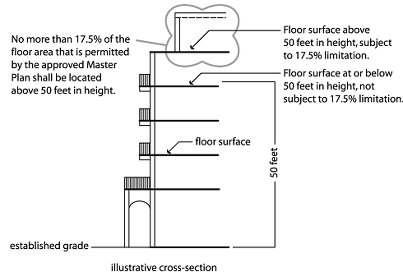
Nonresidential intensity shall be not less than a floor area ratio of 0.15 and shall not exceed a floor area ratio of 0.30. Height of every development must be varied so that not more than 17.5 percent of the floor area that is permitted by the approved master plan shall be located above 50 feet in height. (see illustration)
Maximum allowable density and intensity
(Ord. No. 4908, § 1, 2-28-06)
Sec. 28-1244. - Building height.
(1)
Maximum height. No building or structure, or part thereof, shall be erected or altered in a VC district to a height exceeding 72 feet.
(2)
Distribution of building height; minimum size. Buildings shall be arranged on the land area included in a master plan within a VC district so that the taller buildings or taller portions of buildings are central to the development, as follows:
(Ord. No. 4908, § 1, 2-28-06; Ord. No. 5169, § 1, 6-7-11)
Sec. 28-1245. - Size.
The VC district shall only be applied to parcels proposed for development containing at least 20 contiguous acres.
(Ord. No. 4908, § 1, 2-28-06)
Sec. 28-1246. - Landscaped yards.
(1)
Yards abutting U.S. 1 and Dixie Highway shall not be less than 15 feet in depth.
(2)
Yards shall be planted and maintained in accordance with the landscape plan approved pursuant to all applicable landscaping requirements set forth in this Code.
(3)
Sidewalks and walkways composed of pavers or other material approved by the city, and landscape structures such as fountains, benches, gazebos, and similar improvements are permitted within required yards.
(4)
Except as provided in section 28-1246(3), no pavement shall be permitted within yards except for: public sidewalks along street frontages, shared use pathways, and bus shelters (when required pursuant to sections 23-162, 23-163, and 23-192, respectively); and/or driveways, leading to a structure on the premises.
(Ord. No. 4908, § 1, 2-28-06; Ord. No. 5706, § 44, 10-22-24; Ord. No. 5714, § 5, 11-4-24)
Sec. 28-1247. - Open space and landscaping.
(1)
Minimum open space. A minimum of 35 percent of the net area of the master plan shall be open space.
(2)
Calculation of open space. The following shall be counted as open space:
(a)
Open-air ground-level recreational facilities, including all areas required by section 28-1247(4);
(b)
Plazas;
(c)
Sidewalks that are a minimum of 6 feet wide;
(d)
Turf and landscape areas;
(e)
Fountains, benches, and similar landscape features;
(f)
Covered arcades;
(g)
Gazebos;
(h)
Areas of primary streets that, in the aggregate, are not more than 5 percent of the gross area of the master plan shall be counted as required open space if:
1.
The areas are composed of pavers and provide equal dignity to vehicular traffic and pedestrians; and
2.
The areas can be closed to vehicular traffic on a temporary basis for special events without preventing access to parking structures and off-street surface parking lots.
(3)
Landscaping of open space area.
(a)
Open space shall be planted and maintained in accordance with the landscape plan approved pursuant to all applicable landscaping requirements set forth in this Code.
(b)
Trees shall be planted at a density of 1 tree per 1,250 square feet of open space provided.
(4)
All VCs shall contribute to the establishment or enhancement of community and outdoor spaces by providing space(s) that include, but are not limited to, the following: patio seating area, pedestrian plaza with benches, covered/shaded playground area, water feature, clock tower or similar focal feature or amenity. Any such area shall have direct access to the sidewalk network and be placed in a visible location that is convenient for use as a gathering area.
(5)
Urban recreational experience. At least 5 percent of the net area of the master plan shall be designed to provide both an active and passive family-friendly leisure and recreational experience, including, but not limited to: street or park furniture; shade; grass; playgrounds; plazas; informal seating and climbing opportunities such as stairs, fountains or planters that have capped sides that are not more than 2 feet in height; sculptures that provide seating opportunities; sidewalk access to food vendors; plazas, interactive water features, drinking fountains, and changes in elevation.
(Ord. No. 4908, § 1, 2-28-06; Ord. No. 5169, § 1, 6-7-11; Ord. No. 5392, § 11, 5-23-17; Ord. No. 5706, § 45, 10-22-24)
Sec. 28-1248. - Street network and connectivity.
(1)
Any street network that is provided shall be designed to promote the overall connectivity of the system while avoiding excessive through-traffic in residential areas by including:
(a)
Multiple direct multimodal connections to and between local destinations such as parks, schools and shopping; and
(b)
Interconnections to multimodal transportation facilities and services including but not limited to Palm Tran, Tri-Rail, and greenway and trail systems, including:
1.
Bus and shuttle stops at locations identified by Palm Tran and Tri-Rail; and
2.
Accommodation for pedestrian crossings at signalized intersections where primary and secondary streets connect to the public street network, and in other appropriate locations along the perimeter of the area of the master plan where safety, visibility and pedestrian use will be maximized.
(c)
Modified grid systems, T-intersections, roadway jogs, and other appropriate traffic calming measures to discourage the use of local streets for speeding traffic.
(2)
Street Network Design:
(a)
Any street network that is provided shall be designed to accommodate future street and pedestrian connections to adjacent developable or redevelopable parcels.
(b)
No side of a street block shall exceed 400 feet in length unless outdoor pedestrian access is provided through the block at intervals of no more than 400 feet.
(c)
Cul-de-sacs shall be discouraged.
(Ord. No. 4908, § 1, 2-28-06; Ord. No. 5169, § 1, 6-7-11)
Sec. 28-1249. - Design and performance standards.
(1)
Limitation on retail floor area.
(a)
The maximum floor area for any individual retail establishment is 40,000 square feet.
(b)
The 3 individual retail establishments with the largest floor areas shall not have a combined floor area of more than 80,000 square feet, collectively.
(2)
Limitation on ground floor residential area.
(a)
For developments in which retail and/or office uses comprise more than five percent of the total floor area, no more than 70 percent of the ground floor area shall be used for multiple-family dwellings (including townhomes); and
(b)
Dwelling units shall not be located on the ground floor of mixed-use buildings.
(3)
Townhomes.
(a)
Townhomes shall be designed and developed such that no more than 2 adjacent townhomes are substantially alike in terms of either façade, materials, color, or roof.
(b)
Townhomes shall be developed in groups of no less than 3 and no more than 8 units that are attached by common walls.
(4)
Design of structured parking. Structured parking shall be designed and configured so that parking structures are not a material part of the physical character of the District, as follows:
(a)
Structured parking shall not have vehicular access points on any primary street within the VC district, Federal Highway, or Dixie Highway;
(b)
Structured parking should not be designed with more than one dead-end aisle; and
(c)
Structured parking shall be screened as follows:
1.
Intervening buildings or "wraps" composed of permitted uses other than parking shall screen ground-level views of parking structures form primary streets within the VC district and from public streets outside of the VC district. In addition or in the alternative, permitted uses other than parking may be located in the ground level of parking structures to disguise their use as parking.
2.
Any sides of a parking structure that are exposed to secondary, residential, or service streets shall be designed so that use of the structure for parking is not obvious except at points of ingress and egress.
(5)
Location and design of off-street surface parking lots.
(a)
Surface parking spaces shall be located to the rear and sides of buildings wherever feasible. No off-street surface parking lots shall be located between the front façade of any building(s) and the primary adjacent street.
(b)
Surface parking lots and maneuvering areas shall not be located between a primary building's entrance and an abutting urban minor arterial or urban collector street, except where the applicant has demonstrated that no other alternative is available.
(c)
Surface parking lots and maneuvering areas located to the side of a building cannot occupy more than 50 percent of a site's frontage onto an urban minor arterial or urban collector street.
(d)
Wherever possible, parking lots and maneuvering areas on corner lots should not be located adjacent to intersections.
(e)
Provide smaller, more dispersed surface parking lots instead of one large parking area.
(6)
Design of pedestrian connections. In addition to the requirements set forth in section 23-162, sidewalk policy, the following requirements shall be met:
(a)
Covered pedestrian access shall be provided between parking structures and the front of the principal adjacent buildings that they are intended to serve.
(b)
A sidewalk shall be provided immediately adjacent to the exterior wall of a new building that is greater than 100 feet in length when the wall is located next to an off-street surface parking lot or street. A pedestrian path shall also be provided along the entire length of a wall that includes a principal public entrance to the building. Notwithstanding the previous sentence, a pedestrian path need not be provided if:
1.
The edge of the building is within 20 feet of 1 or more sidewalks and two or more building entrances are connected to the sidewalks by an on-site pedestrian route, or
2.
The edge of the building is bordered by a perimeter of landscaping that does not exceed 30 feet in width and an onsite pedestrian route is constructed at the outside edge of the landscaped area.
(c)
If there is insufficient right-of-way to accommodate the minimum sidewalk and buffer widths for Federal Highway set out in section 23-162, new developments shall either dedicate public rights of way or provide easements for bicycles and pedestrians to the extent necessary to provide the required widths.
(d)
Pedestrian access points outside of the public rights-of-way to adjacent lots shall be provided to facilitate pedestrian circulation between developments.
(e)
All on-site pedestrian walkways located in vehicle use areas shall be distinguished from driving surfaces to enhance pedestrian safety and comfort.
(Ord. No. 4908, § 1, 2-28-06; Ord. No. 5169, § 1, 6-7-11)
Sec. 28-1250. - Definitions.
The following definitions apply within this article VIII, division 6:
"Business, professional, and medical offices" means a use where a business, profession, service or government activity is conducted which does not involve retail activities on site and not including veterinary offices, hospitals, or problematic uses.
"Entertainment" means a commercial use where entertainment, either passive or active, is provided for the pleasure of the patrons of the principal use, including but not limited to vocal and instrumental music, dancing, comedy, and theater, but not including adult entertainment establishment, adult bookstore/adult novelty store/adult video store, adult dancing establishment, adult domination/submission parlor, adult mini motion picture theater, encounter studio/modeling studio, massage establishment, adult health studio, adult motel, and adult motion picture theater.
"Gross area of the master plan" means the total gross area encompassed by a master plan, including all of the land areas of required or voluntary dedication of land for public roadway right of way or other purposes.
"Live-work unit" means a residential dwelling unit that includes flex space which may be used for commercial, retail, office, and/or services.
"Master plan" means a master plan that is prepared pursuant to section 23-353, Code of Ordinances.
"Net area of the master plan" means gross area of the master plan, minus the land area of required or voluntary dedications of land for public roadway rights-of-way.
"Plaza" means a public or private square with room for pedestrian gathering.
"Primary street" means an internal VC roadway which provides front door access to the retail, restaurant, office and cultural uses. A primary street may also provide access to the community spaces.
"Problematic uses" means commercial retail and service uses such as pawn shops, check cashing centers and blood plasma centers which are typically characterized by poorly maintained facilities, loitering and other indices of neighborhood deterioration or urban blight.
"Residential street" means an internal VC roadway with only residential uses on both sides of the roadway.
"Retail sales and services" means the sale of goods, products, materials, or services directly to the consumer, including financial institutions, grocery stores, personal services, art galleries, farmer markets and including the sale of alcoholic beverages for off-premises consumption provided that the sale of alcoholic beverages is subordinate to the principal use and the display of alcoholic beverages occupies less than 25 percent of the floor area of the use, not including problematic uses, adult entertainment establishment, adult bookstore/adult novelty store/adult video store, adult dancing establishment, adult domination/submission parlor, adult mini motion picture theater, encounter studio/modeling studio, massage establishment, adult health studio, adult motel, and adult motion picture theater, or the on-premise consumption of alcoholic beverages.
"Secondary street" means an internal VC roadway which borders both residential and retail, restaurant and office uses.
"Service street" means an internal VC roadway which provides access to parking structures and/or the loading areas. Service streets do not provide front door access to permitted uses.
(Ord. No. 4908, § 1, 2-28-06; Ord. No. 5169, § 1, 6-7-11; Ord. No. 5392, § 12, 5-23-17)
Sec. 28-1251. - Zoning district and symbol created.
The symbol PM-0.40 shall refer to the planned mobility 0.40 district and shall be used to designate all land so zoned.
(Ord. No. 5239, § 1, 8-27-13; Ord. No. 5327, § 1, 11-24-15)
Sec. 28-1251.1. - Purpose.
The purpose and intent of the PM-0.40 district is to implement the planned mobility ("PM") future land use designation on appropriate parcels of land pursuant to the city's comprehensive plan by promoting development that enhances the community character and promotes the efficient use of infrastructure and services through the use of innovative design, development techniques and mobility programs, while respecting and complementing the character of existing adjacent neighborhoods.
(Ord. No. 5239, § 1, 8-27-13; Ord. No. 5327, § 1, 11-24-15)
Sec. 28-1251.2. - Eligibility and review procedures
(a)
Eligibility. The PM-0.40 district shall be a zoning district available for: (i) lands which are designated PM on the future land use map of the city's comprehensive plan; (ii) lands which were designated as residential on the future land use map at the time of adoption of Ordinance No. 5144 on October 26, 2010; (iii) lands which are a minimum of 40 acres in gross land area. Land zoned PM-0.40 shall be noted as such on the city's zoning map; (iv) lands for which an applicant has submitted a concurrent master plan as required in chapter 28, article XVII, division 8, planned mobility development, which follows regulations and standards pursuant to applications for planned mobility development, as specified in chapter 28, article XVII, division 8, planned mobility development (including, without limitation, the notice and procedural requirements of master plans as set forth in article XVII, division 3), with the exception of perimeter setbacks, height, and perimeter landscape buffers (but allowing modifications to perimeter sidewalk buffers, as provided in section 28-1850(4)) and vehicular connections which shall not be eligible for modification and are specified in (and shall be controlled by the specific provisions of) this division (a master plan authorized pursuant to this subsection shall be referred to in this division as a "PMD master plan"); and (v) lands for which an applicant has provided a traffic analysis demonstrating that the development proposed, pursuant to a PMD master plan as required in chapter 28, article XVII, division 8, planned mobility development, is consistent with the assumptions and conclusions of the traffic analysis upon which rezoning of the subject lands was approved (specifically, that certain traffic analysis entitled "Traffic Impact Analysis Zoning Change (R1D to PM-1)" received by the development services department and dated May 23, 2013, prepared by J.M.D. Engineering, Inc., an official copy of which is on file with the city clerk) and that external trip generation resulting from development of the PMD master plan at the maximums proposed does not exceed the external trip generation that the assembly of land uses (including internalization and all other assumptions) would generate as set forth in the traffic analysis. If an application for a site plan is not filed and approved within 3 years from the date of adoption of an ordinance rezoning lands to PM-0.40, the traffic analysis shall be updated and the original assumptions and conclusions modified, if necessary, to ensure compliance with the city's requirements for testing traffic impacts associated with rezoning.
(b)
Traffic concurrency. Consistency and concurrency testing and analysis shall not be required for approval of the PMD master plan but shall be required prior to consideration of a site plan pursuant to section 28-1251.2(d).
(c)
Review criteria. In addition to the review criteria specified in chapter 28, article XVII, division 8, planned mobility development, both the planning and zoning board and the city council shall review the PMD master plan to ensure that the PMD master plan:
(i)
Is compliant with the assumptions and conclusions of the traffic analysis upon which rezoning of the lands within the PMD master plan was approved (as more particularly described in subsection (a)(v) above) or, in the event that the PMD master plan application (or any application to amend a PMD master plan) is filed more than 3 years from the date of adoption of the ordinance rezoning lands to PM-0.40, the traffic analysis shall be updated and the original assumptions and conclusions modified, if necessary, to ensure compliance with the city's requirements for testing traffic impacts associated with rezoning;
(ii)
Does not result in external trip generation exceeding that set forth in the traffic analysis (including internalization and all other assumptions within the traffic analysis);
(iii)
Is compliant with planned mobility program requirements set forth in section 28-1849(6);
(iv)
Is consistent with the comprehensive plan; and
(v)
Is compliant with the PM-0.40 zoning district purpose and regulations.
(d)
Modifications. If a site plan proposes any change in use, square footage for a category of use (provided such change is not de minimis as determined by city staff), configuration (provided such change is not de minimis as determined by city staff), access/roadway/infrastructure, or any other amendment as depicted, noted or otherwise provided for in the PMD master plan for that "parcel", "pod", or any other "parcel", "pod", or portion thereof, an amendment to the PMD master plan shall be required. In no event, shall a PMD master plan be revised to become a single use project for all of the phases and pods within the project. A PMD master plan shall be modified by the same procedure required for approval of a new PMD master plan.
(e)
Platting requirement. In conjunction with the first application for site plan approval, the applicant shall submit an application for an overall final plat showing all tracts within the PMD master plan which includes the entire parcel of land, with the location of the concurrent site plan shown on the final plat. The plat shall be amended as part of each successive application for site plan approval, if required.
(f)
Site plans in PM-0.40. After approval of a PMD master plan and prior to commencement of any development, an application for approval of a site plan for all parcels or a portion of parcels within the PMD master plan shall be filed within 5 years of approval of the PMD master plan. A PMD master plan shall expire in the event that a site plan is not obtained within 5 years. After approval of the first site plan implementing the PMD master plan, each subsequent site plan shall be obtained within 3 years after issuance of a certificate of occupancy for the construction authorized by the last approved site plan. In the event a site plan is not timely obtained as provided herein, or is obtained but expires or is abandoned, then the PMD master plan shall expire, be null and void, and of no further force and effect with respect to improvements for which no site plan was obtained or the site plan expired or was abandoned. Each application for site plan approval (and any amendment thereto) shall be reviewed pursuant to the provisions of chapter 28, article II, division 2, site plans, and provisions in chapter 28, article XVII, division 8, planned mobility development, except that the planning and zoning board shall make a recommendation regarding PM-0.40 site plans (and any amendment thereto) to the city council, and the city council shall review and render final decisions regarding any PM-0.40 site plan (and any amendment thereto). Each site plan and any amendment thereto, individually and in the aggregate taken together with all previously approved development orders, shall be compliant with the PMD master plan and PMD regulations and standards with the exception of perimeter setbacks, height, and perimeter landscape buffers (but allowing modifications to perimeter sidewalk buffers, as provided in section 28-1850(4)) and vehicular connections (which are specified in this division and shall not be eligible for modification), and the expiration and timing of the PMD master plan and subsequent site plans which are specified in (and shall be controlled by the specific provisions of) this division. Each site plan shall be consistent with the design concepts in the approved PMD master plan. The roadway, intersection, and infrastructure improvements (including roadway design cross-sections and alignments, public transit facilities, on-site bus transfer stations, internal shuttle circulator, bicycle facilities, and all pedestrian amenities such as seating areas, benches, street trees, trash receptacles, shelters, covered walkways, raised sidewalk locations, street lights and pedestrian scale lighting) for the phase within which a site is located shall be completed as part of the development of the first site within such phase, in addition to improvements required to provide access and services to any individual site plan regardless of whether located within the limits of such site plan. In reviewing site plans within a PMD master plan, in addition to consideration of the requirements described above, the planning and zoning board and the city council shall consider the following decisional criteria:
(i)
The site plan is consistent with and promotes the mobility goals, objectives, and policies of the comprehensive plan;
(ii)
The site plan demonstrates adequate infrastructure to support the use(s) proposed within the site plan and future uses on lands within the PMD master plan;
(iii)
The distribution of use(s) proposed in the site plan provides a land development pattern that encourages a balance of complementary uses that respects the existing character of surrounding land uses and allows for logical development of undeveloped lands within the PMD master plan;
(iv)
The location, sizes, and overall distribution of use(s) in the site plan support viable and economically stable projects appropriate to the surrounding area and the city overall in the context of the planned mobility objectives of the comprehensive plan;
(v)
The use(s) in the site plan are effectively dispersed and maximally located in relation to the other uses on lands within the PMD master plan;
(vi)
The proposed density, intensity, and distribution of use(s) in the site plan encourage the effective and harmonious development of the lands within the PMD master plan;
(vii)
The location of any use(s) on the site which exceeds the maximum density, intensity, and total development floor area (as provided in section 28-1251.4, Code of Ordinances) as measured on a parcel basis, advances the planned mobility initiatives of the comprehensive plan and the overall viability of the lands within the PMD master plan.
(g)
PMD master plan—Notice to subsequent owners/purchasers. The PMD master plan shall include language providing notice to all subsequent owners/purchasers, in a form approved by the city attorney, that proposed development of lands within the PMD master plan shall be limited to the development set forth on the PMD master plan, which may be amended pursuant to this division 7. The PMD master plan and any site plan (and any amendments thereto) approved pursuant to the PMD master plan shall also include language, in the form of a recordable notice, noting the following: (i) that the development regulations governing the PMD master plan (and amendments), as well as any site plan or amendments thereto approved pursuant to the PMD master plan, permit density, intensity, total development floor area, open space, and all other applicable Code requirements to be calculated on all lands within the PMD master plan rather than calculated on a per parcel basis (which is not the typical method of calculation utilized in conventional zoning districts); (ii) that the development that may be authorized pursuant to those calculations may be allocated to 1 or more of the parcels established within the PMD master plan; (iii) that, accordingly, development that may be authorized on parcels created within the PMD master plan may be limited by previous allocations of those rights (specifically, analysis/calculation of a parcel's development potential/rights cannot be confined to the acreage of, or development parameters applicable to, the parcel, but is dependent upon a comprehensive calculation of all development potential/rights previously approved under the PMD master plan compared to the maximum development potential/rights within the PMD master plan so as to determine the remaining development potential/rights which may be allocated to the parcel); (iv) that, in addition, as a result of calculating certain development parameters on all lands within the PMD master plan, as opposed to each parcel, the development parameters may be exceeded when calculated on a per parcel basis but shall not be exceeded when calculated on a PMD master plan basis; (v) that notice of the PMD master plan (and any amendments thereto) shall be recorded in the public records together with a unity of control in lieu of a unity of title for all lands encompassed within the PMD master plan within 30 days of the rezoning to PM-0.40 (executed by all owners of real property within the PMD master plan as of the date of recordation of such instruments); and (vi) with any PMD master plan amendment and site plan, the applicant shall provide the city with evidence that the applicant has notified all property owners within the PMD master plan, at least 10 days prior to a public hearing, of the proposed PMD master plan amendment or site plan and the public hearing by certified mail with return receipt.
(Ord. No. 5239, § 1, 8-27-13; Ord. No. 5327, § 1, 11-24-15)
Sec. 28-1251.3. - Permitted uses.
No building, structure, land, or part thereof shall be erected, altered, or used, in whole or in part, in a PM-0.40 district for other than 1 or more of the following uses:
(a)
Single-family, duplex, and multi-family residential dwellings (for single-family development, the requirements of section 28-336(1) for the R-1-D district shall apply. For duplex development, the requirements of section 28-389 (as to minimum plot requirements only), section 28-392 and section 28-393 shall apply). All residential units shall strictly comply with the city's occupancy limits restricting a unit to no more than 3 unrelated individuals and, further, no residential units shall be developed or utilized as a student housing facility (as defined in the City's Code), including, without limitation, for "university housing" often referred to as "3 or 4 students behind the door";
(b)
Neighborhood serving retail;
(c)
Hotel and motel;
(d)
Commercial and retail uses, including restaurants and bars. No commercial or retail use in excess of 15,000 square feet of floor are shall be permitted on a parcel except as provided herein. A maximum of 3 retail uses on a parcel may be permitted up to and including 25,000 square feet of floor area each, and a maximum of 1 retail use on a parcel may be permitted up to and including 45,000 square feet of floor area. No retail use in excess of 15,000 square feet of floor area shall be situated with frontage with direct access to a right-of-way having a functional classification of urban major arterial, urban principal arterial or urban collector, as designated in the comprehensive plan;
(e)
Business and professional offices other than medical;
(f)
Financial institutions; provided that no such establishment may provide drive through services unless walk-up service is also provided. In no event shall drive-through services for such establishments exceed 2 lanes;
(g)
Government uses;
(h)
Recreational uses;
(i)
Community/cultural facilities;
(j)
Convention/conference centers;
(k)
Daycare;
(l)
Educational facilities, including institutions of higher learning and specialized schools such as technological schools;
(m)
Medical offices and medical clinics, provided that such medical offices and medical clinics are ancillary to an educational institution or community hospital located within the city;
(n)
Places of worship;
(o)
Uses accessory to permitted uses; and
(p)
Other uses, not listed above, which are determined by the city manager to be similar or comparable to those listed above.
(Ord. No. 5239, § 1, 8-27-13; Ord. No. 5327, § 1, 11-24-15)
Sec. 28-1251.4. - Density, intensity, and use restrictions.
(a)
Density. The residential density in the PM-0.40 district may not exceed 20 dwelling units per acre of gross area of land of the entire PMD master plan parcel. Pursuant to an approved PMD master plan, the maximum density may be calculated on all lands included within the PMD master plan and may exceed 20 dwelling units per acre when calculated on a parcel basis. Residential development in the PM-0.40 district shall not be subject to the maximum number of dwelling units allowed under section 28-1854.
(b)
Intensity. Non-residential floor area may not exceed a floor area ratio of 0.40 of the gross area of land of the entire PMD master plan parcel. Pursuant to an approved PMD master plan, the maximum floor area ratio may be calculated on all lands included within the PMD master plan and may exceed a floor area ratio of 0.40 when calculated on a parcel basis.
(c)
Total development floor area. In no event shall the total square feet of development for all buildings, including residential buildings, hotels and motels, and non-residential buildings regardless of use (but excluding parking structures) exceed 40 percent of the total square feet of the parcel; provided, however, pursuant to an approved PMD master plan, the total square feet of development, as described in this subsection, may be calculated on all lands included within the PMD master plan and may exceed 40 percent when calculated on a parcel basis.
(Ord. No. 5239, § 1, 8-27-13; Ord. No. 5327, § 1, 11-24-15)
Sec. 28-1251.5. - Building height.
The maximum height of all buildings or structures shall be 85 feet, except as follows:
(a)
The maximum height shall be reduced if required by the Federal Aviation Administration; and
(b)
A maximum height of 25 feet shall apply to all buildings or structures located within 100 feet of the property line of a parcel that is zoned single-family residential.
(Ord. No. 5239, § 1, 8-27-13)
Sec. 28-1251.6. - Open/green space.
The minimum open/green space required shall be 25 percent of the gross area of the land of any parcel within the PM-0.40 district; provided, however, pursuant to an approved PMD master plan, the 25 percent open space requirement may be calculated based on all lands included within the PMD master plan and may be less than 25 percent when calculated on a parcel basis. Each application for site plan approval shall include a demonstration that the approved PMD master plan continues to meet the 25 percent open space requirement. In all cases, plazas, paver driveways which are posted with signs that identify the driveway as a joint vehicular and pedestrian way, sidewalks, covered arcades, gazebos, and other hardscape areas may be counted towards satisfying the open/green space requirement provided such areas promote connectivity and mobility.
(Ord. No. 5239, § 1, 8-27-13; Ord. No. 5327, § 1, 11-24-15)
Sec. 28-1251.7. - Setbacks.
The minimum front, side and rear yard setbacks for all buildings shall be 20 feet from the property line. The minimum setback from any property line fronting a road right-of-way having a functional classification of urban major arterial, urban principal arterial, or urban collector, as designated in the comprehensive plan, shall be 50 feet from the property line. All required yards shall be landscaped in accordance with all applicable landscaping requirements set forth in this Code.
(Ord. No. 5239, § 1, 8-27-13; Ord. No. 5706, § 46, 10-22-24)
Sec. 28-1251.8. - Residential minimum floor area.
The minimum floor area of a residential dwelling unit shall be 700 square feet. The average floor area for all residential dwelling units on any parcel of land within the PM-0.40 district shall be a minimum of 900 square feet.
(Ord. No. 5239, § 1, 8-27-13; Ord. No. 5327, § 1, 11-24-15)
Sec. 28-1251.9. - Landscape buffer and vehicular connections.
A landscaped buffer that is no less than 100 feet in width, as measured from the abutting property line, shall be placed along all boundaries of any PM-0.40 site plan that abuts a parcel that is zoned single-family residential. No structure of any kind shall be permitted within the landscaped buffer. No vehicular connections to parcels zoned single-family residential abutting the boundaries of any PM-0.40 district shall be allowed except for gated access which shall be for fire rescue purposes only.
(Ord. No. 5239, § 1, 8-27-13; Ord. No. 5327, § 1, 11-24-15)
Sec. 28-1251.10. - Mobility.
No development shall be authorized or permitted within the PM-0.40 district unless the development plan (PMD master plan and individual site plans) demonstrates that the proposed development scores at least 100 points pursuant to the planned mobility program requirements set forth by section 28.1849(6) (as established in Ordinance No. 5225 of the City of Boca Raton, adopted and in effect on December 11, 2012 and further amended by Ordinance No. 5292 of the City Boca Raton, adopted and in effect on January 13, 2015), as Table 1, and complies with the requirements of sections 23-35 and 23-37 and chapter 23, article IV, division 8 (transportation demand management), Code of Ordinances.
TABLE 1
PLANNED MOBILITY MATRIX
(Ord. No. 5239, § 1, 8-27-13; Ord. No. 5292, §§ 2, 3, 1-13-15; Ord. No. 5327, § 1, 11-24-15)
Sec. 28-1251.11. - Repealer exemption.
Development orders authorized pursuant to this division that have not expired as of the repeal date of division 8, chapter 28, article XVII by December 11, 2022, as provided in section 28-1855 shall be deemed active development orders, notwithstanding the provisions of section 28-1855.
(Ord. No. 5239, § 1, 8-27-13; Ord. No. 5327, § 1, 11-24-15)