
Boca Raton City Zoning Code
ARTICLE XVII
- PLANNED DEVELOPMENT54
Editor's note— Ord. No. 2561, § 2, amended the Code by providing for planned unit development. Provisions formerly providing for planned unit development, §§ 25-83.100—25-83.148, were repealed pursuant to § 1 of Ord. No. 2561. Section 3 of Ord. No. 2561 provides as follows:
"Section 3. Any PUD approved pursuant to sections 25-83.100 to 25-83.148, Code of Ordinances, as of the effective date of this ordinance [December 12, 1978] shall remain subject to the requirements of those provisions."
Subsequently, the entire article was amended by § 1 of Ord. No. 3247, adopted Sept. 27, 1983.
Cross reference— Conditional land use amendments and rezonings under the land development regulations, § 23-351 et seq.; signs, ch. 24; uses prohibited in all districts, § 28-1326 et seq.; off-street parking and loading, § 28-1646 et seq.
Sec. 28-1686. - Title.
This article shall be known and may be cited as the Boca Raton PD Regulations. "Planned development" shall be referred to herein as "PD."
(Ord. No. 3247, § 1, 9-27-83)
Sec. 28-1687. - Definitions.
The following words, terms and phrases, when used in this article, shall have the meanings ascribed to them in this section, except where the context clearly indicates a different meaning:
"Applicant" shall mean any natural person, firm, association, syndicate, copartnership, corporation, trust or any other legal entity commencing proceedings under this article to effect the planned unit development of land.
"Comprehensive plan" shall mean the comprehensive plan adopted by the city council pursuant to the Local Government Comprehensive Planning Act of 1975, and including all adopted elements or parts thereof and any amendments thereto.
"Electrical main distribution feeder line" shall mean a 69kv-240kv line from a substation to a transformer to serve single-phase laterals.
"Engineering design standards manual" shall mean the manual as defined in section 26-1.
"Environmental survey" shall mean an inventory and analysis of existing and proposed environmental conditions, which need only be sufficiently detailed to permit necessary review with respect to the proposed PD and its effect on adjacent lands.
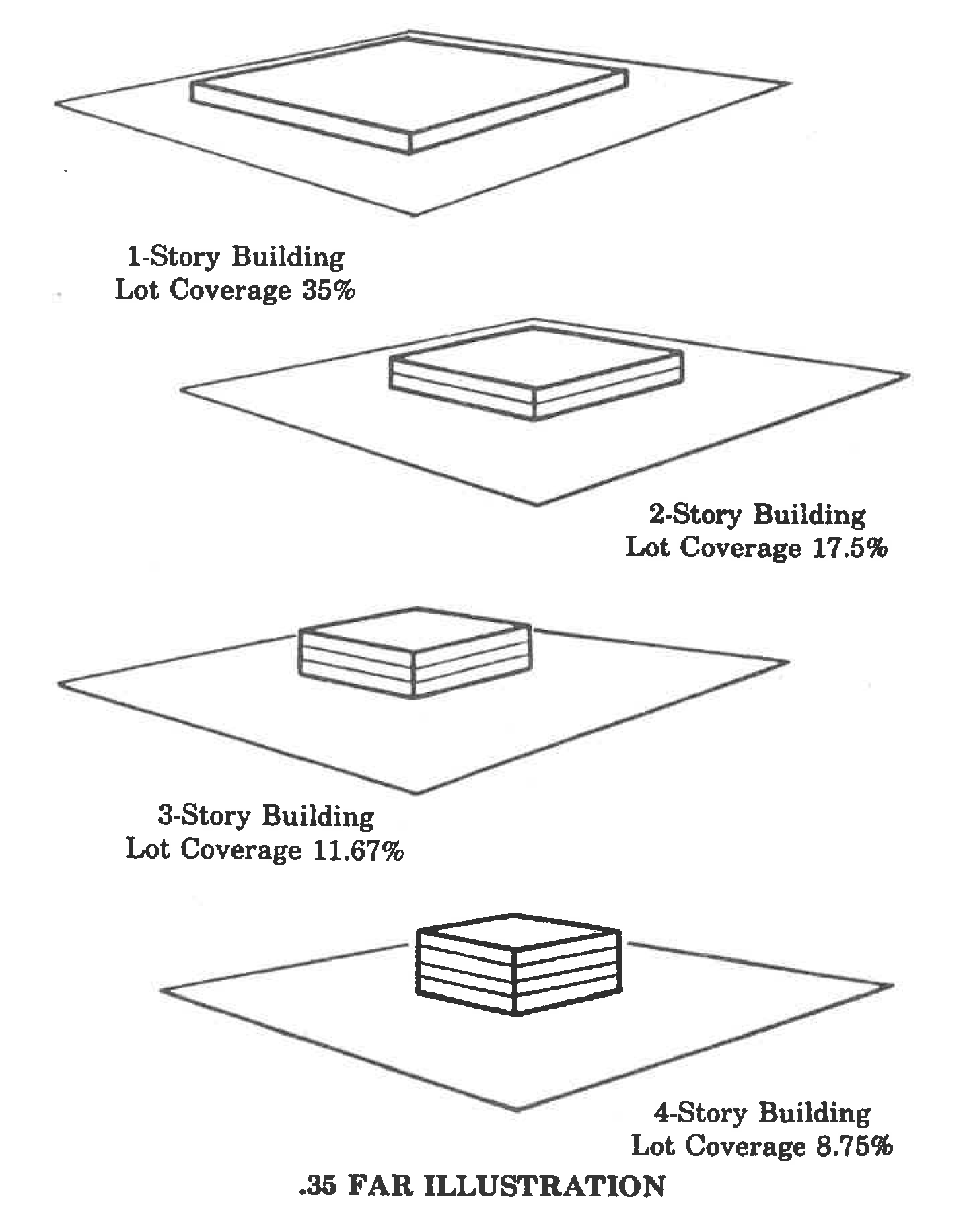
"Floor area" shall mean the sum of the gross areas of the horizontal plane of each story of a building excluding parking structures measured from the exterior faces of the exterior walls or from the centerline of walls separating 2 buildings, excluding attic space, unenclosed areas, fire escapes, atrium space and basement space where the ceiling is less than 72 inches above the floor. (See illustration below.) For the purpose of this definition, "attic space" shall be that portion of a building immediately below the roof of a building not designed, arranged or used for business purposes or habitation, and "basement space" shall be that portion of a building partly underground having less than half its height above the established grade.
"Lot" shall mean a portion of a PD, however designated, intended as a building site.
"Parcel" shall mean any designated portion of a PD other than a lot.
"PD plat" shall have the same meaning as the definition of "PD plat" set forth in Section 26-1.
"Planned commercial development" shall mean a commercial project developed and approved pursuant to this article. The letters "PCD" shall refer to a planned commercial development. The letters "PCD" shall refer to an entire PCD project whether the project consists of 1 PCD plat or several PCD plats subject to a master plan.
"Planned development" shall mean a residential, commercial or industrial project developed and approved pursuant to this article.
"Planned industrial development" shall mean an industrial project developed and approved pursuant to this article. The letters "PID" shall refer to a planned industrial development. The letters "PID" shall refer to an entire PID project whether the project consists of 1 PID plat or several PID plats subject to a master plan.
"Planned unit development" shall mean a residential project developed and approved pursuant to this article. The letters "PUD" shall refer to a planned unit development. The letters "PUD" shall generally refer to an entire PUD project whether the project consists of 1 PUD plat or several PUD plats subject to a master plan.
"Public utility manual" shall mean the comprehensive set of specifications prepared by the city, establishing minimum requirements for the design and construction of water distribution and sewer collection systems.
Streets, alleys, easements, rights-of-way and similar terms:
"Alley" shall mean a minor way which is used primarily for vehicular service access to the rear or the side of parcels or lots otherwise abutting a street.
"Arterial street" shall mean a heavily traveled street of considerable continuity used primarily as a main traffic artery.
"Collector street" shall mean a street which carries traffic from minor streets to arterial streets, and includes the principal entrance streets of a residential development and streets for circulation within the development.
"Cul-de-sac" or "dead-end street" shall mean a street with only 1 outlet and which terminates at the opposite end with or without a circular turnaround.
"Easement" shall mean any land reserved for utility, drainage or other public or private use, the fee simple title to which remains in the property owner, subject to the right of use designated in the grant of easement.
"Limited-access highway" shall mean a highway which does not permit access except at authorized and controlled points.
"Mapped street" shall mean any approved street shown on the official map of the city, or the projection of an existing street through an unsubdivided parcel of land regardless of whether the street is dedicated or in existence.
"Minor street" shall mean a street serving the immediate area.
"Right-of-way" shall mean a strip of land dedicated or deeded for public or private use.
"Service street" shall mean a street which is parallel and adjacent to arterial streets or limited-access highways and which provides access to abutting properties and protection from through traffic.
"Width of a street or right-of-way" shall mean the width measured along a line perpendicular to the designated centerline.
Unless the context suggests otherwise, all references to streets and alleys shall refer to both public and private streets and alleys.
(Ord. No. 3247, § 1, 9-27-83; Ord. No. 5533, § 8, 9-9-20)
Cross reference— Definitions and rules of construction generally, § 1-2.
Sec. 28-1688. - Purpose; intent.
(1)
The purpose of this article is to promote the public health, safety, comfort, order, appearance, convenience and general welfare of the city; to protect the environment and retain natural landscaping; to answer the growing demand for housing of all types and designs; to encourage innovations in residential, industrial and commercial development, with greater variety in type, design and layout of buildings than is generally possible under conventional zoning regulations; to conserve and efficiently use open space; to provide greater opportunities for housing, employment and recreation; to encourage more efficient use of land and public services; and to conserve land values.
(2)
It is further the intent of this article to secure:
(a)
The establishment of standards of PD design which will encourage the development of a sound and economically stable community, and the creation of healthy living environments;
(b)
The efficient, adequate and economic supply of utilities and services to land developments;
(c)
The prevention of traffic hazards and the provisions of safe and convenient vehicular and pedestrian traffic circulation in land developments;
(d)
The availability of public open spaces in land developments for recreational, educational and community facilities;
(e)
The availability of adequate school facilities to meet the additional student enrollment reasonably projected as a result of each residential approval;
(f)
The coordination of land development in the community in accordance with orderly physical growth patterns;
(g)
Implementation of the comprehensive plan.
(Ord. No. 3247, § 1, 9-27-83)
Sec. 28-1689. - Coordination with other regulations.
(1)
In the event of conflict between this article and other zoning and subdivision regulations of the city, the provision of this article shall prevail to the extent of such conflict.
(2)
In the event of conflict between this article and the building and life safety codes of the city, the provisions of the building and life safety codes shall prevail to the extent of such conflict.
(Ord. No. 3247, § 1, 9-27-83; Ord. No. 5533, § 9, 9-9-20)
Sec. 28-1706. - Compliance.
No PD shall be approved unless the conditions of this division are satisfied. The requirements of this division are continuing and enforceable against any PD approved hereunder.
(Ord. No. 3247, § 1, 9-27-83)
Sec. 28-1707. - Reserved.
Editor's note— Ord. No. 5427, § 1, adopted Nov. 28, 2017, repealed § 28-1707, which pertained to size and derived from Code 1966, § 25-155.
Sec. 28-1708. - Ownership and applicant qualifications.
(1)
A PD application may be filed in the names of the owners of record of the property included within the PD. However, the application may be filed by an applicant with an equitable interest in the property, or by an attorney or agent for the owners, provided the owners of record join in and executes the application.
(2)
A PD application may be filed for an area as part of a voluntary annexation petition or by the city or owners of 50 percent of the total land area to be considered for annexation by referendum.
(Ord. No. 3247, § 1, 9-27-83)
Sec. 28-1709. - Site improvements required.
All site improvements required by this article shall be constructed or installed by the applicant.
(Ord. No. 3247, § 1, 9-27-83)
Sec. 28-1710. - Parking required.
The provisions of section 28-1646 et seq. in effect at the time of site plan approval shall regulate parking within a PD.
(Ord. No. 3247, § 1, 9-27-83)
Sec. 28-1711. - Setback and landscaped yard requirements.
(1)
Modified building setbacks. Subject to PD master plan approval, building setbacks may be modified from the provisions of the underlying zoning districts. Modified building setbacks shall be set forth on the PD master plan and shall be enforced by the city as if the setbacks were provisions of the underlying zoning districts. Building setbacks may be modified only in accordance with the following criteria:
(a)
The modified building setback in residential developments shall provide privacy within dwellings.
(b)
The modified building setback shall provide adequate light and air.
(c)
The location of a modified setback and the compatibility of adjacent uses shall be a factor in granting approval of setback modifications.
(d)
Building configuration and the relationship between building configuration and privacy, light, air and the compatibility of modified building setback uses shall be factors in granting approval of setback modifications.
(e)
Fire exposure of proposed PD buildings, ground floor area of buildings, height of buildings, occupancy usage, type of construction, availability of water for fire flow, and spacing of fire hydrants shall be factors in granting approval of setback modifications.
(2)
Required perimeter building setback. No building shall be located closer than 25 feet to any right-of-way or to the perimeter property line of a PD. There shall be added 1 foot of perimeter setback for each 2 feet or fraction thereof of building height over 30 feet. The perimeter building setback shall be landscaped to the standards of, and maintained as required by, section 28-1712. In determining the specific perimeter setback requirement for each PD, the compatibility of adjacent land uses, building heights and any parking structures shall be considered and the required perimeter building setback may be adjusted accordingly.
(Ord. No. 3247, § 1, 9-27-83; Ord. No. 5533, § 10, 9-9-20)
Sec. 28-1712. - Landscaping standards.
The term "landscaping" shall mean the planting of lawn, ground cover, flower beds, shrubs, hedges, trees or other types of landscaping. All required landscaping as shown on the approved landscaping plan shall be perpetually maintained in a healthy growing condition, neat and orderly in appearance, and kept free of refuse and debris. All planting shall be arranged and maintained so as not to obscure the vision of traffic. Yard landscaping requirements may be satisfied by high-quality natural plant communities or forest areas. There shall be no parking of vehicles in required landscaped yards; except that driveways, walkways and bike paths may cross required landscaped yards as necessary. Prior to construction of a structure other than a single-family house on a lot, a landscape plan for all required landscape yards shall be submitted to the city for approval. Approved landscaping shall not be changed without prior approval. Any approved landscaping that is replaced shall be in conformity with the approved landscaped plan.
(Ord. No. 3247, § 1, 9-27-83; Ord. No. 5706, § 56, 10-22-24)
Sec. 28-1713. - Accessory buildings.
The location of accessory buildings and structures shall be approved by the development services director.
(Ord. No. 3247, § 1, 9-27-83; Ord. No. 4122, § 70, 9-28-93; Ord. No. 4170, § 27, 9-27-94)
Sec. 28-1714. - Land dedication requirements.
(1)
The PD applicant for a residential development shall dedicate land or pay a fee in lieu of land dedication to the city for park purposes. The land dedication or fee in lieu thereof shall be determined pursuant to the provisions of section 23-107 et seq. Land dedicated within the PD shall qualify as required open space.
(2)
The PD applicant shall dedicate land or pay a fee in lieu of land dedication, as may be required by the city council, for community facilities. Community facilities include but are not limited to fire stations, police stations, libraries, community centers, government offices or public utilities. Land dedicated for community facilities shall, whenever possible, be strategically located and consolidated. Land dedicated for community facilities shall not be included as part of the required open space. Land dedication for community facilities which otherwise qualifies shall be included in the calculation of gross area for purposes of maximum density. The amount and location of land to be dedicated shall be determined by the city council as part of the final PD plat approval or master phasing plan approval. The determination shall be based on the need for community facilities resulting from the size, location and impact of the proposed PD, including projected PD phases. Community facilities shall be architecturally compatible with the surrounding structures and shall be heavily buffered with landscaping.
(3)
The PD applicant shall convey land to the city, to the Greater Boca Raton Beach Tax District, to the county, or to the school board of the county, for park purposes or for community facilities at final PD plat approval; and any land so conveyed shall be deemed included within the PD, notwithstanding the conveyance for the purpose of allowing all available credit for such land against the land dedication requirements of this section, if the size and location of the land has been approved by the city council and if the land adjoins the remainder of the PD along at least 1 boundary line.
(Ord. No. 3247, § 1, 9-27-83)
Sec. 28-1715. - Location requirements.
(1)
Relation to major transportation facilities. A PD shall be located with respect to arterial streets, highways or other major transportation facilities so as to provide direct access therefrom to the PD without creating additional traffic along minor streets not within the PD.
(2)
Relation to utilities. A PD shall be located in relation to existing sanitary sewers, waterlines, storm and surface drainage systems and other utilities systems such that neither extension nor enlargement of such systems will be required in degree or time that will result in net public cost higher than or the incurrence of public cost earlier than would development of the area as otherwise permitted.
(3)
Relation to public facilities. A PD shall be located with respect to schools, parks, playgrounds and other public facilities so as to have access in the same degree as would development of the area as otherwise permitted.
(4)
Locational deficiencies. An applicant may cure locational deficiencies by either providing highway, street, sewer, water, utility drainage or other improvements at its own cost or by agreeing with the city to fund all or part of the cost of such improvements, the effect of either of which shall be to offset fairly and equitably any higher net public cost resulting from the impact of the PD or to cure the locational deficiencies. In any computations of additional net public costs, the differences between otherwise anticipated public costs and PD impact costs, and otherwise anticipated public revenue and PD impact revenues shall be considered, among other factors. The city council may require expert determination and analysis of public cost and revenues and PD impact thereon. The experts shall be selected by the city council and may be city staff, and the cost of the determination and analysis shall be paid by the applicant.
(5)
Nonprogressive development. The proposed PD shall not be located in relation to other developed areas of the city such that checkerboard or nonprogressive development results. This subsection shall not prohibit development based upon the strategic location of 1 single tract of land.
(Ord. No. 3247, § 1, 9-27-83)
Sec. 28-1716. - Encroachments on or in street rights-of-way.
(1)
Facilities for utilities, including but not limited to power and light, cable television, telephone and telegraph, water, sewer and gas utilities, shall be constructed and installed beneath the surface of the ground. This subsection shall not prohibit the erection on the ground or flush with the ground of transformers, pullboxes, service terminals, pedestal-type telephone terminals, telephone splice closures or other similar on-the-ground facilities normally used with and as a part of an underground distribution system; or of main feeder electric lines, the principal purpose of which is delivering power between substations or from substations to local single-phase distribution systems; or of electrical power transmission or main distribution feeder lines serving more than the immediate area.
(2)
The applicant shall make the necessary cost and other arrangements for such underground installation with the appropriate utility provider.
(3)
The city council may modify any of the provisions of this section on its own initiative or upon application from a utility or the applicant whenever the property to be platted hereunder is of such size or shape or is affected by such geographical location, subsurface or topographical conditions that it is impractical or economically unfeasible to conform to the strict application of the requirements of this section.
(4)
Facilities for utilities shall be constructed in appropriate easements except water and sewer utilities which shall be constructed in the right-of-way, whenever possible.
(Ord. No. 3247, § 1, 9-27-83)
Sec. 28-1717. - Median strip beautification and utilization.
Median strips which are part of a right-of-way may not be used by any other person than the city or a city-franchised utility, except as follows:
(a)
Landscape beautification. The applicant, a property owners' association or similar entity may landscape and beautify a median strip within or in proximity to a PD, provided that such landscape beautification is approved by the city council. An application for median landscape beautification shall be made in writing to the city and shall include a landscape beautification plan which shall contain sufficient detail as to location and dimension of the area involved, the materials and plantings to be utilized and responsibility for maintenance of landscaping improvements. The application shall be forwarded to the community appearance board for its recommendation. After community appearance board action, the request shall be forwarded to the city council through the city manager. The city council shall consider the recommendations and may approve, disapprove or approve with conditions the application. The city shall issue the appropriate permits after the city council has approved the application or approved the application with conditions, provided the conditions are satisfied.
(b)
Planned development entrance signs. PD entrance signs may not be placed in any public right-of-way. PD entrance signs may be erected in common areas subject to community appearance board approval. PD entrance signs shall not interfere with the visual sight line of motorists or pedestrians traveling upon nearby streets or with the orderly flow of traffic. A PD entrance sign shall not be removed without prior approval of the community appearance board, which approval may be conditioned upon replacement beautification.
(Ord. No. 3247, § 1, 9-27-83; Ord. No. 4122, § 71, 9-28-93)
Sec. 28-1718. - Drainage.
(1)
Permits. No applicant or other person shall construct, deepen, widen, fill, reroute or alter any existing drainageway, ditch, drain or canal within or serving the PD without first obtaining a permit from the city and all other governmental bodies requiring permits.
(2)
Rights-of-way and easements. Whenever any drainageway, stream, surface drainage course or retention basin is located or planned to be located within a PD, the applicant shall dedicate all necessary easements and rights-of-way and provide for the perpetual maintenance of the drainage improvements.
(3)
Stormwater. Stormwater shall be drained from the PD by methods employing engineering practices acceptable to the city.
(4)
Contour map and drainage of adjacent areas. A contour map shall be prepared and submitted by a state-registered land surveyor or engineer for the area within the PD and such additional areas as may be required by the city necessary to include all watersheds which drain into or through the property to be developed. The design for drainage of the PD must be adequate to provide for drainage of adjacent watershed areas after complete development of the total area. The applicant shall dedicate all necessary easements and rights-of-way for watershed drainage and provide for the perpetual maintenance of the watershed drainage improvements.
(5)
Drainage. The applicant shall coordinate all drainage both on and off the site with the city's civil engineer and all other agencies having jurisdiction.
(Ord. No. 3247, § 1, 9-27-83; Ord. No. 4122, § 72, 9-28-93)
Sec. 28-1719. - Design standards; conformance with comprehensive plan.
(1)
A PD shall conform with the comprehensive plan.
(2)
Streets.
(a)
Generally. The width, grade and general location of all streets shall conform with the comprehensive plan, existing and planned streets, topographical conditions, public convenience, safety, and the proposed uses of the land to be served by the streets.
(b)
Adjoining street systems. The arrangement of streets in a PD shall provide for the continuation of existing streets in adjoining areas as necessary.
(c)
Projection of streets. Where adjoining areas are not subdivided, the arrangement of streets in a PD shall provide for the proper projection of streets from the boundaries of the PD into the adjoining areas.
(d)
Streets continued to property lines. When a PD adjoins lands with proposed or developed streets which are proposed to continue through the PUD, the streets of the PD shall be continued to the property line.
(e)
Street jogs. Street jog centerline offsets shall not be less than 125 feet.
(f)
Dead-end streets or cul-de-sacs. Permanent dead-end streets or cul-de-sacs shall be provided at the closed end with a turnaround having an outside pavement diameter of at least 100 feet. If a dead-end street is of a temporary nature and more than 1 lot in depth, a similar turnaround shall be required and provision made for future extension of the street into adjoining property.
(g)
Service streets. Where a PD abuts or contains a limited-access highway or an arterial street, a service street shall be provided or other such treatment as may be necessary for adequate buffering of the PD residential dwellings and to afford separation of through and local traffic.
(h)
Minor street. Minor streets shall be laid out so that their use by through traffic shall be discouraged.
(i)
Railroad on or abutting the residential development. Where a residential development abuts or contains a railroad or limited-access highway, buffering open space shall be required.
(j)
Tangent between reversed curves. A tangent at least 100 feet long may be required between reversed curves on arterial and collector streets.
(k)
Angle of intersection. Streets shall be laid out so as to intersect as nearly as possible at right angles.
(l)
Property lines at street intersections. Property lines at street intersections shall be rounded with a radius of at least 25 feet. The city may permit comparable cutoffs or chords in place of round corners.
(m)
Rights-of-way: Rights-of-way shall be as shown on the PD plat and shall be not less in width than the following:
1.
Arterial, 100 feet.
2.
Collector, 80 feet.
3.
All other streets, 50 to 60 feet.
(n)
Street number. Street identifications shall be of the following 3 categories:
1.
A north-south category, which shall be preceded by a quadrant designation (N.E., S.E., N.W., or S.W.) and a numerical designation respectively, and shall be placed on the map so that they will read east or west from the north-south control line of the Florida East Coast Railway in the following order:
a.
Avenue.
b.
Way.
c.
Terrace.
d.
Court.
2.
An east-west category, which shall be preceded by a quadrant designation (N.E., S.E., N.W., or S.W.) and a numerical designation respectively, and shall be so placed on the map that they will read north or south from the east-west control line of Palmetto Park Road in the following order:
a.
Street.
b.
Road.
c.
Drive.
d.
Place.
e.
Lane.
3.
A miscellaneous category, which shall be preceded by a name or numerical identification, shall be followed by the quadrant designation (N.E., S.E., N.W., or S.W.) and shall include the following:
a.
Boulevards.
b.
Diagonals.
c.
Federal road designations.
d.
State road designations.
(3)
Alleys. New alleys shall not be permitted unless the development services director finds that alleys are necessary to provide additional means of service access, or for off-street loading, unloading and parking for the uses proposed.
(4)
Easements. Easements shall be provided for utilities where necessary and shall be at least 12 feet wide across lots and, where possible, shall be centered on lot lines. Easements 10 feet wide shall be provided for underground utilities across that portion of the lot adjacent to a street.
(5)
Blocks. The length, width and shape of blocks shall be established with due regard to:
(a)
Providing adequate building sites suitable to the type of use contemplated.
(b)
Setback and landscaped-yard requirements.
(c)
Convenient access, circulation, control and safety of street traffic.
(d)
Limitations and opportunities of topography.
(e)
Providing open areas within the block PD adequate to serve the intended population.
(f)
In a block in excess of 900 feet in length, a paved 6-foot-wide crosswalk in a 15-foot right-of-way may be required to provide circulation or access to school, playground, commercial nodes, transportation, and other community facilities.
(6)
Building sites. Building sites shall be of a depth, shape and orientation appropriate for their location in the PD and the type of development and use contemplated. Each building site shall contain setbacks and landscaped yards pursuant to the underlying zoning or pursuant to section 28-1711.
(a)
Each building site shall have access to a dedicated street. Such access may be through a private street or private parking court.
(b)
Double-frontage or through lots shall be avoided except where essential to provide separation of residential development from traffic arteries or to overcome specific problems of topography or orientation. If a double-frontage or through lot is included in a PD plat, a planting screen, improved with a combination of berms, walls and landscaping at least 10 feet in depth may be required by the city council, across which there shall be no right of access. The planting screen shall be shown as an easement on the final PD plat; and the applicant or its successor in interest or title, including without limitation a property owners' association or a condominium owners' association, shall provide for its perpetual maintenance. The side of the double-frontage lot which is landscaped and limited as to access shall not be considered a frontage for setback purposes.
(Ord. No. 3247, § 1, 9-27-83; Ord. No. 4122, § 73, 9-28-93; Ord. No. 4170, § 27, 9-27-94)
Sec. 28-1720. - Special conditions; modification of development parameters.
(1)
The development parameters set forth in this division may be reasonably modified where the conditions and designs are such that modification is necessary in the determination of the city council, after receiving a recommendation from the planning and zoning board. Any modification shall require evidence of the necessity for the modification and the resulting impact of the modification.
(2)
In the case of annexed property, the development parameters set forth in this division may be reasonably modified when such modification is necessary for the preservation of a substantial property right available prior to annexation through a governmental site plan approval, plat approval or partial development of the area as determined by the city council at the time of annexation, after receiving a recommendation from the planning and zoning board. Any modification shall require evidence of the necessity for the modification and the resulting impact on adjacent areas.
(Ord. No. 3247, § 1, 9-27-83)
Sec. 28-1721. - Establishment of standards and criteria.
Wherever reference is made in this article to standards, criteria and the like established by the city and when the manner by which such standards, criteria and the like are to be established are not defined by external criteria, then such standards, criteria and the like shall be consistent with good, generally accepted engineering, public works or planning and zoning practices, and reasonably necessary to effectuate the intent of this article.
(Ord. No. 3247, § 1, 9-27-83; Ord. No. 4122, § 74, 9-28-93; Ord. No. 5525, § 11, 8-25-20)
Sec. 28-1722. - Planned commercial development (PCD).
In addition to all general provisions and general development parameters of this article, the following requirements shall apply to all planned commercial developments:
(a)
Permitted areas: A PCD shall only be permitted in business and commercial districts specifically set forth in section 28-701 et seq.
(b)
Permitted uses: Any permitted use in the underlying zoning district.
(c)
Conditional uses: Any conditional use in the underlying zoning district, subject to division 4 of article II.
(d)
Height of buildings: No building or structure shall be erected in excess of the maximum height in the underlying zoning district.
(e)
Maximum floor area: The maximum floor area of a building or structure shall not exceed 35 percent of the lot or plot area.
(f)
Open space: Each lot or plot to be developed shall contain a minimum of 20 percent open space not including driveways and parking areas.
(g)
Size: A PCD shall consist of an area not less than 1.0 gross acre and shall be a reasonably compact area that is of sufficient size to accommodate the proposed amount of development in a form that is compatible with existing and potential development in the immediate vicinity as designated in the comprehensive plan.
(Ord. No. 3247, § 1, 9-27-83; Ord. No. 4323, § 29, 5-1-97; Ord. No. 5427, § 2, 11-28-17)
Sec. 28-1723. - Planned industrial development (PID).
In addition to all general provisions and general development parameters of this article, the following requirements shall apply to all planned industrial developments:
(a)
Permitted areas: A PID shall only be permitted in industrial districts except LIRP districts set forth in section 28-976 et seq.
(b)
Permitted uses:
1.
All permitted uses in the underlying zoning district.
2.
Offices for any use permitted in the underlying zoning district.
(c)
Conditional uses, subject to Division 4 of Article II:
1.
Any conditional use in the underlying zoning district.
2.
General business and professional offices which improve the overall quality and appearance of the PID may be approved as part of a master plan to a maximum of 20 percent of the land area under the master plan, subject to the following:
a.
The minimum plot area for general office use shall not be less than 5 contiguous acres.
b.
Development of the general office area shall not precede development of 15 percent of the portion of the land under the master plan other than the portions designated for general office use.
c.
No building or structure shall be erected in excess of the maximum height in the underlying zoning district.
d.
The maximum total floor area, excluding parking structures, of all buildings and structures shall not exceed 35 percent of the lot or plot area.
e.
Each lot or plot to be developed shall contain a minimum of 20 percent open space not including driveways and parking areas.
3.
In the M-3 zoning district, lands and structures used primarily for entertainment, sport or recreation uses which improve the overall quality and appearance of the PID may be approved as part of a master plan to a maximum of 20 percent of the land area under the master plan, subject to the following:
a.
The minimum plot area for entertainment, sport or recreation uses shall not be less than 5 contiguous acres.
b.
No building or structure shall be erected in excess of the maximum height of 85 feet.
c.
The maximum total floor area, excluding parking structures, of all buildings and structures used for entertainment, sport or recreation uses shall not exceed 35 percent of the lot or plot area.
d.
Each lot or plot to be developed to entertainment, sport or recreation uses shall contain a minimum of 20 percent open space not including driveways and parking areas.
e.
Accessory uses such as restaurant uses may also be approved by the city council.
4.
Restaurants which are part of, accessory and related to the uses described in 3. above may be approved to open at hours when the main use is not in operation, provided such hours of operation improve the overall quality of the PID.
5.
A master plan may contain a mix of the uses described in 2., 3. and 4. above if the following additional conditions are satisfied:
a.
The mixed uses or separate office or recreational use shall not exceed in the aggregate 20 percent of the land area under the master plan.
b.
Nonconcurrent parking agreements between mixed uses shall be provided.
c.
Each plot or lot in a mixed-use master plan shall comply with the minimum open space requirement and maximum floor area requirement for the designated use of the plot or lot. With reference to a mixed-use master plan, the general development parameters of these PID regulations, the requirements of underlying zoning districts, or off-street parking and related regulations may be modified by the city council.
(d)
Size: A PID shall consist of an area not less than 1.0 gross acre. A PID shall consist of a reasonably compact area that is of sufficient size to accommodate the proposed amount of development in a form that is compatible with existing and potential development in the immediate vicinity as designated in the comprehensive plan.
(Ord. No. 3247, § 1, 9-27-83; Ord. No. 3771, § 1, 5-9-89; Ord. No. 4323, § 30, 5-1-97; Ord. No. 5427, § 3, 11-28-17; Ord. No. 5655, § 4, 10-11-23)
Sec. 28-1724. - Planned unit development.
In addition to all general provisions and general development parameters of this article, the following requirements shall apply to all planned unit developments in accordance with division 4 of article II:
(a)
Size. A PUD shall include a minimum of 5 residential dwelling units, and shall consist of a reasonably compact area that is of sufficient size to accommodate the proposed number of dwelling units and other development proposed in a form that is compatible with existing and potential development in the immediate vicinity as designated in the comprehensive plan. The determination of sufficient size shall include consideration of minimum plot size requirements, where applicable, areas required for parking, access, circulation and open space, and other factors as necessary to comply with this Code of Ordinances.
(b)
Size of plot. Where any plot within a PUD includes 1 or more 1-family dwellings (single-family or townhouse) or 2-family dwellings (duplexes), but does not include multiple dwellings (multifamily), as those terms are defined in section 28-2, the minimum size of the plot shall be 1,250 square feet multiplied by the number of dwelling units on that plot. Where a plot within a PUD includes 1 or more multifamily dwellings, the minimum size of that plot shall be determined through the PUD approval process.
(c)
Minimum floor area. For a multifamily dwelling, the minimum floor area of each dwelling unit shall not be less than 700 square feet. In addition, a minimum of 75 percent of any multifamily dwelling units shall be greater than the minimum floor area.
(d)
Permitted areas. A PUD shall be permitted only in the single-family and multifamily residential zoning districts specifically set forth in section 28-301(a) and (b) and in the REC zoning district. No part of a PUD may include any other zoning district.
(e)
Permitted uses. Permitted uses in a PUD include:
1.
Single-family dwellings, duplexes, townhouses and multifamily dwellings, both separately or in any combination with each other.
2.
Real estate sales offices as set forth in (i) below.
3.
Commercial nodes as set forth in (j) below.
4.
Accessory uses permitted in single-family districts.
5.
Child care and adult care centers and social service activities as approved in a master plan.
(f)
Conditional uses. Any conditional use in the underlying zoning district, subject to Division 4 of Article II.
(g)
Maximum density. The maximum dwelling unit density of a PUD shall be the density of the underlying zoning; however, density may be transferred among PUD phases pursuant to the provisions of (e) below. Property zoned REC for which a PD has been approved shall have no residential density except the gross density contained on the entire PD parcel. PD plats and documents shall contain appropriate language to restrict REC property to the underlying density.
(h)
Density transfer within PUD's. Density may be transferred within PUD phases, provided that a final PUD plat shall not be approved unless the entire development is subject to an approved master plan, and:
1.
The density of the final PUD plat to be approved and all prior approved final PUD plats does not exceed the density of the underlying zoning districts; or
2.
The density of future plats is restricted such that the total density of the final PUD plat to be approved, all prior approved PUD plats, and all future PUD plats do not exceed the density of the underlying zoning districts.
(i)
Height of buildings. No building or structure shall be erected in excess of 50 feet in height or the maximum height in the underlying zoning, whichever is greater.
(j)
Landscaped yards. All residential buildings shall be provided with usable contiguous landscaped yards. The following criteria shall determine the size and location of the required landscaped yards:
1.
Building privacy.
2.
Landscaping intensity.
3.
The proposed use of the landscaped yard.
4.
The relationship between the landscaped yard and other landscaped yards, public and semipublic areas, streets and screenings.
5.
The need for percolation to absorb rainwater runoff from nearby impervious surfaces.
(k)
Open space requirements. A PUD shall permanently provide open space for its residents, and such open space shall be not less than 40 percent of the gross area of the PUD.
1.
Inclusions. The following types of facilities or uses may be considered as open space for the purposes of fulfilling the open space requirement, provided that these inclusions do not alter or affect the definition of maximum allowable density in section 28-2:
a.
Recreation facilities, including golf courses, swimming pools, tennis courts and similar facilities.
b.
Outdoor commercial recreation facilities which are determined to be of a substantive benefit to the residential development of the PUD and surrounding areas.
c.
Canals, lakes, ponds and other surface water areas located within the PUD which:
i.
Are designed in an environmentally acceptable manner and do not adversely affect existing native vegetation and valuable natural ecosystems;
ii.
Do not result in inadequate recreational opportunities in terms of the PUD as a whole; and
iii.
Are determined to be of substantive benefit to the residential development of the PUD.
d.
Mangrove areas and other areas of environmental sensitivity which are reserved in perpetuity against future development.
e.
Common areas and parks.
f.
Private yards assigned to a particular dwelling.
g.
Areas or facilities similar in purpose and effect to the above-listed areas and facilities.
h.
Not more than 50 percent of the total open space requirement shall be satisfied by private yards, canals, lakes, ponds or other water areas.
2.
Exclusions. Areas that shall not be considered as open space include but are not limited to parking areas, rights-of-way, streets, swales, nonrecreational buildings, and recreational facilities operated primarily as commercial enterprises open to the general public, except if determined to be of substantive benefit to the residential development of the PUD and surrounding areas as provided for in (h)1.b. above.
3.
Maintenance. All open space shall be maintained in a neat and orderly appearance, and kept free of refuse and debris. Open space may be maintained in a natural condition when so designated and approved by city council.
(l)
1. Real estate sales offices as set forth in section 28-1531.
2.
In PUD's approved for 300 or more dwelling units with controlled access and private roads, the developer shall be permitted to maintain 1 sales facility. Such sales facility may only lie within recreational or other nonresidential areas of the PUD, and may be within a separate permanent structure or combined with another use in a permanent structure. Such models or sales offices shall not be used for the purpose of negotiating or consummating sales concerning areas outside the subdivision or resale of existing homes.
(m)
Commercial nodes. All commercial node uses must be conditionally approved in accordance with division 4 of article II and the special standards set forth in this article. PUD commercial node uses are intended for the convenience of the residents of the PUD.
1.
Conditional uses. The following uses may be conditionally approved in commercial nodes:
a.
Banks, and savings and loan associations.
b.
Reserved.
c.
Professional and governmental offices.
d.
Personal service shops.
e.
Retail stores of not more than 10,000 square feet each of floor area, except that 1 supermarket of up to 45,000 square feet and 1 retail pharmacy and 1 medical marijuana treatment center dispensing facility of up to 14,000 square feet each, and which retail pharmacy and medical marijuana treatment center dispensing facility shall additionally be subject to the requirements and limitations set forth in section 28-1312, may be permitted in each node.
f.
Laundry and drycleaning establishments which:
1.
Use only equipment which complies with all applicable state and federal standards;
2.
Utilize a total of not more than 5 full or part-time employees;
3.
Do not exceed 2,000 square feet in gross floor area;
4.
Provide retail, noncommercial service only; and
5.
Do not process garments delivered from other laundry or drycleaning pick-up shops.
g.
Restaurants.
h.
One gas station per node.
i.
Child care and adult care centers as approved in a master plan.
j.
Uses similar to the above if not specifically prohibited.
k.
Uses accessory to any of the above uses.
2.
Uses prohibited. The following commercial node uses are prohibited:
a.
Small loan offices.
b.
General business offices.
c.
Package stores primarily selling alcoholic beverages.
d.
Bars and cocktail lounges.
e.
Sale of secondhand merchandise.
f.
Eating establishments having curb service.
g.
Living quarters for an owner or operator.
h.
Outdoor displays.
3.
Design requirements. Commercial nodes shall conform to the following requirements:
a.
No more than 2 percent of the total gross PUD acreage may be approved for a commercial node.
b.
A commercial node shall not exceed 10 gross acres nor be less than 5 gross acres.
c.
Development of commercial nodes shall be phased so that commercial development shall be limited to 25 percent of the total commercial nodes allowable until such time as 25 percent of the residential units in the PD are developed.
d.
The parcel which is proposed for the commercial node shall contain sufficient width and depth to adequately accommodate the proposed uses and shall be conducive to the clustering of the buildings rather than the strip placement of the buildings.
e.
No building or structure with a floor area of less than 2,000 square feet is permitted.
f.
Access to a commercial node shall not be located within 500 feet of the perimeter of a PUD. All access to the commercial nodes shall be from internal collector streets.
g.
Structures in a commercial node shall not exceed 30 feet in height.
4.
Approval of proposed development. The proposed development of the commercial node; the size, nature and type of buildings; the architectural design, landscaping and appointments, and the design compatibility of both with surrounding development; the business sign to be adopted and the exterior lighting to be utilized shall be reviewed for consistency with the community appearance board criteria in section 2-129 and section 2-130.
5.
Buffering of residential, open space area. The surrounding residential or open space areas shall be buffered from the commercial node.
(n)
Amendment of zoning map. Upon approval of a PUD by the city council, the official zoning map of the city shall be amended to show the PUD and the portions of it designated for single-family and multifamily uses and commercial node uses.
(Ord. No. 3247, § 1, 9-27-83; Ord. No. 3705, § 24, 7 -26-88; Ord. No. 3996, § 1, 2-25-92; Ord. No. 4200, §§ 1—3, 2-13-95; Ord. No. 4290, § 27, 10-29-96; Ord. No. 4323, § 31, 5-1-97; Ord. No. 5040, § 28, 9-9-08; Ord. No. 5427, § 4, 11-28-17; Ord. No. 5513, § 16, 2-11-20; Ord. No. 5706, § 57, 10-22-24)
Sec. 28-1741. - Contents, processing of application.
(1)
A PD master plan application, including a phased development, shall be processed in accordance with the procedures and requirements set forth in section 28-9, and additionally shall contain the following information in written and graphic form in such a format as approved by the city manager:
(a)
A project development schedule of the PD phases, if any, indicating the approximate date when construction of the PD master plan or stages of the PD master plan can be expected to begin and be completed;
(b)
A statement of planning objectives to be achieved by the PD master plan through the particular approach proposed by the applicant, including a description of the character of the proposed development and the rationale behind the assumptions and choices made by the applicant.
(c)
The existing and proposed pedestrian and bicycle circulation system, including its interrelationship with the vehicular circulation system, indicating proposed treatments of points of conflict.
(d)
The following quantitative data for the total PD and, if applicable, for each phase:
1.
Number of dwelling units, by type;
2.
Area size by type of dwelling unit or land use;
3.
Total gross density and gross density by subarea for residential land uses;
4.
Proposed height, setback and buffering regulations by land use, between different land uses, and by dwelling unit type;
5.
Proposed location, size and percentage of open space;
6.
Commercial nodes, area and location if a PUD;
7.
Business office areas and location, if a PID;
8.
Typical architectural sketches of proposed development types;
9.
An environmental survey;
(e)
Adjacent areas information, including:
1.
Existing land use;
2.
Zoning classification;
3.
Density;
4.
Circulation system;
5.
Public facilities;
6.
Natural features including site topography;
(f)
Name and address of the owner of record;
(g)
Name and address of the applicant;
(h)
Date, north arrow, scale;
(i)
Proposed PD name and name of each phase and PD plat;
(j)
Proposed zoning changes required, if any;
(k)
Legal description and survey map of the tract and all phase boundaries, made and certified by a state-registered land surveyor or engineer;
(l)
Phasing of water and sewer utilities;
(m)
Phasing of streets.
(2)
Reserved.
(3)
A master plan application and, where applicable, the PD plat application may be processed simultaneously.
(4)
Planning and zoning board action. The planning and zoning board shall hold a public hearing on the master plan. Notice of the public hearing shall be provided as set forth in section 28-8.
(a)
The board shall consider all aspects of the master plan necessary to meet the intent and the requirements of this article and the comprehensive plan and shall also consider the recommendations and comments of the staff and the recommendations of the environmental advisory board, if applicable.
(b)
The board shall recommend approval, approval with modifications and/or conditions, or disapproval.
(5)
City council action.
(a)
The development services director shall expeditiously forward to the city council copies of the master plan.
(b)
The city council shall hold a public hearing to consider the PD master plan. Notice of the public hearing shall be provided as set forth in section 28-8.
(c)
The city council shall either approve, approve with modifications or conditions, or deny the master plan, or may refer the master plan to any board of the city for further consideration. In making its decision, the city council shall consider all aspects of the master plan necessary to meet the intent and requirements of this article and comprehensive plan. The city council shall consider the recommendations and comments of the city departments, environmental advisory board and planning and zoning board.
(d)
City council approval of the master plan shall establish as a minimum:
1.
The maximum density for residential use;
2.
The location, size and tributary area of any commercial nodes;
3.
The general location and size of proposed parks, community facilities or business offices;
4.
General phasing of streets and water and sewer facilities;
5.
Height and setback regulations.
(e)
Master plan approval shall not, however, limit the city's right to impose new, different or additional conditions at the time of tentative or final plat approval when and to the extent that such conditions are required as a result of material changes in the circumstances which form a factual basis for any determination or finding set forth in the master plan and which conditions are authorized under the platting provisions of the city and are generally applied throughout the city.
(f)
Minor changes from the approved master plan in the location, siting and height of buildings and structures may be authorized by the city manager, in writing, if required by engineering or other circumstances not foreseen at the time the PD master plan was approved. No change authorized by this subsection may cause any of the following:
1.
A change in the use or character of the master plan;
2.
An increase in overall lot coverage of structures;
3.
An increase in the intensity of use, or the density;
4.
An increase in the daily trips;
5.
A reduction in approved open space;
6.
A reduction of off-street parking and loading space;
7.
A reduction in required pavement widths;
8.
A violation of a specific requirement of this Code.
(6)
The master plan shall lapse upon 30 days' written notice by the city if there is a 3-year lapse between the master plan approval and the first application for PD plat approval or between any 2 PD plat approvals. If development proceeds according to the projected development schedule, a master plan shall remain in effect until the projected development is completed. A master plan shall not be allowed to lapse in order to avoid requirements imposed upon an applicant as a condition of master plan approval.
(7)
No revisions to an approved master plan shall be permitted unless the master plan is reapproved in the same manner as the original master plan, provided that minor changes from the approved master plan may be approved by the city council after recommendation by the planning and zoning board. Minor changes are those changes which are necessary to make a prior PD master plan approval consistent with the current provisions of this article or which do not alter the overall development characteristics of the master plan. The city council shall be the sole judge of whether a requested change alters the overall development characteristics of the master plan.
(8)
PD phases shall not rely upon future undeveloped phases for the provision of sufficient urban services including, but not limited to:
(a)
A public potable water supply system.
(b)
Water and fire hydrants for firefighting purposes.
(c)
A sanitary sewage collection system.
(d)
An electrical power distribution system.
(e)
Roads for access by emergency vehicles and residents.
(9)
PD plats shall be processed as set forth in chapter 26, article II, Plats.
(Ord. No. 3247, § 1, 9-27-83; Ord. No. 3884, § 1, 10-23-90; Ord. No. 4170, § 27, 9-27-94; Ord. No. 4320, § 18, 4-8-97; Ord. No. 4983, § 1, 5-22-07; Ord. No. 5533, § 11, 9-9-20; Ord. No. 5600, § 25, 10-26-21; Ord. No. 5642, § 30, 1-10-23)
Sec. 28-1742. - Reserved.
Editor's note— Ord. No. 5533, § 12, adopted Sept. 9, 2020, repealed § 28-1742, which pertained to tentative PD plat approval and derived from Ord. No. 3247, § 1, adopted Sept. 9, 27, 1983; Ord. No. 3400, § 8, adopted May 14, 1985; Ord. No. 4068, § 3, adopted Jan. 12, 1993; Ord. No. 4122, § 75, adopted Sept. 28, 1993; Ord. No. 4170, § 27, adopted Sept. 27, 1994; and Ord. No. 4320, § 19, adopted April 8, 1997.
Sec. 28-1743. - Reserved.
Editor's note— Ord. No. 5533, § 12, adopted Sept. 9, 2020, repealed § 28-1743, which pertained to final PD plat approval and derived from Ord. No. 3247, § 1, adopted Sept. 27, 1983; Ord. No. 3400, § 9, adopted May 14, 1985; Ord. No. 4068, § 4, adopted Jan. 12, 1993; Ord. No. 4122, § 76, adopted Sept. 28, 1993; Ord. No. 4170, §§ 27, 29, adopted Sept. 27, 1994; Ord. No. 4274, § 4, adopted July 23, 1996; Ord. No. 4320, § 20, adopted April 8, 1997; and Ord. No. 4323, § 31, adopted May 1, 1997.
Sec. 28-1744. - Fees.
An applicant shall pay the applicable PD application and processing fees.
(Ord. No. 3247, § 1, 9-27-83; Ord. No. 3400, § 10, 5-14-85; Ord. No. 3802, § 29, 10-10-89)
Sec. 28-1745. - Site plans.
Site plans in planned developments shall be required and approved pursuant to section 28-51 et seq.
(Ord. No. 3247, § 1, 9-27-83)
Sec. 28-1761. - Open space and landscaped yards.
(1)
All open space required by this article shall be either private, reserved for common use, or dedicated to the public. All required open space shall be reserved as such through appropriate deed restrictions which cannot be removed without the consent of the city.
(2)
Private open space shall be owned in fee simple title as part of a lot or parcel in private ownership. The use of private open space shall be reserved and limited through appropriate deed restrictions to the uses set forth in section 28-1724(h). The deed restriction shall require the property owner to perpetually maintain the private open space.
(3)
All open space reserved for common use shall ultimately be owned in fee simple by an association of property owners within the PD plat. The association shall be established by the applicant and all organizational documents, including but not limited to articles of incorporation, bylaws and restrictive deed covenants, shall be submitted to the city attorney for approval prior to recording in the public records of the county and filing with the secretary of state. The association shall be responsible for the maintenance of all common spaces. The association shall be empowered to assess reasonable maintenance fees upon the owners of real property within the PD plat for the maintenance of the common open space. Additionally:
(a)
All open space reserved for common use shall be conveyed to the association prior to or at the time when ⅔ of all the dwelling units if a PUD or ⅔ of the building sites of the PD plat under development have been sold. Conveyance shall be by a general warranty deed in fee simple absolute, acceptable to the city attorney. The deed shall include a deed restriction providing for the perpetual maintenance of the common open space by the organization.
(b)
The association may offer to convey the common open space to the city at no cost. If the city accepts the offer, then the conveyance shall be by general warranty deed in fee simple absolute, acceptable to the city attorney. Upon acceptance, the open space shall be available for use by the general public. The city shall not accept a conveyance of common open space unless arrangements acceptable to it are made for the continued maintenance of the open space, which arrangements may include maintenance by the city.
(4)
Open space dedicated to the public shall be open to the general public.
(5)
All landscaped yards shall be owned in fee simple as part of an approved lot or parcel, and the landscaped yards shall be reserved and limited through appropriate deed restriction to the uses set forth in section 28-1724(g). The deed restrictions shall require the property owner to perpetually maintain the landscaping as set forth in section 28-1724(h) and shall grant to the city the right to enforce the landscape requirements.
(Ord. No. 3247, § 1, 9-27-83)
Sec. 28-1762. - Letters of credit, cash bonds.
Any requirement for a letter of credit or cash bond required under this article may be satisfied by presentation of a cash bond or irrevocable letter of credit in accordance with section 26-6.
(Ord. No. 3247, § 1, 9-27-83; Ord. No. 3261, § 5, 11-8-83)
Sec. 28-1763. - Required improvements.
(1)
The applicant shall install and construct the following improvements:
(a)
Permanent reference monuments. Monuments shall be placed as required by the city. The monuments shall be of the material, size and length specified by the city; and installation shall be as prescribed in the engineering design standards manual.
(b)
Streets. All streets shall be constructed and surfaced in accordance with the applicable standards set forth in the engineering design standards manual. The construction shall be subject to inspection by the city and subject to the issuance of any required permits.
(c)
Curbs, gutters and drainage. When required, curbs, gutters, storm drainage and drainage improvements shall be in accordance with applicable specifications in the engineering design standards manual. The construction shall be in accordance with applicable specifications in the engineering design standards manual. The construction shall be subject to inspection by the city and subject to issuance of any required permits.
(d)
Fill. Where fill is necessary in a PD plat, it shall be placed to the elevation after settlement indicated by the flood criteria prepared by the city. The type of fill shall be satisfactory to and meet with the approval of the city, which shall require soil tests of the fill and the underlying material in areas where streets or other public facilities are to be located. The fill for the balance of the PD shall be certified by a registered engineer as to type and method of placement.
(e)
Street designation signs. Street designation signs shall be placed at all street intersections within or abutting the PD plat at the expense of the applicant. Design of such signs shall be approved by the city.
(f)
Sidewalks. Sidewalks shall be installed in accordance with the applicable specifications set forth in the engineering design standards manual.
(g)
Water supply. A potable water distribution system shall be constructed and shall be connected to the city water distribution system. Each lot or parcel within the PD plat shall be provided with a connection thereto. All systems and extensions thereto shall be in accordance with the public utilities manual and shall be subject to the approval of the fire chief, utility services director, the county board of health, and the state department of environmental regulation.
(h)
Fire hydrants. Installation of fire hydrants shall be required, subject to the approval of the fire chief, and utility services director, in accordance with uniform standards established by the Southeastern Underwriters Association and the engineering design standards manual.
(i)
Sanitary sewer system. A sanitary sewer collection system shall be constructed and connected to the city sewer collection system. Each lot or parcel shall be provided with a connection. All systems, extensions and connections shall be in accordance with the public utility manual and shall be subject to the approval of the utility services department, the county board of health and the state department of environmental regulation.
(j)
Seawalls and public waterways.
1.
All public waterways shall have banks stabilized by seawalls or natural elements. Where seawalls are constructed, the waterside face shall be on the property line.
2.
Seawalls, including caps, riprap or natural elements, shall be owned and maintained by the abutting property owners.
3.
Seawalls shall be designed to at least the minimum standard set forth in the engineering design standards manual. Two sets of plans sealed by a state-registered professional engineer shall be submitted to the chief code administrator for issuance of a seawall permit. The plan shall indicate elevations, types of soil conditions and the proposed design. A certificate of construction, stating construction has been completed in accordance with the plans, shall be delivered to the city by the engineer in charge of the construction of the seawall. The chief code administrator shall issue a certificate of completion if the seawall as built satisfies all requirements. Any change in plans during construction shall be shown on a revised signed and sealed plan which shall be submitted to the city.
(k)
Pedestrian/bike paths. Pedestrian/bike paths shall be installed by the applicant. Where pedestrian/bike paths are not located in a public right-of-way and accepted by the city, maintenance by the abutting property owners or the owners' organization shall be required.
(l)
Streetlights. Streetlights shall be installed by the applicant, subject to the approval of the city, in accordance with the minimum criteria set forth in the engineering design standards manual.
(m)
Landscaping. Landscaping shall be installed by the applicant in accordance with the approved planned unit development master plan. In addition, any landscaping required pursuant to the provisions of section 28-1711(2) shall be included among the required landscaping for the purposes of this paragraph.
(Ord. No. 324 7, § 1, 9-27-83; Ord. No. 3762, § 1, 3-28-89; Ord. No. 4122, § 77, 9-28-93; Ord. No. 4170, § 35, 9-27-94)
Sec. 28-1764. - Construction plans.
(1)
The applicant shall submit to the city complete construction plans, prepared by an engineer registered in the state, for the entire development of the area for which application to plat has been submitted, together with a complete and accurate contour map using National Geodetic Vertical Datum (NGVD), and a drainage plan showing elevations of adjacent properties. Sewer and water systems shall be reviewed and approved by the city staff, and all applicable regulatory agencies. The construction plan shall include the complete design of required sanitary sewer systems, water supply systems, storm drainage systems and street systems for the entire area to be developed under the PD plat. Due consideration shall be given to the problems that may be created by the development of adjacent lands, especially storm drainage. The construction plans shall conform with the requirements of the public utilities manual, the engineering design standards manual, and all applicable ordinances. The applicant shall not start construction until the complete construction plans have been approved by the city staff. The submission of such construction plans shall be accompanied by a fee as provided in the city municipal facilities and services user fee schedule.
(2)
Approval. All construction plans shall be reviewed and approved by all city public works review staff. Sewer and water plans shall also be reviewed and approved by the county health department, and no water or sewer construction shall commence prior to receipt of the approved county health department permit.
(3)
Construction of improvements; inspections. Required improvements shall be constructed and inspected as provided in section 26-149. The applicant shall pay an inspection fee to the city as provided in the city municipal facilities and services user fee schedule.
(4)
Letter of credit or cash bond in lieu of immediate construction. The improvement shall be constructed and accepted by the city prior to final PUD plat approval or, in lieu of immediate construction of improvements, the applicant shall file with the city attorney a letter of credit or cash bond approved by the city attorney and city manager equal to 110 percent of the cost of improvements and in accordance with section 28-1762 to ensure the city the actual satisfactory completion of construction of proposed improvements within a period of not more than 1 year from the date of such letter of credit or cash bond. The letter of credit or cash bond for the installation of sidewalks may be a separate letter of credit or cash bond. The city may require the applicant to recalculate and resubmit revised construction cost estimates, and letter of credit or cash bond. Provisions may be made for extension of all such letters of credit or cash bonds, such extension to be commensurate with the percentage of improvements constructed in the PUD. Letters of credit or cash bonds shall also include maintenance provisions for 1 year covering all improvements by the applicant in an amount equal to 15 percent of the certified cost of the improvements. Letters of credit or cash bonds shall be subject to cancellation, reduction or renewal only by the city council upon the recommendation of the city manager.
(Ord. No. 3247, § 1, 9-27-83; Ord. No. 3261, § 6, 11-8-83; Ord. No. 3399, § 1, 4-23-85; Ord. No. 3802, § 30, 10-10-89; Ord. No. 4122, § 78, 9-28-93; Ord. No. 4170, § 35, 9-27-94; Ord. No. 4768, § 4, 3-23-04; Ord. No. 4850, § 7, 2-23-05)
Sec. 28-1765. - Building permits.
(1)
No building, structure or foundation permits shall be issued for any PD until the final PD plat is approved and recorded, except temporary construction, including sales models and sales offices, or maintenance buildings or structures, including gatehouses and improvements required by these regulations.
(2)
A letter of credit or cash bond shall be required for the removal of all temporary construction. All permits issued for temporary construction or maintenance buildings or structures shall comply with all applicable permit requirements.
(Ord. No. 3247, § 1, 9-27-83)
Sec. 28-1781. - Created.
There is hereby created planned unit development zoning districts which shall be designated by the symbol "PUD/" followed by a single-family or multifamily residential or REC zoning district; provided, however, from and after November 28, 2017, no parcel of land shall be rezoned pursuant to this section. There shall be no limitation on the number of planned unit development zoning districts which may be created by a combination of single-family or multifamily residential or REC zoning districts.
(Ord. No. 2678, § 1, 2-27-80; Ord. No. 3095, § 1, 5-25-82; Ord. No. 5427, § 8, 11-28-17)
Sec. 28-1782. - Uses permitted.
No building, structure or land, or part thereof, shall be erected or used, in whole or in part, in a PUD district for other than single-family, duplex, townhouse, multifamily dwelling or approved commercial node uses.
(Ord. No. 2678, § 1, 2-27-80; Ord. No. 3095, § 1, 5-25-82)
Sec. 28-1783. - Conditional uses.
The conditional uses permitted in single-family residential districts may be approved in PUD districts in accordance with division 4 of article II and the special standards set forth in this article.
(Ord. No. 2678, § 1, 2-27-80; Ord. No. 3095, § 1, 5-25-82; Ord. No. 4323, § 32, 5-1-97)
Sec. 28-1784. - Density requirements.
The maximum allowable density imposed upon lands and properties zoned PUD shall reflect the underlying zoning density constraints. Examples:
(Ord. No. 2678, § 1, 2-27-80; Ord. No. 3095, § 1, 5-25-82)
Sec. 28-1785. - Size.
PUD districts have no minimum acreage requirement and are exempt from the requirements set forth in section 28-1707.
(Ord. No. 2678, § 1, 2-27-80; Ord. No. 3095, § 1, 5-25-82)
Sec. 28-1786. - Development parameters.
All development of lands zoned PUD shall be pursuant to and subject to an approved PUD plat and, if applicable, a PUD master phasing plan. All development within the district shall be approved pursuant to the Boca Raton PUD regulations set forth in this article, rather than pursuant to the subdivision regulations set forth in chapter 26.
(Ord. No. 2678, § 1, 2-27-80; Ord. No. 3095, § 1, 5-25-82)
Cross reference— Subdivision plats, § 26-31 et seq.
Sec. 28-1806. - Created.
There are hereby created planned commercial development zoning districts which shall be designated by the symbol "PCD/" followed by a commercial zoning district; provided, however, from and after November 28, 2017, no parcel of land shall be rezoned pursuant to this section. There shall be no limitation on the number of planned commercial development zoning districts which may be created.
(Ord. No. 3531, § 1, 9-9-86; Ord. No. 5427, § 9, 11-28-17)
Sec. 28-1807. - Uses permitted.
No building, structure or land, or part thereof, shall be erected or used, in whole or in part, in a PCD district for other than as permitted by the underlying zoning district and as approved by the city council in the proceedings which rezoned the property to PCD.
(Ord. No. 3531, § 1, 9-9-86)
Sec. 28-1808. - Conditional uses.
The applicant may request conditional use approval in PCD districts for those uses enumerated as conditional uses in the underlying zoning district(s) in accordance with division 4 of article II and the special standards set forth in this article.
(Ord. No. 3531, § 1, 9-9-86; Ord. No. 4323, § 33, 5-1-97)
Sec. 28-1809. - Development parameters.
All development of property zoned PCD shall occur pursuant to the PCD regulations in this article, provided that a PCD shall be exempt from the provisions of section 28-1723 through and including section 28-1765. All development of property zoned PCD shall, in addition, occur pursuant to the following:
(a)
An approved site plan (if appropriate), an approved PCD master plan, and, if provided or required, an approved PCDE tentative plat.
(b)
Any conditions placed upon the property by its owner in the proceedings which rezoned the property to PCD.
(c)
PCD districts have no minimum acreage requirement and are exempt from the size requirements set forth in section 28-1707.
(d)
PCD projects shall be submitted to the environmental advisory board, which shall review the project at a public meeting after at least 10 days' written notice to the applicant. The project shall be reviewed with respect to its environmental impact and for the consideration of preservation and conservation of land pursuant to the comprehensive plan. The board's recommendations and reasons shall be reduced to writing in the form of a resolution and forwarded to the planning and zoning board and the city council prior to the consideration of the project.
(e)
Property may be zoned to PCD only pursuant to a rezoning adopted pursuant to the provisions of section 23-351 et seq.
(Ord. No. 3531, § 1, 9-9-86)
Sec. 28-1826. - Created.
There are hereby created planned industrial development zoning districts which shall be designated by the symbol "PID" followed by an industrial zoning district; provided, however, from and after November 28, 2017, no parcel of land shall be rezoned pursuant to this section. There shall be no limitation on the number of planned industrial development zoning districts which may be created.
(Ord. No. 3532, § 1, 9-9-86; Ord. No. 5427, § 10, 11-28-17)
Sec. 28-1827. - Uses permitted.
No building, structure or land, or part thereof, shall be erected or used, in whole or in part, in a PID district for other than as permitted by the underlying zoning district and as approved by the city council in the proceedings which rezoned the property to PID.
(Ord. No. 3532, § 1, 9-9-86)
Sec. 28-1828. - Conditional uses.
The applicant may request conditional use approval in PID districts for those uses enumerated as conditional uses in the underlying zoning district(s) in accordance with division 4 of article II and the special standards set forth in this article.
(Ord. No. 3532, § 1, 9-9-86; Ord. No. 4323, § 34, 5-1-97)
Sec. 28-1829. - Development parameters.
All development of property zoned PID shall occur pursuant to the PID regulations in this article, provided that a PID shall be exempt from the provisions of section 28-1723 through and including section 28-1765. All development of property zoned PID shall, in addition, occur pursuant to the following:
(a)
An approved site plan (if appropriate), an approved PID master plan, and, if provided or required, an approved PID tentative plat.
(b)
Any conditions placed upon the property by its owner in the proceedings which rezoned the property to PID.
(c)
PID districts have no minimum acreage requirement and are exempt from the size requirements set forth in section 28-1707.
(d)
PID projects shall be submitted to the environmental advisory board, which shall review the project at a public meeting after at least 10 days' written notice to the applicant. The project shall be reviewed with respect to its environmental impact and for the consideration of preservation and conservation of land pursuant to the comprehensive plan. The board's recommendations and reasons shall be reduced to writing in the form of a resolution and forwarded to the planning and zoning board and the city council prior to the consideration of the project.
(e)
Property may be zoned to PID only pursuant to a rezoning adopted pursuant to the provisions of section 23-351 et seq.
(Ord. No. 3532, § 1, 9-9-86)
Sec. 28-1841. - Established.
Planned mobility developments (PMD) may be approved for lands that are designated planned mobility on the future land use map of the comprehensive plan and upon which the applicant seeks to develop or redevelop in accordance with the regulations set forth in this division 8. Lands approved hereunder as a PMD shall be noted on the city's zoning map by reference to the decisional resolution or ordinance.
(Ord. No. 5225, § 2, 12-11-12)
Sec. 28-1842. - Purpose.
In addition to the purposes stated in section 28-1688, the purpose and intent of planned mobility developments is to encourage multiple/mixed-use land use patterns that support and enhance the city's non-residential employment centers and are characterized by pedestrian-oriented site design and strategically located higher density development directed toward locations served by transit, while respecting and complementing the character of existing adjacent neighborhoods, natural areas, and employment uses. It is further the intent of planned mobility developments to encourage and foster other sustainability goals such as the reduction of greenhouse gas emissions, climate protection, energy conservation and green building practices.
(Ord. No. 5225, § 2, 12-11-12)
Sec. 28-1843. - Modification of development parameters.
In order to encourage innovative design solutions that promote planned mobility strategies, the development parameters and design standards of this article XVII and the underlying zoning may be reasonably modified by city council (or the planning and zoning board when authorized to approve a PMD hereunder) based upon satisfaction of the requirements for modification in the City Code applicable to PD regulations and upon a finding that the modified design mitigates daily vehicle trips and vehicle miles traveled. Provided, however, height, density, intensity, floor area ratio, and total square feet of development shall not be modified.
(Ord. No. 5225, § 2, 12-11-12)
Sec. 28-1844. - Uses.
No building, structure or land, or part thereof, shall be erected or used, in whole or in part, in a PMD other than as permitted by the underlying zoning district.
(Ord. No. 5225, § 2, 12-11-12)
Sec. 28-1845. - Size.
A PMD shall have no minimum acreage and is exempt from the requirements set forth in section 28-1707.
(Ord. No. 5225, § 2, 12-11-12)
Sec. 28-1846. - PD plats waived.
Where the lands comprising the PMD have been previously platted and are served by roads and other infrastructure, the city council may waive the requirement for PD plats as set forth elsewhere in this article XVII.
(Ord. No. 5225, § 2, 12-11-12)
Sec. 28-1847. - Eligibility and applicability of other codes.
(1)
A PMD may be approved in accordance with the procedures and standards of this article XVII without regard to the location requirements set forth in section 28-1715 so long as the lands are designated as planned mobility on the future land use map of the comprehensive plan and the underlying zoning districts set forth development parameters for planned mobility developments.
(2)
Chapter 23, article IV, division 8, transportation demand management, shall apply to all PMDs.
(Ord. No. 5225, § 2, 12-11-12)
Sec. 28-1848. - PMD approvals, master plans and site plans.
(1)
PMD approvals. Except as provided below, all PMDs shall be approved by city council in accordance with the procedures set forth in this article XVII.
(2)
Master plans.
(a)
A PMD which contains 1 or more separate phases (each of which is a self-contained stand alone project) shall be approved by city council under the procedures of article XVII, division 3, master plan approval process.
(b)
Once a PMD master plan is approved, individual standalone phases (or self-contained standalone projects with a single phase) of a PMD master plan shall only require approval of the planning and zoning board; provided, however, any phase (whether a single phase project or a phase within a multiphase project) that includes residential units shall be approved by the city council after recommendation from the planning and zoning board. All site plan approvals shall be pursuant to chapter 28, article II, division 2, site plans.
(3)
Procedures. The time to implement, the duration thereof, amendment thereto and the expiration of any PMD and the separate phases thereof, if any, approved hereunder shall be governed by the applicable provisions of chapter 28, article II, division 2, site plans or chapter 28, article XVII, division 3, master plans, except that master plans shall expire in the event that a site plan is not obtained within 5 years.
(4)
Phasing. A master plan containing multiple phases (a multiphase master plan) may be developed:
(a)
Pursuant to a site plan obtained for all phases of the master plan; or
(b)
Pursuant to site plan(s) for 1 or more phase(s) of the master plan. Subsequent to the timely permitting, construction and completion of the first phase, the site plan for each phase(s) thereafter must be obtained not more than 18 months after the issuance of the certificate of occupancy of the prior phase.
In the event a site plan is not timely obtained as provided herein, or is obtained but expires or is abandoned, then the master plan shall expire, be null and void, and of no further force and effect with respect to improvements for which no site plan was obtained or the site plan expired or was abandoned.
(Ord. No. 5225, § 2, 12-11-12)
Sec. 28-1849. - Additional application requirements.
In addition to the other requirements of this article XVII and the underlying zoning district regulations, an application for a PMD shall include:
(1)
Identification of complementary uses within the proposed PMD and within ¼ mile of the proposed PMD.
(2)
A narrative description and analysis of the planned mobility strategies of the PMD which shall demonstrate that the PMD promotes and furthers the planned mobility goals for the planning area within which the PMD is located. The analysis shall quantitatively demonstrate that the planned mobility strategies improve the quality of service on roadways in the planning area within which the PMD is located.
(3)
A building massing model.
(4)
An analysis of public facility capital and operational costs associated with implementation of the planned mobility strategies.
(5)
At the option of the applicant, a proposed proportionate fair share agreement.
(6)
In addition to the requirements of sections 23-35 and 23-37, a PMD mobility analysis that assesses the extent to which a proposed PMD achieves the mobility objectives of the comprehensive plan. The PMD mobility analysis shall be prepared and certified by a professional qualified in traffic planning and engineering and shall include an analysis of external vehicle trip generation and vehicle miles of travel. A PMD master plan shall include 1 or more of the planned mobility programs described in this subsection that reduce the generation of external vehicle trips and total vehicle miles of travel sufficient to generate at least 100 points pursuant to the planned mobility program matrix in Table 1, below. The proposed PMD master plan application shall include a completed planned mobility matrix together with an analysis prepared by a qualified traffic planner or traffic engineer that justifies the proposed rating for each element of the planned mobility program. In addition to the planned mobility program matrix provided in Table 1, the city manager may promulgate criteria for the evaluation of matrix elements in the engineering design standards manual.
TABLE 1
PLANNED MOBILITY MATRIX
(7)
Any additional information as may be reasonably required by the City staff, the Planning and Zoning Board, and/or the City Council.
(Ord. No. 5225, § 2, 12-11-12; Ord. No. 5292, § 1, 1-13-15)
Sec. 28-1850. - Design standards.
A PMD shall be designed so as to conform to the following design standards:
(1)
Residential development in a PMD. Where residential development is included in a PMD of 10 acres or more or in any phase thereof, an on-site complementary use shall be provided.
(2)
Minimum floor area. The minimum floor area of a residential dwelling unit in a PMD shall be 700 square feet. The average floor area of all the dwelling units in a PMD shall be 900 square feet per unit.
(3)
Site design.
(a)
A PMD shall identify locations where sidewalks, shared use pathways, and other trails or unimproved travel ways will provide non-vehicular mobility connection(s) between each proposed or existing area of predominant residential character and a proposed or existing area of employment or neighborhood serving retail.
(b)
Proposed land uses shall be integrated so that all uses to be developed are capable of sharing amenities and infrastructure with one another and with existing adjacent land uses, and so that nonresidential uses are conveniently located for access by adjacent or nearby residential uses to reduce vehicular trips and trip lengths.
(c)
Adequate residential density or non-residential intensity, or both, shall be provided to generate an internal rate of capture of vehicular trips, and to create attractive and functional areas that will serve as anchors for revitalization, redevelopment, and infill development.
(d)
Provide bicycle, pedestrian, transit and vehicle access within the area of a PMD and between areas that are adjacent to the PMD.
(e)
Streets shall be designed with a pedestrian orientation, which includes the provision of continuous sidewalks and areas where pedestrian amenities such as seating areas, street trees, trash receptacles, shelters and lighting are located.
(f)
While parking structures are preferred for satisfying the off-street parking requirements of the PMD, where surface parking lots are provided they shall be located and designed to support pedestrian safety, connectivity and comfort by reducing the number of curb cuts and providing interconnectivity between and through sites.
(g)
The extent of surface parking lots shall be broken up with landscaping and placement around the PMD.
(h)
Convenience parking between the right-of-way and building entrances shall be provided based on the use and design of the building, consistent with providing pedestrian accessibility and minimizing vehicular conflicts.
(i)
Drive-through service is strongly discouraged; provided, however, the city council may determine that drive-through service is appropriate within a particular PMD based upon the location of the PMD, the location of the drive-through service area(s) within the PMD, and the overall design of the site.
(4)
Sidewalks. In addition to section 23-162 et seq., the following requirements shall be met.
(a)
Sidewalks adjacent to or within a private or public right-of-way shall be designed as follows:
(i)
A planted buffer zone that shall be a minimum of 4 feet in width, measured from the back of curb or when no curb, 10 feet from the edge of pavement.
(ii)
A pedestrian sidewalk that shall be a minimum of 6 feet in width, and which shall provide a clear pedestrian path for the entire width at all times.
(iii)
The planted buffer zone shall include street trees, street furniture, pedestrian scaled lighting, awnings and other pedestrian-oriented features.
(iv)
Utilities, street trees, poles and all similar objects shall not be located within or along the edges of the pedestrian sidewalk.
(v)
Sidewalks shall be constructed on both sides of the right-of-way.
(b)
All other sidewalks shall be a minimum of 6 feet in clear width, with a minimum of 10 feet in width for locations with sidewalk cafes, displays, sales or other pedestrian-oriented activities.
(5)
Bicycle facilities. Off-street and on-street bicycle facilities shall be provided in accordance with sections 23-163 et seq. Where the city has established or adopted a plan to establish an on-street or off-street bicycle, pedestrian, greenway and shared-use pathway system that abuts or adjoins the PMD, the PMD shall provide for a connection to that pathway system.
(6)
Connectivity.
(a)
General. The PMD shall create conditions which are conducive to a mobility circulation system. Pathways and sidewalks shall be designed to enhance pedestrian comfort and use by way of such techniques as distinctive pavement; identity, way finding and directional signage; identified departure and arrival points; distance markers and destination walking arrival times in minutes; shaded rest stops with "street" furniture and spray water features; and, decorative pole lighting fixtures.
(b)
Regional transportation service. A PMD that is located within ½ mile of any regional transportation service point of service shall identify a continuous non-vehicular connection between the PMD and such point of service. A non-vehicular connection may cross a street that accommodates vehicular travel and still be deemed continuous if a clearly delineated crosswalk with pedestrian signage exists or will be provided during implementation of the PMD. If the PMD has frontage on any transit route, a bus shelter and/or transit/bus pick-up facility shall be provided by the PMD unless there is an existing suitable facility within 600 feet of the PMD. For any PMD with a street frontage in excess of 600 feet, transit stops shall be provided every 600 feet along the property frontage.
(c)
City transit program. All PMDs shall participate in the city's transit programs. The PMD shall either implement and maintain a shuttle service operating between the PMD and the Tri-Rail station, or pay an annual fee to the city in lieu thereof.
(d)
Crosswalks. Crosswalks shall be provided at all signalized or stopped controlled intersections and pedestrian signals shall be installed at all signalized intersections and any other locations where high pedestrian volumes or other conditions warrant a signalized crossing.
(7)
Setbacks. The minimum front, side and rear yard setbacks for all buildings within a PMD shall be 20 feet. The minimum setback from any property line fronting a road right-of-way having a functional classification of urban major arterial, urban principal arterial, or urban collector, as designated in the comprehensive plan, shall be 50 feet, except as follows: for a building located at the intersection of any 2 rights-of-way identified in this subsection, the minimum setback may be 25 feet for both yards abutting such rights-of-way, provided the building is not greater than 35 feet in height. That part of any building that has a height of greater than 35 feet shall be set back an additional 10 feet from the required minimum yard setbacks as established above; that part of any building that has a height of greater than 55 feet shall be set back an additional 20 feet from the required minimum yard setbacks as established above. Except as provided herein, all required yards shall be landscaped in accordance with the city's landscape regulations and community appearance board criteria.
(a)
Outdoor seating for restaurants and cafes, and pedestrian amenities such as benches, street trees, trash receptacles, shelters and lighting shall be permitted within any required yard setback if the yard fronts along a public or private right of way.
(b)
The inclusion of any required sidewalk or other pedestrian or non-vehicular pathways within the area of any required setback is permitted when doing so would provide direct walking access between complementary uses.
(8)
Open/green space. The minimum open/green space required in a PMD shall be 25%. Plazas, paver driveways which are posted with signs that identify the driveway as a joint vehicular and pedestrian way, sidewalks, covered arcades, gazebos, and other hardscape areas may be counted towards satisfying the open/green space requirement provided such areas promote connectivity and mobility.
(9)
Adequate public facilities. The public facilities serving the PMD shall be adequate taking into account those public facilities dedicated, constructed and a proportionate share thereof paid by the PMD.
(10)
Building design.
(a)
Building massing shall be designed to result in structures which are varied in terms of height, bulk, and articulation.
(b)
Uses that are oriented towards pedestrians, such as retail sales and services, shall be located on the ground floor of non-residential and residential buildings.
(c)
Each building shall include at least 1 pedestrian entrance oriented toward the public street or other primary pedestrian access way and shall include design elements to ensure that such entrance is identifiable and integrated into the building architecture. Such design elements may include, but are not limited to canopies, wall recesses or projections, arcades, arches, and columns.
(d)
Building façades shall be designed to reduce the uniform monolithic scale and appearance of large unadorned walls, while providing a more pedestrian-oriented design and visual interest through the use of detail and scale and fenestration (i.e. character and interrelationships of façade design components including windows, doors, and roof design).
(e)
Window and door openings of buildings shall provide transparency into the ground floor of retail facilities. A minimum of 60 percent of the ground level retail façade shall be transparent (including windows and door openings), as measured between 2 and 8 feet above the ground of all building containing retail facilities that fronts along a private or public right-of-way.
(11)
Lighting. Outdoor lighting shall create and encourage a pedestrian friendly environment. Pedestrian scaled lighting at a height of no greater than 15 feet shall be placed along the public sidewalk at a spacing of no greater than 50 feet. Lighting shall be located as close as possible to the center-point between adjacent street trees.
(12)
Parking. Except as provided in subsections (a) (b) and (c) below, the provisions of chapter 28, article XVI, off street parking and loading shall apply.
(a)
Required parking spaces. The provision of required parking within a PMD shall be in the amount of 95 percent of the off-street parking requirement in chapter 28, article XVII and bicycle parking shall be 10 percent of the required number of motor vehicle parking spaces and shall include long term and short term facilities.
(b)
Shared parking. Shared parking in accordance with section 28-1655 and shared parking agreements with adjacent uses shall be strongly encouraged.
(c)
Reserved parking. Reserved parking and/or valet parking is strongly discouraged.
(d)
On-street parking locations. On-street parking (parallel or angled) is permitted and may be used when continuous pedestrian connections are provided between the on-street spaces and the non-residential uses of PMD. Such on-street parking spaces may be counted toward satisfying the off-street parking requirement for those non-residential uses to which the on-street spaces are connected.
(e)
Surface parking spaces shall be located to the rear and sides of buildings wherever feasible.
(f)
Surface parking lots and maneuvering areas located to the side of a building cannot occupy more than 50 percent of a site's frontage onto an urban minor arterial or urban collector street.
(g)
Wherever possible, parking lots and maneuvering areas on corner lots should not be located adjacent to intersections.
(h)
When surface parking lots are provided, provide smaller, more dispersed surface parking lots instead of 1 large parking area.
(13)
Parking structures.
(a)
Parking structures are preferred for satisfying the PMD's off-street parking requirements and shall be designed so that automobile headlamps are screened with an opaque structure to a height of at least 3.5 feet above any drive surface within the structure.
(b)
Parking structures shall be wrapped with either residential or non-residential uses, or both, or otherwise buffered from the street and adjacent residential structures by the use of landscaping with over-story canopy of palm trees and under-story of trees at a density of 1 over-story and 1 under-story tree for every 150 square feet of distance between the parking structure and the street or adjacent residential structure.
(c)
Parking structures that are not wrapped shall be designed in the same architectural style with similar materials and finishes as the principal building or buildings which are served by the structure;
(d)
No light fixture on the top floor of a parking structure shall be located at a height above the surface of the top parking level of greater than 3½ feet.
(e)
Parking structures shall be designed to include pedestrian walkways separated from the driving aisles near all entrances and exits to and from the parking structure and be designed in accordance with the city's engineering design standards manual.
(f)
Covered pedestrian access shall be provided between parking structures and the main use buildings that they are intended to serve.
(14)
Streets network. All streets and vehicular drives within a PMD shall be designed as follows:
(a)
All streets and drives shall be designed to create connections within the PMD master plan, between all stand-alone site plans of the PMD master plan, and between the PMD and all streets and drives in proximity thereto.
(b)
Any street network that is provided shall be designed to accommodate future street and pedestrian connections to adjacent developable or redevelopable parcels.
(c)
No side of a street block shall exceed 660 feet in length unless outdoor pedestrian access is provided through the block at intervals of no more than 660 feet.
(d)
Curvilinear street designs, dead end streets and cul-de-sacs are discouraged and streets within the PMD area shall connect to and continue any street patterns that are previously established or approved on adjacent parcels.
(e)
Landscape treatment:
(i)
All streets shall be treated with landscaping through sustainable practices such as xeroscape, native plants, and the selection of materials that require minimum continuous maintenance and irrigation.
(ii)
Street trees shall be planted at a maximum distance between trees of 35 feet on center.
(iii)
Hardscape materials, patterns, and colors shall serve to complement buildings and adjacent spaces such as plazas.
(15)
Driveway standards. Any driveway located within a PMD or at points of access to a PMD not on a thoroughfare roadway may be designed per the urban driveway classification standards set forth in section 23-190. All other points of access shall comply with the suburban driveway classification standards set forth in section 23-190.
(16)
Community appearance board. All landscaping, colors and materials shall be reviewed and approved on a preliminary basis by the community appearance board in accordance with their rules and regulations as part of the PMD approval process. Where these design standards refer to trees, tree plantings and other landscape requirements the intent is to set forth a minimum requirement. The community appearance board in the exercise of its jurisdiction may require a greater amount.
(Ord. No. 5225, § 2, 12-11-12; Ord. No. 5302, § 5, 4-28-15; Ord. No. 5392, § 14, 5-23-17)
Sec. 28-1851. - Proportionate fair share agreements.
In order that the PMD may provide adequate public facilities and mobility infrastructure, and in order to assure the implementation of the planned mobility strategies within the PMD, an applicant for a PMD may submit a proposed proportionate fair share agreement pursuant to section 23-40 proportionate fair share program. The city council in its sole discretion may enter into a proportionate fair share agreement or not in connection with the approval of a PMD. For purposes of this section it is understood that an applicant may propose a proportionate fair share agreement even though level of services and/or quality of services are otherwise met, but rather for the purpose of assuring the implementation of the planned mobility strategies of the PMD, to otherwise mitigate the impact of the PMD and to improve the quality of service within the planning area of the city where the PMD is located. By way of example, the city may from time to time adopt resolutions that encourage the implementation of mobility infrastructure within a planning area of the city. When such resolutions are in effect, the applicant for a PMD shall propose a proportionate fair share agreement in order that the PMD may participate in the implementation of the mobility infrastructure. By way of further example, the applicant for a PMD is encouraged to offer a proportionate fair share agreement toward planned mobility infrastructure proposed in the transportation capital improvement elements of the comprehensive plan.
(Ord. No. 5225, § 2, 12-11-12)
Sec. 28-1852. - Decisional criteria.
(1)
The city council (or the planning and zoning board when so authorized hereunder) may grant, with or without conditions, modify, or deny a PMD. When granting a PMD, with or without, conditions, in addition to consideration of the provisions of section 28-1688 and section 28-54, City Code of Ordinances, the city council (or the planning and zoning board) shall make the following findings of fact and conclusions in the decisional resolution:
(a)
The PMD is consistent with and furthers and promotes the mobility goals, objectives and policies of the comprehensive plan.
(b)
Full implementation of the PMD shall mitigate single occupant vehicle trips and total vehicle miles traveled by a meaningful and measurable amount when compared to standard trip generation rates and average vehicle miles of travel without regard to the planned mobility strategies of the PMD and the mobility infrastructure dedicated, constructed or for which the PMD pays its proportionate fair share.
(c)
The PMD has secured, as provided in chapter 28, article XVII, division 4 PD improvements, the implementation of its planned mobility strategies by dedication or construction of mobility improvements within the PMD.
(d)
The PMD has by dedication, construction or payment of its proportionate fair share secured implementation of mobility infrastructure for the planning area of the city within which it is located. Construction to be secured as provided in chapter 28, article XVII, division 4, PD improvements.
(e)
Any modifications of development parameters or design standards pursuant to section 28-1843 mitigate daily vehicle trips and vehicle miles traveled.
(2)
The following standards shall be met by all applicants seeking approval of multi-family residential units in a PMD master plan or site plan and shall be considered by the city council in its review of a proposed residential project to be included in a PMD master plan or site plan.
(a)
The proposed residential project will provide for multiple/mixed use land patterns that encourage a balance of complementary uses while respecting the existing character of surrounding land uses.
(b)
The proposed residential project is consistent with and furthers the public health, safety, and welfare of the residents of the city.
(c)
The location, sizes, and overall distribution of unit types support a viable residential project meeting a diversity of housing needs appropriate to the area and to the city overall.
(d)
The proposed residential units, within each zoning district as provided in Ordinance No. 5224, are effectively dispersed and maximally located in relation to available employment uses and services and to other residential units.
(e)
The proposed residential units support and enhance proximate employment centers.
(Ord. No. 5225, § 2, 12-11-12)
Sec. 28-1853. - Miscellaneous.
(1)
In the event of conflict between the provisions of this division 8 and the other provisions of article XVII, the provisions of this division 8 shall prevail to the extent of such conflict. It is the intent that a PMD be subject to all provisions of article XVII not in conflict with this division 8.
(2)
In the event of conflict between the provisions of this division 8 and the other provisions of this Code of Ordinances, the provisions of this division 8 shall prevail to the extent of such conflict. It is the intent that a PMD be subject to all provisions of this Code of Ordinances not in conflict with this division 8.
(3)
Conditions of approval. The planning and zoning board and the city council may impose reasonable conditions on PMD approval in order to ensure that its planned mobility strategies are achieved and that the approved PMD, if any, is implemented, including:
(a)
A condition describing an enforceable method of securing performances of any condition;
(b)
A condition requiring recording of appropriate covenants and restrictions documenting and restricting the densities and intensities regarding all or a portion of the PMD; or,
(c)
A proportionate fair share agreement.
(4)
The city manager shall have the power and authority to make such rules, regulations and criteria as may be necessary to effect the provisions of this division 8, and to make such other reasonable rules and regulation as he may deem proper to implement the provisions of this division 8 and which shall not be inconsistent with the terms and provisions of this division 8.
(Ord. No. 5225, § 2, 12-11-12)
Sec. 28-1854. - Maximum number of dwelling units.
(1)
The maximum number of multifamily dwelling units that may be authorized by development orders pursuant to chapter 28, article XVII, division 8, is 2,500. [Note: Dwelling units in existence as of the date of adoption of this Ordinance No. 5225, specifically the 198 dwelling units authorized by and constructed under Resolution Nos. 129-2006 and 64-2010 and the 155 dwelling units authorized by and constructed under Resolution No. 220-2003, shall not be counted against nor reduce the 2,500 maximum number of dwelling units that may be authorized hereunder.] The maximum number of multifamily dwelling units is established to ensure multiple/mixed use land patterns, to encourage a balance of complementary uses and to enhance the utilization of planned mobility strategies while respecting the existing character of adjacent land uses. These purposes are consistent with and in furtherance of the public health, safety and welfare of the residents of the city. The multifamily residential units shall be available on a first come, first served basis. This section does not establish any development rights, entitlements, or other rights with respect to authorization of any multifamily dwelling units or the maximum number of 2,500 (either for specific properties or for properties in a zoning district in which chapter 28, article XVII, division 8 approvals are available). If, and at such time as, 2,500 multifamily dwelling units have been authorized (i.e., approved under an active development order as defined in section 28-1855) pursuant to chapter 28, article XVII, division 8, no additional multifamily dwelling units shall be approved.
(Ord. No. 5225, § 2, 12-11-12)
Sec. 28-1855. - Limitations; repeal.
(1)
Division 8 of chapter 28, article XVII, hereof shall be repealed on December 11, 2022 ("repeal date") without requirement for any notice or action, provided, however, the provisions of chapter 28, article XVII, division 8 shall continue to apply to active development orders (defined below).
(2)
(a)
Development orders authorized pursuant to chapter 28, article XVII, division 8 hereof that have not expired as of the repeal date pursuant to the terms of division 8 and/or the conditions of the development order shall, for purposes hereof, be deemed an "active development order."
(b)
No development orders shall be approved pursuant to chapter 28, article XVII, division 8 on or after the repeal date. In addition, after the repeal date:
(i)
An active development order may be amended in accordance with the procedures and regulations of division 8, but the expiration date may not be extended;
(ii)
All lawful structures constructed pursuant to a development order or an active development order pursuant to the terms of division 8 shall remain lawful conforming structures and shall be permitted to be modified, enlarged and reconstructed pursuant to the procedures and regulations of division 8;
(iii)
All lawful uses commenced pursuant to a development order or an active development order pursuant to the terms of division 8 shall remain lawful conforming uses (provided the use neither ceases nor discontinues).
(c)
Subsequent to the repeal date, an active development order shall remain in full force and effect until:
(i)
Expiration pursuant to the terms of the active development order or of division 8; or
(ii)
For a non-multiphase master plan, expiration of any building permit timely obtained for improvements authorized by an active development order; or
(iii)
For a multiphase master plan, expiration of 5 years (pursuant to section 28-1848(3)) without a site plan being timely obtained or 18 months (pursuant to section 28-1848(4)(b)) after issuance of a certificate of occupancy for the construction of a prior phase without a site plan being timely obtained for a subsequent phase.
Subsequent to the events described in (i), (ii) and (iii) above, the active development order shall be null and void and of no further force and effect with respect to improvements for which no site plan had been timely obtained or the site plan expired or was abandoned.
(Ord. No. 5225, § 2, 12-11-12)
Sec. 28-1871. - Established; purpose and intent.
(1)
Enhanced mobility developments (EMD) may be approved for lands that are designated enhanced mobility (EM) on the future land use map of the city's comprehensive plan, provided they meet the eligibility criteria and other requirements for an EMD specified in the applicable underlying zoning district for such lands and meet the minimum standards for approval of an EMD otherwise set forth in this division 9, upon which the applicant seeks to develop or redevelop. Lands approved hereunder as an EMD shall be noted on the city's zoning map by reference to the resolution number approving the EMD.
(2)
In addition to the purposes set forth in section 28-1688, the purpose and intent of an EMD is to allow for mixed-use development (including residential, commercial and employment-generating uses), with appropriate densities and intensities, strategically located to enhance use of the Yamato Tri-Rail station, and with all parts of an EMD designed to foster and encourage multimodal transportation. Specifically, an EMD is intended to foster densities/intensities and facilities that are specifically authorized in the underlying zoning district, which may, generally:
(a)
Support the use of public transportation;
(b)
Encourage a variety of housing types, and technology, research park, commercial retail and office uses;
(c)
Encourage project design that achieves an overall context-based development within the EMD area;
(d)
Include streetscape design elements that are attractive to pedestrians and cyclists;
(e)
Increase connectivity to surrounding areas (including existing and proposed employment-generating uses and planned pedestrian and bicycle facilities), which encourage walking and biking, and are less automobile-dependent;
(f)
Encourage and attract uses with a focus on technology, art and innovation; and
(g)
Implement the city's comprehensive plan.
(Ord. No. 5655, § 7, 10-11-23)
Sec. 28-1872. - Eligibility and applicability of other codes.
(1)
Eligibility. A property shall be eligible for consideration of approval as an EMD if it meets the following criteria:
(a)
The entire property is designated EM on the future land use map of the city's comprehensive plan; and
(b)
The property is a minimum of 100 acres in size. Where an EMD master plan is approved pursuant to this division 9, the 100-acre minimum land area requirement shall be applicable to the EMD master plan as a whole, and individual site plans for portions of the EMD master plan may be less than 100 acres.
(2)
Lands designated EM on the future land use map of the city's comprehensive plan may be approved as an EMD without regard to the location requirements set forth in section 28-1715, provided the underlying zoning district allows for development pursuant to this division.
(3)
The provisions of chapter 23, article IV, division 8 (transportation demand management) shall apply to any property approved as an EMD.
(4)
A property approved as an EMD shall comply with the regulations of the underlying zoning district and city code that are applicable to the EMD, as well as any applicable regulations set forth in this division 9. In the event of a conflict between the regulations set forth in this division 9 and the regulations set forth in the underlying zoning district or any other provision of the city code, the regulations set forth in this division 9 shall control to the extent of such conflict.
(Ord. No. 5655, § 7, 10-11-23)
Sec. 28-1873. - Definitions.
For purposes of this division 9, the following definitions shall be applicable in addition to those definitions set forth in section 28-2. Where there is a conflict between the definitions set forth herein, and those set forth in section 28-2, the definitions set forth herein shall control for the purposes of this division 9.
(1)
"Active use" shall mean land uses which tend to have or encourage interaction between the use and pedestrians on a street, including entering and exiting the use directly to and from the street, and observing activity and/or merchandise inside the use from a street. Examples of an "active use" shall include, but shall not be limited to, retail establishments, restaurants, bars, post offices that include direct service to walk-in customers, personal services establishments, and accessory uses that would otherwise meet this definition.
(2)
"Alternative power generation and services" shall mean power sources that come from renewable or green resources, including, but not limited to, wind, hydro, and solar.
(3)
"Clinical laboratory" shall mean a laboratory where tests and procedures to obtain clinical specimens are carried out for the purpose of gathering information on the health of a patient to aid in diagnosis, treatment, and disease prevention.
(4)
"Commercial recreation (indoor only)" shall mean a use primarily dedicated to providing indoor recreational opportunities to the general public, including, but not limited to, arcades, indoor sport courts, laser tag, paintball games, and similar uses. This use may also contain accessory uses that are consistent with the provision of indoor recreational opportunities to the general public, such as, but not limited to, food and beverage sales, equipment rentals, and administrative offices.
(5)
"Conference center" shall mean a commercial facility designed for use by businesses, industries, or service, social and charitable organizations, educational institutions, and other similar entities for the purpose of conducting meetings, seminars, trade shows, product displays, and similar events. These facilities may also include additional areas for ancillary storage, food preparation, and providing customary services to the facility.
(6)
"EMD hotel" shall mean hotels, motels or other public lodging establishments containing sleeping room accommodations for 25 or more guests and allowing services generally found in hotels.
(7)
"Live-work unit" shall mean a type of unit that consists of both a nonresidential component (commercial/office) and a residential component, and that satisfies the requirements set forth in section 28-1880.
(8)
"Major amendment" shall mean any proposed amendment to a previously approved EMD master plan that does not otherwise qualify as a minor amendment, as defined in this section.
(9)
"Minor amendment" shall have the same meaning as "minor site plan amendment" as set forth in section 28-51(3) (and shall apply to both EMD master plans and EMD site plans).
(10)
"Museums" shall mean an institution that is dedicated to acquiring, preserving, researching, and/or exhibiting physical and non-physical objects for the purposes of education, research and/or entertainment. Museums include, but shall not be limited to, institutions focused on history, science, technology, photography, and art. Museums may also have customary ancillary uses such as, but not limited to, storage, receiving areas, assembly of artwork and collections, framing, setup, workshops, and artist space, which customary ancillary uses shall not exceed 20 percent of the total floor area of the overall museum use.
(11)
"Open space" shall mean 2 types of areas, as set forth in section 28-1881:
(a)
"Ground Level Open Space," which is an open area that extends from the ground to the sky and is designated for pedestrian use, containing only landscape features, fountains, benches, arcades and objects of art. Ground level open space shall also include plazas, parks, active and passive recreational open spaces, water bodies that are designed as a pedestrian or recreational amenity, and landscaped areas; and
(b)
"Upper level open space," which is an area located on the rooftop or upper level of buildings and designated for pedestrian use, containing with terraces, plazas, active and passive recreational open spaces, landscape features, fountains, benches, and objects of art.
(12)
"Life science and bio-science facilities" shall mean a facility with technology utilized in the research and development of life science and bio-science, including, but not limited to, production, prototyping, and the ancillary storage of life science and bio-science products. An example of such a facility is a robotic programming facility. Ancillary storage shall not exceed 20 percent of the total facility.
(Ord. No. 5655, § 7, 10-11-23)
Sec. 28-1874. - Approval process.
(1)
An EMD master plan which includes 1 or more development sequences shall be subject to approval by the city council under the procedures set forth in article XVII, division 3, master plan approval process, and any additional procedures and requirements set forth in this division 9.
(2)
The site plan(s) for each development sequence of a multi-development sequence EMD shall be subject to the procedures set forth in article II, division 2, site plans, and any additional procedures and requirements set forth in this division 9. In the case of a single-development sequence EMD, the EMD master plan itself shall also be deemed to be a site plan (and such EMD master plan shall satisfy all applicable requirements for a site plan). Additionally, in the event that the applicant elects to have individual building permits issued for each building within a development sequence, as authorized by 28-1888(3), then the site plan shall specify the sequential order of the construction of the buildings within the development sequence.
(3)
An application for approval of a new EMD master plan or site plan shall be authorized, in writing, by any and all record owners of all lands encompassed in the boundaries of the EMD master plan or site plan, as applicable.
(4)
An amendment to an EMD master plan may be classified as a minor amendment or a major amendment, as defined in section 28-1873. A minor amendment shall be processed and shall be approved or denied by the city manager or designee in an administrative capacity. However, if the proposed amendment is a major amendment, it shall be processed, reviewed, considered, and approved or denied in the same manner as a new application. The submittal, review and approval process set forth in article II, division 2, site plans, shall be applicable to an amendment to an EMD site plan.
(5)
Any application for an EMD master plan or site plan, or amendments thereto, shall be authorized, in writing, by any and all record owners of any lands within the EMD master plan or site plan that are affected by the proposed amendment, unless the developer or the master association has a power of attorney or other legal instrument for any owners subject to the application or owners affected by the proposed amendment, as more particularly described herein. For purposes herein, lands within an EMD master plan or site plan shall be deemed to be "affected by a proposed amendment" if, in the determination of the city manager or designee:
(a)
The proposed amendment would directly modify the development rights or obligations of the land, or modify the development authorized on such land, the obligations imposed upon such land or the obligations imposed upon the owner of such land by virtue of such ownership (for such purposes, any application to utilize density and/or intensity available under the Code but not previously assigned under the EMD master plan shall be deemed to affect the entire EMD master plan); or
(b)
The proposed amendment would indirectly impact the land through, for example:
1.
The rights of such lands under the existing EMD master plan, before the proposed amendment, would be modified (or additional obligations imposed) by the proposed amendment due to more general factors such as the reallocation of density or intensity within the EMD master plan;
2.
The relocation or alteration of required elements such as parking, open space, transportation facilities or streetscape elements that serve or are calculated to fulfill the requirements of the EMD master plan as a whole;
3.
The use of unallocated or unassigned development rights that remain with the EMD master plan;
4.
The modification of a structure or use that establishes or satisfies the right/preconditions for qualification of an EMD master plan, any portion thereof, or any development sequence; or
5.
The modification of a condition or obligation of the EMD master plan or site plan that provides for or addresses the obligations of the EMD master plan or site plan and all of the lands within it (including, without limitation, obligations to maintain common areas located throughout the EMD master plan and within specific development sequences).
(c)
Notwithstanding anything else contained herein, de minimis (as determined in the sole discretion of the city manager or designee) changes to the EMD master plan or site plan shall only require approval of the city manager or designee.
(6)
The determination on whether particular lands would be affected by a proposed amendment to an EMD master plan or site plan (and therefore, whether any and all record owners of such lands, and the master association, must authorize the application for the proposed amendment) shall be within the sole discretion of the city manager or designee. If the city manager or designee determines that lands within the EMD master plan or site plan are affected by the proposed amendment (other than the specific lands being amended), the application shall also be authorized, in writing, by the master association required by section 28-1889.
(7)
Proposed amendments seeking to utilize unallocated or unassigned development rights within an existing EMD master plan (such that the proposed amendment would utilize development rights remaining in pool of unallocated or unassigned development rights within the EMD master plan) shall be processed on a first-come, first-served basis, as determined by the city manager or designee.
(8)
In the event the city manager or designee determines that the lands, subject to the amendment, will not affect any other lands, or some portion of the lands, within the EMD master plan or site plan (other than the subject of the amendment) (the "unaffected lands"), the applicant shall nevertheless notify the record owners of such unaffected lands of the proposed EMD master plan amendment or site plan amendment and any public hearing on such amendment, by mail, at least 10 days prior to any public hearing, and provide evidence of such notice to the city.
(9)
In addition to the requirements set forth in article XVII, division 3 or article II, division 2 for a master plan or site plan (as applicable), any application for EMD approval shall include the following, together with any other relevant information required by the city manager or designee in order to evaluate the request:
(a)
A long and short term mobility plan showing how development will connect within and to bicycle and pedestrian access points, both contiguous to and internally throughout the EMD.
(b)
A street network and connectivity plan.
(c)
An open space plan.
(d)
A building massing model (but only as part of an application for an EMD site plan, or a single-development sequence EMD master plan).
(e)
An alternative mobility plan indicating the locations of transit/shuttle stops, ride share locations, and similar information to encourage and achieve greater utilization of travel modes other than private automobiles.
(f)
In the case of a multi-development sequence EMD master plan, the plans and drawings submitted for both the EMD master plan and each individual site plan shall include a statement, in a prominent and clearly visible location, acknowledging that some portions of the EMD master plan may be dependent upon other portions of the EMD master plan in order to comply with the city's code of ordinances, and that the development rights of certain portions of the EMD may be limited or restricted by the amount of the overall EMD master plan's development rights that have been allocated to other portions of the EMD master plan. This means that the development potential of a particular site may be restricted if the total amount of development rights available for the entire EMD master plan has already been allocated to other areas. The purpose of the prominent statement is to clearly communicate and acknowledge potential development limitations, so that stakeholders and property owners can make informed decisions and take necessary steps to ensure compliance with the city's code of ordinances.
(10)
In furtherance of the purposes set forth in subsection (9)(f), notice of the EMD master plan (and any amendments thereto) shall be recorded in the public records, together with a unity of title, or unity of control in lieu of a unity of title for all lands encompassed within the EMD master plan, within 60 days of the approval of such EMD master plan, and no building permit shall be issued unless and until such instrument has been recorded. The unity of title, or unity of control in lieu of unity of title, shall be executed by all owners of real property within the EMD master plan as of the date of recordation of such instrument. The recorded notice shall include the information required to be on the EMD master plan pursuant to subsection (9)(f) of this section, in a form approved by the city attorney.
(11)
Expiration of approval.
(a)
The approval of a single-development sequence EMD master plan shall expire 24 months from the date of the approval. In the case of a multi-development sequence EMD master plan, the approval shall expire 24 months from the date of the approval unless a site plan approval has been issued by the city for 1 or more development sequences of the multi-development sequence EMD master plan, and then shall expire with respect to any development sequence or development sequences for which no new site plan approval has been issued for 24 months since the latest site plan approval for any development sequence. If the approval expires, the EMD master plan shall be null, void and of no further effect.
(b)
An EMD site plan shall expire and shall be null, void and of no further effect unless a building permit for vertical construction has been issued by the city within 24 months from the date of approval. Provided, however, that where a building permit has been issued for vertical construction, and such vertical construction requires the completion of other improvements (such as other vertical construction, infrastructure or any other type of construction or improvements) in order to comply with the city's code of ordinances, the EMD site plan shall not expire with respect to authorization for such construction or improvements.
(c)
The city manager or designee may extend the duration of an EMD master plan approval, or an EMD site plan, 1 time only, for no greater than an additional 12 months. The city manager may further extend the approval 1 time only, for no greater than an additional 24 months, provided a complete application for extension is filed at least 60 days prior to the expiration date. Failure to timely file such an application shall constitute a waiver by the applicant of the right to seek an extension. The extension application shall be in writing, and shall include an explanation of the progress made regarding the proposed project and a justification for granting such an extension. The extension application shall demonstrate compliance with concurrency management requirements, and shall include any other information required by the city manager or designee in order to evaluate the request. At least 10 days prior to taking action with regard to an application for an extension, the city manager or designee shall cause a notice to be posted in 3 locations: on the subject property in a prominent location that is plainly visible from at least 1 abutting street; in a location at city hall generally reserved for the posting of public notices; and on the city's website. The notice shall include the following: the address of the property; contact information that may be used to make any inquiries, comments or objections regarding the application; the expiration date of the approval, and the duration of the extension requested; and the time period for receipt of comments by staff and the filing of an appeal. Placement of the sign by the city shall satisfy the posting requirement on the subject property, regardless of whether the sign is subsequently removed by another party; provided, however, that the property owner shall not remove the sign, or the cause the sign to be removed, prior to completion of any action by the city manager noticed thereon. The decision to grant or deny a request for extension shall be within the sole discretion of the city manager or designee. No extension pursuant to this section shall be available with respect to any period of extension authorized under state law or action of the governor which extends the effectiveness of said EMD master plan or site plan, and any such extensions under state law shall reduce the time period for the extensions available under this section on a 1-day for 1-day basis).
(d)
With respect to expiration of an EMD master plan approval or site plan approval, the provisions of this section 28-1874(11) shall supersede any other expiration provision of this Code including, but not limited to, section 28-58 and section 28-1741(6).
(12)
A decision of the city manager or designee on an application pursuant to this division 9 may be appealed to the planning and zoning board, and the board's determination may be further appealed to the city council. A decision of the planning and zoning board on an application pursuant to this division 9 may be appealed to the city council. Such appeals shall be processed in accordance with the procedures and requirements set forth in section 28-10.
(Ord. No. 5655, § 7, 10-11-23)
Sec. 28-1875. - Requirements for master plans and development sequencing of EMD.
(1)
The EMD master plan serves as the governing development order for all lands encompassed by the EMD master plan, and establishes the uses and development rights within its boundaries. In order to fulfill the requirements outlined in this article, an EMD master plan must provide significantly more specificity with regard to uses and development rights, and must expressly allocate such uses and development rights on the land, to a greater extent than required by article XVII, division 3 or a master plan under chapter 28. Merely listing uses and development rights in a chart or narrative is insufficient; all uses and development rights must be clearly identified, located, and graphically depicted on the EMD master plan. Accordingly, in addition to the general information already required by the code for master plans, every EMD master plan shall provide specific, detailed information with regard to all essential components of the EMD master plan, which shall be clearly identified and depicted on all plan drawings. Any application for an EMD master plan that does not contain such required information shall be deemed incomplete. Such essential components of the EMD master plan shall include, but shall not be limited to, the following:
(a)
Nature and volume of all uses: The EMD master plan shall specify each use permitted, as well as their locations within the EMD master plan and within each development sequence;
(b)
Development rights allocation and structure locations: The EMD master plan shall specify the amount and location of development rights assigned to each use, the specific location of each structure associated with each use, and the maximum height of each structure within the EMD master plan and within each development sequence;
(c)
Intensity and density allocation: The EMD master plan shall clearly state the allocation of intensity and density for each use and structure within the EMD master plan and within each development sequence (with intensity allocations including both non-residential and residential square footage), and, to the extent applicable, shall include maximum and minimum intensity and density amounts;
(d)
Parking requirements: The EMD master plan shall specify the location of all required parking, along with the specific use(s) for which such parking is required, within the EMD master plan and within each development sequence;
(e)
Open space: The EMD master plan shall specify the location of any and all open space within the EMD master plan and within each development sequence;
(f)
Required yards: The EMD master plan shall specify the required yards for each and every structure. The EMD master plan shall indicate the minimum and maximum required yards from each street in the EMD master plan. For purposes of this section, yards may be identified in table form as site plans will further define the type and location of the requisite yards; and
(g)
Street types: The EMD master plan shall indicate the street type of each proposed street.
(2)
In addition to the information required by (1), if an EMD is to be developed in development sequences, approval of a multi-development sequence EMD master plan shall be required, and the EMD master plan shall include the following:
(a)
An EMD master plan shall clearly delineate the lands upon which each development sequence of the EMD will occur, and the order in which the development sequences will be developed. An EMD master plan shall consider the potential impacts of each development sequence on other development sequences, as they may affect all or specific parts of the same lands, but their effects may occur at different times as the development sequences of the EMD master plan proceed.
(b)
At a minimum, the EMD master plan for each shall indicate, for each development sequence, the general location of streets dividing the lands upon which such development sequence will occur into blocks, along with proposed uses in each block and a range of the amount of each potential use within that block. For example, a block designated for residential and retail uses may indicate a range of 250—350 residential units and 20,000—40,000 square feet of retail uses.
(c)
If the minimum and maximum yards from a street differ depending upon the development sequence and/or block, the EMD master plan shall so indicate.
(d)
The EMD master plan shall address the development sequencing of all infrastructure including, but not limited to, streets and utilities.
(e)
The EMD master plan shall clearly delineate each development sequence, indicate the order in which the development sequences will be developed, and shall demonstrate compliance with all applicable requirements for the development of the EMD master plan as a whole at the conclusion of each development sequence. The EMD master plan may provide for different scenarios for the order in which the development sequences will proceed, provided that all applicable requirements are met in each scenario throughout the development of the EMD master plan. Each scenario shall satisfy all applicable requirements for the EMD master plan as a whole at the conclusion of each development sequence (i.e., upon the completion of each development phase the overall development of the site shall comply with the EMD master plan and the code regardless of whether later development sequences are developed). Additionally, nothing herein shall limit the size of a development sequence, or the ability for multiple development sequences to occur concurrently, provided such development sequence satisfies all applicable criteria for approval and is authorized by the EMD master plan.
(3)
An EMD master plan shall be designed and developed to incorporate a variety of uses and infrastructure, and employ mixed-use strategies to further the objectives of enhanced mobility and fulfill the purpose and intent of these regulations.
(4)
In conjunction with the first application for an EMD site plan (or for a single-development sequence EMD master plan), the applicant shall submit an application for an overall plat. In addition to all other applicable requirements set forth in chapter 26, article II, the plat shall depict all public and private streets or other rights-of-way that are either internal to, or adjoin, the EMD, together with any dedicated common areas or other areas dedicated to the public or a master association, and shall depict all easements or other rights necessary for infrastructure within the EMD, either by the city or by other utility providers, as applicable.
(a)
Each time an application for an EMD site plan for a development sequence in a multi-development sequence EMD master plan is made, an amendment to the existing plat or a re-plat shall only be required in the event such EMD site plan is not consistent with the plat, in the determination of the city manager or designee (in which case it shall be contemporaneously processed); provided, however, exemptions to platting pursuant to chapter 26, and provisions for administrative subdivision or reconfiguration pursuant to section 26-31, shall be available, if applicable. This provision shall not be construed to require that the plat establish the geographic boundaries for development sequences.
(b)
Authorization to submit and finalize an application for such a plat amendment or re-plat shall only be required by the owner(s) and mortgage holder(s) of lands within the boundaries of the proposed plat amendment or replat (and shall not require the authorization of those with an interest within the boundaries of the EMD master plan but not within the boundaries of the plat amendment or replat) and by the master association required by section 28-1889; provided, however, to the extent such amendment or re-plat, in the determination of the city manager or designee, either: (i) has a material impact on lands outside the boundaries of the proposed plat amendment or replat that are within the overall EMD master plan, or (ii) affects overall compliance with the EMD master plan, then the amendment or re-plat shall be authorized, in writing, by any and all record owners (and mortgage holder(s)) of any lands within the EMD master plan or site plan that are affected by the proposed amendment or re-plat. For purposes herein, "material impact" shall mean that the proposed amendment or replat substantially impacts, in the determination of the city manager or designee, access, the provision of infrastructure, or rights established in the plat for such lands. The applicant shall, in addition to any notice required pursuant to section 28-8, notify the record owners of all lands within the EMD master plan of the proposed plat amendment or re-plat and any public hearing scheduled on such application, by mail, at least 10 days prior to any public hearing, and provide evidence of such notice to the city.
(Ord. No. 5655, § 7, 10-11-23)
Sec. 28-1876. - Modification of development parameters.
To encourage innovative design solutions that promote enhanced mobility strategies, the development parameters and design standards in this division 9 and (to the extent applicable) of the underlying zoning district regulations may be reasonably modified by the city council or by the planning and zoning board, as applicable, as part of approval of an EMD master plan or EMD site plan, upon finding that the applicant has demonstrated that the proposed modification results in a design that will result in a greater proportion of trips by alternative modes of transportation (such as walking, bicycling and use of public transit) when compared to the design required by the development parameter(s) and design standard(s) proposed to be modified. Provided, however, height, density, intensity and total square feet of development shall not be modified.
(Ord. No. 5655, § 7, 10-11-23)
Sec. 28-1877. - Criteria for approval.
The city council may approve, modify, or deny an application for an EMD master plan, with or without conditions. In cases where an EMD master plan has previously been approved by the city council, the planning and zoning board may approve, modify, or deny an application for an EMD site plan for 1 or more development sequences consistent with the previously approved EMD master plan, with or without conditions. In order to approve an EMD master plan or EMD site plan, the city council or the planning and zoning board, as applicable, shall consider the provisions of section 28-1688 and section 28-54, Code of Ordinances, as applicable. In addition to these provisions, the following criteria shall be satisfied:
(1)
The EMD (master plan/site plan) is consistent with and furthers and promotes the goals, objectives and policies of the city's comprehensive plan.
(2)
The EMD (master plan/site plan) enhances connectivity to existing and planned (as designated in the comprehensive plan) employment-generating uses in the surrounding area.
(3)
The EMD (master plan/site plan) enhances connectivity to existing and planned (as designated in the comprehensive plan) pedestrian, bicycle and transit facilities in the surrounding area.
(4)
The location, size, and overall distribution of residential unit types, where applicable, promote and support a diverse range of housing options appropriate for the area and to the city as a whole, and support and enhance proximate employment centers.
(5)
Approval of the EMD (master plan/site plan) will not be detrimental to the public welfare or injurious to the property values in the surrounding districts and neighborhoods.
(6)
The EMD (master plan/site plan) provides for a balanced mix of uses, and spatial distribution of such uses, such that at the conclusion of each development sequence, the EMD master plan as a whole will include residential, employment, services, and recreational uses in a manner such that the daily needs of residents and employees in the EMD can be met without requiring the use of a private automobile, such as by walking, cycling and/or the use of public transit.
(Ord. No. 5655, § 7, 10-11-23)
Sec. 28-1878. - Permitted uses.
No building, structure or land, or part thereof, shall be erected or used, in whole or in part, in an EMD other than as permitted by section 28-987(4).
(Ord. No. 5655, § 7, 10-11-23)
Sec. 28-1879. - Conditional uses.
Conditional use approval may be requested by the owner of property for the following uses in accordance with division 4 of article II.
(1)
Commercial venues for music, art, performance, and entertainment described in section 28-987(4)(n), if the aggregate number of seats within an EMD exceeds 5,000 seats and/or if the use of the venue occurs outside the limitations on days and times set forth in section 28-987(4)(n). Provided, however, that in no event shall the aggregate number of seats within an EMD for all commercial venues for music, art, performance, and entertainment exceed 10,000 seats.
(2)
Relocation and/or expansion of any use established pursuant to the underlying LIRP district regulations, but which is not otherwise permitted in an EMD. Provided, however, that any such expansion shall not exceed 25 percent of its previous floor area.
(Ord. No. 5655, § 7, 10-11-23)
Sec. 28-1880. - Live-work units.
(1)
The same person who owns and lives in a live-work unit must also operate a business in the same unit. In addition to the owner of the business, up to 3 additional employees may work at the business, but there shall be no limit on the number of additional employees who may work remotely.
(2)
If a live-work unit is located on the ground floor, such unit shall be 2 stories in height or include a mezzanine/loft level. The ground floor of the live-work unit shall be limited to a business set forth in subsection (1), and the remainder of the unit shall be limited to residential use for the owner of the business. The full conversion of the live-work unit into a residential use shall be prohibited. In such an event where a unit is leased, it shall be leased in its entirety. The ground floor business portion of the live-work unit shall be internally connected to the residential portion of the unit, and shall provide direct access from the business to the public sidewalk along the street.
(3)
Business uses permitted within a live-work unit shall include the following (or a use determined, in the sole discretion of the city manager or designee, to be substantially similar in nature thereto):
(a)
Non-residential business services such as commercial art, photography, computer programming, editing/proofreading, mailing, paralegal work, photocopying, secretarial service, and telemarketing;
(b)
Personal services such as alterations/dressmaking, barbershops, beauty salons, income tax services, locksmiths, shoe shine and repair, tailoring, photography studios, and spa-type services such as massage, pedicures, manicures and facials;
(c)
Professional services such as title companies, accountants, insurance adjusters, advertising offices, appraisers, architects, attorneys, auditors, brokers, contractor offices (no construction materials permitted), stenographers, engineer offices, interior decorators, loan companies, model agencies, notary public offices, real estate sales management, stock exchanges, and travel agency; and
(d)
Fabrication of arts and handicrafts such as paintings, pottery, jewelry, textiles, and other crafts, with retail sales limited to arts or handicrafts fabricated by the owner/proprietor. Retail sales directly to customers shall not include mass-produced items or products made by others.
(4)
Operating hours for the business use portion of a live-work unit shall be limited to from the hours of 8:00 a.m. to 8:00 p.m. Furthermore, deliveries shall only be permitted between the hours of 9:00 a.m. and 6:00 p.m.
(Ord. No. 5655, § 7, 10-11-23)
Sec. 28-1881. - Open space.
(1)
An EMD master plan shall provide a minimum of 25 percent of its gross land area as open space.
(2)
The minimum required open space for an EMD may be determined based on the total land area of the approved EMD master plan. The applicant shall submit an open space plan as part of the EMD master plan submittal, reflecting the amount of open space for the entire master plan and the amount of open space for each development sequence of the EMD master plan. Each subsequent site plan must demonstrate compliance with the approved open space plan. For a multi-development sequence EMD master plan, each individual site plan(s) associated with a development sequence may not meet the minimum open space requirements on its own, as long as the total open space completed and available for use (developed in accordance with all applicable requirements and pursuant to the applicable approved plans and development order(s) at the completion of each development sequence of the EMD master plan meets the minimum open space requirements. In the event a prior development sequence(s) exceeds its minimum open space requirement, the excess open space can be applied to meet the requirements of subsequent development sequences of the EMD master plan. Any modification to such allocations of open space between development sequences after EMD master plan approval shall require an amendment to the EMD master plan to make such modification express, which amendment shall be subject to all applicable requirements including, but not limited to, obtaining authorization by record owners of affected lands as set forth in section 28-1874; provided, however, an increase in open space may be approved by the city manager or designee.
(3)
Water bodies may comprise no more than 25 percent of the total minimum open space requirement.
(4)
The total area of any upper level open space shall not exceed 10 percent of the overall minimum open space required for the EMD master plan.
(5)
The EMD shall provide private and publicly accessible open spaces designed to accommodate both active and passive recreational activities. These spaces shall be convenient and accessible to the residents and/or employees of the EMD. At least 15 percent of the total open space shall be publicly accessible, meaning that the general public at large has the right to use and enjoy the area. An easement or similar instrument in a form acceptable to the city attorney shall be provided to ensure public access to the space.
(6)
All publicly accessible and private open space shall be accessible via sidewalks and other pedestrian walkways.
(Ord. No. 5655, § 7, 10-11-23)
Sec. 28-1882. - Building orientation and required yards.
An EMD shall be designed to comply with the following design standards:
(1)
Building orientation and frontage determination.
(a)
The primary building entrance shall face the front plot line and shall include design elements to ensure that such entrance is identifiable and integrated into the overall building architecture.
(b)
In the case of a corner plot, the front plot line shall run along the street type that is higher in the street type hierarchy set forth in section 28-1883. Where both street types are the same, the front plot line shall be on that street which is the more important pedestrian route, as determined by city staff during the EMD master plan/site plan review process. The determination of the rear and side plot lines shall be based on the other provisions specified in this chapter.
(2)
Minimum and maximum required yards. The following table sets forth the minimum and maximum required yards in an EMD:
* Areas located within the front yard from the Main Street and Enhanced Street types shall consist of elements that enhance the walkability and pedestrian areas of the street, including, but not limited to, extensions of the sidewalk, appropriate landscaping and outdoor seating.
Note: Required yards shall be measured from the adjacent street, rather than the property line, where applicable.
Note: In cases where plazas and larger pedestrian seating areas are being provided, resulting in building locations that exceed the maximum setback allowed, the maximum yard for any building on such a plaza or seating area shall be within 5 feet from the plaza or seating area.
Note: Any permitted encroachments into the minimum required yard shall be regulated in accordance with article XV, division 3.
(3)
Additionally, required yards measured from the exterior boundary of an EMD master plan shall be pursuant to the underlying zoning district regulations.
(Ord. No. 5655, § 7, 10-11-23)
Sec. 28-1883. - Street network and design.
The design of a street network in an EMD shall promote and facilitate pedestrian and bicycle mobility, as well as support and encourage adjoining development that supports these modes of transportation.
(1)
In each EMD, there shall be at least 1 main street that provides direct pedestrian and bicycle connectivity to the Yamato Tri-Rail Station. This requirement shall be applicable to the EMD master plan as a whole, where applicable. Additionally, every EMD shall provide a street plan identifying the type of street(s) included within the overall EMD master plan, as more particularly described herein.
(2)
In order to encourage a vibrant internal street network, no block in an EMD shall exceed 700 feet between streets. Provided, however, the foregoing shall not require the demolition of existing buildings or portions of buildings that are proposed to be retained. Mid-block pedestrian crossings shall be provided as necessary such that pedestrian crossings are provided at spacing of no greater than 350 feet, including, but not limited to, crossings at street intersections. Notwithstanding anything contained herein to the contrary, the provisions of this paragraph shall not be applicable to thoroughfare streets, as described in detail below.
(3)
Crosswalks shall be provided at all signalized or stop-controlled intersections. Pedestrian signals shall also be installed at all signalized intersections and any other locations where there is a high volume of pedestrians or other conditions warrant a signalized crossing.
(4)
A main street shall comply with the following design requirements:
* The streetscape area along a main street shall be comprised of the following:
1.
Curb Zone: The width of the curb zone shall be at least 4 feet, measured from the back of curb to the pedestrian clear zone. This area is designated for street trees and public infrastructure such as utility poles, streetlights, street signs, parking meters, and other similar elements. These elements shall be located as close to the curb as possible, with signs and parking meters being positioned with greatest consideration.
2.
Pedestrian Zone: The pedestrian zone shall be a minimum of 10 feet wide, measured from the end of the curb zone. The pedestrian zone shall provide a minimum of 10 feet of sidewalk or pedestrian design elements. Alternatively, up to 4 feet of the pedestrian zone may be utilized for outdoor seating and/or open space areas for public use. A pedestrian zone easement that provides for public access to the pedestrian zone, in a form acceptable to the city attorney, shall be dedicated to the city for that portion of the property within which the pedestrian zone is located. The pedestrian zone may be located within the required yard. Street trees may encroach into the pedestrian zone.
The minimum widths of the curb zone and pedestrian zone may be increased where necessary to accommodate the healthy growth of the applicable street tree species.
Vehicular lane widths for outside travel lanes shall be measured from the curb face.
Distance between crosswalks, including intersections and mid-block crossings, shall be no greater than 350 feet between each other.
MAIN STREET DESIGN
(5)
Any street in an EMD that is not designated as a main street or a thoroughfare street, as defined in subsection (6) below, shall be an enhanced street, which shall comply with the following design requirements:
The streetscape area along the main street shall be comprised of the following:
1)
Curb Zone: The width of the curb zone shall be at least 4 feet, measured from the back of curb to the pedestrian clear zone. This area is designated for street trees and public infrastructure such as utility poles, streetlights, street signs, parking meters, and other similar elements. These elements shall be located as close to the curb as possible, with signs and parking meters being positioned with greatest consideration.
2)
Pedestrian Zone: The pedestrian zone shall be a minimum of 6 feet, measured from the end of the curb. The pedestrian zone shall provide a minimum of 6 feet of sidewalk or pedestrian design elements. Alternatively, up to 3 feet of the pedestrian zone may be utilized for outdoor seating and/or open space areas for public use. A pedestrian zone easement that provides for public access to the pedestrian zone, in a form acceptable to the city attorney, shall be dedicated to the city for that portion of the property within which the pedestrian zone is located. The pedestrian zone may be located within the required yard. Street trees may encroach into the pedestrian zone.
The minimum widths of the curb zone and pedestrian zone may be increased where necessary to accommodate the healthy growth of the applicable street tree species.
Vehicular lane widths for outside travel lanes shall be measured from the curb face.
Distance between crosswalks, including intersections and mid-block crossings, shall no greater than 350 feet between each other.
ENHANCED STREET DESIGN
(6)
Existing Streets. All existing streets within the boundary of the EMD, excluding thoroughfare streets, shall be subject to the street design standards set forth in this section. A thoroughfare street is a major and principal connection to an arterial roadway on the city's roadway map and serves as the principal means of access to the internal main and enhanced streets. Thoroughfare streets shall be specifically designated on the EMD master plan at the time of approval of the EMD. A thoroughfare street shall comply with the following design requirements.
* If compliance with this requirement necessitates a reduction in travel lane width, such reduction may be accomplished by restriping, and does not necessarily require reconstruction.
THOROUGHFARE DESIGN
(7)
Streetscape. Within the EMD, the streetscape shall include amenities such as street trees, benches, landscaping, and public art that provide shade, shelter and comfort, and contribute to the aesthetics of the streetscape. Street trees shall be planted along all streets, as provided herein.
(a)
Street trees. Street trees shall be located in the curb zone, with an average spacing of 35 feet on center, averaged across the length of a block, and/or located in areas where an existing tree's canopy currently extends over the street's right-of-way. Street trees may encroach into the pedestrian zone, provided that a minimum of 4 feet is maintained as a clear zone for pedestrians.
1.
Main street, street trees:
a.
Principal street trees: The principal street trees located along Main Street shall include, but are not limited to, the following species:
i.
Medjool Date Palm (provided, however, that the total aggregate number of palm trees serving as principal street trees on main streets in an EMD master plan, and in any 1 development sequence of an EMD master plan, shall not exceed 10 percent of the total number of such street trees)
ii.
Sylvester Date Palm (provided, however, that the total aggregate number of palm trees serving as principal street trees on main streets in an EMD master plan, and in any 1 development sequence of an EMD master plan, shall not exceed 10 percent of the total number of such street trees)
iii.
Cathedral Live Oak Tree
iv.
Southern Live Oak
v.
Highrise Live Oak Tree
vi.
Gumbo Limbo Tree
vii.
Eagleston Holly Tree
viii.
Japanese Blueberry Tree
ix.
Green Buttonwood Tree
x.
Beauty Leaf Tree
xi.
Pigeon Plum Tree
xii.
Small Leaf Clusia Tree
Specimen palm trees shall have a minimum clear trunk or grey wood of 10 feet, while canopy trees shall have a minimum height of 16 feet, an 8-foot spread, a 5-foot clear trunk, and 3-1/2 inch caliper.
b.
Complementary accent street trees shall include, but are not limited to, the following species:
i.
Bridalveil Tree
ii.
Pink Cassia Tree
iii.
Rainbow Cassia Tree
iv.
Vera Wood Tree
v.
Orange Geiger Tree
vi.
Silver Buttonwood Tree
vii.
Ligustrum Tree
viii.
Thatch Palm
Flowering trees shall have a minimum height of 10 feet and a 4-foot spread, while accent trees shall have a minimum height of 7 feet and a 4-foot spread. Complementary accent trees, shrubs, and ground covers shall also be utilized.
2.
Enhanced street and thoroughfare street, street trees:
a.
Principal street trees: The principal street trees located along enhanced streets and thoroughfare streets shall include, but are not limited to, the following species:
i.
Sabal Palm (provided, however, that the total aggregate number of palm trees serving as principal street trees on enhanced streets and thoroughfare streets in an EMD master plan, and in any 1 development sequence of an EMD master plan, shall not exceed 10 percent of the total number of such street trees on enhanced streets, and 25 percent of the total number of such trees on thoroughfare streets)
ii.
Ribbon Palm (provided, however, that the total aggregate number of palm trees serving as principal street trees on enhanced streets and thoroughfare streets in an EMD master plan, and in any 1 development sequence of an EMD master plan, shall not exceed 10 percent of the total number of such street trees on enhanced streets, and 25 percent of the total number of such trees on thoroughfare streets)
iii.
Japanese Fern Tree
iv.
Paradise Tree
v.
Live Oak Tree
vi.
Shady Lady Black Olive Tree
vii.
Gumbo Limbo Tree
viii.
Eagleston Holly Tree
ix.
Piegon Plum Tree
x.
Small Leaf Clusia Tree
Specimen palm trees shall have a minimum clear trunk or grey wood of 10 feet, and canopy trees shall have a minimum height of 16 feet, an 8-foot spread, a 5-foot clear trunk, and a 3-1/2 inch caliper.
b.
Complementary accent street trees shall include, but are not limited to, the following species:
i.
Bridalveil Tree
ii.
Pink Cassia Tree
iii.
Rainbow Cassia Tree
iv.
Vera Wood Tree
v.
Orange Geiger Tree
vi.
Silver Buttonwood Tree
vii.
Ligustrum Tree
viii.
Thatch Palm
Flowering trees should have a minimum height of 10 feet and a 4-foot spread, while accent trees shall have a minimum height of 7 feet and a 4-foot spread. Complementary accent trees, shrubs, and ground covers shall also be utilized.
(b)
Special tree locations.
1.
Palm and ornamental trees may be planted at the entry points of the EMD.
2.
If palm trees are proposed in commercial areas, other shade trees shall be provided in combination with such palms to provide adequate shading of the sidewalk. Shading may also be accomplished by the use of arcades, trellises, or building overhangs.
3.
Streets with existing trees are not subject to this requirement, so long as the distance between street trees (excluding driveways, curb cuts, plazas, and/or areas where an existing tree's canopy currently extends over the street right-of-way) does not exceed 45 feet. If the distance between street trees exceeds 45 feet, additional street tree(s) shall be planted to supplement existing trees.
4.
Streets shall be designed to ensure that adequate line of sight is maintained while also incorporating all required street trees.
(c)
Other streetscape amenities.
1.
Benches may be located in the pedestrian zone or the curb zone so long as pedestrian mobility is not impacted.
2.
Benches are required for any street frontage that includes adjacent commercial or residential buildings. One bench is required for an average of 250 linear feet of frontage. If a single block is longer than 250 linear feet but less than 500 linear feet, 2 benches shall be required. Benches shall be placed near primary building entrances, storefronts, or intersections, and shall be located to maintain a minimum 6-foot wide clear pedestrian zone on the sidewalk.
3.
Public art may be located in either the curb zone or pedestrian zone so long as pedestrian mobility is not impacted.
4.
Other streetscape amenities, including, but not limited to, trash cans, parking meters and similar items, shall be provided as determined by the city during the EMD review process.
5.
Driveway standards. Any driveway located within an EMD or at points of access to an EMD not on a thoroughfare roadway shall be designed in accordance with the urban driveway classification standards set forth in section 23-190(d).
(Ord. No. 5655, § 7, 10-11-23)
Sec. 28-1884. - Design standards.
(1)
An EMD shall comply with the following design standards:
(a)
Location. For commercial or mixed-use buildings, primary façades shall be built to establish a consistent street edge. At least 70 percent of a building's primary façade shall be built in accordance with the minimum and maximum front yards required by this division. The remaining 30 percent may be offset by no more than 15 feet; however, the 15-foot maximum yard shall not apply to pocket parks and public gathering spaces. Existing buildings that do not comply with this requirement shall be supplemented by adding 1 or more new buildings to satisfy this requirement.
(b)
Placement and orientation of doorways and entrances. A building shall have at least 1 major building entrance facing the primary street frontage and its placement and orientation shall be considered carefully in order to encourage and promote pedestrian walkability and active uses;
(c)
Massing and articulation. Building façades on primary streets shall provide articulation, changes in materials or height, or other architectural features that interrupt the building plane at least once every 150 linear feet. Additionally, no section of a building's primary frontage may be blank or completely devoid of any architectural features for more than 50 linear feet;
(d)
The building façade shall include pedestrian-scaled details, articulation and quality craftmanship;
(e)
Rooflines shall be architecturally compatible with the buildings they serve and shall not exceed 300 linear feet without any variation in pitch, plane, height or roof style; and
(f)
The EMD master plan/site plan shall maintain the view corridors at entry points on the streets within the development, promoting visibility of architecturally significant iconic buildings, open spaces, plazas and public art features.
(g)
Pedestrian and bicycle environment. The design of new projects shall promote pedestrian walkability, create a bicycle-friendly environment, and ensure connectivity through design elements including, but not limited to:
1.
Providing connectivity for pedestrians and cyclists with external streets and internal streets (if any), pathways, or bike facilities in accordance with an approved pedestrian and bike plan;
2.
In addition to internal streets and driveways as noted above, the incorporation of bike paths in other locations is encouraged to connect property amenities, transit and bike stations, as well as to provide connections to residents, employees and guests of the EMD;
3.
Bike racks and storage facilities (both secure and unsecure) or bike sharing docks shall be conveniently located throughout the development in order to promote the use of bike paths to access proposed and existing buildings, community amenities and the Yamato Tri-Rail Station; and
(h)
When both non-residential and residential uses are proposed within a building, the first floor along any street shall include active uses, such as retail or other compatible non-residential uses that are appealing to pedestrians and have well-designed visibility and access to the building from the street. Where a residential building is proposed, any first floor frontage along a street shall include spaces that encourage visual interest for pedestrians, such as leasing offices and recreational amenities for residents.
(2)
Parking design. All parking, except on-street parking, shall be located behind or to the side of buildings or within parking structures, and shall be designed as follows:
(a)
For all new development, except for entrances and exits to parking structures, structured parking shall be wrapped with habitable uses or located in such a way that buildings surround the parking structure and substantially screen such parking from a public street. If a parking structure wall does not front a street but is visible from a public street, screening by a method other than building space with habitable uses (such as landscaping or decorative structures) may be permitted, provided such screening complements the building architecture. Provided, however, in no event shall such screening by a method other than building space with habitable uses be used for more than 2 façades of the parking structure.
(b)
Structured parking shall be screened with architectural elements that enhance the streetscape, such as stoops, balcony overhangs, architectural decorative screening and/or art, except as provided in this section.
(c)
Landscaping plans shall include trees, shrubs, or groundcover to adequately screen surface parking lots.
(3)
Sustainability and green building design.
(a)
Project design and materials to achieve sustainability and green building design shall be incorporated into any new development.
(b)
Buildings in an EMD shall be designed to prioritize energy efficiency, water conservation, durability, and use of nontoxic materials, including the incorporation of recycled materials ......
(c)
While all new buildings are encouraged to be designed and constructed according to LEED Certified standards, the Florida Green Building Code, or equivalent, LEED Certification or Florida Green Building Code certification is not required.
(4)
Compatibility criteria. The design of any EMD shall be compatible with adjacent properties. Compatibility is achieved when the apparent scale and massing of new buildings aligns with the goal of achieving a mix of uses resulting in a more sustainable mobility-oriented neighborhood. The design should establish connections between buildings and create a unified pattern when viewed from a visual perspective. The determination of compatibility between the EMD and adjacent properties shall take into consideration various factors, including, but not limited to, the following: the location, scale, massing, and design of buildings and other improvements; a street grid pattern that encourages and promotes connectivity between uses, parking, open spaces and roadways; a pattern of bicycle and pedestrian pathways that encourage their use; variation in roof lines and building projections; the blending of sizes, proportions, and orientations of windows, doors, balconies, and terrace areas to create visual interest in design; the location and treatment of entryways; the use of decorative features and architectural styles that blend and integrate the different building types and uses; and the use of landscaping that minimizes massing, beautifies the streetscape, and promotes walkability.
(5)
Contextual criteria.
(a)
As used in this section, "context" refers to the relationship between the site's development and adjacent street types, surrounding land uses, and on-site or nearby natural features, such as parks, plazas, open spaces or landscaping. Effective transitions to these adjacent uses and features should take into account and satisfy comprehensive plan policies. The term "context" should not be construed as a desire to replicate existing surroundings but rather to provide appropriate transitions to those surroundings. Additionally, "context" is not limited to architectural style or design, although in some instances, relationships may be reinforced by an architectural response.
(b)
Context-based design standards. In addition to the architectural review required pursuant to section 2-129, the following context-based design standards are applicable within an EMD, as further illustrated on the accompanying diagrams. In the event there is a conflict between this section and sections 2-129 and 2-130, this section shall control:
1.
Color and texture.
a.
Accent colors shall be selected to complement the dominant building color and may be applied to window mullions, cornices and other architectural elements.
b.
Fluorescent colors shall not be used.
c.
If visible from an adjacent right-of-way, the design of the roof shall be complimentary to the overall design of the building.
2.
Building materials.
a.
Building façades may include elements such as pilasters, cornices, string courses, window sills, lintels, and rustication to add detail. Brick, cast stone, stone, ornamental metal, EIFS, stucco and concrete may be used for such elements.
b.
The transition from outdoor to indoor spaces should be clearly indicated. Materials used in a lobby should be distinct from those applied to the exterior walls.
c.
On all frontages, walls shall display an articulated base course.
d.
Walls shall show no more than 3 materials or colors.
e.
Walls shall be finished in brick, stone, cast stone, or stucco products.
f.
Any visible wood or simulated wood shall be painted.
g.
Brick mortar joints shall be struck.
h.
Aluminum siding or cladding, galvanized steel or other bright metal (except when used as a roof) or simulated stucco products shall be prohibited. Provided, however, this prohibition shall not apply to energy-efficient EIF (exterior insulation finish system) stimulated stucco.
3.
Attachments.
a.
Porches and loggias shall have finishes of brick, case stone, EIFS, stucco, or cast material.
b.
Awnings shall be a metal armature with a canvas membrane.
c.
Gutters, downspouts, and projecting drain pipes shall be made of galvanized metal.
d.
Arches and piers shall be no less than 1 by 1 foot.
e.
Wood and metal posts for porches or loggias shall be no less than 6 inches by 6 inches.
f.
Railings and protecting walls that are attached to buildings shall be designed as architectural extensions of the building, constructed with the same materials and in the same style.
g.
Balconies that are cantilevered shall be visibly supported by brackets.
4.
Roofs.
a.
Flat or gabled (sloped) roofs are permitted.
b.
If principal roofs are sloped, such roofs shall be designed as a symmetrical gable or hip roof, with an angle between 3:12 and 8:12. If the roof is flat roofs, it shall be surrounded by a horizontal parapet wall that is no less than 3.5 feet in height.
c.
The eaves of the building shall be continuous, except where they meet a major building articulation. The eaves shall project no less than 4 feet from the building and have an elaborated soffit.
d.
All roof penetrations, including vent stacks, shall be located on the back slope of the principal frontage of the roof. In all cases, such stacks and other penetrations shall be finished to match the color of the roof.
e.
Parapets shall be designed to screen rooftop mechanical equipment from public view at ground level.
f.
Skylights shall be installed generally parallel to the plane of the roof or ceiling on which they are installed.
5.
Openings.
a.
Windows shall be single, double or triple-hung, or operable casements. Windows shall be vertical or square in proportion. Windows shall have a 3-inch minimum reveal and shall not be flush mounted.
b.
Residential screens shall cover the entire window area.
c.
Inoperable shutters are not allowed. Operable shutters shall be sized and shaped to match the associated openings.
d.
Doors on balconies shall be French doors.
e.
Upper story openings shall be centered above lower story openings. Openings on gabled ends must be centered.
f.
Storefront windows shall be a maximum of 2.5 feet above ground level.
g.
Window frames shall be made of non-reflective glass and painted aluminum, wood or vinyl
h.
Shutters shall be either louvered or paneled, and made of painted wood, metal, or Hardie plank or its equal.
(6)
Screening and service areas.
(a)
Loading areas and services bays. Service areas shall be screened from adjacent property, and from all public rights-of-way. Service areas should ideally be located at the rear (side opposite the street) of all buildings. Where it is necessary to locate service areas on the side of buildings perpendicular to the street, measures shall be taken to screen any view into the service area from motorists and pedestrians passing by on the street. Preferred methods of screening include walled entrances, landscaping, and depressed service areas. A shorter wall constructed of the same materials as the main building may serve as an extension of the building.
(b)
Street level mechanical equipment. All ground-mounted service equipment, including HVAC, utility meters, transformers, irrigation equipment, satellite dishes, and any other ground mounted equipment, etc. shall be screened from the sidewalk.
(c)
Roof mounted mechanical equipment.
1.
All roof mounted mechanical elements must be screened from view from the adjacent public right-of-way. Where applicable, screening shall be accomplished in a manner which is architecturally compatible with the building design.
2.
When roof decks with mechanical units are visible from adjacent developments, such decks shall be screened and painted to match finish roof material and minimized to reduce their direct view.
3.
Roof mounted mechanical units and penthouses shall be as symmetrically placed as possible on the roof deck.
(Ord. No. 5655, § 7, 10-11-23)
Sec. 28-1885. - Parking.
The provisions of article XVI, "Off-Street Parking and Loading," shall be applicable in an EMD, except as provided in this section.
(1)
Off street parking shall be provided in an EMD in accordance with the following parking rates. Any use not specifically included herein shall be governed by the requirements for off-street parking set forth in section 28-1655, which determination shall be within the sole discretion of the city manager or designee.
(2)
Bicycle parking. Bicycle parking in an EMD shall be equivalent to 7.5 percent of the required number of motor vehicle parking spaces, or as set forth in section 28-1655, whichever is greater. Bicycle parking facilities shall include a minimum of 80 percent short-term and a minimum of 5 percent long-term facilities. Bicycle parking shall be in accordance with the following provisions:
(a)
Bicycle parking areas shall be appropriately located to ensure safe use and access without interfering with pedestrian, vehicle or transit circulation.
(b)
Any required long-term bicycle parking spaces shall be covered, located indoors, or otherwise sheltered to provide protection from the weather.
(c)
Short-term bicycle parking spaces may be located in public or private rights-of-way, in accordance with city standards.
(d)
Bicycle sharing stations are encouraged at transit stops.
(e)
The number of required bicycle parking spaces shall be rounded up to the nearest whole number.
(3)
On-street parking. On-street parking spaces in compliance with all applicable city standards shall be counted toward satisfying required parking.
(4)
For a multi-development sequence EMD master plan, each individual site plan(s) associated with a development sequence may not meet the minimum parking requirements on its own, as long as the total parking required for each development sequence of the EMD master plan meets the minimum parking requirements at the conclusion of that particular development sequence. The minimum parking requirement for the entire EMD master plan as a whole, shall be satisfied at the conclusion of each development sequence with parking that has been fully constructed in accordance with all applicable requirements and pursuant to the applicable approved plans and development order(s). In the event a prior development sequence(s) exceeds its minimum parking requirements, the excess parking can be applied to meet the parking requirements of subsequent development sequences of the EMD master plan. Any modification made to such allocation of parking between development sequences after the approval of an EMD master plan shall require an amendment to the EMD master plan to make such modification express, which amendment shall be subject to all applicable requirements including, but not limited to, obtaining authorization from the record owners of affected lands, as set forth in section 28-1874.
(Ord. No. 5655, § 7, 10-11-23)
Sec. 28-1886. - Transit.
An EMD shall be subject to the following transit-related requirements:
(1)
An EMD shall provide consistent pedestrian and bicycle connectivity to the Yamato Tri-Rail station.
(2)
City transit program. All EMDs shall participate in the city's transit programs by either implementing and maintaining a shuttle service operating between the EMD and the Yamato Tri-Rail Station, or by paying an annual fee to the city in lieu thereof. In the case of shuttle service operated by the EMD, the minimum required operational characteristics of such service, including, but not limited to, operating hours and frequency, shall be established as part of the EMD master plan approval.
(Ord. No. 5655, § 7, 10-11-23)
Sec. 28-1887. - Closure or relocation of Yamato Tri-Rail Station.
The continued operation of the Yamato Tri-Rail Station is an essential component of enhanced mobility development, without which the city would not have adopted these regulations. Accordingly, if the Yamato Tri-Rail Station is either closed or relocated ("Yamato Closure/Relocation"), and the City Council does not approve an alternative mobility enhancement regulatory solution or plan as set forth in subsection (6), the EMD master plan shall remain legally conforming, as provided herein. In the event of the Yamato Closure/Relocation, (i) all structures and improvements constructed through completion and issuance of a certificate of occupancy pursuant to an EMD development order prior to such closure/relocation under the terms of division 9, and (ii) all structures and improvements authorized by an active EMD development order for which a building permit was obtained prior to closure/relocation and construction is completed through certificate of occupancy after closure/relocation, shall be deemed legally conforming. In addition, and as more specifically provided in section 28-987(2), upon closure/relocation, lands zoned LIRP and designated enhanced mobility on the future land use map of the city's comprehensive plan may exist, develop or redevelop under the non-EMD provisions of the LIRP district regulations (including the non-EMD planned development regulations). In the event an EMD expires or is abandoned, subsequent development on the property shall adhere to the non-EMD provisions of the LIRP district regulations, and no development shall be permitted if the maximum non-EMD density and/or intensity of the LIRP district regulations is exceeded.
(1)
Development orders authorized pursuant to chapter 28, article XVII, division 9 hereof that have not expired as of the date of the Yamato Closure/Relocation shall, for purposes hereof, be deemed an "active EMD development order" (through its expiration date).
(2)
No EMD master plans or site plans shall be approved pursuant to chapter 28, article XVII, division 9 on or after the date of the Yamato Closure/Relocation, unless in accordance with subsection (6).
(3)
After the date of the Yamato Closure/Relocation:
(a)
An active EMD development order may be amended in accordance with the procedures and regulations of division 9, but the expiration date shall not be extended, and the construction of additional building square footage and/or additional residential units shall not be granted;
(b)
All lawful structures constructed (through completion and issuance of a certificate of occupancy) pursuant to an active EMD development order under the terms of division 9 shall remain lawful conforming structures and shall be permitted to be modified and reconstructed pursuant to the procedures and regulations of division 9;
(c)
All lawful uses commenced pursuant to an active EMD development order under the terms of division 9 shall remain lawful conforming uses.
(4)
Subsequent to the date of the of the Yamato Closure/Relocation, an active EMD development order shall remain in full force and effect until:
(a)
Expiration pursuant to the terms of the active EMD development order or of division 9; or
(b)
For a single-development sequence EMD master plan, expiration of any building permit timely obtained for improvements authorized by an EMD active development order; or
(c)
For a multi-development sequence EMD master plan: expiration of any building permit timely obtained for improvements authorized by an EMD active development order; expiration of 24 months (pursuant to section 28-1874) without a site plan being timely obtained; or expiration of 24 months (pursuant to section 28-1874) after issuance of a certificate of occupancy for the construction of a prior development sequence without a site plan being timely obtained for a subsequent development sequence.
(5)
Subsequent to the date of the Yamato Closure/Relocation, the active EMD development order shall be null and void and of no further force and effect with respect to improvements for which: no site plan was timely obtained; the site plan expired or was abandoned; or the building permit has expired for that development sequence of the EMD master plan.
(6)
Alternative mobility enhancement plan. In the event city council approves (pursuant to this subsection) a regulatory solution and an alternative mobility enhancement plan as set forth herein ("alternative mobility enhancement plan"), then, subject to any terms, conditions of expiration periods of such regulations or plan, the provisions of subsections (1) through (5) shall not apply, and the terms and provisions of chapter 28, article XVII, division 9 shall remain in full force and effect, notwithstanding the Yamato Closure/Relocation.
(a)
The owners of all of the real property within the EMD master plan shall have 1 year from the date of the Yamato Closure/Relocation to obtain approval of an alternative regulatory solution and an alternative mobility enhancement plan.
(b)
The regulatory solution and alternative mobility enhancement plan shall be based upon a study prepared by a qualified expert, and shall include comprehensive and effective alternative transit plans and infrastructure to replace the enhanced mobility benefits lost due to the Yamato Closure/Relocation. The regulatory solution and alternative mobility enhancement plan shall take into account the specific mobility needs of the EMD master plan, propose innovative alternative transportation options, and provide the same level of accessibility and convenience to the employees, residents, visitors and invitees of the EMD master plan (including access to major transit hubs, employment centers, and other destinations).
(c)
In order to obtain approval of an alternative mobility enhancement plan, 2 distinct steps and determinations shall be necessary:
1.
A legislative amendment to the text of chapter 28, article XVII, division 9, setting forth a regulatory solution to address the impacts of the Yamato Closure/Relocation must be submitted by the owners and approved by the city council, which legislative amendment shall be in the sole discretion of the city council; and
2.
Only if the foregoing first step is achieved, a quasi-judicial EMD master plan amendment to implement and effectuate the alternative regulatory approach (in the form of an alternative mobility enhancement plan specific to the EMD master plan) can be submitted by the owners and may be approved by the city council. (The second step can only proceed if the proposed alternative regulatory approach has been approved by the city council through a legislative amendment.)
(d)
In the event: the owners fail to timely apply for, or if the city council rejects, the regulatory solution pursuant to the first step set forth in subsection (c)1; or the owners fail to timely apply for an alternative mobility enhancement plan as an amendment to the EMD master plan, or the city council denies such application, then the provisions of subsections (1) through (5) shall apply.
(Ord. No. 5655, § 7, 10-11-23)
Sec. 28-1888. - Requirements for building permits and certificates of occupancy.
(1)
Building permits and certificates of occupancy. All construction, improvements, buildings, structures and infrastructure associated with an individual development sequence of an EMD master plan or a single-development sequence EMD master plan shall be covered under a single master building permit or, alternatively, shall be covered under individual building permits for each building within the development sequence. No master building permit, nor any individual building permit, shall be issued unless and until the city determines that the permit complies with all applicable requirements including, but not limited to, the Code of Ordinances, the EMD master plan and the applicable development sequence site plan.
(2)
Single master building permit; issuance of permit; issuance of certificate of occupancy.
(a)
In the event a single master building permit is sought for a development sequence, such master building permit shall not be issued unless and until each and every portion of construction and other improvements within the applicable development sequence is included within the permit's scope of work, including all infrastructure and associated improvements upon which the construction and other improvements depend for full compliance with the requirements of this Code (including, but not limited to, those requirements set forth in this division 9) and necessary for a development sequence.
(b)
In the event a single master building permit has been issued for a development sequence, no certificate of occupancy or its functional equivalent (including any temporary certificate of occupancy) shall be issued unless and until all construction and improvements covered under the single master building permit (in other words, all improvements included in the individual development sequence) have been completed and inspected by the city (including all infrastructure for the entire development sequence) to ensure compliance with the code's requirements, including those outlined in this division 9. Provided, however, that in the event a certificate of occupancy is sought for 1 or more buildings in a development sequence (but not for all buildings in the development sequence), then such certificate of occupancy shall be issued if: (i) all infrastructure for the entire development sequence has been completed and approved by the city, and (ii) all other buildings in the development sequence are under active construction pursuant to the aforementioned master building permit, and such construction on each of such buildings has proceeded past the first approved inspection for post-foundation, vertical construction.
(3)
Individual building permits; issuance of permits; issuance of certificates of occupancy.
(a)
In the event individual building permits are sought for each building within the development sequence, each permit shall be issued if and only if all infrastructure for the entire development sequence is included within the scope of work of the first such individual building permit to be issued. Additionally, the EMD site plan approval for the applicable development sequence shall expressly detail the sequential order in which the buildings and/or uses may be issued a building permit (the "sequential order of construction"). Each sequential step may include 1 building or multiple buildings and, in the case that a sequential step includes multiple buildings, the buildings within that sequential step may be issued permits and be constructed in any order. Additionally, the applicant for an EMD site plan approval may propose, subject to review and approval by the city, multiple, alternative scenarios for the sequential order of construction. Each individual building permit will be issued if and only if (i) a building permit (or permits) has (or have) been issued for the prior sequential step in the development sequence and construction of the prior sequential step has either received a certificate of occupancy (or its functional equivalent) or is under active construction and has proceeded past the first approved inspection for post-foundation, vertical construction, and (ii) the construction is in compliance with the sequential order of construction specified in the EMD site plan development order. Any sequential order of construction proposed in an application for an EMD site plan shall be subject to review under all applicable requirements for an EMD including, but not limited to, the criteria for approval set forth in section 28-1877, and shall only be approved if upon the completion of each step in the sequential order of development specified in the EMD site plan development order, the applicant demonstrates that the EMD would fully comply with and satisfy said requirements for an EMD (such that, even if no subsequent steps in the development sequence are completed, the EMD would remain in full compliance with all EMD regulations).
(b)
In the event that individual building permits have been issued for buildings within the development sequence, no certificate of occupancy or its functional equivalent (including any temporary certificate of occupancy) shall be issued for any building unless and until: all infrastructure for the entire development sequence has been completed and approved by the city.
(4)
Development risks. Permit issuance, inspections and all other acts in connection with development order approval, construction, or determinations of compliance with applicable city codes shall not create, or form the basis of, a claim of estoppel, vested rights, nor serve as an assurance or guarantee that a certificate of occupancy will be issued with regard to any such permit or construction (notwithstanding compliance with the Florida Building Code and the status of completion of construction under such permit). The permit holder's ability to obtain a certificate of occupancy is inextricably tied to certificate of occupancy conditions/requirements for the development sequence, as set forth in subsections (2) and (3) (including, without limitation, the construction/requirements related to their own permit as well as to any other work/construction/requirements for the development sequence pursuant to subsections (2) and (3). Accepting a permit entails understanding and assuming the risks, including potential investment loss and potential non-receipt of a certificate of occupancy (and inability to occupy and utilize a building). The city shall not bear any liability for any project's completion or certificate of occupancy issuance.
(5)
Infrastructure. For purposes of this section, "infrastructure" shall mean streets and sidewalks, utilities, street trees and other landscaping within public or private rights-of-way, driveway connections, parks or other open spaces intended for use by the public or general users within the EMD, and such similar improvements, in the sole determination of the city manager or designee. Provided, however, in the sole discretion of the city manager or designee, certain de minimis infrastructure may be exempted from this requirement if construction remaining to be completed would result in the damage or destruction of such de minimis infrastructure. In such cases, the developer shall ensure the timely completion of such de minimis infrastructure as specified by the city by posting a cash bond with the city, thereby granting full rights to the city (if the city elects) to complete the de minimis infrastructure.
(6)
Existing improvements; tenant improvements. Any development sequence may include existing improvements, along with proposed improvements to be constructed as part of the development sequence. Nothing contained herein to the contrary shall prevent a separate and concurrent permit from being issued for interior-only tenant improvements.
(Ord. No. 5655, § 7, 10-11-23)
Sec. 28-1889. - Authority of master association to apply for amendments (and other specified actions) and ongoing maintenance and obligations; code enforcement.
(1)
This subsection is intended to acknowledge the potential authority of a master association, if duly authorized, to apply for any application relating to an EMD master plan or site plan, or amendment thereof, plats, any other application which may be required by the city (and take all other specified actions), and to ensure that all improvements within an EMD master plan or site plan are maintained after their completion. A master association, comprised of each of the owners of property within an EMD master plan, shall be created to oversee the ongoing maintenance of the EMD master plan, including any common areas or infrastructure, and the ongoing adherence to the EMD master plan's uses, activities, functions, conditions and operations. Accordingly, prior to the issuance of any permit for any improvement(s) authorized by an EMD master plan, a master declaration of restrictions, in a form approved by the city attorney, for all lands within the EMD master plan shall be recorded in the public records. The master declaration of restrictions shall identify all of the lands and improvements included within the EMD master plan, as well as any other relevant provisions related to the use and maintenance of such lands and improvements. The master declaration of restrictions shall be binding on all owners of the properties within the EMD master plan (and all owners shall join in/consent to such declaration), shall run with the land, and shall not be amended without the prior written approval of the city. The master declaration of restrictions required by this section shall include only provisions relating to the master association's authority, rights and duties pursuant to this division and any approved EMD master plan and site plan, and shall not include any additional private provisions between the master association and/or individual property owners that do not pertain to the specified purposes set forth in this division. Nothing contained herein shall prohibit the master association from having other declarations or legal instruments which bind the owners within the boundaries of an EMD master plan. As more specifically set forth in section 28-1874(4), amendments to an EMD master plan or site plan can alter development rights, obligations, and authorized activities on lands within an EMD master plan or site plan; amendments can also indirectly impact the EMD master plan lands by reallocating density or intensity within the EMD master plan or site plan, relocating or altering required elements, utilizing unallocated development rights, modifying structures or uses that are preconditions for qualification of an EMD master plan or site plan, and changing conditions or obligations that pertain to the entire EMD master plan or site plan, or any portion thereof. Accordingly, to the extent the master association is authorized to apply for amendments to an EMD master plan or site plan (or take any other specified action), the master declaration of restrictions shall expressly grant the master association the right and authority to apply for such amendments (pursuant to section 28-1874(4)—or take such other specified action—on behalf of the owners of property within such EMD master plan or site plan. If the master declaration of restrictions contains the above-referenced express language, all owners of property within an EMD master plan or site plan shall be deemed to have provided their consent to the master association to apply for amendments to an EMD master plan or site plan (or take such other specified action) on their behalf, based upon the recordation of the master declaration of restrictions. The master association shall be responsible for collecting maintenance fees from the property owners within the EMD master plan, and for using those fees to maintain the improvements included within, and satisfy all conditions of, the EMD master plan. The master association shall have the authority to enforce the provisions of the master declaration of restrictions, including the imposition of fines and other penalties for noncompliance.
(2)
For purposes of code enforcement, and as reflected in the unity of title (or unity of control in lieu of a unity of title) required by section 28-1874(10), all lands encompassed within an EMD master plan are approved for development as 1, interrelated, unified zoning/building site, with unified zoning obligations. In the event that a code enforcement violation is specific and unique to a particular building, structure or use, and such violation does not have a material impact on other buildings, structures or uses within the EMD master plan, nor affect the overall compliance with the EMD master plan, then, if the city makes such determination, in the sole discretion of the city manager or designee, the city will only take code enforcement action against the owner of the building, structure or property in violation. Unless the city determines that the violation is specific and unique to a particular building, structure or use, the city's code enforcement actions will affect all the properties within the EMD master plan. In additional to any and all remedies available to the city, in the event the city elects to take any corrective action within the EMD master plan, as authorized by law, the city may recover all costs and expenses incurred from any individual, multiple, or all property owners within the EMD master plan.
(Ord. No. 5655, § 7, 10-11-23)
Sec. 28-1890. - Existing buildings.
The requirements set forth in section 28-1882, which pertain to building orientation and required yards, and the requirements set forth in sections 28-1884(1)(b), (1)(c), (1)(d), (1)(e), (3) and (5), which pertain to building architecture, shall not apply to buildings or portions of buildings that were lawfully constructed (through issuance of a certificate of occupancy) and existing on October 11, 2023 [the date of adoption of Ordinance No. 5655]. Provided, however, if such a building is destroyed, or partially destroyed, due to events such as explosion, fire, war, storm or other involuntary causes, or it is demolished through voluntary action of the property owner, such building shall not be replaced (either in whole or in part) unless it fully complies with all requirements of this chapter. Provided further, however, the exterior of such a building shall not be expanded, to an extent greater than 50 percent, cumulatively, of the total gross square footage of the building as of October 11, 2023 [the date of adoption of Ordinance No. 5655], nor structurally altered, unless it fully complies with all requirements of this chapter. The provisions of this section are specifically targeted at changes to the exterior of the building, inclusive of the building footprint, building height, or external architecture, and shall be not applicable to interior improvements to the building (including interior renovations and similar changes) that do not alter the building footprint, building height or exterior architecture of the building. Nothing herein shall be interpreted to restrict or diminish the effectiveness of any other provisions set forth in this article.
(Ord. No. 5655, § 7, 10-11-23)