
Bonita Springs City Zoning Code
ARTICLE V
- DISTRICT REGULATIONS
DIVISION 11. - REDEVELOPMENT OVERLAY DISTRICTS[5]
State Law reference— Community redevelopment, F.S. § 163.330 et seq.
Sec. 4-399.- Districts established.
In order to classify, regulate and restrict the location of buildings erected or structurally altered for specific uses, to regulate the use of land, to regulate and limit the height and bulk of buildings hereafter erected or structurally altered, to regulate and determine the area of yards and other open space about buildings, to regulate the intensity of land use and to promote the orderly growth of the city, in compliance with the goals, objectives and policies set forth in the Bonita Plan, the city is divided into zoning districts as set forth in this article. The zoning districts of the city are as follows:
AG-1, AG-2, AG-3 - Agricultural
RS - Single Family
TFC - Two-Family Conservation
TF-1 - Two-Family District
RM-2 - Multiple-Family
MH - Mobile Home
RV - Recreational Vehicle
CF - Community Facilities
Commercial Zoning Districts:
C-1A, C-1, C-2 C-2A are only listed as commercial district as they were old Lee County zoning district which were no longer used except for those properties that currently have them prior to incorporation
CN-1, CN-2 - Neighborhood Commercial
CC - Community Commercial
CG - General Commercial
CS-1, CS-2 - Special Commercial Office
CT - Tourist Commercial
CM - Marine Commercial
IL - Light Industrial
IG - General Industrial
RPD - Residential Planned Development
RVPD - Recreational Vehicle Planned Development
CFPD - Community Facility Planned Development
CPD - Commercial Planned Development
IPD - Industrial Planned Development
MPD - Mixed-Use Planned Development
(Ord. No. 11-02, § 3(4-611), 1-19-2011)
Sec. 4-400. - Types and general purpose of districts.
(a)
There are two basic types of zoning districts provided for in this article: conventional zoning districts and planned development districts. The general purpose of both types of zoning districts is to implement the goals, objectives and policies of the Bonita Plan, as well as to provide protection to the public health, safety and welfare through the regulation of land use.
(1)
Conventional districts. Conventional zoning districts are districts within the city within which land use is controlled through the regulation of the height and bulk of buildings and structures, the minimum area and dimensions of lots, the percentage of lot coverage, minimum open space and yard areas, through the use of setback requirements, the density of population, and the type and intensity of use of the land and buildings. Use and development regulations for the conventional districts are provided in divisions 2 through 8 of this article.
(2)
PD, planned development districts. The purpose and intent of the various planned development districts is to further implement the goals, objectives and policies of the Bonita Plan while providing some degree of flexibility in planning and designing developments by:
a.
Facilitating state-of-the-art site planning in order to improve the quality of the built environment and to ensure the most economical use of land and public resources;
b.
Stimulating, where appropriate, the integration of new development with surrounding land uses, providing for consistency and visual harmony through various techniques, including screening and buffering, sign control, architectural controls and landscape design;
c.
Encouraging multiple or mixed use development strategies, including the use of several housing types, the provision of several uses in combination such as residential and neighborhood commercial, office and light industry, and other analogous combinations;
d.
Promoting improved and unifying design techniques that reduce dependence on vehicular movement within the development, encourage the use of joint parking and loading facilities, provide for joint access, and generally maintain adequate service and facilities while avoiding negative impacts on surrounding land use and traffic circulation;
e.
Encouraging patterns of land use that support more economical provision of infrastructure;
f.
Providing a mechanism by which the preservation or conservation of historic or natural resources and environmental amenities, including open space, may be ensured;
g.
Providing a mechanism for offsetting any increased cost of the premature commitment of capital by any public utility or service provider through developer donations and dedications of capital, through private provisions and operation of services and facilities, or through a system of impact fees;
h.
Providing a process and record on which developers, public officials, the general public and the consumers of development may rely; and
i.
Providing for the protection and preservation of historic resources through reuse, sensitive adaptive use, compatible design and rehabilitation.
(b)
Use and development regulations for planned development districts are provided in division 9 of this article.
(Ord. No. 11-02, § 3(4-612), 1-19-2011)
Sec. 4-401. - Zoning maps; designation of district boundaries; vested rights.
(a)
The boundaries of each zoning district as they were officially adopted from 1991 through 1994 are designated and established as shown on the official zoning map of the county prior to incorporation of Bonita Springs. Amendments officially approved by the city council since the adoption of the most recent official zoning maps are shown on the current zoning map described in section 4-402. Both the official zoning map and the current zoning map are a part of this chapter as if fully described in this chapter.
(b)
There is no right to rely on either the official or current zoning maps to vest development or private rights. Staff members and members of the public must consult the pertinent zoning ordinances or resolutions, decisions for special exceptions or variances, and administrative approvals or deviations to determine the parameters and conditions affecting the subject property.
(Ord. No. 11-02, § 3(4-613), 1-19-2011)
Sec. 4-402. - Official zoning map.
(a)
Description. The official zoning map of the city consists of that portion lying within the corporate boundaries of the city through a series of computer-generated and printed section maps depicting zoning information adopted by the board of county commissioners between 1991 and 1994 as follows:
(1)
Resolution 92-03-11 (adopted March 18, 1992). All areas lying within Range 26E that are within the corporate boundaries of the city.
(2)
Resolution 93-01-17 (adopted January 20, 1993). All areas lying within Range 25E that are within the corporate boundaries of the city.
(3)
Resolution 94-03-27 (adopted March 16, 1994). All areas lying within Range 24E that are within the corporate boundaries of the city.
(b)
Public availability. The official zoning map is part of the public records and is on file in the city clerk's office.
(c)
Replacement pages and new official zoning maps. If a page of the official zoning map is determined to have an error in the official zoning map, the city council may adopt by resolution at an advertised public hearing a replacement page printed from the corrected current zoning map which will supersede the prior official zoning map page.
(d)
New official zoning maps. The city council may, periodically, but not less than once every ten years, adopt new official zoning maps in accordance with this chapter.
(e)
Records management for official zoning maps. The department of community development must retain a copy of the official zoning maps adopted under this section 4-402 consistent with statutory recordkeeping requirements.
(f)
Unauthorized changes to the official zoning maps. Changes to the official zoning map may only be made as provided for in subsection (c) of this section. No one may acquire any interest or right in property or personalty from an unauthorized change in the official zoning map.
(Ord. No. 11-02, § 3(4-614), 1-19-2011)
*A copy of this map is available to the public and on file in the city clerk's office.
Sec. 4-403. - Current zoning maps.
(a)
Description. The current zoning maps of the city consist of computer-generated section maps depicting the same information on the official zoning map as it may be subsequently modified by zoning amendments, special exceptions, variance or administrative deviations, etc., and mapping corrections that have been entered into the computer database since the most recent adoption of the official zoning maps which is on file in the city clerk's office.
(b)
Public availability. The current zoning maps are part of the public records.
(c)
Preparation. The city council hereby authorizes the preparation of current zoning maps in conformance with the procedures set forth in this section.
(1)
Current zoning maps are scaled, computer-generated maps.
(2)
Printed copies of the current zoning map that are provided as part of a public records or zoning verification letter request must contain the following statement: "This map represents the official zoning map and all district boundary changes, special exceptions, zoning variances and administrative amendments approved as of ________ (date)."
(3)
The boundaries of each district will be shown on the current zoning map, and the district symbols will be used to designate each district.
(4)
For mapping purposes only, a zoning district boundary line may be drawn to the centerline of a street, stream or river, or to the shoreline of a stream, river or other body of water, and all existing streets or bodies of water within such district may be included within such district without delineation of the streets or bodies of water.
(5)
Official changes to the current zoning map will be entered into the computer database in the following manner:
a.
The district boundary change will be entered into the database and will indicate the new district designation, as well as a symbol referencing additional zoning information.
b.
The additional zoning information may include the city council zoning ordinance number, what the change of districts was and any special conditions.
(6)
All approved special exceptions or variances and all appropriate administrative approvals and deviations will be noted as follows:
a.
The property in question will be marked with a reference symbol directing the reader to additional zoning information;
b.
The additional information may include the case number, type of action taken (i.e., special exception or variance) and special conditions and the administrative approval or deviation reference number.
(Ord. No. 11-02, § 3(4-615), 1-19-2011)
Sec. 4-404. - Rules for interpretation of district boundaries.
When uncertainty exists as to the boundaries of districts of the official or current zoning map, the following rules apply:
(1)
Boundaries following centerlines. Boundaries indicated as approximately following the centerlines of streets, highways or alleys will be construed to follow such centerlines.
(2)
Boundaries following lot, section or tract lines. Boundaries indicated as approximately following lot lines, section lines or tract lines will be construed as following such lot lines.
(3)
Boundaries following municipal boundaries. Boundaries indicated as approximately following municipal boundaries will be construed as following such municipal boundaries.
(4)
Boundaries following railroad lines. Boundaries indicated as approximately following railroad lines will be construed to be the centerline of the railroad right-of-way.
(5)
Boundaries following shorelines. Boundaries indicated as approximately following the centerlines of streams, rivers or canals will be construed to follow such centerlines. Boundaries indicated as following shorelines will be construed to follow such shorelines as indicated on the aerial photography flown for the county in 1984. In the event of change in the shoreline due to natural causes, land created through accretion will automatically be classified as EC until and unless a zoning district change is applied for and approved in accordance with procedures set forth in this chapter.
(6)
Parallel lines. Boundaries that are approximately parallel to the centerlines or street lines of streets, the centerlines or alley lines of alleys, or the centerline or right-of-way lines of highways will be construed as being parallel thereto and at such distance therefrom as indicated on the zoning maps. If no distance is given, such dimension will be determined by the use of the scale shown on the zoning maps.
(7)
Vacated lands. Where a public road, street, alley or other form of right-of-way is officially vacated the regulations applicable to the property to which the vacated lands attach will also apply to such vacated lands.
(8)
Excluded areas.
a.
Where parcels of land and water areas have been annexed or revert to the city in any manner, such parcels will be classified in accordance with F.S. § 171.062, unless or until rezoned pursuant to current regulations.
b.
Where land accretes through natural processes, the land will be classified as an EC zoning district unless or until rezoned pursuant to current regulations.
(9)
Uncertainties. Where physical or cultural features existing on the ground are at variance with those shown on the official or current zoning map, or in case any other uncertainty exists as to the proper location of district boundaries, the director will interpret the intent of the official or current zoning map as to the proper location of the district boundaries.
(Ord. No. 11-02, § 3(4-616), 1-19-2011)
Sec. 4-405. - District conversions.
(a)
The 1986 zoning ordinance effective on August 1, 1986, contained a chart (section 400.04) which converted existing zoning districts and some select areas to the new districts incorporated in the revised ordinance. For historical purposes only, this conversion chart is retained as subsection (d) of this section.
(b)
Upon the effective date of Ordinance No. 93-24 (September 27, 1993), all land currently zoned RM-14 was converted to RM-2.
(c)
Upon the effective date of Ordinance No. 96-17 (September 27, 1996), the following described land will be converted from MH-1 to MHC-2.
(d)
1986 zoning district conversions.
Notes:
(1)
The following developments, legally described in the indicated zoning resolution, and currently zoned RPD, will be converted to MHPD: Southern Pines, Phase II, Zoning Resolution No. ZAB 86-64.
(Ord. No. 11-02, § 3(4-619), 1-19-2011)
Sec. 4-406. - Uses not specifically listed.
The director is authorized to determine that uses that are not specifically listed in the use activity groups or in any of the use regulation tables are permitted by right or by special exception in a particular zoning district based upon the placement of similar listed uses in the various districts.
(Ord. No. 11-02, § 3(4-620), 1-19-2011)
Sec. 4-407. - Use and development regulations for conventional districts.
(a)
Applicability. No land, body of water or structure shall be used or permitted to be used and no structure shall hereafter be erected, constructed, moved, altered or maintained in any conventional zoning district for any purpose other than as provided in the use regulation tables and in accordance with the property development regulations tables set forth in this article for the zoning district in which the property is located, except as may be specifically provided for in article VII of this chapter, pertaining to nonconforming uses, or in section 4-406.
(1)
All uses of land, water and structures in the conventional zoning districts are subject to the comprehensive plan (the Bonita Plan) and the future land use plan map, and therefore may not be permitted in all land use categories.
(2)
All uses of land, water and structures in the conventional zoning districts are subject to the specific use and property development regulations set forth for the district in which located, as well as all general provisions and all applicable supplemental regulations set forth in this chapter. Except as may be specifically provided for elsewhere in this chapter, deviations from the property development regulations may only be granted in accordance with the procedures established in sections 4-195(e) and (f) and 4-124(b) for variances.
(b)
Use regulations tables. Divisions 2 through 9 of this article contain use regulations tables which list specific uses or use activity groups followed by a symbol indicating whether the use is permitted by right (P), special exception (SE) or by administrative approval (AA), or not permitted at all. In all instances, unless specifically noted to the contrary, the symbols used in the use regulations tables shall have the following meaning:
(1)
Administrative approval required. The director has the authority to approve the use when in compliance with the referenced sections of this chapter.
(2)
Existing only. The use is permitted only if it lawfully existed on September 27, 1993, or was granted a special exception within the two years prior to such date and commenced the approved construction within two years after such date. A use which qualifies as existing only shall not be classified as a nonconforming use and shall be afforded the same privileges as a permitted use.
(3)
P Permitted. The use is permitted when in compliance with all applicable regulations.
(4)
Special exception required. The zoning board may recommend approval of the use after public hearing upon a finding that the use is consistent with the standards set forth in section 4-145(c), as well as all other applicable regulations. The zoning board may recommend restrictions on the use as a condition of approval.
(5)
Temporary permit. The use may be granted a temporary permit in accordance with section 4-2124.
(6)
Not permitted. The use is not permitted or permissible in the zoning district.
(7)
Permitted. The use is permissible either through administrative approval or special exception, subject to the regulations set forth in the specified section.
(8)
Lawfully existing uses; special exception. Lawfully existing uses are permitted, but new uses are permissible only by special exception.
(9)
Parenthesized number. The use is limited as set forth in the referenced footnote. For example: Note (1) The use is limited as set forth in the referenced footnote.
(c)
Property development regulations. Divisions 2 through 9 of this article contain property development regulations tables which set forth the minimum lot size and dimensions, setbacks, lot coverage, maximum building height and similar regulations for development of land within the specified districts.
(Ord. No. 11-02, § 3(4-621), 1-19-2011)
Sec. 4-408. - Use activity groups.
(a)
Purpose and intent. The purpose and intent of this section is to provide a method whereby lengthy lists of use activities can be categorized into simplified groups for insertion and use in the zoning district regulations.
(b)
Applicability; interpretation of schedule.
(1)
When a particular activity group is shown as a permitted or permissible use within the use regulations of a zoning district, it shall be interpreted to mean any of the uses listed under that particular use activity group in this section, unless specifically noted to the contrary.
(2)
When an individual use which is included within an activity group is listed specifically within the use regulations tables in article V of this chapter, it shall be interpreted to apply to only that use, and shall not be interpreted to be inclusive of any other uses within the overriding activity group in which it is located.
(3)
When a section, article or division number is indicated in parentheses following a particular activity, it is an indication that supplemental regulations affect the use, and the reader should refer to the indicated provisions.
(4)
Whenever a use group title includes the word "manufacturing," it shall be interpreted to also include repair of the type of product contained within the listing. However, this is not to be interpreted as requiring repair establishments to be placed within one of these use groups if:
a.
No manufacturing is involved; and
b.
The repair establishment qualifies under a different use activity group or defined term.
(5)
Schedule of uses approved as part of an existing planned development prior to September 1, 2016, are subject to the use activity group regulations as adopted at the time of PD approval.
(c)
Use activity groups are as follows:
(1)
Apparel, manufacturing. Establishments whose primary function is the production of clothes, accessory items and other comparable textile, leather, and fur products.
(2)
Automotive repair and service (article VI, division 8 of this chapter).
a.
Group I. Establishments primarily engaged in automotive repair, installation, and incidental retail sales relating to passenger vehicles, including, but not limited to: air conditioning, batteries and ignition (electrical), brakes, brake linings, carburetors, fuel systems, generators and starters, glass/windshield, interiors, mufflers (exhaust systems), phones/radios, radiators, tires (no vulcanizing), tops and bed liners (canvas or plastic only), transmission, trim, undercoating, and upholstery. Also included in this group are establishments engaged in automotive services including: detailing, diagnostic centers, drive-in oil changes, inspections, wheel alignment, and ancillary towing services.
b.
Group II. Establishments primarily engaged in general automotive and truck repair, not listed in Group I, including: paint shops, body shops; rebuilding and repair of auto bodies, diesel engines, engines, frames, front ends, motors, springs, and tops; rebuilding and retreading tires, tire recapping, and vulcanizing tires and tubes.
(3)
Banks and financial establishments.
a.
Group I.
1.
ATMs (automatic teller machines).
2.
Commercial and stock savings banks.
3.
Mutual savings banks.
4.
Savings and loan associations.
5.
Agricultural credit institutions.
6.
Personal and business credit institutions.
7.
Mortgage bankers and brokers.
8.
Federal Reserve banks.
9.
Trust companies not engaged in deposit banking.
10.
Rediscount and financing institutions for credit agencies other than banks.
11.
Security brokers, dealers and flotation companies.
12.
Commodity contracts brokers and dealers.
13.
Security and commodity exchanges and allied services.
14.
Holding and investment offices, and trusts.
b.
Group II.
1.
Title loan lenders when not associated with pawn shops.
2.
Check cashing services.
3.
Payday loan services.
(4)
Building materials, sales (article VI, division 36 of this chapter). Establishments engaged in selling primarily lumber, or lumber and a general line of building materials, to the general public or wholesale contractors. The building materials may include roofing, siding, shingles, wallboard, paint, brick, tile, cement, sand, gravel and other building materials and supplies. Asphalt and concrete batch plants are specifically excluded.
a.
Brick and tile dealers.
b.
Buildings, prefabricated.
c.
Cabinets, kitchen, prefabricated.
d.
Cement dealers.
e.
Concrete and cinderblock dealers.
f.
Fencing dealers.
g.
Flooring, wood.
h.
Garage doors, sale and installation.
i.
Insulation material, building.
j.
Jalousies.
k.
Lumber and building material dealers.
l.
Lumber and planing mill product dealers.
m.
Roofing material dealers.
n.
Sand and gravel dealers.
o.
Storm windows and sash, wood, metal, or vinyl PVC.
p.
Structural clay products.
q.
Wallboard (composition) dealers.
(5)
Business services. This group includes establishments primarily engaged in providing business services to other businesses or individuals, which are not classified elsewhere in this section.
a.
Group I. Business service establishments which customarily occupy standard office space and do not require outdoor storage of supplies or the use of vehicles other than cars or small vans. Establishments of this type include, but are not limited to:
1.
Advertising agencies (excluding sign construction).
2.
Business and real estate agents and brokers.
3.
Caterers without on-site food preparation or food service.
4.
Clerical services and notary publics.
5.
Collection agencies, credit reporting services, and debt counseling services.
6.
Commercial photography, art, drafting, blueprinting, and graphics.
7.
Computer or data processing services.
8.
Consulting services such as architects, attorneys, engineers, planners, etc.
9.
Detective agencies, personal investigation services, and protective services but not including armored car or animal (guard dog) rental.
10.
Employment and management agencies.
11.
Film processing or developing, retail.
12.
Insurance agencies.
13.
Message answering and telephone solicitation services.
14.
Sign painting and lettering (including the assembly of prefabricated signage components but not including manufacturing).
15.
Travel agencies.
16.
Visiting nurse associations.
17.
Tax return preparation services.
18.
Funeral services.
b.
Group II. Business services which, due to equipment and vehicle storage or to processes used, usually require facilities in addition to standard office space. Included in this group are services similar to:
1.
Aircraft food services and catering.
2.
Armored car services.
3.
Automobile claims adjusters.
4.
Automobile repossessing services.
5.
Horticultural services.
6.
Lawn and garden services.
7.
Messenger services.
8.
Packaging services.
9.
Parcel and express services.
10.
Pest control (exterminators).
11.
Swimming pool cleaning and maintenance services.
12.
Water softening services.
(6)
Chemicals and allied products, manufacturing.
a.
Drugs (when not associated with a retail pharmacy, including retail pharmacies that offer compounding services).
b.
Industrial inorganic chemicals.
c.
Plastics materials and synthetic resins, synthetic rubber, and synthetic and other manmade fibers, except glass.
d.
Soap, detergents and cleaning preparations, and perfumes, cosmetics and other toilet preparations.
e.
Paints, varnishes, lacquers, enamels and allied products.
f.
Industrial organic chemicals.
g.
Agricultural chemicals, excluding 2875, fertilizers, mixing only.
h.
Miscellaneous chemical products (including explosives).
(7)
Cleaning and maintenance services (no repairs). Establishments primarily engaged in providing a service to individual homes or businesses on a contract or fee basis, and wherein the particular service is performed at the individual home or business such as janitorial services, carpet cleaning, housecleaning, and window cleaning.
(8)
Clothing stores, general. Establishments primarily engaged in selling new clothing, shoes, hats, underwear and related articles.
(9)
Contractors and builders. General, operative and special trade contractors and builders, including:
Group I. Permits offices and indoor storage facilities but specifically excludes any fabrication work or outdoor storage, other than parking of cars.
Group II. Permits offices, indoor storage and light fabrication work. Outdoor storage of materials and equipment is permitted if enclosed. Specifically prohibited is any heavy construction equipment such as cement trucks, cranes, bulldozers, well-drilling trucks and other similar heavy equipment, or wrecking or demolition debris.
Group III. Permits offices, storage (indoor or outdoor), fabrication work and outdoor storage of heavy construction equipment. Storage of wrecking debris is prohibited.
(10)
Cultural facilities. This group includes facilities of historic, educational or cultural interest such as animal exhibits/zoos, botanical gardens, and museums.
(11)
Electrical machinery and equipment manufacturing.
a.
Electric transmission and distribution equipment.
b.
Electrical industrial apparatus.
c.
Household appliances.
d.
Electric lighting and wiring equipment.
e.
Radio and television receiving equipment, except communication types.
f.
Communication equipment.
g.
Electronic components and accessories.
h.
Miscellaneous electrical machinery, equipment and supplies.
(12)
Essential services. See the definition in section 4-2.
(13)
Essential service facilities. This group includes buildings or aboveground structures, exceeding 27 cubic feet in volume, required to provide essential services, including electricity, communications, telephone, cable television, gas, water, sewage, solid waste and resource recovery. This does not include wireless communication facilities which are regulated by section 4-1215 et seq.
a.
Group I (article VII, division 14 of this chapter).
1.
Natural gas or water regulation stations, including meters and master meters.
2.
Pumping stations (excluding above-groundwater storage facilities).
3.
Transmission or metering stations.
4.
Car charging stations.
b.
Group II.
1.
Above-ground water storage facilities.
2.
Electric substations.
3.
Sewage disposal or treatment facilities.
4.
Solid waste transfer station.
5.
Water treatment facilities.
c.
Group III.
1.
Electric power generating plants.
2.
Resource recovery facilities such as incinerators or generation of energy from waste materials.
3.
Landfills (article VI, division 20 of this chapter).
(14)
Fabricated metal products, manufacturing.
a.
Group I.
1.
Metal forgings and stampings.
2.
Coating, engraving and allied services.
3.
Cutlery, hand tools and general hardware.
b.
Group II.
1.
Metal cans and shipping containers.
2.
Heating equipment, except electric and warm air; and plumbing fixtures.
3.
Fabricated structural metal parts, excluding sheet metal work, and prefabricated metal buildings and components.
4.
Screw machine products and bolts, nuts, screws, rivets and washers.
5.
Miscellaneous fabricated products.
c.
Group III.
1.
Prefabricated metal buildings and components.
2.
Ordnance and accessories, except vehicles and guided missiles.
(15)
Food and kindred products, manufacturing. Establishments primarily engaged in manufacturing or processing foods and beverages for consumption.
a.
Group I.
1.
Bakery products.*
2.
Candy and other confectionery products.*
3.
Chocolate and cocoa products.
4.
Chewing gum.
5.
Bottled and canned soft drinks and carbonated waters.
6.
Roasted coffee.
7.
Manufactured ice.
*Not including establishments manufacturing primarily for direct retail sale on the premises to household consumers.
b.
Group II.
1.
Sausages and other prepared meat products.
2.
Dairy products (excluding fluid milk).
3.
Canned and preserved fruits and vegetables.
4.
Cereal breakfast foods.
5.
Blended and prepared flour.
6.
Fats and oils.
7.
Malt beverages, including breweries and micro-breweries; wines, brandy, brandy spirits; and distilled, rectified and blended liquors.
8.
Flavoring extracts and flavoring syrups.
9.
Canned and cured fish and seafoods.
10.
Fresh or frozen packaged fish and seafoods.
11.
Pasta products.
12.
Food preparation, not elsewhere classified.
c.
Group III.
1.
Meat packing plants (slaughtering).
2.
Poultry dressing plants (slaughtering).
3.
Poultry and egg processing.
4.
Fluid milk (pasteurizing, homogenizing and bottling).
5.
Flour and other grain mill products.
6.
Rice milling.
7.
Wet corn milling.
8.
Dog, cat and other pet food (slaughtering).
9.
Prepared foods and feed ingredients for animals and fowl.
10.
Cane sugar, refining only.
(16)
Food stores. Retail stores primarily engaged in selling food for home preparation and consumption. This group shall not include establishments primarily engaged in selling prepared foods or drinks for consumption on the premises or stores primarily engaged in selling packaged beers, ales or other liquors.
a.
Group I.
1.
Confectionery stores.
2.
Dairy products but not including ice cream or frozen custard stands.
3.
Delicatessens.
4.
Fish (seafood) markets, enclosed.
5.
Fruit and vegetable markets, enclosed.
6.
Groceries.
7.
Meat or poultry markets (no slaughtering).
8.
Produce markets.
9.
Specialty food stores, including specialty food items such as, but not limited to, health foods, spices, herbs, coffee, tea, vitamins, dietetic foods and mineral water.
10.
Supermarkets.
b.
Group II.
1.
Freezer and locker meat provisioners; primarily the retail sale, on a bulk basis, of meat products for freezer storage.
(17)
Freight and cargo handling establishments. Establishments primarily engaged in undertaking the packaging for, or the transportation of, freight or cargo.
(18)
Furniture and fixtures, manufacturing. Establishments primarily engaged in manufacturing furniture and fixtures.
(19)
Health care facilities. Establishments primarily engaged in conducting medical, surgical or nursing care to persons, as well as certain related activities.
a.
Group I. Medical offices. Establishments primarily engaged in clinical medical services with permanent facilities and a medical staff that do not provide overnight care to patients, such as doctors' offices, dental offices, dialysis clinics and physical therapy clinics.
b.
Group II. Nursing and personal care facilities. Establishments primarily engaged in providing limited health care, nursing and health-related personal care but not continuous nursing services. These establishments have at least one shift with a licensed or registered nurse to provide routine health care and observation.
c.
Group III. Skilled nursing care facilities, hospices. Establishments primarily engaged in providing care and treatment for patients who require continuous health care but not hospital services such as memory care and assisted living facilities. These establishments have an organized medical staff, including physician and continuous nursing services.
d.
Group IV. Outpatient care facilities. Establishments primarily engaged in outpatient care with permanent facilities and with medical staff to provide diagnosis or treatment, or both, for patients who are ambulatory and do not require inpatient care such as day surgery centers.
e.
Group V. Hospitals. Establishments primarily engaged in providing diagnostic services, extensive medical treatment, including surgical services, and other hospital services, as well as continuous nursing services. These establishments have an organized medical staff, in-patient beds, and equipment and facilities to provide complete health care.
f.
Group VI. Medical-related activities. Establishments primarily engaged in medical-related activities not classified elsewhere, including, but not limited to, blood banks and plasma donation centers.
(20)
Hobby, toy and game shops. This group includes establishments primarily engaged in the retail sale of toys, games, hobby kits and supplies, artist supplies, collectors' items, cameras, sewing and piece goods, etc.
(21)
Household and office furnishings.
a.
Group I. Establishments primarily engaged in the retail sale of household or office furniture, appliances, floor coverings, window coverings, and miscellaneous furnishings not requiring outdoor display of merchandise.
b.
Group II. Establishments primarily engaged in the retail sale of household recreational equipment with outdoor display of merchandise.
1.
Hot tubs and spas.
2.
Swimming pools, prefabricated.
3.
Playground equipment.
(22)
Laundry or dry cleaning. This group includes establishments primarily engaged in laundering or dry cleaning on the premises. It does not include laundry agents or coin-operated laundries classified as a personal service Group I, nor shall it include agencies which provide pickup and delivery service only but do not perform the actual laundering or dry cleaning on the same premises.
a.
Group I. Enclosed systems. Dry cleaning, laundry and dying establishments employing completely sealed and enclosed systems, providing the following provisions are met; services are limited to individual retail sales on the premises, excluding commercial bulk dry cleaning and laundry services, and use of materials and solvents is limited to those which do not require special fire prevention regulation.
b.
Group II. Establishments providing commercial bulk dry cleaning and laundry services, and which require special fire prevention regulation.
(23)
Leather and leather products, manufacturing.
a.
Group I. Manufacturing of leather products that do not require tanning and/or finishing.
b.
Group II. Manufacturing of leather products that requires tanning and/or finishing.
(24)
Lumber and wood products, manufacturing.
a.
Group I.
1.
General woodwork manufacturing.
b.
Group II.
1.
Mobile homes.
2.
Prefabricated wood buildings, sheds, and components.
c.
Group III.
1.
Wood preserving.
(25)
Machinery, manufacturing.
a.
Group I.
1.
Lawn and garden equipment.
2.
Power-driven hand tools.
3.
Office, computing and accounting machines.
4.
Machinery components.
b.
Group II.
1.
Engines and turbines.
2.
Farm machinery and equipment.
3.
Construction, mining and materials handling machinery and equipment.
4.
Metalworking machinery and equipment, excluding power-driven hand tools.
5.
Special industry machinery, except metalworking machinery, excluding office, computing and accounting machines.
6.
General industrial machinery and equipment.
7.
Refrigeration and service industry machinery.
8.
Miscellaneous machinery, except electrical.
c.
Group III.
1.
Blast furnaces, steel works, and rolling and finishing mills.
2.
Iron and steel foundries.
3.
Primary smelting and refining of nonferrous metals.
4.
Secondary smelting and refining of nonferrous metals.
5.
Rolling, drawing and extending of nonferrous metals.
6.
Nonferrous foundries (castings).
7.
Miscellaneous primary metal products.
(26)
Measuring, analyzing and controlling instruments, manufacturing.
a.
Engineering, laboratory, scientific and research instruments and associated equipment.
b.
Measuring and controlling instruments.
c.
Optical instruments and lenses.
d.
Surgical, medical and dental instruments and supplies.
e.
Photographic equipment and supplies.
f.
Watches, clocks and clockwork operated devices, and parts.
(27)
Novelties, jewelry, toys and signs, manufacturing.
a.
Group I.
1.
Jewelry, silverware and plated ware.
2.
Pens, pencils and other office and artists' materials.
b.
Group II.
1.
Musical instruments.
2.
Toys and sporting goods.
3.
Signs and advertising displays, not including the assembly of prefabricated signs.
(28)
Nonstore retailers. Sellers of goods and services which operate outside the confines of a retail facility or store. This group excludes distribution center.
a.
Group I. Mail order houses. Establishments primarily engaged in the retail sale of products by internet, catalog and mail order.
b.
Group II. Automatic merchandising machine operators. Office or storage facilities for establishments primarily engaged in the retail sale of products by means of automatic merchandising units, also referred to as vending machines.
c.
Group III. Direct selling establishments. Office facilities for establishments primarily engaged in the retail sale of merchandise by telephone, internet, or house-to-house canvass. Included are individuals who sell products by this method and who are not employees of the organization which they represent, and establishments which are retail sales offices from which employees operate to sell merchandise from door to door.
(29)
Paper and allied products, manufacturing.
a.
Group I.
1.
Envelopes, stationary, sanitary paper products, pressed and molded pulp goods.
2.
Bags, except textile bags.
3.
Paper coating and glazing.
4.
Die-cut paper and paperboard and cardboard.
b.
Group II.
1.
Pulp and paper mills.
(30)
Parks. A tract of land (including customarily associated buildings and structures), designated and used for recreational purposes by the public, and which is owned or operated by the city, county, state or federal government.
a.
Group I.
1.
Beach access.
2.
Beaches.
3.
Fishing piers.
4.
Highway rest stops.
5.
Nature or wildlife preserves.
6.
Neighborhood parks.
7.
Passive and active recreational and educational activities including, but not limited to, hiking, nature trails and similar activities which require few or no on-site facilities or capital investment and which utilize the natural environment with little or no alteration of the natural landscape.
b.
Group II. Recreational activities primarily for active recreational purposes and providing community-wide recreation, open space, and amenities.
1.
Boat ramps.
2.
Community parks.
3.
Regional parks.
4.
State or federal parks.
c.
Group III.
1.
Arenas.
2.
Civic centers.
3.
Fairgrounds.
(31)
Personal services. This major group includes establishments primarily engaged in providing services generally involving the care of the person or his or her apparel.
a.
Group I.
1.
Barbershops or beauty shops.
2.
Clothing alterations and repair, including dressmakers, seamstresses and tailors.
3.
Self-serviced and coin-operated laundromats.
4.
Shoe repair services where shoe repair or shoe shining for individual customers is performed.
5.
Pet sitting services.
6.
Oxygen tent services.
7.
Dating services.
b.
Group II. The following uses are permitted provided that lodging facilities or resorts are not included:
1.
Beauty spas.
2.
Health clubs or spas.
3.
Massage establishments licensed in accordance with F.S. ch. 480.
4.
Reducing or slenderizing salons.
5.
Saunas.
c.
Group III. Establishments primarily engaged in the sale, rental or service and ancillary repair of health-related devices such as:
1.
Artificial limbs.
2.
Crutches.
3.
Hearing aids.
4.
Hospital beds.
5.
Optical supplies.
6.
Orthopedic supplies.
7.
Wheelchairs.
d.
Group IV. Personal service agencies. Establishments primarily engaged in providing a personal service not classified elsewhere, including, but not limited to:
1.
Palm readers, fortunetellers or card readers.
2.
Tattoo parlors.
3.
Bail bonding.
(32)
Petroleum manufacturing.
a.
Petroleum refining.
b.
Paving and roofing materials, not including asphalt batch plants.
c.
Miscellaneous products of petroleum and coal.
(33)
Printing and publishing. Services relating to the publication and printing of paper products, including books, loose-leaf binders, greeting cards, newspapers, and periodicals.
(34)
Racetracks (article VI, division 35 of this chapter).
a.
Group I. Auto-oriented.
1.
Drag strips.
2.
Go-cart tracks.
3.
Motorcycle racing.
4.
Racetracks.
5.
Speedways.
b.
Group II. Non-auto-oriented.
1.
Dog tracks.
2.
Horse racing.
(35)
Recreation facilities, commercial. This use group includes recreational facilities, not specifically regulated elsewhere in this LDC, that are operated as a business and open to the public for a fee. This does not include facilities owned or operated by a government unit.
a.
Group I.
1.
Billiard halls or pool halls.
2.
Coin-operated amusement establishments that primarily provide coin-operated amusement devices; coin-operated includes coins, tokens or other similar devices.
3.
Indoor model car race courses.
b.
Group II. Reserved.
c.
Group III. Outdoor facilities. With the exception of water slides, Group III does not include amusement devices, amusement attractions or structures regulated by F.S. ch. 616 and the state department of agriculture and consumer services.
1.
Any outdoor cultural facility operated as a commercial establishment.
2.
Golf courses, miniature.
3.
Golf driving ranges (article VI, division 35 of this chapter).
4.
Passive and active recreational and educational activities, including, but not limited to, hiking, nature trails and similar activities requiring few or no on-site facilities or capital investment and which utilize the natural environment with little or no alteration of the natural landscape.
5.
Swimming pools, tennis courts and other similar outdoor activities not grouped elsewhere.
6.
Water slides, aquatic centers.
d.
Group IV. Indoor facilities.
1.
Any indoor cultural facility operated as a commercial establishment.
2.
Bingo halls.
3.
Bowling alleys.
4.
Convention or exhibition halls.
5.
Dancehalls or ballrooms.
6.
Gymnasiums.
7.
Health clubs.
8.
Racquetball, handball, squash or tennis courts.
9.
Skating rinks.
10.
Swimming pools or aquatic centers.
11.
Theaters, indoor.
e.
Group V. Large recreation facilities not owned or operated by a government agency, including, but not limited to:
1.
Arenas.
2.
Convention or exhibition halls.
3.
Fairgrounds.
4.
Stadiums.
(36)
Rental or leasing establishments. (Section 4-1099, section 4-2271 and article VI, division 36 of this chapter). This group includes establishments primarily engaged in renting or leasing machinery, tools and other equipment and supplies to individuals or businesses for use off the premises. This shall not include businesses which rent items for use in conjunction with an on-premises activity such as golf carts, clubs, etc.
a.
Group I.
1.
Beach chairs, umbrellas and similar items.
2.
Bicycles.
3.
Mopeds, segways and scooters.
4.
Passenger car pickup and drop off (no maintenance or repairs, limited storage only).
b.
Group II. Household.
1.
Appliances.
2.
Bicycles.
3.
Costumes.
4.
Furniture.
5.
Garden equipment.
6.
Movies, videotapes and similar home entertainment.
7.
Party or banquet supplies.
8.
Tools and equipment primarily for home use.
c.
Group III. Automotive.
1.
Passenger cars, vans, trucks, and off-road recreational vehicles under one ton.
2.
Motorized and towable recreation vehicles (RVs).
3.
Utility trailers.
d.
Group IV. Construction equipment and trucks.
1.
Construction equipment (cranes, bulldozers, etc.).
2.
Portable toilets.
3.
Trucks, truck tractors and semi-trailers.
(37)
Repair shops. This group includes establishments primarily engaged in performing miscellaneous repair work not elsewhere grouped.
a.
Group I. Establishments primarily engaged in repairing small household appliances and equipment, excluding furniture and gasoline-driven motorized items. This group includes, but is not limited to, clocks, musical instruments, hand tools, cameras and non-motorized bicycles.
b.
Group II. Establishments primarily engaged in repairing laboratory, office and other precision instruments and equipment, excluding furniture. This group includes, but is not limited to, computers, precision and mechanical instruments, gunsmiths, locksmiths, and photographic equipment.
c.
Group III. Establishments primarily engaged in repairing household appliances and furniture, office furniture and other similar equipment not elsewhere classified. This group includes, but is not limited to, air conditioning repair, antique refurbishing, re-upholstering shops, and large appliance repair.
d.
Group IV. Establishments primarily engaged in repairing gasoline-driven motorized equipment (not automotive) or which are engaged in welding, electric motor rewinding or other similar major repair work.
e.
Group V. Establishments primarily engaged in repair or services of large equipment and machinery not elsewhere classified.
(38)
Research and development laboratories. This group includes establishments or other facilities primarily engaged in laboratory or field research and development in the natural, physical or social sciences, or engineering and development as an extension of investigation.
a.
Group I. Agricultural research. Establishments primarily concerned with improving soil, crops, livestock or other agricultural products.
b.
Group II. Medical and dental laboratories. Establishments primarily engaged in providing professional analytic or diagnostic services to the medical profession, or to the patient on prescription of a physician, or in making dentures and artificial teeth to order for the dental profession.
c.
Group III. Chemical. Establishments primarily concerned with research and development of chemicals or other hazardous materials.
d.
Group IV. General. Establishments primarily concerned with research and development of computer, engineering, food, general industry and other type projects, excluding those listed in Group III.
(39)
Residential accessory uses (article VI, division 2 of this chapter). This group includes uses customarily accessory to residences provided all property development regulations of the zoning district in which located are complied with.
a.
Carports and garages.
b.
Decks, gazebos, patios and screen enclosures.
c.
Docks, personal (section 4-1588).
d.
Fences (article VI, division 17 of this chapter).
e.
Garage or yard sales, limited to not more than one week in duration, with sales limited to two garage or yard sales per year.
f.
Garden sheds.
g.
Recreational facilities, personal, such as pools, spas, Jacuzzis, hot tubs, swings, sand boxes and similar equipment.
h.
Seawalls.
(40)
Restaurants. This group includes establishments primarily engaged in the retail sale of prepared food and drinks for consumption on the premises.
a.
Group I. Refreshment stands. Establishments which do not normally provide indoor seating; including, but not limited to, box lunch stands, dairy bars, frozen custard stands, hot dog stands, ice cream stands, and soft drink stands.
b.
Group II. Convenience restaurants. Establishments primarily pedestrian-oriented. These facilities are usually located in business or recreational areas for the convenience of walk-in customers, including, but not limited to, sandwich shops, cafeterias, lunch counters, and ice cream shops.
c.
Group III. Standard restaurants. Establishments wherein customers usually arrive via automobile and are seated within the establishment, including "fast food establishments". Service may be provided or may be by self-service.
d.
Group IV. Dinner theaters. Establishments which provide paid entertainment, such as singers, dancers, comedians or theater plays, along with food service.
(41)
Rubber, plastics, and fiberglass products, manufacturing.
a.
Group I.
1.
Tires and inner tubes.
2.
Rubber and plastics footwear.
3.
Reclaimed rubber.
4.
Rubber and plastics hose and belting.
5.
Fabricated rubber products, not elsewhere classified.
b.
Group II.
1.
Miscellaneous plastics products.
2.
Hot tubs and swimming pools, plastic or fiberglass.
(42)
Schools, commercial.
a.
Art schools including fine arts, crafts, dance, gymnastics and martial arts.
b.
Aviation, ground school only.
c.
Bartending.
d.
Business, clerical, legal, real estate and other business-specific educational facilities.
e.
Driving school (automobile and motorcycle only).
f.
Drone instruction school.
g.
Sailing and marine-oriented outdoor lifestyle.
(43)
Social services (article VI, division 38 of this chapter). This major group includes establishments providing social services and rehabilitation services to those persons with social or personal problems requiring special services and to the handicapped and the disadvantaged.
a.
Group I. Establishments primarily engaged in providing counseling and guidance services to individuals or families but which do not provide resident facilities.
1.
Adoption services.
2.
Child guidance agencies.
3.
Disaster services.
4.
Family location services.
5.
Family (marriage) counseling services.
6.
Helping hand services, e.g., Big Brother, Big Sister, etc.
7.
Job counseling.
8.
Public welfare centers (offices).
9.
Referral services for personal and social problems.
10.
Traveler's aid centers.
11.
Other social services of a similar type, not specifically listed elsewhere.
b.
Group II. Establishments primarily engaged in providing training and support services to individuals, but which do not provide resident facilities, such as:
1.
Job training.
2.
Manpower training.
3.
Self-help organizations, e.g., Alcoholics Anonymous and Gamblers Anonymous.
4.
Skill training centers.
5.
Vocational rehabilitation agencies and counseling.
6.
Vocational training agencies.
7.
Work experience centers, e.g., OIC, Goodwill, Job Corps, Lighthouse for the Blind, etc.
c.
Group III. Establishments primarily engaged in providing rehabilitation or other social services for individuals with personal or social problems, but which do not provide resident facilities, such as:
1.
Day shelters.
2.
Offender rehabilitation agencies.
3.
Offender self-help organizations.
4.
Outpatient substance abuse and addiction treatment facilities.
5.
Settlement houses.
6.
Social service centers, e.g., Salvation Army.
7.
Soup kitchens.
d.
Group IV. Establishments primarily engaged in providing temporary living facilities for individuals with personal or social problems.
1.
Domestic violence abuse centers.
2.
Halfway homes for delinquents and offenders.
3.
Halfway or self-help group homes for persons with social or personal problems.
4.
Juvenile correctional homes.
5.
Training schools for delinquents.
6.
Homeless shelters f/k/a homes for destitute men and women.
e.
Group V. Community residential homes and similar establishments primarily engaged in providing long-term living facilities for individuals and for which health care is incidental.
1.
Homes for children.
2.
Developmental disability centers.
3.
Homes for the deaf or blind.
4.
Homes for the emotionally disturbed.
5.
Homes for the physically handicapped.
6.
Rehabilitation centers.
(44)
Specialty retail store.
a.
Group I. Clothing, accessory, and miscellaneous specialty retail.
b.
Group II.
1.
Ammunition.
2.
Bicycle and bicycle parts, except gasoline motors.
3.
Bowling equipment and supplies.
4.
Camping equipment.
5.
Firearms.
6.
Hunters equipment.
7.
Riding goods and equipment.
8.
Saddlery stores.
9.
Skiing equipment.
10.
Sporting goods, general.
11.
Tent shops.
c.
Group III.
1.
Gymnasium equipment.
3.
Pool and billiard tables.
4.
Swimming pool supplies.
(45)
Stone, clay, glass and concrete products, manufacturing.
a.
Group I.
1.
Glass products, made of purchased glass.
b.
Group II.
1.
Ready-mix concrete.
c.
Group III.
1.
Concrete block and brick.
2.
Concrete products, except block and brick.
d.
Group IV.
1.
Flat glass.
2.
Glass and glassware, pressed or blown.
3.
Cement, hydraulic.
4.
Structural clay products.
5.
Pottery and related products but not to include pouring of molds or firing of greenware which is done ancillary to a hobby shop.
6.
Lime.
7.
Gypsum products.
8.
Cut stone and stone products.
9.
Abrasive, asbestos and miscellaneous nonmetallic mineral products.
(46)
Studios. Establishments providing space for practitioners of music and fine arts with ancillary retail sales of products.
(47)
Textile mill products, manufacturing. Establishments whose primary service is the manufacturing of textiles and related products and procedures such as yarn, lace, and the process of dyeing fabrics.
(48)
Tobacco manufacturing. Establishments whose primary service is the manufacturing of tobacco and/or tobacco products, such as cigars and cigarettes.
(49)
Transportation equipment, manufacturing.
a.
Group I.
1.
Motor vehicle parts and accessories.
2.
Aircraft engines and engine parts.
3.
Aircraft parts and auxiliary equipment, not elsewhere classified.
b.
Group II.
1.
Boatbuilding.
c.
Group III.
1.
Motorcycles, bicycles and parts.
2.
Transportation equipment, not elsewhere classified, excluding trailers.
d.
Group IV.
1.
Motor vehicles and passenger car bodies.
2.
Truck and bus bodies.
3.
Truck trailers.
4.
Aircraft.
5.
Shipbuilding.
6.
Railroad equipment.
7.
Guided missiles and space vehicles.
8.
Travel trailers and campers.
9.
Tanks and tank components.
10.
Car or boat trailers.
(50)
Transportation services. This group includes establishments which provide land or water transportation services to individuals and in which the driver or instructor is provided by the leasing agency.
a.
Group I. Non-motorized services.
1.
Carriage ride.
2.
Rickshaw.
b.
Group II. Water-oriented transportation services.
1.
Airboats.
2.
Boat charter.
3.
Boats, party fishing.
4.
Excursion rides.
5.
Fishing charter.
6.
Sailing or boating classes.
7.
Sightseeing boats.
8.
Water taxis.
c.
Group III. Automobile.
1.
Ambulances (nonemergency transport).
2.
Automobile rental with driver provided.
3.
Cabs.
4.
Hearses or limousines with driver provided.
5.
Taxicabs.
d.
Group IV. Bus.
1.
Bus stations/depots (article VI, division 9 of this chapter).
2.
Bus terminals (article VI, division 9 of this chapter).
3.
Charter buses.
4.
Interstate buses.
5.
Sightseeing buses.
6.
Local or other buses.
e.
Group V. Trucking.
1.
Interstate trucking, without storage facilities.
2.
Local trucking, without storage facilities.
3.
Truck driving school.
(51)
Used merchandise stores. This group includes establishments primarily engaged in the retail sale of used merchandise, antiques and secondhand goods such as clothing and shoes or furniture, musical instruments, office furniture or equipment, store fixtures and similar items. This group does not include dealers selling used motor vehicles, trailers, boats or mobile homes, which are separately grouped, nor does it include scrap, waste or junk dealers:
a.
Group I. Household items, clothing, books, and accessories.
b.
Group II. Office and business furniture, fixtures, and equipment.
c.
Group III. Automotive accessories and parts (not junkyard or auto wrecking yard).
d.
Group IV. Building materials.
e.
Group V.
1.
Pawnshops.
2.
Title loan lenders when associated with pawn shops.
(52)
Vehicle and equipment dealers (section 4-1099). This group includes establishments primarily involved in the retail sale or storage of motor vehicles, trailers, boats and other similar equipment. Incidental servicing and repairs and the stocking of replacement parts is a normal ancillary function.
a.
Group I. Auto and truck dealers. Establishments primarily engaged in the retail sale, storage or leasing of automobiles, small trucks and vans.
b.
Group II. Motorcycle and lawnmower dealers. Establishments primarily engaged in the retail sale of new or used lawnmowers, motorcycles, motorbikes, dune buggies, go-carts, golf carts and other similar type small vehicles.
c.
Group III. Boat and yacht dealers. Establishments primarily engaged in the retail sale of new or used motorboats, yachts and other watercraft, including boat trailers.
d.
Group IV. Recreational vehicle/bus dealers. Establishments primarily engaged in the retail sale of new or used recreational vehicles or campers, or utility trailers.
e.
Group V. Construction equipment dealers. Establishments primarily engaged in the retail sale of large trucks, bulldozing cranes, semitrailers, earthmovers and other similar large transportation, construction or hauling equipment.
(53)
Wholesale establishments. This group includes establishments or places of business primarily engaged in selling merchandise to retailers, to industrial, commercial, institutional or professional business users, or to other wholesalers; or acting as agents or brokers and buying merchandise for, or selling merchandise to, such individuals or companies.
a.
Group I. Farm produce. Establishments primarily engaged in buying or marketing farm produce other than livestock.
b.
Group II. Livestock. Establishments primarily engaged in buying or marketing livestock.
c.
Group III. Indoor storage. Establishments primarily engaged in buying or selling, on a wholesale basis, durable or nondurable goods, excluding hazardous chemicals, petroleum products or explosives which are stored totally within a building.
d.
Group IV. Open storage. Establishments primarily engaged in buying or selling, on a wholesale basis, durable or nondurable goods, excluding hazardous chemicals, petroleum products or explosives, which because of their size are normally stored out of doors or under a roofed shed.
(Ord. No. 11-02, § 3(4-622), 1-19-2011; Ord. No. 13-05, § 4-622, 4-3-2013; Ord. No. 15-27, § 2, 12-2-2015; Ord. No. 17-03, § 1, 2-1-2017)
Sec. 4-409. - Performance standards; environmental quality.
All uses and activities permitted by right, special exception or temporary permit in any zoning district, including planned development and PUD districts, must be constructed, maintained, placed, conducted, and operated so as to:
(1)
Comply with all local, state and federal air, noise, and water pollution standards; and
(2)
Not adversely impact water quality and water needs.
(Ord. No. 11-02, § 3(4-623), 1-19-2011)
Sec. 4-410. - Performance standards; creation of nuisance.
All uses and activities permitted by right, special exception or temporary permit in any zoning district, including planned development and PUD districts, must be constructed, maintained, placed, conducted, and operated so as to:
(1)
Not be injurious or offensive and thereby constitute a nuisance to owners or occupants of adjacent premises, nearby residents, or to the community, by reason of the emission or creation of noise, vibration, smoke, dust or other particulate matter, toxic or noxious waste materials, odors, fire or explosive hazard, or glare;
(2)
Not cause light from a point source of light to be directed, reflected, or refracted beyond the boundary of the parcel or lot, onto adjacent or nearby residentially zoned or used property or onto any public right-of-way, and thereby constitute a nuisance to owners or occupants of adjacent premises, nearby residents, or to the community; and
(3)
Ensure all point sources of light and all other devices for producing artificial light are shielded, filtered, or directed in such a manner as to not cause light trespass.
(Ord. No. 11-02, § 3(4-624), 1-19-2011)
Sec. 4-434.- Purpose and intent.
The purpose of the agricultural districts is to provide areas for the establishment or continuation of agricultural operations, with residential uses being permitted only as ancillary to agricultural uses, and to accommodate those individuals who understand and desire to live in an agricultural environment.
(Ord. No. 11-02, § 3(4-651), 1-19-2011)
Sec. 4-435. - Applicability of use and property development regulations.
No land, body of water or structure may be used or permitted to be used and no structure may hereafter be erected, constructed, moved, altered or maintained in any AG district for any purpose other than as provided in section 4-436, pertaining to use regulations for agricultural districts, and section 4-437 pertaining to property development regulations for agricultural districts, except as may be specifically provided for in article VII (nonconformities) of this chapter, or in section 4-406.
(Ord. No. 11-02, § 3(4-652), 1-19-2011; Ord. No. 12-13, § 1(4-651), 8-15-2012)
Sec. 4-436. - Use regulations table.
Use regulations for agricultural districts are as follows:
TABLE 4-436. USE REGULATIONS FOR AGRICULTURAL DISTRICTS
Notes:
(1)
Any expansion which will bring the number of beds to 50 or more requires PD zoning. See section 4-272 and Table 4-740.
(2)
Includes but is not limited to farming, horticulture, pasturage, forestry, citrus and other fruit groves, greenhouses and nurseries, truck farms and dairy farms, commercial fish, frog or poultry hatcheries, and raising of hogs and other farm animals. Lumbering or harvesting of cypress (Taxodium spp.) is not permitted except by special exception.
(3)
Limited to uses and buildings customarily incidental to agricultural uses, including the processing and packaging of agricultural products primarily grown on the premises.
(4)
Mobile home permitted, provided it is the only residential unit on the property, and provided further that the property meets the same lot area and dimensions, setbacks, height and maximum lot coverage as set forth in Table 4-437 for the AG-1 district.
(5)
Only permitted in compliance with section 4-930.
(6)
Expansion of facility to ten or more acres requires PD zoning. See section 4-272 and Table 4-740.
(7)
Any new facility of ten or more acres or any expansion of an existing facility to ten or more acres requires PD zoning. See section 4-272 and Table 4-740.
(8)
Any expansion of an existing facility which will bring the number of beds to 16 or more or which changes the use, requires PD zoning. See section 4-272, table 4-740, and section 4-2190
(9)
Recreational halls require a special exception approval.
(10)
Limited to passive and active recreation and educational activities including, but not limited to hiking and nature trails, where the activities require little or no on-site facilities or capital investment, and utilize the natural environment with little or no alteration of the natural landscape.
(11)
Existing only.
(12)
The keeping of ostrich, cassowary, rhea, or emu for the production of meat, skins, or hides, feathers, or the progeny thereof, as part of a bona fide agricultural operation does not require a special exception.
(13)
Family day care home exemption. F.S. § 166.0445 exempts family day care homes from needing the special exception. See section 4-195(e)(9).
(14)
Noncommercial only.
(15)
This use will require a special exception if located outside of the Rural Agricultural Overlay District, unless lawfully existing prior to September 1, 2012.
(Ord. No. 11-02, § 3(4-653), 1-19-2011; Ord. No. 12-13, § 1(4-653), 8-15-2012; Ord. No. 12-17, § 1(4-653), 12-19-2012; Ord. No. 13-05, § 4-653, 4-3-2013; Ord. No. 17-03, § 1, 2-1-2017)
Sec. 4-437. - Property development regulations table.
Property development regulations for agricultural districts are as follows:
TABLE 4-437. PROPERTY DEVELOPMENT REGULATIONS FOR
AGRICULTURAL DISTRICTS
Notes:
(1)
Certain projects in agricultural districts may fall within the density reduction/groundwater resource areas of the comprehensive plan, as amended or replaced. In such areas, additional density and use restrictions are applicable. Permitted land uses in density reduction/groundwater resource areas include agriculture, mineral or limerock extraction, conservation uses, and residential uses at a maximum density of one dwelling unit per ten acres. Individual residential parcels may contain up to two acres of wetlands without losing the right to have a dwelling unit, provided that no alterations are made to those wetlands.
(2)
Minimum lot requirements in the comprehensive plan will be used instead of the zoning width and depth for lots of record as specified in the single-family residence provision of the comprehensive plan (Administrative Section of FLUE). See section 4-2399.
(3)
Modifications to required setbacks for collector or arterial streets, or for solar or wind energy purposes, are permitted only by variance. See section 4-1892 et seq.
(4)
For nonconforming lots, as defined in section 4-2397, the maximum lot coverage will be 40 percent.
(5)
Reserved.
(6)
For property located within San Carlos Estates Water Control District, minimum setbacks are as follows:
(a)
For property on fronting two or more streets, a street setback from the front street not less than 40 feet and a side setback of at least 25 feet from any other street. The property owner shall select the street that is to be designated as the front street.
(b)
For property on fronting one street, a street setback not less than 40 feet.
(c)
The property owner shall select the street that is to be designated as the front street.
(Ord. No. 11-02, § 3(4-654), 1-19-2011; Ord. No. 13-08, § 1(4-654), 8-7-2013)
Sec. 4-632.- Purpose and intent.
(a)
The purpose and intent of the community facilities districts is to accommodate and provide opportunities for the suitable location of community services and facilities which are not approved as part of a planned development.
(b)
There are four CF districts provided for in this division:
(1)
CF-1, which is primarily to accommodate cultural facilities.
(2)
CF-2, which is primarily to accommodate social and limited health related services.
(3)
CF-3, which is primarily government service facilities.
(4)
CF-4, which is temporarily retained pending rezonings.
(Ord. No. 11-02, § 3(4-811), 1-19-2011)
Sec. 4-633. - Applicability of use and property development regulations.
No land, body of water or structure may be used or permitted to be used and no structure may hereafter be erected, constructed, moved, altered or maintained in any community facility district for any purpose other than as provided in section 4-634, pertaining to use regulations for community facility districts, and section 4-635, pertaining to property development regulations for community facility districts, except as may be specifically provided for in article VII (nonconformities) of this chapter, or in section 4-406.
(Ord. No. 11-02, § 3(4-812), 1-19-2011)
Sec. 4-634. - Use regulations table.
Use regulations for the community facilities districts are as follows:
TABLE 4-634. USE REGULATIONS FOR COMMUNITY FACILITIES DISTRICTS
Notes:
(1)
New facilities of 50 or more beds, or the expansion of an existing facility that will bring the number of beds to 50 or more, or which changes the use, must request and be approved as a PD. See section 4-272 and Table 4-740.
(2)
Facilities proposed for ten or more acres or the expansion of an existing facility that will bring the number of acres to ten or more acres or that changes the use must request and be approved as a PD. See section 4-272 and Table 4-740.
(3)
Permitted only when clearly subordinate to the permitted use of the property and when conducted wholly within the principal building.
(4)
Noncommercial only.
(5)
Reserved.
(6)
New facilities of 16 or more beds, or the expansion of an existing facility that will bring the number of beds to 16 or more, or which changes the use, must request and be approved as a PD. See division 38 of this chapter.
(Ord. No. 01-18; Ord. No. 03-15; Ord. No. 11-02, § 3(4-813), 1-19-2011; Ord. No. 13-05, § 4-813, 4-3-2013; Ord. No. 17-03, § 1, 2-1-2017; Ord. No. 19-10, § 1(Exh. A), 11-20-2019)
Sec. 4-635. - Property development regulations table.
Property development regulations for the community facilities districts are as follows:
TABLE 4-635. PROPERTY DEVELOPMENT REGULATIONS FOR COMMUNITY FACILITIES DISTRICTS
Notes:
(1)
Modifications to required setbacks for collector or arterial streets are permitted only by variance. Modifications for solar or wind energy purposes, are permitted only by special exception. See section 4-1892 et seq.
(Ord. No. 11-02, § 3(4-814), 1-19-2011)
Sec. 4-659.- Purpose and intent.
(a)
Generally. The purpose and intent of the conventional commercial districts is to regulate the continuance of certain land uses and structures lawfully existing as of August 1, 1986, which were originally permitted by the county zoning regulations of 1962, as amended, or 1978, as amended, and to encourage and guide new commercial development in accordance with the goals, objectives and policies set forth in the Bonita Plan. Commercial development shall be permitted where requisite infrastructure exists or can feasibly be extended. Subsequent to August 1, 1986, with the exception of rezonings to recognize and accommodate existing developments, no parcel of land of ten or more acres in size shall be rezoned to any of the conventional commercial districts.
(b)
C-1A, C-1 and C-2 commercial districts. The purpose and intent of the C-1A, C-1 and C-2 districts is to regulate the continuance of commercial and select residential land uses and structures lawfully existing in the C-1A, C-1 and C-2 districts as of August 1, 1986, and as originally permitted by the county zoning regulations of 1962, as amended, and 1978, as amended, respectively. Subsequent to February 4, 1978, no land or water shall be rezoned into the C-1A, C-1 or C-2 districts. In no case shall new development be permitted in any existing C-1A, C-1 or C-2 district which is not consistent with the Bonita Plan.
(c)
C-2A commercial district. The purpose and intent of the C-2A district is to recognize and provide for the continuation of most commercial and residential uses as set forth in the C-2 zoning district use regulations but prohibiting the industrial and manufacturing uses permitted by the C-2 district. This district is not available to landowners through normal procedures, but shall be used only by the city council on its own initiative to achieve the purpose stated in this subsection.
(d)
CN-1 neighborhood commercial district. The purpose and intent of the CN-1 district is to permit the designation of suitable locations for small-scale commercial facilities within or adjacent to areas or neighborhoods which are essentially residential in nature, and to facilitate their proper development and use. It is anticipated that locating small retail and service establishments in close proximity to low to moderate-density residential land uses will encourage pedestrian activity and otherwise reduce the number and length of automobile trips, as well as providing increased convenience to all users. It is further intended that substantial buffering and other design techniques shall be used to prevent negative impacts on nearby or adjacent residential or lower-intensity land uses.
(e)
CN-2 neighborhood commercial district. The purpose and intent of the CN-2 district is to permit the designation of suitable locations for consumer-oriented commercial facilities of moderate scale, including neighborhood shopping centers, and to facilitate their proper development and use. Such facilities include the functions of CN-1 commercial places, but the greater floor area and the broader mix of goods and services available results in a wider market or service area, a larger population served, and a greater impact on surrounding land uses. The primary uses provided for include retail trade in food, drugs, sundries, hardware and similar items, and the provision of personal services.
(f)
CC community commercial district. The purpose and intent of the CC district is to permit the designation of suitable locations for medium to large-scale consumer-oriented commercial facilities, particularly for multiple-occupancy complexes known as community or regional shopping centers, and to facilitate their proper development and use. In addition to the retail sale of consumer goods, this district is intended to permit a wide range of services, financial and other, including business and professional offices, all arranged in discrete commercial centers or evolving business districts. Such centers or districts differ from neighborhood commercial facilities in concentrating a greater floor area of use and a broader mix of goods and services in order to serve a wider market or service area and a larger population. This is expected to create greater impact on surrounding land uses and therefore require buffering and designed gradients of intensity adjacent to less intense uses.
(g)
CG general commercial district. The purpose and intent of the CG district is to permit the designation of suitable locations for and to facilitate the proper development and use of consumer-oriented commercial facilities which are of a type or scale which are not suited for and do not generally seek locations in neighborhood, community or regional shopping centers. Such uses frequently consist of a single principal building containing sales, administration, repair services or manufacture; often rely on large ground areas for storage or display of goods; and are relatively insensitive to the impacts of adjacent land uses while generating substantial impacts on their neighbors. High visual exposure and easy accessibility, usually from arterial roads or suburban highways, are important.
(h)
CS-1 special commercial office district. The purpose and intent of the CS-1 district is to permit the designation of suitable locations for and to facilitate the proper development and use of land for standard office space for various purposes, and a minimum level of retail sales and personal services required to provide convenient access to goods and services for the workforce and clientage. While it is recognized that such uses will demand easy access from arterial or high-volume collector roads, this district is intended to be used to separate and buffer residential and other low- or medium-intensity land uses, such as schools or parks, from higher-intensity commercial and light industrial land uses.
(i)
CS-2 special commercial office district. The purpose and intent of the CS-2 district is to permit the designation of suitable locations for the proper development of standard office space for various purposes, as well as a number of other low-impact uses that can be allowed by special exception in particular circumstances. This district is intended to be used to separate and buffer residential and other low- or medium-intensity land uses, such as schools or parks, from higher-intensity commercial and light industrial land uses.
(j)
CT tourist commercial district. The purpose and intent of the CT district is to permit the designation of suitable locations for and to facilitate the proper development and use of land for the commercial provision of accommodations and services for tourists and other visitors and short-term or seasonal residents. The term "accommodations," as used in this subsection, is intended to include housing, various amenities, including recreational facilities, and local retail trade in goods and services, both general and specific to the locality or attractor or principal activities. Areas designated tourist commercial are expected to be located near or adjacent to an attractor of tourism such as gulf beach frontage, theme parks, major public or private parks and other recreational or scenic resources.
(Ord. No. 11-02, § 3(4-841), 1-19-2011)
Sec. 4-660. - Applicability of use and property development regulations.
No land, body of water or structure may be used or permitted to be used and no structure may hereafter be erected, constructed, moved, altered or maintained in any conventional commercial district for any purpose other than as provided in section 4-661, pertaining to use regulations for conventional commercial districts, and section 4-662, pertaining to property development regulations for conventional commercial districts, except as may be specifically provided for in article VII (nonconformities) of this chapter, or in section 4-406.
(Ord. No. 11-02, § 3(4-842), 1-19-2011)
Sec. 4-661. - Use regulations table.
Use regulations for conventional commercial districts are as follows:
TABLE 4-661. USE REGULATIONS FOR CONVENTIONAL
COMMERCIAL DISTRICTS
Notes:
(1)
Permitted only when accessory to a lawfully permitted single-family dwelling unit.
(2)
If located within the U.S. 41 Overlay District, special exception approval required. See section 4-891.
(3)
Permitted only if completely enclosed within a building.
(4)
Establishments exceeding 40,000 square feet require PD zoning. See section 4-1560 et seq.
(5)
Limited to 500 square feet when in conjunction with one dwelling unit on the same premises.
(6)
Use only permitted when clearly incidental to a hotel or motel.
(7)
The following uses may be permissible seaward of the water body setback line only by special exception boat rentals (inflatables, sailboats, jet skis, windsurfers and the like), foodstands, rental of cabanas and beach furniture, outdoor amusements, including boat balloonist, and seaplane rides, water ski tows, parasail tows and similar activities, fishing and sightseeing piers and towers.
(8)
Bail bonding, blood banks, blood donor stations and caterers permitted only by special exception.
(9)
Excluding fast food restaurants for which drive-through facilities are permitted by right.
(10)
The total square footage of the residential uses shall not exceed the total square footage of all existing and proposed commercial uses on the subject property, and the total number of residential units shall not exceed the number of units permitted by the Bonita Plan, whichever is less.
(11)
Not permitted within 500 feet of the nearest residence.
(12)
Excluding supermarkets.
(13)
New facilities of 50 or more beds, or the expansion of an existing facility that will bring the number of beds to 50 or more, requires PD zoning. See section 4-272 and Table 4-740.
(14)
Use is prohibited within U.S. 41 Overlay District. See section 4-891.
(15)
Limited to those commodities and products which are permitted to be sold at retail, provided that parking meets the requirements for retail sales.
(16)
Automatic teller machines may only be approved by special exception.
(17)
Limited to rental of passenger cars, vans, and pickup trucks less than three-quarter ton capacity. Maintenance activities limited to washing, waxing, vacuuming and minor repairs but excluding activities classified as Automotive repair and service Groups I and II. See section 4-408(c)(2).
(18)
Two pumps are permissible as an accessory use to businesses (other than a convenience food and beverage store which is listed separately) to provide fuel for their own fleet of vehicles and equipment. Additional pumps require approval of a special exception.
(19)
Limited to eight pumps unless a greater number is approved as part of a special exception or as specifically approved in the master concept plan. An existing business with more than eight lawfully permitted pumps as of January 31, 1998, will not be considered nonconforming. Existing pumps may be modernized, replaced, or relocated on the same premises but additional new pumps will not be permitted.
(20)
Facilities proposed for ten or more acres or the expansion of an existing facility that will bring the number of acres to ten or more acres must request and be approved as a special exception.
(21)
For purposes of this use only, grade is the average elevation of the street or streets abutting the property. Average elevation of the street is measured along the centerline of the streets, at the points of intersection of the streets with the lot lines (as extended) and the midpoint of the lot frontage.
(22)
Reserved.
(Ord. No. 01-18; Ord. No. 03-15; Ord. No. 11-02, § 3(4-843), 1-19-2011; Ord. No. 13-05, § 4-843, 4-3-2013; Ord. No. 14-12, § 1, 6-4-2014; Ord. No. 14-18, § 2, 7-2-2014; Ord. No. 15-27, § 2, 12-2-2015; Ord. No. 17-03, § 1, 2-1-2017;Ord. No. 19-10, § 1(Exh. A), 11-20-2019)
Sec. 4-662. - Property development regulations table.
Property development regulations for conventional commercial districts are as follows:
TABLE 4-662. PROPERTY DEVELOPMENT REGULATIONS FOR COMMERCIAL DISTRICTS
Notes:
(1)
Residential development shall not exceed that density permitted by the Bonita Plan for the land use category in which the property is located.
(2)
The minimum lot area required for nonresidential uses shall be applicable to combined commercial and residential living units approved by special exception in the same manner as if the residential use did not exist.
(3)
Modifications to required setbacks for arterial or collector streets are permitted only by variance. Modifications for solar or wind energy purposes, are permitted only by special exception. See section 4-1892 et seq.
(4)
Reserved.
(5)
No side yard setback is required from common lot line for two-family attached or townhouse.
(6)
Reserved.
(7)
Reserved.
(8)
No outdoor display or storage of merchandise shall be permitted in the CN-1 or CN-2 district.
(9)
Lot coverage applies to structures only.
(10)
Truck terminals shall be required to comply with the setback requirements as set forth in Table 4-719
(Ord. No. 03-15; Ord. No. 11-02, § 3(4-844), 1-19-2011)
Sec. 4-683.- Purpose and intent.
CM marine commercial district. The purpose and intent of the CM district is to permit the designation of suitable locations for and to ensure the proper development and use of land and adjacent waters for commercial marinas and other uses incidental to such facilities. The principal uses of land at these locations shall be limited to waterfront-dependent uses required for the support of recreational boating and fishing. The marina siting and design criteria to be used are those set forth in the Bonita Plan.
(Ord. No. 11-02, § 3(4-871), 1-19-2011)
Sec. 4-684. - Applicability of use and property development regulations.
No land, body of water or structure may be used or permitted to be used and no structure may hereafter be erected, constructed, moved, altered or maintained in the marine-oriented districts for any purpose other than as provided in section 4-685, pertaining to use regulations for marine-oriented districts, and section 4-686, pertaining to property development regulations for marine-oriented districts, except as may be specifically provided for in article VII (nonconformities) of this chapter, or in section 4-406.
(Ord. No. 11-02, § 3(4-872), 1-19-2011)
Sec. 4-685. - Use regulations table.
Use regulations for marine-oriented districts are as follows:
TABLE 4-685. USE REGULATIONS FOR MARINE ORIENTED DISTRICTS
Notes:
(1)
Minor boat repair only.
(2)
Limited to yacht or sailing clubs, youth-oriented boating clubs, and U.S. Coast Guard power squadrons.
(4)
Limited to marine-oriented schools.
(6)
Limited to caretaker's residence only.
(7)
In conjunction with approved caretaker's residence only (see note (6)).
(8)
For purposes of this use only, grade is the average elevation of the street or streets abutting the property. Average elevation of the street is measured along the centerline of the streets, at the points of intersection of the streets with the lot lines (as extended) and the midpoint of the lot frontage.
(9)
Reserved.
(Ord. No. 01-18; Ord. No. 03-15; Ord. No. 11-02, § 3(4-873), 1-19-2011; Ord. No. 17-03, § 1, 2-1-2017;Ord. No. 19-10, § 1(Exh. A), 11-20-2019)
Sec. 4-686. - Property development regulations table.
Property development regulations for marine-oriented districts are as follows:
TABLE 4-686. PROPERTY DEVELOPMENT REGULATIONS FOR
MARINE-ORIENTED DISTRICTS
Notes:
(1)
Reserved.
(2)
Modifications to required setbacks for collector or arterial streets is permitted only by variance. Modifications for solar or wind energy purposes, are permitted only by special exception. See section 4-1892 et seq.
(3)
Boat service buildings or boat service structures may be built up to the mean high-water line.
(Ord. No. 11-02, § 3(4-874), 1-19-2011)
Sec. 4-716.- Purpose and intent.
(a)
Generally. The purpose and intent of the industrial districts is to regulate the continuance of certain land uses and structures lawfully existing as of August 1, 1986, which were originally permitted by the county zoning regulations of 1962, as amended, or 1978, as amended. It is also the purpose and intent of the industrial districts to encourage industrial growth in accordance with the goals, objectives and policies set forth in the Bonita Plan, and to guide most industrial growth into areas where required infrastructure exists or can be feasibly extended.
(b)
It is the intent of this chapter that any proposed industrial development which requires a rezoning, and which meets or exceeds one or more of the following criteria, must be rezoned only to an IPD industrial planned development:
(1)
Any development exceeding the thresholds set out in section 4-203.
(2)
Any development involving the manufacturing of the following products, regardless of the land area involved:
a.
Chemicals and allied products Groups I and II (excluding cosmetics, perfumes, etc.) (section 4-408(c)(6)).
b.
Fabricated metal products Group I (section 4-408(c)(14)).
c.
Lumber and wood products Groups V and VI (section 4-408(c)(25)).
d.
Paper and allied products Group I (section 4-408(c)(30)).
e.
Petroleum manufacturing (section 4-408(c)(33)).
f.
Primary metal industries (section 4-408(c)(34)).
g.
Research and development laboratories Group III (section 4-408(c)(40)).
h.
Rubber and plastic products Group I (section 4-408(c)(43)).
i.
Stone, clay, glass and concrete products Group IV (section 4-408(c)(47)).
j.
Textile mill products Group III (section 4-408(c)(49)).
(3)
Refuse and trash dumps.
(4)
Sanitary landfills.
(5)
Salvage yards or junkyards.
(6)
Auto wrecking yards.
(7)
Resource recovery facilities to produce energy.
(c)
IL light industrial district. The purpose and intent of the IL district is to permit the designation of suitable locations for and to facilitate the proper development and use of areas devoted to various light industrial and quasi-industrial commercial uses. While it is presumed that most industrial processes will take place within enclosed buildings, any activity not taking place within a building shall take place within a yard enclosed by an opaque wall or fence.
(d)
IG general industrial district. The purpose and intent of the IG district is to permit the designation of suitable locations for and to facilitate the proper development and use of areas devoted to various heavy industrial uses which have the potential of producing extensive adverse impacts on surrounding land uses or resources. Such uses include those which produce noise, odors or increased hazards of fire, or are generally incompatible with lower-intensity land uses.
(Ord. No. 11-02, § 3(4-901), 1-19-2011)
Sec. 4-717. - Applicability of use and property development regulations.
No land, body of water or structure may be used or permitted to be used and no structure may hereafter be erected, constructed, moved, altered or maintained in the industrial districts for any purpose other than as provided in section 4-718, pertaining to use regulations for industrial districts, and section 4-719, pertaining to property development regulations for industrial districts, except as may be specifically provided for in article VII (nonconformities) of this chapter, or in section 4-406.
(Ord. No. 11-02, § 3(4-902), 1-19-2011)
Sec. 4-718. - Use regulations table.
Use regulations for industrial districts are as follows:
TABLE 4-718. USE REGULATIONS FOR INDUSTRIAL DISTRICTS
Notes:
(1)
Excluding asphalt or concrete batch plants that were not lawfully existing as of February 4, 1978.
(2)
New facilities of ten or more acres or expansion of an existing facility to ten or more acres requires PD zoning. See section 4-272.
(3)
Limited to agricultural products, livestock and equipment.
(4)
Expansion of an existing facility to over 50 beds requires PD zoning unless otherwise approved as part of another planned development. See section 4-272.
(5)
Limited to manufacturing of cosmetics, perfumes and other toilet preparations only.
(6)
Limited to assembly of the finished product from its component parts.
(7)
Limited to paperboard containers and boxes only.
(8)
Limited to small custom-designed concrete products produced in molds, such as decorative architecture or ornamental features commonly associated with residential uses.
(9)
The use is subject to the special setback regulations as set forth in section 4-2014, minimum required setbacks.
(10)
Family day care home exemption. F.S. § 166.0445 exempts family day care homes from needing the special exception. See section 4-195(e)(9).
(11)
Two pumps are permissible as an accessory use to businesses to provide fuel for their own fleet of vehicles and equipment. Additional pumps require approval of a special exception.
(12)
Reserved.
(13)
If located within the U.S. 41 Overlay District, special exception approval is required. See section 4-891.
(14)
Use is prohibited if located within the U.S. 41 Overlay District. See section 4-891.
(Ord. No. 01-18; Ord. No. 03-15; Ord. No. 11-02, § 3(4-903), 1-19-2011; Ord. No. 15-27, § 2, 12-2-2015; Ord. No. 17-03, § 1, 2-1-2017;Ord. No. 19-10, § 1(Exh. A), 11-20-2019)
Sec. 4-719. - Property development regulations table.
Property development regulations for industrial districts are as follows:
TABLE 4-719. PROPERTY DEVELOPMENT REGULATIONS FOR
INDUSTRIAL DISTRICTS
Notes:
(1)
Modifications to required setbacks for collector or arterial streets is permitted only by variance. Modifications for solar or wind energy purposes, are permitted only by special exception. See section 4-1892 et seq.
(Ord. No. 01-18; Ord. No. 11-02, § 3(4-904), 1-19-2011)
Sec. 4-737.- Purpose and intent.
(a)
Generally. The general purpose and intent of the various planned development districts is set forth in section 4-400(2). The purpose and intent of specific planned development districts is set forth in subsections (b) through (g) of this section.
(b)
RPD residential planned development and MHPD mobile home planned development districts.
(1)
The intent of the RPD and MHPD districts is to further the general purpose of planned developments set forth in section 4-400(2) as it relates to residential areas.
(2)
It is also the intent of these districts to provide a property owner or land developer with a development technique that can increase residential density and its ancillary development in areas designated by the Bonita Plan, provided that the proposed development shall be completely independent of city subsidized facilities and services, and that the project will not have an adverse economic, environmental, fiscal or social impact to its surrounding environs or to the city.
(3)
The principal use of any residential or mobile home planned development is human habitation in permanent yearround dwelling units. However, the RPD and MHPD districts permit some limited nonresidential uses for the convenience of the residents and the welfare of the public.
(c)
RVPD recreational vehicle planned development district.
(1)
The purpose and intent of the RVPD district is to further the general purpose of planned developments set forth in section 4-400(2) as it relates to recreational vehicle developments.
(2)
It is the intent of this chapter that all new recreational vehicle developments and any expansion to an existing recreational vehicle development shall only be permitted if first rezoned into the RVPD district.
(3)
The principal use of a recreational vehicle planned development is recreational vehicle emplacement, although some ancillary commercial uses for the convenience of the development guests may also be permitted.
(d)
CFPD community facilities planned development district. The purpose of the CFPD district is to accommodate those governmental, religious and community service activities which frequently complement and are necessary to the types of activities permitted in other zoning districts, but which, due to the size, intensity or nature of the use and the potential impact on adjacent land uses, roads or infrastructure, should not be permitted as a use by right in those districts.
(e)
CPD commercial planned development district.
(1)
The intent of the CPD district is to further the general purpose of planned developments set forth in section 4-400(2), as it relates to commercial development.
(2)
The principal uses of any commercial planned development are generally the retail sale and distribution of consumer goods and services, or the provision of standard office space for various purposes, including the delivery of professional services (including health care, short of inpatient facilities), or financial services, or for the administration of business and general business purposes.
(3)
Ancillary uses which may be permitted in the commercial planned development district include permanent human habitation in multiple-family buildings and townhouses, transient housing in hotel or motel rooms, health care facilities, and other limited institutional uses and selected light industrial uses.
(f)
IPD industrial planned development district.
(1)
The intent of the IPD district is to further the general purpose of planned developments set forth in section 4-400(2) as it relates to industrial development.
(2)
The principal use of any industrial planned development is the manufacture of goods and materials, and the storage and wholesale distribution of such goods and materials. However, for the welfare of the public and for the efficiency of the local economic structure, the IPD district permits many services and activities not allowed elsewhere and a limited number of commercial uses intended to serve principally the employees or patrons of businesses within the IPD.
(g)
MPD mixed use planned development district. To permit planned developments with a mixture of uses in accordance with section 4-400(2) as set forth in this chapter and the Bonita Plan in order to reduce the number of vehicular trips on the arterial and collector road network.
(Ord. No. 11-02, § 3(4-931), 1-19-2011)
Sec. 4-738. - Regulation of land use in planned developments.
(a)
All uses of land, water and structures permitted in a planned development shall be subject to the general requirements for planned developments, an adopted master concept plan and various special conditions, as required.
(b)
Special conditions may be formulated and applied to address unique aspects of the parcel in the protection of a bona fide public interest. The source of such restrictions may include good planning practice as well as those specifications set forth in the application documents, policy and standards set forth in the Bonita Plan.
(c)
All special conditions shall be reasonably related to the proposed development and to any reasonably expected impacts on public services and facilities and the public safety, health and general welfare. Such special conditions should be pertinent to the mitigation of these impacts. All conditions shall be adopted as part of the zoning resolution and as an appendix to the approved master concept plan which governs the planned development.
(d)
The standards for use and development of a planned development shall be set forth in the documentation attached to the master concept plan, and, unless modified through the schedule of deviations, where applicable (see section 4-326), such standards shall not be less restrictive than the minimum standards set forth elsewhere in this chapter or other applicable development regulations.
(e)
Areas devoted to various uses shall be designated on the concept plan. The application for a planned development shall include a schedule detailing the uses desired, identifying such uses by citing the enumerated uses of one or more conventional zoning districts, use activity groups (section 4-408), and defined uses (section 4-2).
(Ord. No. 11-02, § 3(4-932), 1-19-2011)
Sec. 4-739. - Permitted uses.
Except as specifically indicated to the contrary, the uses listed in section 4-740, pertaining to use regulations for planned development districts, may be permitted in the indicated districts when consistent with the goals, objectives and policies of the Bonita Plan for the land use category in which the property is located, and when approved on the enumerated documentation of the master concept plan. Uses that are not specifically listed in section 4-740 may also be permitted if, in the opinion of the director, they are substantially similar to a listed permitted use.
(Ord. No. 11-02, § 3(4-933), 1-19-2011)
Sec. 4-740. - Use regulations table.
Use regulations for planned development districts are as follows:
TABLE 4-740. USE REGULATIONS FOR PLANNED DEVELOPMENT DISTRICTS
Notes:
(1)
If use or structure is customarily accessory to an approved permitted use it does not need to be shown on the master concept plan.
(2)
Permitted only when accessory to a lawfully permitted single-family dwelling unit.
(3)
If not shown on the master concept plan, but included in the approved list of enumerated uses, this use may be approved administratively, at the director's discretion, or as a planned development amendment after approval of the master concept plan.
(4)
Subject to limitations for commercial uses set forth in section 4-743.
(5)
If the use or activity does not conform to the criteria set-forth in section, 4-744, then it is subject to the setback requirements set forth in sections 4-741(b)(4) and 4-2012 et seq.
(6)
Limited to non-transient parks only.
(7)
Uses anticipated include boat rentals (inflatable's, sailboats, jet skis, windsurfers and the like) food stands, rental of cabanas and beach furniture, outdoor amusements including balloonist, seaplane rides, ski tows and similar activities, fishing and sightseeing piers and towers.
(8)
Permitted as an accessory use when designed and intended primarily for use by people staying at the recreational vehicle development.
(9)
Permitted only when accessory to an airport or other transportation facility, hotel or motel, or an office complex of 50,000 or more square feet.
(10)
Permitted only in conjunction with at least 50,000 square feet or more of commercial or industrial uses.
(11)
Not permitted within 500 feet of nearest residence.
(12)
Serving air transportation or improving intermodal capabilities.
(13)
Permitted only where clearly related to highway interchange, airports, sea or river ports, or wholesale marts.
(14)
Park-trailers permitted in non-transient parks only.
(15)
Limited to recreational vehicles, trailers, boats, and other vehicles and goods belonging to park residents.
(16)
Establishments exceeding 40,000 square feet require PD zoning. See section 4-1560 et seq.
(17)
Limited to recreational vehicles only.
(18)
If located within the U.S. 41 Overlay District, special exception approval is required. See section 4-891.
(19)
Only when clearly subordinate to a cemetery located on the same premises.
(20)
Recreational vehicle sites in mobile home planned developments (MHPD) must be designated on the approved master concept plan. All recreational vehicles approved as part of a MHPD are subject to the regulations in sections 4-577(1), 4-577(2), 4-604, 4-606 and sections 4-608 through 4-612.
(21)
In RPDs, MHPDs, and residential areas of MPDs, a special exception is required.
(22)
Wireless communication facilities must be listed on the approved schedule of uses for the planned development; however, approval of a specific facility must be in accordance with section 4-1215 et seq.
(23)
Real estate sales offices in residential areas are limited to sales of lots, homes or units within the development, except as may be permitted in section 4-1662 et seq. The location of, and approval for, the real estate sales office will be valid for a period of time not exceeding five years from the date the certificate of occupancy for the sales office is issued. The director may grant one two-year extension at the same location.
(24)
Two pumps are permissible as an accessory use to businesses to provide fuel for their own fleet of vehicles and equipment. Additional pumps require approval of a special exception.
(25)
In the MPD district, use is limited to commercial areas only.
(26)
Use is prohibited if located in the U.S. 41 Overlay District. See section 4-891.
(27)
Limited to eight self-service fuel pumps (df) unless a greater number is specifically approved as part of the planned development and depicted on the master concept plan. An existing business with more than eight lawfully permitted pumps as of January 31, 1998, will not be considered nonconforming. Existing pumps may be modernized, replaced, or relocated on the same premises, but additional new pumps will not be permitted.
(28)
Approved PDs that included social services, groups III—V in the schedule of uses prior to May 1, 2013, are subject to the regulations in article VI, division 38.
(Ord. No. 03-15; Ord. No. 11-02, § 3(4-934), 1-19-2011; Ord. No. 12-13, § 1(4-934), 8-15-2012; Ord. No. 13-05, § 4-934, 4-3-2013; Ord. No. 14-18, § 2, 7-2-2014; Ord. No. 15-27, § 2, 12-2-2015; Ord. No. 17-03, § 1, 2-1-2017)
Sec. 4-741. - Property development regulations.
(a)
Minimum area for planned developments.
(1)
Recreational vehicle planned developments. The minimum area required for a new recreational vehicle planned development is 20 acres. A minimum of five acres is required to expand an existing recreational vehicle park, a phased recreational vehicle park or an approved recreational vehicle planned development in order to provide additional recreation vehicle units to the park. However, a recreational vehicle park, a phased recreational vehicle park or an approved recreational vehicle planned development can be expanded by less than five acres, if the expansion is solely for the purpose of providing amenities to the park and will not result in creating additional recreational vehicle units.
(2)
Other planned developments. Minimum area and dimensions are not specified for other planned developments. However, the net developable land remaining, after deleting any environmentally sensitive lands and waters, must be of such size, configuration and dimension as to adequately accommodate the proposed structures, parking, access, onsite utilities, including wet or dry runoff retention, all required open space, including buffers, and similar spatial requirements.
(b)
Minimum setbacks of structures and buildings from development perimeter boundaries.
(1)
All buildings and structures must be set back from the development perimeter a distance equal to the greater of:
a.
The width of any buffer area or landscape strip, required by chapter 3;
b.
Fifteen feet, if the subject property is, or will be zoned RPD, MHPD, CFPD, or CPD;
c.
Fifteen feet for residential and commercial portions of the development, if the subject property is, or will be zoned MPD; or 25 feet for industrial portions of the development, if the subject property is, or will be MPD;
d.
Twenty-five feet, if the subject property is, or will be zoned IPD;
e.
One-half the height of the building or structure;
f.
The setback from road, street or drive as appropriate (see section 4-1893), if the development perimeter abuts a street right-of-way or easement; or
g.
Forty feet, if the subject property is, or will be zoned RVPD unless abutting land zoned RV or RVPD.
(2)
Parking or internal roads or drives may not be closer to the development perimeter than the width of any buffer area or landscape strip, required by chapter 3 or five feet, whichever is greater.
(3)
Notwithstanding the provisions of subsections (b)(1) and (2) of this section all buildings, parking areas, and shipping and receiving areas and open storage areas of industrial land uses within a CPD, IPD or MPD, must be set back in accordance with section 4-2012 et seq. or 100 feet, whichever is greater, from the development perimeter where the planned development abuts a residential land use or land zoned exclusively for residential uses.
(4)
Notwithstanding the provisions of subsections (b)(1) and (2) of this section, when a proposed development will abut an existing residential subdivision or residential lots, the requirements set forth in section 3-418(d)(6) must be satisfied.
(5)
The provisions of this subsection notwithstanding, the city council may require greater setbacks and buffers when, in its opinion, they are necessary for the protection of public health, welfare or safety.
(c)
Uses permitted within required perimeter setback. Street stubs required by chapter 3, bikeways and pedestrian walks, sidewalks, jogging and equestrian paths, and park furniture, including gazebos and picnic shelters, are permitted within required perimeter setbacks.
(d)
Minimum lot size, dimensions and setbacks.
(1)
Lot size and dimensions.
a.
In the RPD and MHPD districts, if the development contains or consists of a conventional subdivision for single-family residences, two-family or duplex structures or mobile homes, the lot dimensions and areas specified in section 4-489 for the RSA, RS-1, RS-2, RS-3, RS-4, RS-5 and TF-1 single-family and two-family districts or in section 4-556 for the MH-1 or MH-2 mobile home districts shall apply as appropriate, unless other lot areas and dimensions are approved by the city council.
b.
Where the master concept plan calls for dwelling units on individual lots in clusters or townhouse configurations, the specific lot areas and dimensions shall be determined by the space requirements of the unit itself, the provision of private open space and the voluntary reservation of additional common open space, if any.
(2)
Setbacks for residential buildings and mobile homes. Setbacks from lot lines and separation of buildings for residential buildings and mobile homes in residential planned developments and mobile home planned developments shall be determined as follows:
a.
If the development contains or consists of a subdivision for single-family detached or duplex structures or mobile homes, the front, side and rear setbacks specified in section 4-489 for the RSA, RS-1, RS-2, RS-3, RS-4, RS-5 and TF-1 single-family and two-family districts or in section 4-556 for the MH-1 or MH-2 mobile home district shall apply as appropriate, unless other lot areas and dimensions are approved by the city council.
b.
Where the master concept plan calls for single-family detached or attached zero lot line housing, each dwelling unit structure may have one wall without windows or doors on a side lot line, may encroach with eaves or cornice no more than 36 inches into the adjacent yard, and shall maintain at least a minimum separation from the building or mobile home on the side opposite the zero setback line consistent with the standard set forth in subsection (d)(2)c of this section.
c.
Where the master concept plan calls for clustering of single-family detached structures or mobile homes, and so long as sufficient separation is maintained to prevent the spread of fire, and so long as adequate access is provided for emergency services as certified by the fire official, the separation of buildings may be reduced to no less than ten feet.
(3)
Setbacks for buildings in commercial planned developments, industrial planned developments and mixed use planned development.
a.
If the development contains or consists of a subdivision for development parcels to be sold or leased as improved land for further development for commercial, industrial or multifamily residential purposes, where permitted, side and rear setbacks for all lots shall be scheduled on the master concept plan, except that, where a lot line is congruent with the development perimeter, the setback defined in subsection (b) of this section shall have priority.
b.
The setbacks from internal streets shall be determined by the functional classification of the streets as set forth in section 4-1893.
(4)
Minimum separation of buildings. Unless otherwise specified, where there are two or more principal buildings on a development tract, the minimum separation of buildings shall be one-half of the sum of their heights, or 20 feet, whichever is greater.
(e)
Height of buildings.
(1)
Bonita Beach Road Corridor.
a.
Bonita Beach Road Corridor west of U.S. 41. No building or structure may exceed 45 feet in height*, unless all side setbacks are increased 12 inches for each 12 inches by which the height exceeds 45 feet. In no event, may the height exceed 55 feet unless a variance or deviation is approved by the city council as part of a mixed use development.
b.
Bonita Beach Road Corridor east of U.S. 41. No building or structure may exceed 55 feet in height* unless all required setbacks are increased 12 inches for each 12 inches by which the height exceeds 55 feet. In no event, may the height exceed 65 feet unless a variance or deviation is approved by the city council.
*For purposes of this subsection only, height is measured to the eave line of the roof.
(2)
Other areas within the city.
a.
Mobile home planned developments. In the MHPD district, no building or structure may exceed 35 feet in height, and no mobile home may exceed one story in height.
b.
Community facility planned developments. The maximum permitted height of any building is 35 feet. Buildings above 35 feet may be approved by the city council at the time of master concept plan approval, provided that setbacks from adjacent property not under the same ownership must be equal to or greater than the height of the building.
c.
Other planned developments. Except as restricted by section 4-1874, height of buildings in all other planned developments will vary in accordance with the land use classification of the subject property according to the Future Land Use Map of Bonita Springs contained within the comprehensive plan.
(f)
Open space. See section 4-328(a) for definitions pertaining to open space.
(1)
Residential and mobile home planned developments.
a.
In the residential or mobile home planned development districts, 40 percent of the total area of the project shall be common open space, except that this may be reduced to 30 percent when the remaining ten percent is distributed as private open space to individual dwelling units having immediate private ground floor access. Additional land or water may be reserved as open space at the developer's discretion.
b.
No additional open space is required in the accessory commercial area beyond landscaped buffering, as required elsewhere in this chapter.
c.
The common open space requirements set forth in subsection (g)(1)a of this section do not apply to developments consisting of a conventional subdivision for single-family detached or two-family (duplex) dwelling units or mobile homes on lots of standard dimensions.
(2)
Community facilities planned developments. In the community facilities planned development district, not less than 30 percent of the total area of the project shall be common open space.
(3)
Commercial planned developments. Open space shall be required in accordance with chapter 3.
(4)
Industrial planned developments.
a.
In the industrial planned development district, open space shall be provided in accordance with chapter 3. Additional land or water may be reserved as open space at the developer's discretion.
b.
In IPD districts, where the principal uses are open, area extensive, or productive of various noxious spillovers such as dust, odors, glare, noise and vibration and visual blight, the open space requirement shall be concentrated at the perimeter and used mainly for buffering, screening and landscaping.
(5)
Mixed use planned developments. All applications for development orders for parcels within mixed use planned developments must contain the amount of applicable open space set forth in section 4-741(g)(1), (2), (3) and (4).
(Ord. No. 01-18; Ord. No. 11-02, § 3(4-935), 1-19-2011)
Sec. 4-742. - General conditions for all land uses.
(a)
Compliance with use restrictions. Only those land uses enumerated in the documentation to the master concept plan are permitted in a planned development. The conditions of approval in the applicable zoning ordinance shall be incorporated into covenants, restrictions and rules of operation binding on the developer, his successors and heirs, tenants-in-fee or leasehold.
(b)
Parking. Unless governed by alternative standards established by special conditions, parking for any use in this planned development shall be governed by article VI, division 26, of this chapter in accordance with the actual use.
(c)
Signs. Signage for any use in a planned development, not otherwise governed by special conditions, shall be controlled by general sign regulations currently in force.
(d)
Sale of alcoholic beverages. Package sales and sale of alcoholic beverages for on-premises consumption shall be governed by the provisions of article VI, division 5, of this chapter and other special conditions set forth at the time of planned development approval.
(e)
Outdoor display of goods. Except in RPD and MHPD developments, all open display of goods for sale shall be set back from public rights-of-way no less than 25 feet. In the RPD and MHPD districts, the outdoor display or storage of goods for retail sale is prohibited.
(f)
Outdoor storage of goods. Any and all storage of retail or wholesale goods shall be enclosed by a wall or opaque fence or solid hedge, not less than six feet in height, or otherwise completely visually buffered.
(g)
Lighting. Lighting of the exterior and parking areas of the planned development uses shall be of the lowest intensity and energy use adequate for its purpose, and shall not create conditions of glare outside the area designated for commercial uses.
(h)
Bikeways and pedestrian ways. Unless governed by alternative standards established by special conditions, bicycle paths and pedestrian ways must be located and constructed in accordance with the requirements set forth in chapter 3.
(Ord. No. 11-02, § 3(4-936), 1-19-2011)
Sec. 4-743. - Commercial uses in RPD and MHPD districts.
In order to ensure that commercial uses permitted in a residential or mobile home planned development district are limited to the convenience and utility of the residents of any specific development, they must meet the following conditions:
(1)
Unless constrained by physical factors or a policy of higher priority, e.g., wetlands preservation, commercial uses must be oriented to the interior of the project, located centrally within the development, and not quickly or easily accessible from the outside perimeter.
(2)
No more than a specified maximum amount of floor area, relative to the number of dwelling units or size of an RPD or MHPD district, may be used for commercial purposes. This relationship is specified as follows:
(3)
The following commercial uses shall not be counted against the limitation set forth in subsection (a)(2) of this section:
a.
Day care center (section 4-1280).
b.
Food and beverage service, limited.
c.
Home occupation (article VI, division 18, of this chapter).
d.
Self-service fuel pumps, exterior area only.
e.
Boarding stables.
(4)
Signs for commercial uses other than project sales shall not be visible from the perimeter of the project and shall comply with chapter 6.
(5)
Parking for commercial uses shall be governed by article VII, division 26, of this chapter in accordance with the actual uses, except that:
a.
A joint use of parking program based on the requirements of section 4-1730 may be made part of the planned development approval; or
b.
Up to but not more than one-half of the required number of parking spaces may be reduced in direct proportion (one space deleted per unit) to the number of dwelling units located within one-quarter mile of the commercial area, as measured to the geometric center of the commercial area, and served by continuous and technically adequate systems of pedestrian and bicycle paths or ways.
(6)
Outside display or storage of goods for retail sale is prohibited.
(7)
Real estate sales activity and model homes shall be limited to that project only. Such uses shall be terminated upon the sale of the last unit in the project or phase or 12 months after the issuance of the last certificate of occupancy for the project or phase, whichever occurs first.
(8)
In the RPD or MHPD district, no commercial land use or commercial occupancy of a structure may commence until a substantial proportion of the residential uses or occupancies have begun. The following table indicates the maximum proportion of the total permitted commercial floor space that may be occupied for a minimum proportion of residential land uses commenced. This limit shall not apply to health care facilities.
PHASING LIMITS
Proportions are cumulative from left to right.
These conditions are in addition to and not in lieu of any other general condition or regulation applicable to a residential or mobile home planned development.
(Ord. No. 11-02, § 3(4-937), 1-19-2011)
Sec. 4-744. - Industrial uses in CPD district.
(a)
In the commercial planned development district, industrial uses may only be permitted in accordance with the following standards:
(1)
If producing a tangible product, the use or activity must stand at or near the end of the manufacturing process, accounting only for the last steps of preparation or assembly of components or preprocessed materials.
(2)
All operations must be conducted within a fully enclosed building.
(3)
The use may not emit dust, smoke, odor or other air or water pollutant, glare, sound or other vibration that can be perceived outside the boundaries of the development tract or industrial use area.
(4)
The use may not receive, process or create hazardous materials in sufficient quantity to constitute a danger to persons, property or activities outside the boundaries of the development parcel or industrial use area.
(5)
Open storage of raw materials, waste products or finished goods awaiting shipment is prohibited.
(b)
Industrial uses not listed in section 4-740 as permitted uses in the commercial planned development (CPD) zoning district may be permitted by the city council as part of an approved CPD provided the floor area of the unlisted uses does not exceed 50,000 square feet of floor area or the aggregate floor area of the other uses on the approved schedule of uses, whichever is less.
(Ord. No. 11-02, § 3(4-938), 1-19-2011)
Sec. 4-745. - RVPD recreational vehicle planned developments.
(a)
Location. No new recreational vehicle park shall be developed and no existing recreational vehicle park shall be expanded if on barrier islands or in coastal high-hazard areas (V zones) as designated on the adopted flood insurance rate maps (FIRM) for the city.
(b)
Design criteria.
(1)
Compatibility. A recreational vehicle park shall be designed and developed in a manner compatible with and complimentary to existing and potential development in the immediate vicinity of the project site. Site planning shall give consideration to protection of the property from adverse environmental influences within the development, such as drainage problems or potential insect breeding sites. Further consideration shall be given to ensuring that the development will not adversely affect surrounding areas.
(2)
Utilities. Each recreational vehicle park shall be connected to a public or private central water system and a public or private central sewage disposal system. Peak loadings determined in the development of city impact or development of regional impact review shall be the minimum capacity required.
(3)
Buffers. All recreational vehicle parks are required to have a perimeter buffer area at least 40 feet wide adjacent to and completely around the boundary of the site, except along that portion of a boundary abutting a parcel of land zoned RV or RVPD. All recreational vehicle parks created or additions added to the existing parks after September 19, 1985, must provide an eight-foot-high vegetative visual screen within the 40-foot perimeter buffer area. No roads or streets may be placed within the buffer area. However, roads and streets may cross over the perimeter buffer. The natural vegetation in the buffer area may not be removed except as follows:
a.
Exotic species as defined in section 3-422 shall be removed.
b.
Natural vegetation may be removed to provide adequately sized grass swales adjacent to the points of access to the park.
c.
Natural vegetation may be removed to provide a bikepath in the buffer area.
d.
A minimum of 50 percent of all trees and shrubs used in buffers and landscaping shall be native varieties.
(4)
Streets. Except as may be specifically approved to the contrary as part of the recreational vehicle planned development approval, all streets and access drives within a recreational vehicle planned development shall meet the following minimum criteria:
a.
Transient parks.
1.
The minimum street right-of-way or easement is 50 feet.
2.
The minimum pavement width is 20 feet.
3.
Parking on streets shall be prohibited unless pavement width is increased eight feet on each side of the street where parking will be permitted.
b.
Non-transient parks. Streets shall be in compliance with the requirements for streets as set forth in chapter 3.
(5)
Recreational facilities. Every recreational vehicle park shall have at least one outdoor recreation area, which shall be easily accessible from all sites. Such recreation area shall contain at least 250 square feet for each acre contained within the park, and no single recreation area within the park shall be less than 3,000 square feet in size.
(6)
Maximum density. All new recreational vehicle parks shall be limited to maximum densities as follows:
a.
Transient parks. Transient parks shall have a minimum recreational vehicle site size of 5,000 square feet per unit, excluding all internal roads or access drives, and shall have a maximum of eight recreational vehicle sites per acre.
b.
Non-transient parks. Non-transient parks shall have a minimum lot size of 5,000 square feet per unit, excluding street rights-of-way or easements and buffers. Maximum density shall not exceed the standard density permitted by the Bonita Plan for the land use category in which located.
(7)
Separation of structures.
a.
All parks. Unless otherwise provided in this section, no common-use permanent buildings may be placed within:
1.
The required 40 foot perimeter buffer;
2.
Twenty-five feet of any park boundary not required to have a 40 foot buffer; or
3.
Twenty-five feet of any recreational vehicle site.
b.
Transient parks. There shall be a minimum separation of ten feet between the closest walls of any recreational vehicles or appurtenances thereto, and any other recreational vehicle or appurtenance thereto.
c.
Non-transient parks. There shall be a minimum setback of ten feet from each side and rear recreational vehicle site (lot) line, and 25 feet from any interior street right-of-way or easement.
(8)
Completion of lots prior to occupancy; minimum occupancy prior to initiation of commercial use. A minimum of 30 lots must be completed and ready for occupancy before the first occupancy is permitted in a recreational vehicle park. No accessory commercial use will be issued an occupancy permit prior to a minimum of 30 lots being completed and ready for occupancy.
(c)
Accessory structures and additions. Individual accessory structures, additions or freestanding storage sheds shall be permitted only in non-transient parks, and only when in compliance with the regulations set forth in sections 4-606 through 4-612.
(Ord. No. 11-02, § 3(4-939), 1-19-2011)
Sec. 4-746. - Mixed-use planned developments.
(a)
All mixed-use planned developments, except those in the Downtown District or any project under two acres must meet or exceed the following requirements:
(1)
Residential uses shall comprise not less than 20 percent of the acreage;
(2)
The aggregate of commercial development and light industrial uses shall not comprise more than 45 percent of the acreage;
(3)
Light industrial uses shall not comprise more than 20 percent of the acreage;
(4)
Public and semi-public uses shall not comprise more than 65 percent of the acreage.
(b)
If the mix of scheduled uses falls below the guidelines, it is presumed not to be a mixed use development but may be permitted as a planned development by its predominant type use (i.e., residential planned development or commercial planned development) and may be permitted as a residential, commercial or industrial planned development as long as the determination of appropriate land use types, densities and intensities are compatible with adjacent and surrounding properties.
(c)
Mixed-use developments over two acres containing residential uses should be designed to capture within the development a substantial percentage of the vehicular trips that are projected to be generated by those uses at the project's build out.
(Ord. No. 11-02, § 3(4-940), 1-19-2011; Ord. No. 21-02, § 2(Exh. A), 5-19-2021)
Subdivision II. - Downtown Form-Based Code[6]
Editor's note—Ord. No. 20-10, § 2(Exh. A §§ 1—14), adopted November 4, 2020, repealed the former Subdivision II, §§ 4-866—4-872, and enacted a new Subdivision II as set out herein. The former Subdivision II pertained to Old U.S. 41 Redevelopment Overlay District and derived from Ord. No. 09-13; Ord. No. 11-02, §§ 3(4-1151)—(4-1156), January 9, 2011; Ord. No. 13-01, §§ 1(4-1151), 1(4-1152), 1(4-1153), 1(4-1154), 1(4-1155), 1(4-1155), 1(4-1156), February 6, 2013; Ord. No. 13-09, §§ 1(4-1151)—(4-1154), (4-1155(a)—(h)), (4-1156), August 7, 2013; Ord. No. 15-02, § 1, February 7, 2015; Ord. No. 15-08, § 1, April 15, 2015; Ord. No. 15-21, § 1, October 21, 2015; Ord. No. 16-01, § 1, January 20, 2016; Ord. No. 16-19, § 1, December 7, 2016.
Sec. 4-458. - General purpose and intent.
The purpose and intent of the residential districts is to permit various types of dwelling units at various densities in the urban service areas where infrastructure exists or can feasibly be extended, and to permit lower-density single-family conventional and mobile home dwelling units in nonurban areas where the services and conveniences of the urban areas are not provided.
(Ord. No. 11-02, § 3(4-671), 1-19-2011)
Sec. 4-485. - Purpose and intent.
(a)
RS residential single-family districts. The purpose and intent of the RS residential single-family district is to provide opportunities for the suitable location of detached, conventionally built single-family dwelling units and for facilitation of the proper development and protection of the subsequent use and enjoyment thereof.
(b)
TFC residential two-family conservation district. The purpose and intent of the TFC residential two-family conservation district is to recognize and protect existing two-family residential developments, lots, structures and uses, previously permitted but not conformable to the regulations of the other two-family residential districts set forth in this chapter, and to accommodate residential use of existing lots that were nonconforming under previous zoning regulations. This district is not available for new developments, but may be used only by property owners in existing developments that comply with the property development regulations or by the city council upon its own initiative to achieve the purpose mentioned in this section.
(c)
TF1 two-family district. The purpose and intent of the TF1 two-family district is to designate suitable locations for residential occupancy of conventionally built duplex, two-family and single-family dwelling units and to facilitate the proper development and to protect the subsequent use and enjoyment thereof. The TF district is intended for use only within the future urban areas as designated by the comprehensive plan and subject to the range of densities for each land use category accommodating residential uses.
(Ord. No. 06-12; Ord. No. 11-02, § 3(4-691), 1-19-2011)
Sec. 4-486. - Applicability of use and property development regulations.
No land, body of water or structure may be used or permitted to be used and no structure may hereafter be erected, constructed, moved, altered or maintained in any one- or two-family residential district for any purpose other than as provided in section 4-488, pertaining to use regulations for one- and two-family residential districts, and section 4-489, pertaining to property development regulations for one and two-family residential districts, except as may be specifically provided for in article VII (nonconformities) of this chapter, or in section 4-406.
(Ord. No. 11-02, § 3(4-692), 1-19-2011)
Sec. 4-487. - Property development regulations for nonresidential uses.
(a)
All nonresidential uses in the one- and two-family residential districts shall comply with the minimum lot dimensions, setbacks, maximum lot coverage and height requirements set forth for single-family dwellings in the district in which located, and shall have sufficient lot area to satisfy all open space, buffering, drainage, retention, parking and other development requirements of this chapter and chapter 3.
(b)
Exceptions and modifications to property development regulations are set forth in article VI, division 30, of this chapter.
(Ord. No. 06-12; Ord. No. 11-02, § 3(4-693), 1-19-2011)
Sec. 4-488. - Use regulations table.
Use regulations for one- and two-family residential districts are as follows:
TABLE 4-488. USE REGULATIONS FOR ONE- AND TWO-FAMILY RESIDENTIAL DISTRICTS
Notes:
(1)
Permitted only when accessory to a lawfully permitted single-family dwelling unit.
(2)
New facilities of 50 or more beds, or the expansion of an existing facility that will bring the number of beds to 50 or more, requires PD zoning. See section 4-272 and Table 4-740.
(3)
Any new facility of ten or more acres or any expansion of an existing facility to ten or more acres, requires PD zoning. See section 4-272 and Table 4-740.
(4)
Accessory buildings and uses (to the main building) may be located closer to the front of the property than the main building but must comply with all other setback requirements for accessory buildings and uses.
(5)
Recreational halls require a special exception approval.
(6)
Real estate sales are limited to sales of lots, homes or units within the development. The location of, and approval for, the real estate sales office will be valid for a period of time not exceeding three years from the date the certificate of occupancy for the sales office is issued. The director may grant one two-year extension. Additional time will require a new special exception approval.
(7)
Family day care home exemption. F.S. 166.0445 exempts family day care homes from needing the special exception. See section 4-195(e)(9).
(8)
Noncommercial only.
(9)
Redevelopment of an existing only golf course with residential buildings or structures requires PD zoning.
(10)
Public parking lots are those owned, operated or maintained by a governmental agency (city, county or state), which may or may not be charged a parking fee, used off-site from other uses adjacent to the public parking lot. Such public parking lots require a special exception approval, which will include the requirements of section 4-1729 through 4-1734 where feasible and practical, as determined in the conditions imposed by city council for this use.
(11)
Community residential homes will be sited in accordance with F.S. ch. 419.
(Ord. No. 03-15; Ord. No. 05-17; Ord. No. 06-12; Ord. No. 07-18, § 1, 11-7-2007; Ord. No. 11-02, § 3(4-694), 1-19-2011; Ord. No. 12-13, § 1(4-694), 8-15-2012; Ord. No. 13-05, § 4-694, 4-3-2013; Ord. No. 16-20, § 1, 12-7-2016; Ord. No. 17-03, § 1, 2-1-2017)
Sec. 4-489. - Property development regulations table.
Property development regulations for one- and two-family residential districts are as follows:
TABLE 4-489. PROPERTY DEVELOPMENT REGULATIONS FOR
ONE- AND TWO-FAMILY RESIDENTIAL DISTRICTS
Notes:
(1)
Modifications to required setbacks for collector or arterial streets, or for solar or wind energy purposes, are permitted by variance only. See section 4-1892 et seq.
(2)
Accessory buildings and uses can be located closer to the front of the property than the main building, but must comply with all other setback requirements for accessory building uses.
(3)
No side yard setback required from common side lot line for two-family attached.
(Ord. No. 03-15; Ord. No. 06-12; Ord. No. 07-18, § 1, 11-7-2007; Ord. No. 11-02, § 3(4-695), 1-19-2011; Ord. No. 20-12, § 2, 11-4-2020)
Sec. 4-517. - Purpose and intent.
(a)
The purpose of the RM multiple-family districts is to designate suitable locations for residential occupancy of various types of conventional residential buildings for projects which are not already approved planned unit developments or which fall below the criteria for residential planned developments, and for facilitating the proper development and protecting the subsequent use and enjoyment thereof.
(b)
RM districts are intended for use as designated by the Bonita Plan and are subject to the densities for each land use category accommodating residential uses.
(c)
There are two RM districts: RM-2 and RM-6.
(Ord. No. 11-02, § 3(4-711), 1-19-2011)
Sec. 4-518. - Applicability of use and property development regulations.
No land, body of water or structure may be used or permitted to be used and no structure may be hereafter be erected, constructed, moved, altered or maintained in the RM districts for any purpose other than as provided in section 4-520, pertaining to use regulations for multiple-family residential districts, and section 4-521, pertaining to property development regulations for multiple-family districts, except as may be specifically provided for in article VII (nonconformities) of this chapter, or in section 4-406 or section 4-519.
(Ord. No. 11-02, § 3(4-712), 1-19-2011)
Sec. 4-519. - Alternate property development regulations for duplex, two-family attached and townhouse units.
As an alternative to developing in accordance with section 4-521, pertaining to property development regulations for multiple-family residential districts, a parcel may be developed with duplexes, two-family attached units and townhouses on lots with a minimum area of 2,400 square feet per unit without compliance with minimum width, depth or side yard setback requirements; provided:
(1)
The overall parcel on which the lots are developed shall comply with all lot coverage, area, width and depth requirements for the RM district in which located;
(2)
All structures shall comply with setbacks for the RM district in which located, as measured from the boundary of the overall parcel;
(3)
All structures shall comply with front and rear and water body setbacks for the RM district in which located, as measured from individual lot lines;
(4)
All structures which exceed the maximum height requirements of the RM district in which located shall comply with the additional setbacks specified in article VI, division 30, subdivision II of this chapter as measured from the overall parcel boundary; and
(5)
The applicant shall provide adequate assurance that all areas of the overall parcel which are not developed with individual lots shall remain as open space. Such assurance may be in the form of an easement or other document or combination of documents satisfactory to the city attorney.
(Ord. No. 11-02, § 3(4-713), 1-19-2011)
Sec. 4-520. - Use regulations table.
Use regulations for multiple-family districts are as follows:
TABLE 4-520. USE REGULATIONS FOR MULTIPLE-FAMILY RESIDENTIAL DISTRICTS
Notes:
(1)
Permitted only when accessory to a lawfully permitted single-family dwelling unit.
(2)
New facilities of 50 or more beds, or the expansion of an existing facility to 50 or more beds, requires CFPD zoning unless approved as part of another PD development.
(3)
Expansion of a facility to ten or more acres requires PD zoning. See section 4-272 and Table 4-740.
(4)
Real estate sales are limited to sales of lots, homes or units within the development, except as may be permitted in section 4-1662 et seq. The location of, and approval for, the real estate sales office will be valid for a period of time not exceeding three years from the date the certificate of occupancy for the sales office is issued. The director may grant one two-year extension. Additional time will require a new special exception approval.
(5)
Redevelopment of an existing only golf course with residential buildings or structures requires PD zoning.
(6)
Family day care home exemption. F.S. 166.0445 exempts family day care homes from needing the special exception. See section 4-195 (e)(9).
(7)
Noncommercial only.
(8)
Recreational halls require a special exception approval.
(9)
Community residential homes will be sited in accordance with F.S. ch. 419.
(Ord. No. 03-15; Ord. No. 11-02, § 3(4-714), 1-19-2011; Ord. No. 12-13, § 1(4-714), 8-15-2012; Ord. No. 13-05, § 4-714, 4-3-2013; Ord. No. 17-03, § 1, 2-1-2017)
Sec. 4-521. - Property development regulations table.
Property development regulations for multiple-family districts are as follows:
TABLE 4-521. PROPERTY DEVELOPMENT REGULATIONS FOR
MULTIPLE FAMILY RESIDENTIAL DISTRICTS
Notes:
(1)
Minimum lot size is 6,500 square feet. However, the maximum permitted density shall not exceed the density permitted for the land use category in which the property is located.
(2)
Minimum lot size is 7,500 square feet. However, the maximum permitted density shall not exceed the density permitted for the land use category in which the property is located.
(3)
14,000 square feet for the first two dwelling units plus 6,500 square feet for each additional dwelling unit in the same building.
(4)
Modifications to required setbacks for arterial or collector streets, or for solar or wind energy purposes, are permitted only by variance. See section 4-1892 et seq.
(5)
No side setback is required from common lot line for two-family attached or townhouse.
(Ord. No. 11-02, § 3(4-715), 1-19-2011)
Sec. 4-551. - Purpose and intent.
The purpose and intent of the MH-1 and MH-2 mobile home residential districts is to accommodate the housing needs of those residents who prefer mobile home living and of those who desire an alternative to conventional dwellings, and to provide for properly located, equipped and designed mobile home residential developments within the future urban areas.
(Ord. No. 11-02, § 3(4-731), 1-19-2011)
Sec. 4-552. - Applicability of use and property development regulations.
No land, body of water or structure may be used or permitted to be used and no structure may hereafter be erected, constructed, moved, altered or maintained in the mobile home districts for any purpose other than as provided in section 4-555, pertaining to use regulations for mobile home districts, and section 4-556, pertaining to property development regulations for mobile home districts, except as may be specifically provided for in article VII (nonconformities) of this chapter, or in section 4-406.
(Ord. No. 11-02, § 3(4-732), 1-19-2011)
Sec. 4-553. - Special requirements for certain developments in MH-2 district.
The following general requirements shall apply to all mobile home residential developments zoned MH-2 developed after January 5, 1978, and prior to August 1, 1986:
(1)
Open space area. All MH-2 mobile home residential developments shall be required to have an open space area at least 40 feet wide and adjacent to and completely around the boundary of the development.
(2)
Maximum area for residential and commercial uses. Pursuant to more specific requirements and regulations as prescribed in this chapter, the following percentages express the maximum land area of a mobile home residential development. The specific land uses may occupy:
a.
Residential: 80 percent of total area.
b.
Commercial: Two percent of the residential (80 percent) area as prescribed in subsection (2)a of this section.
(3)
Minimum open space and recreation area. Minimum area limitations are as follows:
a.
Open space: 15 percent of total area.
b.
Private recreation: five percent of total area.
(Ord. No. 11-02, § 3(4-733), 1-19-2011)
Sec. 4-554. - Emergency shelters.
Mobile home residential developments commenced after August 1, 1986, will be required to provide emergency shelters in accordance with the provisions of section 3-265.
(Ord. No. 11-02, § 3(4-734), 1-19-2011)
Sec. 4-555. - Use regulations table.
Use regulations for mobile home districts are as follows:
TABLE 4-555. USE REGULATIONS FOR MOBILE HOME DISTRICTS
Notes:
(1)
Expansion of facility to ten or more acres requires PD zoning. See section 4-272 and Table 4-740.
(2)
Real estate sales are limited to sales of lots, homes or units within the development, except as may be permitted in section 4-1662 et seq. The location of, and approval for, the real estate sales office will be valid for a period of time not exceeding three years from the date the certificate of occupancy for the sales office is issued. The director may grant one two-year extension. Additional time will require a new special exception approval.
(3)
Subordinate uses permitted only in conformity with section 4-2095.
(4)
Recreational halls require a special exception approval.
(5)
Family day care home exemption. F.S. 166.0445 exempts family day care homes from needing the special exception. See section 4-195(e)(9).
(6)
Non-commercial only.
(7)
In the interstate interchange area, mobile homes are existing only and may not be replaced or relocated into the interchange areas.
(8)
Single-family development in the MH zoning districts is permitted by right for individual single-family development. Any redevelopment of an existing mobile home park under unified control/ownership, into a single-family development, requires approval of planned development zoning.
(Ord. No. 03-15; Ord. No. 06-11; Ord. No. 11-02, § 3(4-735), 1-19-2011; Ord. No. 12-13, § 1(4-735), 8-15-2012; Ord. No. 14-14, § 1, 6-18-2014; Ord. No. 17-03, § 1, 2-1-2017; Ord. No. 20-12, § 2, 11-4-2020; Ord. No. 23-02, § 2(Att.), 5-3-2023)
Sec. 4-556. - Property development regulations table.
Property development regulations for mobile home districts are as follows:
TABLE 4-556. PROPERTY DEVELOPMENT REGULATIONS FOR
MOBILE HOME RESIDENTIAL DISTRICTS
Notes:
(1)
Developments built between January 5, 1978, and July 31, 1986, see section 4-553 for minimum and maximum area requirements.
(2)
For developments built after August 1, 1986, see section 4-554 for emergency shelter requirements.
(3)
Modifications to required setbacks for collector or arterial streets, or for solar or wind energy purposes, are permitted only by variance. See section 4-1892 et seq.
(4)
May be reduced to 3,750 square feet if on a central sewage system.
(5)
If adjacent to another mobile home or recreational vehicle park or to a commercial or industrial use, setback may be reduced to 15 feet.
(6)
Lot coverage includes parking spaces unless off-street parking is provided elsewhere.
(7)
Reserved.
(Ord. No. 11-02, § 3(4-736), 1-19-2011; Ord. No. 20-12, § 2, 11-4-2020; Ord. No. 23-02, § 2(Att.), 5-3-2023)
Sec. 4-576. - General purpose and intent.
(a)
The purpose and intent of the recreational vehicle park districts is to provide regulations for existing recreational parks which were lawfully established under state or county regulations prior to September 16, 1985.
(b)
It is the intent of this chapter that:
(1)
Except as provided for in sections 4-577(1) and 4-605, no recreational vehicle shall be used as a yearround residence;
(2)
All new recreational vehicle development and all expansion of existing recreational vehicle developments shall be permitted only as recreational vehicle planned developments (see division 9 of this article); and
(3)
Any lawfully existing recreational vehicle development that cannot conform to any of the conventional recreational vehicle districts set forth in this division may apply for a recreational vehicle planned development so as to resolve issues of nonconformity on a development-wide rather than on an individual basis.
(Ord. No. 11-02, § 3(4-761), 1-19-2011)
Sec. 4-577. - General regulations.
The following regulations are applicable to all existing and new recreational vehicle parks:
(1)
Permanent residency prohibited. The use of a recreational vehicle type unit by a permanent resident as a permanent residence, as the terms are defined in F.S. ch. 196, is expressly prohibited as of September 16, 1985. Persons who have established permanent residency within a recreational vehicle park as of September 16, 1985, are exempt from the residency provisions of this section, provided that the proof of residency was established by an affidavit filed with the county prior to October 31, 1985.
(2)
Tiedowns.
a.
All of the following recreational vehicles shall be properly tied down in accordance with the standards set forth in F.S. § 320.8325 and Ordinance No. 90-23, as may be amended from time to time, whichever is applicable, as follows:
1.
All permanent units.
2.
All travel trailers, motor homes or camping trailers left unattended for more than two weeks during the months of June through December. For purposes of this section only, the term "unattended" shall be interpreted to mean that the owner of the unit has not provided for a person to be responsible for the unit in the event of a hurricane watch alert as set forth in subsection (2)b of this section.
b.
All travel trailers, motor homes or camping trailers shall be tied down within 48 hours of the issuance of a hurricane watch for the county by the National Hurricane Center. Travel trailers, motor homes or camping trailers not tied down shall be removed within 48 hours of such a hurricane watch, or placed within an approved off-lot storage area.
(3)
Emergency shelters. New or phased recreational vehicle developments will be required to provide an emergency shelter in accordance with the provisions of section 3-265.
(4)
Recreational vehicle storage facilities. Off-lot storage of recreational vehicles shall be allowed for periods of non-occupancy in recreational vehicle parks; provided, however, all such storage shall comply with the following:
a.
Off-lot storage areas shall provide a continuous visual screen of at least eight feet in height along any lot line abutting a residential use under separate ownership, and along any street right-of-way.
b.
Off-lot storage areas shall comply with all other applicable regulations contained in this chapter.
c.
All storage areas presently in existence and use which are in noncompliance with any provision set forth in this section shall be brought into compliance within one year from the effective date of the ordinance from which this section is derived.
d.
The area of the off-lot storage shall be limited to ten percent of the total area of the recreational park.
(Ord. No. 11-02, § 3(4-762), 1-19-2011)
Sec. 4-603. - Purpose and intent.
(a)
The purpose and intent of the conventional recreational vehicle district is to accommodate existing developed or phased recreational vehicle parks which were lawfully constructed in compliance with state and local laws prevailing at the time of development.
(b)
The conventional recreational vehicle districts include, and are limited to, two subdistricts based upon the minimum required lot size (recreational vehicle site) at the time of development. The two subdistricts are further categorized as transient or nontransient, or a combination of both.
(c)
It is the intent of this division that all existing developed and phased parks will be rezoned into one or both subdistricts where possible. Any park which does not fall within a subdistrict shall be required to apply for an RVPD zoning or remain as a nonconforming park subject to the provisions for nonconformities.
(Ord. No. 11-02, § 3(4-781), 1-19-2011)
Sec. 4-604. - Subdistricts and subtypes.
(a)
Subdistricts. All existing recreational vehicle parks which meet the definition of a developed or phased vehicle park shall be classified into one or more of the recreational vehicle subdistricts based upon the period of time in which they were developed. (See section 4-614, pertaining to property development regulations.)
(b)
Subtypes. The subtype of a park indicates the predominant use (transient or non-transient) of the park, or portion of the park, as of the effective date of the ordinance from which this section is derived, and establishes regulations for accessory uses which may or may not be permitted within the park. The subtype shall be noted on the official zoning map at the time of rezoning. Park subtypes are as follows:
(1)
Type A (transient). Parks which are predominately operated as transient parks and in which individual sites are rented or leased for relatively short periods of time (six months or less).
(2)
Type B (non-transient). Parks which are predominately operated as non-transient parks and in which individual sites were lawfully subdivided, platted, recorded or otherwise approved by the city council prior to the city incorporation. Individual sites may be rented or leased, owned by individuals, or part of a condominium, cooperative or other similar arrangement.
(Ord. No. 11-02, § 3(4-782), 1-19-2011)
Sec. 4-605. - Applicability of use and property development regulations; prohibited uses.
(a)
No land, body of water or structure may be used or permitted to be used and no structure may hereafter be erected, constructed, moved, altered or maintained in the RV-1 or RV-3 district for any purpose other than as provided in section 4-613, pertaining to use regulations for recreational vehicle districts, and section 4-614, pertaining to property development regulations for recreational vehicle districts, except as may be specifically provided for in article VII (nonconformities) of this chapter, or in section 4-406. No recreational vehicle shall be used for other than temporary living quarters except as provided in subsection (b) of this section.
(b)
Any use not specifically enumerated in section 4-613 is hereby prohibited in an RV district. Additionally, in the RV district, there is expressly prohibited the use of a recreational vehicle type unit by a permanent resident as a permanent residence, as the terms are defined in F.S. ch. 196, as of September 16, 1985. Persons who have established permanent residency within a recreational vehicle park as of September 16, 1985, are exempt from the residency provisions of this subsection, provided that the proof of residency was established by an affidavit filed with the county within 45 days of September 16, 1985.
(Ord. No. 11-02, § 3(4-783), 1-19-2011)
Sec. 4-606. - Location.
No new recreational vehicle park shall be developed, and no existing recreational vehicle park shall be expanded, if on barrier islands or in coastal high-hazard areas (V zones) as designated on the adopted flood insurance rate maps (FIRM) for the city.
(Ord. No. 11-02, § 3(4-784), 1-19-2011)
Sec. 4-607. - Total lot coverage.
Maximum lot coverage for a recreation vehicle and appurtenances thereto, including any carport and/or storage shed, may not exceed the maximum coverage permitted in the district in which the site is located. (See section 4-614.)
(Ord. No. 11-02, § 3(4-785), 1-19-2011)
Sec. 4-608. - Accessory structures and additions.
(a)
Storage sheds and carports on individual recreational vehicle sites are prohibited in type A (transient) parks.
(b)
One freestanding storage shed, not exceeding 120 feet in floor area and ten feet in height, may be permitted in any type B (non-transient) park, provided:
(1)
No storage shed may be located closer than five feet to the side or rear lot line or closer than ten feet to a recreational vehicle under separate ownership; and
(2)
The shed is properly tied down and complies with all building code requirements.
(c)
Carports may be permitted in any type B (non-transient) park located within a conventional RV district, provided the carport:
(1)
Is located on a lot with a minimum of 2,000 square feet in size;
(2)
Does not exceed 12 feet in width, 20 feet in length, and ten feet in height;
(3)
Is not located closer than five feet to any side or rear lot line or closer than ten feet (measured overhang to overhang) to any recreational vehicle or carport under separate ownership;
(4)
Remains open from grade up to the eave except the back end of the carport may be attached to a permitted storage shed; and
(5)
Is in compliance with all building code requirements.
(d)
Carports, to cover both the RV and one vehicle, may be permitted in any type B (non-transient) park located within an RVPD with an overall gross density of less than six units per acre, provided the carport:
(1)
Is located on a lot a minimum of 3,000 square feet in size;
(2)
Does not exceed 25 feet in width, 42 feet in length, and 15 feet in height with a clear span of 13 feet six inches;
(3)
Is not located closer than five feet to the side or rear lot line or closer than ten feet (measured overhang to overhang) to a recreational vehicle or carport under separate ownership;
(4)
Remains open from grade up to the eave except that the back end of the carport may be attached to a permitted storage shed and a screened porch may be located along one side, provided the length does not exceed five percent of the length of the carport; and
(5)
Is in compliance with all building code requirements.
(Ord. No. 11-02, § 3(4-786), 1-19-2011)
Sec. 4-609. - Utility rooms and enclosures.
Utility rooms and additions will be permitted only in type B (non-transient) parks, provided they are in compliance with the regulations set forth in sections 4-607 and 4-610 and no closer than ten feet to another recreational vehicle, utility room or enclosure.
(Ord. No. 11-02, § 3(4-787), 1-19-2011)
Sec. 4-610. - Additions to recreational vehicles.
(a)
Additions to recreational vehicles may be permitted in non-transient parks on permanent recreational vehicles, provided:
(1)
The individual recreational vehicle site meets or exceeds the minimum required lot size set forth in this division;
(2)
The total floor area of additions, excluding open decks and stair landings, does not exceed the total floor area of the recreational vehicle; and
(3)
The maximum height of additions does not exceed one story or the height of the recreational vehicle, whichever is less.
(b)
Open decks, up to 120 square feet in area, may be permitted, provided all setback requirements are met. Stair landings incorporated into a deck must be included in the square footage of the deck.
(c)
Stairs or stair landings attached to an addition and not incorporated into an open deck, may be permitted to encroach three feet into the side and rear setbacks. No stair landing may exceed 12 square feet in area.
(Ord. No. 11-02, § 3(4-788), 1-19-2011)
Sec. 4-611. - Storage facilities for unoccupied recreational vehicles.
Off-lot storage of recreational vehicles shall be allowed for periods of non-occupancy in all recreational vehicle parks, subject to the provisions of section 4-577(4).
(Ord. No. 11-02, § 3(4-789), 1-19-2011)
Sec. 4-612. - Camping cabins.
(a)
Excluded areas. Camping cabins are not permitted on barrier islands or in coastal high-hazard areas (V zones) as designated on the adopted flood insurance rate maps (FIRM) for the city.
(b)
Development standards. To further promote recreational camping within recreational vehicle zoned districts, the development of camping cabins is permitted subject to the following:
(1)
One camping cabin is permitted per recreational vehicle lot or site;
(2)
The maximum number of camping cabins permitted in a recreational vehicle park shall be ten percent of the total approved recreational vehicle lots or sites or 20 cabins, whichever is less;
(3)
The maximum floor area is 350 square feet, including any open decks or screened enclosures;
(4)
Camping cabins must be constructed to resemble natural wood materials, such as logs;
(5)
If electrical fixtures and receptacles are required, they shall be limited to a maximum of two 110/115 volt receptacles, one overhead light per room and one porch light;
(6)
No internal water, cooking or bathroom facilities are permitted;
(7)
Camping cabins shall be located in a compliance with the property development regulations for the conventional or recreational vehicle planned development district in which they are located;
(8)
Camping cabins, where permitted, shall comply with all applicable county building code regulations; and
(9)
Occupancy by the same party is limited to a maximum of 30 consecutive days.
(Ord. No. 11-02, § 3(4-790), 1-19-2011)
Sec. 4-613. - Use regulations table.
Use regulations for recreational vehicle districts are as follows:
TABLE 4-613. USE REGULATIONS FOR RECREATIONAL VEHICLE DISTRICTS
Notes:
(1)
The listed commercial uses are limited to the extent that they are designed and intended primarily for the use of those staying at the RV park. The total land area for all commercial uses shall not exceed ten percent of the total land area of the RV park.
(2)
Use is permitted only when within a conventional building.
(3)
Family day care home exemption. F.S. § 166.0445 exempts family day care homes from needing the special exception. See section 4-195(e)(9).
(4)
Real estate sales are limited to sales of lots or units within the development, except as may be permitted in section 4-1662 et seq. The location of, and approval for, the real estate sales office will be valid for a period of time not exceeding three years from the date the certificate of occupancy for the sales office is issued. The director may grant one two-year extension. Additional time will require a new special exception approval.
(5)
Noncommercial only.
(Ord. No. 03-15; Ord. No. 11-02, § 3(4-791), 1-19-2011; Ord. No. 12-13, § 1(4-791), 8-15-2012; Ord. No. 17-03, § 1, 2-1-2017)
Sec. 4-614. - Property development regulations table.
Property development regulations for recreational vehicle districts are as follows:
TABLE 4-614. PROPERTY DEVELOPMENT REGULATIONS FOR
RECREATIONAL VEHICLE DISTRICTS
Notes:
(1)
The lot area may include one-half of the abutting internal access road.
(2)
Modifications to required setbacks for collector or arterial streets are permitted only by variance. See section 4-1892 et seq.
(3)
Modifications to setbacks for solar or wind energy purposes are permitted only by special exception. See section 4-1892 et seq.
(4)
No recreational vehicle or enclosed appurtenance thereto shall be placed closer than 25 feet to any common use accessory building.
(5)
No recreational vehicle or enclosed appurtenance shall be placed closer to a park perimeter boundary, or to a park building, or to another recreational vehicle or enclosed appurtenance thereto under separate ownership, than ten feet.
(6)
A roof overhang or eave may encroach into the required ten-foot separation, provided the encroachment is 12 inches or less.
(7)
Minimum setback is 15 feet unless adjacent to another park, in which case the setbacks for side, rear or street setbacks shall apply as applicable.
(8)
All parks shall provide an open space not less than 40 feet wide adjacent to and completely around the boundary of the site except for portions abutting land zoned RV, RVPD or MH. No roads shall be placed within the 40-foot open space.
(9)
Internal streets are required to provide a minimum paved width of 20 feet. Setback shall be measured from the edge of the 20 foot pavement.
(10)
Minimum separation of ten feet between units in situations where units are not centered on lots.
(11)
15 feet if adjacent to another RV, RVPD or MH park or commercial or industrial zone.
(12)
All parks shall provide a vegetative visual screen within a minimum height of eight feet within the 40-foot open space completely around the site of a park or any addition thereto developed after 1978.
(Ord. No. 11-02, § 3(4-792), 1-19-2011)
Sec. 4-776. - Purpose and intent.
The purpose and intent of the special purpose districts is to recognize and provide for certain types of uses and conditions which do not fall within the broader generalized categories set forth in this article. There are three special purpose districts as provided in subdivisions II through IV of this division.
(Ord. No. 11-02, § 3(4-961), 1-19-2011)
Sec. 4-806. - Purpose and intent.
(a)
The purpose and intent of the EC environmentally critical district is to preserve and protect certain land and water areas which have overriding ecological, hydrological or physiographic importance to the public at large.
(b)
The application of the EC district is intended to prevent a public harm by precluding the use of land for purposes for which it is unsuited in its natural state and which injures the rights of others or otherwise adversely affects a defined public interest. The EC district shall be applied to an area of land or water only upon a recommendation by the zoning board and a finding by the city council in their respective public hearings that the use or conversion of the property may create a public harm or a public need.
(c)
Lands or waters to which this district may be applied to include those areas that would fit the criteria of wetlands.
(Ord. No. 11-02, § 3(4-981), 1-19-2011)
Sec. 4-807. - Standards for application of EC district.
Any land classified as wetland area or any other environmentally sensitive land category may be considered for inclusion in the EC district.
(Ord. No. 11-02, § 3(4-982), 1-19-2011)
Sec. 4-808. - Use regulations.
(a)
No land, body of water or structure may be used or permitted to be used and no structure may be hereafter erected, constructed, moved, altered or maintained in the EC district for any purpose other than as provided in this section.
(b)
Permitted uses. In the EC district, no land or water use is permitted by right except for those uses and developments permitted by the Bonita Plan in wetlands, including:
(1)
Boating and canoeing, with no motors permitted except electric trolling motors.
(2)
Entrance gates and gatehouses (see article VI, division 17, of this chapter).
(3)
Fishing, limited to sport or recreational fishing only.
(4)
Forest management activities, limited to removal of intrusive exotic species or diseased or dead trees, and pest control.
(5)
Hiking and nature study, clearing, including pedestrian boardwalks.
(6)
Outdoor education, in keeping with the intent of the district.
(7)
Recreation activities, outdoor only, to include passive recreation and that active recreation requiring little or no facilities, capital investment or alteration of the natural landscape.
(8)
Single-family dwellings and their customary accessory uses, when in compliance with the requirements of an applicable environmental resource permit pertaining to wetlands protection.
(9)
Wildlife management, as wildlife or game preserves.
(c)
Special exceptions. Upon a finding that the proposed use is consistent with the standards set forth in section 4-124(c)(2), as well as all other applicable city regulations, the zoning board may recommend any specific use from the following list as a special exception, subject to conditions set forth in this chapter and in the ordinance of approval:
(1)
Accessory structures, to include any building, structure (including sea walls) or impervious surface area including bikeways which is accessory to a use permitted by right or by special exception in the EC district.
(2)
Boating, without restriction, except that it shall be limited to natural or existing manmade channels.
(3)
Nature study center, noncommercial, and its customary accessory uses.
(Ord. No. 11-02, § 3(4-983), 1-19-2011)
Sec. 4-809. - Property development regulations.
(a)
Residential density. Residential density in the EC district is subject to the land use category wherein located, as well as chapter 7, article VII, pertaining to wetland protection. Wetlands have a maximum density as specified in the comprehensive plan.
(b)
Setbacks. See article VI, division 30, subdivision III, of this chapter. In order to maximize flexibility in siting any structure permitted in the EC district, the minimum setbacks shall be as follows:
(1)
Street or accessway: Variable according to the functional classification of the street or road (see section 4-1983).
(2)
Side or rear lot lines or parcel boundaries 15 feet.
(3)
Gulf of Mexico 50 feet from mean high water or as required by Lee County Land Development Code, chapter 6, article III, divisions 1 and 2 (Coastal Construction Code) whichever is the most restrictive.
(4)
Other water body 25 feet.
(c)
Additional regulations. See article VI, division 30, of this chapter for additional regulations pertaining to property development.
(Ord. No. 11-02, § 3(4-984), 1-19-2011)
Sec. 4-827. - Applicability.
(a)
The PUD planned unit development district is intended to recognize and provide for those developments which had received preliminary or final approval as a planned unit development or which had been scheduled for a PUD hearing before the local planning agency prior to September 30, 1985. Subsequent to September 30, 1985, no application for preliminary approval of a development of a planned unit development shall be accepted.
(b)
Certain sections of the PUD district regulations are hereby retained so as to allow completion of these developments which have received preliminary approval prior to August 1, 1986.
(Ord. No. 11-02, § 3(4-1031), 1-19-2011)
Sec. 4-828. - Purpose and intent.
It is the intent of this subdivision to establish a planned unit development (PUD) zoning district in an effort to:
(1)
Encourage developers to exercise greater ingenuity and imagination in the planning and development or redevelopment of tracts of land under unified control than generally is possible under this chapter;
(2)
Allow a diversification of uses, structures and open areas in a manner compatible with both the surrounding existing and approved development of land surrounding and abutting the PUD site;
(3)
Provide a means for land to be used more efficiently, and for utilization of smaller networks of utilities and streets;
(4)
Retain the natural amenities of land by encouraging scenic and functional open space within the PUD; and
(5)
Give the developer reasonable assurance of approval of a PUD application before he expends complete design monies, while providing the city with assurances that the PUD will be developed according to approved specifications.
(Ord. No. 11-02, § 3(4-1032), 1-19-2011)
Sec. 4-829. - Definitions.
(a)
All definitions in section 4-2 shall be applicable to this subdivision, except to the extent of inconsistency with any definitions contained in this subdivision.
(b)
For purposes of this subdivision, the following words and terms shall have the meaning given in this subsection:
Planned unit development (PUD) means a tract of land which is developed as a unit under single ownership or control and which is planned and developed in a single operation or within a proposed period of time by a series of scheduled development phases according to an officially approved final PUD development plan, which does not necessarily correspond to the property development and use regulations of the conventional zoning districts but which permits flexibility in building siting and mixtures of housing types and land uses, and encourages the utilization of usable open space and the maintenance of significant natural features.
Unified control means a recorded agreement or covenant running with a parcel of land stipulating that the subject parcel shall be held under single ownership or control and shall not be transferred, conveyed, sold or divided in any unit other than in its entirety; provided however, that individual condominium units, or subdivision lots, if any, may be conveyed to a bona fide ultimate individual purchaser if not intended for resale.
(Ord. No. 11-02, § 3(4-1033), 1-19-2011)
Sec. 4-830. - Conflicting provisions.
Where conflict exists between the provisions in this subdivision and general zoning regulations, subdivision regulations and other applicable regulations, the provisions of this subdivision shall apply.
(Ord. No. 11-02, § 3(4-1034), 1-19-2011)
Sec. 4-831. - Compliance with other regulations.
Except as expressly provided in this subdivision, the provisions of this chapter, chapter 3 and other applicable regulations shall apply to each PUD application.
(Ord. No. 11-02, § 3(4-1035), 1-19-2011)
Sec. 4-832. - Procedure for approval; effect of PUD zoning.
Unless otherwise specified, applications for final PUD zoning must be submitted and processed in the same manner as zoning changes generally (see article II of this chapter) and in accordance with the following procedures. However, subsequent to September 30, 1985, no application for the approval of a preliminary PUD development plan under this section will be accepted. Thereafter, all new planned unit developments will be approved and administered under article III (sections 4-272 through 4-369) and division 9 of this article (sections 4-737 through 4-746).
(1)
Public hearing required. Public hearings with due public notice, as required in article II of this chapter, will be held before the zoning board and the city council on the application for rezoning to PUD.
(2)
Reversion of preliminary approval. Preliminary approval of a PUD zoning application will be in effect for a two-year period. One extension for one year will be granted by the city council with cause shown based on the recommendation of the zoning board. Application for this extension must be filed with the department no later than 45 days prior to the expiration of the two-year period for the preliminary approval. If a final PUD development plan has not been filed with the department at the expiration of the preliminary approval, the official zoning map will be amended to show the previous zoning and a notice of revocation will be filed with the case.
(3)
Final approval.
a.
All applications for final approval of a PUD zoning must contain all of the information described in this subdivision.
b.
The final PUD development plan must be in substantial compliance with the approved preliminary development plan. Any modification by the developer of the preliminary PUD development plan must not:
1.
Increase the proposed number of dwelling units by more than five percent;
2.
Involve a reduction of the area set aside for open space and usable open space, or a substantial relocation of such area;
3.
Increase by more than five percent the total lot coverage of all buildings and structures within the PUD; or
4.
Involve a substantial change in the height of buildings.
c.
Each application for final approval of a PUD zoning and the final PUD development plan must be filed with the department of community development prior to the expiration of the preliminary approval. After official acceptance of this application, the department director must forward such application to the zoning board for inclusion on the agenda of a regular meeting.
d.
All applications for final approval of a PUD application must be reviewed by the city staff.
e.
Recommendations of the zoning board must be forwarded to the city council (see article II of this chapter).
f.
Subsequent to September 30, 1985, any applicant holding a preliminary PUD plan approved in accordance with this subdivision, that also meets the standards of detail and sufficiency of information set forth in article III, division 2, of this chapter, may elect to seek approval of the final PUD development plan by submitting an application for a development permit in accordance with chapter 3 and administrative code AC-13-4. In all other aspects, the final plans must be consistent with this subdivision and all other applicable development regulations in force. The PUD zoning will become final when the initial development permit is issued in conformance with chapter 3.
(4)
Effect of PUD zoning. Any development of a PUD must be undertaken and carried out in accordance with:
a.
The approved preliminary and final PUD development plans.
b.
The zoning regulations existing at the time when the preliminary development plan was approved.
c.
Such other conditions or modifications as may be attached to the PUD application during the process of the zoning change.
(Ord. No. 11-02, § 3(4-1036), 1-19-2011)
Sec. 4-833. - Contents of final development plan.
Each application for final approval of a PUD rezoning application shall be accompanied by the final PUD development plan, composed of the following elements:
(1)
A site development plan, drawn to an acceptable scale, which shall indicate:
a.
The title of the project and the name of the developer.
b.
The exact location, arrangement and dimensions of all proposed land uses, buildings and structures within the project boundaries, including the number of floors and height of all structures above finished grade.
c.
The exact location of the traffic circulation pattern, including the location and width of all streets, driveways, walkways, bikeways, buildings and entrances to parking spaces.
d.
A final design of off-street parking and loading areas, with exact dimensions.
e.
A final design for all common elements, including open space, dedicated park land, if any, and dedicated park and recreation facilities.
(2)
Agreements, provisions or covenants, including leasehold interests, restrictions and conditions, which govern the use, maintenance and continued protection of the PUD site or any portion thereof.
(3)
A proposed schedule of development which identifies the anticipated project and component start and completion dates, stages of development, and the area and location of any nonresidential land use and common open space to be provided at or by each stage.
(4)
An exact statement of the percent of the site to be covered by buildings, sidewalks, parking areas, roofed structures and other impervious surfaces, areas to be covered by water bodies or by golf courses, if any, areas to be landscaped, areas to be left in a natural undisturbed condition, and areas devoted to private recreational facilities and park lands.
(5)
An exact statement, in tabular form, summarizing by phases the approved residential density, total number of dwelling units by type, size, site location and number of bedrooms, and total gross leasable floor area for commercial as well as other nonresidential uses.
(Ord. No. 11-02, § 3(4-1037), 1-19-2011)
Sec. 4-834. - Changes to final development plan.
(a)
The director of community development may approve those minor changes specifically allowed pursuant to an approved final PUD development plan for a PUD. For any approved final PUD development plan for a PUD which does not specifically set forth those minor changes that may be approved by the director of community development or any PUD development plan which has not received final approval prior to the effective date of the ordinance from which this subdivision is derived (July 6, 1987), minor changes (amendments) that may be approved by the community development director include, in general, any change to the interior of the development which does not increase density or intensity (i.e., number of dwelling units or quantity of commercial or industrial floor area), or which does not decrease buffers or open space. The director shall not approve any change which results in a substantial underutilization of public resources and public infrastructure committed to the support of the development, nor shall the director approve any change which results in a reduction of total open space, buffering, landscaping and preservation areas, or which adversely impacts on surrounding land uses.
(b)
Any other changes or amendments to the approved final development plan for a PUD not authorized pursuant to this section shall only be approved by the city council after public hearing.
(Ord. No. 11-02, § 3(4-1038), 1-19-2011)
Sec. 4-835. - Amendments to built planned unit developments.
(a)
Any part or all of a planned unit development (PUD) which is built may be the subject of an application for a variance, special exception or other approval covered by this chapter wherein the subject property is the only part of the original (PUD) for which the approval is sought. If the subject property meets the threshold for a development of city impact, it must be reviewed in accordance with the provisions in this chapter which apply to developments of city impact. If the subject property is not a development of city impact, it will be reviewed in accordance with the provisions in this chapter which apply to conventional zoning districts. In either case, the applicant must be the owner of the property and the consent of the owners of the remainder of the original (PUD) is unnecessary. However, these owners must be given notice of the application and other proceedings as if they were owners of property abutting the subject property regardless of their actual proximity to the subject property.
(b)
For purposes of this section, the term "built" means that the roads, utilities, buffering, open space, surface water management features and structures, common space, common amenities, common landscaping, gatehouses, entrance signs, entrance ways and other similar items identified as part of the final approved master concept plan have been constructed and acknowledged by the city as complete. In the case of (PUDs) which include residential structures, the term "built" does not mean that all residential structures have been constructed on individual platted lots.
(Ord. No. 11-02, § 3(4-1039), 1-19-2011)
Sec. 4-836. - Area, density and setback requirements; permitted uses.
(a)
Minimum area. A PUD must be at least ten acres in area.
(b)
Permitted uses. The following uses may be permitted in PUD zoning districts when they are approved on the preliminary and final PUD development plans:
(1)
Dwellings of any variety or combination of types, including timeshare units and residential accessory uses.
(2)
Parks, playgrounds, community centers or other recreation or social facilities owned and operated by a nonprofit organization.
(3)
Recreational facilities such as golf, swimming, tennis and country clubs.
(4)
Places of worship, libraries, schools, nursing homes and child care centers.
(5)
Public parks and playgrounds, public buildings, and public utility and service uses.
(6)
Storage of recreational vehicles and boats (see article VI, division 36, of this chapter).
(7)
Commercial uses to the extent that they are designed for the use of the residents of the PUD and their guests. This shall include food and beverage service located in a private club with access limited to residents of the PUD and their guests and members of the private club.
(8)
Model homes and temporary sales offices with display and sales activity limited to that project only (see article VI, division 24, of this chapter).
(9)
Signs, provided such signs comply with chapter 6.
(c)
Setback from PUD boundaries. The minimum distance between any building or structure in the PUD and the PUD boundaries shall be one-half the height of the building or structure, but in no case shall the distance be less than 20 feet.
(d)
Lot area and width. No minimum lot area or width shall be required within a PUD, provided that the density of the development complies with the density set forth in the Bonita Plan for the land use classification in which the property is located, and provided further that the proposed lot lines are shown on the master concept plan.
(e)
Distance between structures. The minimum distance between buildings within the PUD shall be one-half of the sum of the heights of the buildings, but in no case shall the distance be less than 20 feet.
(f)
Lot coverage. The total lot coverage of all buildings and structures shall not exceed 40 percent of the total area of the PUD, or any development phase.
(g)
Usable open space. A PUD shall exhibit and maintain a total usable open space requirement at least equal to 35 percent of the total area of the PUD. No more than 50 percent of the required usable open space shall be contained in the water bodies within the PUD.
(h)
Off-street parking and loading. Off-street parking and loading requirements for a PUD shall be as for comparable uses set forth in article VI, divisions 25 and 26, of this chapter.
(i)
Exceptions. For exceptions to property development regulations, see article VI, division 30, of this chapter.
(j)
Keeping of animals. For regulations pertaining to animals, see article VI, division 6, of this chapter.
(k)
Residential density. The base number of dwelling units per acre permitted in a PUD, or any section thereof, shall be that of the zoning district which permits similar uses.
(l)
Adjustments to base number of dwelling units permitted. Under certain conditions, adjustments may be made or required to be made to the base number of dwelling units permitted in a PUD when the preliminary and final approval are given, or subsequent to approval.
(1)
Decreases in the base number of dwelling units permitted may be required if it has been determined that the calculated base number would:
a.
Create inconvenient or unsafe access to the PUD;
b.
Create traffic congestion in the streets which adjoin or lead to the PUD;
c.
Place an undue burden on streets, utilities, schools and other public facilities which serve or are proposed to serve the PUD;
d.
Be in conflict with the intent or provisions of the Bonita Plan; or
e.
Create a threat to property or incur abnormal public expense in areas subject to natural hazards.
(2)
Increases in the base number of dwelling units permitted in a PUD may be given for providing for items such as:
a.
Construction of a public bicycle path, with benches or gazebos, as appropriate.
b.
A minimum of ten percent low- and moderate-income units.
c.
Construction of sidewalks within or surrounding a PUD site.
d.
Developable acreage dedicated for a bona fide public purpose.
e.
Use of solar energy for heating or cooling.
f.
Provision of a public beach access easement.
g.
Construction of a public community pool.
These adjustments shall not be automatic, and the actual extent of the adjustment is to be determined by the city council acting on the recommendations of the zoning board and city staff.
(m)
Sale of alcoholic beverages. For regulations pertaining to alcoholic beverages, see article VI, division 5, of this chapter.
(Ord. No. 11-02, § 3(4-1040), 1-19-2011)
Sec. 4-837. - General development standards; required improvements.
All PUD applications must conform to the purpose and intent of this subdivision and be in compliance with the following development standards:
(1)
General standards.
a.
A PUD must conform to the Bonita Plan.
b.
Every effort must be made in the planning and development of a PUD to protect desirable natural, historic or archaeological features of the PUD site, including trees and other vegetation of consequence. The disturbance of terrain or vegetation in a manner likely to significantly increase either wind or water erosion or possible flooding within or adjacent to the PUD is prohibited.
c.
Structures and open space should be arranged in such a way as to serve the needs of the PUD residents and minimize any adverse effects on neighboring properties.
d.
Integrated architectural design for buildings, structures, landscaping and common open space is encouraged.
e.
If a PUD contains a mixture of land uses, such as residential and commercial, the schedule of development must provide for coordination of these mixed uses.
f.
Underground utilities will be encouraged wherever possible.
(2)
Public facilities.
a.
A PUD must be located in relation to sanitary sewers, water lines, drainage systems and other utility systems and installations so that extensions or enlargements of those systems will not result in higher net public cost or earlier expenditure of public funds than would development in a form generally permitted in the city.
b.
However, if a PUD is not located as required in subsection (2)a. of this section, the developer must:
1.
Provide public utilities, facilities or services approved by the appropriate utility to ensure satisfactory continuing operation and maintenance permanently or until equivalent public utilities or services are available; or
2.
Make provisions to offset any added net public cost or premature commitment of public funds necessitated by the PUD.
(3)
Public safety standards.
a.
There must be adequate space to permit accessibility to all structures by firefighting and similar emergency equipment within the PUD.
b.
The applicant must install fire hydrants in accordance with the provisions of the board of fire underwriters.
(4)
Fill and excavation.
a.
The developer's plans should minimize the hauling of fill along county or city rights-of-way.
b.
The developer is encouraged to utilize existing high and dry land for higher-density residential use.
(5)
Vehicular and pedestrian traffic. Principal vehicular access points must be designed to encourage smooth traffic flow and minimum hazard to vehicular or pedestrian traffic. Merging and turnout lanes and traffic dividers will be required where existing or anticipated heavy traffic flows indicate need. A safe sight zone (see section 4-2251) must be maintained where streets within the PUD intersect adjoining streets.
(6)
Screening.
a.
Fences, walls or vegetative screening must be provided at the perimeter of the PUD site where necessary to reduce noise, glare or other influences that have an adverse impact either on the PUD or on adjacent property.
b.
Similar screening requirements may also be necessary to separate different land uses within the PUD, such as residential uses from commercial uses, developed recreational facilities, utility facilities, or outdoor loading or storage.
(7)
Open space.
a.
There should be reasonably convenient access from all occupied structures to open space.
b.
Abutting and interrelated open space is desired.
c.
Open space plans should attempt to maintain and enhance valuable site amenities such as vegetation, natural land forms and the like.
d.
If a proposed PUD is to be constructed in a series of development phases, the total area of open space provided at the end of any phase must bear substantially the same or greater relationship to the total open space to be provided on the entire PUD site as the structures of units completed or under development bear to the entire PUD site.
(8)
Fees. Each applicant for rezoning to a PUD district must pay a fee to the city for the examination of development plans or an amendment thereto and the inspection of all required improvements shown on such plans.
(Ord. No. 11-02, § 3(4-1041), 1-19-2011)
Sec. 4-849. - Purpose and intent.
(a)
The Redevelopment Overlay District is a special zoning classification established to recognize and provide for the unique requirements of redevelopment that cannot be adequately addressed through existing regulations. The purpose of the district is to create favorable conditions for the revitalization of redevelopment areas, or portions thereof, by establishing a procedure through which such areas can be master planned. The master planning may include development guidelines and standards that, to the extent covered, are intended to provide an incentive driven alternative to the standard zoning and other land development regulations.
(b)
Redevelopment Overlay Districts approved by city council are hereby established through city council's ability to create them through home rule authority and not through a community redevelopment plan pursuant to F.S. §§ 163.360 and 163.362.
(Ord. No. 11-02, § 3(4-1080), 1-19-2011)
Sec. 4-866. - General provisions.
(a)
Intent. The requirements set forth in this section are intended to:
(1)
Support the goals, objectives and policies of the city's comprehensive plan and downtown district.
(2)
Keep cognizant the elements are scale, aesthetics, predictability, and new investment.
(3)
Capitalize on opportunities to attract the development of a variety of building types and uses in order to contribute to a robust economic base.
(4)
Encourage mixed-use development within the downtown district in support of viable and diverse locally-oriented business and cultural institutions.
(5)
Promote development attractive to past, present and future generations that allows them to participate in the economic growth.
(6)
Enable a walkable streetscape and predictable, small-town urban character.
(7)
Achieve context-based development and complete streets.
(b)
Application of the transect zones. The transect, as a framework, identifies a range of habitats from the most natural to the most urban. Its continuum, when subdivided, lends itself to the creation of zoning categories. These categories include standards that encourage diversity similar to that of organically evolved settlements. The standards overlap (they are parametric), reflecting the successional ecotones of natural and human communities. The transect methodology allows for a wide range of building types in each transect zone, arranged to provide balanced walkable streetscapes. This Code contains the following transect zones:
(1)
T-5 urban zone consists of higher density mixed-use buildings that accommodate retail, offices, rowhouses, and multi-family. It has a tight network of streets, with wide sidewalks, steady street tree planting and buildings set close to the sidewalks. The T-5 urban zone has two variations:
a.
The core T-5 zone is used for portions of downtown fronting Old-41 and near civic open spaces such as Riverside Park and the Imperial River. These important lots shall have retail-ready ground floors to activate Old-41, as well as gallery frontages to create a walkable and shaded streetscape. Other lots in the T-5 zone, are not required to have retail-ready ground floors but may have them by option (See: section 4-487(a)(2))
(2)
T-4 general urban zone consists of a primarily residential urban fabric. It may have a wide range of building types: single-family houses, side-yard houses, rowhouses, and small apartment buildings. Live/work buildings with home occupations are allowed in small quantities. Setbacks and landscaping are variable. Most streets in their existing form lack sidewalks and curbs.
(3)
T-3 sub-urban zone consists of low density residential areas, adjacent to higher zones that may have some mixed use. Accessory dwellings are allowed. Planting is naturalistic and setbacks are relatively deep. Blocks may be large and the roads irregular to accommodate natural conditions. The T-3 sub-urban zone has two variations:
a.
The restricted T-3 zone is used for portions of the downtown which are sub-divisions with an HOA or areas which contain multiple historically significant buildings. The T-3 zone is for all T-3 areas not included in the restricted zone.
(4)
Civic zone consists of civic buildings and/or civic spaces appropriate to their transect zones.
(5)
Special districts consist of areas with buildings that by their function, disposition, or configuration cannot, or should not, conform to one or more of the six normative transect zones. The existing industrial area in the southwest corner of the downtown district shall be designated as a special district with an emphasis on incubation of local businesses. City-owned parcels along the Imperial River are also designated to be a special district.
(c)
Boundaries of the downtown district. The boundaries of the Bonita Springs Downtown Form-Based Code are derived from the boundary found on the Old U.S. 41 Corridor Redevelopment Master Plan, with slight modifications. These expansions of the boundary are shown below as Figure 2.1-1.
(1)
Regulating plan. The boundaries of the downtown district shall be as outlined on Figure 2.1-1.
(d)
Applicability.
(1)
Unless approved through the planned development process, these standards shall apply to all new construction and substantial modifications within the downtown district. "Substantial modifications" shall be defined as any modification, alteration or repair or combination thereof, to a structure or land, which exceeds 50 percent of the combined building cost and land value, over a five-year period, as assessed by the Lee County Property Appraiser. Existing planned developments may voluntarily comply with the standards herein.
(2)
This document shall replace all prior regulatory documents for the Downtown District of the City of Bonita Springs. Where a conflict exists between this section and other land development regulations, this section shall prevail, except for those contained within the comprehensive plan.
(a)
Properties and/or projects located within the Downtown District but have frontage along Bonita Beach Road may be developed in accordance with the regulations of the Bonita Beach Road Corridor Overlay.
(3)
This section may be expanded to other portions of the City of Bonita Springs, so long as their boundaries are explicitly defined under section 4-867(c) and added to Figure 2.1-1.
(4)
Standards, activated by "shall", are regulatory in nature. Deviations from these standards shall only be permitted by variance or special exception in accordance with applicable LDC sections.
(5)
Guidelines, activated by "should", are encouraged and recommended but not mandatory. Developments subject to this overlay district are encouraged to incorporate them as appropriate in order to enhance and complement the built and natural environment. The intent is to create the highest level of design quality while providing the needed flexibility for creative site design.
(e)
Existing conditions.
(1)
Existing buildings, structures, and land features that do not conform to the requirements of this downtown district may be occupied, operated, repaired, renovated or otherwise continue in use in their existing non-conforming state until such time as a substantial modification is requested to 50 percent or more of the combined building cost and land value, over a five-year period, as assessed by the Lee County Property Appraiser, and as outlined in LDC 4-866(d)(1).
(2)
The adaptive re-use of a building shall not be required to comply with minimum height standards established in section 4-870.
(3)
The restoration or rehabilitation of an existing building does not require the provision of parking in addition to the existing, if less than six new spaces are required.
(f)
Administrative variances. This section is applicable to property proposing a commercial use (or commercial uses) or property that already contains a commercial use (or commercial uses) as described in Section 4-868. Table 3.1-1. Permitted Uses, and located in the T4, T5, T5-Core, and special transect zone districts.
(1)
An applicant may request a variance from any of the form based code sections by completing and submitting the necessary administrative action application and required documentation listed therein.
(2)
The applicant shall provide the specific code section and a written justification stating why they cannot comply with the code section.
(3)
The applicant is required to provide their proposed option for consideration. Staff has the right to request additional details, plans, renderings, surveys, and other information that may be needed for the review. At minimum, a statement explaining how the proposed option does not conflict with section 4-866(a), intent of the form based code, shall be provided.
(4)
Before the approval of a variance, staff shall find that all of the following exist:
a.
The proposed variance is not in conflict with section 4-866(a), intent of the form based code.
b.
There are exceptional or extraordinary conditions or circumstances that are inherent to the property or building in question.
c.
The exceptional or extraordinary conditions or circumstances are not the result of actions taken by the applicant.
d.
The variance, if granted, is the minimum necessary to relieve the applicant from the assumed burden of the code section.
e.
The granting of the variance will not be injurious to the neighborhood or otherwise detrimental to the public welfare.
(5)
If staff denies the administrative variance request, the applicant has the right to appeal the decision, pursuant to section 4-53(c) of the land development code.
(Ord. No. 20-10, § 2(Exh. A, § 1), 11-4-2020; Ord. No. 21-02, § 2(Exh. A), 5-19-2021; Ord. No. 23-02, § 2(Att.), 5-3-2023; Ord. No. 24-02, § 2(Exh. A), 3-6-2024)
Sec. 4-867. - Districts and transects.
(a)
Transect zones. Development is regulated according to the intensity of use permitted on each parcel, according to the following transects. These are represented in Figure 2.1-1.
(1)
T5-core (T5-C): A high intensity mixed-use zone, consisting of residential, commercial, and institutional uses. This zone shall include lots along Old 41 near the Imperial River. All buildings in this zone shall have a first floor frontage that accommodates retail and/or restaurant uses as well as a gallery frontage.
(2)
T5 (T5): A high intensity mixed-use zone, consisting of residential, commercial, and institutional uses. This zone shall include lots along Old-41 that are not within the T5-core zone.
(3)
T4: A medium-high intensity residential zone, consisting of single family and multi-family housing, attached and detached, and home occupations.
(4)
T3 (T3): A medium-low intensity residential zone, consisting of single-family detached housing. This zone shall not include lots which fall within existing sub-divisions or areas of historical housing stock.
(5)
T3-restricted (T3-R): A medium-low intensity residential zone, consisting of single-family detached housing. This zone shall include lots which fall within existing sub-divisions or areas of historical housing stock.
(b)
Special transect zone districts.
(1)
Imperial River district (SD-IRD):
a.
This special transect zone is intended for property which the City of Bonita Springs owns within the downtown which is located along/near the Imperial River
(2)
Downtown innovation district (SD-DID):
a.
This special transect zone is intended to incubate new and unique businesses for the downtown. Residential uses are permitted. It shall include the present day "Industrial Section", bounded to the North by Oak Creek, to the South by Bonita Beach Road, to the East by Old 41 Road, and to the West by the railroad right-of-way.
(3)
Civic open space (C-OS):
a.
This special transect zone is intended to preserve important civic open space that exists within the downtown, such as Depot Park, Riverside Park, the Bonita Springs Recreation Center, and city owned land which falls within the floodway of the Imperial River.
(4)
Civic institutional (C-I):
a.
This special transect zone shall include existing institutional buildings within the downtown such as the elementary school and new county library.
(c)
Historic properties overlay.
(1)
Historic commercial and residential properties are scattered throughout downtown rather than located in defined areas. Any existing historic properties shall be indicated and regulated on a lot by lot or building by building basis. They are represented by a hatch pattern in Figure 2.1-1 and are derived from the Bonita Springs Historic Preservation Structures/Buildings list.
Table 2.1-1. Regulating Plan
(Ord. No. 20-10, § 2(Exh. A, § 2), 11-4-2020)
Sec. 4-868. - Uses.
(a)
Permitted uses. Uses which are permitted by-right in the downtown.
(1)
Table 3.1-1 indicates which uses shall be permitted within each transect zone.
(b)
Restricted uses. Uses which shall require a special exception within the downtown.
(Ord. No. 20-10, § 2(Exh. A, § 3), 11-4-2020; Ord. No. 21-02, § 2(Exh. A), 5-19-2021; Ord. No. 21-10, § 2(Exh. A), 6-16-2021)
Sec. 4-869. - Density.
(a)
Density by right: Densities for the downtown shall be based off of those found within the comprehensive plan and are translated to the transect zones as follows. Density shall be calculated as gross:
(1)
T3-R = maximum six dwelling units/acre
(2)
T3 = maximum ten dwelling units/acre
(3)
T4 = maximum 15 dwelling units/acre*
(4)
T5 = maximum 15 dwelling units/acre*
(5)
T5-C = maximum 15 dwelling units/acre*
(6)
SD-IRD = 15 dwelling units/acre*.
(7)
SD-DID = 15 dwelling units/acre*.
(b)
Accessory dwellings: Accessory dwelling units (ADUs) shall not be counted in density calculations. Accessory dwellings are limited to one unit per principal building.
(c)
*Density bonuses: Zones T4 (for cottage court assemblages only), T-5, T5-C, SD-IRD, and SD-DID are eligible for density bonuses if certain criteria is met. The total density, inclusive of all bonuses, shall not be greater than 20 dwelling units/acre.
i.
Density Bonus Criteria (must choose one option)
a.
Affordable Housing Option, as set forth in LDC 4-1317
b.
Cash Contribution density bonus, as set forth in LDC 4-1318
c.
Special Assemblage Master Plan, as set forth in LDC 4-875
(d)
Density equivalencies: The following equivalent residential dwelling calculations (ERD) are applicable to T4, T5, and T5-C only.
(1)
Unit living area between 480 sf and 700 sf = 0.25 ERD
(2)
Unit living area between 701 sf and 850 sf = 0.33 ERD
(3)
Unit living area between 851 and 1,000 sf = 0.50 ERD
(4)
Unit living area between 1,001 sf and 1,250 sf = 0.75 ERD
(5)
Unit living area above 1,2501 sf = 1 ERD
(e)
T4 commercial: The T4 zone may contain commercial uses so long as:
(1)
The commercial space is part of an owner-occupied live/work unit, with the floor area of the commercial space being less than 2,000 sf.
(2)
The commercial space may be larger than 2,000 sf and not an owner-occupied live/work unit if the lot fronts Terry Street or Bonita Beach Road.
(Ord. No. 20-10, § 2(Exh. A, § 4), 11-4-2020; Ord. No. 21-02, § 2(Exh. A), 5-19-2021)
Sec. 4-870. - Urban design standards and guidelines.
(a)
Summary of standards.
(1)
Tables 5.1-1 through 5.1-5 summarize a subset of standards applicable to transect zones, specified within this and other chapters, for quick reference.
(2)
Should there be a conflict between the standards summarized in Tables 5.1-1 through 5.1-5 and the standards specified elsewhere in text and tables, the standards specified elsewhere in text and tables prevails.
TABLE 5.1-1. DESIGN STANDARDS SUMMARY T5-Core
SETBACKS ILLUSTRATED—GALLERY FRONTAGE
TABLE 5.1-1. DESIGN STANDARDS SUMMARY T5-Core
SETBACKS ILLUSTRATED—MIXED FRONTAGE
TABLE 5.1-1. ILLUSTRATIVE VIEWS FROM STREET (GALLERY) T5-Core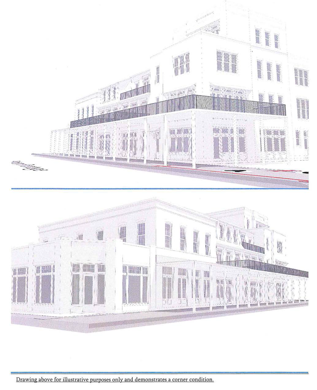
TABLE 5.1-1. ILLUSTRATIVE VIEWS FROM STREET (MIXED) T5-Core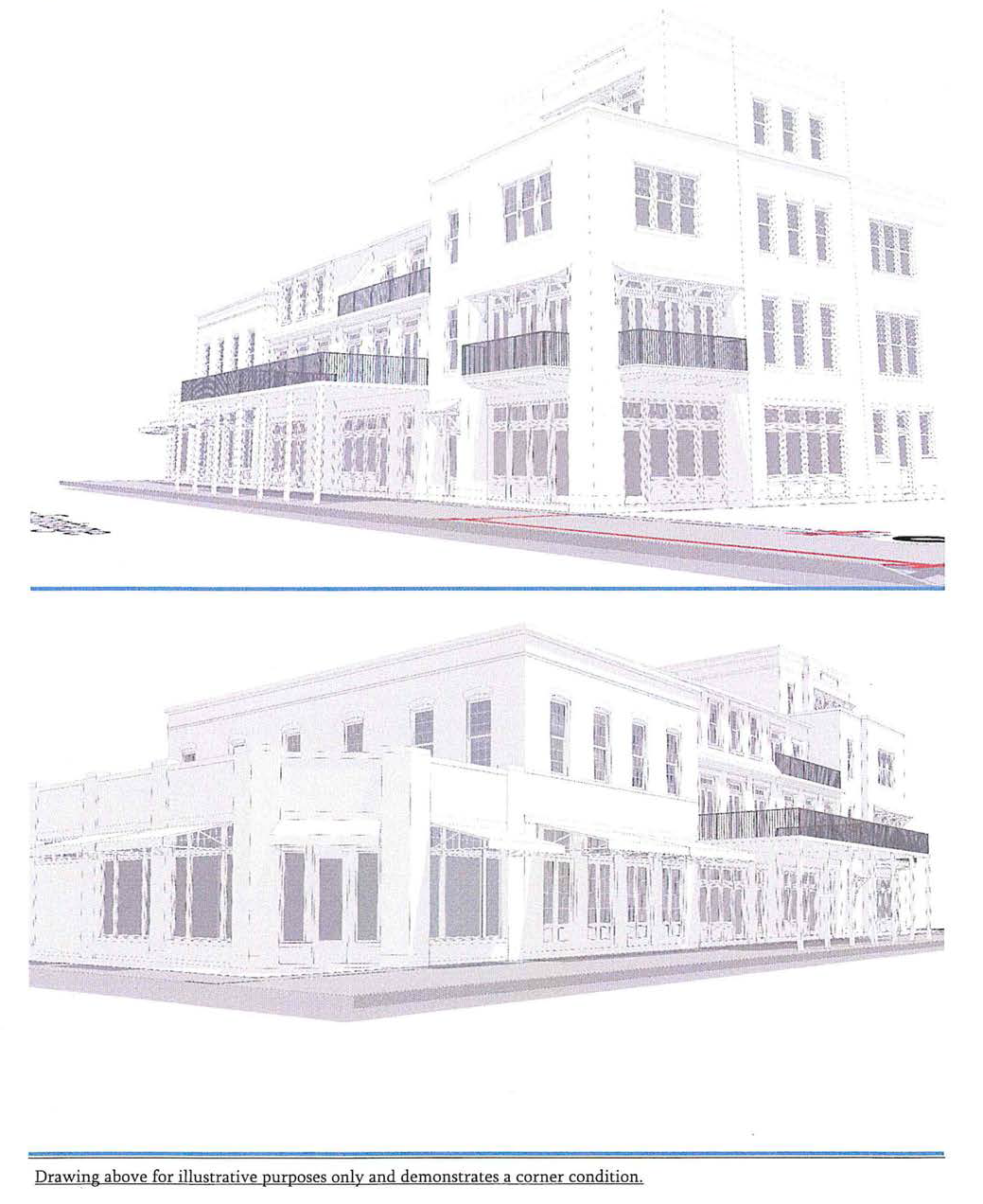
TABLE 5.1-1. SAMPLE ILLUSTRATIVE MASSING MODEL VIEWS T5-Core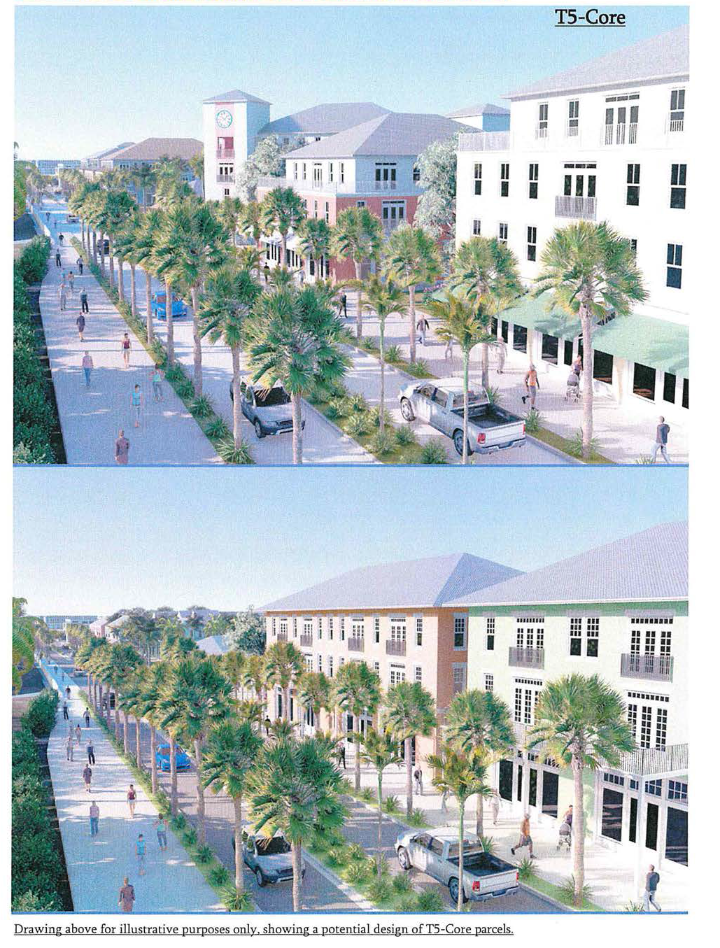
TABLE 5.1-1. SAMPLE ILLUSTRATIVE OLD 41 SECTIONS T5-Core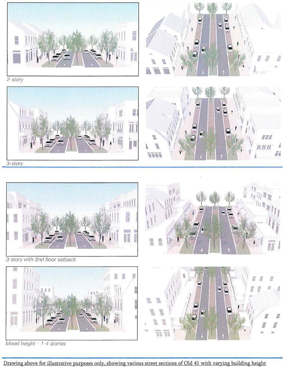
TABLE 5.1-2. DESIGN STANDARDS SUMMARY T5
SETBACKS ILLUSTRATED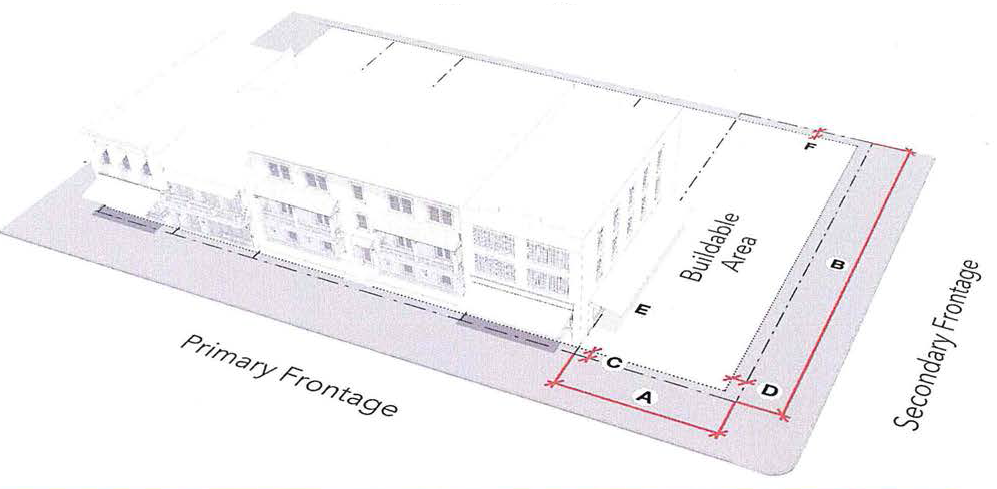
TABLE 5.1-2. ILLUSTRATIVE VIEWS FROM STREET T5
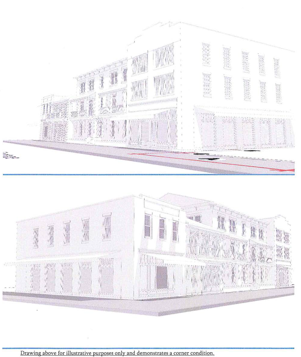
TABLE 5.1-3. DESIGN STANDARDS SUMMARY T4
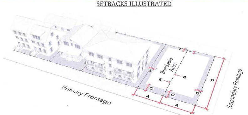
TABLE 5.1-3. ILLUSTRATIVE VIEWS FROM STREET T4
SETBACKS ILLUSTRATED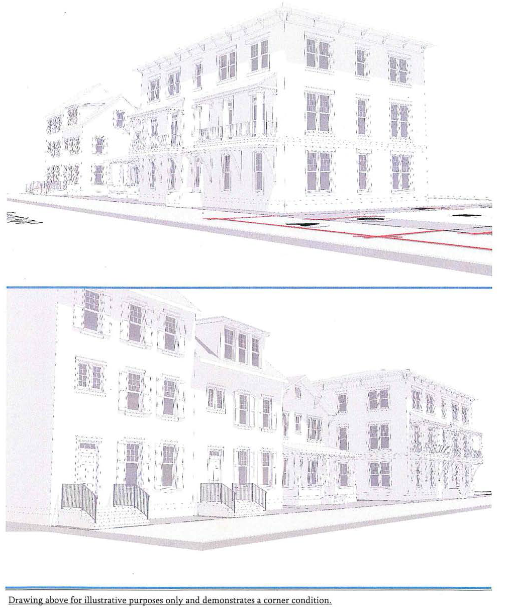
TABLE 5.1-3. SAMPLE ILLUSTRATIVE COTTAGE COURT T4
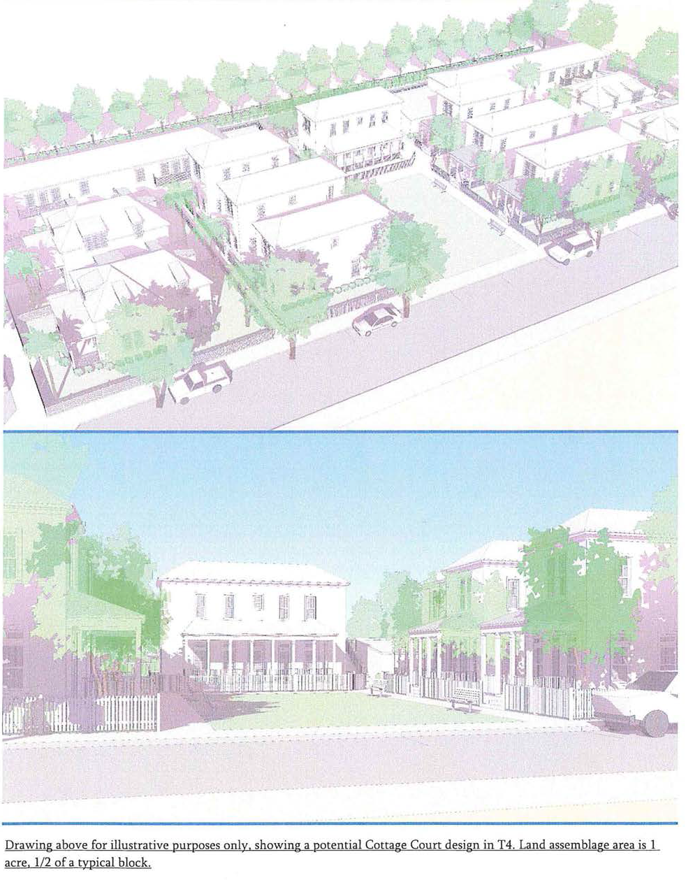
TABLE 5.1-4. STANDARDS SUMMARY T3
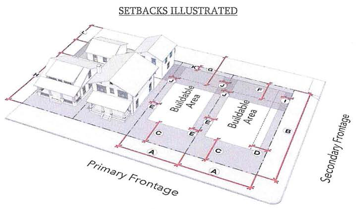
TABLE 5.1-3. SAMPLE ILLUSTRATIVE MASSING—COTTAGE COURT T3
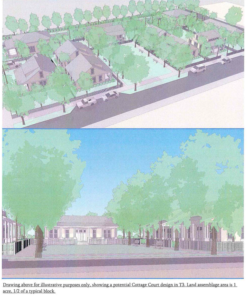
TABLE 5.1-5. STANDARDS SUMMARY T3-Restricted
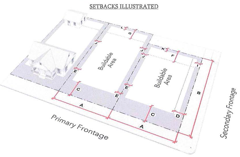
(b)
Form standards (lot size, occupation and coverage, setbacks).
(1)
Lot size must meet the minimum standards specified in Tables 5.1-1 to 5.1-5.
a.
Occupation: Buildings and covered structures are limited in the total area they may occupy as a percentage of the gross lot area as specified in Tables 5.1-1 to 5.1-5 as occupation.
b.
Coverage: Impervious surfaces are limited in the total area they may cover as a percentage of the gross lot area as specified in Tables 5.1-1 to 5.1-5 as coverage.
(c)
Required setbacks.
(1)
All structures must be set back from the lot boundaries as specified in Table 5.3-1 and Table 5.3-2, and as follows:
a.
Front specifies the setback from the front lot line.
b.
Elements that project forward from frontage facades are permitted to project into front setbacks
c.
The front lot line is the lot line associated with the address.
d.
In T5 and T4, townhouses may exceed the maximum setback when designed with a door yard frontage yard.
e.
Side street specifies the setback from any lot line abutting a street other than the front lot line.
1.
In T5 and T4, where there are multiple structures on one lot, the side street maximum setback applies to only the nearest structure
2.
Elements that project forward from frontage facades are permitted to project into side street setbacks.
f.
Side specifies the setback from side lot lines other than those qualifying for a side street setback.
g.
Rear specifies the setback from the rear lot line, except where abutting an alley.
h.
Rear alley specifies the setback from the rear lot line in instances abutting an alley.
(2)
Garages.
a.
In alley loaded configurations, where garages are part of the primary dwelling unit structure, the following conditions apply:
1.
Rear alley setback for accessory dwellings apply to the garage portion of the structure.
2.
Rear alley setback for dwellings apply to all other portions of the structure, including rooms above garages.
3.
Accessory dwelling units above garages that are separate from the principal dwelling structure are subject to the accessory dwelling setback requirements.
(3)
Setback considerations for fire access.
a.
Where fire access is provided from the alley and eave height exceeds 30 feet, additional rear alley setback may be required.
b.
Where fire access is provided from streets and eave height exceeds 30 feet, buildings may be required to be located closer to lot lines than the minimum setback.
(4)
Setback considerations for utilities.
a.
Utility easements along front, side, and side street lot lines may require additional front, side, and side street setback causing buildings to exceed maximum setbacks.
b.
Utility services provided from the alley may require additional rear alley setbacks.
c.
Utility services may require easements at front, side, side street, or rear lot lines for meters, pedestals, and other equipment requirements.
(d)
Building height.
(1)
The height of all structures is limited as specified in Tables 5.1-1 to 5.1-5.
(2)
Story measurement.
a.
Building height is measured in stories above sidewalk grade.
b.
Ground floor story heights are measured from the following:
1.
Ground floor story heights for non-residential uses shall be measured starting from 12 inches above the crown of the frontage road and must be flood proofed according to FEMA standards
i.
The ground floor shall not be located any higher than 18 inches above the crown of the frontage road
2.
Ground floor story heights for residential use shall be measured starting from the FEMA flood criteria line
i.
No more than 18 inches of fill shall be used to raise a building/site
c.
Uninhabited roofs, chimneys, cupolas, antennae, vents, elevator bulkheads, stair housings, and other uninhabited accessory elements do not count toward building height.
d.
Mezzanines exceeding 40 percent of the floor area of a tenant space or residential unit, count toward building height as additional stories.
(3)
Story height.
a.
Above ground stories are limited in height as specified in Tables 5.1-1 to 5.1-5 and as follows:
1.
Story height is measured from finished floor to finished ceiling.
2.
Story height is measured at all points within the structure.
3.
Where an above ground story exceeds the maximum story height it is counted as one or more stories by dividing the story height by the maximum story height, and rounding up.
4.
Ceiling height in bathrooms, kitchens, closets, and other ancillary rooms may be lower than minimum story height.
(e)
Building orientation.
(1)
Lots with a single building, excluding accessory dwelling units and structures less than 600 sq. ft. in footprint, are subject to the following:
a.
The principal building must be oriented parallel to the front property line or tangent to a curved front property line.
b.
The building must have a primary entry accessible from the sidewalk.
(2)
Lots with multiple buildings, excluding accessory dwelling units and structures less than 600 sq. ft. in footprint, are subject to the following:
a.
The building closest to the front property line must be oriented parallel to the front property line or tangent to a curved front property line.
b.
The building is considered the primary building and must have a primary entry accessible from the sidewalk.
c.
Accessory dwelling units and structures less than 600 sq. ft. must be behind or beside the building relative to the front property line.
(f)
Building frontage.
(1)
Frontage requirements regulate the following:
a.
The yard space between front and side street lot lines and building facades nearest those lot lines, frontage yards;
b.
Building facades nearest the front and side street lot lines, frontage facades; and
c.
Elements projecting from building facades into frontages, frontage projections.
d.
In order to encourage diversity in design, building frontages shall vary from lot to lot.
(2)
Frontage assignment.
a.
Primary and secondary frontages may be assigned on the regulating plan.
1.
Where primary and secondary frontages are not assigned on the regulating plan, they are assigned as follows:
i.
Primary frontages correspond with the lot line bearing the address.
ii.
Secondary frontages correspond with all side street lot lines.
(3)
Frontage buildout—Requirements apply to T4 and T5 zones only.
a.
Frontage buildout requires that a minimum length of frontages, primary or secondary, are lined with building facades situated between the minimum and maximum setbacks:
1.
At corner lots, frontage buildout measurements exclude the building setback in the measurement of total frontage length.
2.
In T4, frontage buildout at primary frontages must be a minimum of 60 percent.
3.
In T5, frontage buildout at primary frontages must be a minimum of 80 percent.
4.
In T5, frontage buildout at secondary frontages must be a minimum of 60 percent.
(4)
Frontage yard—Frontage yard type must be selected from Table 5.6-1 and as follows:
a.
Urban and shallow yards must be ten feet or less in depth.
b.
Door yards and fenced yards must be ten feet or greater in depth.
c.
Continuous yards must be 15 feet or greater in depth.
d.
Frontage yards are subject to the requirements specified in Table 5.6-2 and as follows:
1.
Pedestrian forecourts are limited to 2,500 square feet in area.
2.
Cottage court central courtyards must maintain a minimum of 30 feet in width between all structures and projections along the depth of the court.
3.
Cottage court courtyards have a minimum area of 1,800 square feet within the court, excluding the space between buildings and the public sidewalk.
(5)
Frontage facades.
a.
The primary building entry must be located along a frontage facade.
1.
Access to the primary building must be provided from the front property line.
2.
Glazing along frontage facades must meet the requirements specified in Tables 5.1-1 to 5.1-5 and as follows:
i.
Glazing is calculated on a per-story basis along the frontage facade.
ii.
Glazing is calculated as the percentage of the total area of glazing within a story divided by the total facade area of that story.
iii.
Window muntins and other glazing divisions less than four inches in width are considered glazed areas.
(6)
Frontage projections.
a.
Building features that project forward from frontage facades into front or side street setbacks are frontage projections.
b.
Frontage projections are limited as specified in Table 5.6-4 and as follows:
1.
Trim, cornices, eaves, plagues, mailboxes, bay and bow windows, storefront windows, and elements that are anchored to walls may project up to four feet.
2.
Signs may project into frontages.
3.
Balconies may project into frontages in T5-C and T5.
c.
Additional requirements and projection allowances by type of frontage projection are specified in Table 5.7-5.
| TABLE 5.6-2. FRONTAGE YARD TYPE REQUIREMENTS | |||
|---|---|---|---|
| Yard | Illustration | Requirements | |
| Urban | Planting | Permitted within raised containers, no minimum requirement. | |
| Surface | Must be paved and at sidewalk grade, should match sidewalk material | ||
| Fencing | Decorative aluminum fence at outdoor seating areas only | ||
|
Pedestrian
Forecourt | 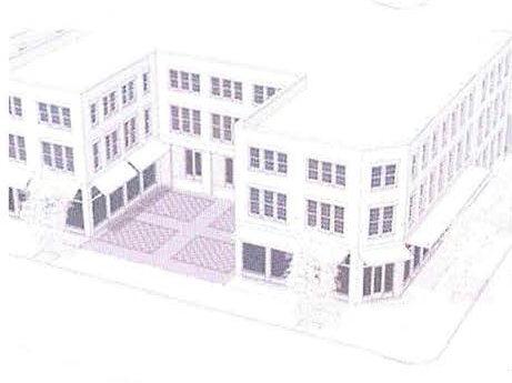 | Planting | Optional, no minimum requirement. |
| Surface | Must be a minimum of 30% paved and at sidewalk grade | ||
| Fencing | Masonry walls permitted along the frontage facade line. | ||
| Area | 2,500 square feet, max. | ||
| Shallow Yard | 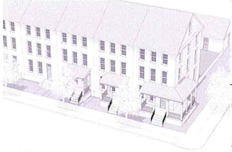 | Activation | Must be lined by habitable spaces |
| Planting | T4: 4 shrubs per 400 sf. min.; 50% min. planted surface. | ||
| Surface | Landscaped in T4, may be paved in T5 | ||
| Walkways | 1 per building entry | ||
| Door Yard | 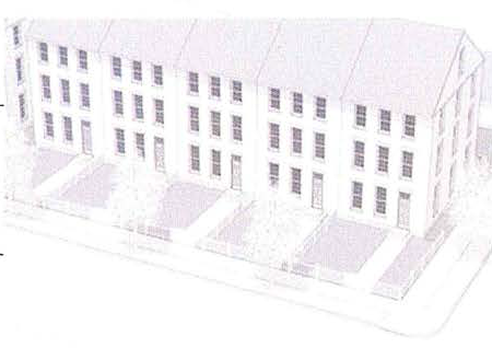 | Fencing | Permitted |
|
Planting
& Surface |
T4: 60% min. planted surface, 40% max. paved.
T5: 30% min. planted surface, 70% max. paved. | ||
| Walkways | 1 per building entry | ||
| Fencing | Required | ||
| Cottage Court | 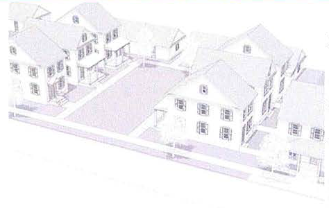 | Planting | A minimum of 50% trees should be canopy shade trees. 60% min. planted surface. |
| Surface | Landscaped, programmed spaces optional. | ||
| Walkways | Required, connecting each building entry to sidewalks. | ||
| Fencing | Frontage fencing permitted at streets and to define yards for each unit. | ||
| Fenced Yard | 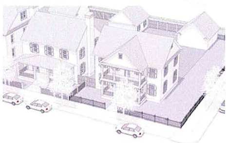 | Planting | A minimum of 50% trees should be canopy shade trees. 60% min. planted surface. |
| Surface | Landscaped, paving limited to walkways, driveways, and terraces | ||
| Walkways | 1 per building entry | ||
| Fencing | Required along front and side street property lines | ||
| Continuous Yard | 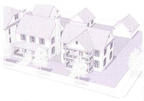 | Planting | A minimum of 50% trees should be canopy shade trees. 70% min. planted surface. |
| Surface | Landscaped, paving limited to walkways, driveways, and terraces | ||
| Walkways | 1 per building entry | ||
| Fencing | Permitted at frontage facade lines, not permitted along front or side street property lines. | ||
(g)
Building elements and encroachments.
(1)
Buildings should be designed in proportions that reflect human-scaled pedestrian movement, and to encourage interest at the street level.
(2)
Building entries shall be as follows:
a.
Building entrances shall be clearly visible from the street.
b.
One building entry shall be provided every 80 feet of facade leading to a habitable space.
c.
Entries for multifamily buildings shall provide protection from the elements with canopies, marquees, recesses or roof overhangs.
d.
Residential building entries at grade are restricted as follows:
1.
Single-family residential buildings shall be raised above average grade according to Table 5.7-1 Facade Types.
2.
Multi-family residential buildings shall be raised above average grade according to Table 5.7-1 Facade Types. In no instance shall the entry be raised less than 18 inches. The entry may need to be raised to comply with FEMA flood regulations.
3.
Mixed-use and non-residential building entries shall be at sidewalk grade unless located within a FEMA flood zone.
i.
Mixed-Use and commercial buildings should keep the entry at sidewalk grade, raise glazing above the flood line, and flood-proof the commercial space.
(3)
Facade types shall be as follows:
a.
Facades shall be assigned along frontages and are limited by type according to Table 5.7-1 Facade Types.
b.
Projections into all setbacks are permitted as follows, but not beyond the property line:
1.
Roof overhangs, cornices, window and door surrounds and other facade decoration may project up to two feet.
2.
Where permitted, shading devices may project into the front setback up to the property line with a minimum eight foot clearance.
3.
Balconies may project up to five feet.
4.
Bay windows may project up to three feet.
5.
Porches and stoops may project according to 5.7-1 Facade Types.
| TABLE 5.7-1: FACADE TYPES | ||
| A: Porch | ||
| Entry grade | Minimum 18 inches above grade | |
| Requirements |
• Required at the primary building entrance.
• Porches shall be a minimum 6 feet in depth. • Porches and related structures may project into front setbacks a maximum 10 feet. • Porch openings shall be vertical in proportion. • Porches shall be a maximum 10 feet in height. Columns should have a diameter between 1/9th and 1/14th their height. | 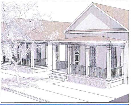 |
| B: Stoop | ||
| Entry grade | Minimum 34 inches and a maximum 48 inches above grade | |
| Requirements |
• A stoop is required at building entrances, projecting from the facade.
• Wood is prohibited for stoop railings. • Stoops and related structures may project into front setbacks up to 100%. | |
| C: Common Entry | ||
| Entry grade | Minimum 18 inches and a maximum 24 inches above grade (exception to maximum may be made for FEMA Flood requirements) | |
| Requirements |
• A single collective entry to a multi-family lobby is required at the primary building
entrance.
• Canopies and awnings are permitted to project into front setbacks up to 100% of their depth. | 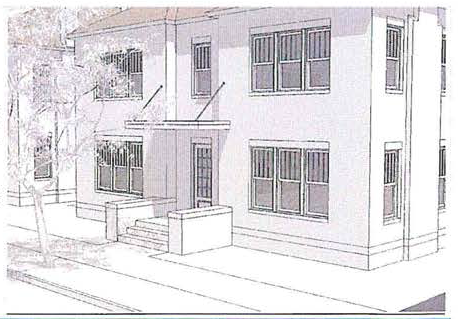 |
| D: Gallery | ||
| Entry grade | At sidewalk grade | |
|
Requirements
(see section 4-870(g)) |
• Where a gallery occurs, it is required along a minimum of 80% of the frontage.
• Encroachments are permitted according to section 4-870(g) • Awnings are not permitted in galleries • Ground floor flood proofed if in FEMA flood zone | |
| E: Storefront | ||
| Entry grade | At sidewalk grade | |
|
Requirements
(see section 4-870(g)) |
• A storefront is required at the primary entrance of the tenant space.
• A minimum 70% of the ground floor of a storefront shall be glazing • Ground floor flood proofed if in FEMA flood zone | 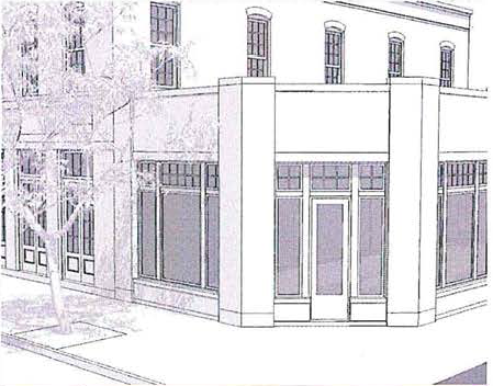 |
(h)
Building encroachments.
(1)
Encroachments located within the public right-of-way shall comply with any clearance standards established by FDOT or the City of Bonita Springs Public Works and Facilities Department.
(2)
Awnings and canopies are restricted as illustrated in Figure 5.8-1 and per the following:
a.
Awnings and canopies may project into the public right-of-way, up to two feet of the curb.
b.
Awnings and canopies shall be a minimum of six feet in depth and have a minimum of eight feet of vertical clearance.
FIGURE 5.8-1: AWNINGS AND CANOPY ENCROACHMENTS ILLUSTRATED
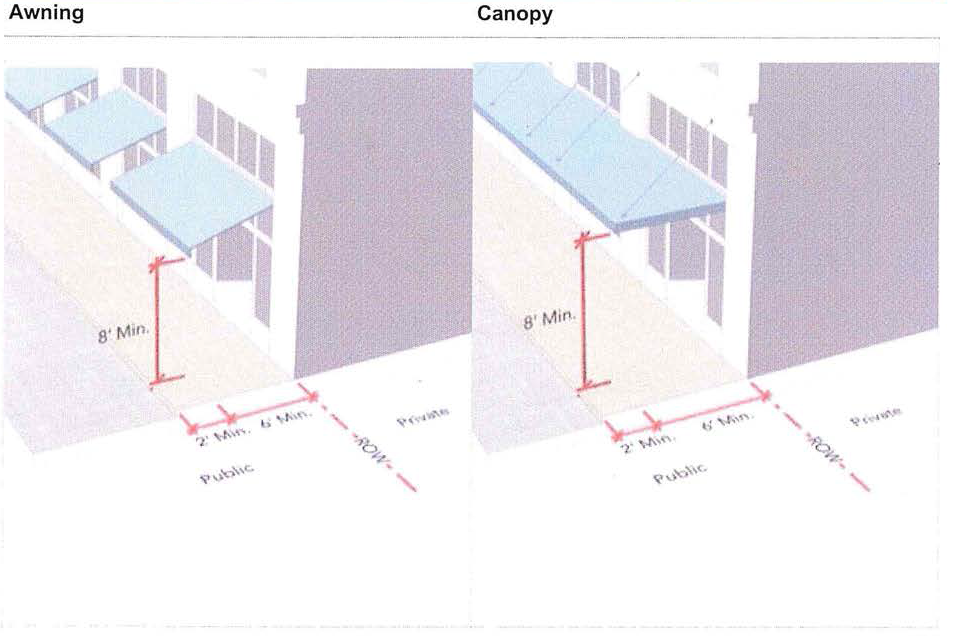
(3)
Galleries are restricted according to Figure 5.8-2., and as follows:
a.
Shall be a minimum of eight feet in depth and a minimum of 12 feet in height, maintaining a 1.2:1 to a 2:1 height to width ratio, as illustrated in Figure 5.8-2.
b.
Gallery columns should have a diameter between 1/9th and 1/20th their height, measured from the base to the bottom of the entablature, as in Figure 5.8-2.
c.
Galleries should encroach into building setbacks.
d.
Galleries should encroach over sidewalks.
e.
Where galleries encroach over sidewalks, they shall not extend beyond two feet of the curb.
f.
Galleries shall not change height or width along a building facade.
FIGURE 5.8-2: ENCROACHMENT FOR GALLERIES ILLUSTRATED
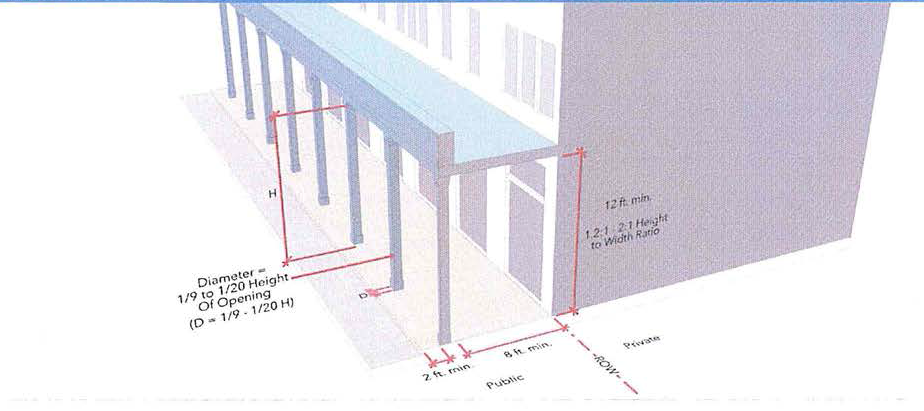
(i)
Parking access, design and reductions.
(1)
Vehicular parking location and access: T3-R.
a.
Driveways are limited as follows:
1.
Driveway width is limited to a maximum of 12 feet;
2.
Driveways accessing multiple garage doors may be up to width of the garage within 20 feet of the garage doors;
3.
Driveways may have a single point of access or two points of access in a loop.
4.
Lots with side street lot lines should provide parking access from that lot line.
5.
Lots with alley access must provide parking access from the alley.
b.
Carports and covered parking:
1.
Carports and covered parking are permitted.
c.
Garages:
1.
Individual garage doors are limited to a maximum width of ten feet.
2.
Garages must be configured in one of the following orientations:
i.
Type 1: Independent of the dwelling.
ii.
Type 2: Front-entry, set back from the dwelling facade.
iii.
Type 3: Side-entry, within the main dwelling massing.
iv.
Type 4: Side-entry, forward of the main dwelling massing.
3.
Type 1 garages are subject to the following requirements:
i.
The garage must be detached from the dwelling a minimum of ten feet.
ii.
Where the garage is closer to the front property line than the dwelling:
iii.
Vehicular entry movement must be parallel with the front property line.
iv.
A minimum of one window must be installed on the garage facade, facing the front property line.
4.
Type 2 garages are subject to the following requirements:
i.
The garage must be set back a minimum of ten feet from the principal dwelling facade, excluding projections.
5.
Type 3 garages are subject to the following requirements:
i.
The garage should be set towards the rear of the main dwelling volume.
ii.
The garage may not extend forward of the main dwelling volume.
iii.
Where the garage is located parallel with the dwelling front facade, a minimum of one window must be installed on the garage facade, facing the front property line.
6.
Type 4 garages are subject to the following requirements:
i.
Vehicular entry to the garage must be parallel with the front property line.
ii.
A minimum of one window must be installed on the garage facade, facing the front property line.
(2)
Vehicular parking location and access: T3 and T4.
a.
On-street parking spaces located along lot lines count towards minimum required parking.
b.
Off-street parking may be provided individually or clustered within the same block.
c.
Driveways are limited as follows:
1.
Driveways providing parking access to four or fewer units are limited to a maximum of 12 feet in width.
2.
Driveways providing parking access to more than four units are limited to a maximum of 22 feet in width.
d.
Garages within the front half of a lot are limited to a maximum width of 30 percent of the lot width.
e.
Carports and covered parking are permitted in off-street parking areas and must be located behind buildings relative to front lot lines.
f.
Parking access is permitted as follows:
1.
Where alleys abut any property line for individual or clustered properties, on-site parking must be accessed from an alley.
2.
Lots or clustered properties without alley access with any side street lot lines must access parking from a side street lot line.
3.
Lots without alley access or side street lot lines may access parking from the front lot line, limited to one access point adjacent to a side lot line.
4.
Clustered properties without alley access or side street lot lines may access parking from the front lot line, limited to two access points, each along a side lot line.
5.
Off-street parking must be located behind buildings relative to the front lot line.
6.
Off-street parking serving clustered properties must be located as follows:
i.
Parking must be a minimum of ten feet behind the facade of the nearest building to front and side street lot lines.
ii.
Parking must be shielded from front and side street lot lines by buildings or frontage facade fencing.
(3)
Vehicular parking location and access: T5.
a.
Minimum required parking may be provided as follows:
1.
The required parking may be provided off site, provided the site is approved by the city manager or designee and the number of required off-street parking spaces may be reduced by no more than one-third, if supported by a parking study submitted by the applicant.
2.
Developers may pay a fee in lieu of providing the required spaces. The fee shall be based on the average cost of constructing a surface parking space in the zone, as determined in an applicable administrative code, until such time as surface parking spaces are determined to be infeasible due to land availability in the zone. Said fee shall be a one-time payment, to be placed in the redevelopment trust fund and shall be utilized for parking and other public improvements that benefit the Zone.
3.
Developers may provide valet parking program for commercial and mixed-use projects in accordance with the requirements set forth in the administrative code to offset a maximum of 50 percent of the required parking spaces. Valet parking programs may not be utilized to offset parking requirements for stand-alone residential development.
4.
Approved on-street parking along the corresponding frontage(s) of the site shall count 100 percent towards the parking requirements. Off-street parking must be located behind buildings relative to front lot lines.
(4)
Vehicular parking location and access: S-DID
a.
Parking placement and design shall be subject to the review process for special assemblage plans. Approved on-street parking along the corresponding frontage(s) of the site shall count 100 percent towards the parking requirements.
b.
Off-street surface parking adjacent to side street lot lines must be lined or screened as follows:
1.
One or more liner buildings should be located along the sidewalk as generally illustrated in Table 5.9-2(b);
2.
In the case that liner buildings are not feasible, parking must be screened with a street screen as generally illustrated in Table 5.9-2(a) and as follows:
i.
The street screen must meet the fencing standards for T5;
ii.
The street screen may be interrupted for pedestrian and vehicular access.
c.
Off-street structured parking must be lined or screened as follows:
1.
One or more liner buildings, a minimum of 20 feet in depth, should be located along the sidewalk, screening the parking structure from the sidewalk
2.
In the case that liner buildings are not feasible, parking must be screened by use of planting, glazing, or with regularized openings resembling glazing
3.
The ground floor of the parking structure must include habitable spaces along sidewalks;
4.
Ground floor habitable spaces may be interrupted for pedestrian and vehicular access;
5.
Ground floor habitable spaces must be designed with shopfronts.
6.
Openings above the ground floor must meet the window proportion and minimum glazing requirements. Openings count towards minimum glazing.
7.
Along designated main streets, structured parking must be lined.
d.
Adjacent lots providing off-street parking and district managed parking lots must be supplied with vehicular and pedestrian connections to any on-site parking areas.
e.
Carports and covered parking are permitted in off-street parking areas.
f.
Along side-street lot lines, parking must be shielded by buildings or frontage facade fencing.
g.
Parking access is permitted as follows:
1.
Where alleys abut any property line, access to on-site parking must be provided from the alley.
2.
Lots with side street lot lines may provide one access point from each side street lot line.
3.
Lots without alley or side street lot line access may provide one access point from the front property line.
4.
Where more than one access point is required for circulation, access points should be located along different property lines.
h.
Driveways are limited to a maximum of 22 feet in width.
TABLE 5.9-2. LINED AND SCREENED PARKING
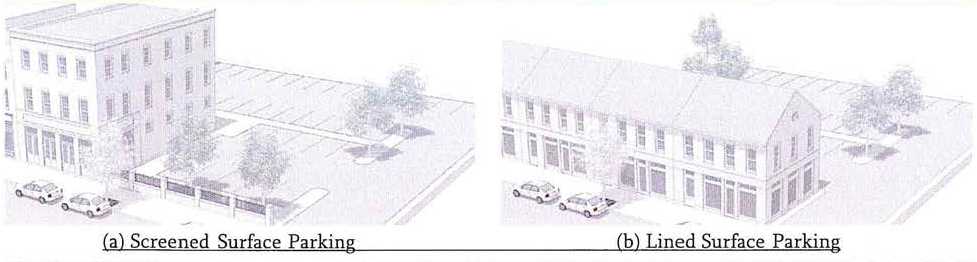
(4)
Required vehicular parking.
a.
Parking is required for each residential dwelling unit in the amounts specified in Table 5.9-3.
b.
Multi-family residential parking provided on site may not exceed 200 percent of the minimum parking requirement, excluding on-street parking spaces.
c.
Parking is required for each non-residential use in the amounts specified in Table 5.9-4.
d.
Parking for assembly uses, schools, and libraries is required in the amounts specified in the City of Bonita Springs Land Development Code.
e.
Shared parking provided by the city may exceed maximum parking ratios to provide for future uses and events.
(5)
Required vehicular parking adjustments.
a.
Shared parking.
1.
Shared parking may be used to adjust down the number of required parking spaces within a single site or within a city parking lot.
2.
Within a single site, shared parking may only be applied to uses within the site.
3.
Within a city parking lot, shared parking is limited as follows:
i.
Shared parking is calculated collectively for all shared parking lot uses;
ii.
Uses must be within 800 feet (measured along the pedestrian circulation route) of the shared parking lot, except when within a special district;
iii.
On-street parking spaces included within the shared city parking lot are limited to those located along the block-face of uses accounted for in shared parking calculations.
4.
Shared parking reductions are calculated using Table 5.9-5 and as follows:
i.
The number of required spaces for each use as determined in Section 5.9.4 is entered into the yellow column;
ii.
For each use and time of day, the number of required parking spaces is multiplied by the occupancy rate listed, entered into the red columns;
iii.
Each column is summed vertically in the green row;
iv.
The adjusted minimum required parking spaces is the highest result within the green row.
(6)
Vehicular parking lot design.
a.
Parking lots must have a minimum vertical clearance of eight feet, and 15 feet where the facility is to be used by trucks or for loading or along a garbage collection path.
b.
Parking deck floor levels shall align with floor levels of attached habitable space
c.
Compact stalls may account for up to 40 percent of off-street spaces in each parking lot.
d.
Drive aisles must meet the minimum size requirements as specified in Table 5.9-6.
e.
Parking stalls must meet the minimum size requirements as specified in Table 5.9-7.
(7)
Vehicular parking lot landscaping.
a.
Parking lot landscaping is required as specified in the City's Land Development Code.
b.
Bicycle parking location and access: T5
1.
On-street bicycle parking spaces may be provided by the city. Allocation of shared spaces towards individual requirements is determined by the city.
2.
Minimum required bicycle parking may be provided as follows:
i.
Provided by the city, on-street or in shared parking lots within 400 feet of the use;
ii.
Provided on-site independent of the city;
iii.
Both provided from the city and on-site.
3.
Off-street bicycle parking must be located within buildings or behind or to the side of buildings relative to front lot lines.
(8)
Required bicycle parking.
a.
Bicycle parking is required in the amounts specified in Table 5.9-8, and as follows:
1.
A minimum percentage of spaces must be enclosed for each use;
2.
Enclosed spaces for multi-family residential must be located:
i.
In a common area on the ground floor;
ii.
In the ground floor of a separate structure on the same site;
iii.
In the ground floor of an attached structure.
3.
A maximum percentage of spaces may be located on-street for each use.
(j)
Fences and walls—Fencing and walls.
(1)
The following fencing is prohibited:
a.
Electric, barbed wire, razor wire, hog wire, rolled wire, or other types of hazardous fencing;
b.
Chain link fencing;
c.
Any wire smaller in size than 12 gauge.
(2)
Fence and wall height is limited as specified in Table 5.10-1 and as follows (see Table 5.10-3 for terminology):
a.
Frontage fencing and walls must be located as follows:
b.
Fencing and walls must be a minimum of four inches from public sidewalks in all instances.
c.
Fencing and walls must be within three feet of frontage lines.
d.
Fencing and walls over three feet in height must be set back from the street-side edge of sidewalks as least two feet plus the minimum sidewalk width specified by FDOT for the street type designation.
e.
Where the desired appearance is fencing and walls with zero setback from sidewalks, a sidewalk extension may be provided on the private lot, in which case a control joint is required to separate the public and private sidewalks.
f.
Fencing and walls along side and rear property lines within frontages is considered frontage fencing and walls.
(3)
Fence and wall materials are limited as specified in Table 5.10-2.
(4)
Metal and iron fencing must be black.
(5)
Masonry walls may be combined with decorative metal or wrought iron with the masonry portion below and optionally forming pillars.
TABLE 5.10-3. FENCING TERMINOLOGY
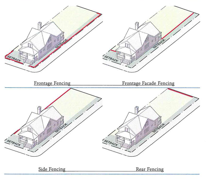
(k)
Accessory dwelling units.
(1)
Accessory dwelling units (ADUs) are permitted where specified in section 4-868: Use.
(2)
ADUs may be provided in the following locations:
a.
Within or attached to the primary dwelling structure;
b.
Above a free-standing garage;
c.
As an independent, free-standing accessory dwelling.
(3)
ADUs are limited to a maximum area of 800 square feet.
(4)
ADUs must have an entry independent of the primary dwelling, accessible from a sidewalk or from a rear alley where possible.
(l)
Exterior lighting.
(1)
General.
a.
Fluorescent and compact fluorescent lights are prohibited on the exterior of structures, including within open porches and stoops.
b.
Exterior lights should have a color temperature below 3,200 kelvin.
c.
Exterior lighting must include controls to automatically extinguish lighting when sufficient daylight is available.
d.
Exterior lighting should include controls to automatically lower lighting lumens by 30 percent or more after 10:00 p.m., except in the following conditions in T5;
1.
Landscape lighting where a single exterior luminaire is provided such as at residential front doors; and motion activated lighting.
(Ord. No. 20-10, § 2(Exh. A, § 5), 11-4-2020; Ord. No. 21-02, § 2(Exh. A), 5-19-2021)
Sec. 4-871. - Architectural character.
(a)
Building materials.
(1)
The exterior finish material on all facades of a building or project shall be consistent around the project. A building or project may utilize any number of wall materials provided they respect the following guides:
a.
Primary materials include any materials (not including windows, doors, or storefront materials, awnings and such) that face the majority of the building facade. Such materials include but are not necessarily limited to brick, wood or hardboard siding, stucco, stone, concrete, and finished concrete block. The primary materials shall not include any materials listed as secondary materials.
b.
Secondary materials are those that complement the primary materials but are limited to 20 percent or less of the materials on the facade.
c.
Accent materials are very limited in quantity and are for accent purposes only.
d.
Materials that may constitute secondary or accent materials include, but not limited to:
1.
Corrugated metals or corrugated metal panels.
2.
Unpainted or natural concrete block.
3.
Metal standing seam or raised panels.
4.
Wood siding.
e.
Prohibited materials include vinyl or aluminum lap siding or other imitation materials; and mirrored or reflective materials.
f.
Project or building architects may present in lieu submittals to the reviewer for variations from the above for both use of materials and colors.
g.
All stucco, metal, and wood at galleries, porches, stoops, and balconies visible from a public way shall be primed and painted. Wood floor decking may be stained or left unpainted.
(2)
Exterior colors. Effective March 1, 2013, all development, redevelopment, renovation and restoration projects within the Downtown District must follow the designated color palette as set forth in section 4-880, specifically designated as Sherwin Williams Exterior Coastal Colors for Southern Shores and Beaches, or paint from another manufacturer of similar color and quality. In addition to the designated color palette, owners of property may also consider the exterior pastel colors as also set forth in section 4-880. Owners of property within the applicable area shall paint their buildings to conform to the aforesaid color palette in accordance with the following procedures:
a.
There are 24 sets (three colors each) in the palette, and ten pastel shades. The painting of building exteriors will use the body, trim and accent from the same set in the approved palette colors. If a property owner selects one of the ten pastel shades for the body of the structure, the owner will comply with the following guidelines:
1.
The body of the structure should have a base lighter than any selected trim or accent, unless the trim or accent is painted white.
2.
No more than two additional colors should be selected in a darker pastel or white for trim and accent.
3.
Not all architectural styles are appropriate for pastel colors. Pastel colors may be attractive on Florida (Cracker) Vernacular Architecture, Post-War Modern and Art Deco design. The reviewer may deny the use of the pastel shades if it is incompatible with the existing or planned structure intended to be painted, subject to city council review.
4.
The reviewer is authorized to approve minor "shading" variations in palette colors that may be caused by the use of paint from different manufacturing companies. Any other change in palette colors may be approved on a case-by-case basis.
5.
Buildings in single ownership, including sheds and accessory structures, shall be of uniform facade and trim color, with exception to gazebos.
6.
Upon the completion of the exterior painting of any building, the property owner shall provide community development with a color facade photograph (preferably by email).
7.
The city may adopt an incentive plan for property owners to paint the entire exterior of their building by administrative code.
8.
It is not the intent of implementing the color palette to discourage placement of any murals, as approved by the arts in public places board.
(b)
Openings and walls.
(1)
Massing and composition. The size of a building is independent of its scale. The scale can be modified by articulation.
a.
Overly long buildings should be broken down to a scale comparable to that of the buildings on the rest of the block face. This can be accomplished by articulating the overall building height while keeping a uniform story height. This shall be mandatory for buildings which are a result of a lot assemblage where the principal frontage is over 100 feet in length. Building wall articulations in plan, such as recesses and projections, shall be limited to four per each 100 feet length.
b.
Scale is most effectively modified when the various integral elements of the facade (windows, balconies, loggias and parapets) support the articulation.
1.
Architects should avoid too many individual elements on a single elevation
2.
Architects shall use a small number of well-built elements for all openings and attachments.
c.
The frontages of new buildings shall be harmonious with the block face on both sides of its street. The existing buildings will provide the design context unless they are non-conforming or non-contributing. Applicants are expected to provide drawn and/or photo documentation of the block faces with the frontage proposed building drawn within its urban context.
(2)
General composition.
a.
Residential structures shall have a limit for facade openings. 15—35 percent of an individual facade area can be used for openings (except for ground floor storefronts, see Tables 5.1-1 and 5.1-2)
b.
Opening should be evenly spaced along a facade to create a harmonious composition
c.
Window and door header heights should be consistent along a facade
d.
Windows and doors should be recessed from the facade; not attached to the exterior
(3)
Glazing.
a.
Storefronts shall not have tinted (greater than ten percent), mirrored, reflective, or colored glass on doors or windows.
b.
Storefronts shall have vertically proportioned lights/panes.
(4)
Doors.
a.
All storefront doors shall remain unlocked during business hours
b.
Garage doors shall be in accordance with section 4-870(i).
(5)
Windows.
a.
Shall be vertically proportioned and rectangular in shape.
b.
Shall use vertically proportioned panes.
c.
Should use vertical subdivisions to break up horizontality of window assemblages.
d.
Window sills shall be a minimum of 36″ above grade for ground floor buildings.
e.
Bay windows shall extend to the ground or be supported by wood or concrete brackets of appropriate scale. Sides shall return to the building wall at a 45° or 90° angle. Bay window walls may be faced in wood or hardboard siding.
f.
Prohibited: Window-mounted air conditioning units; applied door or window moldings.
g.
All shutters should be operable and useable.
1.
If non-operable, the shutters shall be of proportions which are identical to an operable shutter for the window. Shutters shall be made of wood or constructed of composite PVC in louvered panel, solid panel, or board-and-batten construction. Molded PVC shutters are prohibited.
(6)
Arches and piers.
a.
Arches and piers shall be made of stuccoed concrete/masonry and shall be no less than 12 inches in thickness. Wood structural posts shall be no less than six inches by six inches nominal dimension.
b.
Piers, columns, and posts shall be spaced to form square or vertically proportioned bays.
c.
Arches shall have columns/bases which are no wider than 20 percent of the arch opening.
d.
Height of arch springline shall be located at the same or a higher elevation than the storefront header.
e.
Segmented arches shall have the radius of the segment equal to the width of the opening. Full arches shall have the radius of the arch equal to one-half the width of the opening.
(c)
Screening.
(1)
No rooftop mounted mechanical equipment shall be visible as viewed from any public right-of-way at ten-foot eye level. All such equipment shall be screened by an appropriate method.
(d)
Roofs.
(1)
Visible roofs. Buildings with sloped roofs visible from any public right-of-way shall have symmetrical pitched roofs with slopes no less than 5:12. Porches and first floors and dormers may have shed roofs with pitch no less than 2:12. Flat roofs shall provide parapets sufficient to screen mechanical equipment from any public right-of-way.
(2)
Roof materials. Roof materials should be appropriate for the function they are to serve as well as appropriate to the overall expression of the building or project. Standing seam metal is the recommended material for sloped roofs.
(3)
Prohibited: Skylights in pitched roofs when visible from the street; Precast cornice moldings.
(e)
Porches, stoops and balconies.
(1)
Porches, stoops, and balconies shall be made of stuccoed concrete/masonry or wood. Stucco finish shall match building wall finish. Flooring at entry stoops, porches, and steps shall be made of wood, exposed concrete, concrete pavers, brick, or colored cement tile. Tile and brick selection is subject to approval of reviewer.
(2)
Porch and stoop roofs may be exposed or closed with wood deck or panel-and-batten ceiling.
(3)
Stoops are permitted at all building entries and may be covered by roofs, awnings or canopies. Stoops shall be no greater than eight feet in length or depth.
(4)
Balconies may be recessed into the main volume of a building for a maximum 50 percent of their depth. Any part of a balcony that projects beyond the building wall shall be structurally supported by concrete beams or profiled sills, or wood beams or brackets of appropriate scale.
(Ord. No. 20-10, § 2(Exh. A, § 6), 11-4-2020; Ord. No. 21-02, § 2(Exh. A), 5-19-2021)
Sec. 4-872. - Storefronts and signage.
(a)
Unified storefront design: The storefront windows, doors, signage, awnings, details and lighting shall be designed as a unified composition.
(1)
Storefront walls: Storefronts shall be built of wood, brick, concrete siding, stone, custom metal work or steel frame. Storefronts shall not be constructed of extruded aluminum frames or panels.
(2)
Storefront windows: First floor facades shall be a minimum of 70 percent clear glass as measured between the floor and ceiling including the glass area of the front door. Storefront glass shall be clear with no more than ten percent tinted. Reflective glass shall not be permitted along any commercial street. In flood-prone areas, glazing should not extend below the prescribed height to allow for easier flood proofing of the commercial space without having to raise the entire finish floor above the flood line.
(3)
Entrance doors: Storefront entrance doors shall be recessed to allow the door to swing out without obstructing pedestrian flow on the sidewalk. Each tenant space shall have at least one three-foot wide door at the main entry. Storefront entrances shall be encouraged at building corners. Where appropriate, sliding or folding doors that allow the activity of the business to open adjacent to and onto the public sidewalk may be installed for restaurants and food services. Rear and side doors facing service alleys and parking lots are encouraged, but not required.
(4)
Bulkheads: Storefronts shall have a minimum 12-inch high masonry kick plate or bulkhead along all street frontages. Storefront bulkheads shall be a maximum of 36 inches above the adjacent sidewalk except for when required for flood-proofing within the Imperial River floodway. Bulkheads shall be designed as an integral component of the overall storefront.
(5)
Sign bands: Storefronts shall have a horizontal sign band at the top of the first floor window. Sign bands shall be an integral design with the storefront's elevation and details, and may be a contrasting color to the building. Sign bands may be up to 12 inches in height and may extend the entire length of the storefront. Sign bands shall not be internally illuminated but may be externally lit subject to the approval of the city.
(6)
Security gates and shutters: Solid metal security gates and solid roll-down shutters shall not be permitted. Interior link or grill security devices may be permitted if they can be completely enclosed or hidden from view when not in use, and subject to the approval by the city.
(7)
Design for tenant flexibility: The design of first and second floor commercial spaces should anticipate restaurant requirements. Accommodation for restaurant venting and sewage utilities such as grease traps and interceptors should be designed into the building. Designs shall anticipate potential commercial power and gas load needs. In addition, buildings shall provide maximum clear space between interior columns for the ground floor retail and activity spaces.
(8)
Store heights: All first floors of commercial buildings shall have a minimum of 14-foot tall ceilings as measured between the finished floor and finished ceiling.
(9)
Outside commercial uses: Temporary exterior commercial uses, seating, dining and displays along the storefront's adjacent sidewalks are encouraged subject to approval by the city. All temporary displays shall maintain a minimum clear pedestrian walkway of five feet.
(10)
Galleries at retail frontage in T-5 zone shall be continuous along frontage and made of metal. Decking at second- and third-story floors shall be made of wood, and railing shall be made of metal.
(11)
Awning materials: Canvas, glass or metal awnings are encouraged and should be coordinated with the top edge of the ground floor windows and doorframes.
(12)
Awning configuration: Awnings shall be a metal armature stretching a non-translucent membrane without side or bottom soffit panels. They shall consist of sloping squares or rectangles without side or bottom soffit panels and shall not be backlit from under or inside. Edgeless awnings are encouraged. External lighting of awnings may be permitted with the approval by the city.
(13)
Awnings shall be a minimum of 60 inches wide by 60 deep, and shall not extend closer than two feet to the edge of the adjacent street curb. All awnings shall be integral to the overall design of the storefront and shall respect vertical column and window spacing. Awnings shall be at least seven feet high from the adjacent sidewalk.
(14)
Round, half domed and plastic awnings are prohibited. Awnings shall not be used as signs, except as noted below, and shall have a maximum slope of 1:3 from the building to the edge. Awnings shall have a maximum of two colors subject to the approval by the city.
(15)
Outdoor dining areas on sidewalk and public rights-of-way shall be allowed subject to the following standards:
a.
Outdoor dining areas shall be separated from public walkways and streets using railings, wrought-iron fences, planters, and landscaping; and
b.
A minimum unobstructed pedestrian path of at least six feet wide shall be provided along public rights-of-way.
(b)
Exempted signs. The signs specified in this section shall not require a sign permit provided that the sign complies with the standards prescribed hereunder:
(1)
Changeable copy, in accordance with LDC Section 6-4(c)(1), maintenance in accordance with Section 6-4(c)(2), or the repainting of a sign shall not require a sign permit provided no structural and electrical changes are made.
(2)
Signs erected entirely within the confines of a nonresidential or mixed-use site shall not require a sign permit, provided the sign cannot be viewed from streets or common property.
(3)
Address and residential identification signs as defined in LDC Section 6-2;
(4)
Holiday decorations, provided the decorations comply with LDC Section 6-6(1)(g), (h);
a.
Holiday decorations, flags, streamers, and similar.
(5)
Flags, in accordance with LDC Section 6-6(1)(d);
(6)
Governmental and public safety signs, in accordance with LDC 6-6(1)(f);
(7)
A-frame signs provided the signs are utilized in accordance with the regulations of Table 7.6-1 and 7.6-2;
(8)
Residential construction signs, subject to the following:
a.
One construction sign shall be permitted per construction project on each street frontage. The sign shall be erected no more than five days prior to any construction of the project, shall be confined to the site of construction, and shall be removed prior to the issuance of a certificate of occupancy.
b.
Construction signs may denote the architect, engineer, contractor, subcontractor, owner, future tenant, financing agency, or other persons performing services or labor or supplying materials to the premises.
(9)
Residential rental signs, subject to the following:
1.
One sign may be attached to the house or mounted in the yard, provided that all signs must be removed once the residence is rented for a 60-day period of longer.
2.
Signs are limited to four square feet in area.
(10)
Warning and instructional signs.
a.
Any posted property sign, as defined in LDC Section 6-2, which pertains to the parcel of property upon which it is located, provided any such sign does not exceed four square feet in copy area and is not illuminated.
b.
Any business information sign, as defined in LDC Section 6-2, provided any such sign does not four square feet in copy area.
(11)
Miscellaneous signs.
a.
Any memorial sign, or tablet, in accordance with 6-6(1)(l);
b.
Any generic, architectural feature that is designed, integrated, and constructed as part of a building in accordance with a building permit or local development order approved by the city.
(c)
Prohibited signs and sign locations. The following signs specified in this section are prohibited.
1.
Billboards (replacements subject to LDC Ch. 6).
2.
Any sign advertising products or articles that are not manufactured, assembled, processed, repaired, serviced or sold on the premises.
3.
Two or more signs that convey a single, cumulative advertising message, part of which is contained on each sign in the series.
4.
Illuminated, animated, or inflatable signs.
5.
Any sign that simulates emergency lights on emergency vehicles, traffic-control signals or devices, directional, informational, or warning signs erected by the POA, a government, utility, or similar agency.
6.
Any sign that uses an intermittent light or lights, including flashing lights, beach lights, strobe lights, rotating beacons, chasing lights, or zip lights.
7.
Any sign that is wind or power operated including, streamers, pinwheels, and balloons.
8.
No signs may be located in a way that causes a hazard to pedestrian or vehicular traffic.
a.
Temporary signs at street intersections are limited to 30 inches in height within a triangle measured 30 feet from the intersection along each right-of-way.
b.
No permanent sign may be located within a triangle measured 30 feet from the intersection along each right-of-way.
(d)
Permitted signs.
(1)
General.
a.
Unless explicitly exempted in LDC Section 4-872(b) of this chapter, a permit is required for all other signs permitted under this chapter. After original permit approval, no sign shall be moved or altered without additional approval.
b.
Signs must conform with the following standards, as specified in Table 7.6-1 and illustrated in Table 7.6-2:
1.
Sign type limitations by zone;
2.
The height and area of the sign;
3.
The number of signs per site;
4.
The height of sign copy.
c.
Exterior signs must be made of durable, weather resistant materials.
(2)
Clearance.
a.
Signs must provide the following clearance:
1.
A minimum of nine feet over pedestrian ways;
2.
A minimum of 13.5 feet over vehicular travel ways and parking aisles.
b.
Signs located along streets must be a minimum of two feet from a curb, ramp, driveway, light pole, street sign, or fire hydrant.
(3)
Removal.
a.
Signs must be removed as specified in Table 7.6-1, and as follows:
1.
(P) Permanent; Signs do not require removal.
2.
(O) Occupancy; Signs must be removed within seven days of the end of tenant occupancy.
3.
(B) Business; Signs must be removed when the business is closed.
4.
(T) Temporary; Signs must be removed within the time period specified by sign type.
5.
Any moveable signs must be removed from outdoor spaces during high winds or other weather conditions that might pose a hazard to public safety.
(4)
Illumination.
a.
Internal sign illumination is limited to window and wall signs within storefronts.
b.
Light sources must be mounted, shielded, and pointed towards the sign face to eliminate spill-over glare onto any adjacent streets, properties, or skyward.
(e)
Requirements by sign type.
(1)
Band signs.
a.
Band signs may be located above tenant storefronts, below second story windows, and beneath the building cornice or coping.
b.
Band sign copy must be at least six inches from building corners.
(2)
Banner signs.
a.
Banner signs must be made of flexible materials such as cloth, canvas, and vinyl.
b.
Banner signs may be hung on the side of a building or suspended from a portion of a building structure.
(3)
Commercial construction signs.
a.
Signs are limited to identification of the name of the project, the architect, the developer, renderings, contractor, sub-contractor, landscaper, and financier.
b.
Signs must be removed within five days of the final inspection.
c.
Signs may only be erected after a development order has been issued. If a development order is not required, signs may only be erected after a building permit has been issued.
d.
Signage must not be above six feet from street grade and shall be in compliance with the standards of Table 7.6-1, except that signage may be of unlimited sign area if attached to an approved construction fence, provided that such signs do not exceed the height of the fence.
(4)
Corner signs.
a.
Corner signs are only permitted at building corners where each facade is along a street.
b.
Corner signs may extend up to six feet above parapets.
(5)
For sale.
a.
Signs must be removed within seven days of closing
(6)
Ground signs.
a.
Ground signs are limited to the following locations:
1.
Forecourts.
2.
SD-DID.
3.
C-OS.
b.
The bottom of the sign must be within two feet of sidewalk grade.
c.
Ground signs must be set back a minimum of ten feet from property lines.
(7)
Marquee signs.
a.
Marquee signs may be used for lodging and movie theaters. The City Architect may permit marquee signs for additional businesses upon request.
(8)
Projecting signs.
a.
Projecting signs must be erected on a wall of a building.
b.
Projecting signs may project up to four feet from the wall of the building on which it is erected.
(9)
Open house, model home.
a.
Reserved.
b.
Signs must be free standing on a stake or frame and cannot exceed four square feet.
c.
The business name must be identified on signs, two in[ch] copy minimum.
d.
Signs are allowed for three consecutive days in any one week.
e.
Up to four signs may be located off site provided such signs are not located in any right of way.
(10)
Window signs. Window signs may be:
a.
Letters painted directly on the window;
b.
Hanging signs hung interior of the glass;
c.
Vinyl applique letters applied to the window, consisting of individual letters or graphics with no visible background.
| TABLE 7.6-2. SIGN TYPES ILLUSTRATED |
|---|
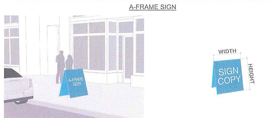 |
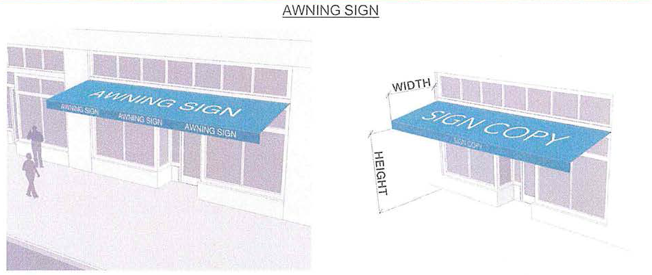 |
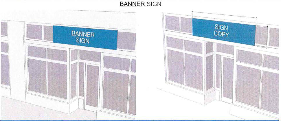 |
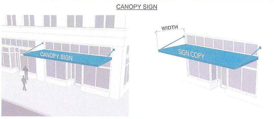 |
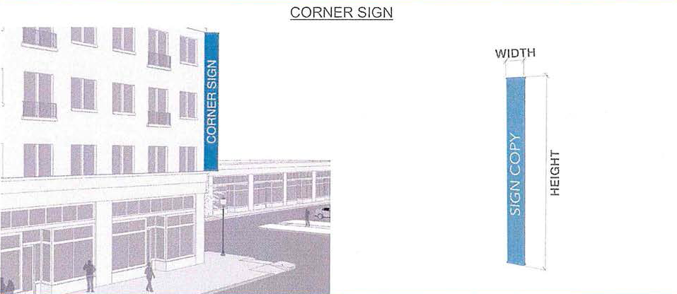 |
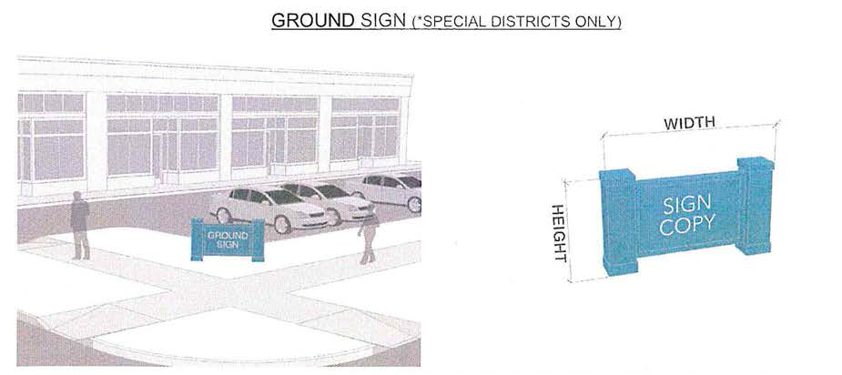 |
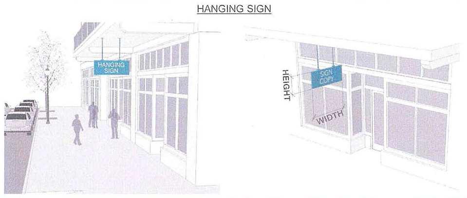 |
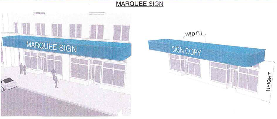 |
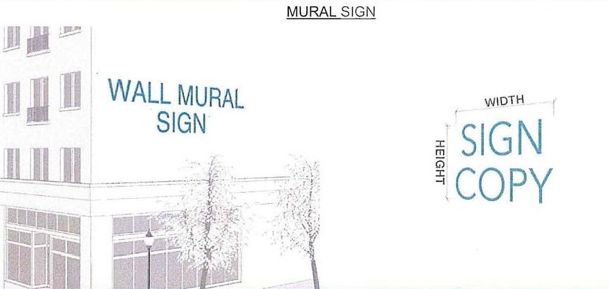 |
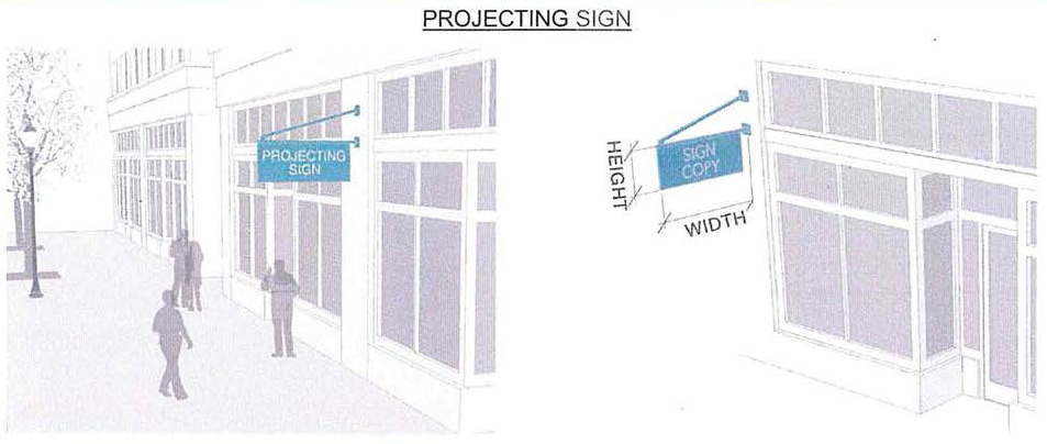 |
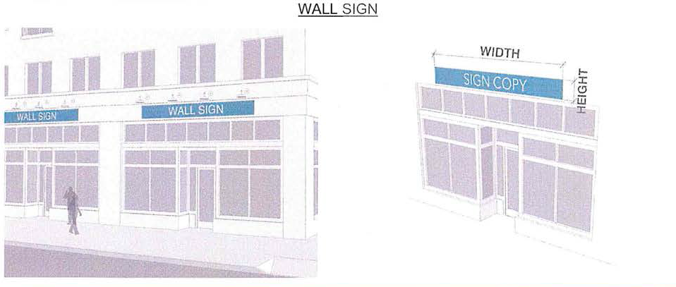 |
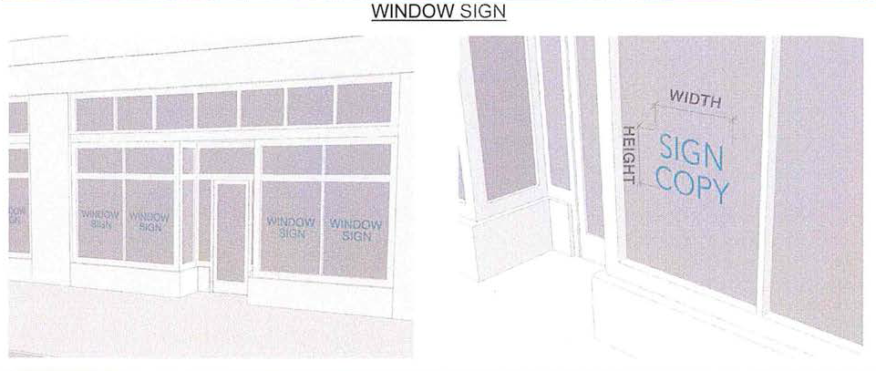 |
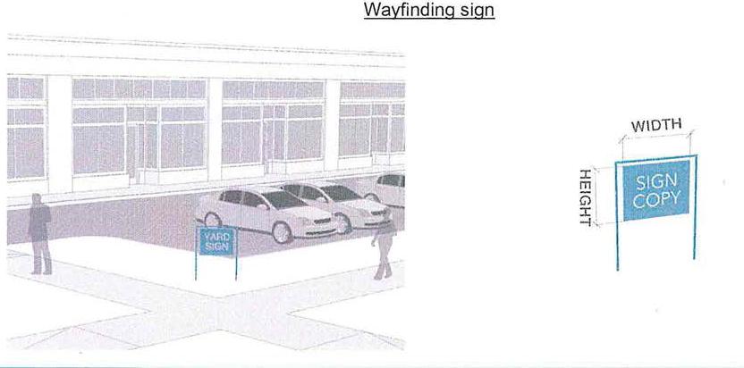 |
(Ord. No. 20-10, § 2(Exh. A, § 7), 11-4-2020; Ord. No. 21-02, § 2(Exh. A), 5-19-2021; Ord. No. 23-02, § 2(Att.), 5-3-2023)
Sec. 4-873. - Landscape standards and guidelines.
(a)
Landscape in the public right-of-way.
(1)
Due to the unique development standards of the Old U.S. 41 Redevelopment Zone within the city, landscape and buffering standards must be reviewed and approved according to these standards. In the event of conflicts with other sections of this zoning code, the provisions of this section shall take precedence and shall supersede other sections of this Land Development Code. However, the provisions of this section shall not be construed to take precedence over the state building code.
(2)
When a covered walkway along a building frontage or right-of-way is not provided, tall or medium trees or palms are required to establish continuous shade.
(3)
For buildings with shared walls or a zero side setback, landscaping is not required for that portion of the property line.
(4)
Unless specifically prohibited due to building design and location, building perimeter plantings will be required. Property owners or registered agents may apply for administrative relief, plant the trees and/or shrubs in decorative pots, or have landscaping relocated to a different portion of the project site. Trees and shrubs required shall adhere to the species and sizes pursuant to Chapter 3 of the Comprehensive Plan.
(5)
Projects may receive administrative approval to reduce the width of required buffers and/or relocate required plantings on-site as part of the development order process.
(6)
Existing landscaping that does not comply with the provisions of this Code must be brought into conformity, to the maximum extent possible, when the building/site is modified or expanded, or the building has been vacant for a period of one year or more and a request for certificate of use for a new local business tax is made.
(b)
Landscape on private property.
(1)
These landscape standards and guidelines apply to all projects within the Old U.S. 41 District area.
(2)
These landscape standards and guidelines apply to all areas of the site plan that are not covered under the streetscape and plaza design guidelines of the Land Development Code.
(3)
All landscaping shall be installed in a sound workmanlike manner and according to accepted good planting procedures with the quality of plant materials as hereinafter described. (All elements of landscaping shall be installed so as to meet all other applicable ordinances and code requirements.)
(4)
Landscaped areas shall require protection from vehicular encroachment. Community development will inspect all landscaping and no certificates of occupancy and use or similar authorization will be issued unless the landscaping meets the requirements provided herein.
(5)
All landscaped areas shall provide an automatic irrigation water supply system or as an alternate, an irrigation system consistent with Florida friendly landscape plans, to the extent the irrigation plan conforms to the Florida Yards and Neighborhoods Program, as administered by the University of Florida Institute of Food and Agricultural Sciences.
(6)
The property owner, or his agent, shall be responsible for the maintenance of all onsite landscaping which shall be maintained in good condition so as to present a healthy, neat and orderly appearance and shall be kept free from refuse and debris. All existing and newly landscaped properties shall receive an initial landscape/irrigation inspection to ensure compliance with these standards and guidelines.
(Ord. No. 20-10, § 2(Exh. A, § 8), 11-4-2020)
Sec. 4-874. - Thoroughfare standards and guidelines.
(a)
Context classification.
(1)
The Context Classification system, as developed by FDOT and described within the FDOT Complete Streets Manual, shall be adopted to identify place and guide streets and other transportation features, and to allow transportation to support adjacent land uses. See Figure 9.1-1 depicting context classification zones.
(2)
Streets shall be classified in accordance with the FDOT Context Classifications.
Figure 9.1-1: FDOT Context Classification Zones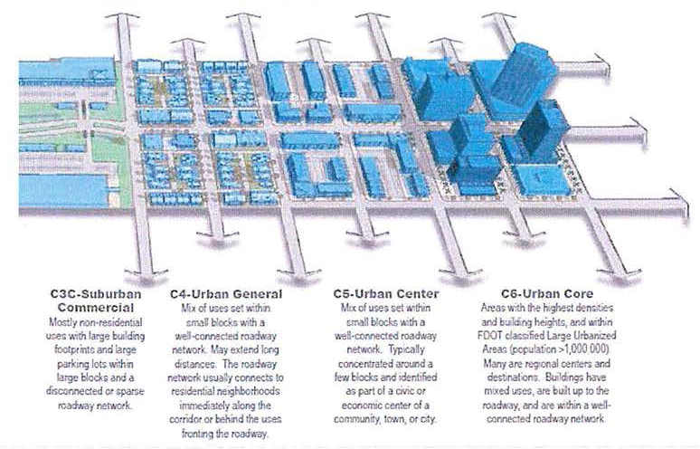
(b)
Street design.
(1)
Design of local streets shall be guided by the Florida Greenbook, Chapter 19 Traditional Neighborhood Design.
(2)
Where a greenway of at least five feet exists, driveway approaches and curb cuts shall not be permitted to interrupt the sidewalks.
(3)
Sidewalks. Sidewalks shall be required on all street frontages in residential, nonresidential, commercial and industrial developments in accordance with standards established by the engineering division of the city's public works and facilities and the Florida Greenbook.
(4)
Driveways and curb cuts. Driveway, driveway approaches and curb cut requirements shall be as follows:
a.
Single-family residential types. Driveway and curb cut widths for single-family residential types shall be a minimum of ten feet up to a maximum of 22 feet in width.
b.
Multifamily, mixed use and non-residential types. Driveway and curb cut widths for multi-family and non-residential types shall be a minimum of 12 feet up to a maximum of 24 feet in width.
(5)
Driveway and curb cut spacing on a single property shall be a minimum of 42 feet with the following exception:
a.
Lots less than 42 feet wide shall be exempt from driveway spacing requirements.
(Ord. No. 20-10, § 2(Exh. A, § 9), 11-4-2020)
Sec. 4-875. - Special assemblage plans.
(a)
The purpose of special assemblage plans is to allow parcels or groupings of multiple abutting parcels greater than two acres in size, and/ or multiple abutting parcels fronting Old 41, within the Downtown district to be master planned so as to allow greater integration of public and private improvements and infrastructure, to enable greater Thoroughfare connectivity, to encourage a variety of building types, heights, and massing and streetscape design, and/or greater flexibility so as to result in higher or specialized quality building and tree preservation within the downtown to further the intent of this Code as expressed in section 4-866(a).
(b)
A special assemblage plan shall not alter the permitted uses listed in Table 3.1.1 for its transect zone, nor the density allocations outlined in section 4-869 that are based on those found within the comprehensive plan. The total acreage of the proposed special assemblage plan may be utilized for the purpose of calculating gross residential density. Nonresidential uses shall be limited to a maximum floor area ratio (FAR) of 0.5. The total acreage of a proposed mixed-use development may be utilized for the purpose of calculating commercial FAR.
(c)
General.
(1)
The single or multiple owner(s) of abutting properties in excess of two acres, and/or multiple abutting parcels fronting Old 41, (excluding any separation by a public right-of-way) within the downtown district, may apply to the community development department for a special assemblage plan.
(2)
A special assemblage plan shall include a map of any proposed new thoroughfares and any standards that deviate from requirements of the downtown form-based code.
(3)
A special assemblage plan shall assign at least 12 percent of its aggregated lot area to civic open space. A civic building site may be located within or adjacent to the open space or at the axial termination of a significant thoroughfare. The developer shall be responsible for constructing the public improvements within the special assemblage plan, including but not limited to new and/or altered open spaces and thoroughfares.
(4)
Development within the special assemblage plan shall be pursuant to a recorded development agreement that will establish the allocation of thoroughfares and open spaces and building areas, and the creation and retention of the public benefits.
(5)
Unless a building is specifically approved as part of the special assemblage plan, any building shall be reviewed by the planning staff prior to issuance of a building permit.
(6)
A special assemblage plan may include:
a.
Build-to-lines that differ from transect zone setback requirements.
b.
A terminated vista location, requiring that the building be provided with architectural articulation of a type and character that responds to the location.
c.
A (pedestrian) passage, requiring a minimum ten foot wide pedestrian access be reserved between buildings.
d.
A preservation plan acceptable to the planning department for any historic resources in the area of the special assemblage plan.
(7)
Additional design guidelines.
a.
A parking management program that enables shared parking among public and private uses.
b.
Assemblages shall contain a mix of building types. No building type shall be used more than three times unless treated with a different massing and facade.
c.
Flexible allocation of development capacity and height, (excluding density) on individual sites within the special assemblage plan shall be allowed so long as the capacity or height distribution does not result in development that is out of scale or character with the surrounding area, and provides for appropriate transitions. Maximum allowable height of structures shall be limited to 60 feet. Allowable height shall be determined on a case-by-case basis subject to compatibility with surrounding properties and appropriate transition to lands located outside of the Terry Street subdistrict. For the purposes of this special assemblage plan, height shall be measured as the vertical distance from 18″ above the adjacent roadway to the eave line of the building.
(8)
Procedure for approval.
a.
A pre-application meeting with city staff is required, prior to submitting an application for a special assemblage plan.
b.
Submittal requirements: The applicant shall provide a detailed site plan depicting the proposed layout, structure types, height, setbacks, open space, pedestrian/sidewalk locations, parking and vehicular use areas (including thoroughfares), transect boundaries, proposed density/intensity, and other applicable attributes that may be required by the city. The applicant shall additionally provide architectural renderings of the proposed building types throughout the site. These drawings shall be drawn to scale and shall provide elevations from all sides. The applicant shall also provide a boundary survey, a narrative that outlines the project, and a completed administrative action application for a special assemblage plan/special transect zone district plan.
c.
Review of documentation: Staff will have up to 20 business days to perform its review. The review clock will not start until all the documents outlined in 4-875(c)(8)a. have been provided by the applicant. If approved, staff will issue a letter of approval, which may include zoning, building, or development conditions. This letter, along with a copy of the approved documents and plans will go to city council to be ratified as a consent agenda item. If denied, staff will issue a letter that explains the reasons for denial. The applicant may appeal the decision in accordance with the Land Development Code.
d.
If approved by staff and ratified by city council, the applicant shall then go through the standard local development order/building permit process for the city.
(Ord. No. 20-10, § 2(Exh. A, § 10), 11-4-2020; Ord. No. 21-02, § 2(Exh. A), 5-19-2021)
Sec. 4-876. - Special transect zone districts.
(a)
Unless the property is owned by the city, special transect zone districts shall follow the regulations of 4-875(c)(8) for review and approval. In the event that the assemblage of property within the special transect district exceeds two acres, all standards in section 4-875: special assemblage plans, shall apply.
(Ord. No. 20-10, § 2(Exh. A, § 11), 11-4-2020)
Sec. 4-877. - Procedures for review.
(a)
Design review meeting and submission requirements for the downtown district:
(1)
Excluding special assemblage plans and special transect zone district plans, if a project complies with all the requirements of this Code, it will be approved administratively by right.
(2)
The review process is to help guide the planning and design of projects and buildings within the downtown district governed by the Table 2.1-1 Regulating Map. The intent of the review is to strive to create a genuine downtown area with well-designed and sensible buildings that work together harmoniously, while the individual buildings themselves are different. The city's objective is to encourage high quality development that will be of benefit to its residents and others for generations to come. The purpose of the review is to encourage a design approach and product that is compatible with southwest Florida's cultural and geographical context. The design process should incorporate the natural and manmade environmental conditions, as well as the social and economic milieu that any development within or near the town center needs to accommodate. The review is to encourage good design and good buildings that fit within the context of the downtown area.
(3)
Consistent with section 3-487(e) of the Land Development Code a reviewer will offer advice and recommendations concerning the applications for each specific development.
(4)
When any property owner has a project requiring new, rehabilitated or remodeled building within the downtown district the applicant must submit during the design phases of any project, including hardscape improvement designs proposed on any properties within the area, regardless of whether a building is involved (for example, the proposed layout of a parking lot).
(5)
The owner or authorized representative shall attend the review meeting if this is a major impact project. A review meeting may be needed for a minor impact project, depending on the submitted materials.
(6)
A minor-impact project is one that does not involve structural changes except replacement with identical materials. It can be accommodated by either an informal meeting or by providing the reviewer with simple illustrations, drawings, or diagrams that clearly indicate the intent of the design of the project in its relation to the streetscape. The reviewer can then determine whether a meeting is necessary. Examples of a minor impact project include the addition of a sign, an awning, replacing of windows or doors, or the repainting of a facade, or other such minor improvement to a building. An owner, or tenant, or a representative thereof, such as a sign company, awning company, graphics firm, etc., may make the presentation to the reviewer for the applicant, if needed.
(7)
All other projects not considered minor shall be deemed major impact projects. For any architectural projects determined to have a major impact, the Florida-licensed architect or engineer responsible for the design of the building or the project and its buildings shall make submissions and presentations to the reviewer. For a planning concept project, the Florida planner or planning entity, the Florida-license.
(Ord. No. 20-10, § 2(Exh. A, § 12), 11-4-2020; Ord. No. 21-02, § 2(Exh. A), 5-19-2021)
Sec. 4-878. - Supplemental regulations/special topics.
(a)
Flood criteria and frontages.
(1)
All new construction and major renovations shall be subject to the most current FEMA floodway information.
(2)
This may involve the raising of residential first floors above the required height, or flood-proofing of commercial spaces
(b)
Abandoned street ROWs.
(1)
There are several abandoned rights-of-way within the downtown. All were at one time accessible vehicular streets
(2)
The city should make an effort to use these ROW's as opportunities for restoring connectivity within downtown. Not all may need to be restored as vehicular streets
a.
Abandoned ROWs in areas of critical connectivity should be converted to vehicular streets
b.
Abandoned ROWs which are greater than 300 feet (a typical block) in length should be converted to pedestrian and bicycle paths or linear parks
c.
Abandoned ROWs which are un-important to the surrounding connectivity should be converted into pocket parks.
(c)
Abandoned alley ROWs.
(1)
There are numerous blocks in downtown that once had rear alleyways
a.
The city should try to reactivate these alleys where possible
b.
Developers should be encouraged to restore alleyways where possible
(d)
CSX ROW.
(1)
The existing rail line owned by CSX is an active right-of-way.
a.
It is understood this ROW may be abandoned in the future. In this scenario, the city should use the ROW as a linear park and pedestrian/cycling path which connects.
(Ord. No. 20-10, § 2(Exh. A, § 13), 11-4-2020)
Sec. 4-879. - Definitions.
(a)
Definitions of building uses.
Accessory building: an accessory dwelling with an accessory unit.
Accessory unit: means an apartment not greater than 800 square feet sharing ownership and utility connections with a principal building; it may or may not be within an accessory dwelling. See Table 10 and Table 17. (Syn: Ancillary unit).
Affordable housing: means dwellings consisting of rental or for-sale units that have a rent (including utilities) or mortgage payment typically no more than 30 percent of the income of families earning no more than 80 percent of median incomes by family size for the county. (Alt. definition: Rental or for-sale dwellings that are economically within the means of the starting salary of a local elementary school teacher.)
Allee: means a regularly spaced and aligned row of trees usually planted along a thoroughfare or path.
Apartment: means a residential unit sharing a building and a lot with other units and/or uses; may be for rent, or for sale as a condominium.
Arcade: means a private frontage conventional for retail use wherein the facade is a colonnade supporting habitable space that overlaps the sidewalk, while the facade at sidewalk level remains at the frontage line.
Attic: means the interior part of a building contained within a pitched roof structure.
Avenue (AV): means a thoroughfare of high vehicular capacity and low to moderate speed, acting as a short distance connector between urban centers, and usually equipped with a landscaped median.
Awning: means a sheet of canvas or other material stretched on a frame and used to keep the sun or rain off a storefront, window, doorway, or deck.
Backbuilding: means a single-story structure connecting a principal building to an accessory dwelling.
Base density: means the number of dwelling units per acre before adjustment for other functions and/or TDR. See Density.
Bed and breakfast: means an owner-occupied lodging type offering one to five bedrooms, permitted to serve breakfast in the mornings to guests.
Bicycle lane (BL): means a dedicated lane for cycling within a moderate-speed vehicular thoroughfare, demarcated by striping.
Block: means the aggregate of private lots, passages, rear alleys and rear lanes, circumscribed by thoroughfares.
Block face: means the aggregate of all the building facades on one side of a block.
Brownfield: means an area previously used primarily as an industrial site.
By right: means characterizing a proposal or component of a proposal that complies with the Code and is permitted and processed administratively, without public hearing. See Warrant and special exception.
Civic: means the term defining not-for-profit organizations dedicated to arts, culture, education, recreation, government, transit, and municipal parking.
Civic building: means a building operated by not-for-profit organizations dedicated to arts, culture, education, recreation, government, transit, and municipal parking, or for use approved by the legislative body.
Civic parking reserve: means parking structure or parking lot within a quarter-mile of the site that it serves.
Civic space: means an outdoor area dedicated for public use. Civic Space types are defined by the combination of certain physical constants including the relationships among their intended use, their size, their landscaping and their enfronting buildings.
Civic zone: means designation for public sites dedicated for civic buildings and civic space.
Commercial: means the term collectively defining workplace, office, retail, and lodging functions.
Common yard: means a planted private frontage wherein the facade is set back from the frontage line. It is visually continuous with adjacent yards. See Table 7.
Configuration: means the form of a building, based on its massing, private frontage, and height.
Corridor: means a lineal geographic system incorporating transportation and/or greenway trajectories. A transportation corridor may be a lineal transect zone.
Cottage: means an edgeyard building type. A single-family dwelling, on a regular lot, often shared with an accessory building in the back yard.
Cottage court: means an assemblage of cottages in which the site(s) can be master-planned in order to provide the common/shared courtyard at the front of the site.
Courtyard building: means a building that occupies the boundaries of its lot while internally defining one or more private patios.
Curb: means the edge of the vehicular pavement that may be raised or flush to a swale. It usually incorporates the drainage system.
Density: means the number of dwelling units within a standard measure of land area.
Design speed: means is the velocity at which a thoroughfare tends to be driven without the constraints of signage or enforcement. There are four ranges of speed: Very low: (below 20 MPH); Low: (20—25 MPH); Moderate: (25—35 MPH); High: (above 35 MPH). Lane width is determined by desired design speed.
Developable areas: means lands other than those in the C-OS transect.
Disposition: means the placement of a building on its lot.
Dooryard: means a private frontage type with a shallow setback and front garden or patio, usually with a low wall at the frontage line. (Variant: Lightwell, light court.)
Drive: means a thoroughfare along the boundary between an urbanized and a natural condition, usually along a waterfront, park, or promontory. One side has the urban character of a thoroughfare, with sidewalk and building, while the other has the qualities of a road or parkway, with naturalistic planting and rural details.
Driveway: means a vehicular lane within a lot, often leading to a garage.
Edgeyard building: means a building that occupies the center of its lot with setbacks on all sides.
Effective parking: means the amount of parking required for mixed use after adjustment by the shared parking factor.
Effective turning radius: means the measurement of the inside turning radius taking parked cars into account.
Elevation: means an exterior wall of a building not along a frontage line.
Encroach: means to break the plane of a vertical or horizontal regulatory limit with a structural element, so that it extends into a setback, into the public frontage, or above a height limit.
Encroachment: means any structural element that breaks the plane of a vertical or horizontal regulatory limit, extending into a setback, into the public frontage, or above a height limit.
Expression line: means a line prescribed at a certain level of a building for the major part of the width of a facade, expressed by a variation in material or by a limited projection such as a molding or balcony. (Syn: Transition line).
Extension line: means a line prescribed at a certain level of a building for the major part of the width of a facade, regulating the maximum height for an encroachment by an arcade frontage.
Facade: means the exterior wall of a building that is set along a frontage line. See Elevation.
Forecourt: means a private frontage wherein a portion of the facade is close to the frontage line and the central portion is set back.
Frontage: means the area between a building facade and the vehicular lanes, inclusive of its built and planted components. Frontage is divided into private frontage and public frontage.
Frontage line: means a lot line bordering a public frontage. Facades facing frontage lines define the public realm and are therefore more regulated than the elevations facing other lot lines.
Function: means the use or uses accommodated by a building and its lot, categorized as restricted, limited, or open, according to the intensity of the use.
Gallery: means a private frontage conventional for retail use wherein the facade is aligned close to the frontage line with an attached cantilevered shed or lightweight colonnade overlapping the sidewalk.
Green: means a civic space type for unstructured recreation, spatially defined by landscaping rather than building frontages.
Greenfield: means an area that consists of open or wooded land or farmland that has not been previously developed.
Greenway: means an open space corridor in largely natural conditions which may include trails for bicycles and pedestrians.
Greyfield: means an area previously used primarily as a parking lot. Shopping centers and shopping malls are typical greyfield sites. (Variant: Grayfield).
Highway: means a rural and suburban thoroughfare of high vehicular speed and capacity. This type is allocated to the more rural transect zones (T-1, T-2, and T-3).
Home occupation: means non-retail commercial enterprises. The work quarters should be invisible from the frontage, located either within the house or in an accessory dwelling. Permitted activities are defined by the restricted office category.
House: means an edgeyard building type, usually a single-family dwelling on a large lot, often shared with an accessory building in the back yard. (Syn: Single).
Infill: means noun new development on land that had been previously developed, including most greyfield and brownfield sites and cleared land within urbanized areas. (Verb—to develop such areas).
Inn: means a lodging type, owner-occupied, offering six to 12 bedrooms, permitted to serve breakfast in the mornings to guests.
Layer: means a range of depth of a lot within which certain elements are permitted.
Linear pedestrian shed: means a pedestrian shed that is elongated along an important mixed use corridor such as a main street. A linear pedestrian shed extends approximately ¼ mile from each side of the corridor for the length of its mixed use portion. The resulting area is shaped like a lozenge. (Syn: Elongated pedestrian shed).
Liner building: means a building specifically designed to mask a parking lot or a parking structure from a frontage.
Live-work: means a mixed use unit consisting of a commercial and residential function. The commercial function may be anywhere in the unit. It is intended to be occupied by a business operator who lives in the same structure that contains the commercial activity or industry. See Work-live. (Syn: Flexhouse).
Lodging: means premises available for daily and weekly renting of bedrooms.
Lot: means a parcel of land accommodating a building or buildings of unified design. The size of a lot is controlled by its width in order to determine the grain (i.e., fine grain or coarse grain) of the urban fabric.
Lot line: means the boundary that legally and geometrically demarcates a lot.
Lot width: means the length of the principal frontage line of a lot.
Main civic space: means the primary outdoor gathering place for a community. The main civic space is often, but not always, associated with an important civic building.
Manufacturing: means premises available for the creation, assemblage and/or repair of artifacts, using table-mounted electrical machinery or artisanal equipment, and including their retail sale.
Marquee: means a metal or wood protective projection usually over a building entrance or storefront. (Syn: Canopy).
Meeting hall: means a building available for gatherings, including conferences, that accommodates at least one room equivalent to a minimum of ten square feet per projected dwelling unit within the pedestrian shed in which it is located.
Mixed use: means multiple functions within the same building through superimposition or adjacency, or in multiple buildings by adjacency, or at a proximity determined by warrant.
Mobile food vendor: means a person or business selling foods other than fresh fruits or vegetables from a mobile food vehicle, mobile food cart or food stand.
Mobile food vendor park: means a site approved through a special exception to allow for permanent location for three or more mobile food vehicles. Such sites must include required infrastructure and public seating for all vehicles serving in the park.
Net site area: means all developable land within a site including thoroughfares but excluding land allocated as civic zones.
Office: means premises available for the transaction of general business but excluding retail, artisanal and manufacturing uses.
Open space: means land intended to remain undeveloped; it may be for civic space.
Park: means a civic space type that is a natural preserve available for unstructured recreation.
Parking structure: means a building containing one or more stories of parking above grade.
Passage (PS): means a pedestrian connector, open or roofed, that passes between buildings to provide shortcuts through long blocks and connect rear parking areas to frontages.
Path (PT): means a pedestrian way traversing a park or rural area, with landscape matching the contiguous open space, ideally connecting directly with the urban sidewalk network.
Pedestrian shed: means an area that is centered on a common destination. Its size is related to average walking distances for the applicable community unit type. Pedestrian sheds are applied to structure communities. (Syn: Walkshed, walkable catchment).
Planter: means the element of the public frontage which accommodates street trees, whether continuous or individual.
Plaza: means a civic space type designed for civic purposes and commercial activities in the more urban transect zones, generally paved and spatially defined by building frontages.
Principal building: means the main building on a lot, usually located toward the frontage.
Principal entrance: means the main point of access for pedestrians into a building.
Principal frontage: means on corner lots, the private frontage designated to bear the address and principal entrance to the building, and the measure of minimum lot width. Prescriptions for the parking layers pertain only to the principal frontage. Prescriptions for the first layer pertain to both frontages of a corner lot. See Frontage.
Private frontage: means the privately held layer between the frontage line and the principal building facade.
Public frontage: means the area between the curb of the vehicular lanes and the frontage line.
Rear alley (RA): means a vehicular way located to the rear of lots providing access to service areas, parking, and accessory dwellings and containing utility easements. Rear alleys should be paved from building face to building face, with drainage by inverted crown at the center or with roll curbs at the edges.
Rear lane (RL): means a vehicular way located to the rear of lots providing access to service areas, parking, and accessory dwellings and containing utility easements. Rear lanes may be paved lightly to driveway standards. The streetscape consists of gravel or landscaped edges, has no raised curb, and is drained by percolation.
Rearyard building: means a building that occupies the full frontage line, leaving the rear of the lot as the sole yard. (Var: Rowhouse, townhouse, apartment house).
Recess line: means a line prescribed for the full width of a facade, above which there is a stepback of a minimum distance, such that the height to this line (not the overall building height) effectively defines the enclosure of the enfronting public space. (Var: Extension line).
Regulating plan: means a zoning map or set of maps that shows the transect zones, civic zones, special districts if any, and special requirements if any, of areas subject to, or potentially subject to, regulation by the Code.
Residential: means characterizing premises available for long-term human dwelling.
Retail: means characterizing premises available for the sale of merchandise and food service.
Retail frontage: means frontage designated on a regulating plan that requires or recommends the provision of a shopfront, encouraging the ground level to be available for retail use. See Special requirements.
Road (RD): means a local, rural and suburban thoroughfare of low-to-moderate vehicular speed and capacity. This type is allocated to the more rural transect zones (T3).
Rowhouse: means a single-family dwelling that shares a party wall with another of the same type and occupies the full frontage line. See Rearyard building. (Syn: Townhouse, single-family attached).
Secondary frontage: means on corner lots, the private frontage that is not the principal frontage. As it affects the public realm, its first layer is regulated.
Setback: means the area of a lot measured from the lot line to a building facade or elevation that is maintained clear of permanent structures. (Var: Build-to-line).
Shared parking factor: means an accounting for parking spaces that are available to more than one function.
Shall: means indicates code standards which are regulatory in nature. Deviations from these standards shall only be permitted by variance or special exception.
Shopfront: means a private frontage conventional for retail use, with substantial glazing and an awning, wherein the facade is aligned close to the frontage line with the building entrance at sidewalk grade.
Should: means indicated code standards which are encouraged and recommended but not mandatory.
Sidewalk: means the paved section of the public frontage dedicated exclusively to pedestrian activity.
Sideyard building: means a building that occupies one side of the lot with a setback on the other side. This type can be a single or twin depending on whether it abuts the neighboring house.
Special district (SD): means an area that, by its intrinsic function, disposition, or configuration, cannot or should not conform to one or more of the normative community unit types or transect zones specified by the SmartCode. Special districts may be mapped and regulated at the regional scale or the community scale.
Special exception: means a ruling that would permit a practice that is not consistent with either a specific provision or the intent of this Code. Special exceptions are usually granted by the board of appeals in a public hearing.
Special flood hazard area: means a designation by the Federal Emergency Management Agency (FEMA) that may include the V (velocity) zones and coastal A zones where building construction is forbidden, restricted, or contingent upon raising to the base flood elevation.
Square: means a civic space type designed for unstructured recreation and civic purposes, spatially defined by building frontages and consisting of paths, lawns and trees, formally disposed.
Standard pedestrian shed: means a pedestrian shed that is an average ¼ mile radius or 1,320 feet, about the distance of a five-minute walk at a leisurely pace. See Pedestrian shed.
Stepback: means a building setback of a specified distance that occurs at a prescribed number of stories above the ground.
Stoop: means a private frontage wherein the facade is aligned close to the frontage line with the first story elevated from the sidewalk for privacy, with an exterior stair and landing at the entrance.
Story: means a habitable level within a building, excluding an attic or raised basement.
Street (ST): means a local urban thoroughfare of low speed and capacity.
Streetscreen: means a freestanding wall built along the frontage line, or coplanar with the facade. It may mask a parking lot from the thoroughfare, provide privacy to a side yard, and/or strengthen the spatial definition of the public realm. (Syn: Streetwall).
Substantial modification: means alteration to a building that is valued at more than 50 percent of the replacement cost of the entire building, if new.
Swale: means a low or slightly depressed natural area for drainage.
T-zone: means transect zone.
TDR: means transfer of development rights, a method of relocating existing zoning rights from areas to be preserved as open space to areas to be more densely urbanized
Terminated vista: means a location at the axial conclusion of a thoroughfare. A building located at a terminated vista designated on a regulating plan is required or recommended to be designed in response to the axis.
Thoroughfare: means a way for use by vehicular and pedestrian traffic and to provide access to lots and open spaces, consisting of vehicular lanes and the public frontage.
Townhouse: means See Rearyard building. (Syn: Rowhouse).
Transect: means a cross-section of the environment showing a range of different habitats. The rural-urban transect of the human environment used in the SmartCode template is divided into six transect zones. These zones describe the physical form and character of a place, according to the density and intensity of its land use and urbanism.
Transect zone (T-zone): means one of several areas on a zoning map regulated by the SmartCode. Transect zones are administratively similar to the land use zones in conventional codes, except that in addition to the usual building use, density, height, and setback requirements, other elements of the intended habitat are integrated, including those of the private lot and building and public frontage.
Turning radius: means the curved edge of a thoroughfare at an intersection, measured at the inside edge of the vehicular tracking. The smaller the turning radius, the smaller the pedestrian crossing distance and the more slowly the vehicle is forced to make the turn.
Two-family dwelling: means two residential units sharing a single lot and having the massing, appearance, and setbacks of a single-family dwelling and where each unit is assigned its own yard space. These units can be attached side-by-side, sharing a party wall, or occur one above the other. (Syn: Duplex, two-family attached).
Warrant: means a ruling that would permit a practice that is not consistent with a specific provision of this Code, but that is justified by its intent. Warrants are usually granted administratively by the city.
Work-live: means a mixed use unit consisting of a commercial and residential function. It typically has a substantial commercial component that may accommodate employees and walk-in trade. The unit is intended to function predominantly as work space with incidental residential accommodations that meet basic habitability requirements. See Live-work. (Syn: Live-with).
Yield: means characterizing a thoroughfare that has two-way traffic but only one effective travel lane because of parked cars, necessitating slow movement and driver negotiation. Also, characterizing parking on such a thoroughfare.
Zoning map: means the official map or maps that are part of the zoning ordinance and delineate the boundaries of individual zones and districts. See Regulating plan.
(Ord. No. 20-10, § 2(Exh. A, § 14), 11-4-2020)
Sec. 4-880. - Color palate.
Color Palette Based on Sherwin Williams Exterior Coastal Colors for Southern Shores and Beaches and the following additional pastel colors as approved by city council.
(Ord. No. 21-02, § 2(Exh. A), 5-19-2021)
Sec. 4-886. - Purpose and intent.
(a)
The intent of establishing this subdistrict is to create a transition between more intense mixed-use development to the west and the established single-family neighborhood to the east. By permitting commercial uses of low intensity adjacent to mixed-use development, the impacts of those uses could be reduced gradually creating a more integrated feel to the community. Permitted uses and development standards for this area are intended to establish a subdistrict that embraces the city's vision for redevelopment on Old U.S. 41 with consideration for adjacent residential uses. This subdistrict will consist of existing single-family residences while allowing for low intensity nonresidential uses.
(b)
Applicability. The Felts Avenue Subdistrict shall apply to those areas generally defined as property south of the Imperial River and east of Felts Avenue, extending approximately block east of Felts Avenue, as designated in the Bonita Plan. The provisions of this subdistrict shall supplement or supersede the provisions of the underlying zoning districts. Those provisions of the City Land Development Code and Old U.S. 41 Redevelopment Overlay District shall apply except when in conflict with this subdistrict. In the event of a conflict, the provisions of this district shall apply.
(c)
Permitted uses. Uses not specifically listed under permitted shall be prohibited, unless the proposed uses has similar traffic, patronage, intensity and characteristics similar to those cited therein. The determination of similarity shall be determined by the director of community development.
(1)
Art galleries.
(2)
Bed and breakfasts, not to exceed 12 bedrooms.
(3)
Dance, art, and music studios.
(4)
Dwelling unit (as limited by density in the Bonita Plan and Sub-area designation).
(5)
Home occupational uses/home offices (use must be conducted within the residence, with clients and employees permitted, based on meeting parking requirements).
(6)
Public uses.
(7)
Professional offices.
(8)
Recreational facilities (public and private).
(9)
Retail (within existing structures).
(10)
Restaurant or specialty food establishment (within existing structures). Outdoor seating by special exception only.
(d)
Dimensional requirements.
(1)
Residential. All residential development, redevelopment, and alterations to existing structures will be in accordance with section 4-872.
(2)
Nonresidential.
a.
All nonresidential development standards will be in accordance with 4-869; however a minimum of 15 feet side setback along property lines is required when adjacent to a single-family residential use.
b.
Infill development, redevelopment, and substantial improvements. Infill development, redevelopment, and substantial improvements for commercial uses of existing structures within this subdistrict shall maintain the character and scale of single-family homes and shall conform to the design standards for nonresidential and residential uses contained in sections 4-869 through 4-871. Any structures floor to area ratio (FAR) must be compatible with existing properties within the subdistrict so as to achieve compatibility with mass and scale.
(3)
Regulations and processes for development within the Felts Avenue Subdistrict. For any structural changes associated with a change of use, the regulations contained in sections 4-869 through 4-871 shall apply.
(4)
Parking. Parking for commercial or multifamily developments must be provided per section 4-1732 or 4-871. Parking may be provided entirely on-street, in a manner not to interfere with vehicular movement. The city manager shall have the authority to reduce required parking administratively.
(5)
Stormwater. For projects utilizing existing structures, or those determined to create minimal impact, no additional stormwater treatment will be required unless required by South Florida Water Management District. For projects required to install stormwater treatment, the standards of the Old U.S. 41 Redevelopment Overlay shall apply.
(Ord. No. 10-09; Ord. No. 11-02, § 3(4-1161), 1-19-2011; Ord. No. 13-09, § 1(4-1161), 8-7-2013)
Sec. 4-887. - Reserved.
Editor's note— Ord. No. 20-10, § 2(Exh. A), adopted November 4, 2020, repealed § 4-887, which pertained to exhibits and derived from Ord. No. 13-01, exhs. I—IV, February 6, 2013; Ord. No. 13-09, exhs. I—V, August 7, 2013; Ord. No. 15-02, § 1, January 7, 2015.
Sec. 4-888. - Purpose and intent.
The intent of the U.S. 41 Overlay District is to guide future growth and redevelopment along U.S. 41 in a manner that maintains and enhances the aesthetic/visual quality of the corridor, makes efficient use of public infrastructure, protects existing neighborhoods, and balances automobile-oriented development patterns with the pedestrian realm. The U.S. 41 Overlay District is intended to prevent the expansion of a "strip" commercial development pattern, and create a physically attractive, and functionally integrated built environment through cohesive and complimentary site development and design standards provided for herein.
(Ord. No. 15-27, § 2, 12-2-2015)
Sec. 4-889. - Applicability.
(a)
The U.S. 41 Overlay District as outlined within Exhibit IV.
(b)
Provisions of this division shall apply to all development and redevelopment located within the geographical boundaries set forth in Exhibit IV, which are further defined as minor development and major development, as follows:
(c)
Minor development. Minor developments, for the purpose of this section, are defined below and must comply with sections 4-892, 4-893(a)(2), 4-893(b), 4-894(c) of this division. Where size constraints preclude compliance with 4-893(b), an alternate landscape betterment plan may be approved in accordance with section 3-421.
(1)
Projects requiring Type 1/A, Type 7/G and Type 9/I Limited review development order in accordance with section 3-159, or minor change development order approval; or
(2)
Building expansion of more than 15 percent of the existing square footage, but less than 50 percent; or
(3)
Building renovation or improvements performed over a period of five years that exceed 15 percent, but are less than 50 percent of the current assessed value of the structure.
(d)
Major development. Major developments, for the purpose of this section, are defined below and must comply with all provisions of this subdivision:
(1)
New construction requiring local development order approval or an amendment to an existing development order (including large and small projects as defined in chapter 3); or
(2)
Building expansion of more than 50 percent of the existing square footage; or
(3)
Building renovation or improvements performed over a period of five years that exceed 50 percent.
Compliance with these provisions will be required in order to obtain development order approval.
(e)
If a parcel is located in one or more overlay districts, the more restrictive overlay standards shall apply.
(f)
Existing PDs may voluntarily bring a master concept plan into compliance with the regulations contained in this subdivision administratively. Uses that are prohibited, or subject to special exception approval in accordance with this subdivision, and are approved as part of an existing PD must comply with this subdivision unless local development order approval has already been obtained for that use.
(Ord. No. 15-27, § 2, 12-2-2015)
Sec. 4-890. - Definitions.
[The following words, terms and phrases, when used in this subdivision, shall have the meanings ascribed to them in this section, except where the context clearly indicates a different meaning:]
Amenity zone is defined as the area internal to the site and within 50 feet of the public right-of-way, which is intended for pedestrian-oriented uses that are visually attractive, take into consideration the human scale and proportion, and provide for multi-modal connections between the right-of-way and development.
(Ord. No. 15-27, § 2, 12-2-2015)
Sec. 4-891. - Permitted uses.
Uses within the U.S. 41 Overlay District shall be permitted in accordance with the underlying zoning district, except as provided for herein.
(1)
Special exception approval required. The following uses require special exception approval:
a.
Auto parts store with installation or service, including self-service installation.
b.
Auto repair and services, Groups I and II.
c.
Automobile service stations.
d.
Boat sales.
e.
Boat storage, dry.
f.
Building material sales.
g.
Bus station/depot.
h.
Car washes.
i.
Contractors and builders, Group III.
j.
Convenience food and beverage store.
k.
Farm equipment, sales, storage, rental, service.
l.
Flea market, open and indoor.
m.
Mini-warehouse, public and private.
n.
Mobile home dealers.
o.
Models: display center, model units.
p.
Night clubs.
q.
Non-store retailers, all Groups.
r.
Personal services, Group IV.
s.
Rental or leasing establishments, Groups III and IV.
t.
Repair shop, Groups III—V.
u.
Restaurants, fast food.
v.
Specialty retail, Group III.
w.
Theater, indoor or outdoor (drive-in).
x.
Transportation services, Groups I—V.
y.
Variety store (except when located within a large-scale retail establishment).
z.
Vehicle and equipment dealers, Groups I—V.
1.
Approval criteria. The following criteria will be utilized to evaluate special exception requests in the U.S. 41 Overlay:
(i)
Consistency with the intent of the U.S. 41 Overlay District in protecting and enhancing viewsheds from U.S. 41 and other public roadways.
(ii)
The building and site design standards incorporate innovative techniques to address the project's visual impact on the U.S. 41 corridor and demonstrate enhancements to the minimum standards.
(iii)
The request addresses the balance between auto-oriented design and pedestrian access through enhanced design standards.
(iv)
Exceptional or extraordinary conditions exist which warrant the proposed use, including but not limited to demonstrated market demand and minimum spatial separation of 500 feet from a similar use.
(v)
Will not be injurious to the neighborhood or otherwise detrimental to the public welfare.
(vi)
Will be compatible with existing or planned uses.
(vii)
Will cause damage, hazard, nuisance or other detriment to persons or property.
(viii)
Will protect, conserve or preserve environmentally critical areas and natural resources.
(ix)
Consistency with the goals, objectives, policies and intent of the Bonita Plan.
(x)
In compliance with all general zoning provisions, supplemental regulations and performance standards pertaining to the use set forth in this chapter.
(2)
Prohibited uses. The following uses are prohibited within the U.S. 41 Overlay District:
a.
Cold storage warehouse.
b.
Feed or fertilizer, mixing and sales.
c.
Fish house, wholesales.
d.
Freight and cargo handling establishments.
e.
Gasoline dispensing system, special (except as accessory to a principal use).
f.
Manufacturing.
g.
Open storage, outdoor storage.
h.
Processing and warehousing.
i.
Recycling facility.
j.
Truck stop.
k.
Truck terminal
l.
Used merchandise stores, Group V.
(3)
Large-scale retail establishments. For developments defined as large-scale retail establishments within the U.S. 41 Overlay refer also to the supplementary regulations in division 21.
(4)
Outdoor display. In addition to the requirements of section 4-2072, outdoor display areas must be setback a minimum of 50 feet from the U.S. 41 right-of-way. Outdoor display areas exceeding 2,500 square feet, or one percent of the total site area, whichever is lesser, are prohibited in front and side yards, unless approved through the special exception or planned development process. Outdoor storage is prohibited. Outdoor display of merchandise is limited to the hours of operation for the establishment.
(Ord. No. 15-27, § 2, 12-2-2015)
Sec. 4-893. - Site design standards.
(a)
Amenity zones. Developments that abut U.S. 41 must address the public realm through the incorporation of an amenity zone that meets the following minimum criteria. These standards may be administratively waived where principal structures are located within 50 feet of the U.S. 41 right-of-way.
(1)
Retention ponds smaller than five acres and visible from the U.S. 41 right-of-way must enhance the public realm through two or more of the following:
a.
Fountain or water feature consistent with all other city ordinances.
b.
Enhanced littoral plantings with a minimum of two native wetland herbaceous plants per three linear feet of lake shoreline as measured from control elevation and a minimum of one cluster of native wetland tree and shrubs within a 50-square-foot area containing a minimum of 25 plants. The tree and shrub cluster may be used to offset the minimum number of required herbaceous plants in accordance with LDC section 3-420.
c.
Gazebo, trellis, pergolas or other architectural feature.
(2)
Pedestrian amenities. Developments must incorporate sidewalks, benches, street furniture, planters, and other pedestrian amenities in their design. All accessories such as railings, trash receptacles, street furniture and bicycle racks must be complimentary to and consistent with the architectural design of principal building(s) within the development.
(b)
U.S. 41 right-of-way buffer. U.S. 41 right-of-way buffer requirements. Developments that directly abut the U.S. 41 right-of-way must provide the following buffer:
(1)
The landscape buffer shall be a minimum of 20 feet in width with five trees per 100 lineal feet. Clustering of trees and plant material is encouraged to promote healthy growth of vegetation, screen parking areas from public view, and generally uphold the view corridors along U.S. 41.
(2)
The required trees and palms shall be clustered in double rows with a minimum of three trees per cluster. Canopy trees shall be planted a minimum of 30 feet on center within a cluster. Palms shall be planted in staggered heights, a minimum of three palms per cluster, spaced at a maximum of eight feet on center, with a minimum of three feet in difference in height between each tree. The maximum spacing between canopy trees and/or palm clusters is 50 feet.
(3)
All trees must be a minimum of 14 feet in height at the time of installation, and shrubs must be a minimum of three feet in height at time of installation. The buffer must be designed in a manner that does not block signage.
(4)
The buffer must be designed in a manner that facilitates pedestrian access to the development. Where perimeter fences and walls are incorporated into the perimeter buffer design of the site, the pedestrian access point(s) must be visible and well marked from the adjacent rights-of-way, and must include an archway, pergola, or other architectural feature to identify the pedestrian access.
(5)
Where buildings are located a maximum of 25 feet from the U.S. 41 right-of-way line, an alternative buffer may be permitted in accordance with LDC section 3-421.
(6)
For developments defined as large-scale retail establishments within the U.S. 41 Overlay, refer also to the supplementary regulations in section 4-1560.
(Ord. No. 15-27, § 2, 12-2-2015)
Sec. 4-894. - Parking and circulation.
(a)
Off-street parking location. Where off-street parking areas are located in the front or sides of buildings and exceed one double row of parking, an enhanced buffer shall be required. The buffer shall meet the minimum requirements of LDC section 4-893(b) except the buffer shall be a minimum of 25 feet in width, tree requirements shall be increased to six trees per 100 lineal feet, and an undulating berm with a maximum slope of 3:1, and a minimum average height of two feet shall be constructed along the entire length of the landscape buffer.
(b)
Vehicular interconnections required. Developments are required to provide vehicular, interconnections to the adjacent property, regardless of existing or proposed land use, unless one of the following criteria are met:
(1)
It is not physically possible to provide the interconnection.
(2)
The cost associated with the shared access or interconnection is unreasonable. For this application unreasonable will be considered when the cost exceeds the cost of a typical local road section or is above ten percent of the value of the improvements being made to the development.
(3)
The location of environmentally sensitive lands, either on site or off site, precludes it and mitigation is not possible.
(4)
The abutting use is found to be incompatible with the existing or proposed use. All developments required to provide interconnections to existing and future developments must dedicate sufficient right-of-way or easement for all required roads, sidewalks, and bike lanes. Bike lane and sidewalk interconnections must be constructed concurrently with the required vehicular interconnection.
(c)
Pedestrian interconnections required. Sidewalks and crosswalks must be provided to separate pedestrians from vehicular traffic both internal and external to the site. Pedestrians will only share pavement with vehicular traffic in marked crosswalks.
(1)
Sidewalks must be a minimum of five feet wide.
(2)
Sidewalks and crosswalks must be provided internal to the site, and connect pedestrians from parking areas to all principle building(s), including outparcels, and amenity zones.
(3)
External sidewalk connections must be provided at a ratio of one sidewalk for each vehicular entrance to a project. Drive aisles leading to main entrances must provide a sidewalk on one side of the drive aisle, at a minimum.
(4)
Internal sidewalks must connect to external sidewalk infrastructure on adjacent properties.
(5)
A waiver of lighting standards found in LDC section 3-269 may be granted to illuminate a sidewalk crossing on property or parcel lines, provided the lighting standards remain in compliance with the city's dark skies provisions.
(Ord. No. 15-27, § 2, 12-2-2015)
Sec. 4-895. - Intersection design and corner lots.
(a)
Corner lots. Sites located at collector or arterial intersections along U.S. 41 shall be designed to define and give prominence to the corner on which they are sited and contribute to the public realm through the use of building placement, both principal and accessory; accessory structures or architectural feature, such as pergolas, bell towers, monuments; landscape feature; or other focal point.
Developments subject to this subsection must be designed to include a minimum of one of the following design elements:
(1)
Principal building placement. Corner lot design requirements may be accomplished through placement of the principal structure a maximum of 25 feet from each adjacent right-of-way. The building design and placement must also provide pedestrian access from the street intersection. The design of the building must also incorporate an architectural feature, or features, including but not limited to: dome, conical or pyramidal roof; storefront or building protrusion, bay, porch element or arcade that wraps around the corner; public entrance that protrudes or is cut-away from the corner; change in roofline; such as a gabled end to mark the corner.
Where developments employ this design concept the director may administratively waive or modify right-of-way buffer requirements, building perimeter plantings, and minimum open space requirements.
Figure 1. Corner Lot Principal Building Placement (N.T.S)

(2)
Accessory structure placement. Where buildings are set back more than 25 feet from the adjacent rights-of-way, the corner lot design requirements may be accomplished through the placement of an accessory structure(s) or architectural feature along the property frontage, including, but not limited to: pergolas, belltower, colonnades, gazebos, or other structure. The feature must be set back a maximum of 25 feet from the right-of-way and must be a minimum of eight feet in height and maximum of 20 feet in height to address the pedestrian realm. The accessory structure must be designed in a manner that is complimentary to and consistent with the architectural design of principal building(s) within the development.
Figure 2. Corner Lot Accessory Structure Placement (N.T.S)
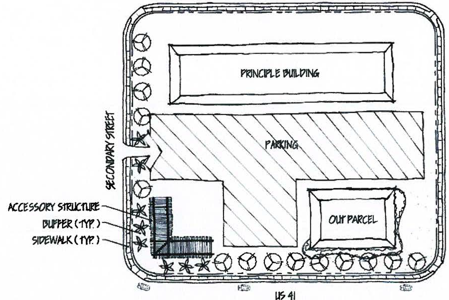
(3)
Landscape/hardscape feature. The corner lot design requirements may also be met through the provision of a combination landscape/hardscape feature at the intersection. The landscape feature must comprise a minimum of 500 square feet in area, or one percent of the site, whichever is greater. The landscape/hardscape feature must be set back a maximum of 25 feet from the right-of-way, and must incorporate enhanced plantings and a minimum of one hardscape feature, including, but not limited to: seating, monuments, fountains, planters, and decorative walls. These requirements must be provided in addition to the amenity zone requirements set forth in section 4-893. Permanent signage is permitted within the landscape/hardscape feature in accordance with chapter 6.
Figure 3. Corner Lot Hardscape Feature Placement (N.T.S)


EXHIBIT IV—U.S. 41 OVERLAY
(Ord. No. 15-27, § 2, 12-2-2015)
Sec. 4-896. - Purpose and intent.
The intent of the Bonita Beach Road Corridor District is to guide future growth and redevelopment along the Bonita Beach Road Corridor within zones, quadrants, and nodes as identified in the Bonita Plan, Bonita Beach Road Visioning Study and Bonita Beach Road Land Use Report. The Bonita Beach Road Corridor District is intended to support urbanized development patterns that focus on human-scale development, an appropriate mixture of land uses, site design, interconnectivity, mobility, architectural standards, and a vibrant and aesthetically-pleasing streetscape.
(Ord. No. 19-10, § 1(Exh. A), 11-20-2019)
Sec. 4-897. - Applicability.
(a)
Development and redevelopment within the Bonita Beach Road Corridor District are defined by four distinctive zones as described herein and graphically depicted in figure 4-V-1.
(1)
The Interstate zone—This zone is located between Imperial Boulevard and Bonita Grande Road. Has also been referred to as the "Gateway Zone".
(2)
Commercial zone—This is located between Vanderbilt Road and the Railroad Tracks, and between Race Track Road and Imperial Boulevard
(3)
Historic zone—This zone is located between the Railroad tracks and Race Track Road.
(4)
Beach zone—This zone is located between Hickory Boulevard and Vanderbilt Road.
(5)
Community zone—This zone is located between Bonita Grande Road and the eastern limits of Bonita Beach Road. Each network zone may include specific design regulations.
(b)
Provisions of this division shall apply to all development and redevelopment located within the geographical boundaries set forth in Figure 4-V-1 and further defined as minor development and major development, as follows:
(c)
Minor development. For the purpose of this section, minor developments, are defined as:
(1)
Projects requiring a Type 9/I limited review development order in accordance with section 3-159; or
(2)
Building expansion of more than 15 percent of the existing square footage, but less than 50 percent; or
(3)
Building renovation or improvements performed over a period of five years that exceed 15 percent of the existing square footage and less than 50 percent of the current assessed value of the structure.
(4)
Redevelopment of existing minor developments and structures are to be into compliance with the provisions of this subdivision. If the strict application of these regulations are deemed impractical or unfeasible the existing minor development project be brought into conformity to the maximum extent possible. Request for this relief shall be made by the applicant, to the community development director, said request shall include an alternate plan, and this plan shall demonstrate compliance with the section 4-896. If approved by the city manager or designee said plan may be substituted in part for the standards of this district.
(d)
Major development. For the purpose of this section, major developments are defined as:
(1)
New construction requiring local development order approval or an amendment to an existing development order (including large and small projects as defined in chapter 3; or
(2)
Building expansion of more than 50 percent of the existing square footage; or
(3)
Building renovation or improvements performed over a period of five years that exceed 50 percent.
(e)
Projects that result in redevelopment or a change in use shall be subject to the regulations set forth in (b)—(c) of this section.
(f)
If a parcel is located in one or more overlay districts, the more restrictive overlay standards shall apply.
(g)
Applicability and exemptions:
(1)
It is the intent of this overlay to apply to all property within the overlay district. Existing planned developments may voluntarily comply with the standards herein.
(2)
Notwithstanding, the provisions of this subdivision shall not apply to the following:
i.
Planned developments that have reached 80 percent build out (based on building square footage or number of dwelling units) are exempt from these regulations and shall abide by the terms, conditions and zoning established in their planned development ordinance.
ii.
Planned developments that have reached more than 50 percent but less than 80 percent build out (based on building square footage or number of dwelling units) are exempt from these regulations for a period of three years from the adoption of these regulations (approximately December 2022) after which any unbuilt structures shall be subject to the regulations set forth herein.
iii.
Planned developments that have reached less than 50 percent of (based on building square footage or number of dwelling units) shall be subject to the regulations set forth herein.
iv.
Planned developments that have not constructed any buildings or infrastructure shall bring their master concept plan into compliance with the regulations contained in this subdivision.
v.
All planned developments in the beach and community zones.
vi.
Planned developments with an unexpired master concept plans approved by the city at least 36 months prior to the adoption of this subdivision.
vii.
All existing development orders authorized pursuant to the interim moratorium processes authorized pursuant to Ordinance 17-12 to the extent of any conflict with this subdivision.
viii.
Any existing development orders otherwise specifically recognized for their conformity with the Bonita Beach Visioning Study and subsequent Comprehensive Plan Amendments (Ordinance 17-06) to the extent of any conflict with this subdivision; including the Horizon Park CPD (Zoning Ord. 17-07) reaffirmed as modified by the city council on June 19, 2019.
ix.
Any development orders specifically authorized pursuant to the settlement agreement, approved by council on July 27, 2019, between Angler's Paradise of Bonita Springs, Inc. and the city to the extent any development approvals contemplated by that settlement shall conflict with this subdivision.
x.
Notwithstanding any other provision of this section, any property owner who believes the strict application of this subdivision interferes with a vested rights may petition the city manager for relief from its application. Any such petition must be received within six months of the effective date of this subdivision and will be reviewed administratively for limited relief from the provisions of this subdivision to the extent such provisions interfere with a vested right. The city manager shall base on such determination on competent substantial evidence and upon consideration of the following factors:
1.
The history of the property along with its present nature and use.
2.
Whether the use or uses proposed in the petition are compatible with the comprehensive plan and overall intent of this subdivision even if its specific terms cannot be met; and
3.
Whether the property owner has made substantial expenditures of money or resources in reliance upon prior approvals and diligently pursued additional regulatory approvals in furtherance of a specific plan for development; and
4.
Whether denial of the petition would expose the petitioner to substantial monetary liability to third parties or leave the petitioner completely unable, after a thorough review of alternative solutions, to achieve their reasonable investment backed expectation for the property.
The city manager shall make a written determination within 30 days of receipt of a completed petition. If denied, the petitioner shall have the right to appeal such denial to the city council within 15 days. The city council will consider the evidence against the aforesaid factors at a public hearing within 30 days of their filing of the appeal.
xi.
Development located partially within and outside the boundaries of the overlay district.
1.
When the map of this overlay was created, it was intended to follow property lines and to allow for the orderly development/redevelopment of property fronting on Bonita Beach Road.
2.
To avoid situations that would create multiple standards and regulations. Since that time, ownership patterns have continued through their natural evolution and property assemblage has created just this condition.
3.
When a property owner wishes to create a single standard for a development, such a request may be approved through a planned development. This will allow for the standards and criteria for review for uses and development patterns be based on the defined process while performed through a single process (e.g. A use requiring a special exception would be approved under that criteria through the planned development process).
4.
When a property owner choosing to receive approval for numerous requests through a planned development, each request will be reviewed under the standards identified for that particular request. This may include but not limited to the review criteria for a special exception or variance.
5.
The opportunity previously outlined does not prevent a property owner from filing individual request(s)/application(s) for uses or development standards consistent with the standards of this overlay.
(h)
Planned developments that are partially constructed will come into compliance with these standards for interconnectivity, building orientation, and multi-modal access. Deviations to these standards will be considered when evidence is provided demonstrating that the literal application of these regulations create a negative result.
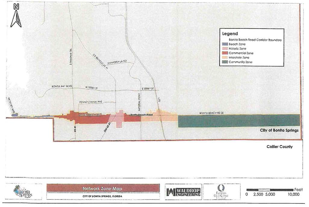
(Ord. No. 19-10, § 1(Exh. A), 11-20-2019; Ord. No. 21-03, § 2(Exh. A), 5-19-2021)
Sec. 4-898. - Permitted uses.
Use regulations for the Bonita Beach Road Corridor Overlay district are as follows:
(a)
All uses of land are subject to comprehensive plan (the Bonita Plan) and the future land use plan map.
(b)
All developments categorized as developments of city impact shall be rezoned to a planned development pursuant to sections 4-272(a) and 4-272(b).
Notes:
(1)
Permitted only when accessory to a lawfully permitted single-family dwelling unit.
(2)
Establishments exceeding 40,000 square feet require PD zoning. See section 4-1560 et seq.
(3)
Limited to eight self-service fuel pumps (df) unless a greater number is specifically approved as part of a planned development and depicted on the master concept plan. An existing business with more than eight lawfully permitted pumps as of January 31, 1998, will not be considered nonconforming. Existing pumps may be modernized, replaced, or relocated on the same premises, but additional new pumps will not be permitted.
(4)
Any single-family, duplex, or two-family residential buildings fronting and/or visible from Bonita Beach Road shall meet the design requirements set forth in Chapter 3, Article IV.—Design Standards and Guidelines for Commercial Buildings and Developments unless pre-empted by Florida Statute.
(5)
Any increase is density and intensity is limited by Goal 5 of the Conservation/Coastal Management Element. Unless approved and located within a planned development, the property development regulations for residential development along the Bonita Beach Road Corridor District shall be as follows:
Single-family: RS-1 residential single-family district
Duplex/Two-Family Attached: TFC-2 residential two-family conservation district
Townhouse/Multiple-family: RM-2 multiple-family district
(6)
Uses that include an ancillary manufacturing component of less than 1,500 square feet are permitted when clearly incidental and subordinate to a permitted principal use on the same premises. If producing a tangible product, the use or activity must stand at or near the end of the manufacturing process, accounting only for the last steps of preparation or assembly of components or preprocessed materials. All operations must be conducted within a fully enclosed building. The use may not emit dust, smoke, odor or other air or water pollutant, glare, sound or other vibration that can be perceived outside the boundaries of the building. The use may not receive, process or create hazardous materials in sufficient quantity to constitute a danger to persons, property or activities outside the boundaries of the building. Open storage of raw materials, waste products or finished goods awaiting shipment is prohibited.
(7)
Real estate sales offices in residential areas are limited to sales of lots, homes or units within the development, except as may be permitted in section 4-1662 et seq. The location of, and approval for, the real estate sales office will be valid for a period of time not exceeding five years from the date the certificate of occupancy for the sales office is issued. The director may grant one two-year extension at the same location.
(8)
Wholesale establishments, Group III and Research and Development. Uses less than 3,000 square feet in size per business are permitted as a part of a business/office park and/or shopping center. The use must be enclosed within a building and may not emit dust, smoke, odor or other air or water pollutant, glare, sound or other vibration that can be perceived outside the boundaries of the development area.
(9)
Noncommercial schools with 100 students or more must request a special exception.
(10)
Permitted by right for indoor use only, with no outdoor storage, display, or stacking of vehicles.
(11)
Electric substations require administrative review and approval.
(12)
Permitted by right for indoor use only, with no outdoor cages, pens, runs, or exercise facilities. The operation must be fully conducted indoors within an air conditioned, soundproof building.
(Ord. No. 19-10, § 1(Exh. A), 11-20-2019; Ord. No. 21-10, § 2(Exh. A), 6-16-2021; Ord. No. 23-02, § 2(Att.), 5-3-2023)
Sec. 4-899. - Site design standards.
(a)
Property development regulations.
(1)
Projects exceeding three (3) acres in size shall submit a block layout plan. Blocks located adjacent to arterials are not required to obtain a deviation from LDC Section 3-291, Connection separation subject to review of LDC 3, Article III, Division 2-Transportation, Roadways, Streets and Bridges at local development order review.
(2)
Accessory structures such as arcades or plazas and courtyards may meet the intent of this requirement. Existing non-conforming developments shall redevelop by incorporating covered sidewalks with arcades and shade trees.
(3)
Projects located along secondary streets or internal project streets are not subject to a maximum street setback.
(4)
The maximum street setback for projects located along slip lanes may be measured from the back of sidewalk.
(5)
(5) The maximum street setback for properties within the Interstate Zone may be increased up to 65′ for developments that include one single or double-stacked row of parking along the street frontage.
(6)
Projects with proper bulkhead techniques may request a zero (0′) foot setback for pedestrian boardwalks and outdoor seating.
(b)
Additional design standards:
(1)
All auto oriented uses shall be designed so that buildings are oriented along the frontage with drive-thru and associated stacking located along the side and rear property lines. Fueling and charging station pumps shall be oriented behind a building and not visible from the Bonita Beach Road frontage.
(2)
Lighting. Building mounted or free standing luminaires (bollards or light poles) shall be provided along frontage lines and/or street rights-of-way. All applicants must submit a photometric plan in accordance with section 3-269.
(3)
Parking requirements.
a.
All uses shall provide the minimum required parking as set forth in section 4-1732 except as modified herein. Maximum parking spaces are limited no more than 15 percent more than the minimum required. All uses requesting 16 percent or more spaces than required may only do so through approval of a special exception.
b.
The required spaces may be reduced by the city manager or designee if supported by a parking study submitted by the applicant.
b.
On-street parking along a corresponding frontage(s) of the site shall count 100 percent towards the parking requirements.
d.
Adjacent property owners are encouraged to share parking facilities in accordance with LDC Section 4-1730.
e.
An applicant may provide a valet parking program for commercial and mixed-use projects to offset a maximum of 50 percent of the required parking spaces. Valet parking programs may not be utilized to offset parking requirements for stand-alone residential development.
f.
Bicycle racks shall be provided in accordance with LDC Section 3-438. (Rack provision may be shared by different businesses within each block.). Parking ratios within urban areas may be reduced by using a 3 to 1 ratio (three bicycle parking stalls to one vehicular parking space); however this does not exempt meeting the American Disability Act (ADA) parking standards.
(4)
Parking placement.
a.
On-street parking is encouraged along all intersecting streets with the exception on Bonita Beach Road.
b.
Surface parking lots shall not be permitted on a frontage line or within 30 feet of the frontage line within the Commercial, Historic, and Beach Zone. One full bay of parking is permitted along frontage lines within the Interstate Zone. Setbacks for shared parking along side and rear property lines is zero feet.
c.
On-site parking within the Beach, Commercial, and Historic Zone will be restricted to the side or rear yards of those properties fronting Bonita Beach Road. In the case of side yard parking, the parking area shall be a minimum of five feet behind the front build-to line and a street wall or opaque screen, shall be provided at the right-of-way line or build-to line, whichever is further removed from the roadway. Such street wall or opaque screen shall be no taller than four feet.
d.
Buffering adjacent property.
i.
Required right-of-way buffer plantings may be planted in the street right-of-way or roadway easement subject to review and approval of the applicable city, county, state, or special district entities. The applicant shall enter into a maintenance agreement to properly maintain the required buffer.
ii.
If roads, drives, or parking areas are located less than 125 feet from an existing residential dwelling or residential lot, a solid fence, opaque landscape hedge, or combination berm and solid fence or opaque landscape hedge not less than six feet in height must be constructed along the property line. Fence, berms, and hedges must not be placed so they violate the vehicle visibility requirements of LDC.
(5)
Continuous shaded bike facilities and pedestrian facilities.
a.
All development shall meet the standard set forth in chapter 3 of the Land Development Code
b.
Buffering adjacent property. Required right-of-way buffer plantings may be planted in the street right-of-way or roadway easement subject to review and approval of the applicable city, county, state, or special district entities. The applicant shall enter into a maintenance agreement to properly maintain the required buffer.
c.
When a covered walkway along a building frontage or right-of-way is not provided, tall or medium trees or palms are required to establish continuous shade.
(6)
Streetscape amenities. Developments must incorporate sidewalks, benches, street furniture, planters, and other pedestrian amenities in their design. All accessories such as railings, trash receptacles, street furniture and bicycle racks must be complimentary to and consistent with the architectural design of principal building(s) within the development.
(7)
Dumpsters. Dumpsters shall be screened from off-premises view and not located on frontage lines. Screening materials shall be compatible with the building design. Existing dumpsters that are visible from the right-of-way, adjoining property, or pedestrian walkway must be screened. Wherever possible, dumpsters may be shared between property owners. If a particular property by its use does not require a dumpster or when it can be demonstrated that a dumpster is not required, then the garbage receptacles or containers must be screened from view.
(c)
Site specific regulations:
(1)
Within the Bonita Beach Road Corridor there are three Gateways or Nodes that announce a place of arrival. They are located at:
a.
The intersection of Bonita Beach Road and Tamiami Trail.
b.
The intersection of Bonita Beach Road and Old U.S. Road 41.
c.
Bonita Beach Road between Imperial Parkway and Interstate 75.
(2)
All development and redevelopment of these areas shall incorporate the following design standards:
a.
Use of internal and external block patterns.
b.
Building that address the adjacent roadway and embrace pedestrian and other non-automobile access.
c.
Provide for interconnectivity to adjacent parcels thru pedestrian ways and parking areas.
d.
Buildings fronting Bonita Beach Road, Tamiami Trail, Old U.S. Road 41 and Imperial Parkway are shall provide 70 percent glazing, consisting of window and glazed door openings. Upon request by the applicant, the city manager or designee may administratively approve an alternate design in accordance with LDC Section 3-488 that may be substituted in part for a plan that otherwise meets the standards of this section. The alternate plan is subject to architectural review by the city, and must demonstrate compliance with the stated intent of supporting an urbanized development pattern that focuses on human-scale development.
The following figures are provided as an illustrative guide, to assist in the site and architectural design of new development and redevelopment within the Bonita Beach Road Corridor Overlay.
Bonita Beach Road and Tamiami Trail (NODE)
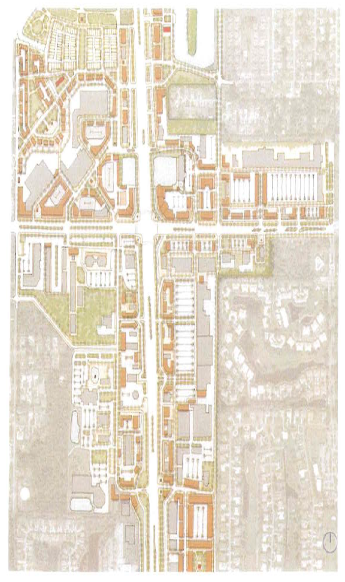
Figure 4-V-10 - Intersection of Tamiami Trail and Bonita Beach Road
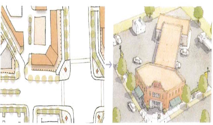
Figure 4-V-11 Redevelopment design suggestion at intersection corner
Bonita Beach Road and Old U.S. Road 41 (NODE)
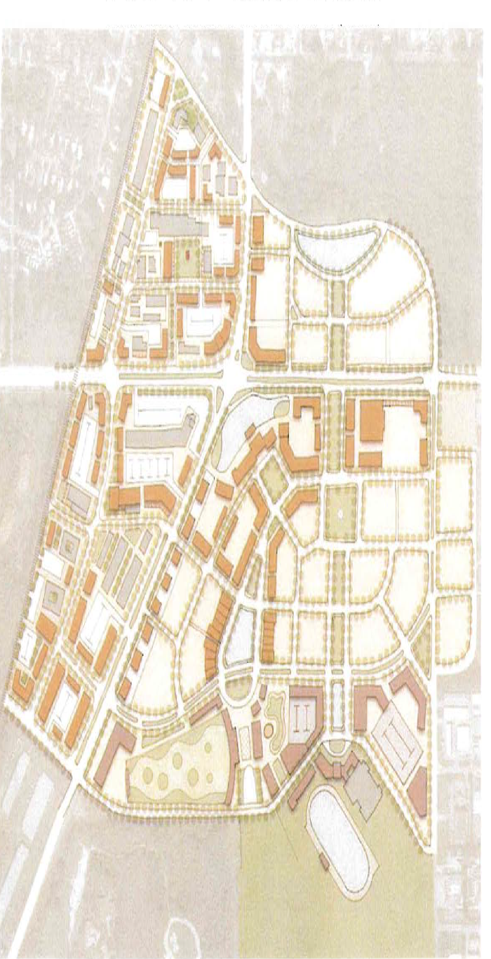
Figure 4-V-12 Illustrative redevelopment potential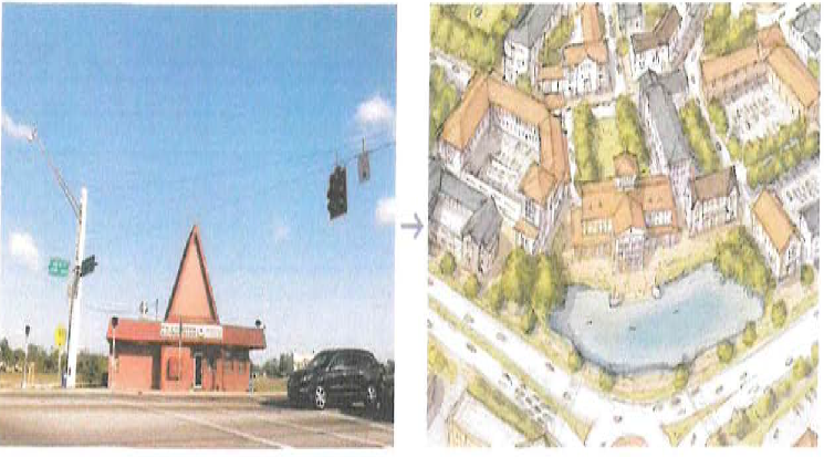
Figure 4-V-13, I-75 Gateway—Bonita Beach Road between Imperial Parkway and Interstate 75 (NODE)
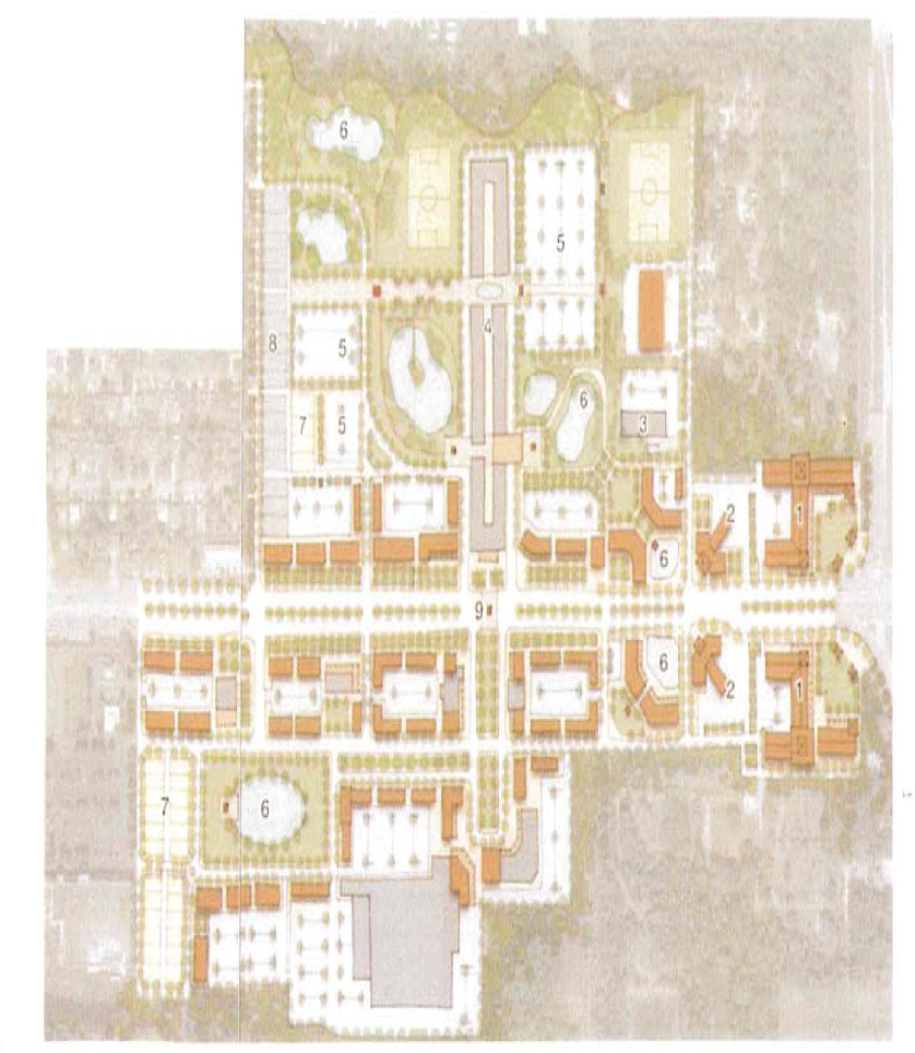
Figure 4-V-14 illustrative design for redevelopment (Northeast area of Imperial Parkway
and Bonita Beach Road)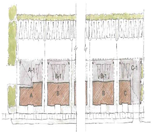
Figure 4-V-15 illustrative design for I-75 interchange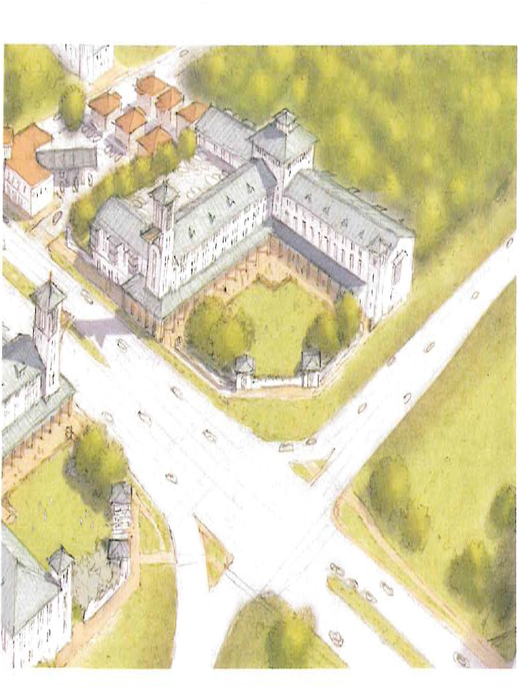
(Ord. No. 19-10, § 1(Exh. A), 11-20-2019; Ord. No. 23-02, § 2(Att.), 5-3-2023)