
Boone County Unincorporated
City Zoning Code
City Zoning Code
CHAPTER 3
- DISTRICTS AND GENERAL PROVISIONS
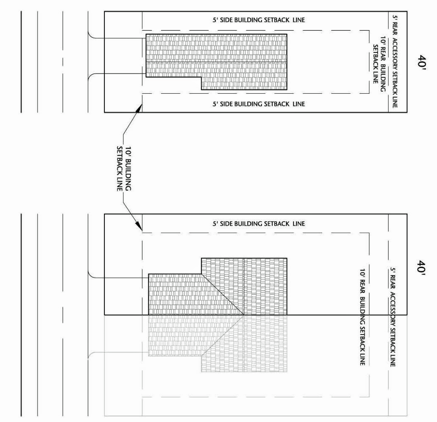
3.5.- SINGLE-FAMILY RESIDENTIAL DISTRICT (R-1)[2]
Note— Existing Zoning Only.
3.13.- FLOODPLAIN OVERLAY DISTRICT (FPO)[3]
Editor's note— Ord. No. 11-04, § 1, adopted Jan. 19, 2011, amended Ch. 3, § 3.13 in its entirety to read as herein set out. Former § 3.13, §§ 3.13.1—3.13.25, pertained to similar subject matterer, and derived from Ord. No. 08-20, § 1, adopted July 9, 2008.
3.14.- BUSINESS ROUTE 20 CORRIDOR OVERLAY DISTRICT (US20)[4]
Editor's note— Ord. No. 18-03, § 1, adopted Jan. 17, 2018, changed the title of § 3.14 from "US Highway 20 Corridor Overlay District (US20)" to read as herein set out.
3.1.1.- Establishment of districts.
For the purpose of this ordinance, the county is hereby organized into the following zoning districts:
3.1.2. - Overlay districts.
Overlay districts are created for the purpose of imposing special regulations in given designated areas of the county to accomplish stated purposes that are set forth for each overlay district. Overlay districts shall be in addition to, and shall overlap and overlay all other zoning districts within which lands placed in each district also lie, so that any parcel of land lying in an overlay district shall also lie in one or more of the other zoning districts provided for in this ordinance. In general, overlay districts and amendments thereto shall be established in the same fashion and by the same procedures set forth in section 2.10 for other zoning districts provided for by this ordinance, unless such procedures are qualified by the provisions of a particular overlay district as set forth herein.
3.1.3. - Zoning map.
The location and boundaries of the zoning districts are established by this ordinance and are set forth on the Zoning District Map of Boone County and are incorporated herein and hereby made a part of this ordinance. Said map(s), together with everything shown thereon and all amendments thereto, shall be as much a part of this ordinance as though fully set forth and described herein.
3.1.4. - Boundaries.
A.
The boundaries of the districts established in section 3.1 are as shown on the Zoning District Maps of Boone County.
B.
District boundary lines are the centerlines of highways, streets, alleys, and easements.
C.
When the exact boundaries of a district are uncertain, they shall be determined by reading the distance on the zoning district maps from a line of known location to such district boundary.
D.
When a right-of-way is vacated, the districts adjoining each side are respectively extended to the center of this area so vacated.
E.
If a boundary line of a district divides a lot having frontage on a street, so that the front part of the lot lies in one district, and part of the lot lies in another, a restriction that applies to the front part of the lot applies to the entire lot.
F.
If the boundary line of a district divides a lot in a manner essentially perpendicular to a street, that restriction that applies to the larger part of the lot applies to the entire lot.
3.1.5. - Territory not included.
In every case where territory has not been specifically included within a district or where a territory becomes a part of the unincorporated area as the result of the disincorporation of any municipality, or portion thereof, or otherwise, such territory shall automatically be classified as an A-1 district until otherwise classified.
3.1.6. - Lots of record.
All lots of record in lawful existence prior to May 10, 1978, must be developed according to the use district in which they are located, except as provided in section 1.1.4.
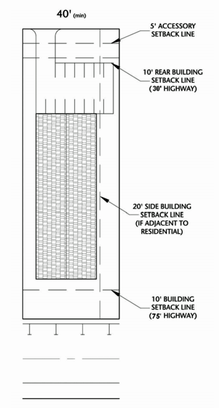
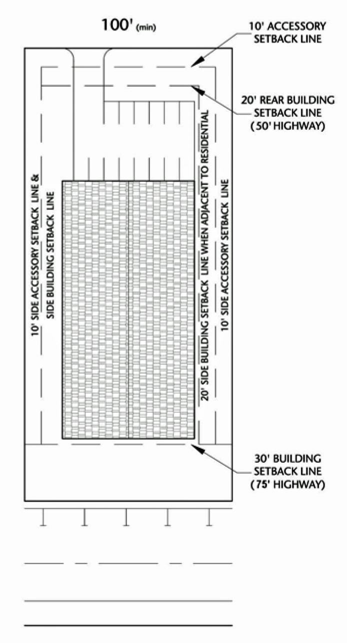
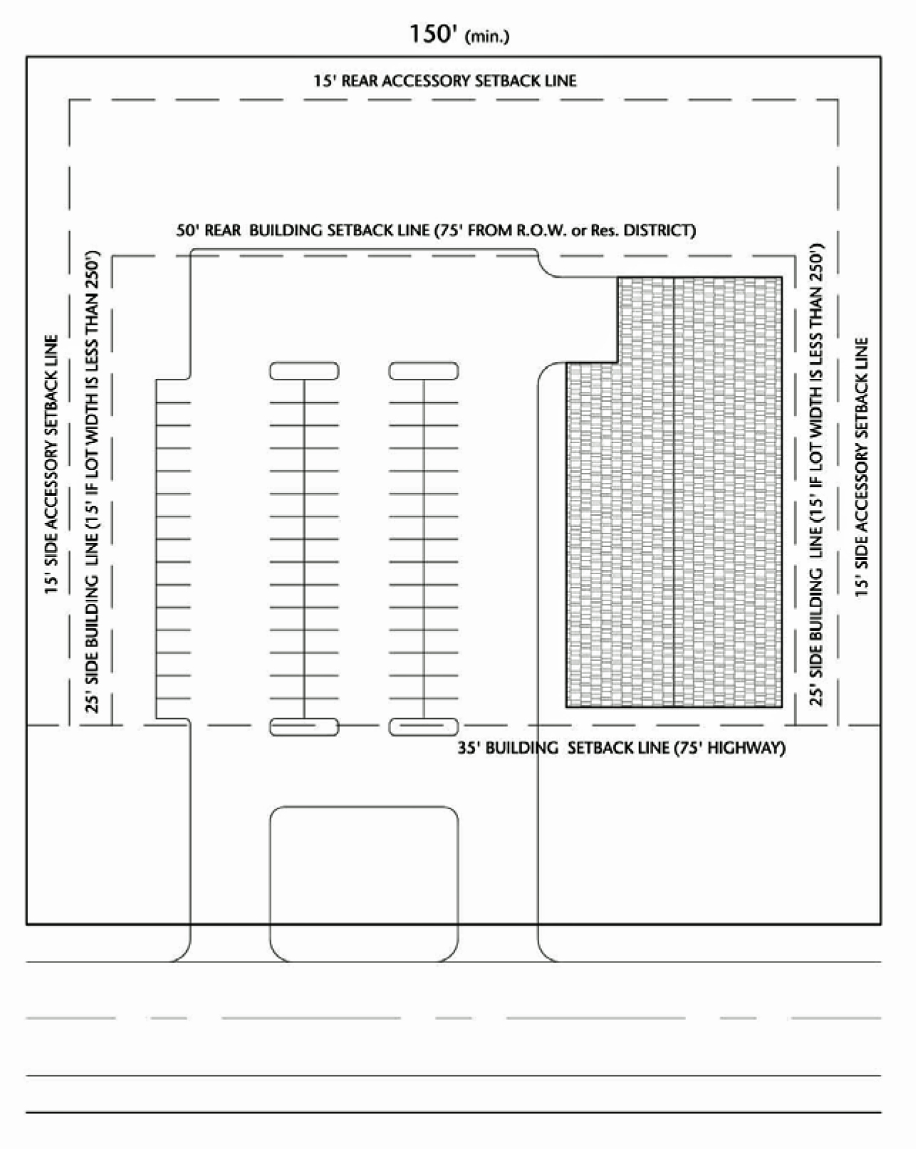
3.1.7. - General setbacks.
Setback requirements shall be set forth in each section for the specific needs of the district.
3.1.8. - Exception to height limits.
The height limitations of this ordinance shall not apply to religious spires, belfries, cupolas, and domes not intended for human occupancy; monuments, grain elevators, water towers, transmission towers, chimneys, and aerials, and fences for baseball backstops and basketball/tennis courts.
3.1.9. - Flood hazard development requirements.
The county board shall take into account flood hazards, to the extent that they are known, in all official actions related to land management, use and development.
A.
New subdivisions, manufactured home parks, travel trailer parks, planned developments and additions to manufactured home parks and subdivisions shall meet the requirements of chapter 2 of this ordinance. Plats or plans for new subdivisions, manufactured home parks, and planned developments shall include a signed statement by a registered professional engineer that the plat or plan accounts for changes in the drainage of surface waters in accordance with the Plat Act (765 ILCS 205/0.01, et seq.)
B.
Proposals for new subdivisions, manufactured home parks, travel trailer parks, planned developments and additions to manufactured home parks and subdivisions shall include base flood elevation data and floodway delineations. Where this information is not available from an existing study filed with the Illinois State Water Survey, the applicant shall be responsible for calculating the base flood elevation and the floodway delineation and submitting it to the State Water Survey for review and approval as best available regulatory data.
3.2.1.- Intent and purpose.
The agricultural preservation area district is intended to maintain, enhance, and conserve prime agricultural soils and historically farmed soils, to protect sensitive natural features, and to prevent the uncontrolled, uneconomical spread of nonagricultural development, which results in excessive costs to the county for the provision of essential public services. Boone County takes its direction in the agricultural preservation area district from the Farmland Preservation Act (505 ILCS 75/1 et seq.) and the Agricultural Areas Conservation and Protection Act (505 ILCS 5/1 et seq.). The map symbol and the short name for the agricultural preservation area district shall be A-1 district.
Agriculturally valuable soils predominate this district and lots are to be very sparsely developed to protect the county's natural resources, indigenous plant and animal habitats, and traditional rural lifestyles. The purpose of the A-1 district is to provide a means of achieving the agriculture and open space policies set forth by the Boone County Comprehensive Plan.
The A-1 district is not intended for, and shall not permit or include residential subdivisions requiring county board approval due to the incompatibility of such development in agricultural areas.
• The higher densities of residential subdivisions, as opposed to scattered individual residences, have detrimental effects and are not permitted;
• The increased demand for public services cannot be efficiently met in rural areas and therefore their costs become increasingly higher;
• Such development stimulates land speculation;
• The unjustified disruption and fragmentation of farming activity occurs;
• Such development discourages future farm improvement investments, and;
• The creation of conflicting land uses leads to potentially damaging nuisance complaints.
3.2.2. - Uses.
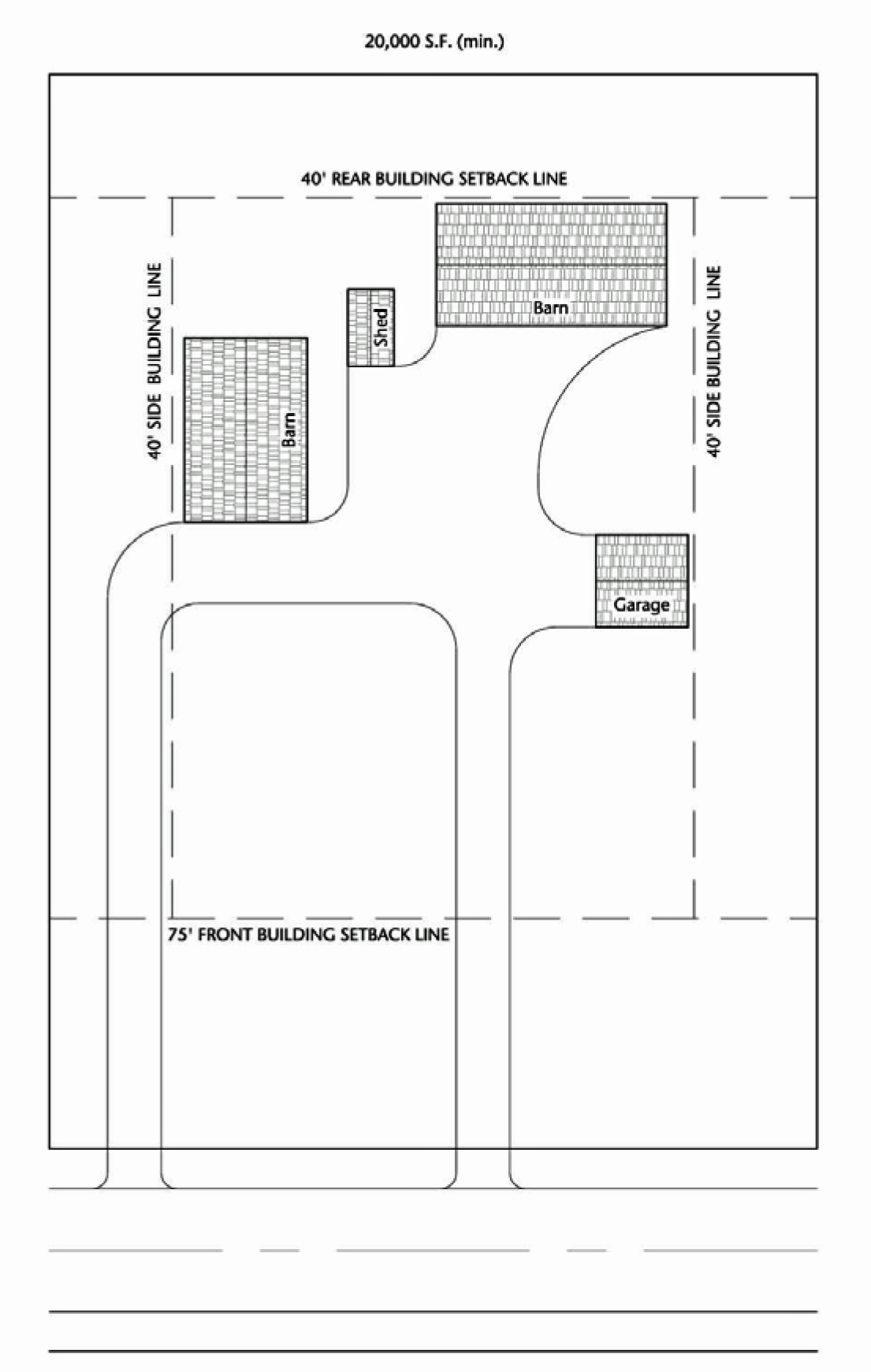
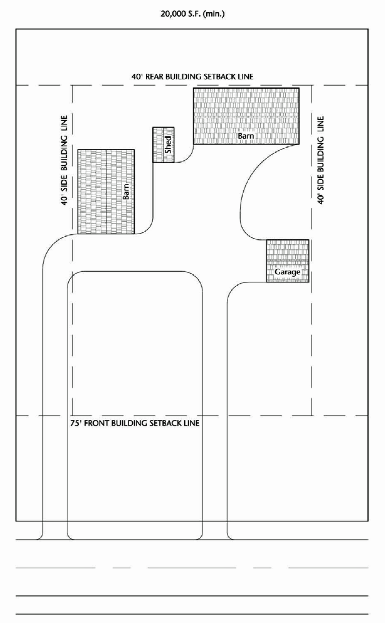
Permitted and special uses are listed in the use table in section 3.16. The lot area, lot width and yard requirements for a special use shall be designated in the permit granting the special use. However, the lot area shall not be less than one acre in size (exclusive of public road right-of-way) nor the lot width less than 150 feet in any case.
3.2.3. - Non-farm residential uses.
A.
New residences.
1.
All undeveloped lots of record in the A-1 district in lawful existence prior to May 10, 1978, may be developed with one single family residence per lot provided that other provisions of this ordinance and other applicable Boone County Codes and Ordinances are met. Refer to section 1.1.4. Including the following conditions:
a.
The parcel may not be divided after May 10, 1978.
b.
The parcel may not be combined after May 10, 1978.
2.
New residences shall meet the standards set forth in the tables in section 3.2.4.B. and 3.2.4.C.
B.
Existing residences—To be separated.
1.
Residences existing, or for which a building permit has been issued, prior to the adoption of this ordinance may be separated from the parcel provided that they meet the lot size and yard requirements for new residences as noted in section 3.2.4.B.
2.
Residences existing with a front yard setback established at more than 200 feet, or for which a building permit has been issued establishing such a setback distance, prior to the adoption of this ordinance may be separated with its related structures from the parcel provided that the lot so created shall:
• Retain frontage on a public road of at least 40 feet.
• Be not less than two acres in size, exclusive of public road right-of-way.
• Have a lot width of at least 250 feet measured at the building line.
• Have a front yard located immediately in front of the building line of at least 35 feet.
• Have a rear yard of at least 35 feet.
• Have a side yard of at least 15 feet.
3.
An existing residence, for which a building permit was issued, may be separated from a lawful lot of record to form a new lawful "buildable" lot of record containing the existing residence regardless of the date of the creation of the lot, provided that all applicable codes and ordinances are being met. Any new lot created by the severance of a buildable lot is considered an unbuildable lot because it will not consist of a creation date that complies with the May 10, 1978 requirement, listed under section 3.1.6 lots of record. The lot of record status remains with the lot on which the existing residence is/was located.
(Ord. No. 11-45, § 1, 10-19-2011; Ord. No. 14-43, § 1, 9-17-2014; Ord. No. 22-01, 12-16-2021)
3.2.4. - Lot development standards.
A.
Agriculture uses:
B.
Residential uses, less than five acres:
C.
Residential uses, five acres or more:
D.
Non-residential and non-agricultural uses:
(Ord. No. 10-28, § 1, 5-19-2010; Ord. No. 11-45, § 1, 10-19-2011)
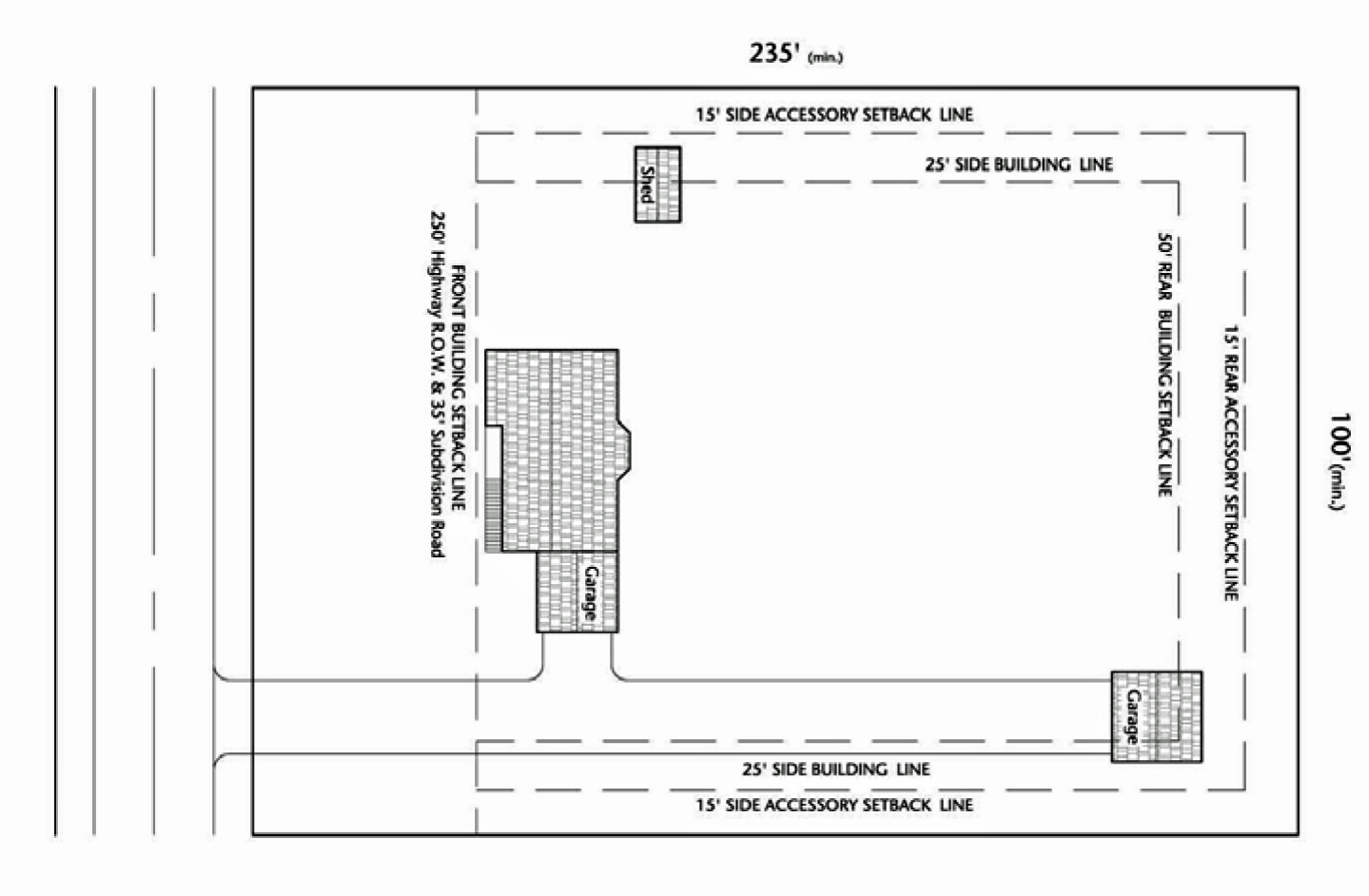
3.3.1.- Intent and purpose.
The agricultural residence district is intended to permit individual nonfarm single-family residences in areas not historically utilized for crop production or the raising of livestock, or areas which are unsuitable for farming. The purpose of the agricultural residence district is to provide a means of achieving the agriculture policies set forth by the Boone County Comprehensive Plan. It is not to encroach on and exploit those areas described in the open space policies set forth by the Boone County Comprehensive Plan. It is not a development district. The map symbol and short name for the agricultural residence district shall be A-2 district.
3.3.2. - Uses.
Permitted and special uses are listed in the use table in section 3.16.
3.3.3. - Conditions to be applied to nonfarm single-family residences.
A.
The applicant shall present clear and convincing evidence that the property consists of one of the following:
1.
Topography. If the slope of the lot is greater than nine percent or the land is classified as Highly Erodible Land (HEL) as defined by USDA. An erosion and sediment control plan for construction sites with its schedule for completion prepared by the applicant and the SWCD shall accompany applications using this criterion.
2.
Existence of physical features which serve as a barrier to farm operations. Including but not limited to streams, rock outcropping, wetlands. This should be reviewed and recommended by the Boone County Soil and Water Conservation District and the Boone County Conservation District or based on jurisdictional determination.
3.
Tree Cover. Contains more than 50 percent historically natural wooded areas. Area of trees whose combined canopies cover a minimum of 50 percent of one acre or more, as shown on the most recent available air photos of the County from a county recognized flight and provider and verified by an on-site survey.
B.
If the applicant can present evidence from section A, the following conditions must also be met:
1.
Free of water wells or, occupied by one or more water wells in service or, occupied by one or more properly sealed abandoned water wells.
2.
Shall comply with current local and state roadway safety requirements, situated in such a manner that any and all points along its frontage have adequate sight distance for egress and ingress, in both directions, as approved by the Boone County Engineer.
3.
Septic Suitability: Determined by a licensed Illinois Soil Classifier or an Illinois licensed Professional Engineer, and reviewed by the BC Health Department.
4.
Site plan.
a.
The parcel to be rezoned must demonstrate compatibility for rezoning in surrounding area.
b.
Site plan provided must show the percentage of property that will be maintained as open, undeveloped land, existing conditions and proposed site of home.
C.
A parcel with a LE score of 69 or lower as rated by the Boone County Soil and Water Conservation District (BCSWCD), deemed not prime agricultural land, shall be considered for the A-2 Zoning district, not subject to meeting conditions in section A.
(Ord. No. 22-10, 4-21-2022)
3.3.4 - Reserved.
Editor's note— Ord. No. 22-10, adopted April 21, 2022, eliminated section 3.3.4, which pertained to the Illinois State Plat Act requirements, and derived from Ord. No. 08-20, § 2, adopted July 9, 2008.
3.3.5. - Lot development standards.
A.
Agriculture uses:
B.
Residential uses:
(Ord. No. 10-28, § 1, 5-19-2010; Ord. No. 11-45, § 1, 10-19-2011)
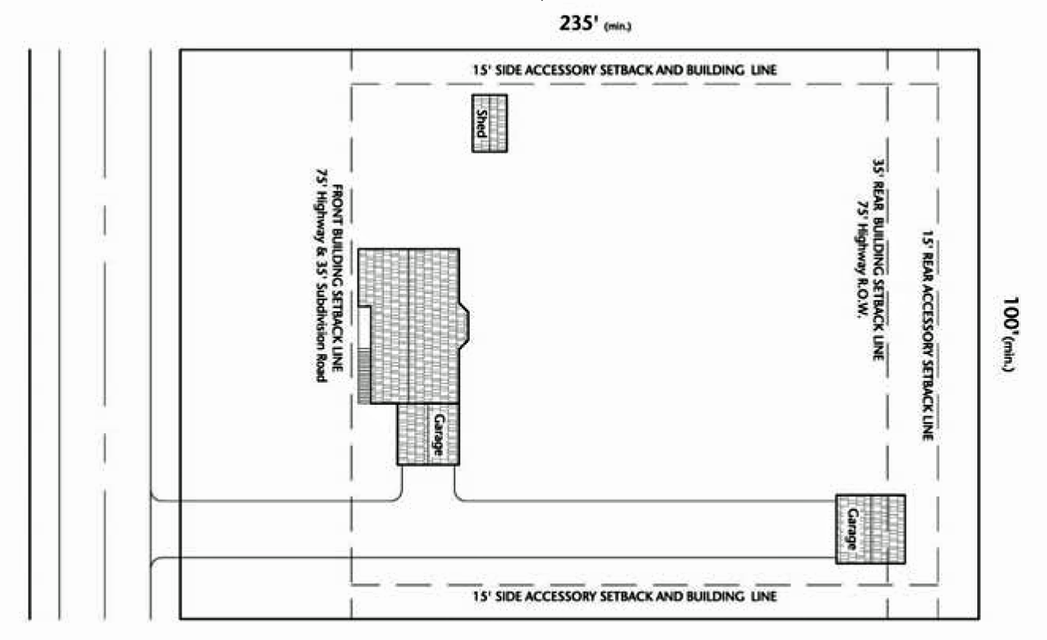
3.4.1.- Intent and purpose.
The exurban residential district is intended to permit rural, small estate residential development in areas not expected to have centralized water and/or sewer facilities in the near future, to provide an area for limited agricultural pursuits, equestrian uses, and to conserve areas which are physically unsuitable for intensive urban development. The map symbol and short name for the exurban residential district shall be RE district.
3.4.2. - Uses.
Permitted and special uses are listed in the use table in section 3.16.
3.4.3. - Density.
The residential density in a subdivided tract shall not exceed one dwelling unit for every three gross acres in said tract.
3.4.4. - Lot development standards.
A.
Residential uses:
B.
Non-residential uses:
(Ord. No. 09-23, § 1, 5-20-2009; Ord. No. 10-28, § 1, 5-19-2010; Ord. No. 11-45, § 1, 10-19-2011)
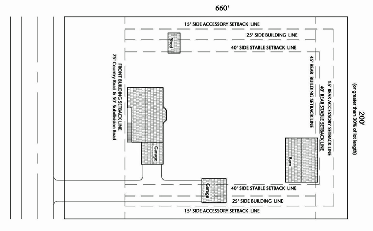
3.5.1.- Intent and purpose.
The purpose of the single-family residential district is to provide a means for achieving the rural residential development objective of the comprehensive plan for parcels and tracts of land classified single-family residential district on and prior to March 31, 2001. The map symbol and short name for the single-family residential district shall be R-1 district.
3.5.2. - Uses.
Permitted and special uses are listed in the use table in section 3.16.
3.5.3. - Density.
One dwelling unit for every two gross developable acres.
3.5.4. - Lot development standards.
A.
Residential uses:
**Residential lot reduction. The provision of section 3.5.4 shall not apply where either a public or private sewerage system for a smaller lot size is approved by the Boone County Health Department under standards established by the Illinois Department of Health. In such a case the minimum lot area for each single-family residence shall be 15,000 square feet. The minimum lot width shall be 75 feet at the building line.
B.
Non-residential uses:
(Ord. No. 10-28, § 1, 5-19-2010; Ord. No. 11-45, § 1, 10-19-2011)
3.6.1.- Intent and purpose.
The residential conservation development district is intended to permit rural, residential development in areas not expected to be served by centralized water and/or sewer facilities and to conserve landscapes in the county that are physically unsuitable for urban development, to protect natural resources, to conceal development from roads and adjacent development, and, wherever practical, maintain viable agricultural activities and landscapes. The map symbol and short name for the residential conservation development district shall be RC district.
The purpose of the RC district is to provide for single-family residential development which is designed to preserve and enhance natural systems for stormwater conveyance, infiltration, and water quality improvements; native habitat and vegetation. A property will not be rezoned to RC district unless it goes through the subdivision process concurrently.
3.6.2. - Uses.
Permitted and special uses are listed in the use table in section 3.16.
3.6.3. - Density.
The residential density in a subdivided tract shall not exceed one dwelling unit for every two gross acres in said tract.
3.6.4. - Additional design standards.
A.
Notwithstanding the lot standards, all new principal structures shall be setback from all perimeter roads 75 feet.
B.
Unobstructed views of residential and nonresidential lots from perimeter roads and abutting properties shall be avoided. Views from perimeter roads can be obstructed by the use of changes in topography, existing vegetation, the addition of new landscaping, or any combination thereof.
C.
New lots shall have access from interior streets rather than perimeter roads.
D.
Open space plan required. Conservation development shall set aside a minimum of 30 percent of lands for open space purposes. Such open space lands may be used for resource conservation or restoration purposes, active or passive recreation purposes, or for agricultural purposes. Land improved under the requirements of the section shall have an open space plan prepared indicating the nature and extent of open space improvements, the responsible party(ies) upon completion, and the standards pertaining to the ownership and maintenance of the open space.
E.
The design shall demonstrate the preservation and enhancement of existing natural features of the site, including woodlands, wetlands, steep slopes, and open drainage swales.
3.6.5. - Procedure (concurrent with subdivision review).
• Pre-application meeting.
• Concept plan approval.
• Preliminary plat and zoning request.
• Final plat.
3.6.6. - Lot development standards.
A.
Residential uses:
B.
Non-residential uses:
(Ord. No. 10-28, § 1, 5-19-2010; Ord. No. 11-45, § 1, 10-19-2011)
3.7.1.- Intent and purpose.
The purpose of the residential clustering district is to provide a means for achieving the environmental conservation and protection objectives in the Boone County Comprehensive Plan. The use of residential clustering is intended to create a distinct physical settlement surrounded by a protected greenbelt used for agricultural, silvicultural, recreational, and environmental protection purposes. This district does not allow more units per development, but does allow the full measure of units to consume less space while protecting open space. The map symbol and short name for the residential clustering district shall be RC-2 district.
A central square should be used to organize the development and provide buildings for civic or religious assembly or for other common purposes. Please refer to the open space regulations in section 5.3 and section 5.4. This district is proposed for use in conjunction with the community separation overlay district. A property will not be rezoned to RC-2 district unless it goes through the subdivision process concurrently.
3.7.2. - Uses.
Permitted and special uses are listed in the use table in section 3.16.
3.7.3. - Density determination.
A.
Density. The maximum density for all residential uses shall be two units per gross acre. The net density may be higher to accomplish the open space preservation desired.
B.
Areas used for commercial or institutional purposes shall be subtracted from the gross acreage before determining permissible residential density.
C.
A minimum of 70 percent of a proposed development shall be preserved for greenbelt/open space uses. The actual open space should be based on site capacity factors including wetlands, steep slopes, and other biological constraints.
D.
All dwelling units constructed above commercial/storefront uses shall be permissible in addition to the number of dwelling units otherwise authorized under this section. However, the total number of dwelling units in a development shall not be increased by more than ten dwelling units or ten percent, whichever is greater.
E.
When greenbelt land is to be donated to a land trust or to Boone County or another public entity, the board may allow up to a ten percent density bonus to generate additional income to the applicant for the sole purpose of endowing a permanent fund to offset continuing costs of maintaining land, including costs associated with active or passive recreation facilities. Spending from the endowment fund shall be restricted to the expenditure of interest so that the principal may be preserved. The estimate of maintenance costs shall be prepared by an agency, firm, or organization acceptable to the Boone County Board and with experience in managing conservation land and recreational facilities. Any area that is not accessible to the residents of the subdivision shall not be counted toward this density bonus.
F.
Non-residential uses. Retail uses, professional office, and personal or professional services shall be in buildings that are:
• 1 to 1.5 stories and 1,500 square feet or less, or
• 2 or more stories and 3,500 square feet or less, or
• 2 or more stories with greater square footage with special use findings.
• Lots intended for nonresidential use shall be identified on the final plat of subdivision.
Other nonresidential uses such as public and institutional uses will not have a density or size restriction.
3.7.4. - Procedure (concurrent with subdivision).
• Pre-application meeting.
• Concept plan approval.
• Preliminary plat and zoning request.
• Final plat.
3.7.5. - Lot development standards.
A.
Residential uses:
B.
Non-residential uses:
(Ord. No. 10-28, § 1, 5-19-2010; Ord. No. 11-45, § 1, 10-19-2011)
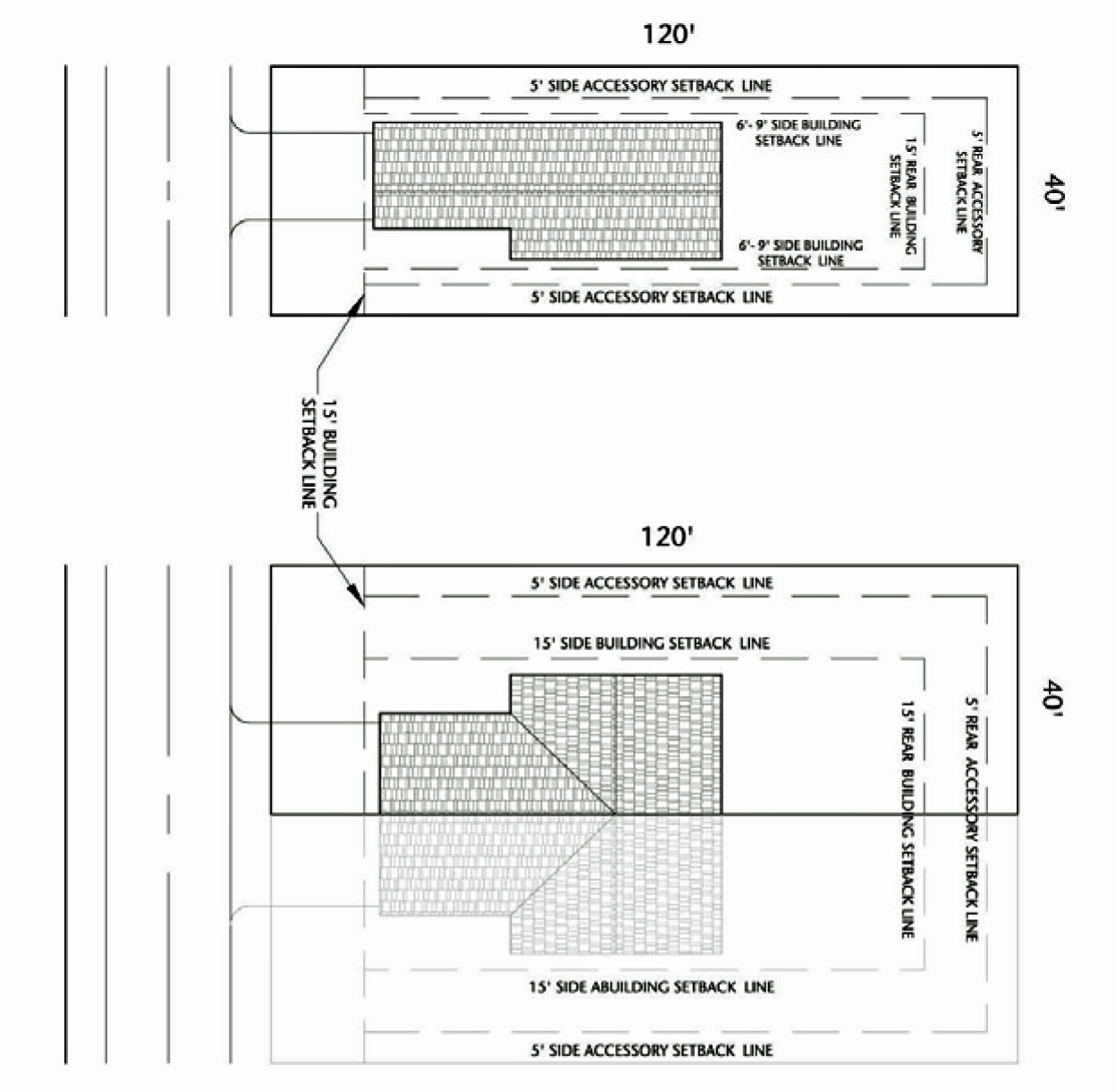
3.8.1.- Intent and purpose.
The purpose of the traditional neighborhood residential district is to provide a means for achieving the development objectives in the areas of Boone County that are designated for "Two-Family Residential," "Mixed Residential," "Planned Neighborhood," and "Traditional Neighborhood" in the Boone County Comprehensive Plan. The map symbol and short name for the traditional neighborhood residential district shall be RTN district.
Any development would have to be rezoned to the RTN district in order to permit intensity greater than one residential unit per two gross acres. Such rezoning should not take place if the tract of land is not directly adjacent to a municipality or land already zoned for development. Neighborhood services or a local business district should be located in the vicinity (within a ¾-mile). Mixed-uses in the same building are appropriate for this district.
Conservation design and traditional neighborhood developments are required in this district. A property will not be rezoned to RTN district unless it goes through the subdivision process concurrently.
3.8.2. - Uses.
Permitted and special uses are listed in the use table in section 3.16.
3.8.3. - Density and lot requirements.
A.
Density. The maximum density for attached and detached single-family residential uses shall be three units per gross acre. Multiple-family uses shall be allowed at eight units per gross acre, with no more than eight units in a single building.
B.
Detached single-family residences. Each single-family residence shall have a minimum lot width of 40 feet at the building line.
C.
Attached single-family residences (duplexes or townhouses). Each two-family residence shall have a minimum lot width of 80 feet at the building line if both residences share the ground floor. Two-family residences may be placed on smaller lots (minimum 40 feet) if the residences are arranged up and down, occupying separate floors. Every townhouse property shall have a minimum lot width of 80 feet with an additional width of 20 feet for every unit over two. A maximum of eight units shall be allowed in a single building.
D.
Multiple-family residences (apartments and condominiums). Multiple-family buildings shall have a minimum lot width of 100 feet at the building line.
E.
Non-residential uses. All nonresidential principal uses shall be located on a lot having a minimum lot width of not less than 40 feet at the building line.
3.8.4. - Setback exceptions.
A.
Allowable projections of business structures over sidewalk. Signs, awnings, canopies, or marquees, are permitted to over hang the sidewalk in the commercial districts only, providing that overhanging signs are a minimum of eight feet above the sidewalk at any point and that all other structures are a minimum of six feet eight inches above the sidewalk at any point.
B.
Allowable projection of accessory building into rear yard. One story accessory buildings may project into rear yards abutting an alley provided such projection extends not closer than five feet from the rear lot line.
3.8.5. - Lot development standards.
A.
Residential uses:
B.
Non-residential uses:
(Ord. No. 10-28, § 1, 5-19-2010; Ord. No. 11-45, § 1, 10-19-2011)
3.9.1.- Intent and purpose.
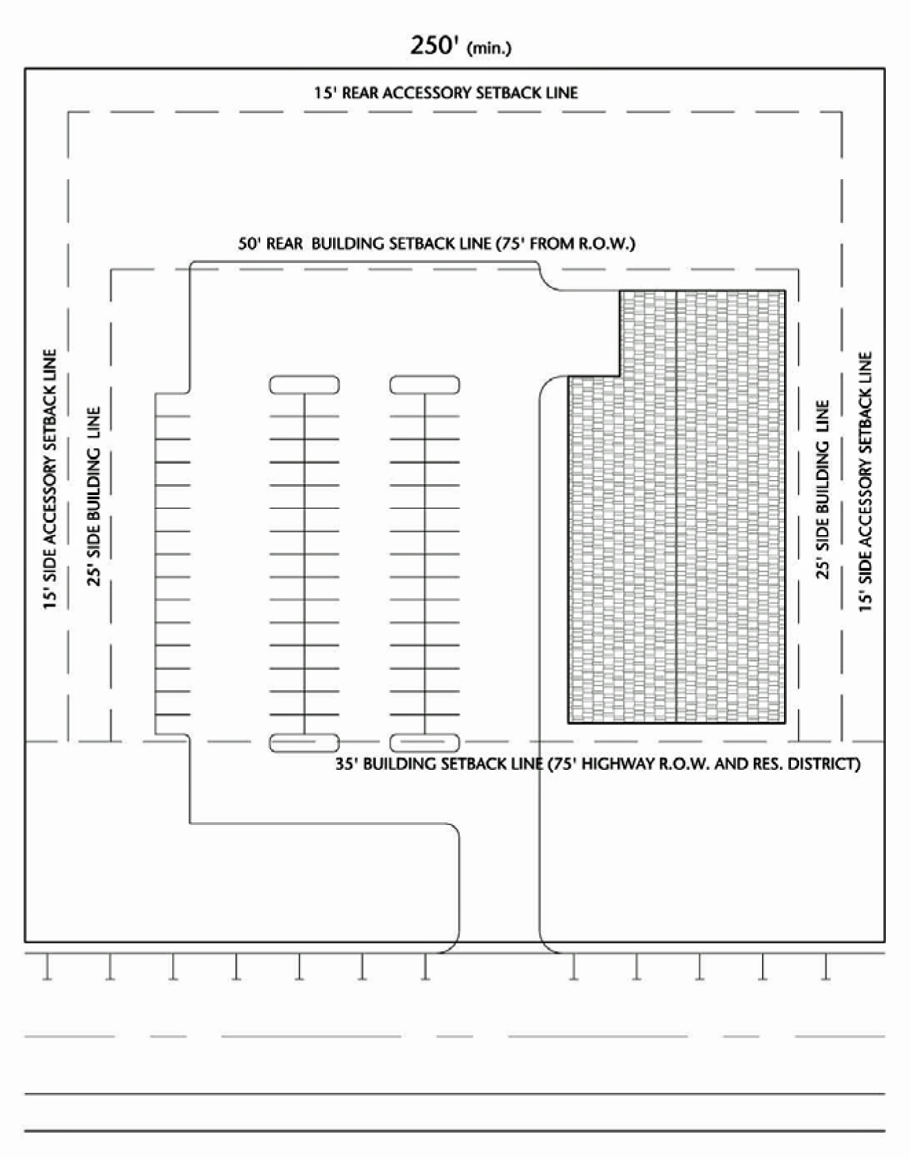
The local business district is intended to permit a limited range of retail sales and services which accommodate the daily or frequent shopping needs of local residential areas. This district is designed to permit pedestrian-oriented uses limited to those compatible with the residential character of the surrounding area. The map symbol and short name for the local business district shall be B-1 district.
The purpose of the B-1 district is to provide a means of achieving the rural commercial policies set forth by the Boone County Comprehensive Plan, and the village center business policies discussed by the plan for unincorporated hamlets and villages. Traditional neighborhood design is encouraged for this district.
3.9.2. - Uses.
Permitted and special uses are listed in the use table in section 3.16.
3.9.3. - Required conditions.
A.
Dwelling units are not permitted below the second floor.
B.
There shall be no manufacture, processing or treatment of products other than those which are clearly incidental and essential to the retail business conducted on the same premises.
C.
All uses, operations or products shall not be objectionable due to odor, dust, smoke, noise, vibration or other similar causes. Performance standards shall be enforced per section 4.1.
3.9.4. - Accessory uses.
Those uses customarily accessory to the principal uses are permitted by right, provided that:
A.
The accessory uses and buildings are on the same parcel as the principal building.
B.
The accessory uses and/or building are not located in any front or corner yard.
(Ord. No. 09-23, § 1, 5-20-2009)
3.9.5. - Lot development standards.
(Ord. No. 09-23, § 1, 5-20-2009; Ord. No. 10-28, § 1, 5-19-2010; Ord. No. 11-45, § 1, 10-19-2011)
3.10.1.- Intent and purpose.
The general business district is intended to permit a broad range of retail sales and services which require large tract locations in areas that are highway-oriented with good accessibility to large numbers of shoppers, and which can accommodate relatively heavy traffic. The map symbol and short name for the general business district shall be B-2 district.
The purpose of the B-2 district is to provide a means of achieving the rural commercial policies set forth by the Boone County Comprehensive Plan, and the limited business policies discussed by the Plan for unincorporated hamlets and villages. Conservation design and green building design is encouraged for this district. These design concepts are described in chapter 5 of this ordinance.
3.10.2. - Uses.
Permitted and special uses are listed in the use table in section 3.16.
3.10.3. - Required conditions.
A.
There shall be no manufacture, processing or treatment of products other than those which are clearly incidental and essential to the retail business conducted on the same premises.
B.
All uses, operations or products shall not be objectionable due to odor, dust, smoke, noise, vibration or other similar causes. Performance standards shall be enforced per section 4.1.
3.10.4. - Accessory uses.
Those uses customarily accessory to the principal uses are permitted by right, provided that:
A.
The accessory uses and buildings are on the same parcel as the principal building.
B.
The accessory uses and/or building are not located in any front or corner yard.
(Ord. No. 09-23, § 1, 5-20-2009)
3.10.5. - Lot development standards.
(Ord. No. 09-23, § 1, 5-20-2009; Ord. No. 10-28, § 1, 5-19-2010; Ord. No. 11-45, § 1, 10-19-2011)
3.11.1.- Intent and purpose.
The light industrial district is intended to permit industries which encourage the development of wholesale warehousing, assembly, and limited manufacturing establishments which are clean, quiet, and free of hazardous or objectionable elements such as noise, odor, dust, smoke or glare.
This district is designed for businesses that operate entirely within enclosed structures and generate little industrial traffic. Research and development activities are encouraged. This district is further designed to act as a transitional area between general industrial activities and other less intense nonindustrial uses. The map symbol and short name for the light industrial district shall be I-1 district.
The purpose of the I-1 district is to provide a means of achieving the industrial policies set forth by the Boone County Comprehensive Plan, and the limited industrial policies discussed by the comprehensive plan for unincorporated hamlets and villages. Conservation site planning principles and green-building designs are encouraged in this district.
3.11.2. - Uses.
Permitted and special uses are listed in the use table in section 3.16.
3.11.3. - Required conditions.
All permitted uses are subject to the following conditions:
A.
All production, assembly, fabrication, manufacture, servicing, testing, or repair shall take place within completely enclosed buildings.
B.
All storage, except of motor vehicles in operable condition, shall be within completely enclosed buildings or within the rear yard, effectively screened by a solid wall, fence (including solid entrance and exit gates) not less than six feet nor more than eight feet in height or suitable landscaping devices as provided in section 5.4.
3.11.4. - Lot development standards.
A.
Industrial/office/public uses:
B.
Agriculture uses:
(Ord. No. 10-28, § 1, 5-19-2010; Ord. No. 11-45, § 1, 10-19-2011)
3.12.1.- Intent and purpose.
The general industrial district is intended to permit industries that encourage the development of major manufacturing, processing, warehousing, and research and development operations. These activities require extensive community facilities and reasonable access to arterial thoroughfares. They may have extensive open storage and service areas, generate heavy industrial traffic, and meet lower industrial performance standards than those uses permitted in the light industrial district. The map symbol and short name for the general industrial district shall be I-2 district.
The I-2 district is not intended for, and shall not permit or include industrial establishments that create nuisances beyond the limitations set by this ordinance. This district is designed to be isolated from residential and commercial development.
The purpose of the I-2 district is to provide a means of achieving limited special facilities areas and extractive uses policies set forth by the Boone County Comprehensive Plan, and the limited industry policies discussed by the plan for unincorporated hamlets and villages.
3.12.2. - Uses.
Permitted and special uses are listed in the use table in section 3.16.
3.12.3. - Required conditions.
All permitted uses are subject to the following conditions:
A.
All production, assembly, fabrication, manufacture, servicing, testing, or repair shall take place within completely enclosed buildings.
B.
Outdoor storage shall be done in the rear yard only. All storage within 500 feet of a residence district (except of motor vehicles in operable condition) shall be within completely enclosed buildings or within the rear yard and effectively screened by a solid wall or fence (including solid entrance and exit gates) not less than six feet nor more than eight feet in height in accordance with section 5.2.3.
C.
All activities, within 500 feet of a residence or business district (except for off-street parking and loading) shall be conducted within completely enclosed buildings.
3.12.4. - Lot development standards.
A.
Industrial/office/public uses:
B.
Agriculture uses:
(Ord. No. 10-28, § 1, 5-19-2010; Ord. No. 11-45, § 1, 10-19-2011)
3.13.1.- Intent, purpose, and boundaries.
The floodplain overlay district is intended to maintain, enhance, and protect the natural environment associated with waterways, their floodways and floodplains, and wetland areas. The boundaries of this district shall be as delineated on the 100-year flood profiles in the Flood Insurance Study of Boone County prepared by the Federal Insurance Administration dated February 18, 2011; and the Soils Survey for Boone County compiled by the United States Department of Agriculture, Natural Resources Conservation Service. The purpose of the Floodplain Overlay district is to provide a means of achieving the open space policies set forth by the Boone County Comprehensive Plan. The map symbol and short name for the floodplain overlay district shall be FPO district.
(Ord. No. 11-04, § 1, 1-19-2011)
3.13.2. - Development standards.
This section is enacted pursuant to the police powers granted to Boone County by the County Statutory Authority in 55 ILCS 5/5-1041 and 5/5-1063 in order to accomplish the following purposes:
A.
To prevent unwise developments from increasing flood or drainage hazards to others;
B.
To protect new buildings and major improvements to buildings from flood damage;
C.
To promote and protect the public health, safety and general welfare of the citizens from the hazards of flooding;
D.
To lessen the burden on the taxpayer for flood control, repairs to public facilities and utilities, and flood rescue and relief operations;
E.
To maintain property values and a stable tax base by minimizing the potential for creating blight areas;
F.
To make federally subsidized flood insurance available for property in the county by fulfilling the requirements of the National Flood Insurance Program, and
G.
To preserve the natural characteristics and functions of watercourses and floodplains in order to moderate flood and storm-water impacts, improve water quality, reduce soil erosion, protect aquatic and riparian habitat, provide recreational opportunities, provide aesthetic benefits and enhance community and economic development.
(Ord. No. 11-04, § 1, 1-19-2011)
3.13.3. - Uses.
Only the following uses are permitted regardless of the underlying zoning district:
A.
Agriculture and row crop production.
B.
Wholesale nursery stock provided that no noxious fertilizer is stored on the premises and no noxious soil or fertilizing process is conducted thereon.
C.
Orchards and vineyards.
D.
Land and water conservation practices.
E.
Artificial lakes of five acres or less.
F.
Public parks and playgrounds.
G.
Ultra-light landing area for five or fewer air vehicles.
H.
Towers, less than 200 feet above ground level.
I.
Accessory uses and buildings.
Permitted by special use:
A.
Artificial lakes of more than five acres and marinas.
B.
Earth materials extraction (gravel, peat, sand, and stone).
C.
Towers, 200 feet or greater above.
D.
Restricted landing areas and airports.
E.
Outdoor commercial recreation enterprise and private recreational developments.
F.
Fish and game hatcheries and preserves.
G.
Nursery stock and horticultural supplies (garden center), retail; provided that in A-1 and A-2 districts nursery stock is grown on-site or on adjacent sites.
H.
Seasonal tourist attractions.
I.
Public camp.
J.
Energy facilities, less than 1.0 MW production.
(Ord. No. 11-04, § 1, 1-19-2011)
3.13.4. - Setbacks.
Setbacks required by the underlying zoning district shall prevail.
(Ord. No. 11-04, § 1, 1-19-2011)
3.13.5. - Maximum height.
Two and one-half stories or 30 feet, whichever is less.
(Ord. No. 11-04, § 1, 1-19-2011)
3.13.7. - Definitions.
The following words and terms when used in the interpretation and administration of this section 3.13 shall have the meaning set forth herein except where otherwise specifically indicated.
Base flood. The flood having a one percent probability of being equaled or exceeded in any given year. The base flood is also known as the 100-year flood. The base flood elevation at any location is as defined in section 3 of this ordinance.
Base flood elevation (BFE). The elevation in relation to mean sea level of the crest of the base flood.
Basement. That portion of a building having its floor sub-grade (below ground level) on all sides.
Building. A walled and roofed structure, including a gas or liquid storage tank that is principally above ground also including manufactured homes, prefabricated buildings and gas or liquid storage tanks. The term also includes recreational vehicles and travel trailers installed on a site for more than 180 days per year.
Critical facility. Any facility which is critical to the health and welfare of the population and, if flooded, would create an added dimension to the disaster. Damage to these critical facilities can impact the delivery of vital services, can cause greater damage to other sectors of the community, or can put special populations at risk.
Examples of critical facilities where flood protection should be required include: emergency services facilities (such as fire and police stations), schools, hospitals retirement homes and senior care facilities, major roads and bridges, critical utility sites (telephone switching stations or electrical transformers, and hazardous material storage facilities (chemicals, petrochemicals, hazardous or toxic substances).
Development. Any man-made change to real estate including, but not necessarily limited to:
1.
Demolition, construction, reconstruction, repair, placement of a building, or any structural alteration to a building;
2.
Substantial improvement of an existing building;
3.
Installation of a manufactured home on a site, preparing a site for a manufactured home, or installing a travel trailer on a site for more than 180 days per year;
4.
Installation of utilities, construction of roads, bridges, culverts or similar projects;
5.
Construction or erection of levees, dams walls or fences;
6.
Drilling, mining, filling, dredging, grading, excavating, paving, or other alterations of the ground surface;
7.
Storage of materials including the placement of gas and liquid storage tanks, channel modifications or any other activity that might change the direction, height, or velocity of flood or surface waters.
"Development" does not include routine maintenance of existing buildings and facilities, resurfacing roads, or gardening, plowing, and similar practices that do not involve filing, grading, or construction of levees.
Existing manufactured home park or subdivision. A manufactured home park or subdivision for which the construction of facilities for servicing the lots on which the manufactured homes are to be affixed or buildings to be constructed (including, at a minimum, the installation of utilities, the construction of streets, and either final site grading or the pouring of concrete pads) is completed before the effective date of the floodplain management regulations adopted by a community.
Expansion to an existing manufactured home park or subdivision. The preparation of additional sites by the construction of facilities for servicing the lots on which the manufactured homes are to be affixed (including the installation of utilities, the construction of streets, and either final site grading or the pouring of concrete pads).
FEMA. Federal Emergency Management Agency.
Flood. A general and temporary condition of partial or complete inundation of normally dry land areas from the overflow, the unusual and rapid accumulation, or the runoff of surface waters from any source.
Flood fringe. That portion of the floodplain outside of the regulatory floodway.
Flood insurance rate map. A map prepared by the Federal Emergency Management Agency that depicts the floodplain or special flood hazard area (SFHS) within a community. This map includes insurance rate zones and may or may not depict floodways and show base flood elevations.
Flood insurance study. An examination, evaluation and determination of flood hazards and, if appropriate corresponding water surface elevations.
Floodplain and special flood hazard area (SFHA). These two terms are synonymous. Those lands within the jurisdiction of the county that are subject to inundation by the base flood. The floodplains of the Kishwaukee River and the North Kinnikinnick, South Kinnikinnick Beaver, Mosquito, Picasaw, Meander, Mud and Coon Creeks are generally identified on the panels of the county-wide Flood Insurance Rate Map of Boone County prepared by the Federal Emergency Management Agency and dated February 18, 2011. Floodplain also includes those areas of known flooding as identified by the community.
Flood-proofing. Any combination of structural or nonstructural additions, changes, or adjustments to structures which reduce or eliminate flood damage to real estate, property and their contents.
Flood-proofing certificate. A form published by the Federal Emergency management agency that is used to certify that a building has been designed and constructed to be structurally dry or flood proofed to the flood protection elevation.
Flood protection elevation (FPE). The elevation of the base flood plus one foot of freeboard at any given location in the floodplain.
Floodway. That portion of the floodplain required to store and conveys the base flood. The floodway for the floodplains of Kishwaukee River and the North Kinnikinnick, South Kinnikinnick Beaver, Mosquito, Picasaw, Meander, Mud and Coon Creeks shall be as delineated on the county-wide Flood Insurance Rate Map of Boone County prepared by FEMA and dated February 18, 2011. The floodways for each of the remaining floodplains of the Boone County shall be according to the best data available from the federal, state, or other sources.
Freeboard. An increment of elevation added to the base flood elevation to provide a factor of safety for uncertainties in calculations, future watershed development, unknown localized conditions, wave actions and unpredictable effects such as those caused by ice or debris jams.
Historic structure. Any structure that is:
1.
Listed individually on the National Register of Historic Places or preliminarily determined by the Secretary of the Interior as meeting the requirements for individual listing on the National Register.
2.
Certified or preliminarily determined by the Secretary of the Interior as contributing to the historic district or a district preliminarily determined by the Secretary to qualify as a registered historic district.
3.
Individually listed on the state inventory of historic places by the Illinois Historic Preservation Agency.
4.
Individually listed on a local inventory of historic places that has been certified by the Illinois Historic Preservation Agency.
IDNR/OWR. Illinois Department of Natural Resources/Office of Water Resources.
Lowest floor. The lowest floor of the lowest enclosed area (including basement). An unfinished or flood resistant enclosure, usable solely for parking of vehicles, building access or storage in an area other than a basement area is not considered a building's lowest floor. Provided that such enclosure is not built so as to render the structure in violation of the applicable non-elevation design requirements of section 3.13.17 of this ordinance.
Manufactured home. A structure transportable in one or more sections that is built on a permanent chassis and is designed to be used with or without a permanent foundation when connected to required utilities.
Manufactured home park or subdivision. A parcel (or contiguous parcels) of land divided into two or more lots for rent or sale.
New construction. Structures for which the start of construction commenced or after the effective date of floodplain management regulations adopted by a community and includes any subsequent improvements of such structures.
New manufactured home park or subdivision. A manufactured home park or subdivision for which the construction of facilities for servicing the lots on which the manufactured homes are to be affixed or buildings to be constructed (including, at a minimum, the installation of utilities, the construction of streets, and either final site grading or the pouring of concrete pads) is completed on or after the effective date of the floodplain management regulations adopted by a community.
NFIP. National Flood Insurance Program.
Recreational vehicle or travel trailer. A vehicle which is:
1.
Built on a single chassis;
2.
Four hundred square feet or less in size;
3.
Designed to be self-propelled or permanently towable by a light duty truck and designed primarily not for use as a permanent dwelling but as temporary living quarters for recreational, camping, travel or seasonal use.
Repetitive loss. Flood related damages sustained by a structure on two separate occasions during a ten year period for which the cost of repairs at the time of each such flood event on the average equals or exceeds 25 percent of the market value of the structure before the damage occurred.
SFHA. See definition of floodplain.
Start of construction. Includes substantial improvement and means the date the building permit was issued. This, provided the actual start of construction, repair, reconstruction, rehabilitation, addition placement or other improvement, was within 180 days of the permit date. The actual start means either the first placement of permanent construction of a structure on a site, such as the pouring of slab or footings, the installation of piles, the construction of columns or any work beyond the stage of excavation or placement of a manufactured home on a foundation. For a substantial improvement, actual start of construction means the first alteration of any wall, ceiling, floor or other structural part oaf a building whether or not that alteration affects the external dimensions of the building.
Structure. See "Building".
Substantial damage. Damage of any origin sustained by a structure whereby the cumulative percentage of damage during the life of the building equals or exceeds 50 percent of the market value of the structure before the damage occurred regardless of actual repair work performed. Volunteer labor and materials must be included in this determination. The term includes "Repetitive loss buildings" (see definition).
Substantial improvement. Any reconstruction, rehabilitation, addition or improvement of a structure taking place during the life of the building in which the cumulative percentage of improvements:
Equals or exceeds 50 percent of the market value of the structure before the improvement or repair is started, or
Increases the floor area by more than 20 percent.
"Substantial improvement" is considered to occur when the first alteration of any wall, ceiling, floor or other structural part of the building commences, whether or not that alteration affects the external dimensions of the structure. This term includes structures which have incurred repetitive loss or substantial damage, regardless of the actual repair work done.
The term does not include:
1.
Any project for improvement of a structure to comply with existing state or local health, sanitary, or safety code specifications which are solely necessary to assure safe living conditions, or
2.
Any alteration of a structure listed on the National Register of Historic Places or the Illinois Register of Historic Places.
Violation. The failure of a structure or other development to be fully compliant with the community's floodplain management regulations. A structure or other development without the required federal, state, and/or local permits and elevation certification is presumed to be in violation until such time as the documentation is provided.
(Ord. No. 11-04, § 1, 1-19-2011)
3.13.8. - Base flood elevation.
This ordinance's protection standard is the base flood. The best available base flood data are listed below. Whenever a party disagrees with the best available data, the party shall finance the detailed engineering study needed to replace the existing data with better data and submit it to the FEMA and IDNR/OWR for approval prior to any development of the site.
A.
The base flood elevation for the floodplains of Kishwaukee River and the North Kinnikinnick, South Kinnikinnick Beaver, Mosquito, Picasaw, Meander, Mud and Coon Creeks shall be as delineated on the 100-year flood profiles in the county-wide Flood Insurance Study of Boone County prepared by the Federal Emergency Management Agency and dated February 18, 2011.
B.
The base flood elevation for each floodplain delineated as an "AH Zone" or AO Zone" shall be that elevation (or depth) delineated on the county wide Flood Insurance Rate Map of Boone County.
C.
The base flood elevation for each of the remaining floodplains delineated as "A Zone" on the countywide Flood Insurance Rate Map of Boone County shall be according to the best data available from federal, state or sources. Should no other data exist, an engineering study must be financed by the applicant to determine base flood elevations.
(Ord. No. 11-04, § 1, 1-19-2011)
3.13.9. - Duties of the zoning enforcement officer.
The zoning enforcement officer shall be responsible for the general administration of this ordinance and ensure that all development activities within the floodplains under the jurisdiction of Boone County meet the requirements of this ordinance. Specifically, the zoning enforcement officer shall:
A.
Process development permits in accordance with section 3.13.11;
B.
Ensure that all development in a floodway (or a floodplain with no delineated floodway) meets the damage prevention requirements of section 3.13.16;
C.
Ensure that the building protection requirements for all buildings subject to section 3.13.17 are met and maintain a record of the "as-built" elevation of the lowest floor (including basement) or flood-proof certificate;
D.
Assure that all subdivisions and annexations meet the requirements of section 3.13.18;
E.
Ensure that water supply and waste disposal systems meet the public health standards of section 3.13.19;
F.
If a variance is requested, ensure that the requirements of section 3.13.21 are met and maintain documentation of any variances granted;
G.
Inspect all development projects and take any and all penalty actions outlined in section 3.13.22 as a necessary to ensure compliance with this ordinance;
H.
Assure that applicants are aware of and obtain any and all other required local, state, and federal permits;
I.
Notify IDNR/OWR and any neighboring communities prior to any alteration or relocation of a watercourse;
J.
Provide information and assistance to citizens upon request about permit procedures and floodplain construction techniques;
K.
Cooperate with state and federal floodplain management agencies to coordinate base flood data and to improve the administration of this ordinance;
L.
Maintain for public inspection base flood data, floodplain maps, copies of state and federal permits, and documentation of compliance for development activities subject to this ordinance;
M.
Perform site inspections to ensure compliance with this ordinance and make substantial damage determinations for structures within the floodplain, and
N.
Maintain the accuracy of floodplain maps including notifying IDNR/OWR and/or submitting information to FEMA within six months whenever a modification of the floodplain may change the base flood elevation or result in a change to the floodplain map.
(Ord. No. 11-04, § 1, 1-19-2011)
3.13.10. - Required conditions.
A.
Buildings or structures authorized in the flood plain district shall be built on a permanent foundation and not obstruct natural drainage courses and floodways (in accordance with section 3.13.17).
B.
Equipment and materials stored in areas subject to flooding shall have a specific gravity substantially heavier than water, or shall be otherwise secured against floating away and shall not be a source of water pollution or contamination.
(Ord. No. 11-04, § 1, 1-19-2011)
3.13.11. - Development permit.
No person, firm, corporation, or governmental body not exempted by law shall commence any development in the floodplain without first obtaining a development permit from the zoning enforcement officer. The zoning enforcement officer shall not issue a development permit if the proposed development does not meet the requirements of this ordinance.
A.
The application for development permit shall be accompanied by:
1.
Drawings of the site, drawn to scale showing property line dimensions;
2.
Existing grade elevations and all changes in grade resulting from excavation or filling;
3.
The location and dimensions of all buildings and additions to buildings;
4.
The elevation of the lowest floor (including basement) of all proposed buildings subject to the requirements of section 3.13.17 of this ordinance, and
5.
Cost of project or improvements as estimated by a licensed engineer or architect. A signed estimate by a contractor may also meet this requirement.
B.
Upon receipt of an application for a development permit, the zoning enforcement officer shall compare the elevation of the site to the base flood elevation. Any development located on land that can be shown by survey data to be higher than the current base flood elevation and which has not been filled after the date of the site's first flood insurance rate map is not in the floodplain and therefore not subject to the requirements of this ordinance. Conversely, any development located on land shown to be below the base flood elevation and hydraulically connected, but not shown on the current flood insurance rate map is subject to the provisions of this ordinance.
The zoning enforcement officer shall maintain documentation of the existing ground elevation at the development site and certification that this ground elevation existed prior to the date of the site's first flood insurance rate map identification.
The zoning enforcement officer shall be responsible for obtaining from the applicant copies of all other federal, state, and local permits, approvals or permit-not-required letters that may be required for this type of activity. The zoning enforcement officer shall not issue a permit unless all other federal, state, and local permits have been obtained.
(Ord. No. 11-04, § 1, 1-19-2011)
3.13.12. - Occupancy permits.
It shall be unlawful to use or occupy any buildings or any development site or any part thereof hereafter constructed in the SFHA without an occupancy permit. Application for an SFHA occupancy permit shall be submitted to the zoning enforcement officer upon completion of the work authorized in the development permit issued for the project in question. If, upon final inspection of a building or development site, the zoning enforcement officer finds that the work has been performed in accordance with the approved application and plans of the development permit, a use permit shall be issued. If final inspection reveals otherwise, a use permit may not be issued until all deficiencies are corrected. An "as-built" elevation certificate prepared by a registered land surveyor shall be required prior to the issuance of an occupancy certificate.
(Ord. No. 11-04, § 1, 1-19-2011)
3.13.13. - Permit review.
Refer to section 2.5 for permit review process.
(Ord. No. 11-04, § 1, 1-19-2011)
3.13.14. - Consent for inspections.
All work for which a permit is required shall be subject to inspection by the zoning enforcement officer or a duly authorized representative. It shall be unlawful to refuse to permit the zoning enforcement officer or the representative to enter such premises or structure at any reasonable time to make an inspection. It shall be unlawful to interfere with or hinder the zoning enforcement officer or the representative when in the performance of their duties.
(Ord. No. 11-04, § 1, 1-19-2011)
3.13.15. - Fees.
Fees for permits shall be established by the county board.
(Ord. No. 11-04, § 1, 1-19-2011)
3.13.16. - Preventing increased flood heights and resulting damages.
Within any floodway identified on the county-wide flood insurance rate map and within all other floodplains where a floodway has not been delineated, the following standards shall apply:
A.
Except as provided in section 3.13.16.B. of this ordinance, no development shall be allowed which, acting in combination with existing and anticipated development will cause any increase in flood heights or velocities or threat to public health and safety. The following specific development activities shall be considered as meeting this requirement:
1.
Bridge and culvert crossings of streams in rural areas meeting the following conditions of the Illinois Department of Natural Resources, Office of Water Resources Statewide Permit Number 2:
a.
The crossing will not result in an increase in water surface profile elevation in excess of 1.0 feet, and
b.
The crossing will not result in an increase in water surface profile elevation in excess of one-half feet at a point 1,000 feet upstream of the proposed structure.
c.
There are no buildings in the area impacted by the increases in water surface profile.
d.
The proposed bridge or culvert crossing will not involve straightening, enlarging, or relocating the existing channel.
e.
The design must be certified by a licensed professional engineer in the State of Illinois and the designs must meet the conditions of an IDNR/OWR permit.
f.
The design must be certified by a second licensed professional engineer.
2.
Barge fleeting facilities meeting the following conditions of IDNR/OWR Statewide Permit Number 3:
a.
The permit is only applicable when deadmen, pier cells, or other similar anchorage devices have been permitted by the U.S. Army Corps of Engineers.
3.
Aerial utility crossings meeting the following conditions of IDNR/OWR Statewide Permit Number 4:
a.
The utility line must be constructed above the existing 100-year flood elevation or attached to an existing bridge.
b.
A utility line attached to an existing bridge shall be constructed above the low cord elevation of the bridge.
c.
No supporting towers or poles shall be located in a river, lake or stream.
d.
Supporting towers including foundation and poles shall be designed and located so as to not cause an obstruction of flood flows by trapping debris.
e.
All disturbed areas shall be returned to pre-construction grades and re-vegetated.
f.
All Illinois Commerce Commission, National Electrical Safety Code, and federal requirements must be met.
4.
Minor boat docks meeting the following conditions of IDNR/OWR Statewide Permit Number 5:
a.
The boat dock must not extend more than 50 feet into a waterway and no more than one-quarter of the width of the waterway and shall not extend beyond the navigational limited established by the IDNR and Corps of Engineers.
b.
The width of the boat dock shall not be more than ten feet.
c.
For L-shaped or T-shaped docks, the length of that portion parallel to the shoreline must not exceed 50 percent of the landowner's shoreline frontage nor 50 feet.
d.
Docks must be aligned so as not to cross the projection of property lines into the waterway or come within ten feet of the projected property line.
e.
Dock posts must be marked by reflective devices.
f.
The boat dock must be securely anchored to prevent detachment during times of high wind or water.
g.
Metal drums or containers may not be used as buoyancy units unless they are filled with floatation foam. Containers which previously stored pesticides, herbicides, or any other toxic chemicals are not permissible.
h.
This permit does not authorize any other related construction activity such as shore protection or fill.
i.
Non-floating boat docks must be constructed in a manner which will minimize obstruction to flow.
j.
At any future date, the permittee must agree to make necessary modifications to the dock as determined by the IDNR or Corp of Engineers.
5.
Minor, nonobstructive activities meeting the following conditions of IDNR/OWR Statewide Permit Number 6:
a.
The following activities (not involving fill or positive change in grade) are covered by this permit:
i.
The construction of underground utility lines, wells, or septic tanks not crossing a lake or stream.
ii.
The construction of light poles, sign posts, and similar structures.
iii.
The construction of sidewalks, driveways, athletic fields (excluding fences), patios, and similar structures.
iv.
The construction of properly anchored, un-walled, open structures such as playground equipment, pavilions, and carports.
v.
The placement of properly anchored buildings not exceeding 70 square feet in size, nor ten square feet in any dimension. Only one such building on a property is authorized by this statewide permit.
vi.
The raising of existing buildings, provided no changes are made to the outside dimensions of the building and the placement of fill is not involved.
6.
Outfall structures and drainage ditch outlets meeting the following conditions of IDNR/OWR Statewide Permit Number 7:
a.
Any outfall structure, including any headwall or end-section, shall not extend riverward or lakeward of the existing adjacent natural bank slope or adjacent bank protection.
b.
The velocity of the discharge shall not exceed the scour velocity of the channel soil, unless channel erosion would be prevented by the use of riprap or other design measures.
c.
Outlets from drainage ditches shall not be opened to a stream until the ditch is vegetated or otherwise stabilized to minimize stream sedimentation.
d.
Disturbance of streamside vegetation shall be kept to a minimum during construction to prevent erosion and sedimentation. All disturbed floodway areas, including the stream banks, shall be restored to their original contours and seeded or otherwise stabilized upon completion of construction.
7.
Underground pipeline and utility crossings meeting the conditions of IDNR/OWR Statewide Permit Number 8:
a.
In all cases, the crossing shall be placed beneath the bed of the river, lake or stream and, unless the crossing is encased in concrete or entrenched in bedrock, a minimum of three feet of cover shall be provided. The river, lake or stream bed shall be returned to its original condition.
b.
Disturbance of streamside vegetation shall be kept to a minimum during construction to prevent erosion and sedimentation. All disturbed floodway areas, including stream banks, shall be restored to their original contours and seeded or otherwise stabilized upon completion of construction.
c.
Any utility crossing carrying material which may cause water pollution, as defined by the Environmental Protection Act (415 ILCS 5), shall be provided with shut-off valves on each side of the body of water to be crossed.
d.
If blasting is to be utilized in the construction of the crossing, the permittee shall notify the IDNR/OWR at least ten days prior to the blasting date to allow monitoring of any related fish kills.
8.
Bank stabilization projects meeting the conditions of IDNR/OWR Statewide Permit Number 9:
a.
Only the following materials may be utilized in urban areas: stone and concrete riprap, steel sheet piling, cellular blocks, fabric-formed concrete, gabion baskets, rock and wire mattresses, sand/cement filled bags, geotechnical fabric materials, natural vegetation and treated timber. Urban areas are defined as: areas of the state where residential, commercial, or industrial development currently exists or, based on land use plans or controls, is expected to occur within ten years. (The department should be consulted if there is a question of whether or not an area is considered urban).
b.
In addition to the materials listed in section 3.13.16.A.(8)(a), other materials (e.g. tire revetments) may be utilized in rural areas provided all other conditions of this permit are met.
c.
The following materials shall not be used in any case: auto bodies, garbage of debris, scrap lumber, metal refuse, roofing materials, asphalt or other bituminous materials, or any material which would cause water pollution as defined by the Environmental Protections Act (415 ILCS 5).
d.
The affected length of shoreline, stream bank, or channel to be protected shall not exceed, either singularly or cumulatively, 1,000 feet.
e.
All material utilized shall be properly sized or anchored to resist anticipated forces of current and wave action.
f.
Materials shall be placed in a way which would not cause erosion or the accumulation of debris on properties adjacent to or opposite the project.
g.
Materials shall not be placed higher than the existing top of the bank.
h.
Materials shall be placed so that the modified bank full-width and cross-sectional area of the channel will conform to or be no more restrictive than that of the natural channel upstream and downstream of the site.
For projects involving continuous placement of riprap along the bank, toe of the bank or other similar applications, in no case shall the cross-sectional area of the natural channel be reduced by more than ten percent nor the volume of material placed exceed two cubic yards per lineal foot of the stream bank or shoreline. The bank may be graded to obtain a flatter slope and to lessen the quantity of material required.
i.
If broken concrete is used, all protruding materials such as reinforcing rods shall be cut flush with the surface of the concrete and removed from the construction area.
j.
Disturbance of vegetation shall be kept to a minimum during construction to prevent erosion and sedimentation. All disturbed areas shall be seeded or otherwise stabilized upon completion of construction.
k.
In the case of seawalls and gabion structures on lakes, the structure shall be constructed at or landward of the water line as determined by the normal pool elevation, unless:
i.
It is constructed in alignment with an existing seawall(s) or gabion structure(s), and
ii.
The volume of material placed, including the structure, would not exceed two cubic yards per lineal foot.
l.
Excess material excavated during the construction of the bank or shoreline protection shall be placed in accordance with local, state, and federal laws and rules, and shall not be placed in a floodway.
9.
Accessory structures and additions to existing residential buildings meeting the conditions of IDNR/OWR Statewide Permit Number 10:
a.
The accessory structure or building addition must comply with the requirements of the local floodplain ordinance.
b.
The principle structure to which the project is being added must have been in existence on the effective date of this permit (July 25, 1988).
c.
The accessory structure or addition must not exceed 500 square feet in size and must not deflect floodwaters onto another property, and
d.
Must not involve the placement of any fill material.
e.
No construction shall be undertaken in, or within 50 feet of the bank of the stream channel.
f.
The accessory structure or addition must be properly anchored to prevent its movement during flood conditions.
g.
Only one accessory structure or addition to an existing structure shall be authorized by this permit; plans for any subsequent addition must be submitted to IDNR/OWR for review.
h.
Disturbances of vegetation shall be kept to a minimum during construction to prevent erosion and sedimentation. All disturbed floodway areas shall be seeded or otherwise stabilized upon completion of construction.
10.
Minor maintenance dredging activities meeting the following conditions of IDNR/OWR Statewide Permit Number 11:
a.
The affected length of the stream shall not either singularly or cumulatively exceed 1,000 feet.
b.
The project shall not include the construction of any new channel; all work must be confined to the existing channel or to reestablishing flows in the natural stream channel, and
c.
The cross-sectional area of the dredged channel shall conform to that of the natural channel upstream and down stream of the site.
d.
Dredged or spoil material shall not be disposed of in a wetland and shall be either:
i.
Removed from the floodway;
ii.
Used to stabilize an existing bank provided no materials would be placed higher than the existing top of bank and provided the cross-sectional area of the natural channel would not be reduced by more than ten percent, nor the volume of material placed exceed two cubic yards per lineal foot of stream-bank;
iii.
Used to fill an existing washed out or scoured floodplain area such that the average natural floodplain elevation is not increased;
iv.
Used to stabilize and existing levee provided the height of the levee would not be increased nor its alignment changed;
v.
Placed in a disposal site previously approved by the department in accordance with the conditions of the approval, or
vi.
Used for beach nourishment, provided the material meets all applicable water quality standards.
e.
Disturbance of streamside vegetation shall be kept to a minimum during construction to prevent erosion and sedimentation. All disturbed floodway areas, including the stream banks, shall be seeded or otherwise stabilized upon completion of construction.
11.
Bridge and culvert replacement structures and bridge widening meeting the following conditions of IDNR/OWR Statewide Permit Number 12:
a.
A licensed professional engineer shall determine and document that the existing structure has not been the cause of demonstrable flood damage. Such documentation shall include, at a minimum, confirmation that:
i.
No buildings or structures have been impacted by the backwater induced by the existing structure, and
ii.
There is no record of complaints of flood damages associated with the existing structure.
b.
A licensed professional engineer shall determine that the new structure will provide the same or greater effective waterway opening as the existing structure. For bridge widening projects the existing piers and the proposed pier extensions must be in line with the direction of the approaching flow upstream of the bridge.
c.
The project shall not include any appreciable raising of the approach roads. (This condition does not apply if all points on the approaches exist at an elevation equal to or higher than the 100-year frequency flood headwater elevation as determined by a FEMA flood insurance study completed or approved by IDNR/OWR).
d.
The project shall not involve the straightening, enlargement or relocation of the existing channel of the river or stream except as permitted by the department's Statewide Permit Number 9 (Minor Shoreline, Channel and Stream-bank Protection Activities) or Statewide Permit Number 11 (Minor Maintenance Dredging Activities).
e.
The permittee shall maintain records of projects authorized by this permit necessary to document compliance with the above conditions.
12.
Temporary construction activities meeting the following conditions of IDNR/OWR Statewide Permit Number 13:
a.
No temporary construction activity shall be commenced until the individual permittee determines that the permanent structure (if any) for which the work is being performed has received all required federal, state and local authorizations.
b.
The term "temporary" shall mean not more than one construction season. All temporary construction materials must be removed from the stream and floodway within one year of their placement and the area returned to the conditions existing prior to the beginning of construction. Any desired subsequent or repetitive material placement shall not occur without the review and approval of the IDNR/OWR.
c.
The temporary project shall be constructed such that it will not cause erosion or damage due to increases in water surface profiles to adjacent properties. For locations where there are structures in the upstream floodplain, the temporary project shall be constructed such that all water surface profile increases, due to the temporary project, are contained within the channel banks.
d.
This permit does not authorize the placement or construction of any solid embankment or wall such as a dam, roadway, levee, or dike across any channel or floodway.
e.
No temporary structure shall be placed within any river or stream channel until a licensed professional engineer determines and documents that the temporary structure will meet the requirements of Special Condition Number 3 of this statewide permit. Such documentation shall include, at a minimum, confirmation that no buildings or structures will be impacted by the backwater induced by the temporary structure.
f.
The permittee shall maintain records of projects authorized by this permit necessary to document compliance with the above condition.
g.
Disturbance of vegetation shall be kept to a minimum during construction to prevent erosion and sedimentation. All disturbed areas shall be seeded or otherwise stabilized upon completion of the removal of the temporary construction.
h.
Materials used for the project shall not cause water pollution as defined by the Environmental Protection Act (415 ILCS 5).
13.
Any development determined by IDNR/OWR to be located entirely within a flood fringe area shall be exempt from state floodway permit requirements.
B.
Other development activities not listed in [section] 3.13.16A. may be permitted only if:
1.
Permit has been issued for the work by IDNR/OWR (or written documentation is provided that an IDNR/OWR permit is not required), or
2.
Sufficient data has been provided to FEMA when necessary, and approval obtained from FEMA for a revision of the regulatory map and base flood elevation.
(Ord. No. 11-04, § 1, 1-19-2011)
3.13.17. - Protecting buildings.
A.
In addition to the damage prevention requirements of section 3.13.16 of this ordinance, all buildings located in the floodplain shall be protected from flood damage below the flood protection elevation. This building protection requirement applies to the following situations:
1.
Construction or placement of a new building or alteration or addition to an existing building valued at more than $1,000.00 or 70 square feet.
2.
Substantial improvements or structural alterations made to an existing building that increase the floor area by more than 20 percent or equal or exceed the market value by 50 percent. Alteration shall be figured cumulatively during the life of the building). If substantially improved, the existing structure and the addition must meet the flood protection standards of this section.
3.
Repairs made to a substantially damaged building. These repairs shall be figured cumulatively during the life of the building. If substantially damaged the entire structure must meet the flood protection standards of this section.
4.
Installing a manufactured home on a new site or a new manufactured home on an existing site. (The building protection requirements do not apply to returning a manufactured home to the same site it lawfully occupied before it was removed to avoid flood damage).
5.
Installing a travel trailer or recreational vehicle on a site for more than 180 days per year.
6.
Repetitive loss to an existing building as defined in section 3.13.7.
B.
Residential or nonresidential buildings can meet the building protection requirements by one of the following methods:
1.
The building may be constructed on permanent land fill in accordance with the following:
a.
The lowest floor (including basement) shall be at or above the flood protection elevation.
b.
The fill shall be placed in layers no greater than six inches before compaction and should extend at least ten feet beyond the foundation before sloping below the flood protection elevation.
c.
The fill shall be protected against erosion and scour during flooding by vegetative cover, riprap, or other structural measure.
d.
The fill shall be composed of rock or soil and not incorporated debris or refuse material, and
e.
Shall not adversely affect the flow of surface drainage from or onto neighboring properties and when necessary storm-water management techniques such as swales or basins shall be incorporated.
2.
The building may be elevated on solid walls in accordance with the following:
a.
The building or improvements shall be elevated on stilts, piles, walls, crawlspace, or other foundation that is permanently open to flood waters.
b.
The lowest floor and all electrical, heating, ventilating, plumbing, and air conditioning equipment and utility meters shall be located at or above the flood protection elevation.
c.
If walls are used, all enclosed areas below the flood protection elevation shall address hydrostatic pressures by allowing the automatic entry and exit of flood waters. Designs must either be certified by a licensed professional engineer or by having a minimum of one permanent opening on each wall no more than one foot above grade with a minimum of two openings. The openings shall provide a total net area of not less than one square inch for every one square foot of enclosed area subject to flooding below the base flood elevation, and
d.
The foundation and supporting members shall be anchored, designed, and certified so as to minimize exposure to hydrodynamic forces such as current, waves, ice, and floating debris.
i.
All structural components below the flood protection elevation shall be constructed of materials resistant to flood damage.
ii.
Water and sewer pipes, electrical and telephone lines, submersible pumps, and other service facilities may be located below the flood protection elevation provided they are waterproofed.
iii.
The area below the flood protection elevation shall be used solely for parking or building access and not later modified or occupied as habitable space, or
iv.
In lieu of the above criteria, the design methods to comply with these requirements may be certified by a licensed professional engineer or architect.
3.
The building may be constructed with a crawlspace located below the flood protection elevation provided that the following conditions are met:
4.
The building must be designed and adequately anchored to resist flotation, collapse, and lateral movement of the structure resulting from hydrodynamic and hydrostatic loads, including the effects of buoyancy.
5.
Any enclosed area below the flood protection elevation shall have openings that equalize hydrostatic pressures by allowing for the automatic entry and exit of floodwaters. A minimum of one opening on each wall having a total net area of not less than one square inch per one square foot of enclosed area. The openings shall be no more than one foot above grade.
6.
The interior grade of the crawlspace below the flood protection elevation must not be more than two feet below the lowest adjacent exterior grade.
7.
The interior height of the crawlspace measured from the interior grade of the crawl to the top of the foundations wall must not exceed four feet at any point.
8.
An adequate drainage system must be installed to remove floodwaters from the interior area of the crawlspace within a reasonable period of time after a flood event.
9.
Portions of the building below the flood protection elevation must be constructed with materials resistant to flood damage, and
10.
Utility systems within the crawlspace must be elevated above the flood protection elevation.
C.
Non-residential buildings may be structurally dry flood-proofed (in lieu of elevation) provided a licensed professional engineer or architect certifies that:
1.
Below the flood protection elevation the structure and attendant utility facilities are watertight and capable of resisting the effects of the base flood.
2.
The building design accounts for flood velocities, duration, rate of rise, hydrostatic and hydrodynamic forces, the effects of buoyancy, and the impact from debris and ice.
3.
Flood-proofing measures will be incorporated into the building design and operable without human intervention and without an outside source of electricity.
4.
Levees, berms, flood-walls and similar works are not considered flood-proofing for the purpose of this subsection.
D.
Manufactured homes or travel trailers to be permanently installed on site shall be:
1.
Elevated to or above the flood protection elevation in accordance with section 3.13.17.B. and
2.
Anchored to resist flotation, collapse, or lateral movement by being tied down in accordance with the rules and regulations for the Illinois Mobile Home Tie-Down Act issued pursuant to 77 Ill. Adm. Code § 870.
E.
Travel trailers and recreational vehicles on site for more than 180 days per year shall meet the elevation requirements of section 3.13.17.D. unless the following conditions are met:
1.
The vehicle must be either self-propelled or towable by a light duty truck.
2.
The hitch must remain on the vehicle at all times.
3.
The vehicle must not be attached to external structures such as decks and porches.
4.
The vehicle must be designed solely for recreation, camping, travel, or seasonal use rather than as a permanent dwelling.
5.
The vehicles largest horizontal projections must be no larger than 400 square feet.
6.
The vehicle's wheels must remain on axles and inflated.
7.
Air conditioning units must be attached to the frame so as to be safe for movement of the floodplain.
8.
Propane tanks as well as electrical and sewage connections must be quick-disconnect and above the 100-year flood elevation.
9.
The vehicle must be licensed and titled as a recreational vehicle or park model, and
10.
Must either:
a.
Entirely be supported by jacks, or
b.
Have a hitch jack permanently mounted, have the tires touching the ground and be supported by block in a manner that will allow the block to be easily removed by used of the hitch jack.
F.
Garages, sheds or other minor accessory structures constructed ancillary to an existing residential use may be permitted provided the following conditions are met:
1.
The garage of shed must be nonhabitable.
2.
The garage or shed must be used only for the storage of vehicles and tools and cannot be modified later into another use.
3.
The garage or shed must be located outside of the floodway or have the appropriate state and/or federal permits.
4.
The garage or shed must be on a single family lot and be accessory to an existing principle structure on the same lot.
5.
Below the base flood elevation, the garage or shed must be built of materials not susceptible to flood damage.
6.
All utilities, plumbing, heating, air conditioning and electrical must be elevated above the flood protection elevation.
7.
The garage or shed must have at least one permanent opening on each wall not more than one foot above grade with one square inch of opening for every one square foot of floor area.
8.
The garage or shed must be less than $10,000.00 in market value or replacement cost whichever is greater or less than 500 square feet.
9.
The structure shall be anchored to resist floatation and overturning.
10.
All flammable or toxic materials (gasoline, paint, insecticides, fertilizers, etc.) shall be stored above the flood protection elevation.
11.
The lowest floor elevation should be documented and the owner advised of the flood insurance implications.
(Ord. No. 11-04, § 1, 1-19-2011)
3.13.18. - Subdivision requirements.
The Boone County Board shall take into account hazards, to the extent that they are known, in all official actions related to land management use and development.
A.
New subdivisions, manufactured home parks, annexation agreements, planned unit developments, and additions to manufactured home parks and subdivisions shall meet the damage prevention and building protections standards of sections 3.13.16. and 3.13.17. of this ordinance. Any proposal for such development shall include the following data:
1.
The base flood elevation and the boundary of the floodplain, where the base flood elevation is not available from an existing study, the applicant shall be responsible for calculating the base flood elevation;
2.
The boundary of the floodway when applicable, and
3.
A signed statement by a licensed professional engineer that the proposed plat or plan accounts for changes in the drainage of surface waters in accordance with the Plat Act (765 ILCS 205/2).
Streets, blocks lots, parks and other public grounds shall be located and laid out in such a manner as to preserve and utilize natural streams and channels. Wherever possible the floodplains shall be included within parks or other public grounds.
(Ord. No. 11-04, § 1, 1-19-2011)
3.13.19. - Public health and other standards.
A.
Public health standards must be met for all floodplain development. In addition to the requirements of sections 3.13.16 and 3.13.17 of this ordinance the following standards apply:
1.
No development in the floodplain shall include locating or storing chemicals, explosives, buoyant materials, flammable liquids, pollutants, or other hazardous or toxic materials below the flood protection elevation unless such materials are stored in a flood-proofed and anchored storage tank and certified by a professional engineer or flood-proofed building constructed according to the requirements of section 3.13.17 of this ordinance.
2.
Public utilities and facilities such as sewer, gas and electric shall be located and constructed to minimize or eliminate flood damage.
3.
Public sanitary sewer systems and water supply systems shall be located and constructed to minimize or eliminate infiltration of flood waters into the systems and discharges from the systems into flood waters.
4.
New and replacement on-site sanitary sewer lines or waste disposal systems shall be located and constructed to avoid impairment to them or contamination from them during flooding. Manholes or other above ground openings located below the flood protection elevation shall be watertight.
5.
Construction of new or substantially improved critical facilities shall be located outside the limits of the floodplain. Construction of new critical facilities shall be permissible within the floodplain if no feasible alternative site is available. Critical facilities constructed within the SFHA shall have the lowest floor (including basement) elevated or structurally dry flood-proofed to the 500-year flood frequency elevation or three feet above the level of the 100-year flood frequency elevation whichever is greater. Flood-proofing and sealing measures must be taken to ensure that toxic substances will not be displaced by or released into floodwaters. Access routes elevated to or above the level of the base flood elevation shall be provided to all critical facilities.
B.
All other activities defined as development shall be designed so as not to alter flood flows or increase potential flood damages.
(Ord. No. 11-04, § 1, 1-19-2011)
3.13.20. - Carrying capacity and notification.
For all projects involving channel modification, fill, or stream maintenance (including levees), the flood carrying capacity of the watercourse shall be maintained.
In addition, Boone County shall notify adjacent communities in writing 30 days prior to the issuance of a permit for the alteration or relocation of the watercourse.
(Ord. No. 11-04, § 1, 1-19-2011)
3.13.21. - Variances.
Whenever the standards of this ordinance place undue hardship on a specific development proposal, the applicant may apply to the zoning board of appeals for a variance. The zoning board of appeals shall review the applicant's request for a variance and shall submit its recommendation to the Boone County Board. The county board may attach such conditions to granting of a variance as it deems necessary to further the intent of this ordinance.
A.
No variance shall be granted unless the applicant demonstrates that all of the following conditions are met:
1.
The development activity cannot be located outside the floodplain.
2.
An exceptional hardship would result if the variance were not granted.
3.
The relief requested is the minimum necessary.
4.
There will be no additional threat to public health, safety or creation of a nuisance.
5.
There will be no additional public expense for flood protection, rescue or relief operations, policing, or repairs to roads, utilities, or other public facilities.
6.
The applicant's circumstances are unique and do not establish a pattern inconsistent with the intent of the NFIP, and
7.
All other state and federal permits have been obtained.
B.
The zoning enforcement officer shall notify an applicant in writing that a variance from the requirements of the building protections standards of section 3.13.17 that would lessen the degree of protection to a building will:
1.
Result in increased premium rates for flood insurance up to $25.00 per $100.00 of insurance coverage;
2.
Increase the risk to life and property, and
3.
Require that the applicant proceed with knowledge of these risks and that the applicant acknowledge in writing the assumption of the risk and liability.
C.
Variances to the building protection requirements of section 3.13.17 of this ordinance which are requested in connection with reconstruction, repair, or alteration of a historic site or historic structure as defined in "Historic Structures", may be granted using criteria more permissive than the requirements of sections 3.13.16 and 3.13.17 of this ordinance subject to the conditions that:
1.
The repair or rehabilitation is the minimum necessary to preserve the historic character and design of the structure.
2.
The repair or rehabilitation will not result in the structure being removed as a certified historic structure.
(Ord. No. 11-04, § 1, 1-19-2011)
3.13.22. - Disclaimer of liability.
The degree of protection required by this ordinance is considered reasonable for regulatory purposes and is based on available information derived from engineering and scientific methods of study. Larger floods may occur or flood heights may be increased by man-made or natural causes. This ordinance does not imply that development either inside or outside of the floodplain will be free from flooding or damage. This ordinance does not create liability on the part of Boone County or any officer or employee thereof for any flood damage that results from proper reliance on this ordinance or any administrative decision made lawfully hereunder.
(Ord. No. 11-04, § 1, 1-19-2011)
3.13.23. - Penalty.
Failure to obtain a permit for development in the floodplain or failure to comply with the conditions of a permit or a variance shall be deemed to be a violation of this ordinance and be subject to the penalties provided in section 2.5.9.
(Ord. No. 11-04, § 1, 1-19-2011)
3.13.24. - Abrogation and greater restrictions.
This section 3.13 repeals and replaces other ordinances adopted by the county board to fulfill the requirements of the National Flood Insurance Program. However, this ordinance does not repeal the original resolution or ordinance adopted to achieve eligibility in the program. Nor does this ordinance repeal, abrogate, or impair any existing easements, covenants, or deed restrictions. Where this ordinance and other ordinance easements, covenants or deed restrictions conflict or overlap, whichever imposes the more stringent restrictions shall prevail.
(Ord. No. 11-04, § 1, 1-19-2011)
3.13.25. - Severabilility.
The provisions and sections of this ordinance shall be deemed separable and the invalidity of any portion of this ordinance shall not affect the validity of the remainder.
(Ord. No. 11-04, § 1, 1-19-2011)
3.14.1.- Purpose and intent.
In furtherance of the purpose and intent of this ordinance and in keeping with the goals, objectives, and recommendations of the West Hills Neighborhood Plan, the Boone County Comprehensive Plan and specifically the land use element of those plans, the Business Route 20 Corridor Overlay District is hereby created. It is intended that this district will, in general, assist in maintaining the integrity and neighborhood feel of the West Hills area and thereby safeguard the public efforts and investment of public funds allocated to planning and developing this area. Further, by means of site plan and architectural review of the developments permitted within the underlying base zoning districts, it is intended that an overall theme and level of quality may be maintained throughout this corridor.
(Ord. No. 18-03, § 1, 1-17-2018)
3.14.2. - Business Route 20 Corridor Overlay District.
All portions of parcels with more than 50 percent of their area lying within ¼-mile of Business Route 20 and within unincorporated Boone County between Beloit Road and the Winnebago county line are hereby included within the Business Route 20 Corridor Overlay District. The map symbol and short name for the Business Route 20 Corridor Overlay District shall be US20 district.
(Ord. No. 09-23, § 1, 5-20-2009; Ord. No. 18-03, 1-17-2018)
3.14.3. - Administration.
Administration of the US20 district shall be provided by the zoning administrator.
(Ord. No. 18-03, 1-17-2018)
3.14.4. - Permitted uses.
Unless modified by the county board, all uses permitted in the underlying zoning district are permitted.
(Ord. No. 18-03, 1-17-2018)
3.14.5. - Special uses.
All uses permitted by a special use permit in the underlying district, except as may be amended by the county board. In addition, outdoor display and sales, including auto sales, shall be considered a special use within the US20 district.
(Ord. No. 18-03, 1-17-2018)
3.14.6. - Development standards.
In addition to the requirements contained in the underlying district, the following shall apply to all development occurring in the US20 district:
A.
Site plan. A scaled drawing (not greater than one inch equals 100 feet) showing location of all buildings, parking areas, signs, landscaping areas, access ways, and similar features.
B.
Landscaping. A minimum of 20 percent of the site shall be allocated to landscaping.
C.
Building design and exterior construction material standards. The purpose of this section is to establish general development performance standards. These standards are intended and designed to assure compatibility of uses; to prevent urban blight, deterioration, and decay; and to enhance the health, safety, and general welfare of the residents of the county.
1.
Building design and construction requirements in the Local Business (B-1) and General Business (B-2) districts. Colors, materials, finishes, and building form shall be coordinated in a consistent manner on the front, side, and rear exterior walls. Materials shall be one of the following:
a.
Hard burned clay brick. Color and texture to be approved.
b.
Concrete masonry. Units shall be those generally described by the National Concrete Masonry Association as "customized architectural concrete masonry units" or shall be broken faced brick type units with marble aggregate or split face or broke off concrete block. There shall be no exposed concrete block on the exterior of any building. Any concrete masonry units that have a gray cement color shall be coated.
c.
Concrete. May be poured in place, tilt-up or pre-cast. Poured in place and tilt-up walls shall have a finish of stone, a texture or a coating. Textured finishes, except in special cases, shall be coated. Pre-cast units which are not uniform in color shall be coated. Coating shall be an approved cementatious or epoxy type with a ten year minimum life expectancy.
d.
Natural stone.
e.
Glass curtain walls.
f.
Metal siding. May be used only in combination with one of the approved materials and with approval of county staff. Metal siding may be utilized only on the side and rear building walls that do not face an adjacent street. The first 25 feet of any building side wall or 25 percent of the side wall surface, whichever is greater, and 25 percent of the rear wall (excluding door, window or other openings, shall be constructed of the materials listed under (A) through (E), above. Any metal siding proposed for use shall be entirely coated with a colorfast, abrasion and corrosion resistant, long life (minimum of 20 years) finish that is resistant to chemicals, withstands temperature extremes, and has a low permeability. Such panels shall be insulated (facing shall carry a U.L. Approval), have a vapor barrier and have a minimum eight foot (from floor) interior wall. Any material utilized to attach the metal siding to the building shall be concealed or the utilization of shadow panels or semi-concealed fastener panels with fasteners painted to match the panels shall be required.
g.
Other materials approved by the zoning administrator.
2.
Building design and construction requirements in the Light Industrial (I-1) and General Industrial (1-2) districts. All buildings hereinafter constructed, expanded, remodeled or otherwise improved within these districts shall be designed in such a manner so that it provides a basic harmony with and does not detract from the overall attractiveness of surrounding development and shall be constructed of the following materials:
a.
Brick.
b.
Concrete masonry. Units shall be those generally described by the National Concrete Masonry Association as "customized architectural concrete masonry units" or shall be broken faced brick type units with marble aggregate or split face or broke off concrete block. There shall be no exposed concrete block on the exterior of any building. Any concrete masonry units that have a gray cement color shall be coated.
c.
Concrete. May be poured -in-place, tilt-up, or precast. Poured-in-place and tilt-up walls shall have a finish of stone, a texture or a coating. Textured finish, except in special cases, shall be coated. Precast units that are not uniform in color shall be coated. Coating shall be an approved cementatious or epoxy type with a ten year minimum life expectancy.
d.
Natural stone.
e.
Other materials approved by the zoning administrator.
f.
Metal siding may be used only in combination with one of the approved materials unless the metal siding mimics or is consistent in appearance with other permitted materials. Metal siding may only be used with the prior approval of staff to ensure compliance with this Section. Any metal siding proposed for use shall be entirely coated with a colorfast, abrasion and corrosion resistant, long life (minimum of 20 years) finish that is resistant to chemicals, withstands temperature extremes, and has a low permeability. Such panels shall be insulated (facing shall carry a U.L. Approval), have a vapor barrier and have a minimum 8 foot (from floor) interior wear wall. Any material utilized to attach the metal siding to the building shall be concealed or the utilization of shadow panels or semi-concealed fastener panels with fasteners painted to match the panels shall be required.
3.
Building design and construction requirements in the residential traditional neighborhood (RTN) and residential clustering (RC-2) districts. All buildings, excluding single-family homes, hereinafter constructed, expanded, remodeled, or otherwise improved within this district shall be designed in such a manner so they provide basic harmony with and do not detract from the overall attractiveness of surrounding development and shall be constructed of the following materials
a.
Brick.
b.
Natural stone.
c.
Other materials approved by the zoning administrator.
D.
Mechanical equipment. All mechanical equipment, including roof mounted, shall be integrated into the design of the structure to the extent possible, enclosed or screened as part of the overall architectural design.
E.
Screening of outdoor storage. All materials, equipment, and receptacles and containers for refuse and recyclables shall be stored within a building or fully screened so as not to be visible from adjoining properties, and be located in the side or rear yard, except for construction and landscaping materials currently being used or intended for use on the premises within six months. Said screening shall be with materials identical to those used on the principal building exterior.
F.
Trademark architecture. Trademark architecture shall not be permitted, unless approved by the zoning administrator.
G.
Signs. Plans showing the nature and extent of proposed signing for the development shall be reviewed similarly and in conjunction with the architectural plan. In the case of any project involving multiple owners or uses, a coordinated overall signing plan will be required. Freestanding signs shall be monument style and not exceed ten feet in height.
H.
Lot size. As specified in the underlying district.
I.
Lot development standards. As specified in the underlying district.
J.
Parking requirements. Parking areas shall not be placed within a required front yard. Other regulations as specified in the underlying district.
(Ord. No. 18-03, 1-17-2018)
3.14.7. - Procedures.
Development standards are subject to review by appropriate county staff.
(Ord. No. 18-03, 1-17-2018)
3.14.8. - Appeals.
Unless otherwise provided herein, appeals to the requirements contained in these standards shall be heard by the zoning board of appeals.
(Ord. No. 18-03, 1-17-2018)
3.14.9. - Exceptions.
The special use permit process described in section 2.7 may be used to propose the use of a material otherwise prohibited by this section.
(Ord. No. 18-03, 1-17-2018)
3.15.1.- Purpose and intent.
In furtherance of the purpose and intent of the comprehensive plan and specifically the community separation areas element of the comprehensive plan, an overlay district is hereby created. It is intended that this district will provide an open space buffer between communities that allows the communities to develop distinctly and retain their individuality.
3.15.2. - Establishment of the community separation overlay district.
All lands depicted in the Boone County Comprehensive Plan Separation Land Use Maps and within unincorporated Boone County are hereby included within the community separation overlay area district. The map symbol and short name for the community separation overlay area overlay district shall be CSA district.
3.15.3. - Permitted zoning.
All lands in the CSA district shall be zoned agricultural preservation area district (A-1). Areas may be rezoned to residential conservation district (RC) and residential clustering district (RC-2) and shall go through the subdivision process concurrently.
3.15.4. - Uses.
Unless modified by the county board, all uses permitted in the underlying zoning district are permitted.
3.15.5. - Development standards.
In addition to the requirements contained in the underlying district, the following shall apply to all development occurring in the CSA district:
A.
Individual conservation developments should be designed to integrate open spaces with adjacent or nearby developments throughout the entire separation area to create large, usable areas of open space.
B.
Large woodlands, wetlands, and sloping lands should be incorporated within the open space areas.
C.
Intensive night lighting shall be carefully controlled.
3.15.6. - Density.
The maximum residential density shall be as follows:
A.
On parcels less than 60 acres in size: One dwelling unit per 20 gross acres.
B.
On parcels 60 acres or more in size: One dwelling unit per acre in a conservation or clustering development and maintaining a minimum of 70 percent of the land in permanent open space. For the purpose of this section, open space shall mean any or all of the following: crop lands, conservation lands, park lands, open water, and woodlands but does not include any part of a buildable lot.
3.16.1. - Table of permitted uses.
Use of a building, structure or land shall be allowed only in the zoning districts indicated and for the purposes specified in the following table of permitted uses. Each use is mutually exclusive and does not encompass other uses listed in the table. A principal use listed in the table in any district denoted by the letter "P" is permitted by right provided all other requirements of state law, this ordinance, and all other applicable ordinances and regulations of Boone County have been satisfied. A principal use listed in the table of permitted uses in any district denoted by the letter "S" is a special use and permitted only subject to the provisions of article 2.7. A principal use listed in the table of permitted uses in any district denoted by the letter "T" is a temporary use and permitted only subject to the provisions of article 4.2. A use listed in the table of permitted uses in any district denoted by the letter "A" is an accessory use and permitted only subject to the provisions of article 5.2. A use of building, structure or land not indicated by either "P" or "S", "T", or "A" is not allowed in that district.
(Ord. No. 09-23, § 1, 5-20-2009; Ord. No. 09-33, § 1, 6-17-2009; Ord. No. 09-46, § 1, 9-16-2009; Ord. No. 10-28, § 1, 5-19-2010; Ord. No. 11-36, § 1, 7-20-2011; Ord. No. 12-39, § 1, 12-19-2012; Ord. No. 14-44, § 3, 9-17-2014; Ord. No. 16-08, § 1, 3-16-2016; Ord. No. 17-09, § 1, 4-19-2017; Ord. No. 19-10, § 1, 1-16-2019; Ord. No. 19-15, § 1, 3-20-2019; Ord. No. 20-04, § 1, 3-18-2020; Ord. No. 21-07, § 1, 3-18-2021; Ord. No. 21-11, 5-20-2021; Ord. No. 22-11, 4-21-2022; Ord. No. 22-15, 5-19-2022; Ord. No. 22-22, 5-19-2022)