
Burnsville City Zoning Code
CHAPTER 10
6 BUSINESS DISTRICTS
10-6-1: B-1 Office Business District
- Purpose and Intent: The purpose of the B-1 Office Business District is to provide areas for commercial office and nonretail uses that are compatible with commercial offices.
- Permitted Uses: The following are permitted uses:
- Daycare Center.
- Essential service.
- Government office use.
- Health club.
- Medical services or clinic.
- Office.
- Research centers and development including laboratories (i.e. medical, software, communications, scientific, etc.).
- Schools.
- Studio, artist, or instructional service.
- Therapeutic massage businesses pursuant to Title 3, Chapter 3 of this Code.
- Permitted Accessory Uses: The following are permitted uses:
- Accessory solar energy systems pursuant to Section 10-10-10 of this title.
- Antennas mounted on an existing structure, not exceeding fifteen feet (15') above the highest point of the structure, as regulated by Section 10-10-12 of this title.
- Buildings temporarily located for purposes of construction on the premises for a period not to exceed time necessary to complete construction.
- Incidental accessory uses to the to the primary use, such as offices, storage, employee or client areas, and limited on-site sales of products produced on the premises. .
- Incidental repair, processing, or storage necessary to conduct a permitted principal use subject to Section 10-6-8-(A)(11)of this title.
- Off street parking and loading spaces as regulated in this title.
- Public trash and recycling containers pursuant to this title.
- Supporting retail and service use up to ten percent of the building's gross floor space.
- Signs as regulated in chapter Section 10-12 of this title.
- Single satellite earth station antenna two meters (2 m) or less in diameter and single antenna designed to receive direct broadcast services or multichannel multipoint distribution services one meter (1 m) or less in diameter and antennas designed to receive television broadcast signals, as regulated in Section 10-10-12 of this title.
- Conditional Uses: The following are conditional uses:
- Antennas mounted on an existing structure, exceeding 15 feet above the highest point of the structure, as regulated by Section 10-10-12 of this Title.
- Studio, artist, or instructional service.
- Museums, art institutions, galleries and theaters.
- Nursing home, intermediate care facility, long term care facility, and residential healthcare facility, provided the site shall contain not less than 600 square feet of lot area for each person to be accommodated and that no building be located less than 50 feet from any lot line; hospitals for human care, provided that all buildings are not located less than 60 feet from the lot line of an abutting R.
- District. For the purposes of this paragraph, the 50 foot setback shall not apply to any property line adjacent to an arterial roadway, including an interstate freeway.
- Places of worship and religious institution provided that the principal structure and any accessory structures used for assembly shall be located at least fifty feet (50') from any lot line adjacent to a Residential Zoning District. This paragraph shall apply even if the religious use does not occupy the entire structure. For the purposes of this paragraph, the fifty foot (50') setback shall not apply to any property line adjacent to an arterial roadway, including an interstate freeway.
- Single satellite earth station antenna in excess of two meters (2 m) in diameter and single antenna designed to receive direct broadcast services or multichannel multipoint distribution services in excess of one meter (1 m) or less in diameter, as regulated in 10-10-12 of this title.
- Towers as regulated in Section 10-10-12 of this Title.
- Development Standards: The following minimum requirements shall be observed, subject to the additional requirements, exceptions and modifications as set forth in this Title and in Section 10-6-8:1A reduction of the parking setback requirements for the principal use is allowed for outdoor patios per Section 10-6-8(D) of this title.
Lot Area 20,000 square feet Lot Width 100 feet Setback - Principal Structure Front Yard 30 feet Side Yard 10 or 30 feet when adjacent to Residential Districts Side Yard - Street 30 feet Rear Yard 20 or 30 feet when adjacent to Residential Districts Setback - Accessory Structure Front Yard 30 feet Side Yard 5 or 30 feet when adjacent to Residential Districts Side Yard - Street 30 feet Rear Yard 8 or 30 feet when adjacent to Residential Districts Setback - Parking1 Front Yard 30 feet Side Yard 5 or 30 feet when adjacent to Residential Districts Side Yard - Street 30 feet Rear Yard 8 or 30 feet when adjacent to Residential Districts - Supplemental Standards: The following are supplemental standards for the district:
- Commercial zero lot line development, pursuant to Section 10-9-3 of this title.
- Required structures need not be accessory structures and need not comply with the special requirements of Section 10-6-8 of this title. The landscaping requirements of Section 10-9-13(I)(1) of this title may be waived where appropriate.
HISTORY
Adopted by Ord. 1648 on 6/12/2026
Adopted by Ord. 1648 on 6/12/2026
10-6-2: B-2 Neighborhood Business District
- Purpose and Intent: The purpose of the B-2 Neighborhood Business District is to provide for the establishment of highly limited scale neighborhood commercial centers that offer basic convenience type goods and services to the immediately surrounding residential neighborhoods.
- Permitted Uses: The following are permitted uses:
- Bank or financial services.
- Essential service Government office use Health club.
- Instructional/learning center.
- Library.
- Liquor store subject to the requirements of Section 10-6-8(C)(3) of this title and Title 3 of this Code.
- Medical services or clinic.
- Multiple tenant retail sales and service facilities subject to Section 10-6-8-(C)(4)of this title.
- Office.
- Personal services.
- Retail Sales.
- Schools.
- Therapeutic massage businesses pursuant to title 3, chapter 3 of this Code.
- Thrift stores having a gross floor area less than five thousand (5,000) square feet provided all merchandise collection, transfer, processing and storage occurs within the principal building. No accessory outdoor drop off/collection area or outdoor storage is allowed on site.
- Permitted Accessory Uses: The following are permitted accessory uses:
- Accessory solar energy systems pursuant to Section 10-10-10 of this title.
- Antennas mounted on an existing structure, not exceeding fifteen feet (15') above the highest point of the structure, as regulated by 10-10-12 of this title.
- Buildings temporarily located for purposes of construction on the premises for a period not to exceed time necessary to complete construction.
- Incidental accessory uses to the to the primary use, such as offices, storage, employee or client areas, and limited on-site sales of products produced on the premises
- Incidental repair, processing or storage necessary to conduct a permitted principal use subject to Section 10-6-8-(A)(11) of this title.
- Supporting retail and service use up to ten percent of the building's gross floor space.
- Signs as regulated by Title 10-12.
- Single satellite earth station antenna two meters (2 m) or less in diameter and single antenna designed to receive direct broadcast services or multichannel multipoint distribution services one meter (1 m) or less in diameter and antennas designed to receive television broadcast signals, as regulated in Chapter 10-10-12 of this title.
- Conditional Uses: The following are conditional uses:
- Antennas mounted on an existing structure, exceeding 15 feet above the highest point of the structure, as regulated by Section 10-10-12 of this title.
- Car Wash subject to Section 10-10-1of this title.
- Funeral homes and mortuaries.
- Museums, art institutions, galleries and theaters.
- Nursing home, intermediate care facility, long term care facility, and residential healthcare facility, provided the site shall contain not less than 600 square feet of lot area for each person to be accommodated and that no building be located less than 50 feet from any lot line; hospitals for human care, provided that all buildings are not located less than 60 feet from the lot line of an abutting R District. For the purposes of this paragraph, the 50 foot setback shall not apply to any property line adjacent to an arterial roadway, including an interstate freeway.
- Gas stations subject to the requirements of Section 10-6-8(C)(1) of this title.
- Places of worship and religious institution provided that the principal structure and any accessory structures used for assembly shall be located at least fifty feet (50') from any lot line adjacent to a Residential Zoning District. This paragraph shall apply even if the religious use does not occupy the entire structure. For the purposes of this paragraph, the fifty-foot (50') setback shall not apply.
- Restaurants Standard or fast food subject to Section 10-6-8(C)(2)- of this title.
- Single satellite earth station antenna in excess of two meters (2 m) in diameter and single antenna designed to receive direct broadcast services or multichannel multipoint distribution services in excess of one meter (1 m) or less in diameter, as regulated in 10-10-12 of this title.
- Tavern.
- Theaters.
- Thrift stores having five thousand (5,000) square feet or more of gross floor area as regulated by Section 10-6-8(F)-of this title, with or without a drive-through service lane. Towers as regulated in Section 10-10-12 of this title.
- Development Standards The following minimum requirements shall be observed subject to additional requirements, exceptions and modifications as set forth in this Title and in Section 10-6-8:
Lot Area 20,000 square feet Lot Width 100 feet Setback - Principal Structure Front Yard 30 feet Side Yard 10 feet or 30 feet when adjacent to residential districts Side Yard - Street 30 feet Rear Yard 30 feet Setback - Accessory Structure Front Yard 30 feet or 1 ½ times the building height, whichever is greater Side Yard 10 feet or 30 feet when adjacent to residential districts Side Yard - Street 20 feet or 30 feet when adjacent to residential districts Rear Yard 8 feet or 30 feet when adjacent to residential districts Setback - Parking Front Yard 10 feet or 30 feet when adjacent to residential districts Side Yard 5 feet or 30 feet when adjacent to residential districts Side Yard - Street 10 feet or 30 feet when adjacent to residential districts Rear Yard 5 feet or 30 feet when adjacent to residential districts Building Height Maximum Structure Height 30 feet - Supplemental Standards: The following are supplemental standards for the district. Commercial zero lot line development, pursuant to Section 10-9-3 of this title.
- Commercial zero lot line development, pursuant to Section 10-9-3 of this title.
- A reduction of the parking setback requirements for the principal use is allowed for outdoor patios per Section 10-6-8 of this title.
- Maximum Building Size: Maximum building size shall be fifteen thousand (15,000) gross square feet (total floor area above grade). More than one building may be built on a site. Maximum building size of up to thirty thousand (30,000) gross square feet (total floor area above grade) may be allowed by conditional use permit.
- Roof Types: Roofs shall be pitched, mansard, or other roof types commonly found in the adjacent residential area
HISTORY
Adopted by Ord. 1648 on 6/12/2026
Adopted by Ord. 1648 on 6/12/2026
10-6-3: B-3 General Business District
- Purpose and Intent: The purpose of the B-3 General Business District is to provide an area of service facilities to the motoring public. Because of the unique character of this type of commercial activity and its great dependence upon transient trade and traffic, and because of the greater than normal adverse effects created by the uses within this district, the location of such activities are critical and should be developed either within other commercial spheres adjacent to arterial traffic routes or as well buffered areas adjacent to major streets. This district is also intended as a business district which may be located adjacent to shopping centers or other retail business districts, thus keeping the basic retail areas compact and convenient, or in separate areas which may be located in close proximity to a major street or highway, in order that highway service types of land uses can be provided.
- Permitted Uses: The following are permitted uses.
- Automotive repair minor and major.
- Automobile, boat, and other vehicle sales, when conducted entirely within a building.
- Bank or financial service.
- Commercial greenhouse provided it is conducted entirely within a building.
- Daycare center.
- Essential service.
- Health club.
- Hotels.
- Office.
- Pawnshop, licensed under title 3, chapter 4 of this Code; provided, that any such use shall not be located closer than one mile to any other such use, measured at the property lines, and that such use shall not be open to the public between the hours of nine o'clock (9:00) P.M. and nine o'clock (9:00) A.M.
- Research and development centers including laboratories (i.e. medical, software, communications, scientific, etc.).
- Restaurants subject to Section 10-6-8(C)(2) of this title.
- Retail sales "Sexually oriented business" as defined in Section 3-8 of this Code.
- Studio, artist, or instructional service.
- Therapeutic massage businesses pursuant to title 3, chapter 3 of this Code. Thrift stores having a gross floor area less than five thousand (5,000) square feet provided all merchandise collection, transfer, processing and storage occurs within the principal building. No accessory outdoor drop off/collection area or outdoor storage is allowed on site.
- Veterinary clinic/hospital, not including outdoor animal runs.
- Warehouse subject to the requirements of Section 10-10-13 of this title.
- Wholesale showroom subject to Section 10-10-13 of this title and limited to twenty percent (20%) of the floor area of the space occupied by a particular business, not to exceed eight hundred fifty (850) square feet.
- Permitted Accessory Uses: the following are permitted accessory uses:
- Accessory solar energy systems pursuant to Section 10-10-10 of this title.
- Antennas mounted on an existing structure, not exceeding fifteen feet (15') above the highest point of the structure, as regulated by 10-10-12 of this title.
- Auto dealership remote storage subject to Section 10-10-6 of this title.
- Buildings temporarily located for purposes of construction on the premises for a period not to exceed time necessary to complete construction.
- Incidental accessory uses to the primary use, such as offices, storage, employee or client areas, and limited on-site sales of products produced on the premises.
- Incidental repair, processing, or storage necessary to conduct a permitted principal use subject to Section 10-6-8(A)(11)of this title.
- Off street parking and loading spaces as regulated in this title.
- Trash and recycling containers storage as regulated in this title.
- Signs as regulated by this title.
- Single satellite earth station antenna two meters (2 m) or less in diameter and single antenna designed to receive direct broadcast services or multichannel multipoint distribution services one meter (1 m) or less in diameter and antennas designed to receive television broadcast signals, as regulated in 10-10-12 of this title.
- Temporary/seasonal outdoor sales uses subject to Section 10-10-11 of this title.
- Conditional Uses. The following are conditional uses:
- Event center subject to title 3 of this Code.
- Antennas mounted on an existing structure, exceeding 15 feet above the highest point of the structure, as regulated by 10-10-12 of this Title.
- Car Wash subject to Section 10-10-1 of this title.
- Commercial entertainment/recreation indoor Drive-through service lane accessory to a thrift store less than five thousand (5,000) square feet in gross floor area subject to Section 10-6-8(F)-of this title.
- Funeral homes and mortuaries.
- Gas stations subject to the requirements of Section 10-6-8 (C)(1) of this title.
- Kennel, commercial with or without outdoor animal runs.
- Municipal buildings and structures, including the storage of firefighting apparatus; provided, that no buildings shall be located within fifty feet (50') of any lot line of an abutting lot in an R use district. Storage of maintenance equipment and trucks over one and one-half (1 1/2) tons, stockpiling of aggregate and open storage of material shall not be allowed.
- Nursing home, intermediate care facility, long term care facility, and residential healthcare facility, provided the site shall contain not less than 600 square feet of lot area for each person to be accommodated and that no building be located less than 50 feet from any lot line; hospitals for human care, provided that all buildings are not located less than 60 feet from the lot line of an abutting R District. For the purposes of this paragraph, the 50 foot setback shall not apply to any property line adjacent to an arterial roadway, including an interstate freeway.
- Tavern subject to Section 10-6-8(C)(3) of this title and title 3 of this Code.
- Open sales/rental lot subject to the requirements of Section 10-9-8 of this title.
- Open storage lot subject to the requirements of Section 10-9-8 of this title.
- Places of worship and religious institution provided that the principal structure and any accessory structures used for assembly shall be located at least fifty feet (50') from any lot line adjacent to a Residential Zoning District. This paragraph shall apply even if the religious use does not occupy the entire structure. For the purposes of this paragraph, the fifty-foot (50') setback shall not apply.
- Restaurant fast food subject to Section 10-6-8 of this title.
- Sports arenas and stadiums.
- Studio, artist, or instructional service.
- Thrift stores having five thousand (5,000) square feet or more of gross floor area as regulated by Section 10-6-8(F)-of this title.
- Interim Uses: The following are interim uses:
- Land reclamation, mining and soil processing subject to Sections 10-8-1, 10-8-2 and 10-10-7.
- Recycling and reclamation of nonhazardous materials, when conducted entirely within a building.
- Development Standards. The following minimum requirements shall be observed, subject to the additional requirements, exceptions and modifications as set forth in this title and in Section 10-6-8:
1A reduction of the parking setback requirements for the principal use is allowed for outdoor patios per Section 10-6-8 of this title.
Lot Area 20,000 square feet Lot Width 100 Feet Setback - Principal Structure Front Yard 30 feet Side Yard 10 or 30 feet when adjacent to lower density residential zoning districts Side Yard - Street 30 feet Rear Yard 30 feet Setback - Accessory Structure Front Yard 30 feet Side Yard 10 or 30 feet when adjacent to lower density residential zoning districts Side Yard - Street 30 feet Rear Yard 30 feet Setback - Parking1 Front Yard 10 or 30 feet when adjacent to lower density residential zoning districts Side Yard 5 or 30 feet when adjacent to lower density residential zoning districts Side Yard - Street 10 or 30 feet when adjacent to lower density residential zoning districts Rear Yard 5 or 30 feet when adjacent to lower density residential zoning districts
Commercial zero lot line development, pursuant to Section 10-9-3 of this title.
HISTORY
Adopted by Ord. 1648 on 6/12/2026
Adopted by Ord. 1648 on 6/12/2026
10-6-4: B-4 Highway Commercial District
- Purpose And Intent: The purpose of the B-4 Highway Commercial District is to provide for a mixture of commercial, office, and light industrial land uses, made mutually compatible through the enforcement of performance standards, to encourage and accommodate high quality, large scale development opportunities along intermediate arterial roadways within the City.
- Permitted Uses. The following are permitted uses:
- Auto repair major and minor.
- Auto sales and rental conducted entirely within the building.
- Bank or financial services.
- Boat sales.
- Bus terminal.
- Car wash as a principal use.
- Daycare Center.
- Funeral home or mortuary.
- Greenhouse (commercial) with no outdoor storage or display.
- Health club.
- Hospital.
- Commercial Entertainment / Recreation indoor, provided the structure in which the use is located is at least one hundred feet (100') from any Residential Zoning District.
- Instructional/learning center.
- Kennel, commercial with or without outdoor animal runs.
- Library.
- Liquor store subject to the requirements of Title 3 of this Code.
- Medical service or clinic.
- Ministorage.
- Hotel.
- Museum.
- Office.
- Personal services.
- Retail Sales.
- Research center and development including laboratories.
- Restaurants –with a minimum five thousand (5,000) square feet and subject to Section 10-6-8(C)(2) of this title.
- Tavern.
- Thrift stores having a gross floor area less than five thousand (5,000) square feet provided all merchandise collection, transfer, processing and storage occurs within the principal building. No accessory outdoor drop off/collection area or outdoor storage is allowed on site.
- Veterinary clinic/hospital with or without outdoor animal runs.
- Warehouse subject to the requirements of Section 10-10-13 of this title.
- Permitted Accessory Uses: The following are permitted accessory uses:
- Accessory car wash subject to Section 10-10-1 of this title.
- Accessory solar energy systems pursuant to Section 10-10-10 of this title.
- Antennas mounted on an existing structure, not exceeding fifteen feet (15') above the highest point of the structure, as regulated by Section 10-10-12 of this title.
- Auto dealership remote storage subject to Section 10-10-6 of this title.
- Buildings temporarily located for purposes of construction on the premises for a period not to exceed time necessary to complete construction.
- Incidental accessory uses to the to the primary use, such as offices, storage, employee or client areas, and limited on-site sales of products produced on the premises.
- Incidental repair, processing, or storage necessary to conduct a permitted principal use subject to Section 10-6-8(A)(11)- of this title.
- Off street parking and loading spaces as regulated in this title.
- Trash and recycling containers as regulated by this title.
- Signs as regulated by this title.
- Single satellite earth station antenna two meters (2 m) or less in diameter and single antenna designed to receive direct broadcast services or multichannel multipoint distribution services one meter (1 m) or less in diameter and antennas designed to receive television broadcast signals, as regulated in 10-10-12 of this title.
- Temporary/seasonal outdoor sales uses, subject to the provisions of Section 10-10-11 of this title.
- Conditional Uses: The following are conditional uses:
- Antennas mounted on an existing structure, exceeding fifteen feet (15') above the highest point of the structure, as regulated by 10-10-12 of this title.
- Event center subject to Title 3 of this Code.
- Construction services.
- Commercial Entertainment/Recreation outdoor Drive-through service lane accessory to a thrift store less than five thousand (5,000) square feet in gross floor area subject to Section 10-6-8(F)- of this title.
- Event center subject to title 3 of this Code
- Outdoor storage and outdoor operations of a permitted use, as well as outdoor displays and open sales or rental lots, when accessory to a permitted use, are allowed only in accordance with applicable requirements shall comply with the following requirements:
- Open sales/rental lot subject to the requirements of Section 10-9-8 of this title.
- Open storage lot subject to the requirements of Section 10-9-8 of this title.
- Single satellite earth station antenna in excess of two meters (2 m) in diameter and single antenna designed to receive direct broadcast services or multichannel multipoint distribution services in excess of one meter (1 m) in diameter, as regulated in 10-10-12 of this title.
- Towers as regulated in 10-10-12 of this title.
- Thrift stores having five thousand (5,000) square feet or more of gross floor area as regulated by Section 10-6-8(F) of this title.
- E. Interim Uses. The following are interim uses:
- Driving ranges.
- Land reclamation, mining and soil processing subject to 10-8-1, 10-8-2 and 10-10-7.
- Outdoor theaters, including drive-ins.
- Recycling and reclamation of nonhazardous materials, when conducted entirely within a building.
- Required structures need not be accessory structures and need not comply with the special requirements of Section 10-6-8(A)(1)(b) of this title.
- F. Development Standards. The following minimum requirements shall be observed, subject to the additional requirements, exceptions and modifications as set forth in this Title and in 10-6-8:
1A reduction of the parking setback requirements for the principal use is allowed for outdoor patios per Section 10-6-8 of this title.
Lot Area 40,000 square feet Lot Width 150 feet Setback - Principal Structure Front Yard 40 feet Side Yard 20 or 30 feet when adjacent to lower density residential zoning districts Side Yard - Street 40 feet Rear Yard 40 feet Setback - Accessory Structure Front Yard 40 feet Side Yard 15 or 30 feet when adjacent to lower density residential zoning districts Side Yard - Street 40 feet Rear Yard 40 feet Setback - Parking1 Front Yard 20 or 30 feet when adjacent to lower density residential zoning districts Side Yard 15 or 30 feet when adjacent to lower density residential zoning districts Side Yard - Street 20 or 30 feet when adjacent to lower density residential zoning districts Rear Yard 15 or 30 feet when adjacent to lower density residential zoning districts - Gateway Design Standards: Within any gateway district as delineated on the official zoning map, all provisions of this Code shall be met. In addition, all structures and uses shall comply with Burnsville north gateway guidelines as set forth in Ordinance 1022, which is incorporated herein by reference. To the extent this title conflicts with Ordinance 1022, Ordinance 1022 shall control.
- Supplemental Standards: Commercial zero lot line development, pursuant to Section 10-9-3 of this title
HISTORY
Adopted by Ord. 1648 on 6/12/2026
Adopted by Ord. 1648 on 6/12/2026
10-6-5: MIX Mixed Use District
- Purpose And Intent: The purpose of the MIX mixed use district is to promote unique planned developments within the district where residential land uses can be combined into neighborhoods with retail, office, entertainment, and recreational facilities in close proximity to transit. The intent of the MIX district is to promote integrated development patterns that accomplish the following objectives:
- Establish a mixed use land use pattern and neighborhood design that is consistent with the vision, goals, and policies of the Burnsville comprehensive plan.
- Accommodate a mixture of residential, retail, service, office, recreational, and entertainment land uses in an integrated neighborhood design.
- Establish ground level, pedestrian friendly retail and service storefronts complemented by office and residential uses above the ground floor development.
- Promote a development pattern that is a pedestrian friendly, rollable environment that encourages walking, biking and use of mass transit.
- Create attractive neighborhoods that promote pedestrian activity, human interaction, safety, and livability.
- Provide a range of housing options that respond to the needs of residents in each stage of their life.
- Promote a creative and efficient use of land which at the same time protects and promotes health, safety, comfort, aesthetics, economic viability, and general welfare of the city.
- Permitted Uses: The following are permitted uses:
- Bank or financial services.
- Bicycle sales and repair.
- Bookstore.
- Camera and photographic supply and processing store.
- Candy, ice cream, popcorn, nuts, frozen dessert and soft drink shop, but not of the drive-in type.
- Clothing store.
- Coffeehouse, coffee shop, wine bar, tavern three thousand (3,000) square feet or less in floor area.
- Commercial zero lot line development pursuant to Section 10-9-3 of this title.
- Commercial entertainment/recreation indoor.
- Daycare center.
- Government buildings where the use conducted is customarily considered to be an office use.
- Health clubs.
- Hotels, Library.
- Liquor store subject to the requirements of Section 10-6-8(C)(3) of this title and Title 3 of this Code.
- Medical marijuana distribution facility.
- Medical service or clinic.
- Office.
- Personal services.
- Post Office.
- Research and development centers including laboratories (i.e. medical, software, communications, scientific, etc.).
- Restaurant Standard subject to Section 10-6-8(C)(2) of this title.
- Retail Sales.
- Schools.
- Studio, artist, or instructional service.
- Thrift stores having a gross floor area less than five thousand (5,000) square feet provided all merchandise collection, transfer, processing and storage occurs within the principal building. No accessory outdoor drop off/collection area or outdoor storage is allowed on site.
- Veterinary clinic/hospital, not including outdoor animal runs.
- Permitted Accessory Uses: The following are permitted accessory uses:
- Accessory solar energy systems pursuant to Section 10-10-10 of this title.
- Antennas mounted on an existing structure, not exceeding fifteen feet (15') above the highest point of the structure, as regulated by Section 10-10-12 of this title.
- Buildings temporarily located for purposes of construction on the premises for a period not to exceed time necessary to complete construction.
- Daycare centers as home based and licensed. Daycares with more than three (3) children in a structure with more than two (2) dwelling units are prohibited.
- Drive-through service lane accessory to a principal use subject to Section 10-6-5(G)(6) of this chapter.
- Home occupation as regulated by this title.
- Incidental accessory uses to the to the primary use, such as offices, storage, employee or client areas, and limited on-site sales of products produced on the premises.
- Incidental outdoor seating for food service businesses as permitted by Section 10-6-8 of this title.
- Incidental repair, processing, or storage necessary to conduct a permitted principal use subject to Section 10-6-8(A)(11) of this title.
- Keeping of animals as regulated by Sections 10-9-14, 10-10-4 and Chapter 6-2.
- Off street parking and loading spaces as regulated in this title.
- Private swimming pools, tennis courts, recreation buildings, and playgrounds intended for use by occupants of the property on which they are located and privately maintained by a homeowners association or similar entity.
- Trash and recycling containers storage as regulated by this title.
- Restaurant within a building having a principal use other than a restaurant subject to Section 10-6-8(C)(2)- of this title.
- Signs as regulated by this title.
- Single satellite earth station antenna two meters (2 m) or less in diameter and single antenna designed to receive direct broadcast services or multichannel multipoint distribution services one meter (1 m) or less in diameter and antennas designed to receive television broadcast signals, as regulated in Section 10-10-12 of this title.
- Temporary/seasonal outdoor sales uses, subject to the provisions of Section 10-10-11 of this title.
- Conditional Uses: The following are conditional:
- Accessory car wash as regulated by section 10-10-1 of this title.
- Accessory structures or uses other than those listed as permitted.
- Antennas mounted on an existing structure, exceeding fifteen feet (15') above the highest point of the structure, as regulated by Section 10-10-12 of this title.
- Car wash as a principal use.
- Commercial entertainment/recreation outdoor.
- Event center subject to Title 3 of this Code.
- Funeral homes and mortuaries.
- Mixed use/residential and commercial use buildings subject to Section 10-6-5(G)(9) of this chapter.
- Motor fuel stations subject to the requirements of Section 10-6-8(C)(1) of this title.
- Multiple-family residential (freestanding) including apartments, cooperatives, and condominiums. as regulated by section 10-6-5(G)(10) of this chapter and provided the density of the project site complies with Section 10-9-19 of this title.
- Multiple principal structures on the same lot as regulated by Section 10-6-8 (C)(4) of this title.
- Museums, art institutions, and galleries.
- Taverns subject to Section 10-6-8(C)(3) of this title and Title 3 of this Code.
- Nursing home, intermediate care facility, long term care facility, and residential healthcare facility, provided the site shall contain not less than six hundred (600) square feet of lot area for each person to be accommodated and that no building be located less than fifty feet (50') from the lot line; hospitals for human care, provided that all buildings are not located less than sixty feet (60') from the lot line of an abutting R District.
- Place of worship and religious institution, provided that the principal structure and any accessory structures used for assembly shall be located at least fifty feet (50') from any lot line adjacent to a residential zoning district. This paragraph shall apply even if the religious use does not occupy the entire structure. For the purposes of this paragraph, the fifty foot (50') setback shall not apply to any property line adjacent to an arterial roadway, including an interstate freeway.
- Restaurants fast food as regulated by Section 10-6-8(C)(2) of this title.
- Single satellite earth station antenna in excess of two meters (2 m) in diameter and single antenna designed to receive direct broadcast services or multichannel multipoint distribution services in excess of one meter (1 m) or less in diameter, are regulated in Section 10-10-12 of this title.
- Towers as regulated in Section 10-10-12 of this title.
- Townhomes as regulated in Section 10-6-5(G)(10) of this chapter and provided the density of the project site complies with Section 10-9-19 of this title.
- Development Standards: The following minimum requirements shall be observed, subject to the additional requirements, exceptions and modifications as set forth in this title and in Section 10-6-8:
Lot Area 20,000 square feet Lot Area Per Unit: Multiple-family/Multiple Story Apartment Dwelling 2,000 square feet per unit Lot Area Per Unit: Townhomes 5,000 square feet per unit Lot Width 100 feet Residential Lot Coverage 50 percent impervious coverage Commercial/Mixed Use Lot Coverage 75 percent impervious coverage Building Height There is no maximum height limit. Exception where Environmental Overlay Districts and floodplain regulations may apply. Setback - Principal Structure Front Yard 30 feet Side Yard 10 feet Side Yard - Street 30 feet Rear Yard 20 feet Setback - Accessory Structure Front Yard 30 feet Side Yard 5 feet Side Yard - Street 30 feet Rear Yard 8 feet Setback - Parking Front Yard 10 feet Side Yard 10 feet Side Yard - Street 10 feet Rear Yard 10 feet - A zero setback between buildings may be allowed for shopping centers or townhome developments.
- A zero setbacks may be permitted on interior lot lines to facilitate shared parking between lots.
- A reduction of the parking setback requirements for the principal use is allowed for outdoor patios per Section 10-6-8(D) of this title.
- In structures where residential units abut streets of higher carrying capacities than standard residential streets, the minimum setback for the principal structure from that street shall be increased to the following:
Minimum Setback - Yard Street Classification 50 feet Collector, minor arterial 80 feet Principal arterial
- Supplemental Standards: The following are supplemental standards for the district:
- Master Plan: Within any MIX District, a master concept plan or ghost plan shall be required for all development/redevelopment that shows how the development site is integrated with adjoining lots, streets, internal parking and circulation systems, pedestrian circulation, and landscaping. No subdivision of a property shall be allowed without a master concept plan for the larger parcel that illustrates how the purpose and intent objectives of Section 10-6-5(A) of this chapter are accommodated.
- Building Design And Materials:
- Commercial and mixed-use buildings shall comply with the building design and material requirements of Section 10-6-8(A)(1) of this title.
- Residential buildings (freestanding) shall comply with the building design and material requirements of Section 10-6-5(H) of this title.
- Mechanical Equipment: Mechanical equipment (ground mounted and rooftop) shall meet the following requirements:
- Rooftop mechanical equipment shall not exceed the building height standards by more than ten feet (10') for a single-story building, or fifteen feet (15') for a multiple story building.
- All private ground mounted equipment shall be one hundred percent (100%) screened pursuant to Section 10-9-21 of this title and by enclosures constructed of durable and permanent materials with architectural elements (type, quality, and appearance) similar and compatible to the principal structure.
- All rooftop equipment shall be one hundred percent (100%) screened from view from across adjacent streets fifteen feet (15') behind the curb or adjacent properties at the property line.
- Rooftop equipment shall be one hundred percent (100%) screened by the building parapet, or the equipment shall be grouped behind an enclosure and set back a distance of one and one-half (1 1/2) times its height from any primary facade fronting a public street.
- Screens shall be of durable, permanent materials (not including wood) that are compatible with the primary building materials.
- Exterior mechanical equipment, such as ductwork, shall not be located on primary building facades.
- Trash And Recyclables: Trash and recyclable handling equipment shall meet the requirements of Section 10-6-8(A)(2) of this title.
- Parking, Loading, And Pedestrian ways:
- Parking: Parking within the MIX district shall meet the following requirements:
- Design And Maintenance: Design and maintenance of all off street parking areas shall be in accordance with Section 10-9-10 of this title.
- Off Street Parking Lots: Off street parking lots shall be landscaped and screened in accordance with Sections 10-9-13 (H)(2) and 10-9-13(I)(6) of this title.
- Reduction In Required Parking: Within the MIX mixed use district, the amount of parking required by Section 10-9-10 of this title may be reduced provided one of the following conditions are met:
- Provision of joint parking facilities per Section 10-9-10(I) of this title.
- Conditional use permit to reduce the required parking by twenty percent (20%) through the provision of onsite transit interface including:
- Site abuts a designated bus route.
- Dedication of land and construction of bus stop facilities including bus pullout lanes, shelters, benches, lights, and signage.
- Pedestrian connections between the bus stop and the principal buildings on the site.
- Transit interface location and improvements shall be approved by the city and regional transit provider.
- External Loading Areas: External loading areas shall meet the requirements of Section 10-6-8(A)(8) of this title.
- Pedestrian/Bicycles: Within the MIX mixed use district, the following pedestrian and bicycle facilities shall be required:
- Pedestrian Walkways: Pedestrian walkways shall be provided from all building entrances to existing or planned public sidewalks or pedestrian/bike facilities.
- Crosswalks: Crosswalks at private street intersections or within parking lots shall be distinguished from driving surfaces to enhance pedestrian safety by using either different pavement materials, pavement color or pavement textures in conjunction with signage.
- Bicycle Racks: Bicycle racks shall be provided on site at a ratio of one space for every twenty (20) automobile parking spaces or any fraction of that amount.
- Pedestrian Furniture: Mixed use developments shall provide exterior pedestrian furniture in appropriate locations at a minimum rate of one seat for every ten thousand (10,000) square feet of gross floor area.
- Central Areas Or Features: Mixed use developments forty thousand (40,000) square feet in total gross floor area or greater shall provide central area(s) or feature(s) such as a patio/seating area, pedestrian plaza with benches, outdoor playground area, water feature, and/or other designated areas or focal points that adequately enhance the development or community. All such areas shall be openly accessible to the public, connected to the public and private sidewalk system, designed with materials compatible with the building and remainder of the site, and shall be maintained over the life of the building project. The size of the outdoor public space shall be five hundred (500) square feet per ten thousand (10,000) square feet of total floor area of the mixed-use building.
- Aesthetic Design: Sites shall be designed to include three (3) of the following: public art, fountains, plazas, perennial beds, entrance landscaping, or other amenities reviewed and approved by the Development Review Committee.
- Parking: Parking within the MIX district shall meet the following requirements:
- Accessory Drive-Through Facilities: Accessory drive-through facilities shall be allowed subject to the following conditions:
- Not less than one hundred twenty feet (120') of segregated automobile stacking shall be provided for the single service lane. Where multiple service lanes are provided, the minimum automobile stacking may be reduced to eighty feet (80') per lane.
- The stacking lane and its access shall be designed to control traffic in a manner to protect the buildings and will not interfere with onsite traffic circulation or access to the required parking space.
- No part of the public street or boulevard may be used for stacking of automobiles.
- The stacking lane, order board telecom, and window placement shall be designed and located in such a manner as to minimize glare to adjacent premises, particularly residential premises, and to maximize maneuverability of vehicles on the site.
- The drive-through window and its stacking lanes shall be screened pursuant to Section 10-9-21 of this title.
- A lighting and photometric plan will be required that illustrates the drive-through service lane lighting and shall comply with Section 10-9-7 of this title.
- Outdoor Lighting: Within any MIX mixed use district, all exterior building and parking lot lighting shall comply with Section 10-9-7 of this title.
- Landscaping: Within any MIX mixed use district, the following landscaping standards shall be applied:
- Multiple-family/townhome freestanding development in the MIX district shall comply with the landscaping regulations of Sections 10-9-13(G)(2) and 10-9-13(H) of this title.
- Commercial development in the MIX district shall comply with the landscaping regulations of Sections 10-9-13 (H) and 10-9-13(I)6) of this title.
- Mixed Use Buildings: Combined residential and nonresidential buildings shall be allowed by conditional use permit subject to the following conditions:
- Building Facade: Where residential and nonresidential uses share the same first floor building facade, the building design must demonstrate that the location, access, and appearance of the mixed land uses promote continuity of use and architectural appearance along the same building facade.
- Above Ground Floor Uses: Above ground floor uses shall be limited to nonretail business uses and residential uses.
- Entrances: Residential uses shall be provided separate entrances and separately identified parking stalls.
- Density: The residential component of the mixed use building shall maintain a net density consistent with Section 10-9-19 of this title for multiple-family apartment dwellings or five thousand (5,000) square feet of lot area per unit for townhome units, unless the development qualifies for a density bonus as regulated by Section 10-6-8 (F).
- Multiple-Family Residential Buildings/Townhomes (Freestanding): Freestanding residential buildings containing only multiple residential dwelling units shall be allowed by conditional use permit subject to the following conditions:
- The conditions of Section 10-6-5(H) of this title are satisfied.
- The multiple-family development shall maintain a net density consistent with Section 10-9-19 of this title for multiple-family apartments or five thousand (5,000) square feet of lot area per unit for townhome units, unless the development qualifies for a density bonus as regulated by Section 10-6-8(F) .
- Multiple-Family Residential District Special Minimum Requirements
- Floor Area: Four hundred (400) square foot minimum floor area for efficiency apartment units. Minimum five hundred (500) square feet for a one bedroom dwelling unit plus one hundred (100) square feet for each additional bedroom. Garages, breezeways and enclosed porch floor spaces shall not be credited in determining the required floor area of units.
- Utilities: All multiple-family dwellings shall be served by public sanitary sewer and water. The private utility systems within the development shall be subject to the review and approval of the City Engineer.
- Parking: The design and maintenance of off street parking areas and the required number of parking spaces shall be in accordance with Section 10-9-10 of this title.
- Private driveways for garages in townhouse developments shall be a minimum of twenty feet (20') in length to allow vehicle parking on the driveway.
- A land area requirement of three hundred (300) square feet toward the satisfaction of lot area requirements shall be given for each garage space under the principal building, i.e., in R-4 District requirement is one thousand seven hundred (1,700) square feet per unit versus two thousand (2,000) square feet per unit.
- Size Of Development: All developments which contain two (2) or more structures and/or a structure containing ten (10) or more dwelling units shall be by conditional use permit. No townhouse building shall have more than eight (8) dwelling units.
- Trash Handling And Recycling: All trash, recyclable materials, trash and recyclable materials handling equipment and compactors shall be screened pursuant to section 10-9-21 of this title.
- On Site Screening: All private mechanical equipment, utility meters, storage and service areas and similar features shall be screened from the eye level view from adjacent properties and public streets pursuant to section 10-9-21 of this title, or designed to be compatible with the architectural treatment of the principal structure.
- Building Design And Materials: All buildings shall be designed to accomplish the goals and policies of the comprehensive plan. Building materials shall be attractive in appearance, durable, and of a quality which is both compatible with adjacent structures and consistent with the City's standards for the district in which it is located. All buildings shall be of good aesthetic and architectural quality, as demonstrated by the inclusion of elements such as accent materials, entrance and window treatments, contrasting colors, irregular building shapes and rooflines, or other architectural features in the overall architectural concept.
- Major exterior surfaces on all walls shall be face brick (glazed or unglazed), clay faced tile, stone masonry (granite, limestone, marble, slate, sandstone, or quartzite), finished texture stucco (cement or synthetic), exterior finished wood siding (painted, stained, or weather sealed), exterior finished metal siding (not including sheet metal of any kind), exterior finished vinyl siding or fiber cement siding in lap or panel design (color impregnated or painted). Panel seam lines shall be architecturally integrated into the building design so that they are not visible. Seam lines can either be filled, covered with accent material or some other method to make seam lines invisible.
- All building and roofing materials shall meet current accepted industry standards, and tolerances, and shall be subject to review and approval by the City for quality, durability, and aesthetic appeal. For all new buildings and building exterior renovations, the architect shall submit to the City product samples, color building elevations, and associated drawings which illustrate the construction techniques to be used in the installation of such materials.
- If complementary building styles, materials, and color schemes are proposed for a development, the developer shall submit to the City a plan showing the distribution of the styles, materials, and colors throughout the development.
- Parking Lot Screening:
- The light from automobile headlights and other similar sources shall be one hundred percent (100%) screened pursuant to section 10-9-21 of this title, whenever it may be directed onto residential windows.
- When required parking areas abut any Residential District, the edge nearest the lot line shall be one hundred percent (100%) screened to a height of at least three and one-half feet (3 1/2') above the parking grade. Such screening shall either be constructed of durable building materials designed in harmony with the principal structure or accomplished through use of earth berms and/or landscape materials as approved.
- When the design of the site is such that parking occurs in the front yard, a minimum of ten feet (10') landscaped area shall be provided between parking and building, in addition to the required setbacks.
- Setbacks In Townhouse Developments: Buildings in townhouse developments shall be located at least twenty feet (20') apart and twenty feet (20') from the back of the curb of private roadways. The applicable setbacks required in the underlying zoning district shall be met along the perimeter lot lines of the development and along all public roadways.
- Recreational Facilities: On site recreational facilities, such as swimming pools, tennis courts, play equipment, walking trails, gardens, and basketball courts, that are suitable for the projected population of the development shall be provided when the nearest public park is more than one-half (1/2) mile or across a collector or arterial roadway from the development.
- Roadway And Driveway Design: All private roadways in multi-family developments shall have a design speed of twenty five (25) miles per hour, and shall have a maximum grade of seven percent (7%). All private driveways for garages in townhouse developments shall have a maximum grade of eleven percent (11%).
HISTORY
Adopted by Ord. 1648 on 6/12/2026
Adopted by Ord. 1648 on 6/12/2026
10-6-6: TOD Transit Oriented Development District
- Purpose And Intent:
- The purpose of the Transit Oriented Development (TOD) District is to enable development that is:
- Compact;
- Pedestrian-oriented;
- Includes a mix of uses;
- Compatible with its surroundings;
- Allows density and activity that supports transit.
- TOD Districts are form-based and located near rapid transit station areas. A mixture of land uses and sufficient density within the district is essential to establishing a minimum level of activity needed to support rapid transit.
- Proper design is critical to creating a safe, attractive and cohesive place in the TOD District. Form-based standards are based on a palette of street types and set parameters for how buildings and other site elements relate to those streets. The placement of building edges and treatment of building, parking, landscaping, and pedestrian spaces contribute to an environment that is friendly to those traveling by foot, bike, transit, car or other means. The standards in this chapter are intended to create context-sensitive density and intensity through specific standards related to: site planning, parking, signage, architecture, building materials, and landscaping. The TOD District provides a streamlined review process for projects that meet this intent and the standards described in this chapter.
- The purpose of the Transit Oriented Development (TOD) District is to enable development that is:
- Administration: Development applications under this chapter will follow one of two (2) paths for review, depending upon the request's compliance with the provisions of this chapter. A streamlined review process is available for applications that meet the purpose and intent and specific regulations of this chapter.
- Administrative Review: Development applications which meet or do not exceed the thresholds in Sections 10-6-6(C) or 10-6-6(D) will be administratively reviewed by the Development Review Committee. The Development Review Committee will review and take action on applications that meet the following criteria:
- The proposed uses are either permitted or accessory according to Sections 10-6-6(D)(4)(d) and 10-6-6(D)(4)(e).
- The proposed use is going into an existing building, with no proposed modifications to the building footprint.
- The proposed building type is consistent with Table 10-6-6-4 1 -Regulations by Street Type and the specific building type standards in Section 10-6-6-4(B).
- All lot standards in Table 10-6-6-4 2 are met.
- The application meets all general regulations for the TOD District in Section 10-6-6-4.
- Referral To Planning Commission: Development applications which exceed the thresholds in Section 10-6-6-2 will be reviewed by the Planning Commission and City Council per the procedures in Chapter 2: Administration and Compliance.
- Administrative Review: Development applications which meet or do not exceed the thresholds in Sections 10-6-6(C) or 10-6-6(D) will be administratively reviewed by the Development Review Committee. The Development Review Committee will review and take action on applications that meet the following criteria:
- TOD Regulating Plan: The TOD Regulating Plan (replacing the Heart of the City Design Framework) is a set of standards that applies to all areas within the TOD District and is based on street types. The streets are related to each other in a somewhat hierarchical manner and are illustrated on the Regulating Plan. The chapter regulates individual parcels of land based on which type of street they front. In the case of a site with multiple street frontages, the Development Review Committee will determine the primary street frontage that dictates the building types and placement regulations for that building. The physical location of streets and street types are identified in the Regulating Plan. The Regulating Plan works hand-in-hand with the street type standards which include building placement, building type, uses, and parking locations. The Regulating Plan identifies both existing and possible locations for future streets. The hierarchy of streets and the Regulating Plan will serve to act as an informal phasing plan to guide the categorization of future streets. Once the street type is determined from the Regulating Plan, information on allowable building types can be found in Table 10-6-6-D 1 . Table 10-6-6-D 1: Regulations By Street Type
Building Type Street Type A: Mixed Use B:Multi-Family C: Townhomes D: Cottage E: Commercial/Office A X X X X B X X X X X C X X X - Lot Requirements: Minimum lot requirements in the TOD District are shown in Table 10-6-6-D 2 and illustrated in Figure 10-6-6-D 1.
Table 10-6-6-D 2 Lot RequirementLot Requirements Min. area (square feet) 6,000 Min. width (feet) 25 (residential townhomes); 50 (other uses) Min. depth (feet) 120  Figure 10-6-6-D 3: Lot requirements illustrated.
 - Building Types: On the following pages, diagrammatic examples are used to illustrate example building locations, configurations, and dimensions.
- Building Height Limit: In the TOD District the minimum building height shall be governed by the building types described below. There is no maximum height limit in the TOD District, except where Environmental Overlay Districts and floodplain regulations may apply.
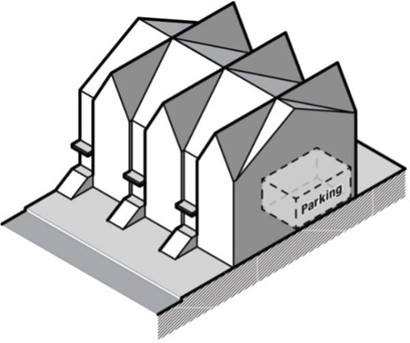
- Building Type A: Mixed Use: Type A buildings may include retail, office, and/or residential uses on the first floor and on upper floors. Parking may be included belowground. Type A buildings may have a flat or pitched roof. Height shall be at minimum thirty feet (30') and no maximum.
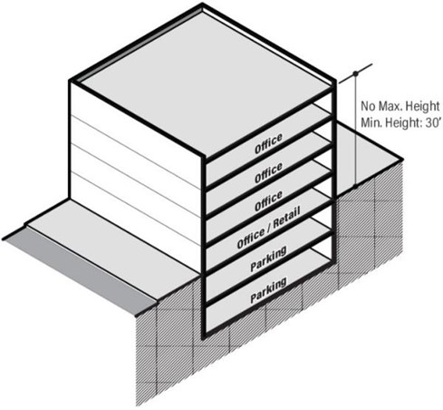
- Building Type B: Multi-family: Type B buildings shall include residential, office, or retail uses on the first floor, and residential apartments or condominiums on upper floors. Parking may be included below ground.
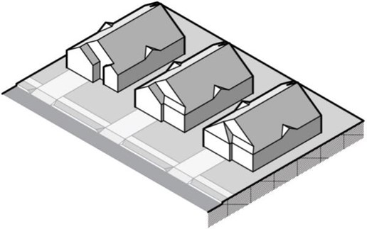
- Building Type C: Townhome: Type C buildings shall be residential townhomes on all floors, except that a portion of the first floor not fronting a street or public open space may include parking. Type C buildings shall have a pitched roof. Minimum width of lots shall be twenty-five feet (25').
- Building Type D: Cottage: Type D cottages are small, single-family dwellings on small lot similar in scale to townhomes but detached. Type D buildings shall have a minimum lot width of twenty-five (35') and shall have a pitched roof.
- Building Type E: Office/Retail: Type E building shall include office or retail uses on the first floor, and office uses on upper floors. Parking may be included belowground. Type E buildings may have a flat or pitched roof. Height shall be at minimum thirty feet (30') and no maxim
- Building Type A: Mixed Use: Type A buildings may include retail, office, and/or residential uses on the first floor and on upper floors. Parking may be included belowground. Type A buildings may have a flat or pitched roof. Height shall be at minimum thirty feet (30') and no maximum.
- Building Height Limit: In the TOD District the minimum building height shall be governed by the building types described below. There is no maximum height limit in the TOD District, except where Environmental Overlay Districts and floodplain regulations may apply.
- Placement Requirements:
- Build-To Line: A build-to line is established which provides a minimum and maximum front setback for buildings and other structures, from the right of way or property line. For parking, the minimum setback applies, but not the maximum. There are three (3) build-to line conditions based on street type. The location of these build-to line conditions on various streets within the TOD District is illustrated on the regulating plan. All principal and accessory structures shall comply with build-to-line requirements as provided in Tables 10-6-6-D 3and 10-6-6-D 4 and illustrated in Figure 10-6-6-D 2, respectively.
- On lots with more than one (1) street frontage, the build-to line shall apply on each side fronting a street.
- The build-to line may be met with either an enclosed building or an arcade constructed with a permanent roof of the same materials as the remainder of the building.
- At least the first and second floors of a building must meet the build-to line.
- The first fifty feet (50') of the lot frontage on both sides of a street interSection must be occupied by buildings meeting the build-to line. Table 10-6-6-D 3 Placement Requirements
Street Type A B C Structure Placement Building - to line setback (feet) 10 15 20 Max. front setback (feet) 15 20 25 Min. rear setback - Principal Structure (feet) 20 20 20 Min. rear setback- Accessory Structure (feet) 5 5 5 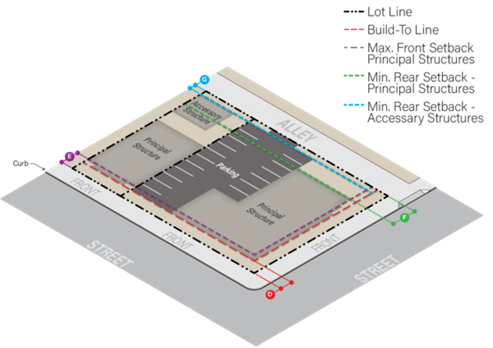 Figure 10-6-6-D 2 Placement Requirements Illustrated
- Accessory Structure Setbacks: Table 10-6-6-D 4 :Accessory structure placement requirement
Setback Front Yard Prohibited Side Yard 0 foot minimum Side Yard - Street Same as front yard Rear Yard 5 foot minimum - Frontage: At least sixty-five percent (65%) of the primary street frontage of any lot shall be occupied by building facades meeting the build-to-line. Other portions of a building beyond the sixty-five percent (65%) may be set back farther than required by the build-to line up to the maximum setback. On lots with more than one (1) frontage, the build-to line shall apply on each side fronting a street. Frontage requirements are provided in Table 10-6-6-D 5and shown in Figure 10-6-6-D 3. Table 10-6-6-D 5: Frontage requirements
Max. building frontage 100% Frontage Min. building frontage 65% For corner lots, the first fifty feet (50') of frontage on either side of a street intersection must be occupied by buildings meeting the build-to line Parking Parking lot fronting along a public street has maximum width of sixty-five feet (65') measured at the lot frontage. Must be screened with a decorative wall, decorative fence, landscaping, hedge, or a combination to a minimum height of three feet (3') and a maximum height of four and one-half feet (4.5') above the level of the parking lot, at the build-to line. Figure 10-6-6-D 3 : Frontage requirements illustrated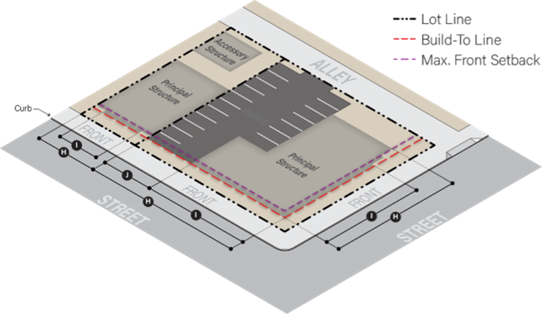
- Length Of Facade: The length of the building facade shall be measured as the maximum width of the building projected onto the front lot line on lines perpendicular to the front lot line
- Build-To Line: A build-to line is established which provides a minimum and maximum front setback for buildings and other structures, from the right of way or property line. For parking, the minimum setback applies, but not the maximum. There are three (3) build-to line conditions based on street type. The location of these build-to line conditions on various streets within the TOD District is illustrated on the regulating plan. All principal and accessory structures shall comply with build-to-line requirements as provided in Tables 10-6-6-D 3and 10-6-6-D 4 and illustrated in Figure 10-6-6-D 2, respectively.
- Parking Placement And Screening: Table 10-6-6-D 6: Parking Placement Requirements
Parking Setback Front Yard Build-to line Side Yard 0 foot minimum Side Yard - Street Same as front yard Rear Yard 5 foot minimum - Screening Of Parking Areas: Wherever a surface parking area faces a street frontage, such frontage shall be one hundred percent (100%) screened with a decorative wall, railing, hedge, or a combination of these elements, to a minimum height of three feet (3') and a maximum height of four feet (4') above the level of the parking lot, at the build-to line. Screening shall preserve the minimum sight triangle as required in Section 10-9-20
- Parking Structures: Parking structures shall maintain a setback/build-to line as required in this Section for all other principal structures. Where a parking structure is adjacent to surface parking in a side or rear yard condition, the parking structure may have a zero (0) setback.
- Uses:
- Use Groups: To allow flexibility in use within the TOD district, the following use groups are established and defined. The Development Review Committee determines which use group a specifically proposed use fits into based upon these definitions.
- Shopping: Retail and commercial establishments that offer goods for sale to the general public. May include resale shops and food stores, but not restaurants.
- Dining: Eating establishments, which may include (but are not limited to) coffee shops, cafes, dine-in or carry-out restaurants, taverns, bars and wine bars.
- Services: Offices and businesses that offer services to the general public and which may include retail sales associated with the service. Examples include: personal services (hair, spa), art or photography studios, animal care facilities and services, and small appliance repair.
- Activities: Public or private places for small gatherings, which include:
- Daycare;
- Community center;
- Health club;
- Funeral home.
- Employment: A mix of moderate- to high-density office, light industrial and institutional development in stacked office and mixed-use buildings as well as multistory flex buildings that can accommodate a range of employment opportunities at higher densities. Employment uses should generally be located further from transit stations than other more active use groups, while still promoting transit-supportive densities and pedestrian-oriented urban design. Employment uses may include:
- Professional offices which generally do not include retail sales;
- Medical office;
- Banks, consultants, and similar uses;
- Limited production and processing, industrial, institutional uses in compliance with performance standards in Section 10-6-6(D);
- Self-storage if included in a mixed use building or integrated in a mixed use development;
- Makerspaces/artisan manufacturing;
- Small brewer, micro-distillery or taprooms;
- Research and design;
- Incidental packaging and processing.
- Residential: In the TOD District, multi-family attached units, apartments, condominiums, and townhomes. May also include combined working and living space, home occupations and residential program (group home) for six (6) or fewer persons as defined and licensed by the State of Minnesota.
- Institution: Public or quasi-public uses including: government buildings, schools of any type, libraries or museums.
- Lodging: Premises available for short-term, transient occupation by guests. Examples include (but are not limited to): hotels, motels, and bed and breakfast establishments.
- Open Space: Outdoor spaces designed for passive or active recreational uses; may be public or private.
- Recreation, Entertainment And Events: Indoor recreational space (public or private) and event centers. Examples include movie theaters, bowling alleys, indoor sports, live music or live theater performance venues.
- Sexually oriented businesses as defined in Section 3-8 and regulated in Section 10-10-9.
- Permitted Uses:
- The following use groups are permitted by right in the TOD District, within the building types regulated by Table 10-6-6-D 1:
- Shopping;
- Dining;
- Services;
- Employment, subject to the performance standards in Sections 10-9-17-7 through 10-9-17-9, 10-9-8, 10-9-23, 10-9-5, 10-9-10-2, 10-9-10-3
- Residential;
- Institution;
- Lodging;
- Activities within Building Types A and E only.
- Exceptions: First-floor residential use is not permitted on building types that have their primary frontage on Nicollet Avenue north of Burnsville Parkway.
- The following use groups are permitted by right in the TOD District, within the building types regulated by Table 10-6-6-D 1:
- Accessory Uses: The following uses are considered accessory to the above permitted uses:
- Accessory solar energy systems pursuant to Section 10-10-10 of this title.
- Buildings temporarily located for purposes of construction on the premises for a period not to exceed the time necessary to complete the construction.
- Outdoor seating on private property.
- Private garages, off street parking and loading spaces as regulated by this article.
- Public trash and recycling containers pursuant to Section 10-9-21 of this title.
- Signs as regulated by this title.
- Repair, processing or storage incidental to a permitted use subject to Section 10-6-8(A)(11) of this title.
- Single satellite earth station antennas two meters (2 m) or less in diameter and single antennas designed to receive direct broadcast services or multichannel, multipoint distribution services one meter (1 m) or less in diameter and antennas designed to receive television broadcast signals, as regulated in Section 10-10-12 of this title.
- Temporary/seasonal outdoor sales subject to the provisions of Section 10-10-11 of this title.
- Mobile food vendors subject to the provisions of Title 3, Chapter 30.
- Essential service structures, such as lift stations, utility meters, power substations and small cell wireless facilities subject to the provisions of Section 10-9-6.
- Incidental accessory uses as permitted by Section 10-9-12.
- Warehouse and distribution, as an accessory to another permitted use and shall not exceed fifteen percent (15%) of the gross floor area of a structure.
- Projecting signs over the public right-of-way or public open space for a permitted or conditional use, provided that:
- The sign is approved by the City Council on the recommendation of the City staff, and on finding that the sign placement will not compromise public health, safety, or welfare.
- The sign shall meet all other provisions for signs under this Section.
- Outdoor seating within the public right-of-way or public open space for a permitted or conditional use, provided that:
- A sidewalk area at least six feet (6') wide is maintained free of seating in the area.
- An outdoor seating plan is prepared and approved by the City Council on the recommendation of the Planning Commission, Community Development Director, Fire Marshal, and Public Works Director, and on finding that the plan will not compromise public health, safety, or welfare. The plan may also include seasonal temporary landscaping and features such as planter boxes, hanging baskets, low partitions, roped off areas, and other approved elements.
- Conditional Uses: Within the TOD District, no structure or land may be used for the following uses or use groups except by conditional use permit:
- Sexually oriented businesses.
- Antennas mounted on an existing structure, if integrated architecturally into the design of a building exceeding five feet (5') above the highest point of the structure, as regulated by Section 10-10-12 of this title.
- Drive-throughs on street type C:
- Drive-through lanes are not permitted in the front yard or within the build-to line/setback area.
- Adequate stacking distance shall be provided, as determined by the City Engineer, which does not interfere with other driving areas, parking spaces or sidewalks.
- Electronic speaker devices, if used, shall not be audible beyond the property being served and shall not be operated between the hours of ten o'clock (10:00) P.M. and seven o'clock (7:00) A.M.
- The view of automobile headlights in the drive-through lane to windows and doors of adjacent uses shall be screened to the maximum extent feasible. The screening shall be a minimum of three feet (3') in height and meet the requirements of Section 10-9-21 of this title.
- A bypass lane shall be provided for each drive-through use, allowing cars to leave the drive-through lane from the stacking area.
- Within TOD there shall be no more than one (1) drive-through lane serving a given use.
- Exterior light poles, light fixtures, or other light sources over sixteen feet (16') above the ground, provided that such light source shall be effectively contained within the development and shall not cause glare or light spillover to any adjacent residential unit.
- Nightclub subject to Section 10-6-8(C)(3) of this title and title 3 of this Code.
- Places of assembly, such as lodges, assembly halls, convention centers and religious institutions, provided that the principal structure and any accessory structures used for assembly shall be located at least fifty feet (50') from any lot line adjacent to a residential building. This Section shall apply even if the assembly use does not occupy the entire structure. For the purposes of this Section, the fifty foot (50') setback shall not apply to any property line adjacent to an arterial roadway or interstate.
- Residential program (group home) for seven (7) to sixteen (16) persons as defined and licensed by the State of Minnesota Department of Human Services. Conditions of the conditional use permit shall be imposed only to assure the proper maintenance and operation of the program and shall not be more restrictive than those imposed on other conditional uses of multi-family residential property unless such additional conditions are necessary to protect the health and safety of the program participants.
- Prohibited Uses: Whenever a use is neither specifically allowed nor specifically prohibited, the use shall be considered prohibited unless the City Council determines that the proposed use is very similar to an allowed use in which case the proposed use shall be deemed allowed.
- Lot Requirements: Minimum lot requirements in the TOD District are shown in Table 10-6-6-D 2 and illustrated in Figure 10-6-6-D 1.
- General Standards:
- Density: In order to create activity levels that support and take advantage of bus-rapid-transit in the area, this Section sets out minimum and maximum residential density standards. These standards apply to the residential component of any residential or mixed use project proposed in the district. For mixed use projects, the required residential density will be calculated based on the acreage of the site devoted to residential uses.
- Minimum density: Twenty (20) units per acre.
- Maximum density: Eighty (80) units per acre.
- Minimum Floor Area Ratio: In order to create activity levels that support and take advantage of bus-rapid-transit in the area, this Section sets out minimum floor area ratio (FAR) standards. FAR is averaged based on all uses including residential. The intention is to allow a diversity of uses within the TOD district. Net FAR does not include areas dedicated for streets or other public spaces.
- Minimum FAR: 1.5.
- Nonconformities: Certain modifications to non-conforming uses may be allowed consistent with the provisions of Section 10-9-16. This includes alterations, changes to building footprints, and green spaces.
- Parking: Parking requirements within the TOD district are reduced in order to account for reduced daily vehicle trips generated by the use given its proximity to transit stations. Other than the exceptions below, parking requirements from Section 10-9-10 shall apply.
- All minimum off-street parking requirements in Section 10-9-10 are automatically reduced by twenty-five percent (25%) within the TOD district.
- Calculating method:
- The automatic reduction shall be calculated by taking the total parking required in Section 10-9-10 and reducing it by twenty-five percent (25%).
- When calculating parking for mixed use developments, individual uses within the building will be calculated separately and added together to arrive at the total required parking spaces.
Exceptions for the following uses: - Shopping requirement: Minimum three (3) spaces per one thousand (1,000) square feet in floor area.
- Apartment dwelling units:
- Minimum one (1) enclosed garage space per unit.
- Additional parking reductions found in this Section shall not apply to apartment dwellings.
- Calculating method:
- Maximum off-street parking within the TOD district shall be one hundred twenty-five percent (125%). Structured parking spaces are exempt from this limitation.
- Additional parking reductions: Within the TOD district, the amount of parking required by this Section may be reduced by twenty percent (20%) provided one of the following conditions are met:
- Inclusion of car-share spaces at a rate of two (2) spaces reduced per one (1) car share space .
- Inclusion of an on-site transit interface including at least one (1) of the following:
- Site is within five hundred feet (500') of a designated transit station.
- Dedication of land and construction of bus stop facilities including bus pullout lanes, shelters, benches, lights, and signage.
- Pedestrian connections between the bus stop and the principal buildings on the site.
- All minimum off-street parking requirements in Section 10-9-10 are automatically reduced by twenty-five percent (25%) within the TOD district.
- Bicycle Parking: Bicycle parking shall be provided for all uses within the TOD district. The following bicycle facilities shall be required:
- Each land use shall provide the number of bicycle parking spaces required by Table 10-6-6(E) 1. A minimum of two (2) short-term bicycle parking spaces and one (1) long-term parking space shall be provided for new non-residential development. When the bicycle parking required for a nonresidential use is based on square footage, at least twenty-five percent (25%) of the bicycle parking spaces shall be provided in long-term parking facilities and at least fifty percent (50%) shall be provided in short-term bicycle parking facilities. When part or all of the bicycle parking spaces required for non-residential land use is based on the number of employees, that portion shall be provided in long-term bicycle parking facilities. Table 10-6-6(E) 1: Bicycle Parking Requirements
Principal Use # of Bicycle Spaces Required Shopping 1 space per 5,000 sq. ft. Dining 1 space per 4,000 sq. ft. Services 1 space per 5,000 sq. ft. Employment 1 space per 5,000 sq. ft. Residential 1 space per 4 dwelling units Institution 1 space per 5,000 sq. ft. Lodging 1 space per 10 guest rooms Recreation/Events 1 space per 5,000 sq. ft. - For changes in use or tenant, bicycle parking will be analyzed along with automobile parking requirements per Section 10-9-10.
- Types of bicycle parking. There are two (2) types of bicycle parking.
- Short-term Bicycle Parking: Short-term bicycle parking is typically in the form of bicycle racks. Bicycle racks must meet the following criteria:
- Supports the bicycle upright by its frame in two (2) places;
- Prevents the wheel of the bicycle from tipping over;
- Enables the bicycle frame and at least one (1) wheel to be secured to the rack with a U-lock;
- Rack is constructed of materials that resist cutting by manual tools such as bolt cutters, hand saws, abrasive cutting cables and pipe cutters;
- Rack is securely anchored to the ground.
- Long-term Bicycle Parking: Long-term bicycle parking protects the entire bicycle and its components from theft, vandalism, and inclement weather. Long-term bicycle parking is required when at least fifty (50) bicycle spaces are required on a site. Long-term bicycle parking may include:
- Bicycle Lockers: A bicycle locker is a fully enclosed space for one (1) bicycle, accessible only to the owner of the bicycle. A bicycle locker must be equipped with an internally mounted key-actuated or electronic locking mechanism, and not lockable with a user-provided lock. Groups of internal-lock bicycle lockers may share a common electronic access mechanism provided that each locker is accessible only to its assigned user. Bicycle lockers shall be constructed of molded plastic/fiberglass, solid metal or perforated metal. Lockers shall be screened per the requirements of Section 10-9-21.
- Restricted-access Bicycle Enclosure: A restricted-access bicycle enclosure is a covered or indoor locked area containing within it one (1) bicycle rack space for each bicycle to be accommodated and accessible only to the owners of the bicycles parked within it.
- Short-term Bicycle Parking: Short-term bicycle parking is typically in the form of bicycle racks. Bicycle racks must meet the following criteria:
- Layout And Design:
- General guidelines:
- All spaces provided shall be on a hard and stable surface;
- All bicycle parking facilities shall be securely anchored to the surface so they cannot be easily removed and shall be of sufficient strength to resist vandalism and theft;
- All bicycle parking facilities within vehicle parking areas shall be separated by a curb or other physical barrier to protect bicycles from damage by automobiles and other moving vehicles.
- Short-term bicycle facilities shall meet all of the following requirements:
- The facilities shall be installed in a clear space at least two (2) feet in width by six (6) feet in length to allow sufficient space between parked bicycles.
- When multiple short-term bicycle parking facilities are installed together in sequence, they shall be installed at least three (3) feet apart and located in a configuration that provides space for parked bicycles to be aligned parallel to each other.
- Location:
- Short-term bicycle parking facilities shall be located in a convenient, highly visible, and well-lit area within fifty feet (50') of a building entrance and within view of pedestrian traffic.
- Long-term bicycle parking facilities for tenant and occupant use shall be conveniently accessible by pedestrians from the street, and at least as close as the closest non-accessible automobile parking.
- General guidelines:
- Each land use shall provide the number of bicycle parking spaces required by Table 10-6-6(E) 1. A minimum of two (2) short-term bicycle parking spaces and one (1) long-term parking space shall be provided for new non-residential development. When the bicycle parking required for a nonresidential use is based on square footage, at least twenty-five percent (25%) of the bicycle parking spaces shall be provided in long-term parking facilities and at least fifty percent (50%) shall be provided in short-term bicycle parking facilities. When part or all of the bicycle parking spaces required for non-residential land use is based on the number of employees, that portion shall be provided in long-term bicycle parking facilities.
- Pedestrian-Oriented Design: Within the TOD district, the following pedestrian facilities are required:
- Pedestrian Walkways: Pedestrian walkways shall be provided from the main building entrance to existing or planned public sidewalks or pedestrian/bike facilities. Where applicable, public sidewalks a minimum of six feet (6') wide shall be provided in the right-of-way. Interior, private sidewalks shall be at least six feet (6') wide.
- Crosswalks: Crosswalks at private street intersections or within parking lots shall be distinguished from driving surfaces to enhance pedestrian safety by using either different pavement materials, pavement color or pavement textures in conjunction with signage.
- Pedestrian Furniture: Developments within the TOD district shall provide exterior pedestrian furniture in appropriate locations at a minimum rate of one (1) seat for every ten thousand (10,000) square feet of gross floor area.
- Placemaking Elements: Placemaking is innovation that involves bringing art and culture in tandem with design to a development project. At least one (1) placemaking element is required with each new development in the TOD district. These elements may include:
- Public art installation;
- Plaza or gathering space;
- Parklets;
- Visual or performing art exhibition space;
- Opportunities for community engagement or interaction.
Placemaking elements may be provided in cooperation with adjacent properties (i.e. shared elements).
- Private Trash Handling: All private trash, recyclable materials, and equipment for handling them, including compactors, shall be screened on three (3) sides from ground level view from public streets by being stored within the principal building, screened from view by the principal building, or stored within an accessory structure.
- Loading Docks: Loading docks shall not be located in the front yard and shall be one hundred percent (100%) screened from ground level view of public streets and public open spaces pursuant to Section 10-9-21 of this title or by a screen wall of the same materials and colors as or complimentary to the principal building. Add note: Except at entrances think about where this may be difficult to implement.
- Landscaping:
- All land area not occupied by buildings, parking, driveways, sidewalks, or other hard surfaces shall be sodded or mulched and landscaped with approved ground cover, flowers, shrubbery and trees.
- At least ten percent (10%) of the total land area within the perimeter of private parking and driveway areas shall be landscaped. Landscaped areas provided within the build-to line may be credited toward this ten percent (10%) landscaping requirement on a square foot per square foot basis, for up to half of the ten percent (10%) requirement, or five percent (5%).
- Parking lot landscaped islands shall be a minimum of one hundred fifty (150) square feet in area and include at least one (1) overstory or evergreen tree meeting the requirements of this chapter.
- Where parking abuts the site perimeter there shall be provided at least one (1) overstory tree per thirty feet (30') of site perimeter.
- At least one (1) overstory tree shall be provided for every six hundred and twenty five (625) square feet of landscaped area on the entire site.
- The landscape plan shall include a full complement of overstory, ornamental and evergreen trees, shrubbery, and ground covers which are hardy and appropriate for the locations in which they are planted, and which provide year round color and interest.
- Trees and plant species listed as prohibited species in the Burnsville woodland protection and evaluation packet may not be used to satisfy the landscaping requirement of this Section.
- Prohibited Species: Prohibited species that shall not be planted within the City are identified in the Burnsville woodland protection and evaluation packet.
- Signage:
- Standards: All signs erected on any building or land within the TOD district must comply with the standards of this Section and Sections 10-12-A, 10-12-B, 10-12-C, and 10-12-D(1) of this title.
- Wall Signs:
- Wall signage is allowed on buildings in the TOD district within a horizontal band no more than three feet (3') in height, at least ten feet (10') and no more than fifteen feet (15') above the ground.
- Wall signage may be either:
- Attached: Flat and parallel to the surface of the building and projecting no more than one foot (1') from it; or
- Projecting: Perpendicular to the surface of the building and no more than one foot (1') in thickness.
- Attached wall signage shall consist of individual letters or script logos mounted on the building.
- Projecting signs may project no more than four feet (4') from the front edge of the building and be no more than twelve (12) square feet in area.
- Projecting signs may not extend over a public right-of-way or public property except by encroachment agreement subject to Public Works Director or designee approval.
- Projecting signs may not extend over a designated parking space or loading area.
- Box signs or cabinet signs, whether on a wall, projecting or on canopies, are prohibited, except for logo signs as approved as part of the overall signage plan.
- Allowable area of wall signs is one and one-half (1.5) square feet of signage per linear foot of building frontage on a public street, public open space, or private parking area. Each wall shall be calculated individually and sign area may not be transferred to another side of the building. In calculating the total allowable area of wall signage, only one side of a two (2) sided projecting sign shall be counted. In calculating the amount of signage for tenants in a multi-tenant building, the exterior facade adjacent to the individual tenant bay shall be the basis for calculating the maximum area of signage allowed for that tenant.
- The number of wall signs and canopy signs are unlimited as long as the total area allowed by this Section is not exceeded.
- Awning/Canopy Signs: Awning/canopy signs may be allowed in addition to wall signs allowed in this Section provided they meet the following standards:
- The lowest part of the awning/canopy shall be not less than eight feet (8') above the sidewalk or above the centerline of the adjacent street or drive aisle.
- Awnings/canopies shall be located over a window or door feature.
- No awning/canopy signs shall be permitted on windows above the first floor.
- Awning/canopy signs shall count against the total allowable sign area.).
- Awning and canopy signs shall require a sign or building permit prior to installation.
- Freestanding Signs: Freestanding signs are prohibited in the TOD district with the following exceptions:
- Monument signs, as defined in 10-12-2. Monument signs shall be limited to a maximum of six feet (6') in height and shall be located no closer than five feet (5') from a street right-of-way.
- Directional signs at driveways and within parking areas, if no more than five feet (5') in height and no more than six (6) square feet in area. Directional signs must be set back at least two feet (2') from right of way, lot lines, and parking spaces.
- Lighting:
- All exterior lighting in the TOD district shall be downcast cutoff type fixtures, and shall follow the regulations in Section 10-9-7.
- The applicant shall provide a photometric lighting diagram prepared by a qualified professional showing light levels, in foot-candles, from all exterior artificial lighting for all points on and within ten feet (10') of the site.
- Lighting levels in exterior parking areas shall average one-half (1/2) foot-candle, with a minimum of one-tenth (1/10) foot-candle in all locations.
- Lighting levels in interior parking areas shall average two (2) foot-candles, with a minimum of one-half (1/2) foot-candle in all locations.
- Lighting levels shall not exceed one-half (1/2) foot-candle at the abutting property line or right of way line, and no direct glare from lighting on site shall extend onto the public street, public open space or neighboring properties.
- Density: In order to create activity levels that support and take advantage of bus-rapid-transit in the area, this Section sets out minimum and maximum residential density standards. These standards apply to the residential component of any residential or mixed use project proposed in the district. For mixed use projects, the required residential density will be calculated based on the acreage of the site devoted to residential uses.
- Building Design And Materials
- All buildings shall be designed to accomplish the goals and policies of the Comprehensive Plan. Building materials shall be durable with a permanent finish, and of a quality that is consistent with the standards and intent of the TOD district. Where appropriate, buildings shall carry over materials and colors of adjacent buildings, with the exception of prohibited materials.
- All buildings shall include the following four (4) elements:
- Accent materials, which shall be wrapped around walls that are visible from a public street or open space;
- Buildings containing office and retail uses shall maintain forty percent (40%) minimum window coverage on each first floor front that faces a street or public open space;
- Complementary major material colors;
- A combination of vertical and horizontal pattern designs in the building facade.
- Any exterior building wall adjacent to or visible from a public street, public open space, or abutting property may not exceed sixty feet (60') in length without significant visual relief consisting of one (1) or more of the following:
- The facade shall be divided architecturally by means of significantly different materials or textures; or
- Horizontal offsets of at least four feet (4') in depth; or
- The maximum length of a blank wall (without divisions or offsets described herein) shall be twenty feet (20').
- Exterior building materials shall be classified either primary, secondary, or accent materials. Primary materials shall cover at least sixty percent (60%) of the facade of a building. Secondary materials may cover no more than thirty percent (30%) of the facade. Accent materials may include door and window frames, lintels, cornices, and other minor elements, and may cover no more than ten percent (10%) of the facade. Allowable materials are as follows:
- Primary exterior building materials may be brick, stone, or glass.
- Secondary exterior building materials may be decorative block, colored stucco, fiber cement siding in vertical panel design only with hidden seams (color impregnated or painted).
- Synthetic stucco may be permitted as a secondary material on upper floors only.
- Accent materials may be wood, metal or fiber cement when used in trim, fascia or soffit if appropriately integrated into the overall building design and not situated in areas which will be subject to physical or environmental damage. All primary and secondary materials shall be integrally colored, except where otherwise stated.
- Primary exterior building materials for townhome buildings where all units contain an exterior entrance: Allowable primary exterior building materials for townhome buildings shall include brick, stone, glass, integrally colored stucco or fiber cement siding in lap or panel (integrally colored or painted). Fiber cement seam lines on panels shall be architecturally integrated into the building design so that they are not visible. Seam lines can be filled, covered by other accent materials or other method thereby making the seam lines invisible.
- Sheet metal, corrugated metal, asbestos, iron, shakes, plain flat concrete block (whether painted or integrally colored or not) are not acceptable as exterior wall materials on buildings within the TOD district.
- All mechanical equipment, whether roof mounted or ground mounted, shall be one hundred percent (100%) screened from contiguous properties and adjacent streets pursuant to Section 10-9-21 of this title. Ground mounted mechanical equipment shall be screened with compatible with the architectural treatment of the principle building.
- All private exterior trash enclosures or other accessory structures shall be constructed of compatible with the architectural treatment of the principal building.
- Consistent interior window treatments are required for windows which are visible from a public street or open space in offices and multiple residential complexes.
- All buildings containing nonresidential uses on the ground floor shall meet the following standards:
- The building shall have entrances to a street or public open space spaced no more than sixty feet (60') apart.
- Entrances shall be oriented conveniently to the street frontage and to on street and off-street parking serving the use.
HISTORY
Adopted by Ord. 1648 on 6/12/2026
Adopted by Ord. 1648 on 6/12/2026
10-6-7: CRD Commercial Recreation District
- Purpose and Intent: The purpose of the Commercial Recreation District is to allow places that bring people together for outdoor and indoor recreation, entertainment, and related services.
- Permitted Uses: The following are permitted uses.
- Amphitheater as a permanent use.
- Athletic club.
- Athletic facility.
- Bus benches, shelters, and transit facilities provided they comply with Title 8 of this code.
- Coffeehouse, coffee shop, wine bar, and tavern.
- Conference/banquet facility complementary to the recreation business.
- Essential service structures.
- Golf course or driving range.
- Health club and/or spa.
- Hotel complementary to the recreation business.
- Minigolf.
- Mountain biking.
- Personal services complementary to the recreation business.
- Playground, indoor or outdoor.
- Restaurant complementary to the recreation business as regulated by Section 10-6-8(C)(2) of this title.
- Ski hill.
- Stadium.
- Swimming pools, indoor or outdoor.
- Tennis club.
- Tubing.
- Water park, indoor or outdoor.
- Permitted Accessory Uses:. The following are permitted accessory uses:
- Accessory solar energy systems pursuant to Section 10-10-10 of this title.
- Antennas mounted on an existing structure, not exceeding fifteen feet (15') above the highest point of the structure, as regulated by 10-10-12 of this title.
- Auto dealership remote storage subject to Section 10-10-6 of this title.
- Buildings temporarily located for purposes of construction on the premises for a period not to exceed time necessary to complete construction.
- Incidental accessory uses as permitted by Section 10-9-12 of this title.
- Incidental outdoor seating for food service businesses as permitted by Section 10-6-8 of this title.
- Incidental repair, processing, or storage necessary to conduct a permitted principal use subject to Section 10-6-8(A)(11) of this title.
- Limited retail sales complementary to the permitted uses.
- Off street parking and loading spaces as regulated in this title.
- Trash and recycling containers pursuant to Section 10-9-21 of this title.
- Signs as regulated in Section 10-12 of this title.
- Single satellite earth station antenna two meters (2 m) or less in diameter and single antenna designed to receive direct broadcast services or multichannel multipoint distribution services one meter (1 m) or less in diameter and antennas designed to receive television broadcast signals, as regulated in Section 10-10-12 of this title.
- Temporary/seasonal outdoor sales uses as regulated by Section 10-10-11of this title.
- Tenant restaurants, cafeterias, and retail service limited to tenants of the building, provided that they be essentially limited to providing service to the users of the permitted use, and that no signs or other evidence of these uses are visible from the exterior of the building.
- Conditional Uses: The following are conditional uses:
- Accessory structures or uses other than those listed as permitted.
- Indoor motorized go-carts.
- Paintball.
- Temporary outdoor concert, theater events held outside of a permanent amphitheater.
- Towers as regulated in chapter 10-10-12 of this title.
- Interim Use: The following are interim uses:
- Motorized or nonmotorized vehicle racing or exhibition event.
- Outdoor motorized recreational vehicles including, but not limited to, go-carts, ATVs and snowmobiles.
- Development Standards. The following minimum requirements shall be observed, subject to the additional requirements, exceptions and modifications as set forth in this Title and in 10-6-8:
Lot Area 1 acre or 43,560 square feet when adjacent to residential districts Lot Width 150 feet Lot Coverage 40 percent Setback - Principal Structure Front Yard 30 feet or 50 feet when adjacent to residential districts Side Yard 30 feet or 50 feet when adjacent to residential districts Side Yard - Street 30 feet or 50 feet when adjacent to residential districts Rear Yard 30 feet or 50 feet when adjacent to residential districts Setback - Accessory Structure Front Yard 30 feet or 50 feet when adjacent to residential districts Side Yard 30 feet or 50 feet when adjacent to residential districts Side Yard - Street 30 feet or 50 feet when adjacent to residential districts Rear Yard 30 feet or 50 feet when adjacent to residential districts Setback - Parking Front Yard 20 feet or 30 feet when adjacent to residential districts Side Yard 20 feet or 30 feet when adjacent to residential districts Side Yard - Street 20 feet or 30 feet when adjacent to residential districts Rear Yard 20 feet or 30 feet when adjacent to residential districts
A reduction of the parking setback requirements for the principal use is allowed for outdoor patios per Section 10-6-8(D) of this title. - Supplemental Standards: The following are supplemental standards for the district: Commercial Buildings: Commercial buildings shall comply with the building design and material requirements of Section 10-6-8(A)(1) of this title.
- Private Mechanical Equipment: Private mechanical equipment (ground mounted and rooftop) shall meet the following requirements:
- Rooftop mechanical equipment shall not exceed the building height standards by more than ten feet (10') for a single-story building or fifteen feet (15') for a multiple-story building.
- All private ground mounted equipment shall be one hundred percent (100%) screened from view from adjacent properties and the public right-of-way by enclosures constructed of durable and permanent materials with architectural elements (type, quality, and appearance) similar and compatible to the principal structure.
- All rooftop equipment shall be one hundred percent (100%) screened from view from across adjacent streets fifteen feet (15') behind the curb or adjacent properties at the property line.
- Rooftop equipment shall be one hundred percent (100%) screened by the building parapet, or the equipment should be grouped behind an enclosure and set back a distance of one and one-half (1 1/2) times its height from any primary facade fronting a public street.
- Screens shall be of durable, permanent materials (not including wood) that are compatible with the primary building materials.
- Exterior mechanical equipment, such as ductwork, shall not be located on primary building facades.
- Trash And Recyclables: Trash and recyclable handling equipment shall meet the requirements of Section 10-6-8(A)(2) of this title.
- External Loading Areas: External loading areas shall meet the requirements of Section 10-6-8(A)(8) of this title.
- Outdoor Lighting: Within any CRD District, all exterior building and parking lot lighting shall comply with Section 10-9-7 of this title.
- Landscaping: Within any CRD District, commercial development shall comply with the landscaping regulations of Sections 10-9-13(H) and 10-9-13(I)(5) of this title.
- Private Mechanical Equipment: Private mechanical equipment (ground mounted and rooftop) shall meet the following requirements:
HISTORY
Adopted by Ord. 1648 on 6/12/2026
Adopted by Ord. 1648 on 6/12/2026
10-6-8: Special Requirements For All Business, CRD And MIX Districts
- Special Requirements And Performance Standards For All Business And Mixed Use Districts:
- Building Design And Materials: All buildings shall be designed to accomplish the goals and policies of the Comprehensive Plan. Building materials shall be attractive in appearance, of a durable finish, and be of a quality that is compatible and harmonious with adjacent structures. All buildings shall be of good aesthetic and architectural quality to ensure they will maintain and enhance the property values of neighboring properties and not adversely impact the community's public health, safety and general welfare.
- Design Elements: All new building fronts and refacing of existing buildings shall include a minimum of three (3) of the following elements:
- Accent materials;
- A visually pleasing front entry that, in addition to doors, shall be accented a minimum of one hundred fifty (150) square feet around the door entrance for single occupancy buildings and a minimum of three hundred (300) square feet total for the front of multi-tenant buildings (this area shall be counted as 1 element);
- Twenty five percent (25%) window coverage on each front that faces a street;
- Contrasting, yet complementary material colors;
- A combination of horizontal and vertical design features;
- Irregular building shapes; or
- Other architectural features in the overall architectural concept.
- If the applicant and the Development Review Committee cannot agree on the proposed building exterior elevations, the applicant shall be required to make an application for a conditional use permit to prove compatibility.
- Accent Materials: Accent materials shall be wrapped around walls visible from public view. Painting shall not be substituted for visual relief, accenting, or a required element. No wall shall exceed one hundred feet (100') in length without visual relief. "Visual relief" may be defined as the incorporation of design features such as windows, horizontal and vertical patterns, contrasting material colors, or varying wall depths. Use of fiber cement trim, soffit and fascia shall be allowed as accent materials.
- Major Exterior Materials: Major exterior materials of all walls including face brick, stone, glass, stucco, synthetic stucco, fiber cement vertical panel siding, architectural concrete and precast and cast in place panels shall be acceptable as the major exterior wall surface when they are incorporated into an overall design of the building. Use of rain screens, panelized systems, or curtain walls are encouraged and will be verified for high quality design and materials through the Development Review Committee. Fiber cement seam lines shall be architecturally integrated into the building design so that they are not visible. Seam lines can be filled, covered by other accent material or other method thereby making the seam lines invisible. Color impregnated decorative block shall also be allowed as a major exterior wall material, and shall be required to be sealed. All materials shall be color impregnated with the exception of allowing architectural concrete precast panel systems and fiber cement siding to be painted. Painting shall be permitted on color impregnated, major exterior materials. If the architectural precast panel systems are painted, they shall be properly prepared and maintained regularly to prevent peeling, stripping, shading or any other form of deterioration or discoloration. Proof of manufacturer's painting specifications shall be supplied prior to issuance of a building permit. All exterior materials, including painted exterior materials, shall comply with Section 304.2 Protective Treatment of the International Property Maintenance Code. This Subsection (A)3 shall also apply to all exterior repairs, remodeling, or expansion of existing buildings that require a building permit.
- Limited Exterior Materials: No more than fifty percent (50%) of any exterior wall on a building shall be fiber cement horizontal siding, wood or 24-gauge or thicker metal accent material. All exterior materials, including painted exterior materials, shall comply with Section 304.2 Protective Treatment of the International Property Maintenance Code. This fifty percent (50%) limit may be exceeded when used in a panelized system that consists of prefabricated, or factory manufactured, panels that form a structural envelope, and significantly simplify on site framing, and request for approval shall be through a conditional use permit or planned unit development. This standard applies only to facades facing a street.
- Prohibited Exterior Materials: Unadorned prestressed concrete panels, whether smooth or raked, nondecorative concrete block, sheet metal, 25-gauge or thinner corrugated metal or unfinished metal shall not be used as exterior materials. This restriction shall apply to all principal structures and to all accessory buildings except those accessory buildings not visible from any property line.
- Visual Relief: No wall shall exceed one hundred feet (100') in length without visual relief. "Visual relief" may be defined as a varying design of the building by incorporating design features such as windows, horizontal and vertical patterns, contrasting material colors or varying wall depths.
- Roofs: Roofs which are exposed or an integral part of the building aesthetics shall be constructed only of commercial grade asphalt shingles, wood shingles, standing seam metal, slate, tile, or copper. Flat roofs, which are generally parallel with the first floor elevation, are not subject to these material limitations.
- Building And Roofing Materials: All building and roofing materials shall meet current accepted industry standards, and tolerances, and shall be subject to review and approval by the Development Review Committee for quality, durability, and aesthetic appeal. For all new buildings and building exterior renovations, the applicant shall submit to the City product samples, color building elevations, and associated drawings which illustrate the construction techniques to be used in the installation of such materials. Building and roofing materials not specifically approved in this section may be allowed by a conditional use permit or planned unit development only after it is demonstrated that the proposed material is equal to or better than approved materials. The long range maintenance of the proposed material shall be incorporated as a condition of the approval and filed on the property.
- Parapets: Renovation or refacing of an existing commercial building that includes increasing the height of the parapet walls, as defined in Section 10-3 of this title, shall be part of a comprehensive building upgrade that meets the following standards:
- The parapet wall finish materials shall match the major exterior materials provided on an exterior wall as specified in this section.
- The parapet walls shall be provided along all perimeter walls.
- Parapet walls may vary in height but shall not exceed the building height of the respective district.
- The back of the parapet wall and/or its supports shall be screened from view from adjoining properties and public streets.
- Parapet wall extensions shall not be permitted as flat wall features on the building facade. All facades proposed to support a taller parapet wall shall be designed to provide variation in facade depth in conjunction with increased height. The following features may be required to provide facade depth in conjunction with the taller parapet walls:
- Recessed or projected windows, awnings, or canopies.
- Entryway treatments, awnings, canopies, marquees, porticoes, and arches.
- Vertical wall treatments that extend from the facade creating a variation in facade depth, columns, corner treatments, and changes in building materials.
- Horizontal wall treatments, cornices, lintels, and color bands that provide some facade depth and divide the building height.
- Design Elements: All new building fronts and refacing of existing buildings shall include a minimum of three (3) of the following elements:
- Private Trash And Recyclable Materials: All private trash, recyclable materials, trash and recyclable materials handling equipment and compactors shall be screened pursuant to Section 10-9-21 of this title.
- Off Street Parking: Design and maintenance of off street parking areas shall be in accordance with Section 10-9-10 of this title.
- Accessory Structures: Garages, accessory structures, excluding trash enclosures, screen walls and exposed areas of retaining walls shall be of a similar type, quality and appearance as the principal structure.
- Utilities: The view of all rooftop equipment and related piping, ducting, electrical and mechanical utilities abutting a street on buildings constructed after January 1, 2006, shall be screened from the ground level view. Screening may include parapet walls, penthouses, or other architecturally integrated elements. Wood fencing or chainlink with slats shall not be used for screening. The term "ground level view" for this provision shall be defined as the view of the building from the furthest point of the width of the right-of-way from the property line(s) that abut a street. A cross sectional drawing shall be provided that illustrates the sightlines from the ground level view. For buildings constructed prior to January 1, 2006, for replacement of existing units, remodeling, and building expansions, the ground level view of all rooftop equipment and related piping, ducting, electrical and mechanical utilities shall be painted to match the building, designed to be compatible with the architectural treatment of the principal structure or screened by the use of parapet walls. Wood fencing shall not be used for screening.
- Private Ground Mechanical Equipment: Private ground mechanical equipment shall be one hundred percent (100%) screened from contiguous properties and adjacent streets pursuant to Section 10-9-21 of this title. Said screening shall be provided to be compatible with the architectural treatment of the principal structure.
- Outdoor Storage: There shall be no outdoor storage of either materials or products, except through the issuance of a conditional use permit where permitted in the underlying zoning district.
- External Loading And Service Areas: External loading and service areas must be one hundred percent (100%) screened pursuant to Section 10-9-21 of this title, except at access points.
- External dock, service and loading doors that face residential uses shall remain closed at all times except during loading and unloading.
- Compatibility: All structures shall be compatible with other structures in the area.
- Outdoor Speakers: Outdoor speakers shall be prohibited for all uses abutting a residential use except by approval of a conditional use permit.
- Incidental Repair, Processing Or Storage: Incidental repair, processing or storage associated with a permitted use in a Business or Industrial Zoning District may be conducted subject to the following:
- Said incidental repair, processing or storage does not occupy more than thirty percent (30%) of the gross floor area of the tenant space.
- If the business abuts or is located across the street from a residential use said repair, processing or storage shall be conducted completely within the building or facility with all business doors closed.
- Building Design And Materials: All buildings shall be designed to accomplish the goals and policies of the Comprehensive Plan. Building materials shall be attractive in appearance, of a durable finish, and be of a quality that is compatible and harmonious with adjacent structures. All buildings shall be of good aesthetic and architectural quality to ensure they will maintain and enhance the property values of neighboring properties and not adversely impact the community's public health, safety and general welfare.
- Additional Height Standards for B-1, B-3, B-4 And CRD Districts:
- No limit shall be placed on the height of buildings in B-1, B-3 and B-4 Districts except that any building exceeding twenty-five feet (25') in B-1 Districts or thirty-five feet (35') in B-3, B-4 and CRD Districts shall be by a conditional use permit.
- Buildings within the Minnesota River Quadrant as identified in the City's Comprehensive Plan shall have no height limitations, except where Environmental Overlay Districts and floodplain regulations may apply.
- No limit shall be placed on the height of buildings in B-1, B-3 and B-4 Districts except that any building exceeding twenty-five feet (25') in B-1 Districts or thirty-five feet (35') in B-3, B-4 and CRD Districts shall be by a conditional use permit.
- Special Use Requirements And Performance Standards In B-2, B-3, CRD And MIX Districts:
- Motor fuel stations shall be subject to the following standards:
- Canopy Height: The total height of any overhead canopy or weather protection shall not exceed twenty feet (20') in height.
- Open Storage: Open storage of motor vehicles shall not be permitted for a period of more than forty eight (48) hours and then only if it is screened.
- Sales, Rentals Prohibited: No sales or rental of motor vehicles or trailers or campers shall be permitted.
- Goods For Sale: All goods for sale by a motor fuel station convenience store other than commercial freezers for ice and petroleum based products required for the operation and maintenance of motor vehicles shall be displayed within the principal motor fuel station structure. No displays shall be permitted in required parking or driveway areas, landscape areas, required setback areas, or any right-of-way or other public property. Displays may be permitted on sidewalks, only if they leave at least four feet (4') of sidewalk width available to pedestrians.
- Compatibility: Each motor fuel station shall be compatible with the area in which it is located.
- Landscaping: A minimum ten foot (10') landscaped yard shall be planted and maintained behind the property line along all public streets. A landscaped yard not less than five feet (5') wide shall be maintained along exterior property lines.
- Motor Fuel Dispenser Location: Motor fuel dispensers shall be located at least thirty feet (30') from a property line, and one hundred feet (100') from an R-1, R-1A, or R-2 District property line.
- Setbacks:
- Structures shall be set back:
Front 30 (60) feet Side 30 (50) feet Rear 30 (50) feet - Setbacks in parentheses apply to lot lines adjacent to R-1, R-1A and R-2 Districts.
- Structures shall be set back:
- Lot Size And Width:
- Lot size:
- Motor fuel station (Class I): Twenty thousand (20,000) square feet.
- Motor fuel station (Class II): Thirty thousand (30,000) square feet.
- Lot width:
- Motor fuel station (Class I): Two hundred feet (200').
- Motor fuel station (Class II): One hundred fifty feet (150').
- Lot size:
- Electronic Speaker Devices: Electronic speaker devices shall be regulated as provided in Section 10-9-17 of this title. Exterior speakers shall not be allowed on sites that abut residential uses unless expressly permitted as part of a conditional use permit.
- Car Wash Stacking Requirements: Car wash stacking requirements shall be regulated as provided in Section 10-9-10 of this title.
- Adjacent Parcels: Any parcel which adjoins another parcel at one corner and any parcel which is across the street from a motor fuel station parcel, except for a principal or intermediate arterial, shall be considered to be adjacent for the administration of this section.
- Restaurants shall be subject to the following standards:
- A proposed restaurant shall be specifically identified as a fast food or standard restaurant.
- Where possible, all outside parking spaces shall be located to the side and/or rear of the restaurant.
- Restaurants located within one thousand feet (1,000') of Residential zoned or developed property shall include odor reducing equipment to minimize food odors emitted outside of the restaurant.
- Buildings containing a bowling alley, electronic game room containing six (6) or more electronic games, billiard and pool room containing six (6) or more tables, skating rink, lounge, nightclub, tavern, liquor store or fraternal organization shall not be located within one hundred feet (100') of any R District, except that the structure for a fraternal organization may be located within one hundred feet (100') of an R District when that structure has a common recreation center of a multi-family project.
- Multiple-tenant retail sales and service facilities shall be subject to the following standards:
- The physical design may include more than one building. If there is an open space between two (2) buildings, the space shall not be less than one-half (1/2) the sum of the heights of the two (2) buildings.
- No building shall be nearer than sixty feet (60') to any exterior lot line except when abutting or across the street from an R District in which case the minimum distance shall be one hundred feet (100').
- The design shall include adequate internal circulation drives not less than twenty four feet (24') in width which are exclusive of the required parking areas.
- The driveway curb cuts to the development shall not exceed twenty six feet (26') in width and be located not less than sixty feet (60') from all intersecting streets.
- When such structures are modified, altered, or repaired the entire building exterior facade shall be modified to be architecturally and materially consistent and/or compatible for the entire structure. If the entire structure is not proposed to be modified and/or consistent as determined by the Development Review Committee , then a conditional use permit shall be required per Section 10-6-8(A)(1) of this chapter. To be considered architecturally and materially consistent and compatible and able to be approved administratively, the following flexibility may be allowed:
- Facades of tenant spaces may be of the same color palette with varying design elements and height.
- A phasing plan for improvements may be submitted up to five (5) years and surety of one hundred percent (100%) of cost in lieu of completing entire structure at once.
- Any corporate identity that does not meet exterior requirements for compatibility and/or consistency as determined by Development Review Committee may be permitted at the front entrance only not exceeding twenty five percent (25%) of the facade.
- Single matching parapets may be added (in lieu of parapets wrapping the entire structure or tenant space) provided rooftop units are screened.
- Facades can have varying identities for tenants if tied into an overall design for the entire center as determined by Development Review Committee. Similar but different identities for tenants may include different colored awnings or different window/parapet trim colors, or same colors but different design elements incorporated.
- Any rear and side facades visible to the public and adjacent properties shall also be compatible.
- Motor fuel stations shall be subject to the following standards:
- Incidental Outdoor Seating For Food Service Businesses
- Food service businesses, including, but not limited to, bakeries, delicatessens, coffee and/or tea shops, and restaurants, may provide outdoor temporary seating for their patrons with the following provisions:
- The seating shall be located on private property.
- The seating shall be of durable, wind resistant, commercial grade patio or cafe type furniture that enhances the appearance of the business.
- The outdoor seating area shall be defined with the use of landscaping, temporary fencing or other means that defines the outdoor seating area and contains the tables and chairs for the use as demonstrated on a site plan and approved by City staff.
- No alcoholic beverages or food shall be served to persons outside of the designated outdoor seating area. Signage shall be posted that restricts consumption of alcohol outside of the designated outdoor seating area as approved by City staff.
- Patrons shall access the outdoor seating area through the main entrance or host station and shall be seated by a staff person and all standard restaurants with waitstaff service.
- The seating shall be located so as not to compromise safety. Seating shall not obstruct any public or private sidewalk or passageway for pedestrians, or any entrance or any required exit or be located on landscaping or parking areas. All provisions of the Building and Fire Codes and ADA compliance must be followed.
- All exterior sound equipment shall be shut off at ten o'clock (10:00) P.M. as regulated in title 7, chapter 1 of this Code.
- Lighting shall be permitted to the extent that it only illuminates the designated area. Lighting shall not shine or cause a glare upon other public or private property outside the designated area or as permitted in Section 10-9-7 of this title.
- If alcohol is served, hours of operation shall be in accordance with Section 3-1-6 of this Code.
- Any proposed outdoor seating area on property abutting an R Residential Zoning District shall be by conditional use permit if the outdoor seating area is facing residential.
- The business owner shall regularly clean the seating area so that it is litter free.
- All other performance standards in this title affecting a property owner's ability to install a patio on the site, except for Environmental Overlay Districts, shall not apply for the installation of the patio area. This includes greenspace, perimeter landscaping, drive aisle provisions, parking standards and setbacks.
- If the outdoor seating area is located within an easement, written permission from the easement holder is required.
- Food service businesses, including, but not limited to, bakeries, delicatessens, coffee and/or tea shops, and restaurants, may provide outdoor temporary seating for their patrons with the following provisions:
- Special Consideration For Properties Located In B-1, B-2, B-3, B-4, CRD And MIX Districts Affected By Public Improvement Projects Resulting In Land Taking:
- Properties that become nonconforming in terms of green area, setbacks or parking requirements as a direct result of a public improvement project resulting in loss of land (taking) for public roadway right-of-way or easements shall be considered in their pretaking condition when proposing any building or parking expansion affected by the land taking.
- The setbacks, green area and parking requirements shall be as follows:
- Minimum setbacks for principal and accessory structures or parking shall only be considered on the side of the structure(s) or parking lot where the public taking resulted in the nonconformity.
- Minimum setbacks shall be the existing setback before the taking less the amount of the taking. Principal and accessory structures shall be set back no less than ten feet (10'). Parking shall be set back no less than five feet (5').
- Green area for the total land area shall be the percent required by Section 10-9-13(I) of this title at the time of the taking, less the percent removed as a result of the taking. Green area shall not be less than ten percent (10%) of the total lot area after taking.
- Required parking spaces shall be those required by Section 10-9-10 of this title less the spaces eliminated as a direct result of the taking. If a property has an approved proof of parking plan with spaces not yet utilized as parking at the time of the taking, the owner shall install such spaces to replace those eliminated by the taking.
- Special Requirements And Performance Standards For Thrift Stores Having Five Thousand Square Feet Or More Of Gross Floor Area Within The B-2, B-3, And B-4 Districts
- All merchandise receiving, transfer, sorting, processing, and storage shall occur within a completely enclosed principal structure.
- No exterior storage or the use of exterior storage containers or semitrailers for storage shall be allowed upon the site.
- For any thrift store that accepts donations, at least one accessory drive-through service lane meeting the standards of this section shall be provided.
- Accessory drive-through service lanes leading to and accessing the indoor collection/donation area shall meet the following conditions:
- Drive-through service lanes shall not be permitted within the front, side, or rear yards abutting a street.
- Drive-through service lanes shall be designed and depicted on the site in a manner that segregates the service lane from drive lanes, parking spaces, and sidewalks on the site.
- The drive-through service lane shall be a minimum of fourteen feet (14') wide and provide up to one hundred sixty (160) linear feet of automobile stacking.
- The drive-through service lane cannot open directly onto a public street. Automobile stacking shall not interfere with on site drive lanes, fire lanes, parking stalls, loading areas, access to trash dumpsters, or sidewalks. Overflow automobile stacking beyond the service lane shall not extend into any public street right-of-way or interrupt traffic on a public street.
- The drive-through lane shall be one hundred percent (100%) screened to a height of at least six feet (6') and meet the provisions of Section 10-9-21 of this title.
- No outdoor audio equipment shall be permitted with a drive-through lane.
- Directional and operational signage shall be provided to direct customers to the drop off lane and explain the drop off process.
- Residential Density Bonuses: Multiple-family housing, as part of a mixed use development or freestanding, may pursue an increase in density up to twenty five percent (25%) through a reduction in the required lot area per unit, based on the following bonus features and square foot reductions:
Square Foot Reduction To Lot Area Per Unit Underground Parking: 1 parking space per efficiency and 1 bedroom unit and 2 parking spaces per 2 or more bedroom units is provided within an underground parking structure attached to the principal building 200 Registered Green Building: Building must be a registered green building (any level) in accordance with the USGBC (United States Green Building Council) 300 Public Transit: The site is located within 300 feet of a bus stop or transit station and the site design provides pedestrian connections to the bus stop or transit station 300 Recreation, Indoor: The mixed use or multiple-family building provides an indoor recreation and/or social room equal to 25 square feet per unit 100
HISTORY
Adopted by Ord. 1648 on 6/12/2026
Adopted by Ord. 1648 on 6/12/2026