
Calabasas City Zoning Code
ARTICLE III
- Site Planning and Project Design Standards
Chapter 17.62 - PERMIT APPROVAL OR DISAPPROVAL
This chapter provides standards for the final review, and approval or disapproval of the land use permit applications established by this development code. Procedures and standards for the review and approval of subdivision maps are found in Article IV. Where applicable, the procedures of this chapter are carried out after those described in Chapter 17.60 for each application.
Land uses not listed in this chapter shall be subject to the provisions of Section 17.11.020 E- Applicable Standards and Permit Requirements.
(Ord. No. 2010-265, § 3, 1-27-2010)
17.20.010 - Purpose and applicability.
A.
Purpose. This chapter ensures that new or modified land uses and development produce a stable and desirable environment, which is harmonious with existing and future development, and protects the use and enjoyment of neighboring properties, consistent with the General Plan.
B.
Applicability. The provisions of the chapter apply to a variety of land uses regardless of the applicable zoning district (e.g., residential, commercial, etc.), and therefore, are combined in this chapter.
1.
These standards shall be considered in combination with the standards for each zoning district in Article II. Where perceived conflict exists, the standards specific to the zoning district shall override these general standards.
2.
All new or modified structures and uses shall conform with all applicable provisions of this chapter prior to construction.
(Ord. No. 2010-265, § 3, 1-27-2010)
17.20.020 - Access, circulation and transportation.
A.
General Standard. Every structure or use shall have adequate physical and legal access to a public street in the form of street frontage, or permanent means of access by way of a public or private easement, or recorded reciprocal (mutual) access agreement. The review authority shall determine whether a structure or use has adequate access. The city engineer and director shall provide a written recommendation to the review authority.
B.
Performance Standards. Proposed developments shall comply with the following access, circulation and transportation performance standards. The performance standards shall not apply to the following developments (i) an individual single-family dwelling unit on an existing lot, (ii) the expansion of existing commercial, office and business park developments, and (iii) the addition of new dwelling units within existing residential developments.
1.
Projects that provide new driveways shall meet the following standards.
a.
Driveway access should be limited to the local street system. Where feasible within business areas, reciprocal access agreements and joint access shall be required to promote shared use of driveways.
b.
Existing driveways which are unnecessary or substandard shall be removed or upgraded in conjunction with any major or minor onsite development, as determined feasible by the review authority.
c.
If single family residences must front collector or arterial roadways, circular driveways or onsite turnarounds shall be required, where feasible, to eliminate the need for residents to back onto the street.
d.
Driveway locations shall maintain adequate separation from access points on the opposite side of the street or shall be aligned with access points on the opposite side of the street.
e.
Driveways on corner parcels shall be located as far away from intersections as is possible.
f.
Driveways shall not be located within passenger waiting areas of bus stops or within bus bays. Driveways shall be located so that drivers will be able to see around bus stop improvements, both existing and planned.
2.
Where medians exist or where a project is required to provide a median, such projects shall meet the following:
a.
Medians shall be required in order to fulfill the following objectives: access control, separation of opposing traffic flows, left turn storage, aesthetic improvement, and pedestrian refuge.
b.
Projects shall provide median openings at the maximum feasible intervals.
3.
Where an approved traffic study requires installation or improvement, traffic signals shall meet the following standards:
a.
Where a series of traffic signals are provided along a route, traffic signals shall be coordinated to optimize traffic progression on a given route.
b.
Traffic signalization should emphasize facilitating access from neighborhood areas onto the city's streets, and should work to discourage through traffic from using local city streets.
c.
Actuated traffic signals should include push buttons to signal the need for pedestrians to cross. Actuated traffic signals along bicycle routes should include bicycle sensitive loop detectors or push buttons adjacent to the curb.
d.
Traffic signals should be limited to urban areas, and should be avoided wherever feasible within rural areas as they tend to conflict with the rural character of outlying lands.
4.
Where intersection improvements are required, the intersection shall meet the following standards:
a.
Intersections should be spaced consistent with the primary function of the street. Accordingly, street intersections along heavily traveled arterials routes should be spaced closer than intersections along collectors.
b.
Streets at intersections along arterials and collectors should not be offset and should be placed directly across the street from one another. Intersections along local and minor residential collector streets may be offset within the subdivision as a means of discouraging through traffic.
c.
Intersections may be expanded to include additional turning and through lanes to relieve congestion and improve intersection operation, so long as the intersection will continue to accommodate pedestrians and bicyclists. The design of traffic system improvements which facilitate vehicular turning and bus movements should not discourage pedestrian or bicycle movements.
d.
Collectors and local streets should intersect with arterial streets at right angles, even though the street alignment may be curvilinear.
5.
The following standards shall factor into on-street parking considerations:
a.
Parking on public streets shall be secondary to the street's primary purpose of providing safe and efficient travel for the public.
b.
Parking is normally permitted on collector streets, but may be restricted to accommodate transit stops, on-street bicycle lanes, additional lanes at intersections, or other similar operational requirements. Removal of parking to increase capacity of traffic along the street should be avoided.
6.
The following standards shall factor into alternate travel mode considerations:
a.
Alternative modes of transportation should be integrated into the city's street system in order to: (i) reduce traffic congestion, (ii) improve air quality, (iii) conserve energy, and (iv) provide better transportation for non-motorist.
b.
Park and ride lots should be provided to allow a safe, convenient place to park for a person utilizing a pre-arranged car pool, van pool or bus pool.
c.
The number of bus bays should be limited because bus bays have the potential to significantly increase travel times of transit passengers. Bus bays may be used as an initial stage toward developing a queue jumper at an intersection. Bus bays are also acceptable on arterials at bus transfer locations and where boarding time delays are substantial.
d.
The standard bus stop location is the far side (after an intersection). Bus stops may be located at the near side (before an intersection) or mid-block depending upon transit demand at a particular site and traffic safety considerations.
e.
All existing and future bus stop locations should include a passenger waiting area adjacent to, but not interfering with, the sidewalk. The waiting area should be equipped with improvements based on the volume of bus patrons using that stop. The bus stop improvements include: a sign, a bench, and a shelter. Bus stop waiting areas should include landscaping, ADA compliant accessibility, lighting, and a paved landing area (if the sidewalk is set back from the curb).
f.
Bicycle storage facilities shall be provided by uses which have a demand for bicycle use (e.g., schools, parks, offices, shopping centers, libraries).
g.
Trails and bicycle facilities shall be provided as required by the maps and policies in the Trails Master Plan and Bicycle Master Plan.
7.
Where the installation of sidewalks is required, the following standards shall apply:
a.
Sidewalks or pedestrian paths approved by the city shall be designed to make direct connections between commercial, residential, schools, parks, bus stops, and other public facilities. Within Old Town Calabasas, where extensive pedestrian movement is desirable, a thematic walkway appropriate to the area's historic character should be adjacent to the roadway.
b.
Sidewalks which will be adjacent to the curb should be a minimum of six feet wide. Sidewalks which will be set back from the curb should be a minimum of five feet wide, except for sidewalks within developed recreational areas, in which case, the minimum setback should be eight feet wide.
c.
Sidewalks should be paved with a hard, all-weather surface which facilitates pedestrian use. Sidewalks and curbs should accommodate pedestrians with disabilities. Sidewalks or pedestrian path within an open space area should have specially paved surfaces or be unpaved so that the sidewalk or pedestrian path blends with the surrounding environment.
d.
In general, sidewalks and pedestrian paths should be straight to provide a direct route for short to medium distance pedestrian trips, and to facilitate the movement of large numbers of pedestrians. Meandering sidewalks are appropriate in areas where the natural topography or low density land uses lend themselves to informal landscapes.
(Ord. No. 2010-265, § 3, 1-27-2010)
17.20.030 - Air quality maintenance.
The following air quality performance standards shall apply to new residential subdivisions, multifamily, retail, and office and business park development:
1.
New residential subdivisions and multi-family developments shall be designed to the following standards to encourage opportunities for residents to work at home, thereby reducing vehicle trips and associated vehicular emissions:
a.
Building designs which provide work spaces are encouraged.
b.
Where feasible, high-technology telecommunication links (fiber optic) are to be incorporated into project infrastructure.
c.
The development's roadway system is to be designed to accommodate bicycle travel. Roadway widths shall be adequate to accommodate both vehicular and bicycle traffic.
d.
Where feasible, multiple walkway/bicycle access points shall be provided along the perimeter of the subdivision, as well as through cul-de-sacs so that more direct and convenient access for those modes of transportation will encourage their use.
e.
Neighborhood pedestrian/bicycle routes are to be connected to community routes to facilitate their use in replacing some automobile trips.
f.
Where projects are located adjacent to shopping centers, schools, parks and other local destinations, pedestrian walks and bicycle routes should connect directly into these facilities to facilitate their use and replace some automobile trips.
g.
Pedestrian barriers along walkways (e.g., lighting standards, utilities/transformers) shall be minimized. Where pedestrian barriers cannot be avoided, additional width shall be provided along the walkway to facilitate pedestrian access.
h.
Within gated developments, provision of separate, but proximate, access points for pedestrians and vehicles shall be provided where feasible to enhance the convenience of pedestrian/bicycle travel without sacrificing access control.
i.
Street trees shall be provided which will assist in shading streets during summer time and thereby reduce the amount of reflective heat on adjacent structures.
j.
To reduce the use of single occupant vehicular travel, telecommuting centers shall be provided in multi-family developments exceeding one hundred fifty (150) dwelling units. Whenever possible, these centers are to be located within the project recreation center so as to eliminate the need to construct a separate structure.
2.
To facilitate pedestrian and bicycle access and afford it a priority equal to vehicular circulation, the following design features shall be incorporated into retail, office, and business park developments where feasible:
a.
Berms and other grade differentials which require the pedestrian or bicyclist to make a strenuous ascent between buildings or to access the development, and thereby make pedestrian or bicycle travel difficult, are to be avoided.
b.
Onsite circulation should separate pedestrian and bicycle traffic from vehicular traffic. Pedestrian walkways shall be clearly defined to enhance safety and convenience, particularly in instances where pedestrians must cross large parking areas.
c.
Retail centers should follow an "L" or "U" shape, with a portion of the buildings located near the street and parking located between or behind buildings. Centers designed with parking as the sole use along the street frontage are to be avoided.
d.
Retail centers and office buildings should be sited on the front of the lot, adjacent to the streetscape to reduce pedestrian travel distances to transit stops.
e.
When requested by the Metropolitan Transit Authority, a transit stop shall be constructed along the adjacent public road as part of required street improvements.
f.
Site planning should favor pedestrian traffic by providing canopy trees to shade walkways, furnishing gathering places, and organizing buildings so that users have a continuous pedestrian level experience.
g.
Office buildings should be located near the street and parking located between or behind buildings. Office complexes with parking as the sole use along the street frontage are to be avoided.
3.
Where the application of all feasible mitigation measures for reducing air pollutant emissions will not reduce emissions below the thresholds of significance maintained by the South Coast AQMD for construction or operations, offsetting indirect mitigation will be required. Such offsetting mitigation may consist of the following items or other measures as would be required by CEQA:
a.
Establishment or contribution toward the establishment of a telecommuting facility or teleconferencing facility;
b.
Construction of offsite pedestrian facilities;
c.
Off-site contributions to regional transit (e.g., right-of-way, park and ride lots, transit stops and/or shelters);
d.
Contribution to an adopted traffic signal synchronization project;
e.
Construction or contribution toward the construction of bicycle facilities;
f.
Implementation of a home dispatching system where employees receive routing schedules by phone rather than by driving to work;
g.
Replacement of fleet vehicles with low emission vehicles or contribution toward replacement of school or transit buses with low emission vehicles;
h.
Establishment or contribution toward establishment of a shuttle service along Calabasas Road to connect office uses with commercial establishments and fast food establishments along Calabasas Road and at the Las Virgenes Road freeway interchange.
i.
Provision of on-site child day care facilities, or contribution toward the establishment of nearby child day care facilities;
j.
Provision of transit incentives by commercial establishments within a retail center.
(Ord. No. 2010-265, § 3, 1-27-2010)
17.20.040 - Archaeological, historical and paleontological resources.
A.
General Standard. In the event that archaeological resources are discovered during any construction, construction activities shall cease, and the department shall be notified so that the extent and location of discovered archaeological resources may be recorded by a qualified archaeologist and disposition of artifacts may occur in compliance with state and federal law and the city's Historic Preservation Ordinance (Chapter 17.36).
B.
Performance Standards. Any proposed development or any intensification of an existing development which will (i) result in any disturbance to the natural ground surface; or (ii)) involve an historical resource, shall conform to the city's Historic Preservation Ordinance (Chapter 17.36).
(Ord. No. 2010-265, § 3, 1-27-2010)
17.20.050 - Biotic resource protection.
A.
The following Performance Standards for Biotic Resources shall apply to all development projects:
1.
Disturbances of biotic resources shall be avoided, to the extent feasible as determined by the review authority.
2.
Vegetative resources which contribute to habitat carrying capacity (vegetative species diversity, faunal resting areas, foraging areas and food sources) and other significant biotic features are to be preserved in their existing location and condition.
3.
The significant impacts identified in Table 6-2 in Chapter 17.60 shall be avoided, to the extent feasible as determined by the review authority.
4.
Significant biotic resources are to be preserved in place unless the only feasible project design alternatives would isolate the resources in such a manner as to jeopardize their long-term survival. Offsite mitigation into a recognized habitat management program may be acceptable.
5.
Development within or adjacent to sensitive biological habitat shall provide one hundred-foot setback from sensitive habitats or other distance determined by a qualified biologist in accordance with Section 17.20.150(D). The setback will preferably be accompanied by protective fencing or other buffers during the construction phase. This minimum setback may be enlarged as necessary to prevent indirect impacts on sensitive biotic resources.
6.
Protect Riparian Vegetation. Where riparian vegetation has previously been removed, except for channelization, the buffer that is provided shall allow for the reestablishment of riparian vegetation to its prior extent as feasible.
7.
Require conservation or open space easements, grant deeds, or other similar mechanisms over sensitive habitat areas where the development may directly impact such habitats or may indirectly impact these habitats through changes in intensity of use on the parcel to the extent the conditions bear a nexus to, and are proportionate to, the impacts of the development.
(Ord. No. 2010-265, § 3, 1-27-2010)
17.20.055 - Cluster development standards.
A.
Cluster Development Standards for HM and RR Zones. In accordance with General Plan policies, clustered development standards allow for superior subdivision design in situations where sensitive or significant natural features warrant preservation or conservation. By adhering to the following standards, clustered development will generally result in the preservation of a greater amount of open space with fewer impacts to the environment, including reduced site grading and a reduced development footprint, fewer oak tree impacts, fewer biological impacts, and minimization of the urban-wildland interface. Accordingly, the following standards apply to all clustered development projects:
1.
Clustered development shall be accomplished via a tract map and a development plan, processed in accordance with Chapter 17.62 of this development code;
2.
Clustered development shall be allowed only when impacts to resources are determined to be comparatively less severe compared to impacts caused by the non-clustered alternative for the same project, and where such determination is based upon a review of potential project impacts documented in an Environmental Impact Report or as otherwise accomplished under CEQA;
3.
Except where lot configuration and sizing modifications may otherwise be accomplished as part of the tract map and development plan, clustered development shall conform to the goals and policies of the General Plan, and all applicable standards of this development code;
4.
A clustered subdivision shall not include a greater number of lots than could otherwise be accommodated in a non-clustered lot configuration under the applicable zoning and non-clustering subdivision standards and requirements;
5.
Where an average slope for a project exceeds twenty (20) percent, dwelling units should be clustered together on the more level portions of a site and steeper areas should be preserved in a natural state.
6.
At least fifty (50) percent of the subdivision shall be preserved as permanent open space.
7.
The following factors, among other relevant factors, shall be balanced to determine the location of lots: topography and efficiency of access, preservation of open space, need for secondary access, geologic hazards and constraints, visual impacts, and conservation of natural resources and landscape features.
8.
Land within the subdivision site not contained in lots, roads, or utility easements, shall be in one or more parcels dedicated or reserved as permanent open space.
9.
The open space shall be generally configured as large, contiguous areas of undisturbed native habitat capable of serving the various purposes of such open space, including view preservation of the natural areas, habitat preservation and wildlife corridor preservation. The open space set aside calculation should not include lawns, landscaping, manufactured slopes, or other artificially landscaped features but may include habitat restoration areas.
10.
Each dedicated open space parcel shall be shown on all subdivision plans with a notation of its area and its intended open space use.
11.
To minimize visual impact of clustered homes from the public rights-of-way buffers consisting of native landscaping shall be utilized.
12.
To avoid a crowded appearance, clustered homes shall be setback from scenic roadways and screened from view with extensive landscaping.
(Ord. No. 2010-265, § 3, 1-27-2010)
17.20.060 - Community Standards.
A.
The performance standards for Fiscally Responsible Development, Educational Facilities, Parks and Recreation, Municipal Services and Facilities, Quality of Life and Responsible Regionalism shall apply to new development as follows:
1.
To ensure that new development meets the Fiscal Management Objectives in the General Plan and "pays for itself," new development shall:
a.
Construct and/or pay for new on-site capital improvements required by the project;
b,
Construct and/or contribute to off-site capital improvements required by the project;
c.
Provide for public services necessary to serve the project;
d.
Not result in any long-term reduction in the level of public services provided to existing development;
e.
Not result in any substantial, short-term reduction in the level of public services provided to existing development;
f.
Where necessary, shall be phased so as to ensure that the capital facilities used by the new development meet applicable performance criteria in this chapter; and
g.
Where a fiscal impact study determines that the aggregate cost of providing new and additional facilities and services to support a new project will exceed the projected aggregate value of contributions, dedications, and exactions, and that a projected shortfall is therefore calculated, the city may negotiate and enter into a development agreement with the project developer to devise appropriate additional funding and contributions to off-set such projected shortfall.
2.
To ensure that new development meets the Educational Services Objectives in the General Plan, new development shall provide full mitigation for school impacts.
3.
To ensure that there is ample access to high quality spaces for leisure and active recreation, new development shall comply with the following standards;
a.
Except in cases where mitigation fees or facilities to mitigate impacts have already been provided, all new residential development, including single family and multi-family projects shall be required to dedicate land or to pay such development impacts fees as the city may establish for the provision of parks and recreational facilities.
b.
Multi-family development projects shall provide usable open space or parkland within the project or pay comparable impact fees, in accordance with the Quimby Act.
c.
To the extent that the city programs make available recreational activities and facilities for area employees and businesses (e.g., ball fields and gymnasium facilities available for corporate leagues, corporate fitness programs), new commercial, office, and business park developments shall be required to pay development impact fees as may be established by the city for the provision of parks and recreational facilities.
4.
To ensure the availability of adequate municipal services and facilities the following standards shall apply:
a.
Except in cases where mitigation fees or facilities to mitigate impacts have already been provided, all new residential development, including single family and multi-family projects shall be required to dedicate land or to pay such development impacts fees as the city may establish in accordance with California law for the provision of parks and recreational facilities.
b.
Unless otherwise required to comply with the City's General Plan, including the Housing Element, or applicable state law, in the event that General Plan objectives for services, infrastructure, and facilities are not being met due to existing development, then only the minimum development intensity defined in the zoning map will be permitted for new development. In addition, new development shall be required to provide such facilities as are necessary to ensure that performance objectives are met for the services, infrastructure, and facilities provided to the new development.
c.
The use of interim facilities by new development shall be permitted only when it is found that development of such interim facilities will not impair the financing or development of master planned facilities.
5.
To preserve the quality of life for residents, the following standards shall apply:
a.
The design of new developments shall consider the privacy of existing residential dwellings and their yard areas to the extent feasible.
b.
Protect residential neighborhoods by avoiding the need for local residential streets to carry cut through traffic or to provide primary access to new residential subdivisions unless to do so would constitute a taking or otherwise violate the legal rights of the subdivider. The intent of this performance standard is to prevent traffic from leaving an arterial or collector roadway and passing through one or several local street segments to reach and continue traveling on another collector or arterial roadway. The various street types are identified in Figure VI-1 of the General Plan.
c.
For residential neighborhoods served by substandard streets, access from new development, other than improvements to existing legal lots, shall be avoided unless to do so would constitute a taking or otherwise violate the legal rights of the proponent of the new development.
d.
Where needed, active programs are to be undertaken to minimize or prohibit through traffic from using neighborhood collectors and local streets. Visual deterrents to through traffic will be emphasized, using physical deterrents only as a last resort.
e.
To maintain natural lighting and solar access, the elements of a site plan (buildings and landscaping) shall not cast a shadow onto adjacent properties greater than that which would be cast by a hypothetical twenty-five-foot wall located at the property line between the hours of nine a.m. and three p.m., Pacific Standard Time, on December 21.
(Ord. No. 2010-265, § 3, 1-27-2010; Ord. No. 2012-297, § 1(Att. A), 5-23-2012; Ord. No. 2021-395, § 5L, 10-13-2021)
17.20.070 - Design considerations.
A.
General Design Guidelines. The following General Urban Design Guidelines shall be utilized by the architectural review panel in their review of all development as specified below. The guidelines also apply to the expansion of existing commercial, office and business park development, and the addition of housing units within an existing multifamily development.
1.
The size, height, bulk, and location of buildings are to be managed in relation to the size of the parcel and overall site design to avoid a crowded appearance, preserve a visual appearance of openness, and to maintain the existing low rise character of Calabasas.
2.
New development shall be, as much as feasible, compatible with the surrounding environment and existing developments. Inclusion of gateways which create a visual sense of entry in all developments is encouraged.
a.
Gateways or entry features should range in scale as appropriate with their importance, and may identify an entrance to the city, neighborhood, development project, or single building.
b.
Gateways or entry features should include enriched paving, raised medians, signage, landscaping, and other features as appropriate.
3.
All exterior wall elevations of buildings and screen walls shall have architectural treatments which enhance their appearance.
a.
Uniform materials and consistent style should be evident within all exterior elevations.
b.
Secondary accent materials and colors should be used to highlight building features and provide visual interest.
4.
The use of transition and buffering techniques will be required where one or more of the following situations exist:
a.
Along the boundaries between residential and business uses;
b.
At the edge of areas being preserved because of their environmental sensitivity or significance.
5.
New multifamily, commercial, office, and business park developments shall emphasize pedestrian level activities by utilizing the following techniques in addition to those discussed as part of air quality performance standards set forth in Section 17.20.030 of this development code:
a.
Incorporate a central plaza or main visual focus which is oriented toward pedestrians;
b.
Incorporate plaza areas which can be used as informal gathering places;
c.
Utilize "street furniture" (planters, benches, bike racks, trash receptacles) to create and enhance open spaces; and
d.
Within commercial, office, and business park developments, encourage architectural styles which provide covered verandas and other similar pedestrian-oriented shade features.
6.
New development within the freeway corridor shall comply with following urban design guidelines:
a.
Landscaped setbacks for structures and required parking spaces shall be used in such a manner as to soften the appearance of development along the freeway right-of-way. These setbacks are to be of a sufficient distance and density, and are to be designed to make the landscaping, rather than the development, the dominant visual feature for freeway motorists.
b.
Structures may be set back various distances from the freeway right-of-way to avoid flat, straight walls at the edge of a fixed setback line.
c.
Project site plans may be oriented either to the freeway or to the adjacent street but in either case should provide an equal amount of site amenities throughout the project. Buildings should not turn their backs completely to either the freeway or adjacent street(s).
d.
Building forms and elevations should create interesting roof silhouettes, strong patterns of light and shadow, and integrated architectural detail. Box-like structures and flat monotonous facades are to be avoided.
e.
Buildings visible from the freeway, regardless of their orientation, are to be designed to provide the same level of architectural detail on the freeway elevation as on other elevations.
f.
Buildings should maintain a low profile and be visually integrated with the natural terrain to the greatest extent possible.
g.
Building materials should blend with the colors and textures of the surrounding hillsides. The use of mirrored glass is strongly discouraged.
h.
Buildings that have the potential to impact views from the freeway shall submit viewshed studies to determine visual impacts.
7.
New business park development shall comply with following urban design guidelines:
a.
Business park and office development shall have a quality, contemporary, low-rise, campus-like design.
b.
A variety of structure and parking setbacks should be provided in order to avoid long monotonous facades and to create diversity within the project.
c.
Setbacks from property lines should be provided proportionate to the scale of the building and in consideration of adjacent development. Larger buildings require additional setback areas for a balance of scale and so as not to impose on neighboring uses.
d.
Placement of structures should create opportunities for plazas, courts, or gardens.
e.
The main elements of appropriate business park design include the following:
i.
A low-rise campus-like setting with strong pedestrian orientation;
ii.
Plazas, courtyards, and landscaped open space;
iii.
Convenient access, visitor parking, and on-site circulation;
iv.
Service areas located at the sides and rear of structures;
v.
Screening of outdoor storage, work areas, and equipment; and
vi.
An emphasis on the primary business entry with significant landscaping.
f.
Parking lots should not be the dominant visual element on the site. Large expansive paved areas located between the street and the buildings are to be avoided in favor of smaller multiple lots separated by buildings and landscaping.
g.
Buildings should be located on "turf islands," where the main entrance does not directly abut paved parking areas. A minimum five- to seven-foot wide landscape strip should be provided between parking areas and buildings.
h.
Parking lots adjacent to and visible from public rights-of-way should be screened from view through combinations of earth berms, low screen walls, changes in elevation, and landscaping.
i.
A variety of design techniques, including color, should be used to help overcome plain semi-industrial buildings constructed in unattractive, "box-like" forms, and to achieve the character of development that reinforces Calabasas' low-rise image.
j.
There should be a consistent use of colors, materials, and detailing throughout all elevations of a building. As such, elevations which do not directly face a street should likewise receive architectural treatment.
k.
Encourage the use of architectural elements to define the main entrance and organize space at the ground plane (e.g., arcades, colonnades, and covered walkways). These elements shall reinforce the pedestrian scale of a building and contribute to its overall low-rise character.
l.
Refuse containers, service areas, loading docks, and other similar facilities shall be (i) be located out of view from the general public or fully screened; and (ii) not interfere with parking and circulation.
8.
New development shall comply with following streetscape design guidelines:
a.
Provide landscaping and trees along streets to act as a buffer for developed sites from street noise and other disturbances. This landscaping shall maintain safe site distances for pedestrians and motorist. In addition, this landscaping should serve the following functions: climate and glare control, aesthetics, architectural enhancement, erosion protection, and delineation of space.
b.
Provide functional travel routes for pedestrians, and, where designated, for bicyclists, horse riders, hikers, joggers, these travel routes shall be buffered from automobile traffic.
c.
Provide visually attractive and physically comfortable environments which encourage the congregation of people. These environments shall be integrated with similar environments of adjacent private property.
d.
Provide visually attractive environments for motorists and users of public transportation.
e.
Combine plant materials with man-made structures to (i) visually soften the built-up environment, (ii) clean the air, and (iii) reduce the heat island effect caused by pavement and concrete.
f.
Plant palettes and irrigation systems shall be designed to be water efficient. The emphasis in plant selection should be on native and naturalized plants.
g.
Where they are relevant to landscaping issues, cultural, environmental, and historical considerations should be considered when selecting a plant palette for the streetscape.
h.
Landscape plans should account for the size of plants when they are mature so as to avoid an overgrown appearance. Landscape plans shall protect necessary sight visibility triangles for all motorists. Landscape plans shall avoid conflicts with existing utilities.
i.
Street landscaping shall be composed of plants which are suitable for road side environments and have tolerance for high levels of reflected heat and glare and vehicle air pollutant emissions. These plants should be easy to maintain and replace.
j.
Existing mature trees should, wherever feasible, be retained in roadway design.
k.
Trees should be used to provide (i) scale, (ii) unify unrelated elements, (iii) overhead and vertical planes to create sheltered spaces, (iv) shade and block winds, and (v) either screening of undesirable views or enhance desirable views.
l.
Shrubs should be used to provide mid-level vertical planes so as to (i) create space, (ii) screen or enhance views, (iii) direct and guide circulation, and (iv) provide a protective barrier between pedestrian and vehicular circulation.
m.
Groundcovers should be used to provide ground level visual interest and direct and guide pedestrian and bicycle circulation.
n.
The design and location of street furniture should not reduce sightlines for motorists or conflicts with existing utilities.
o.
Lighting should accommodate street uses during the evening and promote security through well-lit pedestrian walkways. notwithstanding the foregoing, lighting shall fully comply with the city's dark night sky policy.
p.
Where a distinctive aesthetic street character is important, such as in Old Town, the types and colors of lighting fixtures should be consistent with that character. In all other areas of the city, decorative lighting fixtures should be used.
q.
Pedestrian furniture (e.g., benches, planter seating, trash containers, drinking fountains, and other similar fixtures or items) should enhance the aesthetic character of pedestrian gathering places. Pedestrian furniture should also be (i) compatible with a streetscape theme, (ii) durable, (iii) easily maintained, and (iv) easily replaced.
r.
As pedestrian furniture is both in the public right-of-way and on private property, the style and placement of furniture should be coordinated on public and private property, and should not interfere with pedestrian use of the sidewalk.
s.
Benches and planters should provide comfortable and adequate seating.
t.
Trash containers should be of such size and quantity so as to discourage littering.
u.
Transportation-related furniture (e.g., bicycle parking, bus shelters, bus benches, pedestrian channelization features, railings, bollards) should accommodate and encourage the use of non-automobile travel modes, without blocking sidewalk travel.
v.
Bus passenger waiting areas should be placed between the sidewalk and the street where adequate space exists. Inadequate space or driveway proximity may necessitate placing the passenger shelter behind the sidewalk.
w.
The design of utilities (e.g., traffic signal boxes, power poles, transformers, underground cables) should minimize the visual presence of these features within the streetscape.
9.
Design Guidelines for Second Stories of Single Family Homes. The following guidelines shall be utilized by the architectural review panel and community development director in their review of new second story additions or new two story homes. Alternative design features may be allowed, if the reviewing body finds they are consistent with the intent of the guidelines.
a.
Changes in wall planes and consistent level of articulation should be incorporated into every elevation of the home visible from public view.
b.
Street facing elevations should incorporate architectural features that indicate where a first story ends and a second story begins. For example, floor delineations can be accomplished by adding rooflines.
c.
Where appropriate, some portions of the second story roof should be lowered to the gutter or eave line of the first story roof to reduce the apparent volume of the building.
d.
Building heights should be compatible with the size of a lot, as well as the context of the surrounding neighborhood. The height of a structure should be compatible with the established building heights in the neighborhood.
e.
First and second story plate heights should be consistent with the other homes in the neighborhood.
f.
Long, uninterrupted side walls should be avoided. Second stories should be setback further from the side property line than the first floor.
g.
If it would safeguard the privacy of an adjacent neighbor's backyard or the interior of his or her home, second story should include one or more of the following: (i) stagger or alternate windows, (ii) utilize clerestory windows, and (iii) on side elevations fix or obscure windows to a height of six feet above the second floor, (iv) permanent exterior louvers to a height of six feet above the second floor or (v) incorporate a sill height of five feet or greater.
h.
Colors and materials should be consistent with the colors and materials utilized for the existing house.
B.
Old Town Calabasas. Proposed development and new land uses within the CT zoning district shall comply with the Old Town Master Plan and Design Guidelines.
C.
Scenic Corridor Areas. Proposed development and new land uses within a scenic corridor designated by the -SC overlay zoning district shall comply with the city's Scenic Corridor Development Guidelines.
D.
Specific Design Guidelines Areas. Proposed development and new land uses within any area for which the city has adopted specific design guidelines shall comply with those design guidelines.
(Ord. No. 2010-265, § 3, 1-27-2010; Ord. No. 2014-310, § 1(Att. A), 2-12-2014; Ord. No. 2021-395, § 5L, 10-13-2021)
17.20.080 - Disaster response.
The following Disaster Response Performance Standard shall apply to all new proposed discretionary development projects.
A.
Discretionary development projects will be required to provide points of ingress and egress, to include emergency access for police and fire vehicles, as required by the Los Angeles County Consolidated Fire Districts (LACFD) and the City of Calabasas. If LACFD determines adequate access is provided with only one access point, these projects shall have no more than one access point.
(Ord. No. 2010-265, § 3, 1-27-2010)
17.20.090 - Energy conservation.
A.
The Energy Conservation Performance Standards of this section shall apply to all proposed development, including the expansion or remodeling of existing commercial, business park, and multifamily developments. Energy conservation requirements for proposed subdivisions are in Section 17.46.040. All proposed commercial developments shall also meet the city's Green Building Ordinance (Chapter 17.34).
B.
Performance Standards. To ensure that the city's performance objectives on energy are met, projects shall be reviewed to assess their compliance with the following criteria:
1.
Design buildings in groups or clusters with protected indoor or plaza/open areas which promote both exterior accessibility and enjoyment within a protected environment.
2.
Construct internal circulation roadways at the minimum widths necessary for safe circulation to minimize solar reflection and heat radiation. Developments shall utilize shade trees within parking areas so that fifty (50) percent of the parking area surface is placed in the shade at noon during the summer equinox within five years of installation.
3.
Where possible, locate reflective surfaces (e.g., parking lots) on the north and east sides of buildings to decrease potential heat gain and reflection to adjacent buildings. In the alternative, where parking areas must be located to the south or west of buildings, developments shall have landscaping to reduce potential heat gain.
4.
Where possible, orient glass toward the south, the side with the greatest amount of solar access (heat gain potential).Use appropriate building shapes and locations to promote maximum feasible solar access to individual units.
5.
Design individual buildings to maximize natural internal lighting through the use of court wells, interior patio areas, and building architecture. Site plan elements (e.g., buildings, landscaping) should protect access to sunshine for planned solar energy systems and/or for solar oriented rooftop surfaces which can support a solar collector or collectors capable of providing for the anticipated hot water needs of a building between the hours of nine a.m. and three p.m., Pacific Standard Time, on December 21.
6.
Use canopies and overhangs to shade windows during summer months while allowing for reflection of direct sunlight during winter months.
7.
Install windows and vents in commercial and industrial buildings to provide the opportunity for through ventilation.
8.
Use reflective roof materials to reduce solar gains, unless a passive heat system is provided.
9.
Incorporate the use of deciduous trees in landscaping plans, especially near buildings and around large expanses of parking lots or other paved areas.
10.
Incorporate deciduous vines on walls, trellises and canopies to shade south and west facing walls, to cool them in summer months.
11.
Incorporate wind breaks to protect against winter winds.
12.
Cooperation, where feasible, is encouraged with Southern California Edison (SCE), the Gas Company, and the South Coast Air Quality Management District (SCAQMD) for the purposes of establishing energy conservation demonstration projects, or serving as a laboratory for testing new energy conservation techniques.
(Ord. No. 2010-265, § 3, 1-27-2010)
17.20.100 - Fences, walls and hedges.
The following standards shall apply to the installation of all fences, walls and hedges. Fences require administrative plan review in all zoning districts except Residential Zones unless located in the scenic corridor. Fences in the Residential Zone zoning district that are located in the scenic corridor shall require a minor scenic corridor permit. See Section 17.02.020(B) for situations where fences require no permit.
A.
Exempt Fences. Fences (wood, wrought iron, chain link) in the residential zoning districts, which comply with the height limits in subsection (B) of this section, are exempt from land use permit requirements.
B.
Height Limitations. Fences, walls and hedges are subject to the height limitations in this subsection.
1.
General Height Limit. Freestanding fences, walls and hedges shall be limited to a maximum height of forty-two (42) inches at the front property line, and may increase in height within the front setback area by six inches for every two feet of distance back from the property line, to a maximum of six feet at ten (10) feet from the property line.
a.
Fences, walls and hedges are limited to a height of six feet beyond the front setback.
b.
Fences, walls, and hedges within side yard or rear yard setback areas may not exceed six feet in height.
c.
Entry features over front yard gates (e.g., arches, trellises, pilasters, pedestals), with a maximum height of eight feet, may be authorized through site plan review provided that the entry features are no wider than eight feet.
d.
Tennis court fences, with a maximum height of twelve (12) feet, may be allowed consistent with Section 17.12.165(J).
2.
Corner Parcels. No fence, wall, hedge, shrubbery, mounds of earth, or other visual obstruction over forty-two (42) inches in height above the top of the existing or planned curb elevation shall be located within a traffic safety visibility area. See Section 17.20.140(F).
This requirement shall not apply to: public utility poles; trees trimmed (to the trunk) to a line at least six feet above the elevation of the intersection; saplings or plant species of open growth habits and not planted in the form of a hedge, which are so planted and trimmed as to leave, at all seasons, a clear and unobstructed cross view; supporting members of appurtenances to permanent structures existing on July 1, 1998; and official warning signs or signals.
3.
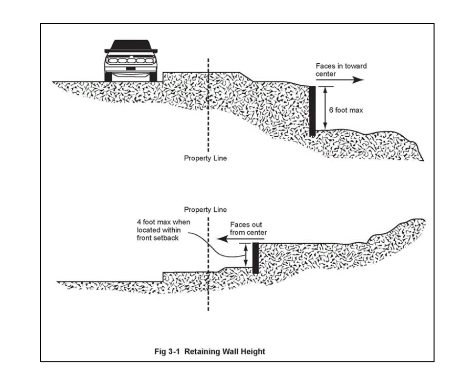
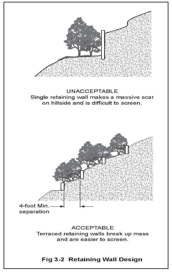
Retaining Walls. Individual retaining walls shall not exceed a height of six feet unless otherwise approved by the director. Outward-facing retaining walls in the front setback may not exceed a height of four feet. See Figure 3-1. Outward-facing retaining walls within a side yard or rear yard setback, and which face a street or public park, may not exceed four feet in height unless approved by the director to a height not exceeding six feet. All retained slopes should be terraced and landscaped/screened as shown in Figure 3-2. The minimum horizontal distance between terraced or tiered retaining walls shall be four feet. See Figure 3-2.
4.
Director Discretion. The director shall have discretion to approve walls or fences which are up to twenty-five (25) percent higher than the height limitations listed in subsections (B)(1) through (B)(3) of this section; however, the average height of any wall or fence may not exceed six feet six inches without a variance.
C.
Fence Design.
1.
Perimeter fences/walls adjacent to public rights-of-way shall be articulated by providing a minimum of one, two-foot deep by five-foot long landscaped recession for every one hundred (100) feet of continuous wall. The design may include an appropriate mix of materials and finish subject to the approval of the director.
2.
Uninterrupted fences and walls facing the public right-of-way are to be avoided, unless they are needed for specific screening, safety, or sound attenuation purposes.
3.
Fences or walls should be consistent with the site being developed and surrounding developments, open spaces, streets, and pedestrian ways.
4.
Fencing and walls should respect existing view corridors, by among other things, preserving existing views of surrounding hillsides to the greatest extent possible.
5.
Fencing and walls should incorporate landscape elements or such materials, colors, or textures which will prevent graffiti, undue glare, heat, reflection, or aesthetic inconsistencies.
D.
Required Fences Exempt. The provisions of this section shall not apply to a fence or wall required by any law or regulation of the city, state or any agency thereof.
E.
Prohibited Materials. The use of barbed wire, electrified fence or razor wire fence in conjunction with any fence, wall or hedge, or by itself within any zoning district, is prohibited unless required by any law or regulation of the city, state or any agency thereof.
F.
Chain Link Fencing. Temporary chain link fencing for construction projects and chain link fencing for private and commercial baseball fields, tennis courts, and other recreational facilities are permitted in any zoning district. Chain link fencing is permitted only in OS, HM, RR, RC and CL zoning districts, as follows:
1.
Residential and Commercial Districts. Chain link fencing within the RC and CL zoning districts shall only be located along the side property line, behind the front yard setback and along the rear property line with vegetation planted in sufficient density and height to screen the fence from adjacent parcels and public areas; and
2.
Scenic Corridors. Where allowed in a scenic corridor, chain link fencing shall be covered with vines or other screening plant materials.
G.
Fences Between Different Land Uses. Fences or walls may be required between different land uses (e.g., commercial and residential, multifamily residential and single-family residential) in compliance with Section 17.20.100.
H.
Fencing for Wildlife Movement. Fencing on properties in the RR, HM, and OS zoning districts located adjacent to or partially or wholly within sensitive biological resource areas, Los Angeles County significant ecological areas, wildlife linkage and corridors or ecological areas and corridors as mapped on Figures IV-1 and VI-2 in the General Plan shall be wildlife friendly except as provided below:
1.
Areas of immediate development and daily use (to include residences and accessory structures, surrounding hardscape areas, swimming pools and patios) may be enclosed entirely or in part by non-wildlife-friendly fencing as necessary for the purpose of protecting public safety.
2.
Animal containment facilities may be enclosed subject to the standards in Section 17.12.040.
3.
Perimeter fencing of a parcel shall be prohibited except where the perimeter is part of the immediate development area or the fence is designed and constructed as a wildlife friendly fence.
(Ord. No. 2010-265, § 3, 1-27-2010; Ord. No. 2012-297, § 1(Att. A), 5-23-2012)
17.20.120 - Freeway corridor development.
The Urban Design - Freeway Corridor Design Guidelines of Section 17.20.070 shall apply to all proposed development within the Ventura Freeway Corridor, including the expansion or remodeling of existing commercial, office and business park developments, where the proposed project:
A.
Is within five hundred (500) feet of the Ventura Freeway right-of-way;
B.
Is within one thousand (1,000) feet of the Ventura Freeway right-of-way and is on a parcel larger than forty thousand (40,000) square feet; or
C.
Is within one thousand (1,000) feet of the Ventura Freeway right-of-way and structures of three or more stories in height are proposed; or
D.
Proposes Freeway-Oriented Signs.
(Ord. No. 2010-265, § 3, 1-27-2010; Ord. No. 2021-395, § 5M, 10-13-2021)
17.20.130 - Hazards.
A.
The following performance standards apply to new development and include hazardous materials, seismic and geologic hazards, and fire hazards.
1.
The use, handling, storage and transportation of hazardous substances shall comply with all applicable state laws (Government Code Section 65850.2 and Health and Safety Code Sections 25505, et seq.), and the Los Angeles County Hazardous Waste Management Plan. Residential uses shall also comply with the standards of the Calabasas Household Hazardous Waste Management Element.
2.
New commercial, office, and business park uses will be required to comply with the provisions of the Los Angeles County Hazardous Waste Management Plan; the most current amendments to Title 22 of the California Code of Regulations; and any other applicable city, county, state or federal standard relating to the use, storage, handling, transportation, or disposal of hazardous materials.
3.
Concurrent with submittal of discretionary development applications, project proponents will be required to submit a history of onsite soil use, and, if warranted, a soil survey to determining the potential presence of hazardous substances in the soil.
4.
The design of all new structures shall comply with the latest California Building Code seismic design standards, as well as such supplemental design criteria as the city may adopt to ensure that a) buildings are designed so as to avoid structural collapse; and b) all uses needed for emergency response are designed to withstand sufficient "g" force to remain functional.
5.
Site-specific soils studies will be required to be submitted concurrent with submittal of grading and/or building permit applications to determine onsite soils and geologic conditions and meet safety standards as established by the city engineer. As part of these studies, the potential for hillside areas to become unstable when saturated at the surface and liquefying shall be investigated and mitigated.
6.
To prevent future slope failures, new development shall be required to 1) achieve a factor of safety of 1.5 against shear failure; and 2) achieve a factor of safety of 1.1 against seismically induced slope failure.
7.
Roadways and internal circulation systems shall be designed to accommodate fire suppression equipment with adequate turn-around areas as determined by the Los Angeles County Consolidated Fire District.
8.
All new development shall be provided with the water facilities needed to meet fire flow requirements as determined by the Los Angeles County Consolidated Fire District.
9.
Fire hydrants and "blue dots" to identify fire hydrant locations are to be provided as required by the Los Angeles County Consolidated Fire District.
10.
The City of Calabasas is designated within Fire Hazard Zone IV by the Los Angeles County Consolidated Fire Districts. This zone includes wildland fire hazard areas defined as watershed lands that contain native growth and vegetation. Development located in or within five hundred (500) feet of native vegetation is subject to the following development provisions:
a.
Within the HM, RR, or RC zones, structures intended for human occupancy are to be located along a paved, all weather, accessible (to emergency personnel) road for the purpose of avoiding the need for firefighters to move equipment onto properties without adequate turnaround space. If a structure cannot feasibly be sited in this manner, the structure shall contain sprinklers as required by the city.
b.
Prior to approval of a building permit for any new structure intended for human occupancy within areas subject to wildland fires, applicants should meet with the County Consolidated Fire Districts to determine the most fire-safe location for the structure. New structures intended for human occupancy within areas subject to wildland fires are generally to be located on the lowest portion of the site. In addition, adequate setbacks from the top of slopes which have natural vegetation shall be maintained so as to reduce the spread of wildland fires to structures.
(Ord. No. 2010-265, § 3, 1-27-2010)
17.20.140 - Height measurement and height limit exceptions.
A.
Maximum Height. The height of structures shall not exceed the standard for the applicable zoning district established by Article II, or other height limit provided by this article.
B.
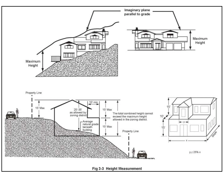
Height Measurement. Maximum allowable height shall be measured as the vertical distance from the natural or finished grade, whichever is lower, of the site to an imaginary plane located the allowed number of feet above and parallel to the natural or finished grade. See Figure 3-3.
C.
Non-Sloping Lots. Building height shall be limited to the maximum allowed height, as established by a zoning district or overlay zone, above natural or finished grade; whichever is lower, where average parcel slope is less than twenty (20) percent.
D.
Sloping Lots. Building height of sites with an average slope of twenty (20) percent or more shall be limited as follows:
1.
Total Height. Total building height shall not exceed the maximum allowed height, as established by a zoning district or overlay zone, above natural or finished grade, whichever is lower, and fifteen (15) feet from the highest elevation on the parcel to the highest point on the building. See Figure 3.3.
2.
Downhill Building Walls. No single building wall on the downhill side of a house shall exceed fifteen (15) feet in height above natural or finished grade, whichever is lower. Additional building height on a downhill side may be allowed in fifteen-foot increments, where each increment is stepped-back from the lower wall a minimum of ten (10) feet. In addition, a portion of a second story may be built to the front building wall as long as that portion does not exceed more than twenty-five (25) percent of the width of the front building elevation. See Figure 3-3. This section applies to enclosed space as well as covered porches and patios.
E.
Exceptions to Height Limits. The height limits of this development code shall not apply to the following:
1.
Agricultural structures (e.g., commercial equestrian barns, water tanks, windmills and other similar agricultural structures if located at least fifty (50) feet from any property line, and is not adjacent to a public street;
2.
Chimneys with a maximum height of thirty (30) inches above the highest point of the roof;
3.
Cooling towers, elevator penthouses, grain elevators, and stairs providing roof access;
4.
Church spires, belfries, cupolas and domes; and
5.
Structures for public assembly (e.g., churches, schools and other permitted public and semi-public structures), with no more than one story, provided that:
a.
The side and rear setbacks of the structure normally required by the applicable zoning district are increased by one additional foot for each foot that the structure exceeds the height limit of the zoning district, and
b.
The structure does not exceed the maximum height established by the applicable zoning district by more than fifty (50) percent without the approval of a variance.
F.
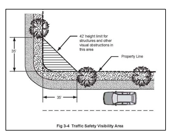
Traffic Safety Visibility Area Required. Proposed development on corner parcels shall be designed to provide a traffic safety visibility area, for public safety purposes. No structure or landscape element placed within the traffic safety visibility area shall exceed a height of forty-two (42) inches, unless approved by the director. This triangular area is formed by measuring thirty-five (35) feet from the intersection of the front and street side property lines of a corner parcel, and connecting the lines across the property. See Figure 3-4.
G.
Height Limits for Specific Structures-Decks. The walking surface of a deck shall not exceed a maximum height of five feet above natural grade.
H.
Final Pad Elevations. Final pad elevations shall be reviewed and approved by the director.
(Ord. No. 2010-265, § 3, 1-27-2010)
17.20.150 - Hillside and ridgeline development.
The general requirements of this section apply to development proposed on sites with a natural slope greater than ten (10) percent, or that include a ridgeline.
A.
Performance Standards. All development shall comply with the applicable performance standards of this chapter. These include, but are not limited to the performance standards for hillside development addressing grading, project site planning, architectural design, landscape treatment and slope maintenance, and hazards ( seismic, geologic and fire).
B.
Performance Standards for Hillside Development. Grading and project design shall conform to the city's grading ordinance (Title 15) and the following standards:
1.
Projects within hillside areas shall be designed to protect important natural features and to minimize the amount of grading. To this end, grading plans shall conform to the following guidelines:
a.
Slopes less than ten (10) percent: For property on slopes less than ten (10) percent, redistribution of earth over large areas may be permitted.
b.
Slopes between ten (10) and twenty (20) percent: Some grading may occur on property on slopes between ten (10) and twenty (20) percent, but landforms must retain their natural character. Padded building sites may be allowed, but split level designs, stacking and clustering are required to mitigate the need for large padded building areas.
c.
Slopes between twenty (20) and thirty (30) percent: Limited grading may occur on property on slopes between twenty (20) and thirty (30) percent; however, major topographic features including ridge lines, bluffs, rock outcroppings, and natural drainage ways shall retain their natural landforms. Special hillside architectural and design techniques shall be required in order to conform to the natural land form, by using techniques such as split level foundations of greater than eighteen (18) inches, stem walls, stacking and clustering.
d.
Slopes between thirty (30) and fifty (50) percent: Development and limited grading can occur on property on slopes between thirty (30) and fifty (50) percent, but only if it can be clearly demonstrated that safety hazards, environmental degradation, and aesthetic impacts will be avoided. Variable setbacks and building structural techniques (e.g., stepped or post and beam foundations) is required for development and limited grading on these properties. Structures shall blend with the natural environment through their shape, materials and colors. Impact of traffic and roadways is to be minimized by following natural contours or using grade separations.
e.
Slopes greater than fifty (50) percent: Except in areas limited in size and in isolated locations development in areas with slopes greater than fifty (50) percent shall be avoided.
The intent of this section is to limit the amount of grading on the steeper portions of a lot. In order to ensure compliance with the intent of this section, the director may require a slope analysis to determine areas and subareas of different slope conditions.
2.
Grading and project design shall address and avoid impacts to habitat linkages and wildlife corridors.
3.
Overall project design and layout shall adapt to the natural hillside topography and maximize view opportunities to and from a development. A development should preserve the hillside rather than alter it to fit the development.
4.
Grading plans should allow for different lot shapes and sizes based primarily on the natural terrain. Encourage split pads in large developments.
5.
Flag lots will be allowed; provided that, it can be demonstrated that (i) the natural topography is preserved through minimal grading; and (ii) adequate visibility is maintained for emergency vehicles.
6.
Structures shall be sited in a manner that will:
a.
Fit into hillside contours and the form of the terrain;
b.
Retain outward views from the maximum number of units and maintain the natural character of the hillside; and,
c.
Preserve natural hillside areas and ridgelines views from the public right-of-way.
7.
Streets should follow the natural contours of the hillside to minimize cut and fill. Streets may be split into two one-way streets in steeper areas to minimize grading and blend with the terrain. Cul-de-sacs or loop roads are encouraged where necessary to fit the terrain. On-street parking and sidewalks may be eliminated, subject to a determination by the review authority that is will reduce required grading.
8.
In subdivisions, the project design should maximize public access to canyons, overlooks, and open space areas by providing open space easements or such other rights-of-way to allow the development's residents to access these locations.
9.
Development should use retaining structures when it significantly reduces grading; however, such retaining structures shall be located and restricted in height so that they do not become a dominant visual feature of a parcel.
10.
Where retaining walls face public streets, the retaining walls should be covered with or contain materials that help blend the wall with the natural terrain.
11.
Large retaining walls in a uniform plane should be avoided. Retaining walls should be divided into terraces. Developments should use landscaping to screen retaining walls from the public right-of-way and adjacent properties.
12.
The overall scale and massing of structures shall respect the natural surroundings and unique visual resources of the area by incorporating designs which (i) minimize bulk and mass, (ii) follow natural topography, and (iii) minimize visual intrusion on the natural landscape.
13.
The overall height of a building is an important aspect of how well it fits into the existing character of a neighborhood and its hillside environment. Houses shall not be excessively tall so as to dominate their surroundings or create a crowded appearance in areas of small lots. Structures should be stepped down a hillside and contained within a limited envelope parallel to the natural grade rather than jut out over the natural slope.
14.
Building forms shall be scaled to the particular environmental setting so as to complement the hillside character and to avoid excessively massive forms that fail to enhance the hillside character.
15.
Building facades shall change plane or use overhangs as a means to create changing shadow lines to further break up massive forms.
16.
Wall surfaces facing towards viewshed areas shall be minimized through the use of single story elements, setbacks, roof pitches, and landscaping.
17.
Collective mass roof lines and elements shall blend with the hillside or reflect the naturally occurring ridgeline silhouettes and topographical variation.
18.
Medium to dark colors which blend with the surrounding environment should be used for building elevations and roof materials in view-sensitive areas.
19.
Architectural style, including materials and colors, should be compatible with the natural setting and the surrounding neighborhood. No one dwelling should stand out.
20.
Exposed structural and mechanical elements shall be avoided.
21.
Roof materials shall be of fire-retardant material. Roof design shall reflect the underlying contour of the land.
22.
Slope plantings should create a gradual transition from developed slope areas into natural areas. New landscape should blend with the natural vegetation, in part, by extending plantings in finger-like configurations into existing slopes.
23.
Plantings along the slope side of a development shall be designed to allow controlled views from the development. At the same, these planting shall partially screen and soften the architecture of the development. No less than fifty (50) percent of screening should consist of plant materials.
24.
Trees shall be randomly spaced and massed together, and they shall be used to reduce the scale of long, steep slopes.
25.
Shrubs are to be randomly placed and massed together.
26.
To act as a backdrop for structures, landscaping shall be used along any recontoured ridge or hillside located behind and at a higher elevation than structures in order to recreate the linear line of the recontoured ridge or hillside. Trees shall be planted to create a continuous linear silhouette to avoid gaps in the planting.
27.
Trees of sufficient height or height capacity shall be planted between structures to eliminate any open gap and blend the roof lines into one continuous silhouette.
28.
New subdivisions, commercial and multi-family development within hillside areas shall meet the following requirements:
a.
Recordation of a declaration of covenants, conditions and restrictions requiring the maintenance of manufactured slopes;
b.
Developer shall prepare a program for preventive maintenance of major manufactured slope areas. This preventive maintenance program shall include homeowner slope maintenance requirements and guidelines declaration of covenants, conditions, and restrictions which shall be recorded against each parcel within the development. Developer shall submit its preventive maintenance program to the department for its review and approval prior to final map approval.
c.
Developer shall prepare and submit to the department for its review and approval a minimum five year revegetation monitoring and maintenance program. Program inspections shall be performed by a qualified botanist. This requirement shall only apply to developments which require slope bank or habitat vegetation.
C.
Standards for the Location of Structures. The following provisions shall apply to the placement of proposed structures on sloping sites.
1.
General Siting Principles. Buildings should be located in the most accessible, least visually prominent, and most geologically stable portion or portions of a site. Buildings should be located in the least visually prominent locations of a property, on open, grassy hillsides, where the prominence of buildings should be minimized by placing them in locations where they will be screened by existing vegetation, rock outcroppings, or depressions in topography. In wooded areas, building placement may be guided by the fire hazard prevention performance standards of Section 17.20.130.
2.
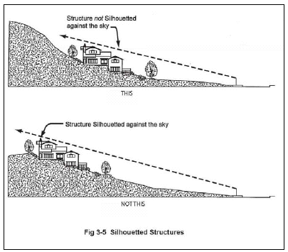
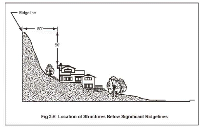
Ridgelines. For the purposes of maintaining the natural appearance of the ridge, structures should not be placed on or near ridgelines so that they appear silhouetted against the sky when viewed from any point on a roadway designated as a scenic corridor by the General Plan (see Figure 3-5). For significant ridgelines identified in the Open Space Element of the General Plan (Figure III-4), the highest point of any structure that requires a permit shall be located at least fifty (50) vertical feet and fifty (50) horizontal feet from a significant ridgeline, excluding chimneys, rooftop antennas, and amateur radio antennas.
However, this ridgeline setback provision shall not apply to:
a.
Any addition to a legally established residence or accessory structure(s) existing as of the effective date of this ordinance that is located on a significant ridgeline, or within the ridgeline protection area of fifty (50) vertical and fifty (50) horizontal feet from the significant ridgeline, such that said addition does not cumulatively with any other permitted additions enlarge the structure by an amount exceeding twenty-five percent (25%) or one thousand two hundred (1,200) square feet of additional gross floor area, whichever is less, above the structure's original size.
b.
Any new accessory structure which is otherwise allowed within the applicable zoning district and which complies fully with the development standards for the zone.
3.
Where structures on a lot or parcel of land cannot meet the standards prescribed in subsection C.2, above, a variance as provided in Section 17.62.080 shall be required. In addition to the required findings set forth in subsection E. of Section 17.62.080, findings shall be made that:
a.
Alternative sites within the property or project have been considered and eliminated from consideration based on physical infeasibility or the potential for substantial habitat damage or destruction if any such alternative site is used and that the siting principles outlined under subsection (C)(4) have been applied; and
b.
The proposed project maintains the maximum view of the applicable significant ridgeline through the use of design features for the project including minimized grading, reduced structural height, clustered structures, shape, materials, and color that allow the structures to blend with the natural setting, and use of native landscaping for concealment of the project.
4.
Siting Priorities. Based on the principles in subsections (C)(1) and (2) of this section, the building sites selection for subdivision design and the development of existing individual lots should occur according to the following priorities:
a.
The first priority for building site selection should be areas below the tops of ridgelines, on slopes less than twenty (20) percent.
b.
In cases where a lot has no building site of at least four thousand (4,000) square feet that satisfies subsection (C)(4)(a) of this section, the second priority should be areas below the tops of ridgelines, on slopes between twenty (20) and thirty (30) percent, where development can occur with careful attention to minimizing grading through building designs that employ stepped foundations.
c.
Where a lot has no potential building sites that satisfy subsection (C)(4)(b) of this section, the third priority for site selection should be areas on ridge tops with slopes less than twenty (20) percent. Proposed buildings should be set back as far as possible from the edge of the ridge (where downhill slopes begin to exceed twenty (20) percent and landscaped, to minimize visibility.
D.
Watercourse Setbacks. Structures, paving and grading (other than grading determined by the review authority to be necessary for slope stabilization) shall be set back from the from the outer edge of the riparian vegetation canopy of a perennial or intermittent stream by a minimum of one hundred (100) feet, or other distance determined by a qualified biologist approved by the city to be adequate for the preservation of existing riparian vegetation and habitat. Where riparian vegetation is not present, the one-hundred-foot buffer shall be measured from the outer edge of the bank of the subject stream. A one-hundred-foot setback or other distance determined by a qualified biologist approved by the city shall also be maintained from ephemeral streams which contain riparian vegetation as determined by the city qualified biologist. Provided that no development shall be:
1.
Placed in an area identified by a flood insurance rate map (FIRM) as being subject to flooding, except in compliance with applicable federal regulations; or
2.
Located within an intermittent drainage channel known to be subject to dangerous storm water flows during heavy rains.
E.
Access. To ensure adequate all-weather access for emergency vehicles and any necessary excavations, access to the lot shall be from a paved, city-maintained roadway, or a private road/driveway in compliance with the following standards.
1.
Width. The minimum width of a proposed driveway shall be sixteen (16) feet, or twenty (20) feet if the driveway slope exceeds ten (10) percent.
2.
Slope and Surface. The average slope of a driveway shall not exceed seventeen (17) percent, with no portion of the driveway exceeding a slope of twenty (20) percent. Driveways shall be paved with asphalt, concrete, or other surfacing approved by the city engineer, and shall include proper drainage facilities, as approved by the city engineer.
3.
Fuel Modification Area. A fuel modification area shall be provided at the time of driveway construction, and permanently maintained.
4.
In no event shall a driveway exceed three hundred (300) feet unless there is no other feasible location to site the structure.
F.
Parking. The development of lots along city streets or private roads with pavement less than thirty-two (32) feet wide shall be required to provide two off-street parking spaces for guests, in addition to the parking normally required for a residence by Chapter 17.28.
G.
Improvements to Paper Streets. Where residential construction is proposed on a site adjacent to a paper street (a recorded, but unimproved road right-of-way), project review by the department shall include a determination of the adequacy of proposed access, and project approval may include requirements to improve a paper street right-of-way proposed to serve a site, to ensure adequate, all-weather emergency vehicle access, and safe evacuation routes. Standards for improvements (e.g., the location of pavement within the right-of-way, horizontal and vertical alignments, drainage measures, the structural section of pavement and base materials, and other such standards ), and requirements for right-of-way dedication shall be determined by the city engineer, and shall at a minimum comply with subsection (E) of this section.
(Ord. No. 2010-265, § 3, 1-27-2010; Ord. No. 2012-297, § 1(Att. A), 5-23-2012; Ord. No. 2016-340, § 3, 10-26-2016)
17.20.160 - Noise.
A.
Performance Standards. The following noise management performance standards shall apply to all proposed development, except for the construction of one single-family home on an existing lot, the expansion of existing commercial, office and business park projects, and the addition of housing units to an existing multifamily residential project.
1.
Limit project-related noise to no greater than a sixty (60) dBA CNEL (Community Noise Equivalent Level) within known wildlife nesting or migration areas, as well as within natural open space areas, as necessary to maintain tranquil open space and viable wildlife habitats and mobility.
2.
One or more of the following mitigation measures shall be provided as necessary to mitigate project-related noise:
Project Site Planning
a.
Orient buildings to buffer or attenuate noise.
b.
Route or align roadways away from noise sensitive receptors where such routing and alignment can be accomplished without creating other significant impacts.
c.
Locate the highest noise sources as far away from adjacent sensitive uses as is feasible.
d.
Provide sound attenuation walls (open space buffers and berms are preferred).
e.
Utilize landscape materials and "softscape" design to break up hard surfaces for the purpose of minimizing reverberation (mandatory for noise, as well as aesthetic purposes).
Landscape Treatment
f.
Utilize open space and landscaped buffers between uses to naturally attenuate noise with distance. Project applicants shall be responsible for providing open space buffers in the form of easements to eliminate noise encroachment from having an adverse effect. The distance shall be sufficient to meet the exterior noise standards established in Sections 17.20.160 (C) and (D).
g.
For commercial retail and business park uses place fixed equipment, such as air conditioning units, inside an enclosed space, or in shielded locations.
Architectural Design
h.
For commercial, office, and business park uses, place rooftop equipment at an appropriate setback from property lines, or in acoustically treated mechanical rooms or in shielded equipment wells, to meet noise standards and minimize disturbance potential.
i.
Provide one or more of the following: sound rated windows, additional exterior wall or roof insulation, vent or mail slot modifications or relocation, or forced air ventilation.
B.
Noise Standards. Sections 17.20.160 (D) and (E) establish standards for acceptable exterior and interior noise levels. These standards are intended to protect persons from excessive noise levels, which are detrimental to the public health, welfare and safety since they have the potential to: (i) interfere with sleep, communication, relaxation and the full enjoyment of property; (ii) contribute to hearing impairment and a wide range of adverse physiological stress conditions; and (iii) adversely affect the value of real property. It is the intent of this chapter to protect persons from excessive noise levels within or near various residential development and other specified noise-sensitive land uses.
C.
Exceptions to Noise Standards. The standards of Section 17.20.160 (D) are not applicable to noise from the following sources:
1.
Activities conducted in public parks, public playgrounds and public or private school grounds, including school athletic and entertainment events;
2.
The use of any mechanical device, apparatus or equipment related to or connected with emergency activities or emergency work;
3.
Safety signals, warning devices, and emergency pressure relief valves;
4.
Noise sources associated with construction, including the idling of construction vehicles, provided such activities do not take place before seven a.m. or after six p.m. on any day except Saturday in which no construction is allowed before eight a.m. or after five p.m. No construction is allowed on Sunday's or federal holidays. These requirements may be modified by a conditional use permit.
5.
Noise sources associated with work performed by private or public utilities in the maintenance or modification of their facilities;
6.
Noise sources associated with the collection of waste or garbage from property devoted to other than residential uses.
7.
Traffic on public roads and any other activity to the extent regulation thereof has been preempted by state or federal law.
D.
Exterior Noise Level Standards. No person shall cause or allow exterior noise levels to exceed the levels set forth in Table 3-1 on any property owned, leased, occupied or otherwise controlled by such person.
E.
Interior Noise Level Standards for Residential Uses. No person shall operate or cause to operate any source of sound within any residential dwelling unit or allow the creation of noise on property owned, leased, occupied or otherwise controlled by such person which causes the noise level, when measured inside a neighboring dwelling unit to exceed the levels set forth in Table 3-2.
F.
Mixed Use Standards. Noise level standards in Tables 3-1 and 3-2 shall be increased by 5 dBA for mixed used projects.
G.
Noise Level Measurement. For the purpose of evaluating conformance with the standards of this chapter, noise levels shall be measured as follows:
1.
Use of Meter. Any noise measurement required by this section shall be made with a sound level meter using the A-weighted network (scale). Measurement equipment with an acoustical calibrator shall be calibrated immediately prior to recording any noise data.
2.
Measuring Exterior Noise Levels. Exterior noise levels shall be measured at the property line. Where practical, a microphone shall be positioned five feet above the ground and away from reflective surfaces.
3.
Measuring Interior Noise Levels. Interior noise levels shall be measured within the affected residential use at points at least four feet from the wall, ceiling or floor nearest the noise source, with windows in their normal seasonal position. The reported interior noise level shall be the average of the various microphone location readings.
(Ord. No. 2010-265, § 3, 1-27-2010)
17.20.170 - Screening.
A.
Screening Between Uses. Wherever a site within a commercial zoning district abuts a residential zoning district, a six-foot high solid decorative masonry wall shall be constructed along the property line abutting the residential zoning district. The wall shall be architecturally treated on both sides, subject to the approval of the director.
B.
Screening of Equipment. Any equipment, whether on the roof, side of structure, or ground, shall be properly screened from the public right-of-way and adjacent properties. The method of screening shall be architecturally compatible with other site development in terms of materials, colors, shape and size. Landscaping shall be installed and maintained for screening purposes for all ground-mounted equipment. The screening design and construction shall be subject to the approval of the director and shall blend with the design and construction of the structure(s) on the site. Where feasible, ground-mounting of mechanical equipment shall be required as an alternative to roof mounting.
C.
Screening of Loading and Service Areas. Loading, service, storage, special equipment, and maintenance areas should be screened from public right-of-way and adjacent properties with landscaping and architectural elements. Loading docks and service areas should be located on interior side yards, and shall be concealed from public view.
D.
Utility equipment and communication devices shall be screened so that the project will appear free of all such devices.
(Ord. No. 2010-265, § 3, 1-27-2010)
17.20.180 - Setback requirements and exceptions.
A.
Purpose. The following setback standards provide open areas around structures for: visibility, traffic safety; access to and around structures; natural light access; ventilation; incompatible land uses separation; privacy; landscaping and recreation.
B.
Setback Requirements. All structures shall comply with the setback requirements of each zoning district (See Article II) and with any special setbacks established for specific uses by this article, except as otherwise provided by this section. No portion of any structure, including eaves or roof overhangs, shall extend beyond a property line; or into an access easement or public right-of-way, without first securing an encroachment permit or other legal right to do so.
1.
Infill Development Within Previously Approved Projects. Any setback requirements of a recorded subdivision map, or specific plan, development agreement, conditional use permit, or other planned development entitlement shall apply to continuing development within the approved project instead of the setbacks requirements set forth in Article II.
2.
Special Setbacks for Development Plan Projects. The council may authorize uniform setbacks for a specific subdivision project that are different from those required by Article II, through the approval of a development plan (Section 17.62.070), or specific plan (Chapter 17.66).
3.
Front Setback - Limitations of Paved Surface. No more than fifty (50) percent of the required front setback for any lot in a RS zone that contains a single family dwelling shall be paved with asphalt, cement or any other impervious surface.
C.
Exemptions from Setback Requirements. The minimum setback requirements of this development code apply to all development and new land uses, except the following:
1.
Fences or walls six feet or less in height above the grade of the site, when located outside of the front setback; and
2.
Decks, earthworks, free-standing solar devices, steps, terraces and other site design elements that are placed directly upon grade and do not exceed a height of eighteen (18) inches above the surrounding grade at any point. See Section 17.12.180(H) for setback requirements for spas/hot tubs and swimming pools.
D.
Measurement of Setbacks. Setbacks shall be measured as follows. See Figure 3-7 located at the end of this section.
1.
Front Yard Setbacks. The front yard setback shall be measured at right angles from the nearest point on the front property line of the parcel (or edge of access easement on a private street) to the nearest point of the wall of the structure, except as follows.
a.
Flag Lots. For a parcel with a fee ownership strip extending from a street or right-of-way to the building area of the parcel, the measurement shall be taken from the nearest point of the wall of the structure to the point where the access strip ("flag pole") meets the bulk of the parcel along a continuous line, establishing a parallel setback line. See Figure 3-8 located at the end of this section.
b.
Corner Lots. The measurement shall be taken from the nearest point of the structure to the nearest point of the front lot line.
2.
Side Yard Setbacks. The side yard setback shall be measured at right angles from the nearest point on the side property line of the parcel to the nearest line of the structure; establishing a setback line parallel to the side property line, which extends between the front and rear yards.
3.
Street Side Yard Setbacks. The side yard on the street side of a corner parcel shall be measured from the nearest point of the side property line bounding the street, or the easement for a private road.
4.
Rear Yard Setbacks. The rear yard shall be measured at right angles from the nearest point on the rear property line to the nearest line of the structure, establishing a setback line parallel to the rear property line, which extends between the side yards. The rear yard on the street side of a double-frontage parcel shall be measured from the nearest point on the rear property line bounding the street, or the easement for a private road.
E.
Allowed Projections into Setbacks. Attached architectural features and certain detached structures may project beyond the wall of the structure and into the front, side and rear yard setbacks, in compliance with the following requirements:
1.
Architectural Features. Architectural features attached to the primary structure may extend beyond the wall of the structure and into the front, side and rear yard setbacks, in compliance with the following table. See also Figure 3-9.
Notes:
(1) Chimney's that project into a side yard setback shall not exceed six feet in width. Ground-story bay windows, porches and decks shall not project into the side yard over half the length of the side wall.
(2) Features may project not closer than thirty-six (36) inches to the property line.
(3) The cantilevered architectural features that may project into setbacks include balconies, bay windows, cornices, eaves and solar devices.
(4) Decks less than eighteen (18) inches above grade are exempt, in compliance with Section 17.20.170(C) (Exemptions from Setback Requirements), above.
(5) A roofed porch allowed to project into a setback shall be enclosed only by a railing in compliance with Title 15 (Building and Construction) of the Municipal Code, and shall be located at the same level as the entrance floor of the structure.
(6) A stairway that may project into a setback shall not be roofed or enclosed above or below the steps.
(7) The setback for trellises and unenclosed patio covers shall be measured from the support post. The additional roof overhang of thirty (30) inches as noted above may be allowed.
2.
Equipment. Swimming pool equipment, air conditioning and heating equipment, and other equipment, shall not be closer than thirty-six (36) inches to the side or rear property line.
F.
Setback Requirements for Specific Structures:
1.
Fences. See Section 17.20.100.
2.
Site Design Elements. Detached decks, earthworks, freestanding solar devices, steps, terraces, and other site design elements which are placed directly upon the grade, and which exceed a height of eighteen (18) inches above the surrounding grade at any point, shall conform to the setback requirements of the underlying zone (site design elements less than eighteen (18) inches above grade are exempt in compliance with subsection (C)(2) of this section).
3.
Hot Tubs, Swimming Pools and Appurtenant Features and Structures. See Section 17.12.165.
4.
Retaining Walls. Retaining walls less than six feet in height may be located within a required setback. Refer to Section 17.20.100 for standards applicable to retaining walls.
5.
Outdoor recreational features, such as fireplaces, built-in pizza ovens, or built-in barbeque grills. See Section 17.12.165(1).
6.
The following setbacks shall apply to storage sheds:
a.
For a storage shed that qualifies for the exemption in Section 17.02.020 (B)(7) of this Code and is less than six feet in height, the minimum required setback shall be five feet from all property lines.
b.
In the RS, RM, RR, and RC zoning districts, if an storage shed does not qualify for the exemption in Section 17.02.020(B)(7) of this title and/or it is over six feet in height, the storage shed shall meet the required setback of the zoning district in which it is located.
c.
In the HM and OS zoning districts, if an storage shed (i) does not qualify for the exemption in Section 17.02.020(B)(7) of this title, it must meet the required setback of the zoning district in which it is located; or (ii) qualifies for the exemption in Section 17.02.020(B)(7) of the code but is over six feet in height, the accessory must meet a minimum setback of ten (10) feet from the side property line and twenty (20) feet from the rear property line
G.
Restrictions on the Use of Residential Setbacks. No front or street side setback within a residential zoning district shall be used for the storage of scrap, junk, boats, habitable trailers, utility trailers, or other similar vehicles or equipment. This restriction includes the storage of operable or inoperable vehicles in other than improved parking areas.
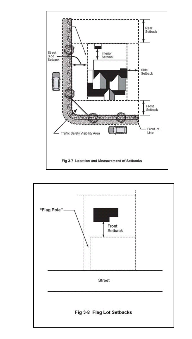
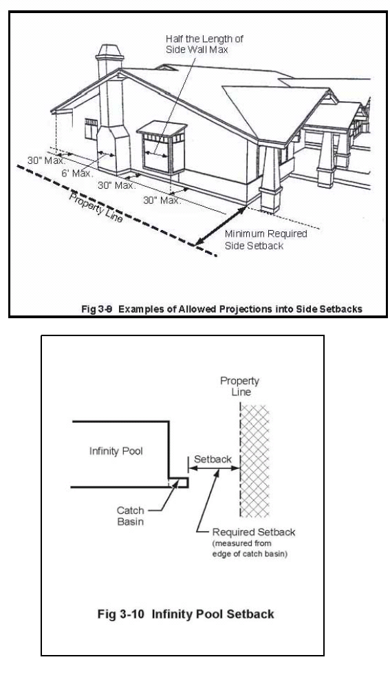
(Ord. No. 2010-265, § 3, 1-27-2010; Ord. No. 2012-297, § 1(Att. A), 5-23-2012)
17.20.190 - Solar energy development standards.
Any proposed active or passive heating and cooling features shall be incorporated into the design of a structure as follows:
A.
Roof-mounted solar collectors shall be placed in a location least visible from the street and adjacent properties, without significantly reducing the operating efficiency of the collectors. Wall-mounted and ground-mounted collectors shall be screened from a public right-of-way;
B.
Roof-mounted collectors shall be installed at the same angle or as close as possible to the pitch of a roof;
C.
Accessory equipment, particularly plumbing and related fixtures, should be installed in attic space; and
D.
Exterior surfaces of the collectors and related equipment shall have a non-reflective finish and shall be color-coordinated to harmonize with roof materials and other dominate colors of the structure.
(Ord. No. 2010-265, § 3, 1-27-2010)
17.20.195 - Survey.
An application for a permit under this title for the construction or alteration of any structure to be located within ten (10) feet of a property which is zoned Open-Space or Open-Space Development-Restricted, as identified in the City's zoning map, shall not be complete unless accompanied by a survey prepared by a licensed land surveyor or another person authorized by law to conduct and prepare a survey. This survey shall be required to depict (i) the boundaries of the property, (ii) the work to be constructed, and (iii) the boundary of the property nearest the site of the work which is zoned Open-Space or Open-Space Development-Restricted, as identified in the city's zoning map. A survey is a construction document subject to all of the requirements and exceptions of Section 106 of the California Building Code. In addition to the foregoing, prior to the issuance of a building permit for any structure located within ten (10) feet of a property which is zoned Open-Space or Open-Space Development-Restricted, as identified in the city's zoning map, an applicant or property owner shall be required to perform a stake survey in the manner required by the director. Any stakes installed to fulfill the foregoing requirement shall not be moved or removed and shall remain in place consistent with the survey until the completion of the work for which the permit issues.
(Ord. No. 2010-265, § 3, 1-27-2010)
17.20.200 - Solid waste/recyclable materials storage.
The following provisions establish standards for the construction and operation of solid waste and recyclable material storage areas in compliance with the California Solid Waste Reuse and Recycling Access Act (Public Resources Code Sections 42900 through 42911).
A.
General Requirement. All proposed development shall comply with applicable provisions of the city's source reduction and recycling element.
B.
Required Storage for Multifamily Projects. Multifamily residential projects, with five or more units shall provide solid waste and recyclable material storage areas as follows:
1.
Individual Unit Storage Requirements. Each dwelling unit shall be provided an area with a minimum of six cubic feet designed for the indoor storage of solid waste and recyclable material. A minimum of three cubic feet shall be provided for the storage of solid waste and a minimum of three cubic feet shall be provided for the storage of recyclable material; and
2.
Multi-family projects shall provide the following minimum solid waste and recyclable material storage areas, which may be located indoors or outdoors as long as they are readily accessible to all residents. These requirements apply to each individual structure. All required areas are measured in square feet.
* Every additional twenty-five (25) dwellings shall require an additional one hundred (100) sq. ft. for solid waste and one hundred (100) sq. ft. for recyclables.
C.
Nonresidential structures and uses within all zoning districts shall provide solid waste and recyclable material storage areas. The following are minimum storage area requirements. These requirements apply to each individual structure. All required areas are measured in square feet.
* Every additional twenty-five thousand (25,000) sq. ft. shall require an additional forty-eight (48) sq. ft. for solid waste and forty-eight (48) sq. ft. for recyclables.
D. Refuse Enclosure Standards and Guidelines.
1.
Purpose. Enclosures should be designed to reduce container visibility and prevent their misplacement of containers, especially in parking areas. Enclosures should increase efficient solid waste and recycling practices and enhance the aesthetic appearance of the community.
2.
Except development of a single-family residence or multi-family residence of up to four units, any new development shall comply with the following:
a.
Space Allocation. Each refuse enclosure shall be large enough to fit at least one receptacle for trash, one receptacle for recycling and one receptacle for organic waste. Each enclosure shall be sized to provide for three receptacles without one blocking the other for proper access. The minimum interior dimensions of a refuse enclosure are seven feet by twenty (20) feet. Enclosure wall height shall be at least six feet high from the base. The roof will be spaced two feet higher than the top of the wall of the enclosure, making height clearance eight feet. There must be ventilation occupying the space between the roof and the wall; however, this space shall be covered with a wire mesh (painted to match the enclosure) to keep animals out and debris in. The enclosure should be at the same level as the concrete outside of its walls.
b.
Materials. The refuse enclosure shall resemble the exterior surface of the main building. It should blend with the texture and color of the primary building(s). The refuse enclosure should be made of material that is harmonious with the material of the main building and surrounding buildings. The floor of the enclosure should be paved with concrete and graded toward the sanitary sewer.
c.
Roofing. A permanent, waterproof and noncombustible roof must be present to prevent rainfall from entering the enclosure. The roof shall overhang the enclosure on all sides. Acting as protection over the enclosure, the roof shall be at a height of eight feet. The roof should limit contaminated water from escaping into nearby storm drains and creeks. The roof should be designed in such a way that rainwater from the enclosure roof discharges into the surrounding landscape.
d.
Screening. Refuse enclosure areas shall be enclosed such that they are screened from view. The enclosure gates shall be swing or roll-up and be of a color and design that is compatible with the enclosure. Swinging doors shall be permanent and made of solid steel. Wire mesh is acceptable as long as it has small holes, so that the inside of the enclosure is not visible from the outside. The opening for the gates should be at least eight feet wide and should allow for an overhead clearance of at least seven feet. The gates shall not open towards the street; they shall instead open towards the structures of the development. Double swing gates should have swivel spots outside of the opening area of the enclosure. Swivel points shall be attached to concrete filled steel posts or columns at the ends of the walls. In addition, six inch diameter bollards shall be installed to ensure that the gates do not open into adjacent structures or parking spaces. These bollards shall be brightly colored with reflective taping at the top. For commercial and industrial sites, property owners shall have the option to lock the enclosure after business hours, and, in some cases, the owner can choose to lock the enclosure during business hours.
e.
Interior Design. Refuse enclosures shall have six inch high wheel stops to prevent the bins from damaging the walls. In addition, a six inch high curb should be created within the perimeter of the interior enclosure walls further protecting the walls from possible damage caused by the bins. The concrete curb shall be eight inches from the wall in order to provide an eight inch clearance from all three walls of the enclosure.
f.
Lighting. Adequate lighting should be provided within the refuse enclosure to ensure safety and to discourage illegal dumping into and around the enclosures. The lighting shall be equipped with sensors to turn off automatically when not in use.
g.
Sanitary Sewer Connection. A drain shall be located on the floor of the refuse enclosure. This drain shall be connected to the sanitary sewer to facilitate disposal of leachate resulting from cleaning of the enclosure. The enclosure shall have adequate filtration at the sewer drain so that hazardous waste does not enter the sewer system.
h.
Prohibited Waste. No other materials (e.g. hazardous wastes, grease, equipment, furniture) shall be stored in the refuse enclosure. The property owner shall prevent the storage of these materials within the enclosure. If there is cooking oil or grease, it must be disposed into a grease receptacle.
i.
Oil and Grease Receptacle. Any commercial or industrial refuse enclosure shall reserve adequate space for oil and grease receptacle, regardless of the current or planned use. This space shall be at least twelve (12) square feet in addition to the minimum dimensions in this section.
j.
Signage. Unless otherwise provided for by a solid waste hauler permanent signage shall be posted on recycling and organic waste containers to distinguish these bins from the solid waste containers. The enclosure shall have eighteen (18) inch by thirty-six (36) inch signage that reads, "Do Not Mix Recyclable Materials with Trash…" posted on its front wall or on the gate of the enclosure. "NO PARKING" signs shall also be posted. All required signage shall be adequately lighted.
k.
Location and Accessibility. Refuse enclosures shall be located within two hundred and fifty (250) feet of a residential unit but not closer than fifty (50) feet. Refuse enclosure shall provide convenient access for solid waste vehicles and sufficient space for turnaround movements. The turning radius for the enclosure shall be at least forty (40) feet. The front of a refuse enclosure shall also have striped "keep clear" areas. A reinforced four to six inch thick concrete pad shall be located outside the entrance of the refuse enclosure. The pad shall not be sloped so that it drains towards the refuse enclosure; rather the pad shall be sloped so that it drains away from it. The refuse enclosure may have both a pedestrian and a service access. All refuse enclosures must be located at least twenty-five (25) feet from any storm drain inlet.
(Ord. No. 2010-265, § 3, 1-27-2010)
17.20.210 - Urban runoff mitigation.
Proposed development shall comply with all applicable provisions of Chapter 8.28.
(Ord. No. 2010-265, § 3, 1-27-2010)
17.20.220 - Undergrounding of utilities.
A.
Facilities to be Undergrounded. All existing and proposed on-site utility facilities (including electric, telecommunications and cable television lines) intended to serve a new structure shall be installed underground from the utility company distribution line to the structure, except for equipment appurtenant to underground facilities, including surface-mounted transformers, pedestal-mounted terminal boxes and meter cabinets, and concealed ducts.
B.
Responsibility of Applicant. The applicant is responsible for complying with the requirements of this section and shall make the necessary arrangements with the utility companies for facility installation.
The review authority may waive the requirements of this section if topographical, soil, or any other factors or conditions make underground installation unreasonable or impractical.
C.
Location of Installation. Underground utility lines may be installed within public rights-of-way or along any lot line. When installed within public rights-of-way, their location and method of installation shall be subject to the approval of the city engineer.
(Ord. No. 2010-265, § 3, 1-27-2010)
17.20.230 - Water conservation.
A.
The Water Conservation Performance Standards of this section apply to all proposed development, including the expansion or remodeling of existing commercial, office, business park, or multifamily residential developments. Landscaping on individual single-family parcels shall comply with the provisions of Section 17.26.050.
B.
Performance Standards. To meet the city's overall water conservation performance objectives, projects shall comply with Section 17.26.050 and with the following:
1.
Landscaped areas shall be clustered to maximize the efficiency of irrigation systems. Irrigation systems shall be designed to eliminate watering of impervious surfaces and reduce runoff.
2.
Water conserving kitchen and bathroom fixtures and appliances shall be installed along with, thermostatically controlled mixing valves for baths and showers. Hot water lines shall be insulated.
3.
Where reclaimed water is or can be feasibly made available by the Las Virgenes Municipal Water District and where use of reclaimed wastewater is legally permissible, the installation of a reclaimed water system for irrigation purposes will be required.
(Ord. No. 2010-265, § 3, 1-27-2010)
17.22.010 - Purpose.
This chapter shall assist implementation of the goals and policies of the housing element of the General Plan and state statutes promoting the provision of affordable housing, including Chapter 4.3 of Division 1 of Title 7 of the Government Code. This chapter implements the foregoing by: (i) offering density bonuses and other incentives to residential projects that incorporate housing that is affordable to very low, low and/or moderate income households, senior citizens and their family members, and transitional foster youth, disabled veterans, and homeless persons; (ii) requiring an in-lieu fee for nonresidential projects that create excessive demands for new housing, and (iii) requiring an in-lieu fee for residential projects that do not incorporate housing for very low, low and/or moderate income households and/or senior citizens and their family members.
(Ord. No. 2010-265, § 3, 1-27-2010; Ord. No. 2017-346, § 3, 2-8-2017)
17.22.020 - Affordable housing requirements; eligibility for bonus and incentives.
A.
Affordable Housing Requirement. All residential or mixed use development projects proposing five or more housing units shall include housing that is affordable to low, very low and/or moderate income households, in compliance with this section. Housing units provided in compliance with this section that meet the requirements of both this Section 17.22.020(A) and Section 17.22.020(B) shall be eligible for density bonuses and incentives in compliance with Section 17.22.030. At a minimum, a proposed residential development project shall include the following number of affordable housing units at the stated rental rates or sales prices, or shall provide off-site alternatives in compliance with the provisions of this chapter:
1.
Twenty (20) percent of the total number of units shall be rented or sold at prices affordable to households with an income of up to one hundred ten (110) percent of the county median income; or
2.
Fifteen (15) percent of the total number of units shall be rented or sold at prices affordable to households with an income of up to ninety (90) percent of the county median income; or
3.
Ten (10) percent of the total number of units shall be rented or sold at prices affordable to households with an income of up to seventy-five (75) percent of the county median income; or
4.
Five percent of the total number of units shall be rented or sold at prices affordable to households with an income of up to fifty (50) percent of the county median income.
B.
In order to be eligible for a density bonus and other incentives as provided by this chapter, a proposed residential development project shall:
1.
Consist of five or more dwelling units; and
2.
Provide for the construction of one or more of the following within the development, one of which the permit applicant shall elect as the basis for its request for a density bonus:
a.
Ten (10) percent of the total units of a housing development for low income households, as defined in Health and Safety Code section 50079.5; or
b.
Five percent of the total units of a housing development for very low income households, as defined in Health and Safety Code section 50105; or
c.
A senior citizen housing development as defined in Civil Code sections 51.3 and 51.12, or mobile home park that limits residency based on age requirements for housing for older persons pursuant to Civil Code section 798.76 or 799.5; or
d.
Ten (10) percent of the total dwelling units in a common interest development as defined in Civil Code section 1351, for persons and families of moderate income, as defined in Health and Safety Code section 50093, provided that all units in the development are offered to the public for purchase; or
e.
Ten percent of the total units of a housing development for transitional foster youth, as defined in Section 66025.9 of the Education Code, disabled veterans, as defined in Section 18541, or homeless persons, as defined in the federal McKinney-Vento Homeless Assistance Act (42 U.S.C. Sec. 11301 et seq.). The units described in this subparagraph shall be subject to a recorded affordability restriction of 55 years and shall be provided at the same affordability level as very low income units.
3.
Satisfy all other applicable provisions of this development code.
(Ord. No. 2010-265, § 3, 1-27-2010; Ord. No. 2014-310, § 1(Att. A), 2-12-2014; Ord. No. 2017-346, § 3, 2-8-2017)
17.22.025 - AHO site development limits for qualifying projects.
A.
Processing of Projects Seeking Entitlement under AHO.
1.
Permits Required. Any project located within the AHO which includes affordable housing units and which qualifies for review and consideration in accordance with the provisions of the AHO, shall be reviewed and considered in accordance with the standards and procedures for the underlying zone and any other applicable overlay zone. Any such project shall require approval of a site plan review (per 17.62.020 of this title), and all other permits applicable to the project as required under Titles 15 and 17 of this Code.
2.
Criteria for AHO project reviews. In reviewing and analyzing any project for which one or more AHO site development limits are requested in lieu of the corresponding standards specified for the underlying zoning district, staff and reviewing bodies shall confirm that the applicant has agreed to construct the project such that it meets the requirements of this section.
B.
Applicable Development Standards. For a qualifying project on a property located in the AHO, the applicant may submit to the city a proposal which includes affordable housing units at a percentage consistent with the minimum required affordable housing percentages or ratios as specified by the AHO. The applicant may request review and approval of a qualifying project such that the project would benefit from any combination of the following more permissive site development limits: maximum allowable density, maximum allowable building height, maximum allowable floor area ratio, and minimum on-site open space (inclusive of private and community spaces). These AHO site development limits are specified in Table 3-8. The allowable development limits for qualifying AHO projects supersede the corresponding development standards established for the applicable underlying zoning district, with the exception of any requirement imposed by Section 17.16.030. Except as required by Section 17.16.030, in no case may the city apply any other development standard that would have the effect of precluding construction of a qualifying development project meeting the AHO criteria and the AHO site development limits permitted by this chapter, and consistent with the development standards applicable to the underlying zoning district.
Findings for Approval. In addition to the project approval findings required by the underlying zoning district, any other applicable overlay zoning district, and all other applicable chapter or section of this development code, approval of a qualifying project for which any AHO site development limits have been requested shall require the following additional findings:
1.
The development project would not be a hazard or public nuisance or establish a use or development inconsistent with the goals and policies of the General Plan; and,
2.
The units will remain subject to a recorded affordability restriction for at least fifty-five (55) years, as required by Government Code Section 65915.
C.
Continued Availability and Affordability. Before issuance of a building permit for any dwelling unit in a development benefitting from any AHO site development limit, as specified within Section 17.22.025.B, above:
1.
The land use permit application for the qualifying AHO project shall include procedures for maintaining continued affordability of all lower income units and any other restricted occupancy units;
2.
The land use permit application shall identify the affordable (income restricted) housing units within the project; and,
3.
The applicant shall enter into a written agreement or covenant with the city to guarantee the continued affordability of all such lower income and restricted occupancy AHO units, consistent with the requirements of California Government Code Section 65915, which requires units to be subject to a recorded affordability restriction of fifty-five (55) years.
D.
Recordation of Agreement. The terms and conditions of the covenant set forth in subsection D.3, above, shall run with the land which is to be developed, shall be binding upon the successor(s)-in-interest of the permit applicant, shall be recorded in the county recorder's office, shall last for fifty-five (55) years from the date of the certificate of occupancy for each unit, and shall be approved as to form by the city attorney as compliance with applicable state and local law.
E.
Qualifying projects under this section, and consistent with Section 17.18.060, shall be given the highest priority for application processing.
(Ord. No. 2021-395, § 4, 10-13-2021)
17.22.030 - Types of bonus and incentives allowed.
As required by Government Code Section 65915, this section offers density bonuses, incentives, concessions, and waivers, as applicable, to permit applicants for providing housing that is affordable to the types of households and qualifying residents identified in subsection (A) of this section. A housing or mixed-use development that satisfies all applicable provisions of this section shall be entitled to one density bonus and one or more incentives or concessions, described below. If the density bonus, incentives, or concessions cannot be accommodated on a site due to strict compliance with the provisions of this development code, the council shall waive or modify development standards, to the extent required by state law, to accommodate the bonus units, incentives, or concessions to which the development would be entitled, unless such waiver or modification does not result in identifiable and actual cost reductions to provide for affordable housing costs or would have a specific, adverse impact, as defined in Government Code Section 65589.5(d)(2), upon public health, safety, or the physical environment, and for which there is no feasible method to mitigate or avoid the specific adverse impact. In offering these incentives, this section carries out the requirements of Government Code Sections 65302, 65913, and 65915, et seq.
A.
Density Bonus. The density bonus granted to a residential development project shall consist of an increase over the otherwise maximum allowable residential density under the applicable zoning ordinance and land use element of the General Plan as of the date of application. The applicant may elect to accept a lesser percentage of a density bonus. The amount of density bonus to which the applicant is entitled shall vary according to the amount and type of affordable housing units provided, and shall be set at the amount specified in Government Code Section 65915. The city will also grant a density bonus for qualifying projects containing affordable housing provided by partnership between a commercial developer and an affordable housing developer, as required by Government Code Section 65915.7.
B.
Additional Density Bonus. When an applicant for a tentative subdivision map, parcel map, or other residential development approval donates developable land to the city as provided for in Government Code Section 65915, the applicant shall be entitled to an increase above the otherwise maximum allowable residential density under the applicable zoning ordinance and land use element of the General Plan for the entire development, as required and at the amounts set by Government Code Section 65915. This increase is in addition to any density bonus provided by subsection (A)(2) of this section, up to a maximum combined density increase of thirty-five (35) percent.
C.
Incentives and Concessions, Number. In addition to reduced off-street parking requirements, as provided in Government Code 65915, an eligible project shall receive at least one and as many as four incentives or concessions as follows:
1.
One incentive or concession for a project that includes at least ten (10) percent of the total units for lower income households, at least five percent for very low income households, or at least ten (10) percent for persons and families of moderate income in a common interest development;
2.
Two incentives or concessions for a project that includes at least seventeen (17) percent of the total units for lower income households, at least ten (10) percent for very low income households, or at least twenty (20) percent for persons and families of moderate income in a common interest development;
3.
Three incentives or concessions for a project that includes at least twenty-four (24) percent of the total units for lower income households, at least fifteen (15) percent for very low income households, or at least thirty (30) percent for persons and families of moderate income in a common interest development; and
4.
Four incentives or concessions for a project that includes at least eighty (80) percent of the total units for very low income or low income households.
D.
Incentives and Concessions, Description. A project that is eligible to receive incentives pursuant to subsection (C) above shall be entitled to at least one of the following incentives identified in Government Code Section 65915(I):
1.
A reduction in the site development standards (as defined by Government Code Section 65915 Subsection (o)(1)) or a modification of zoning code requirements or architectural design requirements that exceed the minimum building standards approved by the California Building Standards Commission.
2.
Approval of mixed-use zoning in conjunction with the housing project if nonresidential land uses would reduce the cost of the housing project, and the nonresidential land uses would be compatible with the housing project and adjoining development.
3.
Other regulatory incentives or concessions proposed by the permit applicant or the city that would result in identifiable and actual cost reductions to provide for affordable housing costs, as defined in Section 50052.5 of the Health and Safety Code, or for rents for the targeted units to be set at the applicable affordability levels.
Nothing in this section shall be construed to require the city to provide, or limit the city's ability to provide, direct financial incentives for housing development, including the provision of publicly owned land by the city or the waiver of fees and dedication requirements.
E.
Limitations and Exceptions.
1.
In order to receive incentives or concessions as described in subsections (C) and (D), an applicant must submit a proposal to the city requesting the specific incentives or concessions that the applicant desires. The applicant must file an application for a density bonus, on the form provided by the Community Development Director and with the attachments required by that form, which is part of and must be filed with the application for the development project itself. The applicant must provide reasonable documentation to establish eligibility for a requested density bonus, incentives or concessions, and/or waivers or reductions of development standards and parking ratios, including information demonstrating that the requested incentives, concessions, or waivers will result in identifiable and actual cost reductions to provide for affordable housing costs, as defined in Section 50052.5 of the Health and Safety Code, or for rents for the targeted units to be set at the applicable affordability levels. The application for a density bonus is part of the application for the development project itself, as such the application for a density bonus may not be deemed complete until the application for the housing or mixed use development is deemed complete.
2.
The city shall grant the incentives or concessions requested by the permit applicant pursuant to subsection (E)(1) and required pursuant to subsection (C), unless the city makes a written finding, based upon substantial evidence, of either of the following:
a.
The incentive or concession will not result in identifiable and actual cost reductions to provide for affordable housing costs, as defined in Health and Safety Code Section 50052.5 or for rents for the targeted units to be set at the applicable affordability levels; or
b.
The incentive or concession would have a specific adverse impact, as defined in Government Code Section 65589.5(d)(2), upon public health and safety or the physical environment or on any real property that is listed in the California Register of Historical Resources and for which there is no feasible method to satisfactorily mitigate or avoid the specific adverse impact without rendering the development unaffordable to low-income and moderate income households.
3.
The city's granting of an incentive, concession, or density bonus shall not require or be interpreted, in and of itself, to require a General Plan amendment, zoning change, or other discretionary approval.
4.
Nothing in this section shall be interpreted to require the city to waive or reduce development standards or to grant an incentive or concession that would violate applicable state or federal law or have a specific, adverse impact upon public health, safety or the physical environment for which there is no feasible method of mitigating or avoiding the specific adverse impact; nor shall this subsection require the city to waive or reduce development standards or to grant an incentive that would have an adverse impact on any real property that is listed in the California Register of Historical Resources.
F.
Continued Availability and Affordability. Before the issuance of a building permit for any dwelling unit in a development for which density bonus units have been awarded or incentives or concessions have been received, the land use permit application for the residential project shall include the procedures proposed by the permit applicant to maintain the continued affordability of all lower income and restricted occupancy density bonus units, and the permit applicant shall identify the restricted units and enter into a written covenant with the city to guarantee the continued affordability of all lower income and restricted occupancy density bonus units as required by Government Code section 65915.
G.
Recordation of Agreement. The terms and conditions of the covenant set forth in subsection (F) shall run with the land which is to be developed, shall be binding upon the successor(s)-in-interest of the permit applicant, shall be recorded in the county recorder's office, and shall be approved as to form by the city attorney as compliance with applicable state law.
H.
Processing of Bonus Request.
1.
Permit Required. Requests for affordable units shall require approval of a building permit, together with all other permits required by this Code, in compliance with the requirements of this development code which shall be reviewed and recommended by the commission, and approved by the council.
2.
Criteria to Be Considered. Criteria to be considered in analyzing a requested density bonus shall include whether the applicant has agreed to construct a development that meets the requirements of Section 17.22.020. Criteria to be considered in analyzing a requested incentive or concession shall include whether the applicant has provided information demonstrating that the requested incentives, concessions, or waivers will result in identifiable and actual cost reductions to provide for affordable housing costs, as defined in Section 50052.5 of the Health and Safety Code, or for rents for the targeted units to be set at the applicable affordability levels and whether an incentive or concession has a specific adverse impact upon health, safety or the physical environment, and whether there is no feasible method to eliminate or mitigate such specific adverse impact.
3.
Findings for Approval. In addition to the findings required for the approval of a building permit in compliance with the requirements of this development code, the approval of a density bonus shall require the following additional findings to be made:
a.
The development project would not be a hazard or public nuisance or establish a use or development inconsistent with the goals and policies of the General Plan;
b.
Adequate evidence exists to ensure that the development of the property would result in the provision of affordable housing in a manner consistent with the purpose and intent of this chapter, including information demonstrating that the requested incentives, concessions, or waivers will result in identifiable and actual cost reductions to provide for affordable housing costs, as defined in Section 50052.5 of the Health and Safety Code, or for rents for the targeted units to be set at the applicable affordability levels and that the provision of any requested incentives, concessions, or waivers will not violate applicable state or federal law, not have a specific, adverse impact upon public health, safety or the physical environment for which there is no feasible method of mitigating or avoiding the specific adverse impact, and will not have an adverse impact on any real property that is listed in the California Register of Historical Resources;
c.
In the event that the city does not grant at least one financial concession or incentive as defined in Government Code Section 65915 in addition to the density bonus, that additional concessions or incentives will not result in identifiable and actual cost reductions to provide for affordable housing costs, as defined in Section 50052.5 of the Health and Safety Code, or for rents for the targeted units to be set at the applicable affordability levels; and
d.
There are sufficient provisions to guarantee that the units will remain affordable in the future.
4.
Development Standards. In no case may the city apply any development standard that would have the effect of precluding the construction of a development meeting the criteria of Section 17.22.020(B) at the densities or with the incentives or concessions permitted by this chapter. An applicant may submit to the city a proposal for the waiver or reduction of development standards. The applicant must show that the waiver or modification is necessary to not physical preclude the construction of a development meeting the criteria of subdivision (b) at the densities or with the concessions or incentives permitted under this chapter.
I.
Appeal. In accordance with Chapter 17.74, appeals of commission actions on the granting of density bonuses in compliance with this chapter will be heard by the council. Additionally, an applicant may initiate judicial proceedings if the city refuses to grant a requested density bonus, incentive, or modification or waiver of a development standard. If a court finds that the refusal to grant a requested density bonus, incentive, or modification or waiver of a development standard is in violation of this chapter or Government Code Section 65915, the court shall award the plaintiff reasonable attorney's fees and costs of suit. Nothing in this section shall be interpreted to require the city to waive or reduce development standards or to grant an incentive that would have a specific, adverse impact upon public health, safety or the physical environment for which there is no feasible method of mitigating or avoiding the specific adverse impact; nor shall this subsection require the city to waive or reduce development standards or to grant an incentive that would have a specific adverse impact on any real property that is listed in the California Register of Historical Resources.
(Ord. No. 2010-265, § 3, 1-27-2010; Ord. No. 2017-346, § 5, 2-8-2017; Ord. No. 2021-392, § 3, 3-24-2021)
17.22.040 - Location of assisted housing units—Additional housing requirements.
The location of affordable units within the qualifying project shall be at the discretion of the city with the goal to integrate the units into the overall project. The city has determined that, to the extent feasible, projects that provide housing units for very low, low and moderate income households should be designed to locate the units as follows:
A.
The number of assisted housing units in any project, except for those designed for the elderly or disabled, should not exceed forty (40) percent of the total number of units in the project;
B.
Assisted housing should be located within reasonable proximity to public facilities, including convenient shopping, public schools, park and recreation facilities, transportation services, and employment centers; and
C.
Assisted units, except those for the elderly, should be distributed throughout the project site, and not grouped together in a single area.
D.
To the extent that subsections (A) through (C) are not feasible, or circumstances arise in which the public interest would be served by allowing some or all of the affordable units associated with one housing development to be produced and operated at an alternative development site, such a site may be utilized. Under these circumstances, the resulting linked developments shall be considered a single housing development for purposes of this chapter, and the permit applicant shall be subject to the same requirements of this chapter for the affordable units to be provided on the alternative site. Where the director determines that on-site provision of affordable housing is not feasible, the review authority may approve one or more of the alternatives listed below (or other alternatives determined by the review authority to be equally effective). Any approved alternatives shall be carried out under a development agreement (Chapter 17.68) between the applicant and the city for covering the entire project.
1.
New Construction of Affordable Housing. An applicant may construct a number of new affordable units off-site equal to the number that would otherwise have been required on-site.
2.
New Construction of Special Needs Housing. An applicant may construct new units off-site that are specifically designed to meet the needs of an identified special needs population. This housing may include emergency shelters, special care homes, employee housing, senior housing and hospices. Each unit created under this alternative shall satisfy the requirement for two affordable units as required by subsection (A)(1) of this section.
3.
Conversion of Market Rate Housing. An applicant may convert market rate housing to affordable housing through a "buy down" mechanism, and establishing restrictive covenants or similar protection of the affordability of the converted units.
4.
Rehabilitation of Existing Housing Stock. An applicant may rehabilitate structures that currently do not comply with Title 15 of this Code, and have been deemed uninhabitable by the city. Housing appropriate for rehabilitation need not be price restricted, and must be determined by the review authority to be affordable based on its age and/or condition.
5.
Preservation of Existing Affordable Housing. An applicant may extend the lifetime of an existing restrictive covenant on affordable units that have been identified by the city as being "at risk" of conversion to market rate housing within a five-year period.
6.
Payment of In-Lieu Fee. An applicant may pay an in-lieu fee as set by council resolution. The fee shall be deposited in a designated fund to be used for the preservation and development of affordable housing.
7.
Timing of Fee Payment. Where a fee is required, the fee shall be paid prior to issuance of building permits.
E.
Commercial Projects. A commercial, office or manufacturing/industrial development that introduces new workers into the community and thereby creates a need for more new housing than is available within a five-mile radius of the site, shall either, as determined to be appropriate by the director:
1.
Design the development as a mixed-use project, providing housing affordable to employees within the project site; or
2.
Pay to the city the housing impact fee established by the council, which will be placed into a housing trust fund administered as provided by the General Plan and council resolution.
(Ord. No. 2010-265, § 3, 1-27-2010)
17.24.010 - Statement of intent and purpose.
In its awareness of the aesthetic enhancement and enrichment of the community by the inclusion of fine art throughout the city, the city council adopts this chapter. The goal of Calabasas' art in public places program is to provide a collection of nationally recognized permanent artwork. The program is designed to present the community with a wide range of artwork styles, themes and media, all of the highest quality. All pieces must be of monumental scale in proportion to the size of the buildings. Balance and variety are qualities to strive for as the program grows. This program will provide a collection of public artworks throughout the city to be enjoyed by all. Therefore, an art in public places fee is established on all applicable building projects within the city.
(Ord. No. 2010-265, § 3, 1-27-2010)
17.24.020 - Program requirements.
A.
Any person constructing or reconstructing a commercial building within the city shall be assessed a fee for acquisition of artwork based on the total building valuation. Where the installation of art is impractical or inaccessible, the developer will contribute the assessed fees to the art in public places fund. Art purchased from the fund will be installed within the city at the discretion of the city council based on the recommendation of the art in public places advisory committee.
B.
The fee shall be one percent of the building valuation as computed using the latest building valuation data as set forth by the International Conference of Building Officials (ICBO). The maximum fee per project will be set at one hundred fifty thousand dollars ($150,000.00).
(Ord. No. 2010-265, § 3, 1-27-2010)
17.24.040 - Art project approval.
Prior to issuance of any certificate of occupancy for a commercial structure, the artist and art project shall be approved by the art in public places advisory committee and the artwork installed after the art in public places advisory committee recommendation is approved by the city council; or the appropriate fees shall be collected by the city building and safety division. A list of professional artists will be provided to the developer to assist in the decision making process and to insure the professional quality of the artwork. The art must be displayed at the building, in a place highly visible to the public. This location will be reviewed by the art in public places advisory committee and approved by the city council before the art is permanently placed.
(Ord. No. 2010-265, § 3, 1-27-2010)
17.24.050 - Separate fund to be established and use of fees collected.
All fees collected under this chapter shall be held in a separate fund of the city. The city manager shall be responsible for maintaining the records relating to the art in public places fund, and these records shall be reviewed and approved by the city council annually.
All fine art purchased with such funds shall be the property of the city. Monies appropriated under this chapter may be used for hiring artists to develop design concepts and for the selection, acquisition, purchase and commissioning of public artworks. Monies appropriated under this chapter may be used for operating costs of the art in public places program, including the cost of public dedications when the artwork is completed. Funds not expended in any given year shall be carried over into the next year and shall be used solely for the art in public places program.
Fees collected under this chapter shall not be used for the following:
A.
Directional elements such as super graphics, signage, or color coding except where these elements are integral parts of the original work of art or executed by artists in unique or limited editions;
B.
Art objects which are mass produced of standard design such as playground equipment or fountains;
C.
Decorative or functional elements or architectural details, which are designed solely by the building architect as opposed to an artist commissioned for this purpose working individually or in collaboration with the building architect;
D.
Landscape architecture and landscape gardening except where these elements are designed by the artist and are an integral part of the work of art by the artist.
(Ord. No. 2010-265, § 3, 1-27-2010)
17.24.060 - Definition of public artworks.
The works of art are to be enduring original artworks. They should be of the highest quality and craftsmanship. They should engage one's mind and senses while enhancing and enriching the quality of life of the city. The artworks will be generally permanently sited and an integral part of the landscaping and/or architecture of the building. The artwork shall be constructed in a scale that is proportional to the scale of the development.
(Ord. No. 2010-265, § 3, 1-27-2010)
17.24.070 - Selection of artworks and creation of advisory committee.
An art in public places advisory committee shall be approved by the city council. The committee shall be comprised of a parks and recreation commissioner appointed by the chair, a planning commissioner appointed by the chair and one at-large member appointed by the city council and the committee shall be advisory to the city council. All members shall be residents of the city. This committee shall provide general oversight of the art in public places program, its projects, the sites, scope of project, artworks, and artists to be selected. The committee shall review and the city council shall approve the developers' choice of artist and proposed art piece prior to any approval of occupancy by the building and safety division.
The composition and ultimate responsibilities of the art in public places advisory committee shall be established by the city council in a separate resolution. A comprehensive policy manual will be developed to outline the program scope and to assist developers in complying with this chapter.
(Ord. No. 2010-265, § 3, 1-27-2010)
17.26.010 - Purpose.
This chapter establishes landscape regulations that enhance a development's appearance, reduce heat and glare, control soil erosion, retain and conserve water, screen incompatible land uses, preserve neighborhood integrity, and improve pedestrian and vehicular traffic and safety.
(Ord. No. 2010-265, § 3, 1-27-2010)
17.26.020 - Applicability.
The requirements of this chapter for landscape installation and prior plan approval apply to development as follows.
A.
Compliance with Chapter Required. The requirements of this chapter apply to:
1.
All new residential and nonresidential development;
2.
Landscape alterations in existing developments exceeding fifty (50) percent of the total planted area; and,
3.
Golf courses, community gardens, and existing common open space areas of one acre or more.
B.
Exempt Projects. The following projects are exempt from the provisions of this chapter:
1.
Ecological restoration projects that do not require a permanent irrigation system;
2.
Replacement or repair of existing plant material or irrigation systems in conjunction with routine maintenance, so long as replacement or repair does not exceed fifty (50) percent of the total landscape area;
3.
Interior remodels, tenant improvements (interior modifications only) and approved demolitions; and
4.
Revegetation projects after a wildfire or prescribed burn.
(Ord. No. 2010-265, § 3, 1-27-2010)
17.26.030 - Landscape plan requirements.
A.
Applicability. This section applies to all proposed development, except for the construction of one single-family dwelling on an individual lot that is not constructed in conjunction with two or more units, or proposed on a site with a cut bank of twenty (20) feet or more in height. Applicants for the approval of individual dwellings, except those located in a scenic corridor, shall instead submit a preliminary planting plan with a planting palette, prior to approval of a final building inspection. Individual dwellings located in a scenic corridor shall submit a preliminary planting plan with a planting palette prior to approval by the reviewing authority. Approved landscaping shall then be installed within ninety (90) days of occupancy
B.
Conceptual Landscape Plan. A conceptual landscape plan shall be submitted with any application for a land use permit, subdivision, new development, or major redevelopment, excluding properties in the RS zoning district.
C.
Landscape Documentation Package. After approval of a land use permit application, a landscape documentation package shall be prepared and submitted concurrent with a building permit application. The landscape documentation package shall be approved before building permit issuance.
D.
Content. Conceptual landscape plans and landscape documentation packages shall contain all information specified in the instructions for preparing landscape plans, provided by the department.
E.
Plan Preparation. A conceptual landscape plan and landscape documentation package shall be prepared by a certified landscape professional registered to practice in the state of California, unless waived by the director.
F.
Review and Approval. After initial application review in compliance with Section 17.60.050, the director and a certified landscape professional selected by the director shall review each conceptual landscape plan and landscape documentation package to verify its compliance with the provisions of this chapter. The director may approve the submittal in compliance with this chapter, and may disapprove or require changes to a submittal that is not in compliance.
(Ord. No. 2010-265, § 3, 1-27-2010)
17.26.040 - Landscape installation requirements.
Landscape shall be provided where required by this section, in compliance with Section 17.26.050, in addition to any areas required by Chapters 17.20 and 17.12.
A.
General Locations for Landscape. Landscape shall be provided in the following locations:
1.
Setbacks. All required setback areas shall be landscaped in compliance with this section, except where (i) enclosed and screened from the public right-of-way and adjoining properties by solid fencing, (ii) a required setback is occupied by a sidewalk or driveway.
2.
Unused Areas. All areas shall be landscaped in compliance with this section, except areas (i) identified in a site plan for a specific use or purpose such as a building, parking lot or site amenities; except where enclosed and screened from the public right-of-way and adjoining properties.
3.
Parking Areas. Landscape shall be provided within parking areas in compliance with subsection (B)(2) of this section and Section 17.28.070.
4.
Slopes. All slopes shall be landscaped in compliance with this section, where grading or the removal of natural vegetation has occurred.
B.
Minimum Areas for Landscaping and Pervious Surfaces. Proposed development and new land uses shall be designed, constructed and maintained with minimum areas of landscaping and pervious paving materials in accordance with the requirements of this chapter. Pervious paving materials allow infiltration of water into soil below paving and minimize surface water runoff. Pervious surface materials can include wood slatted decking, pavers, brick or stone with spaces to allow percolation between the surface materials, pervious concrete or asphalt, or other similar methods approved by the director. The water surface of a lake, pond or swimming pool is considered pervious;
1.
Overall Site Requirements. Proposed development and new land uses shall provide the following landscape and pervious surface areas. Specific requirements for parking areas are provided in subsection (B)(2) of this section.
a.
Whenever there is residential subdivision with permanent open space dedicated as part of the original subdivision approval and which is controlled by the city, another public agency, or an active Homeowners Association, individual lots within that subdivision may receive a credit against the landscape and pervious surface requirements. This credit shall be equal to the percentage of the total dedicated permanent open space within the lot as determined by the director.
b.
Existing single family homes can receive a ten (10) percent credit against the minimum landscape and pervious surface requirements, if a system of storm water management and artificial recharge of precipitation is submitted and approved by the director. Alternative methods may include use of any of the various roof runoff controls: cisterns, rain barrels, dry wells (french drains) and infiltration trenches, stormwater detention tanks, and routing roof runoff through landscape areas. See Figure 3-11.
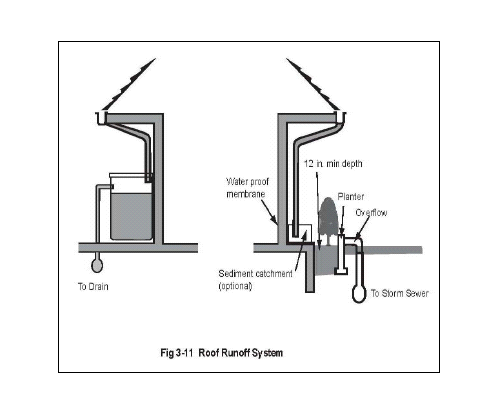
2.
Parking Area Requirements. Required parking area landscaping shall be provided as set forth herein, and as required by Section 17.28.070E (see also, Figure 3-12 at the end of Section 17.28.070), unless otherwise specified in this chapter. A minimum of thirty (30) percent of all parking lots shall be designed, constructed and maintained as landscaped areas, or other pervious surfacing as approved by the review authority. The landscape and pervious surface required by this subsection may be counted toward compliance with the overall landscape/pervious surface requirements of subsection (B)(1) of this section.
a.
Perimeter Landscaping.
i.
Adjacent to Streets. Parking areas with more than ten (10) spaces adjacent to a public right-of-way shall be designed to provide a landscaped planting strip between the right-of-way and parking, equal in depth to the setback required by the zoning district or ten (10) feet, whichever is less. The buffer should be increased to twenty (20) feet on sites that are deep (two hundred (200) feet or more) or large (fifteen thousand (15,000) square feet or more). Any planting, sign or other structure within the traffic safety visibility area of a driveway shall not exceed forty-two (42) inches in height.
ii.
Adjacent to Residential Use. Parking areas for nonresidential uses adjacent to residential uses shall be designed to provide a landscaped planting strip a minimum of ten (10) feet in width between the parking area and the property line bordering the residential use. A screening wall shall also be provided in compliance with Section 17.20.070(H).
iii.
Side Yard Landscaping—CL, CO and CMU Zones. A minimum of five feet of side yard landscaping shall be provided adjacent to all parking areas abutting nonresidential uses.
iv.
Parking Lot Screening—CB Zone. All parking areas shall be screened to a minimum height of forty-two (42) inches from the top of curb by landscaping, berms/mounding, decorative fences or walls, or appropriate combination of each.
b.
Interior Landscaping.
i.
Planting Strips between Parking Aisles. Parking areas with multiple parking aisles shall be designed to provide a continuous planter strip between each aisle. The planter strip shall be six feet wide, with six-foot by eighteen-foot projecting landscaped islands every ten (10) parking spaces. As determined by the director, adequate pedestrian paths shall be provided throughout the landscaped areas. The planting strips shall include at least one twenty-four (24) inch box shade tree for every three parking spaces. Trees shall be clustered as required by the director.
ii.
Projecting Islands. Planting strips between aisles in parking lots with more than fifteen (15) parking spaces shall include projecting islands to accommodate additional trees and other landscape materials. Islands shall be provided between every ten (10) parking spaces, and shall be a minimum of six feet wide.
iii.
Required Shading. The landscaping program (including tree species selected) shall be designed to provide shading for fifty (50) percent of the parking lot area within fifteen (15) years.
iv.
Bumper Overhang Areas. To increase the parking lot landscaped area, a maximum of two feet of the parking stall depth may be landscaped with low-growth, hearty materials in lieu of asphalt, allowing a bumper overhang while maintaining the required parking dimensions.
v.
Areas not Used for Parking. Areas in a parking lot not used for driveways, maneuvering areas, parking spaces, or pedestrian walkways, shall be landscaped and permanently maintained, in compliance with a program submitted by the applicant and approved by the director.
c.
Curbing and Irrigation. All areas containing plant materials shall be bordered by a concrete curb at least six inches high and six inches wide, and provided with an approved automatic irrigation system.
C.
Specific Zone Landscaping Requirements. The following landscape standards are established for the specified zoning districts, in addition to the standards in subsection (A) of this section. The following landscaped areas may be used to comply with the minimum requirements of subsection (B) of this section.
1.
RS Residential Zone. Fifty (50) percent of the required front setback area shall be permanently landscaped. Street trees shall be planted in front of all structures with a height greater than eighteen (18) feet.
2.
Commercial Zones.
a.
CR Zone:
i.
A minimum ten-foot wide landscape buffer shall be provided along all street frontages. The buffer shall include a landscaped berm with a height of forty-two (42) inches, and two to one slope;
ii.
In instances where a building is not proposed on the property line, a minimum five-foot wide screen planting shall be established along all interior property lines, except that property lines bordering residential zoning districts shall have a ten-foot landscaped setback, including trees at least every twenty (20) feet; and
iii.
Medium-to-large size trees shall be used and in scale with the commercial areas and serve as sidewalk canopies, screening and parking area shade and relief.
b.
CL, CO and CMU Zones. Property lines bordering residential zoning districts shall have a ten-foot landscaped setback where required by the review authority, including trees at least every twenty (20) feet.
c.
CB Zone:
i.
A landscaped area with a minimum width of fifteen (15) feet shall be provided from the property line to parking areas, and of thirty (30) feet from the property line to buildings. The landscaped area shall include meandering sidewalks, appropriate mounded landscaping, lawns, shrubs, street trees and clusters of trees, coordinated to create a continuous design along the street frontages; and
ii.
Landscaping shall be designed to create and enhance the visual quality and park-like nature of development within the CB zoning district. Landscaping shall be used (i) to screen and soften parking areas and other broad expanses of paving as provided above; (ii) to provide a park-like setting for structures; and (iii) to buffer and merge the various uses proposed on a site.
d.
CT Zone: The landscape requirements for the CT zone shall be determined by the Old Town Calabasas Master Plan and Design Guidelines.
3.
Special-Purpose Zones. The landscape requirements for the HM, OS, PF and REC zoning districts shall be established and designed for each individual project as part of land use permit approval for each use.
(Ord. No. 2010-265, § 3, 1-27-2010)
17.26.050 - Landscape standards.
Landscape areas and materials shall be designed, installed, and maintained as provided by this section.
A.
Design Standards and Guidelines. The following features shall be incorporated into the design of the proposed landscape and shown on required landscape plans (Section 17.26.030).
1.
Proposed landscape should relate to the architectural design of the structures on the site, and it should be compatible with the character of adjacent landscaping; provided, that this landscaping complies with this chapter.
2.
The protection and preservation of native species and natural site features and areas is encouraged.
3.
Tree planting is encouraged, in addition to that required by Section 17.26.040. Tree selection shall take into consideration the potential for future root damage to public sidewalks and growth of the tree canopy into or near overhead utilities.
4.
Plants with similar water needs shall be grouped together in distinct hydrozones.
5.
Parkway strips shall include design provisions to ensure blending and smooth transitions between different types and patterns of landscaping, and public and private property. To accomplish the foregoing, parkway strips shall utilize street trees and complementary landscaping.
6.
When inorganic groundcover is used, it shall be in combination with live plants and shall only be used as an accent feature.
7.
Irrigation systems shall be equipped with smart irrigation controllers.
8.
Landscaping should be designed as an integral part of the overall site plan design. Landscaping and open spaces should not be relegated to pieces of the site left over after buildings, parking, and circulation have been laid out.
9.
Landscape design should accent the overall design theme and reinforce the pedestrian scale of the project through the use of structures, arbors, and trellises that are appropriate to the particular architectural style of the project. Pedestrian amenities should be provided throughout the project including benches, trash receptacles, drinking fountains, and lighting.
10.
Unless a street has an existing landscape theme, whenever landscaping of the public parkway is required it should be designed in coordination with the project's on-site landscaping to provide an integrated design concept along street frontages.
11.
Project entries should be designed as special statements reflective of the character of the project so that they reinforce an identity for tenants, and visitors. Accent planting, specimen trees, enhanced paving, and project entry signs should be used in furtherance of the foregoing.
12.
Deciduous shade trees should be planted on the south and east side of structures to maximize summer shade and winter sun.
B.
Plant Material Limitations. Plant materials shall be selected and installed to comply with the following requirements:
1.
Plant materials shall emphasize drought-tolerant and native species;
2.
Plant materials in areas adjacent to and not physically separated from native chaparral should be selected to prevent invasion of the chaparral.
3.
Trees and shrubs shall be planted so that, at maturity, they do not interfere with service lines, and traffic safety visibility areas. See Section17.20.120(D).
4.
Trees planted near public bicycle trails, pedestrian paths, or curbs shall be of a species and installed in a manner which prevents physical damage to sidewalks, curbs, gutters and other public improvements.
C.
Irrigation. Irrigation systems shall be designed and installed as follows.
1.
Equipment.
a.
Anti-Drain Valves. Integral, under the head, or in-line anti-drain valves shall be installed as needed to prevent low head drainage.
b.
Automatic Control Valves. Different hydrozones shall be irrigated by separate valves.
c.
Controllers. Automatic control systems shall be required for all irrigation systems and must be able to accommodate all aspects of the design. Automatic controllers shall be digital, have multiple programs, multiple cycles (start-times), and have sensor input capabilities.
d.
Rain Sensor Devices. Rain sensing override devices shall be required where appropriate on all irrigation systems.
e.
Soil Moisture Sensors. Soil moisture sensing devices shall be considered where appropriate, such as turf areas.
f.
Sprinkler Heads. Sprinkler heads shall be selected for proper area coverage, application rate, operating pressure and adjustment capability. Sprinklers shall have matched precipitation and application rates within each control valve circuit.
g.
Water Meters. Separate landscape water meters or sub-meters shall be installed for all projects with landscape and non-landscape areas. Landscape sub-meters, if used, shall be purchased, installed and maintained by the owner.
2.
Recycled Water. For those sites where recycled water systems are feasible (commercial, manufacturing/industrial and common areas for residential developments), a recycled water irrigation system (dual distribution system) shall be required to allow for the current and future use of recycled water in compliance with the requirements of the Las Virgenes Municipal Water District. A recycled water irrigation system shall be designed and operated in accordance with all local and state codes.
3.
Runoff and Overspray. All irrigation systems shall be designed to avoid runoff, low head drainage, overspray or other similar conditions where water flows or drifts onto adjacent property, non-irrigated areas, pedestrian walkways, roadways or structures.
4.
System Performance—Turf Areas. Irrigation systems for turf areas must achieve a minimum distribution uniformity of:
a.
Seventy-five (75) percent for areas of one acre or more of contiguous area;
b.
Sixty-five (75) percent for areas less than one acre but greater than five thousand (5,000) square feet of contiguous area; and,
c.
Fifty-five (55) percent for areas less than five thousand (5,000) square feet of contiguous area.
5.
Water Efficient Systems. Irrigation systems shall be designed to reduce overall water consumption, including irrigation water consumption. The following methods should be utilized in designing water efficient irrigation systems.
a.
Group plants with similar water requirements, and to match these plant groupings with precipitation heads and emitters.
b.
Use drip irrigation for trees, shrub beds and areas of groundcover to eliminate evaporation losses.
c.
Choose low-volume, low-angle sprinklers for lawn areas.
d.
Select heads that fit the size and shape of the areas to be watered.
e.
Program automatic controllers for night irrigation to reduce water losses due to evaporation and wind drift.
f.
Select controllers with adjustable watering schedules and moisture sensors to account for seasonal variations, and calibrate them during installation.
g.
Place three to five inches of mulch on planting beds each spring to minimize evaporation.
h.
Install sub-grade drip irrigation systems to converse water.
D.
Installation. All landscape materials and support equipment shown in an approved landscape documentation package shall be installed on a site as follows:
1.
Timing of Installation.
a.
Building Construction Projects. Except as set forth in Section 17.26.030 (A), required landscape shall be installed and verified by the department prior to approval of a final building inspection or certificate of occupancy.
b.
Residential Subdivisions. The city shall require as a condition of approval that each developer of a residential subdivision record with the county record's office a condition, covenant or restriction against each parcel of the subdivision requiring the complete installation of landscaping in full compliance with this chapter no later than six months from the time title passes to the first purchaser of a constructed residence within the subdivision.
c.
Individual Homes. Prior to approval of a final building inspection, landscape plans shall be reviewed and approved and landscape and irrigation shall be installed.
d.
Delayed Installation. In the event that weather conditions prevent the effective installation of required landscape prior to occupancy, a performance bond in the amount equal to the value of the landscape materials may be permitted, subject to the approval of the director.
2.
Special Requirements for Model Homes. Model homes shall comply with the requirements of this chapter. Code compliant model home landscaping shall include signs identifying the model home as an example of a water efficient landscaping and feature any equipment that has been utilized to achieve water efficiency. The model home shall include information to the visiting public describing the water efficient landscape along with its design, installation, and required maintenance.
3.
Changes to Design. Changes to any portion of an approved landscape documentation package must be approved by the director.
E.
Maintenance of Landscape. Landscape shall be permanently maintained as follows:
1.
General Standard. Maintenance of approved landscape installations shall consist of regular watering, pruning, fertilizing, debris and weed clearing, dead plant removal and replacement, and the repair and replacement of irrigation systems and integrated architectural features.
2.
Maintenance of Common Open Space Areas. For new residential subdivisions, landscaped areas with common open space in excess of one acre, owned and maintained by a homeowner's association shall work with the city to establish a water budget within the first year after installation of all landscaping in the development. The applicant shall have up to five years in which to implement all necessary landscape improvements to the satisfaction of the director.
F.
Oak Tree Removal. No oak tree shall be altered or removed, except one confirmed by city staff as dead, without first obtaining an oak tree permit pursuant to Chapter 17.32.
(Ord. No. 2010-265, § 3, 1-27-2010)
17.27.005 - Compliance.
Exterior lighting on private property within the city shall comply with the requirements of this chapter.
(Ord. No. 2010-265, § 3, 1-27-2010)
17.27.010 - Purpose and legislative intent.
The purpose of this chapter is to provide standards for outdoor lighting in order to protect the suburban, semi-rural and rural character of the City of Calabasas from inappropriate levels of night lighting. It is this chapter's intent to encourage lower level illumination in the city, to institute lighting practices and systems that conserve energy, to provide for lighting that minimizes conflicts with wildlife movement, and to enhance the visibility of natural features during night-time hours. These goals are to be accomplished through the regulation of the types, kinds, construction, installation and use of outdoor electrically powered illuminating devices. Moreover, the purposes of this chapter are to be satisfied without significantly decreasing public safety and security, the utility of recreational spaces or interfering with business activities and economic productivity.
In general terms, the overall legislative intents of these regulations are (i) to minimize artificial light effect on the night sky, (ii) to provide for well designed commercial spaces with appropriate lighting levels, and (iii) to preserve the significance of darkness to the human and wildlife populations occupying the surrounding rural and semi-rural areas in the Santa Monica Mountains National Recreation Area vicinity.
(Ord. No. 2010-265, § 3, 1-27-2010)
17.27.015 - Applicability.
This chapter shall apply to all new development proposals including:
A.
Applications for all new commercial, industrial, recreational and residential projects or other permitted uses under the development code;
B.
Lighting in parking lots, parking structures and areas of concentrated parking, including car dealerships;
C.
Private streets and driveways;
D.
Private roadway signs, security lighting, pedestrian sidewalks and bikeways; and
E.
Commercial and residential sports courts (e.g., tennis, basketball, and volleyball).
This chapter does not apply to public property (including city facilities, streets, and parks) or to retrofitting of existing lighting on residential homes (single-family and multifamily) and appurtenant yard landscaping unless an application is filed for a conditional use permit, site plan review or other new development permit subject to planning department review and approval. Residential lighting of sixty (60) watts or less shall not be subject to this chapter. Other specific exemptions are listed in Section 17.27.050. It is the intent of the city to establish a separate and distinct program to extend these standards to public road illumination and lighting at other public facilities.
(Ord. No. 2010-265, § 3, 1-27-2010)
17.27.020 - General guidelines.
General guidelines are provided to assist the public in designing lighting consistent with this chapter. When considering development proposals with prospective applicants for city permits and entitlements subject to this chapter, the following lighting related guidelines are to be incorporated into project designs to ensure conformance with this chapter:
A.
All outdoor light fixtures installed prior to November 20, 2002, the effective date of this chapter, and thereafter maintained upon private property used for commercial, industrial, recreational or residential purposes (including lighting along private roadways) should limit light trespass and glare through the use of shielding and directional lighting methods, including fixture location and height. Where feasible, exterior lighting pole heights should not exceed fifteen (15) feet in height. Pole heights should be the minimum necessary to achieve appropriate standards set forth in this chapter.
B.
Externally illuminated signs, advertising displays, billboards, and building identification signs should use lighting fixtures which illuminate downward and be fully shielded. These externally illuminated signs shall meet with the light levels set forth in Section 17.27.030(B)(2).
C.
By itself, low-pressure sodium lighting should not be used in outdoor light fixtures due to poor color rendition and the need by public safety personnel to identify color in nighttime environments. A combination of low-pressure sodium lighting and other type(s) of lighting, such as fluorescent light, may be used if color rendition can be maintained through such lighting combinations.
D.
Outdoor light fixtures used to illuminate landscaping, flags, statues, or any other objects mounted on a pole, pedestal, or platform should use a very narrow cone of light for the purpose of confining the light to the object of interest and minimize spill-light and glare. In addition, the lighting of these features and other monuments should meet with the light levels set forth in Section 17.27.030(B)(10).
E.
Light fixtures used for outdoor recreational facilities should be fully shielded except when shielding would cause impairment to the visibility required in the intended recreational activity. In such cases, partially shielded fixtures and directional lighting methods shall be utilized to limit light pollution, glare and light trespass to a reasonable level, as determined by the director, without diminishing the performance standards of the intended recreational activity. Illumination from recreational facility light fixtures shall be shielded to minimize glare extending toward roadways where impairment of the motorist vision might cause a hazard. The lighting of outdoor recreational facilities shall meet with the light levels set forth in Section 17.27.030(B)(7). Outdoor recreational facility lighting in designated scenic corridors should be avoided.
F.
All exterior lights and illuminated signs should be designed, located, installed and directed in such a manner as to prevent objectionable light at (and glare across) the property lines and vision impairing glare at any location on or off the property. No permanently installed lighting should blink or flash. All lighting fixtures should be appropriate in scale, intensity, and height for the architectural design and building uses proposed.
G.
Landscaping should be required in areas where plantings can reduce visible glare and enhance natural surroundings.
H.
Lighting fixtures located along roadways and parking lots should be fitted with glare shields or be cut-off type fixtures.
I.
The location of lighting fixtures along rural scenic corridor roadways should be consistent with adopted streetscape plans (where applicable) and shall be situated at intersections and corners to increase visibility of these sections of the roadway.
J.
Lighting fixtures intended for security purposes should be equipped with motion sensors.
K.
All design solutions requiring commercial light standards and poles over fifteen (15) feet in height should be redesigned to accommodate lower elevation poles.
L.
Exterior lighting within scenic corridor overlay zoning district should be limited to lighting types and levels that are necessary for safety and security.
M.
Exterior commercial lighting should have lighting controls such as photocells and other controls which l turn-off lighting during daylight hours.
N.
New single-family residential projects should be encouraged to install dimmers on both interior and exterior lighting fixtures.
(Ord. No. 2010-265, § 3, 1-27-2010)
17.27.030 - Lighting standards.
The purpose of the following lighting standards is to provide staff and applicants guidance about appropriate lighting levels for a variety of land uses:
A.
The standards herein can be measured using an illuminance meter (light meter) by city staff or an agent with training in lighting measurements. Measurements shall be taken immediately outside the cone of illuminance below a fixture.
B.
Lighting design engineers shall use the following maximum thresholds in developing photometric plans for new developments. Some flexibility in final lighting design values should be permitted, but in general, the following values should be considered illumination limits:
1.
Roadway Lighting. Lighting for roadways shall provide adequate illumination for safe and efficient vehicular travel. Roadway lighting fixtures shall either be equipped with glare shields or be a high cut-off type of fixture. Lighting of roadways categorized as scenic corridors or identified as wildlife corridors on Figure IV-1 in the General Plan shall be of a minimal level. Fixtures shall be shielded to prevent glare. The following standards should be considered the maximum average lighting values for roadways in these areas. The pedestrian intensity of use values cited below are ordinal scale measures (not quantified) and are intended only to be relative measures of intensity of use. No specific quantities (such as pedestrian counts) are associated with these ordinal measures. Applicability of standards to various pedestrian levels shall be made by the review authority on a case by case basis.
Scenic or wildlife corridors and developments with few nighttime pedestrians:
Developments with frequent moderately heavy nighttime pedestrian activity:
Developments with heavy nighttime vehicular and pedestrian traffic:
2.
Externally Lighted Roadway Signs. The lighting of roadway signs shall be limited to a level that allows motorists to quickly and easily recognize the sign type and message. The following standards are the maximum horizontal illuminance values for externally lighted roadways.
Rural areas and scenic corridor areas without lighting or areas with very low light levels:
Areas with small commercial developments and lighted roadways:
Areas with high street lighting levels and brightly lighted signs:
3.
Parking Lot. The lighting for parking lots shall be to a level that provides for the safe movement of vehicles and pedestrians. Parking lot lighting fixtures shall either be equipped with glare shields or be of a high cut-off type. Lighting fixture standard heights shall not be in excess of what is necessary to meet the recommended lighting levels. Lighting poles shall not exceed fifteen (15) feet in height. Decorative standards consistent with neighborhood architecture and adopted design and streetscape plans shall be employed in lighting plans. The following standards are the maximum average lighting values for parking lots:
4.
Parking Garages. The following standards are considered maximum average lighting values for parking garages, except that the top level of parking garages should be no greater than is necessary to ensure pedestrian safety and visibility:
5.
Security Lighting. If security lighting is located in an area where it is not continuously required y, fixtures shall be equipped with motion sensors. The following standards are maximum average lighting values for security lighting in large open areas:
6.
Pedestrian Sidewalks and Bikeways. The lighting for pedestrian sidewalks and bikeways shall be to a level that increases pathway visibility and the safety of pedestrians. The following standards are the maximum average lighting values for pedestrian sidewalks and bikeways in these areas.
Scenic and wildlife corridors and developments with few nighttime pedestrians:
Intermediate—Medium-sized residential and business developments with frequent moderately heavy nighttime pedestrian activity:
Developments with heavy nighttime vehicular and pedestrian traffic:
7.
Sports and Recreation Areas. The lighting of sports and recreation areas shall be to a level that allows for clear and accurate visibility of all elements of the activity. High uniformity and low glare shall permit adequate play visibility. Lighting fixtures within these areas shall be correctly aimed to provide maximum task illuminance while limiting glare and light trespass. These lighting fixtures shall be adequately shielded to prevent glare from extending into surrounding properties. Sports and recreation lighting shall be turned off by eleven p.m. Frequently used lighted recreational facilities should not be located in residential neighborhoods but should, whenever possible, be located in areas buffered from such neighborhoods by open space, institutional, industrial, or commercial uses. The following standards are considered the maximum average lighting values for sports and recreation area lighting.
Baseball and softball:
Basketball:
Football and soccer:
Roller hockey:
Tennis:
Volleyball:
8.
Service/Gas Stations. The lighting of service/gas stations shall be to a level that provides customers with a safe and secure environment while limiting glare under canopy areas. Glare to adjacent roadways shall be reduced by either limiting the visibility of lighting fixtures through the use of shields or by reducing the illuminance to the levels set forth herein. The following standards are the maximum average lighting values for a service/gas station.
Pump island area:
Service areas:
9.
Auto Dealerships. The lighting of car dealerships should provide lighting levels that evenly disperse light over display lots. Lighting programs for dealerships should be designed to attract customers to the vehicles without producing excessive glare to adjacent roadways and surroundings. Auto dealership display lighting shall be turned off (except for motion sensor security lighting) by eleven p.m. Fixtures located in inventory lots shall provide adequate levels for inspection of the vehicles while minimizing glare. Lighting levels for car dealerships shall be separated into three distinct categories:
a.
Illumination for display should be concentrated around building frontage and sales entry areas. Display lighting shall be limited to no more than thirty (30) vehicles. Display areas should also be proportionate to facility size.
b.
Inventory lots are designed for the storage of automobile sales inventory. These lots shall occupy no more than forty (40) percent of the total outdoor vehicle parking lot area.
c.
Storage lots shall be designed to accommodate the remainder of a dealership's vehicle inventory (i.e., vehicles that are not within the display or inventory lots). Storage lots shall form over fifty (50) percent of the parking area for an automobile dealership.
The following standards are the maximum average values for auto dealerships.
Display/advertising area:
Inventory and entrance/driveways:
Storage lots:
10.
Monuments (e.g., flags, statues, or other objects mounted on a pedestal, platform or pole). The monument lighting shall provide levels that sufficiently preserve the visibility of the physical characteristics of the monument. Lighting fixtures shall either be shielded or be of a cut-off type to prevent glare from intruding on the public right-of-way or adjacent properties. The following standards are considered the maximum average lighting values for lighting monuments:
(Ord. No. 2010-265, § 3, 1-27-2010)
17.27.040 - Submission of plans and evidence of compliance.
Submission Contents. The applicant for any project subject to this chapter shall submit (as part of the application for permit) evidence that the proposed project will comply with this Code. The submission shall contain but shall not be limited to the following:
A.
Plans indicating the lighting location, and the type of illuminating devices, fixtures, lamps, supports, reflectors, and other devices to be installed;
B.
Photographs or other renderings and photometric data of the illuminating devices, fixtures, lamps, supports, reflectors, and other devices to be installed; and other descriptions which may include, manufacturer catalog cuts and drawings (including cross sections where required);
C.
Photometric plan illustrating the model values produced by the designed lighting.
(Ord. No. 2010-265, § 3, 1-27-2010)
17.27.050 - Exemptions.
A.
All commercial outdoor light fixtures legally installed prior to November 20, 2002, prior to the effective date of this chapter, are exempt from this chapter. However any replacement of outdoor commercial light fixtures shall comply with this chapter.
B.
All residential (single and multifamily) outdoor light fixtures legally installed prior to November 20, 2002, the effective date of this chapter, are exempt from of this chapter. Any replacement of outdoor light fixtures on residential properties shall not be required to comply with this chapter unless an application for a planning approval is requested consistent with Section 17.27.015.
C.
All outdoor light fixtures producing light directly by the combustion of fossil fuels, such as kerosene lanterns or gas lamps.
D.
Construction or emergency lighting.
E.
Signs of the type constructed of translucent materials and wholly illuminated from within are exempt from the shielding requirement.
F.
Holiday lighting.
G.
Exterior lighting for a temporary activity with a temporary use permit approved by the department.
(Ord. No. 2010-265, § 3, 1-27-2010)
17.27.060 - Approved materials and methods of installation.
This chapter is not intended to prevent the use of any design, material or method of installation not specifically proscribed herein.
(Ord. No. 2010-265, § 3, 1-27-2010)
17.27.070 - Variances.
A variance from the requirements of this chapter shall be in compliance with Section 17.62.080 of this development code.
(Ord. No. 2010-265, § 3, 1-27-2010)
17.27.080 - Appeals.
Appeals shall be made pursuant to Chapter 17.74 et seq. and within the times set forth therein for the filing of such appeals.
(Ord. No. 2010-265, § 3, 1-27-2010)
17.27.090 - Enforcement.
The director is hereby empowered and directed to administer and enforce the provisions of this chapter.
(Ord. No. 2010-265, § 3, 1-27-2010)
17.27.100 - Violations and penalties.
A.
Violation of any provision of this section shall be and is hereby declared to be unlawful and a public nuisance. Any violation of any provision of this chapter shall be subject to summary, administrative or judicial abatement of the nuisance by the city, and be subject to fines, penalties, fees and costs imposed by the city or the court pursuant to the summary or administrative abatement procedures contained in this Code or any other provision of law.
B.
Enforcement and penalties shall be consistent with applicable sections of this Code.
C.
Every day that any such violation continues shall constitute a separate offense.
(Ord. No. 2010-265, § 3, 1-27-2010)
17.27.110 - Cumulative remedies.
All remedies set forth in this chapter are cumulative and may be pursued separately or in combination. Provisions of this chapter are to be supplementary and complementary to all of the city ordinances, the city code, and state law.
(Ord. No. 2010-265, § 3, 1-27-2010)
17.27.120 - Nonconforming outdoor lighting.
The city recognizes that the eventual replacement of existing outdoor lighting fixtures that are not in conformity with the provisions of this chapter is as important as the prohibition of new outdoor lighting that would violate this chapter.
A.
Continuation of Nonconforming Commercial Outdoor Lighting. A legally established commercial lighting fixture that does not conform to the provisions of this chapter may continue to be used except that the lighting shall not be:
1.
Structurally altered to extend its useful life;
2.
Expanded, moved, or relocated; or
3.
Re-established after a business has been discontinued for ninety (90) days or more.
B.
Continuation of Nonconforming Residential Outdoor Lighting. No property with a legally established residential (single and multifamily) lighting fixture will be required to comply with this chapter unless there is a new development application submitted for the property. New development application means any of the applications listed in Section 17.15.015.
C.
Correction of Nonconformities Required. When an application is requested for a conditional use permit, site plan review or other development permit, the project site will be required to retrofit all exterior lighting in compliance with this chapter.
(Ord. No. 2010-265, § 3, 1-27-2010)
17.28.010 - Purpose.
The purpose of the off-street parking and loading standards of this chapter is to:
A.
Provide sufficient parking facilities to meet the needs generated by the proposed use;
B.
Provide accessible, attractive, secure, properly lighted, and well-maintained and screened off-street parking and loading facilities;
C.
Reduce traffic congestion and hazards;
D.
Encourage the use of alternative modes of transportation by providing for safe, adequate and convenient bicycle and carpool parking;
E.
Protect neighborhoods from the effects of vehicular noise and traffic;
F.
Ensure access and maneuverability for emergency vehicles; and
G.
Provide loading and delivery facilities in proportion to the needs generated by the proposed use.
(Ord. No. 2010-265, § 3, 1-27-2010)
17.28.020 - Applicability.
Every permanent land use (including a change of use), and every structure shall comply with the requirements of this chapter.
(Ord. No. 2010-265, § 3, 1-27-2010; Ord. No. 2012-297, § 1(Att. A), 5-23-2012)
17.28.030 - General parking and loading regulations.
A.
Maintenance of Required Parking and Loading Areas. All covered or uncovered off-street parking and loading facilities required by this chapter shall be permanently reserved for parking and loading purposes. All parking facilities, including curbs, directional markings, handicapped symbols, landscaping, pavement, signs, striping and wheel stops, shall be permanently maintained by the responsible person, as defined in Chapter 1.17, in good repair, free of litter and debris, potholes, obstructions and stored material.
B.
Deferral of Parking Installation. For nonresidential developments of ten thousand (10,000) square feet or more of gross floor area, the director may approve deferral of the installation of one or more required off-street parking spaces to a future date. The applicant shall demonstrate to the satisfaction of the director that the occupant(s) of the site will not need the required parking spaces and that the area temporarily occupied by landscaping or other aesthetic amenities can readily be used for the required parking spaces when needed. The director may impose reasonable conditions, including requiring a phasing plan for parking development and/or the recordation of an agreement providing that the landscaping or other amenity shall be removed by the applicant and the required off-street parking spaces shall be installed if they are needed to serve the use(s) on the site.
C.
Residential Guest Parking. Required guest parking in residential zoning districts shall be designated and restricted for the use of guests.
D.
Recreational Vehicle Parking—Residential Areas.
1.
Storage. The storage of recreational vehicles and boats in residential zoning districts shall be allowed only outside of required setback areas, in compliance with Section 17.20.180(G), except as noted. All recreational vehicles that may be visible from the public view of the front, side, or street side areas of the site shall be screened by a combination of fencing, walls and/or screening landscaping as determined by the director. An encroachment into the side yard setback shall be permitted for storage of recreational vehicles provided that a five-foot emergency access path is maintained around the residence at all times. In no event shall the area devoted to recreational vehicle storage exceed four hundred (400) square feet of any property. A temporary use permit shall be required for storage of all recreational vehicles over six feet in height beyond seventy-two (72) hours.
2.
Parking. No recreational vehicle shall park overnight [except] by permit, in which case the permit shall permit parking for a period of up to seventy-two (72) hours. Property owners shall be limited to a maximum of eight permits per calendar year unless otherwise authorized by the director.
E.
Commercial Vehicle Parking—Residential Areas. No commercial vehicle or trailer, as defined in Vehicle Code Section 630, exceeding eight feet in height or twenty (20) feet in combined total length, when attached to another vehicle or trailer, shall park between the hours of six p.m. and six a.m. on private property or public rights-of-way within residential zoning districts. This prohibition shall not apply to construction sites during the construction process or to vehicles in the process of making deliveries or pickups. Additional requirements for the parking of commercial and oversize vehicles are provided by Chapter 10.12 and city resolution.
(Ord. No. 2010-265, § 3, 1-27-2010; Ord. No. 2012-297, § 1(Att. A), 5-23-2012)
17.28.040 - Number of parking spaces required.
Each land use shall provide the minimum number of off-street parking spaces required by this section, except where a greater number of spaces is required through conditional use permit conditions of approval.
A.
Expansion of Structure or Change in Use. When a structure is enlarged or increased in capacity, or when a change in use requires more parking than the former use, additional off-street parking spaces shall be provided in compliance with this chapter.
B.
Mixed Uses/Multiple Tenants. A site or facility proposed for multiple tenants or uses (e.g., a hotel with meeting halls, a building with ground-floor shops and second-floor offices or residential units.) shall provide the aggregate number of parking spaces required by this section for each separate use; except where shared parking is allowed in compliance with Section 17.28.050(B).
C.
Parking Required by Development Agreements and Specific Plans. Parking requirements established by development agreements or specific plans supersede the provisions of this section.
D.
Parking Requirements by Land Use. The minimum number of parking spaces shown in the tables within this chapter shall be provided for each use.
1.
Additional Requirements. Additional spaces may be required by the review authority through conditional use permit conditions of approval, where applicable.
2.
Uses not Listed. Land uses not specifically listed in the following table shall provide parking as required by the director. In determining appropriate off- street parking requirements, the director shall use the requirements of the following table as a general guide in determining the minimum number of off-street parking spaces necessary to avoid undue interference with the public's use of the streets.
3.
Rounding of Quantities. Where the number of required parking spaces results in a fraction of 0.50 or higher, the requirements shall be rounded up to the next whole space.
4.
When a parking study is utilized, as allowed in Table 3-11, to determine the required number of parking spaces, the parking study shall be prepared by a licensed traffic engineer and shall be subject to review and approval by the director and city engineer.
(Ord. No. 2010-265, § 3, 1-27-2010; Ord. No. 2012-297, § 1(Att. A), 5-23-2012; Ord. No. 2014-310, § 1(Att. A), 2-12-2014; Ord. No. 2014-311, § 5(Exh. A) , 2-26-2014; Ord. No. 2018-366, § 2, 6-27-2018)
17.28.050 - Reduction of off-street parking requirements.
A.
General Parking Reduction. The review authority may grant up to a twenty-five (25) percent reduction in number of off-street parking spaces required by Section 17.28.040 in compliance with Section 17.62.060. The applicant shall provide evidence to demonstrate, to the satisfaction of the director and the city engineer that any requested reduction is necessary for the efficient operation of the subject use and will not result in a parking deficiency.
The review authority may also grant a reduction in off-street parking requirements in compliance with Section 17.62.060 for development projects:
1.
That are located in close proximity to a public transit stop;
2.
Where the applicant agrees to provide housing for low- and very low-income persons in compliance with Section 17.22.030; and/or
3.
Where the applicant agrees to provide transportation demand management (TDM) programs that exceed the minimum requirements of this Code, the Los Angeles County Congestion Management Program, and state law.
B.
Shared Parking Reduction. Nonresidential parking facilities may be shared if multiple uses cooperatively establish and operate the facilities and if these uses generate parking demands primarily during hours when the remaining uses are not in operation. (For example, if one use operates during evenings or week days only, or where patrons are likely to visit more than one business establishment on a single trip.) The applicant shall provide documentation (i.e., shared parking use analysis) to the satisfaction of the review authority, substantiating the reasons for the requested shared parking reduction. Shared parking may be approved only if:
1.
A sufficient number of spaces are provided to meet the greater parking demand of the participating uses;
2.
Evidence satisfactory to the review authority has been submitted by the parties operating the shared parking facility. The evidence shall describe the nature of the uses and the times when the uses operate so as to demonstrate the lack of potential conflict between them; and
3.
Additional documents, covenants, deed restrictions or other agreements as may be deemed necessary by the review authority are executed and recorded with the county recorder's office to ensure that the required parking spaces provided are maintained and used as approved for the life of the nonresidential development.
(Ord. No. 2010-265, § 3, 1-27-2010)
17.28.060 - Handicapped parking requirements.
Parking areas shall include parking spaces accessible to the handicapped persons in compliance with this section.
A.
Number of Spaces-Design Standards. Handicapped parking requirements are established by the state and are contained in the California Code of Regulations, Title 24, Part 2, Chapter 2-71, Section 2-7102, and in the California Vehicle Code, Section 22511.8. State law may be amended from time to time, so reference should be made directly to the California Code of Regulations for standards on the required number, dimensions, and location of handicapped parking spaces, signage and related facilities. The department will provide information on current requirements and space design upon request.
B.
Reservation of Spaces Required. All handicapped accessible spaces required by this section shall be reserved by the property owner and tenant for use by the disabled throughout the life of the approved land use.
C.
Upgrading of Markings Required. If amendments to state law change state standards for the marking, striping and signing of handicapped parking spaces, all handicapped spaces within the city shall be upgraded in compliance with the new state standards. This upgrading shall be completed by affected property owners within sixty (60) days of receiving written notification from the city regarding the new state standards.
(Ord. No. 2010-265, § 3, 1-27-2010)
17.28.070 - Development standards for off-street parking.
Off-street parking areas shall be provided on the subject site, outside of any public right-of-way, in compliance with this section and Section 17.28.110.
A.
Access.
1.
Driveway Location and Design. Site access driveways shall be located and designed in compliance with Section 17.28.080;
2.
Internal Maneuvering Area. Parking areas shall provide suitable maneuvering room so that all vehicles may enter an abutting street in a forward direction. Single-family homes and duplexes are exempt from this requirement and the director may approve exceptions for other residential projects; and
3.
Parking Space Location. No parking space shall be located so that a vehicle will maneuver within twenty (20) feet of a vehicular entrance measured from the property line.
4.
Vehicle Turnaround/Backup Area. A vehicle turnaround space or backup area shall be provided at the end of all dead-end parking aisles which contain eight or more spaces. The turnaround space or backup area shall be sized to allow for a safe backing movement, and provide a minimum depth of five feet for the width of the aisle. See Figure 3-14.
B.
Adjacent Site Access. Nonresidential development applicants should be encouraged to provide cross-access to adjacent nonresidential properties for convenience, safety and efficient circulation of motor vehicles. A mutual access agreement should be executed where cross-access is provided.
C.
Parking Lot and Space Dimensions.
1.
General Requirements. Parking stalls, aisles, bays and other parking lot features shall be designed and constructed with the minimum dimensions indicated in the following table, and as illustrated by Figures 3-12 and 3-14 set out at the end of this section.
2.
Dimensions for Private Garages or Carports. The following minimum unobstructed inside dimensions shall be provided for private garages and carports:
D.
Drainage. All required off-street parking/loading areas shall be designed and constructed:
1.
So that surface water will not drain over any sidewalk or adjacent site (drainage from a site to a street across a driveway may be approved), or adjacent parcels;
2.
In compliance with Chapter 17.56 and the city's best management practices, adopted in compliance with the requirements of the National Pollution Discharge Elimination System (NPDES);
3.
To include facilities for the sub-surface filtering of oil and grease contaminants, in new or reconstructed nonresidential parking lots with five or more parking spaces.
E.
Landscaping and Pervious Surface. Required parking area landscaping shall be provided as set forth in Chapter 17.26, and as shown on Figure 3-14 set out at the end of this section, unless otherwise specified in this chapter.
F.
Lighting. Parking areas shall have lighting capable of providing adequate illumination for security and safety in conformance with Chapter 17.27. Lighting standards shall be energy-efficient and in scale with the height and use of the on-site structure(s). Any illumination, including security lighting, shall be directed downward, away from adjoining properties and public rights-of-way. See Figure 3-13 set out at the end of this section.
G.
On-Site Location Required. All parking spaces shall be located on the same parcel as the primary structure or use, unless approved otherwise by the director. The director may approve a portion or all of the required off-street spaces to be located on an adjacent parcel. This approval shall be based on accessibility to the primary structure or use, and the use and development of the neighboring parcel.
The applicant shall provide evidence, to the satisfaction of the director, that a suitable long-term lease or other binding agreement can be executed and recorded which would guarantee that the parcel containing the primary structure or use has an irrevocable right to utilize the adjacent parcel for parking for the life of the approved use.
H.
Screening. Commercial/industrial and public parking areas abutting residentially zoned parcels shall provide a six-foot high wood or decorative masonry wall at the property line adjacent to the residential zoning district, to properly screen the parking area(s), subject to approval by the director. The director may waive or modify this requirement to protect the views of adjacent residences. All decorative wall features shall occur on both sides of the wall.
I.
Shopping Cart Storage. Parking facilities for commercial uses that offer shopping cars for use by patron (e.g. grocery stores) shall contain shopping cart storage areas when appropriate. The dimensions and locations of the storage areas shall be determined by the review authority.
J.
Striping. Parking stalls shall be identified with double, four-inch wide stripes of paint on the parking lot surface, in compliance with Figure 3-15 set out at the end of this section. Parallel spaces may be marked with single lines.
K.
Tandem and Valet Parking. Tandem parking shall not be permitted to satisfy off-street parking requirements, except within mobile home parks. Valet parking shall not be permitted to reduce off-street parking requirements, except within Old Town Calabasas, where authorized by conditional use permit approval. Valet parking operations on sites that meet off-street parking requirements shall be allowed in all commercial districts where authorized by a conditional use permit approval.
L.
Wheel Stops/Curbing. Continuous concrete curbing at least six inches high and six inches wide shall be provided for all parking spaces located adjacent to walls, fences, property lines and structures. All parking lots shall have curbing around all parking areas and aisle planters in compliance with subsection (E) of this section.
M.
Underground parking facilities shall conform to all the provisions of this chapter; provided however, that underground parking facilities may be located in the side, front and rear yards which are completely below the existing ground level of the development. No portion of such facility shall have less than seven feet inside vertical clearance, except doorways may be six feet eight inches.
(Ord. No. 2010-265, § 3, 1-27-2010)
17.28.080 - Driveways and site access.
Driveways providing ingress and egress to off-street parking spaces shall be designed, constructed and maintained as follows.
A.
Number of Access Points. One driveway access point per parcel shall be permitted unless the city engineer determines, based on a development/circulation plan submitted by the applicant, or recommendations from the fire department, that more than one access is required to handle traffic volumes or specific designs, such as residential circular driveways. Additional access shall not be permitted if the city engineer determines it will be detrimental to the traffic flow and the safety of adjacent public streets. Whenever a property has access to more than one road, access shall generally be limited to the road with the lowest traffic volume, where the impact of a new access will be minimized. All access from private property to a public street shall require an encroachment permit.
B.
Location of Access.
1.
Distance from Street Intersections. No portion of a driveway access shall be permitted within curb returns. The edge of the access shall not be less than ten (10) feet from the end of curb returns for single-family residential developments. For all other developments, this distance shall not be less than one hundred fifty (150) feet. Where the lot size does not permit the access to be located one hundred fifty (150) feet from the end of curb return, the access shall be located the maximum distance possible from the end of the curb return. This distance does not include the three-foot transition or wing sections on each side of the driveway.
2.
Driveway Spacing. Two or more driveway access points on a public street shall be separated as follows.
a.
Single-Family Residential Development. Where two or more accesses serve adjacent single-family residential parcels, the minimum distance between the nearest points of the two accesses shall be at least twenty (20) feet, unless a shared, single driveway access is approved by the director. The twenty-foot separation does not include the three-foot transition or wing sections on each side of the driveway, and may be reduced by the director for a cul-de-sac street.
b.
Multifamily and Nonresidential Development. Where two or more accesses serve the same or adjacent non-single-family residential development, the minimum distance between the centerline of accesses should be preferably at least two hundred (200) feet on streets with design speeds below thirty (30) mph and three hundred (300) feet on streets with design speeds above thirty (30) mph.
c.
Corner and Double Frontage Lots. For corner and double frontage residential lots, one access on each frontage may be permitted if it is determined by the city engineer that two driveways are needed to provide safe access for traffic entering and leaving the lot because of site distance and geometric design considerations.
3.
Driveway Alignments—Commercial Development. Where commercial lots are not large enough to allow accesses on opposite sides of the street to be aligned, the center of driveways not in alignment will normally be offset a minimum of one hundred fifty (350) feet on all collector roads, and three hundred (300) feet on all major and arterial roads. Greater distances may be required if needed for left-turn storage lanes.
C.
Driveway Width and Length.
1.
RS Zoning District. Driveways in the RS zoning district shall have direct access to a garage, and a minimum width of eighteen (18) feet within twenty (20) feet of the garage entrance, and the remaining portions of the driveway shall be a minimum width of twelve (12) feet. Maximum width shall be twenty-seven (27) feet for a double or triple garage. The minimum length of a single-family driveway shall be twenty (20) feet measured from the back of the sidewalk to the front of the garage, to permit vehicle parking in the driveway without blocking the sidewalk. Where access to a garage, carport, or open parking space is perpendicular (ninety (90) degrees) to the driveway, a minimum twenty-four-foot deep unobstructed back-out area shall be provided.
2.
RM and Commercial Districts. Within RM and commercial zoning districts, driveways shall be a minimum width of twenty-five (25) feet and a maximum of thirty-five (35) feet. The minimum length of a multifamily driveway serving an individual garage shall be eighteen (18) feet where a roll-up garage door is used, and twenty (20) feet where a non-roll-up door is used, to permit vehicle parking in the driveway without blocking the sidewalk or extending into a traffic lane. Curb return radii shall be a minimum of twenty (20) feet where curb returns are deemed necessary by the city engineer.
3.
Manufacturing/Industrial Uses. Accesses serving manufacturing/industrial uses shall be a minimum of thirty-five (35) feet in width and a maximum of forty (40) feet, with minimum curb return radius of twenty-five (25) feet, or as otherwise specified by the city engineer.
4.
Hillside Properties. Driveways located on hillside properties shall meet the requirements of Section 17.20.150(E).
D.
Access Grades. Residential and commercial driveways shall be designed with grades as shown in Figure 3-16 located at the end of this section, and in compliance with Section 17.20.150(E). Access grades for driveways to underground parking structures may be increased to a maximum of fifteen (15) percent or as approved by the review authority.
E.
Clearance from Appurtenances. The nearest edge of any driveway curb cut shall be at least three feet from (i) the nearest property line (except where the review authority has approved a shared driveway between two parcels), and (ii) the centerline of a fire hydrant, utility pole, drop inlet, traffic signal installation, light standard, or any appurtenance. Street trees shall be a minimum of ten (10) feet from the driveway access.
F.
Sight Distance at Driveways. At least three hundred fifty (350) feet of clear sight distance shall be provided for all access onto local streets; four hundred fifty (450) for collector streets; five hundred fifty (550) feet for arterial streets, unless otherwise approved by the city engineer.
G.
Temporary Access. The director may grant temporary access to underdeveloped property prior to approval of all development permits required by this title, or completion of development, if access is needed for construction. Temporary accesses are subject to removal, relocation, or redesign after all permits are approved in the manner required by the department.
(Ord. No. 2010-265, § 3, 1-27-2010)
17.28.090 - Bicycle parking and support facilities.
Bicycle parking facilities, showers and lockers shall be provided in compliance with this section.
A.
Applicability. Bicycle parking spaces facilities are required for all commercial and industrial uses that have more than fifty thousand (50,000) square feet of floor area. These include buildings owned by the city and used for government purposes. The number of bicycle spaces required is determined by Section 17.28.040.
B.
Bicycle Parking Design and Devices. Bicycle parking areas shall be designed and provided with devices for locking bicycles as follows.
1.
Parking Equipment. Each bicycle parking space shall include a stationary parking device to adequately support the bicycle. At least half of the bicycle parking spaces shall include a stationary parking device that will securely lock the bicycle without a user-supplied cable or chain. Devices that hold the bicycle upright by wheel contact must hold at least one hundred eighty (180) degrees of wheel arc.
2.
Parking Layout.
a.
Aisles. Aisles providing access to bicycle parking spaces shall be at least five feet in width.
b.
Spaces. Each bicycle space shall be a minimum of two feet in width and six feet in length, and have a minimum of six feet of overhead clearance.
c.
Relationship to Building Entrances. Bicycle spaces shall be located no farther than the distance from a main entrance of the building to the nearest off-street motor vehicle parking space.
d.
Relationship to Motor Vehicle Parking. Bicycle spaces shall be separated from automobile parking spaces or aisles by a wall, fence or curb, or by at least five feet of open area marked to prohibit motor vehicle parking.
3.
Signs. Each automobile entrance to a parking facility shall be provided clearly legible signs indicating the availability and location of bicycle parking.
C.
Required Shower Facilities. All new buildings and additions to existing buildings that result in a total floor area shall be required to provide showers and dressing areas for each gender as shown in the following table.
D.
Required Locker Facilities. Land uses required by this section to provide bicycle parking spaces shall also provide one locker for each required bicycle parking space. Required lockers shall be located in relation to required showers and dressing areas to permit access to locker areas by either gender.
(Ord. No. 2010-265, § 3, 1-27-2010)
17.28.100 - Loading space requirements.
A.
Number of Loading Spaces Required. Unless modified by the director in compliance with Section 17.62.020, off-street freight and equipment loading spaces shall be provided for all nonresidential uses, except hotels and motels. The following minimum number of loading spaces shall be provided for each use:
Requirements for uses not specifically listed shall be determined by the director based upon the requirements for comparable uses and upon the characteristics of the proposed use, in compliance with Section 17.28.040.
B.
Development Standards for Off-Street Loading. Off-street loading areas shall be provided in the following manner:
1.
Dimensions. Required freight and equipment loading spaces shall be not less than fifteen (15) feet in width, twenty-five (25) feet in length, with fourteen (14) feet of vertical clearance.
2.
Lighting. Loading areas shall have lighting capable of providing adequate illumination for security and safety. Lighting standards shall be energy-efficient and in scale with the height and use of the structure(s). Any illumination, including security lighting, shall be directed away from adjoining parcels and public rights-of-way and shall conform to the requirements for security lighting in Section 17.27.030(5).
3.
Location. Freight and equipment loading spaces shall be located and designed as follows:
a.
Next to, or as close as possible to, the main structure,
b.
Situated to ensure that the loading facility shall not be visible from any major public rights-of-way,
c.
Situated to ensure that all loading and unloading takes place on-site, and in no case within adjacent public rights-of-way, or other traffic areas on-site,
d.
Situated to ensure that all vehicular maneuvers occur on-site, and,
e.
Situated to avoid adverse noise impacts upon neighboring residential properties, in compliance with city noise regulations.
4.
Screening. All loading areas shall be screened from public view by walls and/or landscaping. Loading areas abutting residentially zoned parcels shall have a seven-foot high solid, architecturally treated decorative masonry wall, approved by the director, to properly screen the loading area(s). All decorative treatments shall occur on both sides of the wall.
5.
Loading Doors and Gates. Loading bays and roll-up doors shall be located on the rear of the structure only. Bays and doors may be located on the side of a building away from a street frontage where it can be demonstrated that the bays, doors, and related trucks will be adequately screened from public view from any public right-of-way.
6.
Striping. Loading areas shall be striped indicating the loading spaces and identifying the spaces for "loading only." The striping shall be permanently maintained by the property owner and tenant in a clear and visible manner at all times.
(Ord. No. 2010-265, § 3, 1-27-2010)
17.28.110 - Trip and travel demand reduction measures.
A.
Purpose. This section provides requirements for new and reconstructed residential, commercial and manufacturing/industrial projects that are intended to reduce vehicle trips and travel demand. These provisions, together with the requirements of this chapter for bicycle parking and support facilities (Section 17.28.090), constitute the city's transportation demand ordinance, in compliance with the Los Angeles County Congestion Management Program (CMP) and state law.
B.
Review of Transit Impacts. The processing of a land use permit or subdivision by the city for any project required to have an environmental impact report (EIR) in compliance with the City of Calabasas CEQA Guidelines shall include assessment of impacts on transit. Transit operators serving the city shall be sent a notice of preparation (NOP) for all contemplated EIRs. Operators shall be given the opportunity as part of the NOP to comment on the impacts of the project, to identify recommended transit service or capital improvements that may be required as a result of the project, and to recommend mitigation measures that will minimize automobile trips on the CMP network. Impacts and recommended mitigation measures identified by the transit operators shall be evaluated in the draft EIR.
Phased projects, projects with development agreements, or projects requiring subsequent approvals, need not repeat this process as long as the director determines that no significant changes (e.g., land use changes, project intensifications, and site circulation system changes.) are made to the project.
C.
Applicability of Development Standards. Specific trip and travel demand reduction measurements shall be incorporated into the design of residential and nonresidential projects as provided by this subsection. All facilities and improvements constructed or otherwise required shall be permanently maintained in good repair.
1.
Residential Developments. Proposed residential developments with thirty (30) or more housing units shall provide the following, as part of the land use or subdivision approval process.
a.
A ridesharing, public transportation, and bicycle information packet to be included with buyer move-in materials;
b.
A transit stop and shelter, or other transit amenities as determined by the city;
c.
Bicycle amenities such as bicycle storage areas and bicycle lanes, paths or routes as determined by the city;
d.
An additional phone/fax/modem line in each housing unit to encourage telecommuting; and
e.
Electric vehicle recharging facilities at each housing unit to encourage the use of electric vehicles.
2.
Nonresidential Developments. Commercial, office and manufacturing/industrial uses shall provide the features set forth in Table 3-16, as part of the land use permit or subdivision approval process. The following subsection (D) of this section provides standards for each of the required features.
Additions to buildings which existed prior to the adoption of the ordinance originally codified as Chapter 10.16 of this Code shall comply with the applicable requirements of this chapter. Existing floor area shall be exempt from these requirements. All calculations shall be based on gross floor area, in square feet.
D.
Development Standards. Where specific trip and travel demand reduction measures are required by subsection (C) of this section, each required measure shall be provided as follows:
1.
Electric Vehicle Recharging. Electric vehicle recharging facilities shall be provided to encourage the use of electric powered vehicles.
2.
Enhanced Access. Access facilities shall be provided as follows:
a.
A safe and convenient zone in which vanpool and carpool vehicles may deliver and board their passengers;
b.
Sidewalks or other designated pathways following direct and safe routes from the external pedestrian circulation system to each building in the development; and
c.
Safe and convenient access from the external circulation system to bicycle parking facilities onsite.
3.
Move-in Materials. The property owner shall provide tenants ridesharing and public transportation information as part of occupancy move-in materials.
4.
Preferential Parking. Preferential parking facilities shall be provided as follows:
a.
Number and Location of Spaces. Not less than ten (10) percent of parking spaces reserved for employees shall be located as close as is practical to the employee entrance(s), and shall be reserved for carpool/vanpool vehicles, motorcycles, and electric and hybrid vehicles, without displacing handicapped and customer parking needs. Spaces reserved for vanpools must be accessible to vanpool vehicles, in compliance with paragraph (4)(c) of this subsection.
b.
Minimum Number of Spaces Required. At least one preferential space shall be provided for projects of fifty thousand (50,000) square feet to ninety-nine thousand nine hundred ninety-nine (99,999) square feet. Two spaces for projects of one hundred thousand (100,000) square feet or more shall be for preferential parking vehicles.
c.
Space Layout and Vertical Clearance. Vanpool vehicle spaces within a parking structure and parking space access routes shall be provided a minimum vertical clearance of seven feet, two inches. Adequate turning radii and space dimensions shall also be provided in vanpool areas.
d.
Information on Space Availability. A statement that preferential parking spaces for employees are available and a description of the method for obtaining the spaces shall be posted at the building's required transportation information center.
e.
Signage and Striping. Spaces shall be signed and striped as required by the director.
f.
Permit Application Information. The preferential parking area shall be identified on a site plan submitted with a land use permit or building permit applications for a project, to the satisfaction of the director.
5.
Shower/Locker Facilities. Shower and locker facilities shall be provided in compliance with Section 17.28.090.
6.
Transit Stop. Transit stop improvements shall be provided, if city determines it to be necessary to mitigate project impacts. The city will consult with the local transit service providers in determining appropriate improvements. When the city requires an applicant to locate transit stops or plan building entrances, the applicant shall design entrances shall be d to provide safe and efficient access to nearby transit stations and stops.
7.
Transportation Information Center. A bulletin board, display case, or kiosk with transportation information shall be located where the greatest number of employees are likely to see it. Information in the area shall include, but is not limited to the following:
a.
Current maps, routes and schedules for public transit routes serving the site;
b.
Telephone numbers for public transportation services, including numbers for the regional ridesharing agency and local transit operators;
c.
Ridesharing promotional material supplied by commuter-oriented organizations;
d.
Bicycle route and facility information, including regional and local bicycle maps and bicycle safety information; and
e.
A listing of facilities available for carpoolers, vanpoolers, bicyclists, transit riders and pedestrians at the site.
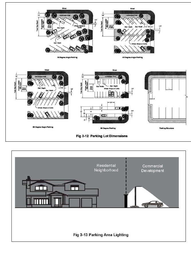
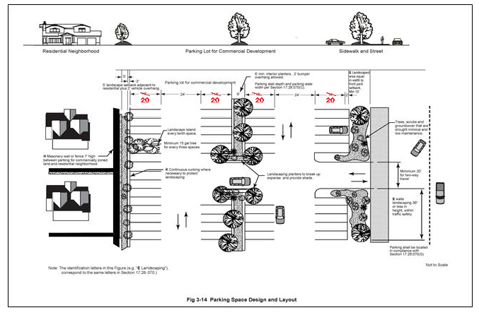
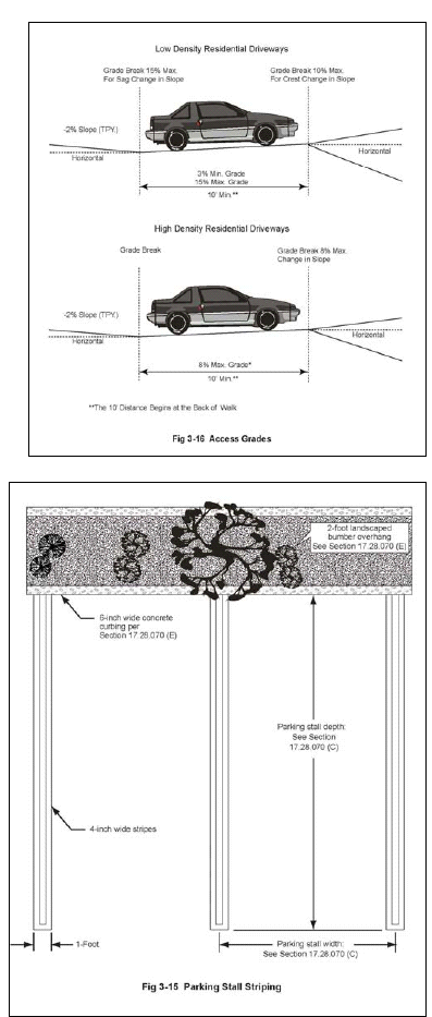
(Ord. No. 2010-265, § 3, 1-27-2010; Ord. No. 2014-310, § 1(Att. A), 2-12-2014)
17.30.010 - Purpose.
A.
The purpose of this chapter is to establish uniform sign regulations that are intended to:
B.
Support and promote viable businesses by allowing signage that provides adequate identification, is of high quality design, and appropriate scale and visibility;
C.
Protect the general public health, safety, welfare and aesthetics of the community;
D.
Reduce possible traffic and safety hazards to pedestrians, bicyclists and motorists through safe signage;
E.
Promote signs that identify uses and premises without confusion;
F.
Implement community design standards, consistent with the General Plan;
G.
Promote the community's appearance by regulating the design, character, location, type, quality of materials, scale, color, illumination and maintenance of signs;
H.
Eliminate visual blight and promote safety by reducing the amount of signage throughout the city within constitutional limitations;
I.
Protect the character of residential neighborhoods;
J.
Provide public notice to ensure participation in the democratic process; and
K.
Protect the public safety by allowing signs that serve to direct traffic and to identify locations for the provisions of emergency services by visible street identification signs.
(Ord. No. 2010-265, § 3, 1-27-2010)
17.30.020 - General provisions.
A.
Signs shall only be erected or maintained in compliance with this chapter. The number and area of signs as outlined in this chapter are intended to be maximum standards, which do not necessarily ensure architectural compatibility. The review authority shall consider a sign's relationship to the overall appearance and scale of the site, buildings and the surrounding community, in addition to the standards of this chapter.
B.
It is unlawful for any person to construct, maintain, display or alter or cause to be constructed, maintained, displayed or altered, a sign within the City of Calabasas except in conformance with this chapter.
C.
If a new zoning district is created after the enactment of this chapter, the director shall have the authority to make determinations as to the applicability of appropriate sign regulations in compliance with Chapter 17.03 until this chapter is amended to govern the new zoning district. Any interpretation by the director may be appealed to the commission as provided by Chapter 17.74.
D.
The city's sign design criteria (Section 17.30.060) will be used in the evaluation of sign permit applications to ensure that signs are well designed, compatible with their surrounding, and do not detract from the overall visual quality of the city.
E.
Definitions for this chapter are provided in Chapter 17.90.020.
F.
Noncommercial Sign. Noncommercial sign copy is allowed wherever commercial signage is permitted and such signs are subject to the same standards and total maximum allowances per site, building, or each design type specified in this chapter. An approval is required for a permanent noncommercial sign only when a permanent commercial sign has not been previously approved. For purposes of this chapter, all noncommercial speech messages shall be deemed to be "on-site" regardless of location.
G.
Substitution of Noncommercial Message. Subject to the consent of the property owner, a noncommercial message of any type may be substituted for all or part of the commercial or noncommercial message on any sign allowed pursuant to this chapter. Design criteria which may apply to commercial signs shall not apply to noncommercial signs, including, the following: color, lettering style, and compatibility with other signs on the same parcel or other signs subject to a sign program. No special or additional approval is required to substitute a noncommercial message for any other message on an allowable sign, provided the sign structure is already approved or exempt from the approval requirement. When a noncommercial message is substituted for any other message, the sign is still subject to the same locational and structural regulations, such as size, height, illumination, maintenance, duration of display, building and electrical code requirements, as would apply if the sign were used to display a commercial message or some other noncommercial message. In the event of any perceived or actual conflict between the general provisions of this subsection and other specific provisions in this chapter, the provisions of this subsection shall prevail.
H.
Substitution of Commercial Messages. The substitution of one commercial message for another commercial message is not automatically allowed. The substitution of a commercial message for a noncommercial message is also not automatically allowed. In addition, no off-site commercial messages may be substituted for on-site commercial messages.
I.
Severability Clause. Should any provision of this chapter or a subsequent amendment thereto be held by a court of competent jurisdiction to be either invalid, void or unenforceable, the remaining provisions of this title shall remain in full force and effect.
(Ord. No. 2010-265, § 3, 1-27-2010)
17.30.030 - Exempt signs.
The following signs shall not require approval nor shall the area of the signs be included in the maximum sign area permitted for any site or use:
A.
Required Signs. Official notices required by law, a court, or other government agency.
B.
Government Signs. Signs for traffic, safety, street identification, government services, emergency services, historical locations, interpretive signs, or city-sponsored events.
C.
Educational and directional signs for the purposes of identifying a trail or other recreational amenities in the OS-DR zoning district.
D.
Informational Signs. Signs less than four square feet that indicate the following: addresses, telephone numbers, emergency address and telephone numbers, hours and days of operation, credit information, and whether a business is open or closed. An unlit analog clock that is an integral part of a building's architecture shall also be considered an informational sign.
E.
Window Signs. Temporary non-illuminated window signs advertising products for sale on the premises shall be allowed on the inside portion of the window or on the interior of the building within three feet of the window. No window shall have more than twenty (20) percent of its window area covered by these signs. This limitation shall also include products displayed on the interior of the premises immediately in front of the window when the name of the product is visible.
F.
Noncommercial Flags. Noncommercial flags are exempt but only if they meet the following criteria: (i) a maximum vertical dimension of five feet; (ii) a maximum horizontal dimension of eight feet; (iii) a maximum cumulative square footage of all flags on a parcel of forty (40) ( feet (one side); (iv) a maximum height of pole of twenty (20) feet for one story buildings and twenty-five (25) feet for two story buildings; (v) a maximum number of poles per lot or parcel of one; and (vi) in no case shall a flag pole be higher than the height of the building. In residential zones, unless an administrative plan review is obtained, flags must be house mounted and may not be on freestanding poles. A pole mounted flag in the RS, RC, RR and OS zone may be permitted subject to an administrative plan review but shall be subject to criteria (i) through (v) herein.
G.
Open House Signs. One temporary "open house" sign is exempt, provided it does not exceed three square feet in area on a property for sale, lease or rent. This sign shall only be posted when an owner or salesperson is present. A maximum of two off-site open house directional signs not exceeding three square feet in area shall be allowed and shall contain only the address of the property where the open house is being held and the name of the real estate agent or party holding the open house. Such signs shall be erected and removed on the day the open house is held. Such signs shall not be located on any public right-of-way.
H.
Temporary Noncommercial Signs and Banners. Temporary signs and banners are permitted in all zones subject to the following regulations:
1.
Two temporary freestanding signs per lot containing only noncommercial messages are permitted at all times. In addition, one temporary freestanding campaign sign shall be allowed for each political candidate or issue on each street frontage per lot. All campaign signs shall be removed within ten (10) days after the election for which they are intended. Each sign shall not exceed six square feet in sign area with a maximum height of four feet. Such signs are in addition to all other signage allowed in this chapter.
2.
Such signs shall not be illuminated or posted on trees, fence posts or public utility poles, or located within any public right-of-way or on any publicly owned property and shall not be within the traffic safety visibility area required by Section 17.20.140(F).
I.
Historical Site Plaques. Plaques or signs not exceeding six square feet designating a building or site as a historical structure or site may be displayed without a permit.
J.
Construction Trade Signs. One on-site non-illuminated sign per street frontage advertising the various construction trades participating in the project is permitted on construction sites with a valid building permit. Such signs shall not exceed a maximum of thirty-two (32) square feet in sign area and shall be removed prior to an issuance of a certificate of occupancy. No construction trade sign shall exceed six feet in height.
K.
Temporary Real Estate Signs.
1.
For developed property, non-illuminated real estate signs are allowed in compliance with California Civil Code Section 713 as follows:
a.
In all residential and special purpose zones except OS-DR, a temporary real estate sign shall be permitted subject to the following conditions:
i.
A maximum of one six square foot sign either wall or pole mounted on a single-family or duplex property. A pole mounted sign may have two faces. One on-site sign shall be permitted for each street frontage. Maximum sign height is six feet for pole mounted signs.
ii.
A maximum of one twelve (12) square foot sign either wall or pole mounted on a multi-family property. Pole mounted signs may have two faces. One on-site sign shall be permitted for each street frontage. Maximum sign height is six feet for pole mounted signs.
iii.
One eight square foot wall or pole mounted per lot on public facility, open space or recreation property. Pole mounted sign may have, two faces. Maximum sign height is six feet for pole mounted signs.
iv.
The sign may only remain on the property until the property is sold or leased. For properties with an approved subdivision map, the sign may remain on the property until the last unit is sold, rented or leased for the first time after construction.
b.
In commercial zones a temporary real estate sign shall be permitted subject to the following conditions:
i.
One twenty-four (24) square foot wall sign for each occupancy.
ii.
No lighting of sign allowed.
iii.
Sign may not project above eave.
iv.
The sign may only remain on the property until the property is sold or leased.
2.
For undeveloped property with or without an approved subdivision map a temporary real estate sign shall be allowed subject to the following conditions:
a.
One on-site sign shall be permitted for each street frontage. The sign area shall not exceed twenty-five (25) square feet.
b.
The sign shall be non-illuminated.
c.
Sign height shall not exceed eight feet above ground level. In those instances when the ground level is below the surface of the street, the sign height may be increased to a maximum of eight feet above the surface of the street. Zoning clearance (Section 17.62.090) and building permit approval shall be obtained for any sign of six feet or more in height.
d.
Signs should not be placed on or near ridgelines so that they appear silhouetted against the sky when viewed from any point on a roadway designated as a scenic corridor.
e.
In the case of a corner lot, the sign shall not obstruct the vision of motorists by being located within the traffic safety visibility area of the parcel, which shall consist of a triangular area formed by measuring thirty-five (35) feet from the intersection of the street property lines, and connecting the lines across the parcel.
f.
For properties with an approved subdivision map, the sign may remain on the property until the last unit is sold, rented or leased for the first time after construction.
(Ord. No. 2010-265, § 3, 1-27-2010)
17.30.040 - Prohibited signs.
The following signs are inconsistent with the purposes and standards of this chapter, and are therefore prohibited:
A.
Abandoned signs that advertise or otherwise identify a business or activity which has been discontinued on the premises for a period of ninety (90) days or more;
B.
Animated, moving, flashing, blinking, reflecting, revolving, digital screen or any other similar moving or simulated moving signs;
C.
Bus stop bench signs or any copy painted on any portion of a bus stop bench;
D.
Billboards and other off-site signs, except where allowed by Section 17.30.030;
E.
Cabinet (can) signs with translucent plastic faces and internal illumination;
F.
Inflatable signs, balloons, pennants, streamers and flags, except where allowed by Section 17.30.030;
G.
Neon signs;
H.
Permanent pole mounted signs except where allowed by Section 17.30.030;
I.
Roof-mounted signs;
J.
Signs on public property or in a public right-of-way, except as provided in Section 17.30.030(A) and (C);
K.
Signs tacked, nailed, posted, pasted, glued or otherwise attached to trees, poles (including utility and street name), stakes, electrical transformers or other accessory structures. Whenever a sign is so posted, the sign itself shall constitute prima facie evidence that the person or business identified on the sign authorized its placement;
L.
Signs painted on fences or roofs;
M.
Signs that simulate in color or design a traffic sign or signal, or which make use of words, symbols or characters in a manner to interfere with, mislead or confuse pedestrian or vehicular traffic;
N.
Temporary signs, including pedestal signs, "A" frame signs and sandwich boards, except as allowed by this chapter and the Old Town Master Plan;
O.
Temporary Vehicle Mounted or Trailer-Mounted Signs. Signs on vehicles are allowed on vehicles, without sign permits, only when the copy or message (i) relates only to the business or establishment of which the vehicle itself is a part; (ii) pertains to the sale, rent, lease or hire of such vehicle; or (iii) is a noncommercial message. Vehicles displaying signs may not be parked for the primary purpose of commercial advertising. Vehicles may not be used as mounting or holding devices for commercial signs. This provision shall not apply to public transportation vehicles; and
P.
Service station ancillary advertising signs located on the exterior of any structure or equipment. Such ancillary advertising signs include business card kiosks and other displays that advertise businesses, services, or products not located on the site.
(Ord. No. 2010-265, § 3, 1-27-2010)
17.30.050 - Sign permits and program required.
A.
Sign Permit. Signs shall only be constructed, displayed or altered with sign permit approval by the review authority.
1.
Application Filing. Sign permit applications shall be filed on the forms provided by the department and shall include all information required therein. Sign permit application shall also be accompanied by the required filing fee. A nighttime photo simulation shall be included in all sign applications requesting freeway facing monument signs.
2.
Review and Decision. A sign permit shall be approved or disapproved by the director or commission in compliance with subsection (F) of this section. The decision of the director is appealable to the commission and decisions by the commission are appealable to the council pursuant to Chapter 17.74.
B.
Sign Program. A sign program shall be required for all new shopping centers with five or more tenants or remodels of existing shopping centers with five or more tenants where new tenant spaces are created or changes are proposed to the exterior of the building. A program shall also be required as deemed necessary by the director to ensure compliance with the provisions of this chapter. Kiosks are allowed at shopping centers, if approved in compliance with the requirements of Section 17.30.065. Amendments to an existing sign program are not required for approval and placement of a kiosk sign, but only if compliant with the requirements of Section 17.30.065 and all other applicable requirements of this Code.
A sign program shall consist of a description, including dimensions, materials, locations, and illustration of all signs proposed on the site. The sign program shall have a unifying design theme or style, as approved by the director. A separate sign permit shall be required for all signs constructed pursuant to an approved sign program.
The purpose of a sign program is to integrate a project's signs into the architectural design of a subject site and to ensure visibility of all signs. A sign program also enables the city to ensure high quality in the design and display of multiple permanent signs and to encourage creativity and excellence in sign design.
C.
Approval Authority. A sign program shall be subject to commission approval. The director may approve minor revisions to a sign program if the intent of the original approval is not affected. Revisions that would substantially deviate from the original approval shall require the approval of a new sign program.
D.
If a shopping center has an approved sign program prior to the adoption of an amendment to this chapter it shall conform to the provisions of that approved sign program and not the amendment.
E.
Modifications to On-Site Sign Regulations (Section 17.30.080). In order to provide for flexibility in sign design, the commission and/or director shall have the authority to approve a sign modification for any new or existing business to allow modifications to sign area, height, and location. The commission shall have the authority to modify the sign area and height (from the ground) of a sign by no more than fifteen (15) percent. The director shall have the authority to modify the sign area and height (from the ground) of a sign by no more than five percent.
The review authority shall consider the following when it determines whether to grant a modification: sign visibility, compliance with design criteria, distance from intended audience, and relative size of the sign to existing signs. A modification shall not be based on the content of a sign.
F.
Findings for Approval. The director and/or the commission may approve or modify a sign permit, sign program or modification application in whole or in part, with or without conditions, only if the following findings are made:
1.
The proposed sign is permitted within the zoning district including any overlay zone and, except as provided in subsection (D) of this section, complies with all applicable provisions of this chapter, and any other applicable standards.
2.
The sign is in compliance with Section 17.30.060.
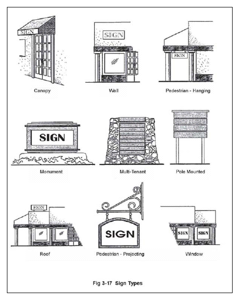
(Ord. No. 2010-265, § 3, 1-27-2010; Ord. No. 2014-310, § 1(Att. A), 2-12-2014; Ord. No. 2015-328, § 3(Exh. A), 10-14-2015; Ord. No. 2025-411, § 4, 2-26-2025)
17.30.060 - Sign design criteria.
Each sign in the city shall comply with the applicable provisions of (i) any adopted sign program; (ii) the business park development urban design performance standards of Section 17.20.070; and (iii) the following requirements:
A.
Relationship to Structures. Building wall and fascia signs shall be compatible with the predominant visual elements of the structure(s), including construction materials, color, or other design feature consistent with Section 17.30.050(E). Commercial centers, offices, industrial complexes, and other similar facilities shall be required to develop a sign program in compliance with the provisions of this chapter, and shall provide a compatible visual design common in theme to all applicable structures and uses.
B.
Relationship to Other Signs. Where there is more than one sign on a site or building, all permanent signs displaying a commercial message shall have designs that similarly treat or incorporate the following design elements:
1.
Letter size and style of copy;
2.
Shape of total sign and related components:
a.
Type of construction materials,
b.
Sign/letter color and style of copy,
c.
Method used for supporting sign (i.e. wall or ground base),
d.
Type of illumination, and
e.
Location.
C.
Sign Illumination. Illumination from or upon any sign shall be shaded, shielded, directed or reduced so as to minimize light spillage onto the public right-of-way or adjacent properties. Externally illuminated signs shall be lighted by screened or hidden light sources.
D.
Materials and Colors. All permanent signs shall be constructed of durable materials, which are compatible in kind or appearance to the building supporting or identified by the sign. Such materials may include, but are not limited to ceramic tile, sand blasted, hand carved or routed wood, channel lettering, concrete, stucco or stone monument signs with recessed or raised lettering. Sign colors and materials should be selected to be compatible with the existing building designs and should contribute to legibility and design integrity. Monument signs shall be landscaped at the base and the design shall be complementary of the building architecture, color and materials.
E.
Construction. Every sign including all parts, portions and materials thereof, shall be manufactured, assembled and erected in compliance with all applicable state, federal and city regulations including Title 15 of this Code.
F.
Maintenance. Every sign including all parts, portions and materials thereof, shall be maintained and kept in good repair. The display surface of all signs shall be kept clean, neatly painted and free from rust, cracking, peeling, corrosion or other states of disrepair. All temporary signs, banners and balloons shall be constructed and mounted in such a manner that they shall not rip, shred, tear or blow away by exposure to normal weather conditions. Signs constructed of paper, cardboard or other non-permanent materials shall be in place no more than sixty (60) days.
G.
Relationship to Streets/Public Rights-of-Way. Signs shall be designed and located to not obstruct any pedestrian, bicyclist, or driver's view of the public right-of-way.
1.
No sign shall be located in or project into the present or future right-of-way of any public street unless specifically authorized by other provisions of this section.
2.
No sign shall interfere with the sight distance of motorists and cyclists proceeding on or approaching adjacent streets, alleys, driveways, or parking area(s), or of pedestrians proceeding on or approaching adjacent sidewalks or pedestrian ways as determined by the city engineer.
3.
No sign suspended over or projecting into the area above a driveway located on private property shall be situated at a height of less than fifteen (15) feet above the surface of the driveway.
4.
No sign suspended over, or projecting into, the area above a pedestrian way shall be situated at a height of less than eight feet, six inches above the ground surface.
H.
Screening. To minimize the visual mass and projection of the sign, all electrical transformer boxes and raceways shall be concealed from public right-of-way and adjacent properties. If a raceway cannot be mounted internally-behind a finished exterior wall, the exposed metal surfaces of the raceway shall be finished to match the background wall, or integrated into the overall design of the sign. All exposed conduit shall be concealed from public view.
(Ord. No. 2010-265, § 3, 1-27-2010; Ord. No. 2015-328, § 3(Exh. A), 10-14-2015)
17.30.065 - Kiosks.
A.
Applicability. Notwithstanding any other requirement of this Code, kiosk signs are permitted at shopping centers with at least fifty thousand (50,000) square feet of commercial building area on properties located in the commercial, retail (CR) or commercial, mixed-use (CMU) zoning districts, if in compliance with this section, all other applicable Code requirements, and approved by the director.
B.
A kiosk is defined in Section 17.90.020. A digital kiosk is a kiosk which incorporates one or more digital display screens to convey information visually to passers-by.
C.
Unless otherwise specified, the standards for kiosks are applicable to digital and nondigital kiosks.
D.
General Standards.
1.
The maximum number of kiosk signs shall not exceed one kiosk sign per thirteen thousand (13,000) square feet of gross commercial building area. If the total square-footage of gross commercial building area is reduced, the maximum number of kiosks shall be reduced accordingly, which may result in the removal of existing kiosks.
2.
Kiosk signs shall not exceed ten (10) feet in overall height and five feet in width.
3.
Each kiosk sign shall be located on private property, and shall be:
a.
Setback at least twenty-five (25) feet from all street-side property lines;
b.
Located in interior portions of the property, with orientation toward pedestrian walkways along and proximate to storefronts of the shopping center, not to the street;
c.
Spaced no less than seventy-five (75) feet apart, as measured along the linear frontage of the buildings (straight-line distance across parking lots is not to be applied); and,
d.
Located in a manner that allows for adequate disabled access around the entire kiosk area, and such that no emergency exit or egress is impeded.
4.
Kiosk signs shall not have projecting or protruding elements.
5.
Notwithstanding any other provision of this Code, kiosks may contain or serve as for off-site signs. Kiosks shall not be visible from any state highway. Kiosks shall not contain any text legible from any public street.
E.
Display Screens.
1.
The area of kiosk display screens shall not exceed eighty (80) percent of the total vertical surface area of the kiosk. Each individual digital screen shall be framed by other elements of the kiosk.
2.
There shall be no more than two displays per kiosk.
3.
Audio is not permitted.
4.
Light intensity of digital display screens shall not be greater than three foot-candles above ambient lighting levels, as measured at the property lines. The director may require a lighting study, field measurements or other satisfactory methods to verify compliance with this requirement.
F.
Security Cameras Required. Each kiosk sign shall have at least two integrated security cameras surveilling the immediate surrounding exterior, public area. Security cameras shall record twenty-four (24) hours per day and shall provide surveillance footage in real time to the county sheriff. All security camera footage shall be archived for no less than thirty (30) days. The type, precise location, and other security characteristics of the security cameras shall be approved by the city, in consultation with the Lost Hills Sheriffs' Station.
G.
Sign Program Amendment Not Required. Kiosk signs shall be of high-quality design, and be generally compatible with the approved sign program for the shopping center. However, amendments to an existing sign program are not required for approval and placement of a kiosk sign.
H.
Kiosk signs are exempt from scenic corridor permits, provided that the director determines the kiosk sign will not be visible from the scenic corridor.
(Ord. No. 2025-411, § 5, 2-26-2025)
17.30.070 - Method of measuring of sign area and height.
For the purposes of determining compliance with this chapter, the area and height of signs shall be measured as provided by this section.
A.
Sign Area. Sign area shall be computed by drawing a line around the outer perimeter of the writing, representation, emblem, or other display, together with any material or color forming an integral part of the background of the display or used to differentiate the sign from the backdrop or structure against which it is placed. The total area of the sign shall include all sign faces. See Figure 3-18.
B.
Monument Sign Height and Area. Sign area shall be measured using the criteria described in Section 17.30.060(A) except area calculations shall not include architectural treatments and support structures that are separately regulated. One side of a double-faced (back to back) sign shall be included when calculating sign area. Sign height shall be measured as the vertical distance from grade adjacent to the base of the sign footing, to the top of the sign, including the support structure and any design elements. In no case shall an artificial grade be established for the sole purpose of elevating the grade adjacent to the base of the sign footing for purposes of sign measurement. See Figure 3-19.
C.
Freeway Facing Monument Sign Additional Height and Area for Commercial Shopping Centers: The planning commission shall consider an application and may grant the allowance of additional height and area up to the maximum of sixteen (16) feet allowed when a) recommended by the Architectural Review Panel, and b) at least one (1) of the following circumstances is present:
1.
The sign is obscured by a physical barrier, such as an existing structure or berm, reducing its visibility from a scenic corridor or public right-of-way;
2.
The location of the sign is at a disadvantage for viewing due to its location at distance from a scenic corridor or right-of-way;
3.
The sign seeks to identify multiple tenants, and the legibility of the tenant signage is enhanced by additional sign area;
4.
The sign is located along the freeway corridor, where traveling speed reduces the opportunity to read the sign based on criteria such as reduced visibility, width of lot or other factor as noted above.
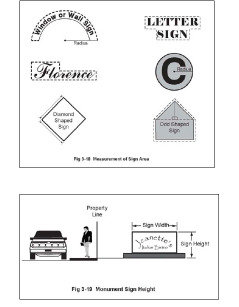
(Ord. No. 2010-265, § 3, 1-27-2010; Ord. No. 2015-328, § 3(Exh. A), 10-14-2015)
17.30.080 - On-site sign regulations.
The signs described in this section may be allowed only on the same site as the use being advertised or identified unless otherwise noted.
A.
Signs Allowed by Permit in All Zoning Districts. The following signs are allowed in all zoning districts, subject to the regulations in this chapter and issuance of a sign permit or other permit as specified below:
1.
Directional Signs. Signs necessary for public convenience and safety, not exceeding four square feet in size or three feet in height, containing information including "entrance," "exit," or directional arrows designed to be viewed by on-site pedestrians or motorists.
2.
Temporary Banners. One temporary banner not exceeding twenty (20) square feet in size shall be permitted for special events if authorized by a temporary use permit. A temporary banner shall be allowed one time for not more than two weeks per year. Banner signs within commercial centers provided for under an adopted sign program shall not be considered temporary banners. Balloons shall be permitted for special events in conjunction with temporary banners if authorized by a temporary use permit.
All temporary banners and balloons shall be constructed and mounted in such a manner that they shall not rip, shred, tear or blow away by exposure to normal weather conditions. These signs shall not be illuminated or posted on trees, fence posts or public utility poles, or located within any public right-of-way or on any publicly owned property and shall not be within the traffic safety visibility area required by Section 17.20.120(D).
B.
Signs Allowed by Permit in Specific Zoning Districts. A permit shall be required for the installation of any sign within the zoning district listed in Tables 3-17 through 3-21. No permit shall be issued except for a sign in compliance with these tables.
Subject to sign program approval, decorative and other supportive architectural graphics, including company logos, are allowed in a commercial zoning district in addition to permitted building-mounted signs. The graphics shall be clearly secondary to the main sign in terms of their size and the portion of wall area covered, and shall complement the building and main sign in color and style. The area of the graphics and any logo shall be counted as part of the total sign area allowed on the building.
1.
Flag and Land Locked Commercial Lots. Subject to the limitations set forth in the following tables, one monument sign may be located in a private access easement adjacent to a public street to provide business identification and directional information for a parcel without street frontage when (i) a wall sign would not be easily seen from the public street; and (ii) there is sufficient area to accommodate a monument sign. The sign shall maintain an adequate separation from other monument signs in the vicinity and shall be placed to avoid undue concentration of monument signs as determined by the director.
2.
Kiosks. Kiosks are permitted with a sign permit approved in compliance with the requirements of Section 17.30.065. Notwithstanding any provision of an approved sign program, a kiosk is allowed if approved by a sign permit by the director in compliance with the requirements of Section 17.30.065 and all other applicable requirements of this Code.
3.
Calabasas Road District. Monument signs shall be permitted along both sides of Calabasas Road from the east side of Mureau Road to the west side of Parkway Calabasas ("Calabasas Road district"). The maximum height of a monument sign in the Calabasas Road district shall be twenty (20)) feet in height with the sign area not to exceed one hundred (100) square feet. Notwithstanding the forgoing, the council, following review and consideration from the commission, may grant an exception allowing a monument sign up to twenty-five (25) feet in height and up to one hundred fifty (150) square feet in sign area, upon finding that increased height or sign area is necessary to allow the applicant visibility comparable to that enjoyed by a substantial number of other properties in the Calabasas Road district. A property which contains a nonconforming pole sign(s) shall not be authorized to construct a monument sign under this paragraph unless the applicant agrees to abate the pole sign(s) as a condition of this approval.
1.
Signs permitted in RS, RM, RR, RC, and HM (Residential Single Family, Residential Multi-Family, Rural Residential, Rural Community and Hillside Mountainous) Zones.
Note: Maximum sign area includes all monument and building mounted signs. All lighting must comply with the Lighting Ordinance.
2.
Signs permitted in CL, CR, CMU, CO, CB (Commercial-Limited, Commercial-Retail, Commercial-Mixed Use, Commercial-Office and Commercial-Business Park) Zones:
Note: A commercial center or complex is defined as where a project shares similar landscape features, common access ways, reciprocal parking or architectural features. Multitenant sites shall have Sign Program, per Section 17.30.050. In street corridors with adopted design guidelines or Master Plans, signage shall be consistent with adopted plans.
3.
Signs permitted in the CT (Commercial-Old Town) Zone:
Note: A commercial center or complex is defined as where a project shares similar landscape features, common access ways, reciprocal parking or architectural features. Multitenant sites shall have Sign Program, per Section 17.30.050. In street corridors with adopted design guidelines or Master Plans, signage shall be consistent with adopted plans.
4.
Signs permitted in PF, OS, and REC (Public-Facilities, Open Space and Recreation) Zones:
5.
Specific land use signs shall be allowed in addition to other permitted signs authorized by this chapter:
(Ord. No. 2010-265, § 3, 1-27-2010; Ord. No. 2014-310, § 1(Att. A), 2-12-2014; Ord. No. 2015-328, § 3(Exh. A), 10-14-2015; Ord. No. 2025-411, § 6, 2-26-2025)
17.30.090 - Nonconforming signs.
This section recognizes that the eventual elimination of existing signs (on-site and off-site) that are not in conformity with the provisions of this chapter is as important as the prohibition of new signs that would violate these regulations.
A.
Continuation of Nonconforming Sign. A legally established sign that does not conform to the provisions of this chapter may continue to be used in compliance with Section 17.30.100, except that the sign shall not be:
1.
Structurally altered to extend its useful life;
2.
Expanded, moved, or relocated;
3.
Re-established after a business has been discontinued for ninety (90) days or more; or
4.
Re-established after damage or destruction of more than fifty (50) percent of the value of the physical structure of the sign, as determined by the director.
B.
Sign Copy Changes. The sign copy and sign faces of a nonconforming sign may be changed upon obtaining a sign permit provided that the change does not include a structural change in the display.
C.
Correction of Nonconformities Required. Approval of any structures on a site or a change in the land use on a site shall require that all nonconforming signs on the site be brought into conformity with this chapter.
(Ord. No. 2010-265, § 3, 1-27-2010)
17.30.100 - Nonconforming sign abatement.
A.
Time Limits. A nonconforming sign shall comply with this chapter within the period of time prescribed in subsection (B) of this section.
B.
Amortization Schedule.
C.
Notice of Abatement. Upon the expiration of the amortization period set forth in subsection B of this section, the director may abate a nonconforming sign. The director shall first send a written notice of abatement by certified mail, return receipt requested to owners of the businesses advertised on the signs and the owners of the property on which the sign is located as shown in the current assessor's records. The date of service shall be the date the director places the notice in a U.S. Postal Service mail receptacle. A notice of abatement shall state the following:
1.
A description of the nonconformity; applicable amortization schedule;
2.
A statement that the amortization period has expired; date of expiration;
3.
That an appeal may only be filed with respect to the director's determination regarding the applicable amortization period.
4.
That an appeal must be filed thirty (30) days from the date of service of the notice.
D.
Appeal. The owners of the businesses advertised on the sign and the owners of the property on which the sign is located may appeal the director's determination regarding the applicable amortization period or request a time extension, on a form provided by the director and accompanied by any required fee in compliance with Section 17.60.040, within thirty (30) days of the date of service of the notice.
1.
Hearings. Within sixty (60) days after receipt of an appeal, the commission shall hold a public hearing and shall forward a recommendation to the council as to whether the nonconformity should be abated as indicated in the notice, or whether a time extension should be granted in compliance with subsection (D)(2) of this section.
a.
Notice of Hearing. Notice of the commission and council hearings shall be provided in the same manner as provided by Chapter 17.78. Both the owner of the business advertised on the sign and the owner of the property on which the sign is located shall be given notice of the hearing.
b.
Conduct of Hearing. The commission shall receive written and oral testimony at the hearing relating to the term of abatement. During the hearing, the owner shall be permitted to call witnesses and be represented by counsel.
c.
Commission Recommendation. At the close of the hearing, the commission shall make a recommendation to the council regarding an appeal. The burden of proof shall be upon the appellant to demonstrate by a preponderance of the evidence that he or she is entitled to a longer abatement period than that contained in the notice of abatement. If the appellant is requesting a time extension, the commission may grant or deny the appeal in compliance with subsection (D)(2) of this section.
d.
Council Hearing. The council shall hold a hearing with notice given in compliance with subsection (D)(1) of this section and render a decision regarding an appeal.
2.
Extension of Time. The council may grant an extension of the time for abatement of a nonconforming sign where it can be demonstrated that an unreasonable hardship would otherwise be imposed on the appellant. The council shall base its decision on any competent evidence presented, including the following:
a.
The nature of the sign and the use it advertises;
b.
The amount of the owner's investment in the sign;
c.
The detriment, if any, caused to the neighborhood by continuance of the nonconforming sign beyond the amortization period;
d.
The amount of time needed to amortize the investment in the sign; and,
e.
Any available depreciation information from the owner's latest federal income tax return, or other applicable documentation.
3.
Decision and Order. The council's decision and the findings in support of the decision shall be in the form of a written order and shall be served upon the appellant personally or by certified mail, return receipt requested, within ten (10) days after the decision is rendered. The order shall be binding upon the appellant, the owners of the business advertised on the sign, the owners of the property on which the sign is located, and the owners' successors, heirs and assignees. If the council grants a time extension, the council may require reasonable modifications or alterations to the sign for the purpose of improving the sign's appearance or compliance with this development code, the Municipal Code or state law.
4.
Recordation of Order. Within thirty (30) days after the hearing, notice of the decision and order of the council shall be recorded with the Los Angeles County recorder's office.
E.
Applicability of Section.
1.
This section applies only to legal nonconforming signs.
2.
Nothing herein prevents the earlier removal of a legal nonconforming sign pursuant to Section 17.30.110.
(Ord. No. 2010-265, § 3, 1-27-2010)
17.30.110 - Removal of illegally installed or unsafe signs.
A.
Unsafe Signs. Any sign that presents an immediate danger to the public health or safety may be removed by the city without prior notice. Alternatively, the director may issue a notice of violation and give the permit holder, property owner, or person in possession and control of the property fifteen (15) days to cure the violation. The date of service shall be the date the director places the notice in a U.S. Postal Service mail receptacle. In the case of an unsafe sign removed by the city, the costs of such removal and storage shall be borne by the permit holder, property owner, or person in possession and control of the property, as applicable and may be collected by the city in the same manner as it collects any other debt or obligation. No unsafe sign that has been removed and stored by the city shall be released until the costs of removal and storage have been paid. If an unsafe sign remains uncured for a period of thirty (30) days after service of the notice, the city may remove the sign and dispose of it.
B.
Illegal Signs. Any illegal sign shall be removed or brought into conformity by the permit holder, property owner, or person in possession and control of the property following written notice from the director as specified in Chapter 17.80. The director's order may be appealed to the council in the manner provided in Chapter 17.80.
C.
Abandoned Signs. A sign that advertises or otherwise identifies a business or activity which has been discontinued on the premises for a period of ninety (90) days shall be considered abandoned and shall be removed by the owner or lessee of the premise.
D.
Penalties. Illegal signs shall be subject to the remedies established in Municipal Code Chapter 17.80.
E.
Removal of Illegal Signs in the Public Right-of-Way. The director may cause the immediate removal of any sign within the public right-of-way or on property that is otherwise abandoned that has been placed there without first complying with the requirements of this chapter.
(Ord. No. 2010-265, § 3, 1-27-2010)
17.31.010 - Purpose.
A.
Purpose and Intent. The purpose of this chapter is to regulate the installation, operation and maintenance of wireless telecommunication facilities in the city. The city recognizes that the unrestricted installation of redundant personal wireless telecommunication facilities is contrary to the city's efforts to stabilize economic and social aspects of neighborhood environments, and to promote safety and aesthetic considerations, family environments and a basic residential character within the city.
In enacting this chapter, the city intends to:
1.
Promote and protect the health, safety, comfort, convenience and general welfare of residents and business in accord with Section 17.01.020 of this title;
2.
Protect the benefits derived by the city, its residents and the general public from access to personal wireless services while minimizing, to the greatest extent feasible, the redundancy of personal wireless telecommunication facilities in the city;
3.
Balance these goals, by permitting the installation and operation of wireless telecommunication facilities where they are needed, while reducing, to the greatest extent feasible, adverse economic, safety and/or aesthetic impacts on nearby properties and the community as a whole; and
4.
Comply with applicable law, including the 1996 Telecommunications Act.
5.
This section is intended to regulate all uses of wireless communications in the city, including uses by public utilities, to the extent of the city's power to regulate the use of land under federal and state law, but not to exceed the scope of the city's authority.
(Ord. No. 2021-391, § 5(Exh. B), 4-14-2021)
17.31.020 - Applicability.
A.
Applicability. This chapter applies to all proposed antennas and modifications and related wireless telecommunication facilities, as follows:
1.
All applications for approval of the installation of new wireless telecommunication facilities in the city.
2.
All facilities for which applications were received by the department but not approved prior to the effective date of the ordinance codifying this chapter, shall comply with the regulations and guidelines of this chapter.
3.
All facilities for which applications were approved by the city on or prior to the effective date of the ordinance codifying this chapter shall be exempt from this section, except for the requirements of subsections 17.31.030(B)(1)(e) and 17.31.030(B)(2)(b).
4.
All facilities for which applications have been previously approved, but are now or hereafter modified.
B.
Permit Requirements. No wireless telecommunication facility shall be installed or modified until the applicant or operator has obtained:
1.
A Tier 1 wireless telecommunication facility permit as specified in Section 17.31.040, or
2.
A Tier 2 wireless telecommunication facility permit as specified in Section 17.31.050, or
3.
A minor modification permit as specified in Section 17.31.060, or
4.
A small wireless facility permit as specified in Section 17.31.070, and
5.
Any other permit required by applicable provisions of this Code including a building permit, an electrical permit, or an oak tree permit.
All new wireless telecommunication facilities and modifications to an existing wireless facility shall be subject to a Tier 2 wireless telecommunication facility permit if the proposed facility does not meet the criteria for a Tier 1 wireless telecommunication facility permit, minor modification permit, or small wireless facility permit.
(Ord. No. 2021-391, § 5(Exh. B), 4-14-2021)
17.31.030 - General standards and conditions of approval.
The following standards and conditions of approval shall apply to all new wireless telecommunication facilities or modifications to existing wireless facilities.
A.
Standards.
1.
Standards for wireless telecommunication facilities located within the public right-of-way.
a.
Facilities shall have subdued colors and non-reflective materials which blend with the materials and colors of the surrounding area and structures.
b.
Unless otherwise prohibited by state or federal law, all equipment not located on a pole shall be underground; any equipment that is not undergrounded shall be screened from adjacent uses to the maximum extent feasible.
c.
Facilities shall not bear any signs or advertising devices other than certification, warning or other signage required by law or expressly permitted by the city.
d.
At no time shall equipment noise (including air conditioning units) from any facility exceed the applicable noise limit established in Section 17.20.160 of this title at the facility's property line; provided, however, that for any such facility located within five hundred (500) feet of any property zoned open space or residential, or improved with a residential use, such equipment noise shall at no time be audible at the property line of any open space or residentially zoned, or residentially improved property.
e.
Pole-mounted equipment, not including antennas, shall not exceed six cubic feet.
f.
All installations shall be engineered to withstand high wind loads. An evaluation of high wind load capacity shall include the impact of an additional antenna installation on a pole with existing antennae.
g.
The maximum height of any antenna shall not exceed twenty-four (24) inches above the height of a pole or tower other than a streetlight pole, nor seven feet above the height of a streetlight pole, nor shall any portion of the antenna or equipment mounted on a pole be less than sixteen (16) feet above any drivable road surface. All installations on utility poles shall fully comply with California Public Utilities Commission General Order 95 as it now exists or may hereafter be amended.
h.
A freestanding telecommunications tower or monopole shall be set back a distance of at least one hundred fifty (150) percent of the height of the tower to the nearest structure designed for occupancy.
i.
Facilities located within a designated scenic corridor or historic districts shall be stealth facilities, with all equipment, excluding required electrical meter cabinets, located underground or pole-mounted. Required electrical meter cabinets shall be screened as approved by the commission or director.
j.
Personal wireless telecommunication facilities not located within a scenic corridor or historic district designated by the city shall be designed to place all equipment underground or on an existing pole consistent with Section 17.31.030(A)(1)(e), excluding required electrical meters. However, if such facilities cannot be placed underground, ground-mounted equipment may be installed up to a height of five feet and to a footprint of fifteen (15) square feet. Ground-mounted equipment shall be screened, to the fullest extent possible, through the use of landscaping, walls, or other decorative feature, as approved by the commission or director.
k.
Equipment shall be located so as not to cause: (i) any physical or visual obstruction to pedestrian or vehicular traffic, (ii) inconvenience to the public's use of a public right-of-way, or (iii) safety hazards to pedestrians and motorists. In no case shall ground-mounted equipment, walls, or landscaping be less than eighteen (18) inches from the front of the curb.
l.
No facility shall be built so as to cause the right-of-way in which the facility is located to fail to comply with the Americans with Disabilities Act.
m.
Ground-mounted equipment shall be screened, to the fullest extent possible, through the use of landscaping, walls, or other decorative feature, as approved by the commission.
n.
Pole-mounted antennas shall adhere to the following guidelines. If an antenna cannot be mounted as set forth in subsection (i), it may be mounted in accordance with subsection (ii). If an antenna cannot be mounted as set forth in either subsection (i) or (ii), it may be mounted in accordance with subsection (iii):
i.
A stealth facility mounted on an existing, collocated monopole or tower;
ii.
A stealth facility mounted on an existing steel, wood, or concrete pole, including a light standard; or
iii.
A stealth facility mounted on a new steel, wood, or concrete pole but only if an operator shows that it cannot otherwise close a significant gap in its service coverage, and that the proposal is the least intrusive means of doing so.
2.
Standard for wireless telecommunication facilities not located within the public right-of-way.
a.
Facilities shall have subdued colors and non-reflective materials which blend with the materials and colors of the surrounding area and structures.
b.
Unless otherwise prohibited by state or federal law, all equipment not located on a pole shall be underground; any equipment that is not undergrounded shall be screened from adjacent uses to the maximum extent feasible.
c.
The facilities shall not bear any signs or advertising devices other than certification, warning or other signage required by law or expressly permitted by the city.
d.
At no time shall equipment noise (including air conditioning units) from any facility exceed the applicable noise limit established in Section 17.20.160 of this title at the facility's property line; provided, however, that for any such facility located within five hundred (500) feet of any property zoned open space or residential, or improved with a residential use, such equipment noise shall at no time be audible at the property line of any open space or residentially zoned, or residentially improved property.
e.
A freestanding telecommunications tower or monopole shall be set back a distance of at least one hundred fifty (150) percent of the height of the tower from the nearest property line of any residentially zoned or occupied lot.
f.
Facilities shall be a stealth design, to the maximum extent feasible.
g.
Building-mounted facilities shall be designed and constructed to be fully screened in a manner that is compatible in color, texture and type of material with the architecture of the building on which the facility is mounted.
h.
All accessory equipment associated with the operation of a wireless telecommunication facility shall be located within a building enclosure or underground vault that complies with the development standards of the zoning district in which the accessory equipment is located.
i.
No wireless telecommunication facility shall be placed within fifty (50) feet horizontally and vertically of a significant ridgeline, as mapped in the General Plan.
j.
Facilities shall comply with the development standards of the underlying zoning district the subject site is located within.
k.
Guidelines for Placement on Structures. Antennas shall be mounted on structures utilizing the methods described below. If an antenna cannot be mounted as set forth in subsection (1), it may be mounted in accordance with subsection (2). If an antenna cannot be mounted as set forth in either subsection (1) or (2), it may be mounted in accordance with subsection (3):
i.
A stealth facility mounted on an existing structure or collocated on an existing tower;
ii.
A stealth facility mounted on an existing steel or concrete pole, including a light standard;
iii.
A stealth facility mounted on a new structure architecturally compatible with the surrounding area; or
iv.
A stealth facility mounted on a new steel, wood, or concrete pole.
B.
Conditions of Approval for All New or Modified Wireless Facilities.
1.
Conditions of Approval for New or Modified Wireless Telecommunication Facilities Located Within the Public Right-of-Way.
a.
Any approved wireless telecommunication communication facility within a public right-of-way shall be subject to such conditions, changes or limitations as are from time to time deemed necessary by the public works director to: (i) protect the public health, safety, and welfare; (ii) prevent interference with pedestrian and vehicular traffic; or (iii) prevent damage to a public right-of-way or any property adjacent to it. Before the director of public works imposes conditions, changes, or limitations pursuant to this paragraph, he or she shall notify the applicant or operator, in writing, by mail to the address set forth in the application or such other address as may be on file with the city. Such change, new limitation or condition shall be effective twenty-four (24) hours after deposit of the notice in the United States mail.
b.
The applicant or operator of the wireless telecommunication facility shall not move, alter, temporarily relocate, change, or interfere with any existing public facility, structure or improvement without the prior written consent of the city, and the owner in the circumstance where the owner is not the city. No structure, improvement or facility owned by the city shall be moved to accommodate a personal wireless telecommunication facility unless: (i) the city determines, in its sole and absolute discretion, that such movement will not adversely affect the city or surrounding residents or businesses, and (ii) the applicant or operator pays all costs and expenses related to the relocation of the city's facilities. Every applicant or operator of any personal wireless telecommunication facility shall assume full liability for damage or injury caused to any property or person by his, her, or its facility. Before commencement of any work pursuant to an encroachment permit issued for any personal wireless telecommunication facility within a public right-of-way, an applicant shall provide the city with documentation establishing to the city's satisfaction that the applicant has the legal right to use or interfere with any other facilities within the public right-of-way to be affected by applicant's facilities.
c.
Should any utility company offer electrical service to a wireless facility which service does not require the use of a meter cabinet, the applicant or operator of the facility shall at its cost remove the meter cabinet and any foundation thereof and restore the area to its prior condition.
d.
Facilities shall not bear any signs or advertising devices other than legally required certification, warning, or other required seals or signage, or as expressly authorized by the city.
e.
The applicant, operator of a facility and property owner (when applicable) shall defend, indemnify and hold the city and its elective and appointed boards, commissions, officers, agents, consultants and employees harmless from and against all demands, liabilities, costs (including attorneys' fees), or damages arising from the city's review and/or approval of the design, construction, operation, location, inspection or maintenance of the facility.
f.
Removal of Unsafe Facilities. If, at any time after the issuance of a building permit or encroachment permit, any wireless telecommunication facility becomes incompatible with public health or safety, the applicant or operator of the facility shall, upon notice from the city and at the applicant's or operator's own expense, remove that facility. Written notice of a determination pursuant to this paragraph shall be sent to the owner and operator of the personal wireless telecommunication facility, who shall be entitled to a hearing on that determination before the city manager or a hearing officer appointed by the city manager, provided that written request for such a hearing is received by the city clerk within ten (10) days of the date of the notice. Any such hearing shall be conducted pursuant to Chapter 17.74 of this title, although no further appeal from the decision of the city manager may be had other than pursuant to Code of Civil Procedure Section 1094.5. Upon a final decision of the city manager or the running of the time for a request for a hearing without such a request, the operator shall have ninety (90) days to remove the facility.
g.
The owner or operator of any wireless telecommunication facility approved by a Tier 1 or Tier 2 wireless telecommunication facility permit under this subsection (A) of this Section 17.31.030 shall cooperate with the director to: (1) verify that the facility design conforms with relevant building and safety requirements; and (2) verify that the facility complies with the requirements of Section 17.31 of the Calabasas Municipal Code.
h.
Prior to the issuance of a building permit or encroachment permit for a new facility, the applicant or owner/operator of the facility shall pay for and provide a performance bond, which shall be in effect until all facilities are fully and completely removed and the site reasonably returned to its original condition. The purpose of this bond is to cover the applicant's or owner/operator of the facility's obligation under the conditions of approval and the City of Calabasas Municipal Code. The bond coverage shall include, but not be limited to, removal of the facility, maintenance obligations and landscaping obligations. (The amount of the performance bond shall be set by the director on a case-specific basis and in an amount reasonably related to the obligations required under this Code and all conditions of approval, and shall be specified in the conditions of approval.)
i.
An applicant shall not transfer a permit to any person or entity prior to completion of construction of a wireless telecommunication facility.
j.
The applicant shall submit as-built photographs of the facility within ninety (90) days of installation of the facility, detailing the installed equipment.
k.
A wireless telecommunication facility approved by a Tier 2 wireless facility permit may operate only until the tenth anniversary of the date it is first placed into service, unless that sunset date is extended by additional term(s) not to exceed ten (10) years pursuant to a wireless facility permit issued under this Section 17.12.050. There is no limit to the number of times the sunset date for a facility may be extended.
l.
Abandonment.
i.
Personal wireless telecommunication facilities that are no longer operating shall be removed at the expense of the applicant, operator, or owner no later than ninety (90) days after the discontinuation of use. Disuse for ninety (90) days or more shall also constitute a voluntary termination by the applicant of any land use entitlement under this Code or any predecessor to this Code.
ii.
The director shall send a written notice of the determination of non-operation to the owner and operator of the personal wireless telecommunication facility, who shall be entitled to a hearing on that determination before the city manager or a hearing officer appointed by the city manager, provided that written request for such a hearing is received by the city clerk within ten (10) days of the date of the notice. Any such hearing shall be conducted pursuant to Chapter 17.74 of this title, although no further appeal from the decision of the city manager may be had other than pursuant to Code of Civil Procedure Section 1094.5. Upon a final decision of the city manager or the running of the time for a request for a hearing without such a request, the operator shall have ninety (90) days to remove the facility.
iii.
The operator of a facility shall notify the city in writing of its intent to abandon a permitted site. Removal shall comply with applicable health and safety regulations. Upon completion of abandonment, the site shall be restored to its original condition at the expense of the applicant, operator, or owner.
iv.
All facilities not removed within the required ninety-day period shall be in violation of this Code. In the event the city removes a disused facility upon the failure of the applicant, operator, or owner to timely do so, the applicant, operator, and owner shall be jointly and severally liable for the payment of all costs and expenses the city incurs for the removal of the facilities, including legal fees and costs.
2.
Conditions of Approval for All New or Modified Wireless Telecommunication Facilities Not Located Within the Public Right-of-Way.
a.
Facilities shall not bear any signs or advertising devices other than legally required certification, warning, or other required seals or signage, or as expressly authorized by the city.
b.
The applicant, operator of a facility and property owner (when applicable) shall defend, indemnify and hold the city and its elective and appointed boards, commissions, officers, agents, consultants and employees harmless from and against all demands, liabilities, costs (including attorneys' fees), or damages arising from the city's review and/or approval of the design, construction, operation, location, inspection or maintenance of the facility.
c.
The owner or operator of any wireless telecommunication facility approved by a Tier 1 or Tier 2 wireless telecommunication facility permit under this subsection (A) of this Section 17.31.030 shall cooperate with the director to: (1) verify that the facility design conforms with relevant building and safety requirements; and (2) verify that the facility complies with the requirements of Section 17.31 of the Calabasas Municipal Code.
d.
An applicant shall not transfer a permit to any person or entity prior to completion of construction of a personal wireless telecommunication facility.
e.
The applicant shall submit as-built photographs of the facility within ninety (90) days of installation of the facility, detailing the installed equipment.
f.
Abandonment.
i.
Wireless telecommunication facilities that are no longer operating shall be removed at the expense of the applicant, operator, or owner no later than ninety (90) days after the discontinuation of use. Disuse for ninety (90) days or more shall also constitute a voluntary termination by the applicant of any land use entitlement under this Code or any predecessor to this Code.
ii.
The director shall send a written notice of the determination of non-operation to the owner and operator of the personal wireless telecommunication facility, who shall be entitled to a hearing on that determination before the city manager or a hearing officer appointed by the city manager, provided that written request for such a hearing is received by the city clerk within ten (10) days of the date of the notice. Any such hearing shall be conducted pursuant to Chapter 17.74 of this title, although no further appeal from the decision of the city manager may be had other than pursuant to Code of Civil Procedure Section 1094.5. Upon a final decision of the city manager or the running of the time for a request for a hearing without such a request, the operator shall have ninety (90) days to remove the facility.
iii.
The operator of a facility shall notify the city in writing of its intent to abandon a permitted site. Removal shall comply with applicable health and safety regulations. Upon completion of abandonment, the site shall be restored to its original condition at the expense of the applicant, operator, or owner.
iv.
All facilities not removed within the required ninety-day period shall be in violation of this Code. In the event the city removes a disused facility upon the failure of the applicant, operator, or owner to timely do so, the applicant, operator, and owner shall be jointly and severally liable for the payment of all costs and expenses the city incurs for the removal of the facilities, including legal fees and costs.
C.
Independent Expert Review. The city may retain one or more independent, qualified consultants to review any application for a Tier 1 and Tier 2 wireless facility permit, a wireless facility minor modification permit, or for a small wireless facility permit. The review is intended to be a review of technical aspects of the proposed wireless telecommunication facility or modification of an existing wireless telecommunication facility and may address any or all of the following, as applicable:
1.
For Tier 2 wireless facility permits, whether the proposed wireless telecommunication facility is necessary to close a significant gap in coverage and is the least intrusive means of doing so;
2.
The accuracy and completeness of submissions;
3.
For Tier 2 wireless facility permits, technical demonstration of the unavailability of alternative sites or configurations and/or coverage analysis;
4.
The applicability of analysis techniques and methodologies;
5.
For Tier 2 wireless facility permits, the viability of alternative sites and alternative designs; and
6.
For all wireless facility permits, an analysis of the potential expansion that would be considered an eligible facility request under Section 6409 of the Middle Class Tax Relief and Job Creation Act of 2012; and
7.
Any other specific technical issues designated by the city.
The cost of the review shall be paid by the applicant through a deposit estimated to cover the cost of the independent review, as established by the director or city council.
D.
Construction. These standards are intended to exert the maximum authority available to the city in the regulation of wireless telecommunication facilities under applicable state and federal law but not to exceed that authority. Accordingly, this section shall be construed and applied in light of any such limits on the city's authority. The purpose of this Chapter (17.31) is to regulate wireless telecommunications facilities proposed for sites within public rights-of-way consistently with the rights conferred on telephone corporations by Public Utilities Code §§ 7901 and 7901.1 and to address the aesthetic and safety concerns unique to such proposals due to their highly visible location in rights-of-way that must be safely shared with pedestrians, motorists and other utility infrastructure.
E.
Standards for All Wireless Facilities. All facilities shall be stealth to the maximum extent feasible.
F.
Violations. The city may revoke a permit for any wireless telecommunication facility in violation of this section in accordance with Section 17.80.070 of this Code. The remedies specified in this section shall be cumulative and the city may resort to any other remedy available at law or in equity and resort to any one remedy shall not cause an election precluding the use of any other remedy with respect to a violation.
G.
Allowed Locations. The following table identifies the allowed zoning districts and locations for wireless telecommunication facilities based on permit type, subject to the limitations and requirements of this Chapter 17.31 and other applicable law:
Wireless facilities are not permitted in any other zone not listed in Table 17.31.1. Tier 2 and small wireless facility permits are not permitted on any privately owned roads or streets rights-of-way.
(Ord. No. 2021-391, § 5(Exh. B), 4-14-2021)
17.31.040 - Tier 1 wireless telecommunication facility permit.
A.
Purpose. The purpose of this section is to encourage the deployment of stealth wireless facilities in appropriate areas of the city, in order to provide safe and reliable wireless service to the community.
B.
Applicability. An applicant seeking approval of a collocation or modification to an existing structure or wireless facility, or deployment of a new wireless facility, which complies with the standards in Section 17.31.030 and Section 17.31.040(C), shall apply for a Tier 1 wireless facility permit and any other permit required by applicable provisions of this Code including a building permit, an electrical permit, or an oak tree permit. An applicant seeking approval of a subsequent proposed modification of an existing wireless facility, which complies with the standards in Section 17.31.030 and Section 17.31.040(C), shall also apply for a Tier 1 wireless facility permit and any other permit required by applicable provisions of this Code including a building permit, an electrical permit, or an oak tree permit.
C.
Standards. Wireless telecommunication facilities subject to a Tier 1 wireless telecommunication facility permit shall be subject to the following standards:
1.
Wireless Telecommunication Facilities Located Within the Public Right-of-Way or Privately Owned "Rights-of-Way" Located Within a Common Interest Development.
a.
Tier 1 wireless telecommunication facilities shall comply with standards set forth in Section 17.31.030.
b.
Tier 1 wireless telecommunication facilities are allowed on arterial and collector roads identified in the Circulation Element of the General Plan, including privately owned "rights-of-way" located within a common interest development as defined by Civil Code Section 4100.
c.
Ground mounted equipment, antennas and structures shall comply with the height and size limits established in Section 17.31.030.
d.
New wireless telecommunication facilities shall be co-located on an existing structure or replacement structure of similar size and location, or if no existing or replacement structure is feasible, may be located on a new light standard, utility pole, or similar structure.
e.
All equipment (except any required utility meter cabinet) shall be located underground or pole mounted.
f.
All facilities shall meet the stealth design criteria established by the city's wireless telecommunication facility design guidelines.
2.
Wireless Telecommunication Facilities Not Located Within the Public Right-of-Way.
a.
Wireless telecommunication facilities shall comply with standards set forth in Section 17.31.030.
b.
Tier 1 wireless telecommunication facilities are allowed in all commercial zones, and the PF, REC, OS, PD, RC, and RS zones. A wireless facility is only allowed in the REC, OS, RC, and RS zones if it is located on a parcel that is developed with a street or structure, under government ownership or common ownership by a common interest development as defined by Civil Code Section 4100, and not dedicated for open space or development restricted.
c.
The height of a wireless telecommunication facility shall comply with the height limit established by the underlying zoning district. Height exceptions may be allowed for antennas completely screened and located within an architectural feature consistent with Section 17.20.140.
d.
Wireless telecommunication facilities shall comply with the setbacks established by the underlying zoning district and Section 17.31.030.
e.
New wireless telecommunication facilities shall be co-located on an existing structure or replacement structure of similar size and location, or if no existing or replacement structure is feasible, may be located on a new light standard, utility pole, or other structure.
f.
All facilities shall meet the stealth design criteria established by the city's wireless telecommunication facility design guidelines.
D.
Application Content. Applications for the approval of a Tier 1 wireless telecommunication facility permit shall include, but are not necessarily limited to, an application fee and the following information, in addition to all other information required by the city pursuant to Chapter 17.60 of this title:
1.
Application Forms. The city's standard application form, available on the city's website or from the community development department, as may be amended by the community development director;
2.
Application Fee. An application fee as established by the council by resolution under the authority of Section 17.60.040;
3.
Independent Consultant Deposit. An independent consultant fee deposit, if required by the council by resolution under the authority of Section 17.60.040, to reimburse the city for its costs to retain an independent consultant to review the technical aspects of the application;
4.
Site and Construction Plans. Complete and accurate plans, drawn to scale, signed, and sealed by a California-licensed engineer, land surveyor, and/or architect;
5.
Structural Analysis. A structural analysis, prepared, signed, and sealed by a California-licensed engineer that assesses whether the proposed wireless facility complies with all applicable building codes;
6.
Noise Study. A noise study or written statement, prepared by a qualified engineer, for the proposed wireless telecommunication facility including, but not limited to, equipment, such as air conditioning units and back-up generators. The noise study shall assess compliance with Section 17.12.050(C)(4)(e);
7.
Site Survey. For any new wireless telecommunication facilities proposed to be located within the public right-of-way, the applicant shall submit a survey prepared, signed and stamped by a California licensed or registered engineer or surveyor. The survey shall identify and depict all existing boundaries, encroachments and other structures within two hundred fifty (250) feet from the proposed project site, which includes without limitation all: (i) traffic lanes; (ii) all private properties and property lines; (iii) above and below grade utilities and related structures and encroachments; (iv) fire hydrants, roadside call boxes and other public safety infrastructure; (v) streetlights, decorative poles, traffic signals and permanent signage; (vi) sidewalks, driveways, parkways, curbs, gutters and storm drains; (vii) benches, trash cans, mailboxes, kiosks, and other street furniture; and (viii) existing trees, oak trees, planters and other landscaping features;
8.
Scaled visual simulations showing the proposed facility superimposed on photographs of the site and surroundings, to assist the commission in assessing the visual impacts of the proposed facility and its compliance with the provisions of this section;
9.
For new facilities, the plans shall include (in plan view and elevations) a scaled depiction of the maximum permitted increase as authorized by Section 6409(a) of the 2012 Middle Class Tax Relief Act, using the proposed project as a baseline;
10.
An affirmation, under penalty of perjury, that the proposed installation will be FCC compliant, in that it will not cause members of the general public to be exposed to RF levels that exceed the MPE levels deemed safe by the FCC. A copy of the fully completed FCC form "A Local Government Official's Guide to Transmitting Antenna RF Emission Safety: Rules, Procedures, and Practical Guidance: Appendix A" titled "Optional Checklist for Determination Of Whether a Facility is Categorically Excluded" for each frequency band of RF emissions to be transmitted from the proposed facility upon the approval of the application. All planned radio frequency emissions on all frequency bands must be shown on the Appendix A form(s) attached to the application. All planned radio frequency emissions are to be entered on each Appendix A form only in wattage units of "effective radiated power";
11.
Other Information. Such other information as the city may require, as specified in publicly available materials, including information required as stated on the city's website.
E.
Application Review. Each application for a Tier 1 wireless telecommunication facility permit shall be reviewed by the director. Any application that is determined to be incomplete, and is not subsequently modified to be complete in the judgment of the director under applicable law within thirty (30) days after the city's notification to the applicant that the application is incomplete, shall be deemed withdrawn.
F.
Findings. The director may approve a Tier 1 wireless telecommunication facility permit only if each of the following findings can be made:
1.
The proposed wireless telecommunication facility meets the standards set forth in Sections 17.31.030 and 17.31.040.
2.
The proposed wireless telecommunication facility is designed as a stealth facility consistent with the city's design guidelines for Tier 1 wireless telecommunication facilities.
G.
Conditions of Approval. In addition to any other conditions of approval permitted under federal and state law and this Code that the director deems appropriate or required under this Code, all Tier 1 wireless telecommunication facility permits under this subsection, shall include the following conditions of approval:
1.
Compliance With Previous Approvals. The grant or approval of a small wireless facility permit shall be subject to the conditions of approval of the underlying permit.
2.
As-Built Plans. The applicant shall submit to the director an as-built set of plans and photographs depicting the entire small wireless facility as modified, including all transmission equipment and all utilities, within ninety (90) days after the completion of construction.
3.
Indemnification. To the fullest extent permitted by law, the applicant and any successors and assigns, shall defend, indemnify and hold harmless [the] city, its employees, agents and officials, from and against any liability, claims, suits, actions, arbitration proceedings, regulatory proceedings, losses, expenses or costs of any kind, whether actual, alleged or threatened, including, but not limited to, actual attorney fees, litigation expenses and court costs of any kind without restriction or limitation, incurred in relation to, as a consequence of, arising out of or in any way attributable to, actually, allegedly or impliedly, in whole or in part, related to the small wireless facility permit and the issuance of any permit or entitlement in connection therewith. The applicant shall pay such obligations as they are incurred by [the] city, its employees, agents and officials, and in the event of any claim or lawsuit, shall submit a deposit in such amount as the city reasonably determines necessary to protect the city from exposure to fees, costs or liability with respect to such claim or lawsuit.
4.
Compliance With Applicable Laws. The applicant shall comply with all applicable provisions of this Code, any permit issued under this Code, and all other applicable federal, state, and local laws. Any failure by the city to enforce compliance with any applicable laws shall not relieve any applicant of its obligations under this Code, any permit issued under this Code, or all other applicable laws and regulations.
5.
Compliance With Approved Plans. The proposed project shall be built in compliance with the approved plans on file with the planning division.
6.
Violations. The wireless facility shall be developed, maintained, and operated in full compliance with the conditions of the small wireless facility permit, any other applicable permit, and any law, statute, ordinance or other regulation applicable to any development or activity on the site. Failure of the applicant to cease any development or activity not in full compliance shall be a violation of these conditions. Any violation of this Code, the conditions of approval for the small wireless facility permit, or any other law, statute, ordinance or other regulation applicable to any development or activity on the site may result in the revocation of this permit. The remedies specified in this section shall be cumulative and the city may resort to any other remedy available at law or in equity and resort to any one remedy shall not cause an election precluding the use of any other remedy with respect to a violation.
H.
Denial Without Prejudice.
1.
Grounds for Denial Without Prejudice. The director may deny without prejudice an application for a Tier 1 wireless telecommunication facility permit in any of the following circumstances:
a.
The director cannot make all findings required for approval of a Tier 1 wireless telecommunication facility permit; or
b.
The proposed permit would cause the violation of an objective, generally applicable law protecting public health or safety.
2.
Procedures for Denial Without Prejudice. All Tier 1 wireless telecommunication facility permit application denials shall be in writing and shall include (i) the decision date; (ii) a statement that the city denies the permit without prejudice; (iii) a short and plain statement of the basis for the denial; and (iv) that the applicant may submit the same or substantially the same permit application in the future.
3.
Submittal After Denial Without Prejudice. After the director denies a Tier 1 wireless telecommunication facility permit application, and subject to the generally applicable permit application submittal provisions in this chapter, an applicant shall be allowed to:
a.
Submit a new wireless facility permit application for the same or substantially the same proposed facility; or
c.
Submit an appeal of the director's decision.
4.
Costs to Review a Denied Permit. The city shall be entitled to recover the reasonable costs for its review of any wireless facility permit application. In the event that the director denies a wireless facility permit application, the city shall return any unused deposit fees within sixty (60) days after a written request from the applicant. An applicant shall not be allowed to submit a wireless facility permit application or submit a wireless facility permit application for the same or substantially the same proposed facility unless all costs for the previously denied permit application are paid in full.
(Ord. No. 2021-391, § 5(Exh. B), 4-14-2021)
17.31.050 - Tier 2 wireless telecommunication facility permit.
A.
Purpose. This section is intended to comply with the city's obligations under federal law to ensure that wireless providers are not prohibited from providing wireless service within the City of Calabasas.
B.
Applicability. All new wireless telecommunication facilities or modifications to an existing wireless telecommunications facility, however originally approved, that do not meet the findings of approval required for a Tier 1 wireless telecommunication facility permit as specified in Section 17.31.040(F), wireless facility minor modification permit as specified in Section 17.31.060(E), or a small wireless facility permit as specified in Section 17.31.070(G), shall be subject to the approval of (i) a Tier 2 wireless telecommunication facility permit, in addition to (ii) an encroachment permit from the public works department (if applicable), and (iii) any other permit required by applicable provisions of this Code including a building permit, an electrical permit, or an oak tree permit.
C.
Standards. Wireless telecommunication facilities subject to a Tier 2 wireless telecommunication facility permit shall be subject to the following standards:
1.
Facilities shall comply with the standards set forth in section 17.31.030.
2.
New Wireless Facility Preferred Zones and Locations. When doing so would not conflict with one of the standards set forth in Section 17.31.030 or with federal law, wireless telecommunication facilities subject to the approval of a Tier 2 wireless telecommunication facility Permit shall be located in the most appropriate location as described in this subsection (2), which range from the most appropriate to the least appropriate. Nothing in this section shall detract from the requirements of Section 17.31.050(C)3 below.
a.
Collocation on an existing facility in a commercial zone;
b.
Collocation on an existing structure or utility pole in a commercial zone;
c.
Location on a new structure in a commercial zone;
d.
Collocation on an existing facility in a public facility or recreation zone;
e.
Location on an existing structure or utility pole in a public facility or recreation zone; or
f.
Location on a new structure in a public facility or recreation zone.
No new facility may be placed in a less appropriate area unless the applicant demonstrates to the satisfaction of the commission or director that no more appropriate location can feasibly serve the area the facility is intended to serve provided, however, that the commission or director may authorize a facility to be established in a less appropriate location if doing so is necessary to prevent substantial aesthetic impacts.
3.
All new wireless telecommunication facilities subject to a Tier 2 wireless telecommunication facility permit, shall be set back at least one thousand (1,000) feet from schools, dwelling units, and parks, as measured from the closest point of the personal wireless telecommunication facility (including accessory equipment) to the applicable property line, unless an applicant establishes that a lesser setback is necessary to close a significant gap in the applicant's personal communication service, and the proposed wireless telecommunication facility is the least intrusive means to do so. An applicant who seeks to increase the height of an existing personal wireless telecommunication facility, or of its antennas, located less than one thousand (1,000) feet from a school, dwelling unit or park and who is subject to the approval of a wireless facility permit for the proposed height increase must establish that such increase is necessary to close a significant gap in the applicant's personal communication service, and the proposed increase is the least intrusive means to do so.
4.
Prohibited Locations. No Tier 2 wireless telecommunication facility shall be established on any ridgeline or within any residential or open space zoning district described in subparagraphs (i), (ii) and (iii) herein:
a.
Ridgelines. No personal wireless telecommunication facility shall be placed on or near a ridgeline.
b.
Residential Zones. No facility shall be located within a residential zone, including areas set aside for open space, parks or playgrounds.
c.
Open Space. No facility shall be located within an open space zone or park.
Notwithstanding this subsection, wireless telecommunication facilities subject to the approval of a Tier 2 wireless telecommunication facility permit may be permitted in a prohibited location only if the applicant obtains a Tier 2 wireless telecommunication facility permit from the city council following a public hearing and recommendation from the communication and technology commission, and provides technically sufficient and conclusive proof that the proposed location is necessary for provision of wireless services to substantial areas of the city, that it is necessary to close a significant gap in the operator's coverage and that there are no less intrusive alternative means to close that significant gap.
D.
Application Content. Applications for the approval of a Tier 2 wireless telecommunication facility permit shall include, but are not necessarily limited to, an application fee and the following information, in addition to all other information required by the city pursuant to Chapter 17.60 of this title:
1.
Application Forms. The city's standard application form, available on the city's website or from the community development department, as may be amended by the community development director;
2.
Application Fee. An application fee as established by the council by resolution under the authority of Section 17.60.040;
3.
Independent Consultant Deposit. An independent consultant fee deposit, if required by the council by resolution under the authority of Section 17.60.040, to reimburse the city for its costs to retain an independent consultant to review the technical aspects of the application;
4.
Site and Construction Plans. Complete and accurate plans, drawn to scale, signed, and sealed by a California-licensed engineer, land surveyor, and/or architect;
5.
Structural Analysis. A structural analysis, prepared, signed, and sealed by a California-licensed engineer that assesses whether the proposed wireless facility complies with all applicable building codes;
6.
Site Survey. For any new wireless facilities proposed to be located within the public right-of-way, the applicant shall submit a survey prepared, signed and stamped by a California licensed or registered engineer or surveyor. The survey shall identify and depict all existing boundaries, encroachments and other structures within two hundred fifty (250) feet from the proposed project site, which includes without limitation all: (i) traffic lanes; (ii) all private properties and property lines; (iii) above and below grade utilities and related structures and encroachments; (iv) fire hydrants, roadside call boxes and other public safety infrastructure; (v) streetlights, decorative poles, traffic signals and permanent signage; (vi) sidewalks, driveways, parkways, curbs, gutters and storm drains; (vii) benches, trash cans, mailboxes, kiosks, and other street furniture; and (viii) existing trees, oak trees, planters and other landscaping features;
7.
Scaled visual simulations showing the proposed facility superimposed on photographs of the site and surroundings, to assist the commission in assessing the visual impacts of the proposed facility and its compliance with the provisions of this section;
8.
For new facilities, the plans shall include (in plan view and elevations) a scaled depiction of the maximum permitted increase as authorized by Section 6409(a) of the 2012 Middle Class Tax Relief Act, using the proposed project as a baseline;
9.
An affirmation, under penalty of perjury, that the proposed installation will be FCC compliant, in that it will not cause members of the general public to be exposed to RF levels that exceed the MPE levels deemed safe by the FCC. A copy of the fully completed FCC form "A Local Government Official's Guide to Transmitting Antenna RF Emission Safety: Rules, Procedures, and Practical Guidance: Appendix A" titled "Optional Checklist for Determination Of Whether a Facility is Categorically Excluded" for each frequency band of RF emissions to be transmitted from the proposed facility upon the approval of the application. All planned radio frequency emissions on all frequency bands must be shown on the Appendix A form(s) attached to the application. All planned radio frequency emissions are to be entered on each Appendix A form only in wattage units of "effective radiated power";
10.
Written documentation demonstrating a good faith effort to locate the proposed facility in the least intrusive location in accordance with the location requirements of this Section 17.31.050;
11.
For new facilities, the plans shall include (in plan view and elevations) a scaled depiction of the maximum permitted increase as authorized by Section 6409(a) of the 2012 Middle Class Tax Relief Act, using the proposed project as a baseline;
12.
A master plan which identifies the location of the proposed facility in relation to all existing and potential facilities maintained by the operator intended to serve the city. The master plan shall reflect all potential locations that are reasonably anticipated for construction within two years of submittal of the application. Applicants may not file, and the city shall not accept, applications that are not consistent with the master plan for a period of two years from approval of a wireless facility permit unless: (i) the applicant demonstrates materially changed conditions which could not have been reasonably anticipated to justify the need for a personal wireless telecommunication facility site not shown on a master plan submitted to the city within the prior two years or (ii) the applicant establishes before the commission that a new personal wireless telecommunication facility is necessary to close a significant gap in the applicant's personal communication service, and the proposed new installation is the least intrusive means to do so;
13.
A siting analysis which identifies a minimum of five other feasible locations within or without the city which could serve the area intended to be served by the facility, unless the applicant provides compelling technical reasons for providing fewer than the minimum. The alternative site analysis shall include at least one collocation site;
14.
A noise study, prepared by a qualified engineer, for the proposed personal wireless telecommunication facility including, but not limited to, equipment, such as air conditioning units and back-up generators;
15.
A written statement of the applicant's willingness to allow other carriers to collocate on the proposed personal wireless telecommunication facility wherever technically and economically feasible and aesthetically desirable; and
16.
Such other information as the director shall establish from time to time pursuant to the Permit Streamlining Act, Government Code Section 65940, or to respond to changes in law or technology.
17.
An application for a personal wireless telecommunication facility in a public right-of-way for which the applicant claims entitlement under California Public Utilities Code Section 7901 shall be accompanied by evidence satisfactory to the director that the applicant is a telephone corporation or has written authorization to act as an agent for a telephone corporation.
E.
Application Review. Applications for Tier 2 wireless telecommunication facility permits shall be first reviewed by the development review committee. All applications for Tier 2 wireless telecommunication facility permits will be scheduled for a public hearing before the commission in accordance with Section 17.31.050(I) and Chapter 17.78 of this Code. The commission shall determine if a proposed project for which a wireless facility permit is required is the least intrusive means to close a significant gap in the applicant's service coverage. Any application that is determined to be incomplete, and is not subsequently modified to be complete in the judgment of the director under applicable law within thirty (30) days after the city's notification to the applicant that the application is incomplete, shall be deemed withdrawn.
F.
Tier 2 Wireless Telecommunication Facility Permit Findings. In addition to the findings required in Section 17.62.060 of this Code, no Tier 2 wireless telecommunication facility permit may be approved unless the commission or council finds as follows:
1.
The applicant has demonstrated by clear and convincing evidence that the facility is necessary to close a significant gap in the operator's service coverage. Such evidence shall include in-kind call testing of existing facilities within the area the applicant contends is a significant gap in coverage to be served by the facility.
2.
The applicant has demonstrated by clear and convincing evidence that no feasible alternate site exists that would close a significant gap in the operator's service coverage which alternative site is a more appropriate location for the facility under the standards of Chapter 17.31 of the Calabasas Municipal Code.
3.
The facility satisfies the location requirements of Section 17.31.050(C)(2) of the Calabasas Municipal Code.
G.
Conditions of Approval. In addition to the conditions of approval in Section 17.31.020, all new wireless facilities subject to a Tier 2 wireless facility permit shall be subject to the following condition(s):
1.
A new wireless telecommunication facility approved by a Tier 2 wireless facility permit may operate only until the tenth anniversary of the date it is first placed into service, unless that sunset date is extended by additional term(s) not to exceed ten (10) years pursuant to a wireless facility permit issued under this Section 17.12.050. There is no limit to the number of times the sunset date for a facility may be extended.
H.
Denial Without Prejudice.
1.
Grounds for Denial Without Prejudice. The director may deny without prejudice an application for a wireless facility minor modification permit in any of the following circumstances:
a.
The director cannot make all findings required for approval of a wireless facility minor modification permit;
b.
The proposed collocation or modification would cause the violation of an objective, generally applicable law protecting public health or safety; or
c.
The proposed collocation or modification involves the removal and replacement of the facility's entire supporting structure.
2.
Procedures for Denial Without Prejudice. All wireless facility minor modification permit application denials shall be in writing and shall include (i) the decision date; (ii) a statement that the city denies the permit without prejudice; (iii) a short and plain statement of the basis for the denial; and (iv) that the applicant may submit the same or substantially the same permit application in the future.
3.
Submittal After Denial Without Prejudice. After the director denies a wireless facility minor modification permit application, and subject to the generally applicable permit application submittal provisions in this chapter, an applicant shall be allowed to:
a.
Submit a new wireless facility minor modification permit application for the same or substantially the same proposed collocation or modification;
b.
Submit a new wireless facility permit application for the same or substantially the same proposed collocation or modification; or
c.
Submit an appeal of the director's decision.
4.
Costs to Review a Denied Permit. The city shall be entitled to recover the reasonable costs for its review of any wireless facility minor modification permit application. In the event that the director denies a wireless facility minor modification permit application, the city shall return any unused deposit fees within sixty (60) days after a written request from the applicant. An applicant shall not be allowed to submit a wireless facility permit application or submit a wireless facility minor modification permit application for the same or substantially the same proposed modification unless all costs for the previously denied permit application are paid in full.
I.
Additional Notice to Neighbors. After an application for a Tier 2 wireless telecommunication facility permit is complete, the city shall endeavor to provide property owners at least thirty (30) days' prior notice of the initial public hearing on the matter as follows:
1.
Written notice shall be mailed to the record owner of each property within one thousand five hundred (1,500) feet of the proposed site.
A public hearing may be set on less than thirty (30) days' notice if necessary to comply with applicable law, including but not limited the Federal Communications Commission Declaratory Ruling 09-99, WT docket number 08-165, released November 18, 2009, (the "Shot Clock" ruling) and Title 47, United States Code, section 1455 and the Federal Communications Commission's regulations implementing this section, adopted on December 17, 2014, and codified at 47 C.F.R. §§ 1.40001, et seq., as they now exist or may hereafter be amended.
Failure of the city to provide notice pursuant to this subsection (I) shall not be grounds to challenge a determination provided that the notice otherwise required by law has been provided.
(Ord. No. 2021-391, § 5(Exh. B), 4-14-2021)
17.31.060 - Wireless telecommunication facility minor modification permit.
Requirements for Personal Wireless Telecommunications Facilities Subject to a Wireless Facility Minor Modification Permit. This subsection governs applications for certain modifications to existing personal wireless telecommunications facilities, as specified.
A.
Purpose. This section is intended to comply with the city's obligations under federal law, which provides that the city "may not deny, and shall approve any eligible facilities request for a modification of an existing wireless tower or base station that does not substantially change the physical dimensions of such tower or base station." (47 U.S.C. § 1455, subd. (a)(1), adopted as Section 6409 of the Middle Class Tax Relief and Job Creation Act of 2012, Pub.L No. 112-96, 126 Stat. 156.) This section creates a process for the city to review an application for a wireless facility minor modification permit submitted by an applicant who asserts that a proposed collocation or modification to an existing wireless telecommunications facility is covered by this federal law and to determine whether the city must approve the proposed collocation or modification. The city's review of these applications is structured to comply with the requirements of Title 47, United States Code, section 1455 and the Federal Communications Commission's regulations implementing this federal law, adopted on December 17, 2014 and codified at 47 C.F.R. §§ 1.40001, et seq. Consistent with Section 17.31.010(A)(5), this subsection is intended to promote the public's health, safety, and welfare, and shall be interpreted consistent with the federal Telecommunications Act of 1996 (Pub.L. No. 104-104, 110 Stat. 56), Title 47, United States Code, Section 1455, and applicable Federal Communications Commission regulations and court decisions considering these laws and regulations.
B.
Applicability. An applicant seeking approval of a collocation or modification to an existing wireless telecommunication facility which the applicant contends is within the protection of Title 47, United States Code, Section 1455 shall apply for the following at the same time: (i) a wireless facility minor modification permit, in addition to (ii) an encroachment permit from the public works department (if the required by applicable provisions of this Code), and (iii) any other permit required by applicable provisions of this Code including a building permit, an electrical permit, or an oak tree permit.
C.
Application Content. All applications for a wireless facility minor modification permit must include the following items.
1.
Application Form. The city's standard application form, available on the city's website or from the community development department, as may be amended.
2.
Application Fee. An application fee as established by the council by resolution under the authority of Section 17.60.040.
3.
Independent Consultant Deposit. An independent consultant fee deposit, if required by the council by resolution under the authority of Section 17.60.040, to reimburse the city for its costs to retain an independent consultant to review the technical aspects of the application.
4.
Site and Construction Plans. Complete and accurate plans, drawn to scale, signed, and sealed by a California-licensed engineer, land surveyor, and/or architect, which include the following items.
a.
A site plan and elevation drawings for the facility as existing and as proposed with all height and width measurements explicitly stated.
b.
A depiction, with height and width measurements explicitly stated, of all existing and proposed transmission equipment.
c.
A depiction of all existing and proposed utility runs and points of contact.
d.
A depiction of the leased or licensed area of the site with all rights-of-way and easements for access and utilities labeled in plan view.
e.
For proposed collocations or modifications to wireless towers, the plans must include scaled plan views and all four elevations that depict the physical dimensions of the wireless tower as it existed on February 22, 2012, or as approved if constructed after February 22, 2012. For proposed collocations or modifications to base stations, the plans must include scaled plan views and all four elevations that depict the physical dimensions of the base station as it existed on February 22, 2012, or as approved if constructed after February 22, 2012.
5.
Visual Simulations. A visual analysis that includes (i) scaled visual simulations that show unobstructed before-and-after construction daytime and clear-weather views from at least four angles, together with a map that shows the location of each view angle; (ii) a color and finished material palate for proposed screening materials; and (iii) a photograph of a completed facility of the same design and in roughly the same setting as the proposed wireless communication facility.
6.
Statement Asserting that Section 6409 Applies. A written statement asserting that the proposed collocation or modification is an "eligible facilities request" and does not result in a substantial change in the physical dimensions of the facility's wireless tower or base station, as defined by Section 6409, Title 47, United States Code, Section 1455, and justifying that assertion. The written statement shall identify and discuss each required finding for approval of a wireless facility minor modification permit under Section 17.31.060(E) and explain the facts that justify the request for the director to make each finding.
7.
Prior Permits. True and correct copies of all previously issued permits, including all required conditions of approval and a certification by the applicant that the proposal will not violate any previous permit or conditions of approval or why any violated permit or conditions does not prevent approval under Title 47, United States Code, Section 1455 and the Federal Communications Commission's regulations implementing this federal law.
8.
Affirmation of Radio Frequency Standards Compliance. An affirmation, under penalty of perjury, that the proposed installation will be FCC compliant, because it will not cause members of the general public to be exposed to RF levels that exceed the MPE levels deemed safe by the FCC. A copy of the fully completed FCC form "A Local Government Official's Guide to Transmitting Antenna RF Emission Safety: Rules, Procedures, and Practical Guidance: Appendix A" titled "Optional Checklist for Determination Of Whether a Facility is Categorically Excluded" for each frequency band of RF emissions to be transmitted from the proposed facility upon the approval of the application. All planned radio frequency emissions on all frequency bands must be shown on the Appendix A form(s) attached to the application. All planned radio frequency emissions are to be entered on each Appendix A form only in wattage units of "effective radiated power."
9.
Structural Analysis. A structural analysis, prepared, signed, and sealed by a California-licensed engineer that assesses whether the proposed wireless telecommunications facility complies with all applicable building codes.
10.
Noise Study. A noise study, prepared, signed, and sealed by a California-licensed engineer, for the proposed personal wireless telecommunication facility including, but not limited to, equipment, such as air conditioning units and back-up generators; or a written statement signed and sealed by a California-licensed engineer indicating that the proposed modification(s) will not alter the existing noise levels or operational equipment which creates noise.
11.
Other Permits. An application for a wireless facility minor modification permit shall include all permit applications with all required application materials for each and every separate permit required by the city for the proposed collocation or modification to an existing personal wireless telecommunications facility, including a building permit, an encroachment permit (if applicable), and an electrical permit (if applicable).
12.
Other Information. Such other information as the city may require, as specified in publicly available materials, including information required as stated on the city's website.
D.
Application Review, Notice, and Hearing. Each application for a wireless facility minor modification permit shall be reviewed by the director at a public hearing. Notice of the public hearing shall be provided in accord with Chapter 17.78, except that written notice shall be mailed to the record owner of each property within three hundred (300) feet of the site of the proposed modification. Under federal law, the city must approve or deny an application for a wireless facility minor modification permit, together with any other city permits required for a proposed wireless facility modification, within sixty (60) days after the applicant submits the application for a wireless facility minor modification permit, unless tolled due to issuance of any notice of incomplete filing or by mutual agreement between the city and the applicant. Under federal law, failure to act on a wireless facility minor modification permit application within the sixty-day review period, excluding tolling period, will result in the permit being deemed granted by operation of law. Any application that is determined to be incomplete, and is not subsequently modified to be complete in the judgment of the director under applicable law within thirty (30) days after the city's notification to the applicant that the application is incomplete, shall be deemed withdrawn.
E.
Findings Required for Approval by Director at Public Hearing.
1.
Facilities Not Located Within the Public Right-of-Way. The director must approve an application for a wireless facility minor modification permit for a collocation or modification to an existing wireless tower on private property only if each of the following findings can be made:
a.
The applicant proposes a collocation or modification to a structure constructed and maintained with all necessary permits in good standing for the sole or primary purpose of supporting any Federal Communications Commission licensed or authorized antennas and their associated facilities;
b.
The proposed collocation or modification does not increase the height of the existing personal wireless telecommunication facility above its lowest height on February 22, 2012, or as approved if constructed after February 22, 2012, by more than ten (10) percent or by the height of one additional antenna array with separation from the nearest existing antenna not to exceed twenty (20) feet, whichever is greater;
c.
The proposed collocation or modification does not increase the width of the facility by more than twenty (20) feet or the width of the tower at the level of the appurtenance, whichever is greater;
d.
The proposed collocation or modification does not involve the installation of more than the standard number of new equipment cabinets for the technology involved, not to exceed four;
e.
The proposed collocation or modification does not involve any excavation outside the lease or license area of the facility, including any access or utility easements;
f.
The proposed collocation or modification does not defeat any existing concealment elements of the support structure; and
g.
The proposed collocation or modification does not violate any prior conditions of approval, except as may be preempted by Section 6409, Title 47, United States Code, Section 1455, subdivision (a).
2.
Facilities Located Within the Public Right-of-Way. The director must approve an application for a wireless facility minor modification permit for a collocation or modification to an existing base station on private property only if each of the following findings can be made:
a.
The applicant proposes a collocation or modification to a structure constructed and maintained with all necessary permits in good standing, whether built for the sole or primary purpose of supporting any Federal Communications Commission licensed or authorized antennas and their associated facilities or not, that currently supports existing wireless transmission equipment;
b.
The proposed collocation or modification does not increase the height of the existing personal wireless telecommunication facility above its lowest height on February 22, 2012, or as approved if constructed after February 22, 2012, by more than ten (10) percent or ten (10) feet, whichever is greater;
c.
The proposed collocation or modification does not increase the width of the facility by more than six feet;
d.
The proposed collocation or modification does not involve the installation of more than the standard number of new equipment cabinets for the technology involved, not to exceed four;
e.
The proposed collocation or modification does not involve any excavation outside the lease or license area of the facility, including any access and utility easements;
f.
The proposed collocation or modification does not defeat any existing concealment elements of the support structure; and
g.
The proposed collocation or modification does not violate any prior conditions of approval, except as may be preempted by Section 6409, Title 47, United States Code, Section 1455, subdivision (a).
3.
Base Station Located Within the Public Right-of-Way. The director must approve an application for a wireless facility minor modification permit for a collocation or modification to an existing wireless tower or base station in the public right-of-way only if each of the following findings can be made:
a.
The applicant proposes a collocation or modification to either (i) a structure constructed and maintained with all necessary permits in good standing for the sole or primary purpose of supporting any Federal Communications Commission licensed or authorized antennas and their associated facilities or (ii) a structure constructed and maintained with all necessary permits in good standing, whether built for the sole or primary purpose of supporting any Federal Communications Commission licensed or authorized antennas and their associated facilities or not, that currently supports existing wireless transmission equipment;
b.
The proposed collocation or modification does not increase the height of the existing personal wireless telecommunication facility above its lowest height on February 22, 2012, or as approved if constructed after February 22, 2012, by more than ten (10) percent or ten (10) feet, whichever is greater;
c.
The proposed collocation or modification does not increase the width of the facility by more than six feet;
d.
The proposed collocation or modification does not involve the installation of more than the standard number of new equipment cabinets for the technology involved, not to exceed four;
e.
The proposed collocation or modification does not involve either (i) the installation of any new equipment cabinets on the ground, if none already exist, or (ii) the installation of ground equipment cabinets that are more than ten (10) percent larger in height or overall volume than any existing ground cabinets;
f.
The proposed collocation or modification does not involve any excavation outside the area in proximity to the existing ground-mounted equipment in the public right-of-way;
g.
The proposed collocation or modification does not defeat any existing concealment elements of the existing structure; and
h.
The proposed collocation or modification does not violate any prior conditions of approval, except as may be preempted by Section 6409, Title 47, United States Code, Section 1455, subdivision (a).
F.
Conditions of Approval for Wireless Facility Minor Modification Permits. In addition to any other conditions of approval permitted under federal and state law and this Code that the director deems appropriate or required under this Code, all wireless facility minor modification permits under this subsection, whether approved by the director or deemed granted by the operation of law, shall include the following conditions of approval:
1.
No Automatic Renewal. The grant or approval of a wireless facility minor modification permit shall not renew or extend the underlying permit term.
2.
Compliance with Previous Approvals. The grant or approval of a wireless facility minor modification permit shall be subject to the conditions of approval of the underlying permit, except as may be preempted by Section 6409, subdivision (a).
3.
As-Built Plans. The applicant shall submit to the director an as-built set of plans and photographs depicting the entire personal wireless telecommunications facility as modified, including all transmission equipment and all utilities, within ninety (90) days after the completion of construction.
4.
Indemnification. To the fullest extent permitted by law, the applicant and any successors and assigns, shall defend, indemnify and hold harmless city, its employees, agents and officials, from and against any liability, claims, suits, actions, arbitration proceedings, regulatory proceedings, losses, expenses or costs of any kind, whether actual, alleged or threatened, including, but not limited to, actual attorney fees, litigation expenses and court costs of any kind without restriction or limitation, incurred in relation to, as a consequence of, arising out of or in any way attributable to, actually, allegedly or impliedly, in whole or in part, related to the wireless facility minor modification permit and the issuance of any permit or entitlement in connection therewith. The applicant shall pay such obligations as they are incurred by city, its employees, agents and officials, and in the event of any claim or lawsuit, shall submit a deposit in such amount as the city reasonably determines necessary to protect the city from exposure to fees, costs or liability with respect to such claim or lawsuit.
5.
Compliance with Applicable Laws. The applicant shall comply with all applicable provisions of this Code, any permit issued under this Code, and all other applicable federal, state, and local laws. Any failure by the city to enforce compliance with any applicable laws shall not relieve any applicant of its obligations under this Code, any permit issued under this Code, or all other applicable laws and regulations.
6.
Compliance with Approved Plans. The proposed project shall be built in compliance with the approved plans on file with the planning division.
7.
Violations. The facility shall be developed, maintained, and operated in full compliance with the conditions of the wireless facility minor modification permit, any other applicable permit, and any law, statute, ordinance or other regulation applicable to any development or activity on the site. Failure of the applicant to cease any development or activity not in full compliance shall be a violation of these conditions. Any violation of this Code, the conditions of approval for the wireless facility minor modification permit, or any other law, statute, ordinance or other regulation applicable to any development or activity on the site may result in the revocation of this permit. The remedies specified in this section shall be cumulative and the city may resort to any other remedy available at law or in equity and resort to any one remedy shall not cause an election precluding the use of any other remedy with respect to a violation.
8.
In the event that a court of competent jurisdiction invalidates or limits, in part or in whole, Title 47, United States Code, Section 1455, such that such statute would not mandate approval for the collocation or modification granted or deemed granted under a wireless facility minor modification permit, such permit shall automatically expire twelve (12) months from the date of that opinion.
9.
The grant, deemed-grant or acceptance of wireless facility minor modification permit shall not waive and shall not be construed or deemed to waive the city's standing in a court of competent jurisdiction to challenge Title 47, United States Code, Section 1455 or any wireless facility minor modification permit issued pursuant to Title 47, United States Code, Section 1455 or this Code.
G.
Wireless Facility Minor Modification Permit Denial Without Prejudice.
1.
Grounds for Denial Without Prejudice. The director may deny without prejudice an application for a wireless facility minor modification permit in any of the following circumstances;
a.
The director cannot make all findings required for approval of a wireless facility minor modification permit;
b.
The proposed collocation or modification would cause the violation of an objective, generally applicable law protecting public health or safety;
c.
The proposed collocation or modification involves the removal and replacement of the facility's entire supporting structure; or
d.
The proposed collocation modification does not qualify for mandatory approval under Title 47, United States Code, Section 1455, as may be amended or superseded, and as may be interpreted by any order of the Federal Communications Commission or any court of competent jurisdiction.
2.
Procedures for Denial Without Prejudice. All wireless facility minor modification permit application denials shall be in writing and shall include (i) the decision date; (ii) a statement that the city denies the permit without prejudice; (iii) a short and plain statement of the basis for the denial; and (iv) that the applicant may submit the same or substantially the same permit application in the future.
3.
Submittal After Denial Without Prejudice. After the director denies a wireless facility minor modification permit application, and subject to the generally applicable permit application submittal provisions in this chapter, an applicant shall be allowed to:
a.
Submit a new wireless facility minor modification permit application for the same or substantially the same proposed collocation or modification;
b.
Submit a new wireless facility permit application for the same or substantially the same proposed collocation or modification; or
c.
Submit an appeal of the director's decision.
4.
Costs to Review a Denied Permit. The city shall be entitled to recover the reasonable costs for its review of any wireless facility minor modification permit application. In the event that the director denies a wireless facility minor modification permit application, the city shall return any unused deposit fees within sixty (60) days after a written request from the applicant. An applicant shall not be allowed to submit a wireless facility permit application or submit a wireless facility minor modification permit application for the same or substantially the same proposed modification unless all costs for the previously denied permit application are paid in full.
(Ord. No. 2021-391, § 5(Exh. B), 4-14-2021)
17.31.070 - Small wireless telecommunication facility permit.
This subsection governs applications for small wireless facilities permits.
A.
Purpose. This section is intended to comply with the city's obligations under 47 C.F.R. Section 1.6001 et seq., which implements 47 U.S.C. Sections 332(c)(7) and 1455. This subsection creates a process for the city to review an application for a small wireless facility permit submitted by an applicant who asserts that a proposed collocation of a small wireless facility using an existing structure or the deployment of a small wireless facility using a new structure, and the modifications of such small wireless facilities, is covered by federal law and to determine whether the city must approve the proposed collocation or deployment.
B.
Applicability. An applicant seeking approval of a collocation to an existing structure or a deployment to a new structure which the applicant contends is within the protection of Title 47, United States Code, Section 1455 shall apply for the following at the same time: (i) a small wireless facility permit, (ii) an encroachment permit from the public works department (if required by applicable provisions of this Code), and (iii) any other permit required by applicable provisions of this Code including a building permit, an electrical permit, or an oak tree permit.
C.
Application Content. All applications for a small wireless facility permit must include the following items:
1.
Application Forms. The city's standard application form, available on the city's website or from the community development department, as may be amended by the community development director.
2.
An application fee as established by the council by resolution under the authority of Section 17.60.040.
3.
Independent Consultant Deposit. An independent consultant fee deposit, if required by the council by resolution under the authority of Section 17.60.040, to reimburse the city for its costs to retain an independent consultant to review the technical aspects of the application.
4.
Site and Construction Plans. Complete and accurate plans, drawn to scale, signed, and sealed by a California-licensed engineer, land surveyor, and/or architect, which include the following items.
a.
A site plan and elevation drawings for the facility as existing and as proposed with all height, depth, and width measurements explicitly stated.
b.
A depiction, with height, depth, and width measurements explicitly stated, of all existing and proposed transmission equipment.
c.
A depiction of all existing and proposed utility runs and points of contact.
d.
A depiction of the leased or licensed area of the site with all rights-of-way and easements for access and utilities labeled in plan view.
e.
All four elevations that depict the physical dimensions of the wireless tower or support structure and all transmission equipment, antennas and attachments.
f.
A demolition plan.
5.
Visual Simulations. A visual analysis that includes (i) scaled visual simulations that show unobstructed before-and-after construction daytime and clear-weather views from at least four angles, together with a map that shows the location of each view angle; (ii) a color and finished material palate for proposed screening materials; and (iii) a photograph of a completed facility of the same design and in roughly the same setting as the proposed wireless communication facility.
6.
Statement Asserting That 47 C.F.R. Section 1.6001 Et Seq. Applies. A written statement asserting that the proposed collocation or deployment qualifies as a "small wireless facility" as defined by the FCC in 47 C.F.R. Section 1.6002.
7.
Prior Permits. True and correct copies of all previously issued permits, including all required conditions of approval and a certification by the applicant that the proposal will not violate any previous permit or conditions of approval or why any violated permit or conditions does not prevent approval under Title 47, United States Code, Section 1455 and the Federal Communications Commission's regulation implementing this federal law.
8.
Affirmation of Radio Frequency Standards Compliance. An affirmation, under penalty of perjury, that the proposed installation will be FCC compliant, because it will not cause members of the general public to be exposed to RF levels that exceed the MPE levels deemed safe by the FCC. A copy of the fully completed FCC form "A Local Government Official's Guide to Transmitting Antenna RF Emission Safety: Rules, Procedures, and Practical Guidance: Appendix A" titled "Optional Checklist for Determination of Whether a Facility is Categorically Excluded" for each frequency band of RF emissions to be transmitted from the proposed facility upon the approval of the application. All planned radio frequency emissions on all frequency bands must be shown on the Appendix A form(s) attached to the application. All planned radio frequency emissions are to be entered on each Appendix A form only in wattage units of "effective radiated power."
9.
Structural Analysis. A structural analysis, prepared, signed, and sealed by a California-licensed engineer that assesses whether the proposed small wireless facility complies with all applicable building codes.
10.
Noise Study. A noise study or written statement, prepared by a qualified engineer, for the proposed personal wireless telecommunication facility including, but not limited to, equipment, such as air conditioning units and back-up generators. The noise study shall assess compliance with Section 17.31.030.
11.
Site Survey. For any new small wireless facility proposed to be located within the public right-of-way, the applicant shall submit a survey prepared, signed and stamped by a California licensed or registered engineer or surveyor. The survey shall identify and depict all existing boundaries, encroachments and other structures with two hundred fifty (250) feet from the proposed project site, which includes without limitation all: (i) traffic lanes; (ii) all private properties and property lines; (iii) above and below grade utilities and related structures and encroachments; (iv) fire hydrants, roadside call boxes and other public safety infrastructure; (v) streetlights, decorative poles, traffic signals and permanent signage; (vi) sidewalks, driveways, parkways, curbs, gutters and storm drains; (vii) benches, trash cans, mailboxes, kiosks, and other street furniture; and (viii) existing trees, oak trees, planters and other landscaping features.
12.
Other Permits. An application for a small wireless facility permit shall include all permit applications with all required application materials for each and every separate permit required by the city for the proposed collocation or deployment, including a building permit, an encroachment permit (if applicable) and an electrical permit (if applicable).
D.
Application Review. Each application for a new or modified small wireless facility permit shall be reviewed by the director. The city must approve or deny an application for a small wireless facility permit, together with any other city permits required for a proposed small wireless facility, within sixty (60) days after the applicant submits an application to collocate a small wireless facility using an existing structure, and within ninety (90) days after the applicant submits an application to deploy a small wireless facility using a new structure. At the time an application is deemed complete, the director shall provide written notice to all property owners within three hundred (300) feet of the site of a proposed small wireless facility.
Applicants may submit up to five individual applications for a small wireless facility permit in a batch; provided, however, that small wireless facilities in a batch must be proposed with substantially the same equipment in the same configuration on the same support structure type. Each application in a batch must meet all the requirements for a complete application, which includes without limitation the application fee for each application in the batch. If any application in a batch is incomplete, the entire batch shall be deemed incomplete. If any application is withdrawn or deemed withdrawn from a batch, the entire batch shall be deemed withdrawn. If any application in a batch fails to meet the required findings for approval, the entire batch shall be denied. Any application that is determined to be incomplete, and is not subsequently modified to be complete in the judgment of the director under applicable law within thirty (30) days after the city's notification to the applicant that the application is incomplete, shall be deemed withdrawn.
E.
Tolling Period. Unless a written agreement between the applicant and the city provides otherwise, the application is tolled when the city notifies the applicant within ten (10) days of the applicant's submission of the application that the application is materially incomplete and identifies the missing documents or information. The shot clock may again be tolled if the city provides notice within ten (10) days of the application's resubmittal that it is materially incomplete and identifies the missing documents or information. For an application to deploy small wireless facilities, if the city notifies the applicant on or before the tenth day after submission that the application is materially incomplete, and identifies the missing documents or information and the rule or regulation creating the obligation to submit such documents or information, the shot clock date calculation will restart at zero on the date the applicant submits a completed application.
F.
Standards Governing Approval by the Director. The director shall approve or deny an application to collocate a small wireless facility using an existing structure by evaluating the following standards in addition to the standards set forth in Section 17.31.030:
1.
The existing structure was constructed and maintained with all necessary permits in good standing.
2.
The existing structure is fifty (50) feet or less in height, including any antennas, or the existing structure is no more than ten (10) percent taller than other adjacent structures.
3.
Each antenna associated with the deployment, excluding associated antenna equipment, is no more than three cubic feet in volume.
4.
All other wireless equipment associated with the structure, including the wireless equipment associated with the antenna and any pre-existing associated equipment serving the facility, is no more than twenty-eight (28) cubic feet in volume.
5.
The small wireless facilities do not extend the existing structure on which they are located to a height of more than fifty (50) feet or by more than ten (10) percent, whichever is greater.
6.
The small wireless facility does not require an antenna structure registration under part 47 C.F.R. Section 17.1 et seq.
7.
The small wireless facility is not located on Tribal lands, as defined under 36 C.F.R. Section 800.16(x).
8.
The proposed collocation is consistent with the allowed locations in Table 17.31.1 of Section 17.31.030.
9.
The proposed collocation is consistent with the design and development standards of subsection 17.31.030.
10.
The proposed collocation is consistent with the independent expert review provisions of subsection 17.31.030(C).
11.
The proposed collocation is consistent with the conditions of approval provisions of subsection 17.31.030.
12.
For collocations not located within the public right-of-way, the proposed collocation shall be consistent with the standards of subsection 17.31.030(A)(2).
13.
For collocation located within the public right-of-way, the proposed collocation shall be consistent with subsection 17.31.030(A)(1).
14.
The proposed collocation would be in the most preferred location and configuration within two hundred fifty (250) feet from the proposed site in any direction or the applicant has demonstrated with clear and convincing evidence in the written record that any more-preferred location or configuration within two hundred fifty (250) feet would be technically infeasible, applying the preference standards of this section.
15.
The proposed collocation is designed as a stealth facility, to the maximum feasible extent.
G.
Findings. The director may approve an application for a small wireless facility permit only if each of the following findings can be made:
1.
The proposed project meets the definition for a "small wireless facility" as defined by the FCC;
2.
The proposed project would be in the most preferred location as identified in Section 17.31.050(C)(2) within two hundred fifty (250) feet from the proposed site in any direction, or the applicant has demonstrated with clear and convincing evidence that any more preferred location(s) within two hundred fifty (250) feet would be technically infeasible;
3.
The proposed project complies with the standards for a small wireless facility as specified in Section 17.31.070(F)
4.
For proposed project not located within the public right-of-way, the proposed project complies with subsection 17.31.030(A)(2).
5.
For proposed projects located within the public right-of-way, the proposed project complies with subsection 17.31.030(A)(1).
6.
The proposed collocation is designed as a stealth facility, to the maximum feasible extent.
H.
Conditions of Approval for Small Wireless Facility Permits. In addition to any other conditions of approval permitted under federal and state law and this Code that the director deems appropriate or required under this Code, all small wireless facility permits under this subsection shall include the following conditions of approval:
1.
No Automatic Renewal. The grant or approval of a small wireless facility permit shall not renew or extend the underlying permit term.
2.
Compliance With Previous Approvals. The grant or approval of a small wireless facility permit shall be subject to the conditions of approval of the underlying permit.
3.
As-Built Plans. The applicant shall submit to the director an as-built set of plans and photographs depicting the entire small wireless facility as modified, including all transmission equipment and all utilities, within ninety (90) days after the completion of construction.
4.
Indemnification. To the fullest extent permitted by law, the applicant and any successors and assigns, shall defend, indemnify and hold harmless [the] city, its employees, agents and officials, from and against any liability, claims, suits, actions, arbitration proceedings, regulatory proceedings, losses, expenses or costs of any kind, whether actual, alleged or threatened, including, but not limited to, actual attorney fees, litigation expenses and court costs of any kind without restriction or limitation, incurred in relation to, as a consequence of, arising out of or in any way attributable to, actually, allegedly or impliedly, in whole or in part, related to the small wireless facility permit and the issuance of any permit or entitlement in connection therewith. The applicant shall pay such obligations as they are incurred by [the] city, its employees, agents and officials, and in the event of any claim or lawsuit, shall submit a deposit in such amount as the city reasonably determines necessary to protect the city from exposure to fees, costs or liability with respect to such claim or lawsuit.
5.
Compliance With Applicable Laws. The applicant shall comply with all applicable provisions of this Code, any permit issued under this Code, and all other applicable federal, state, and local laws. Any failure by the city to enforce compliance with any applicable laws shall not relieve any applicant of its obligations under this Code, any permit issued under this Code, or all other applicable laws and regulations.
6.
Compliance With Approved Plans. The proposed project shall be built in compliance with the approved plans on file with the planning division.
7.
Violations. The small wireless facility shall be developed, maintained, and operated in full compliance with the conditions of the small wireless facility permit, any other applicable permit, and any law, statute, ordinance or other regulation applicable to any development or activity on the site. Failure of the applicant to cease any development or activity not in full compliance shall be a violation of these conditions. Any violation of this Code, the conditions of approval for the small wireless facility permit, or any other law, statute, ordinance or other regulation applicable to any development or activity on the site may result in the revocation of this permit. The remedies specified in this section shall be cumulative and the city may resort to any other remedy available at law or in equity and resort to any one remedy shall not cause an election precluding the use of any other remedy with respect to a violation.
8.
In the event that a court of competent jurisdiction invalidates or limits, in part or in whole, Title 47, United States Code, Section 1455, such that such statute would not mandate approval for the collocation or deployment granted or deemed granted under a small wireless facility permit, such permit shall automatically expire twelve (12) months from the date of that opinion.
9.
The grant, deemed-grant or acceptance of a small wireless facility permit shall not waive and shall not be construed or deemed to waive the city's standing in a court of competent jurisdiction to challenge Title 47, United States Code, Section 1455 or any small wireless facility permit issued pursuant to Title 47, United States Code, Section 1455 or this Code.
I.
Small Wireless Facility Permit Denial Without Prejudice.
1.
Grounds for Denial Without Prejudice. The director may deny without prejudice an application for a small wireless facility permit in any of the following circumstances:
a.
The director cannot make all findings required for approval of a small wireless facility permit;
b.
The proposed collocation or deployment would cause the violation of an objective, generally applicable law protecting public health or safety;
c.
The proposed collocation or deployment involves the removal and replacement of an existing facility's entire supporting structure; or
d.
The proposed collocation or deployment does not qualify for mandatory approval under Title 47, United States Code, Section 1455, as may be amended or superseded, and as may be interpreted by any order of the Federal Communications Commission or any court of competent jurisdiction.
2.
Procedures for Denial Without Prejudice. All small wireless facility permit application denials shall be in writing and shall include (i) the decision date; (ii) a statement that the city denies the permit without prejudice; (iii) a short and plain statement of the basis for the denial; and (iv) that the applicant may submit the same or substantially the same permit application in the future.
3.
Submittal After Denial Without Prejudice. After the director denies a small wireless facility permit application, and subject to the generally applicable permit application submittal provisions in this chapter, an applicant shall be allowed to:
a.
Submit a new small wireless facility permit application for the same or substantially the same proposed collocation or deployment;
b.
Submit a new wireless facility permit application for the same or substantially the same proposed collocation or deployment; or
c.
Submit an appeal of the director's decision.
4.
Costs to Review a Denied Permit. The city shall be entitled to recover the reasonable costs for its review of any small wireless facility permit application. In the event that the director denies a small wireless facility permit application, the city shall return any unused deposit fees within sixty (60) days after a written request from the applicant. An applicant shall not be allowed to submit a small wireless facility permit application for the same or substantially the same proposed modification unless all costs for the previously denied permit application are paid in full.
(Ord. No. 2021-391, § 5(Exh. B), 4-14-2021)
17.31.080 - Communications and technology commission as planning commission for specified purposes.
For purposes of approvals required by this Chapter 17.31 and any other entitlement under this Code required only because the application seeks to construct or operate a personal wireless telecommunication facility (including, but not limited to, a scenic corridor permit, a variance, or an oak tree permit), "commission" means the communications and technology commission created pursuant to Chapter 2.38 of this Code, which is hereby constituted as a planning commission of the city for that purpose pursuant to Government Code Section 65100. As to any application that seeks approvals for both (i) new structures, or uses of existing structures or of land other than construction and operation of a personal wireless telecommunication facility and (ii) for the construction and operation of a personal wireless telecommunication facility, the communications and technology commission shall be the "commission" for purposes of approvals required only because the application seeks to construct and operate a personal wireless telecommunication facility. The planning commission created pursuant to Chapter 2.28 of this Code shall be the "commission" for all other entitlements sought by the application. In addition, the communications and technology commission shall be the "commission" for purposes of review of proposed amendments to this Chapter 17.31. Any appeal of a decision by the director related to a permit application under this Chapter 17.31 shall be heard by the communications and technology commission, subject to further appeal to the city council, under the requirements of Chapter 17.74.
(Ord. No. 2021-391, § 5(Exh. B), 4-14-2021)
17.31.090 - Private enforcement.
In addition to any other remedy available to the city under this Code, at law or in equity, violations of this Chapter 17.31 may be remedied as follows:
A.
The city attorney or city prosecutor may bring a civil action to enforce this section and to obtain the remedies specified below or otherwise available in equity or at law.
B.
Private Enforcement. In addition to any other remedy available to the city under this Code, at law or in equity, violations of this Chapter 17.31 may be remedied as follows:
1.
The action is commenced more than sixty (60) days after the private enforcer gives written notice of an alleged violation of this section to the city attorney and to the alleged violator.
2.
No person acting on behalf of the city has commenced or is prosecuting an action regarding the violation(s) which was or were the subject of the notice on the date the private action is filed.
C.
A private enforcer shall provide a copy of his, her, or its action to the city attorney within seven days of filing it.
D.
Upon settlement of or entry of judgment in an action brought pursuant to paragraph (7) of this subsection (I), the private enforcer shall give the city attorney a notice of that settlement or judgment. No private enforcer may settle such an action unless the city attorney or the court determines the settlement to be reasonable in light of the purposes of this section. Any settlement in violation of this requirement shall be set aside upon motion of the city attorney or city prosecutor to a court of competent jurisdiction.
E.
Upon proof of a violation of this section, the court shall award the following:
1.
Appropriate injunctive relief and damages in the amount of either:
a.
Upon proof, actual damages;
b.
With insufficient or no proof of damages, a minimum of five hundred dollars ($500.00) for each violation of this section (hereinafter "statutory damages"). Unless otherwise specified in this section, each day of a continuing violation shall constitute a separate violation. Notwithstanding any other provision of this section, no private enforcer suing on behalf of the general public shall recover statutory damages based upon a violation of this section if a previous claim brought on behalf of the general public for statutory damages and based upon the same violation has been adjudicated, whether or not the private enforcer was a party to that earlier adjudication.
2.
Restitution to the appropriate party or parties of gains obtained due to a violation of this section.
3.
Exemplary damages, where it is proven by clear and convincing evidence that the defendant is guilty of oppression, fraud, malice, or a conscious disregard for public health and safety.
4.
Attorney's fees and costs reasonably incurred by a successful party in prosecuting or defending an action.
Any damages awarded in an action brought by the city attorney or city prosecutor shall be paid into the city's general fund, unless the court determines that they should be paid to a damaged third party.
F.
Upon proof of at least one violation of this section, a private enforcer, the city prosecutor, city attorney, any peace officer or code enforcement official may obtain an injunction against further violations of this section or, as to small claims court actions, a judgment payable on condition that a further violation of this section occur within a time specified by the court.
G.
Notwithstanding any legal or equitable bar, a private enforcer may bring an action to enforce this section solely on behalf of the general public. When a private enforcer does so, nothing about such an action shall act to preclude or bar the private enforcer from bringing a subsequent action on his, her, or its own behalf based upon the same facts.
H.
Nothing in this section shall prohibit a private enforcer from bringing an action to enforce this section in small claims court, provided the relief sought is within the jurisdiction of that court.
(Ord. No. 2021-391, § 5(Exh. B), 4-14-2021)
17.31.100 - Definitions.
In addition to the definitions provided in Chapter 17.90 of this title and in Chapter 1.08 of Title 1 of this Code, this Chapter 17.31 shall be construed in light of the following definitions:
"Accessory equipment" means any equipment installed, mounted, operated or maintained in close proximity to a personal wireless telecommunication facility to provide power to the personal wireless telecommunication facility or to receive, transmit or store signals or information received by or sent from a personal wireless telecommunication facility.
"Antenna structure" means any antenna, any structure designed specifically to support an antenna and/or any appurtenances mounted on such a structure or antenna.
"Applicable law" means all applicable federal, state and local law, ordinances, codes, rules, regulations and orders, as the same may be amended from time to time.
"Applicant" includes any person or entity submitting an application to install a personal wireless telecommunication facility under this section and the persons within the scope of the term "applicant" as defined by Section 17.90.020 of this Code.
"Base station" means the equipment and non-tower supporting structure at a fixed location that enables Federal Communications Commission licensed or authorized wireless telecommunications between user equipment and a communications network.
"City" means the City of Calabasas and is further defined in Section 1.08.020 of this Code.
"Collocation" means the mounting or installation of additional wireless transmission equipment at an existing wireless facility.
"Commission" has the meaning set forth in paragraph (I) of this section.
"dBA" is defined in Chapter 17.90 of this title.
"Director" means the City of Calabasas Community Development Director or his or her designee.
"FCC" means the Federal Communications Commission or any successor to that agency.
"In-kind call testing" means testing designed to measure the gap in coverage asserted by an applicant. If a claimed gap is for in-building coverage, then in-building call testing must be performed to establish the existence or absence of such a gap unless the applicant provides a sworn affidavit demonstrating good faith but unsuccessful attempts to secure access to buildings to conduct such testing and the circumstances that prevented the applicant from conducting such testing. Claimed gaps in service for "in-vehicle" or "open-air" service may be demonstrated by call testing performed in vehicles or in the open.
"Least intrusive means" means that the location or design of a personal wireless telecommunication facility addresses a significant gap in an applicant's personal communication service while doing the least disservice to the policy objectives of this chapter as stated in Section 17.12.050(A). Analysis of whether a proposal constitutes the least intrusive means shall include consideration of means to close an asserted significant gap by co-locating a new personal wireless telecommunication facility on the site, pole, tower, or other structure of an existing personal wireless telecommunication facility.
"Monopole" means a structure composed of a single spire, pole, or tower used to support antennas or related equipment. A monopole also includes a monopine, monopalm, and similar monopoles camouflaged to resemble faux objects attached on a monopole.
"MPE" means maximum permissible exposure.
"Non-tower supporting structure" means any structure, whether built for wireless communications purposes or not, that supports wireless transmission equipment under a valid permit at the time an applicant submits an application for a permit under this Code and which is not a wireless tower.
"OET" or "FCC OET" means the Office of Engineering and Technology of the Federal Communications Commission.
"Open space" includes (1) land which is zoned OS, OS-DR, or REC, (2) land in residential zones upon which structures may not be developed by virtue of a restriction on title, (3) all common areas, private parks, slope easements, and (4) any other area owned by a homeowners association or similar entity.
"Park" and "playground" shall have their ordinary, dictionary meanings.
"Personal communication service" means commercial mobile services provided under a license issued by the FCC.
"Personal wireless telecommunication facility," "wireless telecommunication facility," or "wireless facility" means a structure, antenna, pole, tower, equipment, accessory equipment and related improvements used, or designed to be used, to provide wireless transmission of voice, data, images or other information, including, but not limited to, cellular phone service, personal communication service and paging service.
"Private enforcer" has the meaning provided in 17.31.090.
"Residential zone" means a zone created by Chapter 17.13 of this title.
"RF" means radio frequency.
"Significant gap" as applied to an applicant's personal communication service or the coverage of its personal wireless telecommunication facilities is intended to be defined in this chapter consistently with the use of that term in the Telecommunications Act of 1996 and case law construing that statute. Provided that neither the Act nor case law construing it requires otherwise, the following guidelines shall be used to identify such a significant gap:
1.
A significant gap may be demonstrated by in-kind call testing.
2.
The commission shall accept evidence of call testing by the applicant and any other interested person and shall not give greater weight to such evidence based on the identity of the person who provides it but shall consider (i) the number of calls conducted in the call test, (ii) whether the calls were taken on multiple days, at various times, and under differing weather and vehicular traffic conditions, and (iii) whether calls could be successfully initiated, received and maintained in the area within which a significant gap is claimed.
3.
A significant gap may be measured by:
a.
The number of people affected by the asserted gap in service;
b.
Whether a wireless communication facility is needed to merely improve weak signals or to fill a complete void in coverage;
c.
Whether the asserted gap affects Highway 101, a state highway, or an arterial street which carries significant amounts of traffic.
"Small wireless facility" means a personal wireless telecommunication facility that also meets the definition of a small wireless facility by the FCC in 47 C.F.R. Section 1.6002, as may be amended or superseded.
"Stealth facility" means any personal wireless telecommunication facility which is designed to blend into the surrounding environment by, among other things, architecturally integrating into a structure or otherwise using design elements to conceal antennas, antenna supports, poles, equipment, cabinets, equipment housing and enclosure; and related above-ground accessory equipment. All equipment shall be placed underground or pole mounted to the maximum extent feasible. All wires, cables, and any other connections shall be completely concealed from public view to the maximum extent feasible. Only non-functional, screening material equivalent in appearance to the existing, underlying building, light standard, or other structure may be visible.
"Tier 1 wireless telecommunication facility permit" means a permit issued under this chapter authorizing the installation, operation and maintenance of a personal wireless telecommunications facility. Except as otherwise provided by this chapter, the procedures for the application for, approval of, and revocation of such a permit shall be those required by this chapter.
"Tier 2 wireless telecommunication facility permit" means a permit issued under this chapter authorizing the installation, operation and maintenance of a personal wireless telecommunications facility. Except as otherwise provided by this chapter, the procedures for the application for, approval of, and revocation of such a permit shall be those required by this chapter (including, but not limited to, those of Section 17.62.060 for a conditional use permit).
"Transmission equipment" or "wireless transmission equipment" means any equipment that facilitates transmission for any Federal Communications Commission licensed or authorized wireless communication service, including, but not limited to, radio transceivers, antennas and other equipment associated with and necessary to their operation, including coaxial or fiber-optic cable, and regular and backup power supplies.
"Wireless" means any Federal Communications Commission licensed or authorized wireless telecommunications service.
"Wireless facility minor modification permit" means a permit issued under this chapter authorizing the modification of an existing personal wireless telecommunications facility. The procedures for the application for, approval of, and revocation of such a permit shall be those required by this title, including, but not limited to, Section 17.31.060.
"Wireless tower" or "telecommunications tower" mean any structure, including a freestanding mast, pole, monopole, guyed tower, lattice tower, free standing tower or other structure, designed and constructed for the primary purpose of supporting any Federal Communications Commission licensed or authorized wireless telecommunications facility antennas and their associated facilities.
(Ord. No. 2021-391, § 5(Exh. B), 4-14-2021)
17.32.010 - Oak trees, oak tree permit.
A.
Purpose.
1.
The City of Calabasas lies within a unique area of Los Angeles County, the beauty and welfare of which is greatly enhanced by the presence of large numbers of oak trees and scrub oak habitat areas. Past development of the area resulted in removal of a great number of these trees and diminished resource habitat areas. Further destruction of these finite resources would detrimentally affect the ecosystem and aesthetics of the city.
2.
It is the policy of the city to preserve and enhance its ecosystem, one element being its inventory of oak trees and scrub oak habitat, due in part to their contribution to the hardwood canopy and wildlife habitat. Other identified benefits of oak trees and scrub oak habitat to the health, safety and welfare of the citizens of Calabasas include, but are not limited to, erosion control, solar benefits, dust control, visual enjoyment, energy reduction, property values and the sense of community and place created by the surrounding vistas.
3.
The preservation program outlined in this section contributes to the historical and environmental value of these trees to the community. Accordingly, the spirit and intent of this section are meant to have an equal parity to its articulated contents.
B.
Oak Tree and Scrub Oak Habitat Preservation.
1.
Any person or entity that owns, controls or has custody or possession of any real property within the city shall maintain all oak trees and scrub oak habitat located thereon in a state of good health pursuant to the most current "Oak Tree Preservation and Protection Guidelines" (Guidelines) adopted by council Resolution 91-36, which can be found on file in the office of the city clerk.
2.
In an effort to further the goals and intent of this section, the city shall establish an oak tree preservation program. The objectives of this program shall include, but not be limited to, the following:
a.
Reforestation of sites inside or outside of a project area that will not be subject to future development;
b.
Replacement of existing oak woodlands and scrub oak habitat previously removed for development;
c.
Public acquisition of or establishment of permanent conservation easements on otherwise developable lands;
d.
Public environmental education regarding reforestation and habitat preservation;
e.
Support for nonprofit organizations and other governmental agencies for the acquisition, preservation and reforestation of oak woodlands and other suitable wildlife habitat areas.
3.
All cash fees, fines, forfeitures and mitigations, apart from permit processing fees, shall be placed within a fund for the oak tree and scrub oak habitat preservation program.
C.
Oak Tree Permit Requirements and Exemptions.
1.
Requirements.
a.
No person shall alter any oak tree or scrub oak habitat on any real property within the city, unless a valid oak tree permit is issued pursuant to the provisions of this section and the guidelines.
b.
Any other permit issued for the purpose of development of any public or private property shall also comply with this section.
2.
Exemptions. A permit is not required to cut or remove an oak tree or alter scrub oak habitat under the following circumstances:
a.
If the oak tree is less than two inches in diameter, unless the tree is within a scrub oak habitat or was planted as mitigation for a prior removal;
b.
If an oak tree or scrub oak habitat is damaged by thunderstorms, windstorms, floods, earthquakes, fires, or other natural disaster or incident and verified by city staff;
c.
Replacement or repair of existing utility lines or structures, while performing emergency or routine maintenance activities that may impact oak trees or scrub oak habitat, and which are necessary to maintain the facilities or other property of a public utility. The utility shall notify the city of any action taken that impacts oak trees or scrub oak habitat as soon as reasonably possible.
3.
Minor Oak Tree Permit. A minor oak tree permit shall be required to remove or alter oak trees, under the following circumstances:
a.
When an oak tree is less than six inches in diameter, as confirmed by city staff, and has any portion of its trunk located within forty (40) feet of an existing primary structure, unless the tree was planted as mitigation for a prior removal. Oak trees located within a public right-of-way, however, are not exempted by this subsection;
b.
Pruning of oak trees or vegetation on scrub oak habitat for fuel modification to meet city requirements. Official agency documentation must be provided to the city and verified by city staff prior to commencing work;
c.
Routine maintenance action needed to maintain the continued good health of an oak tree, limited to removal of deadwood, insect control spraying, fertilization, cabling, mulching and watering;
d.
Routine maintenance actions needed to assure safe clearance for pedestrians, vehicles or structures;
e.
Replacement, modification or repair of existing improvements within the protected zone of an oak tree, as long as the tree is not impacted by the action.
4.
Utility Projects. New construction, modification or replacement of existing facilities, excluding the replacement or repair of utility lines and structures as discussed in subsection (C)(2)(c) of this section, shall be governed by the provisions of this section. Utilities shall be responsible for damage to oak trees. Utilities shall be required to notify the city five working days prior to any maintenance activity that might affect an oak tree or scrub oak habitat. As an alternative to individual prior notifications for each maintenance activity, the utility may submit an annual notification of maintenance activities to the city. This notification shall include, but is not limited to, the following:
a.
List of facilities;
b.
Schedule of work;
c.
Extent of maintenance activities;
d.
List of oak trees and/or scrub oak habitat that might be affected.
Utilities may take emergency action with respect to oak trees without giving advance notice when immediate action is required in order to protect the public or the utility's employees, prevent damage or destruction of facilities and property, or to effect expeditious reinstatement of service following an interruption. The utility shall notify the city of such action taken as soon as reasonably possible.
D.
Permit Processing. The applicant shall furnish all necessary information required by the guidelines and pay the appropriate filing fee to the city.
1.
An application shall be completed and submitted to city staff for review and approval.
2.
The comments from the city staff shall be forwarded to the community development director for review and approval. The director may approve permits for the following types of activity:
a.
Removal of up to three living oak trees, less than six inches in diameter each, and not greater than twelve (12) inches in diameter aggregate. This limit shall be on a cumulative basis for the parcel. Following such removals, a notice shall be recorded regarding the subject property, requiring that any subsequent removal of oak trees from the subject site be approved by the planning commission, as appropriate;
b.
Removal of any number of dead and/or hazardous oak trees or portions of oak trees or scrub oak habitat of any size, which is required due to health and safety concerns, or a public emergency, as determined by the director and the city arborist;
c.
Pruning for clearance from existing structures or above roadways, sidewalks, trails or other transportation corridors, comprising not more than twenty-five (25) percent of the live foliage for each oak tree;
d.
Minor encroachments into a protected zone of an oak tree including, but not limited to, fence installations or minor improvements that may impact up to ten (10) percent of the total area included within the protected zone;
e.
Replacement or repair of existing improvements located within the protected zone of an oak tree, as long as the impacts to the tree do not increase.
3.
The recommendation of the director shall be forwarded to the planning commission for consideration and disposition for the following types of activity:
a.
Removal of any number of oak trees (beyond that allowed by subsection (D)(2)(a) or (D)(2)(b) of this section) or any amount of scrub oak habitat, excluding any living heritage oak;
b.
Pruning comprising more than twenty-five (25) percent of the live foliage for an individual oak tree;
c.
Encroachments impacting more than ten (10) percent of the total area included within the protected zone of an oak tree;
d.
Impacts to any oak tree of special or significant community interest or exceptional, aesthetic, environmental or historical value. Such tree shall have been previously designated as having special or significant value by a specific action of the planning commission or council.
4.
The recommendation of the planning commission shall be forwarded to the council for consideration and disposition for the following levels of activity:
a.
Any oak tree permit for a project that involves the removal of any living heritage oak;
b.
Any oak tree permit for a project that requires a separate development project approval from the council.
E.
Permit Findings. An oak tree permit may be approved by the city based upon at least one of the following findings:
1.
The request to remove an oak tree or scrub oak habitat is warranted to enable reasonable and conforming use of the subject property, which would otherwise be prevented by the presence of the oak tree or scrub oak habitat. Reasonable use of the property shall be determined in accordance with the guidelines.
2.
The request to alter or encroach within the protected zone of an oak tree or scrub oak habitat is warranted to enable reasonable and conforming use of the property, which would otherwise be prevented by the presence of the oak tree or scrub oak habitat. In addition, such alterations and encroachments can be performed without significant long-term adverse impacts to the oak tree or scrub oak habitat. Reasonable use of the property shall be determined in accordance with the guidelines.
3.
The condition or location of the oak tree or scrub oak habitat requires altering to maintain or aid its health, balance or structure.
4.
The condition of the oak tree or scrub oak habitat warrants its removal due to disease, dangerous condition, proximity to existing structures, high pedestrian traffic areas, such as parking lots and pedestrian walkways when such conditions may be unsafe or cannot be controlled or remedied through reasonable preservation and/or prevention procedures and practices.
5.
Removal or altering of the oak tree(s) will have minimal impact on the total hardwood canopy with special emphasis on associated tree growth and their natural regeneration, wildlife habitat and heritage oak trees.
F.
Required Oak Tree Report. The applicant shall submit an oak tree report, prepared by a city-qualified arborist. The exact information and format of the information required is described in the guidelines.
1.
An inventory of the individual oak trees and scrub oak habitat areas associated with the project;
2.
An oak tree location map indicating the current topography and proposed grading plan, the tag number, exact trunk location, dripline, and protected zone of each oak tree within the project area, as well as the outline of proximate scrub oak habitat areas;
3.
All proposed site development activities including, but not limited to, excavation for foundations, utility corridors and construction access routes;
4.
Analysis of the potential impacts of the proposed development activities upon the oak trees and scrub oak habitat;
5.
A mitigation program for the proposed impacts.
G.
Permit Conditions. A gain or loss in oak tree inventory on the site shall be described in terms of species, total inches of diameter aggregate gain or loss, and the magnitude of the impacts. A gain or loss of scrub oak habitat shall be described in terms of acres of habitat coverage and the magnitude of the impacts. Conditions may be imposed on an oak tree permit by the city, including but not limited to any combination of the following:
1.
A cash fee paid to the oak tree mitigation fund, which shall include maintenance and monitoring costs. The determination of the dollar value, cost or loss shall be calculated in accordance with the most current mitigation schedule established by the council. The council shall review and approve such fees at least once every three years. The city may accept appropriate dedication of land in lieu of cash;
2.
One inch of oak tree diameter shall be planted for each inch of tree removed. Scrub oak habitat shall be replaced on a land area basis. Locations appropriate for new replacement plantings may be proposed by the applicant and approved by the city arborist prior to the granting of a permit based upon the potential for long-term viability;
3.
Replacement or placement of additional oak trees, scrub oak habitat, associated hardwood canopy, land or wildlife habitat to proportionally offset the impacts associated with the loss of oak trees, scrub oak habitat, limbs, roots or potential long-term adverse impacts due to alterations or encroachment within the protected zone. Locations appropriate to such new plantings may be proposed by the applicant and must be approved by city staff prior to the granting of a permit based upon the potential for long-term viability;
4.
Relocation of oak trees over ten (10) inches in diameter shall not be considered as mitigation.
5.
Restrictions on construction activities within the protected zone of oak trees or within scrub oak habitat areas;
6.
Remedial maintenance programs to improve the health of existing oak trees and scrub oak habitat areas;
7.
Monitoring. Monitoring shall be conducted during all grading and construction activities at intervals warranted by the site conditions and level of activity. The monitoring program shall consist of quantitative and qualitative observations useful in identifying stress-related responses of oak trees and scrub oak habitat. Monitoring activities shall be performed in accordance with the procedures adopted in the guidelines.
a.
Duration of and Responsibility for Monitoring. As noted above, monitoring shall be maintained during grading and construction activities; furthermore, following construction, annual monitoring shall be performed for a minimum of five years as warranted by site conditions, to ensure continued health of the trees and habitat areas. A city-qualified arborist shall conduct all monitoring. Costs shall be borne by the applicant. Restitution or remediation shall be required, should a project fail to comply with the desired establishment goals.
b.
Use of Monitoring Information. Information provided by monitoring shall be used in establishing realistic mitigation measures and to ensure the future of oak resources throughout the city.
c.
Establishment Goals. Criteria for evaluating the success of oak tree and scrub oak habitat preservation and establishing associated vegetation shall be specified in the permit conditions. Remediation shall be required as necessary to enable a site to meet the establishment criteria;
8.
Registration. All replacement oak trees and scrub oak habitat areas shall be registered with the city in accordance with the guidelines;
9.
Maintenance. All oak trees and scrub oak habitat areas shall be maintained in accordance with the guidelines;
10.
Bond. The city may require adequate security to ensure performance, correct construction procedures, reforestation, monitoring and maintenance, in an amount to be determined by the city;
11.
Recordation. As deemed necessary by the city or as set forth in this section, conditions of approval for an oak tree permit shall be recorded. The specific wording of the recorded permit shall be subject to the approval of the director.
H.
Non-liability of City. Nothing in this section or within the guidelines shall be deemed to impose any liability for damages or a duty of care and maintenance upon the city or upon any of its officers or employees.
I.
Other Laws and Authorities. The granting of an oak tree permit by the city shall not be construed as a permit to ignore any other law or authority. Among the laws that should be considered are the following at the California state level:
1.
California Department of Fish and Game Code laws prohibit the destruction of a tree that contains a nest of certain birds.
2.
State law includes the California Environmental Quality Act, which addresses tree removals.
3.
The California Department of Forestry published the Integrated Hardwood Range Management Program, which has specific guidelines for oak rangeland.
J.
Violation—Penalty.
1.
Any person or entity that violates this section is guilty of a misdemeanor and upon conviction, may be punished as set forth in this Code.
2.
Any person or entity that violates this section shall be required to obtain a retroactive oak tree permit and to comply with any mitigation measures specified therein.
3.
Violation of this section and the guidelines during any construction shall result in an immediate stop-work order issued by the city, and work may not continue until permits are obtained and proper mitigation is completed.
4.
Removal of an oak tree or scrub oak habitat may also result in a building or improvement moratorium being placed on the property for a period not to exceed ten (10) years and will apply to any subsequent owner of the property until the term is completed. A notice of noncompliance may also be recorded on the property.
(Ord. 2006-222 § 2, 2006; Ord. 2005-210 § 1, 2005; Ord. 2001-166 § 3, 2001)
(Ord. No. 2010-265, § 3, 1-27-2010; Ord. No. 2012-297, § 1(Att. A), 5-23-2012)
17.34.010 - Standards.
A.
The city will use the Leadership in Energy and Environmental Design rating system, referred to herein as Calabasas-LEED, to assess the environmental sensitivity of new structures in the city that is subject to this chapter. The Calabasas-LEED system is the United States Green Building Council's LEED Rating System Version 2.0, or current version adopted by the city.
B.
The development of all structures subject to this chapter shall be required to achieve the equivalent of the following Calabasas-LEED rating prior to issuance of a certificate of occupancy: structures up to five thousand (5,000) square feet must achieve at least a "Certified" rating and structures above five thousand (5,000) square feet must achieve at least a "Silver" rating.
C.
The development of all structures subject to this chapter shall comply with all other applicable California laws and regulations. Such compliance shall not be qualified by any standard in this chapter.
(Ord. No. 2010-265, § 3, 1-27-2010)
17.34.020 - Applicability.
A.
This chapter shall apply to the establishment, construction or replacement of privately-owned and city-owned, non-residential structures over five hundred (500) square feet.
B.
Each applicant seeking approval of the development of a structure subject to this chapter shall submit a Calabasas-LEED application to the city, together with a fee in an amount established by resolution of the council to cover the cost of the city's review of the application.
C.
The director shall implement this chapter, and determine whether the development of a structure meets the applicable Calabasas-LEED standard and no permit, approval or other entitlement under this title, nor any certificate of occupancy under Chapter 15.04 of this Code, may issue until such a determination is made. The director shall implement the Calabasas-LEED rating system so that nothing required therein shall alter any energy consumption or insulation standards established by the state of California or any of its agencies or commissions.
(Ord. No. 2010-265, § 3, 1-27-2010)
17.34.030 - Exemptions.
This chapter shall not apply to additions to existing structures of less than five hundred (500) square feet and remodels of existing structures which do not involve the creation of more than five hundred (500) square feet of new, useable interior space.
(Ord. No. 2010-265, § 3, 1-27-2010)
17.36.010 - Title.
This chapter shall be known as the historic preservation ordinance of the City of Calabasas.
(Ord. No. 2010-265, § 3, 1-27-2010)
17.36.020 - Purpose.
The council declares that the recognition, preservation, protection and reuse of historic resources are required in the interests of the health, prosperity, safety, social and cultural enrichment, general welfare and economic well-being of the people of Calabasas. The designation and preservation of historic resources and districts, and the regulation of signs, alterations, additions, repairs, removal, demolition or new construction to perpetuate the historic character of historic resources and districts, is declared to be a public purpose of the city.
Therefore, the purposes of this chapter include the following:
A.
Safeguarding Calabasas' heritage by protecting resources that reflect elements of the city's cultural, social, economic, architectural and archaeological history;
B.
Promoting public understanding, appreciation and involvement in the city's unique heritage;
C.
Fostering civic pride in notable accomplishments of the past;
D.
Deterring demolition, misuse or neglect of historic resources, landmarks, districts, contributing resources, and potential historic resources, landmarks or districts, which represent important links to Calabasas' or California's past;
E.
Promoting conservation, preservation, protection and enhancement of historic resources and potential historic resources;
F.
Protecting and enhancing the city's attractiveness to residents and visitors, and supporting economic development;
G.
Restoring and improving the city's visual and aesthetic character;
H.
Promoting the use of historic resources, especially for the education, appreciation and general welfare of the people of Calabasas.
(Ord. No. 2010-265, § 3, 1-27-2010)
17.36.030 - Applicability.
The provisions of this chapter shall apply to all historical resources within the City of Calabasas.
(Ord. No. 2010-265, § 3, 1-27-2010)
17.36.040 - Historic contexts and historical resource surveys.
The city shall develop, from time to time, historic contexts and historic resource surveys. Historic contexts and historic resource surveys can serve many purposes, including providing the basis to identify and evaluate properties that have the potential to be considered eligible historical resources, as identified in Section 17.36.050. For the purposes of this chapter, historic contexts and historical resource surveys are explained below to provide greater knowledge of the role they serve in an historic preservation program.
A.
Historical Context. An historic context provides the background and the basis for evaluating properties to determine their historical significance. An historic context is an organizational framework for historic preservation. The historic context organizes information based on a cultural theme and its geographical and chronological limits. Contexts describe the significant broad patterns of development in an area that may be represented by historic properties. The development of historic contexts is the foundation for decisions about identification, evaluation, registration and treatment of historic properties. An historic context provides an understanding of the relationship of individual properties to other similar properties, which in turn allows decisions about the identification, evaluation, registration and treatment of historic properties to be made reliably. Information about historic properties representing aspects of history, architecture, archeology, engineering and culture must be collected and organized to define these relationships.
B.
Historical Resource Surveys. Surveys are performed to identify properties that have the potential to become eligible historical resources as well as areas and neighborhoods that, due to the concentration of potential historical resources, have the potential to be historic districts. Surveys are conducted at two different levels: reconnaissance and intensive. Properties surveyed at the reconnaissance level in accordance with the standards set forth by the California Office of Historic Preservation are identified but not evaluated for historic significance. Intensive-level surveys identify and evaluate properties for historic significance.
(Ord. No. 2010-265, § 3, 1-27-2010)
17.36.050 - Eligibility and designation criteria.
A.
Eligibility.
1.
Any property surveyed at the intensive level in accordance with the standards set forth by the California Office of Historic Preservation, and determined by the historic preservation commission to meet the designation criteria for historic landmarks set forth in this section, is considered an eligible historical resource.
2.
Any cultural landscape surveyed at the intensive level in accordance with the standards set forth by the California Office of Historic Preservation, and determined by the commission to meet the designation criteria for historic landscapes set forth in this section, is considered an eligible historical landscape.
3.
Any area or neighborhood surveyed at the intensive level in accordance with the standards set forth by the California Office of Historic Preservation, and determined by the commission to meet the designation criteria for historic districts set forth in this section, is considered an eligible historic district.
B.
Historic Landmarks. Any eligible historical resource may be designated an historic landmark by the council pursuant to Section 17.36.080, if it meets the criteria for listing in the National Register of Historic Places or the California Register of Historical Resources, or it meets one of the following criteria:
1.
Is associated with events that have made a significant contribution to the broad patterns of Calabasas' history;
2.
Is associated with the lives of persons important to Calabasas' history;
3.
Embodies the distinctive characteristics of a type, period, region or method of construction; represents the work of a master; or possesses high artistic values;
4.
Has yielded, or has the potential to yield, information important to the prehistory or history of the local area, California or the nation.
C.
Historic Districts. Any eligible historic district may be designated as an historic district by the council pursuant to Section 17.36.080, if the neighborhood meets the criteria for listing in the National Register of Historic Places or the California Register of Historical Resources, or the neighborhood meets one of the following criteria:
1.
Is a contiguous area possessing a concentration of eligible historic resources or thematically related grouping of structures which contribute to each other and are unified by plan, style, or physical development; and (b) embodies the distinctive characteristics of a type, period, region, or method of construction, represents the work of a master, or possesses high artistic values.
2.
Reflects significant geographical patterns, including those associated with different areas of settlement and growth; particular transportation modes; or distinctive examples of a park landscape, site design, or community planning.
3.
Is associated with, or the contributing resources are unified by, events that have made a significant contribution to the broad patterns of Calabasas' history.
4.
Its contributing resources are associated with the lives of persons important to Calabasas' history.
D.
Historic Landscapes. Any eligible historical landscape may be designated as an historic landscape pursuant to Section 17.36.080, if the landscape meets the criteria for listing in the National Register of Historic Places or the California Register of Historical Resources, or the neighborhood meets one of the following criteria:
1.
Is associated with events that have made a significant contribution to the broad patterns of Calabasas' history;
2.
Is associated with the lives of persons important to Calabasas' history;
3.
Embodies the distinctive characteristics of a type, period, region or method of construction; represents the work of a master; or possesses high artistic values;
4.
Has yielded, or has the potential to yield, information important to the prehistory or history of the local area, California or the nation.
E.
Automatic Designation. Any property listed in the National Register of Historic Places or the California Register of Historical Resources is a local historic landmark. Any cultural landscape listed in the National Register of Historic Places or the California Register of Historical Resources is a local historic landscape. Any neighborhood or area listed in the National Register of Historic Places or the California Register of Historical Resources is a local historic district. Any property identified as a contributing structure to a district listed on the National Register of Historic Places or the California Register of Historical Resources is a contributing structure in the local historic district.
F.
Considerations in Evaluating Properties—Integrity. In addition to having significance, a resource must have integrity for the time period in which it is significant. The period of significance is the date or span of time within which significant events transpired, or significant individuals made their important contributions. Integrity is the authenticity of a historical resource's physical identity as evidenced by the survival of characteristics or historic fabric that existed during the resource's period of significance. Only after significance has been established should the issue of integrity be addressed. The following factors should be considered when evaluating properties for integrity.
1.
Design. Any alterations to the property should not have adversely affected the character-defining features of the property. Alterations to a resource or changes in its use over time may have historical, cultural, or architectural significance.
2.
Setting. Changes in the immediate surroundings of the property (buildings, land use, topography, etc.) should not have adversely affected the character of the property.
3.
Materials and Workmanship. Any original materials should be retained or, if they have been removed or altered, replacements have been made, that are compatible with the original materials.
4.
Location. The relationship between the property and its location is an important part of integrity. The place where the property was built and where historic events occurred is often important to understanding why the property was created or why something happened. The location of an historic property, complemented by its setting, is particularly important in recapturing the sense of historic events and persons. Except in a few cases, the relationship between a structure and its historic associations is destroyed if the structure is moved.
5.
Feeling. Feeling is a property's expression of the aesthetic or historic sense of a particular period of time. It results from the presence of physical features that, taken together, convey the property's historic character.
6.
Association. Association is the direct link between an important historic event or person and a historic property. A property retains association if it is the place where the event or activity occurred and is sufficiently intact to convey that relationship to an observer. Like feeling, association requires the presence of physical features that convey a property's historic character. For example, a Revolutionary War battlefield the natural and manmade elements of which have remained intact since the 18 th century retains its quality of association with the battle.
Because feeling and association are subjective criteria, their retention alone is never sufficient to support eligibility. Historical resources must retain enough of their historic character or appearance to be recognizable as historical resources and to convey the reasons for their significance.
(Ord. No. 2010-265, § 3, 1-27-2010)
17.36.060 - Calabasas register of historic places.
City of Calabasas resolutions designating historic landmarks, landscapes, and districts shall comprise the Calabasas Local Register of Historical Resources. The Calabasas historical preservation officer shall maintain the local register and ensure it lists the resources automatically designated pursuant to Section 17.36.050(E) of this chapter.
(Ord. No. 2010-265, § 3, 1-27-2010)
17.36.070 - Requirements for archaeological resources.
The following studies are required for any project that has the potential to affect archaeological resources. All reports will be prepared in accordance with federal and state guidelines, and by persons who meet the Secretary of the Interior's professional qualification standards.
A.
Phase I Archaeological Assessment. A phase I archaeological assessment is required for any property listed or located within a historical resources sensitivity area as identified in the City of Calabasas General Plan.
B.
Exceptions to a Phase I Study. Exceptions to the phase I study requirement can be made by the city's historic preservation officer in any of the following situations:
1.
Prior archaeological or historic studies have been performed and no significant deposits have been found;
2.
Building additions and modifications will not exceed five percent of the existing building footprint square footage;
3.
Interior remodeling or exterior facade renovation is proposed;
4.
In other circumstances that, in the city historic preservation officer's judgment, warrant an exemption from the phase I study requirement. Exemption decisions should be coordinated as part of planning staff review of a project. Exemptions shall not be permitted for phase I, II, or III studies on any parcel where archaeological deposits or historic structures meeting CEQA definitions of significance are met.
C.
Phase II Study—Archaeological Significance Evaluations. A phase II study is required if archival or physical evidence on the surface of a location proposed for development indicates that historic or prehistoric archaeological resources or important historical resources may be present. Any phase II (subsurface) archaeological test excavations shall be designed and implemented by trained historic and/or prehistoric archaeologists. The phase II requirements are mandatory where any significant cultural resource is identified as a result of phase I evaluation.
A phase II study shall also determine the probable area and vertical extent of archaeological remains and determine whether the deposits are intact and meet CEQA eligibility requirements pursuant to CEQA guidelines. In the cases of historic structures, the phase II study shall identify the significance of the structure and any potential mitigation plan which may reduce impacts to the structure. The phase II report shall include a plan for mitigation complying with Appendix K of the CEQA guidelines if significant deposits or historic buildings or sites are encountered.
D.
Phase III Data Recovery and Mitigation Program. A phase III data recovery and mitigation program shall be required when any archaeological resources are determined to be eligible historical resources under this chapter or CEQA guidelines. Any impacts to a significant historic or prehistoric archaeological site or standing structure shall be mitigated through a phase III (subsurface testing or architectural documentation) data recovery program. Financial limitations on phase III programs shall conform with Appendix K of the CEQA guidelines unless construction is undertaken with federal funds, in which case mitigation funding shall comply with and be limited by federal standards and guidelines. If feasible, construction impacts to significant archaeological deposits shall be minimized through the use of less destructive footing construction technology (post-tensioned slabs, pier footings, etc.). All studies must include mitigation measures to reduce the impact of the proposed project on the archaeological resources. These studies must be completed as part of a certificate of appropriateness application.
E.
Public Records Act. The City of Calabasas will treat all archeological site information, including reports with specific site locations, as confidential information. However, since many nonsensitive properties (such as rock walls, ditches, Victorian buildings, etc.) have been recorded in archeological site records, a review of the individual site record should be accomplished to determine whether a specific property's location and information should be withheld under any given circumstance. This information will be kept on file with the City of Calabasas' community development department. The city historic preservation officer, in consultation with the historic preservation commission, will develop a policy regarding access to such records. Any policy should be consistent with state or federal regulations.
(Ord. No. 2010-265, § 3, 1-27-2010)
17.36.080 - Designation procedures.
A.
Applications for Nomination.
1.
Any person or group, including the city, may request the designation of an historical resource as an historic landmark, landscape or district by submitting an application to the city historic preservation officer.
2.
All applications shall include the following:
a.
Documentation indicating how the nominated resource satisfies the designation criteria;
b.
Any other information determined to be necessary for review of the proposed work;
c.
Required fees.
B.
Initial Application Review. All applications filed with the CHPO as required by this title shall be initially processed as follows:
1.
Completeness Review. Within thirty (30) days of filing, the CPHO shall review all applications for completeness and accuracy before they are accepted as complete.
2.
Notification of Applicant and Property Owner. The applicant shall be informed by letter that the application is either complete and has been accepted for processing; or, that the application is incomplete and that additional information, specified in the letter, must be provided. When an application is incomplete, the time used by the applicant to submit the required additional information shall not be considered part of the time within which the determination of completeness must occur. The time available to an applicant for submittal of additional information is limited by subsection (B)(3) of this section.
3.
Appeal of Determination. Where the CPHO has determined that an application is incomplete, and the applicant believes that the application is complete and/or that the information requested by the CPHO is not required, the applicant may appeal the determination in compliance with Chapter 17.74.
4.
Expiration of Application. If a pending application is not completed by the applicant (i.e., not accepted as complete by the CPHO) within six months after its first filing, the application shall expire and be deemed withdrawn. A new application may then be filed in compliance with this chapter.
C.
Historic Preservation Commission. The historic preservation commission shall evaluate each application for landmark, landscape or district nomination, in accordance with the criteria established in Section 17.36.050, at a public hearing, and shall decide by majority vote whether to approve any nomination and forward it to the council with a recommendation for historic designation.
1.
The secretary of the commission shall set the time and place for such hearings, which may be continued from time to time.
2.
The secretary shall give the applicant(s) and property owner(s) notice of the time, place and purpose of such hearings in writing. The secretary shall also publish a notice of commission hearings according to the noticing requirements in Chapter 17.78. Notwithstanding the requirements of Chapter 17.78, notice shall not be required for all owners of real property within five hundred (500) feet of the subject site. The secretary may also give such additional notice as deemed desirable and practicable.
3.
Following the hearing, the historic preservation commission shall recommend by resolution that the council approve or reject the nomination. If the commission votes to nominate the historic resource for landmark, landscape or district designation, the secretary shall forward the nomination to the council with a written recommendation for designation.
4.
Within ten (10) days of the commission's decision, the secretary shall mail notice thereof to the applicant(s) and owner(s) of record of the property proposed for nomination.
D.
Council. The council has sole authority to designate an historic resource as an historic landmark, landscape or historic district.
1.
Within ten (10) days of the historic preservation commission's nomination, the secretary shall send a copy of the historic landmark or district nomination to the city clerk. The city clerk or his/her designee shall set a public hearing at which the council shall consider the commission's recommendation.
2.
The secretary shall give the applicant(s) and property owner(s) notice of the council hearing time and place at least ten (10) days prior to the hearing date, together with a copy of the commission's written recommendation to the council, according to the noticing procedures contained in Chapter 17.78. Notwithstanding the requirements of Chapter 17.78, notice shall not be required for all owners of real property within five hundred (500) feet of the subject site.
3.
Following the hearing, the council shall adopt or reject the historic designation or, at its discretion, continue consideration of the matter, or refer the proposed designation to the commission for further review within a period of time the council sets.
4.
Designation of an historic resource as an historic landmark, landscape or district shall be by resolution and shall reference the specific criteria and/or findings on which the historic designation is based.
5.
Within ten (10) days of the council's decision, the city clerk shall mail notice thereof to the applicant(s) and owner(s) of record of the nominated property.
6.
All buildings or structures designated as historic landmarks or as part of an historic district pursuant to this chapter shall be so recorded by the city in the office of the Los Angeles County recorder. The recorded document shall contain the name of the owner or owners; a legal description of the property; the date and substance of the designation; a statement explaining that alteration; relocation or demolition are restricted; and a reference to this section authorizing the recordation.
E.
Permits. No building, alteration, demolition, or removal permits for any historical resource shall be issued while a nomination of that resource for designation as an historic landmark or for designation of an historic district to which the resource contributes is pending.
F.
Removal. The historic preservation commission shall not recommend that a resource be removed from the local register unless it is discovered that the information relied on by the commission and the council in making the original designation was erroneous or false; or that circumstances wholly beyond the owner's control have rendered the resources ineligible for designation based on the criteria listed in Section 17.36.050, and it would be infeasible to restore the resource. A resource cannot be removed from the local register merely because the value of the resource has been degraded by neglect.
G.
Owner Objection to Designation. No property shall be designated an historic landmark if the owner objects to the designation, unless the council makes the findings listed in subsection (H) below. No area will be designated an historic district if a majority of the property owners of the contributing properties to the proposed district object, unless the council makes the findings listed in subsection (H) below. For historic landscapes, if the landscape is located on a single property, the property shall not be designated as an historic landscape if the property owner objects, unless the council makes the findings listed in subsection (H) below. If the landscape is contained on multiple properties, the properties shall not be designated as an historic landscape if a majority of the property owners object, unless the council makes the findings listed in subsection (H) below.
H.
Council Override of Owner's Objection to Designation. The council may, by a four-fifths vote, designate an historic landmark, historic district, or historic landscape over the objection of the owner(s) as described above in subsection (G) of this section, if all of the following findings are made:
1.
The landmark, district, or landscape meets the criteria for designation under Section 17.36.050 of this Code;
2.
The landmark, district, or landscape is an especially valuable historic resource as compared to other designated resources in and near the city;
3.
The social benefit of designating the landmark, district or landscape can be shown by clear and convincing evidence to outweigh the private burden of designation, and designation would not damage the owner of the property unreasonably in comparison to the benefits conferred on the community.
(Ord. No. 2010-265, § 3, 1-27-2010)
17.36.090 - Alterations to historical resources (certificates of appropriateness).
A certificate of appropriateness process is established to ensure that any alteration to an historical resource is in keeping with the historic character of the resource.
A.
General Requirements.
1.
A certificate of appropriateness is required for any of the following:
a.
Alteration, addition, restoration, rehabilitation, remodeling, demolition or relocation of an historical resource, including interior improvements, when the historic preservation commission has determined that interior features of the historic resource are significant features. Approval of such work shall be required even if no other permits are required by this Code or other law.
b.
Any work, including alterations, additions, restorations, rehabilitations, remodeling, or demolition to the exterior of any noncontributing structure in an historic district. Reasonable efforts shall be made to make such exterior alternations compatible with the historic district, and in no event shall alteration of the exterior of a noncontributing structure increase the dissimilarity of the structure and its historic context.
c.
Infill development within an historic district.
d.
Any work, including alterations, additions, restorations, rehabilitations, remodeling, or demolition to any historic landscape.
e.
Development projects that may impact archaeological resources.
2.
No permit shall be issued for work on an historical resource until a certificate of appropriateness or waiver has been issued in accordance with this section.
3.
Once a certificate of appropriateness has been issued, the city historic preservation officer may inspect the work to ensure that it complies with the approved certificate of appropriateness.
B.
Initial Staff Review.
1.
The city historic preservation officer shall review all proposed work on any historical resource to determine if a certificate of appropriateness is required.
2.
If the CPHO determines the proposed work is consistent with the guidelines set forth in Section 17.36.120(H), a waiver shall be issued.
3.
If the CPHO determines the proposed work is not consistent with the guidelines set forth in Section 17.36.120(H), a certificate of appropriateness shall be required.
4.
Determinations by the CPHO pursuant to this subsection shall be made within thirty (30) days of the date an application is deemed complete.
C.
Applications.
1.
All applications shall be filed with the city historic preservation officer. The applicant is encouraged to confer with the CPHO before submittal of the application.
2.
All applications shall include the following:
a.
Plans and specifications showing the existing and proposed exterior appearances;
b.
Materials and colors to be used on the exterior of the resource;
c.
Relationship of the proposed work to the surrounding environment, if necessary;
d.
For new construction in historic districts, relationship to the existing scale, massing, architectural style, site and streetscape, landscaping and signage;
e.
Any other information the CHPO reasonably determines to be necessary for review of the proposed work;
f.
Required fees.
D.
Procedures. Applications for certificates of appropriateness shall be processed in accordance with the procedures listed in Chapter 17.60.
E.
Findings of Fact. One of the following findings shall be required for the approval of a certificate of appropriateness:
1.
The proposed alteration, restoration, relocation or construction, in whole or in part, will not do any of the following:
a.
Detrimentally change, destroy, or adversely affect any significant architectural feature of the resource;
b.
Detrimentally change, destroy, or adversely affect the historic character or value of the resource;
c.
Be incompatible with the exterior features of other improvements within the district;
d.
Adversely affect or detract from the character of the district.
2.
The applicant has obtained a certificate of economic hardship, in accordance with Section 17.36.100.
F.
Infill Development.
1.
New structures constructed within an historic district shall be designed to be compatible with the architectural style, features and historic character of the district.
2.
New buildings shall be compatible with the original style of the contributing resources within an historic district. The design of the new building shall incorporate the following considerations:
a.
The design shall incorporate the design features and details of contributing buildings/structures;
b.
The height, width, and length of the new building/structure shall be consistent with the original characteristics of the contributing structures;
c.
The exterior materials and treatment shall be similar to the contributing structures.
G.
Waivers. When alterations, restorations, rehabilitations, remodeling and additions to historical resources are accomplished in substantial accord with the guidelines set forth in this section, as determined by the city historic preservation officer, a certificate of appropriateness from the historic preservation commission is not required prior to issuance of a building permit in the following cases:
1.
Minor Alterations. The CHPO may deem that certain alterations to historical resources are "minor." Those alterations may include but are not limited to the following, if no change in appearance occurs or the proposed change restores period features:
a.
Roofing;
b.
Foundation;
c.
Chimney;
d.
Construction, demolition or alteration of side, rear and front yard fences;
e.
Landscaping, unless the property is designated as an historic landscape or the historic landmark or district designation specifically identifies the landscape, layout, features, or elements as having particular historical, architectural, or cultural merit;
f.
Wall or monument signs.
2.
Additions and Accessory Structures. A waiver may be issued for the construction of accessory structures or small additions to historical resources not visible from a public right-of-way, if the new construction is accomplished in substantial accord with the design guidelines set forth in this section. New construction where a waiver can be issued may include, but is not limited to, the following, if the construction is consistent with the design guidelines:
a.
Additions under five hundred (500) square feet;
b.
Accessory structures.
(Ord. No. 2010-265, § 3, 1-27-2010)
17.36.100 - Certificates of economic hardship.
A certificate of economic hardship process is established to ensure that denial of a certificate of appropriateness does not impose undue hardship on the owner of a historical resource.
A.
General Requirements. No action shall be taken to demolish or otherwise alter an historical resource for a period of fourteen (14) days following the issuance of a certificate of economic hardship.
B.
Applications.
1.
All applications shall be filed with the city historic preservation officer. The applicant is encouraged to confer with the CPHO before submittal of the application.
2.
An application for a certificate of economic hardship shall include the following information. Private financial information shall be maintained in confidence by the city.
a.
Cost estimates for the proposed construction, addition, alteration, demolition or relocation, and an estimate of additional costs that would be incurred to comply with the recommendations of the historic preservation commission for issuance of a certificate of appropriateness.
b.
A rehabilitation report from a licensed engineer or architect with expertise in rehabilitation, as to the structural soundness of any structures on the property and their suitability for rehabilitation.
c.
The estimated market value of the property in its current condition.
d.
The estimated market value of the property after completion of the proposed construction, alteration, demolition, or relocation.
e.
The estimated market value of the property after any condition recommended by the commission.
f.
In the case of demolition; the estimated market value of the property after renovation of the existing property for continued use.
g.
In the case of demolition; an estimate from an architect, developer, real estate consultant, appraiser or other real estate professional with experience in rehabilitation, as to the economic feasibility of rehabilitation or reuse of the existing structure on the property.
h.
For income-producing properties, information on annual gross income, operating and maintenance expenses, tax deductions for depreciation and annual cash flow after debt service, current property value appraisals, assessed property valuations, and real estate taxes.
i.
The remaining balance on any mortgage or other financing secured by the property and annual debt service, if any, for the previous two years.
j.
All appraisals obtained within the previous two years by the owner or applicant in connection with the purchase, financing, or ownership of the property.
k.
The amount paid for the property if purchased within the previous thirty-six (36) months; the date of purchase; and the party from whom purchased, including a description of the relationship, if any, between the owner of record or applicant and the person from whom the property was purchased, and any terms of financing between the seller and buyer.
l.
Any listing of the property for sale or rent, including the prices asked and offers received, if any occurred within the previous two years.
m.
Any other information considered necessary by the commission to determine whether or not the property does or may yield a reasonable return to the owners.
n.
Required fees.
C.
Procedures. Applications for a certificate of economic hardship shall be processed in accordance with the procedures listed in Chapter 17.60.
D.
Findings of Fact. One or more of the following findings are required for the approval of a certificate of economic hardship.
1.
Denial of the application will diminish the value of the subject property, so as to leave substantially no value or otherwise work a taking of the property under the U.S. or State Constitution.
2.
Sale or rental of the property is impractical, when compared to the cost of holding such property for uses permitted in the zone.
3.
An adaptive reuse study has been conducted and found that lawful use of the property is impractical.
4.
Rental at a reasonable rate of return is not feasible.
5.
Denial of the certificate of appropriateness would damage the owner of the property unreasonably, in comparison to the benefits conferred on the community.
6.
All other means involving city-sponsored incentives, such as transfer of development rights, tax abatements, financial assistance, building code modifications, changes in the zoning ordinance, loans, grants and reimbursements, have been explored to relieve the asserted economic hardship.
(Ord. No. 2010-265, § 3, 1-27-2010)
17.36.110 - Conservation plan.
A conservation plan process is established to expedite review of certificates of appropriateness for proposed work on multiple historical resources in a project area.
A.
Contents. A conservation plan should identify the proposed work to be completed within the plan area, any work requiring further review, the structures covered by the plan, and other information reasonably required by the city historic preservation officer to facilitate review of the proposed plan.
B.
Procedures. A conservation plan shall be evaluated under the procedures and standards established by this chapter for a certificate of appropriateness.
C.
Amendments. Conservation plans may be amended with the approval of the council, upon a recommendation by the historic preservation commission.
D.
Findings of Fact. Approval of a conservation plan shall require findings that the proposed alterations, restorations, relocations or construction within the plan area will not, in whole or in part, do any of the following:
1.
Detrimentally change, destroy, or adversely affect any significant architectural feature of historical resources;
2.
Detrimentally change, destroy, or adversely affect the historic character or value of historical resources;
3.
Be incompatible with the exterior features of other improvements within the plan area;
4.
Adversely affect or detract from the character of the plan area.
(Ord. No. 2010-265, § 3, 1-27-2010)
17.36.120 - Demolition of historic structures (certificates of appropriateness).
A certificate of appropriateness process is established for demolitions to ensure that any demolition of an historic resource complies with the requirements of this chapter and CEQA guidelines to mitigate the impacts of demolition.
A.
General Requirements.
1.
A certificate of appropriateness is required for any demolition, in whole or in part, of an historical resource.
2.
No permit shall be issued for demolition of an historic resource until a certificate of appropriateness has been issued in accordance with the provisions of this section.
3.
Once a certificate of appropriateness has been issued the city historic preservation officer shall, from time to time, inspect the work to ensure compliance with the approved certificate.
B.
Applications.
1.
All applications shall be filed with the CHPO. The applicant is encouraged to confer with the CHPO before submitting the application.
2.
All applications shall include the following information:
a.
Plans and specifications showing the proposed exterior appearance of the project site following demolition, and any proposed new construction;
b.
Materials and colors to be used on the exterior of structures on the site following the proposed demolition;
c.
Relationship of the proposed work to the surrounding environment, if necessary;
d.
Relationship of proposed new construction to the existing scale, massing, architectural style, site and streetscape, landscaping and signage in an historic district;
e.
Any other information the CHPO reasonably determines to be necessary for review of the proposed work;
f.
Required fees.
C.
Procedures. Applications for certificates of appropriateness shall be processed in accordance with Chapter 17.60.
D.
Review for Significance. Properties determined to be potential historical resources, but not yet designated as landmarks or contributing resources to an historic district, shall be evaluated for significance in conjunction with any application for demolition. The city historic preservation officer shall review the property for significance and determine its eligibility for listing on the National Register of Historic Places, the California Register of Historical Resources, or local designation in conjunction with the certificate of appropriateness. The review may include, but is not limited to, a historical resources survey at the intensive level in accordance with standards set forth by the office of historic preservation. The historic preservation commission shall make any determination of significance, subject to appeal to the council pursuant to Chapter 17.74.
E.
Findings of Fact. One of the following findings shall be made prior to approval of a demolition application.
1.
The proposed demolition, in whole or in part, is necessary because of both of the following:
a.
All efforts to restore, rehabilitate, and/or relocate the resource have been exhausted;
b.
Restoration or rehabilitation is not practical because the extensive alterations required would render the resource not worthy of preservation.
2.
The applicant has obtained a certificate of economic hardship in accordance with Section 17.36.100.
F.
Mitigation Measures. Prior to the issuance of a permit to demolish an historic resource in accordance with this section, the following mitigation measures must be completed.
1.
Documentation. Each historic structure shall be documented to provide a record of the buildings. Plans shall include, but are not limited to, a site plan; floor plans; elevations; and detailed drawings of character-defining features such as moldings, stairs, etc. Photographs shall include the structure's exterior and interior, and include relevant character-defining features such as moldings, light fixtures, trim patterns, etc.
2.
Replacement Structures.
a.
A certificate of appropriateness shall not be issued for the demolition, in whole or in part, of an historical resource, until the city historic preservation officer or the commission has approved a site plan for (a) replacement structure(s).
b.
No permit shall be issued for the demolition, in whole or in part, of an historical resource, until a permit has been issued for (a) replacement structure(s), unless demolition is required in conformance with Section 17.36.230.
3.
Salvaged Features and Artifacts. In an effort to preserve features and artifacts from historic structures, a determination whether items within or appurtenant to the building should be salvaged shall be made by the city historic preservation officer, who may consult the Calabasas Historical Society prior to the issuance of the demolition permit.
G.
Waiver of Replacement Structure Requirement. The historic preservation commission, upon the recommendation of the city historic preservation officer, may waive the requirement for replacement structures if the ultimate project proposed for the site of the demolition provides an exceptional benefit to the community.
1.
Findings. The following findings must be made to waive the replacement structure requirement.
a.
The demolition is necessary to allow for the acquisition and assembly of land for a future housing project.
b.
The future project will provide exceptional benefits to the city with respect to employment, fiscal, social, housing and economic needs of the community; or will provide new public facilities which are needed by the city (i.e., off-site improvements, parks, open space, recreation, or other community facilities, not including parking lots).
2.
Conditions of Approval. When the historic preservation commission approves a waiver of the replacement structure requirement, the following conditions shall be applied to the approval.
a.
Any new project on the site shall follow the process for a certificate of appropriateness for a historic landmark or district.
b.
Any new project on the site shall follow the infill guidelines listed in Section 17.36.090(F), to ensure compatibility with the surrounding area or neighborhood.
(Ord. No. 2010-265, § 3, 1-27-2010)
17.36.130 - Time extensions for certificates of appropriateness.
A certificate of appropriateness shall lapse and become void twelve (12) months after the date of approval, unless a building permit (if required) has been issued, work authorized by the certificate of appropriateness has commenced prior to such expiration date, and said work is diligently pursued to completion. Upon request of the property owner and a showing of delays due to no fault of the applicant, or a showing of reasonable diligence by the applicant, the city historic preservation officer director may extend a certificate of appropriateness for an additional period of twelve (12) months. The CHPO may approve, approve with conditions, or deny any request for extension.
(Ord. No. 2010-265, § 3, 1-27-2010)
17.36.140 - Revocation of certificates of appropriateness and economic hardship.
A.
A certificate of appropriateness or a certificate of economic hardship may be revoked or modified following notice to the applicant and property owner and a hearing pursuant to Chapter 17.78, upon a finding by the historic preservation commission that the applicant or property owner is responsible for any of the following:
1.
Noncompliance with any terms or conditions of the certificate;
2.
Noncompliance with any provision in this chapter;
3.
Fraud or misrepresentation in the obtaining of the certificate.
B.
Procedures. Revocation proceedings pursuant to subsection A. of this section may be initiated by a dated writing signed by the secretary of the historic preservation commission, who shall give notice of the potential revocation to the applicant and the property owner by certified mail. Upon receipt of such notice, the applicant and property owner, and their agents and contractors, shall cease all work pursuant to the certificate until a final determination by the historic preservation commission can be made, unless the secretary provides written authorization for specified work to secure the project site and protect historic resources pending a historic preservation commission decision.
1.
A proposal to revoke a certificate shall be scheduled for the next historic preservation commission meeting, allowing for public noticing pursuant to Chapter 17.78.
2.
The historic preservation commission shall determine whether or not to revoke the certificate within sixty (60) days of initiation of the proceedings.
3.
The applicant shall be notified of the historic preservation commission's decision by mail within ten (10) days.
(Ord. No. 2010-265, § 3, 1-27-2010)
17.36.150 - The Mills Act.
A Mills Act contract process is established to provide economic incentives for the preservation of a designated historic landmark or contributing structure within a designated historic district.
A.
General Requirements. All designated historic landmarks, contributing structures in designated historic districts, and properties listed on the National Register of Historic Places or the California Register of Historical Resources, are eligible for Mills Act contracts, pursuant to the provisions of Article 12, Sections 50280 through 50289, Chapter 1, Part 1, Title 5, of the California Government Code.
B.
Required Provisions of a Mills Act Contract. All Mills Act contracts shall comply with Section 50281 of the California Government Code, which include, but are not limited to, the following provisions:
1.
The term of the contract shall be for a minimum of ten (10) years.
2.
The applicant and property owner shall be required to comply during the term of the contract with the U.S. Secretary of the Interior's Standards for Treatment of Historic Properties with guidelines for preserving, rehabilitating, restoring and reconstructing historic buildings, as well as the State Historic Building Code.
3.
The city shall be authorized to conduct periodic inspections to determine the applicant's and property owner's compliance with the contract.
4.
The contract shall be binding upon, and inure to the benefit of, all successors in interest to the owner and the applicant.
5.
The contract shall require written notice to the state office of historic preservation within six months of execution of the contract.
C.
Applications. All applications shall be filed with the community development department. The applicant is encouraged to confer with the department before submittal of the application. All applications shall include the following:
1.
A copy of the latest grant deed for the property;
2.
A rehabilitation plan/maintenance list of the work to be completed within the ten-year contract period, including cost estimates and the year in which the work will be completed;
3.
A financial analysis form showing current property taxes and estimated taxes for the property under a Mills Act contract;
4.
Required fees.
D.
Procedures. Applications for certificates of appropriateness shall be processed in accordance with Chapter 17.60.
E.
Recordation. The approved contract shall be recorded with the county recorder within twenty (20) days of approval.
F.
Nonrenewal. A Mills Act contract shall be a perpetual, ten-year contract that automatically renews annually unless and until either party gives written notice to the other that the contract will not be renewed upon the expiration of its current term.
G.
Cancellation. A Mills Act contract may be cancelled or modified if the historic preservation commission finds, after written notice to the applicant and the property owner, and a hearing pursuant to Chapter 17.78, either of the following conditions.
1.
The owner or applicant is responsible for any of the following:
a.
Noncompliance with any terms or conditions of the contract;
b.
Noncompliance with any provision in this chapter;
c.
Misrepresentation or fraud used in the process of obtaining the contract.
2.
The historic resource has been subject to either of the following:
a.
Destroyed by fire, flood, wind, earthquake or other calamity, or the public enemy;
b.
Taken by eminent domain.
H.
Cancellation Procedures. Cancellation proceedings may be initiated by any member of the historic preservation commission.
1.
Once notice of possible cancellation has been given under subsection (G) of this section, the proposed cancellation shall be scheduled for the next historic preservation commission meeting, allowing for public noticing requirements in conformance with Chapter 17.78.
2.
The historic preservation commission shall make a recommendation to the council, which the commission's secretary shall transmit to the council and to the applicant and property owner by certified mail.
3.
The council, within sixty (60) days of initiation of the proceedings, shall cancel or continue the contract.
4.
The historic preservation commission's secretary shall notify the applicant and the property owner of the council's decision by certified mail within ten (10) days.
I.
Cancellation Fee. If a Mills Act contract is cancelled pursuant to subsection (G)(1) of this section, the property owner shall be liable to the city for a cancellation fee equal to twelve and one-half (12½) percent of the current fair market value of the property.
(Ord. No. 2010-265, § 3, 1-27-2010)
17.36.160 - Historic rehabilitation financing program.
The Marks Historic Rehabilitation Act of 1976 was established by the state of California to allow cities and counties to provide long-term, low-interest loans to finance the preservation, restoration, and rehabilitation of historical resources. The City of Calabasas establishes a historic rehabilitation financing program, in accordance with and subject to, the provisions of the Marks Historic Rehabilitation Act.
A.
Rehabilitation Area. This area shall consist of all properties within the city.
B.
Eligible Structures. Any property eligible for funding under this program must be located within a rehabilitation area as defined in subsection (A) of this section, and must be a designated local historic landmark or landscape, a contributing structure to a designated local historic district, or listed or determined eligible for listing on the California Register of Historical Resources or the National Register of Historic Places.
C.
Rehabilitation Requirements. Any property rehabilitated with funding from this program must meet the following requirements.
1.
Rehabilitation Standards. Any rehabilitation must use the Secretary of the Interior's Standards for the Treatment of Historic Properties with guidelines for preserving, rehabilitating, restoring, and reconstructing historic buildings, as well as any local preservation and design guidelines adopted by the city.
2.
Maintenance. Any property rehabilitated with funding from this program must be maintained in good condition for a period of at least ten (10) years from the completion of the rehabilitation.
D.
Advisory Board. The council will establish an advisory board pursuant to and in accord with state law, if and when an application for funding under this section is received by the city.
(Ord. No. 2010-265, § 3, 1-27-2010)
17.36.170 - Incentives for historic preservation.
The following section is provided to allow for incentives to be used to support the preservation, maintenance and appropriate rehabilitation of the city's designated historical resources.
A.
Eligible Properties. Preservation incentives shall be made available to owners of any of the following types of properties:
1.
Properties listed on the National Register of Historic Places;
2.
Properties listed on the California Register of Historical Resources;
3.
Properties designated as local historic landmarks or landscapes;
4.
Properties that are contributing structures in designated local historic districts.
B.
Eligible Projects. The following types of projects are eligible for preservation incentives. Any project listed below must comply with the Secretary of the Interior's Standards for the Treatment of Historic Properties and be approved by the historic preservation commission:
1.
Restoration or exterior rehabilitation that includes the restoration, repair or replacement, in kind, of significant architectural features;
2.
Re-roofing with similar material, or repair and replacement of roofing, where the roof is a significant architectural feature;
3.
Relocation to another site;
4.
Restoration of designated interior spaces;
5.
Seismic reinforcement or structural rehabilitation;
6.
Replacement of building systems that will further the preservation of the historical resource;
7.
Additions shall be eligible for development incentives only.
C.
Incentives. The following incentives may be used for eligible projects as listed in subsections (A) and (B) of this section:
1.
Economic and Financial Incentives. The following incentives may be applied to a project approved by the historic preservation commission, and subject to approval by the city manager:
a.
Approval of a Mills Act contract pursuant to Section 17.36.150;
b.
Approval of funding through the historic rehabilitation financing program, as prescribed in Section 17.36.160;
c.
Grants or loans through other city funding sources, including housing funds;
d.
Preservation easements;
e.
Reduction or elimination of building plan-check or permit fees;
f.
Reduction or elimination of development-impact fees;
g.
Reduction or elimination of any other applicable city fees;
h.
Federal Rehabilitation Tax Credits (applied through the California Office of Historic Preservation).
2.
Development Incentives.
a.
State Historic Building Code.
b.
Parking Variances. For single-family residences, the zoning requirement for two parking spaces within an enclosed garage when adding floor area shall be waived, if an existing one-car garage contributes to the significance of the property and/or district and is in good condition or, if deteriorated, will be returned to good condition as part of work to add new living space to the residence.
c.
Setback Reduction. Reductions in required setbacks or height requirements may be granted when a reduction allows for the restoration of a character-defining feature, or allows for character-defining features to be replicated in additions to historic structures. In no case shall a reduction in a setback be granted when the reduction will cause an adverse affect to the property or cause an adverse affect to the character of the neighborhood or district.
(Ord. No. 2010-265, § 3, 1-27-2010)
17.36.180 - State Historic Building Code.
The California State Historic Building Code (SHBC) provides alternative building regulations for the rehabilitation, preservation, restoration, or relocation of structures surveyed and identified as historical resources. The SHBC shall be used in evaluating any building permit for work affecting an historical resource.
(Ord. No. 2010-265, § 3, 1-27-2010)
17.36.190 - Preservation easements.
Preservation easements on the facades of buildings designated as historical resources may be acquired by the city, or on the city's behalf, by a nonprofit group designated by the city through purchase, donation, or condemnation pursuant to California Civil Code Section 815.
(Ord. No. 2010-265, § 3, 1-27-2010)
17.36.210 - Duty to keep in good repair.
In addition to any duty of maintenance established by another provision of this Code or other applicable law, the owner or other person in possession of an historical resource has a duty to keep in good repair all of the exterior features of said resource, and all interior features thereof which, if not maintained, may cause or tend to cause the exterior features of said resource to deteriorate, decay, become damaged or fall into a state of disrepair.
A.
All historical resources shall be preserved against such decay and be kept free from structural defects through the prompt repair of any of the following:
1.
Facades which may fall and injure a member of the public or property;
2.
Deteriorated or inadequate foundations, defective or deteriorated flooring or floor supports, and deteriorated walls or other vertical structural supports;
3.
Members of ceilings, roofs and roof supports or other horizontal members which age, split or buckle;
4.
Deteriorated or insufficient waterproofing of exterior walls, roofs, foundations or floors, including broken windows or doors;
5.
Defective or insufficient weather protection for exterior walls, including lack of paint or weathering due to lack of paint, or other protective covering;
6.
Any fault or defect in the building, which renders it not watertight or otherwise structurally unsafe.
B.
A certificate of appropriateness shall not be issued for the demolition of an historical resource because of the failure of the owner to comply with this section.
C.
It shall be the duty of the city's building officials to enforce this section.
(Ord. No. 2010-265, § 3, 1-27-2010)
17.36.220 - Ordinary maintenance and repair.
Nothing in this chapter shall be construed to prevent the ordinary maintenance or repair of any exterior architectural feature in or on any property covered by this chapter that does not involve a change in design, material, or external appearance thereof.
(Ord. No. 2010-265, § 3, 1-27-2010)
17.36.230 - Unsafe or dangerous conditions.
Nothing contained in this chapter shall prohibit the construction, alteration, restoration, demolition or relocation of any historical resource, when such action is required for public safety due to an unsafe or dangerous condition which cannot be rectified through the use of the California State Historic Building Code.
The community development department shall, upon the assessment and recommendation of the city's building official, certify that such a condition exists and inform the historical preservation commission of that determination. Upon such certification, a certificate of appropriateness shall not be required for work within the scope of this section.
(Ord. No. 2010-265, § 3, 1-27-2010)
17.36.240 - Enforcement and penalties.
A.
Any person who violates a requirement of this chapter, fails to obey an order issued by the historic preservation commission, or fails to comply with a condition of approval for any certificate or permit issued under this chapter, shall be guilty of a misdemeanor punishable pursuant to Section 1.16.020(A) of this Code.
B.
Any alteration or demolition of an historical resource in violation of this chapter is expressly declared to be a nuisance and shall be abated by restoring or reconstructing the property to its original condition prior to the violation. Any person or entity who demolishes, or substantially alters or causes substantial alteration or demolition of, a structure in violation of the provisions of this chapter, shall be liable for a civil penalty pursuant to subsection (D) of this section and/or Chapter 1.17, as well as any other criminal or civil remedies authorized by this Code or other law.
C.
Alteration or demolition of an historical resource in violation of this chapter shall authorize the city to issue a temporary moratorium for the development of the subject property for a period not to exceed twenty-four (24) months from the date the city becomes aware of the alteration or demolition. The purpose of the moratorium is to provide the city an opportunity to study and determine appropriate mitigation measures for the alteration or removal of the historic structure, and to ensure measures are incorporated into any future development plans and approvals for the subject property. Mitigation measures as determined by the city historic preservation officer shall be imposed as conditions of any subsequent permit for development of the subject property.
D.
In the case of demolition, the civil penalty authorized by subsection (B) of this section shall be equal to one-half the assessed value of the historical resource prior to the demolition. In the case of alteration, the civil penalty authorized by subsection (B) of this section shall be equal to one-half the cost of restoration of the altered portion of the historical resource. Building and construction permits and/or a certificate of occupancy may not be issued for additional work on the property (other than work pursuant to Section 17.36.230) until the penalty has been paid in full to the city.
E.
In addition to any other remedies available at law or in equity, the city attorney may maintain an action for injunctive relief to restrain a violation, or cause, where possible, the complete or partial restoration, reconstruction or replacement of any structure demolished, partially demolished, altered or partially altered in violation of this chapter.
(Ord. No. 2010-265, § 3, 1-27-2010)
17.36.250 - Historic preservation guidelines.
In order to ensure that Calabasas' historic buildings are preserved for future generations, the historic preservation commission may recommend guidelines for adoption by the council to assist owners in the preservation, rehabilitation, protection and maintenance of historic buildings. Any guidelines shall be consistent with the Secretary of the Interior's Standards for the Treatment of Historic Properties with guidelines for preserving, rehabilitating, restoring and reconstructing historic buildings.
A.
Secretary of the Interior's Standards for the Treatment of Historic Properties. Any proposed work on an historical resource should follow the intent of the Secretary of the Interior's Standards for the Treatment of Historic Properties with guidelines for preserving, rehabilitating, restoring and reconstructing historic buildings. These standards were developed by the federal government to set up very broad, general philosophical principles regarding work done to historic properties. Any proposed work should follow these general principles while meeting any guidelines adopted by the historic preservation commission.
(Ord. No. 2010-265, § 3, 1-27-2010)
17.38.010 - Purpose.
In accordance with federal and state law, it is the policy of the city to provide disabled persons reasonable accommodations as necessary to ensure equal access to their dwelling unit and/or place of business. The purpose of this section is to provide a clear and defined process for disabled persons to make reasonable accommodation requests from existing standards in the city's development code.
(Ord. No. 2010-265, § 3, 1-27-2010)
17.38.020 - Application—General.
Any disabled person, or his or her representative, may request a reasonable accommodation from the application of a land use or zoning regulation, policy, practice or procedure when necessary to afford such persons equal opportunity to use and enjoy their dwelling unit or place of business.
(Ord. No. 2010-265, § 3, 1-27-2010)
17.38.030 - Application—Contents.
A.
Application. A disabled person or his/her representative who desires to request a reasonable accommodation may file an application with the department. A reasonable accommodation may be approved only for the benefit of one or more individuals with a disability. An application for a reasonable accommodation from a land use or zoning regulation, policy, or practice shall be made on a form provided by the department. No fee will be required for a request for reasonable accommodation, but if the project requires another discretionary permit and environmental review, then the prescribed fee shall be paid for that discretionary permit and environmental review.
B.
If a project for which a reasonable accommodation request is made requires another discretionary approval, then the applicant may file the reasonable accommodation request together with the application for the other discretionary approval. The processing procedures of the non-reasonable accommodation discretionary approval shall govern the joint processing of both the reasonable accommodation request and the non-reasonable accommodation discretionary permit.
C.
Application Contents. In addition to the materials required under other applicable provisions of this Code, the applicant is required to submit the following information with the application:
1.
The applicant's name, address, and telephone number.
2.
If not the applicant, the identity of the disabled person(s), and the applicant's relation to the disabled person(s).
3.
Identification and description of the disability which is the basis for the request for reasonable accommodation. The applicant shall include current written certification of the disability and a description of the disability's effects on the individual's medical, physical or mental limitations.
4.
The specific exception or modification to this development code, or other land use or development regulation, policy, or practice requested by the applicant.
5.
Documentation that the specific exception or modification requested by the applicant is necessary to provide one or more individuals with a disability an equal opportunity to use and enjoy his or her residence or business. Where appropriate, the applicant shall include a summary of any alternatives to the reasonable accommodation
6.
Copies of memoranda, correspondence, pictures, plans, or background information reasonably necessary for the review authority to reach a decision regarding the need for reasonable accommodation.
7.
Other supportive information deemed necessary by the city to facilitate proper consideration of the request so long as any request for additional information complies with state and federal law.
(Ord. No. 2010-265, § 3, 1-27-2010)
17.38.040 - Criteria for granting accommodations.
A reasonable accommodation request will be reviewed in accordance with the following procedures:
A.
Findings. The written decision to approve, conditionally approve, or deny a request for reasonable accommodation shall be based on the following findings, all of which are required for approval:
1.
The requested accommodation is requested by or on behalf of one or more individuals with a disability protected by federal or state law.
2.
The requested accommodation is necessary to provide accommodation is requested by or on behalf of one or more individuals with a disability protected by federal or state law.
3.
The requested accommodation is necessary to provide one or more individuals with a disability an equal opportunity to use and enjoy their dwelling or business.
4.
The requested accommodation will not impose an undue financial or administrative burden to the city.
5.
The requested accommodation will not result in a fundamental alteration of a neighborhood's character or will not substantially undermine any express purpose of the General Plan or any applicable specific plan.
6.
The requested accommodation will not, under the specific facts of a case, result in a direct threat to the health and safety of other individuals or substantial physical damage to the property of others.
In making these findings, the review authority may approve alternative reasonable accommodations which provide an equivalent level of use and enjoyment.
B.
Conditions. Any modifications granted for an individual with a disability may, at the discretion of the review authority, be considered as a personal accommodation for the individual applicant and may, at the determination of the review authority, not run with the land. The conditions of approval may, where deemed appropriate, provide for any or all of the following:
1.
Inspection of the affected property periodically, as specified in the conditions, to verify compliance with this chapter and with any applicable conditions of approval.
2.
Prior to any transfer of interest in the property, notice to the transferee of the existence of the modification, and the requirement that the transferee apply for a new modification as necessary. Once such transfer takes effect, the originally approved modification shall have no further validity.
3.
Other necessary conditions deemed necessary to protect the public health, safety, and welfare.
(Ord. No. 2010-265, § 3, 1-27-2010)
17.38.050 - Review Authority.
A.
Director's Review. Requests for reasonable accommodation shall be reviewed by the director, if no discretionary approval is sought other than the request for reasonable accommodation.
The director shall issue a written decision on a request for reasonable accommodation within forty-five (45) days of the date of the application and may either grant, grant with modifications, or deny a request for reasonable accommodation in accordance with the required findings set forth in Section 17.38.040.
If necessary to reach a determination on the request for reasonable accommodation, the director may request further information from the applicant consistent with fair housing laws, specifying in detail the information that is required. In the event that a request for additional information is made, the forty-five-day period to issue a decision is stayed until the applicant responds to the request.
B.
Concurrent Review. A request for reasonable accommodation submitted for concurrent review with another discretionary land use application shall be reviewed by the authority reviewing the discretionary land use application. The written determination on whether to grant or deny the request for reasonable accommodation shall be made by the review authority in compliance with the applicable review procedure for the discretionary review. The written determination to grant or deny the request for reasonable accommodation shall be made in accordance with Section 17.38.040 of this section.
(Ord. No. 2010-265, § 3, 1-27-2010)
17.38.060 - Discontinuance.
Unless the review authority determines a reasonable accommodation runs with the land, a reasonable accommodation shall lapse if the rights granted by it are discontinued for one hundred and eighty (180) consecutive days. If the person initially occupying a residence or business vacate, the reasonable accommodation shall remain in effect only if the director determines that (i) the modification is physically integrated into a structure and cannot easily be removed or altered to comply with the Municipal Code; (ii) its removal would constitute an unreasonable financial burden; and (iii) the accommodation is necessary to give another disabled individual an equal opportunity to enjoy the dwelling or business. The director may request the applicant or his or her successor-in-interest to the property to provide documentation that subsequent occupants are persons with disabilities. Failure to provide such documentation within ten (10) days of the date of a request by the director shall constitute grounds for discontinuance by the city of a previously approved reasonable accommodation.
(Ord. No. 2010-265, § 3, 1-27-2010)
17.40.010 - Title and purpose of article.
This article is and may be cited as the City of Calabasas subdivision ordinance. The regulations in this article are intended to supplement and implement the California Subdivision Map Act, Sections 66410 et seq. of the California Government Code (hereafter referred to as the Map Act). This article is not intended to replace the Map Act, and must be used in conjunction with it in application preparation, and the review, approval and construction of proposed subdivisions.
(Ord. No. 2010-265, § 3, 1-27-2010)
17.40.020 - Applicability and exemptions.
A.
Tentative, and Final or Parcel Map Required. Except as otherwise provided by subsection (B) of this section, any subdivision of land in the city shall require the filing and approval of a tentative map in compliance with Chapter 17.41 and:
1.
Parcel map: A parcel map (Sections 17.42.100 and following) for a subdivision creating four or fewer parcels, with or without a designated remainder in compliance with Chapter 1, Article 2 of the Map Act; or
2.
Final map: A final map (Sections 17.42.200 and following) for a subdivision of five or more parcels.
B.
Exemptions—No Subdivision Approval Required. In compliance with Article 1, Chapter 1 of the Map Act, the following subdivisions do not require the filing or approval of tentative, parcel or final maps.
1.
Agricultural Leases. Leases of agricultural land for the cultivation of food or fiber, or the grazing or pasturing of livestock.
2.
Cellular Antenna Facilities. The leasing or licensing of a portion of a parcel, or the granting of an easement, development plan, or similar right on a portion of a parcel, to a telephone corporation as defined in Public Utilities Code Section 234, exclusively for the placement and operation of cellular radio transmission facilities, including but not limited to antenna support structures, microwave dishes, structures to house cellular communications transmission equipment, power sources, and other incidental equipment.
3.
Cemeteries. Land dedicated for cemetery purposes under the Health and Safety Code.
4.
Commercial/Industrial Financing or Leases. The financing or leasing of:
a.
Offices, stores or similar spaces within commercial or industrial buildings; existing separate commercial or industrial buildings on a single parcel; or
b.
Any parcel or portion of a parcel, in conjunction with the construction of commercial or industrial buildings on the same site when Article II of this development code requires a site plan review or conditional use permit for the project.
5.
Condominium Conversions. The conversion of:
a.
A community apartment project or a stock cooperative to condominiums, if the conversion satisfies the requirements of Map Act Sections 66412(g) or 66412(h), respectively; or
b.
Certain mobilehome parks to condominiums as provided by Map Act Section 66428(b).
6.
Lot Line Adjustments. A lot line adjustment between four or fewer adjoining parcels processed in compliance with Chapter 17.44.
7.
Mineral Leases. Mineral, oil or gas leases.
8.
Public Agency or Utility Conveyances. Any conveyance of land, including a fee interest, an easement, or a license, to a governmental agency, public entity, public utility or a subsidiary of a public utility for rights-of-way.
9.
Small, Removable Commercial Buildings. Subdivisions of four parcels or less for the construction of removable commercial buildings having a floor area of less than one hundred (100) square feet.
10.
Residential Financing or Leases. The financing or leasing of: apartments, or similar spaces within apartment buildings, mobilehome parks or trailer parks; or "granny" units or secondary housing units in compliance with Government Code Sections 65852.1 or 65852.2, respectively.
11.
Separate Assessments. Any separate assessment under Section 2188.7 of the Revenue and Taxation Code.
C.
Appeals. Any determination or action in compliance with this article may be appealed in compliance with Chapter 17.74.
(Ord. No. 2010-265, § 3, 1-27-2010)
17.40.030 - Review authority.
The authority to review and approve tentative maps, parcel and final maps, lot line adjustments, and certificates and conditional certificates of compliance in compliance with this article, is determined by section 17.60.020 and the provisions of this article.
(Ord. No. 2010-265, § 3, 1-27-2010)
17.40.040 - Exceptions.
An exception to any of the provisions of this article may be requested by a subdivider in compliance with this section. An exception shall not be used to waive or modify provisions of the Map Act.
A.
Application. An application for an exception shall be submitted on forms provided by the department together with the required filing fee. The application shall include a description of each standard and requirement for which an exception is requested, together with the reasons why the subdivider believes the exception is justified.
B.
Filing and Processing. A request for an exception may be filed with the tentative map application to which it applies, or after approval of the tentative map. An exception shall be processed and acted upon in the same manner as the tentative map, concurrently with the tentative map if the exception request was filed at the same time. An exception shall not be considered as tentative map approval and shall not extend the time limits for expiration of the map established by Section 17.41.310.
C.
Approval of Exception. The commission or council shall not grant an exception unless all the following findings are first made:
1.
There are exceptional or extraordinary circumstances or conditions applicable to the proposed subdivision, including size, shape, topography, location or surroundings;
2.
The exceptional or extraordinary circumstances or conditions are not due to any action of the subdivider subsequent to the enactment of this development code;
3.
The exception is necessary for the preservation and enjoyment of a substantial property right possessed by other property in the vicinity and zoning district and denied to the proposed subdivision;
4.
Granting the exception will not be materially detrimental to the public welfare nor injurious to the property or improvements in the vicinity and zoning district in which the property is located; and
5.
The exception will not affect the consistency of the proposed subdivision with the General Plan or any applicable specific plan.
6.
In granting an exception, the review authority shall impose substantially the same regulations applicable to a tentative map for which the exception is requested and shall impose whatever conditions it deems necessary to protect the public health, safety, general welfare and convenience. The review authority shall also require the mitigation of any environmental impacts in compliance with CEQA.
(Ord. No. 2010-265, § 3, 1-27-2010)
17.40.050 - Notice of judicial challenge.
At least thirty (30) days prior to filing any judicial action or proceeding to attack, review, set aside, void or annul the decision of the commission or council concerning a tentative, parcel or final map, or any of the proceedings, acts or determinations taken, done or made prior to the decision, or to determine the reasonableness, legality or validity of any condition attached thereto, written notice shall be served upon the council detailing the nature of the conduct or action intended to be challenged. This section is not intended to extend or toll in any way the statute of limitations provided in Map Act Section 66499.37.
(Ord. No. 2010-265, § 3, 1-27-2010)
17.41.010 - Tentative map preparation—Application contents.
Tentative map submittals shall include the application forms, and all information and other materials prepared as required by the tentative map preparation and contents instruction list, provided by the department.
(Ord. No. 2010-265, § 3, 1-27-2010)
17.41.020 - Tentative map filing—Initial processing.
Tentative map applications shall be submitted to the department for processing, be reviewed for completeness and accuracy, referred to affected agencies, reviewed in compliance with the California Environmental Quality Act (CEQA), and evaluated in a staff report in compliance with Chapter 17.60.
(Ord. No. 2010-265, § 3, 1-27-2010)
17.41.030 - Development review committee evaluation.
After completion of the initial processing in compliance with Chapter 17.60, the development review committee shall:
A.
Review and evaluate each tentative map as to its compliance and consistency with applicable provisions of this development code, the General Plan, applicable specific plan, and the Map Act; and
B.
Determine the extent to which the proposed subdivision complies with the findings in Section 17.41.100, and recommend to the commission the approval, approval with specified conditions, or disapproval of the tentative map application.
The applicant shall be provided a copy of the staff report before a meeting of the development review committee to consider a tentative map.
(Ord. No. 2010-265, § 3, 1-27-2010)
17.41.040 - Commission review and decision.
After review of a tentative map application by the development review committee (Section 17.41.030), the commission shall be responsible for the following:
A.
Conduct a public hearing on a proposed tentative map, and shall consider the recommendations of the development review committee, and any agency providing comments on the tentative map in compliance with Section 17.60.050(B). The public hearing shall be scheduled and notice provided in compliance with Section 17.41.060; and
B
Review and evaluate each tentative map as to its compliance and consistency with applicable provisions of this development code, the General Plan, applicable specific plan, and the Map Act. The commission's evaluation shall be based on a staff report (Section 17.60.070) and information provided by an initial study or environmental impact report (Section 17.60.060), and any public testimony and evidence received during the public hearing.
C.
In compliance with Government Code Section 66452.1, approve, conditionally approve, or disapprove the tentative map within fifty (50) days after certification of an environmental impact report or adoption of a negative declaration on the tentative map. This fifty-day time limit may be extended by mutual consent of the subdivider and the commission.
Approval or conditional approval of a tentative map shall be granted only after the commission has first made all findings required by Section 17.41.100. The commission may impose conditions of approval in compliance with Section 17.41.110.
The director shall report the action of the commission to the council. If the tentative map is conditionally approved, the report shall specify the conditions.
(Ord. No. 2010-265, § 3, 1-27-2010)
17.41.050 - Tentative map public hearings.
When a public hearing is required by this development code for a tentative map or an appeal of a tentative map decision, the hearing shall be scheduled and conducted in compliance with this section, in addition to public notice being provided in compliance with Chapter 17.78.
A.
Scheduling of Hearing-Decision. A public hearing on a tentative map or appeal shall be scheduled, and a decision shall be reached, within the following time limits.
1.
Tentative Map.
a.
Hearing. A hearing on a tentative map by the commission shall be scheduled pursuant to Section 17.41.040(C).
b.
Decision on Map. The commission shall approve, conditionally approve or disapprove the tentative map within the time limits set forth in 17.41.040 C.
2.
Appeals. A hearing on an appeal (Chapter 17.74) shall be scheduled within thirty (30) days after the filing of the appeal, and the council shall reach its decision on the appeal within ten (10) days of the conclusion of the hearing. If there is no regular meeting date within thirty (30) days, the appeal hearing shall be conducted at a special meeting or other meeting as early as possible as after proper notice.
3.
Distribution of Staff Report. The staff report on the tentative map shall be mailed to the subdivider (and each tenant of the subject property, in the case of a condominium conversion (Section 17.44.310)) at least ten (10) days before any hearing or action on the tentative map by the commission or council.
4.
Notice of a hearing shall be given to any owner of a mineral right who has recorded a notice of intent to preserve the mineral right pursuant to Section 883.230 of the Civil Code.
(Ord. No. 2010-265, § 3, 1-27-2010)
17.41.100 - Findings for tentative map approval or disapproval.
In order to approve a tentative map and conditions of approval, or to disapprove a tentative map, the commission shall first make the findings required by this section. In determining whether to approve a tentative map, the city shall apply only those ordinances, policies and standards in effect at the date the department determined that the application was complete in compliance with Section 17.60.050 except where the city has initiated General Plan, specific plan or development code changes, and provided public notice as required by Map Act Section 66474.2.
A.
Required Findings for Approval. The review authority may approve a tentative map only when it shall first find that the proposed subdivision, together with the provisions for its design and improvement:
1.
Is consistent with the General Plan, and any applicable specific plan, and
2.
That none of the findings for disapproval in subsection (D) of this section can be made. The findings shall apply to each proposed parcel as well as the entire subdivision, including any parcel identified as a designated remainder in compliance with Map Act Section 66424.6.
B.
Supplemental Findings. In addition to the findings required for approval of a tentative map by subsection (A) of this section, the following findings are also required when they are applicable to the specific subdivision proposal:
1.
It is in the interest of the public health and safety, and it is necessary as a prerequisite to the orderly development of the surrounding area, to require the construction of road improvements within a specified time after recordation of the parcel map, where road improvements are required (see Section 17.46.020);
2.
Any findings required by Sections 17.44.310 for condominium conversions.
C.
Findings for Waiver of Parcel Map. If waiver of a parcel map has been requested with the tentative map application, the review authority shall determine whether the findings required by Section 17.42.110 can also be made.
D.
Findings Requiring Disapproval. A tentative map shall be denied if the review authority makes any of the following findings:
1.
The proposed subdivision including design and improvements is not consistent with the General Plan or any applicable specific plan;
2.
The site is not physically suitable for the type or density of the proposed development;
3.
The design of the subdivision or the proposed improvements are likely to cause substantial environmental damage or injure fish or wildlife or their habitat;
4.
The design of the subdivision or type of improvements is likely to cause serious public health problems;
5.
The design of the subdivision or the type of improvements will conflict with easements, acquired by the public at large for access through or use of, property within the proposed subdivision. This finding may not be made if the review authority finds that alternate easements for access or use will be provided, and that they will be substantially equivalent to ones previously acquired by the public. This finding shall apply only to easements of record, or to easements established by judgment of a court of competent jurisdiction, and no authority is hereby granted to the review authority to determine that the public at large has acquired easements of access through or use of property within the proposed subdivision;
6.
The discharge of sewage from the proposed subdivision into the community sewer system would result in violation of existing requirements prescribed by this Municipal Code or the California Regional Water Quality Control Board; or
7.
The proposed subdivision is not consistent with all applicable provisions of this development code, the Municipal Code, or the Map Act.
E.
Findings that may Justify Disapproval. A tentative map may be denied if the commission or council (as applicable) makes any of the following findings:
1.
The tentative map is not in conformity with accepted planning or engineering standards;
2.
The environmental, public services or facilities costs to city taxpayers outweigh the advantages created by the proposed subdivision;
3.
The proposed development is not compatible with the character of the neighborhood;
4.
The proposed development is in an area not desirable for the intensive use proposed; or
5.
A preliminary soils report or geological hazard report indicates adverse soil or geological conditions and the subdivider has failed to provide sufficient information to the satisfaction of the city engineer, commission or council that the conditions can be corrected in the plan for the development.
(Ord. No. 2010-265, § 3, 1-27-2010)
17.41.110 - Conditions of approval.
Along with the approval of a tentative map, the adoption of conditions of approval shall occur in compliance with this section, provided that all conditions shall be consistent with the requirements of the Map Act.
A.
Mandatory Conditions. The review authority shall adopt conditions of approval that will:
1.
Require that parcels, easements or rights-of-way be provided for streets, water supply and distribution systems, sewage disposal systems, storm drainage facilities, solid waste disposal, and public utilities providing electric, gas and communications services, as may be required to properly serve the subdivision. Easements for public utilities shall be limited to those needed to provide service to present and future development;
2.
Mitigate or eliminate environmental problems identified through the environmental review process, or require redesign of the subdivision as a prerequisite to the approval of the tentative map;
3.
Carry out the specific requirements of Chapters 17.46 and 17.48 of this development code;
4.
Secure compliance with the requirements of this development code and the General Plan; and
5.
Require that any designated remainder parcels not be subsequently sold unless a certificate or conditional certificate of compliance (Sections 17.44.200 and 17.44.210, respectively) is obtained before recordation of a final or parcel map, or is further subdivided in compliance with this development code.
B.
Optional Conditions. The review authority may also require as conditions of approval:
1.
The waiver of direct access rights to any existing or proposed streets;
2.
The dedication of additional land for bicycle paths, local transit facilities, (including bus turnouts, benches, and shelters), sunlight easements, and school sites, in compliance with Map Act Chapter 4, Article 3;
3.
The reservation of sites for public facilities, including fire stations, libraries, and other public uses in compliance with Map Act Chapter 4, Article 4;
4.
Time limits or phasing schedules for the completion of conditions of approval, when deemed appropriate; and/or
5.
Any other conditions deemed necessary by the review authority to achieve compatibility between the proposed subdivision, its immediate surroundings, and the community, or to achieve consistency with the General Plan, the Municipal Code or state law.
(Ord. No. 2010-265, § 3, 1-27-2010)
17.41.120 - Effective date of tentative map approval.
The approval of a tentative map shall become effective for the purposes of pursuing recordation, including compliance with conditions of approval,
On the eleventh day after the decision on a subdivision by the commission unless an appeal to the decision is filed before that time, as set forth in Chapter 17.74.
(Ord. No. 2010-265, § 3, 1-27-2010)
17.41.130 - Changes to approved tentative map or conditions.
A subdivider may request changes to an approved tentative map or its conditions of approval before recordation of a parcel or final map in compliance with this section. Changes to a parcel or final map after recordation are subject to Section 17.42.420.
A.
Limitation on Allowed Changes. Changes to a tentative map that may be requested by a subdivider in compliance with this section include major adjustments to the location of proposed lot lines and improvements, and reductions in the number of approved lots (but no increase in the number of approved lots), and any changes to the conditions of approval, consistent with the findings required by subsection (D) of this section. Other changes shall require the filing and processing of a new tentative map.
B.
Application for Changes. The subdivider shall file an application and filing fee with the department, using the forms furnished by the department, together with the following additional information:
1.
A statement identifying the tentative map number, the features of the map or particular conditions to be changed and the changes requested, the reasons why the changes are requested, and any facts that justify the changes; and
2.
Any additional information deemed appropriate by the department.
C.
Processing. Proposed changes to a tentative map or conditions of approval shall be processed in the same manner as the original tentative map, except as otherwise provided by this section.
D.
Findings for Approval. The review authority shall not modify the approved tentative map or conditions of approval unless it shall first find that the change is necessary because of one or more of the following circumstances, and that all of the applicable findings for approval required by Section 17.41.100(A) and (B) can still be made:
1.
There was a material mistake of fact in the deliberations leading to the original approval;
2.
There has been a change of circumstances related to the original approval; and
3.
A serious and unforeseen hardship has occurred, not due to any action of the applicant subsequent to the enactment of this development code.
E.
Effect of Changes on Time Limits. Approved changes to a tentative map or conditions of approval shall not be considered as approval of a new tentative map, and shall not extend the time limits provided by Section 17.41.310.
(Ord. No. 2010-265, § 3, 1-27-2010)
17.41.140 - Completion of subdivision process.
A.
Compliance with Conditions—Improvement Plans. After approval of a tentative map pursuant to this chapter, the subdivider shall proceed to fulfill the conditions of approval within any time limits specified by the conditions and the expiration of the map and, where applicable, shall prepare, file and receive approval of improvement plans pursuant to Chapter 17.48 before constructing any required improvements.
B.
Parcel or Final Map Preparation, Filing and Recordation.
1.
A parcel map for a subdivision of four or fewer parcels shall be prepared, filed, processed and recorded as set forth in Chapter 17.42 to complete the subdivision, unless a parcel map has been waived in compliance with Section 17.42.110.
2.
A final map for a subdivision of five or more parcels shall be prepared, filed, processed and recorded as set forth in Chapter 17.42 to complete the subdivision.
(Ord. No. 2010-265, § 3, 1-27-2010)
17.41.200 - Vesting tentative map.
This section establishes procedures to implement the vesting tentative map requirements of state law, Sections 66498.1 et seq. of the Map Act.
A.
Applicability. Whenever this development code requires that a tentative map be filed, a vesting tentative map may instead be filed, provided that the vesting tentative map is prepared, filed and processed in compliance with this section.
1.
A vesting tentative map may be filed for either residential, commercial or industrial developments.
2.
If a subdivider does not seek the rights conferred by this section, the filing of a vesting tentative map is not a prerequisite to any approval for any proposed subdivision, permit for construction, or work preparatory to construction; however, nothing in this section shall be construed to eliminate the need for a subdivider to obtain subdivision approval in compliance with the other applicable provisions of this development code or the Municipal Code.
B.
Procedures for Processing a Vesting Tentative Map. A vesting tentative map shall be filed in the same form, have the same contents and accompanying data and reports and, shall be processed in the same manner as set forth by this chapter as a tentative map, except as follows.
1.
Application Content. The vesting tentative map shall include the following information in addition to that required by Section 17.41.010:
a.
Title. The vesting tentative map shall be prepared with the words "vesting tentative map" printed conspicuously on its face; and
b.
Intended Development. The vesting tentative map application shall include accurately drawn, preliminary floor plans and architectural elevations for all buildings and structures intended to be constructed on the property after subdivision.
2.
Findings for Approval. The approval of a vesting tentative map shall not be granted unless the review authority first determines that the intended development of the subdivision is consistent with the zoning regulations applicable to the property at the time of filing, in addition to all other findings required for tentative map approval by Section 17.41.100.
C.
Expiration of Vesting Tentative Map. An approved vesting tentative map shall be subject to the same time limits for expiration as are established for tentative maps by Sections 17.41.300 et seq.
D.
Changes to Approved Map or Conditions. The subdivider may apply for an amendment to the vesting tentative map or conditions of approval at any time before the expiration of the vesting tentative map. An amendment request shall be considered and processed as a new application, in compliance with this section.
E.
Development Rights Vested.
1.
The approval of a vesting tentative map shall confer a vested right to proceed with development of the subdivided lots in substantial compliance with the ordinances, policies and standards (excluding fees) described in Section 66474.2 of the Map Act.
2.
If Map Act Section 66474.2 is repealed, approval of a vesting tentative map shall confer a vested right to proceed with development in substantial compliance with the ordinances, policies and standards in effect at the time the map is approved.
3.
Subsequent land use permits, building permits, extensions of time or other entitlements filed on parcels created by the subdivision may be conditioned or denied if:
a.
A failure to do so would place the residents of the subdivision or the immediate area in a condition dangerous to health or safety; or
b.
The condition or disapproval is required in order to comply with state or federal law.
4.
Fees charged for building or land use permits, filed after the approval of a vesting tentative map shall be as required at the time the subsequent permit applications are filed, including any related utility or development impact fees (e.g., sewer/water hookup fees, traffic mitigation fees). Application contents shall be as required by ordinance requirements in effect at the time the subsequent application is filed.
F.
Duration of Vested Rights. The development rights vested by this section shall expire if a parcel map or final map is not approved before the expiration of the vesting tentative map in compliance with Sections 17.41.300 et seq. If the parcel or final map is approved and recorded, the development rights shall be vested for the following periods of time.
1.
An initial time period of twenty-four (24) months from the date of recordation of the parcel or final map. Where several final maps are recorded on various phases of a project covered by a single vesting tentative map, this initial time period shall begin for each phase when the final map for that phase is recorded.
2.
The initial twenty-four (24) months shall be automatically extended by any time used for processing a complete application for a grading permit or for design or architectural review, if processing exceeds thirty (30) days from the date the application is accepted for processing as complete.
3.
The subdivider may apply for a one-year extension at any time before the initial twenty-four (24) months expires. Application for an extension shall be submitted to the department and shall be accompanied by the required fee. The council shall approve or deny any request for extension.
4.
If the subdivider submits a complete application for a building permit during the periods of time specified in subsections (F)(1) and (F)(2) above, the vested rights shall continue until the expiration of the building permit, or any extension of that permit.
(Ord. No. 2010-265, § 3, 1-27-2010)
17.41.300 - Tentative map time limits.
17.41.310 - Expiration of approved tentative map.
The expiration date of a tentative map is determined by Map Act Sections 66452.6, 66452.11 and 66463.5. An approved tentative map or vesting tentative map is valid for twenty-four (24) months after its effective date (Section 17.41.120). At the end of that time, the approval shall expire and become void unless:
A.
A parcel or final map, and related bonds and improvement agreements, have been filed with the city engineer in compliance with Chapter 17.42; or
B.
An extension of time has occurred in compliance with Section 17.41.320.
A tentative map approval shall be deemed to have expired if a parcel or final map has not been recorded within the time limits established by this section or within an extension of time approved in compliance with Section 17.41.320. Expiration of an approved tentative map or vesting tentative map shall terminate all proceedings. The application shall not be reactivated unless a new subdivision application is filed.
(Ord. No. 2010-265, § 3, 1-27-2010)
17.41.320 - Extensions of time for tentative maps.
When a subdivision has not been completed through the recording of a parcel or final map within the time limits set by Section 17.41.310, time extensions may be granted in compliance with this section. Extension requests shall be in writing and shall be filed with the department on or before the date of expiration of the approval or previous extension, together with the required filing fee.
A.
Tentative Maps. The commission may grant a maximum of three, one-year extensions to the initial time limit only after finding that:
1.
There have been no changes to the provisions of the General Plan, any specific plan, or this development code applicable to the project since the approval of the tentative map;
2.
There have been no changes in the character of the site or its surroundings that affect how the policies of the General Plan or other standards of this development code apply to the project; and
3.
There have been no changes to the capacities of community resources, including but not limited to water supply, sewage treatment or disposal facilities, roads or schools so that there is no longer sufficient remaining capacity to serve the project.
B.
Tentative Maps with Multiple Final Maps. Where a subdivider is required to expend more on improvements than the amount, including any annual increase, specified in Map Act Section 66452.6 and multiple final maps are filed covering portions of a single approved tentative map, each filing of a final map shall extend the expiration of the tentative map by an additional thirty-six (36) months from the date of its expiration, or the date of the previously filed final map, whichever is later. Provided that the total of all extensions shall not extend the approval of the tentative map more than ten (10) years from its approval.
C.
Vesting Tentative Maps. The commission may grant a maximum of three, one-year extensions to the initial time limit pursuant subsection (A) of this section. Any rights conferred by Section 17.41.200 shall expire if a final map is not approved and recorded before the expiration of the vesting tentative map.
(Ord. No. 2010-265, § 3, 1-27-2010)
17.41.330 - Applications deemed approved.
Any subdivision application deemed approved in compliance with Section 65956 of the Government Code or Map Act Sections 66452 et seq., shall be subject to all applicable provisions of this development code, which shall be satisfied by the subdivider before any building permits or other land use entitlements are issued. Parcel or final maps filed for record after the automatic approval of the tentative map therefore shall remain subject to all the mandatory requirements of this development code and the Map Act, including but not limited to Map Act Sections 66473, 66473.5 and 66474.
(Ord. No. 2010-265, § 3, 1-27-2010)
17.42.010 - Purpose of chapter.
This chapter establishes requirements for the preparation, filing, approval and recordation of parcel and final maps, consistent with the requirements of the Subdivision Map Act.
(Ord. No. 2010-265, § 3, 1-27-2010)
17.42.100 - Parcel maps.
As required by Sections 17.40.020 and 17.41.140 a parcel map shall be filed and approved to complete the subdivision process for a subdivision of four or fewer parcels, except when the requirement for a parcel map is waived as set forth in Section 17.42.110. A parcel map shall be prepared, filed and processed as set forth in Sections 17.42.120 through 17.42.140.
(Ord. No. 2010-265, § 3, 1-27-2010)
17.42.110 - Waiver of parcel maps.
A subdivider may request waiver of a parcel map, and the commission may grant the waiver in compliance with this section.
A.
When Waiver is Allowed. Waiver of a parcel map may be requested by a subdivider and granted by the commission for a subdivision that results in the creation of only two parcels, and the boundaries of the original parcel have been previously surveyed and a map recorded and are certain as to location.
B.
Application Processing and Approval. A request for waiver of parcel map shall be submitted with the tentative map application, together with the required filing fee. The waiver request shall be processed and acted upon concurrently with the tentative map application. The commission may grant a requested waiver if:
1.
The proposed tentative map satisfies all findings required for approval by Section 17.41.100; and
2.
The proposed subdivision complies with all applicable requirements of the Map Act and this development code as to lot area, improvement and design, drainage, flood control, appropriate improved public roads, sanitary disposal facilities, water supply availability and environmental protection.
C.
Expiration of Waiver. An approved waiver of parcel map shall be subject to the same time limits and opportunities for extension of time as the accompanying tentative map, in compliance with Sections 17.41.310 and 17.41.320 and subsection (D) of this section.
D.
Completion of Subdivision. A subdivision for which a parcel map has been waived shall be completed by the subdivider satisfying all conditions of approval, and by then filing and obtaining approval of a certificate of completion in compliance with this section.
1.
Preparation and Filing of Certificate. The subdivider shall submit an application for a certificate of completion to the city engineer for review and approval, including the following information:
a.
A diagram or exhibit illustrating the configuration and dimensions of the parcels described in the legal descriptions submitted with the certificate of completion;
b.
A statement signed by the subdivider under penalty of perjury that no change in the ownership of the subject property has occurred since the submittal of the title report with the tentative map application. If a change in ownership has occurred, the sub divider shall submit a new title report issued within sixty (60) days before the filing of the certificate of completion application;
c.
A statement by a registered civil engineer, licensed land surveyor, or title company verifying that any required access easements extend to a publicly maintained road;
d.
A certificate of completion in the form required by the city engineer, prepared for recording, including:
i.
A list of all requirements imposed as conditions of approval of the tentative map, including but not limited to any requirements for the construction of offsite and onsite improvements,
ii.
A statement signed by the owner under penalty of perjury attesting that all of the conditions of approval of the tentative map have been met or provided for under the terms of an acceptable subdivision agreement secured by appropriate surety as prescribed by the Map Act, and
iii.
A legal description of each parcel created in substantial conformance with the approved tentative map, prepared by a registered civil engineer or licensed land surveyor;
e.
Any required recordation fees.
2.
Review and Approval of Certificate. The city engineer shall review, approve or disapprove, and complete the processing of a certificate of completion by examining the materials submitted and performing other investigations as necessary to ensure that:
a.
All record title owners have consented to the subdivision;
b.
The certificate of completion accurately describes the conditions of approval, and that the conditions of approval have been satisfactorily completed; and
c.
The legal descriptions on the certificate are accurate, and are in substantial conformance with the approved tentative map.
d.
If the city engineer is satisfied that the certificate of completion and materials submitted with it comply with the above requirements, the city engineer shall place an endorsed approval upon the face of the certificate and shall file it with the county recorder. Upon recording, the subdivision shall be deemed completed, and the parcels created by the subdivision may be conveyed or otherwise transferred.
(Ord. No. 2010-265, § 3, 1-27-2010)
17.42.120 - Parcel map—Form and content.
A parcel map shall be prepared by or under the direction of a qualified, registered civil engineer or licensed land surveyor, registered or licensed by the state of California. Parcel map submittals shall include the application forms, and all information and other materials prepared as required by the parcel and final map preparation and contents instruction list, provided by the department.
(Ord. No. 2010-265, § 3, 1-27-2010)
17.42.130 - Parcel map—Filing and processing.
A.
Filing with the City Engineer. The parcel map, together with all data, information and materials required by Section 17.42.120 shall be submitted to the city engineer. The parcel map shall be considered submitted when it is complete and complies with all applicable provisions of this development code and the Map Act.
B.
Review of Parcel Map. The city engineer shall:
1.
Determine whether all applicable provisions of this development code and the Map Act have been complied with, that the map is technically correct, and that it is in substantial compliance with the approved tentative map; and
2.
Obtain verification from the department that the parcel map conforms to the approved tentative map and that any conditions of approval for which that office is responsible have been completed.
If the parcel map does not conform as required above, the subdivider shall be notified, and given the opportunity to make necessary changes and resubmit the parcel map, together with all required data. The fifty-day time limit shall not include any time needed by the subdivider to make any necessary changes.
(Ord. No. 2010-265, § 3, 1-27-2010)
17.42.140 - Parcel map approval.
After determining that the parcel map is in compliance and is technically correct in compliance with Section 17.42.130, the city engineer shall approve the parcel map and forward the map to the county recorder for filing in compliance with Section 66450 of the Map Act, except as follows.
A.
Map with Dedications. If a dedication or offer of dedication is required on the parcel map, the city engineer shall forward the parcel map to the council. The map shall then be placed on the council consent agenda for final acceptance. After action by the council, the city engineer shall transmit the parcel map to the county recorder for filing.
B.
Map with Incomplete Improvements. If improvements required by this development code, conditions of approval or by law have not been completed, the map shall not be approved by the city engineer unless the council first authorizes deferred completion of the improvements by approving an agreement with the subdivider for posting security to guarantee the improvements, in compliance with Section 17.48.040.
C.
Effect of Recorded Map. When a properly endorsed parcel map has been filed for record, the subdivision shall be deemed complete, and the new parcels may be conveyed or otherwise transferred. The recordation of the map shall have the effect of eliminating any lot lines that existed within the boundaries of the subdivision before approval of the tentative map.
(Ord. No. 2010-265, § 3, 1-27-2010)
17.42.200 - Final maps.
17.42.210 - Final map—Form and content.
A final map shall be prepared by or under the direction of a qualified registered civil engineer or licensed land surveyor, registered or licensed by the state of California. Final map submittals shall include all information and other materials prepared as required by the parcel and final map preparation and contents instruction list, provided by the department. A final map submittal shall also include a digital copy of the final map, prepared using computer software and standards specified by the city engineer.
(Ord. No. 2010-265, § 3, 1-27-2010)
17.42.220 - Final map—Filing and processing.
A.
Filing with City Engineer. The final map, together with all data, information and materials required by Section 17.42.210 shall be submitted to the city engineer. The final map shall be considered submitted when it is complete and complies with all applicable provisions of this development code and the Map Act.
B.
Review of Final Map. The city engineer shall review the final map and all accompanying materials, and shall:
1.
Determine whether all applicable provisions of this development code and the Map Act have been complied with, that the map is technically correct, and that it is in substantial compliance with the approved tentative map; and
2.
Obtain verification from the department that the final map conforms to the approved tentative map and that any conditions of approval for which that office is responsible have been completed.
If the final map does not conform as required above, the subdivider shall be notified, and given the opportunity to make necessary changes and resubmit the parcel map, together with all required data.
C.
Multiple Final Maps. The subdivider may file multiple final maps on the approved tentative map if the subdivider either included a statement of intention with the tentative map or, if after the filing of the tentative map, the director approved the request.
(Ord. No. 2010-265, § 3, 1-27-2010)
17.42.230 - Final map approval.
After determining that the final map is technically correct and in compliance with Section 17.42.210, the city engineer shall execute the city engineer's certificate on the map in compliance with Map Act Section 66442, and forward the final map to the council for action.
A.
Review and Approval by Council. The council shall approve or disapprove the final map at its next regular meeting after the city clerk receives the map.
1.
Criteria for Approval. The council shall approve the final map if it conforms to all the requirements of the Map Act, all provisions of this development code that were applicable at the time that the tentative map was approved, and is in substantial compliance with the approved tentative map.
2.
Waiver of Errors. The council may approve a final map that fails to meet any of the requirements of this development code or the Map Act applicable at the time of approval of the tentative map, when the council finds that the failure of the map is a technical or inadvertent error which, in the determination of the council does not materially affect the validity of the map.
3.
Approval by Inaction. If the council does not approve or disapprove the map within the prescribed time or any authorized extension, and the map conforms to all applicable requirements and rulings, it shall be deemed approved, and the city clerk shall certify its approval on the map.
B.
Map with Dedications. If a dedication or offer of dedication is required on the final map, the council shall accept, accept subject to improvement, or reject with or without prejudice any or all offers of dedication, at the same time as it takes action to approve the final map.
C.
Map with Incomplete Improvements. If improvements required by this development code, conditions of approval or by law have not been completed at the time of approval of the final map, the council shall require the subdivider to enter into an agreement with the city as specified in Map Act Section 66462, and Section 17.48.040 as a condition precedent to the approval of the final map.
D.
Transmittal to Recorder. After action by the council, and after the required signatures and seals have been affixed, the city clerk shall transmit the final map to the county recorder for filing, in compliance with Section 17.42.400.
(Ord. No. 2010-265, § 3, 1-27-2010)
17.42.300 - Supplemental information sheets.
In addition to the information required to be included in parcel maps and final maps (Sections 17.42.120 and 17.42.210, respectively), additional information may be required to be submitted and recorded simultaneously with a final map as required by this section.
A.
Preparation and Form. The additional information required by this section shall be presented in the form of additional map sheets, unless the director determines that the type of information required would be more clearly and understandably presented in the form of a report or other document. The additional map sheet or sheets shall be prepared in the same manner and in substantially the same form as required for parcel maps by Section 17.42.120.
B.
Content of Information Sheets. Supplemental information sheets shall contain the following statements and information:
1.
Title. A title, including the number assigned to the accompanying parcel or final map by the city engineer, the words "Supplemental Information Sheet;"
2.
Explanatory Statement. A statement following the title that the supplemental information sheet is recorded along with the subject parcel or final map, and that the additional information being recorded with the parcel or final map is for informational purposes, describing conditions as of the date of filing, and is not intended to affect record title interest;
3.
Location Map. A location map, at a scale not to exceed one inch equals two thousand (2,000) feet. The map shall indicate the location of the subdivision within the city;
4.
Areas Subject to Flooding. Identification of all lands within the subdivision subject to periodic inundation by water;
5.
Soils or Geologic Hazards Reports. When a soils report or geological hazard report has been prepared, the existence of the report shall be noted on the information sheet, together with the date of the report and the name of the engineer making the report; and
6.
Information Required by Conditions of Approval. Any information required by the reviewing authority to be included on the supplemental information sheet(s) because of its importance to potential successors in interest to the property.
(Ord. No. 2010-265, § 3, 1-27-2010)
17.42.400 - Recordation of maps.
A.
At the time of filing of a parcel or final map with the county recorder, the subdivider shall present to the county recorder evidence that, at the time of filing the map, the parties consenting to the filing are all parties having vested fee interest in the property being subdivided and are parties required to sign the certificate described in Map Act Section 66436.
B.
The county recorder will review and act upon parcel and final maps filed with that office in the manner set forth in Article 6, Chapter 3 of the Map Act and other applicable provisions of state law.
(Ord. No. 2010-265, § 3, 1-27-2010)
17.42.410 - Effect of recorded map.
When a properly endorsed final map has been filed for record, the subdivision or reversion to acreage shall be deemed complete, and the new parcels may be conveyed or otherwise transferred. The recordation of the map shall have the effect of eliminating any lot lines that existed within the boundaries of the subdivision before approval of the tentative map.
(Ord. No. 2010-265, § 3, 1-27-2010)
17.42.420 - Amendments to recorded maps.
A recorded parcel or final map shall be modified to correct errors in the recorded map or to change characteristics of the approved subdivision only as set forth in this section.
A.
Corrections. In the event that errors in a parcel or final map are discovered after recordation, or that other corrections are necessary, the corrections may be accomplished by either the filing of a certificate of correction or an amending map, in compliance with Article 7, Chapter 3 of the Map Act. For the purposes of this section, "errors" include errors in course or distance (but not changes in courses or distances from which an error is not ascertainable from the parcel or final map), omission of any course or distance, errors in legal descriptions, or any other map error or omission as approved by the city engineer that does not affect any property right, including but not limited to lot numbers, acreage, street names, and identification of adjacent record maps. Other corrections may include indicating monuments set by engineers or surveyors other than the one that was responsible for setting monuments, or showing the proper character or location of any monument that was incorrectly shown, or that has been changed.
B.
Changes to Approved Subdivision. In the event that a subdivider wishes to change the characteristics of an approved subdivision, including but not limited to the number or configuration of parcels, location of streets or easements, or the nature of required improvements, the construction of which has been deferred through the approval of an agreement in compliance with Section 17.48.040, a new tentative and parcel or final map shall be filed and approved as required by Section 17.40.020.
(Ord. No. 2010-265, § 3, 1-27-2010)
17.44.010 - Purpose of chapter.
This chapter establishes requirements for special-purpose procedures related to subdivisions, including lot line adjustments, lot mergers, certificates of compliance, conditional certificates of compliance, condominiums and condominium conversions.
(Ord. No. 2010-265, § 3, 1-27-2010)
17.44.100 - Lot line adjustment.
A.
In compliance with Map Act Section 66412(d), the lot line adjustment procedure is for the purpose of relocating lot lines between two or more existing adjacent parcels, where land taken from one parcel is added to an adjoining parcel and where no more parcels are created than originally existed. A lot line adjustment shall be processed in compliance with Sections 17.44.110 through 17.44.130.
B.
Lots combined by encumbrances or encroachments of existing structures shall be considered a single original parcel for purposes of an adjustment in compliance with this chapter.
(Ord. No. 2010-265, § 3, 1-27-2010)
17.44.110 - Adjustment application and processing.
A lot line adjustment application shall be prepared, filed and processed in compliance with this section.
A.
Application Content. A lot line adjustment application shall include all information and other materials prepared as required by the lot line adjustment preparation and contents instruction list, provided by the department.
B.
Processing.
1.
Lot line adjustment applications shall be submitted to the department and shall be processed according to the procedures specified by Chapter 17.60.
2.
The director shall schedule the lot line adjustment for review by the development review committee. The committee shall review the proposed adjustment for compliance with the provisions of this chapter, and will recommend that the director approve or disapprove the proposed adjustment in compliance with Section 17.44.120.
(Ord. No. 2010-265, § 3, 1-27-2010)
17.44.120 - Approval or disapproval of adjustment.
The director may approve, conditionally approve or deny the lot line adjustment as set forth in this section. Decisions made by the director may be appealed to the commission as set forth in Chapter 17.74.
A.
The director shall hold a public hearing in compliance with Chapter 17.78 (Public Hearings) for lot line adjustments involving land area of more than five acres in size or parcels with an average slope of twenty (20) percent or more.
B.
Required Findings. The director shall deny a proposed lot line adjustment if it finds any of the following:
1.
The lot line adjustment does not maintain a position with respect to General Plan or specific plan consistency, parcel design, minimum lot area, environmental quality, and other standards as specified in this development code and other applicable Municipal Code and state law provisions relating to real property divisions, which is equal to or better than the position of the existing lots before adjustment;
2.
The adjustment will have the effect of creating a greater number of parcels than are buildable in compliance with applicable provisions of this development code than exist before adjustment;
3.
Any parcel resulting from the adjustment will conflict with any applicable regulations of this development code; or
4.
The adjustment will result in an increase in the number of nonconforming parcels.
An adjustment for which any of the above findings are made may instead be resubmitted as a subdivision in compliance with Section 17.40.020.
C.
Conditions of Approval. In approving a lot line adjustment, the director shall adopt conditions as necessary to conform to the requirements of this development code or to facilitate the relocation of existing utilities, infrastructure or easements.
(Ord. No. 2010-265, § 3, 1-27-2010)
17.44.130 - Completion of adjustment.
Within twenty-four (24) months after approval of a lot line adjustment, the adjustment process shall be completed as set forth in this section through the recordation of a deed or record of survey, after all conditions of approval have been satisfied.
A.
Completion by Deed. A lot line adjustment shall not be considered legally completed until either a grant deed or a quit claim deed signed by the record owners has been recorded. The applicant shall submit deeds to the city engineer for review and approval as set forth in subsection C. of this section before recordation of the grant deed or quit claim deed. The legal descriptions provided in the deeds shall be prepared by a qualified registered civil engineer, or a licensed land surveyor licensed or registered in California.
B.
Completion by Record of Survey. If required by Section 8762 et seq. of the Business and Professions Code, a lot line adjustment shall not be considered legally completed until a record of survey has been checked by the city engineer and sent to the county recorder for recordation. Where not required, a lot line adjustment may also be completed by record of survey in compliance with this subsection at the option of the applicant.
C.
Review and Approval by City Engineer. The city engineer shall:
1.
Examine the deeds to ensure that all record title owners have consented to the adjustment;
2.
Verify that all conditions of approval have been satisfactorily completed and that the deeds are in substantial compliance with the lot line adjustment as approved by the development review committee;
3.
If satisfied that the deeds comply with the above requirements, place an endorsed approval upon the deeds; and
4.
After approval of the legal descriptions, assemble the deeds and return them to the applicant for recordation.
D.
Expiration. The approval of a lot line adjustment shall expire and become void if the adjustment has not been completed as required by this section within twenty-four (24) months of approval.
(Ord. No. 2010-265, § 3, 1-27-2010)
17.44.140 - Lot mergers.
In compliance with Government Code Section 66451.10 et seq. this section provides a procedure for owner-initiated merger of contiguous parcels in common ownership. The procedure set forth in this section shall not apply when an entire subdivision is being reverted to acreage. This procedure cannot modify or eliminate improvements required as a condition of a subdivision approval. Any voluntary merger that does not satisfy all the requirements of this section can be processed by a reversion to acreage or other appropriate procedure as determined by the city engineer.
A.
Requirements for Merger. The requirements of a voluntary merger pursuant to this section shall be limited to the following:
1.
The parcels to be merged shall be existing legal lots that are contiguous to one another and are under common ownership.
2.
Except as hereinafter provided, a parcel map shall be required and shall be recorded on approval of the merger. The director, in his or her sole discretion, shall have the authority to allow the recording of a "Certificate of Lot Merger," in a form acceptable to him or her, in lieu of a parcel map.
3.
No building permit shall be issued for any addition to, rebuild or repair of any building or structure that crosses a property line until a lot merger (or lot line adjustment, if applicable) has been completed. Projects limited to interior remodeling, including electrical, plumbing or mechanical work, or combinations thereof, shall be exempt from this requirement. In addition, required ancillary improvements (new or existing) serving the building or structure, including septic systems and required parking facilities, must be entirely on the same lot as the structure for such building permit to be issued.
B.
Merger Application and Processing. A lot merger application shall be prepared, filed and processed in compliance with this section.
1.
Application. The applicant shall submit a completed application form prescribed by the department, the required processing fee as determined by resolution of the council, a tentative map, and any other information deemed necessary by the city engineer in order to process the application.
2.
Processing.
a.
Lot merger applications shall be submitted to the department and shall be processed according to the procedures specified by Chapter 17.60.
b.
The director shall schedule the lot merger for review by the development review committee. The committee shall review the proposed merger for compliance with the provisions of this chapter, and will recommend that the director approve or disapprove the proposed merger in compliance with Section 17.44.145.
(Ord. No. 2010-265, § 3, 1-27-2010)
17.44.145 - Approval or disapproval of merger.
The director may approve, conditionally approve or deny the lot merger as set forth in this section. Decisions made by the director may be appealed to the commission as set forth in Chapter 17.74.
A.
Required Findings.
1.
The lot merger is consistent with the Subdivision Map Act provisions.
2.
The lots to be merged at the time of merger are under common ownership.
3.
The lots as merged will not be deprived of legal access as a result of the merger and access to the adjoining lots will not be restricted by the merger.
4.
Lot mergers may only be approved provided that dedications or offers of dedication to be vacated or abandoned by the merger are unnecessary for present or future public use.
5.
Lot mergers may only be approved provided that dedications or offers of dedication which are necessary for present or future public use are reserved in the merger.
B.
Conditions of Approval. In approving a lot merger, the director shall adopt conditions as necessary to conform to the requirements of this development code or to facilitate the relocation of existing utilities, infrastructure or easements.
C.
Duration of Approval. Approval of a merger shall be valid for a period of two years from the date approval is given. During this period any and all conditions of approval shall be fulfilled and the deed and parcel map shall be recorded. Such period may be extended by approval of the director for up to an additional one year. Requests for an extension of time shall be accompanied by a fee in an amount prescribed by the council.
(Ord. No. 2010-265, § 3, 1-27-2010)
17.44.200 - Certificates of compliance.
A.
Certificate of compliance applications are filed to establish a legal record where the city officially recognizes an existing parcel that was not created by approved subdivision map as a legal lot. A conditional certificate of compliance (Section 17.44.210), is used to validate a parcel where the property was not divided legally. Section 66499.35 of the Map Act makes approval of certificates mandatory. Any person owning real property, or a vendee of that person in compliance with a contract of sale of the property, may request a certificate of compliance. The preparation, filing and processing of certificate applications shall occur as set forth in this section.
B.
Application. A certificate of compliance application shall include the form provided by the department, the required filing fee, and a chain of title, consisting of copies of all deeds beginning prior to the division and thereafter, unless the parcels were created through a recorded subdivision map.
C.
Review and Approval. The department shall review all available information and make a determination whether the real property was divided in accordance with the Map Act, this development code, and other applicable provisions of this Code. Upon making the determination, the department shall cause a certificate of compliance to be filed with the county recorder. In the event that the department determines that the real property does not comply with the provisions of the Map Act or this development code, the application shall instead be processed as a conditional certificate of compliance (Section 17.44.210).
D.
Form of Certificate. The certificate of compliance shall identify the real property and shall state that the division complies with the provisions of the Map Act and this development code.
E.
Effective Date of Certificate. A certificate of compliance shall not become final until the document has been recorded by the county recorder.
(Ord. No. 2010-265, § 3, 1-27-2010)
17.44.210 - Conditional certificates of compliance.
A conditional certificate of compliance is used to validate a parcel that was not legally divided. If the current owners are the original dividers, conditions may be based on current standards. The preparation, filing and processing of a conditional certificate of compliance application shall occur as set forth in this section.
A.
Application. An application for a conditional certificate of compliance shall be prepared and include the same materials as a certificate of compliance (Section 17.44.200).
B.
Review and Approval. The processing, review and approval of the application shall occur as set forth in this section.
1.
Staff Report for the Development Review Committee. The department shall prepare a staff report that:
a.
Describes the history of the land division;
b.
Determines whether the property was legally divided, as set forth in Section 17.44.200(B);
c.
References provisions of state law and city (or earlier county) ordinances applicable to the subdivision at the time the division in question occurred; and
d.
Recommends Appropriate Conditions of Approval.
2.
Review by Development Review Committee. The director shall schedule the conditional certificate of compliance for review by the development review committee. Upon making a determination that the real property does not comply with the provisions of the Map Act or this development code, the director, upon recommendation of the development review committee, shall grant a conditional certificate of compliance, imposing conditions in compliance with subsection C of this section.
C.
Conditions of Approval. If the owners of the property for which a certificate is requested are the original subdividers, the director may impose any conditions that would be applicable to a current subdivision, in compliance with the Map Act and this development code, regardless of when the property was divided. If the owners had no responsibility for the subdivision that created the parcel, the director may only impose conditions that would have been applicable at the time the property was illegally divided.
D.
Appeal. The conditions imposed by the director may be appealed to the commission as set forth in Chapter 17.74.
E.
Completion of Process. Following expiration of the ten-day appeal period after the director has made his or her determination and imposed conditions, the department shall file a conditional certificate of compliance with the county recorder. The certificate shall identify the property, and serve as notice to the property owner or vendee who applied for the certificate, a grantee of the owner, or any subsequent transferee or assignee of the property that the fulfillment and implementation of the conditions shall be required before subsequent issuance of a permit or other approval for the development of the property.
F.
Effective Date of Certificate. A conditional certificate of compliance shall not become effective until the document has been recorded by the county recorder.
(Ord. No. 2010-265, § 3, 1-27-2010)
17.44.300 - Condominiums.
A tentative map for a condominium or other common interest development (including a community apartment project, planned development or stock cooperative, in compliance with California Civil Code Section 1351), shall be filed in the same form, have the same contents and accompanying data and reports and shall be processed, approved or disapproved in the same manner in compliance with Chapter 17.41 for tentative maps. Chapter 17.42 determines whether a parcel or final map must also be filed.
(Ord. No. 2010-265, § 3, 1-27-2010)
17.44.310 - Condominium conversions.
A condominium conversion is the conversion of real property to a common interest development as defined by Section 1351 of the California Civil Code. City policies on condominium conversion are in the Housing Improvement Program of the General Plan. A conversion shall require the approval of a tentative map, and parcel or final map, except where a parcel map, or tentative and final map are waived in compliance with Map Act Sections 66428(b) or 66428.1, for the conversion of a mobilehome park. If a parcel map is waived, a tentative map shall still be required.
A tentative map for a condominium conversion shall be filed in the same form, have the same contents and accompanying data and reports and shall be processed, approved or disapproved in the same manner as set forth in Chapter 17.41 with the following exceptions.
A.
Application Contents. Condominium conversion applications shall include the same information and materials as tentative map applications, except for conversions of residential projects, which shall also include the following information and materials.
1.
Tentative Map. The tentative map for a condominium, community apartment project, or the conversion of five or more existing dwelling units to a stock cooperative need not show the buildings or the manner in which the airspace above the property shown on the map are to be divided. However, the applicant shall provide an illustration of how division will occur to enable verification of the accuracy of the legal descriptions on deeds for the transfer of ownership of the units.
2.
Public notice materials: stamped, Number ten envelopes addressed to each tenant of the property being converted.
3.
Verification of Stock Cooperative Vote. If the development being converted to a condominium is a stock cooperative, the application shall also include verification of the vote required by Map Act Section 66452.10.
4.
Relocation assistance program: a program proposed by the applicant that will assist tenants displaced through the conversion in relocating to equivalent or better housing, in compliance with the General Plan.
5.
Vacancy rate assessment: an assessment of the vacancy rate in multifamily housing within the city.
6.
Mobilehome Park Conversion Impact Report. If the development being converted to a condominium is a mobilehome park, the application shall also include the report required by Map Act 66427.4.
B.
Staff Report. The staff report on the tentative map for the condominium conversion (Section 17.60.070) shall be provided to the subdivider and each tenant of the subject property at least ten (10) days before any hearing or action on the tentative map by the review authority.
C.
Public Notice. The following notice shall be provided in addition to that required by Chapter 17.78:
1.
Tenant Notice. The subdivider shall give notice to all existing or prospective tenants as set forth in Map Act Sections 66452.8 and 66452.9, and shall provide the department satisfactory proof that the notice was given; and
2.
Public Hearing Notice. Notice of the public hearing(s) on the tentative map shall be provided to all tenants of the subject property, as required by Map Act Section 66451.3.
D.
Approval of Conversion—Required Findings.
1.
Time Limit—Stock Cooperatives. The approval or disapproval of the conversion of an existing building to a stock cooperative shall occur within one hundred twenty (120) days of the application being found complete in compliance with Section 17.60.050. The one hundred twenty (120) day time limit may be extended by mutual consent of the subdivider and the city.
2.
Conversion Findings—Residential Projects. Approval of a tentative or final map for a subdivision to be created from the conversion of residential real property into a condominium project, community apartment project or stock cooperative shall not be granted unless the findings set forth in Map Act Section 66427.1 are first made.
3.
Limitation on Conversions. In compliance with the General Plan, no condominium conversion shall be approved while the vacancy rate within the city for multifamily housing is less than four percent.
4.
Completion of Conversion. The filing, approval and recordation of a parcel map or final map in compliance with Chapter 17.42 shall be required to complete the subdivision process, except where a parcel map, or tentative and final map are waived for the conversion of a mobilehome park in compliance with Map Act Section 66428(b).
(Ord. No. 2010-265, § 3, 1-27-2010)
17.46.010 - Purpose and applicability of chapter.
A.
Purpose. This chapter establishes standards for the design and layout of subdivisions, and the design, construction or installation of public improvements within subdivisions. The purpose of these standards is to ensure, through careful site evaluation and design, the creation of new parcels that are compatible with existing neighborhoods, the natural environment, the health and safety of city residents, and are consistent with the General Plan and any applicable specific plan.
B.
Applicability of Design and Improvement Standards. The requirements of this chapter apply to subdivisions, and conditional certificates of compliance, in addition to all applicable requirements of this development code, as follows:
1.
Design Standards. The standards in Sections 17.46.020 through 17.46.120 of this chapter apply to the design of all proposed subdivisions, in addition to all applicable requirements of the city engineer, the Calabasas Public Works policies and related design standards and, where applicable, the performance standards for hillside development in Section 17.20.150.
2.
Subdivision Improvement Standards—Conditions of Approval. The applicable subdivision improvement and dedication requirements of this chapter and any other improvements and dedications required by the review authority in compliance with Section 17.41.100 shall be described in conditions of approval adopted for each approved tentative map (Section 17.41.110). The design, construction or installation of all subdivision improvements shall comply with the requirements of the city engineer.
3.
Conflicting Provisions. In the event of conflicts between the provisions of this chapter and other provisions of this development code, or other provisions of the Municipal Code, the most restrictive provisions shall control.
C.
Extent of Improvements Required. As required by Article 1, Chapter 1 of the Map Act, improvements required for subdivisions of four or fewer parcels shall be limited to the dedication of rights-of-way, easements, and the construction of reasonable offsite and onsite improvements for the parcels being created.
D.
Oversizing of Improvements. At the discretion of the review authority, improvements required to be installed by the subdivider for the benefit of the subdivision may also be required to provide supplemental size, capacity, number or length for the benefit of property not within the subdivision, and may be required to be dedicated to the city, as provided by Article 6, Chapter 3 of the Map Act.
E.
Exceptions. Exceptions to the provisions of this chapter may be requested and considered in compliance with Section 17.40.040.
(Ord. No. 2010-265, § 3, 1-27-2010)
17.46.020 - Access and circulation.
Proposed subdivisions shall be designed to provide adequate access from each new parcel to a city street. Street systems to be constructed with new subdivisions shall be designed in compliance with this section, and with the Calabasas Public Works policies and related design standards.
A.
Access to Subdivision. Every subdivision shall be designed to have access to a city street. Private roads are allowed only in compliance with subsection (D) of this section. Access shall be provided by:
1.
The subdivision abutting a street, where the length of the subdivision along the street, the street right-of-way, and the width of the right-of-way will accommodate the construction of all road improvements required by this section; or
2.
The subdivision being connected to a city street by a non-exclusive right-of-way easement for street, utility and appurtenant drainage facilities purposes, where the easement shall be:
a.
Offered for dedication,
b.
Unencumbered by any senior rights that might serve to restrict its proposed use, and
c.
Of a width and location to accommodate the construction of all improvements required by this section and the Calabasas Public Works policies and related design standards.
B.
Access to New Parcels. Parcels within a proposed subdivision shall be provided access as follows:
1.
City Street Access Required. Each parcel within a proposed subdivision shall be provided access to a city street by being located on an existing city street or a new city street designed and improved in compliance with subsection (C) of this section, or on a private road if allowed by subsection (D) of this section.
2.
Access Denial. When a state highway or a street classified as a major arterial in the circulation element of the General Plan passes through or abuts a proposed subdivision, direct access to the highway or arterial shall not be permitted from proposed parcels. Reservation strips shall be dedicated to the state or city, as appropriate, where required to control access over certain lot lines over the ends of street stubs.
3.
Frontage Roads. When lots are proposed to front on a major arterial or state highway, the review authority may require the subdivider to dedicate and improve a service or frontage road separate from the arterial or highway.
4.
Alleys. Alleys may be proposed as part of residential or nonresidential subdivisions. When a subdivision is proposed in an area zoned commercial or industrial, the subdivider may be required to dedicate and improve alleys at least twenty (20) feet wide at the rear of the parcels.
C.
Design and Improvement of Proposed Streets. New streets proposed or required within a new subdivision or adjacent to a new subdivision shall be located and designed as follows, and in compliance with the Calabasas Public Works policies and related design standards:
1.
Alignment. The alignment of streets shown on a tentative map shall be:
a.
Consistent with the circulation element of the General Plan, where applicable; and
b.
Located so as to be in alignment with existing adjacent streets by continuation of their centerlines, or by adjustments by curves; and
c.
As required by the city engineer.
2.
Right-of-Way and Surfaced Width. The width of the right-of-way and improved surface of streets shown on a tentative map shall be as provided by the Calabasas Public Works policies and related design standards.
3.
Access to Unsubdivided Property. When a proposed subdivision abuts vacant land that is designated by the General Plan for future subdivision and development, the review authority may require that streets to be constructed with the proposed subdivision be extended to the boundary of the property to provide the future development street access.
4.
Improvements to Existing Streets. When an existing city street provides access to, passes through, or is contiguous with a proposed subdivision, the review authority may require dedication of additional right-of-way and/or improvements to be made to the city street in compliance with the General Plan; provided they determine that the proposed subdivision will create the need for the improvements, or the subdivider otherwise agrees to the improvements.
5.
Length of Loop, Cul-de-sac and Other Dead-End Streets. The maximum length of a loop street shall be one thousand two hundred (1,200) feet. A proposed subdivision shall not be designed with a dead-end street having a length from the first intersecting through street greater than six hundred (600) feet, except for private roads. The maximum length of a private dead-end road, including all dead-end roads accessed from that dead-end road, shall not exceed eight hundred (800) feet, regardless of the number of parcels served. Maximum length shall be measured from the edge of the roadway surface at the intersection that begins the road, to the end of the road surface at its farthest point.
6.
Street Names. All streets within a proposed subdivision shall be named, and the names shall be approved by the review authority. Duplication of existing names within the same area shall not be allowed in a new subdivision unless the street is an obvious extension of an existing street.
D.
Private Roads. Private roads are allowed as provided in this section. Private roads shall not be permitted except where the council determines that a private street system will adequately serve the proposed subdivision, will not be a substantial detriment to adjoining properties and will not disrupt or prevent the establishment of an orderly circulation system in the vicinity of the subdivision.
1.
Maintenance Requirements. Provisions satisfactory to the city attorney shall be made for lot owners association or other organization to assume responsibility for the maintenance of private roads and ownership of the street right-of-ways of any subdivision.
2.
Design and Improvement Standards. Private roads shall be designed and improved as set forth in subsections (B) and (C) of this section.
3.
Security and Conditions. The review authority may require any guarantees and conditions it deems necessary to carry out the provisions of this article pertaining to private roads. Private roads and easements providing access to parcels within a subdivision shall be located and shown on the parcel or tract map.
E.
Alternative Circulation Systems. Proposed subdivisions shall be designed to provide rights-of-way for pedestrian paths, bikeways and multiple use trails consistent with the circulation element of the General Plan, the Parks and Recreation Master Plan or Bikeway Master Plan, as applicable, where the review authority determines that the alignment of these systems shown in the General Plan and/or any applicable specific plan can be feasibly accommodated within the subdivision, and that the system is needed because of the characteristics of the proposed subdivision.
(Ord. No. 2010-265, § 3, 1-27-2010)
17.46.030 - Drainage and watercourses.
A.
Drainage Systems Required. Subdivisions shall be provided storm drainage facilities as required by this section, Chapter 17.48 and Chapter 17.20. Storm drain facilities to be dedicated to Los Angeles County Flood Control District shall instead comply with the standards of that agency.
1.
Performance and Capacity. Subdivisions shall be designed to provide drainage systems to carry storm run-off both tributary to and originating within the subdivision to approved points of discharge, determined to be necessary by the city engineer on the basis of information and recommendations provided by the engineer for the subdivider. Drainage facilities shall be designed pursuant to the current edition of the Los Angeles County Department of Public Works Hydrology Manual most recently adopted by the city engineer and available for review in the office of the city engineer. Drainage system design shall avoid unnatural concentrations of stormwater runoff and retain existing drainage courses wherever possible to avoid cross-lot drainage.
2.
Culverts. The minimum diameter of a storm drain pipe placed beneath a public street shall be eighteen (18) inches. Pipes shall be made of reinforced concrete, and placed at the grade of the drainage channel whenever practical. Minimum allowable culvert grade shall be two percent under normal circumstances or where otherwise approved by the city engineer. Minimum allowable open ditch grade shall be one percent.
3.
Location of Facilities. Drainage facilities shall be located within a street right-of-way or within public drainage easements. Drainage facilities shall be installed prior to the issuance of building permits unless otherwise approved by the city engineer.
4.
Timing of Installation. Any drainage structures required for the individual parcels of a subdivision shall be installed at the same time as drainage structures within street rights-of-way and other subdivision improvements. Any drainage facilities to be transferred to Los Angeles County Flood Control district shall be designed to Los Angeles County Public Works standards.
5.
Interim Maintenance. All subdivision drainage facilities shall be maintained by the developer until accepted by the Los Angeles County Flood Control District.
B.
Drainage Easements. Required drainage systems shall be located within drainage easements delineated on the final map or parcel map, and the easements shall satisfy the following standards. Drainage easements to be dedicated to the Los Angeles County Flood Control District, shall instead comply with the standards of that agency.
1.
Offer of Dedication. Drainage easements shall be offered for dedication in a form acceptable to the city engineer.
2.
Alignment of Easements. The alignment of drainage easements shall conform to the meandering of the natural watercourse or to the alignment approved for the drainage system.
3.
Width of Easements.
a.
Natural Channels. A drainage easement for a natural channel is required where determined to be necessary by the city engineer. The width of drainage easements for natural channels shall be sufficient to include the one-hundred-year flood high water marks, plus five feet on either side, but in no case less than twenty (20) feet.
b.
Constructed Channels. The minimum width of any drainage easement for a closed conduit system shall be ten (10) feet and the minimum width for any open system shall be twenty (20) feet.
c.
Service Roads. For any conduit exceeding thirty (30) inches in diameter, or any open ditch with a top width exceeding twelve (12) feet, a twelve-foot service road shall be improved within the drainage easement.
4.
Natural Watercourses. Drainage easements shall be provided for all natural watercourses.
5.
Downstream Property. Where a subdivision causes an increase in and the unnatural concentration of surface waters onto adjacent private or public property, the subdivider shall obtain an easement for drainage purposes across the property of sufficient width and shall improve the easement in a manner adequate to convey the runoff to an approved point of disposal. If the owner(s) of the affected property agrees to accept the increased run-off concentration of surface water and the agreement has been recorded, an easement shall not be required.
(Ord. No. 2010-265, § 3, 1-27-2010)
17.46.040 - Energy conservation.
The design of a subdivision for which a tentative and final map are required by this article shall provide, to the extent feasible, for future passive or natural heating or cooling opportunities in the subdivisions, in compliance with Map Act Section 66473.1.
(Ord. No. 2010-265, § 3, 1-27-2010)
17.46.050 - Grading, erosion and sediment control.
New subdivisions shall be designed so that all proposed grading incorporates appropriate erosion and sediment control measures in compliance with Chapter 17.54.
(Ord. No. 2010-265, § 3, 1-27-2010)
17.46.060 - Landscaping materials.
Residential subdivisions shall be provided landscaping in the form of street trees on each proposed parcel, and landscaping with irrigation facilities for any common areas or other open space areas within the subdivision. The improvements may be deferred until the subdivided lots are developed through the provisions of Section 17.48.040.
(Ord. No. 2010-265, § 3, 1-27-2010)
17.46.070 - Lot and block design and configuration.
The size, shape and arrangement of new parcels shall conform to the provisions of this section, or with any General Plan policy, applicable specific plan requirement, development code provision, or other Municipal Code provision applicable to a proposed subdivision.
A.
Minimum Lot Area. The minimum area for new parcels shall be as required by Article II except as otherwise provided by this section.
1.
Calculation of Area. When calculating the area of a parcel to determine compliance with this section, Article II or the General Plan, the following shall be deducted from the gross area of any parcel:
a.
A vehicular or nonvehicular access easement through the lot;
b.
An easement for or relating to an open drainage course, whether a ditch, natural channel or floodway; or
c.
The "flag pole" (access strip) of a flag lot. (See subsection (B)(4) of this section.)
The area of an easement exclusively for constructing and maintaining construction slopes may be included when calculating lot area.
2.
Specific Minimum Lot Area Requirements—Small-Lot Projects. The minimum lot area requirements of Article II shall not apply to condominiums and condominium conversions, planned developments, townhouses, zero lot line, and similar small-lot projects intending individual lot ownership. However, the minimum lot area requirements of Article II shall apply to the creation of the original parcel or parcels that are the location of the small-lot project.
B.
Size and Shape. The size and shape of new parcels shall be as required by Article II, except as otherwise provided by the following.
1.
Lot Width. New parcels shall be designed to have a minimum width of fifty (50) feet; except that each parcel on a turnaround, cul-de-sac or curved street, where the side lot lines are diverging from the front to the rear of the parcel, shall have a minimum width of sixty (60) feet, or the width required by Article II, whichever is greater, measured at the front setback line required for the main building by Article II.
2.
Lot Depth. No new parcel shall have a depth less than eighty feet, or a depth greater than three times the average width of the lot when the lot has a width of less than two hundred fifty (250) feet.
3.
Exceptions. Parcels may be approved with a width and depth less than otherwise required by this section where:
a.
Located in the CT (Old Town) zoning district (Chapter 17.14), and authorized through the approval of a development plan (Section 17.62.070) in compliance with the Old Town Calabasas Master Plan and Design Guidelines;
b.
Located in the -OT and CH (Old Topanga/Highlands) overlay zoning districts (Section 17.18.020 and 17.18.025), and authorized through the approval of a development plan (Section 17.62.070); or
c.
Located in the - DP (Development Plan) overlay zoning district (Section 17.18.030) and authorized through the approval of a development plan (Section 17.62.070).
4.
Location of Lot Lines.
a.
Orientation to Streets. The side lot lines of all parcels shall be at right angles to the center line of the street, and radial or approximately radial to curved streets.
b.
City Limits. No parcel shall be designed so that it will be divided by the city's corporate boundary.
c.
Relationship to Easements. Parcels shall be designed so that lot lines conform to existing or planned easements unless the easements are relocated to conform to the proposed lot pattern.
5.
Flag Lots. Flag lots are generally discouraged unless they can improve the efficiency of land use, protect natural features, or implement provisions of the General Plan and Chapter 17.20. Where determined to be appropriate by the review authority, flag lots shall comply with the following requirements.
a.
Lot Design and Size. The main portion of the flag lot (not including the access strip, or "flag pole") shall satisfy the provisions of this section for length, depth, area and design. In no case shall the access strip be less than eighteen (18) feet in width nor more than two hundred (200) feet in depth.
b.
Number of Housing Units Served. No tentative map shall be approved with more than four homes being provided access to a public street by means of a single flag access strip.
C.
Parcel and Block Configuration. The layout of proposed parcels and streets shall be designed to use land efficiently, mitigate environmental impacts, and minimize site disturbance in terms of cuts and fills, and the removal of significant vegetation.
1.
Double-Frontage Lots. Parcels with streets along both the front and rear lot lines shall be prohibited, except when necessitated by topographical or other physical conditions or where access from one of the roads is prohibited.
2.
Block Length. Blocks shall be no longer than one thousand two hundred (1,200) feet unless existing conditions warrant an exception (Section 17.40.040).
(Ord. No. 2010-265, § 3, 1-27-2010; Ord. No. 2014-310, § 1(Att. A), 2-12-2014)
17.46.080 - Monuments.
Survey monuments shall be set for all new subdivisions requiring a parcel map or final map by the engineer or surveyor, as set forth in this section. All monuments shall conform with the provisions of Article 9, Chapter 4 of the Map Act, the California Land Surveyors Act and the following standards:
A.
Location of Monuments. Permanent ferrous survey monuments shall be set in the following locations:
1.
At all angle points on the exterior boundary of the subdivision;
2.
At all lot corners and at the beginning and ending of all property line curves, except that in a subdivision creating parcels each with a gross area of twenty (20) acres or more, a permanent ferrous monument shall be set at the major parcel corners and at the intersection of all property lines with the side lines of all street easements;
3.
Swing ties points shall be provided at all locations where curves begin or end, at intersections, and as required by the Map Act. Swing ties sheets shall be provided to the city engineer on reproducible mylar film, on eighteen (18) by twenty-four (24) inch sheets;
4.
A permanent survey monument approved by the city engineer shall be set at the intersection of all street centerlines;
5.
If the exterior boundary of the subdivision or any lot or parcel line is at a location where setting a monument is impractical, a reference monument shall be set in a manner and location satisfactory to the city engineer;
6.
All tract boundary corners shall be two-inch diameter pipe with cap and set in concrete;
7.
All bench marks set for the subdivision shall be recorded with the county of Los Angeles surveyor's office. Copies of bench marks that have been accepted and recorded shall be provided to the city engineer and noted on the final map.
B.
Timing of Monument Installation. The exterior boundary of the subdivision shall be completely monumented or referenced before the final map or parcel map is submitted to the city engineer for filing. Interior monuments need not be set at the time the final map or parcel map is filed if the engineer or surveyor certifies on the map that the monuments will be set on or before a specified later date, and if the subdivider furnishes the city a bond, instrument of credit, or cash deposit in a sufficient amount to guarantee payment of the cost of setting the monuments in compliance with Map Act Section 66496.
C.
Cost Estimate and Bond Requirements. The cost of setting monuments shall be included in the engineer's estimate for improvements in compliance with Section 17.46.040. If requested, this amount of the bond may be released upon verification of the setting of monuments by the city engineer.
D.
Notice of Completion. Within five days after the final setting of all monuments has been completed, the engineer or surveyor shall give written notice to the subdivider and the city engineer that the final monuments have been set. Verification of payment to the engineer or surveyor shall be filed as required by Article 9, Chapter 4 of the Map Act.
(Ord. No. 2010-265, § 3, 1-27-2010)
17.46.090 - Public utilities and utility easements.
Public utilities including electricity, gas, water, sewer, telecommunications services, and storm drain shall be installed as part of the improvements within all subdivisions as provided by this section, and by Sections 17.46.100 and 17.46.120. The installation of utilities may be waived by the review authority through the exception process (Section 17.40.040) if the review authority finds not installing the utilities as part of the subdivision improvements to be in the public interest.
A.
Underground Utilities Required. Utilities in new subdivisions shall be installed underground, as follows:
1.
When Undergrounding is Required. All existing and proposed utility distribution facilities (including but not limited to electric, telecommunications and cable television lines) installed in and for the purpose of supplying service to any subdivision, except for equipment appurtenant to underground facilities, including surface mounted transformers, pedestal mounted terminal boxes, meter cabinets, and concealed ducts.
The subdivider is responsible for complying with the requirements of this section and shall make the necessary arrangements with the affected utility companies for facility installation. The utilities shall be installed along the entire subdivision frontage unless waived by the city engineer. The review authority may waive the requirements of this section if topographical, soil or any other conditions make underground installation unreasonable or impractical.
2.
Location of Installation. Underground utility lines may be installed within street rights-of-way or along any lot line. When installed within street rights-of-way, their location and method of installation, insofar as it affects other improvements within the street right-of-way, shall be subject to the approval of the city engineer.
3.
Timing of Installation. All underground utilities, water lines, sanitary sewers and storm drains installed in streets, shall be constructed before the streets are surfaced. Connections to all underground utilities, water lines and sanitary sewers shall be laid to sufficient lengths to avoid the need for disturbing the street improvements when service connections are made.
B.
Utility Easements.
1.
Minimum Width. The minimum width of easements for public or private utilities, sanitary sewers, or water distribution systems, shall be as determined by the review authority based on the recommendations of the city engineer for city facilities, and the recommendations of the applicable utility company, for public or private utilities.
2.
Overhead Lines. Easements for overhead utility lines shall be located at the rear of lots where practical, and along the side of lots where necessary. Where practical, the poles supporting overhead lines shall not be installed within any street, alley or easement designated exclusively for drainage purposes.
(Ord. No. 2010-265, § 3, 1-27-2010)
17.46.100 - Sewage disposal.
A proposed subdivision shall be designed to provide for connection to the city's sewage collection, treatment and disposal system, where available as determined by the city engineer. If any part of the system is to be installed within a street right-of-way, the system location and construction specifications shall be subject to the approval of the city engineer. Sewage lines shall be installed as part of the improvements within all subdivisions and shall be dedicated to the city or other public agency. Installation shall be governed by Chapter 17.48 requirements, the current edition of the Los Angeles County Private Contract Sanitary Sewer Procedural Manual, most recently adopted by the city engineer and available for review in the office of the city engineer. When applicable, installations shall also be governed by the Las Virgenes Municipal Water District Standard Plans and Specifications for the Construction of Water Mains and Facilities, most recently adopted by the city engineer and available for review in the office of the city engineer.
(Ord. No. 2010-265, § 3, 1-27-2010)
17.46.110 - Street lighting.
A proposed subdivision shall incorporate street lighting facilities determined by the review authority to be consistent with the character of the area, and the needs of public safety, and designed and constructed to the standards established by the applicable lighting district, or the city engineer.
(Ord. No. 2010-265, § 3, 1-27-2010)
17.46.120 - Water supply.
Water mains and services shall be installed to serve each lot in a proposed subdivision and connected to the facilities of the Las Virgenes Municipal Water District. These installations will require a separate permit issued by the Las Virgenes Municipal Water District. If any part of the water system is to be installed within a street right-of-way, the system location, including valve boxes, meter boxes, and fire hydrants and the system construction specifications shall be subject to the approval of the city engineer, and the location of fire hydrants shall also be approved by the Los Angeles County fire department.
(Ord. No. 2010-265, § 3, 1-27-2010)
17.48.010 - Purpose of chapter.
This chapter establishes procedures and requirements for the review and approval of improvement plans, the installation of improvements, agreements and guarantees for their installation, and dedications.
(Ord. No. 2010-265, § 3, 1-27-2010)
17.48.020 - Improvement plans.
After the approval of a tentative map, the subdivider shall diligently proceed to complete any work necessary to fulfill the conditions of approval. A public works improvement application shall be required for all improvements proposed within new subdivisions. The application shall include any applicable forms on file with the city. Before the construction of any improvements, the subdivider shall submit plans to the city as follows:
A.
Preparation and Content. Improvement plans shall be prepared by a California registered civil engineer. Improvement plan submittals shall include the following information:
1.
Any drawings, specifications, calculations, design reports and other information required by the city engineer;
2.
Grading, drainage, erosion and sediment control, and any pollution control requirements for the entire subdivision; and
3.
Required fees, as approved by the council, including fees for improvement plan/specification checking and construction inspection.
B.
Submittal of Plans. Improvement plans shall be submitted to the city engineer for review and approval. Upon the approval of improvement plans in compliance with subsection (C) of this section, the subdivider shall also submit a detailed cost estimate of all improvements to the city engineer on a form approved by the city, which shall include a fifteen (15) percent contingency factor.
C.
Review and Approval. Improvement plans shall be reviewed and approved by the city engineer within the time limits provided by Map Act Section 66456.2.
D.
Effect of Approval. The approval of improvement plans shall be required before approval of a parcel or final map. The approval of improvement plans shall not bind the city to accept the improvements nor waive any defects in the improvements as installed.
(Ord. No. 2010-265, § 3, 1-27-2010)
17.48.030 - Installation of improvements.
Subdivision improvements required as conditions of approval of a tentative map in compliance with this chapter (See Section 17.46.010(B)) shall be installed as provided by this section.
A.
Timing of Improvements. Required improvements shall be constructed or otherwise installed only after the approval of improvement plans as provided by Section 17.48.020, and before the approval of a parcel or final map in compliance with Sections 17.42.140 or 17.42.230, except where:
1.
Improvements are deferred in compliance with Section 17.48.040; or
2.
Improvements are required as conditions on the approval of a subdivision of four or fewer lots, in which case construction of the improvements shall be required:
a.
Only when a permit for development of an affected parcel is issued by the department, or
b.
At the time the construction of the improvements is required in compliance with an agreement between the subdivider and the city, as set forth in Section 17.48.040, or
c.
At the time set forth in a condition of approval, when the review authority finds that fulfillment of the construction requirements by that time is necessary for public health and safety, or because the required construction is a necessary prerequisite to the orderly development of the surrounding area.
B.
Inspection of Improvements. The construction and installation of required subdivision improvements shall occur as follows.
1.
Supervision. Before starting any work, the contractor engaged by the subdivider shall designate in writing an authorized representative who shall have the authority to represent and act for the contractor in contacts with the city. The designated representative shall be present at the work site at all times while work is in progress. At times when work is suspended, arrangements acceptable to the city engineer shall be made for any emergency work that may be required.
2.
Inspection Procedures.
a.
Inspections Required. The city engineer shall make any inspections as he or she deems necessary to ensure that all construction complies with the approved improvement plans. Where required by the city engineer, the developer shall enter into an agreement with the city to pay the full cost of any contract inspection services determined to be necessary by the city engineer.
b.
Access to Site and Materials. The city engineer shall have access to the work site at all times during construction, and shall be furnished with every reasonable facility for verifying that the materials and workmanship are in accordance with the approved improvement plans.
c.
Authority for Approval. The work done and all materials furnished shall be subject to the inspection and approval of the city engineer. The inspection of the work or materials shall not relieve the contractor of any obligations to fulfill the work as prescribed.
d.
Improper Work or Materials. Work or materials not meeting the requirements of the approved plans and specifications may be rejected, regardless of whether the work or materials were previously inspected by the city engineer. In the event that the city engineer determines that subdivision improvements are not being constructed as required by the approved plans and specifications, he or she shall order the work stopped and shall inform the contractor of the reasons for stopping work and the corrective measures necessary to resume work. Any work done after issuance of a stop work order shall be a violation of this title.
3.
Notification. The subdivider shall notify the city engineer upon the completion of each stage of construction as outlined in this chapter, and shall not proceed with further construction until authorized by the city engineer.
(Ord. No. 2010-265, § 3, 1-27-2010)
17.48.040 - Improvement agreements and security.
A subdivider may file a parcel or final map before completion of all the improvements required by this article and conditions of approval of the tentative map, only when the subdivider first obtains council approval of a subdivision improvement agreement executed and submitted for council review by the subdivider, and provides the city performance security as required by this section. Improvement agreements and required security shall also comply with Chapter 5 of the Map Act.
A.
Contents of Improvement Agreement. A subdivision improvement agreement shall be submitted on a form provided by the city engineer and approved by city attorney and shall include the following provisions.
1.
Description of Improvements. A description of all improvements to be completed by the subdivider, with reference to the approved subdivision improvement plans;
2.
Time Limit for Construction. The period within which all required improvements will be completed to the satisfaction of the city engineer;
3.
Completion by City. Provide that if the subdivider fails to complete all required improvements within the specified time, the city may elect to complete the improvements and recover the full cost and expenses thereof from the subdivider or the surety, including any attorney and legal fees associated with enforcement of the agreement. The costs and expenses may be recorded as a lien against all parcels within the subdivision;
4.
Surety Requirement. Require the subdivider to secure the agreement by furnishing security to insure full and faithful performance, as specified in subsection (B) of this section. The amount of surety shall be based on an engineer's cost estimate submitted by the subdivider as provided by Section 17.48.020(B) and approved by the city engineer. The total cost of improvements to be guaranteed shall be as provided in the approved engineer's cost estimate;
5.
Phased Construction. Provisions for the construction of improvements in units, at the option of the subdivider;
6.
Time Extensions. Provisions for an extension of time under conditions specified therein, at the option of the subdivider, consistent with the requirements of subsection (E) of this section;
7.
Progress Payments or Partial Release. Provide for progress payments from surety deposits or partial release of agreement surety, at the option of the subdivider, consistent with the requirements of subsection (D) of this section; provided that no progress payment or partial release shall be construed to be acceptance by the city of any portion of the required improvements or any defective work or improper materials.
B.
Security Required to Guarantee Improvements. A subdivision improvement agreement or a subdivision road maintenance and repair agreement shall be secured by adequate surety in a form approved as to form and sufficiency by the city attorney, as follows:
1.
Type of Security. Subdivision improvement agreements shall be secured by all of the following:
a.
A guarantee for faithful performance, in the amount of one hundred (100) percent of the engineer's cost estimate; and
b.
A guarantee for materials and labor, in the amount of one hundred (100) percent of the engineer's cost estimate.
2.
Form of Security. The required surety shall consist of a cash deposit of ten (10) percent of the amounts specified in subsection (B)(1) of this section, or other amount determined by the city engineer, or in one of the following forms for the full amounts specified in subsection (B)(1) of this section, as approved by the city engineer:
a.
A bond or bonds executed by one or more duly authorized corporate sureties;
b.
An instrument of credit or letter of credit from one or more financial institutions subject to regulation by the state or federal government pledging that funds necessary to carry out the act or agreement are on deposit and guaranteed for payment; or
c.
A lien upon the property to be divided, created by contract between the owner and the city.
C.
Release of Security. The security furnished by the subdivider shall be released as provided by Chapter 5 of the Map Act.
D.
Progress Payments or Partial Release. No progress payment or partial release of surety shall be made except when the city engineer has certified that the work required to qualify for payment or release has been satisfactorily completed and the payment or release has also been approved by the council by at least four-fifths vote. No certificate given, progress payment made, or release of surety, except the final certificate of acceptance, shall be considered as any evidence of the performance of the agreement either wholly or in part. There shall be no partial acceptance of any improvements.
E.
Time Extensions. An extension of time for completion of improvements under a subdivision improvement agreement pursuant shall be granted by the council only as follows:
1.
Public Works Report. The city engineer notifies the council that the subdivider is proceeding to do the work required with reasonable diligence and has given satisfactory evidence of being able and willing to complete all required work within the time of the requested extension.
2.
Agreement by Sureties. The sureties agree in writing to extend for the additional period of time at the original amount of the bond or other surety, or if recommended by the city engineer, at an increased amount.
3.
Council Action. The council approves the extension by at least a four-fifths vote. As a condition of granting a time extension, the council may impose whatever additional requirements the council deems reasonable to protect the public interest.
F.
Acceptance of Improvements. Before acceptance for maintenance or final approval by the council of subdivision improvements, the city engineer shall verify that the improvement work has been completed in substantial compliance with the approved plans and specifications.
(Ord. No. 2010-265, § 3, 1-27-2010)
17.50.010 - Purpose of chapter.
This chapter establishes standards for subdivider dedications of land or payment of fees in lieu thereof, in conjunction with subdivision approval.
(Ord. No. 2010-265, § 3, 1-27-2010)
17.50.020 - Applicability.
A.
Compliance Required. All proposed subdivisions shall comply with the requirements of this chapter for dedications, reservations or the payment of in-lieu fees.
B.
Conditions of Approval. The requirements of this chapter as they apply to a specific subdivision shall each be described in conditions of approval adopted by the review authority for the tentative map.
(Ord. No. 2010-265, § 3, 1-27-2010)
17.50.030 - Park land dedications and fees.
A.
Purpose. This section provides for the dedication of land and/or the payment of fees to the city for park and recreational purposes as a condition of the approval of a tentative map, in compliance with the General Plan. This section is enacted as authorized by the provisions Government Code Section 66477 also known as the "Quimby Act."
B.
Applicability.
1.
Land Dedication and/or Fee Payment Required. As a condition of tentative map approval, the subdivider shall dedicate land and/or pay a fee in compliance with this section for the purpose of developing new or rehabilitating existing park or recreation facilities. Only the payment of a fee shall be required in compliance with subsection (E) of this section, for subdivisions proposing less than fifty (50) parcels.
2.
Value to Include Street Improvements. The amount and location of land to be dedicated or the fees to be paid shall bear a reasonable relationship to the use of park and recreational facilities by the future inhabitants of the subdivision; therefore, the land dedication or fee in lieu of land calculated in compliance with this section shall also include full street improvements, either dedicated or to be maintained by a property owner for an equivalent amount of land.
3.
Exemptions. The provisions of this section do not apply to:
a.
Nonresidential subdivisions proposing less than five parcels, provided that a condition shall be placed on the approval of the parcel map that if a building permit is requested for the construction of any residential structure on one or more of the parcels within four years, the fee shall be paid by the owner of each parcel as a condition of building permit issuance;
b.
Commercial or industrial subdivisions;
c.
Condominium projects or stock cooperatives which consist of the subdivision of airspace in an existing apartment building which is more than five years old, when no new dwelling units are added; or
d.
Any other subdivisions exempted by Map Act Section 66477.
C.
Standards for Determinations. The amount of land or fees paid shall be based on the residential density, which shall be determined based on the approved or conditionally approved tentative map.
1.
There shall be a rebuttable presumption that the average number of persons per household by units in a structure is the same as that disclosed by the most recent available Federal census or a census taken in compliance with Government Code Sections 40200 et seq.
2.
Subdividers may offer evidence of the actual population densities of a proposed project for determination by the council. The council shall consider the evidence submitted and if it finds that the actual population density will differ from the presumed density, the council shall use the actual density to calculate the required land or in-lieu fee. The population density shall be for, but not limited to the persons for unit for:
a.
Single-family dwellings;
b.
Multifamily dwellings;
c.
Mobilehomes within mobilehome parks; and
d.
City approved senior citizen residential housing units.
D.
Amount of Land to be Dedicated. The area of land required to be dedicated by a residential subdivider for park and recreational purposes shall be equivalent to a ratio of three acres of usable park land per one thousand (1,000) residents.
The determination of area required for dedication shall be based upon the number of approved dwelling units in the subdivision and the average number of persons per household, using the following formula.
A = .003 x UP
Where:
A = Amount of park land required, in acres.
U = Total number of approved dwelling units in the subdivision.
P = Population density per dwelling unit.
.003 = 3 acres of park land per 1,000 population.
E.
Formula for Fees in Lieu of Land. If the entire park land obligation for a proposed residential subdivision is not satisfied by dedication in compliance with subsection (D) of this section, the subdivider shall pay to the city a fee in lieu of dedication, as a condition of tentative map approval. The fee shall equal:
1.
The park land obligation in acres derived from the formula in subsection (D) of this section, less the acreage of park land, if any, offered for dedication by the subdivider, times the per acre fair market value of the unimproved land within the subdivision; plus
2.
The value of street improvements for the park land, calculated as the number of acres determined by subsection (D) of this section, times the fair market value per acre of the actual cost per acre for the full street improvements of the subdivision for which the fee is calculated.
F.
Determination of Fair Market Value. For purposes of determining the required fee in lieu of land in compliance with subsection (E) of this section, fair market value shall be determined in compliance with the following requirements:
1.
Methods of Determination. The fair market value of the unimproved land for subdivision shall be established by one or a combination of the following methods:
a.
The fair market value can be determined through the use of accepted assessment practices and may be based on the current assessed value, with adjustments, if necessary, to reflect current fair market value in compliance with the standards and practices established by the county assessor.
b.
If the city or subdivider objects to the valuation, either party at the subdivider's expense, may employ a recognized, qualified certified neutral real estate appraiser to obtain an appraisal of the property. The city or its designated representative shall be provided with a certified copy of the appraisal report in order to calculate and substantiate the in-lieu fee.
c.
The city and the subdivider may agree to a fair market value through the use of a certified copy of the current escrow instructions establishing full purchase value, comparable sales records, or other mutually acceptable procedures or methods.
2.
Time Limit for Determination. A land evaluation or appraisal shall be determined a minimum of ninety (90) days prior to map recordation. Written notice of the proposed valuation shall be provided by first class mail, postage prepaid, to the subdivider along with the city's calculation in compliance with this section. The notice shall be deemed served upon its deposit in the United States mail.
3.
Objections to Valuation. The subdivider may object to the assessed valuation and resulting fee within thirty (30) days of service of the valuation notice. The objection shall be in writing and presented to the city manager by mail, or in person. The council may object within thirty (30) days of service of the valuation notice by a resolution adopted by a majority of its members. If no objections are made within thirty (30) days, all objections to the proposed value for use in calculating the in-lieu fees are deemed waived.
G.
Criteria for Requiring Dedication and/or Fees. In subdivisions of over fifty (50) lots, the city may require the subdivider to dedicate both land and pay a fee, as follows:
1.
Determination of Land or Fee. Whether the city accepts land dedication or elects to require payment of a fee in lieu thereof, or a combination of both, the amount shall be determined by consideration of the following:
a.
The General Plan, Parks and Recreation Master Plan and any applicable specific plans, and the compatibility of dedication with those plans;
b.
Topography, geology, access, size, shape and the location of land available for dedication;
c.
Feasibility of dedication; and
d.
Availability of previously acquired park property.
2.
Fees Only. Only the payment of fees shall be required in subdivisions of fifty (50) parcels or less; except that when a condominium project, stock cooperative, or community apartment project exceeds fifty (50) dwelling units, land dedication may be required regardless of the fact that the total number of parcels may be less than fifty (50).
3.
Procedure for Determining Land or Fee. The council, upon recommendation of the director, shall determine whether the subdivider shall dedicate land, pay in-lieu fees, or provide a combination of both, at the time of tentative map approval. The recommendations and the action of the review authority shall consider the factors in subsection (G)(1) above, and shall include the following:
a.
The amount of land required;
b.
Whether a fee shall be charged in lieu of land;
c.
Whether land and a fee shall be required, and/or that a stated amount of credit be given for private recreation facilities;
d.
The location and suitability of the park land to be dedicated or use of in-lieu fees; and
e.
The approximate time when development of the park or recreation facility shall commence.
The determination of the city as to whether land shall be dedicated, or whether a fee shall be charged, or a combination thereof, shall be final and conclusive.
4.
Formula for Land and Fees. When both land dedication and fee payment are required or proposed, they shall be negotiated with the council and shall be calculated based on the number of acres determined in compliance with subsection (D) of this section, times the value for land and full street improvements per acre.
5.
Credit for Improvements. If the subdivider provides park and recreational improvements on dedicated land, the value of the improvements together with any installed equipment shall be a credit against the required fees or land.
6.
Credit for Private Recreation or Open Space. Where a substantial private park and recreational area is provided in a proposed subdivision (including planned developments, stock cooperatives, community apartment projects and condominiums) that will be privately owned and maintained by the future residents of the subdivision, credit may be given toward the requirement of land dedication or payment of fees in lieu thereof as the council determines is appropriate. The council's determination shall be based on the recommendations of the director who shall consider the formula in the city's guidelines for determining allowed Quimby credit as well as factors in subsection (G)(1) of this section and subsections (G)(6)(a) through (G)(6)(f) of this section. In addition, before determining to grant credit, the council shall find all of the following:
a.
Yards, court areas, setbacks and other open areas required to be maintained by Titles 15 and 17 of the Municipal Code are not included in the computation of the private open space;
b.
The private ownership and maintenance of the open space in the future is adequately secured and contained in recorded written agreements, conveyances, covenants, conditions, or restrictions;
c.
The use of the private open space is restricted for park and recreational purposes by recorded covenants, conditions, or restrictions, which run with the land in favor of the future owners of property and which cannot be defeated or eliminated without the consent of the city;
d.
The proposed private open space is usable for active recreation;
e.
The proposed private open space is open to all subdivision property owners and residents therein; and
f.
Facilities proposed for the open space are in substantial compliance with the provisions of the General Plan and Master Plan of Parks.
H.
Suitability of Land to be Dedicated. Each park site proposed for dedication in compliance with this section shall be physically suited for the intended use.
1.
Land which is made part of a park site for subdivision design purposes, but which is physically unsuited for park use, shall be discounted when calculating the area of the park site provided in compliance with this section. The park space provided shall be calculated from the road rights-of-way and interior property lines abutting the site, and not from any abutting roadway centerline.
2.
Land intended for other than trail use shall have a maximum slope of three percent. If necessary, the site shall be graded by the subdivider to achieve this slope, in compliance with plans approved by the city. Land which has an average slope of more than three percent may be credited against the park dedication requirement where the review authority determines that special circumstances exist which would make the acceptance of the land in the public interest. The amount of credit against the park obligation in these cases shall be calculated as shown in Table 4-1. Greater credit for sites in excess of three percent slope may be granted where the review authority determines that a site contains an exceptional visual, biotic or other natural resource.
3.
If the council determines that any of the land proposed to be dedicated is not suitable for park use or open space purposes, it may reject all or any portion of the land offered, and in that event the subdivider shall instead pay a fee in compliance with subsection (E) of this section.
I.
Conveyance of Land—Payment of Fees.
1.
Real property being dedicated for park purposes shall be conveyed by grant deed in fee simple to the city by the subdivider, free and clear of all encumbrances except those which, in the opinion of the city attorney, will not interfere with use of the property for park and recreational purposes, and which the city agrees to accept. Required deeds for the dedication of land and/or the amount of required fees, including any fees required by this section pursuant to the Quimby Act, shall be deposited with the city at the time of submittal of a parcel or final map. The deeds and/or fees shall be held by the city until the map is recorded, withdrawn by the subdivider, or the time for recordation expires. The subdivider shall provide all fees and instruments required to convey the land, and title insurance in favor of the city in an amount equal to the value of the land.
2.
If subdivider is only required to pay fees, these fees shall be paid no later than at the time of final map recordation.
J.
Use of Collected Fees. Fees collected in compliance with this section shall be used only for either acquiring land or developing new or rehabilitating existing park or recreational facilities reasonably related to serving the proposed subdivision.
1.
The council, considering any recommendations from the director, shall develop a schedule specifying how, when, and where it will use the land or fees, or both, to provide park or recreational facilities to serve the residents of the subdivision.
2.
Any fees collected shall be committed within five years after payment, or issuance of building permits on one-half of the lots created by the subdivision, whichever occurs later. If the fees are not committed, they shall be distributed and paid to the then record owners of the subdivision in the same proportion that the size of their lot bears to the total area of all lots within the subdivision.
K.
Supplemental Regulations. The council may, by resolution adopted after a noticed public hearing, and upon the recommendation of the director, adopt regulations to further define administration, procedures, interpretations, and policies considered necessary or desirable to carry out the requirements of this section.
(Ord. No. 2010-265, § 3, 1-27-2010)
17.50.040 - Right-of-way dedications.
A.
Offers of Dedication Required. As a condition of tentative map approval, the subdivider shall dedicate or make an irrevocable offer of dedication in fee simple of all land within the subdivision that is determined by the review authority to be needed for public and private streets and alleys, including access rights and abutters' rights; drainage; public and private greenways; scenic easements, public utility easements; and any other necessary public and private easements.
B.
Improvements. The subdivider shall improve or agree to improve all streets and alleys, including access rights and abutters' rights; and drainage, public utility and other public easements in accordance with design and improvement standards within this chapter or as may be adopted by resolution of the council.
C.
Rights-of-Way—Generally. Rights-of-way shall be of sufficient size to accommodate the required improvements. In addition, where parcels front on a city-maintained road of insufficient width, or when the existing right-of-way is not deeded, the subdivider shall dedicate right-of-way sufficient for the ultimate facility. Dedications on remainder parcels that are not at the smallest lot area allowed under present zoning will not be required unless necessary for orderly development of the area or public health and safety.
D.
Bicycle Paths. If the subdivision, as shown on the final map, contains two hundred (200) or more parcels, any subdivider who is required to dedicate roadways to the public, shall dedicate additional land for bicycle paths for the use and safety of the residents of the subdivision.
E.
Transit Facilities. Dedications in fee simple or irrevocable offers of dedication of land within the subdivision will be required for local transit facilities including bus turnouts, benches, shelters, landing paths and similar items that directly benefit the residents of the subdivision if:
1.
The subdivision as shown on the tentative map has the potential for two hundred (200) dwelling units or more if developed to the maximum density shown in the General Plan; and
2.
The review authority finds that transit services are or will, within a reasonable time period, be available to the subdivision.
F.
Alternative Transportation Systems. Whenever the subdivision falls within an area designated for the development of bikeways, hiking or equestrian trails in the General Plan, Parks and Recreation or Bikeways Master Plan, applicable specific plan, or implementing legislation, the subdivider shall dedicate land as is necessary and feasible to provide for these ways.
(Ord. No. 2010-265, § 3, 1-27-2010)
17.60.010 - Purpose.
This article provides procedures and requirements for the preparation, filing and initial processing of applications for the land use permits and other entitlements required by this development code. Procedures and requirements for the filing and processing of subdivision maps are in Article IV.
(Ord. No. 2010-265, § 3, 1-27-2010)
17.60.020 - Authority for land use and zoning decisions.
Table 6-1 (Review Authority) identifies the city official or body responsible for reviewing and making decisions on each type of permit or amendment.
For any specific project, the final review authority to approve, conditionally approve, or deny an application ordinarily subject to the decision of a lower review authority shall be the higher review authority as identified in Table 6-1, if the application is filed concurrently with an application subject to the decision of a higher review authority as set forth in Table 6-1.
Notes:
1) "Recommend" means that the review authority makes a recommendation on the approval or disapproval of the request to a higher decision-making body; "Decision" means that the review authority makes the final decision on the matter; "Appeal" means that the review authority may consider and decide upon appeals to the decision of an earlier decision-making body, in compliance with Chapter 17.74.
2) The director may refer any matter subject to a decision by the director to the commission, so that the commission may instead make the decision.
3) The director's decision is based on the standards and guidelines in this development code. Final approval signature shall be required by the city engineer based on compliance with other applicable laws and codes.
(Ord. No. 2010-265, § 3, 1-27-2010)
17.60.025 - Review of projects within the CT Zone.
In addition to all other review otherwise required by this Code, the historic preservation commission shall review all projects located within the Commercial, Old Town (CT) zone for consistency with the Old Town Calabasas Master Plan and Design Guidelines, as they may be amended from time to time. The historic preservation commission shall review and make recommendations to the appropriate approval body required by this Code.
(Ord. No. 2010-276, § 6, 6-23-2010)
17.60.030 - Application filing.
A.
Application Contents. Applications for permits, amendments, and other matters pertaining to this development code shall be filed with the department on a city application form, together with all fees, plans, maps, reports and other information prepared as required by the land use application preparation and contents instruction lists provided by the department. Applicants are encouraged to contact the department before submitting an application to verify which materials are necessary for application filing.
B.
Eligibility for Filing. Applications may only be made by the owners or lessees of property, or their agents, or persons who have contracted to purchase or lease property contingent upon their ability to acquire the necessary permits under this development code.
C.
Pre-Application Conference. A prospective applicant or agent is encouraged to request a pre-application conference with the department prior to completion of project design and the formal submittal of a permit application. The purpose of this conference is to inform the applicant of city requirements as they apply to the proposed development project, review the procedures outlined in this development code, explore possible alternatives or modifications, and identify any technical studies that may be necessary for the environmental review process when a formal application is filed.
(Ord. No. 2010-265, § 3, 1-27-2010)
17.60.040 - Application fees.
The council shall, by resolution, establish a schedule of fees for permits, amendments and other matters pertaining to this development code. The schedule of fees may be changed or modified only by resolution of the council. The city's processing fees are cumulative. For example, if an application for site plan review also requires a variance, both fees will be charged. Also, unusually large or complex projects may be subject to an hourly rate in addition to the basic application fees. Processing shall not commence on any application until all required fees have been paid.
(Ord. No. 2010-265, § 3, 1-27-2010)
17.60.050 - Initial application review.
All applications filed with the department as required by this development code shall be initially processed as follows:
A.
Completeness Review. Within thirty (30) days of filing, the department shall review all applications for completeness and accuracy before they are accepted as being complete and officially filed.
1.
Notification of Applicant. The applicant shall be informed by a letter either that the application is complete and has been accepted for processing; or that the application is incomplete and that additional information, specified in the letter, must be provided. When an application is incomplete, the time used by the applicant to submit the required additional information shall not be considered part of the time within which the determination of completeness must occur. The time available to an applicant for submittal of additional information is limited by subsection (A)(3) of this section.
2.
Appeal of Determination. Where the department has determined that an application is incomplete, and the applicant believes that the application is complete and/or that the information requested by the department is not required, the applicant may appeal the determination in compliance with Chapter 17.74.
3.
Expiration of Application. If a pending application is not completed by the applicant (i.e., not accepted as complete by the city) within six months after the first filing with the department, the application shall expire and be deemed withdrawn unless otherwise extended by the director. A new application may then be filed in compliance with this article.
4.
Additional Information. After an application has been accepted as complete, the department may require the applicant to submit additional information needed for the environmental review of the project as provided by Section 17.60.060.
B.
Referral of Application. At the discretion of the director or where otherwise required by this development code, state or federal law, any application filed in compliance with this development code may be referred to any public agency that may be affected by or have an interest in the proposed land use.
(Ord. No. 2010-265, § 3, 1-27-2010)
17.60.055 - Community development forum requirement.
A.
Purpose. The city is committed to informing and engaging the community as large development projects are proposed within the city and move through the city's development permit application review and approval process. The required community development forums offer the community, applicants, and project stakeholders an opportunity to hear and consider the ideas and concerns of residents and stakeholders as applicants develop and finalize project design before and during the initial stage of the formal application process and the city's development permit application review and approval process.
Statement of Purpose. Every notice required to be provided by applicants under this section shall include the following statement of purpose:
"The City of Calabasas requires that Community Development Forums be conducted for the following reasons:
1.
This forum is an opportunity to inform the public at the earliest stage possible that a development project may be proposed for the area.
2.
Because the development project being discussed may be one that could have an effect, benefit, impact, or contribution to your neighborhood, the City believes that community engagement and outreach is important.
3.
The City of Calabasas believes that an informal exchange of project information, together with ideas and concerns from members of the public, can result in superior projects.
4.
This Forum is not a formally noticed "public hearing," and no decisions will be made at the Forum. Neither is there any obligation for the City, Applicant, or Property Owner to adopt or incorporate ideas and suggestions which arise and are discussed at the Forum."
B.
Applicability.
1.
Projects Required to Hold Two Community Development Forums. The city requires that two (2) community development forums be held for project applications located in commercial, recreational, multi-family or planned development zones proposing either a new, replacement or addition building area larger than ten thousand (10,000) square feet, or seeking one (1) or more of the following entitlements, in addition to all other applicable application requirements under this Code:
a.
General plan amendment,
b.
Development plan amendment,
c.
Development agreement,
d.
Zone change,
e.
Variance,
f.
Tract maps.
2.
Exemptions. This requirement does not apply to development projects that are either individual single-family residences in a residential zoning district or consist of solely interior remodeling or alterations of existing commercial structures.
3.
Other Projects. An applicant for a project not subject to the requirement to host community development forums may nevertheless choose to hold community development forums for any project of potentially significant public interest.
4.
Waiver Requests and Criteria. Notwithstanding the requirements in subsection (B)1 of this section, an applicants may apply for a waiver of the community development forums requirement. The director may waive the requirement for projects with a building area smaller than ten thousand (10,000) square feet if the director finds that waiving the requirement would not substantially impact the ability of the public to provide meaningful comments on a project's development and that adequate alternative measures exist to ensure that the public is kept informed of the proposed project, including, but not limited to, a public hearing notice for a project under consideration by the planning commission. The planning commission may waive the requirement for projects with a building area larger than ten thousand (10,000) square feet if the planning commission finds that waiving the requirement would not substantially impact the ability of the public to provide meaningful comments on a project's development, that adequate alternative measures exist to ensure that the public is kept informed of the proposed project, including, but not limited to, a public hearing notice for a project under consideration by the planning commission, and that granting the waiver is not likely to result in substantial adverse impacts as a result of insufficient public participation in considering the application.
C.
Forum Number, Location, and Timing Requirements.
1.
Two (2) Community Development Forums Required. An applicant is required to hold two (2) community development forums. The applicant must hold the first community development forum prior to submitting a development application for planning entitlements for a project subject to this section. The applicant must hold the second community development forum after the development review committee has met and considered the submitted project application. The city will not deem an application subject to this section complete until after submission of proof, as specified in this section, that the applicant has held both the first and second community development forums.
2.
Location and Time. The applicant must hold community development forums on a Monday through Thursday, starting between six p.m. and seven p.m. Community development forums may not be held on Fridays, Saturdays, Sundays, or a declared federal, state, or city holiday. Applicants shall consider scheduled community events that may be likely to conflict and shall coordinate with planning department staff in scheduling community development forums. Community development forums must be located within city limits, and near the project site to the extent feasible. The first community development forum may be held at a private facility or one (1) of two (2) city facilities, Founders Hall located at 200 Civic Center Way, and the community center located at 27040 Malibu Hills Road. The second community development forum shall be held in either the council chambers or Founders Hall in the Civic Center, and broadcast on the Calabasas TV Channel (CTV), which is to also be publicly available via the CTV website.
D.
Forum Notice Requirements.
1.
The applicant is required to provide at least 21-days' notice of the first and second community development forums, using the community development forum template available from the director, by US mail to the following persons and entities:
a.
To all resident stakeholders identified as having a potential interest in the project, known to the applicant and/or city by having signed up on an interest or notification list maintained by the applicant for the project or by having signed up with the city on a list seeking additional information regarding a project.
b.
To all residents of the city zone in which the project is located, whether east, central, or west, as depicted on the city's most recent notification zones map available from the director, using USPS "Every Door Direct Mail" or other equivalent targeted mail service. Notices sent using this service shall be sent to both property owners and resident tenants, to the extent separate addressing information is available.
c.
To the Planning Department. Upon receipt of a copy of the first community development forum notice, the city will assist in advertising the forum in the city's website, and will additionally send the notice by email to:
i.
The city's citywide homeowners associations (HOA) list;
ii.
The city's standard media notification lists; and
iii.
The city's listing of individuals who have requested to be notified of public meetings, specific projects as applicable, or all community development forums.
d.
For the second community development forum, to all persons who attended the first community development forum and signed in or otherwise provided their mailing address to the applicant.
2.
The applicant is additionally required to publish a minimum one-eighth-page display ad providing notice of the first and second community development forums in the Acorn newspaper or other adjudicated newspaper of general circulation in the city at least twenty-one (21) days prior to the workshops. The applicant is additionally required to place a banner or sign, acceptable in form and size to the director, announcing the first and second community development forums at the project site twenty-one (21) days in advance of each community development forum. If available and approved by the director, banners announcing the meeting may also be placed at the city's designated community messaging sites.
E.
Forum Content Requirements.
1.
First Community Development Forum. The first community development forum is intended as an opportunity to exchange ideas with the community about the proposed development and project options and alternatives for the project site. The format is ideally a "charrette", with audience participation in design concepts and development features.
a.
To facilitate the purposes of the first community development forum, the applicant is required to provide the following materials to attendees and complete the following requirements in holding the first community development forum:
i.
Any available slide show presentation providing information on the proposed project, such as an overview of the project's conceptual plan, proposed land uses, and site plan, with optional copies for the public;
ii.
A recent aerial photograph of the site and surrounding area;
iii.
The adopted zoning map and zoning designation of the subject property, along with a list of allowable land uses under that zoning designation;
iv.
The city adopted general plan land use designation of the subject project, and any specific plan which identified desired or specified uses or development at that location;
v.
Any applicant-generated preliminary plans/concepts/sketches or image boards that illustrate the project's idea or concept for site use. If the applicant has analyses of project traffic, geotechnical studies, parking calculations, or other specific information, applicants shall include that information as well;
vi.
An opportunity for the public to engage with the project's design team and other subject matter experts. The proposer may, at their option, use a "hands on" or "charrette" style interactive design process;
vii.
Applicant's company profile or individual biography, providing a list of significant or relevant past projects or other relevant development background; and
viii.
Contact information for a designated representative and the address of a project website or social media site.
b.
At the conclusion of the forum, the applicant is required to provide an oral summary of the discussions held, ideas received, and concepts offered by attendees.
c.
The applicant must provide a sign-in sheet to allow attendees to register their attendance and provide their name, mailing address, and other contact information for receipt of future project notices. The applicant must advise attendees that the sign-in sheet will be transmitted to the city, is a public document, and thus that attendees are not required to sign in to attend the forum.
2.
Second Community Development Forum. The second community development forum is intended to be held after the applicant has received formal comments from the city's design review committee regarding the proposed project, but must be held before the project application may be deemed complete. The city intends that this second forum serve as an opportunity for the applicant to inform the public about project proposals and updates after the first forum and to inform the public and neighborhood about benefits that the project will contribute to the community. It is also a forum for the applicant to receive substantive audience comments regarding the project's size, land uses, and other aspects and suggestions in order to improve and refine project designs.
a.
To facilitate the purposes of the second community development forum, the applicant is required to provide the following materials to attendees to the extend they are available, and complete the following requirements in holding the second community development forum:
i.
The project and site information available at the first community development forum, updated as applicable;
ii.
A project site plan;
iii.
Floor plans, elevations and cross-sections through the project;
iv.
Renderings or models;
v.
A written narrative of how the project addresses applicable site constraints and city, regional, state, and federal legal requirements, related to traffic, parking, natural, biological, historic, and other resources, grading, or other potential environmental impacts, and any planned mitigation measures to reduce one (1) or more of those potential impacts;
vi.
A written narrative of how the project addresses the goals and requirements of the general plan and development code, and any applicable specific plan or specialty zone or development standard, such as the scenic corridor; and
vii.
A written narrative of special conditions at the project site, as appropriate.
b.
At the second community development forum, the applicant is required to present the project's conceptual plan, provide an overview of the proposed land uses and site plan, provide an overview of the information required above, and then answer detailed questions from the audience. Planning staff will also be present to provide an overview of the various applicable standards, such as those found in the general plan, any relevant specific plan and the development code which will be used in evaluating the proposal. After completing the presentation and answering questions from the public, the applicant is required to host several small-group discussions with members of the project's design and engineering teams, then answer further specific questions from members of the public. The city anticipates that the public will have specific questions regarding project impacts such as traffic, noise, or grading of concern to the community, and thus the applicant is required to have present members of the project team qualified to answer questions regarding those and other potential impacts of the project. After completing the small-group break-out sessions, the applicant is required to provide an oral summary of the discussions held, ideas received, and concepts discussed at each small-group break-out session.
F.
Development Permit Application Requirements After Community Development Forum.
1.
Post-First Forum Requirements. After the first community development forum, the applicant may file formal planning entitlement applications with the city planning department, in compliance with all applicable requirements of this Code. The applicant must include the following materials, to the extent that they are available from the first community development forum, as part of the application submittal for a project subject to this section:
a.
A copy of the published Acorn or other newspaper ad, with a proof of publication;
b.
A copy of the residents and other stakeholders list developed and used for notification of the first community development forum;
c.
A proof of service evidencing that notices were delivered to the city zone in which the project is located through USPS "Every Door Direct Mail" or other targeted mail service;
d.
A copy of the sign-in sheet from the first community development forum;
e.
Copies of available presentation materials from the first community development forum;
f.
A written narrative description/summary of the first community development forum, that must describe the applicant's presentation, materials and format, include a summary of the applicant's outreach efforts to identify key stakeholder groups and explanation of the use of social media sites to solicit meeting interest, include a summary of public comments, suggestions and concerns, and include a narrative description of how those public comments, suggestions and concerns will be addressed; and
g.
Proof that the applicant has established a webpage or social media page for the project, as well as contact information for a project representative.
2.
Post-Second Forum Requirements. After the second community development forum, the applicant must submit the following materials to the city, to the extent that they are available, providing proof of completing this requirement, before the project's planning entitlement applications may be deemed complete, if in compliance with all other applicable requirements of this Code:
a.
A copy of the published Acorn or other newspaper ad, with a proof of publication;
b.
A copy of the residents and other stakeholders list developed and used for notification of the second community development forum;
c.
A proof of service evidencing that notices were delivered to the city zone in which the project is located through USPS "Every Door Direct Mail" or other targeted mail service;
d.
A copy of the sign-in sheet from the second community development forum;
e.
Copies of available presentation materials from the second community development forum;
f.
A written narrative description/summary of the second community development forum, that must describe the applicant's presentation, materials and format, include a summary of the applicant's outreach efforts to identify key stakeholder groups and explanation of the use of social media sites to solicit meeting interest, include a summary of public comments, suggestions and concerns, and include a narrative description of how those public comments, suggestions and concerns will be addressed in revised project plans, as applicable; and
g.
Proof that the applicant has established an updated webpage or social media page for the project, as well as contact information for a project representative.
G.
Enforcement. The director shall have the power to enforce this section under all remedies available under this Code and to require an applicant to comply with the terms of this section by not deeming a planning entitlement application complete until the applicant submits proof of compliance, as stated in Subsection (F), with the terms of this section. The director shall also have the power to waive strict compliance with the terms of this section, in the event of failure or deviation by an applicant from strict compliance with the terms of this section, if the director finds that granting a waiver of strict compliance with this section will not defeat the stated purpose of this section and will not prejudice the public's right to be apprised of and participate in a community development forum for a project subject to this section. Any person may appeal a director determination under this subsection to the planning commission under Chapter 17.74 of this Code.
(Ord. No. 2018-353, § 1, 5-23-2018)
17.60.060 - Environmental assessment.
After acceptance of a complete application, the project shall be reviewed as required by the California Environmental Quality Act (CEQA), and the City of Calabasas CEQA guidelines, to determine whether the proposed project is exempt from the requirements of CEQA or is not a project as defined by CEQA, whether a negative declaration may be issued, or whether an environmental impact report (EIR) must be required. These determinations and, where required, EIRs shall be prepared in accordance with CEQA guidelines.
If the city finds that the significant development impacts identified in Table 6-2 could potentially have a significant impact on the environment a mitigated negative declaration or environmental impact report shall be prepared.
(Ord. No. 2010-265, § 3, 1-27-2010)
17.60.070 - Staff report and recommendations.
A.
Staff Evaluation. The development review committee and/or department staff shall review all discretionary applications filed in compliance with this chapter to determine whether they comply and are consistent with the provisions of this development code, other applicable provisions of the Municipal Code, and the General Plan, and shall provide a recommendation to the review authority on whether the application should be approved, approved subject to conditions, or disapproved.
B.
Staff Report Preparation. A staff report shall be prepared by the department that describes the conclusions of the development review committee and/or department staff about the proposed land use and any development as to its compliance and consistency with the provisions of this development code, other applicable provisions of the Municipal Code, applicable specific plans, and the General Plan. The staff report shall include recommendations on the approval, approval with conditions, or disapproval of the application, based on the evaluation and consideration of information provided by the applicant and any environmental documents, reports, or studies, if applicable.
C.
Report Distribution. Staff reports shall be furnished to applicants at the same time as they are provided to members of the review authority prior to a hearing on the application.
(Ord. No. 2010-265, § 3, 1-27-2010)
17.60.080 - Application Denial—Reapplication.
A.
Whenever an application or portion of an application has been denied or revoked and the denial or revocation becomes final, any new application for the same or similar request shall not be accepted until after one year of the date of the denial, unless the director finds that the conditions surrounding the application have sufficiently changed to warrant a new application or unless the review authority which denies the permit or application does so without prejudice to a new filing sooner than would otherwise be permitted by this section.
B.
For the purposes of this section, "changed conditions" shall mean any of the following:
1.
A substantial change or improvement has occurred regarding land use(s) on properties in the vicinity;
2.
A substantial change or improvement has occurred regarding infrastructure in the vicinity;
3.
A substantial change or improvement has occurred regarding traffic patterns on surrounding streets and intersections,
4.
A change in General Plan policy or zoning has occurred which affects the subject property and may benefit the proposed project or request, or
5.
Any such similar change has occurred resulting in a changed or improved physical condition warranting reconsideration of the proposal.
(Ord. No. 2010-265, § 3, 1-27-2010)
17.62.020 - Site plan review.
A.
Purpose. Site plan review is a discretionary land use permit required for certain proposed land uses that involve new construction. The site plan review process is intended to promote comprehensive design and planning for orderly and compatible development, and ensure that site development, the exterior appearance of structures, landscaping, grading, signs and other improvements are designed to minimize adverse aesthetic and environmental impacts on the site and its surroundings.
B.
Applicability. Site plan review is required for all land uses identified by this title as allowable subject to site plan review, and the following:
1.
New site development, or new construction and additions to existing buildings over five thousand (5,000) square feet in commercial and special purpose zoning districts;
2.
Construction of new residential single-family, multifamily housing, or mixed use residential projects;
3.
Residential home additions to existing legally permitted single-family or multifamily housing or structures, where the cumulative square footage of the addition, plus the square footage(s) of any legally permitted addition(s) accomplished within the previous five-year period, meets or exceeds any of the following thresholds:
a.
Additions of over four hundred (400) square feet to existing legally permitted single-family or multifamily housing or structures where the gross floor area of the addition is twenty (20) percent or greater than the gross floor area of the existing legally permitted home or structures, except in the Old Topanga and Calabasas Highlands Overlay Districts;
b.
Additions over one thousand two hundred (1,200) square feet to existing legally permitted single-family or multifamily housing or structures, except in the Old Topanga and Calabasas Highlands Overlay Districts; or
c.
Additions over two hundred fifty (250) square feet to existing legally permitted single-family housing on properties located in the Old Topanga or Calabasas Highlands Overlay Districts.
4.
New single family homes in the Old Topanga and Calabasas Highlands Overlay Districts except for items for which the director is the review authority pursuant to subsection 17.62.050(C)(2); and
5.
For new site development or construction in the scenic corridor except for items for which the director is the review authority pursuant to subsection 17.62.050(C)(2).
C.
Where used in subsection B above, "residential home addition" means the construction of any new or expanded, fully enclosed structure, on a property with existing, legally permitted, single-family or multifamily housing.
D.
Application Filing and Processing. An application for site plan review shall be filed and processed in compliance with Chapter 17.60.
E.
Project Review, Notice and Hearing. Each site plan review application shall be analyzed to ensure that the proposed development complies with all applicable provisions of this development code. Each application for new structures or site plan modifications shall be reviewed by the commission. The commission shall hold a public hearing in compliance with Chapter 17.78 for all projects requiring site plan review.
F.
Findings, Decision and Conditions. After a public hearing, the review authority shall record the decision and the findings upon which the decision is based. The review authority may approve a site plan review application with or without conditions, if all of the following findings are made:
1.
The proposed project complies with all applicable provisions of this development code;
2.
The proposed project is consistent with the general plan, any applicable specific plan, and any special design theme adopted by the city for the site and vicinity;
3.
The approval of the site plan review is in compliance with the California Environmental Quality Act (CEQA);
4.
The proposed structures, signs, site development, grading and/or landscaping are compatible in design, appearance and scale, with existing uses, development, signs, structures and landscaping for the surrounding area;
5.
The site is adequate in size and shape to accommodate the proposed structures, yards, walls, fences, parking, landscaping, and other development features; and
6.
The proposed project is designed to respect and integrate with the existing surrounding natural environment to the maximum extent feasible.
G.
Expiration. A site plan review shall be exercised within one (1) year from the date of approval or the permit shall become void, unless an extension is approved by the director in compliance with Chapter 17.64.
(Ord. No. 2010-265, § 3, 1-27-2010; Ord. No. 2018-367, § 3, 9-26-2018)
17.62.030 - Temporary use permit.
A.
Purpose. A temporary use permit allows short-term activities that might not meet the normal development or use standards of the applicable zoning district, but may be acceptable because of their temporary nature. This section provides a process for reviewing a proposed use to ensure basic public health, safety and welfare standards are met, and approving suitable temporary uses with the minimum necessary conditions or limitations consistent with the temporary nature of the use.
B.
Permitted Temporary Uses and Events. The following temporary uses and events may be permitted, subject to the issuance of a temporary use permit. Uses that do not fall within the categories defined below shall instead comply with the use and development restrictions and permit requirements that otherwise apply to the property.
1.
Construction Yards. Off-site contractors' construction yards in conjunction with an approved construction project.
2.
Location Filming. Location filming is subject to Municipal Code Chapter 5.04.
3.
Seasonal Sales Lots. Christmas tree sales lots or the sale of other seasonal products (e.g., pumpkins), and temporary residence/security trailers. A permit shall not be required when the sales are in conjunction with an established commercial business holding a valid business license, provided the activity does not consume more than fifteen (15) percent of the total parking spaces on the site and does not impair emergency vehicle access.
4.
Special Events. Art and craft fairs, carnivals, circuses, ethnic celebrations, festivals and other similar special events. These may be approved in commercial districts provided that they do not continue for more than five consecutive days.
5.
Temporary Offices and Work Trailers. A trailer, coach or mobilehome as a temporary office facility, or work site for employees of a business (not including temporary construction trailers, see Section 17.02.020(B)):
a.
During construction or remodeling of a permanent commercial or industrial structure when a valid building permit is in force; or
b.
Upon demonstration by the applicant that this temporary facility is a short-term necessity while a permanent facility is being obtained or constructed.
The permit may be granted for up to one year. An extension may be authorized by the commission through conditional use permit approval.
6.
Storage—Temporary portable structures subject to the standards in Section 17.12.220.
7.
Temporary signs and banners pursuant to Section 17.30.080(A).
8.
Similar Temporary Uses. Similar temporary uses which, in the opinion of the director, are compatible with the zoning district and surrounding land uses.
C.
Development Standards. Standards for structure setbacks, heights, floor areas, parking and landscaping areas and other structure and property development standards that apply to the type of use or the zoning district of the site shall be used as a guide for determining the appropriate development standards for temporary uses. However, the temporary use permit may authorize variation from the specific requirements as may be appropriate.
D.
Application. A temporary use permit application shall be made on a form prescribed by the director and filed with the department. The application shall be accompanied by the following:
1.
Illustrations. Sketches or drawings of sufficient size and clarity to show without further explanation the following: size and location of the property, location of the adjacent street, location and size of all structures on the site, location of structures on adjacent lots, location and number of parking spaces, and location of any temporary fences, signs, or structures to be installed as part of the temporary use;
2.
Statement of Operations. Letter describing the hours of operation, days that the temporary use will be on the site, number of people staffing the use during operation, anticipated number of people using the facility during commercial operation, and other information about the operation of the use that pertains to the impact of the use on the community or on adjacent uses; and
3.
Letters from Abutting Property Owners. For uses proposed to last more than thirty-five (35) consecutive days per calendar year (where listed as allowable uses in the applicable zoning district by Article II) letters signed by the property owners of each lot abutting the site on which the temporary use is proposed to be located. The letters shall acknowledge the proposed use, dates and times of operation, and state the abutting property owner's agreement to the operation of the temporary use as described. Applications for which the applicant is unable to obtain these letters may be converted to a standard conditional use permit where the use is allowed with conditional use permit approval by the applicable zoning district.
E.
Project Review. A temporary use permit may be approved, modified, conditioned or disapproved by the director. At the discretion of the director, a temporary use permit may be referred to the commission for a hearing and decision. A temporary use permit shall be reviewed by the development review committee for recommendations on approval, modification, conditions or disapproval prior to approval by the director or commission.
F.
Findings. The review authority may approve or conditionally approve a temporary use permit application, only if all the following findings are made:
1.
That the establishment, maintenance or operation of the use will not, under the circumstances of the particular case, be detrimental to the health, safety or general welfare of persons residing or working in the neighborhood of the proposed use; and
2.
The use, as described and conditionally approved, will not be detrimental or injurious to property and improvements in the neighborhood or to the general welfare of the city.
In making these determinations, the review authority shall take into consideration the short time period of the proposed use.
G.
Conditions of Approval. In approving an application for a temporary use permit, the review authority may impose conditions deemed necessary to ensure that the permit will be in compliance with the findings required by subsection (F) of this section.
H.
Condition of Site Following Temporary Use. Each site occupied by a temporary use shall be cleaned of debris, litter or any other evidence of the temporary use upon completion or removal of the use, and shall thereafter be used in compliance with the provisions of this development code. A bond may be required prior to initiation of the use to ensure cleanup after the use is finished.
(Ord. No. 2010-265, § 3, 1-27-2010)
17.62.040 - Minor use permits.
A.
Purpose. A minor use permit is a discretionary administrative review process that allows for the review and approval of minor use applications as required by this Title.
B.
Applicability. A minor use permit is required for all land uses identified by this Title as allowable subject to minor use permit approval including hobby farms and large farm animals as an accessory use.
C.
Application Filing and Processing. An application for minor use permit shall be filed and processed in compliance with Chapter 17.60 (Application Filing and Processing).
D.
Project Review, Notice and Hearing. Each minor use permit application shall be analyzed to ensure that the proposed use complies with all applicable provisions of this development code. Each application for new structures or site plan modifications shall be reviewed by the director. The director shall hold a public hearing in compliance with Chapter 17.78 (Public Hearings).
E.
Findings, Decision, Conditions. After a public hearing, the director shall record the decision and the findings upon which the decision is based. The director may approve a minor use permit application with or without conditions, if all of the findings are made:
1.
The proposed use is permitted within the applicable zoning district and complies with all applicable provisions of this development code;
2.
The proposed use is consistent with the General Plan, any applicable specific plan, any special design theme adopted by the city for the site and vicinity;
3.
The approval of the minor use permit for the proposed use is in compliance with the California Environmental Quality Act (CEQA);
4.
The proposed structures, signs, site development, grading, and/or landscaping related to the proposed use are compatible in design, appearance, and scale, with existing uses, development, signs, structures, and landscaping for the surrounding area;
5.
The site is adequate in size and shape to accommodate the proposed structures, yards, walls, fences, parking, landscaping, and other development features related to the proposed use; and
6.
The proposed use is designed to respect and integrate with the existing surrounding natural environment to the maximum extent feasible;
F.
Expiration. A minor use permit shall be exercised within one year from the date of approval or the permit shall become void, unless an extension is approved by the director in compliance with Chapter 17.64.
(Ord. No. 2010-265, § 3, 1-27-2010)
17.62.050 - Scenic corridor permits.
A.
Purpose. A scenic corridor permit is a discretionary review process that allows for the review and approval of development applications within the -SC (scenic corridor) overlay zoning district (Section 17.18.040),
B.
Applicability. All development within the -SC overlay zoning district shall receive land use permit approval in compliance with this subsection in addition to the permit normally required by the development code, except for:
1.
Interior tenant improvements for residential, commercial, office or industrial projects;
2.
Ministerial projects as defined in Section 15268 of the California CEQA Guidelines and/or the city's CEQA Guidelines;
3.
Where it is determined by the director that the project will not be visible from the designated scenic corridor; and
4.
Where a project is exempt per Section 17.02.020.
C.
Project Review, Notice and Hearing. Each scenic corridor permit application shall be analyzed to ensure that the application is consistent with all applicable provisions of this development code. A public hearing shall be required in compliance with Chapter 17.78.
1.
Scenic Corridor Permit. The commission shall be the review authority for any new construction or site development within the scenic corridor overlay zone except as provided in subsection (C)(2) of this section.
2.
Minor scenic corridor permit. The director shall be the review authority for the following:
a.
Residential Accessory Structures. Residential accessory structures, including decks, gazebos and patio covers, and fences and walls not exceeding six feet in height;
b.
Residential Additions. All ground floor additions to single-family homes and additions above the ground floor not exceeding five hundred (500) square feet;
c.
Signs. Individual, freestanding or wall-mounted signs in compliance with Chapter 17.30; and
d.
Tennis Courts. Tennis courts without night lighting.
D.
Required Findings. Approval of development within an -SC overlay district shall require that the review authority make following findings, in addition to the findings required by a site plan review.
1.
The proposed project design complies with the scenic corridor development guidelines adopted by the council;
2.
The proposed project incorporates design measures to ensure maximum compatibility with and enhancement of the scenic corridor;
3.
The proposed project is within an urban scenic corridor designated by the General Plan, and includes adequate design and landscaping, which serves to enhance and beautify the scenic corridor; or
4.
The proposed project is within a rural or semi-rural scenic corridor designated by the General Plan, and is designed to ensure the continuing preservation of the character of the surrounding area.
5.
The proposed structures, signs, site development, grading, and/or landscaping related to the proposed use are compatible in design, appearance, and scale, with existing uses, development, signs, structures, and landscaping of the surrounding area.
(Ord. No. 2010-265, § 3, 1-27-2010; Ord. No. 2014-310, § 1(Att. A), 2-12-2014)
17.62.060 - Conditional use permit.
A.
Purpose. Conditional use permits are intended to allow for activities and uses that are unique and whose effect on the surrounding environment cannot be determined prior to being proposed for a particular location. At the time of application, a review of the location, design, configuration and potential impact of the proposed use shall be conducted by comparing it to established development standards and design guidelines.
B.
Applicability. Conditional use permit approval is required for all land uses identified by Article II as allowable subject to conditional use permit approval.
C.
Application Filing and Processing. An application for a conditional use permit shall be filed and processed in compliance with Chapter 17.60.
D.
Project Review, Notice and Hearing. Each conditional use permit application shall be analyzed to ensure that the application is consistent with all applicable provisions of this development code. Each application shall be reviewed by the director, who shall make a recommendation to the commission. The commission shall hold a public hearing in compliance with Chapter 17.78, and may approve or disapprove the conditional use permit in compliance with this section.
E.
Findings, Decision and Conditions. Following a public hearing, the commission shall record the decision and the findings upon which the decision is based. The commission may approve a conditional use permit application with or without conditions, if all of the following findings are made:
1.
The proposed use is conditionally permitted within the subject zoning district and complies with all of the applicable provisions of this development code;
2.
The proposed use is consistent with the General Plan and any applicable specific plan or master plan;
3.
The approval of the conditional use permit for the proposed use is in compliance with the California Environmental Quality Act (CEQA); and
4.
The location and operating characteristics of the proposed use are compatible with the existing and anticipated future land uses in the vicinity.
F.
Expiration. A conditional use permit shall be exercised within one year from the date of approval or the permit shall become void, unless an extension is approved by the director in compliance with Chapter 17.64.
(Ord. No. 2010-265, § 3, 1-27-2010)
17.62.070 - Development plan.
A.
Purpose and Applicability. The purpose of a development plan permit is to permit greater flexibility and creativity in order to allow land uses and development that is superior to those attainable under existing zoning district standards. Development plan approval is required for the following: (i) all development proposed on a site that is subject to a development plan DP overlay zoning district, (ii) all development proposed within the PD zoning district, (iii) to establish setbacks for projects in the PF, REC and OS zoning districts, (iv) to modify the standards for multi-family projects pursuant to Section 17.12.145, (v) to increase the allowed height in the CR zones, (vi) to establish a parcel width and depth less than required by Section 17.46.070 and (vii) subdivisions that propose a cluster development project pursuant to 17.18.030(F). Development plans may also be utilized to modify development standards as set forth in this Title.
B.
Application Filing and Processing. An application for a development plan shall be filed and processed in compliance with Chapter 17.60.
C.
Project Review, Notice and Hearing. Each development plan application shall be analyzed to ensure that the application is consistent with all applicable provisions of this development code. Each application shall be reviewed by the development review committee and the director, who shall make a recommendation to the commission. The commission shall hold a public hearing in compliance with Chapter 17.78, and shall make a recommendation to the council. The council may approve or disapprove a development plan in compliance with this section.
D.
Findings, Decision and Conditions. Following a public hearing, the council shall record the decision and the findings upon which the decision is based. The council may approve a development plan application with or without conditions, if all of the following findings are made:
1.
The proposed use is conditionally permitted within the subject zoning district and complies with all of the applicable provisions of this development code;
2.
The proposed use is consistent with the General Plan and any applicable specific plan or master plan;
3.
The approval of the development plan for the proposed use is in compliance with the California Environmental Quality Act (CEQA); and
4.
The location, design, scale and operating characteristics of the proposed use are compatible with the existing and anticipated future land uses in the vicinity.
E.
Expiration. A development plan shall be exercised within one year from the date of approval or the permit shall become void, unless an extension is approved by the director in compliance with Chapter 17.64.
(Ord. No. 2010-265, § 3, 1-27-2010)
17.62.080 - Variance.
A.
Purpose. The provisions of this section allow for variance from the development standards of this development code only when, because of special circumstances applicable to the property, including size, shape, topography, location or surroundings, the strict application of this development code denies the property owner privileges enjoyed by other property owners in the vicinity and in identical zoning districts.
B.
Applicability. The commission may grant a variance from the requirements of this development code governing only the following development standards:
1.
Dimensional standards (i.e., distance between structures, parcel area, site coverage, landscape and paving requirements, parcel dimensions, setbacks, and structure heights);
2.
Sign regulations (other than prohibited signs); and
3.
Number and dimensions of parking areas, loading spaces, landscaping or lighting requirements, except as otherwise provided in this development code. A variance may be granted for a reduction in the number of parking spaces greater than the reduction allowed pursuant to Section 17.28.50.
Variances shall not be issued to allow deviations from allowed land uses, or residential density regulations.
C.
Application Requirements. An application for a variance shall be filed in compliance with Section 17.60.030. It is the responsibility of the applicant to provide evidence in support of the findings required by subsection (E) of this section.
D.
Project Review, Notice and Hearing. Each variance application shall be analyzed to ensure that the application is consistent with the purpose and intent of this section. The director shall make a recommendation to the commission, which shall hold a public hearing in compliance with Chapter 17.78.
E.
Findings and Decision. Following a public hearing, the commission may approve, approve subject to conditions, or disapprove the variance, and shall record the decision in writing with the findings upon which the decision is based, in compliance with state law (Government Code Section 65906). The commission may approve an application, with or without conditions, only if all of the following findings are made:
1.
That there are special circumstances applicable to the property which do not generally apply to other properties in the same zoning district (i.e., size, shape, topography, location or surroundings), such that the strict application of this chapter denies the property owner privileges enjoyed by other property owners in the vicinity and in identical zoning districts;
2.
That granting the variance is necessary for the preservation and enjoyment of substantial property rights possessed by other property owners in the same vicinity and zoning district and denied to the property owner for which the variance is sought;
3.
That granting the variance would not constitute the granting of a special privilege inconsistent with the limitations of other properties in the same zoning district.
4.
That granting the variance will not be detrimental to the public health, safety or welfare, or injurious to property or improvements in the vicinity and zoning district in which the property is located; and
5.
That granting the variance is consistent with the General Plan and any applicable specific plan.
F.
Conditions. Any variance granted shall be subject to conditions that will ensure that the variance does not grant special privilege(s) inconsistent with the limitations upon other properties in the vicinity and same zoning district.
G.
Expiration. A variance shall be exercised within one year from the date of approval, or the variance shall become void, unless an extension is approved by the director in compliance with Chapter 17.64.
(Ord. No. 2010-265, § 3, 1-27-2010; Ord. No. 2012-297, § 1(Att. A), 5-23-2012)
17.62.090 - Administrative plan review.
A.
Purpose. Administrative plan review is a discretionary land use permit required for certain proposed land uses that involve new construction. The administrative plan review process is intended to promote comprehensive design and planning for orderly and compatible development, and ensure that site development, the exterior appearance of structures, landscaping, grading, signs and other improvements are designed to minimize adverse aesthetic and environmental impacts on the site and its surroundings.
B.
Applicability. Administrative plan review is required for all land uses identified by this title as allowable subject to administrative plan review including the following:
1.
Construction in residential zoning districts as provided below, unless located in a scenic corridor;
a.
Residential home additions to existing legally permitted single-family or multifamily housing or structures, where the cumulative square footage of the addition, plus the square footage(s) of any legally permitted addition(s) accomplished within the previous five-year period, meets or exceeds any of the following thresholds:
(1)
Additions of up to four hundred (400) square feet to existing legally permitted single-family or multifamily housing or structures where the gross floor area of the addition is twenty (20) percent or greater than the gross floor area of the existing legally permitted home or structures, except in the Old Topanga and Calabasas Highlands Overlay Districts;
(2)
Additions of over four hundred (400) square feet, and up to a maximum of one thousand two hundred (1,200) square feet, to existing legally permitted single-family or multifamily housing or structures where the gross floor area of the addition is less than twenty (20) percent of the gross floor area of the existing legally permitted home or structures, except in the Old Topanga and Calabasas Highlands Overlay Districts;
(3)
Additions of two hundred fifty (250) square feet or less to existing legally permitted single-family homes or structures on properties located in the Old Topanga or Calabasas Highlands Overlay Districts.
b.
Where used in subsection (B)(1)(a) above, "residential home addition" means the construction of any new or expanded, fully enclosed structure, on a property with existing legally permitted single-family or multifamily housing.
2.
Exterior modifications to buildings or site plans in non-residential zones;
3.
Fences in all zoning districts except residential zoning districts. Fences for residential properties located in the scenic corridor overlay district shall require a minor scenic corridor permit;
4.
Flags higher than the height of a building;
5.
Pole mounted flags in the RS, RC, RR and OS zones;
6.
Pool and spa with reduced setback from rear of side property line adjacent to dedicated open space (subsection 17.12.165(H)(5));
7.
Satellite antenna larger than one (1) meter unless located in the scenic corridor overlay district;
8.
Reverse vending machines (up to five (5) machines); and
9.
Tennis and other recreational fencing over six (6) feet in height.
C.
Application Filing and Processing. An application for administrative plan review shall be filed and processed in compliance with Chapter 17.60.
D.
Project Review, Notice, and Hearing. An administrative plan review may be approved, modified, conditioned or disapproved by the director. Each administrative plan review application shall be analyzed to ensure that the proposed project complies with all applicable provisions of this development code. The director shall hold a public hearing in compliance with Chapter 17.78.
At the discretion of the director, an administrative plan review application may instead be referred to the commission for a hearing and decision in compliance with this section.
E.
Findings, Decision and Conditions. The review authority shall record the decision and the findings upon which the decision is based. The review authority may approve an administrative plan review application with or without conditions, if all of the following findings are made:
1.
The proposed project complies with all applicable provisions of this development code;
2.
The proposed project is consistent with the General Plan, any applicable specific plan, and any special design theme adopted by the city for the site and vicinity;
3.
The approval of the administrative plan review is in compliance with the California Environmental Quality Act (CEQA);
4.
The proposed structures, signs, site development, grading and/or landscaping are compatible in design, appearance and scale, with existing uses, development, signs, structures and landscaping for the surrounding area;
5.
The site is adequate in size and shape to accommodate the proposed structures, yards, walls, fences, parking, landscaping, and other development features; and
6.
The proposed project is designed to respect and integrate with the existing surrounding natural environment to the maximum extent feasible.
F.
Expiration. An administrative plan review shall be exercised within one year from the date of approval or the permit shall become void, unless an extension is approved by the director in compliance with Chapter 17.64.
(Ord. No. 2010-265, § 3, 1-27-2010; Ord. No. 2012-297, § 1(Att. A), 5-23-2012; Ord. No. 2018-367, § 4, 9-26-2018)
17.62.100 - Home occupation permit.
A.
Purpose. A home occupation permit is established to allow home occupations to exist, provided the residential character of residential neighborhoods is maintained and provided safeguards are established to prevent the use of home occupations from transforming the use of a residence into a commercial use or a residential neighborhood into a commercial one.
B.
Project Review. An application for a home occupation permit must be submitted to the city on forms supplied by the department. The applicant must provide information required by the application and any additional information requested by the city to assist in the review of the permit request.
C.
Decision. The director shall issue the home occupation permit after determining that the request complies with Section 17.12.115 and all other Code provisions applicable to the proposed use.
(Ord. No. 2010-265, § 3, 1-27-2010)
17.62.110 - Zoning clearance.
A.
Purpose. Zoning clearance is the procedure used by the city to verify that a proposed structure or land use complies with (i) the permitted list of activities allowed in the applicable zoning district, and (ii) the development standards applicable to the type of use. Where Article II requires zoning clearance as a prerequisite to establishing a land use, the director shall evaluate the proposed use to determine whether the clearance may be granted in compliance with this section.
B.
Applicability. A zoning clearance shall be required at the time of department review of any building, grading or other construction permit, or other authorization required by this development code for the proposed use. Where no other authorization is required, a request for zoning clearance shall be filed with and as required by the department.
C.
Criteria for Clearance. The director shall issue the zoning clearance after determining that the request complies with all development code provisions applicable to the proposed project.
D.
A zoning clearance is not required for projects that have been approved under another permit process identified in this chapter.
(Ord. No. 2010-265, § 3, 1-27-2010)
17.64.010 - Purpose.
The following provisions outline requirements for the implementation or exercising of the permits required by this development code, including time limits, and procedures for extensions of time. Time limits and extension criteria for tentative maps are found in Article IV, beginning with Section 17.41.300.
(Ord. No. 2010-265, § 3, 1-27-2010)
17.64.020 - Effective date of permits.
The land use permits established by this article shall become effective on the eleventh day following the date of application approval by the appropriate review authority, provided that no appeal of the review authority's action has been filed in compliance with Chapter 17.74.
(Ord. No. 2010-265, § 3, 1-27-2010)
17.64.030 - Applications deemed approved.
Any permit application deemed approved in compliance with Government Code Section 65956 shall be subject to all applicable provisions of this development code, which shall be satisfied by the applicant before any construction permit is issued, or a land use not requiring a construction permit is established.
(Ord. No. 2010-265, § 3, 1-27-2010)
17.64.040 - Performance guarantees.
A permit applicant may be required by conditions of approval or by action of the director to provide adequate security to guarantee the faithful performance and proper completion of any approved work, and/or compliance with conditions of approval imposed by the review authority. The provisions of this section apply to performance guarantees for projects authorized by any of the land use permits covered by this article. Requirements for performance guarantees for subdivision improvements are instead provided by Section 17.48.040.
A.
Form and Amount of Security. The required security shall be in the form of a cash deposit, cashier's check or certified check deposited with the city's finance department. Where approved by the director, a certificate of deposit or letter of credit may be used, with the city named as beneficiary, where the security pledges that funds necessary to complete permitted work are on deposit and guaranteed for payment to the city when required by the city. The amount and form of security shall be as determined by the director. The amount of security shall be sufficient to ensure proper completion of the work and/or compliance with conditions of approval.
B.
Security for Maintenance. In addition to any improvement security required to guarantee proper completion of work, the director may require security for maintenance of the work, in an amount determined by the director to be sufficient to ensure the proper maintenance and functioning of improvements.
C.
Duration of Security. Unless otherwise specified in the permit, required improvement security shall remain in effect until final inspections have been made and all work has been accepted by the director. Unless otherwise specified in the permit, maintenance security shall remain in effect for one year after the date of final inspection. Security for oak tree monitoring shall comply with the provisions of Chapter 17.32.
D.
Release or Forfeit of Security. Upon satisfactory completion of work and the approval of a final inspection (or after the end of the required time for maintenance security), the improvement and/or maintenance security shall be released. However, upon (i) failure to complete the work, (ii) failure to comply with all of the terms of any applicable permit, or (iii) failure of the completed improvements to function properly, the city may do the required work or cause it to be done, and collect from the permittee or surety all the costs incurred by the city, including the costs of the work, and all administrative and inspection costs. Any unused portion of the deposit shall be refunded to the permittee after deduction of the cost of the work by the city.
(Ord. No. 2010-265, § 3, 1-27-2010)
17.64.050 - Time limits and extensions.
A.
Time Limits. Unless conditions of approval or other provisions of this development code establish a different time limit, any permit or entitlement not exercised within one year of approval shall expire and become void. A permit shall not be deemed exercised until the permittee has obtained a building permit and performed substantial construction, commenced construction, or has commenced the permitted use on the subject property in compliance with the conditions of approval provided, however, that if a permittee has taken all actions necessary to obtain a building permit and such a permit has not issued solely due to the requirements of Sections 17.18.020(E), 17.18.025 (E) or Section 17.18.050(B) of this title, then the expiry of the permit shall be tolled from the date the permittee takes the last action on necessary to obtain a building permit to the date that a permit issues.
B.
Extensions of Time. Upon request by the applicant, the director may extend the time for an approved permit to be exercised. The applicant shall file a written request for an extension of time with the department at least ten (10) days before the expiration of the permit, together with the filing fee required by the city fee resolution. The director shall then determine whether the permittee has attempted to comply with the conditions of the permit. The burden of proof is on the permittee to establish with substantial evidence that the permit should not expire. If the director determines that the permittee has proceeded in good faith and has exercised due diligence in complying with the conditions in a timely manner, the director may renew the permit for an additional one year from the date of the decision.
C.
Hearing on Expiration. At the request of the applicant, the director may hold a hearing on any proposed expiration of a permit, in compliance with Chapter 17.78.
(Ord. No. 2010-265, § 3, 1-27-2010; Ord. No. 2010-267, § 6, 2-10-2010)
17.64.060 - Changes to an approved project.
Development or a new land use authorized through an entitlement granted in compliance with this chapter shall be established only as approved by the review authority and subject to any conditions of approval, except where changes to the project are approved in compliance with this section. An applicant shall request desired changes in writing, and shall also furnish appropriate supporting materials and an explanation of the reasons for the request. Changes may be requested either before or after construction or establishment and operation of the approved use.
A.
The director may authorize changes to an approved site plan, architecture or the nature of the approved use if the changes:
1.
Are consistent with all applicable provisions of this chapter;
2.
Do not involve a feature of the project that was specifically addressed or was a basis for findings in a negative declaration or environmental impact report for the project;
3.
Do not involve a feature of the project that was specifically addressed or was a basis for conditions of approval for the project or that was a specific consideration by the review authority in the approval of the permit;
4.
Do not result in a significant expansion of the use; and
5.
Are generally consistent with the intent of the original approval.
B.
Changes to the project involving features described in subsections (A)(2) and (3) of this section shall only be approved by the review authority through a new permit application processed in compliance with this development code.
(Ord. No. 2010-265, § 3, 1-27-2010)
17.64.070 - Permits to run with the land.
A.
A conditional use permit granted in compliance with Chapter 17.62 shall continue to be valid upon a change of ownership of the site, business, service, use or structure that was the subject of the permit application.
B.
Change in Ownership. In the event there is a change in either the owner or operator of a site with a conditional permit, the issuance of a new conditional use permit shall not be required. The new owner or operator shall (i) notify the city of the change in identity of the owner or operator within fifteen (15) days after the date the change becomes effective, (ii) register such change with the director by providing the name and business address of the new owner or operator, and (iii) verify in writing that the new owner or operator has fully reviewed the conditional use permit and is familiar with its terms. Upon receipt of notification of a change in the owner or operator of a conditional use permit, the city may inspect the property to make certain that the new owner or operator is complying with all the terms and conditions of the conditional use permit. The new owner/operator shall agree in writing to all applicable conditions and operating standards prior to re-opening/use under the new ownership.
(Ord. No. 2010-265, § 3, 1-27-2010)
17.66.010 - Purpose.
When required by the General Plan, this development code, or by state law to systematically implement the General Plan for any part of the city, a specific plan shall be prepared, processed, approved or disapproved, and implemented in compliance with this chapter.
(Ord. No. 2010-265, § 3, 1-27-2010)
17.66.020 - Mandatory pre-application conference.
Before preparing a draft specific plan in compliance with this chapter, the applicant shall contact the director to request a pre-application conference with the development review committee. The purpose of the meeting shall be for the committee (i) to review with the applicant the requirements of this chapter, the General Plan, this development code, and/or state law which trigger the need to prepare a the specific plan, (ii) to discuss issues associated with the specific plan area that must be addressed by the proposed plan, and (iii) to respond to questions from the applicant about the plan preparation and processing implementation issues if it is approved. The director shall convene the committee to meet with the applicant at a mutually acceptable time.
(Ord. No. 2010-265, § 3, 1-27-2010)
17.66.030 - Specific plan—Preparation and content.
An applicant shall prepare a draft specific plan for review by the city that includes the following detailed information in the form of text and diagrams, organized in accordance with department requirements:
A.
Proposed Land Uses. The distribution, location and extent of land uses proposed within the area covered by the plan, including open space areas;
B.
Infrastructure. The proposed distribution, location, extent and intensity of major components of public and private infrastructure needed to support the proposed land uses, including such facilities related to transportation, sewage, water, drainage, solid waste disposal, energy and other essential facilities to be located within the specific plan area;
C.
Land Use and Development Standards. Standards and criteria by which development will proceed, and standards for the conservation, development and utilization of natural resources, where applicable;
D.
Implementation Measures. A program of implementation measures, including regulations, programs, public works projects, and financing measures necessary to carry out the proposed land uses, infrastructure and development and conservation standards and criteria;
E.
Relationship to General Plan. A statement of the relationship of the specific plan to the General Plan;
F.
Additional Information. The specific plan shall contain any additional information determined to be necessary by the director because of the characteristics of the area to be covered by the plan, applicable policies of the General Plan, or any other issue determined by the director to be significant.
(Ord. No. 2010-265, § 3, 1-27-2010)
17.66.040 - Specific plan—Filing and processing.
A draft specific plan shall be filed with the department, and shall be accompanied by the fee required by the city fee resolution. The draft plan shall be processed in the same manner as required for General Plans by Government Code Sections 65350 et seq., and as follows:
A.
Development Review Committee Evaluation. After the filing of a draft specific plan, the development review committee shall review the draft specific plan to determine whether it conforms with the provisions of this section. If the draft plan is not in compliance, it shall immediately be returned to the applicant with a written explanation as to why it does not comply, and with suggested revisions to ensure compliance. When a draft plan is returned by the applicant to the department and the committee determines it is complete and in compliance with this section, the plan shall be deemed to be accepted for processing.
B.
Environmental Review. The draft specific plan shall be subject to environmental review as specified in Section 17.60.060.
C.
Staff Report. A staff report shall be prepared for the draft specific plan in compliance with Section 17.60.070 which shall include detailed recommendations for changes to the text and diagrams of the specific plan to make it acceptable for adoption.
D.
Public Hearings. A proposed specific plan shall be subject to public hearings before both the commission and council before its adoption, as follows:
1.
Commission. The director shall schedule a public hearing on the proposed specific plan after completion of a staff report and any required environmental documents, but not before the expiration of any public review periods for environmental documents required by CEQA. The hearing shall receive public notice and be conducted in compliance with Chapter 17.78. After the hearing, the commission shall forward a written recommendation to the council.
2.
Council. After receipt of the commission recommendation, a public hearing on the specific plan shall be scheduled. The hearing shall be noticed and conducted in compliance with Chapter 17.78. After the hearing, the council may adopt the specific plan, may disapprove the plan, or may adopt the plan with changes, provided that any changes to the plan that were not considered by the commission shall be referred to the commission for its recommendation. Failure of the commission to report within forty-five (45) days after the referral, or any longer period set by the council shall be deemed a recommendation for the approval of the changes.
(Ord. No. 2010-265, § 3, 1-27-2010)
17.66.050 - Adoption of specific plan.
The adoption of a proposed specific plan is entirely at the discretion of the council. The council shall adopt a specific plan only if it first determines that the plan:
A.
Is consistent with the General Plan; and
B.
Will not have a significant effect on the environment, or is subject to the overriding findings specified in the city's CEQA Guidelines.
The specific plan shall be adopted by ordinance, or by resolution of the council.
(Ord. No. 2010-265, § 3, 1-27-2010)
17.66.060 - Implementation—Amendments.
A.
Development within Specific Plan Area. After the adoption of a specific plan, no public works project may be approved, no tentative map or parcel map for which a tentative map was not required may be approved, and no amendment to this development code may be adopted within an area covered by a specific plan unless it is consistent with that specific plan. The council may impose a specific plan fee surcharge on development permits within the specific plan area, in compliance with Government Code Section 65456.
B.
Amendments. An adopted specific plan may be amended through the same procedure specified by this chapter for the adoption of a specific plan.
(Ord. No. 2010-265, § 3, 1-27-2010)
17.68.010 - Purpose.
This chapter outlines the procedures and requirements for the review and approval of development agreements. The provisions of this chapter are fully consistent with the provisions of state law governing development agreements (Article 2.5 of Section 4 of Division 1 of Title 7, commencing with Section 65864 of the California Government Code).
(Ord. No. 2010-265, § 3, 1-27-2010)
17.68.020 - Application.
A.
Filing. Any owner of real property may request and apply through the director to enter into a development agreement provided the following are met:
1.
The status of the applicant as the owner or long-term lessee of the property is established to the satisfaction of the director; and
2.
The application is made on forms approved, and contains all information required, by the director.
B.
Processing. The director is empowered to receive, review, process and prepare, together with recommendations for commission and council consideration, all applications for development agreements.
C.
Fees. Processing fees shall be collected for any application for a development agreement made in compliance with the provisions of this chapter.
(Ord. No. 2010-265, § 3, 1-27-2010)
17.68.030 - Development agreement hearings.
A.
Commission Review. Upon finding the application for a development agreement complete, the director shall set the application, together with staff recommendations, for a public hearing before the commission in compliance with Chapter 17.78. Following conclusion of the public hearing, the commission shall make a written recommendation to the council.
B.
Council Consideration. Upon receipt of the commission's recommendation, the city clerk shall set the application and written report for public hearing before the council in compliance with Chapter 17.78. Following conclusion of the public hearing, the council shall approve, conditionally approve or disapprove the application.
C.
Council Action. Should the council approve or conditionally approve the application, it shall as a part of its action direct the preparation of a development agreement embodying the terms and conditions of the application as approved or conditionally approved, and an ordinance authorizing execution of the development agreement by the city manager.
D.
Ordinance Content. The ordinance shall contain findings that the development agreement is consistent with this chapter, the General Plan, and any applicable specific plans.
(Ord. No. 2010-265, § 3, 1-27-2010)
17.68.040 - Content of development agreement.
A.
Mandatory Contents. All development agreements shall contain the following provisions:
1.
Duration of the agreement;
2.
Permitted uses for the subject property;
3.
Density or intensity of the permitted uses;
4.
Approved site plans, elevations, floor plans and sections;
5.
Provisions, if any, for reservation or dedication of land for public purposes;
6.
Protection from either a future growth control ordinance or a future increase in development impact fees;
7.
A tiered amendment review procedure that may incorporate the following:
a.
Director sign-off for minor modifications to the development project, with specific criteria for the minor modifications, and
b.
Approval of major modifications to the development project by the council;
8.
Provisions which would necessitate a reconsideration or amendment of the a development agreement when there is a discovery of health and safety issues of compelling public necessity (i.e., a new environmental health hazard is discovered).
B.
Permissive Contents. A development agreement may include the following at the option of the council:
1.
Conditions, terms, restrictions and requirements for subsequent discretionary actions, provided that these provisions shall not prevent development of the land in the manner specified in the agreement;
2.
Provisions which require that construction shall be commenced within a specified time and that the project or any single phase, be completed within a specified time;
3.
Terms and conditions relating to applicant financing of necessary public improvements and facilities, including applicant participation in benefit assessment proceedings; and
4.
Any other terms, conditions and requirements as the council may deem necessary and proper, including, a requirement for ensuring, to the satisfaction of the city, performance of all provisions of the agreement in a timely fashion by the applicant/contracting party.
C.
Construction and Interpretation. In defining the provisions of any development agreement executed in compliance with this chapter, each provision shall be consistent with the language of this chapter, state law (Article 2.5 of the California Government Code, cited above), and the agreement itself. Should any discrepancies between the meaning of these documents arise, reference shall be made to the following documents, and in the following order:
1.
The plain terms of the development agreement itself;
2.
The provisions of state law (Government Code Sections 65864 et seq., cited above); and
3.
The provisions of this section.
(Ord. No. 2010-265, § 3, 1-27-2010)
17.68.050 - Execution and recordation.
A.
Effective Date. The city shall execute development agreements on or after the effective date of the ordinance approving the agreement.
B.
Recordation. A development agreement shall be recorded in the office of the Los Angeles County recorder no later than ten (10) days after it is executed.
(Ord. No. 2010-265, § 3, 1-27-2010)
17.68.060 - Periodic review.
A.
Review Required. Every development agreement approved and executed in compliance with this section shall be subject to periodic city review during the full term of the agreement. Appropriate fees to cover the city's costs to conduct the periodic reviews shall be collected from the applicant in compliance with Section 17.60.040.
B.
Purpose of Review. The purpose of the periodic review shall be to determine whether the applicant or its successor-in-interest has complied in good faith with the terms of the development agreement. The burden of proof shall be on the applicant or its successor to demonstrate compliance to the full satisfaction of, and in a manner prescribed by, the city.
C.
Action Based on Noncompliance. If, as a result of periodic review the council finds and determines, on the basis of substantial evidence, that the applicant or its successor-in-interest has not complied in good faith with the terms or conditions of the agreement, the council may order, after a noticed public hearing, that the agreement be terminated or modified.
(Ord. No. 2010-265, § 3, 1-27-2010)
17.68.070 - Effect of development agreement.
A.
Applicable Regulations. Unless otherwise provided by the development agreement itself, the rules, regulations and official policies governing permitted uses of the land, density and design, improvement and construction standards and specifications, applicable to development of the property subject to a development agreement, are the rules, regulations and official policies in force at the time of execution of the agreement.
B.
Additional Requirements. A development agreement does not prevent the city, in subsequent actions, from applying new rules, regulations and policies that do not conflict with those applicable to the property, nor does a development agreement prevent the city from conditionally approving or disapproving any subsequent development project application on the basis of existing or new rules, regulations and policies.
(Ord. No. 2010-265, § 3, 1-27-2010)
17.68.080 - Amendments or extensions to development agreements.
A.
Changes to Approved Development. If any development agreement is amended during its term, any change in the overall intensity of development or revisions to approved land uses shall be consistent with the provisions of the General Plan. In any case where state law requires a finding of consistency with the General Plan in order to approve an amendment to a development agreement, the provisions of the amendment shall be made consistent with the General Plan.
B.
Extension of Agreement. If the term of a development agreement is extended, any development that occurs after the original expiration date shall be consistent with the provisions of the General Plan as of the adoption date of the amended development agreement.
(Ord. No. 2010-265, § 3, 1-27-2010)
17.70.010 - Purpose.
This chapter describes the authority and responsibilities of city staff and official bodies in the administration of this development code, in addition to the council.
(Ord. No. 2010-265, § 3, 1-27-2010)
17.70.020 - Planning agency defined.
The functions of a planning agency shall be performed by the Calabasas city council, planning commission and community development department, in compliance with Government Code Section 65100.
(Ord. No. 2010-265, § 3, 1-27-2010)
17.70.030 - Community development director.
A.
Appointment. The director shall be appointed by the city manager.
B.
Duties and Authority. The director shall:
1.
Head and manage the department;
2.
Have the responsibility to perform all the functions designated by Government Code Section 65103;
3.
Perform the duties and functions prescribed in this development code, including, the review of development projects, and making similar use determinations and code interpretations, in compliance with this development code and the California Environmental Quality Act (CEQA);
4.
Make determinations regarding consistency with all indicated standards and guidelines in this development code.
5.
Perform any other responsibilities assigned by the city manager or council.
Except where otherwise provided by this development code, the responsibilities of the director may also be carried out by department employees under the supervision of the director.
(Ord. No. 2010-265, § 3, 1-27-2010)
17.70.040 - Development review committee (DRC).
A.
Membership. The DRC shall consist of the following members:
1.
The director or designee, who shall serve as the chair and secretary; and
2.
Other city department directors or their designees (public works, fire, police, etc.) as needed.
B.
Duties and Authority. The duties and responsibilities of the DRC shall be to review discretionary development/improvement proposals, provide applicants with appropriate design comments, and make recommendations to the director, or the Commission, as provided by this development code.
(Ord. No. 2010-265, § 3, 1-27-2010)
17.70.060 - Architectural review panel (ARP).
The Calabasas architectural review panel (ARP) is established, and assigned duties and authorities by Chapter 2.40 (architectural review panel) of the Municipal Code.
(Ord. No. 2010-265, § 3, 1-27-2010)
17.70.070 - Planning commission.
The Calabasas planning commission is established, and assigned duties and authorities by Chapter 2.28 of the Municipal Code.
(Ord. No. 2010-265, § 3, 1-27-2010)
17.72.010 - Purpose.
This chapter establishes uniform provisions for the regulation of nonconforming structures, land uses and lots. Within the zoning districts established by title, there exist structures, land uses and lots that were lawful prior to the adoption, or amendment of this development code, but which would be prohibited, or regulated or restricted differently under the terms of this development code or future amendments. It is the intent of this development code to discourage the long-term continuance of these nonconformities, but to permit them to exist under limited conditions.
(Ord. No. 2010-265, § 3, 1-27-2010)
17.72.020 - Restrictions on nonconforming structures and uses.
Nonconformities may be continued subject to the following provisions, except as otherwise provided by Section 17.72.030.
A.
Nonconforming Uses. A use, lawfully occupying a structure or a site on the effective date of this chapter or of amendments thereto, that does not conform with the use regulation for the applicable zoning district shall be deemed to be a nonconforming use and may be continued, except as otherwise provided in this article. A site that does not conform with parking, loading, landscaping, or sign regulations of the applicable zoning district shall not be deemed a nonconforming use solely because of one of more of these nonconformities. A nonconforming use of land or within a structure may be continued, transferred or sold, provided that:
1.
The use shall not be expanded or intensified without complying with all applicable provisions of this development code;
2.
The use shall not be extended to occupy a greater area than it lawfully occupied before becoming a nonconforming use without complying with all applicable provisions of this development code; and
3.
No additional uses are established on the site unless the nonconforming use is first discontinued, and any replacement use complies with all applicable provisions of this development code.
B.
Nonconforming Structures. A nonconforming structure may continue to be used as follows:
1.
Alterations and Additions to Structures. A building or structure that does not conform to the standards of the applicable zoning district may be structurally altered or enlarged, upon approval of any applicable permit, as follows:
a.
The alteration or addition shall not increase the discrepancy between the existing conditions and the current development standards including site coverage, pervious surface, setbacks, and height.
b.
A nonconforming setback may be continued provided the alteration or addition is an extension of that portion of the existing structure that encroaches into a required setback; provided, however, the alteration or addition shall not (i) extend into the required setback farther than the existing portion of the structure that encroaches into the required setback, (ii) have an area greater than fifty (50) percent of the area of the existing portion of the structure that encroaches into the required setback or (iii) exceed fifty (50) percent of the length or the existing structure that encroaches into the required setback. This provision may only be utilized once on a property. Future alterations or additions may not encroach into the required setback.
c.
New construction on the second or third floors shall conform to the setback of the applicable zoning district except as provided in subsection b. above.
d.
A reconstruction or alteration of a nonconforming accessory structure that are not considered part of the floor area of the main structure, such as attached or detached patio covers, may be remodeled or reconstructed utilizing the existing setback if the new structure has no greater floor area than existed before the reconstruction or alteration. For those structures without floor area, such as covered patios, the floor areas shall mean that area occupied by the structure. Measurement of this area shall be from post or other vertical support and shall not include any overhangs or projections.
e.
Structures that are to be remodeled or renovated such that fifty (50) percent or greater of any existing exterior walls or existing square footage is demolished or removed within a two-year period, shall conform to all current development standards for that district.
2.
Maintenance and Repair. A nonconforming structure may undergo normal maintenance and repairs provided no structural alterations are made involving the removal and reconstruction of fifty (50) percent or more of the non-conforming structure (exception: see subsection (B)(3), following); and
3.
Seismic Retrofitting. Reconstruction required to reinforce unreinforced masonry structures shall be permitted without cost limitations, provided the retrofitting is limited exclusively to compliance with earthquake safety standards.
C.
Nonconforming Use of a Conforming Structure. The nonconforming use of a building that otherwise conforms with all applicable provisions of this chapter may be continued, transferred and sold, as follows:
1.
Expansion of Use. The nonconforming use of a portion of a structure may be extended throughout the building with conditional use permit approval.
2.
Substitution of Use. The nonconforming use of a structure may be changed to a use of the same or more restricted nature, with conditional use permit approval.
D.
Conforming Use of a Nonconforming Structure. A new use may occupy a non-conforming structure pursuant to the requirements herein for use permits. Structural alterations to a nonconforming structure shall be permitted when necessary to comply with the requirements of law, or to accommodate a conforming use when such alterations do not increase the degree of nonconformance.
E.
Destroyed Structure. The reconstruction of a structure damaged by fire or calamity, which at the time was devoted to a nonconforming use may be authorized by the site plan permit approval, provided that an application shall be submitted within twelve (12) months and reconstruction shall commence no later than twenty-four (24) months after the date of the damage, and the reconstructed building shall have no greater floor area than the one destroyed.
(Ord. No. 2010-265, § 3, 1-27-2010)
17.72.030 - Loss of nonconforming status.
If a nonconforming use of land or a nonconforming use of a conforming structure is discontinued for a continuous period of one year, it shall be presumed that the use has been abandoned. Without further action by the city, further use of the site or structure shall comply with all the regulations of the applicable zoning district and all other applicable provisions of this development code.
(Ord. No. 2010-265, § 3, 1-27-2010)
17.72.040 - Nonconforming signs.
17.72.050 - Nonconforming lots.
A nonconforming lot of record that does not comply with the access, area or width requirements of this development code for the zoning district in which it is located, shall be considered to be a legal building site if it meets one of the criteria specified by this section. It shall be the responsibility of the applicant to produce sufficient evidence to establish the applicability of one or more of the following.
A.
Approved Subdivision. The lot was created through a subdivision approved by the county of Los Angeles or the city.
B.
Individual Lot Legally Created by Deed. The lot is under one ownership and of record, and was legally created by a recorded deed prior to the effective date of the zoning amendment that made the parcel nonconforming.
C.
Variance or Lot Line Adjustment. The lot was approved through the variance procedure (Section 17.62.080) or resulted from a lot line adjustment as provided in the Article IV.
D.
Partial Government Acquisition. The lot was created in conformity with the provisions of this development code, but was made nonconforming when a portion of the lot was acquired by a governmental entity so that the lot size is decreased not more than twenty (20) percent and the yard facing any road was decreased not more than fifty (50) percent.
Where structures have been erected on a nonconforming lot, the area where structures are located shall not be later divided so as to reduce the building site area and/or frontage below the requirements of the applicable zoning district or other applicable provisions of this development code, or in any way that makes the use of the parcel more nonconforming.
(Ord. No. 2010-265, § 3, 1-27-2010)
17.72.060 - Nonconforming Use—Large farm animals.
Large farm animals in excess of the number allowed in Section 17.12.040 may be continued on a property if the property is sold or otherwise transferred, provided that the number of large farm animals shall not be expanded or intensified without complying with all applicable provisions of this development code.
(Ord. No. 2010-265, § 3, 1-27-2010)
17.74.010 - Purpose.
Determinations or actions of the director or commission may be appealed or called for review as provided by this chapter.
(Ord. No. 2010-265, § 3, 1-27-2010)
17.74.020 - Subjects and jurisdiction.
Determinations and actions that may be appealed or called for review, and the authority to act upon an appeal or called for review shall be as follows:
A.
Code Administration and Interpretation. The following actions of the director and department staff may be appealed to or called for review by the commission and then appealed to or called for review by the council:
1.
Determinations of the meaning or applicability of the provisions of this development code that are believed to be in error, and cannot be resolved with staff;
2.
Any determination pursuant to Government Code 65943 that a permit application or information submitted with the application is incomplete; and
B.
Land Use Permit and Hearing Decisions. Decisions of the director on applications including zoning clearances, sign permits, administrative plan reviews, minor scenic corridor permits, lot line adjustments, and minor use permits may be appealed to, or called for review to the commission. Decisions by the commission may be appealed to, or called for review, the council.
C.
Notwithstanding any provision in this chapter and in the remainder of Title 17 of the Calabasas Municipal Code to the contrary, a determination of the director or department staff that a violation of the development code exists pursuant to Section 17.80.020 is not appealable to the commission or to the council, nor is it subject to a call for review. When an action or application for a land use permit occurs in connection with the abatement of a violation of the development code, any appeal or call for review pursuant to subsections A or B above, shall not stay or otherwise affect the city's exercise of the remedies set forth in Section 17.80.050.
(Ord. No. 2010-265, § 3, 1-27-2010)
17.74.030 - General requirements.
A.
Appeals.
1.
Unless another provision of this development code specifies otherwise, for any order, requirement, decision, determination, interpretation or ruling described in subsection A. of Section 17.74.020, appeals may be initiated by (i) any person who sought a determination of the meaning or applicability of a provision of the development code; or (ii) any person who filed an application which city determines is incomplete pursuant to Government Code section 65943.
2.
Unless another provision of this development code specifies otherwise, for decisions described in subsection B. of Section 17.74.020, appeals may be initiated by (i) the applicant; (ii) an owner of real property, any part of which is located within five hundred (500) feet of the external boundaries of the subject property; or (iii) any person who, in person or through a representative explicitly identified as such, presented written or oral testimony to the director or commission at a public hearing for the subject approval.
B.
Calls for Review. As an additional safeguard to avoid results inconsistent with the purposes of this Code, any order, requirement, decision, determination, interpretation or ruling of the director may be called up for commission review upon written request by two (2) members of the commission and any order, requirement, decision, determination, interpretation or ruling of the commission may be called up for council review upon written request by any two (2) members of the council.
(Ord. No. 2010-265, § 3, 1-27-2010; Ord. No. 2016-334, § 2, 4-13-2016)
17.74.040 - Form and content.
A.
Filing of Appeals. A notice of appeal shall be in writing and shall be filed in duplicate in the office of the city clerk upon forms provided by the city. An appeal from any order, requirement, decision, determination, or interpretation by the commission or director in the administration of the provisions of this title must set forth specifically the error or abuse of discretion claimed by the appellant or how an application did meet or fail to meet, as the case may be, the standards of this title.
B.
Initiation of a Call for Review. A call for review may be initiated by any two (2) members of the commission or any two (2) members of the city council and shall be filed in writing with the city clerk.
C.
Effect on Decisions. Decisions that are appealed or called up for review shall not become effective until the appeal or review is resolved.
(Ord. No. 2010-265, § 3, 1-27-2010; Ord. No. 2016-334, § 3, 4-13-2016)
17.74.050 - Processing of appeals.
A.
Action and Findings.
1.
When reviewing a decision on a land use permit, the appeal body may adopt additional conditions of approval that may address other issues or concerns than the subject of the appeal.
2.
A decision by an appeal body may also be appealed as provided by Section 17.74.020, provided that the decision of the council on an appeal shall be final.
B.
Judicial Review. The time within which judicial review of any final decision must be sought is governed by Municipal Code Chapter 3.32 and the California Code of Civil Procedure Section 1094.6.
C.
Withdrawal of Appeal—Commission Actions. After an appeal of a commission decision has been filed, the appeal shall not be withdrawn except with the consent of the council.
(Ord. No. 2010-265, § 3, 1-27-2010)
17.74.060 - Time for filing.
A.
Appeals. Appeals shall be initiated within ten (10) business days after director or commission action.
B.
Calls for Review. Calls for review shall be initiated within ten (10) business days after director or commission action.
(Ord. No. 2010-265, § 3, 1-27-2010)
17.74.070 - Filing fees.
A.
Appeals. An appeal shall be accompanied by a filing fee in an amount determined by council resolution.
B.
Calls for Review. No fee shall be required for a call for review.
(Ord. No. 2010-265, § 3, 1-27-2010)
17.74.080 - Procedures for appeals and calls for review.
A.
Scheduling. Within thirty (30) days after the director or commission action, the commission or council shall schedule the appeal or call for review for hearing and decision and give notice of the date, time and place thereof to the applicant, the commission and the appellant, if any. Prior to the hearing, the director shall transmit to the city clerk a report of the findings of the director or commission and the director shall present at the hearing all exhibits, notices, petitions and other papers and documents on file with the commission. The hearing shall be held within sixty (60) days after the commission action.
B.
Public Hearing and Notice. An appeal or call for review shall be a public hearing if the decision being appealed or reviewed required a public hearing. Notice shall be given in the manner required for the decision being appealed or reviewed.
C.
Evidence. The hearing shall be de novo. At the hearing, the commission or council shall consider all pertinent material, including all documents constituting the administrative record.
D.
Hearing. At the hearing, any party or person may appear in person or by agent or attorney to provide testimony.
E.
Required Findings, Decision and Notice. Following an appeal or review hearing, the commission may remand the matter to the director for further consideration or may affirm (in whole or in part), modify, or reverse the decision appealed or reviewed or the council may remand the matter to the commission for further consideration or may affirm (in whole or in part), modify, or reverse the decision appealed or reviewed. If the commission does not remand the matter to the director or the city council does not remand the matter to the commission, it shall make the findings prescribed by this Code for the matter in issue. The commission or council decision shall be made within thirty (30) days of the hearing date. The city clerk shall mail notice of the commission or council decision to the applicant and to the appellant, if any, within five working days after the date of the decision. When the commission or council acts on an appeal by denying an application it may do so with or without prejudice to a new filing of a substantially similar project sooner than would be permitted by Section 17.60.080 of this Title.
(Ord. No. 2010-265, § 3, 1-27-2010)
17.76.010 - Purpose.
The following provisions allow for the amendment of the General Plan, the official zoning map, or this development code whenever required by public necessity and general welfare. A General Plan amendment may include revisions to text, goals, policies, actions or land use designations. Zoning map amendments have the effect of rezoning property from one zoning district to another. Amendments to this development code may modify any standards, requirements or procedures applicable to the subdivision, development or use of property within the city.
(Ord. No. 2010-265, § 3, 1-27-2010)
17.76.020 - Hearings and notice.
Upon receipt of a complete application to amend the General Plan, the zoning map or this development code, or upon initiation by the director, commission or council, and following department review, public hearings shall be set before the commission and council. Notice of the hearings shall be given in compliance with Chapter 17.78.
(Ord. No. 2010-265, § 3, 1-27-2010)
17.76.030 - Commission action on amendments.
The commission shall make a written recommendation to the council whether to approve, approve in modified form, or disapprove the proposed amendment, based upon the findings contained in Section 17.76.050.
(Ord. No. 2010-265, § 3, 1-27-2010)
17.76.040 - Council action on amendments.
Upon receipt of the commission's recommendation, the council shall, approve, approve in modified form or disapprove the proposed amendment based upon the findings in Section 17.76.050.
If the council proposes to adopt any substantial modification to the amendment not previously considered by the commission during its hearings, the proposed modification shall be first referred back to the commission for its recommendation. Failure of the commission to report within forty-five (45) days after the referral, or within any longer time set by the council, shall be deemed a recommendation for approval of the modification.
(Ord. No. 2010-265, § 3, 1-27-2010)
17.76.050 - Findings.
A.
Findings for General Plan Amendments. An amendment to the General Plan may be approved only if all of the following findings are made:
1.
The proposed amendment is internally consistent with the General Plan;
2.
The proposed amendment would not be detrimental to the public interest, health, safety, convenience or welfare of the city;
3.
The site is physically suitable (including access, provision of utilities, compatibility with adjoining land uses, and absence of physical constraints) for the requested/anticipated land use development(s); and
4.
The proposed amendment is in compliance with the provisions of the California Environmental Quality Act (CEQA).
B.
Findings for Zoning Map or Development Code Amendments. An amendment to the text of this development code or the official zoning map may be approved only if all of the following findings are made, as applicable to the type of amendment.
1.
Findings Required for all Zoning Map and Development Code Amendments.
a.
The proposed amendment is consistent with the goals, policies, and actions of the General Plan;
b.
The proposed amendment would not be detrimental to the public interest, health, safety, convenience or welfare of the city; and
c.
The proposed amendment is in compliance with the provisions of the California Environmental Quality Act (CEQA).
2.
Additional Finding for Development Code Amendments. The proposed amendment is internally consistent with other applicable provisions of this development code.
3.
Additional Finding for Zoning Map Amendments. The site is physically suitable (including access, provision of utilities, compatibility with adjoining land uses, and absence of physical constraints) for the requested zoning designations and anticipated land uses/developments.
(Ord. No. 2010-265, § 3, 1-27-2010)
17.78.010 - Purpose.
This chapter provides procedures for public hearings before the commission and council as required by this development code. Public notice shall be given and the hearing shall be conducted as provided by this chapter, and applicable provisions of state law.
(Ord. No. 2010-265, § 3, 1-27-2010)
17.78.020 - Notice of hearing.
The public shall be provided notice of hearings in compliance with state law (the Planning and Zoning Law, Government Code Sections 65000 et seq., Subdivision Map Act, Government Code Sections 66410 et seq., and the California Environmental Quality Act, Public Resources Code 21000 et seq.).
A.
Content of Notice. Notice of a public hearing shall include: the date, time and place of the hearing; the name of hearing body; a general explanation of the matter to be considered; a general description, in text or by diagram, of the location of the real property that is the subject of the hearing. If a proposed negative declaration or final environmental impact report has been prepared for the project pursuant to the Calabasas CEQA Guidelines, the hearing notice shall include a statement that the hearing body will also consider approval of the proposed negative declaration or certification of the final environmental impact report (EIR).
B.
Method of Notice Distribution. Notice of a public hearing required by this chapter for a permit, permit amendment, appeal, or zoning ordinance amendment shall be given as follows, as required by Government Code Sections 65090 and 65091:
1.
Notice shall be published at least once in a newspaper of general circulation in the city at least ten (10) days before the hearing.
2.
Notice shall be mailed or delivered at least ten (10) days before the hearing to:
a.
The owner(s) of the property being considered or the owners agent, and the applicant;
b.
Each local agency expected to provide water, schools or other essential facilities or services to the project, whose ability to provide the facilities and services may be significantly affected;
c.
All owners of real property as shown on the latest equalized assessment roll within five hundred (500) feet of the property that is the subject of the hearing;
d.
Any person whose property might, in the judgment of the director, be affected by the proposed project; and
e.
Any person who has filed a written request for notice with the director and has paid the fee set by the most current city fee resolution for the notice.
If the number of property owners to whom notice would be mailed is more than one thousand (1,000), the director may choose to provide the alternate notice allowed by Government Code Section 65091(a)(3).
3.
Notice shall be posted in at least three places in compliance with council resolution.
C.
Additional Notice. If the director determines that the notice required by subsection (B) of this section will not be sufficient, the subject property shall be posted in a conspicuous place with a notice/sign of conspicuous size, at least ten (10) days prior to the hearing. The director may also provide any additional notice that the director determines is necessary or desirable.
D.
Additional Notice in Old Topanga and Calabasas Highlands Overlay Districts. In addition to the notice required for a public hearing by this chapter, the proposed site shall be posted with a notice, designed, prepared, and placed as required by the department at least ten (10) days prior to a hearing.
(Ord. No. 2010-265, § 3, 1-27-2010)
17.78.030 - Scheduling of hearing.
After the completion of any environmental documents required by the California Environmental Quality Act (CEQA) and a department staff report, the matter shall be scheduled for public hearing on the next available commission or council agenda (as applicable) reserved for such matters, but no sooner than twenty-one (21) days after the posting of a proposed negative declaration.
(Ord. No. 2010-265, § 3, 1-27-2010)
17.78.040 - Hearing procedure.
Hearings shall be held at the date, time and place for which notice has been given as required in this chapter. Any hearing may be continued provided that prior to the adjournment or recess of the hearing, a clear public announcement is made specifying the date, time and place to which the hearing will be continued.
(Ord. No. 2010-265, § 3, 1-27-2010)
17.78.050 - Notice of decision—Director.
The director shall announce and record the decision at the conclusion of a scheduled hearing. The decision shall contain applicable findings and any conditions of approval. Following the hearing, a notice of the decision and any conditions of approval shall be mailed to the applicant at the address shown upon the application.
(Ord. No. 2010-265, § 3, 1-27-2010)
17.78.060 - Notice of decision—Commission.
The commission may announce and record the decision at the conclusion of a scheduled hearing; or defer action and take specified items under advisement and announce and record the decision at a later date. The decision shall contain applicable findings and any conditions of approval. Following the hearing, a notice of the decision and any conditions of approval shall be mailed to the applicant at the address shown upon the application.
(Ord. No. 2010-265, § 3, 1-27-2010)
17.78.070 - Recommendation by commission.
At the conclusion of any public hearing on a matter which requires final approval by the council, the commission shall forward a recommendation, including all required findings, to the council for final action. Following the hearing, a notice of the commission's recommendation shall be mailed to the applicant at the address shown on the application.
(Ord. No. 2010-265, § 3, 1-27-2010)
17.78.080 - Notice of decision—Council.
For applications requiring council approval, the council shall announce and record its decision at the conclusion of the public hearing. The decision shall contain the findings of the council and any conditions of approval and reporting/monitoring requirements deemed necessary to mitigate any impacts and protect the health, safety and welfare of the city. The decision of the council shall be final.
(Ord. No. 2010-265, § 3, 1-27-2010)
17.80.010 - Purpose.
The provisions of this chapter are intended to ensure compliance with the requirements of this development code and any conditions of land use permit or subdivision approval, to promote the city's planning efforts and for the protection of the public health, safety and welfare.
(Ord. No. 2010-265, § 3, 1-27-2010)
17.80.020 - Violations.
A.
Any structure or use which is established, operated, erected, moved, altered, enlarged or maintained, contrary to the provisions of this development code or any applicable condition of approval is hereby declared to be unlawful and a public nuisance. This subsection shall also apply, without limitation, to any improved or unimproved land that is altered, graded or maintained in violation of this development code.
B.
Any person, partnership, firm or corporation, whether as principal, agent, employee or otherwise, violating or failing to comply with any provision(s) of this development code or any condition imposed on any entitlement, development permit, map or license, shall be subject to the sanctions that are set forth in Section 1.16.010 of this Code.
C.
Any construction in violation of this development code or any condition(s) imposed on a permit shall be subject to the issuance of a stop work order. Any violation of a stop work order shall constitute a misdemeanor.
(Ord. No. 2010-265, § 3, 1-27-2010)
17.80.030 - Remedies are cumulative.
All remedies contained in this development code for the handling of violations or enforcement of the provisions of this development code shall be cumulative and not exclusive of any other applicable provisions of city, county or state law. Should a person be found guilty and convicted of a misdemeanor or infraction for the violation of any provision of this development code, the conviction shall not prevent the city from pursuing any other available remedy to correct the violation.
(Ord. No. 2010-265, § 3, 1-27-2010)
17.80.040 - Inspection.
Every applicant seeking a permit or any other action in compliance with this development code shall allow the city officials handling the application access to any premises or property which is the subject of the application. If the permit or other action in compliance with this development code is approved, the owner or applicant shall allow appropriate city officials access to the premises in order to determine continued compliance with the approved permit and/or any conditions of approval.
(Ord. No. 2010-265, § 3, 1-27-2010)
17.80.050 - Legal remedies.
The city may choose to undertake any of the following legal actions to correct and/or abate nuisances or violations of this development code.
A.
Civil Actions.
1.
Injunction. At the request of the director, the district attorney or city attorney may apply to the Superior Court for injunctive relief to terminate a violation of this development code.
2.
Abatement. Where any person, firm or corporation fails to abate a violation and/or nuisance after being provided a notice thereof and the opportunity to correct or end the violation, the director may request the city attorney or district attorney to apply to the Superior Court of Los Angeles County for an order authorizing the city to undertake actions necessary to abate the violation and requiring the violator to pay for the cost of the actions.
3.
Nuisance Abatement. The city may, in its discretion, elect to exercise the administrative procedures in Chapter 8.20 of the Calabasas Municipal Code to cause the abatement of a public nuisance.
B.
Civil Remedies and Penalties.
1.
Civil Penalties. Any person who violates the provisions of this development code or any permit issued in compliance with this development code, shall be liable for a civil penalty not to exceed twenty-five thousand dollars ($25,000.00) for each day that the violation continues to exist.
2.
Costs and Damages. Any person violating any provisions of this development code or permits issued in compliance with this development code, shall be liable to the city for the costs incurred and the damages suffered by the city, its agents, and agencies as a direct result of the violations.
3.
Procedure. In determining the amount of the civil penalty to impose, the court shall consider all relevant circumstances, including the extent of the harm caused by the conduct constituting a violation, the nature and persistence of the conduct, the length of time over which the conduct occurred, the assets, liabilities and net worth of the defendant, whether corporate or individual, and any corrective action taken by defendant.
C.
Criminal Actions and Penalties. Person who violate this development code are subject to the sanctions contained in Sections 1.16.010 and 1.16.020 of the Calabasas Municipal Code.
(Ord. No. 2010-265, § 3, 1-27-2010)
17.80.065 - Prohibition on new permits on properties in violation of code.
This section is intended to aid enforcement of this Code by preventing those who own or control a property in a condition, other than a legal nonconforming use, which violates the provisions of this Code from increasing the extent to which a property is out of compliance with this Code and to avoid confusion as to the relationship between legal and illegal improvements on the site and the facts surrounding each.
A.
Prohibition Against Permit Issuance. No permit under the Calabasas Municipal Code may be issued for any property on which the director finds a violation of this Code exists until such violation(s) is corrected to the satisfaction of the director.
B.
Exceptions. Notwithstanding the prohibition contained in subsection (A), this section shall not apply where the director, in his or her sole discretion, finds that an emergency or condition exists which necessitates the issuance of a permit, or where the issuance of a permit is necessary to correct the existing code violation(s). In such case, a permit may issue but shall be conditioned on a requirement that the illegal condition be corrected in conjunction with the permitted development on the property.
C.
Cost of Additional Services. If deemed necessary by the director, additional sheriff, code enforcement, fire, and other city services shall be provided for inspection of construction or other services to confirm that existing violations of this Code are properly abated in conjunction with development on the property permitted pursuant to subsection (B) of this section. The cost of such additional services shall be paid in advance to the city by the applicant prior to the issuance of any permit in an amount reasonably estimated by the director.
D.
Additional Conditions. The director may impose any conditions found necessary to protect the public health safety and welfare on a permit issued under subsection (B), of this section.
E.
Appeal Procedures. A decision of the director to issue, conditionally issue, or deny a permit under this section shall be final unless appealed as provided in Chapter 17.74 of this title.
(Ord. No. 2010-265, § 3, 1-27-2010; Ord. No. 2018-364, § 3, 4-25-2018)
17.80.070 - Permit revocation.
The review authority must hold a public hearing in order to revoke or modify any permit or entitlement granted in compliance with the provisions of this development code. Ten (10) days prior to the public hearing, notice shall be delivered in writing to the applicant and/or owner of the property for which the permit was granted. Notice shall be deemed delivered two days after being mailed, first class postage paid, to the owner as shown on the current tax rolls of the county of Los Angeles, and/or the project applicant.
A.
Permit Revocation. A permit may be revoked or modified by the review authority if any one of the following findings can be made:
1.
That circumstances have changed so that one or more of the findings contained in Section 17.62.030 or 17.62.060 can no longer be made;
2.
That the permit was obtained by misrepresentation or fraud;
3.
That the improvement authorized in compliance with the permit had ceased or was suspended for six or more months;
4.
That one or more of the conditions of the permit have not been met;
5.
That the improvement authorized in compliance with the permit is in violation of any statute, ordinance, law or regulation; or
6.
That the improvement allowed by the permit is detrimental to the public health, safety or welfare or constitutes a nuisance.
B.
Variance Revocation. A variance may be revoked or modified by the review authority if any one of the following findings can be made, in addition to those outlined in subsection (A) of this section:
1.
That circumstances have changed so that one or more of the findings contained in Section 17.62.080(E) can no longer be made, and the grantee has not substantially exercised the rights granted by the variance; or
2.
That one or more of the conditions of the variance have not been met, and the grantee has not substantially exercised the rights granted by the variance.
(Ord. No. 2010-265, § 3, 1-27-2010)
17.80.080 - Recovery of costs.
This section establishes procedures for the recovery of administrative costs, including staff time expended on the enforcement of the provisions of this development code in cases where no permit is required in order to correct a violation. The intent of this section is to recover city administrative costs reasonably related to enforcement.
A.
Record of Costs. The department shall maintain records of all administrative costs, incurred by responsible city departments, associated with the processing of violations and enforcement of this development code, and shall recover the costs from the property owner in compliance with this section. Staff time shall be calculated at an hourly rate as established and revised from time to time by the council.
B.
Notice. Upon investigation and a determination that a violation of any of the provisions of this development code is found to exist, the director shall notify the record owner or any person having possession or control of the property by mail, of the existence of the violation, the department's intent to charge the property owner for all administrative costs associated with enforcement, and of the owner's right to a hearing on any objections they may have. The notice shall be in a form approved by the city attorney.
C.
Summary of Costs and Notice. At the conclusion of the case, the director shall send a summary of costs associated with enforcement to the owner and/or person having possession or control of the property by certified mail. The summary shall include a notice in a form approved by the city attorney, advising the responsible party of their right to request a hearing on the charges for city cost recovery within ten (10) days of the date of the notice, and that if no such request for hearing is filed, the responsible party will be liable for the charges. In the event that no request for hearing is timely filed or, after a hearing the director affirms the validity of the costs, the property owner or person in control shall be liable to the city in the amount stated in the summary or any lesser amount as determined by the director. These costs shall be recoverable in a civil action in the name of the city, in any court of competent jurisdiction within the city.
D.
Request for Hearing on Costs. Any property owner, or other person having possession and control of the subject property, who receives a summary of costs shall have the right to a hearing before the director on their objections to the proposed costs.
1.
A request for hearing shall be filed with the department within ten (10) days of the service by mail of the department's summary of costs, on a form provided by the department.
2.
Within thirty (30) days of the filing of the request, and on ten (10) days' written notice to the owner, the director shall hold a hearing on the owner's objections, and determine their validity.
3.
In determining the validity of the costs, the director shall consider whether total costs are reasonable in the circumstances of the case. Factors to be considered include, but are not limited to: whether the present owner created the violation; whether there is a present ability to correct the violation; whether the owner moved promptly to correct the violation; the degree of cooperation provided by the owner; and whether reasonable minds can differ as to whether a violation exists.
4.
The director's decision shall be appealable to the council as provided by Chapter 17.74.
(Ord. No. 2010-265, § 3, 1-27-2010)
17.80.090 - Retroactive permit requirements.
If any person establishes a land use, or erects, constructs, alters, enlarges, moves or maintains any structure without first obtaining any permit required by this development code, that person shall be required to fully comply with applicable permit application processes and requirements of this development code including the payment of the additional permit processing fees established by the city fee resolution prior to the city's issuance of any permit for any building, structure or use on the site. At the discretion of the director, the city shall not be obligated to process permits for work or improvements on the property until all documented code violations are first remedied.
(Ord. No. 2010-265, § 3, 1-27-2010)
17.82.010 - Purpose, intent, and automatic repeal.
The purpose of this chapter is to establish objective standards and regulations to govern the subdivision of parcels under Government Code Section 66411.7, which was adopted into law by Senate Bill No. 9, Chapter 162 of the Statutes of 2021, effective January 1, 2022. If Government Code Section 66411.7 is ever repealed or ruled unconstitutional, unlawful, or no longer in effect by a court of competent jurisdiction, this section shall be automatically repealed. The director shall approve an exception to any of the standards specified in this chapter if necessary upon determining that strict compliance with the standard would physically preclude the construction of up to two residential units per parcel or would physically preclude either unit from being eight hundred (800) square feet in area.
(Ord. No. 2022-398, § 4(Att. A), 6-22-2022)
17.82.020 - Eligibility.
A.
Under Government Code Section 66411.7(a)(3)(A), only parcels located within single-family residential zones are eligible for urban lot splits, that is parcels located in the following zones:
1.
RS (residential, single-family) district;
2.
RR (rural residential) district; and
3.
RC (rural community) district.
B.
Further, an applicant applying for an urban lot split must meet the following criteria:
1.
The applicant's parcel was not established through a prior exercise of an urban lot split as provided for in this chapter.
2.
The applicant's parcel is not adjacent to another parcel that was subject to an urban lot split by either the applicant or any person acting in concert with the applicant as provided for in this chapter. For the purposes of this chapter, "any person acting in concert" with the applicant includes, but is not limited to, an individual or entity operating on behalf of, acting jointly with, or in partnership or another form of cooperative relationship with, the applicant.
3.
The applicant's parcel is not located within a historic district or property included on the state historic resources inventory, as defined in Public Resources Code Section 5020.1, or within a site that is designated a local historic landmark or a local historic district under Chapter 17.36 of this Code.
4.
The applicant's parcel is not located on a site that includes any of the characteristics listed in Government Code Section 65913.4(a)(6)(B)—(K).
5.
The project meets all applicable requirements of Government Code Section 66411.7.
6.
The applicant must receive approval of any other permit required for the project by this Code, including, as applicable, encroachment and grading permits.
C.
An urban lot split is not available for any parcel where the urban lot split would require the demolition or alteration of any of the following types of housing:
1.
Housing that is subject to a recorded covenant, ordinance, or law that restricts rents to levels affordable to persons and families of moderate, low, or very low income.
2.
Housing that is subject to any form of rent or price control through a public entity's valid exercise of its police power.
3.
A parcel or parcels on which an owner of residential real property has exercised the owner's rights under Government Code Section 7060 et seq. to withdraw accommodations from rent or lease within fifteen (15) years before the date that the development proponent submits an application.
4.
Housing that has been occupied by a tenant in the last three years.
(Ord. No. 2022-398, § 4(Att. A), 6-22-2022)
17.82.030 - Pre-filing conference.
Prior to filing an application, a potential applicant shall meet with the director or his or her designee to discuss the application process, subdivision design, applicable fees, and the need for supplemental information.
(Ord. No. 2022-398, § 4(Att. A), 6-22-2022)
17.82.040 - Application.
A.
The applicant shall submit an urban lot split application in a form approved by the director.
B.
The applicant shall pay all filing fees and deposits as prescribed by resolution adopted by the city council.
C.
Courtesy public notice of an application shall be provided by the city in a manner deemed reasonable in the sole discretion of the director.
(Ord. No. 2022-398, § 4(Att. A), 6-22-2022)
17.82.050 - Development standards.
A.
Design and Development Standards. An urban lot split shall comply with all design and development standards for the RS, RR, and RC districts, as applicable, and all other applicable development standards of this Code except as modified by this section.
B.
Density Standards. Each original parcel subdivided under this chapter may be developed with a total maximum of four residential units, calculated as a maximum of two newly created parcels and a maximum of two residential units per each of those two newly created parcels. No additional accessory dwelling units or junior dwelling units are permitted.
C.
Lot Line Standards.
1.
An urban lot split may only subdivide one existing, legal parcel and shall create no more than two resulting new parcels.
2.
All lot lines shall be contiguous to existing zoning boundaries.
3.
All parcels created pursuant to this chapter shall have access to, provide access to, or adjoin the improved public right-of-way.
4.
The subdivision shall not result in a new parcel with an average width that is less than the average width of the original parcel, unless this requirement would have the effect of physically precluding the construction of two units on either of the resulting parcels or that would result in a unit size of less than eight hundred (800) square feet.
5.
An urban lot split may not subdivide a parcel in a way that bisects an existing structure, unless the structure is proposed for demolition as part of the project.
6.
All required ancillary improvements (new or existing) serving any existing or proposed structure, including private sewage disposal (septic) systems and required parking spaces, must be entirely on the same lot as the structure served by that improvement.
D.
Lot Size and Access Standards. The urban lot split shall meet all of the following size and access requirements:
1.
Both newly created parcels shall be at least one thousand two hundred (1,200) square feet.
2.
Both newly created parcels must be of approximately equal lot area. The smaller parcel shall not be smaller than forty (40) percent of the lot area of the original parcel.
3.
All necessary easements and access to rights-of-way must be provided for fire department, utilities, and lot access. If the urban lot split results in the creation of a lot behind another lot, without direct frontage to a public or private street, then a private access easement, acceptable as to form to the city, must be provided over the front parcel for the back parcel to access a public or private street that meets all applicable fire department access requirements. All driveways shall be designed in accordance with Section 17.28.080 of the CMC.
4.
No new access from an arterial street is permitted.
E.
Fire Safety Standards. In addition to complying with all applicable provisions of Title 15 of this Code, projects developed under this chapter shall comply with the following fire safety requirements:
1.
Where two residential units are configured as sharing a common wall, a one-hour fire wall between the units is required.
2.
All new residential units are required to have an automatic fire sprinkler system.
3.
All new residential units are required to use fire-resistant building materials.
4.
All new or modified detached residential units shall be separated from any other residential unit or building by at least ten (10) feet to prevent the spread of fire.
F.
Unit Size Standard. The maximum unit size for any unit developed under this chapter is eight hundred (800) square feet in size.
(Ord. No. 2022-398, § 4(Att. A), 6-22-2022)
17.82.060 - Application review and findings.
A.
The director will review all applications under this chapter ministerially and without a public hearing or discretionary review.
B.
In order to grant a ministerial design review permit, the director must find that the proposed project:
1.
Complies with all provisions of this Chapter 17.82;
2.
Complies with all development standards, with the exception of minimum lot size;
3.
Complies with all applicable objective General Plan, zoning code, and design standards; and
4.
Complies with all applicable provisions of state law.
C.
Denial Finding. The director may deny a proposed urban lot split, with written findings based upon a preponderance of the evidence, if the proposed project would have a specific, adverse impact upon public health and safety or the physical environment and there is no feasible method to satisfactorily mitigate or avoid that specific, adverse impact. For purposes of this section, "specific, adverse impact" means a significant, quantifiable, direct, and unavoidable impact, based on objective, identified written public health or safety standards, policies, or conditions as they existed on the date the application was deemed complete.
(Ord. No. 2022-398, § 4(Att. A), 6-22-2022)
17.82.070 - Conditions of approval.
A.
As a standard condition of issuance of a parcel map by the director for an urban lot split under this chapter, the applicant shall sign and record a covenant stating the following:
1.
The applicant shall occupy one of the residential units on the subdivided parcels as occupant's principal residence for at least three years from the date of the approval of the urban lot split.
2.
All resulting parcels shall be used solely for residential use.
3.
All dwelling units on the new parcels shall not be rented for a period of less than thirty (30) days and cannot be occupied as a short-term rental unit.
4.
Any development constructed in accordance with this chapter shall be subject to all development impact fees related to the development of a new residential unit.
5.
Separate utility connections shall be provided for each parcel prior to recordation.
6.
The applicant shall comply with all other provisions of this Code that are not in conflict with the provisions of this chapter.
7.
The applicant may apply for an accessory dwelling unit or junior accessory dwelling unit permit under Section 17.12.170 or a ministerial design review permit under Chapter 17.84 on either or both resulting parcels, but under no circumstance may an applicant apply to develop more than two residential units of any kind per parcel created under this chapter or more than four total residential units of any kind on the combined originally subdivided parcel. Any parcel created under this chapter may be developed with a maximum of two residential units of any kind per parcel.
8.
In all cases, the applicant is limited to developing a maximum of four total units on the two resulting subdivided parcels.
9.
Neither the applicant nor any successor in interest shall apply for an urban lot split for either resulting parcel.
10.
Neither the applicant, a successor in interest, nor any person acting in concert with the applicant or successor in interest shall apply for an urban lot split for any adjacent parcel. For the purposes of this provision, "any person acting in concert" with the applicant includes, but is not limited to, an individual or entity operating on behalf of, acting jointly with, or in partnership or another form of cooperative relationship with, the applicant.
B.
The recorded document shall include a note on the parcel map indicating that each parcel was created under this chapter and that no further subdivision of the parcel is permitted.
(Ord. No. 2022-398, § 4(Att. A), 6-22-2022)
17.82.080 - Appeal.
The determination of the director may be appealed to the planning commission per Chapter 17.74.
(Ord. No. 2022-398, § 4(Att. A), 6-22-2022)
17.84.010 - Purpose, intent, and automatic repeal.
The purpose of this chapter is to establish objective standards and regulations to govern the development of qualified residential units as authorized under Government Code Section 65852.21, which was adopted into law by Senate Bill No. 9, Chapter 162 of the Statutes of 2021, effective January 1, 2022. If Government Code Section 65852.21 is ever repealed or ruled unconstitutional, unlawful, or no longer in effect by a court of competent jurisdiction, this section shall be automatically repealed. The director shall approve an exception to any of the standards specified in this chapter if necessary upon determining that strict compliance with the standard would physically preclude the construction of up to two residential units per parcel or would physically preclude either unit from being eight hundred (800) square feet in area.
(Ord. No. 2022-398, § 5(Att. B), 6-22-2022)
17.84.020 - Eligibility.
A.
Only parcels located within single-family residential zones are eligible for a ministerial design review permit, that is parcels located in the following zones:
1.
RS (residential, single-family) district;
2.
RR (rural residential) district; and
3.
RC (rural community) district.
B.
A ministerial design review permit may only be issued if:
1.
The proposed development consists of no more than two residential units equal to or less than eight hundred (800) square feet each, on a single residential parcel.
2.
The parcel is not located within a historic district or property included on the state historic resources inventory, as defined in Public Resources Code Section 5020.1, or within a site that is designated a local historic landmark or within a local historic district under Chapter 17.36 of this Code.
3.
The parcel is not located on a site that includes any of the characteristics listed in Government Code Section 65913.4(a)(6)(B)—(K).
4.
The project meets all applicable requirements of Government Code Section 65852.21.
5.
The applicant must receive approval of any other permit required for the project by this Code, including, as applicable, encroachment and grading permits.
C.
A ministerial design review permit may not be issued if approval would require the demolition or alteration of any of the following types of housing:
1.
Housing that is subject to a recorded covenant, ordinance, or law that restricts rents to levels affordable to persons and families of moderate, low, or very low income;
2.
Housing that is subject to any form of rent or price control through a public entity's valid exercise of its police power;
3.
A parcel or parcels on which an owner of residential real property has exercised the owner's rights under Government Code Section 7060 et seq. to withdraw accommodations from rent or lease within fifteen (15) years before the date that the development proponent submits an application; or
4.
Housing that has been occupied by a tenant in the last three years.
(Ord. No. 2022-398, § 5(Att. B), 6-22-2022)
17.84.030 - Pre-development review.
Prior to filing an application, a potential applicant shall meet with the director or his or her designee to discuss the application process, project design, applicable fees, and the need for supplemental information.
(Ord. No. 2022-398, § 5(Att. B), 6-22-2022)
17.84.040 - Application.
A.
The applicant shall submit a ministerial design review permit application in a form approved by the director.
B.
All design drawings, as determined by the department, shall be prepared by an architect licensed by the California Architects Board.
C.
The applicant shall pay all filing fees and deposits as prescribed by resolution adopted by the city council.
(Ord. No. 2022-398, § 5(Att. B), 6-22-2022)
17.84.050 - Development standards.
A.
Design and Development Standards. A proposed one or two unit residential development project under this chapter shall comply with all design and development standards for the RS, RR, and RC districts, as applicable, and all other applicable development standards of this Code except as modified by this section.
B.
Building and Design Standards.
1.
For a detached unit, the exterior materials and design shall match the design of any existing primary dwelling unit on the property through the use of the same exterior wall materials, identified color tones, window types, door and window trims, roofing materials and roof pitch.
2.
For an attached unit, the exterior materials, windows and other architectural features shall match the existing structure by employing the same building form, color tones, window design, door and window trims, roofing materials and roof pitch.
3.
Roof decks are prohibited.
4.
All units ministerially approved under this chapter shall install a new or separate utility connection.
5.
All electrical and utility services to a new unit shall be undergrounded.
6.
If an adjoining property installed a solar energy system, the applicant shall submit a shadow study prepared by an engineer licensed by the board of professional engineers, land surveyors, and geologists or by an architect licensed by the California Architects Board. The shadow of any proposed development shall not cover more than ten (10) percent of the area of any solar energy system on any adjoining property.
7.
Any unit proposed to be served by a private sewage disposal system must meet all applicable requirements in Title 15 and Title 17.
8.
Any lighting shall comply with the requirements of Chapter 17.27.
C.
Density Standards. No development project under this chapter may include more than two residential units per parcel.
D.
Fire Safety Standards. In addition to complying with all applicable provisions of Title 15 of this Code, projects developed under this chapter shall comply with the following fire safety requirements:
1.
Where two residential units are configured as sharing a common wall, a one-hour fire wall between the units is required.
2.
All new residential units are required to have an automatic fire sprinkler system.
3.
All new residential units are required to use fire-resistant building materials.
4.
All new or modified detached residential units shall be separated from any other residential unit or building by at least ten (10) feet to prevent the spread of fire.
E.
Unit Size Standard. The maximum unit size for any residential unit developed under this chapter is eight hundred (800) square feet in size.
F.
Height Standards. The maximum height standards for any residential unit developed under this chapter shall be the height standards in the underlying zone. If there is an existing primary dwelling on the parcel, then all new units on the parcel cannot exceed the maximum height of the existing residence.
G.
Lot Coverage Standards. The lot coverage standards in this chapter shall be governed by the lot coverage standards in the underlying zone.
H.
Open Space Standards. Two hundred fifty (250) square feet per residential unit of on-site open space shall be provided on the ground level for use by residents. Open space may be common or private. To be counted toward the open space requirement, the minimum width and length of each dimension of the open space area shall be ten (10) feet. Driveways and other vehicular access areas shall not count toward the open space requirement.
I.
Parking Standards.
1.
One off-street, covered parking space is required for each residential unit.
2.
The parking space shall be a dimension of at least ten (10) feet wide, 8 feet tall, and twenty (20) feet deep.
3.
If a new residential unit is located within one-half mile walking distance of either a high-quality transit corridor, as defined in Public Resources Code Section 21155(b), or a major transit stop, as defined in Public Resources Code Section 21064.3, or if there is a car share vehicle located within one block of the parcel, then off-street parking is not required.
J.
Setback Standards.
1.
The front setbacks from the lot line shall be determined by the zoning district in which the unit is located.
2.
The minimum side and rear setbacks from the lot line shall be four feet.
3.
No additional setback is required for a new unit constructed in the same location as an existing structure on the parcel proposed for demolition.
4.
Portions of the unit, including eaves, awnings, sills, cornices, chimneys, overhangs and other projections, may encroach into front, side or rear yards or setbacks in a manner consistent with the building design but in no case greater than one foot in depth.
(Ord. No. 2022-398, § 5(Att. B), 6-22-2022)
17.84.060 - Oak tree preservation.
A.
When the director determines that an application for a ministerial design review permit requires removal or substantial trimming of a protected tree, as defined in Section 12.08 and Chapter 17.32 of this code, a certified arborist selected by the city and paid for by the applicant shall prepare a tree survey and arborist report in accordance with paragraph F of Section 17.32.010 of this Code.
B.
The arborist report will list measures to mitigate the harmful impact of the proposed project on the protected trees and those mitigation measures will be made a condition of approval of the ministerial design review permit.
C.
Prior to the removal or substantial trimming of any protected tree, the applicant must obtain an oak tree permit and pay all accompanying fees.
(Ord. No. 2022-398, § 5(Att. B), 6-22-2022)
17.84.070 - Application review and findings.
A.
The director or his or her designee, shall review all applications under this chapter ministerially and without a public hearing or discretionary review.
B.
In reviewing an application, the director shall ensure that no objective design standards have the effect of physically precluding the construction of up to two units or physically precluding either of the two units from being at least eight hundred (800) square feet in floor area.
C.
In order to grant a ministerial design review permit, the director must find that the proposed project:
1.
Complies with all provisions of this Chapter 17.84;
2.
Complies with all applicable objective general plan, zoning code, and design standards; and
3.
Complies with all applicable provisions of state law.
D.
Denial Finding. The director may deny a proposed project under this chapter, with written findings based upon a preponderance of the evidence, if the proposed project would have a specific, adverse impact upon public health and safety or the physical environment and there is no feasible method to satisfactorily mitigate or avoid that specific, adverse impact. For purposes of this section, "specific, adverse impact" means a significant, quantifiable, direct, and unavoidable impact, based on objective, identified written public health or safety standards, policies, or conditions as they existed on the date the application was deemed complete.
(Ord. No. 2022-398, § 5(Att. B), 6-22-2022)
17.84.080 - Conditions of approval.
A.
As a standard condition of issuance of a ministerial design review permit approving a one or two unit residential development project by the director under this chapter, the applicant shall sign and record a covenant stating the following:
1.
The residential units shall not be rented for a period of less than thirty (30) days and cannot be occupied as short-term rental units.
2.
Any development constructed in accordance with this chapter shall be subject to all development impact fees related to the residential unit.
3.
Separate utility connections shall be provided for each parcel prior to recordation.
4.
The applicant may apply for an accessory dwelling unit or junior accessory dwelling unit permit under Section 17.12.170 or ministerial design review permit under this chapter, but under no circumstance may an applicant apply to develop more than two residential units of any kind per parcel if one of the units is developed under this chapter or if the parcel was created by a subdivision under Chapter 17.82. Any parcel developed under this chapter may be developed with a maximum of two units of any kind.
5.
The applicant shall comply with all mitigation measures as provided in the arborist report, as applicable, under paragraph (B) of Section 17.84.060.
6.
The applicant shall comply with all other provisions of this Code that are not in conflict with the provisions of this chapter.
(Ord. No. 2022-398, § 5(Att. B), 6-22-2022)
17.84.090 - Appeal.
The determination of the director may be appealed to the planning commission, per Chapter 17.74.
(Ord. No. 2022-398, § 5(Att. B), 6-22-2022)