
Caledonia Village Racine County
City Zoning Code
City Zoning Code
CHAPTER 16
6 - ZONING DISTRICTS ESTABLISHED
SEC. 16-6-1.- ZONING DISTRICTS ESTABLISHED.
(a)
General. The Regulations of the various Sections of this Code are made specifically applicable to each individual district as hereinafter set forth in the Individual District sections of this Code.
(b)
Format of District Regulations and Summary.
(1)
Basic Districts ("Basic Districts"). All property in the Village has been placed on the basic districts created for the purpose of establishing the general pattern of intended land use consistent with the General Plan for Comprehensive Development.
(2)
Overlay Districts. Overlay of "floating" districts are also established which provide for the possibility of superimposing upon a basic district certain additional permissive uses and regulatory standards applicable thereto without disturbing the underlying basic district regulations. The basic intent is similar to that upon which conditional use grants are premised and in effect represent the granting of specifically defined special use rights in specifically defined areas.
(3)
Planned Unit Development Districts. The Planned Unit Development District is intended to allow for greater freedom, imagination, and flexibility in the development of land while ensuring substantial compliance to the intent of the normal district regulations of this ordinance. These districts consist of subdivisions, commercial, industrial, and mixed use land uses.
(4)
Organization of District Regulations. For convenience and readability the uses as permitted in each district and the supplementary regulations thereto are presented in a summary tabular form consisting of the following:
a.
A statement of intent interpreting the intended purpose of the specific district classification.
b.
The specific numeric requirements of the provisions of this Code made applicable to the district. In case of an Overlay district the requirements listed apply to the uses permitted by virtue of the overlay and do not alter the application of the underlying district regulations to the use permitted therein.
c.
A list of permitted, accessory, and conditional uses with a reference to related provisions of the Ordinance.
(c)
Base Districts.
(1)
Agricultural District
a.
A-2 Agricultural District
(2)
Single-Family Residential Districts
a.
R-1 Country Estate District
b.
R-2 Single Family Residential District
c.
R-3 Single Family Residential District
d.
R-4 Single Family Residential District
e.
R-5 Single Family Residential District
(3)
Multi-Family Residential Districts
a.
RD-1 Two-Family Residential District
b.
RM-1 Multi-Family Residential District
(4)
Commercial Districts
a.
B-1 Neighborhood Business District
b.
B-2 Community Business District
c.
B-3 Highway Business District
(5)
Industrial Districts
a.
M-1 Light Manufacturing and Office District
b.
M-2 General Manufacturing District
c.
M-3 Heavy Manufacturing District
d.
M-4 Quarrying District
(6)
Institutional & Park Districts
a.
I-1 Institutional District
b.
P-2 Park District
(7)
Conservation District
a.
C-1 Resource Conservation District
(d)
Overlay Districts.
(1)
The following overlay districts are created:
a.
SSO Structural Setback Overlay District
b.
NSO Non-Structural Setback Overlay District
c.
SWO Shoreland-Wetland Overlay District
d.
APO Airport Protection Overlay District
(e)
Planned Unit Development Districts.
(1)
New Planned Development Districts are created as they are approved by the Village and are notated as "PUD-" Planned Unit Developments along with the corresponding number in which they were approved ("PUD-1").
(f)
District Boundaries.
(1)
Boundaries of the districts, except for the floodplain districts, structural and nonstructural districts, are hereby established as shown on a series of maps entitled "Zoning Maps, Village of Caledonia, Wisconsin," dated to correspond with their adoption by the Village, as amended, which accompany and are a part of this chapter. Unless otherwise noted on the zoning map, such boundaries shall be construed to follow: corporate limits; U.S. Public Land Survey Lines; lot or property lines; centerlines of street, highways, alleys, easements, and railroad rights-of-way or such lines extended. Where a C-1 resource conservation district is delineated on the zoning district map in a linear form along a perennial or intermittent watercourse, the district boundaries shall be construed to be the following unless otherwise noted on the zoning district map:
a.
One hundred (100) feet from the ordinary high-water mark of perennial streams.
b.
Fifty (50) feet from the ordinary high-water mark of intermittent streams.
(Ord. No. 2022-23, 10/03/2022)
SEC. 16-6-2. - A-2 AGRICULTURAL DISTRICT.
(a)
Statement of Intent. This district is intended to provide for agricultural and related uses in rural areas where non-farm residential development is not of significant proportions presently nor anticipated or to be encouraged. Residential development in this district is permitted at densities not to exceed 0.2 dwelling units per net acre.
(b)
Basic Regulations.
*If sewered, lot size can be 40,000 SF for one family dwelling lot & 80,000 SF for two family dwelling lot if created for farm owner family
*Unless reduced by Lot Averaging per Title 14 of Caledonia Codes
*Section 14-1-5(g)(3)—all lots not served by public sanitary sewer and located outside the approved sanitary sewer service area shall have an area of not less than five acres.
**Agricultural structures, such as barns, silos and windmills, shall not exceed in height twice their distance from the nearest lot line.
(c)
Permitted Uses by Right ("Permitted Uses by Right").
(1)
General farm practices such as dairying, forestry; grazing, livestock, apiary, and crops.
(2)
One single or one two-family dwelling, whether or not such dwellings are associated with farm operations. The principal structure shall be the residential structure intended to service the parcel on which such residence is located.
(3)
Undeveloped natural resource and open space areas.
(4)
Land within a federal or state agricultural land conservation payment program.
(5)
Livestock and farm animals per Section 7-1-13(3).
(6)
Solar Energy Farm Facility.
(d)
Permitted Accessory Uses ("Accessory Uses").
(1)
A building, structure, or improvement that is an integral part of, or is incidental to, an agricultural use.
(2)
An activity or business operation that is an integral part of or incidental to, an agricultural use.
(3)
Any other use that the Department of Agriculture, Trade and Consumer Protection (DATCP), by rule, identifies as an agricultural use.
(4)
A business, activity, or enterprise, whether or not associated with an agricultural use, that is conducted by the owner or operator of a farm, that requires no buildings, structures, or improvements other than those described in paragraph (1) or (3), that employs no more than four (4) full-time employees annually, and that does not impair or limit the current or future agricultural use of the farm or of other protected farmland.
(5)
Accessory structures may be permitted in the agricultural district prior to the presence of the principal structure provided that the parcel on which the accessory structure will be located is ten (10) contiguous acres in size or larger, the accessory structure is intended for an agricultural use, the proposed accessory structure meets the setback requirements needed for a principal structure in that district, and the accessory structure is at least one hundred (100) feet from any existing residence on abutting parcels.
(6)
Not more than one (1) roadside stand on anyone (1) farm not exceeding 200 square feet in area for the sale of farm products produced on the premises shall be permitted as an accessory use.
(e)
Permitted Uses by Conditional Use Permit ("Conditional Grant").
(1)
Private Utility Installations (Principal structures not less than 100' from residential district lot line).
(2)
Animal Hospitals (Lot area 3+ Acres and Principal Structures not less than 100' from a residential district).
(3)
Commercial Egg Production.
(4)
Pea vineries, creameries and condenseries.
(5)
Commercial Raising of Animals such as dogs, foxes, goats, mink, pigs, and rabbits (must meet W.S.A. § 91.01(1)).
(6)
Commercial Grain and Seed Operations.
(7)
Sod Farms.
(8)
Airstrips.
(9)
Storage, parking, and maintenance of vehicles and equipment (600' from residential districts along with screening approved by the Plan Commission).
(10)
Colleges; universities; hospitals; sanitariums; religious, charitable, penal and correctional institutions; cemeteries and crematories provided all principal structures and uses are not less than fifty (50) feet from any lot line.
(11)
Bed and Breakfast.
(12)
Non-farm residences.
(13)
Itinerant agricultural laborer's quarters not for rent.
(14)
Barn Meeting/Reception Events.
(Ord. No. 2022-23, 10/03/2022)
SEC. 16-6-3. - R-1 COUNTRY ESTATE DISTRICT.
(a)
Statement of Intent. This district in intended to provide for high quality detached single family residential development of a semi-rural nature on a large lot, low density basis in areas not intended to be served by municipal sewer facilities. Residential development in this district is permitted at densities not to exceed 0.33 dwelling units per net acre.
(b)
Basic Regulations.
*Unless reduced by Lot Averaging per Title 14 of Caledonia Codes
*Section 14-1-5(g)(3)—all lots not served by public sanitary sewer and located outside the approved sanitary sewer service area shall have an area of not less than five acres.
(c)
Permitted Uses by Right ("Permitted Uses by Right").
(1)
One single-family dwelling.
(2)
Licensed Community Living Arrangements (serving 8 or fewer persons).
(d)
Permitted Accessory Uses ("Accessory Uses").
(1)
Private accessory structures subject to Section 16-10-4.
(2)
Home Occupations per Section 16-10-2.
(3)
Livestock and farm animals per Section 7-1-13(3).
(4)
Renewable energy structures.
(5)
Buildings housing animals shall be located not closer than fifty (50) feet from any lot line.
(e)
Permitted Uses by Conditional Use Permit ("Conditional Grant").
(1)
Private Utility Installations provided all principal structures and uses are not less than fifty (50) feet from any residential district lot line.
(2)
Governmental and cultural uses, such as fire and police stations, community centers, libraries, public emergency shelters, parks, playgrounds and museums.
(3)
Stables, nurseries, orchards, riding trails.
(4)
Public and parochial and private elementary and secondary schools and churches.
(5)
Licensed Community Living Arrangements (serving more than 8 persons, but no more than twenty (20) persons).
(f)
The sum total of the floor area on all floors of the principal and all accessory buildings shall not exceed twenty (20) percent of the lot area.
(Ord. No. 2022-23, 10/03/2022)
SEC. 16-6-4. - R-2 SINGLE FAMILY RESIDENTIAL DISTRICT.
(a)
Statement of Intent. This district in intended to provide for high quality detached single family residential development of a suburban character on a moderately large lot, moderately low-density basis in areas intended or not intended to be served by municipal sewer facilities. Residential development in this district is permitted at densities not to exceed 1.1 dwelling units per net acre.
(b)
Basic Regulations.
*Section 14-1-5(g)(3) — all lots not served by public sanitary sewer and located outside the approved sanitary sewer service area shall have an area of not less than five acres.
(c)
Permitted Uses by Right ("Permitted Uses by Right").
(1)
One Single-family dwelling.
(2)
Licensed Community Living Arrangements (serving 8 or fewer persons).
(d)
Permitted Accessory Uses ("Accessory Uses").
(1)
Private accessory structures subject to Section 16-10-4.
(2)
Home Occupations per Section 16-10-2.
(3)
Renewable energy structures.
(e)
Permitted Uses by Conditional Use Permit ("Conditional Grant").
(1)
All Private Utility Installations provided all principal structures and uses are not less than fifty (50) feet from any residential district lot line.
(2)
Governmental and cultural uses, such as fire and police stations, community centers, libraries, public emergency shelters, parks, playgrounds and museums.
(3)
Public and parochial and private elementary and secondary schools and churches.
(4)
Licensed Community Living Arrangements (serving more than eight (8) persons, but no more than twenty (20) persons).
(f)
The sum total of the floor area on all floors of the principal and all accessory buildings shall not exceed twenty (20) percent of the lot area.
(Ord. No. 2022-23, 10/03/2022)
SEC. 16-6-5. - R-3 SINGLE FAMILY RESIDENTIAL DISTRICT.
(a)
Statement of Intent. This district in intended to provide for a moderately high quality detached single family residential development of a suburban character, but of slightly higher density and permitting smaller lots than the R-2 District and intended to be served by municipal sewer facilities. Residential development in this district is permitted at densities not to exceed 2.2 dwelling units per net acre.
(b)
Basic Regulations.
*Section 14-1-5(g)(3) — all lots not served by public sanitary sewer and located outside the approved sanitary sewer service area shall have an area of not less than five acres.
(c)
Permitted Uses by Right ("Permitted Uses by Right").
(1)
One Single-family dwelling.
(2)
Licensed Community Living Arrangements (serving 8 or fewer persons).
(d)
Permitted Accessory Uses ("Accessory Uses").
(1)
All Accessory Uses per the R-2 District.
(e)
Permitted Uses by Conditional Use Permit ("Conditional Grant").
(1)
All Conditional Uses per the R-2 District.
(f)
The sum total of the floor area on all floors of the principal and all accessory buildings shall not exceed thirty (30) percent of the lot area.
(Ord. No. 2022-23, 10/03/2022)
SEC. 16-6-6. - R-4 SINGLE FAMILY RESIDENTIAL DISTRICT.
(a)
Statement of Intent. This district in intended to provide for a moderately high quality detached single family residential development of a suburban character, but of slightly higher density and permitting smaller lots than the R-3 District and intended to be served by municipal sewer facilities. Residential development in this district is permitted at densities not to exceed 3.0 dwelling units per net acre.
(b)
Basic Regulations.
*Section 14-1-5(g)(3) — all lots not served by public sanitary sewer and located outside the approved sanitary sewer service area shall have an area of not less than five acres.
(c)
Permitted Uses by Right ("Permitted Uses by Right").
(1)
One Single-family dwelling.
(2)
Licensed Community Living Arrangements (serving 8 or fewer persons).
(d)
Permitted Accessory Uses ("Accessory Uses").
(1)
All Accessory Uses per the R-2 District.
(e)
Permitted Uses by Conditional Use Permit ("Conditional Grant").
(1)
All Conditional Uses per the R-2 District.
(f)
The sum total of the floor area on all floors of the principal and all accessory buildings shall not exceed forty (40) percent of the lot area.
(Ord. No. 2022-23, 10/03/2022)
SEC. 16-6-7. - R-5 SINGLE FAMILY RESIDENTIAL DISTRICT.
(a)
Statement of Intent. This district in intended to provide for a moderately high quality detached single family residential development of a suburban character, but of slightly higher density and permitting smaller lots than the R-4 District and intended to be served by municipal sewer facilities. Residential development in this district is permitted at densities not to exceed 4.0 dwelling units per net acre.
(b)
Basic Regulations.
*Section 14-1-5(g)(3) — all lots not served by public sanitary sewer and located outside the approved sanitary sewer service area shall have an area of not less than five acres.
(c)
Permitted Uses by Right ("Permitted Uses by Right").
(1)
One Single-family dwelling.
(2)
Licensed Community Living Arrangements (serving 8 or fewer persons).
(d)
Permitted Accessory Uses ("Accessory Uses").
(1)
All Accessory Uses per the R-2 District.
(e)
Permitted Uses by Conditional Use Permit ("Conditional Grant").
(1)
All Conditional Uses per the R-2 District.
(f)
The sum total of the floor area on all floors of the principal and all accessory buildings shall not exceed fifty (50) percent of the lot area.
(Ord. No. 2022-23, 10/03/2022)
SEC. 16-6-8. - RD-1 TWO-FAMILY RESIDENTIAL DISTRICT.
(a)
Statement of Intent. This district is intended to provide for residential development for 2 family dwellings but of slightly higher density and permitting smaller lots than the RM-1 District. This district shall be found where such development would be compatible with surrounding uses, the density would not create service problems, and in areas served by municipal sewer. Residential development in this district is permitted at densities not to exceed 6.0 dwelling units per net acre.
(b)
Basic Regulations.
*Section 14-1-5(g)(3) — all lots not served by public sanitary sewer and located outside the approved sanitary sewer service area shall have an area of not less than five acres.
(c)
Permitted Uses by Right ("Permitted Uses by Right").
(1)
One Two-family dwelling.
(2)
Licensed Community Living Arrangements (serving 8 or fewer persons).
(d)
Permitted Accessory Uses ("Accessory Uses").
(1)
All Accessory Uses per the R-2 District.
(e)
Permitted Uses by Conditional Use Permit ("Conditional Grant").
(1)
All Conditional Uses per the R-2.
(2)
Rest homes, nursing homes, homes for the aged, clinics and children's nurseries provided all principal structures and uses are not less than fifty (50) feet from any lot line.
(3)
Licensed commercial day care centers.
(Ord. No. 2022-23, 10/03/2022)
SEC. 16-6-9. - RM-1 MULTI-FAMILY RESIDENTIAL DISTRICT.
(a)
Statement of Intent. This district is intended to provide for multi-family residential development not to exceed eight (8) dwelling units per structure on a single lot in areas served by municipal sewer.
(b)
Basic Regulations.
*Lot Area is shown as the minimum for the district regardless of the amount of units proposed in a structure. The lot area minimum is further defined depending on the proposed units per the following:
-2,000 SF of lot area required per efficiency unit
-2,500 SF of lot area required per 1-bedroom unit
-3,000 SF of lot area required per 2- or more bedroom units
*Section 14-1-5(g)(3) — all lots not served by public sanitary sewer and located outside the approved sanitary sewer service area shall have an area of not less than five acres.
(c)
Permitted Uses by Right ("Permitted Uses by Right").
(1)
Two-family dwellings.
(2)
Multiple-family dwellings up to eight (8) units per structure.
(3)
Licensed Community Living Arrangements (serving fifteen (15) or fewer persons).
(d)
Permitted Accessory Uses ("Accessory Uses").
(1)
All Accessory Uses per the R-2 District.
(e)
Permitted Uses by Conditional Use Permit ("Conditional Grant").
(1)
All Conditional Uses per the R-2.
(2)
Multiple-family dwellings with greater than eight (8) units per structure.
(3)
Rest homes, nursing homes, homes for the aged, clinics and children's nurseries provided all principal structures and uses are not less than fifty (50) feet from any lot line.
(4)
Mobile Home Parks (Restrictions in Conditional Use permit portion of this ordinance).
(5)
Licensed Community Living Arrangements (serving sixteen (16) or more persons).
(Ord. No. 2022-23, 10/03/2022)
SEC. 16-6-10. - B-1 NEIGHBORHOOD BUSINESS DISTRICT.
(a)
Statement of Intent. This district is intended to provide for individual or small groups of retail and customer service establishments serving primarily the convenience of a local neighborhood and the character, appearance and operation of which are compatible with the character of the surrounding area. Outdoor display or storage of product and merchandise are prohibited.
(b)
Basic Regulations.
*Side and rear setbacks shall not be less than thirty (30) feet to a residential, institutional, or park district line, and subject to landscaped buffer requirements in Section 16-5-7.
*Section 14-1-5(g)(3)—all lots not served by public sanitary sewer and located outside the approved sanitary sewer service area shall have an area of not less than five acres.
(c)
Permitted Uses by Right ("Permitted Uses by Right").
(1)
Retail establishments selling and storing product and merchandise
(2)
Professional Offices
(3)
Restaurants
(4)
Financial Institutions
(5)
Churches
(6)
Personal Service Establishments
(7)
State Licensed Massage Therapy
(8)
State Licensed Tattoo Piercing Studio
(d)
Permitted Accessory Uses ("Accessory Uses").
(1)
Uses incidental with the operation of the business subject to Plan Commission approvals.
(2)
Off-street parking and loading areas in conjunction with the operation of the business.
(3)
Renewable energy structures attached to principal structure.
(e)
Permitted Uses by Conditional Use Permit ("Conditional Grant").
(1)
Residential quarters may be permitted as a conditional use provided that such quarters are clearly accessory to the principal use on the property and occupy fifty (50) percent or less of the total floor space of the structure in which they are located.
(2)
Licensed commercial day care centers.
(3)
Pet Grooming.
(4)
Governmental and cultural uses, such as fire and police stations, community centers, libraries, public emergency shelters, parks, playgrounds and museums.
(5)
Private Utility Installations provided all principal structures and uses are not less than fifty (50) feet from any residential district lot line.
(f)
Building Area.
(1)
The maximum building floor area shall be 5,000 square feet.
(2)
The sum total of the floor area on all floors of the principal building and all accessory buildings shall not exceed forty (40) percent of the lot area.
(Ord. No. 2022-23, 10/03/2022)
SEC. 16-6-11. - B-2 COMMUNITY BUSINESS DISTRICT.
(a)
Statement of Intent. This district is intended to provide for the orderly and attractive grouping at appropriate locations of retail stores, shops, offices and service establishments serving the daily needs of the surrounding local community area that offer a wider range of retail products and services that are provided in the B-1 District.
(b)
Basic Regulations.
*Side and rear setbacks shall not be less than thirty (30) feet to a residential, institutional, or park district line, and subject to landscaped buffer requirements in Section 16-5-7.
*Section 14-1-5(g)(3) — all lots not served by public sanitary sewer and located outside the approved sanitary sewer service area shall have an area of not less than five acres.
(c)
Permitted Uses by Right.
(1)
All uses permitted by right in the B-1 District
(2)
Liquor Stores
(3)
Personal Service Establishments
(d)
Permitted Accessory Uses ("Accessory Uses").
(1)
Uses incidental with the operation of the business subject to Plan Commission approvals.
(2)
Off-street parking and loading areas in conjunction with the operation of the business.
(3)
Renewable energy structures attached to principal structure.
(e)
Permitted Uses by Conditional Use Permit ("Conditional Grant").
(1)
All conditional uses as found in the B-1 District.
(2)
Funeral Homes (provided all principal structures and uses are not less than twenty-five (25) feet from any lot line).
(3)
Drive-in establishments for food and beverage.
(f)
Building Area.
(1)
The sum total of the floor area on all floors of the principal building and all accessory buildings shall not exceed forty (40) percent of the lot area.
(Ord. No. 2022-23, 10/03/2022)
SEC. 16-6-12. - B-3 HIGHWAY BUSINESS DISTRICT.
(a)
Statement of Intent. This district is intended to provide for the orderly and attractive grouping at appropriate locations of commercial activities of a more general retail and wholesale nature, and of the office and service facilities serving a larger community trade area. The size and location of such districts shall be based upon relationship of the community need and economy.
(b)
Basic Regulations.
*Side and rear setbacks shall not be less than thirty (30) feet to a residential, institutional, or park district line, and subject to landscaped buffer requirements in Section 16-5-7.
*Section 14-1-5(g)(3) — all lots not served by public sanitary sewer and located outside the approved sanitary sewer service area shall have an area of not less than five acres.
(c)
Permitted Uses by Right.
(1)
All uses permitted by right in the B-2 District
(2)
Animal Hospitals (Lot area 3+ Acres and Principal Structures not less than 100' from a [residential district])
(3)
Building Material & Product Sales
(4)
Taxidermy
(d)
Permitted Accessory Uses ("Accessory Uses").
(1)
Uses incidental with the operation of the business subject to Plan Commission approvals.
(2)
Off-street parking and loading areas in conjunction with the operation of the business.
(3)
Renewable energy structures.
(e)
Permitted Uses by Conditional Use Permit ("Conditional Grant").
(1)
All conditional uses as found in the B-2 District.
(2)
Landscape Contractors and Yards.
(3)
Clubs, Fraternities, and Lodges.
(4)
Commercial Recreation Facilities.
(5)
Public passenger transportation terminals (not less than 100' from residential district boundary).
(6)
Vehicle (including boats and trailers) sales, service, washing, gas, and repair stations, garages, vehicle wash, taxi stands and public parking lots (provided all gas pumps are not less than thirty (30) feet from any side or rear lot line and twenty-five (25) feet from any existing or proposed street line).
(7)
Drive-In Theatres (provided that a planting screen at least twenty-five (25) feet wide is created along any side abutting a residential district and no access is permitted to or within one thousand (1,000) feet of an arterial street).
(8)
Motels and Hotels.
(9)
Self-service storage facilities (mini-warehouses) and yards. (The maximum lot coverage by structures for a self-service storage facility shall not exceed fifty (50) percent, and such facility shall not exceed fifteen (15) feet in height and shall meet the setbacks for the district in which it is located.)
(10)
Microbreweries, wineries, distilleries.
(f)
The sum total of the floor area on all floors of the principal building and all accessory buildings shall not exceed forty (40) percent of the lot area.
(Ord. No. 2022-23, 10/03/2022)
SEC. 16-6-13. - M-1 LIGHT MANUFACTURING DISTRICT.
(a)
Statement of Intent. This district is intended to provide for the orderly and attractive grouping in appropriately landscaped grounds of a mix of low-impact (of a limited nature and size) manufacturing, industrial, wholesaling, limited warehousing, research and development, engineering, and testing related service facilities and uses which occur within enclosed buildings, and which, on the basis of actual physical and operational characteristics, would not be detrimental to the surrounding area or to the community as a whole by reason of noise, dust, smoke, odor, traffic, physical appearance or other similar factor; and to establish such regulatory controls as will reasonably ensure compatibility with the surrounding area in this respect.
(b)
Basic Regulations.
*Side and rear setbacks shall not be less than thirty (30) feet to a residential, institutional, or park district line, and subject to landscaped buffer requirements in Section 16-5-7.
*Section 14-1-5(g)(3) — all lots not served by public sanitary sewer and located outside the approved sanitary sewer service area shall have an area of not less than five acres.
(c)
Permitted Uses by Right.
(1)
General and Professional Offices
(2)
Schools
(3)
Tool and Dye
(4)
Commercial Greenhouses
(5)
Warehousing means any of the following:
a.
Establishments engaged in the storage or movement of goods for themselves or other firms or the sale, lease, or rental of goods primarily intended for industrial, institutional, or commercial businesses.
b.
Establishments engaged in long-term and short-term storage of goods that do not meet the definition of a self-service storage facility.
c.
Establishments used primarily for the storage, management, processing, and transmission of digital data, which houses computer or network equipment, systems, servers, appliances, and other associated components related to digital data storage and operations.
(6)
Light Manufacturing
(7)
Laboratories (research and product development, engineering and testing)
(d)
Permitted Accessory Uses ("Accessory Uses").
(1)
Uses incidental with the operation of the business subject to Plan Commission approvals.
(2)
Off-street parking and loading areas in conjunction with the operation of the business.
(3)
Renewable energy structures attached to principal structure.
(e)
Permitted Uses by Conditional Use Permit ("Conditional Grant").
(1)
Public passenger transportation terminals ((not less than 100' from residential district boundary), such as heliports, bus and rail depots, except airports, airstrips and landing fields (not less than 100' from residential and on 20 acres+).
(2)
Commercial service facilities such as restaurants and fueling stations.
(3)
Governmental and cultural uses, such as fire and police stations, community centers, libraries, public emergency shelters, parks, playgrounds and museums.
(4)
Private Utility Installations provided all principal structures and uses are not less than fifty (50) feet from any residential district lot line.
(5)
Self-Service Storage Facilities, mini-warehouses. (The maximum lot coverage by structures for a self-service storage facility shall not exceed fifty (50) percent, and such facility shall not exceed fifteen (15) feet in height and shall meet the setbacks for the district in which it is located.)
(6)
Micro-breweries, distilleries, and wineries.
(f)
Building Area.
(1)
The sum total of the floor area on all floors of the principal building and all accessory buildings shall not exceed sixty (60) percent of the lot area.
(Ord. No. 2022-23, 10/03/2022; Ord. No. 2024-15, 11/12/2024)
SEC. 16-6-14. - M-2 GENERAL MANUFACTURING DISTRICT.
(a)
Statement of Intent. This district is intended to provide for the same type of manufacturing and industrial development as in the M-2 ("I-1") District, but in those areas where the relationship to surrounding land use would create fewer problems of compatibility and would not necessitate as stringent regulatory controls.
(b)
Basic Regulations.
*Side and rear setbacks shall not be less than thirty (30) feet to a residential, institutional, or park district line, and subject to landscaped buffer requirements in Section 16-5-7.
*Section 14-1-5(g)(3)—all lots not served by public sanitary sewer and located outside the approved sanitary sewer service area shall have an area of not less than five acres.
(c)
Permitted Uses by Right.
(1)
All M-1 permitted uses.
(2)
Manufacturing & Packaging Facilities.
(3)
Food Product Facilities.
(4)
Wholesalers & Distributors.
(d)
Permitted Accessory Uses ("Accessory Uses").
(1)
Uses incidental with the operation of the business subject to Plan Commission approvals.
(2)
Off-street parking and loading areas in conjunction with the operation of the business.
(3)
Renewable energy structures attached to principal structure.
(e)
Permitted Uses by Conditional Use Permit ("Conditional Grant").
(1)
All M-1 conditional uses.
(2)
Airports and landing fields (not less than 100' from residential and on 20 acres+).
(3)
Self-storage facilities. (The maximum lot coverage by structures for a self-service storage facility shall not exceed fifty (50) percent, and such facility shall not exceed fifteen (15) feet in height and shall meet the setbacks for the district in which it is located.)
(4)
Recycling drop-off sites.
(5)
Animal Hospitals (Lot area 3+ Acres and Principal Structures not less than 100' from a residential district).
(6)
Contractor's office with outdoor storage of equipment and materials.
(f)
Building Area.
(1)
The sum total of the floor area on all floors of the principal building and all accessory buildings shall not exceed eighty (80) percent of the lot area.
(Ord. No. 2022-23, 10/03/2022)
SEC. 16-6-15. - M-3 HEAVY MANUFACTURING DISTRICT.
(a)
Statement of Intent. This district is intended to provide for the same type of manufacturing and industrial development as in the M-2 District, but in those areas where the relationship to surrounding land use may create problems of compatibility and may necessitate as stringent regulatory controls.
(b)
Basic Regulations.
**Side and rear setbacks shall not be less than thirty (30) feet to a residential, institutional, or park district line, and subject to landscaped buffer requirements in Section 16-5-7.
*Section 14-1-5(g)(3) — all lots not served by public sanitary sewer and located outside the approved sanitary sewer service area shall have an area of not less than five acres.
(c)
Permitted Uses by Right.
(1)
All M-2 permitted uses.
(2)
Adult establishment uses per Chapter 16-16 of this Ordinance.
(d)
Permitted Accessory Uses ("Accessory Uses").
(1)
Uses incidental with the operation of the business subject to Plan Commission approvals.
(2)
Off-street parking and loading areas in conjunction with the operation of the business.
(3)
Renewable energy structures attached to principal structure.
(e)
Permitted Uses by Conditional Use Permit ("Conditional Grant").
(1)
All M-2 conditional uses.
(2)
Sanitary landfills and their related accessory uses.
(3)
The following subject to being at least six hundred (600) feet from residential and park and institutional districts.
a.
Manufacturing of abrasive materials.
b.
Storage and/or manufacturing of explosives and flammables.
c.
Beverage Bottling.
(f)
Building Area.
(1)
The sum total of the floor area on all floors of the principal building and all accessory buildings shall not exceed sixty (60) percent of the lot area.
(Ord. No. 2022-23, 10/03/2022)
SEC. 16-6-16. - M-4 QUARRYING DISTRICT.
(a)
Statement of Intent. This district is intended to provide an environment capable of addressing the unique concerns associated with extractive operations.
(b)
Basic Regulations.
*Lot width and size is as necessary to comply with all district regulations subject to Plan Commission approval.
**All excavations shall be at least 200' from a right-of-way or property line; 200-foot excavation setback can be reduced to 0' if approved by Plan Commission if a common lot line is shared with another mineral extraction operation.
***All accessory uses such as offices, other structures, parking areas, and stockpiles shall be at least 100' from any right-of-way line or property line.
*Section 14-1-5(g)(3)—all lots not served by public sanitary sewer and located outside the approved sanitary sewer service area shall have an area of not less than five acres.
(c)
Permitted Uses by Right.
(1)
Mineral extraction operations and concrete and concrete products manufacturing. (The manufacture of concrete and concrete products, including concrete and asphalt batch plants, may occur on a parcel only during the duration of the on-site mineral extraction activity.)
(2)
Nonmetallic mining and associated extractive operations pursuant to Chapter NR 135 Wisconsin Administrative Code and subject to Title 7 Chapter 7-11 of Caledonia Codes.
(d)
Permitted Accessory Uses ("Accessory Uses").
(1)
Uses incidental with the operation of the business subject to Plan Commission approvals.
(2)
Renewable energy structures attached to principal structure.
(e)
Permitted Uses by Conditional Use Permit.
(1)
All M-3 District Conditional Uses ("Conditional Grant").
(Ord. No. 2022-23, 10/03/2022)
SEC. 16-6-17. - I-1 INSTITUTIONAL DISTRICT.
(a)
Statement of Intent. This district is intended to specifically define areas where churches, schools, libraries, and other uses of a public or institutional nature shall be permitted subject to such regulatory standards as will ensure compatibility with the surrounding uses an area.
(b)
Basic Regulations.
*Public or semipublic facilities, such as schools, churches, hospitals, monuments, sanitariums, libraries, governmental offices and stations, may be erected to a height of sixty (60) feet, provided all required yards are increased not less than one (1) foot for each foot the structure exceeds the district's maximum height requirement.
*Section 14-1-5(g)(3)—all lots not served by public sanitary sewer and located outside the approved sanitary sewer service area shall have an area of not less than five acres.
(c)
Permitted Uses by Right.
(1)
Public and Private Institutional Uses
(2)
Schools
(3)
Health Facilities
(4)
Churches
(d)
Permitted Accessory Uses ("Accessory Uses").
(1)
Uses incidental with the operation of a principal or conditional use subject to Plan Commission approvals.
(e)
Permitted Uses by Conditional Use Permit ("Conditional Grant").
(1)
Airports and Landing Fields (not less than 100' from residential and on 20 acres+)
(2)
Recycling Drop-Off Sites (see conditional use grant section for restrictions)
(3)
Licensed Commercial Day Care Centers
(4)
Cemeteries
(Ord. No. 2022-23, 10/03/2022)
SEC. 16-6-18. - P-2 PARKLAND & RECREATIONAL DISTRICT.
(a)
Statement of Intent. This district is intended to provide areas where outdoor recreational needs of the citizens can be met. This district is intended to specifically define areas where park and recreation uses of a public or private nature shall be permitted subject to such regulatory standards as will ensure compatibility with the surrounding uses of an area.
(b)
Basic Regulations.
*Section 14-1-5(g)(3) — all lots not served by public sanitary sewer and located outside the approved sanitary sewer service area shall have an area of not less than five acres.
(c)
Permitted Uses by Right.
(1)
Parkland Recreation Uses
(d)
Permitted Accessory Uses ("Accessory Uses").
(1)
Uses incidental with the operation of a principal or conditional use subject to Plan Commission approvals.
(e)
Permitted Uses by Conditional Use Permit ("Conditional Grant").
(1)
The following private recreational uses: assembly structures, golf facilities, campgrounds, swimming pools athletic fields, lodges, archery and firearm ranges, zoological and botanical gardens.
(2)
Recreational based motorized off-road vehicle trails.
(Ord. No. 2022-23, 10/03/2022)
SEC. 16-6-19. - C-1 RESOURCE CONSERVATION DISTRICT.
(a)
Statement of Intent. This district is intended to provide areas where open space and limited outdoor recreational needs of the citizens can be met. This district is intended to specifically define areas where conservation uses of a public or private nature shall be permitted subject to such regulatory standards as will ensure compatibility with the surrounding uses an area.
(b)
Basic Regulations.
*Lot width and size is as necessary to comply with all district regulations subject to Plan Commission approval.
**Structures are not permitted unless accessory to a principal or conditional use as approved by the Planning Commission
*Section 14-1-5(g)(3)—all lots not served by public sanitary sewer and located outside the approved sanitary sewer service area shall have an area of not less than five acres.
(c)
Permitted Uses by Right.
(1)
Public and private passive recreation and open space uses including fishing; flood overflow and floodwater storage; hunting; pedestrian and equestrian trails; preservation of scenic, historic and scientific areas; public fish hatcheries, soil and water conservation practices; sustained yield forestry; stream bank and lakeshore protection; water retention ponds; and wildlife areas.
(d)
Permitted Accessory Uses ("Accessory Uses").
(1)
Uses incidental with the operation of a principal or conditional use subject to Plan Commission approvals.
(e)
Permitted Uses by Conditional Use Permit ("Conditional Grant").
(1)
The following Public and private passive recreation and open space uses including Boating, game farms, grazing, orchards, shooting preserves, swimming, truck farming, utilities, water measurement and water control facilities, and wild crop harvesting. (These above uses shall not involve drainage; dumping; filling; tilling; mineral, soil, or peat removal; or any other use that would substantially disturb or impair the natural fauna, flora, watercourses, water regimen or topography.)
(Ord. No. 2022-23, 10/03/2022)
SEC. 16-6-20. - SSO STRUCTURAL SETBACK OVERLAY DISTRICT.
(a)
Statement of Intent. The SSO structural overlay district is intended to be used to protect people and property from shore erosion damage in Lake Michigan shoreland areas which are recommended to be protected by properly designed, constructed and maintained shore protection structures.
Compliance with the structural setback distances set forth is assumed to provide reasonable protection from further bluff recession if the shore protection structures are properly designed, constructed, and maintained. However, even proper protection structures meeting all of the required criteria may fail during major storm events or other natural occurrences. These regulations do not guarantee or warrant that development in compliance with its terms will be protected from all erosion damage. Reliance on these regulations shall not create liability on the part of the board of trustees, its agencies or employees for any erosion damages that may occur as a result of reliance upon, and conformance with, this chapter.
(b)
Application. The SSO structural overlay district applies to those Lake Michigan shoreline areas which are located south of the northern one-half of Township 4 North, Range 23 East, Section 8, in the Village of Caledonia. In addition, the SSO district applies to the northernmost one thousand three hundred (1,300) feet of Lake Michigan shoreline in Section 6 of the Village of Caledonia, Township 4 North, Range 23 East, which is covered by fly ash deposits. All new development within this overlay district shall be adequately protected by properly designed, constructed, and maintained shore protection structures or measures. Such structural protection structures or measures shall meet the criteria established in Recommendations of the Racine County Technical Subcommittee on Shoreland Development Standards to the Racine County Land Use Committee, 1982.
(c)
Boundaries. Boundaries of the structural and nonstructural setback overlay districts shall be determined as follows. The boundaries of the SSO structural setback overlay district shall be determined through the use of the following equation establishing a setback distance from the existing Lake Michigan bluff edge:
(1)
SSO structural setback overlay district distance = Horizontal distance required to achieve one on two and one-half stable bluff slope + Minimum facility setback distance.
(d)
Stable Slope.
(1)
In delineating the SSO structural setback overlay district, the required recession or regrading of the bluff needed to form a stable slope, plus a minimum facility setback distance, shall be computed. The provision of the stable slope provides protection against further major bluff recession, as long as the shore protective structures are effective. This stable slope distance is measured from the existing bluff edge. The minimum facility setback distance is then measured from the edge of the regraded bluff needed to form a stable slope. The minimum facility setback distance provides a safety factor against possible failure of the protective structures during extreme storm events or other natural occurrences and provides a buffer area which helps protect the regraded bluff edge from excessive surface water runoff and from the potential bluff instability which could be caused by the additional weight of buildings being placed close to the bluff edge. In addition, the minimum facility setback distance provides an area which may be effectively utilized to facilitate surface water and subsurface water drainage and control.
(2)
The distance required to achieve a one (1) on two and one-half (2½) stable slope is set forth in Table 12, page 65, of SEWRPC Community Assistance Planning Report No. 86, A Lake Michigan Coastal Erosion Management Study for Racine County, Wisconsin, and shall be used to determine the stable slope distance. Minimum facility setback distances measured from the edge of the net stable slope distance shall one hundred (100) feet for all structures. The minimum setback distance may be reduced for public utilities, public recreational facilities, and single family residential units in areas of existing facility development to be at least the average distance from the edge of the net stable slope distance to adjacent principal structures located on abutting parcels (excluding public rights-of-way and easements), although the minimum setback distance shall not be less than fifty (50) feet from the edge of the net stable slope distance. If an abutting parcel is vacant, a setback of one hundred (100) feet will be assumed for purposes of averaging.
(e)
Structures Prohibited. New, permanent residential, institutional, commercial, industrial and agricultural structures designed for human habitation, or the confinement of animals are prohibited in the SSO structural setback overlay district.
(f)
Permitted Uses by Right.
(1)
Surface and subsurface water drainage and control; general farming activities, not including the erection of structures; open space; outdoor recreation; yard; storage of portable equipment and supplies; accessory buildings such as storage sheds; and minor structures such as driveways, sidewalks, patios and fences.
(g)
Permitted Accessory Uses ("Accessory Uses").
(1)
Uses incidental with the operation of a principal or conditional use.
(h)
Permitted Uses by Conditional Use Permit ("Conditional Grant").
(1)
Tree cutting and shrubbery clearing, land disturbance and earth movements, and shore protection structures.
(Ord. No. 2022-23, 10/03/2022)
SEC. 16-6-21. - NSO NON-STRUCTURAL SETBACK OVERLAY DISTRICT.
(a)
Statement of Intent. The NSO nonstructural setback overlay district is intended to be used to protect people and property from shore erosion damage in Lake Michigan shoreland areas which are not protected by properly designed, constructed, and maintained shore protection structures.
The nonstructural setback distance provisions for the Lake Michigan shoreland are considered the minimum reasonable requirements necessary to reduce bluff recession damages to facilities for an anticipated fifty-year hazard period. These requirements are based upon engineering, geological, and other scientific studies and principles. Higher rates of erosion may occur. Erosion rates may be increased by natural causes such as major storms or high lake levels or by manmade causes such as construction activities.
(b)
Application. The NSO nonstructural setback overlay district applies to those Lake Michigan shoreline areas which are located north of the southern one-half of Township 4 North, Range 23 East, Section 8, Village of Caledonia, except for the northernmost one thousand three hundred (1,300) feet of Lake Michigan shoreline in Section 6 of the Village of Caledonia, which is covered by fly ash deposits.
(c)
Boundaries. Boundaries of the structural and nonstructural setback overlay districts shall be determined as follows. The boundaries of the NSO nonstructural setback overlay district shall be determined through the use of the following equation establishing a setback distance from the existing Lake Michigan bluff edge:
(1)
NSO nonstructural setback overlay district distance = Horizontal distance required to achieve one on two and one-half stable bluff slope + (Average annual bluff recession rate × 50 years) + Minimum facility setback distance.
(d)
Stable Slope.
(1)
In delineating the NSO nonstructural setback overlay district, the expected bluff recession over a fifty-year period, plus the required recession, or re-grading the bluff needed to form a stable slope, plus a minimum facility setback distance from the regraded bluff edge, shall be computed. The NSO district thus includes those Lake Michigan shoreland areas which, based on historical bluff recession rates, are expected to be lost due to bluff recession, and the formation of a stable slope, over a fifty-year period, plus a minimum facility setback distance.
(2)
The distance required to achieve a one (1) on two and one-half (2½) stable slope is set forth in Table 12, page 65, of SEWRPC Community Assistance Planning Report No. 86, A Lake Michigan Coastal Erosion Management Study for Racine County, Wisconsin, and shall be used to determine the stable slope distance. Minimum facility setback distances measured from the edge of the net stable slope distance shall be as follows:
a.
One hundred (100) feet for all structures except public utilities; public recreational facilities and single-family residential units.
b.
Fifty (50) feet for public utilities, public recreational facilities, and single-family residential units. The minimum setback distance shall be reduced in areas of existing facility development to the average distance from the regraded bluff edge to adjacent structures within one hundred (100) feet of the structure, although the minimum setback distance shall not be less than fifty (50) feet from the edge of the net stable slope distance.
(e)
Modifications.
(1)
The calculated NSO nonstructural setback overlay district distance may be modified upon submittal by an applicant or property owner of acceptable engineering analyses which indicate that the actual bluff recession rate is different than as set forth in SEWRPC Community Assistance Planning Report No. 86, that the required distance for a stable slope is different, or that the height of the bluff is different than the height presented in the report.
(f)
Structures Prohibited. New, permanent residential, institutional, commercial, industrial and agricultural structures designed for human habitation, or the confinement of animals are prohibited in the NSO nonstructural setback overlay district.
(g)
Permitted Uses by Right.
(1)
General farming activities, not including the erection of structures; open space, outdoor recreation; yard; storage of portable equipment and supplies; accessory buildings such as storage sheds; and minor structures such as driveways, sidewalks, patios and fences.
(h)
Permitted Accessory Uses ("Accessory Uses").
(1)
Uses incidental with the operation of a principal or conditional use.
(i)
Permitted Uses by Conditional Use Permit ("Conditional Grant").
(1)
Tree cutting and shrubbery clearing, land disturbance and earth movements, shore protection structures, and the placement of structures or buildings which may be relocated at a cost not to exceed 30 percent of the equalized value of the structure.
(Ord. No. 2022-23, 10/03/2022)
SEC. 16-6-22. - SWO SHORELAND-WETLAND OVERLAY DISTRICT.
(a)
The restrictions of the Shoreland-Wetland Overlay District are outlined in Section 15 of this ordinance.
(Ord. No. 2022-23, 10/03/2022)
SEC. 16-6-23. - APO AIRPORT PROTECTION OVERLAY DISTRICT.
(a)
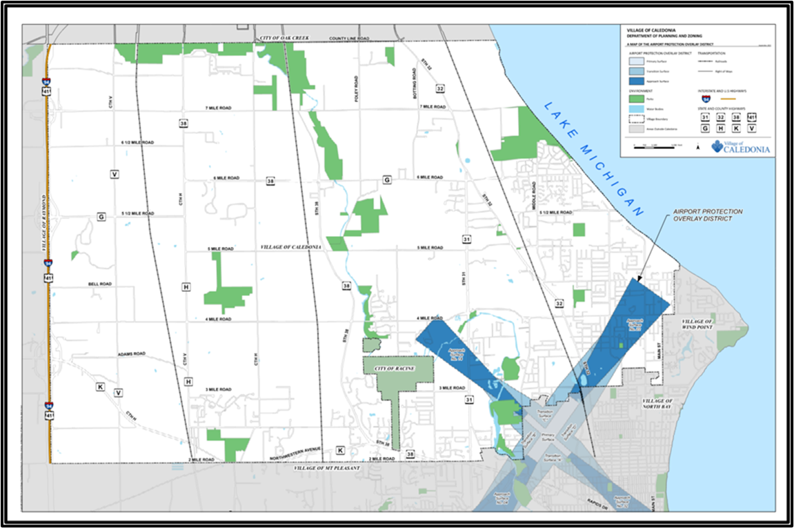
The airport protection overlay district is intended to maintain the existing utility of any airport in the county and prevent further encroachment or obstruction of the airspace necessary for safe landing, takeoff and maneuvering of aircraft. It is intended to protect any airport that is open for use by the general public. It is hereby declared that obstructions to the airspace required for the safe landing, takeoff and maneuvering of aircraft and that land uses which interfere with the safe operation of aircraft, have the potential for endangering lives and the property of users of the county airports and of those who occupy land in their vicinity.
(b)
It is therefore determined that the public safety and general welfare require the prohibition of hazardous land use and obstructions to the airspace necessary for safe air operations. So far as is practical, the provisions of this division regarding airport protection have been structured and modeled in accordance with Federal Aviation Regulations Part 77, Objects Affecting Navigable Airspace. The initial airport covered by the APO district is the Racine Commercial Airport, which has been designated by the federal aviation administration as an official reliever airport for General Mitchell Field and O'Hare International Airport in the category of general aviation.
(c)
Prohibited Uses.
(1)
No use may be made of any lands within the airport protection overlay district which will result in or cause any of the following:
a.
Interference with navigational signals or radio communications between airport and aircraft.
b.
Make it difficult for pilots to distinguish between airport lights and others by maintaining lights which resemble airport marker or navigational lights or aids.
c.
Result in causing glare in the eyes of pilots using the airport.
d.
Impair visibility from aircraft using the airport.
e.
Create bird strike hazards by creating bodies of water which attracts birds; or
f.
Otherwise interfere with the landing, takeoff or maneuvering of aircraft using or intending to use the airport.
(2)
Use of any land in the airport protection overlay district for solid waste disposal is prohibited.
(3)
This section shall not be construed as prohibiting the tilling of soil in normal farming operations or the use of land for retention of stormwater for short periods not to exceed forty-eight (48) hours.
(d)
Protected Surfaces. The following surfaces in the Airport Overlay District shall be protected:
(1)
Primary Surface. A surface whose elevation at any point is the same as the elevation at the nearest point on a runway and whose horizontal projection is bounded as follows: Begin at a point on the Section line between Section 31, Township 4 North, Range 23 East and Section 6, Township 3 North, Range 23 East which is located S88º07'45"W 35.56 feet from the southeast corner of said Section 31; run thence S35º25'36"W 329.76 feet; thence N54º34'24"W 1,000.00 feet; thenceN35º25'36"E 1,899.83 feet; thence N48º11'17"W 1,791.55 feet; thence N41º48'43"E 500.00 feet; thence S48º11'17"E 1,735.00 feet; thence N35º25'36"E 3,067.76 feet: thence S54º34'24"E 1,000.00 feet; thence S35º25'36"W 3,176.66 feet: thence S48º11'17"E 1,667.09 feet; thence S41º48'43"W 500.00 feet; thence N48º11'17"W 1,611.14 feet; thence S35º25'36"W 1,458.16 feet to the point of beginning.
(2)
Approach Surface No. 04. Commence at a point on the Section line between Section 31, Township 4 North, Range 23 East and Section 6, Township 3 North, Range 23 East, located S88º07'45"W 35.56 feet from the Southeast corner of said Section 31; run thence S35º25'36"W 329.76 feet to the point beginning of this description at elevation 667.20; run thence S26º53'45"W 5,157.06 feet to a point at elevation 817.20; thence S26º53'45"W 4,954.82 feet to a point at elevation 817.20; thence N54º34'24"W 4,000.00 feet to a point at elevation 817.20; thence N43º57'27"E 4,954.82 feet to a point at elevation 817.20; continue thence N43º57'27"E 4,954.82 feet to a point at elevation 817.20; continue thence N43º57'27"E 5,157.06 feet to a point at elevation 667.20; thence S54º34'24"E 1,000 feet to the point of beginning.
(3)
Approach Surface No. 14. Commence at a point on the East line of Section 31, Township 4 North, Range 23 East, located N01º21'46"W 1,953.40 feet from the Southeast corner of said Section 31; run thence N48º11'17"W 1,649.11 feet to the point of beginning of this description at elevation 668.61; run thence N53º53'55"W 3,768.70 feet to a point at elevation 818.61; continue thence N53º53'55"W 6,281.17 feet to a point at elevation 818.61; thence N41º48'43"E 2,500 feet to a point at elevation 818.61; thence S42º28'39"E 6,281.17 feet to a point at elevation 818.61; continue thence S42º28'39"E 3,768.70 feet to a point at elevation 668.61; thence S41º48'43"W 500.00 feet to the point of beginning.
(4)
Approach Surface No. 22. Commence at a point on the North-South ¼ line of Section 32, Township 4 North, Range 23 East, located N01º05'11"W1,715.72 feet from the center of said Section 32; run thence N54º34'24"W 539.97 feet to the point of beginning of this description at elevation 665.25; run thence N28º18'06"E 5,139.69 feet to a point at elevation 815.25; continue thence N28º18'06"E 4,938.13 feet to a point at elevation 815.25; thence S54º35'24"E 3,500.00 feet to a point at elevation 815.25; thence S42º33'06"W 4,938.13 feet to a point at elevation 815.25; continue thence S42º33'06"W 5,139.69 feet to a point at elevation 665.25; thence N54º34'24"W 1,000.00 feet to the point of beginning.
(5)
Approach Surface No. 32. Commence at a point on the North-South ¼ line of Section 32, Township 4 North, Range 23 East, located N00º47'06"W 194.51 feet from the South ¼ corner of said Section; run thence 53º53'55"W 361.46 feet to the point of beginning of this description at elevation 655.06; run thence S53º53'55"E 3,768.70 feet to a point at elevation 805.06; continue thence 53º53'55"E 6,281.17 feet to a point at elevation 805.06; thence S41º48'43"W 2,500 feet to a point at elevation 805.06; thence N42º28'39"W 6,281.17 feet to a point at elevation 805.06; continue thence N42º28'39"W 3,768.70 feet to a point at elevation 655.06; thence N41º48'43"E 500.00 feet to the point of beginning.
(6)
Transition Surface "A." Commence at a point on the Section line between Section 31, Township 4 North, Range 23 East and Section 6, Township 3 North, Range 23 East, located S88º07'45"W 35.56 feet from the Southeast corner of said Section 31; run thence S35º25'36"W 329.76 feet to the point of beginning of this description at elevation 667.20; run thence S26º53'45"W feet to a point at elevation 817.20; thence N38º37'31"E 5,107.96 feet to a point at elevation 817.20; thence N35º25'36"E 613.87 feet to a point at elevation 809.48; thence S48º11'17"E 437.08 feet to a point at elevation 805.06; thence S58º23'32"E 3,810.27 to a point at elevation 805.06; thence N42º28'39"W 3,768.70 feet to a point at elevation 655.06; thence N48º11'17"W 1,611.14 feet to a point on the primary surface; thence S35º25'36"W 1,787.93 feet to the point of beginning.
(7)
Transition Surface "B." Commence at a point on the East line of Section 31, Township 4 North, Range 23 East; located N01º21'46"W 1,953.40 feet from the Southeast corner of said Section 31; run thence N48º11'17"W 1,649.11 feet to the point of beginning of this description at elevation 668.61; thence S48º11'17"E 1,791.55 feet to a point on the primary surface; thence S35º25'36"W 1,899.83 feet to a point at elevation 667.20; thence S43º57'27"W 5,157.06 feet to a point at elevation 817.20; thence N32º13'41"E 5,107.96 feet to a point at elevation 817.20; thence N35º25'36"E 960.78 feet to a point at elevation 817.96; thence N48º11'17"W 852.50 feet to a point at elevation 818.61; thence N37º59'03"W 3,810.27 feet to a point at elevation 818.61; thence S53º53'55"E 3,768.70 feet to the point of beginning.
(8)
Transition Surface "C." Commence at a point on the East line of Section 31, Township 4 North, Range 23 East, located S01º21'26"E 24.73 feet from the East ¼ corner of said Section 31; run thence N48º11'17"W 1,180.00 feet to the point of beginning of this description at elevation 668.61; run thence N42º28'39"W 3,768.70 feet to a point at elevation 818.61; run thence S58º23'32"E 3,810.27 feet to a point at elevation 818.61; thence S48º11'17"E 561.54 feet to a point at elevation 818.20; thence N35º25'36"E 1,893.70 feet to a point at elevation 815.25; thence N40º03'03"E 5,116.65 feet to a point at elevation 815.25; thence S28º18'06"W 5,139.69 feet to a point at elevation 665.25; thence S35º25'36"W 3,067.76 feet to a point on the primary surface; thence N48º11'17"W 1,735.60 feet to the point of beginning.
(9)
Transition Surface "D." Commence at a point on the North-South ¼ line of Section 32, Township 4 North, Range 23 East located N00º47'06"W 194.51 feet from the South ¼ corner of said Section; run thence N53º53'55"W 361.46 feet to the point of beginning of this description at elevation 655.06; run thence N48º11'17"W 1,667.09 feet to a point on the primary surface; thence N35º25'36"E 3,179.66 feet to a point at elevation 665.25; thence N42º33'06"E 5,139.69 feet to a point at elevation 815.25; thence S30º48'09"W 5,116.65 feet to a point at elevation 815.25; thence S35º25'36"W 2,240.61 feet to a point at elevation 807.15; thence S48º11'17"E 728.04 feet to a point at elevation 805.06; thence S37º59'03"E 3,810.27 feet to a point at elevation 805.06; thence N53º53'55"w 3,768.70 feet to the point of beginning.
(e)
The overlay district shall encompass the area as identified on the Airport Protection Area Map for illustrations purposes only and as legally described in Section 16-6-23(d) excluding areas located outside the Village of Caledonia:
(Ord. No. 2022-23, 10/03/2022)

