
Calumet City City Zoning Code
Sec. XII
Administration.
12.1 Enforcing officer.
The building commissioner of the City of Calumet City shall be the zoning administrator of the City of Calumet City. Said administrator shall see that the provisions of this ordinance are properly enforced.
Restrictions on employees. No official or employee responsible for the enforcing of this ordinance shall engage directly or indirectly in the construction industry or the building professions, or in any type of gainful employment or business that conflicts with official duties or the interests of the business incorporated in this ordinance.
12.2 Zoning permit.
No building or structure shall be erected, reconstructed, enlarged, or moved until a permit shall have been applied for in writing and issued by the building commissioner. Said permit shall be posted in a prominent place on the premises prior to and during the period of erection, reconstruction, enlargement or moving.
Before a permit is issued for the erection, moving, alteration, enlargement or occupancy of any building, or structure or use of premises, the plans and intended use shall indicate conformity in all respects to the provisions of this ordinance.
Site plan. Every application for permit submitted to the building commissioner shall be accompanied by a site plan, drawn to scale, showing the zoning lot, required yards, the location of buildings on the lot, accurate dimensions of the lot, and any existing and proposed uses together with such other information as may be necessary for the enforcement of this ordinance.
Certain permit applications and zoning petitions may require site development plan approval under subsection 12.9 and landscape plan approval under subsection 12.10 of this ordinance.
12.3 Interpretation of ordinance.
In interpreting and applying the provisions of this ordinance, they shall be held to be the minimum requirements for the promotion of health, safety, morals, convenience of the general welfare.
12.4 Certificate of occupancy.
A certificate of occupancy to be issued by the building commissioner shall be required for any of the following, except buildings incidental to agricultural operations other than residences:
(a)
Occupancy and use of a building thereafter erected or enlarged;
(b)
Change in use of an existing building;
(c)
Occupancy and use of land to a use of a different classification, except for the raising of crops;
(d)
Change in the use of land to a use of a different classification, except for the raising of crops;
(e)
Any change in the use of a nonconforming use.
No such occupancy, use or change of use, shall take place until a certificate of occupancy therefore shall be issued.
Written application for a certificate of occupancy for a new building or for an existing building which has been enlarged shall be made at the same time as the application for the building permit for such building. Said certificate shall be acted upon within seven (7) days after a written request for the same has been made to the building commissioner after the erection or enlargement of such building or part thereof has been completed in conformance with the provisions of this ordinance.
Pending the issuance of such a certificate, a temporary certificate of occupancy may be issued by the building commissioner for a period of not more than six (6) months during the completion of the construction of the building or of alterations which are required under the terms of any law or ordinance. Such temporary certificate may be renewed, but it shall not be construed in any way to alter the respective rights, during or obligations of the owner or of the city relating to the use or occupancy of the land or building, or any other matter covered by this ordinance, and such temporary certificate shall not be issued except under such restrictions and provisions as will adequately ensure the safety of the occupants.
Written application for a certificate of occupancy for the use of vacant land, or for a change in the use of land or of a building, or for a change in a nonconforming use, as herein provided, shall be made to the building commissioner.
If the proposed use is in conformity with the provisions of this ordinance, the certificate of occupancy therefore shall be issued within seven (7) days after the application for the same has been made.
Each certificate of occupancy shall state that the building or proposed use of a building or land complies with all provisions of this ordinance.
A record of all certificates of occupancy shall be kept on file in the office of the building commissioner and a copy shall be forwarded on request, to any person having proprietary or tenancy interest in the building or land affected.
12.5 Zoning board of appeals.
Zoning board of appeals established.
There is hereby established a zoning board of appeals. Said zoning board of appeals shall consist of seven (7) members appointed by the mayor by and with the advice and consent of the city council of the City of Calumet City.
Each member so appointed shall serve for a term of five (5) years. Vacancies shall be filled in the same manner for the unexpired term. Members may be removed by the city council for cause after written charges have been filed and after a public hearing has been held if demanded by the member so charged.
One (1) of the members of said zoning board of appeals at the time of his appointment shall be designated by the mayor with the consent of the city council, as chairman of said zoning board of appeals and shall hold said office as chairman until a successor is appointed. Such chairman, or in his absence, the acting chairman, may administer oaths and compel the attendance of witnesses.
The zoning board of appeals shall have a secretary and may employ a court reporter who shall make and keep a record of all of its meetings and official acts.
The zoning board of appeals in existence at the time of the passage of this ordinance shall be recognized as the zoning board of appeals established under the provisions of this ordinance, and the members previously appointed under the old ordinance shall be recognized as members thereof, and shall serve for such period of time as designated at time of appointment, the time to run from the date of the original appointment under the old ordinance.
Jurisdiction.
The zoning board of appeals is hereby vested with the following jurisdiction and authority:
(a)
To hear and decide appeals from any order, requirement, decision or determination made by the zoning administrator under this ordinance;
(b)
To hear applications for variations from the terms provided in this zoning ordinance in the manner prescribed by, and subject to, the standards established herein, and make recommendations to the city council regarding such applications.
(c)
To review and make recommendations to the city council on certain proposed site plans and landscape plans in accord with subsection 12.9 and 12.10 of this ordinance.
Meetings.
All meetings of the zoning board of appeals shall be held at the call of the chairman and at such other times as the zoning board of appeals may determine.
All meetings of the zoning board of appeals shall be open to the public.
The zoning board of appeals shall keep minutes of its proceedings, showing the vote of each member upon every question, or absent or failing to vote, indicating such fact, and shall also keep records of its examinations and other official actions. Findings of fact shall be included in the minutes of each case and the reasons for granting or denying such application shall be specified. Every rule, regulations and every order, requirement, decision, or determination of the zoning board of appeals shall immediately be filed in the office of the executive secretary and shall be of public record.
The zoning board of appeals shall adopt its own rules of procedure and may require submission to each record, plats and other information necessary to make its determination. A copy of said rules and procedure, and all recommendations thereto, and shall be filed in the office of the building commissioner.
The minutes of the zoning board of appeals shall be open to public examination at reasonable hours.
Expenses incurred by the zoning board of appeals are to be itemized and shall be borne by Calumet City.
The building commissioner is authorized to require applicants for building permits as a condition for issuance of said permit to provide reasonable aesthetic and sound barriers between contiguous barriers which have different zoning classifications.
Finality of decisions of the zoning board of appeals. Decisions and findings of the zoning board of appeals on appeal from any order, requirement, decision or determination made by the zoning administration shall be final administrative determinations and shall be subject to review by court as by law may be provided.
12.6 Variations. [2]
Purpose. The zoning board of appeals, after a public hearing, may recommend that the city council vary the regulations of this ordinance in harmony with their general purpose and intent, only in the specific instances hereinafter set forth and only where the board of appeals made findings of fact in accordance with the standards hereinafter prescribed, and further finds that there are practical difficulties or particular hardships in the way of carrying out the strict letter of the regulations of this ordinance.
Application for variation and notice of hearing.
An application for a variation shall be filed in writing with the city clerk. The application shall contain such information as the zoning board of appeals may from time to time, by rule, require. The city council shall by motion or resolution refer the same to the zoning board of appeals.
The zoning board of appeals shall publish notice of a public hearing on the application for variation, stating the time and place and the purpose of the hearing. Notice shall be published at least fifteen (15) days but not more than thirty (30) days in a paper of general circulation in Calumet City. Notice of the public hearing may be mailed to the petitioner and the owners of all property deemed by the zoning board of appeals to be affected thereby.
The zoning board of appeals shall, within thirty (30) days after the public hearing or hearings, render its recommendation in writing to the owner or applicant and the city council of its action.
Standards for variations.
The zoning board of appeals shall not recommend a variance in the regulations of this ordinance, unless it shall make findings based upon the evidence presented to it in each specific case that each and all the standards for hardships set forth in the Illinois Municipal Code are complied with and specifically that:
(a)
Because of the particular physical surroundings, shape or topographical conditions of the specific property involved, a particular hardship to the owner would result, as distinguished from a mere inconvenience, if a strict letter of regulations were carried out.
(b)
The conditions upon which the petition for a variation is based are unique to the property for which the variance is sought and are not applicable, generally, to other property within the same zoning classification.
(c)
The alleged difficulty or hardship is caused by the ordinance and has not been created by any person presently having an interest in the property.
(d)
The granting of the variation will not be detrimental to the public welfare or injurious to other property or improvements in the neighborhood in which the property is located.
(e)
The proposed variation will not impair an adequate supply of light and air to adjacent property, or substantially increase the congestion in the public streets, or increase the danger of fire, or endanger the public safety, or substantially diminish or impair property values within the neighborhood.
The zoning board of appeals may impose such conditions and restrictions upon the premises benefitted by a variation as may be necessary to comply with the standards established in this subsection, to reduce or minimize the effect of such variation upon other property in the neighborhood and to better carry out the general intent of this ordinance.
Authorized variation.
Variations from the regulations of this ordinance shall be recommended by the zoning board of appeals only in accordance with the standards established in the above subsection, and may be granted only in the following instances and in not others:
(a)
To permit any yard or setback less than the yard to setback required by the applicable regulations, but by not more than twenty-five (25) percent.
(b)
To permit the use of a lot or lots for a use otherwise prohibited solely because of insufficient area or width of the lot or lots but in no event shall the respective area and width of the lot or lots be less than eighty (80) percent of the required area and width. The percentage set forth in this subparagraph is not to be reduced by any other percentage for minimum lot width and area set forth in this ordinance.
(c)
To permit the same off-street parking facility to qualify as required facilities for two (2) or more uses, provided the substantial use of such facility by each use does not take place at approximately the same hours of the same days of the week.
(d)
To reduce the applicable off-street parking or loading facilities required by not more than one (1) parking space or loading space, or twenty (20) percent of the applicable regulations, whichever number is greater.
(e)
To increase by not more than twenty-five (25) percent the maximum distance that required parking spaces are permitted to be located from the use served.
(f)
To increase by not more than twenty (20) percent the gross area of any sign.
(g)
To increase by not more than ten (10) percent the maximum gross floor area of any use so limited by the applicable regulations.
(h)
To exceed any of the authorized variations allowed under this section, when a lot of record or a zoning lot, vacant or legally used on the effective date of this ordinance, is by reason of the exercise of the right of eminent domain by any authorized governmental body or by reason of the conveyance under threat of an eminent domain proceeding reduced in size so that the remainder of said lot of record or zoning lot or structure on said lot does not conform with one (1) or more of the regulations of the district in which said lot of record or zoning lot or structure is located.
The concurring vote of four (4) members of the zoning board of appeals shall be necessary to recommend a variation.
12.7 Special uses.
Purpose. The development and execution of a zoning ordinance is based upon the division of the city into districts, within which districts the use of land and buildings and the bulk and location of building and structures in relation to the land are substantially uniform. It is recognized, however, that there are uses which because of their unique characteristics, cannot be properly classified in any particular district or districts without consideration, in each case of the impact of those uses upon neighboring land and of the public need for the particular user at the particular location. Such special uses fall into two (2) categories.
(a)
Uses publicly operated or traditionally affected with a public interest;
(b)
Uses entirely private in character but of such an unusual nature that their operation may give rise to unique problems with respect to their impact upon neighboring property or public facilities.
Initiation of special uses. Any person owning or having an interest in the subject property may file an application to use such land for one (1) or more of the special uses provided for in this ordinance in the zoning district in which the land is situated.
Application for special use. An application for a special use or expansion of a special use shall be filed with the city clerk and shall be accompanied by a site development plan and landscape plan in accord with subsections 12.9 and 12.10 of this ordinance.
Hearing on application. Upon receipt of the application referred to above, the zoning board of appeals shall hold at least one (1) public hearing. At least fifteen (15) days in advance of such hearings, but not more than thirty (30) days, notice of time, place and purpose of such hearing shall be published in a newspaper of general circulation in Calumet City.
Authorization. For each application for a special use, the zoning board of appeals shall report to the city council its findings and recommendations, including the stipulations of additional conditions and guarantees that such conditions will be complied with when they are deemed necessary for the protection of the public interest. The city council may grant or deny any application for a special use, provided, however, that in the event of written protest against any proposed special use, signed and acknowledged by the owners of twenty (20) percent of the frontage adjacent thereto, or across an alley, or directly opposite therefrom, such special use shall not be granted except by the favorable vote of two-thirds (⅔) of all the members of the city council.
Standards. No special use shall be recommended by the zoning board of appeals unless said zoning board of appeals shall find:
(a)
That the establishment, maintenance or operation of the special use will not be unreasonably detrimental to or endanger the public health, safety, morals, comfort or general welfare;
(b)
That the special use will not be injurious to the use and enjoyment of other property in the immediate vicinity for the purposes already permitted, nor substantially diminish and impair property values within the neighborhood;
(c)
That the establishment of the special use will not impede the normal and orderly development and improvement of surrounding property for uses permitted in the district;
(d)
That adequate utilities, access roads, drainage and/or other necessary facilities have been or are being provided;
(e)
That adequate measures have been or will be taken to provide ingress or egress so designed as to minimize traffic congestion in the public streets;
(f)
That the special use shall in all other respects conform to the applicable regulations of the district in which it is located, except as such regulations may in each instance be modified by the city council pursuant to the recommendations of the zoning board of appeals.
Conditions and guarantees. Prior to granting any special use, the mayor and city council shall stipulate such conditions and restrictions upon the establishment, location, construction, maintenance and operation of a special use as deemed necessary for the protection of the public interest and to secure compliance with the standards and requirements specified herein, or as may be from time to time required. In all cases in which special uses are granted, the mayor and city council shall require such evidence and guarantees as it may deem necessary as proof that the conditions stipulated in connection therewith are being, and will be, complied with.
Effect of denial of a special use. After a public hearing, no application for a special use which has been denied wholly or in part by the mayor and city council shall be resubmitted for a period of one (1) year from the date of said order of denial, except on the grounds of substantial new evidence or proof of changed conditions found to be valid by the zoning board of appeals, the mayor and city council.
Termination of special use permit. If work on the proposed development has not begun within six (6) months from the date of the authorization order of the mayor and city council, the authorization shall become null and void and all rights thereunder shall lapse. Upon written application, filed prior to the termination of the six (6) months time limit, the mayor and the city council may authorize a single extension of the time limit for a further period of not more than one (1) year.
12.7.5 Special Use Permit for Cannabis Business Establishments.
(a)
Application. All cannabis business establishments within the city shall require a special use permit and shall be processed in accordance with the provisions of section 12.7. In addition to the application requirements contained above, a cannabis business establishment must also submit the following:
A site plan containing the total square footage, security installations, building code compliance, parking, commercial vehicle loading and unloading, signage, areas designated for sales, cultivation, infusing, etc.
(b)
Standards. The zoning board of appeals shall consider the following factors when determining whether to grant a special use permit for a cannabis business establishment:
(1)
The impact of the proposed facility on existing or planned uses located within the vicinity of the subject property.
(2)
The proposed structure in which the facility will be located, including co-tenancy (if a multi-tenant building), total square footage, security installations/security plan, and building code compliance.
(3)
The hours of operation and anticipated number of customers/employees.
(4)
The anticipated parking demand and available private parking supply, including any unique demand for handicapped parking.
(5)
The anticipated traffic generation and adjacent roadway capacity.
(6)
Site design, including access points, internal site circulation, and commercial vehicle loading, unloading, and parking.
(7)
Proposed signage plan.
(8)
Any other criteria the zoning board of appeals determines is necessary to their decision-making.
(c)
Zoning regulations.
(1)
Cultivation centers.
i.
A medical cannabis cultivation center may not be located within two thousand five hundred (2,500) feet of the property line of a preexisting public or private nursery school, preschool, primary or secondary school, daycare home, residential care home, or area zoned for residential use.
ii.
A cannabis cultivation center may not be located within five hundred (500) feet of any school or daycare center.
iii.
An adult-use cannabis cultivation center may not be located in any area zoned for residential use.
iv.
A cannabis cultivation center may not contain more than two hundred ten thousand (210,000) square feet of canopy space for plants in the flowering stage.
(2)
Dispensaries.
i.
Dispensaries may not have drive-through window service
ii.
Dispensaries may not be located within one thousand five (1,500) feet of another existing dispensary.
iii.
Dispensaries may not be located within five hundred (500) feet of any school or daycare center.
(3)
Infusers.
i.
Infuser facilities may not be located in a house, apartment, condominium, or any area zoned for residential use.
ii.
Infusers may co-located with craft growers and/or dispensaries.
iii.
A cannabis infuser may not be located within five hundred (500) feet of any school or daycare center.
(4)
Craft growers.
i.
Craft grow facility may not be located in a house, apartment, condominium, or any area zoned for residential use.
ii.
The facility may contain no more than five thousand (5,000) square feet of canopy space for plants in the flowering stage.
iii.
The facility may not be located within one thousand five hundred (1,500) feet of another craft grower or cultivation center.
iv.
A cannabis craft grower may not be located within five hundred (500) feet of any school or daycare center.
v.
Craft growers may co-locate with processors and/or dispensaries.
(d)
Conditions. The city may require the applicant to install building enhancements such as security cameras, lighting, or other improvements or additional parking as a condition of issuing the special use permit to ensure the safety of employees and customers of the cannabis business establishment. Said improvements shall be determined based on the specific characteristics of the floor plan for a cannabis business establishment and the site on which it is located.
12.8 Planned development.
Purpose. To encourage the most orderly development of properties through advance planning and thus assure adequate standards for the development of residential neighborhoods; provide regulations to encourage a variety of dwelling types; assure adequate open space; protect residential areas from undue traffic congestion; protect residential areas from the intrusion of business, industrial and other land uses that may create an adverse effect upon the living environment; and thus promote the general welfare of the community.
Provisions. The basic provisions and requirements concerning planned developments are as follows: The subdivision, development and use of land as an integral unit, combining more than one (1) primary land use and which may provide for single-family residential, multiple-family residential, education, business, commercial, industrial, recreational, park and common open areas, may be described as planned development.
(a)
In its establishment and authorization as a special use, in addition to the foregoing provisions, the following procedures, requirements, restrictions, standards, and conditions shall be observed.
(b)
The planned development may be excepted from the provision of the subdivision regulations and of the zoning ordinance of Calumet City to the extent specified in this ordinance and in the final authorization of the planned development.
Procedure.
(a)
A pre-application conference shall be held with the building department. At such conference the applicant shall provide information as to the location of the proposed planned development, the uses, and approximate area of use category; a list of any and all exceptions to the subdivision and zoning ordinances of Calumet City; and any other information necessary to clearly explain the planned development to the building department.
(1)
The building department shall review and consider the proposed as to its compatibility with the comprehensive plan and the goals and policies for planning of Calumet City and advise the applicant on the information, documents, exhibits, drawings, and any limitations on the proposal that should be included in the application to the city for a special use permit for planned development.
(b)
The applicant shall request the special use permit, by letter addressed to the Calumet City Zoning Board, to be placed on the agenda of the zoning board for a preliminary discussion of the proposed planned development, and the zoning board shall consider the proposed planned development at such meeting, which may be continued from time to time. The applicant shall present such exhibits and written information as may be necessary to fully acquaint the plan commission with the proposed development which shall include, but not necessarily be limited to the following:
(1)
A tentative sketch plan, which may be in freehand sketch form, showing the location and extent of the types of land uses proposed.
(2)
The existing topography at five (5) foot contour intervals which may be taken from U.S.G.S. information.
(3)
Existing streets surrounding the subject property.
(4)
Existing utilities including storm drainage facilities.
(5)
The following shall be provided by either graphic exhibits or written statement:
The density of residential uses and the number of dwelling units by type;
The ancillary and nonresidential uses to be provided in a residential planned development;
The off-street parking and other service facilities proposed;
The exceptions or variations to the Calumet City zoning or subdivision requirements being requested as part of the planned development application.
(c)
Within thirty (30) days after final adjournment of the meeting, the plan commission shall submit to the mayor and city council a report in writing containing its recommendations.
(d)
The formal petition for a planned development shall be addressed to the mayor and city council and shall be filed with the city clerk; twenty (20) copies of the petition shall be filed with the secretary of the plan commission; attached to each copy shall be copies of the supporting documents and exhibits hereinafter provided for.
(e)
A filing fee in an amount of two dollars ($2.00) per dwelling unit or ten dollars ($10.00) per gross acres, whichever is greater, shall be paid to the city clerk at the time of such filing.
(f)
The city clerk shall set a hearing date which shall be not less than thirty (30) or more than sixty (60) days after the filing of the petition, and shall cause notice of the hearing to be published at least once, not more than thirty (30) days nor less than fifteen (15) days before said hearing date in one (1) or more newspapers of general circulation in Calumet City.
(g)
The city clerk shall forward a copy of the petition to the mayor and to each member of the zoning board of appeals.
(h)
The petition shall be heard by the zoning board of appeals and reviewed by the planning commission and the report of both committees shall be submitted to the mayor and the city council. The report of the findings and recommendations shall be accompanied by such plats, exhibits and agreements as shall have been presented by the petitioner, each identified for reference by letter or number together with any suggested changes therein.
(i)
The mayor and city council may grant a special use for a planned development which shall be by specific ordinance and which shall contain or to which shall be appended all terms and conditions of the special use permit, including covenants and agreements, guarantees, performance bonds, plats and the like.
Content of petition. The formal petition shall contain, in addition to all other requirements, the following:
(a)
A site plan of the planned development. This plan will be at a scale of not less than one inch equals one hundred feet (1" = 100') which shall show all proposed streets (public and private), street classifications, rights-of-way, pavement width of street and driveways, all principal and accessory buildings and their use, lot sizes, building lines, easements for utility services, off-street parking, service areas, open space, recreation facilities and any other information necessary to clearly show the proposed elements of the planned development.
(b)
Preliminary architectural plans for all residential buildings shall be submitted in sufficient detail to show the basic planning, the number of units per building and the number of bedrooms per dwelling unit.
Preliminary architectural plans are not required for business of other nonresidential buildings at the time of this application but must be submitted to the plan commission for its approval prior to filing an application for a building permit.
(c)
A topographic survey with two (2) foot contour intervals and boundary survey of the subject area, prepared and certified by a registered Illinois surveyor.
(d)
A rendered plan of the planned development area showing in contrasting colors or by other means the respective location of all categories of land use.
(e)
A map of Calumet City, Illinois showing the location of the planned development site and its relation to the existing roads and streets and use districts within the immediately adjacent and surrounding area.
(f)
Preliminary plans and outline specifications of the following improvements:
(1)
Roads, streets and alleys, including classifications, width of right-of-way, widths of paved surfaces and construction details.
(2)
Sidewalks, including widths of paved surfaces and construction details.
(3)
Sanitary and storm sewer system.
(4)
Water supply system.
(5)
Street lighting and public area lighting system.
(6)
Recommended installations for electric, gas and telephone facilities and distribution.
(7)
Sequence of phases or stages of development of the planned development.
(8)
A general landscape planting plan shall be prepared by a landscape architect and shall meet the approval of the plan commission.
(g)
Estimates of cost of installation of all proposed improvements, confirmed by a registered Illinois engineer.
(h)
Petitioner's proposed covenants, restrictions and conditions to be established as a part of the planned development.
Construction of improvements. The petitioner shall construct and install the required improvements and must post in accordance with the Calumet City Subdivision Control Ordinance.
Street classifications. Street classifications, definitions, and specifications, shall be in accord with the regulations pertaining to same as established in the subdivision regulations and the comprehensive plan of Calumet City, Illinois, as may be amended from time to time, as may be modified by the special use permit.
Standards. No planned development shall be authorized by the city council unless the plan commission shall find and recommend, in addition to those standards established herein for special uses, that the following standards will be met:
(a)
General.
(1)
The uses permitted by such exceptions as may be requested or recommended are necessary or desirable and appropriate to the purpose of the development.
(2)
The uses permitted in such development are not of such nature or so located as to exercise an undue detrimental influence or effect upon the surrounding neighborhood.
(3)
That any industrial park areas established in the planned development conform to all requirements therefore as set forth elsewhere in this ordinance.
(4)
That all minimum requirements pertaining to commercial, residential, institutional, or other uses established in the planned development shall be subject to the requirements for each individual classification as established elsewhere in this ordinance, except as may be specifically varied in the ordinance granting and establishing a planned development use.
(5)
When private streets and common driveways are made a part of the planned development or private common open space or recreation facilities are provided, the applicant shall submit as part of the application, the method and arrangement whereby these private facilities shall be operated and maintained. Such arrangements for operating and maintaining private facilities shall be subject to the approval of the mayor and city council.
(b)
Residential.
(1)
Residential density for a planned development shall not be greater than that specified in each use district for planned developments, nor shall any lot to be used for residential purposes be less in area or dimension than that required by the district regulations applicable to the district in which the planned development is located as specified in said district for planned developments. The plan commission may recommend and the mayor and city council may grant a reduction in such lot area and dimension, but not more than twenty (20) percent when the planned development provides common open space equal to not less than ten (10) percent of the gross area of the planned development.
(2)
Business uses may be included as part of a planned residential development when the plan commission finds that such business uses are beneficial to the overall planned development and will not be injurious to adjacent or neighboring properties. Such business uses shall not be greater in area than ten (10) percent of the planned development.
(3)
The open areas provided in the part of the planned development containing only residential structures shall be preserved over the life of the planned development for use only by the residents of the planned development or dedicated to Calumet City, Illinois for school, park playground or other public uses by an instrument or guarantee acceptable to the mayor and city council.
(4)
For that part of a planned development devoted to residential uses, the plan commission may recommend and the mayor and city council may approve, access to a dwelling by a driveway or pedestrian walk easement, and spacing between buildings of lesser widths or depths than required by district regulations for the district in which the planned development is located, provided:
That adequate provisions are made which perpetuate during the period of the special use, access easements and off-street parking spaces for use by the residents of the dwellings served;
The spacing between buildings shall be approved by the plan commission and shall be consistent with the application of recognized site planning principles for securing a unified development, and due consideration is given to the openness normally afforded by intervening streets and alleys. Minimum side yards between principal buildings within a part of a planned development where subsequent transfer of ownership is contemplated, shall be equivalent to side yards as would be required between buildings by district regulations for the district in which it is located; and
The yards for principal buildings along the periphery of the development shall be not less in width or depth than required for permitted uses in the district regulations applicable to the districts in which the planned development is located, and the plan is developed to afford adequate protection to neighboring properties as recommended by the zoning board and approved by the mayor and city council.
(c)
Variations of minimum requirements.
(1)
Residential. Wherever the applicant proposes to provide and set out, by platting, deed, dedication, restriction, or covenant, any land or space separate from single-family or multiple-family residential districts, to be used for parks, playgrounds, commons, greenways, or open areas, the zoning board, may consider and recommend to the mayor and the city council, and the mayor and city council may vary the applicable minimum requirements of the subdivision regulations and the zoning ordinance which may include but necessarily be limited to the following:
Rear yard.
Side yard.
Lot area.
Bulk.
Intensity of use.
Street width.
Sidewalks.
Public utilities.
Off-street parking.
(2)
Business.
Business uses shall be as prescribed by the zoning board.
All business and storage of materials shall be conducted or stored within a completely enclosed building.
Not more than thirty (30) percent of the lot area shall be covered by buildings or structures.
At least ten (10) percent of the lot shall be provided for landscape and open space purposes.
Off-street parking shall be provided and maintained on the same lot based upon three (3) square feet of parking space for each square foot of gross floor area unless the building commissioner recommends and the mayor and city council approves additional off-street parking space.
Service and loading and unloading facilities shall be provided as recommended and approved by the building commissioner.
No building shall be located nearer than fifty (50) feet to any street line.
Business developments shall be adequately screened by fencing or landscaping or both along the boundaries of adjacent residential, public open space, schools, churches, or other similar uses. The screen planting shall be prepared by a landscape architect and shall meet the approval of the building commissioner.
Outside lighting shall be so designed and placed so as to not be disturbing to adjacent residential areas.
Signs shall comply with the regulations of the business uses permitted in this ordinance.
12.9 State Street—State Line Road Redevelopment Area site development plan review.
(1)
Authority. The city council and the city council committee on development, subject to the procedures provided herein, have the authority to approve or disapprove site development plans required to be submitted for approval under this section.
(2)
Purpose. Site plan review and approval is required to ensure that the use and development of land within the State Street—State Line Road Redevelopment Project Area is undertaken in an orderly and proper manner which furthers the public health, safety and welfare and makes adequate provision to ensure the available of appropriate public and private services and amenities and for minimizing the adverse effects of such development.
The design, orientation and location of open spaces, buildings, structures and signs visible from public streets, places and ways has a material and substantial relationship to property values and the taxable values of property in the city and the cost of the municipal services provided thereto. Further, many neighborhoods in other urban and suburban communities have deteriorated in the past by reason of the lack of planning, neglect of proper maintenance standards and the erection of buildings and structures unsuitable to and incompatible with the character of the neighborhood or area, resulting in a reduction in property values.
Therefore, it is the policy of the city that these regulations be adopted to arrest and prevent deterioration of the function, character and appearance of the State Street and State Line Road Redevelopment Area; provide a favorable environment for residents and businesses; and preserve and enhance the general public welfare.
(3)
Approved plan, when required.
Site plan approval shall be required for any nonresidential development within the State Street—State Line Road Redevelopment Area, as illustrated in Figure 1, and under the following intended situations:
(a)
Any new principal structure intended and designed for nonresidential occupancy (or complete redevelopment of any site for nonresidential use) or the use of land for nonresidential purposes.
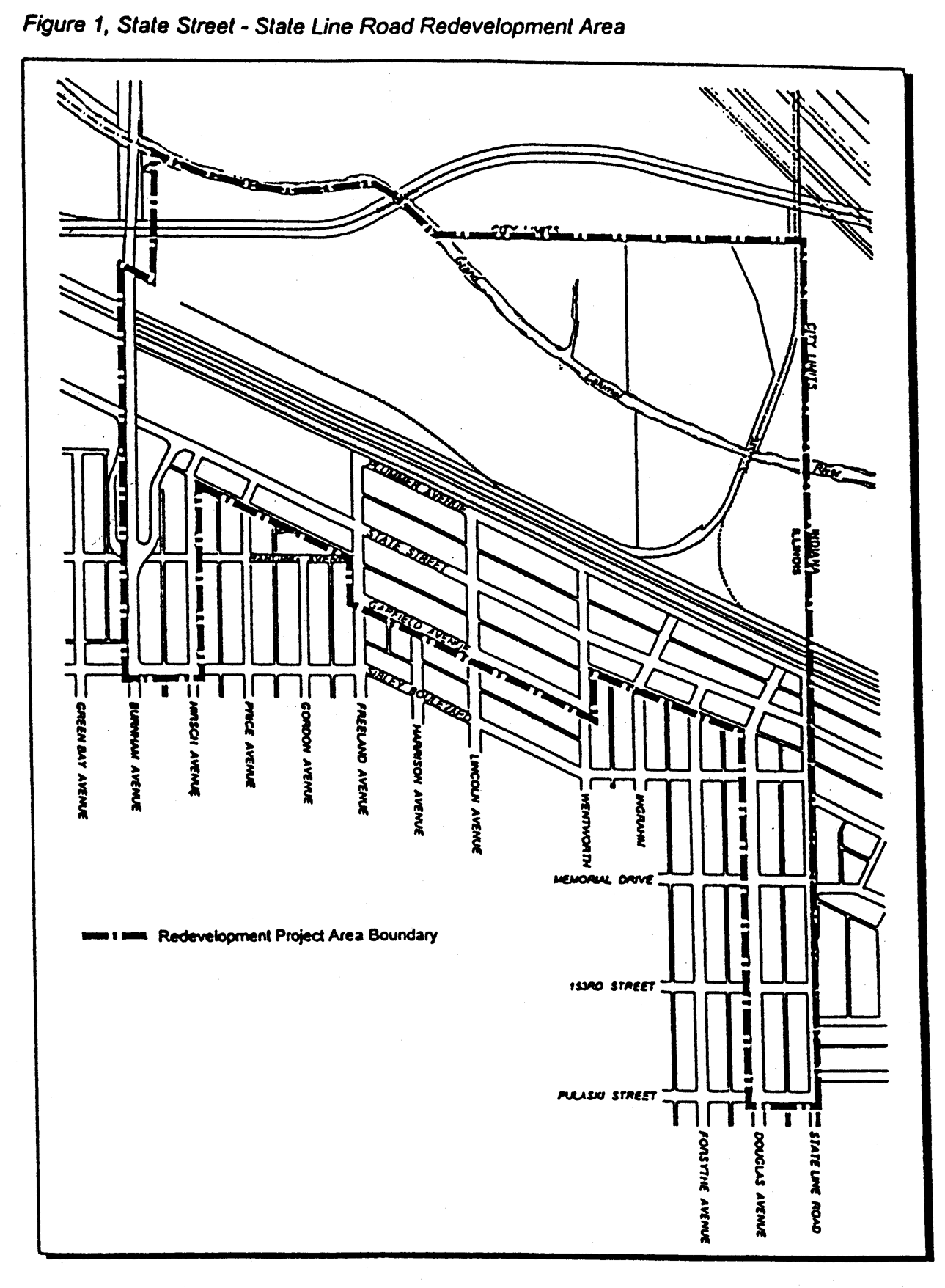
Figure 1, State Street - State Line Road Redevelopment Area
(b)
Where an existing principal structure erected prior to the date of adoption of these site plan requirements is proposed to be expended, for which the sum total of gross floor area expansion(s) since the date of these requirements are equal to or greater than thirty-five (35) percent of the total gross floor area of said structure.
(c)
Any new or modified building and/or site improvements for a zoning lot which has previously received site plan approval under this ordinance. Reapproval of the plan is required for components of the plan which depart from the approved site plan. The extent of changes to be incorporated in the submittal for reapproval shall be determined by the building commissioner.
(d)
A site plan shall not be required as a result of a change of use, except where such change of use results in increased off-street parking requirements which are not currently met on the site.
(e)
A site plan shall be required along with any application for a special use permit or a special use permit amendment for any nonresidential development.
(f)
These requirements exclude the legal reconstruction of legally nonconforming buildings, when such buildings and related improvements are substantially restored consistent with their prior condition.
Site plan review is not required as part of planned development approval (subsection 12.8), but may apply to development of individual sites following approval of a special use planned unit development, as controlled by the ordinance granting planned development approval.
(4)
Initiation. Plan approval shall be initiated by the owner of the property, or the owner's agent, for which plan approval is sought.
(5)
Procedure for initiation.
(a)
The owner of the property for which a zoning map amendment or a special use permit is sought (requiring site plan approval under subsection (3) above) shall file an application for site plan approval along with such application for an amendment or special use permit.
(b)
The owner of the property for which a building permit is sought (requiring site plan approval under section (3), above) and which development has not been approved under the requirements of this section, shall file an application for site plan approval along with an application for such building or zoning permit.
(c)
The owner of the property, or a duly authorized representative of the owner, shall file an application for site plan approval with the building commissioner, or his/her designee. It shall be accompanied by a nonrefundable fee established from time to time by the city council and shall contain the following information:
1.
Name, address and telephone number of the applicant including the name and address of each person or entity owning an interest in the applicant or owner and the extent of such ownership interest unless any of such entities is a corporation or a partnership, in which case only those persons owning an interest in excess of ten (10) percent in such corporation or partnership need be identified by name, address and extent of interest. For purposes of this section, the term ownership interest shall include any legal or equitable interest held at the time of the application in the real property which is the subject of the application. The application shall include the signature of the owner(s).
2.
A site plan containing the information required by subsection (6), below.
(6)
Contents of a site plan application. The application shall include the following information and material for sites and development projects which have not received site plan approval under this ordinance or prior to the adoption of this ordinance. For those sites and development projects which have received site plan approval subsequent to the adoption of this ordinance (excluding P.U.D.s) which require reapproval as a result of a change in planned conditions, the building commissioner is authorized to waive requirements in this section which are not affected by or do not apply to the proposed change:
(a)
Site plan application.
1.
A completed application form provided by the building department.
2.
Each application associated with a map zoning amendment or special use permit shall provide nineteen (19) copies of all full-size documents and drawings. For applications associated with an application for a building permit or zoning permit approval, twelve (12) copies of all full-sized documents and drawings shall be submitted. For all graphic and plan drawings, a scale of not less than one (1) inch equals one hundred (100) feet shall be used. In no event shall individual sheets or drawings exceed thirty (30) inches by forty-two (42) inches. In addition, one (1) set of reduced copies sized at eleven (11) inches by seventeen (17) inches shall be submitted.
3.
The names and addresses of the persons responsible for preparing the plan.
4.
The present zoning of the site and adjoining property.
5.
Any other information that may reasonably be required by the city council, city council committee on development, or the zoning board of appeals, as the case may be, which may include, but is not limited to, the following:
a.
A traffic study.
b.
In the case of a map amendment or special use, an analysis of the need and demand for the proposed use and the impact of the proposed use on the value of adjoining and nearby properties.
c.
A fiscal impact analysis.
(b)
An existing conditions map shall show the location, dimensions, size and height of the following, as applicable:
1.
Sidewalks, streets, alleys, easements and utilities, including street lighting and underground conduits for street lighting.
2.
Buildings and structures.
3.
Septic fields, wells and public sewer and water systems.
4.
Driveways, entrances, exits and parking areas.
5.
Water mains and fire hydrants.
6.
Natural and artificial watercourses and bodies of water and wetlands.
7.
Limits of floodplains, if any.
8.
Areas that can reasonably be expected to or which do contain soils or materials contaminated with any toxic or hazardous materials.
9.
Underground storage tanks, if any.
10.
The topography of existing ground and paved areas. Topography is to be shown by dashed lines illustrating one (1) foot standard contour intervals and by spot elevations where necessary to indicate flat areas.
11.
General alignment and lengths of all streets and all property lines.
12.
All building restriction lines, highway setback lines, easements, covenants, reservations and rights-of-way.
13.
Date, scale and north point.
(c)
A site plan shall be prepared to show the general location, dimensions, size and height of the following regarding the proposed development:
1.
For a site plan which includes any existing structures or other improvements, an indication of those improvements that are to remain and those which will be removed.
2.
Sidewalks, streets, alleys, easements and utilities, including any street lighting.
3.
Buildings and structures with entrances and exits identified.
4.
A general utility plan for water and for sewage disposal.
5.
Slopes, terraces and retaining walls.
6.
Driveways, entrances, exits, parking areas and sidewalks.
7.
Water mains and fire hydrants.
8.
Natural and artificial watercourses and bodies of water and wetlands.
9.
Distances between buildings.
10.
Calculations of the following, as applicable:
a.
Square footage of nonresidential structures/uses;
b.
Number of parking spaces;
c.
Number of loading spaces;
d.
Total land area;
e.
Total landscaped area;
f.
Total open space;
g.
Total impervious surface.
11.
Tentative plans for collecting and depositing storm water and the method of treatment of natural and artificial watercourses, including a delineation of proposed limits of floodplains, if any.
12.
A general indication of proposed grading, surface drainage, terraces, retaining wall heights, grades on paved areas and ground floor elevations of proposed buildings and structures.
13.
A landscape plan showing the location, names and area coverage of trees, shrubs and ground cover to be planted in accordance with subsection 12.10.
14.
Plans to remediate, remove, or control on site any contaminated soils, materials, underground storage tanks, etc.
15.
Plans for minimizing or mitigating the impact on existing wetlands, if any.
16.
Proposed locations and methods of enclosing refuse disposal systems.
17.
A light plan indicating all exterior building-mounted and freestanding lights and structures including overall height, type of lamp, luminaries.
18.
General exterior building elevation of all proposed structures and exterior elevations of existing buildings when existing buildings are proposed to be structurally altered.
(7)
Agreement of owner. All documents and information submitted as part of an application for site plan approval constitute a statement by the applicant that he or she intends and agrees to be bound to develop in accord with such information upon approval.
(8)
Notice requirements. Site plans do not require any form of public notice; however, a site plan application concurrently filed with an application for a zoning map amendment or an application for a special use permit shall state that site plan approval is sought as part of the public notice in addition to the requested map and/or special use permit amendment.
(9)
Procedure for decisions. Plans which are filed with an application for a zoning map amendment or with an application for a special use permit shall be processed as a part of the amendment or special use petition. All other site plans shall be approved under the following procedure.
(a)
Action by city council committee on development. Within sixty (60) days of the date that the site plan application was filed, the item shall appear on the agenda of the city council committee on development. The city council committee on development shall approve or deny the site plan. Approval shall be made upon action by a majority vote of those committee members present.
(10)
Standards for plans. In reaching a decision to approve or disapprove a site plan, the following factors listed below, as applicable to a given plan, should be considered.
(a)
The application shall comply with the provisions of this ordinance and other ordinances of the city and of any other applicable laws.
(b)
Reasonable provision shall be made to ensure that development will be served by essential public facilities and services such as highways, streets, parking spaces, police and fire protection, drainage structures, refuse disposal, water and sewers.
(c)
Any building or structure shall be reasonably accessible to fire, police, emergency and service vehicles. When deemed necessary for access, emergency vehicle easements shall be provided. The access for fire, police and emergency vehicles shall be unobstructed at all times.
(d)
Streets and sidewalks shall, insofar as reasonably practicable, provide access and good traffic circulation to and from adjacent lands, existing streets and sidewalks.
(e)
Provision shall be made to ensure that adequate access roads or entrance or exit drives will be provided and will be designed and improved so as to prevent traffic hazards or problems and to minimize traffic congestion in public streets.
(f)
Plans have demonstrated the ability to provide for the adequate collection and disposition of all on- and off-site storm water and natural water, including but not limited to on-site drainage retention facilities.
(g)
Adequate provision shall be made to clean, control and otherwise alleviate contamination or environmental hazards on land when the site is in an area found by the city to be contaminated by a toxic substance or otherwise to contain environmental hazards which are detrimental to the public health, safety and welfare.
(h)
Adequate provision shall be made to avoid glare of vehicular and stationary lights that would affect the established character of the neighborhood, and to the extend such lights will be visible across from any property line, the performance standards for illumination shall be met.
(i)
Adequate provision shall be made to ensure that the location, lighting and type of signs and the relationship of signs to traffic control is appropriate for the site and will not have an adverse affect on any adjacent properties.
(11)
Conditions on plans. The city council, or city council committee on development, as appropriate, in consideration of any site plan, may impose certain conditions in granting plan approval to minimize any negative impacts or minimize any adverse impacts due to the development.
(12)
Modifications of plans. Changes to site plans require reconsideration and reapproval by the city council or the city council committee on development, as provided in this subsection.
(13)
Lapse of approval. Unless the city council, or the city council committee on development, as appropriate, provides otherwise, or unless the city council has extended the term of site plan approval, plan approval shall automatically lapse one (1) year after the date of approval of the plan, unless a building permit has been issued and construction commenced.
12.10 Landscape plan approval.
(1)
Purpose. The landscaping, screening and site design requirements specified herein are intended to foster aesthetically pleasing and functional development. The regulations are intended to increase the compatibility between adjacent land uses and accessory structures and uses within and between developments within the State Street—State Line Road subarea. The requirements serve to minimize impacts from noise, dust, debris and motor vehicle headlight glare to surrounding land use areas.
(2)
Landscape plans, when required. Landscaped plans shall be required for all developments requiring site plan approval (under subsection (9) above) for land located within the State Street—State Line Road Redevelopment Area, as illustrated in Figure 1.
The procedure for landscape plan approval shall follow the procedure for site plan approval. When required, landscape plans shall be prepared in accordance with the requirements of this subsection.
(3)
Submission requirements. Each application association with a map zoning amendment or special use permit shall provide nineteen (19) copies of all full-sized documents and drawings. For applications associated with an application for a building permit or zoning permit approval, twelve (12) copies of all full-sized documents and document and drawings shall be submitted. For all graphic and plan drawings, a scale of not less than one (1) inch equals one hundred (100) feet shall be used. Preferably, the scale of landscape plans shall be the same as the accompanying site plan. In no event, however, shall individual sheets or drawings exceed thirty (30) inches by forty-two (42) inches. In addition, one (1) reduced set of plans to eleven (11) inches by seventeen (17) inches shall be submitted.
(4)
Requirements for a landscaping plan. A landscape plan shall include the following elements:
(a)
A completed application form and appropriate fee.
(b)
Consistent with the site development plan, the locations and dimensions of all existing and/or proposed parking lots, drives, roadways, and rights-of-way, sidewalks, bicycle paths, free-standing signs, refuse disposal areas, bicycle parking areas, free-standing electrical equipment, free-standing signs, building-mounted, heating, ventilating and air circulation equipment, and all fences.
(c)
Species, planting size and location of proposed plant material required under this subsection.
(d)
Illustrations indicating the proposed locations and methods for screening for refuse disposal areas.
(e)
The location of all off-street loading areas, including an indication whether loading docks will be enclosed and methods of proposed screening.
(f)
The location and placement of sprinkler heads of any proposed irrigation system.
(g)
The following calculation, in square feet, displayed on the landscape plan:
1.
Total site area;
2.
Total area devoted to off-street parking (including access drives);
3.
Total area devoted to impervious surfaces;
4.
Total landscaped area;
5.
Total parking lot landscaped area;
6.
Total internal landscaping.
(h)
Any other plan documentation requirements, including elevations, cross-sections and other plan details as deemed necessary by the building commissioner.
(4.1)
Requirements for interior parking lot landscaping.
(a)
Applicability. Parking lot landscaping shall apply to all nonresidential development within all residential zoning districts and shall meet the requirements of this section. Interior parking lot landscaping shall apply to developments requiring eight (8) or more off-street parking spaces.
(b)
Interior parking lot landscaping.
1.
Coverage. Not less than five (5) percent of the interior of a parking lot shall be devoted to landscaping. The "interior" of a parking lot shall mean the area encompassed between the backs-of-curbs or edge of pavement encompassing the drives and parking area serving the site. Perimeter landscaping islands penetrating the parking area may count toward the five (5) percent minimum landscaping requirement, provided all other requirements are met. Transitional yards shall not count toward parking lot landscaping.
2.
Landscape areas. Interior parking lot landscaping is intended to be distributed throughout the parking lot. The design should facilitate pedestrian access through the site and seek to separate vehicle traffic from pedestrian traffic.
3.
Landscaping material.
a.
Type. The primary landscaping materials used in parking lots shall be shade trees which provide for shade. Ornamental trees, shrubbery and other live planting material may be used to supplement shade trees.
b.
Quantity. One (1) large to medium shade tree shall be provided for each one hundred eighty (180) square feet of landscaped area.
c.
Ground cover. A minimum of seventy-five (75) percent of each interior parking lot landscaping area shall be composed of live landscape material.
(5)
Requirements for perimeter parking lot landscaping.
(a)
Applicability. Perimeter parking lot landscaping shall be required except where parking lots are adjacent to a required transitional yard. Perimeter parking lot landscaping shall apply to all off-street parking areas regardless of size.
(b)
Landscaping.
1.
Planting material.
Across from or adjoining a nonresidential property. Where a parking lot is located across a dedicated public right-of-way from or adjoins property zoned for a nonresidential use, or is designated for nonresidential use in the State Street—State Line Road Implementation Plan, landscaping shall be provided across fifty (50) percent of the street frontage to a minimum of three (3) feet in height. Such landscaping shall consist of shrubbery.
Across from a residential property. Where a parking lot is located across a dedicated public right-of-way from property zoned for a residential district, or is designated for a residential use in the State Street—State Line Road Implementation Plan, landscaping shall be provided across one hundred (100) percent of the parking lot perimeter facing the public street (except for intersecting drives, signs and other obstructions to landscaping) to a minimum of three (3) feet in height. Such landscaping shall consist of shrubbery.
2.
Ground cover. Except where occupied by planting beds, all perimeter parking lot landscaped areas located in a front yard shall be seeded or sodded.
(6)
Requirements for transitional yards.
(a)
Applicability. Transitional yards are intended to provide a physical separation between potentially incompatible land uses. In all cases where a transitional yard is required, the requirements of this section shall substitute for any parking lot screening requirement along the portion of any affected yard.
Screening is required within the transitional yard(s) of a nonresidential development where the nonresidential development directly adjoins a residential district or land designated for residential use in the State Street—State Line Road Implementation Plan. This requirement does not apply to a nonresidential development which lies across public street right-of-way of land zoned or designated in the State Street—State Line Road Implementation Plan for residential use. This requirement does apply to a nonresidential development which lies across public alley right-of-way of land zoned or designated in the State Street—State Line Road Implementation Plan for residential use.
(b)
Screening requirements in the B, B-2, and B-3 zoning districts. A screen shall consist of a solid fence, wall, or landscaping, or a combination thereof to provide a year-round solid visual screen at a minimum height of six (6) feet. Building walls of principal structures may substitute for fencing and/or landscaping, provided such walls are greater than six (6) feet in height, are located within five (5) of the property line along the transition yard, and when combined with any other screening materials, establish a continuous screen along the entire width of the yard.
Where landscaping is utilized as screening in a transitional yard, the minimum dimension of any planting area shall be five (5) feet for shrubs and seven (7) feet for trees.
(c)
Screening requirements in the OR, M-1 and M-2 districts
(1)
Screening and berming.
a.
Screening. Screening shall consist of solid fences, decorative walls, or landscaping or any combination thereof, and shall be used to provide a year-round solid visual screen to a minimum height of six (6) feet.
b.
Berming. Transition yards may include earth berms. The design of berms is encouraged to provide a change in topographical orientation ad undulation. Side slopes are preferred at a ratio of four to one (4:1), although a maximum side slope of three to one (3:1) is permitted. Plantings placed on top of berms are restricted to species compatible with the terrain.
(7)
Tree preservation. For landscape plans which propose to preserve existing trees, the methods which are to be used to preserve those trees shall be clearly specified in the landscape plan. If, in the opinion of the building commissioner, the necessary precautions, as specified in the tree preservation plan for the development, were not undertaken before or during construction to ensure the preservation of those trees, the land development permit for the parcel shall not be issued or, if previously issued, may be revoked until such time as these precautions have been complied with. The following precautions shall be taken in connection with new development proximate to existing trees:
(a)
Grading and construction equipment. All grading and construction equipment shall not encroach upon the trees' drip lines.
(b)
Materials detrimental to trees. Crushed limestone and other materials detrimental to trees shall not be dumped within the drip line of any trees nor at any higher location where drainage toward the tree could conceivably affect the health of the tree.
(c)
Installation of snow fencing. Snow fencing shall be installed at the periphery of the trees' drip lines.
(8)
Screening and landscaping requirements for building appurtenances and related elements.
(a)
Exterior electrical and utility equipment. All ground-mounted electrical and utility-related connection and service boxes shall be effectively screened with shrubbery or other forms of living plant material to a minimum of fifty (50) percent opacity at the time of planting. Alternative methods of screening may be approved by the building commissioner where it is found that the size or positioning of the equipment to be screened presents unique conditions or difficulty in accomplishing the intent of this paragraph. This provision is not intended to apply to individual service pedestals less than twelve (12) inches by twelve (12) inches.
(b)
Free-standing signs. All free-standing sign locations shall provide for landscaping around the base of the sign a minimum of two (2) feet from any portion of the base of the sign. Landscaping shall include shrubbery or annual flowering plant material or other plant material.
(9)
Minimum planting requirements.
(a)
Minimum planting sizes shall be as follows:
1.
Large deciduous shade trees—Three (3) inches caliper as measured six (6) inches above ground.
2.
Medium deciduous shade trees—Two and one-half (2.5) inches caliper as measured six (6) inches above ground.
3.
Small deciduous and ornamental trees—Eight (8) feet in height, with the exception of true dwarf species.
4.
Evergreens—Six (6) feet in height.
5.
Shrubs—Twenty-four (24) inches.
6.
Ground cover plants, whether in the form of crowns, plugs or containers, shall be planted in numbers appropriate by species to provide fifty (50) percent surface coverage after one (1) growing season.
(b)
Methods of determining planting sizes shall be as follows: This section outlines acceptable specifications for shade trees and flowering trees.
1.
Shade and flowering trees. In size grading baled and burlapped trees, caliper size shall take precedence over tree height. For purposes of simplicity, only one (1) size per "grade" will be listed. That size will be the minimum size allowable for that grade and shall include plants from that size up to but not including the next larger grade size. (Example: Acer rubrum, two (2) inch caliper. This could include Acer rubrum calipering two (2) inches up to but not including two and one-half (2½) inches in caliper, measured six (6) inches above the ground line.)
The caliper of the trunk shall be taken six (6) inches above the ground up to and including four (4) inch caliper size, and twelve (12) inches above the ground for larger sizes. Seldom are tree trunks perfectly round. Therefore, caliper measurement may be taken with "slot" type caliper, "pincer" type caliper, or diameter tape.
2.
Conifers and evergreens. For purposes of simplicity, only one (1) size per "grade" will be used. That size will be the minimum size allowable for the grade, and the grade shall include plants from that size up to but not including the next larger grade size. (Example: Taxus media "Brownii" fifteen (15) inches. This could include Taxus media "Brownii" fifteen (15) inches in height up to but not including eighteen (18) inches and having a minimum spread of twelve (12) inches.)
The following height measurement units shall apply: Three-inch intervals up to eighteen (18) inches in height. Six-inch intervals from eighteen (18) inches to four (4) feet one (1) foot intervals greater than four (4) feet.
3.
Deciduous shrubs. This section outlines acceptable specifications for deciduous shrubs, dwarf and semi-dwarf shrubs and strong growing shrubs.
For purposes of simplicity, only one (1) size per "grade" will be used. That size will be the minimum size allowable for that grade, and the grade shall include plants from that size up to but not including the next larger grade size. (Example: Forsythia, two (2) feet. This could include Forsythia plants with not less than three (3) two 920 foot canes up to but not including four (4) three-foot canes.)
Dwarf and semi-dwarf shrubs. Determine height in inches up to twenty-four (24) inches; above twenty-four (24) inches determine height in feet. Grade in three-inch series to eighteen (18) inches, six-inch series eighteen (18) to twenty-four (24) inches. (example 12 in.; 15 in.; 18 in.; 2 ft.; 2½ ft.)
Strong growing shrubs. Determine height in six-inch series up to twenty-four (24) inches tall (example: 12 in., 18 in.); over twenty-four (24) inches, measure in single feet up to six (6) feet tall; over six (6) feet; measure in two (2) foot increments. (Example: 5 ft., 6 ft., 8 ft., 10 ft.)
(c)
Ground cover specifications. All open areas of the development which are not paved, sodded or otherwise landscaped shall have a new lawn established through seeding.
(10)
Plant material, prohibited plant varieties.
(a)
The following plants are restricted from use in any areas covered by this ordinance.
(11)
Landscaping maintenance. Trees, shrubs, and other landscaping materials depicted on landscaping plans approved by the city shall be considered to be elements of the project in the same manner as parking, building materials and other details. The developer, its successor and/or subsequent owners and their agents shall be responsible for maintenance of landscaping on the property on a continuing basis for the life of the development. Plant materials which exhibit evidence of insect pests, disease and/or damage shall be appropriately treated, and dead plants promptly removed and replaced within the next planting season after installation. All landscaping will be subject to periodic inspection by the building commissioner, or his or her designee. Should landscaping not be installed, maintained and replaced as needed to comply with the approved plan, the owner and its agent or agents shall be considered in violation of the terms of the certificate of occupancy. The building commissioner is empowered to enforce the terms of this article.
(a)
As a condition to issuance of a certificate of occupancy, a cash escrow or irrevocable letter of credit in the amount of twenty-five (25) percent of the initial landscaping costs shall be posted to ensure the needed replacement of materials and the continued maintenance of the same for a period of two (2) years after initial installation. Said cash escrow or irrevocable letter of credit may be forfeited if the necessary maintenance and replacement has not been performed in a satisfactory manner within the two (2) year period. Further, should it be determined that the landscaping as approved on the landscaping plan is not being maintained as specified beyond the initial two (2) year maintenance period, resubmission of the approved plan and the posting of an additional maintenance escrow may be required by the city.
(12)
Administrative relief. A written application for administrative relief of [from] the requirements of subsections (4), (5) and (6) may be filed with the building commissioner as part of an application for landscape plan approval. Nineteen (19) copies of the application and all supporting documentation shall be submitted. Such application shall be submitted with the landscape plan and demonstrate the following:
(a)
The strict application of the regulation in question is unreasonable given the development proposal or the measures proposed by the applicant, or, that the property has extraordinary or exceptional physical conflicts that do not generally exist in nearby properties in the same zoning district and such conditions will not allow a reasonable use of the property in absence of relief.
(b)
Dependent upon the approval process under which the application for relief is sought, the approving authority shall make the final decision upon whether any relief from these requirements may be approved.
(c)
In granting any administrative relief, the city council, or city council committee on development, may require alternative improvements, or stipulate such conditions as appropriate.
(13)
Effect of approval; plan revisions. An application may be made following the initial submission of a landscape plan to propose alternatives or changes to the approved plan or any plans pending approval, or as may be requested by the city. Any alterations or changes to a plan document upon resubmission to the building commissioner shall include plan copies required under subsection (3), above together with a written statement indicating all changes made and a revision block on the face of the plan(s) indicating each date of revision.
All plan changes shall be represented on the face of the plan(s) by notation encompassing the area of change and with reference to the written statement of changes. Except where changes are noted, the content of the plan is presumed to be that of the last plan accepted by the building commissioner. The building commissioner may reject any plan changes where insufficient documentation of the location and nature of the change(s) lends the proposed revisions uninterpretable.
Any proposed changes to a landscape plan following final action on the plan shall constitute a new application subject to the procedures and requirements of this subsection.
(Code 1980, App. B, § XII; Ord. No 96-30, § 1(Exh. A), 5-23-1996; Ord. No. 00-44, § 2, 8-24-2000; Ord. No. 20-19, § 6, 4-9-2020)
Cross reference— Administration, ch. 2.
Editor's note— Section 3 of Ord. No. 00-44 adopted Aug. 24, 2000, states "that all billboards in existence on the effective date of this ordinance are hereby exempt from the requirements of Section 2."