
Canal Winchester City Zoning Code
TITLE ONE
Subdivision Regulations
CHAPTER 1130 Planning and Zoning Residential Standards
EDITOR’S NOTE: Former Chapter 1130 was repealed by Ordinance 20-008, passed April 6, 2020.
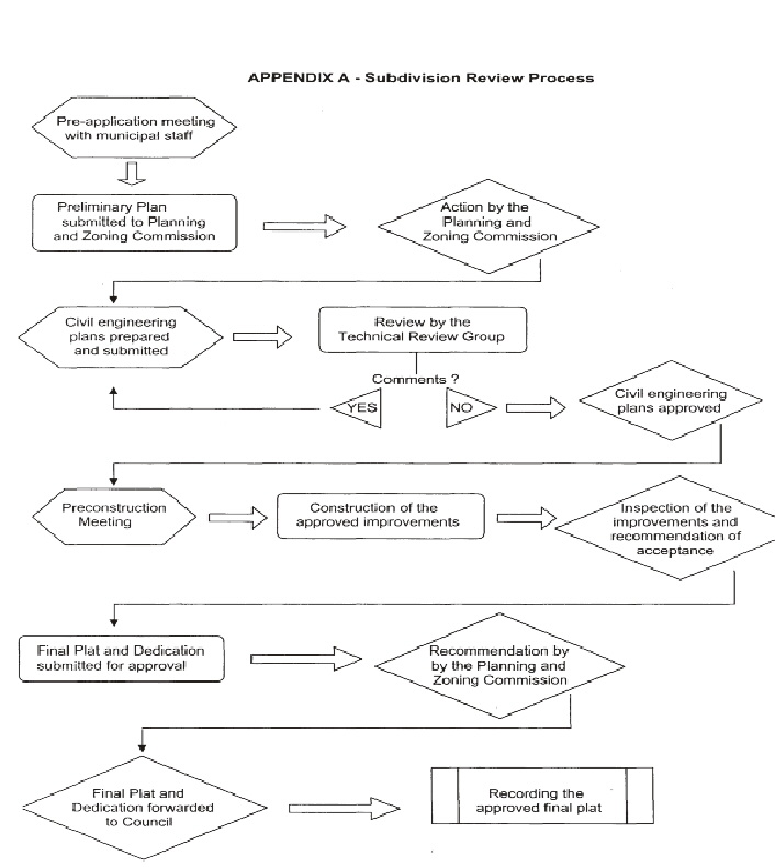
APPENDIX A
 |
APPENDIX B - Final Plat Language
The following wording shall be shown on the final plat: Situated in the Village of Canal Winchester, County of __________, State of Ohio, and being of Section __________, Township Range (Land Grant - U.S. Military Lands, etc) containing _____ acres and being the same tract as conveyed to _______________ and described in deed recorded in Deed Book ______, Page ______, Recorder's Office, __________ County, Ohio. We, the undersigned, being all the owners and lien holders of the land platted herein, certify that the attached final plat correctly represents our _______________, a subdivision of lots ______ to ______ inclusive, do hereby accept this final plat of same, and do voluntarily consent to the execution of said final plat. (NOTE: If any new streets are platted, the following statement must be included). All streets shown hereon will not be accepted for public use until such time as construction is complete and said streets are formally accepted as such by the Village of Canal Winchester. In Witness thereof _______________ have hereunto set their hands this day of _______________, 20___. Witness _______________ Signed _______________ _______________ _______________ Easements are reserved for the construction, operation and maintenance of all public and private utilities proposed above and beneath the surface of the ground, and where necessary, are for the construction, operation and maintenance of service connections to all lots and lands, and for stormwater drainage. Structures are not permitted within easements. No landscaping shall interfere with the right to construct, operate and maintain utilities and service connections, and shall not interfere with stormwater drainage. In Witness thereof _______________ have hereunto set their hands this day of _______________, 20___. Witness _______________ Signed _______________ _______________ _______________
Surveyed and Platted by ______________________________ Civil Engineer and/or Surveyor We do hereby certify that we have surveyed the premises and prepared the attached plat and that said plat is correct and meets the minimum standards for boundary surveys in the State of Ohio. The dimensions of the lots and streets are shown in feet and decimal parts thereof. Dimensions on curves are chord measurements. By ____________________ Registered Surveyor State of Ohio
Before me a Notary Public for said State personally came _______________ who acknowledged the signing of the foregoing instrument to be their voluntary act and deed (and voluntary corporate on partnership act and deed) for uses and purposes therein expressed. In witness whereof I have hereunto set my hand and affixed my official seal this day of _______________, 20___. _______________ Notary Public
Approved this _____ day of __________, 20___ ______________________________ Planning and Zoning Administrator
Approved this _____ day of __________, 20___ ______________________________ Chair, Planning & Zoning Commission
Approved this _____ day of __________, 20___ ______________________________ Municipal Engineer
This _____ day of __________, 20___, rights-of-way for all roads, boulevards, etc., herein dedicated to public use are hereby approved and accepted as such for the Village of Canal Winchester. ______________________________ ______________________________ Mayor, Village of Canal Winchester Clerk of Council Village of Canal Winchester
NOTE: This plat shall not be transferred or recorded until all above required signatures are placed on this final plat. This plat shall be recorded by _______________________, 20________.
Transferred this _____ day of __________, 20___. _____________________________ County Auditor
Filed for record this _____ day of __________, 20___, at __________M. Recorded this _____ day of __________, 20___, in Plat Book _____, Page No. _____ [ for Franklin County ]
Cabinet ______, Slot ______ [ for Fairfield County ]. _______________ _______________ County Recorder Deputy Recorder |
Appendix C - Subdivider's Agreement
THIS AGREEMENT is entered into this ______ day of ______________, 20__, between the Village of Canal Winchester and, being the owner/developer of a tract of land situated in the Village of Canal Winchester, hereinafter referred as the SUBDIVIDER, as evidenced by the (Project Name) _____________________ Subdivision Plat to be filed with the (County) Recorder, _______________ County, Ohio. NOW THEREFORE, in consideration of the mutual covenants contained herein and other good and valuable consideration, the parties hereby agree as follows: Said SUBDIVIDER is to construct, install and complete all public improvements shown on the improvement plan on file with the Village of Canal Winchester in compliance with the approved engineering drawings and specifications, all of which are a part of this AGREEMENT. Said SUBDIVIDER is to execute a Performance Bond, certified check, irrevocable letter of credit, or other approved financial surety equal to the cost of construction as shown in the Project Engineer's Estimate, which has been reviewed by the Village Engineer and is acceptable to the Village of Canal Winchester, to insure faithful performance of this AGREEMENT and the completion of all improvements in accordance with the Subdivision Regulations of the Village of Canal Winchester, Ohio. The SUBDIVIDER shall pay the entire cost and expenses of said improvements. The SUBDIVIDER agrees to release, indemnify and hold harmless the Village of Canal Winchester and its officials, employees and/or agents from all claims, suits, actions and proceedings which may originate from or on account of any death, injuries or damages to persons or property arising form or sustained as a consequence of any actions or omissions of SUBDIVIDER or its contractors or subcontractors in the performance of the work set forth in this AGREEMENT. All public improvement construction shall be performed within one year from the date on which this AGREEMENT is executed by the Village of Canal Winchester and SUBDIVIDER. Daily construction work shall only be between the hours of 7 a.m. and 6 p.m., unless otherwise authorized by the village. The SUBDIVIDER shall have a competent representative who is familiar with the project on site during construction. The representative shall be capable of reading plans and specifications and shall have the authority to execute the plans and specifications and alterations required by the Village of Canal Winchester. The representative shall be replaced by the SUBDIVIDER when, in the opinion of the Village of Canal Winchester, his/her performance is deemed inadequate. The SUBDIVIDER further agrees that the Village of Canal Winchester shall have the right to stop work forthwith and act against the performance surety for the purpose of proper abandonment and/or completion of the public improvements within this subdivision as the Village shall deem necessary and appropriate in the event SUBDIVIDER defaults on its obligations to install the public improvements in accordance with the terms and conditions of this AGREEMENT.
It is further agreed that upon execution of this AGREEMENT, the SUBDIVIDER shall deposit $___________________ dollars estimated to be necessary to pay the cost of inspection by the Village of Canal Winchester and, if deemed necessary by the Village of Canal Winchester, testing by an independent testing laboratory. The SUBDIVIDER agrees to deposit additional funds when, upon notice by the Village of Canal Winchester, the inspection and testing fees are anticipated to exceed
the original retainage amount. Upon completion and acceptance of the construction, the remaining amount in this fund shall be returned to the SUBDIVIDER. Upon the completion of construction, the SUBDIVIDER shall be responsible for the maintenance, repair or reconstruction of any and all defective materials or workmanship for a period of one (1) year and roadway items for an additional period of four (4) years. The SUBDIVIDER'S Performance Bond, certified check, irrevocable letter of credit or other financial surety shall be released to the SUBDIVIDER only when replaced with a Maintenance Bond, or other financial surety approved by the Village of Canal Winchester, in an amount estimated by the Village Engineer for maintenance of the subdivision's public improvements. This Maintenance Bond, or other financial surety, may be approved only after the Village of Canal Winchester has been provided evidence that all work has been completed in accordance to the approved construction plans to the Village of Canal Winchester's satisfaction. Acceptance of the public improvements in said subdivision shall be made by written request from the SUBDIVIDER to the Village. The SUBDIVIDER'S maintenance responsibility as described above shall commence upon formal acceptance by the Village Council. The SUBDIVIDER shall, within thirty (30) days following the completion of construction and prior to final acceptance, furnish to the Village of Canal Winchester "as built" drawings of the improvements, which plans shall become the property of the Village of Canal Winchester. The SUBDIVIDER shall indemnify and hold harmless the Village of Canal Winchester from expenses or claims for labor or material incident to said construction of improvements, and shall take necessary steps to release any mechanics lien. The SUBDIVIDER shall obtain all other necessary utility services incident to the construction of the improvements and for their continued operation. The SUBDIVIDER shall be responsible for all utility charges and installation costs. The utility user charges shall be paid by the SUBDIVIDER and maintained in continuous use throughout the construction and testing phases until accepted for operation and maintenance by the Village of Canal Winchester. SUBDIVIDER grants the Village a license to enter upon the subject real property, from and after the date of this AGREEMENT, to perform such completion or abandonment of the improvements as the Village shall deem necessary and appropriate in the event SUBDIVIDER defaults on its obligations to install the improvements in accordance with the terms and conditions of this AGREEMENT. SUBDIVIDER agrees to withhold all Village income taxes for wages, salaries and commissions paid to its employees, and further agrees that any of its subcontractors shall be required to withhold any such Village income taxes for services performed under this AGREEMENT. In consideration whereof, the Village of Canal Winchester, Ohio hereby grants the SUBDIVIDER or his/her agent the right and privileges to make the improvements stipulated herein. SUBDIVIDER _________________________ Title: _________________________
Accepted on behalf of the Village of Canal Winchester, this day of __________________ , 20___ _________________________ ( insert mayor's name ), Mayor
|
1101.01 TITLE.
(a) Title One of this Part Eleven - Planning and Zoning Code shall be known and may be designated and cited as "The Municipality of Canal Winchester, Ohio, Subdivision Regulations", and heretofore may be referred to as the Subdivision Regulations.
(b) Unless otherwise provided herein or by law or implication required, the same rules of construction, definition and application shall govern the interpretation of this Title One as those governing the interpretation of the Ohio Revised Code.
1101.02 AUTHORITY.
This Chapter is adopted pursuant to the authority contained in the Ohio Revised Code, 711 and 713.
1101.03 JURISDICTION.
This Chapter shall be applicable throughout the municipality's planning jurisdiction, which comprises the area within the corporate boundaries of the Municipality of Canal Winchester, Ohio and to all subdivisions that are subject to extraterritorial jurisdiction, which the municipality may choose to exercise under the provision of Section 711.09, Ohio Revised Code.
1101.04 EFFECTIVE DATE.
The provisions of these Subdivision Regulations were adopted by Ordinance #47-08 and became effective on October 2, 2008.
1101.05 PURPOSE AND INTENT.
(a) The purpose of this Title One is to establish subdivision standards and procedures for the Canal Winchester, Ohio.
(b) This Title One is to guide and facilitate the orderly, beneficial growth of the community by assuring the orderly subdivision of land and its development, and to promote the public health, safety, convenience, comfort, prosperity and general welfare.
1101.06 RELATIONSHIP TO EXISTING SUBDIVISION REGULATIONS.
These Subdivision Regulations are adopted in whole and are a replacement of the Subdivision Regulations of Canal Winchester effective February 5, 2003, and as amended by Ordinance #07-04 and Ordinance #40-05.
1101.07 RELATIONSHIP TO COMPREHENSIVE PLANNING.
It is the intention of Council that this chapter shall implement the subdivision policies adopted by Council for Canal Winchester, as reflected in a comprehensive plan, land-use plan, and all other planning documents formally adopted by Council. While the Council reaffirms its commitment that this Title One and any amendment to it be in conformity with adopted planning policies, the Council hereby expresses its intent that neither this Title One nor any amendment to it may be challenged on the basis of any alleged nonconformity with any planning document.
1101.08 SEVERABILITY.
Each chapter, section, paragraph, sentence, clause, phrase, or other divisible part of the Subdivision Regulations is hereby declared to be severable and if any such chapter, section, paragraph, sentence, clause, phrase, or other divisible part is declared unconstitutional or otherwise invalid by any court of competent jurisdiction in a valid judgment or decree, such unconstitutionality or invalidity shall not affect any of the remaining chapters, sections, paragraphs, sentences, clauses, phrases, or other devisable part of these Regulations since the same would have been enacted without the incorporation into these Regulations of such unconstitutional or invalid chapter, section, paragraph, sentence, clause, phrase, or other devisable part.
1101.09 PLATTING REQUIRED.
(a) No land shall be subdivided within the corporate boundaries of the municipality except in compliance with these Subdivision Regulations and the Zoning Code.
(b) No Certificate of Zoning Compliance or Certificate of Occupancy shall be issued for any parcel or plat of land which was created by subdivision after the effective date of, and not in conformity with, the provisions of this chapter, and no excavation of land or construction of any public or private improvements shall take place or be commenced except in conformity with these regulations and other applicable municipal codes.
1101.10 INTERPRETATION AND CONFLICTING ORDINANCES.
In the interpretation and application, the provisions of these Subdivision Regulations shall be held to be minimum requirements. It is not intended by these Subdivision Regulations to interfere with, or abrogate, or annul any easements, covenants, or other agreements between parties unless they violate these Subdivision Regulations. When specific provisions of these Subdivision Regulations conflict with any other lawfully adopted regulations, ordinances, or resolutions, the most restrictive or that imposing the higher standard shall apply and thereby supersede the less strict requirement(s). It is the intent of these Subdivision Regulations that all questions of interpretation, administration and enforcement shall be presented to the Planning and Zoning Administrator. In matters involving Chapter 1125 Required Improvements, the Planning and Zoning Administrator shall defer to the Director of Public Works. Decisions of the Planning and Zoning Administrator and Director of Public Works may be appealed in accordance with Section 1105.08.
1101.11 GENERAL NOTES DEFINED.
The General Notes of Canal Winchester are administrative in nature, administered by the Technical Review Group, and, therefore, not an adopted section of these Subdivision Regulations. The General Notes are subject to change upon adoption by motion by the Technical Review Group. The Technical Review Group shall keep records of any changes made to the General Notes.
1103.01 GENERAL DEFINITIONS.
Except where specifically defined herein, all words used in the Subdivision Regulations shall carry customary meanings. Words used in the present tense include the future tense; the plural includes the singular and the singular includes the plural; the word "lot" includes the word "parcel" and "plot"; the word "building" includes the word "structure"; the word "shall" is mandatory, the word "may" is permissive, and the word "should" is preferred; the words "used" or "occupied" include the words "intended, designed or arranged to be used or occupied"; and the word "person" includes a firm, association, organization, partnership, trust, company, or corporation as well as an individual. Words denoting the masculine gender shall be deemed to include the feminine and neuter genders. A general term following specific enumeration of terms is not to be limited to the class enumerated unless expressly so limited.
1103.02 SPECIFIC DEFINITIONS.
(1) "Agent" means the authorized representative of the owner. The authority of the agent shall be established to the satisfaction of the Planning and Zoning Administrator.
(2) “Alley" means a public right-of-way less than fifty (50) feet wide which affords only a secondary means of access to property abutting thereon.
(3) "ANSI" means American National Standards Institute.
(4) "Applicant" means the authorized representative of the developer. The authority of the applicant shall be established to the satisfaction of the Planning and Zoning Administrator.
(5) "Architect" means an architect registered by the State of Ohio.
(6) "Arterial street." See "Streets."
(7) "As Built Plans" means engineering construction plans that have been revised to incorporate all changes that occurred during construction of the project.
(8) "ASTM" means American Society of Testing and Materials.
(9) "Average Daily Traffic (ADT)" means the total traffic volume during a given time period in whole days greater than one day and less than one year divided by the number of days in that time period.
(10) "AWWA” means American Water Works Association.
(11) "Block" means all or part of one side of a street between two intersecting streets.
(12) "Commission" means the Planning and Zoning Commission of the Municipality of Canal Winchester, Ohio.
(13) "Bond" means any form of security including cash deposit, surety bond, collateral, property, or letter of credit in a form satisfactory to the Law Director.
(14) "Buffer" means any combination of mounds, fencing, plantings, etc., intended to separate one land use from another.
(15) "Buildable Area" means the area of a lot remaining after the minimum yard and open space requirements of the Zoning Code have been met.
(16) "Building" means any structure with substantial walls and roof securely affixed to land and entirely separated on all sides from any similar structure by space or by walls in which there are no communicating doors, windows, or similar openings.
(17) "Caliper" means the diameter of a tree as measured six (6) inches above the ground up to and including four (4) inch caliper size.
(18) "Certificate of Deposit" means a certificate held on deposit by a financial institution for the municipality until such time as the subdivider has fulfilled his obligation to install the required improvements.
(19) "Clerk" means the Clerk of Council of Canal Winchester, Ohio.
(20) "Collector Street." See "Streets."
(21) "Comprehensive Plan" means the plan or plans prepared and adopted by Council as may be amended, indicating the general locations recommended for the principal streets, parks, public buildings, zoning districts, character and extent of community development and other physical aspects of urban and rural planning.
(22) "Concept Plan" means written and graphic documents that indicate in a conceptual form the proposed land uses and their overall impact on the subject property and surrounding properties.
(23) "Construction Services Administrator" means the Director of Construction Services of Canal Winchester, Ohio.
(24) "Council" means the Council of Canal Winchester, Ohio.
(25) "County" means Franklin or Fairfield County, Ohio, as applicable.
(26) "Culvert, Major" means any culvert in excess of twelve (12) inches.
(27) "Cut Sheets" means tabular survey information used for the purpose of constructing the improvements.
(28) "Density" means the number of dwelling units per unit of land. To determine density divide the total number of dwelling units by the net developable site as measured in acres. (See definition of "net developable site".)
(29) "Developer." See "Subdivider."
(30) "Development" means any man-made change to improved or unimproved real estate.
(31) "Diameter at Breast Height (DBH)" means the outside bark diameter of a tree as measured four and one-half (4 ½) feet above the forest floor on the uphill side of a tree.
(32) "Director of Public Works" means the Director of Public Works for the municipality.
(33) "Easement" means a grant of one or more of the property rights by the property owner to and/or for the use by the public, a corporation, or another person or entity.
(34) "Engineer, Registered" means an engineer registered by the State of Ohio.
(35) "Engineering Construction Plans" means the plans and supporting information accompanying a subdivision and showing the specific location and design of improvements to be installed in the subdivision.
(36) "Erosion" means the wearing away of the land surface by running water, wind, ice, or other geological agents, including such processes as gravitational creep and/or detachment and movement of soil or rock fragments by wind, water, ice, or gravity.
(37) "Escrow" means a deposit of cash with the municipality in lieu of an amount required and still in force on a performance or maintenance bond.
(38) "Escrow Fund" means cash placed by the developer in an account to be held by a financial institution in favor of the municipality to guarantee the installation of improvements according to the provisions of the Subdivision Regulations.
(39) "Excavation" means the removal or recovery by any means whatsoever of soil, rock, mineral substances, or organic substances other than vegetation, from water or land on or beneath the surface thereof, or beneath the land surface, whether exposed or submerged, whether by mechanical or manual means.
(40) "Final Plat" means the plat of a proposed subdivision, drawn on durable material as specified in this document and intended for recording, meeting all the requirements as herein enumerated.
(41) "Fire Chief" means the Fire Chief of the applicable township fire department.
(42) "Flood, Base" means the flood having a one percent chance of being equaled or exceeded in any given year. The base flood may also be referred to as the 1% chance annual flood or one hundred (100) year flood.
(43) "Floodway" means the channel of a river or other watercourse and the adjacent land areas that have been reserved in order to pass the base flood discharge.
(44) "Frontage" means that portion of a lot abutting on a dedicated right-of-way.
(45) "Grade" means the slope of any surface specified in percentage terms.
(46) "Grade, Existing Street" means the grade of the street measured from the centerline to the edge of the street.
(47) "Grade, Finished" means the grade of the surface of the ground of any parcel of land after construction of buildings, parking, driveways, streets, the completion of all landscaping, and any other improvements.
(48) "Grade, natural" means the grade of the undisturbed surface of any land.
(49) "Hillside" means an area with an average grade of more than fifteen (15) percent.
(50) "IES" means Illuminating Engineering Society.
(51) "Improvement, public" means any roadside ditch, roadway, parkway, sidewalks, pedestrian way, tree lawn, off-street parking area, lot improvement, public utility, or other facility for which Canal Winchester may ultimately assume the responsibility for operation and maintenance or which may effect an improvement for which Canal Winchester is responsible.
(52) "Improvements" means street pavement or resurfacing, curbs, gutters, sidewalks, water lines, sewer lines, storm drains, street lights, flood control and drainage facilities, utility lines, landscaping, grading, and other related matters normally associated with development of raw land into building sites.
(53) "Infrastructure" means facilities and services such as water, storm water and sanitary sewer lines, and streets needed to sustain industry, residential, commercial, and all other land use activities.
(54) "In-lieu fees" means fees paid by a private individual or party to Canal Winchester to compensate for the mandatory dedication provisions of the Canal Winchester Zoning Code when said land dedication is waived by Council.
(55) "Inspection Fee" means the cost to the Municipality of monitoring construction, to be paid by the developer.
(56) "Landscape Architect" means a landscape architect registered by the State of Ohio.
(57) "Law Director" means the Law Director of Canal Winchester, Ohio.
(58) "Lot" means a tract, plat, or portion of a subdivision or other parcel of land intended as a unit for the purpose, whether immediate or future, of transfer of ownership or for building development.
(59) "Lot, corner" means a lot located at the intersection of two or more streets.
(60) "Lot, double frontage" means a lot, other than a corner lot, with frontage on more than one street.
(61) "Lot Improvement" means any building, structure, place, work of art, or other object or improvement of the land on which they are situated constituting a physical betterment of real property or any part of such betterment.
(62) "Lot, interior" means a lot with only one frontage on a street.
(63) "Lot, irregular" means a lot that is neither square nor rectangular.
(64) "Lot, minimum area" means the area of a lot as is computed exclusive of any portion of the right-of-way of any public or private street.
(65) "Lot, measurement." A lot shall be measured as follows:
A. The depth of a lot shall be considered to be the distance between the mid-points of straight lines connecting the foremost points of the side lot lines in the front to the rearmost points of the side lot lines in the rear. However, the straight line connecting the rearmost side lot lines shall not be less than one-half of the length of the straight line connecting the foremost points of the side lot lines.
B. The width of a lot shall be considered to be the distance between straight lines connecting front and rear lot lines at each side of the lot, measured at the building setback line.
(66) "Lot of Record" means a lot that is part of a subdivision recorded in the appropriate County Recorder's Office, or a lot or parcel described by metes and bounds, the description of which has been recorded.
(67) "Lot, Reverse Frontage" means a double frontage lot located along a collector or arterial that derives access from an interior local street.
(68) "Manager, Division of Streets" means the Manager, Division of Streets of Canal Winchester, Ohio.
(69) "Manager, Division of Water" means the Manager, Division of Water of Canal Winchester, Ohio.
(70) "Manager, Division of Water Reclamation" means the Manager, Division of Water Reclamation of Canal Winchester, Ohio.
(71) "Mandatory Land Dedication" means the required dedication of private land to Canal Winchester for the purpose of providing space for park, recreation, open space and other public uses.
(72) "Map Index" means a map supplied with street improvement plans showing the street and storm system at a scale of 1" = 200'.
(73) "Map Location" means a map supplied with the plat that shows legibly, by dimension and/or other means, the proposed subdivision and enough area beyond the bounds of the proposed subdivision to locate and orient the subdivision and show the relationship of the site to the community facilities that serve or influence the property, at a scale of 1" = 1,000'.
(74) "Mayor" means the Mayor of Canal Winchester, Ohio.
(75) "Municipal Engineer" means the municipal engineer or engineering firm contracted by the municipality.
(76) "Municipality" means the Municipality of Canal Winchester, Ohio
(77) "Net Developable Acres" means the land area within a subdivision excluding the minimum open space requirements, all areas designated for public and private streets and alleys, open bodies of water including streams, creeks and ditches, and all other dedicated rights-of-way.
(78) "Net Developable Site" means the remainder of a parcel of land following the subtraction of all areas designated for public and private streets and alleys, open bodies of water including streams, creeks and ditches, and all other dedicated rights-of-way.
(79) "No Build Zone" means an area or portion of a lot that is designated by deed or plat not to contain any buildings, structures or other built improvement on a permanent basis.
(80) "ODOT" means the Ohio Department of Transportation.
(81) "OEPA" means the Ohio Environmental Protection Agency.
(82) "Off-Site" means any premises not located within the area of the property to be subdivided or improved, whether or not in the same ownership of the applicant for subdivision.
(83) "Owner" means the legal owner of the land proposed to be subdivided.
(84) "Performance and Indemnity Bond or Surety Bond" means an agreement by and between a subdivider and a bonding company in favor of Canal Winchester for the amount of the estimated construction cost guaranteeing the completion of physical improvements according to plans and specifications within the time prescribed by subdivider's agreement.
(85) "Planning and Zoning Administrator" means the Planning and Zoning Administrator of the municipality.
(86) "Planning and Zoning Commission" means the Planning and Zoning Commission of the municipality.
(87) "Preliminary Plan" means a map of a subdivision of land showing required features that is submitted to the platting authority for purposes of preliminary consideration and approval.
(88) "Reserves" means parcels of land within a subdivision set aside for future subdivision or set aside for other purposes, as noted on the plat.
(89) "Right-of-Way" means the surface of any the space above and below any public street, public road, public highway, public freeway, public lane, public path, public way, public alley, public court, public sidewalk, public boulevard, public parkway, public drive or any public easement now or hereafter held by the Municipality.
(90) "Sediment" means solid material both mineral and organic that is in suspension, is being transported, or has been moved from its site of origin by surface water, and has come to rest on the earth's surface above or below ground level. "Sediment basin" means a barrier, dam, or other suitable detention facility built across an area of water-flow to settle and retain sediment carried by run-off waters.
(91) "Setback, Front" means the minimum distance between the right-of-way and a building facing said right-of-way, as required by the Zoning Code.
(92) "Setbacks, Platted" means the minimum distance between a building and the right-of-way line, the rear lot line, and the side lot lines as required by the Zoning Code and shown on the recorded plat of the subdivision.
(93) "Setback, Rear" means the minimum distance between the rear lot line and a building, as required by the Zoning Code.
(94) "Setback, Side and Corner Side" means the minimum distance between the side lot line and a building, as required by the Zoning Code.
(95) "Street, Arterial" means a street that accommodates traffic to and from the expressways or to or through major commercial districts. Traffic volumes are generally greater than 10,000 ADT (Average Daily Traffic).
(96) “Street, Cul-De-Sac" means a local street having only one outlet and a paved terminal for safe and convenient reversal of traffic movement.
(97) "Street, Dead End" means a local street having only one outlet without a safe and convenient means for reversal of traffic.
(98) "Street, Industrial" means a street intended to provide access to other streets from industrial properties, generally being a volume of traffic that includes a relatively large amount of vehicles other than passenger automobiles.
(99) "Street, Expressway" means a street entirely devoted to the movement of large volumes of traffic at relatively high speeds. Access is completely controlled, not intended to serve abutting property.
(100) "Street, Local" means a street intended to provide access to other streets from individual properties, generally bearing a volume of traffic no greater than 800 ADT.
(101) "Street, Major Collector" means a street that carries traffic from the minor collector system to the arterial. Traffic usually has origin and destination within the community and does not exceed 10,000 ADT.
(102) "Street, Minor Collector" means a street that carries internal traffic within a given neighborhood, connecting local streets to the major collectors or to the arterial system and generally bearing volume of traffic no greater than 4,000 ADT.
(103) "Structure" means that which is constructed having a location on or in the ground or attached to that having a location on or in the ground; the term shall include buildings, outdoor seating facilities, outdoor theaters, swimming pools, platforms, decks, tents, towers, bridges, poles, roadside signs.
(104) "Subdivider" means the person who intends to build/construct the subdivision.
(105) "Subdivider's Agreement" means an agreement by and between a subdivider and Canal Winchester that sets forth the manner in which the subdivider agrees to proceed with the construction of public improvements and the disposition of lots in the subject subdivision.
(106) "Subdivision" means any or all of the following:
A. The division of any parcel of land shown as a unit or as contiguous units on the last preceding tax roll, into two or more parcels, sites, or lots for the purpose, whether immediate or future, of transfer of ownership, provided, however, that the division or partition of land into parcels of more than five acres not involving any new streets or easements of access, and the sale or exchange of parcels between adjoining lot owners, where such sale or exchange does not create additional building sites, shall be exempted; or
B. The improvement of one or more parcels of land for residential, commercial or industrial structures or groups of structures involving the division or allocation of land for the opening, widening or extension of any street or streets, except private streets serving industrial structures; the division or allocation of land as open spaces for common use by owners, occupants or lease holders or as easements for the extension and maintenance of public sewer, water, storm drainage or other public facilities.
(107) "Subdivision, Minor" or Lot Split, means any subdivision that does not result in the creation of more than five lots out of a single tract or does not require the construction of new streets, roads, public water or sewer facilities, sidewalks or similar facilities.
(108) "Surety" means a certificate of deposit, performance bond, irrevocable letter of credit or cash escrow account in favor of the Municipality designed to guarantee the construction of required improvements.
(109) "Surveyor" means a surveyor registered by the State of Ohio.
(110) "Technical Review Group" means the municipality's review body of engineering construction plans for private and public development projects.
(111) "Thoroughfare Plan" means the system of streets for the Municipality adopted by the Municipality, on file in the Planning and Zoning Administrator's office, together with all amendments thereto subsequently adopted.
(112) "Tree" means any tree, shrub, or other woody plant.
(113) "Tree Lawn" means the strip of land between the back of curb and sidewalks and/or planting easement.
(114) "Tree, Large" means any tree species having a trunk caliper of six inches or more.
(115) "Tree, Significant" means any individual tree that is of cultural, historical, biological, or horticultural value as determined by the Urban Forester.
(116) "Urban Forester" means the Urban Forester of Canal Winchester, Ohio.
(117) "Zoning Code" means the Zoning Code of the municipality. (Ord. 47-08. Passed 9-2-08; Ord. 22-048. Passed 11-7-22.)
1105.01 ENFORCEMENT BY PLANNING AND ZONING ADMINISTRATOR.
It shall be the duty of the Planning and Zoning Administrator to enforce these Subdivision Regulations in accordance with the administrative provisions of these regulations. All departments, officials, public employees, and representatives of the Municipality, vested with the duty or authority to issue permits or licenses, shall conform to the provisions of these Subdivision Regulations and shall issue no permit or license for any use, building or purpose in conflict with the provisions of these regulations. Any permit or license issued in conflict with the provisions of these Subdivision Regulations shall be null and void.
1105.02 WAIVERS BY THE TECHNICAL REVIEW GROUP.
A waiver may be granted by the Technical Review Group where it finds extraordinary and unnecessary hardship may result from strict compliance with Chapter 1115 Required Improvements. The extraordinary and unnecessary hardship shall be a result of topographic or other physical condition(s) of the subject property. Granting a waiver shall not (1) conflict with the preliminary plan approval by the Planning and Zoning Commission nor the final plat approval by Council, (2) violate the intent of these Subdivision Regulations, and (3) be detrimental to the public interest. Under no circumstances shall a waiver be granted under this section to any requirement of the Zoning Code.
1105.03 VARIANCES BY THE PLANNING AND ZONING COMMISSION.
(a) Where the Planning and Zoning Commission finds that extraordinary hardships may result from strict compliance with the Subdivision Regulations and/or the purposes of the Subdivision Regulations may be served to a greater extent by an alternative proposal, it may approve variances to the Subdivision Regulations so that substantial justice may be done and the public interest secured. Approving such variance shall not have the effect of nullifying any intent or purpose of these Subdivision Regulations. In addition, the Planning and Zoning Commission shall not approve variances unless it shall make findings based upon the evidence presented to it in each specific case that:
(1) The granting of the variance will not be detrimental to the public safety, health, or welfare or injurious to other property;
(2) The conditions upon which the request for a variance is based are unique to the property for which the variance is sought and are not applicable generally to other property;
(3) Because of the particular physical surroundings, shape or topographical conditions of the specific property involved, a particular hardship to the owner would result, as distinguished from a mere inconvenience, if the strict letter of these Subdivision Regulations are carried out; and
(4) Variances contrary to other applicable guidelines and ordinances shall not be granted.
(b) In approving variances, the Planning and Zoning Commission may require such conditions as will, in its judgment, substantially secure the objectives of the standards or requirements of these Subdivision Regulations.
(c) Public Notification. At least one (1) notice shall be given at least ten (10) days prior to the public hearing in one or more newspapers of general circulation in the municipality. Such notice shall include the date, time and place of the public hearing and nature of the appeal. Written notice of the appeal shall be mailed by the municipality, certified mail, at least ten (10) days prior to the date of the public hearing to abutting property owners. Such notice shall include the date, time and place of the public hearing and nature of the appeal.
1105.04 PLAT ADJUSTMENTS.
No changes shall be made to any final plat after approval by Council except that minor technical adjustments or corrections, which do not significantly change the plat as approved by Council, may be made with the approval of the Planning and Zoning Administrator.
1105.05 REQUEST TO VACATE A RECORDED PLAT OR PORTION THEREOF.
A subdivider may file a request to vacate a recorded plat or portion thereof. A written request shall be filed with the Planning and Zoning Administrator. The request shall be heard by the Planning and Zoning Commission, who shall act on the request within a reasonable time, and make a recommendation to Council. Council shall have a maximum of sixty (60) calendar days from receipt of the Planning and Zoning Commission's recommendation to make a decision. To reverse or modify the Planning and Zoning Commission's decision, a vote of three-fourths (3/4) of the full membership of Council shall be required. If approved by Council, the subdivider shall submit the proper recording instrument(s) to the Law Director for review and approval. Once the recording instrument(s) is/are approved by the Law Director, the subdivider is responsible for recording it with the appropriate County Recorder's Office. This recording shall operate to destroy the force and effect of the original plat, or portion thereof, so vacated.
1105.06 NOTICE OF VIOLATION.
The Planning and Zoning Administrator shall notify by certified mail the property owners and those violating these Subdivision Regulations and any related ordinances of any non-compliance situations and shall order actions to correct or remedy said violations. This notification shall order the discontinuance of any illegal action and shall order actions to correct or remedy said violation(s). The Planning and Zoning Administrator may also issue a Stop Work Order and request the Law Director to institute the appropriate action or proceeding at law or equity to restrain, correct, remove or prosecute such violation(s).
1105.07 VIOLATIONS AND PENALTIES.
Any person, firm, or corporation who fails to comply with a Notice Of Violation Order, or violates any of these Subdivision Regulations or Chapter 711 of the Ohio Revised Code, shall be subject to the penalties as set forth in said Chapter 711.
1105.08 APPEALS.
(a) Appeal of Planning and Zoning Administrator Decision or Technical Review Group Decision. Whoever is aggrieved or affected by the decision of the Planning and Zoning Administrator or the Technical Review Group shall have the right to file an appeal with the Planning and Zoning Commission. A written appeal shall be filed with the Planning and Zoning Administrator within ten (10) calendar days of the decision of the Planning and Zoning Administrator or Technical Review Group. At the time of filing the appeal, the Planning and Zoning Administrator shall turn over to the Planning and Zoning Commission the application and any relevant background information. The Planning and Zoning Commission shall have a maximum of seventy-five (75) calendar days from receipt of an appeal to hold a public hearing, consider the appeal and make a decision on the appeal. To reverse or modify the decision of the Planning and Zoning Administrator or the Technical Review Group, a simple majority vote of the full membership of the Planning and Zoning Commission shall be required.
(Ord. 47-08. Passed 9-2-08.)
(b) Appeal of Planning and Zoning Commission Decision. Whoever is aggrieved or affected by the decision of the Planning and Zoning Commission shall have the right to file an appeal with the Council. A written appeal shall be filed with the Clerk of Council within ten (10) calendar days of the decision of the Planning and Zoning Commission. Upon the filing of an appeal, the Planning and Zoning Commission will memorialize its decision in Findings of Fact and Conclusions of Law when a Notice of Appeal is filed. At the time of filing the appeal, the Planning and Zoning Administrator shall turn over to Council the application and any relevant background information. A public hearing shall be scheduled within thirty (30) days of Council's receipt of the appeal. Council shall have a maximum of sixty (60) calendar days from receipt of an appeal to hold a public hearing, consider the appeal and make a decision on the appeal. To reverse or modify the Planning and Zoning Commission's decision, a simple majority vote of the full membership of Council shall be required.
(Ord. 22-11. Passed 4-4-11.)
(c) Public Notification. At least one (1) notice shall be given at least ten (10) days prior to the public hearing in one or more newspapers of general circulation in the municipality. Such notice shall include the date, time and place of the public hearing and nature of the appeal. Written notice of the appeal shall be mailed by the municipality, certified mail, at least ten (10) days prior to the date of the public hearing to abutting property owners. Such notice shall include the date, time and place of the public hearing and nature of the appeal.
(d) The Planning and Zoning Commission in reversing or modifying the decision of the Planning and Zoning Administrator or Director of Public Works, or Council in the case of Planning and Zoning Commission, may prescribe additional conditions and safeguards in conformity with these Subdivision Regulations. Violations of such conditions and safeguards, when made a part of said approval, shall be deemed a violation of these Subdivision Regulations and punishable as prescribed in Section 1105.07, and shall result in revocation of said approval.
(e) Recourse from Council shall be the Franklin County or Fairfield County Court of Common Pleas, as appropriate, as provided under the Ohio Revised Code.
1107.01 GENERAL REQUIREMENTS.
The following rules and regulations shall govern request for boundary line adjustment and minor subdivision (lot split) approvals.
(a) Prior to submittal of the exemption request, the applicant should meet with the Planning and Zoning Administrator to determine whether the request meets the exemption criteria and to explain the procedure and submittal requirements. If it is determined that the applicant's proposal does not meet the exemption criteria, the applicant shall be required to comply with Chapter 1109 of these Regulations.
1107.02 BOUNDARY LINE ADJUSTMENT.
Boundary Line Adjustment Exemption. The Boundary Line Adjustment process is an administrative process conducted by the Planning and Zoning Administrator. Boundary line adjustments cannot be used to create new parcels of record.
(a) Criteria. An application must meet, at a minimum, all of the criteria below:
(1) Resulting parcels comply with the adopted standard platting conditions and any other conditions determined applicable by the Planning and Zoning Administrator or municipal engineer.
(2) Resulting parcels comply with all applicable zoning, building, fire, and health codes, rules and regulations.
(b) Submittal Process. The submittal process below shall apply to all Boundary Line Adjustments:
(1) The applicant shall file two (2) complete copies of the exemption request to the Planning and Zoning Administrator.
(2) The submittal shall be reviewed in a timely manner for completeness by the Planning and Zoning Administrator. The applicant shall be notified in writing of any inadequacies, missing or incomplete documentation. No application for Boundary Line Adjustment shall be reviewed by village officials until all required information has been received by the Planning and Zoning Administrator.
(3) Once the submittal is determined complete, the Planning and Zoning Administrator will conduct a site characteristics analysis and perform a site visit to verify characteristics and determine if the application meets the criteria for a Boundary Line Adjustment. The Planning & Zoning Administrator may consult with the municipal engineer and other municipal officials as necessary.
(4) If the Planning and Zoning Administrator denies the exemption request, the applicant shall have the right to appeal it to the Planning and Zoning Commission in accordance with Section 1105.08 of these Subdivision Regulations. If the request is approved on appeal, the applicant shall submit the final exemption documents.
(c) Submittal Requirements. In addition to the submittal requirements listed below, the Planning and Zoning Administrator may request other materials or information as deemed necessary, before or during the process.
(1) Application Form, as provided by the Planning and Zoning Administrator, signed by the property owner(s).
(2) A fee as stipulated by ordinance, paid by the applicant, shall be included with all application filings.
(3) Preliminary Drawing: drawing of the properties involved submitted at a scale no less than 1-inch equals 100-feet. The drawing shall, at a minimum, depict the following:
A. The title shall be placed at the top of the sheet and shall include: the name of the proposed exemption and a general legal description.
B. The drawing shall include: the preparation date; a north arrow; a written and graphic scale; the name, address, and phone number of the person who prepared the exhibit.
C. The proposed boundaries of the subject properties shall be depicted in a heavy solid line and any boundaries proposed to be deleted depicted with a dashed line.
D. Boundaries of adjacent properties or portions of those boundaries that are in immediate proximity of the subject properties shall be depicted in a lighter line weight.
E. Other elements that may be required are: existing roads; existing structures; utilities; site modifications and easements.
(d) Final Exemption Documents. Upon approval of the preliminary drawing by the Planning and Zoning Administrator, a boundary survey for all affected properties, prepared by a certified land surveyor duly registered by the State of Ohio, shall be submitted along with legal descriptions of said properties. The boundary survey shall be at a scale no less than 1" = 100'. New legal descriptions are not valid until the final approved documents, including new deeds, are signed and recorded with the applicable County Auditor's Office and County Recorder's Office. If the new legal descriptions are not recorded within thirty (30) days of approval, the descriptions deemed to be null and void.
1107.03 MINOR SUBDIVISION EXEMPTION.
Minor Subdivision Exemption. The Minor Subdivision Exemption process is to change real property boundaries to create five (5) or fewer new parcels.
(a) Criteria. An application must meet, at a minimum, all of the criteria below.
(1) Creates no more than a total of five (5) parcels.
(2) Resulting parcels comply with all applicable zoning, building, fire, and health codes, rules and regulations.
(3) All of the parcels created comply with the minimum lot size requirements in the applicable zoning district.
(4) Resulting parcels are accessed, at a minimum, by a public right-of-way that meet, or with improvements can meet, Municipal Road Design Standards.
(5) All of the parcels can comply with Municipal and Health Department Sewage Disposal Requirements.
(6) The owner(s) shall provide for the construction to extend all utilities to the site and other public infrastructure as may be required at no cost to the Municipality.
(b) Submittal Process. The submittal processes below shall apply to all Minor Subdivision Exemptions:
(1) The applicant shall file two (2) complete copies of the exemption request and appropriate documentation to the Planning and Zoning Administrator.
(2) The submittal shall be reviewed in a timely manner for completeness by the Planning and Zoning Administrator. The applicant shall be notified in writing of any inadequacies, missing, or incomplete documentation. No application for Minor Subdivision shall be reviewed by village officials until all required information has been received by the Planning and Zoning Administrator.
(3) The Planning and Zoning Administrator may consult with the municipal engineer or other municipal officials as necessary.
(4) The Planning and Zoning Administrator shall approve, approve with conditions, or deny the exemption based on the information presented and compliance with the adopted standards, regulations and policies of the municipality.
(5) If the Planning and Zoning Administrator denies the exemption request, the applicant shall have the right to appeal it to the Planning and Zoning Commission in accordance with Section 1105.08 of these Subdivision Regulations. If the request is approved on appeal, the applicant shall submit the final exemption documents.
(c) Submittal Requirements. In addition to the submittal requirements listed below, the Planning and Zoning Administrator may request other materials or information as deemed necessary, before or during the process.
(1) Application Form, as provided by the Planning and Zoning Administrator, signed by the property owner(s).
(2) A fee as stipulated by ordinance, paid by the applicant, shall be included with all application filings.
(3) Preliminary Drawing: drawing at a scale not less than 1" = 100'. The Plan shall depict the following:
A. The title shall be placed at the top of the sheet and include the name of the proposed exemption and a general description.
B. The drawing shall include: the preparation date; a north arrow designated at true north; a written and graphic scale; the name and address of the owner and person who prepared the exhibit.
C. The boundaries of the proposed parcels shall be depicted in a heavy solid line.
D. Boundaries of adjacent properties or portions of those boundaries that are in immediate proximity of the parcels proposed for subdivision shall be depicted in a lighter line weight.
E. Depict all existing roads, structures, utilities, earthwork, site modifications and easements as applicable.
F. Depict all lots providing accurate dimensions for each.
(d) Final Exemption Documents. Upon approval of the exemption request a full certified Land Survey for all affected parcels shall be submitted including new legal descriptions. The Survey shall be at a scale not less than 1" = 100'. New legal descriptions are not valid until the final approved documents are signed and recorded with the applicable County Auditor and Recorder. If the new legal descriptions are not recorded within thirty (30) days of approval, the descriptions shall become null and void.
1109.01 PRELIMINARY SUBDIVISION PLAN, SUBMITTAL AND REVIEW.
(a) It is strongly recommended that, prior to filing a preliminary subdivision plan application, the developer submit a Conceptual Plan to the Planning and Zoning Administrator for review. Depending on the particulars of the proposed development, the Planning and Zoning Administrator may request input from the Technical Review Group and/or Planning and Zoning Commission.
(b) A preliminary subdivision plan application shall be filed with the Planning and Zoning Administrator at least twenty-one (21) days prior to the Planning and Zoning Commission meeting date. Fourteen (14) 11" by 17" size copies and five (5) full size copies of all preliminary subdivision plans and supporting information shall be included with the application submittal. In addition, plan sheets shall be submitted in electronic form in either jpeg or tif formats. Upon the filing of a preliminary subdivision plan application, the Planning and Zoning Administrator shall review the application for compliance with Section 1113.02 of these Subdivision Regulations. Should any information not be included with the application, it shall be returned to the developer with a written explanation of what information is missing. No preliminary subdivision plan application shall be reviewed by village officials until all required information has been received by the Planning and Zoning Administrator.
(c) A fee as stipulated by ordinance, paid by the developer, shall be included with the preliminary subdivision plan application filing.
(d) All preliminary subdivision plans shall be prepared by a certified land surveyor duly registered by the State of Ohio.
(e) The Planning and Zoning Commission shall review the preliminary subdivision plan and act thereon within thirty-five (35) days from receipt of a complete application. The Commission may approve the plan as submitted or modified, it may conditionally approve the plan and stipulate the conditions of such approval, or it may disapprove the plan and express the reasons therefore. The developer shall be advised as to the decision of the Planning and Zoning Commission by letter and/or legible markings and notes on the plan.
(f) All updated preliminary subdivision plans and supporting information submitted to the Planning and Zoning Commission for review shall include all revisions requested at the Commission's prior meeting. Upon the submittal of updated preliminary subdivision plans and supporting information, the Planning and Zoning Administrator shall review the submittal for compliance with the requested revisions. Should any information not be included with the updated submittal, it shall be returned to the developer with a written explanation of what information is missing. No updated submittal shall be reviewed by village officials until the requested revisions have been made.
(g) Approval of a preliminary subdivision plan shall not constitute approval of the final subdivision plat nor required improvement plans, but rather shall be deemed an expression of approval of the layout as a guide to preparation of the engineering construction plans and final subdivision plat.
(h) Review of the preliminary plan is based on conformance with present zoning, general conformance with the required improvement as stipulated herein, and compatibility to adjacent land use, adjacent zoning and to appropriate plans for the area, including but not limited to the comprehensive plan.
(i) Whether it is proposed to develop the property in one section or in multiple sections, the layout of the entire tract is required.
(j) Public Notification for the review of a preliminary subdivision plan shall consist of listing on the Planning and Zoning Commission's meeting agenda posted in accordance with the Planning and Zoning Commission's Rules.
1109.02 TECHNICAL REVIEW GROUP.
(a) The Technical Review Group is established as the Municipality's review body of engineering construction plans for private and public development projects and consists of, but not be limited to, the Planning and Zoning Administrator, Director of Public Works, Municipal Engineer, Manager Division of Water, Manager Division of Water Reclamation, Manager Division of Streets, Director of Construction Services, Urban Forester, School Superintendent, and police and fire safety services. The Technical Review Group will meet on an as needed basis to provide for a forum at which proposed developments at any state in the regulatory process may be discussed. These meetings are intended to minimize conflicts with various regulatory requirements and to provide coordination of various requirements and procedures. The Technical Review Group also provides the Planning and Zoning Commission technical expertise in matters that come before the Commission. (Ord. 22-048. Passed 11-7-22.)
(b) The Planning and Zoning Administrator shall chair the Technical Review Group and shall coordinate the review process. The developer shall be advised by the Planning and Zoning Administrator as to the decision of the Technical Review Group by letter and/or legible markings and notes on the plans.
(c) Approval of engineering construction plans by the Technical Review Group shall expire twelve (12) months from the date of such approval, unless construction work has started. A single extension, not to exceed six (6) months, may be given by the Technical Review Group upon written request by the developer.
1109.03 ENGINEERING CONSTRUCTION PLANS, SUBMITTAL AND REVIEW.
(a) Engineering Construction Plans shall only be accepted for review after the Planning and Zoning Commission has approved the preliminary subdivision plan or, in the case of a site plan development, the site plan has been approved by the Planning and Zoning Commission. All required improvements shall be installed at the cost of the developer in accordance with design and construction standards of the municipality.
(b) Submittal Procedure: The developer shall prepare and submit five (5) full-size copies of the engineering construction plans and supporting information to the Planning and Zoning Administrator. If complete, they are distributed and reviewed by the Technical Review Group. If the submittal is incomplete, it is returned to the applicant with a written explanation of what information is missing. No engineering construction plans shall be reviewed by the Technical Review Group until all required information has been received.
(Ord. 47-08. Passed 9-2-08.)
(c) Preliminary Review Procedure:
(1) Civil engineering construction plan review with Director of Public Works, Director of Construction Services, Division of Streets Manager, Division of Water Manager, Division of Water Reclamation Manager, and Urban Forester within one week of submission.
(2) Review any approval conditions by the Planning and Zoning Commission.
(3) Review General Notes.
(4) Review compliance with Chapter 1115 Required Improvements.
(5) Hold preliminary engineering construction plan meeting with the Planning and Zoning Administrator, Director of Public Works, Director of Construction Services, Municipal Engineer, and, as applicable, the appropriate local school district and fire department within two weeks of distribution to compile comments to be forwarded to the developer for revision and/or clarification.
(d) Final Review Procedure:
(1) All updated engineering construction plans and supporting information submitted for review shall include all revisions and/or clarifications as previously requested. The developer also shall return all annotated review plans along with a mylar cover sheet for signatures and construction cost estimate. No updated submittal shall be reviewed by the Technical Review Group until all requested revisions have been made and/or clarifications have been provided.
(2) Civil engineering construction plan review with Director of Public Works, Director of Construction Services, Division of Streets Manager, Division of Water Manager, Division of Water Reclamation Manager, and Urban Forester within one week of submission.
(3) Review revisions from preliminary engineering construction plan review.
(4) Hold final engineering construction plan meeting with the Planning and Zoning Administrator, Director of Public Works, Director of Construction Services, Municipal Engineer, and, as applicable, the appropriate local school district and fire department within two weeks of distribution to compile comments to be forwarded to the developer for revision and/or clarification. If there are additional comments, forward to the developer for revision and/or clarification.
(e) When there are no additional comments, return signed mylar to the developer.
(f) Pre-Construction Meeting Required: Infrastructure improvements for the area proposed under the subdivision, or site plan development, may proceed following the required pre-construction meeting with the municipality. The property owner or applicant is responsible to contact the municipality's Director of Construction Services to schedule and review the pre-construction meeting requirements including, but not limited to, submitting signed engineering construction plans, bonding, insurance and inspection fees in accordance with Chapter 1117.
(Ord. 22-048. Passed 11-7-22.)
1109.04 FINAL SUBDIVISION PLATS, SUBMITTAL AND REVIEW.
(a) Final subdivision plats shall be subsequent to and substantially in conformance with a previously approved preliminary subdivision plan. A final subdivision plat shall constitute only that portion of the development that is proposed for recording and development at the current time.
(b) The final subdivision plat, or the final subdivision plat of the first phase of a subdivision, shall be submitted to the Planning and Zoning Administrator within twelve (12) months after approval of the preliminary subdivision plan but not until the engineering construction plans have been approved by the Technical Review Group. Otherwise, said preliminary subdivision plan approval shall become null and void unless an extension of time has been granted by the Planning and Zoning Commission upon the developer showing justified cause to the satisfaction of the Commission. Only one extension of time may be granted for a period not to exceed twelve (12) months.
(c) A final subdivision plat application shall be filed with the Planning and Zoning Administrator at least thirty (30) days prior to the Planning and Zoning Commission meeting date. Twelve (12) 11" by 17" size copies and two (2) full size copies of all final subdivision plats and supporting information shall be included with the application submittal. In addition, plan sheets shall be submitted in electronic form in either jpeg or tif formats. Upon the filing of a final subdivision plat application, the Planning and Zoning Administrator shall review the application for compliance with Section 1113.03 of these Subdivision Regulations. Should any information not be included with the application, it shall be returned to the developer with a written explanation of what information is missing. No final subdivision plat application shall be reviewed by village officials until all information has been received by the Planning and Zoning Administrator.
(d) A fee as stipulated by ordinance, paid by the developer, shall be included with the final subdivision plat application filing.
(e) Final subdivision plats shall be prepared by a registered surveyor duly certified by the State of Ohio.
(f) The Planning and Zoning Commission shall review the final subdivision plat application and forward its recommendation to Council within thirty-five (35) days from receipt of a complete application. The Planning and Zoning Commission may recommend approval of the final plat as submitted or modified, it may recommend conditional approval of the final plat and stipulate said conditions, or it may recommend disapproval of the final plat and express the reasons thereof. The developer shall be advised as to the recommendation of the Planning and Zoning Commission by letter and/or legible markings and notes on the plat. The plat together with the Planning and Zoning Commission's recommendation shall then be immediately forwarded to Council.
(1) Before any final subdivision plat application is recommended for approval or conditional approval by the Planning and Zoning Commission, the developer shall give notice to the Ohio State Director of Transportation of the proposed improvements and obtain a letter from the Ohio State Director of Transportation stating that: This property is not within 300 feet of the centerline of a proposed new highway, or within 500 feet of the centerline of a highway for which changes are proposed; or this property is within these limits but that acquisition of the land at this time is not in the public interest. If the Ohio State Director of Transportation notifies the Planning and Zoning Commission that the State shall proceed to acquire the land needed, then the Planning and Zoning Commission may refuse to recommend approve the plat, according to provisions of Section 5511.01 of the Ohio Revised Code.
(2) At the request of the subdivider, the Planning and Zoning Commission may give conditional approval and allow the developer to proceed with completion of the plat. However, it shall be clearly at the subdivider's own risk and the conditional approval shall be withdrawn if the Ohio State Director of Transportation proceeds to acquire the land.
(3) If the State Director of Transportation notifies the Planning and Zoning Commission that acquisition at this time is not in the public interest, or upon expiration of a 120-day period from date of notice to the Ohio State Director or any extension thereof agreed upon by the Ohio State Director of Transportation and the property owner, the Planning and Zoning Commission shall, if the final plat is in conformance with all provisions of these Subdivision Regulations, recommend approval of the final subdivision plat application.
(4) The developer shall provide a copy of all correspondence to the Ohio State Director to the Planning and Zoning Administrator. The correspondence to the Ohio State Director shall indicate the 120-day notification deadline.
(g) Council shall review the final subdivision plat application and act thereon within sixty (60) days upon receipt of the final plat application from the Planning and Zoning Commission and their recommendation. Council shall either approve or disapprove the final subdivision plat application. To reverse or modify the Planning and Zoning Commission's recommendation, a simple majority vote of the full membership of Council shall be required.
(h) If the final subdivision plat application is disapproved by Council, it shall be returned to the Planning and Zoning Commission with recommendations for modification.
(i) Upon approval by Council, the Mayor and Clerk shall sign the final plat for recording with the appropriate County Auditor's Office and County Recorder's Offices. The Municipality shall record the signed plat with the respective county. The developer shall be responsible for all recording costs. The approved final plat shall be placed on record within thirty (30) days from the date of Council's approval, or said approval shall be deemed null and void. Provided, however, the said recording time may be extended by Council for good cause.
(Ord. 47-08. Passed 9-2-08.)
(j) The subdivider shall submit a full size copy of the approved final plat, as recorded, to the Planning and Zoning Administrator. Upon completion of the subdivision, four full size copies of as-built plans, prepared by the developer's engineer and based on the municipality's construction inspection records, shall be submitted to the Director of Construction Services. As-built plans shall also be submitted in electronic format as specified by the Director of Construction Services. (Ord. 22-048. Passed 11-7-22.)
(k) No building permits for lots within the platted (recorded) subdivision shall be issued until after the public infrastructure has been constructed and said improvements have been accepted by the municipality.
1111.01 INITIATION.
The provisions of these Subdivision Regulations may be amended, supplemented, changed or repealed to meet changing conditions or to better meet good development practices. Amendments may be initiated in one of three ways: (1) by adoption of a motion by the Planning and Zoning Commission; (2) by adoption of a resolution by Council; or (3) by filing of an application by the owner(s) of the property affected by the proposed amendment to these Subdivision Regulations.
1111.02 APPLICATION REQUIRED.
(a) A complete written application shall be filed with the Planning and Zoning Administrator at least thirty (30) days prior to Planning and Zoning Commission meeting date. Twelve (12) copies of all supporting information including, but not limited to, information listed in Section 1111.02 (c) shall be included with the application filing. Upon the filing of the application, the Planning and Zoning Administrator shall review the application for compliance with Chapter 1111. Should any information not be included with the application, it shall be returned to the owner with a written explanation of what information is missing. No application shall be reviewed by village officials until all required information has been received by the Planning and Zoning Administrator.
(b) A fee as stipulated by ordinance, paid by the owner(s), shall be included with the application filings.
(c) The application shall contain as a minimum:
(1) Name, address and phone number of the owner(s) and agent, and if available the subdivider if different from the owner.
(2) A written description of the proposed amendment to these Subdivision Regulations.
(3) A written explanation of why the proposed amendment should be adopted and how the proposed amendment relates to the implementation of the municipality's Community Plan and other related adopted plans.
1111.03 CRITERIA FOR REVIEW OF A PROPOSED AMENDMENT.
All amendments to these Subdivision Regulations must be consistent with the adopted comprehensive plan. The Planning and Zoning Commission and Council shall, at the minimum, consider the following factors in the review of the application:
(a) Compatibility of the proposed amendment to adjacent land use, adjacent zoning and to appropriate plans for the area, including but not limited to the comprehensive plan.
(b) Relationship of the proposed amendment to access and traffic flow and utility services including sanitary sewer, water, and storm drainage, as outlined in the transportation thoroughfare plan, comprehensive plan and/or other adopted plans for the area.
(c) Relationship of the proposed amendment to the public health, safety, convenience, comfort, prosperity and general welfare, including impact on infrastructure and municipal services.
(d) Relationship of the proposed use to the adequacy of available services and to general expansion plans and planned capital improvements.
1111.04 REVIEW PROCEDURE OF A PROPOSED AMENDMENT.
(a) The Planning and Zoning Commission shall act on proposed amendments presented to it within a reasonable time. The owner or agent shall be advised as to the decision of the Planning and Zoning Commission by letter.
(b) The Planning and Zoning Commission shall hold a public hearing on the proposed amendment. Nothing in this section shall prevent the Commission from granting a continuance of the public hearing.
(c) At least one (1) notice of the Planning and Zoning Commission’s public hearing shall be given at least ten (10) days prior to the scheduled public hearing date on the website of the City of Canal Winchester. Such notice shall include the time and place of the public hearing, the nature of the proposed amendment, and a statement that after the conclusion of such public hearing the matter will be referred to Council for further determination.
(d) Action by Planning and Zoning Commission. Within thirty-five (35) days of the public hearing, the Planning and Zoning Commission shall review the application and forward one of the following recommendations to Council: (1) Recommend the proposed amendment be approved as requested; (2) Recommend a modification of the proposed amendment; or (3) Recommend the proposed amendment not be approved.
(e) Upon Receipt of the Planning and Zoning Commission's recommendation, Council shall schedule a public hearing within sixty (60) days of said receipt. Nothing in this section shall prevent Council from continuing said public hearing.
(f) At least one (1) notice of Council’s public hearing shall be given at least ten (10) days prior to the scheduled public hearing date on the website of the City of Canal Winchester. Such notice shall include the time and place of the public hearing, the nature of the proposed amendment, and a summary of the Planning and Zoning Commission’s recommendation.
(g) Within forty-five (45) days after the public hearing, Council shall adopt or deny the recommendation, or adopt a modification thereof. To adopt the Planning and Zoning Commission's recommendation, a majority vote of the full membership of Council is required. To reverse or modify the Planning and Zoning Commission's recommendation, a vote of three-fourths (3/4) of the full membership of Council is required.
(Ord. 23-005. Passed 2-6-23.)
1113.01 GENERAL REQUIREMENTS.
Preliminary plans, final plats, and supporting information submitted to the municipality for review shall be in accordance with the requirements contained in Chapter 1113.
1113.02 PRELIMINARY PLAN REQUIREMENTS.
Preliminary subdivision plans shall be on sheet(s) no larger than 24-inches by 36-inches and prepared at a scale not smaller than one inch equals one-hundred feet (1" = 100'). The entire project shall be displayed on a single sheet when possible. If more than two sheets are required, an index sheet must be included. Where information is required for items off-site, and access to such areas is not available to the registered surveyor preparing the preliminary plan, required information may be an approximate nature, based on an existing recorded plat(s) of surrounding parcels and must be so noted. Preliminary subdivision plans shall include the following:
(a) A location map showing the relationship of the proposed subdivision to the surrounding area.
(b) The name of the subdivision, the name and address of the developer, the name and registration number of the registered surveyor, a north arrow, scale, and date the plan was prepared.
(c) The location by Section, Range, and Township or other surveys.
(d) Soils information, presented on a separate drawing, identical in scale to the preliminary plan. Street and lot layout shall be superimposed upon the soils information sheet. Data shall be derived from the United States Department of Agriculture Soil Survey.
(e) The current names and locations of all adjoining property owners and adjacent subdivisions within 150 feet of the proposed subdivision.
(f) The current zoning of the property to be subdivided and of the contiguous properties.
(g) The location and dimensions of all boundary lines of the property expressed in feet and decimals of a foot, and the approximate acreage of the land to be subdivided.
(h) The location of existing water bodies, streams, drainage ditches, stands of trees and trees with a diameter breast height (DBH) more than six inches in diameter, and other pertinent features within 500 feet of the proposed subdivision.
(i) The location, width, names, and classification of all existing and proposed streets, rights-of-way, and easements, and where pertinent, their designated use within 500 feet of the proposed subdivision.
(j) Approximate location of all existing buildings within 500 feet of the proposed subdivision.
(k) Location and illustration of existing storm and sanitary sewers, culverts, drainage tiles, water lines, gas lines, CATV, utility poles, and utility lines within and adjacent to the proposed subdivision.
(l) The location of all existing wells within 300 feet of the proposed subdivision.
(m) The approximate location, dimensions, and numbering of all proposed lots.
(n) The approximate location, dimensions, and area of all land proposed to be set aside for required parks and open space, and other public or private reservation, with designation of the purpose and proposed ownership and maintenance thereof.
(o) Topography with a maximum contour interval of two feet. Elevations shall be based on mean sea level datum obtained from benchmarks established by the NGS (Canal Winchester) Control.
(p) Indication of the proposed use of any lots other than residential.
(q) Lots within the subdivision including future additions shall be numbered consecutively beginning with "one" (1), and the total number of lots and their combined acreage shown on the plat.
(r) Preliminary proposals for connection to existing water supply and sanitary sewer systems and for the collection and discharge of surface water drainage including the location and size of existing and proposed water mains, sanitary sewers and drainage facilities.
(s) Delineation of the drainage areas involved, with a plan for draining the total upstream watershed through the development. The major storm routing path shall be delineated.
(t) The 100-year floodplain and floodway of any watercourse identified as having a flood hazard area and delineated on the most current Flood Insurance Rate Maps.
(u) Written indication from the Director of Public Works that capacity for both water and sanitary sewer service is available.
(v) Preliminary street lighting plan showing proposed locations of street lights and the typical street light fixture to be used in the subdivision.
(w) Where it is proposed to develop the property in multiple sections, a tentative delineation of the sections including an estimated time frame for construction and build out.
1113.03 FINAL PLAT REQUIREMENTS.
Final Subdivision plats shall be on sheet(s) no larger than 24-inches by 36-inches and prepared at a scale not smaller than one inch equals one-hundred feet (1" = 100'), drawn in black India ink on reproducible mylar. The entire project on a single sheet when possible. If more than two sheets are required, an index sheet shall be included. The reproducible mylar shall meet the size requirements of the applicable County Auditor's Office and County Recorder's Office. Where information is required for items off-site, and access to such areas is not available to the registered surveyor preparing the final plat, required information may be an approximate nature, based on an existing recorded plat(s) of surrounding parcels and must be so noted. Final subdivision plats shall include the following:
(a) A location map showing the relationship of the proposed subdivision to the surrounding area.
(b) The name of the subdivision, name and address of the developer, the name and registration number of the registered surveyor, a north arrow, scale, and date the plat was prepared.
(c) The location by Section, Range, and Township or other surveys of the subdivision.
(d) The current names and locations of all adjoining property owners and adjacent subdivisions within 150 feet of the proposed subdivision.
(e) The current zoning of the property to be subdivided and of the contiguous properties.
(f) The location and dimensions of all boundary lines of the property being subdivided with accurate distance and bearings, including section, municipal corporation, and county lines.
(g) Accurate dimensions for all lots, reserve parcels, rights-of-way, and all known easements.
(h) The numbering of the lots in the final subdivision plat application. All lots within the entire subdivision, including any future sections or additions, shall be numbered consecutively starting with the first plat to be recorded and beginning with the number 'one' (1).
(i) The location, width, names and classification of all existing and proposed streets, rights-of-way and easements, and where pertinent, their designated use, within 500 feet of the proposed subdivision.
(j) Curve data for all proposed streets including the radii, arcs, chords, chord bearings, tangent and central angle.
(k) Accurate location of all required monuments.
(l) A summary of the area of land used for each of the following: (1) lots, (2) rights-of-way, and (3) parks, open space, and other public or private reservation, with designation of the purpose and purposed ownership and maintenance thereof.
(m) Location of setback lines from all rights-of-way, public or private, and the building envelope shown on all lots.
(n) An acknowledgement by and bearing the signature of the owner that the subdivision plat was prepared with the owner's consent and approval and dedicating the public streets and the appropriate areas to Canal Winchester.
(o) A statement signed by the owner setting forth the rights associated with the easements and reserve parcels shown on the subdivision plat.
(p) Certification by the registered surveyor who prepared the subdivision plat that the information contained on the plat is true and correct and conforms to the requirements of these Subdivision Regulations.
(q) A signature block for the endorsement of an approved final subdivision plat by the Mayor and Clerk upon the approval by Council. The signature block and associated final subdivision plat wording is shown in Appendix B.
1115.01 GENERAL.
(a) Prior to final plat approval by Council, the subdivider shall have installed the required improvements.
(b) All items of work covered and stipulated in the construction plans, including altering or any extra work shall be performed in accordance with the lines, grades, typical cross sections and dimensions shown on the construction plans. All areas within the rights-of-way and easements shall be graded in accordance with the grading plan. All other areas shall be rough graded such that building construction (including basement excavation) will satisfy final grading in accordance with the grading plan. The setting and marking of all lines, profile and grade stakes necessary for the layout of the work in accordance with the improvement plans shall be performed under the supervision of a registered surveyor. Should any misunderstanding arise as to the intent or meaning of the construction plans, or any discrepancy appear in same, or in the proper method of setting and marking of the construction stakes, the decision of the Municipal Engineer in such cases shall be final. All surveys and construction plans shall be based on the Canal Winchester Horizontal and Vertical Control System. An index of control points is available at the Canal Winchester Municipal Building.
(c) The construction material specifications and standard drawings of Canal Winchester, along with the City of Columbus, Ohio and ODOT, shall govern the required improvements except as modified within these Subdivision Regulations.
(d) (1) All engineering construction plans shall be prepared, signed and sealed by a registered professional engineer. Construction plans shall include title sheet, index map, location map, typical sections, plan and profile view, benchmarks, miscellaneous engineering details, and estimate of quantities. Cross sections shall be submitted upon request by the Municipal Engineer. All typical sections and major engineering details to be used on any particular street shall be approved in advance before completion of the engineering construction plans.
(2) The title sheet of the engineering construction plans must contain the name of the subdivision, road or street names, county and location map. Space shall be provided on the title sheet or the first sheet of the plan for signature of the Mayor; Director of Public Works; Manager, Division of Streets; Manager, Division of Water; Manager, Division of Water Reclaimation; and Municipal Engineer. The following statement shall be above the village's signature block: "Signatures below signify only concurrence with the general purpose and general location of the project. All technical details remain the responsibility of the engineer preparing the plans."
(3) The necessity of guard rail, seeding, erosion control, type of backfill or other special conditions shall be determined with the assistance of the Municipal Engineer before completion of the construction plans.
(4) The engineering construction plans shall show the drainage area and design flow for all major culverts in twelve (12) inches and greater.
(5) The engineering construction plans shall be made with india ink on matte mylar material. Freehand linear drawings will not be accepted. No shading or coloring shall be allowed. The sheets upon which the engineering construction drawings are made shall measure 24" x 36", with 1/2" margin border on three sides and a 1½" to 2" binding margin on the short left side. A poorly drawn or illegible plan is sufficient cause for rejection.
(6) Submittal requirements include improvement plans, sanitary sewer calculations, storm drainage calculations, grading plans, landscaping plans, erosion and sedimentation control plans, and lighting plans. See Section 1109.03 for time frames for submittal to the Planning and Zoning Administrator.
(7) Resubmittals of engineering construction plans shall clearly show all revisions made thereto by notes in the "revision" block with each revision clearly outlined on the appropriate sheet(s). A lack of properly addressing all Technical Review Group comments is sufficient cause for rejecting the resubmittal. (ORd. 47-08. Passed 9-2-08.)
(8) After all improvements have been constructed, a complete set of as-built plans on reproducible mylar and electronic copy of the same in either pdf or tif format shall be submitted to the Director of Construction Services for Municipal files.
(e) Testing to ensure compliance with the standards contained herein shall be required by the Director of Construction Services or the Municipal Engineer, and shall be at the expense of the subdivider. (Ord. 22-048. Passed 11-7-22.)
(f) (1) Plan view on improvement plans must include the following:
A. Right-of-way line, centerline, departing lot lines, lot numbers, subdivision limits, and limits of construction.
B. Centerline curve data and centerline tangent data, including delta, radius, arc, chord, and tangent.
C. Radius of all curb returns to face of curb.
D. Approved street name.
E. Stations at every 100 feet on centerline. Indicate stations at points of curve and tangent at the beginning and end of all returns at centerline intersection, and at subdivision or section limits.
F. Street widths are based on face of curb to face of curb for full length.
G. When proposed streets intersect with or join existing streets or traveled way, indicate both edges of existing pavement, surface, or curb and gutter for a minimum of 100 feet, or the length of connection, whichever is the greater distance.
H. All existing or proposed easements.
I. All water mains, their sizes, valves, and fire hydrants, and location of mains to centerline of street.
J. All sanitary sewers and appurtenances. Identify sanitary sewer appurtenances by type. All appurtenances shall be numbered.
K. The location of all or any natural springs whether within or draining to street right-of-way and indicate proposed treatment of it. All springs will be capped and piped in a minimum six-inch diameter perforated pipe encased in washed gravel, and connected into the nearest storm manhole or curb inlet.
L. Proposed stream or channel relocations. Show existing and proposed locations. Furnish detailed typical section and type of stabilization to be provided. Any proposed stream or channel relocation, exclusing road side ditch, shall comply with the requirements of the Army Corp of Engineers.
M. Guard posts or barricade at the end of streets that are to be extended in the future. A temporary T-turnaround shall be provided for dead end streets exceeding 200 feet in length.
N. Protection of ends of curb and gutter by providing for erosion control and temporary drainage where required.
O. Where a special typical section is approved, provides detail on plan.
P. Notes that may be necessary to explain the intent and purposes of the plan.
Q. Symmetrical transition of pavement at intersection with existing street.
(2) Profile view on improvement plans must include the following:
A. Elevations at beginning and end of all vertical curves.
B. Length of vertical curves with elevations and stations of vertical points of intersections (VPI).
C. Elevations computed every 50 feet on all tangent sections, and grades computed every 25 feet in all vertical curves.
D. Elevations along all curbs and curb returns on intersecting streets. The grades of intersecting streets shall match at the intersection of the extensions of the respective curbs. In other words, a hypothetical curb P.I. must be established.
E. Elevations at all curb inlets.
F. Extension of centerline profile 300 feet beyond property line or boundary on all streets that provide for access to adjoining property.
G. Existing centerline profiles for 200 feet minimum distance to insure proper grade tie, when proposed street is an extension of, or connects with an existing street or road.
H. Centerline profile of existing street or road 300 feet minimum distance to right and left of proposed connection, when a proposed street intersects with an existing street or road.
I. All proposed water mains, sanitary sewer mains, storm drains, and appurtenances.
J. All crossings of existing utilities.
K. Notes that may be necessary to explain the intent and purposes of the profile.
1115.02 MONUMENTS.
Iron pins and permanent markers shall be set under the direction of a surveyor registered by the State of Ohio at all changes in direction of all outside boundary lines of the platted property and at all changes in direction of the right-of-way lines. Iron pins and permanent markers shall meet the minimum standards for boundary surveys as set forth by the State of Ohio.
1115.03 STREETS.
(a) Design and Construction. Streets shall be designed and constructed so as to meet the following criteria:
(1) Right-of-way and pavement widths shall be drawn in accordance with the following table. Pavement widths shall be measured face of curb to face of curb. Turnarounds on cul-de-sacs shall have a minimum 100' diameter right-of-way. There shall be no center islands in the turn around of a cul-de-sac.
Street Type | Minimum Right-of-Way | Minimum Pavement Width |
Arterial w/ median | 100 | 61 |
Arterial | 100 | 52 |
Collector | 70 | 36 |
Local | 60 | 30 |
Cul-de-sac | R = 38 ft. |
(2) The typical sections contained in the Standard Drawings for Canal Winchester shall be utilized.
(3) Minimum pavement composition shall be determined by existing soil conditions and an AASHTO pavement design. All new pavement design shall include an aggregate base having a minimum thickness of six (6) inches. The design engineer shall also consider future construction traffic. For new and reconstruction of streets and roads within the corporation limits of Canal Winchester, Ohio with ADT's less than 400, the current "AASHTO Guidelines For Geometric Design of Very Low Volume Local Roads" shall govern.
(4) The minimum radius at intersections measured at the face of curb shall be 20 feet for cul-de-sacs and local streets, 35 feet for collector streets, and 50 feet for arterial intersections.
(5) Horizontal and vertical alignment shall meet the following minimum standards:
Arterial | Major Collector | Minor Collector | Cul-de-sac or Local | |
Centerline Radius | 1,050 ft. | 650 ft. | 400 ft. | 250 ft. |
Minimum Gradient | 0.5% | 0.5% | 0.5% | 0.5% |
Maximum Gradient | 6% | 6% | 7% | 8% |
Minimum Street Intersection Angle | 90-degrees | 90-degrees | 90-degrees | 80-degrees |
(6) Clear sight distance (length along each approach leg) shall follow ODOT's Location and Design Manual, Table 201-5 E Vol. 1.
(7) Intersection centerline offsets shall meet the following minimum requirements:
Local/local 150 feet Local/collector 200 feet Local/arterial 300 feet Collector/collector 300 feet Collector/arterial 1,320 feet Cul-de-sac/cul-de-sac 150 feet Cul-de-sac/local 150 feet Cul-de-sac/collector 200 feet Cul-de-sac/arterial not permitted |
(8) Vertical curves shall be provided at any change of vertical grade where the algebraic difference on grades is one (1) percent or greater, unless otherwise directed by the Municipal Engineer. Sight distance shall be measured as the line of sight from a height of 3.75 feet to 0.5 feet above the pavement. The length of vertical curve shall meet the length as set by the ODOT requirement for crest and vertical segment. The ODOT Location and Design Manual Vol. 1, latest edition, or the AASHTO guidelines for low volume roads shall govern.
(9) The maximum profile grade approach to intersections shall be two (2) percent.
(10) Sidewalks shall be installed inside the right-of-way along all streets, constructed of portland cement concrete and located one (1) foot off the right-of-way, unless otherwise approved by the Technical Review Group. Sidewalks shall be a minimum width and thickness as indicated below. At driveways and other points of vehicle crossing, the thickness shall be six inches. Sidewalks shall extend to the curbs at all intersections and include wheelchair ramps compliant with current ADA requirements. ADA detectible warning devices on ramps shall be "brick red."
Type of Street | Sidewalk Width | Sidewalk Thickness |
Cul-de-sac | 4 feet | 4 inches |
Local | 4 feet | 4 inches |
Collector | 4 feet | 4 inches |
Arterial | 8 feet* | 4 inches |
*Or may be a leisure path, may be asphalt or concrete.
(11) Driveway aprons, six (6) inches thick minimum for residential and eight (8) inches thick minimum for non-residential, shall be provided from the sidewalk to the curb at all driveway locations in accordance with the Municipal standard drawing. The maximum grade of a driveway apron shall not exceed ten (10) percent.
(b) Street Layout. The arrangement, character, extent, width, and location of all streets shall conform to the master street plan of Canal Winchester and to the following:
(1) Streets shall be so arranged as to provide for the continuation of existing streets.
(2) Connections shall be provided to adjoining properties for future access.
(3) Local residential streets shall be laid out so as to discourage through traffic while providing for interconnection of neighborhoods, reasonable safety, and access by emergency vehicle services.
(4) Cul-de-sacs shall be provided with a bulb type turnaround.
(5) Permanent cul-de-sacs shall not exceed 600 feet except where a variance to this requirement is specifically granted by the Planning and Zoning Commission. Temporary cul-de-sacs may exceed 600 feet where they are part of an overall street network.
(6) The following regulations shall govern the design and layout of blocks:
A. Irregularly shaped blocks, those intended for cul-de-sacs or loop streets, and those containing interior parks or playgrounds, will be evaluated by the Planning and Commission and may be approved by the Planning and Commission if properly designed and located, and if the maintenance of interior public spaces is covered by notation on the plat.
B. No block shall be longer than 1,500 feet and the block width shall accommodate two tiers of lots, except where unusual topography or other exceptional physical circumstances exist.
C. Where blocks are over 900 feet in length, a crosswalk easement no less than ten feet in width at or near the halfway point may be required to provide proper access to schools, recreational areas, shopping centers, and other facilities.
(7) Street names shall be approved by the Planning and Zoning Administrator and shall not duplicate or be similar to names of existing streets within the municipality or its postal zip code area.
(c) Lots should be designed so as to accomplish the following:
(1) Each lot shall have frontage on a public or private street as specified in the Zoning Code, or zoning text as may be applicable.
(2) The depth and width of commercial and industrial lots shall be adequate to provide for the required off-street loading and parking spaces.
(3) Corner lots shall have extra width to permit appropriate building set back from and orientation to both streets.
(4) Double frontage, reverse frontage and irregularly shaped lots shall be avoided.
(5) Lot lines shall be substantially at right angles or radial to street lines.
(6) No lot shall have an average depth that is more than three and one-half times its average width unless otherwise allowed by the Planning and Commission.
(7) Pipe roof drain: roof drains shall either be to the street pavement via. two (2) cored-holes per lot, or tied directly to the curb under drain as determined by the Technical Review Group.
1115.04 STREET LIGHTING.
(a) Street lighting shall be required, designed and installed by the subdivider following the recommendations of the current Illuminating Engineering Society (IES) Handbook. Illumination provided shall be uniform and compatible with adjacent light sources. Energy efficient lamps, controlled by dusk-to-dawn photocells, are required unless otherwise directed by the Municipal Engineer.
(b) For arterial roadways, street lighting poles and luminaries shall be decorative and conform to Canal Winchester decorative street light type "A" or "B" for non-residential development and street light type "C" for residential development.
(c) The Subdivider shall submit a street lighting plan to the municipality for its review and approval. Every intersection shall be lighted. The developer shall supply the Manager, Division of Streets with one light fixture for every five fixtures to be installed, with a minimum of one fixture supplied.
1115.05 TRAFFIC CONTROL AND STREET SIGNS.
(a) All traffic and street name signs shall be installed by the subdivider and shall conform to the requirements as set forth by the Municipal Engineer. A schedule of traffic signs conforming to the current Ohio Manual of Uniform Traffic Control Devices shall be submitted for review and approval by the Municipal Engineer.
(b) For all required traffic control signals, the subdivider shall install mast arms.
(c) All traffic control devices shall conform to Canal Winchester standards.
1115.06 WATER.
Adequate public water service shall be provided for all lots in conformance with the following criteria:
(a) All water mains shall be PVC AWWA C-900 or C-905, AWWA C-909 CL-150 or HDPE, AWWA C-906, DIPS, DR-11 minimum.
(b) All water mains and appurtenances shall be constructed in accordance with the rules, standards, and specifications of Canal Winchester and shall be reviewed, tested, and approved by the Municipal Engineer prior to acceptance by the Village.
(c) Service connections shall be HDPE DR-9 with stiffners at every coupling, installed at the time the water main is installed.
(d) The minimum size of mains shall be 8-inches, unless prior approval from the Technical Review Group. All water main sizes shall conform to current water distribution model on file at the Canal Winchester Division of Water. The subdivider shall provide necessary data to the Manager, Division of Water to run the model.
(e) Minimum cover shall be 54 inches.
(f) New waterlines, along with sanitary sewers and storm drains shall be placed within the roadway right-of-way and meet the required horizontal and vertical separations as set forth by the OEPA.
(g) The following requirements shall be met for fire protection:
(1) In a residential single-family area, there shall be a minimum distribution of fire hydrants on a ratio of one to each 120,000 square feet of area. The distance between fire hydrants shall not exceed 400 feet, and one hydrant shall be placed at the dead-end of a cul-de-sac.
(2) In commercial, business, industrial, and multi-family areas, there shall be a distribution of public and/or private fire hydrants on a ratio of one to each 80,000 square feet of area. A minimum of one hydrant shall be provided within 300 feet of every building or part thereof with a minimum of one additional hydrant within 500 feet of every building or part thereof.
(3) Fire hydrants shall be placed two (2) feet clear behind the back of curb, whenever possible, or eight (8) feet clear behind the edge of pavement in uncurbed streets. Fire hydrants shall be placed a minimum of forty (40) feet from buildings protected whenever possible.
(4) Computations may be required to verify that the minimum fire hydrant flow in the proposed improvement meets the requirements for the appropriate insurance ratings. The computations shall be based on a Hazen Williams coefficient of 100. For residential, (single family) areas, the fire flow should be 1,000 gpm at 20 pounds per square inch (psi). For industrial, multi-family, or commercial areas, the fire flow should be a minimum of 2,000 gpm at 30 psi. Higher flows may be required depending on the type of use. Fire flows shall be provided in addition to maximum daily requirements.
(5) Fire hydrants shall conform to AWWA C502 and shall be Mueller Company A423 Super Centurion or American Darling B84B fire hydrants. All hydrants shall be supplied with five (5) inch 30-degree Stortz fitting. A maximum of one extension shall be permitted per hydrant. The hydrants shall have a 6-inch mechanical joint inlet connection, a 5¼-inch main valve opening, two 2½-inch hose nozzles, and one 4-inch pumper nozzle with coarse thread (4 per inch). All outlet nozzles shall have National Standard threads. Hydrants shall be furnished with a 5-foot bury depth unless otherwise shown on the plans. Hydrants shall be self-draining. A drainage sump 2 feet in diameter and 2 feet deep shall be excavated below each hydrant and filled with coarse gravel or stone, compacted in place, under and around the shoe of the hydrant and to a level of 6 inches above the waste opening. No drainage sump shall be connected to a sanitary sewer. The operating nut shall be pentagon. Fire hydrants shall be factory painted white with maroon caps and bonnet. One hydrant wrench shall be furnished with each five hydrants.
(h) Valves shall be placed outside of pavement wherever practical. In general, two valves shall be installed at every main line tee, and three valves shall be placed at every main line cross. The distance between main line valves shall be in accordance with the OEPA's Ten-State Standard.
(i) At high points in water mains where air can accumulate, provisions shall be made to remove the air by means of air / vacuum release valve or fire hydrant as determined by Canal Winchester.
(j) All tees, bends, plugs, and hydrants shall be provided with reaction blocking and an approved restraining system designed to prevent movement. Restraining systems shall be epoxy coated.
(k) Meters shall be supplied by the Municipality and paid for by the customer.
(l) The subdivider shall provide the Municipality with all required OEPA approvals and pay all OEPA and associated review fees.
(m) Fire Department connections to a building fire sprinkler system shall be a 5-inch Stortz-type connection.
(n) Location of the connections set forth in subsection (m) above will be determined by the local fire authority.
(o) All valves and hydrants shall include factory installed stainless steel trim bolts and nuts.
(p) Curb boxes shall be Ford arch pattern type boxes with an extension road provided.
(q) All water fitting appurtances shall be American made.
1115.07 SANITARY SEWERS.
Each lot shall be served by an adequate sanitary sewage collection and disposal system.
(a) (1) All sanitary sewer pipe shall be PVC sewer pipe ASTM D-3034, SDR 35 and ASTM F-679 or HDPE minimum DR-17. All pipes shall have sufficient strength to withstand an HS-20 live load. If PVC pipe is used, a mandrel test is required just prior to expiration of the 1-year guarantee to assure maximum deflection of five percent (5%) has not been exceeded. Any pipe that fails this test will be replaced at the subdividers expense.
(2) PVC pipe, shall be shop tested in accordance with the City of Columbus Construction Inspection Division's quality control program at the subdivider's expense. A report of the material tests shall be provided to the Municipal Engineer.
(b) New sanitary sewers, along with waterlines and storm drains, shall be placed within the roadway right-of-way and meet the required horizontal and vertical separation as set forth by the OEPA. All sanitary sewage collection systems shall be constructed in accordance with the rules, regulations, standards and specifications of Canal Winchester, OEPA's Ten-State Standards and the Ohio Department of Health.
(c) A map must be provided delineating the contributing area in acres to the sanitary sewer system. All sanitary sewer manholes shall be numbered, consistent with the numbering on the improvement plans. A copy of the location map may be used for this purpose.
(d) Sanitary sewers shall be designed in accordance the latest edition of OEPA's "Ten States Standards."
(e) The subdivider shall provide the Municipality with all required OEPA approvals and pay all OEPA and associated review fees.
(f) Minimum collection line size shall be eight (8) inches.
(g) All sanitary sewer manholes and covers shall conform to Canal Winchester Standard Drawings.
(h) Service shall be provided to each lot. If basement service is not provided, it shall be so noted on the sanitary sewer improvement plans and on the final plat. Risers shall be provided where the service is greater than twelve (12) feet deep, provided that basement service will still be provided.
(i) All sanitary sewers shall be videotaped in DVD format after construction prior to acceptance of the sewers by the Municipality. The DVD shall remain the property of the Municipality. The DVD shall clearly identify the location of the camera within the sewer, date and time of DVD, and be of sufficient quality to determine the condition of the sewers.
(j) The top of the manhole cover shall be flush with the finished grade of the surrounding area. Covers are not permitted to be buried nor be above final grade.
(k) Plan view on sanitary sewer plans must include the following: (TBC by engineer).
1115.08 DRAINAGE.
An adequate storm drainage system shall be provided for each subdivision/ development. The Public Service Director shall be responsible for enforcement of the Stormwater Runoff Control Code and shall not allow any development of land unless such development meets the design requirements specified in the current version of the Municipality's Stormwater Design Manual adopted by Council through ordinance and all revisions and amendments thereto.
1115.09 BRIDGES.
Bridges over walkways or watercourses shall be designed to ODOT standards. Calculations shall be submitted to the Municipal Engineer to demonstrate that these standards have been met.
1115.10 EROSION AND SEDIMENTATION CONTROL.
(a) Measures shall be taken to minimize erosion and its impact during subdivision construction activity. Prior to construction, a copy of the Notice of Intent (NOI) to use the Ohio Environmental Protection Agency's General Construction Permit, as well as the storm water pollution prevention plan prepared as part of the NOI, shall be submitted with the improvement plans for review by the municipality. All erosion control devices shall be in place at the start of construction and maintained by the subdivider at all times, and other measures implemented according to the approved time schedule. Such erosion control devices, techniques and other measures shall not be removed and/or disturbed until earth disturbing activities on the site have been concluded.
(b) Erosion control plans shall be based upon controlling erosion on-site, with the object of eliminating or minimizing erosion or sedimentation impacts off-site. Erosion and sedimentation control plans shall follow the OEPA NPDES Phase II Permit and be approved by the municipal engineer.
(c) Erosion and sedimentation control techniques will be inspected by the municipality to ensure compliance with the State's General Construction Permit. The cost for this inspection shall be stipulated by ordinance. Failure to maintain erosion and sedimentation control measures as approved by the municipality is a violation of these Subdivision Regulations.
1115.11 LANDSCAPING.
(a) All improved areas within dedicated street rights-of-way shall be graded, friable soil, and seeded in accordance with current standards of the municipality and in a manner approved by the Director of Construction Services.
(Ord. 22-048. Passed 11-7-22.)
(b) The number, type and location of trees to be planted, excluding the dedicated street right-of-way, shall be based upon the existing trees preserved on the site and shall be shown on a landscaping plan to be submitted with the Preliminary Plan. Landscaping plans shall be in accordance with a master tree plan. Where such plans do not exist, landscaping shall be based on criteria derived from Chapter 1191 of the Zoning Code.
(c) The Urban Forester shall be responsible for planting trees in the public right-of-way. Consistent with Chapter 1191 of the Zoning Code, the subdivider will be assessed a fee for such plantings.
(d) An irrigation system shall not be allowed within the dedicated public street right-of-way.
(e) All tree and shrub planting shall follow ANSI A300, latest edition, Part 6 " Transplanting Standard".
1115.12 HILLSIDE REGULATIONS.
(a) Cuts and Fills. No land shall be graded, cut or filled so as to create a slope exceeding a vertical rise of one (1) foot for every two and one-half feet of horizontal distance between abutting lots, or between adjoining tracts of land, unless a retaining wall of sufficient height and thickness is provided to retain the graded bank, or other acceptable control measures are provided.
(b) Compaction of Fill. All fill outside the right of way shall be compacted to a density of ninety-eight percent (98%) dry density or greater, to within four (4) inches of finished grade.
(c) Retaining Walls. Retaining walls may be required whenever topographic conditions warrant or where necessary to retain fill or cut slopes within the right-of-way. Such improvements shall require the approval of the Municipal Engineer.
1115.13 SCHOOL FACILITIES.
(a) Facilities requirement. In all new single family, multi-family, planned residential or planned unit developments, a school facility dedication shall be made to the appropriate school board. Said dedication shall be suitable for development and the intended use to meet the need generated by the proposed development in compliance with the school district's adopted School Facility's Plan. All of the dedicated school land shall be suitable for construction of school facilities and associated outdoor areas. The dedicated school land shall be a single parcel, centrally located within the service radius, with public access to adjacent street frontage, and free from hazards that would threaten the safety of those using the land.
(b) Land Dedication formula. The formula for land dedication for schools is 0.03 acres per single-family dwelling unit proposed. The formula for multi-family dwelling unit is as follows: 0.01 acres for every one bedroom dwelling unit proposed; 0.015 acres for every two bedroom dwelling unit proposed; and 0.03 acres for every dwelling unit of three bedrooms or more proposed. The Municipal Council reserves the right to adjust the acreage requirements as deemed necessary to meet the specific needs of the applicable school district. The following is the minimum acreage requirement per school: Elementary = 10 acres; Middle = 25 acres; High = 50 acres; Middle and High combined = 70 acres.
(c) Cash-in-lieu of Land Dedication. Cash-in-lieu of land dedication shall be permitted when deemed by the school board to be more appropriate.
(d) Combination of Dedication and Cash-in-lieu. The applicant may propose a combination of cash-in-lieu of land dedication. The value of the combination of both the land dedication and the cash-in-lieu of land shall not exceed the fair market value of the total required dedication.
(e) Process.
(1) The appropriate school board shall review the applicant's request to dedicate land, pay cash-in-lieu of land dedication, or a combination of said alternatives and make a recommendation to the Municipal Council.
(2) If the developer and school board cannot agree on the land dedication or cash-in-lieu of land dedication requirement, the Municipal Council shall determine said requirement.
(3) The cash-in-lieu fee shall be equivalent to the fair market value of the acreage required for school land dedication at the time of Preliminary Plan approval. Value shall be based on anticipated market value after completion of platting. The applicant shall submit a proposal for the cash-in-lieu and supply the information necessary for the appropriate school board to evaluate the adequacy of the proposal. This information shall include at least one (1) appraisal of the property by a licensed appraiser.
(f) Conveyance of Land or Payment of Fees. The conveyance of land or payment of fees obtained through the school facilities requirement shall be required prior to the municipality's signing of the Final Plat. The conveyance of dedicated school land to the appropriate school district shall be by warranty deed and the title shall be free and clear of all liens and encumbrances, including real property taxes prorated to the time of conveyance. The applicant shall provide a title insurance policy in the school district's name and a certified survey at the time of conveyance.
1115.14 SEWAGE DISPOSAL AND WATER SUPPLY.
(a) General Policy. Connection to the Municipal central sanitary sewer and water systems shall be required for all subdivisions within Canal Winchester.
(b) Exemptions for Minor Subdivisions (Lot Splits). Exemptions may be granted for Minor Subdivisions by the Planning and Zoning Administrator or the Planning and Zoning Commission, subject to the following:
(1) Central sanitary sewer and water systems are not available, and
(2) The newly created lots shall comply with the minimum development standards of the applicable zoning district, and
(3) The subdivider provides written evidence from the applicable health or environmental agency indicating that the lots proposed for exemption can be properly serviced with systems other than central sanitary sewer and water systems.
1115.15 PLATTED EASEMENTS.
The following standards shall govern the provision of easements:
(a) Where a subdivision is traversed by a water course, drainage way, channel, storm conduit or stream, there shall be provided to the Municipality, a storm drainage easement or drainage right-of-way on forming substantially with the lines of such water course and containing additional width as required for maintenance.
(b) Easements, a minimum of ten (10) feet in width shall be provided adjacent to each side of and contiguous with all proposed rights-of-way. Such easements shall be used for any and all public or private underground utilities, street trees and other public facilities.
(c) Utility or drainage easements across lots or along side or rear lot lines shall be a minimum twenty (20) feet in width. The Municipal Engineer may require additional width where appropriate, based on the proposed usage. If a proposed utility is outside the right-of-way, a minimum of 7½ feet of clearance must be provided between the centerline of the proposed utility and the edge of the easement. If a proposed utility is within the right-of-way, an easement must be provided adjacent to the right-of-way if the utility is less than seven and one-half (7½) feet from the right-of-way line.
(d) Where subdivisions are adjacent to schools, parks, or other public facilities, access easements shall be provided to those facilities where deemed appropriate by the Planning and Zoning Commission. Such access easement shall be a minimum of twenty feet in width and side yard setbacks for adjacent lots shall be measured from the easement.
1115.16 LOCATION OF PRIVATE UTILITIES.
All utilities (including, but not limited to, gas, electric, telephone, and CATV cables) shall be located underground throughout the subdivision. Wherever existing utility facilities are above ground, unless otherwise stipulated by the Municipal Engineer, they shall be placed underground.
1117.01 GENERAL REQUIREMENTS.
Prior to final approval of any plat, the following bonds, deposits and insurance policies shall be provided to the municipality by the subdivider:
1117.02 BONDING REQUIREMENTS.
(a) Purpose. A performance bond shall be posted by the subdivider to guarantee to the Municipality that in the event the required public improvements and utilities, which were an integral part of the approved final plat, are not installed, the Municipality may install such required public improvements and utilities at the expense of the subdivider.
(b) Performance Bond Requirements. The required bond shall be so worded as to ensure the completion of the improvements, to the extent required by the Subdivision Regulations or which may be required by the Planning and Zoning Commission, including the construction of all streets and bridges, all sidewalks and curbs and the installation of a storm drainage system, all sanitary sewage facilities, water services, and the setting of all monuments.
(1) The applicant shall file with the Municipal Clerk a surety bond in favor of Canal Winchester. Such bond must be executed by a surety company authorized to enter into such bonds under the laws of the State of Ohio. The bond shall be in such amount and in such form and contain such conditions as the municipality may require.
(2) Should a subdivision be approved in sections, the above requirements may be applied by section, rather then to the subdivision as a whole at the option of the subdivider unless specifically required by the Planning and Zoning Commission. Requirements by the Planning and Zoning Commission may include thoroughfare and infrastructure improvements that are deemed appropriate for the large development and necessary for incremental development of the section.
(Ord. 47-08. Passed 9-2-08.)
(c) Term of Performance Bond Extension. The Director of Construction Services may extend the term of the performance bond upon a written request from the subdivider when good cause for delay is shown and the surety company agrees to the extension.
(d) Maintenance Bond. Prior to the release of a performance bond, the subdivider shall present a maintenance bond in an amount as stipulated by ordinance based on the value of the public and private improvements required by the approved improvement plans and the subdivision regulations. The developer or designated representative shall contact the Director of Construction Services to schedule a meeting with Municipal officials during the eleventh (11th) month of the first year of the maintenance bond to perform an inspection of the improvements. Any deficiencies shall be documented in writing and provided to the developer who shall take appropriate action in addressing said deficiencies.
After all deficiencies, if any, have been addressed to the satisfaction of the municipality, the maintenance bond may be reduced in an amount determined by the Director of Construction Services to cover street improvements for an additional four (4) years.
No Certificate of Zoning Compliance or Building Permit shall be issued in the approved subdivision, or section thereof, until the required maintenance bond is accepted.
(Ord. 22-048. Passed 11-7-22.)
(e) Release of Performance Bond and "As Built" Drawings. Request for the release of a performance bond upon completion of all required improvements including "punch list" items must include "as built" drawings to include any changes from the approved improvement plans, including grading plan for storm drainage. Two hard copies of the "as built" drawings must be submitted and in electronic format in either jpeg or tif format. The "as built" drawings shall be reviewed and approved by the Municipal Engineer, showing the location of said improvements, as constructed, in both plan and profile. The "as built" drawings and revised grading plan shall be respectively signed by a licensed engineer or surveyor licensed in the State of Ohio.
(Ord. 47-08. Passed 9-2-08.)
(f) Bond Instructions.
(1) The bond form obtainable from the Director of Construction Services is the only one acceptable to the municipality.
(Ord. 22-048. Passed 11-7-22.)
(2) The bond must be for the total amount required by the municipality.
(3) Power of Attorney of person signing on behalf of the surety company must be attached to the bond if not already on file with the municipality.
(4) If the person acting as attorney for the surety company is not a licensed resident agent of the State of Ohio, then a licensed Ohio resident agent of the company shall countersign this bond.
(5) The signatures of two witnesses are required on the bond.
(6) If the subdivision applicant is a corporation, then the corporate seal must be shown in addition to the seal of the bonding company.
(7) The bond must show the bond number and the name of the bonding company's local agent.
(8) Canal Winchester requires a completion date of five (5) years (Performance Bonds only).
(g) Cash Bond. The Municipality may, as its discretion, require the posting by the developer of a cash bond in lieu of any or all of the provisions of this Section. Interest on such bond shall accrue to the developer, but in no event shall be payable thereto until performance has been completed in accordance with all of the provisions of the Regulations. The Municipal Engineer shall determine the amount of such bond.
1117.03 INDEMNITY INSURANCE.
A policy of indemnity insurance for personal liability and property damage, in the amount as stipulated by ordinance, protecting the Municipality against any claims for damage to person or property resulting from or by reason of the construction of the required improvements, shall be furnished to the Municipality and maintained in force by the subdivider. The insurance policy shall remain in full force and effect until all improvements are completed and maintained to the satisfaction of the Council.
1117.04 FEES.
In addition to the required fees for processing a subdivision application, said fees as stipulated by ordinance, the subdivider shall be responsible for the following:
(a) Payment to the municipality of a retainer for inspection, monitoring and the testing of materials consisting of (1) an amount as stipulated by ordinance of the construction cost of the required improvements based on the subdivider's engineer's detailed estimate of said costs as reviewed by the municipal engineer, and (2) an amount as stipulated by ordinance multiplied by the number of months of land disturbing activities set forth in the OEPA NPDES Phase II Permit. Any retainage remaining at the completion of the construction will be returned to the subdivider. If the inspection, supervision and testing fees are anticipated to exceed the original retainage amount, the subdivider shall be required to deposit additional fees to the municipality. The Director of Construction Services shall inform the subdivider if this situation should occur. The municipality may temporarily stop construction work until additional retainage has been provided.
(Ord. 22-048. Passed 11-7-22.)
(b) Other applicable fees as stipulated by ordinance.
1117.05 CONSTRUCTION INSPECTION PROCESS.
(a) Pre construction Meeting Required. Prior to the construction of improvements, a pre-construction meeting shall be required between the subdivider and/or designated representative(s) and the municipality's Director of Construction Services, who shall chair this meeting, Municipal Engineer, Director of Public Works, and Planning and Zoning Administrator. The purpose of this meeting is to review the construction schedule and related details, as well as the inspection process. The subdivider shall contact the municipality's Director of Construction Services to schedule this meeting. The required performance bond, retainage fees for inspection, monitoring and testing, and municipal engineering review fees shall be submitted to the municipality no later then the preconstruction meeting.
(b) Construction Inspection Process. Following completion of improvements, the municipality's Director of Construction Services will conduct a walk-through of the project and, if necessary, prepare a detailed punch list of items that are not in compliance with municipal standards and regulations. The municipal engineer, Director of Public Works, Manager Division of Streets, Manager Division of Water, Manager Division of Water Reclaimation, and Urban Forester shall review this punch list for accuracy before the list is released to the subdivider. The subdivider is responsible for addressing all items on the punch list. The Director of Construction Services, upon notice by the subdivider, will reinspect said items and inform the Planning and Zoning Administrator when completed.
(c) Notwithstanding anything in the foregoing paragraph to the contrary, erosion and sedimentation control measures shall be maintained throughout all land disturbing activities, in accordance with the approved storm water pollution prevention plan.
(d) Compliance Inspections. Periodic inspections of a land disturbing activities' erosion and sedimentation control measures will determine either partial compliance or non-compliance with erosion and sedimentation control regulations. Partial Compliance is defined as erosion and sedimentation control measures that are found to be in need of repair or maintenance or when practices fail to provide their intended function. Non-compliance is defined as erosion and sedimentation control measures are not installed or implemented or when partial compliance schedules are not adhered to.
(1) Should land disturbing activities be found to be in partial compliance, a notification will be issued by the Director of Construction Services that will require full compliance within three (3) working days, unless it is found that the practices fail to provide their intended function, in which case there will be ten (10) calendar days to submit a revised storm water pollution prevention plan and implement new control measures.
(2) Should land disturbing activities be found to be non-compliant, a notification will be issued that will require full compliance within ten (10) calendar days, including weekends and holidays, along with a re-inspection fee as stipulated by ordinance.
(3) If the afore mentioned time frames are not met, the site will be found to be in violation of the code of the Village of Canal Winchester and subject to penalty in accordance with Section 1105.07.
(Ord. 47-08. Passed 9-2-08; Ord. 22-048. Passed 11-7-22.)