
Canton City Zoning Code
CHAPTER 106
GLOSSARY
106.01.00 - Acronyms and definitions.
Except as specifically defined herein, all words used in this UDC shall have their customary dictionary definitions. The following terms are defined for the purposes of this UDC.
(Ord. No. 2014-18, § 2, 8-21-2014)
106.01.01 - Acronyms.
ADA—Americans with Disabilities Act.
AASHTO—American Association of State Highway and Transportation Officials.
ADAAG—Americans with Disabilities Act Accessibility Design Guidelines.
ADT—Average daily traffic.
ANSI—American National Standards Institute.
APA—American Planning Association.
ARC—Atlanta Regional Commission.
ASTM—American Society for Testing and Materials.
ATS—Automatic transfer switch.
AWWA—American Water Works Association.
BFPD—Backflow prevention device.
BMP—Best management practices.
BZA—City of Canton Board of Zoning Appeals.
CABO—Council of American Building Officials.
CBD—Central Business District.
CLOMA—Conditional letter of map amendment.
CLOMR—Conditional letter of map revision.
CMP—Corrugated metal pipe.
CPESC—Certified professional in erosion and sediment control.
CRZ—Critical root zone.
CUP—Conditional use permit.
DBH—Diameter at breast height.
DBS—Direct broadcast satellites.
DCA—Georgia Department of Community Affairs.
DCVA—Double check valve assembly.
DHR—Georgia Department of Human Resources.
DIP—Ductile iron pipe.
DNR—Georgia Department of Natural Resources.
DOT—Georgia Department of Transportation.
DRI—Development of regional impact.
DRT—Development review team.
DU—Dwelling units.
DUA—Dwelling units per acre.
EDF—Existing density factor.
EPA—Environmental Protection Agency.
EPD—Georgia Environmental Protection Division.
EPPC—Georgia Exotic Pest Plant Council.
FAA—Federal Aviation Administration.
FCC—Federal Communications Commission.
FEMA—Federal Emergency Management Agency.
FHBM—Flood hazard boundary map.
FIFO—First-in, first-out.
FIRM—Flood insurance rate map.
FIS—Flood insurance study.
FPS—Feet per second.
GC—General commercial district.
GDOT—Georgia Department of Transportation.
GFA—Gross floor area.
GIS—Geographic information system.
GSMM—Georgia Stormwater Management Manual.
GSWCC—Georgia Soil and Water Conservation Commission.
HPDE—High density poly-ethylene.
HVAC—Heating, ventilation, and air conditioning.
IBC—International Building Code.
ICC—International Code Council.
IR—Impervious area rate.
ITE—Institute of Transportation Engineers.
IU—Impervious runoff unit.
L-I—Light industrial district.
LCD—Liquid crystal diodes.
LDP—Land disturbance permits.
LED—Light emitting diodes.
LCI—Livable centers initiative.
LFE—Lowest floor elevation.
LIA—Local issuing authority.
LOMR—Final letter of map revision.
MHP—Manufactured home park district.
MMDS—Multichannel multipoint distribution providers.
MRPA—Metropolitan River Protection Act.
NAVD—North American Vertical Datum.
NEC—National Electric Code.
NFPA—National Fire Protection Association.
NGVD—National Geodetic Vertical Datum.
NIER—Nonionizing electromagnetic radiation.
NOI—Notice of intent.
NOT—Notice of termination.
NPDES—National Pollutant Discharge Elimination System.
NSFR—Non-single-family residential.
NTU—Nephelometric turbidity units.
NWI—National Wetlands Inventory.
OCGA—Official Code of Georgia Annotated.
PD—Planned development.
PSI—Pounds per square inch.
PVC—Polyvinyl chloride.
PWS—Personal wireless service.
PTS—Personal telecommunications service.
R-4—Single-family residential district (4,000 sq. ft.).
R-10—Single-family residential district (10,000 sq. ft.).
R-15—Single-family residential district (15,000 sq. ft.).
R-20—Single-family residential district (20,000 sq. ft.).
R-40—Single-family residential district (40,000 sq. ft.).
RA-6—Residential attached district (six dua).
RA-8—Single-family residential district (eight dua).
RCP—Reinforced concrete pipe.
RDF—Replacement density factor.
RF—Radio frequency.
RM-15—Multiple-family residential district (15 dua).
ROW—Right-of-way.
RPZ—Reduced-pressure zone.
RTI—Remote terminal unit.
RV—Recreational vehicle.
SCADA—Supervisory control and data acquisition.
SFR—Single-family residential.
TUBS—Television broadcast stations.
TVRO—Television reception only.
UDC—City of Canton Unified Development Code.
ULI—Urban Land Institute.
USACE—United States Army Corps of Engineers.
USGS—United States Geological Survey.
WEDS—Weekend directional sign.
(Ord. No. 2014-18, § 2, 8-21-2014; Ord. No. 2024-0404-2, § 9, 4-4-2024)
106.01.02 - Definitions.
A
AASHTO Standards. Standards set forth by the American Association of State Highway Transportation Officials.
Abandonment. To cease or discontinue a use or activity without intent to resume, but excluding temporary or short-term interruptions to a use or activity during periods of remodeling, maintaining, or otherwise improving or rearranging a facility, or during normal periods of vacation or seasonal closure.
Abutting. Having property or district lines in common, or having property separated by only an alley or easement. Properties opposite rights-of-way shall be considered abutting properties.
Acceleration lane. An added roadway lane which permits integration and merging of slower moving vehicles into the main vehicular stream.
Access. A way or means of approach to provide physical entrance to a property.
Accessory structure. A subordinate structure detached from but located on the same lot as the principal structure, the use of which is incidental and accessory to that of the principal structure.
Accessory dwelling unit. See "Dwelling, accessory."
Accessory use. A use incidental to, and on the same lot as, a principal use.
Acre. A measure of land area containing 43,560 square feet.
Acre-foot. The volume (as of irrigation water) that would cover one acre to a depth of one foot.
Addition. Any walled and roofed expansion to the perimeter or height of a building in which the addition is connected by a common load-bearing wall other than a fire wall. Any walled and roofed addition which is connected by a fire wall or is separated by an independent perimeter load-bearing wall shall be considered new construction.
Adjacent to the future-conditions floodplain. Those areas that are at or lower in elevation than either three feet above the base flood elevation or one foot above the future-conditions flood elevation, whichever is higher, unless the area is hydraulically independent (meaning absolutely no connection to the flooding source such as through pipes, sewer laterals, down drains, foundation drains, ground seepage, overland flow, gated or valved pipes, excavated and backfilled trenches, etc. with no fill or other manmade barriers creating the separation).
Administrator. The City Manager of Canton, Georgia, or the city manager's designee, who is hereby charged with implementation and enforcement of chapter 113, Development Impact Fees.
Adjoining land, lot, or parcel. A lot or parcel of land that shares all or part of a common boundary line with another lot or parcel of land.
Adult-oriented business. See "Sexually-oriented business."
Aesthetic. The perception of artistic elements or elements in the natural or created environment that are pleasing to the eye.
Agriculture (see also "Farm"). The use of land for agricultural purposes, including farming, dairying, or pasturage agriculture, horticulture, floriculture, viticulture, and animal and poultry husbandry and the necessary accessory uses for packing, treating, or storing the produce; provided, however, that the operation of any such accessory uses shall be secondary to that of normal agricultural activities.
Air gap. An unobstructed vertical distance between the lowest opening from any pipe or faucet supplying water to a tank, plumbing fixture, or other device and the flood level rim of the receptacle.
Air rights. The ownership or control of all land, property, and that area of space at and above a horizontal plane over the ground surface of land used for railroad or expressway purposes. The horizontal plane shall be at a height that is reasonably necessary or legally required for the full and free use of the ground surface.
Airport. A place where aircraft can land and take off, usually equipped with a runway, hangars, facilities for refueling and repair, and an airport control tower.
Aisle. The traveled way by which cars enter and depart parking spaces.
Alley. A public or private way which affords and serves as a secondary means of access to abutting property.
Alteration. Any change in the supporting members of a building, and modification or change in construction, any addition which increases the area or height, any change in occupancy use, or movement of a building from one location to another.
Amenity. A natural or manmade feature which enhances or makes more attractive or satisfying a particular property.
Amphitheater. A permanent structure, whether open or under a roof with no walls, including a stage and tiered and/or sloped seating.
Amusement or theme park. A facility, primarily outdoors, that may include structures and buildings where there are a variety of attractions, such as mechanical rides, water rides, games, shows, theme exhibits, refreshment stands, and picnic grounds.
Animal and pet services. Establishments that provide animal and pet care services (except veterinary), such as boarding, grooming, sitting, and training.
Animal production. An establishment that raise or fatten animals for the sale of animals or animal products. Establishments that keep, graze, breed, or feed animals in ranches, farms, or feedlots.
Annexation. The incorporation of a land area into existing corporate limits of a community with a resulting change in the boundaries of a community.
Antique shops, flea market (indoor). An establishment that primarily sells a general line of used goods in an enclosed building. Examples of these establishments include antique shops, flea markets, and thrift stores.
Apartment. A room or suite of two or more rooms, which is designed or intended for occupancy by or which is occupied by one family doing its own cooking therein.
Appeal. A request for a review of the city engineer or their designee's interpretation of any provision of chapter 107, Resource Management, section 107.03, Floodplain management/flood damage prevention.
Applicant. The owner of land proposed to be subdivided or developed or his legally appointed representative, including any employee, agent, consultant or contractor acting on behalf of an applicant that has applied for a permit to do work under this UDC. Consent shall be required from the legal owner of the premises on all applications.
Appropriate state approved professional. A professional, currently registered in the State of Georgia, who is approved by state law to provide such design documents and plans as required in this UDC.
Archery or shooting range. A totally enclosed facility that is designed to offer a controlled indoor sport shooting environment that includes impenetrable walls, floor and ceiling, and acoustical treatment for sound attenuation suitable for the range's use. Includes the term "gun range."
Area of future-conditions flood hazard. The land area that would be inundated by the one-percent-annual-chance flood based on future-conditions hydrology (100-year future-conditions flood).
Area of shallow flooding. A designated AO or AH zone on a community's flood insurance rate map (FIRM) with a one percent or greater chance of flooding to an average depth of one to three feet where a clearly defined channel does not exist, where the path of flooding is unpredictable and indeterminate, and where velocity flow may be evident. Such flooding is characterized by ponding or sheet flow.
Area of special flood hazard. The land subject to a one percent or greater chance of flooding in any given year. This includes all floodplain and flood prone areas at or below the base flood elevation designated as zones A, A1-30, A-99, AE, AO, AH, and AR on the FIRM floodplain management. All streams with a drainage area of 100 acres or greater shall have the area of special flood hazard delineated.
Aquifer. Any stratum or zone of rock beneath the surface of the earth capable of containing or providing water for a well.
Art dealers, supplies, sales and service. An establishment classified as "retail sales — other consumer goods" that sells original and limited edition art works, and offers art supplies and services to consumers.
Assisted-living services. These services are provided by board-and-care establishments, such as adult foster care homes and adult care group homes (personal care homes) in accordance with the Rules of Georgia Department of Community Health, Healthcare Facility Regulation chapter 111-8-62. Services include daily activity assistance, such as dressing, grooming, and bathing for ambulatory adults. Homes cited herein are categorized as follows:
Family personal care home. A home for adults in a residence, non-institutional in character, which offers care to two to six persons.
Group personal care home. A home for adults in a residence, or compatible building type that is non-institutional in character, which offers care to seven to 15 persons.
Congregate personal care home. A home for adults which offers care to 16 or more persons.
Automobile. A self-propelled free moving vehicle, with four or more wheels, primarily for conveyance on a street or roadway.
Automobile parking facilities. Any public or private area designed and used for parking motor vehicles, including surface parking (open or covered); multi-storied parking structure with ramps; underground parking structure with ramps; and rooftop parking. Does not include private driveways.
Automobile repair and service. A specialized structure for auto repair and service, including service garages and other structures that have bays for automobile service.
Average daily trips (ADT). The total number of vehicle movements both entering and exiting the designated study site on an average weekday. ADT for various land uses will be determined using the most current edition of the Institute of Transportation Engineers' (ITE) Trip Generation Manual.
Awning. An architectural projection or shelter projecting from and supported by the exterior wall of a building and composed of a covering of rigid or non-rigid materials and/or fabric on a supporting framework that may be either permanent or retractable.
B
Backflow prevention device (BFPD). A device or means to prevent backflow or backsiphonage.
Banquet hall. A facility, smaller than an exhibition, convention or conference structure, that maintains an on-site catering staff and hosts events such as: trade shows, graduation parties, wedding receptions, and business or retirement luncheons.
Bar or drinking place. An establishment that primarily prepares and serves alcoholic beverages for immediate consumption. These establishments may also provide limited food and entertainment (primarily music) services. These establishments are also known as bars, taverns, nightclubs or drinking places.
Base flood. The flood having a one percent chance of being equaled or exceeded in any given year, also known as the 100-year flood.
Base flood elevation. The highest water surface elevation anticipated at any given point during the base flood.
Basement. A level within a building having at least ½ of its height on one side below grade. As used in the floodplain management/flood damage prevention section of chapter 107, Resource Management, the term shall mean any area of a building having its floor subgrade below ground level on all sides.
Basin. An area drained by the main stream and tributaries of said stream.
Bed and breakfast inn (B&B). A private home with one or more bedrooms that are rented for overnight lodging, where meals may be provided subject to applicable City codes and Environmental Health Department regulations. The operator of the inn shall live on the premises or in adjacent premises.
Bedroom. Any room used principally for sleeping purposes, an all-purpose room, a study, or a den, provided that no room having less than 100 square feet of floor area shall be considered a bedroom.
Beer, wine, and liquor store. An establishment that sells packaged alcoholic beverages, such as ale, beer, wine, and liquor for off-premises consumption.
Berm. A mound of earth, or the act of pushing earth into a mound.
Best management practices (BMPs). These include sound conservation and engineering practices to prevent and minimize erosion and resultant sedimentation, which are consistent with, and no less stringent than, those practices contained in the "Manual for Erosion and Sediment Control in Georgia" published by the commission as of January 1 of the year in which the land-disturbing activity was permitted.
Block. A tract of land entirely surrounded by streets (other than alleys), railroads or other rights-of-way, or boundaries of the development within which the block is located.
Board. The board of natural resources.
Board of zoning appeals. The body established by these regulations composed of or appointed by the city council which has original jurisdiction to take action on appeals, variances and other determination as herein established. Includes the term "City of Canton Board of Zoning Appeals."
Book, magazine, music and stationary stores. An establishment classified as "Retail sales — durable goods" that offers items such as: books; newspapers; magazines (and other periodicals); stationery; school and office supplies; novelty merchandise; souvenirs; greeting cards; seasonal and holiday decorations; curios; sheet music; prerecorded audio and video tapes; compact discs (CDs); or phonograph records.
Borrow pit. Any place or premises where dirt, soil, sand, gravel, or other material is removed below the grade of surrounding land for any purpose other than that necessary and incidental to site grading or building construction.
Brewery. An establishment that manufactures malt liquor.
Buffer, replanted. A buffer where boundaries are established and the allowance to plant a vegetated screen which will attain a height of eight feet within three years from the date of planting will occur. In such a buffer, it is understood and permitted that the natural topography will be altered to accomplish such vegetative screening.
Buffer, undisturbed. That area within the boundaries of an established buffer which is free from any grading or site development work which would change or alter the natural topography of said site. However, where said buffer is sparsely vegetated, the replanting of vegetation only may occur.
Buffer. A landscaped open space and/or screen located between incompatible land uses for the purpose of visibly separating uses through distance and to shield or block noise, light, glare, or visual or other nuisances. See also "Zoning buffer." The following meanings shall also apply:
With respect to the stream buffer section of chapter 107, Resource Management, a buffer shall mean a natural or enhanced vegetated area (established by the land development requirements subsection in the stream buffer section), lying adjacent to the stream.
With respect to the river corridor section of chapter 107, Resource Management, a buffer shall mean a natural or enhanced vegetated area located adjacent to and within a protected river corridor and containing flora native to that area.
With respect to the water supply watershed protection section of chapter 107, Resource Management, a buffer shall mean a natural or enhanced vegetated area with no land disturbances except as may be specifically permitted within a buffer, located adjacent to water supply reservoirs or perennial streams within water supply watersheds.
With respect to the soil erosion, sedimentation and pollution control section of chapter 107, Resource Management, a buffer shall mean the area of land immediately adjacent to the banks of state waters in its natural state of vegetation, which facilitates the protection of water quality and aquatic habitat. Buildable area. The portion of a lot which is not located within any minimum required yard, landscape strip/area or buffer, or required easement; that portion of a lot wherein a building or accessory structure may be located.
Building. Any structure attached to the ground having a roof supported by columns or by walls and intended for shelter, housing or enclosure of persons, animals or personal property. As used in the floodplain management/flood damage prevention section of chapter 107, Resource Management, see "Structure."
Building, accessory (see also "Accessory structure"). A building subordinate to the main building on a lot and used for purposes incidental to the main or principal building and located on the same lot therewith.
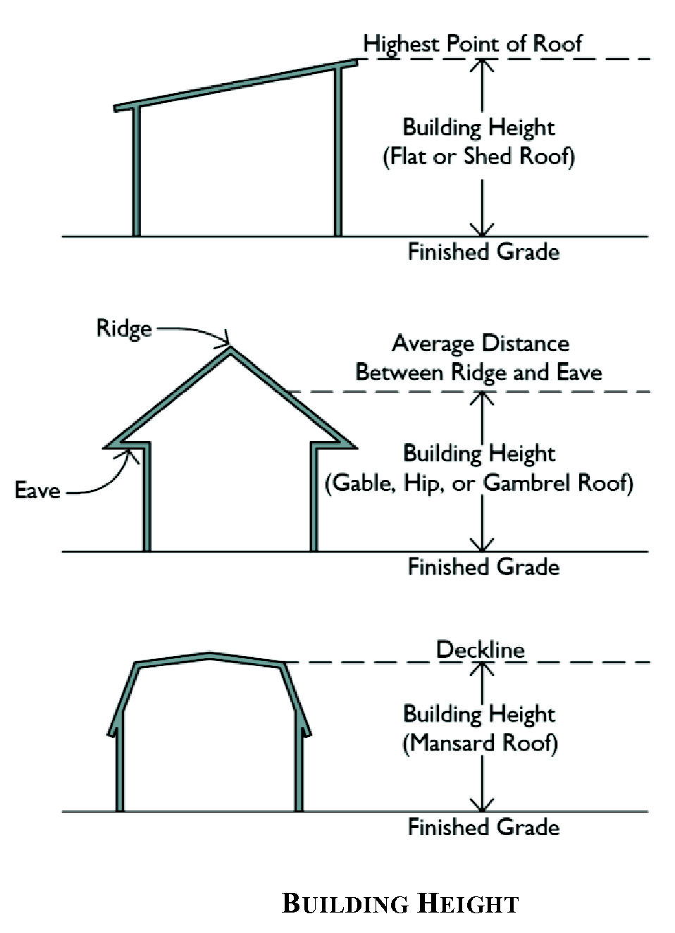
Building, height of. The vertical distance measured from the average grade to the highest point of the coping of a flat roof; to the deck lines of a mansard roof; or to the mean height level between the eaves and ridge of a gable, hip or gambrel roof. Grade is defined as the average elevation of the ground on all sides of a building.
Building, principal. A building in which is conducted the principal use of the lot on which said building is situated. In any residential district, any structure containing a dwelling unit shall be defined to be the principal building on the plot on which same is situated.
Building coverage. See "Lot coverage."
Building envelope. The three-dimensional space within which a structure is permitted to be built on a lot; it is defined by maximum height regulations and minimum yard setbacks.
Building footprint. The area within the perimeter of a building measured at the foundation but shall not include driveways, parking lots, open uncovered patios, decks, unroofed structures and unroofed stoops or stairs or roof projections. It shall include all porches, roofed areas and any cantilevered portions of the building.
Building pad. The horizontal limits of the area defined by the building foundation and as required by the hillside and ridgeline protection section of chapter 107, Resource Management.
Building official. The Chief Building Inspector of the City of Canton, or his/her representative.
Building permit. The permit required for new construction, completion of construction, or an interior finish pursuant to the applicable building code. As used in chapter 113, Development Impact Fees, the term shall not include permits required for remodeling, rehabilitation, or other improvements to an existing structure provided there is no increase in the demand placed on those public facilities as defined herein.
Building setback line. A line establishing the minimum allowable distance between the main or front wall of the building and the street right-of-way line when measured perpendicularly thereto. Covered porches, whether enclosed or not, shall be considered as a part of the building and shall not project into the required yard. Includes the term "building line."
Bus or truck maintenance facility. A specialized structure for bus or truck repair and service, including service garages and other structures that have bays for automobile service.
Bus stop shelter. A small, roofed structure, usually having three walls, located near a street and designed primarily for the protection and convenience of bus passengers.
C
Caliper. A method of measuring the diameter of a tree trunk for the purpose of size grading or classification. The caliper of the trunk is measured at diameter breast height (DBH).
Camera and photographic supplies store. An establishments classified as "Retail sales — Durable goods" that offers cameras, photographic equipment, and photographic supplies. Repair services and film developing may also be provided.
Campground/RV park. A site where one or more lots are used, or are intended to be used, by campers and their equipment, including tents, tent trailers, travel trailers, and recreational vehicles. These establishments may provide facilities and services, such as cabins, washrooms, food services, recreational facilities and equipment, and organized recreational activities.
Capital improvement. As used in chapter 113, Development Impact Fees, the term shall mean an improvement with a useful life of ten years or more, by new construction or other action, which increases the service capacity of a public facility.
Capital improvements element. A component of the Canton Comprehensive Plan that sets out projected needs for system improvements during the planning horizon established therein, a schedule of capital improvements that will meet the anticipated need for system improvements, and a description of anticipated funding sources for each required improvement, as most recently adopted or amended by the city council.
Car rental. See "Vehicle rental."
Car wash. An establishment that engages in cleaning, washing, and/or waxing automotive vehicles, such as passenger cars, trucks, and vans, and trailers.
Catering business. An establishment that provides single event-based food services, transporting food via equipment and vehicles to events or prepare food at an off-premise site.
Cellar. A level within a building having more than one-half of its height on all sides below grade.
Cellular telephone store. An establishment classified as "Retail sales — Durable goods" that offers cellular telephones and accessories. Software upgrading and bill payment services may also be provided.
Cemetery. Property used for the interment of the dead. A cemetery may include: a burial park for earth interments; a mausoleum for vault or crypt interments; a columbarium with niches for urns; and a chapel. Types of cemeteries include: the monument cemetery, the lawn cemetery, and the garden memorial park.
Centerline of street. The line surveyed and monumented, or, if a centerline has not been surveyed and monumented, it shall be that line running midway between the outside curbs or ditches of the street.
Certificate of occupancy. A legal statement or document issued by the building official indicating that the building and use or reuse of a particular building or land is in conformity with all applicable codes and regulations, and that such building or land may be occupied for the purpose stated therein.
Certified personnel. As applies to the soil erosion, sedimentation and pollution control section of chapter 107, Resource Management, the term shall mean a person who has successfully completed the appropriate certification course approved by the Georgia Soil and Water Conservation Commission.
Charter bus terminal. Any premises for the storage or parking of motor-driven buses and the loading and unloading of passengers. The terminal may include ticket purchase facilities and restrooms.
Chattel. Personal property as contrasted with real estate.
Child day care. Establishments that are licensed or commissioned by the Georgia Department of Human Resources to care for infants and preschool children for less than 24 hours of day without transfer of legal custody. Some offer pre-kindergarten education programs or provide care services for older children. Child day care facilities are classified as follows:
Family day care home. A private residence operated as day care for up to six children.
Group day care home. Any place operated as day care for not less than seven or more than 18 children.
Child day care center. Any place operated as day care for 19 or more children.
City. Canton, a municipal corporation of the State of Georgia.
City council. The City Council of Canton, Georgia.
City engineer. The Engineer of the City of Canton, or his/her authorized representative.
City manager. The individual designated by the mayor and council who is responsible for the general supervision of all city departments, including the city water and wastewater systems. When "city manager" is referred to in the cross-connection control program, it shall mean the city manager or his/her designee.
Clear-cutting. The indiscriminate and broad removal of trees, shrubs, or undergrowth with the intention of preparing real property for nonagricultural development purposes. Includes root mat and topsoil removal. This definition shall not include the selective removal of nonnative tree and shrub species when the soil is left relatively undisturbed; removal of dead trees; or normal moving operations (See also "Clearing").
Clearing. The selective removal of vegetation from a property, whether by cutting or other means.
Clothing, jewelry, luggage, shoe store. An establishment classified as "Retail sales — Durable goods" that retail new clothing and clothing accessories merchandise from fixed point-of-sale locations. Establishments are primarily engaged in retailing clothing, footwear, jewelry, sterling and plated silverware, watches and clocks, luggage and leather goods, and sewing supplies. They may also provide repair services.
Cluster development. A development design technique that concentrates buildings in specific areas on a site to allow the remaining land to be used for recreation, common open space, and preservation of environmentally sensitive areas.
Coastal marshlands. Shall have the same meaning as in O.C.G.A. § 12-5-282.
Colleges and universities. Junior colleges, colleges, universities, and professional schools. These establishments furnish academic or technical courses and grant degrees, certificates, or diplomas at the associate, baccalaureate, or graduate levels. The requirement for admission is at least a high school diploma or equivalent general academic training.
Commencement of construction. For private development, means initiation of physical construction activities as authorized by a development or building permit and leading to completion of a foundation inspection or other initial inspection and approval by a public official charged with such duties; and for public projects, means expenditure or encumbrance of any funds, whether they be development impact fee funds or not, for a public facilities project, or advertising of bids to undertake a public facilities project.
Commission. The Georgia Soil and Water Conservation Commission (GSWCC).
Communications and information. Establishments that produce or distribute information. These establishments include publishing (newspapers, magazines and other periodicals, books, databases, calendars, greeting cards, maps and similar works, as well as computer software); motion pictures and sound recording (production, publishing, and distribution); telecommunications and broadcasting (excluding wireless telecommunication facilities); Internet access and service providers; library or archive services; and news syndicates.
Community development director. The Community Development Director of the City of Canton, or his/her authorized representative.
Community work program. The component of the comprehensive plan that lays out the specific activities the city plans to undertake during the five years following adoption of the plan.
Compatibility. The characteristics of different uses or activities that permit such uses or activities to be located near each other in harmony and without conflict. Some elements affecting compatibility include: intensity of occupancy as measured by dwelling units per acre or gross square footage per acre; pedestrian or vehicular traffic generated; volume of goods handled, and such environmental effects as noise, vibration, odor, glare, air pollution or radiation.
Completion of construction. The issuance of the final certificate of occupancy by the appropriate designated city official. The date of completion is the date on which such certificate is issued.
Comprehensive plan. The official development policy and implementation guide for the City of Canton to coordinate and direct physical and economic development, related public investment, and, to provide reasonable regulations for the development of private property in the interest of public health, safety, comfort, convenience, prosperity, and general welfare. The plan shall be adopted or amended in accordance with the Georgia Comprehensive Planning Act (O.C.G.A § 50-8-1 et seq.) and the applicable Minimum Standards and Procedures for Local Comprehensive Planning as adopted by the Georgia Department of Community Affairs. Includes the term "City of Canton Comprehensive Plan."
Computer and software store. An establishment classified as "Retail sales — Durable goods" that offers computers, computer peripherals, and prepackaged computer software without retailing other consumer-type electronic products or office equipment, office furniture and office supplies. An establishment may also offer repair, support, and training services.
Conditional use. A use that would not be appropriate without restriction throughout a zoning district but which, if controlled as to number, area, location or relation to the area for which it is sought, would not be injurious to the public health, safety, welfare, morals, order, comfort, convenience, appearance or general welfare. Such uses may be permitted only in zoning districts which are specified in this UDC and are subject to issuance of a conditional use permit by the city council.
Conditional zoning. The granting or adoption of zoning for property subject to compliance with restrictions as to use, size, density or actions stipulated by the governing body to negate adverse impacts that are anticipated without imposition of such conditions.
Condominium. A building containing individually owned dwelling units and related, jointly owned, common areas as defined by laws of the State of Georgia.
Conservation areas. Environmentally sensitive and valuable lands protected from any activity that would significantly alter their ecological integrity, balance, or character, except in cases of overriding public interest. Conservation areas include freshwater marshes, shallow grassy ponds, hardwood swamps, cypress swamps, natural shorelines (other than natural beaches or dunes), sand pine scrub communities, and other areas of significant biological productivity or uniqueness.
Conservation easement. An easement granting a right or interest in real property that is appropriate to retaining land or water areas predominately in their natural, scenic, open, or wooded condition; retaining such areas as suitable habitat for fish, plants, or wildlife; or maintaining existing land uses.
Construction related businesses (onsite storage or equipment or materials). Establishments that either build buildings or structures, or perform additions, alterations, reconstruction, installation, and repairs. They may also provide building demolition or wrecking services. Establishments engaged in blasting, test drilling, landfill, leveling, earthmoving, excavating, land drainage, and other land preparation are included as well.
Construction, on-site. Construction, by conventional means, of a dwelling unit on the site where it is to be occupied. This form of construction may include prefabrication of certain building components as well as panelized construction of walls but should not be interpreted to include the on-site assemblage of modular units or incidental hookups associated with mobile homes. The extent to which prefabrication is permitted shall be determined by the planning and zoning administrator with approval by the planning commission and the Canton City Council.
Contractor. The individual, firm or corporation undertaking the execution of the work under the terms of the contract and acting through its agents and employees.
Contractor's establishment. An establishment engaged in the provision of construction activities including but not limited to plumbing, electrical work, building, paving, carpentry and other such contracting activities, including the storage of materials and the overnight parking of commercial vehicles.
Convenience store, without fuel pumps. An establishment that primarily sells a limited line of goods that generally includes milk, bread. soda, snacks, newspapers and magazines, and a limited amount of freshly prepared foods for off-premises consumption, but does not sell gasoline or other motor vehicle fuel.
Conversion. Any change in the original use or purpose of a building or lot to a different use.
Correctional facility. A public or privately operated facility housing persons awaiting trial or persons serving a sentence after being found guilty of a criminal offense, such as: jails; penitentiaries; and detention centers.
Corrective action. As used in the mass grading and clearing section of chapter 107, Resource Management, means that all soil disturbing activities at the site have been halted and that for unpaved areas not covered by permanent structures, at least 80 percent of the soil surface is uniformly covered in permanent vegetation or equivalent measures (such as the use of rip rap, gabions, permanent mulches, or geotextiles).
Corridor. As used in the water supply watershed protection section of chapter 107, Resource Management, the term shall mean all land within the buffer areas established adjacent to water supply reservoirs or perennial streams within water supply watersheds and within other setback areas specified in this Code.
Courier and messenger services. Establishments that provide air, surface, or combined courier delivery services of parcels and messages within or between metropolitan areas or urban centers. These establishments may form a network including local, and point-to point pickup and delivery.
CPESC. Certified professional in erosion and sediment control with current certification by, EnviroCert, Inc., which is also referred to as CPESC or CPESC, Inc.
Critical root zone (CRZ). The minimum area beneath a tree which must be left undisturbed in order to preserve a sufficient root mass to give a tree a reasonable chance of survival. The CRZ will typically be represented by a concentric circle centering on the tree's trunk with a radius equal in feet to one and one-half times the number of inches of the trunk diameter (at diameter breast height).
Crop production. Establishments that grow crops, including: grains and oilseeds; wheat; corn; rice; soybean and oilseed; dry peas, beans and lentils; root and tuber crops, or edible plants; fruit or tree nuts; tobacco; cotton; sugarcane; hay, alfalfa, clover or mixed hay; and peanuts. These establishments may also produce seeds of the crops identified herein.
Cross-connection control program. Definitions related to the cross connection control program (chapter 110, Design Standards: Water System) are:
Cross-connection control program administrator or program administrator. Authorized representative of the City Manager of the City of Canton who shall administer the cross-connection control program.
Cross-connection. A physical connection between two otherwise separate piping systems or vessels, one of which contains potable water and the other does not.
Cross-connection (nonpressure type). A low inlet installation where a potable water supply pipe is connected or extended below the overflow rim of a receptacle, 01' an environment, that does not contain potable water and which is at atmospheric pressure.
Cross-connection (pressure type). An installation where a potable water supply pipe is connected to a closed vessel, or a piping system, that does not contain potable water and which is above atmospheric pressure.
Customer. Any and all persons, including any individual firm or associations, and any municipal or private corporation organized or existing under the laws of this or any other state or country having a service connection to the public water supply.
Crosswalk. A right-of-way within a block dedicated to public use, ten feet or more in width, intended primarily for pedestrians and from which motor-propelled vehicles are excluded. It is designed to improve or provide access to adjacent roads and lots.
Cul-de-sac. A local street, one end of which is closed and consists of a circular turnaround.
Curb break. Any interruption or break in the line of a street curb for the purpose of connecting a driveway to a street, or otherwise to provide vehicular access to abutting property.
Cut. A portion of land surface or area from which earth has been removed or will be removed by excavation; the depth below original ground surface to the excavated surface. Also known as excavation.
D
Dam break flood zone. That area within the flood contour elevations subject to flooding as designated by the city engineer based on information obtained from the U.S. Corps of Engineers or other federal, state, or county agencies, or local hydraulic studies which occur from any seepage or failure of any dam.
Dam. Any artificial barrier, including appurtenance works which impounds or diverts water, and which either:
1)
Is 25 feet or more in height from the natural bed of the stream or watercourse measured at the downstream tow of the barrier, or from the lowest elevation on the outside limit of the barrier if it is not across the stream channel or watercourse, to the maximum water storage elevation; or
2)
Has an impounding capacity at maximum storage elevation of 50 acre-feet or more, except that the term shall not include:
a.
Any artificial barrier which is not in excess of six feet in height, regardless of storage capacity, or which has a storage at maximum water storage elevation not in excess of 15 acre-feet, regardless of height;
b.
Any artificial barrier constructed by the United States Army Corps of Engineers, the Tennessee Valley Authority, the United States Soil Conservation Service, or any other department or agency of the United States government when such department or agency has designed or approved plans, has supervised construction, maintained the program of inspection, provided that this exception shall cease when the supervising federal agency relinquishes authority for the operation of maintenance of such artificial barrier;
c.
Any artificial barrier licensed by the federal energy regulatory commission; or for which a license application is pending with the federal energy regulatory commission; or
d.
Any artificial barrier classified by the state soil and water conservation committee as a dam where improper operation or dam failure would not be expected to result in loss of human life.
Day. As used in chapter 113, Development Impact Fees, the term shall mean a calendar day unless otherwise specifically identified as a "work" day or other designation when used in the text.
Deciduous. Plants that annually lose their leaves.
Density. The number of dwelling units permitted per acre of land. For the purpose of the tree protection section in chapter 103, Site Planning and Project Design Standards, "density" shall mean the quantity of trees required on each acre.
Density, gross. Calculation of density based on the entire area within the boundaries of a specific site. For the purpose of chapter 102, Zoning Districts and Land Uses, "density" shall mean "gross density" unless otherwise indicated in the development standards table in chapter 102.
Density, net. Calculation of density based on developable areas only, excluding streets, easements, water areas, lands with environmental constraints, parklands and required open space, and other undevelopable lands.
Department. The Georgia Department of Natural Resources (DNR).
Department store, warehouse club or superstore. An establishment that offers a large variety of goods from a single location. Products may include: apparel; furniture appliances and home furnishings paint hardware toiletries cosmetics photographic equipment jewelry, toys, and sporting goods; and groceries.
Design professional. A professional licensed by the State of Georgia in the field of: Engineering, architecture, landscape architecture, forestry, geology, or land surveying; or a person that is a certified professional in erosion and sediment control (CPESC) with a current certification by EnviroCert, Inc. Design professionals shall practice in a manner that complies with applicable Georgia law governing professional licensure.
Developer. Any person, corporation or duly authorized agent who undertakes development or the subdivision of land as defined in this UDC.
Development. All structures and other modifications of the natural landscape above and below ground or water, on a particular site. As used in the floodplain management/flood damage prevention section of chapter 107, Resource Management, the term shall mean: Any man-made change to improved or unimproved real estate including but not limited to buildings or other structures, mining, dredging, filling, clearing, grubbing, grading, paving, and other installation of impervious cover, excavation or drilling operations or storage of equipment or materials. As used in chapter 113, Development Impact Fees, the term shall mean any construction or expansion of a building, structure, or use; any change in use of a building or structure; or any change in the use of land; any of which creates additional demand and need for public facilities, as defined herein.
Development approval. Written authorization, such as issuance of a building permit, land disturbance permit or other approval for grading or site development, or other forms of official action required by local law or regulation which authorizes the commencement of construction.
Development impact fee. The payment of money imposed upon development as a condition of development approval to pay for a proportionate share of the cost of system improvements needed to serve new growth and development.
Development inspector. The city inspector responsible for inspections in the field throughout the development phase of a specific development.
Diameter breast height (DBH). The tree trunk diameter (in inches) at a height of four and one-half feet above the ground. If a tree splits into multiple trunks below four and one-half feet, then the trunk is measured at its most narrow point beneath the split.
Director. The director of the environmental protection division or an authorized representative.
Display area. See "Outdoor display."
Distillery. An establishment where the distillation of alcoholic spirits (liquors) takes place.
District. The Limestone Valley Soil and Water Conservation District.
Division. The Environmental Protection Division (EPD) of the Department of Natural Resources.
Domestic animals: See "Household pet."
Double check valve assembly (DCVA). An assembly of at least two independently acting check valves.
Drainage structure. A device composed of a virtually nonerodible material such as concrete, steel, plastic or other such material that conveys water from one place to another by intercepting the flow and carrying it to a release point for storm water management, drainage control, or flood control purposes.
Drainage. Surface water runoff; the removal of surface water or groundwater from land by drains, grading or other means which include runoff controls to minimize erosion and sedimentation during and after construction or development, the means for preserving the water supply and the prevention of alleviation of flooding.
Drainage area. That area in which all of the surface runoff resulting from precipitation is concentrated into particular streams.
Drainage district. A district established by a governmental unit to build and operate facilities for drainage.
DRASTIC. The standardized system for evaluating groundwater pollution potential using the hydrogeologic settings described in U.S. Environmental Protection Agency document EPA-600-2-87-035. (Note: The DRASTIC methodology is the most widely used technique for evaluating pollution susceptibility.)
Drip line. A vertical line extending from the outer surface of a tree's branch tips to the ground.
Drive-in theater. An outdoor movie theater, where motion pictures are projected upon a screen for viewing by patrons seated in automobiles.
Duplex. See "Dwelling, duplex."
Dwelling, accessory. A second dwelling unit that is added to an existing lot for use as a complete and independent facility. The dwelling unit may be established within the principal building or in a separate building on the same lot as the principal building. Includes the terms "carriage house," "guest house," "second unit," "granny flat" and "accessory apartment."
Dwelling, duplex. A two-dwelling unit building that is divided horizontally, and each dwelling unit has a separate entrance from the outside or through a common vestibule.
Dwelling, multi-family. A building designed and constructed or altered which contains three or more living units which connected by walls, ceiling or floor. Individual units may be accessed by an interior corridor or external walkway.
Dwelling, quad-plex. A building containing four living units which are connected by one or two common, shared wall(s). Each unit shall have a minimum of two exposed exterior walls. Access to each unit may be gained through a front or back entrance. The living units are not to be stacked.
Dwelling, single-family detached. A standard single-family residential building; a detached building containing one dwelling unit. A modular home shall be considered a single-family detached unit.
Dwelling, townhouse. A building that has three or more separate dwelling units divided vertically, and each unit has separate entrances to a front and rear yard.
Dwelling, tri-plex. A building containing three living units which are connected by one or two common, shared wall(s). Each unit shall have a minimum of two exposed exterior walls. Access to each unit may be gained through a front or back entrance. The living units are not to be stacked.
Dwelling unit. A room or group of internally connected rooms that have sleeping facilities, sanitary facilities and not more than one kitchen, which constitute an independent housekeeping unit, occupied for one household on a long-term basis.
E
Easement. A nonpossessor interest in land; a grant by property owner for the use by the public, a corporation or person, of a portion of land for specified purpose or purposes.
Egress. An exit.
Electronics and appliances stores. An establishment classified as "Retail sales - Heavy consumer goods" that offers electronics and appliance merchandise from point-of-sale locations and may offer maintenance and repair services. Products sold at these establishments include household-type appliances, cameras, televisions, stereos, and other electronic goods. These establishments often sell computer hardware and software along with other lines of merchandise. Does not include "computer and software stores," "camera and photographic supplies stores," and "cellular telephone stores."
Elevated building. A nonbasement building which has its lowest floor raised above the ground level by foundation walls, shear walls, posts, piers, pilings, or columns.
Encumber. To legally obligate by contract or otherwise commit to use by appropriation or other official act of Canton, Georgia.
Environmental health department. The Cherokee County Environmental Health Department.
Erosion. The process by which land surface is worn away by the action of wind, water, ice or gravity.
Erosion, Sedimentation and Pollution Control Plan. A plan required by the Erosion and Sedimentation Act, O.C.G.A. ch. 12-7, that includes, as a minimum protections at least as stringent as the State General Permit, best management practices, and requirements in the Soil Erosion, Sedimentation and Pollution Control section of chapter 107, Resource Management.
Evergreen (conifers). Plants that retain foliage throughout the year.
Exhibition, convention, or conference structure. A facility designed to accommodate special events that require an exhibition hall, meeting rooms, an auditorium and/or kitchen and banquet facilities. Trade shows, public shows, conventions, food functions, receptions, dances, banquets, assemblies, and other activities are typically hosted in these structures.
Excess capacity. That portion of the capacity of a public facility or system of public facilities which is beyond that necessary to provide adequate service to existing development at the adopted level-of-service standard.
Existing construction. Any structure for which the "start of construction" commenced before March 5, 1981 [i.e., the effective date of the initial floodplain management code or ordinance adopted by the community as a basis for that community's participation in the National Flood Insurance Program (NFIP)].
Existing density factor (EDF). The tree density units awarded for the preservation of existing trees which will remain on site to be protected during construction.
Existing manufactured home park or subdivision. A manufactured home park or subdivision for which the construction of facilities for servicing the lots on which the manufactured homes are to be affixed (including, at a minimum, the installation of utilities, the construction of streets, and either final site grading or the pouring of concrete pads) is completed before March 5, 1981 [i.e., the effective date of the initial floodplain management code or ordinance adopted by the community as a basis for that community's participation in the National Flood Insurance Program (NFIP)].
Expansion to an existing manufactured home park or subdivision. The preparation of additional sites by the construction of facilities for servicing the lots on which the manufactured homes are to be affixed, including the installation of utilities, the construction of streets, and either final site grading or the pouring of concrete pads.
F
Façade. The exterior wall of a building exposed to public view or that wall viewed by persons not within the building.
Family. An individual; or two or more persons related by blood or marriage, limited to the occupant, his or her spouse, and their parents and children; or a group of not more than three persons, excluding servants, who need not be related by blood or marriage, living together in a dwelling unit.
Farm. An area of land principally devoted to agriculture.
Fast food. Food that is prepared/cooked prior to being ordered or food that takes a minimal amount of time to prepare when ordered. Fast food may be take out or consumed on premise.
Fee simple. The owner is entitled to the entire property with unconditional power of disposition during his life and which descends to his or her heirs and legal representatives upon his death intestate.
Feepayor. That person or entity who pays a development impact fee, or his or her successor in interest where the right or entitlement to any refund of previously paid development impact fees which is required by chapter 113, Development Impact Fees has been expressly transferred or assigned to the successor in interest. In the absence of an express transfer or assignment of the right or entitlement to any refund of previously paid development impact fees, the right or entitlement shall be deemed "not to run with the land."
Fence. A structural barrier for enclosure, screening or demarcation, presenting a solid face or having openings amongst or between its constituent's members; also, a wall separate from or extending from a building.
Fill. A portion of land surface to which soil or other solid material has been added; the depth above the original ground surface or an excavation.
Final plat. A plat of a tract of land which meets the requirements of this UDC for recording in the office of the Clerk of the Superior Court of Cherokee County.
Final stabilization. All soil disturbing activities at the site have been completed, and that for unpaved areas and areas not covered by permanent structures and areas located outside the waste disposal limits of a landfill cell that has been certified by EPD for waste disposal, 100 percent of the soil surface is uniformly covered in permanent vegetation with a density of 70 percent or greater, or landscaped according to the plan (uniformly covered with landscaping materials in planned landscape areas), or equivalent permanent stabilization measures as defined in the manual (excluding a crop of annual vegetation and seeding of target crop perennials appropriate for the region). Final stabilization applies to each phase of construction.
Finished floor elevation. The top surface of the lowest inhabitable level of an enclosed area in a building, including the basement. This could be the top of the slab in concrete slab construction or the top of wood flooring in wood frame construction. The term does not include the floor of a garage used solely for parking vehicles.
Finished grade. The final elevation and contour of the ground after cutting or filling and conforming to the proposed design.
Fitness, gym or athletic club. An indoor recreational facility which provides services for fitness or recreational sports teams, clubs, or individual activities. The facility may include any of the following: sauna, spa or hot tub facilities, exercise rooms, indoor tennis, handball, racquetball, and other indoor sports and fitness activities. Does not include sexually oriented businesses.
Flea market. See "Antique shops."
Flood or flooding. A general and temporary condition of partial or complete inundation of normally dry land areas from: The overflow of inland or tidal waters; or the unusual and rapid accumulation or runoff of surface waters from any source.
Flood, future conditions. The flood having a one percent chance of being equaled or exceeded in any given year based on future-conditions hydrology. Also known as the 100-year future-conditions flood.
Floor area, gross. The sum of the areas of the several floors of a building including areas used for human occupancy in basements, attics, and penthouses, as measured from the exterior faces of the walls. It does not include cellars, unenclosed porches, or attics not used for human occupancy, or any floor space in accessory buildings or in the main building intended and designed for the parking of motor vehicles in order to meet the parking requirements of this UDC, or by such floor space intended and designed for accessory heating and ventilating equipment. It shall include the horizontal area at each floor level devoted to stairwells and elevator shafts.
Flood elevation, future-conditions. The highest water surface elevation anticipated at any given location during the future-conditions flood.
Flood insurance rate map or FIRM. An official map of a community, issued, by FEMA, delineating the areas of special flood hazard and/or risk premium zones applicable to the community.
Flood insurance study or FIS. The official report by FEMA providing an examination, evaluation and determination of flood hazards and corresponding flood profiles and water surface elevations of the base flood.
Floodplain or flood-prone area. Any land area susceptible to flooding.
Floodplain, future-conditions. Any land area susceptible to flooding by the future-conditions flood.
Floodproofing. Any combination of structural and nonstructural additions, changes, or adjustments to structures which reduce or eliminate flood damage to real estate or improved real property, water and sanitary facilities, structures and their contents.
Floodway or Regulatory floodway. The channel of a stream, river, or other watercourse and the adjacent areas that must be reserved in order to discharge the base flood without cumulatively increasing the water surface elevation more than a designated height.
Floor area ratio. Determined by dividing the gross floor area of all buildings on a lot by the area of that lot.
Floor area. The gross horizontal areas of all floors, including penthouses (but excluding such areas within a building which are used for parking) measured from the exterior faces of the exterior walls of a building. Basements and cellars shall not be included in the gross floor area.
Florist. An establishment classified as "Retail sales — Other consumer goods" that sells cut flowers, floral arrangements, and potted plants purchased from others. These establishments usually prepare the arrangements they sell.
Front yard. See "Yard, front."
Frontage. The width of a lot as measured where it abuts the street right-of-way.
Functionally dependent use. A use which cannot perform its intended purpose unless it is located or carried out in close proximity to water.
Funeral home. A building used for the preparation of the deceased for burial and the display of the diseased and rituals connected therewith before burial or cremation. A funeral home may contain assembly rooms; rooms for embalming, caskets, showing and other functions; cremation facilities; and sleeping quarters for employees.
Furniture or home furnishing store. An establishment classified as "Retail sales — Heavy consumer goods" that offers furnishings such as: baby furniture: outdoor furniture; office furniture (except those sold in combination with office supplies and equipment): floor coverings (rugs, carpets, vinyl floor coverings, and floor tile not only ceramic or wood); and window treatments (curtains, drapes, blinds, and shades). Some of these items may be sold in combination with major appliances or home electronics, or in combination with installation and repair services.
Future-conditions flood. See "Flood, future-conditions."
Future-conditions flood elevation. The flood standard equal to or higher than the base flood elevation. The future-conditions flood elevation is defined as the highest water surface anticipated at any given point during the future-conditions flood.
Future-conditions floodplain. See "Floodplain, future-conditions."
Future-conditions hydrology. The flood discharges associated with projected land-use conditions based on a community's zoning map, comprehensive land-use plans, and/or watershed study projections, and without consideration of projected future construction of flood detention structures or projected future hydraulic modifications within a stream or other waterway, such as bridge and culvert construction, fill, and excavation.
G
Gas station. An establishment that sells gasoline or other motor vehicle fuel utilizing fuel pumps and storage tanks, often underground or hidden. Other products may be sold and other services may be provided in addition to the sale of gasoline or other motor vehicle fuel.
Generalized wetlands map. A map of wetlands provided in the U.S. Fish and Wildlife Service National Wetlands Inventory (NWI) map showing wetlands within the local jurisdiction.
Glare. A sensation of brightness within the visual field that causes annoyance, discomfort, or loss in visual performance and visibility.
Golf course. A tract of land laid out for at least nine holes for playing the game of golf that may include a clubhouse, snack bars, pro shop, and practice facilities. A golf course may comprise dining facilities and other recreational facilities that are known as country clubs. These establishments often provide food and beverage services, equipment rental services, and golf instruction services.
Golf driving range. A stand-alone golf practice facility that operates outside of a golf course.
Governing body. The Mayor and Council of the City of Canton, duly elected by the citizens within the jurisdiction.
Grade schools. Public, private, and specialty schools between the preschool and university level that are licensed by the State of Georgia and meet state requirements for education.
Grade. The average level of the finished ground surface adjacent to the exterior walls of the building.
Grade, average. The average elevation of the ground on all sides of a building or structure.
Grade, finished. The final elevation of the ground surface after development.
Grade, highest adjacent. The highest natural elevation of the ground surface, prior to construction, adjacent to the proposed walls of a structure. Includes the term "natural grade."
Grading. Altering the shape of ground surfaces to a predetermined condition; this shall include stripping, cutting, filling, stockpiling and shaping or a combination thereof, and shall include the land in its cut or filled condition.
Greenhouse, nursery, and floriculture. An establishment that grows food crops of any kind under cover or grows nursery stock (including shrubbery, bulbs, fruit stock, and sod) and flowers. "Under cover" is generally defined as greenhouses, cold frames, cloth houses, and lath houses. The crops grown are removed at various stages of maturity and have annual and perennial life cycles. The nursery stock includes short rotation woody crops that have growth cycles of ten years or less.
Grocery store, supermarket, bakery, or specialty food store. An establishment that primarily sells a general line of food products for off-premises preparation and consumption. These establishments include meat and seafood markets, delicatessen-type establishments, establishments retailing baked goods (not for immediate consumption and made off-premises); and specialty food stores.
Gross leasable area. The total floor area designed for tenant occupancy and exclusive use, including basements, mezzanines, and upper floors, if any, expressed in square feet and measured from the centerline of joint partitions and from outside wall faces.
Ground coverage. See "Lot coverage."
Ground elevation. The original elevation of the ground surface prior to cutting or filling.
Grubbing. The removal of stumps or roots from a site.
H
Hardware store or home center. An establishment classified as "Retail sales — Heavy consumer goods" that offers materials and supplies for home building or repairs. They also sell other products, such as lumber, plumbing goods, electrical goods, tools, house wares, hardware, and, sometimes, lawn and garden supplies.
Hazardous material. Any substance defined as hazardous material by the state department of natural resources pursuant to O.C.G.A. § 12-8-60 et seq.
Hazardous waste. Includes those solid and liquid wastes or combinations thereof that may cause or contribute to an increase in mortality or an increase in serious, irreversible or incapacitating reversible illness or which pose a substantial threat to human health when improperly handled.
Health department. The Cherokee County Health Department.
Health and human services, medical. Establishments that provide health care services outside of a hospital, such as: Ambulatory or outpatient care services; clinical offices for physicians, dentists, chiropractors, optometrists, etc.; outpatient care centers or clinics; medical and diagnostic laboratories; and, blood and organ banks. These establishments require workers with the appropriate expertise for such services, and are bound to the regulations and oversight of local, state, and federal health and human services departments.
Health and human services, non-medical. Establishments that provide social assistance and associated services, such as: Social assistance, welfare, and charitable services; child and youth services (non-day care), community food services, emergency and relief services, elderly and persons with disabilities services (outside of home); other family services such as hotline centers, suicide crisis centers, and self-help organizations; veterans affairs; and vocational rehabilitation. These establishments require workers with the appropriate expertise for such services, and are bound to the regulations and oversight of local, state, and federal health and human services departments.
Health and personal care store (excluding personal services). An establishment that sells health and personal care merchandise from a fixed point-of-sale location. These establishments include pharmacy or drug stores, cosmetic and beauty supply stores, and optical stores. Does not include "Personal services."
Heating and plumbing equipment sales. An establishment that sells heating and plumbing equipment. Does not include heating and plumbing contractors that retail and install or service equipment (see "Construction related business").
Height. The vertical distance to the highest point of the roof for flat roofs: to the deck line of mansard roofs; and to the average height between eaves and the ridge for gable, hip, and gambrel roofs, measured from the curb level if the building is not more than ten feet from the front lot line or from the average elevation of the finished grade surrounding the structure in all cases.
Highest adjacent grade. The highest natural elevation of the ground surface prior to construction next to the proposed walls of a structure.
Historic area. A district or zone designated by local authority, state or federal government within which the buildings, structures, appurtenances and places are of basic and vital importance because of their association with history, or because of their unique architectural style and scale, including color, proportion, form and architectural detail, or because of their being a part of or related to a square, park, or area, the design or general arrangement of which should be preserved and/or developed according to a fixed plan based on cultural, historical or architectural motives or purpose.
Historic preservation. The protection, rehabilitation, and restorations of districts, sites, buildings, structures and artifacts significant in American history, architecture, archaeology, or culture.
Historic structure. Any structure that is:
1)
Listed individually in the National Register of Historic Places (a listing maintained by the U.S. Department of Interior) or preliminarily determined by the Secretary of the Interior as meeting the requirements for individual listing on the national register;
2)
Certified or preliminarily determined by the Secretary of the Interior as contributing to the historical significance of a registered historic district or a district preliminarily determined by the secretary to qualify as a registered historic district;
3)
Individually listed on a state inventory of historic places and determined as eligible by states with historic preservation programs which have been approved by the Secretary of the Interior; or
4)
Individually listed on a local inventory of historic places and determined as eligible by communities with historic preservation programs that have been certified either:
a.
By an approved state program as determined by the Secretary of the Interior, or
b.
Directly by the Secretary of the Interior in states without approved programs.
Home occupation. Any use, occupation or activity conducted entirely within a dwelling by the residents thereof, which is clearly incidental and secondary to the use of the dwellings for residence purposes and does not change the character thereof.
Homeowners' association. A formally constituted nonprofit association or corporation made up of the property owners and/or residents of a fixed area; may take permanent responsibility for costs and upkeep of semiprivate community facilities.
Hospital. Hospitals provide medical, diagnostic, and treatment services. These establishments often offer physician, nursing and specialized accommodation services for inpatient care.
Hotel, motel, or tourist court. A facility with guest rooms or suites, with or without kitchen facilities, rented to the general public for transient lodging. These establishments include resort hotels that do not have gambling services. They may also offer food services, recreational services, convention hosting services, laundry services, etc. and may provide accessory guest facilities such as swimming pools, tennis courts, indoor athletic facilities, accessory retail uses, etc.
Household pet. An animal which is customarily kept for company or pleasure within a home or yard which is not exhibited to the public, nor raised for commercial purposes. Household pets include domestic canines, felines, tropical birds, fish, rabbits, rodents and other animals customarily sold in pet stores.
Hydrologic Atlas 18. A map prepared by the Georgia Department of Natural Resources (DNR) and published by the Georgia Geologic Survey in 1989, which identifies the most significant groundwater recharge areas of Georgia as spotted areas labeled as "areas of thick soils."
Hydrologic Atlas 20. A multicolored map of Georgia at a scale of one-to-five hundred thousand (1:500,000), prepared by the Georgia DNR using the DRASTIC methodology and published by the Georgia Geologic Survey in 1992, which shows areas of high, average (or medium), and low susceptibility of groundwater to pollution in Georgia. This map is also commonly known as the Groundwater Pollution Susceptibility Map of Georgia.
Hydrology, future conditions. The flood discharges associated with projected land-use conditions based on a community's zoning maps, comprehensive land use plans, and/or watershed study projections, and without consideration of projected future construction of stormwater management (flood detention) structures or projected future hydraulic modifications within a stream or other waterway, such as bridge and culvert construction, fill, and excavation.
I
Impervious surface. Any material that substantially reduces or prevents the infiltration of stormwater into previously undeveloped land. Includes the term "impervious cover."
Improvements. Refers to such sidewalks, street work and utilities and other facilities to be installed, or agreed to be installed, by the developer to be used for public or private streets, highways, and easements, as are necessary.
Individual assessment study. The engineering, financial, or economic documentation prepared by a fee payer or applicant to allow individual determination of a development impact fee other than by use of the applicable fee schedule.
Individual assessment determination. A finding by the administrator that an individual assessment study does or does not meet the requirements for such a study as established by chapter 113, Development Impact Fees, or, if the requirements are met, the fee calculated therefrom.
Indoor games or recreation facility. An establishment that provides indoor amusement and entertainment services for a fee or admission charge, including bowling alleys, ice skating and roller skating, pool and billiard rooms as primary uses, coin-operated amusement arcades, electronic game arcades (video games, pinball, etc.) and dance halls, clubs and ballrooms. Restaurant or the sale of food is considered an acceptable accessory use.
Industry, light. A use engaged in the manufacture, predominantly from previously prepared materials, of finished products or parts, including processing, fabrication, assembly, treatment, packaging, incidental storage, sales, and distribution of such products, but excluding basic industrial processing and manufacturing of materials or products predominantly from extracted or raw materials.
Ingress. Access or entry.
Inoperable vehicle. Any motorized vehicle, other than those vehicles temporarily disabled incapable of immediately being driven. Any motorized vehicle without a current vehicle registration tag shall be considered an inoperable vehicle.
Institution. A building occupied by a nonprofit corporation or nonprofit establishment for public use.
Island. A land area totally surrounded by water; in parking lot design, built-up structures, usually curbed, placed at the end of parking rows as a guide to traffic and also used for landscaping, signing or lighting.
Isolation. Installation of an appropriate device at the source of a cross-connection on premises to prevent backflow or backsiphonage.
J
Junk. Dilapidated, scrap or abandoned metal, paper, building material and equipment, bottles, glass, appliances, furniture, beds and bedding, rags, rubber, motor vehicles, and parts thereof.
Jurisdictional wetland. An area that meets the definitional requirements for wetlands as determined by the U.S. Army Corps of Engineers.
Jurisdictional wetland determination. A delineation of jurisdictional wetland boundaries by the U.S. Army Corps of Engineers, as required by section 404 of the Clean Water Act, 33 U.S.C. § 1344, as amended.
K
Kitchen. See International Building Code, as amended. Pertaining to a dwelling unit, a kitchen is a space required to contain the following minimum facilities:
1)
Food preparation surfaces impervious to liquids.
2)
Shelving, cabinets or drawers for the storage of food and cooking and eating utensils.
3)
Freestanding or permanently installed cookstove.
4)
Mechanical refrigeration equipment for the storage of perishable foodstuffs.
5)
A sink supplied with hot or tempered and cold running water in accordance with the International Plumbing Code.
6)
At least two separate and remote receptacle outlets.
L
Laboratory or specialized industrial facility. A laboratory or unique and specialized light industrial structure Testing laboratories perform physical, chemical, and other analytical testing services, such as acoustics or vibration testing, assaying, biological testing (except medical and veterinary), calibration testing, electrical and electronic testing, geotechnical testing, mechanical testing, nondestructive testing, or thermal testing.
Land clearing. Removal of all trees and/or vegetation from the land surface.
Land development. Any land change including, but not limited to, clearing, grubbing, stripping, removal of vegetation, dredging, grading, excavating, transporting and filling of land, construction, paving and any other installation of impervious cover.
Land development activity. Those actions or activities which comprise, facilitate or result in land development.
Land disturbance. Any land or vegetation change, including, but not limited to, clearing, grubbing, stripping, removal of vegetation, dredging, grading, excavating, transporting and filling of land, that do not involve construction, paving or any other installation of impervious cover.
Land disturbance permit. Any permit other than a building permit issued by the city that authorizes clearing, grubbing, excavating, filling or grading activities on a site or portion of a site. Said permit may be clearing, clearing and grubbing, or development permit as defined and authorized under this UDC.
Land-disturbing act. Any grading, scraping, excavating, or filling of land; clearing of vegetation; any other alteration of land which causes soil and streambank erosion or the movement of sediments into state waters or onto lands within the state; any construction, rebuilding or alteration of a structure. As used in the stream buffer section of chapter 107, Resource Management, the term shall also include grubbing, stripping, dredging, and transporting and filling of land; in addition, land-disturbing acts shall not be defined as involving construction, paving, or any other installation of impervious cover. As used in the river corridor protection section of chapter 107, Resource Management, the term shall not include activities such as ordinary maintenance and landscaping operations; yard and grounds maintenance; individual home gardens; repairs, additions or minor modifications to a single-family residence; or the cutting of firewood for personal use. As used in the soil erosion, sedimentation and pollution control section of chapter 107, Resource Management, the term shall not include agricultural practices as described in the exemptions subsection. Includes the terms "land disturbance," "land disturbance activity" and "land-disturbing activity."
Land-disturbing activity. Any activity which may result in soil erosion from water or wind and the movement of sediments into state waters or onto lands within the state, including, but not limited to, clearing, dredging, grading, excavating, transporting, and filling of land but not including agricultural practices as described in section 107.09.01.E.
Landscape plan. A component of a development, site or other plan required by this UDC and the landscape ordinance on which is shown those details required by the city landscape ordinance.
Landscaping. An expanse of natural scenery; any combination of natural and man-planted and maintained features including lawns, trees, shrubs, other plants, decorative or natural ground cover, exposed rock, mulch, wood chips, water features, sculpture, paths, etc.
Landslide. Abrupt downslope movement of a mass of soil or rock.
Larger common plan of development or sale. As used in the soil erosion, sedimentation and pollution control section of chapter 107, Resource Management and in chapter 108, Plans, Plats, Permits and Inspections, the term shall mean a contiguous area where multiple separate and distinct construction activities are occurring under one plan of development or sale. For the purposes of this definition, "plan" means an announcement; piece of documentation such as a sign, public notice or hearing, sales pitch, advertisement, drawing, permit application, zoning request, or computer design; or physical demarcation such as boundary signs, lot stakes, or surveyor markings, indicating that construction activities may occur on a specific plot.
Large water supply watershed. A watershed containing 100 square miles or more of land within the drainage basin upstream of a governmentally owned public drinking water supply intake.
Lawn and garden supply store. An establishment classified as "Retail sales — Heavy consumer goods" that offers specialized products and services for lawn and garden. They come in two variations: a) Some sell new outdoor power equipment which may or may not be accompanied with repair services and replacement parts. b) Others sell nursery and garden products, such as trees, shrubs, plants, seeds, bulbs, and sod, that are predominantly grown elsewhere (these establishments may sell a limited amount of a product they grow themselves).
LCI district. An area described by geographic boundaries for the purpose of creating an overlay zone. See also the Livable Centers Initiative (LCI) Overlay District section in chapter 102, Zoning Districts and Land Uses.
LCI master plan. A drawing or map to measurable scale upon which is presented a description and definition of the way in which the design requirements of the established LCI district are to be met and intended.
Level of service. A measure of the relationship between service capacity and service demand for public facilities as established by Canton, Georgia in terms of demand to capacity ratios, the comfort and convenience of use or service of such public facilities, or both.
Library building. A public or privately operated facility containing books and print and digital media for reading, study, and research.
Life care services. Services are typically provided by church or social welfare organizations in housing facilities, such as: endowment facilities; founders care facilities; and continuing care retirement centers. Services include personal care, convenience care, and some health care.
Liquefaction. A process in which soil loses strength and behaves like a liquid.
Liquid product (non water) storage. Tanks that primarily store fuel, oil, and other liquid products
(except water). Includes the term "tank farm."
Litter. Any organic or inorganic waste material, rubbish, refuse, garbage, trash, hulls, peelings, debris, grass, weeds, ashes, sand, gravel, slag, brickbats, metal, plastic, and glass containers, broken glass, dead animals or intentionally or unintentionally discarded materials of every kind and description which are not "waste" as such term is defined in O.C.G.A., § 16-7-51(6).
Livable centers initiative (LCI). A program of the Atlanta Regional Commission (ARC) that awards planning grants on a competitive basis to local governments and nonprofit organizations to prepare plans for the enhancement of existing centers and corridors consistent with regional development policies.
Loading space. A space within the main building or on the same lot, providing for the standing, loading or unloading of trucks.
Local issuing authority. The governing authority of any county or municipality which is certified pursuant to O.C.G.A. § 12-7-8(a).
Lot. A platted parcel of land occupied or capable of being occupied by a use, building or group of buildings devoted to a common use, together with the customary accessories and open spaces belonging to the same.
Lot area. The area of horizontal plane bounded by the vertical planes through front, side, and rear lot lines.
Lot coverage. The area of a site covered by buildings, roofed areas, or parking and driveways, excluding allowed projecting eaves, balconies, gazeboes, sidewalks, patios, decks and similar features.
Lot depth. The mean horizontal distance between front and rear lot lines.
Lot line, front. The front property line coincident with a street right-of-way line.
Lot line, rear. That lot line which is opposite to the front property line; Where the side property lines of a lot meet in a point.
Lot line, side. Any lot line not a front or rear lot line.
Lot line. The boundary line of a lot.
Lot of record. A lot which is part of a subdivision, a plat of which has been recorded in the records of the clerk of superior court of Cherokee County; or a parcel of land, the deed of which has been recorded in the same office as of the effective date of the ordinance from which this UDC is derived.
Lot width. The distance between side lot lines measured at the front building line.
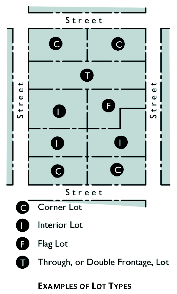
Lot, corner. A lot abutting upon two or more streets at their intersection.
Lot, double frontage. Any lot, other than a corner lot, which has frontage on two streets.
Lot, flag. A lot with access provided to the bulk of the lot by means of a narrow corridor.
Lot, interior. An interior lot is a lot other than a corner lot.
Lot, nonconforming. See "Nonconforming parcel."
Lot, through. A lot having its front and rear yards each abutting on a street.
Lumber yard and building materials sales. An establishment that stores (including outside storage), distributes and sells finished or rough-cut lumber and lumber products, as well as other heavy building materials.
Lowest floor. The lowest floor of the lowest enclosed area, including basement. An unfinished or flood resistant enclosure, usable solely for parking of vehicles, building access, or storage in an area other than a basement area, is not considered a building's lowest floor, provided that such enclosure is not built so as to render the structure in violation of other provisions of the floodplain management/flood damage prevention section in chapter 107, Resources Management.
M
Mail order or direct selling establishment. An establishment that offers services through sales staff that may go to the customers' location (e.g., door-to-door sales, home parties), or may utilize mail or electronic media, such as interactive television or computer. Examples of these establishments include: home delivery newspaper routes; home delivery of heating oil, liquefied petroleum gas, and other fuels; and establishments retailing from catalogue showrooms of mail-order houses. Does not include vending machine sales.
Major street. An existing or proposed street or highway designated as a major street on the official zoning map of the City of Canton, Georgia.
Major thoroughfare plan. A comprehensive plan or program for the development of the system of arterial, collector and local streets and roads for all or a portion of the City of Canton.
Manufactured home park. A parcel of land or any portion thereof under which has been designed, planned, or improved for the placement of two or more manufactured homes for residential use, including land, buildings, and facilities used by the occupants of manufactured homes on such property.
Manufactured home. A factory fabricated dwelling unit transportable in one or more sections and which is built on a permanent chassis and is installed with or without a permanent foundation, and which bears a label certifying that it is built in compliance with the Federal Manufactured Housing Construction and Safety Standard Act of 1974 (42 USC 5401, et. seq.), which became effective June 15, 1976. As used in the floodplain management/flood damage prevention section of chapter 107, Resource Management, the term shall include any structure commonly referred to as a "mobile home" regardless of the date of manufacture, and shall also include parked trailers, travel trailers and similar transportable structures placed on a site for 180 consecutive days or longer and intended to be improved property but does not include a "recreational vehicle."
Manufacturer (alcoholic beverage). Any maker, producer or bottler of an alcoholic beverage.
Manufacturing. Establishments engaged in the mechanical or chemical transformation of materials or substances into new products, including the assembling of component parts, the creation of products, and the blending of materials.
Manufacturing—Chemicals, metals, machinery and electronics. Manufacturing establishments that transform or refine chemicals or metals, and manufacture products from chemicals or metals. These establishments manufacture: petroleum and coal products (by transforming crude petroleum and coal into usable products); chemicals, plastics, and rubber products; nonmetallic mineral products such as bricks, refractories, ceramics, glass, cement, concrete, lime, gypsum, abrasives, ceramic plumbing fixtures, statuary, cut stone products, and mineral wool (by transforming nonmetallic minerals, such as sand, gravel, stone, clay, and refractory materials); basic metal products, such as ingot, billet, sheets, strips, bars, rods, wires, and castings, or finished products (by smelting/refining and transforming metal); products that apply mechanical force, such as machinery for agriculture, construction, mining, ventilation, industrial/commercial heating and cooling, and metalworking; electrical equipment, appliance, and components manufacturing, such as computers, computer peripherals, communications equipment, audio equipment, lighting equipment, batteries, motors, and other products that generate, distribute and use electrical power; and equipment for transporting people and goods, such as automobiles.
Manufacturing—Food, textiles and related products. Manufacturing establishments that produce or manufacture: food products for intermediate or final consumption in a process that primarily uses raw materials from livestock or agricultural products; nonalcoholic and fermented and distilled alcoholic beverages (excluding malt liquor); ice; tobacco products; textiles and apparel; and leather and leather substitute (such as rubber, plastics or textiles) products.
Manufacturing—Miscellaneous. Manufacturing establishments that manufacture products not classified elsewhere, such as: jewelry and silverware; dolls, toys, games and musical instruments; office supplies (excluding paper); and signs.
Manufacturing—Wood, paper and printing products. Manufacturing establishments that manufacture: wood and paper products, such as lumber, plywood, veneers, wood containers, wood flooring, wood trusses, and prefabricated wood buildings; paper, pulp or converted paper products, such as paper bags; printed materials, such as newspapers, books, periodicals, and greeting cards; and furniture and related articles, such as mattresses, windows blinds, cabinets, fixtures, furniture parts, and frames.
Mass grading. The movement of earth by mechanical means to alter the gross topographic features, including elevation and slope, to prepare a site for final grading and construction of facilities, including buildings, parking lots, and roads.
Mean sea level. The datum to which base flood elevations shown a community's flood insurance rate map (FIRM) are referenced. For purposes of the floodplain management/flood damage prevention section in chapter 107, Resource Management, the term is synonymous with National Geodetic Vertical Datum (NGVD) of 1929 or the North American Vertical Datum (NAVD) of 1988.
Metes and bounds. A system of describing and identifying land by distances or measures (metes) and bearings or direction (bounds) from an identifiable point of reference, such as a monument or other marker or the corner of intersecting streets.
Metropolitan River Protection Act (MRPA). A state law referenced as O.C.G.A. § 12-5-440 et seq. which addresses environmental and developmental matters in certain metropolitan river corridors and their drainage basins.
Miniature golf. Indoor or outdoor novelty golf game played on a miniature course. These establishments are distinct from golf courses and country clubs.
Mining and extracting establishments. These establishments extract natural mineral solids (coal and ores), liquid minerals (crude petroleum), and gases (natural gas). Mining includes quarrying, well operations, beneficiating (e.g., crushing, screening, washing, and flotation), and other preparations customarily performed at the mine site, or as a part of mining activity.
Mobile food services. Any motorized or non-motorized vehicle designed and used to portion, prepare and handle any foods not received and handed to customers in sealed packages. For the purpose of this definition, a "motorized vehicle" is further defined as an enclosed, road-worthy, wheel mounted vehicle that is not a tractor trailer. A "motorized vehicle" shall include the term "food truck." A "non-motorized vehicle" is further defined as any rubber-wheeled pushcart, and includes the term "food cart."
Mobile home. A structure, transportable in one or more sections, which, in the travelling mode, is eight body feet or more in width, or 40 body feet or more in length or, when erected on site, is 320 or more square feet, and is built on a permanent chassis and designed to be used as a dwelling with or without a permanent foundation when connected to the required utilities and includes the plumbing, heating, air-conditioning, and electrical systems contained therein and manufactured prior to June 15, 1976.
Modular home. A factory fabricated dwelling unit built in one or more sections designed to fit together on a permanent foundation but which usually does not originally have wheels for movement and which is constructed in accordance with the Georgia Industrialized Building Act and which bears the seal of approval issued by the Commissioner of the Georgia Department of Community Affairs. Includes the term "industrialized housing."
Movie theater. A specialized indoor theater for showing movies or motion pictures.
Multi-family dwelling. See "Dwelling, multi-family."
Multi-storied parking structure with ramps. A building or structure consisting of more than one level and used for the parking of vehicles.
Museum, exhibition, or similar facility. Establishments that present displays of natural, historic, educational, or cultural interest such as: exhibitions and art galleries; planetariums; aquariums; and outdoor facilities without a major structure.
N
Natural features. Trees or other living vegetation, rocks, and other landscape features that were created by natural processes.
National Geodetic Vertical Datum (NGVD). As corrected in 1929 is a vertical control used as a reference for establishing varying elevations within the floodplain.
Natural ground surface. The ground surface in its original state before any grading, excavation or filling.
Natural vegetated area. An undeveloped area largely free from human disturbance where naturally occurring vegetation is allowed to remain undisturbed or is enhanced and maintained by human intervention. Activities specifically allowed in such an area include the following:
1)
Conservation or preservation of soil, water, vegetation, fish, shellfish and other wildlife.
2)
Outdoor recreational activities including hunting, fishing, trapping, bird watching, hiking, boating, horseback riding, swimming, canoeing, skeet and trap shooting, education, scientific research and nature trails.
3)
Maintenance or repair of lawfully located roads, structures and utilities used in the service of the public, provided the work is conducted using best management practices to ensure that negative effects on the previous nature of the land shall be minimized.
4)
Limited excavating, filling and land disturbance necessary for the repair and maintenance of structures necessary to the uses permissible in the area as provided in this definition.
Nephelometric turbidity units (NTU). Numerical units of measure based upon photometric analytical techniques for measuring the light scattered by finely divided particles of a substance in suspension. This technique is used to estimate the extent of turbidity in water in which colloidally dispersed or suspended particles are present.
Net acre. An acre of land less the public improvements.
New construction. As used in the floodplain management/flood damage prevention section of chapter 107, Resource Management, the term shall mean any structure for which the "start of construction" commenced after March 5, 1981 [i.e., the effective date of the initial floodplain management code or ordinance adopted by the community as a basis for that community's participation in the National Flood Insurance Program (NFIP)] and includes any subsequent improvements to the structure.
New manufactured home park or subdivision. As used in the floodplain management/flood damage prevention section of chapter 107, Resource Management: A manufactured home park or subdivision for which the construction of facilities for servicing the lots on which the manufactured homes are to be affixed (including, at a minimum, the installation of utilities, the construction of streets, and either final site grading or the pouring of concrete pads) is completed on or after March 5, 1981 [i.e., the effective date of the initial floodplain management code or ordinance adopted by the community as a basis for that community's participation in the National Flood Insurance Program (NFIP)].
NOI. A notice of intent form provided by EPD for coverage under the state general permit.
NOT. A notice of termination form provided by EDP to terminate coverage under the state general permit.
Nonconforming lot. A lot of record whose area, width, depth or other dimensions were lawful prior to the adoption or amendment of this UDC, but which, by such adoption or amendment, no longer meets the requirements of this UDC. Any parcel or lot which was subsequently annexed into the Canton city limits which does not meet the requirements of the particular zoning district shall also be considered to be nonconforming. Includes the term "nonconforming parcel."
Nonconforming structure. Any building or structure whose size, dimensions, location on a property or other features were lawful prior to adoption or amendment of this UDC, but which, by such adoption or amendment, no longer meets or conforms to one or more such requirements of this UDC.
Nonconforming use. Any use or activity that was lawfully established prior to the adoption or amendment to this UDC, but which, by reason of such adoption or amendment, is no longer a use or activity allowed by right or no longer meets or conforms to requirements of this UDC.
North American Vertical Datum (NAVD). Of 1988 is a vertical control used as a reference for establishing varying elevations within the floodplain.
Nuisance. Anything that interferes with the use or enjoyment of property, endangers public health or safety, or is offensive to the senses.
Nursing home. See "Skilled-nursing services."
O
Office building over storefronts. A type of mixed use development; a building that contains a variety of complementary and integrated uses, such as office and retail in a compact urban form.
Office or bank building. A building constructed for office-type use, such as: finance and insurance establishments (including bank, credit union, or savings institution; credit and finance establishment; investment banking, securities, and brokerage establishment; insurance-related establishment; and, fund, trust, or other financial establishment); real estate and property management services; business, professional, scientific, and technical services (including legal services; accounting, tax, bookkeeping, payroll services; architectural, engineering, and related services; graphic, industrial, and interior design services; consulting services; research and development services; advertising, media and photography services); and, administrative services (including facilities support services; employment agency; business support services; collection agency; travel arrangement and reservation services; investigation and security services. Does not include "Services to buildings and dwellings."
Office or bank building, with drive-through facility. An office building with drive-in windows to serve customers in automobiles.
Office or store building with residence on top. A type of mixed use development; a building that contains a variety of complementary and integrated uses, such as office, retail and residential in a compact urban form.
Official zoning map. The map that delineates the geographic location of the boundaries of zoning districts established in this UDC in relation to natural features, manmade features and/or property uses.
Open space, landscaped. That portion of a given lot, not covered by buildings, parking, access and service areas, that is designed to enhance privacy and the amenity of the development by providing landscaping features, screening and buffering for the benefit of the occupants or those in neighboring areas, or a general appearance of openness.
Open space. An area that is intended to provide light and air and is designed for either environmental, scenic, or recreational purposes. Open space shall not be deemed to include driveways, parking lots, or other surfaces designed or intended for vehicular travel. As used in the conservation subdivision/open space development section of chapter 107, Resource Management, the term shall mean the portion of the conservation subdivision that has been set aside for permanent protection; activities within the open space are restricted in perpetuity through the use of an approved legal instrument.
Operator. The party or parties that have (a) operational control of construction project plans and specifications, including the ability to make modifications to those plans and specifications; or (b) day-to-day operational control of those activities that are necessary to ensure compliance with an erosion, sedimentation and pollution control plan for the site or other permit conditions, such as a person authorized to direct workers at a site to carry out activities required by the erosion, sedimentation and pollution control plan or to comply with other permit conditions.
Outdoor display. An area located outside of a building used for display of merchandise or goods that are available for purchase from the business that is located on the premises.
Outdoor recreational sports facility. A facility providing various outdoor sports for fitness or recreational sports teams, clubs or individual activities, where the facilities are oriented more toward participants than spectators, such as: athletic/sports fields (baseball, football, softball, soccer, track and field, etc.); skateboard parks, swimming pools, and court sports (basketball, handball, squash, tennis, volleyball, racquetball, etc.) Does not include equestrian facilities or archery or shooting ranges.
Outdoor retail sales. Use of property for the display and sales of products primarily outside of a building, including but not limited to manufactured homes, burial monuments, swimming pools, portable storage sheds, playground equipment, etc. Typically a building/structure is located on-site in which the sale of the displayed items is finalized.
Outdoor storage. The keeping, in an unenclosed area, of any inventory, goods, junk, materials, merchandise, or commercial vehicles (includes raw, semi-finished and finished materials) in the same place for more than 24 hours.
Outfall. The location where storm water in a discernible, confined and discrete conveyance, leaves a facility or site or, if there is a receiving water on site, becomes a point source discharging into that receiving water.
Overlay zone. A set of zoning requirements that is described in the ordinance text is mapped and is imposed in addition to those of the underlying zoning district. Developments within the overlay zone must conform to the requirements of both the district and the overlay zone or the more restrictive of the two. Includes the term "overlay district."
Oversight committee. A committee comprised of the mayor, the community development director and the zoning administrator that is responsible for reviewing proposed community design plans in accordance with the design guidelines and standards section of chapter 103, Site Planning and Project Design Standards.
Owner. The legal or beneficial owner of a site, including, but not limited to, a mortgagee or vendee in possession, receiver, executor, trustee, lessee or other person, firm or corporation in control of the site.
P
Parcel. A piece or area of land formally described and recorded with block and lot numbers, by metes and bounds, by ownership, or in such a manner as to specifically identify the dimensions and/or boundaries.
Park. An outdoor recreation area that may provide a variety of recreational opportunities including playground equipment and open space areas for passive recreation and picnicking.
Parking area. An open, unoccupied space used or required for parking of vehicles exclusively and in which no gasoline or vehicular accessories are sold or no other business is conducted and no fees are charged.
Parking lot. An open area used exclusively for the temporary storage of motor vehicles and within which motor fuels and oils may be sold and fees charged, but no vehicles are to be equipped, repaired, rented or sold.
Parking space. An area to be used exclusively as a temporary storage space for a private motor vehicle.
Parking, shared. The development and use of parking areas on two or more separate properties for joint use by the business on those properties.
Pedestrian walkway. A right-of-way within a block dedicated to public use, having a minimum of ten feet in width, intended primarily for pedestrians and from which motor-propelled vehicles are excluded.
Perennial river. A river or section of a river that flows continuously throughout the year.
Perennial stream. A stream that flows throughout the whole year as indicated by a solid blue line on a United States Geological Survey Quadrangle map.
Performance bond/guarantee. Any security accepted by the City of Canton in the form of cash, certified check, performance bond, surety bond, or certificate of deposit endorsed to the City of Canton. Includes the term "maintenance guarantee."
Performance theater. An indoor facility with fixed seats that are arranged on a sloped or stepped floor and are oriented toward a performance stage. Includes the term "concert hall."
Perimeter. The boundaries or borders of a lot, tract, or parcel of land.
Permit. The authorization necessary to conduct a land-disturbing activity under the provisions of this UDC.
Permit holder. The individual, partnership, or corporation who has received an approved permit.
Permitted use. A use by right which is specifically authorized in a particular zoning district.
Person. Any individual, partnership, firm, association, joint venture, public or private corporation, trust, estate, commission, board, public or private institution, utility, cooperative, state agency, municipality or other political subdivision of the State of Georgia, any interstate body or any other legal entity.
Personal care home. See "Assisted-living services."
Personal services. Establishments providing non-medical services involving the care of a person or his or her personal goods or apparel. These establishments include: barber and beauty shops; tailor and dressmaker shops; shoe repair; coin-operated laundromats; dry cleaning pick-up stores; massage therapy services that are licensed in accordance with the Georgia Massage Therapy Practice Act; locksmiths; clothing rental stores; and tanning salons that are registered in accordance with O.C.G.A. tit. 31, ch. 38.
Personal services—Restricted. Personal services that may tend to have a potentially offensive effect upon surrounding areas and which may need to be dispersed to minimize their adverse impacts. Examples of these services include: bail bonds, check cashing and cash advancing businesses; title loan businesses; fortune tellers, psychics, and palm, tarot and card readers; tattoo and body piercing services licensed in accordance with the North Georgia Health District 1-2, Rules and Regulations of Body Art Studios and Tattoo/Body Piercing Artists; and pawn shops.
Pervious surface. All that area of land that can be landscaped or planted, allows natural passage through by water, and is not covered by manmade materials or structures such as buildings or paving.
Pet or pet supply store. An establishment that sells pets, pet foods, and other pet supplies. Does not include the sale of animals for farming purposes.
Phase or phased. Sub-parts or segments of construction projects where the sub-part or segment is constructed and stabilized prior to completing construction activities on the entire construction site.
Phasing. As used in the mass grading and clearing section of chapter 107, Resource Management, the term shall mean the clearing or grading a parcel of land in distinct phases with the stabilization of each phase before the clearing or grading of the next.
Plans. As used in chapters 108 and 111 this UDC, those drawings that show the character and scope of work and shall include all drawings identified in the contract documents.
Planned development. An area of a minimum contiguous size that allows a combination of uses and is planned and developed in accordance with an approved master plan.
Planned shopping center. A group of commercial establishments, planned, developed, owned and managed as a unit, with off-street parking provided on the property and related in its location, size and type of shops to the trade area which the unit serves. Includes the term "commercial shopping center."
Plat. A map representing a tract of land, showing the boundaries and location of individual properties and streets; a map of a subdivision or site plan.
Plat, final. The final map of all or a portion of a subdivision or site plan which is presented to the proper review authority for final approval.
Plat, preliminary. A preliminary map indicating the proposed layout of the subdivision or site plan which is submitted to the proper review authority for consideration and preliminary approval.
Pollutant. A nontoxic substance that is introduced into the potable water supply would be objectionable but would not create a health hazard.
Pollution susceptibility. The relative vulnerability of an aquifer to being polluted from spills, discharges, leaks, impoundments, applications of chemicals, injections and other human activities in the recharge area. Each significant recharge area shown on Hydrologic Atlas 18 is classified on Hydrologic Atlas 20 as high, medium, or low, and these classifications are relevant in this UDC.
Postal services. Establishments that operate the national postal service. Establishments that perform one or more postal services, such as sorting, routing, and delivery on a contract basis (except the bulk transportation of mail), are included in this definition.
Premises. A lot together with all buildings and structures existing thereon.
Present value. The current value of past, present, or future payments, contributions, or dedications of goods, services, materials, construction, or money, as calculated using accepted methods of financial analysis for determination of "net present value."
Principal building. A building in which the primary use of the lot on which the building is located is conducted.
Principal use. The primary use and chief purpose of a lot or structure.
Project. The entire proposed development project regardless of the size of the area of land to be disturbed. As used in chapter 113, Development Impact Fees, the term shall mean a particular development on an identified parcel of land.
Project improvements. As used in chapter 113, Development Impact Fees, the following definition shall apply: Site improvements and facilities that are planned, designed, or built to provide service for a particular development project and that are necessary for the use and convenience of the occupants or users of the project, and are not "system" improvements. The character of the improvement shall control a determination of whether an improvement is a "project" improvement or a "system" improvement, and the physical location of the improvement on-site or off-site shall not be considered determinative of whether an improvement is a "project" improvement or a "system" improvement. If an improvement or facility provides or will provide more than incidental service or facility capacity to persons other than users or occupants of a particular project, the improvement or facility is a system improvement and shall not be considered a project improvement. No improvement or facility included in a plan for public facilities and approved for public funding by Canton, Georgia, shall be considered a project improvement.
Properly designed. As used in the soil erosion, sedimentation and pollution control section of chapter 107, Resource Management, the term shall mean designed in accordance with the design requirements and specifications contained in the "Manual for Erosion and Sediment Control in Georgia" (Manual) published by the Georgia Soil and Water Conservation Commission as of January 1 of the year in which the land-disturbing activity was permitted and amendments to the manual as approved by the commission up until the date of NOI submittal.
Property owner. That person or entity that holds legal title to property.
Proportionate share. That portion of the cost of system improvements that is reasonably and fairly related to the service demands and needs of a project.
Protected mountain area. All land area 2,200 feet or more above mean sea level, that has a percentage slope of 25 percent or greater for at least 500 feet horizontally and includes crests, summits and ridge tops which lie at elevations higher.
Protected river. Any perennial river or watercourse with an average annual flow of at least 400 cubic feet per second as determined by appropriate U.S. Geological Survey documents.
Protection area or stream protection area. With respect to a stream, the combined areas of all required buffers and setbacks applicable to such stream.
Public facilities. As used in chapter 113, Development Impact Fees, the term shall mean:
1)
Parks, open space, and recreation areas and related facilities;
2)
Public safety facilities, including police and fire protection facilities; and
3)
Road improvements.
Public improvements. Any drainage, roadway, parkway, sidewalk, pedestrian way, tree, lawn, off-street parking area, lot improvements or other facility for which local government may ultimately assume the responsibility for maintenance and operation, or which may affect an improvement for which local government responsibility is established. All such improvements shall be properly bonded.
Public notice. The advertisement of a public hearing in a paper of general circulation in the area, and through other media sources, indicating the time, place and nature of the public hearing.
Public or private property. As used in the litter control section of chapter 107, Resource Management, shall mean the right-of-way of any road or highway; any body of water or watercourse or the shores or beaches thereof; any park, playground, building, refuge, or conservation or recreation area; timberlands or forests; and residential, commercial, industrial, or farm properties.
Public safety-related facility. A facility used exclusively for public safety purposes by any department or branch of government, such as: fire and rescue stations; police stations; and emergency operation centers.
Public use. Any building, structure or use owned and/or operated by the federal government, State of Georgia, Cherokee County or other county, the City of Canton or other municipality, or any authorized, agency, board or commission of the above governments, which is necessary to serve a public purpose, such as but not limited to the following: government administrative buildings; police and fire stations; public health facilities and hospitals; public works camps; parks and community centers; public roads and streets; airports; water and sanitary sewerage storage; intake, collection and treatment and pumping facilities; public housing facilities; jails and correctional centers.
Public water supply. The City of Canton Water System.
Q
Quadrangle map. A one-to-twenty-four thousand (1:24,000), 7.5 minute topographic map published by the United States Geological Survey.
Quadrant. The most recently published U.S. Geological Survey 7.5-minute topographic map prepared at a scale of one-to-twenty-four thousand (1:24,000).
R
Racetrack. A circuit or course used for vehicular sports including automobile racing, dirt racing, motorcycle racing, and other cross country type events.
Railroad facility (excluding train station). A railroad switching facility, railroad shed, or other support structures.
Recharge area. Any portion of the earth's surface where water infiltrates into the ground to replenish an aquifer.
Recreational vehicle. A vehicle which is:
1)
Built on a single chassis;
2)
Four hundred square feet or less when measured at the largest horizontal projection;
3)
Designed to be self-propelled or permanently towable by light duty truck; and
4)
Designed primarily not for use as a permanent dwelling but as temporary living quarters for recreational, camping, travel, or seasonal use.
Reduced-pressure zone backflow-prevention assembly (RPZ). A device that consists of two springloaded independently acting check valves with an intermediate, reduced pressure zone draining to the atmosphere by an independently acting relief valve. The unit operates on the principle that water will not flow from a zone of lower pressure to a zone of higher pressure.
Recyclable material wholesaler. An establishment engaged in the merchant wholesale distribution of automotive scrap, industrial scrap, and other recyclable materials. These establishments include auto wreckers engaged in dismantling motor vehicles for the purpose of wholesaling scrap.
Regulated activity. Any activity which will, or which may reasonably be expected to, result in the discharge of dredged or fill material into waters of the U.S. excepting those activities exempted in section 404 of the Federal Clean Water Act.
Religious facility. Church, synagogue, temple, mosque or other facility that is designed for worship, ceremonies, and rituals pertaining to a particular system of beliefs.
Repetitive loss. Flood-related damages sustained by a structure on two separate occasions during a ten-year period for which the cost of repairs at the time of each such flood event, on the average, equals or exceeds 25 percent of the market value of the structure before the damage occurred.
Replacement density factor (RDF). The minimum number of tree density units which must be achieved on a property after calculating tree density units for existing trees (EDF) which will remain on site to be protected during construction.
Reservoir boundary. The edge of a water supply reservoir defined by its normal pool level.
Restaurant, fast food. A restaurant building where food or drink are served for consumption, either on or off the premises, by order from or service to persons either over an interior counter, outside the structure or from an outdoor service window or automobile service window, or by delivery.
Restaurant, with drive-through facility. A restaurant building that serves food for customers for consumption on or off premises and that has drive-in windows to service customers in automobiles.
Restaurant, without drive-through facility. A restaurant building that serves food for customers for consumption on or off premises.
Retail sales—Durable goods. Establishments engaged in a sales and service use in which household or personal items are rented or sold. These items are generally smaller than those offered by "Retail sales — Heavy consumer goods" establishments. Examples of "Retail sales — Durable goods" establishments include: computer and software stores; camera and photographic supplies stores; cellular telephone stores; clothing, jewelry, luggage and shoe stores; sporting goods, toy and hobby, and musical instruments stores; and, books, magazines, and music and stationary stores.
Retail sales — Heavy consumer goods. Establishments engaged in a heavy sales and service use in which large household items are rented or sold, and home delivery by truck may be required. Examples include: furniture or home furnishing store; hardware store or home center; lawn and garden supply store; and electronics and appliances stores. These establishments may provide outdoor areas to conduct business where there is a service or retail need, and outdoor sales or storage areas are an integral part of the use.
Retail sales — Other consumer goods. Establishments that sell merchandise for household and personal use (except groceries or health items) not included in the definitions for "Retail sales — Heavy consumer goods" and "Retail sales — Durable consumer goods." Examples of these establishments are florists, art stores, and tobacco stores.
Rezoning. An amendment to or a change in the official zoning map.
Right-of-way. That public or private area, distinguished from an easement, on which an irrevocable right of passage has been recorded for the use of vehicles and utilities.
Riparian. Belonging or related to the bank of a river, stream, lake, pond or impoundment.
Riverbank. The rising ground, bordering a river, which serves to confine the water to the natural channel during the normal course of flow.
River corridor. All land, inclusive of islands, in areas of a protected river, which serves to confine the water to the natural channel during the normal course of flow. Because stream channels move due to natural processes, the river corridor may shift with time. For the purpose of the river corridor protection section in chapter 107, Resource Management, the river corridor shall be considered to be fixed at its position at the time of adoption of the river corridor protection plan. Any shift in the location after that time will require a revision of the boundaries of the river corridor at the time of comprehensive plan review by the state department of community affairs.
River corridor protection plan. That part of the local comprehensive plan which deals with the river corridor protection requirements specified in this article.
Road, private. (See also "Right-of-way" and "Street.") A way open to vehicular ingress and egress established as a separate tract for the benefit of certain, adjacent properties. This definition shall not apply to driveways.
Road, public. (See also "Right-of-way" and "Street.") All public property reserved or dedicated for street traffic.
Rooftop parking facility. A parking area on the roof of a building, typically a commercial building or mixed use development.
Roadway drainage structure. A device such as a bridge, culvert, or ditch, composed of a virtually nonerodible material such as concrete, steel, plastic, or other such material that conveys water under a roadway by intercepting the flow on one side of a traveled roadway consisting of one or more defined lanes, with or without shoulder areas, and carrying water to a release point on the other side.
Rooming and boarding. Temporary accommodations that serve a specific group or membership, such as a dormitory, fraternity or sorority house, or workers' camp and that may offer housekeeping, meals, and laundry services.
S
Satellite dish antenna. A device incorporating a reflective surface that is solid, open mesh, or bar configured and is in the shape of a shallow dish, cone, horn, or cornucopia. Such device shall be used to transmit and/or receive radio or electromagnetic waves between terrestrially and/or orbital based uses. This definition is meant to include but not be limited to what are commonly referred to as satellite earth stations, TVRO's (television reception only satellite dish antennas), and satellite microwave antennas.
Scenic corridor. Those roadways that have a view of unusual natural significance in the city.
Scenic easement. An easement, the purpose of which is to limit development in order to preserve a view or scenic area.
Screen. A method of shielding, obscuring or buffering one use or building from another use or building by fence, walls, berms, densely planted vegetation or other means.
Seating capacity. The actual seating capacity of an area based upon the number of seats or one seat per 18 inches of bench or pew length.
Sediment. Solid material, both organic and inorganic, that is in suspension, is being transported, or has been moved from its site of origin by wind, water, ice, or gravity as a product of erosion.
Sediment basin. A barrier or dam built across a waterway or at suitable locations to retain sediment.
Sedimentation. The process by which eroded material is transported and deposited by the action of water, wind, ice or gravity.
Sensitive natural areas. Any area, as identified by the state department of natural resources, which contains one or more of the following:
1)
Habitat, including nesting sites, occupied by rare or endangered species;
2)
Rare or exemplary natural communities;
3)
Significant land forms, hydro forms or geological features; or
4)
Other areas so designated by the state department of natural resources and which are sensitive or vulnerable to physical or biological alteration.
Service area. As used in chapter 113, Development Impact Fees, the term shall mean a geographic area as defined by the city council of the City of Canton, Georgia, in which a defined set of public facilities provide service to development within the area. Service areas shall be designated on the basis of sound planning or engineering principles or both.
Services to buildings and dwellings. Establishments that primarily provide services associated with building maintenance and that may require use of a vehicle fleet. Examples of these establishments include pest control and extermination services; janitorial services for building and transportation equipment interiors, as well as windows; landscaping services; carpet and upholstery cleaning; and packing, crating and convention trade show services, which package client owned materials and organize, promote, and manage events such as business and trade shows, conventions, conferences, and meetings.
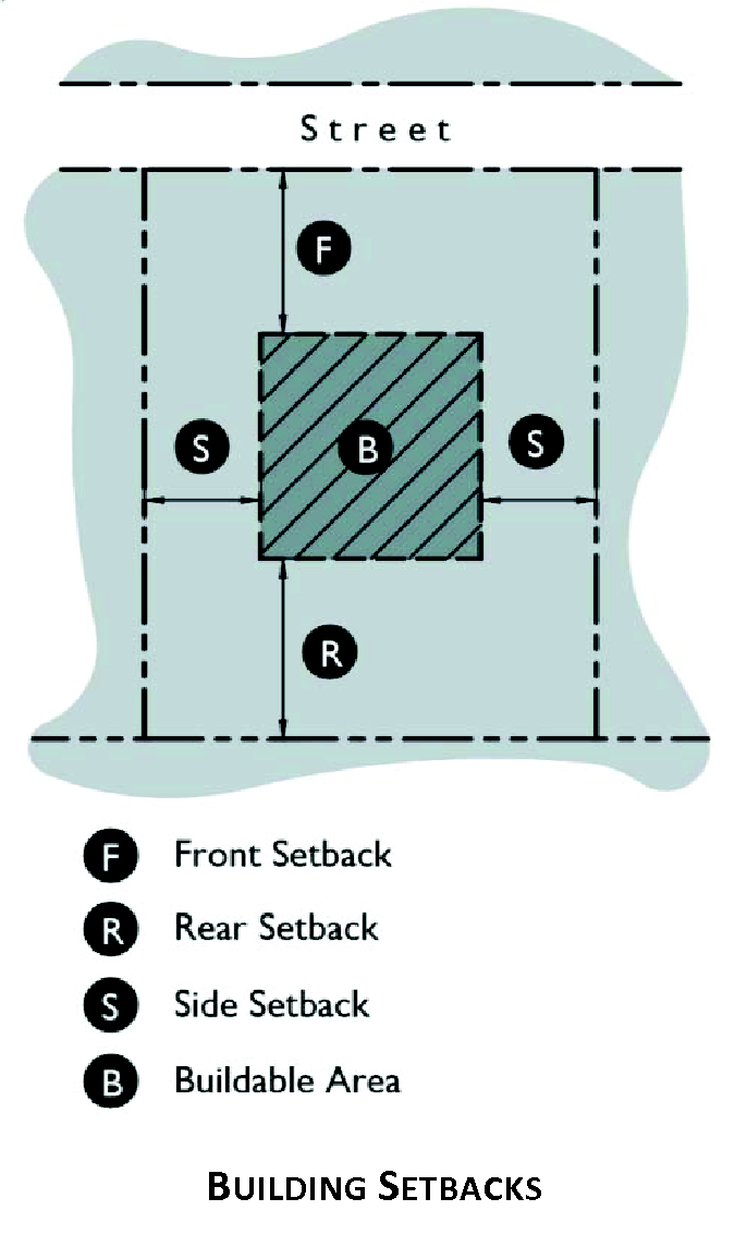
Setback. The minimum horizontal distance between a street, alley, or the property boundary lines of a lot and the front, rear, or side lines of a building located on that lot. As used in the stream buffer section of chapter 107, Resource Management, the term shall mean the area established by the land development requirements subsection extending beyond any buffer applicable to the stream. As used in the river corridor section of chapter 107, Resource Management, the term shall mean the measurement for buffer areas which shall be measured horizontally from the uppermost part of the riverbank, usually marked by a break in the slope.
Front setback. See "Yard, front."
Rear setback. See "Yard, rear."
Side setback. See "Yard, side."
Sexually-oriented business (also known as "adult-oriented business"). Any business establishment or concern which as a regular and substantial course of conduct operates as adult arcade, adult bookstore, adult cabaret, adult dance studio, adult hotel/motel, adult modeling studio, adult theater; any business establishment or concern which as a regular and substantial course of conduct sells or distributes or offers for sale or distribution sexually oriented merchandise or sexually oriented material; or any other business establishment or concern which as a regular and substantial course of conduct offers to its patrons products, merchandise, services, or entertainment characterized by an emphasis on matters depicting, describing, or relating to specified sexual activities or specified anatomical areas as a regular and substantial course of conduct when one or more of the following conditions exist:
1)
The area devoted to adult merchandise and/or sexually oriented materials exceeds more than 20 percent of the total display or floor space area open to the public;
2)
The business establishment or concern presents any type of live entertainment which is characterized by an emphasis on specified sexual activity or specified anatomical areas at least four times in any one month;
3)
The regular and substantial course of conduct of the business consists of or involves the sale, trade, display, or presentation of services, products, or entertainment which are characterized by an emphasis on matter depicting, describing, or relating to specified sexual activities or specified anatomical areas.
The following terms and phrases are defined for the purposes of the additional requirements for allowed uses section (sexually oriented businesses subsection) in chapter 104, Standards for Specific Uses:
Adult arcade. Any business establishment or concern containing one or more coin or slug operated or manually or electronically controlled still or motion picture projectors, video machines, projector or similar image-producing devices, that are maintained to display images to an individual or group of individuals when those images are distinguished or characterized by an emphasis on matter depicting, describing, or relating to specific sexual activities or specified anatomical areas.
Adult bookstore or adult video store. Any establishment which as a regular and substantial course of conduct, displays and/or distributes sexually oriented merchandise, sexually oriented material, books, periodicals, magazines, or other printed materials, or photographs, drawings, sculptures, films, motion pictures, videos, discs, cassettes, slides, tapes, records, or other form of visual or audio representations which are distinguished or characterized by their emphasis on matter depicting, describing, or relating to specified sexual activities and/or specified anatomical areas (see "Adult-oriented business" for definition of regular and substantial course of conduct).
Adult cabaret. A nightclub, bar, lounge, restaurant, or similar business establishment or concern which features as a regular and substantial course of conduct, any type of live entertainment, films, motion pictures, computer generated images, videos, discs, slides, or other photographic reproductions, or other oral, written or visual representations which are distinguished or characterized by an emphasis upon matter depicting, describing, or relating to specified sexual activities or specified anatomical areas.
Adult dance studio. Any business establishment or concern which provides for members of the public a partner for dance where the partner, or the dance is distinguished or characterized by an emphasis upon matter depicting, describing, or relating to specified sexual activities or specified anatomical areas.
Adult hotel/motel. A hotel, motel, or other similar business establishment or concern offering public accommodations for any form of consideration which as a regular and substantial course of conduct provides to its patrons, through the provision of rooms equipped with closed-circuit television, films, computer generated images, motion pictures, videos, discs, slides, other photographic reproductions, or other medium, material which is distinguished or characterized by an emphasis on matter depicting, describing, or relating to specified sexual activities or specified anatomical areas and which rents, leases, or lets any room for less than a 12-hour period, or rents, leases, or lets any single room more than once in a 24-hour period.
Adult modeling studio. Any business or premises where there is furnished, provided, or procured, a figure model or models who pose in any manner which is characterized by its emphasis on matter depicting, describing, or relating to specified sexual activities or specified anatomical areas where the model(s) is being observed or viewed by any person for the purpose of being sketched, photographed, painted, drawn, sculpted, filmed, or videotaped or otherwise depicted for a fee, compensation, gratuity, or other thing of value as consideration for the right or opportunity to so observe the model(s) or to remain on the premises. "Adult modeling studio" does not include any live art class or any studio or classroom which is operated buy any public agency, or any private educational institution authorized to issue and confer a diploma or degree in compliance with standards set by the state board of education or the state board of regents.
Adult theater. A business establishment or concern which, as a regular and substantial course of conduct, presents live entertainment performances, motion pictures, videos, computer generated images, slide photographs, or other pictures or visual or audio representations or reproductions which are distinguished or characterized by their emphasis on matter depicting, describing, or relating to specified sexual activities or specified anatomical areas.
Adult-oriented business operator. A person who supervises, manages, inspects, directs, organizes, controls, or in any other way is responsible for or in charge of the premises of an adult-oriented business or the conduct or activities occurring on the premises thereof. This term shall hereinafter be referred to as "operator."
Applicant. A person who is required to file an application for a permit under this UDC, including an individual owner, managing partner, officer of a corporation, or any other operator, manager, employee, or agent of an Adult-Oriented Business.
Bar. Any commercial establishment licensed by the City of Canton and the State of Georgia to serve any alcoholic beverages on the premises.
Distinguished or characterized by an emphasis upon. Shall mean and refer to the dominant or essential theme of the object described by the phrase. For instance, when the phrase refers to films "which are distinguished or characterized by an emphasis upon" the depiction or description of specified sexual activities or specified anatomical areas, the films so described are those whose dominant or predominant character or theme are the depiction of the enumerated sexual activities or anatomical areas. See Pringle v. City of Covina (1981) Cal.App.3d 151.
Employ, employee, and employment. Describe and pertain to any person who performs any service on the premises of a sexually oriented business, on a full-time, part-time, or contract basis, whether or not the person is denominated an employee, independent contractor, agent, or otherwise. The term "employee" does not include a person exclusively on the premises for repair or maintenance of the premises or for the delivery of goods to the premises.
Entertainer. Any person who dances, models, entertains, and/or performs specified sexual activities or displays specified areas in an adult-oriented business.
Establishment of an adult-oriented business. Shall mean and include any of the following: The opening or commencement of any adult-oriented business as a new business; the conversion of an existing business, whether or not an adult-oriented business, to any adult-oriented business defined herein; the addition of any of the adult-oriented businesses defined herein to any other existing adult-oriented business; or the relocation of any adult-oriented business.
Figure model. Any person who, for pecuniary compensation, consideration, hire, or reward, poses in a modeling studio to be observed, sketched, painted, drawn, sculptured, photographed, or otherwise depicted.
Hearing officer. An independent attorney licensed to practice in the State of Georgia.
Influential interest. Means any of the following:
a.
The actual power to operate the sexually oriented business or control the operation, management or policies of the sexually oriented business or legal entity which operates the sexually oriented business; or
b.
Holding an office (e.g., president, vice president, secretary, treasurer, managing member, managing director, etc.) in a legal entity which operates the sexually oriented business.
Live art class. Any premises on which all of the following occur: There is conducted a program of instruction involving the drawing, photographing, or sculpting of live models exposing specified anatomical areas; instruction is offered in a series of at least two classes; the instruction is offered indoors; an instructor is present in the classroom while any participants are present; and pre-registration is required at least 24 hours in advance of participation in the class.
Nudity or a state of nudity. The showing of the human male or female genitals, pubic area, or buttocks with less than a fully opaque covering, the showing of the female breast with less than a fully opaque covering of any part of the aerola.
Operate an adult-oriented business. The supervising, managing, inspecting, directing, organizing, controlling, or in any way being responsible for or in charge of the conduct of activities of an adult-oriented business or activities within an adult-oriented business.
Permitee. The person to whom an adult-oriented business permit is issued.
Person. Any individual, partnership, co-partnership, firm, association, joint stock company, corporation, or combination of the above in whatever form or character.
Sexual device shop. A commercial establishment that regularly features sexual devices. Nothing in the term "sexual device shop" shall be construed to include any pharmacy, drug store, medical clinic, or any establishment primarily dedicated to providing medical or healthcare products or services, nor shall the term "sexual device shop" be construed to include commercial establishments which do not restrict access to their premises by reason of age.
School. Any child or day care facility, or an institution of learning for minors, whether public or private, offering instruction in those courses of study required by the Georgia Board of Education (Georgia Education Code) and maintained in compliance with the standards set by the state board of education. This definition includes a nursery school, kindergarten, elementary school, middle or junior high school, senior high school, or any special institution of education or an institution of higher education including a community or junior college, vocational/technical college, college, or university.
Semi-nude. A state of dress in which clothing covers no more than the genitals, pubic region, buttocks, areola of the female breast, as well as portions of the body covered by supporting straps or devices.
Sexual encounter center. Any business, agency, or person who, for any form of consideration or gratuity, provides a place where three or more persons, not all members of the same family, may congregate, assemble, or associate for the purpose of engaging in specified sexual activities or exposing specified anatomical areas.
Sexually oriented material. Any element of sexually oriented merchandise, or any book, periodical, magazine, photograph, drawing, sculpture, motion picture film, video, disc, computer generated image, or other written, oral, or visual representation which, for purposes of sexual arousal, provides depictions which are characterized by an emphasis on matter depicting, describing, or relating to specified sexual activities or specified anatomical areas.
Sexually oriented merchandise. Sexually oriented implements and paraphernalia, including but not limited to dildos, auto sucks, sexually oriented vibrators, edible underwear, benwa balls, inflatable orifices, anatomical balloons with orifices, simulated and battery or electrically operated vaginas or penises, and similar sexually oriented devices which are designed or marketed primarily for the stimulation of human genital organs or sado-masochistic activity or which are distinguished or characterized by their emphasis on matter depicting, describing, or relating to specified sexual activities or specified anatomical areas.
Specified anatomical areas. Shall mean and include any of the following:
a.
Less than completely and opaquely covered human: (1) genitals or pubic region; (2) buttocks; and/or (3) female breast below a point immediately above the top of the areola; or
b.
Human male genitals in a discernibly turgid state, even if completely and opaquely covered; or
c.
Any device, costume, or covering that simulates any of the body parts included in Subparagraphs a. or b., above.
Specified sexual activities. Shall mean and include any of the following, whether performed directly or indirectly through clothing or other cover:
a.
The relocation of any adult-oriented business;
b.
Actual or simulated sexual intercourse, oral copulation, anal intercourse, oral-anal copulation, bestiality, direct physical stimulation of genitals, flagellation or torture in the context of a sexual relationship, or the use of excretory function in the context of a sexual relationship, ant of the following depicted sexually oriented acts or conduct: Analingus, bestiality, buggery, coprophagy, coprophilia, cunnilingus, fellatio, necrophilia, pdeerastuy, pedophilia, piquerism, sapphism, zooerastia;
c.
Clearly depicted human genitals in a state of sexual stimulation, arousal, or tumescence;
d.
Use of human or animal ejaculation, sodomy, oral copulation, coitus, or masturbation;
e.
Fondling, or touching of nude human genitals, pubic region, buttocks, or female breast;
f.
Masochism, erotic, or sexually oriented torture, beating, or the infliction of pain;
g.
Erotic or lewd touching, fondling, or other sexually oriented contact with an animal by a human being; or human excretion, urination, menstruation, vaginal, or anal irrigation; or
h.
The presence of any person who performs, or appears in a state of nudity or semi nude.
Shooting range. See "Archery or shooting range."
Short-term rental unit. An accommodation for transient guests where, in exchange for monetary compensation, a residential dwelling unit, either the primary structure or portion thereof, or any approved accessory dwelling, is provided for lodging for a period of time not to exceed 30 consecutive days. For the purposes of this definition, a residential dwelling shall include all single family and multi-family housing types with no more than five bedrooms offered for rent and shall exclude group living or other lodging uses, as defined in the Unified Development Code and regulated separately throughout this Code. A motor vehicle as defined in O.C.G.A. tit. 40 may not be used as a short-term rental. A property that has been advertised or listed via the internet or other media sources (e.g. www.vrbo.com, www.airbnb.com, etc.) for short-term rental shall be prima facie evidence the property is being used as a short-term rental.
Shrub. Prostrate or upright woody plants, either evergreen or deciduous with a mature height usually less than ten feet.
Sidewalk café. An area adjacent to and directly in front of a street-level eating or drinking establishment located within the sidewalk area of the public right-of-way exclusively for dining, drinking, and pedestrian circulation. The encroachment area of a sidewalk cafe may be separated from the remainder of the sidewalk by railings, fencing, or landscaping planter boxes or a combination thereof.
Sidewalk. A paved surface or leveled area, paralleling and usually separated from the street, used for pedestrian traffic and/or movement.
Sign. Any display of words, shapes or images designed to convey a message to the viewer, located on the exterior of any dwelling, building or structure, or located anywhere on a lot upon a dedicated supporting structure or device, including poles, banners, windows and similar devices.
The following terms and phrases are defined for the purposes of the signs section in chapter 103, Site Planning and Project Design Standards:
A-frame sign. Any single or double faced sign which may readily be moved from place to place, and which is intended to be used on a sidewalk or pedestrian way. Includes the term "sandwich board sign."
Abandoned sign. Any permanent sign that is located on property which becomes vacant or is unoccupied for a period of 60 days or more, or any temporary sign that pertains to a time, event, or purpose which no longer applies.
Accessory sign. A sign made for short term use, containing no reflecting elements, flags, or projections and which may contain any commercial or non-commercial message, or any political or non-political message, except that such messages cannot depict obscenity, as defined by O.C.G.A. § 16-12-80, or sexual conduct, nor can they display nudity as defined in this chapter, nor advertise any activity illegal under the laws of Georgia or the United States.
Advertising bench. A sign painted on, located on, or attached to any part of the surface of a bench, seat, or chair placed on or adjacent to a public place or roadway.
Animated sign. Any sign, or part of a sign, that uses any movement or change of lighting or color to depict action or create a special effect or scene.
Awning sign. Any sign that is part of, or attached to, an awning, canopy or other fabric, plastic or structural protective cover over a door, entrance, window, or outdoor service area. Includes the term "canopy sign."
Banner. A sign either enclosed or not enclosed in a rigid frame and secured or mounted so as to allow movement caused by the atmosphere. Flags of governmental jurisdictions are not banners.
Changeable copy. Letters, numerals, or other copy that may be manually or mechanically affixed to and/or removed from a sign. Examples of manual changeable copy include boards with changeable letters or changeable pictorial panels. Mechanical changeable copy shall mean an electronic sign.
Directional sign. A sign dedicated to providing traffic direction such as enter, exit, drive through, etc.
Double-faced sign. A sign which has two display areas against each other, where one face is designed to be seen from one direction and the other face from another direction.
Electronic sign. A sign whose message may be changed at intervals by computer controller, microprocessor controller or by remote control, and whose message is displayed through the use of LED, LCD, plasma or other similar type of panels or screens.
Freestanding sign. A sign supported by any structure or support placed in or anchored in the ground and not attached to any building or structure.
Ground sign. See "Monument sign."
Historic sign. Any sign designated as historic by the City of Canton Historic Preservation Commission in accordance with the criteria of an adopted historic preservation ordinance. Extensions, additions or embellishments are not considered part of a historic sign.
Illuminated sign, external. A sign illuminated by an external light source. Such source cannot be a device that changes color, flashes or alternates.
Illuminated sign, internal. A sign illuminated by an internal light source. Such source cannot be a device that changes color, flashes or alternates.
Inflatable sign. Any sign inflated or supported internally by wind, air, or pneumatic noncombustible pressure.
LCD sign. An electronically controlled sign utilizing liquid crystal diodes to form some or all of the sign message.
LED sign. An electronically controlled sign utilizing light-emitting diodes to form some or all of the sign message.
Official flag. Any fabric, banner, or bunting containing distinctive colors, patterns or symbols, used as a symbol of a government.
Monument sign. A freestanding sign mounted directly upon the ground and not attached to or part of or supported by a building and designed in such a manner that the base of the sign face is flush with the supporting solid base which is flush with the ground. The base shall be at least as wide as the sign.
Pennant. Any lightweight plastic, fabric, or material, whether or not containing a message of any kind, suspended from a rope, wire, or string, usually in series, designed to move in the wind as a means of attracting attention. Flags of governmental jurisdictions are not pennants. Includes the term "streamer."
Permanent sign. Any sign that is not temporary.
Pole or pylon sign. A sign that is mounted on a freestanding pole, pylon, columns, or similar support such that the bottom of the sign face or lowest sign module is not in contact with the ground.
Portable sign. Any sign whether on its own trailer, wheels, or otherwise, which is designed to be transported from one place to another. Even if the wheels or supports of such sign are removed and the sign converted and attached, temporarily or permanently, to the ground or other structure, said sign shall remain a portable sign. In addition, the following shall be deemed a portable sign: a sign mounted or painted upon a parked vehicle that is positioned for the primary purpose of acting as a sign exposed to the public and is not in use in the ordinary course of carrying out its transportation function.
Projecting sign. A double faced sign suspended from an awning or similar type structure; or affixed to a bracket-mount to the building or structure. Includes the term "swinging sign."
Real estate sign. A temporary sign erected by the owner, or agent, advertising the real property upon which the sign is located for rent, lease, or sale.
Roof sign. A sign erected upon or above a roof structure and wholly or partially supported by the roof. "Roof signs" shall also constitute any signage placed upon sloped building fascia intended to appear as or actually be roof elements of the building.
Sign area. The area within a continuous perimeter of a sign which encloses the limits of writing, representation, emblem or any figure of similar character, together with any frame, other material, open space, or color forming an integral part of the display or used to differentiate such sign from the background against which it is placed.
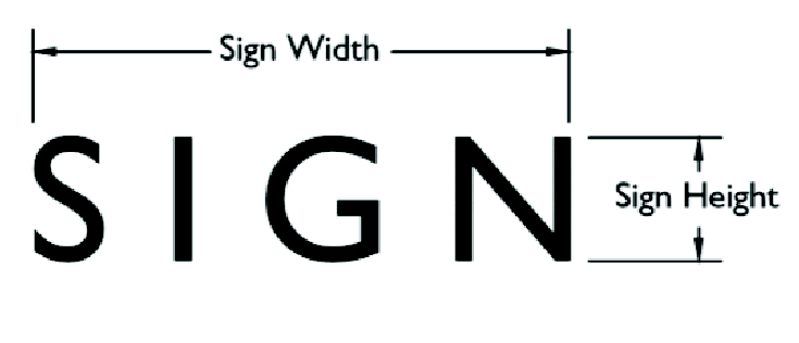
Sign face. The message-carrying portion of the sign that can be used to display content, including any area that can display or does display words, pictures or other communicative elements of the sign, including the background color.
Swinging sign. See "Projecting sign."
Temporary sign. Any sign not permanently affixed to the ground or other permanent structure and designed to be displayed for a limited time.
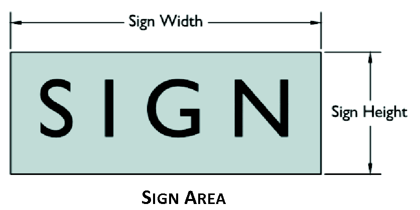
Tri-vision sign. A sign designed with a series of triangular slats or columns that mechanically rotate in sequence with one another to show three different sign messages in rotation.
Wall sign. Any sign attached parallel to a wall, painted on the wall surface or erected and confined within the limits of an outside wall of any building or structure, which is supported by such wall or building and which displays only one sign surface. Includes the term "painted sign."
Weekend directional sign. A temporary sign erected for the duration of a specific, time-limited weekend place or event.
Window sign. Any sign that is affixed to, made part of, or projected upon a window surface on the exterior of a building, including translucent surfaces of doors. A sign located interior to, within 15 feet of a window and visible from outside such window.
Yard sale sign. A temporary sign erected by the owner of the property on which the sale is conducted.
Significant recharge areas. Those areas mapped by the Georgia DNR in Hydrologic Atlas 18 (1989 edition) within the City of Canton. Each significant recharge area shall be determined to have a pollution susceptibility of high, medium, or low based on Hydrologic Atlas 20.
Silt. Finely divided particles of soil or rock, often carried in cloudy suspension in water and eventually deposited as sediment.
Single-family detached unit. A standard single-family residential building; a detached building containing one dwelling unit. A modular home shall be considered a single-family detached unit.
Site density factor (SDF). The minimum number of tree density units per acre which must be achieved on a property after development. (Twenty units per acre, exclusive of any acreage within a zoning buffer and any trees required to be preserved or planted in a zoning buffer.)
Site. Any tract, lot, or parcel or land in combination of tracts, lots, or parcels of land which are in one ownership or are contiguous and in diverse ownership where development is to be performed as part of a unit, subdivision, or project; the parcel of land being development, or the portion thereof on which the development project is located; all contiguous land and bodies of water in one ownership, graded or proposed for grading or development as a unit, although not necessarily at one time; regarding historic properties, a site is the location of a significant event, a prehistoric or historical occupation or activity, or a building or structure, whether standing, ruined, or vanished, where the location itself maintains historical or archaeological value regardless of the value of any existing structure.
Site plan. A document or group of documents containing sketches, text, drawings, maps, photographs, and other material intended to present and explain certain elements of a proposed development, including physical design, siting of buildings and structures, interior vehicular and pedestrian access, the provision of improvements, and the interrelationship of these elements.
Skilled-nursing services. Twenty-four-hour skilled nursing care that is provided in nursing homes and convalescent hospitals for the elderly.
Slope. An inclined earth surface, the inclination of which is expressed as the ratio of horizontal distance to vertical distance. In the hillside and ridgeline section of chapter 107, Resource Management, slopes are generally expressed as a percentage; percentage of slope refers to a given rise in elevation over a given run in distance. A 50 percent slope, for example, refers to a 100-foot rise in elevation over a distance of 200 feet. A 50 percent slope is expressed in engineering terms as a two-to-one (2:1) slope.
Social club, civic or fraternal. Establishments primarily engaged in promoting the civic and social interests of their members. Establishments may operate bars and restaurants for their members.
Soil and water conservation district approved plan. An erosion, sedimentation and pollution control plan approved in writing by the Limestone Valley Soil and Water Conservation District.
Solid waste landfill facility. A landfill used for the disposal of nonhazardous solid waste. These may locally collect or haul nonhazardous waste materials along with landfill operation. These establishments also manage recycling and resource recovery facilities that operate in conjunction with landfills.
Sporting goods, toy and hobby, and musical instruments stores. An establishment classified as "Retail sales — Durable goods" that offers the following items: sporting goods (specialized clothing, equipment and accessories for sport and recreational activities), such as bicycles and bicycle parts, camping equipment, exercise and fitness equipment, athletic uniforms, specialty sports footwear, and similar equipment and accessories; toys, games, and hobby and craft supplies; or musical instruments and related supplies and services, including music instruction and instrument rental or repair.
Sports stadium or arena. An enclosed area for the presentation of sports events and entertainment such as circuses, ice shows, indoor soccer, hockey games, horse shows, and music concerts.
Stabilization. The process of establishing an enduring soil cover of vegetation by the installation of temporary or permanent structures for the purpose of reducing to a minimum the erosion process and the resultant transport of sediment by wind, water, ice or gravity.
Stabilized. The process of establishing an enduring soil cover of vegetation by the installation of temporary or permanent structures for the purpose of reducing to a minimum the erosion process and the resultant transport of sediment by wind, water, ice of gravity.
Standard design specifications. Standards and specifications prepared by the city engineer and adopted by the mayor and council shall apply to the physical improvements required to be provided and installed by a subdivider in a subdivision.
Start of construction. As used in the floodplain management/flood damage prevention section of chapter 107, Resource Management, the term shall mean the date the permit was issued, provided the actual start of construction, repair, reconstruction, or improvement was within 180 days of the permit date. The actual start means the first placement of permanent construction of the structure such as the pouring of slabs or footings, installation of piles, construction of columns, or any work beyond the stage of excavation, and includes the placement of a manufactured home on a foundation. Permanent construction does not include initial land preparation, such as clearing, grading and filling; nor does it include the installation of streets and/or walkways; nor does it include excavation for a basement, footings, piers or foundations or the erection of temporary forms; nor does it include the installation on the property accessory buildings, such as garages or sheds not occupied as dwelling units or part of the main structure. (Note: accessory structures are not exempt from any UDC requirements). For a substantial improvement, the actual start of construction means the first alteration of any wall, ceiling, floor, or other structural part of a building, whether or not that alteration affects the external dimensions of the building.
State general permit. The National Pollution Discharge Elimination System (NPDES) general permit or permits for storm water runoff from construction activities as is now in effect or as may be amended or reissued in the future pursuant to the state's authority to implement the same through federal delegation under the Federal Water Pollution Control Act, as amended, 33 U.S.C. section 1251, et seq., and O.C.G.A. § 12-5-30(f).
State waters. Any and all rivers, streams, creeks, branches, lakes, reservoirs, ponds, drainage systems, springs, wells, and other bodies of surface or subsurface water, natural or artificial, lying within or forming a part of the boundaries of Georgia which are not entirely confined and retained completely upon the property of a single individual, partnership, or corporation.
Statement of intent. A document that accompanies the master plan application which describes, in detail, the type of development the master plan includes.
Storage facility. Rental mini-warehouses and self-storage units, which provide space (i.e., rooms, compartments, lockers, or containers) where clients store and retrieve goods.
Stormwater utility. Definitions related to the City of Canton's Stormwater Utility (see chapter 109, Design Standards: Streets and Stormwater Systems) are:
Credit. A conditional reduction in the amount of a stormwater service charge to an individual property based on the provision and continuing presence of an effectively maintained and operational on-site stormwater system or facility or the provision of a service or activity by property owners, which system, facility, service, or activity reduces the stormwater utility's cost of providing stormwater services and facilities. Credits for on-site stormwater systems shall be generally proportional to the affect that such systems have on the peak rate of runoff from the site.
Customers. All persons, properties, and entities served by and/or benefiting from the utility's acquisition, management, maintenance, extension, and improvement of the public storm water management systems and facilities and regulation of public and private stormwater storm water systems, facilities and activities related thereto, and persons, properties, and entities which will ultimately be served or benefited as a result of the stormwater management program.
Detached dwelling unit. Developed land containing one structure which is not attached to another dwelling and which contains one or more bedrooms, with a bathroom and kitchen facilities designed for occupancy by one family. Detached dwelling units may include houses, manufactured homes and mobile homes located on one or more individual lots or parcels of land. Developed land may be classified as a detached dwelling unit despite the presence of incidental structures associates with residential uses such as garages, carports or small storage buildings or the presence of a commercial impervious area such as parking spaces, playgrounds, or additions to the building which are used as offices, storage facilities, meeting rooms, classrooms, houses of worship, or similar non-residential uses. Detached dwelling units shall not include developed land containing: structures used primarily for non-residential purposes, manufactured homes and mobile homes located within manufactured home or mobile home parks where the land is owned by others than the owners of the manufactured homes or mobile homes, or multiple-unit residential properties.
Developed land. Property altered from its natural state by construction or installation of more than 200 square feet of impervious surfaces as defined below and in the stormwater utility section of chapter 109 of this UDC.
Duplexes. Developed land containing two (duplex) attached residential dwelling units located on one or more parcels of land.
Impervious runoff unit (IU) or impervious area. The unit of impervious coverage of detached dwelling units properties in the City of Canton as determined by the city, and shall be used as the basis for determining stormwater service charges to detached dwelling unit properties or classes of detached dwelling unit properties and other properties. Single-family residential (SFR) shall be one impervious runoff unit up to 3,999 square feet of impervious area, with a cap of two units. Non-single-family residential (NSFR) shall be based on total square feet of impervious area for the impervious runoff unit.
Impervious area rate (IR). The rate in U.S. dollars as determined and levied by the city, and used as a basis for determining stormwater service charges to detached dwelling unit properties or classes of detached dwelling unit properties and other properties. This rate shall be adopted by resolution of the mayor and council of the City of Canton.
Hydrologic response. The manner and means whereby stormwater collects, remains, infiltrates, and is conveyed from a property. It is dependent upon several factors including but not limited to, the presence of impervious area, the size, shape, topographic, vegetative, and geologic conditions of a property, antecedent moisture conditions, and groundwater conditions on a property.
Impervious surfaces. Those surfaces which prevent or impede the infiltration of stormwater into the soil as it entered in natural conditions prior to development. Common impervious areas include, but are not limited to, rooftops, sidewalks, walkways, patio areas, driveways, parking lots, storage areas, compacted gravel and soil surfaces, awnings and other fabric or plastic coverings and other surfaces which prevent or impede the natural infiltration of stormwater runoff which existed prior to development.
Multiple dwelling units residential properties. Developed land whereon three or more attached residential dwelling units are located and shall include, but are not limited to, apartment houses, condominiums, townhomes, attached single-family homes, boarding houses, group homes, hotels and motels, retirement centers and other structures in which two or more family groups commonly and normally reside or could reside. In the application of stormwater service charge rates, multiple dwelling unit properties shall be treated as other developed lands.
Other developed land. The term shall mean, but shall not be limited to, multiple dwelling unit residential properties, manufactured home, mobile home parks, commercial and office buildings, public buildings, and structures, industrial and manufacturing buildings, storage buildings and storage areas covered with impervious surfaces, parking lots, parks, recreation properties, public and private schools and universities, research stations, hospitals and convalescent centers, airports, agricultural uses covered by impervious surfaces, water reservoirs, and water and wastewater treatment plants.
Service charges. The stormwater management service charge or charges applicable to a parcel of developed land, which charge shall be reflective of the City of Canton stormwater utility's cost of providing stormwater management services and facilities. Service charges will be based on measurable parameters which influence the stormwater utility's cost of services and facilities, and may include but are not necessarily limited to the amount of impervious area and gross area on each parcel of developed land. The use of impervious area as a service charge rate parameter shall not preclude the use of other parameters, or the grouping of properties having similar characteristics through the use of ranges or rounding up or down to a consistent numerical interval, or the use of flat-rate charges for one or more classes of similarly-situated properties whose impact on the stormwater utility's cost of providing stormwater management services and facilities is relatively consistent. Stormwater service charges may also include special charges for development plan review, inspection or development projects and on-site stormwater control systems, and enhanced levels of stormwater services above those normally provided by the city.
Single-family residential (SFR). A developed property that contains one residential dwelling unit designated for that use. A SFR property shall be classified as residential and shall not be multi-family residential (MFR), commercial, industrial, institutional, educational, religious, municipal, or recreational.
Non-single-family residential (NSFR). A developed property that contains structures utilized for purposes other than residential dwelling unit. Examples of NSFR properties include those classified as MFR, commercial, industrial, institutional, educational, religious, municipal, and recreational.
Stormwater management system. The issues of drainage management (flooding) and environmental quality (pollution, erosion and sedimentation) of receiving rivers, streams, creeks, lakes, ponds, and reservoirs through improvements, maintenance, regulation and funding of plants, works, instrumentalities and properties used or useful in the collection, retention, detention, and treatment of stormwater or surface water drainage.
Undeveloped land. Land in its unaltered natural state or which has been modified to such minimal degree as to have a hydrologic response comparable to land in an unaltered natural state shall be deemed undeveloped. Undeveloped land shall have no pavement, asphalt, or compacted gravel surfaces or structures which create an impervious surface that would prevent infiltration of stormwater or cause stormwater to collect, concentrate, or flow in a manner materially different than that which would occur if the land was in an unaltered natural state.
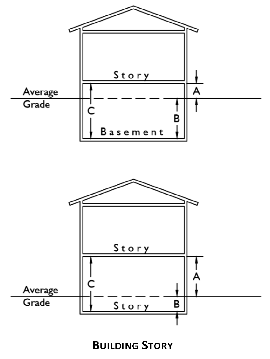
Story. That portion of a building compromised between a floor and the floor or roof next above. The first floor of a two or multistory building shall be deemed the story that has: a) no floor immediately below it that is designed for living quarters or for human occupancy or b) a floor immediately below it that is designed for living quarters or for human occupancy but has at least one-half of its height on one side below grade (see also "Basement"). Those stories above the first floor shall be numbered consecutively.
Story, half. A space under a sloping roof which has the line of intersection of roof decking and wall face not more than three feet above the top floor level, and in which space not more than two-thirds of the floor area is finished off for use. A half story containing independent apartment or living quarters shall be counted as a full story.
Stream. Any stream, beginning at:
1)
The location of a spring, seep, or groundwater outflow that sustains stream flow;
2)
A point in the stream channel with a drainage area of 25 acres or more; or
3)
Where evidence indicates the presence of a stream in a drainage area of other than 25 acres, the local permitting authority may require field studies to verify the existence of a stream.
Stream, perennial. See "Perennial stream."
Stream, trout. See "Trout streams."
Stream bank. The sloping land that contains the stream channel and the normal flows of the stream.
Stream buffer. A natural or enhanced vegetated area (established by the stream buffer protection section in chapter 107, Resource Management) lying adjacent to the stream.
Stream channel. The portion of a watercourse that contains the base flow of the stream. Street. A right-of-way for vehicular traffic referred to as a street, highway parkway, road, avenue, drive, boulevard, lane, place or otherwise. As used in this UDC, includes the terms "road" and "roadway."
Specific functional classifications of streets, from highest to lowest, are:
1)
Street, freeway. A multi-lane, limited access street designed for fast, continuous movement of all types of traffic, with control over access to abutting property.
2)
Street, arterial. A street designed for rapid, continuous movement of all types of traffic but with less control over the access points from streets and adjacent property than freeways.
3)
Street, collector. Conducts and distributes traffic between local streets and higher-order streets (arterials and freeways). Its function is to promote free traffic flow and access to individual properties. On-street parking should be limited.
4)
Street, local. The lowest order street, providing frontage for access to private lots. Designed to carry traffic at slowest speed. Local streets include residential 1 and 2 and non-residential streets.
Streetscape theme. A planting strip along a roadway frontage incorporating some or all aspects of the following: connecting sidewalks, fences, trees, jogging trails, and bike paths.
Stripping. Any activity which removes the vegetative surface cover including tree removal, clearing, grubbing, and storage or removal of topsoil.
Structure. Anything constructed or erected, the use of which requires more or less permanent location on the ground or which is attached to something having more or less permanent location on the ground. As used in the floodplain management/flood damage prevention section of chapter 107, Resource Management, the term shall mean a walled and roofed building (including a gas or liquid storage tank), that is principally above ground, or a manufactured home.
Structure, historic. See "Historic structure."
Structural erosion, sedimentation and pollution control practices. Practices for the stabilization of erodible or sediment-producing areas by utilizing the mechanical properties of matter for the purpose of either changing the surface of the land or storing, regulating or disposing of runoff to prevent excessive sediment loss. Examples of structural erosion and sediment control practices are riprap, sediment basins, dikes, level spreaders, waterways or outlets, diversions, grade stabilization structures and sediment traps, etc. Such practices can be found in the publication Manual for Erosion and Sediment Control in Georgia. Includes the term "Erosion and sedimentation control."
Structural panel. As used in the design guidelines and standards section of chapter 103, Site Planning and Project Design Standards, structural panels are insulated metal wall panels for exterior use for metal building construction.
Subdivider. Any person, corporation or duly authorized agent, planner, designer, land surveyor, landscape architect, architect or engineer, who undertakes the subdivision of land as defined herein.
Subdivision. All divisions of a tract or parcel of land into two or more lots, building sites, or other divisions for the purpose, whether immediate or future, of sale or building development and includes all division of land involving a new street or a change in existing streets, and includes resubdivisions and, where appropriate to the context, relates to the process of subdividing or to the land area subdivided.
Subdivision, major. A subdivision of land which results in the creation of five or more lots.
Subdivision, minor. A subdivision of land which results in the creation of two to four lots and does not result in the creation of any public or private streets.
Subdivision, non-residential. A subdivision developed in an office, commercial or industrial zoning district, where the intended use is primarily non-residential.
Subdivision, residential. A subdivision developed in a residential, PD-mixed use or PD-traditional neighborhood development zoning district, where the intended use is primarily residential.
Substantial damage. Damage of any origin sustained by a structure whereby the cost of restoring the structure to its before damaged condition would equal or exceed 50 percent of the market value of the structure before the damage occurred. This term also includes "Repetitive loss."
Substantial improvement. Any reconstruction, rehabilitation, addition, or other improvement to a structure, taking place during a 10-year period, in which the cumulative cost equals or exceeds 50 percent of the market value of the structure prior to the improvement. The market value of the building means:
1)
The appraised value of the structure prior to the start of the initial repair or improvement; or
2)
In the case of damage, the value of the structure prior to the damage occurring.
This term includes structures which have incurred "repetitive loss" or "substantial damage," regardless of the actual amount of repair work performed. The term does not, however, include those improvements of a structure required to comply with existing state or local health, sanitary, or safety code specifications which are the minimum necessary to assure safe living conditions, which have been identified by the code enforcement official. The term does also not include any alteration of a historic structure, provided that the alteration will not preclude the structure's continued designation as a historic structure.
Substantially improved existing manufactured home park or subdivision. The repair, reconstruction, rehabilitation or improvement of the streets, utilities and pads equals or exceeds 50 percent of the value of the streets, utilities and pads before the repair, reconstruction or improvement commenced.
System improvement costs. Costs incurred to provide additional public facilities capacity to serve new growth and development for planning, design and construction, land acquisition, land improvement, design and engineering related thereto, including the cost of constructing or reconstructing system improvements or facility expansions. System improvement costs include but are not limited to the construction contract price, surveying and engineering fees, related land acquisition costs (including land purchases, court awards and costs, attorneys' fees, and expert witness fees); expenses incurred for qualified staff or any qualified engineer, planner, architect, landscape architect, or financial consultant for preparing or updating the capital improvements element; and administrative costs, provided that such administrative costs shall not exceed three percent of the total amount of the costs. Projected interest charges and other finance costs may be included if the impact fees are to be used for the payment of principal and interest on bonds, notes, or other financial obligations issued by or on behalf of the city to finance the interest on bonds, notes, or other financial obligations issued by or on behalf of the city to finance the capital improvements element. System improvement costs do not include routine and periodic maintenance expenditures, personnel training, and other operating costs.
System improvements. Capital improvements that are public facilities designed to provide service to more than one project or to the community at large, in contrast to "project" improvements.
T
Taxi and limousine service. An establishments that provides passenger transportation by automobile or van, not over regular routes or regular schedules. Taxicab owner/operators, taxicab fleet operators, and taxicab organizations are included. Also included are limousine and luxury sedan establishments, which may provide an array of specialty and luxury passenger transportation services.
Technical, trade, and other specialty schools. Schools that offer vocational and technical training in a variety of technical subjects and trades, such as: barbering, hair styling or cosmetic arts; business management; computer training; driving education; fine and performing arts education; flight training; and sports and recreation education. The training often leads to job-specific certification.
Temporary use. A prospective use, intended for limited duration, to be located in a zoning district not permitting such use, and not continuing a nonconforming use or building.
Timber. Harvestable trees; wooded areas.
Tobacco or tobacconist establishment. An establishment classified as "Retail sales — Other consumer goods" that sells cigarettes, cigars, tobacco, tobacco pipes, and other tobacco supplies.
Towing and other road and ground services. Establishments that tow light or heavy motor vehicles, both local and long distance. These establishments may provide incidental services, such as storage and emergency road repair services.
Townhouse. See "Dwelling, townhouse."
Trail. A cleared way for pedestrians, bicycles, and/or equestrians that may or may not be improved.
Train station. Any premises for the loading and unloading of passengers, as well as accessory uses such as ticket purchase facilities and restrooms.
Transfer of development rights. The conveyance of development rights by deed, easement, or other legal instrument authorized by local law to another parcel of land and the recording of that conveyance.
Tree. Any living, self-supporting woody perennial plant which normally obtains a trunk diameter of at least twp inches and a height of at least ten feet, and typically has a main stem or trunk and many branches.
Tree, canopy. Those tress that compose the top layer or canopy of vegetation and will generally reach a mature height of greater than 40 feet.
Tree, hardwood. Any tree that is not coniferous (cone-bearing).
Tree, overstory. Those trees that compose the top layer or canopy of vegetation and will generally reach a mature height of greater than 40 feet.
Tree, shade. Typically means a deciduous overstory tree planted primarily for its height crown of foliage or overhead canopy.
Tree, softwood. Any coniferous (cone-bearing) tree. This definition is based on the colloquialism and does not necessarily reflect any true qualities of the tree.
Tree, specimen. Any tree which qualifies for special consideration for preservation due to its size, species or historic relevance as established by this UDC.
Tree, street. A tree which is located within the public right-of-way.
Tree, understory. Those trees that grow beneath the overstory and will generally reach a mature height of less than 40 feet.
Tree density standard. The minimum number of tree density units per acre which must be achieved on a property after development.
Tree density unit. A credit assigned to a tree, based on the diameter of the tree, in accordance with tables contained in the site planning and project design standards chapter of this UDC.
Tree diameter. The cross-sectional dimension of a tree trunk measured at four and one-half feet above the ground. If the tree has more than one trunk, only the largest trunk shall be used to establish the diameter for the tree.
Tree protection area. Any portion of a site wherein are located existing trees which are proposed to be retained in order to comply with the requirements of the site planning and project design standards chapter of this UDC. The tree protection areas shall include no less than the total area beneath the tree canopy as defined by the drip line of the tree; plus any additional area encompassing the critical root zone of a tree or group of trees collectively.
Tree protection plan. A plan that identifies tree protection areas, existing trees to be retained and proposed trees to be planted on a property to meet minimum requirements, as well as, methods of tree protection to be undertaken on the site and other pertinent information.
Tree protection zone for Interstate 575. That area which runs parallel along Highway 575 which has a maximum width of 75 feet and a minimum (where designated) of 25 feet and is established as an undisturbed buffer to further enhance the parkway image as created along the Highway 575 corridor.
Tree protection zone. All lands that fall outside the buildable area of a parcel required to remain in open space, or all areas required as landscaping strips or buffers according to the site planning and project design standards chapter of this UDC, conditions of zoning approval, conditions to master plan approval, or provisions of this UDC or other related ordinances.
Tree removal. Any act which causes a tree to die within three years after commission of the act, including, but not limited to, damage inflicted upon the root system or trunk as a result of:
1)
The improper use of machinery on the trees;
2)
The storage of materials in or around the trees;
3)
Soil compaction;
4)
Altering the natural grade to expose the roots or to cover the tree's root system with more than four inches of soil;
5)
Pruning judged to be excessive by the city LA or not in accordance with the standards set forth by the International Society of Arboriculture (ISA);
6)
Paving with concrete, asphalt, or other impervious surface within such proximity as to be harmful to the tree or its root system; and
7)
Application of herbicides or defoliates to any trees without first obtaining a permit.
Tree save area. An area designated for the purpose of meeting tree density requirements, saving natural trees, and/or preserving natural buffers.
Tree thinning. Selective cutting or thinning of trees for the clear purpose of good forestry management in order to protect said forest from disease or infestation and in no way shall be construed as clear cutting.
Tri-plex. See "Dwelling, tri-plex."
Trout streams. All streams or portions of streams within the watershed as designated by the Wildlife Resources Division of the Georgia Department of Natural Resources under the provisions of the Georgia Water Quality Control Act, O.C.G.A. § 12-5-20, in the rules and regulations for Water Quality Control, Chapter 391-3-6 at www.epd.georgia.gov. Streams designated as primary trout waters are defined as water supporting a self-sustaining population of rainbow, brown or brook trout. Streams designated as secondary trout waters are those in which there is no evidence of natural trout reproduction, but are capable of supporting trout throughout the year. First order trout waters are streams into which no other streams flow except springs.
Truck, trailer, RV rental. Establishments that rent or lease trucks, truck tractors or buses, semi-trailers, utility trailers, or RVs (recreational vehicles). Drivers or operators are not provided.
Truck and freight transportation services. Establishments that provide over-the-road transportation of cargo using motor vehicles, such as trucks and tractor trailers.
U
Underground parking structure with ramps. A structure used for the parking of vehicles that is constructed underground, typically located beneath a multi-storied parking structure, a commercial building, a mixed-use development, or multi-family dwellings.
Unit of development. As used in the development impact fees chapter of this UDC, the standard incremental measure of land development activity for a specific type of land use upon which the rate of demand for public service and facilities is based, such as a dwelling unit, square foot of floor area, motel room, etc.
Unused or excess impact fee. Any individual impact fee payment from which no amount of money or only a portion thereof has been encumbered or expended according to the requirements of the development impact fees chapter of this UDC.
Utility substation. An assembly of equipment in an electric power system through which electrical energy is passed for transmission, distribution, interconnection, transformation, conversion, or switching.
Utilities. Public and private services provided to residential and non-residential subdivisions. These services for the purposes of the UDC chapters containing the design standards for streets and stormwater systems, water systems, and sewer systems include: Roads, stormwater systems, water, sanitary sewer and storm sewer. As used in the river corridor section and the water supply watershed protection section of chapter 107, Resource Management, utilities are public or private water or sewer piping systems, water or sewer pumping stations, electric power lines, fuel pipelines, telephone lines, roads, driveways, bridges, river/lake access facilities, stormwater systems and railroads or other utilities identified by a local government.
V
Vacuum breaker. A general term applied to a backsiphonage prevention device that introduces air into the potable water system.
Vacuum breaker (atmospheric type). A vacuum breaker designed for use under flow conditions only, not to exceed 24 consecutive hours, and where it will be subject to no static pressure and no back pressure.
Vacuum breaker (hose type). A vacuum breaker designed for hose connections only. It is not approved for continuous pressure, static or flowing.
Vacuum breaker (pressure type). A vacuum breaker designed to operate under continuous pressure, static or flowing, but no backpressure.
Variance. A method of alleviating unnecessary hardship. A dispensation, minimum relaxation or modification of the strict terms of the height, area, placement, setback, yard, buffer, landscape strip, parking and loading regulation as applied to specific property when, because of particular physical surroundings, shape, or topographical condition of the property, compliance would result in a particular hardship upon the owner, as distinguished from a mere inconvenience or a desire to make a profit. A variance shall in no way make null the standard design specifications or zoning regulations of this UDC.
Vegetation. Shall grasses, legumes, ground cover, trees, and shrubs.
Vegetation, native. Any plant species with a geographic distribution indigenous to all or part of the state. Plant species which have been introduced to a region by man are not native vegetation.
Vegetative erosion and sedimentation control measures. Measures for the stabilization of erodible or sediment-producing areas by covering the soil with:
1)
Permanent seeding, sprigging or planting, producing long-term vegetative cover, or
2)
Temporary seeding, producing short-term vegetative cover; or
3)
Sodding, covering areas with a turf of perennial sod-forming grass.
Such measures can be found in the publication Manual for Erosion and Sediment Control in Georgia.
Vehicle rental. An establishment that rents or leases passenger vehicles without drivers.
Vehicle and marine craft sales. Establishments that sell new or used motor vehicles and marine craft, including: Compact automobiles and light trucks (sold at car dealerships); buses, recreational vehicles (RVs), manufactured homes, and trucks not sold at car dealerships; motorcycles, motor scooters, motor bikes, mopeds, and off-road terrain vehicles (ATV's); boats, personal watercraft, outboard motors, and boat trailers. These establishments may have showrooms or open lots for selling vehicles and may provide repair and maintenance services.
Veterinary services. Establishments with licensed practitioners of veterinary medicine, dentistry, or surgery for animals; also included are establishments that provide testing services for licensed veterinary practitioners.
Violation. The failure of a structure, building, site or other development to comply with this UDC. As used in the floodplain management/flood damage prevention section of chapter 107, Resource Management, the term shall mean a structure or other development without the elevation certificate, other certificates, or other evidence of compliance required in the section is presumed to be in violation until such time as that documentation is provided.
W
Water supply reservoir. A governmentally owned impoundment of water for the primary purpose of providing water to one or more governmentally owned public drinking water systems. This excludes the multipurpose reservoirs owned by the U.S. Army Corps of Engineers.
Water supply watershed. The area of land upstream of a governmentally owned public drinking water intake.
Water supply watershed, small. A watershed that contains less than 100 square miles of land within the drainage basin upstream of a governmentally owned public drinking water supply intake.
Watercourse. Any natural or artificial watercourse, stream, river, creek, channel, ditch, canal, conduit, culvert, drain, waterway, gully, ravine, or wash in which water flows either continuously or intermittently and which has a definite channel, bed and banks, and including any area adjacent thereto subject to inundation by reason of overflow or floodwater.
Watershed protection map. A map prepared for the local jurisdiction which identifies water supply watersheds and water supply reservoirs, which are the subject of this UDC. The watershed protection map also identifies public water supply intake points and perennial streams within the watershed that are upstream of water supply intake points or water supply reservoirs, and the seven-mile radius line from each water intake or water supply reservoir boundary.
Watershed. The land area that drains into a particular stream.
Warehouse storage (indoor, warehouse products). Establishments that operate warehouse and storage facilities for general merchandise, refrigerated goods, and other warehouse products. These establishments provide the facilities to store goods but do not sell the goods they handle. They may also provide a range of services related to the distribution of goods, such as labeling, breaking bulk, inventory control and management, light assembly, order entry and fulfillment, packaging, pick and pack, price marking and ticketing, and transportation arrangement.
Wetlands. Those areas that are inundated or saturated by surface or ground water at a frequency and duration sufficient to support, and that under normal circumstances do support a prevalence of vegetation typically adapted for life in saturated soil conditions. Wetlands generally include swamps, marshes, bogs, and similar areas.
Wetlands, jurisdictional. See "Jurisdictional wetlands."
Wholesale trade establishment—Durable goods. A wholesale trade establishment that sells or arranges the purchase or sale of capital or durable goods to other businesses. These establishments include wholesale products, such as motor vehicles, furniture, construction materials, machinery and equipment (including household-type appliances), metals and minerals (except petroleum), sporting goods, toys and hobby goods, recyclable materials, and parts. Durable goods generally have life expectancy of at least three years.
Wholesale trade establishment—Nondurable goods. A wholesale trade establishment that sells or arranges the purchase or sale of nondurable goods to other businesses. These establishments include wholesale products, such as paper products, chemicals, drugs, textiles, apparel, footwear, groceries, farm products, petroleum products, alcoholic beverages, books, magazines, newspapers, flowers, and tobacco products. Nondurable goods generally have a life expectancy of less than three years.
Wholesale trade establishment. An establishment that either sell s or arranges the purchase of goods to other businesses and normally operates from a warehouse or office building.
Winery. An establishment where wine is made.
Wireless telecommunications facility. A facility for the provision of personal wireless service. Facilities may include antenna, towers, and related equipment and network components (transmitters, receivers, base stations, power supplies, cabling, and accessory equipment), as well as DAS and small-cell facilities used for the provision of personal wireless services. Includes the term "personal wireless service facility."
The following terms and phrases are defined for the purposes of the wireless telecommunications facilities section of chapter 104:
Accessory equipment. Any equipment serving or being used in conjunction with a wireless facility or wireless support structure and includes, but is not limited to, utility or transmission equipment, power supplies, generators, batteries, cables, equipment buildings, cabinets, and storage sheds, shelters, or similar structures.
Antenna. Communications equipment that transmits, receives or transmits and receives electromagnetic radio signals used in the provision of all types of wireless communication services.
Base station. A structure or equipment at a fixed location that enables FCC-licensed or authorized wireless communications between user equipment and a communications network. The term does not encompass a tower as defined in this Glossary or any equipment associated with a tower.
1)
The term includes, but is not limited to, equipment associated with wireless communications services such as private, broadcast, and public safety services, as well as unlicensed wireless services and fixed wireless services such as microwave backhaul.
2)
The term includes, but is not limited to, radio transceivers, antennas, coaxial or fiber-optic cable, regular and backup power supplies, and comparable equipment, regardless of technological configuration (including distributed antenna systems and small-cell networks).
3)
The term includes any structure other than a tower that, at the time the relevant application is filed with the City of Canton under the provisions of chapter 104 of this UDC, supports or houses equipment described under 1) and 2) of this definition that has been reviewed and approved under the applicable zoning or siting process, or under another state or local regulatory review process, even if the structure was not built for the sole or primary purpose of providing such support.
4)
The term does not include any structure that, at the time the relevant application is filed with the City of Canton under the provisions of chapter 104 of this UDC, does not support or house equipment described under 1) and 2) of this definition.
Camouflage (or stealth or stealth technology). Disguising a tower or wireless telecommunications facility so as to make it less visually obtrusive and not recognizable to the average person as a wireless telecommunications facility.
Collocation or collocate. The placement or installation of new wireless facilities on previously approved and constructed wireless support structures, including monopoles and towers, both self-supporting and guyed, in a manner that negates the need to construct a new freestanding wireless support structure. Such term includes the placement of accessory equipment within an existing equipment compound.
Commercial impracticability or commercially impracticable. The inability to perform an act on terms that are reasonable in commerce; the cause or occurrence of which could not have been reasonably anticipated or foreseen and that jeopardizes the financial efficacy of the project. The inability to achieve a financial return on investment or profit deemed satisfactory by an applicant may be considered, but, standing alone, shall not deem a situation to be "commercial impracticable" and shall not in and of itself render an act or the terms of an agreement "commercially impracticable."
Distributive antenna system (DAS). A technology using an antenna combining technology allowing for multiple carriers or wireless service providers to use the same set of antennas.
Eligible support structure. 1) Any base station as defined in this glossary or 2) any tower built for the sole or primary purpose of supporting any FCC-licensed or authorized antennas and their associated facilities, including structures that are constructed for wireless communications services including, but not limited to, private, broadcast, and public safety services, as well as unlicensed wireless services and fixed wireless services such as microwave backhaul, and the associated site. Eligible support structures are further defined as existing at the time the relevant application is filed with the City of Canton under chapter 104 of this UDC.
Equipment compound. An area surrounding or adjacent to the base of a wireless support structure within which accessory equipment is located.
Height. When referring to a tower or structure, the distance measured from the pre-existing grade level to the highest point on the tower or structure, even if said highest point is an antenna or lightening protection device.
Modification or modify. The improvement, upgrade, expansion, or replacement of existing wireless facilities on an existing wireless support structure or within an existing equipment compound, provided such improvement, upgrade, expansion, or replacement does not: i) increase the overall height or width of the wireless support structure to which the wireless facilities are to be attached or ii) increase the dimensions of the equipment compound initially approved by the city.
Need. Anything that is technically required for the wireless service to be provided primarily and essentially within the City of Canton and creates the least physical and visual impact. This does not necessarily mean the internal design standards of the applicant, as companies' standards can vary greatly and normally reflect preferences. Rather, need relates to the ability of the user-equipment to function as designed.
Personal wireless services (PWS) or personal telecommunications service (PTS). Shall have the same meaning as defined and used in the 1996 Telecommunications Act.
Repairs and maintenance. The replacement or repair of any components of a wireless facility where the replacement is identical to the component being replaced or for any matters that involve the normal repair and maintenance of a wireless facility without the addition, removal or change of any of the physical or visually discernable components or aspects of a wireless facility that will add to the visible appearance of the facility as originally permitted.
Registry. Any official list, record, or register maintained by a local governing authority of wireless facilities, equipment compounds, or wireless support structures.
Stealth or stealth technology. See "Camouflage."
Substantial change. A modification that substantially changes the physical dimensions of an "eligible support structure" as defined in this glossary if it meets any of the following criteria:
1)
For towers other than towers in the public rights-of-way, it increases the height of the tower by more than ten percent or by the height of one additional antenna array with separation from the nearest existing antenna not to exceed 20 feet, whichever is greater; for other eligible support structures, it increases the height of the structure by more than ten percent or more than ten feet, whichever is greater; (Changes in height should be measured from the original support structure in cases where deployments are or will be separated horizontally, such as on buildings' rooftops; in other circumstances, changes in height should be measured from the dimensions of the tower or base station, inclusive of originally approved appurtenances and any modifications that were approved prior to the passage of the Spectrum Act.)
2)
For towers other than towers in the public rights-of-way, it involves adding an appurtenance to the body of the tower that would protrude from the edge of the tower more than 20 feet, or more than the width of the tower structure at the level of the appurtenance, whichever is greater; for other eligible support structures, it involves adding an appurtenance to the body of the structure that would protrude from the edge of the structure by more than six feet;
3)
For any eligible support structure, it involves installation of more than the standard number of new equipment cabinets for the technology involved, but not to exceed four cabinets; or, for towers in the public rights-of-way and base stations, it involves installation of any new equipment cabinets on the ground if there are no pre-existing ground cabinets associated with the structure, or else involves installation of ground cabinets that are more than ten percent larger in height or overall volume than any other ground cabinets associated with the structure;
4)
It entails any excavation or deployment outside the current site;
5)
It would defeat the concealment elements of the eligible support structure; or
6)
It does not comply with conditions associated with the siting approval of the construction or modification of the eligible support structure or base station equipment, provided however that this limitation does not apply to any modification that is non-compliant only in a manner that would not exceed the thresholds identified in subsections 1) through 4) of this definition.
Telecommunications. The transmission and/or reception of audio, video, data, and other information by wire, radio frequency, light, and other electronic or electromagnetic systems.
Transmission equipment. Equipment that facilitates transmission for any FCC-licensed or authorized wireless communication service, including, but not limited to, radio transceivers, antennas, coaxial or fiber-optic cable, and regular and backup power supply. The term includes equipment associated with wireless communications services including, but not limited to, private, broadcast, and public safety services, as well as unlicensed wireless services and fixed wireless services such as microwave backhaul.
Utility. Any person, corporation, municipality, county, or other entity, or department thereof or entity related or subordinate thereto, providing retail or wholesale electric, data, cable, or telecommunications services.
Wireless support structure. A freestanding structure, such as a monopole, tower, either guyed or self-supporting, or suitable existing or alternative structure designed to support or capable of supporting wireless facilities. Such term shall not include any telephone or electrical utility pole or any tower used for the distribution or transmission of electrical service. Includes the term "tower."
Woodlands, existing. Tree and shrubs of a number, size and species that accomplish the same general function as new plantings.
Work. As used in the UDC chapters containing the design standards for water and sewer systems, means labor, material, equipment, skills, transportation, tools, machinery, and other equipment and things useful and necessary to complete the contract.
X
Y
Yard. A space on the same lot with a principal building, open, unoccupied and unobstructed by buildings or structures from ground to sky except where encroachments and accessory buildings are expressly permitted.
Yard, corner. An open, unoccupied space on the same lot with the principal building, situated between the building and a public right-of-way or private street and extending from front yard setback to the rear yard setback.
Yard, front. An open, unoccupied space on the same lot with a principal building, extending the full width of the lot, and situated between the street right-of-way and the minimum front building line setback. Where a corner lot exists, the front yard shall be determined by that portion of the lot with the shortest road frontage.
Yard, rear. An open, unoccupied space on the same lot with the principal building, situated between the building and sideline of the lot and extending from the rear line of the lot and the rear line of the building projected to the sidelines of the lot.
Yard, side. An open, unoccupied space on the same lot with the principal building, situated between the building and the sideline of the lot and extending from the rear line of the front yard to the front line of the rear yard.
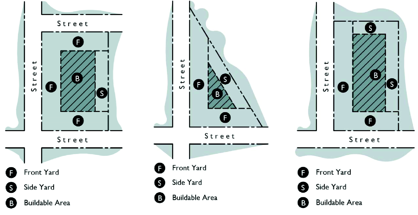
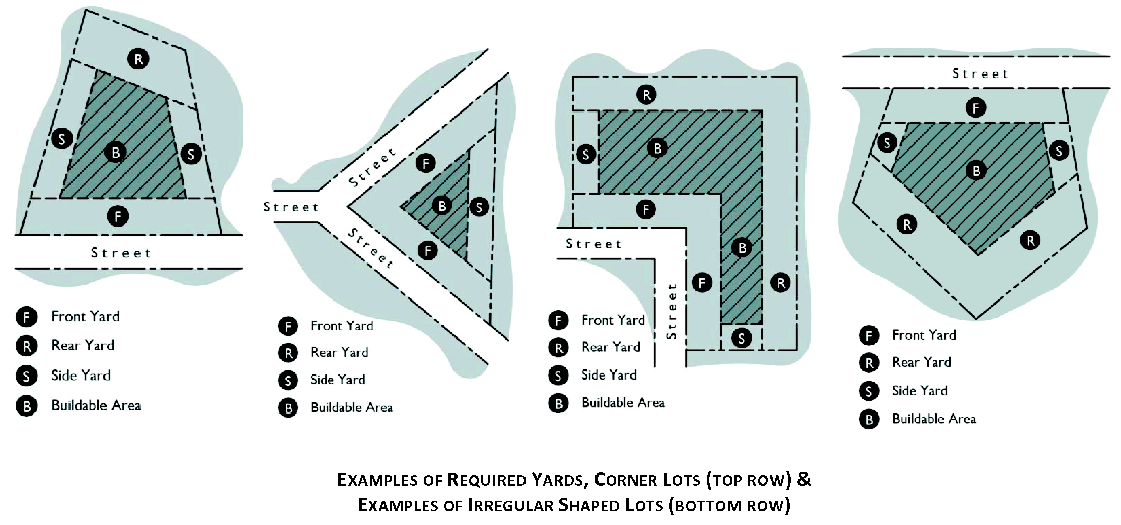
Yard sale. The sale or trading of clothing, furniture, household items, food, dishes, antiques or similar goods or merchandise, other than in the normal course of business, or the sale or trading of such goods, as outlined in this definition, by a person not regularly engaged in such business. Such goods or merchandise do not need to be attended for a sale to be deemed to be in existence. Includes the terms "garage sales," "carport sales," and similar types of sales or events.
Z
Zero lot line. The location of a freestanding building on a lot in such a manner that one building side will have no side building setback and rests directly on a side lot line.
Zoning buffer. A buffer, as required by this UDC or as a condition of zoning, special exception, or variance approval for a specific property.
Zoning. A police power measure in which the community is divided into districts or zones within which permitted uses, and in some cases conditional uses, are established as well as regulations governing lot size, bulk, height and other development requirements.
Zoning regulations. Adopted procedures and zones or districts within the City of Canton which regulate the uses and development standards of property within such zones or districts. The term also includes adopted zoning which shows the zones and districts and zoning classifications of property therein.
Zoos, botanical gardens, arboreta. Establishments that preserve and exhibit live plant and animal life displays, including those in natural areas or settings (as in the case of national parks).
(Ord. No. 2014-18, § 2, 8-21-2014; Ord. No. 2017-03, 3-16-2017; Ord. No. 2018-0719-01, 7-19-2018; Ord. No. 2018-0920-02, 9-20-2018; Ord. No. 2019-0321-01, 3-21-2019; Ord. No. 2019-0516-01, 5-16-2019; Ord. No. 2019-1121-03, 11-21-2019; Ord. No. >2020-0319-01, 3-19-2020; Ord. No. 2020-0319-03, 3-19-2020; Ord. No. 2021-0415-01, 4-15-2021; Ord. No. 2021-1118-01, §§ 1, 2, 11-18-2021; Ord. No. 2022-0616-03, 6-16-2022; Ord. No. 2023-1005-1, 10-5-2023; Ord. No. 2023-1116-2, § 1, 11-16-2023)