
Carl City Zoning Code
ARTICLE XII
PROCEDURES AND PERMITS
Sec. 89-1311.- Purpose of article.
This article describes the process through which a rezoning, special use, or concurrent hardship variance may be approved on a property, the approval process for construction of subdivisions and other land development projects, and the procedures for amendments to the comprehensive plan and text of this Development Code.
(Ord. of 10-13-2020)
Sec. 89-1312. - Land development overview.
The following presents a summary of the plans and procedures involved in the land development approval and construction regulation process. Details are provided in other sections of this article.
(a)
Land use plan purpose; amendment. The county's land use plan set forth in the comprehensive plan shall serve as a guide for the board of commissioners when confronted with requests for rezonings, special use permits, and other land use changes. The county's land use plan should be amended when the conditions, circumstances, environment, situations, policies, etc., on which the plan is based, have significantly changed so as to materially detract from the usefulness of the county's land use plan as a guide to local decision making.
(b)
Absent such significant changes to conditions, circumstances, environment, situations, policies, etc., the comprehensive plan and future land use plan recommendations for land use shall be adhered to with respect to zoning and land development.
(c)
Zoning changes (rezoning or special use approval). If the property is not appropriately zoned, a request for rezoning or approval of a special use must be approved prior to development or construction. A zoning change for a subdivision, multi-family or nonresidential project must include a concept plan for the proposed development.
(d)
Major subdivisions. Permitting and construction of a major subdivision will be conducted as follows:
a.
Project approval is granted by the planning and community development department upon review and approval of a preliminary subdivision plat.
b.
A development permit is issued by the planning and community development department based on review and approval of development plans for construction of the subdivision.
c.
Receipt and approval by the public works department of accurate surveys of the as-built condition of public improvements is required in order to allow filing of a final plat.
d.
Approval of a final subdivision plat by the planning and community development department will authorize recordation of the plat with the Clerk of the Superior Court.
e.
After recordation of the final plat, the lots may be sold and building permits on the lots may be obtained.
f.
All public improvements will be inspected by the county prior to the end of the two-year maintenance period. After the developer has made any required repairs, the maintenance responsibility of the developer will be released by the director of public works.
(e)
Minor subdivisions. Approval of a minor subdivision shall be conducted as follows:
a.
The lots contained on any final subdivision plat for a minor subdivision, may be sold and building permits authorizing construction activity on the lots may be obtained only after approval by the planning and community development department.
(f)
Multi-family and nonresidential projects.
a.
Project approval is granted by the planning and community development department upon review and approval of a site plan for the project.
b.
A development permit is issued by the planning and community development department based on review and approval of development plans for construction of the project.
c.
A building permit is issued by the building official based on review and approval of architectural plans. Buildings falling under the authority of the state fire marshal shall be approved by the fire marshal prior to issuance of the building permit.
d.
Receipt by the planning and community development department of accurate surveys of the as-built condition of all public improvements is required in order to authorize issuance of a certificate of occupancy.
e.
Permanent electric power and occupancy of the building is authorized by the building official based on final inspection and issuance of a certificate of occupancy.
(Ord. of 10-13-2020)
Sec. 89-1313. - Application intake.
An application for any permit or approval under this article or for a variance or special exception under the appeals article of this Development Code will first be considered as follows:
(a)
If the application is for a project that qualifies as a development of regional impact (DRI), and is the first request for county action or is a revision to a previous DRI, refer to section 89-1327 of this article for details and procedures.
(b)
If the application is for approval of a minor subdivision plat, refer to subsection 89-1312(d) for the short cut procedures.
(c)
If the application is for any other type of approval or permit, refer to the appropriate sections of this article or the appeals article for procedures pertinent to the request.
(d)
The total number of zoning applications that will be accepted per zoning cycle is 15.
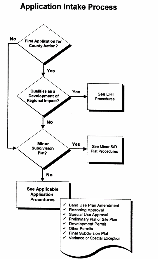
Figure 12.1 Application intake process
(Ord. of 10-13-2020)
Sec. 89-1314. - Amendments to the land use plan and development code.
(a)
Land use plan amendments.
(1)
Generally. The comprehensive plan may be amended from time to time for specific properties or areas on the future land use map by the board of commissioners, subject to the requirements of the Georgia Zoning Procedures Act, O.C.G.A. §§ 36-66-1 et seq. Such a change is referred to as a "land use plan amendment," or LUP amendment, in this Development Code.
(2)
Applications by owners. Upon submitting an application for the rezoning of a property in accordance with section 89-1315, a private property owner or the owner's authorized representative may submit an application to amend the future land use plan with regard to the property at issue in accordance with application procedures and fees set forth by the director of community development and approved by the board of commissioners. Applications will be received and considered by the board of commissioners only to the extent that such applications are submitted in connection with related rezoning applications and only where the director of community development has determined that the related request to rezone is inconsistent with the comprehensive plan.
a.
The county may consider the following criteria in evaluating amendment applications filed by private property owners, giving weight or priority to those factors particularly appropriate to the circumstances of the application:
i.
The extent to which a change in the economy, land use or development opportunities of the area has occurred;
ii.
The extent to which the proposed character area and/or future land use designation is in compliance with the goals and policies of the comprehensive plan;
iii.
The extent to which the proposed designation would require changes in the provision of public facilities and services;
iv.
The extent to which the proposed designation would impact the public health, safety, and welfare;
v.
The extent to which additional land area needs to be made available or developed for a specific type of use;
vi.
The extent to which area demographics or projections are not occurring as projected.
vii.
An application submitted by a property owner or the owner's authorized representative for an amendment affecting the same property shall not be considered by the board of commissioners more often than once every 12 months from the date of action by the board of commissioners denying the change to the Future Land Use Plan; provided, however, that the board of commissioners may approve a reduction in the waiting period to no less than six months. A county-initiated change to the future land use map may be pursued at any time.
(3)
State of Georgia oversight.
a.
Developments of regional impact (DRIs). A proposed LUP amendment shall be submitted to the Northeast Georgia Regional Commission (NEGRC) if the proposed LUP amendment qualifies as a development of regional impact under the procedures of section 89-1327.
b.
Major amendments. If the board of commissioners, at its public hearing, determines that the LUP amendment is a "major amendment" under the state guidelines in that it is justified only because the conditions or policies underlying the comprehensive plan have change significantly so as to alter the basic tenets of the plan, or that the proposal will significantly affect another political jurisdiction, then no action shall be taken on the amendment until the review process mandated by the state's minimum standards and procedures for local comprehensive planning shall have been completed.
c.
Effect of a land use plan amendment approval. Approval of a land use plan amendment shall be in full force and effect upon its approval by the board of commissioners.
(b)
Development code text amendments.
(1)
Generally. The text of the Development Code may be amended from time to time by the board of commissioners, subject to the requirements of the Georgia Zoning Procedures Law, O.C.G.A. §§ 36-66-1 et seq.
(2)
Process for amending text. Before the board of commissioners may take final action on a proposed amendment to the Development Code text, the board of commissioners shall hold a public hearing on the proposal pursuant to the notice and hearing requirements as described in section 89-1315(d).
(3)
Hearings by the planning commission. In addition to the hearing by the board of commissioners, the planning and community development director, in his or her discretion, may require a public hearing by the planning commission on any proposed amendment to the Development Code text. If applicable, such hearing by the planning commission shall be held prior to the public hearing by the board of commissioners, and shall also be subject to the notice and hearing requirements as described in section 89-1315(d). Upon conclusion of any public hearing conducted by the planning commission on a text amendment, the planning commission may recommend to the board of commissioners' approval of the proposed text amendment, approval of a revised version of the proposed text amendment, or rejection of the proposed text amendment.
(Ord. of 10-13-2020; Ord. of 6-27-2023, § 1(Exh. A))
Sec. 89-1315. - Rezoning approval.
The official zoning map may be amended from time to time by the board of commissioners under the procedures in this section. In addition, changes in the conditions of approval pertaining to a specific rezoning approval may also be approved by the board of commissioners following the procedures in this section.
(a)
Initiation of rezoning proposal.
(1)
An application for a rezoning for any property or properties may be initiated by the board of commissioners, or by the owner of the property. Unless initiated by the board of commissioners, the owner of the property affected, or their authorized representative shall initiate all such applications.
(2)
All applications by an owner or the owner's authorized representative shall be submitted to the planning and community development department on the department's application forms. A nonrefundable fee, if any, as set by the board of commissioners from time to time, shall accompany all applications. Completed forms, plus any information the applicant feels to be pertinent is to be filed with the planning and community development department.
(3)
The planning and community development department shall review the application submitted by an owner or the owner's authorized representative for completeness within five days of submission. Incomplete or improper applications will be returned to the applicant. Any zoning application that causes the total number of zoning applications accepted per zoning cycle to exceed 15 will be held until and included in the next zoning cycle in the order in which they are submitted.
(4)
Concurrent variance and rezoning consideration. Hardship variance and special exception variance requests associated with a rezoning application may be heard by the board of commissioners which may concurrently grant approval of rezoning and variance(s), if warranted, in accordance with the standards set out in section 89-1384 and/or section 89-1385, as applicable.
(5)
An application submitted by an owner or the owner's authorized representative for rezoning affecting the same property shall not be considered by the board of commissioners more often than once every 12 months from the date of action by the board of commissioners denying the rezoning; provided, however, that the board of commissioners may approve a reduction in the waiting period to no less than six months. A county-initiated zoning can be pursued by the board of commissioners at any time. In any event, the board of commissioners may consider an application for rezoning within the 12-month time period in connection with settlement of litigation or pursuant to an order by a court of competent jurisdiction without complying with any of the procedural formalities set forth herein, and subject only to the requirements of the Georgia Zoning Procedures Law, O.C.G.A. § 36-66-1 et seq.
(6)
Notwithstanding any other provision of this article to the contrary, the board of commissioners may initiate a rezoning for purposes of settlement of a lawsuit or for other purposes deemed to be in the best interests of the public by the board of commissioners, without observing any of the procedural formalities set forth herein, subject only to the requirements of the Georgia Zoning Procedures Act, O.C.G.A. §§ 36-66-1 et seq.
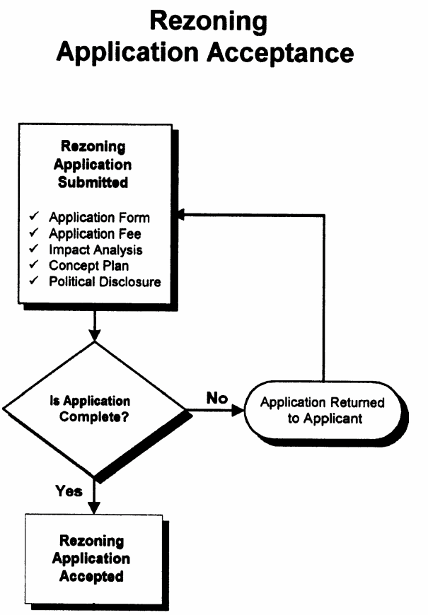
Figure 12.2 Rezoning Application Acceptance
(b)
Rezoning concept plan.
(1)
An application for a rezoning shall be accompanied by a concept plan if any new construction is proposed or alteration of the site is required under the site or development design standards of this Development Code.
(2)
A concept plan may be prepared by the applicant, a professional engineer, a registered land surveyor, a landscape architect, a land planner or any other person familiar with land development activities.
(3)
The concept plan shall be drawn to approximate scale on a boundary survey of the tract or on a property map showing the approximate location of the boundaries and dimensions of the tract.
(4)
The concept plan shall show the following:
a.
A location sketch of the property in relation to the surrounding area with regard to well-known landmarks such as arterial streets or railroads. Sketches may be drawn in freehand and at a scale sufficient to show clearly the information required, but not less than one inch equal to 2,000 feet. US. Geological Survey maps may be used as a reference guide for the location concept.
b.
Zoning district classification of the subject property and all adjacent properties, and zoning district boundaries if they cross the property. The number of acres of land in each zoning classification on the property (or square feet if less than one acre).
c.
Man-made features within and adjacent to the property, including existing streets and names, city and county political boundary lines, and other significant information such as location of bridges, utility lines, existing buildings to remain, and other features as appropriate to the nature of the request.
d.
Natural features, such as the 100-year floodplain, and protected wetlands and stream buffers required under the buffers and tree conservation article of this Development Code.
e.
A statement as to the proposed use of the property and the amount of development proposed, such as:
1.
For residential subdivisions, the number of acres of land to be developed (or square feet if less than one acre), the number of lots and minimum house sizes. For open space subdivisions and master planned development, computations consistent with the requirements of the subdivisions and master planned developments article of this Development Code.
2.
For multi-family projects, the number of acres of land to be developed (or square feet if less than one acre), the number of dwelling units by number of bedrooms, and the minimum unit floor areas and number of parking spaces by unit size.
3.
For nonresidential development projects, the number of acres of land to be developed (or square feet if less than one acre), and the gross floor area and number of parking spaces by type of land use.
4.
For any development, the Future Land Use designation and a statement as to how the proposed rezoning is consistent with this designation and the Comprehensive Plan.
f.
The proposed project layout including:
1.
For subdivisions, approximate lot lines and street right-of-way lines, along with the front building setback line on each lot.
2.
For multi-family and nonresidential development projects, the approximate outline and location of all buildings, and the location of all minimum building setback lines, outdoor storage areas, buffers, parking areas and driveways.
g.
A statement as to the source of domestic water supply.
h.
A statement as to the provision for sanitary sewage disposal.
i.
The approximate location of proposed stormwater detention facilities.
j.
The approximate location of proposed access to the county road system.
(5)
The concept plan shall also indicate:
a.
Name and address of the property owner.
b.
Name, address, and telephone number of the applicant (if different than the owner).
c.
If drawn on a boundary survey: date of survey and source of datum.
d.
Date of plan drawing, and revision dates, as appropriate.
e.
North point and approximate scale of the drawing.
f.
Location (tax map and parcel number) and size of the property in acres (or in square feet if less than an acre).
g.
Such additional information as may be useful to permit an understanding of the proposed use and development of the property.
(c)
Impact analyses.
(1)
If the rezoning has been initiated by an owner or their representative, the application must be accompanied by a written, documented analysis of the proposed rezoning with regard to each of the standards for rezoning enumerated under subsection (5) below.
(2)
An application for a proposed development that is capable of generating 1,000 average daily vehicle trips or more shall be accompanied by a traffic study, prepared by a professional engineer registered in Georgia, under guidelines available from the public works department. Anticipated vehicle trips may be based upon the latest edition of "Trip Generation" published by the Institute of Transportation Engineers. The public works director may waive this requirement when conditions warrant.
(3)
A traffic study, prepared by a professional engineer registered in Georgia, shall also be required for a proposed modification to a previously approved rezoning if the average daily vehicle trips will increase by 10 percent or more than calculated for the original rezoning approval, or average daily vehicle trips will exceed 1,000 for the first time. The public works director may waive this requirement when conditions warrant.
(4)
For a proposed development that will generate fewer than 1,000 average daily vehicle trips or an increase of less than 10 percent, a traffic study, prepared by a professional engineer registered in Georgia, may be required by the public works director. Determination of such requirements will be made within five working days of receipt of the application for rezoning and must be submitted to the public works director at least five working days prior to the first public hearing.
(5)
A traffic study or other studies of the impact of the proposed development may be required by the planning commission or the board of commissioners as deemed necessary for adequate consideration and a fully-informed decision on the rezoning request, relative to the standards for rezoning consideration contained in subsection (e) below.
(d)
Process for rezoning. Before the board of commissioners may take final action on a proposed rezoning, the planning commission and the board of commissioners shall each hold a public hearing on the proposal.
(1)
Public notice.
a.
At least 30 days but no more than 45 days prior to any public hearing required by this subsection, notice shall be published in a newspaper of general circulation within the county. The notice shall state the time, place and purpose of the hearing.
b.
A rezoning initiated by an owner or their representative shall be heard at a public hearing only upon:
1.
The published notice, in addition to the requirements of subsection (d)(1).a. above, shall include the location of the property, the present zoning classification of the property, and the proposed zoning classification of the property requested; and
2.
At least 15 days prior to the public hearing, the applicant shall post a sign or signs, as provided by the Planning and Community Development Department, stating the date, time and place for the planning commission public hearing and the initially scheduled board of commissioners public hearing, the present land use classification and the nature of the proposed land use change. One such sign shall be placed in a conspicuous location along each street frontage of the property for which the rezoning has been requested. If the property has no street frontage, the sign shall be placed on each street from which access will be gained to the property.
(2)
Public hearings; procedures. The public hearing held by the planning commission and the board of commissioners for rezoning will be conducted in the following manner:
a.
The chair or an appointed designee, who will act as the presiding official, will convene the public hearing at the scheduled time and place.
b.
The presiding official will call for each proposed zoning change to be presented.
c.
No person in attendance is to speak unless first formally recognized by the presiding official. Upon rising to speak each person recognized is to state his or her name and home address.
1.
The presiding official may place reasonable limits on the number of persons who may speak for or against a proposal, on the time allowed for each speaker, and on the total time allowed for presentation of the proposed zoning change.
2.
No less than ten minutes is to be provided for all of those speaking in support of a zoning change and no less than ten minutes is to be provided for all of those speaking against, unless such proponents or opponents take less time than the minimum allowed.
3.
If reasonable time limitations permit, any member of the general public may speak at the public hearing.
d.
The applicant will be allowed to speak first in order to present the application. Others in support of the application may then speak, followed by those in opposition to the application. The applicant may then be allowed time for rebuttal if adequate time remains. Rebuttal must be limited to points or issues raised by opponents to the application at the hearing.
e.
Following the presentation of positions by members of the public, a recommendation from Barrow County staff shall be presented.
f.
During the public hearing, the members of the planning commission or the board of commissioners may ask questions at any time. Time devoted to questions and answers will not be counted against any time limitations that have been imposed on presentations.
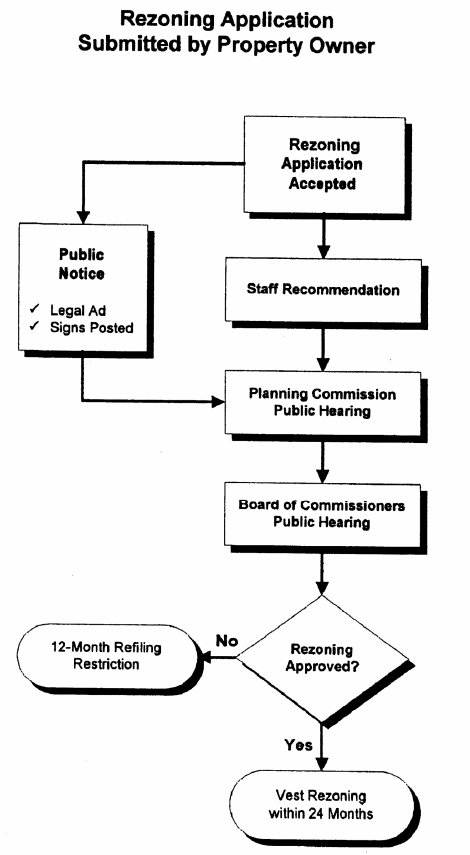
Figure 12.3 Rezoning Process
(3)
Decision.
a.
The planning commission shall take action on the rezoning application at its public hearing.
1.
The planning commission's action may recommend amendments and conditions to the applicant's request which may be deemed advisable so that the purpose of this Development Code will be served.
2.
Failure to make a recommendation shall go forward to the board of commissioners as "no comment".
b.
Following the planning commission's public hearing, the board of commissioners shall consider the rezoning application at the next meeting scheduled for the purpose of considering zoning amendments for which adequate notice has or can be published.
c.
In considering a rezoning application, action shall be taken by the board of commissioners by vote of the members present.
1.
A motion to approve or deny an application must be approved by an affirmative vote of a majority of a quorum of the members present in order for the motion to be approved.
2.
If a motion to approve an application fails, the application is automatically denied. If a motion to deny an application fails, another motion would be in order.
3.
If a vote results in a tie among the district commissioners, the chair shall cast his or her vote to break the tie. In the absence of the chair, a tie vote shall automatically table the matter until the next regular zoning meeting of the board of commissioners.
4.
If no action is taken on an application, it shall be considered tabled and action deferred to the next regular zoning meeting of the board of commissioners.
5.
A final decision must be made no later than the third meeting at which the rezoning application appears on the board's agenda (i.e., following the board's public hearing, the application may not be deferred or tabled more than twice). If, at the third meeting, the board is unable to take final action, the application shall be considered denied.
d.
In taking final action on an application, the board of commissioners may:
1.
Approve, approve with conditions, or deny the application; or
2.
Approve or approve with conditions any portion of the area proposed for rezoning, thus reducing the boundaries of the area rezoned; or
3.
Rezone the area or any portion of the area proposed for rezoning to another zoning district that is deemed more appropriate than that requested by the applicant; or
4.
Allow withdrawal of said request by the applicant (with or without opposing a 12-month period during with another zoning change on the property may not be considered); or
5.
Table the application for consideration at its next scheduled zoning meeting; or
6.
Return the application to the planning commission for further consideration; or
7.
Such other action as the board of commissioners may, in its discretion, deem advisable.
(e)
Standards for rezoning consideration.
(1)
Map amendments (rezoning). The planning commission and the board of commissioners shall consider the following standards in considering any rezoning proposal, giving due weight or priority to those factors that are appropriate to the circumstances of each proposal:
a.
Is the proposed use consistent with the stated purpose of the zoning district that is being requested?
b.
Is the proposed use suitable in view of the zoning and development of adjacent and nearby property?
c.
Will the proposed use not adversely affect the existing use or usability of adjacent or nearby property?
d.
Is the proposed use compatible with the goals, objectives, purpose and intent of the comprehensive plan?
e.
Are their substantial reasons why the property cannot or should not be used as currently zoned?
f.
Will the proposed use not cause an excessive or burdensome use of public facilities or services, including but not limited to streets, schools, water or sewer utilities, and police or fire protection?
g.
Is the proposed use supported by new or changing conditions not anticipated by the comprehensive plan or reflected in the existing zoning on the property or surrounding properties?
h.
Does the proposed use reflect a reasonable balance between the promotion of the public health, safety, morality, or general welfare and the right to unrestricted use of property?
(2)
Change in conditions of rezoning approval. Any application that proposes a change in the conditions of approval previously established by the board of commissioners through action on a rezoning shall be reviewed in light of the standards set forth in this subsection for map amendments.
(f)
Withdrawal of rezoning request. Any applicant wishing to withdraw a proposed rezoning prior to final action by the board of commissioners shall file a written request for withdrawal with the planning and community development director.
(1)
If the request for withdrawal is received prior to the publication of notice for the public hearing, the planning and community development director shall withdraw the application administratively without restriction on the refiling of a proposed rezoning on the property in the future.
(2)
If notice has been published (or is irretrievably set for publication) but the application has not been heard by the planning commission, the application shall be withdrawn administratively by the planning and community development director, and an application for a rezoning on the property may not be resubmitted for six months from the date of withdrawal.
(3)
Should any request for withdrawal be made by the applicant after the planning commission hearing but before the board of commissioners hearing, the application shall remain on the board of commissioners' public hearing agenda and the withdrawal request shall be considered for approval or denial, with or without prejudice, by the board of commissioners.
(4)
Approval of a rezoning shall be in full force and effect upon its approval by the board of commissioners.
(5)
For a property on which a use, building, structure or other improvements existed in conformity with this Development Code prior to the effective date of a rezoning affecting the property, any such use, building, structure or other improvements no longer in conformance shall be governed under the provisions of article I of this Development Code relating to grandfathered development.
(6)
Construction of any use, building, structure, or other improvements for which a building permit has been issued in conformity with this Development Code prior to the effective date of a rezoning affecting the property may continue to completion in accordance with the provisions for exemptions of previously issued permits in article I and, upon completion, shall be governed under the provisions of the grandfathered development section of said article, as applicable.
(g)
Vesting of rezoning approval. After an approval has been granted by the board of commissioners for a rezoning, the applicant, agent or property owner has 24 months to vest the rezoning approval. To vest a rezoning approval and forego its expiration, the applicant must record a final subdivision plat, receive project approval of a preliminary plat or site plan, obtain a building permit or lawfully initiate the use, whichever occurs first. If the applicant, agent, or property owner fails to vest the rezoning approval, the board of commissioners may initiate a rezoning application to revert the property to the previously zoned condition. Such reversionary action shall proceed in accordance with provisions of this article pertaining to rezoning approvals. The owner of the property will be notified of the reversionary action and afforded an opportunity to appear before the board of commissioners to show just cause why the reversionary action should not be taken.
(Ord. of 10-13-2020; Ord. of 6-27-2023, § 1(Exh. A))
Sec. 89-1316. - Special use approval.
Certain uses as shown on Tables 2.2 and 2.3 require a special use approval prior to being allowed on a property. A special use may be approved by the board of commissioners under the procedures in this section. In addition, the board of commissioners following the procedures in this section may also approve changes in the conditions of approval pertaining to a specific special use approval.
(a)
Initiation of special use request.
(1)
The owner of the property affected, or their authorized representative may initiate an application for a special use for any property or properties.
(2)
All applications shall be submitted to the planning and community development department on the department's application forms. A nonrefundable fee, if any, as set by the board of commissioners from time to time, shall accompany all applications. Completed forms, plus any information the applicant feels to be pertinent is to be filed with the planning and community development department.
(3)
The planning and community development department shall review the application for completeness within five days of submission. Incomplete or improper applications will be returned to the applicant.
(4)
Concurrent variance and rezoning consideration. Hardship variance and special exception variance requests associated with a rezoning application may be heard by the board of commissioners which may concurrently grant approval of rezoning and variance(s), if warranted, in accordance with the standards set out in section 89-1384 and/or section 89-1385, as applicable.
(5)
An application for a special use affecting the same property shall not be considered by the board of commissioners more often than once every 12 months from the date of action by the board of commissioners denying the special use; provided, however, that the board of commissioners may approve a reduction in the waiting period to no less than six months. In any event, the board may consider an application for a special use within the 12-month time period in connection with settlement of litigation or pursuant to an order by a court of competent jurisdiction without complying with any of the procedural formalities set forth herein, and subject only to the requirements of the Georgia Zoning Procedures Law, O.C.G.A. § 36-66-1 et seq.
(b)
Special use concept plan.
(1)
An application for a special use shall be accompanied by a concept plan if any new construction is proposed or alteration of the site is required under the site or development design standards of this Development Code.
(2)
A concept plan may be prepared by the applicant, a professional engineer, a registered land surveyor, a landscape architect, a land planner or any other person familiar with land development activities.
(3)
The concept plan shall be drawn to approximate scale on a boundary survey of the tract or on a property map showing the approximate location of the boundaries and dimensions of the tract.
(4)
The concept plan shall show the following:
a.
A location sketch of the property in relation to the surrounding area with regard to well-known landmarks such as arterial streets or railroads. Sketches may be drawn in freehand and at a scale sufficient to show clearly the information required, but not less than one inch equal to 2,000 feet. US. Geological Survey maps may be used as a reference guide for the location concept.
b.
Zoning district classification of the subject property and all adjacent properties, and zoning district boundaries if they cross the property. The number of acres of land in each zoning classification on the property (or square feet if less than one acre).
c.
Man-made features within and adjacent to the property, including existing streets and names, city and county political boundary lines, and other significant information such as location of bridges, utility lines, existing buildings to remain, and other features as appropriate to the nature of the request.
d.
Natural features, such as the 100-year floodplain, and protected wetlands and stream buffers required under the buffers and tree conservation article of this Development Code.
e.
A statement as to the proposed use of the property and the amount of development proposed, such as the number of acres of land in the property (or square feet if less than one acre), the number of dwelling units or the gross nonresidential floor area, and the number of parking spaces.
f.
The proposed project layout including the approximate outline and location of all buildings, and the location of all minimum building setback lines, outdoor storage areas, buffers, parking areas and driveways.
g.
A statement as to the source of domestic water supply.
h.
A statement as to the provision for sanitary sewage disposal.
i.
The approximate location of proposed stormwater detention facilities.
j.
The approximate location of proposed access to the county road system.
(5)
The concept plan shall also indicate:
a.
Name and address of the property owner.
b.
Name, address, and telephone number of the applicant (if different than the owner).
c.
If drawn on a boundary survey: date of survey and source of datum.
d.
Date of plan drawing, and revision dates, as appropriate.
e.
North point and approximate scale of the drawing.
f.
Location (tax map and parcel number) and size of the property in acres (or in square feet if less than an acre).
g.
Such additional information as may be useful to permit an understanding of the proposed use and development of the property.
(c)
Impact analysis.
(1)
If the special use request has been initiated by an owner or their representative, the application must be accompanied by a written, documented analysis of the proposed use with regard to each of the standards for special use approval enumerated under subsection (e).
(2)
A special use application for a proposed development that is capable of generating 1,000 average daily vehicle trips or more shall be accompanied by a traffic study, prepared by a professional engineer registered in Georgia, under guidelines available from the public works department. Anticipated vehicle trips may be based upon the latest edition of "Trip Generation" published by the Institute of Transportation Engineers. The public works director may waive this requirement when conditions warrant.
(3)
A traffic study, prepared by a professional engineer registered in Georgia, shall also be required for a proposed modification to a previously approved special use if the average daily vehicle trips will increase by 10 percent or more than calculated for the original special use approval, or average daily vehicle trips will exceed 1,000 for the first time. The public works director may waive this requirement when conditions warrant.
(4)
For a proposed development that will generate fewer than 1,000 average daily vehicle trips or an increase of less than ten percent, a traffic study, prepared by a professional engineer registered in Georgia, may be required by the public works director. Determination of such requirements will be made within five working days of receipt of the application for the special use and must be submitted to the public works director at least five working days prior to the first public hearing.
(5)
A traffic study or other studies of the impact of the proposed development may be required by the planning commission or the board of commissioners as deemed necessary for adequate consideration and a fully-informed decision on the rezoning request, relative to the standards for special use consideration contained in subsection (e), below.
(d)
Process for special use approval. Before the board of commissioners may take final action on a proposed special use, the planning commission and the board of commissioners shall each hold a public hearing on the proposal.
(1)
Public notice.
a.
At least 30 days but no more than 45 days prior to any public hearing required by this subsection, notice shall be published in a newspaper of general circulation within the county. The notice shall state the time, place and purpose of the hearing.
b.
A special use request initiated by an owner or their representative shall be heard at a public hearing only upon:
1.
The published notice, in addition to the requirements above, shall include the location of the property, the present zoning classification of the property, and the proposed zoning classification of the property requested; and
2.
At least 15 days prior to the public hearing, the applicant shall post a sign or signs, as provided by the planning and community development department, stating the date, time and place for the planning commission public hearing and the initially scheduled board of commissioners public hearing, the present zoning classification and the nature of the proposed zoning change. One such sign shall be placed in a conspicuous location along each street frontage of the property for which the rezoning has been requested. If the property has no street frontage, the sign shall be placed on each street from which access will be gained to the property.
(2)
Public hearings; procedures. The public hearing held by the planning commission and the board of commissioners for a special use is to be conducted in the following manner:
a.
The chair or an appointed designee, who will act as the presiding official, will convene the public hearing at the scheduled time and place.
b.
The presiding official will call for each proposed special use to be presented.
c.
No person in attendance is to speak unless first formally recognized by the presiding official. Upon rising to speak each person recognized shall state his or her name and home address.
1.
The presiding official may place reasonable limits on the number of persons who may speak for or against a proposal, on the time allowed for each speaker, and on the total time allowed for presentation of the proposed special use.
2.
No less than ten minutes will be provided for all of those speaking in support of a special use approval and no less than ten minutes shall be provided for all of those speaking against, unless such proponents or opponents take less time than the minimum allowed.
3.
If reasonable time limitations permit, any member of the general public may speak at a hearing.
d.
The applicant will be allowed to speak first in order to present the application. Others in support of the application may then speak, followed by those in opposition to the application. The applicant will then be allowed time for rebuttal. Rebuttal must be limited to points or issues raised by opponents to the application at the hearing.
e.
Following the presentation of positions by members of the public, a recommendation from Barrow County staff shall be presented.
f.
During the public hearing, the members of the planning commission or the board of commissioners may ask questions at any time. Time devoted to questions and answers will not be counted against any time limitations that have been imposed on presentations.
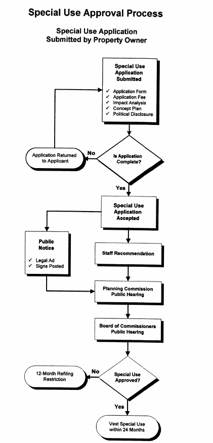
Figure 12.4 Special Use Approval Process
(3)
Decision.
a.
The planning commission shall take action on the special use application at its public hearing.
1.
The planning commission's action may recommend amendments and conditions to the applicant's request which may be deemed advisable so that the purpose of this Development Code will be served.
2.
Failure to make a recommendation shall go forward to the board of commissioners as "no comment".
b.
Following the planning commission's public hearing, the board of commissioners shall consider the special use application at the next meeting scheduled for the purpose of considering special use applications for which adequate notice has or can be published.
c.
In considering a special use request, action shall be taken by the board of commissioners by vote of the members present, as follows:
1.
A motion to approve or deny an application must be approved by an affirmative vote of at least a majority of a quorum of the members present in order for the motion to be approved.
2.
If a motion to approve an application fails, the application is automatically denied. If a motion to deny an application fails, another motion would be in order.
3.
If a vote results in a tie among the district commissioners, the chair shall cast his or her vote to break the tie. In the absence of the chair, a tie vote shall automatically table the matter until the next regular zoning meeting of the board of commissioners.
4.
If no action is taken on an application, it shall be considered tabled and action deferred to the next regular zoning meeting of the board of commissioners.
5.
A final decision must be made no later than the third meeting at which the rezoning application appears on the board's agenda (i.e., following the board's public hearing, the application may not be deferred or tabled more than twice). If, at the third meeting, the board is unable to take final action, the application shall be considered denied.
d.
In taking action on an application, the board of commissioners may:
1.
Approve, approve with conditions, or deny the proposal; or
2.
Allow withdrawal if so requested by the applicant (with or without imposing a 12-month period during which another special use on the property may not be considered); or
3.
Table the proposal for consideration at its next scheduled meeting; or
4.
Return the proposal to the planning commission for further consideration.
(e)
Standards for special use consideration.
(1)
Approval of special use. A use that would be allowed otherwise permitted within a zoning district with special use approval shall be considered to be compatible with other uses permitted in the district, provided that due consideration is given to the following objective criteria. Emphasis may be placed on those criteria most applicable to the specific use proposed:
a.
Will the proposed special use be consistent with the stated purpose of the zoning district in which it will be located?
b.
Is the proposed special use compatible with the goals, objectives, purpose and intent of the comprehensive plan?
c.
Will the establishment of the special use impede the normal and orderly development of surrounding property for uses predominate in the area?
d.
Is the location and character of the proposed special use consistent with a desirable pattern of development for the locality in general?
e.
Is or will the type of street providing access to the use be adequate to serve the proposed special use?
f.
Is or will access into and out of the property be adequate to provide for traffic and pedestrian safety, the anticipated volume of traffic flow, and access by emergency vehicles?
g.
Are or will public facilities such as schools, water or sewer utilities, and police or fire protection be adequate to serve the special use?
h.
Are or will refuse, service, parking and loading areas on the property be located or screened to protect other properties in the area from such adverse effects as noise, light, glare or odor?
i.
Will the hours and manner of operation of the special use have no adverse effects on other properties in the area?
j.
Will the height, size or location of the buildings or other structures on the property be compatible with the height, size or location of buildings or other structures on neighboring properties?
(2)
Change in conditions of special use approval. Any application that proposes a change in the conditions of approval previously established by the board of commissioners through action on a special use shall be reviewed in light of the standards set forth in this section for a special use, as appropriate.
(f)
Withdrawal of special use request. Any applicant wishing to withdraw a special use application prior to final action by the board of commissioners shall file a written request for withdrawal with the planning and community development director.
(1)
If the request for withdrawal is received prior to the publication of notice for the public hearing, the application shall be withdrawn administratively by the planning and community development director without restriction on the refiling of a proposed special use on the property in the future.
(2)
If notice has been published (or is irretrievably set for publication) but the application has not been heard by the planning commission, the application shall be withdrawn administratively by the director planning and community development director, and an application for a special use on the property may not be resubmitted for six months from the date of withdrawal.
(3)
Should any request for withdrawal be made by the applicant after the planning commission hearing but before the board of commissioners' hearing, the application shall remain on the board of commissioners' public hearing agenda and the withdrawal request shall be considered for approval or denial, with or without prejudice, by the board of commissioners.
(g)
Effect of special use denial.
(1)
If an application for special use approval is denied by the board of commissioners, then any portion of the same property may not again be considered for approval of the same or another special use for a period of 12 months from the date of the denial action by the board of commissioners.
(2)
The board may only reconsider property for special use approval within the 12-month time period in connection with settlement of litigation or pursuant to an order by a court of competent jurisdiction. However, the board, if time permits, shall direct staff to advertise, post the property, and notify the applicant and owner in writing prior to taking such action.
(h)
Effect of special use approval.
(1)
Approval of a special use shall be in full force and effect upon approval by the board of commissioners.
(2)
A special use approval.
(3)
For a property on which a use, building, structure or other improvements existed in conformity with this Development Code prior to the effective date of a special use approval affecting the property, any such use, building, structure or other improvements no longer in conformance shall be governed under the provisions of article I of this Development Code relating to grandfathered development.
(4)
Construction of any use, building, structure, or other improvements for which a building permit has been issued in conformity with this Development Code prior to the effective date of a special use approval affecting the property may continue to completion in accordance with the provisions for exemptions of previously issued permits in article I and, upon completion, shall be governed under the provisions of the grandfathered development section of said article, as applicable.
(i)
Vesting of special use approval. After an approval has been granted by the board of commissioners for a special use, the applicant, agent or property owner has 24 months to vest the special use approval. To vest a special use approval and forego its expiration, the applicant must record a final subdivision plat, receive project approval of a preliminary plat or site plan, obtain a building permit or lawfully initiate the use, whichever occurs first. If the applicant, agent, or property owner fails to vest the special use approval, the board of commissioners may initiate a special use application to revert the property to the previously zoned condition. Such reversionary action shall proceed in accordance with provisions of this article pertaining to special use approvals. The owner of the property will be notified of the reversionary action and afforded an opportunity to appear before the board of commissioners to show just cause why the reversionary action should not be taken.
(Ord. of 10-13-2020; Ord. of 6-27-2023, § 1(Exh. A))
Sec. 89-1317. - Project approval.
The planning and community development department must first approve a preliminary plat for a major subdivision or a site plan for development of a multi-family or nonresidential project prior to the issuance of a development permit or initiation of any land disturbing or construction activities.
(a)
Responsibility for project approval.
(1)
The planning and community development director is responsible for administering the review and approval process for preliminary subdivision plats and site plans. The planning and community development department shall forward a copy of the project approval application to other appropriate county departments, the Georgia Department of Transportation, or others as appropriate, for their review and comment. The planning and community development department shall provide all comments to the applicant for resolution, who shall work directly with each department as necessary to resolve all issues.
(2)
A preliminary plat or site plan may be prepared by a professional engineer, a registered land surveyor, a landscape architect, a land planner or any other person professionally familiar with land development and project construction activities.
(b)
Procedure for project approval.
(1)
A pre-application review with a preliminary concept plan is suggested. Such concept plan shall be the concept plan associated with rezoning or special use approval of the property, if any.
(2)
An application for project approval may be processed independently or in conjunction with an application for issuance of a development permit.
(3)
An application for project approval shall be submitted to the planning and community development department. The application shall include:
a.
The name and address of the person requesting review.
b.
A properly completed application form, as furnished by the planning and community development department, requesting review for project approval.
c.
A number of copies, as established by the planning and community development director, of the preliminary subdivision plat or site plan showing the entire ownership drawn to the specifications of this section.
d.
Payment of the applicable application and review fees as established by the board of commissioners from time to time.
(4)
The planning and community development department will review the application for completeness within five days of submission. Incomplete applications will be returned to the applicant.
(5)
If the subdivision includes or abuts a U.S. or state numbered highway, unless all of the lots in the subdivision contain five acres or more and no new street is involved, review by the Georgia Department of Transportation (DOT) is required under O.C.G.A. § 32-6-151. Two additional copies of the final plat must be submitted to the planning and community development department for forwarding to DOT. The owner or subdivider must respond to the recommendations of the DOT prior to project approval by the county. If the written recommendations of the DOT are not made within 30 days of receipt of the plat by DOT, their approval shall be assumed as provided under state law.
(6)
Following review of the application, the planning and community development department will indicate on the drawing or in writing all comments related to compliance with this Development Code.
(7)
The owner is responsible for compliance with all codes, regulations and zoning requirements, including all codes and requirements of other departments and agencies* (such as NPDES and Section 404, as applicable), and for the satisfaction of all the noted and written comments.
(8)
* See the list of other departments and agencies under subsection 89-1319(e)(5).
(9)
The planning and community development department may not approve any preliminary subdivision plat or site plan that shows a lot or situation that would clearly require a variance to order to be reasonably usable, whether due to the presence of floodplain, unusual configuration, zoning compliance, lack of public utilities, or for any other reason.
(10)
When the Planning and Community Development Department has determined that the preliminary subdivision plat or site plan is in compliance with the requirements, purpose and intent of this Development Code, it will be approved. The planning and community development director will sign and date the certificate of project approval stamped or printed on a reproducible copy of the preliminary subdivision plat or site plan. One copy of the approved drawing will be transmitted to the applicant and one copy will be retained by the Planning and Community Development Department.
(11)
The certificate of project approval will remain in effect for a period of 12 consecutive months after which time it will become null and void and a new certificate may be required if no permit has been issued or no development activity has begun.
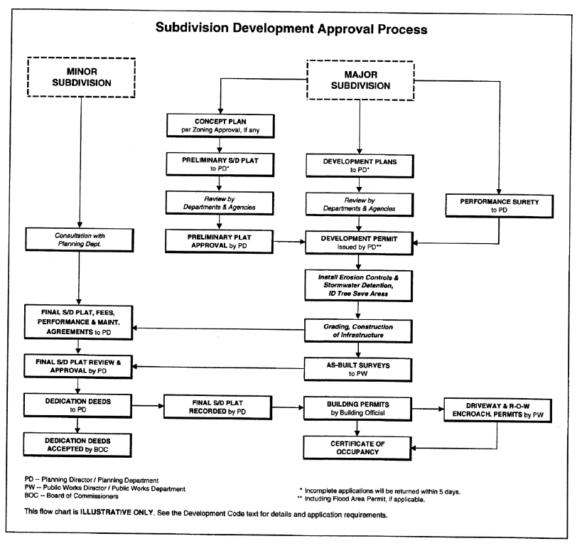
Figure 12.5 Subdivision Development Approval Process
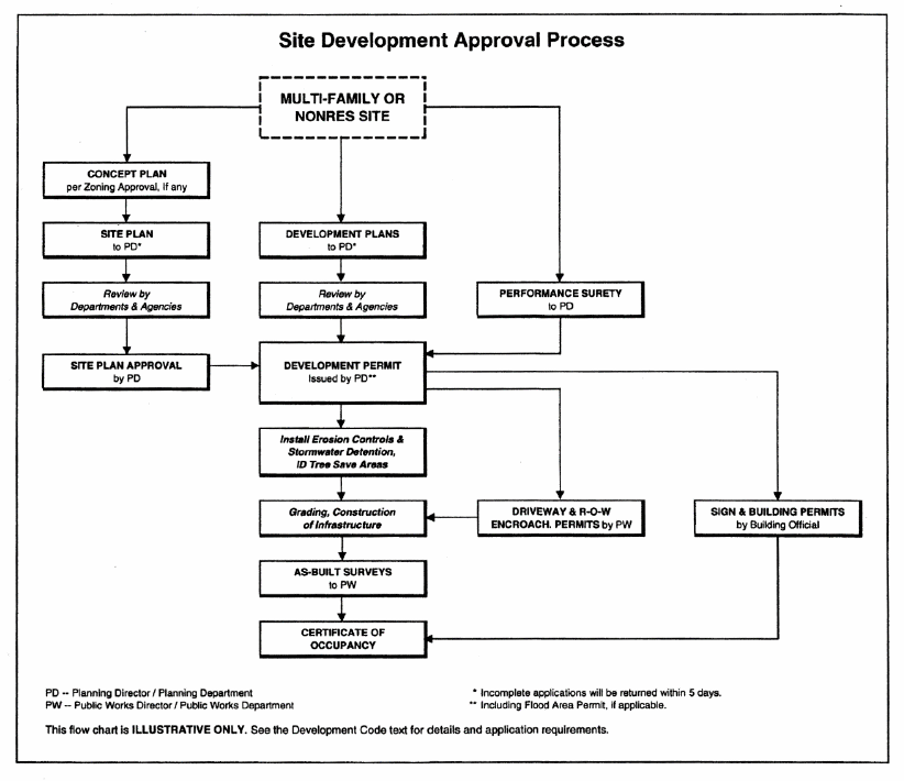
Figure 12.6 Site Development Approval Process
(c)
General standards for project approval.
(1)
The proposed name of the development and proposed street names shall not duplicate or too closely approximate, phonetically, the name of any other development or street in the county. If shown to the contrary, the Planning and Community Development Department may refuse to accept such development or street names. The development may use letter designations in place of proposed street names at the option of the applicant.
(2)
The preliminary plat or site plan shall be prepared on a boundary survey of the entire tract to be subdivided or developed showing the location of the boundaries and dimensions of the tract to be developed.
(3)
The preliminary subdivision plat or site plan shall be clearly and legibly drawn at a scale of not less than 100 feet to one inch. The recommended maximum dimensions of the sheet size is 36 inches by 42 inches and the minimum dimensions of 17 inches by 22 inches; however, the planning and community development director may approve other sheet sizes and graphic scales as appropriate.
(4)
For property of over 100 acres, a smaller scale may be used where, in the judgment of the planning and community development director, presentation of detailed data is not necessary to evaluate the entire project. It is the intent of this provision that in all cases sufficient information shall be provided for an adequate evaluation of the public and private improvements.
(d)
Preliminary plat or site plan requirements. Each preliminary plat or site plan shall show the following:
(1)
Caption:
a.
Proposed name of the development and its acreage (or square footage if less than an acre).
b.
Name, address, telephone and fax numbers of the property owner and subdivider or developer.
c.
Name, address, telephone and fax numbers of the applicant.
d.
Name, address, telephone and fax numbers of the individual or company responsible for the design. The name, registration number and seal of the professional under whom the plan was prepared shall be stamped on the plan and signed.
e.
Date of survey, north point and graphic scale, source of datum, date of plan drawing, and revision dates, as appropriate.
(2)
Proposed use of the property, including a statistical summary of development factors such as density, nonresidential floor area, number of lots or dwelling units, and minimum unit sizes, as may be pertinent to the type of project.
(3)
Location (tax map and parcel number) and size of the property in acres (or in square feet if less than an acre).
(4)
Location map of the property in relation to the surrounding area with regard to well known landmarks such as arterial streets, railroads or others. Sketches may be drawn in freehand and at a scale sufficient to show clearly the information required, but not less than one inch equal to 2,000 feet. U.S. Geological Survey maps may be used as a reference guide for the location sketch.
(5)
Name and boundary of former approved subdivision if any or all of the land in the preliminary subdivision plat or site plan has been previously subdivided, showing boundaries of the lots to be re-subdivided.
(6)
Zoning district classification of the subject property and all adjacent properties, and zoning district boundaries as appropriate.
(7)
Rezoning or special use application number, date of approval, and stipulations (conditions of approval), as applicable.
(8)
Variances obtained on the property by application number, date of approval, and stipulations (conditions of approval), as applicable.
(9)
Recorded deed names of adjoining property owners or subdivisions.
(10)
Natural features within the property, including:
a.
Drainage channels, bodies of water, wooded areas and other significant natural features such as rock outcroppings.
b.
On all water courses entering or leaving the property, the direction of flow shall be indicated, the 100-year floodplain, and wetland areas
c.
All primary conservation areas as defined under the environmental protection article of this Development Code.
d.
All secondary conservation areas as defined under the environmental protection article of this Development Code.
(11)
Protected groundwater recharge areas.
(12)
Man-made features within and adjacent to the property, including street right-of-way and pavement widths, names of existing streets, all easements, city and county political boundary lines, and other significant information such as location and dimensions of bridges, utility lines, existing buildings to remain, and other features
(13)
The proposed project layout including:
a.
For subdivisions, lot lines and street right-of-way lines, with proposed street names or letter designations and right-of-way widths, along with the front building setback line and the dimension of its length on each lot (i.e., the lot width) and land to be reserved for public uses.
b.
For multi-family and nonresidential development site plans, the outline and location of all buildings, and the location of all minimum building setback lines, outdoor storage areas, buffers, parking areas, driveways, curb cuts, and designated fire lanes.
(14)
Topographic contours with a minimum vertical interval of five feet shall be provided for both existing and proposed topography.
(15)
The proposed phasing of the development if it is proposed to be built in sections.
(16)
A statement as to the source and adequacy of domestic water supply.
(17)
A statement as to the provision for sanitary sewage disposal and treatment capacity, if applicable.
(18)
The approximate location of proposed stormwater detention facilities.
(19)
Such additional information as may be reasonably required to permit an adequate evaluation of the development activity proposed in the application.
(e)
Design professional and owner certifications. Each preliminary plat or site plan is to include a certification by the design professional and by the owner that read as shown on Figure 12.7 and are signed in blue ink on the original drawing.
(f)
Evidence of project approval. Each preliminary subdivision plat or site plan shall carry the following certificates printed or stamped on the plat:
(1)
Signed approval from the county health department (if septic tanks will be used) or written comments and approval by the health department, as appropriate.
(2)
Certificate of project approval, to read as shown on Figure 12.7.
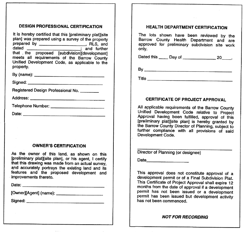
Figure 12.7 Certifications of Design Professional; Project Approval
(Ord. of 10-13-2020)
Sec. 89-1318. - Requirements for development plans.
(a)
Generally.
(1)
Persons seeking to undertake land-disturbing activity (as defined in this Development Code) shall not commence or proceed until development plans are approved and a development permit is issued by the planning and community development department. The process for approval of a development permit is presented in the development permit section (section 89-1318), below.
(2)
The development plans for a project shall conform in all respects with the requirements of this Development Code, and shall include each of the plans in this section as appropriate to the project. These include:
a.
Erosion and sedimentation control plan;
b.
Grading plan;
c.
Floodplain management plan;
d.
Stormwater management plan;
e.
Street improvement plan;
f.
Street widening construction data;
g.
Landscaping, buffer and tree conservation plans; and
h.
Public utility plans.
(3)
Standard plans and specifications referred to in this section are the minimum acceptable standards. Additional information may be required by the county as needed for a complete understanding of the development proposed.
(4)
All development plans and supporting studies shall be prepared by or under the supervision of a professional engineer registered in the state, except that the landscaping, buffer and tree conservation plans are to be prepared by or under the supervision of a landscape architect registered in the state.
(b)
Erosion and sedimentation control plan.
(1)
Plans must be prepared to meet the erosion and sedimentation control requirements of the land development activities article of this Development Code. Conformance with the minimum requirements may be attained through the use of design criteria in the current issue of the "Manual for Erosion and Sediment Control in Georgia"; or through the use of alternate design criteria that conform to sound conservation and engineering practices. The erosion and sedimentation control plan shall consider the interrelationship of the soil types, geological and hydrological characteristics, topography, watershed, vegetation, proposed permanent structures including roadways, constructed waterways, sediment control and stormwater management facilities, local ordinances and state laws.
(2)
Data required for erosion and sedimentation control plan.
a.
Narrative or notes, and other information: Notes or narrative to be located on the erosion and sedimentation control plan in general notes or in erosion and sediment control notes.
b.
Description of existing land use at project site and description of proposed project.
c.
Name, address, and phone number of the property owner and the developer.
d.
Name and phone number of 24-hour local contact who is responsible for erosion and sediment controls.
e.
Size of project, or phase under construction, in acres.
f.
Activity schedule showing anticipated starting and completion dates for the project. Include the statement in bold letters that "the installation of erosion and sediment control measures shall occur prior to or concurrent with land-disturbing activities".
g.
Stormwater and sedimentation management systems storage capacity, hydrologic study, and calculations, including off-site drainage areas.
h.
Vegetative plan for all temporary and permanent vegetative practices, including species, planting dates, and seeding, fertilizer, lime and mulching rates. The vegetative plan should show options for year-round seeding.
i.
Detail drawings for all structural practices. Specifications may follow guidelines set forth in the "Manual for Erosion and Sediment Control in Georgia".
j.
Maintenance statement to read as follows: "Erosion and sediment control measures will be maintained at all times. If full implementation of the approved plan does not provide for effective erosion and sediment control, additional erosion and sediment control measures shall be implemented to control or treat the sediment source".
(3)
Maps, drawings and supportive computations shall bear the signature/seal of a registered or certified professional in engineering, architecture, landscape architecture, land surveying or erosion and sediment control. After December 31, 2006, all persons involved in land development design, review, permitting, construction, monitoring, or inspection or any land-disturbing activity shall meet the education and training certification requirements as developed by the commission pursuant to O.C.G.A. § 12-7-20.
The certified plans shall contain:
a.
Graphic scale and north point or arrow indicating magnetic north.
b.
Vicinity map showing location of project and existing streets.
c.
Boundary line survey.
d.
Delineation of disturbed areas within project boundary.
e.
Existing and planned contours, with contour lines drawn with an interval in accordance with the following:
f.
Spot elevations:
1.
For sites smaller than one acre in size, show the direction of drainage and spot elevations at all breaks in grade and along drainage channels or swales at selected points not more than 100 feet apart.
2.
For sites of one acre and larger with slopes of less than two percent, show contours at intervals of not more than two feet and spot elevations at all breaks in grade along drainage channels and swales at selected points not more than 100 feet apart.
g.
Adjacent areas and features such as streams, lakes, residential areas, etc. which might be affected should be indicated on the plan.
h.
The limits of the 100-year floodplain.
i.
Proposed structures or additions to existing structures and paved areas.
j.
The 25-foot horizontal stream buffer adjacent to state waters and the specified width in MRPA areas, or other stream buffer as required under the environmental protection article of this Development Code.
k.
The specified horizontal stream buffer along designated trout streams, where applicable.
l.
Location of erosion and sediment control measures using coding symbols from the "Manual for Erosion and Sediment Control in Georgia",Chapter 6.
(4)
Maintenance of all soil erosion and sedimentation control practices, whether temporary or permanent, shall be at all times the responsibility of the property owner.
(c)
Grading plan.
(1)
Grading plans shall identify existing and proposed topographic contour lines at the interval required for erosion and sedimentation control plans, above.
(2)
Grading plans shall outline any area that is required to remain undisturbed, such as a natural buffer, tree protection area or greenway (see the buffers and tree conservation article and the environmental protection article of this Development Code) and shall identify and describe the protective fencing or staking to be placed surrounding such area.
(3)
If the property contains any area of special flood hazard (the 100-year floodplain), grading plans in and around the floodplain shall be designed in conformance to all requirements relating to flood damage prevention under the land development activities article of this Development Code.
(d)
Stormwater management plan. A stormwater management permit is required for all developments, except for those specifically exempted in this Development Code.
(1)
Submission of plan.
a.
Review and approval. In order to obtain a stormwater management permit, a stormwater management site plan showing the design of the development shall be provided to the department of engineering for review and approval.
b.
Effect on permits. A development permit, building permit or land disturbance permit shall not be issued without an approved stormwater management site plan.
(2)
General standards. All drainage facilities shall be included in a surface drainage plan and shall be so designed to serve the entire drainage area. No increase in peak discharge to existing streams or stormwater sewers shall be permitted unless calculations are submitted and approved showing that such increase will not adversely affect upstream or downstream conditions.
(3)
Requirements for proposed improvements. The location and size of all proposed stormwater improvements shall be designed in accordance with and meet all standards relating to stormwater management of the current edition of the "Georgia Stormwater Management Manual."
(4)
Stormwater management site plan requirements. The stormwater management plan shall include the information listed below, as more specifically detailed in the current edition of the "Georgia Stormwater Management Manual."
a.
Existing conditions hydrologic analysis.
1.
A topographic map of existing site conditions (minimum two-foot contour interval) with the basin boundaries indicated.
2.
Acreage, soil types and land cover of areas for each subbasin affected by the project.
3.
All perennial and intermittent streams and other surface water features.
4.
All existing stormwater conveyances and structural control facilities.
5.
Direction of flow and exits from the site.
6.
Analysis of runoff provided by off-site areas upstream of the project site.
7.
Methodologies, assumptions, site parameters and supporting design calculations used in analyzing the existing conditions site hydrology.
a.
Post-development hydrologic analysis.
1.
A topographic map of developed site conditions (two-foot contour interval required) with the post-development basin boundaries indicated.
2.
Total area of post-development impervious surfaces and other land cover areas for each sub-basin affected by the project.
3.
Unified stormwater sizing criteria runoff calculations for water quality, channel protection, overbank flooding protection and extreme flood protection for each sub-basin.
4.
Location and boundaries of proposed natural feature protection areas, such as natural buffers and tree protection areas (see the general development standards article of this Development Code), and primary and secondary conservation areas (see the resource conservation article of this Development Code).
5.
Documentation and calculations for any applicable site design credits that are proposed to be utilized.
6.
Methodologies, assumptions, site parameters and supporting design calculations used in analyzing the existing conditions site hydrology.
b.
Stormwater management system.
1.
Drawing or sketch of the stormwater management system including the location of nonstructural site design features and the placement of existing and proposed structural stormwater controls. This drawing is to show design water surface elevations, storage volumes available from zero to maximum head, location of inlet and outlets, location of bypass and discharge systems, and all orifice/restrictor sizes.
2.
Narrative describing that appropriate and effective structural stormwater controls have been selected.
3.
Cross-section and profile drawings and design details for each of the structural stormwater controls in the system. This is to include supporting calculations showing that the facility is designed according to the applicable design criteria.
4.
Hydrologic and hydraulic analysis of the stormwater management system for all applicable design storms (including stage-storage or outlet rating curves, and inflow and outflow hydrographs).
5.
Documentation and supporting calculations showing that the stormwater management system adequately meets the unified stormwater sizing criteria.
6.
Drawings, design calculations and elevations for all existing and proposed stormwater conveyance elements including stormwater drains, pipes, culverts, catch basins, channels, swales and areas of overland flow.
c.
Downstream analysis. Supporting calculations for a downstream peak flow analysis using the ten-percent rule necessary to show safe passage of post-development design flows downstream.
d.
Operations and maintenance plan. Description of maintenance tasks, responsible parties for maintenance, funding, access and safety issues.
e.
Evidence of acquisition of applicable local and non-local permits. Such evidence shall include a copy of the Notice of Intent (NOI) form submitted to DNR under General Permit No. GAR100000 (relating to authorization under NPDES for stormwater discharges associated with construction activity).
f.
Waiver requests (if any). Waivers from the provisions of the current edition of the "Georgia Stormwater Management Manual" will be considered by the public works department on a case-by-case basis. Waivers may be granted only when a requirement is shown to be impractical or having no benefit on adequate stormwater management of the site, or for an alternative approach that will have greater benefit and practicality than that otherwise required.
(e)
Street improvement plan.
(1)
Plans must include centerline profiles and typical street sections of all proposed streets. Profiles shall be drawn on standard plan and profile sheet with plan section showing street layout, pavement and right-of-way width, curvature, and required drainage facilities. Typical street sections shall be provided for street widenings.
(2)
Where sanitary or storm sewers are to be installed within a street, the grade, size, location and bedding class of pipe, location and invert elevation of manholes shall be indicated on the road profile.
(3)
Centerline profile covering roadways that are extensions of existing roadways shall include: elevations at 50-foot intervals for such distance as may be adequate to provide continuity consistent with the standards required by these regulations for street improvements, but not less than 200 feet.
(4)
All elevations shall be coordinated and tied into U.S. Coast and Geodetic Survey or department of transportation benchmarks where feasible, or into reference monuments established by the Federal Emergency Management Agency.
(5)
A street striping and signage plan, showing improvements in accordance with the "Manual on Uniform Traffic Control Devices", latest edition as published by the Federal Highway Administration, shall be prepared for any street newly constructed or widened to four or more lanes.
(6)
Profile covering roadways that are extensions of existing roadways shall include: elevations at 50-foot intervals for such distance as may be adequate to provide continuity consistent with the standards required by these regulations for street improvements, but not less than 200 feet.
(f)
Landscaping, buffer and tree conservation plans. All proposed site landscaping and buffers as required by this Development Code for parking lot landscape areas, trees and street-side screening; in buffers; and trees to be retained or planted as required by the tree conservation provisions of this Development Code, shall be illustrated on plans as described in this subsection. The plans may be consolidated as one plan if the information can be clearly shown.
(1)
Site landscaping plan.
a.
Scale at one inch = 20 feet to 50 feet, as needed to clearly show illustrate the proposed plantings. Multiple sheets keyed to an index sheet may be used.
b.
Caption:
1.
The name of the development and its acreage (or square footage if less than an acre).
2.
Name, address, telephone and fax numbers of the property owner and subdivider or developer.
3.
Name, address, telephone and fax numbers of the applicant.
4.
Name, address, telephone and fax numbers of the individual or company responsible for the design. The name, registration number and seal of the professional under whom the plan was prepared shall be stamped on the plan and signed.
5.
Date of survey, north point and graphic scale, source of datum, date of plan drawing, and revision dates, as appropriate.
c.
The location and size of all underground or aboveground utilities on the site, including the limits of any public or private utility easements and stormwater detention areas.
d.
The location of all existing and proposed parking areas, sidewalks and other paved or impervious surfaces.
e.
The outline of all existing and proposed buildings and structures.
f.
The boundaries of all natural buffers, greenways and other areas required to remain undisturbed.
g.
The boundaries of each required landscape strip.
h.
A planting plan showing the location, size and common name of proposed plant materials.
i.
The location, size and common name of all existing plant materials to be retained that contribute to meeting the minimum requirements of this Development Code for landscape strips or parking lot landscaping.
(2)
Buffer plan. A buffer plan shall be prepared for any natural or structural buffer required in accordance with the specifications and standards contained in this Development Code. The buffer plan shall show:
a.
Caption, as required under subsection (f)(1)b. for site landscaping plans.
b.
The boundaries of each required buffer area.
c.
The location and size of all underground or aboveground utilities on the site, including the limits of any public or private utility easements and stormwater detention areas.
d.
For each natural buffer, the plan must show:
1.
Methods to be employed to protect the critical root zones of the trees in the buffer from disturbance during construction, including fencing details, erosion control, signage, etc., consistent with the protection of existing trees section of the buffers and tree conservation article of this Development Code.
2.
Proposed supplemental plantings required to maintain the opaque visual screen required.
e.
For each structural buffer, the plan must show:
1.
All grading and construction details for earthen berms, walls and fences that are proposed as part of the visual screen.
2.
A planting plan showing the location, size and type of proposed plant materials.
3.
The location, size and common name of all existing plant materials to be retained that contribute to meeting the minimum requirements of this Development Code for buffers.
4.
Typical cross-sections of the buffer illustrating the improvements proposed and typical location of vegetation. At least one cross-section shall be provided for each buffer.
(3)
Landscaping plan. The landscaping plan shall be submitted to the Planning and Community Development Department prior to any grading, bulldozing, or other removal of existing vegetation that may affect the health of existing tree coverage.
a.
Landscaping plan; preparation.
1.
The landscaping plan shall be provided for any development in accordance with article VIII Division 3 and shall be related to the site plan for the project.
2.
For subdivisions, the landscaping plan shall be drawn on a copy of the preliminary subdivision plat, to which the information required by this subsection will be added.
b.
The landscaping plan shall meet all requirements of article VIII division 3 and include the following basics:
1.
Drawings at scale at one inch = 20 feet to 50 feet, as needed to clearly illustrate the proposed plantings. Multiple sheets keyed to an index sheet may be used.
2.
Caption, as required under section 89-1318 (f)(1)b. for site landscaping plans.
3.
The location and size of all underground or aboveground utilities on the site, including the limits of any public or private utility easements and stormwater detention areas. Off-site easements that may be affected by tree plantings must also be shown.
4.
The location of all existing and proposed parking areas, sidewalks and other paved or impervious surfaces.
5.
The outline of all existing and proposed buildings and structures.
6.
The boundaries of all natural buffers, greenways and other areas required to remain undisturbed.
7.
The boundaries of each required landscape strip.
8.
Identification of all trees that will be retained upon the site.
9.
Location of tree protection area fencing.
10.
Location and species of trees and other landscaping to be planted.
11.
Irrigation.
i.
The landscaping plan is to include a note indicating the type of irrigation to be used. If hand watering is the type to be used, the plan must show the location of water faucets or quick couplers that will be used for this purpose.
ii.
If an irrigation system is provided, a separate irrigation plan is to be submitted showing the location of lines and heads, the spray radius for each head, all valves (control, shut off, drainage, etc.), timer and rain sensor location. The name and telephone number of a responsible 24-hour emergency contact shall be prominently displayed on the plan.
12.
During-construction activities:
i.
Methods to be employed to protect the critical root zones of the trees in the buffer from disturbance during construction, including fencing details, erosion control, signage, etc., consistent with article VIII division 3 of this Development Code.
ii.
Staging areas for parking, materials storage, concrete washout, and debris burn and tub grinding.
13.
Additional information. Additional information that the planning and community development director may require to provide a full understanding of conditions on the site and the elements of the proposed tree conservation plan or during-construction activities.
14.
Notes. Each landscaping plan shall include notes clearly printed on each plan sheet, as shown in Figure 12.8.
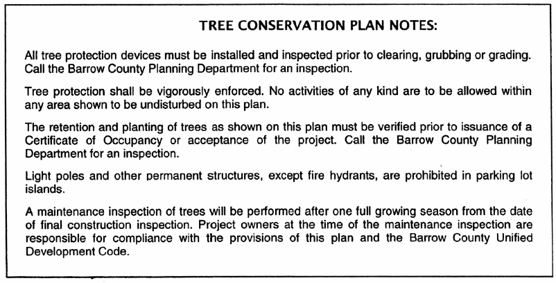
Figure 12.8 Tree Conservation Plan Notes
(g)
Public utility plans.
(1)
Domestic water supply plan. If connection to a public water system is proposed or required, the domestic water supply plan shall depict all water system improvements, water mains, fire hydrants, valves and other appurtenances, and other information as may be required by the providing water jurisdiction.
(2)
Sewage disposal plan.
a.
If a connection to a public system is proposed, sewage disposal plans are to include: Sanitary sewerage plans, including profiles of all mains and outfalls, lift station and force main details, typical manhole construction details, and other information as may be required by the providing sanitary sewer jurisdiction.
b.
For projects approved to be served by on-site sewage disposal systems, location of septic tank, extent of drain field and attendant structures, location and results of percolation tests, and other information shall be shown as required by the county health department.
(Ord. of 10-13-2020)
Sec. 89-1319. - Development permit.
(a)
Responsibility for development actions.
(1)
No person shall conduct any land-disturbing activity, including grading, clearing and grubbing, tree clearance, land development or project construction without first obtaining a development permit from the planning and community development department to perform such activity.
(2)
Any person proposing development shall first submit to the planning and community development department an application for a development permit, including all civil design and construction drawings required by section 89-1318 of this Development Code. The application must be authorized by the property owner.
(3)
The planning and community development department is responsible for administering the review and approval process for issuance of development permits. The planning and community development department shall forward a copy of the development permit application, including the civil design and constructions drawings for the project, to other departments, the soil and water conservation commission district, the Georgia Department of Transportation or others as appropriate, for their review and comment. The planning and community development department shall provide all comments to the applicant for resolution, and shall issue the development permit when all requirements of this Development Code are met.
(4)
Approval of plans by the planning and community development department shall not imply or transfer acceptance of responsibility for the application of the principles of engineering, architecture, landscape architecture or any other profession, from the professional, corporation or individual under whose hand or supervision the plans were prepared.
(5)
The completion of inspections and authorization for work continuation shall not transfer responsibility for the quality of the work performed or materials used from the owner, nor imply or transfer acceptance of responsibility for project design or engineering from the professional, corporation or individual under whose hand or supervision the plans were prepared.
(6)
No development permit shall be interpreted to relieve any owner of the responsibility of maintaining full compliance with all applicable codes, ordinances and other regulations. Any development permit issued in error or in contradiction to the provisions of this Development Code shall be considered to have been null and void upon its issuance.
(7)
Liability.
a.
The approval of an erosion and sedimentation control plan or other plans under the provisions of this Development Code, the issuance of a development permit, or the compliance with any other provisions of this Development Code shall not relieve any person from the responsibility for damage to any person or property otherwise imposed by law nor impose any liability upon the board of commissioners, County staff, or the soil and water conservation district for damage to any person or property.
b.
The fact that any activity for which a development permit has been issued results in injury to the property of another shall neither constitute proof of, nor create a presumption of, a violation of the standards provided for in this Development Code or the terms of the development permit.
(b)
Development activities authorized.
(1)
Activities authorized by permit. A development permit shall be issued to authorize all activities associated with development activity regulated by this Development Code, including, but not limited to, clearing and grubbing, grading and the construction of such improvements as streets, surface parking areas and drives, stormwater drainage facilities, sidewalks, or other structures permanently placed on or in the property except for buildings, signs, or other structures requiring the issuance of a building permit.
(2)
Two-step process. Approval of a development shall initially authorize only the placement of erosion control measures, stormwater detention facilities, and the identification in the field of tree save areas or individual trees to be protected. Upon inspection and approval by the county, other land development activities authorized by the development permit may proceed.
(c)
Clearing and grubbing permit. A development permit authorizing clearing and grubbing shall not be issued prior to project approval of a preliminary plat for a subdivision or prior to approval of a site plan for a multi-family or nonresidential development project. Issuance of a development permit authorizing clearing and grubbing shall require approval of a grading plan for the development, a soil erosion and sediment control plan, and a landscaping, buffers and landscaping plan.
(1)
A soil erosion and sediment control plan prepared in accordance with the requirements of the soil erosion control ordinance shall also be submitted and approved prior to the issuance of a clearing and grubbing permit. All soil erosion control measures as shown and as approved must be in place and maintained at all times during the clearing and grubbing activities.
(2)
A permit for clearing and grubbing shall expire unless activities are commenced within 60 calendar days of issuance of the permit or if activities lapse and the project is abandoned for a period exceeding 30 calendar days.
(3)
The planning and community development director may approve one extension not to exceed 30 calendar days.
(4)
Said permit shall be limited to the removal of vegetation and stumps and the placement of required tree protection measures and soil erosion and sedimentation facilities, and may authorize the removal of existing structures on the property at the option of the developer.
(5)
No grading or construction activities may be started under a clearing and grubbing permit. The approval of a clearing and grubbing permit shall not imply the approval of or authorization to construct any improvements, buildings, or other structures on the property.
(d)
Grading permit. A grading permit, which may include clearing and grubbing, shall not be issued prior to project approval of a preliminary plat for a subdivision or prior to approval of a site plan for a multi-family or nonresidential development project. Issuance of a development permit authorizing grading shall require approval of a grading plan for the development, a soil erosion and sediment control plan, and a landscaping, buffers and tree conservation plan.
(1)
A grading permit may also be issued for earth borrow, where no development or construction is proposed or imminent, based on approval of grading plan, soil erosion and sediment control plan, and hydrology study.
(2)
A permit authorizing grading shall expire unless activities are commenced with 60 days of issuance of the permit or if activities lapse and the project is abandoned for a period exceeding 30 calendar days.
(3)
The planning and community development director may approve one extension not to exceed 30 days. Said permit shall be limited in its authorization to land grading activities along with associated clearing and grubbing, and demolition activities, and may authorize the construction of storm drainage improvements and soil erosion and sedimentation facilities as allowed by the permit itself.
(e)
Process for approval of development permit. An application for a development permit may proceed simultaneously with an application for a preliminary subdivision plat or site plan, but may not be issued prior to project approval of such plat or plan by the planning and community development department.
(1)
General.
a.
The property owner, developer and designated planners and engineers shall review the general development plans and detailed plans of Barrow County that affect the tract to be developed and the area surrounding it. They shall review the zoning ordinance, stormwater management ordinance, development regulations, flood damage prevention ordinance, this article, and other ordinances which regulate the development of land within the jurisdictional boundaries of Barrow County. However, the operator is the only party who may obtain a permit.
b.
An "operator" is defined as the party or parties that have operational control of construction project plans and specifications, including the ability to make modifications to those plans and specifications; or day-to-day operational control of those activities that are necessary to ensure compliance with a stormwater pollution prevention plan for the site or other permit conditions, such as a person authorized to direct workers at a site to carry out activities required by the stormwater pollution prevention plan or to comply with other permit conditions.
(2)
The application for a development permit shall be submitted to the planning and community development department and must include the following:
a.
Application on the form furnished by the planning and community development department, requesting review for issuance of a development permit, in a number of copies as required by the planning and community development department.
b.
Evidence that the applicant has complied with the "Notice of Intent" (NOI) requirements of the Georgia General Stormwater Permit for authorization under the National Pollution Discharge Elimination System (NDPES) to discharge stormwater associated with construction activity (if applicable). A copy of the NOI form and a copy of the certified mail return receipt request card indicating receipt by the Georgia Environmental Protection Division.
c.
The following plans in a number of copies as required by the planning and community development department:
1.
The preliminary plat or site plan requesting or reflecting project approval by the planning and community development department.
2.
The civil design and construction drawings prepared in conformance with the specifications and standards in section 89-1318 of this Development Code.
d.
Applicable fees, as follows:
1.
Payment of any county development permit fee, as established from time to time by the board of commissioners.
2.
In addition, fees will also be assessed pursuant to O.C.G.A. § 12-5-23(a)(5), in the amount of $80.00 per acre of land-disturbing activity, and these fees shall be calculated and paid by the primary permittee as defined in the state general permit for each acre of land-disturbing activity included in the planned development or each phase of development. All applicable fees shall be paid prior to issuance of the land disturbance permit. Pursuant to O.C.G.A. § 12-7-8(a), one-half of such fees levied shall be submitted to Barrow County and one-half to the EPD; except that any and all fees due from an entity which is required to give notice pursuant to O.C.G.A. § 12-7-17(9) or (10) shall be submitted in full to the EPD.
e.
Certification. All applications shall contain a certification stating that the erosion and sedimentation control plan preparer or the designee thereof visited the site prior to creation of the plan or that such a visit was not required in accordance with rules and regulations established by the Georgia Board of Natural Resources.
(3)
The application will be checked for completeness within five days of its submission. Incomplete applications will be returned to the applicant.
(4)
Upon acceptance of a development permit application, the planning and community development department shall refer the soil erosion and sedimentation control plan to the soil and water conservation district for its review and approval or disapproval concerning the adequacy of the erosion and sedimentation control plan.
a.
The soil and water conservation district shall approve or disapprove the plan within 35 days of receipt. Failure of the district to act within 35 days shall be considered an approval of the pending plan. The results of the district review shall be forwarded to Barrow County.
b.
No development permit will be issued unless the soil erosion and sedimentation control plan has been approved by the district, and any variances and bonding, if required, have been obtained.
(5)
The applicant may be required by the planning and community development department to secure development approval from other agencies if they are affected by the development. Development approval may be required from but not limited to:
a.
Director of public works.
b.
Reserved.
c.
County health department.
d.
Soil and water conservation district.
e.
Georgia Department of Transportation.
f.
Georgia Department of Natural Resources.
g.
U.S. Army Corps of Engineers.
h.
U.S. Environmental Protection Agency.
(6)
Upon receipt of comments from other departments and agencies, the planning and community development department will indicate on a copy of the civil design and construction drawings or in writing all comments related to compliance with this Development Code, conditions of zoning approval, and other regulations or ordinances, as appropriate.
(7)
The planning and community development department will forward its comments to the applicant.
(8)
The applicant will be responsible for compliance with all codes, regulations and zoning requirements and for the satisfaction of all of the comments received. The owner will also be responsible for obtaining approval from all other agencies affected by the project.
(9)
No development permit will be issued unless the applicant provides a statement by the county tax commissioner's office certifying that all ad valorem taxes levied against the property and due and owing have been paid.
(f)
Required performance surety.
(1)
Stormwater performance surety. Upon approval of the stormwater management plan, but before the issuance of a building permit or subdivision plat approval, the applicant shall be required to post a performance bond, cash escrow, certified check or other acceptable form of performance security.
a.
The amount of the surety shall not be less than the total estimated construction cost of the facilities required by the stormwater management plan.
b.
The performance bond or other securities shall not be released until the following requirements have been met. The planning and community development director shall:
1.
Perform a final inspection of the facilities and determine that they have been constructed in compliance with the stormwater management plan.
2.
Determine that all provisions of the stormwater management plan have been faithfully executed.
c.
A provision may be made for partial release of the amount of the bond pro rata upon completion and acceptance of various stages of development as specifically delineated, described and scheduled in the stormwater management plan. The applicant shall notify the Planning and Community Development Department upon completion of each stage that is ready for inspection.
(2)
Erosion and sedimentation performance surety. If the applicant has had two or more violations of previous development permits, this Development Code or the Georgia Erosion and Sedimentation Act, as amended, within three years prior to the date of filing of the application under consideration, the planning and community development director shall refer the development permit application to the board of commissioners.
a.
The board of commissioners may deny the development permit application; or,
b.
The board of commissioners may require the applicant to post a performance bond in the form of government security, cash, irrevocable letter of credit or any combination thereof up to, but not exceeding, $3,000.00 per acre or fraction thereof of the proposed land-disturbing activity, prior to issuing the development permit. If the applicant does not comply with this Development Code or with the conditions of the development permit after issuance, the board of commissioners may call the bond or any part thereof to be forfeited and may use the proceeds to hire a contractor to stabilize the site of the land-disturbing activity and bring it into compliance.
c.
The board of commissioners may approve issuance of the development permit and waive or reduce any performance bond requirement after consideration of such factors as proof of financial ability of the developer or the record of performance of compliance by the developer since the last violation, or any other factors the board of commissioners considers relevant to the protection of the public from potential erosion or sedimentation violations.
(g)
Exemptions to land disturbance permits. The disturbance of the land, including clearing, grubbing, or grading activities, shall not commence or proceed except in accordance with the provisions of these regulations, unless the activity is either an agricultural activity or is for the construction of an individual single-family residence, and is otherwise exempt from the soil erosion and sedimentation control requirements of the land development activities article of this Development Code.
(h)
Issuance of development permit.
(1)
Following satisfaction of all comments, receipt of approvals from all affected agencies and receipt of all required bonds, the planning and community development department shall issue a development permit authorizing development activities to begin based on the approved civil design and construction drawings.
(2)
Permits shall be issued or denied as soon as practicable but in any event not later than 45 days after receipt by the planning and community development department of a complete application, providing variances and bonding are obtained where necessary.
(3)
No development permit shall be issued unless the erosion and sedimentation control plan has been approved by the soil and water conservation district, project approval has been granted by the planning and community development department, and the planning and community development department has affirmatively determined that the plan is in compliance with all requirements of this Development Code, any stream buffer variances approved by the EPD director have been obtained, bonding requirements, if necessary, as per subsection (f) are met and all ordinances and rules and regulations in effect within the jurisdictional boundaries of Barrow County are met. If the development permit is denied, the reason for denial shall be furnished to the applicant.
(4)
If the tract is to be developed in phases, then a separate development permit shall be required for each phase.
(5)
The development permit may be suspended, revoked or modified, as to all or any portion of the land affected by the plan, upon finding that the holder or his successor in title is not in compliance with the approved erosion and sedimentation control plan or that the holder or his successor in title is in violation of this Development Code. A holder of a development permit shall notify any successor in title to him as to all or any portion of the land affected by the approved plan or the conditions contained in the development permit.
(6)
Development activities shall be limited to those authorized by the applicable permit and as may be further restricted by conditions of approval pertaining thereto by the planning and community development director or other department or agency as may have authority or jurisdiction over said activities in whole or in part.
(i)
Expiration of development permit.
(1)
A development permit shall expire if the development activity described in the permit is not begun within 12 months from the date of issuance, or if such authorized activities lapse for a period exceeding 60 days.
(2)
Any development permit that has expired may be renewed once by the planning and community development department within six months of expiration. Activity must commence within three months or the permit shall expire.
(3)
If a development permit has expired for more than six months, the applicant shall be required to apply for a new development permit under the development permit approval process of this Development Code.
(Ord. of 10-13-2020)
Sec. 89-1320. - Flood area permit.
(a)
Flood area permit required. If development or construction is proposed within or affecting an area of special flood hazard, approval of a flood area permit application shall be required. An application for a flood area permit may be included with and reviewed along with a development permit application.
(b)
Application process for a flood area permit.
(1)
Application for a flood area permit shall be made to the planning and community development department on forms furnished by them prior to any development activities.
(2)
The application for a flood area permit is to include the following:
a.
Plans in duplicate drawn to scale showing the nature, location, dimensions, and elevations of the area in question.
b.
Location of existing or proposed structures, fill, storage of materials and drainage facilities.
c.
Elevation in relation to mean sea level of the proposed lowest floor, including basement, of all buildings.
d.
Elevation in relation to mean sea level to which any nonresidential building will be floodproofed.
e.
Design certificate from a registered professional engineer or architect that any nonresidential floodproofed building will meet the floodproofing criteria in the flood damage prevention section of the land development activities article of this Development Code.
f.
Description of the extent to which any watercourse will be altered or relocated as a result of proposed development.
g.
Construction stage:
1.
For all new construction and substantial improvements the permit holder shall provide to the planning and community development director an as-built certification of the regulatory floor elevation or floodproofing level immediately after the lowest floor or floodproofing is completed. Any lowest floor certification made relative to mean sea level shall be prepared by or under the direct supervision of a registered land surveyor or professional engineer and certified by same. When floodproofing is utilized for nonresidential structures, said certification shall be prepared by or under the direct supervision of a professional engineer or architect and certified by same.
2.
Any work undertaken prior to submission of these certifications shall be at the permit holder's risk. The planning and community development director shall review the above referenced certification data submitted. Deficiencies detected by such review shall be corrected by the permit holder immediately and prior to further progressive work being allowed to proceed. Failure to submit certification or failure to make said corrections requires hereby, shall be cause to issue a stop-work order for the project.
(Ord. of 10-13-2020)
Sec. 89-1321. - Driveway permit.
(a)
Driveway permit; when required.
(1)
No driveway connecting to a public street or a public right-of-way or public property shall be repaired or installed without first having approval from the public works department. If the driveway connects to a state or U.S. numbered highway, approval of the Georgia Department of Transportation shall be required prior to county approval.
(2)
Applications shall be made to the building official's office and referred to the public works department for review and approval.
(b)
Driveway permit; expiration. A permit shall expire for work not started within 90 days or completed within six months after issuance of a permit, and a new permit shall be required before beginning or completing the work.
(Ord. of 10-13-2020)
Sec. 89-1322. - Right-of-way encroachment permit.
(a)
Right-of-way encroachment permit; when required.
(1)
Any utility work, encroachments into a public right-of-way or easement, pavement cuts and associated road or lane closures must be reviewed, approved and permitted by the director of public works.
(2)
Applications may be made to the director of public works.
(b)
Right-of-way encroachment permit; expiration. A right-of-way encroachment permit shall expire for work not started within 90 days or completed within six months after issuance of a permit, and a new permit shall be required before beginning or completing the work.
(Ord. of 10-13-2020)
Sec. 89-1323. - Sign permits.
See the sign regulations article of this Development Code regarding the issuance of sign permits.
(Ord. of 10-13-2020)
Sec. 89-1324. - Final subdivision plat.
(a)
Responsibility.
(1)
The planning and community development director shall be responsible for coordination of the approval process for all final subdivision plats.
(2)
The final subdivision plat shall be certified and sealed by a registered land surveyor.
(3)
The owner is responsible for compliance with all requirements of this Development Code. Approval of a final subdivision plat and acceptance of the public improvements and dedications therein shall not relieve the owner of this responsibility.
(b)
Procedures for final plat approval.
(1)
Prior to submission of an application for final subdivision plat approval, either:
a.
All public improvements shall have been properly installed and completed in accordance with all requirements and standards of this Development Code (other than traffic signs, street name signs, street striping, and signalization) and as-built surveys of the improvements shall have been approved by the public works director as required in the land development activities article of this Development Code; or
b.
A guarantee in lieu of completed improvements shall have been received by the public works department as provided under the project design standards article of this Development Code.
(2)
An application for a final subdivision plat approval shall be made to the planning and community development department. The application shall include:
a.
The name and address of the person to whom the notice of approval shall be sent.
b.
A properly completed application form, as furnished by the planning and community development department, requesting final subdivision plat review.
c.
Executed stormwater management facility maintenance agreement.
d.
A number of copies, as established by the planning and community development director, of the final subdivision plat drawing prepared in conformance with the specifications in this section, the original of which shall be drawn in permanent ink on cloth or film.
e.
The as-built surveys of the improvements as required in the land development activities article of this Development Code if the surveys have not been previously received and approved.
f.
Payment of all applicable final subdivision plat filing and recording fees, as established by the board of commissioners from time to time.
g.
Payment for materials and installation of traffic signs and street name signs. Payment of the cost of street striping or signalization, if required and not completed by the owner, shall also be included in the application.
h.
Executed deeds for the dedication of all street rights-of-way, easements and other public properties.
i.
A maintenance surety providing adequate surety for the maintenance of all public improvements required by this Development Code in the subdivision for a period of at least 1.5 years following the date of approval of the final plat. See the land development activities article of this Development Code for information regarding maintenance surety.
(3)
The planning and community development department shall review the application for completeness at the time of submission. Incomplete applications will be returned to the applicant.
(4)
If the subdivision includes or abuts a U.S. or state numbered highway, unless all of the lots in the subdivision contain five acres or more and no new street is involved, review by the Georgia Department of Transportation (DOT) is required under O.C.G.A. § 32-6-151. If the subdivision is an exempt or minor subdivision or otherwise was not submitted for review as a preliminary plat, two additional copies of the final plat must be submitted to the planning and community development department for forwarding to DOT. The owner or subdivider must respond to the recommendations of the DOT prior to final plat recording. If the written recommendations of the DOT are not made within 30 days of receipt of the plat by DOT, their approval shall be assumed as provided under state law.
(5)
Within two weeks following receipt of the application, the planning and community development department shall indicate on the drawing or in writing all comments related to compliance with this Development Code. The planning and community development director shall have sole authority to determine the applicability of any provisions of this Development Code to the final plat.
(6)
The owner shall be responsible for compliance with all codes, regulations and zoning requirements, and for the satisfaction of all the noted and written comments of the planning and community development department. Resubmission of all revised drawings shall be made to the planning and community development department.
(7)
When all of the requirements of this Development Code, and any conditions of zoning approval, have been met, the planning and community development director shall sign and date the certificate of final plat approval stamped or printed on a reproducible copy of the final subdivision plat.
(8)
Once the final subdivision plat has been so certified, it shall be recorded by the planning and community development department, or by the applicant with the planning and community development director's approval, with the clerk of the superior court.
(9)
The planning and community development director will forward the executed deeds for the streets, easements and dedication of other public properties, and the conservation easement, if applicable, to the board of commissioners for approval and recording. The planning and community development director will also coordinate the creation of any special tax district by the board of commissioners as may be required by this Development Code.
(10)
Subsequent to the recording of the final plat, one copy on cloth or film and one additional copy with all certificates endorsed thereon shall be filed with the records of the planning and community development department. The map book, volume and page numbers where the plat is recorded shall also be indicated on the copies.
(c)
General standards for final plats.
(1)
The final subdivision plat shall be drawn on an appropriate material and sheet size, and using minimum line weights and letter heights as required by Georgia law for the recordation of maps and plats (O.C.G.A. § 15-6-67), and as acceptable to the clerk of the superior court.
(2)
Final subdivision plats must be at least 8½ inches by 11 inches in size to be recorded. The maximum sheet size is 18 inches by 24 inches to the sheet edge, with a maximum image area of 17 inches by 22 inches.
(3)
The final subdivision plat shall substantially conform to the preliminary subdivision plat and may constitute only that portion of the approved preliminary subdivision plat that the owner proposes to record at any one time, provided that such portion conforms to the requirements of this Development Code.
(d)
Final plat requirements. The final subdivision plat shall contain all caption information and plat data required by Georgia law pertaining to the recordation of maps or plats (O.C.G.A. § 15-6-67, as amended), as well as the additional information required in this subsection.
(1)
Caption. The maps or plats shall have a title or name, including the name of the subdivision, which shall be contained in the caption, and the caption shall also provide the following information:
a.
The county, tax map and parcel number, and subdivision, if the property lies within a particular subdivision;
b.
The date of plat preparation;
c.
The scale, stated and shown graphically;
d.
The name, address, telephone number, and registration number of the land surveyor or the statement that he is the county surveyor and is not required by law to be a registered surveyor; and
e.
All reproductions of original maps or plats shall bear the original signature, in black ink, of the registrant placed across the registration seal in order to be a valid or recordable map or plat.
(2)
Plat data. Maps or plats shall be made in a professional manner and in accordance with the standards of good drafting procedures and shall show the following information, as specified:
a.
All maps or plats shall show the direction and distance from a point of reference to a point on the boundary of the individual survey, and such additional data as may be required to relocate the boundary point from the point of reference with the same degree of accuracy required of the parcel surveyed. The point of reference shall be an established, monumented position which can be identified or relocated from maps, plats, or other documents on public record;
b.
All maps or plats of boundary surveys or subdivision surveys shall show bearings of all lines of the boundary or lot lines, and distances of all boundary or lot lines, and area of the parcels expressed in acres or square feet;
c.
All maps or plats shall show the width and the former widths, if pertinent, of all rights of way adjacent to or crossing the property or adjacent to any point of reference;
d.
All maps or plats shall show easements and apparent encroachments, if pertinent;
e.
In the case of curved lines, the curve shall be defined by curve data to include the radius, arc length, chord bearing, and distance for regular curves. Chord distances and directions shall be given for irregular curves;
f.
All land lot lines, land district lines, land section lines, and city boundaries intersecting or adjacent to the surveyed property shall be indicated by lines drawn upon the map or plat with appropriate words and figures;
g.
All corner markers and markers of pertinent reference points shall be fully described and indicated as to their material or types and shall be constructed of a permanent material such as iron, steel, concrete, or stone, as required for survey monuments under the project design standards article of this Development Code;
h.
An arrow shall be shown on the map or plat to indicate the principal meridian, and a notation shall be made as to the reference of bearings to magnetic north, astronomic north, or grid north. A grid north reference shall indicate the zone;
i.
All linear distances shown on maps or plats shall be horizontal;
j.
All angular directions shown on maps or plats shall be represented in degrees and minutes. Where plats state or surveys require accuracy in excess of one in 5,000, the angular directions shall be represented in degrees, minutes, and seconds. All angular directions shall be referenced to the principal meridian; and
k.
All maps or plats shall show the state plane coordinates of at least two permanent monuments thereon, when a National Geodetic Survey monument is within 500 feet of any point on the property mapped or platted, or any point of reference shown thereon.
(3)
Additional data. The following is to be shown on the final plat in addition to the caption information and plat data required by Georgia law:
a.
Street names including both the name and the suffix, such as "street", "avenue", etc.;
b.
Name of the former subdivision if any or all of the property has been previously subdivided;
c.
Location sketch;
d.
Lot lines with dimensions to the 1/100 (0.01) foot, necessary internal angles, arcs, and chords and tangent or radii of rounded corners;
e.
Building front setback lines with dimensions as to length across each lot and distance from the street right-of-way;
f.
Lots or sites numbered in numerical order and blocks lettered alphabetically;
g.
Location, dimensions and purpose of all easements, including slope easements, if required, and any areas to be reserved, donated, or dedicated to public use;
h.
The extent of any area of special flood hazard, as defined in this Development Code; and
i.
The street address number of each lot.
(4)
Curve data shall be required for all roadway centerline curves of greater than ten degrees on new roads. Centerline data including the radius, central angle, arc length, chord bearing and distance, and tangent distance between curves must be given for regular curves. Chord distances and directions shall be given for irregular curves on preexisting roads.
(e)
Certification by health department. Certification by the health department shall be printed or stamped on the plat, as appropriate to the source of water supply and method of waste disposal approved. For lots not served by public sewerage or public water, the certification by the health department is to read as shown on Figure 12.4 and signed in blue ink on the original drawing. For developments with public sewerage and public water systems, this certification may be omitted.
(f)
Surveyor and owner certificates. Each final subdivision plat shall carry the following certificates printed or stamped on the plat to read as shown on Figure 12.5. The original certificates on the reproducible copy of the final plat shall be signed and dated.
(1)
Surveyor's certificate, signed in blue ink on the original drawing.
(2)
Surveyor's seal. The reproducible final subdivision plat drawing shall bear the original signature, in black ink, of the registered land surveyor placed across the surveyor's seal in order to be valid and recordable.
(3)
Owner's certificate, signed in blue ink on the original drawing.
(g)
Statement of private covenants. A statement of the private covenants, if applicable and if they are brief enough to be put directly on the plat; otherwise, a statement as follows: "This plat is subject to the covenants set forth in the separate document(s) attached hereto dated _______, which hereby becomes part of this plat".
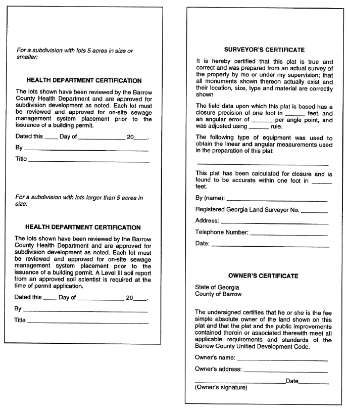
Figure 12.9 Health Department, Surveyor, and Owner Certificates
(h)
Certificate of final subdivision plat approval. The certificate of final plat approval shall be stamped or printed on the final subdivision plat for execution upon its approval by the planning and community development director. Appropriate certificates for different types of subdivisions are shown in Figure 12.10.
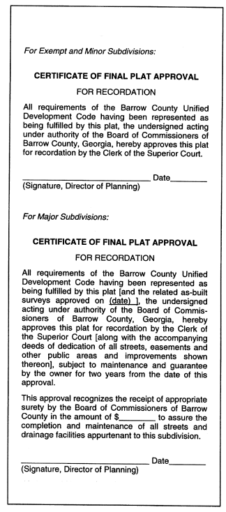
Figure 12.10 Certificate of Plat Approval
(i)
Creation of homeowners association. If required by provisions of this Development Code, a homeowners' association shall be created and the instruments of such creation and financial endowment shall be recorded at the time of final plat recording. A copy of the recorded instruments shall be filed with the Planning and Community Development Department.
(j)
Acceptance of public improvements.
(1)
If construction of any required public improvements was deferred at the time of final plat approval, said work must be completed within nine months.
(2)
The developer shall maintain the improvements in the development for a period of 1.5 years. The 1.5-year maintenance period shall begin upon recordation of the final subdivision plat or upon completion of all deferred improvements, whichever occurs later.
(3)
Prior to expiration of the maintenance period, a final acceptance inspection of the public improvements shall be conducted by the planning and community development department.
(4)
The owner must correct all defects or deficiencies in materials or workmanship and make such repairs as necessary to approximate the as-built condition of the improvements. If any lands are shown on the final plat for dedication to Barrow County other than street rights-of-way or easements, a warranty deed transferring title of said land in fee simple shall be submitted with the final plat applications.
(5)
Upon certification by the planning and community development director that the public improvements depicted on the as-built surveys are in conformance with the specifications of this Development Code and are in good repair, the board of commissioners shall release the maintenance bond and accept the public improvements into perpetual maintenance.
(k)
Erosion control plan prepared in accordance with the requirements of the soil erosion and sediment control ordinance. Erosion control measures may be shown on the grading plan, if desired.
(Ord. of 10-13-2020)
Sec. 89-1325. - Building permitting.
(a)
Building permit required. A building permit issued by the building official is required in advance of the initiation of construction, erection, moving or alteration of any building or structure in accordance the provisions of the Building Code. No building permit shall be issued and no building shall be erected on any lot in the county unless access has been established in accordance with this Development Code. No building permits shall be issued before approval of the final plat. All structures shall comply with the requirements of this Development Code, whether or not a building permit is required.
(b)
Procedures to obtain a building permit.
(1)
Procedure for approval. The building official is responsible for administering and enforcing the building codes of the county.
a.
Prior to issuance of a building permit the owner shall have received a development permit if required by this Development Code.
b.
Zoning verification shall be obtained from the planning and community development department. The following shall be attached to or included within the zoning verification application:
1.
A street address number as shown on the final plat or as assigned by the county; the tax map and parcel number, verified by tax office; and a plat, location sketch map or other graphic indication of the location of the lot.
2.
For a single-family detached or two-family dwelling, a building site plan drawn to scale shall be submitted with the application, showing the following:
i.
Identity, address and phone number of the owner of the lot, the applicant for the building permit, and the person responsible for all construction and land-disturbing activities on the property;
ii.
Lot dimensions with property line monuments located thereon, minimum principal building setback lines, the lot width measured at the minimum front setback line, and the lot frontage measured along the street right-of-way line;
iii.
Shape, size, height and location of the structure(s) proposed to be erected, demolished, altered, or moved, and of any buildings already on the lot;
iv.
The use of structures, including the number of dwelling units and minimum floor area within each structure;
v.
Easements (public and private) including natural resource or conservation easements established under the requirements of the environmental protection article of this Development Code;
vi.
Watercourses, stream buffers and the limits of the 100-year floodplain;
vii.
Erosion control and tree protection measures proposed to be placed and maintained on the property;
viii.
Street names and street right-of-way lines; and
ix.
Other information regarding abutting property as directly affects the application;
3.
For a multi-family or nonresidential building, the site plan upon which was granted project approval by the Planning and Community Development Department under subsection 89-1315(9).
(2)
Application for a building permit shall be made to the building official. The application shall include:
a.
Application on the form furnished by the building official, requesting issuance of a building permit.
b.
A copy of the zoning verification approved by the planning and community development department.
c.
Architectural plans for principal multi-family or nonresidential buildings, prepared in conformance with this Development Code and the applicable building codes. Plans shall be prepared by or under the supervision of an architect registered in Georgia, who shall sign and seal each sheet in the original set of drawings.
d.
County health department approval if an on-site sewage disposal system has been allowed.
e.
Payment of the building permit application and review fee.
f.
Water meter receipt issued by the applicable public water jurisdiction, if applicable.
g.
For applications to move a house, structure or building, the following additional information is required:
1.
The name of the person performing the moving;
2.
The origin and destination of the moving;
3.
The names of the owners of the property from which the house is removed and of the property to which it is moved;
4.
A detailed outline of the route to be followed and the equipment to be used; and
5.
An estimate of the time involved, including the time of the day when said operation shall be conducted.
6.
Any application for a permit must be made at least 48 hours prior to the proposed moving.
7.
In addition to a fee charged for permits, the mover of any house, building or structure shall deposit with the building official $400.00 for each house, to be returned to the mover within five days after such moving if no damage is done to public property.
8.
The county sheriff's department shall furnish a police escort if he deems it necessary
(3)
Issuance of building permit.
a.
The application will be checked by the building official for completeness within five days of receipt. Incomplete applications will be returned to the applicant.
b.
Within two weeks following receipt of a complete application, the building official shall indicate on the architectural plans approval or disapproval and attest to same by his signature. One copy shall be returned to the applicant and the original copy shall be retained by the building official.
c.
The owner shall be responsible for compliance with this Development Code and all building code requirements, regulations, and for the satisfaction of all of the comments of the building official. Notwithstanding the county's role in accepting and approving submissions specified in this ordinance, the owner is not entitled to rely on approval from the county of any documents as evidence that the development and building plans are all internally consistent or compliant with applicable health and safety codes. Nothing herein is intended to create an actionable duty on the part of county staff.
d.
At such time as the owner has addressed the comments to the satisfaction of the building official and the state fire marshal, a building permit will be issued for the structure.
e.
Plumbing, electrical and mechanical permits shall be issued separately by the building official or separately identified on the building permit. Such permits must be issued prior to commencement of work by each affected trade.
f.
If the work authorized by a building permit has not begun within six months from the date of issuance the permit shall expire, unless it is renewed under the provisions of the building code.
(4)
Standards for approval.
(5)
Building permits shall be issued only on buildable lots of record, as defined in this Development Code.
(6)
Building permits shall be issued in conformance with the adopted technical codes and supplements that constitute the county's building code. Conformance to this Development Code is also required as a prerequisite to issuance of a building permit.
(c)
Certificate of occupancy.
(1)
It is unlawful to use or occupy or permit the use or occupancy of any part of a building, structure, or premises, until a certificate of occupancy has been issued stating that the building or structure or premises conforms to the requirements of the building codes and this Development Code.
(2)
A certificate of occupancy shall be required for any of the following:
a.
Occupancy and use of a building or structure constructed or enlarged.
b.
Change in use of existing buildings to uses of a different classification.
c.
Any change in use of a nonconforming use, lot or building.
(3)
Upon completion of construction but prior to occupancy or use for the purpose constructed and prior to utility hookup, the property owner or his agent shall notify the building official and request final inspection of the premises.
(4)
The building official shall conduct such inspection as quickly as is reasonably practicable after said request and shall issue a certificate of occupancy only if he finds said construction comports with all applicable local, state or national rules, regulations, statutes, laws, ordinances, and the terms of this resolution.
(5)
Permanent electric power may not be supplied to any structure until a certificate of occupancy shall have been issued and the power company contacted by the building official.
(6)
A record of all certificates of occupancy shall be maintained by the building official and a copy shall be furnished upon request to any person.
(Ord. of 10-13-2020)
Sec. 89-1326. - Sexually oriented establishment permit.
(a)
Filing of application; application fee.
(1)
Any person desiring to obtain a permit to operate, engage in, conduct or carry on any sexually oriented establishment shall make application to the county or its designated representative. Prior to submitting such application, a nonrefundable fee, established by resolution of the board of commissioners, shall be paid to the county to defray, in part, the cost of investigation and report required by this section. The county shall issue a receipt showing that such application fee has been paid. The receipt or a copy thereof shall be supplied to the county at the time such application is submitted.
(2)
The application for a permit does not authorize the engaging in, operation of, conduct of or carrying on of any sexually oriented establishment.
(b)
Contents of application.
(1)
Each application for a sexually oriented establishment permit shall contain the following information:
a.
The full true name and any other names used by the applicant.
b.
The present address and telephone number of the applicant.
c.
The previous addresses of the applicant, if any, for a period of five years immediately prior to the date of the application and the dates of residence at each.
d.
Acceptable written proof that the applicant is at least 18 years of age.
e.
The applicant's height, weight, color of eyes and hair, and date and place of birth.
f.
Two photographs of the applicant at least two inches by two inches in size, taken within the last six months.
g.
Business, occupation or employment history of the applicant for the five years immediately preceding the date of application; and business or employment records of the applicant, partners in a partnership, directors and officers of a corporation and, if a corporation, all shareholders holding more than five percent of the shares of corporate stock outstanding.
h.
The business license history of the applicant, and whether such applicant, in previous operations in this or any other county, state or territory under license, has had such license or permit for an sexually oriented business or similar type of business revoked or suspended, the reason therefore, and the business activity or occupation subsequent to such action of suspension or revocation.
i.
All convictions, including ordinance violations, exclusive of traffic violations, stating the dates and places of any such convictions.
j.
If the applicant is a corporation, the name of the corporation, set forth exactly as shown in its articles of incorporation or charter, together with the place and date of incorporation, and the names and addresses of each of its current officers and directors, and each stockholder holding more than five percent of the stock in the corporation. If the applicant is a partnership, the applicant shall set forth the name, residence address and dates of birth of the partners, including limited partners. If the applicant is a limited partnership, it shall furnish a copy of its certificate of limited partnership filed with the county clerk. If one or more of the partners is a corporation, the provisions of this subsection pertaining to corporations shall apply. The applicant corporation or partnership shall designate one of its officers or general partners to act as its responsible managing officer. Such designated persons shall complete and sign all application forms required of an individual applicant under this section, but only one application fee shall be charged.
k.
The names and addresses of the owner and lessor of the real property upon which the business is to be conducted and a copy of the lease or rental agreement.
l.
Such other identification and information as the sheriff's department may require in order to discover the truth of the matters specified in this subsection as required to be set forth in the application.
m.
The age and date of birth of the applicant, of any partners, or of any and all officers, of any stockholders of more than five percent of the shares of the corporation stock outstanding and directors of the applicant, if the applicant is a corporation.
n.
Whether the applicant, any partners or any of the officers or stockholders holding more than five percent of the outstanding shares of the corporation, or the directors of the applicant, if the applicant is a corporation, have ever been convicted of any crime constituting a felony, or any crime not a felony involving moral turpitude, in the past five years, and, if so, a complete description of any such crime, including the date of violation, the date of conviction, jurisdiction and any disposition, including any fine or sentence imposed and whether the terms of disposition have been fully completed.
o.
For individual applicants, the fingerprints of the applicant, furnished by the applicant.
p.
If the applicant is a person doing business under a trade name, a copy of the trade name properly recorded; and if the applicant is a corporation, a copy of authority to do business in Georgia, including the articles of incorporation, trade name affidavit, if any, and last annual report, if any.
q.
At least three character references from individuals who are in no way related to the applicant or individual shareholders, officers or directors of a corporation and who are not or will not benefit financially in any way from the application if the permit is granted and who have not been convicted of any felony or a violation of this Development Code involving moral turpitude in the past five years. The licensing officer shall prepare forms consistent with the provisions of this subsection for the applicant, who shall submit all character references on such forms.
r.
The address of the premises for which the permit is to be issued.
s.
Whether the premises are owned or rented and if the applicant has a right to legal possession of the premises, copies of those documents giving such legal rights.
t.
A plat by a registered land surveyor licensed by the state, showing the location of the proposed premises in relation to the neighborhood, the surrounding zoning and its proximity to any church, school, public park, governmental building or site or other business regulated under this section.
(2)
Each application for a sexually oriented establishment permit shall be verified and acknowledged under oath to be true and correct as follows:
a.
If the applicant is an individual, by the individual.
b.
If the applicant is a partnership, by the manager or general partner.
c.
If the applicant is a corporation, by the president of the corporation.
d.
If the applicant is any other organization or association, by the chief administrative official.
(c)
Personal appearance by applicant. The applicant for a permit under this section, if an individual, or designated responsible managing officer if a partnership or corporation, shall personally appear at the county and produce proof that a nonrefundable application fee, established by resolution of the board of commissioners, has been paid and shall present the application containing the information described in subsection (b).
(d)
Investigation.
(1)
The county shall have 30 days to investigate the application and the background of the applicant. Upon completion of the investigation, the board of commissioners or the planning and community development director may grant the permit if it finds that:
a.
The required fee has been paid.
b.
The application conforms in all respects to the provisions of this section.
c.
The applicant has not knowingly made a material misrepresentation in the application.
d.
The applicant has fully cooperated in the investigation of his application.
e.
The applicant, if an individual, or any of the stockholders of the corporation or any officers or directors, if the applicant is a corporation, or any of the partners, including limited partners, if the applicant is a partnership, has not been convicted in a court of competent jurisdiction of an offense involving conduct or convicted of an attempt to commit any of the offenses mentioned in subsection (b), or convicted in any state of any offense which, if committed or attempted in this state, would have been punishable as one or more of the offenses mentioned in subsection (b), or any crime involving dishonesty, fraud, deceit or moral turpitude.
f.
The applicant has not had a sexually oriented establishment permit or other similar license or permit denied or revoked for cause by this county or any other county located in or out of this state prior to the date of application.
g.
The building, structure, equipment or location of such business as proposed by the applicant would comply with all applicable laws, including but not limited to health, zoning, distance, fire and safety requirements and standards.
h.
The applicant is at least 21 years of age.
i.
The applicant or his employee, agent, partner, director, officer, stockholder or manager has not, within five years of the date of the application, knowingly allowed or permitted any of the specified sexual activities as defined in this Development Code to be committed or allowed in or upon the premises where such sexually oriented establishment is to be located or allowed the premises to be used as a place in which solicitations for the specified sexual activities as defined in this Development Code openly occur, except as allowed under a previous adult entertainment permit or sexually oriented establishment permit issued by Barrow County.
j.
On the date the business for which a permit is required in this section commences, and thereafter, there will be a responsible person on the premises to act as manager at all times during which the business is open.
k.
The proposed premises meets the standards for distancing and location as set forth in subsection 89-135(e) of this Development Code.
l.
The grant of such permit will not cause a violation of this section, this Development Code, or any other ordinance or regulation of the county, the state or the United States.
(2)
The county may make any other inquiry deemed necessary or desirable by the county to ensure the health, safety, and welfare of the citizens of the public or the preservation of its neighborhoods.
(e)
Restrictions on permit issuance.
(1)
Persons ineligible for permit. No permit provided for by this section shall be issued to or held by:
a.
An applicant who has not paid all required fees and taxes for a business at that location, or property taxes.
b.
Any person who is not of good moral character.
c.
Any corporation, any of whose officers, directors or stockholders holding over five percent of the outstanding issued shares of capital stock are not of good moral character.
d.
Any partnership or association, any of whose officers or members holding more than five percent interest therein are not of good moral character.
e.
Any person employing, assisted by or financed in whole or in part by any person who is not of good moral character.
f.
Any applicant who is not qualified to hold and conduct a business according to the laws of the United States, the state or the county.
(2)
Number of permits. Should there be a sufficient number of current permits to meet the needs and desires of the inhabitants of the county, no new permit shall be issued. In determining the needs and desires of the inhabitants, the standard of review shall be that the market is virtually unrestrained as defined in Young v. American Mini Theaters, Inc.
(f)
Issuance or denial; appeals; compliance with zoning regulations.
(1)
The process for application for a permit to operate an enterprise regulated as a sexually oriented establishment shall be the procedure set forth in this Development Code for approval of special uses, and the procedure for review and appeals shall be governed by the provisions of the appeals article of this Development Code. No sexually oriented establishment permit shall be issued until special use approval has been granted by the board of commissioners.
(2)
Nothing in this section shall be construed as relieving any applicant of the terms, conditions or strictures of the zoning district within which the sexually oriented establishment is located, and all other requirements and restrictions of this Development Code.
(g)
Renewal. Permits for sexually oriented establishments may be renewed on a year-to-year basis, provided that the permittees continue to meet the requirements set out in this section relating to the issuance of such permits, and the requirements of this Development Code for sexually oriented establishments. The renewal fees for sexually oriented establishment permits shall be established by resolution of the board of commissioners from time to time.
(h)
Transfer. No sexually oriented establishment permit may be sold, transferred, or assigned by a permittee, or by operation of law, to any other person. Any such sale, transfer or assignment or attempted sale, transfer or assignment shall be deemed to constitute a voluntary surrender of such permit, and such permit shall thereafter be null and void; provided and excepting, however, that if the permittee is a partnership and one or more of the partners should die, one or more of the surviving partners may acquire, by purchase or otherwise, the interest of the deceased partner or partners without effecting a surrender or termination of such permit, and in such case the permit, upon notification to the county, shall be placed in the name of the surviving partner. An sexually oriented establishment permit issued to a corporation shall be deemed terminated and void when either any outstanding stock of the corporation is sold, transferred or assigned after the issuance of a permit or any stock authorized but not issued at the time of the granting of a permit is thereafter issued and sold, transferred or assigned.
(i)
Change of location or name; expansion of business.
(1)
No sexually oriented establishment shall move from the location specified on its permit until a change of location fee, as established by resolution of the board of commissioners, has been deposited with the county and approval has been obtained from the planning and community development director and the planning and community development director. Such approval shall not be given unless all requirements and regulations as contained in this Development Code have been met.
(2)
No permittee shall operate, conduct, manage, engage in, or carry on a sexually oriented establishment under any name other than his or her name and the name of the business as specified on his or her permit.
(3)
Any application for an extension or expansion of a building or other place of business where a sexually oriented establishment is located shall require inspection and shall comply with the provisions and regulations of this section and this Development Code.
(j)
Employees.
(1)
Qualifications. Employees of a sexually oriented establishment shall not be less than 18 years of age. Every employee must be of good moral character as defined in this Development Code. Any employee who is convicted of a crime constituting a felony or a crime not a felony involving moral turpitude while employed as an sexually oriented establishment employee shall not thereafter work on any premises for which a permit has been issued under this section for a period of five years from the date of such conviction, unless a longer time is ordered by a court of competent jurisdiction. For purposes of this section, the term "convicted" shall include an adjudication of guilt or a plea of guilty or nolo contendere or the forfeiture of a bond when charged with a crime, and the terms "employed on the premises for which a permit has been issued under this section" and "work on any premises for which a permit has been issued under this section" shall include work done or services performed while in the scope of employment elsewhere than on the premises for which a permit has been issued under this section.
(2)
Investigation; approval of employment. Before any person may work on premises for which a permit has been issued under this section, he or she shall file a notice with the licensing officer of his or her intended employment on forms supplied by the licensing officer and shall receive approval of such employment from the licensing officer. The prospective employee shall supply such information as the licensing officer requires, including a set of fingerprints, on regular county or United States Department of Justice forms. Upon approval, the employee may begin working on the premises. If approval is denied, the prospective employee may, within ten days of the denial, apply to the licensing officer for a hearing. The decision of the licensing officer after hearing may be appealed to the board of commissioners, which may issue such order as is proper on the premises. An investigation fee of $50.00 shall accompany the notice of intended employment or a receipt of the licensing officer evidencing the payment of such fee shall be presented at the time the notice is filed.
(3)
Suspension or revocation of license. Violation of the provisions of this Development Code, the ordinances of the county, the laws and regulations of the state or the rules and regulations of the county shall subject an employee of a sexually oriented establishment to suspension or revocation of his or her license.
(4)
Independent contractors. For the purpose of this section, independent contractors shall be considered as employees and shall be licensed as employees, regardless of the business relationship with the owner or licensee of any sexually oriented establishment.
(Ord. of 10-13-2020)
Sec. 89-1327. - Developments of regional impact.
(a)
Types of approvals covered. The provisions of this section apply to any type of governmental action requested by a private party related to a development project, such as a land use plan amendment, rezoning or special use approval, special exception variance or hardship variance approval, project approval of a subdivision or site plan, issuance of a development permit or building permit, or hookup to a public utility.
(b)
Thresholds for regional review. Any development project for which any governmental action is requested that meets or exceeds any of the development thresholds adopted by the Georgia Department of Community Affairs (DCA) shall be considered a development of regional impact (DRI).
(c)
Process for DRI review.
(1)
Submission to the regional commission.
a.
First request for project approval.
1.
Upon determination by the planning and community development director that an application qualifies for DRI review, the applicant shall provide such information as necessary for the DRI review on forms available from DCA.
2.
The DRI review forms prepared by the applicant shall be submitted by the planning and community development director to the Northeast Georgia Regional Commission (NEGRC).
3.
Once the NEGRC has accepted the DRI forms as complete, the 30-day review period officially begins.
4.
Throughout the DRI process, the applicant shall coordinate with the planning and community development department and the NEGRC and provide such additional information as may be needed to complete the DRI evaluation.
b.
Subsequent requests for project approval. Once the development project has been reviewed by the NEGRC and the first governmental action has been granted, no further reviews by the NEGRC of subsequent governmental actions need to be reviewed by the NEGRC unless the project is revised by an increase of ten percent or more in the applicable threshold factor.
(2)
Final action by the county. Approval of the first request for governmental action by the county shall not be made on a development of regional impact until either:
a.
Any interjurisdictional conflicts related to the DRI have been brought to a conclusion; and
b.
A report has been received from the NEGRC reflecting its public findings and comments, if any; or
c.
Said report is not received within 30 days of official determination by the NEGRC that the DRI application is complete.
(Ord. of 10-13-2020)
Sec. 89-1328. - Temporary suspension of permitting during zoning change.
Upon initiation or submission of a valid application for a rezoning or special use approval on a property, or the initiation of a text amendment, no permits shall be issued nor shall any actions be undertaken on the property that may be affected by the outcome of such application.
(Ord. of 10-13-2020)