
Chamblee City Zoning Code
TITLE 3
DEVELOPMENT AND PERMITTING
ARTICLE 3. - SUBDIVISION AND SITE DEVELOPMENT PLAN REVIEW PROCEDURES[2]
Editor's note— Ord. No. 803, amended Art. 3 in its entirety by renumbering existing §§ 300-20—300-27 as §§ 300-23—300-30 and adding new provisions as § 300-20 as herein set out.
ARTICLE 5. - PUBLIC SEWER CONNECTION AND SEPTIC SYSTEM CONVERSION TO PUBLIC SEWER[3]
Section 330-1.- Purpose.
(a)
It is hereby determined that the flood hazard areas of the City of Chamblee are subject to periodic inundation which may result in loss of life and property, health and safety hazards, disruption of commerce and governmental services, extraordinary public expenditures for flood relief and protection, and impairment of the tax base, all of which adversely affect the public health, safety and general welfare.
(b)
Flood hazard areas can serve important stormwater management, water quality, stream bank protection, stream corridor protection, wetland preservation and ecological purposes when permanently protected as undisturbed or minimally disturbed areas.
(c)
Effective floodplain management and flood hazard protection activities can:
(1)
Protect human life and health;
(2)
Minimize damage to private property;
(3)
Minimize damage to public facilities and infrastructure such as water and gas mains, electric, telephone and sewer lines, streets and bridges located in floodplains; and
(4)
Minimize expenditure of public money for costly flood control projects associated with flooding and generally undertaken at the expense of the general public.
(d)
Article IX, Section II of the Constitution of the State of Georgia and O.C.G.A. § 36-1-20(a), have delegated the responsibility to local governmental units to adopt regulations designed to promote the public health, safety and general welfare of its citizenry. Therefore, the City of Chamblee establishes this set of floodplain management and flood hazard reduction policies for the purpose of regulating the use of flood hazard areas. It is determined that the regulation of flood hazard areas and the prevention of flood damage are in the public interest and will minimize threats to public health and safety, as well as to private and public property.
(Ord. No. 743, 12-19-17)
Section 330-2. - General provisions.
(a)
Purpose and intent. The purpose of this chapter is to protect, maintain and enhance the public health, safety, environment and general welfare and to minimize public and private losses due to flood conditions in flood hazard areas, as well as to protect the beneficial uses of floodplain areas for water quality protection, stream bank and stream corridor protection, wetlands preservation and ecological and environmental protection by provisions designed to:
(1)
Require that uses vulnerable to floods, including facilities which serve such uses, be protected against flood damage at the time of initial construction;
(2)
Restrict or prohibit uses which are dangerous to health, safety and property due to flooding or erosion hazards, or which increase flood heights, velocities or erosion;
(3)
Control filling, grading, dredging and other development which may increase flood damage or erosion;
(4)
Prevent or regulate the construction of flood barriers which will unnaturally divert floodwaters or which may increase flood hazards to other lands;
(5)
Limit the alteration of natural floodplains, stream channels, and natural protective barriers which are involved in the accommodation of floodwaters; and
(6)
Protect the stormwater management, water quality, stream bank protection, stream corridor protection, wetland preservation and ecological functions of natural floodplain areas.
(b)
Applicability. This chapter shall be applicable to all areas within the city.
(c)
Designation of ordinance administrator. The Planning and Development Director or his/her designee is hereby appointed to administer and implement the provisions of this chapter.
(d)
Basis for Establishing Areas of Special Flood Hazard, Areas of Future-Conditions Flood Hazard and Associated Floodplain Characteristics—Flood Area Maps and Studies. For the purposes of defining and determining "Areas of Special Flood Hazard," "Areas of Future-conditions Flood Hazard," "Areas of Shallow Flooding," "Base Flood Elevations," "Floodplains," "Floodways," "Future-conditions Flood Elevations," "Future-conditions Floodplains," potential flood hazard or risk categories as shown on FIRM maps, and other terms used in this chapter, the following documents and sources may be used for such purposes and are adopted for reference:
(1)
The Flood Insurance Study (FIS) for DeKalb County, dated May 16, 2013, with accompanying maps and other supporting data and any revision thereto.
(2)
The Future-conditions Floodplain Map and other accompanying supporting data on file at the City are hereby adopted.
(3)
Other studies which may be relied upon for the establishment of the base flood elevation or delineation of the 100-year floodplain and flood-prone areas include:
a.
Any flood or flood-related study conducted by the United States Army Corps of Engineers, the United States Geological Survey or any other local, state or federal agency applicable to the City; or
b.
Any base flood study authored by a professional engineer licensed in the State of Georgia which has been prepared by the Federal Emergency Management Agency (FEMA) approved methodology and approved by the City.
(4)
Other studies which may be relied upon for the establishment of the future-conditions flood elevation or delineation of the future-conditions floodplain and flood-prone areas include:
a.
Any flood or flood-related study conducted by the United States Army Corps of Engineers, the United States Geological Survey, or any other local, state or federal agency applicable to the City; or
b.
Any future-conditions flood study authored by a professional engineer licensed in the State of Georgia in the state which has been prepared by FEMA approved methodology approved by the City.
(5)
The repository for public inspection of the FIS, accompanying maps and other supporting data is located in the offices of the Planning and Development Department.
(e)
Compatibility with other regulations. This chapter is not intended to modify or repeal any other ordinance, rule, regulation, statute, easement, covenant, deed restriction or other provision of law. The requirements of this chapter are in addition to the requirements of any other ordinance, rule, regulation or other provision of law, and where any provision of this chapter imposes restrictions different from those imposed by any other ordinance, rule, regulation or other provision of law, whichever provision is more restrictive or impose higher protective standards for human health or the environment shall control.
(f)
Severability. If the provisions of any section, subsection, paragraph, subdivision or clause of this chapter shall be adjudged invalid by a court of competent jurisdiction, such judgment shall not affect or invalidate the remainder of any section, subsection, paragraph, subdivision or clause of this chapter.
(g)
Warning and disclaimer of liability. The degree of flood protection required by this chapter is considered reasonable for regulatory purposes and is based on scientific and engineering considerations. Larger floods can and will occur; flood heights may be increased by manmade or natural causes. This chapter does not imply that land outside the areas of special flood hazard or uses permitted within such areas will be free from flooding or flood damages. This chapter shall not create liability on the part of the City or by any officer or employee thereof for any flood damages that result from reliance on this chapter or any administrative decision lawfully made thereunder.
Section 330-3. - Permit procedures and requirements.
(a)
Permit application requirements. No owner or developer shall perform any development activities on a site where an area of special flood hazard or area of future-conditions flood hazard, as defined in Chapter 110, is located without first meeting the requirements of this chapter prior to commencing the proposed activity. Unless specifically excluded by this chapter, any landowner or developer desiring a permit for a development activity shall submit to the City a permit application on a form provided by the City for that purpose. No permit will be approved for any development activities that do not meet the requirements, restrictions and criteria of this chapter.
(b)
Floodplain management plan requirements. An application for a development project with any area of special flood hazard or area of future-conditions flood hazard located on the site will be required to include a floodplain management/flood damage prevention plan. This plan shall include the following items:
(1)
Site plan drawn to scale, which includes but is not limited to:
a.
Existing and proposed elevations of the area in question and the nature, location and dimensions of existing and/or proposed structures, earthen fill placement, amount and location of excavation material, and storage of materials or equipment;
b.
For all proposed structures, spot ground elevations at building corners and 20-foot or smaller intervals along the foundation footprint, or one-foot contour elevations throughout the building site;
c.
Proposed locations of water supply, sanitary sewer and utilities;
d.
Proposed locations of drainage and stormwater management facilities;
e.
Proposed grading plan;
f.
Base flood elevations and future-conditions flood elevations;
g.
Boundaries of the base flood floodplain and future-conditions floodplain;
h.
If applicable, the location of the floodway; and
i.
Certification of the above by a professional engineer licensed in the State of Georgia or surveyor.
(2)
Building and foundation design detail, including but not limited to:
a.
Elevation in relation to mean sea level (or highest adjacent grade) of the lowest floor, including basement, of all proposed structures;
b.
Elevation in relation to mean sea level to which any nonresidential structure will be floodproofed;
c.
Certification that any proposed nonresidential floodproofed structure meets the criteria in Subsection 330-5(b)(2);
d.
For enclosures below the base flood elevation, location and total net area of foundation openings as required in Subsection 330-5(a)(5); and
e.
Design plans certified by a professional engineer licensed in the State of Georgia or architect for all proposed structure(s).
(3)
Description of the extent to which any watercourse will be altered or relocated as a result of the proposed development;
(4)
Hard copies and digital files of computer models, if any, copies of work maps, comparison of pre- and post-development conditions base flood elevations, future-conditions flood elevations, flood protection elevations, special flood hazard areas and regulatory floodway widths, flood profiles and all other computations and other information similar to that presented in the FIS;
(5)
Copies of all applicable state and federal permits necessary for proposed development; and
(6)
All appropriate certifications required under this Chapter.
(c)
The approved floodplain management/flood damage prevention plan shall contain certification by the applicant that all development activities will be done according to the plan or previously approved revisions. Any and all development permits and/or use and occupancy certificates or permits may be revoked at any time if the construction and development activities are not in strict accordance with approved plans.
(d)
Construction stage submittal requirements. For all new construction and substantial improvements on sites with a floodplain management/flood damage prevention plan, the permit holder shall provide to the Planning and Development Director a certified as-built elevation certificate or floodproofing certificate for nonresidential construction including the lowest floor elevation or floodproofing level immediately after the lowest floor or floodproofing is completed. A final elevation certificate shall be provided after completion of construction including final grading of the site. Any lowest floor certification made relative to mean sea level shall be prepared by or under the direct supervision of a registered land surveyor or professional engineer and certified by same. When floodproofing is utilized for nonresidential structures, said certification shall be prepared by or under the direct supervision of a professional engineer or architect and certified by same using the FEMA Floodproofing Certificate. This certification shall also include the design and operation/maintenance plan to assure continued viability of the floodproofing measures.
(e)
Any work undertaken prior to approval of these certifications shall be at the permit holder's risk. The Planning and Development Director or his/her designee shall review the above-referenced certification data submitted. Deficiencies detected by such review shall be corrected by the permit holder immediately and prior to further work being allowed to proceed. Failure to submit certification or failure to make the corrections required hereby shall be cause to issue a stop work order for the project.
(f)
Duties and responsibilities of the administrator. Duties of the Planning and Development Director or his/her designee shall include, but shall not be limited to:
(1)
Review all development applications and permits to assure that the requirements of this chapter have been satisfied and to determine whether proposed building sites will be reasonably safe from flooding;
(2)
Require that copies of all necessary permits from governmental agencies from which approval is required by federal or state law, including but not limited to, section 404 of the Federal Water Pollution Control Act Amendments of 1972, 33 U.S.C. § 1334, be provided and maintained on file;
(3)
When base flood elevation data or floodway data have not been provided, then the Planning and Development Director or his/her designee shall require the applicant to obtain, review and reasonably utilize any base flood elevation and floodway data available from federal, state or other sources in order to meet the provisions of Section 330-4 and Section 330-5;
(4)
Review and record the actual elevation in relation to mean sea level (or highest adjacent grade) of the lowest floor, including basement, of all new or substantially improved structures;
(5)
Review and record the actual elevation, in relation to mean sea level to which any substantially improved structures have been floodproofed;
(6)
When floodproofing is utilized for a nonresidential structure, the Planning and Development Director or his/her designee shall obtain certification of design criteria from a professional engineer or architect licensed in the State of Georgia;
(7)
Notify affected adjacent communities and the Georgia Department of Natural Resources prior to any alteration or relocation of a watercourse and submit evidence of such notification to the Federal Emergency Management Agency (FEMA);
(8)
Where interpretation is needed as to the exact location of boundaries of the areas of special flood hazard (e.g., where there appears to be a conflict between a mapped boundary and actual field conditions) the Planning and Development Director or his/her designee shall make the necessary interpretation. Any person contesting the location of the boundary shall be given a reasonable opportunity to appeal the interpretation as provided in this chapter. Where floodplain elevations have been defined, the floodplain shall be determined based on flood elevations rather than the area graphically delineated on the floodplain maps;
(9)
All records pertaining to the provisions of this chapter shall be maintained in the office of the Planning and Development Director and shall be open for public inspection;
(10)
Coordinate all FIRM revisions with the Georgia Department of Natural Resources and FEMA; and
(11)
Review variance applications and make recommendations to City Council.
Section 330-4. - Standards for development.
(a)
Definition of floodplain boundaries.
(1)
Studied "A" zones, as identified in the FIS, shall be used to establish base flood elevations whenever available.
(2)
For all streams with a drainage area of 100 acres or greater, the future-conditions flood elevations shall be provided by the City. If future-conditions elevation data is not available from the City, then it shall be determined by a professional engineer licensed in the State of Georgia using a method approved by FEMA and the City.
(b)
Definition of floodway boundaries. The width of a floodway shall be determined from the FIS or FEMA approved flood study. For all streams with a drainage area of 100 acres or greater, the regulatory floodway shall be provided by the City. If floodway data is not available from the City, then it shall be determined by a licensed professional engineer using a method approved by FEMA and the City.
(c)
General standards.
(1)
No development shall be allowed within the future-conditions floodplain that could result in any of the following:
a.
Raising the base flood elevation or future-conditions flood elevation equal to or more than 0.01 foot;
b.
Reducing the base flood or future-conditions flood storage capacity;
c.
Changing the flow characteristics as to the depth and velocity of the waters of the base flood or future-conditions flood as they pass both the upstream and the downstream boundaries of the development area; or
d.
Creating hazardous or erosion-producing velocities, or resulting in excessive sedimentation.
(2)
Any development within the future-conditions floodplain allowed under Subsection (a)(1) above shall also meet the following conditions:
a.
Compensation for storage capacity shall occur between the average groundwater table elevation and the base flood elevation for the base flood, and between the average groundwater table elevation and the future-condition flood elevation for the future-conditions flood, and lie either within the boundaries of ownership of the property being developed and shall be within the immediate vicinity of the location of the encroachment. Acceptable means of providing required compensation include lowering of natural ground elevations within the floodplain, or lowering of adjoining land areas to create additional floodplain storage. In no case shall any required compensation be provided via bottom storage or by excavating below the elevation of the top of the natural (pre-development) stream channel unless such excavation results from the widening or relocation of the stream channel;
b.
Cut areas shall be stabilized and graded to a slope of no less than 3:1;
c.
Effective transitions shall be provided such that flow velocities occurring on both upstream and downstream properties are not increased or decreased;
d.
Verification of no-rise conditions (0.01 foot or less), flood storage volumes, and flow characteristics shall be provided via a step-backwater analysis meeting the engineering study requirements for floodplain encroachments set forth in Subsection 330-4(d);
e.
Public utilities and facilities, such as water, sanitary sewer, gas, and electrical systems, shall be located and constructed to minimize or eliminate infiltration or contamination from floodwaters; and
f.
Any significant physical changes to the base flood floodplain shall be submitted as a conditional letter of map revision (CLOMR) or conditional letter of map amendment (CLOMA), whichever is applicable using the City's consent forms. The CLOMR submittal shall be subject to approval by the City before forwarding the submittal package to FEMA for final approval. The responsibility for forwarding the CLOMR to FEMA and for obtaining the CLOMR approval shall be the responsibility of the applicant. Within six months of the completion of development, the applicant shall submit as-built surveys for a final letter of map revision (LOMR).
(d)
Engineering study requirements for floodplain encroachments. An engineering study is required, as appropriate to the proposed development activities on the site, whenever a development proposes to disturb any land within the future-conditions floodplain, except for a residential single-lot development on streams without established base flood elevations and/or floodways for which the building standards for residential single-lot developments on streams without established base flood elevations (A-zones) apply. This study shall be prepared by a currently professional engineer licensed in the State of Georgia and made a part of the application for a permit. This information shall be submitted to and approved by the City prior to the approval of any permit which would authorize the disturbance of land located within the future-conditions floodplain. Such study shall include:
(1)
Description of the extent to which any watercourse or floodplain will be altered or relocated as a result of the proposed development;
(2)
Step-backwater analysis, using a FEMA-approved methodology approved by the City. Cross-sections (which may be supplemented by the applicant) and flow information will be obtained whenever available. Computations will be shown duplicating FIS results and will then be rerun with the proposed modifications to determine the new base flood profiles, and future-conditions flood profiles;
(3)
Floodplain storage calculations based on cross-sections (at least one every 100 feet) showing existing and proposed floodplain conditions to show that base flood floodplain and future-conditions floodplain storage capacity would not be diminished by the development; and
(4)
The study shall include a preliminary plat, grading plan, or site plan, as appropriate, which shall clearly define all future-conditions floodplain encroachments.
(e)
Floodway encroachments. Located within areas of special flood hazard are areas designated as floodway. A floodway may be an extremely hazardous area due to velocity floodwaters, debris or erosion potential. In addition, floodways must remain free of encroachment in order to allow for the discharge of the base flood without increased flood heights. Therefore the following provisions shall apply:
(1)
Encroachments are prohibited, including earthen fill, new construction, substantial improvements or other development within the regulatory floodway, except for activities specifically allowed in Subsection (e)(2) below;
(2)
Encroachments for bridges, culverts, roadways and utilities within the regulatory floodway may be permitted provided it is demonstrated through hydrologic and hydraulic analyses performed in accordance with standard engineering practice that the encroachment shall not result in any increase to the pre-project base flood elevations, floodway elevations, or floodway widths during the base flood discharge. A professional engineer licensed in the State of Georgia must provide supporting technical data and certification thereof; and
(3)
If the applicant proposes to revise the floodway boundaries, no permit authorizing the encroachment into or an alteration of the floodway shall be issued by the City until an affirmative conditional letter of map revision (CLOMR) is issued by FEMA and no-rise certification is approved by the City.
(f)
Maintenance requirements. The property owner shall be responsible for continuing maintenance as may be needed within an altered or relocated portion of a floodplain on his property so that the flood-carrying or flood storage capacity is not diminished. The City may direct the property owner (at no cost to the City) to restore the flood-carrying or flood storage capacity of the floodplain if the owner has not performed maintenance as required by the approved floodplain management plan on file with the City.
(Ord. No. 743, 12-19-17)
Section 330-5. - Provisions for flood damage reduction.
(a)
General standards. In all areas of special flood hazard the following provisions apply:
(1)
New construction and substantial improvements of principal buildings (residential or nonresidential), including manufactured homes, shall not be allowed within the limits of the future-conditions floodplain, unless all requirements of general standards, engineering study requirements for floodplain encroachments and floodway encroachments as set forth in Subsections 330-4(c), (d) and (e) have been met;
(2)
New construction or substantial improvements of existing structures shall be anchored to prevent flotation, collapse or lateral movement of the structure;
(3)
New construction or substantial improvements of existing structures shall be constructed with materials and utility equipment resistant to flood damage;
(4)
New construction or substantial improvements of existing structures shall be constructed by methods and practices that minimize flood damage;
(5)
Elevated buildings. All new construction and substantial improvements of existing structures that include any fully enclosed area located below the lowest floor formed by foundation and other exterior walls shall be designed so as to be an unfinished and flood-resistant enclosure. The enclosure shall be designed to equalize hydrostatic flood forces on exterior walls by allowing for the automatic entry and exit of floodwater.
a.
Designs for complying with this requirement must either be certified by a professional engineer or architect or meet the following minimum criteria:
1.
Provide a minimum of two openings having a total net area of not less than one square inch for every square foot of enclosed area subject to flooding;
2.
The bottom of all openings shall be no higher than one foot above grade; and
3.
Openings may be equipped with screens, louvers, valves or other coverings or devices provided they permit the automatic flow of floodwater in both directions.
b.
So as not to violate the "lowest floor" criteria of this chapter, the unfinished and flood-resistant enclosure shall solely be used for parking of vehicles, limited storage of maintenance equipment used in connection with the premises, or entry to the elevated area; and
c.
The interior portion of such enclosed area shall not be partitioned or finished into separate rooms.
(6)
All heating and air conditioning equipment and components (including ductwork), all electrical, ventilation, plumbing, and other service facilities shall be designed and/or located three feet above the base flood elevation or one foot above the future-conditions flood elevation, whichever is higher, so as to prevent water from entering or accumulating within the components during conditions of flooding;
(7)
Manufactured homes shall be anchored to prevent flotation, collapse or lateral movement. Methods of anchoring may include, but are not limited to, use of over-the-top or frame ties to ground anchors. This standard shall be in addition to and consistent with applicable state requirements for resisting wind forces;
(8)
All proposed development shall include adequate drainage and stormwater management facilities per Chapter 340 of the Unified Development Ordinance to reduce exposure to flood hazards;
(9)
New and replacement water supply systems shall be designed to minimize or eliminate infiltration of floodwaters into the system;
(10)
New and replacement sanitary sewage systems shall be designed to minimize or eliminate infiltration of floodwaters into the systems and discharges from the systems into floodwaters;
(11)
On-site waste disposal systems shall be located and constructed to avoid impairment to them, or contamination from them, during flooding;
(12)
Other public utilities such as gas and electric systems shall be located and constructed to avoid impairment to them, or public safety hazards from them, during flooding;
(13)
Any alteration, repair, reconstruction or improvement to a structure which is not compliant with the provisions of this chapter, shall be undertaken only if the nonconformity is not furthered, extended or replaced;
(14)
If the proposed development is located in multiple flood zones or multiple base flood elevation cross the proposed site, the higher or more restrictive base flood elevation or future condition elevation and development standards shall take precedence;
(15)
When only a portion of a proposed structure is located within a flood zone or the future conditions floodplain, the entire structure shall meet the requirements of this ordinance; and
(16)
Subdivision proposals and other proposed new development, including manufactured home parks or subdivisions, shall be reasonably safe from flooding:
a.
All such proposals shall be consistent with the need to minimize flood damage within the flood-prone area;
b.
All public utilities and facilities, such as sewer, gas, electrical, and water systems shall be located and constructed to minimize or eliminate flood damage; and
c.
Adequate drainage shall be provided to reduce exposure to flood hazards.
(b)
Building standards for structures and buildings within the future-conditions floodplain. The following provisions, in addition to those in Subsection 330-5(a) above, shall apply:
(1)
Residential buildings.
a.
New construction. New construction of principal residential structures, including manufactured homes, shall not be allowed within the limits of the future-conditions floodplain unless all requirements of general standards, engineering study requirements for floodplain encroachments and floodway encroachments set forth in Section 330-4 have been met. If all of the requirements of general standards, engineering study requirements for floodplain encroachments and floodway encroachments as set forth in Section 330-4 have been met, all new construction shall have the lowest floor, including basement, elevated no lower than three feet above the base flood elevation or one foot above the future-conditions flood elevation, whichever is higher. Should solid foundation perimeter walls be used to elevate the structure, openings sufficient to equalize the hydrologic flood forces on exterior walls and to facilitate the unimpeded movements of floodwaters shall be provided in accordance with standards of Subsection 330-5(a).
b.
Substantial improvements. Substantial improvements of principal residential structures, including manufactured homes, shall not be allowed within the limits of the future-conditions floodplain unless all requirements of general standards, engineering study requirements for floodplain encroachments and floodway encroachments set forth in Section 330-4 have been met. If all of the requirements of general standards, engineering study requirements for floodplain encroachments and floodway encroachments as set forth in Section 330-4 have been met, all substantial improvements shall have the lowest floor, including basement, elevated no lower than three feet above the base flood elevation or one foot above the future-conditions flood elevation, whichever is higher. Should solid foundation perimeter walls be used to elevate the structure, openings sufficient to equalize the hydrologic flood forces on exterior walls and to facilitate the unimpeded movements of floodwaters shall be provided in accordance with standards of Subsection 330-5(a).
(2)
Nonresidential buildings.
a.
New construction. New construction of principal nonresidential buildings, including manufactured homes, shall not be allowed within the limits of the future-conditions floodplain unless all requirements of general standards, engineering study requirements for floodplain encroachments and floodway encroachments set forth in Section 330-4 have been met. If all of the requirements of Subsections 330-4(c), (d) and (e) have been met, all new construction shall have the lowest floor, including basement, elevated no lower than one foot above the base flood elevation or at least as high as the future-conditions flood elevation, whichever is higher. Should solid foundation perimeter walls be used to elevate the structure, openings sufficient to automatically equalize the hydrostatic flood forces on exterior walls shall be provided in accordance with standards of Subsection 330-5(a). New construction that has met all of the requirements of general standards, engineering study requirements for floodplain encroachments and floodway encroachments as set forth in Section 330-4 may be floodproofed in lieu of elevation. The structure, together with attendant utility and sanitary facilities, must be designed to be watertight to one foot above the base flood elevation, or at least as high as the future-conditions flood elevation, whichever is higher, with walls substantially impermeable to the passage of water and structural components having the capability of resisting hydrostatic and hydrodynamic loads and the effect of buoyancy. A licensed professional engineer or architect shall certify that the design and methods of construction are in accordance with accepted standards of practice for meeting the provisions above, and shall provide such certification to the Planning and Development Director or his or her designee using the FEMA Floodproofing Certificate along with the design and operation/maintenance plan.
b.
Substantial improvements. Substantial improvements of principal non-residential buildings, including manufactured homes, shall not be allowed within the limits of the future-conditions floodplain unless all requirements of general standards, engineering study requirements for floodplain encroachments, and floodway encroachments set forth in Section 330-4 have been met. If all of the requirements of Subsections 330-4(c), (d), and (e) have been met, all substantial improvements shall have the lowest floor, including basement, elevated no lower than one foot above the base flood elevation or at least as high as the future-conditions flood elevation, whichever is higher. Should solid foundation perimeter walls be used to elevate the structure, openings sufficient to automatically equalize the hydrostatic flood forces on exterior walls shall be provided in accordance with standards of Subsection 330-5(a). Substantial improvements that have met all of the requirements of general standards, engineering study requirements for floodplain encroachments, and floodway encroachments as set forth in Section 330-4 may be floodproofed in lieu of elevation. The structure, together with attendant utility and sanitary facilities, must be designed to be watertight to one foot above the base flood elevation, or at least as high as the future-conditions flood elevation, whichever is higher, with walls substantially impermeable to the passage of water and structural components having the capability of resisting hydrostatic and hydrodynamic loads and the effect of buoyancy. A licensed professional engineer or architect shall certify that the design and methods of construction are in accordance with accepted standards of practice for meeting the provisions above, and shall provide such certification to the Development Director or his or her designee using the FEMA Floodproofing Certificate along with the design and operation/maintenance plan.
(3)
Accessory structures and facilities. Accessory structures and facilities (i.e., barns, sheds, gazebos, detached garages, parking lots, recreational facilities and other similar non-habitable structures and facilities) which meet the requirements of Subsections 330-4(c), (d) and (e) and are permitted to be located within the limits of the floodplain shall be constructed of flood-resistant materials and designed to pass all floodwater in accordance with Subsection 330-5(a) and be anchored to prevent flotation, collapse or lateral movement of the structure.
(4)
Standards for recreational vehicles. All recreational vehicles placed on sites shall either:
a.
Be on the site for fewer than 180 consecutive days and be fully licensed and ready for highway use, (a recreational vehicle is ready for highway use if it is licensed, on its wheels or jacking system, attached to the site only by quick-disconnect type utilities and security devices, and has no permanently attached structures or additions); or
b.
Meet all the requirements for residential buildings—Substantial improvements Subsection 330-5(b)(1), including the anchoring and elevation requirements.
(5)
Standards for manufactured homes.
a.
New manufactured homes shall not be allowed to be placed within the limits of the future-conditions floodplain unless all requirements of general standards, engineering study requirements for floodplain encroachments and floodway encroachments set forth in Section 330-4 have been met. If all of the requirements of Subsections 330-4(c), (d) and (e) have been met, all new construction and substantial improvement shall have the lowest floor, including basement, elevated no lower than three feet above the base flood elevation or one foot above the future-conditions flood elevation, whichever is higher. Should solid foundation perimeter walls be used to elevate the structure, openings sufficient to automatically equalize the hydrostatic flood forces on exterior walls shall be provided in accordance with standards of Subsection 330-5(a).
b.
Manufactured homes placed and/or substantially improved in an existing manufactured home park or subdivision shall be elevated so that either:
1.
The lowest floor of the manufactured home is elevated no lower than three feet above the level of the base flood elevation, or one foot above the future-conditions flood elevation, whichever is higher; or
2.
The manufactured home chassis is elevated and supported by reinforced piers (or other foundation elements of at least an equivalent strength) of no less than 36 inches in height above grade.
c.
All manufactured homes must be securely anchored to an adequately anchored foundation system to resist flotation, collapse and lateral movement in accordance with standards of Subsection 330-5(a)(7).
(c)
Building standards for structures and buildings authorized adjacent to the future-conditions floodplain.
(1)
Residential buildings. For new construction or substantial improvement of any principal residential building or manufactured home, the elevation of the lowest floor, including basement and access to the building, shall be at least three feet above the base flood elevation or one foot above the future-conditions flood elevation, whichever is higher. Should solid foundation perimeter walls be used to elevate the structure, openings sufficient to automatically equalize the hydrostatic flood forces on exterior walls shall be provided in accordance with standards of Subsection 330-5(a)(5)a.
(2)
Nonresidential buildings. For new construction or substantial improvement of any principal nonresidential building, the elevation of the lowest floor, including basement and access to the building, shall be at least one foot above the level of the base flood elevation or at least as high as the future-conditions flood elevation, whichever is higher. Should solid foundation perimeter walls be used to elevate the structure, openings sufficient to automatically equalize the hydrostatic flood forces on exterior walls shall be provided in accordance with standards of Subsection 330-5(a)(5)a. Nonresidential buildings may be floodproofed in lieu of elevation. The structure, together with attendant utility and sanitary facilities, must be designed to be watertight to one foot above the base flood elevation, or at least as high as the future-conditions flood elevation, whichever is higher, with walls substantially impermeable to the passage of water and structural components having the capability of resisting hydrostatic and hydrodynamic loads and the effect of buoyancy. A licensed professional engineer or architect shall certify that the design and methods of construction are in accordance with accepted standards of practice for meeting the provisions above, and shall provide such certification to the [Planning and] Development Director or his or her designee using the FEMA Floodproofing Certificate along with the design and operation/maintenance plan.
(d)
Building standards for residential single-lot developments on streams without established base flood elevations and/or floodway (A-zones). For a residential single-lot development not part of a subdivision that has areas of special flood hazard, where streams exist but no base flood data have been provided (A-zones), the Planning and Development Director or his/her designee shall review and reasonably utilize any available scientific or historic flood elevation data, base flood elevation and floodway data, or future-conditions flood elevation data available from a federal, state, local or other source, in order to administer the provisions and standards of this chapter. If data are not available from any of these sources, the following provisions shall apply:
(1)
No encroachments, including structures or fill material, shall be located within an area equal to twice the width of the stream or 50 feet from the top of the bank of the stream, whichever is greater.
(2)
In special flood hazard areas without base flood or future-conditions flood elevation data, new construction and substantial improvements of existing structures shall have the lowest floor of the lowest enclosed area (including basement) elevated no less than three feet above the highest adjacent grade at the building site. Openings sufficient to facilitate the unimpeded movements of floodwaters shall be provided in accordance with Subsection 330-5(a).
(e)
Building standards for areas of shallow flooding (AO-zones). Areas of special flood hazard may include designated "AO" shallow flooding areas. These areas have base flood depths of one to three feet above ground, with no clearly defined channel. In these areas the following provisions apply:
(1)
All new construction and substantial improvements of residential and nonresidential structures shall have the lowest floor, including basement, elevated to no lower than one foot above the flood depth number in feet specified on the flood insurance rate map (FIRM), above the highest adjacent grade. If no flood depth number is specified, the lowest floor, including basement, shall be elevated at least three feet above the highest adjacent grade. Openings sufficient to facilitate automatic equalization of hydrostatic flood forces shall be provided in accordance with standards of Subsection 330-5(a);
(2)
New construction and substantial improvement of a nonresidential structure may be floodproofed in lieu of elevation. The structure, together with attendant utility and sanitary facilities, must be designed to be water-tight to the specified FIRM flood level plus one foot above the highest adjacent grade, with walls substantially impermeable to the passage of water, and structural components having the capability of resisting hydrostatic and hydrodynamic loads and the effect of buoyancy. A licensed professional engineer or architect shall certify that the design and methods of construction are in accordance with accepted standards of practice, and shall provide such certification to the Planning and Development Director or his/her designee using the FEMA Floodproofing Certificate along with the design and operation/maintenance plan; and
(3)
Drainage paths shall be provided to guide floodwater around and away from any proposed structure.
(f)
Standards for subdivisions of land.
(1)
All subdivision proposals shall identify the special flood hazard area and provide base flood elevation data and future-conditions flood elevation data;
(2)
All residential lots in a subdivision proposal shall have sufficient buildable area outside of the future-conditions floodplain such that encroachments into the future-conditions floodplain for residential structures will not be required; and
(3)
All subdivision plans will provide the elevations of proposed structures in accordance with Subsection 330-3(b)(2).
Section 330-6. - Variance procedures.
(a)
The following variance and appeals procedures shall apply to an applicant who has been denied a permit for a development activity, or to an owner or developer who has not applied for a permit because he/she was advised by the Planning and Development Director that the proposed development activity would be inconsistent with the provisions of this chapter:
(1)
Requests for variances from the requirements of this chapter shall be submitted in writing to the City Clerk using forms provided by the Planning and Development Department. All such requests shall be heard and decided in accordance with procedures provided in Subsection 280-16(c) of this UDO. At a minimum, such procedures shall include notice to all affected parties and the opportunity to be heard.
(2)
Any person adversely affected by any decision of the City shall have the right to appeal such decision to the City Council in accordance with procedures to be published in writing by the City Council. At a minimum, such procedures shall include notice to all affected parties and the opportunity to be heard.
(3)
Any person aggrieved by the decision of the City Council may appeal such decision to the superior court of the county, as provided in O.C.G.A. § 5-4-1.
(4)
Variances may be issued for the repair or rehabilitation of historic structures upon a determination that the proposed repair or rehabilitation will not preclude the structure's continued designation as an historic structure, and the variance issued shall be the minimum necessary to preserve the historic character and design of the structure.
(5)
Variances may be issued for development necessary for the conduct of a functionally dependent use, provided the criteria of this section are met, no reasonable alternative exists, and the development is protected by methods that minimize flood damage during the base flood and create no additional threats to public safety.
(6)
Variances shall not be issued within any designated floodway if any increase in flood levels during the base flood discharge would result.
(7)
In reviewing such requests, the City and the City Council shall consider all technical evaluations, relevant factors, and all standards specified in this and other sections of this chapter.
(8)
Conditions for variances:
a.
A variance shall be issued only when there is:
1.
A finding of good and sufficient cause;
2.
A determination that failure to grant the variance would result in exceptional hardship; and
3.
A determination that the granting of a variance will not result in increased flood heights, additional threats to public safety, extraordinary public expense, or the creation of a nuisance.
b.
The provisions of this chapter are minimum standards for flood loss reduction; therefore, any deviation from the standards must be weighed carefully. Variances shall only be issued upon determination that the variance is the minimum necessary, considering the flood hazard, to afford relief; and, in the instance of a historic structure, a determination that the variance is the minimum necessary so as not to destroy the historic character and design of the building.
c.
Any person to whom a variance is granted shall be given written notice specifying the difference between the base flood elevation and the elevation of the proposed lowest floor and stating that the cost of flood insurance resulting from the lowest floor elevation being placed below the base flood elevation will be commensurate with the increased risk to life and property.
d.
The Planning and Development Director or his/her designee shall maintain the records of all variance actions, both granted and denied, and report them to the Georgia Department of Natural Resources and the Federal Emergency Management Agency upon request.
(9)
Any person requesting a variance shall, from the time of the request until the time the request is acted upon, submit such information and documentation as the City and the City Council shall deem necessary to the consideration of the request.
(10)
Upon consideration of the factors listed above and the purposes of this chapter, the City and City Council may attach such conditions to the granting of variances as they deem necessary or appropriate, consistent with the purposes of this chapter.
(11)
Variances shall not be issued "after the fact."
Section 330-7. - Violations, enforcement and penalties.
(a)
Any action or inaction which violates the provisions of this chapter or the requirements of an approved stormwater management plan or permit may be subject to the enforcement actions outlined in this section. Any such action or inaction which is continuous with respect to time is deemed to be a public nuisance and may be abated by injunctive or other equitable relief. The imposition of any of the penalties described below shall not prevent such equitable relief.
(1)
Notice of violation. If the City determines that an applicant or other responsible person has failed to comply with the terms and conditions of a permit, an approved stormwater management plan or the provisions of this chapter, it shall issue a written notice of violation to such applicant or other responsible person. Where a person is engaged in activity covered by this chapter without having first secured a permit therefor, the notice of violation shall be served on the owner or the responsible person in charge of the activity being conducted on the site. The notice of violation shall contain:
a.
The name and address of the owner or the applicant or the responsible person;
b.
The address or other description of the site upon which the violation is occurring;
c.
A statement specifying the nature of the violation;
d.
A description of the remedial measures necessary to bring the action or inaction into compliance with the permit, the stormwater management plan or this chapter and the date for the completion of such remedial action;
e.
A statement of the penalty or penalties that may be assessed against the person to whom the notice of violation is directed; and
f.
A statement that the determination of violation may be appealed to the City by filing a written notice of appeal within 30 days after the notice of violation (except, that in the event the violation constitutes an immediate danger to public health or public safety, 24 hours' notice shall be sufficient).
(2)
Penalties. In the event the remedial measures described in the notice of violation have not been completed by the date set forth for such completion in the notice of violation, any one or more of the following actions or penalties may be taken or assessed against the person to whom the notice of violation was directed. Before taking any of the following actions or imposing any of the following penalties, the City shall first notify the applicant or other responsible person in writing of its intended action, and shall provide a reasonable opportunity, of not less than ten days (except, that in the event the violation constitutes an immediate danger to public health or public safety, 24 hours' notice shall be sufficient) to cure such violation. In the event the applicant or other responsible person fails to cure such violation after such notice and cure period, the City may take any one or more of the following actions or impose any one or more of the following penalties:
a.
Stop work order. The City may issue a stop work order which shall be served on the applicant or other responsible person. The stop work order shall remain in effect until the applicant or other responsible person has taken the remedial measures set forth in the notice of violation or has otherwise cured the violation or violations described therein, provided the stop work order may be withdrawn or modified to enable the applicant or other responsible person to take the necessary remedial measures to cure such violation or violations.
b.
Withhold certificate of occupancy. The City may refuse to issue a certificate of occupancy for the building or other improvements constructed or being constructed on the site until the applicant or other responsible person has taken the remedial measures set forth in the notice of violation or has otherwise cured the violations described therein.
c.
Suspension, revocation or modification of permit. The City may suspend, revoke or modify the permit authorizing the development project. A suspended, revoked or modified permit may be reinstated after the applicant or other responsible person has taken the remedial measures set forth in the notice of violation or has otherwise cured the violations described therein, provided such permit may be reinstated (upon such conditions as the (local permitting authority) may deem necessary) to enable the applicant or other responsible person to take the necessary remedial measures to cure such violations.
d.
Civil penalties. In the event the applicant or other responsible person fails to take the remedial measures set forth in the notice of violation or otherwise fails to cure the violations described therein within ten days, or such greater period as the City shall deem appropriate (except, that in the event the violation constitutes an immediate danger to public health or public safety, 24 hours' notice shall be sufficient) after the City Council has taken one or more of the actions described above, the City may impose a penalty not to exceed $1,000.00 (depending on the severity of the violation) for each day the violation remains unremedied after receipt of the notice of violation.
e.
Criminal penalties. For intentional and flagrant violations of this chapter, the City may issue a citation to the applicant or other responsible person, requiring such person to appear in the municipal court of the City to answer charges for such violation. Upon conviction, such person shall be punished by a fine not to exceed $1,000.00 or imprisonment for 60 days, or both. Each act of violation and each day upon which any violation shall occur shall constitute a separate offense.
(Ord. No. 743, 12-19-17)
ARTICLE 3. - RESERVED[4]
ARTICLE 4. - POST-CONSTRUCTION STORMWATER MANAGEMENT FOR NEW DEVELOPMENT AND REDEVELOPMENT[5]
Editor's note— Ch. 340, Art. 4 was formerly entitled "Post-Development Stormwater Management," which was retitled as herein set out by Ord. No. 776.
Section 300-1. - Authority and purpose.
(a)
Purpose. The purpose of this Title of the Unified Development Ordinance (UDO) is to establish procedures and standards for the development and subdivision of land which facilitates the creation of functional neighborhoods enhancing the quality of life for the immediate residents, adjoining neighborhoods, and the City as a whole. This Title aims to achieve the following:
(1)
Orderly growth and development of new and redeveloped neighborhoods;
(2)
Coordination of streets within proposed neighborhoods with existing or planned streets and other public facilities;
(3)
General distribution of population and traffic in a manner that will avoid congestion and overcrowding;
(4)
Dedication or reservation of parks, squares, and recreational areas, accessible to all residents to serve as community focal points;
(5)
Set standards for landscaping and detailing of the public domain of streets, parks, and squares to promote a pedestrian oriented atmosphere and civic awareness; and to
(6)
Provide for pleasing visual environments to ensure public health, safety and the general welfare to residents of the City.
(b)
This Title is designed to facilitate adequate provision for water, sewer, stormwater management facilities; for the dedication of rights-of-way or easements for streets and utility purposes; to ensure the proximity of residential areas to centers of employment and shopping; to facilitate the further subdivision of larger tracts into smaller parcels of land; and to provide proper land records for the convenience of the public and for better identification and permanent location of real property boundaries.
(c)
This Title is also designed to protect and enhance the quality of the natural environment of the City by encouraging the preservation and protection of significant existing trees (in accordance with the City Tree Preservation and Replacement Regulations, Chapter 320, Article 4); assisting in the natural control of solar heat; reducing the impact of development on the community's storm drainage system; assisting in soil conservation and flood control; reduction of air emissions and noise; conserving the City's water supply; and enhancing the visual and aesthetic appearance of the community.
Section 300-2. - Applicability of subdivision and development standards.
(a)
Jurisdiction. These regulations govern all property within the corporate limits of the City.
(b)
General Provisions. All development within the jurisdiction of this Chapter shall conform to the general provisions of this Title 3 of the UDO.
(c)
No construction or installation of improvements shall commence in a proposed development until the land disturbance permit has been approved and all applicable preliminary plats, construction plans and specifications have been approved by the appropriate authorities.
(d)
No building or other permits shall be issued for erection of a structure on any lot not of record until all requirements of this Title have been met.
(Ord. No. 743, 12-19-17)
Section 300-3. - Definitions.
For the purpose of interpreting this Title, certain words and terms used herein shall be defined as follows:
Accessory structure: A building or structure which is clearly subordinate and incidental to and is customarily found in connection with a principal building and located on the same lot therewith.
Accidental discharge: A prohibited discharge into the City's municipal separate storm sewer system which occurs by chance and without planning or consideration prior to occurrence.
Addition (to an existing building), as used in Chapter 330 Floodplain Management: Any walled and roofed expansion to the perimeter of a building in which the addition is connected by a common roof or wall other than a fire wall. Any walled and roofed addition which is connected by a fire wall or is separated by an independent perimeter load-bearing wall shall be considered new construction.
Adjacent to the future-conditions floodplains as used in Chapter 330 Floodplain Management: Those areas located within the defined horizontal distance from the future-conditions floodplain boundary that are at or lower in elevation than either three (3) feet above the base flood elevation or one (1) foot above the future-conditions flood elevation, whichever is higher, unless the area is hydraulically independent (meaning absolutely no connection to the flooding source such as through pipes, sewer laterals, down drains, foundation drains, ground seepage, overland flow, gated or valved pipes, excavated and backfilled trenches, etc. with no fill or other manmade barriers creating the separation).
Applicant, as used in Chapter 340 Stormwater Management: A person submitting a post-development stormwater management application and plan for approval.
Aquifer: Any stratum (rock layer) or zone of rock beneath the surface of the earth capable of containing or producing water from a well. (Note: This is the same definition used in the Groundwater Use Act).
Area of future-conditions flood hazard: The land area that would be inundated by the one percent annual chance flood based on future-conditions hydrology (100-year future-conditions flood).
Area of shallow flooding: A designated AO or AH zone on a community's flood insurance rate map (FIRM) with base flood depths from one to three feet, and/or where a clearly defined channel does not exist, where the path of flooding is unpredictable and indeterminate, and where velocity flow may be evident.
Area of special flood hazard: The land subject to a one percent or greater chance of flooding in any given year. This includes all floodplain and flood-prone areas at or below the base flood elevation (including A, A1-30, A-99, AE, AO, AH, and AR on the DeKalb County FIRM), all floodplain and flood-prone areas at or below the future-conditions flood elevation, and all other flood-prone areas as referenced in Chapter 340. All streams with a drainage area of 100 acres or greater shall have the area of special flood hazard delineated.
Authorized representative, as used in Chapter 340 Stormwater Management:
(1)
If the discharger is a business, an owner, partner, corporate officer or highest ranking employee of the business employed at the facility from which the discharge or connection was made;
(2)
If the discharger is a federal, state or local government facility, a director or highest official appointed or designated to oversee the operation and performance of the activities of the government facility, or that person's designee.
A-weighting (dBA): The electronic filtering in sound level meters that models human hearing frequency sensitivity. See Section 310-43.
Basal area: The cross-sectional area of a tree trunk at diameter breast height (DBH) expressed in terms of "units" per acre.
Base flood: The flood having a one percent chance of being equaled or exceeded in any given year, also known as the 100-year flood.
Base flood elevation: The highest water surface elevation anticipated at any given point during the base flood.
Best management practices (BMPs): Sound conservation and engineering practices to prevent and minimize erosion and resultant sedimentation, which are consistent with, and no less stringent than, those practices contained in the "Manual for Erosion and Sediment Control in Georgia", published by the GSWCC, as of January 1 of the year in which the land-disturbing activity was permitted. This term also includes a wide range of stormwater management regulations, procedures, engineering designs, activities, prohibitions or practices which control the quality and/or quantity of stormwater.
Board as used in Chapter 310, Article 1 Soil Erosion, Sedimentation and Pollution, and Article 2 Stream Buffer Protection: The Georgia Board of Natural Resources.
Buffer, as used in Chapter 310, Article 2 Stream Buffer Protection: The area of land immediately adjacent to the banks of state waters in its natural state of vegetation, which facilitates the protection of water quality and aquatic habitat.
Buffer, as used in Chapter 310 Environmental Standards: With respect to a stream, a natural or enhanced vegetated area (established by Subsection 310-18(a)), lying adjacent to the stream.
Building: See definition for "Structure".
Caliper: A forest standard of tree trunk measurement for understory or replacement trees. Caliper of the trunk shall be taken at six (6) inches above the ground for trees up to and including four (4) inch caliper size, and breast height (DBH) for trees larger than four (4) inch caliper (see DBH ).
Certified personnel, as used in Chapter 310, Article 1 Soil Erosion, Sedimentation and Pollution: A person who has successfully completed the appropriate certification course approved by the Georgia Soil and Water Conservation Commission.
City of Chamblee Municipal Separate Storm Sewer System: See "Municipal separate storm sewer system".
City of Chamblee Stormwater Management Program: That program of activities and procedures for stormwater management as set forth in the application for the permit, as approved by the Georgia EPD, and any amendment or modification thereto.
Clean Water Act: The Federal Water Pollution Control Act (33 U.S.C. § 1251 et seq.), and any subsequent amendments thereto.
Closing, as used in Chapter 310, Article 3 Nuisances: Causing a dwelling, building, or structure to be vacated and secured against unauthorized entry.
Commission, as used in Chapter 310, Article 1 Soil Erosion, Sedimentation and Pollution: The Georgia Soil and Water Conservation Commission (GSWCC).
Construction activity: Activities subject to the Georgia Erosion and Sedimentation Control Act or NPDES general construction permits. These include construction projects resulting in land disturbance. Such activities include, but are not limited to, clearing and grubbing, grading, excavating and demolition.
Construction activity area (zone): An area 20 feet around the building footprint.
Cooling water, as used in Chapter 340 Stormwater Management: Water used exclusively as a cooling medium in an appliance, device or apparatus.
Cover area as used in Chapter 320 Buffers, Landscaping, and Tree Protection: That area which falls within the drip line of any tree.
CPECS, as used in Chapter 310, Article 1 Soil Erosion, Sedimentation and Pollution: Certified Professional in Erosion and Sediment Control with current certification by Envirocert, Inc., which is also referred to as CPESC, or CPESC, Inc.
Credit, as used in Chapter 340, Article 5 Stormwater Utility: A conditional reduction in the amount of a stormwater service charge to an individual property based on the provision and continuing presence of an effectively maintained and operational on-site stormwater system or facility or the provision of a service or activity by property owner, which system, facility, service, or activity reduces the stormwater utility's cost of providing stormwater services and facilities. Credits for on-site stormwater systems shall be generally proportional to the affect that such systems have on the peak rate of runoff from the site.
Critical Root Zone (CRZ): The minimum area beneath a tree, 70% of which must be left undisturbed in order to preserve a sufficient root mass to give a tree a reasonable chance of survival. The CRZ will typically be represented by a concentric circle centering on the tree's trunk with a radius equal in feet to one and one-half (1.5) times the number of inches of the trunk diameter.
Customer of the stormwater utility: All persons, properties and entities served by and/or benefitting from the utility's acquisition, management, maintenance, extension, and improvement of the public stormwater management systems and facilities and regulation of public and private stormwater systems, facilities and activities related thereto, and persons, properties and entities which will ultimately be served or benefited as a result of the stormwater management program.
Cut: A portion of land surface or area from which earth has been removed or will be removed by excavation; the depth below original ground surface to the excavated surface. Also known as excavation.
C-weighting (dBC): The electronic filtering in sound level meters that measures the peak sound pressure level. See Section 310-43.
DBH (Diameter at Breast Height): The standard measure of tree size (for trees existing on a site) measured in caliper inches. The tree trunk is measured at a height of four and one-half (4.5) feet above the ground. If a tree splits into multiple trunks below four and one-half (4.5) feet, then the trunk is measured at its most narrow point beneath the split. Trees with less than four and one-half (4.5) feet of clear trunk shall be measured as the diameter of the largest vertical branch or leader at breast height.
Density factor, as used in Chapter 320 Buffers, Landscaping and Tree Protection: A unit of measure used to prescribe the calculated tree coverage on a site. The site density factor for areas within the corporate limits of the City of Chamblee is assigned in Chapter 320.
Department, as used in Chapter 310, Article 1 Soil Erosion, Sedimentation and Pollution: The Georgia Department of Natural Resources (DNR).
Design professional, as used in Chapter 310, Article 1 Soil Erosion, Sedimentation and Pollution: A professional licensed by the State of Georgia in the field of engineering, architecture, landscape architecture, forestry, geology or land surveying; or a person that is a certified professional in erosion and sediment control (CPESC) with a current certification Envirocert, Inc. Design professionals shall practice in a manner that complies with applicable Georgia law governing professional licensure.
Detention: The temporary storage of stormwater runoff in a stormwater management facility for the purpose of controlling the peak discharge.
Detention, extended: The detention of stormwater runoff for an extended period, typically 24 hours or greater.
Detention facility: A detention basin or structure designed for the detention of stormwater runoff and gradual release of stored water at controlled rates.
Developed land: Property altered from its natural state by construction or installation of impervious surface as defined in this UDO.
Development, major: Any alteration of the natural environment which requires the approval of a development or site plan and issuance of a building permit. By way of illustration, but not limitation, major development shall also include substantial removal or destruction of trees incidental to the development of land or to the marketing of land for development, the removal or destruction of trees in conjunction with any grading activity, including the removal or filling (stockpiling) of soil or the removal of trees not in conjunction with an ongoing forest management program.
Development, minor: Any alteration of the natural environment, which may or may not require development, site plan approval, or issuance of a building permit, but which would possibly cause minor removal or destruction of any tree(s). Any removal of trees that constitutes major development as that term is herein defined shall not constitute minor development.
Development, new: A land development activity on a previously undeveloped site, or on a site which previous buildings or structures were completely removed.
Director, as used in Chapter 310, Article 1 Soil Erosion, Sedimentation and Pollution: The Director of the Environmental Protection Division or an authorized representative.
Discharge: The spill, draining, dumping, deposit, seeping, disposal, placement, release or loss of any material or substance to the City of Chamblee Municipal Separate Storm Sewer System.
Discharger: Any person who discharges to the City of Chamblee Municipal Separate Storm Sewer System, either directly or indirectly, including, without limitation, the owner and occupant of the property where the discharge occurs and the person responsible for or performing the discharge. For purposes of notice, "discharger" shall include the authorized representative of such discharger.
District, as used in Chapter 310, Article 1 Soil Erosion, Sedimentation and Pollution: The DeKalb County Soil and Water Conservation District.
Division, as used in Chapter 310, Article 1 Soil Erosion, Sedimentation and Pollution: The environmental protection division (EPD) of the department of natural resources.
Drainage easement: An easement appurtenant or attached to a tract or parcel of land allowing the owner of adjacent tracts or other persons to discharge stormwater runoff onto the tract or parcel of land subject to the drainage easement.
Drainage structure: A device composed of a virtually non-erodible material such as concrete, steel, plastic or other such material that conveys water from one place to another by intercepting the flow and carrying it to a release point for stormwater management, drainage control or flood control purposes.
Drip line: The peripheral limits of the horizontal crown of a tree spread vertically to the ground; provided, however, that the same shall not be less than a circle with a five-foot radius measured from the center of the tree.
Emergency as used in Chapter 310, Article 4 Noise: Any occurrence or set or set of circumstances involving actual or imminent physical trauma or property damage which demands immediate action.
Emergency work as used in Chapter 310, Article 4 Noise: Any work or action performed for the purpose of preventing or alleviating the physical trauma or property damage threatened or caused by an emergency.
Equivalent residential unit (ERU): The unit of measure which provides the basis for comparing the runoff generated by one parcel with that generated by another. An ERU shall be the median impervious coverage of a statistical sampling of single detached dwelling lots in the county, which has been determined to be 3,000 square feet of impervious area.
Erosion: The process by which land surface is worn away by the action of wind, water, ice or gravity.
Erosion, sedimentation and pollution control plan: A plan required by the Erosion and Sedimentation Act, O.C.G.A. ch. 12-7 that includes, as a minimum protections at least as stringent as the state general permit, best management practices, and requirements in Subsection 310-3(c) of this ordinance.
Existing construction, as used in Chapter 330 Floodplain Management: Any structure for which the "start of construction" commenced before July 1, 2006.
Extreme flood protection: Measures taken to prevent adverse impacts from large low-frequency storm events with a return frequency of 100 years or more.
Federal Clean Water Act or Clean Water Act: The Federal Water Pollution Control Act, as amended, presently codified at 33 U.S.C. 1251 et seq., and all regulations adopted pursuant thereto.
Fill: A portion of the land surface to which soil or other solid material has been added; the depth above the original ground surface or an excavation.
Final stabilization as used in Chapter 310, Article 1 Soil Erosion, Sedimentation and Pollution: All soil-disturbing activities at the site have been completed, and that for unpaved areas and areas not covered by permanent structures and areas located outside the waste disposal limits of a landfill cell that has been certified by EPD for waste disposal, 100 percent of the soil surface is uniformly covered in permanent vegetation with a density of 70 percent or greater, or landscaping according to the plan (uniformly covered with landscaping materials in planned landscape areas), or equivalent permanent stabilization measures as defined in the Manual (excluding a crop of annual vegetation and seeding of target crop perennials appropriate for the region). Final stabilization applies to each phase of construction.
Finished floor elevation (FFE): The elevation of the lowest floor level that is entirely at or above the ground. The FFE is set at the top of the foundation wall, and does not refer to the floor elevation of the basement since it is below grade.
Finished Grade: The final elevation and contour of the ground after cutting or filling and conforming to the proposed design.
Flood or flooding: A general and temporary condition of partial or complete inundation of normally dry land areas from:
(1)
The overflow of inland or tidal waters; or
(2)
The unusual and rapid accumulation or runoff of surface waters from any source.
Flood hazard area: Any site designated by the Federal Emergency Management Authority (FEMA) as susceptible to flooding, and shown on the official flood hazard boundary map and/or flood insurance rate maps for the Belmont area.
Flood insurance rate map or FIRM: The official map of a community, issued by the Federal Emergency Management Association, delineating the areas of special flood hazard and/or risk premium zones applicable to the community.
Flood insurance study or FIS: The official report by the Federal Emergency Management Association evaluating flood hazards and containing flood profiles and water surface elevations of the base flood.
Floodplain as used in Chapter 310, Article 2 Stream Buffer Protection: Any land area susceptible to flooding, which would have at least a one percent probability of flooding occurrence in any calendar year based on the basin being fully developed as shown on the current land use plan; i.e., the regulatory flood.
Floodplain or "Flood-prone area" as used in Chapter 330 Floodplain Management: Any land area susceptible to flooding.
Floodproofing: Any combination of structural and nonstructural additions, changes, or adjustments to structures which reduce or eliminate flood damage to real estate or improved real property, water and sanitary facilities, structures and their contents.
Floodway or regulatory floodway: The channel of a stream or other watercourse and the adjacent areas of the floodplain which is necessary to contain and discharge the base flood flow without cumulatively increasing the base flood elevation more than one foot.
Functionally dependent, as used in Chapter 330 Floodplain Management: A use which cannot perform its intended purpose unless it is located or carried out in close proximity to water.
Future-conditions flood: The flood having a one percent chance of being equaled or exceeded in any given year based on future-conditions hydrology. Also known as the 100-year future-conditions flood.
Future-conditions flood elevation: The flood standard equal to or higher than the base flood elevation. The future-conditions flood elevation is defined as the highest water surface anticipated at any given point during the future-conditions flood.
Future-conditions floodplain: Any land area susceptible to flooding by the future-conditions flood.
Future-conditions hydrology: The flood discharges associated with projected land-use conditions based on a community's zoning map, comprehensive land-use plans, and/or watershed study projections, and without consideration of projected future construction of flood detention structures or projected future hydraulic modifications within a stream or other waterway, such as bridge and culvert construction, fill and excavation.
Georgia EPD: The Environmental Protection Division of the Georgia Department of Natural Resources.
Georgia Water Quality Control Act or Water Quality Control Act: The Georgia Quality Control Act, as amended, presently codified at O.C.G.A. § 12-5-20 et seq., and all regulations adopted pursuant thereto.
Grading: Altering the shape of ground surfaces to a predetermined condition; this includes stripping, cutting, filling, stockpiling and shaping or any combination thereof and shall include the land in its cut or filled condition.
Greenspace: Permanently protected areas of the site that are preserved in a natural state.
Greenway: A linear park and alternative transportation route approved by the City that provides passive recreational opportunities, pedestrian and/or bicycle paths, and conservation of open spaces or natural areas.
Ground elevation: The original elevation of the ground surface prior to cutting or filling.
Groundwater: Water beneath the Earth's surface between saturated soil and rock.
Groundwater recharge area (synonymous with aquifer recharge area): An area of the Earth's surface where water infiltrates the ground, thereby replenishing the groundwater supplies within an aquifer. See also "Groundwater recharge areas, significant."
Groundwater recharge areas, significant: Areas mapped by DNR in Hydrologic Atlas 18 (1989 edition). Mapping of recharge areas is based on outcrop area, lithology (chemical nature and form of the rock), soil type and thickness, slope, density of lithologic contact, geologic structure, presence of "karst" topography (sinkholes, caves and fissures associated with limestone and other carbonate rocks), and potentiometric surfaces.
Historic structure: Any structure that is:
(1)
Listed individually in the National Register of Historic Places (a listing maintained by the U.S. Department of Interior) or preliminarily determined by the Secretary of the Interior as meeting the requirements for individual listing on the National Register;
(2)
Certified or preliminarily determined by the Secretary of the Interior as contributing to the historical significance of a registered historic district or a district preliminarily determined by the Secretary to qualify as a registered historic district;
(3)
Individually listed on a state inventory of historic places and determined as eligible by states with historic preservation programs which have been approved by the Secretary of the Interior; or
(4)
Individually listed on a local inventory of historic places and determined as eligible by communities with historic preservation programs that have been certified either:
a.
By an approved state program as determined by the Secretary of the Interior, or
b.
Directly by the Secretary of the Interior in states without approved programs.
Hotspot: An area where the use of the land has the potential to generate highly contaminated runoff, with concentrations of pollutants in excess of those typically found in stormwater.
Hydrologic response: The manner and means whereby stormwater collects, remains, infiltrates, and is conveyed from a property. It is dependent on several factors including, but not limited to, the presence of impervious area, the size, shape, topographic, vegetative, and geologic conditions of a property, antecedent moisture conditions, and groundwater conditions on a property.
Hydrologic soil group (HSG): A natural resource conservation service classification system in which soils are categorized into four runoff potential groups. The groups range from group A soils, with high permeability and little runoff produced, to group D soils, which have low permeability rates and produce much more runoff.
Illegal connection as used in Chapter: Either of the following:
(1)
Any pipe, open channel, drain, or conveyance, whether on the surface or subsurface, which allows an illicit discharge to enter the storm drain system including but not limited to any conveyances which allow any non-stormwater discharge including sewage, process wastewater, and wash water to enter the storm drain system, regardless of whether such pipe, open channel, drain or conveyance has been previously allowed, permitted, or approved by an authorized enforcement agency; or
(2)
Any pipe, open channel, drain, or conveyance connected to the municipal separate storm sewer system which has not been documented in plans, maps, or equivalent records and approved by an authorized enforcement agency.
Illicit discharge: Any direct or indirect non-stormwater discharge to the municipal separate storm sewer system, except as exempted in Section 340-18.
Industrial activity: Activities subject to NPDES industrial permits as defined in 40 CFR, section 122.26(b)(14).
Industrial stormwater permit: A national pollutant discharge elimination system (NPDES) permit issued to an industry or group of industries which regulates the pollutant levels associated with industrial stormwater discharges or specifies on-site pollution control strategies based on Standard Industrial Classification (SIC) Code.
Infiltration: The process of percolating stormwater runoff into the subsoil.
Inspection and maintenance agreement: A written agreement providing for the long-term inspection and maintenance of stormwater management facilities and practices, including their associated landscaping measures on a site or with respect to a land development project, which when properly recorded in the deed records constitutes a restriction on the title to a site or other land involved in a land development project.
Interested parties:
(1)
Owner;
(2)
Those parties having an interest in the property as revealed by a certification of title to the property conducted in accordance with the title standards of the State Bar of Georgia;
(3)
Those parties having filed a notice in accordance with O.C.G.A. § 48-3-9;
(4)
Any other party having an interest in the property whose identity and address are reasonably ascertainable from the records of the petitioner or records maintained in the county courthouse or by the clerk of the court. Interested parties shall not include the holder of the benefit or burden of any easement or right-of-way whose interest is properly recorded which interest shall remain unaffected; and
(5)
Persons in possession of said property and premises.
Jurisdictional wetland: An area that is inundated or saturated by surface water or groundwater at a frequency and duration sufficient to support a prevalence of vegetation typically adapted for life in saturated soil conditions, commonly known as hydrophytic vegetation.
Land-Disturbing Activity: Any activity which may result in soil erosion from water or wind and the evolvement of sediments into state waters or onto lands within the state, including, but not limited to, clearing, dredging, grading, excavating, transporting, and filling of land but not including agricultural practices as described in Subsection 310-2(a)(5) of this UDO.
Larger Common Plan of Development or Sale, as used in Chapter 310, Article 1 Soil Erosion, Sedimentation and Pollution: A contiguous area where multiple separate and distinct construction activities are occurring under one plan of development or sale. For the purposes of this paragraph, "plan" means an announcement; piece of documentation such as a sign, public notice or hearing, sales pitch, advertisement, drawing, permit application, zoning request, or computer design; or physical demarcation such as boundary signs, lot stakes, or surveyor markings, indicating that construction activities may occur on a specific plot.
Local Issuing Authority, as used in Chapter 310, Article 1 Soil Erosion, Sedimentation and Pollution: The governing authority of any county or municipality which is certified pursuant to O.C.G.A. § 12-7-8(a).
Maintenance, as used in Chapter 340 Stormwater Management: Any action necessary to preserve stormwater conveyances in proper working condition, in order to serve the intended purposes set forth in this appendix or to prevent structural failure of such conveyances.
Multi-use path: A path physically separated from motor vehicle traffic by a landscaped area or barrier within the street right-of-way or an independent easement. A multi-use path is used by several transportation modes, including bicyclists, pedestrians, joggers, skaters and other non-motorized travelers. Multi-use paths accommodate two-way travel.
Municipal separate storm sewer system: Any facility designed or used for collecting and/or conveying stormwater, including but not limited to, any roads with drainage systems, highways, city streets, streets, curbs, gutters, inlets, catch basins, piped storm drains, pumping facilities, structural stormwater controls, ditches, swales, natural and manmade or altered drainage channels, reservoirs, and other drainage structures, and which is:
(1)
Owned or maintained by the City;
(2)
Not a combined sewer; and
(3)
Not part of a publicly-owned treatment works.
National Geodetic Vertical Datum (NGVD) as corrected in 1929: A vertical control used as a reference for establishing varying elevations within the floodplain.
National pollutant discharge elimination system (NPDES) stormwater discharge permit: A permit issued by the Georgia EPD under authority delegated pursuant to 33 USC § 1342(b) that authorizes the discharge of pollutants to waters of the United States, whether the permit is applicable on an individual, group, or general area-wide basis.
Natural Ground Surface: The ground surface in its original state before any grading, excavation or filling.
Naturalized, as used in Chapter 320 Buffers, Landscaping, and Tree Protection: Adapted or acclimated to a new environment; introduced and established as if native.
Nephelometric turbidity units (NTU): Numerical units of measure based upon photometric analytical techniques for measuring the light scattered by finely divided particles of a substance in suspension. This technique is used to estimate the extent of turbidity in water in which colloidally dispersed or suspended particles are present.
New construction, as used in Chapter 330 Floodplain Management: Any structure (see definition) for which the "start of construction" commenced after July 1, 2006 and includes any subsequent improvements to the structure.
Noise: Any sound which annoys or disturbs humans or causes or tends to cause an adverse psychological or physiological effect on humans.
Noise disturbance: Any sound that:
(1)
Endangers the safety or health of any person;
(2)
Disturbs a reasonable person of normal sensitivities; or
(3)
Endangers personal or real property.
Noise sensitive facility: Any facility whose operations may be detrimentally impacted by excessive sound levels. Such facilities include, but are not limited to, schools, hospitals and places of worship.
Nonpoint source pollution: A form of water pollution that does not originate from a discrete point such as a sewage treatment plant or industrial discharge, but involves the transport of pollutants such as sediment, fertilizers, pesticides, heavy metals, oil, grease, bacteria, organic materials and other contaminants from land to surface water and groundwater via mechanisms such as precipitation, stormwater runoff, and leaching. Nonpoint source pollution is a by-product of land use practices such as agricultural, silvicultural, mining, construction, subsurface disposal and urban runoff sources.
Non-stormwater discharge: Any discharge to the storm drain system that is not composed entirely of stormwater.
Nonstructural stormwater management practice or nonstructural practice: Any natural or planted vegetation or other nonstructural component of the stormwater management plan that provides for or enhances stormwater quantity and/or quality control or other stormwater management benefits, and includes, but is not limited to, riparian buffers, open and greenspace areas, overland flow filtration areas, natural depressions and vegetated channels.
North American Vertical Datum (NAVD) of 1988: A vertical control used as a reference for establishing varying elevations within the floodplain.
Notice of intent (NOI): A notice of intent form provided by EPD for coverage under the State General Permit.
Notice of termination (NOT): A notice of termination form provided by EPD to terminate coverage under the state general permit.
Nuisances: Any activity that endangers the health, welfare or good order of the community, including, but not limited to, one or more of the following:
(1)
Stagnant water on any premises;
(2)
Any dead or decaying matter, weeds or vegetation, or any fruit, vegetable, animal or rodent, upon any premises, which is odorous or capable of causing disease or annoyance to the inhabitants of the City;
(3)
The generation of smoke or fumes in sufficient amounts to cause odor or annoyance to the inhabitants of the City;
(4)
The pollution of public water or the injection of matter into the sewer system which would be damaging thereto, or the pollution of public water or the injection of matter or other non-stormwater discharges into the separate stormwater sewer;
(5)
Maintaining a dangerous or diseased animal or fowl;
(6)
Obstruction of a public street, highway or sidewalk without a permit;
(7)
Any unauthorized accumulation of garbage or trash on any premises;
(8)
All walls, trees and buildings that may endanger persons or property;
(9)
Any business or building where illegal activities are habitually and commonly conducted in such a manner as to reasonably suggest that the owner or operator of the business or building was aware of the illegal activities and failed to reasonably attempt to prevent such activities;
(10)
Unused freezers, refrigerators and the like, unless the doors, latches or locks thereof are removed; and
(11)
Any commercial real property which satisfies the definition of Nuisance Commercial Property as defined in Chapter 22, Article XI of the Code of Ordinances.
Octave band: All the components in a sound spectrum whose frequencies are between two sine wave components separated by an octave.
Off-site, as used in Chapter 320 Buffers, Landscaping, and Tree Protection: For tree relocation and tree replacement, means any location in excess of one (1) mile from the tree's original location.
Off-site facility, as used in Chapter 340 Stormwater Management: A stormwater management facility located outside the boundaries of the site.
On-site, as used in Chapter 320 Buffers, Landscaping, and Tree Protection: For tree relocation and tree replacement, means any location one (1) mile or less from the tree's original location.
On-site facility, as used in Chapter 340 Stormwater Management: A stormwater management facility located within the boundaries of the site.
Operator: The party or parties that have: (A) operational control of construction project plans and specifications, including the ability to make modifications to those plans and specifications; or (B) day-to-day operational control of those activities that are necessary to ensure compliance with an erosion, sedimentation and pollution control plan for the site or other permit conditions, such as a person authorized to direct workers at a site to carry out activities required by the erosion, sedimentation and pollution control plan or to comply with other permit conditions.
Outfall: The location where stormwater in a discernible, confined and discrete conveyance, leaves a facility or site or, if there is a receiving water on-site, becomes a point source discharging into that receiving water.
Overbank flood protection: Measures taken to prevent an increase in the frequency and magnitude of out-of-bank flooding (i.e., flow events that exceed the capacity of the channel and enter the floodplain), and that are intended to protect downstream properties from flooding for the two-year through 25-year frequency storm events.
Overstory trees: Those trees that compose the top layer or canopy of vegetation and will generally reach a mature height of greater than 40 feet (40').
Pedestrian walkway: A walking surface similar to a sidewalk, which facilitates the safe, unobstructed and convenient flow of pedestrians internally on a private property.
Permit, as used in Chapter 310, Article 1 Soil Erosion, Sedimentation and Pollution: The authorization necessary to conduct a land-disturbing activity under the provisions of this ordinance.
Permit, as used in Chapter 340 Stormwater Management: The national pollution discharge elimination system permit for discharges from the City of Chamblee Municipal Separate Storm Sewer System issued by the Georgia EPD or such subsequent permit or authorization for discharges from the City of Chamblee Municipal Separate Storm Sewer System to waters of the state.
Person: Any individual, partnership, firm, association, joint venture, public or private corporation, trust, estate, commission, board, public or private institution, utility, cooperative, state agency, municipality or other political subdivision of the State of Georgia, any interstate body or any other legal entity.
Phase or Phased, as used in Chapter 310, Article 1 Soil Erosion, Sedimentation and Pollution: Sub-parts or segments of construction projects where the sub-part or segment is constructed and stabilized prior to completing construction activities on the entire construction site.
Pollutant: Anything, which causes or contributes to pollution. Pollutants may include, but are not limited to: paints, varnishes, and solvents; petroleum hydrocarbons; automotive fluids; cooking grease; detergents (biodegradable or otherwise); degreasers; cleaning chemicals; non-hazardous liquid and solid wastes and yard wastes; refuse, rubbish, garbage, litter, or other discarded or abandoned objects and accumulations, so that same may cause or contribute to pollution; floatables; pesticides, herbicides and fertilizers; liquid and solid wastes; sewage, fecal coliform and pathogens; dissolved and particulate metals; animal wastes; wastes and residues that result from constructing a building or structure; concrete and cement; and noxious or offensive matter of any kind.
Pollution or polluted: The contamination or other alteration of any of water's physical, chemical or biological properties, including, but not limited to, change in temperature, taste, color, turbidity, or odor of such waters; or the discharge of any liquid, gaseous, solid, radioactive, or other substance into the City of Chamblee Municipal Separate Storm Sewer System as will or is likely to create a nuisance or render any waters contained therein or discharged into waters of the state harmful, detrimental or injurious to the public health, safety or general welfare or to domestic, commercial, industrial, agricultural, recreational, or other legitimate beneficial uses, or to livestock, wild animals, birds, fish or other aquatic life.
Pollution susceptibility: The relative vulnerability of groundwater to pollution from chemical spills, leaching of pollutants from dumpsites, animal waste from agricultural operations of pollution generated by other human activities.
Pollution susceptibility map(s): Maps prepared by the Georgia Department of Natural Resources (DNR) that shows the relative susceptibility of groundwater to pollution. Pollution susceptibility maps categorize the land areas of the State into areas of high, medium and low groundwater pollution potential.
Post-construction (stormwater): Stormwater best management practices that are used on a permanent basis to control runoff once construction is complete.
Post-development: The time period, or the conditions that may reasonably be expected or anticipated to exist, after completion of the land development activity on a site as the context may require.
Pre-development: The time period, or the conditions that exist, on a site prior to the commencement of a land development project and at the time that plans for the land development of a site are approved by the plan approving authority. However, if removal and replacement of impervious surfaces occur on more than 50 percent of the site, then the pre-development condition shall be characterized hydrologically with an SCS curve number of 60 or a rational method runoff coefficient of 0.30, unless stated otherwise within this appendix. Where phased development or plan approval occurs (preliminary grading, roads and utilities, etc.), the existing conditions at the time prior to the first item being approved or permitted shall establish pre-development conditions.
Procedure, as used in Chapter 340 Stormwater Management: A procedure adopted by the department to implement a regulation or regulations adopted under this appendix, or to carry out other responsibilities as may be required by this appendix or other chapters of this Code, or other ordinances or resolutions of the City or other agencies.
Project, as used in Chapter 310, Article 1 Soil Erosion, Sedimentation and Pollution: The entire proposed development project regardless of the size of the area of land to be disturbed.
Properly designed: Designed in accordance with the design requirements and specifications contained in the "Manual for Erosion and Sediment Control in Georgia" (Manual), published by the Georgia Soil and Water Conservation Commission as of January 1 of the year in which the land-disturbing activity was permitted and amendments to the manual as approved by the commission up until the date of NOI submittal.
Protected zone: All lands which fall outside the buildable area of a parcel, all areas of a parcel required to remain in open space, and/or all areas required as yards, buffers or landscaped areas according to provisions of the City zoning ordinance or conditions of zoning or variance approval.
Protection area, or stream protection area means, with respect to a stream: The combined areas of all required buffers and setbacks applicable to such stream.
Public or private property (as used in Chapter 340, Article 3 Litter Control): The right-of-way of any road or highway; any body of water or watercourse or the shores or beaches thereof; any park, playground, building, refuge, or conservation or recreation area; timberlands or forests; and residential, commercial, industrial or farm properties.
Public tree: Any tree located in the public right-of-way or City-owned property.
Real property line: The line, including its vertical extension that separates one parcel of real property from another.
Recompense: The dollar value to the City of a tree on private or public property used for the purpose of calculating cash recompense for removal or destruction.
Redevelopment: A land development project on a previously developed site, but excludes ordinary maintenance activities, resurfacing of paved areas, and exterior changes or improvements which do not materially increase or concentrate stormwater runoff, or cause additional nonpoint source pollution.
Regional stormwater management facility: Stormwater management facilities designed to control stormwater runoff from multiple properties, where the owners or developers of the individual properties may assist in the financing of the facility, and the requirement for on-site controls is either eliminated or reduced.
Required decommissioning date: Twelve months after a previously permitted SES no longer is in operation as a power generating facility.
Reservation: A reservation of land does not involve any transfer of property rights. It simply constitutes an obligation to keep property free from development for a stated period of time.
Resident: Any person residing in the jurisdiction where the property is located on or after the date on which the alleged nuisance arose.
Riparian: Belonging or related to the bank of a river, stream, lake, pond or impoundment.
Roadway drainage structure: A device such as a bridge, culvert or ditch, composed of a virtually non-erodible material such as concrete, steel, plastic, or other such material that conveys water under a roadway by intercepting the flow on one side of a traveled roadway consisting of one or more defined lanes, with or without shoulder areas, and carrying water to a release point on the other side.
Runoff: Stormwater runoff.
Sanitary sewer system: The complete sanitary sewer system of the City which discharges sanitary sewerage directly or indirectly into the sewage treatment plant, including sanitary sewer pipelines, manholes and flushing inlets and appurtenances to the foregoing, but shall exclude any portion or facilities of the sewage treatment plant.
Sediment: Solid material, both organic and inorganic, that is in suspension, is being transported, or has been moved from its site of origin by wind, water, ice, or gravity as a product of erosion.
Sedimentation: The process by which eroded material is transported and deposited by the action of water, wind, ice or gravity.
Service fees: The stormwater management service fees applicable to a parcel of developed land, which charge shall be used to fund the City stormwater utility's cost of providing stormwater management services and facilities.
Soil and water conservation district approved plan: An erosion, sedimentation and pollution control plan approved in writing by the DeKalb County Soil and Water Conservation District or the City of Chamblee, in accordance with the approved Memorandum of Agreement.
Sound level meter (SLM): An instrument used to measure sound pressure levels conforming to type 1 or type 2 standards as specified in ANSI Standard Sl.4-1983 or the latest version thereof.
Stabilization, as used in Chapter 310, Article 1 Soil Erosion, Sedimentation and Pollution: The process of establishing an enduring soil cover of vegetation by the installation of temporary or permanent structures for the purpose of reducing to a minimum the erosion process and the resultant transport of sediment by wind, water, ice or gravity.
State general permit: The National Pollution Discharge Elimination System (NPDES) general permit or permits for stormwater runoff from construction activities as is now in effect or as may be amended or reissued in the future, pursuant to the state's authority to implement the same through federal delegation under the Federal Water Pollution Control Act, as amended, 33 U.S.C. § 1251 et seq., and O.C.G.A. § 12-5-30(f).
State waters: Any and all rivers, streams, creeks, branches, lakes, reservoirs, ponds, drainage systems, springs, wells, and other bodies of surface or subsurface water, natural or artificial, lying within or forming a part of the boundaries of Georgia which are not entirely confined and retained completely upon the property of a single individual, partnership or corporation.
Stormwater: Any type of stormwater runoff, snow melt runoff, surface or subsurface runoff or drainage.
Stormwater better site design: Nonstructural site design approaches and techniques that can reduce a site's impact on the watershed and can provide for nonstructural stormwater management. Stormwater better site design includes conserving and protecting natural areas and greenspace, reducing impervious cover and using natural features for stormwater management.
Stormwater conveyance: Natural or constructed stormwater conduits, features, facilities or best management practices designed or used for the collection, conveyance or treatment of stormwater through open or closed drainage systems, including, but not limited to, pipes, ditches, depressions, swales, roads with drainage systems, highways, rights-of-way, county streets, catch basins, curbs, gutters, ditches, manmade channels, storm drains, detention ponds, retention ponds, infiltration devices, oil/water separators, sediment basins, modular pavement or other such devices.
Stormwater discharge associated with industrial activity: The discharge from any stormwater conveyance which is directly related to manufacturing, processing or raw materials storage areas at an industrial facility. The term includes, but is not limited to, stormwater discharges from industrial facility yards; immediate access roads and rails lines used or traveled by carriers of raw materials, manufactured products, waste materials or by-products used or created by the facility; material handling sites; refuse sites; sites used for the storage and maintenance of material handling equipment; sites used for application or disposal of process wastewaters; sites used for residual treatment, storage, or disposal; shipping and receiving areas; manufacturing buildings; storage areas (including tank farms for raw materials, and intermediate and finished products); and areas where industrial activity has taken place in the past and significant materials remain and are exposed to stormwater.
Stormwater management: The collection, conveyance, storage, treatment and disposal of stormwater runoff in a manner intended to prevent increased flood damage, streambank channel erosion, habitat degradation and water quality degradation, and to enhance and promote the public health, safety and general welfare. Stormwater management shall include a system of vegetative or structural measures, or both.
Stormwater management facility: Any infrastructure that controls or conveys stormwater runoff.
Stormwater management measure: Any stormwater management facility or nonstructural stormwater practice.
Stormwater management plan: A document describing how existing runoff characteristics will be affected by a land development project and containing measures for complying with the provisions of this appendix.
Stormwater management system: The entire set of structural and nonstructural stormwater management facilities and practices that are used to capture, convey and control the quantity and quality of the stormwater runoff from a site.
Stormwater retrofit: A stormwater management practice designed for a currently developed site that previously had either no stormwater management practice in place or a practice inadequate to meet the stormwater management requirements of the site.
Stormwater runoff: The direct response of a land surface to precipitation and includes the surface and subsurface runoff or drainage or other concentrated flow that enters a stormwater conveyance during and following precipitation.
Stream: A flowing body of water, beginning at:
(1)
The location of a spring, seep, or groundwater outflow that sustains streamflow;
(2)
A point in the stream channel with a drainage area of 25 acres or more; or
(3)
Where evidence indicates the presence of a stream in a drainage area of more than 25 acres, the City may require field studies to verify the existence of a stream.
Stream bank: The sloping land that contains the stream channel and the normal flows of the stream.
Stream channel: The portion of a watercourse that contains the base flow of the stream.
Stream, ephemeral: A stream that flows only briefly during and following a period of rainfall in the immediate area.
Stream, Intermittent: A stream that flows for only part of the year or seasonally.
Structural erosion, sedimentation and pollution control practices: Practices for the stabilization of erodible or sediment-producing areas by utilizing the mechanical properties of matter for the purpose of either changing the surface of the land or storing, regulating or disposing of runoff to prevent excessive sediment loss. Examples of structural erosion and sediment control practices are riprap, sediment basins, dikes, level spreaders, waterways or outlets, diversions, grade stabilization structures and sediment traps, etc. Such practices can be found in the publication, "Manual for Erosion and Sediment Control in Georgia."
Structural stormwater control: A structural stormwater management facility or device that controls stormwater runoff and changes the characteristics of that runoff including, but not limited to, the quantity and quality, the period of release or the velocity of flow of such runoff.
Structure: A walled and roofed building (including a gas or liquid storage tank) that is principally above ground, or a manufactured home.
Substantial improvement: Any combination of repairs, reconstruction, alteration or improvements to a building, taking place during a ten-year period, in which the cumulative cost equals or exceeds 50 percent of the market value of the structure prior to the improvement. The market value of the building means:
(1)
The appraised value of the structure prior to the start of the initial repair or improvement; or
(2)
In the case of damage, the value of the structure prior to the damage occurring.
This term includes structures which have incurred "substantial damage" regardless of the actual amount of repair work performed. For the purposes of this definition, "substantial improvement" is considered to occur when the first alteration of any wall, ceiling, floor, or other structural part of the building commences, whether or not that alteration affects the external dimensions of the building. The term does not, however, include those improvements of a building required to comply with existing health, sanitary or safety code specifications which are solely necessary to assure safe living conditions, which have been pre-identified by the code enforcement official, and not solely triggered by an improvement or repair project.
Tree: Any self-supporting, woody perennial plant which has a trunk diameter of two inches or more when measured at a point six inches above ground level and which normally attains an overall height of at least ten feet at maturity, usually with one main stem or trunk and many branches.
(1)
Boundary tree: A tree on adjacent property whose root save area intrudes across the property line of the site under consideration, including across City limits.
(2)
Destroyed tree: When there is over 30 percent impact to the critical root zone of a tree, it shall be considered destroyed.
(3)
Hardwood tree: Any leaf-bearing (not needle-bearing) tree that is not coniferous (cone-bearing). This definition is based on the colloquialism, and does not reflect any true qualities of the tree.
(4)
Hazardous tree: A tree certified by a horticultural professional as having a major structural fault that could lead to catastrophic loss and could injure or damage property or human targets. Major structural faults may include, but not be limited to, large vertical cracks, decayed areas or columns, including bark areas, forks, dead wood/branches, hollows, significant leans, openings to the inner portions and mechanically damaged areas. Minor faults (correctable faults requiring care) may include things such as pavement buckles, surface roots, small dead wood, tree litter, animal/insect activities, entrapment, face-level branches, and destruction of surrounding property.
(5)
Public tree: Any tree which exists on publicly owned or controlled property or right-of-way.
(6)
Softwood trees: Any coniferous (cone-bearing) tree, such as pine, fire, hemlock, cedar, etc. This definition is based on the colloquialism, and does not necessarily reflect any true qualities of the tree.
(7)
Specimen tree or tree stand: Any tree or group of trees which has been determined to be of high value because of its species, size, age or other definable criteria.
(8)
Understory tree: Those trees that grow beneath the overstory, and will generally reach a mature height of less than forty feet (40').
Tree protection zone: An area encompassing one and one-half times the diameter of a tree, which is protected by some physical method.
Tree removal: Any act, which causes a tree to die within two (2) years after commission of the act, including but not limited to, damage inflicted upon the root system in the Critical Root Zone or trunk, as the result of:
(1)
The improper use of machinery on the trees;
(2)
The storage of materials in or around the trees;
(3)
Soil compaction;
(4)
Altering the natural grade to expose the roots or to cover the tree's root system with more than four (4) inches of soil;
(5)
Causing the infection or infestation of the tree by pests, fungus or harmful bacteria;
(6)
Pruning judged to be excessive by the Administrator or not in accordance with the standard set forth by the International Society of Arboriculture (ISA);
(7)
Paving with concrete, asphalt or other impervious surface within such proximity as to be harmful to the tree or its root system; and
(8)
Application of herbicides or defoliants to any tree without first obtaining a permit.
Tree save area: All areas designated for the purpose of meeting tree density requirements, saving specimen trees, and/or preserving natural buffers.
Tree species selection list: The City of Chamblee's recommended species of trees.
Trout streams: All streams or portions of streams within the watershed as designated by the Wildlife Resources Division of the Georgia Department of Natural Resources under the provisions of the Georgia Water Quality Control Act, O.C.G.A. § 12-5-20, in the rules and regulations for water quality control, Chapter 391-3-6 at www.epd.georgia.gov. Streams designated as primary trout waters are defined as water supporting a self-sustaining population of rainbow, brown or brook trout. Streams designated as secondary trout waters are those in which there is no evidence of natural trout reproduction, but are capable of supporting trout throughout the year. First order trout waters are streams into which no other streams flow except springs.
Undeveloped land: Land in it unaltered natural state or which has been modified to such minimal degree as to have a hydrologic response comparable to land in an unaltered natural state shall be deemed undeveloped. Undeveloped land shall have no more than 100 square feet of impervious surface.
Undeveloped property: Property upon which no building, structure, pavement or other improvements have been placed.
Unpolluted: The absence of pollution.
Vegetative erosion and sedimentation control measures: Measures found in the publication, "Manual for Erosion and Sediment Control in Georgia" for the stabilization of erodible or sediment-producing areas by covering the soil with:
(1)
Permanent seeding, sprigging or planting, producing long-term vegetative cover; or
(2)
Temporary seeding, producing short-term vegetative cover; or
(3)
Sodding, covering areas with a turf of perennial sod-forming grass.
Such measures can be found in the publications Manual for Erosion and Sediment Control in Georgia.
Violation: The failure of a structure or other development to be fully compliant with the City's floodplain management regulations. A structure or other development without the elevation certificate, other certificates, or other evidence of compliance required in this chapter is presumed to be in violation until such time as that documentation is provided.
Water quality: Those characteristics of stormwater that relate to the physical, chemical, biological or radiological integrity of water.
Water quantity: Those characteristics of stormwater that relate to the rate and volume of the stormwater, both surface and subsurface.
Watercourse: Any natural or artificial watercourse, stream, river, creek, channel, ditch, canal, conduit, culvert, drain, waterway, gully, ravine or wash, in which water flows either continuously or intermittently and which has a definite channel, bed and banks, and including any area adjacent thereto subject to inundation by reason of overflow or floodwater.
Watershed: The land area that drains into a particular stream.
Wetlands: Those areas that are inundated or saturated by surface or groundwater at a frequency and duration sufficient to support, and that under normal circumstances do support a prevalence of vegetation typically adapted for life in saturated soil conditions. Wetlands generally include swamps, marshes, bogs and similar areas.
(Ord. No. 743, 12-19-17; Ord. No. 757, 12-18-18; Ord. No. 776, 12-17-19; Ord. No. 784, 8-18-20; Ord. No. 805, 12-21-21; Ord. No. 833, pt. II, 2-18-25)
Section 300-4. - Priority of conditions of zoning over these regulations.
Whenever there is a discrepancy between the requirements of this UDO and those contained in adopted building codes applicable regulations of the state or federal government, the most restrictive shall apply. In those instances where a specific project is subject to a condition of zoning approval that is more restrictive, the requirements of the zoning conditions shall control.
(Ord. No. 743, 12-19-17)
Section 300-5. - Incorporation of standard drawings and design guidelines.
(a)
The City hereby incorporates by reference the standard drawings of DeKalb County and the Georgia Department of Transportation for water, sewer and transportation infrastructure. Development proposals within the City of Chamblee shall be consistent with these standard drawings except as provided below.
(b)
Exceptions to Subsection 300-5(a) may be made for selected street details, bike paths, alleys, and streetscapes as specified by the City. In the case of conflicts between DeKalb County standards and the standards in Title 3 or Addendas 1.0, 2.0 and 3.0 of this UDO, the Planning and Development Director may determine that the City's standards will govern.
(c)
Additional guidelines for erosion control, tree preservation, and stormwater management shall also apply as provided in Chapters 310, 320 and 340.
Section 300-6. - Reserved.
Editor's note— Ord. No. 776, adopted Dec. 17, 2019, deleted § 300-6 entitled "Pre-application conference," which derived from: Ord. No. 743, adopted Dec. 19, 2017; and Ord. No. 757, adopted Dec. 18, 2018.
Section 300-7. - Reserved.
Section 300-8. - Waivers.
Waivers permit specified minor deviations from Title 3 and other authorized portions of the Unified Development Ordinance. Waivers are intended to relieve practical difficulties in complying with the strict requirements of this Code. Waivers are not intended to relieve specific cases of financial hardship, nor to allow circumventing of the intent of this Code. Request for waiver shall be submitted per application requirements outlined on forms produced by the Planning and Development Department.
(a)
The City Council may authorize waivers based on consideration of the following criteria:
(1)
Features such as topography, high frequency transmission lines, existing trees of specimen or significant quality, underlying rock, or other condition outside the owner's control to the extent that strict adherence to said requirements would be unreasonable and not consistent with the purposes and goals of this code;
(2)
Proposal will not result in any detriment to the public good, including without limitation, detriment to the interest of the public, and will not result in any harm to the health, safety or general welfare of the City and its citizens; and
(3)
Alternative streetscape or building/facade design configurations are provided (where applicable).
(Ord. No. 743, 12-19-17; Ord. No. 757, 12-18-18; Ord. No. 805, 12-21-21)
Section 300-10. - Land development, subdivision and site design.
(a)
Project access improvements. Except as provided in Section 300-21, every land development in the City shall provide the project access improvements required in this UDO and other pertinent codes, ordinances, and regulations of the City of Chamblee. Project improvements and associated rights-of-way or easements shall be provided at no cost to the City of Chamblee and shall be dedicated or otherwise transferred, as required, to the public in perpetuity and without covenant or reservation, except as otherwise provided by law.
(b)
Right of refusal of dedication. Whenever a developer proposes the dedication of land to public use, and the Planning and Development Director or the appropriate agency finds that such land is neither required nor is it suitable for public use, the Planning and Development Director shall refuse such dedication and may require the rearrangement of lots to include such land in private ownership. Any lot or lot remnant that does not meet the standards of a buildable lot shall be restricted by a conservation easement in a manner approved by the Mayor and City Council.
Section 300-11. - Land suitability.
(a)
Land subject to flood hazard, improper drainage, erosion or that is for topographical or other reasons unsuitable for use as determined by the Planning and Development Director, shall not be platted for any use that will continue or increase the danger to health, safety or property unless the hazards can be and are corrected.
(1)
Flood hazard area development. Land within designated flood zones as shown on FEMA maps for the Chamblee area shall be identified on all plats, see Subsection 330-5(e). No structures or fill shall be placed in the floodway which would interfere with the natural watercourse except when shown to have no downstream impact by competent study of a licensed hydrologic engineer licensed in the State of Georgia. Streets and utility lines and structures may be placed within the flood hazard area only if their elevation is raised above maximum flood heights or if they are otherwise flood protected.
(2)
Demolition landfill development. Areas that have been used for the disposal of solid waste shall not be subdivided into commercial or residential building sites. This includes areas that have been used for the disposal of trash, demolition waste, and other waste materials.
Section 300-12. - Design of lots.
(a)
With the exception of minimum lot size requirements for lots created under the provisions of a conservation subdivision (Section 300-14), no lot, even though it may consist of one or more adjacent lots of record, shall be reduced in size so that the lot width or depth, front, side or rear yards, lot area or buffer specification table dimensional requirements of this UDO are not maintained, unless approved through a variance authorized by the UDO. Lots created after the effective date of this UDO shall meet said minimum size and dimensional requirements established by this UDO. This section shall not apply when, and to the extent that, a portion of a lot is acquired for a public purpose.
(b)
The lot size, width, depth, shape and orientation, and the minimum building setback lines shall comply with the requirements established in Title 2 of the UDO.
(c)
Corner lots. See Section 230-1, Dimensional Standards of zoning districts. Both Front and Street Side Yard requirements would apply. See Section 230-3, Contextual Lot and Building Standards for Infill Development, if applicable.
(d)
Through lots. When through lots are required for residential subdivisions abutting boulevards, primary or secondary streets a vehicular no-access easement of at least ten feet in width shall be required abutting the back of curb of such thoroughfare, across which there shall be no right of access except approved bicycle or pedestrian pathways. The vehicular no-access easement may be incorporated into the design of the required sidewalk zone and/or landscape zone for the streetscape or landscape strip along such major thoroughfare. See Section 320-22 for landscaping requirements of vehicular no-access easements.
(e)
The Planning and Development Director may approve an unbuildable lot of record in a proposed subdivision only for the following purposes:
(1)
No lot shall be reduced in size so that minimum lot width or depth, size of yards, or any other lot requirement is not maintained. This limitation shall not apply when a portion of a lot has been lawfully acquired for public purpose or for unbuildable lots used exclusively for subdivision identification signage or subdivision entrance landscape features or stormwater facilities.
(2)
To provide a location for a ground sign permitted in Chapter 260.
(3)
To provide a location for a stormwater management facility as provided in Section 340-39, Post-Development Stormwater Management Performance Criteria.
(4)
To provide common areas.
(f)
The establishment of any new split-zoned lot is prohibited.
Section 300-14. - Conservation subdivisions.
(a)
Purposes.
(1)
To provide for the preservation of greenspace as a nonstructural stormwater runoff and watershed protection measure.
(2)
To provide a residential zoning district that permits flexibility of design in order to promote environmentally sensitive and efficient uses of the land.
(3)
To preserve in perpetuity unique or sensitive natural resources such as groundwater, floodplains, wetlands, streams, steep slopes, woodlands and wildlife habitat.
(4)
To permit clustering of houses and structures on less environmentally sensitive soils which will reduce the amount of infrastructure, including paved surfaces and utility easements, necessary for residential development.
(5)
To reduce erosion and sedimentation by minimizing land disturbance and removal of vegetation in residential development.
(6)
To promote interconnected greenways and corridors throughout the community.
(7)
To promote contiguous greenspace with adjacent jurisdictions.
(8)
To encourage interaction in the community by clustering houses and orienting them closer to the street, providing public gathering places and encouraging use of parks and community facilities as focal points in the neighborhood.
(9)
To encourage street designs that reduce traffic speeds and reliance on main arteries.
(10)
To promote construction of convenient landscaped walking trails and bike paths both within the subdivision and connected to neighboring communities, businesses, and facilities to reduce reliance on automobiles.
(11)
To conserve scenic views and reduce perceived density by maximizing the number of houses with direct access to and views of open space.
(12)
To preserve important historic and archaeological sites.
(b)
General regulations.
(1)
Applicability of regulations. This conservation subdivision option shall be limited to the NR-1 zoning district. Applicant shall comply with all other provisions of the zoning code and all other applicable laws, except for minimum lot size. Minimum lot size may be reduced, provided that all minimum setback and building spacing requirements are met, without the need for a variance.
(2)
Minimum subdivision size. Conservation subdivisions shall be a minimum of five acres in area.
(3)
Reserved.
(4)
Ownership of development site. The tract of land to be subdivided shall be held in single and separate ownership. If it is to be sold in multiple ownership, however, the site shall be developed according to a single plan with common authority and common responsibility.
(5)
Housing density determination. The maximum number of lots in the conservation subdivision shall be determined by either of the following two methods, at the discretion of the Planning and Development Director or his/her designee:
a.
Calculation: The maximum number of lots is determined by dividing the area of the tract of land by the minimum lot size specified in the underlying zoning. In making this calculation, the following shall not be included in the total area of the parcel:
1.
Slopes over 25 percent of at least 5,000 square feet contiguous area;
2.
The 100-year floodplain;
3.
Bodies of open water over 5,000 square feet contiguous area; or
4.
Wetlands that meet the definition of the Army Corps of Engineers pursuant to the Clean Water Act.
b.
Yield plan. The maximum number of lots is based on a conventional subdivision design plan, prepared by the applicant, in which the tract of land is subdivided in a manner intended to yield the highest number of lots possible. The plan does not have to meet formal requirements for a site design plan, but the design must be capable of being constructed given site features and all applicable regulations pertinent to a conventional subdivision. When using this method, the developer is entitled to achieve a yield that is equivalent to that shown on the yield plan multiplied by the factor of 1.2, provided all setback regulations are met or appropriate variances are obtained.
(c)
Application requirements.
(1)
Site analysis map required. Concurrent with the submission of a site concept plan, the applicant shall prepare and submit a site analysis map. The purpose of the site analysis map is to ensure that the important site features have been adequately identified prior to the creation of the site design, and that the proposed open space will meet the requirements of this article. The preliminary site plan shall include the following features:
a.
Property boundaries;
b.
All streams, rivers, lakes, wetlands and other hydrologic features;
c.
Stream buffer requirements of Chapter 310, Article 2 of this Title 3;
d.
Topographic contours of no less than ten-foot intervals;
e.
All primary and secondary conservation areas labeled by type, as described in Subsection 300-14(d)(2) of this article;
f.
General vegetation characteristics;
g.
General soil types;
h.
The planned location of protected open space;
i.
Existing roads and structures; and
j.
Potential connections with existing greenspace and trails.
(2)
Open space management plan required. An open space management plan, as described in Subsection 300-14(d), shall be prepared and submitted prior to the issuance of a land disturbance permit.
(3)
Instrument of permanent protection required. An instrument of permanent protection, such as a conservation easement or permanent restrictive covenant and as described in Subsection 300-14(d), shall be placed on the open space concurrent with the issuance of a land disturbance permit.
(4)
Other requirements. The applicant shall adhere to all other applicable requirements of the underlying City zoning code.
(d)
Open space.
(1)
Definition. Open space is the portion of the conservation subdivision that has been set aside for permanent protection. Activities within the open space are restricted in perpetuity through the use of an approved legal instrument.
(2)
Standards to determine open space.
a.
The minimum restricted open space shall comprise at least 30 percent of the gross tract area.
b.
The following are considered primary conservation areas and are required to be included within the open space, unless the applicant demonstrates that this provision would constitute an unusual hardship and be counter to the purposes of this article:
1.
The regulatory 100-year floodplain;
2.
Buffer zones of at least 75-foot width along all perennial and intermittent streams;
3.
Slopes above 25 percent of at least 5,000 square feet contiguous area;
4.
Wetlands that meet the definition used by the Army Corps of Engineers pursuant to the Clean Water Act;
5.
Populations of endangered or threatened species, or habitat for such species; and
6.
Archaeological sites, cemeteries and burial grounds.
c.
The following are considered secondary conservation areas and should be included within the open space to the maximum extent feasible:
1.
Important historic sites;
2.
Existing healthy, native forests of at least one acre contiguous area;
3.
Other significant natural features and scenic viewsheds such as ridge lines, peaks and rock outcroppings, particularly those that can be seen from public roads; and
4.
Existing or proposed trails that connect the tract to neighboring areas.
d.
Above ground utility rights-of-way and small areas of impervious surface may be included within the protected open space but cannot be counted towards the 30 percent minimum area requirement (exception: historic structures and existing trails may be counted). Large areas of impervious surface shall be excluded from the open space.
e.
At least 75 percent of the open space shall be in a contiguous tract. The open space should adjoin any neighboring areas of open space, other protected areas, and non-protected natural areas that would be candidates for inclusion as part of a future area of protected open space.
f.
The open space shall be directly accessible to the largest practicable number of lots within the subdivision. Non-adjoining lots shall be provided with safe, convenient access to the open space.
(3)
Permitted uses of open space. Uses of open space may include the following:
a.
Conservation of natural, archeological or historical resources;
b.
Meadows, woodlands, wetlands, wildlife corridors, game preserves, or similar conservation-oriented areas;
c.
Walking or bicycle trails, provided they are constructed of pervious paving materials;
d.
Passive recreation areas;
e.
Active recreation areas, provided that they are limited to no more than ten percent of the total open space and are not located within primary conservation areas. Active recreation areas may include impervious surfaces. Active recreation areas in excess of this limit must be located outside of the protected open space;
f.
Agriculture, horticulture, silviculture or pasture uses, provided that all applicable best management practices are used to minimize environmental impacts, and such activities are not conducted within primary conservation areas;
g.
Nonstructural stormwater management practices;
h.
Easements for drainage, access, and underground utility lines; or
i.
Other conservation-oriented uses compatible with the purposes of this article.
(4)
Prohibited uses of open space.
a.
Golf courses;
b.
Roads, parking lots and impervious surfaces, except as specifically authorized in the previous sections;
c.
Agricultural and forestry activities not conducted according to accepted best management practices; and
d.
Other activities as determined by the applicant and recorded on the legal instrument providing for permanent protection.
(5)
Ownership and management of open space.
a.
Ownership of open space. The applicant must identify the owner of the open space who is responsible for maintaining the open space and facilities located thereon. If a homeowners association is the owner, membership in the association shall be mandatory and automatic for all homeowners of the subdivision and their successors. If a homeowners association is the owner, the homeowners' association shall have lien authority to ensure the collection of dues from all members. The responsibility for maintaining the open space and any facilities located thereon shall be borne by the owner.
b.
Management plan. Applicant shall submit a plan for management of open space and common facilities ("plan") that:
1.
Allocates responsibility and guidelines for the maintenance and operation of the open space and any facilities located thereon, including provisions for ongoing maintenance and for long-term capital improvements;
2.
Provides that any changes to the plan be approved by Chamblee City Council; and
3.
Provides for enforcement of the plan.
c.
In the event the party responsible for maintenance of the open space fails to maintain all or any portion in reasonable order and condition, the City may assume responsibility for its maintenance and may enter the premises and take corrective action, including the provision of extended maintenance. The costs of such maintenance may be charged to the owner, homeowner's association, or to the individual property owners that make up the homeowner's association, and may include administrative costs and penalties. Such costs shall become a lien on all subdivision properties.
(6)
Legal instrument for permanent protection.
a.
The open space shall be protected in perpetuity by a binding legal instrument that is recorded with the deed. The instrument shall be one of the following:
1.
A permanent conservation easement in favor of either:
(i)
A land trust or similar conservation-oriented, nonprofit organization with legal authority to accept such easements. The organization shall be bona fide and in perpetual existence and the conveyance instruments shall contain an appropriate provision for retransfer in the event the organization becomes unable to carry out its functions; or
(ii)
A governmental entity with an interest in pursuing goals compatible with the purposes of this article. If the entity accepting the easement is not [the jurisdiction], then a third right of enforcement favoring [the jurisdiction] shall be included in the easement.
2.
A permanent restrictive covenant for conservation purposes in favor of a governmental entity; or
3.
An equivalent legal tool that provides permanent protection, if approved by the City.
b.
The instrument for permanent protection shall include clear restrictions on the use of the open space. These restrictions shall include all restrictions contained in this Article, as well as any further restrictions the applicant chooses to place on the use of the open space.
(Ord. No. 743, 12-19-17; Ord. No. 757, 12-18-18; Ord. No. 776, 12-17-19)
Section 300-15. - Access and right-of-way.
(a)
Access.
(1)
New streets shall be constructed to the roadway construction standards of Section 350-3 of this UDO.
(2)
The number and location of driveways and other vehicle access points shall be governed by Section 350-2 or GDOT, where applicable. Vehicular access easements may be provided from a public street indirectly via easement in any one or more of the following circumstances:
a.
The easement shall be in a location and the access driveway shall have a width and alignment acceptable to the DeKalb County Fire Rescue Department.
b.
The property is a lot of record, as defined herein, but does not meet the minimum frontage requirement of the applicable zoning district. The property must be served by an exclusive access easement which shall be limited to the provision of access to only one principal use or structure.
c.
The access easement serves a single-family residence on a lot which is otherwise a buildable lot of record, and which is sharing a common driveway with no more than one other single-family residence.
d.
The access easement coincides with a private roadway approved under the code, ordinances, or regulations of the City of Chamblee. All new private roadways must be constructed to the roadway standards of this UDO, and their ownership and maintenance responsibility by private party(s) must be clearly established on the final plat of the development.
e.
The access easement serves a buildable lot of record which meets the minimum frontage requirements of Title 2 of this UDO, but at which point the access is not achieved.
(b)
Dedication of Street Right-of-Way. Right-of-way for all project public streets, existing and proposed, shall be dedicated in accordance with the street classifications and specifications of Chapter 350 of this Title 3 and the provision of Section 300-24, Final Plat Procedures. Dedication of right-of-way for all private streets shall be done in accordance with the provisions of Subsection 350-3(b) Private Streets.
(Ord. No. 743, 12-19-17)
Section 300-16. - Utility easements.
(a)
The following easements shall be provided:
(1)
Utility easements. Easements for underground or above ground utilities shall be provided for and centered along rear or side lot lines, and shall be at least ten feet in width. Easements for water lines, sanitary sewers, and storm drains shall be centered on the pipe and at least 20 feet in width. See Subsection 340-39(a)(7).
(2)
Landscape easements. The Mayor and City Council may require landscape easements for certain developments where industrial or commercial uses abut residential uses.
(3)
Sidewalk easements. Easements for sidewalks shall be provided along the exterior and interior streets of the development. Sidewalk specifications and design shall be constructed in compliance with this Title.
(Ord. No. 743, 12-19-17)
Section 300-17. - Design of blocks.
(a)
The lengths, widths, and shapes of blocks shall be determined with due regard to:
(1)
The provision of adequate building sites suitable to the special needs of the type of use contemplated, and adequate public open spaces accessible and visible to residents;
(2)
Zoning requirements and design criteria;
(3)
Needs of non-vehicular and vehicular traffic circulation and the control and safety of such traffic;
(4)
Opportunities and constraints of topography, with convenient access to important physical and topographical features such as lakes and rivers, significant areas of trees and other natural features, and areas of high ground offering scenic views;
(5)
Newly created blocks shall not have block faces less than 200 feet, nor more than 600 feet, as measured from street curb to street curb;
(6)
Streets used to divide properties into blocks shall meet all of the street and sidewalk designations of this UDO;
(7)
Lots zoned for uses other than for single-family residential units shall provide for interparcel access as provided in Subsection 350-2(c).
(b)
Pedestrian access. In blocks over 500 feet long the director shall require alleys, pedestrian ways, or bike paths to be constructed on access easements to provide necessary pedestrian and bicycle access to public gathering spaces, transit stops and to achieve a connected network of pedestrian and bicycle pathways between desirable destinations.
(c)
Nonresidential and mixed-use developments with more than 600 feet of frontage along a single street shall be divided by streets into blocks having a maximum length of 400 feet measured from street curb to street curb.
Section 300-18. - Monumentation.
The Technical Standards for Property Surveys of the State Board of Registration for Professional Engineers and Land Surveyors shall apply when conducting surveys of subdivision; to determine the accuracy for surveys and placement of monuments, control corners, markers, and property corner ties; to determine the location, design, and material of monuments, markers, control corners, and property corner ties; and to determine other standards and procedures governing the practice of land surveying for subdivisions.
(Ord. No. 743, 12-19-17)
Section 300-19. - Assignment of street names and addresses.
Assignment of names and addresses shall be administered by DeKalb County.
(Ord. No. 743, 12-19-17)
Section 300-20. - Street Name Change Procedures.
(a)
Name change initiated by petition. An application requesting a street name change shall be submitted to the planning and development department and contain the following:
(1)
A written petition bearing signatures of a minimum of twenty-five (25) percent of the property owners fronting the street.
(2)
Existing and proposed street names.
(3)
Reason for requesting change.
(4)
Map showing street or portion of street affected by change.
(5)
A filing fee as established by the Department of Planning and Development, if any.
(b)
Name change initiated by City Staff or Mayor and Council. The Department of Planning and Development shall process the proposed name change according to the procedures below. The petition process outlined in Section 300-20(a) is not required for City-initiated changes.
(c)
All name change proposals shall be processed and scheduled for public hearing as follows:
(1)
The proposed name shall be checked by the city to ensure nonduplication.
(2)
Mayor and Council shall consider the name change after conducting one public hearing.
(3)
Legal notice of the application and the date, time, and place of the public hearing shall be published in the official legal organ of the city at least ten (10) days prior to the public hearing.
(4)
The department shall post a sign at approximately one-mile intervals along the length of the roadway for which a name change is proposed and shall give notice by regular mail to the owners (according to tax records) of each property which bears an address on the roadway for which a name change is proposed. The postmaster shall also be notified of the hearings by regular mail.
(5)
The final decision on the proposed change shall be made by the council after having held the scheduled public hearing.
(6)
Petitioners shall bear all costs necessary for street marker changes as determined by the city.
(7)
Procedures for notification to all affected agencies shall follow addressing procedures.
(Ord. No. 803, 9-21-21)
Section 300-23. - Policies and purposes.
(a)
Policies.
(1)
It is declared to be the policy of the City to consider the subdivision of land and the subsequent development of the subdivided land as subject to the control of the City pursuant to the City's official Comprehensive Plan in order to promote the orderly, planned, efficient and economical development of the City.
(2)
Land to be subdivided must be of such character that it can be used safely for building purposes without danger to health or peril from fire, flood, or other menace.
(3)
The existing and proposed public improvements must conform to and be properly related to the proposals shown in adopted City plans and maps.
(b)
Purposes. The City's subdivision regulations are adopted for the following purposes:
(1)
To protect and provide for the public health, safety, and general welfare of the citizens of the City;
(2)
To guide the future growth and development of the City in accordance with the comprehensive plan;
(3)
To protect and conserve the value of land and the economic stability of all communities in the City and to encourage the orderly and beneficial development of the City through appropriate growth management techniques, including consideration of the timing and sequencing of development, consideration of infill development in existing neighborhoods and nonresidential areas with adequate public facilities;
(4)
To guide public policy and both public and private actions in order to provide adequate and efficient transportation, water, sewerage, schools, parks, playgrounds, recreation, and public services and support facilities;
(5)
To provide for the safe and efficient circulation of motorized and non-motorized traffic throughout the City;
(6)
To ensure the adequate provision of safe and convenient traffic access and circulation, both motorized and non-motorized, in new land developments;
(7)
To establish reasonable standards of design and procedures for subdivisions and resubdivisions to further the orderly layout and use of land, and to ensure proper legal descriptions and monumenting of subdivided land;
(8)
To ensure to the extent legally possible that public facilities and services are available concurrent with development and will have a sufficient capacity to serve the proposed subdivision;
(9)
To protect and restore the highest quality of the City's air and water resources, to ensure the adequacy of drainage facilities, to safeguard the water table, and to encourage the wise use and management of natural resources throughout the City in order to preserve the integrity, stability, and beauty of the City and the value of the land;
(10)
To preserve the natural beauty, environment, and topography of the City and to ensure appropriate development with regard to these natural features.
(c)
Applicability.
(1)
No person may record any subdivision plat until it has been approved and accepted by the Planning and Development Director, nor may any lot be sold by reference to any subdivision plat whether recorded or not, if the plat is made after the effective date of the ordinance from which this chapter is derived, unless it has been approved and accepted by the Planning and Development Director. The recording of a plat must be based on an approved plat and may not be recorded solely on the basis of a metes and bounds description.
(2)
No person may record any conservation subdivision plat until it has been reviewed and approved by the Mayor and City Council for compliance with all provisions of Sec. 300-14.
(Ord. No. 743, 12-19-17; Ord. No. 757, 12-18-18; Ord. No. 776, 12-17-19; Ord. No. 803, 9-21-21)
Section 300-24. - Exemptions from provisions of preliminary plat procedures.
(a)
General requirements. For the purpose of this UDO, the types of activities contained in this Section shall be considered subdivisions, but exempt from the preliminary plat requirements of Article 3 of this Chapter, except as noted. Each such subdivision shall be drawn in accordance with Final Plat standards in Section 300-24 of this UDO and shall be submitted with the appropriate fees to the Planning and Development Department for review and approval. Upon approval, the Planning and Development Director shall authorize the applicant to record the Exemption Plat with the Clerk of Superior Court of DeKalb County and grant the issuance of building permits pursuant to the Codes and Ordinances of the City.
(b)
No conservation subdivision, regardless of the number of lots created, shall be exempt from the preliminary plat procedures.
(c)
Recombinations. The combination or recombination of all of two or more buildable lots of record, where the total number of lots is not increased and the resultant lots or parcels are in compliance with Title 2 of this UDO.
(d)
Minor residential subdivision. The division of a buildable lot of record into five or fewer lots is subject to the following:
(1)
Each proposed lot complies with all requirements of Title 2 of this UDO and is limited to single-family detached residential use.
(2)
The subdivision does not include the installation of any public infrastructure.
(3)
Each proposed lot abuts an existing public street or previously approved private street.
(4)
All project related slope and utility easements as well as necessary street right-of-way as determined by the Department are provided at no cost to the City.
(5)
Platted open space or common areas that are not a part of an individually owned lot are not created.
(6)
The subdivision does not create any unbuildable lots, unless permitted pursuant to Subsection 300-12(e).
(7)
The subdivision receives approval of County Board of Health if occupied structures will be served by on-site septic systems.
(e)
Nonresidential subdivisions. Lots for the purpose of sale within a nonresidential development, provided:
(1)
Each proposed lot complies with applicable requirements of Title 2 of this UDO.
(2)
Does not include the installation of any public infrastructure.
(3)
Each proposed lot abuts upon and has access from an existing public street or previously approved private street.
(4)
All project related slope and utility easements as well as necessary street right-of-way as determined by the Department are provided at no cost to the City.
(5)
Each lot thus created may not be resubdivided pursuant to the provisions of this Subsection. Such resubdivision shall be accomplished only through the procedures contained in Article 3 of this Chapter.
(6)
Each proposed lot shall comply with the requirements of the DeKalb County Watershed Protection Department or the Environmental Health Department, as appropriate, whose certification of approval shall be required prior to approval of the Exemption Plat by the Department.
(7)
A Record Survey certified by a Land Surveyor currently registered in the State of Georgia shall be submitted to and approved by the Department showing the lot.
(f)
Nonresidential project management. Lots may be created for recording within a nonresidential development, provided:
(1)
The nonresidential development is a single multi-phase or multi-use project under the unified control of a single developer, is zoned for such use or development, and a Concept Plan for the entire project has been approved by the Director.
(2)
The proposed subdivision is intended to transfer title for financing or building management purposes and not for the sale of the property for future development, and an affidavit to this fact signed by the owner(s) is submitted with the final plat application.
(3)
The proposed lot has been approved by the Department to be provided permanent vehicular access established by easement or acceptable covenant prior to or concurrently with recording of the Exemption Plat.
(4)
The proposed lot must encompass a principal structure which has been granted a building permit and which is under construction or has been completed.
(5)
The Exemption Plat shall be drawn to include the entirety of the overall development and shall clearly identify those lots to be recorded, those lots previously recorded and the remainder of the development which shall be labeled "not included." All easements, dedications, etc., shall be shown as appropriate or as required. Each lot shall be consistent with the zoning approved for the overall development and the applicable requirements of Title 2 of this UDO.
(Ord. No. 743, 12-19-17; Ord. No. 757, 12-18-18; Ord. No. 776, 12-17-19; Ord. No. 803, 9-21-21)
Section 300-25. - Subdivision plat application and review process.
(a)
Application and filing procedures.
(1)
All subdivisions as defined in Chapter 110 of this UDO shall adhere to the requirements of this section of the UDO in regards to application and procedure, except as otherwise provided in Section 300-21, above.
(2)
The Mayor and City Council shall adopt from time to time, a schedule of fees for application and approval processing as specified in this chapter.
(3)
Conservation subdivisions are subject to Mayor and Council review as required by Sec. 300-26.
(b)
Applicability. This Section 300-22 is applicable to all subdivisions of land involving any of the following:
(1)
Street dedication;
(2)
Public infrastructure;
(3)
Utility extensions;
(4)
Platted open space or common areas that are not part of an individually owned lot; and
(5)
All other subdivisions not exempt in Section 300-21.
(Ord. No. 743, 12-19-17; Ord. No. 776, 12-17-19; Ord. No. 803, 9-21-21)
Section 300-26. - Preliminary plat procedures.
(a)
Application and plat required. The owner of the land where the proposed development is to occur, or the owner's authorized agent, must file a plat with the Planning and Development Department along with an application for approval. The application must:
(1)
Be made on forms prepared by the Planning and Development Department;
(2)
Be accompanied by a plat prepared by a Georgia licensed civil engineer, surveyor, architect, or landscape architect, as described in these regulations and complying in all respects with these regulations; and
(3)
Be accompanied by an application fee in the amount set by the City Council.
(b)
Plat information. The following information must be shown on the preliminary plat:
(1)
The boundary, as determined by survey, of the area to be subdivided with all bearings and distances shown and the location within the area, or contiguous to it, of any existing streets, railroad lines, watercourses, easements or other significant features of the tract.
(2)
Scale denoted both graphically and numerically with north arrow and declination.
(3)
Complete construction plans, in accordance with the requirements in Section 300-34, as applicable, prepared by a registered engineer and approved by the City and the appropriate state agency.
(4)
The location of proposed streets, alleys, easements, lots, parks or other open spaces, reservations (i.e., school sites), property lines with street dimensions, tentative lot dimensions, lot and block numbers, and the location of any building restriction areas, i.e., flood hazard areas, watershed protection districts, wetlands. Site calculations shall include total acreage of tract, acreage in parks and other nonresidential uses, total number and acreage of parcels, and the total number of housing units.
(5)
The proposed name of the subdivision, street names, the owners name and address, signature of the owner or owner's duly authorized agent, the name of the surveyor, the names of adjoining subdivisions or property owners, the name of the City, county, and state in which the subdivision is located, the date of plat preparation, and the zoning classification of the tract to be subdivided and of adjoining properties.
(6)
Typical cross sections of proposed streets showing rights-of-way, pavement widths, grades, and design engineering data for all corners and curves. Where a proposed street is an extension of an existing street the profile of the street shall include 300 feet of the existing roadway, with a cross section of the existing street. Where a proposed street within the subdivision abuts a tract of land that adjoins the subdivision and where said street may be expected to extend into said adjoining tract of land, the profile shall be extended to include 300 feet of the said adjoining tract.
(7)
The location of any existing or proposed demolition landfills in the site. Such sites shall not be used for building.
(8)
A timetable for estimated project completion for each phase covered by the preliminary plat.
(9)
The following wording must be shown on the preliminary plat:
"This preliminary plat has been submitted to and approved by the City of Chamblee,
on this ________ day of ____________ , ____________ ____________ .
By: ____________ ____________ (By Dir.)
Planning and Development Director, City of Chamblee, Georgia"
(10)
Any additional information deemed necessary by the Planning and Development Department to determine compliance with ordinance standards.
(c)
In addition to the above required information, the following additional information may be necessary for unique sites:
(1)
Original contours for the entire area to be subdivided and extending into adjoining property for a distance of 300 feet at all points where street rights-of-way connect to the adjoining property.
(2)
Where a proposed water and sewer system does not contemplate the use of facilities owned and operated by the City or a sanitary district, the proposed facility plans as approved by the appropriate agency, shall be submitted with the preliminary application.
(d)
Application submittal.
(1)
An application will be considered complete and ready for processing only when it fully complies with the requirements of this chapter.
(2)
If the application and preliminary plat are not accepted, the Planning and Development Director must inform the applicant of the deficiencies and request the applicant to resubmit the application and preliminary plat with the additional information.
(e)
Referral of preliminary plat for review.
(1)
Upon official acceptance of the application and the preliminary plat, the Planning and Development Department, Public Works, and any other city or county department the Planning and Development Director determines should be consulted for the particularities of the proposed subdivision, shall review the preliminary plat. As part of its review, each such department and receiving entity must make comments and recommendations regarding any required changes necessary to comply with all applicable regulations. Once the Planning and Development Director has received each department's comments and recommendations, the Planning and Development Director must either notify the applicant that the preliminary plat has been approved or notify the applicant that revisions to the plat are required.
(2)
The Planning and Development Director shall approve the preliminary plat if the application and preliminary plat conform to all requested revisions, the requirements of this UDO and state law and must deny the preliminary plat if the application and preliminary plat do not conform to all requested revisions, and the requirements of this Code or state law.
(3)
If a preliminary plat is not approved within 180 days of the official acceptance of the application, the application and preliminary plat is considered withdrawn without further action by the City.
(f)
Compliance with design and improvement standards and approval criteria.
(1)
Subdivisions are subject to compliance with all applicable land development regulations in Title 3.
(2)
The Planning and Development Director may require the applicant to submit a site plan for any lot to demonstrate that the lot contains adequate buildable area that is suitable for the intended use.
(g)
After review of the preliminary plat and related comments, and where, in the judgment of the Planning and Development Director, the preliminary plat conforms to all of the requirements of this UDO, the preliminary plat shall stand approved.
(h)
Effect of approval. The preliminary plat does not constitute nor provide assurance of approval of the final plat or building or development permits, but is to be used as the development design for the subdivision and for the acquisition of a development permit as provided for in the UDO. The preliminary plat must be submitted to the Planning and Development Department in a digital format acceptable to the City, prior to or simultaneous with an application for a development permit.
(i)
Lapse of approval. The preliminary plat expires 24 months from the date of its approval. If more than 50 percent of linear feet of total road in the entire development shown on the preliminary plat is complete at the expiration of 24 months from the date of the approval of the preliminary plat, then the Planning and Development Director is authorized to grant a one-time, one-year extension of the approval of the preliminary plat. An expired preliminary plat is null and void and is of no effect. An expired preliminary plat may not be renewed.
(j)
Preliminary plat amendments. If the approved preliminary plat is amended or altered by the applicant after approval as a preliminary plat, then the applicant is required to note any discrepancies on the final plat.
(Ord. No. 743, 12-19-17; Ord. No. 757, 12-18-18; Ord. No. 803, 9-21-21)
Section 300-27. - Final plat procedures.
(a)
All subdivisions of land exempted from the Preliminary Plat process in Section 300-21 and all Preliminary Plats shall proceed through the Final Plat process.
(1)
No final plat shall be approved unless and until the subdivider has installed all improvements required by this chapter, or appropriate sureties have been secured pursuant to Section 300-27. The final plat and a fee in the amount established by the City Council must be filed with the City. The final plat and as-built drawings must also be submitted in a digital format acceptable to the City.
(2)
The final plat shall be prepared by a registered land surveyor, licensed to practice in the State of Georgia and shall meet the requirements of the City, the county register of deeds office, the minimum standards and specifications adopted in the rules and regulations of the State Board of Registration for Professional Engineers and Land Surveyors for plats to be filed and recorded in the office of the clerk of superior court. The final plat shall constitute all portions of the preliminary plat site which the subdivider proposes to record and develop at the time.
(b)
Plat information:
(1)
In accordance with O.C.G.A. § 15-6-67, a caption shall be provided including the following information:
a.
A title or name;
b.
The City, land district and lot, and subdivision, if property lies within a particular subdivision;
c.
The date of plate preparation and the date of the field survey;
d.
The scale, stated and shown graphically;
e.
The name, address, telephone number and registration number of the land surveyor or the statement that he or she is the county surveyor and is not required by law to be a registered surveyor; and
f.
All reproductions of original maps or plats shall bear the signature of the registrant placed across the registration seal in order to be a valid or recordable map or plat. The provisions of this subsection shall apply to all maps or plats that are sealed by a land surveyor which depict and describe real property boundaries. Maps and plats which do not meet the requirements of this subsection shall not be sealed nor recorded by the Clerk of the Superior Court.
(2)
The exact boundary of the tract of land being subdivided showing clearly the disposition of all portions of the tract.
(3)
North arrow and declination.
(4)
A vicinity map showing the location of the subdivision with respect to adjacent streets and properties.
(5)
As built drawings and plans of all water, sewer, and storm drainage system facilities, illustrating their layouts and connections to existing systems. Such plans shall show all easements and rights-of-way, to demonstrate that the facilities are properly placed and the locations of all fire hydrants, blow offs, manholes, pumps, force mains, and gate valves are indicated. This information shall not be placed on the final plat but must be submitted at the time of request for final plat approval or prior to Certificate of Occupancy/Completion.
(6)
Sufficient data to determine readily and reproduce accurately on the ground the location, bearing, and length of every street, alley line, lot line, building line, easement line, and setback line. All dimensions shall be measured to the nearest one-hundredth of a foot and all angles to the nearest second.
(7)
The lines and names of all streets, alley lines, lot lines, lot and block numbers, lot addresses, building setback lines, easements, reservations, common areas, open space, on-site demolition landfills and other areas dedicated to public purpose with notes stating their purposes. All lots subject to flooding shall be noted.
(8)
Compliance with the tree preservation ordinance of the City, Chapter 320 of this UDO.
(9)
The accurate locations and descriptions of all monuments, markers and control points.
(10)
The deed restrictions or any other similar covenants proposed for the subdivision, if any.
(11)
The subdivision, the name of the owner, the name, registration number, and seal of the registered surveyor under whose supervision the plat was prepared, and the date of the plat.
(12)
Private street easements and maintenance agreements required in Subsection 350-3(b), if applicable and payment in lieu of underground utilities improvements (Section 350-25) (if applicable).
(13)
In addition to all certification required by the county the following certification must also appear on the final plat:
Certificate of Approval for Recording. I hereby certify that the subdivision plat shown hereon has been found to comply with the Subdivision Regulations for Chamblee, Georgia, and that this plat has been approved by the Chamblee Planning and Development Director for recording in the office of the register of deeds of DeKalb County.
____________
Date
________________
Planning and Development Director, Chamblee, Georgia
(c)
Application submittal.
(1)
An application will be considered complete and ready for processing only when it fully complies with the requirements of this chapter.
(2)
If the application and final plat are not accepted, the Planning and Development Director must inform the applicant of the deficiencies and request the applicant to resubmit the application and final plat with the additional information.
(3)
Material specifications. The final plat shall meet all provisions of the Georgia Plat Act, O.C.G.A. § 15-6-67.
(4)
Compliance with UDO. The final plat must comply with the requirements of the City UDO and all conditions of zoning for the subject property. If the final plat is inconsistent with any portion of the preliminary plat, the applicant is required to note any discrepancies on the final plat.
(d)
Referral of final plat for review.
(1)
Upon official acceptance of the application and the final plat, the Planning and Development Department, Public Works, and any other city or county department the Planning and Development Director determines should be consulted for the particularities of the proposed subdivision, shall review the preliminary plat. As part of its review, each such department and receiving entity must make comments and recommendations regarding any required changes necessary to comply with all applicable regulations.
(2)
Once the Planning and Development Director has received each department's comments and recommendations, the Planning and Development Director must either notify the applicant that the final plat has been approved or notify the applicant that revisions to the plat are required.
(3)
If a final plat is not approved within 180 days of the official acceptance of the application, the application and final plat is considered withdrawn without further action by the City. The Planning and Development Director must approve the final plat if the application and final plat conform to all requested revisions, the requirements of this Code and state law and must deny the final plat if the application and final plat do not conform to all requested revisions, the requirements of this Code or state law.
(e)
Recording the final plat.
(1)
The approved final plat must be recorded with the Clerk of the County Superior Court by the applicant and returned to the Planning and Development Director.
(2)
The filing and recording of the final plat will, upon completion of the improvements by the applicant and compliance with all procedures of this chapter, be deemed an acceptance of the dedication of the streets and other public land as shown upon the plat on behalf of the public.
(Ord. No. 743, 12-19-17; Ord. No. 757, 12-18-18; Ord. No. 803, 9-21-21)
Section 300-28. - Revised final plat.
When it becomes necessary to revise an original recorded final plat due to some error, required adjustment or desired adjustment, the applicant must confer with the Planning and Development Director to determine what steps are necessary to revise the final plat. When determined to be minor, some requirements may be determined to be unnecessary based on the applicability of the ordinance.
(Ord. No. 743, 12-19-17; Ord. No. 757, 12-18-18; Ord. No. 803, 9-21-21)
Section 300-29. - Mayor and City Council approval of conservation subdivision.
(a)
The preliminary plat shall be submitted to Mayor and City Council as required by established deadlines and on applications as provided by the Planning and Development Director. The Mayor and City Council shall approve, approve with conditions, or disapprove the preliminary plat within 60 days of its first consideration of the preliminary plat.
(b)
If disapproved, the reasons for disapproval shall be provided to the subdivider in writing. Resubmission of the revised application shall follow the requirements of this section.
(c)
Any conditions placed by the mayor and city council on the approval of the preliminary plat shall be addressed by the subdivider within 60 days, after which time the director shall have 30 days to review the proposed preliminary plat to determine whether it has addressed the required conditions of approval. Failure of the subdivider to meet the 60-day response period or to make required changes shall cause the conditional approval of the Mayor and City Council to be null and void.
(d)
Only after receiving preliminary plat approval and written approval from the appropriate regulating agencies, shall the subdivider submit an application for a land disturbance permit for the development.
(Ord. No. 776, 12-17-19; Ord. No. 803, 9-21-21)
Section 300-30. - Guarantees and sureties.
(a)
Before plat recordation, land disturbance permit, building permit, or other project close-out, the Planning and Development Director shall certify that the developer/subdivider has obtained the necessary bonds, other sureties, and/or agreements that ensure completion of all required public and private improvements on the subject property. Three types of guarantees and sureties may be provided for as a part of the final plat approval and development permitting process:
(1)
Performance guarantees.
(2)
Maintenance guarantees.
(3)
Maintenance agreements/inspections.
(b)
Performance Guarantees. Performance guarantees shall be allowed for required site improvements (public or private) not yet completed. In lieu of requiring the completion, installation, and dedication of any and all improvements (e.g., water, sewer, street lights, landscaping, sidewalks, etc.) prior to approval of a final plat or certificate of occupancy/completion(CC/CO), the City may enter into a written agreement with the developer or subdivider whereby the developer or subdivider shall agree to complete all required improvements prior to the release of the performance guarantee.
(1)
The performance guarantee shall be payable to the City and shall be in an amount equal to 1.5 timesthe entire cost, as estimated by the developer or subdivider and verified by the City, of installing all outstanding required improvements.
(2)
The duration of the guarantee shall be for no longer than twelve (12) months, or until such lesser time that the improvements are accepted by the City. Guarantee funds are forfeited if the improvements arenot completed and accepted within 12 months.
(3)
In addition, a performance bond in accordance with the bonding requirements of this section and the terms of Sustainable Certification in Section 230-9 shall be submitted for all applicable developments.
(c)
Maintenance Guarantees. Maintenance guarantees shall be provided for all improvements to be publicly dedicated and/or maintained (e.g.; streets, sidewalks, landscaping) to guarantee the quality and ongoing performance of the installations. Prior to approval of a final plat or final certificate of occupancy/completion (CC/CO), the City may enter into a written agreement with the developer or subdivider whereby the developer or subdivider shall agree to maintain in good repair and living condition all applicable improvements prior to the release of the maintenance guarantee.
(1)
The maintenance guarantee shall be payable to the City and shall be in an amount equal to 60 percentof the construction value for all public improvements, as estimated by the developer or subdivider andverified by the City.
(2)
The duration of the surety shall be for a period of 24 months following the date of approval of development conformance, marked by the approval of a final plat or final certificate of occupancy/completion (CC/CO).
(d)
Maintenance Guarantees (stormwater). Stormwater maintenance guarantees shall be provided for the ongoing maintenance of stormwater management facilities and features. Prior to approval of a final plat or final certificate of occupancy/completion (CC/CO), the City may enter into a written agreement with the developer or subdivider whereby the developer or subdivider shall agree to maintain in good repair and working order all applicable improvements prior to the release of the maintenance guarantee.
(1)
The stormwater maintenance guarantee shall be payable to the City and shall be in an amount equal to $5.00/cubic foot of storage provided by the stormwater management facility, as estimated by thedeveloper or subdivider and verified by the City.
(2)
The duration of the surety shall be for a period of 24 months following the date of approval of development conformance, marked by the approval of a final plat or final certificate of occupancy/completion (CC/CO).
(3)
The guarantee shall be accompanied by the appropriate agreements outlined in Section 300-27(e).
(e)
Maintenance Agreements/Inspections (stormwater). Prior to the issuance of any project close-out, final plat, or certificate of completion/occupancy requiring a stormwater management facility or practice hereunder and for which the City requires ongoing maintenance, the applicant or owner of the site must, unless an on-site stormwater management facility or practice is dedicated to and accepted by the City, execute an inspection and maintenance agreement, and/or a conservation easement, if applicable, that shall be binding on all subsequent owners of the site.
(1)
The inspection and maintenance agreement, if applicable, must be approved by the City prior to approval, and recorded in the deed records of the office of the Clerk of the Superior Court of DeKalb County, Georgia. The inspection and maintenance agreement shall identify, by name or official title, the person(s) responsible for carrying out the inspection and maintenance.
(2)
Unless the City accepts ownership or an easement as provided for by the City Code, responsibility for the operation and maintenance of a stormwater management facility or practice shall remain with the property owner and shall pass to any successor owner. If portions of the land are sold or otherwise transferred, legally binding arrangements shall be made to pass the inspection and maintenance responsibility to the appropriate successors in title. These arrangements shall designate for each portion of the site, the person to be permanently responsible for its inspection and maintenance.
(3)
As part of the inspection and maintenance agreement, a schedule shall be developed for when and how often routine inspection and maintenance will occur to ensure proper function of the stormwatermanagement facility or practice, including their associated landscaping measures. The agreement shall also include plans for annual inspections to ensure proper performance of the facility between scheduled maintenance and shall also include remedies for the default thereof.
(4)
In addition to enforcing the terms of the inspection and maintenance agreement, the City may also enforce all of the provisions for ongoing inspection and maintenance in Title 3.
(5)
The City, in lieu of an inspection and maintenance agreement, may accept dedication of any existing or future stormwater management facility for maintenance, provided such facility meets all the requirements of this Ordinance and includes adequate and perpetual access and sufficient area, by easement or otherwise, for inspection and regular maintenance.
(f)
As-built drawings (stormwater). The developer shall submit as-built drawings and plans of all water, sewer, and storm drainage system facilities, illustrating their layouts and connections to existing systems. Such plans shall show all easements and rights-of-way to demonstrate that the facilities are properly placed and the locations of all fire hydrants, blow offs, manholes, pumps, force mains, and gate valves are indicated. This information shall not be placed on the final plat but must be submitted at the time of request for final plat approval, prior to the issuance of the Certificate of Occupancy/Completion, or prior to project close-out (for stand-alone land development projects), whichever comes last.
(g)
Guarantee Specifications. The developer or subdivider shall provide either one, or a combination, of the following guarantees in the amounts and durations specified in this division. Any expenses associated with the cost verification by the City shall be paid entirely by the applicant.
(1)
Bond. Bond(s) shall be secured from a surety bonding company authorized to do business in the state. The bond shall be payable to the City.
(2)
Cash or equivalent security. The developer or subdivider shall deposit cash, an irrevocable letter of credit, or other instrument readily convertible into cash at face value, either with the City or in escrowwith a financial institution designated as an official depository of the City.
(3)
If cash or other instrument is deposited in escrow with a financial institution as provided above, then the applicant shall file with the City of Chamblee an agreement between the financial institution andthe applicant guaranteeing the following:
a.
That said escrow amount will be held in trust until released by the Planning and Development Director, and may not be used or pledged by the applicant in any other transaction during the term of the escrow; and
b.
That in case of a failure on the part of the developer or subdivider to complete said improvements/maintenance, the financial institution shall, upon notification of the City to the financial institution of an estimate of the amount needed to complete the improvements, immediately pay to the City the funds estimated to complete the improvements, up to the full balance of the escrow account, or deliver to the City any other instruments fully endorsed or otherwise made payable in full to the City.
(h)
Default. Upon default, meaning failure on the part of the applicant to complete the required improvements in the time allowed by this UDO or as spelled out in the performance or maintenance bond or escrow agreement, then the surety, or financial institution holding the escrow account, shall, if requested by the City, pay all or any portion of the bond or escrow fund to the City up to the amount needed to complete the improvements or maintenance based on an estimate by the City. Notification may take place following abandonment of the project for more than 90 continuous days. Upon payment, the City, in its discretion, may expend such portion of said funds as it deems necessary to complete all or any portion of the required improvements. The City shall return to the applicant any funds not spent in completing the improvements.
(i)
Release of Guarantee Security. The City may release a portion of any security posted as the improvements are completed or maintenance period completed and approved by the Planning and Development Director. When the Planning and Development Director approves said improvements, Planning and Development Director shall inspect the premises, and if work is found to be completed and satisfactory in accordance with ordinance regulations and approved plans, the Planning and Development Director shall release the portion of the security posted which covers the approved cost of the improvements and maintenance of satisfactorily completed workthat was subject to the security. It shall be the responsibility of the applicant to petition the City for release of guarantees and sureties and to warrant that all improvements subject to the guarantee or surety have been completed to fulfill the requirements of this ordinance.
(Ord. No. 743, 12-19-17; Ord. No. 757, 12-18-18; Ord. No. 803, 9-21-21; Ord. No. 805, 12-21-21)
Section 300-34. - Applicability.
The requirements of this Article shall apply to permits described in Article 5 below.
(1)
Application Requirements.
a.
Applications for permits described in Article 5 below shall be accompanied by the appropriate fees, and the required number of site construction plans and related documentation, including but not limited to the following:
1.
A boundary survey showing current topography, state waters, structures, easements and other existing conditions prior to proposed development.
2.
Landscaping, Buffer and Tree Protection Plan - Section 300-35.
3.
Erosion, Sedimentation and Pollution Control Plan - Section 300-36.
4.
Stormwater Management Plan - Subsection 340-38(c).
5.
Grading Plan - Section 300-37.
6.
Storm Drainage Profile Drawing - Section 300-38.
7.
Street Plan/Profile Sheets - Section 300-39.
8.
Construction Parking Plan showing the location of and access to parking for workers during construction.
b.
All site construction drawings and other engineering data, except for the landscaping, buffer, and tree protection plan and shall be prepared, signed and sealed by a professional engineer currently registered in the State of Georgia.
c.
Multi-phase developments may submit construction plans in phases.
d.
After receiving an application for approval of site construction plans, the Planning and Development Director or his/her designee shall confirm that the application is complete. If the application is determined to be incomplete or insufficient, the Planning and Development Director shall notify the applicant in writing and shall require that missing components be resubmitted prior to further review.
Section 300-35. - Landscaping, buffer and tree protection plans.
(a)
All projects which require a Land Disturbance Permit must comply with the Unified Development Ordinance and the tree preservation and replacement regulations in Chapter 320, Article 4. Some projects may be subject to additional landscape requirements defined by the UDO, stipulated as a condition of rezoning, or established as a matter of policy in this document. Required landscape plans for these situations shall include the following:
(1)
All information required by the tree preservation and replacement regulations in Chapter 320, Article 4 and tree preservation administrative guidelines;
(2)
Landscape plans shall be prepared by and signed and sealed by a registered landscape architect;
(3)
The plans shall show background information on existing and proposed contours, existing trees to remain and those to be removed, proposed trees and other vegetation, proposed utilities, proposed temporary and permanent drainage features, proposed drives and other permanent structures to be demolished, etc., in the appropriate line weight and line type so that the plans can be read and understood as a representation of water flow, vegetation, silt fence, and other features as they ought to be working together to prevent excess land disturbance and runoff, erosion, siltation, and damage to trees to remain;
(4)
Planting details for each type of plant;
(5)
A delineation and designation of any required landscaped or undisturbed buffers;
(6)
A detail plant list indicating the size, type, and spacing, of and other requirements for all trees, and shrubs and ground covers; and
(7)
Every effort should be made to landscape so as to minimize all maintenance required and minimize fertilizer water, plant food, and herbicide applications. Natural vegetation indigenous to the City of Chamblee should be promoted where appropriate; exotic invasive vegetation should shall not be used.
Section 300-36. - Erosion, sedimentation and pollution control plan.
The erosion, sedimentation and pollution control plan shall follow the version of the NPDES Erosion, Sedimentation, and Pollution Control Plan Checklist as required by the Environmental Protection Division (EPD).
(Ord. No. 743, 12-19-17)
Section 300-37. - Grading plan.
When required, grading plans shall include:
(1)
All information required under Subsection 300-24(b) (unless included elsewhere in the plans);
(2)
Topographic layout proposed grading of the development must be at two-foot (maximum) contour intervals based on mean sea level datum;
(3)
Site grading plans superimposed over existing drainage structures. Drainage area that contributes to each existing structure shall be specified or shown;
(4)
Location, and construction details, and design criteria of accessory structures (headwalls, drainage ditches, catch basins, junction boxes, drop inlets, retention areas, and retention outlet controls) shall be provided on plan and/or detail sheet;
(5)
Maximum cross-slope on sidewalks is three percent, on other pavement, six percent;
(6)
Northern and eastern coordinates shall be shown for all stormwater and sanitary sewer appurtenances;
(7)
Bicycle and/or pedestrian-safe grates specified as appropriate for all drain inlets;
(8)
Top and bottom elevations indicated for all walls, steps and ramps;
(9)
Drainage at intersections indicated by flow arrows on plan;
(10)
The 100-year floodplain limits and elevations, or note absence (specify latest floodplain map and panel);
(11)
Structural detail and dimension of the detention pond including section through detention pond, dam or wall;
(12)
All retaining walls over four feet in height must be certified by a structural engineer licensed in the State of Georgia;
(13)
Ingress/egress easement from a public street to stormwater detention structure and maintenance easement to include the surface area ten feet outside the area inundated by the 100-year storm event. The ingress/egress easement shall be a minimum of 20 feet wide with a grade of 20 percent or less;
(14)
Detail of outlet control structure;
(15)
Show limits of actual grading (plus ten-foot grading buffer at the bottom of proposed slopes) outside of the root protection zone for all trees to remain;
(16)
Establish easements for dedication of all stormwater drainage features directing concentrated flows across property lines as directed by the City;
(17)
All development must satisfy the requirements of this UDO concerning potential flood areas;
(18)
Show or indicate whether the site is part of and in compliance with a master/parent stormwater management plan;
(19)
Water quality BMPs as recommended in the 2016 edition of the Georgia Stormwater Management Manual, Volumes 1, 2 and 3. For any project that requires a land disturbance permit the project shall consider water quality. The following BMPs may be used:
a.
Wet ponds (extended detention for less than 20 acres)—ED-micro pool;
b.
Extended dry detention ponds;
c.
Wetland-constructed;
d.
Infiltration trenches;
e.
Dry swales;
f.
Sand filter;
g.
Bio-retention;
h.
Vegetated filtration systems; and
i.
Any other best management practice approved by the City Engineer.
Section 300-38. - Storm drainage profile drawing.
When required, storm drainage profile drawings shall include:
(1)
All information required under Subsection 300-24(b) (unless included elsewhere in the plans);
(2)
Storm drainage profiles must be prepared to a scale no smaller than one inch = 100 feet horizontal × one inch = ten feet vertical;
(3)
Each profile should be labeled consistent with the labeling scheme used on the drainage plan view;
(4)
No main line storm pipe shall be less than 15 inches diameter; (roof laterals and landscape drainage are exempted from this requirement);
(5)
No pipe shall have a slope greater than 12 percent;
(6)
If a drop in a structure is greater than five feet, a reinforced base shall be provided for that structure;
(7)
The 25-year hydraulic grade line shall be shown for all storm pipes. The 100-year HGL shall be shown for all pipes within road rights-of-way;
(8)
No corrugated metal pipe shall be used in any road right-of-way;
(9)
All utility crossings shall be shown on storm profiles;
(10)
All structures shall be labeled as to type and function using standard county or GDOT call outs;
(11)
No outfall pipe shall have a slope greater than one percent. Maximum allowable velocity for storm sewer exit pipe is ten feet per second when flowing full or half-full based on Manning's Formula. Energy dissipater is required for exit velocity in excess of five feet per second;
(12)
Rip-rap and/or concrete aprons other acceptable aprons shall be shown for all outfalls;
(13)
A pipe chart representing all sizing and capacity calculations, including but not limited to, pipe size, capacity, drainage area, velocity, and pipe material, shall be included;
(14)
The profile must show the existing and proposed elevations along the length of the drainage system;
(15)
Open channel design must show the grade of the flow line of the channel and include a typical ditch section that provides a non-erodible velocity at design flows. Channel slopes less than one percent may be grassed; for channel shapes greater than one but less than three percent the designer must demonstrate calculated velocity at or less than five feet per second including a channel lining for design to accommodate the design philosophy; channel slopes over three percent must be approved by the City;
(16)
Channel lining (i.e., grass, concrete, etc.) must be specified along the profile;
(17)
Pipe material and bedding shall be specified;
(18)
Crown elevations must be matched at each junction structure or the upstream crown must be higher than the downstream crown; and
(19)
Shall be compliant with the requirements of Chapter 340, Article 4, Post-Development Stormwater Management.
(Ord. No. 743, 12-19-17; Ord. No. 757, 12-18-18; Ord. No. 805, 12-21-21)
Section 300-39. - Street plan and profile sheets.
(a)
Plan and profile sheets shall be provided for all streets.
(1)
All traffic control devices, signs, signals and markings (striping) to be used shall conform to the requirements of the Manual on Uniform Traffic Control Devices for Streets and Highways (MUTCD), latest edition.
(2)
A state department of transportation (GDOT) permit may be required on state-maintained routes. Provide a copy of the GDOT approved plan or a letter stating that the permit is not required on all state routes.
(b)
The street plan/profile sheets shall contain at a minimum:
(1)
All information required in Subsection 300-24(b) (unless included elsewhere in the plans);
(2)
Provide plans and profiles for proposed streets including intersections (scale to be one inch = 50 feet or 100 feet horizontal and one inch = ten feet vertical);
(3)
Show and state percent grade of streets and length of vertical curves;
(4)
Profiles shall show all utility crossings;
(5)
Label all tangents, PIs, PCs, vertical and horizontal curves, K values, curve lengths, stations and chord bearings;
(6)
Minimum K value is ten;
(7)
No road shall have a grade greater than 14 percent for longer than 1,000 feet;
(8)
No road shall have a grade greater than 15 percent;
(9)
All intersections shall have a 50-foot vertical tangent approach at a maximum slope of 2.00 percent;
(10)
All intersections shall have a 50-foot horizontal tangent;
(11)
Vertical and horizontal sight distance shall be shown graphically at all major intersections in accordance with GDOT regulations;
(12)
Minimum stopping sight distance requirements must be satisfied at all vertical curves;
(13)
Proposed vertical curves must be adequate for grades shown;
(14)
Show curve data necessary to reproduce street centerline;
(15)
Provide typical roadway cross section and pavement specifications;
(16)
Provide typical cul-de-sac detail which includes right-of-way and pavement radius. All cul-de-sac dimensions shall match current City standards;
(17)
Provide sidewalks and planting strips as required by the City zoning ordinance, latest revision. Show on plans and include detail;
(18)
Provide handicap ramps at all intersections, driveways, and curb encroachment locations. Show on plans and include detail;
(19)
Show and state all names and right-of-way (existing and proposed) sizes from centerline and pavement widths of all roads, which appear on plans;
(20)
Provide right-of-way miter with ten-foot legs at all intersections within subdivision. A 20-foot miter is required at major street intersections;
(21)
Developments with roadways requiring decel lanes or one additional lane widening shall require 1:20 scale construction plans for the intersection approaches;
(22)
Dimension improvements (in feet) from street centerline to back of curb;
(23)
Indicate tapers beyond projected property lines or end of decel, as appropriate;
(24)
Tapers are not to be curbed (transition curbing down unless tying to existing curb);
(25)
Show all existing and proposed grades and slopes at maximum two-foot contour intervals;
(26)
Provide appropriate spot elevations;
(27)
Clearly indicate curb type to be used and indicate transition locations. Show on plan and include detail;
(28)
All markings to be thermoplastic;
(29)
Depending upon the complexity and size of the development, separate roadway signing, marking and traffic signal plans may be required;
(30)
All traffic signal plans must be submitted to and approved by the DeKalb County DOT or GDOT if it is a state highway.
(c)
For driveways, the following information shall be shown:
(1)
Show proper widths of all driveways;
(2)
State driveway radius;
(3)
Provide spot elevations from edge of pavement along centerline of proposed drive(s);
(4)
Provide driveway/intersection profiles;
(5)
On one-way drives, show one-way arrows and provide details; and
(6)
Show all streets and non-single-family driveways near the proposed access on both sides of the road.
Section 300-40. - Initiation of development activities.
(a)
Initial Activities Required. Following the issuance of any permit authorizing clearing and grading of a site:
(1)
The Planning and Development Department shall schedule a pre-construction conference. The applicant shall contact the Department at least 72 hours prior to initiating land disturbance activities.
(2)
Required erosion control measures, including soil sedimentation facilities must be installed where practical by the developer, operational, inspected and approved by the Department prior to actual grading or removal of vegetation (see Chapter 310, Article 1). All control measures shall be in place as soon after the commencement of activities as possible and in coordination with the progress of the project.
(3)
Areas required to be undisturbed by this UDO, conditions of zoning approval or other ordinance or regulation shall be designated by survey stakes, flags, or other appropriate markings and shall be inspected and approved by the Planning and Development Department prior to the commencement of any clearing or grading activities.
(b)
Tree Protection Areas. Prior to the initiation of land disturbance activities and throughout the clearing and grading process the following must be accomplished for a designated tree protection area in accordance with any approved Buffer and Landscape Plan or Tree Preservation/Replacement Plan for the property, as set forth in Chapter 320 of this UDO:
(1)
For those trees which are not to be removed, all protective fencing, staking, and any tree protection area signs shall be in place. These barriers must be maintained throughout the land disturbance process and shall not be removed until landscaping is begun.
(2)
The tree protection areas shall not be utilized for storage of earth, construction materials, or other materials resulting from or used during the development process.
(3)
Construction site activities such as parking, materials storage, concrete washout, burning, etc., shall be arranged to prevent disturbances within the tree protection areas.
(c)
Stabilization for Erosion Control. If for any reason a Land Disturbance Permit expires after land disturbance activities have commenced, the developer shall be responsible for stabilizing the site for erosion control, under the direction of the Planning and Development Director.
(Ord. No. 743, 12-19-17; Ord. No. 757, 12-18-18)
Editor's note— Ord. No. 757, adopted Dec. 18, 2018, deleted § 300-40 entitled "Effect of construction plan approval," which derived from Ord. No. 743, adopted Dec. 19, 2017; and said ordinance further amended the Code by renumbering §§ 300-41—300-43 as §§ 300-40—300-42 as herein set out.
Section 300-41. - Development inspections.
(a)
Development inspections. Oral notification shall be made by the developer or contractor to the Development Inspections Section of the Department at least 24 hours prior to commencement of activity for each of the following phases as authorized by any development permit. Inspections shall be made by the Department and passed prior to continuation of further activity or proceeding into new phases.
(1)
Clearing or clearing and grubbing of the site or any portion included under the permit.
(2)
Grading and initial installation of stormwater infrastructure, detention, or other stormwater facilities.
(3)
Installation of sanitary sewer and water main extensions. This notification will be made by the approved utility contractor after obtaining a utility construction permit DeKalb County in a manner determined by DeKalb County.
(4)
Curbing of roadways. Inspection should be requested before the forms have been set (if used). Roadway width will be spot checked by string line between curb stakes.
(5)
Sub-base or subgrade of streets. After compaction, the subgrade will be string-lined for depth and crown. The subgrade shall be roll tested and shall pass with no movement, to the satisfaction of the Planning and Development Department.
(6)
Street base. The base will be string-lined for depth and crown, and shall pass a roll test with no movement to the satisfaction of the Planning and Development Department.
(7)
Paving. A Planning and Development Department inspector shall be on-site during the paving process to check consistency, depth, and workmanship, as applicable. For asphalt paving, the temperature of the material will be spot-checked, and the roadways will be cored after completion to check thickness.
(8)
Stream Buffers. If applicable, see Section 310-18.
(9)
Any other inspections determined necessary by the Director.
(b)
Responsibility for quality and design. The completion of inspections by authorized officials or employees and authorization for work continuation shall not transfer responsibility for the quality of the work performed or materials used from the contractor or developer, nor imply or transfer acceptance of responsibility for project design or engineering from the professional corporation or individual under whose hand or supervision the plans were prepared.
(c)
Final Inspections. Final inspections are required to verify compliance with all approved plans and conditions by all personnel related to landscaping and engineering and planning requirements. All requirements shall be addressed prior to obtaining project closeout or Certificates of Occupancy.
Section 300-42. - Stop Work Orders.
(a)
The Planning and Development Director is authorized to issue a Stop Work Order when a violation of a permit occurs, see Section 310-24, Violations, Enforcement and Penalties. Unless more time is needed for corrective action to prevent imminent public danger or property damage, if the violation has not ceased within 30 minutes of the issuance of the Stop Work Order, the Planning and Development Director shall take any or all of the following actions:
(1)
Immediately revoke the permit.
(2)
Issue a citation subject to enforcement by the municipal court.
(3)
Institute a civil action for injunctive relief.
(4)
Take other enforcement steps authorized in this UDO.
Section 300-45. - Land Disturbance Permits.
(a)
A major Land Disturbance Permit is required for all land-disturbing activities in the City not otherwise exempted by this Title.
(b)
Land disturbance associated with a building permit shall require a separate land disturbance permit. Construction associated with single-family detached residential development, not part of a larger, multi-parcel development, shall not require a separate Land Disturbance Permit.
(c)
Major Land Disturbance Permits shall meet the application requirements for construction plans located in Article 4 and any other requirements contained on applications and forms provided by the Planning and Development Department.
(d)
A minor Land Disturbance Permit may be required in lieu of a full Land Disturbance Permit for all land-disturbing activities under 5,000 square feet.
(e)
The Planning and Development Director may waive Land Disturbance Permit requirements for land-disturbing activities under 500 square feet.
(f)
Land Disturbance Permits shall meet requirements contained on applications and forms provided by the Planning and Development Department.
Section 300-49. - Driveway permits.
A permit shall be required from the Department of Public Works prior to creating curb cuts or installing a driveway connecting a property to a public roadway. The permit shall assure that access management, erosion control, stormwater regulations and other development regulations of this Title 3 are met. Depending on the roadway, additional driveway permits will be required by the Georgia Department of Transportation and or the DeKalb County Department of Transportation. See Section 350-2 for driveway design standards.
Section 300-50. - Moving and demolition of buildings.
(a)
Moving of Buildings.
(1)
No dwelling unit or other permanent structure shall be relocated within the City unless, when relocated, it meets all requirements of this zoning ordinance and other City Code requirements, and prior to the transportation of the structure, the relocation has been approved by moving permit issued by the City.
(2)
Where application for a permit to move a structure or a portion thereof has been filed and the requisite moving permit fee paid, where written agreement regarding cleanup of the site has been signed and where all other applicable ordinances of the City have been complied with and all other permit fees paid, the Planning and Development Director shall be authorized to issue a moving permit to the applicant.
(3)
A permit to move a structure or any portion thereof, except for those described in Subsection 300-50(a)(4) below, from inside the City to a point inside or outside the City shall not be issued until the applicant has posted performance surety in the amount of $5,000.00 with the Planning and Development Department. The performance surety may be in the form of cash deposited with the City, or a bond, irrevocable letter of escrow or letter of credit from a bank or other financial institution in a form acceptable to the Planning and Development Director. The performance surety shall be released to the applicant after the structure has been moved, and any damages to City property caused by the move have been repaired by the applicant. In the event the permit holder should fail to comply with these requirements, all or any portion of the performance surety shall be applied by the City to the cost of the City performing the work to the premises or location from where the structure was moved or performing the repairs to City property damaged as a result of the move. In the application for the moving permit, the applicant shall grant in writing unto the City, its agents or employees, the right to enter upon the premises to perform the work.
(4)
Any individual, firm or corporation transporting any house, dwelling, apartment or other structure formerly used for human habitation, or any commercial building or other structure formerly occupied in the conduct of any trade or business across or along the public roads or highways of the County, shall be required to furnish proof that it has, in effect, public liability insurance in the amount of at least $500,000.00 combined single limit; to protect the property and persons who may be damaged as a result of the moving of the structure.
(5)
The application for a moving permit shall include information as to the route, date, and time of the move which shall be subject to the approval of the Planning and Development Director.
(6)
The mover shall, in writing, indemnify the City and hold the City harmless from any and all damages which the City may suffer and from any and all liability claims including interest thereon, demands, attorney's fees, and costs of defense, or judgment against it, arising from damages caused by the move of the structure.
(7)
During the move, all structures shall be provided with an escort by a City law enforcement officer at the mover's expense.
(8)
For moving a structure or any portion of a structure for which a moving permit has been issued, the mover shall provide at least two calendar days' notice to the Police Department prior to the date of moving.
(b)
Demolition of Buildings.
(1)
Whenever any person desires to demolish any house, dwelling, apartment or other similar structure formerly used for human habitation or any commercial, industrial or other structure formerly used in the conduct of any trade or business, he or she shall, before being entitled to the issuance of a demolition permit, agree in writing that he or she shall, following the demolition of the structure, take all necessary action, including that specified in this Section 300-50, to ensure that the premises or location where the structure is demolished shall be left in a sanitary condition and free from all trash, debris and structures which might become a harboring place for insects, rodents or vermin.
(2)
The applicant shall also be responsible for proper removal of all hazardous material in compliance with U.S. Environmental Protection Agency regulations contained in 40 CFR 61, Subparts A and M and 29 CFR 1910 and 1926. The applicant shall further be responsible for the proper disposal of solid waste containing asbestos in accordance with the "Georgia Asbestos Safety Act" and the "Georgia Air Quality Act of 1978."
(3)
A temporary fence may be erected to keep out trespassers during demolition and cleanup.
(4)
A permit or bond shall not be required for the demolition of barns, sheds or other accessory buildings where the structure was not used for human habitation or any commercial, industrial, trade or business purpose, or any building not having gas, water, electricity and other utilities connected.
(5)
It shall be unlawful to demolish any house, dwelling or other similar structure formerly used for human habitation or any commercial, industrial or other structure formerly used in the conduct of any trade or business without a permit.
(c)
Duty to Restore Premises to Safe and Sanitary Condition. After the removal of the structure as set forth in Subsection 300-50(b), the owner of the location or premises on which the structure was located shall be required to take necessary action to ensure that such location or premises shall be left in a safe and sanitary condition and shall be specifically required to do the following:
(1)
Remove all trash, debris, garbage and other similar material.
(2)
Fill all holes and depressions caused by the removal of any part of the structure, or caused as a result of compliance with this Section 300-50, which might become a harboring place for insects, rodents or vermin.
(3)
Tear down and remove all underpinnings, pilasters, steps, plumbing connections and fixtures above ground level.
(4)
Seal, close-off, and make gastight and watertight all water, gas and sewer lines.
(5)
Fill or cover all wells with a concrete cap.
(6)
Remove any temporary fencing installed to keep out trespassers during demolition and cleanup.
(d)
Time Limits for Premises Restoration; Failure to Restore Premises. All persons to whom this Section is applicable shall comply with the provisions of this Section within 30 calendar days following the date of the removal of any structure specified in this Section.
Section 300-51. - Model home permits.
Section 300-60. - Appeals of administrative decisions.
Appeals of Title 3 shall be made pursuant to the process outlined in Chapter 280, Article 6.
(Ord. No. 743, 12-19-17)
Section 300-61. - Duration of Plan Validity/Expiration.
(a)
In the event the building or site development plans are denied because revisions are required, the applicant may submit revised plans. If the applicant fails to submit revisions within 180 days of filing the completed application, the application and site plans shall be deemed withdrawn. If revised plans are not approved within 180 days of filing the completed application, the plan(s) shall be deemed withdrawn. The plans will not expire within 180 days if the inactivity is a result of a pending review from an external agency outside the City or applicant's control.
(b)
In the event that a permit has not been issued for approved plans, building and development plans shall expire within 180 days of notice of plan approval.
(Ord. No. 805, 12-21-21)
Section 300-62. - Duration of Permit Validity/Expiration.
(a)
If the work authorized in any permit has not begun within 180 days from the date of permit issuance, the permit expires and has no further effect.
(b)
If the work described in any permit has not been substantially completed within two (2) years of the date of permit issuance, the permit expires and has no further effect. For the purposes of this section, a project shall pass the 80% inspection to be considered "substantially complete."
(Ord. No. 805, 12-21-21)
Section 300-63. - Extension.
(a)
One 180-day extension of the plans or permit validity may be requested from the Planning and Development Director if the applicant demonstrates the failure to meet the deadlines outlined in this section is a result of extenuating circumstances.
(Ord. No. 805, 12-21-21)
Section 310-1. - Applicability.
(a)
In order to prevent soil erosion and sedimentation pollution of streams, springs, flat water bodies, or other drainage networks, all land-disturbing activities shall comply with all requirements of the Georgia Department of Natural Resources standards and specifications and any locally adopted sediment control ordinances.
(b)
Land-disturbing activities shall cause all grading, excavations, open cuts, side slopes, and other land surface disturbances to be mulched, seeded, sodded, or otherwise protected. Temporary erosion and sedimentation control measures shall be placed as required by this UDO.
(c)
Erosion and sedimentation from land disturbance activities of less than one acre shall be controlled with silt fencing to prevent siltation of adjoining parcels, lots and streets.
Section 310-2. - Exemptions.
(a)
This article shall apply to any land-disturbing activity undertaken by any person on any land except for the following:
(1)
Surface mining, as the same is defined in O.C.G.A. § 12-4-72, the "Georgia Surface Mining Act of 1968";
(2)
Granite quarrying and land clearing for such quarrying;
(3)
Such minor land-disturbing activities as home gardens and individual home landscaping, repairs, maintenance work, fences, and other related activities which result in minor soil erosion;
(4)
The construction of single-family residences, when such construction disturbs less than one acre and is not a part of a larger common plan of development or sale with a planned disturbance of equal to or greater than one acre and not otherwise exempted under this subsection; provided, however, that construction of any such residence shall conform to the minimum requirements as set forth in O.C.G.A. § 12-7-6 and this subsection. For single-family residence construction covered by the provisions of this subsection there shall be a buffer zone between the residence and any state waters classified as trout streams pursuant to Article 2 of Chapter 5 of the Georgia Water Quality Control Act. In any such buffer zone, no land-disturbing activity shall be constructed between the residence and the point where vegetation has been wrested by normal stream flow or wave action from the banks of the trout waters. For primary trout waters, the buffer zone shall be at least 50 horizontal feet, and no variance to a smaller buffer shall be granted. For secondary trout waters, the buffer zone shall be at least 50 horizontal feet, but the director of the environmental protection division (EPD) of the Georgia Department of Natural Resources (DNR) or an authorized representative may grant variances to no less than 25 feet. Regardless of whether a trout stream is primary or secondary, for first order trout waters, which are streams into which no other streams flow except for springs, the buffer shall be at least 25 horizontal feet, and no variance to a smaller buffer shall be granted. The minimum requirements of O.C.G.A. § 12-7-6(b), and the buffer zones provided by this subsection shall be enforced by the City;
(5)
Agricultural operations as defined in O.C.G.A. § 1-3-3, "Definitions", to include raising, harvesting or storing of products of the field or orchard; feeding, breeding or managing livestock or poultry; producing or storing feed for use in the production of livestock, including but not limited to, cattle, calves, swine, hogs, goats, sheep and rabbits, or for use in the production of poultry, including, but not limited to, chickens, hens and turkeys; producing plants, trees, fowl, or animals; the production of aqua culture, horticultural, dairy, livestock, poultry, eggs and apiarian products; farm buildings and farm ponds;
(6)
Forestry land management practices, including harvesting; provided, however, that when such exempt forestry practices cause or result in land-disturbing or other activities otherwise prohibited in a buffer, as established in Subsection 310-3(c)(15) of this article, no other land-disturbing activities, except for normal forest management practices, shall be allowed on the entire property upon which the forestry practices were conducted for a period of three years after completion of such forestry practices;
(7)
Any project carried out under the technical supervision of the Natural Resources Conservation Service (NRCS) of the United States Department of Agriculture;
(8)
Any project involving less than 5,000 square feet of disturbed area; provided, however, that this exemption shall not apply to any land-disturbing activity within a larger common plan of development or sale with a plan disturbance of equal to or greater than one acre or within 200 feet of the bank of any state waters, and for purposes of this subsection "state waters" excludes channels and drainage ways which have water in them only during and immediately after rainfall events and intermittent streams which do not have water in them year-round; provided, however, that any person responsible for a project which involves less than one acre, which involves land-disturbing activity and which is within 200 feet of any such excluded channel or drainage way, must prevent sediment from moving beyond the boundaries of the property on which such project is located and provided, further, that nothing contained herein shall prevent City from regulating any such project which is not specifically exempted by subsections (1)—(7), (9) or (10) of this section;
(9)
Construction or maintenance projects, or both, undertaken or financed in whole or in part, or both, by the Georgia Department of Transportation (GDOT), the Georgia Highway Authority, or the State Road and Tollway Authority (SRTA); or any road construction or maintenance project, or both, undertaken by any county or municipality; provided, however, that construction or maintenance projects of the department of transportation or SRTA which disturb one or more contiguous acres of land shall be subject to provisions of O.C.G.A. § 12-7-7.1; except where GDOT, the Georgia Highway Authority, or SRTA is a secondary permittee for a project located within a larger common plan of development or sale under the state general permit, in which case a copy of a notice of intent under the state general permit shall be submitted to the City shall enforce compliance with the minimum requirements set forth in O.C.G.A. § 12-7-6, as if a permit had been issued, and violations shall be subject to the same penalties as violations by permit holders;
(10)
Any land-disturbing activities conducted by any electric membership corporation or municipal electrical system or any public utility under the regulatory jurisdiction of the public service commission, any utility under the regulatory jurisdiction of the Federal Energy Regulatory Commission, any cable television system as defined in O.C.G.A. § 36-18-1, or any agency or instrumentality of the United States engaged in the generation, transmission, or distribution of power is a secondary permittee for a project located within a larger common plan of development or sale under the state general permit, in which case City of shall enforce compliance with the minimum requirements set forth in O.C.G.A. § 12-7-6, as if a permit had been issued, and violations shall be subject to the same penalties as violations by permit holders; and
(11)
Any public water system reservoir.
Section 310-3. - Minimum requirements.
(a)
General provisions. Excessive soil erosion and resulting sedimentation can take place during land-disturbing activities if requirements of the ordinance and the NPDES general permit are not met. Therefore, plans for those land-disturbing activities which are not exempted by the ordinance from which this article derives, shall contain provisions for application of soil erosion, sedimentation and pollution control measures and practices. The provisions shall be incorporated into the erosion, sedimentation and pollution control plans. Soil erosion, sedimentation and pollution control measures and practices shall conform to the minimum requirements of subsections (b) and (c) of this section. The application of measures and practices shall apply to all features of the site, including street and utility installations, drainage facilities and other temporary and permanent improvements. Measures shall be installed to prevent or control erosion, sedimentation and pollution during all stages of any land-disturbing activity in accordance with requirements of this article and the NPDES general permit.
(b)
Minimum requirements/BMPs.
(1)
Best management practices as set forth in Subsections (b) and (c) of this section shall be required for all land-disturbing activities. Proper design, installation and maintenance of best management practices shall constitute a complete defense to any action by the director of the EPD of DNR or an authorized representative or to any other allegation of noncompliance with Subsection (b)(2) below, or any substantially similar terms contained in a permit for the discharge of stormwater issued pursuant to O.C.G.A. § 12-5-30(f), the "Georgia Water Quality Control Act". As used in this section the terms "proper design" and "properly designed" mean designed in accordance with the hydraulic design specifications contained in the "Manual for Erosion and Sediment Control in Georgia" specified in O.C.G.A. § 12-7-6(b).
(2)
A discharge of stormwater runoff from disturbed areas where best management practices have not been properly designed, installed and maintained shall constitute a separate violation of any land-disturbing permit issued by the City or of any state general permit issued by the division pursuant to O.C.G.A. § 12-5-30(f), the "Georgia Water Quality Control Act", for each day on which such discharge results in the turbidity of receiving waters being increased by more than 25 nephelometric turbidity units for waters supporting warm water fisheries or by more than ten nephelometric turbidity units for waters classified as trout waters. The turbidity of the receiving waters shall be measured in accordance with guidelines to be issued by the director of the EPD of DNR or an authorized representative. This subsection shall not apply to any land disturbance associated with the construction of single-family homes which are not part of a larger common plan of development or sale unless the planned disturbance for such construction is equal to or greater than five acres.
(3)
Failure to properly design, install or maintain best management practices shall constitute a violation of any land-disturbing permit issued by the City or of any state general permit issued by the division pursuant to O.C.G.A. § 12-5-30(f), the "Georgia Water Quality Control Act", for each day on which such failure occurs.
(4)
The director of the EPD of DNR or an authorized representative may require, in accordance with regulations adopted by the Georgia Board of Natural Resources reasonable and prudent monitoring of the turbidity level of receiving waters into which discharges from land-disturbing activities occur.
(5)
The City may set more stringent buffer requirements than stated in subsections (c)(15) and (16) of this section, in light of O.C.G.A. § 12-7-6(c).
(c)
The rules and regulations, ordinances or resolutions adopted pursuant to O.C.G.A. § 12-7-1 et seq., for the purpose of governing land-disturbing activities shall require, as a minimum, protections at least as stringent as the state general permit; and best management practices, including sound conservation and engineering practices to prevent and minimize erosion and resultant sedimentation, which are consistent with, and no less stringent than, those practices contained in the Manual for Erosion and Sediment Control in Georgia, published by the Georgia Soil and Water Conservation Commission as of January 1 of the year in which the land-disturbing activity was permitted, as well as the following:
(1)
Stripping of vegetation, regrading and other development activity shall be conducted in a manner so as to minimize erosion;
(2)
Cut-fill operations must be kept to a minimum;
(3)
Development plans must conform to topography and soil type so as to create the lowest practical erosion potential;
(4)
Whenever feasible, natural vegetation shall be retained, protected and supplemented;
(5)
The disturbed area and the duration of exposure to erosive elements shall be kept to a practicable minimum;
(6)
Disturbed soil shall be stabilized as quickly as practicable;
(7)
Temporary vegetation or mulching shall be employed to protect exposed critical areas during development;
(8)
Permanent vegetation and structural erosion control practices shall be installed as soon as practicable;
(9)
To the extent necessary, sediment in runoff water must be trapped by the use of debris basins, sediment basins, silt traps, or similar measures until the disturbed area is stabilized. As used in this subsection, a disturbed area is stabilized when it is brought to a condition of continuous compliance with the requirements of O.C.G.A. § 12-7-1 et seq.;
(10)
Adequate provisions must be provided to minimize damage from surface water to the cut face of excavations or the sloping of fills;
(11)
Cuts and fills may not endanger adjoining property;
(12)
Fills may not encroach upon natural watercourses or constructed channels in a manner so as to adversely affect other property owners;
(13)
Grading equipment must cross flowing streams by means of bridges or culverts except when such methods are not feasible; provided, in any case, that such crossings are kept to a minimum;
(14)
Land-disturbing activity plans for erosion, sedimentation and pollution control shall include provisions for treatment or control of any source of sediments and adequate sedimentation control facilities to retain sediments on-site or preclude sedimentation of adjacent waters beyond the levels specified in Subsection (b) of this section;
(15)
Except as provided in Subsection (c)(16) of this section, there is established a 25-foot buffer along the banks of all state waters, as measured horizontally from the point where vegetation has been wrested by normal stream flow or wave action, except where the director of the EPD of DNR or an authorized representative determines to allow a variance that is at least as protective of natural resources and the environment, where otherwise allowed by the director of the EPD of DNR or an authorized representative pursuant to O.C.G.A. § 12-2-8, or where a drainage structure or a roadway drainage structure must be constructed; provided that adequate erosion control measures are incorporated in the project plans and specification, and are implemented along any ephemeral stream. As used in this provision, the term "ephemeral stream" means a stream that under normal circumstances has water flowing only during and for a short duration after precipitation events; that has the channel located above the groundwater table year-round; for which groundwater is not a source of water and for which runoff from precipitation is the primary source of water flow. Unless exempted as along any ephemeral stream, the buffers, as defined in Chapter 300, of at least 25 feet established pursuant to O.C.G.A. tit. 12, ch. 5, art. 5, pt. 6, the "Georgia Water Quality Control Act", shall remain in force unless a variance is granted by the director of the EPD of DNR or an authorized representative as provided in this subsection. The following requirements shall apply to any such buffer:
a.
No land-disturbing activities shall be conducted within a buffer and a buffer shall remain in its natural, undisturbed state of vegetation until all land-disturbing activities on the construction site are completed. Once the final stabilization of the site is achieved, a buffer may be thinned or trimmed of vegetation as long as a protective vegetative cover remains to protect water quality and aquatic habitat and a natural canopy is left in sufficient quantity to keep shade on the stream bed; provided, however, that any person constructing a single-family residence, when such residence is constructed by or under contract with the owner for his or her own occupancy, may thin or trim vegetation in a buffer at any time as long as protective vegetative cover remains to protect water quality and aquatic habitat and a natural canopy is left in sufficient quantity to keep shade on the stream bed; and
b.
The buffer shall not apply to the following land-disturbing activities, provided that they occur at an angle, as measured from the point of crossing, within 25 degrees of perpendicular to the stream; cause a width of disturbance of not more than 50 feet within the buffer; and adequate erosion control measures are incorporated into the project plans and specifications and are implemented:
1.
Stream crossings for water lines; or
2.
Stream crossings for sewer lines.
(16)
There is established a 50-foot buffer as measured horizontally from the point where vegetation has been wrested by normal stream flow or wave action, along the banks of any state waters classified as "trout streams" pursuant to O.C.G.A. tit. 12, ch. 5, art. 2, the "Georgia Water Quality Control Act", except where a roadway drainage structure must be constructed; provided, however, that small springs and streams classified as trout streams which discharge an average annual flow of 25 gallons per minute or less shall have a 25-foot buffer or they may be piped, at the discretion of the landowner, pursuant to the terms of a rule providing for a general variance promulgated by the board, so long as any such pipe stops short of the downstream landowner's property and the landowner complies with the buffer requirement for any adjacent trout streams. The director of the EPD of DNR or an authorized representative may grant a variance from such buffer to allow land-disturbing activity, provided that adequate erosion control measures are incorporated in the project plans and specifications and are implemented. The following requirements shall apply to such buffer:
a.
No land-disturbing activities shall be conducted within a buffer and a buffer shall remain in its natural, undisturbed, state of vegetation until all land-disturbing activities on the construction site are completed. Once the final stabilization of the site is achieved, a buffer may be thinned or trimmed of vegetation as long as a protective vegetative cover remains to protect water quality and aquatic habitat and a natural canopy is left in sufficient quantity to keep shade on the stream bed; provided, however, that any person constructing a single-family residence, when such residence is constructed by or under contract with the owner for his or her own occupancy, may thin or trim vegetation in a buffer at any time as long as protective vegetative cover remains to protect water quality and aquatic habitat and a natural canopy is left in sufficient quantity to keep shade on the stream bed; and
b.
The buffer shall not apply to the following land-disturbing activities, provided that they occur at an angle, as measured from the point of crossing, within 25 degrees of perpendicular to the stream; cause a width of disturbance of not more than 50 feet within the buffer; and adequate erosion control measures are incorporated into the project plans and specifications and are implemented:
1.
Stream crossings for water lines; or
2.
Stream crossings for sewer lines.
(d)
The fact that land-disturbing activity for which a permit has been issued results in injury to the property of another, shall neither constitute proof of, nor create a presumption of a violation of the standards provided for in this article or the terms of the permit.
(e)
Nothing contained in O.C.G.A. § 12-7-1 et seq. shall prevent the City from adopting rules and regulations, ordinances, or resolutions which contain stream buffer requirements that exceed the minimum requirements in Subsections 310-3(b) and (c) of this ordinance.
(Ord. No. 743, 12-19-17; Ord. No. 757, 12-18-18; Ord. No. 776, 12-17-19)
Section 310-4. - Application and permit process.
(a)
General. The property owner, developer and designated planners and engineers shall design and review before submittal the general development plans. The City shall review the tract to be developed and the area surrounding it. The City shall consult the UDO and any other ordinances, rules, regulations or permits, which regulate the development of land within the jurisdictional boundaries of the City. However, the owner and/or operator are the only parties who may obtain a permit.
(b)
Application requirements.
(1)
No person shall conduct any land-disturbing activity within the jurisdictional boundaries of the City of Chamblee without first obtaining a permit from the City of Chamblee to perform such activity as provided in Chapter 300, Article 5 and providing a copy of notice of intent submitted to EPD, if applicable.
(2)
The application for a permit shall be submitted to the City of Chamblee and must include the applicant's erosion, sedimentation and pollution control plan with supporting data as provided in Section 300-36, as necessary. Said plans shall include, as a minimum, the data specified in Subsection (c) of this section. Erosion, sedimentation and pollution control plans, together with supporting data, must demonstrate affirmatively that the land-disturbing activity proposed will be carried out in such a manner that the provisions of Subsections 310-3(b) and (c) of this article will be met. Applications for a permit will not be accepted unless accompanied by copies of the applicant's erosion, sedimentation and pollution control plans. All applications shall contain a certification stating that the plan preparer or the designee thereof visited the site prior to creation of the plan in accordance with EPD Rule 391-3-7-10.
(3)
In addition to the local permitting fees, fees will also be assessed pursuant to O.C.G.A. § 12-5-23(a)(5), provided that such fees shall not exceed $80.00 per acre of land-disturbing activity, and these fees shall be calculated and paid by the primary permittee as defined in the state general permit for each acre of land-disturbing activity included in the planned development or each phase of development. All applicable fees shall be paid prior to issuance of the land disturbance permit. In a jurisdiction that is certified pursuant to O.C.G.A. § 12-7-8(a), half of such fees levied shall be submitted to the division; except that any and all fees due from an entity which is required to give notice pursuant to O.C.G.A. §§ 12-7-17(9) or (10), shall be submitted in full to the division.
(4)
Immediately upon receipt of an application and plan for a permit, the City shall refer the application and plan to the district for its review and approval or disapproval concerning the adequacy of the erosion, sedimentation and pollution control plan. The district shall approve or disapprove a plan within 35 days of receipt. Failure of a district to act within 35 days shall be considered an approval of the pending plan. The results of the district review shall be forwarded to the City. No permit will be issued unless the plan has been approved by the district, and any variances required by Subsections 310-3(c)(15) and (16) has been obtained, all fees have been paid, and bonding, if required as per Subsection 310-4(b)(6), have been obtained. Such review will not be required if the City and the district have entered into an agreement which allows the City to conduct such review and approval of the plan without referring the application and plan to the district. The City with plan review authority shall approve or disapprove a revised plan submittal within 35 days of receipt. Failure of the City with plan review authority to act within 35 days shall be considered an approval of the revised plan submittal.
(5)
The City may reject a permit application if the applicant has had two or more violations of previous permits or the Erosion and Sedimentation Act permit requirements within three years prior to the date of the application.
(6)
The City may require the permit applicant to post a bond in the form of government security, cash, irrevocable letter of credit, or any combination thereof up to, but not exceeding, $3,000.00 per acre or fraction thereof, of the proposed land-disturbing activity, prior to issuing the permit. If the applicant does not comply with this article or with the conditions of the permit after issuance, the City may call the bond or any part thereof, to be forfeited and may use the proceeds to hire a contractor to stabilize the site of the land-disturbing activity and bring it into compliance. These provisions shall not apply unless there is in effect an ordinance or statute specifically providing for hearing and judicial review of any determination or order of the City with respect to alleged permit violations.
(c)
Plan requirements.
(1)
Plans must be prepared to meet the minimum requirements as contained in Subsections 310-3(b) and (c) of this article, or through the use of more stringent, alternate design criteria which conform to sound conservation and engineering practices. The Manual for Erosion and Sediment Control in Georgia is hereby incorporated by reference into this article. The plan for the land-disturbing activity shall consider the interrelationship of the soil types, geological and hydrological characteristics, topography, watershed, vegetation, proposed permanent structures including roadways, constructed waterways, sediment control and stormwater management facilities, local ordinances and state laws. Maps, drawings and supportive computations shall bear the signature and seal of the certified design professional. Persons involved in land development design, review, permitting, construction, monitoring, or inspections or any land-disturbing activity shall meet the education and training certification requirements, dependent on his or her level of involvement with the process, as developed by the commission and in consultation with the division and the stakeholder advisory board created pursuant to O.C.G.A. § 12-7-20.
(2)
Data required for site plan shall include all the information required in Section 300-36 and from the appropriate erosion, sedimentation and pollution control plan review checklist established by the commission as of January 1 of the year in which the land-disturbing activity was permitted.
(d)
Permits.
(1)
Permits shall be issued or denied as soon as practicable but in any event not later than forty-five (45) days after receipt by the City of a completed application, providing variances and bonding are obtained, where necessary and all applicable fees have been paid prior to permit issuance. The permit shall include conditions under which the activity may be undertaken.
(2)
No permit shall be issued by the City unless the erosion and sedimentation control plan has been approved by the district and the City has affirmatively determined that the plan is in compliance with this article, any variances required by Subsections 310-3(c)(15) and (16) are obtained, bonding requirements, if necessary, as per Subsection 310-4(b)(6) are met and all ordinances and rules and regulations in effect within the jurisdictional boundaries of the City are met. If the permit is denied, the reason for denial shall be furnished to the applicant.
(3)
Any land-disturbing activities by the City shall be subject to the same requirements of this ordinance, and any other ordinances relating to land development, as are applied to private persons and the division shall enforce such requirements upon the City.
(4)
If the tract is to be developed in phases, then a separate permit shall be required for each phase.
(5)
The permit may be suspended, revoked, or modified by the City, as to all or any portion of the land affected by the plan, upon finding that the holder or his successor in the title is not in compliance with the approved erosion and sedimentation control plan or that the holder or his successor in title is in violation of this article. A holder of a permit shall notify any successor in title to him as to all or any portion of the land affected by the approved plan of the conditions contained in the permit.
(6)
The permit is effective until completion of the permitted land-disturbing activity project. However, if the permitted land-disturbing activity project is not complete or initiated within 12 months from the date of permit issuance, the permit will become null and void; the person originally issued the expired permit may apply to reissue the permit for up to 12 months. In no case shall a land disturbance permit be valid for more than a total of 24 months.
(7)
The City may reject a permit application if the applicant has had two or more violations of previous permits or the Erosion and Sedimentation Act permit requirements within three years prior to the date of the application, in light of O.C.G.A. § 12-7-7(f)(1).
Section 310-5. - Inspection and enforcement.
(a)
The City will periodically inspect the sites of land-disturbing activities for which permits have been issued to determine if the activities are being conducted in accordance with the plan and if the measures required in the plan are effective in controlling erosion and sedimentation. Also, the City shall regulate primary, secondary and tertiary permittees as such terms are defined in the state general permit. Primary permittees shall be responsible for installation and maintenance of best management practices where the primary permittee is conducting land-disturbing activities. Secondary permittees shall be responsible for installation and maintenance of best management practices where the secondary permittee is conducting land-disturbing activities. Tertiary permittees shall be responsible for installation and maintenance where the tertiary permittee is conducting land-disturbing activities. If, through inspection, it is deemed that a person engaged in land-disturbing activities as defined herein, has failed to comply with the approved plan, with permit conditions, or with the provisions of this article, a written notice to comply shall be served upon that person. The notice shall set forth the measures necessary to achieve compliance and shall state the time within which such measures must be completed. If the person engaged in the land-disturbing activity fails to comply within the time specified, he shall be deemed in violation of this article.
(b)
The City shall have the power to conduct such investigations as it may reasonably deem necessary to carry out duties as prescribed in this article, and for this purpose to enter at reasonable times upon any property, public or private, for the purpose of investigation and inspecting the sites of land-disturbing activities.
(c)
No person shall refuse entry or access to any authorized representative or agent of the City, the commission, the district, or division who requests entry for the purposes of inspection, and who presents appropriate credentials, nor shall any person obstruct, hamper or interfere with any such representative while in the process of carrying out his official duties.
(d)
The City must amend its ordinance to the extent appropriate within twelve months of any amendments to the Erosion and Sedimentation Control Act of 1975.
(e)
The District or the Commission or both shall semi-annually review the actions of the City. The District or the Commission or both may provide technical assistance to the City for the purpose of improving the effectiveness of the City's erosion, sedimentation and pollution control program. The District or the Commission shall notify the Division and request investigation by the Division if any deficient or ineffective local program is found.
(f)
The Division may periodically review the actions of the City. Such review may include, but shall not be limited to, review of the administration and enforcement of the City's ordinance and review of conformance with an agreement, if any, between the district and the City. If such review indicates that the City has not administered or enforced its ordinances or has not conducted the program in accordance with any agreement entered into pursuant to O.C.G.A. § 12-7-7(e), the Division shall notify the City in writing. The City so notified shall have 90 days within which to take the necessary corrective action to retain certification as a Local Issuing Authority. If the City does not take necessary corrective action within 90 days after notification by the division, the division shall revoke the certification of the City as a Local Issuing Authority.
Section 310-6. - Penalties and incentives.
(a)
Failure to obtain a permit for land-disturbing activity. If any person commences any land-disturbing activity requiring a land-disturbing permit as prescribed in this article without first obtaining said permit, the person shall be subject to revocation of his business license, work permit or other authorization for the conduct of a business and associated work activities within the jurisdictional boundaries of the City.
(b)
Stop Work Orders.
(1)
For the first and second violations of the provisions of this article, the director of the EPD of DNR or an authorized representative shall issue a written warning to the violator. The violator shall have five days to correct the violation. If the violation is not corrected within five days, the director of the EPD of DNR or an authorized representative or the City shall issue a Stop Work Order requiring that land-disturbing activities be stopped until necessary corrective action or mitigation has occurred; provided, however, that, if the violation presents an imminent threat to public health or waters of the state or if the land-disturbing activities are conducted without obtaining the necessary permit, the director of the EPD of DNR or an authorized representative or the City shall issue an immediate Stop Work Order in lieu of a warning;
(2)
For a third and each subsequent violation, the director of the EPD of DNR or an authorized representative or the City shall issue an immediate Stop Work Order;
(3)
All Stop Work Orders shall be effective immediately upon issuance and shall be in effect until the necessary corrective action or mitigation has occurred; and
(4)
When a violation in the form of taking action without a permit, failure to maintain a stream buffer, or significant amounts of sediment, as determined by the City or by the director of the EPD of DNR, an authorized representative or his or her designee, have been or are being discharged into state waters and where best management practices have not been properly designed, installed and maintained, a Stop Work Order shall be issued by the City or by the director of the EPD of DNR, an authorized representative, or his or her designee. All such Stop Work Orders shall be effective immediately upon issuance and shall be in effect until the necessary corrective action or mitigation has occurred. Such Stop Work Orders shall apply to all land-disturbing activity on the site with the exception of the installation and maintenance of temporary or permanent erosion and sediment controls.
(c)
Bond forfeiture. If, through inspection, it is determined that a person engaged in land-disturbing activities has failed to comply with the approved plan, a written notice to comply shall be served upon that person. The notice shall set forth the measures necessary to achieve compliance with the plan and shall state the time within which such measures must be completed. If the person engaged in the land-disturbing activity fails to comply within the time specified, he shall be deemed in violation of this article and, in addition to other penalties, shall be deemed to have forfeited his performance bond, if required to post one under the provisions of Subsection 310-4(b)(6). The City may call the bond or any part thereof to be forfeited and may use the proceeds to hire a contractor to stabilize the site of the land-disturbing activity and bring it into compliance.
(d)
Monetary penalties. Any person who violates any provisions of this article, or any permit condition or limitation established pursuant to this article, or who negligently or intentionally fails or refuses to comply with any final or emergency order of the director of the EPD of DNR or an authorized representative issued as provided in this article shall be liable for a civil penalty not to exceed $2,500.00 per day. For the purpose of enforcing the provisions of this article, notwithstanding any provisions in any City Charter to the contrary, municipal courts shall be authorized to impose penalty not to exceed $2,500.00 for each violation. Notwithstanding any limitation of law as to penalties which can be assessed for violations of county ordinances, any competent jurisdiction trying cases brought as violations of this article under county ordinances approved under this article shall be authorized to impose penalties for such violations not to exceed $2,500.00 for each violation. Each day during which violation or failure or refusal to comply continues shall be a separate violation.
Section 310-7. - Education and certification.
(a)
Persons involved in land development design, review, permitting, construction, monitoring or inspection or any land-disturbing activity shall meet the education and training certification requirements, dependent on their level of involvement with the process, as developed by the commission in consultation with the division and the stakeholder advisory board created pursuant to O.C.G.A. § 12-7-20.
(b)
For each site on which land-disturbing activity occurs, each entity or person acting as either a primary, secondary or tertiary permittee, as defined in the state general permit, shall have as a minimum one person who is in responsible charge of erosion and sedimentation control activities on behalf of said entity or person and meets the applicable education or training certification requirements developed by the commission present on-site whenever land-disturbing activities are conducted on that site. A project site shall herein be defined as any land disturbance site or multiple sites within a larger common plan of development or sale permitted by an owner or operator for compliance with the state general permit.
(c)
Persons or entities involved in projects not requiring a state general permit but otherwise requiring certified personnel on-site may contract with certified persons to meet the requirements of this article.
(d)
If a state general permittee who has operational control of land-disturbing activities for a site has met the certification requirements of O.C.G.A. § 12-7-19(b)(1), then any person or entity involved in land-disturbing activity at that site and operating in a subcontractor capacity for such permittee shall meet those educational requirements specified in O.C.G.A. § 12-7-19(b)(4) and shall not be required to meet any educational requirements that exceed those specified in said subsection.
(Ord. No. 743, 12-19-17)
Section 310-8. - Validity and liability.
(a)
Validity. If any section, paragraph, clause, phrase or provision of this article shall be adjudged invalid or held unconstitutional, such decisions shall not affect the remaining portions of this article.
(b)
Liability.
(1)
Neither the approval of a plan under the provisions of this article, nor the compliance with provisions of this article shall relieve any person from the responsibility for damage to any person or property otherwise imposed by law, nor impose any liability upon the City or DeKalb County Soil and Water Conservation District for damage to any person or property.
(2)
The fact that a land-disturbing activity for which a permit has been issued results in injury to the property of another shall neither constitute proof of, nor create a presumption of a violation of the standards provided for in this article or the terms of the permit.
(3)
No provision of this article shall permit any persons to violate the Georgia Erosion and Sedimentation Act of 1975, the Georgia Water Quality Control Act, or the rules and regulations promulgated and approved thereunder, or pollute any waters of the state as defined thereby.
(Ord. No. 743, 12-19-17)
Section 310-16. - Title.
This article shall be known as the "City of Chamblee Stream Buffer Protection Ordinance."
(Ord. No. 743, 12-19-17)
Section 310-17. - Findings and purposes.
(a)
Findings. The City finds that buffers adjacent to streams provide numerous benefits including:
(1)
Protecting, restoring and maintaining the chemical, physical and biological integrity of streams and their water resources;
(2)
Removing pollutants delivered in urban stormwater;
(3)
Reducing erosion and controlling sedimentation;
(4)
Protecting and stabilizing stream banks;
(5)
Providing for infiltration of stormwater runoff;
(6)
Maintaining base flow of streams;
(7)
Contributing organic matter that is a source of food and energy for the aquatic ecosystem;
(8)
Providing tree canopy to shade streams and promote desirable aquatic habitat;
(9)
Providing riparian wildlife habitat;
(10)
Furnishing scenic value and recreational opportunity; and
(11)
Providing opportunities for the protection and restoration of greenspace.
(b)
Purposes. It is the purpose of this article to protect the public health, safety, environment and general welfare; to minimize public and private losses due to erosion, siltation and water pollution; and to maintain stream water quality by provisions designed to:
(1)
Create buffer zones along the streams of the City for the protection of water resources; and
(2)
Minimize land development within such buffers by establishing buffer zone requirements and by requiring authorization for any such activities.
Section 310-18. - Applicability.
(a)
This article shall apply to all land development activity on property containing a stream protection area as defined in Chapter 300. These requirements are in addition to, and do not replace or supersede, any other applicable buffer requirements established under state law and approval or exemption from these requirements do not constitute approval or exemption from buffer requirements established under state law or from other applicable local, state or federal regulations.
(b)
Grandfather provisions. This article shall not apply to the following activities:
(1)
Work consisting of the repair or maintenance of any lawful use of land that was zoned and approved for such use on or before the effective date of this article.
(2)
Existing development and on-going land disturbance activities including, but not limited to, existing agriculture, silviculture, landscaping, gardening and lawn maintenance, except that new development or land disturbance activities on such properties will be subject to all applicable buffer requirements.
(3)
Any land development activity that is under construction, fully approved for development, scheduled for permit approval or has been submitted for approval as of the effective date of this article.
(4)
Land development activity that has not been submitted for approval, but that is part of a larger master development plan, such as for an office park or other phased development that has been previously approved within two years of the original effective date of this article.
(c)
Exemptions. The following specific activities are exempt from this article. Exemption of these activities does not constitute an exemption for any other activity proposed on a property:
(1)
Activities for the purpose of building one of the following:
a.
A stream crossing by a driveway, transportation route or utility line;
b.
Public water supply intake or public wastewater outfall structures;
c.
Intrusions necessary to provide access to a property;
d.
Public access facilities that must be on the water including boat ramps, docks, foot trails leading directly to the river, fishing platforms and overlooks;
e.
Unpaved foot trails and paths; or
f.
Activities to restore and enhance stream bank stability, vegetation, water quality and/or aquatic habitat, so long as native vegetation and bioengineering techniques are used.
(2)
Public sewer line easements paralleling the creek, except that all easements (permanent and construction) and land disturbance should be at least 25 feet from the top of the bank. This includes such impervious cover as is necessary for the operation and maintenance of the utility, including, but not limited to, manholes, vents and valve structures. This exemption shall not be construed as allowing the construction of roads, bike paths or other transportation routes in such easements, regardless of paving material, except for access for the uses specifically cited in Subsection 310-18(b)(1) above.
(3)
Land development activities within a right-of-way existing at the time this article takes effect or approved under the terms of this article.
(4)
Within an easement of any utility existing at the time this article takes effect or approved under the terms of this article, land disturbance activities and such impervious cover as is necessary for the operation and maintenance of the utility, including, but not limited to, manholes, vents and valve structures.
(5)
Emergency work necessary to preserve life or property. However, when emergency work is performed under this section, the person performing it shall report such work to the (review and permitting authority) on the next business day after commencement of the work. Within ten days thereafter, the person shall apply for a permit and perform such work within such time period as may be determined by the (review and permitting authority) to be reasonably necessary to correct any impairment such emergency work may have caused to the water conveyance capacity, stability or water quality of the protection area.
(6)
Forestry and silviculture activities on land that is zoned for forestry, silvicultural or agricultural uses and are not incidental to other land development activity. If such activity results in land disturbance in the buffer that would otherwise be prohibited, then no other land-disturbing activity other than normal forest management practices will be allowed on the entire property for three years after the end of the activities that intruded on the buffer.
(Ord. No. 743, 12-19-17; Ord. No. 757, 12-18-18; Ord. No. 776, 12-17-19)
Section 310-19. - Land development requirements.
(a)
Buffer and setback requirements. All land development activity subject to this article shall meet the following requirements:
(1)
An undisturbed natural vegetative buffer shall be maintained for 50 feet, measured horizontally, on both banks (as applicable) of the stream as measured from the top of the stream bank.
(2)
An additional setback shall be maintained for 25 feet, measured horizontally, beyond the undisturbed natural vegetative buffer, in which all impervious cover shall be prohibited. Grading, filling and earthmoving shall be minimized within the setback.
(3)
No septic tanks or septic tank drain fields shall be permitted within the buffer or the setback.
Figure 310-19. Stream Buffers
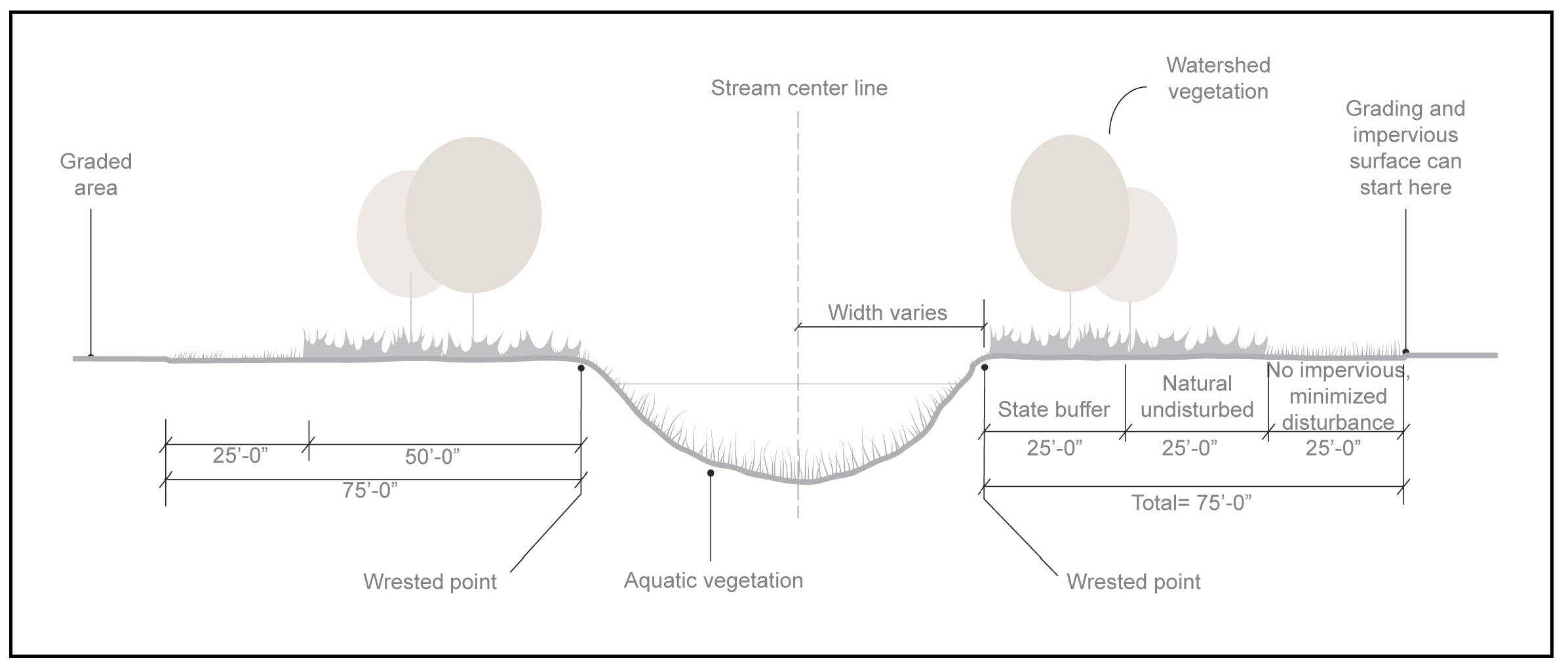
(b)
Exemptions. The stream buffer regulations of this division do not apply to any of the following activities, provided that any activity within a state-mandated stream buffer must meet state requirements. Exemption of these activities does not constitute an exemption from any other activity proposed on a property or a requirement to obtain a building/land development permit.
(1)
Work consisting of the usual and customary repair or maintenance of any lawful use of land that is zoned and approved for such use on or before the effective date of this section. Such usual and customary repair and maintenance activities cannot create any land disturbance, and must occur within the pre-existing disturbed area;
(2)
Maintenance of structures, including the full replacement of existing decks, porches, or similar improvements, attached to a dwelling that encroach into a city stream buffer. The work shall not increase the degree of encroachment of any nonconformity. The complete replacement of these improvements may include the replacement of stairs, all supporting beams, posts, and footings, subject to compliance with other applicable city codes. The necessary construction of new or improved footings as required to comply with current building codes is allowable up to a maximum of 100 square feet of land disturbance;
(3)
Construction of new decks, porches, or other similar additions, provided they are no more than 300 square feet in area. This exemption does not allow additional area to be added to existing decks, porches, or similar structures likewise exempted herein;
(4)
Existing development and on-going land-disturbance activities, including existing agriculture, silviculture, landscaping, gardening, and lawn maintenance, except that new development or land-disturbance activities on such properties is subject to all applicable buffer requirements;
(5)
Public sewer line installation in easements running parallel with the stream, where necessary, except that all easements (permanent and construction) and land disturbance within a state waters' buffer must meet state requirements. This includes such impervious cover as is necessary for the operation and maintenance of the utility, including but not limited to manholes, vents, and valve structures. This exemption may not be construed as allowing the construction of roads, bike paths or other transportation routes in such easements, regardless of paving material, except for access for the uses expressly identified in this paragraph;
(6)
Removal of unwanted ground cover (e.g.; poison ivy, kudzu, and English ivy) using hand tools, as long as protective vegetative cover remains to protect water quality and aquatic habitat and a natural canopy is left in sufficient quantity to keep shade on the stream bed;
(7)
Land development activities within a dedicated transportation right-of-way existing at the time this section takes effect or approved under the terms of this section;
(8)
Within an easement of any utility existing at the time this section takes effect or approved under the terms of this section, land-disturbance activities and such impervious cover as is necessary for the operation and maintenance of the utility, including but not limited to manholes, vents, and valve structures;
(9)
Emergency work necessary to preserve life or property. However, when emergency work is performed, the person performing it must report such work to the Planning and Development Department on the next business day after commencement of the work. Within ten business days thereafter, the person must apply for a permit and perform such work within such time period as may be determined by the Planning and Development Director to be reasonably necessary to correct any impairment such emergency work may have caused to the water conveyance capacity, stability, or water quality of the protection area;
(10)
Forestry and silviculture activities on land that is zoned for forestry, silvicultural, or agricultural uses and are not incidental to other land development activity. If such activity results in land-disturbance in the buffer that would otherwise be prohibited, then no other land-disturbing activity other than normal forest management practices will be allowed on the entire property for three years after the end of the activities that intruded on the buffer;
(11)
Activities to restore or enhance stream bank stability, riparian vegetation, water quality or aquatic habitat, so long as native vegetation and bioengineering techniques are used;
(12)
Construction and land disturbance that results in the reduction or removal of impervious surfaces;
(13)
The removal of dead, diseased, insect-infested, or hazardous trees (without any associated land disturbance), provided the property owner receives a tree removal permit; and
(14)
Multi-use trails and related improvements built to City standards that are part of a City Council-approved plan.
(c)
Variance procedures. Variances from the above buffer and setback requirements may be granted in accordance with the following provisions:
(1)
Where a parcel was platted prior to the effective date of this article, and its shape, topography or other existing physical condition prevents land development consistent with this article, and the (review and permitting authority) finds and determines that the requirements of this article prohibit the otherwise lawful use of the property by the owner, the City Council may grant a variance from the buffer and setback requirements hereunder, provided such variance require mitigation measures to offset the effects of any proposed land development on the parcel.
(2)
Except as provided above, the City Council shall grant no variance from any provision of this article without first conducting a public hearing on the application for variance as provided in Subsection 280-15 and authorizing the granting of the variance by an affirmative vote. The City shall give public notice of each such public hearing as provided in Subsection 280-15.
(3)
Variances will be considered only in the following cases:
a.
When a property's shape, topography or other physical conditions existing at the time of the adoption of this article prevents land development unless a buffer variance is granted.
b.
Unusual circumstances when strict adherence to the minimal buffer requirements in this article would create an extreme hardship.
(4)
Variances will not be considered when, following adoption of this article, actions of any property owner of a given property have created conditions of a hardship on that property.
(d)
Variance application requirements. At a minimum, a variance request shall include the following information:
(1)
A survey site map that includes locations of all streams, wetlands, floodplain boundaries and other natural features;
(2)
A description of the shape, size, topography, slope, soils, vegetation and other physical characteristics of the property;
(3)
A detailed site plan that shows the locations of all existing and proposed structures and other impervious cover, the limits of all existing and proposed land disturbance, both inside and outside the buffer and setback. The exact area of the buffer to be affected shall be accurately and clearly indicated;
(4)
Documentation of unusual hardship should the buffer be maintained;
(5)
At least one alternative plan, which does not include a buffer or setback intrusion, or an explanation of why such a site plan is not possible;
(6)
A calculation of the total area and length of the proposed intrusion;
(7)
A stormwater management site plan, if applicable; and
(8)
Proposed mitigation, if any, for the intrusion. If no mitigation is proposed, the request must include an explanation of why none is being proposed.
(e)
The following factors will be considered in determining whether to issue a variance:
(1)
The shape, size, topography, slope, soils, vegetation and other physical characteristics of the property;
(2)
The locations of all streams on the property, including along property boundaries;
(3)
The location and extent of the proposed buffer or setback intrusion;
(4)
Whether alternative designs are possible which require less intrusion or no intrusion;
(5)
The long-term and construction water-quality impacts of the proposed variance; and
(6)
Whether issuance of the variance is at least as protective of natural resources and the environment.
(Ord. No. 743, 12-19-17; Ord. No. 757, 12-18-18; Ord. No. 805, 12-21-21)
Section 310-20. - Compatibility with other buffer regulations and requirements.
This article is not intended to interfere with, abrogate or annul any other ordinance, rule or regulation, statute or other provision of law. The requirements of this article should be considered minimum requirements, and where any provision of this article imposes restrictions different from those imposed by any other ordinance, rule, regulation or other provision of law, whichever provisions are more restrictive or impose higher protective standards for human health or the environment shall be considered to take precedence.
(Ord. No. 743, 12-19-17)
Section 310-21. - Additional information requirements for development on buffer zone properties.
(a)
Any permit applications for property requiring buffers and setbacks hereunder must include the following:
(1)
A site plan showing:
a.
The location of all streams on the property;
b.
Limits of required stream buffers and setbacks on the property;
c.
Buffer zone topography with contour lines at no greater than five-foot contour intervals;
d.
Delineation of forested and open areas in the buffer zone; and
e.
Detailed plans of all proposed land development in the buffer and of all proposed impervious cover within the setback.
(2)
A description of all proposed land development within the buffer and setback; and
(3)
Any other documentation that the Mayor and City Council may reasonably deem necessary for review of the application and to ensure that the buffer zone ordinance is addressed in the approval process.
(4)
All buffer and setback areas must be recorded on the final plat of the property following plan approval. See Section 300-24, Final plat specifications.
Section 310-22. - Responsibility.
Neither the issuance of a development permit nor compliance with the conditions thereof, nor with the provisions of this article shall relieve any person from any responsibility otherwise imposed by law for damage to persons or property; nor shall the issuance of any permit hereunder serve to impose any liability upon the City, its officers or employees, for injury or damage to persons or property.
(Ord. No. 743, 12-19-17)
Section 310-23. - Inspection.
(a)
The Planning and Development Department may cause inspections of the work in the buffer or setback to be made periodically during the course thereof and shall make a final inspection following completion of the work. The permittee shall assist the Planning and Planning and Development Department in making such inspections. The City shall have the authority to conduct such investigations as it may reasonably deem necessary to carry out its duties as prescribed in this article, and for this purpose to enter at reasonable time upon any property, public or private, for the purpose of investigating and inspecting the sites of any land development activities within the protection area.
(b)
No person shall refuse entry or access to any authorized representative or agent who requests entry for purposes of inspection, and who presents appropriate credentials, nor shall any person obstruct, hamper or interfere with any such representative while in the process of carrying out official duties.
Section 310-24. - Violations, enforcement and penalties.
(a)
Any action or inaction which violates the provisions of this article or the requirements of an approved site plan or permit may be subject to the enforcement actions outlined in this section. Any such action or inaction which is continuous with respect to time is deemed to be a public nuisance and may be abated by injunctive or other equitable relief. The imposition of any of the penalties described below shall not prevent such equitable relief.
(1)
Notice of violation. If the City determines that an applicant or other responsible person has failed to comply with the terms and conditions of a permit, an approved site plan or the provisions of this article, it shall issue a written notice of violation to such applicant or other responsible person. Where a person is engaged in activity covered by this article without having first secured the appropriate permit therefor, the notice of violation shall be served on the owner or the responsible person in charge of the activity being conducted on the site.
The notice of violation shall contain:
a.
The name and address of the owner or the applicant or the responsible person;
b.
The address or other description of the site upon which the violation is occurring;
c.
A statement specifying the nature of the violation;
d.
A description of the remedial measures necessary to bring the action or inaction into compliance with the permit, the approved site plan or this article and the date for the completion of such remedial action;
e.
A statement of the penalty or penalties that may be assessed against the person to whom the notice of violation is directed; and
f.
A statement that the determination of violation may be appealed to the Planning and Development Director by filing a written notice of appeal in the office of the City Clerk within 30 days after the notice of violation (except that in the event the violation constitutes an immediate danger to public health or public safety, 24 hours' notice shall be sufficient).
(2)
Penalties. In the event the remedial measures described in the notice of violation have not been completed by the date set forth for such completion in the notice of violation, any one or more of the following actions or penalties may be taken or assessed against the person to whom the notice of violation was directed. Before taking any of the following actions or imposing any of the following penalties, the Planning and Development Department shall first notify the applicant or other responsible person in writing of its intended action, and shall provide a reasonable opportunity, of not less than ten days (except that in the event the violation constitutes an immediate danger to public health or public safety, 24 hours' notice shall be sufficient) to cure such violation. In the event the applicant or other responsible person fails to cure such violation after such notice and cure period, the Planning and Development Department may take any one or more of the following actions or impose any one or more of the following penalties:
a.
Stop Work Order. The Planning and Development Department may issue a Stop Work Order which shall be served on the applicant or other responsible person. The Stop Work Order shall remain in effect until the applicant or other responsible person has taken the remedial measures set forth in the notice of violation or has otherwise cured the violation or violations described therein, provided the Stop Work Order may be withdrawn or modified to enable the applicant or other responsible person to take necessary remedial measures to cure such violation or violations.
b.
Withhold Certificate of Occupancy. The Planning and Development Department may refuse to issue a Certificate of Occupancy for the building or other improvements constructed or being constructed on the site until the applicant or other responsible person has taken the remedial measures set forth in the notice of violation or has otherwise cured the violations described therein.
c.
Suspension, revocation or modification of permit. The Planning and Development Department may suspend, revoke or modify the permit authorizing the land development project. A suspended, revoked or modified permit may be reinstated after the applicant or other responsible person has taken the remedial measures set forth in the notice of violation or has otherwise cured the violations described therein, provided such permit may be reinstated (upon such conditions as the Planning and Development Department may deem necessary) to enable the applicant or other responsible person to take the necessary remedial measures to cure such violations.
d.
Civil penalties. In the event the applicant or other responsible person fails to take the remedial measures set forth in the notice of violation or otherwise fails to cure the violations described therein within ten days (or such greater period as the Planning and Development Department shall deem appropriate except that in the event the violation constitutes an immediate danger to public health or public safety, 24 hours' notice shall be sufficient) after the Planning and Development Department has taken one or more of the actions described above, the Planning and Development Director may impose a penalty not to exceed $1,000.00 (depending on the severity of the violation) for each day the violation remains unremediated after receipt of the notice of violation.
e.
Criminal penalties. For intentional and flagrant violations of this article, the Planning and Development Director may issue a citation to the applicant or other responsible person, requiring such person to appear in the municipal court of the City to answer charges for such violation. Upon conviction, such person shall be punished by a fine not to exceed $1,000.00 or imprisonment for 60 days or both. Each act of violation and each day upon which any violation shall occur shall constitute a separate offense.
Section 310-25. - Administrative appeal and judicial review.
(a)
Administrative appeal. Any person aggrieved by a decision or order of the Planning and Development Department, may appeal to the Mayor and City Council as provided in Section 280-15. Such appeal shall be submitted in writing to the City Clerk's office within ten days after the issuance of such decision or order.
(b)
Judicial review. Any person aggrieved by a decision or order of the Mayor and Council, after exhausting all administrative remedies, shall have the right to appeal de novo to the superior court of the county, see Section 120-8, Judicial Review.
Section 310-30. - Nuisances prohibited.
It is hereby declared to be an offense for any owner, agent or tenant to maintain a nuisance as defined in Chapter 300 of the Unified Development Ordinance. Each day a nuisance is continued shall constitute a separate offense. It is unlawful for any responsible person(s) to create, permit, maintain, suffer, carry on or allow, upon their premises, any of the acts or things declared or defined by this chapter to be a public nuisance. Any person creating, keeping or maintaining a nuisance, or permitting, allowing or suffering any nuisance to be maintained, who neglects or fails to abate or remove the nuisance within a reasonable time after so creating, keeping or maintaining the nuisance, or permitting, allowing or suffering the same to be maintained, shall, for each twenty-four (24) hours thereafter during which the nuisance is continued, be guilty of a separate violation of maintaining a public nuisance.
(Ord. No. 743, 12-19-17; Ord. No. 776, 12-17-19; Ord. No. 800, 6-15-21)
Section 310-31. - Notice of Violation.
Upon the discovery of a nuisance, the Code Enforcement Officer may order the responsible person creating, keeping, maintaining or permitting the same to abate it, and in default thereof, to undertake the abatement. At least seventy-two (72) hours before abatement is ordered, save in those cases of immediate necessity, the officer shall notify the person creating, keeping, maintaining or permitting the nuisance, the property owner and any person in possession of the property, if known, of the violation for abatement. The notice shall be served personally or by first class mail and shall describe with particularity the nature of the violation, the sections of this Code or other law which are being violated and specifying a reasonable time within which the abatement must be accomplished.
(Ord. No. 800, 6-15-21)
Section 310-32. - Jurisdiction of municipal court.
(a)
Citations. The municipal court shall have full jurisdiction to try and dispose of all questions of nuisance affecting the public health or welfare, and shall also have jurisdiction to try and, in case of conviction, to punish persons failing to abate nuisances, as prescribed in Section 310-31 of the City Code of Ordinances.
(b)
Hearing Process. Any official or inhabitant of the city may direct a complaint of nuisance to the City Code Enforcement, which shall investigate and may place the complaint on the municipal court docket for a hearing upon the basis of the investigation. The municipal court, after five days' notice to the party involved, shall hold a hearing thereon, and, upon finding that a nuisance does exist, shall issue an order to the owner, agent in control or tenant in possession, stating that a nuisance has been found to exist and that the nuisance must be abated within so many hours or days as the municipal court judge shall deem reasonable, having consideration for the nature of the nuisance and its effect on the public.
(Ord. No. 743, 12-19-17; Ord. No. 800, 6-15-21)
Editor's note— Ord. No. 800 added new provisions as § 310-31 and combined and renumbered existing §§ 320-31 and 310-32 as § 310-32, as herein set out.
Section 310-33. - Abatement by city.
(a)
Municipal Court Intervention. In any case where the owner, agent or tenant fails to abate a nuisance in the time specified pursuant to this article, or where the owner, agent or tenant cannot be served with notice, or where the nature of the nuisance is such, in the opinion of the municipal court judge, that it must be immediately abated, the municipal court judge may issue an order to the Code Enforcement Division directing the nuisance to be abated. Code Enforcement, in such case, shall keep a record of the expenses and cost of abating the nuisance, and the costs shall be billed against the owner, agent or tenant for collection as for City revenues in accordance with Section 310-36.
(b)
Repeat or Unresolved Offenses. The Code Enforcement Officer may forego the citation process in Section 310-32 for any repeat offences or occurrences after the first violation is properly notified and adjudicated in any given calendar year pursuant to either Section 310-32 or Subsection 310-33(a). Upon the failure to comply within the required time frame pursuant to the provisions of Section 310-31, or without notice on repeat offenses, the City is authorized to enter onto the property, or hire a third-party contractor to enter upon the property, to abate any such nuisance, including mowing, trimming, or control of weeds, grass, and vegetation; remediation of rodent infestation; trash and junk removal; or any other condition deemed a nuisance by this chapter. All expenses related to the abatement shall be passed on to the owner as outlined in Section 310-36.
Section 310-34. - Findings of the existence of unsafe structures or buildings.
(a)
The Mayor and Council finds and declares that within the city limits there is the existence or occupancy of dwellings or other buildings or structures which are unfit for human habitation or for commercial, industrial or business occupancy or use and not in compliance with applicable state minimum standard codes as adopted by ordinance or operation of law or any optional building, fire, life safety or other codes relative to the safe use of real property and real property improvements adopted by ordinance in the city; or general nuisance law and which constitute a hazard to the health, safety and welfare of the people of the city and the state; and that a public necessity exists for the repair, closing or demolition of such dwellings, buildings or structures.
(b)
It is further found and declared that in the city where there is in existence a condition or use of real estate which rendered adjacent real estate unsafe or inimical to safe human habitation, such use is dangerous and injurious to the health, safety and welfare of the people of the city and a public necessity exists for the repair of such condition or the cessation of such use which renders the adjacent real estate unsafe or inimical to safe human habitation. The governing authority of the City finds that there exist in the city dwellings, buildings or structures which are unfit for human habitation or for commercial, industrial or business uses due to dilapidation and which are not in compliance with applicable codes; which have defects increasing the hazards of fire, accidents or other calamities; which lack adequate ventilation, light or sanitary facilities; or other conditions exist rendering such dwellings, buildings or structures unsafe or unsanitary, or dangerous or detrimental to the health, safety or welfare or otherwise inimical to the welfare of the residents of the city, or vacant, dilapidated dwellings, buildings or structures in which drug crimes are being committed, and private property exists constituting an endangerment to the public health or safety as a result of unsanitary or unsafe conditions to those persons residing or working in the vicinity of the property.
(c)
It is the intention of the governing authority that this article shall comply with and does comply with O.C.G.A. § 41-2-9(a) as a finding that conditions as set out in O.C.G.A. § 41-2-7 exist within the city.
Section 310-35. - Nuisance abatement procedures.
(a)
Continued use of other laws and ordinances. It is the intent of the Mayor and Council that nothing in this article shall be construed to abrogate or impair the powers of the courts or of any department of the City to enforce any provisions of any local enabling act, charter, or ordinance or regulation, nor to prevent or punish violations thereof; and the powers conferred by this article shall be in addition to and supplemental to the powers conferred by any other law or ordinance, legislation or regulation.
(b)
Applicable codes, as referenced in this Section 310-35, shall include the following:
(1)
Any optional housing or abatement standard provided in O.C.G.A. tit. 8, ch. 2 as adopted by ordinance or operation of law, or general nuisance law, relative to the safe use of real property;
(2)
Any fire or life safety code as provided for in O.C.G.A. tit. 25, ch. 2; and
(3)
Any building codes adopted by local ordinance prior to October 1, 1991, or the minimum standard codes provided in O.C.G.A. tit. 8, ch. 2 after October 1 provided that such building or minimum standard codes for real property improvements shall be deemed to mean those building or minimum standard codes in existence at the time such real property improvements were constructed unless otherwise provided by law.
(c)
Duties of owners; appointment of public officer; procedures for determining premises to be unsafe or unhealthful.
(1)
It is the duty of the owner of every dwelling, building, structure or property within the jurisdiction to construct and maintain such dwellings, building, structure, or property in conformance with applicable codes in force within the city, or such ordinances which regulate and prohibit activities on property and which declare it to be a public nuisance to construct or maintain any dwelling, building, structure or property in violation of such codes or ordinances.
(2)
The Mayor and Council of the City hereby appoint or designate the Planning and Development Department, County Fire Marshal, City Police Chief, and his/her designees as public officer(s) to exercise the powers prescribed by this article.
(3)
Whenever a request is filed with the public officer by a public authority or by at least five residents of the City charging that any dwelling, building or structure is unfit for human habitation or for commercial, industrial or business use and not in compliance with applicable codes; is vacant and being used in connection with the commission of drug crimes; or constitutes an endangerment to the public health or safety as a result of unsanitary or unsafe conditions, the public officer shall make an investigation or inspection of the specific dwelling, building, structure or property. If the officer's investigation or inspection identifies that any dwelling, building, structure or property is unfit for human habitation or for commercial, industrial or business use and not in compliance with applicable codes, is vacant and being used in connection with the commission of drug crimes; or constitutes an endangerment to the public health or safety as a result of unsanitary or unsafe conditions, the public officer may issue a complaint in rem against the lot, tract or parcel of real property on which such dwelling, building or structure is situated or where such public health hazard or general nuisance exists and shall cause summons and a copy of the complaint to be served on the owner and parties in interest in such dwelling, building or structure. The complaint shall identify the subject real property by appropriate street address and official tax map reference; identify the interested parties; state with particularity the factual basis for the action; and contain a statement of the action sought by the public officer to abate the alleged nuisance. The summons shall notify the interested parties that a hearing will be held before a court of competent jurisdiction as determined by O.C.G.A. § 41-2-5, at a date and time certain and at a place within the city where the property is located. Such hearings shall be held not less than 15 days, nor more than 45 days after the filing of said complaint in court. The interested parties shall have the right to file an answer to the complaint and to appear in person or by attorney and offer testimony at the time and place fixed for hearing.
(4)
If after such notice and hearing, the court determines that the dwelling, building or structure in question is unfit for human habitation or is unfit for its current commercial, industrial or business use and not in compliance with applicable codes; is vacant and being used in connection with the commission of drug crimes; or constitutes an endangerment to the public health or safety as a result of unsanitary or unsafe conditions, the court shall state in writing findings of fact in support of such determination and shall issue and cause to be served upon any interested party that has answered the complaint or appeared at the hearing an order:
a.
If the repair, alteration or improvement of the said dwelling, building or structure can be made at a reasonable cost in relation to the present value of the dwelling, building or structure, requiring the owner, within the time specified in the order, to repair, alter or improve such dwelling, building or structure so as to bring it into full compliance with the applicable codes relevant to the cited violation and, if applicable, to secure the structure so that it cannot be used in connection with the commission of drug crimes; or
b.
If the repair, alteration or improvement of the said dwelling, building or structure in order to bring it into full compliance with applicable codes relevant to the cited violations cannot be made at a reasonable cost in relation to the present value of the dwelling, building or structure, requiring the owner, within the time specified in the order, to demolish and remove such dwelling, building or structure and all debris from the property as provided in Subsection 300-50(b) of this UDO;
c.
For purposes of this article, the court shall make its determination of reasonable cost in relation the present value of the dwelling, building or structure without consideration of the value of the land on which the structure is situated; provided, however, that costs of the preparation necessary to repair, alter, or improve a structure may be considered income and financial status of the owner shall not be factor in the court's determination. The present value of the structure and the costs of repair, alteration or improvement may be established by affidavits of real estate appraisers with a state appraiser classification as provided in O.C.G.A. tit. 41, ch. 39A, qualified building contractors, or qualified building inspectors without actual testimony presented. Costs of repair, alteration or improvement of the structure shall be the cost necessary to bring the structure into compliance with the applicable codes relevant to the cited violations in force in the jurisdiction.
(5)
If the owner fails to comply with an order to repair or demolish the dwelling, building or structure, the public officer may cause such dwelling, building or structure, to be repaired, altered, improved, to be vacated and closed or demolished. Such abatement actions shall commence within 270 days after the expiration of time specified in the order for abatement by the owner. Any time during which such action is prohibited by a court order issued pursuant to O.C.G.A. § 41-2-13, or any other equitable relief granted by a court of competent jurisdiction shall not be counted toward the 270 days in which such abatement action must commence. The public officer shall cause to be posted on the main entrance of the building, dwelling or structure a placard with the following words:
"This building is unfit for human habitation or commercial, industrial or business use and does not comply with the applicable codes or has been ordered secured to prevent its use in connection with drug crimes or constitutes and endangerment to the public health or safety as a result of unsanitary or unsafe conditions. The use or occupation of this building is prohibited and unlawful."
(6)
If the public officer has the structure demolished, reasonable effort shall be made to salvage reusable materials for credit against the cost of demolition. The proceeds of any moneys received from the sale of salvaged materials shall be used or applied against the cost of the demolition and removal of the structure, and proper records shall be kept showing application of sales proceeds. Any such sale of salvaged materials may be made without the necessity of public advertisement and bid. The public officer and the City are relieved of any and all liability resulting from or occasioned by the sale of any such salvaged materials, including, without limitation, defects in such salvaged materials.
(7)
The amount of the cost of demolition or other remediation measures outlined herein, including all court costs, appraisal fees, administrative costs incurred by the county tax commissioner or municipal tax collector or City revenue officer, and all other costs necessarily associated with the abatement action, including restoration to grade of the real property after demolition, shall be a lien against the real property upon which such cost was incurred.
a.
The lien provided for in Subsection (c)(7) of this section shall attach to the real property upon the filing of a certified copy of the order requiring repair, closure or demolition in the office of the clerk of superior court in the county and shall relate back to the date of the filing of the lis pendens notice required under O.C.G.A. § 41-2-12(c). The Clerk of the Superior Court shall record and index such certified copy of the order in the deed records of the county and enter the lien on the general execution docket. The lien shall be superior to all other liens on the property, except liens for taxes to which the lien shall be inferior, and shall continue in force until paid.
b.
Upon final determination of costs, fees and expenses incurred in accordance with this article, the public officer responsible for enforcement actions in accordance with this article shall transmit to the appropriate county tax commissioner or municipal tax collector or City revenue officer a statement of the total amount due and secured by said lien, together with copies of all notices provided to interest parties. The statement of the public officer shall be transmitted within 90 days of the completion of the repairs, demolition or closure. It shall be the duty of the appropriate county tax commissioner or municipal tax collector or City revenue officer, who is responsible or whose duties include the collection of municipal taxes, to collect the amount of the lien using all methods available for collecting real property ad valorem taxes, including specifically O.C.G.A. tit. 48, ch. 4; provided, however, that the limitation of O.C.G.A. § 48-4-78 which requires 12 months of delinquency before commencing a tax foreclosure shall not apply. A county tax commissioner shall collect and enforce municipal liens imposed pursuant to this chapter in accordance with O.C.G.A. § 48-5-359.1. The county tax commissioner or municipal tax collector or City revenue officer shall remit the amount collected to the governing authority of the county or municipality whose lien is being collected.
c.
Enforcement of liens pursuant to this article may be initiated at any time following receipt by the county tax commissioner or municipal tax collector or City revenue officer of the final determination of costs in accordance with this article. The unpaid lien amount shall bear interest and penalties from and after the date of final determination of costs in the same amount as applicable to interest and penalties on unpaid real property ad valorem taxes. An enforcement proceeding pursuant to O.C.G.A. § 48-4-78 for delinquent ad valorem taxes may include all amounts due under this article.
d.
The redemption amount in any enforcement proceeding pursuant to this article shall be the full amount of the costs as finally determined in accordance with this article together with interest, penalties and costs incurred by the governing authority, county tax commissioner, municipal tax collector, or City revenue officer in the enforcement of such lien. Redemption of property from the lien may be made in accordance with the provisions of O.C.G.A. §§ 48-4-80 and 48-4-81.
e.
The county tax commissioner shall collect and retain an amount equal to the cost of administering a lien authorized by O.C.G.A. § 41-2-7 et seq., unless such costs are waived by resolution of the county. Any such amount collected and retained for administration shall be deposited in the general fund of county to pay the cost of administering the lien.
f.
The City may waive and release any such lien imposed on property upon the owner of such property entering into a contract with the county or municipality agreeing to a timetable for rehabilitation of the real property of the dwelling, building or structure on the property and demonstrating the financial means to accomplish such rehabilitation.
g.
Where the abatement action does not commence in the superior court, review of a court order requiring the repair, alteration, improvement or demolition of a dwelling, building, or structure shall be by direct appeal to the superior court under O.C.G.A. § 5-3-29.
h.
The public officers designated herein may issue citations for violations of state minimum standard codes, optional building, fire, life safety, and other codes adopted by ordinance, and conditions creating a public health hazard or general nuisance, and may seek to enforce such citation in court of competent jurisdiction prior to issuing a complaint in rem as provided in this article.
i.
Nothing in this article shall be construed to impair or limit in any way the power of the City to define and declare nuisances and to cause their removal or abatement by summary proceedings or otherwise.
(d)
Determination by public officer that under existing ordinances dwellings, buildings or structures are vacant and sample conditions of nuisances. The public officer may determine, under existing ordinances, that a dwelling, building or structure is unfit for human habitation or is unfit for its current commercial, industrial or business use if he/she finds that conditions exist in such building, dwelling or structure which are dangerous or injurious to the health, safety, or morals of the occupants of such dwelling, building or structure; of the occupants of neighborhood dwelling, buildings or structures; or of other residents of the city. Such conditions include the following (without limiting the generality of the foregoing):
(1)
Defects therein increasing the hazards of fire, accidents or other facilities;
(2)
Lack of adequate ventilation, light or sanitary facilities;
(3)
Dilapidation;
(4)
Disrepair;
(5)
Structural defects;
(6)
Uncleanliness; and
(7)
Other additional standards which may from time to time by adopted and referenced herein by ordinance amendment.
The public officer may determine, under existing ordinances, that a dwelling, building or structure is vacant, dilapidated, and being used in connection with the commission of drug crimes based upon personal observation or report of a law enforcement agency and evidence of drug crimes being committed.
(e)
Powers of public officers. The public officer(s) designated in this article shall have the following powers:
(1)
To investigate the dwelling conditions in the city in order to determine which dwellings, buildings or structures therein are unfit for human habitation or are unfit for current commercial, industrial or business use or are vacant, dilapidated, and being used in connection with the commission of drug crimes;
(2)
To administer oaths and affirmations, to examine witnesses, and to receive evidence;
(3)
To enter upon premises for the purpose of making examinations; provided, however, that such entries shall be made in such manner as to cause the least possible inconvenience to the persons in possession;
(4)
To appoint and fix the duties of such officers, agents, and employees as he or she deems necessary to carry out the purposes of this article; and
(5)
To delegate any of his or her functions and powers under the ordinance to such officers and agents as he or she may designate.
(f)
Service of complaints.
(1)
Complaints issued by a public officer pursuant to this article shall be served in the following manner. At least 14 days prior to the date of the hearing, the public officer shall mail copies of the complaint by certified mail or statutory overnight delivery, return receipt requested, to all interested parties whose identities and addresses are reasonably ascertainable. Copies of the complaint shall also be mailed by first-class mail to the property address to the attention of the occupants of the property, if any, and shall be posted on the property within three business days of filing the complaint and at least 14 days prior to the date of the hearing.
(2)
For interested parties whose mailing address is unknown, a notice stating the date, time, and place of the hearing shall be published in the newspaper in which the sheriff's advertisements appear in such county once a week for two consecutive weeks prior to the hearing.
(3)
A notice of lis pendens shall be filed in the office of the clerk of the superior court of the county. Such notice shall have the same force and effect as other lis pendens notices provided by law.
(4)
Orders and other filings made subsequent to service of the initial complaint shall be served in the manner provided in this Code section on any interested party who answers the complaint or appears at the hearing. Any interested party who fails to answer or appear at the hearing shall be deemed to have waived all further notice in the proceedings.
(Ord. No. 743, 12-19-17; Ord. No. 757, 12-18-18; Ord. No. 800, 6-15-21)
Section 310-36. - Recovery of Costs for Abatement.
(a)
The cost of abating, vacating and closing or removal or demolition or clean-up shall be a lien against the real property upon which such cost was incurred. Such lien shall attach to the real property upon the payment of all costs incurred by the city and the filing of an itemized statement of the total sum of said costs in the office of the City Clerk on a lien docket maintained by the clerk for such purposes.
(b)
The City may enforce the collection of any amount due on such lien for removal or demolition of dwellings, buildings, fences, walls or structures or clean-up of property only in the following manner:
(1)
The owner or parties at interest shall be allowed to satisfy the amount due on such lien by paying to the City within thirty (30) days after the perfection of such lien, a sum of money equal to twenty-five (25) percent of the total amount due and by further paying to the City the remaining balance due on such lien, together with interest at the rate of seven (7) percent per annum, in three (3) equal annual payments, each of which shall become due and payable on the anniversary date of the initial payment made as hereinabove prescribed.
(2)
Should the property upon which such lien is perfected be sold, transferred, or conveyed by the owner or parties at interest at any time prior to the termination of the said three-year period, then the entire balance due on such lien shall be due and payable to the City.
(3)
Should the amount due on such lien, or any portion thereof, be unpaid after the passage of such three-year period, or upon the occurrence of the contingency provided for in subsection (2) of this subsection, the City may enforce the collection of any amount due on such lien for abatement, alteration, repair, removal, or demolition of dwellings, buildings, or structure or clean-up of property as provided by O.C.G.A § 48-5-358 and other applicable state statutes. This procedure shall be subject to the right of redemption by any person having any right, title, or interest in or lien upon said property, all as provided by O.C.G.A. article 3 of chapter 4 of title 48 (O.C.G.A. § 48-3-4).
(Ord. No. 800, 6-15-21)
Section 310-40. - Sound level limitations.
(a)
No person shall cause, suffer, allow or permit the operation of any sound source in such a manner as to create a sound level that exceeds the sound level limits set forth in the Sound Level Limits by Receiving Property Table below when measured at or within the real property line of the receiving property using the slow response setting unless otherwise noted. Such a sound source would constitute a noise disturbance.
Sound Level Limits by Receiving Property Table
(b)
If the noise is an impulsive sound, the fast response setting shall be used and the daytime (7:00 a.m.—11:00 p.m.) limits of the Sound Level Limits by Receiving Property Table above shall be increased by ten dBA.
(c)
In a multifamily dwelling, it shall be unlawful to create or permit to be created, any noise that exceeds the daytime (7:00 a.m.—11:00 p.m.) limit of 55 dBA and the nighttime (11:00 p.m.—7:00 a.m.) limit of 45 dBA as measured from the closest neighbor's dwelling.
(Ord. No. 743, 12-19-17)
Section 310-41. - Exemptions.
(a)
Noise generated from municipally-sponsored or approved celebrations or events shall be exempt from the provisions of this article.
(b)
The following are exempt from the sound level limits of Subsection 310-40(a):
(1)
Sound by public safety vehicles, emergency signaling devices or authorized public safety personnel for the purpose of alerting persons to the existence of an emergency.
(2)
Noise from an exterior burglar alarm of any building, provided such burglar alarm shall terminate its operation in compliance with Section 58-109 of the Chamblee Code of Ordinances.
(3)
Noise from any automobile alarm, provided such alarm shall terminate its operation within five minutes of its activation if the sound is uninterrupted or ten minutes if the sound is intermittent.
(4)
The generation of sound in situations within the jurisdiction of the Federal Occupational Safety and Health Administration.
(5)
Noise resulting from any practice or performance sponsored by or associated with the educational process administered by a recognized institution of learning, including, but not limited to, band, choir and orchestral performances.
(6)
Noise that results from the activities of an organized sports league.
(7)
Unamplified bells, chimes or carillons while being used in conjunction with religious services between the hours of 7:00 a.m.—10:00 p.m.
(8)
Emergency work.
(9)
Events with amplified sound that are operating within the time and volume parameters set forth in an approved special administrative permit.
(Ord. No. 743, 12-19-17)
Section 310-42. - Restricted uses and activities.
(a)
Notwithstanding the provisions of Subsection 310-40(a) and the exceptions above, the following standards shall apply to the activities or sources of sound set forth below:
(1)
Noncommercial or non-industrial power tools used for landscaping and yard maintenance shall not be operated between the hours of 9:00 p.m. and 7:00 a.m., or on Saturday or Sunday before the hour of 8:30 a.m., unless such activities can meet the applicable limits set forth in Subsection 310-40(a). At all other times, the limits set forth in Subsection 310-40(a) do not apply to noncommercial or non-industrial power tools and landscaping and yard maintenance equipment, provided that all motorized equipment is operated with a functioning muffler.
(2)
Commercial or industrial power tools used for landscaping and yard maintenance shall be operated with a muffler. All motorized equipment used in these activities shall not be operated on a residential property or within 250 feet of a residential property line, between the hours of 7:00 p.m. and 7:00 a.m. on weekdays, or before the hour of 9:00 a.m., or after the hour of 5:00 p.m. on Saturday, or at any time on Sunday, unless:
a.
Such activities are deemed emergency work; or
b.
Such activities meet the limits set forth in Subsection 310-40(a). At all other times, the limits set forth in Subsection 310-40(a) do not apply to commercial or industrial power tools and landscaping and yard maintenance equipment.
(3)
Construction and demolition activity shall not be performed between the hours of 7:00 p.m. and 7:00 a.m. on weekdays, before the hour of 9:00 a.m. or after the hour of 5:00 p.m. on Saturday, or at any time on Sunday, unless:
a.
Such activities are deemed emergency work; or
b.
Such activities meet the limits set forth in Subsection 310-40(a). This provision shall not apply if the chief of police determines that the loss or inconvenience that would result to any party in interest is of such a nature as to warrant special consideration. In such cases, the chief of police may grant a renewable permit for a period not to exceed ten days for this work to be done within the hours of 10:00 p.m. to 7:00 a.m.
(4)
Construction and demolition activity shall not be performed on the following holidays: New Year's Day, Memorial Day, Independence Day, Labor Day, Thanksgiving Day and Christmas Day, unless:
a.
Such activities are deemed emergency work; or
b.
Such activities meet the limits set forth in Subsection 310-40(a). This provision shall not apply if the chief of police determines that the loss or inconvenience that would result to any party in interest is of such a nature as to warrant special consideration. In such cases, the chief of police may grant a renewable permit for a period not to exceed ten days for this work to be done within the hours of 10:00 p.m. to 7:00 a.m.
(5)
Domesticated animals may not make any vocalizations (including barking, baying, howling, crying or making any other noise) for more than ten minutes without interruption or more than 30 minutes if intermittent.
(6)
The collection of trash or refuse in residential districts is prohibited between the hours of 9:00 p.m. and 7:00 a.m.
(7)
No person shall operate, play or permit the operation or playing of any radio, television, phonograph, drum, musical instrument or similar device in such a manner as to create a continuing noise disturbance at 50 feet from such device, when operated in or on a motor vehicle on a public right-of-way or public space.
(8)
Late-night establishments are prohibited from allowing noises and/or sounds to emanate from their establishment which are plainly audible more than 50 feet beyond the building or structure from which the noises and/or sounds emanate between the hours of 12:00 a.m. and 7:00 a.m.
Section 310-43. - Procedures for the determination of sound levels.
(a)
Insofar as practicable, sound will be measured while the source under investigation is operating at normal, routine conditions and, as necessary, at other conditions, including, but not limited to, design, maximum and fluctuating rates. All noise measurements shall be made at or within the property line of the impacted site, unless otherwise directed in this article. When instrumentation cannot be placed at or within the property line, the measurement shall be made as close thereto as is reasonable. For the purposes of this article, noise measurements are measured on the A- or C-weighted sound scale, as applicable, of a sound level meter of standard design and quality having characteristics established by ANSI.
(b)
Measurements shall be taken by police officers appropriately trained in the use of a sound level meter.
(Ord. No. 743, 12-19-17)
Section 310-44. - Special variances.
(a)
The Planning and Development Director shall have the authority, consistent with this article, to grant special variances.
(b)
Any person seeking a special variance pursuant to this article shall file an application with the Planning and Development Director. The application shall contain information which demonstrates that bringing the source of sound into compliance with this article would constitute an unreasonable hardship on the applicant, on the community, or on other persons. Notice of an application for a special variance shall be given by the Planning and Development Director to persons who frequent the area of the sound or activity and who may be adversely affected by the granting of the variance. Any individual who claims to be adversely affected by allowance of the special variance may file a statement with the Planning and Development Director containing any information to support such individual's claim.
(c)
In determining whether to grant or deny the application, the Planning and Development Director shall balance the hardship to the applicant, the community and other persons of not granting the special variance against the adverse impact on the health, safety and welfare of persons affected, the adverse impact on property affected, and any other adverse impact of granting the special variance. Applicants for special variances may be required to submit any information the Planning and Development Director may reasonably require. In granting or denying an application, the Planning and Development Director shall place on public file a copy of the decision and the reasons for denying or granting the special variance.
(d)
Special variances shall be granted by notice to the applicant containing all necessary conditions, including a time limit on the permitted activity. The special variance shall not become effective until all conditions are agreed to by the applicant. Noncompliance with any condition of the special variance shall terminate it and subject the person holding it to those provisions of this article regulating the source of sound or activity for which the special variance was granted.
(e)
Application for extension of time limits specified in special variances or for modification of other substantial conditions shall be treated like applications for initial special variances.
(f)
The Planning and Development Director may issue guidelines approved by the Mayor and City Council defining the procedures to be followed in applying for a special variance and the criteria to be considered in deciding whether or not to grant a special variance.
Section 310-45. - Enforcement procedures; miscellaneous.
(a)
Except as provided in Subsection 310-45(c), the City may prosecute noise-related violations by issuance of a City ordinance citation, in which case the penalty for a violation shall be as provided in Section 1-6 of the City Code of Ordinances.
(b)
In addition to assessing a fine as provided, or in lieu thereof, the municipal court judge may issue an order requiring immediate abatement of any sound source alleged to be in violation of this section. Failure to abate such noise results in contempt of court.
(c)
Whenever any city resident shall complain to the police department that a dog which habitually barks, howls or yelps, or a cat which habitually cries or howls, is being kept by any person in the city, a City law enforcement officer, prior to the issuance of a citation, shall issue a formal warning to the owner of such dog or cat that the owner shall take whatever steps necessary to alleviate the barking, howling, yelping or crying. If the warning given to the owner is ineffective, a citation shall be issued to the owner of the dog or cat.
(d)
No provision of this section shall be construed to impair any common law or statutory cause of action, or legal remedy therefor, of any person for injury or damage arising from any violation of this section or from other law.
(Ord. No. 743, 12-19-17)
Section 310-50. - Mandatory connections to public sanitary sewer.
(a)
The owner of all houses, buildings or properties used for human occupancy, employment, recreation, or other such purposes, located within the City of Chamblee and abutting on any street, alley, or right-of-way in which there is now located a public sanitary sewer, is required to install, at the owner's expense, suitable toilet facilities, and to connect such facilities directly to the public sanitary sewer. In accordance with the provisions of this article, the owner has twenty-four (24) months after the date of official notice to accomplish this, provided that the public sanitary sewer is within one hundred (100) feet of the property line.
(b)
Exceptions to the provisions of subsection (a) of this section may be granted by the County upon application.
(Ord. No. 804, 10-19-21)
Section 310-51. - Private sewage disposal facilities generally.
(a)
Except as specifically permitted by this title, including Chapter 340, Article 6, of the UDO or by the DeKalb County Board of Health, whichever is more restrictive, it shall be unlawful to construct or maintain any privy, privy vault, septic tank, cesspool or other similar facility intended or used for the disposal of sewage.
(Ord. No. 804, 10-19-21)
Section 310-52. - Nonavailability of public sanitary sewer.
(a)
Where a public sanitary sewer is not available, the building sewer shall be connected to another means of sewage disposal. The private sewage disposal system must comply with all applicable regulations of the Planning and Development Department, the DeKalb County Board of Health, DeKalb County Department of Watershed Management, and the Georgia Department of Natural Resources. Unless specific exceptions are made, a private sewage disposal facility shall consist of an approved septic tank.
(Ord. No. 804, 10-19-21)
Section 310-53. - Sewer Construction and Assessments for new developments.
(a)
Sewer construction standards shall be in conformance with DeKalb County standards of Chapter 25, Article IV, Division 2, or as updated and renumbered.
(Ord. No. 804, 10-19-21)
Section 310-54. - Special Septic Tank to Sewer Conversion Tax District—Sewer Extensions for Existing Developments.
(a)
Sewer extension standards shall be in conformance with DeKalb County standards of Chapter 25, Article IV, Division 2.5, or as updated and renumbered.
(Ord. No. 804, 10-19-21)
Section 310-55. - Prohibitions.
(a)
The following uses are a waste or unreasonable use or method of use of potable water and are prohibited:
(1)
Allowing water to escape from any premises onto public right-of-way, such as streets and sidewalks, or upon any other person's property.
(2)
Operating an irrigation system or other lawn or landscaping watering device duringrain.
(3)
Operating an irrigation system or other lawn or landscaping watering device that has any broken or missing sprinkler heads.
(4)
Failing to repair a controllable leak, including a broken sprinkler head, or a leaking valve, or a leaking outdoor faucet, or a service line leak, or any other visible outside water leaks, on premises owned, leased, or managed by that person, within 30 days of notice to the property owner.
(5)
Washing any vehicle with a hose and not having a water shut-off nozzle or allowing water torun continuously from a hose while washing any vehicle is also prohibited.
(Ord. No. 804, 10-19-21)
Section 310-56. - Exceptions.
(a)
The restrictions in this ordinance do not apply to the following authorized uses:
(1)
Flow resulting from firefighting or routine inspection of fire hydrants or from fire training activities.
(2)
Water applied as a dust control measure, as required by erosion and sedimentation rules.
(3)
Water applied to abate spills of flammable or otherwise hazardous materials, where water is the appropriate methodology.
(4)
Water applied to prevent or abate health, safety, or accident hazards when alternatemethods are not available.
(5)
Water used for construction or maintenance activities where the application of water is appropriate methodology and where no other practical alternative exists.
(6)
Water used for power-washing hard surfaces to alleviate safety or sanitary hazards, unless prohibited by drought restrictions.
(7)
Mobile car washes complying with all regulations in the UDO.
(8)
Emptying of swimming pools for maintenance only when water is unpolluted and dechlorinated.
(Ord. No. 804, 10-19-21)
Section 320-1. - Intent.
(a)
It is the intent of this chapter to provide standards for the preservation and/or replacement of the city's trees, provide vegetated buffer areas between incompatible land uses, and enhance landscaping on project sites in order to facilitate:
(1)
The health of City citizens in improved air and water quality;
(2)
The control of flooding, noise, glare and soil erosion;
(3)
The protection of urban wildlife;
(4)
The maintaining and increasing of property values; and
(5)
The character and beauty of the city.
(Ord. No. 743, 12-19-17)
Section 320-2. - Purpose.
The purpose of this article is to ensure and facilitate the preservation and/or replacement of trees and landscape as part of the land development process within the city and to provide minimum landscape standards for commercial developments in the city so as to enhance architectural features, improve energy efficiency, improve water quality, reduce environmental damage, reduce urban heat island effect, provide quality wildlife habitat, control of soil erosion and aesthetics and to provide a scenic amenity within Chamblee. This Chapter also provides for appropriate buffers between dissimilar land uses.
(Ord. No. 743, 12-19-17)
Section 320-3. - Standards applying to all projects.
(a)
All tree protection plans and landscape plans submitted to meet city requirements for projects qualifying as a Development of Community Impact (DCI) or a Planned Unit Development (PUD) shall be prepared and stamped by a state-licensed landscape architect. Tree protection plans and landscape plans submitted to meet city requirements for other projects shall be prepared and stamped by a landscape architect licensed to practice in the State of Georgia or surveyor who is knowledgeable in landscape architecture and horticulture.
(b)
Projects shall be compatible with the guidelines provided in the Buffer, Landscaping and Tree Preservation Administrative Guidelines, Addendum 2.0.
(c)
Projects requiring buffers, landscaping, and/or tree replacement, as provided in Chapter 320, Articles 2, 3 and 4, shall meet the following planting requirements:
(1)
A minimum of 10 percent of the trees to be planted in a project shall be of a single species; and
(2)
No more than 30 percent of the trees to be planted in a project shall be of a single species; and
(3)
Staking may be added at the discretion of the applicant but should not damage the critical root zone and shall be removed at the end of the required two-year maintenance period; and
(4)
Invasive species, as identified in Addendum 2.0, shall be prohibited from all commercial landscape, buffer and tree protection plans; and
(5)
Artificial Materials Prohibited. Artificial plants, trees, shrubs, grass or other vegetation shall be prohibited from fulfilling the requirements of this UDO.
(Ord. No. 743, 12-19-17)
Section 320-4. - Water-efficient design considerations.
See Chapter 340 Stormwater Management for water-efficient design requirements. Bioretention areas shall be planted with approved species as provided in the Bioretention Area Species Selection List as provided in Addendum 2.0 and shall be consistent with the Recommended Detail for Typical Bioswale/Bioretention as provided in Addendum 2.0.
(Ord. No. 743, 12-19-17)
Section 320-5. - City Landscape Coordinator.
(a)
The Planning and Development Director shall appoint a coordinator on buffers, landscaping and tree protection. This coordinator shall be a person skilled and trained in the arts and sciences of municipal arboriculture, ornamental horticulture, urban forestry, and landscape architecture, and have Registered Landscape Architect (RLA) and International Society of Arboriculture (ISA) arborist certifications.
(b)
The City Landscape Coordinator shall be called upon to advise the City regarding the specifications and standards of practice governing the planting, maintenance, removal, fertilization, pruning, and bracing of trees in public areas as well as the planting and maintenance of landscape strips and buffers. The City Landscape Coordinator shall also review permit requests and site development plans submitted to the City and make recommendations concerning them to the City. The Landscape Coordinator shall conduct follow-up and final inspections as appropriate to insure compliance with this article.
(c)
The City Landscape Coordinator shall be called upon to identify or confirm the presence of specimen trees on development permit sites.
Section 320-12. - Landscape standards for permanent buffers.
(a)
Existing conditions.
(1)
In those instances where the existing natural vegetation and topography are insufficient to achieve the desired level of screening as required by this article, a planted buffer shall be provided and shall consist of plant material that will provide an opaque acoustical and visual screen having a height of not less than six feet at the time of planting and planted in a minimum of two rows, with staggered on center spacing such that a continuous opaque screen is created within two years of planting.
(2)
With the exception of additional planting, buffers shall remain undisturbed.
(b)
Materials and ratios.
(1)
Plant materials. Buffers shall contain a maximum of 25 percent of deciduous plant materials.
(2)
Planting ratios and layout. For the entire length of the unvegetated buffer area, provide a minimum of one row of evergreen screening trees spaced 8 feet on center. For every 50 linear feet of unvegetated buffer area, provide two overstory trees planted a minimum of 25 feet apart, three understory trees planted a minimum of 15 feet apart, and 20 shrubs planted a minimum of 5 feet on center in two rows. Plant materials may be staggered within the square footage of the overall buffer.
(c)
Permanent buffers shall use only the plants identified in the Plant Species Selection List for Permanent Buffers provided in the Buffer, Landscaping, and Tree Preservation Administrative Guidelines, Addendum 2.0 of this UDO, except as approved by the City Landscape Coordinator.
(d)
Invasive species are prohibited. See Invasive Species List in Addendum 2.0 for a complete list of invasive species prohibited by the City of Chamblee.
(Ord. No. 743, 12-19-17)
Section 320-13. - Buffer maintenance.
In addition to the maintenance requirements of Section 230-30 and Subsection 300-27(c), the buffer planting shall be maintained for the life of the development. Necessary trimming and maintenance shall be performed to maintain the health of the plant materials, to provide an aesthetically pleasing appearance, and to assure that the buffer serves the purpose of this UDO. Plantings that have died shall be replaced unless the City Landscape Coordinator deems such replacement unnecessary from a finding that the remaining buffer plantings achieve the overall purpose of this Article.
(Ord. No. 743, 12-19-17)
Section 320-14. - Standards for construction buffers.
(a)
Where Required. Construction buffers may be required by the Mayor and Council as a condition of its approval of any action.
(b)
Time constraints. Construction buffers shall be in effect during the construction of a project until a Certificate of Completion is approved. In the case of a residential subdivision, a construction buffer shall terminate upon each individual lot with the issuance of a Certificate of Occupancy for each principal dwelling.
(c)
Disturbance or encroachments.
(1)
Construction buffers shall be natural, undisturbed and free of encroachments except as otherwise authorized by the Planning and Development Department.
(2)
Sediment basins must be located outside of a required construction buffer.
(3)
Natural bottom stormwater ponds and their appurtenant structures that do not require grading and removal of trees may encroach upon the construction buffer. See Chapter 340, Article 4 for additional regulations for stormwater management practices.
(4)
Ditches, swales, stormwater conveyance facilities, stormwater detention ponds, sediment basins, sanitary sewer conveyance facilities, similar facilities, and any associated easements may not encroach into a construction buffer except for perpendicular crossings by water, sewer or stormwater pipes.
(5)
If the construction buffer on a residential lot is devoid of existing trees and vegetation and is documented by a tree survey prior to conducting land-disturbing activities on the lot, the Planning and Development Director may authorize the encroachment of a building or structure into the construction buffer for a distance not to exceed 10 feet.
(d)
Protection during land-disturbing activities.
(1)
Prior to initiating land-disturbing activities, construction buffers shall be clearly marked in the field and shall be continuously protected during construction.
(2)
The Planning and Development Director shall review and approve the method of demarcation and protection in accordance with best management practices.
Section 320-20. - Landscape zone planting requirements.
(a)
Permanent structures (including buildings, parking spaces, dumpsters, drainage structures and detention facilities) shall be prohibited within landscape zones. Exceptions include perpendicular crossings for driveways, sidewalks and bicycle pathways, as well as retaining walls, signs and drainage swales.
(b)
Signs within landscape zones may only be located in areas of turf or ground cover and must not conflict with the growth potential of trees and shrubs.
(c)
Design standards: All required landscape zones must be designed with at least 60 percent coverage in trees and shrubs, and no more than 40 percent coverage in grass and ground cover. Trees and shrubbery may be either existing or new and may be included in the tree density calculation required in Section 320-39.
(1)
Landscape strip coverage will be calculated as follows:
a.
Calculate the total spatial area of the landscape zone.
b.
Count the number of trees within the landscape strip and multiply by 50 square feet for trees less than six-inch caliper and 150 square feet for trees greater than six-inch caliper. (This will allow some credit for the spatial coverage of the tree canopy.)
c.
Measure the spatial coverage of the proposed shrub beds and add to the tree coverage.
1.
Twelve square feet for each five-gallon shrub;
2.
Nine square feet for each three-gallon shrub;
3.
Six square feet for each two-gallon shrub or ground cover; or
4.
Three square feet for each one-gallon shrub or ground cover.
d.
The total area of Subsections (c)(1)b and c above, shall be greater than or equal to 60 percent of the total area of the strip.
(2)
Except where required otherwise by state regulations and approved by the Planning and Development Director or his/her designee, newly planted trees shall be a minimum of 2.5 inches in caliper measured 36 inches above the ground, shall be a minimum of 16 feet in height, shall have a minimum mature height of 40 feet, and shall be limbed up to a minimum height of ten feet.
(3)
Any exposed ground shall be planted with a living ground cover or lawn, with an appropriate mulch as specified in Addendum 2.0, Buffer, Landscaping and Tree Preservation Administrative Guidelines.
(4)
Tree planting areas shall provide porous drainage systems that allow for drainage of the planting area.
(5)
All trees and landscape materials should be planted during the fall, winter or spring and maintained in perpetuity. The City may require performance bonds, as provided in Section 300-27, be posted if planting is delayed due to seasonality.
(6)
Trees within required landscape strips shall be provided as follows:
a.
Trees are required and shall be planted in accordance with Section 230-26;
b.
The Planning and Development Director may approve street tree grouping if it enables existing trees to be saved within the landscape zone in a manner that results in an improved appearance. Clumping is permitted provided that adequate spacing is allowed for future growth;
c.
Street tree species shall be consistent for an entire block length. Similar species shall be permitted to change on individual block faces and only when approved by the Planning and Development Director;
d.
Trees planted along Georgia Department of Transportation (GDOT) rights-of-way shall be selected from the list of Trees Appropriate for Planting in GDOT Right-of-Way as provided in Addendum 2.0. Trees planted along GDOT rights-of-way within 500 feet of a billboard shall be selected from the list of Trees Appropriate for Planting in GDOT Right-of-Way within 500-Foot Billboard Zones as provided in Addendum 2.0;
e.
Required street trees may be planted in the adjacent front yard when unique circumstances of topography, geography or geometric shape result in hardships or safety problems, as determined by the Planning and Development Director; and
f.
Physical permanent root barriers shall be required along the required street curbs to prevent roots from damaging the curbs.
(7)
The area between required plantings shall either be planted with sod or shall be paved as approved by the Planning and Development Director.
(d)
See Subsection 230-26(e) for additional landscape zone requirements.
Section 320-21. - Off-street surface parking lot planting requirements.
(a)
Interior landscaping for off-parking areas shall be required for all surface parking lots designed for 20 or more spaces. The following requirements shall apply:
(1)
Landscape islands shall be located no farther apart than every ten parking spaces and at the terminus of all rows of parking. Each landscaped island shall be at least 200 square feet in area with a minimum width or diameter of ten feet.
(2)
There shall be at least one overstory tree, ten low shrubs and a minimum of 60 percent living ground cover, sod, and/or annual or perennial color in each landscaped island. Shrubs, sod and/or living ground cover shall not to exceed three feet in height. Landscape islands shall include mulch as specified in the Administrative Guidelines.
(3)
Vehicles shall be separated from sidewalks, driveways, supplemental zones, and streets in public rights-of-way by one wheel bumper per parking space and by a strip of land at least ten feet wide reserved as open space and planted in grass containing at least one understory or overstory tree, as appropriate, and ten shrubs per 50 linear feet, and a minimum of 80 percent living ground cover, sod, and/or annual or perennial color in the landscape strip surface area. Wheel bumpers shall be placed a minimum of 48 inches from the nearest tree trunk.
(4)
Head-to-head parking shall provide a five-foot grass strip with curb. The grass strip may be counted as part of the landscaped areas and shall have one tree every 50 feet containing at least one overstory tree, and ten shrubs, per 50 linear feet, and a minimum of 70 percent living ground cover, sod, and/or annual or perennial color in the landscape strip surface area.
(5)
The perimeter of a surface parking lot shall provide a five-foot wide landscape strip where such parking lot abuts side or rear property lines. The perimeter landscape strip shall be planted with a single row of overstory trees of a species appropriate for buffers and spaced every 40 linear feet of landscape strip, and evergreen shrubs spaced every 5 linear feet of landscape strip. The perimeter landscape strip shall be continuous except for near perpendicular crossings of driveways and sidewalks.
(6)
Landscaped areas in parking lots shall provide drainage and irrigation that ensures full drainage to the storm drainage system.
(7)
See the Tree Species Selection list in Addendum 2.0 for overstory trees that shall not be permitted within parking lot landscape areas.
(8)
The requirement in Section 350-2 for all developments to have pedestrian walkways connecting ground level parking to public sidewalks and all building entrances shall be met and shall not be interpreted to prevent the landscaping requirements of this section to be fully met.
Section 320-22. - Screening requirements for vehicular "no access."
(a)
Vehicular no-access easements which are required by this UDO or as a condition of approval of any City action shall be screened as follows:
(1)
Five-foot landscape strip with 6-foot high screening wall. Planted with a single row of street trees spaced every 40 linear feet of landscape strip and small evergreen shrubs spaced every 4 linear feet of landscape strip; or
(2)
Ten-foot landscape strip with 10-foot high masonry screening wall planted with a single row of street trees spaced every 40 linear feet of landscape strip and large evergreen shrubs spaced every 6 linear feet of landscape strip; or
(3)
Contain such other landscaping treatments or grade changes that will produce a partial screening effect as authorized by the Planning and Development Director.
(b)
Screening requirements shall be consistent with landscape strips in Section 320-20.
(c)
Walls and fences shall meet the requirements of Section 230-6.
Section 320-30. - Applicability.
(a)
The terms and provisions of this article shall apply to any activity on real property.
(b)
Exemptions. The following shall be exempt from permitting:
(1)
Single-family residential lots. Previously developed single-family residential lots are exempt from this Article under the following circumstances:
a.
Up to five non-specimen trees may be removed from a single property in one calendar year without a permit;
b.
This exemption shall not apply to the removal of any specimen trees;
c.
This exemption shall not apply to single-family residential lots being developed or redeveloped.
(2)
During the period of an emergency, such as a tornado, ice storm, or other act of nature, the requirements of this article may be waived by the Planning and Development Director or his/her designee.
(3)
Regardless of whether a permit is required, all lots shall maintain tree density requirements of Section 320-39.
(c)
The following varieties of plants are prohibited from planting in the City of Chamblee:
(1)
Invasive bamboo varieties (including Phyllostachys, Sasa, Shibataea, Pseudosasa and Pleioblastus varieties). Fargesia and Borinda varieties are not prohibited.
(Ord. No. 743, 12-19-17; Ord. No. 757, 12-18-18; Ord. No. 805, 12-21-21)
Section 320-31. - Public trees.
(a)
Utility companies, private contractors, outside governments, and individuals must apply for and procure a permit, comply with tree protection and replacement administrative guidelines to this article to protect and preserve City properties in any modification of their landscape. Written plans outlining purpose, proposed operations, and approximate dates shall be submitted to the Public Works Department for approval.
(b)
Wherever it is necessary to remove a tree or trees from a landscape strip in connection with paving of a sidewalk, or the paving or widening of a street or bike path, this requirement may be satisfied if an equivalent number of trees of the same potential size and species are planted on adjoining property or other public property.
(c)
No person shall deposit, place, store or maintain excess soil, stone, brick, sand, concrete, or other materials which may endanger the critical root zone of any tree growing therein, except by written permit of the Public Works Department.
(d)
Planting trees in right-of-way. In any instance where the cutting of any paved sidewalk in a right-of-way of the City is necessary for the planting of any shrub or tree, such work shall be supervised by the Public Works Department or shall be done according to plans approved by and a permit issued by the Public Works Director.
(Ord. No. 743, 12-19-17; Ord. No. 757, 12-18-18; Ord. No. 776, 12-17-19)
Section 320-32. - Permitting process.
(a)
No person, firm, organization, public agency or society shall directly or indirectly destroy or remove any trees situated on property described in Section 320-33 of this article without obtaining a permit as provided herein.
(b)
Permits shall be obtained by making application to the Planning and Development Department, and the application shall thereafter be referred to the City Landscape Coordinator. The permit fee shall be as fixed from time to time by the Mayor and City Council. The application, when made in conjunction with an application for a building permit or a soil erosion control permit, shall also include a landscaping plan, a plan for protection of trees during construction, and any other documentation required for all areas of the parcel within the protected zone as required by Section 300-35. The applicant may be required to submit a tree replacement plan if, at the discretion of the City Landscape Coordinator, replacement is appropriate. Methods and standards for tree protection and replacement shall be established from time to time and set forth in the tree preservation administrative guidelines.
Section 320-33. - Protection of trees.
(a)
All trees on any street or other publicly owned property near an excavation or construction of any building, structure, or street work, shall be guarded with a fence, frame, or box not less than four feet high and eight feet square, or at a minimum distance in feet from the tree equal to the diameter of the trunk, whichever is greater. The fence, frame, or box shall not impede upon the critical root zones of trees. Any barrier with lesser dimensions than those specified above shall be subject to approval by the City Landscape Coordinator. All building material, dirt, or other debris shall be kept outside the barrier.
(b)
No person shall excavate any ditches, tunnel, trenches, or lay any drive within a radius of ten feet from any public tree without first obtaining a written permit from the Planning and Development Director.
(c)
Unless specifically authorized by the Planning and Development Director, no person shall intentionally damage, cut, carve, transplant, or remove any public tree or shrub; attach any rope, wire, nails, advertising posters, or other contrivance to any public tree or shrub; allow any gaseous liquid or solid substance which is harmful to such plants to come in contact with them; or set fire or permit any fire to burn when such fire or the heat thereof will injure any portion of any public tree or shrub.
(d)
Prior to causing impacts to more than 30% of the critical root zone of boundary trees, as defined by Chapter 300, the developer of property shall obtain approval of the property owner where the boundary tree is located using a form provided by the Planning and Development Department. Said form shall be filed with the Planning and Development Department prior to disturbing more than 30% of the critical root zone of a boundary tree.
(e)
It shall be the duty of any person or persons owning or occupying real property having trees that border on any street to prune such trees in such manner that they will not obstruct or shade the street lights, obstruct the passage of pedestrians on sidewalks, obstruct the vision of traffic signs, or obstruct the view of any street, driveway or alley intersection. The minimum clearance of any overhanging portion thereof shall be ten feet over sidewalks, and 12 feet over all streets.
(Ord. No. 743, 12-19-17; Ord. No. 757, 12-18-18; Ord. No. 776, 12-17-19)
Section 320-34. - Tree removal permits.
(a)
Application Requirements. Except for exemptions in Subsection 320-30(b), when a person applies for any type of development permit (land disturbance, demolition or building permit), that requires removal of existing trees, they shall file an application for a Tree Removal Permit providing the following:
(1)
Type 1 Major Development, as defined in Chapter 300, or Redevelopment:
a.
A complete Tree Survey and Inventory Plan, as described in Section 320-36.
b.
A complete Tree Protection Plan as described in Subsection 320-37(a).
c.
A complete Tree Replacement Plan as described in Subsection 320-37(b).
d.
An application fee, as provided in the fee schedule maintained by the City.
(2)
Type 2 Minor Development, as defined in Chapter 300, Redevelopment, or Non-Exempt:
a.
Minor Development projects or tree removals not exempted by Section 320-30 and not covered by a Type 1 or 3 removal require a detailed sketch showing proposed changes to the City Landscape Coordinator for review and approval. In the event that any tree 2 inches DBH or greater will be impacted or removed during development, the sketch shall contain the required elements of the Tree Survey Plan and Inventory as required in Section 320-36 and the Tree Replacement Plan as described in Subsection 320-37(b). In the event that the site cannot bear replanting of the required density of trees, then the applicant shall comply with the alternate guidelines under the Minimum DBH Density Requirements in Section 320-39.
b.
An application fee, as provided in the tree preservation and protection fee schedule maintained by the City.
(3)
Type 3 - Removal of Hazardous Trees:
a.
The removal of one of more hazardous trees may be applied for in one Hazardous Tree Removal application.
b.
The applicant shall submit an application on a form provided by the Planning and Development Department along with a detailed sketch showing the location of a hazardous tree or trees, as well as the location of existing structures, paving, driveways, detention areas, etc., within fifty feet (50') of the hazardous tree(s).
c.
The application shall be accompanied by a fee, as provided in the tree preservation and protection fee schedule maintained by the City.
d.
The Landscape Coordinator will examine the application materials and the tree(s) in question, then make a recommendation concerning whether or not the tree is hazardous and should be permitted for removal.
e.
If the tree is determined to be hazardous the applicant shall be responsible for the costs of safely removing the hazardous tree unless the hazardous tree is a public tree.
(b)
The city approved and issued tree removal permit and the associated public notice sign must be present in physical form at least five days prior to and on the day or days in which approved tree removal is executed; the city issued public notice sign must be staked in a location in the property which is visible and legible from a frontage street. Additionally, the applicant shall mark each tree to be removed with flagging tape at the time of the sign posting. The five-day pre-posting requirement shall not apply to emergency tree removals authorized by the Planning and Development Director pursuant to Section 320-30(b)(2).
(Ord. No. 743, 12-19-17; Ord. No. 757, 12-18-18; Ord. No. 776, 12-17-19; Ord. No. 805, 12-21-21; Ord. No. 832, § 1, 12-17-24)
Section 320-35. - Specimen trees.
(a)
When making a determination of the type of trees to be affected within a development project the following criteria shall be referenced.
(1)
Specimen Tree:
a.
Any tree in fair or better condition, which equals or exceeds the following diameter sizes:
1.
Large Hardwoods Trees: 24-inches DBH or larger - such as oaks, hickories, yellow poplars, sweetgums, etc.
2.
Large Softwoods Trees: 30-inches DBH or larger - such as pines, deodar cedars, etc.
3.
Understory Trees: 4-inches DBH or larger- such as dogwoods, redbuds, sourwoods, etc.
b.
A tree in fair or better condition must meet the following minimum standards:
1.
A life expectancy of greater than 15 years.
2.
A structurally sound trunk, not hollow and having no extensive decay, and less than 20 percent radial trunk dieback.
3.
No more than one major and several minor dead limbs (hardwoods only).
4.
No major insect or pathological problem.
c.
A lesser-sized tree can be considered a specimen tree if it is a rare or unusual species, of exceptional or unique quality, or of historical significance.
d.
A lesser size tree can be considered a specimen tree if it is specifically used by a builder, developer, or design professional as a focal point in a landscape project.
e.
In order to encourage the conservation of specimen trees and the incorporation of these trees into the design of projects, additional density credit will be given for specimen trees, which are successfully saved by a design feature specifically designated for such purpose. Credit for any specimen tree thus saved would be counted one for one based on replacement and recompense DBH.
f.
The Critical Root Zone of Specimen Trees will be protected with hog-back/wire-back tree save fencing with metal support posts. See landscape details provided in Addendum 2.0.
(b)
Tree Stand:
(1)
A contiguous grouping of trees, which has been determined to be of high value in the opinion of the City Landscape Coordinator. Determination is based upon meeting any the following criteria:
a.
A relatively mature, even-aged stand.
b.
A stand with purity of species composition or of a rare or unusual nature.
c.
A stand of historical significance.
d.
A stand with exceptional aesthetic quality.
(c)
If a specimen tree is to be removed, a plan or written documentation authored by a RLA or ISA certified arborist indicating the reason for the removal must be submitted to the City Landscape Coordinator for approval.
(1)
Specimen trees that cannot be saved must be replaced with trees having an equal value to twice the DBH of the trees removed above and beyond minimum site DBH densities. Likewise, specimen trees saved may be counted as having an equal value to twice the DBH toward meeting minimum site DBH densities.
(2)
Specimen trees removed shall be replaced with a 2.5-inch tree caliper, by species with potentials for comparable size and quality. If applicant cannot determine specimen trees, the applicant is to hire an independent ISA certified arborist for determination and supply the results to the City Landscape Coordinator for approval.
Section 320-36. - Tree survey plan and inventory.
(a)
The Tree Survey Plan shall be in the form of a to-scale map or a site plan prepared and sealed by a registered surveyor, certified engineer or landscape architect noting the location of all specimen trees or stands of trees plus all other trees which will be preserved and counted toward meeting site density requirements. It should also include the following information:
(1)
All specimen trees and their critical root zones should be labeled, and must be shown on the survey and inventoried by size and species. This includes those specimen trees that are to be preserved as well as those proposed for removal.
(2)
The critical root zone of boundary trees that are located on neighboring properties whose critical route zone extends on to applicant's property shall be shown.
(3)
All other trees that are to be counted toward meeting density requirements must be shown on the survey and inventoried by size and species. Only trees with a DBH measurement of two inches or greater are to be identified as eligible for density compliance. Existing trees less than two inches DBH will not be counted toward Existing Density Factor.
(4)
Trees that measure less than 2" DBH, and thus can't be counted toward the density requirements, do not have to be counted and shown individually on the plan.
(5)
Sampling methods may be used to determine tree densities for forested areas over two (2) acres.
(6)
Show all areas of proposed land disturbance along with tree protection zones, tree save areas, and buffers with existing trees on the Survey.
(Ord. No. 743, 12-19-17)
Section 320-37. - Tree protection and replacement plans.
(a)
Tree Protection Plan—Required documents. A Tree Protection Plan is a detailed plan designed to protect and preserve trees before, during and for a period of two (2) years after construction. This Protection Plan is a separate drawing that must be submitted at the same time as the Tree Survey Plan in order to qualify for a Tree Removal Permit. The Plan should list the following specifications:
(1)
The identity of the tract of land upon which tree(s) sought to be removed are located.
(2)
The name, address and phone number of the owner of the land and the name, address and phone number of any tenant of the property.
(3)
The type, location and size as measured at the diameter breast height of the tree(s) constituting those to be protected. Only trees designated on the Tree Protection Plan will be counted toward density requirements.
(4)
Locations of all specimen trees and their critical root zones (CRZ's). Indicate those specimen trees proposed for removal or for preservation. Removal of specimen trees is subject to approval by the City Landscape Coordinator. Any specimen tree proposed for removal is to be identified in terms of exact location, size and species.
(5)
All tree protection zones, natural areas, landscaped areas, buffers and areas of re-vegetation. Include detailed locations and specifications for active and/or passive tree protection measures. Methods of tree protection should be indicated for all tree protection zones, including tree fencing, erosion control, retaining walls, tunneling for utilities, aeration systems, transplanting, staking, signage, etc.
(6)
Limits of clearing and land disturbance such as grading, trenching, etc., where these disturbances may affect tree protection zones.
(7)
The locations of all existing and proposed utility lines or easements. Include the location for any boring sites for underground utilities.
(8)
Indication of staging areas for parking, material storage, concrete washout, and other areas where tree protection may be affected.
(9)
A delineation of tree save areas in which trees have been inventoried for minimum site DBH calculation.
(10)
Calculations showing compliance with the required minimum site DBH density using existing trees, replacement/recompense trees, and/or alternative compliance methods. Site density compliance should be demonstrated on both the Tree Protection and the Tree Replacement plans. Existing trees or stands of trees used in determining the minimum site DBH density requirement must be indicated on the drawings. All trees must be accordance with Subsection 320-39 if they are to be applied toward the minimum site DBH density. Trees with a DBH of two (2) inches or greater shall be applied to the site minimum DBH requirements.
(11)
Site area (roads, utility lines, detention ponds, etc.).
(12)
The locations of existing and proposed structures, paving, driveways, land disturbance, cut and fill areas, detention areas, etc.
(13)
Phase lines and/or limits of construction.
(14)
Location and details for all permanent tree protection measures (tree wells, aeration systems, permeable paving, retaining walls, bollards, etc.).
(15)
Additional information as required on a case-by-case basis or as requested by the City Landscape Coordinator.
(b)
Tree Replacement Plan standards and vegetation.
(1)
The last part of the Tree Removal Permit is the Tree Replacement Plan. This plan may be included as a part of the Tree Protection Plan or may be submitted as a separate drawing. The Tree Replacement Plan includes the planting schedules along with proposed tree names (botanical and common), quantity, size, spacing and any special planting notes. Unless otherwise approved by the City Landscape Coordinator, all trees selected for replanting must be on the City's Tree Species List, see Addendum 2.0.
(2)
Trees selected for planting must be free from injury, pests, disease, nutritional disorders or root defects, and must be of good vigor in order to assure a reasonable expectation of survivability. Standards for transplanting should be in keeping with those established in the International Society of Arboriculture publication Tree and Shrub Planting Manual or similar publication. Reference the American Association of Nurserymen publication American Standard for Nursery Stock (ANSI Z60, 1973) for plant material quality specifications. Reference the Manual of Woody Landscape Plants (Michael Dirr, 1983, Castle Books) or similar publication for information on tree species site requirements.
(3)
The Tree Replacement Plan should also reflect the following guidelines:
a.
Replanted trees shall be of the same or similar species as those removed when practical unless a change in species is appropriate to achieve the requirements of Subsection 320-3(c).
b.
The use of flowering ornamental trees or plants classified as large shrubs may be included in the Tree Replacement Plan, but shall not be used for the purpose of meeting the density calculations for the site unless approved by the City Landscape Coordinator.
c.
All overstory trees should be a minimum of eight (8) feet tall and have a trunk of not less than three (3.0) caliper inches. All understory trees should be a minimum of six (6) feet tall and have a trunk of not less than two (2.0) inches. In order to provide sufficient growing area for planted trees, the following minimum criteria must be observed unless otherwise approved by the City Landscape Coordinator:
1.
Overstory Trees - 200 square feet of pervious root zone.
2.
Understory Trees - 75 square feet of pervious root zone.
3.
Up to 30% of root zone may be impervious area except for parking lot islands).
d.
For new residential single-family detached dwellings, smaller caliper replacement trees shall be considered, provided the total minimum tree density goal is reached. A list of proposed plant species and sizes is to be submitted in writing to the City Landscape Coordinator.
e.
All planting and staking details should be provided on the plan. Examples of acceptable details are provided in Addendum 2.0.
f.
All debris from trees cut or substantially damaged should be removed from the site in a timely fashion including the removal of any portion of the tree stump above the original natural grade or elevation of land unless accepted by the City Landscape Coordinator for a specific reason such as, but not limited to, unusually large size or age.
(Ord. No. 743, 12-19-17)
Section 320-38. - Tree preservation and replacement requirements.
(a)
Existing tree cover and natural vegetation shall be preserved and/or replaced with suitable vegetation. All existing, healthy hardwood or softwood trees with a caliper of two or more inches at a point four and one-half feet above the ground shall be retained whenever feasible; if not feasible, the tree shall be replaced by the guidelines set forth in this article.
(b)
A minimum of one overstory tree shall be required for each 500 square feet of the total minimum required open space outside parking areas. For purposes of meeting this requirement, all existing, replaced or planted trees as defined in this article and all other existing trees of at least 20 feet in canopy diameter and height shall be counted. Trees required for screening purposes shall not be included in the aforementioned calculation.
(c)
Except as required by this section and to meet specific community design policies established for various areas of the city, trees shall be planted and/or retained in areas of the site to enhance the overall project design and provide such amenities as visual attractiveness, natural resources preservation, energy conservation, etc.
(d)
All retained or planted trees shall be protected or situated as to prevent damage from environmental changes, particularly grading and other contractor operations, resulting from any building or other improvements.
(e)
Overstory and understory trees identified in the Tree Species Selection List of Addendum 2.0, Buffer, Landscaping, and Tree Preservation Administrative Guidelines, shall be permitted in keeping with the tree species diversity requirements of Subsection 320-3(c).
(f)
Other trees may be approved on a case-by-case basis. The general criteria for overstory replacement trees are large growing (40 feet tall or greater), and ecologically compatible with the site. The general criteria for understory replacement trees are medium growing (ten to 35 feet in height), and ecologically compatible with the site. All planting and replanting plans are subject to the City Landscape Coordinator's approval.
(Ord. No. 743, 12-19-17)
Section 320-39. - Tree density requirements.
(a)
The following tree density requirements are intended to supplement plantings where tree replacement is necessary to meet the minimum standards of the City of Chamblee:
(1)
Tree density factor. All applicable sites shall maintain a minimum tree density of 100 inches DBH per acre, except for existing single-family detached residential lots, which shall maintain a minimum of 50 inches DBH per acre.
(2)
An applicant for development or redevelopment is only required to plant additional trees to meet the minimum tree density requirements of this Article if the total tree density factor provided by the following provisions of the UDO does not exceed the minimum tree density factor:
a.
All existing trees retained on-site as per Section 320-36 and Section 320-38 (Not including public trees);
b.
Trees planted in landscape strips required in Section 320-20;
c.
Trees planted in parking lots as required in Section 320-21;
d.
Trees planted in landscape strips around parking structures required in Subsection 240-13(b)(39)g;
e.
Trees planted in landscaping around detention ponds as described in Subsection 340-38(c)(3)h;
f.
Trees planted in open space landscaping required in Subsection 320-38(b);
g.
Trees planted in no-access easements required in Section 320-22; and
h.
Trees planted in buffers required in Section 320-12.
(3)
Specimen Tree(s) located outside of the buildable area (i.e.; within the setbacks where building should not be occurring) must be preserved with less than 20% disturbance of their critical root zones.
(4)
The site minimum DBH density requirement must be met whether or not a site had trees prior to development. Occasionally, this density cannot be met because a project site will not bear the required density of trees. To provide some alternatives in such cases, two (2) alternative methods of compliance may, at the discretion of the City Landscape Coordinator, be approved: planting at a location remote from the project site; or, contribution to the City of Chamblee Tree Bank Fund, as provided in Subsection 320-40(c).
(5)
The City Landscape Coordinator and the Planning and Development Department must review and approve all requests for alternative compliance. In no instance will more than eighty percent (80%) of the required site density be met through alternative compliance.
(6)
A minimum of 20% or as many trees that can reasonably be expected to survive must be planted on the site in question. No permit will be issued until the City Landscape Coordinator and Planning and Development Department have approved the request and received the necessary documentation and/or funds.
(7)
Minimum site DBH density shall be calculated and established using the procedure described in this Section 320-39. The inches per acre calculation shall be based on the net site areas, excluding any detention ponds, lakes, stream buffers, floodplain areas and permanent easements where planting is prohibited. Non-specimen sized trees saved with less than 30% CRZ impact providing DBH in excess of the required minimum site DBH located within the building setback limits, may count toward the specimen recompense on an inch-for-inch basis.
(8)
Trees replanted to achieve density requirements should be selected from the Tree Species Selection List found in Addendum 2.0 and shall meet the requirements of Subsection 320-3(c). In addition, replanting should be at the ratio of not less than one overstory tree for every three understory tree. Density credit may be met by planting all overstory trees, but not by planting only understory trees.
(9)
All reasonable efforts shall be made to save specimen trees. Reasonable efforts include, but are not limited to, alteration of building design; alternate location of building, parking area, water retention, drainage pipes; or relocation of utilities. Administrative authority is granted to the Planning and Development Director to approve minor variances for development designed to save tree stands and specimen trees pursuant to Section 280-37.
(Ord. No. 743, 12-19-17; Ord. No. 757, 12-18-18; Ord. No. 805, 12-21-21)
Section 320-40. - Recompense and alternative compliance.
(a)
If the City Landscape Coordinator agrees that trees to replace removed specimen trees will not fit on the site based on industry accepted spacing requirements, alternative compliance is available by recompense, as defined by Chapter 300, to the City of Chamblee Tree Bank Fund or planting the remainder of trees at a location remote from the project site.
(b)
Planting at a location remote from the project site.
(1)
Trees to be planted at another location will be planted at sites designated by the City.
(2)
Each DBH density unit that cannot be placed on-site shall be replaced one-for-one off-site, by species of the minimum caliper stated in Subsection 320-37(b), Tree replacement plan.
(3)
A tree replacement plan, meeting all applicable standards, must be reviewed and approved for the alternate planting location.
(c)
Recompense. City of Chamblee Tree Bank Fund donation.
(1)
If full or partial monetary recompense is to be paid to the City of Chamblee Tree Bank Fund, City Landscape Coordinator, the applicant shall pay as provided in the Tree Replacement fee schedule. Such funds shall be used for tree plantings in public spaces, to purchase land where either specimen trees are located or where a suitable site exists for parkland, designated wildlife habitats, or for park related landscaping projects as approved in the annual budgeting process or as directed by City Council.
(2)
The amount of the recompense shall be based upon the size of DBH that cannot be planted at the site. Each DBH density unit that cannot be placed on-site shall be replaced one-for-one by species of the minimum caliper stated in Subsection 320-37(b), tree replacement plan.
a.
Cost. Recompense is to be paid per DBH inch to be replaced, as provided in the Tree Preservation and Protection Fee Schedule maintained by the City.
(Ord. No. 743, 12-19-17; Ord. No. 776, 12-17-19; Ord. No. 788, 11-17-20)
Section 320-41. - Inspection.
(a)
The City Landscape Coordinator shall perform an inspection of the plantings and landscape materials required by this UDO prior to expiration of the two-year maintenance period. The owner shall be notified of any replacements or restoration that must be made to maintain compliance with this UDO or conditions approval of any City action.
(b)
Required landscape material found to be dead or near death shall be replaced prior to release by the City Landscape Coordinator of the warranty or maintenance surety. In no case shall replacement be delayed greater than 30 days from notification unless a performance bond is posted with the Department.
(Ord. No. 743, 12-19-17)
Section 320-42. - Sureties and guarantees.
Refer to Section 300-27 for required sureties and guarantees.
(Ord. No. 743, 12-19-17)
Section 320-44. - Continuing maintenance.
(a)
Installation. All landscaping shall be installed in a sound workmanlike manner. Plant materials, installation and maintenance shall meet the standards incorporated in ANSI Z60.1, American Standard for Nursery Stock, most current edition, ANSI A 300, Standard Practices for Tree, Shrub and other Woody Plant Maintenance, most current edition, as specified in Addendum 2.0 and as indicated in the project Design Professional's drawings and specifications. The City Landscape Coordinator shall inspect all landscaping and no certificate of completion or certificate of occupancy will be issued unless the landscaping meets the requirements provided in this zoning ordinance or performance surety requirements of Section 300-27.
(b)
Maintenance. The owner, occupant, tenant and respective agent of each, if any, shall be jointly and severally responsible for the maintenance and protection of all required landscaping in perpetuity, in accordance with the following standards:
(1)
Keep landscaping reasonably free of visible signs of insects and disease and appropriately irrigated to enable landscaping to exist in a healthy growing condition;
(2)
Mow or trim landscaping in a manner and at a frequency appropriate to the use made of the material and species on the site so as not to detract from the appearance of the general area. Growth of plant material at maturity shall be considered where future conflicts such as view, signage, street lighting, utilities and circulation might arise;
(3)
Maintain all landscaping to minimize property damage and public safety hazards, including removal of dead or decaying plant material, and removal of low hanging branches next to sidewalks and walkways obstructing street lighting; and
(4)
Pruning is to be performed to maintaining healthy plant matter in accordance with the specifications set forth by the American Forestry Association, the National Arborist Association, or other professional arboricultural organizations.
(Ord. No. 743, 12-19-17)
Section 320-45. - Violation and penalty.
Any person, firm or corporation violating any provision of this article shall be punished as described in Section 1-6, general penalty, of this Code, and in addition thereto may be enjoined from continuing the violation. Each tree cut, damaged, or poisoned shall constitute a separate offense and shall be subject to a fine of $1,000.00 per boundary tree or specimen tree and $500.00 per non-specimen tree as defined in Section 300-3, Definitions. Any tree, specimen or non-specimen, which is removed without the appropriate review and approval of the administrator must be replaced by trees with a total density up to eight times the unit value of the tree(s) removed with a minimum four-inch tree caliper. The owner of any buildings or premises or parts thereof, where anything in violation of this section exists, and any architect, builder, contractor or any other agent of the owner, or any tenant, who commits or assists in the commission of any violation, shall be guilty of a separate offense and subject to the above-stated penalties. The same penalties shall be assessed for trees damaged directly or indirectly on any existing residential or nonresidential property adjacent to a site under development or construction without having first obtained a tree removal permit and permission of the owner of such adjacent residential or nonresidential property.
(Ord. No. 743, 12-19-17; Ord. No. 776, 12-17-19; Ord. No. 805, 12-21-21)
Section 320-46. - Judicial review.
See Section 120-8 for judicial review of final decisions of the City regarding permits.
(Ord. No. 743, 12-19-17)
Section 340-1. - Findings.
(a)
Uncontrolled stormwater discharges may have a significant, adverse impact on the health, safety and general welfare of the city and on the quality of life of its citizens. More specifically, surface water runoff can carry pollutants and nutrients into receiving waters.
(b)
Adverse stormwater discharge quality and quantity consequences as described above, could result in substantial economic losses. Potential losses include, but are not limited to, increased water treatment costs, as well as state and federal fines associated with water quality violations.
(c)
Many future problems can be avoided through proper stormwater management.
(d)
Every parcel of real property, both public and private, either impacts or derives benefits from the operation and maintenance of the municipal separate storm sewer system.
(e)
Current and anticipated growth will contribute to and increase the need for improvement and maintenance of the municipal separate storm sewer system.
(f)
Coordination of management, monitoring, and enforcement among co-applicants to the City's stormwater management program will be beneficial for the public health, safety and general welfare of the citizens of the city and will facilitate compliance with the provisions of the permit.
(Ord. No. 743, 12-19-17)
Section 340-2. - Objectives.
(a)
The objectives of this Article include the following:
(1)
Protect, maintain and enhance the short-term and long-term public health, safety and general welfare. This objective will be achieved by providing for regulation and management of the municipal separate storm sewer system.
(2)
Comply with Georgia Environmental Protection Division (EPD) and Federal Environmental Protection Agency (EPA) stormwater regulations developed pursuant to the Federal Clean Water Act and the Georgia Water Quality Control Act.
(3)
Provide for intergovernmental cooperation in management, monitoring and enforcement of the City's stormwater management program between the City and the county government.
(Ord. No. 743, 12-19-17)
Section 340-3. - Scope of regulation.
(a)
The provisions of this Article shall apply throughout the incorporated City.
(b)
The Public Works Director, acting through the Public Works Department, shall be responsible for the coordination and enforcement of the provisions of this Article.
(c)
The Public Works Director, acting through the Public Works Department, shall be responsible for the conservation, management, maintenance (where applicable), extension and improvement of the municipal separate storm sewer system, including activities necessary to control stormwater discharges, and activities necessary to carry out stormwater management programs included in the Phase 1 Large MS4 Permit, NPDES Permit No. GAS000105.
(d)
The provisions of this Article shall be the minimum stormwater management requirements and shall not be deemed a limitation or repeal of any other powers or authority granted by federal, state or local law or ordinance.
(Ord. No. 743, 12-19-17)
Section 340-4. - Powers of the public works department.
(a)
The Public Works Department shall have the power to administer and enforce all regulations and procedures adopted to implement this Article, including the right to maintain an action or proceeding in any court of competent jurisdiction to compel compliance with or restrain any violation of this Article, or to seek recovery of damages, fees or costs.
(b)
The Public Works Department can:
(1)
Administer, coordinate and oversee conservation, acquisition, extension, improvement, design, construction, management, operation and maintenance of the municipal separate storm sewer system;
(2)
Establish or oversee establishment of regulations for control, management, and enhancement of the quality or quantity of stormwater, subject to approval by the governing body, and establish procedures and guidelines to implement such regulations;
(3)
Determine the manner in which stormwater conveyances should be operated;
(4)
Inspect and enforce private stormwater conveyances which discharge to the municipal separate storm sewer system;
(5)
Advise the City Council and other City departments or agencies on issues related to stormwater;
(6)
Protect the municipal separate storm sewer system and stormwater conveyances and properties owned or maintained by the City and prescribe how they are used by others;
(7)
Require new, increased, or significantly changed stormwater discharges to the municipal separate storm sewer system to comply with the terms of this Article, including regulations and procedures adopted pursuant thereto, with respect to the installation of stormwater conveyances or best management practices;
(8)
Develop programs or procedures to control the discharge of pollutants into the municipal separate storm sewer system;
(9)
Develop, adopt and implement the City Stormwater Management Program; and
(10)
Comply with federal and state regulations and permits concerning the municipal separate storm sewer system.
(Ord. No. 743, 12-19-17)
Section 340-5. - Maintenance.
(a)
All stormwater conveyances shall be privately owned and maintained, unless accepted for public ownership and maintenance by the City.
(b)
The City may require dedication of privately owned stormwater conveyances which discharge to the municipal separate storm sewer system.
(c)
Owners of stormwater conveyances that discharge to the City's municipal separate sewer system shall maintain a perpetual nonexclusive easement that allows for monitoring, inspection and emergency maintenance by the City.
(d)
Where stormwater conveyances are accepted by the City for maintenance, public access easements shall be provided.
(Ord. No. 743, 12-19-17)
Section 340-6. - Emergency powers.
(a)
If, after inspection, the condition of a stormwater conveyance presents an immediate danger to the public health, safety or general welfare because of unsafe conditions or improper maintenance, the City shall have the right to take action as may be necessary to protect the public health, safety and general welfare and make the stormwater conveyance safe.
(b)
The Public Works Department may conduct emergency maintenance or remediation operations on private property and on private stormwater conveyances. Emergency maintenance or remediation operations shall constitute actions to remedy conditions that in the opinion of the public works director create a condition potentially injurious to life, property or municipal separate storm sewer system.
(c)
Emergency maintenance conducted on any stormwater conveyance shall not be construed as constituting a continuing maintenance obligation on the part of the City.
(Ord. No. 743, 12-19-17)
Section 340-7. - Cooperation with other governments.
The City may enter into agreements with other local governments to carry out the purposes of this Article, to comply with the provisions of the permit, and to implement the City of Chamblee Stormwater Management Program. These agreements may include, but are not limited to, agreements regarding enforcement of provisions, resolution of disputes, cooperative stormwater management programs and cooperative monitoring, maintenance, enforcement and management of municipal separate storm sewer systems, or other actions as may be needed to control the contribution of pollutants from and among any municipal system, and the municipal separate storm sewer system.
(Ord. No. 743, 12-19-17)
Section 340-16. - Introduction.
(a)
It is hereby determined that:
(1)
Discharges to the separate storm sewer system that are not composed entirely of stormwater runoff contribute to increased nonpoint source pollution and degradation of receiving waters. These non-stormwater discharges occur due to spills, dumping and improper connections to the Municipal Separate Storm Sewer System from residential, industrial, commercial or institutional establishments;
(2)
These non-stormwater discharges not only impact waterways individually, but geographically dispersed, small volume non-stormwater discharges can have cumulative impacts on receiving waters;
(3)
The impacts of these discharges adversely affect public health and safety, drinking water supplies, recreation, fish and other aquatic life, property values and other uses of lands and waters;
(4)
These impacts can be minimized through the regulation of spills, dumping and discharges into the municipal separate storm sewer system; and
(5)
The City is required to comply with a number of state and federal laws, regulations and permits which require a locality to address the impacts of stormwater runoff quality and nonpoint source pollution due to improper non-stormwater discharges to the municipal separate storm sewer system.
(b)
Therefore, the City Council adopts this Article to prohibit such non-stormwater discharges to the municipal separate storm sewer system. It is determined that the regulation of spills, improper dumping and discharges to the municipal separate storm sewer system is in the public interest and will prevent threats to public health and safety, and the environment.
(Ord. No. 743, 12-19-17)
Section 340-17. - General provisions.
(a)
Purpose and intent. The purpose of this Article is to protect the public health, safety, environment and general welfare through the regulation of non-stormwater discharges to the municipal separate storm sewer system to the maximum extent practicable as required by federal law. This Article establishes methods for controlling the introduction of pollutants into the municipal separate storm sewer system in order to comply with requirements of the National Pollutant Discharge Elimination System (NPDES) permit process. The objectives of this Article are to:
(1)
Regulate the contribution of pollutants to the municipal separate storm sewer system by any person;
(2)
Prohibit illicit discharges and illegal connections to the municipal separate storm sewer system;
(3)
Prevent non-stormwater discharges, generated as a result of spills, inappropriate dumping or disposal, to the municipal separate storm sewer system; and
(4)
To establish legal authority to carry out all inspection, surveillance, monitoring and enforcement procedures necessary to ensure compliance with this Article.
(b)
Applicability. The provisions of this Article shall apply throughout the City.
(c)
Compatibility with other regulations. This Article is not intended to modify or repeal any other ordinance, rule, regulation, other provision of law. The requirements of this Article are in addition to the requirements of any other ordinance, rule, regulation, or other provision of law, and where any provision of this Article imposes restrictions different from those imposed by any other ordinance, rule, regulation, or other provision of law, whichever provision is more restrictive or imposes higher protective standards for human health or the environment shall control.
(d)
Severability. If the provisions of any section, subsection, paragraph, subdivision or clause of this Article shall be adjudged invalid by a court of competent jurisdiction, such judgment shall not affect or invalidate the remainder of any section, subsection, paragraph, subdivision or clause of this Article.
(e)
Responsibility for administration. The City Public Works Department shall administer, implement and enforce the provisions of this Article.
(Ord. No. 743, 12-19-17)
Section 340-18. - Prohibitions.
(a)
Prohibition of illicit discharges. No person shall throw, drain, or otherwise discharge, cause, or allow others under its control to throw, drain, or otherwise discharge into the municipal separate storm sewer system any pollutants or waters containing any pollutants, other than stormwater.
(b)
The following discharges are exempt from the prohibition provision above:
(1)
Water line flushing performed by a government agency, other potable water sources, landscape irrigation or lawn watering, diverted stream flows, rising groundwater, groundwater infiltration to storm drains, uncontaminated pumped groundwater, foundation or footing drains (not including active groundwater dewatering systems), crawl space pumps, air conditioning condensation, springs, natural riparian habitat or wetland flows, and any other water source not containing pollutants;
(2)
Discharges or flows from firefighting, and other discharges specified in writing by the public works department as being necessary to protect public health and safety;
(3)
The prohibition provision above shall not apply to any non-stormwater discharge permitted under an NPDES permit or order issued to the discharger and administered under the authority of the state and the U.S. EPA; provided that the discharger is in full compliance with all requirements of the permit, waiver, or order and other applicable laws and regulations; and provided that, written approval has been granted for any discharge to the municipal separate storm sewer system.
(c)
Prohibition of illegal connections. The construction, connection, use, maintenance or continued existence of any illegal connection to the municipal separate storm sewer system is prohibited.
(1)
This prohibition expressly includes, without limitation, illegal connections made in the past, regardless of whether the connection was permissible under law or practices applicable or prevailing at the time of connection.
(2)
A person violates this Article if the person connects a line conveying sewage to the municipal separate storm sewer system, or allows such a connection to continue.
(3)
Improper connections in violation of this Article must be disconnected and redirected, if necessary, to an approved on-site wastewater management system or the sanitary sewer system upon approval of the county sanitary sewer department.
(4)
Any drain or conveyance that has not been documented in plans, maps or equivalent, and which may be connected to the storm sewer system, shall be located by the owner or occupant of that property upon receipt of written notice of violation from the City Public Works Department requiring that such locating be completed. Such notice will specify a reasonable time period within which the location of the drain or conveyance is to be completed, that the drain or conveyance be identified as storm sewer, sanitary sewer or other, and that the outfall location or point of connection to the storm sewer system, sanitary sewer system or other discharge point be identified. Results of these investigations are to be documented and provided to the department.
(Ord. No. 743, 12-19-17)
Section 340-19. - Industrial or construction activity discharges.
Any person subject to an industrial or construction activity NPDES stormwater discharge permit shall comply with all provisions of such permit. Proof of compliance with said permit may be required in a form acceptable to department prior to allowing discharges to the municipal separate storm sewer system.
(Ord. No. 743, 12-19-17)
Section 340-20. - Access and inspection of properties and facilities.
(a)
The Public Works Department shall be permitted to enter and inspect properties and facilities at reasonable times as often as may be necessary to determine compliance with this Article.
(1)
If a property or facility has security measures in force which require proper identification and clearance before entry into its premises, the owner or operator shall make the necessary arrangements to allow access to representatives of the Public Works Department.
(2)
The owner or operator shall allow the Public Works Department ready access to all parts of the premises for the purposes of inspection, sampling, photography, videotaping, examination and copying of any records that are required under the conditions of an NPDES permit to discharge stormwater.
(3)
The Public Works Department shall have the right to set up on any property or facility such devices as are necessary in the opinion of the department to conduct monitoring and/or sampling of flow discharges.
(4)
The Public Works Department may require the owner or operator to install monitoring equipment and perform monitoring as necessary, and make the monitoring data available to the department. This sampling and monitoring equipment shall be maintained at all times in a safe and proper operating condition by the owner or operator at his/her own expense. All devices used to measure flow and quality shall be calibrated to ensure their accuracy.
(5)
Any temporary or permanent obstruction to safe and easy access to the property or facility to be inspected and/or sampled shall be promptly removed by the owner or operator at the written or oral request of the Public Works Department and shall not be replaced. The costs of clearing such access shall be borne by the owner or operator.
(6)
Unreasonable delays in allowing the Public Works Department access to a facility is a violation of this Article.
(7)
If the Public Works Department has been refused access to any part of the premises from which stormwater is discharged, and the Public Works Department is able to demonstrate probable cause to believe that there may be a violation of this Article, or that there is a need to inspect and/or sample as part of a routine inspection and sampling program designed to verify compliance with this Article or any order issued hereunder, or to protect the overall public health, safety, environment and welfare of the community, then the Public Works Department may seek issuance of a search warrant from any court of competent jurisdiction.
(Ord. No. 743, 12-19-17)
Section 340-21. - Notification of accidental discharges and spills.
(a)
Notwithstanding other requirements of law, as soon as any person responsible for a facility, activity or operation, or responsible for emergency response for a facility, activity or operation has information of any known or suspected release of pollutants or non-stormwater discharges from that facility or operation which are resulting or may result in illicit discharges or pollutants discharging into stormwater, the municipal separate storm sewer system, state waters, or waters of the U.S., said person shall take all necessary steps to ensure the discovery, containment, and cleanup of such release so as to minimize the effects of the discharge.
(b)
Said person shall notify the authorized enforcement agency in person or by phone, facsimile or in person no later than 24 hours of the nature, quantity and time of occurrence of the discharge. Notifications in person or by phone shall be confirmed by written notice addressed and mailed to the department within three business days of the phone or in person notice. If the discharge of prohibited materials emanates from a commercial or industrial establishment, the owner or operator of such establishment shall also retain an on-site written record of the discharge and the actions taken to prevent its recurrence. Such records shall be retained for at least three years. Said person shall also take immediate steps to ensure no recurrence of the discharge or spill.
(c)
In the event of such a release of hazardous materials, emergency response agencies and/or other appropriate agencies shall be immediately notified.
(d)
Failure to provide notification of a release as provided above is a violation of this Article.
(Ord. No. 743, 12-19-17)
Section 340-22. - Violations, enforcement and penalties.
(a)
Violations. Any person violating any of the provisions of this Article shall become liable to the City by reason of such violation.
(1)
It shall be unlawful for any person to violate any provision or fail to comply with any of the requirements of this Article. Any person who has violated or continues to violate the provisions of this Article, may be subject to the enforcement actions outlined in this section or may be restrained by injunction or otherwise abated in a manner provided by law.
(2)
In the event the violation constitutes an immediate danger to public health or public safety, the Public Works Department is authorized to enter upon the subject private property, without giving prior notice, to take any and all measures necessary to abate the violation and/or restore the property. The Public Works Department is authorized to seek costs of the abatement as outlined in Subsection 340-22(e).
(b)
Notice of violation. Whenever the Public Works Department finds that a violation of this Article has occurred, the department may order compliance by written notice of violation.
(1)
The notice of violation shall contain:
a.
The name and address of the alleged violator;
b.
The address when available or a description of the building, structure or land upon which the violation is occurring, or has occurred;
c.
A statement specifying the nature of the violation;
d.
A description of the remedial measures necessary to restore compliance with this Article and a time schedule for the completion of such remedial action;
e.
A statement of the penalty or penalties that shall or may be assessed against the person to whom the notice of violation is directed; and
f.
A statement that the determination of violation may be appealed to the public works department by filing a written notice of appeal within 30 days of service of notice of violation.
(2)
Such notice may require without limitation:
a.
The performance of monitoring, analyses, and reporting;
b.
The elimination of illicit discharges and illegal connections;
c.
That violating discharges, practices, or operations shall cease and desist;
d.
The abatement or remediation of stormwater pollution or contamination hazards and the restoration of any affected property;
e.
Payment of costs to cover administrative and abatement costs; and
f.
The implementation of pollution prevention practices.
(c)
Appeal of notice of violation. Any person receiving a notice of violation may appeal the determination of the Public Works Department. The notice of appeal must be received within 30 days from the date of the notice of violation. Hearing on the appeal before City Council, or other appropriate authority shall take place within 15 days from the date of receipt of the notice of appeal. The decision of the appropriate authority or their designee shall be final.
(d)
Enforcement measures after appeal. If the violation has not been corrected pursuant to the requirements set forth in the notice of violation, or, in the event of an appeal, within 30 days of the decision of the appropriate authority upholding the decision of the Public Works Department, then representatives of the Public Works Department may enter upon the subject private property and are authorized to take any and all measures necessary to abate the violation and/or restore the property. It shall be unlawful for any person, owner, agent or person in possession of any premises to refuse to allow the government agency or designated contractor to enter upon the premises for the purposes set forth above.
(e)
Costs of abatement of the violation. Within 15 days after abatement of the violation, the owner of the property will be notified of the cost of abatement, including administrative costs. The property owner may file a written protest objecting to the assessment or to the amount of the assessment within ten days of such notice. If the amount due is not paid within 30 days after receipt of the notice, or if an appeal is taken, within 30 days after a decision on said appeal, the charges shall become a special assessment against the property and shall constitute a lien on the property for the amount of the assessment.
(f)
Civil penalties. In the event the alleged violator fails to take the remedial measures set forth in the notice of violation or otherwise fails to cure the violations described therein within ten days, or such greater period as the Public Works Department shall deem appropriate, after the department has taken one or more actions described above, the department may impose a penalty not to exceed $1,000.00 (depending on the severity of the violation) for each day the violation remains unremedied after receipt of the notice of violation.
(g)
Criminal penalties. For intentional and flagrant violations of this Article, the Planning and Development Director may issue a citation to the alleged violator requiring such person to appear in the municipal court to answer charges for such violation. Upon conviction, such person shall be punished by a fine not to exceed $1,000.00 or imprisonment for 60 days, or both. Each act of violation and each day upon which any violation shall occur shall constitute a separate offense.
(h)
Violations deemed a public nuisance. In addition to the enforcement processes and penalties provided, any condition caused or permitted to exist in violation of any of the provisions of this Article is a threat to public health, safety, welfare and environment and is declared and deemed a nuisance, and may be abated by injunctive or other equitable relief as provided by law.
(i)
Remedies not exclusive. The remedies listed in this Article are not exclusive of any other remedies available under any applicable federal, state or local law and the department may seek cumulative remedies.
(j)
The Public Works Department may recover attorney's fees, court costs, and other expenses associated with enforcement of this Article, including sampling and monitoring expenses.
Section 340-36. - Introduction.
(a)
It is hereby determined that:
(1)
Land development projects and other land use conversions, and their associated changes to land cover, permanently alter the hydrologic response of local watersheds and increase stormwater runoff rates and volumes, which in turn increase flooding, stream channel erosion and sediment transport and deposition;
(2)
Land development projects and other land use conversions also contribute to increased nonpoint source pollution and degradation of receiving waters;
(3)
The impacts of post-development stormwater runoff quantity and quality can adversely affect public safety, public and private property, drinking water supplies, recreation, fish and other aquatic life, property values and other uses of lands and waters;
(4)
These adverse impacts can be controlled and minimized through the regulation of stormwater runoff quantity and quality from new development and redevelopment, by the use of both structural facilities as well as nonstructural measures, such as the conservation of open space and greenspace areas. The preservation and protection of natural area and greenspace for stormwater management benefits is encouraged through the use of incentives or "credits." The Georgia Greenspace Program provides a mechanism for the preservation and coordination of those greenspace areas which provide stormwater management quality and quantity benefits;
(5)
The City is required to comply with a number of state and federal laws, regulations and permits which require a locality to address the impacts of post-development stormwater runoff quality and nonpoint source pollution; and
(6)
Therefore, the City has established this set of stormwater management policies to provide reasonable guidance for the regulation of post-development stormwater runoff for the purpose of protecting local water resources from degradation. It has determined that it is in the public interest to regulate post-development stormwater runoff discharges in order to control and minimize increases in stormwater runoff rates and volumes, post-construction soil erosion and sedimentation, stream channel erosion, and nonpoint source pollution associated with post-development stormwater runoff.
(Ord. No. 743, 12-19-17)
Section 340-37. - General provisions.
(a)
Purpose and intent. The purpose of this Article is to protect, maintain and enhance the public health, safety, environment and general welfare by establishing minimum requirements and procedures to control the adverse effects of increased post-development stormwater runoff and nonpoint source pollution associated with new development and redevelopment. It has been determined that proper management of post-development stormwater runoff will minimize damage to public and private property and infrastructure, safeguard the public health, safety, environment and general welfare of the public, and protect water and aquatic resources. This Article seeks to meet that purpose through the following objectives:
(1)
Establish decision-making processes surrounding land development activities that protect the integrity of the watershed and preserve the health of water resources;
(2)
Require that new development and redevelopment maintain the pre-development hydrologic response in their post-development state as nearly as practicable in order to reduce flooding, stream bank erosion, nonpoint source pollution and increases in stream temperature, and maintain the integrity of stream channels and aquatic habitats;
(3)
Establish minimum post-development stormwater management standards and design criteria for the regulation and control of stormwater runoff quantity and quality;
(4)
Establish design and application criteria for the construction and use of structural stormwater control facilities that can be used to meet the minimum post-development stormwater management standards;
(5)
Encourage the use of nonstructural stormwater management and stormwater better site design practices, such as the preservation of greenspace and other conservation areas, to the maximum extent practicable;
(6)
Establish provisions for the long-term responsibility for and maintenance of structural stormwater control facilities and nonstructural stormwater management practices to ensure that they continue to function as designed, are maintained, and pose no threat to public safety; and
(7)
Establish administrative procedures for the submission, review, approval and disapproval of stormwater management plans, and for the inspection of approved active projects, and long-term follow up.
(b)
Applicability.
(1)
This Article shall be applicable to all land development, including, but not limited to, site plan applications, subdivision applications, and grading applications, unless exempt pursuant to Subsections (b)(2) or (3) below. These standards apply to any new development or redevelopment site that meets one or more of the following criteria:
a.
New development that involves the creation of 5,000 square feet or more of impervious cover, or that involves other land development activities of 10,000 square feet or more. If the development adds between 1,000 square feet and 5,000 square feet, then only runoff reduction and water quality as per Code Section 340-39(a)(1) is required. All site improvements must be evaluated for impacts to surface flow characteristics.
b.
Redevelopment that includes the creation, addition and/or replacement of 5,000 square feet or more of impervious cover, or that involves other land development activity of 10,000 square feet or more. If the redevelopment adds or replaces between 1,000 square feet and 5,000 square feet, then only runoff reduction and water quality as per Code Section 340-39(a)(1) is required. All site improvements must be evaluated for impacts to surface flow characteristics.
c.
Any new development or redevelopment, regardless of size, that is defined by the Public Works Director to be a hotspot land use; or
d.
Land development activities that are smaller than the minimum applicability criteria set forth in Subsections (b)(1)a. and (b)(1)b. above, if such activities are part of a larger common plan of development, even though multiple, separate and distinct land development activities may take place at different times on different schedules.
e.
Linear transportation projects that exceed the threshold in (a) or (b) above.
(2)
The following activities are exempt from this Article:
a.
Agricultural or silvicultural land management activities within areas zoned for these activities;
b.
Repairs to any stormwater management facility or practice deemed necessary by the Public Works Director;
c.
Land disturbing activity conducted by local, state, authority, or federal agencies, solely to respond to an emergency need to protect life, limb, or property or conduct emergency repairs;
d.
Land disturbing activity that consists solely of cutting a trench for utility work and related pavement replacement;
e.
Land disturbing activity conducted by local, state, authority, or federal agencies, whose sole purpose is to implement stormwater management or environmental restoration;
f.
Installations or modifications to existing structures solely to implement Americans with Disabilities Act (ADA) requirements, including but not limited to, elevator shafts, handicapped access ramps and parking, and enlarged entrances or exits; and
g.
Linear transportation projects, funded in whole or in part and managed by the City, to the extent the administrator determines that implementing the stormwater management standards is infeasible for any portion of the Site. For this exemption to apply, an infeasibility report shall first be submitted to the administrator that contains adequate documentation to support the evaluation for the applicable portion(s) and any resulting infeasibility determination, if any, by the administrator.
(3)
The following activities are exempt from stream channel protection and overbank flooding protection requirements of this Article, if the applicant can provide adequate proof that the improvements will not have any adverse impacts to upstream and downstream properties, and the proposed project would not exacerbate any existing drainage problems within the drainage basin:
a.
Individual single-family or duplex residential lots that are not part of a subdivision or phased development project that includes the creation, addition and/or replacement of 3,000 square feet or more of impervious cover, or that involves other land development activity of 10,000 square feet or more.
b.
Additions, additional accessory structures, or modifications to existing single-family or duplex residential structures that includes the creation, addition and/or replacement of 3,000 square feet or more of impervious cover, or that involves other land development activity of 10,000 square feet or more.
(c)
Designation of ordinance administrator. The public works director or his designee is hereby appointed to administer and implement the provisions of this Article.
(d)
Compatibility with other regulations. This Article is not intended to modify or repeal any other ordinance, rule, regulation or other provision of law. The requirements of this Article are in addition to the requirements of any other ordinance, rule, regulation or other provision of law, and where any provision of this Article imposes restrictions different from those imposed by any other ordinance, rule, regulation or other provision of law, whichever provision is more restrictive or imposes higher protective standards for human health or the environment shall control.
(e)
Severability. If the provisions of any section, subsection, paragraph, subdivision or clause of this Article shall be adjudged invalid by a court of competent jurisdiction, such judgment shall not affect or invalidate the remainder of any section, subsection, paragraph, subdivision or clause of this Article.
(f)
Stormwater design manual. The City will utilize the policy, criteria and information including technical specifications and standards in the 2016 edition of the Georgia Stormwater Management Manual and any relevant local addenda or equivalent local stormwater management design manual, for the proper implementation of the requirements of this Article. The manual may be updated and expanded periodically, based on improvements in science, engineering, monitoring and local maintenance experience.
(Ord. No. 743, 12-19-17; Ord. No. 776, 12-17-19; Ord. No. 799, 5-18-21)
Section 340-38. - Permit procedures and requirements.
(a)
Permit application requirements.
(1)
No owner or developer shall perform any land development activities without first meeting the requirements of this Article prior to commencing the proposed activity.
(2)
Unless specifically exempted by this Article, any owner or developer proposing a land development activity shall submit to the City a permit application on a form provided by the City for that purpose.
(3)
Unless otherwise exempted by this Article, a permit application shall be accompanied by the following items in order to be considered:
a.
Stormwater concept plan and consultation meeting certification in accordance with Subsection 340-38(b);
b.
Stormwater management plan in accordance with Subsection 340-38(c);
c.
Inspection and maintenance agreement in accordance with Subsection 340-38(d), if applicable;
d.
Performance bond in accordance with Section 300-27, if applicable; and
e.
Permit application and plan review fees in accordance with Subsection 340-38(e).
(b)
Stormwater concept plan and consultation meeting.
(1)
Before any stormwater management permit application is submitted, it is recommended that the land owner or developer shall meet with the City for a consultation meeting on a concept plan for the post-development stormwater management system to be utilized in the proposed land development project. This consultation meeting shall take place at the time of the preliminary plan of subdivision or other early step in the development process and may be coordinated with the pre-application conference required by Section 300-6. The purpose of this meeting is to discuss the post-development stormwater management measures necessary for the proposed project, as well as to discuss and assess constraints, opportunities and potential ideas for stormwater management designs before the formal site design engineering is commenced.
(2)
Applicants must request a consultation meeting with the City when applying for a Determination of Infeasibility through the Practicability Policy.
(3)
To accomplish this goal the following information shall be included in the concept plan which shall be submitted in advance of the meeting:
a.
Existing conditions/proposed site plans. Existing conditions and proposed site layout sketch plans, which illustrate at a minimum: existing and proposed topography; perennial and intermittent streams; mapping of predominant soils from soil surveys (when available); boundaries of existing predominant vegetation and proposed limits of clearing and grading; and location of existing and proposed roads, buildings, parking areas and other impervious surfaces.
b.
Natural resources inventory. A written or graphic inventory of the natural resources at the site and surrounding area as it exists prior to the commencement of the project. This description should include a discussion of soil conditions, forest cover, topography, wetlands, and other native vegetative areas on the site, as well as the location and boundaries of other natural feature protection and conservation areas such as wetlands, lakes, ponds, floodplains, stream buffers and other setbacks (e.g., drinking water well setbacks, septic setbacks, etc.). Particular attention should be paid to environmentally sensitive features that provide particular opportunities or constraints for development.
c.
Stormwater management system concept plan. A written or graphic concept plan of the proposed post-development stormwater management system including: preliminary selection and location of proposed structural stormwater controls; location of existing and proposed conveyance systems such as grass channels, swales, and storm drains; flow paths; location of floodplain/floodway limits; relationship of site to upstream and downstream properties and drainages; and preliminary location of proposed stream channel modifications, such as bridge or culvert crossings.
d.
Any local watershed plans, greenspace projection plans (if applicable), and any relevant resource protection plans will be consulted in the discussion of the concept plan.
(c)
Stormwater management plan requirements.
(1)
The stormwater management plan shall detail how post-development stormwater runoff will be controlled or managed and how the proposed project will meet the requirements of this Article, including the performance criteria set forth in Section 340-39.
(2)
The plan shall be in accordance with the criteria established in this section and be prepared under the direct supervisory control of either a professional engineer or landscape architect licensed in the State of Georgia. Subsections c, d, e, and f of Subsection 340-38(c)(3) shall be prepared under the direct supervisory control of a professional engineer licensed in the State of Georgia, who shall seal and sign the work. The landscaping and open space plan (see Subsection 340-38(c)(3)h.) shall be prepared under the direct supervisory control of a registered landscape architect, who shall seal and sign the work. Portions of the overall plan may be prepared and stamped by a registered land surveyor licensed in the State of Georgia as appropriate, such as boundary surveys, contour maps, erosion and sedimentation control plans.
(3)
The stormwater management plan must ensure that the requirements and criteria in this Article are being complied with and that opportunities are being taken to minimize adverse post-development stormwater runoff impacts from the development. The plan shall consist of maps, narrative, and supporting design calculations (hydrologic and hydraulic) for the proposed stormwater management system. The plan shall include all of the information required in the stormwater management site plan guidance and general landscape guidelines found in the 2016 edition of the Georgia Stormwater Management Manual and the plan review checklist provided by the City. This includes:
a.
Common address and legal description of site;
b.
Vicinity map;
c.
Existing conditions hydrologic analysis. The existing condition hydrologic analysis for stormwater runoff rates, volumes, and velocities, which shall include: a topographic map of existing site conditions with the drainage basin boundaries indicated; acreage, soil types and land cover of areas for each sub-basin affected by the project; all perennial and intermittent streams and other surface water features; all existing stormwater conveyances and structural control facilities; direction of flow and exits from the site; analysis of runoff provided by off-site areas upstream of the project site; and methodologies, assumptions, site parameters and supporting design calculations used in analyzing the existing conditions site hydrology. For redevelopment sites, pre-development conditions shall be modeled using the established guidelines for the portion of the site undergoing land development activities;
d.
Post-development hydrologic analysis. The post-development hydrologic analysis for stormwater runoff rates, volumes, and velocities, which shall include: a topographic map of developed site conditions with the post-development drainage basin boundaries indicated; total area of post-development impervious surfaces and other land cover areas for each sub-basin affected by the project; calculations for determining the runoff volumes that need to be addressed for each sub-basin for the development project to meet the post-development stormwater management performance criteria in Section 340-39; location and boundaries of proposed natural feature protection and conservation areas; documentation and calculations for any applicable site design credits that are being utilized; methodologies, assumptions, site parameters and supporting design calculations used in analyzing the existing conditions site hydrology. If the land development activity on a redevelopment site constitutes more than 50 percent of the site area for the entire site, then the performance criteria in Section 340-39 must be met for the stormwater runoff from the entire site;
e.
Stormwater management system. The description, scaled drawings and design calculations for the proposed post-development stormwater management system, which shall include: a map and/or drawing or sketch of the stormwater management facilities, including the location of nonstructural site design features and the placement of existing and proposed structural stormwater controls, including design water surface elevations, storage volumes available from zero to maximum head, location of inlet and outlets, location of bypass and discharge systems, and all orifice/restrictor sizes; a narrative describing how the selected structural stormwater controls will be appropriate and effective; cross-section and profile drawings and design details for each of the structural stormwater controls in the system, including supporting calculations to show that the facility is designed according to the applicable design criteria; a hydrologic and hydraulic analysis of the stormwater management system for all applicable design storms (including stage-storage or outlet rating curves, and inflow and outflow hydrographs); documentation and supporting calculations to show that the stormwater management system adequately meets the post-development stormwater management performance criteria in Section 340-39; drawings, design calculations, elevations and hydraulic grade lines for all existing and proposed stormwater conveyance elements including stormwater drains, pipes, culverts, catch basins, channels, swales and areas of overland flow; and where applicable, a narrative describing how the stormwater management system corresponds with any watershed protection plans and/or local greenspace protection plan;
f.
Post-development downstream analysis. A downstream peak flow analysis which includes the assumptions, results and supporting calculations to show safe passage of post-development design flows downstream. The analysis of downstream conditions in the boundaries at which runoff will exit the property. The analysis shall focus on the portion of the drainage channel or watercourse immediately downstream from the project. This area shall extend downstream from the project to a point in the drainage basin where the project area is ten percent of the total basin area. In calculating runoff volumes and discharge rates, consideration may need to be given to any planned future upstream land use changes. The analysis shall be in report form and shall address every point or area along the project site in accordance with the 2016 edition of the Georgia Stormwater Management Manual;
g.
Construction-phase erosion and sedimentation control plan. An erosion and sedimentation control plan in accordance with Chapter 310, Article 1, Soil Erosion, Sedimentation and Pollution or NPDES permit for construction activities. The plan shall also include information on the sequence/phasing of construction and temporary stabilization measures and temporary structures that will be converted into permanent stormwater controls;
h.
Landscaping and open space plan. A detailed landscaping and vegetation plan describing the woody and herbaceous vegetation that will be used within and adjacent to stormwater management facilities and practices. The landscaping plan must also include: the arrangement of planted areas, natural and greenspace areas and other landscaped features on the site plan; information necessary to construct the landscaping elements shown on the plan drawings; descriptions and standards for the methods, materials and vegetation that are to be used in the construction; density of plantings; descriptions of the stabilization and management techniques used to establish vegetation; and a description of who will be responsible for ongoing maintenance of vegetation for the stormwater management facility and what practices will be employed to ensure that adequate vegetative cover is preserved. The minimum landscape plan requirements shall include a planting plan and schedule and associated details and specifications. The minimum planting sizes shall be as follows: Two-inch caliper for trees, three-gallon pots for shrubs, and four-inch pots for ground cover. Vegetation shall be spaced appropriately to establish mature plant growth. The minimum coverage percentages after one year of establishment for stormwater structural control measures within the stormwater design manual shall be 75 percent coverage for stormwater ponds, stormwater wetlands, biorention areas, submerged gravel wetlands, and dry detention/dry extended detention basins and 90 percent coverage for sand filters, enhanced swales, infiltration trenches, filter strips, grassed channels and organic filters;
i.
Operations and maintenance plan. Detailed description of ongoing operations and maintenance procedures for stormwater management facilities and practices, including their associated landscaping measures to ensure their continued function as designed and constructed or preserved. These plans will identify the parts or components of a stormwater management facility or practice, including their associated landscaping measures that need to be regularly or periodically inspected and maintained, and the equipment and skills or training necessary. The plan shall include an inspection and schedule, maintenance tasks, responsible parties for maintenance, funding, access and safety issues. Provisions for the periodic review and evaluation of the effectiveness of the maintenance program and the need for revisions or additional maintenance procedures shall be included in the plan. The landscape maintenance plan shall include: inspection periods, mulching frequency, removal and replacement of dead and diseased vegetation, treatment of diseased trees, watering schedule after initial installation, and repair and replacement of staking and wires;
j.
Maintenance access easements. The applicant must ensure access from public right-of-way to stormwater management facilities, stormwater conveyance facilities that are designed to carry runoff from more than one parcel, and practices requiring regular maintenance at the site for the purpose of inspection and repair by securing all the maintenance access easements needed on a permanent basis. Such access shall be sufficient for all necessary equipment for maintenance activities. Upon final inspection and approval, a plat or document indicating that such easements exist shall be recorded in the deed records of the clerk of superior court of the county and shall remain in effect even with the transfer of title of the property. Proof of the recorded plat or document shall be submitted to the City prior to final inspection and approval;
k.
Inspection and maintenance agreements. The applicant must execute an easement and an inspection and maintenance agreement binding on all subsequent owners of land served by an on-site stormwater management facility or practice, including their associated landscaping measures in accordance with Subsection 340-38(d);
l.
Evidence of acquisition of applicable local and nonlocal permits. The applicant shall certify and provide documentation to the City that all other applicable environmental permits have been acquired for the site prior to approval of the stormwater management plan;
m.
Indemnity agreement. An indemnity agreement shall be signed by the property owner and submitted to the City prior to final inspection and approval; and
n.
Determination of Infeasibility (if applicable).
(d)
Application procedure.
(1)
Applications for land development permits shall be filed with the City as provided in Chapter 300.
(2)
Permit applications shall include the items set forth in Subsection 340-38(c) above, (two copies of the stormwater management plan and the inspection maintenance agreement, if applicable, shall be included).
(3)
The City shall inform the applicant whether the application, stormwater management plan and inspection and maintenance agreement are approved or disapproved.
(4)
If the permit application, stormwater management plan or inspection and maintenance agreement are disapproved, the City shall notify the applicant of such fact in writing. The applicant may then revise any item not meeting the requirements hereof and resubmit the same, in which Subsection (f)(3) above, and this subsection shall apply to such resubmittal.
(5)
Upon a finding by the City that the permit application, stormwater management plan and inspection and maintenance agreement, if applicable, meet the requirements of this Article, the City may issue a permit for the land development project, provided all other legal requirements for the issuance of such permit have been met as provided in Section 300-34.
(6)
Notwithstanding the issuance of the permit, in conducting the land development project, the applicant or other responsible person shall be subject to the following requirements:
a.
The applicant shall comply with all applicable requirements of the approved plan and this Article and shall certify that all land clearing, construction, land development and drainage will be done according to the approved plan;
b.
The land development project shall be conducted only within the area specified in the approved plan;
c.
The City shall be allowed to conduct periodic inspections of the project;
d.
No changes may be made to an approved plan without review and written approval by the City; and
e.
Upon completion of the project, the applicant or other responsible person shall submit the engineer's report or landscape architect's report and certificate and as-built plans required by Subsection 340-40(b).
(e)
Application review fees. The fee for review of any stormwater management application shall be based on the fee structure established by the City and shall be made prior to the issuance of any building permit for the development.
(f)
Modifications for off-site facilities.
(1)
The stormwater management plan for each land development project shall provide for stormwater management measures located on the site of the project, unless provisions are made to manage stormwater by an off-site or regional facility. The off-site or regional facility must be located on property legally dedicated for the purpose, must be designed and adequately sized to provide a level of stormwater quantity and quality control that is equal to or greater than that which would be afforded by on-site practices and there must be a legally-obligated entity responsible for long-term operation and maintenance of the off-site or regional stormwater facility. All property owners participating in the off-site or regional facility shall sign an agreement regarding use of the facility and how the overall capacity is accounted for on a form provided by the City. Future modifications to participating properties shall ensure adequate capacity within the off-site or regional facility, accounted for on an updated form provided by the City. In addition, on-site measures shall be implemented, where necessary, to protect upstream and downstream properties and drainage channels from the site to the off-site facility.
(2)
A stormwater management plan must be submitted to the City which shows the adequacy of the off-site or regional facility.
(3)
To be eligible for a modification, the applicant must demonstrate to the satisfaction of the City that the use of an off-site or regional facility will not result in the following impacts to upstream or downstream areas:
a.
Increased threat of flood damage to public health, life and property;
b.
Deterioration of existing culverts, bridges, dams and other structures;
c.
Accelerated streambank or streambed erosion or siltation;
d.
Degradation of in-stream biological functions or habitat; or
e.
Water quality impairment in violation of state water quality standards, and/or violation of any state or federal regulations.
(g)
Approval of proprietary structural controls.
(1)
The following structural controls and conditions associated with devices are approved for use:
a.
Devices approved under the New Jersey Department of Environmental Protection (NJDEP) Manufactured Treatment Devices Certification Program are approved for use in the city. The total suspended solids (TSS) removal rate to be used for the device shall be the same as that listed by NJDEP. Any conditions by the NJDEP required for use of the proprietary device shall be considered for site use applicability and/or shall be implemented into the stormwater management design and maintenance measures for the proposed new development or redevelopment.
b.
Pretreatment and basic treatment devices approved under the State of Washington Department of Ecology Technology Assessment Protocol - Ecology (TAPE) Program with use level designations of conditional use level designation (CULD) and general use level designation (GULD) are approved for use in the city. Pretreatment devices shall have a TSS removal rate of 50 percent and basic treatment devices shall have a TSS removal rate of 80 percent. Any conditions by TAPE required for use of the proprietary device shall be considered for site use applicability and/or shall be implemented into the stormwater management design and maintenance measures for the proposed new development or redevelopment.
c.
Proprietary structural control devices and associated conditions listed by the City as previously approved through the procedures described by Subsection 340-38(g)(2) may be approved for use in the city.
(2)
Proprietary structural control reviews not approved for use described in this subsection may be used after review and approval by City Engineer in accordance with the provisions below:
a.
The applicant shall submit a letter from the manufacturer stating which criterion under Subsection 340-38(g)(2)b. shall be the basis of the City's evaluation for review and necessary testing reports to prove that criterion was met. Also, provide as part of the device review: physical description; site requirements; sizing methodology; installation; operation and maintenance requirements; reliability; and other benefits and limitations associated with the use of this device. Describe how the device meets the chosen criterion from the submitted manufacturer data and what TSS removal rate is expected to be achieved by the device.
b.
The City will evaluate the proposed structural device based on the applicable criterion described below:
1.
The proprietary structural control is proven to be similar in function to a structural control measure listed within the 2016 edition of the Georgia Stormwater Management Manual. The proprietary structural control device shall be designed using the design guidelines associated with the similar structural control measures described with the stormwater design manual. The proprietary structural control device shall use the same TSS removal rate of the similar structural control measure listed within the stormwater design manual.
2.
The proprietary structural control manufacturer provides adequate information that proves that the device meets the general intent of the guidelines listed within the 2016 edition of the Georgia Stormwater Management Manual for proprietary systems. However, where testing guidelines are not specifically listed in the 2016 edition of the Georgia Stormwater Management Manual, supplement with testing standards used by NJDEP Manufactured Treatment Devices Certification Program or State of Washington TAPE Program to allow uniform minimum criteria for review and comparison of these devices, such as: identifying which events to sample; selecting sampling locations; sampling methods; flow measurement methods; sample data quality assurance and control; analytical laboratory requirements; and calculating best management practices efficiencies. The TSS removal rate for the device will be assigned by the City from the information provided with the submittal.
3.
The proprietary structural control manufacturer provides adequate information that proves that the device meets the general intent of the established guidelines for laboratory and/or field testing used by NJDEP Manufactured Treatment Devices Certification Program or State of Washington TAPE Program. The TSS removal rate for the device will be assigned by the City from the information provided with the submittal.
c.
The City will then make a determination as to whether the proprietary structural control device is approved with any conditions and assign the TSS removal rate that shall be associated with the use of the device.
d.
To obtain approval for use of this device for the proposed new development or redevelopment, all proposed proprietary devices shall submit site-specific design information as part of the stormwater management plan procedures described in Subsection 340-38(c) of this Article.
e.
The City reserves the right to deny the use of any previously approved proprietary structural control device.
(h)
Deviations from this Article. The Planning and Development Director may grant deviations of engineering performance criteria prescribed by this Article upon recommendation by the City Engineer that the stormwater management measures proposed for the new development or redevelopment meet the engineering performance criteria to the maximum extent technically feasible. All other requests for deviations from the terms of this Article may only be granted by the Mayor and Council under the procedures described within this subsection.
(1)
General standards for application and approval.
a.
Before any application is submitted for a deviation from the terms of this Article, the land owner or developer shall meet with the City staff for a consultation meeting to review a concept plan of the post-development stormwater management system to be utilized in the proposed land development project.
b.
Request for applications for deviations from the terms of this Article shall be filed with the City Clerk.
c.
All filed applications shall be reviewed by the appropriate City staff member and this staff member shall provide a written recommendation to the Mayor and City Council for a final decision.
d.
Applications for deviations from the terms of this Article shall follow the variance provisions as set forth in Chapter 280, Article 4, Variances, of the UDO with the exception that the written analysis shall follow the criteria listed in Subsection 340-38(h)(1)e.
e.
The Mayor and City Council shall authorize deviations from the terms of this Article only upon determination of each of the following:
1.
There are extraordinary and exceptional conditions pertaining to the property in question because of its size, shape or topography;
2.
The application of this Article to the property in question would create an unnecessary hardship to owner;
3.
Such conditions are peculiar to the property in question;
4.
Such conditions are not the result of any actions of the property owner; and
5.
Relief, if granted, would not cause substantial detriment to the public good, nor impair the purposes or intent of this Article.
(2)
Mayor and City Council hearings.
a.
Before deciding a deviation from the terms of this Article, the Mayor and City Council shall provide for a hearing on the proposed action as set forth in Section 280-16 of the UDO.
b.
The following provisions shall apply to applications for deviations from the terms of this Article: public notice as set forth in Section 280-15; sign postings as set forth in Subsection 280-15(b)(2) of the UDO; and written notices as set forth Subsection 280-15(b)(3)b of the UDO.
c.
The Mayor and City Council shall make a "deviation decision" for each application. For purposes of this Article, the term "deviation decision" shall mean final action by the Mayor and City Council which results in an approval or denial of deviations from the terms of this Article.
d.
A "deviation decision" shall be made no later than 60 days following an applicant's submittal of a complete application, unless extended by agreement with the applicant.
e.
The Mayor and City Council may require accompanying written requirements as part of a "deviation decision", thereby approving the variance as "conditional."
f.
An application may be withdrawn by the applicant prior to the "deviation decision."
g.
Appeals of a "deviation decision" of the Mayor and City Council by an aggrieved party to the DeKalb County Superior Court shall be authorized pursuant to Section 280-32 of the UDO.
(i)
Approval process for amenity pond/wetland located within restricted portions of site as described in Subsection 340-39(a)(5) of this Article.
(1)
Before any request shall be submitted for an amenity pond/wetland located within restricted portion of the site as described in this section, the land owner or developer shall meet with the City for a consultation meeting to review a concept plan of the post-development stormwater management system to be utilized in the proposed land development project.
(2)
Submit to the City an application for the amenity pond/wetland to be presented before council, which shall at a minimum include the following:
a.
A site plan of the proposed development, showing the planned location and size of the amenity pond/wetland;
b.
A grading plan of the site showing existing and proposed elevations;
c.
A landscape plan of the proposed plantings within the amenity pond/wetland; and
d.
A rendering of the amenity pond/wetland area that shows the concept design intent of the amenity pond/wetland area.
(3)
At the council public hearing and work session, the City Council shall discuss the submitted application and provide decision at the following City Council meeting.
(Ord. No. 743, 12-19-17; Ord. No. 757, 12-18-18; Ord. No. 776, 12-17-19)
Section 340-39. - Post-development stormwater management performance criteria.
(a)
The following performance criteria shall be applicable to all stormwater management plans, unless otherwise provided for in this Article:
(1)
Stormwater Runoff Quality/Reduction: Stormwater Runoff Quality/Reduction shall be provided by using the following:
a.
For development with a stormwater management plan submitted before January 1, 2020, the applicant may choose either: (A) Runoff Reduction; or (B) Water Quality.
b.
For development with a stormwater management plan submitted on or after January 1, 2020, the applicant shall choose (A) Runoff Reduction and additional water quality shall not be required. If (A) Runoff Reduction has been determined to be infeasible using the Practicability Policy per 340-39(b), then (B) Water Quality shall apply for the remaining runoff from a 1.2 inch rainfall event and must be treated to remove at least 80% of the calculated average annual post-development total suspended solids (TSS) load or equivalent as defined in the GSMM.
1.
Runoff Reduction - The stormwater management system shall be designed to retain the first 1.0 inch of rainfall on the site using runoff reduction methods, to the maximum extent practicable.
2.
Water Quality - The stormwater management system shall be designed to remove at least 80% of the calculated average annual post-development total suspended solids (TSS) load or equivalent as defined in the GSMM for runoff from a 1.2 inch rainfall event.
c.
If a site is determined to be a hotspot as detailed in Section 300-3, the City may require the use of specific or additional components for the stormwater management system to address pollutants of concern generated by that site.
(2)
Stream channel protection. Protection of stream channels from bank and bed erosion and degradation shall be provided by using all of the following three approaches:
a.
Preservation, restoration and/or reforestation (with native vegetation) of the applicable stream buffer;
b.
Twenty-four-hour extended detention storage of the one-year, 24-hour return frequency storm event; these flows will not have an impact on upstream or downstream stream bank or channel integrity;
c.
Erosion prevention measures such as energy dissipation and velocity control.
(3)
Overbank flooding protection. Downstream overbank flood and property protection shall be provided by controlling (attenuating) the post-development peak discharge rate to at least 90 percent of the pre-development rate for the 25-year, 24-hour return frequency storm event. If control of the one-year, 24-hour storm under Subsection 340-39(a)(2) is exempted, then peak discharge rate attenuation of the two-year through the 25-year return frequency storm event must be provided. If structural stormwater controls are implemented within the stormwater management plan that promote infiltration, the City Engineer may allow the post-development peak discharge rate to not exceed the pre-development rate of the current existing condition, regardless of the amount of impervious area to be removed and replaced on-site.
(4)
Extreme flooding protection. Extreme flood and public safety protection shall be provided by controlling and safely conveying the 100-year, 24-hour return frequency storm event such that flooding is not exacerbated.
(5)
Structural stormwater controls. All structural stormwater management facilities shall be selected and designed using the appropriate criteria from the 2016 edition of the Georgia Stormwater Management Manual and the additional conditions and exceptions listed under Subsections 340-39(a)(5)a.—(a)(5)s. All structural stormwater controls must be designed appropriately to meet their intended function. For other structural stormwater controls not included in the 2016 edition of the Georgia Stormwater Management Manual, or for which pollutant removal rates have not been provided, the effectiveness and pollutant removal of the structural control must be documented through prior studies, literature reviews, or other means and receive approval from the City as described in Subsection 340-38(j) of this Article before being included in the design of a stormwater management system. In addition, if hydrologic or topographic conditions, or land use activities warrant greater control than that provided by the minimum control requirements, the City may impose additional requirements deemed necessary to protect upstream and downstream properties and aquatic resources from damage due to increased volume, frequency, and rate of stormwater runoff or increased nonpoint source pollution loads created on the site in question.
a.
All stormwater structural control measures are allowed except for alum treatment.
b.
Organic filter may only be used in space-limited applications that require enhanced removal capability, such as hotspots. The City Engineer shall meet with the applicant to make a determination if the site is space-limited.
c.
Underground sand filter and submerged gravel wetlands may only be used in space-limited applications. The City Engineer shall meet with the applicant to make a determination if the site is space-limited.
d.
Stormwater structural controls, which are designed to have a permanent pool of water, shall not include slopes in excess of 3:1, incorporate safety and/or aquatic benches as recommended in the stormwater design manual, and deter access to permanent pool by providing landscape on safety benches in order to reduce the potential for accidental drowning. The perimeter of all deep pool areas (four feet or greater in depth) should be surrounded by two benches: safety and aquatic. The safety bench shall extend outward from the normal pool elevation to the toe of the pond side slopes. The maximum slope of the safety bench shall be six percent. An aquatic bench shall extend inward from the normal pool edge with a maximum depth of 18 inches below the normal pool water surface elevation. The average widths of safety and aquatic benches shall be 15 feet. Fencing stormwater structural controls is not an allowed safety precaution. However, if City Council approves a deviation of this Article and allows fencing, fencing shall: be a minimum of six feet in height, allow free flow of runoff into the stormwater structural control measure(s), and include a gate of sufficient size to permit entrance of equipment for periodic maintenance.
e.
Side slopes for stormwater structural controls shall not exceed 3:1. The side slopes for stormwater structural controls that are designed to have a normal pool of water shall terminate on a safety bench. The safety bench may be waived by the Planning and Development Director upon recommendations received from review staff if slopes are 4:1 or greater.
f.
Retaining walls shall not be permitted as structural control or impoundment devices for dry detention ponds. A wall of no more than 18 inches in height above the permanent pool may be approved by the Planning and Development Director for this purpose in a stormwater pond.
g.
Retaining walls shall not be constructed within the side slopes of any stormwater facility. The Planning and Development Director may approve walls of no more than 18 inches within the side slopes of a stormwater pond if deemed to provide an amenity which focuses on the permanent pool of the stormwater pond.
h.
Planning and Development Director may grant a waiver upon recommendations received by review staff for retaining walls used as an outlet control structure, as long as the wall does not extend more than five feet on either side of the outside edge of weir/orifice for grade transitions to earthen berms.
i.
Standpipes and outlet control structures associated with structural stormwater controls shall be designed to provide measures to obstruct and/or soften views to standpipes and outlet control structures from streets and adjacent properties as deemed acceptable by City review staff.
j.
The footprint of stormwater ponds, stormwater wetlands, submerged gravel wetlands, and dry detention/dry extended detention basins shall be irregular in shape as deemed acceptable by City review staff to provide a more natural landscaping effect.
k.
Stormwater ponds within residential subdivisions shall be located on a separate lot that does not contain a dwelling unit. Stormwater ponds may be located within a designated common area within a subdivision or on unbuildable lots.
l.
The footprint of stormwater ponds, stormwater wetlands, submerged gravel wetlands, and dry detention/dry extended detention basins shall not encroach in the space between rights-of-way and portions of buildings that face right-of-way and/or between multiple buildings on a site. All other stormwater structural control measures listed within the stormwater design do not have any site location restrictions. However, stormwater ponds, stormwater wetlands, and submerged gravel wetlands designed as amenity features may be waived of these location restrictions upon council's review and approval of the amenity concept. See Subsection 340-38(i) for amenity pond/wetland approval process.
m.
All stormwater structural controls that require ground cover must meet the landscaping and aesthetics guidance of the 2016 edition of the Georgia Stormwater Management Manual.
n.
Measures shall be provided to aid in containing mulch within bioretention areas during storm events.
o.
No side walls of any stormwater structural control intended to be underground, such as underground sand filter, gravity (oil grit) separator, and underground detention, shall be allowed. The tops of these units shall not be exposed in nonpaved areas, except for inlets and access manholes associated with these units.
p.
The total suspended solids removal rate associated with pervious concrete and modular paver systems may be 80 percent if: runoff from pervious surface is avoided to the pervious pavement system; manufacturer can submit proven documentation of maintenance measures to prevent clogging and methods to easily unclog system; and owner agrees to implement these maintenance measures recommended by manufacturer.
q.
Stormwater structural control measures that have a permanent pool of water shall include mosquito control measures.
r.
The following landscaping requirements shall apply to stormwater ponds:
1.
The bottom and sides of detention ponds shall be planted with fast-germinating, erosion-controlling vegetation, continuous over the entire surface of disturbed soils both inside and outside of the pond.
2.
Larger-growing species of perennial plants shall be interplanted in the wet areas of the pond (up to the 25-year storm inundation line) on minimum ten-foot centers, that are capable of thriving in intermittently wet and dry soils and will provide food and habitat for birds and other wildlife.
3.
Trees are prohibited within or on the outer slopes of detention ponds in order to prevent damage to the pond structure.
4.
If located within a permanent buffer, the screening requirements for permanent buffers as regulated by Section 320-12 shall also apply.
s.
Applicants shall consult the 2016 edition of the Georgia Stormwater Management Manual for guidance on the factors that determine site design feasibility when selecting and locating a structural stormwater control.
(6)
Stormwater credits for nonstructural measures. The use of one or more site design measures by the applicant may allow for a reduction in the water quality treatment volume required under Subsection 340-39(a)(1). The applicant may, if approved by the City, take credit for the use of stormwater better site design practices and reduce the water quality volume requirement. For each potential credit, there is a minimum set of criteria and requirements which identify the conditions or circumstances under which the credit may be applied. The site design practices that qualify for this credit and the criteria and procedures for applying and calculating the credits are included in the 2016 edition of the Georgia Stormwater Management Manual.
(7)
Drainage system guidelines.
a.
Stormwater conveyance facilities, which may include, but are not limited to, culverts, stormwater drainage pipes, catch basins, drop inlets, junction boxes, headwalls, gutter, swales, channels, ditches, and energy dissipaters shall be provided when necessary for the protection of public right-of-way and private properties adjoining project sites and/or public rights-of-way. All new development and redevelopment sites that generate concentrated flow will be required to connect to existing public underground storm drainage conveyance system(s). However, if City Engineer determines that connection to an existing public underground storm drainage conveyance system is not feasible, all new development and redevelopment sites shall discharge into a stabilized channel from the point of release to the point of connection to the public storm drainage conveyance system. Also, all outlets from structural stormwater controls must be located a minimum distance from the project boundary to provide adequate dissipation of energy as described by the 2016 edition of the Georgia Stormwater Management Manual. Under no circumstances shall the outlet from structural stormwater controls be any closer than ten feet to the site boundary.
b.
Stormwater conveyance facilities that are designed to carry runoff from more than one parcel, existing or proposed, shall meet the following requirements:
1.
Methods to calculate stormwater flows shall be in accordance with the 2016 edition of the Georgia Stormwater Management Manual;
2.
All culverts, pipe systems and open channel flow systems shall be sized in accordance with the stormwater management plan using the methods included in the 2016 edition of the Georgia Stormwater Management Manual;
3.
Design and construction of stormwater conveyance facilities shall be in accordance with the criteria and specifications found in the 2016 edition of the Georgia Stormwater Management Manual; and
4.
Provide drainage easement for the stormwater conveyances that are designed to carry runoff from more than one parcel. The drainage easement widths shall be as listed in the following Table of Minimum Easement Widths in Feet, unless the Public Works Director approves otherwise:
Table of Minimum Easement Widths in Feet
(8)
Dam design guidelines. Any land-disturbing activity that involves a site which proposes a dam shall comply with the Georgia Safe Dams Act and Rules for Dam Safety, as applicable.
(b)
Determination of Infeasibility for the Practicability of Runoff Reduction.
(1)
The City's Planning and Development Department will rule on a determination of Infeasibility for an application under this title upon preparation of a report by a design professional as defined in 310-4(e). The report shall be prepared in accord with 340-38(c) and address the minimum criteria as outlined in the following table:
Table 2-1. Gl Infeasibility Criteria and Required Documentation
(2)
The City is to provide a determination of either acceptance or rejection. If rejected, the applicant may appeal in accord with 310-25.
(3)
Approval of the permit will constitute final approval of the Determination of Infeasibility.
(Ord. No. 743, 12-19-17; Ord. No. 757, 12-18-18; Ord. No. 776, 12-17-19)
Section 340-40. - Construction inspections of post-development management system.
(a)
Inspections to ensure plan compliance during construction.
(1)
Periodic inspections of the stormwater management system construction shall be conducted by the staff of the City or conducted and certified by a professional engineer or registered landscape architect who has been approved by the City.
(2)
Construction inspections shall utilize the approved stormwater management plan for establishing compliance.
(3)
All inspections shall be documented with written reports that contain the following information:
a.
The date and location of the inspection;
b.
Whether construction is in compliance with the approved stormwater management plan;
c.
Variations from the approved construction specifications; and
d.
Any other variations or violations of the conditions of the approved stormwater management plan. If any violations are found, the applicant shall be notified in writing of the nature of the violation and the required corrective actions.
(b)
Final inspection and as built plans. Upon completion of a project, and before a certificate of occupancy shall be granted, the applicant is responsible for certifying that the completed project is in accordance with the approved stormwater management plan. All applicants are required to submit actual "as built" plans for any stormwater management facilities or practices after final construction is completed. The plan must show the final design specifications for all stormwater management facilities and practices and must be certified by a professional engineer or a registered landscape architect. A final inspection by the City is required before the release of any performance securities can occur.
(Ord. No. 743, 12-19-17)
Section 340-41. - Ongoing inspection and maintenance of stormwater facilities and practices.
(a)
Long-term maintenance inspection of stormwater facilities and practices.
(1)
Stormwater management facilities and practices included in a stormwater management plan which are subject to an inspection and maintenance agreement must undergo ongoing inspections to document maintenance and repair needs and ensure compliance with the requirements of the agreement, the plan and this Article.
(2)
A stormwater management facility or practices and their associate landscaping shall be inspected on a periodic basis by the responsible person in accordance with the approved inspection and maintenance agreement. In the event that the stormwater management facility and its associated landscaping has not been maintained and/or becomes a danger to public safety or public health, the City shall notify the person responsible for carrying out the maintenance plan by registered or certified mail to the person specified in the inspection and maintenance agreement. The notice shall specify the measures needed to comply with the agreement and the plan and shall specify the time within which such measures shall be completed. If the responsible person fails or refuses to meet the requirements of the inspection and maintenance agreement, the City, may correct the violation as provided in Subsection 340-41(d) hereof.
(3)
Inspection programs by the City may be established on any reasonable basis, including but not limited to: routine inspections; random inspections; inspections based upon complaints or other notice of possible violations; and joint inspections with other agencies inspecting under environmental or safety laws. Inspections may include, but are not limited to: reviewing maintenance and repair records; sampling discharges, surface water, groundwater, and material or water in stormwater management facilities; and evaluating the condition of stormwater management facilities and practices.
(b)
Right-of-entry for inspection. The terms of the inspection and maintenance agreement shall provide for the City to enter the property at reasonable times and in a reasonable manner for the purpose of inspection. This includes the right to enter a property when it has a reasonable basis to believe that a violation of this Article is occurring or has occurred and to enter when necessary for abatement of a public nuisance or correction of a violation of this Article.
(c)
Records of maintenance activities. Parties responsible for the operation and maintenance of a stormwater management facility shall provide records of all maintenance and repairs to the City.
(d)
Failure to maintain. If a responsible person fails or refuses to meet the requirements of the inspection and maintenance agreement, the City, after 30 days' written notice (except, that in the event the violation constitutes an immediate danger to public health or public safety, 24 hours' notice shall be sufficient), may correct a violation of the design standards or maintenance requirements by performing the necessary work to place the facility or practice in proper working condition. The City may assess the owner(s) of the facility for the cost of repair work which shall be a lien on the property, and may be placed on the ad valorem tax bill for such property and collected in the ordinary manner for such taxes.
(Ord. No. 743, 12-19-17)
Section 340-42. - Violations, enforcement and penalties.
(a)
Any action or inaction which violates the provisions of this Article or the requirements of an approved stormwater management plan or permit may be subject to the enforcement actions outlined in this section. Any such action or inaction which is continuous with respect to time is deemed to be a public nuisance and may be abated by injunctive or other equitable relief. The imposition of any of the penalties described below shall not prevent such equitable relief.
(1)
Notice of violation.
a.
If the City determines that an applicant or other responsible person has failed to comply with the terms and conditions of a permit, an approved stormwater management plan or the provisions of this Article, it shall issue a written notice of violation to such applicant or other responsible person. Where a person is engaged in activity covered by this Article without having first secured a permit therefor, the notice of violation shall be served on the owner or the responsible person in charge of the activity being conducted on the site.
b.
The notice of violation shall contain:
1.
The name and address of the owner or the applicant or the responsible person;
2.
The address or other description of the site upon which the violation is occurring;
3.
A statement specifying the nature of the violation;
4.
A description of the remedial measures necessary to bring the action or inaction into compliance with the permit, the stormwater management plan or this Article and the date for the completion of such remedial action;
5.
A statement of the penalty or penalties that may be assessed against the person to whom the notice of violation is directed; and
6.
A statement that the determination of violation may be appealed to the City by filing a written notice of appeal within 30 days after the notice of violation (except, that in the event the violation constitutes an immediate danger to public health or public safety, 24 hours' notice shall be sufficient).
(2)
Penalties. In the event the remedial measures described in the notice of violation have not been completed by the date set forth for such completion in the notice of violation, any one or more of the following actions or penalties may be taken or assessed against the person to whom the notice of violation was directed. Before taking any of the following actions or imposing any of the following penalties, the City shall first notify the applicant or other responsible person in writing of its intended action, and shall provide a reasonable opportunity, of not less than ten days (except, that in the event the violation constitutes an immediate danger to public health or public safety, 24 hours' notice shall be sufficient) to cure such violation. In the event the applicant or other responsible person fails to cure such violation after such notice and cure period, the City may take any one or more of the following actions or impose any one or more of the following penalties:
a.
Stop work order. The City may issue a stop work order which shall be served on the applicant or other responsible person. The stop work order shall remain in effect until the applicant or other responsible person has taken the remedial measures set forth in the notice of violation or has otherwise cured the violation or violations described therein, provided the stop work order may be withdrawn or modified to enable the applicant or other responsible person to take the necessary remedial measures to cure such violation or violations.
b.
Withhold certificate of occupancy. The City may refuse to issue a certificate of occupancy for the building or other improvements constructed or being constructed on the site until the applicant or other responsible person has taken the remedial measures set forth in the notice of violation or has otherwise cured the violations described therein.
c.
Suspension, revocation or modification of permit. The City may suspend, revoke or modify the permit authorizing the land development project. A suspended, revoked or modified permit may be reinstated after the applicant or other responsible person has taken the remedial measures set forth in the notice of violation or has otherwise cured the violations described therein, provided such permit may be reinstated (upon such conditions as the City may deem necessary) to enable the applicant or other responsible person to take the necessary remedial measures to cure such violations.
d.
Civil penalties. In the event the applicant or other responsible person fails to take the remedial measures set forth in the notice of violation or otherwise fails to cure the violations described therein within ten days, or such greater period as the City shall deem appropriate (except, that in the event the violation constitutes an immediate danger to public health or public safety, 24 hours' notice shall be sufficient) after the City has taken one or more of the actions described above, the City may impose a penalty not to exceed $1,000.00 (depending on the severity of the violation) for each day the violation remains unremedied after receipt of the notice of violation.
e.
Criminal penalties. For intentional and flagrant violations of this Article, the City may issue a citation to the applicant or other responsible person, requiring such person to appear in the municipal court of the City to answer charges for such violation. Upon conviction, such person shall be punished by a fine not to exceed $1,000.00, or imprisonment for 60 days, or both. Each act of violation and each day upon which any violation shall occur shall constitute a separate offense.
(Ord. No. 743, 12-19-17)
Section 340-46. - Findings.
(a)
The Mayor and City Council make the following findings:
(1)
The City is authorized by the supplementary powers provisions of Article IX, section II, paragraph III(a)(6) of the Georgia Constitution to provide a stormwater collection and disposal system throughout the city.
(2)
The federal Clean Water Act as amended by the Water Quality Act of 1987 (33 U.S.C. § 1251 et seq.) and rules promulgated by the United States Environmental Protection Agency pursuant to the Act emphasizes the role of local governments in developing, implementing, conducting and funding stormwater programs which address water quality and the impact of stormwater runoff.
(3)
Stormwater management services and facilities will assist the City in meeting the regulatory obligations imposed by its national pollutant discharge elimination system (NPDES) permit by reducing pollution and increasing water quality within the City.
(4)
The City presently owns and operates stormwater management systems and facilities which have been developed over many years. The future usefulness of the existing stormwater systems owned and operated by the City, and of additions and improvements thereto, rests on the ability of the City to effectively manage, protect, control, regulate, use, and enhance stormwater systems and facilities in the City in concert with the management of other water resources in the City. To do so, the City must have adequate and stable funding for its stormwater management program's operating needs and capital.
(5)
Stormwater management services and facilities are needed throughout the City because most of those areas are developed. While specific service and facility demands may differ from area to area at any given point in time, a stormwater management service area encompassing all lands and water bodies within the City is consistent with the present and future needs of the community.
(6)
The provision of stormwater management services and facilities in the City promotes an essential regulatory purpose by controlling where stormwater runoff flows and how it is disposed, and thereby reducing flooding, erosion and water pollution caused by stormwater runoff.
(7)
Stormwater management services and facilities will provide a specific service to property owners by assisting in the property owner's legal obligation to control stormwater runoff from their property and ensure that runoff does not flow upon their neighbors in greater quantities than it would if the property were in an undeveloped state. By mitigating the impact of stormwater runoff from developed property, the stormwater management system helps prevent damage that would subject a property owner to civil liability.
(8)
The City is responsible for the protection and preservation of the public health, safety, and welfare of the community, and finds that it is in the best interest of the health, safety, and welfare of the citizens of the City to proceed with the development, implementation, and operation of a utility for stormwater management accounted for in the City budget as a separate enterprise fund dedicated solely to stormwater management and to institute funding methods associated therewith.
(9)
The City has undertaken a comprehensive review by staff and professional consultants of the need for, management of, and funding for, a stormwater utility. The staff reports and the professional engineering and financing feasibility analysis properly assess and define the stormwater management problems, needs, goals, program priorities and funding opportunities of the City.
(10)
As a result, the City finds that a stormwater utility provides the most practical and appropriate means of properly delivering storm water management services and facilities, and finds that a utility fee provides the most practical and appropriate means of funding stormwater management services in the City.
Section 340-47. - Establishment of a utility and enterprise fund.
(a)
There is hereby established a stormwater management utility within the city which shall be responsible for stormwater management throughout the City's corporate limits, and shall provide for the management, protection, control, regulation, use, and enhancement of stormwater systems and facilities. Such utility shall be under the direction of a stormwater utility director, appointed by the Planning and Development Director.
(b)
The Planning and Development Director shall establish a stormwater enterprise fund in the City budget and accounting system, separate and apart from its general fund, for the purpose of dedicating and protecting all funding applicable to the purposes and responsibilities of the utility, including, but not limited to, rentals, rates, charges, fees and licenses as may be established by the City Council. All revenues and receipts of the stormwater utility shall be deposited promptly upon receipt into the stormwater enterprise fund, to be held and invested in trust for the purposes dedicated and expended exclusively for purposes of the utility, including capital project construction. No other funds of the City shall be deposited in the stormwater enterprise fund or commingled with dedicated stormwater revenues, except that other revenues, receipts and resources not accounted for in the stormwater enterprise fund, including grants, loans and bond proceeds may be combined with and applied to stormwater management capital projects as deemed appropriate by the City Council, upon recommendation of the stormwater utility director.
(c)
The City Council hereby transfers to the stormwater utility director operational control over the existing stormwater management systems and facilities owned and heretofore operated by the City and other related assets, including, but not limited to, properties upon which such facilities are located, easements, rights of entry and access, and certain equipment.
(Ord. No. 743, 12-19-17; Ord. No. 757, 12-18-18; Ord. No. 807, pt. I, 4-19-22)
Section 340-48. - Scope of responsibility for the drainage system in the city.
(a)
The City drainage system consists of all rivers, streams, creeks, branches, lakes, reservoirs, ponds, drainage ways, channels, ditches, swales, storm sewers, culverts, inlets, catch basins, pipes, head walls and other structures, natural or manmade, within the political boundaries of the City which control and/or convey stormwater through which the City intentionally diverts surface waters from its public streets and properties. The City owns or has legal access for purposes of operation, maintenance and improvements to those segments of this system which:
(1)
Are located within public streets, rights-of-way and easements;
(2)
Are subject to easements, rights-of-entry, rights-of-access, rights-of-use, or other permanent provisions for adequate access for operation, maintenance, and/or improvement of systems and facilities; or
(3)
Are located on public lands to which the City has adequate access for operation, maintenance, and/or improvement of systems and facilities.
(b)
Operation and maintenance of stormwater systems and facilities which are located on private property or public property not owned by the City and for which there has been no public dedication of such systems and facilities shall be and remain the legal responsibility of the property owner, or its occupant, except as that responsibility may be otherwise affected by the laws of the state and the Unites States of America.
(c)
It is the intent of this Article to protect the public health, safety and general welfare of all properties and persons in general, but not to create any special duty or relationship with any individual person or to any specified property within or without the boundaries of the City. The City expressly reserves the right to assert all available immunities and defenses in any action seeking to impose monetary damages upon the City, its officers, employees and agents arising out of any alleged failure or breach of duty or relationship as may not exist or hereafter be created. To the extent any permit, plan approval, inspection or similar act is required by the City as a condition precedent to any activity by or upon property not owned by the City, pursuant to this or any other regulatory ordinance, regulation or rule of the City or under federal or state law, the issuance of such permit, plan approval, or inspection shall not be deemed to constitute a warranty, express or implied, nor shall afford the basis for any action, including any action based on failure to permit or negligent issuance of a permit, seeking the imposition of money damages against the City, its officers, employees oragents.
Section 340-49. - Requirements for on-site stormwater systems; enforcement methods and inspections.
All property owners and developers of developed real property within the city shall provide, manage, maintain and operate on-site stormwater systems sufficient to collect, convey, detain and discharge stormwater in a safe manner consistent with all City development regulations and the laws of the state and the United States of America. Any failure to meet this obligation shall constitute a nuisance and be subject to an abatement action filed by the City in the municipal court. In the event a public nuisance is found by the court to exist, which the owner fails to properly abate within such reasonable time as allowed by the court, the City may enter upon the property and cause such work as is reasonably necessary to be performed, with the actual cost thereof assessed against the owner in the same manner as a tax levied against the property. From date of the filing of such action, the City shall have lien rights which may be perfected, after judgment, by filing a notice of lien on the general execution docket of the superior court of the county. The City shall have the right, pursuant to the authority of this Article, for its designated officers and employees to enter upon private and public property owned by entities other than the City, upon reasonable notice to the owner thereof, to inspect the property and conduct surveys and engineering tests thereon in order to assure compliance.
(Ord. No. 743, 12-19-17)
Section 340-50. - Determination and modification of stormwater service charges.
Stormwater service charges shall be determined and modified from time to time by resolution of the City Council. In setting or modifying such rates it shall be the objective of the City Council to establish rates, fees and charges that are fair and reasonable, reflect the value of stormwater management services and facilities to those properties who benefit therefrom and, which together with any other sources of revenue that may be made available to the stormwater utility, will be sufficient to meet the cost of budgeted programs, services and facilities.
(Ord. No. 743, 12-19-17)
Section 340-51. - Effective date of stormwater service charges.
Stormwater service charges shall accrue beginning January 1, 2005, and shall be billed periodically thereafter to customers, except as specific exemptions and credits may apply.
(Ord. No. 743, 12-19-17)
Section 340-52. - Stormwater service fees established.
(a)
In order to fully recover the cost of providing stormwater services and facilities while fairly and reasonably apportioning the cost among developed properties throughout the City, the City has set forth a stormwater service charge, which shall be established by resolution and set forth in a fee schedule kept and maintained by the office of the city clerk.
(1)
Residential properties: The stormwater service charge shall be four dollars per month per unit, calculated as follows:
a.
All single-family attached and detached dwellings shall be charged the rate applicable to one equivalent residential unit.
b.
All multifamily and mixed-use multifamily dwellings shall be charged the rate applicable to 0.5 times the number of dwelling units located on the multifamily or mixed-use multifamily property.
(2)
All other properties: The stormwater service charge shall be four dollars per month for each 3,000 square feet of impervious surface or increment thereof on the property.
(Ord. No. 743, 12-19-17; Ord. No. 757, 12-18-18; Ord. No. 807, pt. I, 4-19-22)
Section 340-53. - Exemptions and credits applicable to stormwater service charges.
(a)
Except as provided in this section, no public or private property shall be exempt from stormwater utility service charges or receive a credit or offset against such service charges. No exception, credit, offset, or other reduction in stormwater service charges shall be granted based on the age, tax or economic status, race, or religion of the customer, or other condition unrelated to the stormwater utility's cost of providing stormwater services and facilities.
(b)
The following properties are exempt from stormwater utility fees:
(1)
Undeveloped land.
(2)
All public rights-of-way.
(3)
Railroad rights-of-way (tracks). However, railroad stations, maintenance buildings, or other developed land used for railroad purposes shall not be exempt from stormwater service charges.
(4)
Any property whereby 100 percent of the stormwater runoff is contained on the premises and no runoff enters into the stormwater management system.
(5)
Developed land which by reason of topography discharges stormwater onto land or property which does not lie within the jurisdictional limits of the City.
(c)
Credits are available based on the following:
(1)
Property owners of developed land may receive a stormwater service charge credit for on-site systems or facilities. Stormwater service charge credits shall be determined based on the technical requirements, design and performance standards contained in the 2016 edition of the Georgia Stormwater Management Manual, as may be updated or amended from time to time. Stormwater service charge credits may total up to 40 percent of the service charge applicable to a property, and shall be granted in the following increments:
a.
Ten percent credit for on-site systems or facilities sized and functioning to meet water quality in accordance with City of Chamblee Code of Ordinances and the 2016 edition of the Georgia Stormwater Management Manual, as may be updated or amended from time to time.
b.
Ten percent credit for on-site systems or facilities sized and functioning to meet the channel protection in accordance with City of Chamblee Code of Ordinances and the 2016 edition of the Georgia Stormwater Management Manual, as may be updated or amended from time to time.
c.
Ten percent credit for on-site systems or facilities sized and functioning to meet the overbank flood protection in accordance with City of Chamblee Code of Ordinances and the Georgia Stormwater Management Manual, as may be updated or amended from time to time.
d.
Ten percent credit for on-site systems or facilities sized and functioning to meet the extreme flood protection properly in accordance with City of Chamblee Code of Ordinances and the 2016 edition of the Georgia Stormwater Management Manual, as may be updated or amended from time to time.
(2)
Property owners seeking service charge credits must apply for stormwater service charge credits through completion and submittal to the City of a stormwater service charge credit application prior to January 1 of the year in which stormwater service charges are to be billed. (Except for 2005, in which applications must be received by March 1, 2005). Credits will only be granted through applications approved by the City for the remainder of the year in which stormwater service charges are to be billed.
(3)
Upon receipt of a timely filed, completed application, the chief executive officer or his designee shall review the application and make a determination as to whether the applicable criteria for a credit has been met. All decisions regarding the approval or disapproval of a stormwater credit shall be made within 45 days of the date the completed application was submitted to the City.
(4)
Any credit allowed against the service charge is conditioned on:
a.
Continuing compliance with the City's design and performance standards as stated in the 2016 edition of the Georgia Stormwater Management Manual, as may be updated or amended from time to time; and
b.
Upon continuing provision of the systems or facilities provided, operated, and maintained by the property owner or owners upon which the credit is based.
(d)
The City may revoke any credit at any time for noncompliance with this Article.
Section 340-54. - Stormwater service charge billing, delinquencies, collections.
(a)
A stormwater service charge bill may be sent through the United States Mail or by alternative means, notifying the customer of the amount of the bill, the date the payment is due, and the date when past due. Failure to receive a bill is not justification for nonpayment. Regardless of the party to whom the bill is initially directed, the owner of each parcel of developed land, as shown from public land records of the county, shall be ultimately obligated to pay such fee. If a customer is under-billed or if no bill is sent for developed land, the City may back-bill for a period of up to four years, but shall not assess penalties for any delinquency. A 1.5 percent late charge shall be billed based on the unpaid balance of any stormwater utility service charge that becomes delinquent.
(b)
Suit for collection shall be commenced by the City in the court of the owner's residence; provided, however, if the owner is not a resident of this state, suit may be filed in the superior court of the county. No lien shall be imposed for delinquent collections unless a judgment is first obtained from a court of competent jurisdiction.
(Ord. No. 743, 12-19-17)
Section 340-55. - Stormwater utility service charges billed in common.
The stormwater utility service charge may be billed on a common statement and collected along with City taxes or county taxes or both City and county taxes.
(Ord. No. 743, 12-19-17)
Section 340-56. - Appeals.
(a)
Any customer who believes the provisions of this Article have been applied in error may appeal in the following manner:
(1)
An appeal must be filed in writing with the City stormwater utility director. In the case of service charge appeals, the appeal shall include a survey prepared by a registered land surveyor or professional engineer containing information on the total property area, the impervious surface area, and any other features or conditions which influence the hydrologic response of the property to rainfall events.
(2)
Using the information provided by the appellant, the director shall conduct a technical review of the conditions on the property and respond to the appeal in writing within 30 days.
(3)
In response to an appeal the director may adjust the stormwater service charge applicable to a property in conformance with the general purpose and intent of this Article.
(4)
A decision of the director which is adverse to an appellant may be further appealed to the Planning and Development Director within 30 days of receipt of notice of the adverse decision. Notice of the appeal shall be served on the Planning and Development Director by the appellant, stating the grounds for the appeal. The Planning and Development Director shall issue a written decision on the appeal within 30 days. All decisions of the Planning and Development Director shall be served on the appellant personally or by registered or certified mail, sent to the billing address of the appellant.
(5)
All decisions by the Planning and Development Director shall be final.
(6)
The appeal process contained in this section shall be a condition precedent to an aggrieved customer seeking judicial relief. Any decision of the Planning and Development Director may be reviewed upon application for writ of certiorari before the superior court of the county, filed within 30 days of the date of service of the decision.
Section 340-66. - Title of article, findings and objectives.
(a)
This Article shall be known as the Groundwater Recharge Area Protection Ordinance of the City of Chamblee, Georgia.
(b)
In order to provide for the health, safety and welfare of the public and a healthy economic climate within the city and surrounding communities, it is essential that the quality of public drinking water be ensured. For this reason, it is necessary to protect the subsurface water resources that the City and surrounding communities rely on as sources of public water. Groundwater resources are contained within aquifers, which are permeable, rock strata occupying vast regions of the subsurface. These aquifers are replenished by infiltration of surface water runoff in zones of the surface known as groundwater recharge areas. Groundwater is susceptible to contamination when unrestricted development occurs within significant groundwater recharge areas. It is, therefore, necessary to ensure that pollution threats are minimized.
(c)
The objectives of this Article are:
(1)
Protect groundwater quality by restricting land uses that generate, use or store dangerous pollutants in recharge areas;
(2)
Protect groundwater quality by limiting destiny of development; and
(3)
Protect groundwater quality by ensuring that any development that occurs within the recharge area shall have no adverse effect on groundwater quality.
(Ord. No. 743, 12-19-17)
Section 340-67. - Establishment of a groundwater recharge area district.
A groundwater recharge area district is hereby established which all shall correspond to all lands within the jurisdiction of the City that are mapped as significant recharge areas by the Georgia Department of Natural Resources in Hydrologic Atlas 18, 1989 Edition.
(Ord. No. 743, 12-19-17)
Section 340-68. - Determination of pollution susceptibility.
Each recharge area shall be determined to have a pollution susceptibility of high, medium, or low based on the Georgia Pollution Susceptibility Map, prepared by the Georgia Department of Natural Resources.
(Ord. No. 743, 12-19-17)
Section 340-69. - Permit requirements and enforcement.
(a)
No building permit, rezoning request or subdivision plan will be approved by the City unless the permit, request or plan is in compliance with the groundwater protection standards listed in Section 340-71. The City, its agent officers and employees shall have authority to enter upon privately owned land for the purpose of performing their duties under this Article and may take or cause to be made such examinations, surveys or sampling as the City deems necessary.
(1)
The City is hereby designated as the administrator and enforcement officer for this Article.
(2)
The City shall have authority to enforce this Article; issue permits hereunder; and address violations or threatened violations hereof by issuance of violation notices, administrative orders and civil and criminal actions. All costs, fees and expenses in connection with such actions may be recovered as damages against the violator.
(3)
Law enforcement officials or other officials having police powers shall have authority to assist the City in enforcement.
(4)
Any person who commits, takes part in, or assists in any violation of any provision of this Article shall be fined not more than $1,000.00 for each offense. Each violation shall be a separate offense and, in the case of a continuing violation, each day's continuance shall be deemed to be a separate and distinct offense.
(5)
The City shall have the authority to issue cease and desist orders in the event of any violation of this Article. Cease and desist orders may be appealed to a court of competent jurisdiction, as identified in Section 340-72.
(6)
When a building or other structure has been constructed in violation of this Article, the violator shall be required to remove the structure.
(7)
When removal of vegetation cover, excavation or fill has taken place in violation of this Article, the violator shall be required to restore the affected land to its original contours and to restore vegetation, as far as practicable.
(b)
With the exception of certain exempted activities identified in Subsection 340-69(c), applications for a development permit within the Groundwater Recharge Area District shall include a site plan. The following information is required for all site plans:
(1)
A map or maps, drawn to a scale of 1 inch equals 50 feet, showing all planned improvements including the width, depth and length of all existing and proposed structures, roads, watercourses and drainage ways, water lines, wastewater and stormwater facilities, and utility installations, shall be provided by the applicant.
(2)
Location, dimensions and area of all impervious surfaces, both existing and proposed, on the site.
(3)
The orientation and distance from the boundaries of the proposed site to the nearest bank of an affected perennial stream or water body.
(4)
Elevations of the site and adjacent lands within 200 feet of the site at contour intervals of no greater than five feet.
(5)
Location and detailed design of any spill and leak collection systems designed for the purpose of containing accidentally released hazardous to toxic materials.
(6)
Calculations of the amount of cut and fill proposed and cross-sectional drawings showing existing and proposed grades in areas of fill or excavation. Elevations, horizontal scale and vertical scale must be shown in cross-sectional drawings.
(7)
All development activities or site work conducted after approval of the site plan shall conform with the specifications of said site plan. Significant changes to the site plan that would alter the amount and velocity of stormwater runoff from the site, increase the amount of impervious surface within the development, alter the overall density of the development, result in a considerable increase in the amount of excavation, fill or removal of vegetation during construction of otherwise result in an alteration of the overall appearance of the development as proposed, can be amended only with the approval of the City. Minor changes, such as the realignment of streets or minor alterations to drainage structures and other infrastructure to meet unexpected conditions are exempted from this requirement.
(c)
The following activities and developments are exempt from the requirement for detailed site plans:
(1)
Single-family detached homes constructed within a subdivision of fewer than five parcels.
(2)
Repairs to a facility that is part of a previously approved permitted development.
(3)
Construction of minor structures, such as sheds or additions to single-family residences.
(d)
The application shall be made to the permits and inspection director and will be reviewed within ten days. The review period shall include the preparation of findings (approval, approval with conditions or disapproval) by the City. The applicant will receive written notification of the findings of the City. Decisions of the permits and inspection director may be appealed to the Mayor and City Council.
(e)
A public hearing on the application, to be held before the Mayor and City Council, may be scheduled if requested by a citizen. Public announcement of the hearing shall be printed in a local newspaper of general circulation at least 14 days prior to the hearing. A record of the proceedings shall be made and kept on file by the City Clerk. Any person may testify at the hearing. Decisions of the Mayor and City Council may be appealed to a court of competent jurisdiction identified in Section 340-72.
(f)
If construction described in the development permit has not commenced within 6 months from the date of issuance, the permit shall expire. If construction described in the development permit is suspended or abandoned after work has commenced, the permit shall expire 24 months from the date of issuance of the permit. Written notice of pending expiration of the development permit shall be issued by the Planning and Development Director.
Section 340-71. - Groundwater protection standards.
(a)
For all pollution susceptibility areas, new waste disposal facilities must have synthetic liners and leachate collection systems.
(b)
New agricultural impoundments shall meet the following requirements:
(1)
For areas of high susceptibility, a liner shall be provided that is approved by the U.S. Soil Conservation Service (SCS).
(2)
For areas of medium susceptibility, an SCS approved liner shall be provided if the site exceeds 15 acre-feet.
(3)
For areas of low susceptibility, a SCS approved liner shall be provided if the site exceeds 50 acre-feet.
(c)
No land disposal of hazardous waste shall be permitted within significant groundwater recharge area.
(d)
For all significant groundwater recharge areas, the handling, storage and disposal of hazardous materials shall take place on impermeable surface having spill and leak protection approved by the Georgia Department of Natural Resources, Environmental Protection Division (EPD).
(e)
For all significant groundwater recharge areas, new above ground chemical or petroleum storage tanks larger than 650 gallons must have secondary containment of 110 percent of tank volume or 110 percent of the largest tanks in a cluster of tanks.
(f)
For high pollution susceptibility areas, new wastewater treatment basins shall have an impermeable liner approved by EPD.
(g)
For high pollution susceptibility areas, no new stormwater infiltration basins may be constructed.
(h)
For high pollution susceptibility areas, wastewater spray irrigation systems or the land spreading of wastewater sludge shall be practiced in accordance with Department of Natural Resources criteria for slow rate land treatment. An application for a development permit for activities involving wastewater spray irrigation or land spreading of wastewater sludge must be accompanied by proof that the applicant has received a land application system permit from EPD.
(i)
New homes served by septic tank/drain systems shall conform to minimum lot size requirements identified in the Minimum Lot Size Requirements Table and Single-Family Home Minimum Lot Size Where Served by On-site Septic Tank Systems Table below:
Minimum Lot Size Requirements Table
Source: DHR Manual for On-Site Sewerage Management Systems
Single-Family Home Minimum Lot Size Where Served
by On-Site Septic Tank Systems Table
Source: DHR Manual for On-Site Sewerage Management Systems
(Ord. No. 743, 12-19-17)
Section 340-72. - Judicial review.
(a)
All final decisions of the City, concerning denial, approval or conditional approval of a permit shall be reviewable in DeKalb County Superior Court. Based on these proceedings and the decision of the court, the City may, within the time specified by the court, elect to:
(1)
Institute negotiated purchase or condemnation proceedings to acquire an easement or fee interest in the applicants land;
(2)
Approve the permit application with lesser restrictions or conditions (i.e., grant a variance); or
(3)
Institute other appropriate actions ordered by the court that fall within the jurisdiction of the City.
(Ord. No. 743, 12-19-17)
Section 340-73. - Amendments.
These regulations may, from time to time, be amended in accordance with procedures and requirements in the general statues and as new information becomes available.
(Ord. No. 743, 12-19-17)
Section 340-74. - Assessment relief.
Assessors and boards of assessors shall consider the requirements of these regulations in determining the fair market value of land.
(Ord. No. 743, 12-19-17)
Section 350-1. - Street classification requirements.
(a)
Intent. It is the intent of this Article to build streets that are integral components of community design. Streets shall be detailed to complement neighborhoods and commercial centers and shall be pedestrian in scale.
(b)
Street Classifications.
(1)
For purposes of this Unified Development Ordinance, all of the public streets, roads and highways in the City except where otherwise noted, are classified as boulevard, primary, secondary, feeder, or local streets, as shown on the Streetscapes and Gateways Map of the appendix.
(2)
In addition, to the road classification certain streets are also designated on the Streetscapes and Gateways Map as storefront streets. Storefront streets are designed to provide access to local businesses for pedestrians and bicycles over vehicular through-put and as such buildings along such roadways are required to meet the provision of Section 230-29, Storefront Streets.
(3)
Street improvements. Streets, shall be constructed or improved to the standards as established in this UDO, or as otherwise required by the City Council.
(c)
Relationship to State Road Construction Standards.
(1)
All state-maintained roads and intersections shall comply with the standards and specifications of the Georgia Department of Transportation (GDOT). All new roads and intersections which are to be state-maintained shall be constructed to meet those standards.
(2)
GDOT standards are based on the Federal Highway Administration Functional Classification System, which are separate from the street classification established by the City of Chamblee.
(3)
Work done within the State rights-of-way is subject to review and approval by both GDOT and the City of Chamblee.
(4)
All of the materials, methods of construction, and workmanship for the work covered in reference to street construction shall conform to the latest specifications of the Georgia Department of Transportation, "Design Policy Manual," latest edition. Exceptions may be made for pedestrian crosswalk and sidewalk materials, which may vary according to the overall design and character of the development.
(d)
Streetscape requirements.
(1)
The dimensions of all streetscape elements, including landscaping, sidewalks, on-street parking, and lighting, are governed by Chapter 230, Standards Applying to All Districts, and Addendum 3.0, Streetscape Guidelines.
(2)
All streets shall be landscaped as provided in Section 230-26 Streetscape Design and Chapter 320, Article 3.
(Ord. No. 743, 12-19-17)
Section 350-2. - Access management.
(a)
Driveways.
(1)
Driveways and curb cuts shall meet the following criteria:
a.
Interior driveway. Where 90-degree parking is utilized, all interior driveways shall be a minimum of 22 feet in width. If 45- or 60-degree angle parking is used, then interior driveways shall be at least 12 feet in width for one-way traffic and 22 feet in width for two-way traffic. Where parallel parking is utilized or there is no parking, interior driveways shall be a minimum of ten feet in width for one-way traffic and 20 feet in width for two-way traffic.
b.
All sidewalk paving materials shall be continued across any intervening driveway at the same prevailing grade and cross slope as on the adjacent sidewalk clear zone. A corresponding interior sign or painted bar on the driveway shall be provided adjacent to the sidewalk paving as it intersects the driveway which shall communicate that vehicles must stop or yield for the intervening sidewalk.
c.
Driveway widths shall be a maximum of 24 feet for two-way entrances or shared driveways, and 20 feet for one-way entrances, unless otherwise permitted by the City of Chamblee Public Works Department or state department of transportation. Residential driveways shall be limited to a maximum of 20 feet in width in the right of way. Apron may be flared up to an additional two feet on either side.
d.
Driveway curb cuts shall not be permitted on any street that is classified as a boulevard, primary, secondary, or feeder street when access may be provided from a side or rear local street located immediately adjacent to a contiguous property, with the exception of hotel patron drop-off drives.
e.
Driveways and drive aisles are not permitted between the sidewalk and a building and shall be perpendicular to any adjacent street.
f.
No more than one curb cut shall be permitted for each development, provided that properties with more than one street frontage may have one curb cut located on each street frontage. However, developments on properties with a single street frontage greater than 400 feet shall be permitted two curb cuts along one street frontage.
g.
A shared driveway serving two or more adjoining lots may be authorized by the Planning and Development Director based on the application of the following criteria:
1.
The shared driveway is desired to improve traffic safety and operations.
2.
The shared driveway is necessary in order to provide for reasonable use and development of property due to its size, shape, topography or hydrology.
3.
The shared driveway has environmental benefits such as the minimization of impervious surface and the protection of mature vegetation in areas with environmental constraints, such as steep slopes, sub-surface rock, floodplain, and stream buffers or other similar characteristics that would be impacted with the construction of multiple driveways.
4.
Ownership of the shared driveway can be established to provide for the perpetual maintenance and repair of the shared driveway in an equitable way that does not encumber the City of Chamblee.
5.
Construction standards for the shared driveway will meet or exceed the standards of construction of Sections 350-2 and 350-5.
h.
All developments other than single-family detached dwellings shall have pedestrian walkways a minimum width of five feet connecting ground level parking to the public sidewalks and to all building entrances.
(2)
Minimum driveway spacing. All driveways along public streets, except for driveways serving individual driveway lots or single dwelling units, shall meet the following criteria:
a.
Minimum separation for driveways and streets:
b.
Spacing shall be measured from centerline to centerline of driveways or streets. Greater separation may be required for safe operation of intersections and right or left turning lanes. Whenever possible, proposed driveways along one side of a street shall coincide with existing or proposed driveways on the opposite side of such street. If offset driveways cannot be avoided, the same driveway spacing criteria as given in Table 350.1 should be provided. Spacing shall be measured from centerline to centerline. If the street involved is a divided facility and the driveways do not align with a median crossover, the driveway spacing would only apply to the adjacent driveway on the same side of the street as provided in Table 350.1.
c.
Maximum number of driveways serving a single project: one for each 400' of property frontage, or fraction thereof per street, along a Boulevard, Primary or Secondary Street.
d.
No new curb cut, driveway, or private street intersection shall be permitted on a street classified as a Feeder, Secondary, Primary or Boulevard without the approval of the Planning and Development Director, if it is within 50 feet of an existing driveway or street intersection.
(b)
No-access easements along thoroughfares where driveways are discouraged. Land in private ownership adjacent to public rights-of-way which could control or are intended to control access to streets, alleys, or public lands shall not be permitted unless their control is given to the City under ownership, dedication or easement conditions approved by the City Attorney or acceptable to the Planning and Development Director, and the access to abutting properties is provided by an alley, see Subsection 300-12(d), Double frontage or reverse frontage lots. No development shall be designed so as to deny access to abutting properties. See Section 320-22 for landscape requirements within the no-access easement.
(c)
Requirements for interparcel access. To the maximum extent possible, sidewalks and parking lots serving adjacent lots shall be interconnected to provide continuous driveway connections and pedestrian connections between adjoining lots and streets, except that this requirement shall not apply to lots zoned for single-family residential units. In all cases, access easements shall be provided to accommodate continuous access and egress routes connecting commercial, office, and multifamily lots, now or in the future. If interparcel access is implemented after the initial site development, any deficiencies created to formalize the connection are permitted without need for any formal relief through the variance process (e.g.; removing a required parking space to accommodate the connection will render it nonconforming but is permitted to prioritize interparcel connectivity).
(d)
Gates and security arms shall be prohibited from crossing any public street or sidewalk.
(Ord. No. 743, 12-19-17; Ord. No. 757, 12-18-18; Ord. No. 805, 12-21-21)
Section 350-3. - Requirements for new streets.
(a)
Standards for New Streets.
(1)
All new streets proposed to be dedicated to the City shall be designed at least to the standards contained in this UDO in accordance with the category of said streets (see Section 230-26, Streetscape Design and Addendum 3.0, Streetscape Guidelines).
(2)
Proposed street layouts shall interconnect within a development and with adjoining development as often as possible.
(3)
Public or private streets longer than 150 feet shall be connected to a continuous street network. Culs-de-sac or hammerheads shall be allowed only where topographical and/or lot line configurations offer no practical alternatives for connections or through traffic. Maximum cul-de-sac length is 250 feet in length from the nearest intersection with a street providing through access (not a cul-de-sac). Minimum radius for culs-de-sac shall be 40 feet from back of curb, except for industrial or warehouse areas, where the minimum radius shall be 50 feet from back of curb. The minimum radius of the right-of-way for culs-de-sac shall be 10 feet greater than the radius from back of curb.
(4)
The following street specifications are provided for non-state-maintained public roads within the municipal limits of the city. In addition to the specifications, all the following designs shall provide a 90-foot minimum tangent between reverse curves on all streets.
(5)
Streets are encouraged to be designed with on-street parking.
Table of Street Specifications for Non-State-Maintained Public Roads
(b)
Private Streets.
(1)
Private Streets Permitted. Private streets are prohibited except where necessary and subject to approval by the Planning and Development Director. The Planning and Development Director may impose conditions on the approval of private streets to ensure the health, safety and welfare of the general public and to mitigate potential problems with private streets.
(2)
General Provisions.
a.
It shall be unlawful for any person, firm or corporation to construct a new private street or alter an existing private street or to cause the same to be done without first obtaining a development permit for such construction or alteration from the Planning and Development Director.
b.
All private streets shall be constructed to the roadway base, paving and curbing standards required for public streets and contained herein. No permit for a private street shall be issued unless the proposed roadway improvements are in conformity with the standards and the provisions of this UDO.
c.
For setback purposes, front setbacks shall be measured as if the streets were public streets, or as approved by individual variances.
d.
All provisions of the UDO regarding roadways, water lines, sewer lines, stormwater facilities and their appurtenances, including the design, submittal of plans, required improvements, etc., shall apply to all developments with private streets approved pursuant to this Section.
e.
The subdivider/developer shall establish a mandatory property owners association, with bylaws and/or covenants which shall include the following:
1.
Mandatory membership of all purchasers of lots therein and their successors.
2.
Responsibility for maintenance, insurance and taxes.
3.
Equitable sharing of the cost of maintenance.
4.
Authority to place liens on the real property of members who fail to pay their dues or assessments.
f.
No final plat or development permit involving any private streets shall be approved unless said final plat or development permit conforms to the requirements of this section.
(3)
Street Names and Address Assignments for Private Streets.
a.
Proposed names and address assignments for private streets shall follow to the same rules as for public streets, Section 350-8.
b.
The subdivider of land involving a private street shall install street signs with the street name and designation "private," as approved by the Planning and Development Director.
(4)
Easements for Private Streets.
a.
Easements for private streets shall be designated on final plats as general purpose public access and utility easements, along with the name of said private street. Said easement shall at minimum be of the same width as that required for the right-of-way of a public street as shown on the Streetscape and Gateways Map for the type of public street (local, feeder, etc.) most closely resembling the proposed private street, except that private streets used exclusively for single-family attached dwellings shall be constructed on an easement with a minimum width of 40 feet.
b.
Easements for private streets shall not be included in any calculation of minimum lot size or density limitations established by this UDO.
c.
In the cases of private streets where roadway improvements are required, the general purpose public access and utility easement for a private street shall be drawn as its own discrete parcel to be dedicated to a mandatory private homeowners association (i.e., not shown to be a part of any lot).
(5)
Maintenance.
a.
The City shall not maintain, repair, resurface, rebuild, or otherwise improve streets, signs, drainage improvements, or any other appurtenances within general purpose public access and utility easements established for private streets.
b.
Permanent repairs to the streets shall be made by the homeowners associations or other entity having maintenance responsibility for the development. Driveways and sidewalks will be repaved, sodded or landscape areas will be graded, smoothed, reseeded or resodded where appropriate.
c.
A private maintenance covenant recorded with the Clerk of the Superior Court shall be required for any private street and other improvements within general purpose public access and utility easements established for private streets. The covenant shall set out the distribution of expenses, remedies for noncompliance with the terms of the agreement, rights to the use of easements, and other pertinent considerations. The covenant shall specifically include the following terms:
1.
The covenant shall establish minimum annual assessments in an amount adequate to defray costs of ordinary maintenance and procedures for approval of additional needed assessments. The covenant shall also specify that the funds from such assessments will be held by a homeowners or property owners association in cases of a subdivision fronting on a private street.
2.
The covenant shall specify that the property owners association shall be responsible for the maintenance and repair of the stormwater drainage system and all common areas within the development.
3.
The covenant shall include a periodic maintenance schedule.
4.
The covenant for maintenance shall be enforceable by any property owner served by the private street.
5.
The covenant shall establish a formula for assessing maintenance and repair costs equitably to property owners served by the private street.
6.
The covenant shall run with the land.
7.
The Planning and Development Director may, at his or her discretion, as a condition of approving private streets, require a performance bond and/or maintenance bond be submitted by the subdivider and held by a homeowners or property owners association, or the Planning and Development Director may require that the subdivider pay an amount of money as recommended by the Planning and Development Director into an escrow account or other suitable account for the construction, maintenance and repair of private streets to be drawn from by the homeowners or property owners association as the needs may arise.
(6)
Specifications for final plats involving private streets. No final plat involving a private street shall be approved by the Department for recording unless and until it shall contain the following on the face of the plat:
a.
Deed book and page reference to the recorded covenant required in Subsection 350-3(b)(5), Maintenance, as listed above.
b.
"The City of Chamblee has no responsibility to build, improve, maintain, or otherwise service the private streets, drainage improvements, and other appurtenances contained within the general public purpose access and utility easement or easements for private streets shown on this plat."
c.
"Grant of Easement. The general purpose public access and utility easement(s) shown on this plat for private street(s) is hereby granted and said grant of rights shall be liberally construed to provide all necessary authority to the City, County, and to public or private utility companies serving the subdivision, for the installation and maintenance of utilities, including, but not limited to, electric lines, gas lines, telephone lines, water lines, sewer lines, cable television lines, and fiber optic cables, together with the right to trim interfering trees and brush, together with a perpetual right of ingress and egress for installation, maintenance, and replacement of such lines.
________________________________________
Signature of Property Owner Date"
d.
"Certificate of Dedication. All water and sewer lines installed within the general purpose public access and utility easement(s) shown on this plat for private street(s) are hereby dedicated to DeKalb County."
(7)
Requirement for Purchaser's Acknowledgement of Private Street Responsibilities. Prior to the sale or as a condition of the closing of a real estate transaction involving any lot served by a private street in the City of Chamblee, the subdivider or seller of said lot shall execute a notarized purchaser's acknowledgement of private street construction and drainage maintenance responsibilities set forth below. A copy of the purchaser's acknowledgement shall be retained by the purchaser and shall be required to be submitted as a condition of a building permit for a principal building on said lot:
"Purchaser's Acknowledgement of Private Street and Drainage Maintenance Responsibility.
(I) (We) have read the Declaration of Covenant which pertains to the lot that is the subject of this real estate transaction ____________ (insert address or attach legal description). (I) (We) understand that the Declaration of Covenant applies to the lot that (I am) (we are) purchasing and requires (me) (us) to provide a specified percentage or amount of the financing for the construction and maintenance of any private street and drainage facilities serving the lot which (I am) (we are) purchasing, and that owners of other lots in this plat may sue and recover for those costs which this covenant requires (me) (us) to pay, plus their damages resulting from (my) (our) refusal to contribute, plus reasonable attorney's fees. (I) (we) further understand that the City of Chamblee has no obligation to assist with the maintenance and improvement of the private street, drainage facilities, and other appurtenances within the general purpose public access and utility easement for the private road serving the lot in question. I (we) understand that a copy of this purchaser's acknowledgement shall be required as a condition of the issuance of a building permit for a principal building on the lot (I am) (we are) purchasing.
(c)
Alleys.
(1)
Alleys shall be required wherever topography or the presence of a street classified as a boulevard or primary street or other features makes vehicular access from the front of the lot impractical or unsafe. Where the alley serves as the primary means of vehicular access to the lot, it shall be dedicated as a public right-of-way and built to the standards required in this Chapter.
(2)
Alleys may be permitted as private streets providing secondary or service access and where the principal buildings have adequate access for emergency vehicles from a public street on their frontage. Private alleys may end in a turn-around.
(3)
All alleys dedicated to the public shall provide a continuous connection between one or more public streets. Alleys shall be paved and constructed to the same standards as the connecting public streets except that:
a.
The paved width of a one-way alley shall be not less than 11 feet; Two-way alleys shall be a minimum of 14 feet wide with 4-foot graded shoulders;
b.
Alleys shall be constructed with flush curbs;
c.
Buildings shall be set back at least 10 feet from the back of curb of an alley;
d.
All access to garages would be from alley when the lot frontage is less than 50 feet in width.
(d)
Narrow Streets.
(1)
Narrow Streets shall be utilized as design alternative in a PUD, or in a single-family subdivision with more than 5 lots as a through street, to slow down vehicular traffic and encourage pedestrian activity.
(2)
Narrow Streets may be permitted as private streets.
(3)
All Narrow Streets dedicated to the public shall provide a continuous connection between two (2) or more public streets. Narrow Streets shall be paved and constructed to the same standards as the connecting public streets except that:
a.
The paved width of a narrow street shall be not less than twenty-two (22) feet, with two travel lanes, each having a minimum width of 11 feet;
b.
Optional to have parallel parking on either side or both sides where each parallel parking aisle adds 7 feet to street width;
c.
If parallel parking is used then provide bulb out at the intersection, see Addendum 1.0, Design Guidelines;
d.
Two-foot curb and gutter on each side of the street;
e.
Landscape zone of 5 feet on each side with street trees planted 40 feet on center, and streetlights constructed 80 feet on center;
f.
Sidewalks on both sides at 4 feet each;
g.
Utilities are underground in 10 feet easements on one or both sides, or as an alternative utilities can be in an easement located in alley;
h.
Curb radii for corners - minimum 15 feet.
Section 350-4. - Street intersections.
(a)
Angle of intersection. Intersections shall generally be at right angles and shall not be at an angle of less than 85 degrees unless approved by the City, nor less than 80 degrees unless the intersection is signalized in which case the angle of the intersection may be reduced subject to the review and approval of the Traffic Engineer.
(b)
Maximum grade. Street intersections should be designed with a flat grade wherever possible, but in no case should the grade exceed 2 percent in normal situations (or 4 percent in topographical hardship situations on local streets).
(c)
Islands. Islands in street intersections shall conform to the design requirements of the standard drawings. In no case shall anything in an island extend more than three feet above the street grade within the right-of-way, except traffic regulatory devices and other infrastructure erected or approved by the City. No island shall be approved which contains less than 100 square feet.
(d)
Intersection corner sight distance. See Section 230-7, Corner Visibility.
(e)
Turning lanes at intersections. Left turning lanes shall be provided where required by DeKalb County, GDOT, or the City to meet traffic demand and safe operations. Right turning lanes may be required to meet traffic demands or safety concerns. When provided, turning lanes shall meet the following criteria:
(1)
Storage length. A minimum of 150 feet of storage length for turning lanes on any Primary or Secondary street shall be used. A minimum of 100 feet of storage length for turning lanes on all feeders shall be used.
(2)
Taper Length. The minimum taper length shall be 50 feet.
(3)
Left turning lanes from a street designated a boulevard or primary street shall be subject to longer storage lengths and tapers an as determined on a case-by-case basis.
(Ord. No. 743, 12-19-17)
Section 350-5. - Street design standards.
(a)
Street Grades and Design Speeds.
(1)
Minimum grade for all local and feeder streets shall be 1.5 percent. Minimum grades for all streets designated a boulevard, primary, or secondary shall conform to Georgia Department of Transportation.
(2)
Minimum grade of less than 1.5 percent on a local street may be approved by the City, based on adequate engineering designs, where at least 1.5 percent cannot reasonably be achieved due to topographical limitations imposed by the land. In such cases, a Record Drawing and such computations as necessary shall be provided after construction to establish that the street will drain in accordance with this UDO. Street sections where unacceptable pooling, excessive spread at catch basins, or other hazardous conditions occur shall be reconstructed or otherwise improved to eliminate such conditions.
(3)
Minimum vehicle design speeds and maximum grades allowable in the City of Chamblee by street classification shall conform to GDOT/DeKalb County DOT standards as appropriate.
(4)
Maximum grade on any cul-de-sac turnaround shall be six percent.
(b)
Street paving standards. Street paving shall be subject to the specification provided by the City of Chamblee Planning and Development Department.
Section 350-6. - Curbs and gutters.
(a)
Curb and gutter required. All new streets and Project Access Improvements shall be provided with curb and gutter. All gutters shall drain smoothly with no areas of ponding.
(b)
Curbing.
(1)
When an existing street within the overlay is improved, extended or rebuilt, the curbing for such street improvement, extension or reconstruction shall be granite curbing of a similar size and type as the granite curbing used on such existing street.
(2)
When an existing street with granite curbing is improved, extended or rebuilt, the curbing for such street improvement, extension or reconstruction shall be concrete curbing or granite curbing of a similar size and type as the granite curbing used on such existing street.
(3)
Otherwise, new curbing shall meet the following requirements:
a.
Concrete shall be Class "A" (as defined by Georgia Department of Transportation) and have a minimum strength of 3,000 PSI at 28 days.
b.
Typical minimum section shall be 6" x 24" x 12".
c.
See UDO Addendum 3(e) for Typical Curbing Details.
d.
Roll curbing as shown as Type I in UDO Addendum 3(e) may be permitted subject to approval of the Public Works Director.
(c)
Construction methods. Curb and gutter shall be set true to line and grade, horizontal be field staked, and finished to the section shown on the plans. Along the Project Access Improvements of a road which the Department of Public Works has identified for resurfacing within one year of the new construction, the grade of the new gutter shall be placed 1" above the Project Access Improvement pavement grade in areas where drainage will not be adversely affected.
(1)
Line and grade shall be field staked for grades less than two percent and grades over 12 percent, and within 100 feet in both directions from all low points.
(2)
One-half inch expansion joints or pre-molded bituminous expansion joint material shall be provided at all structures and radius points and at intervals not to exceed 250 feet in the remainder of the curb and gutter.
(3)
Inferior workmanship or unprofessional construction methods resulting in unacceptable curb and gutter will be cause for rejection of the finished work.
(4)
Disturbed areas along all curbing shall be backfilled, stabilized and grassed.
Section 350-7. - Sidewalks and bikeway construction standards.
(a)
Pathways shall form a logical, safe and convenient system for pedestrian or bike access to all dwelling units and other buildings and facilities.
(b)
Pathways shall be so located and safeguarded as to minimize contacts with automotive traffic.
(c)
Pathways that are appropriately located, designed and constructed may be combined with other easements and used by emergency and service vehicles, but shall not be used by other automotive traffic.
(d)
Public sidewalks shall be located along both sides of all streets and shall have minimum widths as specified in the street type dimensions table, see Section 230-26.
(e)
Sidewalk construction standards. When required by this section and Sec. 270-9, Redevelopment Assessment, sidewalks and curb ramps shall be constructed in all new development or redevelopment along all abutting or internal streets, existing or new, private or public. Sidewalks shall be constructed in accordance with the requirements of this Section. The Planning and Development Director is authorized to grant modifications upon specific application due to topographic or drainage difficulty as well as alternative design proposals after receiving recommendations from the Public Works Director. Whenever a discrepancy occurs between the design (see Section 230-26, Streetscape Design) and construction standards (this Section) of this UDO and any state or federal regulation, then the most restrictive shall apply.
(1)
Sidewalk installation and timing. Sidewalks shall be installed as follows:
a.
Residential subdivision projects. Sidewalks shall be installed on new internal streets (both sides including "eyebrow" turnarounds, culs-de-sac, and hammerheads) and on adjacent external streets prior to the recordation of the final plat, unless a performance bond is secured pursuant to Section 300-27.
b.
Nonresidential subdivision projects. Sidewalks shall be installed on new internal streets (both sides including cul-de-sac, hammerheads, and "eyebrow" turnarounds) and on adjacent external streets prior to the recordation of the final plat, unless a performance bond is secured pursuant to Section 300-27.
c.
Nonsubdivision projects. Required sidewalks shall be installed prior to the issuance of a Certificate of Occupancy/Completion.
d.
Performance surety. Performance surety provided to the City shall include the cost of sidewalk curb and ramp construction not yet installed, per the requirements of Section 300-27, Guarantees and Sureties. The surety shall be in an amount acceptable to the City.
e.
Escrow alternative. The cost of sidewalk installation may be set aside in escrow with the Department of Public Works if proposed road improvements by the City may impact the location of a sidewalk.
(2)
Sidewalk site preparation and material standards.
a.
Cross slope. Sidewalks shall be constructed with a cross slope of 0.25 inch per foot. Sidewalks shall maintain this cross slope at driveway crossings or transition the sidewalk to a driveway with ramps and detectable warnings. Sidewalks crossing driveways shall meet the requirements of Sec. 350-2(a)(1)b.
b.
Material. Class "B" (as defined by Georgia Department of Transportation) with a minimum strength of 2,200 PSI at 28 days.
c.
Final stabilization. Disturbed areas resulting from sidewalk construction shall be backfilled, stabilized, and grassed or landscaped.
(3)
Sidewalk curb ramp construction standards. Intersection radius curb ramps shall be provided at street intersections. Straight ramps may be provided at intersections of curbed driveways and at streets without sidewalks. Curb ramps shall meet the requirements of DeKalb County.
(4)
Damage repair. Damage to sidewalks and ramps caused by construction or development activity shall be repaired at no cost to the County within 30 days or prior to issuance of a Certificate of Occupancy, whichever is earlier.
(f)
Bikeway construction standards. All bicycle routes and lanes, multi-use paths, and greenways shall be designed and developed as follows:
(1)
Bicycle lanes within the right-of-way. Bicycle lanes, where provided, shall be a minimum of four feet in width and placed between the outside lane of a roadway and the curb or shoulder. When on-street parking is permitted, the bicycle lane shall be between the parking lane and the outer lane of moving vehicles. Lanes shall be delineated with appropriate markings, as required by the Manual on Uniform Traffic Control Devices. Bikeways and bicycle lanes must be pre-approved by the City and meet the requirements of the latest edition of the AASHTO "Guide for the Development of Bicycle Facilities," and the latest edition of the NACTO "Urban Bikeway Design Guide."
(2)
Multi-use paths. Multi-use paths, where provided, shall comply with the provisions of this Section and shall meet the following requirements:
a.
Width. Multi-use trails and paths shall be a minimum of 10 feet in width.
b.
Material and construction details.
1.
A multi-use path that is constructed in a floodplain, adjacent to a stream, or adjacent to undisturbed land shall be either asphalt or concrete.
2.
In all other cases, a multi-use path shall be concrete.
c.
Multi-use paths shall be designed to minimize direct auto-pedestrian and/or auto-conflicts by such means as sidewalks, striping and signs.
d.
Multi-use paths shall be connected to crosswalks at intersections where applicable.
e.
Multi-use paths shall be in substantial conformity with the provisions of Addendum 1.0, Design Guidelines.
(3)
Greenways. Greenway paths, where provided shall comply with the provisions of this Section and shall meet the following requirements:
a.
Width. Greenway paths shall be a minimum of 12 feet in width.
b.
Material and construction details.
1.
A greenway path that is constructed in a floodplain, adjacent to a stream, or adjacent to undisturbed land shall be either asphalt or concrete.
2.
In all other cases, a greenway path shall be concrete.
c.
Greenways shall be designed to minimize direct auto-pedestrian and/or auto-bicycle interaction by such means as sidewalks, striping and signs.
d.
Greenways shall be connected to crosswalks at intersections where applicable.
(4)
Peachtree Creek Greenway. Planned and future portions of the Peachtree Creek Greenway, where provided shall comply with the provisions of this Section and shall meet the following requirements:
a.
Width. Greenway paths shall be a minimum of 14 feet in width.
b.
Material and construction details.
1.
Shall be concrete.
2.
Shall be constructed with adequate strength for emergency vehicles to traverse.
c.
Shall include adequate lighting to allow for trail usage from 6:00 a.m. until 11:00 p.m.
d.
Shall include security cameras tied to the local police department, for 24-hour surveillance of the trail in its entirety, subject to approval of the City of Chamblee Chief of Police.
e.
Bike repair stations shall be located at every trailhead or every ¾ mile, whichever distance is less.
f.
Benches shall be provided on concrete pads adjacent to the trail, approximately every 400 feet.
g.
Trash and recycling receptacles shall be provided approximately every 400 feet. Such receptacles shall be distanced from seating areas to avoid odors and pests forusers.
h.
Pet waste stations shall be provided approximately every 1,000 feet.
i.
Trailheads, including a minimum of 20 parking spaces, shall be provided approximately every mile.
j.
Hours of operation shall be limited to 7:00 a.m. until 11:00 p.m.
k.
Greenways shall be designed to minimize direct auto-pedestrian and/or auto-bicycle interaction by such means as sidewalks, striping and signs.
l.
Greenways shall be connected to crosswalks at intersections where applicable.
(Ord. No. 743, 12-19-17; Ord. No. 757, 12-18-18; Ord. No. 776, 12-17-19; Ord. No. 784, 8-18-20)
Section 350-8. - Traffic control devices.
(a)
Traffic control signs. The installation of street signs, traffic control signs, and devices such as striping and signalization, shall be coordinated with the Public Work Director, and provided through payment of fees to the appropriate agency.
(b)
Street name signs. Street name signs shall have a green background with white legends mounted on channelized posts. Alternate post material shall be subject to the review and approval of the Planning and Development Director or his/her designee. The posts and signs will be furnished and installed by the City at all street intersections. The developer (or homeowners association, in the event an alternate signpost is chosen at a later date) shall install the signs prior to the recordation of the final plat and shall pay the City's costs.
(c)
Traffic signals and signs. All traffic signals and signs shall conform to the Manual on Uniform Traffic Control Devices (no decorative traffic control devices will be allowed).
Section 350-9. - Traffic calming devices.
(a)
Traffic Calming Devices shall be compatible with standards outlined in the Georgia Department of Transportation Pedestrian and Streetscape Guide.
(b)
Subdivision streets shall be designed in accordance with the above so as to encourage and maintain maximum operating speeds of no more than 25 mph. The maximum length of roadway section between speed control points shall be 500 feet.
(c)
The traffic-calming plan is subject to review and approval by the Planning and Development Department. The Planning and Development Director may grant modifications.
Section 350-16. - Culverts and pipe collection system guidelines.
(a)
Storm drainage profile drawing.
(1)
No main line storm pipe shall be less than 15 inches diameter; (roof laterals and landscape drainage are exempted from this requirement);
(2)
No pipe shall have a slope greater than 12 percent;
(3)
If a drop in a structure is greater than five feet, a reinforced base shall be provided for that structure;
(4)
No Corrugated Metal Pipe (CMP) shall be used in any publicly maintained road right-of-way;
(5)
No outfall pipe shall have a slope greater than one percent. Maximum allowable velocity for storm sewer exit pipe is ten feet per second when flowing full or half-full, based on Manning's Formula. Energy dissipater is required for exit velocity in excess of five feet per second;
(6)
Open channel design must show the grade of the flow line of the channel and include a typical ditch section that provides a non-erodible velocity at design flows. Channel slopes less than one percent may be grassed; for channel shapes greater than 12 but less than three percent the designer must demonstrate calculated velocity at or less than five feet per second including a channel lining for design to accommodate the design philosophy; channel slopes over three percent must be approved by the city;
(7)
Crown elevations must be matched at each junction structure or the upstream crown must be higher than the downstream crown.
(b)
Stormwater easements specifications are provided in subsection 340-39(a)(7).
(Ord. No. 743, 12-19-17)
Section 350-17. - Walls.
Section 350-24. - Installation of public utilities administrative requirements.
Installation of public utilities shall meet the requirements of DeKalb County Code of Ordinances and corresponding administrative requirements.
(Ord. No. 743, 12-19-17)
Section 350-25. - Underground electric and communication utilities.
(a)
Undergrounding Utilities.
(1)
Utilities, including telephone, electric power, and cable television in both public and private rights-of-way, shall be placed underground for all developments establishing new roads through the subdivision process outlined herein. Fee in lieu/alternative compliance are not permitted alternatives for this requirement.
(2)
Utilities, including telephone, electric power and cable television in both public and private rights-of-way, shall be placed underground for all any new developments or redevelopments with total floor areas 20,000 s.f. or over and identified on the Underground Utilities Map as adopted and incorporated herein by reference.
(3)
This requirement does not apply to high voltage power lines.
(b)
Fee in lieu. The developer may request approval from the Planning and Development Director for a fee in lieu arrangement meeting the following:
(1)
A City fund, known as the "The City of Chamblee Utility Conversion Fund" is hereby created. The purpose of said fund is to accept deposits as described herein, along with other funds or grants apportioned by the Mayor and City Council, and the use of such funds shall be restricted for the sole purpose of offsetting the cost of projects undertaken by the City that bury or relocate power lines from streets and sidewalks.
(2)
The developer shall contribute toward the City's Utility Conversion Fund in lieu of requiring burial of the utilities. Such fee in lieu arrangement shall be based on a cost per linear foot of such underground relocation of utilities established by the Board of Mayor and Commissioners, and it may be adjusted from time to time by City Ordinance.
(c)
Alternative Compliance. When extreme conditions prevent the developer from burying utilities or paying a fee in lieu, as determined by the Planning and Development Director, the developer shall meet a minimum of two of the following requirements beyond what is required by ordinance or any other alternative compliance credited elsewhere for other relief:
(1)
Close or minimize the dimension of an existing deficient curb cut;
(2)
Add architectural interest to improve the pedestrian experience (e.g.; patios, entrance vestibules, porte cochere, etc.);
(3)
Provide additional landscape materials or large planters;
(4)
Add active open space;
(5)
Provide public art as approved by the Public Art Commission.
(d)
Sequencing. Fee in lieu, alternative compliance, or burial of utilities shall be done prior to issuance of any Certificate of Occupancy being issued for structures in any phase abutting the right-of-way within which the overhead utilities are situated. The fee-in lieu option is not available for developments requiring utility burial under paragraph (a).
(e)
In all single-family residential or commercial condominium developments:
(1)
Individual systems for water, sewer, and HVAC shall be required for each unit.
(2)
Individual metering shall be provided for all utilities.
(3)
Easements for utility lines shall be provided in the common ownership area where lateral service connections shall take place.
(Ord. No. 743, 12-19-17; Ord. No. 757, 12-18-18; Ord. No. 805, 12-21-21)
Section 350-50. - Authority and responsibility.
Except as otherwise provided for in Section 350-51, the responsibility for providing street lighting and other furniture for public streets, sidewalks and multi-use trails in the City rests with the Mayor and City Council. No lighting of the streets, sidewalks or multi-use trails in City is permitted unless provided for by the Mayor and City Council.
(Ord. No. 743, 12-19-17)
Section 350-51. - Applicability.
Street and pedestrian lighting and street furniture shall be provided by the developer in new developments which propose the construction of a new street to be dedicated to the City or which propose lot access to existing City streets.
(Ord. No. 743, 12-19-17)
Section 350-52. - Procedures.
(a)
Installation of street and pedestrian lights. The installation and operation of lighting fixtures located within the rights-of-way of any public street, road, highway, sidewalk or alley in the unincorporated areas of the City or fixed to any pole, lamppost, standard or other supporting device which is located within such rights-of-way, will comply the following procedures:
(1)
Plans and specifications for the proposed installation showing compliance with the standards in this Section shall be submitted to the Planning and Development Director for approval. No installations will be made without this approval.
(2)
Roadway or street lighting luminaries or fixtures installed within the public rights-of-way as "security lights" or for the purpose of lighting areas other than the public streets shall require the approval of the Planning and Development Director thereof before installation of such lights.
(3)
Fixtures for illuminating areas adjoining the public streets, roads, and the like, such as parking areas and driveways, shall be mounted in such a manner as to ensure that the light pattern is kept off the public roadway. When street or roadway lighting luminaries are to be used for security lighting, they will be mounted on the side of the pole that is opposite from the public street and will be mounted to ensure that the lateral light distribution pattern is parallel to the street and the vertical light distribution at the initial light source is perpendicular to the street.
(4)
If lighting fixtures of a type other than those in the classification of street or roadway luminaries are to be used or if the proposed lighting is to be installed outside of public rights-of-way, the plans and specifications submitted will be sufficiently detailed to clearly show that such shall be installed and operated in such a manner to prevent glare from being a hazard to or interfering with the normal use of the public rights-of-way.
(b)
Street lights for new subdivisions.
(1)
Prior to the approval of a Final Plat, the developer shall submit and prepare a street light design drawn on the approved Preliminary Plat based upon the requirements of this UDO. The design shall be forwarded to the appropriate power provider and the developer shall pay the power provider the appropriate cost for materials and installation. Proof of payment to the power provider shall be required.
(2)
All fixtures and poles shall meet the specification requirements of the City pursuant to the specification in Section 350-54 and all maintenance shall be the responsibility of the power provider. The City, in addition to other requirements, may require a light to be located at street intersections within the development.
(3)
Upon acceptance of the street light installation by the City, the power provider shall submit monthly bills to the Planning and Development Director for payment. The City shall assign a special assessment to each property abutting a street with street lights for payment of the monthly utility costs in accordance with the provisions of this Chapter 350, Article 4 of the UDO.
(c)
Street Light Request Process for Existing Public Streets. This policy follows the standard City process for citizen response to provide uniformity and ensure responsiveness and accountability.
(1)
Requests for new street lights and/or changes in existing street lights on existing streets must be made in writing to the Public Works Director. Requests should include the primary concern and an individual contact person for follow up. Requests will be logged into the City's tracking system and included on the list of street light requests.
(2)
When an organized group is active, i.e., homeowners association (HOA), civic association or other, the request shall be submitted by that entity. If no formal group exists, the request may be made by an individual or group of individuals.
(3)
Requests for street light changes may include, but are not limited to, the following:
a.
Additional/fewer lights;
b.
Rearrangement of lights;
c.
Refurbishing of lights.
(4)
Upon receipt of the street light request, a field inspection may be conducted by City staff to determine the existing lighting conditions including number of street lights, locations, spacing, fixture types, poles, and any other pertinent information. An inspection may take place at night hours if deemed necessary.
(5)
Findings are documented and the results are presented to the Planning and Development Director for direction. As directed by the Planning and Development Director, the Director shall notify the identified contact person of the findings and recommendations.
(6)
If installation is recommended, the community shall circulate a petition to the impacted neighboring property owners. The impacted neighboring property owners are defined as any property owner that has all or a portion of their property within a 250-foot radius of a requested street light modification. The requestor must obtain approval of at least 65% of the property owners petitioned unless a single light is requested, at which point 100% of the property owners must be in favor of the additional street light. All properties in the impacted area must be contacted. If a property owner does not respond, it will be counted as a no vote. If a safety problem can be documented, the Director will recommend to the Planning and Development Director to waive the petition process.
(7)
Once the petition is verified, a map shall be drawn of the area showing any existing street lighting.
(8)
Contact shall be made by City staff with the power utility provider and a meeting shall take place, if necessary, to discuss various options. The power utility provider shall later supply their recommendations and estimated costs, including installation and monthly billings, to City staff.
(9)
The map shall be updated to show proposed lighting and submitted to the Planning and Development Director with all supporting documentation for review. The street light request will be implemented at the direction of the Planning and Development Director.
(d)
Appeal of decisions. Should the Planning and Development Director thereof disapprove the request to install or operate lighting fixtures within any public right-of-way, he shall communicate the disapproval in writing to the party requesting the same. The written communication shall include the specific reasons for disapproval. Any appeal of a light or lighting system decision would follow the procedures outlined in Section 280-15.
Section 350-53. - Standards of installation and operation.
(a)
The American Standard Practice for Roadway Lighting, as sponsored by the Illuminating Engineering Society and approved by the American Standards Association on July 11, 1973, is hereby adopted as the standard, except as noted in Subsection (b) of this Section, for installation and operation of street and roadway lighting in the City of Chamblee.
(b)
Lighting fixtures installed within the public rights-of-way to be operated for the purpose of street illumination shall comply with these standards. The minimum average horizontal foot-candle illumination level by roadway classification shall be as set forth in the table below.
Minimum Average Horizontal Foot-candle Illumination Level
(c)
The uniformity of illumination shall be such that the point of lowest illumination shall have at least one-third of the average horizontal foot-candle required illumination level, except that on local streets it may be not less than one-sixth of such average.
(Ord. No. 743, 12-19-17)
Section 350-54. - Fixture specifications.
The following specifications are required for all street and pedestrian lighting and all other street furniture, unless a similar fixture is approved by the Planning and Development Director, as required to be installed in accordance with the UDO and the City's Smart Park Design Manual:
(1)
Trash Receptacle:
a.
Manufacturer: Victor Stanley, Inc.
b.
Type: Model S-424, 36 Gallon.
c.
Color: Powder-coated black metal.
(2)
Bench:
a.
Manufacturer: DuMor, Inc.
b.
Type: Bench Series 57 or 91.
c.
Color: Powder-coated black metal with wood plastic seat with back, or approved equal.
(3)
Pedestrian Light:
a.
Manufacturer: Philips Lumec, or approved alternative.
b.
Type: Fixture Type "C": Philips LUMEC #S55-80W48LED3K-T-GL-LE3-UNIV-DMG-SFX-FN10-BXTX-SOLID TOP WITH #R80A-14-TBC2-GFII-BKTX POLE.
c.
Light: LED ARRAY; 90 Watts.
(4)
Street Light:
a.
Manufacturer: Holophane, or approved alternative.
b.
Type: Memphis Series standard teardrop with Boston Harbour crossarm. Fixture shall be full cut-off. Poles to be round, non-decorative, tapered aluminum.
c.
Light: LED; 3000 Kelvin; 76 Watts.
d.
Color: Powder-coated black metal.
(Ord. No. 743, 12-19-17; Ord. No. 757, 12-18-18; Ord. No. 776, 12-17-19)