
Chatsworth City Zoning Code
ARTICLE XIV
LIVINGSTON COUNTY AIRPORT ZONING8
Editor's note— A resolution adopted July 11, 2024(4), Exh. A, did not specify manner of inclusion, hence, codification as Art. XIV, §§ 56-1041—56-1044, 56-1071—56-1079 was at the discretion of the editor.
DIVISION 1. - REGULATIONS GOVERNING AIRPORTS AND THEIR SURROUNDINGS[9]
Editor's note— These provisions shall govern all public and private airports, heliports, vertiports, restricted landing areas, helistops, and vertistops. Airports, heliports, vertiports, restricted landing areas, helistops, and vertistops and their surroundings are subject to all rules and regulations of the Federal Aviation Administration (FAA), the Aeronautics Division of the Illinois Department of Transportation (IDOT), and [the provisions of Art. XIV].
Sec. 56-1041. - Height of structures within boundaries of airports and RLAs with an approach plan.
Height of structures in areas surrounding the boundaries of airports having established approach plans approved by IDOT shall be in accordance with requirements set forth in the approach plans.
(Res. of 7-11-2024(4), Exh. A)
Sec. 56-1042. - Airports and RLAs without established approach plans.
(a)
Height of structures, in areas 2,000 lineal feet beyond the boundaries of airports that do not have established approach plans shall be in accordance with requirements established by IDOT for each type of airport (e.g., restricted landing areas and residential airports.)
(b)
All structures within subdivisions surrounding airports without established approach plans or within 1,000 lineal feet of the end of the runways of such airports shall be certified by a registered engineer or surveyor for compliance with height restrictions of IDOT prior to the issuance of building permits.
(Res. of 7-11-2024(4), Exh. A)
Sec. 56-1043. - Special use required.
Prior to the operation or construction of an airport, heliport, vertiport, restricted landing area, helistop, vertistop or any other facility utilized in the take-off or landing of aircraft, the owner must obtain a special use permit. All special uses approved must comply with the standards of the underlying zoning district where such development is located.
(Res. of 7-11-2024(4), Exh. A)
Sec. 56-1044. - Approved districts.
Airports, heliports, vertiports, restricted landing areas, helistops, and vertistops are prohibited in the R3, C4 and I3 zoning districts, and are allowed only by special use permit in all other zoning districts.
(Res. of 7-11-2024(4), Exh. A)
Sec. 56-1071. - Purpose.
Airport hazards endanger the lives and property of users of airports/RLAs, as well as the occupants of land in an airport's vicinity. Hazards may also destroy or impair the utilization of an airport/RLA by reducing the size of the area available for the landing, takeoff, and maneuvering of aircraft.
The purpose, therefore, of this article is to restrict the height of structures, equipment, and vegetation, and to regulate the use of property, on or in the vicinity of, all airports and RLAs in Livingston County. This article does not regulate medical airports, medical heliports, take-off landing areas of drones, public-use airports, the Pontiac Municipal Airport or any existing airport or RLA located in the county which received approval prior to the passage of this article.
(Res. of 7-11-2024(4), Exh. A)
Sec. 56-1072. - Definitions.
Livingston County, Illinois hereby adopts and incorporates all definitions found within the Illinois Administrative Code, Title 92, Parts 14 and 16, and 620 ILCS 5/1 et seq.
(Res. of 7-11-2024(4), Exh. A)
Sec. 56-1073. - Surfaces and height limitations.
Livingston County, Illinois hereby adopts and incorporates all surface and height limitations found within the Illinois Administrative Code, Title 92, Part 16.
(Res. of 7-11-2024(4), Exh. A)
Sec. 56-1074. - Surfaces defined.
Livingston County, Illinois hereby adopts and incorporates all surface definitions found within the Illinois Administrative Code, Title 92, Part 16.
(Res. of 7-11-2024(4), Exh. A)
Sec. 56-1075. - Setback, fencing and vegetative screening.
(a)
The minimum distance from a residential district or residential use to a commercial airport shall be 500 feet, as measured from the lot line of the nearest residential district or lot line of the nearest residentially used parcel to the fence line of the airport.
(b)
The minimum distance from a residential district or residential use to a private airport shall be 300 feet, as measured from the lot line of the nearest residential district or lot line of the nearest residentially used parcel to the fence line of the airport.
(c)
The minimum distance from a residential district or residential use to a heliport or vertiport shall be 50 feet, as measured from the lot line of the nearest residential district or lot line of the nearest residentially used parcel to the edge of the heliport or vertiport.
(d)
The minimum distance from a residential district or residential use to an RLA shall be 100 feet, as measured form the lot line of the nearest residential district or lot line of the nearest residentially used parcel to the edge of the RLA.
(e)
The minimum distance from a residential district or residential use to any airport, heliport, vertiport, or RLA's parking area shall be 100 feet as measured from the lot line of the nearest residential district or lot line of the nearest residentially used parcel to the nearest edge of the parking area.
(f)
Any airport shall be fenced or walled surrounding the entirety of the airport area. RLA's may be required to be fenced depending on the utilization of adjoining or nearby parcels, the character of the community and the need to ensure safe usage of the RLA. The decision to determine fencing or wall requirements shall be vested with the county board.
(g)
Vegetative screening shall be utilized to shield the view of the airport from nearby residences, and to reduce any noise pollution. Said vegetative screening shall provide year around screening and shall be six feet high and three feet wide at full growth.
(h)
Vegetative screening may be required to shield the view of an RLA, and to reduce any noise pollution based on the utilization of adjoining or nearby parcels.
(i)
The decision to determine fencing or wall requirements shall be vested with the county board.
(j)
Any fencing or wall required under this article shall be at least six feet in height.
(Res. of 7-11-2024(4), Exh. A)
Sec. 56-1076. - Factors to be utilized in deciding a special use for an airport or RLA or other facility governed by this article.
The county board may approve a special use permit application for a facility governed by the provisions of this article if it finds the evidence complies with state, federal and local law and regulations, and with the standards of this zoning code including the factors listed below. The factors below are applied as a balancing test, not individual requirements to be met.
(1)
The establishment, maintenance or operation of the facility will not be detrimental to or endanger the public health, safety, morals, comfort or general welfare;
(2)
The facility will not be injurious to the uses and enjoyment of other property in the immediate vicinity for the purposes already permitted, nor substantially diminish and impair property values of surrounding properties;
(3)
The establishment of the facility will not impede the normal and orderly development and improvement of the surrounding properties;
(4)
Adequate public utilities, access roads, drainage and/or necessary facilities have been or will be provided;
(5)
Adequate measures have been or will be taken to provide ingress and egress so designed as to minimize traffic congestion in the public streets;
(6)
The proposed facility is not contrary to the objectives of the current comprehensive plan of the county; and
(7)
The facility shall, in all other respects, conform to the applicable regulations of this article and the zoning district in which it is located, except as such regulations may, in each instance, be modified pursuant to the recommendations of and approved by the county board.
(Res. of 7-11-2024(4), Exh. A)
Sec. 56-1077. - Use restriction.
No use may be made of land or water within any obstruction clearance area and building restriction area identified on illustration attached which would create electrical interference with navigational signals or radio communication between the airport/RLA and aircraft, make it difficult for pilots to distinguish between airport/RLA lights and others, result in glare in the eyes of pilots using the airport/RLA, impair visibility in the vicinity of the airport/RLA, create bird strike hazards, or otherwise in any way endanger or interfere with the landing, takeoff, or maneuvering of aircraft intending to use the airport/RLA.
(Res. of 7-11-2024(4), Exh. A)
Sec. 56-1078. - Pre-existing, nonconforming uses (grandfather clause).
Nothing contained herein shall require any change in the construction, alteration of any structure or tree, or intended use of any structure where said structure existed prior to the effective date of this amendment.
(Res. of 7-11-2024(4), Exh. A)
Sec. 56-1079. - Variances.
(a)
Variance application. Any person desiring to erect or increase the height of any structure, or permit the growth of any tree, or use property, not in accordance with this amendment, may apply to the zoning board of appeals for a variance from such regulations. The application for variance shall be accompanied by a determination from the Federal Aviation Administration as to the effect of the proposal on the operation of air navigation facilities and the safe, efficient use of navigable airspace. Such variances shall be allowed where it is duly found that a literal application or enforcement of the regulations will result in unnecessary hardship and relief granted, will not be contrary to the public interest, will not create a hazard to air navigation, will do substantial justice, and will be in accordance with the spirit of this amendment. Applications for variances to the zoning board of appeals must also be submitted to the Illinois Department of Transportation Aeronautics Division for advice as to the aeronautical effects of the variance. If the Illinois Department of Transportation Aeronautics Division does not respond to the application within 15 days after receipt, the zoning board of appeals may act on its own to grant or deny said application.
(b)
Obstruction marking and lighting. Any variance granted may be so conditioned to require the owner of the structure or tree in question to install, operate, and maintain, at the owner's expense, such markings and lights as may be necessary to reduce the hazard risk.
Illustration.
Airport Minimum Dimensional Standards Illustrated.
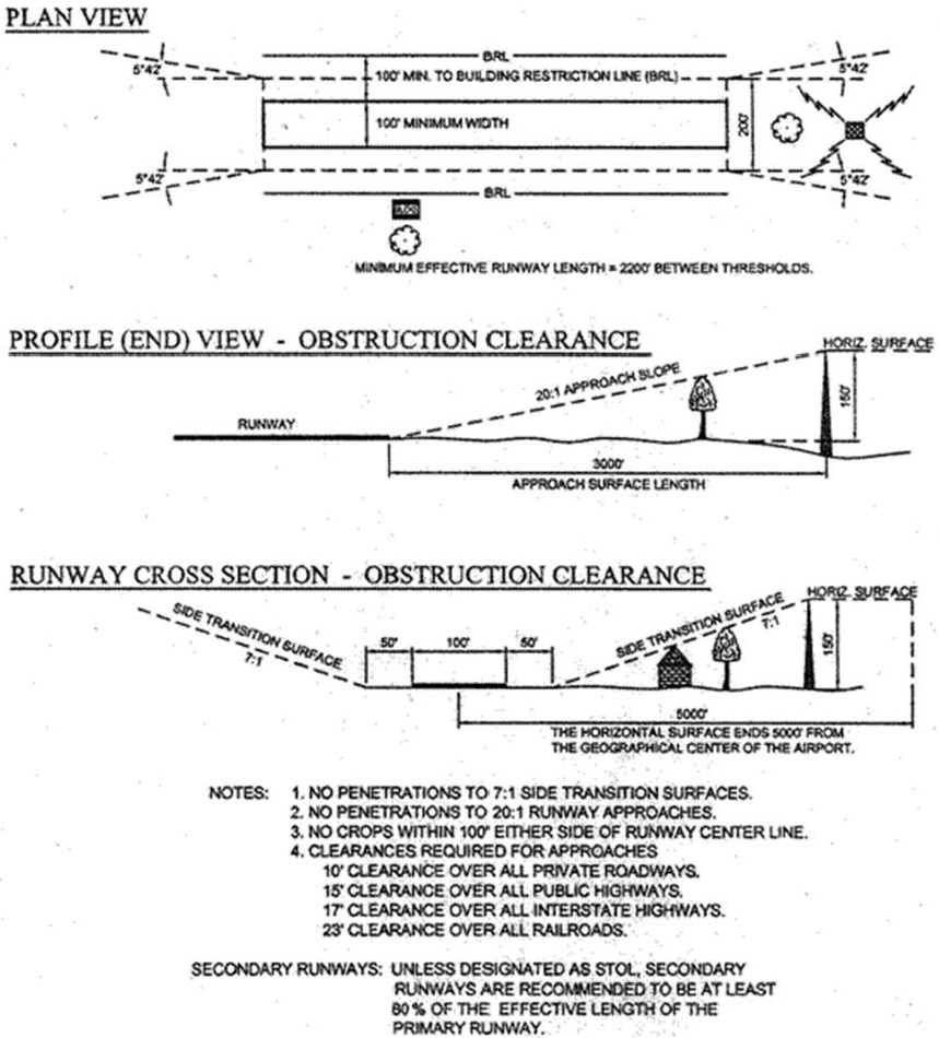
Illinois Administrative Code
Plan view—This shows the airport from overhead. The approach zones start at each end of the runway. The width of the approach zone starts at 200 feet and widens horizontally to 1,250 feet at 5,000 feet from the end of the runway.
Profile (end) view—Obstruction clearance—This is a side view of the runway with the approach zone extending from the end. The approach zone extends from each end of the runway at a 20:1 slope. For each 20 feet from the end of the runway, the height restriction increases by a foot. At 3,000 feet from the end of the runway, a maximum height limit is 150 feet. Between 3,000 feet and 5,000 feet from the end of the runway, the height maximum remains at 150 feet.
Runway cross section—Obstruction clearance—This illustrates the view from one end of the runway and the side transition surfaces rising on either side of the runway. Beginning 100 feet from the centerline of the runway, the side obstacle maximums increase in a 7:1 slope. For each seven feet, the obstacle maximum height increases by one foot until it reaches a maximum height of 150 feet. The 150 feet maximum height continues to 5,000 feet from the geographical center of the airport.
(Res. of 7-11-2024(4), Exh. A)