
Cochise County Unincorporated
City Zoning Code
City Zoning Code
2.51 SITE
DEVELOPMENT STANDARDS SDS
2.51.010 SDS ZONING PURPOSE
It is the intent of this article to set forth specific criteria, known as site development standards, with which all uses in all Zoning Districts must comply unless otherwise exempted in these Zoning Regulations. These standards are designed to protect surrounding properties from adverse impacts of the proposed use.
2.51.020 SDS INDEX WITH MINIMUM SITE AREA AND MAXIMUM DENSITY TABLE
- Site development standards applicable to each use in a Zoning District are found in the appropriate Article in these Zoning Regulations for that Zoning District and in this Article. They shall include, but are not limited to:
- Minimum Site Area and Maximum Density.
- Maximum Height, see applicable Zoning District.
- Setbacks, see applicable Zoning District. Setback Area and Easements, see Section 2.51.030.
- Maximum Site Coverage; see applicable Zoning District.
- Distance Between Buildings, see applicable Zoning District.
- Screening, see applicable Zoning District and Section 2.51.050.
- Off-Street Parking and Loading, see Section 2.51.040.
- Landscaping, see Section 2.51.060.
- Street Improvements, Access, and Traffic Circulation see Section 2.51.070.
- Sewage Disposal and Water Requirements, see Section 2.51.080.
- Floodplain and Drainage Requirements per Cochise County Floodplain Regulations, see Section 2.51.090.
- Outdoor Storage, see Section 2.51.100.
- Mobile Home, Manufactured Home, and Recreational Vehicle Parks see Section 2.51.110.
- Communications Facilities, see Section 2.51.120.
- Keeping of Livestock, see Section 2.51.130.
- Swimming Pools, see Section 2.51.140.
- Golf Courses, see Section 2.51.150.
- Land Clearing, see Section 2.51.160.
- Water Conservation Measures, see Section 2.51.170.
- Human Remains Protection, see Section 2.51.180.
- Wind Energy Systems, see Section 2.51.190.
- Wind Energy Power Plants, see Section 2.51.200.
- Solar Energy Systems, see Section 2.51.210.
- Solar Energy Power Plants, see Section 2.51.220.
- Marijuana Uses, see Section 2.51.230.
- Minimum Site Area and Maximum Density.
- Minimum Site Area. The minimum area of a site upon which a specific use(s) may be permitted.
- Easements may be included in the calculation of the minimum site area.
- Property that is transferred in fee simple to the public or to the County, as necessary to perfect adequate right-of-way for those roadways depicted on the Cochise County Maintained Road System Map, or right-of-way acquired by the County, or another public entity for some other public purpose, may also be included in the calculation of the minimum site area.
- A permit may be issued if the minimum site area deficiency can be attributed to surveyor error, as denoted the table below.
- See applicable Zoning District for additional information.
- Easements may be included in the calculation of the minimum site area.
- Maximum Density. See application Zoning District.
Minimum Site Area Deficiency TableZONING DENSITY MARGIN OF ERROR
0.00125 (Square Feet)MIN. PARCEL SIZE
SQUARE FEETMIN. PARCEL SIZE ACRES RU RU-2 108.9 87,011.10 1.9975 RU-4 217.8 174,022.20 3.995 RU-10 544.5 435,055.50 9.9875 RU-18 980.1 783,099.90 17.9775 RU-36 1,960.20 1,566,199.80 35.955 R R-9 11.25 8,988.75 0.2064 R-18 22.5 17,977.50 0.4127 R-36 45.0 35,955.00 0.8254 SM SM-9 11.25 8,988.75 0.2064 SM-18 22.5 17,977.50 0.4127 SM-36 45 35,955.00 0.8254 SM-87 108.9 87,011.10 1.9975 SM-174 217.8 174,022.20 3.995 SM-10 Acres 544.5 435,055.50 9.9875 SM-18 Acres 980.1 783,099.90 17.9775 SM-36 Acres 1,960.20 1,566,199.80 35.955 SR SR-8 10 7,990.00 0.1834 SR-12 15 11,985.00 0.2751 SR-22 27.5 21,972.50 0.5044 SR-43 54.45 43,505.55 0.9988 SR-87 108.9 87,011.10 1.9975 SR-174 217.8 174,022.20 3.995 SR-10 Acres 544.5 435,055.50 9.9875 SR-18 Acres 980.1 783,099.90 17.9775 SR-36 Acres 1,960.20 1,566,199.80 35.955 MR MR-1 or 2 4.5 3,595.50 0.0825
- Minimum Site Area. The minimum area of a site upon which a specific use(s) may be permitted.
2.51.030 SDS SETBACK AREA REGULATIONS
- Setback Area. The setback area may contain parking areas or loading spaces subject to the requirements of Section 2.51.040(6). The setback area may also contain landscaping, walkways, courtyards, driveway entrances (except as noted in Section 2.51.040(6,f,2)), open space, leisure activity areas, walls, fences, flagpoles, and screening. In residential areas, the setback may also include swimming pools (see Section 2.51.140), gardens, playground equipment, clotheslines, and storage incidental to the principal dwelling.
- Projections into Required Setback Area. Projections of structures into a required setback area shall not be allowed, except that on residentially developed sites:
- Cornices, eaves, and awnings may project not more than three feet over any required setback area, provided they are not closer than two feet to any property line.
- Window-type refrigeration units, suspended evaporative coolers, and furnaces attached to solar and similar equipment used for the dwelling may project not more than five feet into the required setback area, provided they are not closer than two feet to the property line.
- Rules Pertaining to Setback Areas.
- No space needed to provide a setback area may be sold, leased, bequeathed, or otherwise transferred apart from the site if the transfer would result in the site failing to comply with all applicable requirements of these Zoning Regulations, except that this section shall not apply to prohibit governmental acquisitions of property or the use of remaining property after such acquisitions.
- Adjustments – Lot Line and Common Wall Subdivisions. Setback areas between lots or parcels in a platted subdivision may be reduced or eliminated, thereby permitting lot line and common wall subdivisions so long as appropriate setback areas are maintained at the perimeter of the subdivision.
- Other Adjustments – Sharing Setback Areas. An owner of a site may enter into agreements with abutting landowners recorded on both properties in the office of the County, the Recorder to provide some or all the required setback area for both land uses, so long as the total setback equals the total requirement for both uses. The setback sharing agreement shall apply to the entire length of the affected property line and shall be binding on any future successors or assigns of the affected subject properties.
- Rules Pertaining to Easements. No structures shall be permitted within public easements.
2.51.040 SDS OFF-STREET PARKING AND LOADING
- Purpose. To alleviate traffic congestion and to provide for the parking of motor vehicles in all Zoning Districts, off-street parking and loading facilities shall be provided for buildings and uses erected or established after the date of these Zoning Regulations and for existing buildings and uses which are extended, enlarged, or changed thereafter.
- Basic Requirement for Off-Street Parking.
- Off-street parking shall be provided for any new building constructed or for any new use placed on a site. Parking must be established prior to operation and shall be maintained for the duration of the use.
- Whenever the use or area of an existing building is changed, additional off-street parking for the increased area or the use shall be provided in conformance with the standards set forth in this Section.
- The owner or occupant of an existing or proposed building or use subject to off-street parking requirements shall not discontinue or reduce any existing required parking area without first having established other parking space that meets all Zoning regulations' requirements.
- The use of any off-street parking space as required under these Zoning Regulations for storing merchandise, vehicles for sale or rent, or repairing vehicles shall be prohibited.
- Parking areas used for activities operating during hours of darkness shall be lighted, and all lighting must comply with Article 2.45.
- Methods of Providing Required Off-Street Parking. Subject to location requirements under Paragraph 6, required off-street parking may be provided by any one or combination of the following methods:
- By providing the required parking space on the same site as the building or use being served.
- By the collective provision of required parking for two-or-more buildings or uses, whereupon the total of such parking shall be not less than the sum of the requirements for the several buildings or uses computed separately; provided, however, that if two or more of such buildings or uses have operating hours that do not overlap, the County Zoning Inspector may grant a reduction of individual and collective requirements based upon the special circumstances involved. A written contract for joint use of such facilities shall be executed between the parties concerned, and a copy filed with the County Zoning Inspector.
- By securing the consent to use off-street parking facilities under another’s ownership, which is not otherwise used or required during the principal operating hours of the proposed building or use, provided. However, that consent shall be in written form and a copy filed with the County Zoning Inspector. In the case where off-street parking is proposed on an adjoining property but in a different Zoning District, the County Zoning Inspector shall make a determination that the parking in the adjoining district would not create any additional adverse impacts within that district. In the event the off-site spaces are or become unavailable, the owner shall provide additional parking to meet the requirement.
- Where parking is provided on a different site than the building or use as indicated above, the off-site area used shall not be used in computing the actual site area of the use or in satisfying any other site development standards than the provision of the parking area.
- Computation of Off-Street Parking Area.
- The minimum parking area for a site is the total area containing the required number of spaces plus that area required under Paragraph 9 (Parking Area Design Standards) for maneuvering vehicles.
- Where more than one use or activity takes place on a site, each of which would generate a different parking need according to the schedule in Paragraph 5 and each of which has a separate or definable floor area or area of use, the minimum required off-street parking area shall be the sum of the individual requirements for the several uses computed separately. Where it is not feasible to separate the uses on the site, the required off-street parking area shall be determined by the County Zoning Inspector.
- When the computation of parking requirements results in a fractional requirement, any fraction of less than one-half shall be disregarded, and any fraction of one-half or more shall be counted as one space.
- To calculate parking requirements related to fixed seating, each seat shall be 18-inches wide.
- Service bays are not considered a parking space.
- Schedule of Required Off-Street Parking. The minimum number of off-street parking spaces required for buildings, structures, and uses shall be determined according to the following schedule. For use not specifically listed, requirements shall be determined by the County Zoning Inspector.
USE MINIMUM OFF-STREET PARKING SPACES REQUIRED RESIDENTIAL Single-Household Dwellings, including Mobile Homes and Manufactured Homes 1-per dwelling unit Multiple-Household Dwellings 2-per dwelling unit Group Quarters 1-per five-beds Recreational Vehicle Parks 1-per-lot space Accessory Recreational Facilities 1 per 3,000-square feet of residential site area COMMERCIAL/OFFICE Motels, Hotels, Resorts, Guest Ranches, Group Camps 1-per guest room or suite of rooms plus 1 per three-employees in the largest working shift Restaurants, Bars, Taverns, Nightclubs, Winery Tasting Rooms 1 per 50-square feet of floor area, excluding areas designed for restrooms, storage, service, or other non-public purposes Automobile Service Stations 1-per-service bay Vehicle/Mobile or Manufactured Home Sales Lots 1 per 200-square feet of enclosed customer circulation area plus 1-per service stall Furniture Stores, Commercial Plant Nurseries, and Swap Meets 1 per 1,000-square feet of gross sales area Shopping Centers 5-spaces for each 1,000-square feet of gross leasable floor area Grocery Stores, Other Retail Trade of Merchandise, including Convenience Stores 1 per 250-square feet of gross floor area in Category A and B Areas; 1 per 350-square feet in Category C and D Areas Business Offices, Personal, Professional Services, Repair Services, Veterinary Clinics, Animal Hospitals 1-per 250-square feet of gross floor area in Category A and B Areas; 1-per 350-square feet in Category C and D Areas Hospitals, Residential Care Institutions 1-per two-patient beds plus 1-per 2-employees on the largest working shift Animal Husbandry Services 1-per 500-square feet of gross floor area Day Care Facilities, Day Care Establishments, Residential Care Facilities 1-per 5-persons of licensed capacity plus 1-per employee on largest working shift Mini-Warehouses 1 per 250-square feet of business office area in Category A and B Areas; 1 per 350-square feet in Category C and D Areas. To provide additional loading areas, the minimum width of access drives between buildings shall be 24 feet Junkyards 1-per each 50,000-square feet of storage area plus 1-per employee on largest working shift Impound Storage Yards 1-plus 1-per employee of largest working shift Unmanned Facilities 12-foot-wide unimproved driveway with one 9-foot by 19-foot unimproved parking space EDUCATION/PUBLIC ASSEMBLY Grades K-8 1.5-per classroom College and Vocational Schools 12-per classroom Other 1-per 500-square feet of gross floor area Churches or Places of Religious Worship 1-per 4-seats of maximum capacity in the sanctuary area Welfare and Charitable Services, Civic, Social, Fraternal and Business Associations 1-per 500-square feet of gross floor area Cultural, Historical, Nature Exhibits, and Stockyard/Auction Sales 1-per 500-square feet of gross floor area and exterior exhibit area Recreational Facilities, Indoor, and Outdoor 1-per 5-fixed seats or 1-per 5-persons at expected maximum capacity if seating is unfixed or a combination thereof Shooting and Golf Driving Ranges 1-per station Theaters 1-per 3-seats of spectator seating Fairgrounds, Amusement Parks 1 per 1,000-square feet of site area Bowling Alleys 4-per lane Tennis, Racquetball, Handball Courts 2-per court Health Clubs 1-per 250-square feet of gross floor area Golf Courses 3-per golf hole plus 1 per employee Jails, Prisons, Offender Rehabilitation Facilities 1-per every 25 inmates of design capacity plus 1-per employee in the largest working shift Cemeteries 1-per employee and ten additional spaces if no internal drives exist which can accommodate two passing vehicles INDUSTRIAL/OTHER Manufacturing, Wholesaling, Warehousing, Distribution and Storage of Goods 1 per employee plus 1 per 1,000-square feet of gross floor area or 1-per 3-employees in the largest working shift, whichever is greater Contract Construction Services 1 per 1,000-square feet of gross floor or display area plus 1 per facility vehicle Bus, Motor Freight, Taxi, Rail Terminals, and Airports 1-per 4-seats for waiting passengers plus 1-per 3-employees in the largest working shift - Restrictions as to Location and Placement of Non-Residential Parking Areas on a Site.
- Parking Areas – Location. Required off-street parking areas shall be located on or off the site within 300 feet of the building or use it is intended to serve. The distance is measured from the nearest point of the building or use. For non-residential uses, some or all the required parking areas may be located more than 300 feet from the building or use if, in the opinion of the County Zoning Inspector, the developer has provided appropriate and adequate access for the disabled and a reasonably safe means of access from all designated parking areas.
- Parking Areas – Separation from Abutting Residential Zoning Districts. Parking areas containing 10 or more parking spaces on a site directly adjacent to residentially-zoned sites shall be located no closer to the boundaries of such adjacent residentially zoned site unless that site is currently developed with a non-residential use:Provided, however, that the above separation distances may be eliminated by the construction of a six-foot-high solid wall or fence at or near the boundary of the two sites.
NUMBER SPACES FOR PROPOSED USE SEPARATION 10-25 spaces 30-feet 26-75 spaces 40-feet 76 or more spaces 50-feet - Parking Area Within Site Boundary. Irrespective of the District in which it is located, every part of a parking area shall be set back from every site boundary at a sufficient distance to ensure that no part of any parked vehicle will project over any site boundary.
- Access to Parking from a Street. There shall be no direct access to any off-street parking space from a street.
- Access to Parking from an Alley. Any parking area may use an abutting alley for direct access to parking spaces. The developer may be required to improve the alley to the Cochise County, Highway & Floodplain, Road Design & Construction Standards & Specifications for Public Improvements.
- Driveway Design and Location.
- Driveways to a parking area from a street shall be limited to definable entry and exit driveways.
- No driveway entrance or exit to a parking area shall be located closer than 15 feet to an adjacent residentially zoned site.
- The minimum width of a one-way driveway to a street shall be 12 feet. The minimum width of two-way driveways shall be 24 feet. For an unmanned facility where there will be no more than one vehicle servicing the equipment, a one-way driveway (12 feet wide) is acceptable.
- For driveway access to streets, see Section 2.51.070(2).
- Parking and Loading Area Improvements.
- Single-Household Dwellings and Unmanned Utility Facilities. Single-household dwelling sites and unmanned utility facilities shall be exempt from parking area surface improvement requirements.
- Category A (Urban Growth) Areas. Except as noted below, every parking and loading area and all driveways for sites within a Category A (Intensive Growth) Area shall be paved with asphaltic concrete or with an equivalent or better material approved by the County Zoning Inspector. These shall be properly drained to prevent impoundment of surface water and shall conform to the design standards of Paragraph 9 herein. A two-inch thick gravel surface, or equivalent or better surface, if approved by the County Zoning Inspector, properly drained to prevent impoundment, shall be allowed if the site takes primary access off of a dirt or gravel road. If any of the roads accessed by the use are improved with a double bituminous surface treatment or better, any expansion of the use requiring a building permit or a change of use shall require that all existing and required additional parking and loading areas and driveways be improved per the standards in this section within six-months from the date of building permit issuance for the expansion.
- Category B (Community Growth) Areas. Except as noted below, every parking and loading area and all driveways for sites within a Category B (Community Growth) Area shall be paved with double bituminous surface treatment (modified pavement) or with an equivalent or better treatment approved by the County Zoning Inspector. These shall be properly drained to prevent impoundment of surface water and shall conform to the design standards of Paragraph 9. A two-inch thick gravel surface, or equivalent or better surface approved by the County Zoning Inspector, properly drained to prevent impoundment, shall be allowed if the site takes primary access off a dirt or gravel road. If any of the roads accessed by the use are improved with a double bituminous (“chip seal”) surface treatment or better, any expansion of the use requiring a building permit or a change of use shall require that all existing and required additional parking and loading areas and driveways be improved per the standards in this section within six months from the date of building permit issuance for the expansion.
- Category C (Rural Community Growth) and D (Rural) Areas. Except as noted below, every parking and loading area and all driveways for all sites in Category C (Rural Community Growth) Areas and Category D Areas shall be improved with a two-inch thick gravel surface or with an equivalent or better surface approved by the County Zoning Inspector and shall be properly drained to prevent impoundment of surface water. Parking areas with gravel surfaces need not be striped. If the lot is paved, it shall conform to the design standards of Paragraph 9.
- Outdoor Storage and Display Area Improvements of Vehicles, Materials, or Equipment. Areas of a site reserved or used for the outdoor storage and/or display of vehicles, materials, or equipment shall be improved with at least a dust-free, gravel surface or with an equivalent or better surface approved by the County Zoning Inspector. Permits are not required for structures in a permitted display area unless they are to be occupied. Permits are required for signs.
- Parking Area Design Standards. Except as otherwise specified herein, every required off-street parking space shall have a minimum width of nine feet and a minimum length of 19 feet, exclusive of driveways and aisles. The parking space length may include allowance for vehicle overhang of a curb or planter area up to a maximum of three feet, provided that the vehicle may not encroach upon a street, sidewalk, or another parking space, driveway, or parcel. The County Zoning Inspector may deviate from these measurements if there are unusual circumstances to warrant the deviation.
- Parallel parking spaces shall have a minimum width of nine feet and a minimum length of 22 feet.
- Angle parking shall be designed as illustrated in Figure 18.1
- Row Ends: Dead space at the end of each row shall be clearly separated from any driveway or aisle and either landscaped or striped to prevent encroachment from vehicular traffic.
- First parking space for angle parking: 10-feet minimum distance from the property line to the beginning of the stall.
- Striping: Minimum requirement for marking parking spaces shall be single line striping four inches in width.
- Parking for the disabled, including an accessible route to the main entrance of the building that is the subject of these parking requirements, shall be provided in accordance with applicable State and Federal laws.
90° Parking Space Angle - 9’ x 19’ parking Space - Aisle Width 24.’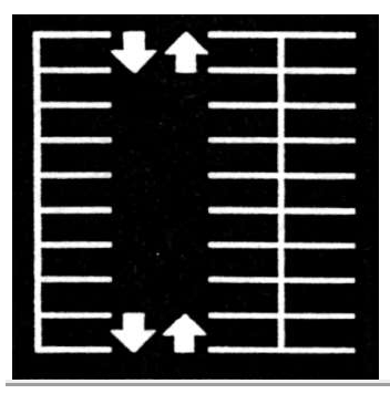
60° Parking Space Angle - 9’ x 19’ parking Space - Aisle Width 18.’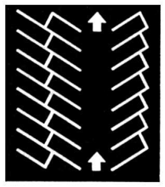
30° Parking Space Angle - 9’ x 19’ parking Space - Aisle Width 12.'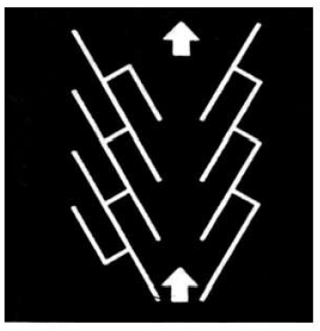
- Off-Street Loading Requirements.
- Necessity. In all Zoning Districts, for every use, building, or part thereof, erected or enlarged after the effective date of these Zoning Regulations, which is occupied or to be occupied by a use requiring receipt or distribution of materials or merchandise by motor truck, there shall be provided and maintained on the same site as the building or use, adequate off-street loading space meeting the minimum requirements hereinafter specified or at the discretion of the County Zoning Inspector. Loading shall be in addition to the requirements for minimum parking area.
- Provision of Loading Spaces.
Total Floor Area of Building (Square Feet) Number of Loading Spaces Required 1,000 to 9,999 square feet 1 10,000 to 29,999-square feet 2 30,000 to 49,000-square feet 3 50,000 or more square feet 4 - Measurement of Loading Space. Every required off-street loading space shall have a minimum width of 12 feet and a minimum length of 45 feet, exclusive of access aisles and maneuvering space, and a minimum clear height of 14 feet.
- Location of Loading Space. The required off-street loading space(s) will be an integral part of the internal traffic circulation pattern of the site; it may occupy any part of the site and may be partially or entirely enclosed within a building.
- Use of Alley for Maneuvering Space. Where a building or use in a non-residential district requiring off-street loading space abuts an alley, such alley may be used for maneuvering space for loading and unloading spaces. The developer may be required to improve the alley to the standards identified in Paragraph 7.
Amended by Ord. 12-10 (R-12-02) on 8/20/2012
Amended by Ord. 14-04 (R-14-06) on 5/6/2014
Amended by Ord. 14-10 (R-14-08) on 12/2/2014
Amended by Ord. 16-02 (R-16-01) on 7/26/2016
2.51.050 SDS SCREENING
- Purpose. Screening shall be used to reduce the negative impacts of one use upon another, particularly non-residential uses on residential ones; to preserve property values; to screen adverse views of buildings, parking, and storage areas; to protect the scenic value of the community; and to allow a greater mixture of uses, which may otherwise be incompatible.
- Screening Material. Screening includes solid walls and fences, or any combination thereof, that cannot be seen through and are a minimum of six feet in height from grade. The screen shall be constructed out of standard materials or other acceptable materials approved by the County Zoning Inspector. An existing vegetative screen on the subject site may be approved by the County Zoning Inspector if it meets the intent of creating a solid screen.
- Screening Placement. Screening, where required by these regulations, will be placed and maintained, subject to the requirements set forth below.
- Sight Distance at Intersections. No screening shall present traffic visibility hazards within the sight triangle as described in Section 2.51.070(6) of these Zoning Regulations.
- Maintenance of Screening. All required screening shall be maintained by the owner for the duration of the use or until such time as the abutting site protected by the screening is developed in such a manner that screening is no longer required between the abutting sites.
- Refuse Collection Areas. All refuse collection areas related to non-residential uses shall be screened from view from all public streets and surrounding properties except for one approved access opening.
- Screening in Floodplain Areas. If a Floodplain Use Permit is required, the screening material could begin six inches above the grade.
- Deferred Screening. In areas where screening is required by these Zoning Regulations but has been deferred by the County Zoning Inspector due to an abutting residentially zoned site being undeveloped, the screening shall be installed within six months of such development on the adjacent parcel.
2.51.060 SDS LANDSCAPING
- Purpose. It is the purpose of this section to establish minimum standards for the provision, installation, and maintenance of landscaping on the undeveloped portion of parcels or within the interior of large parking areas. Landscaping enhances the visual and environmental character of the County and further promotes the control of erosion, reduction of glare and dust, moderation of climate and noise, detention of storm water, the visual softening of building masses, as well as enhancing property values.
- Placement of Landscaping.
- Exemptions. The following shall be exempt from the installation and maintenance of landscaping:
- Single-household dwelling sites in all Growth Category Areas
- Uses within the Category C and D Areas
- Category A and B Growth Areas. All uses in Category A (Urban Growth) and Category B (Community Growth) Areas shall have landscaped a minimum of five percent of the total developed area of a site. The landscaping shall be integrated into the developed area and shall include a minimum five-foot-wide strip along the abutting street(s). Landscaping shall be approved as part of building permit approval.
- Sight Distance at Intersections. No landscaping shall present traffic visibility hazards within the sight triangle as described in Section 2.51.070(6).
- Exemptions. The following shall be exempt from the installation and maintenance of landscaping:
- Landscaping, Planting, and Maintenance Requirements. When landscaping is used, the following specific planting and maintenance requirements shall apply:
- No trees shall be planted under overhead utility wires if their mature height will interfere with those wires.
- Earth berms shall have adequate plant material or ground cover treatment to prevent erosion.
- Trees shall not be less than five gallons in size or comparable height if bare root at planting time.
- Shrubbery used for required landscaping shall be a minimum of one gallon in size.
- Landscaping construction must be completed with all other permitted building construction unless extended by the County Zoning Inspector.
- Retention of native vegetation in a natural drainage channel shall satisfy the landscaping requirement for such an area.
- All landscaping shall be maintained for the duration of the use or uses on the site.
- All plants used in landscaping shall be chosen from the County’s approved list of drought-tolerant plant species or similar plants that have been specifically approved by the County Zoning Inspector.
- All landscaping shall comply with applicable provisions of Section 2.51.170.
- Irrigation Requirements.
- Purpose. The irrigation system and its related components shall be planned and designed to allow for proper installation, management, and maintenance. It shall meet all the requirements listed in this section and the manufacturers’ recommendations. The design, installation, service, and operation of the irrigation shall be in a manner that promotes the most efficient use of water and applies the least amount of water that is required to reduce dust, control erosion, as well as maintain healthy landscape plants.
- General Requirements. An irrigation design plan meeting the following design criteria shall be submitted as part of the landscape documentation package.
- All irrigation systems shall be designed, installed, maintained, altered, repaired, serviced, and operated in a manner that will promote water conservation.
- Irrigation systems and watering schedules shall supply the appropriate amount of water without over-watering.
- Water running off a landscaped area to another area where the water is not beneficially used, such as onto streets, sidewalks, gutters, alleys, public utility easements, or public or private parking areas, is prohibited.
- The irrigation plan must show that the irrigation system provides complete coverage of all areas to be irrigated. While head-to-head coverage is recommended, sprinkler spacing shall be designed to achieve the highest possible distribution uniformity using the manufacturer’s recommendations. In addition, the design of the irrigation system shall conform to the hydrozones of the landscape plan.
- The irrigation systems shall be designed to ensure that the operating pressure at each emission device is within the manufacturer’s recommended pressure range for optimal performance.
- Irrigation should be avoided during windy or freezing weather or during rain.
- Property owners shall repair water leaks upon their property within fourteen (14) days after discovery.
- System Requirements.
- Pop-up spray heads or rotary sprinkler heads must direct flow away from any adjacent surface and shall not be installed closer than four inches from a hardscape, such as, but not limited to, a building foundation, fence, concrete, asphalt, pavers, or rocks.
- All new automatically controlled irrigation systems must include sensors or other technology designed to suspend or interrupt the operation of the irrigation system during periods of moisture or rainfall. Rain or moisture shut-off technology must be installed according to the manufacturer’s published recommendations. Repairs to existing automatic irrigation systems that require the replacement of an existing controller must include a sensor or other technology designed to inhibit or interrupt the operation of the irrigation system during periods of moisture or rainfall.
- Backflow prevention devices shall be required to protect the water supply from contamination by the irrigation system and shall comply with local plumbing codes.
- Manual shutoff valves (such as a gate valve, ball valve, or butterfly valve) shall be required, as close as possible to the point of connection of the water supply, to minimize water loss in case of an emergency (such as the main line break) or routine repair.
- Narrow or irregularly shaped areas, including turfgrass areas, less than ten feet (10 ft) in dimension in any direction shall not utilize overhead sprinkler irrigation.
- Plan Requirements. The irrigation plan, at a minimum, shall include each of the following:
- A scaled plan showing property lines, easements, existing or proposed structures, impervious surfaces, and significant existing natural features.
- Location, type, and size of all components of the irrigation system, including backflow preventer, flow sensor, master valve, smart irrigation controllers, main and lateral lines, manual valves, remote control valves, sprinkler heads, moisture sensing devices; end caps; quick couplers, and pressure regulators.
- An irrigation legend showing the identification of irrigation components.
- Installation details for each of the irrigation components.
- Reclaimed Water. Reclaimed water may be used, and is encouraged for use, in irrigation systems provided compliance with all the following:
- There is no direct contact with edible crops unless the crop is pasteurized before consumption.
- The irrigation system does not spray water across property lines that do not belong to the irrigation system’s owner.
- The irrigation system is installed using purple components.
- Backflow prevention on the reclaimed water supply line shall be in accordance with the County’s adopted plumbing code.
- A notice is prominently posted on/in the area that is being irrigated that reads, “RECLAIMED WATER - DO NOT DRINK” and “AGUA DE RECUPERACIÓN - NO BEBER”.
2.51.070 SDS STREET IMPROVEMENTS, ACCESS STANDARDS, AND TRAFFIC CIRCULATION
- Purpose. It is the purpose of this section to coordinate the development of land uses in accordance with policy guidelines adopted under the Comprehensive Plan. Standards are designed to reduce safety hazards, lessen traffic congestion, limit total usage to the traffic carrying capacities of arterial and collector streets, provide a suitable location for land uses, provide adequate and safe access to uses, and minimize other negative impacts of development.
- Location and Nature of Access Points to Streets. The following specific access requirements shall apply to the development of sites under these Zoning Regulations:
- Permanent Legal Access. No building permit for non-residential use shall be issued unless a site has direct permanent access to a publicly maintained street or to a street where a private maintenance agreement is in place.
- Access to Arterial Streets. Within a Category A or B Growth Area:
- No use shall take direct permanent access onto an arterial street at any point within 200-feet of a street intersection.
- No use shall take direct permanent access onto an arterial street unless in conformance with the Cochise County, Highway & Floodplain, Road Design & Construction Standards & Specifications for Public Improvements.
- Development of a site should not result in the placement of excessive drives or streets on that site with direct access to an arterial street.
- If the site has more than 500 feet of frontage along an arterial street, it shall be entitled to one access point. Additional access points may be approved by the County Engineer if the arterial street is County maintained and the additional access points comply with the Cochise County, Highway & Floodplain, Road Design & Construction Standards & Specifications for Public Improvements.
- If the site contains less than 500 feet of frontage along an arterial street, the property owner or his agent shall be required to enter into a sharing agreement of record with surrounding property owners.
- The location or an alternative may be approved by the County Engineer if the arterial street is County maintained and the location or alternative complies with the Cochise County, Highway & Floodplain, Road Design & Construction Standards & Specifications for Public Improvements.
- MT, Major Thoroughfare Overlay District.
- Purpose. MT (Major Thoroughfare) Overlay Zoning Districts are established to achieve the following purposes:
- To preserve the traffic flow and reduce the vehicle conflict points on designated arterial streets, which are necessary to move high volumes of traffic.
- To minimize disruption of traffic flow and the creation of additional turning movements onto and off a designated MT.
- To reduce the number and location of direct access points and streets connecting to a designated MT.
- Identification. The area zoned as an MT Overlay Zone will be identified by its underlying zone designation plus the suffix “MT.”
- Permissible Uses. This zone, when overlaid upon any Zoning District, shall allow those uses permitted in the underlying Zoning District but shall subject those uses to the additional requirements of this Section.
- Procedure and Scope.
- Any street or portion thereof, which is determined by the Board of Supervisors as being necessary to handle high volumes of traffic or to move through traffic, may be designated as an MT.
- A Major Thoroughfare Overlay Zoning District (MT) shall be formed in the same manner as any other Zoning District. All parcels of land abutting or having direct access to the street or portion thereof designated as an MT shall be part of the MT overlay Zoning District and subject to the requirements herein.
- Development Standards in an MT District.
- All new development or redevelopment of lots abutting an MT but having permanent legal access onto another street, public alley, or private driveway easement shall take access via the alternate access; and a one-foot no-access easement shall be recorded or shown on the site plan along the property boundary with the MT as a part of permit approval to preclude future access.
- All new residential subdivisions with individual parcels in an MT overlay zone shall be designed and constructed, so that said MT lots take access off a street other than the MT. Streets connecting such subdivisions to the MT shall be designed to accommodate traffic and minimize disruption of traffic on the MT.
- All such MT subdivision lots abutting the MT shall be screened with a six-foot high screen wall or fence or such equivalent screening approved by the County Zoning Inspector to reduce the noise, light, and air pollution impacts of the MT.
- No permit shall be issued for any non-residential use on a lot created after November 1, 1984, with less than 200 feet of frontage along the MT if such a lot must take direct access to the MT.
- No use permit shall be issued unless a provision is made for all parking to be on-site. Nothing herein shall preclude the consolidation or sharing of parking areas on adjoining sites.
- Purpose. MT (Major Thoroughfare) Overlay Zoning Districts are established to achieve the following purposes:
- Street Improvements – MT and Other Areas.
- For all uses, other than the development of a single residential site, developers shall construct those off-site improvements related to traffic and safety needs resulting from the development of the site. Said improvements may include but are not limited to the dedication of streets and alleys, construction of streets or additions to streets, widening of streets, traffic control signals and other devices, turn lanes and turn bays, drainage improvements, pavement, or dust abatement. The type and extent of improvements shall be based upon:
- The amount and type of additional traffic that will be generated by the development of the site.
- Any adverse effect upon traffic flow along the street abutting the site resulting from traffic entering and leaving the site.
- The ease and safety of vehicles entering and leaving the site.
- Conformity to applicable provisions of the Comprehensive Plan, Area Plan, traffic circulation plan, and/or any approved master development plan.
- Existing and anticipated traffic patterns along the street(s); and
- The Plan Area and Zoning District in which the site is located.
- The levels of improvement and design requirements of the Cochise County Road Construction Standards for Public Improvements shall be used as a guide in determining the minimum extent of improvements under Paragraph 4,a above.
- If the proposed use is of such magnitude as to significantly reduce the level of service on a street or streets, or if it is likely to cause a substantial increase in traffic or congestion, the County Engineer may require a traffic impact analysis from the developer before a building permit is issued. The traffic impact analysis shall be prepared by a Registered Engineer and shall describe the site and all surrounding streets, intersections, and access points; existing traffic conditions showing daily or peak hour volumes; and the transportation impact of the development, including its effect on service levels for all streets impacted by the proposed project. Developers shall then be required to construct improvements as may be necessary to address all of the issues identified in the study.
- If both the County Engineer and the County Zoning Inspector are in agreement that the construction of some or all of these improvements may be delayed without giving rise to an unreasonable risk to health and safety and without adversely impacting traffic flow in the area during a foreseeable time period, the County Zoning Inspector is authorized to enter into an agreement with the developer, at the developer’s request, which may phase the completion of these improvements over an extended period of time, not to exceed 10-years.
- If the proposed development is of such magnitude as to significantly affect drainage flow conditions on abutting streets, the County Engineer shall require the submittal of a drainage study specifically addressing the effect of site drainage on the street(s) both before and after development. The developer will be required to construct such improvements as may be necessary to mitigate any adverse drainage impacts.
- For all uses, other than the development of a single residential site, developers shall construct those off-site improvements related to traffic and safety needs resulting from the development of the site. Said improvements may include but are not limited to the dedication of streets and alleys, construction of streets or additions to streets, widening of streets, traffic control signals and other devices, turn lanes and turn bays, drainage improvements, pavement, or dust abatement. The type and extent of improvements shall be based upon:
- Internal Circulation. The location of all buildings, structures, landscaping, access points to and from the site, and internal traffic circulation shall be arranged so that traffic congestion is avoided and vehicular and pedestrian safety is protected.
- Sight Triangles.
- Purpose. Define the area adjacent to intersections that must be clear of a visual obstruction to assure safe turning movements and a clear line of sight for drivers.
- Calculation of Sight Distance Triangle. The sight distance triangle shall be determined for each controlled street or driveway that intersects a through or uncontrolled street. The determination of this sight distance triangle shall be made according to the minimum sight distance at the intersections chart and diagram below or as designated by traffic or civil engineer.
POSTED THROUGH SPEED X DISTANCE 25 MPH 280 FEET 35 MPH 390 FEET 45 MPH 500 FEET 55 MPH 550 FEET 65 MPH 650 FEET 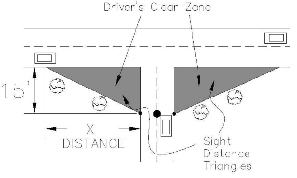 Step 1. On your scaled site plan, show your driveway or street intersection through the street. Indicate a point center of your driveway or street located 15 feet back from the edge of the curb line, edge of the pavement, or edge of travel way.
Step 2. Identify the speed limit through the street. Connect the driveway CenterPoint to the curb, line, edge of the pavement, or edge of travel way for a scaled distance noted in the table above in both directions.
Step 3. Shade that triangle area in. Make sure that no visual obstructions are placed in that area. - Preservation of Sight Distance Triangle Area. No screening, landscaping, vegetation, structures, parking areas, or other obstruction to visibility between the heights of 3 and 10 feet above the top of the curb or centerline grade of the street shall be permitted within the clear zone, as defined by the sight distance triangular area. The development shall be set back or restricted to provide a clear sight distance.
2.51.080 SDS SEWAGE DISPOSAL AND WATER REQUIREMENTS
All uses shall be in compliance with all statutes and regulations of the State, State agencies, the County, and County agencies, governing sewage disposal and water systems. Written assurance from the provider of sewer and water utilities is required for uses on community water and sewer systems.
2.51.090 SDS FLOODPLAIN AND DRAINAGE REQUIREMENTS
All uses shall be in compliance with all Federal, State, and County floodplain requirements and regulations, including any floodplain regulations duly adopted by the Board of Supervisors and administered by the Cochise County Highway and Floodplain Department.
2.51.100 SDS OUTDOOR STORAGE
- Residential Uses. It shall be the intent of this Section to provide acceptable limits of outdoor storage accessory to residential uses based upon the Comprehensive Plan Growth Category Area in which located. Nothing in this Section shall apply to the accessory storage of objects and materials within a completely enclosed building or structure, such as a garage or shed, or to the residential accessory storage of objects and materials that as a result of fencing, topography, or natural vegetation are not visible by the unaided eye six feet above ground level from any other property or street.
- Accessory Use Outdoor Storage and parking, which is permitted under this Section, is an accessory use only and shall not be permitted unless a primary residential use of the property has been established except for limited storage of equipment specifically used for road or property maintenance in Category B, C or D Areas.
- Permitted Visible Outdoor Storage of certain objects and materials shall only be permitted as an accessory use as specified below. Additional amounts of visible outdoor storage are permitted as specified below.
- Automobiles.
- Category A Areas. Licensed and titled automobiles are allowed for personal use.
One unlicensed or inoperative automobile that is titled or registered to the owner or occupant is permitted. If more than one, they cannot be visible by the unaided eye six-feet above ground level from any adjoining property or street and must be located in the rear yard. Said automobiles cannot be stored for commercial purposes. - Category B, C, and D Areas. Any number of automobiles titled or registered to the owners or occupants of the parcel may be stored, provided they are not stored for commercial purposes.
- Hazard/Nuisance. All automobiles and automobile parts and tires must be parked or stored in such a manner as not to constitute a hazard or nuisance. The non-accessory use of outdoor storage of any site on which the storage, keeping, salvage, sale, or abandonment of junk occurs, including tires and auto parts, constitutes a public nuisance.
- Category A Areas. Licensed and titled automobiles are allowed for personal use.
- Construction Materials. In all areas, construction materials and equipment may be stored temporarily, provided that said materials/equipment are for on-site use pursuant to a current valid building permit. All building or construction materials and equipment shall be removed within 30-calendar days of completion of construction, issuance of a certificate of occupancy (where applicable), or expiration of the building permit, whichever occurs first. Construction debris shall not be permitted to scatter or blow onto another property.
- Furniture and Appliances. In all areas, furniture, appliances, playground equipment, and other incidental household items may be placed outside (Note: Items in excess of these requirements shall be permitted only to the extent provided for in Paragraph 1,c below) provided that:
- All appliances are in operating condition and are connected for the private use of the resident/occupant in such a manner as not to constitute a fire or safety hazard.
- Any furniture is placed outside for personal on-site use only (rather than for storage).
- Automobiles.
- Other Permitted Outdoor Storage. Except for the visible outdoor storage permitted above, outdoor storage of objects and materials shall be permitted as follows:
- Category A Growth Areas for Residentially Developed Properties. Visible outdoor storage not to exceed 60-square feet in area and four feet in height.
- Category B, C, and D Growth Areas for Residentially Developed Properties. Visible or screened accessory outdoor storage shall be permitted.
- Large Trucks, Truck Tractors, Construction Equipment.
- Category A Areas. The outdoor storage or parking of any trucks, truck tractors, trailers, or semi-trailers having a rated capacity of more than one and one-half (1.5) tons and the parking or storage of any construction equipment (except as provided on a temporary basis in Paragraph 1, b, 2, above) such as bulldozers, graders, cement trucks, towable compressors, dump trucks, and backhoes shall not be permitted in any residential Zoning Districts in a Category A (Urban) Growth Area.
- Category B, C, and D Areas. No primary residential use is required for limited storage of equipment used for road and property maintenance in rural or residential Zoning Districts subject to the following requirements:
- A minimum lot size of 36,000 square feet is required
- No more than 600 square feet of the property shall be used for storage
- The storage shall meet the minimum setbacks of the zoning district
- Non-Residential Uses. For site development standards relating to outdoor storage for non-residential uses, see Section 2.51.040(8) (Outdoor Storage Area Improvements) and applicable Zoning District Articles.
2.51.110 SDS MOBILE HOMES, MANUFACTURED HOMES, AND RECREATIONAL VEHICLE PARKS
The following site development standards shall apply to Mobile Home, Manufactured Home, and Recreational Vehicle Parks or any combination thereof (collectively referred to as “Parks”).
- Maximum Density of Parks. The maximum density shall be the maximum density specified in the Zoning District in which the Park is located.
- Space Size, Width, and Setbacks. Within Parks, there shall be no minimum individual space size and no minimum individual space width. The minimum setback for all units and other structures from the space boundary shall be seven and one-half feet. The minimum setback from all streets and from the perimeter of the Park shall be 10 feet.
- Distance Between Structures. Except as otherwise provided in these Zoning Regulations, a minimum distance between principal structures shall be 15 feet. Nothing herein shall prevent the permanent attachment of principal structures.
- Maximum Height. Principal structure: 30 feet above grade Accessory structure: 20 feet above grade Wall or fence: eight feet above grade
- Site Coverage. Within a Park, the maximum site coverage shall be 55 percent for each residential space and for the entire Park, exclusive of rights-of-way and recreational areas. The maximum site coverage for recreational areas shall be 75 percent.
- Screening. A six-foot high solid wall, fence, or existing vegetative equivalent, or any combination thereof, shall be provided along all Park boundaries, except at vehicle and pedestrian access locations. Such screening shall not encroach upon the sight triangles.
- Interior Streets. All two-way interior drives or streets within a Park shall be not less than 24 feet in width. One-way drives or streets shall be not less than 12 feet in width and shall be properly signed.
- Parking. Parking shall be provided in accordance with Section 2.51.040.
- Access to Exterior Streets. No space within a Park shall have direct vehicular access to a street bordering the Park.
- Sidewalks and Pedestrian Paths. Sidewalks or pedestrian paths shall be placed on at least one side of all internal drives or streets for Parks within a Category B Growth Area and on both sides for Parks situated within a Category A Growth Area.
- Skirting in Parks. Skirting shall be required for each mobile/manufactured home in a Park.
- Landscaping. In all Parks, the entire Park shall be landscaped in accordance with Section 2.51.060. The developer must provide a landscape plan as part of the permit application.
- Recreational Facilities in Parks. No less than ten (10) percent of the gross area of any Park established under these Zoning Regulations shall be devoted to common recreational areas and facilities, such as playgrounds, swimming pools, community buildings, or common open spaces.
- Accessory Structures and Uses. Accessory structures and uses intended primarily to serve the needs of persons within the Park, including retail trade, recreational facilities, laundry areas, restaurants, other personal services, Park offices, and maintenance and storage areas, shall be permitted, provided they are designed and located to protect the residential character of the district and surrounding residential districts. The sites upon which said retail uses and personal services are located shall not, in the aggregate, exceed five percent of the gross area of the Park. All outdoor Park maintenance areas shall be enclosed by a six-foot high solid screen.
2.51.120 SDS COMMUNICATIONS FACILITIES
- Existing Towers. A communication tower in existence prior to the effective date of the 1999 revised Zoning Regulations will not require a Special Use or building permit if located in an applicable Zoning District.
- Design.
- All new communication facilities will be designed by a Registrant licensed by the State of Arizona.
- For towers up to 150 feet in height, the structure shall be designed to accommodate at least two providers.
- For towers greater than 150 feet in height, the structure shall be designed to accommodate at least three providers.
- Certification.
- Affidavits will be provided to show conformance with all Federal Aviation Administration (FAA) requirements regarding lighting and marking so as not to create a hazard to air navigation.
- Affidavits will be provided to show conformance with all Federal Communications Commission (FCC) technical emissions standards and licensing requirements, including radio frequency data.
- Prior to permit issuance for new communication equipment on an existing tower, a certificate, report, or plan prepared and stamped by an Arizona-Registered Professional Engineer will be provided by the Applicant that indicates the equipment and tower will meet minimum safety standards regarding deflection and survival specs at the proposed antenna load and with regard to potential electrical hazards.
- Setbacks. Communication facilities must be setback from all parcel boundaries, lease boundaries, and rights-of-way at a distance equal to at least the height of the tallest structure in the facility, measuring from its base. No setbacks are required between communication facilities located on the same parcel.
- Minimum Site Area Requirements. Communication facilities will be exempt from the Zoning Districts’ minimum site area requirements.
- Maximum Height. In those Zoning Districts where communication towers are permitted use, the towers shall be limited to the maximum allowable height of the Zoning District unless otherwise noted in that District. There shall be no limit to the requested maximum height of a tower seeking approval through the Special Use Authorization process.
- Noise or Vibration. No noise or vibration (other than normal vehicular traffic) will be permitted, which is discernible on neighboring residential sites to the unaided human senses for three minutes or more duration in any one-hour of the day between the hours of 7:00 a.m. and 7:00 p.m. or 30-seconds or more duration in any one hour between the hours of 7:00 p.m. and 7:00 a.m.
- Removal of Abandoned Communication Facilities. Any facility that is not operated for a continuous period exceeding twelve months will be considered abandoned, and the owner of such facility will remove the structure(s) within 90-calendar days of receipt of notice from the County Zoning Inspector.
2.51.130 SDS KEEPING OF LIVESTOCK
Livestock for private use may be kept in all Zoning Districts, provided that:
- The site contains not less than 36,000 square feet of area. The temporary care and feeding of two or fewer animals for 4-H or similar projects shall be exempt from this requirement.
- Animals shall be kept confined by fences or other restraints of sufficient strength and durability or be otherwise under the control of the owner or keeper to prevent such animals from roaming at large unless otherwise exempted by Article 2.57 of these Zoning Regulations or the Arizona Revised Statutes.
- Stables/barns (both enclosed and unenclosed), corrals, piles of manure, and areas where livestock may concentrate, such as feeding and shade structures, shall be set back from the property line a minimum of 50 feet. Perimeter fences are not considered corrals unless used to confine animals within 50 feet of the property line.
- Roping Arenas or other areas which are used occasionally, intermittently, or for specific purposes other than livestock living and congregating areas will be considered an accessory use and set back from the property line per Zoning District requirements. If the arena is used as a stable, corral, or livestock living area or becomes a place where piles of manure may accumulate, it shall be set back 50 feet from all property lines.
- Nothing contained herein shall relieve the owner or keeper of such animals from complying with all applicable rules and regulations of the County Health Department or others having jurisdiction.
2.51.140 SDS SWIMMING POOLS
Swimming pools shall be permitted in all Zoning Districts, provided applicable site development standards in the individual Zoning District article have been met. For single-household dwelling sites, swimming pools may be allowed in the side, or rear setback area provided the edge of a swimming pool shall be no closer than seven-feet to any property line. Every swimming pool shall demonstrate compliance with all regulations contained in the Arizona Revised Statutes. Every swimming pool shall be enclosed by a fence or wall not less than five feet in height, which is constructed, gated, and locked so as to discourage unauthorized entry to such pool. All new pools shall have a cover. Pools shall be covered when not in use to minimize evaporation.
2.51.150 SDS GOLF COURSES
- Design. For all new golf courses and additions to existing golf courses, the area of irrigated grasses, the “turf area,” used for the greens, fairways, practice areas, borders, and all other uses associated with the golf course, shall be limited. The total turf area of the golf course and associated uses shall be limited to an average of five-irrigated acres per golf hole. The maximum usage of water for irrigation purposes from sources other than groundwater (e.g., reclaimed wastewater, harvested rainwater, or an alternative water supply) will be considered a positive factor towards compliance with water conservation requirements set forth within these Zoning Regulations. The Applicant must address the potential sources and impacts of the proposed use in a water availability report provided by the Applicant and approved by the County as part of the required Special Use Authorization application. Ponds, lakes, artificial watercourses, and other types of water hazard areas shall be prohibited unless they are an integral component of the water reclamation or water harvesting being used for irrigation purposes. The golf course design shall reflect the natural topography and drainage ways of the site and minimize the clearing of native vegetation.
- Golf Course Landscaping. All new golf courses and additions to existing golf courses shall use only plants included in the County’s approved list of drought-tolerant plant species or similar plants that have been specifically approved by the County Zoning Inspector for the non-turf areas. Rough and fairway areas shall make maximum use of existing landforms and indigenous grasses and vegetation. Landscaping plans, subject to County approval, shall include provisions to monitor and regulate irrigation of turf areas and other irrigated plants to prevent unnecessary water use.
Fairways are not required to be screened adjacent to residentially zoned and developed properties.
2.51.160 SDS LAND CLEARING
Any clearing of land for residential and non-residential purposes, unless otherwise exempted, shall be in compliance with the requirements of the Cochise County Land Clearing Ordinance (Ordinance 00-030).
2.51.170 SDS WATER CONSERVATION MEASURES
- County-Wide Water Conservation Measures. The following measures will be applied to non-residential uses:
- Approved Plant Species. The County Zoning Inspector shall maintain a list of suitable drought-tolerant landscape plants for Cochise County. Only plants included in the County’s approved landscape plants, or similar plants that have been specifically approved by the County Zoning Inspector, shall be included on a landscape plan. Any plant species proposed in a landscaping plan, and not included in the County’s list of approved landscape plants, shall be accompanied with documentation sufficient to demonstrate that it would be appropriate to add the species to the County’s list. Substitution of plant species, following landscape plan approval, is prohibited.
- Groundcover. The use of turf types listed in the Cochise County approved landscape plant list is limited to the following applications/uses within non-commercial developments:
- erosion control
- soil stabilization
- seeding detention basins
- Exemptions:
- Golf courses subject to the limits of Section 2.51.150.
- Common areas of multi-family developments, hotels, and motels (not to exceed 500 SF).
- Schools
- Parks
- Cemeteries
- Public recreational facilities
- Irrigation. See 2.51.060(4) Irrigation Requirements.
- Water Conservation Measures – Sierra Vista Sub-Watershed Overlay Zone. The following water conservation measures shall be required of all non-residential properties in the Sierra Vista Sub-watershed, as defined by the Arizona Department of Water Resources and delineated on County maps, and when a building permit is required, be subject to plan review and inspections:
- Commercial Car Wash Operations.
- All commercial conveyor and in-bay car wash operations located on properties not served by sanitary sewers shall be equipped with a self-contained water recycling system. For the purposes of this section of zoning, a water recycling system is defined as a water system at the car wash that captures and reuses water previously used in the wash or rinse cycles. Plans shall indicate and specify a water reclamation system for the purpose of recycling water to the maximum degree possible, given the equipment to be used in conducting car wash activities.
- All commercial self-serve car wash operations shall indicate the disposal of rain or surface water and the protection of the potable water system on associated site plans.
- The use of misters is prohibited in commercial and industrial developments.
- All new multi-family development exceeding four units shall provide independent-unit metering (water meter for each dwelling unit), with the following exceptions: multi-family complexes providing 80 percent or more low- to moderate-income housing units, as defined by the Federal office of Housing and Urban Development (HUD), may provide an alternative to independent-unit metering. The applicant shall state all proposed alternative water savings measures for consideration by the County Zoning Inspector. Alternative water-saving methods may include, but not be limited to, the following:
- Short hot-water line run distances (core plumbing systems).
- Ratio Utility Billing Systems (R.U.B.S. – as allowed under applicable State law).
- New artificial water features such as ponds, lakes, water courses, and other types of decorative water features are prohibited in any new nonresidential development unless their sole source is harvested rainwater or they are a necessary and functional component serving other allowable uses, for example, storage ponds on a golf course or aeration devices. All new ponds must be lined to prevent seepage. This provision does not pertain to required storm water detention/retention facilities, holding ponds used for treated effluent being used for permitted irrigation purposes, or permitted swimming pools and spas.
- Commercial Car Wash Operations.
Amended by Ord. 14-03 (R-13-02) on 2/25/2014
Amended by Ord. 21-12 (R-21-04) on 8/26/2021
Amended by Ord. 21-16 (R-21-03) on 12/30/2021
2.51.180 SDS HUMAN REMAINS PROTECTION
This section is intended to allow the interment of human remains on private property and to protect human remains in undisturbed condition perpetuity, which has been buried on private property. Although the provisions of this section presume protection of the human remains in an undisturbed condition, certain circumstances of a property may warrant alternative measures, including relocation of the remains, as a better method and means of preserving and honoring the human remains. The provisions of this section do not supersede Arizona cemetery or burial statutes that protect human remains and associated funerary objects on private lands. The provisions of this section do not supersede Federal laws that, from time to time, apply to human remains and cultural resources on private lands in Arizona.
- New Family Cemeteries. Applicants who wish to bury human remains on private property must satisfy the following requirements:
- Family cemeteries are considered an accessory use allowed only in the RU, R, SM, SR, MR, and NB Zoning Districts.
- The subject property must be at least one acre in size.
- Only family members of the property owner(s) may be buried on the property.
- Each time a family member is interred, the following must be recorded at the County Recorder’s Office:
- A complete legal description of the property.
- A map of the property with the exact location of the burial site, including distances to property lines, watercourses, and wells; and
- A copy of the death certificate and Disposition-Transit Permit per Arizona Revised Statutes.
- The Applicant shall submit a zoning use permit application for informational purposes. No fee is required. This application shall include:
- A dimensioned site plan of the property showing the location of the private burial site, any other burial site(s) on the property, and any water courses and wells.
- The proposed burial site must be set back at least 50 feet from all property lines, drainage ways, floodplains, or watercourses on the property and at least 100 feet from all water wells on or off-site.
- If any fencing material is proposed, it must be constructed of standard fence material as determined by the County Zoning Inspector; and
- A copy of all documents recorded with the County Recorder’s Office.
- Protection of Existing Human Burial Sites and Cemeteries.
- Applicability. The following measures shall apply to the following permit applications:
- Land clearing permits.
- Septic installation permits.
- Residential permits; and
- Non-residential permits.
- Qualifying Properties. The following measures shall apply to properties or portions of properties that contain human remains, including public or private cemeteries or an individual burial site on private property. If the provisions of Section 2.51.180(1) have been performed, provisions under this section are not necessary unless some disturbance to human remains is being proposed. Properties for which an inadvertent discovery of human remains has occurred are also subject to the provisions of this Section; in which case, all construction-related work shall cease immediately at the discovery site and within a 100-feet radius of the discovery site until the extent of the remains has been identified by the Human Remains Assessment noted below, and the provisions of this section have been met.
- Requirements. For properties that contain known burial sites or cemeteries, the permit application cited in Paragraph 2,a above shall not be deemed complete until the following materials are included with the application.
- Site Survey/Human Remains Assessment. If a cemetery or burial site is not already recorded with the County Recorder, property owners or Applicants for permits for qualifying properties shall submit to the Planning Department a Human Remains Assessment Survey conducted by an archaeologist with a valid Arizona Antiquities Act Blanket Permit to survey the extent of the human remains on the property. The survey shall meet Arizona State Museum (ASM) Standards for Conducting and Reporting Cultural Resource Surveys and shall include:
- A County Recorder’s Office and land use/permit history records check.
- A complete record check of files at the ASM and the State Historic Preservation Office (SHPO); and
- A field survey of the site to map the location and extent of human remains on the property.
- Preservation Plan. The property owner(s) or Applicant shall submit a Preservation Plan with the permit application. The Plan must be approved in writing by the ASM Repatriation Coordinator and shall contain the following elements:
- A written statement that no physical disturbance (including artifact collection or excavation) of the human remains, associated funerary objects, surface memorials, markers, and/or associated landscaping will be allowed unless specifically indicated in an ASM-approved Mitigation Plan per Paragraph 2,d below. The property owner shall record the location of all human remains on the property with the County Recorder and the ASM.
- The Applicant shall submit a development plan or site plan for the property, which identifies the area that contains human remains plus an adequate “buffer zone” around the site(s), both of which shall be labeled on the site plan as an area to remain undisturbed. The buffer zone shall be a minimum 20-foot around the extent of the human remains.
- If the Human Remains Assessment Survey indicates the presence or potential presence of human remains first buried fifty years ago or longer. The Applicant shall enter into a Burial Agreement with ASM for the treatment of human remains; such agreement shall incorporate the ASM Best Management Practices for protecting in perpetuity (leaving undisturbed) the human remains. This agreement may also stipulate the measures to be taken by the property owner or Applicant to monitor the condition of the resource over time, including the setting aside of funds in trust to support monitoring and maintenance activities. This agreement shall be recorded on the property title.
- The Applicant shall indicate whether the Site Plan includes any public access easement to the burial site or to an alternate memorial site on the property. Such an easement shall be recorded on the property title.
- If the ASM is unable to approve or deny the Applicant’s Preservation Plan or is unable to enter into a Burial Agreement with the Applicant within 90-calendar days of their receipt of the proposed Preservation Plan, it shall be deemed by the County Zoning Inspector that the ASM is unable to respond to the Applicant in a timely fashion. In such a case, the County Zoning Inspector shall be authorized by this Section to represent the ASM in all actions described by this Section. The County Zoning Inspector may approve or disapprove of a Preservation Plan and may enter into a Burial Agreement with the property owner. If the County Zoning Inspector does not approve or disapprove in writing of a Preservation Plan within 120-calendar days of submittal of the draft Plan to the ASM, the Plan shall be automatically deemed approved.
- Site Survey/Human Remains Assessment. If a cemetery or burial site is not already recorded with the County Recorder, property owners or Applicants for permits for qualifying properties shall submit to the Planning Department a Human Remains Assessment Survey conducted by an archaeologist with a valid Arizona Antiquities Act Blanket Permit to survey the extent of the human remains on the property. The survey shall meet Arizona State Museum (ASM) Standards for Conducting and Reporting Cultural Resource Surveys and shall include:
- Exceptions. If an Applicant seeks to remove or build over the human remains on the property, the Applicant may apply for a Special Use Authorization, per the procedures stipulated in Section 2.48.160 of these Zoning Regulations, to allow a Mitigation Plan, approved by ASM or the County Zoning Inspector, that includes the provisions of removal of the human remains or of the “capping,” or burial-in-place, of the remains and development adjacent to and/or above the site. The Applicant shall satisfactorily demonstrate to the Planning Commission that such treatment of the resource would provide a more suitable or effective method or means of preserving or honoring the remains.
- Relocation. If the Applicant proposes relocation of the remains, the Mitigation Plan shall include a draft Burial Agreement, approved by ASM or the County Zoning Inspector, and meeting ASM standards and guidelines, and shall describe the proposed disposition of the remains, including the transfer location, transfer method and process, schedule of transfer, proposed memorial activities and marker(s), maintenance procedures and financial assurances, and other activities and assurances required or recommended by ASM in the draft Burial Agreement.
- If the remains were first buried less than 50 years from the date of the SUP application, the Applicant should prepare a draft Burial Agreement with the County Attorney; this Agreement shall meet the ASM standards and guidelines for relocation of human remains 50 years or older.
- The Burial Agreement should not be signed unless and until the Planning Commission approves the SUP and Mitigation Plan.
- Burial-in-Place. If the Applicant’s Mitigation Plan includes burial-in-place, the Planning Commission may grant a Special Use Authorization that would allow the Applicant to build over the human remains site, provided that the Applicant submits, at a minimum, the following:
- A draft Burial Agreement, approved by ASM or the County Zoning Inspector, shall include a maintenance agreement that would ensure adequate protection of the resource in perpetuity. The Burial Agreement will be recorded with the property title.
- A site plan showing dimensional drawings of the burial site(s) and the vertical clearance, as deemed suitable by ASM, between the surface area of the remains and the development above it and a suitable buffer zone adjacent to the development to allow adequate monitoring of the resource.
- Recordation on the property title of the location of the human remains, the buffer zone, and any public access easement leading to the burial site or an alternate memorial marker; and
- Plans showing a suitable memorial monument or other structure which would be accessible to the public and other interested parties.
- Inadvertent Discovery of Human Remains During Construction. Whenever a property owner or his representative discovers skeletal human remains or suspected skeletal human remains and any associated funerary objects during land alteration or construction activity, the work shall cease immediately at the discovery site and within a 100-feet radius of the discovery site until the following steps have been completed:
- The property owner shall notify the County Sheriff’s Office and ask that a representative from that Office inspect the site and remove a sample of the remains to take to the County Medical Examiner’s Office to determine whether the remains are human.
- If the remains are deemed to be human, and the site is not deemed a crime scene by the Sheriff’s Office, the Applicant shall hire a qualified archaeologist to conduct the Human Remains Assessment Survey. If the remains are not deemed to be human by the County Medical Examiner or other qualified experts, normal construction activities shall proceed.
- Prior to the completion of the survey and findings, the remains and area within a 100 feet radius of the discovery site shall be secured from land alteration or poaching activities; and
- Upon completion of the Survey, the procedures and provisions of Section 2.51.180 shall apply.
- Applicability. The following measures shall apply to the following permit applications:
2.51.190 SDS WIND ENERGY SYSTEMS
The following site development standards shall apply for the permitting, construction, and operation of Wind Energy Systems:
- Zoning Districts. Wind Energy Systems are permitted as Accessory Uses in all Zoning District, subject to applicable site development standards listed below.
- Density Limits. One Wind Turbine shall be permitted on any parcel or on contiguous parcels under the same ownership of up to four acres in size. Two Wind Turbines shall be permitted on parcels larger than four acres. Proposals for more than two Wind Turbines on parcels larger than four acres shall be allowed by Special Use Authorization only. Roof-mounted vertical-axis systems featuring more than one Wind Turbine mounted on the same pole (axis) shall be counted as one turbine.
- Height Limits. Wind Turbines up to 45 feet in height are allowed as accessory structures on any parcel, provided that all site development standards can be met. Wind Turbines greater than 45 feet in height shall be allowed as follows: Prior to issuance of a permit for the system, the Applicant shall submit a permit application to County staff, along with the appropriate fees. The County will notify property owners of the permit application. The notification will include a site plan reflecting the height and location of the turbine and the procedure and requirements for submitting support or protest forms. The procedure for determining which property owners to notify shall be the same as in the Citizen Review process, per Article 2.63. The County shall provide a 15-calendar day comment period for responses. If the County receives no objection from any notified property owner, the permit application shall proceed in the manner applicable to a permitted accessory use permit application. Any written protest shall include the name and address of the person submitting the protest and reasons why the permit application should not be approved. Any protested permit application shall require Special Use Authorization by the Planning Commission. In such cases, the initial permit application materials submitted by the Applicant, as well as any responses from neighbors, shall serve as the Citizen Review Report for the Special Use Authorization application. If, in response to protesting neighbors, an Applicant decides to redesign the project, the Applicant shall submit a new Citizen Review report, and the permit application shall proceed as a Special Use Authorization application.
- Setbacks. Setbacks from all property boundaries and road travel ways for Wind Turbines shall comply with the minimum setback requirements for the respective Zoning District or shall be equal to the height of the structure with turbine blades fully extended for free-standing Wind Turbines, plus 10 feet, whichever is greater. Setbacks for roof-mounted Wind Turbines shall follow the Zoning District setback requirements or the fully extended height of the turbine, whichever is greater. This site development standard is intended to promote safety and minimize damage to property if a turbine falls; it is not subject to Variances, Administrative, or Planning Commission modification.
- Distance Between Structures. The distance between structures shall be equal to the fully extended height of the structure, plus 10 feet for freestanding Wind Turbines. The distance for roof-mounted Wind Turbines shall be equal to the Zoning District minimum structure separation distance or the fully extended height of the turbine, whichever is greater.
- Noise Impacts. Noise generated by the Wind Energy Systems system shall not exceed fifty decibels (50 dBA), as measured from the nearest property line, except during short-term events, including utility outages and severe windstorms.
- Lighting. Light fixtures or illumination of any kind shall not be allowed on Wind Energy Systems except as required by the Federal Aviation Administration (FAA).
- Signage. Signs of any type may not be attached to Wind Energy Systems. This does not include manufacturer’s logos which may be part of the system when purchased, or emergency notification information.
2.51.200 SDS WIND ENERGY POWER PLANTS
- Intent. The intent of these regulations is to promote the effective and efficient use of wind energy resource within the County through wind energy power plants (WEPPs), and to regulate the siting, design, and installation of such systems to preserve and protect the environment as well as public health, safety, welfare.
- Applicability. Wind Energy Power Plants (WEPPs) are constructed primarily for the purpose of providing electricity to off-site consumers and shall be allowed only in RU (in Category D Growth Areas), GB, LI, or HI Zoning Districts, by Special Use Authorization only. This does not include residual power returning to the grid provided by small-scale systems, which primarily provide on-site power, subject to Arizona Corporation Commission regulations. Site-specific conditions and/or project scope may require that Applicants provide drainage and soil reports, environmental assessments or environmental impact statements, visual impact analyses including shadow flicker analysis, electromagnetic interference analysis, migratory bird/bat study, and/or cultural resource assessments with their application.
- Design Standards. The following site design standards shall apply for the permitting, construction, and operation of Wind Energy Power Plants:
- Height Limits. Wind Energy Power Plants are exempt from height limits per Article 2.57 (Height Exceptions) of the Zoning Regulations.
- Setbacks. Setbacks from all property boundaries and road travel ways for Wind Energy Power Plants shall be equal to the height of the tallest structure with turbine blades fully extended for free-standing Wind Turbines, plus 10 feet. Wind Turbines, components, design features, and other structures associated with the Wind Turbines must have a minimum setback of 1,000 feet to any existing residence, school, nursing home, or hospital. This site development standard is intended to promote safety and minimize damage to property if a turbine falls; it is not subject to Variances, Administrative, or Planning Commission modification.
- Distance Between Structures. The distance between structures shall be equal to the fully extended height of the structure, plus 10 feet, for freestanding Wind Turbines.
- Noise Impacts. Noise generated by Wind Energy Power Plant systems shall not exceed fifty decibels (50 dBA), as measured from the nearest property line, except during short-term events, including utility outages and severe windstorms.
- Lighting. Light fixtures or illumination of any kind shall not be allowed on Wind Energy Power Plants except as required by the Federal Aviation Administration (FAA) or to the extent required for safety or applicable federal, state, or local authority. The application shall include a copy of the determination by the Federal Aviation Administration to establish required markings and/or lights for the structure,
- Signage. Signs of any type may not be attached to Wind Energy Power Plants, including fencing and support structures. This does not include manufacturer’s logos which may be part of the system when purchased, emergency notification information, or appropriate warning signage (see 1822.04.B).
- Transmission Lines. All power transmission lines from the tower to any building or other structure associated with the development shall be located underground to the maximum extent practicable.
- Color and Finish. All turbines and towers that are part of the application shall be painted a neutral color. Finishes shall be matte or non-reflective.
- Support Structure. A WEPPs and transmissions poles shall be constructed with a tubular tower or monopole structure, not a lattice tower
- Operational Condition. A WEPP shall be maintained in operational condition at all times, subject to reasonable maintenance and repair outages. Operational condition includes meeting all noise requirements and other permit conditions and requirements of this Section.
- Additional Design Considerations. Additional mitigation measures may be required by the County to mitigate any site-specific conditions to lessen negative impacts uncovered by supplemental reports included within the application.
- Supplemental Safety Provisions.
- All WEPPs shall be equipped with a redundant braking system. This includes both aerodynamic overspeed controls (including variable pitch, tip, and other similar systems) and mechanical brakes. Mechanical brakes shall be operated in a fail-safe mode.
- Appropriate warning signs shall be posted. At least one sign shall be posted at the base of the tower warning of electrical shock or high voltage. A sign shall be posted on the entry area of fence around each tower or group of towers and any building (or on the tower or building if there is no fence), containing emergency contact information, including a local telephone number with 24-hour, 7 day a week coverage.
- No climbing pegs or tower ladders shall be located closer than twelve (12) feet to the ground level at the base of the structure for freestanding single pole or guyed towers.
- Transfer or Sale.
- No transfer of any Wind Energy Facility or Special Use Permit, nor sale of the entity owning such facility shall occur without written acceptance by the transferee of the obligation of the transferor under this Local Law. No transfer shall eliminate the liability or responsibility of an applicant or of any other party under this Local Law for acts or omissions occurring prior to such transfer or sale.
- In the event of a transfer of unit ownership, the County reserves the right to reassess the amount of the bond and request an additional amount to be posted in order to provide adequate surety. Any costs to the County associated with these activities shall be reimbursed by the current project owner or operator.
- Cessation of Use/Abandonment or Damage.
- Should any part of the WEPP be damaged, or should a WEPP violate a permit condition, the owner or operator shall cure any deficiency within ninety (90) days after written notice from the County.
- If any WEPP remains non-functional or inoperative for a continuous period of (1) one year, the applicant and/or its successors or assigns, without any further action by the County, shall remove said system and restore the site at its own expense, subject to the provisions of the Decommissioning Plan.
- Decommissioning and Site Restoration.
- A building permit application for a new WEPP must include a Decommissioning Plan, acceptable to the County, to ensure that all system components are properly decommissioned upon the end of their operational life, cessation of use, or determination of abandonment.
- The Decommissioning Plan shall state how the facility will be decommissioned and will include a Professional Engineer's estimated cost of decommissioning, the financial resources to be used to accomplish decommissioning, and the financial assurances necessary to fund the decommissioning.
- Removal of the system shall include, but not be strictly limited to the following:
- All above ground components including but not limited to, turbines, blades, nacelles, towers, transformers, above ground collection cables and poles and fencing.
- Foundations and buried project components, other than buried collection lines, must be removed to a depth of thirty-six (36) inches.
- Buried collection lines must be removed to a depth of thirty-six (36) inches. Collection lines below a depth of thirty-six (36) inches may remain in place.
- Removal and remediation of any hazardous materials.
- Removal activities must be completed within one year of decommissioning initiation unless otherwise approved by the County.
- Restoration of each site shall include:
- Ground disturbance must be minimized to the extent practical, and the site restored to its original ground contours if possible.
- Disturbed on site soils and vegetation will be reasonably restored and re-established using native seed mix and with proper soil nutrients (fertilizer, lime and other amendments) to provide and sustain growth or in coordination with the landowner to allow desired vegetation to be planted.
- Roads must be adequately restored to their original condition following decommissioning activities.
- Access roads, fencing associate drainage improvements, and residual minor improvements may remain with written consent from the landowner.
- The County shall be granted the right of entry onto the site, pursuant to reasonable notice to the property owner, to effect or complete decommissioning pursuant to the Decommissioning Plan.
- Financial Assurance Required.
- The owner/operator shall continuously maintain financial assurance in the amount of the decommissioning costs. Examples of such include a performance bond, surety bond, trust instrument, cash, escrow, or irrevocable letter of credit, or other form approved by the County. This financial assurance shall be in place before the commencement of construction and will be in the amount of the decommissioning costs, to be determined by a qualified independent engineer licensed to practice in the State of Arizona. All costs of this financial assurance shall be borne by the owner/operator. The cost estimate shall be updated by the owner/operator at no more than five-year intervals to ensure an accurate estimation of costs associated with equipment value and site restoration, adjusted for inflation.
- The financial assurance may further be utilized by the County for the costs of correcting any other acts of non-compliance with these regulations or directives of the County.
- Liability Insurance Required. The owner/operator shall maintain a current liability insurance policy to cover installation and operation costs, with the County being added as an additional insured, with the designation of primary and noncontributory. The applicant will immediately provide Cochise County, in writing, any notice of cancellation or change to any of the insurances referred to herein.
2.51.210 SDS SOLAR ENERGY SYSTEMS
The following site development standards shall apply for the permitting, construction, and operation of Solar Energy Systems:
- Zoning Districts. Solar Energy Systems are permitted as Accessory Uses in all Zoning Districts subject to applicable site development standards listed below.
- Height. Solar Energy Systems are exempt from height limits per Article 2.57 (Height Exceptions) of the Zoning Regulations.
- Setbacks. Setbacks from all property boundaries and road travel ways for Solar Energy System arrays or pole-mounts shall comply with the minimum setback requirements for the respective Zoning District or shall equal the height of the tallest structure associated with the Solar Energy System, whichever is greater.
- Distance Between Structures. There shall be no minimum distance required between Solar Energy System components or design features and other structures on a property.
2.51.220 SDS SOLAR ENERGY POWER PLANTS
- Intent. Solar Energy Power Plants are constructed primarily for the purpose of providing electricity to off-site consumers.
- Applicability. Solar Energy Power Plants shall be allowed as a Permitted Use in LI and HI and may be permitted in RU and GB Zoning Districts by Special Use Authorization only. They may also be approved as part of a PD or Master Development Plan. This does not include residual power returning to the grid provided by small-scale systems, which primarily provide on-site power, subject to Arizona Corporation Commission regulations. Site-specific conditions and/or project scope may require that Applicants provide drainage and soil reports, water budgets and conservation measures, environmental assessments or environmental impact statements, visual impact analyses, FAA obstruction analysis, and/or cultural resources assessments with their application.
- Design Standards. The following site development standards shall apply for the permitting, construction, and operation of Solar Energy Power Plants:
- Height. Ground or pole-mounted solar energy systems shall not exceed twenty (20) feet in height when oriented at maximum tilt. Roof-mounted solar energy systems shall not exceed ten (10) feet in height from roof surface, when oriented at maximum tilt.
- Setbacks.
- Setbacks from all property boundaries and road travel ways for Solar Energy Power Plants shall be, at minimum, twice the minimum setback requirement for the respective Zoning District or shall equal the height of the tallest structure, whichever is greater.
- Setback distance should be measured from the edge of the solar energy system array, excluding security fencing, screening, or berm.
- Distance Between Structures. There shall be no minimum distance required between Solar Energy Power Plant components or design features and other structures on a property.
- Lot Coverage. Ground-mounted systems shall be exempt from lot coverage or impervious surface standards if the soil under the collector is maintained with perennial vegetated groundcover and not compacted.
- Groundcover. Ground around and under solar panels and in project site buffer areas shall be planted, established, and maintained for the life of the solar project with a vegetated perennial ground cover.
- Power and Communication Lines.
- All on-site utility and transmission lines, including power and communication lines running between banks of solar panels and/or interconnections with buildings shall be buried underground to the maximum extent feasible.
- Power and communication lines between the project and the point of interconnection with the transmission system may be overhead.
- Fencing. Perimeter fencing for the site shall incorporate wildlife-friendly fencing standards specific to the site to the greatest extent possible.
- Transfer or Sale.
- No transfer of any Solar Energy Power Plant or Special Use Permit, nor sale of the entity owning such facility shall occur without written acceptance by the transferee of the obligation of the transferor under this Local Law. No transfer shall eliminate the liability or responsibility of an applicant or of any other party under this Local Law for acts or omissions occurring prior to such transfer or sale.
- In the event of a transfer of unit ownership, the County reserves the right to reassess the amount of the bond and request an additional amount to be posted in order to provide adequate surety. Any costs to the County associated with these activities shall be reimbursed by the current project owner or operator.
- Cessation of Use/Abandonment or Damage.
- Should any part of the Solar Energy Power Plant be damaged, or should a Solar Energy Power Plant violate a permit condition, the owner or operator shall cure any deficiency within ninety (90) days after written notice from the County.
- If any Solar Energy Power Plant remains non-functional or inoperative for a continuous period of (1) one year, the applicant and or its successors or assigns, without any further action by the County, shall remove said system and restore the site at its own expense, subject to the provisions of the Decommissioning Plan.
- Decommissioning and Site Restoration.
- A building permit application for a new Solar Energy Power Plant must include a Decommissioning Plan, acceptable to the County, to ensure that all system components are properly decommissioned upon the end of their operational life, cessation of use, or determination of abandonment.
- The Decommissioning Plan shall state how the facility will be decommissioned and will include a Professional Engineer's estimated cost of decommissioning, the financial resources to be used to accomplish decommissioning, and the financial assurances necessary to fund the decommissioning.
- Removal of the system shall include, but not be strictly limited to the following:
- All above ground components including but not limited to, Solar arrays, transformers, battery energy storage systems, above ground collection cables and poles and fencing.
- Foundations and buried project components, other than buried collection lines, must be removed to a depth of thirty-six (36) inches.
- Buried collection lines must be removed to a depth of thirty-six (36) inches. Collection lines below a depth of thirty-six (36) inches may remain in place.
- Removal activities must be completed within one year of decommissioning initiation unless otherwise approved by the County.
- Restoration of each site shall include:
- Ground disturbance must be minimized to the extent practical, and the site restored to its original ground contours if possible.
- Disturbed on site soils and vegetation will be reasonably restored and re-established using native seed mix and with proper soil nutrients (fertilizer, lime and other amendments) to provide and sustain growth or in coordination with the landowner to allow desired vegetation to be planted.
- Roads must be adequately restored to their original condition following decommissioning activities.
- Access roads, fencing associate drainage improvements, and residual minor improvements may remain with written consent from the landowner.
- Removal and remediation of any hazardous materials.
- The County shall be granted the right of entry onto the site, pursuant to reasonable notice to the property owner, to effect or complete decommissioning pursuant to the Decommissioning Plan.
- Financial Assurance Required.
- The owner/operator shall continuously maintain financial assurance in the amount of the decommissioning costs. Examples of such include a performance bond, surety bond, trust instrument, cash, escrow, or irrevocable letter of credit, or other form approved by the County. This financial assurance shall be in place before the commencement of construction and will be in the amount of the decommissioning costs, to be determined by a qualified independent engineer licensed to practice in the State of Arizona. All costs of this financial assurance shall be borne by the owner/operator. The cost estimate shall be updated at no more than five-year intervals by the owner/operator to ensure an accurate estimation of costs associated with equipment value and site restoration, adjusted for inflation.
- The financial assurance may further be utilized by the County for the costs of correcting any other acts of non-compliance with these regulations or directives of the County.
Amended by Ord. 09-04 (R-09-04) on 9/22/2009
Amended by Ord. 16-02 (R-16-01) on 7/26/2016
Amended by Ord. 23-02 (R-22-04) on 2/10/2023
2.51.230 SDS MARIJUANA USES
The purpose of this Section is to establish site development standards for the permitting and operation of Marijuana Cultivation Facilities, Marijuana Establishments, Marijuana Establishment Cultivation Facilities, Marijuana Infusion Facilities, and Marijuana Testing Facilities.
- Setbacks. Minimum setbacks for Marijuana Cultivation Facilities, Marijuana Establishments, Marijuana Establishment Cultivation Facilities, and Marijuana Infusion Facilities shall be no closer than 1000 feet, as measured from the property boundary of the proposed use to the property boundary of any of the following:
- Any other marijuana establishment or marijuana infusion facility.
- Any library.
- Schools (private or public).
- Childcare centers (private or public).
- Churches.
- Youth-oriented facility.
- Restrictions. The following restrictions shall be applied to Marijuana Establishments, Marijuana Establishment Cultivation Facilities, Marijuana Infusion Facilities, and Marijuana Testing Facilities:
- Marijuana Establishments, Marijuana Establishment Cultivation Facilities, Marijuana Infusion Facilities, and Marijuana Testing Facilities shall be located in a permanent building and may not be located in a trailer, cargo container, or motor vehicle.
- No Marijuana Establishments, Marijuana Establishment Cultivation Facilities, and Marijuana Infusion Facilities shall provide outdoor seating areas.
Amended by Ord. 11-01 (R-11-01) on 3/15/2011
Amended by Ord. 16-02 (R-16-01) on 7/26/2016
Amended by Ord. 21-07 (R-21-01) on 6/18/2021