
Coconut Creek City Zoning Code
ARTICLE III
- ZONING REGULATIONS
Subdivision II.- Parking Regulations and Requirements[8]
Cross reference— Parking, stopping and standing generally, § 19-31 et seq.
Subdivision IV.- Landscape Standards and Requirements[9]
Editor's note— Ord. No. 2023-002, § 3, adopted Sept. 14, 2023, amended subdiv. IV in its entirety to read as herein set out. Former subdiv IV, §§ 13-441—13-450, pertained to simialr subject matter, and derived from Ord. No. 103-97, § 1, adopted Feb. 13, 1997; Ord. No. 115-86, §§ 307.05, 307.0501—307.0505, 307.0507, adopted July 10, 1986; Ord. No. 128-94, § 1, adopted July 28, 1994; Ord. No. 129-95, § 1, adopted July 28, 1994; Ord. No. 148-99, §§ 1, 2, 3, adopted Dec. 23, 1999; Ord. No. 159-87, §§ 307.05, 307.0501—307.0507, adopted June 11, 1987; Ord. No. 163-97, § 5, adopted Oct. 23, 1997; Ord. No. 2003-015, § 1, adopted Sept. 11, 2003; Ord. No. 2004-031, §§ 1, 2, 3, 4, adopted Aug. 26, 2004; Ord. No. 2005-018, §§ 1, 2, adopted June 9, 2005; Ord. No. 2006-016, §§ 1, 2, 3, adopted April 27, 2006; Ord. No. 2010-025, §§ 1, 2, 3, 4, 5, 6, 7, 8, adopted Oct. 14, 2010; Ord. No. 2013-001, §§ 1, 2, 3, adopted Jan. 24, 2013; Ord. No. 2017-008, § 2, adopted Jan. 11, 2018.
Subdivision V. - Regulations for the Use and Control of Signs[10]
Editor's note— Ord. No. 2016-39, § 2, adopted Sept. 22, 2016, repealed the former subdiv. V, §§ 13456—13-457, 13-459—13-464, 13-466.1—13-466.11, 13-467, 13-467.1—13-467.6, 13-468.1—13-468.9, 13-469, 13-169.1—13-469.4, 13-470—13-474 and enacted a new subdiv. V as set out herein. The former subdiv. V pertained to similar subject matter and derived from Ord. No. 2011-029, § 2, adopted Nov. 10, 2011; Ord. No. 2015-019, § 2, adopted June 25, 2015; Ord. No. 2015-053, § 7, adopted Oct. 8, 2015.
Subdivision VIII.- Performance Standards[11]
State Law reference— Public health, F.S. Ch. 381 et seq.
Subdivision IX.- Communications Facilities[12]
Editor's note— Ord. No. 2018-012, § 2, adopted June 28, 2018, repealed the former subdiv. IX, §§ 13-535—13-541, 13-541.1—13-541.19, and enacted a new subdiv. IX as set out herein. The former subdiv. IX pertained to Wireless Communication Facilities and derived from Ord. No. 169-96, § 1, adopted Jan. 23, 1997; Ord. No. 122-98, § 1, adopted Sept. 10, 1998; Ord. No. 132-99, § 1, Sept. 9, 1999; Ord. No. 2001-042, § 6, adopted Feb. 28, 2002; Ord. No. 2016-009, § 4, adopted March 10, 2016.
DIVISION 8. - MASTER BUSINESS LIST[13]
Editor's note— Ord. No. 2000-36, § 3, adopted Sept. 14, 2000, repealed the former Div. 8, §§ 13-621—13-642, and enacted a new Div. 8 as set out herein. The former Div. 8 pertained to commercial and industrial land use definitions. See the Code Comparative Table.
Cross reference— Definitions and rules of construction generally, § 1-2.
Sec. 13-291.- Short title.
This article shall be known and referred to as the City of Coconut Creek Zoning Regulations and shall include all texts, tables and maps contained in this article.
(Ord. No. 115-86, § 300, 7-10-86; Ord. No. 159-87, § 300, 6-11-87)
Sec. 13-292. - Purpose and legislative intent.
(a)
This article is enacted, pursuant to the Florida Statutes and the City Charter to protect, promote and improve the public health, safety, comfort, order, appearance, convenience, morals and general welfare of residents through the adoption of regulations which stabilize and enhance property and civic values; provide for a uniform land use pattern and tax assessment basis; facilitate adequate provisions for increased safety and traffic and for transportation, vehicular parking, parks, recreation, schools; and lessen congestion and disorder which result from unregulated development.
(b)
In order to protect the general welfare more effectively and to accomplish the aims and purposes of the comprehensive plan, the city is divided into zoning districts of such number, shape and area, and of such common unity of purpose, adaptability or use to provide for general civic use, to protect the common rights and interests of citizens, to promote harmonious activities and operations and to limit the location, uses and occupancy of buildings, structures and land, including the percentage of plot occupancy and coverage, street setback lines, sizes of yards, and other open spaces.
(Ord. No. 115-86, § 301, 7-10-86; Ord. No. 159-87, § 301, 6-11-87)
Sec. 13-293. - Official zoning map.
The official zoning map shall be adopted by the city commission. The zoning map shall contain the location and boundaries of approved zoning districts within the city. The zoning map shall be maintained and kept current by the director of sustainable development. Copies shall be available to the public at a fee in accordance with section 2-468, "Copying and reproduction charges."
(Ord. No. 115-86, § 302, 7-10-86; Ord. No. 159-87, § 302, 6-11-87; Ord. No. 2017-023, § 5, 7-27-17)
Sec. 13-294. - General rules of interpretation.
Certain terms used in this article have been defined in this section. In the absence of definitions, the standard dictionary meaning shall be utilized. In any event, the director of sustainable development shall have the right to interpret the terms contained in this article. In construing the meaning of this article, the following rules shall apply:
(1)
Words used in the present tense also include the future tense.
(2)
Words used in the singular number also include the plural and vice-versa.
(3)
The word "shall" is mandatory. The word "may" is permissible.
(4)
The word "development" shall refer also to "project" and the area in which a project takes place.
(5)
The words "used" or "occupied" shall be construed to include arranged, designed, constructed, altered, converted, rented, leased or intended to be used, intended to be occupied.
(6)
The word "lot" shall refer also to plot, parcel, tract, and premises.
(7)
The word "building" shall refer also to structure, mobile home, dwelling and residence.
(8)
The words "area" and "district" may indicate and include the meaning "zone."
(9)
Except where specified, the provisions of this article shall be construed to mean the minimum standards, requirements and regulations adopted in pursuit of the purposes of this article.
(10)
Definitions pertaining to landscaping are located in section 13-442.
(11)
Regulations pertaining to signs are located in Subdivision V of Division 4 of this article.
(Ord. No. 115-86, § 303, 7-10-86; Ord. No. 159-87, § 303, 6-11-87; Ord. No. 2024-012, § 2, 4-11-24)
Cross reference— Definitions and rules of construction generally, § 1-2.
Sec. 13-295. - Definitions.
The following words, terms and phrases, when used in this article, shall have the meanings ascribed to them in this section, except where the context clearly indicates a different meaning:
Accessory structure means any structure which houses an accessory use and which is located on the same parcel as the principal use.
Accessory use means a use which is clearly incidental to and customarily found in connection with the principal use to which it is related.
Adult day care center means any building, buildings, or part of a building, whether operated for profit or not, in which is provided through its ownership or management, for a part of a day, basic services to three (3) or more persons who are eighteen (18) years of age or older, who are not related to the owner or operator by blood or marriage, and who require such services.
Alley means a public or private way which affords a secondary means of access to abutting property.
Alteration means any change in size, shape, character, occupancy or use of a building.
Ambulatory surgical center means a facility the primary purpose of which is to provide elective surgical care, in which the patient is discharged from such facility within the same working day and is not permitted to stay overnight, and which is not part of a hospital.
Assisted living facility means a building, section or distinct part of a building, private home, boarding home, home for the aged, or other residential facility, whether operated for profit or not, which undertakes through its ownership or management to provide housing, meals, and one (1) or more personal services for a period exceeding twenty-four (24) hours to one (1) or more adults who are not relatives of the owner or administrator. An assisted living facility that does not function in accord with the definition of "community residence" in the City's Code of Ordinances is not a community residence.
Bar, cocktail lounge, saloon means any establishment devoted primarily (fifty (50) percent or greater) to the retail sale (or area) of alcoholic beverages to be consumed on the premises, whether or not it is in conjunction with another use and where any sign visible from any public right-of-way is erected to indicate that alcoholic beverages are sold for on-premises consumption.
Basement means a story having less than fifty (50) percent of its clear height below surrounding grade elevations.
Billboard means a structure utilized for advertising an establishment, an activity, a product, service or entertainment, which is sold, produced, manufactured, available or furnished at a place other than on the property on which the sign is located.
Birth center means a facility, institution or place, which is not an ambulatory center or a hospital or in a hospital, in which births are planned to occur away from the mother's usual residence following a normal, uncomplicated pregnancy.
Bona fide agricultural purposes means good faith commercial agricultural use of the land, as further defined in F.S. § 193.461(3)(b).
Building means any principal or accessory structure, temporary or permanent, having a roof impervious to weather, including tents, awnings and/or cabanas, situated on public or private property, used for the shelter or enclosure of persons, animals, or property of any kind. This does not include screened enclosures without a roof impervious to the weather.
Building alteration means any change in supporting members of a building such as bearing walls, columns, beams, girders or siding; any addition to a building; any change in use from one (1) district classification to another; or removal of a building from one (1) location to another.
Building, attached means a building which has one (1) or more party walls in common with adjacent buildings.
Building coverage means the horizontal area measured within the outside of the exterior walls of the ground floor of all principal and accessory buildings on a lot including any areas under roof and supported by columns, but not having walls.
Building, detached means a building which has no party wall.
Building, enclosed means a building separated on all sides from adjacent open space or from other buildings or structures, by a permanent roof and exterior walls or party walls.
Building frontage means the length of a side or wall of a building approximately parallel and nearest to a street.
Building height means the vertical distance measured from curb or grade level to the highest point of a flat or mansard roof, to the mean height level between eaves and ridge gable on hip and gambrel roofs or for buildings set back from the street line the mean vertical distance from the average elevation of the finished grade along the front of the building provided that this grade is not greater or less than the height of the grade above the established curb level.
Building line means a line formed by the intersection of a horizontal plane at average grade level and a vertical plane that coincides with the exterior surface of the building on any side. In the case of a cantilevered section of a building, the vertical plane will coincide with the furthest projected surface. All yard requirements are measured to the building line. Projected walls, fences and landscaping elements are not considered to be within the building line. Cornices, eaves and similar structures, may project into any required yard by not more than thirty (30) inches.
Building, semidetached means a building which has only one (1) party wall in common with an adjacent building.
Building site means a lot, or portion of lots used for a building. The total area includes the lot where the building is or will be located.
Business services means a commercial business providing virtual offices, office-sharing, copy and printing services, mailbox services, and/or temporary placement agency.
Carport means an accessory structure or portion of a principal structure consisting of a roof and supporting members such as columns or beams, with one (1) or more sides open, designed and restricted for the storage of motor-driven vehicles.
Change of use means a discontinuance of an existing use and substitution of a different use. Change of use is not intended to include a change of tenants or proprietors unless accompanied by a change in the type of use.
Child care facility includes any child care center or child care arrangement which provides child care for more than five (5) children unrelated to the operator for a period of less than twenty-four (24) hours a day on a regular basis, which supplements parental care, enrichment, and health supervision for the child, in accordance with his or her individual needs and which receives a payment, fee, or grant for any of the children receiving care, wherever operated, and whether or not operated for profit. The following are not included:
(1)
Public schools and non-public schools and their integral programs, except as provided in F.S. § 402.3025, as amended from time to time;
(2)
Summer camps having children in full-time residence;
(3)
Summer day camps;
(4)
Bible schools normally conducted during vacation periods; and
(5)
Operators of transient establishments, as defined in F.S. Ch. 509, as amended from time to time, which provide child care services solely for the guests of their establishment or resort, provided that all child care personnel of the establishment are screened according to the level 2 screening requirements of F.S. Ch. 435, as amended from time to time.
City means the City of Coconut Creek, Florida.
Clinic means a facility where healthcare services are provided to individuals and which tenders such services, including but not limited to a mobile clinic and a portable equipment provider, but specifically excluding pain clinic as defined below.
Club, private means an association or organization of a fraternal or social character, operated and/or maintained on a not-for-profit basis, to which there is restricted public access. The term does not include nightclub or other establishment operated for profit.
Cluster development means a development based upon gross dwelling unit density within a given zoning district, whereby lot sizes and yards are permitted to vary, provided the gross density is not exceeded. Cluster development is intended to create common open space and recreational amenities.
Commercial vehicle means any vehicle designed, intended or used for transportation of people, goods or things other than normally transported by private passenger vehicles, trailers, motor homes and campers for private nonprofit transport of goods and boats.
Common property means a parcel of land or an area of water or a combination of land and water, together with the improvements thereon designed and intended for the ownership, use and enjoyment shared by the residents and owners of a development. Common property may contain such accessory structures and improvements as are necessary and appropriate to the benefit of the residents and owners of the development common property.
Community residence means, except as required by state law, a residential living arrangement for up to ten (10) unrelated individuals with disabilities living as a single functional family in a single dwelling unit who are in need of the mutual support furnished by other residents of the community residence as well as the support services, if any, provided by the staff of the community residence. Residents may be self-governing or supervised by a sponsoring entity or its staff, which provides habilitative or rehabilitative services, related to the residents' disabilities. A community residence seeks to emulate a biological family to normalize its residents and integrate them into the surrounding community. Its primary purpose is to provide shelter in a family-like environment; treatment is incidental as in any home. Supportive inter-relationships between residents are an essential component.
A community residence shall be considered a residential use of property for purposes of all zoning, building, and property maintenance codes. The term does not include any other group living arrangement for unrelated individuals who are not disabled nor residential facilities for prison pre-parolees or sex offenders. Community residences include, but are not limited to, those residences that comport with this definition that are licensed by the Florida Agency for Persons with Disabilities, the Florida Department of Elderly Affairs, the Florida Agency for Health Care Administration, and the Florida Department of Children and Families, and functional family sober living arrangements also known as recovery residences certified by the state's designated credentialing entity established under F.S. § 397.487.
A "community residence" occupied by five (5) to ten (10) unrelated individuals with disabilities can be a "family community residence" or a "transitional community residence." The owner or operator of a community residence may apply for an administrative reasonable accommodation to house more than ten (10) residents in accord with the standards and procedures established in sections 13-35.1(c), "Administrative accommodation required for community residences housing more than ten (10) unrelated individuals" and [section] 13-41, "Requests for accommodation" of the City's Code of Ordinances.
Community residential facility means a residential facility for seven (7) to fourteen (14) unrelated residents as defined by F.S. § 419.001(1)(a), as amended from time to time.
Comprehensive plan means a composite of the written and graphic proposals recommending the physical, social and economic development of the city adopted by the planning and zoning board and by the city commission, as amended from time to time.
Construction, actual means the placing of construction materials in a permanent position and fastened in a permanent manner commenced pursuant to a city building permit. Substantial demolition, excavation, or removal of existing materials or structures preparatory to new construction shall also be deemed actual construction.
Curb level means the average elevation of the curb front of the lot.
Density means the number of dwelling units per acre expressed in terms of gross or net density. Unless otherwise specified, permitted densities enumerated in this article are expressed as net densities.
Density, gross means the density of a building site calculated by dividing the total number of dwelling units by the total acreage of the site without reduction for nonresidential uses such as parks, waterways, streets, shops, houses of worship, schools, etc., (gross development area).
Density, net means the density of a building site calculated by dividing the total number of dwelling units by the total acreage of the site devoted to exclusive residential use. For the purposes of this definition, "exclusive residential use" shall include all yards or other open areas, private roadways and parking areas and private water bodies, but shall exclude all land and water areas dedicated to the public (net development area).
Disability means a physical or mental impairment that substantially limits one (1) or more of an individual's major life activities, impairs an individual's ability to live independently, having a record of such an impairment, or being regarded as having such an impairment. People with disabilities do not include individuals who are currently using alcohol, illegal drugs, or using legal drugs to which they are addicted nor individuals who constitute a direct threat to the health and safety of others.
Distance between buildings means the shortest straight line distance between the building line of adjacent buildings upon the same lot. This term shall not apply to the party wall of attached or semidetached buildings or dwellings.
District or zoning district means a specifically delineated area or district within which regulations and requirements uniformly govern the use, placement, spacing and size of land and buildings.
Dwelling means a building or portion thereof which is designed for or used for residential purposes.
Dwelling, attached means a residential structure on a lot, a portion of a lot held in common ownership, consisting of three (3) or more dwelling units, having at least two (2) party walls shared with adjacent dwelling units, except for end or corner units.
Dwelling, detached means a single dwelling unit physically detached from other buildings, dwelling units or structures.
Dwelling, multiple-family means a building or structure containing three (3) or more dwelling units.
Dwelling, patio means an attached, detached or semidetached dwelling wherein each plot has a perimeter wall upon one (1) or more boundaries of and surrounding the usable plot area designed so as to create a patio which is an integral part of the living area of an individual dwelling unit.
Dwelling, semidetached means a residential structure having no more than two (2) dwelling units attached by a party wall, such as a duplex.
Dwelling, single-family means a building or structure containing only one (1) dwelling unit.
Dwelling, townhouse means an attached dwelling of three (3) or more dwelling units which may be placed upon individual lots, in accordance with the provisions of Article II of this chapter held under common ownership with the dwellings upon a single lot. In all instances, however, exterior design features and appurtenances shall be harmonious. The maximum height of townhouses shall not exceed three (3) stories.
Dwelling, two-family or duplex means a building or structure containing two (2) dwelling units. A semidetached dwelling.
Dwelling unit means a room or group of rooms constituting all or part of a dwelling, which are arranged, designed, used or intended for use exclusively as living quarters for one (1) family, and which include complete kitchen and sanitary facilities permanently installed.
Dwelling unit; minimum size means the sum of the gross horizontal area of all floors of a building measured from the exterior faces of exterior walls or from the centerline of party walls. Attics, basements, porches, terraces and attached and detached garages and storage buildings shall not be counted in determining dwelling unit size.
Easement means a grant of one (1) or more property rights by a property owner for use by public or private entities.
Efficiency means a dwelling unit consisting of not more than one (1) habitable room together with kitchen or kitchenette and sanitary facilities.
Electronic cigarette or e-cigarette means any device that uses an atomizer or similar device that allows users to inhale nicotine vapor or other vapor without the use of fire, smoke, or ash. The definition of e-cigarette shall include, but is not limited to: electronic cigars, electronic cigarillos, hookahs, vaporizers or electronic pipes, and any cartridge or other component of the device or related product including any liquid products that are manufactured for use with e-cigarettes.
Essential public facilities means any structure, or facility (not including buildings over two hundred (200) square feet in interior area) required by a utility owned by the city or contracted to operate within the city limits which, by its nature, is customarily required to be within a specific proximity to the area it serves as determined by the city engineer.
Extended congregate care facility means a facility that provides personal services and care to fourteen (14) or more individuals pursuant to F.S. Part I, Ch. 464, by persons licensed thereunder while carrying out their professional duties and other supportive services. The purpose of such services is to enable residents to age in place in a residential environment despite the mental or physical limitations that might otherwise disqualify them from residency in a facility licensed as an assisted care community per F.S. § 429.02, as amended from time to time.
Facade means the total wall surface, including door and window area of a building's principal face.
Family means one (1) person or a group of two (2) or more persons living together and interrelated by bonds of consanguinity, marriage or legal adoption, or a group of persons not more than four (4) in number who are not so interrelated, occupying the whole or part of a dwelling as a single housekeeping unit that shares a common living, cooking, and eating facilities. Any person under the age of eighteen (18) years who is considered to be a foster child under the laws of the state, and who is placed in foster care with a family, shall be deemed to be related to and a member of the family for the purposes of this definition. A family does not include any society; nursing home; club; boarding or lodging house; dormitory: fraternity; sorority; or group of individuals whose association is seasonal in nature or similar to a resort, motel, hotel, boarding or lodging house.
Family community residence means a relatively permanent living arrangement for five (5) to ten (10) unrelated people with disabilities with no limit on how long a resident may live in the home. The length of tenancy is measured in years. Oxford House is a type of family community residence.
Family day care home means an occupied residence in which child care is regularly provided for children from at least two (2) unrelated families and which receives a payment, fee, or grant for any of the children receiving care, whether or not operated for profit. Household children under thirteen (13) years of age, when on the premises of the family day care home or on a field trip with children enrolled in child care, shall be included in the overall capacity of the licensed home. The specific capacity restrictions as set forth in F.S. § 402.302(8), as amended from time to time, apply.
Farm means the land, buildings, support facilities, machinery, and other appurtenances used in the production of farm or aquaculture products.
Family foster home means a private residence in which children who are unattended by a parent or legal guardian are provided twenty-four (24) hour care, as defined in F.S. § 409.175(2)(e), as amended from time to time.
Fence means an artificially constructed barrier of any material or combination of materials directed to enclose or screen areas of land. Pool fences shall have openings not more than four (4) inches apart.
First floor area means that portion of a building at ground level, excluding basements and garages, measured from the exterior faces of exterior walls or from the centerline of party walls, at the ground level of the building or structure.
Fixed cooking appliances means a stove top burner, a hotplate that does not serve as an integral part of an appliance designed solely to produce coffee, a conventional oven, a convection oven, or any oven producing heat using resistance heating elements, induction heating, or infrared heating sources; provided, however, a microwave shall not be considered a fixed cooking appliance.
Floor area, gross means the sum of the gross horizontal areas of the several floors of a building, measured from the exterior faces of exterior walls or from the centerlines of party walls. This term also includes floor space in penthouses or attics providing structural headroom of seven (7) feet six (6) inches or more; floor space or roofed balconies of mezzanines; any floor space used for dwelling purposes, no matter where located within either a principal building or accessory building.
Floor area, minimum means the sum of horizontal floor area measured from the exterior faces of exterior walls or from the centerlines of party walls, excluding the area of corridors external to the dwelling unit, garages whether separate or integral, carports, porches open to the sky, breezeways or storerooms not accessible from the interior of dwelling units.
Freestanding means a structure, prefabricated by a manufacturer or constructed by a homeowner, that is unattached to a principal building requiring a building permit.
Garage, private means an enclosed space for at least one (1) automobile either attached to a dwelling unit or built as an accessory building. A carport shall be considered a private garage.
Garage, public or commercial means a building or space other than a private garage for the storage of motor vehicles.
Golf course means an area designed for executive (minimum par 60) or regulation (minimum par 70) play, installed on reasonably contiguous tracts having areas greater than forty (40) acres. A golf course may also include accessory uses and structures such as clubhouses, pro shops, cart sheds, starter sheds, maintenance buildings or structures, and dining and refreshment facilities.
Guest house or cottage means a dwelling unit in a building separate from the principal residential structure on a lot intended for intermittent or temporary occupancy by nonpaying guests.
Hospice facility means a centrally administered corporation or a limited liability company that provides a continuum of palliative and supportive care for multiple terminally ill patients and their family. Terminally ill means that the patient has a medical prognosis that his or her life expectancy is one (1) year or less if the illness runs its normal course.
Hospital means any establishment that offers healthcare services more intensive than those required for room, board, personal services, and general nursing care, and offers facilities and beds for use beyond twenty-four (24) hours by individuals requiring diagnosis, treatment, or care for illness, injury, deformity, infirmity, abnormality, disease, or pregnancy; and that regularly make available at least clinical laboratory services, diagnostic X-ray services, and treatment facilities for surgery or obstetrical care, or other definitive medical treatment of similar extent.
Homeowner or condominium association means an incorporated organization operating in a development under recorded covenants or declarations through which each dwelling or property owner is automatically a member and entitled to use the common property. Owners of dwelling units are charged a proportionate share of the expenses for the organization's maintenance and operation. Such charges include any maintenance costs levied against the association by the city.
Hotel means a public lodging establishment licensed by the Florida Department of Business and Professional Regulation offering transient lodging accommodations to the public containing hotel room accommodations for twenty-five (25) or more guests providing housekeeping and providing fixed cooking appliances and kitchens in less than five percent (5%) of the hotel rooms; and other services generally provided by a hotel and recognized as a hotel in the community in which it is situated or by the hotel industry. For the purposes of this chapter, hotel and motel shall be synonymous. A hotel is not a "vacation rental" as defined by section 13-295, as may be amended. On any parcel designated residential on the future land use map, for calculating the maximum density consistent with the Broward County Land Use Plan, two (2) hotel rooms shall be equal to one (1) dwelling unit.
Hotel, extended stay means a hotel that offers transient or nontransient lodging accommodations that contains fixed cooking appliances in more than five percent (5%) of the hotel rooms. Where a regulation or standard is applied to or required for a hotel, and there is not a similar type of regulation or standard for extended stay hotels, then the regulation or standard applicable to hotels is also applicable to extended stay hotels.
Hotel room means a bedroom, with a bathroom in a hotel for overnight accommodations.
Hotel room suite means a hotel room with separate bedrooms connected by a door interior to the suite, which may or may not have a separate living area.
House of worship means a building or portion thereof used as a place wherein persons regularly assemble for the purpose of religious worship, including but not limited to sanctuaries, temples, mosques, chapels and cathedrals, and where permitted, such other onsite buildings supporting the principal use including but not limited to parsonages, friaries, convents, fellowship halls, and religious schools.
Industrial or office park means an area wherein more than one (1) building or structure is erected for office, industrial, and/or research and development purposes as a part of an integrated and planned unit. The buildings are not necessarily erected simultaneously, but roadways, utility services, etc., are installed in accordance with the provisions of Article II of this chapter.
Inpatient rehabilitation facility means a facility that provides acute medical rehabilitation through specialized medical care and treatment dedicated to improving, maintaining or restoring physical strength, function, cognition and mobility to no less than fourteen (14) enrollees who are admitted as inpatients from a hospital licensed under F.S. Part I of Ch. 395, as amended from time to time. The length of stay for enrollees shall be determined based on medical conditions, but in no circumstance shall an enrollee's stay be longer than six (6) months. The medical care and treatment provided shall assist enrollees to gain greater independence following illness, injury or surgery.
Laboratory means the physical location in which services are performed by a licensed practitioner to provide information or materials for use in diagnosis, prevention, or treatment of a disease or the identification or assessment of a medical or physical condition.
Light manufacturing means fabrication, assembly, processing, finishing work, or packaging.
Loading space means an off-street space or berth on the same lot with a building or group of buildings for the temporary parking of a commercial or public service vehicle during loading or unloading.
Lot means any parcel of land separated from other parcels or portions by a subdivision plat or deed of record or by metes and bounds description except that for purposes of this article, contiguous undersized lots under one (1) ownership shall be considered one (1) lot. Further, no portion of a public street shall be included in calculating the lot boundaries or areas.
Lot area means the area contained within the lot lines of a lot.
Lot, corner means a lot at the junction of and abutting two (2) or more intersecting streets where the interior angle of intersection does not exceed one hundred thirty-five (135) degrees.
Lot depth means a mean horizontal distance between the front and rear lot lines, measured in the general direction of the side lot lines.
Lot, double frontage means a lot, other than a corner lot, with street frontage on two (2) or more sides.
Lot frontage means the horizontal distance between side lot lines measured along the street line. The minimum lot frontage shall be the same as the lot width except on cul-de-sacs and other curved alignments, in which case the minimum frontage shall be measured at the front setback line. In the case of a corner lot, either street frontage may be considered the lot frontage.
Lot, interior means a lot other than a corner lot.
Lot line means a line of record bounding a lot which divides one (1) lot from another lot or from a public or private street or any other public space.
Lot of record means a lot which is part of a subdivision recorded pursuant to F.S. Ch. 117 or a parcel recorded by metes and bounds description.
Lots, reversed frontage means a lot on which the frontage is at right angles or approximately right angles to the general pattern in the area. A reversed frontage lot may be a corner lot, an interior lot, or a through lot.
Lot, through means a lot other than a corner lot with frontage on more than one (1) street. Through lots abutting two (2) streets may be referred to as "double frontage lots."
Lot width means the mean horizontal distance between the side lot lines measured at right angles to the depth.
Lot, zoning means a single tract of land located within a single block which, at the time of filing for a building permit, is designated by its owner or developer as a tract to be used, developed, or built upon as a unit, under single ownership or control. A zoning lot shall satisfy this chapter with respect to area, frontage, setback, and other dimensions, as required in the district in which the zoning lot is located. A zoning lot, therefore, may not necessarily coincide with a lot of record, but may be part of a lot of record or may include one (1) or more lots of record, provided all are under the same ownership and are subject to a unified title.
Mean high water line means the land contour line established by the United States Coast and Geodetic Study Survey.
Medical office means an office providing services to the public by physicians, dentists, surgeons, chiropractors, osteopaths, physical therapists, nurses, acupuncturists, podiatrists, psychiatrists, radiologists, (who are also known as health care practitioners) or others who are duly licensed to practice their respective professions in the state, as well as others, including but not limited to technicians and assistants, who are acting under the supervision and control of a licensed health care practitioner. Also included in this section shall be all providers or facilities licensed under F.S. § 397.311(26)(a)2, "Day or Night Treatment," F.S. § 397.311(26)(a)6, "Intensive Outpatient Treatment," F.S. § 397.311(26)(a)8, "Outpatient Treatment," F.S. § 397.311(26)(a)9, "Residential Treatment," and F.S. § 394.455(48), "Treatment Facility," as amended from time to time.
Medical research and development means medical research to help the medical community, medical scientists and physicians gain greater knowledge about various diseases and their treatments, including, but not limited to the development of new medications.
Mental health facility means any hospital, community facility, public or private facility, or receiving or treatment facility providing for the evaluation, diagnosis, care, treatment, training, or hospitalization of persons who appear to have a mental illness or have been diagnosed as having a mental illness.
Model home or unit means a residential structure open to the public for inspection, for demonstration and sales, but not occupied as a dwelling unit. Plumbing and other apparatus may or may not be connected. A permanent certificate of occupancy will not be issued by the director of sustainable development for such model home or unit as long as it is used for model purposes.
Nightclub means a restaurant, dining room, bar or other similar establishment providing food or refreshments where forms of paid entertainment are provided for customers as a part of the commercial enterprise.
Nonconforming building or structures means an existing structure or building which by size, location, or use which was lawful prior to the adoption, revision or amendment to a zoning ordinance, but which fails by reason of such adoption, revision or amendment, to conform to the present requirements of the zoning district.
Nonconforming lot means a lot of record which does not meet the minimum width, frontage, or depth or contain the minimum area requirements for the zoning district in which it is located.
Nonconforming use means any use of land, buildings, or structures lawfully existing at the time of the enactment of this article which does not comply with the provisions of this article or of any amendment to this article governing use for the zoning district in which such use is located.
Nonresidential farm building means any temporary or permanent building or support structure that is classified as a nonresidential farm building on a farm under F.S. § 553.73(10)(c), or that is used primarily for agricultural purposes, is located on land that is an integral part of a farm operation or is classified as agricultural land under F.S. § 193.461, and is not intended to be used as a residential dwelling. The term may include, but is not limited to, a barn, greenhouse, shade house, farm office, storage building, or poultry house.
Nonresidential licensed service provider means a provider or facility under F.S. § 397.311(26)(a)1, "Addictions Receiving Facility," F.S. § 397.311(26)(a)4, "Detoxification," F.S. § 397.311(26)(a)7, and "Medication Assisted Treatment for Opioid Use Disorders," as amended from time to time.
Nursing home means any facility which provides nursing services as defined in F.S. Part I of Ch. 464 and which is licensed according to Part II, entitled "Nursing Homes," of F.S. Ch. 400, as amended from time to time, pursuant to a contract, furnishing shelter and nursing care or personal services to a resident who resides in a facility that provides custodial care for eleven (11) or more individuals, whether such nursing care or personal services are provided in the facility or in another setting designated in the contract for continuing care, by an individual not related to the resident upon payment of an entrance fee.
On-site water and wastewater means private water and wastewater facilities serving one (1) or more dwellings on a lot, such as a well and a septic tank.
Open area means a portion of the total site, lot or parcel, not including the area covered by buildings or structures.
Open space means a portion of the open area, not including parking, drives, private streets, service areas and incidental open area adjacent to structures necessary for adequate privacy and light, which may be used for preservation of natural areas, landscaping, canals and drainage areas, and available for limited recreational activities. Structures, streets, parking and service areas, tennis courts and recreation structures are not permitted to be located within or included as required open space.
Outparcel means a parcel of land designated on a plat or site plan for one free-standing nonresidential building, where said parcel is adjacent to a right-of-way or property line and is located in front of a principal commercial development. An outparcel may be owned by the owner of the principal development or may be owned, leased, or rented to any entity other than the entity owning the principal development.
Oxford House means a self-governed community residence for people in recovery from substance use disorder that has been issued a "conditional charter" or "permanent charter" by Oxford House World Services, or any successor organization providing oversight; where there is no limit on length of residency, where the use of alcohol or any illegal drug is prohibited; where any misuse of legal drugs is prohibited, where any resident who violates this prohibition is expelled from the dwelling; where the residents pay the costs of the dwelling, including rent and utilities; and, where through a majority vote, the residents establish policies governing living in the Oxford House, including the manner in which applications for residence are approved. Upon termination, revocation, or suspension of its charter, an Oxford House must be closed within sixty (60) calendar days and residents must be returned to their families or relocated to another safe and secure living environment.
Pain clinic means any of the following described businesses:
(1)
Any pain management center, clinic, facility, or office, the primary focus or concentration of which is the prescribing and/or dispensing of pain medication to individuals with complaints of pain, chronic or otherwise, which center, clinic, facility, or office is unaffiliated with any hospital, hospice and/or facility for the treatment of the terminally ill in Broward County, Florida; and/or
(2)
Any privately owned center, clinic, facility or office that advertises in any medium as offering any type of pain management services which center, clinic, facility, or office is unaffiliated with any hospital, hospice, and/or facility for the treatment of the terminally ill in Broward County, Florida; and/or
(3)
Any privately owned center, clinic, facility, or office that engages the service of a physician who is primarily engaged in the treatment of pain by prescribing or dispensing controlled substance medications which center, clinic, facility, or office is unaffiliated with any hospital, hospice, and/or facility for the treatment of the terminally ill in Broward County, Florida; and/or
(4)
Any center, clinic, facility, or office that is required to register with the State of Florida pursuant to F.S. § 458.3265 or § 459.0137, as amended from time to time, which center, clinic, facility, or office is unaffiliated with any hospital, hospice, and/or facility for the treatment of the terminally ill in Broward County, Florida; and/or
(5)
Any drug store, pharmacy, or other facility or establishment that engages in the dispensing of controlled substances, unless such drug store, pharmacy, or other facility is exempt hereunder by reason of meeting one (1) of the following criteria:
a.
The drug store, pharmacy, or other facility is affiliated with any hospital, hospice, and/or facility for the treatment of the terminally ill in Broward County, Florida, including any facility licensed pursuant to F.S. Ch. 395;
b.
The drug store, pharmacy, or other facility is located within and affiliated with an establishment where licensed Florida physicians provide surgical services;
c.
The drug store, pharmacy, or other facility is affiliated with an accredited medical school where training and education is provided for medical students;
d.
The drug store, pharmacy, or other facility is owned or operated by a governmental or other public agency;
e.
The drug store, pharmacy, or other facility is located within a retail store selling either food, sundries, and/or cosmetics, which retail store contains a minimum of thirty thousand (30,000) square feet or retail space; maintains more than ten (10) locations within Broward County, Florida; and is owned by a publically held corporation whose shares are traded on a national exchange.
Parcel means a contiguous land area which is considered a unit, subject to single ownership and legally recorded as a single piece.
Parking space means a space for the parking of a motor vehicle within a public or private parking area.
Paved area means an area of ground caused to be less than fifty (50) percent pervious by the application of semipervious or impervious paving material.
Permitted use means any use of land or buildings permitted by this article.
Personal care means assistance to a patient in the activities of daily living, such as dressing, bathing, eating, or personal hygiene, and assistance in physical transfer, ambulation, and in administering medications as permitted by rule.
Personal services means direct physical assistance or supervision of the activities of daily living and the self-administration of medication and other similar services. "Personal services" shall not be construed to mean the provision of medical, dental, nursing, or mental health services.
Personal service establishment means any licensed business establishment that provides barbering and/or cosmetology services. This term includes barber, salon, and spa services establishments.
Place of assembly means a building or portion thereof used as a place where persons regularly congregate for entertainment, religious or cultural activities or meetings and, include, but are not limited to houses of worship, fraternal lodges, schools, libraries, museums, amphitheatres, theatres, stadiums arenas or any other publicly or privately owned facility where individuals gather for the aforestated purposes.
Planning board means the Planning and Zoning Board of Coconut Creek.
Plant and tree nursery means an establishment primarily engaged in the propagation, cultivation, and growth of plants and trees to a desired size, for wholesale or off-site distribution purposes, excluding on-site retail sales operations.
Plat means a map representing a tract of land showing the boundaries and location of individual properties and streets or a map of a subdivision.
Plot means land occupied or intended to be occupied by a building or use and accessory uses together with all yards, open spaces, easements, setbacks or similar areas.
Porch means a roofed over space attached to the outside of an exterior wall of a building having no enclosure other than exterior walls of such building. Screening alone shall not be considered to form an enclosure.
Principal building means a building which is occupied by or devoted to a principal use or an addition to an existing principal building which is larger than such existing building.
Principal use means the primary purpose for which a lot or building is used or is intended to be used.
Private school means a privately administered institution of education whose general course work is comparable to the public school system and whose curriculum is approved by the state department of education and/or the school board of the county.
Public water and public wastewater means water and wastewater systems either privately or publicly owned and operated, with centralized facilities approved by appropriate local city, county and state agencies serving more than one (1) dwelling or other building.
Residential agriculture means the growing and harvesting of plant life and the keeping of farm animals for the enjoyment of the residents on the property and not primarily for commercial purposes.
Restaurant, high turnover means an establishment or portion thereof whose principal business is the sale of pre-prepared food directly to the customer in a ready-to-consume state for consumption within the restaurant building or off-premises.
Restaurant, low turnover means an establishment or portion thereof whose business is the sale of foods or beverages to the customer in a ready-to-consume state involving only the serving of prepared food to the customer at tables or booths on the premises.
Retail electronic-cigarette/vaporizer store means a business establishment for which more than fifty (50) percent of the gross floor area is dedicated to the storage, mixing, display and/or retail sale of electronic cigarette devices, nicotine-enriched solutions and/or liquid products that are manufactured for use with e-cigarettes, such as cartridges, substances and additives.
Right-of-way means land acquired by reservation, dedication, prescription or condemnation and intended to be occupied or used for a public purpose.
Service station means any establishment servicing motor vehicles with fuel, supplies, accessories and minor repairs and adjustments.
Setback line means the minimum horizontal distance from a lot line and a building or part of a building.
Shed means a structure prefabricated by a manufacturer or constructed by a homeowner designed for the storage of domestic equipment for typical day-to-day domestic use and does not exceed eighty (80) square feet in size. A size larger than eighty (80) square feet shall be considered an accessory structure.
Sign means any structure or portion thereof on which any announcement, declaration, demonstration, display, illustration or insignia used to advertise or promote the interest of any person or product is placed in view of the general public.
Smoking lounge, cigar bar, hookah bar, vapor bar, vapor lounge means any business establishment for which the configuration of the enclosed indoor floor area is to facilitate on-site consumption of tobacco, cigarettes, nicotine-enriched solutions, or non-tobacco items designed to be combusted or inhaled or which produce a vapor, whether purchased on the premises or otherwise.
Special exception means an accommodation for a type of community residence which may be permitted only upon demonstration that such community residence will comply with all the conditions and standards for the location or operation of such community residence based on certain findings made and authorized by the city commission.
Special land use means a use which may be permitted in a particular zoning district only upon demonstration that such use in a specified location will comply with all the conditions and standards for location or operation of such use as specified in the zoning district and authorized by the planning and zoning board.
Store, department means a building that offers more than three (3) consumer product lines.
Story means that portion of a building between any floor and the floor next above or if there is no floor above then the ceiling above, not including a basement.
Street means a public or private right-of-way which affords a primary means of vehicular access to abutting property, whether designated as a street, avenue, highway, road, boulevard, lane, throughway, or otherwise, not including driveways to buildings.
Street line means the edge of an existing or proposed public or private right-of-way for street purposes forming the dividing line between the street right-of-way and a lot as shown on the recorded plats and surveys and/or the comprehensive plan.
Structural alteration means any change, other than incidental repairs, which would prolong the life of the supporting members of a building, such as the addition, removal, or alteration of bearing walls, columns, beams, girders, or foundations.
Structure means anything constructed, assembled or erected which requires permanent location on the ground or attachment to something having permanent location on the ground, including buildings, fences, tanks, towers, signs, advertising devices, swimming pools and tennis courts.
Subdivision means the division of land into two (2) or more parcels for purpose of transfer of ownership or development.
Swimming pool or spa, portable means those which are not necessarily permanently installed, do not require water filtration, circulation and purification, do not exceed thirty-six (36) inches in depth, and do not exceed a surface area of one hundred (100) square feet.
Swimming pool or spa, private means artificially constructed residential pools, whether located above or below the ground, having a depth of more than thirty-six (36) inches and/or a water surface of one hundred (100) square feet or more; designed and maintained for swimming and bathing purposes by individuals and located on a lot as an accessory use and shall include all buildings, structures, and equipment appurtenant thereto.
Swimming pool, private community means a swimming pool that is restricted to the members and guests of an association or private project.
Swimming pool, public means a swimming pool and attendant equipment maintained and operated by a governmental unit for the general public or a swimming pool and attendant equipment maintained and operated by a private concern for profit and open to the public.
Tattooing means any licensed method of placing a mark or design on or under the skin of a human being by a process of piercing and ingraining a pigment, dye, or ink in the skin. This term includes permanent make-up and microblading.
Tattooing artist means a person licensed under F.S. §§ 381.00771—381.00791, as may be amended, to practice tattooing. Such individual must apply and receive a business tax receipt in the city prior to engaging in the practice of tattooing.
Tract means an area of land composed of one (1) or more lots adjacent to one another having sufficient dimensions and area to satisfy the provisions of this article for the use intended.
Transient occupant means any person, guest or invitee of such person, who occupies or is in actual or apparent control or possession of residential property registered as a vacation rental. It shall be a rebuttable presumption that any person who holds themselves out as being an occupant or guest of an occupant of the vacation rental is a transient occupant.
Transitional community residence means a temporary living arrangement for five (5) to ten (10) unrelated people with disabilities with a limit on length of tenancy that is measured in weeks or months, not years.
Urgent care center means a facility or clinic that provides immediate but not emergent ambulatory medical care to patients beyond normal business hours.
Use means the specific purpose for which land or a building is designed, arranged, intended or for which it is or may be occupied or maintained.
Vacation rental means any unit or group of units in a condominium or cooperative or any individually or collectively owned single-family, two-family, three-family, or four-family house or dwelling unit that is rented to guests more than three (3) times in a calendar year but for periods of less than thirty (30) days or one (1) calendar month, whichever is less, or which is advertised or held out to the public as a place regularly rented to guests, but that is not a timeshare project. A community residence is not a vacation rental.
Yard means an open space on the same plot, with a building or structure, unoccupied and unobstructed from its lowest level to the sky, except as otherwise permitted in this article. A yard extends along a lot line, and to a depth or width specified as the setback for the zoning district in which such plot is located.
Yard, corner side means a side yard which adjoins a public street.
Yard, front means a yard extending along the full length of the front lot line between the side lot lines.
Yard, interior side means a side yard which is located immediately adjacent to another plot.
Yard, rear means a yard extending along the full length of the rear lot line between the side lot lines.
Yard, side means a yard extending along a side lot line from the front yard to the rear yard.
Zero lot line means the location of a residential dwelling where one (1) or more of the structure's sides rests directly on a lot line.
Zoning board means the Planning and Zoning Board of Coconut Creek.
(Ord. No. 115-86, § 304, 7-10-86; Ord. No. 159-87, § 304, 6-11-87; Ord. No. 166-89, § 1, 10-26-89; Ord. No. 2000-35, § 1, 9-28-00; Ord. No. 2008-035, § 1, 11-13-08; Ord. No. 2008-036, § 1, 11-13-08; Ord. No. 2012-006, § 3, 4-26-12; Ord. No. 2015-008, § 1, 2-26-15; Ord. No. 2015-052, § 2, 10-8-15; Ord. No. 2016-35, § 2, 8-11-16; Ord. No. 2018-034, § 3, 11-8-18; Ord. No. 2019-002, § 2, 5-9-19; Ord. No. 2021-003, § 2, 1-28-21; Ord. No. 2021-020, § 2, 10-28-21; Ord. No. 2022-023, § 2, 12-8-22; Ord. No. 2024-012, § 2, 4-11-24; Ord. No. 2025-026, § 2, 8-7-25)
Cross reference— Definitions and rules of construction generally, § 1-2.
Sec. 13-300. - Reserved.
Editor's note— Ord. No. 2016-34, § 2, adopted Aug. 11, 2016, repealed § 13-300, which pertained to special facilities and derived from Ord. No. 166-89, § 2, adopted Oct. 26, 1989.
Sec. 13-301. - Reserved.
Editor's note— Ord. No. 2016-34, § 2, adopted Aug. 11, 2016, repealed § 13-301, which pertained to definitions[; special facilities] and derived from Ord. No. 166-89, § 3, adopted Oct. 26, 1989.
Sec. 13-302. - Reserved.
Editor's note— Ord. No. 2016-34, § 2, adopted Aug. 11, 2016, repealed § 13-302, which pertained to special facility zoning and derived from Ord. No. 166-89, § 4, adopted Oct. 26, 1989; Ord. No. 2000-36, §§ 1, 4, adopted Sept. 14, 2000; Ord. No. 2008-036, § 1, adopted Nov. 13, 2008.
Sec. 13-303. - Reserved.
Editor's note— Ord. No. 2016-34, § 2, adopted Aug. 11, 2016, repealed § 13-303, which pertained to special facilities development regulations and derived from Ord. No. 166-89, § 5, adopted Oct. 26, 1989; Ord. No. 2000-36, § 1, adopted Sept. 14, 2000.
Sec. 13-311.- General description of zoning districts.
(a)
For the purposes of this article, the city is hereby divided into zoning districts or zones which shall be designated as follows:
(b)
The Residential zoning district titles utilized in this section are intended to conform with the Broward County Zoning Glossary. The abbreviations have meaning as follows:
R means residential
S means single-family
C means cluster
M means multiple-family
The number next to R districts represents the gross maximum density the applicable zoning district permits. The actual density in some instances may be less due to the limitations of the comprehensive plan land use element.
(Ord. No. 115-86, § 305.01, 7-10-86; Ord. No. 159-87, § 305.01, 6-11-87; Ord. No. 128-90, § 1, 11-14-90)
Sec. 13-312. - Official zoning map.
The location and boundaries of the zoning districts established by this article are set forth on the city zoning map. The zoning map and all notations, references and other information shown thereon, is incorporated in this section and is adopted as a part of this article.
(Ord. No. 115-86, § 305.02, 7-10-86; Ord. No. 159-87, § 305.02, 6-11-87)
Sec. 13-313. - Interpretation of zoning boundaries.
Unless otherwise shown, the district boundaries border the centerlines of streets, alleys, canals and lakes or the subdividing or lot lines of recorded plats or the extension thereof. Where, due to the scale or illegibility of the zoning map or due to the absence of a street or lot line of a recorded subdivision, there is any uncertainty, contradiction or conflict as to intended location of any district boundary, the director of sustainable development or designee shall have the power and duty to interpret the intent of such zoning maps to determine the proper location for the district boundary in accordance with the intent of this section. An ordinance causing the rezoning of land, along with its specific legal description, shall be the primary basis for determining district boundaries.
(Ord. No. 115-86, § 305.03, 7-10-86; Ord. No. 159-87, § 305.03, 6-11-87; Ord. No. 2017-008, § 2, 1-11-18)
Sec. 13-314. - Rights-of-way.
If not otherwise indicated on the zoning map or specified in amendments to the zoning map, rights-of-way are placed in the zoning district where they are mapped. Publicly owned rights-of-way shall be permitted in any zoning district.
(Ord. No. 115-86, § 305.04, 7-10-86; Ord. No. 159-87, § 305.04, 6-11-87)
Sec. 13-315. - Effective annexation on property previously governed by unit of local government.
After unincorporated property is annexed by the city pursuant to the Florida Statutes and when the property has been previously zoned by a unit of local government, the transition schedule shall follow state law. Any petition for rezoning shall be considered for conformance with the land use plan.
(Ord. No. 115-86, § 305.05, 7-10-86; Ord. No. 159-87, § 305.05, 6-11-87)
Sec. 13-316. - Existing platted lots.
No plat, yard, setback, parking area or other space shall be reduced in area or dimension which alters it less than the minimum required by this section. If a platted lot is already less than the minimum required by this section for a new building or use, the area of the lot shall not be further reduced. A lot under the minimum requirements shall be considered a nonconforming lot which shall follow the requirements of section 13-580.
(Ord. No. 115-86, § 305.06, 7-10-86; Ord. No. 159-87, § 305.06, 6-11-87)
Sec. 13-317. - Administration and interpretation of chapter regulations and provisions.
(a)
The regulations and provisions of this chapter shall be held to be the minimum requirements adopted for the protection and promotion of the public health, safety, comfort, convenience, order, appearance, prosperity, or general welfare of the city.
(b)
Whenever the regulations and requirements of this chapter are at variance with the requirements of any other lawfully enacted and adopted rules, regulations, ordinances or laws, the most restrictive shall apply.
(Ord. No. 115-86, § 305.07, 7-10-86; Ord. No. 159-87, § 305.07, 6-11-87)
Sec. 13-318. - Correction of violation prior to issuance of certificate of occupancy.
A certificate of occupancy shall not be issued for any property violating this chapter until such time as the violation is corrected.
(Ord. No. 115-86, § 305.08, 7-10-86; Ord. No. 159-87, § 305.08, 6-11-87)
Sec. 13-319. - Zoning overlay areas.
(a)
Intent. The intent of a zoning overlay areas are to note a specific area of the city where circumstances or conditions of location, use or special interest require unique or enhanced land development standards to promote the orderly development, redevelopment and use of the area. Overlay areas may be used to implement goals, objectives and policies of the comprehensive plan or studies.
Overlay areas do not change the effective land use plan or map or the existing zoning district and may be shown on the official zoning map. However, land development regulations may be modified or special conditions of approval may be included within the area to further the special intent of the overlay area. Examples of a zoning overlay area may include but not limited to:
(1)
An environmental corridor or section.
(2)
An urban redevelopment area.
(3)
An important roadway landscape corridor.
(4)
A rural preservation sector.
(5)
A special utility area such as well fields, major electric transmission pathways, resource recovery and landfill areas, etc.
(b)
Implementation. The zoning overlay area shall be designated on the zoning map in the following manner. The designation may be assigned by the city commission by ordinance following the procedures outlined in section 13-36, "Zoning map amendments," section 13-26, "Application review procedures," and 13-27, "Application notices." A zoning overlay area may be rescinded by the city commission if the special intent of the area is no longer valid. The area shall be shown on the zoning map as notes below:
(c)
Specific designation.
(1)
Special utility overlay area (SU). (SU) area is described as the major electric transmission easement that traverses the city in an east-west corridor approximately two hundred sixty-five (265) feet wide and two (2) miles long. Such area is parallel to and approximately two thousand (2,000) feet north of Sample Road. The official zoning map shall delineate such easement which depicts actual legal descriptions on record effective as of the date of this section.
The intent of the special utility area is to provide for major electric transmission facilities that are primarily regulated by Florida Statutes and to permit other joint use facilities that are similar in nature (i.e. poles of extraordinary height) and are similarly or less obtrusive than the existing pole and wiring system. This area does not create any special rights by virtue of this designation.
(2)
Special zoning overlay area No. 1 (SZ-1). (SZ-1) is described as part of Deerfield Lakes Mobile Home Park adjacent to Lyons Road being the west 125 feet of Tracts 5, 22, and 23 of Block 84, Palm Beach Farms Company Plat No. 3, recorded in Plat Book 2, Pages 45—54 inclusive of the Public Records of Palm Beach County providing for special setback conditions and requirements of a "Special Zoning Overlay Area No. 1." The intent of the districts to establish new rear yard setbacks for mobile homes along Lyons Road because of the unique proximity of the roadway to the placement of the mobile homes.
The rear yard setback for address Lots 6971 through 6951 NW 45th Terrace is ten (10) feet. Rear yard setbacks of address Lots 6941 through 6811 NW 45th Terrace remain at fifteen (15) feet and address Lots 5781 through 6711 NW 45th Terrace also remain at fifteen (15) feet. The setback is measured to the right-of-way line of Lyons Road and includes and/or is unaffected by the creation of adjacent easements for sidewalks, landscaping, utilities, etc.
(3)
Medical services overlay area (MSOA). MSOA is described as the land beginning at the northeast corner of the Plat Whittington's Plat, as recorded in Plat Book 119, Page 13 of the Public Records of Broward County, Florida; thence southerly along the east line of said plat to the southeast corner of said plat; thence westerly along the south line of said plat to the southwest corner of said, also being the southeast corner of the plat "m & s office plat", as recorded in Plat Book 177, pages 30-31 of said public records; thence westerly along the south line of said plat to the southwest corner of said plat, also being a point on the east right-of-way line of S.R. 7 (U.S. 441) as shown on State of Florida Department of Transportation (FDOT) right of way map 86100-2548; thence northerly along the said east right of way line to a point on the south right-of-way line of N.W. 76th Place as shown on said FDOT right-of-way map, also being shown as N.W. 79th Court on the Plat Hillsboro Pines section "A", as recorded in Plat Book 42, Page 22 of the said Public Records, also being a line 36.50' feet south of Parcel "E" of said Plat; thence easterly along said south right-of-way line and its easterly extension thereof to a point on the westerly line of said Whittington's Plat; thence north along said westerly line to the northwest corner of said plat; thence easterly along the northerly line of said plat to the point of beginning; in addition to the land described as beginning at the northeast corner of the Plat Wal-Mart at Coconut Creek, as recorded in Plat Book 176, Pages 141-142 of the Public Records of Broward County, Florida; thence southerly along the east line of said plat to the southeast corner of said plat, also being a point on the north right-of-way line of S.R. 810 (Hillsboro Blvd.) as shown on State of Florida Department of Transportation (FDOT) right of way map 86120-2508; thence southerly to a point on the south right-of-way line of said S.R. 810, also being the northeast corner of the Plat Seven Hills Multi-Center, as recorded in Plat Book 151, Page 30 of said Public Records; thence southerly along the east boundary of said Plat to the southeast corner of said Plat, also being the northeast corner of the Plat Coconut Creek Self Storage Plat, as recorded in Plat Book 177, Pages 175-176, of said Broward County Records: thence westerly along the north line of said plat, to the northwest corner of said plat: thence southerly along the westerly line of said plat to the southwest corner of said plat, also being a point on the north right-of-way line of Johnson Street, as shown on said plat: thence westerly along the south right-of-way line to the southwest corner of "El-Rancho-Seven-Plat", as recorded in Plat Book 101, Page 25 of said Public Records, also being a point on the east right-of-way line of S.R. 7 (U.S. 441) as shown on State of Florida Department of Transportation (FDOT) right of way map 86100-2548; thence northerly along the said east right of way line to the most northerly, southwest corner of said plat; thence northerly along said east right-of-way line, also being said westerly plat line to the northwest corner of said plat; thence easterly along the north line of said plat to the point of beginning. In addition, the land described as all of Tract "E" of the Plat Wiles/Butler Plat One, as recorded in Plat Book 160, Page 18 of the Public Records of Broward County, Florida. Said lands situate in the City of Coconut Creek, Broward County, Florida.
a.
Purpose and intent. The purpose of this medical services overlay area (MSOA) is to encourage growth of medical and health care facilities along the SR 7 and Hillsboro Boulevard node. Such new facilities will support the existing facilities and businesses along the SR 7 corridor, specifically the Park Creek Surgery Center and West Boca Medical Center to the north, and North West Medical Center to the south. It is the express intent of this MSOA to be as inclusive as possible in permitted uses while at the same time maintaining a clean, attractive environment that provides for medical needs of the community.
b.
Applicability. The regulations for MSOA shall be applicable within the specified boundaries of the district, as identified in the zoning map. Permitted uses within MSOA are in addition to the entitlements permitted within the underlying zoning designation subject to consistency with the land use designation.
c.
Development regulations. Development regulations for underlying zoning district shall apply. Additionally, development requirements for all new development or redevelopment pursuant to the uses permitted specifically within section 13-625, "medical services overlay area master business list," are as follows:
1.
Location of drive-through or canopies for sound emitting emergency vehicles shall minimize the impact on residential areas.
2.
The character of the buildings shall be 'professional office' in appearance and new construction shall be minimum of two (2) stories in height.
3.
Outdoor open spaces shall be internal to the site, such that they are screened so that they create the least negative impact on adjacent uses.
4.
Development shall incorporate connection to transit opportunities for patients and visitors.
5.
Any applicant seeking approval under this subsection shall be required to file with its application a natural disaster management plan.
6.
The application shall disclose in detail the owner(s) and operator(s) of the facility, and shall be required to update the owner/operator information annually at the time of application for business tax receipts for the business, or at any time that there is a change of owner/operator.
7.
Any applicant seeking approval under this subsection shall be required to file with its application a floor plan showing the location and adequate security for protection of any controlled substance(s) to be dispensed in the course of business, including, but not limited to, such security measures as impact resistant glass, exterior lighting, video recorders, and alarm systems.
8.
Any applicant seeking approval under this subsection shall be required to submit with its application its plans to address, mitigate, or eliminate potential adverse effects of its business upon the public, including, but not limited to, plans for crowd control, parking compliance, noise attenuation, neighborhood compatibility, and crime prevention.
(4)
Vinkemulder Equestrian Neighborhood Overlay Area (Vinkemulder Overlay Area). The Vinkemulder Equestrian Neighborhood Overlay Area is generally located south of Wiles Road, west of Tradewinds Park, north of the Florida Power and Light easement, and east of Lyons Road, excluding the San Mellina subdivision and the Coquina subdivision, and includes the following properties, which together make up the Vinkemulder Neighborhood:
a.
Purpose and intent. The purpose of the Vinkemulder Overlay Area is to implement the standards and policies that guide the development of the Vinkemulder Neighborhood, preserving and enhancing its unique equestrian character and rural ambiance. This purpose will be fulfilled by:
1.
Ensuring that any new development or redevelopment within the area aligns with the community's vision;
2.
Balancing sustainable development with preservation of the neighborhood's cultural identity;
3.
Emphasizing equestrian activities and amenities; and
4.
Promoting a safe, environmentally responsible, and equestrian-focused community.
The Vinkemulder Overlay Area seeks to maintain the neighborhood's residential, equestrian, and recreational nature while enhancing traffic safety and circulation infrastructure, and environmental quality, ensuring a harmonious and vibrant community for its residents.
b.
Adoption of the Vinkemulder Neighborhood Master Plan. The City Commission adopts and incorporates by reference the neighborhood master plan entitled "Vinkemulder Neighborhood Master Plan," dated July 10, 2025, including its assumptions, conclusions, and findings.
c.
Applicability. The regulations for the Vinkemulder Overlay Area shall be applicable within the specified boundaries of the Vinkemulder Overlay Area, as defined in section 13-319(c)(4), "Vinkemulder Equestrian Neighborhood Overlay Area" and shown on the city's adopted zoning map, as amended. This overlay is intended to preserve and reinforce the existing development pattern and character of the area and does not impose more restrictive or burdensome standards than those already provided in the city's land development code or the underlying zoning districts. Where conflicts may occur with this overlay and the other requirements of the land development code, this section shall govern. Where no conflicts occur, the regulations in the underlying zoning district and the land development code shall be applicable and supplement this section.
d.
Uses. Except as provided herein, all uses permitted by right or those uses requiring special land use or special exception approvals within the overlay area shall comply with the regulations and procedures applicable in the underlying zoning district as follows:
1.
For A-1 agricultural district, refer to section 13-332(b), (c) of the land development code.
2.
For RS-1 residential single-family district, refer to section 13-333(b), (c) of the land development code.
3.
For P parks and recreation district, refer to section 13-353(b) of the land development code.
4.
For PUD, Banyan Trails Planned Unit Development, refer to Ordinance 106-98 adopting the Banyan Trails Planned Unit Development, Parcel "B" as open space.
e.
Density. Single-family detached homes are permitted on lots, which are a minimum of two (2) acres in area on lots in the A-1, agricultural district. Single-family detached homes are permitted on lots, which are a minimum of one (1) acre in area for lots in the RS-1, residential single-family detached district.
f.
Development regulations. All development regulations for the underlying zoning districts, except as stated in this ordinance, shall apply, including the following:
1.
For A-1 agricultural district, refer to section 13-332(d), "Development regulations," of the land development code.
2.
For RS-1 residential single-family district, refer to section 13-333(d), "Development regulations," of the land development code.
3.
For P parks and recreation district, refer to section 13-353(c) of the land development code.
4.
For PUD, Banyan Trails Planned Unit Development, Parcel "B" as open space.
5.
For non-residential, non-agricultural uses in agricultural and residential districts, refer to section 13-339, "Development regulations for nonresidential non-agricultural uses in agricultural and residential districts."
6.
Applicable landscaping regulations, refer to chapter 13, "Land Development Code," article III, "Zoning Regulations," division 4, "Accessory Uses and Structures," subdivision IV, "Landscape Standards and Requirements".
(Ord. No. 172-96, § 1, 1-23-97; Ord. No. 169-97, § 2, 12-11-97; Ord. No. 2016-32, § 2, 8-11-16; Ord. No. 2024-012, § 2, 4-11-24; Ord. No. 2025-026, § 2, 8-7-25)
Sec. 13-320. - Green building construction.
(a)
Purpose and intent. The city has determined that the demolition, construction, and maintenance of buildings within the city has a significant impact on the city's environmental sustainability, resource usage, waste management, and the health and productivity of the residents, workers, and visitors. Green building construction increases the efficiency with which buildings and their sites use and harvest energy, water, and materials thereby reducing building impacts on human health, the environment, and the city. The city has also determined that the use of certified green building professionals during the design and planning of a project can significantly improve the sustainability of the finished product and the efficiency at which it is implemented.
(b)
Development requirements for all new development or redevelopment applications. Development requirements for all new development or redevelopment applications are as follows:
(1)
All new development or redevelopment applicants must retain a LEED accredited professional within their planning and design team.
(2)
All new development or redevelopment applications shall address the following green building components at time of development application submittal as indicated in subsection (c).
a.
Sustainable site development.
1.
Construction pollution prevention.
2.
Construction site materials recycling.
3.
Stormwater management.
4.
Alternative transportation.
5.
Minimizing heat island effect.
b.
Water efficiency.
1.
Innovative water technologies.
2.
Water efficient landscaping.
c.
Energy efficiency.
1.
Minimum energy performance.
2.
On-site renewable energy.
d.
Indoor environmental quality.
1.
Indoor air quality.
e.
Materials and recycling.
1.
Recycling of demolition waste.
2.
Storage and collection of recyclables post-occupancy.
3.
Building reuse.
4.
Regional materials.
(3)
Property owner must maintain green building components for the life of the building.
(c)
Submittal requirements.
(1)
At the time of site plan submittal, property owner shall provide a written letter addressing each component listed in subsection (b)(2). The letter must identify in detail how the property owner intends to demonstrate green building within the proposed site and building(s). Site plans shall indicate compliance in the form of notes, drawings, or any other form of details. In addition, the application shall include a checklist for each green building item and indicate how each item will exceed the requirements of the Florida Building Code and other applicable codes.
(2)
Concurrent with site plan submittals and building permit submittals, appropriate documentation shall be provided identifying the LEED accredited professional on the applicant's team.
(3)
At time of building permit submittal, property owner shall provide a checklist for each green building item identified during the site planning process. The checklist must indicate how each item will exceed the requirements of the Florida Building Code and other applicable codes.
(d)
Applicability.
(1)
All new commercial, office, industrial, hotels, and civic uses are subject to green building construction requirements.
(2)
All new mixed-use projects. For the purpose of this section, a mixed-use project is defined as any project that contains a development program of residential and non-residential uses within the project boundaries and is submitted under a mixed-use zoning classification.
(3)
All new residential uses, except one (1) single family home on an existing platted lot with an agricultural district (A-1) or residential single family detached district (RS-1) classification.
(e)
Alternatives.
(1)
As an alternative to this section, projects can fulfill the green building requirements by obtaining certification through an outside organization. A valid certification must be obtained by one (1) of the following organizations to be exempt from this section:
a.
United States Green Building Council (LEED).
b.
Florida Green Building Coalition, Inc.
(2)
At time of site plan submittal, property owner must provide a letter stating the intent to construct a green building project and identify the certification organization.
(3)
At time of building permit submittal, the property owner must provide appropriate documentation demonstrating the progress of certification and tentative certification timeframe.
(4)
Proof of certification must be provided to the department of sustainable development no later than eighteen (18) months from final building certificate of occupancy.
(5)
Property owner must maintain certification for the life of the building. Certification status and procedures shall be determined by the organization certifying the building(s).
(f)
Exemptions.
(1)
Accessory buildings in any zoning district with a building floor area less than five thousand (5,000) square feet.
(2)
Mobile homes.
(3)
Additions on residential homes.
(4)
Addition on nonresidential structures where the addition does not exceed fifteen (15) percent of total floor area of existing structure(s) on site.
(5)
Demolitions of less than one thousand five hundred (1,500) square feet.
(Ord. No. 2007-040, § 2, 1-10-08; Ord. No. 2024-012, § 2, 4-11-24)
Sec. 13-321. - Medical marijuana treatment centers and medical marijuana dispensaries.
(a)
Purpose. The purpose of this section is to establish requirements that regulate medical marijuana treatment centers and medical marijuana dispensaries in the interest of the public health, safety and general welfare and that ease the regulatory burden on the city. In particular, this section is intended to regulate the cultivation, processing, sale and distribution, and use of medical marijuana to ensure a supply of medical marijuana to patients who qualify to obtain, possess, and use medical marijuana, or any other use of medical marijuana permissible under state law, while promoting compliance with other state laws that regulate marijuana. Nothing in this section is intended to promote or condone the sale, distribution, possession, or use of marijuana in violation of any applicable state or federal law. Compliance with the requirements of this section shall not provide a defense to criminal prosecution under any applicable law.
(b)
Definitions. The following words, terms and phrases, when used in this section, shall have the meanings ascribed to them in this section, except where the context clearly indicates a different meaning:
Applicant. An individual or legal entity desiring to operate a medical marijuana treatment center within the city limits.
Business operating name. The legal or fictitious name under which a medical marijuana treatment center conducts its business with the public.
Caregiver. A person who is at least twenty-one (21) years old who has agreed to assist with qualifying patient's medical use of marijuana and has a caregiver identification card issued by the department of health. A caregiver may assist no more than five (5) qualifying patients at one (1) time. An employee of a hospice provider, nursing or medical facility may serve as a caregiver to more than five (5) qualifying patients as permitted by the department of health. Caregivers are prohibited from consuming marijuana obtained for the personal, medical use by the qualifying patient.
Employee. A person authorized to act on behalf of the medical marijuana treatment center, whether that person is an employee or a contractor, and regardless of whether that person receives compensation.
Farm. The land, buildings, support facilities, machinery, and other appurtenances used in the production of farm and aquaculture products when such land is classified as agricultural pursuant to F.S. § 193.461, as amended from time to time. For purposes of this section, a medical marijuana treatment center shall not be deemed a farm.
Identification badge. A tamperproof card issued by the city to the persons involved with a medical marijuana treatment center as evidence that they have passed the background checks and other requirements of this section and are authorized to be present on the premises.
Identification card. A document issued by the Department of Health that identifies a qualifying patient or a caregiver. If the Department of Health does not begin issuing Identification Cards by September 1, 2017, then a valid physician certification will serve as a patient identification card until the department of health begins issuing identification cards.
Marijuana. A substance that has the meaning given cannabis in F.S. § 893.02(3), as amended from time to time, and means all parts of any plant of the genus cannabis, whether growing or not, the seeds thereof, the resin extracted from any part of the plant, and every compound, manufacture, salt, derivative, mixture, or preparation of the plant or its seeds or resin.
Medical marijuana. A substance that includes all parts of any plant of the genus cannabis, whether growing or not; the seeds thereof; the resin extracted from any part of the plant; and every compound, manufacture, salt, derivative, mixture, or preparation of the plant or its seeds or resin that is prescribed by a Florida licensed physician for medical use by a qualified patient as provided in Article X, Section 29, of the Florida Constitution, and F.S. § 381.986, as amended from time to time.
Medical marijuana dispensary. Any facility licensed by the department of health to sell, distribute or dispense products containing medical marijuana, related supplies, or educational materials as authorized by state law.
Medical marijuana treatment center. Any facility licensed by the Florida Department of Health to acquire, cultivate, possess, process (including but not limited to development of related products such as food, tinctures, aerosols, oils, or ointments), transfer, transport or store medical marijuana, products containing medical marijuana, related supplies, or educational materials, as authorized by state law. A medical marijuana treatment center may include a medical marijuana dispensary. Medical marijuana treatment center shall not be used as a physician's office to examine or consult with patients.
Owner. Any person, including any individual or other legal entity, with a direct or indirect ownership interest of five (5) percent or more in the medical marijuana treatment center, which interest includes the possession of stock, equity in capital, or any interest in the profits of the medical marijuana treatment center.
Physician. A physician who is licensed to practice medicine in Florida.
Physician certification. A written document signed by a physician, stating that in the physician's professional opinion, the patient suffers from a debilitating medical condition, that the potential benefits of the medical use of marijuana would likely outweigh the potential health risks for the patient, and for how long the physician recommends the medical use of marijuana for the patient. A physician certification may only be provided after the physician has conducted a physical examination of the patient and a full assessment of the patient's medical history.
Qualifying/qualified patient. A qualifying/qualified patient means a person who has been diagnosed to have a debilitating medical condition, who has a physician certification and a valid qualifying patient identification card. If the department of health does not begin issuing identification cards by September 1, 2017, then a valid physician certification will serve as a patient identification card in order to allow a person to become a "qualifying patient" until the department of health begins issuing identification cards.
(c)
Location requirements. A medical marijuana treatment center shall only be permitted in the medical overlay area as defined in section 13-319, "Zoning Overlay Areas," and as a special land use, in accordance with section 13-35, "Special Land Use," and the additional conditions outlined herein.
(d)
Special land use. No special land use shall be issued hereunder unless and until the premises/business and applicant have been granted special land use approval by the city commission.
(1)
Application. In addition to the standard development approval application requirements and meeting all of the requirements for a special land use, pursuant to section 13-35, "Special Land Use," an application for a special land use hereunder shall:
a.
Be a joint application by the property owner and the owner of the medical marijuana treatment center or medical marijuana dispensary;
b.
Provide the business operating name and all applicant and owner information. If the applicant/owner is:
1.
An individual, his or her legal name, aliases, home address and business address, date of birth, copy of driver's license or other state or federally issued identification;
2.
A partnership, the full and complete name of the partners, dates of birth, copy of driver's license or other state or federally issued identification of all partners, and all aliases used by all of the partners, whether the partnership is general or limited, a statement as to whether or not the partnership is authorized to do business in the State of Florida and, if in existence, a copy of the partnership agreement (if the general partner is a corporation, then the applicant shall submit the required information for corporate application in addition to the information concerning the partnership); or
3.
A corporation, the exact and complete corporate name, the date of its incorporation, evidence that the corporation is in good standing, the legal names and dates of birth, copy of driver's licenses or state or federally issued identification cards of all officers, and directors, and all aliases used, the capacity of all officers, and directors, and, the name of the registered corporate agent, and the address of the registered office for service of process, and a statement as to whether or not each corporation is authorized to do business in the State of Florida; or
4.
Any other type of entity, the exact and complete name, the date of its formation or creation, evidence that the entity is in good standing, the legal names and dates of birth, copy of driver's licenses or other state or federally issued identification of all members, officers, and directors, and all aliases used, the capacity of all members, officers, and directors, and the name of the registered corporate agent, and the address of the registered office for service of process, and a statement as to whether or not each entity is authorized to do business in the State of Florida.
c.
The addresses required by this section shall be physical locations and not post office boxes.
d.
A complete copy of the business' application for approval and licensure as a medical marijuana treatment center or medical marijuana dispensary filed with the State of Florida and all related exhibits, appendices, and back up materials.
e.
Copies of any and all state and other licenses issued to the applicant/owner to engage in the medical marijuana business.
f.
A statement as to whether the applicant or any owner or employee has previously received a medical marijuana special land use approval from the city.
g.
A statement as to whether the applicant or any owner holds other permits or licenses for a business in the city and, if so, the name(s) and location(s) of such other permitted or licensed establishment(s).
h.
A statement as to whether the applicant or any owner has been a partner in a partnership or an officer or director of a corporation whose permit or license issued for a business in the city has previously been suspended or revoked, including the name and location of the establishment for which the license was suspended or revoked, as well as the date of the suspension or revocation.
i.
A statement as to whether or not the applicant or any owner has lost any privilege or had any permit or license to do business revoked or suspended by any local, state or federal government and, if so, the nature of such privilege, permit or license and the reason for such revocation or suspension.
j.
A statement as to whether or not the applicant or any owner or employee has been found guilty of or has pleaded guilty or nolo contendere to a felony relating to any business in this state or in any other state or federal court, regardless of whether a judgment of conviction has been entered by the court having jurisdiction of such cases.
k.
A statement as to whether or not the applicant or any owner, or employee has been found guilty of, or has pleaded guilty or nolo contendere to a felony relating to a battery or physical violence on any person in this state or in any other state or federal court, regardless of whether a judgment of conviction has been entered by the court having jurisdiction of such case.
l.
A statement as to whether or not the applicant or any owner has filed a petition to have their respective debts discharged by a bankruptcy court having jurisdiction of such cases.
m.
Written documentation, acceptable to the chief of police, or his or her designee, that the applicant, every owner, and each manager and employee has successfully completed a Level 2 background screening as defined in F.S. § 435.04, as amended from time to time, within the last twelve (12) months.
n.
A passport photograph of the applicant, every owner, and each employee.
o.
A notarized, signed, and sworn statement that the information within the application is true, independently verifiable, and complete, and that the photocopies of the attached driver's licenses or other state or federally issued photo identifications are currently valid and true and correct copies of the originals.
p.
Be accompanied by a lease that identifies the specific use as a medical marijuana treatment center or medical marijuana dispensary or proof of ownership of the premises on which the medical marijuana treatment center or medical marijuana dispensary is proposed.
q.
Include a survey sealed by a Florida-registered land surveyor who is licensed by the State of Florida. The survey shall indicate the distance between the proposed medical marijuana treatment center and any other use as set forth below in subsection (d)(2) or in the case of a medical marijuana dispensary, the survey shall indicate the distance between the proposed medical marijuana dispensary and any other use set forth in subsection (d)(3); and
r.
Include, in addition to obtaining and providing the list of all property owners within five hundred (500) feet of the proposed special land use, as required by section 13-35, "Special Land Use," a certification, along with a copy of the notice, which certifies that notice of a public hearing was sent to those property owners and posted upon the main public entrances to occupied tenancies within the same commercial property or plaza as the commercial parcels, units, or properties under consideration no later than fourteen (14) days prior to each and every public hearing.
(2)
Separation requirements. A medical marijuana treatment center shall:
a.
Not be located within one thousand (1,000) feet of another medical marijuana treatment center;
b.
Not be located within five hundred (500) feet of the real property that comprises an elementary, middle or secondary school;
c.
Not be located within the same tenant space as any ambulatory surgical center, assisted living facility, clinic, extended congregate care facility, hospice facility, hospital, inpatient rehabilitation facility, medical office, mental health facility, pain clinic, nonresidential licensed service provider, nursing home, residential licensed service provider, or urgent care center.
d.
Be located in conformity with the provisions of this section, however, the subsequent establishment of a use listed in subsection (d)(2)b. above within five hundred (500) feet of an existing medical marijuana treatment center shall not cause a violation of this subsection. Whenever a special land use for a medical marijuana treatment center has been lawfully approved and thereafter an elementary, middle or secondary school is established within a distance otherwise prohibited by law, the establishment of the such use shall not be cause for the revocation of the special land use approval; and
e.
Conform to the above separation requirements, and such distances shall be measured by the pedestrian travel from any point of ingress or egress to the medical marijuana treatment center to any point of ingress or egress to the uses identified in subsections (d)(2)a. and (d)(2)b.
(3)
Separation requirements. A medical marijuana dispensary shall:
a.
Not be located within five hundred (500) feet of the real property that comprises an elementary, middle or secondary school.
b.
Conform to the above separation requirements, and such distances shall be measured by the pedestrian travel from any point of ingress or egress to the medical marijuana dispensary to any point of ingress or egress to the uses identified in subsections (d)(3)a.
(4)
Development conditions.
a.
To provide adequate protection to the community and establish the legitimacy of the facility, the special land use application submission for medical marijuana treatment centers or medical marijuana dispensaries, must, in addition to the criteria set forth in section 13-35, "Special land use," adhere to the following:
1.
No loitering. Adequate seating for its patients and business invitees shall be provided at all times and the medical marijuana treatment center or medical marijuana dispensary shall not allow patients or business invitees to stand, sit (including in a parked vehicle or on a bicycle), gather, or loiter outside of the building where the medical marijuana treatment center or medical marijuana dispensary operates, including: in any parking areas, sidewalks, rights-of-way, or neighboring properties for any period of time longer than reasonably required to arrive and depart. Signs shall be posted in a conspicuous location on all sides of that portion of a building occupied by the medical marijuana treatment center or medical marijuana dispensary stating that no loitering is allowed on the property.
2.
Parking. Any parking demand created shall not exceed the supply of parking spaces legally available within the parking areas allocated on the site plan as required by the Land Development Code. An applicant may be required to demonstrate that on-site traffic flow and parking will be sufficient to accommodate parking demands generated based on a current traffic and parking study prepared and certified by a licensed traffic engineer, if requested by the city.
3.
No queuing of vehicles. The medical marijuana treatment center or medical marijuana dispensary shall ensure that there is no queuing of vehicles in the rights-of-way. The medical marijuana treatment center or medical marijuana dispensary shall take all necessary and immediate steps to ensure compliance.
4.
No drive-thru service or take-out. No medical marijuana treatment center shall have a drive-thru, drive-in, curbside pickup, take-out window or the like. All dispensing, payment for and receipt of products shall occur inside the building.
5.
Deliveries. All deliveries received at the medical marijuana treatment center or medical marijuana dispensary shall be made only while on-site security personnel are present.
6.
No vending machines. No medical marijuana treatment center or medical marijuana dispensary shall utilize any type of vending machines for the dispensing of medical marijuana and/or paraphernalia on-site or off-site.
7.
On-premises consumption of medical marijuana. No consumption of medical marijuana is allowed on the premises of a medical marijuana treatment center or a medical marijuana dispensary, including the alleys, parking areas, sidewalks, buildings and rights-of-way.
8.
No alcoholic beverages. There shall be no sale or consumption of alcoholic beverages allowed on the premises on which a medical marijuana treatment center or a medical marijuana dispensary is located, including the alleys, parking areas, sidewalks, buildings, and rights-of-way.
9.
Display. There shall be no outdoor display of any products, wares, merchandise, or paraphernalia. The medical marijuana treatment center's or medical marijuana dispensary's site plan shall clearly show that medical marijuana and paraphernalia, including related products or facsimile of products, are not visible from the rights-of-way. No medical marijuana or product of any kind shall be visible from any window or exterior glass door.
10.
Security. Every medical marijuana treatment center or medical marijuana dispensary shall incorporate safety measures to protect its property, employees and invitees during and after the medical marijuana treatment center's business hours, which measures, at a minimum, shall include installation of a security system and/or security personnel as approved and verifiable at all times, as deemed appropriate by the city's chief of police or his/her designee. The applicant shall submit, at the time of application for the special land use, a security plan demonstrating compliance with F.S. § 381.986, as amended from time to time, and all other applicable statutes and state administrative rules.
(a)
In addition to proving compliance with all state requirements, the security plan shall, at a minimum, provide the following:
i.
Fully operational lighting and alarms reasonably designed to ensure the safety of persons and to protect the premises from theft, both on the premises and in surrounding rights-of-way, including:
1)
A silent security alarm that notifies the police department that a crime is taking place; and
2)
A vault, drop safe or cash management device that provides minimum access to the cash receipts; and
3)
A security camera system capable of recording and retrieving, for at least forty-five (45) days, an image, which shall be operational at all times during and after business hours. The security cameras shall be located:
a.
At every point of ingress and egress to the medical marijuana treatment center or medical marijuana dispensary, including doors and windows;
b.
On the interior where any monetary transaction shall occur;
c.
At the ingress and egress to any area where medical marijuana is stored; and
d.
Inside the storage area where medical marijuana is stored; and
e.
Inside any area where medical marijuana is cultivated or processed.
ii.
Traffic management and loitering controls.
iii
Cash and inventory controls for all stages of operation on the premises, and during transitions and on-site deliveries.
iv.
On-site armed security personnel at all times.
(b)
The chief of police, or his/her designee, shall review the applicant's operational and security plan using crime prevention through environmental design (CPTED) principles. The chief or his/her designee, may impose site and operational revisions as are deemed reasonably necessary to ensure the safety of the applicant, owner(s), employees, customers, adjacent property owners and residents, which may include items such as methods and security of display and storage of medical marijuana and cash, limitations on window and glass door signage, illumination standards, revisions to landscaping, and any other requirement designed to enhance the safety and security of the premises.
(c)
Commencing upon the first delivery of inventory to the medical marijuana treatment center or medical marijuana dispensary, every applicant, owner, and employee who is aware of any security breaches, security equipment malfunction or failure, theft, suspected theft, or loss of medical marijuana or medical marijuana based products which occurs at the medical marijuana treatment center or medical marijuana dispensary shall, as soon as reasonably practicable, but not more than forty-eight (48) hours after learning of the breach, report same to the city police department and any other entity that requires reporting of such information or incidents.
11.
Hours of operation and delivery services. a medical marijuana treatment center or medical marijuana dispensary shall only be allowed to operate between the hours of 7:00 a.m. and 9:00 p.m. All deliveries to the medical marijuana treatment center or medical marijuana dispensary shall be made during regular operating hours while on-site security personnel are present.
12.
Other activities. No medical marijuana treatment center or medical marijuana dispensary, medical director or doctors, physicians, agents, employees, representatives, contractors or the like, shall provide any medical, social or psychological counseling, diagnosis or advice to any patient or business invitee. A medical marijuana treatment center or medical marijuana dispensary shall not be co-located with an ambulatory surgical center, assisted living facility, clinic, extended congregate care facility, hospice facility, hospital, inpatient rehabilitation facility, medical office, mental health facility, nonresidential licensed service provider, nursing home, pain clinic, residential licensed service provider or urgent care center.
13.
Signage. A medical marijuana treatment center or medical marijuana dispensary shall post in a plainly visible location, at each entrance to the medical marijuana treatment center or medical marijuana dispensary the following language:
ONLY INDIVIDUALS WITH LEGALLY RECOGNIZED MARIJUANA OR CANNABIS QUALIFYING PATIENT OR LEGAL REPRESENTATIVE IDENTIFICATION CARDS OR A QUALIFYING PATIENT'S LEGAL GUARDIAN MAY OBTAIN MEDICAL MARIJUANA FROM A MEDICAL MARIJUANA TREATMENT CENTER OR MEDICAL MARIJUANA DISPENSARY.
The required text shall be in letters one-half (½) inch in height in black and bold font.
All signage must comply with subdivision V, "Regulations for the Use and Control of Signs," of the City's Land Development Code.
14.
On-site community relations contact. The medical marijuana treatment center shall provide the director of sustainable development, or his/her designee, and all property owners and tenants located within one hundred (100) feet of its building or tenant space, with the name, phone number, and e-mail address of an on-site community relations staff person to whom they can provide notice during business hours and after business hours to report operating problems. The medical marijuana treatment center shall make every good faith effort to encourage neighbors to call this person to try to solve operating problems, if any, before any calls or non-criminal complaints are made to the police department or other city officials.
15.
Employment restrictions. It shall be unlawful for a medical marijuana treatment center to employ any person who: (a) is not at least twenty-one (21) years of age or for a medical marijuana dispensary to employ any person who is not at least eighteen (18) years of age; and (b) has not passed a Level 2 background screening, as defined by F.S. § 435.04, as amended from time to time.
16.
Persons allowed to enter the premises.
(a)
No underage entry. It shall be unlawful for any medical marijuana treatment center or medical marijuana dispensary to allow any person who is not at least eighteen (18) years of age on the premises, unless that person is authorized by state law as a qualified patient with a valid identification card and is accompanied by a qualified caregiver with a valid identification card.
(b)
Entry by persons authorized by state law. It shall be unlawful for any medical marijuana treatment center or medical marijuana dispensary to allow any person on the premises during the hours of operation if that person is not authorized by state law to be there. Authorized persons, such as owners, employees and qualified patients, and their legal representatives must wear their identification badge/card, and authorized inspectors and authorized visitors must wear a visitor identification badge and be escorted and monitored at all times by an employee who wears his or her identification badge.
17.
Maintenance of premises. A medical marijuana treatment center or medical marijuana dispensary shall actively remove litter at least twice each day of operation on the premises, from the premises, the area in front of the premises, from any parking lot used by its patrons, and if necessary, on or from public sidewalks or right-of-way within one hundred (100) feet of the outer edge of the premises used by its patrons. Disposal of medical marijuana shall be in compliance with state law.
18.
Compliance with other laws. Each medical marijuana treatment center or medical marijuana dispensary shall at all times be in compliance with all federal, state and local laws and regulations, as may be applicable.
(a)
A medical marijuana treatment center or medical marijuana dispensary shall notify the city, in writing, within five (5) business days of receipt of any notice of violation or warning from the state or of any changes to its state licensing approvals.
(b)
If a medical marijuana treatment center or medical marijuana dispensary receives a notice of violation or warning from the state, it shall, no later than twenty (20) business days after receipt of the notice, provide a copy of the corrective action plan and timeframes and completion date to address the identified issues to the city's director of sustainable development, or his/her designee.
19.
Prohibited activities.
(a)
A medical marijuana treatment center or medical marijuana dispensary shall not engage in any activity other than those activities specifically defined herein as a legally authorized part of the use.
(b)
Outside cultivation prohibited. Outside cultivation of medical marijuana shall be prohibited. Areas of cultivation shall only be within a closed structure or greenhouse.
(c)
Gas products. Gas products (including, without limitation, CO 2 , butane, propane, and natural gas), or generators shall not be used within a closed structure or greenhouse used for the cultivation or storage of medical marijuana.
20.
Access. Areas of cultivation must be restricted to authorized personnel only, eighteen (18) years of age or older. Such areas of cultivation shall be secured and locked at all times when not occupied by authorized personnel of the medical marijuana treatment center or medical marijuana dispensary.
21.
Odor and air quality. A complete air filtration and odor elimination filter and scrubber system shall be provided ensuring the use will not cause or result in the dissemination of dust, smoke, or odors beyond the confines of the building, or in the case of a tenant in a multi-tenant building, beyond the confines of the occupied space. A double door system shall be provided at all retail entrances to mitigate odor intrusion into the air outside the medical marijuana treatment center or medical marijuana dispensary.
(e)
Identification badge required.
(1)
Background screening and identification badge. In connection with the approval of a special land use for a medical marijuana treatment center or medical marijuana dispensary, the chief of police or his/her designee shall, upon verification of successful Level 2 background screening of each person involved in the business at the time of filing the application, confirm that identification badges have been issued to each approved involved person, including the owner and each employee. Each person employed in the conduct of a medical marijuana treatment center or medical marijuana dispensary, shall be screened and approved as set forth below and required to obtain an identification badge before the medical marijuana treatment center or medical marijuana dispensary, receives any medical marijuana inventory or, for persons who become involved with the medical marijuana treatment center or medical marijuana dispensary after such time, before having any involvement in the medical marijuana treatment center's or medical marijuana dispensary's activities. The owner shall be required to provide the chief of police, or his/her designee, with an employee identification badge log at least ten (10) days prior to receiving medical marijuana inventory, and the log shall be dated and consist of the name of the employee, date of employment, and a copy of the required identification badge. The log shall be updated on a monthly basis and submitted to the police chief, or his/her designee, for verification purposes. The owner shall maintain a copy of the current log on-site and make it accessible for inspection by the city. Any employees who are terminated or who no longer work at the medical marijuana treatment center or medical marijuana dispensary, shall turn in their identification badge at the time of termination or expiration of employment. On the face of each identification badge, there shall be placed the following:
a.
A photograph of the owner/employee;
b.
The name and address of the medical marijuana treatment center or medical marijuana dispensary that the owner/employee represents or is employed by.
(2)
Expiration.
a.
Owners shall be required to provide to the chief of police, or his/her designee, updated Level 2 background screenings for themselves and all employees annually.
b.
All owners and employees shall be required to obtain an updated identification badge annually.
(f)
Procedures for appeals of denial and revocation.
(1)
Denial of the initial application.
a.
An appeal of an administrative official's interpretation of this section may be appealed pursuant to the procedures set forth in section 13-34, "Appeals."
b.
If an appeal is sought based on the findings or decisions made by a reviewing body pursuant to a specific application, such appeal is not ripe and shall not be reviewed by appeal until the application has been considered by the final reviewing body. An appeal from a decision made by the final reviewing body shall be handled exclusively by judicial review in the Seventeenth Judicial Circuit Court of Florida, and shall be filed within thirty (30) days from the date of the filing of the final reviewing body's written order with the city clerk or his/her designee.
c.
Denials of the initial application shall bar any reapplication for a special land use for a medical marijuana treatment center or medical marijuana dispensary by the same applicant or Owner on the same premises for a period of one (1) year from the date of denial (when final). Except that a reapplication may not be barred when the applicant or owner makes a showing, through competent substantial evidence, that there has been an intervening change in the circumstances material to the decision regarding the former reason(s) for denial.
(2)
Revocation of special land use approval.
a.
In the event that the medical marijuana treatment center or medical marijuana dispensary is not used in accordance with the approval granted under this section and section 13-35, "Special land use," such special land use is subject to revocation. The city's code compliance officers are vested with authority to initiate enforcement proceedings of the various provisions of the city's ordinances and any other applicable state laws and regulations for the purpose of ensuring that every medical marijuana treatment center or medical marijuana dispensary maintains continued compliance. Revocation of the special land use shall be effected as follows:
1.
Upon learning that a property is not being used in conformance with Florida law, the city's land development code, or the conditions of the special land use, the director of sustainable development, or his/her designee, shall notify the owner of the medical marijuana treatment center or medical marijuana dispensary, and property owner, when applicable, of such noncompliance. Upon receiving such notice, the owner, and the property owner when applicable, shall have thirty (30) days in which to comply with Florida law, the city's land development code or conditions of the special land use.
2.
If after thirty (30) days, the owner and the property owner, when applicable, fail to comply, all violations shall be heard by the city's special magistrate pursuant to the city's code enforcement procedures.
3.
A finding of guilt on any such violation of the Florida law, the city's land development code or the conditions of the special land use, shall operate as an automatic revocation of the approval previous granted to the owner of a medical marijuana treatment center or medical marijuana dispensary.
4.
Appeals sought from the special magistrate's finding(s) shall be handled exclusively by judicial review in the Seventeenth Judicial Circuit Court of Florida, and shall be filed within thirty (30) days from the date of the filing of the special magistrate's final written order with the city clerk or his/her designee. During the pendency of the appeal process, operations of the medical marijuana treatment center or medical marijuana dispensary must cease.
b.
Revocation of the special land use for a medical marijuana treatment center or medical marijuana dispensary shall bar any reapplication for a special land use for a medical marijuana treatment center or medical marijuana dispensary by the same applicant or owner on the same premises for a period of one (1) year from the date of revocation (when final). Except that a reapplication may not be barred when the applicant or owner makes a showing, through competent substantial evidence, that there has been an intervening change in the circumstances material to the decision regarding the former reason(s) for revocation.
(g)
Transfer of medical marijuana special land use approvals prohibited. A special land use approval for a medical marijuana treatment center or medical marijuana dispensary shall not be transferrable.
(h)
Public consumption of marijuana or medical marijuana. Nothing in this section shall be deemed to permit the public consumption of any form of marijuana or medical marijuana. Further, it shall be unlawful for any person to smoke, ingest or consume marijuana, medical marijuana, cannabis, or low-THC cannabis as defined in Florida Statutes, in any form in any public building, on any public right-of-way, or in any public space within the city.
(i)
Non-medical marijuana use prohibited. The acquisition, cultivation, possession, consumption, processing, transferring, transporting, selling, distributing, dispensing or storing of marijuana, or any combination of substances containing marijuana, as defined herein, is prohibited in all zoning districts within the city.
(j)
Severability. If any provisions of this section, or the application thereof to any person or circumstance is held to be invalid, the invalidity shall not affect any other provisions or applications of this section which can be given effect without the invalid provision or application, and to this end the provisions of this section are declared severable.
(Ord. No. 2017-009, § 2, 4-13-17; Ord. No. 2018-003, § 1, 1-25-18; Ord. No. 2019-001, § 2, 2-14-19)
Sec. 13-322. - Vacation rentals.
(a)
Authority, scope and purpose.
(1)
This chapter is enacted under the home rule power of the city in the interest of the health, peace, safety and general welfare.
(2)
F.S. § 509.013 provides a distinction between "transient public lodging establishments," which are rented, advertised or held out for rental to guests more than three (3) times in a calendar year for periods of less than thirty (30) days or one (1) calendar month, whichever is less; and "non-transient public lodging establishments," which are rented, or advertised or held out for rental to guests for periods of at least thirty (30) days or one (1) calendar month, whichever is less.
(3)
F.S. § 509.242(1)(c) further provides for a subset of transient public lodging establishments called "vacation rental", which is any unit or group of units in a condominium or cooperative or any individually or collectively owned single-family, two-family, three-family or four-family house or dwelling unit that is also a transient public lodging establishment, but that is not a timeshare project.
(4)
It is the intent of this section to regulate life safety requirements for vacation rentals as defined by Florida Statutes that are located in residential dwelling zoning districts of the city.
(5)
In 2011, the Florida Legislature passed House Bill 883, (Chapter 2011-119, Laws of Florida), amending F.S. § 509.032(7)(b) to provide that "[a] local law, ordinance, or regulation may not restrict the use of vacation rentals, prohibit vacation rentals, or regulate vacation rentals based solely on their classification, use or occupancy. This paragraph does not apply to any local law, ordinance, or regulation adopted on or before June 1, 2011."
(6)
In 2014, the Florida Legislature passed Senate Bill 356 (Chapter 2014-71, Laws of Florida), amending that same statute to read "[a] local law, ordinance, or regulation may not prohibit vacation rentals or regulate the duration or frequency of rental of vacation rentals. This paragraph does not apply to any local law, ordinance, or regulation adopted on or before June 1, 2011."
(7)
This section does not prohibit vacation rentals, or regulate the duration or frequency of vacation rentals, nor is it the intention of the city to do so, but rather this section is intended to address life safety and compatibility concerns and the secondary effects of vacation rentals in residential neighborhoods in the interests of the health, peace, safety, and general welfare.
(b)
Findings of fact.
(1)
Residents residing within their residential dwellings are inherently familiar with the local surroundings, local weather disturbances, local hurricane evacuation plans, and means of egress from their residential dwellings, thereby minimizing potential risks to themselves and their families.
(2)
In contrast, transient occupants of vacation rentals, due to their transient nature, are typically not familiar with local surroundings, local weather disturbances, local hurricane evacuation plans, and means of egress from the vacation rentals in which they are staying, thereby increasing potential risks to themselves and their families, and putting an additional burden on, and potentially putting at risk, emergency personnel in the event of an emergency situation.
(3)
Certain vacation rentals are presently located within the residential zoning districts of the city.
(4)
Vacation rentals, left unregulated, can create negative impacts within residential neighborhoods due to excessive noise, parking and traffic problems, excessive use and impact on public services and public works, extreme size and/or greater occupancy.
(5)
Vacation rentals situated within residential neighborhoods can disturb the quiet nature and atmosphere of the residential neighborhoods and the quiet enjoyment of its residents.
(6)
Vacation rentals located within established residential neighborhoods can create negative compatibility impacts relating to extreme noise levels, late night activities, on-street parking issues and traffic congestion.
(7)
A residential dwelling is typically the single largest investment a family will make with the residents of the residential dwelling desiring the tranquility and peaceful enjoyment of their neighborhood without excessive noise and increased parking issues and traffic congestion caused by transient occupants of vacation rentals.
(c)
Registration certificate required.
(1)
No person shall operate a vacation rental, or permit a vacation rental to be operated on property owned or leased by said person, without first registering the property as a vacation rental as required herein. A current registration certificate for the property shall be the sole evidence of registration.
(2)
These regulations, do not repeal, abrogate, annul or in any way, impair or interfere with private restrictions placed upon property by a covenant, deed restriction or private agreement, nor have the effect of permitting vacation rentals or other short term rentals where a covenant, deed restriction or private agreement prohibits such uses.
(3)
The city manager or his/her designee shall provide a registration application and may implement specific processes consistent with this section in order to provide for the issuance of the registration certificate and renewals.
(4)
All registrations issued under the section shall be valid for no more than one year, and all registrations shall expire on September 30th of each year.
(d)
Vacation rental standards. Vacation rentals shall be permitted in all residential zoning districts provided they are in compliance with this section and the applicable zoning district regulations and provided the property is the subject of a current registration certificate as provided for herein. No person shall rent or lease all or any portion of a dwelling unit as a vacation rental (as defined in section 13-295 of this land development code) without complying with the following standards governing the use of any vacation rental as a permitted use:
(1)
Minimum life/safety requirements.
a.
Swimming pool, spa and hot tub safety. A swimming pool, spa or hot tub shall comply with the current standards of the Residential Swimming Pool Safety Act, F.S. ch. 515.
b.
Smoke and carbon monoxide (CO) detection and notification system. If an interconnected and hard-wired smoke and carbon monoxide (CO) detection and notification system is not in place within the vacation rental unit, then an interconnected, hard-wired smoke alarm and carbon monoxide (CO) alarm system shall be required to be installed and maintained on a continuing basis consistent with the requirements of Section R314, Smoke Alarms, and Section R315, Carbon Monoxide Alarms, of the Florida Building Code-Residential.
c.
Fire extinguisher. A portable, multi-purpose dry chemical 2A:10B:C fire extinguisher shall be installed, inspected and maintained in accordance with NFPA 10 on each floor/level of the unit. The extinguisher(s) shall be installed on the wall in an open common area or in an enclosed space with appropriate markings visibly showing the location.
d.
Hard-wired emergency lighting of primary means of egress. Hard-wired emergency lighting shall be installed that provides illumination automatically in the event of any interruption of normal lighting for a period of not less than one and one-half (1.5) hours to illuminate the means of egress.
e.
Emergency egress and maintenance. Halls, entrances and stairways within a vacation rental shall be clean and ventilated. Hall and stair runners shall be kept in good condition. Rails shall be installed on all stairways and around all porches and steps.
(2)
Maximum occupancy. All vacation rental units shall be occupied by no more than one (1) family as such is defined section 13-295 of the land development code.
(3)
Minimum vacation rental information required postings. The vacation rental shall be provided with posted material as required by the city as prescribed herein.
(4)
Responsible party. A responsible party, capable of meeting the duties provided herein, shall be designated for each vacation rental.
(5)
Use limitations. The vacation rental may not be used or advertised for any commercial or non-residential use, including use of the property as a filming, party, event or entertainment venue.
(6)
Other standards. The vacation rental property, structure, occupancy, and operation shall comply with all other applicable standards contained within the City Code of Ordinances.
(7)
Registration certificate. It shall be unlawful for any person to operate a vacation rental within the corporate limits of the city without obtaining a registration certificate pursuant to this section.
(e)
Application and issuance or denial of a registration certificate.
(1)
Application. Prior to the issuance of a registration certificate, the applicant must provide all of the following to the sustainable development department in addition to a completed application form signed by the property owner:
a.
Identification and contact information for the owner(s) of record of the property for which a certificate is sought.
b.
Detailed exterior site plan identifying property lines, parking spaces, pools, spas, hot tubs, storage areas of garbage cans, screening of garbage cans, fences, etc.
c.
Detailed interior floor plan identifying all bedrooms, exits and location of fire extinguishers, smoke and carbon monoxide (CO) detectors.
d.
A current business tax receipt from the city pursuant to the City Code of Ordinances.
e.
A copy of the vacation rental's current registration with the Broward County Tourist Development Tax Section for purposes of collecting and remitting tourist development taxes.
f.
A copy of the Florida Department of Business and Professional Regulation license as a transient public lodging establishment/vacation rental.
g.
A copy of the vacation rental's current and active certificate of registration with the Florida Department of Revenue for the purposes of collecting and remitting sales surtaxes, transient rental taxes, and any other taxes required by law to be remitted to the Florida Department of Revenue, or proof of exemption from such registration requirements.
h.
Copies of required postings with pictures showing the posting on the vacation rental premises in a visible location.
i.
A copy of the standard rental/lease agreement to be used when contracting with transient occupants.
j.
Identification and contact information for a designated responsible party.
k.
The owner and responsible party's agreement to use his or her best efforts to assure that the vacation rental use of the dwelling will not disrupt the residential character of the neighborhood, and will not interfere with the rights of neighboring property owners to the quiet enjoyment of their residences;
l.
A registration fee in the amount established by the city commission.
(2)
Approval. A registration certificate will be issued or renewed annually upon submission of the materials above and meeting the compliance inspection requirements of subsection (g) below, provided a revocation notice has not been issued for the property pursuant to subsection (m) below within the previous twelve (12) months. A registration certificate is specific to the property that is the subject of the application and may not be transferred to a different property.
(3)
Denial. A registration certificate will be denied, or will not be renewed, if any of the materials required above are not provided, if violations of the minimum life/safety requirements set forth in this section are found during the compliance inspection and are not cured within the time frame provided by the inspector, or if the registration certificate for the property has been revoked pursuant to subsection (m) below within the previous twelve (12) months.
(f)
Registration certificate renewal. A certificate of registration shall only remain current for a period of one (1) year; thereafter it shall be deemed void unless a new certificate is obtained through the same procedures as were applicable to the original certificate.
(g)
Compliance inspections of vacation rentals.
(1)
An inspection of the dwelling unit for compliance with the minimum life/safety requirements set forth in this section is required as a condition of registration and annual registration renewal.
(2)
If violations are found, all violations must be corrected and the dwelling unit must be re-inspected within thirty (30) calendar days or as otherwise provided in writing by the inspector. Failure to correct such violations or inspection deficiencies in the timeframes provided shall result in the denial of the registration or renewal application or suspension of the vacation rental certificate until such time as the violations are corrected and re-inspected.
(3)
If an inspector is denied admittance by the property owner, or if the inspector fails in at least three (3) attempts to complete an initial or renewal inspection of the dwelling because there was no adult person present to admit him or her, the inspector shall provide notice of failure of inspection to the property owner by certified mail to the address shown on the existing rental certificate, or the application for rental certificate. Within ten (10) days after receipt or refusal of such notice, the property owner shall arrange for the inspector's access to the dwelling for the completion of the required inspection. If the property owner fails to arrange for access or access is denied the registration or renewal application shall be denied.
(4)
The initial inspection and, if necessary, a single re-inspection to inspect corrected violations, shall be included in the registration or renewal application fee. The city commission shall establish a separate re-inspection fee payment of which shall be required prior to inspection if more than one (1) re-inspection is required due to violations or if the inspector is denied entry or no adult is present to admit him or her to conduct the inspection.
(5)
The city shall have the authority to make or cause to be made inspections to determine the condition of property in the interest of safeguarding the health and safety of the occupants of such premises and of the general public and is hereby authorized to enter, examine, and survey with the consent of the owner, operator or occupant all buildings or premises. The property shall be made available for inspection by the City upon forty-eight (48) hours' notice.
(h)
Owner and responsible party requirements.
(1)
The purpose of the responsible party is to respond to routine inspections as well as non-routine complaints and other more immediate problems related to vacation rental of the property.
(2)
The property owner may serve as the responsible party or shall otherwise designate a responsible party to act on their behalf however, it is the affirmative duty and responsibility of the owner and the responsible party, individually and collectively, to adhere to the requirements of this section. Any person eighteen (18) years of age or older may be designated as the responsible party by the owner provided they can perform the duties listed herein.
(3)
The duties of the owner and responsible party, whether the property owner or a designated responsible party, are to:
a.
Inform all guests, in writing, prior to occupancy of the property, of all applicable city ordinances concerning noise, vehicle parking, garbage, and common area usage.
b.
Maintain the property under their control in compliance with the occupancy limits, as specified in this section, the registration certificate, the minimum life/safety standards of this section and the City Code of Ordinances, as determined by the city manager, or designee.
c.
Inspect the property on a monthly basis to ensure that the property is in compliance with this section. Upon the request of the city, the inspection reports shall be made available to the director of sustainable development, or his or her designee.
d.
Ensure that, at all times:
1.
All vehicles associated with the vacation rental are parked in compliance with the City Code of Ordinances;
2.
The entire property, including the front, back, and side yards, is maintained free of garbage and litter, provided however, that this subsection shall not prohibit the storage of garbage and litter in authorized receptacles for collection;
3.
All transient occupants are aware that it shall be unlawful to allow or make any noise or sound of a nature or volume in violation of chapter 14, article II, "Noise" of the City Code of Ordinances;
4.
All transient occupants are aware that unauthorized occupants of any structure or conveyance of the property that have been warned by the owner, responsible party, or lessee to leave and refuse to do so commit the offense of trespass of a structure or conveyance and will be charged under the laws of the State of Florida and local law;
5.
The provisions of this division are complied with and promptly address any violations of this division or any violations of law which may come to the attention of the responsible party.
6.
Be available by landline or mobile telephone at the listed phone number twenty-four (24) hours a day, seven (7) days a week; said person shall have authority from the owner to respond to any issues arising from the vacation rental use related to compliance with this ordinance or any other requirements of the City Code of Ordinances;
7.
If necessary, be willing and able to come to the vacation rental unit within two (2) hours following notification from an occupant, the owner, or the city to address issues related to the vacation rental including but not limited to emergencies, noise complaints, unauthorized events, maximum occupancy violations, and other occurrences determined by the city to require the presence of the owner or responsible party;
8.
Be authorized to receive service of any legal notice on behalf of the owner for violations of this section; and
9.
Otherwise monitor the vacation rental unit and conduct inspections as necessary to assure continued compliance with the requirements of this section.
(4)
A property owner may change his or her designation of a responsible party temporarily or permanently; however, there shall only be one (1) responsible party for each vacation rental at any given time. To change the designated responsible party, the property owner shall notify the city in writing via a completed form provided by the city.
(i)
Required posting in each vacation rental. The following vacation rental unit information shall be posted as provided below.
(1)
On the back of or next to the main entrance door, or on the refrigerator, there shall be provided as a single page the following information:
a.
The name, address and phone number of the designated responsible party for the vacation rental;
b.
The days of trash pickup and recycling;
c.
A copy of this ordinance or directions on where a copy of this ordinance may be accessed on the internet or physically within the unit.
(2)
If the vacation rental unit includes three (3) or more occupied floors, or if the vacation rental unit is located on or above the third floor of a building, on the third floor above ground level and on each and every higher floor there shall be posted, next to the interior door of each bedroom, a legible copy of the building evacuation map - Minimum eight and one-half (8½) inches by eleven (11) inches in size.
(j)
Violations. Any of the following shall be considered violations of this section:
(1)
Noncompliance with any provisions of this section or any life, health or safety regulations in the City Code of Ordinances.
(2)
A material misrepresentation in the application for the registration certificate or registration renewal.
Each day a violation exists shall constitute a separate and distinct violation.
(k)
Penalties.
(1)
Any violation of the provisions of this section may be enforced either pursuant to section 1-8 of the City Code of Ordinances or as set forth in the code enforcement provisions and procedures of this Code.
(2)
Additional remedies. Nothing contained herein shall prevent the city from seeking all other available remedies for violation of this section, which may include, but not be limited to, daily fines through the enforcement procedure, injunctive relief, liens, registration certificate revocation and other civil and criminal penalties as provided by law, as well as referral to other enforcing agencies.
(l)
Effective date. The requirements set forth in this ordinance shall be effective as of February 1, 2021.
(m)
Revocation of registration certificate. Any registration certificate issued under this section shall be deemed revoked if, pursuant to the enforcement procedure, the subject property is found in violation of this section on two (2) separate occasions during any twelve-month period and the violation is not cured within the time frame specified by the code enforcement special magistrate. The city manager or his/her designee shall notify the registrant in writing of the revocation. In such case, no registration certificate shall be reinstated or issued for a period of twelve (12) months after issuance of the revocation notice.
(n)
Vesting.
(1)
Vacation rentals existing as of February 1, 2021 shall be considered vested vacation rentals only as related to contracts entered prior to February 1, 2021. Rental/lease agreements that were entered into prior to February 1, 2021 as evidenced by a written and validly executed rental agreement or contract provided to the city manager no later than May 1, 2021 shall be considered vested.
(2)
Vesting shall:
a.
Apply only to date specific rentals; and
b.
Not apply to renewals of existing rental agreements or contracts which are at the option of either of the parties.
(3)
All rental agreements entered into after February 1, 2021 shall comply with the provisions of this division. No vacation rental shall be occupied pursuant to a contract/lease entered into after February 1, 2021 until the owner has obtained the required registration certificate.
(4)
A vested contract/lease transferred to a subsequent owner shall continue to be vested provided the new owner complies with the inspection and licensing requirements of this section.
(5)
A vested contract/lease shall not be transferred to a different property, unless the new location has obtained a registration certificate.
(o)
Appeals. Final, written decisions of the city manager's or his/her designee's that causes the revocation or denial of a registration certificate or denial of renewal of a registration certificate are subject to appeal. An appeal must be filed in accordance with the procedures set forth in section 13-34, "Appeals."
(Ord. No. 2021-003, § 3, 1-28-21)
Sec. 13-323. - Hotels.
(a)
Purpose. This section is intended to establish minimum standards for hotels and extended stay hotels, address public safety and security impacts, and site design, and outline specific requirements for hotels and extended stay hotels based on their unique respective characteristics, in order to preserve the public health, safety, and general welfare.
(b)
Applicability. This section, 13-323, "Hotels," shall apply to all hotels and extended stay hotels in all zoning categories, including B3, B4, O2, O3, PUD, and PCD zoned properties where hotels, motels, or extended stay hotels are allowed as a permitted or special land use.
(c)
Hotel and extended stay hotel minimum standards.
(1)
Subject to zoning district regulations in article III, division 3, "Zoning District Regulations and Tables," as applicable, in section 13-331, "General Provisions," subsection (d), "Commercial and Industrial District," subsection (2).
(2)
The minimum floor area of the hotel room, which includes all areas to be individually rented by a guest, shall be three hundred (300) square feet.
(3)
At least one (1) hotel employee shall staff a registration desk on site twenty-four (24) hours per day.
(4)
On-site parking of oversized vehicles or trailers is not permitted. Oversized vehicles or trailers are those that do not fit in the typical commercial parking space dimensions as defined in division 4, subdivision II: Parking Regulations and Requirements. Registered guests with oversized vehicles or trailers are exempt from this subsection when responding to a natural disaster or state of emergency, which has been declared by the Florida Governor pursuant to state law or the President of the United States pursuant to the Robert T. Stafford Disaster Relief and Emergency Assistance Act.
(d)
Public safety and security.
(1)
The hotel or extended stay hotel shall install and maintain, in proper operating order, surveillance cameras in the interior areas of the lobby/lounge and at each exterior door. The cameras shall be placed in order to provide visibility to the building access points and public gathering areas. Monitors shall be provided for security and other hotel personnel so that on-site activities may be viewed at all times. Surveillance cameras shall be in operation twenty-four (24) hours a day and records of images and videos recorded shall be kept a minimum of sixty (60) days.
(2)
The owner, operator, keeper, proprietor, or manager of any hotel or extended stay hotel shall immediately report all violations of law to the city police department that were either witnessed or made known to them by an employee, patron, guest, visitor, or other person on the premises.
(e)
Site design standards.
(1)
Exterior wall mounted or through-the-wall air-conditioning units are prohibited.
(2)
Buildings shall be designed so that interior corridors or hallways lead to and from hotel rooms. No "catwalk" exterior hallways to hotel rooms shall be permitted.
(3)
Active outdoor recreation areas including swimming pools shall be screened from view and located at least twenty-five (25) feet from the plot line of any abutting residential zoning district.
(f)
Additional extended stay hotel standards.
(1)
Extended stay hotels shall feature at a minimum a health or fitness facility, swimming pool, and a business meeting room.
(2)
Extended stay hotels must have an enclosed and air conditioned laundry space for guests. Extended stay hotels that offer laundry service to their guests shall be exempt from this provision.
(3)
Housekeeping service shall be provided no less than one (1) times per week for each occupied guest room as part of the standard room rate at any extended stay hotel when there exists a reservation of seven (7) days or longer.
(Ord. No. 2021-020, § 3, 10-28-21)
Sec. 13-331.- General provisions.
(a)
Applicability. No building shall hereafter be wholly or partially altered nor shall any land be designated, used or physically altered for any purpose or in any manner except in conformity with this article.
(b)
Public water and wastewater. It is the specific intent of this article that the availability of public water and wastewater is a necessary precondition for any development proposed within any district except A-1 and RS-1.
(c)
Residential district.
(1)
A building abutting upon a waterway on either side, rear or front, shall be at least twenty (20) feet away from the mean high water mark, plus an additional one (1) foot in depth away from the water for every two-foot increase in height of the structure in excess of twenty (20) feet or as otherwise provided by the applicable zoning district.
(2)
Setbacks for rear and side yards for every plot shall be the minimum specified for the particular zoning district with an increase of one (1) foot for every two (2) feet of additional height exceeding twenty (20) feet or as otherwise provided by the applicable zoning district.
(d)
Commercial and industrial district.
(1)
Parking garages shall not exceed twelve (12) feet in height measured from a floor not exceeding a maximum of eighteen (18) inches above the crown of the adjoining street, and may cover no more than forty (40) percent of the lot area. Parking garages shall meet the applicable zoning district setback requirements.
(2)
Hotel or motel density shall be governed by applicable provisions of city and county land use plans.
(3)
Whenever a building abuts a canal, lake or other body of water, the minimum yard requirement shall be thirty (30) feet from the average mean high water mark, whether it is a front, side or rear yard.
(4)
Yard dimensions stated are the minimum requirements for buildings up to twenty (20) feet or one (1) story in height. For increased height above twenty (20) feet, each yard shall be increased to an amount equal to one-half the height of the building.
(5)
Landscaped berms to conceal parking, provide a visual/noise buffer or to achieve landscape effects, may be included as landscaped open space toward applicable requirements if they are created in a manner that will not cause drainage problems on the property or on adjacent properties.
(6)
When a zoning lot is located in a block partially zoned residential, requirements of the residential district shall apply to the front yard of any lot zoned commercial.
(7)
Side yards may be used for parking and loading but may not be used for open storage of materials.
(8)
No merchandise, products, waste, or equipment, shall be stored or displayed out of doors except where buildings, fences and/or landscape material, approved during site plan review by the city commission, completely screens such uses from thoroughfares and adjacent property. Motor vehicles under four thousand (4,000) pounds in weight which are for sale or lease may be stored or displayed out of doors in areas screened and landscaped pursuant to the requirements applicable to off-street parking.
(9)
Access to commercial/office facilities shall be restricted to locations which represent the safest and most expedient method of directing traffic into parking areas. Traffic signals may be required if, after study by the city engineer, such traffic-control devices are necessary. Turning, deceleration and/or acceleration lanes shall be required on all street-types regardless of size.
(10)
All deliveries to bays or buildings in business zoning districts shall be made by rear door only. Off-street loading/unloading facilities shall be located in areas which provide the least impact on adjacent land uses. Service drives shall be provided to access loading and unloading areas. Such drives shall be designed to facilitate smooth, efficient operations and traffic circulation. Loading and unloading operations shall not commence before 6:00 a.m. nor continue after 9:00 p.m. any day of the week.
(11)
Parking, storing and maintenance of trucks and motor vehicles, associated with the normal operations of commercial facilities shall not be permitted in off-street parking areas designated for the public.
(e)
Lots. Every principal building shall be built upon a lot with frontage upon a street.
(f)
Corner lot yard regulations. All side or rear yards which abut any street shall be equal to the minimum front yard requirements of the zoning district.
(g)
Landscape buffers along major or minor streets.
(1)
Unencumbered roadway buffers shall be provided per the schedule below. The buffers shall be delineated on plats and site plans as separate parcels and be noted as being the perpetual maintenance responsibility of the owners and/or assigns. Required setbacks for proposed buildings, structures and vehicular areas as stated in this Code shall be measured from the interior line of such buffers. These setbacks shall be a minimum, but in the event that other zoning regulations require a higher setback dimension, then the more restrictive shall apply.
The following landscape buffers are required in all zoning districts per right-of-way width:
* These buffers do not apply to front yards of single-family
homes and duplexes along interior subdivision local streets.
(h)
Exceptions to height limitations. The height limitations of this article shall not apply to spires, belfries, minarets, cupolas, and domes, not used for human occupancy; nor to bridges, chimneys, ventilators, skylights, water tanks, bulkheads or similar features and necessary mechanical appurtenances usually carried above the roof level, such as elevator penthouses, air-conditioning equipment, etc.
(i)
Site plan review. All applications for building permits, except one (1) detached single-family dwelling on one (1) lot, shall be subject to site plan review and approval, as provided in this article, prior to the issuance of a building permit.
(j)
Permitted uses. Permitted uses, specified under each zoning district, are intended to express the intent and purpose of that district. Special land uses may be permitted by the city commission in accordance with section 13-35. Any use which is not specified as a permitted use or special land use under a zoning district is specifically prohibited and is a violation of this chapter subject to the penalties provided by section 1-8, to abatement in a court of competent jurisdiction by injunctive relief or other appropriate judicial remedy.
(k)
Accessory use controls. All applications for building permits shall conform to the applicable provisions of Division 4 of this article.
(l)
Planned unit developments. Planned unit developments are permitted in all residential zoning districts with the regulations contained in section 13-348.
(m)
Finished floor elevations. In residential areas, the minimum finished floor elevation shall be no less than eighteen (18) inches above the crown of the abutting roadway, unless prior construction on adjoining property is at variance with the eighteen-inch minimum. In this case, the city engineer shall establish the minimum finished floor elevation. In all zoning districts, other than residential, the city engineer shall establish the minimum finished floor elevation in each individual case.
(n)
Community facilities. Any building or structure used for house of worship, public or parochial schools, libraries, museums, similar cultural facilities, and municipal uses, when not permitted by right in the specific zoning district, the community facilities uses listed herein may be permitted in any zoning district as a special land use.
(o)
Carport use. Carport use shall be restricted as follows:
(1)
Carports located in nonresidential zoning districts shall be limited to operable motor vehicles, motorbikes, motorcycles, and bicycles.
(2)
Carports located in residential zoning districts shall be limited in use to:
a.
Operable motor vehicles, motorbikes, motorcycles, bicycles, and operable lawn equipment exclusively for on-premise use;
b.
Outdoor storage of approved refuse/recycle containers;
c.
Outdoor storage of enclosed shelving unit(s) as long as the total floor area covered by the shelving unit(s) does not exceed fourteen (14) square feet.
(3)
Carport alterations in residential zoning districts that are not fully enclosed shall remain by definition a carport and use thereof shall be limited as set forth above in subsections (1) and (2).
(Ord. No. 115-86, § 306.01, 7-10-86; Ord. No. 159-87, § 306.01, 6-11-87; Ord. No. 103-96, § 1, 1-25-96; Ord. No. 103-97, § 1, 2-13-97; Ord. No. 2008-035, § 2, 11-13-08; Ord. No. 2008-036, § 2, 11-13-08; Ord. No. 2017-008, § 2, 1-11-18; Ord. No. 2018-034, § 4, 11-8-18; Ord. No. 2024-012, § 2, 4-11-24)
Sec. 13-332. - A-1 agricultural district.
(a)
Purpose. It is the purpose of the A-1 agricultural district to:
(1)
Permit agricultural production and related rural activities; and
(2)
Protect undeveloped areas from premature or substandard urban development.
At such time as appropriate, lands within this zoning district shall be rezoned in accordance with the land use provisions of the comprehensive plan. Lot size provisions of this district permit single-family homes on lots which are a minimum of two (2) acres in area.
(b)
Permitted uses. Permitted uses in the A-1 agricultural district are as follows:
(1)
Agriculture uses and buildings subject to the regulations in section 13-339;
(2)
Single-family detached dwellings subject to the regulations of subsection (d) of this section;
(3)
Hunt clubs and riding stables subject to the regulations in section 13-339;
(4)
Plant and tree nurseries, excluding sales operations, subject to the regulations in section 13-339;
(5)
Public and private schools and public utilities subject to the regulations in section 13-339;
(6)
Public outdoor leisure facilities and recreation, park and conservation areas, subject to the regulations in section 13-339;
(7)
Utility facilities subject to the regulations in section 13-339;
(8)
Accessory uses and structures subject to the provisions of division 4 of this article.
(9)
Family community residence, except as required by state law, that houses five (5) to ten (10) individuals and the operator or applicant is licensed or certified by the state to operate the proposed community residence, has certification from an appropriate national accrediting agency, or has been recognized or sanctioned by Congress to operate the proposed community residence;
(10)
Assisted living facility subject to definition of family;
(11)
Family day care home;
(12)
Family foster home subject to definition of family.
(c)
Special approvals required.
(1)
Special land use approval required:
a.
Golf courses subject to the regulations in section 13-339, "Development regulations for nonresidential non-agricultural uses in agricultural and residential districts;"
(2)
Special exception permit approval required.
a.
Transitional community residence except as required by state law, that houses five (5) to ten (10) individuals and the operator or applicant is licensed by the state to operate the proposed community residence, has certification from an appropriate national accrediting agency, or, has been recognized or sanctioned by Congress to operate the proposed community residence subject to a special exception permit. If such licensure or certification is not available, a second special exception permit is required under subsection 13-332(c)(2)b. below.
b.
Community residence if the operator or applicant is not licensed by the state to operate the proposed community residence because no state license is applicable or does not have certification from an appropriate national accrediting agency, because an applicable certification is not available or, has not been recognized or sanctioned by Congress to operate the proposed community residence then a second special exception permit is required.
(d)
Development regulations. Development regulations for single-family detached residential uses in the A-1 agricultural district are as follows:
(1)
Minimum lot area: Two (2) acres;
(2)
Minimum lot width: Two hundred (200) feet;
(3)
Minimum lot depth: Three hundred (300) feet;
(4)
Minimum front setback: Fifty (50) feet;
(5)
Minimum side setback: Fifty (50) feet;
(6)
Minimum rear setback: Seventy-five (75) feet;
(7)
Maximum building height: Thirty-five (35) feet;
(8)
Maximum paved area: Five (5) percent of total lot area;
(9)
Minimum open area: Eighty-five (85) percent of total lot area;
(10)
Minimum open space: Seventy-five (75) percent of total lot area;
(11)
Minimum air conditioned dwelling unit size: Two thousand (2,000) square feet for one (1) bedroom, two thousand two hundred (2,200) square feet for two (2) bedrooms, two thousand four hundred (2,400) square feet for three (3) bedrooms, two thousand six hundred (2,600) square feet for four (4) bedrooms, plus two hundred (200) square feet for each additional bedroom/den.
(12)
Roof design. A minimum 3:12 pitch unless established architectural features can substantiate otherwise. A non-asphaltic based roof material is required on all primary structures.
(Ord. No. 115-86, § 306.02, 7-10-86; Ord. No. 159-87, § 306.02, 6-11-87; Ord. No. 166-89, § 6, 10-26-89; Ord. No. 103-96, § 1, 1-25-96; Ord. No. 2000-36, § 3, 9-14-00; Ord. No. 2016-33, § 2, 8-11-16; Ord. No. 2022-023, § 2, 12-8-22)
Sec. 13-333. - RS-1 residential single-family detached district.
(a)
Purpose. The purpose of the RS-1 residential single-family detached district is to preserve and encourage single-family detached homes at densities no greater than one (1) dwelling unit per acre in areas designated for such densities by the comprehensive plan. The regulations of this district are designed to preserve the rural character and open space quality of the areas where it is mapped. Lot size provisions of this district permit single-family detached homes on lots which are a minimum of one (1) acre in area.
(b)
Permitted uses. Permitted uses in the RS-1 residential single-family detached district are as follows:
(1)
Single-family detached dwellings subject to the regulations of subsection (d) of this section;
(2)
Public and private schools and public utilities subject to the regulations in section 13-339, "Development regulations for nonresidential non-agricultural uses in agricultural and residential districts";
(3)
Public outdoor leisure facilities and recreation, park and conservation areas, subject to the regulations in section 13-339, "Development regulations for nonresidential non-agricultural uses in agricultural and residential districts";
(4)
Utilities facilities subject to the regulations in section 13-339, "Development regulations for nonresidential non-agricultural uses in agricultural and residential districts";
(5)
Accessory uses and structures subject to the provisions in division 4 of this article.
(6)
Family community residence, except as required by state law, that houses five (5) to ten (10) individuals and the operator or applicant is licensed or certified by the state to operate the proposed community residence, has certification from an appropriate national accrediting agency, or has been recognized or sanctioned by Congress to operate the proposed community residence if such licensure of certification is not available, then a special exception permit is required under subsection 13-333(c)(2)b.;
(7)
Assisted living facility subject to definition of family;
(8)
Family day care home;
(9)
Family foster home subject to definition of family.
(c)
Special approvals required.
(1)
Special land use approval required:
a.
Reserved.
(2)
Special exception permit required:
a.
Transitional community residence except as required by state law, that houses five (5) to ten (10) individuals and the operator or applicant is licensed by the state to operate the proposed community residence, has certification from an appropriate national accrediting agency, or has been recognized or sanctioned by Congress to operate the proposed community residence subject to a special exception permit. If such licensure or certification is not available, a second special exception permit is required under subsection 13-333(c)(2)b. below.
b.
Community residence if the operator or applicant is not licensed by the state to operate the proposed community residence because no state license is applicable or does not have certification from an appropriate national accrediting agency because an applicable certification is not available, or, has not been recognized or sanctioned by Congress to operate the proposed community residence then a second special exception permit is required.
(d)
Development regulations. Development regulations for the RS-1 residential single-family detached district are as follows:
(1)
Minimum lot area: One (1) acre;
(2)
Minimum lot width: One hundred fifty (150) feet;
(3)
Minimum lot depth: Two hundred (200) feet;
(4)
Minimum front setback: Fifty (50) feet;
(5)
Minimum side setback: Thirty-five (35) feet;
(6)
Minimum rear setback: Fifty (50) feet;
(7)
Maximum building height: Thirty-five (35) feet;
(8)
Maximum paved area: Five (5) percent of total lot area;
(9)
Minimum open area: Eighty-five (85) percent of total lot area;
(10)
Minimum open space: Seventy-five (75) percent of total lot area;
(11)
Minimum air conditioned dwelling unit size: Two thousand (2,000) square feet for one (1) and two (2) bedroom units, two thousand two hundred, (2,200) square feet for three (3) bedrooms, two thousand four hundred (2,400) square feet for four (4) bedrooms, plus two hundred (200) square feet for each additional bedroom/den.
(12)
Roof design. A minimum 3:12 pitch unless established architectural features can substantiate otherwise. A non-asphaltic based roof material is required on all primary structures.
(Ord. No. 115-86, § 306.03, 7-10-86; Ord. No. 159-87, § 306.03, 6-11-87; Ord. No. 166-89, § 6, 10-26-89; Ord. No. 103-96, § 1, 1-25-96; Ord. No. 2000-36, § 3, 9-14-00; Ord. No. 2016-33, § 2, 8-11-16; Ord. No. 2022-023, § 2, 12-8-22)
Sec. 13-334. - RS-3 residential single-family detached district.
(a)
Purpose. The purpose of the RS-3 residential single-family detached district is to preserve and encourage single-family detached dwellings at densities no greater than three (3.0) dwelling units per acre in areas designated for such densities by the comprehensive plan. Lot size provisions of this district permit single-family detached homes on lots which are a minimum of ten thousand (10,000) square feet in area.
(b)
Permitted uses. Permitted uses in the RS-3 residential single-family detached district are as follows:
(1)
Single-family detached dwellings subject to the regulations of subsection (c) of this section;
(2)
Accessory uses and structures subject to the provisions of Division 4 of this article;
(3)
Any other uses permitted in the RS-1 district, subject to the regulations of such district.
(c)
Special approvals required.
(1)
Special land use required:
a.
Any uses permitted as a special land use in the RS-1 district.
(2)
Special exception permit required:
a.
Transitional community residence except as required by state law, that houses five (5) to ten (10) individuals and the operator or applicant is licensed by the state to operate the proposed community residence, has certification from an appropriate national accrediting agency, or has been recognized or sanctioned by Congress to operate the proposed community residence subject to a special exception permit. If such licensure or certification is not available, a second special exception permit is required under subsection 13-334(c)(2)b. below.
b.
Community residence if the operator or applicant is not licensed by the state to operate the proposed community residence because no state license is applicable or does not have certification from an appropriate national accrediting agency because an applicable certification is not available, or, has not been recognized or sanctioned by Congress to operate the proposed community residence then a second special exception permit is required.
(d)
Development regulations. Development regulations for the RS-3 residential single-family detached district are as follows:
(1)
Gross density: Three (3) dwelling units per acre in each plot including credit for adjacent rights-of-way as permitted by the county land use plan;
(2)
Minimum lot area: Ten thousand (10,000) square feet;
(3)
Minimum lot width: Eighty (80) feet;
(4)
Minimum lot depth: One hundred ten (110) feet;
(5)
Minimum front setback: Twenty-five (25) feet;
(6)
Minimum side setback: Ten (10) feet;
(7)
Minimum rear setback: Twenty-five (25) feet;
(8)
Maximum building height: Twenty-five (25) feet;
(9)
Maximum paved area: Fifteen (15) percent of total lot area;
(10)
Minimum open area: Sixty-five (65) percent of total lot area;
(11)
Minimum open space: Forty-five (45) percent of total lot area;
(12)
Minimum air conditioned dwelling unit size: One thousand eight hundred (1,800) square feet for one (1) and two (2) bedrooms, two thousand (2,000) square feet for three (3) bedrooms, two thousand two hundred (2,200) square feet for four (4) bedrooms, plus two hundred (200) square feet for each additional bedroom/den.
(13)
Roof design. A minimum 3:12 pitch unless established architectural features can substantiate otherwise. A non-asphaltic based roof material is required on all primary structures.
(Ord. No. 115-86, § 306.04, 7-10-86; Ord. No. 159-87, § 306.04, 6-11-87; Ord. No. 166-89, § 6, 10-26-89; Ord. No. 103-96, § 1, 1-25-96; Ord. No. 2016-33, § 2, 8-11-16; Ord. No. 2022-023, § 2, 12-8-22)
Sec. 13-335. - RS-4 residential single-family detached district.
(a)
Purpose. The purpose of the RS-4 residential single-family detached district is to preserve and encourage single-family detached dwellings at densities no greater than four (4) dwelling units per acre in areas designated by the comprehensive plan for densities up to five (5) dwelling units per acre. The lot size provisions of this district permit single-family homes on lots which are a minimum of seven thousand five hundred (7,500) square feet in area.
(b)
Permitted uses. Permitted uses in the RS-4 residential single-family detached district are as follows:
(1)
Single-family detached dwellings subject to the regulations of subsection (d) of this section;
(2)
Any other use permitted in an RS-1 district, subject to the regulations of such district;
(3)
Accessory uses and structures subject to the provisions of Division 4 of this article.
(c)
Special approvals required.
(1)
Special land use approval required:
a.
Any uses permitted as a special land use or in the RS-1 district.
(2)
Special exception permit required:
a.
Transitional community residence except as required by state law, that houses five (5) to ten (10) individuals and the operator or applicant is licensed by the state to operate the proposed community residence, has certification from an appropriate national accrediting agency, or has been recognized or sanctioned by Congress to operate the proposed community residence subject to a special exception permit. If such licensure or certification is not available, a second special exception permit is required under subsection 13-335(c)(2)b. below.
b.
Community residence if the operator or applicant is not licensed by the state to operate the proposed community residence because no state license is applicable or does not have certification from an appropriate national accrediting agency because an applicable certification is not available, or, has not been recognized or sanctioned by Congress to operate the proposed community residence then a second special exception permit is required.
(d)
Development regulations. Development regulations for the RS-4 residential single-family detached district are as follows:
(1)
Gross density: Four (4) dwelling units per acre in each plot including credit for adjacent rights-of-way as permitted by the county land use plan;
(2)
Minimum lot area: Seven thousand five hundred (7,500) square feet;
(3)
Minimum lot width: Seventy (70) feet;
(4)
Minimum lot depth: One hundred (100) feet;
(5)
Minimum front setback: Twenty-five (25) feet;
(6)
Minimum side setback: Seven point five (7.5) feet;
(7)
Minimum rear setback: Twenty (20) feet;
(8)
Maximum building height: Twenty-five (25) feet;
(9)
Maximum paved area: Fifteen (15) percent of total lot area;
(10)
Minimum open area: Sixty-five (65) percent of total lot area;
(11)
Minimum open space: Forty-five (45) percent of total lot area;
(12)
Minimum air conditioned dwelling unit size:
a.
One (1) bedroom: One thousand four hundred (1,400) square feet;
b.
Two (2) bedrooms: One thousand six hundred (1,600) square feet;
c.
Three (3) bedrooms: One thousand eight hundred (1,800) square feet;
d.
Four (4) or more bedrooms: Two thousand (2,000) square feet plus one hundred fifty (150) square feet for each additional bedroom/den.
(13)
Roof design. A minimum 3:12 pitch unless established architectural features can substantiate otherwise. A non-asphaltic based roof material is required on all primary structures.
(Ord. No. 115-86, § 306.05, 7-10-86; Ord. No. 159-87, § 306.05, 6-11-87; Ord. No. 166-89, § 6, 10-26-89; Ord. No. 103-96, § 1, 1-25-96; Ord. No. 2016-33, § 2, 8-11-16; Ord. No. 2022-023, § 2, 12-8-22)
Sec. 13-336.1. - RS-5 residential single family district.
(a)
Purpose. The purpose of the RS-5 residential single family district is to preserve and encourage single family detached dwellings at densities no greater than five (5) dwelling units per acre in areas designated for such densities in the comprehensive plan.
(b)
Permitted uses. Permitted uses in the RS-5 residential single family detached district are as follows:
(1)
Single-family detached dwellings subject to the regulations of subsection (c) of this section;
(2)
Any other use permitted in RS-1 district, subject to the regulations of such district;
(3)
Accessory uses and structures subject to the provisions of Division 4 of this article.
(c)
Special approvals required.
(1)
Special land use approval required:
a.
Any uses permitted as a special land use in the RS-1 district.
(2)
Special exception permit required:
a.
Transitional community residence except as required by state law, that houses five (5) to ten (10) individuals and the operator or applicant is licensed by the state to operate the proposed community residence, has certification from an appropriate national accrediting agency, or has been recognized or sanctioned by Congress to operate the proposed community residence subject to a special exception permit. If such licensure or certification is not available, a second special exception permit is required under subsection 13-336.1(c)(2)b. below.
b.
Community residence if the operator or applicant is not licensed by the state to operate the proposed community residence because no state license is applicable or does not have certification from an appropriate national accrediting agency because an applicable certification is not available, or, has not been recognized or sanctioned by Congress to operate the proposed community residence then a second special exception permit is required.
(d)
Development regulations. Development regulations of the RS-5 residential single family district are as follows:
(1)
Gross density: Five (5) dwellings per acre in each plot including credit for adjacent rights-of-way as permitted by the county land use plan;
(2)
Minimum lot area: Five thousand five hundred (5,500) square feet for single-family detached dwellings on individual lots;
(3)
Minimum lot width: Fifty-five (55) feet;
(4)
Minimum lot depth: One hundred (100) feet;
(5)
Minimum front setback: Twenty-five (25) feet;
(6)
Minimum side setback: Five (5) feet per lot; minimum between structures fifteen (15) feet;
(7)
Minimum rear setback: Ten (10) feet:
(8)
Maximum building height: Twenty-five (25) feet;
(9)
Maximum building coverage: Forty (40) percent of total lot area;
(10)
Maximum paved area: Twenty (20) percent of the total lot area;
(11)
Minimum open area: Sixty (60) percent of total lot area;
(12)
Minimum open space: Thirty-five (35) percent of total lot area;
(13)
Minimum air conditioned dwelling unit size:
a.
One (1) bedroom: One thousand four hundred (1,400) square feet;
b.
Two (2) bedrooms: One thousand five hundred (1,500) square feet;
c.
Three (3) bedrooms: One thousand six hundred (1,600) square feet;
d.
Four (4) or more bedrooms: One thousand eight hundred (1,800) square feet plus two hundred (200) square feet for each additional bedroom/den.
(14)
Roof design. A minimum 3:12 pitch unless established architectural features can substantiate otherwise. A non-asphaltic based roof material is required on all primary structures.
(Ord. No. 103-96, § 1, 1-25-96; Ord. No. 2016-33, § 2, 8-11-16; Ord. No. 2022-023, § 2, 12-8-22)
Sec. 13-336.2. - RC-5 residential cluster district.
(a)
Purpose. The purpose of the RC-5 residential cluster district is to provide for a variety of moderate density housing types, including single-family detached dwellings, single-family detached dwellings in a cluster configuration, zero lot line dwellings, semidetached dwellings and attached dwellings. Such dwellings are permitted at densities no greater than five (5) dwelling units per acre in areas designated for such densities in the comprehensive plan.
(b)
Permitted uses. Permitted uses in the RC-5 residential cluster district are as follows:
(1)
Single-family detached dwellings subject to the regulations of subsection (c) of this section;
(2)
Single-family cluster developments, as regulated in Subdivision VI of Division 4 of this section;
(3)
Semidetached dwellings subject to the regulations of subsection (c) of this section;
(4)
Attached dwellings subject to the regulations of subsection (c) of this section;
(5)
Zero lot line dwellings subject to the regulations of subsection (c) of this section;
(6)
Any other use permitted in RS-1 district, subject to the regulations of such district;
(7)
Accessory uses and structures subject to the provisions of Division 4 of this article.
(c)
Special approvals required.
(1)
Special land use approval required:
a.
Any uses permitted as a special land use in the RS-1 district.
(2)
Special exception permit required:
a.
Transitional community residence except as required by state law, that houses five (5) to ten (10) individuals and the operator or applicant is licensed by the state to operate the proposed community residence, has certification from an appropriate national accrediting agency, or has been recognized or sanctioned by Congress to operate the proposed community residence subject to a special exception permit. If such licensure or certification is not available, a second special exception permit is required under subsection 13-336.2(c)(2)b. below.
b.
Community residence if the operator or applicant is not licensed by the state to operate the proposed community residence because no state license is applicable or does not have certification from an appropriate national accrediting agency because an applicable certification is not available, or, has not been recognized or sanctioned by Congress to operate the proposed community residence then a second special exception permit is required.
(d)
Development regulations. Development regulations of the RS-5 residential single family district are as follows:
(1)
Gross density: Five (5) dwelling units per acre in each plot including credit for adjacent rights-of-way as permitted by the county land use plan;
(2)
Minimum development size: Five (5) acres. Minimum lot size for single family detached dwelling cluster configuration five thousand five hundred (5,500) square feet.
(3)
Minimum lot width: Fifty-five (55) feet;
(4)
Minimum lot depth: One hundred (100) feet;
(5)
Minimum front setback: Twenty-five (25) feet;
(6)
Minimum side setback:
a.
Zero (0) feet, ten feet between structures for zero lot line development;
b.
Five and one quarter (5.25) feet per lot; ten and one-half (10.50) feet between structures for other development types.
(7)
Minimum rear setback: Twenty (20) feet for attached dwelling, ten (10) feet for detached dwelling;
(8)
Maximum building height: Twenty-five (25) feet;
(9)
Maximum building coverage: Thirty-five (35) percent of total lot area;
(10)
Maximum paved area: Twenty (20) percent of total lot area;
(11)
Minimum open area: Sixty-five (65) percent of total lot area;
(12)
Minimum open space: Thirty-five (35) percent of total lot area;
(13)
Minimum air conditioned dwelling unit size:
a.
One (1) bedroom: Fourteen hundred (1,400) square feet;
b.
Two (2) bedrooms: Fifteen hundred (1,500) square feet;
c.
Three (3) bedrooms: One thousand six hundred (1,600) square feet;
d.
Four (4) or more bedrooms: One thousand eight hundred (1,800) square feet plus two hundred (200) square feet for each additional bedroom/den.
(14)
Roof design. A minimum 3:12 pitch unless established architectural features can substantiate otherwise. A non-asphaltic based roof material is required on all primary structures.
(Ord. No. 115-86, § 306.06, 7-10-86; Ord. No. 159-87, § 306.06, 6-11-87; Ord. No. 166-89, § 6, 10-26-89; Ord. No. 103-96, § 1, 1-25-96; Ord. No. 2016-33, § 2, 8-11-16; Ord. No. 2022-023, § 2, 12-8-22)
Sec. 13-337. - RC-8 residential attached district.
(a)
Purpose. The purpose of the RC-8 residential attached district is to provide areas where single-family attached and multiple-family residential structures can be combined in larger scale developments at moderate densities. The architectural scale of the dwelling unit types permitted within this district are suitable for transitional zones between single-family detached dwellings and other uses. Concentration of densities and preservation of open areas is encouraged to accommodate pressures for growth while fostering properly coordinated open space systems, recreational areas, flood control criteria, existing wooded areas, natural features, and an optimum street network within the utilitarian rationale of an overall development design.
(b)
Permitted uses. Permitted uses in the RC-8 residential attached district are as follows:
(1)
Single-family attached dwellings subject to the regulations of subsection (d) of this section;
(2)
Townhouses subject to the regulations of subsection (d) of this section.
(3)
Multiple-family dwellings subject to the regulations of subsection (d) of this section, provided that such dwellings are located in developments containing at least five (5) acres of land and provided further that such dwellings do not exceed thirty (30) percent of the total number of dwellings within the development in which they are located;
(4)
Any uses permitted in an RC-5 district, subject to the regulations of such district;
(5)
Accessory uses and structures subject to the provisions of Division 4 of this article;
(6)
Minimum distance between buildings and parking; vehicular circulation areas be the greater of eight (8) feet or five (5) feet per story;
(c)
Special approvals required.
(1)
Special land use approval required:
a.
Child care facility;
b.
Family foster home;
c.
Extended congregate care facility;
(2)
Special exception permit approval required:
a.
Transitional community residence except as required by state law, that houses five (5) to ten (10) individuals and the operator or applicant is licensed by the state to operate the proposed community residence, has certification from an appropriate national accrediting agency, or has been recognized or sanctioned by Congress to operate the proposed community residence subject to a special exception permit. If such licensure or certification is not available, a second special exception permit is required under subsection 13-337(c)(2)b. below.
b.
Community residence if the operator or applicant is not licensed by the state to operate the proposed community residence because no state license is applicable or does not have certification from an appropriate national accrediting agency because an applicable certification is not available, or, has not been recognized or sanctioned by Congress to operate the proposed community residence then a second special exception permit is required.
(d)
Development regulations. Development regulations for the RC-8 residential attached district are as follows:
(1)
Gross density: Eight (8) dwelling units per acre in each plot including credit for adjacent rights-of-way as permitted by the county land use plan;
(2)
Minimum development size: Five (5) acres;
(3)
Minimum lot width: Three hundred (300) feet;
(4)
Minimum lot depth: Three hundred (300) feet;
(5)
Minimum front setback: Twenty-five (25) feet;
(6)
Minimum side setback: Twenty (20) feet;
(7)
Minimum rear setback: Twenty (20) feet;
(8)
Maximum building height: Thirty-five (35) feet;
(9)
Maximum building coverage: Forty (40) percent of total lot area;
(10)
Maximum paved area: Twenty-five (25) percent of total lot area;
(11)
Minimum open area: Fifty (50) percent of total lot area;
(12)
Minimum open space: Thirty (30) percent of total lot area;
(13)
Minimum air conditioned dwelling unit size:
a.
One (1) bedroom: One thousand four hundred (1,400) square feet;
b.
Two (2) bedrooms: One thousand five hundred (1,500) square feet;
c.
Three (3) bedrooms: One thousand six hundred (1,600) square feet;
d.
Four (4) or more bedrooms: One thousand eight hundred (1,800) square feet plus two hundred (200) square feet for each additional bedroom/den.
(14)
Minimum distance between building and parking; vehicular circulation area shall be set back the greater of eight (8) feet or five (5) feet per story.
(15)
Roof design. A minimum 3:12 pitch unless established architectural features can substantiate otherwise. A non-asphaltic based roof material is required on all primary structures.
(Ord. No. 115-86, § 306.07, 7-10-86; Ord. No. 159-87, § 306.07, 6-11-87; Ord. No. 166-89, § 6, 10-26-89; Ord. No. 103-96, § 1, 1-25-96; Ord. No. 2016-33, § 2, 8-11-16; Ord. No. 2022-023, § 2, 12-8-22)
Sec. 13-338. - RM-10 residential multiple-family district.
(a)
Purpose. The purpose of the RM-10 residential multiple-family district is to provide areas for medium density residential growth including townhomes and multiple-family apartments. Townhomes developed in accordance with this section may be conveyed along with the land underneath the particular unit and its associated lot provided that all of the land upon which the townhouse itself and its accessory appurtenances are constructed is conveyed in unity with the townhouse, and provided further that all land other than the individual townhouse site is conveyed in common to all of the individual owners or to a duly constituted property owner's association. RM-10 districts are intended to be located near arterial roadways and commercial facilities.
(b)
Permitted uses. Permitted uses in the RM-10 residential multiple-family district are as follows:
(1)
Multiple-family apartment dwellings subject to the regulations of subsection (d) of this section;
(2)
Townhouses subject to the regulations of subsection (d) of this section;
(3)
Accessory uses and structures subject to the provisions of Division 4 of this article;
(4)
No townhouse unit shall be located closer than twenty-five (25) feet to a street, nor closer than ten (10) feet to any parking lot or drive aisle, nor closer than twenty-five (25) feet to any overall project boundary.
(5)
Family day care home;
(6)
Community residence, except as required by state law, that houses five (5) to ten (10) individuals and the operator or applicant is licensed or certified by the state to operate the proposed community residence, has certification from an appropriate national accrediting agency, or has been recognized or sanctioned by Congress to operate the proposed community residence; If such licensure or certification is not available, a special exception permit is required under subsection 13-338(c)(2)a. below.
(7)
Assisted living facility subject to definition of family;
(8)
Family foster home subject to definition of family;
(9)
Residential licensed service provider subject to definition of family.
(c)
Special approvals required.
(1)
Special land use approval required.
a.
Community residential facility;
b.
Child care facility;
c.
Family foster home;
d.
Extended congregate care facility.
(2)
Special exception required.
a.
Community residence if the operator or applicant is not licensed by the state to operate the proposed community residence because no state license is applicable or does not have certification from an appropriate national accrediting agency because an applicable certification is not available, or, has not been recognized or sanctioned by Congress to operate the proposed community residence then a special exception permit is required.
(d)
Development regulations. Development regulations for the RM-10 residential multiple-family district are as follows:
(1)
Gross density: Ten (10) dwelling units per acre in each plot including adjacent rights-of-way as permitted by the county land use plan;
(2)
Minimum development size: Five (5) acres; minimum project depth three hundred (300) feet; minimum project width three hundred (300) feet;
(3)
Minimum townhouse width: Twenty-four (24) feet for two (2) story unit, thirty-six (36) feet for one story unit;
(4)
Minimum front setback: Twenty-five (25) feet;
(5)
Minimum building separation: Each grouping shall be separated from all other groupings of townhouse units per the following table:
Side to side = 20 feet
Side to back = 30 feet
Back to back = 40 feet
Front to side = 40 feet
Front to back = 40 feet
Front to front = 60 feet
(6)
Minimum rear setback: Twenty (20) feet;
(7)
Maximum building height: Four (4) stories or forty (40) feet for apartments, two (2) stories or thirty-five (35) feet for townhouses;
(8)
Maximum building coverage: Forty (40) percent of total lot area;
(9)
Maximum paved area: Twenty-five (25) percent of total development area;
(10)
Minimum open area: Fifty (50) percent of total development area;
(11)
Minimum open space: Thirty (30) percent of total development area
(12)
Minimum air conditioned dwelling unit size:
a.
One (1) bedroom: One thousand (1,000) square feet;
b.
Two (2) bedrooms: One thousand two hundred (1,200) square feet;
c.
Three (3) bedrooms: One thousand four hundred (1,400) square feet:
e.
Four (4) or more bedrooms: One thousand six hundred (1,600) square feet plus one hundred fifty (150) square feet for each additional bedroom/den.
(13)
Building length. No single grouping of two story townhouse units shall exceed six (6) in a row. No single grouping of one story townhomes shall exceed eight (8) in a row.
(14)
Roof design. A minimum 3:12 pitch unless established architectural features can substantiate otherwise. A non-asphaltic based roof material is required on all primary structures.
(15)
Sidewalks. Sidewalks shall be required to connect individual units to driveways, parking lots, or streets. Sidewalks shall be constructed of concrete or brick pavers, not asphalt.
(16)
Garages. A garage, designed for the storage of at least one (1) automobile shall be required for each townhouse unit.
(17)
Accessory buildings and structures.
a.
No accessory buildings or structures shall be permitted on individual townhouse sites with the exception of pools, spas, hottubs, decks, cabanas, screen enclosures, walls, fences, awnings, trellises, and mechanical equipment with its enclosure.
b.
Whenever the city and developer intend to allow the installation of accessory uses and structures such as swimming pools, hot tubs, spas, trellises, decks and the like within the private rear yard areas of townhouse units, a masonry wing wall, a minimum of five (5) feet in height and having a minimum length of ten (10) feet, shall be installed along the common side property lines between the units, extending from the back of the units. Walls or fences constructed across the common rear line of the private exterior yard areas shall be required to provide emergency access.
(Ord. No. 115-86, § 306.08, 7-10-86; Ord. No. 159-87, § 306.08, 6-11-87; Ord. No. 166-89, § 6, 10-26-89; Ord. No. 103-96, § 1, 1-25-96; Ord. No. 2016-33, § 2, 8-11-16; Ord. No. 2022-023, § 2, 12-8-22)
Sec. 13-339. - Development regulations for nonresidential non-agricultural uses in agricultural and residential districts.
(a)
Purpose. Development regulations for nonresidential non-agricultural uses in agricultural and residential districts are intended to apply to uses where special standards are necessary in order to maintain the welfare of the agricultural and residential districts.
(b)
Special land use approval. All nonresidential nonagricultural uses in agricultural and residential zoning districts shall comply with special land use requirements outlined in Section 13-35 and the development standards set forth in this section.
(c)
Development regulations. Development regulations for all nonresidential nonagricultural uses in agricultural and residential zoning district are as follows:
(1)
Minimum lot area: Two (2) acres;
(2)
Minimum lot width: Two hundred (200) feet;
(3)
Minimum lot depth: Three hundred (300) feet;
(4)
Minimum front setback: Fifty (50) feet;
(5)
Minimum side setback: Fifty (50) feet;
(6)
Minimum rear setback: Seventy-five (75) feet;
(7)
Maximum building height: Thirty-five (35) feet;
(8)
Maximum paved area: Ten (10) percent of total lot area;
(9)
Minimum open space: Fifty (50) percent of total lot area;
(d)
Parking requirements. Parking requirements for nonresidential non-agricultural uses in agricultural and residential districts shall be as set forth in Subdivision II of Division 4 of this article.
(e)
Landscape regulations. Landscape regulations for nonresidential non-agricultural uses in agricultural and residential districts shall be as set forth in section 13-443. A six (6) foot high masonry wall shall be placed on property lines abutting a residential use or residential district.
(f)
Street frontage. All permitted nonresidential non-agricultural uses shall be located adjacent to, and have access to an arterial street.
(Ord. No. 115-86, § 307.13, 7-10-86; Ord. No. 159-87, § 306.09, 6-11-87; Ord. No. 2008-036, § 2, 11-13-08)
Sec. 13-340. - MH-1 mobile home park district.
(a)
Purpose. The MH-1 mobile home park district is intended to apply to areas to be used for the parking or placement of mobile homes for occupancy as living quarters. Existing mobile home parks shall follow the zoning regulations in force at the time of site plan approval.
(b)
Permitted uses. Permitted uses in the MH-1 mobile home park district are as follows:
(1)
Mobile home parks for occupancy by mobile homes as living quarters subject to the regulations of subsection (c) of this section;
(2)
The sale of new or used mobile homes by licensed owners or dealers on occupied or unoccupied sites;
(3)
Storage or parking of mobile homes on sites between periods of occupancy;
(4)
Accessory uses and structures subject to the provisions of division 4 of this article;
(5)
Family community residence, except as required by state law, that houses five (5) to ten (10) individuals and the operator or applicant is licensed or certified by the state to operate the proposed community residence, has certification from an appropriate national accrediting agency, or has been recognized or sanctioned by Congress to operate the proposed community residence. If such licensure or certification is not available, then a special exception permit is required under subsection 13-340(c)(2)b.;
(6)
Assisted living facility subject to definition of family;
(7)
Family day care home;
(8)
Family foster home subject to definition of family.
(c)
Special approvals required.
(1)
Reserved.
(2)
Special exception permit approval required:
a.
Transitional community residence except as required by state law, that houses five (5) to ten (10) individuals and the operator or applicant is licensed by the state to operate the proposed community residence, has certification from an appropriate national accrediting agency, or has been recognized or sanctioned by Congress to operate the proposed community residence subject to a special exception permit. If such licensure or certification is not available, a second special exception permit is required under subsection 13-340(c)(2)b. below.
b.
Community residence. If the operator or applicant is not licensed by the state to operate the proposed community residence because no state license is applicable or does not have certification from an appropriate national accrediting agency because an applicable certification is not available, or, has not been recognized or sanctioned by Congress to operate the proposed community residence then a second special exception permit is required.
(d)
Development regulations. Development regulations for the MH-1 mobile home park district are as follows:
(1)
Gross density: Ten (10) dwelling units per acre in each plot including credit for adjacent rights-of-way as permitted by the county land use plan;
(2)
Minimum lot area: Two thousand four hundred (2,400) square feet;
(3)
Minimum lot width: Forty (40) feet;
(4)
Minimum lot depth: Sixty (60) feet;
(5)
Minimum front setback: Twenty-five (25) feet (measured from centerline of fifty-foot roadway easement);
(6)
Minimum side setback: Ten (10) feet;
(7)
Minimum rear setback: Fifteen (15) feet;
(8)
Maximum unit height: Twenty-five (25) feet;
(9)
Maximum unit coverage: Forty (40) percent of total lot area;
(10)
Maximum paved area: Twenty (20) percent of total lot area;
(11)
Minimum open area: Sixty (60) percent of total lot area;
(12)
Minimum open space: Thirty (30) percent of total lot area.
(e)
Limitations and special requirements. No permit for the construction of a mobile home park shall be issued by the department of sustainable development unless the land area to be developed has been subdivided by a recorded plat. For the purpose of this district, the plat may contain private streets not less than fifty (50) feet in width and an easement for utility purposes shall be dedicated on all private streets. Mobile homes may not encroach upon roadway easements.
(f)
Density limits. Notwithstanding any of the provisions of this article no mobile home park shall be developed to a gross density exceeding ten (10) dwelling units per acre.
(g)
Recreation facilities. All mobile home parks shall provide recreational facilities not less than six (6) percent of the gross area. Yard space shall not be included in the calculation of this area. The lakes and waterways may be used to satisfy up to one-third of this requirement. At least one (1) land recreation area of not less than two (2) acres shall be provided in any mobile home park.
(Ord. No. 115-86, § 306.10, 7-10-86; Ord. No. 159-87, § 306.10, 6-11-87; Ord. No. 166-89, § 6, 10-26-89; Ord. No. 2016-33, § 2, 8-11-16; Ord. No. 2022-023, § 2, 12-8-22; Ord. No. 2024-012, § 2, 4-11-24)
Sec. 13-341. - O-2 local office district.
(a)
Purpose. The purpose of the O-2 local office district is to permit those office uses which meet the needs of local resident and business populations and which have the least impact on neighborhoods and thoroughfares. The uses permitted typically have site and operating characteristics which make them compatible with adjacent residential development. Because most of the permitted uses typically generate low traffic volume per unit of floor area, this district is appropriate for locations along thoroughfares where conflicts between site access and traffic carrying functions should be minimized. This district is intended for areas designated commercial and office park by the comprehensive plan land use element.
(b)
Permitted uses. Permitted uses in the O-2 local office district are found in the master business list.
(c)
Development regulations. Development regulations for the O-2 local office district are as follows:
(1)
Maximum building height: Thirty (36) feet or three (3) stories. Hotels may be seventy-two (72) feet or six (6) stories, provided the building setback is increased in addition to the applicable minimum front, rear, or side yard required setback at a distance equal to the height of the proposed hotel;
(2)
Maximum floor area ratio: Five-tenths square foot floor area to one (1) square foot net site area;
(3)
Maximum building coverage: Thirty-five (35) percent of total lot area;
(4)
Maximum zoning lot area: Ten (10) acres;
(5)
Minimum zoning lot area: Two (2) acres;
(6)
Minimum zoning lot width: Two hundred (200) feet;
(7)
Minimum zoning lot depth: Three hundred (300) feet;
(8)
Minimum front setback: Seventy-five (75) feet;
(9)
Minimum side setback: Thirty (30) feet;
(10)
Minimum rear setback: Fifty (50) feet;
(11)
Minimum distance between buildings on same zoning lot: Eight (8) feet plus one (1) foot for each one (1) foot of height over ten (10) feet;
(12)
Minimum distance between buildings and parking and/or vehicular circulation areas on same zoning lot: Ten (10) feet of landscape area. (Sidewalks, structures and other hard scape surfaces are not permitted in this ten (10) feet). This landscape area shall be outside of all buildings, roof overhangs, and support columns);
(13)
Minimum open space: Ten (10) percent of total zoning lot area;
(14)
Minimum separation of access-egress curb cuts with arterial roadways: In the O-2 district, no access or egress drive which connects an arterial roadway to any off-street parking or loading area shall be located closer than two hundred (200) feet to any other such access drive;
(15)
No use shall be established, changed or enlarged in the O-2 district, except pursuant to the site plan review provisions of Division 5 of this article;
(16)
All uses shall be subject to the performance standards requirements of Subdivision VIII of Division 4 of this article;
(17)
No use which is listed as a prohibited use in Division 9 of this article shall be established or enlarged.
(Ord. No. 115-86, § 306.11, 7-10-86; Ord. No. 159-87, § 306.11, 6-11-87; Ord. No. 166-89, § 6, 10-26-89; Ord. No. 163-97, § 3, 10-23-97; Ord. No. 2000-36, § 3, 9-14-00)
Sec. 13-342. - O-3 regional office district.
(a)
Purpose. The purpose of the O-3 regional office district is to permit those office uses which meet regional needs for headquarters and other office space. The uses permitted generate relatively low traffic volumes per unit of floor area, however they are developed at intensities which make them substantial traffic generators. This district is most appropriate for sites which: (1) are located along thoroughfares which have rights-of-way sufficiently wide to permit separate turning and acceleration/deceleration lanes; and (2) are separated from single-family residential development by natural features or other less intensive land uses. This district is intended for areas designated commercial and office park by the comprehensive plan land use element.
(b)
Permitted uses. Permitted uses in the O-3 regional office district are found in the master business list.
(c)
Development regulations. Development regulations for the O-3 regional office district are as follows:
(1)
Maximum building height: Seventy-two (72) feet or six (6) stories. Hotels may be seventy-two (72) feet or six (6) stories provided the building setback is increased in addition to the applicable minimum front, rear, or side yard required setback at a distance equal to the height of the proposed hotel;
(2)
Maximum floor area ratio: One and five-tenths (1.5) square feet of floor area to one (1) square foot net site area;
(3)
Maximum building coverage: Thirty-five (35) percent of total lot area;
(4)
Maximum zoning lot area: None;
(5)
Minimum zoning lot area: Ten (10) acres;
(6)
Minimum zoning lot width: Four hundred fifty (450) feet;
(7)
Minimum zoning lot depth: Six hundred seventy-five (675) feet;
(8)
Minimum front setback: One hundred (100) feet;
(9)
Minimum side setback: Seventy (70) feet;
(10)
Minimum rear setback: Seventy (70) feet;
(11)
Minimum distance between buildings on same zoning lot: Eight (8) feet plus one (1) foot for each one (1) foot of height over ten (10) feet;
(12)
Minimum distance between buildings and parking and/or vehicular circulation areas on same zoning lot: Ten (10) feet of landscape area. (Sidewalks, structures and other hard scape surfaces are not permitted in this ten (10) feet. This landscape area shall be outside of all buildings, roof overhangs, and support columns);
(13)
Minimum open space: Twenty (20) percent of total lot area;
(14)
Minimum separation of access-egress curb cuts with arterial roadways: In the O-3 district, no access or egress drive which connects an arterial roadway to any off-street parking or loading area shall be located closer than two hundred (200) feet to any other such access drive;
(15)
Mandatory frontage road: Uses in the O-3 district shall provide a twenty-four-foot wide frontage road in accordance with the provisions of section 13-378;
(16)
No use shall be established, changed or enlarged in the O-3 district, except pursuant to the site plan review provisions of Division V of this article;
(17)
All uses shall be subject to the performance standards requirements of Subdivision VIII of Division 4 of this article;
(18)
No use which is listed as a prohibited use in Division 9 of this article shall be established or enlarged.
(Ord. No. 115-86, § 306.12, 7-10-86; Ord. No. 159-87, § 306.12, 6-11-87; Ord. No. 166-89, § 6, 10-26-89; Ord. No. 163-97, § 3, 10-23-97; Ord. No. 2000-36, § 3, 9-14-00)
Sec. 13-343. - B-2 convenience shopping district.
(a)
Purpose. The purpose of the B-2 convenience shopping district is to provide commercial uses which serve the everyday shopping needs of business and residential populations. Certain complementary office and financial uses are permitted in order to provide flexibility in the use of property zoned in this district. The development regulations of this district restrict the size of site areas which may be mapped in this district to provide more precise control of the locations of the permitted uses. This district is most appropriate for sites which: (1) are located along thoroughfares which have rights-of-way sufficiently wide to permit separate turning and acceleration/deceleration lanes; and (2) are separated from single-family residential development by natural features or other less intensive land uses. This district is intended for areas designated commercial by the land use element of the comprehensive plan.
(b)
Permitted uses. Permitted uses in the B-2 convenience shopping district are found in the master business list.
(c)
Development regulations. Development regulations for the B-2 convenience shopping district are as follows:
(1)
Maximum building height: Twenty-four (24) feet or two (2) stories;
(2)
Maximum floor area ratio: Five tenths (0.5) square foot floor area to one (1) square foot net site area;
(3)
Maximum building coverage: Thirty-five (35) percent of total lob area;
(4)
Maximum zoning lot area: Five (5) acres;
(5)
Minimum zoning lot area: Two (2) acres;
(6)
Minimum zoning lot width: Two hundred fifty (250) feet;
(7)
Minimum zoning lot depth: Two hundred fifty (250) feet;
(8)
Minimum front setback: One hundred (100) feet;
(9)
Minimum side setback: Seventy-five (75) feet;
(10)
Minimum rear setback: Seventy (70) feet;
(11)
Minimum distance between buildings on same zoning lot: Eight (8) feet plus one (1) foot for each one (1) foot of height over ten (10) feet;
(12)
Minimum distance between buildings and parking and/or vehicular circulation areas on same zoning lot: Ten (10) feet of landscape area. (Sidewalks, structures, and other hard scape surfaces are not permitted in this ten (10) feet. This landscape area shall be outside of all buildings, roof overhangs, and support columns). This landscape area and the required landscape material within may not be required where a section of building is proposed and approved for loading and unloading, delivery through roll up doors, and/or other utility areas as approved through the site plan process;
(13)
Minimum open space: Fifteen (15) percent of total lot area;
(14)
Minimum separation of access-egress curb cuts with arterial roadways: In the B-2 District, no access or egress drive which connects an arterial roadway to any off-street parking or loading area shall be located closer than four hundred (400) feet to any other such access drive;
(15)
Mandatory frontage road: Uses in the B-2 district shall provide a frontage road in accordance with the provisions of section 13-378;
(16)
No use shall be established, changed or enlarged in the B-2 district, except pursuant to the site plan review provisions of Division 5 of this article;
(17)
All uses shall be subject to the performance standards requirements of Subdivision VIII of Division 4 of this article;
(18)
No use which is listed as a prohibited use in Division 9 of this article shall be established or enlarged.
(Ord. No. 115-86, § 306.13, 7-10-86; Ord. No. 159-87, § 306.13, 6-11-87; Ord. No. 166-89, § 6, 10-26-89; Ord. No. 158-96, § 1, 9-26-96; Ord. No. 163-97, § 3, 10-23-97; Ord. No. 2000-35, § 2, 9-28-00; Ord. No. 2000-36, § 3, 9-14-00)
Sec. 13-344. - B-3 community shopping district.
(a)
Purpose. The purpose of the B-3 community shopping district is to provide for a broad range of office and retail uses. However, permitted uses do not include those which generate very heavy traffic and therefore require legislative consideration of their location. The development regulations of this district permit large scale development, but do not require major shopping center type development. This district is most appropriate for sites which: (1) are located along thoroughfares which have rights-of-way sufficiently wide to permit separate turning and acceleration/deceleration lanes; and (2) are separated from single-family residential development by natural features or other less intensive land uses. This district is intended for areas designated commercial by the land use element of the comprehensive plan.
(b)
Permitted uses. Permitted uses in the B-3 community shopping district are found in the master business list.
(c)
Development regulations. Development regulations for the B-3 community shopping district are as follows:
(1)
Maximum building height: Thirty-six (36) feet or three (3) stories. Hotels may be seventy-two (72) feet or six (6) stories, provided the building setback is increased in addition to the applicable minimum front, rear, or side yard required setback at a distance equal to the height of the proposed hotel;
(2)
Maximum floor area ratio: Five-tenths (0.5) square foot floor area to one (1) square foot net site area;
(3)
Maximum building coverage: Thirty-five (35) percent of total lot area;
(4)
Maximum zoning lot area: Twenty-five (25) acres;
(5)
Minimum zoning lot area: Five (5) acres;
(6)
Minimum zoning lot width: Three hundred twenty-five (325) feet;
(7)
Minimum zoning lot depth: Four hundred seventy-five (475) feet;
(8)
Minimum front setback: Twenty-five (25) feet;
(9)
Minimum side setback: Twenty (20) feet;
(10)
Minimum rear setback: Twenty-five (25) feet;
(11)
Minimum distance between buildings on same zoning lot: Eight (8) feet plus one (1) foot for each one (1) foot of height over ten (10) feet;
(12)
Minimum distance between buildings and parking and/or vehicular circulation areas on same zoning lot: Ten (10) feet of landscape area. (Sidewalks, structures and other hard scape surfaces are not permitted in this ten (10) feet. This landscape area shall be outside of all buildings, roof overhangs, and support columns.) This landscape area and the required landscape material within may not be required where a section of building is proposed and approved for loading and unloading, delivery through roll up doors, and/or other utility areas as approved through the site plan process;
(13)
Minimum open space: Fifteen (15) percent of total zoning lot area;
(14)
Minimum separation of access-egress curb cuts with arterial roadways: In the B-3 district, no access or egress drive which connects an arterial roadway to any off-street parking or loading area shall be located closer than three hundred (300) feet to any other such access drive;
(15)
Mandatory frontage road: Uses in the B-3 district shall provide a frontage road in accordance with the provisions of section 13-378;
(16)
No use shall be established, changed or enlarged in the B-3 district, except pursuant to the site plan review provisions of Division 5 of this article;
(17)
All uses shall be subject to the performance standards requirements of Subdivision VIII of Division 4 of this article;
(18)
No use listed as a prohibited use in Division 9 of this article shall be established or enlarged.
(Ord. No. 115-86, § 306.14, 7-10-86; Ord. No. 159-87, § 306.14, 6-11-87; Ord. No. 166-89, § 6, 10-26-89; Ord. No. 158-96, § 2, 9-26-96; Ord. No. 163-97, § 3, 10-23-97; Ord. No. 2000-35, § 3, 9-28-00; Ord. No. 2000-36, § 3, 9-14-00)
Sec. 13-345. - B-4 regional shopping district.
(a)
Purpose. The purpose of the B-4 regional shopping district is to provide for a broad range of office and retail uses, including some which generate very heavy traffic. The development regulations of this district require large scale, shopping center type development. This district should only be mapped on sites which: (1) are located along thoroughfares which have rights-of-way sufficiently wide to permit separate turning and acceleration/deceleration lanes; and (2) are separated from single-family residential development by natural features or other less intensive land uses. This district is intended for areas designated commercial by the comprehensive plan land use element.
(b)
Permitted uses. Permitted uses in the B-4 regional shopping district are found in the master business list.
(c)
Development regulations. Development regulations for the B-4 regional shopping district are as follows:
(1)
Maximum building height: Seventy-two (72) feet or three (3) stories. Hotels may be seventy-two (72) feet or six (6) stories provided the building setback is increased in addition to the applicable minimum front, rear, or side yard required setback at a distance equal to the height of the proposed hotel;
(2)
Maximum floor area ratio: Eight-tenths (0.8) square foot of floor area to one (1) square foot net site area;
(3)
Maximum building coverage: Thirty-five (35) percent of total lot area;
(4)
Maximum zoning lot area: None;
(5)
Minimum zoning lot area: Twenty-five (25) acres;
(6)
Minimum zoning lot width: Seven hundred (700) feet;
(7)
Minimum zoning lot depth: One thousand (1,000) feet;
(8)
Minimum front setback: One hundred fifty (150) feet;
(9)
Minimum side setback: One hundred (100) feet;
(10)
Minimum rear setback: One hundred (100) feet;
(11)
Minimum distance between buildings on same zoning lot: Eight (8) feet plus one (1) foot for each one (1) foot of height over ten (10) feet;
(12)
Minimum distance between buildings and parking and/or vehicular circulation areas on same zoning lot: Ten (10) feet of landscape area. (Sidewalks, structures and other hard scape surfaces are not permitted in this ten (10) feet. This landscape area shall be outside of all buildings, roof overhangs, and support columns.) This landscape area and the required landscape material within may not be required where a section of building is proposed and approved for loading and unloading, delivery through roll up doors, and/or other utility areas as approved through the site plan process;
(13)
Minimum open space: Fifteen (15) percent of total lot area;
(14)
Minimum separation of access-egress curb cuts with arterial roadways: In the B-4 district, no access or egress drive which connects an arterial roadway to any off-street parking or loading area shall be located closer than four hundred (400) feet to any other such access drive;
(15)
Mandatory frontage road: Uses in the B-4 district shall provide a frontage road in accordance with the provisions of section 13-378;
(16)
No use shall be established, changed or enlarged in the B-4 district, except pursuant to the site plan review provisions of Division 5 of this article;
(17)
All uses shall be subject to the performance standards requirements of Subdivision VIII of Division 4 of this article;
(18)
No use which is listed as a prohibited use in Division 9 of this article shall be established or enlarged.
(Ord. No. 115-86, § 306.15, 7-10-86; Ord. No. 15987, § 306.15, 6-11-87; Ord. No. 166-89, § 6, 10-26-89; Ord. No. 158-96, § 3, 9-26-96; Ord. No. 163-97, § 3, 10-23-97; Ord. No. 2000-35, § 4, 9-28-00; Ord. No. 2000-36, § 3, 9-14-00)
Sec. 13-346. - IO-1 industrial office district.
(a)
Purpose. The purpose of the IO-1 industrial office district is to permit the establishment of office uses and a restricted range of industrial uses. The industrial uses permitted are those which have moderate external impacts and therefore do not create an appreciable nuisance or hazard. The district also provides for wholesale, warehousing and service uses which have an industrial character. To achieve the purposes of a restricted industrial district, permitted uses are very carefully identified. Uses are also subject to performance standards to further ensure that district purposes are achieved. This district is intended for areas designated industrial by the land use element of the comprehensive plan.
(b)
Permitted uses. Permitted uses in the IO-1 industrial office district are found in the master business list.
(c)
Development regulations. Development regulations for the IO-1 industrial office district are as follows:
(1)
Maximum building height: Forty-eight (48) feet or four (4) stories;
(2)
Maximum floor area ratio: One and five-tenths (1.5) square feet of floor area to one (1) square foot net site area;
(3)
Maximum building coverage: Thirty-five (35) percent of total lot area;
(4)
Maximum zoning lot area: None;
(5)
Minimum plat size: Thirty (30) acres;
(6)
Minimum zoning lot area: Three (3) acres.
(7)
Minimum zoning lot width: Two hundred (200) feet;
(8)
Minimum zoning lot depth: Three hundred seventy-five (375) feet;
(9)
Minimum front setback: Thirty (30) feet;
(10)
Minimum side setback: Thirty (30) feet;
(11)
Minimum rear setback: Thirty (30) feet;
(12)
Minimum distance between buildings on same zoning lot: Twenty-five (25) feet plus one (1) foot for each one (1) foot of height over ten (10) feet;
(13)
Minimum distance between buildings and parking and/or vehicular circulation areas on same zoning lot: Ten (10) feet of landscape area. (Sidewalks, structures and other hard scape surfaces are not permitted in this ten (10) feet. This landscape area shall be outside of all buildings, roof overhangs, and support columns.) This landscape area and the required landscape material within may not be required where a section of building is proposed and approved for loading and unloading, delivery through roll up doors, and/or other utility areas as approved through the site plan process;
(14)
Minimum open space: Twenty (20) percent of total lot area;
(15)
Minimum width of landscape buffer adjacent to residential districts and uses: Fifty (50) feet;
(16)
Minimum separation of access-egress curb cuts with arterial roadways: In the IO-1 District, no access or egress drive which connects an arterial roadway to any off-street parking or loading area shall be located closer than four hundred (400) feet to any other such access drive;
(17)
Mandatory frontage road: Uses in the 10-1 district shall provide a frontage road in accordance with the provisions of section 13-378;
(18)
No use shall be established, changed or enlarged in the IO-1 district, except pursuant to the site plan review provisions of division 5 of this article;
(19)
All uses shall be subject to the performance standards requirements of Subdivision VIII of Division 4 of this article;
(20)
No use which is listed as a prohibited use in Division 9 of this article shall be established or enlarged;
(21)
No merchandise, products, waste or equipment shall be stored or displayed out of doors except where buildings, fences and/or landscape material is approved, pursuant to site plan review, completely screening such items from thoroughfares and adjacent property.
(Ord. No. 115-86, § 306.16, 7-10-86; Ord. No. 159-87, § 306.16, 6-11-87; Ord. No. 166-89, § 6, 10-26-89; Ord. No. 103-97, § 1, 2-13-97; Ord. No. 163-97, § 3, 10-23-97; Ord. No. 2000-36, § 3, 9-14-00)
Sec. 13-347. - IM-1 industrial manufacturing district.
(a)
Purpose. Thee purpose of the IM-1 industrial manufacturing district is to permit a wide range of industrial uses. Permitted uses are those which have external impacts and therefore could create a nuisance or hazard. The district also provides for wholesale, warehousing and service uses which have an industrial character. Industrial uses which have substantial negative external impacts are not permitted. To achieve the purposes of the district, permitted uses are very carefully identified. This district is intended for areas designated industrial by the land use element of the comprehensive plan.
(b)
Permitted uses. Permitted uses in the IM-1 industrial manufacturing district are found in the master business list.
(c)
Development regulations. Development regulations for the IM-1 industrial manufacturing district arenas follows:
(1)
Maximum building height: Forty-eight (48) feet or four (4) stories;
(2)
Maximum floor area ratio: One and five-tenths (1.5) square feet of floor area to one (1) square foot net site area;
(3)
Maximum building coverage: Twenty-five (25) percent;
(4)
Maximum zoning lot area: None;
(5)
Minimum plat area: Thirty (30) acres;
(6)
Minimum zoning lot area: Three (3) acres;
(7)
Minimum zoning lot width: Two hundred (200) feet;
(8)
Minimum zoning lot depth: Three hundred seventy five (375) feet;
(9)
Minimum front setback: Thirty (30) feet;
(10)
Minimum side setback: Thirty (30) feet;
(11)
Minimum rear setback: Thirty (30) feet;
(12)
Minimum distance between buildings on same zoning lot: Eight (8) feet;
(13)
Minimum distance between buildings and parking and/or vehicular circulation areas on same zoning lot: Ten (10) feet of landscape area. (Sidewalks, structures and other hard scape surfaces are not permitted in this ten (10) feet. This landscape area shall be outside of all buildings, roof overhangs, and support columns.) This landscape area and the required landscape material within may not be required where a section of building is proposed and approved for loading and unloading, delivery through roll up doors, and/or other utility areas as approved through the site plan process;
(14)
Minimum open space: Twenty (20) percent of zoning lot area;
(15)
Minimum width of landscape buffer adjacent to residential districts and uses: One hundred (100) feet;
(16)
Minimum separation of access-egress curb cuts with arterial roadways: No access or egress drive which connects an arterial roadway to any off-street parking or loading area shall be located closer than four hundred (400) feet to any other such access drive;
(17)
Mandatory frontage road: Uses in the IM-1 district shall provide a frontage road in accordance with the provisions of section 13-378;
(18)
No use shall be established, changed or enlarged in the IM-1 district, except pursuant to the site plan review provisions of Division 5 of this article;
(19)
All uses shall be subject to the performance standards requirements of Subdivision VIII of Division 4 of this article;
(20)
No use which is listed as a prohibited use in Division 9 of this article shall be established or enlarged.
(Ord. No. 115-86, § 306.17, 7-10-86; Ord. No. 159-87, § 306.17, 6-11-87; Ord. No. 166-89, § 6, 10-26-89; Ord. No. 114-91, § 1, 5-9-91; Ord. No. 103-97, § 1, 2-13-97; Ord. No. 163-97, § 3, 10-23-97; Ord. No. 2000-36, § 3, 9-14-00)
Sec. 13-348. - Planned unit development district.
(a)
Purpose. The intent of the planned unit development district is to provide flexibility in the use and design of structures and laid in applications where modification of specific provisions of this chapter will not be contrary to the purpose of land development regulations or inconsistent with the comprehensive plan. Regulations for planned unit developments are intended to accomplish the purpose of zoning, subdivision and other applicable city regulations to the same degree that such regulations are intended to control development on a lot-by-lot basis. It is the intent of planned unit development regulations to promote and encourage development where parcels of land are suitable in size, location and character for the uses and structures proposed and to encourage development in, a uniform and coordinated manner.
(b)
Definitions. Definitions that apply to the planned unit development district are as follows:
(1)
Gross area means the total surface (land and water) area contained within the proposed PUD, including on-site streets and rights-of-way, but excluding dedicated rights-of-way having a transportation land use.
(2)
Open space means a generally unobstructed parcel or area of land permanently dedicated or reserved for the use and enjoyment of owners and occupants of the land within a PUD. Lakes, canals, and other features may be considered as required open spaces to the extent of the limitations contained in this article.
(3)
Planned unit development (PUD) means land under unified control, planned and developed as a whole in a single development operation or an approved programmed series of development operations for residential dwelling units and limited office and commercial uses.
a.
A PUD may include principal and accessory uses and structures substantially related to the character of the development itself and the surrounding area of which it is a part.
b.
A PUD shall be developed according to comprehensive and detailed plans which include streets, utilities, lots, building sites, and site plans, floor plans and elevations for all buildings intended to be located, constructed, used, and related to one another, and detailed plans for other uses and improvements on the land related to the buildings.
c.
A PUD shall include a maintenance area to accommodate a program for full maintenance and operation of such areas, improvements, facilities and services for common use by the occupants of the planned unit development.
d.
A PUD rezoning development plan shall mean a document that is consistent with the information requirements listed in section 13-350(1) and (2) of this division. This document shall be processed with the rezoning application and presented to the planning and zoning board for recommendation to the city commission.
(4)
Unified control means all land included for purpose of development within a PUD district shall be under the control of the applicant (an individual, partnership or corporation or group of individuals, partnerships or corporations). The applicant shall present satisfactory legal documents to constitute evidence of the unified control of the entire area which shall be certified by the city attorney. Upon application for rezoning the applicant shall agree as follows:
a.
To proceed with the proposed development according to the provisions of this article and the applicable planned unit development zoning plan;
b.
To provide agreements, contracts, covenants, deed restrictions and sureties acceptable to the city for completion of the development according to the plans approved at the time of rezoning to PUD and for continuing operations and maintenance of such areas, functions and facilities which are not proposed to be provided, operated or maintained at public expense; and
c.
To bind their successors in title to any commitments made under the above. All agreements and evidence of unified control shall be reviewed by the city attorney and no rezoning of land to PUD classification shall be adopted without a certification by the city attorney that such agreements and evidence of unified control meet the requirements of this article.
(c)
Permitted uses. Permitted commercial uses within the planned unit development districts are found in the master business list under the B-3 community shopping district.
(d)
Development regulations. The following development regulations shall apply within a planned unit development but may be waived by the city commission as part of the rezoning approval upon a finding by the city commission that the proposed development regulation standards, when considered collectively, create a rezoning development plan that provides harmony and compatibility with the adjacent neighborhoods and an enhanced design:
(1)
Minimum size of planned unit development: Ten (10) acres of contiguous land.
(2)
Maximum density in planned unit developments: The maximum gross density of residential dwelling units per acre permitted within any proposed PUD shall not exceed the combined density recommendation of the comprehensive plan over the area where a particular PUD is proposed.
(3)
Public access: Each dwelling unit or other permitted use shall have access to a public street either directly, or indirectly via a private approach road, pedestrian way, court or other area dedicated by common easement guaranteeing access. Permitted uses are not necessarily required to front on a dedicated road. The city shall be allowed access on privately owned roadways, easements and common open space to ensure the police and fire protection of the area, to meet emergency needs, to conduct city services and the services of the exclusive franchises and to generally ensure the health and safety of the residents of the planned unit development.
(4)
Required setbacks and yards:
a.
A setback of not less than twenty-five (25) feet in depth abutting all public road rights-of-way within or adjacent to a planned unit development.
b.
A setback of not less than twenty-five (25) feet shall be required next to the boundary of a planned unit development. A setback of not less than fifteen (15) feet shall be required next to the boundary of a PUD that boarders a one hundred-foot canal right-of-way or easement or a transportation land use as designated on the effective future and use plan of the city. No portion of such setback may be used for buildings, parking or other vehicular use area except for accessways. Perimeter lots are required to maintain lot depths exclusive of the buffer. The required twenty-five-foot or fifteen-foot perimeter PUD setbacks shall include landscaped berms in accordance with open space landscaping berms in accordance with open space landscaping requirements. Fences or walls may not be installed any closer than fifteen (15) feet from the right-of-way. A fifteen-foot roadway buffer is required along roads classified as minor collectors and greater. If additional rights-of-way are acquired by transportation agencies that reduce said buffer width, then said fence or wall must be relocated to accommodate the required fifteen-foot setback from the new right-of-way limit.
c.
Setbacks, distance between buildings, and other applicable site development regulations shall conform to the standards contained in the design development standards required by section 13-350(2).
(5)
Parking and loading requirements: Off-street parking and loading requirements shall conform to Subdivision II of Division 4 of this article.
(6)
Lighting and landscaping requirements shall conform to section 13-374 and Subdivision IV of Division 4 of this article.
(7)
Underground utilities: All utilities within planned unit developments, including telephone, television cable, and electrical systems shall be installed underground. Primary facilities providing service to the site may be exempted from this requirement. Large transformers shall be placed on the ground and contained within pad mounts, enclosures or vaults. The developer shall provide adequate landscaping with shrubs and plants to screen all utility facilities permitted above ground.
(8)
Open space requirement and computation: Planned unit developments shall exhibit and maintain a total open space requirement equal to at least thirty-five (35) percent of the gross area of the PUD. All previous land areas within required boundary setbacks may be included in the open space computation. The area contained in public or private street rights-of-way may not be included in the open space computation.
(9)
All commercial development within a planned unit development shall meet the minimum distance between buildings and parking and/or vehicular circulation of ten (10) feet of landscape area. (Sidewalks, structures and other hard scape surfaces are not permitted in this ten (10) feet). This landscape area shall be outside of all buildings, roof overhangs, and support columns.) This landscape area and the required landscape material within may not be required where a section of building is proposed and approved for loading and unloading, delivery through roll up doors, and/or other utility area as approved through the site plan process.
(e)
Maintenance of common open space. All privately-owned common open space shall conform to its intended purpose and remain as shown in the PUD rezoning development plan. Deed restrictions and/or covenants shall govern the maintenance of privately owned common open space. Such restrictions and covenants shall provide for privately owned common open space to be maintained by private property owners with an interest in such open space. Required maintenance standards and/or maintenance activities shall be included in the deed restrictions and/or covenants. The deed restrictions and/or covenants shall provide for the city to assess private property owners with an interest in common open space for the cost of maintenance if inadequate private maintenance results in a public nuisance. Deed restrictions and covenants shall run with the land and be for the benefit of present as well as future property owners.
(f)
Common open space and improvements. All common open space as well as public and recreation facilities shall be specifically included in the PUD rezoning development plan schedule and be constructed and fully improved by the developer. Common open space and improvements including private or public parks, pools, recreation centers, or other facilities shall be constructed in conjunction with residential dwellings. Such facilities shall be completed at a rate equal to that which is capable of serving the number of completed residential units in the PUD. The PUD rezoning development plan shall specify the location and scope of common area improvements. The improvements must be backed by performance bonds issued to the city in a form and quantity acceptable to the city attorney and sustainable development director respectively, prior to the issuance of the first residential permits.
The improvements shall be complete prior to the first residential certificate of occupancy for which the improvements are associated as identified and approved during the site plan process.
(g)
Water area open space credit. Water area open space credit in the planned unit development district shall be as follows:
(2)
Manmade water bodies may not be counted toward meeting more than forty (40) percent of the total open space requirement.
(3)
If the water body is natural and the shoreline vegetation will not be disturbed by the development, one hundred (100) percent of the area contained therein may be counted as open space.
(h)
Preservation of natural habitats. If natural animal and/or plant habitats of significant value are determined to exist on the site of a proposed PUD, the planning and zoning board or city commission may require that the PUD plan preserve such areas in a natural state and adequately protect them as open space preserves or passive recreation areas. One hundred (100) percent of such area contained therein may be counted as open space.
(i)
Limitations applying to commercial uses. No certificates of occupancy shall be issued for commercial uses in a PUD that are so designated by the city using the five-percent residential to commercial land use flexibility rule until certificates of occupancy for no less than seventy-five (75) percent of the total number of residential units have been issued.
(Ord. No. 115-86, § 306.18, 7-10-86; Ord. No. 159-87, § 306.18, 6-11-87; Ord. No. 166-89, § 6, 10-26-89; Ord. No. 118-95, § 2, 5-22-95; Ord. No. 103-96, § 1, 1-25-96; Ord. No. 163-97, § 3, 10-23-97; Ord. No. 2000-36, § 3, 9-14-00; Ord. No. 2008-036, § 2, 11-13-08; Ord. No. 2017-008, § 2, 1-11-18; Ord. No. 2018-034, § 4, 11-8-18; Ord. No. 2020-007, § 2, 1-27-20)
Sec. 13-349. - Rezoning of land to PUD.
(a)
Application. Applications for rezoning of land to planned unit development shall proceed in general as other applications for rezoning of land.
(b)
Hearing; review by development review committee; action by planning and zoning board and city commission.
(1)
Applications for rezoning of land to a PUD shall be processed in accordance with section 13-36, "Zoning map amendments," section 13-26, "Application review procedures," and section 13-27, "Application notices."
(2)
Applications for a PUD approval shall be reviewed by the development review committee.
(3)
Upon completion of development review committee review, applications shall be scheduled for consideration by the planning and zoning board.
(4)
Following the planning and zoning board recommendation on the application, the application shall be forwarded to the city commission for consideration by ordinance. The city commission shall consider and approve, approve with conditions, or deny the application.
(5)
The ordinance enacting planned unit development zoning shall specifically incorporate the planned unit development zoning plan, which shall consist of submissions required in subsections a. through j. of the application as listed in section 13-350(2), "Planned unit development zoning plan and supporting information."
(c)
Deviations. Site plan approval and subdivision approval may be granted for developments which deviate from the enacted planned unit development zoning plan if all of the following criteria are met:
(1)
The deviations do not increase the total number of residential units or the total nonresidential floor area of the development.
(2)
The deviations do not increase the total number of residential units or the nonresidential floor area of any PUD land use module by more than ten (10) percent. See section 13-350(2)e for an explanation of PUD land use module.
(3)
The deviations do not increase the amount of average daily traffic and peak hour traffic feed into a specific arterial road by more than twenty (20) percent.
(4)
The deviations do not substantially alter the size and location of land use modules, streets or other significant development features. Modules may be aggregated in size, if all of the following conditions are met: (1) the total of the sum of both modules are not increased by ten (10) percent, and (2) the development type remains the same. Modules may not be decreased in size if: (1) the density range is exceeded, and (2) the development type is changed to a higher density project.
(5)
The deviations do not substantially alter the nature or effect of maintenance agreements.
(d)
PUD rezoning criteria. In making its recommendation, or granting an approval or approval with conditions, the reviewing body shall find that the plans, maps, and documents submitted by the applicant and presented at the public hearing do or do not establish that:
(1)
the applicant has met the requirements of this article, and
(2)
the proposed development would or would not promote the public health, safety and welfare.
(e)
Effect of planned unit development zoning. Subsequent to the enactment of planned unit development zoning, development of all or a portion of the planned unit development shall proceed in accordance with the site plan review and subdivision approval provisions of this chapter. Site plan approval and subdivision approval shall be granted only for developments which conform to the submissions incorporated into the PUD ordinance in accordance with this section, except that the provisions of subsection (c) of this section shall apply.
(f)
City commission action. Upon receipt of the planning and zoning board recommendation, the city commission shall act in accordance with the procedures for rezoning generally. The city commission shall, after due consideration, enact or deny planned unit development zoning for the subject property. The ordinance enacting planned unit development zoning shall specifically incorporate the planned unit development zoning plan which shall consist of submissions a. through j. of the applicant as listed in section 13-350(2). Upon receipt of the planning and zoning board recommendation, the city commission shall act in accordance with the procedures for rezoning generally.
(g)
Effect of planned unit development zoning. Subsequent to the enactment of planned unit development zoning, development of all or a portion of the planned unit development shall proceed in accordance with the site plan review and subdivision approval provisions of this chapter. Site plan approval and subdivision approval shall be granted only for developments which conform to the submissions incorporated into the PUD ordinance in accordance with subsection (f) of this section, except that the provisions of subsection (c) of this section shall apply.
(h)
Applications for amendments to the PUD requiring action by the planning and zoning board and the city commission shall pay the required fee set forth in section 13-81. Applicants shall be required to prepare and post a four-foot by four-foot (4' × 4') sign on the property proposed for amendment. The required format for public hearing signage shall be included within the zoning map amendment application. The sign shall be installed fourteen (14) days prior to the public hearing and shall be posted on the property proposed amendment facing all road frontages setback ten (10) feet from the property line.
Signs shall be posted on the property proposed for amendment facing all road frontages setback ten (10) feet from the property line. A dated photograph of all signs shall be submitted to the development services department by the applicant.
The applicant shall obtain a list with addresses of all property owners within five hundred (500) feet of the boundary lines of the property under consideration. The list shall be certified by the county property appraiser, an abstract or title company, or an attorney. Commercial tenants occupying properties within the same commercial property or plaza as the parcel, unit, or property under consideration shall be included in the notice requirements. Proof of notice to a commercial tenant shall be done by posting notice on the main public entrance to the tenancy. A dated photograph of all postings shall be submitted to the sustainable development department by the applicant the day the notice was posted.
(Ord. No. 115-86, § 306.19, 7-10-86; Ord. No. 159-87, § 306.19, 6-11-87; Ord. No. 118-95, § 2, 6-22-95; Ord. No. 2000-34, § 2, 9-14-00; Ord. No. 2005-040, § 3, 11-10-05; Ord. No. 2019-001, § 2, 2-14-19; Ord. No. 2020-007, § 2, 1-27-20; Ord. No. 2024-012, § 2, 4-11-24)
Sec. 13-350. - Information required with PUD rezoning petition.
In addition to information generally required for an application to rezone, the applicant shall submit the following materials or data in the form of a petition for planned unit development rezoning:
(1)
Legal documents demonstrating unified control of the proposed PUD.
(2)
Planned unit development zoning plan and supporting information. The planned unit development zoning plan shall, as a minimum consist of items a. through j. below. The supporting information shall, as a minimum, consist of items l. through r. below. The plan and supporting information shall be set forth as written descriptions and maps, reproduced and bound in two (2) separate reports not to exceed eleven (11) inches by seventeen (17) inches in size.
a.
Title of project and the name of the professionals preparing the submission.
b.
Identification of the developer.
c.
Overall PUD land use plan. The overall PUD land use plan shall show the proposed PUD divided into land use modules. A different land use module shall be shown for: (1) each type of residential use by density and housing, i.e. high rise, low rise, townhouse, garden apartment, standard single-family, single-family zero lot line, single-family cluster including density ranges and minimum lot sized including minimum lot width and depth, (2) for each type of office, commercial and other nonresidential land use, (3) for each type of open space, (4) for community facility areas, and (5) for each type of other land use.
d.
Overall PUD circulation plan. The overall circulation plan shall show: (1) right-of-way widths for collector and arterial streets which serve more than one (1) land use module either directly or indirectly, (2) right-of-way widths for all streets which connect directly with streets outside of the PUD, and (3) right-of-way widths for major pedestrian, bicycle and other nonmotor vehicle circulation ways which serve more than one (1) land use module, and (4) whether the roads that serve the lots will be publicly or privately maintained.
e.
Residential program. The residential program shall specify the following data for each land use module: (1) the land area of the module, (2) the predominant housing type of the module, (3) the number of different types of residential units (efficiency, one-bedroom, two-bedroom, three-bedroom, four-bedroom and larger units), (4) the projected population for each land use module by age group, and (5) the total number of off-street parking spaces for the module.
f.
Office and commercial program. The office and commercial program shall specify the following information for each land use module: (1) the land area of the module, (2) the predominant office and/or commercial uses to be included in the module, (3) the amount of floor area to be devoted to each different type of office and commercial use, and (4) the total number of off-street parking spaces for the module.
g.
Open space and recreation program. The open space and recreation program shall specify the following information for each land use module: (1) the land area of the module, (2) the predominant open space type of the module, (3) the recreation facilities to be included within the module, and (4) the total number of off-street parking spaces for the module.
h.
Overall PUD utilities plan. The overall PUD utilities plan shall show the locations, sizes and direction of slope for major water and wastewater mains within the PUD and necessary connections to main outside of the PUD.
i.
Overall PUD drainage plan. The overall PUD drainage plan shall show drainage courses and retention areas which will serve more than one (1) parcel within the PUD.
j.
Design development standards for the PUD. Design development standards shall include the following:
1.
Typical development plans and standards for streets, pedestrian ways, bicycle paths and other circulation elements. Plans and standards should include right-of-way and pavement widths, cross sections, intersection geometry, lighting, and landscaping;
2.
Typical development plans and standards for each type of residential unit, including floor plans and elevations;
3.
Typical development plans and standards for the placement of each type of residential unit in relation to the boundaries of the PUD, property lines within the PUD, other residential and nonresidential structures within the PUD, and parking areas within the PUD;
4.
Typical development plans and standards for the placement of each nonresidential structure in relation to the boundaries of the PUD, property lines within the PUD, other residential and nonresidential structures within the PUD, and parking areas within the PUD;
5.
Typical development plans and standards for the improvement of open areas, canals and water bodies;
6.
Typical development plans and standards for the placement of parking areas in relation to the boundaries of the PUD, property lines within the PUD, and residential and nonresidential structures within the PUD;
7.
Covenants and restrictions applicable to each piece of property within the PUD;
8.
Proposed setbacks for each land use type.
9.
A written justification demonstrating how any proposed variations from the development regulations of section 13-348(d) create a plan which is harmonious and compatible with the adjacent neighborhoods and create an enhanced design.
k.
A map showing the existing plan and zoning designations for all land within one-quarter mile of the PUD.
l.
Map and narrative explanations of the relationship of the proposed PUD to the city comprehensive plan and the county comprehensive plan.
m.
Map and narrative analyses of natural features and geographic determinants. The analyses shall show the location and nature of significant natural and manmade features on and near the site. Features considered shall include existing vegetation, topography, watercourses, streets and rights-of-way, easements, structures, soils (series) and others as necessary.
n.
An analyses of the traffic impact of the PUD on existing and proposed streets.
o.
An analysis of the fiscal impact of the PUD on the city.
p.
A map showing land within the PUD to be dedicated to the city.
q.
A boundary map showing the perimeter of the PUD with dimensions and a full legal description.
r.
A location map showing the PUD in relation to streets and development within five (5) miles of the boundary of the PUD.
s.
A map showing size and location of maintenance area as required by section 13-348(b).
(Ord. No. 115-86, § 306.20, 7-10-86; Ord. No. 159-87, § 306.20, 6-11-87; Ord. No. 118-95, § 2, 6-22-95; Ord. No. 2020-007, § 2, 1-27-20)
Sec. 13-351. - Issuance of building permits for PUD districts.
(a)
No building permit shall be issued in or for development in a PUD district except in conformity with all provisions of the rezoning to PUD classification and plans submitted under this article.
(b)
The director of sustainable development may issue building permits only after a final plat has been approved by the city commission and the final plat has been recorded, unless otherwise required by Broward County rules and regulations.
(Ord. No. 115-86, § 306.21, 7-10-86; Ord. No. 159-87, § 306.21, 6-11-87; Ord. No. 2020-007, § 2, 1-27-20)
Sec. 13-352. - GC golf course district.
(a)
Purpose. The purpose of the GC golf course district is to designate areas for golf courses and related uses and to preserve areas of open space by limiting the intensity of development permitted.
(b)
Permitted uses. Permitted uses in the GC golf course district are as follows:
(1)
Uses permitted by right:
a.
Golf courses;
b.
Golf clubs.
(2)
Uses permitted as special land uses: Accessory residential units.
(c)
Development regulations. Development regulations for the GC golf course district are as follows:
(1)
Maximum building height: Fifty (50) feet;
(2)
Maximum building coverage: Ten (10) percent of total lot area;
(3)
Maximum zoning lot area: None;
(4)
Minimum zoning lot area: Forty (40) acres;
(5)
Minimum zoning lot width: One thousand (1,000) feet;
(6)
Minimum zoning lot depth: One thousand (1,000) feet;
(7)
Minimum front setback: One hundred fifty (150) feet;
(8)
Minimum side setback: One hundred (100) feet;
(9)
Minimum rear setback: One hundred (100) feet;
(10)
Minimum distance between buildings on the same zoning lot: Eight (8) feet, plus one (1) foot for each foot of height over ten (10) feet;
(11)
Minimum distance between buildings and parking with vehicular circulation areas on the same zoning lot: Eight (8) feet;
(12)
Minimum open space: Fifteen (15) percent of total lot area;
(13)
Minimum separation of access/egress curb cuts with arterial roadways: In the GC district, no access or egress drive which connects an arterial roadway to an off-street parking or loading area shall be located closer than four hundred (400) feet to any other such access drive;
(14)
No use shall be established, changed or enlarged in the GC district, except pursuant to the site plan review provisions of Division 5 of this article;
(15)
All uses shall be subject to the performance standards requirements of Subdivision VIII of Division 4 of this article;
(16)
No use which is listed as a prohibited use in Division 9 of this article shall be established or enlarged.
(Ord. No. 115-86, § 306.22, 7-10-86; Ord. No. 159-87, § 306.22, 6-11-87)
Sec. 13-353. - P parks and recreation district.
(a)
Purpose. The purpose of the P parks and recreation district is to permit active and passive recreation areas. All public and commercial owned and operated recreation facilities are intended to be mapped within the P district.
(b)
Permitted uses. Permitted uses in the P parks and recreation district are as follows:
(1)
Uses permitted by right:
a.
Parks;
b.
Playgrounds;
c.
Picnic grounds;
d.
Athletic playing fields;
e.
Athletic playing courts, indoor and outdoor;
f.
Swimming pools;
g.
Gymnasiums;
h.
Buildings for multipurpose recreational uses;
i.
Any use generally and customarily accessory to the above principal uses;
j.
Conservation areas as defined in section 13-442.
(2)
Uses permitted as special land uses:
a.
Family aquatics center.
(c)
Development regulations. Development regulations for the P parks and recreation district are as follows:
(1)
Maximum building height: Thirty (30) feet. Light poles located more than two hundred (200) feet from adjacent residential property shall not be subject to the thirty-foot height limit. Water slides in family aquatics centers permitted as special land uses shall not be subject to the thirty (30) foot height limit. The maximum height shall be determined during the site plan approval process;
(2)
Maximum building coverage: Ten (10) percent of total lot area;
(3)
Maximum zoning lot area: None;
(4)
Minimum zoning lot area: One (1) acre for lots with roofed structures. No minimum size for all other lots;
(5)
Minimum front setback: Twenty-five (25) feet;
(6)
Minimum side setback: Twenty-five (25) feet;
(7)
Minimum rear setback: Twenty-five (25) feet;
(8)
No use shall be established, changed or enlarged in the P district, except pursuant to site plan review provisions in Division 5 of this article.
(9)
All uses shall be subject to the performance standards requirements of section 13-521.
(10)
No use which is listed as a prohibited use in division 9 of this article shall be established or enlarged.
(Ord. No. 115-86, § 306.23, 7-10-86; Ord. No. 159-87, § 306.23, 6-11-87; Ord. No. 2000-08, § 1, 5-11-00)
Sec. 13-354. - CF community facility district.
(a)
Purpose. The purpose of the CF community facility district is to provide for governmental, institutional and cultural facilities utilizing at least five (5) acres of land.
(b)
Permitted uses. Permitted uses in the CF community facility district are as follows:
(1)
Public, elementary, middle and high schools;
(2)
Libraries;
(3)
Museums and art galleries;
(4)
Public auditoriums, amphitheaters and band shells;
(5)
Cultural, civic and community centers;
(6)
Governmental buildings;
(7)
Governmental water and wastewater treatment facilities;
(8)
Uses generally accessory to the above principal uses;
(9)
Child care facility.
(10)
Houses of worship.
(c)
Special approvals required.
(1)
Uses permitted as special land uses:
a.
Colleges, universities or other schools which award degrees;
b.
Private schools, including business schools;
c.
Private water and wastewater treatment facilities;
d.
Private fraternal, civic, charitable, professional or educational clubs;
e.
Cemeteries, crematories, or mausoleums;
f.
Uses generally accessory to the above principal uses;
g.
Community residential facilities;
h.
Educational facility related to diet and nutrition.
(2)
Special exception permit required:
a.
Community residence, except as required by state law, that houses five (5) to ten (10) individuals, and the operator or applicant is licensed or certified by the state to operate the proposed community residence, has certification from an appropriate national accrediting agency, or has been recognized or sanctioned by Congress to operate the proposed community residence subject to a special exception permit. If such licensure or certification is not available, a second special exception permit is required under subsection 13-354(c)(2)b. below.
b.
Community residence if the operator or applicant is not licensed by the state to operate the proposed community residence because no state license is applicable or does not have certification from an appropriate national accrediting agency because an applicable certification is not available, or, has not been recognized or sanctioned by Congress to operate the proposed community residence subject to a special exception permit, then a second special exception permit is required.
(d)
Development regulations. Development regulations for the CF community facility district are as follows:
(1)
Maximum building height: Fifty (50) feet;
(2)
Maximum floor area ratio: Eight-tenths (0.8) square foot floor area to one (1) square foot net site area;
(3)
Maximum building coverage: Thirty-five (35) percent of total lot area;
(4)
Maximum zoning lot area: None;
(5)
Minimum zoning lot area: Five (5) acres;
(6)
Minimum zoning lot width: Two hundred (200) feet;
(7)
Minimum zoning lot depth: Three hundred (300) feet;
(8)
Minimum front setback: Seventy-five (75) feet;
(9)
Minimum side setback: Thirty (30) feet;
(10)
Minimum rear setback: Fifty (50) feet;
(11)
Minimum distance between buildings on the same zoning lot: Eight (8) feet, plus one (1) foot for each foot of height over ten (10) feet;
(12)
Minimum distance between buildings in parking with vehicular circulation areas on the same zoning lot: Eight (8) feet;
(13)
Minimum open space: Ten (10) percent of total zoning lot area;
(14)
Minimum separation of access/egress curb cuts with arterial roadways: In the CF district, no access or egress drive which connects an arterial roadway to any off-street parking or loading area shall be located closer than two hundred (200) feet to any other such access drive;
(15)
No use shall be established, changed or enlarged in the CF district, except pursuant to site plan review provisions in division 5 of this article;
(16)
All uses shall be subject to the performance standards requirements of subdivision VIII of division 4 of this article.
(17)
No use which is listed as a prohibited use in subdivision VIII of division 4 of this article shall be established or enlarged.
(Ord. No. 115-86, § 306.24, 7-10-86; Ord. No. 159-87, § 306.24, 6-11-87; Ord. No. 166-89, § 6, 10-26-89; Ord. No. 2000-36, § 3, 9-14-00; Ord. No. 2008-036, § 2, 11-13-08; Ord. No. 2016-33, § 2, 8-11-16; Ord. No. 2018-034, § 4, 11-8-18; Ord. No. 2022-023, § 2, 12-8-22)
Sec. 13-355. - PCD, planned commerce district—Generally.
(a)
Purpose. The intent of the planned commerce district is to provide flexibility on the use and design of structures and lands involved in nonresidential or mixed use development. The regulations pertaining to the planned commerce district are to accomplish the purposes of related city regulations and to implement the goals, objectives and policies of the city comprehensive plan. It is the intent of the planned commerce district regulations to promote nonresidential and mixed use developments as comprehensively planned modules that encourage uniform and coordinated development upon land suitable in size, location and character. With these regulations the city can provide protection and compatibility with abutting residential parcels; and provide compatibility and amenity among uses located within a planned commerce district.
(b)
Definitions. Definitions that apply to the planned commerce district are as follows:
(1)
Gross area means the total surface area (land and water) contained within the proposed PCD, including on-site streets and rights-of-way, but excluding dedicated rights-of-way having a transportation land use.
(2)
Open space means a generally unobstructed parcel or area of land permanently dedicated or reserved for the use and enjoyment of owners and occupants of the land within a PCD. Lakes, canals and other features may be considered as required open spaces to the extent of the limitations contained in the article.
(3)
Planned commerce district (PCD) means land under unified control, planned and developed as a whole in a single development operation or an approved programmed series of development operations for nonresidential activities including office, commercial, industrial and mixed use commerce/employment center uses.
a.
A PCD may include principal and accessory uses and structures substantially related to the character of the development itself and the surrounding area of which it is a part.
b.
A PCD shall be developed according to comprehensive and detailed plans which include streets, utilities, lots, building sites and site plans, floor plans and elevations for all buildings intended to be located, constructed, used and related to one (1) another, and detailed plans for other uses and improvements on the land related to the buildings.
c.
A PCD shall include a maintenance area or contract to accommodate a program for full maintenance and operation of such areas, improvements, facilities and services for common use by the occupants of the planned commerce district.
d.
A PCD rezoning development plan shall mean a document adopted as part of the rezoning to PCD that is consistent with the information requirements listed in section 13-357(1) and (2) of this division.
(4)
Land use module concept plan means a document specifying the use of individual land use modules of an approved planned commerce district indicating proposed accessways; open space; proposed uses and acreages; proposed engineering, landscaping, buffers and easements; and other information as requested by the development review committee.
(5)
Master site plan means a site plan for a parcel or parcels within an approved land use module concept plan that is consistent with the approved PCD and the informational requirements of the article III, "Zoning Regulations," division 5, "Site Plan Review Requirements."
(6)
Unified control means all land included for purpose of development within a PCD shall be under the control of the applicant (an individual, partnership or corporation or group of individuals, partnerships or corporations). The applicant shall present satisfactory legal documents to constitute evidence of the unified control of the entire area which shall be certified by the city attorney. Upon application for rezoning the applicant shall agree as follows:
a.
To proceed with the proposed development according to the provi sions of this article and the applicable planned commerce district rezoning development plan;
b.
To provide agreements, contracts, covenants, deed restrictions and sureties acceptable to the city for completion of the development according to the plans approved at the time of rezoning to PCD and for continuing operations and maintenance of such areas, functions and facilities which are not proposed to be provided, operated or maintained at public expense; and
c.
To bind their successors in title to any commitments made under the above. All agreements and evidence of unified control shall be reviewed by the city attorney and no rezoning of land to PCD classification shall be adopted without a certification by the city attorney that such agreements and evidence of unified control meet the requirements of this article.
(c)
Permitted uses:
(1)
Sustainable development staff shall review commercial, industrial, office and mixed-use commerce/employment center as listed in article III "Zoning Regulations;" division 8, "Master Business List," and division 9, "Prohibited Uses."
(2)
Special land uses: Uses listed as special land uses shall be reviewed using the procedures set forth in section 13-35, as may be amended from time to time.
(3)
Existing PCD zoning districts: All PCD zoning districts in effect on the effective date of this ordinance shall retain their permitted uses and have such additional religious assembly and religious institutional uses which are dictated by the zoning district table detailed in division 8, "Master Business List," that most closely matches the similar type of permitted uses described in the specified location within the PCD. Special land uses shall be reviewed using the procedures set forth in section 13-35, "Special land use," as may be amended from time to time. Nothing herein grants further permitted uses to such districts.
(d)
Development regulations: The following development regulations shall apply within a planned commerce district but may be waived by the commission as part of the rezoning approval upon a finding by the city commission that the proposed development regulation standards, when considered collectively, create a rezoning development plan that provides harmony and compatibility with the adjacent neighborhoods and enhanced design:
(1)
Minimum size of a planned commerce district: ten (10) acres of contiguous land.
(2)
Site regulations:
a.
Maximum building coverage:
1.
Commercial and office use: Forty (40) percent.
2.
Mixed use commerce/employment center and industrial: Forty-five (45) percent.
b.
Minimum size for a master site plan: Five (5) acres of contiguous land.
c.
Minimum distance between buildings: Ten (10) feet per story.
d.
Maximum floor area ratio shall be determined by the PCD rezoning development plan.
e.
Maximum intensity in PCD: The maximum intensity of nonresidential buildings per acre permitted within any proposed PCD shall not exceed the combined intensity recommendations of the Coconut Creek Comprehensive Plan and the Broward County Comprehensive Plan over the area where a particular PCD is proposed. Intensity calculations shall include all land within the proposed PCD designated for nonresidential use by the land use element of the comprehensive plan.
f.
Traffic generation shall be based on specific land use.
(3)
Public access: Each building or other permitted use shall have access to a public street either directly, or indirectly via a private approach road, pedestrian way, court or other area dedicated by common easement guaranteeing access. Permitted uses are not necessarily required to front on a dedicated road. Frontage roads and/or service between and through building lots may be required to ensure cross access. The city shall be allowed access on privately owned roadways, easements and common open space to ensure the police and fire protection of the area, to meet emergency needs, to conduct city services and to generally ensure the health and safety of the businesses and residents of the city.
(4)
Required setbacks and yards:
a.
A setback of not less than twenty-five (25) feet in depth abutting public road rights-of-way within or adjacent to a PCD.
b.
A setback of not less than twenty-five (25) feet shall be required next to the boundary of a PCD. No portion of such setback may be used for parking or other vehicular use area except for accessways.
c.
A setback of not less than twenty-five (25) feet shall be required between land use modules.
d.
Setbacks, distance between buildings and other applicable site development regulations shall conform to the standards contained in the design development standards required by section 13-357(2).
e.
Twenty-five-foot perimeter setbacks shall be fully landscaped with berms and plant material in accordance with buffer requirements of the landscape code.
(5)
Parking and loading requirements: Off-street parking and loading requirements shall conform to Subdivision II of Division 4 of the article.
(6)
Lighting and landscaping requirements shall conform to section 13-374 and Subdivision IV of Division 4 of this article.
(7)
Underground utilities: All utilities within planned commerce developments, including telephone, television cable, and electrical systems shall be installed underground. Primary facilities providing service to the site along collector and larger roads may be exempted from this requirement. Large transformers shall be placed on the ground and contained within pad mounts, enclosures or vaults. The developer shall provide adequate landscaping with shrubs and plants to screen all utility facilities permitted above ground.
(8)
Open space requirement and computation: Planned commerce districts shall exhibit and maintain a total open space requirement equal to at least twenty (20) percent of the gross area of the PCD. All pervious land areas within required boundary setbacks may be included in the open space computation. The area contained in public or private street rights-of-way may not be included in the open space computation.
(e)
Maintenance of common open space. All privately owned common open space shall conform to its intended purpose and remain as shown in the PCD rezoning development plan. Deed restrictions and/or covenants shall govern the maintenance of privately owned common open space. Such restrictions and covenants shall provide for privately owned common open space to be maintained by private property owners with an interest in such open space. Required maintenance standards and/or maintenance activities shall be included in the deed restrictions and/or covenants. The deed restrictions and/or covenants shall provide for the city to assess private property owners with an interest in common open space for the cost of maintenance if inadequate private maintenance results in a public nuisance. Deed restrictions and covenants shall run with the land and be for the benefit of present as well as future property owners.
(f)
Common open space and improvements. All common open space as well as public and recreation facilities shall be specifically included in the PCD plan schedule and be constructed and fully improved by the developer. Common open space and improvements or other facilities shall be constructed in conjunction with nonresidential buildings. Such facilities shall be completed at a rate equal to that which is capable of serving the number of completed nonresidential buildings in the PCD.
(g)
Water area open space credit. Water area open space credit in the planned commerce district shall be as follows:
(2)
Manmade water bodies may not be counted toward meeting more than thirty (30) percent of the total open space requirement.
(3)
If the water body is natural and the shoreline vegetation will not be disturbed by the development, one hundred (100) percent of the area contained therein may be counted as open space.
(h)
Preservation of natural habitats. If natural animal and/or plant habitats of significant value are determined to exist on the site of a proposed PCD, the planning and zoning board or city commission may require that the PCD rezoning development plan preserve such areas in a natural state and adequately protect them as open space preserves or passive recreation areas. One hundred (100) percent of such area contained therein may be counted as open space, but not to exceed twenty-five (25) percent of required open space.
(Ord. No. 128-90, § 2, 11-14-90; Ord. No. 2000-35, § 5, 9-28-00; Ord. No. 2000-36, § 3, 9-14-00; Ord. No. 2008-036, § 2, 11-13-08; Ord. No. 2018-034, § 4, 11-8-18; Ord. No. 2020-007, § 3, 1-27-20; Ord. No. 2024-012, § 2, 4-11-24)
Sec. 13-356. - Same—Rezoning of land to PCD.
(a)
Application. Applications for rezoning of land to planned commerce district shall proceed in general as other applications for rezoning of land.
(b)
Hearing; review by development review committee; action by planning and zoning board and city commission.
(1)
Applications for rezoning of land to a PCD shall be processed in accordance with section 13-36, "Zoning map amendments," section 13-26, "Application review procedures," and section 13-27, "Application notices."
(2)
Applications for a PCD approval shall be reviewed by the development review committee.
(3)
Upon completion of development review committee review, applications shall be scheduled for consideration by the planning and zoning board.
(4)
Following the planning and zoning board recommendation on the application, the application shall be forwarded to the city commission for consideration by ordinance. The city commission shall consider and approve, approve with conditions, or deny the application.
(5)
The ordinance enacting planned commerce district zoning shall specifically incorporate the planned commerce district zoning plan which shall consist of submissions required in subsections a. through i. of the application as listed in section 13-357(2), "Planned commerce district zoning plan and supporting information."
(c)
Deviations. Site plan approval and subdivision approval may be granted for developments which deviate from the enacted planned commerce district rezoning development plan if all of the following criteria are met:
(1)
The deviations do not increase the total nonresidential floor area of the development.
(2)
The deviations do not increase the nonresidential floor area of any PCD land use module by more than twenty (20) percent. See section 13-357(2)(e) for an explanation of PCD land use module.
(3)
The deviations do not increase the amount of average daily traffic and peak hour traffic fed into a specific arterial road by more than twenty (20) percent.
(4)
The deviations do not substantially alter the size and location of land use modules, streets or other significant development features.
(5)
The deviations do not substantially alter the nature or effect of maintenance agreements.
(6)
The deviations do not substantially increase adverse external impacts to adjacent sites.
(d)
PCD rezoning criteria. In making its recommendations, or granting an approval, or approval with conditions, the reviewing body shall find that the plans, maps and documents submitted by the applicant and presented at the public hearing do or do not establish that:
(1)
The applicant has met the requirements of this article; and
(2)
The proposed development would or would not promote the public health, safety and welfare.
(e)
Effect of planned commerce district zoning. Subsequent to the enactment of planned commerce district zoning, development of all or a portion of the planned commerce district shall proceed in accordance with the site plan review and subdivision approval provisions of this chapter. Site plan approval and subdivision approval shall be granted only for developments which conform to the submissions incorporated into the PCD ordinance in accordance with this section, except that the provisions of subsection (c) of this section shall apply.
(Ord. No. 128-90, § 2, 11-14-90; Ord. No. 2000-34, § 2, 9-14-00; Ord. No. 2005-040, § 4, 11-10-05; Ord. No. 2019-001, § 2, 2-14-19; Ord. No. 2020-007, § 3, 1-27-20; Ord. No. 2024-012, § 2, 4-11-24)
Sec. 13-357. - Same—Information required with PCD rezoning petition.
In addition to information generally required for an application to rezone, the applicant shall submit the following materials or data in the form of a petition for planned commerce district rezoning:
(1)
Legal documents demonstrating unified control of the proposed PCD.
(2)
Planned commerce district zoning plan and supporting information. The planned commerce district zoning plan shall, as a minimum, consist of items a. through h. below. The supporting information shall, as a minimum, consist of items i. through r. below. The plan and supporting information shall be set forth as written descriptions and maps, reproduced and bound in two (2) separate reports not to exceed eleven (11) inches by seventeen (17) inches in size.
a.
Title of project and the name of the professionals preparing the submission.
b.
Identification of the developer.
c.
Overall PCD land use plan. The overall PCD land use plan shall show the proposed PCD divided into land use modules. A different land use module shall be shown for:
1.
Each type of office, commercial and other nonresidential land use;
2.
Each type of open space;
3.
Community facility areas; and
4.
Each type of other land use.
d.
Overall PCD circulation plan. The overall circulation plan shall show:
1.
Right-of-way widths for collector and arterial streets which serve more than one (1) land use module either directly or indirectly;
2.
Right-of-way widths for all streets which connect directly with streets outside of the PCD; and
3.
Right-of-way widths for major pedestrian, bicycle and other nonmotor vehicle circulation ways which serve more than one (1) land use module.
e.
Office, commercial, industrial, manufacturing and mixed use commerce/employment center program shall specify the following information for each land use module:
1.
The land area of the module;
2.
The predominant uses to be included in the module;
3.
The amount of floor area to be devoted to each different type of land use; and
4.
The approximate total number of off-street parking spaces for the module.
f.
Open space and recreation program. The open space and recreation program shall specify the following information for each land use module:
1.
The land area of the module;
2.
The predominant open space type of the module;
3.
The recreation facilities to be included within the module; and
4.
The approximate total number of off-street parking spaces for the module.
g.
Overall PCD utilities plan. The overall PCD utilities plan shall show the locations, sizes and direction of slope for major water and wastewater systems within the PCD and necessary connections to master infrastructure plan outside of the PCD.
h.
Overall PCD drainage plan. The overall PCD drainage plan shall show drainage courses and retention areas which will serve each land use module within the PCD, and any necessary connections to the city's master drainage plan.
i.
Design development standards for the PCD. Design development standards shall include the following:
1.
Typical development plans and standards for streets, pedestrian ways, bicycle paths and other circulation elements. Plans and standards should include right-of-way and pavement widths, cross sections, intersection geometry, lighting and landscaping.
2.
Typical development plans and standards for each type of land use module, including floor plans and elevations.
3.
Typical development plans and standards for the placement of each type of structure in relation to the boundaries of the PCD, property lines within the PCD, other structures within the PCD, and parking areas or vehicular use within the PCD.
4.
Typical development plans and standards for the improvement of open areas, canals and water bodies.
5.
Typical development plans and standards for the placement of parking areas in relation to the boundaries of the PCD, property lines within the PCD and structures within the PCD.
6.
Covenants and restrictions applicable to each piece of property within the PCD.
7.
Proposed setbacks for each land use type.
8.
Any site specific design standards, whether graphic or written.
9.
A written justification demonstrating how any proposed variations from the development regulations of section 13-355(d) create a plan which is harmonious and compatible with the adjacent neighborhoods and create an enhanced design.
j.
A map showing the existing plan zoning designations for all land within one-quarter (.25) mile of the PCD.
k.
Map and narrative explanations of the relationship of the proposed PCD to the city comprehensive plan and the county comprehensive plan.
l.
Map and narrative analyses of natural features and geographic determinants. The analyses shall show the location and nature of significant natural and manmade features on and near the site. Features considered shall include existing vegetation, topography, watercourses, streets and rights-of-way, easements, structures, soils (series) and others as necessary.
m.
An analysis of the traffic impact of the PCD on existing and proposed streets.
n.
An analyses of the fiscal impact of the PCD on the city.
o.
A map showing land within the PCD to be dedicated to the city.
p.
A signed and sealed survey showing the perimeter of the PCD with dimensions and a full legal description.
q.
A location map showing the PCD in relation to streets and development within five (5) miles of the boundary of the PCD.
r.
A map showing size and location of maintenance area as required by section 13-355.
(Ord. No. 128-90, 2, 11-14-90; Ord. No. 2020-007, § 3, 1-27-20)
Sec. 13-358. - Same—Issuance of building permits for PCD.
(a)
No building permits shall be issued for development in a PCD district until:
(1)
A PCD, approved by the city commission, meets all requirements of section 13-140, Consistency and concurrency determination standards; consistency with city/county comprehensive plan, and section 13-141, Levels of service, of article II, division 1; and
(2)
A master site plan has been approved by the city commission.
(b)
Reserved.
(c)
No building permit shall be issued in or for development in a PCD district except in conformity with all provisions of the rezoning to PCD classification and plans submitted under this article.
(d)
The director of sustainable development may issue building permits only after a final plat has been approved by the city commission and has been recorded, unless otherwise provided by Broward County rules and regulations.
(Ord. No. 128-90, § 2, 11-14-90; Ord. No. 2000-35, § 6, 9-28-00; Ord. No. 2017-008, § 2, 1-11-18; Ord. No. 2020-007, § 3, 1-27-20)
Sec. 13-359. - Outparcels.
(a)
Purpose. The establishment of commercial outparcel tracts to serve freestanding structures may be permitted whereby they complement and serve to better define the principal commercial development. To provide for their appropriateness, site standards are identified for outparcel development. The objectives of these standards are as follows:
(1)
To assure that principal developments are not visually obscured by outparcel development;
(2)
To maintain architectural continuity with the principal design features of surrounding buildings and signage;
(3)
To encourage complementary amenities;
(4)
To enhance the adjacent public right-of-way with landscaping and other pedestrian features;
(5)
To provide convenient and safe pedestrian connections with the principal development structures;
(6)
To provide on-site parking and circulation systems that can sufficiently serve the outparcel;
(7)
To permit uniform signage in the form of monument or building signage to occur.
(b)
Development standards. These standards are applicable to all outparcels in the B-2, B-3, B-4, PUD and PCD zoning districts.
(1)
Independent review. Each outparcel must be developed so as to independently meet the provisions of the city's code. For the purpose of determining whether an outparcel has provided for sufficient landscaping, setbacks, as well as all other city code regulations have been met, each outparcel shall be reviewed independently and the condition of other parcels will not be considered in determining whether code criteria are met.
(2)
Number of outparcels. The number of outparcels permitted on any commercial development shall be no more than one (1) outparcel for every five (5) acres of total site area.
(3)
Minimum lot size. No outparcel shall be less than forty three thousand five hundred sixty (43,560) square feet (one (1) acre) in area, with a minimum width of two hundred (200) feet.
(4)
Number of outparcel buildings. Only one (1) free-standing building, either a single or multiple use, shall be permitted to be constructed on any one outparcel.
(5)
Height of outparcel buildings. Height shall be compatible in scale to the principal commercial development.
(6)
Separation between buildings. No building or canopy on any outparcel shall be located within 300 feet of any building or canopy on any other outparcel along the same street frontage.
(7)
Access, storage services. Access to the outparcel shall be as direct as possible avoiding excessive movement across parking aisles and queuing across surrounding parking and driving aisles. All access to the outparcel must be internalized utilizing the main or secondary access drives of the principal retail center. Storage and service facilities for all outparcels shall be integrated within the building zone and constructed as an integral part of the structure. Drive-in facilities shall be provided on the outparcel site exclusively. In no instance shall the circulation and access of the principal commercial facility and its parking and service be impaired. Drive-in facilities shall be oriented such that there is no visibility from adjacent roads.
(8)
Architectural design standards. The design of all structures on outparcels associated with principal commercial tracts shall be compatible with the architectural format of the principal buildings comprising the development, colors, material, finishes, and building forms, shall be coordinated with the owner and the city so they are compatible with the principal elevation of the overall center.
(9)
Signage. Signage for outparcel buildings shall comply with Subdivision V of the Land Development Code. All signage shall be compatible materials, colors, and letter style and per the approved sign plan of the principal commercial center.
(10)
Parking. Each outparcel must provide all their required parking on their particular site. Cross access agreements shall be recorded in the public records to allow for the use of common drives.
(11)
Service and delivery. All service and deliveries to any building shall be to the rear of the building. There shall be no outside display or storage of materials, products or goods. No truck or commercial vehicle of any kind shall be permitted to be parked on the property for a period of more than four hours between 9:00 a.m. and 9:00 p.m. unless said vehicles are temporarily present and necessary and incident to the business on the property.
(12)
Screening of service and mechanical equipment. All garbage and trash containers or compactors, bottled gas tanks and irrigation system pumps must be underground or placed in walled-in areas or landscaped screened areas. All air-conditioning units, mechanical equipment, and the like, whether roof mounted or at grade, shall be shielded and hidden so that they shall not be visible from a point six (6) feet above the ground from any abutting public or private right-of-way and/or property line. Wood may not be used as a screening material.
(13)
Timing of development. Outparcel buildings shall obtain a building permit concurrently with or subsequently after the principal building(s) on the main parcel. Special conditions regarding development timing may be considered during the rezoning process if the project is part of a planned unit development or planned commerce district.
(14)
Landscape requirements. Outparcel development sites shall comply with the city's landscaping requirements for the number, type, size and quality of both trees and ground cover. Any area not devoted to a structure or paved parking must be landscaped and irrigated in accordance with minimum standards set by the city.
(15)
Pedestrian access. The owner/developer of an outparcel site shall provide pedestrian walkways connecting the outparcel to the principal development throughout the site.
(c)
Existing PCD zoning districts. All PCD zoning districts in effect on the effective date of this section shall retain their respective development standards where these standards are specifically addressed in the adopting ordinance including exhibits.
(Ord. No. 2000-35, § 7, 9-28-00)
Sec. 13-360. - MainStreet Regional Activity Center (RAC).
The "MainStreet RAC Area," is bounded on the North by Wiles Road, on the South by Sample Road, on the East by Lyons Road and on the West by State Road No. 7. This area is subject to design standards that are specifically intended to create a pedestrian-friendly urban core area. It is also intended to foster the creation of a district that will attract and retain sustainable development through the use of mixed-use buildings, which may include commercial, office, and residential uses. This area is designated as a Regional Activity Center (RAC) in the city's comprehensive plan.
(Ord. No. 2004-050, § 5, 12-9-04; Ord. No. 2006-006, § 1, 3-9-05)
Sec. 13-361. - MainStreet RAC Design Standards adopted.
(a)
Generally. The City of Coconut Creek adopted "MainStreet Project Area Design Standards," now known as "RAC Design Standards" created by the city's consultant, Zyscovich, Inc., dated December 9, 2004, and amended November 13, 2008, which are available in the city clerk department. These standards are to be the basis of review for any new development in the area and for any modification to, or reconstruction of, existing buildings or uses.
(b)
Form of purchases; cost. The public may purchase the MainStreet RAC Design Standards, either in written or electronic form. The cost of such purchase shall be the actual cost of reproduction.
(c)
Educational mitigation requirement for residential development. Any application for a building permit for new residential development in the RAC is subject to an educational mitigation requirement. As required by Broward County's approvals of the RAC, by policy 1161 of the School Board of Broward County, and by interlocal agreement with the county and school board, the applicant shall (a) be assessed student station cost factor fees or school impact fees, whichever is greater, consistent with terms of the educational mitigation agreement as modified; (b) monitor and make certain that development within the Coconut Creek RAC will be built as specified for residential type and mix; and (c) as otherwise may be required to comply with the mitigation agreement as modified.
Alternatively, the obligation to pay educational mitigation fees may be met by the dedication of land for the construction of school facilities, and the fair market value of such dedication shall be credited against the required fees.
(1)
Amount. The student station cost shall be determined by the State of Florida's cost per student station schedule in effect at the time of application for building permit, or an equivalent dedication of land as determined by fair market value.
(2)
County determination of adequacy required. The applicant shall present documentation of the payment or land dedication and notice to the city prior to submission of an application for a building permit. The city shall not issue a building permit or certificate of occupancy for residential development within the RAC, without first receiving proof that Broward County has determined that the student station cost was paid or dedicated as required and that the payment was adequate.
(d)
Notice to school board. The city shall notify the superintendent of the school board or his or her designee of approval of any site plan or plat for residential development within the RAC, which notice shall include the location of the project and the number and type of dwelling units approved.
(Ord. No. 2004-050, § 5, 12-9-04; Ord. No. 2006-006, § 1, 3-9-05; Ord. No. 2015-056, § 2, 12-10-15; Ord. No. 2024-012, § 2, 4-11-24)
Editor's note— Ord. No. 2008-037, § 1(Exh. A), adopted Nov. 13, 2008, amended the RAC Design Standards. The standards as well as amendatory ordinances have not been included herein, but can be found on file in the office of the city clerk.
Sec. 13-362. - MainStreet RAC Entertainment Regulations.
(a)
Purpose and intent. The purpose of the MainStreet RAC Entertainment Regulations is to provide the flexibility for businesses located within the MainStreet RAC to establish outdoor entertainment, restaurant uses, and other outdoor retail related activities which promote a vibrant, pedestrian-oriented downtown. This section regulates those activities that are proposed for public and private plaza areas, outdoor areas, and other areas within the MainStreet RAC that can accommodate outdoor events.
(b)
Definitions. The following definitions shall apply to this section.
(1)
Outdoor dining area is defined in section 13-380 of this Code.
(2)
MainStreet promotional and entertainment activities mean outdoor events and uses which take place outside the confines of a legally permitted outdoor dining area, and include such uses as outdoor vendors as permitted by this Section, business grand openings, special business promotions, festivals, concerts or fund raising events, live or recorded music, theatrical productions and other outdoor entertainment or outdoor entertainment events as defined herein.
(3)
Outdoor dining entertainment means live or recorded music, including vocal and instrumental music, and television broadcasts and other similar entertainment or theatrics taking place within the confines of an outdoor dining area.
(c)
Regulations.
(1)
Outdoor dining areas permitted. Outdoor dining areas are permitted in the MainStreet RAC. If an outdoor dining area is not approved in the original site plan for a specific project in MainStreet, an outdoor dining area may be created consistent with the requirements and standards of section 13-380, Outdoor dining and outdoor cafes.
(2)
When outdoor dining entertainment permitted. outdoor dining entertainment is permitted in conjunction with a legally permitted outdoor dining area. Outdoor dining entertainment is subject to the city noise ordinance.
(3)
MainStreet promotional activities. All MainStreet promotional activities require a MainStreet promotional activities permit.
(4)
MainStreet outdoor vendors. Temporary stationary peddling/vending and temporary stationary accessory outdoor uses, as defined in section 16-2, are permitted within the MainStreet RAC subject to the following provisions:
a.
MainStreet outdoor vendors shall not impede the flow of vehicular or pedestrian traffic.
b.
MainStreet outdoor vendors shall be permitted subject to the provisions of any city, county or state licensing requirements which may be required prior to the sale of certain products, to sell crafts, artwork, flowers, agricultural products, plants, food, produce, beverages and other retail products or promote civic, cultural charitable or philanthropic events and entities.
c.
MainStreet outdoor vendors must have written approval from the city, owner of the property or property management company having authority to grant approval as to specific locations within the MainStreet RAC prior to locating its vending operation on any such property.
d.
MainStreet outdoor vendors shall not be permitted to operate vending operations on public rights of way without city approval.
(5)
Signage. All signage shall comply with the MainStreet design standards. Additional signage is permitted for the following:
a.
Signage within outdoor dining areas are subject to the provisions of section 13-380.
b.
MainStreet Promotional Activities shall be permitted banners not to exceed thirty two (32) square feet each and one (1) animated electronic/LED sign not to exceed sixteen (16) square feet. MainStreet promotional activities that occur on properties managed by a management company may be permitted a number of banners equal to the number of tenants participating in the promotional activity. Banner and animated sign locations shall be determined during the review of the MainStreet promotional activities permit request and removed by the applicant within forty-eight (48) hours of the conclusion of the permitted event.
c.
MainStreet outdoor vendors are permitted one (1) sign not to exceed six (6) square feet in sign area with an aggregate of twelve (12) square feet. Permitted signs shall not exceed five (5) feet in height and shall be placed immediately adjacent to or upon vendor location. No MainStreet outdoor vendor sign shall impede pedestrian circulation.
(6)
Sale of alcoholic beverages.
a.
Hours of operation shall be conducted in accordance with the provisions of section 3-2 of this Code.
b.
Outdoor sale of alcoholic beverages shall be conducted in accordance to section 3-2 or as provided for with a MainStreet promotional activities permit.
c.
Alcoholic beverages sold for consumption on premises within establishments located in the MainStreet RAC, may not be carried off the premises in the original or any substitute container except as may be permitted pursuant to a MainStreet promotional activities permit.
(7)
Frequency. There shall be no restriction on the number of MainStreet promotional activities permitted within the MainStreet RAC.
(8)
License requirements for MainStreet promotional events. Outdoor Vendors, and applicants for MainStreet Promotional Events or Outdoor Dining Areas within the MainStreet RAC shall submit to the City, as part of their application, any licenses required by the State of Florida or Broward County necessary to operate their specific business operation or event.
(9)
Building permits for MainStreet promotional events. All businesses, outdoor vendors and applicants for MainStreet promotional events within the MainStreet RAC shall submit to the city proof that they have obtained all applicable building permits necessary for their planned MainStreet promotional event, including, as necessary permits for tents, electrical connections, and temporary toilets.
(d)
Application required.
(1)
Outdoor dining and outdoor cafes shall comply with application requirements of section 13-380, "Outdoor dining and outdoor cafes."
(2)
A MainStreet promotional activity permit application shall be submitted to the department of sustainable development. The following shall be submitted with the application:
a.
Application fee of fifty dollars ($50.00).
b.
Written approval from the property management company or property owner.
c.
A site plan or drawing to scale depicting the area of activity including the location of signage and/or banners.
d.
If applicable, signage and/or banner drawing illustrating text and colors.
(3)
The director of sustainable development may place additional restrictions on applications if deemed necessary for public safety and welfare.
(4)
The director of sustainable development may revoke, suspend, or deny an application if applicable state and county licenses have not been obtained or have expired, public health concerns arise, or if applicant has failed to comply with the regulations of this section.
(Ord. No. 2008-043, § 2, 1-8-09; Ord. No. 2024-012, § 2, 4-11-24)
Sec. 13-363. - Qualifying development pursuant to F.S. § 166.04151(7), Under the Live Local Act.
(a)
Intent and purpose. The purpose of this section is to establish procedures and regulations for the development of mixed-use affordable housing developments pursuant to the provisions of F.S. § 166.04151(7), as created by Chapter 2023-17, Laws of Florida, the "Live Local Act" (the "Act"), which development involves a combination of residential and non-residential components, and a combination of dwelling units, at least forty (40) percent of which must qualify as affordable housing units, as defined in F.S. § 420.0004, to accomplish the following purposes:
(1)
Protect and promote the public health, safety, and general welfare of the residents of the city;
(2)
Facilitate the orderly and efficient development of affordable multi-family housing in the city pursuant to the Act;
(3)
Confirm that qualifying developments proposed pursuant to the Act are mixed-use residential developments, as required by the Act, given that less than twenty (20) percent of the city's land area is designated for commercial or industrial use;
(4)
Specify the city zoning districts to which this section is applicable and within which qualifying developments proposed pursuant to the Act are authorized and may be approved administratively pursuant to the Act;
(5)
Confirm the land development regulations applicable to proposed qualifying developments under the Act, including acknowledgment of the statutory mandates regarding use, height, and density;
(6)
Provide the minimum non-residential floor area for qualifying developments proposed under the Act in order to ensure a meaningful mixed-use development to support community sustainability and to reduce vehicle trips and vehicle miles traveled; and
(7)
Establish an administrative approval process for qualifying developments under the Act.
(b)
Applicability. Applications for a qualifying development pursuant to this section must be deemed complete prior to October 1, 2033. No applications for qualifying developments shall be accepted after October 1, 2033 unless the legislature extends or reenacts F.S. § 166.04151(7), and the city commission extends these deadlines accordingly.
(c)
Definitions.
Major transit stop shall mean a passenger rail or intercity bus station or a transit hub where two (2) or more transit routes converge.
Qualifying development shall mean a multiple-family mixed-use development proposed pursuant to F.S. § 166.04151(7), with sixty-five (65) percent of the total square footage used for residential purposes, at least forty (40) percent of which are affordable, as defined in F.S. § 420.0004, for a period of at least thirty (30) years, with the remaining thirty-five (35) percent of the total square footage dedicated to non-residential uses, as provided in the applicable zoning district.
Unified control means all land included for purpose of development within a planned unit development (PUD) district shall be under the control of the applicant (an individual, partnership, or corporation, or group of individuals, partnerships, or corporations). The applicant shall present satisfactory legal documents to constitute evidence of the unified control of the entire area, which shall be approved by the city attorney. Upon application for rezoning, the applicant shall agree as follows:
(1)
To proceed with the qualifying development according to the provisions of this division and the affordability requirements as established by state law and covenant;
(2)
To provide agreements, contracts, covenants, deed restrictions, and sureties acceptable to the city for completion of the development according to the plans approved at the time of site plan approval and for continuing operations and maintenance of such areas, functions, and facilities, which are not proposed to be provided, operated, or maintained at public expense; and
(3)
To bind their successors in title to any commitments made under the above. All agreements and evidence of unified control shall be reviewed by the city attorney and no site plan for a qualifying development shall be approved without verification by the city attorney that such agreements and evidence of unified control meet the requirements of this section.
(d)
Zoning districts permitting qualifying developments. Based on the requirements of Florida law, qualifying developments shall be permitted in the following zoning districts:
(1)
B-2, convenience shopping district.
(2)
B-3, community shopping district.
(3)
B-4, regional shopping district.
(4)
IO-1, industrial office district.
(5)
IM-1, industrial manufacturing district.
(6)
PCD, planned commerce district.
(7)
Within any commercial, industrial, or mixed-use land use module of a PUD, planned unit development district.
(8)
Within any commercial, industrial, or mixed-use land use module of a PMDD, planned mainstreet development district.
(e)
Applicable development regulations.
(1)
Unified lot. All land included for purposes of a qualifying development, including all residential and non-residential components shall be under unified control.
(2)
Required residential use.
a.
Sixty-five (65) percent of the total square footage of a qualifying development shall be used for residential purposes.
b.
Equivalency of affordable dwelling units.
1.
Affordable dwelling units and market rate units within a qualifying development shall be located within the same structure or shall be proportionately distributed between multiple structures, if such are proposed, such that every qualifying development structure contains both affordable and market rate units in equal proportions; in no event shall a qualifying development structure consist entirely of market rate units.
2.
All common areas and amenities within a qualifying development shall be accessible and available to all residents (both affordable and market rate units).
3.
Access to the required affordable dwelling units in a qualifying development shall be provided through the same principal entrance(s) utilized by all other dwelling units in the development, provided that for townhouse-style affordable dwelling units, each unit shall have its own entrance.
4.
The sizes and number of bedrooms in the affordable dwelling units shall be proportional to the sizes and number of bedrooms in the market rate units (e.g., for number of bedrooms, if twenty-five (25) percent of the market rate units consist of two (2) bedrooms, then twenty-five (25) percent of the affordable units shall also have two (2) bedrooms, etc., maintaining a proportional distribution across unit types and within each structure within the qualifying development).
5.
Affordable dwelling units shall be developed simultaneously with, or prior to, the development of the market rate units.
6.
If the development is phased, the phasing plan shall provide for the construction of affordable units proportionately and concurrently with the market rate units.
7.
The exterior appearance of affordable units shall be the same as the market rate units and shall provide exterior building materials and finishings of the same type and quality.
8.
The interior building materials and finishes of the affordable units shall be the same type and quality as the market rate units, including but not limited to all electrical and plumbing fixtures, flooring, cabinetry, counter tops, and decorative finishes.
c.
Affordability commitment.
1.
Pursuant to F.S. § 166.04151(7), at least forty (40) percent of the multi-family residential units shall remain affordable, as defined in F.S. § 420.0004, for a period of at least thirty (30) years. The property owner shall execute and deliver to the city for recordation in the public records, on a form approved by the city attorney, a covenant, declaration of restriction, or other deed restriction in favor of the city ensuring compliance with this affordability requirement.
2.
Any violation of the affordability requirement shall result in a monetary penalty to be deposited into the Affordable Housing Trust Fund. Such monetary penalty shall be assessed as a daily fine of two hundred fifty dollars ($250.00) per day per violation until proof of compliance has been provided to the city. The monetary penalty shall not be subject to mitigation or otherwise modified by any body or board, including but not limited to the code enforcement special magistrate.
(3)
Required non-residential use.
a.
Thirty-five (35) percent of the total square footage of the qualifying development shall be devoted to principal non-residential uses that are not dedicated to, or exclusively accessible by, the on-site residential uses. Residential community amenities, or non-residential uses open only to residents of the qualifying development are not considered non-residential uses.
b.
Non-residential uses shall be limited to those uses permitted in the zoning district or land use module regulations applicable to the land on which the qualified project is located.
c.
The developer of a qualifying development shall be entitled to count the affordable housing units within the development to support a request for deferred payment of the housing linkage fee for the non-residential development pursuant to section 13-114, "Alternatives to payment of affordable housing linkage fee," of this Code.
1.
The fees shall be considered waived in full thirty (30) years after issuance of the final affordable housing unit in the qualifying development.
2.
The fees shall be considered deferred and shall become due and payable in full by the then-current owner of the development if and when the development does not comply with the affordable housing requirements of this section after notice and ninety (90) days to cure. Subject to applicable notice and cure provisions, such payment shall be made in full within thirty (30) days following the date on which the development no longer qualifies as a qualified development under this section. Late payments shall accrue interest at the maximum rate permitted by law until fully paid. This is in addition to any other enforcement action pursuant to code or agreement.
3.
The terms of the developer's agreement required by section 13-114, "Alternatives to payment of affordable housing linkage fee," may be incorporated into the covenant required by this section on qualifying development.
(4)
Allocation of shared space square footage.
a.
Lobby, service areas, and amenity areas exclusively serving the residential uses of a qualifying development shall be considered residential square footage.
b.
Common ground floor lobby, service areas, and amenity areas within a structure housing both residential and non-residential uses shall be proportionately allocated to the residential and non-residential square footage requirements.
(5)
Site design.
a.
Qualifying developments must locate all non-residential uses on the same (or unified) plot.
b.
Qualifying developments located on land zoned industrial must locate all non-residential uses in a structure separate from any residential uses. Structures used for industrial purposes need to be buffered and setback from the residential structures in the same manner, applying setbacks, landscape buffers, and other applicable regulations as if the residential structures were on a separate site, to ensure compatibility between residential and industrial uses.
(6)
Development standards.
a.
The following standards are applicable to all qualifying developments regardless of the zoning district they are located in:
1.
Maximum density and height.
(i)
With respect to the residential component of a qualifying development, the maximum density shall be the highest allowed density on any land in the city where residential development is allowed by right, without incorporation of any bonus density.
(ii)
The maximum height shall be the highest currently allowed for a commercial or residential development within the city and within one (1) mile of the proposed development, or three (3) stories, whichever is higher.
2.
Minimum air conditioned dwelling unit size:
(i)
Studio or one (1) bedroom: Eight hundred and fifty (850) square feet;
(ii)
Two (2) bedrooms: One thousand two hundred (1,200) square feet;
(iii)
Three (3) or more bedrooms: One thousand four hundred (1,400) square feet for the first three (3) bedrooms, plus one hundred fifty (150) square feet for each additional bedroom/den.
3.
All other applicable land development code development standards unless specifically regulated in this section or the MainStreet Design Standards if applicable.
b.
Qualifying development within the MainStreet Regional Activity Center (RAC) shall comply with the MainStreet Design Standards, as applicable.
c.
Qualifying development outside but within one (1) mile of the RAC shall comply with the MainStreet Design Standards, as applicable or as provided in Table 13-363-1.
d.
Qualifying development located more than one (1) mile from the RAC shall comply with the development regulations provided in Table 13-363-1.
* No portion of any required setback may be used for buildings, parking, or other vehicular use area except for accessways.
(7)
Parking. Parking shall be provided as required by the city code, or if the qualifying development is located within the RAC, the MainStreet Design Standards.
a.
Parking garages, if used, must be screened and shall not be located along roadway frontages.
b.
A qualifying development that is not located within the RAC, but that is located within a one-half mile of a major transit stop, as determined by the city, may request up to a five (5) percent reduction in the total parking requirements, and such request shall be evaluated based on site conditions and the following criteria:
1.
There is a continuous public sidewalk or multi-use path from the proposed qualifying development to the major transit stop (or the proposed qualifying development will provide such continuous path); and
2.
The proposed qualifying development provides onsite and offsite enhancements to pathways and sidewalks to support pedestrian comfort and other improvements/techniques to achieve the same goal, including, but not limited to: incorporating canopy trees; distinctive pavement; identity, wayfinding, and directional signage; transit infrastructure; and shaded rest areas furnished with appropriate street furniture.
(8)
Regulatory compliance.
a.
In addition to the provisions set forth herein, qualifying developments shall comply with all other land development regulations applicable to multi-family developments.
b.
All aspects of the qualifying development shall be consistent with the city's comprehensive plan, with the exception of provisions establishing allowable use, height, and density.
c.
Compliance with applicable laws and regulations. In addition to the provisions set forth herein, qualifying developments shall comply with all other applicable state and local laws and regulations.
(9)
Expiration or loss of qualifying development status.
a.
Loss for failure to meet affordability requirements.
1.
An approved qualifying development project which fails to maintain the required number of affordable dwelling units and does not comply with the affordable housing requirements of this section after notice and ninety (90) days to cure, shall be considered non-conforming as to all portions of the development that do not comply with use and development regulations applicable based on the assigned zoning designation.
2.
All deferred housing linkage fees shall be due and payable in full upon a determination of non-conforming status for failure to meet the affordable housing requirements of this section.
3.
Subject to applicable notice and cure provisions, such payment shall be made in full within thirty (30) days following the date on which the development no longer qualifies as a qualifying development under this section. Late payments shall accrue interest at the maximum rate permitted by law until fully paid. This is in addition to any other enforcement action pursuant to code or agreement.
b.
Expiration of covenant. A qualifying development, for which a covenant guaranteeing affordable housing has expired, shall be considered:
1.
A legal conforming use, so long as the development maintains the same levels and standards of affordable housing.
2.
A legal non-conforming use, if the number of required affordable dwelling units originally required under the covenant are not maintained as affordable.
3.
Subject to chapter 13, "Land Development Code," division 6, "Nonconforming uses and structures."
(Ord. No. 2023-025, § 2, 9-28-23)
Sec. 13-364. - Planned MainStreet Development District (PMDD).
(a)
The Planned MainStreet Development District (PMDD) is intended to promote development projects as comprehensively planned design districts that encourage coordinated development upon land suitable in size, location and character within the MainStreet Project Area. PMDD development plans must demonstrate consistency with the MainStreet Design Standards.
(b)
Hearing; review by development review committee; action by planning and zoning board and city commission.
(1)
Applications for rezoning of land to a PMDD shall comply with all aspects of the MainStreet Design Standards and shall be processed in accordance with section 13-36, "Zoning map amendments," section 13-26, "Application review procedures," and section 13-27, "Application notices."
(2)
Applications for a PMDD approval shall be reviewed by the development review committee.
(3)
Upon completion of development review committee review, applications shall be scheduled for consideration by the planning and zoning board.
(4)
Following the planning and zoning board recommendation on the application, the application shall be forwarded to the city commission for consideration by ordinance. The city commission shall consider and approve, approve with conditions, or deny the application.
(c)
Effect of Planned MainStreet Development District zoning.
(1)
Subsequent to the enactment of PMDD zoning, development of all or a portion of the PMDD shall proceed in accordance with the site plan review and subdivision approval provisions of this chapter.
(2)
Site plans shall be approved by resolution of the city commission. PMDD site plans previously approved by ordinance of the city commission may be amended by resolution of the city commission.
(3)
Site plan approval and subdivision approval shall be granted only for developments which conform to the submissions incorporated into the PMDD ordinance adopted by the city commission, except that the provisions of subsection (d) of this section shall apply.
(d)
Deviations. Site plan approval and subdivision approval may be granted for developments which deviate from the enacted PMDD zoning plan if all of the following criteria are met:
(1)
The deviations do not increase the total number of residential units or the total nonresidential floor area in the approved PMDD.
(2)
The deviations do not involve MainStreet design standards requirements, any applicable alternative design solutions in the approved PMDD, setbacks, list of permitted or special land uses, open space or greenspace requirements, wetland preservation, or building height.
(3)
The deviations do not increase the total amount of average daily traffic and a.m. and p.m. peak hour traffic generated by the development and is consistent with the consistency and concurrency determination standards in section 13-140, "Consistency and concurrency determination standards; consistency with city/county comprehensive plan," of the land development code.
(4)
The deviations do not substantially alter the size and location of the PMDD, the street network, or other significant development features.
(5)
The deviations do not substantially alter the nature or effect of any applicable maintenance agreements, development agreements, development of regional impact development orders, or any other agreements between the city and a property owner in the PMDD.
(Ord. No. 2024-012, § 2, 4-11-24)
Sec. 13-371.- Accessory uses generally.
Accessory uses include, but are not limited to the following:
(1)
Storage of automobiles and domestic equipment by residential users in numbers and amounts consistent with day-to-day domestic use.
(2)
Storage of merchandise normally carried in stock in connection with a business or industrial use, unless such storage is excluded by applicable district regulations or other local, state or federal regulations.
(3)
Storage of goods used in or produced by an industrial use and related activity unless such storage is excluded by applicable district regulations or other local, state or federal regulations.
(4)
Accessory off-street parking space, open or enclosed, subject to the accessory off-street parking regulations contained in Subdivision II of Division 4 of this article for the district in which the lot is located. Carports located in nonresidential zoning districts shall be considered an accessory use.
(5)
Uses clearly incidental to a principal use. The director of sustainable development or designee shall determine whether or not a use is clearly incidental to a principal use.
a.
The director of sustainable development or designee shall consider whether:
1.
The use is expressly permitted in some district other than the district where located;
2.
The use is expressly prohibited in the district where located or in division 9, "Prohibited Uses," of this chapter; and
3.
The use occupies more than fifteen (15) percent of the floor area of the principal use. In the event floor area is not an indicative measurement of the principal or accessory use, then site area, gross sales, seating capacity, inventory, employees, or hours of operation shall be considered.
b.
The director of sustainable development or designee shall weigh the findings of the above criteria, and determine if the use is accessory. If any of the above conditions are answered in the affirmative, the use shall not be considered accessory, unless:
1.
There are other conditions which clearly indicate such uses are a supplementary component of, directly related to, or complementary to, the principal use,
2.
The use is not overly burdensome to other uses in the immediate area; and
3.
The use does not create a more intense use than those permitted in the zoning district.
(6)
Accessory off-street loading, subject to the off-street loading regulations for the district in which the zoning lot is located.
(7)
Licensed tattooing may be an accessory use, as determined by the director of sustainable development or designee, pursuant to subsection 13-371(5) above, to a personal service establishment or medical office as defined in section 13-295, "Definitions," of this chapter.
(8)
Private swimming pools and spas. A private swimming pool or in ground spa is permitted in a rear or side yard in any residential district, subject to the following:
a.
Pools shall be located at least five (5) feet from the rear or interior side property line and five (5) feet from any portion of a building. Such setbacks shall be measured from the deckline of unenclosed pools or from the screening of enclosed pools. Enclosed, indoor or covered swimming pools, except screen-enclosed pools, shall meet all yard requirements for the district in which such pool is located. A minimum five-foot pervious area shall be maintained on three (3) sides of the pool. A setback of zero (0) foot to a deck or screened enclosure is permitted in "zero lot line" developments on one (1) side of the lot only if a five-foot high masonry wall is installed along the zero lot line side of the pool area.
b.
The entire pool area shall be enclosed with a fence a minimum of five (5) feet high, or open mesh screened enclosure, which shall have a gate with a self-locking/closing device which must be engaged when the pool is not in use. Hedges shall not satisfy the pool enclosure requirement. The five-foot fence height shall be measured from the grade of the land on the outside of fence to the top rail of the fence.
c.
Spas that are equipped with a locking lid are exempt from fencing and screening requirement.
d.
Pools or pool decks are not permitted within easements.
(9)
Commercial, private community, and public swimming pools. Indoor and outdoor commercial, private community and public swimming pools are permitted subject to the following:
a.
No pool shall be located closer than twelve (12) feet from the water to any fence or enclosure.
b.
Pools shall provide adequate shower rooms, dressing rooms, toilet rooms, first aid facilities, lighting, nonslip walking surfaces, and signs indicating the depth of water.
c.
The entire pool area shall be enclosed with a fence or wall enclosure a minimum of eight (8) feet high. Chain link fences in the public view shall not be permitted without landscaping as required by subdivision IV of division 4 of this article.
d.
Swimming pools permitted under this section shall be subject to site plan review procedures contained in Division 5 of this article.
e.
Pool fences must be a minimum of ten (10) feet from the property line or right-of-way line.
(10)
Accessory patios, game courts, fields and paved activities areas. Tennis, basketball or similar game courts or fields or patios may be located in a required side or rear yard subject to the following limitations, but in no event shall be placed in front or street side yards:
a.
All game playing surfaces shall be located no closer than ten (10) feet from any property line.
b.
Lighting fixtures for such facilities, excluding patios, shall be located no closer than ten (10) feet to any property line. Potential off-site adverse effects shall be reviewed at the time of site pian approval.
(11)
Accessory uses as listed below are required to undergo a special land use process, as defined in section 13-35, City of Coconut Creek Code of Ordinances.
a.
Bars, as defined in Chapter 3, City of Coconut Creek Code of Ordinances.
b.
Liquor stores.
c.
Automatic game and device establishments, as defined in Chapter 4, Code of Ordinances.
d.
Motor vehicle fuel sales.
e.
Motor vehicle repair.
f.
Auto, truck, boat sales and rental establishments (new and used).
g.
Very high intensity convenience sales use.
The requirements of other sections of the City of Coconut Creek Code of Ordinances shall apply to the above referenced accessory uses. For example, Chapter 3, Alcoholic Beverages, and Chapter 4, Amusements and Entertainments, set forth additional regulatory criteria for principal and accessory uses.
(Ord. No. 115-86, § 307.01, 7-10-86; Ord. No. 159-87, § 307.01, 6-11-87; Ord. No. 134-91, § 1, 7-11-91; Ord. No. 104-92, § 1, 3-26-92; Ord. No. 127-96, § 1, 6-13-96; Ord. No. 2008-035, § 3, 11-13-08; Ord. No. 2019-002, § 3, 5-9-19)
Sec. 13-372. - Accessory structures generally.
Accessory structures shall include:
(1)
Swimming pools for the use of the occupants and guests of a single dwelling unit or a group of dwelling units;
(2)
Freestanding garages, freestanding carports, and other buildings expressly intended for the parking of automobiles, motorbikes, and motorcycles consistent with typical day-to-day use;
(3)
Freestanding structures and sheds designed for storage of domestic equipment in numbers and amounts consistent with typical day-to-day domestic use;
(4)
Roof mounted accessory structures, including but not limited to solar collectors and air conditioning systems;
(5)
Antennas and related structures.
(Ord. No. 115-86, § 307.02, 7-10-86; Ord. No. 159-87, § 307.02, 6-11-87; Ord. No. 2008-035, § 3, 11-13-08)
Sec. 13-373. - Development regulations.
(a)
All accessory uses and structures in residential districts shall be located in rear yards with the exception of the following:
(1)
Fall-out shelters conforming to recommended standards of the U.S. government may be located in required front and street side yards if they conform to other applicable requirements of this section.
(2)
Flagpoles.
(3)
Entrance guardhouse not exceeding three hundred (300) square feet in area and located so as not to create interference of an existing or proposed traffic plan or pattern, as determined by the director of sustainable development.
(4)
Accessory buildings and structures for essential public facilities which shall not be subject to the dimensional requirements of any zoning district, but shall be subject to the locational requirements of the city engineer.
(b)
An accessory building or structure attached to a principal building shall be considered a part of the principal building and the total structure shall adhere to the regulations applicable to the zoning district in which such building is located.
(c)
The minimum distance between the principal building and an accessory building or structure in the A-1 or RS-1 zoning district shall be twenty-five (25) feet.
(d)
Accessory use setbacks shall be as follows:
(1)
Buildings or structures may be located within the rear yard, provided the distance from the accessory building or structure to the rear lot line is not less than required by the applicable zoning district. Side yard requirements applicable to principal buildings shall also be applicable to accessory buildings or structures.
(2)
Sheds shall not be located closer than 5 feet from rear property line and shall maintain side setbacks not less than required by the applicable zoning district.
a.
Sheds shall not exceed eight (80) square feet in size. A size larger than eighty (80) square feet shall be considered an accessory structure and is subject to setbacks by the applicable zoning district.
b.
Sheds shall be screened from public view by an opaque fence placed around the perimeter of the lot or by landscape material on three (3) sides planted twenty-four (24) inches apart and thirty (30) inches in height.
(e)
An accessory building or structure shall not be of greater height than a principal building on the lot.
(f)
Accessory structures shall not occupy more than thirty-five (35) percent of the required yard area.
(g)
No accessory structures, except for fences and walls, shall be placed within any easement. Walls or fences located in easements shall require written approval of the city engineer or other appropriate public agency having rights within the easement.
(h)
Roof-mounted accessory structures, including air conditioning systems shall be screened from view from abutting public road rights-of-way. Vent pipes, nonmotorized turbines, skylights, cupolas, steeples, and chimneys shall not be subject to this provision.
(1)
Roof-mounted photovoltaic solar systems installed on a flat or sloped roof are permitted in all zoning districts as accessory to the principal use. The active collector surface of the system is not required to be screened from the public.
(2)
Photovoltaic solar systems that occupy more than fifteen (15) percent of the floor area of the principal use shall be permitted as a special land use. Application of photovoltaic solar systems within the MainStreet RAC shall be considered at the time of a PMDD rezoning request or through a special land use application in existing PMDD zoning districts.
(i)
Antennas and structures:
(1)
General provisions. Outside antennas, antenna poles, antenna masts and antenna towers may be permitted as accessory uses and structures to a height not exceeding five (5) feet above the peak of the roof of the primary structure on a lot in all zoning districts, except as otherwise permitted. Said permitted antenna, antenna pole, antenna mast or antenna tower may not exceed a maximum span often (10) feet.
(2)
Requirements. Dish or disc antennas designed to receive transmissions of television signals from communication satellites, are permitted subject to the following requirements:
a.
Dish or disc antenna structures shall meet all setbacks for the applicable zoning district in which they are proposed to be located.
b.
Installation shall meet all requirements of the Florida Building Code and all requirements set by the director of sustainable development, pursuant to enforcement of the Florida Building Code.
c.
No dish antenna will be located in any front or side yard.
d.
Dish antennas may be installed at a height not to exceed the nearest roof line of the closest adjacent building on the same lot.
e.
All dish antennas must be screened from adjacent property by landscaping. Such landscaping shall screen from view the portion of the dish structures not used for reception from any point five (5) feet outside of the lot line of the property on which a dish antenna is installed.
(3)
Exceptions. Licensed amateur radio operators. The limitations of this section shall not be construed to prohibit amateur radio antennas owned and operated by an amateur radio operator holding a valid Federal Communications Commission license to operate an amateur radio station. Antennas necessary to operate an amateur radio station shall not exceed fifty (50) feet in height.
(4)
Flagpoles. Flagpoles in residential zoning districts shall not be greater than twenty (20) feet in height above the finished floor elevation. Other zoning districts shall conform to the following regulations: Up to twenty-five (25) feet for one- and two-story buildings; twenty-five (25) to thirty-five (35) feet for three- to five-story buildings; thirty-five (35) to forty-five (45) feet for six- to ten-story buildings; and height limit as decided at site plan review for buildings over ten (10) stories. Corresponding flag sizes shall be in accordance with architectural graphic standards.
(5)
Exclusions from height limits. Mechanical equipment rooms, penthouses, towers, cupolas, steeples and domes not exceeding in gross area and a maximum horizontal section may occupy thirty (30) percent of the roof area. Chimneys, stacks, steeples and tanks used only for ornamental or mechanical purposes, may exceed the permitted maximum height limitations by not more than twenty (20) feet. Parapet walls may not extend more than five (5) feet above the permitted height of a building. A special land use approval must be obtained for commercial radio towers and transmission.
(Ord. No. 115-86, § 307.0201, 7-10-86; Ord. No. 159-87, § 307.0201, 6-11-87; Ord. No. 2001-042, § 6, 2-28-02; Ord. No. 2008-035, § 3, 11-13-08; Ord. No. 2012-016, § 1, 7-26-12; Ord. No. 2024-012, § 2, 4-11-24)
Sec. 13-374. - Outdoor lighting.
(1)
Definitions. The following words, terms and phrases when used in this division, shall have the meanings ascribed to them in this section, except where the context clearly indicates a different meaning:
Artificial light or artificial lighting. The light emanating from any manmade device.
"Bug" type bulb. Any yellow or other light bulb specifically designed to reduce the attraction of insects to the light.
Bulb or lamp. The component of a luminaire that produces the actual light. To be distinguished from the whole assembly (see luminaire).
Direct light. Light emitted directly from the lamp, off of the reflector or reflector diffuser, or through the refractor or diffuser lens, of a luminaire.
Fixture. Colloquially used to define the assembly that houses the lamp or lamps and can include all or some of the following parts: A housing, a mounting bracket or pole socket, a lamp holder, a ballast, a reflector or mirror, and/or a refractor or lens. (See luminaire).
Flood or spot light. Any fixture or lamp that incorporates a reflector or a refractor to concentrate the light output into a directed beam.
Full cutoff fixture. IESNA classification that describes a fixture or luminaire having a light distribution in which zero candela intensity occurs at or above an angle of 90° above nadir. Additionally, the candela per 1000 lamp lumens does not numerically exceed 100 (10%) at or above a vertical angle of 80° above nadir. This applies to all lateral angles around the luminaire. Colloquially used to define a luminaire that does not emit any light, either directly or by reflection or diffusion, above a horizontal plane running through the lowest part of the fixture.
Glare. Light emanating directly from a light source, lamp, reflector or lens that creates visual discomfort or momentary blindness when viewed.
Hardscape. Permanent hardscape improvements to the site including parking lots, drives, entrances, curbs, ramps, stairs, steps, medians, walkways and non-vegetated landscaping that is 10 feet or less in width. Materials may include concrete, asphalt, stone, gravel, etc.
HPS. High Pressure Sodium.
Hardscape area. The area measured in square feet of all hardscape. It is used to calculate the Total Site Lumen Limit.
IESNA. Illuminating Engineering Society of North America.
Lamp or bulb. The component of a luminaire that produces the actual light. To be distinguished from the whole assembly (see luminaire).
LED. Light-Emitting Diode.
Light trespass. Light from an artificial light source that is intruding into an area where it does not belong, such as an adjoining or nearby property.
LPS. Low Pressure Sodium.
Luminaire. The assembly that houses the lamp or lamps and can include all or some of the following parts: A housing, a mounting bracket or pole socket, a lamp holder, a ballast, a reflector or mirror, and/or a refractor or lens. (See fixture).
Outdoor lighting. The nighttime illumination of an outside area or object by any fixed luminaire. Vehicle lights and flashlights are not included in this definition.
Skyglow. Illumination of the sky from artificial sources.
Uplighting. Any luminaire that directly or indirectly projects light above a horizontal plane passing through its lowest point.
Wallpacks. Luminaires placed along the outer walls of buildings.
Wall wash. Any luminaire that is directly or indirectly used to light the exterior or draw attention to the exterior of a structure.
Wildlife-friendly lighting. Bulbs in the visible spectrum (four hundred (400) to seven hundred (700) nanometers).
(2)
General provisions.
a.
Purpose and intent. The purpose of this section is to set outdoor lighting standards that will minimize glare, light, trespass, and skyglow; conserve energy while maintaining nighttime safety, security, and productivity; protect the privacy of residents; minimize disturbance of wildlife; enhance the ambiance of the community; and ensure optimal viewing of spectacular night skies above the City of Coconut Creek. It is the intent of this section that all luminaires in the city be brought into compliance with the standards of this section in accordance with the conditions established in subsection 13-374(2)f.2. To encourage the replacement of nonconforming outdoor light fixtures, the issuance of a permit, solely for outdoor light fixtures, does not trigger compliance with code requirements unrelated to outdoor lighting. Further, the issuance of a permit for any purpose other than outdoor lighting will not require the replacement or removal of existing non-conforming outdoor lighting as a condition of authorizing such permit, except in accordance with the conditions in subsection 13-374(2)f.2.
b.
The current edition of the "IES Lighting Handbook," published by the Illumination Engineering Society of North America is the standard to be used by the architect or engineer as a guide for the design and testing of parking facility lighting. The standards contained therein shall apply unless standards developed and adopted by this section or subsequent amendments are more severe, in which case the more restrictive standards shall apply.
c.
Applicability.
1.
All residential uses, (regardless of structure type) and non-residential land uses. All new luminaires must comply with the standards of this section.
2.
A permit is not required to reposition or switch out a fixture for a like-style fixture; however, all other electrical work is subject to compliance with the Florida Building Code, as may be amended from time to time.
3.
Renovation or reconstruction does not require compliance with this code unless over fifty percent (50%), as noted in subsection 13-374(2)f.2.
d.
Standards. In addition to the standards for outdoor lights established in this subsection, there are setback standards and height limitations for outdoor lights provided in section 13-238, "streetlights" and 13-443(7)f. "landscape".
1.
Multi-family land uses in the city shall have a lumen limit of five (5.0) lumens per square feet (SF) of hardscape. Commercial/office land uses in the city shall have a lumen limit of seven and a half (7.5) per square feet of hardscape. See table below.
2.
Parking lot lights for nonresidential land uses shall, individually and in aggregation with other outdoor lights, not exceed a maximum site illumination of ten (10) footcandles, measured at three (3) feet above ground.
3.
All exterior lighting in all districts shall be designed and installed to prevent glare and light trespass. Light shall not be allowed to cause glare affecting motorists, bicyclists, or other users of roads, driveways, and bicycle paths.
4.
Light from a property in any district shall not trespass over property lines.
5.
Full cutoff fixtures must be used. Flood or spot lights and wallpacks are prohibited. Wall wash as a lighting tool is prohibited. All outdoor lighting, including display, sign, building, parking lot, and aesthetic lighting, must use full cutoff fixtures or equivalent.
6.
Functional equivalents allowed. Lights that are properly installed in an architectural space (such as under a porch roof or a roof overhang) which provides the functional equivalence of a full cutoff fixture, need not use full cutoff fixtures.
7.
Mercury vapor lighting is prohibited. Energy efficient lighting (high/low pressure sodium, LED) is recommended and encouraged.
8.
Wildlife-friendly lighting is encouraged for all land uses.
9.
In all residential districts, pedestrian scale lighting shall be used with a maximum twelve feet (12') overall height, excluding parking areas.
10.
In residential and commercial settings, motion-detecting security lighting is permitted and encouraged in order to maximize safety, minimize overall illumination, and conserve energy.
11.
All non-residential land uses shall reduce site illumination to a maximum of one (1) footcandle within one (1) hour of the close of business hours. This includes parking, building, landscape, and any specialty lighting.
12.
In no case shall a bulb be exposed beyond the luminaire housing.
13.
Multi-story garage structures shall adhere to the maximum footcandle criteria set forth in this section. Consideration will be given for increased lighting if "green screens" are planned for the project to minimize light emitting from the structure.
14.
Solar power is encouraged in all districts to further the energy saving goals of this section.
15.
Low-voltage uplighting may be permitted upon review of overall site photometric design.
e.
Exemptions. The following are exempt from the requirements of this section:
1.
All temporary emergency lighting needed by the police or fire departments or other emergency services, as well as all vehicle luminaires.
2.
Lighting for public streets, roads, and rights-of-way, including greenways.
3.
All hazard warning luminaires required by federal or state regulatory agencies are exempt from the requirements of this subsection. Unless otherwise mandated, all luminaires used must be yellow/amber and must be shown to be as close as possible to the federally or state required minimum lumen output requirement for the specific task.
4.
Holiday lighting.
5.
Football, baseball, soccer fields (and the like), except that steps shall be taken to minimize glare and light trespass.
6.
Swimming pool in-water lighting.
f.
Nonconforming luminaires. The following categories of outdoor lights must be brought into compliance with the standards of this section in accordance with the criteria provided.
1.
Upon the effective date of this section, all luminaires that direct light toward streets, bicycle paths, or parking lots that cause glare to motorists or cyclists shall be either shielded or redirected so that the luminaires do not continue to cause a potential hazard.
2.
All luminaires, not identified in subsection 13-374(2)f.1. above, shall be permitted to remain until the building permit value of a site renovation or improvement (building additions, renovation of existing buildings or site, and building space) exceeds fifty percent (50%) of the replacement cost of the building or building space. At such time, all outdoor lights shall be brought into compliance with the standards of this section. However, any luminaire that replaces a lawfully existing luminaire, or any lawfully existing luminaire that is moved, must meet the standards of this section.
(3)
Interpretation.
a.
Where any of the provisions of this section appear to be in conflict with state or federal laws preempting local authority, including the Florida Building Code, they shall not take effect until such time as the preemption is withdrawn.
b.
Where any of the provisions of this section appear to be in conflict with another provision of this division or another provision of this Land Development Code, the provision providing the greatest protection against glare, light trespass and sky glow shall apply.
(4)
Enforcement. At any time the city is made aware of a possible compliance issue, city staff will take site illumination measurements. Should the site fail inspection, a notice will be given to the property owner in accordance with normal code enforcement procedures.
(5)
Photometric plans.
a.
A "point to point" lighting plan signed and sealed by an engineer registered in the State of Florida shall be submitted with any site plan application.
1.
The lighting plan shall include all visible exterior lighting for the project, including lighting for parking, landscape, building (architectural, safety, interior), and signage. It is the responsibility of the design engineer to meet the lumen and footcandle requirements listed in subsection 13-374(2)d. 1. and 2., and to adequately convey this on the photometric plans. Approved plans do not constitute approval of the final design by the city if field measurements exceed the maximum noted requirements. Additionally, photometric plans shall include the following table:
* Lamp type, quantity, lumens, and allowed lumens are examples only.
** Allowable lumens calculations per subsection 13-374(2)d.1.
b.
The lighting system shall not be placed in permanent use until the design engineer has certified in writing that the system has been field tested and has been installed and is functioning per the approved plans and specifications.
c.
Final certificate of occupancy of the project is contingent on the site passing the photometric lighting requirements set forth in this section.
(Ord. No. 115-86, § 307.06, 7-10-86; Ord. No. 159-87, § 307.06, 6-11-87; Ord. No. 103-97, § 1, 2-13-97; Ord. No. 163-97, § 4, 10-23-97; Ord. No. 2015-018, § 2, 7-23-15)
Sec. 13-375. - Uncompleted structures.
Buildings or structures not completed in substantial conformance with approved plans and specifications, shall not be maintained or permitted to remain unfinished for more than six (6) months following suspension or abandonment of active construction operations. The applicable provisions of the Florida Building Code shall apply to incomplete construction.
(Ord. No. 115-86, § 307.10, 7-10-86; Ord. No. 159-87, § 307.10, 6-11-87; Ord. No. 2001-042, § 6, 2-28-02)
Sec. 13-376. - Errors and violations.
The issuance of a permit, based on the approved plans and specifications, shall not prevent the director of sustainable development or the department of sustainable development from thereafter requiring the correction of errors in such plans and specifications or preventing building operations from being carried on in violation of this chapter, ordinances of the city, or the Florida Building Code.
(Ord. No. 115-86, § 307.11, 7-10-86; Ord. No. 159-87, § 307.11, 6-11-87; Ord. No. 2001-042, § 6, 2-28-02; Ord. No. 2024-012, § 2, 4-11-24)
Sec. 13-377. - Yard encroachments.
Required yard areas shall be open and unobstructed from the ground to the sky except as follows or as otherwise permitted in this chapter:
(1)
Sills may not project over twelve (12) inches into a required yard.
(2)
Chimneys, fireplaces or pilasters may not project over two (2) feet into a required yard.
(3)
Moveable awnings may be placed over doors or windows in any required yard, but such awnings shall not project closer than one (1) foot to any plot line.
(4)
Fire escapes, stairways and balconies which are unroofed and unenclosed may not project over five (5) feet into a required rear yard, nor over four (4) feet into a required side yard.
(5)
Energy conservation devices not exceeding five (5) feet in height: These devices may encroach up to five (5) feet into any side or rear yard. Such devices shall be effectively screened from abutting street rights-of-way.
(6)
Open and unroofed porches or terraces extending no higher than four (4) feet, may not extend over five (5) feet into a required front yard, nor over three (3) feet into a required side yard, nor over ten (10) feet into a required rear yard.
(7)
Awnings, hoods, canopies or marquees may project not over ten (10) feet into a required yard.
(8)
Fences, walls and hedges shall be permitted in required side and rear yards.
(9)
Decorative masonry, ironwork or woodwork may be used as a front yard wall, fence or enclosure but may not extend higher than four (4) feet or extend more than five (5) feet into the required front yard setback.
(10)
Driveways shall be permitted to be constructed up to three (3) feet from the property line in residential districts.
(Ord. No. 115-86, § 307.12, 7-10-86; Ord. No. 159-87, § 307.12, 6-11-87)
Sec. 13-378. - Mandatory frontage road requirements.
Uses subject to the provisions of this division shall provide a twenty-four-foot wide frontage road running the full width of the property. Such road shall be constructed according to engineering standards duly adopted by the city commission and shall be located so as to provide as direct a connection as is reasonably possible with existing or future frontage roads on nonresidential property. The frontage road requirement may be permanently or temporarily waived, pursuant to site plan review, for uses which are located on a street which serves little or no through traffic and for uses located where there are no adjacent businesses during the period the waiver is in effect. Where the frontage road is temporarily waived, site plans shall be arranged so that there is adequate space for construction of the frontage road and provision of all parking, open space and other site improvements. It shall be presumed that streets which are not arterials serve minimal amounts of through traffic and are therefore eligible for frontage road waiver unless specific traffic volume studies show otherwise. An ingress-egress easement shall encumber the frontage road and street access drives. No backout parking is permitted along the frontage road. The frontage road shall be set back one hundred twenty-five (125) feet from the property at access drives.
(Ord. No. 115-86, § 307.14, 7-10-86; Ord. No. 159-87, § 307.14, 6-11-87)
Sec. 13-379. - Fences, walls and enclosures.
Fences shall mean walls, enclosures and other elements intended to provide privacy and screening where required or permitted, subject to the following requirements:
(1)
Fences on a residential lot shall be limited to six (6) feet in height. Barbed wire and other similar material shall not be permitted on a fence or wall within a residential district. Fences and walls shall not be permitted within a required front yard except as provided herein. Fences in a residential district on a corner or street side must be set back five (5) feet from the right-of-way line, or access easement. If a sidewalk is present, then shrubs or hedges must be placed along the outside of the fence (minimum twenty-four (24) inches height and eighteen (18) inches spread). The decorative side of the fence or wall, if applicable, must face the outside limits of the property. A fence may be permitted within a required front yard only within the agricultural zoning district and must be fifteen (15) feet from the right-of-way.
(2)
Fences for accessory game courts, fields and paved activities areas: any such fence exceeding six (6) feet in height shall be subject to required setbacks of the main structure where the facility is located. No fence or wall shall exceed ten (10) feet in height except for racquetball/handball courts. If a fence or wall is erected, it shall be screened from adjacent properties with a continuous planting strip as defined in Subdivision IV of Division 4 of this article.
(3)
Walls and fences on nonresidential parcels, shall be permitted within a required buffer yard at the perimeter, however, they shall not be permitted within a required front yard, unless approved at the time of site plan approval. Fences and walls within non-residential zoning districts shall not exceed eight (8) feet in height.
(4)
For residential and nonresidential parcels the location of walls or fences in required buffers cannot be closer than fifteen (15) feet from the perimeter or right-of-way.
(5)
Barbed wire fencing is expressly prohibited, except under the following circumstances:
a.
A construction site, provided that such fencing does not obstruct any public easement or right-of-way.
b.
Public utility sites.
c.
The location of any essential public service where the risk to persons or property is greater without such fencing than with it.
d.
It shall be the responsibility of the property owner to ensure that barbed wire fencing is maintained in a rust-free and taut condition.
e.
Installation of barbed wire shall require that the property owner execute a hold harmless and indemnification statement provided in the permit application.
(Ord. No. 115-86, § 307.15, 7-10-86; Ord. No. 159-87, § 307.15, 6-11-87; Ord. No. 127-96, § 2, 6-13-96)
Sec. 13-380. - Outdoor dining and outdoor cafes.
(a)
Purpose and intent. Outdoor dining and outdoor cafes may operate as accessory uses to full-service or self-service restaurants pursuant to the land development code. Outdoor dining and outdoor cafes are encouraged as a manner to promote economic revitalization for existing developments, to generate a positive atmosphere for commercial developments, and increase pedestrian traffic.
(b)
Definition. The following definitions shall apply to this section:
Full-service restaurant means any food service restaurant that maintains and operates with food and beverages prepared, served by waiters and waitresses and sold for consumption on the premises.
Menu board means a board allowing for the posting of an establishment's menu and not as means of general identification.
Outdoor cafe means the portion of a new or existing eating establishment adjacent to the restaurant located on an open, uncovered slab or covered slab or solid, impervious surface and is located on private property.
Outdoor dining area or outdoor cafe area means the area approved by the department of sustainable development during the application process.
Outdoor dining means the portion of a new or existing eating establishment immediately adjacent to an entrance of a restaurant which is located under a continuous, covered sidewalk and is on private property.
Self-service restaurant means any food establishment other than a full-service restaurant and other than a free standing fast food restaurant.
(c)
Outdoor dining regulations.
(1)
Outdoor dining may operate provided the restaurant possesses all required state, county and city licenses, and complies with the provisions of this code.
(2)
Hours of operation shall not be greater than that of the restaurant establishment and may be subject to restrictions as determined by the director of sustainable development.
(3)
Outdoor dining areas shall maintain a clearance of thirty six (36) inches for pedestrian traffic flow adjacent to the outdoor dining area for access to restaurant entrance or other areas of the development and for ADA accessibility.
(4)
Tables and chairs shall be clean and attractive, in good condition at all times, and kept free of refuse and debris. Tables and chairs shall be made of sturdy material and not made from PVC, fiberglass or similar material. Permanent placement of tables and chairs must comply with Florida Building Code.
(5)
One (1) freestanding menu board is permitted. Menu board is limited to six (6) square feet in sign area with an aggregate of twelve (12) square feet. Sign shall not exceed five (5) feet in height and shall be placed within the outdoor dining area. Sign may be internally illuminated or contain down lighting. No flashing, strobe or exposed neon permitted or snipe signs.
(6)
No additional parking is required for outdoor dining areas less than six hundred (600) square feet.
(7)
Service may be provided through a secondary entrance.
(d)
Outdoor cafe regulations.
(1)
Outdoor cafes may operate provided the restaurant possesses all required state, county and city licenses, and complies with the provisions of this code.
(2)
Hours of operation shall not be greater than that of the restaurant establishment and may be subject to restrictions as determined by the director of sustainable development.
(3)
Outdoor cafe areas shall be located on a slab or solid, impervious surface with a decorative metal fence or railing around the perimeter and must be ADA accessible. Decorative metal fence or railing shall not exceed three (3) feet in height. Signs are not permitted on the decorative metal fence or railing.
(4)
Tables, chairs, and umbrellas shall be clean and attractive, in good condition at all times, and kept free of refuse and debris. Tables and chairs shall be made of sturdy material and not made from PVC, fiberglass or similar material. Umbrellas shall be fire-retardant or fire-resistant material. Signs are prohibited on table, chairs, and umbrellas except that the restaurant name shall be permitted on the umbrella with lettering no more than six (6) inches in height. Permanent placement of tables and chairs must comply with Florida Building Code.
(5)
One (1) freestanding menu board is permitted. Menu board is limited to six (6) square feet in sign area with an aggregate of twelve (12) square feet. Sign shall not exceed five (5) feet in height and shall be placed within the outdoor cafe area. Sign may be internally illuminated or contain down lighting. No flashing, strobe or exposed neon permitted or snipe signs.
(6)
No additional parking is required for outdoor dining areas less than six hundred (600) square feet.
(7)
Service may be provided through a secondary entrance.
(e)
Application required.
(1)
An outdoor dining application shall be submitted to planning and zoning division. The following shall be submitted with the application:
a.
Application fee of fifty dollars ($50.00).
b.
Written approval from the property management company or property owner.
c.
Plan drawn to scale depicting the outdoor dining area demonstrating compliance with the provision of this section.
d.
Detailed description and/or product details of table, chairs, and menu board.
(2)
An administrative approval application shall be submitted for outdoor cafe area approval and shall be submitted to the planning and zoning division. The following shall be submitted with the application:
a.
Application fee of two hundred fifty dollars ($250.00).
b.
Written approval from the property management company or property owner.
c.
Plan drawn to scale depicting the outdoor dining area demonstrating compliance with the provision of this section.
d.
Detailed description and/or product details of table, chairs, umbrellas, metal railing, and menu board.
(3)
The development review committee may place additional restrictions on applications for outdoor dining or outdoor cafes if deemed necessary for public safety and welfare.
(4)
The director of sustainable development may revoke, suspend, or deny an application if state and county licenses have expired, public health concerns arise, or if applicant has failed to comply with outdoor dining and outdoor cafe regulations.
(f)
Prohibitions.
(1)
Pass through windows.
(2)
Live entertainment, except as provided through a promotional activity permit.
(3)
Kitchen or food equipment or food preparation outside or within outdoor dining area or outdoor cafe area.
(4)
Trash receptacles, unless approved otherwise.
(5)
Audio, visual, and loud speakers, except as provided through a promotional activity permit.
(g)
Emergencies. Upon issuance of hurricane warning, the business shall immediately place all tables, chairs, umbrellas and menu boards or other items which may become projectiles indoors.
(Ord. No. 2007-017, § 2, 9-17-07; Ord. No. 2024-012, § 2, 4-11-24)
Sec. 13-395.- Definitions.
[For the purpose of this subdivision, the following words and terms shall have the meanings respectively ascribed:]
(1)
Access means the street system providing access to a parking facility, sometimes involving several streets, particularly if one-way.
(2)
Aisle, driving means the traveled path through a parking facility between one (1) or two (2) rows of parked vehicles.
(3)
Angle, parking means the angle at which the parking stall extends from the edge of the parking bay, usually ranging from forty-five (45) to ninety (90) degrees.
(4)
Bay means a parking facility unit that has two (2) rows of parking stalls and a central aisle.
(5)
Bumper means a wheel stop placed at the front of a parking stall to keep the vehicle from striking walls or extending beyond the specified parking area.
(6)
Carpool means a group of two (2) or more people who share their automobile transportation to designated destinations on a regular basis.
(7)
Circulation means a traffic flow pattern, such as two-way or one-way, for an on-street system or off-street parking facility.
(8)
Clear height means clear vertical height inside a parking structure; usually seven (7) feet is a desirable minimum.
(9)
Code requirements means the parking facility requirements contained in a community's codes that affect zoning and construction, as well as plumbing, electrical, and similar specialties.
(10)
Curb means a raised edge on the side of a street or pavement surface.
(11)
Curb distance means the straight-line distance required along a curb for a parking stall and varying in length depending upon the stall angle.
(12)
Curb parking means parking permitted along a curb, usually on a street; parking is parallel or angle, depending upon the street width.
(13)
Dimension, stall means the length and width of a parking stall.
(14)
Direction signs means signs placed in a parking facility that direct motorists to entrances, exists, stairs, or elevators.
(15)
D.O.T. means the Department of Transportation (State of Florida).
(16)
Down ramp means the ramp, or section of a ramp, for traffic proceeding downward in the structure.
(17)
Driver visibility means the ability of a driver to see within a facility, especially at intersecting aisles and ramps.
(18)
Driveway means an entrance roadway from a street to a parking facility.
(19)
Employee parking means parking areas specifically designated for use by employees.
(20)
Exit means the point at which vehicles leave a parking facility (egress).
(21)
Facility means a parking lot, garage, or deck; generally refers to off-street parking.
(22)
Floor area means the area of a floor, measured by length times width; in some cases, the total floor area of a facility.
(23)
Functional design means the design of a structure or facility which increases its overall efficiency and provides maximum user acceptance; a parking concept plan showing traffic flow, stall geometry, and other features that determine the interior design of parking facilities.
(24)
Garage means a building for the storage and/or repair of motor vehicles, generally closed on all sides.
(25)
Geometrics means the design criteria applied to laying out a roadway or parking facility and which control the operation of the vehicles.
(26)
Gross leasable area (GLA) means the area of a building available for leasing, usually measured in square feet or square meters.
(27)
Head-in means a parking system where vehicles park front first in the parking stall.
(28)
Headroom means the vertical clearance in a parking structure, usually about seven (7) feet.
(29)
Helical ramp means a spiral or circular ramp.
(30)
High turnover means a parking facility with a high rate of turnover or a high number of vehicles per space per day.
(31)
Inventory spaces means the total number of parking spaces available in a facility or in a parking system.
(32)
Island means a raised area in a roadway, driveway or parking facility used to control or direct traffic flow.
(33)
Lane means a central path or corridor through a parking facility or a lane of a street, such as two-lane or four-lane pavements.
(34)
Lane width means the width of a lane, expressed in feet.
(35)
Leased space means parking space leased on a monthly or similar basis.
(36)
Loading zone means a specially marked area for the short-term use of delivery vehicles.
(37)
Lot design means the layout of a parking lot in terms of physical features.
(38)
Mass transportation means elements of the total transportation system such as buses, rapid transit lines, and streetcars.
(39)
Off-street means parking space provided beyond the right-of-way of a street or highway.
(40)
One-way means a roadway or aisle on which traffic moves in only one (1) direction.
(41)
Parallel parking spaces means spaces designed parallel to the curb of a street, a lot, or a parking structure wall.
(42)
Parking angle means the angle formed by a parking stall and the wall or center line of the facility, ranging from ninety (90) degrees (perpendicular) to forty-five (45) degrees.
(43)
Parking design means the layout and design of a parking facility based on standard criteria.
(44)
Parking lot means a surface area for parking, off the street or beyond the right-of-way.
(45)
Parking regulations means the control of curb or off-street parking through local ordinances.
(46)
Parking restrictions means the full or partial restriction of off-street parking by local ordinances.
(47)
Parking space means an individual parking stall. All required parking spaces shall be used for the parking of licensed/insured motorized vehicles which consist only of automobiles, trucks, vans or motorcycles associated with the residential use. Parking of commercial, recreational or similar use vehicles will be allowed in required spaces only if they do not displace the previously mentioned motorized vehicles. Additional spaces over the required number may be utilized or added with a site plan modification in order to provide parking for said commercial, residential or similar use vehicle.
(48)
Parking standards means a set of defined criteria for the layout of parking facilities.
(49)
Parking structure means any building either above grade, below grade, or both, for the parking of motor vehicles. All setbacks shall be at a distance equal to or greater than the height of the structure. Minimum zoning setbacks must be adhered to.
(50)
Peak period means the period of maximum parking activity; can be by the hour, day of week, or seasonal.
(51)
Ramp means an inclined portion of a parking structure; can be for travel purposes only, or can also provide parking spaces on one (1) or both sides.
(52)
Ramp, express means a ramp, usually extending several floors or levels, for direct exit from the facility.
(53)
Ramp, garage means a garage or deck composed entirely of ramped floors connected at various levels.
(54)
Screen, decorative means a screen, often of metallic or masonry materials, used to cover open areas of parking structures. Landscaping per level installed at soffit or screen area and approved during site plan.
(55)
Signs, directional means signs which control the flow of traffic within a parking facility.
(56)
Site means the area on which a parking facility or other improvement is constructed.
(57)
Site characteristics mean the physical features of a site such as shape, area, topography, soil conditions and access.
(58)
Site location analysis means an investigation of a given site and the determination of its usability for particular purposes.
(59)
Soffit means the exposed undersurface of any overhead component of a building, such as an arch, balcony, beam, cornice, lintel, or vault.
(60)
Stall means the area, usually marked with distinguishing lines, in which one (1) vehicle is to be parked; a parking space.
(61)
Stall depth means the length of the stall.
(62)
Stall width means the width of the stall.
(63)
Striping means painted lines delineating stalls and circulation patterns.
(64)
Traffic flow means the pattern of traffic movement through an area or through a parking facility.
(65)
Turning radius means the pavement or ramp width necessary to permit a vehicle to complete a turning maneuver.
(66)
Two-way means a roadway or aisle on which traffic moves in the opposite yet parallel direction.
(67)
Up ramp means a directional ramp for traffic moving upward through a parking structure.
(68)
Visitor parking usually means short-term parking.
(69)
Wheel stop means a bumper or block placed at the head of a parking stall to restrain the vehicle from moving.
(70)
Zoning means the regulation of land use, on a parcel or area basis, by local ordinance.
(Ord. No. 106-90, § 1, 4-26-90)
Sec. 13-396. - General requirements.
(a)
Every building, use or structure, used or erected after the effective date of the ordinance from which this section was derived, shall be provided with off-street parking facilities in accordance with the requirements of this subdivision for the use of occupants, employees, visitors and patrons.
(b)
Such off-street parking facilities shall be maintained and continued as an accessory use during the period the main use is continued. If the main use is discontinued, such off-street parking facilities shall be continually maintained.
(c)
Buildings existing on the effective date of the ordinance from which this section was derived may be modernized, altered or repaired, provided there is no increase in floor area or capacity and there is no change of use, and required parking facilities.
(d)
Buildings or uses existing on the effective date of the ordinance from which this section was derived, which are thereafter enlarged in floor area, volume, capacity or occupied space, shall provide the off-street parking facilities specified in this subdivision.
(e)
Buildings or uses existing on the effective date of the ordinance from which this section was derived which are changed in use or occupancy, shall provide additional off-street parking facilities as required by this subdivision. Such facilities shall be provided so that the off-street parking required by this division for the new use or occupancy exceeds the off-street parking facilities which would have been required for the previous use or occupancy.
(f)
It shall be unlawful for an owner or operator of any building, structure or use, as regulated under this subdivision, to discontinue, change or alter or to cause the discontinuance or reduction of the required parking facilities. If reduction in the number of required parking spaces occurs for any reason, the owner or operator of building, structure or use must provide approved alternate parking spaces. It shall be unlawful for any person to utilize buildings, structures or uses without providing the off-street parking facilities for compliance with this subdivision. Violation of the provisions of this subdivision shall be punishable pursuant to section 1-8, or revocation of the occupational license.
(Ord. No. 115-86, § 307.0301, 7-10-86; Ord. No. 159-87, § 307.0301, 6-11-87; Ord. No. 106-90, § 1, 4-26-90)
Sec. 13-397. - Location of required parking.
(a)
All off-street parking facilities required in this subdivision shall have vehicular access or access through a recorded ingress/egress easement to a public or recorded private street which shall be on the same lot as the building, structure or use they are intended to serve. Off-street parking facilities in excess of the required may be provided on other proximate lots.
(b)
Private driveways for detached or semidetached dwelling units shall be considered off-street parking areas. All vehicles in the front yard must be accommodated by a paved parking area. Parking areas on corner lots may be provided on the street side yard with a front yard setback. Required front yards in RS Residential districts shall contain no more than four (4) parking spaces. Driveways shall be a minimum of three (3) feet from property lines in the front yard and street side yard corner setbacks.
(Ord. No. 115-86, § 307.0302, 7-10-86; Ord. No. 159-87, § 307.0302, 6-11-87; Ord. No. 106-90, § 1, 4-26-90; Ord. No. 127-93, § 1, 9-7-93)
Sec. 13-398. - Off-street parking for the disabled.
Each site used or to be used for multifamily residential (handicap occupied), parks, office, commercial, community facility and industrial purposes shall provide parking for the disabled in the immediate vicinity of the entrances to the building as follows:
(1)
Total Parking in Lot
Required Number of Accessible Spaces
(2)
All parking spaces for the disabled shall have immediately accessible curb ramps or curb cuts for access to the building served. The maximum slope of the ramp shall be 1:12. Ramps shall be designed and located so that no user shall, after leaving his or her vehicle, be required to travel behind it in order to get to the ramp. All disabled parking spaces shall be twelve (12) feet wide and provide a five-foot wide area adjacent to a space(s) for access to a four-foot wide ramp. (Figure 13-399.1) Parallel disabled parking spaces shall be located at the beginning or end of a sequence of parking spaces.
(3)
Disabled parking spaces shall be a minimum of twelve (12) feet wide. All spaces for the handicapped shall be delineated with four-inch wide painted strips at the front and at the sides. The painted strips shall be "Department of Transportation (DOT) Blue." (Figure 13-399.1.)
(4)
Each disabled parking space shall be posted and maintained with a freestanding permanent sign of a color and design approved by the state department of transportation, bearing the internationally accepted wheelchair symbol and the caption "Parking by Disabled Permit Only." The twelve-inch by eighteen-inch sign shall be centered at the head of each parking space. A twelve-inch by six-inch penalty sign shall be posted below the handicap sign. The sign shall specify the amount of the fine for parking without a permit in a space reserved for handicapped persons (Figure 13-399.1). A four-foot by four-foot wheelchair symbol shall be painted in DOT blue in the bottom one-third of the parking space.
(5)
Each disabled parking space shall be required and may be counted as part of the parking and loading space requirements contained in this subdivision.
(6)
Any regulation not outlined in section 13-398, "Off-street parking for the disabled," shall adhere to all applicable state accessibility requirements, the Americans with Disabilities Act of 1990 (ADA), and the Florida Board of Building Codes and Standards.
(Ord. No. 115-86, § 307.0303, 7-10-86; Ord. No. 159-87, § 307.0303, 6-11-87; Ord. No. 106-90, § 1, 4-26-90; Ord. No. 127-93, § 1, 9-7-93; Ord. No. 2024-012, § 2, 4-11-24)
Sec. 13-399. - Parking facility design standards.
(a)
Parking space dimensions and layout:
(1)
For nonresidential uses, required and unrequired parking spaces provided in a parallel configuration in a surface parking lot shall not be less than ten (10) feet in width by twenty-four (24) feet in length as shown with a net area of two hundred forty (240) square feet. (Figure 13-399.2.)
(2)
For residential uses, required and unrequired parking spaces provided in a parallel configuration in a surface parking lot shall not be less than nine (9) feet in width by twenty-four (24) feet in length with a net area of two hundred sixteen (216) square feet. (Figure 13-399.2.)
(3)
For nonresidential uses, required parking spaces provided in a perpendicular configuration in a surface parking lot shall not be less than ten (10) feet in width by twenty (20) feet in length with a net area of at least two hundred (200) square feet. At least one hundred eighty (180) square feet shall be in a paved area at the same grade as the parking space access isle which directly serves the space. The remaining twenty (20) square feet may be in a curb, sidewalk or landscape area adjacent to the parking space. However, such a sidewalk or landscaped area shall not be counted toward meeting any requirements for sidewalks or landscaping specified elsewhere in this Code. If the remaining twenty (20) feet is in a landscaped area, such landscaped area shall be protected from vehicle encroachment by curbs or wheel stops.
(4)
For residential uses, required and unrequired parking spaces provided in perpendicular configuration in a surface parking lot shall not be less than nine (9) feet in width by twenty (20) feet in length with a net area of at least one hundred eighty (180) square feet. At least one hundred sixty-two (162) square feet shall be in a paved area at the same grade as the parking space access isle which directly serves the space. The remaining eighteen (18) square feet may be in a curb, sidewalk or landscape area adjacent to the parking space. However, such a sidewalk or landscaped area shall not be counted toward meeting any requirements for sidewalks or landscaping specified elsewhere in this Code. If the remaining twenty (20) feet is in a landscaped area, such landscaped area shall be protected from vehicle encroachment by curbs or wheel stops.
(5)
For required and unrequired parking spaces provided in other than a parallel and perpendicular configuration in a surface parking lot, the parking spaces and access isles shall vary with the angle of parking and other characteristics of parking lot layout in accordance with Figures 13-399.3 and 13.399.4.
(6)
For required and unrequired parking spaces and access isles provided in a parking structure, the size and configuration shall be as set forth in Figure 13-399.4. The applicant may propose alternate parking lot configurations based on the design of the parking structure. Parking standards for radius, slope and parking structure design shall be derived from Ramsey/Sleeper's Architectural Graphic Standards from The American Institute of Architects. Parking structure height and setbacks shall be the minimum according to the applicable zoning district. In addition, the setbacks shall be at a distance equal to or greater, depending on the site plan, than the height at the proposed parking structure. (Parking layout configurations, see Figure 13-399.4.)
(7)
Automobile dealerships and other establishments whose stock in trade is motor vehicles for sale or rent shall provide for required parking spaces sized and configured as indicated for nonresidential uses in subsections (a)(1), (3), (4), (5) and (6) above. Such spaces shall be provided in the quantities indicated in section 13-401. Additionally, such uses may park merchandise automobiles and other merchandise motor vehicles on parking lots with spaces and access isles which meet all of the requirements in subsections (a)(1), (3), (4), (5) and (6) above, except that parking spaces may have a width of nine (9) feet as outlined in section 13-399(a)(4). Such parking lots shall conform to all parking lot screening and landscaping requirements of this Code. Additionally, such uses may also store merchandise automobiles and other merchandise motor vehicles in outdoor storage areas which are completely screened by a solid masonry wall at least six (6) feet in height. Stacked parking in a merchandise automobile storage area shall be allowed at no greater than four (4) deep, end to end. Normal parking lot configuration may also be utilized. Isle widths shall be fifteen (15) feet for one-way traffic and twenty-four (24) feet for two-way traffic. A perimeter access isle of twenty-four (24) feet shall also be maintained. Based on site plan review, fire and safety concerns shall determine any further requirements.
(b)
All parking spaces (other than handicapped) required in all zoned districts of the city shall be delineated with four-inch white painted lines.
(c)
All parking spaces required and provided shall be accessible without driving over or through any other parking space. For property zoned RS or RC, parking spaces may be placed to allow vehicles to back out into public streets which are less than eighty (80) feet in width.
(d)
Parking facilities, including access aisles and driveways, shall be identified as to purpose and location including survey control in accordance with Division 5 of this article.
(e)
Parking facilities, including access aisles and driveways shall be surfaced with brick, asphalt or concrete surfacing maintained in a smooth, well graded condition according to the standards set forth in Article II of this chapter; provided, however, that the following exemptions shall apply:
(1)
For schools and houses of worship, up to forty (40) percent of required off-street parking facilities may be provided in adequately drained grass areas. Such areas shall not be included in meeting the open space standards required in this chapter. Circulation isles providing access to grass parking spaces shall be surfaced with brick, asphalt or concrete maintained in a smooth condition according to the standards set forth in Article II of this chapter.
(2)
Subbase in areas designated for grass parking shall be stabilized to an L.B.R. 30 and compacted to an average of ninety-five (95) percent of the maximum density as determined by AASHTO T-180 (Modified Proctor). Subbase in grass areas designated for emergency fire access shall be stabilized to an L.B.R. 40 and compacted to an average of ninety-eight (98) percent of maximum density as determined by AASHTO T-180 (Modified Proctor). A one-inch layer of suitable top soil material shall then be spread over the compacted subbase and the entire area shall be sodded with durable grass. Emergency access lanes as required by site plans standards shall be a minimum of twenty (20) feet wide, at least ten (10) feet from the building, and have a cross slope of less than 1:20 with a minimum radius of forty-five (45) feet. The architecture of the building may warrant special fire requirements as suggested by the fire department and approved by the department of sustainable development.
(3)
Owners electing the alternate parking surface as provided in subsection (e)(1) and (2) shall maintain such surface in a healthy and viable condition.
(f)
All off-street parking facilities shall be properly drained so as not to cause any nuisances to adjacent or public property. Such drainage facilities shall be arranged for convenient access and safety of pedestrians and vehicles with standards set forth in Article II of this chapter.
(g)
All parking drives, lanes and aisles shall be a minimum of twelve (12) feet in width for each direction of movement. One-way aisles shall be a minimum of sixteen (16) feet in width. Where parking spaces are ninety (90) degrees or perpendicular to the direction of movement on both sides of an aisle, the minimum required aisle width shall e twenty-four (24) feet. A sidewalk with a minimum width of eight (8) feet shall be placed between building facades which provide for public access and circulation isles. A circulation isle with a minimum width of thirty (30) feet shall be placed adjacent to said sidewalks. This aisle will be unobstructed by back-out parking movements. A six-foot area adjacent to the building walkway shall be used for a properly designated fire lane. Offstreet loading requirements may use the rear six-foot area in an assigned location. If paved access is not provided around the buildings, emergency access must be provided in accordance with this chapter.
(h)
Large parking lots shall be arranged with a hierarchy of parking and circulation components including: individual parking spaces, parking space access aisles, circulation drives, inner perimeter drives around shopping buildings, outer perimeter drives around the outer part of the parking lot and access drives leading from the public right-of-way to perimeter drives. Smaller parking lots may contain fewer individual components, but the functional distinction between components must be clear.
(i)
Parking lots shall be divided into areas containing not more than one thousand (1,000) parking spaces.
(j)
Parking space access aisles should be arranged so they point toward the facilities they serve.
(k)
Access drives leading from public rights-of-way shall be designed to prevent maneuvering of vehicles within any portion of any entrance driveway or driveway lane that is within fifty (50) feet of the right-of-way line of any public street.
(l)
Parking facilities should be designed to separate service traffic from customer traffic to the greatest extent possible.
(m)
Access aisles to parking spaces [shall] not exceed three hundred fifty (350) feet in length.
(n)
Curb cuts serving parking areas shall be at least fifty (50) feet from the right-of-way line of any intersecting street. The maximum width of curb cuts for residential uses shall be twenty-four (24) feet. The maximum width of curb cuts for nonresidential uses shall be forty (40) feet. Curb cuts which enter into two (2) or more access lanes shall be separated by a minimum four-foot wide curbed landscaped divider. Curb cut widths shall be measured at the property line.
(o)
No required off-street parking space, including adjacent parking access lanes or maneuvering space shall be located within existing or proposed right-of-way.
(p)
Tandem parking is prohibited in nonresidential zoning districts. Residential tandem parking is permitted per site plan approval. Dual access driveways are not permitted unless a minimum of eighteen (18) feet is provided.
(q)
Curb cuts onto arterial roads serving off-street parking areas shall be spaced not less than four hundred (400) feet apart. Curb cuts onto collector and sub collector streets shall be spaced not less than three hundred (300) feet apart.
(r)
No parking lot designs which create traffic hazards shall be approved. Safety control requirements may be identified and required by the city engineer. Such requirements may include but are not limited to the following: traffic-control devices, acceleration or deceleration lanes, turning lanes, traffic and lane markings, and signs. Such control devices may be required adjacent to or in connection with construction or development of a lot. The owner or developer shall be responsible for construction of any required traffic-control devices.
(s)
Parking stalls which abut landscaped areas, sidewalks, structures or property lines shall have bumper guards, wheel stops, or continuous curbing located two and one-half (2½) feet from any landscaped area, sidewalks, structure or property line.
(t)
Parking stalls which are perpendicular or nearly perpendicular to each other shall be placed so that they are separated by a minimum dimension of ten (10) feet.
(u)
Required landscape islands or medians may be reduced in size to allow larger terminal islands, depending on the overall site plan design concept. Required open space and drainage requirements shall be adhered to. Any variation in parking lot design must be approved by the director of sustainable development.
(v)
Driveway cornering access shall require a minimum fifteen (15) feet inside radius. A minimum fifteen (15) feet backup "T" area shall be required for any driveways utilizing an approximate ninety-degree turn. (Figure 13-399.5.)
(Ord. No. 115-86, § 307.0304, 7-10-86; Ord. No. 159-87, § 307.0304, 6-11-87; Ord. No. 106-90, § 1, 4-26-90; Ord. No. 2024-012, § 2, 4-11-24)
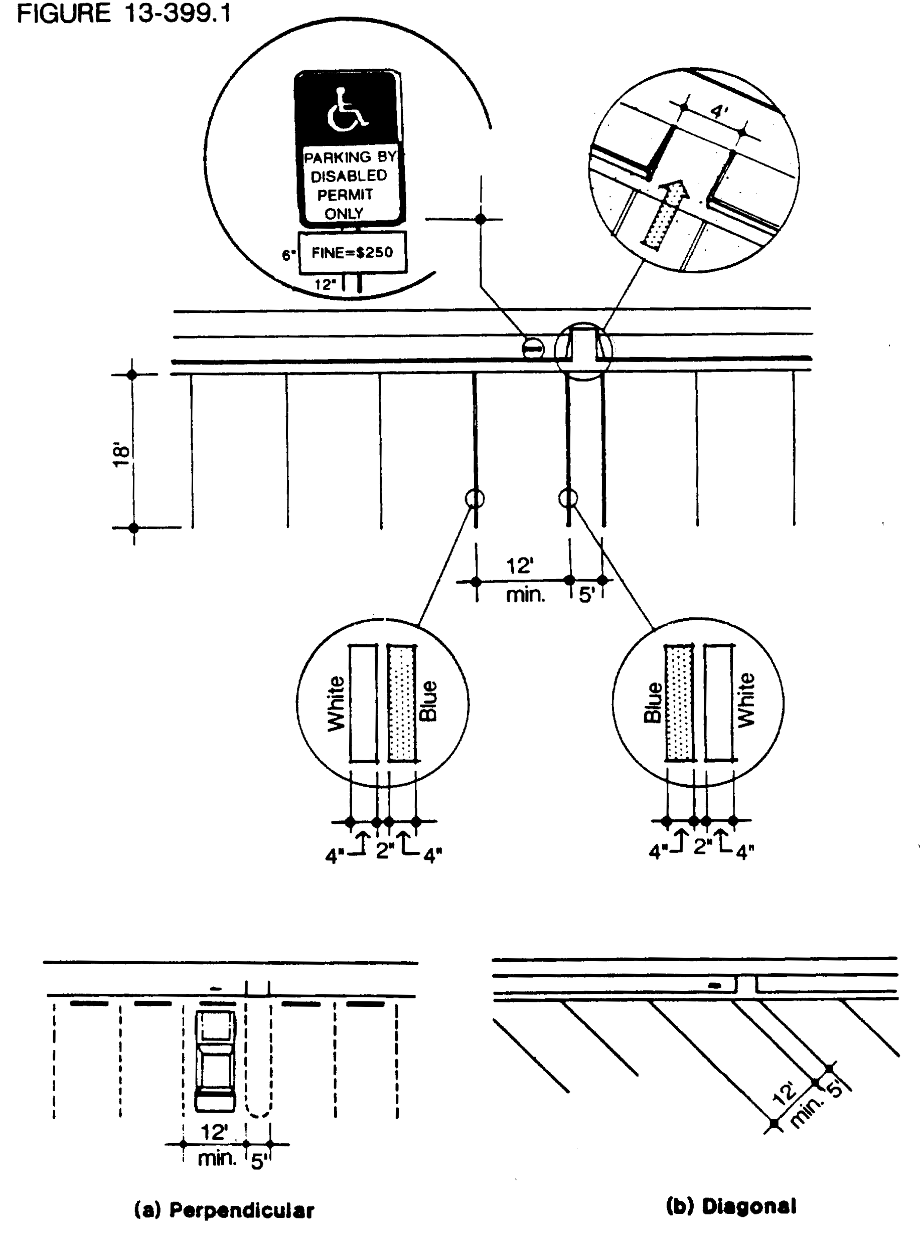
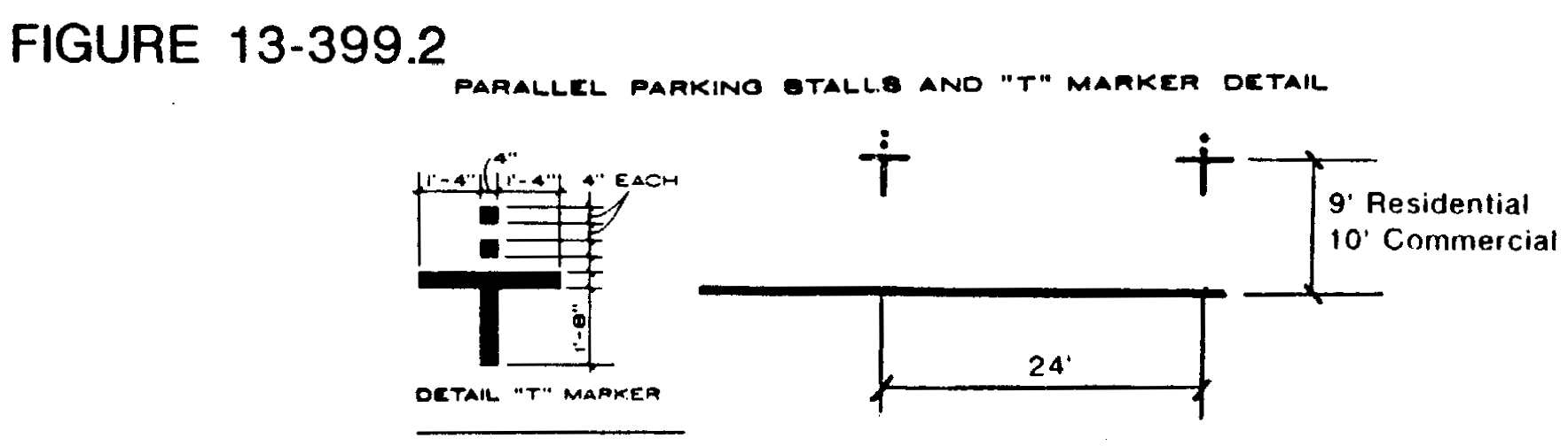
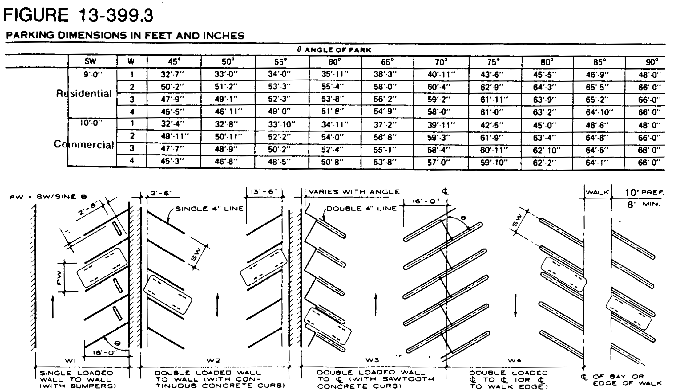
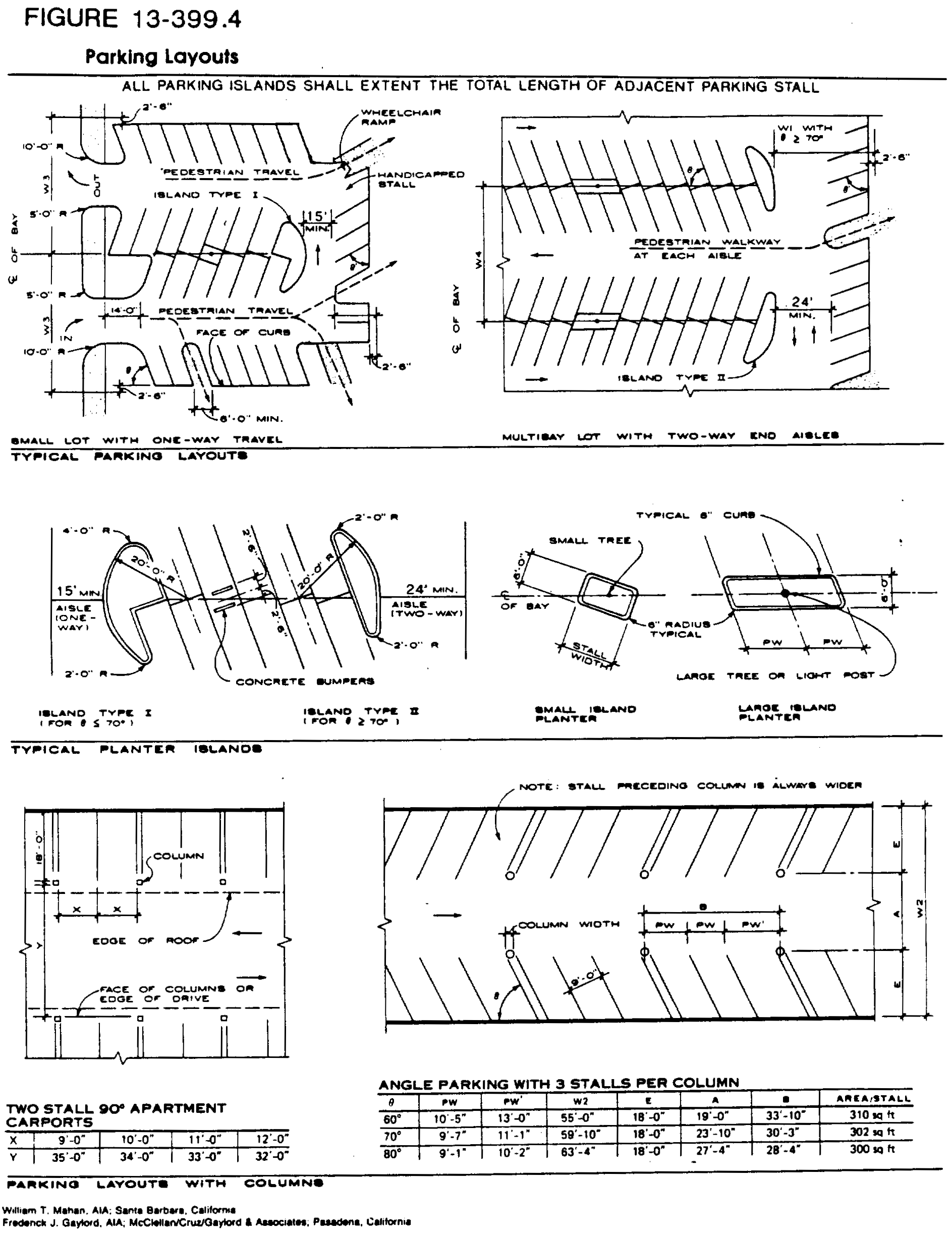
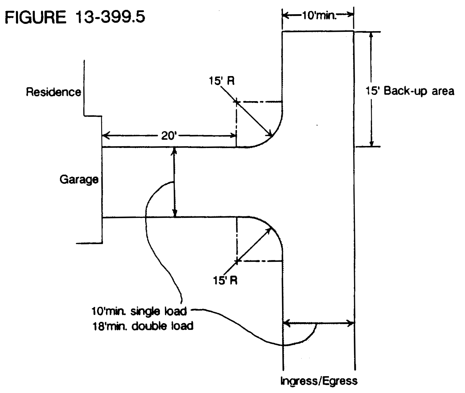
(Ord. No. 106-90, § 4-26-90)
Sec. 13-400. - Residential use parking space requirements.
The minimum number of parking spaces to be provided and maintained for each residential use or occupancy shall be as follows:
(1)
Dwelling, one-family and two-family: Two (2) parking spaces for each dwelling unit. A dwelling may provide a garage or carport for one (1) such space. Such carport shall effectively screen an automobile from view on three (3) sides utilizing a wall, fence or hedge at least four (4) feet in height. Mobile home districts are exempt from providing a garage or carport for one (1) such space. Two (2) spaces shall be provided for each mobile home dwelling unit. Parking spaces may be configured as follows:
a.
Carport or open parking spaces in tandem shall be ten (10) feet wide by thirty-six (36) feet long;
b.
Side-by-side in eighteen (18) feet wide by twenty (20) feet long; or
c.
In two (2) separate areas each ten (10) feet wide by twenty (20) feet long;
d.
Garage or enclosed parking spaces shall be ten (10) feet wide by eighteen (18) feet long for a one-car use, and eighteen (18) feet wide by eighteen (18) feet long for a two-car use.
(2)
Dwelling, multifamily:
a.
One and three-quarters (1.75) parking spaces by each efficiency unit and one-bedroom unit;
b.
Two (2) parking spaces for each unit with either two (2) bedrooms or with one (1) bedroom and a den; and two and one-quarter (2.25) parking spaces for each unit with three (3) bedrooms or with two (2) bedrooms and a den;
c.
Three (3) parking spaces for each unit with over three (3) bedrooms (and combined den) or any combination of bedrooms and den;
d.
In addition to the above, multiple-family buildings shall be required to provide supplemental guest parking spaces equal to a minimum of ten (10) percent of the spaces required above. Such supplemental parking shall be installed pursuant to the requirements of this subdivision.
e.
If multifamily buildings have more than fifty (50) percent three (3) or more bedrooms, the supplemental guest parking spaces must be provided to a minimum of twelve (12) percent of the spaces required above.
f.
For multifamily complexes incorporating garage parking within the building (tandem or otherwise), and where garages are owned fee simple or as common property, each garage may be counted as one (1) space toward the total number required. This total number is based on bedroom numbers for each particular project.
g.
If multifamily complexes charge for covered or uncovered parking, each space being charged shall be in excess of the total number of required parking spaces or shall be part of a mandatory amenity package per unit and shall be submitted by the applicant and reviewed, approved with conditions, or denied by the city commission to ensure appropriate parking availability and distribution.
h.
In addition to the above, multifamily complexes shall submit a parking "bubble plan" indicating the location of the required resident and guest parking per building, along with any excess parking that will be provided.
(3)
Dormitories, fraternities: One (1) parking space for each bed.
(4)
Hotels: One (1) parking space for each hotel room, plus one (1) parking space per two (2) people on shift of greatest employment. If, in addition to hotel rooms, there are other uses operated in conjunction with and/or as part of the hotel, additional off-street parking spaces shall be provided for such other uses as would be required by this subdivision.
(5)
Hotels, extended stay: One (1) parking space for each hotel room and one (1) parking space for each bedroom in a hotel room suite, plus one (1) parking space per two (2) people on shift of greatest employment. If there are other uses operated in conjunction with and/or as part of the extended stay hotel, additional off-street parking spaces shall be provided for such other uses as would be required by this subdivision.
(6)
Housing for elderly: One (1) parking space for each unit.
(7)
Club houses and other amenity buildings: [Club houses and other amenity buildings] accessory to one-family, two-family, multifamily, mobile home and other residential developments shall provide one (1) parking space for two hundred (200) square feet of floor area.
(8)
Community residences: shall provide off-street parking for the greater of:
a.
The number of off-street spaces required under this code for the type of dwelling unit (one-family, two-family, multifamily, etc.) in which the community residence is located; or
b.
0.5 off-street spaces for each staff member on a shift and/or live-in basis, plus, when residents are allowed to maintain a motor vehicle on premises, the maximum number of occupants that is permissible under this section. Off-street spaces must be provided on the premises.
(Ord. No. 115-86, § 307.0305, 7-10-86; Ord. No. 159-87, § 307.0305, 6-11-87; Ord. No. 106-90, § 1, 4-26-90; Ord. No. 127-93, § 1, 9-7-93; Ord. No. 104-96, § 1, 1-25-96; Ord. No. 2021-020, § 4, 10-28-21; Ord. No. 2022-023, § 2, 12-8-22)
Sec. 13-401. - Commercial use parking space requirements.
(a)
All commercial uses except those specified in subsection (b) below or elsewhere in this chapter shall provide parking as follows:
(1)
One (1) space for each structural module and/or business use.
(2)
One (1) space for each two hundred (200) square feet of gross floor area.
(b)
The following uses shall provide parking as indicated below:
(Ord. No. 115-86, § 307.0306, 7-10-86; Ord. No. 159-87, § 307.0306, 6-11-87; Ord. No. 106-90, § 1, 4-26-90; Ord. No. 126-96, § 1, 5-23-96)
Sec. 13-402. - Miscellaneous parking space requirements.
Miscellaneous uses shall provide parking as follows:
(1)
Adult congregate living facility (including section 13-650, SF-1, section 13-651, SF-2, section 13-652, SF-3, and section 13-653, SF-4): One (1) space for every four (4) beds; plus one (1) per employee on the shift of greatest employment.
(2)
Auditoriums, assembly halls, conference meeting rooms, and stadiums: One (1) parking space for each five (5) seats or one (1) parking space for each two hundred (200) square feet of gross floor area, whichever provides the greater number of parking spaces.
(3)
Places of worship: One (1) space for each three (3) seats.
(4)
Educational facilities:
a.
Elementary and middle schools: Three (3) spaces for each classroom.
b.
Senior high schools, vocational and trade schools, and colleges: One (1) space for each five (5) students, with the number of students to be determined by maximum capacity.
(5)
Parks and recreational facilities:
a.
Golf course: Seven (7) parking spaces for each hole.
b.
Parks: One (1) parking space per five thousand (5,000) square feet of passive land area. Active recreational facilities (tennis court, volleyball, racquetball, basketball, etc.) and their associated areas shall require one (1) space for each two (2) possible users, up to the capacity for said facilities. Any parking combinations of active and passive uses shall be determined by the director of sustainable development.
(6)
Hospitals (including section 13-656, SF-7, and section 13-657, SF-8 facilities): One (1) parking space for each bed plus one (1) space per staff doctor.
(Ord. No. 115-86, § 307.0307, 7-10-86; Ord. No. 159-87, § 307.0307, 6-11-87; Ord. No. 106-90, § 1, 4-26-90; Ord. No. 2024-012, § 2, 4-11-24)
Sec. 13-403. - Industrial office, manufacturing, wholesale and warehouse parking requirements.
All industrial, manufacturing, wholesale and warehouse uses shall provide parking per project as follows:
(Ord. No. 115-86, § 307.0308, 7-10-86; Ord. No. 159-87, § 307.0308, 6-11-87; Ord. No. 106-90, § 1, 4-26-90)
Sec. 13-404. - Reduction of the number of developed parking spaces and provision of reserve area for future parking.
The number of developed parking spaces required by this chapter for any site may be reduced by up to twenty (20) percent provided that at least fifty (50) spaces are fully developed on the site. Further, the site shall contain sufficient area for the additional spaces otherwise required by this chapter and sufficient area for all otherwise required improvement such as access isles, driveways and landscaping. The reserve parking can adhere to section 13-399(a)(4) for dimensions.
The area required for the additional required parking spaces shall not be counted toward meeting any other requirements of this chapter. The reserve area shall be shown on the site plan drawings as it would be developed if no reduction in the required number of parking spaces is approved.
Performance bonding of the reserve parking area must be provided at time of original site plan approval. The amount of the bond shall be one hundred twenty-five (125) percent of the cost if the reserved area were to be built at site plan approval. A cost estimate must be submitted and approved by the appropriate departments with the City of Coconut Creek. The letter of credit, cash bond or any other method of a performance bond must be approved by the city attorney. This bond shall have no time limit, and may only be released by the director of sustainable development upon the determination of the site plan review authority through the standard site plan modification process that the reserve area is no longer required. Such a release request shall not be given for a period of at least five (5) years.
Approval for a reduction of the number of developed parking spaces shall be completed through the site plan approval process. Approval for a reduction of the number of developed parking spaces shall be granted only if the site plan review authority finds (at its sole discretion), based on substantial and competent evidence, that the number of developed spaces provided will be sufficient to meet the parking demand on the site on the twentieth busiest hour of the year.
Such a determination shall be considered by the site plan review authority at a regular scheduled meeting. Submittal for review may be made by city staff, any civil official, any adjacent property owner or any other interested party after a normal planning and zoning board agenda submittal date.
A revocation determination shall not be made until at least thirty (30) days after the owner of the subject property has been notified. During that thirty-day period, at a development review committee meeting and at an agendized city commission meeting, the owner of the subject property may present such evidence as he may deem appropriate to the development review committee and site plan review authority's consideration. In the event that the site plan review authority determines to revoke approval for provision of a reduced number of parking spaces, the owner of the subject property shall be notified immediately after a regular scheduled city commission meeting.
Sixty (60) days after the owner has been so notified, no occupational license or permit shall be issued or renewed for the subject property until the required number of developed parking spaces, access isles, driveways, landscaping, lighting and other related improvements have been provided.
(Ord. No. 106-90, § 1, 4-26-90; Ord. No. 2017-008, § 2, 1-11-18)
Sec. 13-405. - Shared usage.
Required parking spaces may be permitted by the site plan review authority to be utilized for meeting the parking requirements of two (2) separate permitted uses when it is clearly established by the applicant that these two (2) uses will primarily utilize these spaces at different times of the day, week, month or year, such as a house of worship sharing spaces with a retail store. Recordable covenants, with correct legal descriptions, shall be submitted by the owners of the property and the business, in form acceptable to the city attorney, and these covenants shall be recorded by the city at the applicant's expense, and shall run with the land. These covenants shall provide that the use, or portion of a use, that requires the shared parking in order to obtain the necessary permits or licenses, shall cease and terminate upon any change in their respective schedules of operation that results in conflicting or overlapping usage of the parking facilities, and no nonresidential use may be made of that portion of the property until the required parking facilities are available and provided. The covenant shall also provide that the city may collect attorney fees if litigation is necessary.
(Ord. No. 106-90, § 1, 4-26-90; Ord. No. 2008-036, § 2, 11-13-08)
Sec. 13-406. - Bicycle parking.
Bicycle parking facilities shall be stationary bike rack, typically a vertical hoop or bar and shall be required for the following uses:
(Ord. No. 115-86, § 307.0309, 7-10-86; Ord. No. 159-87, § 307.0309, 6-11-87; Ord. No. 106-90, § 1, 4-26-90)
Sec. 13-407. - Calculating required parking.
(a)
The parking requirements for uses not specifically mentioned shall be the same as provided in this subdivision for the most similar use as determined by the director of sustainable development.
(b)
Fractional spaces. When units or measurements determining the total number of required off-street parking spaces result in a fractional space, any such fraction shall require a full off-street parking space.
(c)
Mixed uses.
(1)
In the case of mixed uses, the total requirement for off-street parking spaces shall be the sum of the requirements of the various uses computed separately and off-street parking for any other use.
(2)
Shared usage. Section 13-405 designates the requirements for time of operation differences between uses.
(d)
An off-street parking data box shall list the project off-street requirements in reference to the satisfaction of all off-street parking regulations of this subdivision (section number; parking totals showing required versus provided).
(Ord. No. 115-86, § 307.0310, 7-10-86; Ord. No. 159-87, § 307.0310, 6-11-87; Ord. No. 106-90, § 1, 4-26-90; Ord. No. 2024-012, § 2, 4-11-24)
Sec. 13-408. - Use of parking facilities.
(a)
Permitted use. Parking spaces approved in conformance with this subdivision may be used for parking the vehicles of employees, occupants, owners, tenants or customers utilizing the building or use served by such required parking space. Supplemental parking for motor vehicles (parking facilities provided, but not required) may be used for purposes related to the use of the building it serves.
(b)
Limitations on use of required parking facilities. The following uses and activities shall not be permitted in required parking facilities:
(1)
Parking to serve an off-site building.
(2)
Storage, repair or display of any vehicles, equipment or merchandise, except as may be approved by the department of sustainable development on a temporary basis.
(3)
Parking of any vehicle, which due to its size, shape, contents or location, creates an obstruction or public safety hazard or which cannot be contained within a single designated parking space.
(4)
Parking of recreational vehicles, boats and accessory equipment shall not be permitted in the front yard setback in any zoning district.
(Ord. No. 115-86, § 307.0311, 7-10-86; Ord. No. 159-87, § 307.0311, 6-11-87; Ord. No. 106-90, § 1, 4-26-90; Ord. No. 2024-012, § 2, 4-11-24)
Sec. 13-409. - Off-street loading requirements.
(a)
General provisions.
(1)
Adequate space for loading and unloading of materials and goods and for delivery and shipping shall be provided and maintained on the same lot as the building which they serve. Such areas shall be opposite the main customer entrance and the parking area shall be regulated by signs.
(2)
Where any structure is enlarged or any use is extended so that the size of the resulting occupancy requires additional parking facilities, the full amount of off-street loading space shall be supplied and maintained for the structure or use in its enlarged or extended size. Where the use of a structure or land or any part thereof is changed to a use requiring an off-street loading space, such space shall be provided and maintained to comply with this subdivision.
(3)
For the purposes of this subdivision, an off-street loading space shall be an area at the grade level at least twelve (12) feet wide, fifty-five (55) feet long with a fifteen-foot vertical clearance. All detached (outparcel) buildings less than ten thousand (10,000) square feet shall require a separate off-street loading space. The dimensions of the outparcel loading space shall be an area at grade level at least twelve (12) feet wide, thirty-five (35) feet long, with a fifteen-foot vertical clearance. If the outparcel is larger than ten thousand (10,000) square feet, a full sized off-street loading space is required. Each off-street loading space shall be directly accessible from a street or alley without crossing or entering any other required loading space. Such spaces shall be arranged for convenient and safe ingress and egress by vehicles. Loading spaces shall also be accessible from the interior of buildings they are intended to serve.
(4)
Off-street loading facilities may not be considered as meeting off-street parking requirements.
(5)
Off-street loading areas must be a minimum of four (4) feet from the rear of the building. A four-foot encroachment of the eight-foot building walkway area may be permitted through site plan approval. Building and off-street loading areas shall be configured so that no off-street loading docks face directly on major thoroughfares.
(b)
Loading space requirements. Off-street loading spaces shall be provided and maintained in accordance with the following schedule:
(1)
For each retail store, storage warehouse, wholesale establishment, industrial plant, factory, freight terminal, market, restaurant, funeral home, laundry, drycleaning establishment or similar building or use which has an aggregate gross floor area as follows:
a.
Over ten thousand (10,000) square feet to twenty-five thousand (25,000) square feet of gross floor area, two (2) spaces.
b.
Over twenty-five thousand (25,000) square feet to sixty thousand (60,000) square feet of gross floor area, three (3) spaces.
c.
Over sixty thousand (60,000) square feet to one hundred twenty thousand (120,000) square feet of gross floor area, four (4) spaces.
d.
Over one hundred twenty thousand (120,000) square feet to two hundred thousand (200,000) square feet of gross floor area, five (5) spaces.
e.
Over two hundred thousand (200,000) square feet to two hundred ninety thousand (290,000) square feet of gross floor area, six (6) spaces plus one (1) additional space for each ninety thousand (90,000) square feet over two hundred ninety thousand (290,000) square feet or major fraction thereof.
(2)
Convenience store, one (1) space. This loading space is in addition to the commercial requirement. The gross square footage of convenience stores and outparcels may be subtracted from the overall commercial center square footage requirement.
(3)
Hotels and extended stay hotels:
a.
Twenty-five (25) to fifty (50) units, one (1) space.
b.
Over fifty (50) to two hundred (200) units, two (2) spaces.
c.
Over two hundred (200) units, three (3) spaces.
Such loading space shall not be located in the required front yard.
(4)
For each auditorium, convention hall, exhibition hall, museum, sports arena, stadium, hospital or similar use which has an aggregate floor area of: Over twenty thousand (20,000) square feet to forty thousand (40,000) square feet, one (1) space plus one (1) space for each additional sixty thousand (60,000) square feet over forty thousand (40,000) square feet or major fraction thereof.
(c)
Off-loading facilities required for one (1) use shall not be considered as meeting the requirement for off-street loading facilities for any other use.
(d)
No area or facilities supplied to meet the required off-street parking facilities for a particular use shall be utilized for or meet the requirements of this subdivision for off-street loading facilities.
(e)
Plans for buildings or uses requiring off-street loading facilities shall clearly indicate the location, dimensions, clearances and accesses for all such required off-street loading facilities.
(f)
All off-street loading spaces shall be properly drained and paved with a durable weatherproof surface pavement acceptable to the city engineer. Loading facilities shall be maintained in a manner as to not create a hazard or nuisance.
(g)
Additional loading dock, receiving area and trash storage areas may be required at the time of site plan approval depending on specific proposed uses.
(h)
An off-street loading data box shall list the project off-street loading requirements in reference to the satisfaction of all off-street loading regulations of this subdivision.
(Ord. No. 115-86, § 307.0312, 7-10-86; Ord. No. 159-87, § 307.0312, 6-11-87; Ord. No. 2021-020, § 4, 10-28-21)
Sec. 13-421.- Purpose.
The purpose of this subdivision is to regulate the swale areas, driveways and medians in the city and to promote both pedestrian and vehicular safety.
(Ord. No. 115-86, § 307.0401 7-10-86; Ord. No. 159-87, § 307.0401, 6-11-87)
Sec. 13-422. - Definitions.
The following words, terms and phrases, when used in this subdivision, shall have the meanings ascribed to them in this section, except where the context clearly indicates a different meaning:
Curb and gutter section means a type of improved road section characterized by raised or flush concrete structures located at the edge of pavement which are designed for channelizing drainage and separating vehicular and pedestrian traffic.
Hazardous condition means an existing condition in the swale area or median strip which poses immediate danger to the general public as determined by the city engineer.
Median strip means the island located in the center of a right-of-way separating opposing lanes of traffic.
Right-of-way means land reserved, used or to be used for a street, alley, sidewalk or drainage facility or other public purpose.
Swale area means the area between road pavement and sidewalk or property line where no sidewalk exists and is designed for providing street drainage.
(Ord. No. 115-86, § 307.0402, 7-10-86; Ord. No. 159-87, § 307.0402, 6-11-87)
Sec. 13-423. - Scope.
All swale areas shall conform to the requirements of this subdivision.
(Ord. No. 115-86, § 307.0403, 7-10-86; Ord. No. 159-87, § 307.0403, 6-11-87)
Sec. 13-424. - Prohibitions.
(a)
All nonliving objects such as rock gardens, concrete buttons, concrete pyramids, excepting sprinkler heads and irrigation systems which are flush or retractable to be flush with the surrounding ground area shall be prohibited in swale areas except for authorized curb cuts or driveways. Swales shall not be paved or covered with any material other than sod.
(b)
Landscaping, other than sod, is prohibited within fifteen (15) feet of the edge of the pavement at each intersection.
(c)
Parking of any motor vehicle is prohibited on swale areas adjacent to designated expressway, collector or arterial roads. Designated roads are shown on the table of designated road classifications below:
Designated Road Classifications
(Ord. No. 115-86, § 307.0404, 7-10-86; Ord. No. 159-87, § 307.0404, 6-11-87)
Sec. 13-425. - Permitted uses.
(a)
It shall be the adjoining owner's or association's responsibility to maintain the swale area.
(b)
Median strip landscaping may be installed in conformance with plans approved by the city if in the public right-of-way or by the owner if the area is located on a private street.
(c)
Except as prohibited in section 13-424, landscaping is permitted in swale areas and must be maintained in a manner that will not create a hazardous condition.
(d)
Temporary guest (nonresident) parking of any nonrecreational motor vehicle is permitted on swale areas within the public local street rights-of-way.
(Ord. No. 115-86, § 307.0405, 7-10-86; Ord. No. 159-87, § 307.0405, 6-11-87)
Sec. 13-426. - Enforcement.
Any person who shall violate or fail to comply with any of the provisions of this subdivision shall be responsible for removing any obstruction.
(Ord. No. 115-86, § 307.0406, 7-10-86; Ord. No. 159-87, § 307.0406, 6-11-87)
Sec. 13-427. - Exemptions.
Mailboxes, telephone and light poles, traffic signs and other nonliving objects required or authorized by the city shall be exempt from the requirements of this subdivision.
(Ord. No. 115-86, § 307.0407, 7-10-86; Ord. No. 159-87, § 307.0407, 6-11-87)
Sec. 13-441.- Objective.
The objective of this subdivision is to provide regulations for installation and maintenance of landscaping and landscaped open space to promote the establishment of functional and sustainable landscapes and to ensure the safety, appearance, character and aesthetic quality thereby promoting the general welfare of the city. In addition, it shall be the policy of the city commission that every effort shall be made to preserve and maintain natural vegetation within the city, as identified in the land use element of the comprehensive plan. Other subdivisions and guidelines of the land development code shall be used as appropriate.
(Ord. No. 2023-002, § 3, 9-14-23)
Sec. 13-442. - Definitions.
In construing the provisions of this chapter, if no definition is provided herein and when the context will permit, the following publications recognized as authoritative in the landscaping, scientific and engineering fields, in their most current version, shall apply: The American National Standards Institute ("ANSI") A-300, Tree, Shrub and Other Woody Plant Management-Standard Practices, and Z133 The American National Standard for Arboricultural Operations - Safety Requirements; Florida Department of Agriculture and Consumer Services, Division of Plant Industry, Grades and Standards for Nursery Plants; Nelda Matheny and Jim Clark, Trees and Development: A Technical Guide to Preservation of Trees During Land Development; Council of Tree and Landscape Appraisers, Guide for Plant Appraisal; Richard Harris, Arboriculture Integrated Management of Landscape Trees, Shrubs and Vines; Gary W. Watson and E.B. Himelick, Principles and Practices of Planting Trees and Shrubs; Florida Urban Forestry Council, Selecting and Planting Trees for the South Florida Urban Forest; Florida Power and Light'sRight Tree, Right Place (https://www.fpl.com/reliability/trees/tree-location.html); University of Florida IFAS Extension's Trees and Power Lines (https://hort.ifas.ufl.edu/treesandpowerlines/)guidelines; Florida Urban Forestry Council's "Right Tree/ Right Place - Selecting & Planting Tree for the South Florida Urban Forest" (fufc.org); Timothy K. Broschat & Alan W. Meerow, Betrock's Florida Plant Guide; Edward F. Gilman, Trees for Urban and Suburban landscapes; Dr. George K. Rogers, Landscape Plants for South Florida: A Manual For Gardeners, Landscapers & Homeowners; and University of Florida, Institute of Food and Agricultural Sciences (UF/IFAS), Florida-Friendly Landscaping, Guide to Plant Selection & Landscape Design; and UF/IFAS Florida-Friendly Landscaping Pattern Book: Sample Plant Lists and Designs for Four Florida Regions: USDA Hardiness Zones 10a, 10b and 11, South Florida, Gail Hansen, Kelly Perez, and Esen Momol. Other words in these standards have their customary dictionary definition except as specifically defined herein. The words "shall" and "must" are mandatory, and the words "may" and "should" are permissive.
Applicable definitions found in other articles, divisions, subdivisions and/or sections of the City of Coconut Creek Land Development Code shall be used in this subdivision; and definitions found herein shall apply to all other articles, divisions, subdivisions and/or sections of the City of Coconut Creek Land Development Code.
When there are two (2) or more definitions for the same item, the more stringent of the definitions shall apply as determined by the director of sustainable development, regardless of the location of the definition.
The following words, terms and phrases, when used in this subdivision, shall have the meanings ascribed to them in this section, except where the context clearly indicates a different meaning:
Accessway means a vehicular roadway intersecting a right-of-way providing vehicular entrance and/or exit for a property.
ANSI means the American National Standards Institute.
Applicant means the owner of the property or his legally authorized agent.
Application or apply means the actual physical deposit of fertilizer to turf or landscape plants.
Applicator means any person who applies fertilizer on turf and/or landscape plants in the city.
Artificial turf means an artificial product manufactured from synthetic materials that effectively simulates the appearance of live or natural turf, grass, sod, or lawn.
Balled and burlapped (B and B) means field grown trees or shrubs with roots established in an earthen ball encompassing the root system necessary for the full recovery of the plant; wrapped and bound to support the root ball.
Berm means a linear earthen mound.
Best management practices (BMP) means turf and landscape practices or a combination of those practices which, based on research, field-testing, expert review, and economic and technological considerations, are determined to be the most effective and practicable on-location means for improving water quality, conserving water supplies, and protecting natural resources.
Bona fide agricultural property means property designated for agricultural use by the City of Coconut Creek and Broward County and which is referenced on a valid occupational license for an agricultural business on the date of the adoption of this regulation, and is further determined to be an agricultural business by the Broward County Property Appraiser's Office.
Building area means the portion of a lot which is not located within any minimum required yard setback, landscape strip/area, or buffer; that portion of a lot wherein a building may be located, exclusive of certain accessory structures.
Building walkways means the paved area between a building and the vehicular use area.
Buffer means an area established to separate different use districts, or to separate property on which a special permit exists, from a property of a same use district or a different use district. Buffer zones are distinguished by physical characteristics as described by berms, shrubs, trees, ground covers, walls or other acceptable landscape and/or hardscape.
Caliper means the diameter of a tree trunk as measured at the heights as follows:
Dicot or conifer:
Six (6) inches from the ground on trees up to and including four (4) inches in caliper.
Twelve (12) inches above the ground for trees larger.
Monocot:
Twelve (12) inches above the ground.
Canopy means the portion of the tree with foliage from the lowest branch to the topmost part of the tree; also, the collection of several to many crowns of different trees.
Canopy coverage means the aerial extent of ground within the dripline of the tree.
Clear trunk means the area from the point above the root ball along the vertical trunk of a tree to the point at which lateral branching or fronds begin.
Commercial fertilizer applicator means any person who applies fertilizer on turf and/or landscape plants in exchange for money, goods, services, or other valuable consideration.
Conifer means belonging to the group of cone-bearing evergreen trees or shrubs.
Conservation easement means a right or interest in real property as defined in F.S. § 704.06, as amended.
Critical root zone means the rooting area of a tree established to limit root disturbances. This zone is generally defined as a circle with a radius extending from a tree's trunk to a point no less than the furthest crown dripline. Disturbances within this zone will directly affect a tree's chance of survival.
Crown. See canopy.
Danger means there is the presence of non-treatable disease which threatens the physical integrity of the tree or other vegetation or is highly likely to spread to other vegetation, there is an imminent threat to the extent that its continued existence threatens the health and/or safety of contiguous persons or property, or there is an imminent or probable likelihood of failure, as defined in Best Management Practices Tree Risk Assessment, Second Edition, as updated.
Deciduous means not persistent; the shedding of leaves annually. A deciduous tree sheds its leaves annually.
Destruction of natural habit of growth means the pruning that causes irreparable damage and permanent disfigurement to a tree such that, even with regrowth, the tree will never regain the original characteristics of its species, and is a danger to the public or property; or pruning defined herein as tree abuse that results in the tree's death.
Diameter breast height (DBH) means a standard measure of tree size; a tree trunk diameter measured in inches at a height of four and one-half (4½) feet above the ground. If a tree splits into multiple trunks below four and one-half (4½) feet, then the trunk is measured at its most narrow point beneath the split. Diameter breast height may be identified by a landscape architect by another specification; however, such specification must meet or exceed the City of Coconut Creek landscape requirements.
Documentation means a written report of an onsite assessment consistent with Best Management Practices Tree Risk Assessment, Second Edition, as updated, Section 94.6.2.1 ANSI A-300 Part 9, "Tree, Shrub, and Other Woody Plant Management - Standard Practices (Tree Risk Assessment a. Tree Failure)", or equivalent reference manual, from an arborist certified by the International Society of Arboriculture or Landscape Architect, licensed to practice in the state of Florida under Chapter 481 Part II, Florida Statutes or as otherwise provided in F.S. § 163.045 as amended from time to time.
Dripline means the peripheral limits of the horizontal crown of tree spread vertically to the ground, provided, however, that the same shall not be less than a circle with a five-foot radius measured from the center of the tree.
Dumpster means a refuse container of one (1) cubic yard or larger.
Ecological communities shall consist of, but shall not be limited to coastal strand forest community, scrub community, pine flatwoods community, high hammock community, low hammock community, and cypress wetland community (freshwater swamp).
Effectively destroy means to cause, allow or permit any act, which will cause landscape material to die or go into a period of unnatural decline. Acts which may effectively destroy landscape material include, but are not limited to, poisoning, damage inflicted upon the foliage or critical root zone; excessive trimming; changing the natural grade above the critical root zone or around the trunk; damage intentionally inflicted on the landscape material permitting infection or pest infestation, application of herbicides or other chemical agents or intentional fire damage to the landscape material permitting infection or pest infestation, the infliction of a trunk wound that is fifty (50) percent or greater than the circumference of the tree or palm trunk, or the removal of sufficient canopy to cause the unnatural decline of the tree or palm.
Encroachment means any protrusions of a vehicle outside of a parking space, a display area or accessway into a landscaped area.
Equivalent replacement means substituting landscape material equal to or greater size for vegetation that was removed or destroyed. The city shall determine size and quantity of replacement landscape material.
Equivalent value means a monetary amount reflecting the cost of vegetation to be replaced.
Fertilize, fertilizing, or fertilization means the act of applying fertilizer to turf, specialized turf, or landscape plants.
Fertilizer means any substance or mixture of substances that contains one (1) or more recognized plant nutrients and promotes plant growth, controls soil acidity or alkalinity, provides for soil enrichment, or provides other corrective measures to the soil.
Florida-Friendly Landscaping™ means quality landscapes that conserve water, protect the environment, are appropriate for local conditions, and are drought, wind, and/or salt tolerant. The principles of Florida-Friendly Landscaping™ include planting the right plant in the right place, efficient watering, appropriate fertilization, mulching, attraction of wildlife, responsible management of yard pests, recycling yard waste, reduction of stormwater runoff, and waterfront protection. Additional components of Florida-Friendly Landscaping™ include planning and design, soil analysis, the use of solid waste compost, practical use of turf, and proper maintenance.
Flush cut means a destructive removal cut made through the branch collar or into the branch bark ridge. See figure 13-442.1.
Functional and sustainable landscaping means the combination of living and nonliving materials that, when installed or planted, creates an ongoing system providing aesthetic and environmental services to a particular site and surrounding area, which is capable of being maintained and continued with minimal long-term effect on the environment
Girdling means circular, or partial circular pressure to the bark area of branches, trunks and/or roots, thereby choking or restricting the natural flow of water, nutrients and tree manufactured foods. Girdling a tree can also be caused by the use of mechanical or manual equipment (e.g., use of a weedeater, mower damage, guy wires, etc.)
Gray wood means that portion of a palm trunk which is mature, hard wood measured from the top of the root ball to the base of the new, green, soft terminal growth or fronds.
Ground cover means low growing plants that, by the nature of their growth characteristics, completely cover the ground and do not usually exceed two (2) feet in height.
Hardscape means areas such as artificial turf, patios, decks, driveways, paths, sidewalks, or other impervious surfaces that do not require irrigation.
Hatracking means the severe cutting back of branches, making internodal cuts leaving branch stubs; internodal cutting. Severing the leader or leaders; or pruning a tree by stubbing off or reducing the total circumference or canopy spread.
Hedge means a close planting of shrubs or other vegetation which forms a compact, dense, visually opaque living barrier when mature. Hedges shall be maintained at a height not to exceed eight (8) feet. Hedges shall be maintained at a height not to exceed thirty (30) inches in a residential front yard setback.
Historical tree means a particular tree or palm or group of trees or palms which has historical value because of its unique relationship to the region, state, nation or world.
Horizontal plane shall mean an imaginary line that begins at the base of the live frond petioles.
Hydrozone means a distinct grouping of plants with similar water needs and climatic requirements. A hydrozone is also referred to as water use zone. It also means the design practice in irrigation in an effort to improve watering efficiency. The system is designed so that plants with similar watering requirements are watered together and treated differently from plants with different requirements.
Imminent means failure has started or is most likely to occur in the near future, even if there is no significant wind or increased load.
Institutional fertilizer applicator means any person, other than a noncommercial or commercial fertilizer applicator (unless such definitions also apply under the circumstances), that applies fertilizer for the purpose of maintaining turf and/or landscape plants. Institutional fertilizer applicators shall include, but shall not be limited to, owners and managers of public lands, schools, parks, religious institutions, utilities, industrial or business sites, and any residential properties maintained in condominium, common ownership, and/or common management.
Integrated pest management(IPM) means a pest management strategy that focuses on long-term prevention or suppression of pest problems through a combination of techniques such as encouraging biological control, use of resistant plant varieties, and adoption of alternate cultural practices to make the habitat less conducive to pest development. Pesticides are used only when careful monitoring indicates they are needed, or to prevent pests from significantly interfering with the purposes for which plants are being grown.
Internode means a part of the branch between two (2) nodes.
Invasive exotic plant species means an introduced species that has been shown to displace the native vegetation by out-competing native species, as identified by the University of Florida Institute of Food and Agricultural Sciences (UF/IFAS) or the Florida Invasive Species Council (FISC), Category I & II.
Irrigation means a continuous supply of water provided by artificial means.
Land clearing means the clearing of vegetation and soil for the purpose of land development activities. This includes, but is not limited to, construction for buildings, rights-of-way, utility easements or access, drainage ways, parking lots and other structures, rock mining, and agricultural activities that involve the removal of trees, palms, or any form of tree abuse.
Landscape architect means any person duly licensed pursuant to F.S. Ch. 481, Pt. II as amended from time to time, to practice landscape architecture as prescribed by law.
Landscape easement or landscape buffer means any portion of land which is set aside or designated on a landscape plan or site plan, or by plat, or written agreement, to buffer the boundary of adjacent uses.
Landscape inspector means an agent or employee of the city who is authorized by the director of sustainable development or applicable statute, law, or ordinance to enforce city codes and ordinances.
Landscape material means any of the following or a combination thereof such as but not limited to turf/grass, ground cover, shrubs, vines, hedges, trees or palms and other materials subject to section 13-444(c)(1)d.3, such as rocks, mulch, pebbles, sand, but not including paving.
Landscape plan approval means city review and approval of a plan complying with the landscaping requirements of this article.
Landscape/landscaping:
(1)
(When used as a noun) living plant materials such as, but not limited to, turf, ground cover, shrubs, vines, trees or palms and nonliving durable materials commonly used in environmental design such as, but not limited, rocks, pebbles, sand, walls or fences and aesthetic grading and mounding; but excluding paving and structures. Nonliving material usage must meet the intent of the landscape code and be approved by the city during the approval process.
(2)
(When used as a verb) the process of installing or planting materials commonly used in environmental design.
Lifting means the removal of lower branches or limbs of a tree, palm, or shrubs.
Low maintenance zone means an area a minimum of ten (10) feet wide adjacent to water courses which is planted and managed in order to minimize the need for fertilization, watering, mowing, etc.
Micro-irrigation means the application of small quantities of water directly on or below the soil surface, usually as discrete drops, tiny streams, or miniature sprays through emitters placed along the water delivery pipes (laterals). Microirrigation encompasses a number of methods or concepts including drip, subsurface, bubbler, and spray irrigation that deliver water directly to plant root zones with a high degree of efficiency, no runoff, and little to no evaporation.
Mitigation means the compensation for the impacts to tree(s) and palm(s).
Mulch means an organic material such as wood chips, pine straw or bark placed on the soil to reduce evaporation, prevent soil erosion, control weeds and enrich the soil.
Native plant species means any plant species with a geographic distribution indigenous to all, or part, of the state of Florida as identified in the Guide to the Vascular Plants of Florida, R.P. Wunderlin and Bruce Hansen or the Atlas of Florida Vascular Plants (http://www.florida.plantatlas.usf.edu).
Native topsoil means the uppermost layer of existing soil on the site capable of supporting plant growth.
Natural area means an area, as identified in the land use element of the comprehensive plan, designated on the site plan containing natural vegetation, which will remain undisturbed when the property is fully developed.
Natural forest community means a vegetative area generally comprised of a canopy, subcanopy and groundcover, and which meets the criteria for the classification of an area as a natural forest community under section 13-448 "Preservation and protection of trees and tree preservation"(k)(1).
Node means a point on a branch from which another branch naturally arises.
Noncommercial fertilizer applicator means any natural person who applies fertilizer on turf and/or landscape plants on his/her own private, residential property, or that of another when not done in exchange for money, goods, services, or other valuable consideration.
Nuisance trees. For purposes of this section, nuisance trees are those trees identified as "nuisance trees" in section 27-404, Definitions, of the Broward County Code of Ordinances, as amended.
Off-site, for tree relocation and tree replacement, means any location not on the subject property.
On-site, for tree relocation and tree replacement, means any location on the subject property.
Overlift means the removal of more than one-half (½) of the foliage on branches arising in the lower two-thirds (⅔) of the tree which unevenly distributes weight and wind stress along the trunk.
Owner means the actual property owner, developer or other agency, individual, company, corporation, entity or other group that holds title and/or deed to real property.
Owner-occupied means a dwelling in a habitable condition occupied by the owner of record, as the owner's primary residence, and holding a valid certificate of occupancy.
Pervious area means a landscaped area that can be penetrated or permeated by water.
Probable means failure may be expected under normal weather conditions within a specified time frame.
Planting soil means a medium composed of naturally occurring mineral particles and organic matter, which provides the physical, chemical and biological properties necessary for plant growth.
Plot area means the platted site less paved surfaces of dedicated rights-of-way and water surface areas of ponds, lakes or canals only, at mean water level.
Protected tree, palm, or plant means a tree, palm, or plant of a species which due to its size, shape, character, age, historic significance and/or aesthetic value is a locally unique example of the species and practically irreplaceable as declared by the city commission.
Protective barrier means fences or like structures at least four (4) feet in height that are conspicuously colored and prevent or obstruct passage.
Prune or trim means to cut away, remove, cut off or cut back parts of a tree, palm, or other plants.
Remedial action means a corrective action required to offset the impacts of tree or palm abuse as defined in this section.
Removal means to cut down, dig up, destroy, effectively destroy, remove or relocate any tree or palm.
Retention area means an area designed and used for the temporary or permanent storage of stormwater runoff, which may be either dry or wet retention as defined below:
(1)
Dry retention is an area which is designed for temporary storage of stormwater runoff and which is one (1) foot above the ground water level as established by the city engineer and has a maximum slope of 4:1.
(2)
Wet retention is an area which is designed for the permanent storage of water and is at least one-half acre in size, with an average width of not less than one hundred (100) feet and a minimum depth of eight (8) feet below ground water level as established by the city engineer, with a maximum slope of 4:1 extending to a point located two (2) feet below the water line.
Runoff means the water that results from and occurs following a rain event, or following an irrigation event, because the water is not absorbed by the soil or landscape and flows off from the area.
Setback and yard areas means the front, side and rear area of yards as established and required under this chapter and within the zoning district requirements applicable thereto.
Shade/canopy tree means a single or multi-trunked tree, which by virtue of its natural shape, provides, at maturity, a minimum shade canopy thirty (30) feet in diameter.
Shaping means reducing the size of a tree by pruning the outer edge of a crown with small diameter (less that two (2) inches) heading cuts.
Shrub means a bushy, self-supporting, woody plant, usually with several permanent stems, or ornamental grasses with a mature height of at least three (3) feet, usually not over ten (10) feet in height at maturity.
Site specific plant materials means the use of the best adapted plant species to minimize supplemental irrigation, fertilization, and necessary pest control.
Sod. See turf.
Soil compaction means a change in soil physical properties which includes an increase in soil weight per unit volume, and a decrease in soil pore space. Soil compaction is caused by repeated vibrations, frequent traffic and weight. As related to tree or palm roots, compacted soil can cause physical root damage, a decrease in soil oxygen level with an increase in toxic gasses, and can be impervious to new root development.
Special status category tree or palm means any tree, palm, or group of trees as designated by Broward County or approved by the City of Coconut Creek that occur in any of the following areas:
(1)
Natural forest community.
(2)
Local area of particular concern.
(3)
Natural resource area.
(4)
Urban wilderness area.
(5)
Specimen trees are also included within this designation.
Specimen tree means any tree which has a DBH of eighteen (18) inches or greater with a condition rating of sixty (60) percent or greater in accordance with the condition rating guidelines as specified in the Guide for Plant Appraisal 9th edition, as amended; with the exception of species of the genus Ficus except F. aurea (strangler fig), F. laevigata (short leaf fig), F. rubiginosa (rusty fig or rusty leaf fig), and F. jacquinifolia.
Storage area means any exterior area used for garbage or trash cans, dumpsters, newspaper containers and any other mechanical appurtenances.
Street trees means trees that meet the requirements of section 13-443(13).
Structure means anything built or constructed. Examples include, but are not limited to, buildings, trailers, fences, billboards, swimming pools, poles, pipelines, ditches, roads, utility installations, transmission lines, track and advertising signs.
Structured soil means a sub-grade soil medium, such as CU-Structural Soil™ or similar, that meets engineering requirements for a load-bearing paving base used in conjunction with a quantity of uncompacted soil that supports tree root growth.
Substantial deviation means any proposed modification or modification to a development, a permit or a permit application which, either individually or cumulatively with other changes, creates a reasonable likelihood of additional environmental impact, as covered by the scope of this section, or any change or proposed change that may result in any impacts on trees or natural forest communities not previously reviewed by the city as covered by the scope of section 13-448 "Preservation and protection of trees and tree preservation".
Suspended pavement system means a structural system that can support the weight of hard-surfaced area while creating a void space underneath for growing medium, tree root development and storm water management, and includes structured soil cells.
Topiary pruning means the practice of pruning a tree into an ornamental shape by pruning branches one (1) inch in diameter or less provided this practice was started during the tree's young stage.
Topping means undesirable pruning practices resulting in internodal cutting back of branches with little regard to the natural shape of the tree. See "hatracking."
Topsoil means a medium composed of naturally occurring mineral particles and organic matter which provides physical, chemical and biological properties necessary for plant growth.
Transplant means the movement of a living plant from one (1) location to another.
Tree means any living, self-supporting, conifer or dicotyledonous woody perennial plant which has a caliper of no less than one and one-half (1 ½) inches and normally grows to an overall height of no less than ten (10) feet in southeast Florida or no less than the minimum size required for landscaping under the applicable landscape code. The term "tree" shall include palm trees where consistent with the context.
Tree, intermediate means a tree which naturally develops an average height between twenty (20) and thirty (30) feet at maturity as characteristic of the species.
Tree, small means a tree which by virtue of its natural shape, provides at maturity typically less than twenty (20) feet in height.
Tree, palm (palm) means a monocotyledonous tree having fronds with parallel venation and no true woody bark and a minimum clear trunk of eight (8) feet.
Tree abuse means any of the following:
(1)
The removal of greater than twenty-five (25) percent of a tree's canopy within a one-year period; or
(2)
Pruning that reduces the height or spread of a tree that has not attained a height or spread of thirty (30) feet, topping; or
(3)
The hatracking of a tree; or
(4)
Cutting upon a tree which destroys its natural habit of growth; or
(5)
Pruning that leaves stubs or results in a flush cut; or splitting of limb ends; or
(6)
Peeling or striping of bark; or the removal of bark to the extent that:
a.
If a line is drawn at any damaged area around the circumference of the tree, over one-quarter of the length of the line falls on portions of the tree where the bark has been damaged or no longer remains horizontally or vertically; or
b.
Separate sections of the tree within the same area where bark damage has occurred totaling one-quarter of the circumference.
(7)
Girdling of trees by guying, staking, supports, string trimmers, nonremoval of materials from root balls; or
(8)
Use of climbing spikes, nails, screws, tacks, staples, or hooks on trees or palms for any purpose other than total tree removal; or
(9)
Soil compaction within the dripline of a tree; or
(10)
Shaping a tree; or
(11)
Pruning of live palm fronds which initiate at or above the horizontal plane; or
(12)
Overlifting a tree; or
(13)
Pruning of palms in a manner other than as set forth in this subdivision; or
(14)
Pruning that does not conform to standards or recommendations set by the American National Standards Institute, as amended; or
(15)
Lawn mower or mower deck damage inflicted on any portion of a tree or palm; or
(16)
Vehicular damage inflicted causing bark removal, tree leaning and/or destruction; or
(17)
Structures being placed or constructed within or on a tree; or
(18)
Posting of signs, hand bills, etc.; or
(19)
Utilizing any portion of a tree as a fence post or similar structural support; or
(20)
Any act which will cause a tree to die over a period of two (2) years, e.g. damage inflicted upon the root system by heavy machinery or lethal substances, changing the natural grade above the root system or around the trunk, damage inflicted on the tree permitting infection or pest-infestation, application of herbicides or other chemicals, or paving or water/flooding over the root system.
The removal of diseased or dead portions of a tree, the removal of interfering, obstructing, or weak branches, the selective removal of interior branches in order to decrease wind resistance, or the complete removal of a tree pursuant to a valid tree removal permit, shall not constitute tree abuse under this section, providing proper horticultural practices as described herein are practiced.
Tree canopy. See canopy.
Tree stand means a contiguous grouping of native trees including its understory and ground cover consisting of oak, pine, cypress, or other native species including its understory and groundcover.
Tree standard means a woody perennial plant with one (1) stem which has been trained into an upright, small, tree-like form.
Tree survey means a document signed and sealed by a licensed professional surveyor and mapper, which must provide, at a minimum, the following information:
(1)
The location plotted by accurate techniques, of all existing trees with a DBH of two (2) inches or greater and all palm trees ten (10) feet overall height or greater;
(2)
The common and scientific name of each tree and palm;
(3)
The DBH of each tree, or if a multiple trunk tree, the sum DBH for all trunks;
(4)
Native/nonnative indication;
(5)
Condition of each tree and palm (in tabular form within tree inventory);
(6)
Verification of the species names and conditions by a Florida Registered Landscape Architect.
Trim. See prune.
Turf means the upper layer of soil bound by grassy plant roots and covered by viable grass blades. (Sod.)
Unacceptable risk shall have the meaning provided in F.S. § 163.045, as amended from time to time.
Vegetation means angiosperms (monocyledons, dicotyledons), gynmosperms, ferns and mosses; i.e. trees, shrubs, ground covers, etc.
Vegetation abuse means outright removal or any act which causes vegetation to die or significantly decline, within a period of two (2) years including, but not limited to; damage inflicted upon the root system by heavy machinery or lethal substances; changing the natural grade above or below the root system; damage inflicted on the vegetation permitting infection or pest infestation; excessive pruning, cutting or mowing; application of herbicides or other chemicals; paving over the root system.
Vehicular use area means all yard areas and areas used for circulation, parking and/or display of any and all types of vehicles, boats or equipment, whether self-propelled or not and all land upon which vehicles maneuver as a function of the primary use. This shall include, but not be limited to, streets, drive-in facilities, and new and used car lots. Only driveways and parking spaces serving single-family uses shall be exempt from this definition.
Vine means any plant with a long, slender stem that trails or creeps on the ground or climbs by winding itself on a support.
Violator means a person who abuses a tree or other vegetation or otherwise violates this subdivision and/or the owner of property upon which the violation has occurred or the abused tree/vegetation is located shall also be deemed a violator if the violation or abuse is undertaken by the owner's employee, agent or person under the owner's control.
Visual screen means a physical obstruction used to separate two (2) areas or uses which is at least seventy-five (75) percent opaque. Visual screens shall be living plant material, natural or man-made construction material or any combinations thereof.
Water control district means the governmental agency with primary responsibility for the conveyance or retention of stormwater within an established area.
Xeriscape means landscaping utilizing water thrifty plants and ground cover needing little maintenance, which is detailed in the South Florida Water Management District publication, Water Wise Landscaping, incorporated herein by reference and as may be amended or revised from time to time.
(Ord. No. 2023-002, § 3, 9-14-23)
Cross reference— Definitions and rules of construction generally, § 1-2.
Sec. 13-443. - Minimum landscape requirements for zoning districts.
The minimum landscape requirements for zoning districts are as follows:
(1)
RS-1 districts. Each plot shall contain a minimum of six (6) trees per acre and a minimum of thirty (30) shrubs per acre. In addition, each plot shall contain a minimum of one (1) tree and five (5) shrubs for each seven thousand two hundred sixty (7,260) square feet of plot area over one (1) acre. No less than seventy-five (75) percent of the required landscaping shall be located in the front one-half of the plot.
(2)
RS-3, RS-4, RC-5, RS-8, RM-10, MH-1 and PUD districts. Each plot shall contain in the landscaped open space a minimum of one (1) tree and six (6) shrubs per two thousand (2,000) square feet of plot area, or portion thereof. Not less than fifty (50) percent of the required landscaping shall be planted in front of the residential structure, except odd-shaped plots that converge in the front, creating a lesser plot area in the front one-half of the plot may contain no less than twenty-five (25) percent of the required landscaping in the front one-half of the plot. MH-1 districts are permitted to plant twenty-five (25) percent of the landscape requirement in front of the residential structure. Community club houses, country clubs or other residential amenity buildings shall be treated as commercial structures regardless of the zoning district unless provided otherwise in an approved development order.
(3)
B-2, B-3, B-4, O-2, O-3, and PCD districts and plots designated commercial in PUD districts. Each plot shall contain one (1) tree and five (5) shrubs for every one thousand (1,000) square feet of plot area or portion thereof, not utilized for structures and parking.
(4)
IM-1 and IO-1 districts. Each plot shall contain two (2) trees and five (5) shrubs for every one thousand (1,000) square feet of plot area or portion thereof not utilized for structures and parking.
(5)
Additional minimum provisions.
a.
In addition to the other requirements of this section, corner plots shall contain a minimum of one (1) tree and four (4) shrubs in the corner side yard.
b.
Landscaping shall be placed on all areas not covered by main and accessory structures, walks and driveways and shall extend to any abutting street pavement edge and to the main waterline of any abutting canal, lake or waterway.
c.
A minimum five-foot landscaped buffer shall be located around the perimeter of a project that abuts a similar district.
d.
Single family and duplex residential buildings. Landscaping is required along the front and side building façades area of all single family and duplex buildings which shall include at a minimum, ten (10) shrubs or thirty (30) ground cover for each forty (40) linear feet of building facade, or portion thereof.
e.
Residential buildings other than single family or duplex. All residential buildings, except single family or duplex, shall provide a tiered landscape at various levels along the front and side building facades, utilizing as many shrubs and ground cover as necessary to achieve the desired tiered effect, which shall include at a minimum, one (1) tree, ten (10) shrubs and thirty (30) ground cover for each forty (40) linear feet of building facade, or portion thereof.
f.
Commercial, office, industrial, recreational and community facility buildings. A tiered landscape at various levels is required within the green space/planter areas mandated by the zoning district regulations, of all commercial, office, industrial, recreational, community facility, and industrial buildings between the building and parking or vehicular use areas utilizing as many trees, shrubs and ground cover as necessary to achieve the desired effect, which shall include at a minimum, one (1) tree, twenty (20) shrubs and thirty (30) ground cover plants for each forty (40) linear feet of building facades, or portion thereof.
g.
In order to facilitate effective illumination, trees shall be setback from parking lot lighting by fifteen (15) feet or the radius of the mature canopy of the tree, whichever is less, and seven and one half (7 ½) feet for palms and small trees. This provision does not apply to lighting whose primary purpose is aesthetic. For the purpose of traffic safety, trees shall not be installed where they obscure stop signs or create traffic hazards in the parking lot. Parking lot islands are intended for landscape including trees. Site lights shall be located out of parking lot islands such that trees are not affected and do not impede site lights.
(6)
Required landscaping adjacent to street rights-of-way in RC and RM districts. The portion of any plot utilized for off-street parking and any other vehicular use area shall be landscaped according to the following:
a.
A landscaped strip of at least ten (10) feet in width including adjacent easements, and the off-street parking and any other vehicular use area which is exposed to an adjacent right-of-way, shall be landscaped with one (1) tree for each forty (40) linear feet or fraction thereof. Such trees shall be located between the abutting right-of-way and off-street parking area or other vehicular use area and shall be placed in a planting area of at least twenty-five (25) square feet with a width of at least five (5) feet. In addition, a hedge, wall or other durable landscaped screen at least three (3) feet in height shall be placed on the interior perimeter of such landscaped strip. If a wall or other nonliving material is installed, one (1) shrub or vine shall be planted along the street side of such wall for each five (5) feet thereof and shall be a minimum of two (2) feet in height at time of planting. Grass/turf, ground cover or other landscape material shall be installed in the remainder of the required landscaped area.
b.
Accessways from public rights-of-way through required landscaped areas to service parking or other vehicular use area may be subtracted from the linear dimensions used to determine the number of trees required by this section.
(7)
Landscaping adjacent to street rights-of-way in B, O, IO and IM districts. The portion of any plot adjacent to off-street parking and other vehicular use areas shall be landscaped as follows and in addition to other landscape requirements of this chapter:
a.
A landscaped strip at least ten (10) feet in width located between the adjacent right-of-way and the off-street parking and any other vehicular use area, which is exposed to an adjacent right-of-way, shall be landscaped to include one (1) tree for each forty (40) linear feet or fraction thereof. Such trees shall be located between the adjacent right-of-way and off-street parking area or other vehicular use area and shall be placed in a planting area of at least twenty-five (25) square feet with a width of at least ten (10) feet. In addition, a visual screen of at least three (3) feet in height shall be placed along the interior perimeter of such landscaped strip. If such visual screen is of nonliving material, one (1) shrub or vine shall be planted along the street side of the visual screen for each five (5) feet thereof and shall be a minimum of two (2) feet in height at time of planting. Grass/turf, ground cover or other landscape materials shall be installed on the remainder of the required planting area.
b.
All property, other than the required landscaped strip lying between the right-of-way and off-street parking area or other vehicular use area shall be landscaped with the minimum requirements required by this section.
c.
Accessways, from public rights-of-way through required landscaped areas to service parking or other vehicular use area may be subtracted from the linear dimensions used to determine the number of trees required by this section.
(8)
Perimeter landscaping in RM, B, O, IO, and IM districts.
a.
In addition to other landscape requirements of this chapter, all development in an RM, B, O, IO, or IM zoning district shall provide a perimeter landscaped strip of at least ten (10) feet in width to form a visual screen from the property line as follows:
1.
Where overhead utilities do not exist. Trees shall be required at one (1) tree for each forty (40) linear feet of property line (excluding street frontage), or portion thereof, where overhead utility lines do not exist.
2.
Where overhead utilities do exist. Street trees shall be required at one (1) tree for each thirty (30) linear feet of property line (excluding street frontage), or portion thereof, where overhead utility lines exist.
3.
The visual screen shall also include a continuous hedge along the perimeter of the property.
4.
Such trees may be randomly spaced along the property line with no trees located closer than fifteen (15) feet to one another, except the director of sustainable development, or designee, may permit the clustering of trees due to conflicts with existing utility easements or power lines and provided the trees are still located within the designated perimeter strip. Each landscaped strip shall be landscaped with grass, ground cover or other landscape material in addition to the required trees. These provisions shall not be applicable if the property is providing a landscaped buffer under other provisions of this code which provides at least the minimum area and plantings required under this section.
b.
B, O, IO or IM districts abutting RS, RC, or RM districts. Where property located in B, O, IO, or IM districts is contiguous to or only separated from any RS, RC, or RM zoning district property by a right-of-way, street, alley, canal, or other open space of less than eighty (80) feet, a six (6) foot high masonry wall shall be required along the property lines and additional landscaping will be required. For each one hundred (100) linear feet of abutting RS, RC or RM zoned property, the landscaping requirement shall be three (3) trees and a continuous hedge. Each tree shall be a minimum of fifteen (15) feet in height at planting and have an eight-foot spread. The masonry wall requirement may be waived by the city commission if additional landscaping is added in lieu of the wall. Such additional landscaping shall consist of berms, canopy trees, hedges, or a combination thereof, to provide an adequate buffer.
c.
B, O, IO or IM districts abutting RS, RC, or RM districts. Where property located in B, O, IO or IM districts is separated from RS, RC, or RM zoned property, by a right-of-way, street, alley, canal or other open space of more than eighty (80) feet in width, such nonresidential district shall install a landscaped screen of not less than one (1) tree for each adjacent forty (40) linear feet of abutting RS, RC, or RM zoned property, or portion thereof. Each tree shall be a minimum of fifteen (15) feet in height and have an eight-foot spread at time of planting. Such trees shall be located adjacent to the abutting property line.
d.
RM districts abutting RS or RC districts including designated plots in PUD districts. When any RM district is contiguous to or only separated by a right-of-way of eighty (80) feet or less from any RS or RC district, additional landscaping shall be required. For each one hundred (100) linear feet of abutting RM zoned property, the landscaping requirement shall be three (3) trees and a continuous hedge. Each tree shall be a minimum of fifteen (15) feet in height at planting and have a minimum eight-foot spread.
(9)
Open storage areas. Open storage areas shall be screened with landscaping and/or fencing materials as specified in this subsection and shall be located to substantially hide them from view. In addition, storage areas containing refuse, garbage or rubbish containers shall be further screened as described below:
a.
Screening. Storage areas, dumpsters and mechanical equipment such as air conditioning compressors, pool pumps, sprinkler pumps and electrical transformers shall be screened on at least three (3) sides. Such screening shall meet the minimum requirements of section 13-444(c)(1)c at time of planting and shall exceed the vertical height of the object by at least six (6) inches within two (2) years of issuing a certificate of occupancy. Dumpsters shall be screened by a masonry wall which exceeds the vertical height of the dumpster by at least six (6) inches. Storage of materials cannot exceed the height of the fence, wall, or enclosure.
b.
Dumpster screen openings. Any opening provided for access to dumpsters shall be screened by use of a metal gate.
(10)
Interior landscape requirements for vehicular use area
a.
Intermediate and terminal islands. One (1) tree shall be required in every intermediate and terminal island. Such trees shall be planted in a curbed island of at least twelve (12) feet in width, measured outside of curb to outside of curb, or if no curb is present, measured pavement to pavement with a minimum length equal to the length of the paved area of the adjacent parking space(s). Planting islands shall be spaced within the parking area with no more than twelve (12) parking spaces separating planting islands. The remaining area of landscaped islands shall be landscaped with turf/grass, ground cover or other landscaped material. All limerock shall be excavated from islands to a depth of two and one-half (2½) feet and backfilled with the planting mix specified on the landscape plan.
b.
In addition, other vehicular use areas shall have one (1) square foot of landscaped area for each one hundred (100) square feet or fraction thereof of paved area. Where the property contains both parking areas and other vehicular use areas, parking space area and vehicular use area may be separated for purposes of determining other vehicular use areas by first multiplying the total number of parking spaces by three hundred (300) and subtracting the resulting figure from the total square footage of paved area. Such landscaping shall be in addition to the perimeter landscaping requirements.
c.
Divider medians. Where any row of contiguous parking spaces faces or abuts another row of contiguous parking spaces or an interior driveway, a landscaped divider median shall be installed which is not less than five (5) feet in width, not including vehicular overhang. Such divider median shall be placed between contiguous parking spaces or between a row of parking spaces and an interior driveway. One (1) canopy tree shall be provided for each forty (40) linear feet of required divider median. The remainder of such median shall be landscaped with turf/grass or other permitted ground cover.
d.
Divider medians between roads. Where vehicular traffic is separated by a divider median, such medians shall be not less than five (5) feet in width, measured from back of curb to back of curb, curbed and contain a minimum of one (1) tree for each forty (40) linear feet or portion thereof. The trees may be randomly spaced not to exceed more than sixty (60) feet between groups.
(11)
Street trees. The selection and location of street tree species are to provide a consistent theme with surrounding properties. Street trees shall be selected in compliance with Right-Tree-Right-Place principles and shall be installed by the developer or builder prior to the request for a final landscape/zoning inspection and prior to the issuance of a certificate of occupancy on the property for which the street trees are required as follows:
a.
Where overhead utilities do not exist. Street trees shall be required at one (1) tree for each forty (40) linear feet of street frontage, or portion thereof, where overhead utility lines do not exist.
b.
Where overhead utilities do exist. Street trees shall be required at one (1) tree for each thirty (30) linear feet of street frontage, or portion thereof, where overhead utility lines exist.
c.
Calculationofstreet frontage. Vehicular access ways meeting the requirements of the City Code of Ordinances or legally approved by the city shall be excluded from the calculation of linear street frontage for purposes of street tree calculation.
d.
Location.
1.
Street trees are in addition to required property or buffer trees and shall be planted in the rights-of-way along each street frontage, outside of any required buffer. Street trees shall be planted in the rights-of-way along each street frontage.
2.
Where right-of-way widths cannot accommodate planting within the rights-of-way, such trees shall be required to be planted within the adjacent landscape buffer or private land, no more than ten (10) feet from the front property line, as close to in-line with other existing street trees along the block as possible.
3.
The director of sustainable development or designee may permit the location of required street trees more than ten (10) feet from the right-of-way if necessary due to conflicts with existing utility easements and provided the trees are still located within the front yard.
4.
Street trees may be clustered, however, trees shall be planted no closer than twenty-five (25) feet and no farther than sixty (60) feet apart.
e.
Tree requirements.
1.
Tree variety/species shall be selected from the "Recommended Tree List" maintained by the city's urban forester and shall be installed at the required minimum sizes and quality as determined at time of site plan approval or building permit where site plan approval is not required.
2.
The use of palms as street trees will be considered under specific circumstances where existing conditions require consistent with right-tree-right-place principals.
(12)
Sight distance for landscaping adjacent to public rights-of-way and points of access. Where an accessway intersects a public right-of-way or where property abuts the intersection of two (2) or more public rights-of-way, all landscaping within the triangular areas described below shall provide unobstructed cross visibility at a vertical level between thirty (30) inches and six (6) feet from pavement. Trees or palms having limbs and foliage trimmed in such a manner so that no limbs or foliage extend into cross visibility area shall be permitted provided that their location does not create a traffic hazard. Landscaping except required grass or ground cover shall not be located closer than three (3) feet from the edge of any accessway pavement. The triangular areas referred to above are:
a.
The areas of property on both sides of an accessway formed by the intersection of each side of the accessway and the public right-of-way line with two (2) sides of each triangle being ten (10) feet in length from the point of intersection and the third side being a line connecting the ends of the other two (2) sides; or
b.
The area of property located at a corner formed by the intersection of two (2) street edges of pavement with two (2) sides of the triangular area being forty (40) feet in length along the abutting public right-of-way lines, measured from their point of intersection and the third side being a line connecting the ends of the other two (2) lines.
c.
The areas of property on both sides of an accessway formed by the intersection of each side of the accessway and the street edge of pavement with the two (2) sides of each triangle being ten (10) feet in length from the point of intersection and the third side being a line connecting the ends of the other two (2) sides.
(13)
Roadway landscape buffer standards. The intent of this section is to provide enhanced consistent landscaped roadways. This section shall provide minimum requirements for landscape, berms and irrigation within all roadway buffer areas. Such buffer areas shall be separate and distinct from and in addition to, other landscaping and landscape strips which may be required by this subdivision. Such landscape is to provide safety, consistent appearance, character and aesthetic quality thereby promoting the general welfare of the city.
a.
Roadway landscape buffer widths shall conform to section 13-331(g).
b.
Roadway landscape buffers shall be shown and delineated as separate parcels on all plats and site plans. All building, structure and vehicular use setbacks shall be measured from the interior parcel line, not the property line. At time of plat and site plan, all buffer parcels shall be noted to include ownership and the perpetual maintenance responsibility of the owner or assigns.
c.
Required landscaping within the buffers is intended to continue the provision of a meandering, undulating, continuous landscape buffer with a minimum of three (3) different maintained levels or tiers of landscape in addition to all other trees and plantings required by this subdivision, and shall consist of the following:
1.
Trees shall be required within the buffer area at one (1) tree per two thousand (2,000) square feet (1:2,000 square feet) or portion thereof of total land area where overhead utility lines do not exist. Where overhead utility lines exist, tree species acceptable under Florida Power and Light Company's (FPL) Right Tree, Right Place principles (https://www.fpl.com/reliability/trees/tree-location.html), University of Florida IFAS's (UF IFAS) Trees and Power Lines guidelines (https://hort.ifas.ufl.edu/treesandpowerlines/) and Florida Urban Forestry Council's "Right Tree/ Right Place - Selecting & Planting Tree for the South Florida Urban Forest" (fufc.org) shall be required at one (1) tree per each one thousand (1,000) square feet (1:1,000 square feet) or portion thereof of total area. Tree location setbacks from overhead utility lines shall be in conformance with FPL's Right Tree, Right Place principles (https://www.fpl.com/reliability/trees/tree-location.html), UF IFAS's Trees and Power Lines guidelines (https://hort.ifas.ufl.edu/treesandpowerlines/) and Florida Urban Forestry Council's "Right Tree/ Right Place - Selecting & Planting Tree for the South Florida Urban Forest" (fufc.org). Trees may be clustered, however, trees shall be planted no closer than twenty-five (25) feet and no farther than sixty (60) feet apart. Palms may be spaced closer together provided there is adequate stagger in height. Tree sizes shall be in accordance with specifications as provided within the landscape section of this Code.
2.
Palms, where utilized, shall be counted as three (3) palms (3:1) for each required shade tree, in place of the requirement for canopy trees with the exception of Royal Palms (Roysonea elata), Canary Island Date Palms (Phoenix canariensis), Edible Date Palm (Phoenix dactylifera), and Bismarck Palms (Bismarckia nobilis), which shall be counted as one (1) palm for each required shade tree (1:1). Palms shall also conform to FPL's Right Tree, Right Place principles (https://www.fpl.com/reliability/trees/tree-location.html), UF IFAS's Trees and Power Lines guidelines (https://hort.ifas.ufl.edu/treesandpowerlines/) and Florida Urban Forestry Council's "Right Tree/ Right Place - Selecting & Planting Tree for the South Florida Urban Forest" (fufc.org) as to species and location.
3.
Hedges shall be provided and planted at twenty-four (24) inches in height with eighteen (18) inch spread, branches touching. Minimum maintained height of hedges shall be three (3) feet unless specified otherwise on a site plan and approved by the city.
4.
Shrubs shall be a minimum of forty (40) shrubs per two thousand (2,000) square feet (40: 2,000 square feet) of open space or portion thereof in addition to required hedges. Shrub size shall be in accordance with specifications as provided within the landscape section of this Code. The intent of this section is to provide a meandering, undulating, continuous landscape buffer with a minimum of three (3) different maintained levels or tiers of landscape excluding required sod. Additional plant material may be required to create the desired effect.
5.
Ground cover plants shall be provided in order to provide a tiered effect. Ground cover plants shall be utilized in mass and as borders for shrubs and other plant beds.
d.
Walls and entry feature walls where required or provided shall be constructed within the required landscape buffer area/width but within the rear one-third (⅓) of the width which is opposite the right-of-way line. The wall may not be higher than eight (8) feet above the elevation at the edge of the right-of-way. The criteria for wall placement are evaluated by the location of residential versus nonresidential land uses on opposite sides of the roadway. Such conditions are a consideration for the need of a wall. Fences may not be designed or constructed in the buffer unless decorative and incorporated into the wall feature.
e.
There shall be no sidewalks and/or pedestrian or vehicular usage within the landscape buffer area unless approved by the city commission during site plan approval.
f.
In lieu of the required landscape buffer, a perimeter project greenway and multi-purpose path may be provided to satisfy the intent of this section. This alternative shall only be considered in areas of the city where greenway connections are reflected in a master greenway plan as may be modified. Further, such an alternative must be approved by the director of sustainable development and the development review committee. As a condition of approval, all greenways shall be delineated as separate parcels and provide for public access through dedication of such an easement. These parcels shall be noted to include ownership and perpetual maintenance responsibility of the owner or assigns.
(Ord. No. 2023-002, § 3, 9-14-23)
Sec. 13-444. - Installation, maintenance and materials for all zoning districts.
(a)
Installation. The owner of the property, or his agent, or applicable association shall be responsible for the installation and all maintenance and cost of installation and maintenance of all landscaping, where landscaping is required by this chapter (including abutting/adjacent portions of rights-of-way, swales, medians, canals, lakes and waterways, to include easements thereon) in accordance with the following standards.
Minimum requirements: The following shall be considered the minimum requirements for the installation of all landscaping. All landscaping shall be installed according to planting procedures of this section of the Code with the quality of plant materials as hereinafter described and in a sound, workmanlike manner according to accepted good planting procedures as prescribed by the publications as described in section 13-442.
(1)
Soil structure. All required landscape materials shall be installed using a planting soil mix comprised of a type appropriate to the individual proposed plant material and the existing soil found on the site.
(2)
Existing topsoil retention requirement. That amount of existing topsoil found on the site, in such a quantity to cover all proposed landscape areas of the site to a minimum depth of twelve (12) inches should be retained on site. Said retained topsoil shall be clear and free of construction debris, weeds, and rock. Rock or debris (stone, coral, etc.) shall not exceed one (1) inch in size for planting beds or sod preparation area.
(3)
Soil requirements.
a.
Planting soil requirement. All planting beds for shrubs, hedges and groundcovers shall consist of a minimum depth of twenty-four (24) inches and backfilled with the specified planting mix of soil suitable for the intended plant materials. A minimum of six (6) inches of soil, to meet plant growth requirements shall be required in all other landscaped areas. Planting beds and landscaped areas shall be free from rock, weeds and construction debris.
b.
Soil requirements for trees and palms. In all districts required to provide trees and palms per other sections of this code, there shall be provided adequate soil area consistent with existing best practices, with a minimum depth of three (3) feet, to promote health, growth and the ability to achieve the size potential for the species. See Table 13-444.T1 below:
In any case that the required square footage of area or soil depth for tree roots is not achievable or warranted under proposed urban design guidelines, a suspended pavement system or structured soil, shall be used to meet soil depth and volume requirements in areas where the soil surface must be covered by pavement for parking lots, driveways or sidewalks.
(4)
Use of organic mulches. All mulch shall be organic, weed-free, sterilized mulch, certified arsenic free. Cypress mulch is not permitted. Eucalyptus and Melaleuca mulch are recommended. A two-inch minimum thickness, after initial watering in, of approved organic mulch material shall be installed in all areas not covered by buildings, pavement, sod, and preserved areas. Each tree and palm shall have a ring of organic mulch no less than two (2) feet beyond its trunk in all directions, leaving a band of soil, four (4) inches wide, free of mulch adjacent to the base of the trunk.
Mulch shall be pulled away from the base of shrubs and groundcover.
(5)
Stabilization. All trees and palms planted as trees shall be securely guyed, braced, and/or staked with sisal rope or other organic material at the time of planting until establishment. No synthetic material may be used around the tree trunk. The use of nails, wire, rope, or other methods, which damage the tree or palm are prohibited. All plants shall be installed with the top of the root ball positioned so that the top-most root is even with or slightly (two (2) inches) higher than the surrounding landscape grade. See Figure 13-444.1.
FIGURE 13-444.1
(6)
Iron rebar or similar material used for stabilization must be driven below grade and remain below grade after guy wires, straps, etc., are removed after tree establishment.
(7)
Flagging tape shall be used on guying/staking supports.
(8)
Sight distance triangle for landscaping adjacent to rights-of-way and points of access, including the intersection of public to public, private to public or private to private vehicular use areas. See section 13-443(1).
(9)
Landscaped areas abutting parking shall require protection from vehicular encroachment by placing curbing or wheel stops at least two (2) feet from the edge of such landscaped areas. If the two (2) feet of vehicular parking area is left unpaved, it shall be landscaped and shall not be included in the minimum perimeter landscape buffer requirement. Other landscaped islands, medians and areas abutting curved or angular drives shall be curbed, if determined by the city, based on necessary high traffic areas or easily encroached areas by vehicular use. Wheel stops or curb shall be a minimum four (4) inches in height.
(10)
Where hedge rows, shrubs and/or trees abut parking, said landscape shall be placed a minimum of three (3) feet from edge of pavement, wheel stop or continuous curb.
(11)
Trees and palms shall not be planted so close to a building as to inhibit future growth in a natural manner. Proper plant selection shall be given consideration per site.
(12)
Trees and palms planted within six (6) feet of any hardscape elements (including paved surfaces, sidewalks, and artificial turf) or buildings shall incorporate the use of a root barrier system to prevent future damage.
(13)
Once the tree, palm, or shrub is set, burlap, wire cages and/or ropes shall be removed from the top half of the root ball prior to backfilling the planting hole. All synthetic material, including grow bags or grow bag type material, must be completely removed from the root ball prior to planting and backfilling of planting hole.
(14)
Replacement requirements: Vegetation that has died, which is required to be planted by this Code, shall be replaced with equivalent vegetation. Preserved vegetation for which credit was awarded, which subsequently die within two (2) years of the issuance of the certificate of occupancy shall be replaced with equivalent vegetation according to the requirements established in this Code. Periodic inspections of landscape shall be performed by the city to insure health and vigorous growth of such landscape to intended mature specifications. Landscaping below city code requirements shall be brought into compliance within ninety (90) days of said inspection, after the property owner has been notified in writing.
(15)
Upon inspection of required landscaping, all trees, shrubs, ground covers, vines, sod or other landscape material shall be free from foreign material, which includes but is not limited to, paint, stucco, construction debris or other similar material. Should any foreign material be present upon inspection, the plant material shall be replaced prior to reinspection.
(16)
Electric meter clear zone requirements must be met for safety reasons. Prior to the installation of landscape material, the landscape subcontractor and/or the general contractor shall verify with the city electrical inspector the area required to be clear. Plant material, other than sod, shall not encroach within the designated clear zone.
(17)
Fire hydrant clear zone must be met for safety reasons. Fire hydrant clear zone, as defined in the Florida Fire Prevention Code (FFPC) as amended from time to time, must be depicted on landscape drawings prior to approval. Plant material shall be installed in accordance with the fire hydrant clear zone.
(18)
Prior to final inspection, the entire site to be inspected as well as adjacent rights-of-way, lots, property and water bodies, shall be free of all construction material, refuse, debris, excess landscape material and landscape debris.
(19)
Landscaping that is installed adjacent to public or private rights-of-way in buffer areas shall be designed to accommodate earthen berms or, with city approval, pedestrian improvements as outlined in subsection 13-443(12). Modifications to approved plans may be made according to section 13-549, "Modifications to approved site plan".
(b)
Maintenance. The owner of the property or his agent, shall be responsible for the maintenance and cost of maintenance of all landscaping located in areas where landscaping is required by this section (including abutting/adjacent portions of right-of-way, swales, canals, lakes, waterways to include all easements thereon) in accordance with the following standards:
(1)
Landscaping shall be kept reasonably free of visible signs of insects, disease and shall be appropriately irrigated and fertilized to enable landscaping to be in a healthy, vigorous and growing condition. All landscaped areas except those utilizing xeriscape or preserve areas shall have an underground irrigation system designed to provide one hundred (100) percent coverage with fifty (50) percent overlap except approved site planned areas that existed prior to the adoption of this ordinance. See the irrigation subsection 13-444(b)(7) for further provisions.
(2)
Mowing, trimming or pruning of landscaping shall be provided in a manner and at a frequency appropriate to the use made of the material and species on the site so as not to detract from the appearance of the general area. Parking of vehicles in the swale shall not degrade the condition of the sod and said area shall be mowed with the same frequency as the remainder of the yard. Vehicles shall be moved to accommodate mowing. Pruning shall not interfere with the design intent of the original installation. Growth and size of plant material at maturity shall be considerations where future conflicts such as views, signage, street lighting, utilities and circulation may arise. The owner or agent shall be directed by the city to correct obstructions caused or created by plant material.
a.
All yards, swales, medians and parcels of land shall be maintained in accordance with the standards referenced below. The property owner is required to ensure an acceptable aesthetic appearance and alleviate the attraction of rodents and debris accumulation.
1.
Areas partially or fully developed with structures shall have turf/grass and weeds no more than six (6) inches high in all zoning districts.
2.
Areas partially developed without structures shall have turf/grass and weeds no more than twelve (12) inches high.
3.
Undeveloped areas without structures shall have turf/grass and weeds no more than twenty-four (24) inches high.
4.
Sidewalks cannot be encroached upon by adjacent weeds, turf/grass, or vegetation.
5.
Invasive exotic plant species shall be eradicated from all areas where landscaping is required.
6.
In no case shall turf/grass clippings, vegetative material, and/or vegetative debris be washed, swept, or blown off into stormwater drains, ditches, conveyances, water bodies, wetlands, sidewalks, or roadways, either intentionally or accidentally.
7.
Yard wastes shall not be disposed of or stored by shorelines, ditches, swales, or the vicinity of storm drains. Yard waste and compost sites must be hidden from street view, maintained to prevent odor, and be free of weeds.
8.
Turf/grass clippings should be left on the lawn to replace nutrients. Shredded yard clippings and leaves should be used for mulch or be composted for use as fertilizer. However, diseased material should not be mulched and should be properly disposed of to avoid spreading disease.
(3)
Maintenance of all landscaping is required to minimize property damage and public safety hazards. This includes removal of dead or decaying plant material, lifting trees to a minimum height of fourteen (14) feet over roads, lifting trees to a minimum height of eight (8) feet over sidewalks and/or walkways, and which may obstruct street lighting and removal of roots, which show evidence of destroying public or private property, and maintenance of sight distance standards as set forth in this subdivision. Landscaping, including sod, adjacent to a sidewalk and/or walkway shall be maintained in such a manner as to provide clear passage for the entire width of such sidewalk. Hedges shall be maintained at a height not to exceed eight (8) feet. Hedges shall be maintained at a height not to exceed thirty (30) inches in the front yard setback. Any dead vegetation shall be promptly replaced with healthy living plantings of a like plant material as that originally installed or with plants as provided in this subdivision and approved by the city.
Mulching. Two (2) inches of clean, weed free, approved organic mulch should be maintained at all times over all areas originally required by site plan to be mulched. Plastic sheeting and other impervious materials shall not be used under mulched areas.
Mowing. Mowing of turf/grass shall be to encourage deep root growth.
a.
St. Augustine turf/grass/sod shall be mowed by removing no more than one-third (⅓) of the leaf blade at each cutting and should be maintained at a height no less than three (3) inches.
b.
Bahia turf/grass shall be mowed at a height no less than three (3) inches.
Composting. Composting of yard wastes provides many benefits and is strongly encouraged. Other recycled solid waste products are also available and should be used when appropriate.
(4)
Tree and palm abuse and pruning. Vehicles used by tree services/arborists operating within the city shall be clearly marked with the name and telephone number of the tree service/arborist. A photocopy of a local business tax receipt and certificate of insurance shall be available for inspection at each job site.
a.
Prohibition of tree abuse: No person shall abuse a tree located within Coconut Creek unless one (1) of the exemptions applies.
1.
Tree abuse exemptions:
i.
The abuse is necessary to alleviate a dangerous condition posing an imminent threat to the public or property provided that the threat cannot be remedied by pruning that is not defined as tree abuse; or a determination by the city must be made whether the condition is dangerous or not prior to the pruning of the tree. In the situation of imminent danger, a photograph shall be obtained. Failure to obtain and provide such documentation shall be evidence that the abuse was not subject to this exemption.
ii.
County, municipal, school board or franchised utilities, water control districts, and their authorized agents, may obtain a permit from the city, renewable on an annual basis, authorizing the pruning of trees in a manner that may be defined herein as tree abuse provided such pruning is necessary to prevent interference with the utility or operation of water control structures. Stubbing and flush cutting are not permitted under any circumstance.
iii.
Topiary pruning shall only be allowed for those trees that were not installed to meet minimum landscaping requirements and are identified on an approved landscape plan as appropriate for topiary pruning, and are located outside of rights-of-way or roadway easements.
iv.
Shaping of trees to protect property, such as buildings and infrastructure, in which there is adequate evidence accepted by the city that shaping has occurred historically.
v.
The abuse is otherwise exempt pursuant to state law.
2.
Tree abuse waivers: Any person may apply to the department of sustainable development for a waiver from the terms of the section provided that:
i.
The application is made before any actions for which a waiver is sought have been undertaken; and
ii.
Any alleged hardship is not self created by any person having any interest in the property. A hardship shall not be considered self created if the subject tree was installed or abused prior to the effective date of this ordinance; and
iii.
There are unique and special circumstances or conditions applying to the subject tree or the property upon which it is located that do not apply generally to other trees or properties; and
iv.
The waiver proposed is the minimum waiver necessary to alleviate the hardship; and
v.
That the granting of the waiver will be in harmony with the general intent and purposes of this section, and will not create a dangerous condition, whether imminent or future, that threatens the public or property; and
vi.
The term of the waiver shall last for a maximum period of two (2) years unless extenuating circumstances exist that require a longer period to be approved by the waiver authority.
b.
Tree pruning is to be performed strictly adhering to the most current standards established by the ANSI A-300. Said standards as may be amended from time to time are incorporated herein by reference. Unless special approval is provided by the city, trees shall be allowed to attain their normal size and shape for the species and shall not be severely pruned or hatracked. Overlifting of branches/limbs on a tree that destroys the natural shape and/or integrity of the tree shall be a violation of this article and subject to fine and/or replacement of tree. Hatracking, topping, shaping, improper palm pruning, and/or tree abuse as defined in the code, is not permitted within the municipal limits of the City of Coconut Creek.
c.
Palm pruning. Proper palm pruning shall consist of the following: the removal of leaves (called fronds), the inflorescence (flower spikes), remains of inflorescence, young seed stalks, remains of seed stalks, and/or the fruits. The fronds should be cut close to the trunk with a sharp pruning saw or lopping shears. Fronds that arise at or above the nine (9) o'clock and three (3) o'clock position shall be retained, thereby leaving no less than a one hundred eighty (180) degree head of fronds. See Figure 13-444.2. Removing palm fronds that initiate at or above the horizontal plane (other than dead or those interfering with the integrity of a structure) shall constitute tree abuse, as defined herein, and shall be considered a violation of this section.
FIGURE 13-444.2
d.
Pruning and tree abuse remedial actions required.
1.
In the event a person abuses a tree in violation of this subdivision, the violator shall be responsible to undertake pruning and other remedial actions that the city determines is reasonably necessary to protect public safety and property, and to help the tree survive the tree abuse damage if the tree is not a nuisance tree species.
2.
If the city determines that a tree will not survive and grow in a safe manner, i.e. threatens public safety of property, due to the destruction of the natural habit of growth, the violator shall remove the abused tree and install a replacement tree(s). The diameter inches of the replacement tree(s) shall be equal to or greater than the diameter inches of the abused tree. Replacement(s) shall be made within forty-five (45) days of the removal of the tree(s) except as required by state law.
3.
If the city determines that a tree will survive the tree abuse damage but greater than fifty (50) percent of the tree's canopy has been removed due to the tree abuse damage and remedial actions required under subsection (1), the violator shall install a replacement tree(s) except as required by state law. The diameter inches of the replacement tree(s) shall be equal to or greater than one-half (½) the diameter inches of the abused tree.
4.
Replacement trees shall be installed on site or on public lands if such installation is approved by the city. If no suitable public lands are located or if all replacement trees cannot be accommodated on site, the violator shall pay a fee into the Coconut Creek Tree Preservation trust account. Each replacement tree shall be a species found on the "Recommended Tree List" maintained by the city's urban forester. Replacement trees shall be Florida No. 1 quality or better. More than one (1) tree may be utilized for replacement if the aggregate sum of the diameter inches of the replacement trees is equal to or greater than the required replacement tree diameter inches. For each abused tree, the fee shall be determined by multiplying the aggregate diameters of the replacement trees that cannot be replaced on site, by one hundred fifty dollars ($150.00) per diameter inch. Replacement trees shall have a diameter of not less than three (3) inches as measured four and one-half (4½) feet above the ground.
5.
In any instance, the minimum number of trees must be provided and maintained on each parcel or lot as required by the zoning district and/or the approved site plan.
6.
Remedial actions, replacement or donation required under this section shall be completed within forty-five (45) days of notice from the city that such actions are required. The city may require the violator to immediately undertake remedial actions in the event the abused tree is an immediate threat to the public or property.
7.
A tree removal permit shall be required under the Coconut Creek Code of Ordinances to remove a tree as required by the city, unless exempted from a permit by state law. This permit may be applied for in conjunction with a clearing and grubbing or burn permit.
(5)
Vegetation abuse and trimming.
a.
Vegetation abuse is prohibited.
b.
Ornamental grasses shall only be pruned severely (with one-half (½), or more, of the blades removed) once a year, in January or February. Blades overhanging and shading out sod areas may be removed at any time.
(6)
Turf edge trimming. All roadways, curbs and sidewalks shall be edged to prevent encroachment from the adjacent turfed areas. Line trimmers shall not be used or used with extreme caution to trim turf abutting trees or other plant materials. Girdled trees may die, making replacement necessary. Girdling is considered tree abuse.
(7)
Irrigation.
a.
Irrigation systems.
1.
Residential districts (i.e. RS, RC, PUD, etc.) of less than thirty-five thousand (35,000) square feet shall provide irrigation in all areas, to include common areas and individual lots per code requirements. For those common areas, irrigation shall be provided sufficient to maintain the landscaping in a live vegetative state. Irrigation on private lots may be provided as per site plan requirements. The irrigation may be applied in the form of a controlled or manual below grade irrigation system. Single-family lots over thirty-five thousand (35,000) square feet are exempt from irrigation requirements in the rear fifty (50) percent of the lot, unless otherwise exempted.
2.
All other landscape areas in other zoning districts, except preserved ecological communities, shall be irrigated by an automatic controlled or manual below grade system.
3.
Low-volume, drip, trickle, emitter irrigation and other forms of micro-irrigation are encouraged to promote Florida Friendly Landscaping™ principals where applicable.
b.
Coverage requirements. All irrigation systems shall be designed to have a minimum of one hundred (100) percent coverage with a minimum fifty-percent overlap. Drip, trickle, or other nonvisible irrigation systems will be permitted if designated on an irrigation plan along with the approved landscape plan. Irrigation systems shall be designed, installed and maintained to minimize application of water to impervious areas such as roadways and sidewalks.
c.
Irrigation hydrozones.
1.
Low water demand landscape areas shall be designed as separate zones from high water demand areas, such as grass/turf; and
2.
Heads with different precipitation rates shall be installed on separate zones.
d.
Control systems. Controlled irrigation systems shall be operated by an irrigation controller capable of irrigating low water demand areas on a different schedule from high water demand areas.
e.
Use of nonpotable water. Use of nonpotable water, in the irrigation of landscape areas, is required when determined to be available and safe. Water use permits/licenses must be submitted to the city from appropriate agencies prior to irrigation (or well) permit issuance for all system sources other than city water: i.e., well, canal, lake, etc.
f.
Water application rates. Water shall not be applied more frequently than as mandated by the South Florida Water Management District.
g.
Operation of irrigation systems. Irrigation systems shall be operated as mandated by the South Florida Water Management District regulations, under 40E-24.201 (1)-(6), 40E-24.401, and 40E-24.501, F.A.C. Operation of the irrigation system for maintenance, repair, sod installation for new construction and landscape maintenance activities (such as required application of water to apply fertilizer, herbicides and pesticides) is not limited to these hours.
h.
Enforcement shall be the responsibility of city code inspectors and/or police officers.
i.
Maintenance of irrigation systems. Irrigation systems shall be maintained to eliminate waste of water due to loss from damaged, missing or improperly operating sprinkler heads, emitters, pipes and all other portions of the irrigation system.
j.
Water use permits. Water use permits from the South Florida Water Management District shall be required for all wells and irrigation systems utilizing wells, lakes or canal water for all zoning areas.
k.
Temporary irrigation. Temporary irrigation system shall be required to establish planting areas not intended to be permanently irrigated. Temporary irrigation systems shall be designated along with the approved landscape plan.
(8)
Required management of preserved vegetation areas. There shall be no use of mechanical equipment in accomplishing the maintenance of preserved ecological communities unless specifically authorized in writing by the city.
(9)
Pesticide regulation compliance. Persons, corporations, businesses or any others who apply pesticides, and/or any other regulated substances, shall comply with all applicable local, state and federal regulations as amended from time to time. Integrated pest management (IPM) provides many benefits and is strongly encouraged.
(c)
Landscape material general provisions. Plant material used in conformance with provisions of this subdivision shall conform to the standards of Florida No. 1 or better, as given in the current Grades and Standards for Nursery Plants, State of Florida, Department of Agriculture, Tallahassee, or equivalent and as may be amended from time to time. Plant materials and species shall be in accordance with this section. The minimum quantities of native plants and plant species for each type of plant material installed, excluding turf/grass shall be fifty (50) percent.
The types of required plant materials as provided below include: shade/canopy trees, intermediate trees, small trees, palms, and shrubs; but excluding groundcover and all grasses. No more than twenty-five (25) percent of the new materials brought to a site may be of the same species except sod. Sod shall be clean, free of weeds, noxious pests, insects and diseases.
(1)
Trees, palms, shrubs and ground cover.
a.
Trees. Trees shall not be placed where they could materially damage above or below ground utilities, as outlined in Selecting and Planting Trees for the South Florida Urban Forest, by the Florida Urban Forestry Council, Broward County, and Florida Power and Light.
Minimum tree specifications (all zoning districts):
1.
Shade/canopy tree. Shade/canopy trees shall be a minimum overall height of twelve (12) feet, with a minimum trunk caliper of two (2) inches. Canopy spread shall be characteristic of the species at that height and caliper. Minimum canopy spread shall be five (5) feet. This category shall constitute forty (40) percent minimum of the total trees required. For single-family lots, this category shall constitute thirty (30) percent minimum of the total trees required.
2.
Intermediate tree. Intermediate trees shall be a minimum overall height of ten (10) feet and minimum trunk caliper of two (2) inches. Canopy spread shall be characteristic for the species when they meet height and caliper requirements. Minimum canopy spread shall be four (4) feet. This category shall constitute thirty (30) percent minimum of the total trees required.
3.
Small tree. Small trees shall be a minimum overall height of eight (8) feet and a minimum canopy spread of four (4) feet, and minimum trunk diameter at three (3) feet of one and one-half (1½) inches for at least one (1) of the trunks for a multi-stem tree. This category shall constitute no more than ten (10) percent of total trees required.
4.
Compliance with tree specification standards. Trees which do not meet the minimum tree heights and spreads as required by the tree specifications listed above shall not fulfill minimum tree requirements of this section of the Code.
5.
When percentage requirements cannot be met due to individual lot sizes, shade/canopy and intermediate trees shall comprise the majority requirements with one (1) small tree fulfilling the lesser percentage requirement. Single-family lots can replace one (1) required large tree with one (1) intermediate tree, two (2) small trees, or three (3) palms.
b.
Palms. Palms, where utilized, shall be counted as three (3) palms (3:1) for each required shade tree, in place of the requirement for canopy trees, with the exception of Royal Palms (Roysonea elata), Canary Island Date Palms (Phoenix canariensis), Edible Date Palm (Phoenix dactylifera), and Bismarck Palms (Bismarckia nobilis), which shall be counted as one (1) palm for each required shade tree (1:1). Palms shall also conform to FPL's Right Tree, Right Place principles (https://www.fpl.com/reliability/trees/tree-location.html), UF IFAS's Trees and Power Lines guidelines (https://hort.ifas.ufl.edu/treesandpowerlines/), and Florida Urban Forestry Council's "Right Tree/ Right Place - Selecting & Planting Tree for the South Florida Urban Forest" (fufc.org) as to species and location. Palms in groupings of greater than one (1), shall be planted with staggered heights and minimum clear trunk height starting at eight (8) feet. If palms are used, they shall make up no more than fifty (50) percent of the total trees required. Native palms shall be exempt from the twenty-five (25) percent similar species rule as listed prior.
c.
Shrubs.
1.
Shrubs classified as "spreading type" shall have a minimum height of twelve (12) inches with a minimum spread of eighteen (18) inches, and those classified as "upright type" shall have a minimum height of twenty-four (24) inches with a spread of eighteen (18) inches, when measured immediately after planting.
2.
Hedges, where required, shall be planted and maintained so as to form a continuous visual screen. Shrubs used as hedges shall be a minimum height of twenty-four (24) inches full to base and a minimum spread of eighteen (18) inches, when measured immediately after planting. Such shrubs shall be capable of reaching a minimum of three (3) feet in height within two (2) years from the date of planting.
Plant spacing shall be adjusted according to plant sizes as long as a solid screen is achieved. Hedges shall not be permitted in front yards higher than thirty (30) inches and may not extend into the public or private swale area. When shrubs are used as a visual buffer around vehicular use areas, the height of said shrubs at installation shall be measured as a minimum of two (2) feet above finished grade and shall attain a height of three (3) feet within one (1) year.
d.
Ground cover.
1.
Turf/grass areas shall be sodded with a species that will survive as a permanent lawn in Broward County, provided with appropriate and adequate watering and fertilizing. Primarily, turf/grass/sod types used for residential, commercial, office, industrial, and other use areas include St. Augustine and St. Augustine cultivars. Alternative drought resistant sod, such as Bahia may be used with permission of the city. The sod provided must be true to type, viable, free of weeds, noxious pests, insects and disease, and capable of growth and development. In general, sod strips shall be aligned with tightly-fitted joints with no overlap of butts or sides permitted. Sod pieces shall have adequate soil backing for continuous root growth and irrigation retention. Subgrade of lawn areas shall be free of all stones, sticks, rocks, roots and other matter prior to the placement of sod.
2.
Turf/grass/sod shall be placed on all areas not covered by main and accessory structures, walks, vehicular use areas and other landscape areas. Turf/grass/sod shall extend to any abutting street pavement edge, swale and swale rights-of-way and to the mean water line of any abutting canal, lake or waterway. Where the slope does not exceed 2:1, landscape material shall be used and installed in such a manner as to allow reasonable maintenance. Where existing slopes are steeper than 2:1, they shall be cut back at time of construction to result in a slope of 2:1 or less. No slope shall be changed without approval of the city and water control district having jurisdiction. Sod requirements do not apply to xeriscape and preserve areas. Nothing in this section of the code is meant to negate the use of other appropriate turf/grass types for their specific site uses in accordance with accepted horticultural practices. Large turf/grass areas, not subject to erosion, such as playfields, may be grassed by methods other than laid sod if previously approved by the city.
3.
Decorative rocks, pebbles, stone, gravel, concrete, asphalt, or other similar material, etc., excluding legally permitted walks and vehicular use areas, shall only be used to accent organic landscape material and shall not cover more than ten (10) percent of any open space yard area.
4.
Ground covers used in lieu of turf/grass in whole or in part shall be planted with a minimum of seventy-five (75) percent coverage with one hundred (100) percent coverage occurring within six (6) months of installation.
(2)
Landscape provisions.
a.
Plant ball diameter on all plant materials shall conform to or exceed the minimum standards as noted in the most current edition of Florida Grades and Standards.
b.
Use of site specific plant materials. Plants used in the landscape design pursuant to this section of the code shall, to the greatest extent, be appropriate to the soil and other environmental conditions in which they are to be planted.
c.
Vines shall be a minimum of thirty (30) inches in supported height immediately after planting, and may be used in conjunction with fences, visual screens or walls, to meet landscape buffer requirements as specified.
(3)
Artificial or synthetic turf. Artificial turf shall be considered impervious hardscape and is only allowed on the side or rear of a lot, not visible from the street or sidewalk. Artificial turf installation shall be subject to all setback and impervious surface area requirements and conform to all requirements and restrictions relative to hardscape and impervious surfaces under zoning, landscape, and engineering review. The allowance of artificial turf under this section of code does not constitute the negation of any other code requirements, specifically landscape, trees, zoning, and engineering drainage requirements.
a.
Design standards. Artificial turf shall comply with all the following design standards:
1.
Simulate the appearance of live turf, organic turf, grass, sod or lawn;
2.
Be manufactured from polyethylene monofilament, dual yarn system; and
3.
Be lead free and flame retardant.
b.
Installation standards. Artificial turf shall comply with all the following installation standards:
1.
Be installed in a manner prescribed by the manufacturer;
2.
Be installed to provide positive drainage and alleviate flooding;
3.
Be anchored at all edges and seams;
4.
Not have visible seams between multiple panels;
5.
Have seams that are joined in a tight and secure manner; and
6.
Have an infill medium consisting of clean silica sand or other mixture, pursuant to the manufacturer's specifications.
(Ord. No. 2023-002, § 3, 9-14-23)
Sec. 13-445. - Removal of existing vegetation.
(a)
In instances where healthy vegetation exists on a site and is to be retained, the city may adjust the application of the minimum requirements to allow credit for or consideration of such vegetation, if such an adjustment will preserve the intent of this subdivision. When allowances are given, in no case shall the quantities of existing vegetation retained be less than the quantities required in this subdivision. In such cases, a survey shall be provided specifying the species, approximate height and caliper as well as the location and condition of any vegetation used as a basis for requesting any adjustment. Any adjustments shall be based on unique circumstances applicable to the lot in question with the object of such adjustment being to preserve existing vegetation or to maintain tree canopy.
(b)
No existing vegetation shall be destroyed or removed without the consent of the city by permit unless such vegetation creates an imminent danger to public safety because of disease or damage or is otherwise exempted from permit requirements by state law. Documentation of the condition must be presented to the city within forty-eight (48) hours after removal unless exempt by state law. This section shall not apply to nuisance trees that were not part of the approved landscape plan. If nuisance trees are removed as a prerequisite to land clearing, tree removal, clearing and grubbing or a burn permit, their location must be noted on a plan with the associated permit.
(Ord. No. 2023-002, § 3, 9-14-23)
Sec. 13-446. - Plan approval.
(a)
Prior to the issuance of a building permit, a landscape plan shall be submitted to and approved by the city. The landscape plan shall be drawn to a scale not less than one (1) inch to fifty (50) feet. The plan shall include, but not be limited to, the following:
(1)
Existing and/or proposed parking spaces or other vehicular use areas, access aisles, driveways, roads, waterways and/or permanent features, such as, but not limited to curbs, wheel stops, fire hydrants, site lights, existing and proposed utilities such as water and sewer lines, overhead and underground electrical lines.
(2)
Irrigation, source and/or water outlet locations.
(3)
Size, number and description of all landscape materials required and proposed.
(4)
Total plot size in square feet, less any or all authorized deductions. This shall include total calculations and ratios of native and exotic trees and shrubs per square foot, required and proposed, and any other necessary calculations.
(5)
The location and identification of any and all buildings existing and/or proposed.
(6)
Designate by name and location the plant material to be used in accordance with the requirements of this subdivision.
(7)
A landscape data box shall list the project landscape requirements in reference to the satisfaction of all landscape specifications of this subdivision.
(8)
City standard landscape notes, fire hydrant clear zone and drawings as required by the city.
(9)
Any landscape plans submitted for review and approval shall be signed, sealed and dated by a Florida registered (licensed) landscape architect licensed to practice in the state of Florida under F.S. Ch. 481, Pt. II as amended from time to time, with the exception of single-family residences or nurseries for the installation of stock plant material.
(b)
All other landscape requirements for location and quantities must be satisfied for each code section. Existing tree/plant quantities cannot be substituted to other area requirements on site.
(c)
No permit shall be issued for any building unless the landscape plan complies with the provisions of this subdivision. A landscape plan for single-family district lots shall be submitted in the form of a typical planting program. Landscaping detail, including quantity, size and location, shall be shown on the approved site plan as well as any required street trees or perimeter buffers.
(d)
Failure to follow the procedures as required by this section shall constitute grounds for withholding site plans previously approved; revoking building permits, occupancy permits or any other appropriate approval necessary to permit or continue development. Nothing contained in this section shall prohibit the city from enforcing this section by any other appropriate legal means.
(e)
Upon completion of construction, an as-built landscape plan shall be provided to the city depicting any and all deviations from the previously approved landscape plan.
(f)
Existing properties with landscaping which does not meet the minimum standards of an approved site plan or landscape plan, or if neither exists, this article, shall be considered nonconforming and shall not be permitted to increase the degree of nonconformity as it pertains to this article.
(g)
Wherever existing development have required landscaped areas, said areas are to conform to previously approved landscaping plans or approved alternative enhancement landscaping plans, and be maintained to the requirements of this article.
(1)
This section does not require removal of desirable healthy plant material.
(2)
This section does not require meeting the native species ratio set forth elsewhere in this article.
(h)
Nonconforming landscaping. Site improvements which require any type of site plan amendment, shall be brought into full compliance with the requirements of this article. A property which does not comply with this article or with an approved site plan or landscape plan, as applicable, must be brought into full compliance with this article or the approved site plan or landscape plan, if:
(1)
Additions or remodeling to the existing structure(s) on any type of property increase the amount of impervious surface area on the lot;
(2)
Additions or remodeling to the existing structure(s) on any type of property do not increase the amount of impervious surface area on the lot, but the cost of the improvements exceeds twenty-five (25) percent of the assessed value of all the existing structures on the property as identified by the most current Broward County Property Assessment.
(Ord. No. 2023-002, § 3, 9-14-23)
Sec. 13-447. - Preservation of natural habitats.
If habitats/plant communities of significant value (as determined by the comprehensive plan, land development regulations or other jurisdictional agencies) are on a site, they shall be protected and preserved in their natural state and/or mitigated by an approved program. Eradication of invasive exotic plant species shall be conducted as needed to maintain the naturally occurring environmental conditions of the habitats and plant communities. Protected trees and animals are listed in F.S. Ch. 581.
(Ord. No. 2023-002, § 3, 9-14-23)
Sec. 13-448. - Preservation and protection of trees and tree preservation trust account.
(a)
Declaration of legislative intent. The city commission of the City of Coconut Creek (the "commission") finds and declares that the preservation of trees is integral to the prevention of air and water pollution in that trees use their leaf surface to trap and filter out ash, dust and pollen in the air, thereby helping to alleviate air pollution; that the root systems of trees hold and consolidate soil and other loose earthen materials, thereby helping to prevent erosion, reducing nonpoint source water pollution and maintaining the continued vitality of natural habitats for the propagation and protection of wildlife, birds, game, fish and other aquatic life; that protection of trees increases property values and protects all of the resources of the city; and that removal of trees causes increased surface run-off which contributes to water pollution. Owing to the many benefits provided to the community by trees, it is the intent of the commission, in order to protect the land, air and water of Coconut Creek, to preserve this valuable natural resource of Coconut Creek for the health, safety and welfare of the general public. While the destruction of a single tree may not have a significant environmental impact, the commission recognizes that tree destruction has a cumulative impact that causes severe environmental degradation and causes severe deterioration of the quality of life in Coconut Creek and, because of this impact, the commission finds that tree destruction is a public nuisance that must be controlled. In the evaluation of a tree removal permit, priority shall be given to preservation and relocation. Removal with replacement, and or payment into the tree preservation trust fund is the last option. Based on these factual considerations, this section shall be the minimum standards of the city for tree preservation.
(b)
Permit required; exemptions. No person shall cut down, destroy, effectively destroy, remove, relocate or damage any tree or cause any tree to be cut down, destroyed, effectively destroyed, removed, relocated or damaged, without first obtaining a permit from the city as provided in this section, except as permitted by state law.
For the purpose of the permitting requirements of this section, the following are exempt:
(1)
Removal of any tree that is diseased or injured such that it poses an unacceptable risk to persons or property provided that the owner of the property obtains documentation of the risk (photographs, or other documentation which may be required by state law, etc.) that such condition(s) existed prior to the removal of the tree. In the case of natural forest communities, specimen trees or historic trees, documentation of the condition must be presented to the city within forty-eight (48) hours after removal unless exempt under state law;
(2)
Removal of any tree on owner-occupied residential properties of one (1) acre or less developed for detached single-family and duplex usage, except the following:
a.
Previously preserved, relocated or replaced trees that were preserved, relocated or replaced as a condition of granting a tree removal permit; or
b.
Historical or special status category trees; or
c.
Site plan required landscape buffers located on private property; or
d.
Plantings in site plan required landscape easements located on private property; or
e.
Trees planted on public or private property with the intent of providing a consistent street tree theme or image; or
f.
Trees planted on public or private ingress/egress rights-of-way and/or easements with the intent of providing a consistent street tree theme or image; or
(3)
Under emergency conditions such as hurricanes, war, or any natural disasters of similar scope, county utilities, water management district, improvement districts, Florida Department of Transportation, municipal utilities and franchised utilities, except as provided below, may remove a tree in order to prevent an imminent interruption of service or to restore interrupted service. Franchised utilities shall cooperate with the city to preserve such trees by relocation or replacement in the same vicinity or as determined by the city for the best public benefit. Each tree removed shall be replaced by a tree as designated on the "Recommended Tree" List" or "Recommended Trees Adjacent to Power Lines" list maintained by the City's Urban Forester; or
(4)
Removal of trees by all city-licensed nurseries, botanical gardens and commercial grove operations but only in relation to those trees which are planted and growing for the sale or intended sale to the general public in the ordinary course of said licensed business; or
(5)
Removal of trees by all governmental and private nurseries with respect to trees which have been planted and are growing for future relocation; or
(6)
During emergency conditions caused by a hurricane or other disaster, the provisions of this section may be suspended by direction of the city manager until the conclusion of the emergency; or
(7)
Removal or relocation of planted landscape trees prior to the issuance of a certificate of occupancy; or
(8)
Removal of trees, except historical or special status category trees, by franchised utilities after the city and the record owner of the property on which the trees proposed to be removed are located, receive notification, delivered fifteen (15) calendar days prior to tree removal. The record owners may appeal the tree removal by submitting a letter of appeal to the city prior to the expiration of the fifteen (15) day period. The appeals process shall be pursuant to section 13-34, "Appeals," of the Coconut Creek Code of Ordinances. Tree removal may proceed after the expiration of the fifteen (15) day period, providing no letters of appeal have been received by the city, if the utility can:
a.
Prove prior to tree removal that:
1.
The tree will cause a continual disruption of service (specimen palm trees may be removed under this exemption).
2.
The easement or property was in actual use conveying utilities prior to the effective date of this section, and
3.
The threat of service interruption cannot be remedied by tree pruning in accordance with ANSI A-300 or palm pruning in accordance with city standards; or
b.
Prove prior to tree removal that the removal is for the purpose of providing new/additional on-site service to existing development. The franchised utility shall not be required to obtain a permit, but shall comply with all the standards, requirements, and conditions of this section; and
c.
Provide a report to the city to prove compliance with section 13-448, "Preservation and protection of trees and tree preservation"; or
(9)
Removal of trees, except historical or special status category trees, by a water management district or improvement district in or immediately adjacent to canals and lakes operated by the district provided that the district delivers to the city and to the record owner of the property on which the trees proposed to be removed are located, written notification, at least fifteen (15) calendar days prior to the removal of the tree(s). The record owners may appeal the tree removal by submitting a letter of appeal to the city prior to the expiration of the fifteen (15) day period. The appeals process shall be pursuant to section 13-34, "Appeals" of the Coconut Creek Code of Ordinances. After the expiration of the fifteen (15) day period, providing that no letters of appeal have been received by the city, the district may remove tree(s) provided that:
a.
The removal complies with all the standards, requirements, and conditions, other than permitting [subsections 13-448(d) and (e)] and Bonding [subsection 13-448(l)] of this section, and
b.
The canal was excavated in compliance with all appropriate county and/or city code sections or the canal was excavated prior to the effective date of the current county and/or city code sections, and
c.
The canal is not an agricultural canal or ditch,
d.
And proves that:
1.
The tree is causing an immediate disruption of water flow so that the canal cannot function at its designed capacity, or;
2.
The canal was in existence, in actual use conveying water, and under a vegetation management program prior to the effective date of this section as shown by a map of district water management canals which shall be submitted to the city within one (1) month after the adoption of this section.
e.
And provides a report to the city to prove compliance with section 13-448 "Preservation and protection of trees and tree preservation".
(10)
Removal of trees, except historical or special status category trees, by the Florida Department of Transportation or by Broward County or municipal transportation departments, on roads or immediately adjacent to actual existing roads (not rights-of-way) maintained by the department provided that the department delivers to the city and to the record owner of the property on which the tree(s) proposed to be removed is located written notification, at least fifteen (15) days prior to the removal of the tree(s). The record owners may appeal the tree removal by submitting a letter of appeal to the city prior to the expiration of the 15-day period. The appeals process shall be pursuant to section 13-34, "Appeals," of the Coconut Creek Code of Ordinances. After the expiration of the 15-day period, providing that no letters of appeal have been received by the city, the department may remove tree(s) provided that:
a.
The removal is necessary because the tree(s) is an actual and immediate traffic safety hazard to individuals using the road(s).
b.
The removal complies with all standards, requirements, and conditions, other than permitting [subsections 13-448(d) and (e)] and bonding [subsection 13-448(l)] of this section.
c.
The traffic safety hazard caused by the tree(s) cannot be remedied by pruning in accordance with ANSI A-300 standards or palm pruning in accordance with city standards and/or the standards listed in "Arboriculture Second Edition" by Richard W. Harris, as amended.
d.
And provides a report to the city showing compliance with section 13-448 "Preservation and protection of trees and tree preservation."
(11)
Removal of nuisance trees, as defined by section 13-442, "Definitions."
(c)
Prohibitions.
(1)
General. A person shall not cause, suffer, permit or allow the removal of any tree without first obtaining a permit from the city as herein provided. The property owner, holder of an easement and/or person removing a tree without a permit shall be responsible for the violation. Tree abuse or removal of trees in violation of this section is a public nuisance.
(2)
Historical trees. A person shall not cause, suffer, permit or allow the removal of any historical tree without first obtaining a variance from the commission to conduct the removal.
(3)
Land clearing. A person shall not cause, suffer, permit or allow the land clearing of an area designated as a natural forest community without first obtaining a tree removal license from the governing agency as herein provided.
(d)
Permit application. An owner of fee simple title may apply for a tree removal permit. After submitting certified approval of the fee simple owner, the agent of the owner, the lessee of the property, optionee, contract purchaser, or holder of an easement may apply for a tree removal permit. A holder of an easement may obtain a permit only when the proposed tree removal is consistent with the use granted by the easement. The city shall require that any tree surveys or site plans be prepared by any person qualified to do so under the Laws of Florida.
(1)
Application for permit. Application for a tree removal, relocation, or replacement permit shall be made on city forms and be, at a minimum, accompanied by as many copies as required by the city for review and processing, drawings to the largest practical scale, of the following documents in a legible form:
a.
A completed, signed and notarized application form;
b.
Maps showing the size and location of the site where the proposed permitted activities are to be conducted;
c.
A starting date and duration of the proposed permitted activities;
d.
A brief description of the work to be performed, including a plan of the proposed work, showing the location of all existing or proposed buildings, structures, improvements and site uses, properly dimensioned and referenced as to property lines, yard setback areas and special relationships;
e.
Location of existing or proposed utility services;
f.
A certified tree survey, and site plan of identical scale designating those trees, which are proposed to be preserved, relocated, or removed, unless not required by the city. However, in no case shall a tree survey be required when the property contains five (5) or less trees. Groups of trees in close proximity may be designated as clusters with the estimated total number noted. The name, common and scientific, height and DBH of those trees to be removed, relocated, or replaced shall be shown on the site plan; and
g.
Information required above for trees proposed to be removed, relocated or replaced, shall be summarized in tabular form on the plan, and shall include condition, canopy spread, a statement of reasons for such removal, relocation or replacement; and
h.
Tree surveys and tabular form tree inventories shall be prepared, signed and sealed by a Florida registered surveyor with verification of genus, species, height, spread, DBH and condition by a Florida registered landscape architect or other recognized professional qualified to determine same. Verification shall be provided in letter form on the recognized professional's letterhead, signed and sealed if required by state law and/or notarized and attached to the certified survey.
(2)
Application fees. Required fees, for the removal, relocation, or replacement of any tree(s) shall be paid at time of permit issuance as set forth in section 13-84(17).
(3)
Application for a tree removal permit constitutes consent by the property owner and/or applicant for the city to conduct site inspections in furtherance of section 13-448 "Preservation and protection of trees and tree preservation" of the subject property.
(e)
Tree removal permit—Review of application: Conditions for permit.
(1)
As a condition precedent to removal of a tree or to any land clearing and/or site development where any tree removal or relocation is to be conducted, except as otherwise exempted under this section or state law, a person shall be required to obtain a tree removal permit and/or clear and grub permit. For site development or redevelopment, property owner or property owner/agent may submit a sworn/notarized affidavit to the city stating that the property the person wishes to develop does not contain trees that are protected under this ordinance. The city may conduct a review or site inspection.
(2)
Review of application. Application for a permit shall be reviewed by the director of the department of sustainable development. Such review may include visual inspection on the subject plot or site, and referral of the application to such city departments or other agencies having an interest in the determination of the effect upon the public welfare, adjacent properties, or public services and facilities.
(3)
Conditions for permit.
a.
For any properties, a tree may not be removed if it can be relocated in a manner which would permit the proposed development. A tree may be removed only when an applicant has demonstrated to the city that a proposed improvement cannot be located on the site without the relocation or removal of the tree, and that there is no practical way to avoid tree removal and relocation would still not permit the proposed development. As a condition to the granting of a permit, the city shall have the option of requiring the applicant to relocate or replace a tree except as required by state law.
b.
In determining if the applicant may remove trees pursuant to a tree removal permit, at least one (1) of the following conditions, as determined by the city, must exist:
1.
A site plan submitted by the applicant shows that a proposed structure, permissible under all applicable laws and regulations, can be situated on the subject parcel only if specific trees are removed or relocated (the need to remove or relocate a tree in order to locate a structure does not qualify the tree as a danger or identify an unacceptable risk under F.S. § 163.045 as amended from time to time), or
2.
The applicant has made every reasonable effort to incorporate existing trees and to minimize the number of trees removed, or
3.
The tree is located in such proximity to existing or proposed structures of the utility or the structural integrity of such structures is materially impaired, or
4.
The trees proposed to be removed are the minimum number necessary, or
5.
The tree materially interferes with the location, servicing or functioning of public utility lines or service, or
6.
The trees proposed to be removed are of poor quality and condition, or
7.
The trees proposed to be removed are obstructing safe vehicular cross visibility or otherwise create a substantial traffic hazard, or
8.
The trees proposed to be removed are damaging existing improvements in such a way that the damage to the improvements cannot be corrected, or
9.
The trees proposed to be removed are creating ongoing safety problems (growth of the tree to its natural size and shape, or leaves, berries, seeds, fruit, flowers that can be trimmed or cleaned to prevent damage or danger or eliminate risk, do not qualify to support tree removal unless removal is the only means of mitigating the related safety issues), or
10.
The trees to be removed are growing in too close proximity to other trees and/or structures/buildings to permit normal growth and development of affected trees consistent with good forestry practices, or
11.
Trees planted in over-crowded conditions creating a condition where trees cannot grow to proper horticultural standards, may be removed. For each tree removed a minimum of one (1) tree must be replaced from category 1, 2, 3, or 4 in the "Recommended Tree List" or "Recommended Trees Adjacent to Power Lines" list maintained by the city's urban forester. One (1) tree replacement for each one (1) tree removed is permissible for this subsection, except as exempted by state law.
The applicant must relocate the trees to be removed. If relocation is not a viable solution, an applicant shall replace removed trees, except as exempted by state law. If it is determined that an applicant cannot relocate nor replace removed trees, the applicant shall pay the appropriate fee into the tree preservation trust fund.
(4)
Determination. A determination of the extent of jurisdictional environmental impact by the project development shall be performed by the appropriate governing agency as a conceptual review. Upon review of the findings by the governing agency and considering the application needs, condition and locations of the tree(s), and the requirements of this chapter, the city shall make a determination based upon drawings or site plan and a completed tree removal permit application form submitted to the city by the applicant. City and the appropriate governing agency staff shall have the right to conduct field inspections.
(5)
Site improvements. The applicant shall be responsible for the relocation or the replacement of trees removed for utilities, roads, drainage, and other services constructed to benefit the property for which the application was filed. The need to remove any given tree or trees to accommodate new or relocated utilities, roads, drainage, and other services does not qualify the tree as a danger or identify the tree as posing an unacceptable risk under F.S. § 163.045 as amended from time to time.
(6)
Other trees. The permittee shall only remove those trees so specified in the permit. Any damage to any other tree on the site shall constitute a violation of this section.
(7)
Duration. A permit shall be valid for three (3) months with city approval unless specified otherwise by code enforcement action, however, if the tree(s) is to be removed to facilitate construction, such relocation or replacement must be completed prior to the earlier of the final inspection or the issuance of a certificate of occupancy as applicable. A one-time extension of equal to the original duration of the permit may be issued provided there is no substantial deviation from the original application and the permit extension complies with all standards in effect at the time of the permit extension. Additional conditions may be imposed in the permit extension when there is a change in site conditions that may affect trees. A violation of the permit may be prosecuted at any time. Where any activity regulated by the tree removal permit has occurred, the permittee must comply with all conditions of the permit even though the permit may have expired.
(f)
Tree relocation.
(1)
Before the city issues a tree removal permit that allows the replacement of any tree instead of relocation of the original tree, the applicant must demonstrate that relocation is not a viable alternative. Relocation shall occur either within the site or off-site with the concurrence of the City of Coconut Creek, where the site is public property, or with the concurrence of the property owner, where the site is private property. The site shall be in reasonable proximity to the original site and have physiographic conditions similar to the original site. If any tree is to be located either on-site or off-site, a relocation plan shall be submitted. Relocation plans, as required by this section, must first be reviewed and approved by the city prior to granting any tree removal permit. Before a permit is issued for tree relocation, performance bonds may be required to be posted.
(2)
Methods for relocation. In addition to the requirements of section 13-444(a), "Installation," the following standards shall be followed to ensure successful transplanting of trees designated for transplanting:
a.
Any tree being relocated shall not be unnecessarily damaged during removal, transport or replanting of that tree.
b.
If the trees have a dormant period, they should be transplanted during that time. Trees should not be transplanted during periods of strong, dry winter winds or during droughts.
c.
Adequate space and soil volume, per section 13-444(a)(3) for root and crown development shall be provided.
d.
Trees shall be root and canopy pruned according to sound arboricultural standards prior to transplanting.
e.
A root barrier system shall be installed as required in section 13-444(a)(3)b.
f.
During and following transplanting, the root ball and trunk shall be protected. The root ball shall be kept moist at all times.
g.
Transplanted trees shall be braced in accordance with Arboriculture Integrated Management of Landscape Trees, Shrubs and Vines, Fourth Edition, by Richard W. Harris, as amended. (Broward County states "for at least one year.")
h.
Transplanted trees shall be fertilized as appropriate and shall be watered sufficiently until the tree growth is re-established.
i.
All pruning shall be done in accordance with ANSI A-300 standards in accordance with city standards and/or the standards listed in Arboriculture Integrated Management of Landscape Trees, Shrubs and Vines, Fourth Edition by Richard W. Harris, as amended.
(g)
Tree replacement.
(1)
Replacement criteria. Trees that are removed and not relocated, even if exempt from the permit requirement above, shall be replaced except as required by state law so that there is, at a minimum, no loss of tree canopy coverage upon maturity of the replacement trees. Exemption from the city's tree replacement requirement under state law does not relieve a property owner from compliance with any applicable approved site plan requirements or homeowner's association minimum landscape requirements. Performance bonds may be required to be posted. The following procedures shall be used to determine the tree replacement requirements:
a.
Tree coverage on-site shall first be determined using one (1) or any combination of the following methods: review of aerial photography, on-site inspection, and/or review of a tree survey. The city shall require the applicant to submit a tree survey in order to make this determination, unless the applicant can demonstrate that it is clearly unnecessary;
b.
Relocation of trees on-site will be counted towards equivalent replacement. Relocation of trees off-site shall be counted as half credit towards equivalent replacement. Guidelines in this section shall be followed for any trees to be relocated;
c.
Native trees identified in the "Recommended Tree List" or "Recommended Trees Adjacent to Power Lines" list maintained by the city's urban forester shall be required to replace native tree coverage removed;
d.
A determination of the number of trees to be replaced shall be performed. This determination shall be based upon the area of impact and the category of replacement trees selected by the applicant. The replacement at tree maturity shall at least equal the canopy removed. The following table shall be used to determine the number of required replacement trees:
e.
For tree replacement requirements of one (1) to five (5) trees, a minimum of one (1) species shall be utilized as a replacement tree. For six (6) to ten (10) replacement trees required, a minimum of two (2) species shall be utilized. For eleven (11) to twenty (20) replacement trees required, a minimum of three (3) species shall be utilized. For twenty one (21) to fifty (50) replacement trees required, a minimum of four (4) species shall be utilized. For fifty one (51) or more replacement trees required, a minimum of five (5) species shall be utilized.
f.
For trees removed pursuant to section 13-448(e)(3)b.1., 2. or 6., an additional fifty (50) percent tree replacement shall be required.
g.
Replacement of specimen trees and trees of eighteen (18) inches DBH or greater shall be determined in accordance with section 13-448(k).
(2)
Minimum standards for tree replacement.
a.
All trees to be used as replacement trees shall be a minimum quality of Florida No. 1 grade or better (Grades and Standards for Nursery Plants).
b.
Only trees listed from the "Recommended Tree List" or "Recommended Trees Adjacent to Power Lines" list maintained by the city's urban forester shall be used as replacement trees. The applicant shall have the option of choosing the category of trees for replacement provided the total square footage of canopy coverage at least equals the area of canopy coverage effectively destroyed, and at least fifty (50) percent of the replacement trees are from Category 1. If Category 1 trees are unavailable, then Category 2 trees may be used to fulfill this requirement. Minimum size specifications of replacement shade and ornamental trees shall be as follows:
1.
Category 1—Minimum of twelve (12) feet in height, five-foot spread, and two (2) inches caliper at time of planting (see section 13-448 "Preservation and protection of trees and tree preservation").
2.
Category 2—Minimum of ten (10) feet in height, four-foot spread and two (2) inches caliper at time of planting (see section 13-448 "Preservation and protection of trees and tree preservation").
3.
Category 3—Minimum of eight (8) feet in height, four-foot spread and one and a half (1.5) inch caliper at time of planting (see section 13-448 "Preservation and protection of trees and tree preservation").
4.
Category 4—Minimum of eight (8) feet clear trunk at time of planting for mitigation (see section 13-448 "Preservation and protection of trees and tree preservation"). For replacement purposes, palms shall be of like or similar species and replacement palm tree height shall be equal to or greater than those replaced.
c.
Should it be demonstrated to the city that the minimum tree size is unavailable, smaller trees may be substituted with additional trees planted to compensate for size as approved by the city.
(3)
Clearing of a site noted as a natural resource area in Coconut Creek, as indicated on a conservation map series as designated by the city commission as a resource for the city, without benefit of a tree removal permit and/or a clear and grub permit from the city shall constitute a violation of this section. If this violation occurs, the property owner or assigns shall be responsible for the replacement of trees as per the replacement regulations prescribed herein. The area destroyed shall be determined by the most recent aerial photographs or tree survey available prior to destruction of the site. The smallest scale of photographs shall be one (1) inch equals three hundred (300) feet.
(4)
Replacement trees shall not be removed or effectively destroyed unless approval has been granted by a valid tree removal permit. The original permittee and owner of any property on which trees have been replaced or relocated shall place on record a notice that shall inform subsequent purchasers, assigns and occupants of the replacement site that trees on the replacement site may not be removed without a valid tree removal permit.
(h)
General relocation/replacement conditions.
(1)
Any tree remaining on-site shall not be unnecessarily damaged while relocating trees or planting or preparing the site for any replacement trees.
(2)
Replacement or relocated trees shall not be placed where they will interfere with existing or proposed buildings and utilities, either above or below ground. Acceptable trees that can be planted in the vicinity of overhead power lines are listed in the "Recommended Trees Adjacent to Power Lines" list maintained by the city's urban forester.
(3)
Where practicable, replacement tree species, installation methods and maintenance methods shall follow Florida Friendly Landscaping™ principles.
(4)
The permittee shall replace each tree specified in the permit within a time period of up to three (3) months with city approval unless specified as other by code enforcement action however, if the tree(s) is to be removed to facilitate construction, such relocation or replacement must be completed prior to the earlier of the final inspection of the issuance of a certificate of occupancy as applicable. A time extension may be granted if future construction will endanger the replacement trees. However, each tree specified in the permit must be replaced prior to the approval of a certificate of occupancy regardless of any planting extensions granted.
(5)
All relocated or replacement trees shall be located where they will have adequate space for root and canopy development, except where trees are to be later relocated to other areas of the site and are planted temporarily in a holding area prior to final placement, although holding areas are not recommended.
(6)
Relocated or replacement trees, which may reach a height of thirty (30) feet shall not be placed within thirty (30) feet of an overhead powerline.
(i)
Maintenance/monitoring requirements.
(1)
The permittee shall be responsible for maintaining the health of any replacement or relocated tree for one (1) year from planting.
(2)
Determination of success.
a.
The permittee shall determine the condition of each tree one (1) year after the tree was relocated or planted. This determination shall be submitted in writing to the city for approval within thirty (30) days of being made.
b.
Should any tree die or be in a state of unnatural decline within one (1) year of being planted or relocated, the permittee shall be required to notify the city and replace the tree within sixty (60) days of that notification. The one (1) year monitoring and approval period shall begin anew whenever a tree is replaced. If that replacement tree is found not to be viable at the end of the second yearly monitoring period, the permittee may pay the appropriate amount into the tree preservation trust fund as required by 13-448(j) in lieu of planting a third replacement tree. If the licensee fails to replace the tree or pay the appropriate amount into the tree preservation trust fund within sixty (60) days, then the permittee shall be in violation of this section.
(3)
Large scale projects. If a tree removal permit includes the relocation of ten (10) or more trees, or the planting of one hundred (100) or more replacement trees, the determination of success for the overall relocation effort shall be based upon a percent survival rate. A successful project shall be one in which ninety (90) percent or more of the relocated or replacement trees are determined to be viable after a period of one (1) year. If a large scale project is determined to be successful, additional replacement trees will not be required.
(j)
Payment in lieu of replacement/relocation. When allowed by a tree removal permit, any trees which are removed and not relocated shall be replaced in accordance with the requirements of this section. As a condition of being granted permission to remove any trees, the developer, property owner or other applicant shall be required to replace such trees, unless it is demonstrated that replacement is not a viable alternative due to a lack of available space. Where replacement cannot be accomplished the applicant shall pay a replacement fee in lieu of actual tree replacement costs into the city tree preservation trust fund. The replacement fee shall be calculated as follows:
[Total canopy square footage not replaced onsite] / [Category 1 Equivalent Replacement Canopy Area under Section 13-448(g)(1)d] × [Application Fee for "Per tree removed and not replaced" under Section 13-84(17)g.5].
This section shall not apply to specimen trees.
(k)
Special status category trees or areas. Projects containing special status category trees are subject to the following additional procedures and criteria:
(1)
Criteria and procedures for designation as a natural forest community.
a.
On the effective date of this ordinance all Local Areas of Particular Concern (LAPC), Natural Resource Areas (NRA), Urban Wilderness Inventory Site (UWIS), Environmentally Sensitive Lands (ESL) which are at least two (2) acres in size and are generally comprised of a canopy, subcanopy and groundcover shall also be designated as a natural forest community.
b.
The designation of other real property as a natural forest community shall be made by the Coconut Creek City Commission following a public hearing. Before a site is designated as a natural forest community, the commission shall make a finding that the natural forest community is at least two (2) acres in size, is generally comprised of a canopy, subcanopy and groundcover, and is populated by native vegetation associated with one (1) or more of the following communities:
1.
Scrub community. An inland community that occurs on nearly level to sloping land. Soils are deep, acid, somewhat poorly to excessively drained and coarse textured. Trees found in such communities include: sand pine, Chapman oak, sand live oak and myrtle oak. Shrubs include: saw palmetto, scrub palmetto, gopher apple, prickly pear, shiny blueberry, staggerbush, fetterbush and palafoxia. Ground cover is scattered and large areas of light colored sand are often noticeable.
2.
Pine flatwoods community. This community is identified by flat topography and pine and palmetto vegetation with an understory of grasses and herbs. Trees found in such communities include slash pine and occasional oaks. Shrubs include saw palmetto, shiny blueberry, gallberry, tarflower and wax myrtle. Flatwood communities have a high water table during the rainy season.
3.
High hammock community. This community develops slowly as organic materials accumulate creating a favorable land elevation. The presence of a high hammock indicates that the site has been undisturbed for a period of time. High hammocks are among the most diverse systems in South Florida often containing more than one hundred (100) species of trees and shrubs. Characteristic tree species include: live oak, pigeon plum, paradise tree, gumbo limbo, willow bustic, lancewood, mastic, strangler fig, satinleaf, mulberry, Simpson stopper. Shrubs include marlberry and wild coffee and such communities include a variety of ferns.
4.
Low hammock community. Low hammocks are areas of dense forest vegetation dominated by tree species, such as laurel oak, strangler fig, cabbage palm, dahoon holly, scattered cypress trees and wax myrtle. Low hammocks develop on land that is of sufficient elevation to be seldom flooded, but in close proximity to water environments, and is protected from fire. They frequently occur in transitional areas between drier upland communities and lowland vegetation types, such as marsh, wet prairie, cypress swamp or mangrove.
5.
Cypress wetland community (freshwater swamp). Cypress wetlands occupy some portions of the freshwater lowlands of the Atlantic Coastal Plain in Florida. Temperate deciduous trees dominate and the areas are often seasonally flooded. Soils are nearly level or depressional, poorly drained and have a loamy top layer and sandy subsoils. Characteristic trees include: bald cypress, red maple, cocoplum, dahoon holly, strangler fig and pond apple. Leather fern, royal fern and other fern species are found in cypress wetland communities.
c.
The Coconut Creek City Commission shall by resolution direct the city manager to publish and mail or hand deliver a notice of hearing to consider designation of a site as a natural forest community. Notice of hearings to be held by the Coconut Creek City Commission to consider designation of a site as a natural forest community shall be published in a newspaper of general circulation in Broward County and shall be given by mail or hand delivery to the property owners at least fifteen (15) days prior to the hearing date. Such notice shall state that the property is proposed for designation as a natural forest community, shall include the time, date and place of the hearing, the location of the property under consideration, the ecological community or communities alleged to be included within the property, and the effect of the designation on lands classified as natural forest communities. For purposes of this notification, an owner of property shall be deemed to be the person who is shown as the owner on the tax rolls of the Broward County Property Appraiser unless the city has actual notice that a person or entity other than the person or entity shown on the tax roll is the owner. In such case, the notice shall be mailed to the person or entity known to be the owner.
d.
Following designation of a natural forest community, notification of such designation shall be sent to the property owner(s). In addition, the map depicting sites designated as natural forest community shall be furnished to the Broward County Planning Council; and shall be maintained at the city for viewing by the public.
e.
Utility line installations above or below ground shall not be located in natural forest communities.
f.
Sites may be designated by the city in conjunction with the adoption of this ordinance provided that the procedures in this section have been complied with.
g.
Sites may also be designated by Broward County during the conceptual review process.
(2)
Natural forest communities trees may be removed provided that the applicant adheres to the following preservation requirements to the extent determined to be practicable by the city:
a.
Any areas identified during the permitting process as providing habitat to listed species in the most recent version of the "Endangered and Threatened Species Report (https://myfwc.com/wildlifehabitats/wildlife/reports/) by the Florida Fish and Wildlife Conservation Commission shall be identified and preserved.
b.
Areas of high wildlife utilization on-site shall be identified and preserved.
c.
Areas which contain relatively undisturbed canopy and/or have good stratification of cover (e.g. canopy, subcanopy, ground cover) shall be identified and preserved.
d.
Resource management plan. Any proposed development activity which would negatively impact the natural forest community must be mitigated through a resource management plan, approved by the city, which significantly improves the viability of the remainder of the resource. No tree removal permit shall be issued until an agreement providing for the implementation of the resource management plan has been executed and recorded, and any covenants, easements or physical improvements required by the plan are in place. A certificate of occupancy shall not be approved for developments that include natural forest communities unless it is determined that the applicable provisions of the resource management plan have been met.
e.
Conservation easement: As a condition of an issuance of a permit under this subcategory where preservation is required, a conservation easement shall be granted by the applicant to Coconut Creek. The conservation easement shall:
1.
Be duly executed and recorded and placed on the face of the plat.
2.
Meet the approval of the city attorney's office.
3.
Prohibit land clearing, development or other harmful activity on the preserved portion of the natural forest community.
4.
Allow access to the conservation easement by agents of the City of Coconut Creek and Broward County Board of County Commissioners to conduct studies, inspections, and other activities consistent with the purpose of the conservation easement, and
5.
Access to the general public is not a necessary requirement.
(3)
Specimen trees. Projects containing specimen tree(s) or any trees of eighteen (18) inches DBH or greater are subject to the following additional criteria:
a.
Specimen trees and trees of eighteen (18) inches DBH or greater are subject to the preservation and relocation criteria of this section. If it is determined by the city that tree preservation or relocation is not feasible, then payment shall be made into the tree preservation trust fund. Payment shall be based on the value of the tree(s), as determined with the Trunk Formula Method using the Guide for Plant Appraisal, as amended, by the Council of Tree and Landscape Appraisers. Appraisals to be provided by a certified arborist.
b.
The permittee may, at the city's discretion, substitute for this payment the planting of the equivalent value of replacement trees which shall be done in compliance with 13-448(g), (h) and (i).
(l)
Bond requirement. Bonds, as required by this division, shall be in the form of letters of credit, certificates of deposit, cash bond, bonds issued by an insurance company legally doing business in the State of Florida, or other acceptable means agreeable to the city attorney. The letters of credit and certificates of deposit shall be drawn upon banks or savings and loans legally and actually doing business in Florida. Such bonds must meet the approval of the city attorney's office. This bond shall be in addition to any other bond required by any other government entity.
(1)
Bonds shall be required for permits involving the replacement of ten (10) or more trees, or the relocation of five (5) or more trees, or the relocation of any tree with a DBH of ten (10) inches or greater.
(2)
Calculations for the amount of bonds shall be computed based upon the equivalent canopy replacement criteria applied to each tree to be relocated or replaced, as provided in 13-448(g) and upon the cost of installation and maintenance. The fair market value of the cost of trees that would be required to compensate for the canopy to be relocated or replaced shall be posted. The bond period, which shall be a minimum of one (1) year after planting, shall be for the tree replacement performance period, as stated in the permit or as extended or released, plus an additional sixty (60) days. The form of security shall be reviewed by the city attorney's office for legal sufficiency and may not be accepted until approved by the city attorney.
(3)
Release of bonds.
a.
Upon successful tree relocation and replacement as determined by this section and written approval by the city, bonds required for tree relocation and replacement shall be released. Where possible, bonds shall be partially released for partially successful relocation/replacement projects, with the amount retained equal to the value of the additional replacement trees required, plus installation and required maintenance.
b.
Bonds may be released by the city when fee simple title of the property upon which the subject trees are located is transferred. The city may condition the release of the bond upon the establishment of a new bond by the new owner in fee simple.
(4)
Where the permittee plants fifty (50) percent more than the required number of replacement trees and establishes a suitable maintenance plan to ensure the viability of the replacement trees, the city may recognize the additional replacement trees as suitable security in lieu of a bond.
(m)
Historical trees.
(1)
Request for designation. The state, county or any historical preservation society designated by the city commission may request that the city designate a particular tree or group of trees within its jurisdiction as a historical tree. Also, any property owner may make a similar request providing the request is for a tree or group of trees located on property under his or her control or ownership. The request shall contain the exact location of the tree(s), the name and address of the current owner and affected utilities of the land upon which the tree is located, and the reasons for requesting the designation. Upon receipt of the request, the city shall immediately notify the affected property owner and affected utilities by certified mail of the request. The particular tree or group of trees which is the subject of the request shall not be removed during the designation request process or anytime thereafter if so designated historical.
(2)
Consideration by the city commission. A public hearing shall be scheduled within sixty (60) days of receipt of the request to consider the matter. When the person(s) requesting this designation is not the property owner, the property owner shall be notified of the request and the time, date, and place of the hearing. The commission shall only designate a tree or group of trees which meets the following criteria:
a.
The tree(s) must be related to an event in modern history, historic events or individuals since the birth of our nation, or any event in the known history of the human race; and
1.
The tree or group of trees resides on historically significant property and can be linked to the person or event of historical significance, or
2.
The tree or group of trees is uniquely related to the heritage of Broward County, or
b.
The tree or group of trees has value due to extreme age (a tree(s) that is at least seventy-five (75) years old).
(n)
Protection from construction work. During any construction, land development or lot clearing, the contractor and the owner of the property subject to this section shall adhere to the following requirements:
(1)
Place and maintain protective barriers around the furthest drip line or critical root zone, whichever area is largest, of all trees to be retained on the site to prevent their destruction or damage. The protective barriers shall be at least four (4) feet in height and conspicuously colored to be seen easily by operators of trucks and other equipment. Protective barriers shall be constructed of sturdy material (not flagging or ribbons) and shall be installed prior to and during construction and/or land development;
(2)
Not store or use materials or equipment within the furthest drip line or critical root zone, whichever area is largest, of any tree to be retained on site unless the activity is being done to protect trees;
(3)
Not discharge or contaminate the soil within the furthest drip line or critical root zone, whichever area is largest, of any tree to be retained on site with any construction materials such as paint, oil, solvents, petroleum products, asphalt, concrete, mortar, or other materials that may cause adverse impacts;
(4)
Clearing of vegetation within the dripline of trees designated for preservation shall only be by hand or light rubber wheeled equipment that will not damage tree roots; said equipment shall be a maximum of forty-eight (48) inches wide, tire to tire, with a maximum weight of three thousand five hundred (3,500) pounds;
(5)
Utilize retaining walls and drywells where needed to protect trees to be preserved from severe grade changes;
(6)
Pruning of trees to be preserved shall be in accordance with the standards for pruning established by ANSI A-300;
(7)
Make no attachments, other than those of a protective and non-damaging nature, to any tree to be retained on the site;
(8)
Not change the natural grade above the root system within the drip line of any tree to be retained on site unless it can be demonstrated to the city that it will not damage any tree;
(9)
Avoid any encroachments, excavations or severe grade changes within the drip line of preserved trees unless it can be demonstrated to the city that it will not impact any tree;
(10)
Not cause soil compaction within the dripline of any tree to be retained on site; and
(11)
Any trees designated to be preserved which are damaged during construction shall promptly be repaired.
(o)
Protection of trees. No attachments, other than those of a protective and nondamaging nature, shall be attached to any tree, except those trees approved by the city to be eliminated and not to be retained or relocated.
(p)
Trees on public land. No trees, including trees which would not require a permit for removal, shall be removed from any public land, including, but not limited to, street rights-of-way and swale areas, without the approval of the city according to the appropriate sections of this chapter.
(q)
Administration. The city manager shall designate city personnel to be responsible for implementing and enforcing the provisions of this section and any pertinent policies of the city commission and shall prescribe the duties thereof.
(r)
Variances and waivers. Variances or waivers may be granted pursuant to the following criteria. Where a variance, waiver or alternative to an approved landscape plan or the requirements of this article is granted, the property owner may be required to provide an as-built landscape plan upon completion of the planting.
(1)
Variances to other code requirements to support tree preservation. The preservation of any tree may be considered as the basis for the granting of a variance from the literal application of the provisions of the city zoning or subdivision regulations pursuant to section 13-33 "Variances". If, in the determination of the city manager or designee, the sole basis for the request for a variance is to preserve any trees which would otherwise have to be removed, they may direct the required variance fee to be waived.
(2)
Waiver during installation of approved landscaping for new development or redevelopment. If during landscape installation for new development or redevelopment, the director of sustainable development, or designee determines that plant materials required by an approved landscape plan are unavailable, the director may approve alternate species or specifications (size). If the unavailable plant is a native species, a native species shall be used for the replacement. Such alternate plant materials shall, at the time of maturation, provide the same coverage, canopy, heights, and purpose as those designated on the approved landscape plans. The waiver request shall not be based on financial hardship. Revised landscape plans shall be provided.
(3)
Waiver to landscape requirements. Upon review by the city's urban forester, the director of sustainable development, or designee, may allow alternatives to an approved landscaping plan or design provided the proposed plan/design meets the intent of this article when the landscaping for a site, landscape easement/buffer or roadway buffer, cannot be installed, maintained or replaced consistent with the requirements of section 13-443, "Minimum landscape requirements for zoning districts" or the applicable approved landscape plans in circumstances such as:
a.
Roadwork construction, right-of-way changes or easement revisions have altered the size or character of the area available for planting; or
b.
Portions of the landscaping as approved have matured in such a way as to impact the viability of other aspects of the approved landscaping plan.
(4)
Waiver to street tree requirements.
a.
If an existing or missing street tree needs to be replaced and the director of sustainable development, or designee determines that the tree species identified on the approved landscape plans is inappropriate for the location due to its species, size, disease proclivity or growth pattern, the director may approve a like tree-substitution (native for native) provided the new tree:
1.
Enhances or maintains the design intent of the existing streetscape and is compatible with a city-approved applicable neighborhood street tree plan or theme; and
2.
Provides similar canopy and heights or canopy and heights appropriate to the space available; and
3.
Is from the "Recommended Tree List" or "Recommended Trees Adjacent to Power Lines" list maintained by the city's urban forester; and
4.
Is a more disease resistant or a more appropriate species or size for the location; and
5.
Is consistent with FPL's Right Tree, Right Place principles (https://www.fpl.com/reliability/trees/tree-location.html), University of Florida IFAS's Trees and Power Lines guidelines (https://hort.ifas.ufl.edu/treesandpowerlines/), Florida Urban Forestry Council's "Right Tree/Right Place - Selecting & Planting Tree for the South Florida Urban Forest" (fufc.org) and best horticultural practices; and
6.
The conditions which have inspired the request are not self-imposed or based on financial hardship. Further, natural tree features, including leaf dropping or trimming requirements are not growth patterns which justify substitutions under this section.
b.
No waiver may be granted under this section for a property subject to a landscape plan approved through a neighborhood enhancement grant.
(s)
Penalty for violation.
(1)
Any person who violates any provision of this subdivision shall be punished as provided by law. Each and every tree damaged, defaced, destroyed, or removed in violation of this section shall constitute a separate and distinct violation.
(2)
An individual shall be in violation of this section if the trees are not relocated or replaced as specified by this section within three (3) months or as specified elsewhere within this section, of the granting of the tree removal permit; provided, however, if the trees are to be removed to facilitate construction, such relocation or replacement must be completed prior to the earlier of completion of a final inspection or issuance of a certificate of occupancy as applicable.
(3)
An individual shall be in violation of this section if the trees to be relocated or replaced are not maintained in a healthy condition for a period of one (1) year.
(4)
Fines for violation of this subdivision shall be as provide in table XY below:
(t)
Tree preservation trust fund.
(1)
Establishment of trust. There is hereby created a tree preservation account in the general fund of the city for the purpose of accepting and disbursing the cash payments made in lieu of planting trees for the use and beautification of the city. This fund shall solely be used for the planting of trees in Coconut Creek and any other ancillary costs associated with the planting of trees. Ancillary costs shall not exceed twenty (20) percent of the cost of the particular tree planting project.
(2)
Term of existence. The tree preservation trust account (hereinafter the "trust") shall be self-perpetuating from year to year unless specifically terminated by the city commission.
(3)
Trust assets. All monies received hereunder from public or private concerns shall be placed in trust for the use and benefit of the city or any designated branch thereof, and its successors and assigns in interest. Such funds shall be expended, utilized and disbursed only for the use designated by the city manager to enable the division to administer the city's tree preservation program.
(4)
Monetary payment-trust administration.
a.
Trust funds shall be expended, utilized and disbursed only within the City of Coconut Creek and only for the purposes designated by the city.
b.
All monies collected hereunder shall be deposited in the trust, which shall be a separate account established and maintained apart from the general revenue funds and accounts of Coconut Creek.
c.
Monies obtained hereunder may be accepted on behalf of the city by the director of the department of sustainable development or his or her designee, and upon receipt shall be delivered to the Coconut Creek Finance and Administrative Services Department, which shall cause the same to be credited to the trust.
d.
Direct payment into the trust fund shall only be allowed only when permitted by this subdivision.
(5)
Dispersal or conversion of assets; city commission approval.
a.
Expenditures shall be in accordance with city policy.
b.
Expenditures for tree planting will be made in accordance with city procedures pertaining to contracting and purchasing. The disbursements of these monies shall be under the control of the city manager and, when required, by the city commission.
c.
Trust funds may be used to obtain trees, landscaping, sprinkler systems, equipment, and any other items or materials necessary and proper for the preservation, maintenance, relocation or restoration of tree ecosystems, for any public land in Coconut Creek. These monies may also be used to cover the expense of relocation of trees in Coconut Creek, to periodically purchase and distribute saplings to the public, to restore the city's tree canopy as part of the tree canopy replacement program, and to engage supporting elements, such as landscape architects and additional personnel if deemed necessary in the opinion of the city manager. Monies must be expended, utilized and disbursed only for the purposes designated by the city manager to enable the city to administer its tree program.
(u)
Violations. Any violation of this subdivision shall be penalized as provided in the Coconut Creek Code of Ordinances and the Laws of Florida.
(v)
Mitigation. Mitigation shall be required to offset any environmental impacts caused by the removal of any tree(s), environmentally sensitive lands or natural forest community.
(Ord. No. 2023-002, § 3, 9-14-23)
Sec. 13-449. - Stop work orders.
Whenever any person is performing work which is not in compliance with this article, or work is being performed by a person who is not appropriately licensed for the work being completed, a landscape inspector or code compliance officer may order that work be stopped and such persons performing such work shall immediately cease such work. The work may not resume until such time as the person has demonstrated compliance with the applicable licensing or permit requirements or has provided a work plan demonstrating that the work will be performed in compliance with this article.
(Ord. No. 2023-002, § 3, 9-14-23)
Sec. 13-450. - Fertilizer management.
(a)
Applicability. The provisions of this section shall apply to all fertilizer applications within the city, with the following exceptions:
(1)
Bona fide farm operations as defined in the Florida Right to Farm Act, F.S. § 823.14, as amended, provided that fertilizers are applied in accordance with the appropriate best management practices manual adopted by the Florida Department of Agriculture and Consumer Services, Office of Agricultural Water Policy, for the crop in question.
(2)
Fertilizer applications for golf courses, parks, and athletic fields, provided that the provisions of Rule 5E-1.003(2)(d), F.A.C., as amended, are followed.
(b)
Licensing and training of commercial fertilizer applicators.
(1)
All persons providing landscape maintenance services, commercial fertilizer applicator services, and institutional fertilizer applicator services within the city shall have at least one (1) person holding a current certificate of completion for training in the best management practices described in the UF/IFAS Extension'sBest Management Practices for Protection of Water Resources by the Green Industries- Florida-Friendly Landscaping Program present at all times on any job site while fertilizer application is in progress.
(2)
Application of fertilizer to an urban landscape shall only be done by a commercial fertilizer applicator certified by the department of agriculture and consumer services pursuant to F.S. § 482.1562, as amended.
(3)
All commercial and institutional fertilizer applicators shall comply with the standards adopted in this section.
(4)
Noncommercial fertilizer applicators not otherwise required to be certified, such as private citizens applying fertilizer on their own residential properties, are encouraged to follow the most recent edition of the Florida Yards and Neighborhoods Handbook (Univ. of Florida) and UF/IFAS Extension's most recent Florida Yards and Neighborhoods program recommendations.
(c)
Fertilizer content, application rates and practices.
(1)
Fertilizers applied to turf and/or landscape plants shall be formulated and applied in accordance with requirements and directions as provided on the fertilizer bag and by Rule 5E-1003(2), F.A.C., as amended. Nitrogen or phosphorus fertilizer shall only be applied to turf or landscape plants during growth periods, not during dormant periods. These fertilizers shall be applied only in accordance with the directions on the fertilizer bag, unless a soil or plant tissue deficiency has been verified by UF/IFAS Extension or another accredited laboratory or test.
(2)
No applicator shall apply fertilizers containing nitrogen and/or phosphorus to turf and/or landscape plants during times which a flood, tropical storm, or hurricane watch or warning issued by the National Weather Service is in effect for any portion of Broward County.
(3)
Fertilizer shall not be applied within ten (10) feet, or three (3) feet if a deflector shield or drop spreader is used, of any pond, stream, watercourse, lake, canal, wetland, or from the top of any seawall. It is provided, however, that newly-planted turf and/or landscape plants may be fertilized in this zone, but only for the first 60-day establishment period, and caution shall be used to prevent direct deposition of nutrients into the water.
(4)
A voluntary ten-foot low maintenance zone is strongly recommended from any pond, stream, water course, lake, wetland, or from the top of any seawall. A swale/berm system is recommended for installation at the landward edge of this low maintenance zone to capture and filter runoff. No mowed or cut vegetative material should be deposited or left remaining in this zone or deposited in the water. Care should be taken to prevent the over-spray of aquatic weed products in this zone.
(5)
Spreader deflector shields are required when fertilizing via rotary (broadcast) spreaders. Deflectors must be positioned so that fertilizer granules are deflected away from all impervious surfaces, fertilizer-free zones, and water bodies, including wetlands.
(6)
Fertilizer shall not be applied, spilled, or otherwise deposited on any hardscape or other impervious surfaces.
(7)
Any fertilizer applied, spilled, or deposited, either intentionally or accidentally, on any hardscape or other impervious surface shall be immediately and completely removed to the greatest extent practicable.
(8)
Fertilizer released on a hardscape or other impervious surface must be immediately contained and either legally applied to turf or any other legal site, or returned to the original or other appropriate container.
(Ord. No. 2023-002, § 3, 9-14-23)
Sec. 13-456.- Scope, purpose, substitution, and severability.
(a)
Short title. This subdivision V, which is inclusive of subdivisions 5.1 through 5.9, may be cited and referenced as the "City of Coconut Creek Sign Code," or "sign code" when referenced within the City of Coconut Creek Code of Ordinances.
(b)
Scope.
(1)
The provisions of this sign code shall govern the number, size, location, and character of all signs which may be permitted either as a main or accessory use under the terms of this chapter. No signs shall be permitted on a plot or parcel either as a main or accessory use except in accordance with the provisions of this chapter.
(2)
In the event of any conflicts between this subdivision and any declaration of covenants, bylaws, or other restrictions applying to any property within the city, the language affording the more restrictive interpretation shall apply.
(3)
The city specifically finds that these sign regulations are narrowly tailored to achieve the compelling and substantial governmental interests of traffic safety and aesthetics, and that there is no other lesser restrictive way for the city to further these interests.
(c)
Applicability to existing planned districts. Notwithstanding anything to the contrary in this chapter or in any ordinance that established a PUD, PCD or PMDD zoning district with special signage regulations, a property owner may elect to utilize any or all of the provisions of this sign code in lieu of, or in addition to, any such special sign regulations, if and to the extent that, the development review committee or planning and zoning board, as applicable, approves a new or modified uniform sign plan according to the procedures and requirements in section 13-471, "sign review procedures."
(d)
Purpose.
(1)
Florida Statutes. Florida law requires cities to adopt comprehensive plans and implement them through land development regulations (also known as zoning regulations) and approval of development orders that are consistent with the comprehensive plan. See F.S. Part II of Ch. 163. Florida law specifically requires that the city adopt sign regulations. See F.S. § 163.3202(2)(f). Complying with state law is a compelling government interest.
(2)
Caselaw. In accordance with the U.S. Supreme Court's cases on sign regulation, the regulations in this subdivision are not intended to regulate or censor speech based on its content or viewpoint, but rather to regulate the secondary effects of speech that may adversely affect the city's substantial and compelling governmental interests in preserving scenic beauty and community aesthetics, and in vehicular and pedestrian safety in conformance with the First Amendment. These cases and their holdings include, but are not limited to:
a.
Reed v. Town of Gilbert, 135 S.Ct. 2218 (2015) on the topic of noncommercial temporary signs;
b.
Metromedia, Inc. v. City of San Diego, 453 U.S. 490 (1981) on the topic of commercial signs and off-premise signs;
c.
Linmark Assocs., Inc. v. Township of Willingboro, 431 U.S. 85 (1977) on the topic of real estate signs in residential areas;
d.
City Council v. Taxpayers for Vincent, 466 U.S. 789 (1984) on the topic of signs on public property.
(3)
Impact of sign clutter. Excessive signage and sign clutter impairs the legibility of the environment, and undermines the effectiveness of governmental signs, traffic control devices and other required signs that are essential to identifying locations for the delivery of emergency services and other compelling governmental purposes. The intent of these sign regulations is to enhance the visual environment of the city, ensure that city residents and visitors can safely navigate through the city to their intended destinations, and promote the continued well-being of the city. It is therefore the purpose of this subdivision V to promote aesthetics and the public health, safety and general welfare, and assure the adequate provision of light and air within the city through reasonable, consistent and nondiscriminatory standards for the posting, displaying, erection, use, and maintenance of signs that are no more restrictive than necessary to achieve these governmental interests.
(4)
Specific legislative intent. More specifically, the sign regulations in this subdivision are intended to:
a.
Encourage the effective use of signs as a means of communication in the city;
b.
Ensure pedestrian and traffic safety;
c.
Minimize the possible adverse effect of signs on nearby public and private property;
d.
Foster the integration of signage with architectural and landscape designs;
e.
Lessen the visual clutter that may otherwise be caused by the proliferation, improper placement, illumination, animation, excessive height, and excessive area of signs which compete for the attention of pedestrian and vehicular traffic and are not necessary to aid in wayfinding;
f.
Encourage and allow signs that are appropriate to the zoning district in which they are located, consistent with and serving the needs of the land uses, activities and functions to which they pertain;
g.
Curtail the size and number of signs to the minimum reasonably necessary to identify a residential or business location, and the nature of such use, and to allow smooth navigation to these locations;
h.
Establish dimensional limits and placement criteria for signs that are legible and proportional to the size of the lot and building on which the sign is placed, or to which it pertains;
i.
Regulate signs so that they are effective in performing the function of identifying and safely directing pedestrian and vehicular traffic to a destination;
j.
Regulate signs in a manner so as to not interfere with, obstruct the vision of, or distract motorists, bicyclists or pedestrians;
k.
Except to the extent expressly preempted by state or federal law, ensure that signs are constructed, installed and maintained in a safe and satisfactory manner, and protect the public from unsafe signs;
l.
Allow for traffic control devices and government signs without regulation consistent with national standards, because they promote highway safety and efficiency by providing for the orderly movement of road users on streets and highways, and by notifying road users of regulations providing nationally consistent warnings and guidance needed for the safe, uniform and efficient operation of all elements of the traffic stream and modes of travel, while regulating private signs to ensure that their size, location and other attributes do not impair the effectiveness of such traffic control devices;
m.
Protect property values by precluding, to the maximum extent possible, signs that create a nuisance to the occupancy or use of other properties as a result of their size, height, illumination, brightness, or movement;
n.
Protect property values by ensuring that the size, number, and appearance of signs are in harmony with buildings, neighborhoods, structures, and conforming signs in the area;
o.
Classify and categorize signs by type;
p.
Not regulate signs more than necessary to accomplish the compelling and substantial governmental objectives described herein; and
q.
Enable the fair and consistent enforcement of these sign regulations.
(e)
Substitution of noncommercial speech for commercial speech. It is not the purpose of this subdivision V to regulate or control the copy, content or viewpoint of signs. Nor is it the intent of this subdivision V to afford greater protection to commercial speech than to noncommercial speech. Notwithstanding any provisions of this subdivision V to the contrary, to the extent that this subdivision V permits a sign containing commercial copy, it shall permit a noncommercial sign to the same extent. The noncommercial message may occupy the same sign area or any portion thereof, and may substitute for or be combined with the commercial message. The sign message may be changed from commercial to noncommercial, or from one (1) noncommercial message to another, as frequently as desired by the sign's owner, provided that the sign is not prohibited and the sign continues to comply with all requirements of this chapter 13.
(f)
Severability.
(1)
Generally. If any part, section, subsection, paragraph, subparagraph, sentence, phrase, clause, term, or word of this subdivision V is declared unconstitutional by the final and valid judgment or decree of any court of competent jurisdiction, this declaration of unconstitutionality or invalidity shall not affect any other part, section, subsection, paragraph, subparagraph, sentence, phrase, clause, term, or word of this subdivision V.
(2)
Severability where less speech results. Without diminishing or limiting in any way the declaration of severability set forth above in subsection (1) of this section, or elsewhere in this subdivision V, this Code, or any adopting ordinance, if any part, section, subsection, paragraph, subparagraph, sentence, phrase, clause, term, or word of this subdivision is declared unconstitutional by the valid judgment or decree of any court of competent jurisdiction, the declaration of such unconstitutionality shall not affect any other part, section, subsection, paragraph, subparagraph, sentence, phrase, clause, term, or word of this subdivision V, even if such severability would result in a situation where there would be less speech, whether by subjecting previously exempt signs to permitting or otherwise.
(3)
Severability of provisions pertaining to prohibited and off-premises signs. Without diminishing or limiting in any way the declaration of severability set forth above in subsection (1) of this section, or elsewhere in this subdivision V, this Code, or any adopting ordinance, if any part, section, subsection, paragraph, subparagraph, sentence, phrase, clause, term, or word of this subdivision V is declared unconstitutional by the valid judgment or decree of any court of competent jurisdiction, the declaration of such unconstitutionality shall not affect any other part, section, subsection, paragraph, subparagraph, sentence, phrase, clause, term, or word of this subdivision V that pertains to prohibited signs, including specifically those signs and sign types prohibited and not allowed under section 13-458, "prohibited signs." The city commission specifically intends that severability shall be applied to section 13-458, "prohibited signs,", so that each of the prohibited sign types listed in that section shall continue to be prohibited, irrespective of whether another sign prohibition is declared unconstitutional or invalid.
(Ord. No. 2016-39, § 2, 9-22-16)
Sec. 13-457. - Definitions.
The following words, terms and phrases, when used in this subdivision, shall have the meanings ascribed to them in this section, except where the context clearly indicates a different meaning:
A-frame sign means a portable, double-faced sign.
Abandoned sign means a sign which:
(1)
For a period of thirty (30) days or more, no longer correctly directs or informs any person or advertises a bona fide business, lessor, owner, product or activity conducted, or project; or
(2)
For a period of thirty (30) days or more, identifies a time, event or purpose that has passed or no longer applies; or
(3)
For a period of thirty (30) days or more, contains letters which are missing to the extent the intended message is rendered indecipherable.
(4)
Any freestanding pole, pylon or structure installed expressly for the purpose of affixing a sign which bears no sign or copy for a period of six (6) consecutive months.
Address sign means a sign used to identify the street address of the premises, establishment, or dwelling unit upon which placed, consisting of at least the numerical prefix (or range thereof) of the street address, the building number, suite, bay or unit number, as applicable.
Advertising means any form of public announcement intended to aid, directly or indirectly, in the sale, use or promotion of a commercial product, commodity, service, activity or entertainment.
Animated sign means a sign which utilizes motion of its parts, or the optical illusion of movement, or the change of message by means of a design that presents a pattern capable of giving the illusion of motion by any means, including any sign that utilizes lights or illuminations that flash, rotate, scintillate, blink, flicker, or vary in intensity or color by any means, or displays flashing, oscillating or intermittent lights. However, this shall not include digital signs, and shall not include changeable-copy signs. This term also includes use of animals or people for advertising purposes.
Awning means a detachable overhead sheltering screen with a canvas or similar fabric surface pitching downward from its attachment to the façade, stiffened by a rigid frame that is attached to and supported by the building wall and extends over a window, door, or pedestrian way, designed and intended as a decorative embellishment and/or as protection from the elements.
Awning sign means an identification sign, address sign, or both, painted on or otherwise applied to an awning.
Awning valance means the fabric portion of an awning that drapes or extends below the awning's pitched surface, and which is parallel to the building wall to which the awning is attached.
Banner means a sign made of vinyl, fabric or other sturdy, flexible material without a frame or structure, that is designed to be hung from, supported by, or draped onto, a building, structure, or other object, or suspended between two (2) structures or objects when displayed, and which is designed to be attached to the supporting structure(s) or objects through attachments on at least two (2) of its edges.
Base of a ground sign means the portion of the sign between grade and the sign face of a ground sign.
Bench sign means any sign painted on or attached to a bench.
Billboard means a structure utilized for advertising a commercial establishment activity, product, service, or entertainment, which is sold, produced, manufactured, available or furnished at a place other than on the property on which such sign is located.
Building frontage means the length of any of the sides of a building, or tenant space within a building, as applicable, measured horizontally. Any corner of a building formed by two (2) adjoining façades that are joined at an inside angle of more than one hundred fifteen (115) degrees shall be defined as a single building frontage unless the inside angle of the corner is less than one hundred thirty-five (135) degrees and each of the façades have a length of at least one hundred (100) feet.
Building signage means signs permanently attached to a building, including signs on awnings and canopies.
Cabinet sign means any sign, the face of which is enclosed, bordered or contained within a boxlike structure, frame or other device, usually with internal illumination of the face or letters.
Canopy edge sign means an identification sign placed at or near the edge of a structural canopy that is parallel to the face of the building from which the canopy extends, and which extends above or below the canopy.
Canopy, fabric means a detachable overhead sheltering screen made of canvas fabric or similar material, stiffened by a rigid frame that on one (1) end is attached to a building wall over a building entrance and on the other end is supported by ground posts.
Canopy sign means an identification and/or address sign attached to the vertical face of a fabric canopy, parallel to the face of the building from which the canopy extends. Canopy signs are treated as wall signs. See also undercanopy sign.
Canopy, structural means a permanent roof extending outward from the face of a building at the ground floor level, designed to protect the area underneath from the elements. A structural canopy is not an integral part of a building's roof. Examples include colonnade and gallery roofs. A marquee is a structural canopy, but is regulated separately.
Changeable copy sign means a sign that is designed so that characters, letters or illustrations can be changed or rearranged manually without altering the face or the surface of the sign. A changeable copy sign is not an animated sign.
Civic or institutional development means:
(1)
A development occupied by one (1) or more uses that provide a public service that is generally administered by a not-for-profit entity, and includes uses such as governmental administration and service facilities, museums, libraries, centers for performing arts, academic grade preK-12 schools, religious institutions, and parks.
(2)
Hospitals, penal and criminal detention facilities, vocational or technical schools, colleges, universities, private academic schools, and special residential facilities that are not classified as a single-family or multiple-family dwelling for purposes of regulation.
Commercial building or development means a building or development occupied by one (1) or more business uses engaged in the sale or provision of goods or services to consumers for financial gain. Includes, but is not limited to, retail sales and rental, office, dining, lodging, entertainment, and personal services. A multiple-tenant commercial building or development is occupied by two (2) or more such uses.
Commercial message means any sign wording, logo or other representation or image that directly or indirectly names, advertises, or calls attention to a product, service, sale, or sales event or other commercial activity.
Commercial promotional sign means a temporary sign that is authorized by a promotional activity permit allowing the advertising of a sale, grand opening or other event under section 16-20, "outdoor special events."
Copy means the linguistic or graphic content of a sign.
Department means the City of Coconut Creek Department of Sustainable Development.
Designer sign means a wall or monument type of sign that exhibits unique, dimensional, creative and innovative methods of design, lighting, materials of construction that are above the typical sign industry standard. A designer sign can be a wall sign on an individual building or within a shopping center or a ground sign integrated into the site's landscaping. A designer sign can be traditional elements in a creative combination. It must exhibit multiple characteristics identified below in order to be considered designer signage that is eligible for the incentives as listed in section 13-474, "designer signs,:"
(1)
Design must be dimensional and enhance the architecture of the establishment or development that it identifies, and coordinates with, or builds upon, the landscape architecture where placed;
(2)
Materials must be combined to exceed industry standard quality such as natural stone, stainless steel or glass;
(3)
Typefaces, colors and lighting must be contributing elements to the overall design of the sign; and
(4)
Design and arrangement shall be integrated as part of an overall design of the landscape, building or site, as applicable.
Development means one (1) or more buildings, structures or uses of land that functions as a single identifiable unit and occupies a single zoning lot. See also master development.
Digital display means that area of a sign, digital or otherwise, which shows a message via electronic display board, LED, programmable ink or other sign technology capable of displaying words, pictures, symbols, video or images including, but not limited to, any electronic, laser, digital, or projected images display message sign that can be changed electronically or mechanically by remote or automatic means.
Digital sign means any type of digital display board, LED, programmable ink or other sign capable of displaying words, pictures, symbols, video or images including, but not limited to, any electronic, laser, digital, or projected images display that can be changed electronically or mechanically by remote or automatic means. A digital sign is not an animated sign.
Directional sign means a sign that is used to convey direction or information rather than any logo, advertising or commercial message, and which is designed to be viewed by pedestrians or motorists on or adjacent to the premises where located.
Directory sign means a sign that is used to identify the locations of tenants and facilities by address or graphically on a map of the building or development.
(1)
A building directory sign is a single-faced directory sign that is mounted to a building façade.
(2)
A pedestrian directory sign is a directory ground sign that is placed within areas of intended pedestrian activity.
Drive-through sign means a sign that is used at a drive through.
Dwell time means the minimum amount of time that a message must be static on a digital display or digital sign. The dwell time shall not include any transition time.
Entrance feature identification sign means identification signage affixed to each of a pair of ornamental masonry or stone walls located on two (2) sides of a motor vehicle entrance into a development amidst substantial landscaping both in front of the signs and as a backdrop behind the walls.
Façade means any of the exterior wall faces (elevations) of a building, extending along the building frontage from grade to the roofline.
Flag means any fabric, plastic, canvas, material or bunting containing distinctive color(s), pattern(s), symbol(s), emblem(s) or insignia(s). Flags are designed to be attachable at one (1) of its sides to a pole or rope.
Floor means the same as "story" as defined in section 13-295, "definitions," (division 1 of the land development code), unless the context clearly indicates otherwise.
Frontage. See building frontage, street frontage, and primary street frontage.
Ground sign means a sign on a freestanding, self-supporting structure that is affixed in or upon the ground and is not attached to a building or any other structure. See also, monument sign, entrance wall sign.
Height of sign means the vertical dimension of the sign, measured from the lowest part of the sign to the highest part of the sign, including the sign structure. The lowest part of a ground sign shall be considered the grade upon which situated, excluding any portion of such grade that is more than six (6) inches higher than the lowest adjacent on-site grade within ten (10) feet of the sign.
Identification sign means a sign used to identify the name of an occupant or tenant of a premises and the street address. Identification signs shall not be used to advertise services and goods provided.
Illuminated sign means any sign having characters, letters, figures, designs or outlines illuminated by any means, either internal or external.
Incidental sign means a permanent on-premise sign that does not typically serve as the principal means of finding or identifying an establishment or development, and provides secondary information including but not limited to, instructions, warnings, hours of operation, and information about services or products available within an establishment, such as a restaurant menu.
Inflatable advertising device means any temporary inflatable structure used to direct attention to a place of business or special event, which may or may not contain sign copy.
In-line building means a building with multiple in-line tenants, regardless of whether there are also tenant spaces that can be publicly accessed only through a common interior atrium, lobby or corridor.
In-line tenant means a tenant space with direct and independent ground story public shop fronts accessing the outdoors.
Internal illumination means a light source concealed or contained within the sign, which becomes visible by shining through a translucent surface.
Kiosk means a freestanding semi-permanent, structure typically used to display and sell merchandise or provide information that generally remains in a set location within a pedestrian area.
Large urban commercial center means a MainStreet retail development that is comprised of at least two (2) tenants that each occupy at least forty thousand (40,000) square feet of gross retail floor area, and which utilizes structured parking to meet all or part of the off-street parking requirements of this chapter.
Lobby building means a building containing multiple tenant spaces that can be accessed from outside only through a common interior atrium, lobby or internal corridor, regardless of whether there are also tenants with direct access from outdoors.
Lobby entrance means a public entrance to an interior building lobby or corridor from outdoors, which lobby or corridor serves as public access to multiple tenant spaces.
Lobby tenant means a tenant without direct and independent primary access from outdoors that is instead accessed through a central lobby or corridor.
Logo means a symbol, emblem, trademark, or graphic device used as a brand identity for an organization or corporation.
Logotype means a group of words or letters that has been designed to create a brand identity or trademark for an organization or corporation. Logotypes sometimes combine a symbol and typography.
MainStreet means the MainStreet Regional Activity Center (RAC). When the term is used as an adjective, paired with another term such as "development," "building," "use," "venue" or any other noun, it means the development, building, use, venue or other noun is located within the MainStreet RAC.
MainStreet Regional Activity Center (RAC) means the area bound by Wiles Road to the north, Sample Road to the south, Lyons Road to the east, and S.R. 7 to the west that is designated regional activity center on the future land use plan, intended for mixed-use development.
Major street. See street, major.
Mansard roof (or wall) means a false roof projecting over the front of a building; a sloping section of an exterior wall above the functional roofline or deck of a building at an angle with the exterior wall from which it extends. It may be covered with roofing material to simulate a roof, but serves as an aesthetic rather than functional purpose.
Marquee means a structural canopy with at least three (3) prominent vertical faces, projecting from the building wall over an entrance to a place of assembly.
Marquee sign means a sign attached flush to one (1) or more faces of a marquee.
Master development means a master-planned residential community, commercial development, industrial or office park, that is comprised of an internal street system that provides access to multiple nonresidential development sites/zoning lots or residential development phases.
Maximum shall have the same meaning as maximum allowable.
Minimum shall have the same meaning as minimum required.
Minor street. See street, minor.
Mixed-use building means a building that contains nonresidential uses and residential uses.
Mobile cart means a small, wheeled cart used for vending goods, typically moved from their place of operation after business hours.
Monument sign means a ground sign, supporting structure of the sign face of which is architecturally and aesthetically integrated into the overall design of the sign.
Nameplate sign means a sign affixed to a wall or opaque door of a dwelling unit or professional office, used to indicate the name of person(s) residing in or practicing a profession on the premises.
Noncommercial message means any wording, logo or other representation or image that does not constitute a commercial message.
Noncommercial sign means any sign which does not contain a commercial, in nature, message.
Nonconforming sign means a sign legally existing within the city limits on the effective date of the ordinance from which these regulations or subsequent amendment hereto was derived, or a sign legally existing in an area annexed to the city after such date which, by its height, dimensions, type, content, square foot area, location, use, or structural support, does not conform to the requirements of these regulations.
Off-premise or off-site means signs that are located outside the bounds of the relevant parcel of land, including any appurtenant sidewalks, walkways, patios, and landscaped areas.
On-premise or on-site means signs that are located within the bounds of the relevant parcel of land, including any appurtenant sidewalks, walkways, patios, and landscaped areas.
Parapet means a false front or wall extension above the flat roof of a building.
Pedestrian arcade means a non-vehicular corridor, less than seventy-five (75) feet in width, connecting nonresidential or mixed-use buildings which is not, at any point, bisected by motorized vehicular traffic.
Pedestrian plaza means an area bound by building façades, public sidewalks and/or green or open space, devoted entirely to pedestrian traffic and activities, that includes provides shade, focal objects such as public art or fountains, and benches or other areas for sitting.
Permanent sign means any sign not specifically intended and authorized herein as temporary, which must be permanently affixed to the ground, a building, or a permanent structure.
Plaque means a small wall sign located near the entrance of a building or establishment, at or near the eye-level of pedestrians, which is used to identify the name of the building or establishment and the date that it was established.
Place of assembly means a site or facility over ten thousand (10,000) square feet in gross floor area that provides seating for two hundred (200) people or more, the principal purpose of which is providing an indoor and/or outdoor gathering place. This definition shall be distinguished from the definition provided in the Florida Building Code.
Pole sign means a ground sign with a visible support structure, such that the sign face and support structure do not appear as one (1) solid monolithic appearance.
Portable sign means a sign that is designed to be easily transported, and is not secured or attached to the ground or a structure.
Premises means the real property occupied by a tenant, occupant or development, as applicable.
Primary entrance means an entrance into a building, establishment, dwelling unit or development that serves as the "front" main or public access, or is otherwise not subservient in design, size or orientation to other entrances, and excludes service entrances, employee entrances, and emergency access.
Primary street frontage means the longest street frontage of a corner or multiple frontage lot.
Professional office means an office where patients or clients come for professional consultation services, often by appointment, including but not limited to, medical, legal, accounting, and counseling services.
Project announcement sign means a temporary sign that is used to provide information about the nature and timing of development that is or will be under construction.
Projecting sign means a sign that is supported by a building façade, that extends outward at a ninety (90) degree angle from the building façade to which it is attached, such that the sign face is perpendicular to the building wall.
Retail anchor tenant means a tenant within a shopping center that has at least twenty-five thousand (25,000) square feet of gross floor area that was designed on the approved site plan to be occupied by a single retail establishment, and is characterized by a prominent roofline and a relatively high internal ceiling height as compared to smaller in-line tenants.
Roof sign means a sign erected over or on the roof, extending above the roof line, which is dependent upon the roof, parapets or upper walls of any building for support.
Roofline means the top edge of the parapet of a building with a flat roof, the eaves of a gable or hip roof, and the top edge of a mansard roof.
Seasonal and promotional sign means temporary signs which are displayed or erected in connection with the observance of seasonal and promotional events.
Service entrance means a side or rear of a nonresidential establishment building frontage that contains an entrance that is exclusively designed and used for loading and/or employee access.
Service entrance sign means a sign located adjacent to a service entrance, used to identify the name of the establishment, the address, and instructions for deliveries and customer merchandise pick-up.
Shopfront means the building façade of an in-line commercial establishment, characterized by at least sixty (60) percent translucent fenestration and an at-grade entrance.
Shopping center means a development or distinct portion thereof approved on a site plan for uses that include multiple retail, entertainment and/or personal service uses on the ground floor level.
Sign means a device or representation for visual communication that is used for the purpose of bringing the subject thereof to the attention of others. The term includes any structure or portion thereof on which any announcement, declaration, demonstration, display, illustration, logo, or insignia used to advertise or promote the interest of any person or product is placed in view of the general public.
Sign area means the part of the sign that is or can be used for communication purposes. Includes all sign copy and sign background.
Sign background means the portion of a sign that does not contain copy, but is set apart visually or structurally from the surface or structure upon which the sign is affixed, by means of surface material, color, texture, a border or frame, or alignment in the horizontal plane (i.e. it projects or is recessed from the surface or structure upon which affixed).
Sign face means the area enclosed by the perimeter of the sign copy and graphics. Sign face is measured by rectangles enclosing lines of copy and graphics.
Sign structure means any structure which is designed or used specifically for the purpose of supporting a sign. This definition shall include any decorative covers, braces, wires, supports, or components attached to or placed around the sign structure. The area of a sign structure is measured by rectangles enclosing the perimeter of the structure. This measurement shall include internal voids or spaces.
Snipe sign means a sign which is tacked, nailed, pasted, glued or otherwise attached to trees, utility or lighting poles, stakes, fences or to other objects that are not designed to support signs.
Static means a display that is fixed, and unchanging with no portion of the display being in motion, flashing or changing in color or light intensity.
Street frontage means the length of a lot line that is coincident with a street line.
Street type (A—F) means one (1) of six (6) street types designated A through F as defined in the MainStreet Design Guidelines.
Street, major means a street identified in the comprehensive plan as an arterial or collector street; and any street with at least sixty (60) feet of right-of-way that provides access to lots zoned for nonresidential or multiple-family residential developments, but does not provide direct access to individual dwelling units.
Street, minor means a street that is not a major street.
Temporary real estate sign means a temporary sign erected by the owner or owner's agent, that is used to advertise that the real property upon which the sign is erected for rent, sale or lease, identify the agent and his or her contact information, and identify major amenities of the subject real property.
Temporary sign means, unless otherwise specified, any sign permitted in these regulations to be erected only on a temporary basis, meaning erected for twelve (12) months or less, and not permanently affixed to the ground, a building, or permanent structure.
Tenant means the occupant of a premises, whether a business, organization or resident, and whether the occupant owns, leases, rents, or otherwise occupies the premises.
Trailer sign means a sign placed in, on or attached to a portable or mobile device or a device that may be made portable or mobile.
Transition means a visual effect used on a digital sign to change from one message to another.
Umbrella sign means a sign printed or applied to an umbrella within a seating area which is used for identification purposes only and does not contain any advertising.
Under-canopy sign means a pedestrian-oriented sign that is located under a ground-floor roof, awning or canopy, or otherwise located no higher than the ground floor, oriented perpendicular to the building façade, above or immediately to the side of a public entrance.
Uniform sign plan means a master sign plan for a multiple tenant development setting forth standards for uniform sign area, letter style, letter height and sign colors.
Vehicle sign means a sign attached to or placed on a vehicle, including any automobile, van, truck, boat, camper, and trailer, that is parked on or otherwise utilizing public or private property so as to be viewed from a public street for the purpose of advertising products or services, or of directing people to a business or activity. This definition is not to be construed to include those signs that identify a firm or its principal products or the owner on a vehicle, or such advertising devices as may be attached to and within the normal unaltered lines of the vehicle of a licensed transit carrier, when and during that period of time such vehicle is regularly and customarily used to traverse the public highways and during the normal course of business.
Wall sign means a sign that is parallel to a building wall and:
(1)
Meets minimum height clearance as required;
(2)
Is supported by the building wall or a structural canopy projecting there from and does not extend horizontally more than twelve (12) inches from the face of the wall or structural canopy, provided that the maximum allowable projection for designer wall signs shall be defined and limited as part of the designer sign process;
(3)
Is supported on its sides by structural columns or architectural building features, and spans a façade recess; or
(4)
Is suspended from an overhead surface and is not more than eighteen (18) inches from the wall behind it; or
(5)
Is attached or placed on or behind a window in a manner that does not comply with the definition of window sign or transom sign.
Wayfinding sign on private property means a sign oriented to motorists and pedestrians traversing private streets or drives that is used to indicate the direction or location of a destination.
Wayfinding sign in public right-of-way means a sign oriented to motorists and pedestrians traversing the public streets that is used to indicate the direction or location of a destination.
Window means an opening in a building covered by a single pane of glass or other translucent material including a glass door or portion thereof.
Window sign means a sign affixed to the surface of a window, or placed within five (5) feet inside the window in such a way as to be visible and legible to the general public from outside of the window. Any such sign that exceeds eight (8) feet above the finished floor elevation of the building shall be classified as a wall sign and shall be subject to the area and dimensional allowances for wall signs.
Work-in-progress sign means a temporary sign that is used to identify a contractor that is performing authorized work on the premises upon which the sign is erected. This sign is provided as both a safety warning to denote construction areas as well as for identification purposes.
Yard sale sign means a temporary sign in a residential zoning district used to advertise a garage, yard or patio sale conducted as a permitted temporary or promotional use to a dwelling.
(Ord. No. 2016-39, § 2, 9-22-16)
Sec. 13-458.- Prohibited signs.
The following signs shall not be installed or located anywhere within the City of Coconut Creek:
(1)
Animated signs except as provided in section 13-469.2, "temporary noncommercial signs."
(2)
Signs in the right-of-way not permitted by a federal, state or local standard.
(3)
Any permanent inflatable device, or any windborne or attention getting devices.
(4)
Signs that emit audible sound, odor, or visible matter, such as smoke or steam.
(5)
Any sign which is of such intensity or brilliance as to cause glare or impair the vision of the driver of any motor vehicle or pedestrian, which shall include but not be limited to bare bulbs and other lighting restrictions as set forth in section 13-374, "outdoor lighting."
(6)
Snipe signs.
(7)
Permanent signs illuminated from outside the boundaries of the sign where the bulb or other source of light within any lighting fixture is visible from any abutting right-of-way or any adjacent property.
(8)
Roof signs, parapet signs, and signs extending above a canopy, parapet, or roof line of any building (whether flat or pitched) that is not a large urban commercial center as defined in section 13-457, "definitions."
(9)
Billboards and off-premises commercial advertising type signs.
(10)
A sign which covers, interrupts or disrupts the major architectural features of a building. (See section 13-466.8, "wall signs.")
(11)
Signs that resemble any official sign or marker erected by any governmental agency, the position, shape or color of which would conflict with the proper functioning of any traffic sign or signal, or the size, location, movement, color or illumination of which may be reasonably confused with, construed as, or conceal a traffic-control device.
(12)
Words and symbols associated with traffic control that interfere with, mislead or confuse traffic, such as, but not limited to, "stop," "look" "caution" "danger" or "slow."
(13)
Signs located within one hundred (100) feet of traffic control lights, which contain yellow, red or green lights that might be confused with traffic control lights.
(14)
Painted wall signs.
(15)
Any vehicle signs.
(16)
Abandoned signs and signs on structures where the business has ceased to operate at that location.
(17)
Signs made entirely of foam.
(18)
Signs that are obscene pursuant to F.S. Ch. 847, or advocate or incite criminal actions which is likely to produce imminent lawless action.
(19)
All other signs that are not specifically permitted or exempted in this sign code.
(20)
Off-premise commercial signs.
(21)
Trailer signs.
All signs allowed under an alternate approval process including, but not limited to, the "designer sign" procedure in section 13-474, "designer signs," are prohibited unless approval has been obtained for them. A sign listed as permitted for one (1) use of land is not automatically permitted for any other type of development, unless it is expressly identified as permitted for that other land use.
(Ord. No. 2016-39, § 2, 9-22-16)
Sec. 13-459. - Schedule of permitted signs.
All signs identified as permitted in this section are subject to the review, approval and permit requirements contained in subdivision 5.9, "procedures and administration", as applicable, and the general signage provisions in subdivision 5.3, "general provisions for all signs", and all other requirements of this subdivision.
(Ord. No. 2016-39, § 2, 9-22-16)
Sec. 13-460.- General provisions.
(a)
Interpretation. The department shall be responsible for the interpretation of the sign code. Appeals to any interpretation shall be governed by section 13-34, "appeals."
(b)
Signs in the right-of-way. Only signs installed consistent with and approved by federal, state, county and/or city standards shall be permitted in the public right-of-way.
(c)
Traffic safety.
(1)
No sign or support shall be placed in such a position or manner as to interfere with traffic safety. It shall be unlawful for any person, organization or corporation of any kind to erect or cause to be erected any sign upon any public right-of-way in the city, except as authorized by the city.
(2)
No sign or support shall be placed in such a position or manner so as to obstruct or interfere, either physically or visually, with any fire apparatus, police apparatus, traffic signal or sign or any devices maintained by or under public authority.
(d)
Aesthetic design criteria. All signs must be in conformance with the aesthetic design criteria, section 13-37, "aesthetic design," of the City of Coconut Creek Land Development Code. Signs shall be integrated into the architecture and landscape of a development. Signs affixed to buildings shall not obscure architectural detailing. Planning and consideration for signage shall occur during the design of the buildings and premises of a development.
(e)
Sign design within a development to be coordinated pursuant to uniform sign plan. Section 13-471, "sign review procedures," establishes requirements for signs to be compatible in color, size, style, and format.
(f)
Designer sign bonuses. Designer signage qualifies for bonuses, pursuant to section 13-474, "designer signs," for institutional, civic, commercial, mixed-use, and industrial development.
(g)
Transferability between frontages. Signage that is authorized on per-frontage basis is not transferable between frontages unless otherwise authorized in this sign code.
(h)
Materials and construction. Materials and methods of fabrication shall comply with the following standards:
(1)
All structural materials utilized in the construction or erection of signs shall be concealed except for vertical supports or other supporting materials which are designed and arranged so as to be an integral part of the aesthetic composition of a sign.
(2)
All letters and symbols on permanent ground and wall identification signs must extrude from the sign face a minimum of one-half (½) of an inch and extrude more than nine (9) inches.
(3)
Electrical raceways shall not be mounted to the exterior of the building or visible in any way.
(4)
All wood used for signs shall be rot-resistant.
(5)
Dual face signs. Ground signs with two (2) or more faces, having an interior angle of greater than fifteen (15) degrees between the opposing faces, are permitted only as designer signs.
(i)
Vertical clearance. A minimum of eight (8) feet of vertical clearance above grade is required to the bottom of any sign that extends over a sidewalk or other pedestrian way.
(j)
Colors. A maximum of three (3) colors shall be used in the design of a permanent sign. Logos are exempt from this provision. The background color of a building façade is not counted as one (1) of the three (3) permitted colors. Temporary signs are not limited in the number of colors used. For the purpose of this subsection, white shall be considered a color.
(k)
Cabinet signs.
(1)
When used as part of a ground sign, the cabinet shall be internally illuminated, consistent with section 13-374, "outdoor lighting," to display individual letters with clear faces set within a permanently opaque background.
(2)
When used for a logo graphic or individual letter or word, the edge of the cabinet must follow the contours of the logo graphic, letter or word. The sides, or returns, of the cabinet sign must be opaque.
(l)
Logo signage.
(1)
Logos may be any color.
(2)
The use of more than one (1) logo on a ground sign is allowed on a multi-tenant ground sign which is designed to accommodate multiple tenant names, logos, or both.
(m)
Illumination. Permanent sign copy may be illuminated internally or externally unless otherwise provided in this sign code. Temporary signs shall not be illuminated unless specifically authorized in subdivision 5.8, "temporary signs".
(1)
Portable signs, shall not be illuminated.
(2)
Permanent sign letters may be internally illuminated, backlit, or externally-lit, consistent with section 13-374, "outdoor lighting," through an overhead full-cutoff fixture integrated into the design of the sign or façade, or from the ground.
(3)
All lighting for all signs shall be designed to prevent light spillage from sign face, and shall be consistent with section 13-374, "outdoor lighting," so as to avoid glare, visual distraction or nuisance.
(4)
External light sources shall be shielded, landscaped when ground-mounted and, except for architectural fixtures as provided below, not visible from any adjacent rights-of-way or residentially zoned or developed properties, or from dwelling units on upper stories within the same building on which the illuminated sign is located. Light fixtures that are architectural elements of a building need not be hidden from view, provided that the bulbs or other light source within the fixtures are shielded from view.
(5)
The use of neon is limited to an internal light source for signs and only as provided for in section 13-374, "outdoor lighting."
(6)
Strip lighting is permitted only as an integral part of a building sign or as an element of a building's architecture and only as permitted pursuant to the photometric calculations in section 13-374, "outdoor lighting." Strip lighting shall not be used to border or outline a window, door, canopy or any portion thereof.
(n)
Identification.
(1)
A generic description of the business facilities as a business listing (for example: nail salon) is permitted. General descriptions must be at least two (2) words in length; single word descriptions are not permitted (for example: nails).
(o)
Co-located business signage. Co-located businesses are two (2) or more businesses that share one (1) shopfront.
(1)
When a secondary entity occupies at least one hundred (100) square feet of floor area but does not satisfy the minimum criteria in subsection (2) below, the primary entity and each of up to two (2) co-located entities are permitted wall signs on each eligible frontage.
a.
The standard wall sign allowance shall be increased by twenty-five (25) percent, or twelve (12) square feet, whichever is greater, to accommodate wall signage for up to two (2) co-located entities, regardless of whether signage for one (1) or two (2) secondary entities is erected.
b.
Two (2) secondary entities may have independent awning signs, subject to the requirements for same in this sign code.
(2)
The full in-line tenant signage allowance for building and ground signs is permitted for each co-located business that occupies at least seven hundred fifty (750) square feet of demarcated floor area and has its own shopfront at least twenty (20) feet wide. In order to qualify for its own signage allowance, each entity's shopfront must be demarcated with partial partition walls.
(3)
In all cases:
a.
Each entity shall hold separate business tax receipts.
b.
Each use shall be attended by a separate employee during its hours of operation.
(p)
Digital signs. Where digital signs are permitted, they shall comply with the provisions of this subsection.
(1)
Brightness. Each digital sign's operating system shall contain a light sensing device to adjust brightness as ambient light conditions change in order to ensure that the message meets the following brightness standards. The maximum brightness shall be three-tenths (0.3) of a foot-candle above the ambient light measured two hundred fifty (250) feet perpendicular from the face of the sign, or such less distance as may be required by paragraph (m)(3) of this section and in no instance shall any digital exceed the maximum allowed footcandles as prohibited by section 13-374, "outdoor lighting."
(2)
Lighting control and mitigation. If a freestanding residential building is located within two hundred fifty (250) feet of the base of a sign structure, the sign permit applicant must reduce light intensity on, or shade or shield the digital sign, or direct the lighting from such digital sign away from such residential property such that the lighting from the digital sign shall not result in a light intensity greater than three-tenths of one (0.3) foot-candle above ambient lighting, as measured at the property line of any residential property within two hundred fifty (250) feet of the base of the sign structure. At the time of the sign design review application, the sign owner applying for the sign approval shall submit a certification to the department that the sign shall not exceed this standard.
(3)
No digital sign shall display light of such intensity that it may interfere with the effectiveness of an official traffic sign, signal or device, or driver safety.
(4)
Each digital sign shall have a default mechanism or setting that will cause the sign to turn off or freeze in one (1) position at a brightness no brighter than normal operation if a malfunction (any unintended interruption in message sequencing) or failure occurs. The continuing operation of a malfunctioning sign that causes a glare is a traffic hazard and the department shall order such a sign to be turned off until full functionality of the sign has been restored.
(5)
The digital sign shall not be configured to resemble a warning or danger signal, nor shall there be any configuration which may a cause a driver to mistake the sign for a warning or danger sign. The sign shall not resemble or simulate any lights or official signage used to control traffic.
(6)
Digital displays may be operated outside the hours of operation provided in this code only for the conveyance of emergency messages in the event of an emergency as declared by the mayor.
(7)
Replacement of an existing sign with a digital sign shall be considered a structural alteration and will require all appropriate permits and zoning review pursuant to the Code and shall not be permitted except in those instances where a digital sign would otherwise be permitted under this Code.
(q)
Maintenance.
(1)
All signs shall comply with the Florida Building Code.
(2)
All signs shall be maintained as originally permitted, constructed, and approved.
(3)
Any sign that is in a dangerous or defective condition shall be made safe, presentable, and in good structural condition consistent with subsection 13-460(h), "materials and construction,", including but not limited to, the replacement of defective parts, repainting, cleaning, and other actions required for maintenance of the sign. If the sign is not brought into compliance with these standards, the city may require its removal in accordance with subsection 13-460(r), "noncompliant signs."
(r)
Noncompliant signs. Any sign installed or placed on public property, except in conformance with the provisions of this sign code, and any sign or sign structure that does not comply with the requirements of this sign code, shall be removed by the city. Any removed sign shall be retained for a period of three (3) business days while city staff makes every reasonable effort to contact the owner of the sign. In addition to other remedies, the city shall have the right to recover the full costs of its removal and disposal of the sign from the owner or person responsible for the placement of the sign.
(s)
[No signs displayed without permission.] No signs shall be displayed on any property without the permission of the property owner.
(Ord. No. 2016-39, § 2, 9-22-16)
Sec. 13-462.- Permitted signage for certain specified uses.
The following sign types are authorized only for the uses and development types specified.
(1)
Changeable copy. Changeable copy is permitted only as specified in this subsection.
a.
Places of assembly may allocate up to fifty (50) percent of allowable building wall sign face or ground sign structure as changeable copy. Places of assembly may also substitute changeable or digital marquee signage for wall signage. Refer to section 13-466.11, "marquee identification signs," for marquee sign regulations.
(2)
Digital signs. Digital signs and digital displays are permitted only for the following uses:
a.
Places of assembly marquees pursuant to section 13-466.11, "marquee identification signs."
b.
Fuel price signs pursuant to this section.
c.
MainStreet pedestrian plazas pursuant to section 13-463(i), "provisions for digital signs in pedestrian plazas."
d.
MainStreet pedestrian arcades pursuant to section 13-463(j), "provisions for digital signs within pedestrian arcades."
e.
Places of assembly pursuant to section 13-463(k), "provisions for places of assembly digital displays on ground signs".
f.
Parking status signs pursuant to section 13-467.5, "parking, structure status signs".
(3)
Motor fuel pumps as a principal use, and associated retail and service principal uses.
a.
Fuel price signs.
1.
Up to twelve (12) square feet on one (1) monument sign may be allocated to changeable copy for fuel price.
2.
The changeable copy may be digital or changeable copy over a backlit cabinet consistent with section 13-374, "outdoor lighting."
3.
Fuel price and octane rating signs placed on gasoline pumps shall not exceed three (3) square feet in area per pump unit dispenser.
b.
Canopy signs. In addition to the signage permitted in section 13-459, "schedule of permitted signs", one (1) sign is permitted on each street frontage of a permanent structural canopy that shelters fuel pump islands. The signs are subject to wall sign standards except that sign area shall not exceed sixteen (16) square feet, and capital letter height shall not exceed twenty-four (24) inches.
c.
Should any provision of this section conflict with a pre-empting federal or state laws, said federal or state law shall govern.
(4)
Special provision for pedestrian-oriented commercial centers. The city commission may authorize a shopping center or mixed-use development with ground floor retail to utilize the signage provisions of section 13-463, "MainStreet Development Sign Regulations", upon a finding that the development is designed consistent with the pedestrian-oriented principles that MainStreet developments are required to provide. At a minimum, the development must be designed with shopfronts that are primarily oriented to a pedestrian plaza, pedestrian arcade, internal street with on-street parking and shopfronts lining both sides of the street, or other pedestrian-oriented configuration that provides wide sidewalks (twenty (20) feet or wider) with decorative pavement and pedestrian amenities that include shade, focal objects such as public art or fountains, and benches or other areas for sitting.
(Ord. No. 2016-39, § 2, 9-22-16)
Sec. 13-463. - MainStreet development sign regulations.
(a)
Applicability.
(1)
This section governs signage for all development within the area designated MainStreet Regional Activity Center (RAC) on the future land use plan map.
(2)
This section also applies to pedestrian-oriented commercial centers if authorized by the city commission pursuant to subsection 13-462(d), "special provisions for pedestrian-oriented commercial centers".
(3)
This section shall control in the case of conflict with any other regulation.
(b)
Bonuses. Signs that qualify as designer signs are eligible for bonus area and design flexibility pursuant to section 13-474, "designer signs". The following sign types are permitted only with a designer sign bonus:
(1)
Signs on the incline surface of awnings.
(2)
Projecting signs above the ground floor.
(3)
Roof signs, limited to large urban commercial centers pursuant to subsection 13-468(d)(2)"large urban commercial centers".
(c)
Ground identification signs. Ground identification signs are subject to the sign allowance and design standards in section 13-466.6, "ground identification signs", except that they are permitted only at the following locations:
(1)
Along MainStreet perimeter roads (Sample Road, Lyons Road, Wiles Road, and State Road 7);
(2)
At a single entrance along each street frontage to any place of assembly as defined in section 13-457, "definitions";
(3)
At a single location along each street frontage for a civic development that provides or is adjacent to a prominent and easily accessible public pedestrian plaza or park. Such signs shall only be permitted as a designer sign bonus.
(d)
Identification signs. Building-mounted identification signs are subject to subdivision 5.5, "identification signs", except as follows:
(1)
Projecting signs above the ground floor, may be permitted with a designer sign bonus pursuant to section 13-474, "designer signs", are subject to the following standards:
a.
Must be located entirely above the ground floor and not higher than forty (40) feet above grade.
b.
Maximum height of the sign itself shall not exceed forty (40) percent of the height of the façade upon which affixed.
c.
Maximum area is limited to thirty (30) square feet.
d.
No part of the sign shall project further than four and one-half (4.5) feet from the building wall.
e.
Use of a projecting sign shall count as a wall sign when determining permitted allowance.
f.
Logo graphics without adjacent lettering shall be permitted as projecting signs.
(2)
Large urban commercial centers, as defined in section 13-457, "definitions", are permitted the following, only with designer sign bonuses pursuant to section 13-474, "designer signs":
a.
Transferability of eligible wall identification signage between façades. A maximum of ten (10) percent of a permitted wall sign area may be transferred and added to another frontage. In no case shall the total area of a single wall sign exceed three hundred (300) square feet.
b.
Roof signs, subject to the following requirements:
1.
Metal framework and structural elements must add to and enhance the architecture of the façade on or above which it is attached.
2.
The sign shall not extend above a roofline by more than ten (10) feet.
c.
Projecting signs for anchor tenants may be increased by up to fifty (50) percent above the maximum size limitations of subsection 13-474(d)(1), "bonus for designer building identification signs", if the development review committee deems the signs are proportional to the building and overall streetscape.
(e)
Mobile carts and kiosks.
(1)
Mobile carts are permitted to have two (2) signs affixed to the cart, inclusive of umbrella signage on the umbrella that may shade the cart. Signage shall not exceed a total of four (4) square feet in area.
(2)
Open-air kiosks that exceed thirty (30) square feet and provide an interior space for one (1) or more employees are permitted a single two-sided identification sign, or two (2) single-sided and flush-mounted identification signs not to exceed six (6) total square feet. One (1) additional sign is permitted, not to exceed three (3) square feet.
(3)
Small kiosks which display merchandise on their sides, and do not provide an interior area, are permitted one (1) sign not to exceed two (2) square feet in area.
(4)
Mobile carts and kiosk signs shall be permanently affixed to the vending cart or kiosk, and may be painted.
(f)
Directional and wayfinding signs.
(1)
Building directories, directional, parking structure status, and private wayfinding signs are subject to subdivision 5.6, "directional, directory, and wayfinding signs".
(2)
Freestanding pedestrian directories. Pedestrian directories for commercial developments that have at least twelve (12) in-line tenant spaces designed with shopfronts shall comply with the following standards in lieu of those in section 13-467.2, "freestanding, pedestrian directories:"
a.
The sign may be a two-, three- or four-sided freestanding structure designed to provide information, on-premises advertising and/or wayfinding directions within a pedestrian environment.
b.
Directories are permitted anywhere within the development.
c.
One (1) sign is permitted for every six (6) in-line tenants with shopfronts, or fraction thereof. The development review committee may approve one (1) additional pedestrian directory for each twelve (12) in-line tenants if the development review committee finds that the additional directories are necessary to adequately facilitate wayfinding within the development, due to a unique development layout or other characteristic. Pedestrian plazas that occupy at least seven thousand five hundred (7,500) square feet may have one (1) additional pedestrian directory each, in addition to the number of signs authorized above in subparagraph (f)(2)c of this section.
d.
Each directory may have up to four (4) faces. Each face shall be no larger than four and one-half (4.5) feet wide and seven (7) feet in height.
e.
No matter how many sides a directory may have, one (1) face must accommodate the map plan directory of the development. The remaining faces may be used for on-premise tenant advertising purposes.
f.
A minimum seventy-five (75) feet of distance separation shall be provided between signs.
g.
The sign shall be setback at least five (5) feet from the face of a curb.
h.
Maximum permitted letter height is six (6) inches.
(3)
Incidental signs are subject to subdivision 5.7, "incidental signs". Additionally, plaques are permitted subject to the following standards:
a.
One (1) building wall plaque per building frontage is permitted adjacent to a primary entrance not to exceed three (3) square feet in area and six (6) feet above grade, and extending up three (3) inches from the building façade upon which attached.
(g)
Portable signs.
(1)
A-frame signs.
a.
One (1) sign is permitted by the main public entrance of a commercial establishment where there is indoor and/or outdoor seating.
b.
The sign shall not block pedestrian walking corridors and shall maintain a minimum five-foot clear path.
c.
Shall be professionally constructed of wood, faux-wood, sturdy plastic or metal.
d.
One (1) sign permitted per establishment.
e.
Maximum six (6) square feet for each of the two (2) sides, not to exceed three (3) feet in height.
f.
Shall be moved indoors at the close of business.
(2)
Umbrella signs.
a.
Maximum letter height is six (6) inches.
b.
Logos shall not exceed one (1) square foot.
c.
Signage shall not exceed twenty-five (25) percent of the overall umbrella area.
(h)
Temporary signs permitted. Temporary signs are permitted pursuant to subdivision 5.8; "temporary sign standards".
(i)
Provisions for digital signs in pedestrian plazas.
(1)
A pedestrian plaza is eligible for digital signage if the plaza meets all of the following criteria, subject to the restrictions of this section and section 13-374, "outdoor lighting."
a.
Minimum plaza length and width of seventy-five (75) feet each. Minimum width and length shall be measured using any of the following:
1.
From building façade to building façade surrounding the public plaza.
2.
From building façade to the nearest edge of a bordering roadway or drive aisle.
3.
From building façade to edge of a public greenspace as determined in the PMDD approval or site plan processes.
b.
The plaza must contain all of the following elements:
1.
Seating areas, including benches, low wall seating, or permanently installed outdoor seating for adjacent businesses.
2.
Water features such as fountains or bio-swales.
3.
Public art pursuant to sections 13-143, "public art requirement—short title, intent and definitions," through section 13-146, "same—art selection criteria."
4.
Areas of shade including structural elements and landscaping.
5.
No bisecting vehicular thru-traffic.
(2)
Placement and size of digital signs must meet the following requirements:
a.
All digital signs must be identified and approved on a uniform sign plan.
b.
Digital signs must be integrated into a building façade. Digital signs shall not be placed on ground signs or entrance feature signs.
c.
Digital signs may be displayed as part of allowable window sign area. Such displays shall be mounted in a permanent manner within the storefront window and are counted towards the cumulative digital sign allowance.
d.
All signs must face the pedestrian plaza.
e.
Multiple digital signs are permitted on each building façade. The cumulative area of all digital signs shall not exceed ten (10) percent of the façade area of the building's first three (3) floors, or a measured height of thirty-six (36) feet, whichever is less. Only the portions of building façade which directly front the plaza can be used to calculate cumulative sign area.
f.
The maximum size of a single digital sign is two hundred (200) square feet.
g.
Digital signs shall not be placed on the building façade higher than three (3) stories or thirty-six (36) feet above the ground.
h.
Digital signs may only display advertising for those businesses on premises in the pedestrian plaza.
(3)
Digital signs are not subject to a minimum dwell time, and are permitted to have video display, only if not visible from any portion of an arterial roadway. There shall be no transitions. Image changes shall be instantaneous.
(4)
Digital signs which wrap building corners, have curvilinear edges, or have a vertical orientation are permitted.
(5)
Digital signs which project more than one (1) foot from a building façade or are mounted perpendicular to a building façade may be permitted as part of a designer sign review approval.
(j)
Provisions for digital signs within pedestrian arcades.
(1)
All signs must face the pedestrian arcade.
(2)
Signs shall be attached to a building façade or a freestanding pedestrian directory.
(3)
Each sign shall be a maximum of four and one-half (4.5) feet wide and seven (7) feet in height.
(4)
These types of signs must have a minimum separation of one hundred fifty (150) feet, regardless of ownership.
(5)
The signs are not subject to a minimum dwell time requirement, and may display video.
(6)
Digital signs shall not face a roadway, and shall be placed at least fifteen (15) feet from the edge of the right-of-way to avoid creating a distraction to drivers.
(7)
Digital signs may only display advertising for those businesses on premises.
(k)
Provisions for places of assembly digital displays on ground signs.
(1)
Places of assembly are permitted digital displays as part of permitted ground identification signage, which may be operated only during business hours of the associated use. Digital displays on ground signs within the MainStreet development area shall be subject to the following:
a.
Displays shall be static images only;
b.
Scrolling or fading is not permitted;
c.
Dwell time shall not be less than one (1) minute;
d.
There shall be no transitions. Image changes shall be instantaneous;
e.
Digital display area shall be no more than fifty (50) percent of the total permitted sign structure; and
f.
Brightness and lighting control shall be regulated by section 13-374, "outdoor lighting."
(Ord. No. 2016-39, § 2, 9-22-16)
Sec. 13-464. - Wayfinding signs in public right-of-way.
(a)
Intent. A framework is hereby established to guide the development of a city-wide system of public wayfinding within or adjacent to the streets of the city.
(b)
Purpose. The city-wide wayfinding system should function to:
(1)
Guide users of the city's streets to major destinations throughout the city, which include districts, corridors and facilities.
(2)
Announce the arrival to and departure from the district, facility or corridor destination.
(3)
Guide users of the city's streets to specific components within an area-wide destination, which may include subdistricts, developments, uses, and facilities.
(4)
Reinforce the unique identity of a district, facility or corridor through use of common design elements within signage or the signage context (example: landscape treatment around signs).
(c)
Sign program. Wayfinding signs in the public right-of-way shall be consistent with a signage master plan that establishes a system for the design and placement of public wayfinding signs applicable to each district, facility and corridor, use and destination. Sign designs for each district, facility and corridor should be unique to reinforce the destination's identity and assist the public in recognizing and using the wayfinding system.
(d)
Recognized districts and corridors. The following districts and corridors are recognized by the city as destinations that should be integrated into the city's public wayfinding system.
(1)
MainStreet District, within the MainStreet Regional Activity Center. Multiple subdistricts, each with special character, will be designated within MainStreet to assist with wayfinding.
(2)
The Coconut Creek Education Corridor.
(e)
Recognized facilities. All facilities with governmental civic uses, ie: parks and greenways.
(f)
Approval required for other destinations or uses.
(1)
Any vehicular wayfinding signs that are to be located within the public right-of-way of any road within the city must first be granted preliminary approval by the city and as appropriate, submitted to the Broward County and the Florida Department of Transportation for approval as applicable before being granted final approval by the city.
(2)
It is the responsibility of the submitter to obtain all required documents, submissions and permits from all governmental bodies, and have all of their approvals before submitting to the city for final approval and permitting. Final approval is solely at the discretion of the city.
(3)
The signs shall be used to identify the location of uses or areas, not for advertising purposes.
(Ord. No. 2016-39, § 2, 9-22-16)
Sec. 13-466.1. - Nonresidential building frontages that are eligible for building-mounted identification signs.
This section applies to all identification signs on non-residential buildings.
(1)
Eligible building frontages. A building frontage is eligible for nonresidential identification signage when it:
a.
Fronts a major street or interior access drive; or
b.
Contains a shopfront or equivalent public entrance to the establishment; or
c.
Fronts the primary public parking facility for the portion of the development where located, not including parking areas designated or reserved for employee parking on the approved site plan or by signage on the premises.
(2)
Number of eligible frontages. No more than four (4) frontages on any building may contain building identification signage.
(Ord. No. 2016-39, § 2, 9-22-16)
Sec. 13-466.2. - Awning identification signs.
(a)
Copy is permitted only on the valance of the awning. Copy on the awning incline surface is authorized only as a designer sign bonus for MainStreet developments.
(b)
Awning signs, where authorized, are permitted on any frontage upon which a wall sign is permitted.
(c)
Valance signage is limited to a single line of copy with eight-inch maximum letter height, not to exceed any of the following:
(1)
Seventy-five (75) percent of the vertical dimension of the valance drape.
(2)
Seventy-five (75) percent of the horizontal valence dimension.
(3)
Eight (8) square feet in area.
(Ord. No. 2016-39, § 2, 9-22-16)
Sec. 13-466.3. - Fabric canopy identification signs.
(a)
Copy is permitted only on the front face of the canopy (parallel to the building wall from which the canopy projects).
(b)
The maximum permitted sign area is forty (40) percent of the canopy face area, not to exceed twenty (20) square feet. Maximum permitted letter height is eight (8) inches.
(c)
Maximum of one (1) sign per primary entrance to an establishment for each street frontage.
(Ord. No. 2016-39, § 2, 9-22-16)
Sec. 13-466.4. - Structural canopy identification signs.
(a)
Signs affixed to the face of a structural canopy are permitted in lieu of a wall sign where authorized in section 13-459, "schedule of permitted signs," and are subject to the same quantity and area allowances that apply to wall signs.
(b)
Use of this sign type for multiple-family buildings is limited to buildings with a lobby entrance and minimum of four (4) stories.
(c)
Structural canopy edge signs are subject to the following standards.
(1)
Signs may be placed on the roof of a structural canopy, or suspended below the canopy.
(2)
Canopy roof signs must be comprised of individual letters and characters, designed specifically for placement on the top of the canopy, and shall be attached to the canopy roof surface.
(3)
A single line of copy is permitted. Logos may be used only in conjunction with the establishment name.
(4)
No part of the sign structure, including electrical apparatus shall be visible from any adjacent grade.
(5)
The sign must be parallel to building face or canopy edge.
(6)
Maximum permitted height is three (3) feet.
(7)
The sign shall not exceed seventy-five (75) percent of the canopy width.
(Ord. No. 2016-39, § 2, 9-22-16)
Sec. 13-466.5. - Under canopy signs.
(a)
Hanging signs shall not exceed four (4) square feet in area, eighteen (18) inches in height, and three (3) feet in width, and shall be centered under the surface from which suspended.
(b)
An under canopy sign which is mounted to a wall or column shall not exceed six (6) square feet in area, and shall not extend further than four (4) feet from the building wall or column to which it is attached.
(c)
Copy shall not comprise more than seventy (75) percent of the sign face, and shall be centered within the sign.
(d)
Maximum permitted letter height is eight (8) inches.
(e)
One (1) sign is permitted per tenant, per frontage with a public entrance.
(f)
The sign shall be located above or immediately adjacent to a public entrance.
(g)
A minimum separation of fifteen (15) feet is required between any two (2) under canopy signs.
(h)
Maximum height from grade to the top of the sign is fifteen (15) feet.
(i)
The sign may be internally illuminated per cabinet sign standards in subsection 13-460(k), "cabinet signs".
(Ord. No. 2016-39, § 2, 9-22-16)
Sec. 13-466.6. - Ground identification signs.
(a)
Standards for all ground identification signs.
(1)
Sign structure.
a.
Design. The sign base shall be, at a minimum, the same width as the sign structure, unless otherwise designed to take the form of an architectural enhancement that complements the design of the building(s) and plaza and coordinates with the uniform sign plan. A masonry or concrete base is not considered an architectural enhancement.
b.
Support. All supporting members or materials utilized in the construction or erection of ground signs shall be concealed, except for supports or materials which are designed and arranged so as to be an integral part of the aesthetic composition of a sign.
(2)
Sign face.
a.
The sign face area shall not exceed sixty (60) percent of the sign structure area.
b.
Address numerals, a minimum of six (6) inches in height, are required on one (1) sign per frontage. Address numerals may be excluded from maximum sign face calculations.
c.
A minimum border of six (6) inches of blank space shall surround the sign face of every sign. Border is measured from the edge of sign copy or graphics to the nearest architectural or structural detail or feature.
(3)
Required landscaping. Every ground sign shall be surrounded by accent landscaping. The landscaping is subject to site plan approval.
(4)
Minimum setbacks.
a.
Five (5) feet from all property lines and the face of any curb bordering a vehicular use area.
b.
Fifty (50) feet from nonresidential interior side lot lines.
c.
One hundred (100) feet from interior lot lines abutting residentially zoned property with frontage on the same street.
(5)
[Ground signs with more than two faces.] Ground signs with more than two (2) faces are permitted only as designer signs.
(b)
Ground identification sign allowance for residential developments and agricultural uses.
(1)
Ground identification signage is permitted only for agricultural uses as well as any residential development that is part of a planned unit development ("PUD") or Planned MainStreet Development District ("PMDD").
(2)
The structure of a ground sign shall not exceed sixty (60) square feet in area.
(3)
Maximum height of a ground sign is six (6) feet.
(4)
One (1) ground sign is permitted on each street frontage with a vehicular entrance into the development.
(5)
One (1) additional ground sign is permitted for each additional vehicular entrance into the development, conditioned upon a minimum two hundred (200) feet of separation between any two (2) signs.
(6)
Maximum letter height is eighteen (18) inches per line of copy. Multiple lines of copy are permitted.
(c)
Ground identification sign allowance for nonresidential uses.
(1)
Number of ground signs.
a.
Permitted sign allowance can be divided into multiple ground signs.
b.
The number of ground signs allowed on any street frontage shall not exceed the number of vehicular driveway entrances on that street frontage, excluding service entrances.
c.
Outparcel signs do not count toward a property's maximum number of ground signs.
(2)
Maximum height. Ground signs are permitted to a maximum height of ten (10) feet except outparcel ground signs and any sign located on minor streets, which are limited to a height of six (6) feet.
(3)
Sign structure. Each development and outparcel is authorized to have a maximum amount of signage per street frontage, as follows. The sum of the area of all individual sign structures along each street frontage shall not exceed this total.
a.
Size categories one (1) through three (3) must dedicate the equivalent of at least twenty-five (25) percent of the total area sign face used toward development identification to vehicular traffic.
b.
Size categories four (4) through six (6) must dedicate the equivalent of at least twenty-five (25) percent of the total area sign face used toward development identification to vehicular traffic. Area required for development identification can be collectively grouped onto a single ground sign or split between multiple signs.
c.
In multi-phased projects the permitted sign structure area shall be based on the gross floor area of the first phase.
(d)
Location and spacing requirements for all ground identification signs.
(1)
All signs must meet applicable setbacks and shall not obscure the line of sight required for traffic safety.
(2)
A sign is permitted to be located at each of multiple entrances to a development. Alternatively, a sign location may be shifted along the same frontage but in no case be located closer than half the distance to the adjacent entrance drive or street intersection. This standard does not apply to outparcel signs.
(3)
Properties which qualify for only one (1) ground sign on any given frontage are permitted to locate the sign at any point along that frontage in compliance with setback requirements.
(4)
On a corner lot, a single ground sign may be placed near the intersection in lieu of one (1) of the signs authorized for a vehicular entrance but in no case may the sign be less than two hundred (200) feet from another development sign on either frontage. In no case may the sign obscure the line of sight required for traffic safety.
(e)
Standards for all multi-tenant ground signs.
(1)
Up to six (6) tenants may be identified on each face of a multiple-tenant sign.
(2)
Minimum permitted capital letter height is eight (8) inches. Lower case letters may be smaller but not less than six (6) inches in height.
(3)
Multiple-tenant signs shall provide blank ("white") space between rows of unrelated text (i.e. separate tenant copy).
a.
Vertically. A minimum two-inch space is required between lines of text that contain letter heights of ten (10) inches or less. A minimum three-inch space is required between lines of text that each contain a letter greater than ten (10) inches in height.
b.
Horizontally. A minimum six-inch space is required between tenants listings which are side by side.
(4)
All tenant sign panels shall match in material and color.
(5)
Stylized typefaces associated with a business identity are permitted to reflect business identity.
(6)
The property owner is responsible for ensuring that new tenant sign panels match and comply with the approved uniform sign plan and permits. Failure to do so shall be deemed a violation of this Sign Code.
(Ord. No. 2016-39, § 2, 9-22-16)
Sec. 13-466.7. - Entrance feature signs.
A uniform sign plan and site plan may propose an entrance feature identification sign in lieu of a ground identification sign if identified as such on the approved site plan or uniform sign plan. Entrance feature identification signs are permitted subject to the same standards as ground signs, except as follows:
(1)
The entrance feature sign shall consist of coordinated signage on both sides of the development entrance, which shall be considered as a single sign face for the purpose of calculating allowable sign face. When applicable, distance separation requirements shall be measured from the outside edge of each sign face to the outside edge of the nearest other sign structure.
(2)
The grade surrounding the entrance feature sign shall be landscaped with a variety of ground cover, low shrubs and/or flowers. Sod shall not be acceptable as the only ground cover material.
(Ord. No. 2016-39, § 2, 9-22-16)
Sec. 13-466.8. - Wall identification signs.
(a)
Applicability; signage to be located on ground floor. All wall identification signs are restricted to the ground floor, and all regulations in this section apply to ground floor signs, except as provided in subsection 13-466.8(e), "signs on multiple-story buildings," for certain nonresidential multiple-story buildings.
(b)
Maximum permitted number of signs.
(1)
Multiple-family garden apartment development: One (1) sign per development street frontage.
(2)
Multiple-family building, lobby-access: One (1) sign for each building frontage with a lobby entrance.
(3)
Commercial, office, industrial and mixed-use development; in-line tenants: each in-line tenant is permitted one (1) sign for each frontage that is eligible for building signage pursuant to section 13-466.1, "non-residential building frontages that are eligible for building-mounted identification signs".
(4)
Commercial, office, industrial and mixed-use development; lobby access tenants: One (1) sign for each building frontage with a lobby entrance that is eligible for building signage pursuant to section 13-466.1, "non-residential building frontages that are eligible for building-mounted identification signs".
(5)
Civic and institutional development: One (1) sign per building frontage that is eligible for building signage pursuant to section 13-466.1, "non-residential building frontages that are eligible for building-mounted identification signs".
(c)
Maximum sign face area. Each building frontage that is eligible for wall signage is permitted the following sign face area:
(1)
Multiple-family dwellings: Ten (10) square feet.
(2)
Lobby access buildings with commercial, office, mixed-use and industrial uses: Forty (40) square feet to identify the name of the building or a single tenant.
(3)
Commercial, office, institutional and civic buildings are permitted a linear sign area which is three (3) feet in height by seventy-five (75) percent of the width of the façade to which the sign is attached. Alternatively, the calculated linear sign area may be converted to a non-linear sign and exceed three (3) feet in height. In no case may the sign face area exceed the area calculated for a linear sign. In no case may a sign exceed six (6) feet in height.
(4)
Wall signs which consist only of a logo graphic are permitted. Such signs are subject to general provisions for cabinet wall signs in subsection 13-460(k), "cabinet signs".
(d)
Placement standards.
(1)
Signs shall be centered on an architectural feature of the building, centered on an entrance, or justified to building corners.
(2)
A minimum six-inch clearance is required from all edges of the sign face to all architectural elements of the building façade.
(3)
Signs shall not obscure architectural detailing.
(e)
Signs on multiple-story buildings.
(1)
First floor wall signs on multiple-story buildings shall not extend above the lowest part of any second story or mezzanine window or sill.
(2)
Second story nonresidential tenants with individual outside entrances to a second story open-air walkway may have signs above their shopfronts subject to the same standards that apply to ground floor wall signs.
(3)
Any nonresidential tenant in the building may have signage on the upper-most floor of a multi-story building, including the fascia, subject to the limitations of this subsection, provided that a tenant with ground floor wall signage is not permitted to have both ground floor and upper story signs on the same façade unless the building is four (4) or more stories.
(4)
Upper story signs shall not face an adjacent property that is zoned for, or developed with, single-family dwellings or townhouses.
(5)
Upper story signs may occupy a linear area that is up to three (3) feet in height and up to fifty (50) percent of the width of the façade to which the sign is attached. Alternatively, the calculated linear sign area may be converted to a non-linear sign and exceed three (3) feet in height. In no case may the sign face area exceed the area calculated for a linear sign. In no case may a sign exceed six (6) feet in height.
(6)
No more than two (2) upper story signs are permitted on each eligible frontage.
(7)
If two (2) upper-story signs are attached to the same façade face, the combined length of both signs shall not exceed fifty (50) percent of the building frontage dimension measured at the elevation upon which the signs are placed.
(8)
Wall signs that consist only of a logo graphic are permitted. Such signs are subject to general provisions for cabinet wall signs in section 13-460(k), "cabinet signs".
(9)
Any sign proposed on a floor other than provided herein must be processed through a designer sign review.
(Ord. No. 2016-39, § 2, 9-22-16)
Sec. 13-466.9. - Transom identification signs.
(a)
Transom signs are permitted on the ground floor of any nonresidential establishment, and at any lobby entrance of a building.
(b)
Transom signs shall not comprise more than seventy-five (75) percent of the area or width of a transom.
(c)
Letter height shall not exceed eight (8) inches.
(d)
Transom signs shall be comprised of letters, logos and graphics professionally created and applied to the window surface.
(Ord. No. 2016-39, § 2, 9-22-16)
Sec. 13-466.11. - Marquee identification signs.
(a)
Places of assembly are permitted signage on three (3) sides of a marquee.
(b)
Changeable copy or digital copy is permitted on the marquee, pursuant to subsection 13-462(a), "Changeable copy". The changeable copy may be in addition to, or in lieu of, identification signage on a particular sign face. Changeable copy may be illuminated by a translucent backlit cabinet or other means consistent with the regulations in section 13-374, "outdoor lighting." Digital copy shall have a minimum dwell time of sixty (60) minutes with no transitions as defined herein.
(c)
Marquee signage shall not be used in combination with wall signs, and is subject to the wall sign area allowance and standards in section 13-466.8, "wall identification signs".
(d)
Signs on two (2) opposing faces of a marquee shall be considered a single sign face for the purpose of sign area calculation.
(e)
Places of assembly that qualify for projecting signs pursuant to section 13-474, "designer signs", are permitted to combine one (1) projecting sign on the same building frontage with marquee signage.
(Ord. No. 2016-39, § 2, 9-22-16)
Sec. 13-467.- Directory signs, generally.
(a)
All letters on the directory portion must be professionally and permanently designed and constructed with the same typeface, materials and fabrication technique.
(b)
Signs shall include the name of the development or complex in which they are located.
(Ord. No. 2016-39, § 2, 9-22-16)
Sec. 13-467.1. - Building directory signs.
(a)
One (1) single-faced building directory sign affixed to the building wall is permitted at each primary lobby entrance to a building.
(b)
Maximum permitted area is twelve (12) square feet.
(c)
Maximum permitted height above grade is seven (7) feet.
(Ord. No. 2016-39, § 2, 9-22-16)
Sec. 13-467.2. - Freestanding pedestrian directories.
(a)
Freestanding pedestrian directories are permitted within the pedestrian plazas, courtyards and other pedestrian-oriented open spaces of the following types of development:
(1)
Industrial and office park.
(2)
Civic and institutional development with multiple buildings or functions that are separately accessible from outdoors.
(3)
MainStreet developments, subject to subsection 13-463(f)(2), "freestanding pedestrian directories".
(b)
A minimum seventy-five (75) feet of separation shall be provided between signs.
(c)
The sign may have multiple sides.
(d)
Minimum required set back is equal to that of the minimum required building setback.
(e)
Maximum permitted sign area is twelve (12) square feet.
(f)
Maximum permitted structure height is seven (7) feet.
(g)
Maximum permitted letter height is six (6) inches for the development or complex name.
(Ord. No. 2016-39, § 2, 9-22-16)
Sec. 13-467.3. - Wayfinding signs on private property.
This type of sign is intended only for viewing from within the premises upon which the sign is placed, and must be seamlessly integrated into the landscape to reflect the planning of the signs as part of the design of the development. Wayfinding signs on private property are permitted subject to the standards of this subsection.
(1)
Wayfinding signs located internal to a development on private property are permitted as part of a uniform sign plan for the following types of development:
a.
Industrial or office parks and mixed-use developments with at least ten (10) acres of land area.
b.
City-owned facilities.
c.
Educational and civic complexes with at least five (5) acres of land area.
d.
Hotel, resorts, and casinos.
e.
Hospitals and institutions with at least five (5) acres of land area.
f.
Master development.
(2)
A maximum of one (1) vehicular wayfinding sign is allowed adjacent to each interior drive aisle. The development review committee may approve additional signs if the applicant demonstrates that the additional signs will substantially facilitate wayfinding within the development, and that additional signs can be accommodated in a legible, coordinated and aesthetically pleasing manner without appearing forced into one (1) or more areas that are insufficient in size, dimension or otherwise not logistically suited for the signs.
a.
A minimum forty-five (45) feet of setback from the property line is required.
b.
All signs which exceed three (3) feet in height and all signs mounted on a pole or poles, regardless of height, must be landscaped with shrub or plant material at the base.
c.
The structure of each sign shall not exceed thirty (30) square feet in area and six (6) feet in height.
d.
Letter height shall not exceed eight (8) inches.
e.
At least two (2) and not more than ten (10) tenant or destination names shall appear on each sign.
f.
Wayfinding signs identify and direct; no advertising is permitted.
g.
Wayfinding signs on private property must be incorporated into the uniform sign plan for the development. The overall design, sign colors and typefaces shall be coordinated with that of other signage approved on the uniform sign plan for the development.
(Ord. No. 2016-39, § 2, 9-22-16)
Sec. 13-467.4. - Directional signs.
(a)
Maximum permitted sign structure area is ten (10) square feet, unless otherwise required by law.
(b)
Maximum permitted height is five (5) feet above grade when freestanding.
(c)
All signs which exceed three (3) feet in height and all signs mounted on a pole or poles, regardless of height, must be landscaped with shrub or plant material at the base.
(d)
Maximum permitted letter height is eight (8) inches.
(e)
A minimum border of two (2) inches of blank space shall surround the sign face of every sign. Border is measured from the edge of sign copy or graphics to the edge of sign structure.
(f)
Minimum required setback from a property line is forty-five (45) feet.
(g)
A maximum of one (1) directional sign is allowed adjacent to each interior drive aisle.
(h)
The number, location and color of signs must be approved in the uniform sign plan.
(Ord. No. 2016-39, § 2, 9-22-16)
Sec. 13-467.5. - Parking structure status signs.
(a)
One (1) digital parking structure status sign may be permitted per entrance to a parking structure.
(b)
The sign must be attached to parking structure façade and shall not project more than forty-eight (48) inches from the façade.
(c)
No sign may exceed five (5) square feet in size.
(d)
Signs may be used only to provide information on the availability of parking within the garage.
(e)
Displays shall be static displays only.
(f)
Scrolling or fading is not permitted.
(g)
There shall be no transitions. Message changes shall be instantaneous.
(Ord. No. 2016-39, § 2, 9-22-16)
Sec. 13-468.1. - Address signs (mandatory).
(a)
Address sign required. As a condition for receiving a certificate of occupancy, occupational license or certificate of use, the correct street address of every development, building, establishment and dwelling unit, as applicable, shall be permanently and prominently displayed and maintained at all times in accordance with this subsection, so as to be easily recognized from streets and vehicular access ways that provide access to the building by emergency services and the general public as required by law.
(b)
Inclusion on ground sign. Every development with ground signage shall include the address, or range of addresses, on at least one (1) ground identification sign per frontage.
(c)
Location of signs.
(1)
Address signs are permitted wherever identification signs are permitted, and on building walls of dwellings that face streets or internal access drives if applicable. The address of a dwelling may also be displayed on a ground sign of no more than three (3) square feet in area and two (2) feet in height, or on a freestanding single mailbox located in front of the dwelling or tenant unit to which it belongs.
(2)
Address signs shall be included in the uniform sign plans for developments with multiple in-line tenants.
(d)
Graphic standards.
(1)
All dwelling unit address signs shall have minimum four-inch and a maximum of six-inch letter height.
a.
All other address signs shall have a minimum letter of height of six (6) inches.
b.
The color of street address numbers shall contrast with its background wall color.
(Ord. No. 2016-39, § 2, 9-22-16)
Sec. 13-468.2. - Automatic teller machines (ATM).
Each ATM machine is permitted one (1) sign not to exceed five (5) square feet in area. An opaque lighted cabinet sign with lighted sign letters is permitted in this instance, consistent with section 13-374, "outdoor lighting." The sign shall not be higher than seven (7) feet high and shall be adjacent to the machine. The address and contact phone number of the institution affiliated with the machine shall be permitted directly on the ATM as required by Federal law.
(Ord. No. 2016-39, § 2, 9-22-16)
Sec. 13-468.3. - Flag display standards.
(a)
Location. Flags shall be displayed on flag poles attached to the ground or to the building, but not to any other merchandise or display. Flag poles may not be placed on top of buildings or light poles. Flags shall not be draped or folded over the sides of buildings, nor shall they be tied or attached directly to the exterior of any building or window.
(b)
Flag pole height. Flag poles in residential districts shall not exceed a height of twenty (20) feet. Flag poles in nonresidential districts shall be no greater than the actual building height including parapets, or the applicable height limit below, whichever height is lower:
(c)
Flag size. The maximum dimensions of any flag shall be proportional to the flagpole height. The hoist side of the flag shall not exceed twenty (20) percent of the vertical height of the pole. In addition, flags are subject to the following dimensional limitations:
(d)
Number. Other than single-family residential lots, which shall be permitted one (1) flagpole per lot, each lot shall be allowed a maximum of three (3) flagpoles. A maximum of two (2) flags shall be allowed per flagpole. Limitations on the number of flags, flagpoles and flag dimensions refer to both vertical flagpoles and mast-arm flagpoles (for example, staffs extending at an angle from a building).
(e)
Setback. A vertical flag pole must be set back from all property boundaries by a distance that is at least equal to the height of the pole.
(f)
Maintenance of flag and pole or mounting. The flag and flagpole or other permanent mounting shall be maintained in good repair. Flagpoles with broken halyards shall not be used, and torn or frayed flags shall not be displayed.
(Ord. No. 2016-39, § 2, 9-22-16)
Sec. 13-468.5. - Nameplate signs.
(a)
Single-family dwellings and townhouses. One (1) nameplate sign limited to one (1) square foot in area is permitted adjacent to the address sign. Capital letter height is limited to three (3) inches.
(b)
Professional offices. One (1) nameplate sign, limited to three (3) square feet is permitted in lieu of window signage identifying the practitioners. Capital letter height is limited to three (3) inches.
(Ord. No. 2016-39, § 2, 9-22-16)
Sec. 13-468.7. - Drive-through signs.
(a)
Businesses with a drive through window may display one (1) drive through sign oriented to the drive through window stacking lane, for each lane subject to the following requirements:
(1)
Shall not be readable by traffic on adjacent streets;
(2)
Shall be sufficiently screened for sight and sound from adjacent residential districts;
(3)
Shall be single-faced only;
(4)
Maximum height of the sign above grade is seven (7) feet;
(5)
Maximum horizontal dimension is eight (8) feet; and
(6)
Shall comply with section 13-374, "outdoor lighting."
(b)
Drive-through status signs.
(1)
One (1) digital drive-up service lane status sign may be permitted per drive-through service lane.
(2)
The sign must be attached to the structure or structural canopy extending over the service lanes, and shall not project more than twelve (12) inches from the façade or structure to which it is attached.
(3)
No sign may exceed one (1) square foot in size.
(4)
Signs may be used only to provide information on the availability of bank service in the service lane.
(5)
Displays shall be static displays only.
(6)
A minimum dwell time of one (1) minute is required.
(7)
Scrolling or fading is not permitted.
(8)
There shall be no transitions. Message changes shall be instantaneous.
(Ord. No. 2016-39, § 2, 9-22-16)
Sec. 13-468.8. - Service entrance signs.
(a)
Service entrance signs are permitted only on a nonresidential building frontage that does not qualify for or contain other building identification signage.
(b)
Maximum sign area is eight (8) square feet.
(c)
Maximum permitted height above grade is seven (7) feet.
(d)
Shall not be internally illuminated.
(e)
The signs are not required to comply with the standards for wall signs, but must be consistent with the applicable uniform sign plan requirements.
(Ord. No. 2016-39, § 2, 9-22-16)
Sec. 13-468.9. - Window signs.
(a)
Window signs are permitted only on the ground floor.
(b)
The total of all window signs, both temporary and permanent, shall not cover more than twenty-five (25) percent of the total window area. Except as otherwise provided for in section 13-469.1(b), "temporary real estate signs," or through an authorized promotional event.
(c)
Permanent window signs shall not include any price information.
(d)
Maximum permitted letter height for all permanent signs is eight (8) inches.
(e)
Permanent window signs shall be comprised of individual letters, logos and graphics professionally created and installed.
(f)
No more than three (3) colors shall be used in permanent signs, except logos.
(g)
Each storefront is permitted one (1) illuminated identification sign or one (1) illuminated "open" sign on the interior side of a window. All other illuminated signs are prohibited.
(1)
Maximum sign area is three (3) square feet.
(2)
Logo cabinets are permitted consistent with section 13-460(k), "cabinet signs".
(Ord. No. 2016-39, § 2, 9-22-16)
Sec. 13-469.- General provisions.
(a)
Building permit required. No person shall erect, construct, display repair, alter, or relocate any temporary sign without first obtaining a city building permit whenever same is required by the Florida Building Code, as amended from time to time.
(b)
Promotional activity permit required. No person shall erect, construct, display, repair, alter, or relocate any temporary promotional sign without first obtaining a city promotional activity permit pursuant to section 16-20, "outdoor special events." The permit shall address the timing and duration of temporary promotional signage. This shall not apply to any temporary non-commercial signs.
(c)
Illumination. Temporary signs shall not be illuminated.
(d)
Standards for banners.
(1)
Material and design standards.
a.
The sign and supports shall be constructed of durable material. Permitted banner materials are polyester, canvas, cotton duck, poplin, satin, ten-ounce or heavier vinyl, nylon, or similar material that the department determines is equally durable, and is similar in appearance and properties.
b.
Edges and corners must be clean, trimmed and reinforced by the manufacturer. Frayed or ripped edges are not permitted.
c.
Grommets shall be installed at attachment points for rope, cable, hooks, or screws. Sleeves that run the length or height of the sign shall have extra reinforcement, such as D-rings, at the openings.
d.
The banner shall be taut.
e.
Wind slits are prohibited.
f.
Sign copy shall be printed by a professional sign manufacturer (for example: digitally or transfer printed).
g.
Signs shall be maintained in good condition, with no visible fading or surface irregularities (for example: warping).
h.
The size of banners shall be as provided in section 13-469.1, "seasonal and promotional signs."
i.
No banner(s) shall be located on minor streets.
(2)
Mounting and display standards.
a.
Banners shall be flush-mounted to the face of a building or structural canopy below the roof line, or may be suspended between building columns. The banner and any mounting or support equipment shall not extend beyond the partition or end wall of the establishment erecting the banner.
b.
Banners are subject to the minimum clearance for permanent signs above sidewalks, pedestrian and vehicular ways.
(3)
A banner mounted on a frame or pole affixed to the ground shall constitute a temporary ground sign. Ground-mounted banners shall be installed pursuant to the standard construction detail provided by the city.
(e)
Temporary ground sign standards. All temporary signs placed in the ground, shall be subject to the same setback and location standards as permanent ground signs.
(f)
Standards for inflatable devices.
(1)
Inflatable devices may be ground or roof mounted.
(2)
The height of the inflatable device above the ground or roof upon which it is mounted shall not exceed twenty-four (24) feet.
(3)
The total area of the inflatable device, measured as maximum length multiplied by maximum width, shall not exceed four hundred fifty (450) square feet.
(4)
The inflatable device may contain sign copy.
(5)
Internal or external illumination is permitted.
(6)
Inflatable devices that "dance" or move by any means are prohibited.
(7)
Clusters of standard balloons (individual balloons of twenty (20) inches or less in diameter) shall be tethered to a permanent structure.
(Ord. No. 2016-39, § 2, 9-22-16)
Sec. 13-469.1. - Temporary commercial signs.
(a)
Work-in-progress sign.
(1)
Work-in-progress signs on minor streets.
a.
Eligibility. Authorized for any type of construction or landscape installation upon any property.
b.
Permitted signage. One (1) freestanding sign per contractor performing authorized work on the premises, limited to six (6) feet in height and three (3) square feet in area, not to exceed twelve (12) square feet of total sign area per lot.
(2)
Work-in-progress signs on major streets.
a.
Eligibility. This sign types is authorized for new construction of four (4) or more dwelling units on a single zoning lot and for nonresidential construction limited to major street frontages only.
b.
Permitted signage. One (1) sign per major street frontage, either freestanding, attached to a fence or side of a construction trailer, limited to thirty-two (32) square feet in area and six (6) feet in height.
(3)
Timing and duration for work-in-progress signs on minor and major streets.
a.
Project announcement signs may be erected only upon the city's approval of a site plan for the property upon which the sign will be erected.
b.
Work-in-progress signs on major streets may be erected only upon the issuance of a building permit for a principal building for the property upon which the sign will be erected.
c.
For multiple-phase developments, both sign types shall be permitted only for the phase or phases that have received final site plan approval.
d.
All signs shall be removed as follows, when they are no longer applicable:
1.
Nonresidential, mixed-use and multiple-family dwellings, within seven (7) days after issuance of the certificate of occupancy for the last principal building to be constructed. If a multiple-tenant building, this shall mean the certificate of occupancy for the shell of the building.
2.
Single-family detached subdivisions, within seven (7) days after the developer's transfer in title of the last single-family home lot approved on the site plan to any person or entity.
3.
For multiple-phased developments, signs are subject to a schedule for phased removal corresponding to construction progress. Signs for the last phase of development shall be removed in accordance with subsections (i) and (ii). City approval of the schedule as part of the site plan submittal is required.
4.
Signage shall be removed within seven (7) days after expiration of the approved site plan or expiration of the building permit that served as the prerequisite for authorizing the posting of the signage under this section.
(b)
Temporary real estate signs. All new signs must comply with this ordinance and all existing signs that are not in compliance will become non-conforming. By January 1, 2016 all signs must be in compliance with this section.
(1)
Real estate signs for single-family, two-family and townhouse dwellings.
a.
Permitted signage.
1.
One (1) ground sign per street frontage, limited to six (6) feet in height and three (3) square feet in area, plus up to three (3) suspended signs six (6) by twelve (12) inches in dimension.
2.
One (1) sign advertising an "open house," wherein the agent or seller is on premises and the public is welcome to inspect the dwelling unit without the need for an appointment. The sign shall not exceed three (3) square feet in area and four (4) feet in height per street frontage.
b.
Timing and duration.
1.
A real estate sign may be displayed only while the property or dwelling unit is for sale or rent, as applicable, and shall be removed within seven (7) days after the closing of the sale or signing of the lease.
2.
A sign advertising an open house may be displayed only during the actual open house event when the agent or seller is on premises and the public is welcome to inspect the dwelling unit.
(2)
Real estate signs for nonresidential and multiple-family development.
a.
Permitted signs.
1.
One (1) ground sign per street frontage subject to the following requirements;
(i)
Signs shall be installed pursuant to temporary real estate signs construction detail (figures 1 and 2).
(ii)
Maximum three (3) feet by three (3) feet in size and four (4) feet by four (4) feet in height.
(iii)
The sign supports shall be four (4) inches by four (4) inches wood posts painted white with white caps.
(iv)
From the bottom of the sign to twelve (12) inches below the sign shall have a white lattice material installed or alternatively minimum twelve (12) inches high landscaping.
(v)
If more than one sign is erected, it shall have a maximum ninety (90) degree angle (figure 2).
(vi)
Maximum letter and number height is eight (8) inches.
(vii)
Sign copy shall be printed by a professional sign manufacturer.
(viii)
Sign shall have a maximum of two (2) colors excluding black and white.
(ix)
Signs shall be maintained in good condition, with no visible fading or surface irregularities (for example: warping).
2.
One (1) window sign within each ground story industrial tenant space for lease, limited to twenty-five (25) percent of the total window area.
3.
One (1) window sign within each ground story window of a shopfront for lease subject to the following requirements:
(i)
All real estate window signs within a single development shall be of the same design.
(ii)
Maximum letter height is eight (8) inches.
(iii)
Text, symbols, and logo copy may occupy no more than twenty-five (25) percent of the sign.
(iv)
Color blocks or patterns of the sign may occupy the entire window to screen the view of a space which is vacant or under construction.
b.
Timing and duration. Must be removed within seven (7) days of the sale or lease of the vacant space within the premises upon which the sign is located.
(3)
Real estate signs for undeveloped lot(s).
a.
Permitted signs. One (1) temporary ground sign is permitted per street frontage of a lot, not to exceed:
1.
Six (6) square feet in area and six (6) feet in height for each minor street frontage.
2.
Thirty-two (32) square feet in area and six (6) feet in height for each major street frontage.
b.
Timing and duration. A real estate sign may be displayed only while the property is for sale, and shall be removed within seven (7) days after the closing of the sale.
Signs not exceeding four feet zero inches in height may be constructed to meet the following minimum requirements:
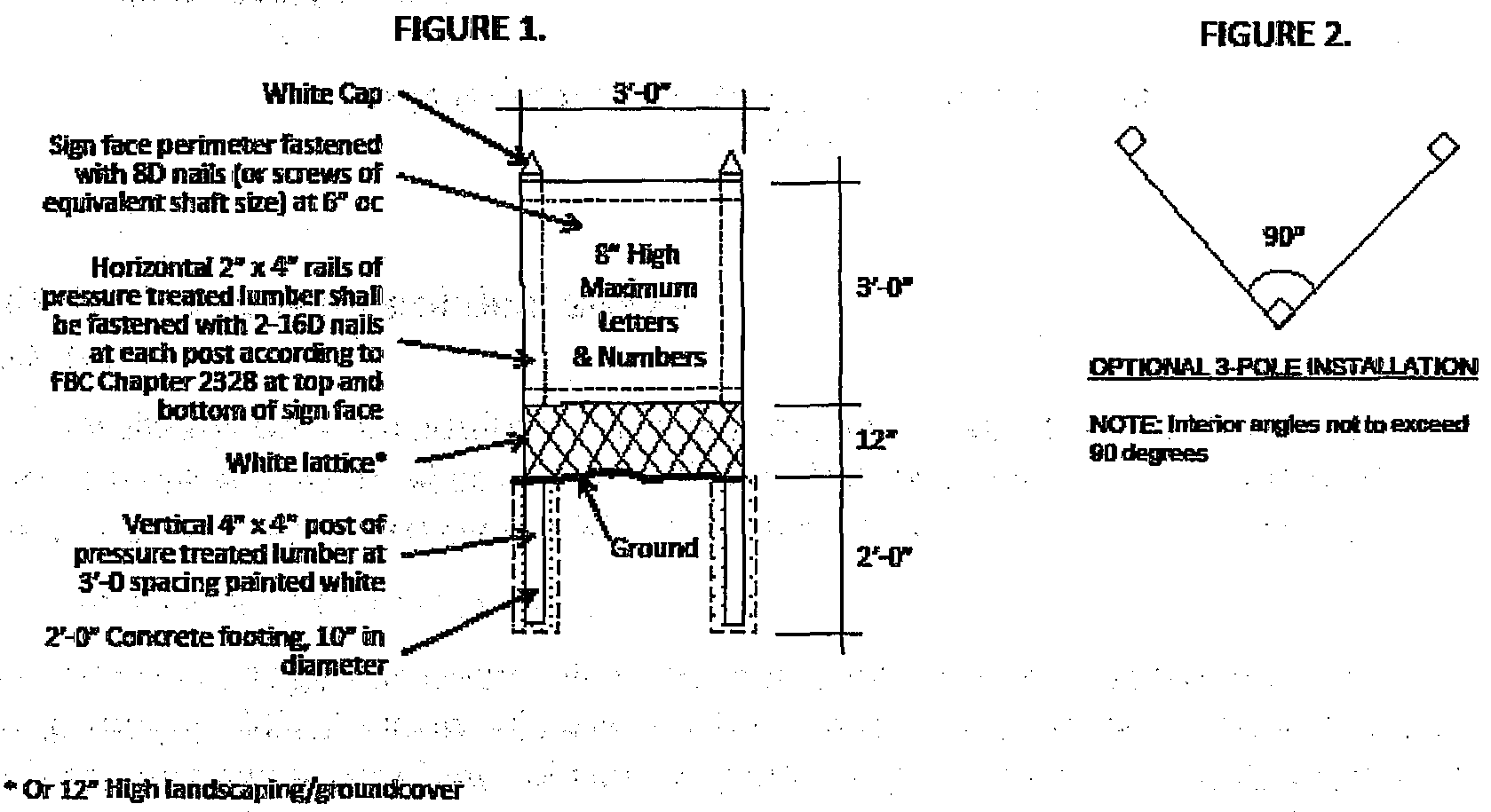
TEMPORARY REAL ESTATE SIGNS CONSTRUCTION DETAIL
NOT TO SCALE
(c)
Seasonal and promotional signs.
(1)
Seasonal signs for nonresidential developments. These may be erected and displayed not more than forty-five (45) days prior to the season and shall be removed within ten (10) days following the conclusion of the season. Such signs shall not be displayed more than ninety (90) days per twelve (12) month period.
(2)
Outdoor promotional sales signs. This subsection applies to temporary outdoor promotional sales, as authorized in section 16-20 of this code, "outdoor special events," that are used to sell merchandise available during a specific season that is not otherwise available on the premises.
a.
Permitted signage.
1.
One (1) ground sign up to thirty-two (32) square feet in area as may be approved for the event license.
2.
One (1) sign on a vehicle, mounted to tent or fence where the sales occur, up to thirty-two (32) square feet in area as may be approved for the event license.
3.
Directional signs up to thirty-two (32) square feet in area as may be approved for the event license.
b.
Timing and duration. Pursuant to section 16-20, "outdoor special events," the signs shall not be installed more than forty-eight (48) hours before or allowed to remain more than forty-eight (48) hours after the authorized timeframe for the event.
(3)
Commercial development promotional signs.
a.
Eligible events. Only events authorized in section 16-20, "outdoor special events," shall qualify for signage under this subsection.
1.
This subsection applies only to year-round businesses. Seasonal or one-time event outdoor promotional sales signage is regulated separately.
2.
Grand opening signs are authorized only upon issuance of a business tax receipt for a new business, and must be conducted within sixty (60) days of the issuance of said receipt.
b.
Permitted signs for individual tenant promotions.
1.
One (1) building-mounted banner per tenant building frontage not to exceed thirty-two (32) square feet in area.
2.
One (1) ground sign along each street frontage of the development, up to thirty-two (32) square feet in area and six (6) feet in height.
3.
For grand openings, inflatable advertising devices and clusters of balloons are permitted. The proposed quantity and placement shall be specified and approved with the application for promotional activity permit.
4.
No more than two (2) tenants within a development may display promotional signage at any one (1) time.
c.
Permitted signs for on-site promotions that are advertised as plaza-wide events on properties with more than five hundred (500) feet of frontage on a major street.
1.
One (1) building-mounted banner adjacent to each entrance into the development, up to sixty-four (64) square feet in area. The banner shall not obscure permanent tenant signage.
2.
One (1) inflatable device per major street frontage.
3.
Signs may be externally illuminated during the establishment's business hours, provided that inflatable devices may be internally illuminated and further that all illumination is consistent with section 13-374, "outdoor lighting."
d.
Timing and duration. Timeframes for the display of promotional signs are regulated by section 16-20, "outdoor special events."
(4)
Yard sale signs.
a.
Permitted signage. One (1) ground sign on the premises upon which the yard sale in a residential zoning district will occur for each street frontage, not to exceed three (3) square feet in area and three (3) feet in height.
b.
Timing and duration. May be posted on the day of the yard sale and shall be removed at the conclusion of the sale.
(Ord. No. 2016-39, § 2, 9-22-16)
Sec. 13-469.2. - Temporary noncommercial signs.
(a)
General regulations for temporary noncommercial signs. Signs are not permitted on rights-of-way or medians, except such signs that are continuously held by persons.
(b)
Temporary noncommercial signs on property that front minor street(s). Signage is permitted up to a cumulative area of three (3) square feet per property, or in the instance of multi-tenant properties, per unit, and six (6) feet in height.
(c)
Temporary noncommercial signs on property that front major street(s). Signage is permitted up to a cumulative area of thirty-two (32) square feet per property and six (6) feet in height; however, any sign over twelve (12) square feet in area requires a building permit in order to ensure compliance with the Florida Building Code.
(Ord. No. 2016-39, § 2, 9-22-16)
Sec. 13-470.- Nonconforming and abandoned signs; signs in disrepair.
(a)
Nonconforming signs. Signs or sign structures made nonconforming upon passage of this sign code or on passage of any amendment hereto, shall be governed by the following regulations:
(1)
A sign existing within the city, upon the passage of this sign code or any amendment hereof which, because of its height, square foot area, location, design or other characteristic, does not conform to this sign code, is hereby declared to be a nonconforming sign.
(2)
In a multi-tenant project with nonconforming signs that are permitted to remain pursuant to the provisions of this section, all new tenant signs shall conform to this sign code.
(3)
In the event a nonconforming sign is damaged or is in need of repair, to the extent that the cost of repairing the sign equals fifty (50) percent or more of the original cost of the sign, then its status as a "nonconforming sign" under this section shall be automatically revoked and any repairs shall be made so that said sign shall meet all the requirements of these regulations.
(4)
Re-lettering or change of copy shall not constitute change of status in nonconforming signs.
(5)
A nonconforming sign shall immediately lose its nonconforming status and the sign shall be immediately brought into compliance with this chapter (with a new permit secured when required by the city's Code of Ordinances or the Florida Building Code) or shall be removed if:
a.
The sign is structurally altered in any way (except for normal maintenance) that makes the sign less in compliance with the requirements of this chapter than it was before the alteration, including updating the technology used in a sign; or
b.
the sign is replaced, abandoned, altered or relocated.
(6)
The status afforded signs under this section shall not be applicable to any sign for which no permit or sign permit was ever issued; such signs are deemed illegal signs.
(7)
This section shall not be interpreted to require the removal of a billboard or other off-premise sign pursuant to F.S. § 70.20, as amended from time to time.
(b)
Nonconforming sign maintenance and repair. Nothing in this section shall relieve the owner or user of a nonconforming sign, or the owner of the property on which the nonconforming sign is located, from required compliance with the provisions of this chapter regarding safety, maintenance and repair of signs.
(c)
Sign removal. Any signs identifying a business, commodity or service previously associated with vacated or abandoned premises shall be removed from the premises by the owner or lessee no later than thirty (30) days from the time said activity ceases to exist. The façade shall be restored to original condition following removal of a sign pursuant to this section. All ground identification signs and entrance feature signs may remain intact provided the sign's aesthetic appearance/condition is maintained in its original condition.
(d)
Signs in disrepair. Any signs on a building, lot or parcel that have structural inadequacies that affect its aesthetic appearance or purpose shall be restored to proper condition or removed from the premises within thirty (30) days.
(Ord. No. 2016-39, § 2, 9-22-16)
Sec. 13-471. - Sign review procedures.
(a)
Required. Except as otherwise provided herein, all signs or flagpoles prior to being located, placed, erected, constructed, altered, extended, or displayed shall first be subject to applicable zoning review in accordance with the following standards and diagrams.
(1)
Uniform sign plan as part of a site plan approval or as part of a separate approval process.
a.
Applicability. At the time of site plan approval or as part of a separate approval process, all projects must submit a preliminary uniform sign plan for review and approval. If the uniform sign plan seeks bonuses through the inclusion of a designer sign or signs, a separate designer sign review application must be submitted in addition to the site plan application.
b.
Submission requirements. Within a site plan package or as part of a separate approval process, a uniform sign plan shall include:
1.
Plans, elevations and details as needed to demonstrate that signs shall be integrated into a coherent design throughout the site and compatible with the architectural design of the development.
2.
The location and type of ground signage relative to other ground signs, landscape features, pedestrian ways, and sidewalks, shown on the fully dimensioned site plan, drawn to scale.
3.
Building elevations showing the intended and permitted locations of each sign type, and depicting the relationship between the various types of signs. This shall include wall signage for the identification of buildings, the development, and individual establishments, as applicable, and building or bay addresses.
4.
Outparcel ground sign locations, as applicable.
5.
Site plan or as part of a separate approval process or elevations that demonstrate how the proposed signage and sightlines will relate to existing and proposed landscaping when mature.
6.
Any other information necessary to determine compliance with this subdivision.
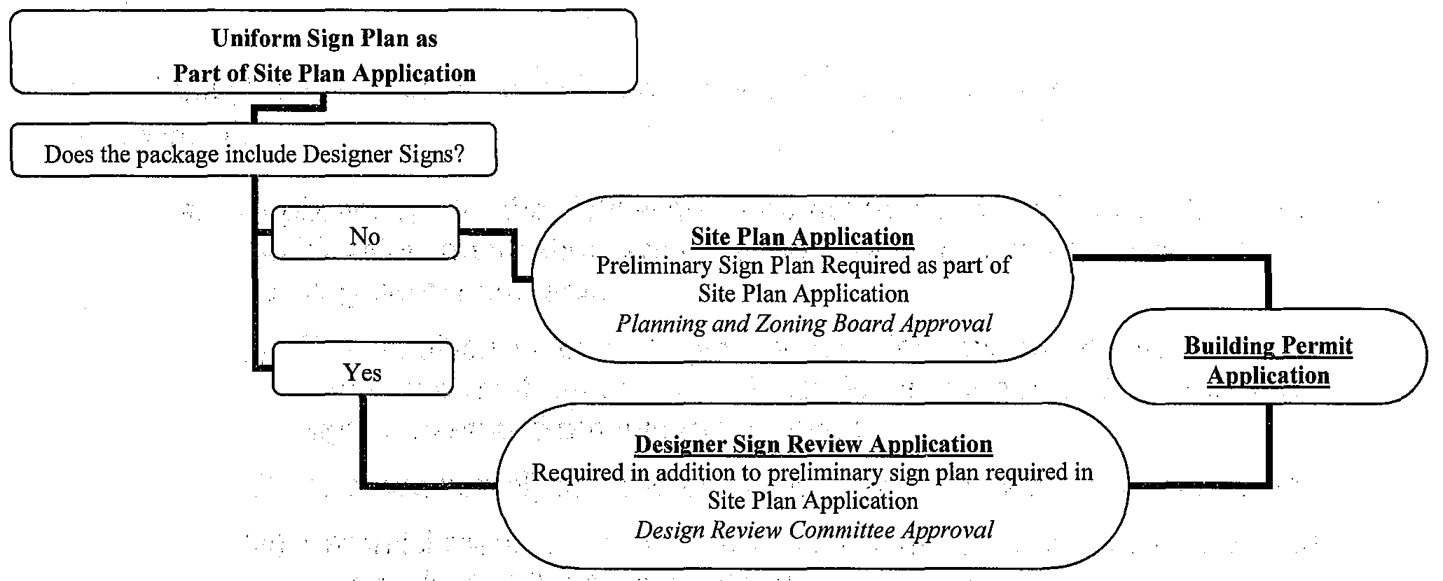
(2)
Sign plan modification. Modification or establishment of a uniform sign plan post site plan approval.
a.
Applicability. In the following circumstances an administrative sign plan modification application shall be filed with the zoning division prior to the building permit process.
1.
The addition of one (1) sign which identifies more than one (1) entity such as a multi-tenant sign. A single directional, directory or wayfinding sign is exempt from this requirement.
2.
The addition of, or structural modification to, two (2) or more signs.
3.
Establishment of a uniform sign plan in the event one was not established at the time of site plan approval.
b.
Submission requirements.
1.
Application form. A sign review application shall be filed, together with drawings and specifications as further detailed below.
2.
Statement of authorization. Any application form which is signed by an individual other than the property owner shall be accompanied by a statement of authorization by the property owner's authorized agent consenting to the sign placement. If the property or building upon which the sign is to be located is leased, a copy of the executed lease specifically authorizing placement of the sign on the premises may be provided in lieu of the notarized statement.
3.
Plans and specifications. Plans and specifications for any proposed sign shall be to scale and shall include the following:
(i)
Dimensions and elevations of the sign structure including the maximum height of the sign, as measured in accordance with this subdivision, the specified materials and finishes of the sign, and the anchoring of the sign's supporting members;
(ii)
Dimensions and elevations of the sign face, including the message of the sign with dimensioned characters and line spacing;
(iii)
For ground signs, site information including lot frontage on all street rights-of-way, location of the sign in relation to property lines, public rights-of-way, easements, buildings, other ground signs, existing and proposed landscape, pedestrian ways, and sidewalks;
(iv)
For wall-mounted signs, intended location of the proposed sign(s), linear and vertical dimension(s) of the portion of the façade to which the sign will be attached, dimensions and sign area calculations, and depicting the relationship between the various types of signs. This shall include wall signage for the identification of buildings, the development, and individual establishments, as applicable, and building or bay addresses;
(v)
For illuminated signs, the type, location, and direction of illumination sources;
4.
Demonstrate that the signs to be located on the property shall be integrated into a coherent design throughout the site that is compatible with the architectural design of the development.
5.
Existing development proposing a new uniform sign plan shall address the removal or modification of signage that does not conform to the plan.
6.
Any other information necessary to determine compliance with this subdivision
(3)
Building permit.
a.
Applicability. In the following instances the zoning review of signs shall occur during the building permit process.
1.
The addition of one (1) sign which identifies a single entity. A sign which identifies more than one (1) entity, such as a multi-tenant sign, must submit a separate sign review application with the zoning division prior to the building permit process. A single directional, directory or wayfinding sign may also be reviewed during the building permit process.
2.
The reface of an existing sign or signs which does not alter the structure of the sign.
3.
Signs which do not require a building permit, such as incidental signs, remain subject to the standards of this subdivision. Prior to installation, plans for such signs may be informally submitted to the zoning division for an administrative review to verify compliance.
b.
Submission requirements. As applicable to the sign type proposed, submittal requirements are consistent with those required for a modification to a uniform sign plan per subsection 13-471(a)(2)b., "sign plan modification", above.
(4)
Designer sign review.
a.
Applicability. A designer sign review is required in the following instances:
1.
A designer sign or signs as part of a proposed uniform sign plan. This application does not preclude an applicant from providing a preliminary uniform sign plan with a site plan application.
2.
The addition of a designer sign to an existing uniform sign plan post site plan approval.
b.
Submission requirements. Designer sign review applications shall be filed consistent with section 13-474, "designer signs."
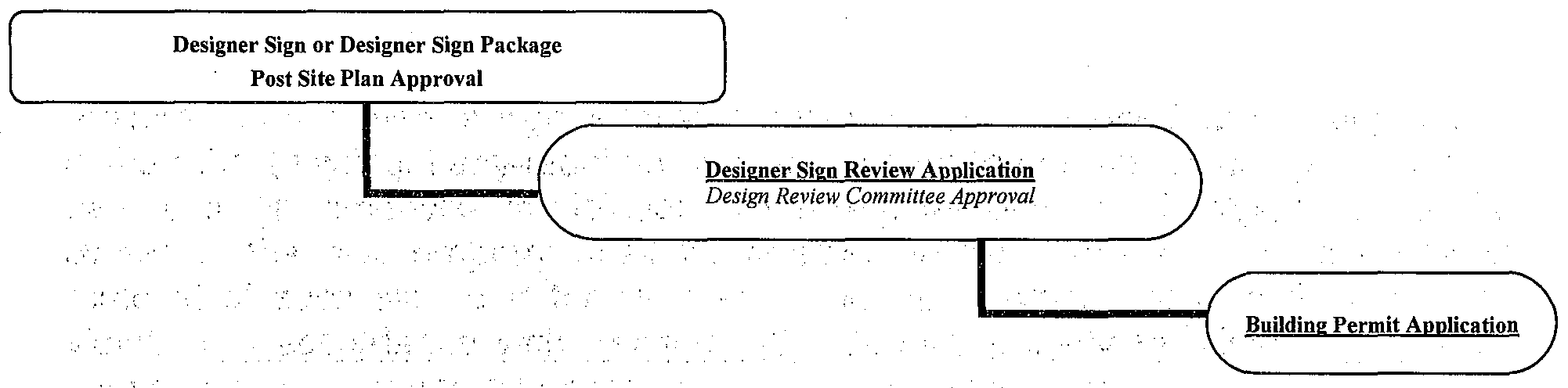
(b)
Violation. In the event a sign is located, installed, or maintained upon real property in the city (i) without required permits, (ii) after the expiration or lapse of a sign permit, or (iii) otherwise in violation of the requirements of this sign code, the owner of the real property shall be deemed to be responsible for the prompt removal of such sign and for all fines or penalties which shall result from such violation in accordance with section 1-8, "general penalty for violation of Code; continuing violation and other remedies and administrative fees."
(c)
Expiration of sign review approval. Every uniform sign plan approval permit issued by the department pursuant to this sign code shall become invalid unless the work authorized by such sign permit is commenced within eighteen (18) months after its issuance or, if the work authorized by such sign permit is suspended or abandoned for a period of eighteen (18) months after the time that the work has commenced. If the work has commenced and the sign plan approval is revoked, becomes null and void or expires because of a lack of progress or abandonment, a new uniform sign plan approval permit covering the proposed work shall be obtained before proceeding with the work.
(d)
Revocation of sign plan approval.
(1)
Revocation. The department is authorized and empowered to revoke, in writing, any sign development review approval issued pursuant to this subdivision: (i) upon failure of the holder of the permit to comply with the provisions of this subdivision, or (ii) if the permit was issued on the basis of misstatement of facts or fraud by the applicant. The written notice of revocation shall describe the appeal process, and shall be delivered by certified mail, return receipt requested, to the sign owner.
(e)
Appeal. An appeal may be filed pursuant to the procedures set forth in section 13-34, "appeals."
(f)
Fees. Sign design review fees shall be paid as provided by the schedule in section 13-81, "development application fees."
(g)
Signs exempt from sign review procedures. The following signs shall be exempt from the sign review procedures. All other provisions of these regulations shall continue to apply. This exemption in no way waives the requirements of structural and/or safety requirements outlined by these regulations and/or the Florida Building Code.
(1)
Signs installed or required to be installed by federal, state, county and/or municipal agencies.
(2)
Window signs unless capable of displaying a changeable digital message or image.
(3)
Real estate signs on single-family and multi-family units.
(4)
Flags (flag poles require a permit).
(5)
Nameplate signs, building address signs, identification signs or signs indicating the hours of operation when said signs do not exceed three (3) square feet in total area; larger signs of these types require a permit.
(6)
Yard sale signs.
(7)
Changes of copy in permitted changeable copy signs.
(8)
Temporary noncommercial signs.
(Ord. No. 2016-39, § 2, 9-22-16)
Sec. 13-473. - Deviations.
(a)
Deviations. A deviation is a modification of requirements of this subdivision to allow for unusual conditions relating to property or structures where special conditions exist or when literal enforcement of the provisions of this chapter will result in unnecessary or undue hardship which is non-self-imposed, non-financial in nature. However, deviations must not have the effect of allowing a category or type of sign that is prohibited by this subdivision. The deviation process replaces the variance process of section 13-33, "variances," as it pertains to signs. Variances shall not be granted for signs.
(b)
Application for deviation. Requests for deviations and the reasons therefore shall be set forth by the applicant in the application for deviation from sign provisions. They shall be accompanied by documentation including, but not limited to, sample detail drawings, schematic architectural drawings, site plans, elevations, and perspectives which shall graphically depict the proposed deviation(s) and illustrate how each deviation would meet the criteria of this section.
(c)
Review. An application for deviation from the sign provisions shall be acted upon within thirty (30) days of receipt of a complete application and associated fees by the department. Deviations from the provisions of this sign code shall be considered by the planning and zoning board with the final decision to be made by the city commission, upon a finding that the following criteria are met:
(1)
The deviation must not be contrary to the public interest, and must be in harmony with the general intent and purpose of this subdivision; and
(2)
Approval of the deviation will not adversely affect the character of the surrounding development or applicable uniform sign plan; and
(3)
The literal interpretation and application of the sign regulations will deprive the applicant of sign visibility or effectiveness shared by other property owners; and
(4)
Approval of a deviation will not degrade the area involved or be detrimental to public welfare; and
(5)
One (1) of the following conditions are satisfied:
a.
Conditions exist that are not the result of the applicant's actions, such that a literal enforcement of the regulations involved would result in unnecessary or undue hardship; or
b.
There is something unique about the land, building or site configuration that would cause the signage permitted by this sign code to be ineffective in identifying a use or structure that would otherwise be entitled to a sign.
(d)
Final decision. Subject to the standards and criteria stated in subsection 13-473(c), "review", above, the city commission shall approve only the minimum deviation from the provisions of this sign code necessary to avoid the unnecessary or undue hardship required by subsection 13-473(c)(5)a. or to cause the signage for the site to be effective in identifying the use or structure located on the site in accordance with subsection 13-473(c)(5)b.
(e)
Appeal of decision. The decision of the city commission is final and may only be appealed to circuit court.
(Ord. No. 2016-39, § 2, 9-22-16; Ord. No. 2017-008, § 2, 1-11-18)
Sec. 13-474. - Designer signs.
(a)
Intent. This special category of signs has been created by the city to encourage signage that is creative or sculptural. Recognizing that a well-designed sign can be a work of art and the extra effort required to create that type of sign, the city seeks to reward this effort through an increase of sign face area or size of sign structure, and flexibility in the design and use of colors in signs.
(b)
Quality design required. Applicants are required to use the services of a design professional to create their sign and to utilize a well-qualified signage manufacturer to fabricate and install their sign. Three-dimensional sculptural creations are encouraged, whether for a wall or ground sign, window or temporary signs.
(c)
Definition and criteria. Designer signs are defined as a wall or monument type of sign that exhibits unique, dimensional, creative and innovative methods of design, lighting, materials of construction that are above the typical sign industry standard. A designer sign can be a wall sign on an individual building or within a shopping center or a ground sign integrated into the site's landscaping. A designer sign can be traditional elements in a creative combination. It must exhibit multiple characteristics identified below in order to be considered designer signage that is eligible for the incentives of this section:
(1)
Design. Must be dimensional and enhance the architecture of the establishment or development that it identifies, and coordinates with, or builds upon, the landscape architecture where placed.
(2)
Materials. Must be combined to exceed industry standard quality such as natural stone, stainless steel or glass.
(3)
Typefaces, colors and lighting. Must be contributing elements to the overall design of the sign.
(4)
Design and arrangement. Shall be integrated as part of an overall design of the landscape, building or site, as applicable.
(d)
Incentives. Designer signs are eligible for the following incentives:
(1)
Bonus for designer building identification signs.
a.
Up to twenty-five (25) percent total additional building identification signage area.
b.
Transfer of signage allowance between façades may be permitted.
c.
Place a building sign in a location other than the first or upper-most fascia of a multi-story building.
(2)
Bonus for designer ground signs.
a.
Area: up to fifty (50) percent additional sign area.
b.
Height: up to four (4) feet of additional ground sign height, not to exceed fourteen (14) feet total height.
c.
Spacing: spacing flexibility between ground signs.
d.
Number: the number of ground signs may be increased, provided the total permitted sign area, with bonus, is not exceeded.
e.
Angle: the interior angle of a dual-face sign may exceed fifteen (15) degrees.
f.
Tenants: the number of tenants that can be identified on the sign may be increased.
g.
Faces: A sign may have more than two (2) faces.
(3)
Colors. There shall be no limitations on the number of colors.
(4)
Additional sign types permitted within MainStreet, only with a designer sign bonus. The following signs types are permitted only as a bonus for a tenant that installs designer building identification signs pursuant to this section, subject to the standards established for these signs in section 13-463, "MainStreet Development Sign Regulations:"
a.
Roof signs.
b.
Projecting signs above the ground floor.
c.
Signage on the incline surface of an awning.
(e)
Procedure.
(1)
Relationship to uniform sign plan. Designer signs shall be proposed as part of a uniform sign plan, or modification to an existing uniform sign plan. However, a single establishment within a larger multi-establishment development that proposes designer signage is not required to amend the uniform sign plan for the entire development, provided that the development review committee shall review the proposal for compatibility with the existing uniform sign plan.
(2)
Submittal materials.
a.
Application must contain exhibits that explain and demonstrate why and how the sign submitted is unique to qualify for this consideration.
b.
Site plan for the entire site, existing or proposed uniform sign plan as applicable, photos and/or drawings of the architecture of the site and a landscape plan for the site of the sign that complements the sign placement.
(3)
Decision, appeal. The development review committee will determine whether the signage proposal qualifies as designer signage, and is therefore eligible for the incentives. The applicant may appeal the decision of the development review committee to the planning and zoning board following the procedures for appeal established in section 13-34, "appeals."
(4)
Fee. Fee is due at the time of submittal pursuant to section 13-81, "development application fees."
(Ord. No. 2016-39, § 2, 9-22-16)
Sec. 13-481.- General purpose.
The purpose of this subdivision is to permit efficient, attractive and economical development by increasing flexibility in the location and arrangement of dwelling units providing increased useful open space.
(Ord. No. 115-86, § 307.0801, 7-10-86; Ord. No. 159-87, § 307.0801, 6-11-87)
Sec. 13-482. - Permitted use.
Any parcel of land at least ten (10) acres in size and located within a residential zoning district which permits cluster development as a permitted use may be developed in conformance with the regulations of this subdivision.
(Ord. No. 115-86, § 307.0802, 7-10-86; Ord. No. 159-87, § 307.0802, 6-11-87)
Sec. 13-483. - Approval process.
Applications for cluster development shall be approved in accordance with the procedures for site plan review contained in Division 5 of this article.
(Ord. No. 115-86, § 307.0803, 7-10-86; Ord. No. 159-87, § 307.0803, 6-11-87)
Sec. 13-484. - Site development regulations.
(a)
Net density. Dwelling units per acre for any residential cluster development shall not exceed the maximum number of dwelling units permitted by applicable land use and zoning regulations for a particular parcel.
(b)
Minimum lot area. The minimum lot area for each dwelling unit may be reduced by thirty-five (35) percent of the minimum required in the applicable zoning district. The total area of the reduced size of individual lots shall be provided in common open space.
(c)
Minimum dwelling unit size. The minimum dwelling unit size shall be no less than that required by the zoning district in which the subject property is located.
(d)
Minimum front setback. The minimum front yard shall be no less than that required by the zoning district in which the subject property is located.
(e)
Minimum side setback. The minimum side setback may be modified to permit zero-lot line development provided the distance between buildings shall be no less than that required by the zoning district in which the subject property is located.
(f)
Minimum lot width and lot depth. There shall be no minimum lot width or lot depth required.
(g)
Maximum building height. The maximum building height shall be no greater than that permitted in the zoning district in which the subject property is located.
(Ord. No. 115-86, § 307.0804, 7-10-86; Ord. No. 159-87, § 307.0804, 6-11-87)
Sec. 13-501.- Permitted uses.
Heliports and helistops shall be a permitted use by special exception use in commercial and industrial districts, subject to approval by the city commission, after review and recommendation by the planning and zoning board and the city engineer.
(Ord. No. 115-86, § 307.0901, 7-10-86; Ord. No. 159-87, § 307.0901, 6-11-87)
Sec. 13-502. - Design and operation.
Design and operation of heliports shall be in compliance with the FAA Heliport Design Guide, supplemented by additional information required by the city commission.
(Ord. No. 115-86, § 307.0902, 7-10-86; Ord. No. 159-87, § 307.0902, 6-11-87)
Sec. 13-503. - Location.
No heliport or helistop area may be located within five hundred (500) feet of any residential area nor within one thousand (1,000) feet of any school or place of public assembly.
(Ord. No. 115-86, § 307.0903, 7-10-86; Ord. No. 159-87, § 307.0903, 6-11-87)
Sec. 13-504. - Size.
The helistop area or site shall be a minimum of one hundred fifty (150) square feet on the ground or on the roof of a structure.
Ord. No. 115-86, § 307.0904, 7-10-86; Ord. No. 159-87, § 307.0904, 6-11-87)
Sec. 13-521.- Application and enforcement.
(a)
Application of standards.
(1)
All uses established or enlarged subsequent to the effective date of the ordinance from which this article was derived shall comply with the performance standards set forth in this subdivision.
(2)
All uses existing on the effective date of the ordinance from which this article was derived shall be brought into compliance with the performance standards set forth in this subdivision within three (3) years of such date, except that the period for compliance may be extended by a number of years equal to: 100 × CC/AV
(b)
Enforcement.
(1)
For uses which are: 1) subject to site plan review, and 2) established or enlarged subsequent to the effective date of the ordinance from which this subdivision was derived, and 3) industrial uses or other uses which involve activities, equipment, materials or processes which have a substantial possibility of being operated in violation of this subdivision, applicants for site plan review approval shall submit a performance standards compliance analysis of proposed facilities and operations prepared by licensed engineers or other professionals. No site plan approval shall be granted unless:
a.
The analysis is found by the site plan review authority to be appropriately prepared by qualified professionals; and
b.
The analysis contains definite findings that the proposed facilities and operations will be in compliance with the performance standards set forth herein; and
c.
The applicant submits a sworn affidavit that the operation will be conducted in accordance with any assumptions set forth in the performance standards compliance analysis.
(2)
Whenever the director of sustainable development determines that there is a possible violation of this subdivision he shall conduct an investigation of the subject use to determine if a violation exists. When a determination can be made by the city staff, using equipment normally available to the city or obtainable without extraordinary expense, such determinations shall be made before notice of violation is issued. When technical complexity or extraordinary expense makes an investigation utilizing city personnel and/or equipment infeasible, the director of sustainable development shall, if funds are available, retain an expert consultant to determine if a land use activity is in compliance with this subdivision. Such consultants shall be fully qualified to make the required determination and shall be persons or firms mutually agreeable to the city and to the owner or operator of the use in question. In the event of inability to select a mutually agreeable consultant, the city and the owner or operator may select independent consultants, in which event each party shall bear its own costs irrespective of the final determination of compliance or noncompliance with the performance standards in question. If one (1) consultant is mutually agreed upon, the cost of the consultant's services shall be borne by the owner or operator of such use, if the use is found to be in violation of this subdivision. If the use is found by the final authority to be in compliance with this subdivision the city shall bear the cost of the consultants services.
(Ord. No. 115-86, § 307.16, 7-10-86; Ord. No. 159-87, § 307.16, 6-11-87; Ord. No. 2024-012, § 2, 4-11-24)
Sec. 13-522. - Reserved.
Editor's note— Ord. No. 2021-005, § 2, adopted March 11, 2021, repealed § 13-522, which pertained to noise limitations and derived from Ord. No. 115-86, § 307.1601, adopted July 10, 1986; Ord. No. 159-87, § 307.1601, adopted June 11, 1987.
Sec. 13-523. - Smoke limitations.
(a)
No smoke shall be emitted from any source having a density or equivalent opacity of greater than No. 1 on the Ringelmann Smoke Chart as published by the U.S. Bureau of Mines Circular, No. 8333, except that smoke in excess of Ringelmann No. 1, but not exceeding Ringelmann No. 2, shall be permitted for not more than five (5) minutes in any one-hour period.
(b)
Smoke not exceeding Ringelmann No. 3 shall be permitted for five (5) minutes during any eight-hour period for the purposes of fire cleaning only. Smoke in excess of Ringelmann No. 3 is prohibited.
(Ord. No. 115-86, § 307.1602, 7-10-86; Ord. No. 159-87, § 307.1602, 6-11-87)
Sec. 13-524. - Limitations on dust and dirt, fumes, vapors and gases.
(a)
The emission of dust, dirt, fly ash, fumes, vapors or gases which can cause any damage to human health, animals or vegetation or other forms of property or which can cause any soiling or staining of persons or property at any point beyond the lot line of the use creating the emission is herewith prohibited.
(b)
No emission, liquid or solid particles from any chimney or similar device shall exceed 0.3 grains per cubic foot of the covering gas at any point beyond the lot line of the use creating the emission. For measurement of the amount of particles in gases resulting from combustion, standard correction shall be applied to a stack temperature of five hundred (500) degrees Fahrenheit and fifty (50) percent excess air in the stack at full load.
(Ord. No. 115-86, § 307.1603, 7-10-86; Ord. No. 159-87, § 307.1603, 6-11-87)
Sec. 13-525. - Odor limitations.
(a)
Odorous material released from any operation or activity shall not exceed the odor threshold beyond the lot line, measured either at ground level or habitable elevation.
(b)
Odor threshold is defined as the lowest concentration of odorous matter that produces an olfactory response in normal human beings. Odor thresholds shall be measured in accordance with ASTM d 1931-57, Standard Method for Measurement of Odor in Atmosphere (Dilution Method), or its equivalent.
(Ord. No. 115-86, § 307.1604, 7-10-86; Ord. No. 159-87, § 307.1604, 6-11-87)
Sec. 13-526. - Heat limitations.
No heat from any use shall be sensed at any property line to the extent of raising the temperature of air or materials more than one (1) degree Fahrenheit.
(Ord. No. 115-86, § 307.1605, 7-10-86; Ord. No. 159-87, § 307.1605, 6-11-87)
Sec. 13-527. - Glare limitations.
Any operation or activity producing glare shall be conducted so that direct or indirect light from the source shall not cause illumination in excess of 0.5 footcandle when measured in any residential or commercial district.
(Ord. No. 115-86, § 307.1606, 7-10-86; Ord. No. 159-87, § 307.1606, 6-11-87)
Sec. 13-528. - Vibration limitations.
(a)
No use shall cause vibrations exceeding the maximum values specified in this section. The maximum vibration is given as particle velocity, which may be measured directly with suitable instrumentation or computed on the basis of displacement and frequency. When computed, the following formula shall be used:
(b)
At any adjacent lot line, PV shall not exceed 0.10 inch per second; except, within any residential district, PV shall not exceed 0.02 inch per second. Where vibration is produced as discrete impulses and such impulses do not exceed a frequency of one hundred (100) per minute, then the values in these values may be multiplied by 2.
(c)
Particle velocity shall be the vector sum of three (3) individual components measured simultaneously in three (3) mutually perpendicular directions.
(Ord. No. 115-86, § 307.1607, 7-10-86; Ord. No. 159-87, § 307.1607, 6-11-87)
Sec. 13-529. - Storage of flammable, toxic or explosive substances.
(a)
General provisions. All flammable, toxic or explosive liquids, solids and gas shall be stored in bulk below ground with the exception of the following:
(1)
Tanks or drums of fuel connected directly to energy devices, heating devices or appliances located and operated on the same lot as the tanks or drums of fuel;
(2)
Temporary diesel fuel tanks and drums.
(b)
Location and use requirements for aboveground diesel fuel tanks and drums.
(1)
Tanks and drums shall be located only on construction sites or in maintenance yards.
(2)
Tanks and drums shall be used to refuel equipment and vehicles used exclusively for on-site construction or maintenance.
(3)
Tanks and drums shall be removed within thirty (30) days of completion of construction or maintenance activities.
(4)
Tanks shall be installed and operated in conformance with the requirements governing installation and operation of stationary tanks contained in Chapter 17-61 of the Florida Administrative Code and Regulation 84-3 of the county environmental quality control board.
(5)
Tanks and drums shall not be installed within one hundred (100) feet of any permanent or temporary structure or within fifty (50) feet of any road or waterway.
(6)
Tanks and drums shall be accessible to firefighting and other emergency equipment and vehicles.
(7)
Tanks and drums shall be protected from unauthorized access by a six-foot high chain link fence with controlled access gates.
(8)
No tank or drum shall exceed one thousand (1,000) gallons of storage capacity. No more than two thousand (2,000) gallons of diesel fuel shall be stored on any construction or maintenance site.
(9)
Tanks and drums shall meet all requirements contained in Chapter 16 of the county fire code.
(c)
Location and use requirements of below ground fuel tanks and drums.
(1)
Belowground fuel storage shall be permitted only in construction and maintenance sites and in the following zoning districts: B-2, IM-1 and PUD.
(2)
Tanks and drums shall be removed within thirty (30) days of completion of construction or maintenance activities or upon completion of business activities related to fuel storage.
(3)
Tanks shall be installed and operated in conformance with the requirements governing installation and operation of belowground tanks contained within Chapter 17-61 of the Florida Administrative Code and Regulation 84-3 of the county environmental quality control board.
(4)
Tanks and drums shall not be installed within one hundred (100) feet of any permanent or temporary structure or within fifty (50) feet of any road or waterway.
(5)
Tanks and drums shall be accessible to firefighting and other emergency equipment and vehicles.
(6)
Those belowground tanks utilized on construction or maintenance sites shall not exceed one thousand (1,000) gallons of storage capacity. No more than two thousand (2,000) gallons of fuel shall be stored below ground on any construction or maintenance site.
(7)
The method of construction for all belowground fuel storage tanks and drums shall be in compliance with Chapter 17-61 of the Florida Administrative Code and all applicable requirements issued by the state department of environmental regulation and the county environmental quality control board.
(d)
Permit requirements.
(1)
A building permit, issued by the director of sustainable development, shall be required for installation of all aboveground and belowground fuel storage tanks and drums.
(2)
The application for such permit shall contain the following information:
a.
A site plan showing the location of the proposed tanks and drums and showing all permanent improvements and site features within one hundred (100) feet of the proposed tanks and drums;
b.
A statement detailing the frequency of refilling of the tanks and drums, methods used to draw or pump fuel from the tanks and methods used to contain and correct accidental spills;
c.
A copy of the required state department of environmental regulation permit or letter verifying waiver of such department of environmental regulation permit requirements pursuant to Chapter 17-61 of the Florida Administrative Code.
(3)
Each permit issued by the director of sustainable development for the installation of temporary aboveground diesel fuel tanks and drums shall remain in effect for a period of one (1) year from the date of issuance. A new permit is required for relocation of such temporary diesel fuel tanks and drums. Each permit issued by the director of sustainable development for the installation of belowground tanks and drums shall remain in effect for that period of time designated in the permit issued for such installation by the state department of environmental regulation.
(Ord. No. 115-86, § 307.1608, 7-10-86; Ord. No. 159-87, § 307.1608, 6-11-87; Ord. No. 2024-012, § 2, 4-11-24)
Cross reference— Fire prevention and protection generally, Ch. 9.
Sec. 13-530. - Application of performance standards.
(a)
Any use established or changed in any building, structure or land developed, constructed or used for any use or any accessory use thereto, shall comply with all the performance standards set forth in this subdivision.
(b)
Any existing use or building or other structure extended, enlarged or reconstructed, shall comply with the performance standards set forth in this subdivision.
(c)
Determinations necessary for administration and enforcement of performance standards set forth in this subdivision range from those which can be made with satisfactory accuracy by a reasonable person using normal senses, without mechanical equipment, to those requiring great technical competence and complex equipment for precise measurement. It is the intent of this subdivision that:
(1)
Where determinations can be made by the director of sustainable development using equipment normally available to the city or obtainable without extraordinary expense, such determinations shall be so made before notice of violation is issued.
(2)
Where technical complexity or extraordinary expense make it unreasonable for the city to maintain the personnel or equipment necessary to make difficult or unusual determinations, procedures shall be made available for causing corrections of apparent violations of performance standards, protecting individuals from arbitrary, capricious and unreasonable administration and enforcement of performance standard regulations and protecting the general public from unnecessary costs for administration and enforcement.
(d)
Upon the determination by the director of sustainable development that a violation exists, he shall take or cause to be taken any lawful action necessary to cause correction within the limits established by such performance standards.
(Ord. No. 115-86, § 307.1609, 7-10-86; Ord. No. 159-87, § 307.1609, 6-11-87; Ord. No. 2024-012, § 2, 4-11-24)
Sec. 13-535.- Intent.
(a)
It is the intent of the city to promote the public health, safety and general welfare by: providing for the placement and maintenance of wireline and wireless communications facilities throughout the city and in the city's rights-of-way; adopting and administering reasonable rules and regulations not inconsistent with state and federal law, including F.S. § 337.401, as it may be amended, the city's home-rule authority, and in accordance with the provisions of the Federal Telecommunications Act of 1996 and other federal and state law; establishing reasonable rules and regulations necessary to manage the placement and maintenance of wireline and wireless communications facilities throughout the city and in the city's rights-of-way; and minimizing disruption to the city's zoning and uses already existing in the public rights-of-way. In regulating its public rights-of-way, the city shall be governed by and shall comply with all applicable federal and state laws.
(b)
The goals of this subdivision are to:
(1)
Minimize the impacts of wireless and wireline communications facilities on surrounding land uses by establishing standards for location, structural integrity, and compatibility;
(2)
Avoid conflict with existing and future city and publicly owned utilities and other facilities;
(3)
Avoid potential injury to persons and properties from tower failure and debris hazards through structural standards and setback requirements;
(4)
Preserve the aesthetic, scenic and visual character of the area by encouraging the location, design and architectural treatment of wireless communications facilities to avoid the disruption of the natural and built environment and to ensure harmony and compatibility with surrounding land use patterns;
(5)
Facilitate the provision of communications services to residents, businesses, and visitors;
(6)
Provide a uniform and comprehensive framework for evaluating proposals for communications facilities;
(7)
Encourage builders and tenants of wireless and wireline communications facilities and antennas to locate them, to the extent possible, in areas where the adverse impact on the community is minimal;
(8)
Encourage the location and collocation of wireless and wireline communications equipment on existing structures thereby minimizing new visual, aesthetic, and public safety impacts; minimizing effects upon the natural environment and wildlife; and reducing the need for additional antenna support structures;
(9)
Accommodate the growing need and demand for communications services;
(10)
Encourage coordination between suppliers and providers of communications services;
(11)
Establish predictable and balanced codes governing the construction and location of communications facilities, within the confines of permissible local regulations;
(12)
Establish review procedures to ensure that applications for wireless and wireline communications facilities are reviewed and acted upon within a reasonable period of time and in accordance with F.S. §§ 365.172 and 337.401, if applicable;
(13)
Respond to the policies embodied in the Telecommunications Act of 1996, if applicable, in such a manner as not to unreasonably discriminate between providers of functionally equivalent personal wireless services facilities or to prohibit or have the effect of prohibiting personal wireless services as those terms are defined in the Act; and
(14)
Encourage the use of public lands, buildings, and structures as locations for wireless and wireline communications infrastructure demonstrating concealed technologies and revenue generating methodologies.
(Ord. No. 2018-12, § 2, 6-28-18)
Sec. 13-536. - General terms and regulations.
(a)
Rules of interpretation. Certain terms used in this subdivision have been defined in this section. In the absence of definitions, the standard dictionary meaning shall be utilized. In any event, the director of development services shall have the right to interpret the terms contained in this subdivision. In construing the meaning of the subdivision, the following rules shall apply:
(1)
Words used in the present tense also include the future tense.
(2)
Words used in the singular number also include the plural and vice-versa.
(3)
The word "shall" is mandatory. The word "may" is permissible.
(4)
The word "development" shall refer also to "project" and the area in which a project takes place.
(5)
The words "used" or "occupied" shall be construed to include arranged, designed, constructed, altered, converted, rented, leased or intended to be used, intended to be occupied.
(6)
The word "lot" shall refer also to plot, parcel, tract and premises.
(7)
The word "building" shall refer also to structure, mobile home, dwelling and residence.
(8)
The words "area" and "district" may indicate and include the meaning "zone."
(9)
Except where specified, the provisions of this article shall be construed to mean the minimum standards, requirements and regulations adopted in pursuit of the purposes of this subdivision.
(b)
Definitions. For the purposes of this article, the following terms, phrases, words and derivations shall have the meanings given. Where not inconsistent with the context, words used in the present tense include the future tense, words in the plural number include the singular number, and words in the singular number include the plural number. The words "shall" and "will" are mandatory, and "may" is permissive. Words not otherwise defined in this section or in any permit that may be granted pursuant to this article shall be given the meaning set forth in the Communications Act of 1934, 47 U.S.C. § 151 et seq., as amended (collectively the "Communications Act"); and if not defined in the Communications Act, as defined by Florida Statutes; and, if not defined by Florida Statutes, shall be construed to mean the common and ordinary meaning.
Abandonment or abandoned shall mean the cessation of all uses of a communications facility for a period of one hundred eighty (180) consecutive days or more. Where a wireless infrastructure provider has applied to place utility poles in the public rights-of-way to support the collocation of small wireless facilities, and such collocation is not used by a wireless services provider to provide service within nine (9) months after the date the application is approved, same shall be deemed abandoned.
Accessory use means a use incidental to, subordinate to, and subservient to the main use of the property. As defined in this section an accessory use is a secondary use.
Alternative structure means a structure that is not primarily constructed for the purpose of supporting antennas, but on which one (1) or more antennas may be mounted. Alternative structures include, but are not limited to, buildings, water tanks, light stanchions, church steeples and electric power transmission towers.
Ancillary equipment means, for the purposes of this subdivision, any form of development associated with a communications facility, including but not limited to foundations, concrete slabs on grade, guy anchors, generators, and transmission cable supports; however, specifically excluding equipment cabinets.
Antenna means any apparatus designed for the transmitting and/or receiving of electromagnetic waves, including but not limited to telephonic, radio or television communications. Types of elements include, but are not limited to omni-directional (whip) antennas, sectionalized (panel) antennas, multi or single bay (FM and TV), yagi, or parabolic (dish) antennas.
Antenna array means a single or group of antenna elements and associated mounting hardware, transmission lines, or other appurtenances which share a common attachment device such as a mounting frame or mounting support structure for the sole purpose of transmitting or receiving electromagnetic waves.
Antenna element means any antenna or antenna array.
Antenna support structure means a vertical projection composed of metal or other material with or without a foundation that is designed for the express purpose of accommodating antennas at a desired height. Antenna support structures do not include any device used to attach antennas to an existing building, unless the device extends above the highest point of the building by more than twenty (20) feet. Types of support structures include the following: guy, lattice, and monopole structures.
Applicable codes shall mean uniform building, fire, electrical, plumbing, or mechanical codes adopted by a recognized national code organization or local amendments to those codes enacted solely to address threats of destruction of property or injury to persons, or local codes or ordinances adopted to implement F.S. § 337.401(7), the "Advanced Wireless Infrastructure Deployment Act," as amended. The term includes objective design standards adopted by ordinance that may require a new utility pole that replaces an existing utility pole to be of substantially similar design, material, and color or that may require reasonable spacing requirements concerning the location of ground-mounted equipment.
Applicant shall mean a person who submits an application and is either a wireless or wireline communications service provider.
Application shall mean a request submitted by a registered applicant to the city for a permit to construct communications facilities in the city's rights-of-way or to collocate small wireless facilities.
As-built survey(s) shall mean the final and complete drawing(s) in hard copy signed and sealed by a professional surveyor and mapper, as defined in F.S. § 472.005. An as-built survey is a survey performed to obtain horizontal and/or vertical dimensional data, so that constructed improvements can be located and delineated (also known as a record survey). As-built surveys depict the present/existing state of facilities/improvements in/on/over/through right(s)-of-way and/or land(s).
Authority shall mean a county or municipality having jurisdiction and control of the rights-of-way of any public road. The term does not include the department of transportation. Rights-of-way under the jurisdiction and control of the department of transportation are excluded from this subdivision.
Authority utility pole shall mean a utility pole owned by an authority in the right-of-way. The term does not include a utility pole owned by a municipal electric utility, a utility pole used to support municipally owned or operated electric distribution facilities, or a utility pole located in the right-of-way within:
(1)
A retirement community that: (I) Is deed restricted as housing for older persons as defined in F.S. § 760.29(4)(b); (II) Has more than five thousand (5,000) residents; and (III) Has underground utilities for electric transmission or distribution.
(2)
A municipality that: (I) Is located on a coastal barrier island as defined in F.S. § 161.053(1)(b)3; (II) Has a land area of less than five (5) square miles; (III) Has less than ten thousand (10,000) residents; and (IV) Has, before July 1, 2017, received referendum approval to issue debt to finance municipal-wide undergrounding of its utilities for electric transmission or distribution.
Base station means the electronic equipment utilized by the wireless communication provider(s) for the transmission and reception of radio signals.
Cable service shall mean the transmission of video, audio, or other programming service to purchasers, and the purchaser interaction, if any, required for the selection or use of any such programming service, regardless of whether the programming is transmitted over facilities owned or operated by the cable service provider or over facilities owned or operated by one (1) or more other providers of communications services. The term includes point-to-point or point-to-multipoint distribution services by which programming is transmitted or broadcast by microwave or other equipment directly to the purchaser's premises, but does not include direct-to-home satellite service. The term includes basic, extended, premium, pay-per-view, digital, and music services.
City shall mean Coconut Creek, Florida, a municipal corporation of the State of Florida, in its present form or in any later reorganized, consolidated, or enlarged form.
Collocation or collocate shall mean to install, mount, maintain, modify, operate, or replace one (1) or more wireless facilities on, under, within, or adjacent to a wireless support structure or utility pole within a public right-of-way subject to F.S. § 337.401, as amended from time to time. The term does not include the installation of a new utility pole or wireless support structure in the public rights-of-way. Collocation outside of a public right-of-way means the mounting or installation of transmission equipment on an eligible support structure for the purpose of transmitting and/or receiving radio frequency signals for communications purposes, where an eligible support structure is a tower or other structure that already has wireless communication equipment located thereon.
Combined antenna means an antenna or an antenna array designed and utilized to provide services for more than one (1) wireless provider, or a single wireless provider utilizing more than one (1) frequency band or spectrum, for the same or similar type of services.
Communications facility shall mean a facility that may be used to provide communications services. Multiple cables, conduits, strands, or fibers located within the same conduit shall be considered one (1) communications facility for purposes of this subdivision. This definition includes wireless communication facilities (micro and small wireless facilities) and wireline communication facilities.
Communications services shall mean the definition ascribed thereto in F.S. § 202.11, as may be amended, and also includes but is not limited to wireless services, as defined in this subdivision. The term shall be inclusive of personal wireless services.
Concealed means a tower, ancillary structure, or equipment compound that is not readily identifiable as such, and is designed to be aesthetically compatible with existing and proposed building(s) and uses on a site. There are two (2) types of concealed facilities: 1) antenna attachments; examples of antenna attachments include, but are not limited to the following: painted antenna and feed lines to match the color of a building or structure, faux windows, dormers or other architectural features that blend with an existing or proposed building or structure: and 2) freestanding; freestanding concealed towers usually have a secondary, obvious function which may be, but is not limited to the following: windmill, bell tower, clock tower, light standard, flagpole with or without a flag, or tree.
Consolidated wireless facilities collocation application shall mean a single permit application that would otherwise require individual permit applications of the collocation of two (2) and no more than thirty (30) small or micro wireless facilities to existing structures within the public rights-of-way.
DAS—Distributed antenna system means a DAS system consists of: (1) a number of remote communications nodes deployed throughout the desired coverage area, each including at least one (1) antenna for transmission and reception; (2) a high capacity signal transport medium (typically fiber optic cable) connecting each node to a central communications hub site; and (3) radio transceivers located at the hub site (rather than at each individual node as is the case for small cells) to process or control the communications signals transmitted and received through the antennas. A DAS installation shall be considered a non-concealed attached antenna for purposes of these regulations.
DAS hub means ancillary equipment usually contained in a shelter or other enclosure which does not have any wireless transmission or receive equipment contained therein but is utilized in the deployment and operation of wireless DAS receive/transmit infrastructure that is located elsewhere same shall be considered wireless equipment for purposes of this subdivision.
Equipment cabinet means any structure including cabinets, shelters, pedestals, and other similar structures that are used exclusively to contain radio or other equipment necessary for the transmission or reception of wireless communication signals.
Equipment compound means the fenced area surrounding the ground-based communication facility including the areas inside or under the following: an antenna support structure's framework and ancillary structures such as equipment necessary to operate the antenna on the tower that is above the base flood elevation including: cabinets, shelters, pedestals, and other similar structures.
Equipment shelter means any structure used for enclosure of all related electronic equipment, including but not limited to combiners, switching equipment, batteries, and generators (if applicable) necessary for the transmission or reception of wireless communication signals.
Emergency shall mean a condition that poses clear and immediate danger to the life, safety, or health of one (1) or more persons, or poses clear and immediate danger of significant damage to property.
Emergency action shall mean any action in the public rights-of-way, including repair, replacement, or maintenance of any existing equipment or facility, which is necessary to alleviate an emergency.
Extraordinary conditions means, subsequent to a hurricane, flood or other natural hazard or subsequent to a defective finding on a previous inspection.
FAA means the Federal Aviation Administration.
FCC means the Federal Communications Commission.
Feed lines means cables used as the interconnecting media between the transmission and/or receiving base station and the antenna.
Flush-mounted means any antenna or antenna array attached directly to the face of the support structure or building such that no portion of the antenna extends above the height of the support structure or building. Where a maximum flush-mounting distance is given, that distance shall be measured from the outside edge of the support structure or building to the inside edge of the antenna.
Geographic search ring means an area designated by a qualified communication services provider or operator utilized to determine the location for a new base station, produced in accordance with generally accepted principles of wireless engineering.
Guyed structure means a style of antenna support structure consisting of a single truss assembly composed of sections with bracing incorporated. The sections are attached to each other, and the assembly is attached to a foundation and supported by a series of wires that are connected to anchors placed in the ground or on a building.
Handoff candidate means a wireless communication facility that receives call transference from another wireless facility, usually located in an adjacent first "tier" surrounding the initial wireless facility.
Height means the measurement of any freestanding and guyed structure as measured at ground level to the top of the tower structure, including antenna(s) and lightning rods.
In public rights-of-way or in the public rights-of-way shall mean in, on, over, under or across the public rights-of-way.
Lattice structure means a tapered self-supporting structure that consists of vertical and horizontal members with multiple legs and cross-bracing, and metal crossed diagonal strips or rods.
Master telecommunications plan means a plan developed for the City of Coconut Creek by the city's telecommunications consultant intended to enforce the planning and zoning issues of the city while complying with all applicable laws, rules, and mandates of all governing bodies.
Micro wireless facility shall mean a small wireless facility having dimensions no larger than twenty-four (24) inches in length, fifteen (15) inches in width, and twelve (12) inches in height and an exterior antenna, if any, no longer than eleven (11) inches.
Microwave means a wireless service intended for point to point communications.
Mitigation means a modification of an existing antenna support structure to increase the height or to improve its integrity, by replacing or removing one (1) or several antenna support structures located in proximity to a proposed new antenna support structure in order to encourage compliance with this subdivision or improve aesthetics or functionality of the overall wireless network.
Monopole structure means a style of freestanding antenna support structure consisting of a single shaft usually composed of two (2) or more stacked hollow sections that are in turn attached to a foundation. This type of antenna support structure is designed to support itself without the use of guy wires or other stabilization devices. These facilities are mounted to a foundation that rests on or in the ground or on a building's roof.
Neutral host antenna means an antenna or an antenna array designed and utilized to provide services for more than one (1) wireless provider, or a single wireless provider utilizing more than one (1) frequency band or spectrum, for the same or similar type of services.
Non-concealed means a communications facility that is readily identifiable as such and can be either freestanding or attached.
Ordinance. Ordinance shall mean this subdivision.
Panel antenna means an antenna consisting of a grouping of radiating or receiving elements within a single container.
Pass-through provider shall mean any person who places or maintains a communications facility in the city's roads or rights-of-way and that does not remit communications service taxes as imposed by the city pursuant to F.S. Ch. 202.
Permit shall mean an official document authorizing performance and setting forth conditions of a specific activity regulated by this subdivision.
Person shall include any individual, child, firm, association, joint venture, partnership, estate, trust, business trust, syndicate, fiduciary, corporation, organization or legal entity of any kind, successor, assignee, transferee, personal representative, and all other groups or combinations, but shall not include the city to the extent permitted by applicable law.
Personal wireless service commercial mobile services, unlicensed wireless services, and common carrier wireless exchange access services, as defined in the Telecommunications Act of 1996.
Personal wireless service facilities means facilities for the provision of personal wireless services and, for the purposes of this subdivision, shall include all of those "wireless communication facilities" as defined in F.S. § 365.172, as it may be amended. Facilities used for communications to remotely facilitate, monitor, or control the distribution or transmission of electricity on electric infrastructure are not included in the definition of personal wireless service facilities.
Place or maintain or placement or maintenance or placing or maintaining shall mean to erect, construct, install, maintain, place, repair, extend, expand, remove, occupy, locate or relocate. A communications services provider or pass-through provider that owns or exercises physical control over communications facilities in public rights-of-way, such as the physical control to maintain and repair, is "placing or maintaining" the facilities. A party providing service only through resale or only through use of a third party's unbundled network elements is not "placing or maintaining" the communications facilities through which such service is provided. The transmission and receipt of radio frequency signals through the airspace of the public rights-of-way is not placing or maintaining facilities in the public rights-of-way.
Public rights-of-way shall mean a road, highway, street, bridge, tunnel, pier, waterway, dock, wharf, court, lane, path, sidewalk, or alley or any other property for which the city is the authority that has jurisdiction and control and may lawfully grant access to such property pursuant to applicable law, and includes the surface, the air space over the surface and the area below the surface to the extent the city holds a property interest therein. "Public rights-of-way" shall not include private property. "Public rights-of-way" shall not include any real or personal city property except as described above and shall not include city buildings, fixtures, poles, conduits, facilities or other structures or improvements, regardless of whether they are situated in the public rights-of-way.
Public safety communications equipment means all communications equipment utilized by a public entity for the purpose of ensuring the safety of the citizens of the city and operating within the frequency range of 150 MHz, 450 MHz, 700 MHz and 800 MHz and any future spectrum allocations at the direction of the FCC.
Radio frequency emissions means any electromagnetic radiation or other communications signal emitted from an antenna or antenna-related equipment on the ground, antenna support structure, building, or other vertical projection.
Registrant shall mean a communications services provider, pass-through provider, or other person that has registered with the city in accordance with the provisions of this subdivision.
Registration and register shall mean the process described in this subdivision whereby a communications services provider or pass-through provider provides certain information to the city.
Replacement tower means the removal of an existing tower for purposes of erecting a new tower of nearly equal dimensions usually for the purposes of improvement of structural integrity.
Roofline means the overall ridge line of the structure which does not include cupolas, elevator towers, clock towers or other features that are permitted to exceed the maximum height of the buildings.
Satellite earth station means a single or group of parabolic (or dish) antennas are mounted to a support device that may be a pole or truss assembly attached to a foundation in the ground, or in some other configuration. A satellite earth station may include the associated separate equipment cabinets necessary for the transmission or reception of communications signals with satellites.
Small wireless facility shall mean a wireless facility that meets the following qualifications: a. Each antenna associated with the facility is located inside an enclosure of no more than six (6) cubic feet in volume or, in the case of antenna that have exposed elements, each antenna and all of its exposed elements could fit within an enclosure of no more than six (6) cubic feet in volume; and b. All other wireless equipment associated with the facility is cumulatively no more than twenty-eight (28) cubic feet in volume. The following types of associated ancillary equipment are not included in the calculation of equipment volume: electric meters, concealment elements, telecommunications demarcation boxes, ground-based enclosures, grounding equipment, power transfer switches, cutoff switches, vertical cable runs for the connection of power and other services, and utility poles or other support structures.
Tower means any structure built for the sole or primary purpose of supporting any Federal Communications Commission-licensed or other governmentally authorized antennas and their associated facilities.
Tower base means the geometric center of the tower.
Tower height means the vertical distance measured from the grade line to the highest point of the tower, including any antenna, lighting, lightning protection or other equipment affixed thereto.
Tower site means the land area that contains, or will contain, a proposed tower, support structures, base station equipment and other related buildings and improvements.
Utility pole shall mean a pole or similar structure that is used in whole or in part to provide communications services or for electric distribution, lighting, traffic control, signage, or a similar function. The term includes the vertical support structure for traffic lights but does not include a horizontal structure to which signal lights or other traffic control devices are attached and does not include a pole or similar structure fifteen (15) feet in height or less unless an authority grants a waiver for such pole.
Whip antenna means a cylindrical antenna that transmits and/or receives signals in three hundred sixty (360) degrees.
Wireless communications facility ("WCF") shall mean equipment at a fixed location which enables wireless communications between user equipment and a communications network, including radio transceivers, antennas, wires, coaxial or fiber-optic cable or other cables, regular and backup power supplies, and comparable equipment, regardless of technological configuration, and equipment associated with wireless communications. The term includes small wireless facilities. The term does not include: (a) The structure or improvements on, under, within, or adjacent to the structure on which the equipment is collocated; (b) Wireline backhaul facilities; or (c) Coaxial or fiber-optic cable that is between wireless structures or utility poles or that is otherwise not immediately adjacent to or directly associated with a particular antenna.
Wireless infrastructure provider shall mean a person who has been certificated to provide telecommunications service in the state and who builds or installs wireless communication transmission equipment, wireless facilities, or wireless support structures but is not a wireless services provider.
Wireless provider shall mean a wireless infrastructure provider or a wireless services provider.
Wireless services shall mean any services provided using licensed or unlicensed spectrum, whether at a fixed location or mobile, using wireless facilities.
Wireless services provider shall mean a person who provides wireless services.
Wireless support structure shall mean a freestanding structure, such as a monopole, a guyed or self-supporting tower, or another existing or proposed structure designed to support or capable of supporting wireless facilities. The term does not include a utility pole.
Wireline communications facility shall mean equipment at a fixed location which enables wireline communications between user equipment and a communications network, including wires, coaxial or fiber-optic cable or other cables, regular and backup power supplies, and comparable equipment, regardless of technological configuration, and equipment associated with wireline communications.
(Ord. No. 2018-012, § 2, 6-28-18)
Sec. 13-536.1. - Registration for placing or maintaining communications facilities in the city rights-of-way.
(a)
A communications services provider or pass-through provider or wireless infrastructure provider that desires to place or maintain a communications facility within the city rights-of-way and/or in public rights-of-way in the city shall first register with the city in accordance with this subdivision. A communications services provider or pass-through provider or wireless infrastructure provider with an existing communications facility in the city rights-of-way or in the public rights-of-way of the city as of the effective date of the passage of this section has sixty (60) days from the effective date of the passage of this section to comply with the terms of this subdivision, including, but not limited to, registration, or be in violation thereof. Maintenance, repair, and replacement of communications facilities in existence at the time of the enactment of this section shall be in accordance with the non-conforming standards in the city's land development code.
(b)
A registration shall not convey any title, equitable or legal, in the public rights-of-way. Registration under this section governs only the placement or maintenance of communications facilities located within the city rights-of-way and/or in the public rights-of-way. Registration does not establish a right to place or maintain, or priority for the placement or maintenance of, a communications facility in roads or rights-of-way of the city or on city property; the city retains the authority to regulate and manage the city's roads and rights-of-way, and other city property, in exercising its police power. Registration does not excuse a communications services provider or pass-through provider or wireless infrastructure provider from obtaining appropriate access or pole attachment agreements before locating its facilities in the city's rights-of-way or another person's facilities or property. Registration does not excuse a communications services provider or pass-through provider or wireless infrastructure provider from complying with all applicable law, including city ordinances, codes or regulations, including this subdivision.
(c)
Each communications services provider or pass-through provider or wireless infrastructure provider that desires to place or maintain a communications facility in the city rights-of-way and/or public rights-of-way within the city shall file a single registration with the city that shall include the following information:
(1)
Name of the registrant;
(2)
Name, address and telephone number of the registrant's primary contact person in connection with the registration and of the person to contact in case of an emergency;
(3)
Evidence of the insurance coverage required under this subdivision and acknowledgment that registrant has received and reviewed a copy of this subdivision; and
(4)
A copy of federal or state certification authorizing the registrant (or associated communications service provider) to provide communications services; a pass-through provider and a wireless infrastructure provider must furnish evidence of a legal commitment of a communications service provider to operate equipment on the proposed communications facility once constructed to avoid a determination of abandonment consistent with the definition contained within this subdivision.
(5)
If the registrant is a corporation, proof of authority to do business in the State of Florida, which may be satisfied by the number of the corporate certification or by other means; and
(d)
The city manager or his/her designee shall review the information submitted by the registrant. If the registrant submits information in accordance with subsection (c) above, the registration shall become effective upon the city's notification to the registrant of the effectiveness of registration in writing. If the city determines that the information has not been submitted in accordance with subsection (c) above, the city shall notify the registrant in writing of the non-effectiveness of registration, and reasons for the non-effectiveness. The city shall notify a registrant within thirty (30) days after receipt of registration information from the registrant of the effectiveness of the registration.
(e)
Reports and records; inspections. A registrant shall provide the following documents to the city as received or filed, and the city shall keep any documentation, books or records of the registrant confidential to the extent required under Florida Statutes:
(1)
Upon reasonable request, any pleadings, petitions, notices, and documents, which may directly impact the obligations under this subdivision and which are reasonably necessary for the city to protect its interests under this subdivision.
(2)
Any request for protection under bankruptcy laws, or any judgment related to a declaration of bankruptcy.
(f)
A registrant may cancel a registration upon written notice to the city that the registrant will no longer place or maintain any communications facilities in public rights-of-way or in the city rights-of-way and will no longer need to obtain permits to perform work in the city. A registrant cannot cancel a registration if the registrant continues to place or maintain any communications facilities in the city rights-of-way or public rights-of-way within the city.
(g)
Registration shall be nonexclusive. Registration shall not establish any right or priority to place or maintain a wireless communications facility in any particular area in public rights-of-way within the city. Registrations are expressly subject to any future amendment to or replacement of this subdivision and further subject to any additional city ordinances, as well as any state or federal laws that may be enacted.
(h)
A registrant shall renew its registration with the city by October 1 annually. Within thirty (30) days of any change in the information required to be submitted pursuant to subsection 13-541.2(c), a registrant shall provide updated information to the city. Failure to renew a registration may result in the city restricting the issuance of additional permits until the communications services provider or pass-through provider or wireless infrastructure provider has complied with the registration requirements of this section.
(i)
In accordance with applicable city ordinances, codes or regulations and this subdivision, a permit shall be required of a communications services provider or pass-through provider or wireless infrastructure provider that desires to place or maintain a communications facility in the city rights-of-way. An effective registration shall be a condition of obtaining a permit. Notwithstanding an effective registration, permitting requirements shall continue to apply. A permit may be obtained by or on behalf of a registrant having an effective registration if all permitting requirements are met.
(j)
Insurance.
(1)
A registrant shall provide, pay for and maintain satisfactory to the city the types of insurance described herein. All insurance shall be from responsible companies duly authorized to do business in the State of Florida and having a rating in best's insurance guide of "A" or better or having a rating acceptable to the city. All insurance coverage shall be primary over any city insurance coverage. Further, all insurance coverage shall be "by occurrence" rather than on a "claims made" basis. All liability policies shall provide that the city is an additional insured in the endorsement. The required coverages must be evidenced by properly executed certificates of insurance forms. The certificates must be signed by the authorized representative of the insurance company and shall be filed and maintained with the city annually. Thirty (30) days' advance written notice by registered or certified mail must be given to the city of any cancellation, intent not to renew or reduction in the policy coverages. The insurance requirements may be satisfied by evidence of other types of insurance acceptable to the city's risk manager.
(2)
The limits of coverage of insurance required shall be not less than the following:
a.
Worker's compensation and employer's liability insurance. Worker's compensation -statutory requirements. Employer's liability—Five hundred thousand dollar ($500,000.00) limit each occurrence, five hundred thousand dollars ($500,000.00) limit per each employee.
b.
Comprehensive general liability. Bodily injury and property damage—Three million dollars ($3,000,000.00) combined single limit each occurrence. Said coverage shall not exclude contractual liability, products/completed operations or independent contractors.
c.
Business automobile liability. Bodily injury and property damage—Three million dollars ($3,000,000.00) combined single limit each occurrence.
(3)
Umbrella or excess liability. Registrant may satisfy the minimum limits required above for either commercial general liability, business auto liability and employer's liability coverage under umbrella or excess liability. The umbrella or excess liability shall have an aggregate limit not less than the highest "each occurrence" limit for commercial general liability, business auto liability or employer's liability. The city shall be specifically endorsed as an "additional insured" on the umbrella or excess liability, unless the certificate of insurance states the umbrella or excess liability provides coverage on a "follow-form" basis.
(4)
Right to review. City reserves the right to review, reject or accept any required policies of insurance, including limits, coverages, or endorsements, herein from time to time throughout the life of this section. City reserves the right, but not the obligation, to review and reject any insurer providing coverage because of its poor financial condition or failure to operate legally.
(5)
This section shall not be construed to affect in any way the City's rights, privileges and immunities as set forth in F.S. § 768.28, as may be amended. Insurance under this section shall run continuously with the presence of the registrant's wireless communications facilities in the public right-of-way and any termination or lapse of such insurance shall be a violation of this section and subject to the remedies as set forth herein. Notwithstanding the foregoing, the City may, in its sole discretion require increased or decreased levels of insurance for any other object placed in the city's rights-of-way by way of individual license or lease agreements.
(k)
Indemnification. A registrant shall, at its sole cost and expense, indemnify, hold harmless and defend the city, its officials, boards, members, agents and employees, against any and all claims, suits, causes of action, proceedings, judgments for damages or equitable relief, and costs and expenses incurred by the City arising out of the placement or maintenance of its communications facilities in city rights-of-way or public rights-of-way, regardless of whether the act or omission complained of is authorized, allowed or prohibited by this subdivision, provided, however, that a registrant's obligation hereunder shall not extend to any damages caused solely by the negligence, gross negligence or wanton or willful acts of the city. This provision includes, but is not limited to, the city's reasonable attorneys' fees incurred in defending against any such claim, suit or proceedings. City agrees to notify the registrant, in writing, within a reasonable time of city receiving notice, of any issue it determines may require indemnification. Nothing in this section shall prohibit the city from participating in the defense of any litigation by its own counsel and at its own cost if in the city's reasonable belief there exists or may exist a conflict, potential conflict or appearance of a conflict. Nothing contained in this section shall be construed or interpreted: (1) as denying to either party any remedy or defense available to such party under the laws of the State of Florida; (2) as consent by the city to be sued; or (3) as a waiver of sovereign immunity beyond the waiver provided in F.S. § 768.28, as it may be amended.
(l)
Termination of registration.
(1)
The involuntary termination of a previously effective registration may only be accomplished by an action of the city commission. The city may declare the registration terminated and revoke and cancel all privileges granted under that registration if:
a.
A federal or Florida authority suspends, denies, or revokes a registrant's certification or license to provide communications service,
b.
The registrant's placement and maintenance in the City rights-of-way or public rights-of-way presents an extraordinary danger to the general public or other users of the public rights-of-way or other city property,
c.
The registrant abandons all of its communications facilities in the city rights-of-way or public rights-of-way, or
d.
A pass-through provider fails to comply with the requirements of set forth in this subdivision and specifically those located in section 13-539.1, "Pass-through providers."
(2)
Prior to such termination for any of the reasons set forth in this subsection, the city manager or his/her designee shall notify the registrant in writing setting forth the matters pertinent to such reasons and describing the proposed action of the city with respect thereto. The registrant shall have sixty (60) days after receipt of such notice within which to cure the violation, or within which to present a plan, satisfactory to the city commission, to accomplish the same.
(3)
In the event of a vote by the city commission to terminate the registration, the registrant shall, within a reasonable time following such termination, provide an acceptable plan for transferring ownership of the communications facilities to another person in accordance with this subdivision or shall remove or abandon the facilities and take such steps as are necessary to render every portion of the facilities remaining in the city's rights-of-way or on public rights-of-way safe. If the registrant has either abandoned its facilities or chooses to abandon its facilities, the city may either (i) require the registrant or the registrant's bonding company to remove some or all of the facilities from the city's rights-of-way or public rights-of-way and restore same to its condition immediately prior to the removal; or (ii) require that some or all of the facilities be removed from the city's rights-of-way or public rights-of-way using city employees, agents or contractors, and charge any and all costs to the registrant for reimbursement to the city; or (iii) utilize or allow other persons to utilize the registrant's abandoned facilities; or (iv) follow such procedures outlined in section 13-536.2, "Abandonment." The obligations of the registrant hereunder shall survive the termination of a registration. In the event of a declaration of termination of registration, this provision does not permit the city to cause the removal of any facilities that are used to provide another service for which the registrant holds a valid certification or license with the governing federal or state agency, where required, and is properly registered with the city, for such certificated service, where required, and does not cause a clear and present danger to the public.
(Ord. No. 2018-012, § 2, 6-28-18)
Sec. 13-536.2. - Abandonment of a communications facility within city rights-of-way.
(a)
Upon purposeful abandonment of a communications facility located in the city rights-of-way or public rights-of-way, the registrant shall notify the city of such abandonment within ninety (90) days of same. Such notice of abandonment shall be deemed to be consent to the alteration or removal of all or any portion of the abandoned facility by the city or another person at such third party's cost.
(b)
Removal of abandoned or unused facilities; public health, safety or welfare.
(1)
The city may direct the registrant by written notice to immediately remove all or any portion of such abandoned facility at the registrant's sole expense if the city determines that the abandoned facility's presence interferes with the public health, safety or welfare, which shall include, but shall not be limited to, a determination that such facility:
a.
Compromises safety at any time for any city or public right-of-way user or during construction or maintenance in a city or public right-of-way;
b.
Prevents another person from locating facilities in the area of city or public rights-of-way where the abandoned facility is located when other alternative locations are not reasonably available. In the event the abandoned facility prevents another person from locating facilities in the area, the city may require the third person to coordinate with the registrant that owns the existing facility for joint removal and placement, where agreed to by the registrant; or
c.
Creates a maintenance condition that is disruptive to the city or public rights-of-way's use.
(2)
If the registrant fails to remove all or any portion of an abandoned communications facility as directed by the city within a reasonable time period as may be required by the city under the circumstances, the city may perform such removal and charge the cost of the removal against the registrant.
(c)
Removal of abandoned or unused facilities; other circumstances. A provider who owns communications facility infrastructure in the city rights-of-way that determines to discontinue its operations or part of its operations in the city rights-of-way must either:
(1)
Remove its own facilities.
(2)
Provide information satisfactory to the city manager or his/her designee that the provider's obligations for its equipment in the right-of-way or public easement under this subdivision have been lawfully assumed by another provider; or
(3)
Submit to the city manager or designee a proposal and instruments for transferring ownership of its equipment to the city. If a provider proceeds under this clause, the city may, at its option:
a.
Assume ownership of the equipment with a ten-dollar nominal consideration, or
b.
Require the provider, at its own expense, to remove it, or
c.
Require the provider to post a bond in an amount sufficient to reimburse the city for reasonably anticipated costs to be incurred in removing the equipment. Equipment of a provider who fails to comply with the preceding paragraph and which, for one hundred eighty (180) consecutive days, remains unused for communications services shall be deemed to be abandoned. Abandoned equipment is deemed to be a nuisance. The city may exercise any remedies or rights it has at law or in equity, including, but not limited to (i) abating the nuisance, or (ii) taking possession of the equipment and restoring it to a useable condition.
(Ord. No. 2018-012, § 2, 6-28-18)
Sec. 13-536.3. - Force majeure.
In the event a registrant's performance of or compliance with any of the provisions of this subdivision is prevented by a cause or event not within the registrant's control, such inability to perform or comply shall be deemed excused and no penalties or sanctions shall be imposed as a result, provided, however, that such registrant uses all practicable means to expeditiously cure or correct any such inability to perform or comply. For purposes of this subdivision, causes or events not within a registrant's control shall include, without limitation, acts of God, floods, earthquakes, landslides, hurricanes, fires and other natural disasters, acts of public enemies, riots or civil disturbances, sabotage, strikes and restraints imposed by order of a governmental agency or court. Causes or events within registrant's control, and thus not falling within this section, shall include, without limitation, registrant's financial inability to perform or comply, economic hardship, and misfeasance, malfeasance or nonfeasance by any of registrant's directors, officers, employees, contractors or agents.
(Ord. No. 2018-012, § 2, 6-28-18)
Sec. 13-536.4. - Reservation of rights.
(a)
The city reserves the right to amend this subdivision as it shall find necessary in the lawful exercise of its police powers.
(b)
The provisions of this subdivision shall be applicable to all communications facilities located in the city, as specified, on or after the effective date of the ordinance from which the provisions derive and shall apply to all existing communications facilities located in the city, as specified, prior to the effective date of this subdivision, to the full extent permitted by state and federal law, except that any provision of this subdivision regarding size, composition, or location of physical facilities shall not apply to physical facilities lawfully placed within the city prior to the effective date of the ordinance from which such provision is derived.
(Ord. No. 2018-012, § 2, 6-28-18)
Sec. 13-536.5. - Appeals.
Final, written decisions of the city manager's or his/her designee's interpretation that causes the suspension or denial of a permit, valid registration, or denial of renewal of a registration are subject to appeal. An appeal must be filed in accordance with the procedures set forth in section 13-34, "Appeals."
(Ord. No. 2018-012, § 2, 6-28-18)
Sec. 13-537.1. - Wireless communications facilities outside of city rights-of-way.
(a)
This section does not authorize a person to collocate or attach wireless communications facilities, including any antenna, micro wireless facility, or small wireless facility, nor construct or install wireless communications facilities on a privately owned utility pole, a utility pole owned by an electric cooperative or a municipal electric utility, a privately owned wireless communications support structure, or other private property without first obtaining the consent of the property owner.
(b)
A wireless communications facility may be allowed on property owned by the city. The city may authorize the use of city property after a communications service provider submits the appropriate permit documentation and executes a written agreement acceptable to the city setting forth the applicable terms and provisions of such use. The city shall have no obligation whatsoever to execute such written agreement even if the applicant does meet the criteria set forth herein. As part of any written agreement, the city shall receive reasonable rental fees based on fair market value for the use of public lands, structures, and buildings. Any permit to develop a wireless communications facility on city-owned property, including city-owned structures, granted pursuant to this subdivision shall not become effective until the owner of the communications facility and the city have executed a written agreement.
(c)
Minimum standards for all wireless facilities outside rights-of-way. Except where a special land use grants otherwise, every wireless facility outside rights-of-way must meet the following minimum standards:
(1)
As part of a building, electrical, and/or an engineering permit, a site development plan shall be presented for approval to the department of sustainable development. Each application for a proposed wireless facility shall include all requirements for site development plan approval as required by sections 13-546 through 13-549 of the land development code. The city manager or his/her designee may waive all or some of these provisions for concealed towers which are designed to emulate existing structures already on the site, including but not limited to light, power, or telephone poles. Approval of the city manager or his/her designee to ensure consistency with the definition of concealed facility is required. Each application shall contain a rendering or photograph of the tower including, but not limited to, colors and screening devices.
(2)
Proposed new freestanding structures.
a.
When the construction of a new freestanding tower is proposed, a statement shall be submitted, including technical data demonstrating that all antenna attachments and collocation options (including all potentially useable high voltage electrical transmission (HVET) poles), replacement towers and other elevated structures within the proposed service area, and alternative antenna configurations have been examined, and found unacceptable. The report shall include reasons why existing facilities, such as HVET poles and other elevated structures, are not acceptable alternatives to a new freestanding tower. The report regarding the adequacy of alternative existing facilities or the replacement or mitigation of existing facilities to meet the applicant's need or the needs of service providers indicating that no existing wireless facility could accommodate the applicant's proposed facility shall consist of any of the following:
1.
No existing wireless facility located within the geographic search ring meets the applicant's engineering requirements, and why.
2.
Existing wireless facilities are not of sufficient height to meet the applicant's engineering requirements, and cannot be increased in height.
3.
Existing wireless facilities do not have sufficient structural integrity to support the applicant's proposed wireless facility and related equipment, and the existing facility cannot be sufficiently improved or replaced.
4.
Other limiting factors that render existing wireless facilities unsuitable.
Technical data included in the report shall include certification by a radio frequency engineer or other qualified professional, which qualifications shall be included, regarding service gaps or service expansions that are addressed by the proposed wireless facility, and accompanying maps and calculations demonstrating the need for the proposed wireless facility. All new freestanding towers shall have the capacity to permit multiple users; at a minimum monopole towers shall accommodate four (4) users and self-support/lattice or guyed structures shall, at a minimum, accommodate five (5) users.
(3)
Aircraft hazard. Prior to the issuance of a building permit by the building division, department of sustainable development, the applicant shall provide evidence that the wireless facilities or antennas are in compliance with Federal Aviation Administration (FAA) regulation, and F.S. Ch. 333, pertaining to airport airspace protections. Where an antenna will not exceed the highest point of the existing structure upon which it is to be mounted, such evidence shall not be required.
(4)
Approval required from other governmental agencies. Each application for a wireless facility may be required to include written approval or a statement of no objection from other federal or state agencies that may regulate wireless facilities siting, design, and construction.
(5)
FCC emissions standards. All proposed wireless facilities shall comply with current radio frequency emissions standards of the Federal Communications Commission, or other legal regulating body. Applicants shall furnish a statement from a qualified professional engineer certifying to the compliance with such standards for the proposed installation of wireless equipment, both individually and on a cumulative basis.
(6)
Buffering.
a.
For ground mounted communications facilities, an eight (8) foot opaque fence or wall constructed in accordance with section 13-379, "Fences, walls and enclosures," of the land development code, as measured from the finished grade of the site, shall be required around the base of any lattice structure and may be required around any accessory buildings or structures.
b.
For ground mounted communications facilities, landscaping, consistent with the requirements of chapter 13, article II, division 4, subdivision IV of the land development code, shall be installed around the entire perimeter of any fence or wall. Additional landscaping may be required around the perimeter of the fence or wall and around any or all anchors or supports if deemed necessary to buffer adjacent properties. The city may require landscaping in excess of the requirements of the city code in order to enhance compatibility with adjacent residential and nonresidential land uses. Landscaping shall be installed on the outside of the perimeter fence or wall. Landscaping consistent with the perimeter and on-site requirements of chapter 13, article III, division 4, subdivision IV of the land development code, shall be installed around any accessory buildings or structures.
c.
Towers including appurtenances shall have a minimum horizontal separation of ten (10) feet from any city-owned utility and city-owned underground facility. Ten (10) feet from closest outer diameter (OD) or outer edge (OE) to OD or OE.
(7)
High voltage and "no trespassing" and other warning signs.
a.
If high voltage is necessary for the operation of the tower or any accessory structures, "HIGH VOLTAGE - DANGER" warning signs shall be permanently attached to the structure, fence, or wall and shall be spaced no more than forty (40) feet apart measured on a horizontal plane.
b.
Where an enclosure is required, "NO TRESPASSING" warning signs shall be permanently attached to the fence or wall and shall be spaced no more than forty (40) feet apart measured on a horizontal plane.
c.
The letters for the "HIGH VOLTAGE - DANGER" and "NO TRESPASSING" warning signs shall be at least six (6) inches in height. The two (2) warning signs may be combined into one (1) sign. The warning signs shall be installed at least five (5) feet above the finished grade of the structure, fence or wall.
d.
Where an enclosure is required, the warning signs may be attached to freestanding poles or wireless support structures only if the content of the signs is or will be obstructed by landscaping.
e.
Signs noting federal registration (if required) shall be attached to the wireless facility in compliance with federal regulation.
(8)
Equipment storage. Mobile or immobile equipment not used in direct support of a wireless facility shall not be stored or parked on the site of the wireless facility, unless repairs to the wireless facility is being made.
(9)
Signs and advertising. The use of any portion of a wireless facility or support structure for signs or advertising purposes including company name, banners, streamers, etc., shall be strictly prohibited. For purposes of emergency contact, the owner of the wireless facility shall place one (1) identification label on the wireless facility or support structure or its equipment not larger than two (2) square feet in size advising of the name and contact telephone number of the owner of the wireless facility and, if applicable, FCC antenna structure registration number.
(10)
Accessory buildings or structures. All accessory buildings or structures shall meet all building design standards as listed in this code, and in accordance with the provisions of the Florida Building Code. All accessory buildings or structures shall require a building permit issued by the building division, department of sustainable development.
(11)
Colors. Except where superseded by the requirements of other county, state, or federal regulatory agencies possessing jurisdiction over wireless facilities and their support structures, and accompanying equipment cabinets/hubs, same shall be painted or constructed in neutral colors, or design wrapped, for the purpose of blending into the surrounding environment or complying with the city's public art master plan.
(12)
Non-interference. Each application to allow construction of a wireless facility shall include a certified statement from a qualified professional engineer that the construction and placement of the wireless facility, will not unnecessarily interfere with public safety communications and the usual and customary transmission or reception of radio, and television, service enjoyed by adjacent residential and non-residential properties. A statement shall be prepared by a registered professional engineer identifying any interference that may result from the proposed construction and placement. Whenever the city has encountered radio frequency interference with its public safety communications equipment, and it believes that such interference has been or is being caused by one (1) or more wireless facilities, the city shall provide notification to all communications service providers operating in the city of possible interference with the public safety communications equipment, and upon such notifications, the owners shall use their best efforts to cooperate and coordinate with the city and among themselves to investigate and mitigate the interference, if any, utilizing the procedures set forth in the joint wireless industry-public safety "Enhanced Best Practices Guide," released by the FCC in Appendix D of FCC 04-168 (released August 6, 2004), including the "good engineering practices," as may be amended or revised by the FCC from time to time in any successor regulations. If any equipment owner fails to cooperate with the city in complying with the owner's obligations under this section or if the FCC makes a determination of radio frequency interference with the city public safety communications equipment, the owner who failed to cooperate and/or the owner of the equipment which caused the interference shall be responsible, upon FCC determination of radio frequency interference, for reimbursing the city for all costs associated with ascertaining and resolving the interference, including but not limited to any engineering studies obtained by the city to determine the source of the interference. For the purposes of this subsection, failure to cooperate shall include failure to initiate any response or action as described in the "best practices guide" within twenty-four (24) hours of city's notification.
(13)
Inspection report.
a.
Wireless communications facility owners shall submit a report to the city building division, department of sustainable development, certifying structural and electrical integrity on the following schedule:
1.
Monopole structures—once every five (5) years;
2.
Self-support/lattice structures—once every two (2) years; and
3.
Guyed structures—once every two (2) years.
b.
Inspections shall be conducted by an engineer licensed to practice in the State of Florida. The results of such inspections shall be provided to the building division, department of sustainable development. Based upon the results of an inspection, the building official may require repair or removal of a wireless facility.
c.
The building division, department of sustainable development, may conduct periodic inspections, with the cost of such inspection paid by the tower owner and/or owner of the land in which the tower is situated, of towers containing wireless facilities to ensure structural and electrical integrity. The owner of the tower may be required by city to have more frequent inspections should there be reason to believe that the structural and electrical integrity of the tower is jeopardized. The city reserves the right to require additional inspections if there is evidence that the tower has a safety problem or is exposed to extraordinary conditions.
d.
Following the completion of construction of a wireless facility in the city, the owner shall submit a report to the department of sustainable development certifying "as-built" compliance with the permitted structural and electrical parameters. The city shall conduct a post-construction inspection to verify the submitted report and confirm the constructed facility does not present a public safety hazard.
e.
An owner of a wireless communications facility located within the city shall maintain its communications facility in a manner consistent with accepted industry practice and applicable law.
(14)
Existing towers.
a.
Notwithstanding the above provisions of this section, towers in existence as of January 23, 1997, may be replaced with a tower of equal or less visual impact after approval by the city manager or his/her designee, and proceed through the permitting process outline herein. However, if the proposed new tower would not be consistent with the minimum standards under this section, replacement must be approved by the city commission as a special land use.
(15)
Modifications or replacements. Modification or replacement of any communications facilities in the city shall be subject to permit approval of the city, subject to the exception provided herein. Any removal or replacement of communications facilities that substantially changes the physical dimensions of an antenna node site shall be subject to permit approval. Notwithstanding anything to the contrary in this section, for an "eligible facilities request" under section 6409 of the Middle Class Tax Relief and Job Creation Act of 2012, (47 USC § 1455(a)), the application shall be subject only to the city manager's or his/her designee's review and approval process.
(16)
Cooperative determination. In the event an applicant demonstrates, in writing, to the satisfaction of the city manager, or designee, that the operation of this section produces a result which is either: (i) overly burdensome and a hardship on the applicant, and is inconsistent with the general public welfare; or (ii) inconsistent with the intent of the particular provisions of this section, and inconsistent with the general public welfare, the applicant and the city manager, or designee, shall cooperate to determine an appropriate location and aesthetic design for the proposed facility. In any such cooperative determination there shall be a preference for collocation with existing wireless facilities or other utility facilities, or for use of unused capacity on existing wireless facilities. Where facilities cannot be collocated and no such unused capacity exists, there shall be a preference for the use of free-standing concealed type structures which are consistent, to the extent possible, with this section. The city manager, or designee, may require a written statement certifying that the proposed location is needed by a communication services provider to close a significant gap in its service to the affected areas.
(d)
Zoning for wireless communications facilities outside of the city's rights-of-way.
(1)
All wireless communications facilities, ("WCF"), installations located outside the city's rights-of-way, but still subject to the city's jurisdiction, require issuance of the appropriate permits prior to installation. New micro wireless facilities and neutral host antenna facilities shall be allowed in the following zoning districts subject only to an administrative review. All other WCFs are subject to the grant of a special land use as an accessory use in the following zoning districts:
a.
(B-2) Convenience shopping district;
b.
(B-3) Community shopping district;
c.
(B-4) Regional shopping district;
d.
(IO-1) Industrial office district;
e.
(IM-1) Industrial manufacturing district;
f.
(PCD) Portions designated a land use as noted in e. above;
g.
(RM-10) Medium high density multiple-family;
h.
(CF) Community facility;
i.
(P) Parks and recreation;
j.
(PUD) portions designated a land use as noted in i. above;
k.
(SU) Special utility overlay district (subject to the scope of the utility easement); and
l.
(PMDD) Planned MainStreet Design District.
(2)
Exceptions to zoning. The location of a new wireless communications facility outside of city rights-of-way in any zoning district other than those districts specified in this section shall be prohibited unless approved as a special land use and subject to the additional conditions specified below:
1.
Antenna attachments (including DAS systems) proposed for location on utility poles outside of city rights-of-way may only be located on existing franchised utility poles or poles owned by the city and for poles owned by the city, subject to a separately executed agreement with the city.
2.
The antenna shall be of a size and placement that is structurally compatible with the engineering design of the wireless support structure or utility pole desired for placement pursuant to the Florida Building Code (and relevant amendments) and attested to by a registered engineer.
3.
The antenna shall not extend more than ten (10) feet above the existing pole height for which the antenna is proposed to be attached. If the pole is replaced to withstand the addition of communications equipment, then the same restriction shall apply except that the replacement utility pole may be no more than ten (10) feet higher than the adjacent pole heights.
4.
No commercial advertising shall be allowed on the antenna, wireless facility equipment or support structure.
5.
The location of a new wireless communications facility, including any micro wireless facility located on a tower, in any nonresidential zoning district other than those districts specified in this section, must be proposed as a concealed facility or monopole.
(3)
Subject to the above, a wireless communications facility that is proposed as part of existing high voltage electrical transmission poles located within the special utility overlay area shall be constructed as part of the existing high voltage electrical transmission ("HVET") poles or as replacements for existing HVET poles, but shall not be more than twenty (20) feet in height over the original existing HVET poles. The height restriction for utility poles within the special utility overlay area shall be limited to one hundred twenty (120) feet. No freestanding wireless communications facilities constructed exclusively for personal wireless services shall be permitted. Non-concealed attachments shall only be allowed on HVET utility poles subject to approval by the utility company, the development standards set forth in this subdivision and in compliance with existing legal restrictions contained in any easement or deed granted for the realty containing said HVET poles. Associated non-antenna equipment cabinets for wireless communications facilities on HVET poles shall be located on the ground and landscaped/screened in accordance with this subdivision.
(4)
Subject to the above, freestanding wireless communications facilities are allowed as a special land use in the industrial zoning districts and industrial portions of a planned commerce district (PCD) zoning district, provided the wireless communications facilities are an accessory use. This provision does not preclude the use of vacant property in the industrial zoning district; however, a concealed facility or monopole must be utilized and processed as a special land use.
(5)
A special land use granted pursuant to this section shall be revocable by the city commission upon a showing that the wireless communications facility has been abandoned as defined herein.
(6)
Exception for satellite earth station (SES). Satellite earth stations which are one meter (39.37 inches) or less in size, intended to receive signals from orbiting or geo-stationary satellites and other sources, or to link wireless service sites together by wireless transmission of voice or data shall be permitted as accessory uses in all zoning districts.
(e)
Design standards.
(1)
Height/setbacks and related location requirements related to towers, monopoles, and wireless support structures.
a.
The height of a tower shall not exceed one hundred fifty (150) feet. Tower height shall be measured from the crown of the road of the nearest public street.
b.
Towers shall conform with the setbacks established for the underlying zoning district.
c.
Monopole, lattice or guyed structures shall not be permitted within two hundred (200) feet of any residential district or residential portion of a PUD/PMDD unless the property is designated as a part of the special utility overlay area.
d.
Monopole, lattice or guyed structures shall not be located within seven hundred fifty (750) feet of any existing monopole, lattice or guyed structures. This distance restriction shall not apply to any monopole, lattice or guyed structure owned by a public agency or entity or be part of an AM broadcasting tower array.
e.
All buildings and other structures to be located on the same property as a tower shall conform with the setbacks established for the underlying zoning district.
(2)
Building or rooftop concealed antennas shall be subject to the following minimum standards:
a.
No lettering, text, logos, or commercial advertising shall be allowed on an antenna;
b.
No signals, lights, or illumination shall be allowed on an antenna, unless required by the Federal Communications Commission or the Federal Aviation Administration;
c.
Any related unmanned equipment compound or cabinet shall not contain more than seven hundred fifty (750) square feet of gross floor area or be more than twelve (12) feet in height, and
d.
If the equipment cabinet is located on the roof of the building, the area of the equipment cabinet shall not occupy more than twenty-five (25) percent of the roof area.
e.
Approval of the city manager or his/her designee to ensure consistency with the definition of concealed facility is required. Each application shall contain a rendering or photograph of the antenna including, but not limited to, colors and screening devices.
f.
Concealed antennas attached to, but not above, rooftop structures shall be exempt from a prohibition against extending more than twenty (20) feet above the highest point of a roof.
(3)
Building or rooftop non-concealed antennas shall be subject to the following minimum standards:
a.
Antennas shall only be allowed on nonresidential structures that are at least thirty (30) feet tall. Antennas may be placed on nonresidential structures that are less than thirty (30) feet tall in the parks and recreation or community facility districts, if public safety needs warrant the antenna;
b.
Antennas may not extend more than twenty (20) feet above highest point of a roof. Antennas may exceed twenty (20) feet above the roof in the parks and recreation or community facility districts if public safety needs warrant additional height;
c.
Antennas, and related equipment compounds or cabinets, shall be located or screened to minimize the visual impact of the antenna upon adjacent properties and shall be of a material or color which matches the exterior of the building or structure upon which it is situated;
d.
No lettering, text, logos, or commercial advertising shall be allowed on an antenna;
e.
No signals, lights, or illumination shall be permitted on an antenna, unless required by the Federal Communications Commission or the Federal Aviation Administration;
f.
Any related unmanned equipment compound or cabinet shall not contain more than seven hundred fifty (750) square feet of gross floor area of where it is proposed to be placed or be more than twelve (12) feet in height; and
g.
If the equipment cabinet is located on the roof of the building, the area of the equipment cabinet shall not occupy more than twenty-five (25) percent of the roof area.
(4)
Antenna types. To minimize adverse visual impacts, concealed antenna types shall be preferred. If a non-concealed antenna is proposed, the applicant shall be required to demonstrate, in a technical manner acceptable to the city manager or his/her designee, why the concealed antenna (i.e. an antenna incorporated into the architecture of the building or fully screened from view from sight proximate to the antenna) cannot be used for the particular application. This does not preclude a combination of the various types of antenna, including flush-mounting if concealed is not feasible.
(5)
Antenna dimensions. Antenna dimensions shall be reviewed by the city manager or his/her designee as required by existing technology. A statement shall be submitted, prepared by a professional registered engineer licensed to practice in the state or qualified professional exempt pursuant to F.S. § 417.003, as may be amended, and competent to evaluate antenna choices, to certify the need for the required dimensions, to include power level and type.
(Ord. No. 2018-012, § 2, 6-28-18)
Sec. 13-537.2. - Wireless communications facilities inside the city rights-of-ways.
(a)
Generally. The purpose of this section is to protect and limit deterioration and obstruction of the city rights-of-way. The city herein adopts uniform regulations for the construction, placement, and maintenance of equipment and wireless communications facilities in the rights-of-way. Such rights-of-way within the city are a unique and physically limited resource that are critical to the travel and transport of persons and property and must be managed and controlled in the best interest of the citizens of the City of Coconut Creek, consistent with applicable federal and state law. When applicable, all communications facilities proposed to be installed in the city's rights-of-way must comply with Section 13-142, "Underground utilities; required."
(b)
Consistent with F.S. § 337.401, as may be amended, only small wireless facilities and micro wireless facilities may be considered for placement within the city's rights-of-way, and same shall be limited to the size parameters listed therein and any other design specifications detailed in this subdivision, and compliant with the requirements of subsections 13-537.1(c)(12), above. Due to the unique nature of wireless signals and the specific equipment needed for transmission and reception of wireless signals, placement of wireless communications facilities in the public right-of-way shall comply with the following:
(1)
Placement of small wireless facilities and non-exempt micro wireless facilities; requirements.
a.
Collocation or use of concealed facilities. A small or non-exempt micro wireless facility and any antennas in the public right-of-way shall, to the extent possible, be collocated on an existing power, light or other utility pole. When collocation of an antenna or small wireless facility or non-exempt micro wireless facility is not possible, a freestanding concealed facility is preferred. The applicant shall submit a permit application to the department of sustainable development for approval prior to any installation. The city prefers that small wireless facilities and non-exempt micro wireless facilities located in the public right-of-way, whether collocated or freestanding, be technically capable of servicing a minimum of four (4) wireless service providers with like technical facilities through the use of neutral host antenna.
[b.]
When collocation occurs upon city utility poles within the city's rights-of-way, in addition to the permit, the city shall require the communications service provider and/or owner, if different parties, to execute a lease agreement and collect an annual rent of one hundred and fifty dollars ($150) per city utility pole.
(2)
Height, setbacks and related location requirements.
a.
The height limitation of a small wireless or non-exempt micro wireless facility is ten (10) feet above the utility pole or structure upon which the small wireless or non-exempt micro wireless facility is to be collocated. Unless waived by the city, the height for a new utility pole is limited to the tallest existing utility pole as of July 1, 2017, located in the same right-of-way, other than a utility pole for which a waiver has previously been granted, measured from grade in place within five hundred (500) feet of the proposed location of the small wireless facility. If there is no utility pole within five hundred (500) feet, the city shall limit the height of the new utility pole to fifty (50) feet.
b.
Except as otherwise provided herein, small wireless or non-exempt micro wireless facilities in the public rights-of-way shall conform to the standards and requirements set forth in the State of Florida Department of Transportation Manual of Uniform Minimum Standards for Design, Construction and Maintenance for Streets and Highways.
c.
No antenna attached to a freestanding pole in the public rights-of-way with a ground mounted equipment, other than as a collocation with an existing power, light or other utility pole, or unless installed as a concealed facility, shall be permitted within fifty (50) feet of any principal residential structure.
d.
An external box or cabinet housing the equipment connected to an antenna attached to a freestanding pole in the public rights-of-way shall be vaulted underground or wrapped with a design that screens it from view consistent with the requirements of this subdivision, or complies with the city's public art master plan.
e.
Small wireless or non-exempt micro wireless communications facilities shall be located in state or county arterial or collector rights-of-way, whenever possible. Placement of small wireless or non-exempt micro wireless facilities in a city collector street, cul-de-sac, local street and marginal access street rights-of-way shall be discouraged unless the applicant cannot otherwise provide service to a particular customer or customers without doing so, and the inability to place facilities in such rights-of-way is necessary to accomplish requirements of nondiscriminatory treatment of the applicant in relation to the city's treatment of other communications service providers. In such circumstances, the applicant shall include with its city permit application, sufficient evidence consistent with industry standards, to justify such placement. Whenever wireless facilities must be placed in a right-of-way with residential uses on one (1) or both sides, neither poles, equipment, antennas or other structures shall be placed directly in front of a residential structure. If a right-of-way has residential structures on only one (1) side, the wireless facilities shall be located on the opposite side of the right-of-way whenever possible. All wireless facilities shall be located in such a way that they do not unreasonably interfere with views from residential structures, such as placement that is at the farthest point from the principle structure within the property line.
(3)
Concealment. All new wireless facilities within a public right-of-way shall be constructed using concealment techniques. In all residential and non-residential districts, the concealment technique to be utilized shall be through the installation of a decorative banner pole capable of concealing all equipment and related appurtenances within the pole structure or located under the ground, or design wrapped on the ground adjacent to the wireless facility support structure. In the MainStreet RAC Area, the concealment technique to be utilized shall be through the installation of a decorative banner and/or pedestrian scale light pole capable of concealing all equipment and related appurtenances within the pole structure and shall be consistent in design, shape, diameter and color with the MainStreet RAC Design Standards (Cooper Lighting Model 902-PT Series Metallic Bronze), as amended.
a.
Buffering. The use of landscaping around any pole or external equipment, cabinet, box or vault may be required as a buffer. Such landscaping shall be consistent with the landscaping otherwise located in the public rights-of-way. Additional landscaping may be required if deemed necessary to buffer adjacent properties. In addition for concealment purposes, all communications facilities and accompanying equipment must blend into the surrounding environment by utilizing appropriate design wraps and colors, or such design wraps that are consistent with the city's public art master plan. As a condition of approval the city manager, or his/her designee, may require: all buffering required in connection with the use of communications facilities in the public rights-of-way shall be maintained by the owner of such facilities at its own cost.
(4)
Maintenance of small wireless facilities and non-exempt micro wireless facilities in the city rights-of-way.
a.
All equipment should be contained within the vertical infrastructure installed in the right-of-way except where insufficient interior physical space or incapable loading issues are present, in which event external cabinets, boxes and vaults may be used. No permit or order shall be granted authorizing the placement, construction or modification in the public right-of-way of an external wireless facility cabinet, box or vault exceeding twenty-eight (28) cubic feet in volume, consistent with F.S. § 337.401, as amended.
b.
Antennas.
1.
Each permit application for a small wireless facility or non-exempt micro wireless facility shall contain a rendering or photograph of the proposed antenna which depicts its aesthetic features including, but not limited to, the use of colors and screening devices. The permit application shall be subject to administrative review regarding consistency with the requirements of this section. The city manager, or his or her designee, may require, to the extent possible, that aesthetic features, including but not limited, to the use of colors and screening devices, be used so that antennas blend into the surrounding environment.
2.
No signals, lights, or illumination shall be permitted on an antenna or, except in the case of a light pole or a concealed facility designed to emulate a light pole, on a pole to which such antenna is attached, unless required by applicable state or federal laws or rules.
3.
Antennas shall be mounted at a height and location that will not interfere with use of the public rights-of-way.
4.
No antenna shall be mounted where the edge of the antenna is more than four (4) inches from the exterior side of the pole to which it is attached unless it is attached as a collocation to an existing power, light or other utility pole. No part of the antenna shall be allowed to extend more than twenty-four (24) inches away from the exterior side of the pole.
5.
When a new small wireless facility or non-exempt micro wireless facility proposes ground-mounted support equipment, there shall be a minimum distance between antenna locations/number of antenna locations within a specified area. To minimize the adverse visual impacts associated with the proliferation and clustering of antennas with associated ground-mounted support equipment, the city prefers that no small wireless facility nor non-exempt micro wireless facility in the public rights-of-way shall be located within five hundred (500) feet of any other wireless communications facility. In the event an applicant proposes a small wireless facility or non-exempt micro wireless facility within a right-of-way that is within five hundred (500) feet of an existing wireless communications facility, the city shall engage in the alternative location process provided in section 13-540, "Permits."
(5)
Exterior looping of excess cable length installed on any small wireless facility or non-exempt micro wireless facility located in the public right-of-way is prohibited and all cabling and interconnecting wires must be concealed.
(6)
Equipment. The location in the public rights-of-way of any equipment or equipment cabinets, boxes or vaults associated with small wireless facilities or non-exempt micro wireless facilities shall be subject to the approval of the city manager or designee. Any such cabinets, boxes, vaults, or equipment must be approved by the city manager or designee as to structural design and structural/electrical safety in accordance with applicable structural and electrical codes, and shall not physically interfere with the use of the public rights-of-way. The city manager or designee may require a statement certifying the need for the proposed equipment and location. No generators utilized in connection with wireless communications facilities may be placed in the public rights-of-way, except temporarily in the case of emergency and only if approved within forty-eight (48) hours of placement by the city manager or designee.
(Ord. No. 2018-012, § 2, 6-28-18)
Sec. 13-538. - Wireline communications facilities inside city rights-of-way.
(a)
Generally. The purpose of this section is to protect and limit deterioration and obstruction of the city rights-of-way. The city herein adopts uniform regulations for the construction, placement, and maintenance of equipment and wireline communications facilities in the rights-of-way. Such rights-of-way within the City are a unique and physically limited resource that are critical to the travel and transport of persons and property and must be managed and controlled in the best interest of the citizens of the City of Coconut Creek, consistent with applicable federal and state law. When applicable, all wireline communications facilities proposed to be installed in the city's rights-of-way must comply with section 13-142, "Underground utilities; required."
(b)
This section does not authorize a person to place wireline communications facilities, including cables or wires, nor construct or install wireline facilities on a privately owned utility pole, a utility pole owned by an electric cooperative or a municipal electric utility, a privately owned communications facility support structure, or other private property without first obtaining the consent of the property owner.
(c)
A wireline facility may be allowed on property owned by the city. The city may authorize the use of city property after a registered communications service provider submits the appropriate permit documentation and executes a written agreement acceptable to the city setting forth the applicable terms and provisions of such use. The city shall have no obligation whatsoever to execute such written agreement even if the applicant does meet the criteria set forth herein. As part of any written agreement, the city shall receive reasonable rental fees based on fair market value for the use of public lands, structures, and buildings. Any permit to develop a wireline facility on city-owned property, including city-owned structures, granted pursuant to this subdivision shall not become effective until the owner of the wireline communications facility and the city have executed a written agreement.
(d)
As part of a building, electrical, and/or an engineering permit application, a site development plan shall be presented for approval to the department of sustainable development. Each application for a proposed wireline facility, shall include all requirements for site development plan approval as required by sections 13-546 through 13-549 of the land development code. The city manager or his/her designee may waive all or some of these provisions for underground facilities that comply with section 13-142, "Underground utilities, required," in order to achieve the objectives of that section. Each application shall contain a rendering or photograph of the wireline structures including, but not limited to, colors and screening devices.
(1)
A statement shall be submitted, including technical data demonstrating that all wireline facilities and collocation options (including all potentially useable HVET poles), replacement poles and other elevated structures within the proposed service area have been examined, and found unacceptable for attachment of new wireline system. The report shall include reasons why existing facilities, such as HVET poles and other elevated structures, are not acceptable alternatives to a new freestanding communications support structures. The report regarding the adequacy of alternative existing facilities or the replacement or mitigation of existing facilities to meet the applicant's need or the needs of service providers indicating that no existing structures could accommodate the applicant's proposed facility shall consist of any of the following:
a.
No existing poles located within the geographic area meet the applicant's engineering requirements to attach wireline facilities to, and why.
b.
Existing poles are not of sufficient height to meet the applicant's engineering requirements, and cannot be increased in height.
c.
Existing poles do not have sufficient structural integrity to support the applicant's proposed wireline communications facilities and related equipment, and the existing facility cannot be sufficiently improved or replaced.
d.
Other limiting factors that render existing poles unsuitable.
(e)
Wireline communications facilities; inside the city's rights-of-way. Because of the unique nature of communications services transmitted via wires, cables, fiber optic, or other hardline transmission equipment and the specific structures needed for construction and/or assembly of same, placement of wireline communications facilities in the public right-of-way shall comply with the following:
(1)
All newly proposed wireline and/or pole fixtures for wireline communications facilities, whether above or below ground, must not unreasonably interfere with the presently existing infrastructure systems and other operations within the city's rights-of-way. Before consideration of constructing new infrastructure for hardline or wireline communications services, the communication services provider must show that other existing conduits or poles to cannot be used. An applicant for a permit under this subsection shall notify the city when it enters into an agreement for use of existing poles and conduits.
(2)
Any wireline communications system located within the city's rights-of-way shall meet or exceed the technical standards set forth in 47 C.F.R. § 76.601, as applicable, and any other applicable technical standards.
(3)
Any wireline communications system shall perform all tests necessary to demonstrate compliance with the technical and performance standards established by applicable law. Unless an applicable law provides otherwise, all tests shall be conducted in accordance with federal rules and in accordance with the most recent edition of National Cable Television Association's "Recommended Practices for Measurements on Cable Television Systems," or such other manual as may be directed under FCC regulations. A written report of compliant test results shall be filed with the city within seven (7) days of a request by the city. If a location fails to meet technical or performance specifications, the owner of the wireline communications facility, without requirement of additional notice or request from city, shall promptly notify the city of such noncompliance, take corrective action, and retest the locations.
(4)
Wireline communications facilities shall have the same distance separation requirements from any principal residential structure as wireless communications service facilities.
(5)
Minimum separation from city-owned equipment.
a.
Wireline communications facilities including appurtenances shall have a minimum horizontal separation of ten (10) feet from any city-owned utility pole and city-owned underground facility. Ten (10) feet shall be measured from closest outer diameter (OD) or outer edge (OE) to OD or OE.
(6)
High voltage and "no trespassing" and other warning signs.
a.
If high voltage is necessary for the operation of the wireline communications facility or any accessory structures, "HIGH VOLTAGE - DANGER" warning signs shall be permanently attached to the fence or wall and shall be spaced no more than forty (40) feet apart.
b.
"NO TRESPASSING" warning signs shall be permanently attached to the fence or wall and shall be spaced no more than forty (40) feet apart.
c.
The letters for the "HIGH VOLTAGE - DANGER" and "NO TRESPASSING" warning signs shall be at least six (6) inches in height. The two (2) warning signs may be combined into one (1) sign. The warning signs shall be installed at least five (5) feet above the finished grade of the fence.
d.
The warning signs may be attached to freestanding poles if the content of the signs may be obstructed by landscaping.
e.
Signs noting federal registration (if required) shall be attached to the wireline communications facility in compliance with federal regulation.
(7)
Equipment storage. Mobile or immobile equipment not used in direct support of a wireline communications facility shall not be stored or parked on the site of the wireline communications facility, unless repairs to same are being made.
(8)
Signs and advertising. The use of any portion of a tower for signs or advertising purposes including company name, banners, streamers, etc., shall be strictly prohibited.
(9)
Accessory buildings or structures. All accessory buildings or structures shall meet all building design standards as listed in this Code, and in accordance with the provisions of the Florida Building Code. All accessory buildings or structures shall require a building permit issued by the building division, department of development services.
(10)
Colors. Except where superseded by the requirements of other county, state, or federal regulatory agencies possessing jurisdiction over towers, towers shall be painted or constructed in neutral colors, designed to blend into the surrounding environment.
(11)
Inspection report.
a.
Wireline communications facility owners shall submit a report to the city building division, department of sustainable development, certifying structural and electrical integrity every two (2) years.
b.
Inspections shall be conducted by an engineer licensed to practice in the State of Florida. The results of such inspections shall be provided to the building division, department of sustainable development. Based upon the results of an inspection, the building official may require repair or removal of a wireline communications facility.
c.
The building division, department of sustainable development, may conduct periodic inspections, with the cost of such inspection paid by the wirelines facilities' owner to ensure structural and electrical integrity. The owner of the wireline communications facility may be required by city to have more frequent inspections should there be reason to believe that the structural and electrical integrity of the wireline communications facility and its support structures are jeopardized. The city reserves the right to require additional inspections if there is evidence that the wireline communications facilities and support structures have a safety problem or are exposed to extraordinary conditions.
d.
Following the completion of construction of a wireline communications facility in the city, the owner shall submit a report to the department of sustainable development certifying "as-built" compliance with the permitted structural and electrical parameters. The city shall conduct a post-construction inspection to verify the submitted report and confirm the constructed facility does not present a public safety hazard.
(12)
Existing wireline infrastructure.
a.
Notwithstanding the above provisions of this section, wireline communications facilities in existence as of January 23, 1997, may be replaced with equal or less visually impacting facilities after approval by the city manager or his/her designee, and same are processed through the permitting process outlined herein. However, if the proposed new facilities would not be consistent with the minimum standards under this section, replacement must be approved by the city commission as a special land use, if located outside the city's rights-of-way.
(13)
System maintenance. Scheduled maintenance shall be performed so as to ensure the integrity of the structures and adjoining wirelines minimize potentially hazardous conditions, and minimize the existence and effect of any downed lines in the city's rights-of-way.
(14)
All regulations stated herein applicable to wireless communications facilities are, as deemed appropriate based on the nature of the equipment and type of wireline installation, equally applicable to proposed wireline communications facilities.
(15)
Modifications or replacements. Modification or replacement of any wireline communications facilities in the city shall be subject to permit approval of the city consistent with the requirements of section 13-40, "Engineering permits." Any removal or replacement of communications facilities that substantially changes the physical dimensions of a wireline system shall be subject to permit approval.
(16)
Cooperative determination. In the event an applicant demonstrates, in writing, to the satisfaction of the city manager, or designee, that the operation of this section produces a result which is either: (i) overly burdensome and a hardship on the applicant, and is inconsistent with the general public welfare; or (ii) inconsistent with the intent of the particular provisions of this section, and inconsistent with the general public welfare, the applicant and the city manager, or designee, shall cooperate to determine an appropriate location and aesthetic design for the proposed wireline communications facility. In any such cooperative determination there shall be a preference for collocation with existing wireline communications facilities or other utility facilities, or for use of unused space on existing wireline communications facilities. Where wireline communications facilities cannot be collocated and no such unused space exists, there shall be a preference for the use of concealed type structures which are consistent, to the extent possible, with this section.
(Ord. No. 2018-012, § 2, 6-28-18)
Sec. 13-539. - Shared use of wireless communication facilities outside city rights-of-way.
(a)
Notwithstanding any other provision of this subdivision, to minimize adverse visual impacts associated with the proliferation and clustering of wireless communications facilities, "WCF," collocation of WCF on existing or new towers, utility poles, of other structures shall be encouraged by:
(1)
Issuing permits to qualified shared facilities at locations where it appears there may be more demand for WCF than the property can reasonably accommodate; or
(2)
Giving preference to qualified shared facilities over other WCF in authorizing use at particular locations.
(b)
For a facility to become a "qualified shared facility", the WCF owner must show that:
(1)
The WCF is appropriately designed for collocation; and
(2)
The WCF owner is prepared to offer adequate space on the tower or other structure to others on fair and reasonable, nondiscriminatory terms.
(c)
To satisfy the requirements of this section, the WCF owner must submit a written evaluation of the structural capacity of the tower or other structure.
(d)
The requirements of this section will be deemed to have been met when an affidavit attesting to the execution, by the tower or structure owner/operator, of an agreement to authorize the collocation of antenna or other telecommunications device is presented. A condition of any permit for a qualified shared facility shall be that the permit shall be terminated, and the facility removed or turned over to the city, if the city finds that the facility owner is not complying with its obligations under this section and associated agreements with the city. The owner shall have sixty (60) days from the city's notice of noncompliance to remedy the deficiency.
(e)
Collocation of wireless communication antennas by more than one (1) provider on existing or new WCF shall take precedence over the construction of new single-use WCF. Accordingly, each permit application for a WCF shall include the following:
(1)
A written evaluation of the feasibility of sharing a WCF, if an appropriate facility or facilities is/are available. The evaluation shall analyze one (1) or more of the following factors:
a.
Structural capacity of the facility or facilities;
b.
Radio frequency interference;
c.
Geographical service area requirements;
d.
Mechanical or electrical incompatibility;
e.
Inability or ability to locate equipment on the facility or facilities;
f.
Availability of facility for collocation;
g.
Any restrictions or limitations of the Federal Communications Commission that would preclude the shared use of the facility;
h.
Additional information requested by the city.
i.
Capability of a facility to serve as a combined antenna support structure if so designed by the city.
(f)
A WCF that is determined to be inappropriate for sharing shall be assumed to be inappropriate for sharing the same types of facilities in the future. Such facilities will not need to be evaluated in the future regarding sharing with the same type of facility for which it has been determined to be inappropriate. The sustainable development department shall retain a list of such towers, and such other structures, and will provide a copy of the list to all potential applicants. The city may require additional sharing feasibility evaluations if warranted by changes in technology.
(g)
For any WCF approved for shared use, the owner of the tower or other structure shall provide notice of the location of the WCF and the tower's or structure's availability of shared use to all other providers and the city's telecommunications consultant.
(h)
Collocation applications under this subsection that are entitled to the streamlined processes described in F.S. § 365.172(13)(d), as amended from time to time, must request such streamlined processing in their application and shall meet all of the following requirements:
(1)
A shared use application requesting and entitled to streamlined processing shall be reviewed by the city within forty-five (45) business days of a completed submission (or within some other mutually agreed upon timeframe). The city shall notify an applicant within twenty (20) business days of initial submission if there are any deficiencies relating to the application materials, otherwise the initial submission shall be deemed complete.
(2)
Approval or denial of the application shall be in writing and shall be postmarked to the applicant by the forty-fifth business day from the date of the application being deemed complete. Denials shall identify the deficiencies in the application which, if cured, would make the application complete.
(3)
Upon resubmittal of the revised site plan application, the city shall follow the process identified in (1) and (2) above until all deficiencies identified are deemed cured.
(4)
If the city does not respond in writing to the applicant within the specified timeframe detailed above, then the application shall be deemed approved.
(5)
Applicants seeking approval under these streamlined processes must submit all required applications (including sustainable development department and building division) applications at the same time and the processing timeline set forth above shall not commence until all applications are properly submitted and deemed complete.
(i)
Collocation applications under this subsection that are entitled to streamlined processing pursuant to section 6409 of the Middle Class Tax Relief and Job Creation Act of 2012 (47 USC § 1455(a)) must request such streamlined processing in their application and shall be approved provided they meet the following requirements:
(1)
A WCF collocation on an existing antenna-supporting structure not in a public right-of-way shall not increase the overall height of the antenna-supporting structure, antenna and/or antenna array more than ten (10) percent or twenty (20) feet, whichever is greater. A WCF collocation on an existing antenna-supporting structure within a public right-of-way shall not increase the overall height of the antenna-supporting structure, antenna and/or antenna array more than ten (10) percent or ten (10) feet, whichever is greater.
(2)
A WCF collocation eligible under this subsection for towers or other structures not in a public right-of-way shall not protrude from the antenna-supporting structure more than twenty (20) feet or the width of the structure at the elevation of the collocation, and for towers or other structures within a public right-of-way, protrude from the antenna-supporting structure more than six (6) feet.
(3)
Any WCF collocation on an existing antenna-supporting structure shall meet current building code requirements (including windloading).
(4)
A WCF collocation shall not add more than four (4) additional equipment cabinets or one (1) additional equipment shelter to be eligible as a collocation under this subsection 13-539(i).
(5)
A WCF collocation eligible under this subsection 13-539(i) shall not require excavation outside of the existing leased or owned parcel or existing easements.
(6)
A WCF collocation eligible under this subsection 13-539(i) shall not defeat any existing concealment elements of the antenna- or wire-supporting structure.
(7)
A WCF collocation eligible under this subsection 13-539(i) shall comply with all conditions associated with the prior approval of the antenna- or wire-supporting structure except for modification of parameters as permitted in this subsection 13-539(i).
(8)
A WCF collocation application entitled to streamlined processing under this subsection shall be deemed complete unless the city notifies the applicant within thirty (30) days of submission (or within some other mutually agreed upon timeframe) that the submission is incomplete. Notices regarding incomplete applications shall specifically identify the deficiencies in the application which, if cured, would make the application complete. Upon notice of deficiency, the timeline for a decision shall be tolled until the applicant corrects such deficiency by resubmitting an application. The city shall, within ten (10) days of re-submission, notify the applicant of continuing deficiencies or the application will be deemed complete. The timeline for a decision shall be likewise tolled during the additional re-submission deficiency period until the second resubmission. Approval or denial of a complete application shall be in writing and shall be postmarked to the applicant by the sixtieth day after the initial submission is received, excluding any tolling period.
(9)
Proposed WCF collocation that do not meet the standards of this subsection shall be processed pursuant to subsection 13-539(h) above if qualified, or pursuant to subsections 13-539 (a) through (g), if requested, or through section 13-540, "Permits," as applicable..
(j)
Fees. Fees for permit processing and inspections for collocation pursuant to this subsection shall be as set forth in section 13-540, "Permits."
(Ord. No. 2018-012, § 2, 6-28-18)
Sec. 13-539.1. - Pass-through provider fees and charges.
(a)
Pass-through providers shall pay to the city on an annual basis an amount equal to five hundred dollars ($500.00) per linear mile or portion thereof of communications facilities placed and/or maintained in the city's rights-of-way. For purposes of this section, the city's rights-of-way do not include rights-of-way that extend in or through the city but are state, county or another authority's rights-of-way.
(b)
The amounts charged pursuant to this section shall be based on the linear miles of rights-of-way where communications facilities are placed, not based on a summation of the lengths of individual cables, conduits, strands or fibers.
(c)
Any annual amount charged shall be reduced for a prorated portion of any twelve-month period during which the pass-through provider remits taxes imposed by the city pursuant to F.S. Ch. 202, as may be amended, or ceases to be a pass-through provider.
(d)
Annual payments shall be due and payable on October 1 of each year. Fees not paid within ten (10) days after the due date shall bear interest at the rate of one (1) percent per month from the date due until paid. The acceptance of any payment required hereunder by the city shall not be construed as an acknowledgement that the amount paid is the correct amount due, nor shall such acceptance of payment be construed as a release of any claim which the city may have for additional sums due and payable. All fee payments shall be subject to audit by the city, and assessment or refund may be appropriate if any payment is found to be in error. If such audit results in an assessment by the city and an additional payment is owed to the city, such additional payment shall be subject to interest at the rate of one (1) percent per month until the date payment is made.
(e)
If the payments required by this section are not made within ninety (90) days after the due date, the city manager or his/her designee may withhold the issuance of any permits to the registrant until the amount past due is paid in full.
(f)
The charges authorized in this section shall not be applied with respect to any communications facility that is used exclusively for the internal communications of an electric utility or other person in the business of transmitting or distributing electric energy.
(Ord. No. 2018-012, § 2, 6-28-18)
Sec. 13-539.2. - Transfer of control, sale or assignment of assets.
(a)
If a registrant transfers, sells or assigns its registration or its communications facilities in the public rights-of-way, incident to a transfer, sale or assignment of the registrant's assets, the transferee, buyer or assignee shall be obligated to comply with the terms of this subdivision. Written notice of any such transfer, sale or assignment shall be provided to the city within twenty (20) days of the effective closing or consummation date of the transfer, sale or assignment. If the transferee, buyer or assignee is a current registrant, then the transferee, buyer or assignee is not required to re-register. If the transferee, buyer or assignee is not a current registrant, then the transferee, buyer or assignee shall register as provided in this subdivision within sixty (60) days of the transfer, sale or assignment. If permit applications are pending in the registrant's name, the transferee, buyer or assignee shall notify the appropriate city officials, in writing, that the transferee, buyer or assignee is the new applicant.
(b)
Any mortgage, pledge, lease or other encumbrance on the communications facilities shall be subject and subordinate to the rights of the city under this subdivision and applicable law.
(Ord. No. 2018-012, § 2, 6-28-18)
Sec. 13-540. - Permits.
(a)
General requirements.
(1)
Applicants seeking to install a communications facility in the city shall submit an application for permit approval through the department of sustainable development. The permit application for wireline communications facilities shall proceed pursuant to section 13-40, "Engineering permits." A permit application for installation or maintenance of a wireless communications facility shall proceed under this subdivision and consist of the following:
a.
Cover letter with name, phone number, and email address of the owner of the proposed wireless communications facility or facilities, and the contact person for the project;
b.
For facilities within a right-of-way, proof of registration pursuant to section 13-526.1, "Registration for placing or maintaining communications facilities in the city rights-of-way;"
c.
Permit application form provided by the city identifying the type of wireless communications facility:
1.
New wireless communications facility;
2.
Collocation of wireless communications facility;
3.
Modification or replacement of wireless communications facility;
4.
Small wireless facility or non-exempt micro wireless facility within right-of-way.
d.
Detailed explanation of the work to be performed.
e.
Name, contact information, and license number of the contractor who is performing the work.
f.
The site or property's street address where the work is to be performed.
g.
A scaled site plan depicting an area within a five hundred (500) foot radius from the center of the proposed communications facility, and showing the proposed antennas, equipment, related infrastructure, sidewalks, all existing utilities, antennas, towers, concealed facilities, the right-of-way boundaries, communications facility boundary, road improvements, all ingress and egress to nearby streets, major vegetation, required grading, existing and proposed elevations, easements, and other significant features of the site.
h.
Certification signed by the permit applicant confirming the distance separation from other communications facilities, including both wireline and wireless communications facilities. The distance requirements provided in this subdivision relate to the distance measured in feet from one (1) ground-mounted communications facility to another. For neutral host antennas, the distance separation does not apply to the multiple communications service providers' facilities' equipment cabinets or boxes utilizing the same neutral host antenna.
i.
Certification of completion of all required neighborhood notifications as provided herein and required by the city manager or his/her designee.
j.
A statement or statements shall be submitted certifying that the construction of communications facilities proposed to be located in the city will comply with applicable standards as set forth in the Florida Building Code, Broward County Amendments, latest editions, the State of Florida Department of Transportation Manual of Uniform Minimum Standards for Design, Construction and Maintenance for Streets and Highways (when proposed to be located in the city rights-of-way), and applicable electrical codes; and describing the proposed wireless communications facility capacity to permit multiple users, if applicable, including an example of the number and type of antennas or other attachments that can be accommodated on the proposed support structures. No communication facility which exceeds its support structure's loading capacity, which causes any pole or structure to exceed its loading capacity or which does not conform to applicable electrical codes shall be permitted in the city.
k.
A statement certifying compliance with FCC emissions standards. All communications facilities in the city shall comply with current radio frequency emissions standards of the Federal Communications Commission.
l.
Proof of approval required from other governmental agencies and owners. Each application for the location of a communications facility in the public rights-of-way or on private property or city property, may be required to include written approval, or a statement of no objection, from agencies that regulate siting, design, and construction of such facilities, or have jurisdiction over the relevant proposed location, if any such agencies or owners require the applicant to seek their review or approval. An existing communications facility or utility pole/structure in the public rights-of-way shall only be utilized in a manner consistent with the City Code and with the written permission of the owner.
m.
Such other information as is required by the city's application form.
(b)
Permit issuance. The city shall act promptly on any permit application submitted in accordance with the provisions of this subdivision once an application is determined to be complete. Except for streamlined collocation applications as defined in subsection 13-539(h) or 13-539(i) which shall be processed and adjudicated in accordance with the applicable state or federal law referenced therein. Notwithstanding the foregoing provisions, in the event the application is for a facility which requires a lease or other written agreement from the city, the approval of such application shall be contingent upon approval of a lease or other written agreement with the city, which shall not be subject to the time parameters set forth in this section.
(c)
Completeness review; time limitation for wireless communications facilities not located within public rights-of-way. An application for a new wireless communications facility or collocation of a wireless communications facility not located within a public right-of way is deemed submitted or resubmitted on the date the application is received by the department of sustainable development. The department of sustainable development shall notify the applicant in writing within twenty (20) business days after the date the application is initially submitted or additional information resubmitted, whether the application is properly completed in compliance with the city's requirements. If the application is not completed in compliance with the city's requirements, the department of sustainable development shall so notify the applicant specifying any missing information or deficiencies which, if cured, make the application properly completed. An application is deemed complete if the city fails to provide notification to the applicant within twenty (20) business days. Upon resubmission of information to cure the stated deficiencies, the department of sustainable development shall notify the applicant, in writing no later than twenty (20) business days after the additional information is submitted, of any remaining deficiencies that must be cured. If a specified deficiency is not properly cured when the applicant resubmits its application to comply with the notice of deficiencies, the department of sustainable development may continue to request the information until such time as the specified deficiency is cured or may establish a reasonable time frame within which the required information to cure the application deficiency is to be provided. If the curative information is not provided within such time frame, the application will be considered withdrawn or closed for incompleteness.
(d)
Completeness review; time limitation for wireless communications facilities located within public rights-of-way. A permit application is deemed submitted or resubmitted on the date the application is received by the department of sustainable development. The department of sustainable development shall notify the applicant in writing via electronic mail within fourteen (14) days after the date the application is initially submitted or additional information resubmitted, whether the application is properly completed in compliance with the city's requirements. If the application is not completed in compliance with the city's requirements, the department of sustainable development shall so notify the applicant specifying any missing information or deficiencies which, if cured, make the application properly completed. An application is deemed complete if the city fails to provide notification to the applicant within fourteen (14) days. Upon resubmission of information to cure the stated deficiencies, the department of sustainable development shall notify the applicant, in writing via electronic mail, no later than fourteen (14) days after the additional information is submitted, of any remaining deficiencies that must be cured. If a specified deficiency is not properly cured when the applicant resubmits its application to comply with the notice of deficiencies, the department of sustainable development may continue to request the information until such time as the specified deficiency is cured, or may establish a reasonable time frame within which the required information to cure the application deficiency is to be provided. If the curative information is not provided within such time frame, the application will be considered withdrawn or closed for incompleteness.
(e)
Permit for collocation within public right-of-way. A permit applicant seeking to collocate small wireless facilities or non-exempt micro wireless facilities within the city right-of-way may file a consolidated communications services collocation application and receive a single permit for the collocation of up to thirty (30) small wireless facilities. If the permit application includes multiple small wireless facilities or non-exempt micro wireless facilities, the city may separately address small wireless facility or non-exempt micro wireless facility collocations for which incomplete information has been received or which are denied. A consolidated communications services collocation application must include the general permit information listed herein.
(1)
The city may deny a proposed collocation of a small wireless facilities or non-exempt micro wireless facility in the public rights-of-way if the proposed collocation:
a.
Materially interferes with the safe operation of traffic control equipment.
b.
Materially interferes with sight lines or clear zones for transportation, pedestrians, or public safety purposes.
c.
Materially interferes with compliance with the Americans with Disabilities Act or similar federal or state standards regarding pedestrian access or movement.
d.
Materially fails to comply with the 2010 edition of the Florida Department of Transportation Utility Accommodation Manual.
e.
Fails to comply with applicable codes.
f.
If the city finds and determines that it is necessary to reserve space on its utility pole that is proposed to be the location of the collocation, and the permit applicant is unwilling to replace the city's pole at no cost to the city in order to make space for the collocation and the future public safety use.
(f)
Unless otherwise specified, the city shall grant or deny a properly completed application for small wireless facilities or non-exempt micro wireless facilities in the public right-of-way within sixty (60) days or, as required by federal and state law, after the date the application is determined to be properly completed. Failure to take any action on the permit application within that time, shall be deemed to be approval of such application. Unless the parties engage in alternate location negotiations as provided herein, the parties may mutually agree to extend the sixty (60) day application review period. At the end of such extended time, the city shall grant or deny the permit application. A permit issued pursuant to this subdivision shall remain effective for one (1) year unless extended by the city. If a permit is denied pursuant to this subdivision, the specific reasons for rejecting the permit application including the specific code provisions on which the denial was based shall be explained and set forth in writing via electronic mail to the permit applicant on the day the city denies the application. The permit applicant may cure the deficiencies identified by the city and resubmit the application within thirty (30) days after notice of the denial is sent to the applicant. The city shall approve or deny the revised application within thirty (30) days after receipt, otherwise the application is deemed approved. The subsequent review shall be limited to the deficiencies cited in the denial.
(g)
Alternate location negotiation period for small wireless facilities or non-exempt micro facilities proposed in the public right-of-way. Within fourteen (14) days after receipt of an application to install a small wireless facilities or non-exempt micro facility within the public right-of-way, the city may request the applicant via e-mail to move the proposed small wireless facility or non-exempt micro wireless facility to another utility pole within the right-of-way or to construct a new utility pole or support structure within the right-of-way. The City and applicant shall negotiate the design, location and spacing of the alternate wireless facility for thirty (30) days after the date of the request. At the conclusion of the negotiation period, the applicant shall either accept the proposed modification which will thereafter be approved by the city or reject the proposed modification in which event the city shall process the original application for a decision to be made within ninety (90) days of original submission. Decisions issued by the city must be in writing and provided by electronic mail.
(h)
Public notice. Prior to the issuance of any permit pertaining to the placement and maintenance of communications facilities within the public rights-of-way located in residential zoning districts, the city manager or designee shall require the permittee to issue notice of the proposed work, via writing, to property owners within 250 feet of such rights-of-way, as well as provide notification to any affected home owners' association or neighborhood association (the "notification area"). The city may further require the permittee to hold a public information meeting for purposes of answering questions and taking comments from affected property owners. Such public information meeting shall be held within ten (10) days of the city's receipt of request for same. Comments may be submitted in person or in writing to the city. The process for submitting written comments shall be provided to all property owners in the notification area by the permittee. Should a public information meeting be required, the permittee shall submit a report to the city, no later than ten (10) days after such meeting, stating the public comments received and any responses provided by the permittee. The permittee shall meet with city staff as soon as practical to review comments received at the public information meeting, and attempt to resolve all negative comments or issues raised. No permit application will be deemed complete, nor permit shall be issued, by the city until this process, if required, has been completed.
(i)
General provisions for all communications facilities permits.
(1)
A permit to install a communications facility issued by the city constitutes authorization to undertake only certain activities in the city in accordance with this subdivision, and does not create a property right or grant authority to impinge upon the rights of others who may have an interest in the property on which the communications facility is permitted to be installed.
(2)
In the interest of the public's health, safety and welfare, upon request of the city, a permittee shall coordinate placement or maintenance activities under a permit with any other work, construction, installation or repairs that may be occurring or scheduled to occur within a reasonable time frame in the subject public rights-of-way or on city property. The city may require a permittee to alter its placement or maintenance schedule as the city determines to be reasonably necessary so as to minimize disruptions and disturbance in the public rights-of-way and on city property. The city may provide a more definite time frame based on individual city construction or maintenance schedules, as are relevant.
(3)
A permit applicant or owner of the communications facility shall, at its own expense, upon completion of any placement or maintenance of a communications facility in public rights-of-way, or each phase thereof, restore the public rights-of-way to at least its original condition before such work began. If the permit applicant or owner of the communications facility fails to make such restoration within thirty (30) days following the completion of such placement or maintenance, the city may perform such restoration as it deems necessary and charge all costs of the restoration against the permit applicant and/or owner of the communications facility in accordance with F.S. § 337.402, as it may be amended. The permit applicant and owner of the communications facility, if different parties, shall jointly and severally guarantee the restoration work for twelve (12) months following the original completion of the work.
(4)
Removal or relocation at the direction of the city of a permit applicant's communications facility in the public rights-of-way shall be governed by the provisions of F.S. §§ 337.403 and 337.404, as they may be amended.
(5)
The city makes no warranties or representations regarding the fitness, suitability, or availability of city's property or public rights-of-way for the permittee's communications facilities and any performance of work or costs incurred by permittee or provision of services shall be at permittee's sole risk. Nothing in this subdivision shall affect the city's authority to add, vacate or abandon public rights-of-way and city makes no warranties or representations regarding the availability of any added, vacated or abandoned public rights-of-way for communications facilities.
(6)
The city reserves the right to place and maintain, and permit to be placed or maintained, sewer, gas, water, electric, storm drainage, communications, and other facilities, cables or conduit, and to do, and to permit to be done, any underground and overhead installation or improvement that may be deemed necessary or proper by the city in public rights-of-way or city property occupied by the permittee. Permittee shall, if the permittee so agrees, allow city facilities to be collocated within city's public rights-of-way through the use of a joint trench during permittee's construction project. Such joint trench projects shall be negotiated in good faith by separate agreement between the permittee and the city and may be subjected to other city rights-of-way requirements. The city further reserves without limitation the right to alter, change, or cause to be changed, the grading, installation, relocation, or width of the public rights-of-way within the limits of the city and within said limits as same may from time to time be altered.
(7)
A subsequent permittee shall, on the request of any person previously issued a permit by the city, temporarily raise or lower its communications facilities to permit the work authorized by the subsequent permit. The expense of such temporary raising or lowering of facilities shall be paid by the person requesting the same, and the previous permittee shall have the authority to require such payment in advance. The previous permittee shall be given not less than thirty (30) days' advance written notice to arrange for such temporary relocation. If the city requests a temporary raising or lowering of a facility for a public purpose, the city shall not be charged for the temporary raising or lowering of the facility.
(8)
No permit granted under this subdivision shall convey any exclusive right, privilege, permit, or franchise to occupy or use the publicly-owned sites of the jurisdiction for delivery of communications services or any other purpose.
(9)
No permit granted under this subdivision shall convey any right, title or interest in the public lands, but shall be deemed a permit only to use and occupy the public lands for the limited purposes and term stated in the agreement between the lessor and lessee. Further, no permit shall be construed as a conveyance of a title interest in the property.
(10)
Conditional use of public rights-of-way.
a.
In the event permittee desires to use its existing facilities or to construct new facilities for the purpose of providing services other than communications services to existing or potential consumers or resellers, or for providing any other use to existing or potential consumers, a permittee shall seek such additional and separate authorization from the city, including but not limited to re-applying for a permit, for such activities as may be required by applicable law.
b.
To the extent that any person or permittee leases or otherwise uses the communications facilities of a person that is duly registered and permitted, or otherwise authorized to place or maintain communication facilities in the public rights-of-way of the city, such person or registrant shall make no claim, nor assert any right, which will impede the lawful exercise of the city's rights, including requiring the removal of such communications facilities from the public rights-of-way of the city, regardless of the effect on authorized person's ability to place or maintain its own communications facilities in public rights-of-way of the city.
(j)
Exemptions. The city does not require a permit for the following, unless same involves sidewalk closures, vehicular lane closures, excavation, a general physical disturbance of the roads or rights-of-way, or denial of access to or full use of the roads or rights-of-way:
(1)
Routine maintenance of an already existing communications facilities.
(2)
Replacement of an existing small or micro wireless facility or an existing wireline facility with another substantially similar or of the same or smaller size facility.
(3)
Installation, placement, maintenance, or replacement of micro wireless facilities that are suspended on cables strung between existing utility poles in compliance with applicable codes by or for a communications services provider registered in the city and authorized to occupy the rights-of-way and who is remitting taxes under F.S. Ch. 202, as may be amended.
(k)
Permit fees. The permit fees for installation of a communications facility within the city, not including any rental of space on city-owned property, as applicable, are as follows:
(1)
In the city's rights-of-way:
a.
Small wireless facilities and non-exempt micro wireless facilities: $0.00
b.
Wireline communications facilities: $0.00
(2)
Outside the city's rights-of-way:
a.
New small wireless facilities and micro wireless facilities: $3,500.00
b.
Collocations/modifications/replacements: $4,000.00
c.
New wireless communications facilities: $6,500.00
d.
Wireline communication facilities: $1,000.00
(3)
Permit fees may not be imposed with respect to permits that may be required for service drop lines not required to be noticed under F.S. § 556.108(5)(a)2, as amended from time to time.
(4)
The city's permit fees associated with construction or placement of communication facilities within the city's rights-of-way are waived. However, where applicable, all communications facilities proposed to be installed in the city's rights-of-way must comply with section 13-142, "Underground utilities; required."
(Ord. No. 2018-012, § 2, 6-28-18)
Sec. 13-540.1. - Construction bonds.
(a)
Prior to performing any permitted work in the city's rights-of-way, the city shall require the permittee and/or owner of the communications facility to establish in the city's favor a performance and payment bonds in an amount equal to a minimum of one hundred (100) percent of the cost of the work being permitted exclusive of equipment cost to secure the restoration of the public rights-of-way and to ensure the permittee's and/or owner's faithful performance of the construction or other obligations related to the work in the public rights-of-way, in accordance with applicable sections of the City Code of Ordinances.
(b)
In the event a permittee and/or owner of the communications facility fails to complete the work in accordance with the provisions of the permit and this subdivision, or fails to complete all restoration work in the right-of-way as required by the city, including but not limited to repair or replacement of damaged landscaping, structures, hardscape, underground utility facilities, structures or equipment, or any other item or feature disturbed by the permitted work, there shall be recoverable, jointly and severally from the principal and surety of the bond, any damages or loss suffered by the city as a result, including the full amount of any compensation, indemnification or cost of removal or abandonment of any property of the permittee or owner, or the cost of completing the work, plus a reasonable allowance for attorney's fees, up to the full amount of the bond.
(c)
No less than twelve (12) months after completion of the construction and satisfaction of all obligations in accordance with the bonds, the permittee and/or owner of the communications facility may request the city manager or his/her designee to remove the requirement to continue the bonds and the city, if appropriate, shall release the bonds within ten (10) days. Notwithstanding, the city shall require a new bond for any subsequent work performed in the public rights-of-way.
(d)
The bonds shall be issued by a surety having a minimum rating of A-1 in Best's Key Rating Guide, Property/Casualty Edition; shall be subject to the approval of the city attorney; and shall provide that:
"Unless released by the city, this bond may not be canceled, or allowed to lapse, until sixty (60) days after receipt by the city, by certified mail, return receipt requested, of a written notice from the issuer of the bond of intent to cancel or not to renew."
(e)
The rights reserved by the city with respect to any bond established pursuant to this section are in addition to all other rights and remedies the city may have under this section, or at law or equity, and no action, proceeding or exercise of a right with respect to the bonds will affect any other right the city may have.
(Ord. No. 2018-012, § 2, 6-28-18)
Sec. 13-540.2. - Inspections.
(a)
Owners or operators of communications facilities in the city shall ensure that the department of sustainable development has current contact information for such owner or its authorized representative.
(b)
The owner or operator of a communications facility in the city shall submit a report to the department of sustainable development, certifying the integrity of the communications facility and the safety of electrical components at least once every two (2) years.
(c)
Statements and certifications. Any statement or certification submitted by or on behalf of a permit applicant pursuant to the provisions of this section shall be prepared applying rational analysis by one (1) or more engineers registered and licensed in the state, or by such other person or persons designated by the permit applicant who are qualified to perform the required analysis. Any person or persons providing such a statement or statements shall also certify as to his or her competence in the discipline or disciplines necessary to perform the analysis and to provide the statement.
(d)
The city shall have the right to make such inspections of communications facilities placed or maintained in public rights-of-way or on city property as it finds necessary to ensure compliance with this subdivision. In the event the city determines that a violation exists with respect to permittee's placement or maintenance of facilities in the public rights-of-way or on city property that is not considered to be an emergency or danger to the public health, safety or welfare, the city will provide the permittee at least three (3) days' written notice setting forth the violation and requesting correction.
(e)
No liability or warranty. Nothing contained in this subdivision shall be construed to make or hold the city responsible or liable for any damage to persons or any property whatsoever, from any cause whatsoever, arising from the use, operation or condition of the permittee's communications facilities; or by reason of any inspection or reinspection authorized herein or failure to inspect or reinspect. Nor shall the issuance of any permit or the approval or disapproval of any placement or maintenance of the permittee's communications facilities as authorized herein constitute any representation, guarantee or warranty of any kind by, nor create any liability upon, the city or any official, agent or employee thereof.
(Ord. No. 2018-012, § 2, 6-28-18)
Sec. 13-540.3. - Suspension of permits.
(a)
Subject to providing reasonable notice and an opportunity to cure, the city manager or his/her designee may suspend a permit issued or deny an application for a subsequent permit for work in the city for one (1) or more of the following:
(1)
Failure to satisfy permit conditions, or conditions set forth in this subdivision or other applicable city codes or regulations governing placement or maintenance of communications facilities, including without limitation, failure to take reasonable safety precautions to alert the public of work at the work site when in the public rights-of-way, or to restore any public rights-of-way;
(2)
Misrepresentation or fraud by permittee in a registration or permit application to the city;
(3)
Failure to properly renew or expiration of registration, when applicable.
(4)
Failure to relocate or to remove communications facilities or other equipment as may be lawfully required by the city.
(b)
After the suspension or denial of a permit pursuant to this section, the city shall provide written notice of the reason to the permittee or permit applicant.
(Ord. No. 2018-012, § 2, 6-28-18)
Sec. 13-541. - Enforcement remedies.
(a)
In addition to any other remedies available at law, including but not limited to F.S. § 166.0415, as may be amended, and F.S. Ch. 162, as may be amended, or equity or as provided in this subdivision, the city may apply any one (1) or combination of the following remedies in the event a registrant and/or permittee violates this subdivision, or applicable local law or order related to the public rights-of-way:
(1)
Failure to comply with the provisions of the subdivision or other law applicable to occupants of the public rights-of-way, may result in the imposition of penalties to be paid by the registrant and/or permittee to the city in an amount of not less than five hundred dollars ($500.00) per day or part thereof that the violation continues.
(2)
Failure of an approved communications facility to be installed and operational within one (1) year after application approval pursuant to this subdivision shall constitute a failure to comply with the provisions of this subdivision and shall result in the revocation of permit granted herein.
(3)
In addition to or instead of any other remedy, the city may seek legal or equitable relief from any court of competent jurisdiction.
(b)
Before imposing a fine pursuant to this section, the city shall give written notice of the violation and its intention to assess such penalties, which notice shall contain a description of the alleged violation. Following receipt of such notice, the registrant and/or permittee shall have ten (10) days to either: (a) cure the violation to the city's satisfaction and the city shall make good faith reasonable efforts to assist in resolving the violation; or (b) file an appeal with the city to contest the alleged violation. Section 13-34, "Appeals," shall govern such appeal. If no appeal is filed and if the violation is not cured within the thirty (30) day period, the city may collect all fines owed, beginning with the first day of the violation, through any means allowed by law.
(c)
In determining which remedy or remedies are appropriate, the city shall take into consideration the nature of the violation, the person or persons bearing the impact of the violation, the nature of the remedy required in order to prevent further violations, and such other matters as the city determines are appropriate to the public interest.
(d)
Failure of the city to enforce any requirements of this subdivision shall not constitute a waiver of the city's right to enforce that violation or subsequent violations of the same type or to seek appropriate enforcement remedies.
(e)
In any proceeding before the city where there exists an issue with respect to a registrant's and/or permittee's performance of its obligations pursuant to this subdivision, the registrant and/or permittee shall be given the opportunity to provide such information as it may have concerning its compliance with the terms and conditions of this subdivision. The city may find a registrant and/or permittee that does not demonstrate compliance with the terms and conditions of this subdivision in default and apply any one (1) or a combination of the remedies otherwise authorized by this subdivision.
(f)
The city manager or his/her designee shall be responsible for administration and enforcement of this subdivision, and is authorized to give any notice required by law.
(Ord. No. 2018-012, § 2, 6-28-18)
Sec. 13-542.- Definition.
"Home-based assembly use" shall be defined as a regularly scheduled social, charitable, religious, political, fundraising, educational, or civic gathering held in a residential dwelling unit or on property zoned residential or with a residential land use classification which takes place on two (2) or more occasions per month and which results in four (4) or more vehicles, in addition to those vehicles legally parked within the confines of a garage or within the driveway of the property, being parked on the property or near the property at each assembly.
(Ord. No. 2007-041, § 1, 1-10-08)
Sec. 13-543. - License required for home-based assembly uses.
(a)
A home-based place of assembly operated by the owner or occupant of a residential dwelling unit or upon land zoned residential or with a residential land use classification shall be permitted as an accessory use to the principal residential use upon obtaining a license from the city.
(b)
There shall be no fee for the license for qualified home-based places of assembly.
(c)
The applicant for a home-based assembly license shall complete and submit an application for a license to the department of sustainable development of the city. If the applicant is not the owner of the property, the owner must co-sign the application.
(d)
The applicant must reside at the location of the place of assembly.
(e)
Upon determination by the director of the sustainable development that the applicant meets the licensure criteria, the applicant shall be issued a home-based assembly license. The license may be renewable annually without fee, but a new application shall be filed every year. Each license shall expire on September 30 of every year, regardless of the date issued.
(f)
The original of the license permitting the home-based assembly shall be located on the premises, and shall be available for inspection by a law enforcement officer or code enforcement officer.
(g)
Applying for and obtaining a home-based assembly license constitutes advanced, informed consent for authorized law enforcement officers or code enforcement officers to come upon the licensed premises during the times of the home-based assembly for the sole purpose of investigating complaints that have been received about the home-based assembly.
(Ord. No. 2007-041, § 1, 1-10-08; Ord. No. 2024-012, § 2, 4-11-24)
Sec. 13-544. - Limitation on home-based assembly use.
(a)
A home-based assembly use is limited to those charitable, religious, political, fundraising, educational, social, or civic assemblies that are incidental accessory uses to the residential use of the property.
(b)
Assemblies that occur four (4) or more times per month for two (2) consecutive months shall be deemed to be beyond the scope of the accessory use and shall not be permitted.
(c)
A home-based assembly use which results in eleven (11) or more vehicles, in addition to those vehicles legally parked within the confines of a garage or within the driveway of the licensed property, being parked on the licensed property or near the licensed property at each assembly will be deemed beyond the scope of the accessory use and shall not be permitted.
(d)
A home-based place of assembly which does not meet the qualifications set forth in this section shall not be permitted to operate on residentially zoned property or on property with a residential land use classification.
(Ord. No. 2007-041, § 1, 1-10-08)
Sec. 13-545. - Revocation of license for prohibited conduct.
(a)
Any holder of a license for operation of a home-based assembly use may be cited by a law enforcement officer, or a code enforcement officer, if one (1) or more of the following circumstances exist:
(1)
The city has reasonable grounds to believe that the licensed premises are being used in a matter inconsistent with the terms of the license or in a fashion that is inconsistent with the provisions of the zoning code or any other applicable code or statute, especially the limitations contained in section 13-544.
(2)
The owner or occupant of any licensed premises has been convicted by a court of competent jurisdiction of a violation of any criminal statute which conviction relates to or arises from an activity committed in conjunction with the operation of the home-based assembly.
(3)
It is determined that any information submitted by the holder of the license or contained in the application for such license is false.
(4)
The holder of the license, or the owner or occupant of the property for which the license is issued, refuses to permit an authorized law enforcement officer or code enforcement officer to inspect the premises during normal operational hours for the residential assembly use for the purpose of investigating a complaint which has been filed against the operation.
(b)
The citation shall be heard by the city's special magistrate, with reasonable notice of hearing, and opportunity to be heard being given to the person cited.
(c)
The special magistrate's authority is limited to finding whether or not the violation occurred, and to imposing an appropriate fine. The special magistrate shall not have the authority to revoke the home-based assembly license.
(d)
Any license for operation of a home-based assembly use may be revoked by the director of sustainable development, providing notice in writing is given to the holder of any such license of the intent to revoke said license based upon the director's determination that the violation of the city's rules and regulations is so frequent, or so egregious so as to warrant revocation.
(e)
The notice of intent to revoke the license for the home-based assembly use shall include substantially the following language:
THE HOLDER OF THE LICENSE FOR HOME-BASED ASSEMBLY USE AT THIS LOCATION SHALL HAVE TEN (10) DAYS FROM THE DATE OF DELIVERY OF THIS NOTIFICATION TO REQUEST A HEARING, IN WRITING, BEFORE THE CITY COMMISSION OF THE CITY OF COCONUT CREEK. IF NO WRITTEN REQUEST FOR A HEARING IS RECEIVED WITHIN TEN (10) DAYS OF THE DATE OF RECEIPT OF THIS NOTICE BY THE HOLDER OF THE LICENSE OR DELIVERY OF THIS NOTICE TO THE PREMISES FOR WHICH THE LICENSE HAS BEEN ISSUED, WHICHEVER DATE FIRST OCCURS, THE LICENSE SHALL BE CONSIDERED REVOKED AND ALL USES RELATING TO THE HOME-BASED ASSEMBLY SHALL CEASE.
(f)
If the holder of the license requests a hearing before the city commission, the license shall remain in effect during the pendency of the action before the city commission.
(Ord. No. 2007-041, § 1, 1-10-08; Ord. No. 2024-012, § 2, 4-11-24)
Sec. 13-546.- Approval required.
(a)
Except as provided in subsection 13-546(b) below regarding certain qualifying development projects, construction or improvement on any site may commence only following approval of a site plan by resolution of the city commission pursuant to division 5, "Site plan review requirements," and section 13-26, "Application review procedures." All construction and improvements shall conform to such approved site plan.
(b)
Qualifying development projects developed pursuant to F.S. § 166.04151(7), shall be processed administratively under section 13-551, Site plan review procedures for applications pursuant to F.S. § 166.04151(7).
(Ord. No. 115-86, § 308.0101, 7-10-86; Ord. No. 159-87, § 308.0101, 6-11-87; Ord. No. 2017-008, § 2, 1-11-18; Ord. No. 2023-025, § 3, 9-28-23; Ord. No. 2024-012, § 2, 4-11-24)
Sec. 13-547. - Review procedures.
(a)
Hearing; review by development review committee; action by planning and zoning board and city commission.
(1)
Applications for site plan approval shall be reviewed by the development review committee and shall be processed as provided in this division, and in section 13-26, "Application review procedures," and section 13-27, "Application notices."
(2)
Upon completion of development review committee review, applications shall be scheduled for consideration by the planning and zoning board.
(3)
Following the planning and zoning board recommendation on the application, the application shall be forwarded to the city commission for consideration by resolution. The city commission shall consider and approve, approve with conditions, or deny the application.
(b)
Abandoned projects. Developers/builders who desire to complete abandoned projects that have an approved site plan that is still in effect must adhere to the same development standards established by said site plan (engineering, setbacks, square footage, architecture, driveway material, landscaping, etc.) in order to preserve the character of the areas as established by said site plan. Any deviations that do not meet the criteria established in section 13-549, "Modifications to approved site plan" thereto will require an application for a new or revised site plan approval to be processed through the city commission.
(c)
Previously approved site plans.
(1)
A site plan approval previously approved by ordinance may be amended by the city commission by resolution.
(2)
Site plans approved prior to the effective date of this section shall be effective for a period of eighteen (18) months from October 1, 2001. If active building permits are not issued for the project within the eighteen (18) month effective period, the site plan approval shall lapse and the site plan will no longer be effective.
(Ord. No. 115-86, § 308.0102, 7-10-86; Ord. No. 159-87, § 308.0102, 6-11-87; Ord. No. 138-90, § 5, 1-10-91; Ord. No. 103-96, § 1, 1-25-96; Ord. No. 2000-37, § 1, 9-28-00; Ord. No. 2001-033, § 1, 10-11-01; Ord. No. 2017-008, § 2, 1-11-18; Ord. No. 2024-012, § 2, 4-11-24)
Sec. 13-548. - Required form and information on site plan.
A digital submittal of a proposed site plan drawn to an appropriate scale, shall be filed with the sustainable development department. the following items shall be shown on all site plan submissions:
(1)
General specifications.
a.
Name of site plan;
b.
Names, addresses and telephone numbers of all owners of the site as listed by the county property appraiser. Also, names, addresses and telephone numbers of all engineers, architects and agents of the property;
c.
Statement of interest in the land including conditions for sale or purchase of parcels such as deed restrictions, reservations of land for other uses, or other conditions which may impact the total land development;
d.
Vicinity map of all property within two hundred fifty (250) feet of the development showing streets, easements, zoning and land uses;
e.
Time schedule indicating anticipated starting and completion dates of proposed development;
f.
North indicator;
g.
Legal description and survey sketch measuring eight and one-half (8½) inches by eleven (11) inches sealed by a registered land surveyor in the state;
h.
Location and identification of all public areas and municipal corporation lines within or adjacent to the site;
i.
One (1) copy of a recorded plat for the site. If a proposed plat is submitted with the site plan, one (1) copy must accompany each site plan;
j.
Site plans must show all property lines, proposed buildings, existing buildings, parking areas, driveways and access lanes, dedicated rights-of-way, lakes, ponds, canals, dedicated open space, dumpsters, mailboxes, sidewalks and address sign locations;
k.
Acreage description and data box, including total acreage of the subject parcel and total acreage of public roads contained in the parcel, percentage of paved area on the site, percentage of open space on the site, percent of building area and use, total parking spaces and loading zones provided and identified;
l.
A trash generation schedule must be submitted to verify the adequacy of the trash dumpsters or trash compactor;
m.
Complete recreation area data; building location, size and use, athletic courts, pool and any other amenity information;
n.
A general design concept must be submitted.
(2)
Site condition, natural features, landscaping, and lighting:
a.
Tree survey of existing native species and general location of exotics;
b.
Total area required for landscaping;
c.
Size of individual areas for landscaping;
d.
Type of plant (botanical and common name) and landscape material to be used;
e.
Spacing of trees and ground cover;
f.
Size of trees and shrubs at time of planting and planting methods and details;
g.
Soil conditions and specifications;
h.
Proposed and existing park land and open space;
i.
Existing and proposed watercourses;
j.
Elevations, dimensions, location, extent and slope of all proposed grading, including building and driveway grades and grassed areas;
k.
All drainage provisions, retaining walls, curbing, planting, or other protective devices to be constructed in connection with the proposed site;
l.
A site lighting photometric plan and light detail (including specifications) must be provided to conform with section 13-374. Light locations must be shown on the landscaping plan to ensure limited foliage obstructions.
m.
Minimum scale of one (1) inch to fifty (50) feet;
n.
Layout of irrigation system, including location of water sources.
(3)
Land use:
a.
Zoning on the site and adjacent sites;
b.
Number and type of units;
c.
Height, number of stories and placement of proposed structures or accessory structures as applicable, including shape, size, floor area and finished floor elevations of all buildings;
d.
Number and detailed dimensions of parking spaces, loading zones and aisles, including wheelstops, curbing and landscaped encroachment, if any;
e.
Front, rear and side setbacks, building to building, building to vehicular use, building to right-of-way, building to water and vehicular use, or structure to PUD boundary if applicable;
f.
Placement, height and type of construction for all fences, enclosures, and walls;
g.
Refuse stations and dumpster locations and screening detail;
h.
Uniform sign plan in conformance with Subdivision V of Division 4 of this article.
(4)
General improvements:
a.
Location, width and names of all proposed and existing platted streets and utility rights-of-way or other underground or aboveground facilities within or adjacent to the site;
b.
Location of all proposed and existing sanitary sewer, storm sewer, watermain and any other underground facilities within or adjacent to the site;
c.
Location and dimension of all proposed sidewalks and easements;
d.
Location and dimension of curb cuts;
e.
Proposed street grades;
f.
Proposed street and aisle horizontal and vertical alignments and survey control;
g.
Access to local, arterial or regional roadways;
h.
Master sign plan in conformance with section 13-458.
(5)
Preparation of information. The information required by this division shall be prepared and digitally sealed by a state registered architect, engineer, landscape architect, or land surveyor. Prior to the certificate of occupancy, a sealed as-built site plan shall be submitted to the director of sustainable development.
(Ord. No. 115-86, § 308.0103, 7-10-86; Ord. No. 159-87, § 308.0103, 6-11-87; Ord. No. 2017-008, § 2, 1-11-18)
Sec. 13-549. - Modifications to approved site plan.
(a)
Administrative site plan modification. Modifications to an approved site plan may be permitted by the administrative approval of the director of sustainable development. Such approval will only be granted in accordance with the following standards:
(1)
The modification does not substantially alter the intent and character of an approved site plan;
(2)
Any additional structures contemplated by any modification shall clearly be accessory to a principal use or structure;
(3)
Any modification shall not generate additional off-street parking or intrude into approved off-street parking areas;
(4)
Any modification shall not substantially alter approved on- or off-site schematic engineering.
(5)
Enhancement landscape plans that do not substantially alter the intent and character of an approved landscape plan.
(b)
All other site plan modifications. Any site plan modification which does not meet the standards of 13-549(a), "Administrative site plan modification," shall be processed in the same manner as a new site plan under the requirements of 13-547, "Review procedures."
(Ord. No. 115-86, § 308.0104, 7-10-86; Ord. No. 159-87, § 308.0104, 6-11-87; Ord. No. 2006-014, § 1, 4-27-06; Ord. No. 2017-008, § 2, 1-11-18; Ord. No. 2024-012, § 2, 4-11-24)
Sec. 13-550. - Exemptions to site plan approval.
The following uses shall be exempt from site plan review requirements, however such exemptions shall in no way waive any other requirements of this chapter or city ordinances:
(1)
One (1) single-family detached dwelling on a platted or legally described lot or parcel permitted within the zoning district in which such parcel is located;
(2)
Any accessory use to a single-family detached dwelling prescribed in Division 4 of this article.
(Ord. No. 115-86, § 308.0105, 7-10-86; Ord. No. 159-87, § 308.0105, 6-11-87)
Sec. 13-551. - Site plan review procedures for applications pursuant to F.S. § 166.04151(7).
(a)
Preplan review. The applicant shall review the proposed site plan with the director of sustainable development, or designee, to confirm general compliance with the requirements of section 13-363, "Development pursuant to F.S. § 166.04151(7), under the Live Local Act, "the land use designation, zoning and application provisions of the city code and F.S. § 166.04151(7), as amended from time to time.
(b)
Filing.
(1)
Application. The applicant shall submit the proposed site plan to the director of sustainable development, or designee. The application shall include:
a.
All information and be in the form as provided in section 13-548, Required form and information on site plan.
b.
Dwelling unit breakdown, including number of bedrooms and unit sizes.
c.
Color renderings of all building elevations.
d.
An affidavit of commitment. The applicant must file an affidavit of commitment, in a form provided by the city, to record a covenant detailing the affordable housing restrictions (and to comply with the monitoring and compliance requirements of the city). The covenant will detail income mix and required affordability, with a release provision ensuring that the covenant is in place for thirty (30) years from temporary certificate of occupancy (TCO) or certificate of occupancy (CO) and may only be released earlier by bringing the project info full compliance with all zoning and land use provisions applicable to the site at the time of the release. The city will provide the form covenant and monitoring and compliance forms upon submittal of the application.
e.
Legal documents demonstrating unified control of the proposed development site and providing for maintenance and cross-access as applicable.
f.
A specific purpose survey demonstrating the one (1) mile distance for the proposed height determination (unless the comparator site is so obviously close to render this unnecessary) with a brief analysis of the comparator site.
g.
A brief analysis of the comparator site for the proposed density determination.
h.
Easily visible notes on the site plan legend or data sheet, indicating the project is a Live Local Act, F.S. § 166.04151(7), project.
i.
A table, or tables, indicating the ratio of residential and non-residential square footage and affordable and market rate residential units.
(2)
Fees. The director of sustainable development, or designee, will compute the required filing and review fees. Such fees are due upon the date of submittal and are established in accordance with division 4, "Fee Schedules," of article I of this chapter 13, "Land Development Code." The applicant shall also digitally submit eight (8) identical copies of a proposed preliminary engineering plan for the site that complies with the requirements of section 13-167, "Preliminary engineering plan."
(c)
Review and recommendation by the development review committee.
(1)
Committee members and departments responsible for development application review shall submit written recommendations to the director of sustainable development, or designee, according to a review schedule established by the city manager, as amended from time to time.
(2)
The applicant will be notified in writing of comments concerning the site plan submission. Revisions, additions, or corrections will be reviewed together by the director of sustainable development, or designee, the development review committee, and the applicant. Required revisions and any other information required by the director of sustainable development, or designee, and the development review committee shall be resubmitted by the applicant within thirty (30) days of the review. Failure of any applicant to submit information or revised plans as required above shall result in cancellation of the application unless an extension is agreed to by the applicant and the director of sustainable development, or designee. The applicant may also submit a waiver on a form provided by the city. Further, the applicant will be required to resubmit an application, including review fees according to division 4, "Fee Schedules," of article I of this chapter 13, "Land Development Code." Applicants may withdraw an application at any time.
(3)
Any fees collected in conjunction with development review are nonrefundable.
(d)
Administrative review.
(1)
The director of sustainable development, or designee, shall review the development review committee comments, applicant responses, and final proposed plans and façade renderings, and based on compliance with the city's land development regulations, comprehensive plan, and applicable state laws, shall approve, approve with conditions, or deny the final site plan and issue a written development order, including findings supporting the decision. The decision of the director of sustainable development, or designee, may be appealed to the city commission pursuant to section 13-34, "Appeals."
(2)
If the proposed project does not meet the city's land development regulations, excepting use, height, or density as preempted by state law, the applicant may apply for a variance or other procedure and shall follow those procedures as provided in the code, including review by the development review committee, planning and zoning board, and city commission.
(e)
Modifications to approved site plan. Modifications to a site plan approved under this section may be permitted by the administrative approval of the director of sustainable development, or designee. Proposed modifications shall be reviewed by the development review committee, as provided in subsection 13-551(3) above if the director of sustainable development, or designee, determines the modification:
(1)
Substantially alters the intent and character of an approved site plan;
(2)
Proposes any additional structures other than a structure clearly accessory to a principal use or structure;
(3)
Generates additional off-street parking or intrudes into approved off-street parking areas;
(4)
Substantially alters approved on- or off-site schematic engineering; or
(5)
Substantially alters the intent and character of an approved landscape plan.
(f)
Expiration or extension of site plan approval. A site plan approval shall expire eighteen (18) months following the date of approval unless a building permit for a principal building as required by the applicable Florida Building Code has been issued to the applicant and kept in force. One (1) twelve-month extension of the site plan approval may be granted by the director of sustainable development, or designee, if all applicable planning, building, zoning, and engineering regulations in effect at the time of the original site plan approval remain unchanged. An extension shall only be granted when an applicant has applied for an extension during the original effective period of the site plan and a determination that the project development is proceeding with due diligence has been made by the director of sustainable development, or designee. Upon expiration of a project under this section, the property will be governed by the entitlements allowed under the property's zoning without the benefit of the preemptive provisions of F.S. § 166.04151(7).
(g)
Denial. Denial of an application shall preclude the applicant from refiling the same application for twelve (12) months from the date of denial.
(Ord. No. 2023-025, § 4, 9-28-23)
Sec. 13-571.- Existing uses.
Any lawful use of land or structure existing at the effective date of the ordinance from which this section was derived, which by its terms has become a nonconforming use, is hereby declared not to be in violation at this section's effective date. Such nonconforming use shall be subject to all provisions of this chapter pertaining to its continuance, change and discontinuance.
(Ord. No. 115-86, § 309.01, 7-10-86; Ord. No. 159-87, § 309.01, 6-11-87)
Sec. 13-572. - Extension of nonconforming uses.
A nonconforming use may be extended throughout any part of a building clearly designated for such use but not so used at the effective date of the ordinance from which this section was derived. Any nonconforming use which occupied a portion of a building not originally designed or intended for such use shall not be extended to any other part of the building. No nonconforming use shall be extended to occupy any land outside the building or any additional building on the same lot not used for such nonconforming use at the effective date of the ordinance from which this section was derived. The nonconforming use of land shall not be extended to any additional land not so used at the effective date of the ordinance from which this section was derived. Nothing herein shall prevent the installation of rooftop solar photovoltaic systems on buildings that have nonconforming use.
(Ord. No. 115-86, § 309.02, 7-10-86; Ord. No. 159-87, § 309.02, 6-11-87; Ord. No. 2012-016, § 2, 7-26-12)
Sec. 13-573. - Repair, alteration, enlargement of structures containing nonconforming uses.
No structure utilized for a nonconforming use shall be enlarged, extended, reconstructed or structurally altered, unless the use of the structure is changed to comply with the provisions of this action. Repairs, maintenance and improvements may be carried out in any one (1) year in an amount not to exceed twenty-five (25) percent of the assessed value of the structure for that year and provided that such work does not increase floor area devoted to the nonconforming use nor increase the number of dwelling units. Nothing in this section shall prevent enforcement of compliance with applicable laws relative to safety and sanitation of a building occupied by a nonconforming use. Nothing herein shall prevent the installation of rooftop solar photovoltaic systems on buildings that have nonconforming use.
(Ord. No. 115-86, § 309.03, 7-10-86; Ord. No. 159-87, § 309.03, 6-11-87; Ord. No. 2012-016, § 3, 7-26-12)
Sec. 13-574. - Reconstruction after catastrophe.
If any nonconforming structure or building is damaged by fire, flood, explosion, collapse, wind or other catastrophe to such an extent that cost of rebuilding, repair and reconstruction will exceed fifty (50) percent of the replacement cost of the building or structure, it shall be reconstructed in conformity with the regulations of the zoning district in which it is located.
(Ord. No. 115-86, § 309.04, 7-10-86; Ord. No. 159-87, § 309.04, 6-11-87)
Sec. 13-575. - Change of nonconforming use.
(a)
Any change of a nonconforming use located in a residential district shall be to a conforming use.
(b)
A nonconforming use in a nonconforming building located in a residential district shall be changed only to a use permitted in the applicable zoning district, except as provided in this section.
(c)
Change of tenancy, ownership or management of a nonconforming use, provided there is no change in the nature of the character of the use, is permitted in conformance with the regulations of this section.
(d)
Any change of a nonconforming use of land, except incidental to a nonconforming structure, shall be to a conforming use.
(e)
Permits requested for conforming uses and structures shall not be issued for property until all nonconforming uses or structures are discontinued immediately or as otherwise noted.
(Ord. No. 115-86, § 309.05, 7-10-86; Ord. No. 159-87, § 309.05, 6-11-87)
Sec. 13-576. - Discontinuance or abandonment of a nonconforming use.
(a)
If a nonconforming use of land ceases or is discontinued for a period of more than sixty (60) continuous days, the land shall not thereafter be used for a nonconforming use.
(b)
If for any reason the nonconforming use of a building or portion thereof ceases or is discontinued for six (6) months or more, the building or that portion shall not thereafter be used for a nonconforming use.
(c)
Any part of a building, structure or land occupied by a nonconforming use, where such use is abandoned, shall not again be occupied or used for a nonconforming use.
(d)
Any part of a building, structure or land occupied by a nonconforming use, which is changed to or occupied by a conforming use shall not thereafter be used or occupied by a nonconforming use.
(Ord. No. 115-86, § 309.06, 7-10-86; Ord. No. 159-87, § 309.06, 6-11-87)
Sec. 13-577. - Continuance of nonconforming uses and structures.
Any legal nonconforming use or structure may be continued. Any nonconforming structure by virtue of use, location, or improper zoning cannot be altered, enlarged or rebuilt.
(Ord. No. 115-86, § 309.07, 7-10-86; Ord. No. 159-87, § 309.07, 6-11-87)
Sec. 13-578. - Unauthorized unlawful uses.
Nothing in this division shall be interpreted as authorization for or approval of continuation of the use of a structure or premises in violation of any law in effect on the effective date of the ordinance from which this section was derived.
(Ord. No. 115-86, § 309.08, 7-10-86; Ord. No. 159-87, § 309.08, 6-11-87)
Sec. 13-579. - Zoning district or regulation change.
The regulations in this division shall also apply to buildings, structures, land, premises or uses which hereafter become nonconforming due to a change or reclassification of zoning district or become nonconforming due to a change in zoning regulations. Where a period of time is specified in this division for the removal or discontinuance of nonconforming buildings, structures or uses, such period shall be computed from the effective date of any such reclassification or change of regulations.
(Ord. No. 115-86, § 309.09, 7-10-86; Ord. No. 159-87, § 309.09, 6-11-87)
Sec. 13-580. - Nonconforming lots.
A single-family residence and customary accessory buildings may be constructed on a single lot, tract or parcel of land notwithstanding the limitations imposed by other provisions of this division according to the filing.
(1)
The construction of such single-family residence was permitted prior to the adoption of the ordinance from which this section was derived.
(2)
A single lot, tract or parcel of land was recorded in the public records or was the subject of an agreement for deed or other instrument of conveyance properly executed prior to the effective date of the ordinance from which this article was derived. The single lot, tract or parcel of land was shown on an unrecorded map, plat, drawing or survey, which was either registered with the Department of Business Regulation or Division of Florida Land Sales, prior to the effective date.
(3)
Such lot, tract or parcel of land shall meet the minimum property development regulations that are required in the applicable zoning district; however, the single lot, tract or parcel of land need not meet the minimum lot area and dimensions, minimum yard setback requirements, maximum lot coverage and maximum total floor area, but shall conform to the following minimum regulations:
a.
Front yard setback; thirty (30) percent of depth;
b.
Side yard setback; fifteen (15) percent of depth;
c.
Rear yard setback; twenty (20) percent of depth;
d.
Maximum lot coverage; forty (40) percent of total area;
e.
Minimum floor area; ninety (90) percent of standard floor area.
(Ord. No. 115-86, § 309.10, 7-10-86; Ord. No. 159-87, § 309.10, 6-11-87)
Sec. 13-581. - Termination of nonconforming signs.
No nonconforming sign shall be changed, expanded or altered in any manner which would increase the degree of its nonconformity, or be structurally altered to prolong its useful life, or be moved in whole or in part to any other location where it would remain nonconforming.
(1)
Immediate termination. The following signs or sign features shall be terminated within six (6) months after the effective date of the ordinance from which this chapter was derived, except as otherwise expressly permitted by this chapter. Termination of the nonconformity shall consist of removal of the sign or its alteration to eliminate fully all nonconforming features: flashing signs, animated and moving signs, signs which obstruct free ingress or egress from a fire escape, door, window, or other required accessway, signs which by reason of size location, content, coloring, or manner of illumination obstruct the vision of drivers or obstruct or detract from the visibility or effectiveness of any traffic sign or control device on streets and roads within the city, and signs which advertise a business no longer conducted or a product no longer sold on the premises where such sign is located.
(2)
Termination by abandonment. Any nonconforming sign structure the use of which as a sign is discontinued for a period of ninety (90) consecutive days, regardless of any intent to resume or not to abandon such use, shall be presumed to be abandoned and shall not thereafter be reestablished except in full compliance with this chapter. Any period of such discontinuance caused by government actions, strikes, material shortages, or acts of God, and without any contributing fault by the nonconforming user, shall not be considered in calculating the length of discontinuance for purposes of this subsection.
(3)
Termination by change of business. Any nonconforming sign advertising or relating to a business on the premises on which it is located shall be terminated upon any change in the ownership or control of such business.
(4)
Termination by damage or destruction. Any nonconforming sign damaged or destroyed, by any means, to the extent of one-third of its replacement cost new shall be terminated and shall not be restored.
(5)
Termination by amortization. Any nonconforming sign not terminated pursuant to any other provision of this section shall be terminated no later than the date stated below:
(Ord. No. 115-86, § 309.11, 7-10-86; Ord. No. 159-87, § 309.11, 6-11-87)
Sec. 13-596.- Definition.
For the purpose of this division, the term "excavation" shall mean the digging, stripping or removal, by any process, of natural materials or deposits from their natural state and their location. Such materials and deposits shall include rock, stone, minerals, shell, sand, marl, muck, and soil but shall not include sod. Excavation as used in this division shall not include digging for foundations, fences, structures or work incidental to construction wherein no materials are removed from the premises, except surplus not required for backfill or grading of the premises. Excavation shall not include the creation of canals, waterways and lakes incidental to real estate, subdividing development.
(Ord. No. 115-86, § 310.01, 7-10-86; Ord. No. 159-87, § 310.01, 6-11-87)
Cross reference— Definitions and rules of construction generally, § 1-2.
Sec. 13-597. - Special land use required.
(a)
Mining and quarrying shall not be permitted without obtaining special land use approval. Applicants for special land use approval shall submit along with the application, the following:
(1)
A plot plan to show the property owned and controlled by the applicant with streets, highways and contiguous platted areas;
(2)
Cross sections to show approximate elevation and grades at the final outside boundaries of excavation;
(3)
A final grading plan to show the ground elevations of the land immediately adjacent to the side of the excavation and all bounding streets and roads;
(4)
Upon completion of the excavation and when there is a question that the excavation is in accordance with the plans approved, the topographical survey may be required showing elevations and cross sections of the final outside boundaries of each excavation at one-hundred-foot intervals.
(b)
The plans, maps, elevations and cross sections required by this section shall be made and sealed by a surveyor or engineer registered as such by the state.
(Ord. No. 115-86, § 310.02, 7-10-86; Ord. No. 159-87, § 310.02, 6-11-87; Ord. No. 2024-012, § 2, 4-11-24)
Sec. 13-598. - Standards.
The following are the minimum requirements and criteria that must be met for an applicant to be granted a special land use for an excavation. The city may impose additional reasonable standards in particular cases as a condition of approval.
(1)
The city shall not grant special land use approval for excavation for a period of time in excess of six (6) years.
(2)
The city shall not grant special land use approval for excavation unless the proposed excavation site is a minimum of ten (10) acres.
(3)
A site development plan shall be submitted for review by the city.
(4)
A site reclamation plan shall be submitted to the city.
(5)
All lands for which a special land use for excavation has been approved shall be reclaimed in accordance with the approved site reclamation plan. The reclamation shall be secured by a reclamation bond in the amount of two hundred dollars ($200.00) per acre. This bond is in addition to the performance bond required by this division.
(6)
The city may also require dedication of the site for park or open space purposes at the completion of the excavation.
(7)
No special land use approval for an excavation operation or excavation permit shall be issued that is in conflict with any applicable federal, state or county regulations.
(Ord. No. 115-86, § 310.03, 7-10-86; Ord. No. 159-87, § 310.03, 6-11-87; Ord. No. 2024-012, § 2, 4-11-24)
Sec. 13-599. - Renewals, extensions, abandonment.
(a)
Yearly renewals of the excavation special land use approval shall be granted to the owners or operators of excavations existing at the adoption date of the ordinance from which this chapter was derived, provided compliance with the applicable requirements is made.
(b)
Any extension, beyond the excavation limits shown in each plat required above shall be treated as a new excavation, and shall be subject to the full requirements of this division.
(c)
Where excavation has been discontinued for a period of six (6) months or more or has been abandoned, any renewal or the resumption of excavation shall be prohibited without obtaining a new special land use approval for a new excavation. The issuance of such a special land use approval shall be subject to all of the requirements of this article for a new special land use.
(Ord. No. 115-86, § 310.04, 7-10-86; Ord. No. 159-87, § 310.04, 6-11-87; Ord. No. 2024-012, § 2, 4-11-24)
Sec. 13-600. - Performance bond.
The applicant for a special land use for an excavation shall post a performance bond, in the amount of one thousand dollars ($1,000.00) per acre, not to exceed one hundred thousand dollars ($100,000.00) per excavation. Such bond shall be conditioned upon complete compliance with the regulations of this division pertaining to the initiation, conduct and completion of excavations within a period of not more than one (1) year after the excavation has been commenced or after work on such excavation has been abandoned or discontinued for a period of six (6) months or more. As alternatives to the performance bond, the applicant may provide the amount in cash or, in a form acceptable to the city commission, may provide an irrevocable letter of credit, negotiable certificate of deposit or escrow agreement, all of which shall be in the amount as set forth above.
(Ord. No. 115-86, § 310.05, 7-10-86; Ord. No 159-87, § 310.05, 6-11-87; Ord. No. 2024-012, § 2, 4-11-24)
Sec. 13-601. - Location.
No excavation shall be permitted within one hundred (100) feet of the future right-of-way line of any street or highway nor within fifty (50) feet of any private property line; provided, however, an excavation may be extended to within not less than twenty-five (25) feet of future right-of-way line for street, or not less than twenty-five (25) feet of private property line if such excavation is clearly indicated on the plot for the excavation and the excavation is backfilled with suitable material to a distance not less than one hundred fifty (150) feet from the private property line, as the case may be. Provided further, that the excavation and slope if required, may commence at the common property line in the case of private property if waivers are secured from the abutting property owners.
(Ord. No. 115-86, § 310.06, 7-10-86; Ord. No. 159-87, § 310.06, 6-11-87)
Sec. 13-602. - Protection.
During excavation operations, the entire excavation site shall be enclosed by a fenced wall or other impenetrable barrier around the perimeter of the excavation site. Warning signs shall be posted on such barrier.
(Ord. No. 115-86, § 310.07, 7-10-86; Ord. No. 159-87, § 310.07, 6-11-87)
Sec. 13-603. - Conduct of operations.
(a)
The grading, leveling and sloping of the final banks shall be on a progressive basis as the project develops and the excavation progresses.
(b)
If sand is encountered during excavation, the vertical cut at the final bank shall be modified in such a manner that the required perimeter slope of one (1) increment vertical to five (5) increments horizontal will be sustained and maintained.
(c)
The property shall be staked along the property line and the top slope line of the lake bank. Stakes shall be maintained in proper fashion during the yearly permit period so that the limits of excavation slopes and grade levels in such portion of the final perimeter may be easily determined and verified.
(d)
During the entire operation, dynamite or other explosives shall not be used except in accordance with state regulations.
(e)
The hours of operation shall be limited to the period between the hours of 7:00 a.m. and 6:00 p.m. on weekdays.
(f)
Every owner and/or operator of any excavation shall be insured in the amount of five hundred thousand dollars ($500,000.00) against liability arising from any activities or operations incidental to excavation carried on or conducted pursuant to any special exception given for such excavation by the city.
(g)
All excavation access roads shall be well sprinkled to minimize dust, provided such sprinkling shall not be required five hundred (500) feet or more from a public street or highway.
(Ord. No. 115-86, § 310.08, 7-10-86; Ord. No. 159-87, § 310.08, 6-11-87)
Sec. 13-604. - Cleaning up and rehabilitation.
(a)
Upon completion of the project, the property shall be prepared so that it will be left in a clean and orderly condition.
(b)
The perimeter of the excavation shall be properly backfilled and graded, so that a slope of one (1) foot vertical shall be maintained for each three (3) feet horizontal from the perimeter into a minimum depth of five (5) feet of water at low water elevation.
(c)
Whenever excavation operations on any property shall have been completed, abandoned or permanently discontinued, all plants, buildings, structures, except fences, and equipment shall be entirely removed from such property and all stockpiles, topsoil, refuse or waste material shall be removed, redistributed on the premises or backfilled within the pit, within one (1) year after such completion; provided, however, that the provisions of this paragraph shall not apply to any plants, buildings, structures, equipment or stockpiles, whenever and so long as any rock, gravel or other materials shall be available from other properties for processing by or through any such plants, buildings, structures, or equipment.
(Ord. No. 115-86, § 310.09, 7-10-86; Ord. No. 159-87, § 310.09, 6-11-87)
Sec. 13-605. - Filling of excavations.
Excavations may be filled if a permit is obtained from the city subject to the following conditions:
(1)
The applicant for a permit and the owner of the property shall comply with such terms and conditions as may be required to prevent objectionable odors and to prevent the operation from becoming detrimental to the health, safety and general welfare of the adjacent neighborhood and which will prevent promiscuous dumping by unauthorized persons.
(2)
A topdressing consisting of no less than one (1) foot of clear fill shall be provided so that the property shall be in a clean, presentable and sanitary condition.
(3)
The owner of the property and the operator shall post a bond in such a manner as may be determined by the enforcing officer as necessary to ensure compliance with the terms and conditions as may be established for the filling permit. As an alternative, the owner or operator may provide the amount in cash or, in a form acceptable to the city commission, an irrevocable letter of credit, negotiable certificate of deposit or escrow agreement, all of which shall be in such a form as may be determined by the enforcing officer as necessary to ensure compliance with the terms and conditions as may be established for the filling permit.
(4)
No permit shall be issued for an excavation or other area filled with, refuse, debris, junk, organic material or garbage.
(Ord. No. 115-86, § 310.10, 7-10-86; Ord. No. 159-87, § 310.10, 6-11-87)
Sec. 13-621.- Master business list—B-2, B-3, and B-4.
•
P—Indicates permitted use.
•
S—Indicates special land use (see section 13-35, "Special land use").
•
(1) Facilities with drive-thrus are special land uses.
•
(2) Permitted use when occupying an in-line bay. Free-standing units are special land uses.
•
(3) Must conduct business wholly within a building, but limited outside dog walking is permitted except that any business which includes animal boarding services and/or outdoor exercise/play areas, shall be subject to the supplemental regulations listed in section 13-35(j), "Standards for animal boarding facilities," in addition to the standard requirements in section 13-35, "Special land use."
•
(4) No motor vehicle or marine repair.
•
(5) No outside storage or display of equipment or supplies.
•
(6) Parking spaces for business vehicles must be provided in excess of the required number for the use.
•
(7) Must be licensed by the department of professional regulation.
•
(8) Subject to supplemental regulations listed in section 13-323, "Hotels."
(Ord. No. 2000-36, § 3, 9-14-00; Ord. No. 2009-014, § 3, 9-10-09; Ord. No. 2012-006, § 4, 4-26-12; Ord. No. 2012-026, § 2, 10-25-12; Ord. No. 2015-008, § 2, 2-26-15; Ord. No. 2016-33, § 2, 8-11-16; Ord. No. 2017-033, § 2, 9-28-17; Ord. No. 2017-034, § 3, 9-28-17; Ord. No. 2018-004, § 2, 1-25-18; Ord. No. 2018-034, § 5, 11-8-18; Ord. No. 2021-020, § 5, 10-28-21)
Sec. 13-622. - Master business list—IO-1, IM-1.
P - Indicates permitted use.
S - Indicates special land use.
(Ord. No. 2000-36, § 3, 9-14-00; Ord. No. 2016-33, § 2, 8-11-16; Ord. No. 2018-034, § 4, 11-8-18)
Sec. 13-623. - Master business list—O-2, O-3.
P - Indicates permitted use.
S - Indicates special land use.
(1) Subject to supplemental regulations listed in section 13-323, "Hotels."
(Ord. No. 2000-36, § 3, 9-14-00; Ord. No. 2016-33, § 2, 8-11-16; Ord. No. 2017-033, § 2, 9-28-17; Ord. No. 2018-004, § 2, 1-25-18; Ord. No. 2018-034, § 4, 11-8-18; Ord. No. 2021-020, § 5, 10-28-21)
Sec. 13-624. - Master business list—Planned commerce district.
P—Indicates permitted use.
S—Indicates special land use (see section 13-35, "Special land use").
(1) Facilities with drive-thrus are special land uses.
(2) Permitted use when occupying an in-line bay. Free-standing units are special land uses.
(3) Must conduct business wholly within a building, but limited outside dog walking is permitted except that any business which includes animal boarding services and/or outdoor exercise/play areas, shall be subject to the supplemental regulations listed in section 13-35(j), "Standards for animal boarding facilities," in addition to the standard requirements in 13-35, "Special land use."
(4) No motor vehicle or marine repair.
(5) No outside storage or display of equipment or supplies.
(6) Parking spaces for business vehicles must be provided in excess of the required number for the use.
(7) Must be licensed by the department of professional regulation.
(8) Self-storage facilities may be permitted in areas designated commercial on the city's land use plan, if deemed appropriate by the city consistent with the city's comprehensive plan, plan implementation element, section 2(a)(10), Commercial use and Broward County next.
(Ord. No. 2023-005, § 2, 5-11-23; Ord. No. 2023-013, § 3, 11-9-23)
Sec. 13-625. - Master business list—MSOA.
(1) To provide housing for five (5) to ten (10) individuals, except as required by state law, and the operator or applicant is licensed or certified by the state to operate the proposed community residence, has certification from an appropriate national accrediting agency, or has been recognized or sanctioned by Congress to operate the proposed community residence. If the operator or applicant is not licensed by the state to operate the proposed community residence because no state license is applicable or does not have certification from an appropriate national accrediting agency because an applicable certification is not available, or, has not been recognized or sanctioned by Congress to operate the proposed community residence subject to a special exception permit, then a special exception permit is required per subsection 13-35.1(b).
(2) To provide adequate protection to the community and establish the legitimacy of the facility, the special land use application submission for pain clinics, must, in addition to the criteria set forth in section 13-35, "Special land use," address the following:
a.
No business approved under this section shall limit the form of payment for services or prescriptions to cash only.
b.
In the event the business applying for approval under this section does not accept insurance reimbursement, it must state the reason for such policy in its application and the failure of any business to accept insurance, Medicare or Medicaid reimbursements shall be considered by the planning and zoning board in making its decision as to the appropriateness of granting a special land use permit.
c.
The application shall disclose in detail the owners and operators of the facility, and shall be required to update the owner/operator information annually at the time of application for business tax receipts for the business, or at any time that there is a change of owner/operator.
d.
No business operating under this section shall be owned, either in whole, or in part, or have any contractual relationship, whether through employment or by independent contract, with a physician who, within the five-year period prior to the date of application for a special land use or at any time after application for a special land use under this section, has been denied the privilege of prescribing, dispensing, administering, supplying or selling any controlled substance or who has, within the five-year period prior to the date of application for a special land use under this section or at any time after application for a special land use under this section, had any state medical board action taken against his or her medical license as a result of dependency on drugs or alcohol.
e.
The business shall be operated by a medical director who is a Florida-licensed physician.
f.
The business shall not be owned in whole or in part by any person who has been convicted of or who has pled guilty or nolo contendere to any felony in this state or in any other state within the five-year period prior to the date of application for a special land use. However, in no event shall the business be owned in whole or in part by any person who has been convicted of or who has pled guilty or nolo contendere at any time to an offense constituting a felony in this state or in any other state involving the prescribing, dispensing, supplying or selling of any controlled substance.
g.
The application shall include an affidavit by the medical director attesting to the fact that no employees of the facility have been convicted of a drug-related felony within the five-year period prior to the date of application and that the business shall not employ any such convicted felons thereafter.
h.
Any business approved under this section shall maintain the appropriate diagnostic equipment to diagnose and treat patients complaining of chronic pain.
i.
Any business seeking approval under this section shall be required to file with its application a natural disaster management plan.
j.
Any business seeking approval under this section shall be required to file with its application a floor plan showing the location and adequate security for protection of any controlled substance to be dispensed in the course of business, including such security measures as impact resistant glass, exterior lighting, video recorders, and alarm systems.
k.
Any business or facility seeking approval under this section, which business or facility is required to register with the State of Florida pursuant to F.S. § 458.3265 or § 459.0137, as amended from time to time, shall provide copies of such registration at the time of application for special land use hereunder and annually thereafter upon application for a business tax receipt for any approved special land use.
l.
Any business or facility seeking approval under this section shall be required to submit with its application its plans to address, mitigate, or eliminate potential adverse effects of its business operation upon the public including plans for crowd control, parking compliance, noise attenuation, neighborhood compatibility, and crime prevention.
m.
Any business or facility approved by the city commission under this section shall update and resubmit to the city the documentation supporting its original application annually at the time of application for business tax receipt for the business, or at any time that there is a change of owner/operator, and in the event such information is not submitted or fails to evidence compliance with the conditions set for approval, the city commission may, after public hearing, revoke any previously approved special land use granted to such business or facility.
(Ord. No. 2016-32, § 3, 8-11-16; Ord. No. 2017-016, § 2, 5-11-17; Ord. No. 2018-004, § 2, 1-25-18; Ord. No. 2022-023, § 2, 12-8-22)
Sec. 13-626. - Master business list—Planned MainStreet Development District (PMDD).
•
P—Indicates permitted use.
•
S—Indicates special land use (see section 13-35, "Special land use").
•
(1) Facilities with drive-thrus are special land uses.
•
(2) Permitted use when occupying an in-line bay. Free-standing units are special land uses.
•
(3) ;hg;Must conduct business wholly within a building, but limited outside dog walking is permitted except that any business which includes animal boarding services and/or outdoor exercise/play areas, shall be subject to the supplemental regulations listed in section 13-35(j), "Standards for animal boarding facilities," in addition to the standard requirements in 13-35, "Special land use."
•
(4) No motor vehicle or marine repair.
•
(5) No outside storage or display of equipment or supplies.
•
(6) ;hg;Parking spaces for business vehicles must be provided in excess of the required number for the use.
•
(7) Must be licensed by the department of professional regulation.
•
(8) Subject to supplemental regulations listed in section 13-323, "Hotels."
•
(9) Permitted by right when ancillary to a pet store or ancillary veterinary clinic.
•
(10) Permitted by right when ancillary to a medical office.
•
(11) Electric vehicle sales only, permitted by right.
•
(12) ;hg;Interior vehicle sales showrooms only, test drive vehicles shall be the same as those on display or stored in the building and with no exterior inventory storage area or outdoor sales display.
•
(13) Service shall be prohibited.
•
(14) ;hg;Community residence where the operator or applicant is not licensed by the state to operate the proposed community residence because no state license is applicable or does not have certification from an appropriate national accrediting agency because an applicable certification is not available, or, has not been recognized or sanctioned by Congress to operate the proposed community residence require a special exception permit.
(Ord. No. 2023-017, § 2, 9-14-23; Ord. No. 2023-035, § 2, 1-25-24)
Secs. 13-627—13-660. - Reserved.
Editor's note— Ord. No. 2000-36, §§ 4, adopted Sept. 14, 2000, renumbered §§ 13-650—13-657 of the Code as subsections 13-302(c)—(j). See the Code Comparative Table.
Sec. 13-661.- Generally.
The uses listed in this division are prohibited in the city. Prohibited uses are those for which there is no satisfactory location within the city. It is possible an unapparent appropriate location for one (1) or more of these prohibited uses exists. If a thorough planning study did identify an appropriate location for a prohibited use, the findings of the study should be incorporated into the Code of Ordinances and made the basis for an amendment to this article.
(Ord. No. 115-86, § 313, 7-10-86; Ord. No. 159-87, § 313, 6-11-87; Ord. No. 2000-36, § 5, 9-14-00)
Sec. 13-662. - Commercial uses with very significant external impact.
Commercial uses with a very significant external impact include the following:
Amusement parks
Commercial animal
Fairs and carnivals
Fortunetellers
Go-cart and other recreational vehicle tracks
Miniature golf establishments
Theaters, outdoor
Travel trailer camps and parks
(Ord. No. 115-86, § 313.01, 7-10-86; Ord. No. 159-87, § 313.01, 6-11-87; Ord. No. 2000-08, § 1, 5-11-00)
Sec. 13-663. - Industrial uses having very significant external impact.
Industrial uses having a very significant external impact include the following:
Abrasive products manufacturing
Blast furnaces, steel works, rolling, drawing and extruding of metals
Brick and structural clay tile manufacturing
Briquette, sawdust or bagasse manufacturing
Cement and concrete manufacturing
Ceramic wall and floor tile manufacturing
Chemical and allied products manufacturing
Chemical milling job shops
Clay refractories
Concrete, gypsum and plaster products manufacturing
Fabricated structural metal products manufacturing
Fabricated structural wood products manufacturing
Food packing and canning including:
Canned and cured fish and seafood manufacturing
Canned and preserved food specialties manufacturing
Canned fruits, vegetable preserves, jams and jellies manufacturing
Food specialty freezing and related packing
Fresh and frozen package fish and seafood manufacturing
Fruit, fruit juice and vegetable freezing and related packing
Grain mill products manufacturing
Iron and steel foundries
Linoleum, asphalted-felt-base, and other hard surface floor coverings manufacturing
Miscellaneous structural clay products manufacturing
Pressed logs of sawdust and other wood products manufacturing
Primary smelting and refining of nonferrous metals
Pulp and paper mills
Rendering plants and glue manufacturing
Sawdust regrinding
Secondary smelting and refining of nonferrous metals
(Ord. No. 115-86, § 313.02, 7-10-86; Ord. No. 159-87, § 313.02, 6-11-87)
Sec. 13-664. - Wholesale trade uses having very significant external impact.
Wholesale trade uses having a very significant external impact include the following:
Animals, live, wholesale trade
Chemicals and allied products wholesale trade
Coal and other minerals and ore wholesale trade
Construction materials not elsewhere classified wholesale trade including the following:
Aggregate, wholesale
Cement, wholesale
Cinders, wholesale
Gravel, wholesale
Lime, wholesale
Sand, wholesale
Stone, crushed, wholesale
Stucco, wholesale
Petroleum and petroleum products wholesalers other than bulk stations
Petroleum bulk stations and terminals including all uses listed in SIC group 5171
(Ord. No. 115-86, § 313.03, 7-10-86; Ord. No. 159-87, § 313.03, 6-11-87)
Sec. 13-665. - Motor freight transportation and warehousing having very significant external impact.
Motor freight transportation and warehousing having a very significant external impact include the following:
Chemical bulk stations and terminals
Petroleum bulk stations and terminals
(Ord. No. 115-86, § 313.04, 7-10-86; Ord. No. 159-87, § 313.04, 6-11-87)
Sec. 13-666. - Industrial-type services having very significant external impact.
Industrial-type services having a very significant external impact include the following:
Catch basin cleaning services
Cesspool cleaning services
Disinfecting and exterminating services
Gas system conversion contractors' shops, work and storage yards
Fuel dealers
Septic tank cleaning services
Sewer cleaning and rodding
Shops, and work and storage yards of building construction contractors
Shops, and work and storage yards for lawn and garden service contractors, include the following:
Garden maintenance contractors
Garden planting contractors
Lawn care contractors
Lawn mowing services
Public right-of-way lawn mowing and maintenance contractors
Sprigging service contractors
Shops, and work and storage yards for oil and gas producers
Shops, and work and storage yards of special trade contractors
Solvents recovery services
(Ord. No. 115-86, § 313.05, 7-10-86; Ord. No. 159-87, § 313.05, 6-11-87)
Sec. 13-667. - Scrap, waste and reclaimed materials trade.
Scrap waste and reclaimed materials trades include the following:
Automobile accessories and parts, second hand, retail
Building materials, second hand, retail
Scrap and waste materials wholesale trade including the following:
Automobile dismantling for the selling of second hand parts
Automobile wrecking for scrap, wholesale
Iron and steel scrap, wholesale
Nonferrous metals scrap, wholesale
Oil waste, wholesale
Reclaiming iron and steel scrap from slag, wholesale
Rubber scrap, wholesale
Scrap steel cutting on a contract basis
(Ord. No. 115-86. § 313.06, 7-10-86; Ord. No. 159-87, § 313.06, 6-11-87)
Sec. 13-668. - Refuse collection and disposal services.
Refuse collection and disposal services are prohibited uses.
(Ord. No. 115-86, § 313.07, 7-10-86; Ord. No. 159-87, § 313.07, 6-11-87)
Sec. 13-669. - Electric service generation and distribution.
Electric service generating plants which distribute electricity are a prohibited use. Electrical utility substations are not a prohibited use.
(Ord. No. 115-86, § 313.08, 7-10-86; Ord. No. 159-87, § 313.08, 6-11-87; Ord. No. 114-91, § 2, 5-9-91)
Sec. 13-670. - Gas production and distribution.
Gas production and distribution is a prohibited use.
(Ord. No. 115-86, § 313.09, 7-10-86; Ord. No. 159-87, § 313.09, 6-11-87)
Sec. 13-671. - Terminal facilities for passenger transportation operations.
Terminal facilities for local, suburban and intercity passenger transportation operators including the following:
Airport transportation services
Ambulance service
Automobile rental, with drivers
Bus lines
Bus charter services
Limousine rental, with drivers
Passenger railroads
School buses
Sightseeing buses
Taxicab companies
(Ord. No. 115-86, § 313.10, 7-10-86; Ord. No. 159-87, § 313.10, 6-11-87)
Sec. 13-672. - Storage and maintenance facilities for passenger transportation operations.
Storage and maintenance facilities for local, suburban and intercity passenger transportation operators including:
Airport transportation services
Ambulance service
Automobile rental, with drivers
Bus lines
Bus charter services
Limousine rental, with drivers
Passenger railroads
School buses
Sightseeing buses
Taxicab companies
(Ord. No. 115-86, § 313.11, 7-10-86; Ord. No. 159-87, § 313.11, 6-11-87)
Sec. 13-673. - Automotive repair services having significant external impact.
Automotive repair services having a significant external impact include the following:
Automobile engine repair
Automobile paint shops
Automobile undercoating
Tire retreading and repair
(Ord. No. 115-86, § 313.12, 7-10-86; Ord. No. 159-87, § 313.12, 6-11-87)