
Coffee County Unincorporated
City Zoning Code
City Zoning Code
CHAPTER 2
- DEFINITIONS
2-1.- Rules of Interpretation.
The Zoning Administrator or his/her designee shall be responsible for the interpretation of the requirements, standards, definitions, or any other provisions of this Code, unless that authority is provided to another administrative official within a specific chapter.
2-2. - Interpretations.
In the interpretation and application of this Code, all provisions shall be considered minimum requirements. Where the literal interpretation is clear, it shall be construed literally. Where the chapter, section or subsection has a statement of purpose and intent, such purpose and intent shall be considered in making the interpretation. Where ambiguity exists, the Zoning Administrator shall interpret this ordinance in favor of the least restrictive use of the property.
2-3. - Use of Words and Phrases.
For the purpose of this Code, the following shall apply to the use of words and phrases:
a.
The word "person" is intended to include any individual, partnership, firm, association, joint venture, public or private corporation, trust, estate, commission, board, public or private institution, utility, cooperative, state agency, municipality or other subdivision of this State, any interstate body or any other legal entity.
b.
Words used in the singular include the plural and words used in the plural included the singular.
c.
Words used in the present tense include the future tense. Words used in the masculine gender include the feminine and are intended to be gender neutral.
d.
The words "shall" and "must" are always mandatory and not discretionary, while the word "may" is permissive.
e.
The word "and" indicates that all of the conditions, requirements, and factors so connected must be met or fulfilled, while the word "or" indicates that at least one condition, requirement or factor so connected must be met.
f.
The term "such as" is intended to introduce one or more examples in illustration of a requirement or point, and is intended to mean "including but not limited to the following,"
g.
The word "day" shall mean a calendar day unless otherwise specified.
h.
Where a term is defined in this chapter, it shall be construed to have that meaning and application throughout this Code.
i.
Where a term is defined in any chapter other than this chapter, it is the intent that such definition only applies within the chapter it appears.
j.
Except as specifically defined herein, all words use in this Code shall have their customary dictionary definitions.
k.
Unless indicated otherwise, reference to zoning districts refer to the most recent copy of the "Official Zoning Map of Coffee County, Georgia".
2-4. - General Definitions.
When used in this Code, the following shall have the meanings herein ascribed to them.
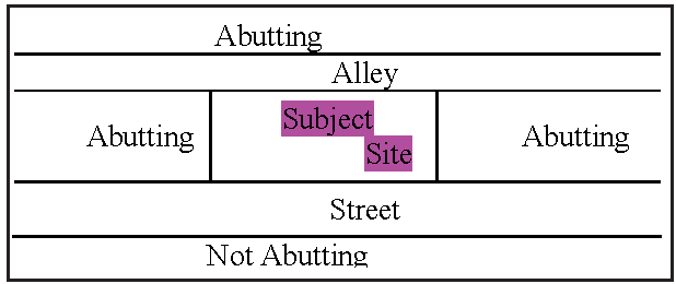
ABUTTING/CONTIGUOUS. This means having property lines in common, or having property separated by only an alley. Separation by a street right-of-way is not considered abutting.
ACCELERATED EROSION. Erosion caused by development activities that exceeds the natural processes by which the surface of the land is worn away by the action of water, wind, or chemical action.
ACCELERATION/DECELERATION LANE. These are paved areas adjacent to exits and entrances of a high traffic area for the purpose of enabling the free and safe flow of traffic.
ACCESS. A paved or unpaved area intended to provide ingress or egress of vehicular or pedestrian traffic from a public or private right-of-way or easement.
ACCESSORY USE, BUILDING OR STRUCTURE. An accessory use, building or structure is one that:
(1)
Is located on the same lot as the principal building, structure or use;
(2)
Is subordinate to an existing principal building, structure or principal use;
(3)
Is subordinate in area, extent and purpose to the principal building, structure or use;
(4)
Contributes primarily to the comfort, convenience or necessity of the occupant, business, or industry in the principal building, structure or use and as more particularly defined further in this Code.
ADDITION. Any walled or roofed expansion to the perimeter of a building in which the addition is connected by a common load-bearing wall other than a fire wall. Any walled and roofed addition that is connected by a fire wall or is separated by an independent perimeter load-bearing wall is new construction.
ADULT ESTABLISHMENT/ENTERTAINMENT. Any commercial establishment that has, as its primary purpose or business, the rent, sale or presentation of any adult materials or adult entertainment. Such establishments include, but are not limited to: Escort Services, Adult Arcade, Adult Bookstore, Adult Dancing, Adult Massage Parlor, Adult Motel/Hotel, Adult Motion Picture Booth, Adult Motion Picture Theater or drive-in, or Adult Theater.
Adult materials shall mean any one or more of the following: books, magazines, periodicals or other printed matter, or photographs, films, motion pictures, DVD's, video cassettes or video reproductions, slides or other visual representations that have as their primary or dominant theme the depicting or describing of "specified sexual activities" or "specified anatomical areas"; or instruments, devices or paraphernalia which are designed for use in connection with "specified sexual activities" as more particularly described or defined in chapter 6 of the Code of Ordinances of Coffee County.
ADVERSE IMPACT. A condition that creates, imposes, aggravates, or leads to inadequate, impractical, unsafe, or unhealthy conditions on a site proposed for development or off-site.
AGRICULTURE. For Profit raising, harvesting or storing of products of the field or orchard; feeding, breeding or managing livestock or poultry; producing or storing feed for use in the production of livestock or poultry; growing plants, sod, and trees for sale; the production of horticultural, dairy, poultry, eggs, and apiarian products.
ALLEY. A right-of-way privately or publicly owned, primarily for secondary access to the back or sides of property.
ALTERATION. Any change in the supporting members of a building or structure such as bearing walls, columns, and girders, except such emergency change as may be required for safety purposes; and addition to a building; any change in use; or, any movement of a building from one location to another.
ANIMAL SHELTER. Any facility operated by or under contract for the state, county, municipal corporation or any other political subdivision of the State for the purpose of impounding or harboring seized, stray, homeless, abandoned, or unwanted dogs, cats, and other animals; any veterinary hospital or clinic operated by a veterinarian or veterinarians which operates for such purpose in addition to its customary purposes; and any facility operated, owned, or maintained by a duly incorporated humane society, animal welfare society, or other non-profit organization for the purpose of providing for and promoting the welfare, protection and humane treatment of animals.
ANIMAL FOSTER HOME. Any place routinely or in the practice of providing temporary care for animals, except equine. An Animal Foster Home must be under a written contract with a licensed Animal Shelter. An Animal Foster Home will be considered an agent for the Animal Shelter, and not an animal shelter itself.
ANTENNA. A transmitting and/or receiving device mounted on a tower, building or structure and used in telecommunications personal wireless services that radiates or captures electromagnetic waves, digital signal, analog signals, and radio frequencies; such devices include but are not limited to, directional antennas such as panel and microwave dish antennas, and omni-directional antennas such as whips, but excluding radar antennas, amateur radio antennas, and satellite earth stations.
(1)
INNOVATIVE SITING TECHNIQUES. Manmade trees, clock towers, bell steeples, light poles and similar alternative design mounting structures that camouflage or conceal the presence of antennas or towers and are compatible with the scale and character of the surrounding natural setting and/or structures.
APARTMENT. A room or suite of rooms, with bathroom and kitchen facilities, used or designed for use as a residence, located in a building that contains three or more independent, separated residential living units.
APPEAL. This is a request for a review of final decisions by the Coffee County Board of Commissioners or an administrative official's interpretation of any provision of this Code, or a request for a review of an action taken by an administrative official in the application or enforcement of this Code.
APPLICANT. A person or entity requesting an action under the definition as provided for under this Code. The applicant may be the owner, developer, project manager or contractor.
AWNING/CANOPY. Any roof or other form that shelters from sunshine, rain, snow, or other forms of precipitation, open on at least one side. A canopy may be attached to a permanent building or it may be independent structure permitted in accordance with the International Building Code.
AS-BUILT PLANS. Amended, detailed plans specifying the location, dimensions, elevations, capacities and operational capabilities of facilities and structures, including storm drainage facilities and structures, as they have been constructed.
BED AND BREAKFAST INN. A facility where overnight accommodations are provided to transients for compensation, with or without a morning meal, and where the operators of the facility live on the premises.
BLOCK. An area of land within a political subdivision that is entirely surrounded by public highways or streets, public lands, rights-of-way, watercourses, or other well-defined and fixed boundaries.
BOARD OF APPEALS. The Coffee County Board of Appeals.
BUFFER. A strip of land located between a side or rear property line and a building, structure, or use, intended to separate and obstruct the view or other nuisances of the site on which the buffer is located from an abutting property, or to protect natural features such as streams or wetlands.
BUILDABLE AREA. The portion of a lot which is not located within any minimum required yard, landscape strip/area or buffer; that portion of a lot wherein a building or structure may be located.
BUILDING. A temporary or permanent building or structure having a roof supported by columns or walls and intended for the shelter, housing or enclosure of any individual, animal, process, equipment, goods, or materials of any kind and occupying more than 100 square feet of area. A modular home shall be considered a building for the purposes of this Code. A mobile or manufactured home shall not be considered a building for the purposes of this Code.
BUILDING FRONTAGE. The linear feet of the exterior wall of a building that faces any road or street that provides a means of direct ingress or egress to the lot.
BUILDING HEIGHT. The vertical distance of a building measured from the average elevation of the finished lot grade along the front of the building to the highest point of the building.
BUILDING PERMIT. Any permit for the erection, placement, or construction of any building, structure or related building system or building system component, or manufactured home, or portion thereof.
BUILDING, Accessory. A detached, subordinate structure, the use of which is clearly incidental to, customarily associated with, and related to the principal structure or use of the land, and which is located on the same lot as the principal structure or use, and has a separate means of egress.
BUILDING, Principal. The building in which the primary use permissible on the lot is conducted. Parcels with multiple principal uses may have multiple principal buildings. However, storage buildings, garages, and other clearly accessory uses shall not be considered principal buildings.
BUILDING SETBACK LINE. A line beyond which no foundation wall or part of the structure of any building shall project, with the exception of roof overhang up to 24 inches, walkways, and the subsurface projection of footings; provided, however that such overhang and footings do not encroach upon the adjacent property, right-of-way, or an easement.
CERTIFICATE OF COMPLETION. A document from the Building Official that an uninhabited structure or system is complete and is released for use. These would include signs, fences, walls, and accessory buildings.
CERTIFICATE OF OCCUPANCY. A document from the Building Official, certifying that all requirements for development or redevelopment of a property or structure have been met and authorizing occupancy of buildings and structures for residential or commercial purposes. For one- or two-family dwellings, the approval of all final inspections may serve as the Certificate of Occupancy.
CHANNEL. A natural or artificial water course with a definite bed and banks that conducts continuously or periodically flowing water.
CLEARING. The removal of trees, other vegetation and/or above ground improvements including, but not limited to, buildings and structures, walls, fences, steps, walks, curbs, gutters, concrete slabs, pavements (including bases for pavements) and surfacing.
CLUB, Private. A non-commercial establishment organized for a common purpose to pursue common goals, interests, or activities and usually characterized by certain membership qualifications, payment of fees and dues, regular meetings and a constitution or by-laws.
(1)
Club or Lodge: An incorporated or unincorporated association for civic, social, cultural, religious, fraternal, literary, political, recreational, or like activities, operated for the benefit of its members and not open to the general public.
COMMERCIAL USE. A use that is carried out for profit by the owner, lessee, or licensee.
COMMUNITY LIVING ARRANGEMENT. Residences, whether operated for profit or not, which undertake through their ownership or management to provide or arrange for the provision of daily personal services, support, care, or treatment exclusively for two or more adults, who are not related to the owner or administrator by blood or marriage and whose residential services are financially supported, in whole or in part, by funds designated through the Department of Behavior Health and Developmental Disabilities.
COMMUNITY WATER SYSTEM. Any water system which serves more than one household and which has been approved by the Health Dept. There are two types of community water systems, Georgia EPD regulated and unregulated. An EPD regulated water system is defined as a public water system, which serves at least 15 service connections, used by year-round residents or regularly serves at least 25 year-round residents (i.e. cities, counties, subdivisions, mobile home parks, etc.).
COMPREHENSIVE PLAN. The "Coffee County and the Cities of Ambrose, Broxton, Douglas and Nicholls" Comprehensive Plan, as currently adopted or amended.
CONCENTRATED ANIMAL FEED LOT OPERATIONS (CAFO). Factory farms are also known as concentrated animal feeding operations (CAFOs) confined animal feeding operations, or intensive livestock operations (ILOs). "A confined animal feeding operation means a lot or facility, together with any associated treatment works, where both of the following conditions are met: First, animals have been, are, or will be stabled or confined and fed or maintained for a total of 45 days or more in any 12-month period. And secondly, crops, vegetation, forage growth, or post-harvest residues are not sustained over any portion of the operation lot or facility." The definition is used as part of waste management and environmental protection laws to deal with the concentrated pollution from large quantities of animal waste. CAFOs and factory farms can be mostly indoor or mostly outdoor operations. The "confinement at high stocking density" aspect refers to lack of natural vegetation that the animals can eat and that can naturally process the resulting animal waste. High stocking density destroys the vegetation and produces unacceptable pollution from the animal waste in run-off and ground water unless it is handled appropriately, so laws have been enacted to deal with that; thus the legal definition for the term CAFO.
CONCEPT PLAN. The conceptual site plan submitted with an application for development under this Code, which requires the applicant to show the intended development and its conceptual design. Approval of the application request does not constitute approval of the concept plan; said plan must be adjusted according to the requirements listed for submittal of civil plans and reviewed by the appropriate departments for permitting.
CONSTRUCTION (erect, build, locate, relocate). The building, erection, location, relocation or substantial improvement to any structure; or the clearing, filling or excavation of any land. It shall also mean any alterations in the size or use of any existing structure or the appearance of any land. When appropriate to the context, "construction" refers to the act of construction or the result of construction.
CONTINUING CARE RETIREMENT COMMUNITY (CCRC). A large scale facility which has a primary purpose of providing housing and continuing care for older people, and which consists of Independent Living Units, Assisted Living Facilities, Skilled Care Nursing Facilities and related accessory uses, all as defined by this Code and as regulated by the Georgia Department of Community Health or other appropriate state agency. Continuing care means the provision of lodging, nursing, medical or other health related services at the same or another location to an individual pursuant to an agreement effective for the life of the individual or for a period greater than one year, including mutually terminable contracts, and in consideration of the payment of an entrance fee with or without other periodic charges to an individual. The following definitions are subsets of a continuing care retirement community:
(1)
Independent Living Unit. A dwelling unit within a CCRC, containing living area(s), kitchen area and bathroom(s), including multi-family dwellings, single-family detached or attached dwellings, which house one or older persons in a manner in which they may live independently while receiving one or more meals per day in a congregate care setting.
(2)
Assisted Living Facility. A facility located within a CCRC that provides a residential living environment, assisted by congregate meals, housekeeping, and personal services for older persons, who have temporary or periodic difficulties with one or more essential activities of daily living, but do not require services in or of a Georgia Department of Community Health licensed long-term care facility or nursing facility. An ALF shall include dwelling units, dining rooms, bathing area(s), common area(s), offices and other spaces necessary to provide the above services, and shall be operated by a legal entity holding a license issued by the George Department of Community Health or other appropriate state agency permitting the operation of an ALF at the location of the facility.
(3)
Skilled Care Nursing Facility. A facility which provides board, shelter and 24-hour skilled nursing and medical care to chronic or convalescent patients. A Skilled Care Nursing Facility shall include nursing beds and/or individual rooms, dining rooms, bathing areas, common areas, offices, clinics, therapy areas, medical facilities and other space necessary to provide the above services and shall be operated by a legal entity holding a license issued by the Georgia Department of Community Health, or other appropriate state agency, permitting the operation of a nursing facility at the location of the facility.
CORRECTIONAL FACILITY. A public or privately operated facility housing persons who are duly arrested, or are awaiting trial or persons serving a sentence after being found guilty of a criminal offense.
COUNTY. Coffee County, Georgia.
COUNTY COMMISSION. The Board of Commissioners for Coffee County, Georgia.
COUNTY ENGINEER. The County's official or his/her designee, responsible for implementing and enforcing the applicable engineering requirements of the County.
CUL-DE-SAC (see STREET, Dead End). A dead-end local street, of limited density, open at one end and closed at the other end by a permanent and safe turn-around.
CURB CUT. The opening along the curb line or edge of pavement of a public street at which point a driveway begins for vehicular ingress and egress from a property.
CUT (excavation). A portion of land surface or area from which earth has been removed or will be removed by excavations; the depth of which is below the original ground surface.
DAY CARE ESTABLISHMENT. Any place operated by a person, society, agency, corporation, institution or group, wherein are received for pay for group care, for fewer than 24 hours per day without transfer of legal custody, children under 18 years of age and which is required to be licensed or commissioned by the Georgia Department of Human Resources. The following categories shall be designated:
(1)
Family Day Care: (12 or less children). A private residence operated as a day care for up to 12 children.
(2)
Day Care Center: (13 or more children). Any place operated as a day care for 13 or more children.
DAY CARE CENTER (Adult). An establishment, licensed by the Georgia Department of Human Resources, operated by any person with or without compensation for providing for the care, supervision, and oversight during daytime hours only of six or fewer adults who are elderly, physically ill or infirm, physically handicapped, or mentally handicapped.
DEDICATION. The deliberate appropriation of property by its owner for general public use.
DEMOLITION. The removal of any above ground improvements including, but not limited to, buildings and structures, walls, fences, steps, walks, curbs, gutters, concrete slabs, pavements (including bases for pavements) and surfacing.
DENSITY, Gross. The total number of dwelling units divided by the total acres of a parcel or tract of land.
DENSITY, Net. The total number of dwelling units divided by the number of acres of a parcel or tract of land less the area for streets, right-of-way, common open space, floodplain, wetland, and surface water.
DETENTION. The temporary storage of storm run-off in a stormwater management practice, with the goals of controlling peak discharge rates and providing gravity settling of pollutants.
DETENTION FACILITY. A detention basin or alternative structure designed for the purpose of temporary storage of stream flow or surface runoff and gradual release of stored water at controlled rates.
DEVELOPER. Any person, individual, firm, partnership, association, corporation, estate, trust, or any other group or combination acting as a unit undertaking any land development activities as defined in this Code, including, but not limited to the subdivision of land, the construction of buildings and/or other land disturbance activities.
DEVELOPMENT. Any manmade change to improved or unimproved real estate, including, but not limited to, buildings or other structures, mining, dredging, filling, grading, paving, excavating, drilling operations, or permanent storage of materials or equipment; any activity which alters the elevation of the land, removes or destroys plant life, or causes structures of any kind to be erected or removed other than for agricultural purposes.
DEVELOPMENT ACTIVITIES. Any activity which may result in soil erosion from water or wind and the movement of sediments into state waters or onto lands within the state, including, but not limited to, clearing, dredging, grading, excavating, transporting, and filling of land but not including agricultural practices.
DEVELOPMENT PLANS. The detailed and professional plans showing the layout and design, site work and construction activities proposed for a project (other than architectural/engineering building plans), including but not limited to: site plans, grading plans, erosion and sediment control plans, tree protection plans, landscape plans, street plans and profiles, water supply plans, sanitary and storm sewer plans and profiles, other site improvement plans. Such plans shall also include other appropriate sections, details, notes, schedules, legends and diagrams.
DEVELOPMENT PERMIT. An official authorization issued by the Zoning Administrator in accordance with this Code to proceed with land disturbance, construction and grading, as set forth in this Code.
DEVELOPMENT REVIEW COMMITTEE. An informative and advisory committee assembled to provide insight and guidance to the Zoning Administrator and his/her associated staff, to applicants for developments and rezoning and to the Coffee County Board of Commissioners. The role of the DRC shall be voluntary and advisory only. The DRC shall include: Zoning Administrator, E911 Director, Solid Waste Director, Road Department Director, Fire Chiefs and, when possible, representatives from EMS, Coffee County Health Department, Board of Education and any affected utilities.
DRAINAGE IMPROVEMENTS. Those facilities and structures intended to control and direct the passage of stormwaters and other surface water flows from and across property; including, but not limited to: modified natural drainage ways, modified creeks, streams, channels, swales, ditches flumes, culverts, cross drains and other piping, catch basins, area drains, drop inlets, junction boxes, headwalls, flared end sections, detention ponds and basins, rip rap, drainage way lining systems, and energy dissipation devices.
DRIVEWAY. Any public or private ingress or egress allowing access between a public street and abutting property.
DRIVEWAY, Joint Access. A driveway that provides vehicular access to two or more abutting properties from a public street.
DWELLING. Any building or structure or portion thereof, which is arranged, designed or used for residential occupancy on a permanent or long-term basis, or for shorter durations where the property is intended for more long-term stable habitation not including transient use such as hotels and motels, and recreational vehicles or campers; and which comply with the provisions of this Code and the International Building Code.
DWELLING, Accessory. A secondary dwelling established in conjunction with, and clearly subordinate to, a primary dwelling unit on the same lot; whether a part of the same structure as the primary dwelling unit or in a detached structure.
DWELLING, Duplex. A building containing two dwelling units, designed to be occupied by no more than two families living independently from each other, each as a separate housekeeping unit.
DWELLING, Live-Work. An owner-occupied dwelling unit in which a significant portion (more than 50 percent) of the ground floor space includes a non-residential use which is operated by the property owners. Such dwellings shall not include Home Occupations.
DWELLING, Multi-Family. A building containing three or more dwelling units, designed to be occupied by three or more families living independently of each other, each as a separate housekeeping unit, i.e. apartments or condominiums.
DWELLING, Single-Family, Attached (Zero Lot Line). A building subdivided by a joint property line and wall which separates the structure into two or more dwelling units, each occupying its own lot. An attached single-family structure must meet all front, rear and side yard setback requirements in the zoning district in which it is located, except for the joint property line and wall. Each unit must be separately metered for all utilities and the joint property wall must be fire-rated and extend from the foundation to the roof decking of the structure.
DWELLING, Single-Family, Detached. An individual detached dwelling unit that is designed to be occupied by no more than one family, living as a separate household unit, excluding mobile homes and double-wide mobile homes.
DWELLING, Townhouse. Two or more attached single-family dwellings which (1) may or may not have a common roof, (2) a common exterior wall; and (3) are separated from each other by fire resistant walls extending at least from the lowest floor level to the roof.
DWELLING UNIT. Any building or part thereof, constituting a separate, independent housekeeping establishment for nor more than one family, and physically separated from any other rooms or housekeeping establishments which may be in the same structure. A dwelling unit contains sleeping facilities, sanitary facilities, and a kitchen.
EASEMENT, Public or Private. A grant of one or more property rights, given by a property owner to the general public, a public utility, a governmental unit, or a private individual or corporation for the use of a portion of the owner's land for a specific purpose, or use as a means of access to other property. Easements shall be designated 'public" or "private" depending on the nature of the usage.
DRAINAGE EASEMENT. The legal right granted by a landowner to a grantee allowing the use of private land for stormwater management purposes; thereby allowing the owner of adjacent tracts or other persons to discharge stormwater runoff on the tract or parcel of land subject to the drainage easement.
Utility Easement. A grant by a property owner for the use of real property for the specified purpose of constructing and maintaining utilities including but not limited to: sanitary sewers; water mains, electric lines, telephone lines, cable lines, storm sewer or storm drainage ways and gas lines.
ENGINEER. A professional engineer who holds an active license in the State of Georgia, and who has extensive education or experience regarding civil/structural/mechanical design.
EROSION, SEDIMENTATION AND POLLUTION CONTROL PLAN. A plan and actions that are designed to minimize the accelerated erosion and sediment run-off at a site during construction activities.
EXTERIOR ARCHITECTURAL FEATURES. The architectural style, general design, and general arrangement of the exterior of a building or other structure including but not limited to the kind of texture of the building material and the type and style of all windows, doors, signs, and other appurtenances, architectural fixtures, features, details, or elements relative to the foregoing.
FAA. Federal Aviation Administration.
FAÇADE. The exterior of a building facing the principal street entrance and extending the entire width of the building elevation.
FAMILY. One or more persons occupying a premise and living as a single housekeeping unit, as distinguished from a group occupying a boarding house, lodging house, hotel, or fraternity or sorority house.
FARM. A bona fide farm is the primary or principal use of land and buildings for the purpose of conducting agricultural activities for profit or self-use including raising, harvesting, or storing of crops: feeding, breeding, or managing livestock or poultry; producing or storing feed for use in the production of livestock; or the production of plants, trees or timber. When agricultural activities are secondary to the use of the land or an accessory to the principal residential or other use and are not for profit, the property shall not be considered a bona fide farm.
FCC. The Federal Communication Commission is an independent agency of the United States government. The chief purpose of the FECC is to make available so far as possible, to all people of the United States, wire and radio communications services.
FEMA. The Federal Emergency Management Agency is an agency of the United States Department of Homeland Security. The primary purpose of FEMA is to coordinate the response to a disaster that has occurred in the United States that overwhelms the resources of local and state authorities. FEMA intervention follows a declaration of disaster from the state governor and a formal request for assistance to the President of the United States.
FILL. A portion of land surface to which soil or other solid material has been added and where the finished grade is above the original ground surface or excavation grade.
FLEA MARKET. A temporary market held in an open area or structure where groups of individual sellers offer goods for sale to the public.
FLOOD OR FLOODING. A general and temporary condition of partial or complete inundation of normally dry land areas from the overflow of inland or tidal waters or the unusual and rapid accumulation or runoff of surface waters from any source.
(1)
Base Flood. Means the flood having a one percent chance of being equaled or exceeded in any given year.
(2)
Flood Hazard Boundary Map (FHBM). An official map of a community, issued by the Federal Emergency Management Agency, where the boundaries of the areas of special flood hazard have been defined as Zone A.
(3)
Flood Insurance Rate Map (FIRM). An official map of a community, on which the Federal Emergency Management Agency has delineated both the areas of special flood hazard and the risk premium zones applicable to the community.
(4)
Flood Insurance Study. The official report provided by the Federal Emergency Management Agency. The report contains flood profiles, as well as the flood boundary/floodway map and the water surface elevation of the base flood.
(5)
Flood Way. The channel of a river or other watercourse and the adjacent land areas that must be reserved in order to discharge the base flood without cumulatively increasing the water surface elevation more than one foot.
(6)
Minimum Flood Elevation. The base flood elevation established by the Federal Emergency Management Agency on the Flood Insurance Rate Map.
(7)
Flood Plain. Any land area susceptible to flooding.
(8)
Flood Proofing. Any combination of structural and nonstructural additions, changes, or adjustments to properties and structures which reduce or eliminate flood damage to land, water and sanitary facilities, structures, and contents of buildings.
FLOOR. The top surface of an enclosed area in a building (including basement), i.e., top of slab in concrete slab construction or top of wood flooring in wood frame construction. The term does not include the floor of a garage used solely for parking vehicles.
FLOOR AREA. The sum of all square feet of each floor of a building, measured from the interior faces of the exterior walls. The following areas are excluded from the measurement of the floor area: unfinished attics and basements, attached garages or spaces used for off-street parking or loading, breezeways, and enclosed or unenclosed decks and porches.
GUEST HOUSE OR GUEST QUARTERS. An attached or detached accessory building that provides living quarters for guests that does not include a full kitchen facility.
GRADING. Altering the shape or topography of ground surfaces to a predetermined condition; this includes stripping, grubbing, cutting, filling, stockpiling and shaping or any combination thereof, and shall include the land in its cut or filled condition.
GRADE. The elevation of the finished surface of the ground immediately surrounding the building or structure.
(1)
Finished Grade. The final elevation and contour of the ground after cutting or filling.
(2)
Highest Adjacent Grade. The highest natural elevation of the ground surface next to the proposed walls of a structure.
(3)
Natural Grade. The elevation of the ground surfaces in its natural conditions, prior to any man made alteration resulting in an increase or decrease in elevation relative to Mean Sea Level (MSL).
GROUP CARE HOME. A facility or dwelling unit licensed by the Georgia Department of Human Services housing persons unrelated by blood, adoption or marriage and operating as a single housekeeping unit under a common housekeeping management plan based on an internally structured relationship providing organization, supervision and care necessary to meet the physical, emotional, and social needs of its residents. The capacity of such facility shall be at least four residents but not more than 15 residents, and specifically excludes a boarding house, lodging house, hotel, or fraternity or sorority house.
GRUBBING. The removal of vegetation from land by means of digging, raking, dragging or otherwise disturbing the roots of vegetation and the soil in which such roots are located.
HARDSHIP. A condition of significant practical difficulty in using a lot because of the physical problems relating solely to the size, shape or topography of the lot in question, which are not economic difficulties, and which are not self-imposed.
HEIGHT. The vertical distance measured from average elevation of the proposed finished grade to the highest point of the coping of a flat roof or to the deck line of a mansard roof, or to the average height of the highest gable of a pitch or hip roof on a building. When referring to a tower or other structure, the distance measured from ground level to the highest point on the tower or other structure, even if said highest point is an antenna.
HISTORIC RESOURCE OR HISTORIC PROPERTY. A building, site, district, object, or structure evaluated as historically significant by Coffee County. These are usually, but not necessarily, 50 years of age or older.
HISTORIC STRUCTURE. Any structure that meets one or more of the following conditions:
(1)
Listed individually in the National Register of Historical Places (as maintained by the U.S. Department of Interior) or preliminarily determined by the Secretary of the Interior as meeting the requirements for individual listing on the National Register;
(2)
Certified or preliminarily determined by the Secretary of the Interior as contributing to the historical significance of a registered historic district or a district preliminarily determined by the Secretary to qualify as a registered historic district;
(3)
Individually listed on a state inventory of historic places and determined as eligible under the state historic preservation program which has been approved by the Secretary of the Interior; or
(4)
Individually listed on a local inventory of historic places and determined as eligible under the local historic preservation program which has been certified either by an approved state program as determined by the Secretary of the Interior.
HYDROLOGIC SOIL GROUP (HSG). A Natural Resource Conservation Service classification system in which soils are categorized into four runoff potential groups. The groups range from Class A soils with high permeability and little runoff production to Class D soils which have low permeability rates and produce much more runoff.
IMPERVIOUS. A material that water cannot pass through or be absorbed by.
IMPERVIOUS AREA. The hard-surface areas which either prevent or retard the entry of water into the soil, as is entered under natural conditions as undeveloped property, and/or cause water to run off the surface in greater quantities or at an increased rate of flow from that present under natural conditions as undeveloped property.
IMPERVIOUS SURFACE. A surface composed of any material that significantly impedes or prevents the natural infiltration of water into soil. Impervious surfaces include, but are not limited to, rooftops, buildings, streets and roads, and any concrete or asphalt surface.
INERT WASTE LANDFILL. A disposal facility permitted by the Georgia Department of Natural Resources as an inert waste landfill to accept only wastes that will not or are not likely to cause production of leachate of environmental concern limited to earth and earth-like products, concrete, cured asphalt, rocks, bricks, yard trimmings, stumps, limbs, and trees.
INFILL. Development of vacant or remnant lands passed over by previous development in the area.
JUNK. Any scrap, waste, reclaimable material, debris, whether or not stored, for sale or in the process of being dismantled, destroyed, processed, salvaged, stored, baled, disposed, or other use related to disposition.
JUNKED VEHICLE. Any wrecked or inoperable dismantled or abandoned automobile, truck, boat, motorcycle, or similar device.
JUNK YARD. Any parcel and/or building which is wholly or partly utilized for the parking, storage or dissembling of junked vehicles, wrecked or inoperable automobiles, trucks or other vehicles; storage, bailing or otherwise dealing in bones, animal hides, scrap iron and other metals, used paper, used cloth, used plumbing fixtures, old household appliances, scrap tires and used building materials. These uses shall be considered junkyards, salvage operations or recyclable material wholesalers.
Use of property for outdoor storage, keeping, abandonment, sale, or resale of junk including scrap metal, rags, paper or other scrap materials, used lumber, salvaged house wrecking and structural steel materials and equipment, or for the dismantling demolition, or abandonment of automobiles or other vehicles or machinery or parts thereof.
JURISDICTIONAL WETLAND. Wetlands that are regulated by the U.S. Army Corps of Engineers under Section 404 of the Clean Water Act.
LAND DISTURBING ACTIVITY. Any activity which may result in soil erosion from water or wind and the movement of sediments into state waters or onto lands within the state, including, but not limited to, clearing, dredging, grading, excavating, transporting, and filling of land but not including agricultural practices.
LANDFILL. A property operated as a commercial venture for profit or operated by a county or municipality for the disposal of solid waste or any location where a private owner accepts solid waste for compensation from sources other than his own property for disposal. As used herein, the term "solid waste" means putrescible and non-putrescible wastes, except water carried body waste, and shall include garbage, rubbish (paper, cartons, boxes, wood, tree branches, yard trimmings, furniture and appliances, metal, tin cans, glass, sludge, animal manures, industrial wastes (waste materials generated in industrial operations), residue from incineration, food processing wasters, demolition wastes, abandoned automobiles, dredging wastes, construction waste, and any other waste material in a solid or semisolid state.
LAND OWNER. The legal or beneficial owner of land, including those holding the right to purchase or lease the land, or any other person holding proprietary rights in the land.
LOADING SPACE. A space within the principal building, or on the same lot, providing for the standing, loading or unloading of trucks and other carriers.
LOT (plot, parcel). A portion or parcel of land separated from other portions or parcels by description, as on a subdivision plat or record of survey map or as described by metes and bounds, and intended for transfer of ownership or for building development. For the purpose of this LDC, the term does not include any portion of a dedicated right-of-way.
(1)
Lot Area. The total area within the boundaries of a lot.
(2)
Lot by Default. A lot which was once whole but divided into parts through the acquisition of public property or construction of a public road. Each piece of the once whole lot shall henceforth be considered a separate and independent lot. The lots shall be governed by section 9.01.02 Nonconforming Lots of Record.
(3)
Lot, Conforming. A lot that meets all the requirements of this Code.
(4)
Lot, Corner. A lot having frontage on two or more public streets at their intersection.
(5)
Lot Coverage. The percentage of total area of a lot that is occupied by buildings.
(6)
Lot Depth. The average horizontal distance between the front and rear lot lines.
(7)
Lot, Double Frontage or Through Lot. A lot other than a corner lot, that has frontage upon two or more streets that do not intersect at a point abutting the property.
(8)
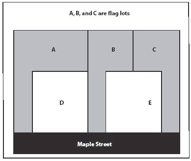
Lot, Flag. A lot having only its driveway fronting on a public street, with the result that the width of the driveway substantially constitutes the frontage of the lot: Lots A, B, and C are all flag lots.
(9)
Lot, Interior. A lot other than a corner lot or a through lot.
(10)
Lot Line (Property Line). The property boundary, abutting a right-of-way line, or any line defining the exact location of a lot.
(11)
Lot of Record. A lot which is part of a subdivision plat recorded in the office of the Clerk of Superior Court after the adoption of the subdivision regulations on September 6, 1972. Also, a lot which was created either by a recorded metes and bounds description or a recorded subdivision plat before the adoption of the subdivision regulations on September 6, 1972.
(12)
Lot Width. The distance between the side lot lines, measured at the building line, parallel to the street right-of-way line.
LOT SPLIT. The platting of real property into no more than two parcels, lots, tracts, tiers, blocks, sites, units, or any other division of land.
MANUFACTURED HOME. A dwelling fabricated in an off-site facility for installation or assembly at the building site, bearing a label certifying that it is constructed in compliance with the Federal Manufactured Home and Standards Act, 42 U.S.C. 5401—5445, and meeting each of the following standards:
(1)
The term "manufactured home" includes a structure, transportable in one or more sections;
(2)
Which in the traveling mode is eight body feet or more in width or 40 body feet or more in length or, when erected on site, is 320 or more square feet in floor area;
(3)
Which is built on a permanent chassis and designed to be used as a dwelling with or without a permanent foundation when connected to the required utilities and includes the plumbing, heating, air-conditioning, and electrical systems contained therein; and
(4)
Which is manufactured after June 15, 1976.
MANUFACTURED HOME PARK. A parcel of land (or contiguous parcels) divided into six or more manufactured home lots or sites for rent.
MEAN SEA LEVEL. The average height of the sea for all stages of the tide, used as a reference for establishing various elevations within the floodplain. For purposes of this LDC, the term is synonymous with National Geodetic Vertical Datum.
MINI-WAREHOUSE. A building or group of buildings that contain(s) individual, compartmentalized stalls or lockers used for storage, including accessory office, but not including retail sale on the premises, commercial repair or other services, manufacturing, outside storage, or any other commercial use.
MOBILE HOME. A dwelling manufactured prior to June 15, 1976, transportable in one or more sections, which, in the traveling mode, is eight feet or more in width or 40 feet or more in length, and when erected on site, is 320 or more in square feet floor area, and which is built on a permanent chassis and designed to be used as a dwelling with or without a permanent foundation when connected to the required utilities and includes the plumbing, heating, air-conditioning, and electrical systems contained therein.
MODULAR HOME OR INDUSTRIALIZED BUILDING. Certain manufactured buildings which are regulated by the Georgia Department of Community Affairs. Georgia law defines an Industrialized Building as "any structure or component thereof which is wholly or in substantial part made, fabricated, formed, or assembled in manufacturing facilities for installation or assembly on a building site and has been manufactured in such a manner that all parts or processes cannot be inspected at the installation site without disassembly, damage to, or destruction thereof." Industrialized buildings are constructed and regulated in accordance with the "Industrialized Buildings Act", Georgia Law 1982 (O.C.G.A. Title 8, Chapter 2, Article 2, Part 1).
MIXED USE. Development or a development project that incorporates more than one land use or activity, such as residential, commercial, office, and/or industrial.
NORTH AMERICAN VERTICAL DATUM. A vertical control datum used as a reference for establishing varying elevations.
NON-CONFORMING LOT OF RECORD. A lot of record on the effective date of this Code that does not comply with the current requirements of this Code, but was lawfully established and authorized by Coffee County.
NON-CONFORMING LEGAL STRUCTURE. Any lawfully existing structure or building on the effective date of this Code that does not comply with all of the provisions of this Code.
NON-CONFORMING LEGAL USE. Any use lawfully being made of any land, building, or structure on the effective date of this Code that does not comply with the provisions of this Code.
NON-RESIDENTIAL PROPERTY. Any property developed for commercial, industrial, governmental or institutional use including churches, hospitals, and other such institutions, but excluding undeveloped property and property used exclusively for agricultural purposes.
OPEN SPACE. Any lot area not used for or occupied by a driveway, off-street parking or loading space, refuse storage, or structure. Naturally wooded areas or other densely vegetated areas may not be considered as open space.
OUTSIDE STORAGE. The placement or containment of goods, materials, or equipment other than within a building, for purposes of keeping such goods, materials, or equipment for processing, use, sale, or transfer to other locations.
OVERLAY ZONE. A defined geographic area that encompasses one or more underlying zoning districts and that imposes additional requirements above those required by the underlying zoning district. An overlay district can have the same boundaries as the existing zoning districts or contain only parts of one or more such districts.
PARCEL OF LAND. Any plot, lot or acreage shown as a unit on the latest County tax assessment records.
PARKING AREA. All property used for off-street parking vehicular aisles and access ways, loading zones, interior and perimeter landscaping, and other outdoor vehicular use areas.
PARKING LOT. An area or plot of land used for the storage or parking of motor vehicles.
PARKING LOT ISLAND. A strip of property, which separates groups of parking spaces from other groups of parking spaces or internal driveways.
PARKING SPACE. An area designed for the temporary storage of a motor vehicle.
PAVING. An area covered by asphalt, concrete, brick or pavers meeting the specifications of the County. Pervious paving materials are subject to approval by the Zoning Administrator and County Engineer and/or the Board of County Commission.
PERMIT. The authorization necessary to conduct a land-disturbing activity, land development activity, building construction, or other activity regulated by Coffee County that requires an official authorization under provisions of this LDC.
PERSONAL CARE HOME. A building or group of buildings, a facility, or place in which is provided beds and other facilities and services including room, meals and personal care for non-family ambulatory adults, which is licensed as a personal care home by the State of Georgia Department of Human Resources. This term does not include buildings which are devoted to independent living units which include kitchen facilities in which residents have the option of preparing and servicing some or all of their own meals or boarding facilities which do not provide personal care. Personal care homes are categorized as follows:
(1)
Family Personal Care Home. A home for adults in a family type residence, non-institutional in character, which offers care to four through six persons.
(2)
Group Personal Care Home. A home for adult persons in a residence or other type building(s), non-institutional in character, which offers care to seven through 15 persons.
(3)
Congregate Personal Care Home. A home for adults which offers care to 16 or more persons.
PLANNED DEVELOPMENT. Development intended to encourage both residential and non-residential land uses according to a master development plan, with related covenants and restrictions. Developments within a PD project may have flexibility in the application of development standards when approved according to a master development plan, and to promote the conservation of natural resources, more efficient use of land, and, efficiency in the extension of streets and utilities.
PLANNING COMMISSION. The Douglas-Coffee County Planning Commission, as established by the governments in accordance with Georgia General Act No 358, 1957, as amended.
PLAT. A map, plan or other graphic layout of a lot, tract, parcel or subdivision indicating the location and boundaries of one or more properties. Plats are typically used for recording purposes.
PLAT, As-Built. An as-built plat may be performed to verify that a particular improvement has been built according to design plans or codes (e.g. setbacks). This type of survey may also be used to document the size or location of an improvement to aid in the design of additions (e.g. building additions, sewer extensions).
PLAT, Final. A finished drawing or map of a subdivision or development site plan, meeting all of the requirements of this Code and approved by Coffee County and fully certified for recording.
PLAT, Preliminary. A tentative plan of a proposed subdivision or development meeting the specified requirements of this Code and showing the layout in sufficient detail to allow an evaluation of the proposed project.
PORTABLE ON DEMAND STORAGE UNITS (PODS). Portable sheds (hereinafter referred to as "PODS") that are loaded with materials and placed on a residential or commercial property for the purpose of storing materials.
POWER GENERATION PLANT. An industrial facility used to generate electric power with the help of one or more generators which converts different energy sources such as Fossil fuel, Nuclear and Hydroelectric, into electric power. For purposes of the Coffee County Land Development Code (LDC), Solar Energy Systems are excluded.
PRINCIPAL USE. The principal purpose for which a lot or the main building thereon is designed, arranged, or intended, and for which it is or may be used, occupied, or maintained.
PROPERTY LINE. The legal boundary that separates a lot or parcel of land from other lots or parcels or right-of-way as recorded by a graphic description on a subdivision plat of record or a survey.
PUBLIC HEARING. An official session of any elected or appointed board advertised according to law.
PUBLIC IMPROVEMENTS. Any improvement, facility, or service together with its associated public site or right-of-way. Public improvements differ from lot improvements because public improvements are constructed either on public property, or on the portion of a site undergoing development that is to be dedicated for public ownership and maintenance. Common examples of public improvements include, but are not limited to, streets, sidewalks, curbs, traffic control devices, street lights, and utilities.
PUBLIC USES AND STRUCTURES. Buildings, structures and uses of land by a unit of government, including but not restricted to government administration, water treatment facilities, streets, libraries, public schools, parks, playgrounds, recreation centers and fire stations.
RECHARGE. The replenishment of underground water reserves.
RECHARGE AREA. Any portion of the earth's surface where water infiltrates into the ground to replenish an aquifer.
Significant Recharge Areas. Those areas mapped by the Georgia Department of Natural Resources in Hydrologic Atlas 18 (latest edition).
RECREATIONAL VEHICLE. A vehicular-type portable structure, built on a single chassis, without permanent foundation which can be towed, hauled, or driven and primarily designed as temporary living accommodation for recreation, camping, and travel use. Examples of recreational vehicles include travel trailers, truck campers, camping trailers, and self-propelled motor homes.
RECREATIONAL VEHICLE PARK. Any area, that meets the requirements and supplemental standards of this LDC, that is occupied or intended for occupancy by transients using recreational vehicles, mobile trailers or tents as temporary living quarters for recreation, education or vacation purposes and is open to the public.
RECYCLABLE MATERIAL WHOLESALER. Any operation where glass, plastic, paper, cardboard, metal cans, non-ferrous materials and yard waste is collected and stored for resale purposes.
REDEVELOPMENT. A land development project on a previously developed site. Excludes ordinary maintenance activities, remodeling of existing buildings, resurfacing of paved areas, and exterior changes or improvements, which do not materially increase or concentrate stormwater runoff or cause additional nonpoint source pollution.
RELIGIOUS FACILITY. A building in which persons regularly assemble for religious worship, and that is maintained and controlled by a religious body organized to sustain public worship.
RESIDENTIAL. Pertaining to the use of land, means premises such as homes, townhomes, patio homes, mobile homes, duplexes, condominiums or apartment complexes, which contain habitable rooms for non-transient occupancy and which are designed primarily for living, sleeping, cooking, and eating therein.
RIGHT-OF-WAY, Public Dedicated. A strip of land dedicated to, designated, reserved or deeded to the City, County or State, and duly accepted, on which facilities such as roads, railroads, canals, utilities, and other similar uses exist or may be constructed.
RIGHT-OF-WAY LINE. The dividing line between a lot, tract, or parcel of land and a contiguous right-of-way.
RIGHT-OF-WAY WIDTH. The distance between property lines measured at right angles to the centerline of the street.
ROAD FRONTAGE. The length of the lot line of any one lot or parcel along a street on which it borders, including proposed streets, within a subdivision of land approved by Coffee County.
SALVAGE OPERATION. See Junk Yard.
SANITARY SEWER. A pipe or conduit that carries wastewater.
SEDIMENT. Solid material, both organic and inorganic, that is in suspension, is being transported, or has been moved from its site of origin by air, water, ice or gravity as a product of erosion.
SEDIMENTATION. The process by which eroded material is transported and deposited by action of water, wind, ice or gravity.
SETBACK, Front. The shortest distance between the right-of-way of a street and the front exterior wall of the principal building or structure on a lot. Primary and accessory buildings may not be placed within a required setback.
SETBACK, Side or Rear. The distance between the property line and any structure, measured from the back or side property line.
SEWER, Public. A common sewer controlled by a government agency or public utility. A pipe or conduit that carries wastewater or stormwater.
SIDEWALK. That portion of the right-of way which is parallel to the street or road which is intended for pedestrian traffic.
SIGN. Any device or display consisting of letters, numbers, symbols, pictures, illustrations, announcements, cutouts, insignia, trademarks or demonstrations, including all trim and borders, which is used or intended to be used to attract attention or convey information when the same is placed in view of the general public.
SOIL AND WATER CONSERVATION DISTRICT APPROVED PLAN. An erosion and sedimentation control plan approved in writing by the Alapaha Soil and Water Conservation District.
SOLAR ENERGY SYSTEM (SES). A device or structural design feature that provides for the collection of solar energy for electricity generation, consumption, or transmission, or for thermal applications. For purposes of the Coffee County Land Development Code (LDC), SES refers only to (1) photovoltaic SESs that convert solar energy directly into electricity through a semiconductor device or (2) solar thermal systems that use collectors to convert the sun's rays into useful forms of energy for water heating, space heating, or space cooling. SES as used in the LDC excludes concentrated solar power, which uses mirrors to focus the energy from the sun to produce electricity. SES as used in the LDC also includes any device associated with a SES, including solar photovoltaic cells, panels, or arrays; lines/cabling, mounting brackets, framing, and foundations; electrical energy storage devices, outdoor electrical unit/control box, material, hardware, and inverters/converters.
(1)
Groundmounted Solar Energy System means an SES that is structurally mounted to the ground. For purposes of the LDC, a Ground Mounted Solar Energy System has a footprint of ten acres or more.
(2)
Rooftop Solar Energy System means an SES that is structurally mounted to the roof of a house, building or other structure.
(3)
Mobile Solar Energy System means an SES that is mounted to a frame or other structure that is transportable.
SPECIAL EVENTS. Events of a temporary nature including outdoor meetings, auctions, bake sales, car washes, yard sales from other than residential properties, carnivals, special outdoor entertainment and similar activities which are not part of the property's normal use and which are not otherwise permitted on the site. Outdoor displays or sales accessory to an established retail use are not considered special events.
STOP WORK ORDER. An order issued which requires that all construction activity on a site be stopped.
STORMWATER FACILITY, Off-Site. A stormwater management measure located outside the subject property boundary described in the permit application for land development activity.
STORMWATER FACILITY, On-Site. A stormwater management measure located within the subject property boundary described in the permit application for land development activity.
STORMWATER MANAGEMENT. The use of structural or non-structural practices that are designed to reduce stormwater runoff pollutant loads, discharge volumes, and/or peak flow discharge rates.
STORMWATER RETROFIT. A stormwater management practice designed for an existing development site that previously had either no stormwater management practice in place or a practice inadequate to meet the stormwater management requirements of the site.
STORMWATER RUNOFF. The flow on the surface of the ground, resulting from precipitation, which reaches a drainage system.
STORMWATER MEASURES. Measures, either structural or nonstructural that are determined to be the most effective, practical means of preventing or reducing point source or nonpoint source pollution inputs to stormwater runoff and water bodies.
STREET or ROAD. This term includes streets, roads, sidewalks, alleys, highways and other ways open to travel by the public including the roadbed, right-of-way, and all culverts, drains, sluices, ditches, water storage areas, waterways, embankments, slopes, retaining walls, bridges, tunnels, viaducts necessary for the maintenance of travel. This definition does not include any private street or way that is not constructed in conformance with the provision of this Code.
STREET or ROAD CLASSIFICATIONS.
(1)
Arterial (Principal): A road which is intended to provide swift and safe movement of traffic through the County. In addition, every United States or State numbered highway is an arterial road.
(2)
Arterial (Minor): A street which is intended to provide easy and convenient traffic movement within the County.
(3)
Connector/Collector: A road which is intended to collect traffic from local streets and direct it safely to minor or major arterial roads. A collector may also provide direct access to adjacent properties.
(4)
Local Road: A road providing service which is of low average traffic volume, short trip length or minimal through traffic and high access for abutting property.
STREET, Controlled Access. The right-of-way of a public street, road or highway where curb cuts are prohibited or limited because of potential interference with safe and efficient movement of vehicles.
STREET, Dead End (Cul-de-Sac). A local street or road of limited length, opened at one end and closed at the other end by a permanent turnaround.
STREET, Grade. The percent change in vertical elevation of the street centerline measured along the finished surface of the street.
STREET, Frontage. The width in linear feet of a lot or parcel, where it abuts the right-of-way of any public street.
STREET, Half. A street or road adjacent to a subdivision tract boundary where only half the required right-of-way and road improvements are provided within the proposed subdivision and the responsibility for the other half is undecided or is left to the adjacent property owner.
STREET, Jog. Where two streets or two portions of a single street are separated by a relatively short distance, usually at their intersection with another street.
STREET LIGHT. A pole or pedestal mounted luminary, 10—12 feet in height, with a metal halide or other full spectrum bulb.
STREET, Private. A strip of land improved and used for vehicular access but has not been accepted by Coffee County for maintenance.
STREET, Public. Right-of-way dedicated to Coffee County held or owned by the County for public street purposes.
STREET, Shoulder. That portion of the street or road from the outer edge of the paved surface or back of curb to the inside edge of the ditch or gutter or original ground surface.
STREET, Substandard. A street which does not meet the specifications of this Code.
STRUCTURE. Anything constructed or installed or portable, the use of which requires a location on a parcel of land. It includes a movable structure, even when it is located on land that can be used for housing, business, commercial, agricultural, or office purposes either temporarily or permanently. It also includes fences, billboards, swimming pools, and signs. Structures shall meet International Building Code Requirements and be permanently affixed.
STRUCTURE, Pre-Constructed. See modular home and industrialized building.
SUBDIVISION. The cumulative platting of real property into six or more parcels, lots, tracts, tiers, blocks, sites, units, or any other division of land, including all division of land involving a new street or six or more parcels involving existing streets, for the purpose of conveyance, except as otherwise excepted or modified herein. (See chapter 4, section 4-9.1).
SUBSTANTIAL DAMAGE. Damage of any origin sustained by a structure whereby the cost of restoring the structure to it's before damaged condition would equal or exceed 50 percent of the market value of the structure before the damage occurred.
SUBSTANTIAL IMPROVEMENT. Any reconstruction, rehabilitation, addition, or other improvement of a structure, taking place during a five-year period, in which the cumulative cost equals or exceeds 50 percent of the market value of the structure prior to the "start of construction" of the improvement. NOTE: The market value of the structure should be (1) the appraised value of the structure prior to the start of the initial repair or improvement, or (2) in the case of damage, the value of the structure prior to the damage occurring. This term includes structures, which have incurred "substantial damage", regardless of the actual amount of repair work performed.
For the purposes of this definition, "substantial improvement" is considered to occur when the first alteration of any wall, ceiling, floor, or other structural part of the building commences, whether or not that alteration affects the external dimensions of the building. The term does not, however, include (1) those improvements of a structure required to comply with existing violations of state or local health, sanitary, or safety code specifications which are solely necessary to assure safe living conditions and which have been identified by the Code Enforcement Official, and not solely triggered by an improvement or repair project, or (2) any alteration of a "historic structure" provided that the alteration will not preclude the structure's continued designation as a "historic structure".
SUBSTANTIAL RENOVATION. Renovation to a structure whereby the cost of renovating the structure would equal or exceed 50 percent of the market value of the structure before the renovation.
SURFACE MINING. Any activity constituting all or part of a process for the removal of minerals, ores, and other solid matter for sale or for processing or for consumption in the regular operation of a business. Tunnels, shafts, borrow pits of less than 1.1 disturbed acres, and dimension stone quarries shall not be considered to be surface mining.
SURVEY, As-Built. Drawings specifying the dimensions, location, elevations of improvements as they have been constructed.
SURVEYOR. A professional surveyor who holds an active license in the State of Georgia.
TAX ASSESSOR. The Coffee County Board of Tax Assessors.
TEMPORARY USE/BUILDING. Land uses/buildings established for a limited duration with the intent to discontinue/remove such use within a designated time period.
TOWER. Any structure that is designed and constructed primarily for the purpose of supporting one or more antennas, including self-supporting lattice towers, guy towers, or monopole towers. The term includes, but is not limited to radio and television transmission towers, microwave towers, common-carrier towers, communication towers, alternative tower structures.
USE OR OCCUPIED. The purpose or activity for which land or buildings are designed, arranged, intended, or occupied and maintained. Used and occupied include the words "arranged, designed or intended to be used," and the word "occupied" shall be deemed to include the words "arranged, designed or intended to be occupied."
UTILITY. Any community service available to the public by means of an overhead or underground distribution or collection system such as electricity, telephone, domestic water, gas, stormwater system and sewerage disposal.
a.
County Water System. Refers to the Coffee County water distribution system, and all component parts, equipment, and structures necessary to provide such services.
b.
Private Water and Sewage System. A system owned and operated by a community corporation or an individual serving two or more premises and approved by the Georgia Department of Natural Resources, Environmental Protection Division.
VARIANCE. A grant of relief from the dimensional requirements of this Code which permits construction in a manner otherwise prohibited by this LDC where specific enforcement would result in unnecessary hardship. See chapter 10 of this Code.
WATERCOURSE. A permanent or intermittent stream or other body of water, either natural or man-made, which gathers or carries surface water.
YARD. A required open space located on the same lot as the principal building, unoccupied and unobstructed except for accessory uses, vegetation, and fences.
(1)
Front Yard. That area of a lot lying between the abutting street right-of-way line and the principal building of the lot and extending across the front of a lot from side lot line to side lot line. The front yard of a corner lot shall be that yard abutting the street with the least frontage, unless otherwise determined on a recorded plat or in a recorded deed. The front yard of a lot existing between two streets not intersecting at a corner of the lot, shall be that yard abutting the street on which adjoining properties face, unless otherwise determined on a recorded plat or in a recorded deed.
(2)
Rear Yard. That area of a lot extending across the rear of a lot from side lot line to side lot line and lying between the rear lot line and the principal building on the lot.
(3)
Side Yard. The area extending from the front building line to the rear building line between the side lot line and the side building line.
ZONING ADMINISTRATOR. The officially designated administrator for Coffee County, or his/her designee, who is responsible for administering all elements of the County's Land Development Code.
ZONING DISTRICT. The use classification of parcels of land as generally defined under this LDC.
ZONING MAP (Map, Zoning Map of Coffee County, GA).
ZONING ORDINANCE. The Zoning Ordinance or Land Development Code enacted by the Coffee County Commission, Georgia, as duly amended.
(Ord. No. 2016-11, 6-20-2016; Ord. No. 2016-12, 9-6-2016; Ord. No. 2019-23, 6-17-2019)