
Coffee County Unincorporated
City Zoning Code
City Zoning Code
CHAPTER 7
- BUILDING AND CONSTRUCTION STANDARDS FOR ROADS, STREETS AND PUBLIC UTILITIES
7-1.- Authority.
This chapter is adopted under the authority of the Constitution of the State of Georgia and laws enacted pursuant thereto.
7-2. - Purpose, Intent and Application.
It is the intent of this chapter to apply to and provide guidance for the development of lands within Coffee County, Georgia, whether the developments involve the subdivision of land or the construction of buildings and/or other improvements on a single parcel. Any land development activity must first comply with this Code. These regulations are intended to serve the following purposes.
a.
To protect and promote the health, safety and general welfare.
b.
Encourage economically sound and orderly land development in accordance with the Comprehensive Plan and other policies and objectives of the County.
c.
To assure the provision of required streets, utilities, and other facilities and services to new developments and to redevelopments in conformance with public improvement policies of the County.
d.
To assure adequate provision of safe and convenient traffic access and circulation, both vehicular and pedestrian, in new land developments and in redevelopments.
7-3. - General Provisions.
a.
Zoning Ordinance. Whenever there is a discrepancy between minimum standards or dimensions required under this section and those contained in other ordinances or regulations of Coffee County, the most restrictive, as determined by Coffee County, shall apply.
b.
Required Public Improvements. Every developer of lands within the jurisdiction of this Code shall provide the public improvements included in this Code, in accordance with this Code and other pertinent ordinances, codes, and regulations of the County. These public improvements together with associated rights-of-way, easements, and other lands shall be provided at no cost to the County and shall be dedicated or otherwise transferred, as required, to the public in perpetuity and without covenant or reservation.
c.
Other Permits. Nothing in this Code shall impose any obligation on the County to obtain or assist in obtaining permits, approvals, and/or clearances from other local, state or Federal agencies having jurisdiction over elements of a project. It is solely the developer's responsibility to obtain all such required permits, approvals, and/or clearances. The developer shall furnish the Zoning Administrator with copies of all such permits, approvals and/or clearances before authorization to proceed with development.
7-4. - Street Improvement Standards.
Public Streets, whether abutting or internal, existing or new, shall be constructed or improved under those circumstances and to the standards as established in this section. Roadway improvements shall be in accordance with the following street classification system:
a.
Arterial. These roadways provide mobility so traffic can move from one place to another quickly and safely.
b.
Collector. These roadways link arterials and local roads and perform some duties of each.
c.
Local. These roadways provide access to homes, businesses and other property.
7-5. - Right-of-Way Requirements.
a.
Minimum Right-of-Way and Pavement Widths:
i.
The minimum widths for public rights-of-way or private street ingress/egress easements and pavements shall be as shown in "Table of Minimum Right-of-Way and Lane Widths." See Standard Drawings for detailed dimensions.
ii.
Minimum widths of right-of-way and lanes shall be as shown in the "Table of Right-of-Way and Lane Widths."
7-6. - Clear Zone Requirements.
a.
All new roads/streets shall meet ASHTO requirements.
7-7. - Access Management.
Applicability: Except for development projects consisting of single-family dwelling units that are not part of a larger common development, the following standards shall apply. These standards shall apply unless a more restrictive standard is required by the GDOT. See chapter 4, section 4-9.6(a).
Standards:
a.
Separation of Access Points:
i.
Proposed driveways along state or federal highways shall be permitted by the Georgia Department of Transportation.
ii.
Corner lot access shall be from the street with the lowest traffic count and shall be located as far from the intersection as reasonably possible to reduce turning movement conflicts and to promote proper traffic circulation.
b.
Emergency Access: All public streets, private and residential drives shall be designed and maintained so as to provide safe and convenient access for emergency vehicles, as required by the County. New developments with restricted access, such as gated subdivisions must receive a variance from this requirement based on review and approval by Coffee County or its designee.
c.
Traffic-Calming Measures: Street layout and configuration within residential areas/developments should include a series of relatively short interconnected roadways in lieu of longer straight roads, to discourage excessive speeds. Additional traffic-calming measures may be required by the County. Any specific measures employed shall be approved by the County.
The separation of access points on any street or road shall be determined by the established speed limit of the street or road, with the following minimum spacing requirements as provided in "Table of Minimum Driveway Spacing."
(a)
Single-Family residential subdivisions are exempt from the minimum driveway spacing requirement.
d.
The distance between access points shall be measured from the centerline of the proposed driveway or roadway to the centerline of the nearest adjacent driveway or roadway. For un-divided highways, driveways and roadways located on the opposite side of the road from the development shall be included. It is desired that new driveways and roadways be aligned directly across and in line with existing driveways and roadways when possible.
e.
Driveways shall be located so that the radius return is a minimum of four feet from a property line that intersects the right-of-way line.
f.
The County Road Department may reduce the required separation distance of access points where the minimum required distance proves impractical or if the site plan incorporates a unified access and circulation system for vehicles and pedestrians.
g.
The requirements of this section are not intended to eliminate all access to a parcel of land that was legally subdivided prior to the enactment of this section.
7-8. - Permits Required.
a.
No driveway shall be constructed abutting a County-maintained road or street until all applicable driveway permits have been approved and issued by the County. For driveways that abut a state or federal highway, all applicable permits shall be obtained from the GDOT prior to construction. See chapter 10, section 10-29(c).
7-9. - Deceleration Lanes.
Minimum Requirements for Right Turn Deceleration Lanes. Right turn deceleration lanes will be required and shall be constructed at no cost to the County if the daily site generated Right Turn Volumes (RTV) based on ITE Trip Generation or other approved method meet or exceed the values shown in Table 7-9.1 below:
Deceleration lanes shall be constructed to the dimensions shown in Table 7-5.5. Width of deceleration lanes shall be 12 feet minimum.
When a new deceleration lane required by this section is proposed to begin or end within 50 feet of an existing deceleration lane, driveway or street intersection, then the new deceleration lane shall be extended as needed to provide a safe, continuous connection with adjacent or nearby deceleration lanes, driveways and intersections.
7-10. - Minimum Requirements for Left Turn Lanes.
Left lanes will be required and shall be constructed at no cost to the County if the daily site generated Right Turn Volumes (RTV) based on ITE Trip Generation or other approved method meet or exceed the values shown in Table 7-10.1 below:
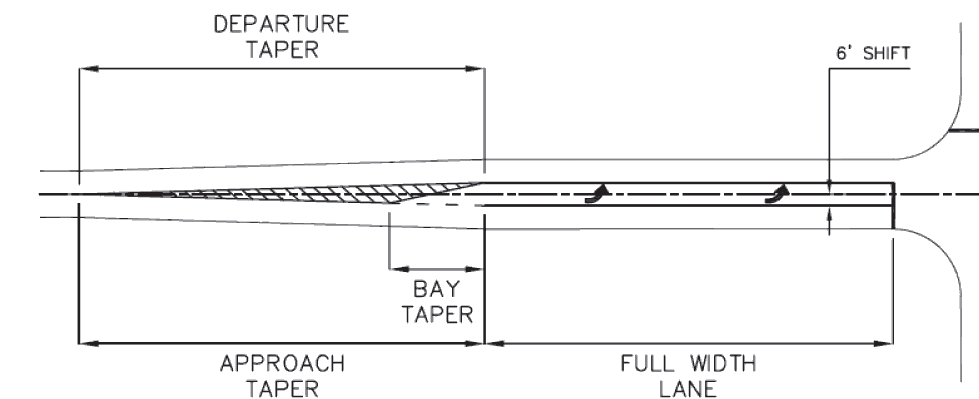
In most cases, it is necessary to widen the existing roadway to introduce the left turn lane. It is preferred that the roadway be widened six feet each direction so that an equal shift in traffic is maintained for both directions. If widening of the roadway in both directions is not feasible, then widening the full 12 feet along the project side of the highway will be permitted. Where required, left turn lanes shall be constructed per Table 7-10.2.
Any additional right-of-way required for the construction and maintenance of right turn deceleration lanes or left turn lanes shall be dedicated in fee simple to the County.
7-11. - Requirements for New Streets and Improvement of Existing Streets.
a.
All new streets proposed to be constructed in a subdivision or other development shall be designed and constructed to the minimum standards contained in these Regulations, in accordance with the classification of streets. For any development which abuts a State or Federal highway, improvements to the roadway and the location and design of any street or driveway providing access from the state highway shall comply with the standards and requirements of the Georgia Department of Transportation. A permit for the proposed access or improvements shall be required to have been approved by the GDOT and incorporated into the construction drawings for the project prior to issuance of a development permit by the County.
b.
The Developer shall be responsible for the relocation and/or modifications of public and/or private utilities as necessitated by the required street improvements.
c.
Substandard Streets.
i.
If a substandard street (dirt or gravel road or inadequate width of pavement or right-of-way) provides a means of access to a development, the street shall be upgraded to the street classification standard required by this Article, contemporaneous with the subdivision development. These improvements shall extend from the entrance of the development to the nearest standard road of an equivalent or higher classification, along the route of primary access.
ii.
The upgrading of substandard streets used for access will not be required if any of the following conditions are met:
a.
The development consists of a single one- or two-family residence, not part of a larger common development, on an existing recorded lot within the County.
d.
Permanent Dead-end Streets: New streets shall connect at both ends to existing or proposed streets unless the County Engineer determines that unique parcel configuration or terrain makes a fully connected street pattern infeasible or unsafe.
i.
When necessary, streets designed to have one end permanently closed shall provide a cul-de-sac turnaround and may be no more than 2,640 ft. in length including the cul-de-sac, unless otherwise approved by the County Engineer.
ii.
The length of a cul-de-sac street shall be measured from the center of the cul-de-sac to the center of the intersection with another street.
iii.
Culs-de-sac shall have a 50 foot radius for residential streets and 75 foot radius for non-residential streets and shall conform to the standard drawings.
7-12. - Street Intersection.
a.
Angle of Intersections: Intersections of two public streets shall form an angle that is 90 degrees if possible but in no case shall be less than 80 or more than 100 degrees, unless otherwise approved by the County Engineer.
b.
Intersection Radius: Intersections within residential subdivisions shall be constructed with a minimum edge of pavement radius of 35 feet to accommodate school buses. Industrial and commercial areas, and any other area where truck traffic has the potential to account for more than ten percent of the total traffic, intersections shall be constructed with a minimum edge of pavement radius of 75 feet. All other intersections shall be constructed with a minimum edge of pavement radius of 50 feet.
c.
Intersection Sight Distance (Sight Triangles):
i.
Intersections shall be designed with adequate sight distance for all proposed intersections. Where necessary, back slopes shall be flattened and horizontal or vertical curves lengthened to provide the minimum required sight distance. The placement or establishment of signs, buildings, fencing, plantings, etc. which have to potential to obstruct the required line of sign are not allowed within the sight triangle unless approved by the County Engineer.
ii.
The minimum intersection sight distance from the approaching street shall be calculated in accordance with the latest edition of AASHTO "Policy on Geometric Design of Highways and Streets."
7-13. - Geometric Design Standards.
a.
All streets and roadways shall be designed in accordance with the AASHTO Standards, as provided in "A Policy on Geometric Design of Highways and Streets," latest edition and any amendments thereto.
b.
Street Centerline Grades:
i.
Street or road grades exceeding ten percent for a minor collector and 12 percent for local streets are prohibited, unless otherwise approved by the County Engineer. The County Engineer may grant limited exceptions on maximum grades, based on conclusive evidence that shows a lesser grade is impractical due to topographic or site specific limitations.
ii.
The minimum centerline grade for street or roadway with curb and gutter shall not be less than 0.5 percent. Streets with roadside ditches should be limited to a minimum of 0.03 percent.
iii.
The maximum centerline grade across any cul-de-sac turnaround shall be two percent.
c.
Crown Slope: Unless super-elevated, all streets and roadways, except alleys, shall be designed and constructed with a crown slope of one-fourth inch per foot (two percent), to provide for the adequate drainage of surface water from the street centerline to the gutter or roadside ditch.
d.
Super-elevation: The design of arterial and major collector roadways may require the super-elevation of the travel surface on horizontal curves in accordance with AASHTO Standards. The design and horizontal alignment of minor collectors and local streets serving subdivision areas should avoid the use of super-elevation where possible. In all instances, super-elevation rates shall not exceed four percent without prior approval from the County Engineer. Under no circumstance is a curved street of any classification to be reverse super-elevated.
e.
Pavement Design: Pavement sections shall be constructed in accordance with the standards in the "Table of Standard Pavement sections." Set out below, as well as the typical paved road section, rural dirt road section and curb and gutter section set forth at Appendix A at the end of this chapter.
Editor's note— Appendix A, referenced above, is not set out herein, but is on file and available for inspection in the County offices.
7-14. - Base and Pavement Minimum Requirements.
a.
Roadway Sectional Composition.
i.
The applicable standard shall be based on functional classification. See latest edition of the Georgia Department of Transportation (GDOT) Standard Specifications for the Construction of Roads and Bridges for specifications of referenced asphaltic concrete types. For all street classifications, before asphalt pavement is placed, a bituminous prime shall be applied to the base material in accordance with GDOT specifications. Application rate shall be a minimum of 0.15 gallons and a maximum of 0.20 gallons per square yard.
b.
Roadways shall be constructed with cross sections according to the following requirements at a minimum. The County will consider alternate designs provided that a suitable pavement design is provided that accommodates the heaviest and maximum traffic counts expected for a particular development.
1.
Local Streets.
i.
1.5" - 12.5 mm Asphalt SuperPave (165 lbs./sq. yd.) top course;
ii.
8" - Graded aggregate base (GAB); or
6" - Soil cement (Soil cement shall be mixed in place).
Base shall be compacted to at least 98 percent maximum dry density per standard proctor test ASTM 0698.
2.
Collector Streets (for residential and commercial developments).
Asphalt Pavement:
i.
1.5" - 12.5 mm Asphalt SuperPave (165 lbs./sq. yd.) (top course);
ii.
2" - 19 mm Asphalt SuperPave (220 lb./sq. yd.) (binder);
iii.
8" - Graded aggregate base (GAB); or
iv.
6" - Soil cement (Soil cement shall be mixed in place);
v.
Base shall be compacted to at least 98 percent maximum dry density per standard proctor test ASTM 0698;
vi.
Graded aggregate base may include crushed concrete, limerock or granite;
vii.
For soil cement, a mix design by a licensed Geotechnical Engineer in the state of Georgia must be submitted to the County Engineer for approval.
3.
Arterial Roads (including industrial roads).
Asphalt Pavement:
i.
1.5" - 12.5 mm Asphalt SuperPave (165 lbs./sq. yd.) (top course).
ii.
2" - 19 mm Asphalt SuperPave (220 lb./sq. yd.) (binder).
iii.
3" - Asphaltic base 25mm (330 lb./sy) Asphalt SuperPave.
iv.
8" - Graded aggregate base (GAB); or
v.
6" - Soil cement (Soil cement shall be mixed in place).
vi.
Base shall be compacted to at least 98 percent maximum dry density per standard proctor test ASTM 0698.
vii.
Graded aggregate base may include crushed concrete, limerock or granite.
viii.
For soil cement, a mix design by a licensed Geotechnical Engineer in the state of Georgia must be submitted to the County Engineer for approval.
4.
Commercial Development.
Heavy Duty Asphalt Pavement:
i.
1.5"- 12.5 mm Asphalt SuperPave (165 lbs./sq. yd.) (top course).
ii.
2"- 19 mm Asphalt SuperPave (220 lbs./sq. yd.) (binder).
iii.
8"- Graded aggregate base (GAB); or
iv.
6"- Soil Cement (Soil cement shall be mixed in place).
v.
Base shall be compacted to at least 98 percent maximum dry density per standard proctor test ASTM D698.
vi.
Graded aggregate base may include crushed concrete, limerock or granite.
vii.
For soil cement, a mix design by a licensed Geotechnical Engineer in the state of Georgia must be submitted to the County Engineer for approval.
Light Duty Asphalt Pavement:
i.
1.5" - 12.5 mm Asphalt SuperPave (165 lbs./sq. yd.) (top course).
ii.
8" - Graded aggregate base (GAB); or
iii.
6" - Soil Cement (Soil cement shall be mixed in place).
iv.
Base shall be compacted to at least 98 percent maximum dry density per standard proctor test ASTM D698.
v.
Graded aggregate base may include crushed concrete, limerock or granite.
vi.
For soil cement, a mix design by a licensed Geotechnical Engineer in the state of Georgia must be submitted to the County Engineer for approval.
5.
Industrial Development.
Heavy Duty Asphalt Pavement:
i.
1.5" - 12.5 mm Asphalt SuperPave (165 lbs./sq. yd.) (top course).
ii.
2" - 19 mm Asphalt SuperPave (220 lb./sq. yd.) (binder).
iii.
3" - Asphaltic base 25mm (330 lb./sy) Asphalt SuperPave.
iv.
8" - Graded aggregate base (GAB); or
v.
6" - Soil cement (Soil cement shall be mixed in place).
vi.
Base shall be compacted to at least 98 percent maximum dry density per standard proctor test ASTM D698.
vii.
Graded aggregate base may include crushed concrete, limerock or granite.
viii.
For soil cement, a mix design by a licensed Geotechnical Engineer in the state of Georgia must be submitted to the County Engineer for approval.
7-15. - Street Construction Standards and Specifications.
Unless otherwise specifically set forth herein, all of the materials, methods of construction, and workmanship for street construction shall conform to the latest edition of the Georgia Department of Transportation Standard Specifications - Construction of Transportation Systems including all amendments.
a.
Erosion and Sedimentation Control: All BMP devices and practices shall be installed, maintained, and/or performed in accordance with the Manual for Erosion and Sediment Control in Georgia, current edition.
b.
Clearing and Grubbing: Before grading is started, the entire right-of-way area shall be first cleared and grubbed of all trees, stumps, roots, brush, debris and other objectionable materials per GDOT Clearing and Grubbing Specifications. Combustible material generated from clearing and grubbing operations may be burned only when authorized and permitted by the Coffee County Fire Chief.
c.
Rough Grading: Conduct street earthwork construction in accordance with Georgia DOT Specification Sections 205 - Roadway Excavation and 208 - Embankments.
i.
For purposes of these Regulations, the maximum density of soil material shall be determined by ASTM D 698 (Standard Proctor) test procedures.
d.
Final Grading and Subgrade Preparation:
i.
Perform sub grade construction in accordance with Georgia DOT Specification Section 209 - Subgrade Construction.
ii.
The developer shall provide quality control testing during earthwork and subgrade construction as necessary to assure the entire earthwork, including all fill layers and subgrades, meet the minimum requirements of these Regulations. The minimum quality control testing to be provided consists of the following:
a.
Moisture - density relationship curve for each type soil encountered.
b.
One in-place density test (ASTM D 1556 or other recognized method) per 1,200 square yards or fraction thereof of subgrade or base to be paved.
c.
One in-place density test (ASTM D1556 or other recognized method) per 1,000 cubic yards or fraction thereof of fill placed.
iii.
Earthwork which falls below specified minimum quality control limits shall be removed, reconstructed and retested until compliance with specified requirements is achieved.
iv.
After completing street earthwork operations and before beginning street base construction, the Developer shall file a copy of the quality control test results demonstrating compliance with these requirements with the County. At any time during the construction process, representatives of the County may request to review and the Developer shall provide quality control test results.
e.
Post-Construction Stabilization of Disturbed Areas: When earthwork and paving are complete, the Developer shall seed with permanent grassing and stabilize all disturbed areas including roadway shoulders which are not covered by paving or other improvements. It shall be the Developer's responsibility to maintain grassed areas by watering, fertilizing, weeding, mowing, trimming, regrading and replanting as required to establish a smooth, acceptable stand of grass free of eroded or bare areas. Grassed areas will be considered acceptable when a viable stand of permanent grass covers at least 90 percent of the total area with no bare spots exceeding one square foot and the ground surface is fully stabilized against erosion. Grassing operations shall meet the technical requirements of Georgia DOT Specification Section 700 - Grassing for Planting Zone 4.
f.
Base and Pavement Quality Control Testing Required:
i.
Base construction which falls below specified minimum quality control limits as defined in GDOT's Standard Specifications for Construction of Transportation Systems shall be removed and reconstructed or mitigated if allowed by and in accordance with GDOT Specifications. Corrected areas shall be retested until compliance is achieved. The minimum quality control testing to be provided consists of the following:
a.
Moisture-density relationship curve for each base material used on project.
b.
For soil cement base, conduct mix design to determine Portland cement content (percent of dry weight of the soil) to achieve a minimum compressive strength of 300 psi at seven days when testing in accordance with ASTM D 1632 and D 1633.
c.
One in-place density test (ASTM D 1556 or other method acceptable to the County per 1,200 square yards or fraction thereof of base.
d.
One thickness measurement normal to base surface per 1,200 square yards or fraction thereof of base.
e.
One surface tolerance measurement using a 15 foot straight edge per 250 square yards or fraction thereof of base.
f.
One asphalt extraction (ASTM D 2172) and aggregate gradation analysis (ASTM C 136) per 2,400 square yards or fraction thereof of surface course and per 2,400 square yards or fraction thereof of binder course (if any). Obtain samples for extraction and gradation tests in accordance with ASTM D 979. 7) One density and compacted thickness measurement per 1,200 square yards or fraction thereof of each course placed. Density determined to be made in accordance with ASTM D 1188. Remove not less than three-inch diameter nor larger than 12-inch square test specimens. Repair test specimen holes with concrete.
g.
Asphalt paving is subject to visual and straight edge inspection during and after construction operations until final acceptance. Inspect the base, intermediate, and surface course surfaces with the straight edge to detect irregularities. Pavements with irregularities that exceed one-fourth of an inch over ten feet are subject to rejection.
ii.
Base construction which falls below specified minimum quality control limits shall be removed and replaced or remediated in accordance with GDOT specifications.
iii.
After completing construction, the Developer shall file a copy of the quality control test results demonstrating compliance with these Regulations with the County. At any time during the construction process, representatives of the County may request to review and the Developer shall provide quality control test results.
g.
Use of Non-specified Base or Paving Materials or Systems: In the event the Developer desires to utilize base or paving materials or systems not included in these Regulations, the Developer shall provide an engineering study prepared by a Georgia registered professional engineer comparing the proposed material or system to the appropriate system which is included in these Regulations. The engineering study will include a pavement structural design based on the AASHTO "Guide for Design of Pavement Structures" and suggested specifications for the materials and construction of the proposed system. The County will treat the Developer's request through the appeals process described elsewhere in this Code.
7-16. - Traffic Control Devices.
a.
Traffic control devices consisting of street name signs, traffic control signs, traffic markings and traffic signals shall be provided by the Developer as appropriate to serve each development. All traffic control devices and installation thereof shall conform to the Federal Highway Administration "Manual on Uniform Traffic Control Devices".
i.
For residential developments, minimum traffic control devices shall consist of street name signs at each street intersection, stop or yield signs at each intersection, one speed limit sign per block, school or pedestrian crossing signs where appropriate, and pavement markings to include, at a minimum, centerline striping, edge of pavement striping, stop bars, raised pavement markers (turtles), words, directional arrows and chevrons (hatches). All pavement markings except centerline striping and edge of pavement striping shall be thermoplastic. Stop bars shall be a minimum of 24 inches, and words, chevrons, and directional arrow dimensions shall be in accordance with GDOT Standards.
ii.
Minimum traffic control devices for non-residential developments shall be in accordance with the Manual for Uniform Traffic Control Devices. Additionally, appropriate other signs and signals shall be provided by the Developer.
7-17. - Street Improvement Plans.
a.
Plans Required: Street improvement plans for all new streets, street widening and existing street upgrades shall be prepared by a Georgia registered professional engineer. Three original prints of the plans shall be submitted to the County for review and comment. An electronic copy (in PDF format) is also required. Within 30 days of submittal of the plans, the County will either approve the plans or make comment on items requiring changes and/or additional information. When not approved, the cycle of plan submittal and review will be repeated until the plans are approved by the County.
b.
Required Information: All plans shall consist of not less than the following:
i.
Existing ground elevations shall be measured and shown on the plans in a manner that accurately depicts field conditions. Contours shall be generated at one foot intervals for slopes between one to three percent and at two-foot intervals for slopes exceeding three percent if necessary for clarity. For areas sloped at less than one percent, existing spot elevations and/or contours at a 0.5 foot interval shall be shown as necessary to depict field conditions. Accuracy of contour elevations shown on the drawings shall not differ from actual field elevations by more than one-half of the contour interval utilized at any location.
ii.
Existing facilities and features within and adjacent to rights-of-way which affect or could be affected by street improvement construction. Items include, but are not limited to, streets, sidewalks, buildings, parking lots, driveways, fences, tree lines, and railroads.
iii.
All drainage ways, lakes, streams, creeks, channels, wetlands, and man-made drainage structures.
iv.
All existing utilities and appurtenances within and adjacent to rights-of-way which affect or could be affected by street improvement construction. Items include, but are not limited to, sanitary and storm sewers, water mains, gas lines, fire hydrants, electric and telephone poles and street lights. The utility type, size, depth, material and location in relation to street improvements should be indicated.
v.
All existing and proposed property lines, rights-of-way, and easements shall be shown for the project area and areas abutting the property. Land lot and land district lines shall also be shown.
vi.
Limits of proposed construction.
vii.
Proposed road improvements, including but not limited to, centerline alignment, curbs and gutters, sidewalks, pavements, driveways, wheel chair ramps, traffic control devices, and street lights (if any).
viii.
Profiles of proposed centerlines with new finished grade elevations at intervals not exceeding 50 feet.
ix.
Horizontal and vertical street geometry for horizontal and vertical curvature shall include street centerline angles of deflection, radii, degree of curvature, design speed, tangent lengths, arc lengths, bearings, centerline grades, and lengths of vertical curves. Stations for all points of curve, points of tangency, points of intersection, both horizontal and vertical, should be shown.
x.
Benchmarks for vertical control.
xi.
Name of the development, names, addresses and telephone numbers of Developer and Developer's engineer, engineer's seal, north arrow, scale, and date.
c.
Plans shall conform to the following standards:
i.
Where specific design guidance is not given in these regulations or other County regulations, rules, or ordinances the AASHTO publication "A Policy on Geometric Design of Highways and Streets", latest edition shall be followed.
ii.
All elevations shall be based on and tied to U.S. Coast and Geodetic Survey mean sea level datum.
iii.
Plan drawings shall be at a scale of at least one inch equals 50 feet. In developed or congested areas, the County may require a scale of one inch equals 20 feet or less to be utilized.
iv.
For profile drawings, the horizontal scale shall be the same as that used for associated plan drawings. The vertical scale shall be at least one inch equals ten feet. A one inch equals five feet vertical scale is often necessary to properly depict grade changes in flat areas.
v.
The desired drawing size is 18 inches by 24 inches. In no case shall drawings be larger than 30 inches by 42 inches nor smaller than 11 inches by 17 inches.
7-18. - Utilities.
All authorized public utilities must be installed by a Georgia Licensed Underground Utility Contractor who must meet minimum bonding and insurance requirements as determined by the County. A note to this effect shall be shown on the construction plans.
a.
Placement of Utilities.
i.
All authorized public and private underground or overhead utilities shall be located within an easement designated for such use. Private underground utilities such as lawn sprinkler systems, septic tanks and drain fields, exterior lighting systems, and heating and cooling piping are not permitted within public street rights-of-way or adjacent easements reserved for other public utilities.
ii.
Underground utilities crossing public roads and right-of-way shall be installed with a minimum 42 inches of cover at all locations, including the bottom of ditches. Crossing utility mains shall not be installed within ten feet of a cross drainage structure and shall provide a minimum of 24 inches of clearance when crossing any longitudinal drainage structures. Utility service laterals shall be installed with a minimum of 24 inches of cover.
iii.
Utility crossings installed concurrently with roadway construction or at unpaved roadways shall be installed by open trench. Trench compaction shall be performed according to DOT specification to prevent settlement of the roadway. The locations of utility crossings at unpaved roadways shall be identified with a permanent sign posted at the right-of-way line indicating a buried utility crossing.
iv.
Utility installations that require crossing an existing paved roadway shall be performed by directional bore or other trenchless method. Cutting of paved roadways is not allowed. Utility mains four inches and smaller are not required to be cased. Utility mains larger than four inches shall be cased for a distance extending ten feet beyond the edges of pavement.
v.
As-built drawings illustrating the location, depth, size, materials, and any other appurtenances installed by the developer shall be submitted to the County upon completion of construction activities.
7-19. - Stormwater Drainage.
a.
The subdivider shall provide adequate stormwater drainage in accordance with these regulations. The subdivider/developer shall also provide for adequate drainage for springs or other ground water drainage.
b.
The drainage system for a subdivision, commercial or industrial development shall be designed in accordance with sound engineering principles and procedures such that all developable parcels included in the subdivision plat are positively drained without negative impacts on neighboring parcels.
c.
The drainage system shall be designed to accommodate drainage from adjacent lands which naturally drain to or through the lands being subdivided. The drainage system shall be designed to not affect the natural drainage onto adjacent lands (no net increase in pre-development flows from the entire drainage basin).
d.
Drainage facilities that are designed to handle flowing water (i.e. culverts, weirs, etc.) shall be hydraulically designed to function when subjected to the maximum flow rate that can be expected to occur no more often than once in 25 years.
e.
Drainage facilities that are designed to handle water accumulations (e.g. retention ponds with no overflow provisions) shall be designed to accommodate the maximum water level that can be expected to occur no more often than once in every 100 years. Necessary drainage facilities including, but not limited to, culverts, rights-of-way, and easements, shall be dedicated to the Coffee County, at no expense to the County, and at the option of the County. Areas required for maintenance shall be cleared of all vegetation which would interfere with the maintenance of the facility.
7-20. - Wetlands.
Jurisdictional wetlands shall be delineated on the Preliminary Plat.
All preliminary plats delineating wetlands shall have on the preliminary plat the note "No fill or work shall occur within jurisdictional wetlands without a prior permit from the US Army Corp of Engineers". The acquisition of permits shall be the responsibility of the owners/developers.
All minimum lot areas per designated zoning district requirements shall be calculated upland of all wetland boundaries within or contiguous to the property.
7-21. - Administration and Enforcement.
This Code shall be administered, interpreted, and enforced by the Zoning Administrator.
It shall be the duty and responsibility of the Zoning Administrator to maintain an accurate and up-to-date compilation of this Code, including Appendices, and all amendments, and to publish said compilation and make it available to the public for a fee set by the County Commission.
In any case in which activities are undertaken in violation of this Code, not in compliance with the provisions of a permit issued by the County, or without authorization of a permit which would otherwise be required, the Zoning Administrator is hereby authorized to order that all unauthorized or improper work be stopped, direct correction of deficiencies, or take any other legal or administrative action appropriate to the severity of the violation and degree of threat to the public health, safety and welfare. The stop work order shall be posted on the property and delivered or mailed to the Developer.
7-22. - Variances.
Requests of for variances to requirements of this chapter shall be submitted in a form as prescribed by the Zoning Administrator along with such fee as shall be established by the County Commission.
The Zoning Administrator shall coordinate the review of each variance request by all other affected County departments and shall summarize such comments and/or recommendations as may be received in a report to the Board of Zoning Appeals for final action in their normal course of business.
In granting variances and modifications, the Board of Zoning Appeals may require such conditions as will secure substantially the objectives of the standards or requirements so varied or modified.
7-23. - Penalties for Violations.
Any person, firm or corporation violating any provision of this Code shall be upon conviction punished for each offense according to section 1-12 of the Code of Ordinances of Coffee County, Georgia.
Each day such violations continue shall constitute a separate offense.
Nothing herein contained shall prevent the County from taking such other lawful action as is necessary to prevent or remedy any violation.