
Colfax City Zoning Code
ARTICLE IV
- GENERAL DEVELOPMENT REGULATIONS
Chapter 17.104 - DENSITY BONUSES AND OTHER INCENTIVES[2]
Editor's note—Ord. No. 555, § 1(Exh. A), adopted Oct. 11, 2023, repealed Ch. 17.104 in its entirety and enacted a new Ch. 17.104 to read as set out herein. Former Ch. 17.104 pertained to similar subject matter and derived from Ord. No. 522, § 3(Att. A), 10-23-2013.
Chapter 17.123 - SHORT-TERM RENTALS
Sections:
17.92.010 - Purpose.
The provisions of this article apply to all zones and all use classifications unless otherwise stated.
(Ord. No. 519, 8-8-2012)
17.96.010 - Purpose.
The purpose of these provisions is to specify the uses that are permitted as accessory to the primary uses in the zone districts, and to establish the regulations that apply to accessory structures.
(Ord. No. 519, 8-8-2012)
17.96.020 - Accessory uses.
A.
Accessory Uses Encompassed by Primary Use. In addition to the primary uses expressly included in a use classification, each use classification shall be deemed to include such accessory uses which are specifically identified by these regulations; and such other accessory uses which are necessarily and customarily associated with, and are appropriate, incidental, and subordinate to, such primary uses. It shall be the responsibility of the planning director to determine if a proposed accessory use is necessarily and customarily associated with, and is appropriate, incidental, and subordinate to the primary use, based on the planning director's evaluation of the resemblance of the proposed accessory use to those uses specifically identified as accessory to the primary uses and the relationship between the proposed accessory use and the primary use. Determinations by the planning director shall be subject to appeal pursuant to Chapter 17.44, and a record of all such determinations shall be maintained by the planning director.
B.
Accessory Uses Subject to Regulations. Accessory uses shall be regulated in the same manner as the primary uses within each use classification, except as otherwise expressly provided by these regulations.
C.
Permitted Accessory Uses for Residential Use Types.
1.
Home occupations, as permitted in Chapter 17.152.
2.
Garage/yard sales, with the following limitations:
a.
Three sales per calendar year at the same address;
b.
Not to exceed three calendar days per event; and
c.
Operating during daylight hours only.
3.
Off-street parking areas and parking structures for use by persons living, or visiting the premises.
4.
Repair and maintenance of automobiles or other vehicles if work is being done on a vehicle registered to a resident of the premises, or not more than one automobile or other vehicle at a time if work is being done on a vehicle registered to someone other than a resident of the premises. Notwithstanding the above, repair or maintenance of any tractor trucks or semi-trucks is not permitted in any residential zone district.
5.
Rental and sales offices for the leasing and sales of units located in the same apartment or condominium complex.
6.
The following accessory uses and buildings shall be permitted in mobilehome parks:
a.
Accessory uses and accessory buildings customarily appurtenant to a permitted use, such as the following accessory structures and uses on individual lots: cabanas, ramadas, patio slabs, carports or garages and storage and washroom buildings;
b.
Accessory uses customarily incidental and subordinate to the residential occupancy of the mobilehomes which are expressly provided for residents of the mobilehome park only, such as:
i.
A manager's office and maintenance equipment storage area;
ii.
Laundry facilities; and
iii.
Carwashing facilities.
7.
Any other accessory use determined by the planning director to be of the same general character as the permitted uses set forth in this section.
D.
Permitted Accessory Uses for Schools, Community Assembly and Community Services Use Types.
1.
Recycling collection center for collection of newspapers only, by nonprofit organizations, when operated in conformance with Chapter 17.184 (recycling collection centers).
2.
Fundraising sale and events.
3.
Food service and distribution facilities (community assembly uses only) subject to the permit requirements set forth in Chapters 17.144 and 17.148.
4.
Any other accessory use determined by the planning director to be of the same general character as the permitted uses set forth in this section.
E.
Permitted Accessory Uses for Commercial and Industrial Use Types.
1.
Automatic teller machines, vending machines and video dispensing machines, where such machines or facilities are designed, located or attached so that they are protected from the elements and completely visible from adjacent public streets. Such location/design must be approved by the planning director.
2.
Cafeteria, delicatessen and food vending with an area of less than one thousand (1,000) square feet.
3.
Fleet storage of company owned vehicles within a parking lot.
4.
Open air vending facilities, as permitted by Chapter 17.168.
5.
Outdoor storage, provided that:
a.
All outdoor storage in commercial zones shall be screened from public view through a combination of building design, landscaping and berming, and or location. Any outdoor storage that is not completely screened, as determined by the planning director, is subject to an administrative permit;
b.
There shall be no visible storage of motor vehicles, trailers, airplanes, boats, or their composite parts except where authorized by an automobile, trailer, airplane, or boat sales business in commercial zones.
6.
Recreational Facilities (Indoors or Outdoors) for Use of Employees. Such facilities include, but are not limited to, basketball courts, ballfields, putting greens and volleyball courts.
7.
Recycling collection center, as permitted by Chapter 17.184.
8.
Used goods collection center, as permitted by Chapter 17.208.
9.
Plazas.
10.
Caretaker residence when associated with a personal storage facility.
11.
Any other accessory use determined by the planning director to be of the same general character as the permitted uses set forth in this section.
F.
Permitted Accessory Uses for Agricultural Use Types.
1.
Home occupations, as permitted in Chapter 17.152;
2.
Growing and harvesting of timber, Christmas trees, or other plants;
3.
Fruit and nut dehydrating plants;
4.
Nurseries, greenhouses, mushroom rooms, floriculture;
5.
Apiaries and honey extraction plants;
6.
Wineries and cideries as defined in Chapter 17.12 and the following incidental uses subject to providing adequate off-street parking as determined by the planning director and meeting all necessary clearances from the health and building departments:
a.
Wine, cider and other agricultural product tasting;
b.
Winery, cidery and other agricultural product tours;
c.
Wholesale and retail sales of wine, grape, cider and other agricultural products;
d.
Compensated or non-compensated events with up to fifty (50) persons in attendance with no limitation on the number of events per year;
e.
Picnic area(s) for winery, cidery and other agricultural product-related activities;
f.
Art galleries with sales and framing;
g.
A food preparation facility for catering on-premises indoor or outdoor functions;
h.
Agricultural-related museums;
i.
Gift display not to exceed a total of five hundred (500) square feet in interior footprint area for the retail sale of winery, cidery and other agricultural product-related promotional items, gift items, and/or prepackaged foods,
j.
Social gatherings or weddings occurring on weekends for up to the maximum occupancy load as established by the California Building Code up to and including two hundred fifty (250) persons up to and including twelve (12) events per year with no more than four such events per month,
k.
Indoor or outdoor amplified music until ten (10) p.m.
7.
Any other accessory use determined by the planning director to be of the same general character as the permitted uses set forth in this section.
(Ord. No. 519, 8-8-2012)
17.96.030 - Accessory structures.
A.
Accessory Structures Included with Permitted Uses. In addition to the primary structures associated with permitted uses, each use classification shall be deemed to include such accessory structures which are specifically identified by these regulations, and such other accessory structures which are necessarily and customarily associated with, and are appropriate, incidental, and subordinate to, such primary structures. It shall be the responsibility of the planning director, or his or her designee, to determine if a proposed accessory structure is necessarily and customarily associated with, and is appropriate, incidental, and subordinate to the primary structure, based on the planning director's evaluation of whether the proposed accessory structure is necessary or customarily associated with the use for which the development was constructed. Determinations by the planning director shall be subject to appeal pursuant to of Chapter 17.44, and a record of all such determinations shall be maintained by the planning director. All accessory structures shall be located in compliance with all other applicable requirements of the zone district in which they are located and any other permits required (e.g., design review permit). Any variance to the accessory structure requirements shall be processed administratively by the planning director.
B.
Accessory Structures Subject to Regulations. Accessory structures shall be regulated in the same manner as the primary structures within each zoning district, except as otherwise expressly provided by these regulations. Accessory structures may be established concurrently or following the construction of a primary structure.
C.
Permitted Accessory Structures to Dwelling Use Type (Single-Family and Two-Family).
1.
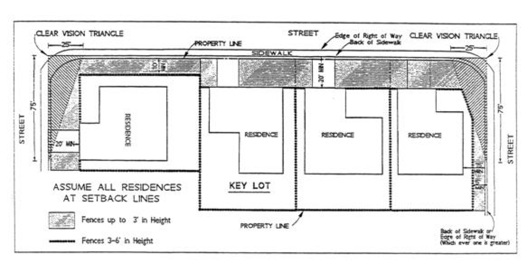
Decks. Uncovered decks under thirty (30) inches in height are permitted anywhere on a parcel, without respect to required setbacks. Any deck which is 30 inches or taller in height, as measured from the edge of the deck and, maintaining a horizontal plane, to six (6) feet from the edge of deck, shall maintain a minimum side yard setback of one and one-half times the required side yard setback for the primary structure, a rear yard setback of one-half the required rear yard setback for the primary structure, a ten-foot front yard setback, and shall be located consistent with the residential clear vision triangle requirements of subsection 17.72.030B. Second story decks or widow's walks are permitted, as long as the required yard setbacks are maintained, and may run the entire length of the wall on which they are located.
2.
Covered Patios Attached to Existing Residences. Patio covers attached to the residence have no site coverage restrictions.
3.
Unenclosed Structures, Including, But Not Limited to, Shade Structures, Carports, Boat and RV Covers and Gazebos. Such structures are not subject to any site coverage requirements but are subject to the following requirements:
a.
Any structure not attached to the residence shall not enclose any area equal to or greater than twenty (20) percent of the available yard space on the side of the residence where the structure is located;
b.
The structure shall not be constructed of materials which would create a year-round livable area;
c.
The structure shall not exceed fifteen (15) feet in height and one story. For each foot in height above ten (10) feet the required setback, except the front yard setback, shall be increased by one foot.
d.
The structure shall maintain a fifteen-foot front yard setback and a five-foot rear and side yard setback;
e.
On the street side of a corner lot, the structure shall maintain a five-foot setback as measured from the back of the sidewalk or, in the absence of a sidewalk, the right-of-way;
f.
On the street side of a corner lot located adjacent to a key lot, the structure shall maintain a ten-foot setback as measured from the back of the sidewalk or, in the absence of a sidewalk, the right-of-way.
 .
.
4.
Enclosed structures less than one hundred twenty (120) square feet, and:
a.
Less than Seven Feet in Height.
i.
General. Detached buildings or structures less than or equal to one hundred twenty (120) square feet in floor area and less than seven feet in height may be located anywhere within a parcel, but shall maintain the required front yard setback. Such buildings are limited to one per legal parcel.
ii.
Corner Lot. On the street side of a corner lot the building or structure shall be setback to maintain a five-foot setback from the back of the sidewalk, or in the absence of a sidewalk, five feet from the back of the right-of -way.
iii.
Corner Lot Adjacent to a Key Lot. On the street side of a corner lot adjacent to a key lot, the building or structure shall be setback to maintain a ten-foot setback from the back of sidewalk, or in the absence of a sidewalk, ten (10) feet from the back of the right-of-way.
b.
Greater than Seven Feet in Height.
i.
The maximum height is fifteen (15) feet and one story;
ii.
Five feet from the rear and side property lines;
iii.
Twelve (12) and one-half feet from the back of sidewalk or edge of right-of-way on corner lots; and
iv.
For each foot in height above ten (10) feet, the required setback, except for the front yard setback, shall be increased by one foot.
5.
Enclosed Structure(s) Greater than One Hundred Twenty (120) Square Feet. Enclosed structures located on the same lot that individually or cumulatively are equal to or greater than one hundred twenty (120) square feet in floor area are subject to the following requirements:
a.
General.
i.
If the building or structure is located within a required rear yard, the total size of the building or buildings, cumulatively, shall be less than fifty (50) percent of the required rear yard setback.
ii.
The required front yard setback of the applicable residential zone district shall be maintained.
iii.
A maximum of seven hundred (700) square feet of detached building(s) or structure(s) is permitted on the same lot. Additional square footage of detached accessory building(s) or structure(s), in excess of seven hundred (700) square feet, may be permitted upon approval of an administrative permit.
iv.
A minimum six-foot separation shall be maintained from any other building or structure located on the same lot.
v.
An extension of the main building or accessory building roof (e.g., a breezeway) may connect the accessory building to the primary building, but it shall not be considered part of (attached to) the main (primary) building. The breezeway and accessory building must maintain required side yard setbacks, as specified in subsection C.5.b. In addition, any accessory structure located less than six feet from a primary building shall be considered attached to (and part of) the primary building for purposes of this article.
vi.
Additions to primary structures that exceed seven hundred (700) square feet in area may be permitted upon approval of an administrative permit, which may include a public hearing as provided in Sections 17.32.010 and 17.40.020.
b.
For buildings greater than seven feet in height, the following shall apply:
i.
The maximum height is fifteen (15) feet and one story;
ii.
Five feet from the rear and side property lines;
iii.
Twelve (12) and one-half feet from the back of sidewalk or edge of right-of-way on corner lots; and
iv.
For each foot in height above ten (10) feet, the required setback, except for the front yard setback, shall be increased by one foot.
c.
For buildings less than or equal to seven feet in height, the following setbacks shall be maintained:
i.
Five feet from the back of sidewalk or right-of-way, whichever is greater, on the street side for corner lots;
ii.
Ten (10) feet from the back of sidewalk or right-of-way whichever is greater when adjacent to a key lot; and
iii.
No setback is required adjacent to the rear or interior side property lines.
6.
Fences and Walls. A maximum six-foot high fence (including lattice and similar attachments) or wall, may be located on a parcel consistent with the following requirements:
a.
For residential lots zoned R-1-20 or larger, appropriate deer-proof fencing is permitted of right.
b.
For all other residential zones, the maximum height shall be reduced to three feet if located:
i.
Within a residential clear vision triangle (see Chapter 17.12, definitions);
ii.
Within a required front setback; or
iii.
Within five feet of the back of the sidewalk or in the absence of a sidewalk the back of the right-of-way of a street-side for a corner lot or within ten (10) feet of the back of the sidewalk or right-of-way of a street side for a corner lot adjacent to a key lot.
c.
When there is a difference in the ground level between two adjoining parcels, the height of any fence or wall constructed along a common property line shall be determined by using the finished grade of the highest contiguous parcel.
d.
The height of a fence or wall may be increased to provide for noise attenuation or buffering of adjacent land uses, subject to approval of an administrative permit.
e.
The provisions of this section shall not apply to any fence or wall required by any law or regulation of the city or state.
7.
Flag Poles. The pole may be a maximum o f thirty-five (35) feet in height and shall maintain a minimum five foot setback from any property line.
8.
Security Facilities, including security gates and gate houses at a project entrance subject to city fire department regulations.
9.
Antennas, including HAM radio, radio and television receiving antennas subject to requirements of Chapter 17.132.
10.
Children's Play Equipment, including playsets, playhouses and tree houses.
11.
Recreation Facilities, including recreation activity courts and facilities, swimming pools, spas and hot tubs.
12.
Satellite Dishes. Satellite dishes as allowed in Chapter 17.132.
13.
Entry Arbors. Entry arbors may be located within the required front yard setback provided they do not cover more than twenty-five (25) square feet in area and do not exceed a height of ten (10) feet.
14.
Exceptions to Accessory Structure Requirements. An exception to the requirements of this section may be approved subject to the approval of an administrative permit.
15.
Any other accessory structure determined by the planning director to be of the same general character as the permitted structures set forth in this section.
D.
Permitted Accessory Structures to Dwelling Use Type (Multi-family).
1.
Bicycle Lockers and Off-Street Parking Areas.
2.
Decks and Balconies. Uncovered decks under thirty (30) inches in height are permitted anywhere on a parcel, without respect to required setbacks. Any deck or balcony of thirty (30) inches or taller, as measured from the edge of the deck and, maintaining a horizontal plane, to six feet from the edge of deck, shall maintain the following:
a.
A minimum side yard setback of two times the required interior side yard setback for the primary structure;
b.
A rear yard setback of one-half the required rear yard setback for the primary structure;
c.
A ten-foot front yard setback; and
d.
Shall be located consistent with the residential clear vision triangle requirements of subsection 17.72.030B.
3.
Unenclosed Structures, Including Detached Shade Structures, Covered Patios, Arbors, and Gazebos. Such structures are not subject to any site coverage requirements but are subject to the following requirements:
a.
The structure shall not enclose any area equal to or greater than twenty (20) percent on any side;
b.
The structure shall not be constructed of materials which would create a year round livable area;
c.
The structure shall not exceed fifteen (15) feet in height and one story. For each foot in height above ten (10) feet the required setback, except the front yard setback, shall be increased by one foot.
d.
The structure shall maintain a fifteen-foot front yard setback and a five-foot rear and side yard setback;
e.
On the street side of a corner lot, the structure shall maintain a five-foot setback as measured from the back of the sidewalk or, in the absence of a sidewalk, the right-of-way;
f.
On the street side of a corner lot located adjacent to a key lot, the structure shall maintain a ten-foot setback as measured from the back of the sidewalk or, in the absence of a sidewalk, the right-of-way; and
g.
The size or location of the structure does not violate any requirements of an approved site review.
4.
Fences and Walls. A maximum six-foot high fence (including lattice and similar attachments) or wall may be located anywhere on a parcel consistent with the following requirements:
a.
The maximum height shall be reduced to three feet if located:
i.
Within a residential clear vision triangle (see Chapter 17.12 definitions);
ii.
Within a required front setback; or
iii.
Within five feet of the back of the sidewalk or right-of-way of a street-side for a corner lot or within ten (10) feet of the back of the sidewalk or right-of-way of a street-side for a corner lot adjacent to a key lot.
b.
When there is a difference in the ground level between two adjoining parcels, the height of any fence or wall constructed along a common property line shall be determined by using the finished grade of the highest contiguous parcel.
c.
The height of a fence or wall may be increased a maximum of two feet to provide for noise attenuation or buffering of adjacent land uses, subject to approval of an administrative permit. Fences and walls in excess of eight feet may be permitted subject to the approval of a conditional use permit.
d.
The provisions of this section shall not apply to any fence or wall required by any law or regulation of the city or state.
5.
Flag Poles. The pole may be maximum of thirty-five (35) feet in height and shall maintain a minimum of five-foot setback from any property line.
6.
Security Facilities. Including security gates and gate houses at a project entrance.
7.
Antennas. Including HAM radio, radio and television receiving antennas subject to the requirements of Chapter 17.132.
8.
Recreation Facilities. Including recreation activity courts and facilities, children's play equipment, swimming pools, spas and hot tubs.
9.
Satellite Dishes. Satellite dishes as allowed in Chapter 17.132.
10.
Signs, as permitted by Title 17.112 of this code.
11.
Transit facilities.
12.
Trash enclosures and recycling facilities.
13.
Exceptions to Accessory Structure Requirements. Unless otherwise noted that a conditional use permit is required, an exception to the requirements of this section may be approved subject to the approval of an administrative permit.
14.
Any other accessory structures determined by the planning director to be of the same general character as the permitted structures set forth in this section.
E.
Permitted Accessory Structures to Commercial and Industrial Use Types.
1.
Bicycle lockers, and off street parking areas and structures.
2.
Unenclosed structures, including arbors and gazebos.
3.
Detached enclosed storage.
4.
Detached unenclosed storage buildings and pole buildings associated with the outdoor display of building materials, nursery stock, or other materials which are typically displayed outdoors or under a canopy.
5.
Fences and walls, except that no fence or wall in excess of three feet may be located within a commercial clear vision triangle (see Chapter 17.12, Definitions);
6.
Flag Poles. The pole may be maximum of thirty-five (35) feet in height and shall maintain a minimum of five-foot setback from any property line.
7.
Security Facilities. Including security gates and gate houses at a project entrance.
8.
Antennas. Including HAM radio, radio and television receiving antennas subject to the requirements of Chapter 17.132.
9.
Recreation facilities, including recreation activity courts and facilities for use by employees.
10.
Satellite Dishes. Satellite dishes as allowed in Chapter 17.132.
11.
Signs, as permitted by Chapter 17.112 of this code.
12.
Transit facilities.
13.
Trash enclosures and recycling facilities.
14.
Any other accessory structure determined by the planning director to be of the same general character as the permitted structures set forth in this section.
F.
Permitted Accessory Structures in the Agricultural Zone District.
1.
One single-family primary residence;
2.
Living quarters for persons employed on the premises;
2.
Detached private garages and private stables;
3.
Nurseries and greenhouses;
4.
Stands for the retail sale of agricultural products.
5.
Building for the processing and packaging of agricultural products.
6.
Deer-proof fencing.
7.
Any structure, building, fencing other than deer-proof fencing or equipment determined by the planning director, based on size, topography and location, to be an appropriate structure that is incidental and necessary to the primary agricultural use or permitted accessory use.
8.
Any other accessory structure determined by the planning director to be of the same general character as the permitted structures set forth in this section.
G.
Prohibited Accessory Uses and Structures Within All Zone Districts and Use Types:
1.
Outdoor Storage. Storage of loose rubbish, garbage, junk or their receptacles shall not be visible from any public right-of-way. Outdoor storage of other materials and equipment may be permitted consistent with the use types and permit requirements of Article II of this title.
2.
Vehicles for Sale. No vehicles shall be stored or displayed for sale on any undeveloped parcel or on any property zoned for commercial or industrial uses except where authorized for automobile sales pursuant to this title.
3.
Fences. The use of barbed wire, electrified fence, razor wire or similar security devices in conjunction with any fence, wall, or hedge, or by itself is prohibited, except in the following circumstances:
a.
For security purposes in non-residential zones, where the barbed wire, electrified wire, or razor wire is located a minimum of six feet above the ground.
b.
Where property is zoned agricultural and which complies with the following:
(i)
Where the fencing is accompanied by adequate warning signage; and
(ii)
Where the fencing is set back from adjacent residential land uses ten feet.
c.
Where property is zoned R-1-20 or larger and the fencing is deer-proof fencing.
d.
Where required by any permit condition, law or regulation of the city or state.
(Ord. No. 519, 8-8-2012)
17.100.010 - Purpose.
The purpose of these provisions of this chapter is to regulate nonconforming uses, structures and parcels, and to establish conditions under which nonconforming uses, structures and parcels, may be expanded, structurally altered or developed.
(Ord. No. 519, 8-8-2012)
17.100.020 - Conforming uses made nonconforming by chapter provisions.
Any lawful use existing on August 24, 1967, for which a use permit is required by the provisions of this title, shall be considered a nonconforming use until a use permit is secured in accordance with the provisions of Chapter 17.32 of this title.
(Ord. No. 519, 8-8-2012)
17.100.030 - Existing nonconforming uses and buildings—Continuance.
Any use, building or structure lawfully existing on July 25, 1967, may be continued, subject to the provisions of this chapter, even though such use, building or structure does not conform with the provisions of this title for the district in which such use, building or structure is located.
(Ord. No. 519, 8-8-2012)
17.100.040 - Nonconforming uses—Changes and extensions.
A.
Changes. Where the nonconforming use of a building is non-residential, the non-conforming use may be changed to a use of the same or more restricted nature provided a use permit is first secured. If the nonconforming use is residential, the change in use will not require a use permit.
B.
Extensions. The nonconforming non-residential use of a portion of a building may be extended throughout the building provided a use permit is first secured.
(Ord. No. 519, 8-8-2012)
17.100.050 - Nonconforming uses—Cessation.
A.
If the actual operation of a nonconforming use of a building ceases for a continuous period of one year, then, without further action by the planning commission, such building and the land on which such building is located shall be subject to all the provisions of this title for the district in which such land and building are located.
B.
In the case of the nonconforming use of land where no building is involved, if such actual use ceases for a period of thirty (30) days, then, without further action by the planning commission, such land shall be subject to all the provisions of this title for the district in which such land is located.
(Ord. No. 519, 8-8-2012)
17.100.060 - Nonconforming buildings—Enlargement, extensions and structural alterations.
A nonconforming building may be enlarged, extended or structurally altered within the limits of the property under one ownership on July 25, 1967, under one or more of the following conditions:
A.
If such enlargement, extension or alteration and the use thereof, conforms in all respects the provisions of this title for the district in which such building is located;
B.
If the building is nonconforming by reason of its violation of the yard, height, coverage or use requirements for the district in which such building is located and any existing nonconforming yards about such buildings are not further reduced by such enlargement, extension or structural alteration and any other yards are not reduced below the requirements of this title and a use permit is first secured; or
C.
If the building is nonconforming by reason of the manner in which it is being used or intended to be used and the enlargement, extension or structural alteration conforms to the yard, height and coverage requirements of this title for the district in which such building is located and a use permit is first secured.
(Ord. No. 519, 8-8-2012)
17.100.070 - Same—Repairs and maintenance.
A.
Work may be done on any nonconforming structure or portion of a structure containing a nonconforming use in any period of twelve (12) consecutive months on ordinary repairs or on the repair or replacement of nonbearing walls, fixtures, wiring or plumbing, to an extent not exceeding ten (10) percent, or a larger percent if approved by the planning director or chief building official, of the current replacement cost of such structure or portion thereof; provided, however, the cubic content existing when such structure became nonconforming shall not be increased.
B.
The provisions of this chapter shall not be deemed to prevent strengthening or restoring to a safe condition any building or portion thereof, declared to be unsafe by any official charged with protecting the public safety upon the order of such official.
(Ord. No. 519, 8-8-2012)
17.100.080 - Same—Destruction.
If at any time any lawful nonconforming building is damaged or destroyed by natural fire, explosion, act of God or act of the public enemy to the extent of more than fifty (50) percent of the appraised value thereof according to the records of the county assessor for the fiscal year in which such destruction occurs, the land and building shall be subject to all the provisions of this title for the district in which such land and buildings are located; provided, however, such building may be rebuilt and the use continued, as provided in this chapter for nonconforming uses, if an administrative permit is first secured from the planning director.
(Ord. No. 519, 8-8-2012)
17.100.090 - Nonconforming off-street parking.
Reconstruction or structural alteration of a building with nonconforming parking or loading facilities, is permitted provided there is no expansion of use requiring additional parking as required by Section 17.108.040. The existing nonconforming parking and loading for the building may remain unchanged.
(Ord. No. 519, 8-8-2012)
17.100.100 - Nonconforming parcels.
A parcel that does not comply with the minimum requirement of this title for the zone district in which it is located, may be used as a building site if it complies with either of the criteria specified below. It shall be the responsibility of the applicant to produce sufficient evidence to establish one of the following:
A.
Approved Subdivision. The parcel was created as part of a subdivision approved pursuant to a duly adopted ordinance of the City of Colfax and in compliance with the Subdivision Map Act (Government Code Section 66410 et seq.).
B.
Approved Certificate or Conditional Certificate of Compliance. The parcel has been issued a certificate or conditional certificate of compliance.
(Ord. No. 519, 8-8-2012)
17.104.010 - Purpose.
This chapter is adopted pursuant to the provisions of California Government Code Sections 65915—65918. The purpose of adopting this chapter is to encourage affordable housing by providing the incentive of increased density and such other incentives provided by this chapter. The provisions of this chapter are intended to comply with California Government Code Sections 65915—65918. If any provision of this chapter conflicts with California Government Code Sections 65915—65918, or any after-enacted amendment of these sections, state law shall control over the conflicting provision.
(Ord. No. 555, § 1(Exh. A), 10-11-2023)
17.104.020 - Definitions.
Terms used in this section shall be defined as in Government Code Section 65915 et seq.
(Ord. No. 555, § 1(Exh. A), 10-11-2023)
17.104.030 - Application requirements.
Each application for a density bonus, incentive(s), or concession(s) request shall be accompanied by the following:
A.
A site plan that identifies all units in the project including the location of the affordable units and the bonus units;
B.
A narrative briefly describing the housing development and shall include information on:
1.
The number of units permitted under the general plan;
2.
The total number of units proposed in the project;
3.
The number of affordable and/or senior units;
4.
The number of bonus units requested based on the tables provided in Section 17.104.050 of this chapter;
5.
A breakdown of units proposed for very low, lower, and moderate income, senior citizen, and/or market rate units; and
6.
Any requested incentive(s) or concession(s), including an explanation as to why the incentive(s) or concession(s) is required for the housing development.
C.
Information indicating that appropriate and sufficient infrastructure capacity (water, sewer, roadway) and water supply is available to serve the bonus units;
D.
Reasonable documentation to establish eligibility for the requested density bonus, incentive(s) or concession(s), waiver(s) or reduction(s) of development standards. The application shall identify upon which basis of Government Code Section 65915 the applicant elects to calculate its density bonus. If incentive(s) or concession(s) are requested, the application shall include an explanation of how the incentive(s) or concession(s) result in identifiable and actual cost reductions as described in Government Code Section 65915. If waiver(s) are requested, the application shall describe with a narrative and/or drawings how application of the development standard(s) the applicant seeks to waive would have the effect of physically precluding the construction of the proposed development at the densities and with the concession(s) or incentive(s) permitted. If a density bonus parking ratio is requested, the application shall identify which parking ratio in Government Code section 65915 applies and describe the characteristics of the proposed development or site that qualify the proposed development for that parking ratio.
E.
If an applicant proposes to donate land to the city pursuant to Government Code Section 65915, the application shall provide evidence that each of the associated eligibility conditions has been met.
F.
If an applicant proposes to develop a childcare facility pursuant to Government Code Section 65915, the application shall show the location and square footage of the childcare facility and provide evidence that each of the associated eligibility conditions has been met.
G.
Any such additional information in support of a request for a density bonus, incentive(s), or concession(s) as may be requested by the Planning Director.
(Ord. No. 522, § 3(Att. A), 10-23-2013)
17.104.040 - Eligibility for density bonus and incentive(s) or concession(s).
Project applicants shall be granted a density bonus and incentive(s) or concession(s) to the extent and subject to the terms required by California Government Code Section 65915 et seq. Any request for approval of a density bonus, incentive(s) or concession(s) pursuant to this section shall be made along with other related land use applications filed for the project as specified in Title 17 - Zoning of the City of Colfax Municipal Code.
(Ord. No. 555, § 1(Exh. A), 10-11-2023)
17.104.050 - Review process.
An application for a density bonus, incentive(s) or concession(s) will be processed concurrently with all other applications required for the development. When the application is complete, notice shall be given as required by Section 17.40.020 - Type A and a hearing shall be held by the planning commission. The planning commission shall make recommendations to the city council regarding the proposed density bonus and incentive(s) or concession(s). The city council's decision shall be final.
(Ord. No. 555, § 1(Exh. A), 10-11-2023)
17.104.060 - Affordable housing agreement required.
Prior to the issuance of a building permit for any dwelling unit in a development for which a density bonus, incentive(s) or concession(s) have been granted, the applicant shall enter into a written agreement with the city for the mandated duration of affordability. The terms and conditions of the agreement shall run with the land which is to be developed, shall be binding upon the successor in interest of the applicant, and shall be recorded in the Office of the Placer County Recorder. The agreement shall be approved by the city council and shall address all issues required by state law.
(Ord. No. 555, § 1(Exh. A), 10-11-2023)
17.108.010 - Purpose.
The purpose of this chapter is to reduce street congestion and traffic hazards in the city by incorporating adequate and attractively designed facilities for off-street parking and loading as an integral part of every use of land in the city.
(Ord. No. 519, 8-8-2012)
17.108.020 - Off-street parking required.
Off-street parking spaces for automobiles shall be provided pursuant to the provisions of this chapter at the time any building or structure is erected or is enlarged or is increased in capacity or any use is established.
(Ord. No. 519, 8-8-2012)
17.108.030 - General off-street parking requirements.
All approved land uses shall be designed and developed to provide the number of off-street parking spaces required by Section 17.108.040 (parking space requirements by use type), and designed as required by Section 17.108.045 (design and improvement of parking).
A.
Handicapped Accessible Parking. Parking lots shall include the number of handicapped accessible parking spaces as required by Title 24 of the California Code of Regulations. See Section 17.108.110 below. Handicapped accessible spaces count toward the total number of parking spaces required by Section 17.108.040.
B.
Company Vehicles. In addition to the number of off-street parking spaces required by Section 17.108.040 (parking space requirements by use type), nonresidential uses shall provide one parking space for each company vehicle that is parked on the site during normal business hours. These spaces may be located within a building.
C.
Bicycle Spaces. All applications for retail, commercial, industrial and multi-family uses within the city shall include bicycle spaces. See Section 17.108.110 below for the number of bicycle spaces required and applicable design standards.
D.
Accessibility and Usability. All required off-street parking spaces shall be designed, located, constructed and maintained so as to be fully and independently usable and accessible at all times. The usability of required parking spaces shall be maintained as follows:
1.
Required off-street parking spaces shall not be used for any purpose that at any time would prevent vehicles from parking in required parking spaces, except as permitted by Chapter 17.204 (temporary uses).
2.
Driveways shall not be used for any purpose that would prevent vehicle access to parking spaces, or inhibit circulation or emergency service response.
3.
All required parking spaces must be available for use by tenants, customers and visitors to the site at all times. Parking spaces shall not be reserved for an individual tenant or customer, or be reserved for a limited period of time.
4.
When park and ride spaces are provided, such spaces may be counted towards the required parking for the project site provided the peak use of the project does not coincide with the park and ride reserved hours. Typically park and ride spaces are reserved for park and ride uses Monday through Friday from six-thirty a.m. to six-thirty p.m.
(Ord. No. 519, 8-8-2012)
17.108.040 - Parking space requirements by use type.
The number of off-street parking spaces required for the land uses identified by Article III (regulations for the principal and special purpose zones) shall be as provided by this section, except where parking requirements are established by Article V (special area and specific use requirements) for a particular use, and except in the MU-1 zone where no on-site parking is required.
A.
Number of Spaces Required. The number of off-street parking spaces required for new uses shall be based upon the use type, listed below.
1.
Terms Used in Tables. The following terms are used throughout the tables and are defined below:
"Square feet" means the total gross building/tenant space area;
"Use area" means the total of gross building/tenant space area plus the gross area of any outdoor/storage/activity.
2.
Civic use types shall provide off-street parking spaces as follows:
3.
Residential use types shall provide off-street parking spaces as follows:
4.
Commercial use types shall provide off-street parking spaces as follows, but no fewer than four spaces for each separate commercial use or tenant:
5.
Industrial use types shall provide off-street parking spaces as follows, but no fewer than four spaces for each separate industrial use or tenant:
6.
Transportation and communication use types shall provide off-street parking spaces as follows:
B.
Special Parking Requirements. The number of parking spaces required for uses not specifically listed in subsection A. shall be determined by the planning director based on common functional, product or compatibility characteristics and activities, as provided for in Section 17.64.050 (classification of uses not specifically listed).
1.
Uses Not Listed. The number of parking spaces required for uses not specifically listed in subsection A. shall be determined by the planning director based on common functional, product or compatibility characteristics and activities, as provided for in Section 17.64.050 (classification of uses not specifically listed).
2.
New Buildings or Development Projects Without Known Tenants. If the type of tenants that will occupy a non-residential building are not known at the time of the development entitlement or building permit approval, the amount of parking to be provided shall be as determined by the planning director
3.
Mixed Use Projects. Where a project contains more than one major use classification (such as a residential and a commercial use), the amount of parking to be provided shall be the total of that required for each use, except as otherwise provided by subsection C. below (adjustment to number of required parking spaces).
4.
Tenant Spaces with Multiple Functions. When a tenant has several functions, such as sales and office, the amount of required parking is to be determined by requiring one hundred (100) percent of required parking for the principal use and the other uses shall provide, in addition, not less than seventy (70) percent of the code requirements.
5.
Tenant Spaces with Accessory Storage. When a tenant has enclosed accessory storage in excess of two thousand (2,000) square feet, the required parking for that portion of the tenant space dedicated to storage shall be calculated as specified by subsection A.5. for warehousing, which is one parking space per one thousand (1,000) square feet of warehousing. The required parking for the remainder of the tenant space shall be calculated as specified in subsection A using the primary use.
6.
Changes in Use. When an existing use is enlarged, increased or intensified, or a new use having greater parking requirements than the previous use is proposed, the required number of parking spaces for the new use or existing, enlarged, increased or intensified use shall be calculated as specified by subsection A.
7.
Rounding Off. When the required number of parking spaces is other than a whole number, the total number of spaces shall be rounded to the nearest whole number (0.49 and below round down, 0.50 and above round up).
8.
Commercial Centers. Commercial centers and building complexes shall provide parking which is the sum of all users within the commercial center or building complex as specified in subsection A, regardless of whether or not the parking is provided on a single or multiple parcels. Where parking is provided on multiple parcels, reciprocal parking and access agreements shall be recorded to provide equal use and access to parking for all users within the commercial center or building complex.
9.
Professional Office Uses. Professional office projects shall calculate parking based on the net leasable square footage of the proposed office building(s). Net square footage shall be ninety (90) percent of the total square footage of the proposed building(s). The net square footage shall be determined at original building shell approval and subsequent tenant improvements shall not be granted any additional reduction for net square footage.
C.
Adjustment to Number of Required Parking Spaces. The number of parking spaces required by subsection A, above, may be reduced as follows:
1.
Specific Plan Provisions. Provisions may be made in a specific plan to allow reductions in the number of required parking spaces based upon special provisions, such as providing golf cart or electric car parking where special provisions are made for golf carts or electric cars.
2.
Parking Reductions for Shared Parking. If an applicant believes the number of parking spaces required for their building complex as specified in subsection A (which is the sum of all the users within the building complex) is not applicable because the hours of operation of different tenants/uses within the building complex will effectively allow for dual use of the parking spaces, then the applicant may request an administrative permit. The approval authority shall be the planning director. The applicant shall have the burden of proof for requesting a reduction in the total number of required off-street parking spaces, and documentation shall be submitted substantiating this request. Shared parking reductions shall only be approved by the approval authority if:
a.
A sufficient number of spaces are provided to meet the greatest parking demand of the participating uses;
b.
Satisfactory evidence is provided describing the nature of the uses and the times when the uses operate so as to demonstrate the lack of potential conflict between them;
c.
Overflow parking will not impact any adjacent use; and
d.
Additional documents, covenants, deed restrictions, or other agreements as may be deemed necessary by the planning director are executed to assure that the required parking spaces provided are maintained and uses with similar hours and parking requirements as those uses sharing the parking facilities remain for the life of the project.
3.
Parking Reductions for an Individual Use. If an applicant for a proposed use believes the number of parking spaces required for their use as specified in subsection A is not applicable because their use functions differently than the generic use type and associated parking standards established in this title, then the applicant may request an administrative permit. The approval authority shall be the planning director. The applicant shall have the burden of proof for requesting a reduction in the total number of required off-street parking spaces, and documentation shall be submitted substantiating the request. Such documentation may include, but is not limited to: a parking study of another facility of the same use which is similar in size and operation, calculating the required parking spaces with field data of peak parking usage. Reduced parking shall only be approved by the approval authority if:
a.
Satisfactory evidence is provided describing the nature of the use, the operation and data from other facilities or similar facilities so as to demonstrate that the required parking standards are excessive and the proposed parking standards are appropriate; and
b.
Overflow parking will not impact any adjacent use.
D.
Purchase or Lease of Parking Spaces. In the event insufficient parking is available for the proposed use, parking requirements may be satisfied by purchasing or leasing available nearby underutilized private or public parking spaces if deemed appropriate by the planning director, after consideration of the proposed lease or other conveyance documentation.
(Ord. No. 519, 8-8-2012; Ord. No. 555, § 1(Exh. A), 10-11-2023)
17.108.045 - Design and improvement of parking.
A.
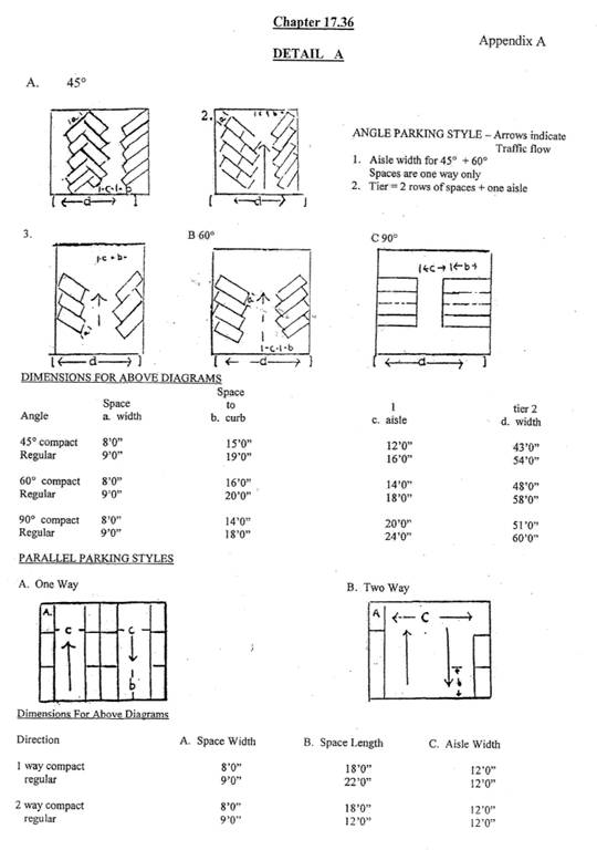
Parking Lot and Parking Space Design and Layout. Except where otherwise provided by subsection 17.108.040C. (adjustments to number of required parking spaces), parking spaces shall be designed as follows and as illustrated in Appendix A to this chapter:
1.
Parking Space Design. Except as provided below, all parking spaces shall be standard spaces, designed to accommodate full-sized passenger vehicles.
a.
Parking Space Sizes. Standard spaces shall be a minimum of nine feet by 18 feet for diagonal or ninety-degree spaces; and a minimum of nine feet by twenty-two (22) feet for parallel spaces. Compact car spaces shall be a minimum of eight feet by eleven (11) feet for diagonal or ninety-degree spaces; and a minimum of eight feet by eighteen (18) feet for parallel spaces. Handicapped spaces shall comply with the requirements set forth in Section 17.108.110 below. All measurements are exclusive of access or drive aisles.
b.
Compact spaces are allowed as follows:
Each compact space shall be labeled "COMPACT" or "C."
c.
Motorcycle Space Substitution. Parking lots with a minimum of ten (10) parking spaces may substitute standard parking spaces with motorcycle spaces. One standard parking space may be replaced with a motorcycle space for each ten (10) required standard parking spaces. Motorcycle spaces shall be a minimum size of four by eight feet.
2.
Parking Lot Design. The design and layout of parking lots shall conform to the following standards:
a.
Circulation Aisle Sizes. Parking lot aisle sizes shall be based on the angle and length of the parking stall pursuant to detail A of the appendix attached to the ordinance codified in this chapter. Other parking designs utilizing other parking angles may be approved upon securing an administrative permit.
b.
Circulation Aisle for Emergency Access. The minimum width of a drive aisle needed for an emergency response vehicle shall be twenty(20) feet.
c.
Vehicular Overhang. Vehicular overhang is permitted, provided no vehicle shall overhang into a sidewalk which would reduce the unencumbered width of a sidewalk to less than four feet. A vehicle is permitted to overhang into a landscaped area by two feet, provided that the required landscaped area is extended by two feet.
d.
Perimeter Landscaping. Where a parking lot is adjacent to a public right-of-way, a landscape planter shall be established and continuously maintained between the public right-of-way and the parking lot. The minimum width of the landscape planter shall be determined by the city's design guidelines (Chapter 17.116). In addition, all unused right-of-way between the public street and the parking lot shall be landscaped and maintained by the property owner.
e.
Bicycle Racks and Lockers. When bicycle spaces are required, a bicycle rack or locker shall be installed. The bicycle rack shall be designed to allow a bicycle to be secured to the rack. The location of the bicycle rack or locker shall not encroach into the sidewalk which would reduce the unencumbered width of the sidewalk to less than four feet and shall provide adequate clearance surrounding the rack or locker such that bicycles shall not encroach into any walkway, parking space, landscape area or similar area.
f.
Curb Stops. A permanent curb, bumper, wheel stop or similar device at least six inches in height shall be installed adjacent to sidewalks, planters and other landscaping areas, parking lot fixtures and buildings and walls to protect these improvements from vehicular damage. The stopping edge of such protected bumper shall be placed no closer than two feet from the above noted improvement.
g.
Parking Space Design. All parking spaces shall be delineated and separated by a painted divider. The stripes shall be a four-inch solid line painted either white or yellow in color. Excluding any applicable Americans with Disabilities Act parking requirements, the use of graphics or text in or around the striping is prohibited. The striping shall be maintained in a clear and visible manner. However, existing parking areas with single striping, which require additional parking spaces or modified parking spaces due to building expansion, parking lot restriping or reconfiguration may maintain the single striping upon securing an administrative permit.
B.
Controlled Access Required. All parking spaces (including garage spaces) required for any land use other than a single-family or two-family dwelling shall be designed and located to provide for vehicle maneuvering on the site so that vehicles will enter any adjacent public right-of-way or private road in a forward direction.
C.
Location of Parking on a Single-Family. Parking spaces may be located as needed on a site, provided that no required parking space shall be located within a front or street side setback required by Article III (use and zone district regulations) except as provided in Section 17.196.040 (second dwelling units), or other use types (community care facility, congregate residence and rooming and boarding house) according to Section 17.108.040. A driveway providing access to a street may be located within a front or street side setback.
D.
Surfacing of Parking Areas. Required parking and circulation areas shall be surfaced with asphalt concrete or Portland cement concrete, or other approved all-weather, hard, non-eroding surface. It shall be the responsibility of the property owner to insure that the surface is maintained free from significant cracks or holes.
E.
Specialized Parking and Circulation. The standards of this subsection apply to the design and construction of specialized parking and on-site circulation facilities. Additional information regarding stacking capacity for drive through facilities and other types of uses with stacking, are contained in the community design guidelines.
1.
Drive-Through Facilities. The following requirements apply to any use with drive-through facilities:
a.
Separation and Marking of Lanes. Drive-through aisles shall be a minimum of twelve (12) feet wide and shall be separated from other circulation aisles necessary for ingress or egress, or aisles providing access to any parking space. Each such aisle shall be striped, marked, or otherwise distinctly delineated.
F.
Loading Requirements. Loading shall be provided as identified below:
1.
No Maneuvering Within Public Rights-of-Way. All site designs shall be designed so as to prevent truck back-up maneuvering within the public right-of-way.
2.
Design. The location, number, size and access of the loading area shall be determined pursuant to design review.
G.
Screening. Off-street parking areas for more than five vehicles shall be effectively screened on each side which adjoins or faces institutional premises or premises situated in residential districts by a masonry wall or fence of acceptable design. Such wall or fence shall be not less than four feet or more than six feet in height and shall be maintained in good condition without any advertising thereon.
H.
Landscaping. Landscaping shall conform to the requirements of this Code.
I.
Lighting. Lighting used to illuminate any off-street parking area shall be so arranged as to reflect the light away from adjoining premises in residential districts, provided such lighting can be provided adequately to accommodate security concerns.
(Ord. No. 519, 8-8-2012)
17.108.050 - Residential districts—Additional requirements.
Any motor vehicle parked out of doors, off the driveway and street, and which can be seen from the public street/right-of-way in any residential district shall be in running condition. Should a motor vehicle be in the process of repair, it shall be restored to running condition within a period not to exceed seven calendar days. No mechanical repairs, other than emergency repairs, may be made on any street.
(Ord. No. 519, 8-8-2012)
17.108.060 - Off-street parking spaces—Location.
The off-street parking required by the provisions of this chapter shall be located on the same parcel as the use or building to which it pertains, except in the following circumstances:
A.
If the use or building lies within the boundary of a legally constituted parking district, the off-street parking space provided by such district shall be deemed to satisfy the provisions of this chapter with regard to such use or building.
B.
If the off-street parking spaces are purchased or leased pursuant to Section 17.108.040D. (purchase or lease of parking spaces).
(Ord. No. 519, 8-8-2012)
17.108.070 - Off-street loading spaces—Location.
Off-street loading spaces may occupy any required yard or court spaces, except that off-street loading spaces shall not be located nearer than fifty (50) feet to any lot in any residential district unless such loading spaces are enclosed by a masonry wall not less than eight feet in height.
(Ord. No. 519, 8-8-2012)
17.108.080 - Off-street loading spaces—Size.
Each off-street loading space shall be not less than ten (10) feet in width, twenty-five (25) feet in length and fourteen (14) feet in height.
(Ord. No. 519, 8-8-2012)
17.108.090 - Off-street loading spaces—Number required.
For every building or part thereof, having a gross floor area of ten thousand (10,000) square feet or more, which building is occupied by a commercial or industrial use and to or from which delivery of materials or merchandise is regularly made by motor vehicle, there shall be provided and maintained on the same lot with such building at least one off-street loading space, plus one additional off-street loading space for each loading door.
(Ord. No. 519, 8-8-2012)
17.108.100 - Handicapped accessible parking provisions.
A.
The city is required to enforce state and federal regulations regarding handicapped parking. The required number of handicapped parking spaces and other applicable design standards are set forth in the official ACS Accessibility Standards Interpretative Manual, as amended from time to time, which is incorporated herein by reference.
(Ord. No. 519, 8-8-2012)
17.108.110 - Bicycle parking provisions.
All applications for commercial, industrial and multi-family uses within the city shall include adequate design plans for bicycle parking for patrons and employees. There are two general categories of bicycle parking requirements applicable to multi-family, mobilehome subdivision, commercial and industrial districts within the city:
Class I: provides employee bicycle parking for retail, industrial, or office park uses, or long-term parking for multifamily residential, or mobilehome parks etc. This class I parking is for bicycles that will be left for hours at a time, and requires provisions for security and weather protection. Such parking can be located on site or within a reasonable distance of the site.
Class II: provides shoppers, customers, messengers and other visitors who generally park for two hours or less in a convenient and readily accessible place to park bicycles. Class II parking should be located within fifty (50) feet of the building entrance that cyclists use.
A.
Design standards for all bicycle parking spaces in any district:
1.
Provide floor, wall or ceiling mounted bike racks, which allow frame and both wheels to be secured, at least fifty (50) percent of such spaces to be covered from the elements
2.
Each parking space shall be striped for two feet by six feet for each bicycle parking space, to allow securing and removing bicycles without interference with adjacent bicycles. Bicycle parking will provide an aisle at least five feet wide behind all bicycle parking to allow room for maneuvering.
B.
Required parking spaces:
(Ord. No. 519, 8-8-2012)
17.108.120 - If more than one regulation applies.
If more than one standard is applicable to any use, then the planning director will make a determination as to which requirements apply.
(Ord. No. 519, 8-8-2012)
17.110.010 - Purpose and intent.
The purpose of establishing tree preservation guidelines is to maintain natural scenic beauty, improve air quality, water quality, reduce soil erosion, preserve significant natural heritage values, preserve wildlife habitat and help to reduce energy consumption for air cooling by providing shade. As development of vacant land occurs, loss of some tree cover may be unavoidable. The city's intent is to reduce the loss of trees to reasonably acceptable levels while encouraging cooperation between the development community, citizens, CalFire and the city in attempting to retain tree cover within the city to the maximum extent possible. In the spirit of reasonableness these guidelines shall not categorically prohibit tree removal and shall take into consideration the most recent CalFire defensive perimeter recommendations when approving a tree removal plan. It is recognized that development of foothill topography and project-specific terrain may dictate tree removal. It shall be the policy of the city to preserve trees whenever feasible through the review of all proposed development activities where trees are present, while recognizing individual rights to develop property in a reasonable manner.
(Ord. No. 519, 8-8-2012)
17.110.020 - Authority.
The city has an established planning application review process. The planning director shall oversee enforcement of the tree preservation guidelines through project conditions of approval in conjunction with granting planning application approval.
(Ord. No. 519, 8-8-2012)
17.110.030 - Tree identification.
Planning applications submitted to the city shall prepare a tree removal plan which identifies all healthy trees on the property in excess of six inches in diameter, measured four and one-half feet from ground level. The plan will also provide data on the health of the trees to be preserved and attempt to provide building envelopes where a majority of the trees can be preserved, while at the same time assuring defensive perimeter protection. Trees to be saved and removed shall be clearly designated on the plan. Clearing of trees over six inches in diameter measured four and one-half feet from the ground is prohibited prior to issuance of a grading permit.
(Ord. No. 519, 8-8-2012)
17.110.040 - Tree preservation requirements.
Innovative techniques or alternative project design shall be considered to preserve trees to the maximum extent feasible to retain conifers, oaks, maples and cedars. Preserving trees shall require installing bright colored mesh fencing, flagged stakes or some visible means of physical demarcation around the drip line of the tree(s) in the field prior to issuance of a grading permit. The drip line of a tree is the outermost edge of a tree's canopy. No movement of soil or earth material shall take place within the drip line of trees designated for preservation.
(Ord. No. 519, 8-8-2012)
17.110.050 - Tree replacement requirements.
Trees enhance the aesthetic appearance of any project. When tree removal is unavoidable:
A.
The applicant/developer shall replace and replant removed trees with an equal number of trees.
B.
Minimum/maximum replacement trees shall range from one-gallon to forty-eight-inch-box container sizes mixed to create a natural horizon line.
C.
A mix of tree species is preferred (rather than planting the same species throughout the project) to achieve a more natural, native appearance.
D.
Hillside development shall preserve trees when feasible or be replanted immediately to prevent erosion. "Immediate" means prior to the issuance of a certificate of occupancy or final inspection.
E.
Trees shall be irrigated and maintained by any and all subsequent owners for a minimum period of three years after installation in accordance with the Colfax design guidelines maintenance requirements:
1.
Deposit with the city a maintenance bond, cash, letter of credit or its equivalent, in an amount equal to one-half the market value of landscaping and irrigation guaranteeing the proper care, treatment and maintenance of landscaping for a period of three years; or
2.
Execute an agreement and equitable lien in an amount equal to the full market value of the landscaping and irrigation with the city, guaranteeing the lien shall cause a written letter of notification by the city to the owner of the real property within ten days that the city will perform or have performed by a reputable landscaper any and all maintenance work it deems necessary and bring legal action against the owner for the frill cost of such maintenance work or foreclose such equitable lien as provided by law.
(Ord. No. 519, 8-8-2012)
17.112.010 - Title.
This chapter shall be known and cited to as the "Colfax Sign Ordinance."
(Ord. No. 519, 8-8-2012)
17.112.020 - Purpose and intent.
A.
This chapter establishes the legal framework for a comprehensive system for the regulation of signs. This chapter presents a set of reasonable, non-arbitrary and non-discriminatory standards and controls designed to optimize communication between the citizens and their environment. To not only facilitate the protection of the public, but the aesthetic character of the city and to ensure the availability to the community of adequate, high quality signs.
B.
Signs have an obvious impact on the character, quality of life and economic health of the city. As a prominent aspect of the scenery, they either attract or repel the viewing public and may affect the safety of vehicular and pedestrian traffic. Their suitability and appropriateness helps define the character of a neighborhood and the larger community. The purpose of this chapter is to regulate signs in a manner that will benefit the public and maintain a high quality of development throughout the city. The regulations contained herein are intended to:
1.
Direct persons to various activities and enterprises in order to provide for the maximum public convenience;
2.
Provide a reasonable system of regulations for signs in order to ensure the development of a quality visual environment;
3.
Encourage signs that are well-designed and pleasing in appearance, recognizing that a well-designed sign enhances a business's image and economic vitality;
4.
Provide incentive and latitude for variety, good design relationships and spacing of signs;
5.
Encourage a desirable urban character that has a minimum of overhead clutter and reduce sign proliferation;
6.
Enhance the economic value of the community and each area thereof through the regulation of such things as size, number, location, design and illumination of signs;
7.
Encourage signs that are compatible with adjacent land uses and that provide pedestrian-scale atmosphere;
8.
Reduce possible traffic and safety hazards through good signage;
9.
Ensure the maintenance of signs; and
10.
Implement the community architectural and landscape design goals, objectives and policies of the general plan, design guidelines established by the city, and other applicable design guidelines to enhance the beautification of the city.
(Ord. No. 519, 8-8-2012)
17.112.030 - Definitions.
For the purposes of this chapter, the definitions shall be as follows:
"Abandoned" means a sign which has not been maintained in accordance with the provisions of this chapter for a period in excess of thirty (30) days following legal notice to the owner of the property and/or owner of the advertising display or tenant on whose property the advertising display is located that such sign does not meet, in the discretion of the planning director, minimum maintenance standards or a sign display for a business, product or service no longer in existence on the premises.
"Accessory sign" means signs which advertise a product or service in association with the business.
"Agricultural sign" means a sign that advertises the sale or growing of fruits, vegetables, nuts and organic materials.
"Amortization" means the elimination of nonconforming signs over a period of time intended to allow the owner opportunity to depreciate the value of the sign.
"Appeal" means a request for reconsideration of an administrative remedy by a higher level of legislative or quasi-judicial government.
"Architect, contractor or construction sign" means a sign which gives notice of development advertising a contractor, architect or construction company.
"Awning/canopy sign" means a simulated roof or umbrella-type structure which projects from a wall or roof of a building, which contains text advertisement for a business, goods or services.
"Beacon" means any light with one or more beams directed into the atmosphere or directed at one or more points not on the same lot as the light source; also any light with one or more beams that rotate or move.
"Building frontage" means that side of a building which contains the main entrance for pedestrian ingress and egress. If more than one main entrance exists, the one that more nearly faces or is oriented to a parking area or the street of highest classification as portrayed in the current circulation element of the general plan shall be considered the building frontage. For unique designs that do not allow use of the preceding discussion, the planning director shall determine building frontage.
"Combination canopy and under-canopy sign" means a sign painted, placed or installed on an awning/canopy and a sign hanging under an awning/canopy.
"Digital billboard" means a billboard or other off-site sign that uses digital-display technology.
"Exempt sign" means a sign not required to comply with the standards of this chapter.
"Freestanding sign" means a sign standing alone or on its own foundation free of support or attachment.
"Government flags" means flags displayed by federal, state, county or city governments.
"Illumination" means the source of light used for visible display of both interior/exterior signage.
"Maintenance" means ongoing care and repair of a sign.
"Master sign program" means a plan for signage for more than one business sign in a unified commercial area.
"Multi-tenant sign, freestanding" means a freestanding sign that is made up of three or more individual sign faces, one of which must be associated with the parcel upon which the sign is located. For the purposes of this chapter, all multi-tenant signs are considered on-site signs.
"Mural" means an application of pictures or other graphic art forms onto exterior walls, either full or portions of walls to enhance the architecture or aesthetics of a building or wall. Murals must not include the name, logo or other representation that advertises a business, product, service or other commercial activity.
"Nonconforming sign" means a sign that originally complied with all applicable regulations and laws at the time it was erected, but violates a regulation or law subsequently adopted.
"Off-site sign" means individual signs advertising a business, service, commercial or industrial entity not located on the parcel of land as the sign.
"Permitted sign" means a sign that has been approved pursuant to this chapter and for which a sign permit has been issued.
"Political sign/civic sign" means a sign that draws attention to a ballot issue, candidate or measure in a national, state or local election.
"Prohibited sign" means a sign and/or sign materials not consistent with the standards of this chapter.
"Projecting sign" means a sign which extends out from a building face or wall so that the sign face is perpendicular or at an angle to the building face or wall.
"Real estate sign" means a sign which gives notice of the sale, rental or lease of real property.
"Residential sign" means a sign which notices the name of an occupant or resident.
"Roof sign, integral" means any sign erected or constructed as an integral part of a normal roof structure of any design, in such way that no part of the sign extends vertically above the highest portion of the roof and no part of the sign is separated from the rest of the roof by a space of more than six inches.
"Sandwich sign" means a freestanding portable "V"-shaped sign (horizontal or vertical "V") used temporarily for events, goods, services or activities.
"Sign clearance" means the distance of the sign to a public right-of-way, pedestrian or vehicular.
"Sign review" means planning director review of a sign permit application for compliance with this chapter and approval or denial by the planning director or planning commission.
"Temporary sign" means a sign that is limited to the duration of a condition, activity or event.
"Wall sign" means a sign affixed to or painted on the wall surface of a building in such a manner that the surface of the sign is parallel with the prevailing surface of the wall upon which the sign is displayed.
"Window sign" means a sign displayed within a building or attached to the interior/exterior of a window or similar opening for the primary purpose of visibility.
(Ord. No. 519, 8-8-2012)
17.112.040 - General provisions.
Unless exempt by Section 17.112.170 of this chapter or an approved freestanding multi-tenant, master sign program, digital billboard sign or off-site subdivision sign, signs shall be located on the same legal parcel as the permitted use and shall be clearly incidental, customary and commonly associated with the operation of the permitted use. For the purposes of this chapter, a unified retail shopping, commercial or business center shall be treated as a single parcel regardless of whether the center is comprised of more than one legal parcel. Freestanding multi-tenant signs must advertise the business located on the parcel, as well as the additional business, product, service or other commercial activity, except as provided in Section 17.112.220 of this chapter, abandoned signs.
(Ord. No. 519, 8-8-2012)
17.112.050 - Administration.
A.
Administration of this chapter shall be carried out by the planning director or his or her designee. All limitations shall be as set forth in the California State Planning and Zoning Law (Title 7, Chapter 65000 of the Government Code, as amended) and all applicable sections of the Business and Professions Code, and California Building and Fire Codes.
B.
Unless expressly exempted in this chapter, no sign may be erected, displayed, reconstructed or altered until a sign permit is granted as set forth in this chapter and a building permit (when applicable) has been issued.
C.
The objectives of sign review are:
1.
To provide a means of review appropriate to the magnitude of the proposed signage;
2.
To assure the planned character of freestanding multi-tenant signs and master sign programs;
3.
To provide a means of flexible application of the sign regulations so as to encourage maximum incentive and latitude in the design and display of signs in order to achieve, not circumvent the intent of this chapter.
D.
All sign applications are subject to sign review by the planning director for compliance with this chapter.
E.
The planning director will review the sign application and may approve, deny or approve with conditions the sign permit (known as an administrative sign permit) or refer the application to the planning commission. The planning director may also delegate administrative sign permit review and approval to other city employees.
F.
Signs associated with projects subject to design review shall be reviewed as part of that process; however, such signs also require a sign permit from the planning director.
G.
Planning commission approval is required for sign applications in any instance where it is combined with a project that is subject to be heard by the planning commission, such as a conditional use permit, general plan amendment or rezone.
H.
The planning director may approve deviation of letter type fonts after approval of the sign permit. This type of change shall not require the applicant to process an additional sign permit application.
I.
Findings. In approving a sign permit, the approval authority shall make the findings set forth in subsection 17.40.070D. or 17.40.070E., as applicable.
(Ord. No. 519, 8-8-2012)
17.112.060 - Sign review.
Sign review shall be initiated by the applicant submitting a completed sign application form to be provided by the city. Upon receipt of a completed application, the planning director will review and may grant approval of the sign or refer the application to the planning commission pursuant to the standards of this chapter. If the planning director determines the sign to be unacceptable and/or the sign application to be incomplete, the applicant will be informed of identifiable issues and suggested alternatives to resolve such issues.
(Ord. No. 519, 8-8-2012)
17.112.070 - Determining the number of signs.
A.
For the purpose of determining the number of signs, a sign shall be considered to be a single display surface or display device containing sign faces physically connected and having a coterminous boundary, with the following exception: combination canopy, under-canopy and awning, under-awning signs shall be considered as one sign.
B.
A two-sided or multi-sided sign shall be regarded as one sign subject to the following:
1.
A "V-type" sign shall be regarded as a single sign only if the two sides are separated by no more than three feet at any point;
2.
Double-faced (back-to-back) signs shall be regarded as a single sign only if the distance between the backs of each face of the sign does not exceed two feet.
C.
All freestanding signs twenty (20) feet or less in height shall have a solid base comprised of rock, brick, wood, exposed aggregate or natural material(s) or as approved by the planning director.
D.
The total number of signs advertising an individual business, service, product or commercial activity shall not exceed three in the historic district.
(Ord. No. 519, 8-8-2012)
17.112.080 - Sign standards.
A.
Signs shall conform to the applicable standards as set forth in this chapter, including the standards set forth in the charts at the end of this chapter.
B.
Height of Signs. Except for restrictions contained in the historic district, determination of the height of the sign will be made pursuant to Section 17.40.070.
C.
Copyrighted Logos. The City of Colfax will not require the modification, including requiring a change in color, of any copyrighted logo, national logo or state-approved logo of any business located outside of the historic district.
D.
The following guidelines should be considered:
1.
Interior lit signs are discouraged and will not generally be approved.
2.
Signs should respect the architectural design and proportion of the building and should not cover transoms, insignias, or any architectural ornamentation.
3.
Limit the number of lettering styles on a sign to increase legibility, i.e. not more than two for small signs.
4.
The preferred lettering styles for Colfax are Bostonian, Hasler Circus, Playbill, Mesquite, Wide Latin, Bookman Bold, and Barclay Expanded Ultrabold. Refer to Appendix 2 of this document.
5.
The following types of signs are encouraged: flush wall mounted, projecting with solid metal supports, hanging signs, window painted signs, integral roof signs and monument signs.
6.
Any change in copy shall still conform to the sign ordinance in terms of materials, sign area, standards, and criteria.
(Ord. No. 519, 8-8-2012)
17.112.090 - Illumination of signs.
A.
The following standards for illumination apply to all signs in all zones:
1.
All sign illumination shall be from the interior or by indirect lighting (diffused) light, which is stationary and constant in intensity and color at all times. All signs shall be turned off after business hours or at ten p.m., whichever is later.
2.
Signs without internal lighting shall be lighted from above and in a downward direction.
3.
All lighted signs shall be mounted, arranged or shielded to prevent spillage of light off-site or into the sky.
4.
Neon tubing as a sign material shall be permitted to the extent that it composes twenty (20) percent or less of the total allowable sign surface area.
5.
Neon tubing as an architectural detail shall be used in limited quantities in the commercial or highway/commercial districts subject to the approval as part of sign review. All neon tubing used as an architectural detail shall be integrated into the design of the building. Visible neon tubing outlining the interior of a window shall be considered a sign.
6.
Neon tubing used as an architectural detail is prohibited in the historic district.
B.
The following standards for illumination shall apply in the A, R, RM, R-MHS and OS zoning districts: maximum illumination of ten (10) foot lambert per sign.
(Ord. No. 519, 8-8-2012)
17.112.100 - Projecting signs and sign clearances.
A.
All projecting signs, except awnings or canopies, must be double-faced.
B.
An encroachment permit from the building department is required for signs that project more than two feet over a public right-of-way.
C.
All signs that project more than two feet over a public right-of-way shall have a minimum height clearance of seven feet.
D.
No permit for any sign shall be issued and no sign shall be constructed or maintained that has less horizontal or vertical clearance from communication lines and energized electrical power lines than that prescribed by the laws of the state or rules and regulations duly promulgated by agencies thereof.
(Ord. No. 519, 8-8-2012)
17.112.110 - Accessory signs.
Signs that are temporary or transient in nature and placed in a window or wall area shall be considered accessory signs and shall not count toward the permitted business signage.
(Ord. No. 519, 8-8-2012)
17.112.120 - Incidental and supplemental signs.
Signs that are incidental or supplemental to the use of the property, such as drive-through menu boards do not count towards the permitted signage. The design, number, location and size of incidental or supplemental signs shall be reviewed and approved as part of a sign review or master sign program by the planning director.
(Ord. No. 519, 8-8-2012)
17.112.130 - Commercial or retail master sign programs.
A.
The purpose of a master sign program is to integrate signs with buildings, landscape design and promote a unified architectural unit, to reduce the overall number of signs and to ensure the magnitude of proposed signs are substantially consistent with existing and proposed buildings and the character of the district within which the signs are proposed.
B.
A master sign program for a unified commercial area, such as a retail shopping, commercial or business center, shall be processed prior to installation of any signs. Any sign which conforms to an approved master sign program may be approved by the planning director. Approval of a master sign program does not waive the permit requirements for individual signs.
C.
Amendment. A master sign program may be amended by submitting an amended master sign program that conforms to all requirements of this chapter to the planning director and obtaining planning director approval.
D.
Binding Effect. After approval of a master sign program, no signs shall be erected, placed, painted, or maintained, except in conformance with such plan, and such plan may be enforced in the same ways as any provision in this chapter. The master sign program shall be attached to the lease agreements for all leasable space within the project. In case of any conflict between the provisions of such a plan with any other provisions herein, this section shall control.
(Ord. No. 519, 8-8-2012)
17.112.140 - Freestanding multi-tenant signs.
Freestanding multi-tenant signs must comply with all applicable provisions of this chapter and consider topographic conditions and visual impairment.
(Ord. No. 519, 8-8-2012)
17.112.150 - Digital billboard signs.
Digital Billboard Signs on City-owned Property. For purposes of this section, (1) a "digital billboard sign" means and refers to an advertising structure (as that term is defined in the California Outdoor Advertising Act - Business & Professions Code, Division 3, Chapter 2) that uses digital-display technology; and (2) "City-owned property" means and refers to any property in which the city is the owner of the majority of the fee title interest, as well as property in which the city has a leasehold, easement, license or other possessory interest.
A.
Notwithstanding any provision of this title to the contrary, the city, on such terms as the planning director may approve in his or her discretion, may: construct, repair, replace and maintain; cause the construction, repair, replacement and/or maintenance of; or issue a permit for the construction, repair, replacement and/or maintenance of, digital billboard signs within city-owned property and visible from Interstate Highway 80 and/or State Highway 174, subject to subsections A.1. through A.5, below. Such terms may include utilizing a relocation agreement, which would allow the removal of a display and construction of a new display to substitute for the display that is removed. A digital billboard sign may be electronic, programmable and/or illuminated and provide for "off-site" advertising (as that term is defined in this chapter). The total number of billboard signs in the city, whether digital or not, may not exceed the number of billboard signs in the city at the time the digital billboard sign ordinance is adopted, without further action of the city council.
1.
The city-owned property must be located in a commercial or industrial zone as of the date a permit for a digital billboard sign is issued.
2.
All digital-display faces must be oriented primarily for viewing from the freeway or highway to which it is adjacent.
3.
Notwithstanding any provision to the contrary in this title, the maximum height of a digital billboard sign, measured from grade to the top of the digital-display face, is forty-five (45) feet; and the overall maximum height, measured from grade to the top of the billboard structure, is fifty (50) feet. The planning director may, upon a showing of good cause supported by substantial evidence in the record, grant a variance on the maximum height restriction.
4.
Notwithstanding any provision to the contrary in this Title, a digital billboard sign may have either one or two display faces, and the maximum area of a display face is one thousand two hundred (1,200) square feet. The maximum height of the display face is 25 feet and maximum length of the display face is sixty (60) feet.
5.
A digital billboard sign may display only a still image in each of its display messages. This means that the still image being displayed may not move or present the appearance of motion and may not use flashing, blinking, or traveling lights or any other means not providing constant illumination (except that part necessary to give public service information such as time, date, temperature, weather, or similar information). The digital billboard sign must expose each message display for not less than four seconds, unless a greater amount of time is set forth as a recommendation in the most recent guidance document issued by the Federal Highway Administration on the subject of changeable electronic variable message signs; in such case, the minimum FHWA standard shall apply. The transition or blank screen time between one display message and the next may not exceed one second, nor shall this transition time be construed as a failure to comply with the constant illumination requirement set forth above.
B.
Notwithstanding any provision of this title to the contrary, an existing sign that is removed and/or relocated in the implementation or exercise of subsection A., above, may include either a legal conforming sign or a legal nonconforming sign; such status shall be determined by the planning director. Any sign approved for relocation must be removed prior to construction or installation of the digital billboard sign that will replace it.
C.
Compliance. In addition to complying with the other requirements of this section, a digital billboard sign must also comply with the requirements of the California Outdoor Advertising Act, Chapter 2 in Division 3 of the California Business and Professions Code ("Act"), including, but not limited to, the restrictions on size, height, intermittent flashing lights, proximity to interstate and primary highways and landscaped freeways, and other regulations set forth in Articles 7 and 8 of the Act. To the extent a conflict arises between this section and the Act, the Act will prevail, except for the FHWA recommendation referenced in subsection A.5., above.
D.
Findings for Approval of a Digital Billboard Sign or Relocation Agreement. A digital billboard sign or relocation agreement may be approved if the planning director makes the following findings:
1.
The digital billboard sign or relocation agreement substantially complies with the purpose and requirements of this section;
2.
The digital billboard sign or relocation agreement will not interfere with on-site access or circulation or significantly interfere with visibility.
(Ord. No. 519, 8-8-2012)
17.112.160 - Mural permit.
A.
Purpose and Intent. To ensure a mural enhances the architecture or aesthetics of a building or wall and does not detract from the character of the district within which it is located. To ensure a mural is not detrimental to the public health, safety or welfare, a mural permit shall be required for all murals.
B.
Review Process. Murals are considered a means to enhance the architecture or aesthetics of a building or wall and not a form of advertisement. All murals shall be treated as a sign and reviewed pursuant to this chapter. If a mural is proposed containing business or business-related advertising materials, it shall be required to pay the sign permit fee. If the mural is civic-oriented in nature, as opposed to promoting a specific business, the sign permit fee shall be waived. The mural permit process shall require review of murals to ensure that size, location and placement is consistent with the character of the district within which it is located; the character of the building or wall upon which it is placed; and that the mural is not detrimental to the public health, safety or welfare. The approval authority for a mural permit is the planning director, who shall not delegate such authority to other city employees.
(Ord. No. 519, 8-8-2012)
17.112.170 - Exempt signs.
The following signs shall be allowed without a sign permit and shall not be included in the determination of type, number or area of signs allowed in each zone district; however, exempt signs are subject to building, plumbing or electrical permits as appropriate.
A.
Official federal, state or local government flags, emblems and historical markers;
B.
Official federal, state or local government traffic, directional and information signs and notices issued by any court, person or officer in performance of a public duty;
C.
Temporary signs warning of construction, excavations or similar hazards;
D.
Temporary holiday decorations;
E.
"No Trespassing" signs not more than one square foot in size placed at each corner and each entrance to a property and at intervals of not less than one hundred (100) feet;
F.
Parking lot and other private traffic directional signs not exceeding three square feet in area which are limited to guidance of pedestrian or vehicular traffic. If located off-site, the signs are further limited to street number, street name and directional symbols. References to the name of a business and/or business logo are not permitted if the sign is located off-site. In addition, off-site signage requires proof of permission from, or a contract with, the property owner to use the location, which must be in a form found to be acceptable to the city manager prior to sign installation; ;
G.
For each service station, pricing and grade signs as required by the state;
H.
Legal or ordinance enforcement signs not exceeding three square feet in area and erected by private individuals or businesses and not otherwise regulated by this Code;
(Ord. No. 519, 8-8-2012)
17.112.180 - Permitted signs.
Permitted signs are all signs that have been approved pursuant to this chapter and for which a sign permit has been issued. Such signs include:
A.
Integral roof signs, awning/canopy signs, combination canopy and under-canopy signs, wall signs and freestanding signs, subject to the regulations set forth in the charts at the end of this chapter;
B.
Temporary advertising signs or special event display, subject to the following regulations and the regulations set forth in the charts at the end of this chapter:
1.
Signs painted on a window or constructed of paper, cloth, wood or similar material, including banners, flags, pennants and balloons provided they are displayed for no more than thirty (30) days prior to an event and five days afterward, with a maximum of three thirty-day periods per business establishment) calendar days each calendar year, to promote events or sales of products, merchandise or service;
2.
Temporary Gas and hot air balloons or inflatable displays, subject to the following regulations and the regulations set forth in the charts at the end of this chapter:
a.
No more than one hot air balloon or inflatable display is permitted per event;
b.
Use of gas balloons or inflatable displays are limited to three days per event. Not to exceed thirty-six (36) such displays in each calendar year per business establishment;
c.
Balloons or inflatable displays shall not be located on any roof structure nor shall they occupy required parking spaces or be placed in walkways;
d.
Window signs, banners, commercial flags and pennants may be used in conjunction with balloons or inflatable displays as listed in subsection A.1. of this section.
3.
Permanent window signs limited to hours of operation; business name; address; and emergency information and menu of services or goods
C.
Real estate signs for sales, rental or lease subject to the following regulations:
1.
Residential dwellings offered for sale, rent or lease on an individual basis not in association with a subdivision or apartment complex, one sign per parcel not exceeding five square feet and six feet in height. Such signs shall be removed within five calendar days after the sale, rent or lease of property. Signs shall not create sight distance hazards.
2.
One sign per parcel to advertise the sale, lease or rent of commercial or industrial property provided all of the following are met:
a.
Such signs shall not exceed four square feet each and be no greater than six feet in height;
b.
Signs shall not create sight distance hazards for pedestrians or vehicles;
c.
Such signs shall be removed within five calendar days of the close of the sale or termination of the lease or rental agreement;
d.
Where a project has in excess of six hundred (600) lineal feet of street frontage, one additional sign shall be permitted for each full six hundred (600) lineal feet of street frontage.
D.
Subdivision signs subject to the following regulations:
1.
On- or off-site, unlighted signs advertising subdivisions within the city, containing only the name of the subdivision, its products, the name of the developer and/or agent, an identification emblem and a directional arrow shall be permitted for not more than two years provided:
a.
There shall be not more than two such signs located within the city limits for each subdivision. Signs must be located on private property;
b.
The total area of each sign shall not exceed ninety-four (94) square feet;
c.
The total height of each sign shall not exceed twenty-four (24) feet;
d.
Directional subdivision signs may be displayed during construction or until the last lot has been sold.
2.
One on-site subdivision sign for each subdivision entrance shall be permitted provided the total area per sign is not greater than thirty-two (32) square feet and sign height does not exceed six feet. Such on-site sign shall be permitted to remain only as long as a sales office is maintained in the subdivision not to exceed four years and provided such signs are maintained in good condition as determined by the planning director.
3.
Permanent gateway/entrance subdivision signs must be consistent with the general plan and are subject to the following regulations:
a.
One on-site subdivision sign for each subdivision entrance, excluding emergency secondary access, provided the total sign area is not greater than forty-eight (48) square feet;
b.
Sign height shall not exceed sixteen (16) feet;
c.
Permanent gateway/entrance subdivision signs shall be maintained in good condition as determined by the planning director.
E.
Architect, contractor or construction signs providing the name of architect(s) and/or contractor(s) working on the site, subject to the following:
1.
For residential projects greater than four dwelling units, up to two signs may be placed on the construction site;
2.
For commercial and industrial projects, up to two signs may be placed on the construction site;
3.
For all other projects, a total of two signs may be placed on the construction site.
F.
Future tenant identification signs to advertise the future use of an approved project on the property may be placed on vacant or developing property to give the location where information may be obtained. Such signs will be approved by the planning director at the time a use permit is issued and are subject to the following restrictions:
1.
One future tenant identification sign per parcel;
2.
Such signs shall not be erected until a use permit is issued for the development and shall be removed within one year from the date of the building permit.
G.
Residential Signs. Multiple-family residential building identification signs limited to address and building number or letter. One wall sign is allowed per building frontage and shall be located below the roof line. Directional signage for the multiple-family residential building complex may be placed along the internal drive areas.
H.
Agricultural signs identifying agricultural products grown or sold on the premises shall be approved at the discretion of the planning director.
I.
Election Campaign Signs. Political signs advertising candidates or positions on issues for an election campaign may be placed on private property only, and are subject to the following requirements:
1.
Location of Signs. Election campaign signs shall be prohibited within any public right-of-way.
2.
Maximum Sign Area. Thirty-two (32) square feet.
3.
Property Owner Consent Required. The placement of election campaign signs shall only occur with the permission of the owner of the property where the sign is to be placed.
4.
Removal Required. Election campaign signs shall be removed from public view no later than twenty-one (21) days after an election to which they apply.
5.
Enforcement. If an election campaign sign is in violation of the provisions of this section, notice shall be given by the planning director to either the property owner or manager and/or the candidate and/or organization for which the sign was placed, that directs removal of the sign within seven days of the date of the notice. Failure to remove the sign shall be punishable as provided in Section 17.112.270. (enforcement).
J.
Government and noncommercial signs except when displayed in connection with commercial promotion, provided that such flags are no greater in size than ten (10) feet by fifteen (15) feet or as approved by the planning director.
K.
Miscellaneous Signs.
1.
Memorial tablets, plaques or directional signs for community historical and cultural resources installed by the city or by a city recognized historical society or civic organization.
2.
Official and legal notices issued by any court, public body or officer or in furtherance of any non-judicial process by federal, state or local law.
3.
Public utility signs indicating danger or that serve as an aid to public safety or that show locations of underground facilities or public telephones.
4.
Safety signs on construction sites.
5.
Public transportation vehicle signs, including, but not limited to buses and taxi cabs.
6.
Signs on licensed commercial vehicles that are not used or intended for use as portable signs and that are not specifically prohibited by the provisions of this chapter.
7.
Change of copy on an approved sign in compliance with this chapter.
8.
Holiday decorations to celebrate nationally recognized holidays and local celebrations.
9.
Vehicle-oriented convenience and directional signs solely for the purpose of guiding traffic and parking on private property and not bearing advertising material, limited to a maximum area of two square feet.
10.
Directional, warning or informational signs as required or authorized by law or by any federal, state, county, special district or city authority and "No Trespassing," "No Parking," "Neighborhood Watch" and similar warning signs, limited to a maximum area of two square feet.
11.
Incidental signs for auto-related uses, motels and hotels that show notices of services provided or required by law, trade affiliations and credit cards accepted, provided such signs are attached to an otherwise approved ground sign, structure or building and limited to a maximum area of two square feet.
12.
"Open" and "Closed" signs.
13.
Automobile service stations are permitted to have the following additional signs provided they conform to the height and setback requirements of the district in which they are located:
a.
State-Authorized Testing Centers. Four square feet per sign, wall mounted only;
b.
Price Signs. One single- or double-faced sign per street frontage, twenty (20) square feet maximum per face. This exception is intended to allow for full compliance with state law for posting of gasoline prices. Portable price signs are not permitted;
c.
Pump Signs. One sign for each gas pump unit not to exceed two square feet per pump face or one sign per bank of pumps, not to exceed eight square feet per face, identifying the gasoline brand and rating only.
14.
City-sponsored civic signs for community entrance, identification, direction or information.
15.
Wall signs must not project beyond the wall surface more than six inches.
L.
Signs on vehicles or trailers provided the sign is painted or attached directly to the body of the original vehicle and does not project or extend beyond the original manufactured body property of the vehicle. The sign is incidental to the vehicle's primary use and the vehicle is not used primarily for advertising purposes. Such signs shall not exceed twelve (12) square feet per sign face.
M.
Any sign as determined by the planning director to be similar in use and size to the signs listed above.
(Ord. No. 519, 8-8-2012; Ord. No. 549, § 1(Exh. A), 8-24-2022)
17.112.190 - Prohibited signs.
A.
Any sign not in compliance with the provisions of this chapter. Violations shall be processed pursuant to this title.
B.
Roof signs extending more than six feet above the eave or parapet line, except when, in the opinion of the planning director, the sign is a complementary architectural feature of the building. This provision does not apply to integral roof signs.
C.
Beacons.
D.
Signs emitting audible sounds, odors or visible matter.
E.
Portable signs not specifically permitted by the provisions of this chapter.
F.
Signs within the public right-of-way except those permitted by a governmental agency, and otherwise permitted for digital billboard signs.
G.
Signs in any location that interferes with vehicular, bicycle or pedestrian circulation or safety.
H.
Signs in proximity to utility lines that have less horizontal or vertical clearance from authorized communication or energized electrical power lines than that prescribed by the laws of the state or rules and regulations duly promulgated by agencies thereof.
I.
Signs blocking driveways, door or window openings or fire escapes.
J.
Electric reader board signs that: (i) are not exempt by virtue of being interior signs or (ii) are not otherwise specifically permitted by the provisions of this chapter, such as digital billboard signs and signs subject to an approved master sign program.
K.
Signs that simulate, by virtue of size, shape, color, lettering, or design, a traffic sign or signal, or signs with characters or graphics that interfere with, mislead, or confuse the pedestrian or motorist are prohibited.
(Ord. No. 519, 8-8-2012)
17.112.200 - Revisions and/or alterations to signs.
Revisions other than copy (text only) to signs will require a modification pursuant to the procedures set forth in Section 17.36.180.
(Ord. No. 519, 8-8-2012)
17.112.210 - Nonconforming signs.
Signs existing prior to the of adoption of the ordinance codified in this chapter that do not comply with the provisions herein shall be regarded as nonconforming signs and shall be removed from the site at the time the business is no longer in operation, in accordance with Section 17.112.220.A, except when the following applies:
A.
Historical Signs.
1.
Upon written request by a sign owner, the planning director may determine that a sign is historical based on the following findings:
a.
The sign is unique because its shape, colors, materials or other aspects of sign design are indicative of the historical period within which it was constructed; or
b.
The sign is unique because it is integrated into the design of a historical building and removal of the sign would jeopardize the historical integrity of the building.
2.
Historical signs may be maintained, reconstructed, modified or expanded consistent with the historical nature of the sign after notification to the planning director.. New signs proposed on the property shall comply with this chapter and shall be complementary to the historical sign.
3.
Signs not qualifying for historical status shall be permitted to remain until such time as there is a change in the use of the property, at which time sign review shall be required pursuant to this chapter.
(Ord. No. 519, 8-8-2012)
17.112.220 - Abandoned signs.
A.
A sign that pertains to a business or occupation which is no longer using the particular property or which relates to a time or event that no longer applies shall be removed within thirty (30) days after the associated business or occupation has vacated the property. Abandoned signs are prohibited and sign removal shall be the joint responsibility of the owner of the sign and the owner of the property.
B.
Any sign copy which no longer identifies the subject matter for which it was intended shall be removed or changed by the owner of the sign or the owner of the property upon which it is located within thirty (30) days of the event causing the improper identification. The structure shall be removed or replaced subject to the appropriate procedures required by this chapter.
(Ord. No. 519, 8-8-2012)
17.112.230 - Signs to be removed.
A.
Notice and Removal. The chief building official shall remove or cause to be removed any abandoned, dangerous, defective, illegal, prohibited, not maintained, or nonconforming sign subject to removal under the provisions of this chapter, which has not been removed within the time period specified in this chapter. The chief building official shall prepare a notice which shall describe the sign and specify the violation involved and shall state that if the sign is not removed or the violation is not corrected within thirty (30) days, the sign shall be removed in accordance with the provisions of this section. For signs described under provisions of this chapter, the notice shall be mailed or given to the occupant of the property or other employee or, the owner of the sign, or representative upon which the sign is located. If known, the notice may also be mailed or delivered to the owner of the sign and the occupant of the property.
B.
Emergency Removal. Notwithstanding the above provisions of this section, in cases where the chief building official determines that the sign may collapse or injure persons or property, thus constituting an emergency, the chief building official may cause the immediate removal of hazardous, dangerous or defective signs, without notice.
C.
Cost of Lien. Any sign removed by the chief building official pursuant to the provisions of this section shall become the property of the City of Colfax, and may be disposed of in any manner deemed appropriate by the city. The cost of removal of the sign shall be considered a debt to the city by the owner of the sign and the owner of the property, and may be recovered by the city by a lien against the property or any other remedy prescribed by law.
(Ord. No. 519, 8-8-2012)
17.112.240 - Construction
specifications and safety.
A.
Compliance with Building Code. All signs shall comply with all applicable provisions of this code, including, but not limited to, the California Building Code and the California Sign Code relative to design and construction, structural integrity, connections and safety. Signs shall also comply with the provisions of all applicable electric codes and any additional construction standards set forth in this code.
B.
Construction of Signs.
1.
All signs shall be structurally safe; shall be made of rust-inhibitive materials; and shall be fabricated, constructed, erected or installed and maintained in such a manner as will comply with the provisions of this title in addition to the California Building Code and National Electrical Code.
2.
Each sign hereafter erected or remodeled shall bear, in a visible position, clearly legible identification decals stating the firm or corporation responsible for its construction and erection. Electric signs shall be marked with input amperages at the full load input.
3.
No sign shall be attached in any form, shape or manner that will interfere with an opening required for ventilation, except in circumstances when not in violation of the building or fire codes.
4.
Signs shall be located in such a way that they maintain horizontal and vertical clearance of all overhead electrical conductors in accordance with the electrical code and the regulations of the affected entity and the public utilities commission.
5.
Certain signs may be required to be properly guttered and connected with down spouts to storm drains so that water will not drip or flow into public sidewalks or streets.
6.
All permanent freestanding signs shall be self-supporting structures erected on and permanently attached to concrete foundations. Such structures shall have exterior aesthetic materials of rock, wood, exposed aggregate or other such materials as approved by the planning director.
7.
All signs shall be constructed to withstand wind loads, acceptable to the chief building official and/or city engineer.
8.
No chains or other devices, which allow a sign to move, are permitted. Signs shall be anchored to prevent any lateral movement that would cause wear on supporting members or connections.
(Ord. No. 519, 8-8-2012)
17.112.250 - Liability for damages.
The provisions of this chapter shall not be construed as relieving or limiting in any way the responsibility or liability of any person erecting or owning any sign, for personal injury or property damage resulting from the placement of such sign, or resulting from the negligence or willful acts of such person, its agents, employees, or workmen, in the construction, maintenance, repair, or removal of any sign erected in accordance with a permit issued under this chapter; nor shall it be construed as imposing upon the city or its officers or employees any responsibility or liability by reason of approval of any signs, materials, or devices under the provisions of this chapter.
(Ord. No. 519, 8-8-2012)
17.112.260 - Maintenance of signs.
A.
Every sign and all parts, portions, components and materials thereof, shall be maintained and kept in good condition and proper repair. The display surface of all signs shall be kept clean, neatly painted and free from rust and corrosion. Any cracked or broken surfaces and malfunctioning or damaged portions of a sign shall be repaired or replaced within thirty (30) calendar days following notification by the city. Noncompliance with such a request shall constitute a nuisance and may be abated in accordance with the provisions of this chapter.
B.
Any maintenance, except a change of copy not specifically exempted, shall be permitted.
(Ord. No. 519, 8-8-2012)
17.112.270 - Enforcement.
A.
Permit Revocation. The planning director or planning commission is authorized and empowered to revoke any sign permit issued by the planning director upon failure of the holder thereof to comply with any provisions of this chapter. Additionally, the planning commission can initiate revocation proceedings. The city council is authorized and empowered to revoke any sign permit issued by the planning commission upon failure of the holder thereof to comply with any provisions of this chapter.
B.
Public Nuisance. In the event any person should erect, alter, relocate or maintain a sign in violation of the provisions of this chapter, the same is declared a public nuisance and, in addition to any other remedies available, including but not limited to administrative citations and civil penalties, the city attorney is authorized to bring and prosecute an action in a court of competent jurisdiction to enjoin such person from continuing such violation.
(Ord. No. 519, 8-8-2012)
17.112.280 - Appeals.
Decisions on sign permits may be appealed pursuant to Chapter 17.44.
(Ord. No. 519, 8-8-2012)
Residential Sign Standards
Residential Districts: R-1-20 single-family residential (20,000 s.f.), R-1-10 single-family residential (10,000 s.f.), R-1-5 single-family residential (5,000 s.f.), RM-1 multi-family residential (medium density), R-M-2 multi-family residential (high density), R-MHS residential mobilehome subdivision, mobilehome park.
Commercial/Industrial Sign Standards
Commercial/Industrial Districts: I industrial, CR commercial retail and CH commercial highway
Agricultural Sign Standards
A agricultural district
Historic District Sign Standards 1
H historic district
Open Space Sign Standards
O open space district
Special Public Service District Sign Standards
SPSD special public service district
(Ord. 451 (part), 1998)
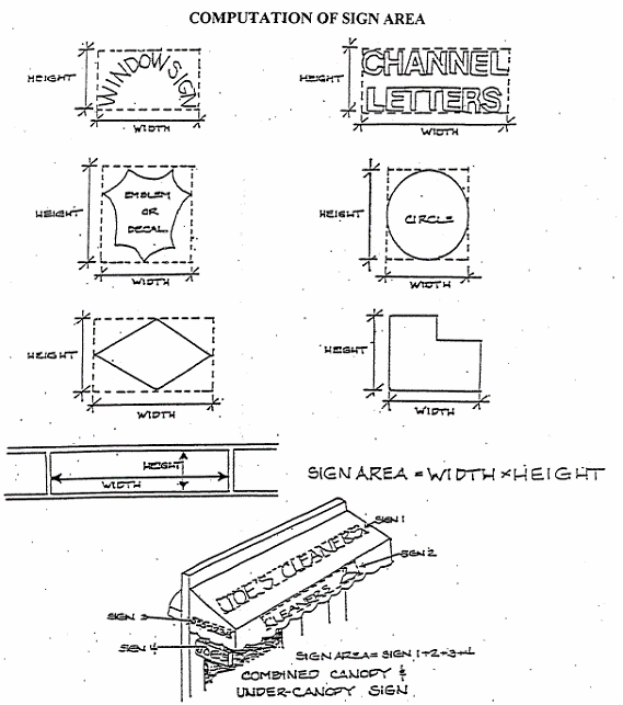
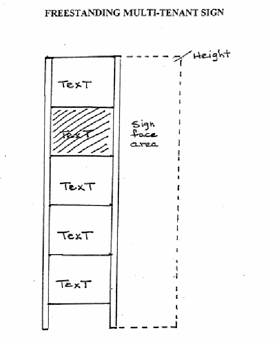
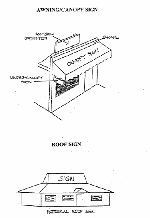
(Ord. No. 519, 8-8-2012)
17.116.010 - Purpose and intent.
The purpose and intent of design guidelines is to establish a set of standard regulations to maintain and enhance the city's character and visual appearance in order to create a quality future community; and to continue to maintain and enhance the historic resources, qualities and character of the city. The city council finds establishment of design guidelines necessary to achieve the cited mitigation of the community design element and implementation of the Colfax General Plan 2020 with the following findings:
A.
The design guidelines will maintain the small town character that makes Colfax a desirable place to live;
B.
The design guidelines will maintain and enhance the city's character and visual appearance in order to create a quality fixture community; and
C.
The design guidelines will maintain and enhance the historic resources, qualities and character of the city.
(Ord. No. 519, 8-8-2012)
17.116.020 - Design guidelines.
This chapter incorporates the Colfax design guidelines previously adopted and as thereafter amended.
These guidelines are applicable to all zones within the city limits of Colfax, excepting therefrom single-family residential zones R-l-5, R-l-1O, R-1-15, R-1-20 and R-1-40. The official zone map is available at city hall. The purpose of the design guidelines is to enhance the visual quality of the city by using the basic design elements in the existing environment: building materials, architectural styles, sign letter type fonts, colors, landscaping, physical elements and space for people; capitalizing on the area's unique assets.
Most of the downtown core area architecture preserves the history of the community. A few buildings have strayed from the past tradition. However, most of the buildings embody quality in construction, craft, and a style the community wants to maintain and replicate. All projects undertaken should reflect the existing community style to reinforce and extend the qualities and special characteristics of the Colfax community, unless clearly infeasible.
A.
General Considerations.
• Research and/or a visual inventory of the surrounding community building architecture, colors, landscaping and signage is recommended.
• Respect the design of the existing structures as products of the design philosophy and reflection of a specific time.
• Retain and restore the distinctive stylistic features of existing structures.
• Replace or repair lot features (i.e. fencing) when possible.
• Restore historical elements of the original building design to create the visual appearance of the original structure.
• Minimize alterations to historic structures. Facade changes should reflect and conform to the appearance of the surrounding area.
• All new or remodeled structures should reflect the early railroad and/or a mountain/western style of architecture.
• Traditional building materials such as simulated wood shingles, lap siding, board and batten, brick, and indigenous rock should be used.
• Utilize varied materials, textures, or colors to create horizontal and vertical articulation. A range of selected colors is available for viewing at city hall.
B.
Considerations for Residential Uses.
• Porches or covered entries are encouraged.
• Residences should be located toward the front lot line setback. Roofs should be pitched.
• Detached and rear access garages are encouraged.
• Garage doors should not be the focal point of a residence.
• Front doors and porches should be the most prominent aspect of residential design.
• Residential housing or land use conversion to commercial should reflect characteristics and architectural features common during 1875 to the early 1940s.
C.
Considerations for Commercial/Business Uses.
• Commercial/business design characteristics should reflect architectural features common during 1875 to the early 1930s.
• Storefronts should be treated as focal point(s).
• Utilize established historic design features i.e. cornices, window types and sizes, recessed double doorways, etc.
• Maintain the existing building/pedestrian scale.
• Differentiate building facades through the use of color, facade elements, or a change in materials.
• Use appropriate window and awning styles, sizes, and spacing.
• Height and building mass should be in proportion to the surrounding buildings, trees, and terrain.
• Two stories or stepped hillside/split level construction is preferred, rather than long ware house buildings with no articulation.
• Avoid a lack of architectural detail, which creates a plain appearance.
• Stucco, concrete slab, and metal exteriors generally detract from the community character and are discouraged.
D.
Considerations for Equipment/Utilities.
• Refuse areas should be recessed, enclosed, or screened from view and located in accordance with the servicing disposal company.
• Enclosures should be constructed and finished in a manner consistent with the design elements of the main structure.
• On-site utility service should be installed underground in accordance with the public works department, city engineer and applicable city codes and policies.
• Adjacent off-site utility services should be installed underground in accordance with the public works department, city engineer and applicable city codes and policies.
• All heating/cooling or other equipment and appurtenances should be recessed and/or screened from view.
E.
Considerations for lighting.
• No lighting should constitute a safety hazard.
• All lighting should be downcast.
• Lighting standards should be mounted on reinforced pedestals or otherwise protected.
• Under canopy lighting should be recessed or concealed so as not to be directly visible from a public street.
• Neon lighting is discouraged in the historic (H) district.
• Exterior lighting should be compatible with the architecture, landscaping, and consistent with surrounding fixtures and styles.
F.
Considerations for Landscaping.
a.
Landscaping should enhance the aesthetic appearance of the project. Innovative techniques or uses of alternative plants and planting schemes will be considered; a minimum of five percent of the gross area of the total parcel or lot should be landscaped; a minimum of two percent in conjunction with parking lot landscaping.
• Hillside development should preserve native trees when feasible, and be planted immediately and landscaped to prevent erosion and should channel run-off to designated retention areas.
• Landscaping should consider conservation of water resources through the efficient use of irrigation, appropriate plant materials (i.e. appropriate plant zones), and regular maintenance of landscaped areas.
• A recommended list of trees, shrubs, and groundcovers is in Appendix 3 of this title. A mix of trees, shrubs, groundcovers, and surfacing materials is preferred, rather than planting the same species throughout the project in public areas.
• Recommended surfacing materials: rocks, gravel, ornamental mulch materials, chips, or any other materials acceptable to the planning director. Not more than thirty (30) percent of the landscape area should be covered by surface materials.
• Minimum tree size should be fifteen (15) gallons.
• Minimum shrub size one gallon, five gallon is preferred.
• Rooted cutting groundcover plants should be placed for uniform coverage within twelve (12) months.
• Retain old/new native conifers, oaks, and maples when possible. Replace and replant any dead or removed plants or trees. All landscaping must be irrigated in conformance with Chapter 17.122 ("California State-Mandated Water Efficient Landscape Regulations") and maintained in a live state, or replaced within a reasonable time (three to six months) of discovery; The use of native vegetation is intended to eliminate the need for permanent irrigation, however, temporary irrigation should be provided for three years or until the vegetation is permanently established.
• Landscaping and irrigation shall be installed prior to issuance of a certificate of occupancy by the chief building official.
• All landscaping and irrigation shall be maintained by any and all subsequent owners for a minimum period of three years after installation, the developer shall comply with either (i) or (ii) of the following provisions and shall comply with (iii):
(i)
Deposit with the city a maintenance bond, cash, letter of credit, or its equivalent, in an amount equal to one-half the market value of landscaping and irrigation guaranteeing the proper care, treatment and maintenance of landscaping for a period of three years or;
(ii)
Execute an agreement and equitable lien in an amount equal to the full market value of the landscaping and irrigation with the city, guaranteeing the maintenance thereof during a three-year period. Default of such agreement or lien shall cause written letter of notification by the city, to the owner of said real property within ten (10) days that the city will perform or have performed by a reputable landscaper any and all maintenance work it deems necessary and bring legal action against the owner for the full cost of such maintenance work, or foreclose such equitable lien as provided by law;
(iii)
Prior to the expiration of the three year maintenance guarantee period and return of the security, the property owner shall maintain, replace or restore all deficient landscaping.
G.
Considerations for parking lots.
• One shade tree for every eight to ten (10) parking spaces is requested, in no case shall there be more than sixteen (16) stalls without a landscape break.
• Perimeter landscaping is required for screening purposes:
- Adjacent to residential uses;
- Street frontage buffers;
- Along property lines, berms, hedges, or other features may be requested to differentiate boundaries of land uses.
• Landscape strips constructed adjacent to the street should be a minimum of four feet wide, except that portion of the frontage within two feet of driveways or alleys.
• Screening hedge should not exceed three feet in height consisting of compact evergreen plants a minimum height of eighteen inches within eighteen (18) months, some situations may substitute a decorative masonry wall.
• Earth berms will be a height of three to four feet, may be substituted provided the landscaped strip is widened appropriately to provide ease of maintenance and slopes not to exceed two feet horizontally to one foot vertically.
• Landscaping, berms, or masonry walls shall not inhibit line of sight distance of driveways, alleys, or street intersections.
• Not less than two percent of the interior parking lot shall be landscaped. Perimeter building landscaping shall not be considered a part of the two percent.
• All unused space resulting from the design of the parking spaces shall be used for planting purposes.
• Planted areas shall be separated from vehicular areas and street rights-of-way by a concrete curb at least six inches high.
• Planted areas should average three feet wide, more when feasible.
• Existing mature trees retained may be given credit for parking stalls.
• Provide safe clearly designated pedestrian pathways when feasible.
H.
Considerations for Sidewalk Treatment.
• Curb cuts shall conform to adopted city codes and standards.
• Street furniture such as benches, trash enclosures, bicycle racks, planter boxes and landscape vegetation is encouraged.
I.
Considerations for signs.
• Sign standards are set forth in Chapter 17.112.
(Ord. No. 519, 8-8-2012)
17.116.030 - Projects requiring a design review permit.
Projects requiring a design review permit are as set forth in subsection 17.32.010C.
(Ord. No. 519, 8-8-2012)
17.116.040 - Approval authority for a design review permit.
The approval authority for a design review permit is as set forth in subsection 17.32.010C.
(Ord. No. 519, 8-8-2012)
17.116.050 - Findings for a design review permit.
The approval authority shall make the findings set forth in subsection 17.40.070B. to approve a design review permit.
(Ord. No. 519, 8-8-2012)
17.116.060 - Appeals.
Decisions on design review permits may be appealed pursuant to Chapter 17.44.
(Ord. No. 519, 8-8-2012)
17.116.070 - Fees.
Fees for design review shall be established by resolution and incorporated in the official city fee schedule.
(Ord. No. 519, 8-8-2012)
17.120.010 - Purposes.
Performance standards shall be enforced for the control of agricultural, commercial and industrial uses in the city for the following purposes:
A.
To permit potential nuisances to be measured factually and objectively in terms of the potential nuisance itself;
B.
To ensure that all industries will provide necessary control methods to protect the city from hazards and nuisances which can be prevented by modern processes of control and nuisance elimination; and
C.
To protect any industry from arbitrary exclusion or persecution based solely on the characteristics of uncontrolled production in such type of industry in the past.
(Ord. No. 519, 8-8-2012)
17.120.020 - Compliance required.
No use shall be undertaken or maintained unless it conforms to the provisions of this chapter in addition to the provisions of this title for the district in which such use is located. Initial and continued compliance with the performance standards set forth in this chapter shall be required for every use, even though such compliance is not required for a particular use to secure a zoning clearance certification.
(Ord. No. 519, 8-8-2012)
17.120.030 - Nonconforming uses—Compliance required—Time limits.
Any use established on or before August 24, 1967, which use is nonconforming as to the performance standards set forth in this chapter, shall be made to conform with the provisions of this chapter on or before August 24, 1972.
(Ord. No. 519, 8-8-2012)
17.120.040 - Uses subject to review.
The planning director may require such reviews for any use in any district when he or she has reason to believe that such use or the manner of its operation does not conform to the performance standards set forth in this chapter.
(Ord. No. 519, 8-8-2012)
17.120.050 - Dangerous and objectionable elements enumerated.
No land or building in any district shall be used or occupied in any manner so as to create dangerous or objectionable elements, which shall include:
A.
Dangerous, injurious, noxious or otherwise objectionable fires, explosives or other hazards;
B.
Noise, vibration, smoke, dust, odor or other forms of air pollution;
C.
Heat, cold, dampness, glare, electrical or other disturbances;
D.
Liquid or solid refuse or wastes; and
E.
Other substances, conditions or elements used in such a manner or in such an amount as to affect adversely the surrounding areas or adjoining premises of any land or building.
(Ord. No. 519, 8-8-2012)
17.120.060 - Dangerous and objectionable elements—Determinations of existence.
The determination of the existence of dangerous and objectionable elements shall be made at the location of the use creating such elements and at any point where the existence of such elements may be more apparent (referred to in this chapter as "at any point"); provided, however, the measurements necessary for the enforcement of the performance standards set forth in Sections 17.120.070 through 17.120.100 of this chapter for noise, vibrations, odors and glare shall be taken at the following points of measurement:
A.
In any district except the industrial district (I): beyond the lot line of the establishment or use; and
B.
In the industrial district (I): five hundred (500) feet from the establishment or use or at the boundary of the district, if closer to the establishment or use or at any point within an adjacent district other than the industrial district.
(Ord. No. 519, 8-8-2012)
17.120.070 - Loud, unnecessary or unusual noises unlawful.
It is unlawful for any business operation to make or continue or cause to be made or continued, any loud, unnecessary or unusual noise or any noise which either annoys, disturbs, injures or endangers the comfort, repose, health, safety or peace of others within the city when not in the normal or usual conduct of commercial or industrial business.
(Ord. No. 519, 8-8-2012)
17.120.080 - Vibrations.
No vibration (other than from a transportation facility or temporary construction work) shall be permitted which is discernible without instruments at the point of measurement set forth in Section 17.120.060 of this chapter.
(Ord. No. 519, 8-8-2012)
17.120.090 - Odors.
No emission of odorous gases or other odorous matter shall be permitted in excess of the most recent standards adopted by the Placer County Air Pollution Control District and Placer County Department of Environmental Health. Any process which may involve the creation or emission of any odor shall be provided with a secondary safeguard system so that control will be maintained if the primary safeguard system should fail.
(Ord. No. 519, 8-8-2012)
17.120.100 - Glare.
No direct or sky-reflected glare, whether from floodlights or from high temperature processes, such as combustion, welding or otherwise, shall be permitted to be visible at the point of measurement set forth in Section 17.120.060 of this chapter. The restriction set forth in this section shall not apply to signs or the lighting of buildings or grounds for advertising or protection as otherwise permitted by the provisions of this title.
(Ord. No. 519, 8-8-2012)
17.120.110 - Fires and explosives.
All activities involving and all storage of, flammable and explosive materials shall be provided at any point with adequate safety devices standard in the industry. The burning of waste materials in open fires shall be prohibited at any point.
(Ord. No. 519, 8-8-2012)
17.120.120 - Radioactivity and electrical disturbances.
No activity shall be permitted which emits dangerous radioactivity at any point or electrical disturbances adversely affecting the operation at the point of any equipment other than that of the creator of such disturbance.
(Ord. No. 519, 8-8-2012)
17.120.130 - Smoke and gas.
No emission of visible smoke from any chimney or other source or gas in excess of the most recent standards adopted by the Placer County Air Pollution Control District shall be permitted.
(Ord. No. 519, 8-8-2012)
17.120.140 - Air pollution.
No emission at any point shall be permitted which can cause damage to human or animal health, to vegetation or to other forms of property or which can cause any excessive soiling. No emission shall be permitted in excess of the most recent standards adopted by the Placer County Air Pollution Control District.
(Ord. No. 519, 8-8-2012)
17.120.150 - Liquid and solid wastes.
No discharge shall be permitted at any point into any public sewer, private sewage system, stream or into the ground and of any materials of such nature or temperature as can contaminate any water supply, interfere with bacterial processes in sewage treatment or otherwise cause the emission of dangerous or offensive elements, except in accordance with the most recent standards approved by the Placer County Environmental Health Services Department and California Regional Water Quality Control Board. No materials or wastes shall be deposited on any property in such form or manner that they may be transferred off the property by natural causes or forces. Any wastes which might be attractive to rodents or insects shall be stored outdoors only in closed containers.
(Ord. No. 519, 8-8-2012)
17.120.160 - Violations—Investigations—Remedies.
The planning director or his or her designee shall investigate any purported violations of such performance standards and may employ qualified experts for such investigations. If the planning director finds that a violation has existed or does exist, the planning director may establish a reasonable time within which compliance with the performance standards shall be achieved. Should the planning director find that the public health, convenience or welfare so require, he or she may order the offending establishment to cease operations until proper steps are taken to correct the conditions which cause the violation. A copy of such findings and rulings shall be forwarded to the offending violator. The services of any qualified expert employed by the planning director to advise in establishing a violation shall be paid by the violator if the violation is established; otherwise the city shall pay for such services.
(Ord. No. 519, 8-8-2012)
17.120.170 - Enforcement.
Provisions for the enforcement of continued compliance with the performance standards set forth in this chapter shall be invoked by the planning director and/or any state and county agencies charged with primary responsibility over such standards against any use if there are reasonable grounds to believe that such performance standards are being violated by such use.
(Ord. No. 519, 8-8-2012)
17.122.010 - Purpose.
The purpose of this chapter is to reduce potential water waste by assuring landscaping and irrigation systems for new development are designed and installed in accordance with the State of California Model Water Efficient Landscape Ordinance (MWELO), Title 23, Waters, Division 2, Department of Water Resources Chapter 2.7.
(Ord. No. 519, 8-8-2012)
17.122.020 - Applicability.
A.
This chapter shall apply to the following projects:
1.
New construction and rehabilitated landscapes for public agency projects and private development projects with a landscape area equal to or greater than two thousand five hundred (2,500) square feet requiring a building or landscape permit, plan check or design review;
2.
New construction and rehabilitated landscapes which are developer-installed in single-family and multi-family projects with a landscape area equal to or greater than two thousand five hundred (2,500) square feet requiring a building or landscape permit, plan check, or design review;
3.
New construction landscapes which are homeowner-provided and/or homeowner-hired in single-family and multi-family residential projects with a total project landscape area equal to or greater than five thousand (5,000) square feet requiring a building or landscape permit, plan check or design review;
4.
Existing landscapes limited to Sections 17.122.200, 17.122.210 and 17.122.220 of this chapter; and
5.
Cemeteries. Recognizing the special landscape management needs of cemeteries, new and rehabilitated cemeteries are limited to Sections 17.122.060, 17.1222140 and 17.122.200; and existing cemeteries are limited to Sections 17.122.200, 17.122.210 and 17.122.220 of this chapter.
B.
This chapter does not apply to:
1.
Registered local, state or federal historical sites;
2.
Ecological restoration projects that do not require a permanent irrigation system;
3.
Mined-land reclamation projects that do not require a permanent irrigation system; or
4.
Plant collections, as part of botanical gardens and arboretums open to the public.
(Ord. No. 519, 8-8-2012)
17.122.030 - Definitions.
The terms used in this chapter have the meaning set forth below:
"Applied water" means the portion of water supplied by the irrigation system to the landscape.
"Automatic irrigation controller" means an automatic timing device used to remotely control valves that operate an irrigation system. Automatic irrigation controllers schedule irrigation events using either evapotranspiration (weather-based) or soil moisture data.
"Backflow prevention device" means a safety device used to prevent pollution or contamination of the water supply due to the reverse flow of water from the irrigation system.
"Certificate of completion" means the document required under Section 17.122.240.
"Certified irrigation designer" means a person certified to design irrigation systems by an accredited academic institution a professional trade organization or other program such as the U.S. Environmental Protection Agency's WaterSense Irrigation Designer Certification Program and Irrigation Association's Certified Irrigation Designer Program.
"Certified landscape irrigation auditor" means a person certified to perform landscape irrigation audits by an accredited academic institution, a professional trade organization or other program such as the U.S. Environmental Protection Agency's WaterSense Irrigation Auditor Certification Program and Irrigation Association's Certified Landscape Irrigation Auditor Program.
"Check valve" or "anti-drain valve" means a valve located under a sprinkler head, or other location in the irrigation system, to hold water in the system to prevent drainage from sprinkler heads when the sprinkler is off.
"Common interest developments" means community apartment projects, condominium projects, planned developments, and stock cooperatives per Civil Code Section 1351.
"The city" means the incorporated City of Colfax that is responsible for adopting and implementing the ordinance. The city is also responsible for the enforcement of this chapter, including but not limited to, approval of a permit and plan check or design review of a project.
"Conversion factor (0.62)" means the number that converts acre-inches per acre per year to gallons per square foot per year.
"Drip irrigation" means any nonspray low volume irrigation system utilizing emission devices with a flow rate measured in gallons per hour. Low-volume irrigation systems are specifically designed to apply small volumes of water slowly at or near the root zone of plants.
"Ecological restoration project" means a project where the site is intentionally altered to establish a defined, indigenous, historic ecosystem.
"Effective precipitation" or "usable rainfall" (EPPT) means the portion of total precipitation which becomes available for plant growth.
"Emitter" means a drip irrigation emission device that delivers water slowly from the system to the soil.
"Established landscape" means the point at which plants in the landscape have developed significant root growth into the soil. Typically, most plants are established after one or two years of growth.
"Establishment period of the plants" means the first year after installing the plant in the landscape or the first two years if irrigation will be terminated after establishment. Typically, most plants are established after one or two years of growth.
"Estimated total water use" (ETWU) means the total water used for the landscape.
"ET adjustment factor" (ETAF) means a factor of 0.7, that, when applied to reference evapotranspiration, adjusts for plant factors and irrigation efficiency, two major influences upon the amount of water that needs to be applied to the landscape. A combined plant mix with a site-wide average of 0.5 is the basis of the plant factor portion of this calculation. For purposes of the ETAF, the average irrigation efficiency is 0.71. Therefore, the ET adjustment factor is (0.7)=(0.5/0.71). ETAF for a special landscape area shall not exceed 1.0. ETAF for existing nonrehabilitated landscapes is 0.8.
"Evapotranspiration rate" means the quantity of water evaporated from adjacent soil and other surfaces and transpired by plants during a specified time.
"Flow rate" means the rate at which water flows through pipes, valves and emission devices, measured in gallons per minute, gallons per hour, or cubic feet per second.
"Hardscapes" means any durable material (pervious and nonpervious).
"Homeowner-provided landscaping" means any landscaping either installed by a private individual for a single-family residence or installed by a licensed contractor hired by a homeowner. A homeowner, for purposes of this chapter, is a person who occupies the dwelling he or she owns. This excludes speculative homes, which are not owner-occupied dwellings.
"Hydrozone" means a portion of the landscaped area having plants with similar water needs. A hydrosome may be irrigated or nonirrigated.
"Infiltration rate" means the rate of water entry into the soil expressed as a depth of water per unit of time (e.g., inches per hour).
"Invasive plant species" means species of plants not historically found in California that spread outside cultivated areas and can damage environmental or economic resources. Invasive species may be regulated by county agricultural agencies as noxious species. "Noxious weeds" means any weed designated by the Weed Control Regulations in the Weed Control Act and identified on a regional district noxious weed control list. Lists of invasive plants are maintained at the California Invasive Plant Inventory and USDA Invasive and Noxious Weeds Database.
"Irrigation audit" means an in-depth evaluation of the performance of an irrigation system conducted by a certified landscape irrigation auditor. An irrigation audit includes, but is not limited to: inspection, system tune-up, system test with distribution uniformity or emission uniformity, reporting overspray or runoff that causes overland flow, and preparation of an irrigation schedule.
"Irrigation efficiency" (IE) means the measurement of the amount of water beneficially used divided by the amount of water applied. Irrigation efficiency is derived from measurements and estimates of irrigation system characteristics and management practices. The minimum average irrigation efficiency for purposes of this chapter is 0.71. Greater irrigation efficiency can be expected from well-designed and maintained systems.
"Irrigation survey" means an evaluation of an irrigation system that is less detailed than an irrigation audit. An irrigation survey includes, but is not limited to: inspection, system test, and written recommendations to improve performance of the irrigation system.
"Irrigation water use analysis" means an analysis of water use data based on meter readings and billing data.
"Landscape architect" means a person who holds a license to practice landscape architecture in the state of California Business and Professions Code, Section 5615.
"Landscape area" means all the planting areas, turf areas, and water features in a landscape design plan subject to the maximum applied water allowance calculation. The landscape area does not include footprints of buildings or structures, sidewalks, driveways, parking lots, decks, patios, gravel or stone walks, other pervious or nonpervious hardscapes, and other nonirrigated areas designated for nondevelopment (e.g., open spaces and existing native vegetation).
"Landscape contractor" means a person licensed by the State of California to construct, maintain, repair, install, or subcontract the development of landscape systems.
"Landscape documentation package" means the documents required under Section 17.122.050.
"Landscape project" means total area of landscape in a project as defined in "landscape area" for the purposes of this chapter, meeting requirements under Section 17.122.020.
"Lateral line" means the water delivery pipeline that supplies water to the emitters or sprinklers from the valve.
"Low-volume irrigation" means the application of irrigation water at low pressure through a system of tubing or lateral lines and low-volume emitters such as drip, drip lines, and bubblers. Low-volume irrigation systems are specifically designed to apply small volumes of water slowly at or near the root zone of plants.
"Main line" means the pressurized pipeline that delivers water from the water source to the valve or outlet.
"Maximum applied water allowance" (MAWA) means the upper limit of annual applied water for the established landscaped area as specified in Section 17.122.230. It is based upon the area's reference evapotranspiration, the ET adjustment factor, and the size of the landscape area. The estimated total water use shall not exceed the maximum applied water allowance. Special landscape areas, including recreation areas, areas permanently and solely dedicated to edible plants such as orchards and vegetable gardens, and areas irrigated with recycled water are subject to the MAWA with an ETAF not to exceed 1.0.
"Microclimate" means the climate of a small, specific area that may contrast with the climate of the overall landscape area due to factors such as wind, sun exposure, plant density, or proximity to reflective surfaces.
"Mined-land reclamation projects" means any surface mining operation with a reclamation plan approved in accordance with the Surface Mining and Reclamation Act of 1975.
"Mulch" means any organic material such as leaves, bark, straw, compost, or inorganic mineral materials such as rocks, gravel, and decomposed granite left loose and applied to the soil surface for the beneficial purposes of reducing evaporation, suppressing weeds, moderating soil temperature, and preventing soil erosion.
"New construction" means, for the purposes of this chapter, a new building with a landscape or other new landscape, such as a park, playground, or greenbelt without an associated building.
"Operating pressure" means the pressure at which the parts of an irrigation system are designed by the manufacturer to operate.
"Overhead sprinkler irrigation systems" means systems that deliver water through the air (e.g., spray heads and rotors).
"Overspray" means the irrigation water which is delivered beyond the target area.
"Permit" means an authorizing document issued by local agencies for new construction or rehabilitated landscapes.
"Pervious" means any surface or material that allows the passage of water through the material and into the underlying soil.
"Placer County Water Agency" is the local water purveyor that provides the city retail water service.
"Plant factor" or "plant water use factor" is a factor, when multiplied by ETo, estimates the amount of water needed by plants. For purposes of this chapter, the plant factor range for low water use plants is 0 to 0.3, the plant factor range for moderate water use plants is 0.4 to 0.6, and the plant factor range for high water use plants is 0.7 to 1.0. Plant factors cited in this chapter are derived from the Department of Water Resources 2000 publication "Water Use Classification of Landscape Species."
"Precipitation rate" means the rate of application of water measured in inches per hour.
"Project applicant" means the individual or entity submitting a landscape documentation package required under Section 17.122.050, to request a permit, plan check, or design review from the city. A project applicant may be the property owner or his or her designee.
"Rain sensor" or "rain-sensing shutoff device" means a component which automatically suspends an irrigation event when it rains.
"Record drawing" or "as-builts" means a set of reproducible drawings which show significant changes in the work made during construction and which are usually based on drawings marked up in the field and other data furnished by the contractor.
"Recreational area" means areas dedicated to active play such as parks, sports fields, and golf courses where turf provides a playing surface.
Recycled water", "reclaimed water", or "treated sewage effluent water" means treated or recycled waste water of a quality suitable for nonpotable uses such as landscape irrigation and water features. This water is not intended for human consumption.
"Reference evapotranspiration" or "ETo" means a standard measurement of environmental parameters which affect the water use of plants. ETo is expressed in inches per day, month, or year, and is an estimate of the evapotranspiration of a large field of four- to seven-inch tall, cool-season grass that is well watered. Reference evapotranspiration is used as the basis of determining the maximum applied water allowance so that regional differences in climate can be accommodated as presented for the Colfax area as follows:
"Rehabilitated landscape" means any relandscaping project that requires a permit, plan check, or design review, meets the requirements of Section 17.122.010 of this chapter, and the modified landscape area is equal to or greater than two thousand five hundred (2,500) square feet, is fifty (50) percent of the total landscape area, and the modifications are completed within one year.
"Runoff" means water which is not absorbed by the soil or landscape to which it is applied and flows from the landscape area. For example, runoff may result from water that is applied at too great a rate (application rate exceeds infiltration rate) or when there is a slope.
"Soil moisture sensing device" or "soil moisture sensor" means a device that measures the amount of water in the soil. The device may also suspend or initiate an irrigation event.
"Soil texture" means the classification of soil based on its percentage of sand, silt, and clay.
"Special landscape area" (SLA) means an area of the landscape dedicated solely to edible plants, areas irrigated with recycled water, water features using recycled water and areas dedicated to active play such as parks, sports fields, golf courses, and where turf provides a playing surface.
"Sprinkler head" means a device which delivers water through a nozzle.
"Static water pressure" means the pipeline or municipal water supply pressure when water is not flowing.
"Station" means an area served by one valve or by a set of valves that operate simultaneously.
"Swing joint" means an irrigation component that provides a flexible, leak-free connection between the emission device and lateral pipeline to allow movement in any direction and to prevent equipment damage.
"Turf" means a groundcover surface of mowed grass. Annual bluegrass, Kentucky bluegrass, Perennial ryegrass, Red fescue, and Tall fescue are cool-season grasses. Bermuda grass, Kikuyu grass, Seashore Paspalum, St. Augustine grass, Zoysia grass, and Buffalo grass are warm-season grasses.
"Valve" means a device used to control the flow of water in the irrigation system.
"Water conserving plant species" means a plant species identified as having a low plant factor.
"Water feature" means a design element where open water performs an aesthetic or recreational function. Water features include ponds, lakes, waterfalls, fountains, artificial streams, spas, and swimming pools (where water is artificially supplied). The surface area of water features is included in the high water use hydrozone of the landscape area. Constructed wetlands used for on-site wastewater treatment or stormwater best management practices that are not irrigated and used solely for water treatment or stormwater retention are not water features and, therefore, are not subject to the water budget calculation.
"Watering window" means the time of day irrigation is allowed.
"WUCOLS" means the Water Use Classification of Landscape Species published by the University of California Cooperative Extension, the Department of Water Resources and the Bureau of Reclamation, 2000.
(Ord. No. 519, 8-8-2012)
17.122.040 - Compliance with landscape documentation package.
A.
Prior to construction, the city shall:
1.
Provide the project applicant with the ordinance and procedures for permits, plan checks, or design reviews;
2.
Review the landscape documentation package submitted by the project applicant;
3.
Approve or deny the landscape documentation package;
4.
Issue a permit or approve the plan check or design review for the project applicant; and
5.
Upon approval of the landscape documentation package, submit a copy of the water efficient landscape worksheet to Placer County Water Agency.
B.
Prior to construction, the project applicant shall:
1.
Submit a landscape documentation package to the city.
C.
Upon approval of the landscape documentation package by the city, the project applicant shall:
1.
Receive a permit or approval of the plan check or design review and record the date of the permit in the certificate of completion;
2.
Submit a copy of the approved landscape documentation package along with the record drawings, and any other information to the property owner or his/her designee; and
3.
Submit a copy of the water efficient landscape worksheet to the Placer County Water Agency.
(Ord. No. 519, 8-8-2012)
17.122.050 - Elements of the landscape documentation package.
A.
The landscape documentation package shall include the following six elements:
1.
Project Information:
a.
Date;
b.
Project applicant;
c.
Project address (if available, parcel and/or lot number(s));
d.
Total landscape area (square feet);
e.
Project type (e.g., new, rehabilitated, public, private, cemetery, homeowner-installed);
f.
Water supply type (e.g., potable, recycled, well) and identify the local retail water purveyor if the applicant is not served by a private well;
g.
Checklist of all documents in landscape documentation package;
h.
Project contacts to include contact information for the project applicant and property owner; and
i.
Applicant signature and date with statement, "I agree to comply with the requirements of the water efficient landscape ordinance and submit a complete Landscape Documentation Package".
2.
Water Efficient Landscape Worksheet:
a.
Hydrozone information table; and
b.
Water budget calculations.
(i)
Maximum applied water allowance (MAWA); and
(ii)
Estimated total water use (ETWU).
(iii)
Soil management report;
(iv)
Landscape design plan;
(v)
Irrigation design plan; and
(vi)
Grading design plan.
(Ord. No. 519, 8-8-2012)
17.122.060 - Water efficient landscape worksheet.
A.
A project applicant shall complete the water efficient landscape worksheet which contains two sections (see sample worksheet in Appendix B):
1.
A hydrozone information table (see Appendix B, Section A) for the landscape project; and
2.
A water budget calculation (see Appendix A, Section B) for the landscape project. For the calculation of the maximum applied water allowance and estimated total water use, a project applicant shall use the ETo values from the reference evapotranspiration table in Appendix A. For geographic areas not covered in Appendix A, use data from other cities located nearby in the same reference evapotranspiration zone, as found in the CIMIS Reference Evapotranspiration Zones Map, Department of Water Resources, 1999.
B.
Water budget calculations shall adhere to the following requirements:
1.
The plant factor used shall be from WUCOLS. The plant factor ranges from 0 to 0.3 for low water use plants, from 0.4 to 0.6 for moderate water use plants, and from 0.7 to 1.0 for high water use plants.
2.
All water features shall be included in the high water use hydrozone and temporarily irrigated areas shall be included in the low water use hydrozone.
3.
All special landscape areas shall be identified and their water use calculated as described below.
4.
ETAF for special landscape areas shall not exceed 1.0.
C.
Maximum applied water allowance:
The maximum applied water allowance shall be calculated using the equation:
MAWA = (ETo) (0.62) [(0.7 x LA) + (0.3 x SLA)]
The example calculations below are hypothetical to demonstrate proper use of the equations and do not represent an existing and/or planned landscape project. The ETo values used in these calculations for Colfax are for planning purposes only as follows:
For actual irrigation scheduling, automatic irrigation controllers are required and shall use current reference evapotranspiration data, such as from the California Irrigation Management Information System (CIMIS), other equivalent data, or soil moisture sensor data.
1.
Example MAWA calculation: a hypothetical landscape project in Colfax, CA, with an irrigated landscape area of fifty thousand (50,000) square feet without any special landscape area (SLA= 0, no edible plants, recreational areas, or use of recycled water). To calculate MAWA, the annual reference evapotranspiration value for Colfax is 47.9 inches.
2.
In this next hypothetical example, the landscape project in Colfax has the same ETo value of 47.9 inches and a total landscape area of fifty thousand (50,000) square feet. Within the fifty thousand (50,000) square foot project, there is now a two thousand (2,000) square foot area planted with edible plants. This two thousand (2,000) square foot area is considered to be a special landscape area.
D.
Estimated Total Water Use. The estimated total water use shall be calculated using the equation below. The sum of the estimated total water use calculated for all hydrazones shall not exceed MAWA. Where:
1.
Example ETWU calculation: landscape area is fifty thousand (50,000) square feet; plant water use type, plant factor, and hydrozone area are shown in the table below. The ETo value is 47.9 inches per year. There are no special landscape areas (recreational area, area permanently and solely dedicated to edible plants, and area irrigated with recycled water) in this example.
Compare ETWU with MAWA: For this example MAWA = (47.9) (0.62) [(0.7 × 50,000) + (0.3 × 0)] = 1,057,320 gallons per year. The ETWU (1,039,430 gallons per year) is less than MAWA (1,102,116 gallons per year). In this example, the water budget complies with the MAWA.
2.
Example ETWU calculation: total landscape area is fifty thousand (50,000) square feet, two thousand (2,000) square feet of which is planted with edible plants. The edible plant area is considered a special landscape area (SLA). The reference evapotranspiration value is 47.9 inches per year. The plant type, plant factor, and hydrozone area are shown in the table below.
= (29.70) (33,099 + 2,000)
= 1,042,440 gallons per year
Compare ETWU with MAWA. For this example:
MAWA = (47.9) (0.62) [(0.7 x 50,000) + (0.3 × 2,000)]
= 29.70 × [35,000 + 600]
= 29.70 × 35,600
=1,057,320 gallons per year
The ETWU (1,042,440 gallons per year) is less than MAWA (1,057,320 gallons per year). For this example, the water budget complies with the MAWA.
(Ord. No. 519, 8-8-2012)
17.122.070 - Soil management report.
A.
In order to reduce runoff and encourage healthy plant growth, a soil management report shall be completed by the project applicant, or his/her designee, as follows:
1.
Submit soil samples to a laboratory for analysis and recommendations.
a.
Soil sampling shall be conducted in accordance with laboratory protocol, including protocols regarding adequate sampling depth for the intended plants.
b.
The soil analysis may include:
(i)
Soil texture;
(ii)
Infiltration rate determined by laboratory test or soil texture infiltration rate table;
(iii)
pH;
(iv)
Total soluble salts;
(v)
Sodium;
(vi)
Percent organic matter; and
(vii)
Recommendations.
2.
The project applicant, or his/her designee, shall comply with one of the following:
a.
If significant mass grading is not planned, the soil analysis report shall be submitted to the city as part of the landscape documentation package; or
b.
If significant mass grading is planned, the soil analysis report shall be submitted to the city as part of the certificate of completion.
3.
The soil analysis report shall be made available, in a timely manner, to the professionals preparing the landscape design plans and irrigation design plans to make any necessary adjustments to the design plans.
4.
The project applicant, or his/her designee, shall submit documentation verifying implementation of soil analysis report recommendations to the city with certificate of completion.
(Ord. No. 519, 8-8-2012)
17.122.080 - Landscape design plan.
A.
For the efficient use of water, a landscape shall be carefully designed and planned for the intended function of the project. A landscape design plan meeting the following design criteria shall be submitted as part of the landscape documentation package.
1.
Plant Material.
a.
Any plant may be selected for the landscape, providing the estimated total water use in the landscape area does not exceed the maximum applied water allowance. To encourage the efficient use of water, the following is highly recommended:
(i)
Protection and preservation of native species and natural vegetation;
(ii)
Selection of water-conserving plant and turf species;
(iii)
Selection of plants based on disease and pest resistance;
(iv)
Selection of trees based on applicable local tree ordinances or tree shading guidelines; and
(v)
Selection of plants from local and regional landscape program plant lists.
b.
Each hydrozone shall have plant materials with similar water use, with the exception of hydrozones with plants of mixed water use, as specified in subsection 17.110.090A.2.d.
c.
Plants shall be selected and planted appropriately based upon their adaptability to the climatic, geologic, and topographical conditions of the project site. To encourage the efficient use of water, the following is highly recommended:
(i)
Use the Sunset Western Climate Zone System which takes into account temperature, humidity, elevation, terrain, latitude, and varying degrees of continental and marine influence on local climate;
(ii)
Recognize the horticultural attributes of plants (i.e., mature plant size, invasive surface roots) to minimize damage to property or infrastructure [e.g., buildings, sidewalks, power lines]; and
(iii)
Consider the solar orientation for plant placement to maximize summer shade and winter solar gain.
d.
Turf is not allowed on slopes greater than twenty-five (25) percent where the toe of the slope is adjacent to an impermeable hardscape and where twenty-five (25) percent means one foot of vertical elevation change for every four feet of horizontal length (rise divided by run × 100 = slope percent).
e.
A landscape design plan for projects in fire-prone areas shall address fire safety and prevention. A defensible space or zone around a building or structure is required per Public Resources Code Section 4291(a) and (b). Avoid fire-prone plant materials and highly flammable mulches.
f.
The use of invasive and/or noxious plant species is strongly discouraged.
g.
The architectural guidelines of a common interest development, which include community apartment projects, condominiums, planned developments, and stock cooperatives, shall not prohibit or include conditions that have the effect of prohibiting the use of low-water use plants as a group.
2.
Water Features.
a.
Recirculating water systems shall be used for water features.
b.
Where available, recycled water shall be used as a source for decorative water features.
c.
Surface area of a water feature shall be included in the high water use hydrozone area of the water budget calculation.
d.
Pool and spa covers are highly recommended.
3.
Mulch and Amendments.
a.
A minimum two-inch layer of mulch shall be applied on all exposed soil surfaces of planting areas except in turf areas, creeping or rooting groundcovers, or direct seeding applications where mulch is contraindicated.
b.
Stabilizing mulching products shall be used on slopes.
c.
The mulching portion of the seed/mulch slurry in hydro-seeded applications shall meet the mulching requirement.
d.
Soil amendments shall be incorporated according to recommendations of the soil report and what is appropriate for the plants selected (see Section 17.110.070).
B.
The landscape design plan, at a minimum, shall:
1.
Delineate and label each hydrozone by number, letter, or other method;
2.
Identify each hydrozone as low, moderate, high water, or mixed water use. Temporarily irrigated areas of the landscape shall be included in the low water use hydrozone for the water budget calculation;
4.
Identify areas permanently and solely dedicated to edible plants;
5.
Identify areas irrigated with recycled water;
6.
Identify type of mulch and application depth;
7.
Identify soil amendments, type, and quantity;
8.
Identify type and surface area of water features;
9.
Identify hardscapes (pervious and nonpervious);
10.
Identify location and installation details of any applicable stormwater best management practices that encourage on-site retention and infiltration of stormwater. Stormwater best management practices are encouraged in the landscape design plan and examples include, but are not limited to:
a.
Infiltration beds, swales, and basins that allow water to collect and soak into the ground;
b.
Constructed wetlands and retention ponds that retain water, handle excess flow, and filter pollutants; and
c.
Pervious or porous surfaces (e.g., permeable pavers or blocks, pervious or porous concrete, etc.) that minimize runoff.
11.
Identify any applicable rain harvesting or catchment technologies (e.g., rain gardens, cisterns, etc.);
12.
Contain the following statement: "I have complied with the criteria of the ordinance and applied them for the efficient use of water in the landscape design plan"; and
13.
Bear the signature of a licensed landscape architect, licensed landscape contractor, or any other person authorized to design a landscape.
(Ord. No. 519, 8-8-2012)
17.122.090 - Irrigation design plan.
A.
For the efficient use of water, an irrigation system shall meet all the requirements listed in this section and the manufacturers' recommendations. The irrigation system and its related components shall be planned and designed to allow for proper installation, management, and maintenance. An irrigation design plan meeting the following design criteria shall be submitted as part of the landscape documentation package.
1.
System.
a.
Dedicated landscape water meters are highly recommended on landscape areas smaller than five thousand (5,000) square feet to facilitate water management.
b.
Automatic irrigation controllers utilizing either evapotranspiration or soil moisture sensor data shall be required for irrigation scheduling in all irrigation systems.
c.
The irrigation system shall be designed to ensure that the dynamic pressure at each emission device is within the manufacturer's recommended pressure range for optimal performance.
(i)
If the static pressure is above or below the required dynamic pressure of the irrigation system, pressure-regulating devices such as in-line pressure regulators, booster pumps, or other devices shall be installed to meet the required dynamic pressure of the irrigation system.
(ii)
Static water pressure, dynamic or operating pressure and flow reading of the water supply shall be measured at the point of connection. These pressure and flow measurements shall be conducted at the design stage. If the measurements are not available at the design stage, the measurements shall be conducted at installation.
d.
Sensors (rain, freeze, wind, etc.), either integral or auxiliary, that suspend or alter irrigation operation during unfavorable weather conditions shall be required on all irrigation systems, as appropriate for local climatic conditions. Irrigation should be avoided during windy or freezing weather or during rain.
e.
Manual shut-off valves (such as a gate valve, ball valve, or butterfly valve) shall be required, as close as possible to the point of connection of the water supply, to minimize water loss in case of an emergency (such as a main line break) or routine repair.
f.
Backflow prevention devices shall be required to protect the water supply from contamination by the irrigation system. A project applicant shall refer to the applicable City Code (i.e., public health) for additional backflow prevention requirements.
g.
High flow sensors that detect and report high flow conditions created by system damage or malfunction are recommended.
h.
The irrigation system shall be designed to prevent runoff, low head drainage, overspray, or other similar conditions where irrigation water flows onto nontargeted areas, such as adjacent property, nonirrigated areas, hardscapes, roadways, or structures.
i.
Relevant information from the soil management plan, such as soil type and infiltration rate, shall be utilized when designing irrigation systems.
j.
The design of the irrigation system shall conform to the hydrozones of the landscape design plan.
k.
The irrigation system must be designed and installed to meet, at a minimum, the irrigation efficiency criteria as described in Section 17.122.060 of this chapter regarding the maximum applied water allowance.
l.
It is highly recommended that the project applicant inquire with the Placer County Water Agency about peak water operating demands (on the water supply system) or water restrictions that may impact the effectiveness of the irrigation system.
m.
In mulched planting areas, the use of low-volume irrigation is required to maximize water infiltration into the root zone.
n.
Sprinkler heads and other emission devices shall have matched precipitation rates, unless otherwise directed by the manufacturer's recommendations.
o.
Head-to-head coverage is recommended. However, sprinkler spacing shall be designed to achieve the highest possible distribution uniformity using the manufacturer's recommendations.
p.
Swing joints or other riser-protection components are required on all risers subject to damage that are adjacent to high-traffic areas.
q.
Check valves or anti-drain valves are required for all irrigation systems.
r.
Narrow or irregularly shaped areas, including turf, less than eight feet in width in any direction shall be irrigated with subsurface irrigation or low-volume irrigation system.
s.
Overhead irrigation shall not be permitted within twenty-four (24) inches of any nonpermeable surface. Allowable irrigation within the setback from nonpermeable surfaces may include drip, drip line, or other low-flow nonspray technology. The setback area may be planted or unplanted. The surfacing of the setback may be mulch, gravel, or other porous material. These restrictions may be modified if:
(i)
The landscape area is adjacent to permeable surfacing and no runoff occurs;
(ii)
The adjacent nonpermeable surfaces are designed and constructed to drain entirely to landscaping; or
(iii)
The irrigation designer specifies an alternative design or technology, as part of the Landscape Documentation Package and clearly demonstrates strict adherence to irrigation system design criteria in subsection 17.122.090A.1.h. of this chapter. Prevention of overspray and runoff must be confirmed during the irrigation audit.
t.
Slopes greater than twenty-five (25) percent shall not be irrigated with an irrigation system with a precipitation rate exceeding 0.75 inches per hour. This restriction may be modified if the landscape designer specifies an alternative design or technology, as part of the landscape documentation package, and clearly demonstrates no runoff or erosion will occur. Prevention of runoff and erosion must be confirmed during the irrigation audit.
2.
Hydrozone.
a.
Each valve shall irrigate a hydrozone with similar site, slope, sun exposure, soil conditions, and plant materials with similar water use.
b.
Sprinkler heads and other emission devices shall be selected based on what is appropriate for the plant type within that hydrozone.
c.
Where feasible, trees shall be placed on separate valves from shrubs, groundcovers, and turf.
d.
Individual hydrozones that mix plants of moderate and low water use, or moderate and high water use, may be allowed if:
(i)
Plant factor calculation is based on the proportions of the respective plant water uses and their plant factor; or
(ii)
The plant factor of the higher water using plant is used for calculations.
e.
Individual hydrozones that mix high and low water use plants shall not be permitted.
f.
On the landscape design plan and irrigation design plan, hydrozone areas shall be designated by number, letter, or other designation. On the irrigation design plan, designate the areas irrigated by each valve, and assign a number to each valve. Use this valve number in the hydrozone information table (see Appendix A, Section A). This table can also assist with the irrigation audit and programming the controller.
B.
The irrigation design plan, at a minimum, shall contain:
1.
Location and size of separate water meters for landscape;
2.
Location, type and size of all components of the irrigation system, including controllers, main and lateral lines, valves, sprinkler heads, moisture-sensing devices, rain switches, quick couplers, pressure regulators, and backflow prevention devices;
3.
Static water pressure at the point of connection to the public water supply;
4.
Flow rate (gallons per minute), application rate (inches per hour), and design operating pressure (pressure per square inch) for each station;
5.
Recycled water irrigation systems as specified in Section 17.122.160;
6.
The following statement: "I have complied with the criteria of the ordinance and applied them accordingly for the efficient use of water in the irrigation design plan"; and
7.
The signature of a licensed landscape architect, certified irrigation designer, licensed landscape contractor, or any other person authorized to design an irrigation system.
(Ord. No. 519, 8-8-2012)
17.122.100 - Grading design plan.
A.
For the efficient use of water, grading of a project site shall be designed to minimize soil erosion, runoff, and water waste. A grading plan shall be submitted, as required by the city's grading ordinance as part of the landscape documentation package. A comprehensive grading plan prepared by a California licensed civil engineer for other city permits satisfies this requirement.
1.
The project applicant shall submit a landscape grading plan that indicates finished configurations and elevations of the landscape area including:
a.
Height of graded slopes;
b.
Drainage patterns;
c.
Pad elevations;
d.
Finish grade; and
e.
Stormwater retention improvements, if applicable.
2.
To prevent excessive erosion and runoff, it is highly recommended that project applicants:
a.
Grade so that all irrigation and normal rainfall remains within property lines and does not drain on to nonpermeable hardscapes;
b.
Avoid disruption of natural drainage patterns and undisturbed soil; and
c.
Avoid soil compaction in landscape areas.
3.
The grading design plan shall contain the following statement: "I have complied with the criteria of the ordinance and applied them accordingly for the efficient use of water in the grading design plan" and shall bear the signature of a licensed professional as authorized by law.
(Ord. No. 519, 8-8-2012)
17.122.110 - Certificate of completion.
A.
The certificate of completion (see Appendix C for a sample certificate) shall include the following six elements:
1.
Project information sheet that contains:
a.
Date;
b.
Project name;
c.
Project applicant name, telephone, and mailing address;
d.
Project address and location; and
e.
Property owner name, telephone, and mailing address.
2.
Certification by either the signer of the landscape design plan, the signer of the irrigation design plan, or the licensed landscape contractor that the landscape project has been installed per the approved landscape documentation package;
a.
Where there have been significant changes made in the field during construction, these "as-built" or record drawings shall be included with the certification.
3.
Irrigation scheduling parameters used to set the controller (see Section 17.122.120);
4.
Landscape and irrigation maintenance schedule (see Section 17.122.130);
5.
Irrigation audit report (see Section 17.122.140); and
6.
Soil analysis report, if not submitted with landscape documentation package, and documentation verifying implementation of soil report recommendations (see Section 17.122.070).
B.
The project applicant shall:
1.
Submit the signed certificate of completion to the city for review;
2.
Ensure that copies of the approved certificate of completion are submitted to the Placer County Water Agency and property owner or his or her designee.
C.
The city shall:
1.
Receive the signed certificate of completion from the project applicant;
2.
Approve or deny the certificate of completion. If the certificate of completion is denied, the city shall provide information to the project applicant regarding reapplication, appeal, or other assistance.
(Ord. No. 519, 8-8-2012)
17.122.120 - Irrigation scheduling.
A.
For the efficient use of water, all irrigation schedules shall be developed, managed, and evaluated to utilize the minimum amount of water required to maintain plant health. Irrigation schedules shall meet the following criteria:
1.
Irrigation scheduling shall be regulated by automatic irrigation controllers.
2.
Overhead irrigation shall be scheduled between eight p.m. and ten (10) a.m. unless weather conditions prevent it. If allowable hours of irrigation differ from the Placer County Water Agency, the stricter of the two shall apply. Operation of the irrigation system outside the normal watering window is allowed for auditing and system maintenance.
3.
For implementation of the irrigation schedule, particular attention must be paid to irrigation run times, emission device, flow rate, and current reference evapotranspiration, so that applied water meets the estimated total water use. Total annual applied water shall be less than or equal to maximum applied water allowance (MAWA). Actual irrigation schedules shall be regulated by automatic irrigation controllers using current reference evapotranspiration data (e.g., CIMIS) or soil moisture sensor data.
4.
Parameters used to set the automatic controller shall be developed and submitted for each of the following:
a.
The plant establishment period;
b.
The established landscape; and
c.
Temporarily irrigated areas.
5.
Each irrigation schedule shall consider for each station all of the following that apply:
a.
Irrigation interval (days between irrigation);
b.
Irrigation run times (hours or minutes per irrigation event to avoid runoff);
c.
Number of cycle starts required for each irrigation event to avoid runoff;
d.
Amount of applied water scheduled to be applied on a monthly basis;
e.
Application rate setting;
f.
Root depth setting;
g.
Plant type setting;
h.
Soil type;
i.
Slope factor setting;
j.
Shade factor setting; and
k.
Irrigation uniformity or efficiency setting.
(Ord. No. 519, 8-8-2012)
17.122.130 - Landscape and irrigation maintenance schedule.
A.
Landscapes shall be maintained to ensure water use efficiency. A regular maintenance schedule shall be submitted with the certificate of completion.
B.
A regular maintenance schedule shall include, but not be limited to, routine inspection; adjustment and repair of the irrigation system and its components; aerating and dethatching turf areas; replenishing mulch; fertilizing; pruning; weeding in all landscape areas, and removing and obstruction to emission devices. Operation of the irrigation system outside the normal watering window is allowed for auditing and system maintenance.
C.
Repair of all irrigation equipment shall be done with the originally installed components or their equivalents.
D.
A project applicant is encouraged to implement sustainable or environmentally-friendly practices for overall landscape maintenance.
(Ord. No. 519, 8-8-2012)
17.122.140 - Irrigation audit, irrigation survey, and irrigation water use analysis.
A.
All landscape irrigation audits shall be conducted by a certified landscape irrigation auditor.
B.
For new construction and rehabilitated landscape projects installed after January 1, 2010, as described in Section 17.122.020:
1.
The project applicant shall submit an irrigation audit report with the certificate of completion to the city that may include, but is not limited to: inspection, system tune-up, system test with distribution uniformity, reporting overspray or runoff that causes overland flow, and preparation of an irrigation schedule;
2.
The city shall administer programs that may include, but not be limited to, irrigation water use analysis, irrigation audits, and irrigation surveys for compliance with the maximum applied water allowance.
(Ord. No. 519, 8-8-2012)
17.122.150 - Irrigation efficiency.
For the purpose of determining maximum applied water allowance, average irrigation efficiency is assumed to be 0.71. Irrigation systems shall be designed, maintained, and managed to meet or exceed an average landscape irrigation efficiency of 0.71.
(Ord. No. 519, 8-8-2012)
17.122.160 - Recycled water.
A.
When recycled water is economically available, new irrigation systems as provided under Section 17.122.020 shall incorporate recycled water systems unless a written exemption has been granted by the Placer County Water Agency in accordance with subsection B. of this section of the chapter.
B.
Irrigation systems and decorative water features shall use recycled water unless a written exemption has been granted by the Placer County Water Agency stating that recycled water meeting all public health codes and standards is not available and will not be available for the foreseeable future.
C.
All recycled water irrigation systems shall be designed and operated in accordance with all applicable local and state laws.
D.
Landscapes using recycled water are considered special landscape areas. The ET adjustment factor for special landscape areas shall not exceed 1.0.
(Ord. No. 519, 8-8-2012)
17.122.170 - Stormwater management.
A.
Stormwater management practices minimize runoff and increase infiltration which recharges groundwater and improves water quality. Implementing stormwater best management practices into the landscape and grading design plans to minimize runoff and to increase on-site retention and infiltration are encouraged.
B.
Project applicants shall refer to the city or regional water quality control board for information on any applicable stormwater ordinances and stormwater management plans.
C.
Rain gardens, cisterns, and other landscapes features and practices that increase rainwater capture and create opportunities for infiltration and/or onsite storage are recommended.
(Ord. No. 519, 8-8-2012)
17.122.180 - Public education.
A.
Publications. Education is a critical component to promote the efficient use of water in landscapes. The use of appropriate principles of design, installation, management and maintenance that save water is encouraged in the community. The city and/or Placer County Water Agency shall provide information to owners of new, single-family residential homes regarding the design, installation, management, and maintenance of water efficient landscapes.
B.
Model Homes. All model homes that are landscaped shall use signs and written information to demonstrate the principles of water efficient landscapes described in this chapter.
1.
Signs shall be used to identify the model as an example of a water efficient landscape featuring elements such as hydrozones, irrigation equipment, and others that contribute to the overall water efficient theme.
2.
Information shall be provided about designing, installing, managing, and maintaining water efficient landscapes.
(Ord. No. 519, 8-8-2012)
17.122.190 - Environmental review.
The city must comply with the California Environmental Quality Act (CEQA), as appropriate.
(Ord. No. 519, 8-8-2012)
17.122.200 - Provisions for existing landscapes.
The city designates Placer County Water Agency to implement all of the requirements contained in Section 17.122.200.
(Ord. No. 519, 8-8-2012)
17.122.210 - Irrigation audit, irrigation survey, and irrigation water use analysis.
A.
This section shall apply to all existing landscapes that were installed before January 1, 2010, and are over one acre in size.
1.
For All Landscapes in Subsection 17.122.200A. that have a water meter, the Placer County Water Agency shall administer programs that may include, but not be limited to, irrigation water use analyses, irrigation surveys, and irrigation audits to evaluate water use and provide recommendations as necessary to reduce landscape water use to a level that does not exceed the maximum applied water allowance for existing landscapes. The maximum applied water allowance for existing landscapes shall be calculated as: MAWA = (0.8) (ETo)(LA)(0.62).
2.
For All Landscapes in Subsection 17.122.200A. that do not have a meter, the city shall administer programs that may include, but not be limited to, irrigation surveys and irrigation audits to evaluate water use and provide recommendations as necessary in order to prevent water waste.
B.
All landscape irrigation audits shall be conducted by a certified landscape irrigation auditor.
(Ord. No. 519, 8-8-2012)
17.122.220 - Water waste prevention.
The city shall prevent water waste resulting from inefficient landscape irrigation by prohibiting runoff from leaving the target landscape due to low head drainage, overspray, or other similar conditions where water flows onto adjacent property, nonirrigated areas, walks, roadways, parking lots, or structures. Penalties for violation of these prohibitions are established under Section 17.122.220.
(Ord. No. 519, 8-8-2012)
17.122.230 - Water Efficient Landscape Worksheet.
"Appendix A" Water Efficient Landscape is hereby incorporated by reference to this chapter and made a part thereof.
(Ord. No. 519, 8-8-2012)
17.122.240 - Certification of completion.
"Appendix B" Certificate of Completion is hereby incorporated by reference to this chapter and made part thereof.
(Ord. No. 519, 8-8-2012)
17.123.010 - Purpose and intent.
It is the purpose of this chapter to provide rules governing the issuance of permits and establishment of operational requirements and restrictions for short-term rentals of dwellings within the city of Colfax. The intent of this chapter is to ensure that the operation of these short-term rentals is consistent with applicable local, state and federal laws, statutes, rules, and regulations.
(Ord. No. 557, § 1(Exh. A), 9-11-2024)
17.123.020 - Permit required.
It is unlawful for any person to advertise, maintain, authorize the use or occupancy of, or operate a short-term rental of a dwelling in the city of Colfax without first obtaining a valid permit as required by this chapter. A short-term rental permit may not be issued for both a single-family dwelling and an accessory dwelling unit on the same parcel.
(Ord. No. 557, § 1(Exh. A), 9-11-2024)
17.123.030 - Term and scope of permit.
A short-term rental permit issued under this chapter shall expire twelve (12) months from the date of issuance, unless revoked, suspended or surrendered earlier. The permit authorizes the permittee to conduct only such activities and services as described in the permit and in accordance with the terms and conditions of the permit and the requirements and limitations in this chapter. It is unlawful for a permittee or other responsible person to violate the terms and conditions of the short-term rental permit.
(Ord. No. 557, § 1(Exh. A), 9-11-2024)
17.123.040 - Definitions used in this chapter.
For purposes of this chapter, the following definitions apply:
A.
"Accessory dwelling" unit has the same meaning as defined in California Government Code Section 65852.2.
B.
"Advertise" or "advertisement" means any method used to solicit interest in a short-term rental including but not limited to, internet-based listing or hosting services.
C.
"Lodger" means a person to whom a person is providing lodging for compensation.
D.
"Owner-occupied short-term rental" is where the owner or tenant is permanently residing within the short-term rental.
E.
"Parcel" means property assigned a separate parcel number by the Placer County Assessor.
F.
"Permittee" means the property owner to whom a short-term rental permit is issued.
G.
"Person" means any individual, partnership, co-partnership, firm association, joint stock company, corporation, limited liability company or combination of the above in whatever form or character.
H.
"Property owner" means the owner of fee title to the property on which the short-term rental exists, or their agent authorized to rent the short-term rental.
L
"Single-family dwelling" means a building or portion thereof, except a tent or trailer, designed or intended to be used for residence purposes by one family. Mobile homes which are not placed on a permanent foundation will be treated as a trailer for the purposes of this definition.
J.
"Short-term rental" means any single-family dwelling or accessory dwelling unit located in a residential or commercial zone that is rented in whole or in part on a short-term basis. A short-term basis is thirty (30) calendar days or less to the same person or the same group of persons.
(Ord. No. 557, § 1(Exh. A), 9-11-2024)
17.123.050 - Application and renewal of short-term rental permits
A.
A property owner may apply for a short-term rental permit by filing an application with the planning director and/or designee. The application must be on a form approved by the planning director and/or designee and may require any information or documentation consistent with the provisions of this chapter. The permit application shall be on a form furnished by the city and signed by the applicant. Such application shall include, but not be limited to, the following information:
1.
Name, address, and telephone number of the applicant;
2.
Name, address, and 24-hour telephone numbers(s) of applicant and secondary point of contact, if the applicant is not located onsite;
3.
Floor plan, parking location(s), a copy of the business license, and proof of insurance;
4.
Any supplemental information which the planning director or designee finds reasonably necessary to determine whether to approve a short term rental permit.
B.
To renew a short-term rental permit, the permittee shall file an application with the planning director or designee that complies with subsection A above. The application must be submitted no later than thirty (30) calendar days prior to the short-term rental permit expiration date.
C.
Knowingly making a false statement of fact or knowingly omitting any information that is required in an application for a short-term rental permit shall be grounds for denial of a permit.
(Ord. No. 557, § 1(Exh. A), 9-11-2024)
17.123.060. - Permit fee.
Every permit application shall be accompanied by a nonrefundable short-term rental permit application fee as established by resolution of the city council, as may be amended from time to time. This application fee shall be in addition to the city's business license tax, transient occupancy tax, and any other license, permit fee, or penalty fee imposed by local, state or federal laws, statutes, rules, or regulations.
(Ord. No. 557, § 1(Exh. A), 9-11-2024)
17.123.070 - Registry required.
A.
Every permittee within the city of Colfax shall retain for a period of eighteen (18) months a register containing the booking information for each group that stays at the short-term rental and make the register available to the city of Colfax upon request.
(Ord. No. 557, § 1(Exh. A), 9-11-2024)
17.123.080 - Suspending, revoking, or conditioning a short-term rental permit.
A.
The planning director or designee may suspend, revoke, or condition any short term rental permit if the permittee has violated any provision of this chapter or if it is determined that it is necessary to preserve the health, safety and welfare of lodgers and citizens of Colfax.
B.
Additionally, upon issuance of any permit, the planning director or designee may limit the permit by any condition reasonably necessary to preserve the health, safety and welfare of lodgers and the citizens of Colfax and fulfill the purpose of this chapter.
C.
The conditions that the city may impose on the short-term rental permit include, but are not limited to:
1.
Requiring the permittee to remain at the short-term rental during certain hours while guests are present;
2.
Reducing the number of guests that are allowed to lodge at the short-term rental;
3.
Reducing the number of days in a year that the permittee is allowed to provide short-term lodging;
4.
Reducing the number of vehicles that may park on the property.
(Ord. No. 557, § 1(Exh. A), 9-11-2024)
17.123.100 - Grounds for denying a short-term rental permit.
The planning director may deny an application for a short-term rental permit for any of the following reasons;
A.
The application is incomplete;
B.
The application contains a false or misleading statement or omission of a material fact;
C.
The short-term rental or permittee is currently in violation of, or under investigation for violation of any local, state or federal laws, statutes, rules or regulations;
D.
The property owner or occupants of the short-term rental is delinquent on any payment to the city of any fees, penalties, taxes, or any other monies related to the short-term rental property including, but not limited to, transient occupancy taxes;
E.
If a short-term rental permit for the dwelling was ever revoked or suspended;
F.
The operation of a short-term rental is a threat to the public health, safety, or welfare; or
G.
Any required application fee or renewal fee has not been paid.
(Ord. No. 557, § 1(Exh. A), 9-11-2024)
17.123.110 - Appeal of action on permit.
A.
Any permittee may appeal the planning director's decision to deny, suspend, revoke, or condition a short-term rental permit by submitting a written notice of appeal to the planning director within fourteen (14) calendar days from the date of service of the notice of decision.
D.
The appeal hearing shall be conducted by the city council or the city council's designee pursuant to Colfax Municipal Code Chapter 17.56 "Revocation Procedure."
B.
Upon receipt of any appeal filed pursuant to this section, the planning director or designee shall schedule the appeal hearing within forty-five (45) calendar days, or as soon thereafter as is practicable.
C.
The city shall provide a notice of the appeal hearing to the appellant. The notice shall be in writing and contain the date, time and location of the appeal hearing. The notice shall be provided to the appellant at the address shown on the appeal at least fifteen (15) calendar days prior to the date of the hearing.
D.
Only those matters or issues specifically raised by the appellant in the written notice of appeal shall be considered in the appeal hearing.
E.
If such an appeal is not received within fourteen (14) calendar days, the decision of the Planning Director shall be final.
(Ord. No. 557, § 1(Exh. A), 9-11-2024)
17.123.130 - Violations.
A.
It is unlawful for any person to operate a short-term rental without complying with the provisions of this chapter. Violation of any provision of this chapter may, at the discretion of the planning director, be charged as an administrative citation under Chapter 1.25 of this Code, or as a misdemeanor or infraction under Chapter 1.24 of this Code. Each day a violation is committed or permitted to continue shall constitute a separate offense. In the case of administrative citations, administrative fines shall be assessed in the amounts provided under subsection 1.25.030 B.2 of this Code for commercial, industrial and other properties.
B.
Violations of this chapter are hereby declared to be a public nuisance. Additionally, a public nuisance may be deemed to exist if operation of the short term rental results in:
1.
More than one response to the parcel, property and/or short-term rental, from law enforcement officers during the term of the permit;
2.
Disruption to the free passage of persons or vehicles in the immediate neighborhood;
3.
All short-term rental guests are required to comply with the noise standards of the city of Colfax General Plan and the community noise equivalent levels (CNEL) standards (Table 4-3 Noise Compatibility Standards of the General Plan).
4.
Any other impacts on the neighborhood or public generally which are disruptive of normal activity in the area.
C.
The remedies and penalties provided herein are cumulative and nonexclusive. The use of one does not prevent the use of other criminal, civil, or administrative remedy or penalty authorized by, or set forth in, the Colfax Municipal Code. None of the penalties or remedies authorized by, or set forth in, the Colfax Municipal Code shall prevent the city from using any other penalty or remedy under state statute which may be available to enforce this chapter or to abate a public nuisance.
(Ord. No. 557, § 1(Exh. A), 9-11-2024)
17.123.140. - Adoption of rules and regulations.
The city manager or designee may develop operational rules, regulations requirements, or performance standards to implement the provisions and intent of this chapter. All such operational rules, regulations, requirements, or performance standards shall be placed on a public meeting agenda for review and approval by resolution of the city council prior to being implemented.
(Ord. No. 557, § 1(Exh. A), 9-11-2024)