
Cortez City Zoning Code
LAND USE
CODE
Chapter 1 - GENERAL PROVISIONS[1]
Editor's note— Ord. No. 1331, Exh. A, adopted March 11, 2025, repealed Ch. 1 and enacted a new Ch. 1 as set out herein and as may later be amended. Former Ch. 1 pertained to similar subject matter and derived from the original codification and Ord. 1024, adopted 2004.
Chapter 2 - DEFINITIONS[1]
Editor's note— Ord. No. 1331, Exh. A, adopted March 11, 2025, repealed Ch. 2 and enacted a new Ch. 2 as set out herein and as may later be amended. Former Ch. 2 pertained to rules of construction definitions and interpretations and derived from the original codification; Ord. 971, adopted 2002; Ord. 973, adopted 2002; Ord. 982, adopted 2003; Ord. 1015, adopted 2004; Ord. 1024, adopted 2004; Ord. 1026, adopted 2004; Ord. 1037, adopted 2005; Ord. 1050, adopted 2005; Ord. No. 1135, adopted January 12, 2010; Ord. No. 1155, adopted February 28, 2012; Ord. No. 1166, adopted May 22, 2012; Ord. No. 1167, adopted September 11, 2012; Ord. No. 1205, adopted March 22, 2016; Ord. No. 1212, adopted August 9, 2016; and Ord. No. 1311, adopted October 25, 2022.
Chapter 3 - ZONE DISTRICT AND USE REGULATIONS[1]
Editor's note— Ord. No. 1331, Exh. A, adopted March 11, 2025, repealed Ch. 3 and enacted a new Ch. 3 as set out herein and as may later be amended. Former Ch. 3 pertained to zoning district regulations and derived from the original codification; Ord. 971, adopted 2002; Ord. 973, adopted 2002; Ord. 982, adopted 2003; Ord. 984, adopted 2003; Ord. 991, adopted 2003; Ord. 1014, adopted 2004; Ord. 1015, adopted 2004; Ord. 1016, adopted 2004; Ord. 1024, adopted 2004; Ord. 1043, adopted 2005; Ord. 1050, adopted 2005; Ord. 1051, adopted 2005; Ord. No. 1130, adopted September 8, 2009; Ord. No. 1135, adopted January 12, 2010; Ord. No. 1141, adopted April 13, 2010; Ord. No. 1155, adopted February 28, 2012; Ord. No. 1166, adopted May 22, 2012; Ord. No. 1167, adopted September 11, 2012; Ord. No. 1191, adopted September 9, 2014; Ord. No. 1192, adopted August 26, 2014; Ord. No. 1197, adopted November 24, 2014; Ord. No. 1201, adopted August 25, 2015; Ord. No. 1212, adopted August 9, 2016; Ord. No. 1220, adopted March 28, 2017; Ord. No. 1239, adopted March 27, 2018; Ord. No. 1264, adopted February 12, 2019; Ord. No. 1310, adopted September 27, 2022; Ord. No. 1311, adopted October 25, 2022; Ord. No. 1303, adopted November 22, 2022; and Ord. No. 1305, adopted January 24, 2023.
Chapter 4 - SUBDIVISION STANDARDS[1]
Editor's note— Ord. No. 1331, Exh. A, adopted March 11, 2025, repealed Ch. 4 and enacted a new Ch. 4 as set out herein and as may later be amended. Former Ch. 4 pertained to similar subject matter and derived from the original codification; Ord. 1069, adopted 2006; Ord. 1091, adopted 2007; Ord. 1096, adopted 2007; and Ord. No. 1150, adopted June 28, 2011.
Chapter 5 - SITE DEVELOPMENT STANDARDS[1]
Editor's note— Ord. No. 1331, Exh. A, adopted March 11, 2025, repealed Ch. 5 and enacted a new Ch. 5 as set out herein and as may later be amended. Former Ch. 5 pertained to similar subject matter and derived from the original codification; Ord. 816, adopted 1996; Ord. 1059, adopted 2005; Ord. 1113, adopted 2008; Ord. No. 1129, adopted September 22, 2009; Ord. No. 1130, adopted September 8, 2009; and Ord. No. 1140, adopted May 25, 2010.
Chapter 6 - ADMINISTRATION AND PROCEDURES[1]
Editor's note— Ord. No. 1331, Exh. A, adopted March 11, 2025, repealed Ch. 6 and enacted a new Ch. 6 as set out herein and as may later be amended. Former Ch. 6 pertained to similar subject matter and derived from Ord. 1025, adopted 2004; Ord. 1026, adopted 2004; Ord. 1028, adopted 2004; Ord. 1038, adopted 2005; Ord. 1043, adopted 2005; Ord. 1072, adopted 2006; Ord. 1086, adopted 2007; Ord. 1117, adopted 2008; Ord. No. 1130, adopted September 8, 2009; Ord. No. 1140, adopted May 25, 2010; and Ord. No. 1205, adopted March 22, 2016.
Chapter 7 - HISTORIC PRESERVATION[1]
Editor's note— Ord. No. 1331, Exh. A, adopted March 11, 2025, repealed Ch. 7 and enacted a new Ch. 7 as set out herein and as may later be amended. Former Ch. 7 pertained to flood damage prevention and derived from Ord. No. 1186, adopted January 14, 2014. Newer floodplain regulations may now be found in Ch. 8.
1.01 - Title and effective date.
1.01.1 Title and Effective Date.
A.
The following is adopted as the Land Use Code of the City of Cortez, Colorado. It may be referred to herein as "this Code," or "the Land Use Code." This Code is effective as of April 18, 2025.
1.01.2 Enactment and Repeals.
A.
Upon the adoption of this Code, the following are repealed in their entirety: The Zoning Ordinance of the City of Cortez, Colorado ("city") originally adopted on March 7, 1946 with Ordinance No. 184, Series 1946, together with all amendments thereto; and the City of Cortez Subdivision Regulations, passed and approved on May 24, 1983, with Ordinance No. 600, Series 1983, together with all amendments thereto; and any other ordinance, resolution or regulation inconsistent with this Code.
B.
The Land Use Code is adopted pursuant to the powers granted and limitations imposed by C.R.S Section 31-23, as amended.
(Ord. No. 1331, Exh. A, 3-11-2025)
1.02 - Organization and purpose.
1.02.1 Table of Contents.
A.
1.01 Title and Effective Date.
B.
1.02 Organization and Purpose.
C.
1.03 Authority and Jurisdiction.
D.
1.04 Relationship to Other Plans, Resolutions and Ordinances.
E.
1.05 Nonconforming Regulations.
F.
1.06 Enforcement and Penalties.
G.
1.07 Vested Property Rights.
1.02.2 Purpose.
A.
The regulations of this Land Use Code have been established in accordance with the comprehensive plan for the purpose of promoting the health, safety, and general welfare of the city in order to:
1.
Lessen the congestion in the streets;
2.
Secure safety from fire, panic, and other dangers;
3.
Provide adequate light and air;
4.
Prevent the overcrowding of land;
5.
Avoid undue concentration of population;
6.
Promote energy conservation; and
7.
Facilitate the adequate provision of transportation, water, sewerage, schools, parks and other public requirements.
B.
This Land Use Code is established with reasonable consideration, among other things, for the character of the zone districts and their peculiar suitability for the particular uses specified; and with a view of conserving the value of buildings and encouraging the most appropriate use of land throughout the city consistent with the comprehensive plan.
(Ord. No. 1331, Exh. A, 3-11-2025)
1.03 - Authority and jurisdiction.
1.03.1 Jurisdiction.
A.
All development of land within the corporate limits of the City of Cortez referred throughout as the "city" shall conform to the following rules and regulations unless specifically exempted herein or by law.
1.03.2 Authority.
A.
The City Council of Cortez has the authority to adopt this Land Use Code pursuant to the Colorado Constitution, C.R.S. Section 31-2, the Home Rule Charter of Cortez, Colorado, and such other authorities and provisions as are established in the statutory and common law of the State of Colorado.
B.
It is the intent of this Land Use Code that all development and use of land shall be subject to the provisions of this Land Use Code. The planning commission and city council shall consider each development from the point of view of the relationship of the development to the existing surrounding land uses and the comprehensive plan.
1.03.3 Severability.
A.
The sections, subsections, sentences, and phrases of this Land Use Code are severable. If any section, subsection, sentence, or phrase is declared invalid or unenforceable by any court of competent jurisdiction, that invalidity or unenforceability does not affect any of the remaining sections, subsections, sentences, or phrases of this Land Use Code.
(Ord. No. 1331, Exh. A, 3-11-2025)
1.04 - Relationship to other plans, resolutions, and ordinances.
1.04.1 Minimum Standards—Conflict With Private Restrictions.
A.
The provisions of this Code are the minimum standards necessary to accomplish its stated purposes. It is not the intent of this chapter to interfere with, abrogate or annul any private easement, covenant, deed restriction or other agreement between private parties. When the provisions of this chapter impose a greater restriction than imposed by such private agreements, the provisions of this chapter shall control. When private agreements impose a greater restriction than imposed by this chapter, such private agreements shall control.
1.04.2 Consistency with the Comprehensive Plan.
A.
The regulations of this Code are intended to implement and be consistent with the city's official comprehensive plan and, as such, may be amended from time to time. The comprehensive plan is a guiding policy document that helps the city government plan in daily decision making and planning for the future. A copy of the comprehensive plan shall be kept in the office of the city clerk with the original ordinance adopting it and it shall be available for public inspection during regular business hours.
1.04.3 Municipal Services Outside of City Boundaries.
A.
Reserved.
1.04.4 Proposed Subdivisions Within Three (3) Miles of the City Boundaries.
A.
Any subdivision proposed on county land and located within three (3) miles of the city shall be referred to the city for consideration by the planning commission.
(Ord. No. 1331, Exh. A, 3-11-2025)
1.05 - Nonconforming provisions.
1.05.1 Purpose.
A.
The purpose of this section is to regulate and limit the development and continued existence of legal uses, buildings, structures, and lots that were lawfully established prior to the effective date of this Code, and any future amendments, but that no longer comply with or conform to one (1) or more requirements of this Code. All such situations are collectively referred to as "nonconformities."
B.
Nonconformities may continue to be used or occupied, subject to regulations as to the maintenance of premises and conditions of operations set forth in this chapter, or unless such nonconformity is terminated as provided in this chapter.
1.05.2 Nonconforming Status.
A.
The land, use, or structure shall be deemed to have nonconforming status when each of the following conditions are satisfied:
1.
The use or structure does not conform to the regulations prescribed in the district in which such use or structure is located and was in existence and lawfully constructed, located and operating prior to, and at the time of, the event that made such use or structure nonconforming.
2.
The event that made such use or structure nonconforming was one (1) of the following: annexation into the city; adoption of this Code or a previous zoning ordinance, or, amendment of this Code or a previous zoning ordinance.
3.
The nonconforming use or the use occupying the nonconforming structure has been operating since the time that the use or structure first became nonconforming without abandonment, as abandonment is defined in Section 1.05.4.F.
B.
To establish record of a nonconformity, the operator, owner, or occupant of any nonconformity is encouraged to submit a certificate of nonconformity to the zoning administrator or designee. The certificate shall be considered as evidence of the legal existence of a nonconformity, as contrasted to an illegal use or violation of this Code. The zoning administrator or designee shall maintain a register of all certificates of nonconformity. The city may also record properties in the register as they become aware of nonconformities through development applications.
1.05.3 Maintenance and Repairs.
A.
Minor repairs or maintenance of nonconformities are permitted and encouraged, provided that the repairs and/or maintenance do not increase the nonconformity of any structure, use, or lot. Maintenance and repairs that qualify as "minor" include the following:
1.
Repairs necessary to maintain and to correct any damage or deterioration to the structural soundness of, or the exterior or interior appearance of, a building or structure, without expanding the building or structure.
2.
Maintenance of land to protect against and mitigate health and environmental hazards.
3.
Maintenance repairs that are necessary to remedy otherwise unsafe conditions or to comply with current building code requirements.
B.
Minor repairs and maintenance shall only be conducted in compliance with building code requirements and shall obtain the necessary permits pursuant to this Code.
1.05.4 Nonconforming Uses.
A.
Any use of land that was legally in existence and nonconforming on the effective date of this Code and has been in regular and continuous use, but which does not conform to the use regulations prescribed by this Code, shall be deemed a nonconforming use.
B.
A nonconforming use may only be changed to a conforming use allowed in the zone district in which it is located.
C.
Once a nonconforming use is converted to a conforming use, it shall not be changed back to a nonconforming use.
D.
A nonconforming use shall not be changed to another nonconforming use.
E.
There shall be no increase in the floor area or the land area devoted to a nonconforming use or other enlargement or extension of a nonconforming use beyond the scope and area of its operation at the time the regulation that made the use nonconforming was adopted.
F.
Any nonconforming use that is discontinued for or that remains vacant for a period of twelve (12) months shall be considered to have been abandoned.
1.
If a nonconforming use is abandoned, all nonconforming rights shall cease, and the use of the premises shall henceforth conform to this Code.
1.05.5 Nonconforming Structures.
A.
A nonconforming structure is a building or structure the size, dimension, design, or location of which was lawful prior to the adoption, revision, or amendment of this Code, but which fails to conform to the requirements of the development regulations applicable to the property by reasons of such adoption, revision, or amendment.
B.
A nonconforming structure may only be enlarged or altered in a manner that does not increase its nonconformity or create a new nonconformity. No such change shall further encroach into any already-nonconforming setback.
C.
An extension to a nonconforming structure may be permitted to comply with the provisions of the Americans with Disabilities Act (ADA), provided that it is demonstrated that the only way to comply with the Act would be through an extension which increases the structure's nonconformity, and that the extension is the minimum necessary to comply with the Act.
D.
A nonconforming structure may be continued subsequent to the effective date of this Code, if such continuance is in accordance with the provisions of this chapter and all other applicable codes of the city necessary to ensure adequate protection and safety of adjacent property and the users and occupants of such nonconforming structure. However, the right to continue a nonconforming structure shall cease and such use contained therein shall conform to the provisions of this Code under any of the following circumstances:
1.
If a nonconforming structure is destroyed by any means to the extent of more than fifty percent (50%) of its gross floor area, it may not be re-established except in compliance with all regulations applicable to the zoning district in which it is located.
a.
This provision shall not apply to single-family dwelling units in a residential zone district, which may be reconstructed within substantially the same floor area, provided there is no increase in any other nonconformity.
2.
If the nonconforming structure is partially destroyed, where the damage does not exceed fifty percent (50%) of its gross floor area, the nonconforming structure may be reconstructed within substantially the same floor area, provided there is no increase in any other nonconformity.
3.
A nonconforming structure shall not be moved to another location unless it shall thereafter conform to the provisions of the zone district into which it is moved.
1.05.6 Nonconforming Lots.
A.
No use or structure shall be established on a lot of record that does not conform to the lot area, lot width, or lot depth requirements established in this Code for the zoning district in which it is located, except as otherwise provided for in this section.
B.
No lot that is conforming as to minimum lot size or minimum lot frontage may be reduced in size or subdivided in such a way that it creates a nonconforming lot, causes any structure or use to become nonconforming, or causes the nonconformity of any use to increase.
C.
A single-family dwelling and accessory buildings may be developed on a lot that has less area than the minimum required by the underlying zone district and was an official "lot of record" prior to the adoption of the city's original zoning ordinance, Ordinance No. 184 (adopted March 7, 1946), if the proposed single-family dwelling can be located on the lot so that the yard, height, and other dimensional requirements of the underlying zone district can be met.
D.
No lot or interest therein shall be transferred, conveyed, sold or subdivided so as to create a new nonconforming lot, to avoid, circumvent or subvert any provision of this Code, or to leave remaining any lot in violation of the dimensional requirements of this Code.
E.
No lot or portion of a lot required as a building site under this Code shall be used as a portion of a lot required as a site for another structure.
1.05.7 Nonconforming Signs.
A.
Any sign that is permitted to remain in place as a nonconformity may be continued in use until the sign, or a substantial part of it, is blown down or otherwise destroyed or dismantled for any purpose other than maintenance operations or for changing the letters, symbols, or other matter on the sign.
B.
A sign, or a substantial part of it, shall be considered to have been destroyed or dismantled if the cost of repairing the sign is more than fifty percent (50%) of the cost of erecting a new sign of the same type at the same location.
C.
It is reasonable that a time limit be placed upon the continuance of nonconforming signs and that the zone district in which the nonconforming sign exists will eventually benefit from a substantial uniformity of permanent signs. Therefore, the right to maintain a sign which is legally nonconforming as of the effective date of this Code shall automatically terminate within three (3) years at which point the sign shall be removed.
(Ord. No. 1331, Exh. A, 3-11-2025; Ord. No. 1349, Exh. A, 11-25-2025)
1.06 - Enforcement and penalties.
1.06.1 General.
A.
Any person, firm or corporation who violates any of the provisions of this Code or who fails to comply with any provisions hereof within the corporate limits of the city shall be guilty of a civil offense punishable by a penalty as determined herein.
B.
Notification of Violation. When it is determined that there has been a violation of any provision of the Land Use Code, written legal notice of violation shall be served by the city's code enforcement officer per the standard city policy to include the following:
1.
A list of violations referring to the section or sections of this Code violated; and
2.
Specify the timeframe of no more than thirty (30) days, unless modified by the zoning administrator;
3.
Suggest a remedy for compliance with relevant Land Use Code provisions.
C.
In the case of violations that constitute an emergency situation as a result of public safety, the director may give notice simultaneously with beginning remedy or enforcement action toward an immediate solution to the violation without requiring for the thirty-day compliance period.
D.
If the violation is not corrected within the timeframe specified in the notice of violation, the city may employ one or more of the following remedy or enforcement actions:
1.
Withhold Permits. The city may deny or withhold all permits, certificates, or other forms of authorization on any land, structure, or improvements thereon upon which there is an uncorrected violation of a provision of this Code. This applies to conditions of a permit, certification, approval, or other authorization previously granted by the city until the violation is corrected. This provision shall apply regardless of whether the current owner or applicant is responsible for the violation in question.
2.
Approve Permits with Conditions. Instead of withholding or denying a permit or other authorization, the city may grant such authorization subject to the condition that the violation be corrected within a specific timeframe. If action is not taken by the applicant within the specified timeframe, the city has the authority to enact any of the other remedies within this section.
3.
Require Property Owner to Correct the Issue Within an Established Timeframe. If not completed, the city will correct the issue and charge the property owner the cost of completing the task which will remain as a lien on the property until paid. This provision is specifically applicable to remedying safety issues.
4.
Stop Work. With or without revoking permits, the city may stop work on construction of any land development on which there is an uncorrected violation of a provision of this Code or of a permit or other form of authorization issued hereunder.
5.
Revoke Approval. Where a violation of this Code involved failure to comply with approved plans, permits, or conditions to which the approval was made subject, the city council may, upon notice to the applicant and other known parties in interest, and after a public hearing, revoke the approval or condition its continuance upon determination of the following:
a.
That there is departure from the plans, specifications, or conditions as required under the terms on the permit;
b.
That the development permit was procured by false representation or was issued by mistake; or
c.
That any provision of this Code is being violated.
d.
Written notice of such revocation shall be served upon the owner, the owner's agent or contractor, or upon any person employed on the building or structure for which such permit was issued, or shall be posted in a prominent location; and thereafter, no such construction shall proceed.
e.
If the permit is allows to continue conditionally, the following shall be considered for conditions to impose:
i.
Strict compliance with this Code;
ii.
The provision of security to ensure that construction is completed in compliance with the approved plans, or
iii.
Such other conditions as the city council may reasonably impose.
6.
Injunctive Relief. The city may seek an injunctive or other equitable relief in court to stop any violation of this Code, or of a permit, certificate, or other form of authorization granted hereunder and may recover costs of such action.
7.
Abatement or Removal of Unapproved Activity. The city may abate the violation per C.R.S. Section 30-28-124 to prevent, enjoin, or remove such unlawful erection, construction, reconstruction, alteration, or use and to otherwise restore the premises in question to the condition in which it existed prior to the violation.
E.
Penalties. The city may impose a fine on the party in violation of this Code in the amount of one hundred dollars ($100.00) for the initial violation, two hundred dollars ($200.00) for the second violation, and three hundred dollars ($300.00) for the third violation. Each day that a violation remains uncorrected shall constitute a distinct and separate violation of this Code.
1.
Other Remedies. The city shall have such other remedies as are and as may be, from time to time, provided by state law for the violation of zoning, subdivision, sign or related provisions of this Code.
2.
Other Enforcement Actions. In addition to the enforcement actions specified in this section, the city may exercise any and all enforcement powers granted by state law.
3.
Continuation. Nothing in this Code shall prohibit the continuation of previous enforcement actions, undertaken by the city pursuant to previous and valid ordinances and laws.
F.
Any person, being the owner or agent of the owner of any land located within a subdivision, who transfers or sells, agrees to sell, or negotiates to sell any land by reference to or exhibition of or by use of a plat of a subdivision before such plat has been approved by the city council and recorded or filed in the office of the county clerk shall pay a penalty to the city of five hundred dollars ($500.00) for each lot or parcel so transferred, or sold, or agreed or negotiated to be sold. Each day any violation or noncompliance continues shall constitute a separate and distinct offense.
G.
The penalties provided herein shall be cumulative of other remedies provided by state law as provided in C.R.S. Sections 31-23-216.5 or 31-23-308 and the power of injunction may be exercised in enforcing this Code whether or not there has been a criminal complaint filed.
H.
Any person aggrieved by a violation or apparent violation of the provisions of this Code may file a written complaint with the zoning administrator, who shall investigate such complaint and take the appropriate action to have the violation penalized or removed, if such violation is found to exist.
1.06.2 Right of Entry.
A.
When it is necessary to make an inspection to enforce the provisions of this Code, or when the zoning administrator or a duly appointed representative has reasonable cause to believe that there exists in a building or upon a premises a condition that is contrary to or in violation of this Code that makes a use or building nonconforming or unsafe, dangerous, or hazardous, the zoning administrator or a duly appointed representative, may enter the building or premises at reasonable times to inspect or to perform the duties imposed by this Code, provided that credentials be presented to the occupant and entry requested. If such building or premises is unoccupied, the zoning official or a duly appointed representative shall first make a reasonable effort to locate and contact the property owner(s) or other person(s) having charge or control of the building premises and request entry. If entry is refused, the zoning official shall have recourse to the remedies provided by law to secure entry.
1.06.3 Fees.
A.
Fees for the processing of land use applications for proposed developments shall be set by ordinance of the city council commensurate with the level of service. Such fees may include all costs occasioned to the city, including publication of notices, public hearing, and review costs, planning, engineering, legal, and other professional review costs.
B.
No applicant/property owner owing money to the city for any land use application fees may be granted a development permit or any other development approval, and the city and any of its boards, commissions, departments, officers or agents will not accept any land use application filed by such person or entity, will not determine such land use application to be complete, will not determine that a complete application has been submitted, and the city shall not take any action on such land use application until all land use application fees owed the city by such applicant/property owner are paid. This provision shall not prohibit the city or any of its designees from conducting a pre-application conference.
(Ord. No. 1331, Exh. A, 3-11-2025; Ord. No. 1349, Exh. A, 11-25-2025)
1.07 - Vested property rights.
1.07.1 General.
A.
Pursuant to the provisions of C.R.S. Section 24-68, a property right shall be deemed vested with respect to any property, following notice and public hearing, when required, upon the approval or conditional approval, of a site specific development plan.
B.
For the purposes of this provision, a site specific development plan shall be defined as the final approval document for all developments to include final plats, site plans, and conditional use permits, which occurs prior to building permit application.
C.
A vested property right shall attach to and run with the applicable property and shall confer upon the landowner the right to undertake and complete the development and use of said property under the terms and conditions of the approval.
D.
Failure to abide by such terms and conditions of final approval of applicable plans will result in a forfeiture of vested property rights.
1.07.2 Vested Property Right Term.
A.
A property right that has been vested as provided in Section 1.07.1 shall remain vested for a period of three (3) years. However, the city council may enter into development agreements with landowners specifying that property rights shall be vested for a period exceeding three (3) years when warranted in light of all relevant circumstances, including but not limited to the size and phasing of development, economic cycles, and market conditions. Such development agreements shall be adopted per procedures in Chapter 6 of this Code.
1.
Issuance of a building permit or a development permit shall guarantee vested rights to continue to use the property in compliance with the terms and conditions of the approved plans, although failure to comply with such terms and conditions shall result in forfeiture of the vested property rights.
2.
Should no building permit or development permit be issued within said three (3) years, the plan shall be terminated, and the vested property right shall automatically expire.
1.07.3 Extension of Vested Property Right Term.
A.
The affected landowner may request that the city council grant an extension of vested rights for up to three (3) years, provided that:
1.
A written request for an extension is submitted by the affected landowner no less than sixty (60) days prior to the date of expiration of the vested property right;
2.
Such extension request shall be considered by the council in a public hearing, notice of which shall be advertised not less than thirty (30) days prior to such hearing in a newspaper of general circulation within the county;
3.
There is no conflict with the Land Use Code, or any conflict shall be corrected by an amendment to the applicable documents, which shall be presented with the request for extension;
4.
The applicant has demonstrated that the project continues to be compatible with adjacent properties and the surrounding area, or that compatibility may be established by an amendment to the final plat, which shall be presented with the request for extension;
5.
The applicant has demonstrated that the project is consistent with the approved plans and documents; and
6.
Such extension, if granted, shall be valid only for the period approved by the city council.
1.07.4 Further Reviews.
A.
Following approval or conditional approval of a site specific development plan, nothing in this section shall exempt such a plan or plat from subsequent reviews and approvals, including, but not limited to, construction drawings, drainage plans, building permit and certificate of occupancy to ensure compliance with the terms and conditions of the original approval, provided that such reviews and approvals are not inconsistent with said original approval.
1.07.5 New Regulations.
A.
The establishment of a vested property right shall not preclude the application of land use regulations which are general in nature and are applicable to all property subject to land use regulation by the city, including, but not limited to, building, fire, plumbing, electrical, mechanical codes, and other public health, safety and welfare codes.
1.07.6 Natural or Manmade Hazards.
A.
A vested property right shall automatically terminate upon the discovery on or in the immediate vicinity of the subject property of natural or man-made hazards which could not reasonably have been discovered at the time of site-specific development plan approval, and which, if uncorrected, would pose a serious threat to the public health, safety and welfare.
B.
Vested Property Rights Inconsistent with State or Federal Law. A vested property right shall automatically expire upon the discovery that a subject property is burdened by a state or federal law inconsistent with that right.
1.07.7 Public Improvements.
A.
The vested property rights provided herein shall in no way diminish or alter the requirement for public improvements, or other requirements, as provided in city regulations.
1.07.8 Approval—Effective Date—Amendments.
A.
A site specific development plan shall be deemed approved upon the date of the approval action relating thereto, as set forth in this section and Section 6.03 of this Code. In the event amendments to an application tied to a vested property right are proposed and approved, the effective date of such amendments, for purposes of duration of a vested property right, shall be the date of the approval of the original site specific development plan, unless city council specifically finds to the contrary and incorporates such findings in its approval of the amendment.
1.07.9 Vested Rights Language.
A.
Each document constituting a site specific development plan shall contain the following language: "Approval of this plan may create a vested property right pursuant to C.R.S. Section 24-68, as amended." Failure to contain this statement shall invalidate the creation of the vested property right. In addition, a notice describing generally the type and intensity of use approved and the specific parcel or parcels of property affected and stating that a vested property right has been created shall be published once, not more than fourteen (14) days after approval of the site-specific development plan, in a newspaper of general circulation within the county.
1.07.10 Other City Rules.
A.
Approval of a final plat shall not constitute an exemption from or waiver of any other provisions of the city's regulations pertaining to the development and use of property.
1.07.11 Other Provisions Unaffected.
A.
Approval of a site specific development plan shall not constitute an exemption from or waiver of any other provisions of this Code pertaining to the development and use of property.
1.07.12 Limitations.
A.
Nothing in this Code is intended to create any vested property right but only to implement the provisions of C.R.S. Section 24-68, as amended. In the event of the repeal of said article or a judicial determination that said article is invalid or unconstitutional, this Code shall be deemed to be repealed, and the provisions hereof no longer effective.
(Ord. No. 1331, Exh. A, 3-11-2025)
2.01 - General provision.
2.01.1 Table of Contents.
A.
2.01 General provisions.
B.
2.02 Rules of construction.
C.
2.03 Standards of measurement.
D.
2.04 Definitions of terms and uses.
2.01.2 Purpose.
A.
This chapter contains all defined terms used throughout the Land Use Code including description of how to measure physical elements and time. Definitions of land uses can be found in Chapter 3.
(Ord. No. 1331, Exh. A, 3-11-2025)
2.02 - Rules of construction.
A.
Meaning and Intent. All provisions, terms, phrases and expressions contained in this chapter shall be construed in order to accomplish the purposes stated in Chapter 1 of this Code.
B.
Text. In case of any difference of meaning or implication between the text of this Code and any illustration or figure, the text shall control.
C.
Computation of Time. The time within which an act is to be done shall be computed by including the first and including the last day. In the computation of time for public hearing notice, both the first day (day of the advertisement) and the last day (day of the hearing) shall be included. Notwithstanding the above, if the last day is a Saturday, Sunday or legal holiday declared by the city, that day shall be excluded. The following time-related words shall have the meanings ascribed below.
1.
"Day" means a calendar day unless working day is specified.
2.
"Week" means seven (7) calendar days.
3.
"Month" means a calendar month.
4.
"Year" means a calendar year, unless a fiscal year is indicated.
D.
Conjunctions. Unless the context clearly indicates to the contrary, conjunctions shall be interpreted as follows:
1.
"And" indicates that all connected items, conditions, provisions or events shall apply; and
2.
"Or" indicates that one (1) or more of the connected items, conditions, provisions or events shall apply.
E.
Delegation of Authority. Whenever a provision appears requiring the head of a department or some other officer or employee to perform an act or duty, it is to be construed to authorize the head of the department or other officer to designate, delegate and authorize subordinates to perform the required act or duty unless the terms of the provision or section specify otherwise.
F.
Nontechnical and Technical Words. Words and phrases shall be construed according to the common and approved usage of the language, but technical words and phrases and such others as may have acquired a peculiar and appropriate meaning in law shall be construed and understood according to such meaning.
G.
Public Officials, Bodies and Agencies. All public officials, bodies, and agencies to which reference is made are those of the city, unless otherwise indicated.
H.
Mandatory and Discretionary Terms. The word shall is always mandatory. The word may is permissive.
I.
Tense, Number and Gender.
1.
Words used in the past or present tense include the future as well as the past or present, unless the context clearly indicates the contrary.
2.
The singular number shall include the plural and the plural shall include the singular, as the context and application of this Code may reasonably suggest.
3.
Words of one (1) gender shall apply to persons, natural or fictitious, regardless of gender as the context and application of this Code may reasonably suggest.
(Ord. No. 1331, Exh. A, 3-11-2025)
2.03 - Standards of measurement.
A.
Setbacks. The minimum setback dimensions described herein refer to the open space at grade between a structure and the property line of the lot on which the structure is located measured by the horizontal distance between the lot line and the foundation of the building.
1.
A: Front yard setback (as referenced in diagram) measured from front lot line to front façade of building.
2.
B: Side yard setback (as referenced in diagram) measured from side lot line to side façade of building.
3.
C: Rear yard setback (as referenced in diagram) measured from rear lot line to rear façade of building.
Figure 2.1—Setback Measurements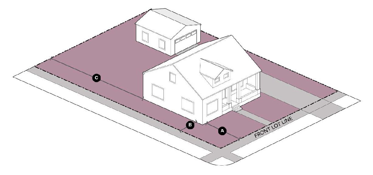
B.
Corner Lots. For lots with frontage on two (2) intersecting streets, such a lot shall have the front of the lot determined by the legal street address for the lot.
Figure 2.2—Corner Lot Addressing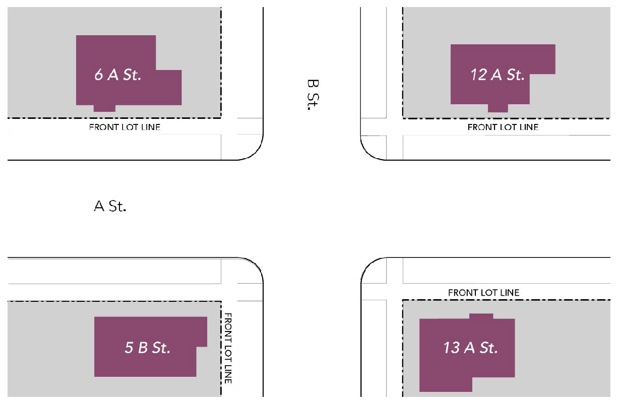
C.
Lot Width. Lot width shall be measured along the length of the minimum required front yard setback line between the two (2) side lot lines. If the front yard setback line is an arc or a curve, the lot width shall be the length of such arc or curve.
D.
Lot Coverage. Lot coverage shall be measured as the percentage of a lot or tract covered by all buildings on a property as measured by the perimeter of the building foundation. Decks, patios, carports, and other site amenities that are not defined as a building are excluded from the calculation.
E.
Height Measurement.
1.
Buildings and Other Structures. Height refers to the vertical distance between average finished grade of the property and the highest point on the peak of the roof. The average finished grade shall be determined by calculating the average of the highest and lowest elevations of finished grade as related to the building foundation.
Figure 2.3—Building Height Measurement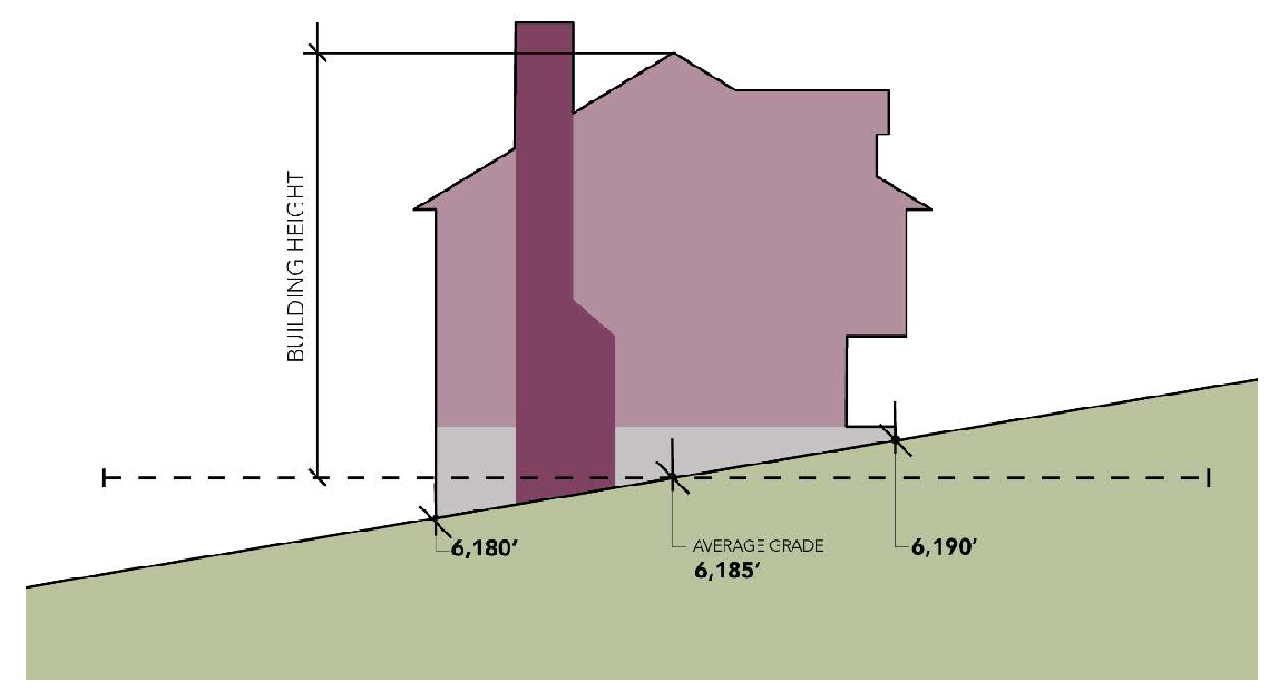
2.
Commercial Wireless Antennas and Towers. The height of commercial antennas and towers shall be determined by measuring the vertical distance from the tower's point of contact with the ground to the highest point of the tower, including all antennas or other attachments when towers are mounted upon other structures.
3.
Accessory Projections. Limited structures and architectural elements may project beyond the specified height limit of each zone district as per the following:
a.
Architectural features such as such as parapets, pipes, chimneys, heating and venting systems, cupolas, stairwell towers, elevator overrun, roof-mounted solar energy systems, or other similar projections may extend up to five (5) feet above the maximum permitted building height of the associated zone district;
b.
Church belfries, towers, or spires may extend up to ten (5) feet above the maximum permitted building height of the associated zone district provided the largest horizontal cross-section of the belfry, tower, or spire feature does not exceed fifteen percent (15%) of the footprint of the primary structure from which it rises;
c.
Antennas used for television or radio shall be of a height that complies with Federal Communications Commission regulations and guidance, provided that the height of the antenna structure may not exceed a dimension equal to the distance of the antenna structure from the nearest property line;
d.
The accessory projection is not constructed for the purpose of providing additional floor area in the building; and
e.
The accessory projection does not interfere with Federal Aviation Administration regulations.
4.
Permitted Exceptions. The following structures and features shall be exempt from the height requirements of this Code:
a.
Tanks and water towers.
b.
Utility poles and support structures.
c.
Monuments, flagpoles, and ornamental towers.
(Ord. No. 1331, Exh. A, 3-11-2025)
2.04 - Definitions of terms and uses.
Words defined in this section shall be given the meanings set forth here. All other words shall be given their common, ordinary meanings, as the context may reasonably suggest. In case of a dispute over the meaning of a term not defined here or over the application of a definition set forth here, the zoning administrator shall give a written interpretation in accordance with Section 2.03 of this Code.
A
"Access" means the ability for vehicles or pedestrians to enter or exit a site or building at a designated location.
"Accessory use or structure" means a use or structure naturally and normally incidental to, subordinate to, and devoted primarily to the principal use or structure of the premises.
"Adult entertainment establishment" means an establishment that rents or sells adult videos or adult publications, which are in excess of fifteen percent (15%) of the total stock available to the public for consumption as further defined in Section 4A-1 of the Cortez City Code. The definition shall not include an establishment where a medical practitioner, psychologist, psychiatrist, or other similar professional person licensed by the state engages in medically approved and recognized sexual therapy.
"Affected person" means individuals, organizations, or governmental bodies that have a stake in or are directly impacted by a proposed regulation or land use decision.
"Affordable housing—For sale" means a development where at least 50 percent of for sale housing is affordable to households with incomes that are equal to or less than one hundred percent (100%) of the area median income for households of that size in Montezuma County. Additionally, the housing must cost the household less than thirty percent (30%) of its monthly income.
"Affordable housing—For rent" means a development where at least fifty percent (50%) of rental housing units are affordable to households with incomes that are equal to or less than sixty percent (60%) of the area median income for households of that size in Montezuma County. Additionally, the housing must cost the household less than thirty percent (30%) of its monthly income.
"Agriculture" means the use of land for the cultivation of crops and the raising of livestock.
"Alley" means a public or private secondary access to the rear or side of properties primarily intended for service access, utilities, and vehicular circulation, and are not designed for general traffic use.
"Antenna" means any structure or devise used for the purpose of collecting or transmitting electromagnetic waves including but not limited to directional antennas, such as panels, microwave dishes, and satellite dishes, and omni-directional antennas, such as whip antennas.
"Applicant" means a person who submits an application for development to a local government.
"Area median income" means the median household income of households of a given size in Cortez, or Montezuma County, as calculated and published for a given year by the United Sates Department of Housing and Urban Development. These numbers vary by year and are available on the Colorado Housing and Finance Authority (CHFA) website.
B
"Block" means an area enclosed by streets and occupied by or intended for buildings; or if such word is used as a term of measurement, it shall mean the distance along a side of a street between the nearest two (2) streets that intersect such street.
"Block face" means the portion of a block facing the same street.
"Board of county commissioners" means the Board of County Commissioners of Montezuma County, Colorado.
"Buffer" means an area of land, including landscaping, berms, walls, fences, and building setbacks, that is located between land uses of different character and is intended to mitigate negative impacts of the more intense use.
"Building" means any structure built for the support, shelter and enclosure of persons, animals, chattels or movable property of any kind. When subdivided in a manner sufficient to prevent the spread of fire, each portion so subdivided may be deemed a separate building. Building includes yurts, removable sheds, and similar uses, but does not include signs or fences.
"Building height." See Section 2.02, Standards of Measurement.
"Building inspector" means the official designated by the building official to enforce the provisions of the city building codes.
"Building official" means the building inspector charged with the responsibility of issuing permits and enforcing on behalf of the city the currently adopted city construction codes, fire codes, or other building code adopted by the city, and Land Use Code, or their designee.
"Building permit" means a permit issued by the building official, after approval of a zoning development permit, that allows a developer to erect, construct, reconstruct, grade, excavate for a foundation, alter or change the use of a building or other structure or improvements of land.
"Building setback" means an imaginary line extending across the full width or length of a lot, parallel with the street right-of-way line or the property line and outside of which no building shall be constructed.
C
"Caretaker or guard residence" means dwelling facilities located on a premise occupied by a permitted main use for the housing of persons and their families who are employed on the premises as guards, caretakers, or in similar custodial capacity.
"Certificate of occupancy" means an official certificate issued by the city through the enforcing official that indicates conformance with or approved conditional waiver from the zoning regulations and authorizes legal use of the premises for which it is issued.
"Character (of a developed area)" means the density, height, coverage, setback, massing, fenestration, materials, and scale of materials.
"City" means the City of Cortez, Colorado.
"City council" means the governing and legislative body of the city.
"City manager" means the chief administrative officer of the city.
"Cold frame" means an unheated outdoor structure consisting of a wooden or concrete frame and a top of glass or clear plastic, used for protecting seedlings and plants from the cold.
"Commercial development" means and includes, but is not limited to: expansion or construction of office, retail, wholesale, warehouse, manufacture, commercial recreation, restaurant/bar and/or service commercial operations by the addition of square footage.
"Common element" means in a condominium or cooperative, all portions of the condominium other than the units.
"Common open space" means a parcel of usable land, area of water, or a combination of land and water within the site intended primarily for the use or enjoyment of residents of the development and surrounding community. Common open space may include, but is not limited to, areas devoted to recreation, courts, gardens, parks and walkways. The term shall not include space devoted to streets, parking and loading areas.
"Community center" means a building and grounds owned and operated by a governmental body or homeowners' association, for the social, recreational health, or welfare of the community served.
"Compatible" means consistent with, harmonious with, similar to and/or enhancing the mixture of uses, siting and/or complimentary architectural styles, either of an individual use, structure, or the character of the surrounding structures.
"Comprehensive plan" means the comprehensive long range strategic plan of the city and adjoining areas adopted by the planning commission and city council, including all of its revisions. The plan indicates the general locations recommended for various land uses, transportation routes, public and private buildings, streets, parks and other public and private developments and improvements.
"Condominium" means a common interest community in which portions of the real estate are designated for separate ownership and the remainder of which is designated for common ownership solely by the owners of the separate ownership portions.
1.
"Condominium, attached" means a residential dwelling unit in a structure containing two (2) or more such units, the living spaces of which are individually owned; the balance of the property (both land and building) is owned either in common by the owners of the individual units or by an association consisting of such owners.
2.
"Condominium, detached" means one (1) of at least two (2) individually owned, unconnected residential dwelling units located on property owned either in common by the owners of such units or by an association consisting of such owners.
"Cooperative" means a common interest community in which the real property is owned by an association, each member of which is entitled by virtue of such member's ownership interest in the association an exclusive possession of a unit.
"Condominium map" means a printed or digital instrument depicting all or a portion of a common interest community in three (3) dimensions. A map or a plat may be combined in one (1) instrument.
"Constructive notice" means notice that shall be deemed given as a result of actual notice or any action by the city recorded in the public record maintained by the county clerk.
"Custom personal service" means barber shop, beauty shop, tailor, dressmaker, shoe shop or similar shop offering custom service.
"Cut area" means any area where the existing grade is lowered.
D
"Density" means the maximum number of dwelling units per gross acre of land permitted in a zone district.
"Developer" means any public or private person, partnership, association or agency that prepares raw land for the construction of buildings or causes to be built physical building space for use primarily by others, during which preparation of the land or the creation of the building space is in itself a business and is not incidental to another business or activity.
"Development" means the physical extension and/or construction of urban land uses. Development activities include: subdivision of land; change in the intensity of use of land; construction, reconstruction, demolition or partial demolition or alteration of buildings, roads, utilities, and other facilities; commencement of drilling (except for a well or to obtain soil samples), mining, or excavation; installation of septic systems; grading; deposit of refuse, debris, or fill materials; and clearing of natural vegetation cover.
"Direct illumination" means illumination resulting from light emitted directly from a lamp, luminary, or reflector. Does not include reflected light from surfaces such as the ground or building faces.
"Director of parks and recreation" means the city staff member in the city parks and recreation department designated to enforce this Code. This staff member oversees the planning, management, and operations of parks, recreational facilities, programs, and open spaces, ensuring they meet community needs, align with city goals.
"District" means a section of the city for which the regulations governing the height, area or use of the land and buildings are uniform.
"Double frontage lot" means a parcel of land that has frontage on two (2) parallel or nearly parallel streets. Unlike a corner lot, which fronts on two (2) intersecting streets, a double frontage lot has streets along both its front and back property lines.
"Dwelling" means a structure occupied or intended to be occupied as living quarters and includes facilities for cooking, sleeping and sanitation. Transitory facilities like hotels, apartment hotels, lodging houses or similar are not considered dwellings.
E
"Easement" means an interest in real property generally established in a real estate document or on a recorded plat to reserve, convey or dedicate the use of land for a specialized or limited purpose without the transfer of fee title. Such specified uses may include but are not limited to transportation facilities, utilities, access, stormwater drainage, and solar exposure.
"Encroachment" means the authorized or unauthorized placement of a building or fence or part of a building or fence upon the land or easement of another or a public right-of-way.
"Engineer" means a person duly authorized under applicable provisions of Colorado Revised Statutes to practice the profession of engineering.
"Essential services" means the development or maintenance of public utilities or city-approved underground, surface or overhead gas, electrical, telephone, steam, fuel or water transmission or distribution systems, including towers, poles, wires, mains, drains, sewers, pipes, conduits, cables, fire alarm and police call boxes, traffic signals, hydrants and similar equipment, and sewage pump stations.
"Excavation" means the formation of a cavity formed by cutting, digging or scooping earth.
"Extraordinary circumstances" means occasions that are not usual, regular, or of a customary nature.
F
"Façade" means the exterior side of a building or structure extending from the ground to top of the roof, parapet, or wall and the entire width of the building elevation.
"Family" means any of the following: one (1) or more persons related by blood, marriage, adoption, or legal guardianship, including foster children, living together in a dwelling unit; or a group of persons not related by blood, marriage, adoption, or legal guardianship living together in a dwelling unit; or two (2) or more unrelated persons and their children living together in a dwelling unit. The number of persons occupying each dwelling unit shall not exceed the maximum permitted by the applicable adopted building code or safety code, or by any applicable state or federal law or regulation, or by affordable housing guidelines applicable to the dwelling unit.
"Fence" means any structure intended for the use of confinement, prevention of intrusion, boundary identification, or screening of an activity.
"Finished grade" means the elevation of the ground surface, following development.
"Floor area" means the total square feet of floor space measured from the outside face of the building walls including each floor level, but excluding cellars, carports or garages. The floor area for any accessory structures shall be calculated separate from the primary structure.
"Frontage" means the boundary of a property that is adjoining a right-of-way.
G
"Greenhouse" means a temporary or permanent structure typically made of, but not limited to, glass, plastic, or fiberglass in which plants are cultivated.
"Gross acreage" means the total acreage of a project or subdivision including all land for building sites, interior public right-of-way and any new public or private open space. A gross acre is forty-three thousand five hundred sixty (43,560) square feet in area. Public right-of-way on the perimeter of a project or subdivision is not part of the gross acre.
"Groundcover" means material planted in such a way as to form a continuous cover over the ground that can be maintained at a height not more than twelve (12) inches.
H
"Habitable space" means any space within a dwelling dedicated to rooms that are used for living, sleeping, cooking, and eating.
"Historical importance" means marked by or indicative of significant worth or consequence.
"Historic district" means an area that possesses a significant concentration, linkage, or continuity of sites, buildings, structures, or objects that are historically or aesthetically united by either a plan or physical development.
"Historic resources" means any buildings, sites, structures, districts, and/or objects that have the potential for historic designation as outlined in Chapter 7. For the purpose of this Land Use Code "historic resources" may also include archaeological resources which means all sites, objects, structures, artifacts, and locations of prehistoric archeological interest, where recorded or still unrecognized.
"Historic site" means the location of a significant event where a historic occupation or activity occurred. It may be the site of a building or structure which is no longer standing or which exists only as a ruin. A site may also include a standing building, if the location itself possesses historic, cultural, or archeological value regardless of the value of any existing structure.
"Historic significance" means the importance of a property to the history, architecture, archeology, engineering, or culture of a community, state, or the nation. It is achieved in several ways:
1.
Association with events, activities, or patterns.
2.
Association with important persons.
3.
Distinctive physical characteristics of design, construction, or form.
4.
Potential to yield important information.
"Hoophouse" means a temporary or permanent structure typically made of, but not limited to, piping or other material covered with translucent plastic, constructed in a half-round or hoop shape, for the purpose of growing plants.
I
"Industrial development" means nonretail, nonresidential uses including but not limited to: manufacturing, heavy equipment repair, fabrication, chemical and petroleum distillation and processing, warehousing, and assembly operations.
"Improvement" means the addition of street, curb and gutter, sidewalk, storm drainage or utilities facilities or street trees or any other required items on a vacant parcel of land.
J
There are no terms in this section.
K
There are no terms in this section.
L
"Landscaping" means trees, shrubs, ground cover, vines, interior paths, ponds, fountains, sculptures, and other organic and inorganic materials used for creating an attractive appearance. Smooth concrete or asphalt surfaces are not considered landscaping.
"Landscape area" means an entire parcel of real property minus that area encompassed by building footprints, driveways, and the non-irrigated portions of parking lots. Water features and areas improved with walkways, benches, seating areas and similar improvements are included in the calculation of the landscaped area.
"Legacy zone district" means a zoning designation that all properties zoned as such as of the effective date of this Code may remain in place and develop within the parameters of the standards herein but no additional properties will be permitted to rezone to that zone district.
"Lot" means an undivided tract or parcel of land under one (1) ownership having frontage on a public street and either occupied or to be occupied by a building or building group together with accessory buildings, which parcel of land is designated as a separate and distinct tract. Contiguous lots under one (1) ownership used, or intended to be used, as a single unit of land shall be considered a single lot for purposes of this Code.
"Lot area" means the net area of the lot, excluding portions of streets and alleys.
"Lot lines" means the lines bounding a lot as defined herein.
1.
"Lot line, front" means any lot line adjacent to a street.
2.
"Lot line, rear" means a lot line opposite a front lot line and not adjacent to a street.
3.
"Lot line, side" means any lot line not defined as a front or rear lot line.
"Lot of record" means a lot that is part of a subdivision or the original city site, the plat of which has been recorded in the office of the county clerk or a parcel of land, the deed for which is recorded in the office of the county clerk prior to the adoption of the city's original zoning ordinance, Ordinance No. 184 (adopted March 7, 1946).
"Low impact development" means stormwater and land use-management that mimics natural hydrologic conditions and emphasizes conservation, use of natural features, site-planning and distributed best management practices for stormwater management. LID may include but is not limited to permeable pavement, bioswales, and rain gardens.
"Lumen" means a standard measurement of light emitted by a light fixture. Lumen output of a fixture shall mean the manufacturer's published documentation of initial lumens for the fixture.
M
"Mayor" means the chairperson of the city council.
"Mineral estate" means an interest in real property that is less than full fee title and that includes mineral rights as shown by the real estate records of the county in which the property is situated.
"Mineral estate owner" means the owner or lessee of a mineral estate underneath a surface estate that is subject to an application for development.
"Municipal facilities" means government-owned and operated institutions or facilities including but not limited to a library, museum, park, playground, recreational center, jail or correctional facility, police, fire or utility facilities.
N
"Neighborhood commercial" uses mean retail establishments primarily serving residents within the immediate neighborhood, oriented and designed toward pedestrian traffic such as bakeries, florists, drugstores and stationary stores.
"Nonconforming use" means any use of land that was legally in existence on the effective date of this Code and has been in regular and continuous use, but which does not conform to the use regulations prescribed by this Code.
"Nonconforming sign" means a sign or portion thereof which does not conform to the regulation of this Code, but which was legally in existence on the effective date of this Code.
"Nonconforming structure" means a building or structure the size, dimension, design, or location of which was lawful prior to the adoption, revision, or amendment of this Code, but which fails to conform to the requirements of the development regulations applicable to the property by reasons of such adoption, revision, or amendment.
O
"Occupancy" means the use or intended use of the land or buildings by proprietors or tenants.
"Occupied" means and includes arranged, designed, built, altered, converted, rented or leased, or intended to be occupied.
"Opaque" means the quality of a material or surface to obscure visible light through at least ninety (90) percent of the material or surface.
"Open space" means area included in any side, rear or front yard or any unoccupied space on the lot or tract that is open and unobstructed to the sky except for the ordinary projections of cornices, eaves, and plant material.
"Outside storage" means areas on a lot that are not enclosed within a building that are used for the storage of items related to the business conducted on the premises.
"Outdoor display" means display of goods associated with a retail business outside of the building which houses the retail use.
"Owner" means any part owner, joint owner, tenant in common, tenant in partnership, joint tenant or other person with sole or with concurrent legal and/or beneficial title to the whole or to part of a building or land.
P
"Parcel" means any quantity of land and water for which location and boundaries can be established that is designated by its owner or developer as land to be used or developed as a unit, or which has been used or developed as a unit.
"Park" means publicly owned land used for active or passive recreational purposes.
"Park trailer" means a unit that is built on a single chassis mounted on wheels and has a gross trailer area not exceeding four hundred (400) square feet in the set-up mode, as defined by the NFPA 70 National Electric Code. A park trailer is not intended for commercial uses such as banks, clinics, offices, or similar. A park trailer may be utilized as a dwelling unit within an approved manufactured home park.
"Parking facility" means a structure, either publicly or privately owned, that is enclosed or open, with a hard surfaced area designed, arranged, and made available for parking vehicles, where such use may be operated as a business enterprise with a service charge or fee being paid by the vehicle operator. Parking facilities may include, but not be limited to, a commercial parking lot and public garage.
"Person" means an individual, proprietorship, trust, partnership, corporation, association, or other legal entity.
"Planned unit development" means a development provided for by the planned unit development zone district wherein certain uses, areas and related standards may be varied and a variety of land uses associated on a tract.
"Planning commission" means the agency designated in this Code and appointed by the city council as an advisory body to it.
"Plat, condominium" means a printed instrument that is a land survey depicting all or a portion of a common interest community in two (2) dimensions. A plat and map may be combined in one (1) instrument.
"Plat, final" means a map of the subdivision showing accurate surveying by a registered surveyor. The map shall show all streets, alleys, blocks, lots and all other requirements listed in Section 6.05 of this Code.
"Plat, preliminary" means the plat of any lot, tract or parcel of land drawn and submitted in accordance with the requirements of adopted regulations listed in Section 6.04 of this Code, that is not to be recorded of record, but is only a proposed division of land for review and study by the city.
"Principal use" means the primary use for which a parcel and any buildings thereon are developed.
"Public land" means land or interests in land owned by a governmental entity or held in trust for the benefit of the public by a not-for-profit organization.
"Public right-of-way" means any parcel of land unobstructed from the ground to the sky dedicated or appropriated to the general public.
"Public utility" means persons, entities, or governments supplying gas, electric, transportation, water, sewer, landline telephone service, cable, internet, and fiber optic, or similar services, to the general public. For the purpose of this Code, commercial wireless telecommunication service facilities shall not be considered public utility uses and are defined separately.
Q
There are no terms in this section.
R
"Real property" means all real property within the city included within the boundaries of any lot approved and recorded in the plat records of the county, or within the boundaries of any unplatted tract or parcel of land described and recorded in the real property records of the county.
"Recreational vehicle" means a vehicular-type unit primarily designed as temporary living quarters for recreational, camping, or travel use, which either has its own motive power or is mounted on or drawn by another vehicle. The basic entities are travel trailer, camping trailer, truck camper, and motor home.
"Replat" means the re-arrangement of any part or all of a previously platted subdivision, addition, lot or tract.
"Reserve strip" means land controlling access to or egress from other property or to or from any street or alley or having the effect of restricting or damaging the adjoining property for subdivision purposes or that will not be taxable or accessible for special improvements.
"Residence" means the same as dwelling.
"Right-of-way" means the entire dedicated tract or strip of land that is to be used by the public for circulation and service.
"Roof" means the top covering structure of a building.
S
"Sexually oriented business." See "adult entertainment establishment."
"School" means a facility or institution where individuals receive educational instruction or training, whether public, private, or charter, and which is recognized or accredited by a state, regional, or national education authority. Schools may include associated uses, such as recreational areas, administrative offices, and auxiliary structures, necessary for their operation.
"Screen" means a structure designed and erected as a visual barrier. A screen may also be nonstructured, consisting of plant material. See also "buffer."
"Setback" means open space at grade between a structure and the property line of the lot on which the structure is located, which shall remain unoccupied and unobstructed from the ground upward, except for permitted fences and landscaping.
"Severed" means that the surface owner does not own one hundred (100) percent of the mineral estate.
"Sign" means any object, device, display, or structure, or part thereof, visible from a public place, a public right-of-way, or any parking area which is designed and used to attract attention to an institution, organization, business, product, service, event, or location by any means involving words, letters, figures, designs, symbols, fixtures, logos, colors, illumination, or projected images. The definition of sign shall include all parts, portions, units, and materials composing the same, together with the frame, background, and supports or anchoring thereof. Signs do not include the following: (a) flags of nations, or an organization of nations, states and cities, fraternal, religious and civic organizations; (b) merchandise, pictures or models of products or services incorporated in a window display; (c) time and temperature devices not related to a product; (e) works of art which in no way identify a product; and (f) scoreboards located on athletic fields. If for any reason, it cannot be readily determined whether or not an object is a sign, the zoning administrator shall make such determination.
1.
"Billboard" means a sign located off-premises advertising goods, services, or other messages, excluding directional signs and signage used by governmental entities for emergency messages.
2.
"Canopy or hanging sign" means a sign suspended from an extended roof structure.
3.
"Display surface" or "face" means the area made available by a sign structure for the purpose of displaying a message.
4.
"Freestanding sign" means any sign permanently affixed to the ground, supported by a standard or legs or other self-supporting structure used solely for that sign, and physically separated from any building or structure.
5.
"Ground sign" means a sign supported by poles, uprights, or braces extending from the ground or an object on the ground but not attached to any part of any building.
6.
"Illuminated sign" means a sign lighted by or exposed to artificial lighting either by lights on the sign, directed towards the sign, or from within the sign.
7.
"Nonconforming sign." See "nonconforming sign."
8.
"Off-premise sign" means a type of directional sign that directs attention to a business, commodity, service, entertainment, attraction or product sold, offered or existing elsewhere than upon the same lot where the sign is located, including billboards.
9.
"Public signs" means signs required or specifically authorized for a public purpose by any law, statute, or ordinance; which may be of any number, type, area, height above grade, location, illumination, or animation, authorized by the law, statute, or ordinance under which the signs are erected.
10.
"Sign with backing" means any sign that is displayed upon, against, or through any material or color surface or backing that forms an integral part of such display and differentiates the total display from the background against which it is placed.
11.
"Sign without backing" means any word, letter, emblem, insignia, figure, or similar character or group thereof, that is neither backed by, incorporated in, or otherwise made part of any larger display area.
12.
"Temporary sign" means any sign or advertising display constructed of cloth, canvas, fabric, plywood, or other light material intended to be displayed for a short period of time as defined in this Code.
13.
"Window sign" means any sign that is applied or attached to or located within three (3) feet of the interior of a window, which sign can be seen through the window from the exterior of the structure.
"Site" means a parcel or portion of land separated from other parcels or portions by legal description and abutting upon one (1) or more public streets or roads intended for use-by-right occupancy.
"Shipping container" means a standardized, reusable steel or aluminum container originally designed for the transportation and storage of goods and materials in the global shipping industry. When repurposed for storage, construction, or other building uses within this Code, containers shall be considered a temporary accessory use.
"Street" means a public way, other than an alley or driveway, which affords the principal means of access to abutting property.
1.
"Arterial/highway street" means a thoroughfare ultimately designed for the movement of two (2) or more lanes of moving traffic in each direction, and designated as a major street by the comprehensive plan or the Cortez Master Street Plan.
2.
"Collector street" means a thoroughfare ultimately designed for the movement of one or more lanes of moving traffic in each direction and designated as a secondary street.
3.
"Local street" means a street which has the primary function of providing access to abutting property and which does not normally carry through traffic.
"Street trees" means trees, shrubs, bushes, and all other woody vegetation on land located within the right-of-way of any street or alley within the city.
"Street width" means the dimension of the shortest distance between the lines that delineate the right-of-way of a street, road or other way.
"Structural alterations" means any change in the supporting member of a building, such as a bearing wall, column, beam or girder.
"Structure" means that which is built or constructed, an edifice or building or any kind or any piece of work artificially built up or composed of parts joined together in some definitive manner.
"Studio apartment" means an apartment or other dwelling unit consisting of a single room that serves as a combined space for living, dining, and sleeping.
"Subdivision improvements agreement" means one (1) or more security arrangement(s) that may be accepted by the city to secure the construction of such public improvements as are required by this Code as a condition of the approval of a subdivision.
"Subdivision" means the division of any parcel of land into two (2) or more parcels.
"Surface estate" means an interest in real property that is less than full fee title that does not include the mineral rights as shown by the real estate records of the county in which the property is situated.
"Surface owner" means the owner of the surface estate and any person with rights under a recorded contract to purchase all or part of the surface estate.
T
"Temporary use" means a use or structure on improved or unimproved land which is of impermanent nature and is used for less than one hundred and eighty (180) days in a calendar year.
"Toxic and noxious matter" means any solid, liquid, or gaseous matter that is present in sufficient quantities to endanger health, safety and comfort of persons in the vicinity or that may injure or damage property.
"Top of bank" means the break in slope between the creek, ditch, or channel bank and surrounding terrain. The top of bank represents the boundary where normal water flow takes place including the active channel, active floodplain, and their associated banks.
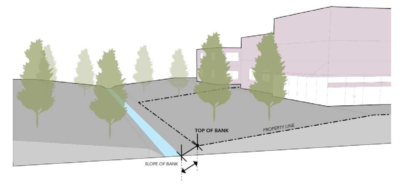
"Tower" means any ground or roof-mounted pole, spire, structure, or combination thereof taller than fifteen (15) feet, including supporting lines, cables, wires, traces, and masts, intended primarily for the purpose of mounting an antenna, meteorological device, or similar apparatus above grade.
1.
"Tower, multi-user" means a tower to which is attached the antennas of more than one (1) commercial wireless telecommunication service provider or governmental entity.
2.
"Tower, single-user" means a tower to which is attached only the antennas of a single user, although the tower may be designed to accommodate the antennas of multiple users as required in this Code.
U
"Urban agriculture" means the growing, processing, and distributing of food and other products through plant cultivation and animal husbandry in and around the city.
"Urban influence area" means an area identified in the Cortez Master Street Plan surrounding the city that is suitable for urbanization.
"Usable floor area" means all of the floor area in a building or buildings including hallways, but excluding areas of floor devoted to structural or partition walls, stair wells, elevator shafts, storage, boiler rooms, and mechanical service rooms.
V
"Variance" means an adjustment in the application of certain zoning district regulations to a particular parcel of property that, because of special conditions or circumstances peculiar to the particular parcel, is necessary to prevent the property from being deprived of rights and privileges enjoyed by other parcels in the same vicinity and zoning district.
"Vested property right" means the right to undertake and complete the development and use of property under the terms and conditions of a site specific development plan.
"Vibration" means a periodic displacement of the earth measured in inches.
W
"Wetlands" means those areas which are saturated or inundated by surface or ground water at a duration sufficient to support, and that under normal circumstances do support, a prevalence of vegetation typically adapted for life in saturated soils conditions. Wetlands identified based on the presence of the following three (3) criteria:
1.
Hydrology: evidence of regular surface or subsurface water sufficient to saturate the soil during the growing season.
2.
Soil: hydric soils that are characteristic of areas subject to prolonged saturation.
3.
Vegetation: plant species that are adapted to wet soil conditions and are typically found in wetland environments.
"Workforce housing" means housing that is affordable to a household with an income of between eighty (80) percent and one hundred twenty (120) percent of the area median income for households of that size. Developers will be required to provide assurances that the housing is and will remain affordable for at least twenty (20) years.
X
There are no terms in this section.
Y
"Yard" means an open space on the lot that is not obstructed from any point thirty (30) inches above the general ground level of the graded lot to the sky except as authorized obstructions.
1.
"Front yard" means a yard adjacent to a front lot line and extending from the lot line a uniform distance into the lot.
2.
"Rear yard" means a yard adjacent to a rear lot line and extending from the lot line a uniform distance into the lot.
Z
"Zoning administrator" means the official designated to enforce the provisions of this Code.
"Zoning map" means the certified official zoning map upon which the boundaries of the various zoning districts are drawn.
(Ord. No. 1331, Exh. A, 3-11-2025; Ord. No. 1349, Exh. A, 11-25-2025; Ord. No. 1352, Exh. A, 11-25-2025)
3.01 - General provisions.
3.01.1 Table of Contents.
A.
3.01 General Provisions.
B.
3.02 District Established.
C.
3.03 Residential Zone Districts.
D.
3.04 Commercial, Industrial, and Open Zone Districts.
E.
3.05 Planned Unit Development Zone District.
F.
3.06 Use Regulations.
3.01.2 Scope and Applicability.
A.
The regulations of this chapter shall apply to all lands located within the corporate limits of the city. All land, buildings, structures or appurtenances thereon located within the city, that are hereafter occupied, used, erected, altered, removed, placed, demolished or converted shall be occupied, used, erected, altered, removed, placed, demolished or converted in conformance with the zoning regulations prescribed for the zoning district in which such land or building is located as provided in this chapter.
B.
The planning and zoning commission and the city council shall have the authority to recommend (planning and zoning commission, if acting as a recommending body) or approve (city council, and planning and zoning commission if planning and zoning commission is acting as an approval body) less restrictive minor deviations or exceptions to the strict application of the provisions of this chapter in circumstances in which the planning and zoning commission or the city council determine involve unique characteristics of a particular property, of a particular proposed use, inconsistency with surrounding property, or other circumstances that make the strict application of the provisions of this Land Use Code inequitable, impractical or contrary to the public good. An applicant/owner that requests a less restrictive minor deviation or exception must provide objective reasons for the need for such deviation or exception.
(Ord. No. 1331, Exh. A, 3-11-2025)
3.02 - Districts established.
3.02.1 Purpose.
A.
In order to implement the comprehensive plan and the other purposes and provisions of this Land Use Code, the city is divided into zone districts with specific dimensional and use requirements as described in this chapter.
Table 3.0 Zone Districts Established
3.02.2 Official Zoning Map.
A.
Map Adoption. The boundaries of the zoning districts set out herein are delineated upon the official zoning map of the city, such map being adopted as a part of this Code as fully as if the same were set forth herein in detail.
B.
Zoning Map Amendment. No changes or amendments to the district boundaries shown on the official zoning map shall be made except in compliance and conformity with all procedures set forth in Section 6.03 of this Code, Zoning Map and Land Use Code Amendments. If, in accordance with these procedures, changes or amendments are made to district boundaries, such changes or amendments shall be made promptly after official adoption of the change or amendment as provided for herein. The zoning administrator shall be responsible for the physical updating and amendment of the official zoning map.
C.
Interpretation of District Boundaries. The district boundary lines shown on the official zoning map are usually along streets, alleys, property lines or extensions thereof. Where uncertainty exists as to the boundaries of districts as shown on the official zoning maps, the following rules shall apply:
1.
Boundaries indicated, as approximately following streets, highways or alleys shall be construed to follow the centerline of such street, highway or alley.
2.
Boundaries indicated, as approximately following platted lot lines shall be construed as following such lines.
3.
Boundaries indicated, as approximately following city limits shall be construed as following city limits.
4.
Boundaries indicated as approximately following the centerline of irrigation ditches or drainage ways shall be construed to follow such centerline.
5.
Boundaries indicated as parallel to or extensions of features indicated in this Subsection shall be so construed. Distances not specifically indicated on the original zoning map shall be determined from the graphic scale on the map.
6.
Whenever any street, alley, or other public way is vacated by official action of the city council, the zoning district line adjoining each side of such street, alley or other public way shall be automatically extended to the centerline of such vacated street, alley or way, and all area so involved shall then and henceforth be subject to all regulations of the extended districts.
3.02.3 Zoning of Annexed Territory.
A.
All territory hereafter annexed to the city shall apply for the appropriate zone district at the time of annexation per the procedure established by this Code for zoning amendments.
B.
All city approvals, such as a site development plan or building permit, must be obtained before construction.
(Ord. No. 1331, Exh. A, 3-11-2025)
3.03 - Residential zone districts.
3.03.1 Purpose.
A.
Residential Zone Districts. In order to secure for the persons who reside there a comfortable, healthy, safe, walkable and pleasant environment in which to live, sheltered from incompatible and disruptive activities and to encourage a diversity of housing options, the following residential districts are established.
B.
Zone Districts.
1.
Residential estate district (RE)
(legacy zone district).
2.
Residential single-family district
(R-1).
3.
Residential multi-family district
(R-2).
4.
Mixed residential district (R-3).
Table 3.1 Residential Dimensional Standards (1)
(1) Additional standards may apply, per Section 5.08 Natural Resource Protections.
(2) Where deed restricted, affordable and/or workforce housing units are provided for more than 10% of the total dwelling unit count in the R2 and R3 zone district, the maximum density can be increased by 20%.
(3) Setback averaging (per Figure 3.03). Front setback averaging may be used if the existing front setbacks of adjacent lots on a block face are less than the required front setback of the underlying zone district. In such cases, the new development may establish a setback that represents the mean (average) setback of all lots on the same side of the street within the same block, excluding lots that are not developed with the same type of use that is proposed on the subject property. Vacant lots shall use the setback dimension required by the zone district in calculating the average setback. This provision shall not be interpreted as requiring a greater front setback than imposed by the underlying zone district. Responsibility for demonstrating eligibility for an "average setback" pursuant to this subsection shall be the sole responsibility of the applicant.
Figure 3.01 Residential Dimensional Standards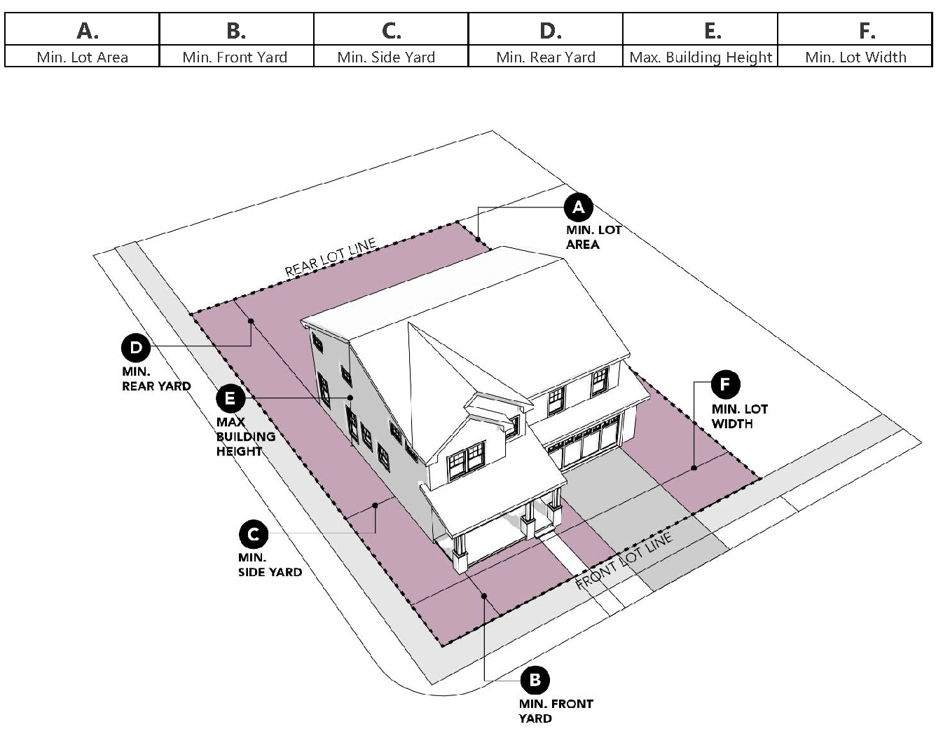
Figure 3.02 Setback Averaging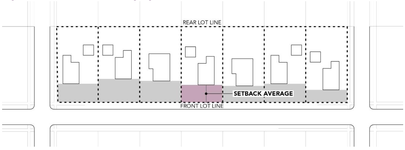
3.03.2 RE, Residential Estate District.
A.
Purpose. The residential estate district is a very low-density residential district intended to provide for large lot, detached single-family development in areas more characteristically rural. This is a legacy district which means all properties zoned RE as of the effective date of this Code may remain in place and develop within the parameters of the standards herein but no additional properties will be permitted to rezone to RE.
B.
Permitted Uses. Refer to Use Table 3.4.
C.
District Regulations. Refer to Section 3.06.3.
D.
Dimensional Standards. Refer to Dimensional Standards Table 3.1.
3.03.3 R-1, Residential Single-Family District.
A.
Purpose. The residential single-family district is intended for a moderate density of detached and limited attached single-family uses on individual lots.
B.
Permitted Uses. Refer to Use Table 3.4.
C.
District Regulations. Refer to Section 3.06.3.
D.
Dimensional Standards. Refer to Dimensional Standards Table 3.1.
3.03.4 R-2, Residential Multi-Family District.
A.
Purpose. The residential multi-family district is intended for a mix of single-family detached dwellings, single-family attached dwellings, and multi-family dwellings.
B.
Permitted Uses. Refer to Use Table 3.4.
C.
District Regulations. Refer to Section 3.06.3.
D.
Dimensional Standards. Refer to Dimensional Standards Table 3.1.
3.03.5 R-3, Mixed Residential District.
A.
Purpose. The mixed residential district is intended for a mix of housing types from single-family to multi-family to mobile and manufactured homes.
B.
Permitted Uses. Refer to Use Table 3.4.
C.
Design Standards. Refer to Section 3.06.3.
D.
Dimensional Standards. Refer to Dimensional Standards Table 3.1.
(Ord. No. 1331, Exh. A, 3-11-2025)
3.04 - Commercial and industrial zone districts.
3.04.1 Purpose.
A.
Commercial Zone Districts. In order to accommodate a wide variety of commercial activities, to make the city's core district a more attractive and energetic place to live, work and shop, to separate pedestrian oriented development from automobile dependent activities, and to enhance the economic development of the city, the following commercial districts are established:
1.
Central Business District (CBD).
2.
Commercial District (C).
3.
Neighborhood Business District (NBD).
B.
Industrial Zone Districts. In order to encourage a diverse employment base, provide for the production of goods and services, and minimize conflict with other land uses, the following industrial district is established.
1.
Industrial District (I).
C.
Other Zone Districts. In order to preserve open space areas for active and passive open space and recreational uses, the following district is established.
1.
Open District (O).
Table 3.2 Nonresidential Dimensional Standards (1)
(1) Additional standards may apply, per Section 5.08 Natural Resource Protections.
(2) The maximum density in the NB zone districts can be increased by 20% where deed restricted, affordable and workforce housing units are provided for more than 10% of the total dwelling unit count.
Figure 3.03 Nonresidential Dimensional Standards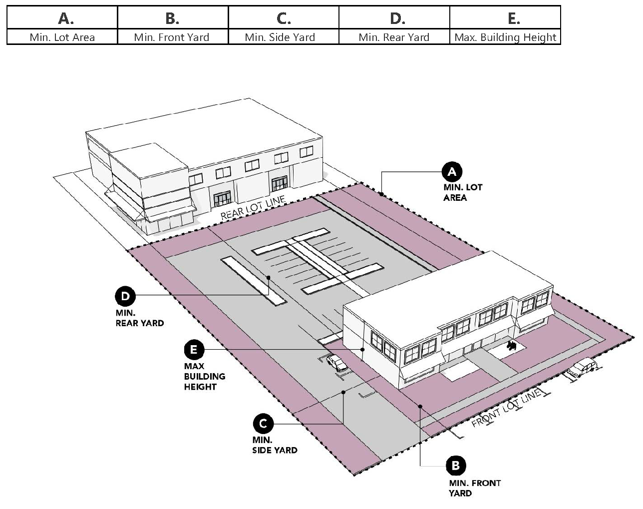
3.04.2 CBD, Central Business District.
A.
Purpose. The central business district is intended to preserve the character of the downtown core and provide a mixture of uses, focused on nonresidential uses, to designate the area as the primary walkable activity center of Cortez.
B.
Permitted Uses. Refer to Use Table 3.4.
C.
Design Standards.
1.
Open space shall be landscaped in accordance with the provisions of Section 5.05 of this Code.
2.
Parking shall be provided per Section 5.02 of this Code.
3.
Refer to Section 3.06 for additional use-specific design standards.
D.
Dimensional Standards. Refer to Dimensional Standards Table 3.2.
3.04.3 C, General Commercial District.
A.
Purpose. The general commercial district is intended to facilitate a variety of businesses that provide employment opportunities and support the retail and service needs of the community.
B.
Permitted Uses. Refer to Use Table 3.4.
C.
Design Standards.
1.
Open space shall be landscaped in accordance with the provisions of Section 5.05 of the Code.
2.
Parking shall be provided per Section 5.02 of this Code.
3.
Refer to Section 3.06 for additional use-specific design standards.
D.
Dimensional Standards. Refer to Dimensional Standards Table 3.2
3.04.4 NB, Neighborhood Business District.
A.
Purpose. The neighborhood business district is intended to support a variety of uses including detached and attached single family dwellings that complement the area's character as well as small-scale, neighborhood-serving commercial establishments that add vibrancy to the overall neighborhood.
B.
Permitted Uses. Refer to Use Table 3.4.
1.
Limitation on Hours of Operation. All commercial activities in the NB, neighborhood business district shall operate only between 6:00 a.m. and 11:00 p.m.
C.
Design Standards.
1.
Open space shall be landscaped in accordance with the provisions of Section 5.05 of this Code.
2.
Refer to Section 3.06 for additional use-specific design standards.
D.
Dimensional Standards. Refer to Dimensional Standards Table 3.2.
3.04.5 I, Industrial District.
A.
Purpose. The industrial district is intended to provide a location primarily for but not limited to manufacturing, warehousing, distributing, and raw materials processing.
B.
Permitted Uses. Refer to Use Table 3.4.
C.
Design Standards.
1.
Open space shall be landscaped in accordance with the provisions of Section 5.05 of the Code.
2.
Refer to Section 3.06 for additional use-specific design standards.
D.
Dimensional Standards. Refer to Dimensional Standards Table 3.2.
3.04.6 O, Open Zone Districts.
A.
Purpose. To preserve space for active and passive open space and recreational uses as well as limited municipal services.
B.
Permitted Uses. Refer to Use Table 3.4.
C.
Design Standards.
1.
Open space shall be landscaped in accordance with the provisions of Section 5.05 of the Code.
2.
Refer to Section 3.06 for additional use-specific design standards.
D.
Dimensional Standards. Refer to Dimensional Standards Table 3.3.
(Ord. No. 1331, Exh. A, 3-11-2025; Ord. No. 1349, Exh. A, 11-25-2025)
3.05 - PUD, planned unit development zone district.
3.05.1 General Provisions and Standards.
A.
Purpose. The PUD, planned unit development district (PUD) is designed to provide flexibility to accommodate mixed-use, nontraditional, or innovative developments. These may include one (1) or more of the following: promoting more economical and efficient use of the land; providing economic benefit to the community; providing a harmonious variety of housing choices; providing a higher level of urban amenities; and/or preserving natural and scenic qualities of open spaces. The PUD district may be applied in all zoning districts. In addition to the regulations of this section, development in the PUD district shall be in compliance with other applicable provisions of this Code.
B.
Minimum Size Requirements.
1.
The minimum lot size for affordable and workforce housing development shall be one (1) acre.
2.
The minimum lot size for all other development shall be five (5) acres.
3.
The city may consider an application for a PUD on a lot smaller than described in subsections 1 and 2 above if the applications adheres to a minimum of three of the following criteria:
a.
Provides an innovative land use not otherwise allowed per zone districts that would allow for alternative residential lot design, innovative architectural or subdivision design features, or in-fill development.
b.
Is considered to be a necessary land use in the community.
c.
Supports local/urban agriculture not specifically identified in the use standards.
d.
Allows for the efficient use of land which may result in reduction in development and maintenance costs of street and utility systems.
e.
Allows for the accumulation of large areas of usable open space for recreation, preservation of natural amenities and provision of community facilities.
f.
Provides a public benefit that is identified in one or more goal or policy in the comprehensive plan.
g.
Provides economic benefit to community.
h.
Provides opportunity for municipal uses mixed with other uses.
C.
General Requirements. The ordinance approving a PUD shall include findings that the proposed development shall:
1.
Be consistent with the comprehensive plan;
2.
Be consistent with the character of existing land uses in the surrounding area; and
3.
Not adversely affect the future development of the surrounding area.
D.
PUDs shall be used only when long-term community benefits, which may be achieved through high quality development, will be derived. The planning and zoning commission shall determine whether substantial community benefits will be derived. In addition to the above findings, the following list provides examples of long-term community benefits:
1.
More effective infrastructure;
2.
Reduced traffic demands;
3.
A greater quality and quantity of public and/or private open space;
4.
Other recreational amenities;
5.
Needed housing types and/or mix;
6.
Job creation or other substantial economic benefits;
7.
Innovative designs; and/or
8.
Protection and/or preservation of natural resources, habitat areas and natural features.
E.
Plan Requirements. In establishing a PUD district in accordance with this section, the city shall require a comprehensive site plan of the development in accordance with the requirements of Section 6.03 of this Code.
1.
Such site plan shall be approved and recorded as part of the approving ordinance prior to the issuance of any building permit.
a.
Such required plan and ordinance shall set forth the requirements for ingress and egress to the property, public streets or drives, with adequate right-of-way, special setbacks, sidewalks, utilities, drainage, parking space, height of building, maximum lot coverage, common open space, yards and open spaces, screening walls or fences, landscaping and other development and protective requirements including maintenance considered necessary to create a reasonable transition to and protection of the adjacent property.
b.
A single-family dwelling may be constructed on a platted lot of record located in a PUD district without approval of a site plan other than as required for a normal building permit where a single-family dwelling is listed as a permitted use.
3.05.2 PUD Application Process.
A.
Every application for a PUD district shall follow the procedure for a zoning map amendment per Section 6.03.3 of this Code.
1.
As part of the zoning map amendment, an overall development plan shall be submitted which includes the following at a minimum:
a.
A project narrative describing the intent of the development,
b.
Proposed conceptual layout of the site showing ingress and egress to the property, public streets or drives, sidewalks, utilities, drainage, and parking area as applicable.
c.
A land use matrix to indicate the gross area proposed for residential versus nonresidential development, rights-of-way, and open space and a summary of building heights, maximum lot coverage, general setbacks, screening walls or fences, landscaping and other development and protective requirements including maintenance considered necessary to create a reasonable transition to and protection of the adjacent property.
2.
The overall development plan shall be approved and recorded as part of the approving ordinance of the zone map amendment.
a.
A single-family dwelling may be constructed on a platted lot of record located in a PUD district without approval of a site plan other than as required for a normal building permit where a single-family dwelling is listed as a permitted use.
B.
In approving the PUD, the city council may impose conditions relative to the standard of development and such conditions shall be complied with before a certificate of occupancy is issued for the use of the land or any structure that is part of the PUD and such conditions shall not be construed as conditions precedent to the approval of the zoning amendment, but shall be construed as conditions precedent to the granting of the certificate of occupancy.
C.
All PUDs approved in accordance with the provisions of this Code shall be referenced on the official zoning map and a list of such properties zoned PUD, together with the category of uses permitted therein, shall be maintained in the office of the zoning administrator.
D.
Once zoning is approved, the applicant shall follow the appropriate subdivision or site plan process for the proposed use and development of the site, specific procedures for which are detailed in Section 6.03 of this Code.
E.
Time Limit of Approval. The city may initiate a rezone of the land to its original state after twelve (12) months if any of the following apply:
1.
The applicant has not submitted a final plat;
2.
The applicant has not submitted a site plan and/or building permit application where a final plat is not required;
3.
If the planning and zoning commission finds that the applicant has abandoned the project; or
4.
If the planning and zoning commission determines that no substantial progress has been made toward completion of the project in the previous twelve (12) months.
F.
At its discretion and for good cause, the planning and zoning commission may extend for twelve (12) months and one (1) time only, the period for filing a final plat or building permit application.
G.
Permitted Uses. Uses in a PUD shall be proposed by the applicant to coordinate with uses listed in Table 3.4 as applicable for the different development areas within the PUD. City council is the final approval authority for the proposed uses, upon recommendation of the planning and zoning commission.
1.
Amendment of approved uses shall require amendment of the PUD ordinance according to the procedures for zoning map amendments set forth in Section 6.02 of this Code.
2.
All proposed uses shall conform to the use-specific standards in Section 3.06.
3.05.3 Street and Access Requirements.
A.
All streets (both public and private) shall conform to the requirements of Section 4.03 of this Code and the street development standards of the city with the following exceptions:
1.
PUD applications may propose flexible design standards with regard to street and alley width and design elements to accommodate innovative developments so long as there is conformance with standards for circulation, connectivity, and surfacing materials.
3.05.4 PUD Dimensional Standards.
A.
PUD applicants may propose their own dimensional standards as appropriate with the type of development proposed.
B.
PUD standards must meet all other site development standards per Chapter 5 of this Code.
(Ord. No. 1331, Exh. A, 3-11-2025)
3.06 - Use regulations.
3.06.1 Schedule of Use Regulations.
A.
The schedule of use regulations of this section provides a tabular summary of the land use types permitted within each zoning district. The table is intended for reference only and does not necessarily reflect all of the regulations that may apply to particular uses or zoning districts. In the event of conflict between the schedule of use regulations and the text of the Code, the text shall control. Reclassification of use types may be done administratively. The schedule of use regulations shall be interpreted as follows:
1.
Permitted Uses. Uses identified in a particular district column with a "P" shall be permitted in such district, subject to compliance with any applicable conditions and all other provisions of the Code.
2.
Conditional Uses. Uses identified in a particular district column with a "C" shall be permitted in such district only upon approval of a conditional use permit by the city council in accordance with the procedures and standards of Section 6.10 of this Code, conditional use permits.
3.
Temporary Uses. Uses identified in a particular district column with a "T" shall be permitted in such district only upon approval of a temporary use permit in accordance with the procedures and standards of Section 6.20 of this Code, temporary use permits.
4.
Not Permitted. Uses not identified in a particular district column with a "P," "C" or "T" are not allowed in such district unless otherwise expressly permitted in the Code.
5.
Use Standards. The use types are defined along with any associated use standards following Table 3.4. The last column in Table 3.4 identifies which section definitions and use standards are located.
Table 3.4 Schedule of Use Regulations
3.06.2 Use Standards Generally.
A.
In addition to applicable site development standards of Chapter 5 of this Code, the following standards apply to the listed uses when referenced in the use regulations of a particular zoning district.
3.06.3 Residential Use Standards.
A.
General Standards Applicable to All Residential Structures.
1.
Refer to the city's adopted building code as amended.
B.
Dwelling, Accessory Dwelling Unit (ADU).
1.
Defined.
a.
A dwelling that is either attached or detached to the primary single-family residence on a parcel of land zoned for residential use. It shall include permanent provisions for living, sleeping, eating, cooking, and sanitation. This type of use is intended to provide a mechanism to help meet the need of affordable housing by allowing accessory residential dwelling units under certain circumstances in areas normally restricted to a single unit, while preserving existing single-family character.
2.
Use Standards.
a.
All accessory single-family dwelling units shall be subject to the following requirements:
i.
The parcel must contain an existing or proposed single-family unit. Either the single-family dwelling or the ADU must be occupied by the property owner at the time of application for the ADU permit.
ii.
The ADU may be attached or incorporated within the living area of the existing primary dwelling or detached.
iii.
The ADU shall not exceed eight hundred fifty (850) gross square feet of living area.
iv.
The ADU may be used for long-term rental purposes (greater than thirty (30) days) and shall be reserved for occupancy of one (1) family.
v.
The ADU must be provided with one (1) off-street parking space, in addition to the two (2) required for the existing single family residence as per Section 5.01 of this Code. Spaces may be contained in a garage or protected by a carport. The spaces provided may be in tandem.
vi.
Any new construction associated with the ADU shall comply with all setbacks, lot coverage, height, and design standards contained within the base zone district and shall not alter the general appearance of the primary dwelling as a single-family residence.
vii.
The ADU shall have adequate sewer and water services and additional tap fees may be required for the dwelling.
viii.
The ADU shall not adversely impact traffic flow or parking in the neighborhood.
ix.
The lot shall be a legal lot of record.
x.
An ADU that conforms to these requirements shall not be considered to exceed the allowable density for the lot upon which it is located, and shall be deemed to be a residential use consistent with the existing general plan and zoning designation for the lot.
C.
Dwelling, Cottage Cluster.
1.
Defined.
a.
A grouping of three (3) or more detached single-family or micro home dwelling units, with a footprint no larger than one thousand two hundred (1,200) square feet, clustered around a common usable open space and developed with a shared plan for access and parking, and a coordinated design for the buildings and site.
2.
Use Standards.
a.
Cottages may be located on one (1) shared parcel or separate parcels.
b.
Cottages must be permanent homes built on a permanent foundation.
c.
The maximum density of a cottage cluster shall be per zone district dimensional standards referenced in Tables 3.1 and 3.2.
d.
Micro homes may be developed as cottage clusters (see Section 3.06.3.L for micro homes standards)
e.
Common usable open space shall be consolidated and equivalent to two hundred (200) square feet per dwelling unit per the following:
i.
Must maintain a minimum average dimension of twenty (20) feet;
ii.
Must be usable by residents of the cottage cluster including but not limited to open lawn, community garden space, picnic space, seating areas, or active sport areas; and
iii.
Held in common ownership by a legal instrument such as an easement or deed restriction that guarantees access and use by all properties in the cottage cluster.
iv.
Parking or access areas shall not count toward required common usable open space.
f.
A minimum of one hundred (100) square feet of private outdoor living area shall be provided at each cottage. Up to fifty (50) square feet of the private usable space may be provided in decks and patios.
g.
Interior walkways shall connect to a public sidewalk in at least one location on the property.
h.
Parking requirements must be met per Section 5.02.
i.
No structure shall be larger than one thousand two hundred (1,200) square feet in gross floor area.
Figure 3.04 Cottage Cluster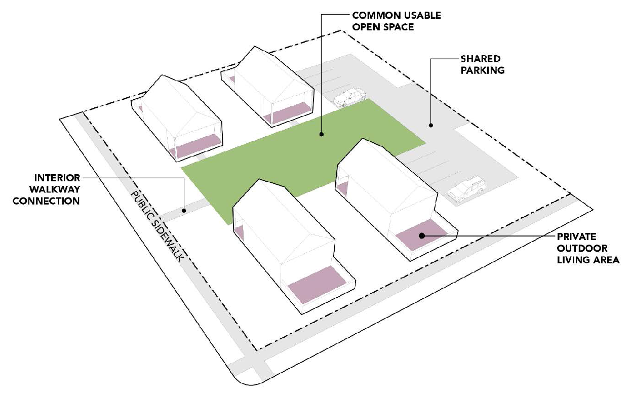
D.
Dwelling, Duplex.
1.
Defined.
a.
A single building on a single lot, designed for occupancy by two (2) separate dwelling units in a side-by-side or stacked configuration attached by a party wall, and not attached to any other buildings other than those accessory to the dwellings.
2.
Use Standards.
a.
Refer to Section 3.06.3.A.
E.
Dwelling, Single-Family Attached.
1.
Defined.
a.
Two (2) or more residential dwelling units, other than manufactured homes, where each unit is attached to other units by party walls, and where habitable spaces of different units are arranged in a side-by-side, rather than in a stacked configuration, with each unit located on its own lot.
2.
Use Standards.
a.
Refer to Section 3.06.3.A.
F.
Dwelling, Single-Family Detached.
1.
Defined.
a.
A dwelling unit located on a separate lot or tract that has no physical connection to a building located on any other lot or tract.
2.
Use Standards.
a.
Refer to Section 3.06.3.A.
G.
Dwelling, Manufactured Home.
1.
Defined.
a.
A HUD-approved structure (formally known as a mobile home prior to 1976) designed to be transported after fabrication on a permanent chassis. Such a structure is suitable for human habitation on a year-round basis when equipped with required plumbing, heating, and electrical facilities.
2.
Use Standards.
a.
Refer to Section 3.06.3.A.
H.
Dwelling, Micro Home.
1.
Defined.
a.
A structure that is:
i.
A modular factory built residential structure that is four hundred (400) square feet or less.
ii.
Designed for long-term occupancy.
iii.
Attached to a permanent foundation (not built on a permanent chassis).
iv.
Has a metal plate insignia that certifies the micro home is built to the codes and standards program within the Colorado Division of Housing.
2.
Use Standards.
a.
A micro home must be built to the International Residential Code as adopted by the building codes and standards program within the division of housing. Colorado micro home will receive a metal plate insignia that certifies the micro home is built to the codes and standards of the program. When installed on a permanent foundation, the micro home will also receive a metal plate installation insignia.
I.
Dwelling, Mixed-Use.
1.
Defined.
a.
A dwelling unit or suite of rooms, which is an accessory use to a commercial or nonresidential structure in a nonresidential zoning district.
2.
Use Standards. Residential uses may comprise up to one-half (½) the floor area of a single-story nonresidential building and shall either be owner-occupied or used for long-term rental purposes. Those structures with multiple floors are allowed unlimited residential use for additional stories above the ground floor.
J.
Dwelling, Modular Home.
1.
Defined.
a.
A factory-built home constructed to the building codes adopted by the Colorado Division of Housing (and City of Cortez), designed to meet the snow load requirement for the site, and to be installed on a permanent foundation. This does not include homes constructed to the Federal Manufactured Home Construction and Safety Standards (HUD) nor does this include any home designed as a mobile home. (Colorado Division of Housing Resolution No. 38; C.R.S. Section 24-32-3302(20)). A modular home must be transported directly from the factory to the lot on a truck bed, not a chassis.
2.
Use Standards.
a.
Refer to Section 3.06.3.A.
K.
Dwelling, Multi-Family.
1.
Defined.
a.
A building on one (1) lot with three (3) or more independent dwelling units where each unit is attached to other units by shared common walls arranged in a side-by-side or stacked configuration. In no event shall the term multi-family be interpreted to include hotels, motels, or inns, regardless of the length of stay of customers of such motels, hotels, or inns.
2.
Use Standards.
a.
Refer to Section 3.06.3.A.
L.
Dwelling, Tiny Home.
1.
Defined.
a.
A structure that conforms to the State of Colorado's tiny home standards, including the following requirements:
i.
Is permanently constructed on a vehicle chassis;
ii.
Is designed for long-term residency;
iii.
Includes electrical, mechanical, or plumbing services that are fabricated, formed, or assembled at a location other than the site of the completed home;
iv.
Is not self-propelled;
v.
Has a square footage of not more than four hundred (400) square feet; and
vi.
Has a metal plate insignia installed under the kitchen sink by the Colorado Division of Housing.
2.
Use Standards.
a.
A tiny home, must be built to the International Residential Code as adopted by the Building Codes and Standards Program within the Colorado Division of Housing. Colorado tiny homes will receive a metal plate insignia that certifies the tiny home is built to the codes and standards of the program. When installed on a temporary or permanent foundation, the tiny home will also receive a metal plate installation insignia.
M.
Manufactured Home Park.
1.
Defined.
a.
A tract of land designed to accommodate three (3) or more manufactured home sites for residential dwelling purposes. Recreational vehicle units and tiny homes, shall be permissible so long as they meet the definitions found in Section 2.02 of this Code. The total number of recreational vehicle shall not exceed ten percent (10%) of all allowable units within an approved manufactured home park.
2.
Use Standards.
a.
Installation Procedure. All manufactured homes within approved manufactured home parks shall be placed in accordance with Ordinance No. 953, Series 2001, and the manufactured housing installations program adopted by the state housing board of the State of Colorado.
b.
Site Design Standards.
i.
The maximum overall density within a manufactured home park shall be seventeen (17) units per gross acre when one hundred percent (100%) of units are manufactured homes or a mix of manufactured homes and tiny homes.
ii.
The maximum overall density within a manufactured home park shall be twenty (20) units per gross acre when one hundred percent (100%) of units are tiny homes.
iii.
Common usable open space shall be consolidated and equivalent to two hundred (200) square feet per dwelling unit per the following:
(a)
Must maintain a minimum average dimension of twenty (20) feet; and
(b)
Must be usable by residents of the manufactured home park including but not limited to open lawn, community garden space, picnic space, seating areas, or active sport areas.
iv.
A minimum of three hundred (300) square feet of private outdoor living area shall be provided at each manufactured home or tiny home space. Up to one hundred (100) square feet of the private usable space may be provided in decks and patios.
c.
Manufactured Home Lot Design Standards.
i.
All manufactured homes shall be installed utilizing only non-permanent foundation systems as defined by, and complying with, all provisions of Ordinance No. 953, Series 2001, Manufactured Home Installation Procedures.
ii.
All recreational vehicles and park trailers shall be set up as required by the manufacturer's specifications or as defined by applicable city ordinances.
iii.
A minimum distance of twenty (20) feet shall be maintained between any two (2) manufactured homes or other approved dwelling units in any direction.
d.
Tiny Home Lot Design Standards.
i.
All tiny homes shall comply with Section 3.06.3J of this chapter.
ii.
A minimum distance of twenty (20) feet shall be maintained between any two (2) tiny homes or other approved dwelling units in any direction.
e.
Street and Road Standards.
i.
Each manufactured home lot within a manufactured home park shall have direct access to an internal circulation street.
ii.
All streets for internal circulation shall be a minimum width of twenty-two (22) feet.
iii.
All street and parking areas shall consist of a dust-free surface (asphaltic materials or concrete).
iv.
The internal street system shall have direct connection to a public right-of-way. Whenever this access meets an existing public street, the access entrance must meet city street design standards for a distance of forty (40) feet from the property line into the development.
v.
Streets and walkways designed for the general use of the manufactured home park residents shall be lighted during the hours of darkness per Chapter 5, Section 5.08 (Exterior Lighting). Such lighting shall not be under the control of the individual manufactured home occupants.
f.
Building Design Standards.
i.
Utility Installations. No dwelling unit may connect to utility services other than the lot with which it has been permitted.
ii.
Removal of Manufactured Home, Recreational Vehicle and Park Trailer Wheels. The removal of wheels, axles, and running gear from manufactured homes located in a manufactured home park shall be permitted.
iii.
Skirting. Each manufactured home or tiny home placed in a manufactured home park shall be skirted so as to obscure from view the space beneath the floor of the unit and the stand.
3.06.4 Accessory and Temporary Uses.
A.
Accessory Structure, Permanent.
1.
Defined.
a.
A structure naturally and normally incidental to, subordinate to, and devoted primarily to the principal structure of the premises.
2.
Use Standards.
a.
Accessory structures may be permitted subject to the following conditions:
i.
Such accessory structures shall be limited to those customarily associated with and appropriate, incidental and subordinate to the principal use.
ii.
Such accessory structures shall be located on the same lot or tract as the associated principal use.
iii.
Such accessory structures, and expressly including detached garages and attached carports located in the front yard setback, shall be controlled in the same manner as the associated principal use, except as otherwise expressly provided in this Code.
iv.
In no event shall an accessory structure be construed to authorize a use not otherwise permitted in the zone district in which the principal use is located, and in no event shall an accessory use or structure be established prior to the principal use or structure to which it is accessory.
b.
Dimensional requirements in the O, RE, R-1, R-2, R-3, and NB zone districts:
i.
Each accessory structure shall have a total square footage not to exceed eight hundred (800) square feet; or, thirty-three percent (33%) of the total square footage of the principal structure.
ii.
The maximum height of accessory structures shall not exceed twenty (20) feet or the height of the principal structure, whichever is less; provided, however, that the height of carports may not exceed sixteen (16) feet or be equal in height of a single-story principal structure if located in the front yard and attached.
c.
Accessory structures exceeding the dimensional requirements listed in this Section may be approved through the conditional use process.
d.
An accessory carport, whether detached from, or attached to the principal structure, may be allowed to extend into the front yard setback if all of the following standards can be met:
i.
The carport roof must be constructed in such a manner to appear as a part of the original construction of the principal structure.
ii.
The materials used in construction of the accessory use are compatible with the materials used in the principal use.
iii.
The carport meets side yard setback standards.
iv.
The carport does not extend into or over any easement or any city right-of-way.
v.
Staff is authorized to review the proposal for compliance with the above standards and approve the building materials for the project.
vi.
All attached carports shall meet the requirements for separation of uses as contained in the adopted building codes of the city.
vii.
Accessory carport structures that are proposed to be placed closer than ten (10) feet to the front property line must go through the conditional use process in accordance with Section 6.10 of this Code.
B.
Accessory Structure, Temporary.
1.
Defined.
a.
A structure naturally and normally incidental to, subordinate to, and devoted primarily to the principal structure of the premises that is used short term per the standards below. Examples could include but not be limited to shipping containers or moving and storage pods.
2.
Use Standards.
a.
Temporary accessory structures are permitted for a maximum of ninety (90) consecutive days, once per calendar year.
b.
Contractors' storage or equipment yards, trailers, or RVs that are used as a temporary residence or office during construction are permitted for a maximum of one-hundred and eighty (180) consecutive days. Any person wishing to utilize a temporary residence or office than longer than one-hundred and eight (180) calendar days during construction may apply for an extension for up to an additional ninety (90) days.
c.
No more than two (2) accessory structures are permitted at any one (1) time.
d.
No temporary accessory structure may be more than ten (10) feet in height, and four hundred (400) square feet in gross floor area.
e.
Any person wishing to utilize a temporary accessory structure longer than ninety (90) calendar days may apply for an extension for up to an additional ninety (90) days or apply for a building permit to make temporary structure a permanent, accessory structure.
f.
Accessory structures cannot be located in any required setback and must be located completely on the owner's lot, and no part of any structure may be located in the public right-of-way.
g.
A temporary use permit shall be acquired for this use.
C.
Asphalt or Concrete Batch Plant, Temporary.
1.
Defined.
a.
A temporary manufacturing facility for asphalt or concrete.
2.
Use Standards.
a.
A temporary asphalt or concrete batching plant permit may be approved by the zoning administrator for producing asphalt or concrete products used in construction activities on the same or nearby sites subject to the following conditions.
i.
The batching plant site shall comply with all applicable provisions of city, state and federal laws.
ii.
The batch plant shall not be located within six-hundred (600) feet of a residence.
iii.
Hours of operation will be limited to Monday through Friday, 7:00 a.m. to 7:00 p.m.
iv.
The batch plant permit will be valid for up to six (6) months.
v.
No portion of the batch plant or its operation shall be located on a public street.
vi.
The batch plant shall only furnish concrete, asphalt, or both, to a specific project. The placement of a temporary batching plant for a private project is restricted to the site of the project or within one-half (½) mile of the batch plant if necessary to maintain at least six-hundred (600) feet of separation from a residence.
vii.
The site must be clear of all equipment, material and debris upon completion.
viii.
All public improvements that are damaged during the operation of the temporary batching plant must be repaired or replaced within thirty (30) days of completion of the project.
ix.
At termination and/or removal of plant permit, permittee shall have the person responsible walk the site with the building official or his/her designee to verify the site meets city approval.
b.
A temporary use permit shall be acquired for this use.
D.
Equipment Rental/Repair/Storage/Wholesaling, Accessory.
1.
Defined.
a.
Maintenance, repair, rental, storage, and/or wholesaling for large construction equipment, including high-capacity mechanical devices such as earth movers, dump trucks, tractors, augers, bulldozers, concrete mixers and similar type devices, when out of order or broken. Includes performing routine actions which keep the machines in working order or to prevent issues. All actions which have the objective of retaining or restoring an item in or to a state in which the item can perform the required function. The actions include the combination of all technical and corresponding administrative, managerial, and supervision actions.
2.
Use Standards.
a.
This use shall be entirely contained within a building or within a yard enclosed on all sides by a screening wall or an opaque fence at least eight (8) feet in height.
E.
Farmers' Market.
1.
Defined.
a.
A seasonal open-air market where local fresh fruits, produce, flowers, and value-added food products like jams, jellies, pickles, sauces, or baked goods, in addition to arts and craft items are sold directly to consumers. Farmers markets are intended to provide a venue for food producers and artisans to sell directly to consumers.
2.
Use Standards.
a.
Vendors are required to have a city sales tax license to sell at a farmers' market.
b.
A temporary use permit shall be acquired for this use.
c.
The sale of second hand or any commercially produced goods is prohibited.
d.
Mobile vendors shall also be regulated as set forth in the Cortez City Code at Chapter 15, Article IX, Mobile Food Vendors, Sections 15-66—15-68.8 and all other applicable Cortez City Code sections, now in effect or as may be amended from time to time with the exception that the conditional use permit shall determine the time frame.
F.
Field Office, Temporary.
1.
Defined.
a.
A structure or shelter used in connection with a development or building project for housing on-site temporary administrative and supervisory functions and for sheltering employees and equipment.
2.
Use Standards.
a.
A temporary field office permit may be approved by the zoning administrator during the construction phase of a project.
b.
Such a structure or shelter shall be promptly removed following the approval of a certificate of occupancy.
G.
Home Occupation.
1.
Defined.
a.
A business, occupation, profession, trade, activity or use that is operated for compensation and serves customers on a lot or site of a primary dwelling unit use.
2.
Use Standards.
a.
Prior to commencing the home occupation the applicant shall request and receive a home occupation permit from the city. The form of the application shall be as required by the city clerk but at a minimum shall contain the following information: name of applicant, address of home occupation, proposed activity, and a statement of assurance that the applicant shall comply with the requirements of this section. The fee for such application shall be established and modified from time to time by resolution of the city council but shall initially be set at fifty dollars ($50.00). Each home occupation shall be subject to compliance with the following conditions:
i.
A home occupation shall be permitted only when it is an accessory use to a dwelling unit.
ii.
A home occupation shall utilize no more than twenty percent (20%) of the total floor area of the dwelling unit.
iii.
A person who engages in a home occupation shall not use an advertisement, sign, or display on or off the premises; provided, however, that this shall not be construed to regulate signage attached to vehicles.
iv.
A home occupation shall not have customers or create noise between 8:00 p.m. and 8:00 a.m.
v.
A home occupation shall not generate more traffic than the typical or average dwelling unit and it shall not involve or result in the presence of more than four (4) patrons on the premises at one time.
vi.
A home occupation shall not generate loud and raucous noise, or utilize mechanical, electrical or other equipment or items that produce noise, electrical or magnetic interference, vibration, heat, glare, smoke, dust, odor or other nuisance outside the residential building or operate in any way that substantially and unreasonably interferes with the use and enjoyment of adjacent or nearby property or interferes with public peace and comfort.
vii.
A home occupation shall not involve the visible storage of equipment or materials, or the presence of highly explosive or combustible equipment or vehicles with more than two (2) axles.
H.
Mobile Vendor.
1.
Defined.
a.
Peddling, vending, selling, serving, displaying, offering for sale or giving away services, goods, wares, merchandise, food, or beverages from a location without a fixed structure, regardless of whether the activity occurs on public or private property. Mobile vending includes, without limitation, offering services and goods from a mobile vending unit, motorized vehicle or trailer attached to a motor vehicle, a mobile food cart, tables, mats, or blankets. See the Cortez City Code at Chapter 15, Article IX, Mobile Food Vendors, Section 15-66, for "mobile food vendor" definition.
2.
Use Standards.
a.
Mobile vendors shall be allowed as a permitted use on public or private property in the CBD zone district at approved temporary, special events such as Third Thursdays and the farmers market. Mobile vendors may be allowed in the central business district (CBD) outside of special events only after issuance of a conditional use permit with full consideration for impacts on adjacent businesses.
b.
Mobile vendors in the CBD shall only be allowed in approved locations and never in public right-of-way of state or public roads, unless closed for approved special events.
c.
Mobile vendors shall also be regulated as set forth in the Cortez City Code at Chapter 15, Article IX, Mobile Food Vendors, Sections 15-66—15-68.8 and all other applicable Cortez City Code sections, now in effect or as may be amended from time to time with the exception that the conditional use permit shall determine the time frame.
d.
A mobile food vendor permit shall be required for placement on public or private property.
e.
Mobile food vendor permits shall state a designated timeframe for temporary use.
I.
Outdoor Storage, Accessory.
1.
Defined.
a.
Storage of goods or products associated with a primary commercial use on a lot that is not enclosed. Outdoor storage does not include wreckage, junk, or salvage yards.
2.
Use Standards. Where outdoor storage is included as accessory to a commercial use, the following standards shall apply:
a.
Outdoor storage must be screened on all sides from public view and no material shall be stacked higher than the top of the screening device.
b.
Outdoor storage shall not be located within any required setback.
c.
Outdoor storage shall not be located within a drainage or other types of easement.
d.
Outdoor storage shall not be located within any required parking areas, parking spaces, loading areas, fire lanes, vehicular traffic aisles, or customer pick-up lanes.
e.
Outdoor displays associated with outdoor storage shall not impede pedestrian walkways or vehicular aisles.
J.
Radio, Television, or Microwave Tower, Private (up to thirty (30) feet high).
1.
Defined.
a.
A private telecommunication tower that transmits analog or digital voice or communications information between or among points using electromagnetic signals via antennas or microwave dishes.
K.
Sales Trailer, Temporary.
1.
Defined.
a.
A mobile office trailer used for home sales while permanent model homes are being constructed.
2.
Use Standards.
a.
A temporary use permit may be issued by the zoning administrator for a manufactured office trailer, subject to the following conditions:
i.
A temporary permit allowing sales from a manufactured office trailer may be issued for a period not to exceed one hundred twenty (120) days from approval of a zoning development permit, with no extensions, while permanent model homes are being constructed.
ii.
The trailer shall not be used for living or sleeping purposes.
iii.
Skirting shall be installed around the trailer to conceal the undercarriage.
iv.
The trailer shall be located in a platted subdivision on a lot that is owned by the applicant/builder and shall not be located within a required front yard.
v.
A building permit must be issued for the model home at the time of the temporary permit for the trailer.
3.06.5 Public, Institutional, and Civic Uses.
A.
Child Care Facilities.
1.
Defined.
a.
"Small home based facility" means one that serves six (6) or less children in accordance with state rules and is not required to limit hours of operation.
b.
"Large home based facility" means a child care facility that serves between seven (7) to twelve (12) children in accordance with state rules and shall be permitted to operate between the hours of 5:00 a.m. to 9:00 p.m. daily.
c.
"Commercial facility" means a facility that is not attached to a residence and shall be permitted to operate between the hours of 5:00 a.m. to 9:00 p.m. daily.
2.
Use Standards.
a.
Child care facilities that desire to operate other than permitted hours shall apply for a conditional use permit.
b.
Large child care facilities that are permitted in the open (O) zoning district must be accessory to a public use.
B.
Civic Space.
1.
Defined.
a.
A public or quasi-public use that is accessible to the public and primarily serves as gathering or meeting area for the immediate community, or reserved as open space that provides a community amenity or promotes environmental or ecological functions.
C.
Club or Lodge.
1.
Defined.
a.
Any membership organization catering exclusively to the members and their guests and whose facilities are limited to meeting, eating and recreational use and whose activities are not conducted principally for monetary gain, but to pursue common goals, interests or activities. "Club or lodge" shall not include night clubs, bars, taverns or other institutions operated as a business and open to the general public.
D.
Continuing Care Facility.
1.
Defined.
a.
Any residential facility or institution that provides full-time or part-time care, for a period exceeding twenty-four (24) hours, for two (2) or more patients not related to the facility administrator or owner by blood or marriage. Continuing care may include assisted living, convalescent care, nursing care, hospice care, or personal care services for elderly individuals or individuals with disabilities.
2.
Use Standards.
a.
Such homes must be state-licensed.
b.
All exterior aspects of a nursing home, including its scale and off-street parking configuration, shall not disrupt the character of the area.
c.
In no case shall the total number of persons residing on premises (including staff) be more than one (1) per four hundred (400) square feet of usable floor area.
d.
Such homes shall provide off-street parking pursuant to Section 5.02(d) of this Code.
E.
Essential Services.
1.
Defined.
a.
The development or maintenance of public utilities or city-approved underground, surface or overhead gas, electrical, telephone, steam, fuel or water transmission or distribution systems, including towers, poles, wires, mains, drains, sewers, pipes, conduits, cables, fire alarm and police call boxes, traffic signals, hydrants and similar equipment, and sewage pump stations.
F.
Group Home, Large.
1.
Defined.
a.
A residential dwelling or facility where more than eight (8) persons, including staff, live as a single housekeeping unit providing care, supervision, and treatment for the exclusive use of citizens protected by the provisions of the federal Fair Housing Act Amendments of 1988, as defined in that Act and interpreted by the courts, or by any similar legislation of the state, including but not limited to facilities providing housing for the aged, people with developmental disabilities, persons with mental illness, or people actively recovering from addiction.
2.
Use Standards.
a.
Large group home must meet the definition of large group home in Section 3.06.5(F)(1)(a) and is subject to the licensing requirements of the State of Colorado and/or the City of Cortez; large group home shall comply with all applicable local, state, or federal health, safety, fire, and building codes.
G.
Group Home, Small.
1.
Defined.
a.
A residential dwelling or facility where eight (8) or fewer persons, including staff, live as a single housekeeping unit providing care, supervision, and treatment for the exclusive use of citizens protected by the provisions of the federal Fair Housing Act Amendments of 1988, as defined in that Act and as interpreted by the courts, or by any similar legislation of the state, including but not limited to facilities providing housing for aged, people with developmental disabilities, persons with mental illness, or people actively recovering from addiction.
2.
Use Standards.
a.
A small group home is subject to the licensing requirements of the State of Colorado and/or the City of Cortez.
b.
A small group home shall comply with all applicable local, state, or federal health, safety, fire, and building codes.
H.
Hospital.
1.
Defined.
a.
An institution providing medical and surgical treatment and nursing care for sick or injured people.
I.
Medical Clinic.
1.
Defined.
a.
A medical services facility where patients are examined and may include in-house clinical laboratory services and x-ray facilities for surgery or obstetrical care or other definitive medical treatment of similar extent. This shall include physician and dental offices, physical or massage therapy but not be construed to mean central service facilities such as pharmacies, medical laboratories, or other related uses.
J.
Municipal Facilities.
1.
Defined.
a.
A city-owned and operated institution or facility including but not limited to a library, museum, park, playground, recreational center, police, fire or utility facilities that are public-owned and operated or under public control and jurisdiction, and subject to the provisions of this Code.
K.
Religious Land Use.
1.
Defined.
a.
A structure or group of structures intended for regular gatherings of people to attend, participate in or conduct religious services and other related activities and associated accessory uses. Associated accessory uses may include religious instructional classrooms, church offices, counseling programs, private school, youth programs, parking, child and adult day care facilities, summer camps, recreational facilities, caretaker's quarters, food bank, sale of religious items, and cemeteries.
L.
School (public, private and church).
1.
Defined.
a.
The use of a site for instructional purposes on an elementary or secondary level, approved under the regulations of the state.
M.
School, Technical.
1.
Defined.
a.
The use of a site for instructional purposes geared toward technical professions, including college or university.
N.
Outdoor Recreation.
1.
Defined.
a.
Uses that provide recreation opportunities outdoors for the public (open to the community) or residents of a subdivision or development, which are not commercial in nature. This includes areas for active or passive recreational activities.
3.06.6 Transportation-Related Uses.
A.
Parking Facility.
1.
Defined.
a.
A structure, either publicly or privately owned, that is enclosed or open, with a hard surfaced area (other than a public street or private road), designed, arranged, and made available for parking vehicles, where such use may be operated as a business enterprise with a service charge or fee being paid by the vehicle operator. Off street parking facilities may include, but not be limited to, a commercial parking lot and public garage.
2.
Use Standards.
a.
See Section 5.02 for parking standards.
B.
Transit Station.
1.
Defined.
a.
A bus terminal or station, and associated right-of-way. May include facilities that are designed and used primarily for the protection and convenience of transit passengers, as well as accessory vehicle or bicycle parking areas that are incorporated for the purpose of providing associated park and ride services.
C.
Truck Freight Terminal.
1.
Defined.
a.
A premises used by a motor freight company as a carrier of goods, which is the origin or destination point of goods being transported, for the purpose of storing, transferring, loading, and unloading goods.
3.06.7 Retail Commercial Uses.
A.
Auto, Motorcycle, Truck, or Boat, Sales or Rental.
1.
Defined.
a.
The use of any structure, lot or parcel for a business involving the sale or rental of vehicles. These establishments may include office space, parking lots for the display and storage of vehicles available for sale, parking areas for customers and employees, vehicle repair facilities, facilities for bodywork, painting, or restoration, and sale of parts.
2.
Use Standards.
a.
Outdoor displays shall not impede pedestrian walkways or vehicular aisles.
b.
Vehicles shall not be displayed in required customer parking areas.
c.
Outdoor displays, excluding vehicles, shall be brought indoors outside of store operating hours.
d.
Outdoor displays shall be displayed on an all-weather surface.
B.
Bank or Savings and Loan.
1.
Defined.
a.
A business where the primary occupation is financial services such as banking, savings and loans, loan offices, and check cashing and currency exchange outlets. It does not include financial services that typically occur in an office or storefront, such as investment companies, credit and mortgage loan companies, insurance services, or brokerage firms, which are classified as "office."
C.
Commercial Nurseries and Greenhouses.
1.
Defined.
a.
A commercial facility, either temporary or permanent, typically made of, but not limited to, glass, plastic, or fiberglass in which plants are cultivated.
D.
Convenience Store.
1.
Defined.
a.
A small-scale retail establishment that offers a limited selection of everyday items such as snacks, beverages, groceries, prepared foods, household goods, and personal care products, often catering to customers seeking quick and convenient purchases. Convenience stores are generally smaller in size than supermarkets and may include accessory uses such as fuel sales, automated teller machines (ATMs), or limited indoor seating for prepared foods.
E.
Flea Markets.
1.
Defined.
a.
Any outdoor market where new or used items are sold from individual locations, with each location being operated independently from the other locations. Items sold include, but are not limited to, household items, antiques, rare items, decorations, used books, and used magazines.
2.
Use Standards.
a.
Vendors are required to have a city sales tax license to sell at a flea market.
b.
A temporary use permit shall be acquired for this use.
c.
Mobile vendors shall also be regulated as set forth in the Cortez City Code at Chapter 15, Article IX, Mobile Food Vendors, Sections 15-66—15-68.88, and all other applicable Cortez City Code sections, now in effect or as may be amended from time to time with the exception that the conditional use permit shall determine the time frame.
F.
Grocery Store.
1.
Defined.
a.
A retail establishment primarily selling food, as well as other convenience and household goods.
G.
Manufactured Home Sales or Rental.
1.
Defined.
a.
An establishment, housed in a trailer or building, engaged in the sale of mobile, manufactured, or factory-built modular homes or residential structures as the principal use of a lot, but not including occupancy on site.
H.
Micro-Breweries/Micro-Wineries/Micro-Distilleries With On-Site Consumption.
1.
Defined.
a.
"Micro-brewery" means a facility for the production and packaging of beers, meads, hard ciders, and/or similar beverages on-site for distribution, retail or wholesale that produces less than fifteen thousand (15,000) barrels per year and includes on-site consumption.
b.
"Micro-winery" means a facility for the production and packaging of wine for distribution, retail or wholesale that produces less than one hundred thousand (100,000) gallons per year and includes on-site consumption.
c.
"Micro-distillery" means a facility for the production and packaging of alcoholic spirits for distribution, retail or wholesale that produces less than fifteen thousand (15,000) gallons per year and includes on-site consumption.
I.
Mobile Vendor, Food Court.
1.
Definition.
a.
A permanent designated area or lot with shared amenities where one (1) or more mobile food vendors operate on a temporary or semi-permanent basis, offering food and beverages for on-site consumption.
2.
Use standards.
a.
Mobile vendors shall acquire a mobile vendor permit from the city to operate within a mobile vendor food court. The use permit shall state the time that the mobile vendor may remain on the property, which may exceed the limits in Chapter 15 of the Cortez City Code.
b.
The following shared amenities must be integrated on the site:
i.
Permanent restrooms.
ii.
Seating area for customers.
iii.
Waste disposal facilities.
iv.
Vehicle pads for mobile vendors.
3.
Surface material. The site shall be covered with all-weather surface materials, such as asphalt, concrete, pavers, or similar durable materials, to ensure safe and clean conditions for vendors and patrons.
4.
Parking, access, and drainage shall adhere to the provisions of Chapter 5.
J.
Neighborhood Commercial.
1.
Defined.
a.
A retail establishment less than five thousand (5,000) square feet in gross floor area primarily serving residents within the immediate neighborhood, oriented and designed toward pedestrian traffic such as coffee shops, bakeries, florists, and specialty food stores.
K.
Retail, General.
1.
Definition.
a.
A retail establishment engaged in selling goods, commodities, pets or merchandise that does not fit the definition of any other land use classification. Typical uses include but are not limited to apparel and accessory stores, camera and photographic supply stores, clothing rental stores, consumer electronics stores, gift, novelty and souvenir shops, liquor stores, pawnshops, luggage and leather goods stores, and jewelry stores.
2.
Use Standards.
a.
Outdoor storage shall comply with outdoor storage, accessory (Section 3.06.04I).
b.
Any outdoor display in the CBD zone district or associated with a sidewalk sale or other temporary outdoor sale or display event which shall comply with the following:
i.
Outdoor displays shall occur within one hundred (100) feet from a customer entrance and no further than twenty-five (25) feet in depth from the front façade of the primary building unless approved by site plan.
ii.
Outdoor displays shall maintain a minimum of five (5) feet for pedestrian access and not impede pedestrian or vehicular aisles and access.
iii.
Goods shall not be displayed in required parking areas.
iv.
Outdoor displays shall be brought indoors outside of store operating hours.
c.
Permanent outdoor sales shall comply with outdoor sales, primary (Section 3.06.11M).
L.
Retail Service Establishments.
1.
Defined.
a.
Business uses dealing primarily in new goods associated with a service use and conducted entirely within an enclosed structure, including but not limited to plumbing or electrical shops, building contractors (excluding storage yards), computer sales and service facilities.
M.
Shopping Center.
1.
Defined.
a.
A full-service grocery or retail service/shopping center requiring more than two (2) acres for building site and associated parking lots. May include pharmacies, retail bakery, and other retail outlets selling general goods, food, beverages, and associated goods but excluding the sale of gasoline or other motor fuel.
2.
Use Standards.
a.
For shopping centers with an outdoor display component, the following standards shall apply:
i.
Allowed display area can extend no further than thirty percent (30%) of the distance between the front of the principal structure and the front curb line or parking lot edge which is closest to the principal structure.
ii.
In no case shall the external placement of merchandise obstruct fire lanes, reduce the required number of off-street parking places, impede the flow of pedestrian traffic, or in any way cause or create a safety hazard.
3.06.8 Personal Service Uses.
A.
Bed and Breakfast.
1.
Defined.
a.
A private home, converted multifamily dwelling, or other such similar land use operated on a fee basis as a business by providing overnight lodging for a period of less than thirty (30) days and provide any food service for guests only.
2.
Use Standards.
a.
A bed and breakfast establishment may provide lodging and breakfast for temporary overnight occupants in no more than eight (8) separate bedrooms for compensation.
b.
In addition to residential off-street parking requirements, a bed and breakfast shall provide one (1) off-street parking space per bedroom offered for use for temporary overnight accommodations.
c.
Short-term rentals are not considered bed and breakfast establishments.
d.
An innkeeper shall be in residence or reside on adjacent property to the bed and breakfast.
B.
Boarding or Rooming House.
1.
Defined.
a.
A building where meals and long-term (thirty days or more) residential tenancy is regularly furnished for four (4) or more persons, not members of the household, but not exceeding twelve (12) persons, for compensation and in which no continuous medical or personal care is provided by the operators of the home. This establishment is not open to transient customers.
2.
Use Standards.
a.
A boarding or rooming house may provide no more than eight (8) separate bedrooms offered for compensation. In addition to residential off-street parking requirements, a boarding or rooming house shall provide one (1) off-street parking space per bedroom offered for guests.
C.
Boat Storage and Service.
1.
Defined.
a.
An establishment that engages in the long-term storage and/or service of boats.
D.
Commercial Animal Kennel.
1.
Defined.
a.
On any property, the commercial breeding, boarding, grooming, or bathing of dogs, cats, or other similar small animals, or the breeding or keeping of dogs for racing purposes. Commercial breeding shall not include the non-commercial raising of animals, breeding animals for show, or the occasional selling of litters when such activities are conducted on the property of the owner/resident of that property.
2.
Use Standards.
a.
All outdoor exercise areas and runs must be fenced for the safe confinement of animals and located outside of the required setbacks.
E.
Crematorium.
1.
Defined.
a.
An establishment or structure in which deceased humans or animals are cremated.
F.
Equipment Rental, Repair, Storage and Wholesaling.
1.
Defined.
a.
An establishment engaged in the rental, repair, storage, and/or wholesaling of equipment used for construction or building, yard and gardening, building repairs, painting, or other similar activities.
G.
Hotel or Motel.
1.
Defined.
a.
A permanent building or group of buildings containing sleeping rooms or suites for residents generally staying less than thirty (30) days. A hotel/motel may have accessory uses such as restaurants or conference space.
H.
Household Appliance Service and Repair.
1.
Defined.
a.
Repair services including furniture and major appliance repairer, home improvement company, interior decorator, upholsterer, carpentry, cabinet making, and similar business, with all processing and product and storage of goods and materials kept within a completely enclosed building.
I.
Laundry, Self-Service and Commercial.
1.
Defined.
a.
An establishment where clothes cleaning, tailoring, and similar activities are performed by employees or customers.
J.
Mortuary or Funeral Home.
1.
Defined.
a.
A building used for the preparation of the deceased for burial or cremation where funeral services may be conducted.
K.
Office, Business or Professional.
1.
Defined.
a.
A use where business, professional, or governmental services are made available to the public, including: (1) business office—an office for use by persons such as realtors, travel, advertising or insurance agents and property managers providing both products and services, or the headquarters of a company that sells retail or wholesale products or provides professional services; (2) professional office—an office for use by persons such as lawyers, architects, engineers, accountants, physicians, dentists and other professionals who primarily provide services rather than products.
L.
Personal Services.
1.
Defined.
a.
A use that provides a personal service that is nonmedical as a primary use and may include accessory retail sales or products related to the service. These include, but are not limited to barber shop, beauty shop, nail salon, tailor, dressmaker, print shop, shoe shop or similar shop offering custom service.
M.
Residential Hotel/Hostel.
1.
Defined.
a.
A facility for residence, on a short-term basis, that provides simple dormitory or sleeping rooms and common rooms for cooking, meeting, recreational, and educational use; that is chartered and approved by the International Hostel Federation or its national or regional affiliates, or similar organizations; and that is supervised by resident house parents or managers who direct the guests' participation in the domestic duties and activities of the hostel.
N.
Veterinary Clinic.
1.
Defined.
a.
A facility where animals or pets are given medical or surgical treatment and the boarding of animals, typically dogs or cats, is limited to short-term care associated with the clinic.
2.
Use Standards.
a.
Animal boarding is permitted as an accessory use to a veterinary clinic within the industrial district.
3.06.9 Recreational and Entertainment Uses.
A.
Equestrian Facility, Private.
1.
Defined.
a.
An equine facility, barn or stable that is used in part for and by the residents (owner/occupant) of the property and their private invited clients or guests for the purpose of raising, boarding, breeding, training and riding, including lessons, education and clinics. These activities may be undertaken for equines not owned by the resident of the property and such services are limited to invited (i.e. with reservations) guests/clients as a business or income source.
B.
Fitness Clubs or Recreation Centers, Private.
1.
Defined.
a.
An indoor or outdoor commercial facility designed and equipped for the conduct of sports and leisure-time activities.
2.
Use Standards.
a.
May include any accessory clubhouse, offices, restaurant, concession stand, picnic tables, pro shop, maintenance facilities, or similar accessory uses or structures.
C.
Golf Course or Driving Range.
1.
Defined.
a.
A tract of land laid out with at least nine (9) holes for playing a game of golf and improved with trees, greens, fairways, and hazards.
2.
Use Standards.
a.
May include any accessory clubhouse, driving range, offices, restaurant, concession stand, picnic tables, pro shop, maintenance facilities, or similar accessory uses or structures.
D.
Recreational Vehicle Park.
1.
Defined.
a.
A plot of land upon which two (2) or more recreational vehicle sites are located, established, or maintained for occupancy by recreational vehicles of the general public as temporary living quarters for recreation or vacation purposes.
2.
Use Standards.
a.
Development and operational standards shall include:
i.
Maximum density of the camping area shall not exceed twenty-five (25) units per gross acre;
ii.
Minimum lot area per unit shall be no less than one thousand (1,000) square feet;
iii.
Each lot shall have access to a dust-free, public or private street or road (whenever this access meets an existing public street the access entrance must meet city street design standards for a distance of forty (40) feet from the property line into the development);
iv.
Sanitary and shower facilities shall comply with the more restrictive minimum standards of either the city or the State of Colorado;
v.
There shall be a minimum distance of fifteen (15) feet provided between occupancy units;
vi.
There shall be one (1) parking space of two hundred (200) square feet provided for each unit no less than fifteen (15) feet distance from the unit;
vii.
Land shall be provided for common recreational space in the amount of five percent (5%) of the gross acreage of the camping area; and
viii.
The Cortez fire protection district shall specify the number and location of fire hydrants.
E.
Recreational Vehicle Storage and Service.
1.
Defined.
a.
Any building, premises, or land in which recreational vehicles, either operable or inoperable, are serviced and/or stored for any length of time.
2.
Use Standards.
a.
All recreational vehicles shall be stored on an all-weather surface.
b.
Associated pedestrian and vehicular circulation areas shall consist of an all-weather surface.
c.
This use shall be entirely contained within a building or within a yard enclosed on all sides by a screening wall or an opaque fence at least eight (8) feet in height.
F.
Restaurant or Bar.
1.
Defined.
a.
Restaurant.
i.
A business that is kept or maintained for the purpose of serving food and drink, typically containing a commercial kitchen, and which may also serve alcoholic beverages as accessory to the service of food.
b.
Bar.
i.
An establishment selling and dispensing liquor by the drink for onsite consumption and which may or may not serve food as accessory to the sale of liquor and which does not qualify as a restaurant. Music, dancing, or entertainment may, but need not, occur on the premises.
G.
Studio, Television, or Radio.
1.
Defined.
a.
A commercial or public communications use including radio and/or television broadcasting and receiving stations and studios, with facilities located entirely within buildings.
H.
Theater, Indoor.
1.
Defined.
a.
A building that is used for dramatic, operatic, or other live performances, or for the display of motion pictures, which is open to the public, and where audience members pay for admission. The term "theater" does not include "adult entertainment uses and establishment."
I.
Theater, Outdoor.
1.
Defined.
a.
An outdoor area surrounded by rows of seats or benches or lawn seating areas, designed for the viewing of sporting events, rodeos, equestrian events, livestock exhibitions, concerts, or other organized entertainment; or an area of land that includes one (1) or more large outdoor screens or other structures for the display of motion pictures, as well as an area for parking automobiles from which the motion pictures are viewed. The phrase "outdoor theaters" may include concession sales.
2.
Use Standards.
a.
Amphitheater stages and drive-in screens shall face away from the nearest residential uses.
3.06.10 Automobile or Related Service Uses.
A.
Auto Parts and Accessory Sales.
1.
Defined.
a.
An automotive shop with a primary purpose of selling new parts and accessories for automobiles, trucks, and vans.
B.
Auto Repair Garage.
1.
Defined.
a.
A building or place arranged, designed, used or intended to be used for the purpose of providing general repair and servicing of motor vehicles. Such repair or servicing may include reconditioning of engines, air conditioning systems and transmissions; wrecker service; collision services, including body, frame or fender straightening or repair; painting, undercoating and dust proofing; replacement or repair of brakes, shock absorbers, tires, batteries, mufflers, or upholstery; and other similar services.
2.
Use Standards.
a.
All motor vehicles on the premises must carry a current registration and a work order with a completion date not to exceed thirty (30) days. Motor vehicles without valid registration and or a work order shall be classified as salvage and junk, and may not be kept, stored or worked on in an auto repair shop.
C.
Car Wash.
1.
Defined.
a.
A building or premises or portion thereof primarily used on a commercial basis for washing motor vehicles.
2.
Use Standards.
a.
Nuisance Standards. All car wash sites shall adhere to Chapter 5.08, Nuisance Standards.
b.
Enclosure. Sides of car wash bays or tunnels facing a residential use shall be screened with a wall.
c.
Wastewater Treatment. All facilities shall comply with all EPA Clean Water Act regulations.
D.
Gasoline Service Station.
1.
Defined.
a.
An establishment offering for sale gasoline, retail electric vehicle charging stations, prepackaged food products, household items, newspapers, magazines, sandwiches and other freshly prepared foods for off-site consumption.
3.06.11 Industrial Uses.
A.
Adult Entertainment Uses and Establishment.
1.
Defined.
a.
Specific definitions for adult entertainment uses and establishments are found in Section 4A-1 of the Cortez City Code.
2.
Use Standards.
a.
The purpose and intent of this section is to regulate adult entertainment businesses to promote the health, safety, morals, and general welfare of the citizens of the city, and to establish reasonable and uniform regulations to prevent the deleterious location and concentration of sexually oriented businesses within the city, thereby helping to reduce and eliminate the adverse secondary effects from such sexually oriented businesses. The provisions of this chapter have neither the purpose nor the effect of imposing a limitation or restriction on the content of any communicative materials, including sexually oriented materials. Similarly, it is not the intent nor effect of this chapter to restrict or deny access by adults to sexually oriented materials protected by the First Amendment or the Colorado Constitution, or to deny access by the distributors and exhibitors of sexually oriented entertainment to their intended market. Neither is it the intent nor effect of this section to condone or legitimize the distribution of obscene material.
b.
No adult entertainment establishment shall be located within five hundred (500) feet of the exterior boundary of any residential zone district, church, public or private school, child care center, public community center, park, fairground, recreation center, any alcoholic beverage establishment located in the city at which alcoholic beverages are offered for sale for consumption on the premises, any area designated as an urban renewal project area pursuant to C.R.S. Section 31-25-107. Further, no adult entertainment use shall be located within two hundred (200) feet of any arterial or major collector roadways.
c.
No adult entertainment use shall be located within one thousand (1,000) feet of any other adult entertainment use whether such adult entertainment uses are within or without the city.
d.
The method of measurement for the one thousand (1,000) foot restriction shall be computed by direct measurement from the exterior boundary of any area identified in this section, or from the nearest property line of the property upon which an adult entertainment business or establishment, or other adult entertainment use is conducted, to the nearest property line of the property where on the building in which an adult entertainment use is to occur.
e.
Any adult entertainment establishment operating at the effective date of this Code in violation of any relevant provision of this Code or the Cortez City Code shall be deemed a nonconforming use. An adult entertainment establishment that is deemed a nonconforming use shall be permitted to continue operating for an amortization period of six (6) months. Such nonconforming adult entertainment use shall not be increased, enlarged, extended, or altered, except that the use may be changed to a conforming use. Notwithstanding the foregoing, any adult entertainment establishment deemed a nonconforming use shall apply for a license provided for by the Cortez City Code Chapter 4A, Article 5, within thirty (30) days of the effective date of this Code or be subject to the relevant penalty provisions set forth herein and in Cortez City Code Chapter 4A, Article V, Sections 4A-38—4A-40.
f.
An adult entertainment establishment lawfully operating as a conforming use pursuant to the receipt of zoning approval and obtaining a license is not rendered a nonconforming use by the location, subsequent to the grant or renewal of an adult entertainment establishment license, of any uses identified in Cortez City Code Chapter 4A or Section 3.04.05 of this Code, within the specific distancing requirements noted therein.
g.
No licensee, manager, or employee mingling with the patrons of sexually oriented businesses or serving food or drinks shall be nude or in a state of nudity. It is a defense to prosecution for a violation of this section that an employee of a sexually oriented business exposed any specified anatomical area during the employee's bona fide use of a restroom, or during the employee's bona fide use of a dressing room that is accessible only to employees. Further, no licensee or employee shall encourage or knowingly permit any person on the premises to engage in specified sexual activities, which conduct involving specified sexual activities is unlawful and shall be subject to penalties as set forth in Chapter 1 of this Code.
h.
Advertisements, displays, or other promotional material depicting adult entertainment uses shall not be shown or exhibited to be visible to the public from pedestrian sidewalks or walkways, or from other areas public or semi-public.
i.
Only one (1) adult entertainment establishment shall be permitted per building or, in other words, no building, premises, structure, or other facility that contains any sexually oriented business shall contain any other kind of sexually oriented business therein.
j.
All building openings, entries, and windows shall be located, covered, or screened in such a manner as to prevent a viewing to the interior from any public or semi-public area; for new construction the building shall also be oriented so as to minimize any possibility of viewing the interior from public or semi-public areas.
k.
No one under eighteen (18) years of age shall be admitted to any adult entertainment establishment of any kind and the foregoing minimum age limitations also apply to any employees, agents, servants, or independent contractors working on the premises during the hours when adult entertainment is being presented.
l.
It is unlawful for an adult entertainment establishment and/or a sexually oriented business to be opened for business or for the licensee or any employee of a licensee to allow patrons upon licensed premises, or to permit any employee to engage in a performance, solicit a performance, make a sale, solicit a sale, provide a service or solicit a service between the hours of 9:00 p.m. and 9:00 a.m. of any particular day. Also, such establishments shall not conduct business beginning from 9:00 p.m. on a Saturday to 9:00 a.m. on a following Monday. Further, it is unlawful and a person commits a misdemeanor if, working as an employee of a sexually oriented business, regardless of whether a license has been issued for such business under this Code, engages in a performance, solicits a performance, makes a sale, solicits a sale, provides a service, or solicits a service between the hours of 1:00 a.m. and 9:00 a.m. of any particular day.
m.
It is unlawful for an adult entertainment establishment and/or a sexually oriented business or for a licensee or any employee of a licensee thereto, regardless of whether a license has been issued for such business under this Code, to knowingly allow any patron upon the premises to engage in a specified sexual activity while on such premises. It is also unlawful for any licensee or employee of an adult entertainment establishment, regardless of whether a license has been issued for such business under this Code to engage in a specified sexual activity while on the premises of such adult entertainment establishment. The foregoing conditions contained in this subsection are promulgated pursuant to the terms of the Cortez City Code contained in Chapter 4A, C.R.S. Sections 18-7-208 and 18-7-301, and this Code.
n.
Any person or entity who operates or causes to be operated an adult entertainment establishment who violates any provisions contained in this section or does not have a valid license is subject to a suit for injunction and is subject to penalties as set forth in Section 1.06 of this Code.
o.
Each day of operation in violation of any provision of this Code shall constitute a separate offense.
p.
Any adult entertainment establishment that engages in repeated or continuing violations of these regulations shall constitute a public nuisance. For purposes of these regulations, "repeated violations" shall mean three (3) or more violations of any provision set forth herein within one (1) year dating from the time of a new violation, and a "continuing violation" shall mean a violation of any provision set forth herein lasting for three (3) or more consecutive days.
q.
Notwithstanding any other remedies at law or equity, the city attorney may bring an action in the district court of Montezuma County for an injunction against the operation of such establishments in a manner that violates any of the provisions set forth herein.
B.
Building Material Sales and Yard.
1.
Defined.
a.
An establishment for the sale of materials, hardware, and lumber customarily used in the construction of buildings and other structures, including facilities for storage. Operations may be indoor and/or outdoor.
2.
Use Standards.
a.
Outdoor display areas and associated pedestrian and vehicular circulation areas shall consist of an all-weather surface.
b.
Outdoor displays shall not be located within any required setback.
c.
Outdoor displays shall not be located within a drainage or other types of easement.
d.
Outdoor displays shall not be located within any required parking areas, parking spaces, loading areas, fire lanes, vehicular traffic aisles, or customer pick-up lanes.
e.
Outdoor displays shall not impede pedestrian walkways or vehicular aisles.
f.
Outdoor storage shall comply with outdoor storage, accessory (Section 3.06.04I).
C.
Commercial Wireless Antennas and Towers.
1.
Defined.
a.
A licensed commercial wireless telecommunication services including cellular, personal communication services ("PCS"), specialized mobilized radio ("SMR"), enhanced specialized mobilized radio ("ESMR"), paging, and similar services that are marketed to the general public.
2.
Use Standards.
a.
Commercial wireless antennas and towers may be permitted, subject to the following requirements:
i.
Co-location requirements: A proposal for a new commercial wireless telecommunication service tower shall not be approved unless the city council finds that the equipment planned for the proposed tower cannot be accommodated on an existing or approved tower or building within a two-mile search radius for towers over one hundred fifty (150) feet, one-mile search radius for towers over one hundred twenty (120) feet, one-half-mile search radius for towers under one hundred twenty (120) feet in height, and one-quarter-mile radius for towers under sixty (60) feet in height of the proposed tower, due to one (1) or more of the following reasons:
ii.
The planned equipment would exceed the structural capacity of the existing or approved tower or building, as documented by a qualified and licensed professional engineer, and the existing or approved tower cannot be reinforced, modified, or replaced to accommodate planned or equivalent equipment at a reasonable cost;
iii.
Existing or approved towers and buildings within the search radius cannot accommodate the planned equipment at a height necessary to function reasonably as documented by a qualified and licensed professional engineer;
iv.
All proposed commercial wireless telecommunication service tower shall be designed (structurally, electrically, and in all respects) to accommodate both the applicant's antennas and comparable antennas for at least two (2) additional users if the tower is to be over sixty (60) feet in height, or for four (4) additional users if the tower is over one hundred (100) feet in height. Towers must be designed to allow for future rearrangement of antennas upon the tower and to accept antennas mounted at varying heights;
v.
Other unforeseen reasons that make it unfeasible to locate the planned telecommunications equipment upon an existing or approved tower or building.
vi.
Tower and antenna design. Proposed or modified towers and antennas shall meet the following design requirements:
vii.
Towers and antennas shall be designed to blend into the surrounding environment through the use of color and camouflaging architectural treatment, except in instances where the color is dictated by federal or state authorities such as the Federal Aviation Administration; and
viii.
Commercial wireless telecommunication service towers shall be of monopole design unless the city council determines that an alternative design would better blend in with the surrounding environment.
ix.
Tower siting. Towers shall not be located between a principal structure and a public street, except in the I, industrial zone district where towers may be placed within a side yard abutting an internal industrial street;
x.
Tower setbacks. All towers shall conform to the minimum setback requirements of the underlying zoning district, subject to the additional requirements and modifications:
xi.
The required setback for antenna and tower not rigidly attached to a building shall be equal to the combined height of the antenna and tower. Antennas and towers rigidly attached to a building, whose base is on the ground, may exceed this required setback by the amount equal to the distance from the point of attachment to the ground.
xii.
Towers shall be setback from the planned public rights-of-way as shown on the most recently adopted master street plan by a minimum distance equal to one-half (½) of the height of the tower including all antennas and attachments.
xiii.
Towers in the I, industrial zone district may encroach into the rear setback area, provided that the rear property line abuts another industrially zoned property and the tower does not encroach upon any easements.
xiv.
Notwithstanding other provisions to the contrary, a tower's setback may be reduced or its location in relation to a public street varied at the sole discretion of the city council, to allow the integration of a tower into an existing or proposed structure such as a church steeple, light standard power line support device or similar structure.
xv.
Tower height. The maximum height of all commercial wireless antennas and supporting towers shall not exceed the minimum that is technically necessary to serve the design purpose; provided, however:
xvi.
The maximum height of all commercial wireless antennas and supporting towers shall not exceed the length of the shortest setback on the subject parcel or one hundred twenty (120) feet, whichever is less; and
xvii.
No tower that serves more than one (1) dwelling or place of business shall be in excess of a height equal to the distance from the base of the antenna and tower to the nearest overhead electrical power line, less five (5) feet.
xviii.
Towers in the industrial (I) zone shall be allowed to attain a height of one hundred fifty (150) feet including the antenna.
xix.
Lights and other attachments. Towers shall not be artificially illuminated or display strobe lights unless the Federal Aviation Administration or other federal or state authority for a particular tower specifically requires such lighting when incorporated into the approved design of the tower, light fixtures used to illuminate ball fields, parking lots, or similar areas may be attached to the tower; and
xx.
No tower shall have constructed on, or attached to, any additional platform, catwalk, crow's nest, or like structure (other than those required by industry standards or federal regulations), except during periods of construction or repair.
xxi.
Signs and advertising. The use of any portion of a tower for signs other than warning or equipment information signs is prohibited.
xxii.
Accessory utility buildings. All utility buildings and structures accessory to a tower shall be architecturally designed to blend in with the surrounding environment and shall meet the minimum setback requirements of the underlying zoning district. All ground mounted equipment shall be screened from view by suitable vegetation, except where a design of non-vegetative screening better reflects and complements the architectural character of the surrounding neighborhood.
xxiii.
Interference with public safety telecommunications. No telecommunications service shall interfere with public safety telecommunications. All applications for new service shall be accompanied by an intermodulation study, which provides a technical evaluation of existing and proposed transmissions and indicates all potential interference problems. Before the introduction of new service or changes in existing service, telecommunication providers shall notify the city at least ten (10) calendar days in advance of such changes and allow the city to monitor interference levels during the testing process. At the city council's discretion, such new service or changes may be required to obtain a new conditional use permit.
xxiv.
Performance standards. All towers must conform to the applicable performance standards in Section 5.07 of this Code.
xxv.
Tower construction requirements. All towers erected, constructed or located within the city, and all wiring therefore, shall comply with the requirements of all current construction codes.
xxvi.
Additional submittal requirements. In addition to the information required elsewhere in this Code, development applications for towers shall include a report from a qualified and licensed professional engineer that:
(a)
Describes the tower height and design including a cross section and elevation;
(b)
Documents the height above grade for all potential mounting positions for co-located antennas and the minimum separation distances between antennas;
(c)
Describes the tower's capacity, including the number and type of antennas that it can accommodate;
(d)
Documents what steps the applicant will take to avoid interference with established public safety telecommunication;
(e)
Includes an engineer's stamp and registration number; and
(f)
Includes other information necessary to evaluate the request;
(g)
A letter of intent committing the tower owner and his or her successors to allow the shared use of the tower if an additional user agrees in writing to meet reasonable terms and conditions of shared use;
(h)
Before the issuance of a building permit, the following supplemental information shall be submitted;
(i)
Proof that the proposed tower complies with regulations administered by Federal Aviation Administration; and
(j)
A report from a qualified and licensed professional engineer, which demonstrates the towers compliance with the aforementioned structural and electrical standard.
D.
Electrical Substation, High Voltage.
1.
Defined.
a.
The electric power equipment which receives electric energy at a very high voltage from its source of generation, by means of a network of high-voltage lines, and which by means of transformers transforms to a lower sub transmission voltage for the purpose of supplying electric power to large individual customers, or interconnections with other power-producing agencies or electric distribution substations for transformation to still lower voltage for distribution to smaller individual use.
E.
Food Processing.
1.
Defined.
a.
A facility where food for human consumption in its final form, such as candy, baked goods, tortillas, and ice cream is produced, and the food is distributed to retailers or wholesalers for resale on or off the premises.
F.
Industrial Laundry Service.
1.
Defined.
a.
An establishment that uses an industrial washing process, including the use of chemicals and solvents to clean stains. The washing process typically requires special equipment and machines.
2.
Standards.
a.
Wastewater Treatment. All facilities shall comply with all EPA Clean Water Act regulations.
G.
Machinery, Heavy—Sales and Rentals.
1.
Defined.
a.
An establishment engaged in selling and renting heavy machinery for use in construction or building, such as off-highway trucks, generator sets scaffolding, cement mixers, front-end loaders, compactors, etc.
H.
Maintenance and Repair Service for Buildings.
1.
Defined.
a.
An establishment engaged in maintenance and repair services for buildings that include sheet metal, electrical, plumbing, carpentry, sign painting, and other similar activities.
I.
Manufacturing, Hazardous/Objectionable.
1.
Defined.
a.
A use engaged in storage of, or manufacturing processes utilizing, flammable or explosive materials, or storage or manufacturing processes that potentially involve hazardous or commonly recognized offensive conditions. Typical uses include chemical manufacturing and warehousing, dry ice manufacturing, fat rendering plants, fertilizer manufacturing, fireworks and explosives manufacturing and warehousing, petroleum refineries, pulp processing and paper products manufacturing, radioactive materials manufacture or use, steel works, slaughterhouses and tanneries.
2.
Use Standards.
a.
Shall be located no closer than two thousand six hundred forty (2,640) feet from any residential district, religious land use, medical care facility, or school.
b.
Shall be located no closer than one thousand three hundred twenty (1,320) feet from any commercial use.
c.
Shall be located no closer than six hundred sixty (660) feet from any manufacturing, light use.
J.
Manufacturing, Heavy.
1.
Defined.
a.
An establishment engaged in the processing and manufacturing of materials or products with outdoor processing that generates noise, dust, or other nuisances including but not limited to lumber mills, asphalt and concrete batch plants.
2.
Use Standards.
a.
Outdoor storage shall comply with outdoor storage, accessory (Section 3.06.04I).
b.
All heavy manufacturing uses shall be located at least three hundred (300) feet from any residential district within the city.
c.
Heavy manufacturing shall comply with all applicable provisions of city, state and federal laws.
K.
Manufacturing, Light.
1.
Defined.
a.
An establishment or use engaged in the manufacture, predominantly indoors from previously prepared materials, of finished products or parts, including but not limited to processing, fabrication, assembly, treatment and packaging of such products, and incidental storage, sales and distribution of such products, but excluding activities classified in another land use category.
2.
Use Standards.
a.
If the use generates noise, dust, or other nuisances, a conditional use permit shall be required in the commercial zone.
b.
Outdoor display areas and associated pedestrian and vehicular circulation areas shall consist of an all-weather surface.
c.
Outdoor displays shall not be located within any required setback.
d.
Outdoor displays shall not be located within a drainage or other types of easement.
e.
Outdoor displays shall not be located within any required parking areas, parking spaces, loading areas, fire lanes, vehicular traffic aisles, or customer pick-up lanes.
f.
Outdoor displays shall not impede pedestrian walkways or vehicular aisles.
g.
Outdoor storage shall comply with outdoor storage, accessory (Section 3.06.04I).
L.
Manufacturing, Prefabricated Buildings.
1.
Defined.
a.
An establishment engaged in the manufacture of prefabricated buildings that are transported to a project site. Buildings types include log homes, tiny homes, sheds, shade structures, kit houses, and other specialized prefabricated building types.
2.
Use Standards.
a.
On-site sale of prefabricated homes is permitted.
b.
Outdoor display areas and associated pedestrian and vehicular circulation areas shall consist of an all-weather surface.
c.
Outdoor displays shall not be located within any required setback.
d.
Outdoor displays shall not be located within a drainage or other types of easement.
e.
Outdoor displays shall not be located within any required parking areas, parking spaces, loading areas, fire lanes, vehicular traffic aisles, or customer pick-up lanes.
f.
Outdoor displays shall not impede pedestrian walkways or vehicular aisles.
g.
Outdoor storage shall comply with outdoor storage, accessory (Section 3.06.04I).
M.
Outdoor Sales, Primary.
1.
Defined.
a.
A facility where the predominant use is for sales of products or equipment that are not typically housed in a building or structure such as garden supplies, vehicles, farm equipment, or similar products.
2.
Use Standards.
a.
Outdoor display areas and associated pedestrian and vehicular circulation areas shall consist of an all-weather surface.
b.
Outdoor displays shall not be located within any required setback.
c.
Outdoor displays shall not be located within a drainage or other types of easement.
d.
Outdoor displays shall not be located within any required parking areas, parking spaces, loading areas, fire lanes, vehicular traffic aisles, or customer pick-up lanes.
e.
Outdoor displays shall not impede pedestrian walkways or vehicular aisles.
f.
Outdoor storage associated with outdoor sales shall comply with outdoor storage, accessory (Section 3.06.04I).
g.
Outdoor sales yards shall be screened from adjacent residential uses on the side and rear of the lot.
h.
Outdoor storage areas shall be separated from public outdoor display and sales areas by a fence or gate or other similar barrier or feature.
N.
Outdoor Storage, Primary.
1.
Defined.
a.
A facility where the primary use is for storage of equipment and material for a specialized trade related to wildland firefighter equipment, contractor storage, construction equipment, electric and plumbing equipment, glass, painting and decorating, welding, water well drilling, sign making, or similar uses. Can include storage of equipment, materials (including sand, road-building aggregate, or lumber), supplies and/or vehicles owned or rented by the business.
2.
Use Standards.
a.
All outdoor storage shall be screened from the front and from adjacent less intense uses with a screening wall or opaque fence that is at least eight (8) feet in height with an elevation differential such as a berm or grade change of at least ten (10) feet, or other similar method.
b.
Stored materials may not be stacked or stored higher than the screen.
O.
Repair Services, Heavy Equipment.
1.
Defined.
a.
An establishment engaged in the repair of trucks, buses, agricultural equipment, construction equipment or other heavy equipment.
P.
Repair Services, Limited.
1.
Defined.
a.
An establishment engaged in repairs, including but not limited to heating and air conditioning shops, and plumbing or electrical shops.
Q.
Self-Storage.
1.
Defined.
a.
A property that is used for renting or leasing storage space in which the occupants themselves store and remove personal property on a self-service basis.
R.
Warehouse.
1.
Defined.
a.
A facility where a service is rendered to a business for the purpose of storing a product(s).
S.
Welding or Machine Shop.
1.
Defined.
a.
An establishment with equipment and supplies for welding or machining.
2.
Use Standards.
a.
All work shall be done entirely within an enclosed building.
b.
Parts awaiting repair may not be stored outside unless screened from public view.
3.06.12 Marijuana Uses.
A.
Cultivation in Excess of Square Footage Limitation.
1.
Defined.
a.
Patient caregiver cultivation (per Section 3.06.12C) that exceeds square footage limitations as listed in the aforementioned subsection.
2.
Use Standards.
a.
If a licensed patient or registered caregiver increases the number of marijuana plants, requiring more than the square footage limitations of Section 3.06.12C, such patient or caregiver must be in full compliance with the Colorado medical marijuana program as provided in C.R.S. Section 25-1.5-106(14).
i.
Such patient or caregiver may grow medical marijuana for personal use and solely to address a debilitating medical condition within the central business district (CBD), or commercial (C) zone districts of the city;
ii.
Such patient or caregiver must submit plans, obtain a building permit, and pass inspections to ensure that the CBD or C premises are in compliance with the city's building code, state electrical code, fire code, and all other relevant life/safety codes in order to obtain a certificate of occupancy from the city's building division;
iii.
Such patient or caregiver must ensure that the premises are secure; however, within the commercial and central business district settings so that no children, visitors, passersby, vandals, or anyone else not licensed to possess medical marijuana may access the premises; and
iv.
The patient or caregiver must reside on premises in an living area constructed in compliance with the city building code, state electrical code, and all other relevant life/safety codes.
v.
Reserved.
vi.
Outdoor cultivation of marijuana is prohibited.
B.
Medical Marijuana Center.
1.
Defined.
a.
Medical marijuana dispensaries are defined as commercial/retail facilities that grow marijuana for provision to, or provides marijuana to, ill state certified medical marijuana patients.
2.
Use Standards.
a.
Medical marijuana dispensaries shall not be allowed within any residentially zoned areas and shall not be allowed as a home occupation.
b.
Any medical marijuana center located within the city shall meet the distance requirements as set forth in Cortez City Code Section 4-212 distance requirements, now in effect or as may be amended from time to time excepting when an operator/owner has a licensed medical marijuana and retail marijuana establishment at the same physical location whether located within or outside city limits. The suitability of a location for the medical marijuana dispensary shall be determined at the time of the issuance of the first license for such dispensary. The fact that changes in the neighborhood that occur after the issuance of the first license might render the site unsuitable for a medical marijuana dispensary under this section shall not be grounds to suspend, revoke, or refuse to renew the license for such dispensary so long as the license for the dispensary remains in effect. Nothing within this section shall preclude the establishment of a public, private, or charter school, licensed child care center or facility, licensed pre-school, or dedicated public park within one thousand (1,000) feet, measured as set forth in Section 4-212(b) of the Cortez City Code, of a preexisting medical marijuana dispensary.
c.
All medical marijuana dispensaries shall be required to obtain a city sales tax license and shall collect and remit all applicable state, county and city sales taxes in a timely manner.
d.
Any medical marijuana dispensary within the city shall be required to have a fully operational alarm system including fire alarm that must be properly maintained.
e.
Medical marijuana dispensaries shall apply for a sign permit through the planning and zoning division of the city. All exterior signage associated with a medical marijuana dispensary will meet the standards established in this Land Use Code. In addition, no exterior signage, including window treatments over eight and one-half (8½) inches by eleven (11) inches in size shall use the word "marijuana," "cannabis," or any other word, phrase, or symbol commonly understood to refer to marijuana.
f.
Each medical marijuana dispensary shall be owned and operated according to Colorado State Constitution, Statutes, and Regulations as may be amended from time to time.
g.
Outdoor cultivation of marijuana is prohibited.
C.
Patient and Caregiver Cultivation.
1.
Defined.
a.
The cultivation, production, or possession of marijuana plants for medical use by a patient or primary caregiver as such terms are defined by Article XVIII, Section 14, of the Colorado Constitution, shall be allowed in residential structures subject to the following use standards.
2.
Use Standards.
a.
Such cultivation, production, or possession of marijuana plants must be in full compliance with all applicable provisions of Article XVIII, Section 14, of the Colorado Constitution, the Colorado Medical Marijuana Code, C.R.S. Section 12-43.3-101 et seq., and the Medical Marijuana Program established by C.R.S Section 25-1.5-106.
b.
Such marijuana plants are cultivated, produced, or possessed within a licensed patient's or registered caregiver's primary residence, as defined in the paragraph below.
i.
The patient or caregiver must reside in the primary residence where the medical marijuana is grown. Outdoor cultivation of marijuana is prohibited.
ii.
The cultivation, production, or possession of such marijuana plants must not be perceptible from the exterior of the primary residence, including, but not limited to:
(a)
Common visual observation, which also prohibits any form of signage;
(b)
Unusual odors, smells, fragrances, or other olfactory stimulus;
(c)
Light pollution, glare, or brightness that disturbs the repose of another;
(d)
Undue vehicular or foot traffic, including excess parking within the a residential zone district; and
(e)
Excess noise from the primary residence, which noise is created as a consequence of growing medical marijuana.
iii.
Such marijuana plants shall not be grown or processed in the common areas of a multi-family or attached residential development.
iv.
Such marijuana plants are used exclusively by a licensed patient for the patient's personal use and solely to address a debilitating medical condition.
v.
Such cultivation, production, or possession of marijuana plants shall be limited to the following space limitations within a primary residence:
(a)
Within a single-family dwelling unit (Group R-3 as defined by the International Building Code, as adopted in Chapter 6, Section 6.1, of the Cortez City Code): a secure, defined, contiguous one hundred fifty (150) square-foot area within the primary residence of the licensed patient or registered caregiver;
(b)
Within a multi-family dwelling unit (Group R-2 as defined by the International Building Code, as adopted in Chapter 6, Section 6.1, of the Cortez City Code): a secure, defined, contiguous one hundred (100) square foot area within the primary residence of the patient or registered caregiver.
(c)
Such cultivation, production, or possession of marijuana plants shall meet the requirements of all adopted city building, life/safety codes, and other applicable state electrical and other codes.
(d)
For purposes of this ordinance, "primary residence" means the place that a person, by custom and practice, makes his or her principle domicile and address and to which the person intends to return, following any temporary absence, such as vacation.
(e)
Residence is evidenced by actual daily physical presence, use, and occupancy of the primary residence and the use of the residential address for domestic purposes, such as, but not limited to, slumber, preparation of and partaking of meals, regular mail delivery, vehicle and voter registration, or credit, water, and utility billing. A person shall have only one (1) primary residence. A primary residence shall not include accessory buildings.
(f)
For purposes of this ordinance, "a secure" area means an area within the primary residence accessible only to the patient or primary caregiver. Secure premises shall be locked or partitioned off to prevent access by children, visitors, casual passersby, vandals, or anyone not licensed and authorized to possess medical marijuana.
D.
Retail Marijuana Establishment.
1.
Defined.
a.
Retail marijuana establishments are defined as those establishments licensed by the State of Colorado and approved by the city as a retail marijuana store, retail marijuana cultivation facility, retail marijuana products manufacturer or retail marijuana testing facility.
2.
Use Standards.
a.
Retail marijuana establishments shall not be allowed within any residentially zoned areas and shall not be allowed as a home occupation.
b.
Any retail marijuana establishment located within the city shall follow the distance requirements as set forth in Section 4-112 distance requirements, now in effect or as may be amended from time to time, excepting when an operator/owner has a licensed medical marijuana dispensary and retail marijuana establishment at the same physical location whether located within or outside the corporate limits of the city. The suitability of a location for the retail marijuana business shall be determined at the time of the issuance of the first license for such retail marijuana establishment. The fact that changes in the neighborhood that occur after the issuance of the first license might render the site unsuitable for a retail marijuana establishment under this section shall not be grounds to suspend, revoke, or refuse to renew the license for such retail marijuana establishment so long as the license for the retail marijuana establishment remains in effect. Nothing within this section shall preclude the establishment of a public, private, or charter school, licensed child care center or facility, licensed pre-school, or dedicated public park within one thousand (1,000) feet, measured as set forth in Section 4-212(b) of the Cortez City Code, of a preexisting retail marijuana establishment.
c.
All retail marijuana establishments shall be required to obtain a city sales tax license and shall collect and remit all applicable state, county and city sales taxes in a timely manner.
d.
Any retail marijuana establishment within the city shall be required to have a fully operational alarm system including fire alarm that must be properly maintained.
e.
Retail marijuana establishments shall apply for a sign permit through the planning and zoning division of the city. All exterior signage associated with a retail marijuana establishment will meet the standards established in this Land Use Code. In addition, no exterior signage, including window treatments over eight and one-half (8½) inches by eleven (11) inches in size shall use the word "marijuana," "cannabis," or any other word, phrase, or symbol commonly understood to refer to marijuana.
f.
Each retail marijuana establishments shall be owned and operated according to Colorado State Constitution, statutes, and regulations as may be amended from time to time.
g.
Outdoor cultivation of marijuana is prohibited.
3.06.13 Urban Agriculture.
A.
Community Garden.
1.
Defined.
a.
A community garden is a privately or publicly owned parcel of land used for the cultivation of fruits, vegetables, plants, flowers, or herbs by multiple users. Community gardens may be divided into separate plots for cultivation by one (1) or more individuals or may be farmed collectively by members of the group and may include common areas maintained or used by group members.
2.
Use Standards.
a.
Community gardens and their users must comply with all federal, state, and local laws and regulations relating to the operation, use, and enjoyment of the garden premises. Site users may not introduce heavy metals or other harmful contaminants to garden or farm sites. Site users may use pesticides only to the extent permitted by law.
b.
All community gardens shall be subject to the following requirements:
i.
Site users must have an established set of operating rules addressing the governance structure of the garden, hours of operation, maintenance, and security requirements.
ii.
Site users must have a garden coordinator to perform the coordinating role for the management of the community gardens and to liaise with the city. The name and telephone number of the garden coordinator and a copy of the operating rules shall be kept on file with the city planning and building department.
iii.
The land shall be served by a water supply sufficient to support the cultivation practices on site.
iv.
The site must be maintained so that water and fertilizer will not drain onto adjacent property.
v.
All seed, fertilizer, and animal feed shall be stored in a sealed, rodent-proof container and housed in an enclosed structure.
vi.
Fences are permitted as regulated in the underlying zone district.
vii.
Compost materials from the garden or gardeners shall be stored at least five (5) feet from adjacent property, and in a manner that controls odor, prevents infestation, and minimizes runoff into waterways and onto adjacent properties.
c.
The following accessory uses and structures shall be permitted, subject to the requirements of the currently-adopted land use code and building codes:
i.
Sheds for storage of tools; greenhouses; hoophouses and cold frames in which plants are cultivated; benches; bike racks; compost or waste bins; picnic tables; children's play area; etc.
ii.
Farm stands shall not be permitted on-site, and sale of community garden produce shall not be permitted on-site, without express written authority from city council.
B.
Home Garden.
1.
Defined.
a.
A privately owned parcel of land used for cultivation of fruits, vegetables, plants, flowers, or herbs by the property owner or primary resident. Home gardens may be divided into multiple plots for cultivation by the primary resident. Marijuana cultivation is not permitted as part of a home garden. Backyard beekeeping and chicken keeping are also permitted.
2.
Use Standards.
a.
Home gardens and their users must comply with all federal, state, and local laws and regulations relating to the operation, use, and enjoyment of the garden premises. Site users may not introduce heavy metals or other harmful contaminants to garden or farm sites. Site users may use pesticides only to the extent permitted by law.
b.
The land shall be served by a water supply sufficient to support the cultivation practices on site.
c.
The site must be maintained so that water and fertilizer will not drain onto adjacent property.
d.
Fences are permitted as regulated in the underlying zone district.
e.
Compost materials from the garden or gardeners shall be stored at least five (5) feet from adjacent property, and in a manner that controls odor, prevents infestation, and minimizes runoff into waterways and onto adjacent properties. If requested by the site users, waste may be collected regularly by the city.
f.
Backyard beekeeping of less than fifty (50) hives is permitted and subject to the following standards:
i.
Minimum lot size of one-quarter-acre, with a maximum of two (2) colonies per acre.
ii.
Colonies are only permitted within the buildable portion of the lot and cannot be located within the setbacks.
iii.
Each beekeeper shall ensure that a convenient source of water is available at all times to the bees.
iv.
Notification of a proposed colony shall be sent by permit applicant to all adjacent property owners.
v.
Notification shall be sent via certified mail or certificate of mail and proof of mailing shall be submitted to the city planning and building department.
g.
Backyard chicken keeping is permitted and subject to the following standards:
i.
Each single-family property may keep up to six (6) chickens. Roosters are prohibited.
ii.
Chickens must be contained within the rear and side yards and may not be permitted to trespass upon another property or upon any street, alley, or other public place.
iii.
Chickens must be housed in a secured chicken coop.
iv.
The outer edge of the chicken coop/structure may not be closer than five (5) feet from any property line.
v.
Chicken coops may not exceed the height of the surrounding property wall.
h.
The following accessory uses and structures shall be permitted, subject to the requirements of the currently-adopted land use code and building codes:
i.
Sheds for storage of tools, greenhouses, hoophouses, and cold frames in which plants are cultivated, benches, bike racks, compost or waste bins, picnic tables, children's play area, etc.
ii.
Chicken coops less than one hundred twenty (120) square feet.
iii.
Farm stands shall not be permitted on-site, and sale of home garden produce shall not be permitted on-site.
C.
Urban Farm.
1.
Defined.
a.
A farm where food is cultivated, processed, and distributed in or around a mixed-use, commercial, or industrial area. Urban farming is generally practiced for profit or food producing activities.
2.
Use Standards.
a.
All urban farms shall be subject to the following requirements:
i.
Site users may not introduce heavy metals or other harmful contaminants to garden or farm sites. Site users may use pesticides only to the extent permitted by law.
ii.
The land shall be served by a water supply sufficient to support the cultivation practices on site.
iii.
The site must be maintained so that water and fertilizer will not drain onto adjacent property.
iv.
All seed, fertilizer, and animal feed shall be stored in a sealed, rodent-proof container and housed in an enclosed structure.
v.
Fences are permitted as regulated in the underlying Zone District.
vi.
Compost materials from the farm shall be stored at least five (5) feet from adjacent property, and in a manner that controls odor, prevents infestation, and minimizes runoff into waterways and onto adjacent properties. If requested by the site users, waste may be collected regularly by the city.
vii.
The following accessory uses and structures shall be permitted, subject to the requirements of the currently-adopted land use code and building codes:
(a)
Sheds for storage of tools, greenhouses, hoophouses, and cold frames in which plants are cultivated, benches, bike racks, compost or waste bins, picnic tables, children's play area, etc.
3.06.14 Natural Medicine Business.
A.
Time Regulation.
1.
Natural medicine healing centers may operate between the hours of 8:00 a.m. to 11:00 p.m. MST, Monday through Sunday. Healing centers may not administer natural medicine later than four (4) hours prior to the closing of a healing center.
2.
Natural medicine cultivators, manufacturers, and testers may operate between the hours of 8:00 a.m. to 8:00 p.m. MST, Monday through Sunday.
B.
Place Regulation.
1.
A building where a natural medicine business is located may not be within one thousand five hundred (1,500) feet of a child care center, preschool, elementary, middle, junior, or high school, or a residential child care facility (collectively "childcare facilities"), or from another existing licensed natural medicine business.
2.
A building where a natural medicine business is located may not be within five hundred (500) feet of a public park, with the exception that this distance limitation shall not apply to natural medicine businesses to be located in the industrial (I) district and the hospital PUD district, near the Carpenter and Gear natural areas.
3.
A natural medicine business may only be located in zones designated in Table 3.4 of this Code.
C.
Manner Regulation.
1.
All doorways, windows, or other openings of a natural medicine business shall be located, covered, or screened in such a manner to prevent a view into the interior from any exterior public or semipublic area. All activities shall occur indoors, except outdoor activities may occur if the outdoor area is completely screened by an opaque privacy fence sufficient to prevent persons on the outside from seeing through the fence.
2.
Primary entrances, parking lots and exterior walkways of a natural medicine business shall be clearly illuminated with downward facing security lights to provide after-dark visibility for employees and customers of natural medicine businesses.
3.
All natural medicine businesses shall have a security plan for the secure storage of natural medicine and natural medicine products that is approved by the State of Colorado Natural Medicine Division, and shall provide the plan to the city prior to beginning operation, and shall provide any updated plans to the city within ten (10) business days.
4.
All natural medicine businesses shall have a video surveillance system that provides coverage of all facility entrances and exits, and the video quality shall be sufficient to allow a viewer to clearly identify persons being surveilled.
5.
All natural medicine businesses shall have a security alarm system that provides coverage of all facility entrances and exits, rooms with exterior windows, rooms with interior walls or walls shared with other building tenants, roof hatches, skylight, and storage rooms containing safes or vaults. Licensees shall make all information related to security alarm systems, monitoring, and alarm activity available to the city police department, and such information shall include a requirement of reporting any theft of product to the city police department.
6.
All storage of natural medicine shall be located within a reasonably secure and permanent building attached to a permanent foundation, and not a trailer, tent, or motor vehicle.
7.
Natural medicine businesses shall use an air filtration and ventilation system designed to ensure that the odors from natural medicine, natural medicine products, natural medicine healing, and natural medicine healing products are confined to the premises and are not detectable beyond the property boundaries on which the business is located. Nonhazardous materials used to process natural medicine shall be stored in a manner so as to mitigate and ensure odors are not detectable beyond the property boundaries on which the processing facility is located, or the exterior walls of the processing facility associated with the processing of natural medicine or natural medicine healing products.
8.
Natural medicine businesses shall provide secure disposal of natural medicine and natural medicine product remnants or by-products. Natural medicine and natural medicine product remnants shall not be placed in a exterior refuse container.
9.
The processing of natural medicine that includes the use of hazardous materials, including without limitation flammable and combustible liquids, carbon dioxide, and liquified petroleum gases, such as butane, is prohibited.
(Ord. No. 1331, Exh. A, 3-11-2025; Ord. No. 1348, 9-23-2025; Ord. No. 1349, Exh. A, 11-25-2025)
3.07 - Incentives.
3.07.1 Basic Standards.
A.
Cortez offers applicants development incentives, as described in this section to incentivize the construction or creation of affordable housing as defined in this Code; and
B.
Incentives are awarded based on objective standards listed in this section and compliance with those standards is determined by the zoning administrator.
C.
If the zoning administrator determines that the application complies with the standards for the incentives, any further review and decision on the application by the city council, planning commission, or city staff shall proceed in an expedited fashion so that a final decision is made within ninety (90) days of receipt of a complete application and determination of technical sufficiency.
D.
While the party with approval authority shall approve, approve with conditions, or deny the application, based on the listed criteria for approval of that type of application, any such decision will not include conditions that remove or reduce any incentive that the zoning administrator determines has been earned by the applicant.
E.
Cortez offers development incentives for developers applying for site plans (major and minor), conditional use permits, building permits, variances, waivers, administrative adjustments, and special exceptions and minor deviations when those reviews are for qualified affordable housing submittals.
3.07.2 Relationship to Zoning and Subdivision Standards.
A.
No incentive shall be awarded for elements, characteristics, or qualities of a proposed development that are required by Chapter 3, Use Regulations or Chapter 5, Site Development Standards.
B.
If the zoning administrator determines that an incentive has been earned under this section, the incentives granted shall supersede any inconsistent dimensional, parking, or other standards in the base zoning district where the property is located.
3.07.3 Declining Incentives.
A.
The expedited affordable housing review process is optional and a developer can opt-out if desired. The developer's desire to opt-out of the expedited review process should be provided to the zoning administrator in writing.
B.
Affordable housing developers are permitted a one-time extension request for up to ninety (90) additional calendar days. If necessary to allow additional time to comply with a state law, court order, agency review outside of the control of the city, or similar situations, additional extensions may be granted.
C.
The city may implement one (1) or more thirty-calendar-day extension(s) to address comments or requests for additional information or project revisions, and for local government staff to review modifications to an application. These thirty-day extensions start once the applicant responds with the requested information. The thirty-calendar-day extensions should only be used for unique circumstances and delays that are outside the control of the developer or city staff or officials.
D.
If a project is withdrawn and a new application is submitted, the ninety-day review timeline starts over with the new application.
3.07.4 Earning the Incentives.
Applicants seeking affordable housing incentives shall comply with one (1) of the two (2) options described below.
1.
Option 1—Specific Amounts and Levels of Affordable Housing.
a.
At least eighty percent (80%) of the gross floor area of the proposed development shall be for residential uses; and
b.
At least fifty percent (50%) of the residential dwelling units in the project shall be restricted to purchase or occupancy by households meeting the following standards:
i.
If the residential dwelling units are offered for sale, the sale price of the units must be affordable to households earning no more than one hundred percent (100%) of the area median income (AMI) for Montezuma County, by household size, while spending not more than thirty percent (30%) of their income on housing expenses including mortgage, property taxes, homeowner's insurance, and community dues (if any); or
ii.
If the residential dwelling units are rental units, the rental rate must be affordable to households earning no more than sixty percent (60%) of the area median income (AMI) for Montezuma County, by household size, while spending not more than thirty percent (30%) of their income on housing expenses including rent, utilities, and the unit's share of any expenses for common areas and shared amenities in the development.
c.
A developer applicant's plan for monitoring and enforcement of the affordable sales price and affordable rental rate limits in subsection b shall be accepted in writing by a department or agency of the city or another entity acceptable to the city.
d.
The size, number of bedrooms, outward appearance, and level of interior quality in the affordable dwelling units shall be substantially similar to those in the same development that are not designated as affordable, as determined by the zoning administrator.
e.
The affordable dwelling units shall be located within the same development (if the dwelling units are detached units) or the same building(s) (if the dwelling units are attached units or multi-household units) as market-rate units.
2.
Option 2—Qualifying for State or Local Affordable Housing Incentives.
a.
The project qualifies for the incentives listed in this section if it has been awarded federal low-income housing tax credits (LIHTCs); or
b.
The project has qualified for funding through a competitive funding process from one (1) or more state or federal incentives to promote the production or preservation of affordable housing and such funding requires that some or all of the dwelling units be restricted to sale or occupancy by household incomes below a defined level of area median income (AMI) for a defined period of time; or
c.
At least fifty percent (50%) of the housing units meet the definition of affordable housing.
3.07.5 Incentives Awarded.
If the criteria in Section 3.07.4 is met, the applicant may select one (1) or more of the following incentives to be applied to the proposed development.
1.
Expedited Review and Processing.
a.
If the number of dwelling units in the project exceed the limits in [Section 3.07.4], final review shall be conducted, and a decision to approve, approve with conditions, or deny the application shall be made by the city council within ninety (90) days of receipt of a complete application and determination of technical sufficiency.
b.
Notwithstanding [Section 3.07.4], if the project has received funding through Colorado Proposition 123 and more than fifty percent (50%) of the dwelling units included in the project meet the definition of affordable housing, the application shall be reviewed and a decision to approve, approve with conditions, or deny the application shall be made within ninety (90) days of receipt of a complete application.
2.
Increased Development Potential.
a.
Where affordable housing units are provided for more than ten percent (10%) of the total dwelling unit count in the R2, R3, NB, and C zone districts, the overall maximum density of housing units in the development can be increased by twenty percent (20%).
(Ord. No. 1352, Exh. A, 11-25-2025)
4.01 - General provisions.
4.01.1 Table of Contents.
A.
4.01 General Provisions.
B.
4.02 Lot and Block Standards.
C.
4.03 Street Design Standards.
D.
4.04 Easement Standards.
E.
4.05 Public Land Dedication.
F.
4.06 Required Improvements.
G.
4.07 Development Improvement Agreements.
H.
4.08 Improvement Guarantee Standards.
I.
4.09 Public and Private Partnership Agreements.
4.01.2 Scope and Applicability.
A.
Scope. Cortez recognizes two (2) different subdivision types, minor and major.
1.
Minor subdivisions include all divisions of land into four (4) lots or less as well as lot line adjustments and plat amendments so long as:
a.
No new streets, roads, extensions or access easements need to be widened, dedicated or developed.
b.
No utilities, other than individual service lines, need to be extended to serve the parcel and the necessary utilities are in place immediately adjacent to the parcel.
c.
The resulting lots are in compliance with all zoning provisions of this Code, including lot and block standards, setbacks, and uses.
d.
These procedures may be utilized only one (1) time for each parcel of land. any further subdivision shall be classified as major.
2.
Major subdivisions include subdivision of land into more than four (4) lots, and subdivisions of land into four (4) lots or less that do not meet the provisions of subsections 1a—d above.
3.
The zoning administrator shall have the authority to reclassify subdivisions prior to application based upon scale of proposed development.
B.
Applicability. All plats and subdivision of land within the corporate limits of the city shall conform to the following rules, regulations, and design standards, unless otherwise stated.
C.
The planning and zoning commission and the city council shall have the authority to recommend (planning and zoning commission, if acting as a recommending body) or approve (city council, and planning and zoning commission is planning and zoning commission is acting as an approval body) less restrictive minor deviations or exceptions to the strict application of the provisions of the subdivision standards in Chapter 4 of this Code in circumstances in which the planning and zoning commission or the city council determine involve unique characteristics of a particular property, of a particular proposed use, inconsistency with surrounding property, or other circumstances that make the strict application of the provisions of this Code inequitable, physically impractical or contrary to the public good. An applicant/owner that requests a less restrictive minor deviation or exception must provide objective reasons for the need for such deviation or exception.
D.
Creation of Building Site. No permit for the construction of a building or buildings upon any tract or plot shall be issued until a building site, building tract, or building lot has been created by compliance with one (1) of the following conditions:
1.
The lot or tract and is part of a subdivision plat of record, properly approved and filed in the plat records of Montezuma County, Colorado; or
2.
The tract, or lot contains at least twelve thousand (12,000) square feet, faces a public street, and was created prior to the effective date of the original subdivision regulations of the city or prior to annexation to the city, whichever is applicable.
a.
A building permit for only one (1) main building conforming to all the requirements of this Code may be issued on each such tract or lot without first complying with subsection 1 preceding.
E.
All land to be subdivided shall be zoned in accordance with this Code.
F.
Any preceding annexation process must be complete before subdivision of land.
G.
All subdivisions shall conform with the monumentation and construction standards of the City of Cortez Construction Design Standards and Specifications.
H.
Exemptions. The following shall be exempt from the provisions of this chapter, subdivisions that:
1.
Create parcels of land each thirty-five (35) or more acres, none of which is intended for use by multiple owners;
2.
Creates parcels of land, such that the land area of each parcel, when divided by the number of interests therein, results in thirty-five (35) or more acres per interest;
3.
Could be created by any court in this state pursuant to the law of eminent domain, or by the operation of law, or by order of any court in this state if the city is given timely notice of any such pending action by the court and given the opportunity to join as a party in interest in such proceeding for the purpose of raising the issue of evasion of this Code prior to entry of the court order; and if the city does not file an appropriate pleading within twenty (20) days after receipt of such notice by the court, then such action may proceed before the court;
4.
Is caused by a lien, mortgage, deed of trust or any other security instrument subject to the conditions of subsection (3) of this section;
5.
Is caused by a security or unit of interest in any investment trust regulated under the laws of this state, or any other interest in an investment entity;
6.
Creates cemetery lots;
7.
Creates an interest or interests in oil, gas, minerals, or water that is now and hereafter severed from the surface ownership of real property; or
8.
Is caused by the acquisition of an interest in land in the name of a family member or other persons in joint tenancy, or as tenants in common.
(Ord. No. 1331, Exh. A, 3-11-2025; Ord. No. 1349, Exh. A, 11-25-2025)
4.02 - Lot and block standards.
A.
Lot Configuration. The lot size, width, depth, shape and orientation, shall be appropriate for the location of the subdivision and for the type of development and use proposed. The depth and width of commercial and industrial properties shall be adequate to provide for the off-street parking and circulation required by the type of use and development proposed.
B.
Lot Area. All lots shall meet the minimum dimensional standards specified in Chapter 3 associated with the zoning of the property.
C.
Side Lot Lines. Side lot lines shall be substantially at right angles to street lines.
D.
Street Frontage. Each lot shall have access from a public street, from a private street that has legally deeded access for the newly created lot or lots, or from an alley that has secondary access from a public or private street.
E.
Double Frontage Lots. Double frontage lots shall be avoided, except where essential to provide separation of residential development from traffic or to overcome specific disadvantages of topography and orientation.
F.
Corner Lots. For a corner lot, the front of the lot is defined as the side with primary building entry.
G.
Large Lots. Where the area is divided into large lots or tracts, for future subdivision, they shall be designed such that the alignment of future street dedications can conform to the street layout in the surrounding area and future lots can conform to the minimum standards specified by the zone district.
H.
Residential Block Length. Blocks in residential subdivisions shall not be less than three hundred (300) feet and not more than one thousand (1,000) feet long except where topography and other similar conditions justify variations.
1.
To break up long blocks and facilitate pedestrian crossing when blocks exceed one thousand (1,000) feet in length, a mid-block pedestrian trail of not less than five (5) feet wide is recommended in a minimum twenty-foot wide open space tract that runs the full depth of the block from street to street.
Figure 4.1 Mid-Block Pedestrian Trail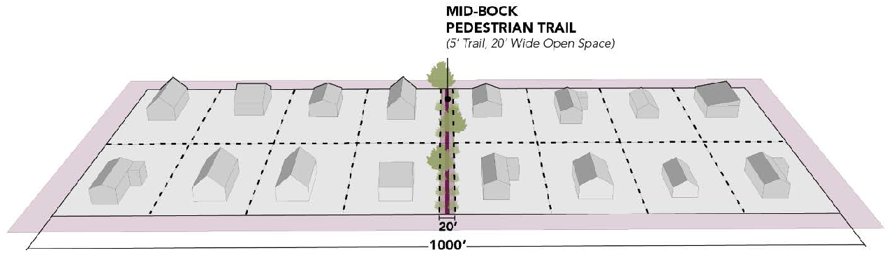
I.
Commercial and Industrial Block Size. Blocks in commercial and industrial subdivisions shall be designed with the purpose of the lot specifically in mind and with adequate space set aside for off-street parking and loading purposes as required by this Code.
(Ord. No. 1331, Exh. A, 3-11-2025)
4.03 - Street design standards.
4.03.1 Standards.
A.
Street Layout and Classification. All new streets shall conform to the layout and classifications identified in the City of Cortez Master Street Plan. Where the layout of streets is not shown in the Cortez Master Street Plan, the arrangement of streets in a subdivision shall either:
1.
Provide for the continuation or appropriate projection to existing streets in surrounding areas by way of right-of-way acquisition by the developer; or
2.
Conform to an approved planned unit development.
B.
Street Design and Construction. Design, construction, and maintenance of all streets shall conform with the City of Cortez Construction Design Standards and Specifications and Table 4.1 of this chapter.
1.
Any parallel parking space within the right-of-way shall be a minimum of nine (9) feet wide by twenty-two (22) feet in length.
2.
All bike lanes provided at the option of the applicant shall be a minimum of six (6) feet wide. The right-of-way shall be adjusted to accommodate the width of the bike lanes in addition to the required dimensional elements of Table 4.1.
a.
The city prefers the installation of buffered or protected bike lanes (cycle tracks), as defined by the latest NACTO Urban Bikeway Design Guide. While bicycle facilities are not mandatory, applicants are strongly encouraged to prioritize buffered or protected bicycle lanes whenever conditions allow to enhance safety for all roadway users. This recommendation applies to local, collector, and arterial rights-of-way. When protected and buffered bike lanes are impractical, applicants should consider conventional, striped bike lanes as a viable alternative to maintain a safe and accessible bicycling environment.
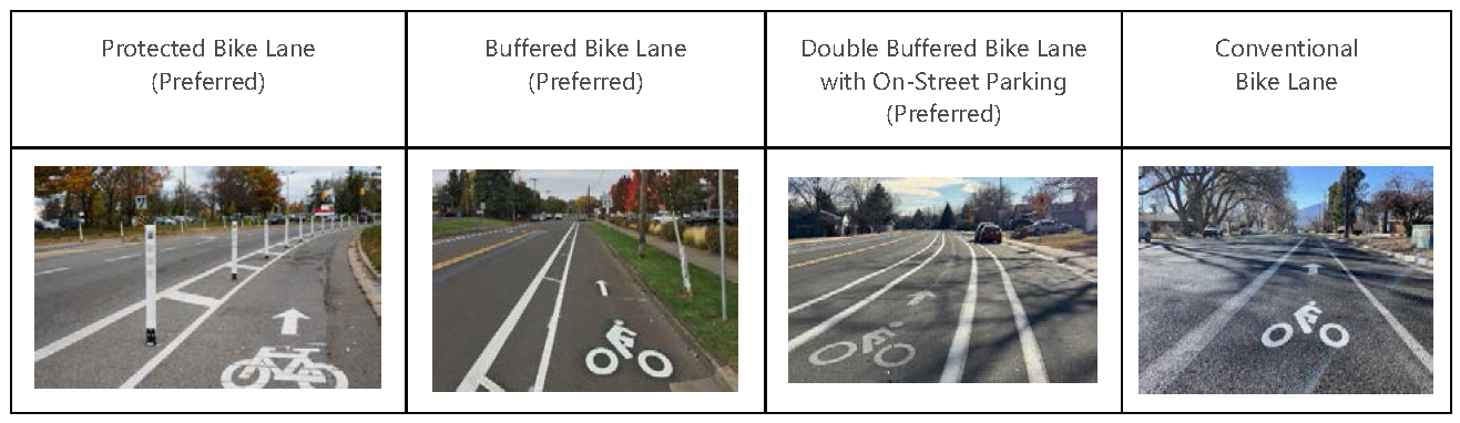
1.
Medians shall be designed and constructed per AASHTO Guidelines and the following standards:
a.
Planted medians shall contain drought tolerant or native plant material.
b.
All plant material, exclusive of trees, shall have a maximum height of thirty (30) inches above the finished grade of the street to preserve visibility.
c.
Trees planted in medians shall meet the streetscape landscape requirements per Section 5.06.3 of this Code.
d.
The right-of-way shall be adjusted to accommodate the width of the median in addition to the required dimensional elements of Table 4.1.
Table 4.1 Street Design Standards
Note: All highways shall follow CDOT standards for design and construction.
Figure 4.2 Alley Design Standard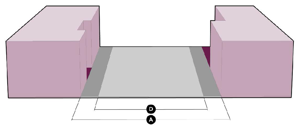
Figure 4.3 Private Road Design Standard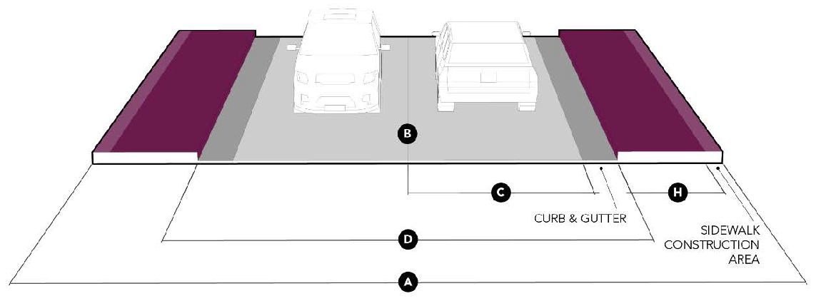
Figure 4.4 Local Road with Parking Design Standard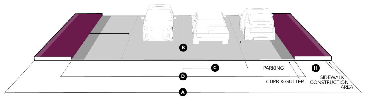
Figure 4.5 Local Road with Parking and Bike Lane Design Standard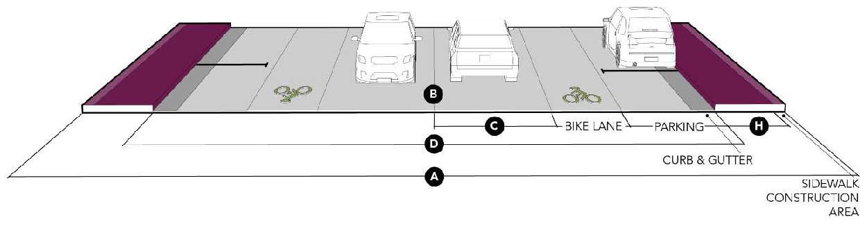
Figure 4.6 Collector Design Standard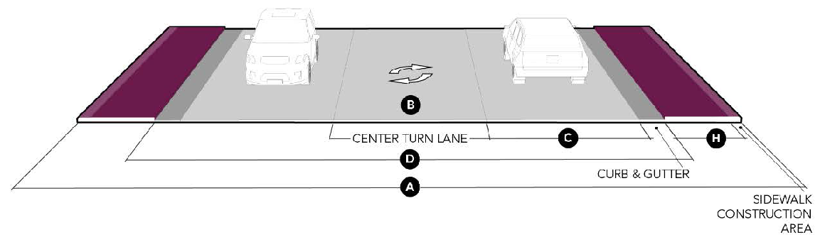
Figure 4.7 Collector Design Standard with Parking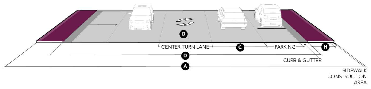
Figure 4.8 Arterial Design Standard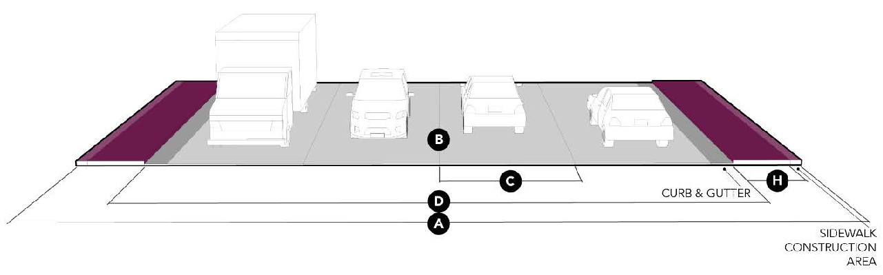
C.
Street Connections. The system of streets designated for the subdivision, except in unusual cases, must connect with streets already dedicated within adjacent subdivisions.
1.
Where no adjacent connections are platted, the new street must be the reasonable projection of streets in the nearest subdivided tracts and must be continued to the boundaries of the tract subdivided, so that other subdivisions may connect therewith.
2.
Reserve strips shall not be permitted in any subdivision unless such reserve strips are conveyed to the city in fee simple.
D.
Emergency Access. Any subdivision with more than twenty (20) residential units or sixty thousand (60,000) square feet of commercial development shall provide two (2) separate points of access to the public road network for emergency response.
1.
All subdivision gates shall include an emergency access mechanism or breakaway device and be set back from the intersecting street by a minimum of thirty (30) feet to allow emergency vehicles to pull off the intersecting road without impeding the flow of traffic.
E.
Residential Access. Residential access shall be from public local or private streets, or alleys. Access from collector or arterial streets may be granted by the public works director if it can be determined that public health and safety will not be impeded.
F.
Nonresidential Access. Nonresidential access shall be from public arterial, collector, or local streets.
G.
Dimensions. All access shall adhere to the dimensional standards of Section 5.03.
H.
Half Streets. Half streets shall be prohibited unless they are for the purpose of increasing the width of an inadequate existing right-of-way.
I.
Street Intersections. More than two (2) streets intersecting at a point shall be avoided, except where it is impractical to secure a proper street system otherwise.
J.
Street Intersection Angle. All streets shall intersect at an angle as close to ninety (90) degrees as possible and in no case shall the intersection angle be less than sixty (60) degrees.
K.
Street Jogs. Steets shall have a minimum centerline offset one hundred twenty-five (125) feet.
L.
Cul-de-Sacs. Cul-de-sacs shall be discouraged, as they do not result in a continuation of or conformance to existing streets or streets pattern. However, where used, cul-de-sacs shall not exceed four hundred (400) feet in length and shall have a turnaround with diameter of one hundred (100) feet.
1.
A cul-de-sac of less than two hundred (200) feet in length in a single-family residential area does not require a radial turnaround if the city engineer determines that an equally safe and convenient form of turning space is adequate for the vehicles expected to use the cul-de-sac.
M.
Dead-End Streets. Dead-end streets, except for cul-de-sacs, shall be prohibited unless they are designed to connect with future streets on adjacent unplatted property. In cases where a dead-end street is provided, a temporary turnaround shall be constructed per fire code.
N.
Half Streets. Half streets shall be prohibited unless they are for the purpose of increasing the width of an inadequate existing right-of-way.
O.
Construction and Dedication of Public Streets. All public streets shall be constructed by the applicant and dedicated to the city per subdivision improvement agreement, see Section 4.08, along with all necessary right-of-way, with no pro-rata share from the city.
P.
Construction and Dedication of Private Streets. All private streets shall be constructed by the applicant and located in a tract or lot. Maintenance of the road shall be per HOA or other organized mechanism of the properties accessed from the private street.
1.
At or near the entrance of a private street, there shall be erected and maintained by the applicant, a sign having the dimensions of at least fifteen (15) inches by twenty-one (21) inches upon which is printed and clearly legible in at least two-inch letters the name of the private street and the words "PRIVATE STREET," and in at least one-inch letters the words, "NOT DEDICATED FOR PUBLIC USE OR MAINTAINED BY THE CITY OF CORTEZ."
2.
If the property owners accessing the private street desire to dedicate the street to the city for public use, application shall be made to the city upon acquisition of petition of a minimum of fifty-one percent (51%) of the property owners with frontage along the private street. The city engineer and public works director shall inspect the street prior to making a determination of dedication.
3.
If the dedication is approved by the city, all required repairs shall be completed by the applicant prior to dedication.
Q.
Ingress and Egress. Turn lanes may be required at the intersection of collector streets if traffic conditions indicate they are needed. Sufficient right-of-way shall be dedicated to accommodate such lanes when they are required.
4.03.2 Street Names and Numbers.
A.
All street names shall be as established subject to approval of the planning commission.
B.
When streets are in alignment with existing streets, any new streets shall be named according to the streets with which they correspond.
C.
Streets that do not fit into an established street-naming pattern shall be named in a manner that will not duplicate or be confused with existing streets within the city or its environs.
D.
Street numbers shall be assigned by the addressing official in accordance with the Uniform Housing Numbering System, as outlined in Chapter 6, Buildings and Uniform Codes, of the Cortez City Code.
(Ord. No. 1331, Exh. A, 3-11-2025)
4.04 - Easement standards.
A.
Utility Easements Required. Utility easements shall be provided on all development proposals per the following:
1.
General utility easements ten (10) feet in width shall be provided on each side of all rear lot lines; and
2.
General utility easements five (5) feet in width shall be provided on each side of lot lines. Easement may accommodate drainage as needed to ensure stormwater runoff is contained on the subject site.
3.
Where the rear or side lot lines abut property outside of the subdivision on which there are no easements, the easements on the rear lot line shall be twenty (20) feet and side lot lines shall be ten (10) feet in width.
4.
Water and sewer easements shall be a minimum of twenty (20) feet in width.
B.
Existing Easements. Existing easements shall be identified on the plat and coordinated with public works to determine the need for additional or expanded easements to meet the utility needs of the site.
C.
Fire Lanes and Emergency Access Easements. Fire lanes and emergency access easements shall be a minimum of twenty-six (26) feet in width per the fire code authority.
D.
Irrigation Ditch Easements. When a proposed subdivision is traversed by an irrigation ditch or channel, an access easement with minimum width of twenty (20) feet shall be provided along a minimum of one (1) side of the ditch or channel as measured from the top of bank, unless otherwise required by the irrigation ditch company.
E.
Adjoining Areas. When easements in areas adjoining proposed subdivisions are necessary to provide adequate drainage thereof or to serve such subdivisions with utilities, the applicant shall obtain such easements.
(Ord. No. 1331, Exh. A, 3-11-2025)
4.05 - Public land dedication.
4.05.1 General Provisions.
A.
Purpose. To ensure that all new subdivisions designate sufficient land in appropriate areas for parks, open space, and schools to meet the demand and need of future residents. This land will be dedicated to the city, or at the option of the city, cash will be paid in lieu of dedication.
B.
Applicability. Every major subdivision shall include dedication of land or a fee in lieu for parks, recreation, and open space, and schools in an amount established by this section. Existing subdivisions and minor subdivisions shall be exempt from these requirements. Building permits shall not be issued for any dwelling units or a multi-family dwelling structure until required dedication fees have been paid.
4.05.2 Public Parks, Trails, and Open Space Dedication.
A.
Dedication Required. Dedication of land for public parks, trails, and open space shall be required in the amount of four percent (4%) of the gross acreage of the subdivision development property for use as open space buffers, public trails, sport fields, playgrounds, picnic areas, or passive recreation features, etc. At the option of the city, a cash fee in lieu of land dedication may be requested.
B.
Design Standards. All land dedicated to the city for public park, trails, or open space shall meet the following requirements:
1.
Land dedicated for use as a recreational park shall be no smaller than five (5) acres in size with access from a public or private street.
2.
Land dedicated for trails shall connect the proposed subdivision to the adjacent properties or regional trails.
3.
Land dedicated for open space shall serve a functional purpose such as stormwater management, wetland mitigation, buffering for waterways, wildlife connectivity, or other similar uses.
C.
Fee in Lieu of Dedication. A fee in lieu of the parks, trails, and open space dedication shall be paid by all subdivision developments that do not dedicate land in accordance with this section.
1.
The required fees shall be per the adopted city fee schedule based upon one or more studies commissioned and approved by the city council.
2.
Revenues from such fees shall be used only to acquire park or open space land or construct park, recreation, or open space related capital improvements that are necessary to serve the community.
4.05.3 School Dedications.
A.
Dedication of land to the school district shall be required in the amount of one percent (1%) of the gross acreage of the subdivision development property for property that is determined by the school district as usable for development of new school facilities. At the option of the city, a cash fee in lieu of land dedication may be requested.
1.
The required fee per dwelling unit shall be per the adopted city fee schedule as determined by one or more studies commissioned and approved by the school district.
2.
Revenue from such fees shall be held in trust and used exclusively by the school district to acquire real property for the construction of new school facilities, expansion of existing school facilities, or to reimburse the school district for sums expended to acquire such property.
B.
The following shall be exempt from school land dedication or fee in lieu:
1.
The construction of accessory dwelling units;
2.
Nonresidential buildings or structures;
3.
Multi-family units that are designed as rental product or for residential care such as group homes; or
4.
Residential development that is deed restricted for age restricted housing.
5.
There shall be a fifty percent (50%) reduction in land dedication or fee-in-lieu for deed restricted affordable and workforce housing as defined herein.
(Ord. No. 1331, Exh. A, 3-11-2025)
4.06 - Required improvements.
A.
It shall be the responsibility of the applicant to install the required improvements outlined below in accordance with plans, specifications, subdivision improvement agreement, and data approved by the city engineer and public works director.
1.
Lot Pins. Lot pins shall be installed at each corner of all lots as required by state law.
2.
Monuments. Monuments shall be placed at all block corners, angle points, points of curves in streets, and at intermediate points as required, and consist of material and at a depth as required by state law.
3.
Streets. The applicant is responsible for improving all streets by paving, installing curbs and gutters and sidewalks per this Code and the City of Cortez Construction Design Standards and Specifications. Before any improvement is installed a grading permit shall be issued and if improvements will disturb existing pavement in the public right-of-way, a permit shall be issued by the public works department.
4.
Utilities. The applicant shall pay for the design, installation, and construction of all the required electric, gas, water, and wastewater necessary to serve the development. All utilities shall be placed underground, except transformers, switching boxes, terminal boxes, and similar facilities.
5.
Water Supply. All municipal water service shall be subject to the requirements of the Cortez City Code. All potable water lines, fire hydrants and appurtenances shall be designed and constructed to meet the currently applicable requirements of the city and the Cortez Code Authority. Fire hydrants shall be provided to serve new subdivisions sufficient to maintain a Class 7 fire rating by the Insurance Service Office ("ISO").
6.
Sanitation. Sanitary sewer service and facilities shall be provided by and meet all requirements of the Cortez sanitation district.
7.
Drainage and Stormwater Management. The applicant shall ensure that all lots drain away from any proposed structures and that such drainage does not interfere with adjoining properties or other lots in the subdivision and does not impede functionality of city infrastructure.
a.
A drainage and erosion control study shall be prepared by a licensed professional and approved by the public works director.
b.
All provisions for drainage and flood control shall be established at a minimum to handle the anticipated one-hundred-year frequency storms.
c.
Drainage structures and ditches shall be of a size and nature sufficient to carry the calculated storm water from streets, roadways and open drainage areas at a peak discharge velocity that is no more than five (5) feet per second.
d.
A five-year frequency, twenty-four-hour duration storm event should infiltrate entirely into the property within seventy-two (72) hours.
e.
Culverts shall have concrete head walls and wing walls where conditions require.
f.
Standard drop inlet catch basins shall be constructed.
g.
Where tying into existing drainage channels, outfall protection shall be required. Released sediment load shall comply with standards published by the Colorado Department of Health and Environment (CDPHE).
h.
Detention areas. For control of on-site drainage that may impact downstream flows from storm run-off, the applicant may be required to construct detention areas if projected runoff amounts to more than 0.05 acre feet, as determined by the drainage and erosion control study in order to meet the specifications of this section.
i.
All areas disturbed by construction shall be permanently stabilized with plant material or other erosion control method as specified by the drainage and erosion control study.
8.
Water Fire Suppression. For all new subdivisions, an adequate water supply for fire suppression services for new buildings shall be provided based on the standards in the adopted International Fire Code.
9.
Fire Hydrants. Fire hydrants shall be installed at locations and at an interval as required by the International Fire Code.
10.
Dedication of Land for Public Purposes. Land shall be dedicated by the applicant for parks, schools, open space and other public purposes in accordance with Section 4.06 of this chapter.
11.
Erosion Control. All areas disturbed during construction shall be treated to prevent erosion and sedimentation, whether by planting or other methods, according to an approved grading and erosion control plan as part of a required grading permit.
12.
Other Utilities. All other utilities (i.e. electrical, natural gas, cable television, broadband, etc.) as necessary shall be installed underground to service the development.
B.
Prior to acceptance of streets, drainage facilities, and water and sewer mains, the city shall cause the installations to be inspected for compliance with the approved plat and any design drawings. The city shall notify the applicant in writing of any changes or improvements required for such compliance.
1.
If it is determined that the required improvements are not constructed in compliance with specifications, a list of specific deficiencies shall be provided to the applicant. The required changes and improvements shall be completed within sixty (60) days of notification, subject to weather conditions.
2.
If it is determined that the applicant will not construct any or a portion of the required improvements or remedy the deficiencies in accordance with the construction plans, city council may withdraw and employ from the construction security such funds as may be necessary to construct the public improvements or remedy deficiencies.
C.
Inspection of underground installations shall be made by the city, or appropriate agency, prior to any backfilling.
D.
The required time for the completion of all required improvements shall be two (2) years from the recording date of the final plat.
1.
City council may grant a maximum of two (2) one-year extensions provided the applicant is pursuing completion of improvements in good faith.
2.
When such improvements are not completed within the required time, the city may use the collateral to complete the required improvements, withhold building permits, or revoke approval of the final plat.
E.
Warranty. All workmanship and materials for all required improvements shall be warranted by the applicant for a period of two (2) years from the date of the city's acceptance of the required public improvements.
1.
The applicant shall post a warranty security in an amount established by the city, at its sole discretion. The warranty security shall be for one hundred twenty-five (125) percent of the estimated cost of replacement. The city shall not release the warranty security until the expiration of the warranty period.
2.
If any other provision of this Code or specifications adopted pursuant thereto, or the Development Improvement Agreement (DIA) requires a warranty of workmanship or materials for a different period of time or for a greater amount of construction security, that provision shall apply.
3.
The inspection or acceptance of any required improvement by the city shall not relieve the applicant of their warranty of workmanship and materials.
(Ord. No. 1331, Exh. A, 3-11-2025)
4.07 - Development improvement agreements.
A.
The city shall require an applicant to execute a DIA for all required improvements to be constructed by this Code and other applicable regulations of the city.
B.
DIA shall be in a format specified by the city per Appendix B, or as amended.
C.
No subdivision plat shall be signed by the city or recorded, and no building permit shall be issued for development, until a DIA has been executed and construction security has been posted.
D.
The DIA shall include:
1.
A list of all agreed-upon required improvements;
2.
An estimate of the cost of such improvements;
3.
The form of construction security for the improvements; and
4.
Any other provisions or conditions deemed necessary by the city to ensure that all required improvements will be completed in a timely, cost-effective manner that meets the city's engineering standards.
E.
The DIA shall run with and be a burden upon the land described in the agreement.
F.
The city, at its discretion, may require the applicant to execute other agreements or contracts setting forth the plan, method, and parties responsible for the construction of any required improvements shown in the approved documents.
(Ord. No. 1331, Exh. A, 3-11-2025)
4.08 - Improvement guarantee standards.
A.
The applicant shall not install any required improvements or begin any construction prior to approval of a final plat.
B.
No building permits shall be issued for building sites within a plat until all required fees have been paid and all required improvements have been installed as specified by the city, or alternatively until acceptable assurances guaranteeing the completion of all required public improvements have been placed on file with the city.
C.
Guarantee to install improvements. The applicant shall furnish a letter of credit, subdivision bond, or evidence of cash held in escrow by the city for one hundred twenty-five percent (125%) of all required improvements required along with the final plat for final signature prior to recordation.
1.
Amount of Surety. The amount of the guarantee for required improvements shall be based on a cost estimate prepared by a registered professional engineer and approved by the city engineer.
D.
Improvement Installation Timeframe. All required improvements shall be installed and accepted by the city prior to the issuance of any certificate of occupancy or release of held funds.
E.
Security Release. When the required improvements on a plat are completed, the applicant may apply in writing for a partial or full release of the security.
1.
Upon receipt of such application, the city shall inspect the completed improvements to ensure that they have been made in accordance with the plat, design drawings, and the requirements of these regulations. If satisfactory, the security in sufficient amount to cover the cost of the improvements will be released.
2.
When all the improvements have been completed, the full security shall be released. If, however, the improvements are not properly installed, the city at its discretion shall have the power to use any of the security held to install the required improvements.
(Ord. No. 1331, Exh. A, 3-11-2025)
4.09 - Public and private partnership agreements.
A.
General. This section provides a means of public and private partnerships to develop and maintain desired features within the public right-of-way that go beyond what the city would normally maintain such as:
1.
Specialty landscape elements such as water features, specialty subdivision or neighborhood signage, art installations, or similar;
2.
Special pedestrian lighting; and
3.
Special or unusual structures used to distinguish entryways and landmarks in specific developments.
B.
Procedure. A development improvement agreement shall be established and finalized with the final plat application to define maintenance responsibilities between the city and the applicant or subsequent development entity managed through a homeowner's association or similar structure.
1.
Assessment of the maintenance cost, which is the difference between the base cost and any additional cost, shall be based on the following:
a.
For landscaping, a cost estimate shall be provided by the applicant and approved by the director of parks and recreation.
b.
For pedestrian lighting the costs shall be based upon the costs associated with repair and replacement of standard city pole and bulb elements and shall include staff time involved in the execution of the activity.
(Ord. No. 1331, Exh. A, 3-11-2025)
5.01 - General provisions.
5.01.1 Table of Contents.
A.
5.01 General Provisions.
B.
5.02 Parking Standards.
C.
5.03 Driveways and Access.
D.
5.04 Sidewalk Standards.
E.
5.05 Fences and Walls.
F.
5.06 Landscaping and Screening.
G.
5.07 Landscape Plan Requirements.
H.
5.08 Natural Resource Protections.
I.
5.09 Exterior Lighting.
J.
5.10 Signs.
K.
5.11 Nuisance Standards.
L.
5.12 Development Reports.
5.01.2 Scope and Applicability.
A.
This chapter applies to all new development, redevelopment or property, and new use of any property within the city limits.
B.
The planning and zoning commission and the city council shall have the authority to recommend (planning and zoning commission, if acting as a recommending body) or approve (city council, and planning and zoning commission if planning and zoning commission is acting as an approval body) less restrictive minor deviations or exceptions to the strict application of the provisions of the site development standards in this chapter in circumstances in which the planning and zoning commission or the city council determine involve unique characteristics of a particular property, of a particular proposed use, inconsistency with surrounding property, or other circumstances that make the strict application of the provisions of this Land Use Code inequitable, physically impractical or contrary to the public good. An applicant/owner that requests a less restrictive minor deviation or exception must provide objective reasons for the need for such deviation or exception.
(Ord. No. 1331, Exh. A, 3-11-2025)
5.02 - Parking and loading.
5.02.1 Purpose.
A.
The purpose of this section is to require off-street parking and loading facilities in proportion to the parking demand for each use to ensure functionally adequate, aesthetically pleasing, and secure off-street parking. The regulations and design standards of this section are intended to accomplish the following:
1.
To establish minimum requirements for the off-street parking of motor vehicles in accordance with the use established on the property;
2.
To relieve congestion on streets, and to provide more fully for movement of traffic, maneuvering of emergency vehicles or street maintenance equipment;
3.
To protect neighborhoods from vehicular traffic congestion generated by the adjacent nonresidential uses of land; and
4.
To promote the general welfare and convenience of residential, commercial and manufacturing developments which depend upon the availability of off-street parking facilities.
5.02.2 Applicability.
A.
All new development, redevelopment of a property, and any development requiring site plan review shall be subject to the provisions of this section.
B.
Legally nonconforming development, as defined by Chapter 1, shall not reduce parking below the minimum required by this section unless determined feasible by an alternative parking plan per Section 5.02.4.A.
5.02.3 Computing Parking.
A.
Minimum Required Parking. The minimum number of parking spaces required for a specific development proposal shall be based on the requirements listed in Section 5.02.3.B, and the following provisions.
1.
Permitted uses in the central business district (CBD) are not required to provide off-street parking.
2.
Where questions arise concerning the minimum off-street parking and requirements for any use not specifically listed, the requirements may be interpreted as those of a similar use.
3.
In computing the parking requirements for any building or development, the total parking requirements shall be the sum of the specific parking space requirements for each class of use included in the building or development. Parking requirements shall be calculated based on the usable floor area, as defined in Chapter 2, Section 2.03.
4.
Fractions. When measurements determining the number of required parking spaces result in fractions, any fraction less than one-half (½) shall be disregarded and any fraction of one-half (½) or more shall be rounded upward to the next highest full number.
5.
The number of parking spaces may be reduced when the land use of a building is reduced to a use for which fewer parking spaces are required.
6.
When a building is expanded, or a land use is changed to increase the number of parking spaces required, the number of such spaces shall be increased to the extent practicable.
7.
Residential uses. Required parking for single-family and accessory dwelling uses may be located in garages, carports, and/or in a tandem configuration on the subject property.
B.
Off-Street Parking and Loading Requirements. Off-street parking spaces shall be provided in accordance with the following minimum requirements.
Table 5.1 Off-Street Parking Requirements
5.02.4 Adjustments to Parking Requirements.
A.
Alternative Parking Plan. Applicants requesting reduced or alternative parking must submit an alternative parking plan. The alternative parking plan shall be included with the submitted site plan application and include the following:
1.
Evidence of similar uses in similar contexts or other industry standard indicating a lesser number will equally or better meet the intent of this chapter due any of the following:
a.
The proposed use can assure that fewer patrons will accessing the building than what would be accommodated by the general parking requirements in Table 5.1 for the type of use;
b.
The likelihood that patrons or tenants have reduced car ownership or drive less;
c.
The availability and practicality of walking, bicycling or transit access supporting the use; or
d.
Other transportation demand management plans proposed by the applicant.
B.
Shared Parking.
1.
Shared Parking. Shared use of required nonresidential parking spaces may occur where two or more uses on the same or separate sites are able to share the same parking spaces because their parking demands occur at different times. Shared use of required nonresidential parking spaces is allowed if the following documentation is submitted in writing with the plan application:
a.
Names and addresses of the property owners that are engaging in a shared parking agreement.
b.
A study performed demonstrating a breakdown of uses, comparing the peak times of weekday night, day, evening, and weekend day and evening hours.
c.
A map of shared parking areas along with number of parking spaces to be shared.
d.
A legal instrument such as an easement or deed restriction that guarantees access to the parking for both uses.
5.02.5 Parking Location and Design Standards.
A.
Off-Site Parking Location. Required off-street parking shall be provided on the same lot as the principal use. All or a portion of the required parking spaces may be located on a separate lot from the principal use per the following.
1.
Parking may be located off-site within three hundred (300) feet of the lot containing the principal use.
B.
Access Required. All required off-street parking shall be provided with driveway access to a public street or alley. Access shall meet all requirements of Section 5.03.
C.
Dimensional Standards. Each off-street parking space shall meet the requirements of Table 5.2 below.
Table 5.2 Parking Lot Dimensional Standards
Figure 5.1 Parking Lot Layout Standards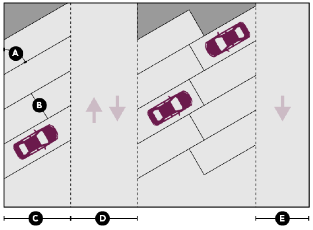
1.
Off-street parking areas shall be constructed and maintained in conformance with the City of Cortez Construction Design Standards per the following standards:
a.
Required surface materials parking lots are those that are resistant to deterioration from weather and/or traffic and shall include, but are not limited to: concrete, asphalt, sealed pavers or bricks, pervious pavers or bricks, or any other material that would have similar characteristics and uses. Industrial uses requiring four (4) or fewer spaces with no public access are exempt from this requirement.
b.
Prohibited materials for parking lots are those that deteriorate from weather and/or traffic and shall include, but are not limited to: gravel, compacted road base, volcanic cinders, clinker rock, or any other material that would have similar characteristics. Industrial uses requiring four (4) or fewer spaces with no public access are exempt from this requirement.
c.
All unpaved parking lots shall be upgraded to these standards when a site plan review is required (6.03.16 Site Plans). Industrial uses requiring four (4) or fewer spaces with no public access are exempt from this requirement.
d.
All parking lots shall meet the drainage provisions of this Code, ensuring that all stormwater is either captured in detention ponds or low impact development features such as bioswales to protect water quality and reduce ponding within the parking lot.
2.
Off-street parking areas serving commercial or industrial uses shall be landscaped and screened in accordance with requirements of Section 5.05 of this chapter.
D.
Restricted Use of Required Parking Areas for Commercial Uses Only. No automobile trailers, boats, detached campers, junk vehicles or any other object that will render the parking space unusable according to the purpose of this section shall be parked or stored in off-street parking areas. Junk vehicles shall be defined as those that either:
1.
Lack a current license or inspection sticker; or
2.
Are wrecked and/or dismantled.
5.02.6 Off-Street Loading Requirements.
A.
Design of Loading Areas. All loading areas shall comply with the following design requirements.
1.
Location. No loading area shall be located within the right-of-way of a public street. Any loading dock or door shall be set back far enough from the right-of-way so that no portion of the right-of-way is occupied by trucks or other vehicles while loading or unloading. The location of the loading area shall not interfere with the free circulation of vehicles in the off-street parking area. No loading space shall be located to block access by emergency vehicles.
2.
Paving Standards. The surface of all loading areas shall conform to the requirements for off-street parking areas.
(Ord. No. 1331, Exh. A, 3-11-2025; Ord. No. 1349, Exh. A, 11-25-2025)
5.03 - Driveways and access.
A.
All streets and access shall be designed per Section 4.03 of this Code.
B.
Minimum Driveway Width. Driveways shall be a minimum of ten (10) feet in width for single family lots, fourteen (14) feet for multi-family lots, and twenty (20) feet for commercial and industrial lots and a maximum of thirty (30) feet for residential uses and forty (40) feet for commercial and industrial uses, or as otherwise required by the Cortez Fire Code.
C.
Driveways shall provide stacking of vehicles entering or exiting the lot as adequate to the use or as required by CDOT or the city.
D.
Driveway and Access Design. The surface of each primary driveway and access shall conform to the requirements for off-street parking areas.
1.
Driveway from a concrete or asphalt surface onto a gravel surface shall include a concrete apron for the first twenty (20) feet of the driveway.
2.
Structures with a nonconforming driveway surface shall be required to comply with these standards upon alteration, reconstruction or change in use resulting in required Site Plan Review.
E.
Driveways on collector and arterial streets shall be spaced per the minimum safe stopping sight distance for the speed limit on the road, as described in the City of Cortez Construction Design Standards and Specifications.
1.
Driveways that are combined to meet this provision shall include a hammer head or equivalent turn around as applicable.
F.
Driveways on collector and arterial streets shall be located no closer than fifty (50) feet from the nearest street intersection.
G.
Vision Clearance. A vision clearance triangle shall be preserved at the intersection of all streets, alleys, and driveways to preserve line of sight across the corner meeting the following:
1.
Street vision clearance shall be formed by measuring from the point of intersection twenty-five (25) feet along the property lines immediately adjacent to the street and connecting the points to create a triangle.
2.
Alley and driveway vision clearance shall be formed by measuring from the point of intersection fifteen (15) feet along the property lines immediately adjacent to the street and connecting the points to create a triangle.
3.
Any wall, hedge, shrub, tree, sign, or decoration placed within the vision clearance triangle shall be thirty-six (36) inches in height or less.
Figure 5.2 Vision Clearance Standards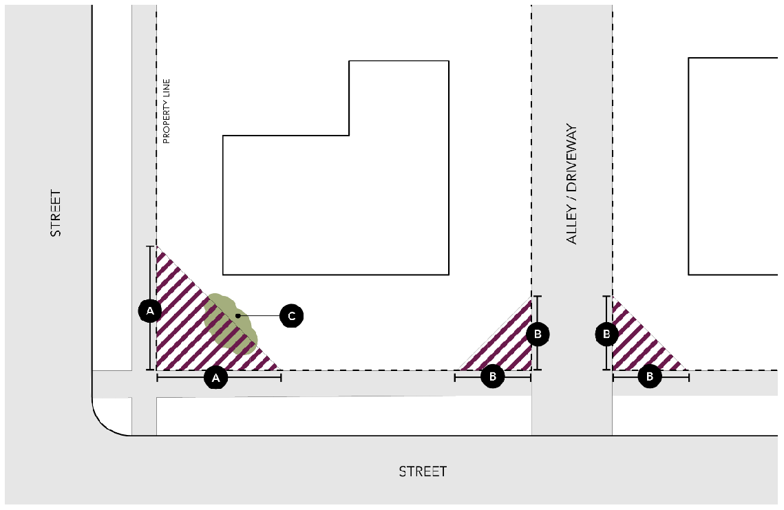
(Ord. No. 1331, Exh. A, 3-11-2025)
5.04 - Sidewalks.
5.04.1 General Provisions.
A.
Purpose. This section is intended to ensure pedestrian access is available to serve uses that need and benefit from such access.
B.
Applicability.
1.
Sidewalks, curbs, and gutters shall be installed along public streets for all new development, infill development, or redevelopment.
2.
If development occurs along an existing street without curb and gutter, the new development shall be responsible for construction of the sidewalk, curb, and gutter with the following exceptions:
a.
Curb, gutter, and sidewalk are not required for improvements of an individual single-family lot that is more than five hundred (500) feet from existing curb, gutter, and sidewalk improvements and not being further subdivided. There is no size limitation for this provision, however, if the lot were to be subdivided, the curb and gutter requirements would apply.
3.
No certificate of occupancy shall be issued until the requirements of this section are met.
5.04.2 Design and Construction Standards.
A.
Sidewalks, curbs, and gutters shall be installed in accordance with the City of Cortez Construction Design Standards.
B.
Sidewalks shall be meet the following minimum width standards:
1.
Nine (9) feet in width in the Central Business District (CBD) with a minimum clear zone of five (5) feet maintained at all times; and
2.
Five (5) feet in width in all other districts.
C.
Infill or redevelopment projects shall design and construct new sidewalks in conformance with the existing sidewalks adjacent to the development site regardless of whether they conform with the standards in this section.
D.
Infill or redevelopment projects that affect the entire block face (corner to corner of a street) shall replace the existing sidewalk with a new sidewalk in conformance with this section.
(Ord. No. 1331, Exh. A, 3-11-2025)
5.05 - Fences and walls.
5.05.1 General Provisions.
A.
Purpose. The purpose of this section is to ensure that all fences and walls meet the city's height and design standards to protect the health and safety of the residents.
B.
Applicability. The provisions of this section apply to all new, infill, and redevelopment subject to site plan review.
C.
Fence Permit. Fences and walls may be permitted in the yards of any zone district. A fence permit must be obtained from the building official prior to constructing any fence or wall. The following information shall be provided with the fence permit:
1.
Description of the type and manner of proposed fence or wall construction;
2.
A site plan of the lot showing property lines, building structures, streets and alleys, and the proposed fence or wall location; and
3.
Proposed height of the fence or wall.
5.05.2 Design and Construction Standards.
A.
Maximum fence and wall heights for any combination of fence materials within the city are as shown in the following table:
Table 5.3 Maximum Fence or Wall Height
Figure 5.3 Residential Fence Height Standards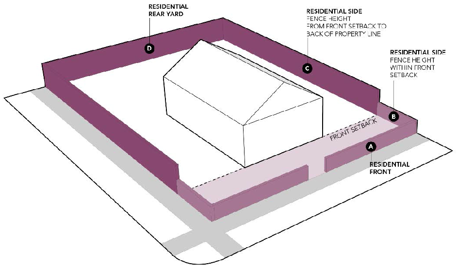
B.
Fence or Wall Heights Exceptions. Public utilities may exceed the specified height limit when required by industry codes. The building official shall be presented with copies of such codes prior to the approval of a fence permit.
C.
Property Line Determination. It shall be the responsibility of the property owner to locate all property lines. No fence may extend beyond or across a property line except with the written approval of the affected property owner.
D.
Fences within the vision clearance triangle described in Section 5.03.G shall be no taller than three (3) feet in height and constructed of materials that are at least ninety percent (90%) open and do not obstruct the line of sight from a vehicle stopped at the intersection.
E.
Prohibited Fences. Sharp-pointed fixtures, barbed wire or electrically-charged fences shall not be permitted anywhere in the City; provided, however, that:
1.
Public utilities shall be exempt from this provision when such fence features are required by industry standards.
2.
Facilities in the I, industrial district shall be exempt from the requirements of this subsection.
3.
Jails, correctional facilities, law enforcement facilities, and other governmental facilities where security fencing is utilized shall be exempt from the requirements of this subsection.
F.
Construction Within Rights-of-Way.
1.
Any person constructing a fence or wall on the city's public right-of-way may be required to relocate that fence or wall in the future if a need arises for the public use of that right-of-way. Fences and walls may not be built upon Colorado State Highway rights-of way.
G.
Location Standards.
1.
Fences and walls must be placed within, or on, the property line or the subject property.
H.
Construction Methods. All fence and wall construction methods must be approved by the fence permit. When available, fences will be built according to manufacturer's recommendation.
1.
For wood, chain-link, and other similarly constructed fences the maximum post spacing shall be ten (10) feet. The minimum depth of posts into the ground shall be eighteen (18) inches.
2.
For block fences or walls, column supports shall be a maximum of twelve (12) feet apart. The foundation requirements are piers the same dimensions, or larger, than the blocks under each column and extending at least thirty-two (32) inches below grade. A continuous footer, a minimum of six (6) inches deep by twelve (12) inches wide, with reinforcing bar shall be constructed between the piers and tied into the piers by reinforcing steel.
3.
No fence shall be constructed in such a manner or be of such design, as to be hazardous or dangerous to persons or animals.
4.
Retaining walls four (4) feet or higher are required to be designed and stamped by a licensed professional engineer.
(Ord. No. 1331, Exh. A, 3-11-2025)
5.06 - Landscaping and screening.
5.06.1 General Provisions.
A.
Purpose. This section is designed to provide standards for the installation and maintenance of landscaping and screening to promote the general welfare of the community. This is accomplished by establishing a long-term, well-planned program to deter erosion, improve soil health, reduce stormwater runoff, reduce heat island effect, promote water efficiency, mitigate visual conflict between different use types, and establish an attractive and healthy environmental setting within the community.
B.
Applicability. This section shall apply to all new streetscapes, parking lots, and multi-family, commercial, and industrial development and redevelopment within the city limit.
C.
Authority. The city parks and recreation director or designee shall enforce the standards and specifications concerning the trimming, spraying, removal, planting, pruning and protection of plant material located in the public right-of-way or other public property as well as commercial and parking areas as provided herein. For the purposes of this section the term "director of parks and recreation" means the director or their duly appointed representative.
5.06.2 General Landscape Standards.
A.
All plant material must meet specifications of the American Association of Nurserymen (AAN) for No. 1 grade.
B.
All disturbed site areas shall be revegetated in conformance with requirements within this section.
C.
Landscapes shall adhere to the following standard xeriscape design principles to facilitate water conservation:
1.
Improve the soil with organic matter;
2.
Group plants with similar water needs together;
3.
Use appropriate turf varieties to minimize the use of high-water bluegrass; and
4.
Use bioswales, water quality ponds, and rain gardens to filter runoff from parking lots, streets, and other impervious surfaces.
D.
Plant material shall consist of native and regionally adapted species with selection based on suitability to conditions of the site such as existing plant palette, soil conditions, water requirements, and the surrounding environment. A recommended plant list is available from the city.
E.
The following noxious and invasive trees species are prohibited from being planted in the city. Existing trees are exempt.
1.
Russian olive.
2.
Siberian elm.
3.
Tree of Heaven.
4.
Ash, Fraxinus species.
F.
Tree species planted under or within ten (10) feet of overhead powerlines shall have a mature height of no more than twenty-five (25) feet.
G.
Trees shall be planted no closer than ten (10) feet to underground water and sewer lines and no closer than five (5) feet to electric and telecommunications lines.
H.
At least fifty (50) percent of each landscaped area shall be covered in living vegetation at plant maturity, which may include shrubs, ground covers, ornamental grasses, perennials, bulbs, wildflowers, native grasses, or other waterwise grass or turf-type grass. The remainder of the area shall be covered in wood or rock mulch material so that no soil remains bare.
1.
The tree canopy shall not be counted in the percentage calculation of vegetative cover.
2.
Specific landscape quantity requirements are provided in Sections 5.03.3 through 5.03.6 below based on the type of use.
3.
Additional screening provisions may be required per Section 5.03.7 as applicable.
I.
Tree Protection. It is declared unlawful for any person, not the owner hereof, or without lawful authority to do so, to injure, willfully deface, disfigure, or destroy any tree or shrub, or to injure, destroy, cut, or pick any vegetation located on any public property.
J.
All plants must be sized according to the following table:
Table 5.4 Minimum Plant Sizes
K.
Disease Control. Upon the discovery of any destructive or communicable disease that endangers the growth, health, life, or well-being of trees in the city, the city shall require the property owner to eradicate the disease or remove the diseased tree. If the property owner fails to comply within the timeframe specified, the enforcement and penalty provisions of Chapter 1 shall apply.
5.06.3 Streetscape Landscape Requirements.
A.
Applicability. Street trees are required to be planted along all new streets per this section.
B.
Spacing and Location. All new street trees shall be spaced thirty (30) to fifty (50) feet apart as appropriate for the species considering size of tree crown at maturity.
1.
Detached Sidewalks. Street trees shall be centered in the space between the sidewalk and street where the sidewalk is detached from the street.
2.
Attached Sidewalks. Street trees shall be located no closer than five (5) feet to and no further than ten (10) feet from the back of the sidewalk where the sidewalk is attached to the street.
3.
No street tree shall be planted within the vision clearance triangle as described in Section 5.03.G. No street tree shall be planted closer than ten (10) feet from any fire hydrant.
C.
Clearance over Streets and Sidewalks. All trees adjacent to a street or sidewalk shall be trimmed by the property owner to maintain a clear height of fourteen (14) feet above the surface of the street and eight (8) feet above the surface of sidewalks.
D.
Maintenance. All plant material adjacent to public sidewalks shall be maintained by the property owner so that no part of such plant material shall extend over any part of a public sidewalk of the city.
1.
Any plant material causing hindrance to the general public, or in any way endangering the security or usefulness of any public street, right-of-way, highway, alley, sewer, or sidewalk, shall be declared a public nuisance and shall be remedied by the property owner.
2.
If the property owner does not correct or remove such nuisance the enforcement and penalty provisions of Chapter 1 shall apply.
E.
Tree Species. A list of recommended tree species for a variety of settings and uses shall be obtainable from the city. No conifer trees shall be permitted to be planted between the sidewalk.
5.06.4 Commercial and Multi-Family Dwelling Landscape Requirements.
A.
Purpose. To ensure water conscious landscape improvements that are designed to enhance the overall appearance of the development and integrate the project with adjacent land uses and in the surrounding neighborhood.
B.
Applicability. All development of multi-family dwellings and commercial uses as listed in the use table in Section 3.06 shall meet the following standards. The central business district (CBD) is exempt from these regulations.
C.
General Design Standards.
1.
No more than thirty (30) percent of the total landscaped area shall be comprised of high-water use plant material, such as functional or irrigated turfgrass.
2.
Landscaping is required along all front building facades to include the following:
a.
A minimum of one (1) tree per every forty (40) linear feet of the front building facade.
b.
A minimum of one (1) shrub or ornamental grass per ten (10) linear feet of the front building facade.
Figure 5.4 Commercial and Multi-Family Dwelling Landscape Standards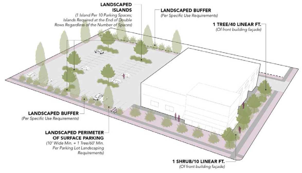
3.
Landscaping around the perimeter of the site shall be consistent with buffer types listed in Section 5.06.7.
4.
All parking areas shall be landscaped per Section 5.06.6.
5.06.5 Industrial Landscape Requirements.
A.
Purpose. To ensure landscape improvements are designed primarily at the public facing building entry to be consistent with commercial landscape standards.
B.
Applicability: All development of industrial uses as listed in the use table in Section 3.06 shall meet the following standards.
C.
General Design Standards.
1.
Landscape areas shall include no more than thirty (30) percent of the total landscaped area comprised of high-water use plant material such as irrigated turfgrass.
2.
The area between the primary building façade and the public right-of-way shall meet the commercial design standards detailed in Section 5.06.4.
3.
Landscaping around the perimeter of the site shall be consistent with buffer types listed in Section 5.06.7 regardless of whether a building is proposed for the site or not.
4.
No perimeter planting is required along property lines that border another industrial use.
5.
Parking lots shall be landscaped per Section 5.06.6 herein.
Figure 5.5 Industrial Landscape Standards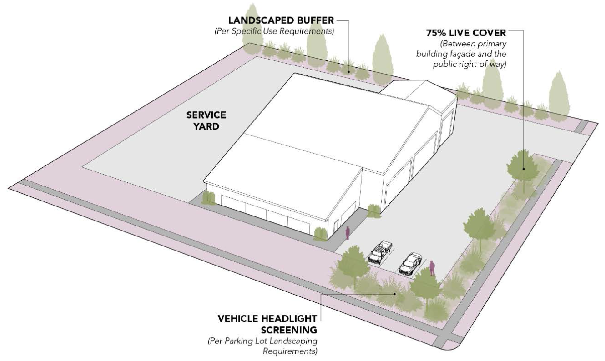
5.06.6 Parking Lot Landscaping Requirements.
A.
Purpose. Parking lot landscaping is intended to break up large expanses of pavement, create shade, buffer views of parking lots from adjacent streets and development, and enhance the overall appearance of the site.
B.
Applicability. All parking lots with ten (10) spaces or more shall be subject to the following requirements.
C.
General Design Standards.
1.
No more than thirty percent (30%) of the total landscaped area shall be comprised of high-water use plant material such as irrigated turfgrass.
2.
Provide a minimum of one landscape island per ten (10) parking spaces in a single row and twenty (20) spaces in a double row to meet the following:
a.
Islands shall have a minimum interior width of five (5) feet and be bound by a concrete curb;
b.
Concrete curb may have curb cuts at desired intervals to capture stormwater if low impact development approaches are being implemented on the site; and
c.
Each island shall contain one (1) shade tree and shrubs or groundcover sufficient to meet the fifty (50) percent live plant material coverage requirement of Section 5.06.2.
3.
Provide a minimum ten (10) foot wide landscape area at the perimeter of surface parking lots.
a.
Provide a minimum of one (1) tree per sixty (60) linear feet in front of surface parking where vehicle headlights face a ROW or neighboring properties.
b.
Provide shrubs or ornamental grasses with a minimum mature height of three (3) feet for a minimum of seventy-five (75) percent of the length of the parking lot perimeter.
Figure 5.6 Parking Lot Landscape Standards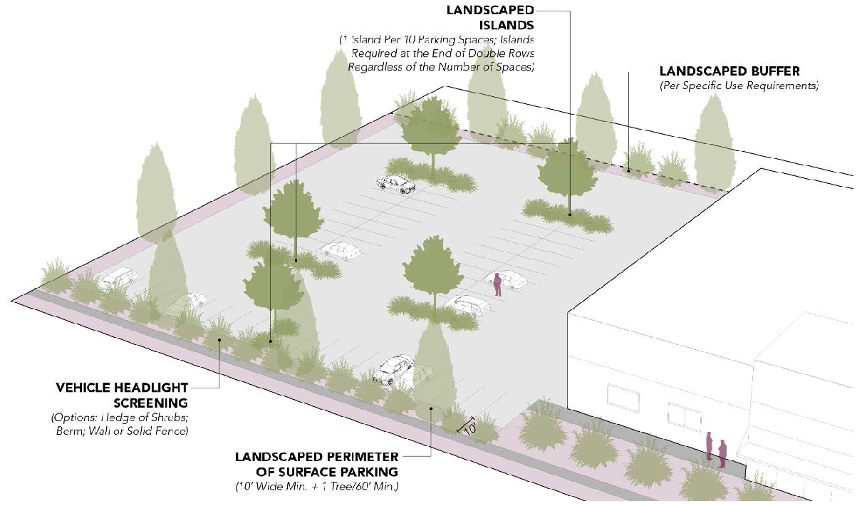
D.
Screening. Screen headlights from adjacent rights-of-way or residential properties with one of the following options:
1.
A hedge of shrubs and/or ornamental grasses with a minimum height of thirty (30) inches to screen seventy-five (75) percent of the parking lot perimeter;
2.
A berm with a minimum of thirty (30) inches height; or
3.
A wall or solid fence with a minimum height of three (3) feet paired with landscape material for at least fifty (50) percent of the length of the wall placed on the street or adjacent property side of the wall.
E.
Landscaping. Maintenance of all landscaping within and adjacent to parking lots shall be the responsibility of the property owner.
5.06.7 Screening and Buffering.
A.
Purpose. Screening and buffers are intended to minimize conflicts between potentially incompatible land uses and development on abutting property.
B.
Applicability. Buffers shall be installed between parcels of different use when a property with a more intense use is developed or redeveloped adjacent to a property with a less intense use as described in Sections 5.03.3 through 5.03.6 and per the table below:
Table 5.5 Buffer Requirements
C.
General Design Standards.
1.
All required buffers shall be located along the entire property line, excluding driveways, between the two (2) uses and entirely on the developing property's side of the required buffer.
2.
Parking of vehicles and placement of buildings or structures, except for walls, fences, and landscaping, shall not be allowed in the required buffer.
3.
No buffering is required where an adjacent structure is a certain distance away or there is a change in elevation of ten (10) feet or more.
D.
Screening. Under no circumstances shall a fence be the only screening material as a buffer between land uses.
E.
Buffer. Buffer type A shall be a minimum of ten (10) feet in width and consist of a mix of evergreen and deciduous trees, shrubs and ornamental grasses at the following rates per one hundred (100) linear feet of buffer or may be clustered if the total number of vegetation per linear foot is provided and the intent of buffering from the adjacent use is met:
1.
Three (3) trees with a minimum mature height of twenty (20) feet with at least twenty (20) percent being evergreen; and
2.
Ten (10) large shrubs or ornamental grasses with a minimum mature height of five (5) feet, up to thirty (30) percent shall be evergreen; and
3.
Ten (10) small shrubs or ornamental grasses with a minimum mature height of two (2) feet.
4.
If a six-foot high privacy fence or wall is installed, the shrub and ornamental grass requirement can be reduced by fifty (50) percent and shall be planted on the neighbor's side of the fence.
Figure 5.8 Buffer Type A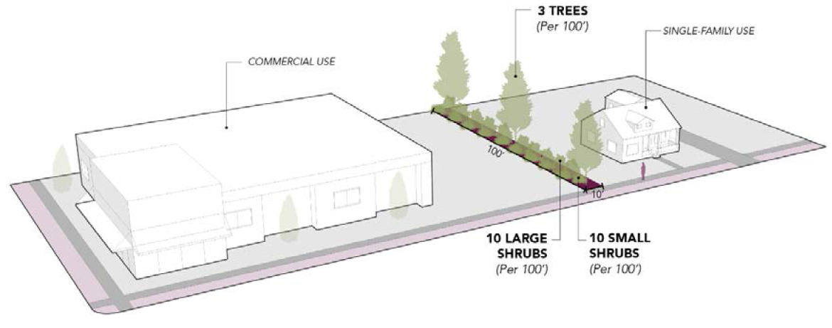
F.
Buffer type B shall be a minimum of fifteen (15) feet in width and consist of an eight (8) foot tall solid fence or wall and a mix of evergreen and deciduous trees, shrubs, and ornamental grasses on the neighbor's side of the fence at the following rates per one hundred (100) linear feet of buffer or may be clustered if the total number of vegetation per linear foot is provided and the intent of buffering from the adjacent use is met:
1.
Two (2) trees with a minimum mature height of twenty (20) feet; and
2.
Ten (10) large shrubs and ornamental grassed with a minimum mature height of five (5) feet; and
3.
Ten (10) small shrubs or ornamental grasses with a minimum mature height of two (2) feet.
Figure 5.9 Buffer Type B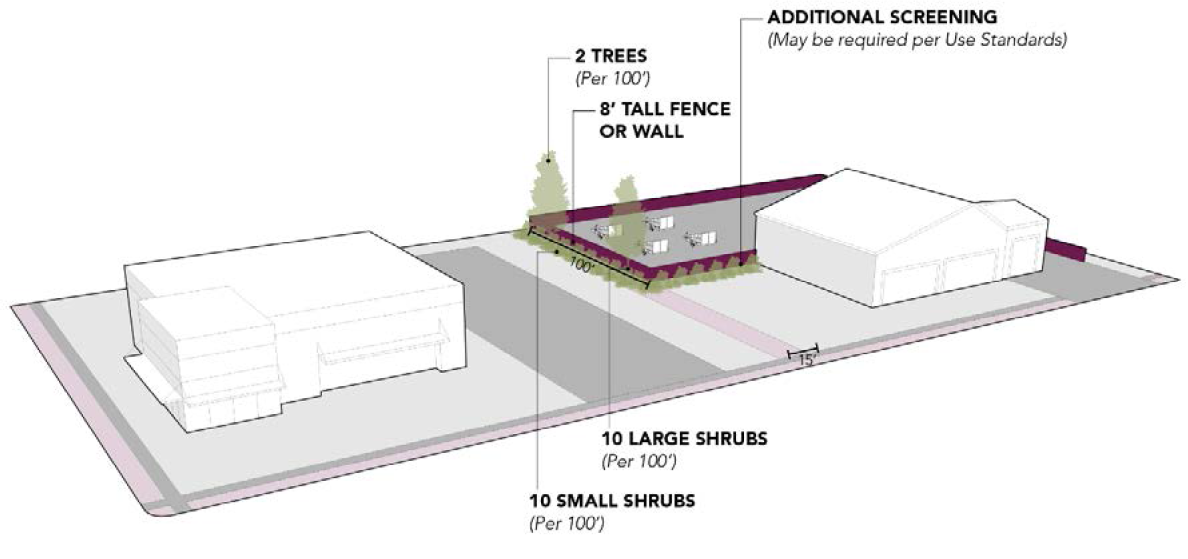
(Ord. No. 1331, Exh. A, 3-11-2025)
5.07 - Landscape plan requirements.
A.
Landscape plans pertaining to the standards of this section shall be submitted as part of the site plan review and contain the following at a minimum:
1.
Location of existing improvements (curbs, gutter, sidewalk, building, etc.), and existing vegetation including all trees with a diameter of one and one-half (1.5) inches or greater.
2.
Location of proposed structures, parking areas, circulation ways, pedestrian way, signs, and landscaping areas.
3.
A statement pertaining to percentages of lot coverage of building, parking areas and landscaping area.
4.
A statement pertaining to preservation and disposition of existing vegetation.
5.
Proposed landscaping showing the layout, location, size, species and spacing of trees and shrubs and the identification of the type of ground cover or ground treatment in all areas not covered by a building or pavement. Size, species, and spacing shall be by direct labeling or by a clearly understandable legend. A summary table with species, size, quantity, and total percentage of landscaped area at plant maturity, shall also be provided in addition to the landscape plan.
6.
When phasing of the project is proposed, a phasing program for the landscaping may also be proposed.
7.
A schematic drawing of any proposed irrigation system or note describing the proposed method of irrigation if system is to be design-build.
8.
Identification of the method of reclamation for repair of cut and fill areas and other landform disruptions caused by construction.
9.
Written statement of the provisions being made for the maintenance and replacement of landscaping to include mandatory replacement of any vegetation which dies within a one-year period from the time of planting.
(Ord. No. 1331, Exh. A, 3-11-2025)
5.08 - Natural resource protections
5.08.1 General Provisions.
A.
Purpose. The purpose of this section is to avoid developing in potentially hazardous areas and to minimize the impacts to natural resources and public health, safety and welfare.
B.
Applicability. This section shall apply to all new major and minor subdivisions.
5.08.2 Buffer Standards.
A.
Required Buffer Zones. Buffer zones shall be required per Table 5.5 for any property containing or directly adjacent to a lake, wetland, river, or stream. Required buffer zones shall be shown on all subdivision plats and site plans.
B.
Buffer Measurement Standards. Lake, stream, and river buffers shall be measured perpendicular to the feature from the ordinary high-water mark. Wetland buffers shall be measured from the edge of the delineated wetland boundary. The area of the property that falls within the buffer zone shall remain free of permanent structures, recreational amenities, infrastructure, and site disturbances such as grading, pavement, soil disturbance, and vegetation removal in association with development activities.
Table 5.5 Buffer Measurement Standards
Figure 5.10 Buffer Measurement Standards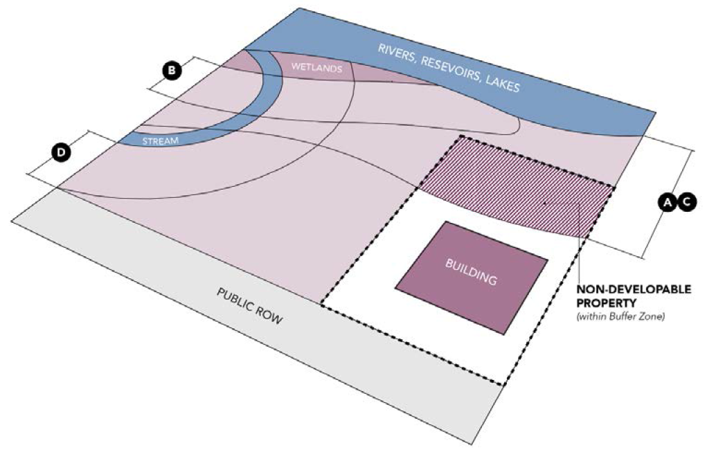
C.
Alternative Compliance. The minimum buffer may be reduced to no less than twenty (20) feet upon demonstration that site limitations constrain identifying an appropriate building site, and that the reduced buffer will not result in new or continuing water quality degradation, stream bank erosion, reduction in riparian or wetland habitat, degradation of aquatic habitat, destruction of floodplain functionality, or the endangerment of life or property due to fluvial hazards.
1.
Demonstration shall be provided in a site-specific analysis prepared by a professional qualified in the areas of ecology, wildlife biology, hydrology, or other relevant discipline.
D.
Development Prohibited Within the Buffer Zone. No disturbance shall occur within any buffer zone and no person shall engage in any activity that will disturb, remove, fill, dredge, clear, destroy, or alter any area, including vegetation within lakes, stream or river corridors, and wetlands.
E.
Restoration. If the development intentionally or inadvertently causes any disturbance within the buffer zone, the applicant shall undertake restoration and mitigation measures within the buffer zone to include regrading and replanting of native vegetation. Any such mitigation or restoration shall be at least equal in ecological value to that which was affected as determined by a professional qualified in ecology, vegetation, wildlife biology, or other relevant discipline.
F.
Exemptions. The zoning administrator may allow disturbance or construction activity within the buffer zone for the following limited purposes:
1.
Restoration of previously disturbed or degraded areas or planned enhancement projects to benefit the natural area or feature;
2.
Emergency public safety activities;
3.
Utility installations when such activities and installations cannot reasonably be located outside the buffer zone or other nearby areas of development;
4.
Construction of a trail or pedestrian walkway in accordance with a city-adopted trails master plan that will provide public access for educational or recreational purposes, provided that the trail or walkway is compatible with the ecological character of the natural habitat or feature, and that the proposed trail or pedestrian walkway does not erode the quality of the natural habitat; or
5.
Construction or installation of recreation features or public park elements, provided that such features or elements are compatible with the ecological character or wildlife use of the natural habitat or feature, and that the proposed trail or pedestrian walkway does not erode the quality of the natural habitat.
G.
Preservation of Native Vegetation. Development shall minimize disturbance of native vegetation. When native vegetation must be removed within habitat areas, it shall be revegetated with native species.
H.
Revegetation and Noxious Weed Control. Areas disturbed by grading shall be revegetated or landscaped, with vegetation established and growing within two (2) growing seasons of the date of project completion, using species with a diversity of native and/or desirable non-native vegetation capable of supporting the post-disturbance land use.
5.08.3 Wetland Standards.
A.
Wetland boundaries shall be established by a professional ecologist or wetland specialist using the National Wetland Inventory or other identified database or tool to indicate property within fifty (50) feet of a wetland.
1.
In establishing the boundaries of a wetland, the applicant shall use soil samples, vegetation analysis, and hydrological evidence to determine the presence and classification of a wetland as naturally occurring or artificial.
2.
Artificial wetlands shall be exempt from the buffer requirements of this Section.
B.
Definitions.
1.
Federally Designated Wetlands. Naturally occurring wetlands which are protected under the Federal Clean Water Act and shall comply with all U.S. Army Corps of Engineers development standards.
2.
Artificial wetlands that are the result of intentional water conveyance such as a man-made ditch, pond, or canal, where soil, vegetation, and hydrology are not characteristic of a naturally-occurring wetland.
C.
All wetlands shall adhere to the buffering standards in Table 5.5.
D.
Where development is projected to impact 0.1 acre or more of a federally designated wetland as defined herein, appropriate steps shall be taken to avoid or minimize impact with priority as set forth in subsection (E) below.
E.
Priority. Development impacts to wetlands shall be prioritized in the following order: avoid, minimize, and mitigate.
1.
Avoid. Development shall, to the greatest extent possible, avoid impacting federally designated and local wetlands.
2.
Minimize. If it is impossible for a development to avoid impacts to a wetland, the development shall, to the greatest extent possible, minimize its impact to the wetland.
(Ord. No. 1331, Exh. A, 3-11-2025)
5.09 - Exterior lighting.
5.09.1 General Provisions.
A.
Purpose. The intent of these standards is to promote safety and minimize the adverse offsite impacts of lighting including light trespass and glare on surrounding uses.
B.
Applicability. All site lighting for subdivisions and exterior lighting for new development or redevelopment of multi-family, commercial, or industrial uses shall comply with the standards of this section, unless exempted in Section 5.09.2 below.
5.09.2 Exemptions.
A.
This section does not apply to the following:
1.
Individual single-family residential properties;
2.
Lighting of signs;
3.
Temporary lighting of construction sites;
4.
Holiday lighting and other exposed bulb-type lighting, provided that individual lamps are less than seventy (70) lumens;
5.
Emergency lighting;
6.
Temporary lighting for theatrical, television, and performance areas, or for special events authorized by a temporary use permit; and
7.
Lighting regulated by the Federal Aviation Administration.
5.09.3 General Development Standards.
A.
The submission of an exterior lighting plan is required for any site plan review application. The plan shall include the following:
1.
Show the location of all exterior lighting; and
2.
Provide manufacturer's cut-sheets for all fixtures.
B.
All fixtures must be downward directed and fully shielded. Existing bulbs being replaced need to provide shielding to direct light downward and conceal the light source.
Figure 5.11 Downward Directed, Shielded Light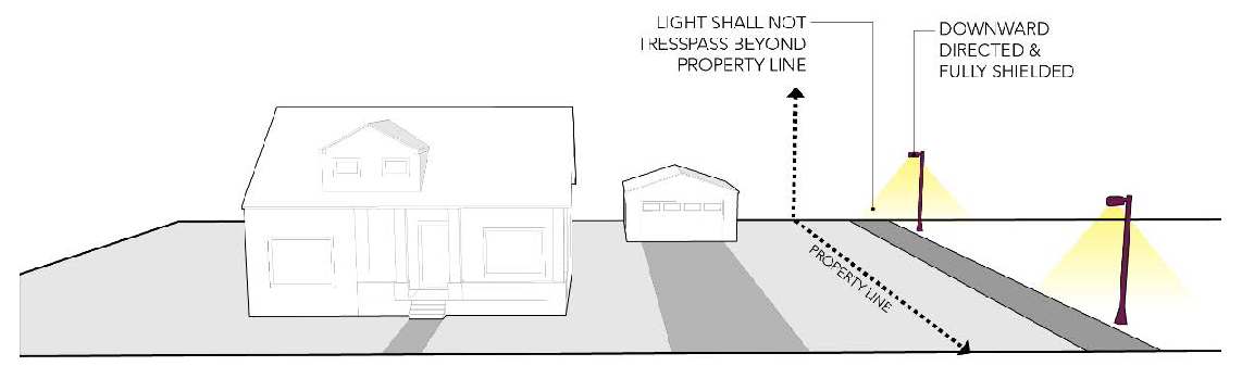
C.
Light shall not trespass beyond the property line.
D.
The color-temperature rating of fixture lamps shall not exceed three thousand (3,000) kelvin or equivalent.
E.
Light levels for each individual light shall not exceed ten thousand (10,000) lumens or equivalent.
F.
All light fixtures shall employ automatic lighting controls that extinguish exterior lighting when sufficient daylight is available, such as timers, photo sensitive light controls, photoelectric lighting controllers, building automation systems, or a lighting energy management system.
5.09.4 Parking Lot Lighting.
A.
Lighting shall be provided in parking lots with a minimum ground level illumination of five (5) lumens at any location in the lot. Lighting shall not trespass on adjoining residential areas.
5.09.5 Prohibited Lighting.
A.
The following lighting types are prohibited from being installed in the city:
1.
Lighting that simulates, imitates, or conflicts with warning signals, emergency signals, or traffic signals.
2.
Blinking or flashing lights used to illuminate building facades or to outline buildings.
3.
Searchlights, laser lights, and aerial lasers or holograms, except as necessary for official emergency services or for meteorological data gathering purposes.
4.
Lighting in which any single luminaire exceeds twenty thousand (20,000) lumens.
5.
Bare lamps (not housed within a fixture), except as allowed per Section 5.09.
(Ord. No. 1331, Exh. A, 3-11-2025)
5.10 - Signs.
5.10.1 General Provisions.
A.
Purpose. The purpose of this section is to encourage and promote a consistent and appropriate signage element for the community. These regulations are not designed or intended to discourage or inhibit aesthetically pleasing signage design, materials, and placement.
B.
Applicability. The following regulations shall govern the placement and construction of all outdoor advertising displayed within the city.
5.10.2 General Development Standards.
A.
Permits. It is unlawful to erect, construct, reconstruct, alter, paint, or repaint, or change the use of any permitted sign as defined in this section without first obtaining a sign permit.
B.
Sign Permit Procedures and Fees. For all sign permits required, an application shall be submitted, and a fee shall be charged to cover the costs of inspection and administration per the city's adopted fee schedule.
C.
Signs Requiring a Permit. The following sign types shall require a permit:
1.
Permanent signs.
2.
Temporary signs.
3.
Electronic messaging signs.
4.
Billboards.
D.
Exceptions. Certain types of signs shall be exempt from the regulations of this section (see Section 2.02 of this Code, Definitions): public, directional, occupant, memorial, bulletin, signs in the display window, professional, real estate, signs within buildings, political, garage sale signs, and wall signs which have less than three (3) square feet of display area.
E.
Sign Area Measurement.
1.
Area to be Measured. The area of a sign shall be measured in conformance with the regulations. The structure or bracing of a sign shall be omitted from measurement unless such structure or bracing is made part of the message or face of the sign. Where a sign has two (2) or more display faces, the total cumulative area of both faces shall be used in determining the area of the sign.
Figure 5.12 Sign Measurement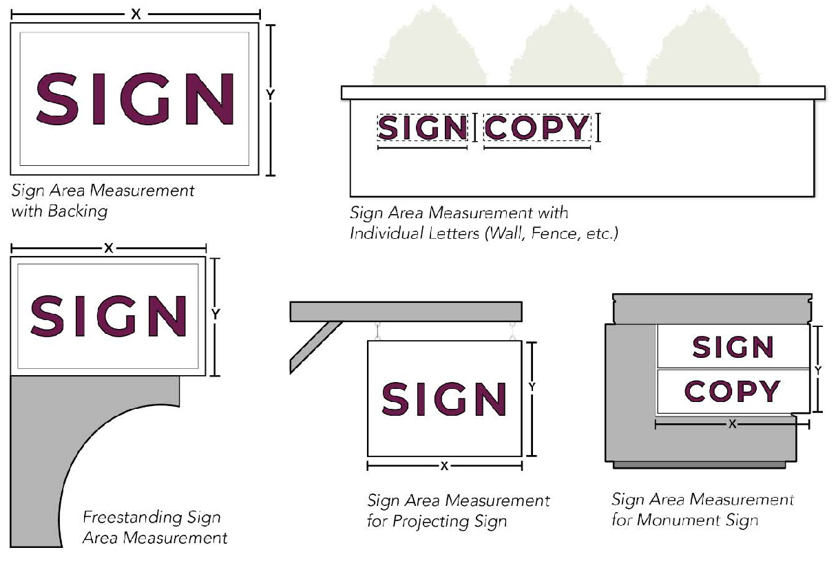
F.
Computations. The area of signs shall be computed by enclosing, with the smallest single continuous perimeter of the sign including the background, material, letters, numbers, or emblems which are part of the overall display. Any structures attached to the sign, such as poles, mounts, platforms, etc. are not included in calculations.
G.
Exempt Signs. The following signs do not require a permit:
1.
Street and lodging room numbers.
2.
Temporary signs that do not exceed six (6) square feet per side and do not obstruct or impair the safety of pedestrian or vehicular traffic.
3.
Signs on vehicles operated in the normal course of operations, subject to the following limitations:
a.
The vehicle shall have all required state licenses, license plates and inspection stickers and shall be operable.
b.
The vehicle shall be regularly operated, which means that the vehicle shall leave the property on a regular basis for an operational purpose and shall not be parked more than twelve (12) continuous hours at the occupant's location except as parked or stored on a private residential lot during nonworking hours.
4.
Vehicle signs shall be magnetic, have vinyl graphics or be painted directly on the vehicle.
H.
Prohibited Signs. The following shall be prohibited in the city:
1.
Signs that are of a size, location, movement, content, coloring or manner of illumination which may be confused with or construed as a traffic control device or which hides from view any traffic or street sign or signal.
2.
Signs that have a moving part or are portable or wheeled.
3.
Signs that contain or consist of ribbon streamers, strings of light bulbs, spinners, or other similarly moving devices. Feather flag signs are only permitted as temporary signs.
4.
Signs that consist of spray painting on any temporary or permanent surface.
5.
Any sign that obstructs the view of an official traffic sign or signal.
6.
Portable signs that are not approved with a temporary sign permit.
7.
Any sign that is structurally unsafe, constitutes a hazard to public health and safety.
5.10.3 Permanent Signs.
A.
Permanent Sign Types.
1.
Wall Signs. Wall signs which are defined as a sign that is attached to, painted on, or erected against a wall of a building which extends no more than three (3) inches from the wall surface upon which it is attached and whose display surface is parallel to the face of the building to which the sign is attached.
2.
Monument Signs. Monument signs which are defined as any sign permanently affixed to the ground, supported by a structure used solely for that sign, and physically separated from any building or structure.
3.
Roof Signs. Roof signs which are defined as a sign or advertising object mounted on, but does not project above the surface of, the roof of a structure.
4.
Projecting Signs. Projecting signs which are defined as a sign (other than a wall sign) which projects from a wall of a building no more than two (2) feet and whose display is perpendicular to the face of the building to which the sign is attached.
5.
Signs Within Buildings. Any sign placed inside a building may be erected without a permit but subject to the safety regulations of the building code.
Figure 5.13 Sign Types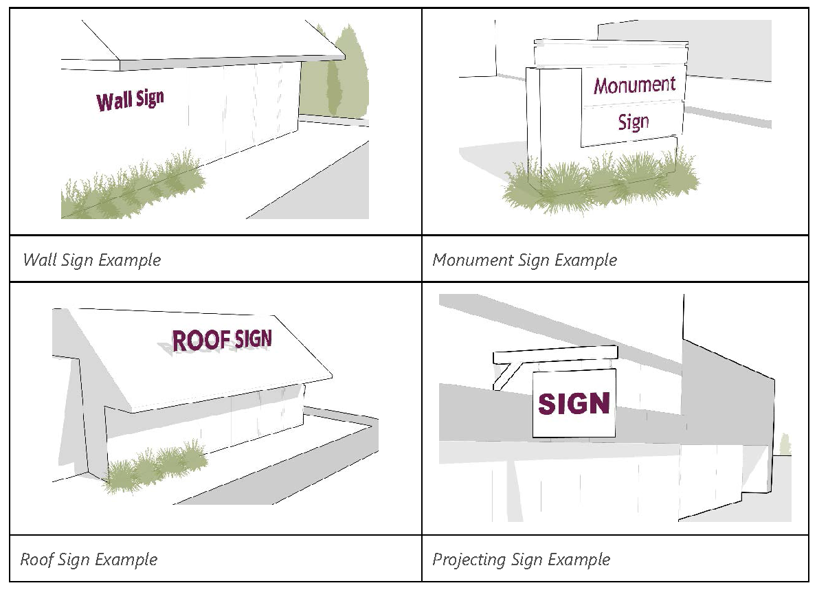
B.
Maximum Number of Signs.
Table 5.6 Sign Measurements
C.
Location and Clearance.
1.
Monument signs shall not protrude over any public right-of-way. On a corner, ground signs shall be at least ten (10) feet back from each boundary line on that lot which it is located, provided that a clear area be maintained to a height of eight (8) feet above public right-of-way.
2.
Wall signs shall be located so that a clear area to a height of eight (8) feet above grade shall be maintained.
3.
Ground signs may be less than eight (8) feet in height if adequately protected by plants, landscaping, benches, etc., and the signs do not impair the vision of vehicular or pedestrian traffic.
4.
Projecting signs shall be a minimum height of eight (8) feet above ground level. The sign shall not extend more than six (6) feet over the public right-of-way and it shall not be higher than four (4) feet above building face of the building, but in any case is not to exceed twenty-five (25) feet in height above grade.
D.
Illumination. Permanent signs may be illuminated, but shall not exceed a total of one hundred (100) lumens per square foot of sign area.
E.
Material. All permanent signs shall be constructed of durable materials capable of withstanding continuous exposure to the elements and the conditions of an urban environment.
F.
Ground Signs. Ground signs will be allowed in the commercial district (C) and the central business district (CBD).
G.
National Electric Safety Code. All permitted signs must be in compliance with the National Electric Safety Code.
5.10.4 Temporary Signs.
A.
All temporary signs shall comply with the standards in this section.
1.
Maximum Size. Thirty-two (32) square feet per sign.
2.
Maximum Height. Twelve (12) feet.
3.
Number. One (1) for each street frontage upon which the property faces, and so placed that only one (1) sign faces each street.
4.
Ground Signs. Ground signs shall be set back a minimum of ten (10) feet from the property lines of the lot on which it is located, provided that a clear area be maintained between three (3) and eight (8) feet in height above the ground as measured from the top of the sidewalk.
5.
Window Signs. Window signs shall cover no more than fifty (50) percent of a window.
6.
Illumination and Animation. No illumination or animation shall be allowed.
7.
Time Limit. Temporary signs shall have a time limit of six (6) months maximum, with four (4) successive renewals each of six (6) months duration at the same location upon application. Once the purpose for which the sign has been erected has been fulfilled, the permit shall be deemed void.
i.
Traffic control signs erected by proper authority shall be exempt from these regulations.
ii.
Advertising for a special city event may be erected two (2) weeks prior to the event and must be removed promptly following termination of the event. Advertising under this clause may exceed the normal size limitation for temporary signs. Pennants, banners, and posters visible from any state highway must also be approved by CDOT.
5.10.5 Electronic Messaging Signs.
A.
Permitted Zones. Digital electronic message centers ("EMCs") are only permitted within the commercial and central business district zones and must conform to the requirements in this subsection.
B.
Design, Spacing, and Dimensions.
1.
EMCs shall not have a pixel pitch that is greater than twelve (12) millimeters.
2.
Not more than fifty (50) percent of the sign area of a permitted sign may be occupied by EMCs.
3.
Signs with EMC components shall be separated from each other, and from property zoned for single-family residential purposes, by a distance of not less than one hundred (100) feet, measured in a straight line.
Figure 5.14 Electronic Messaging Signs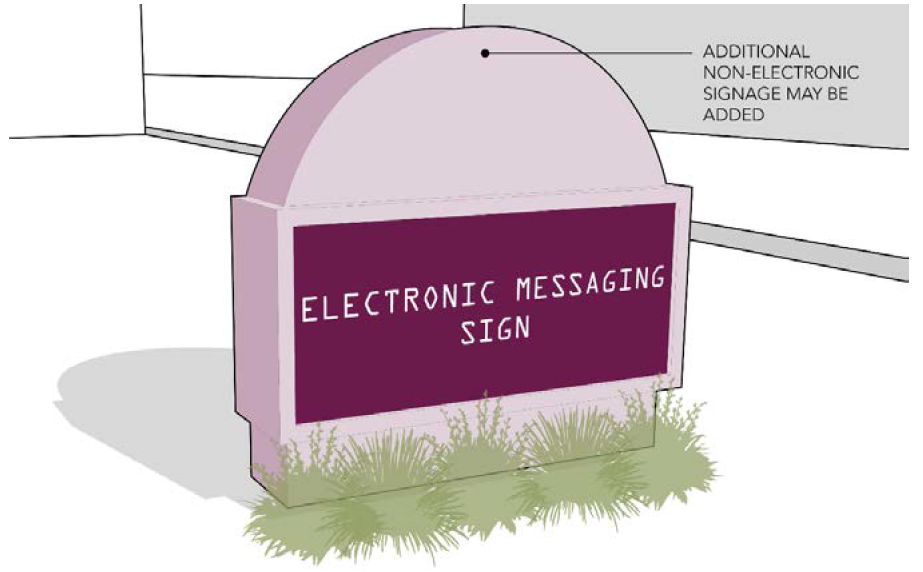
C.
Operations.
1.
The message displayed on an EMC shall not change more frequently than once per eight (8) seconds.
2.
Flashing, animated, dissolve, or fade transitions are not allowed.
3.
EMCs shall adhere to the same illumination standards as all signs with a maximum output of one hundred (100) lumens per square foot of EMC area.
4.
EMCs shall be controlled by dimming software and sensors to adjust brightness for nighttime viewing and variations in ambient light. The intensity of the light source shall not produce glare, the effect of which constitutes a traffic hazard or is otherwise detrimental to the public health, safety or welfare.
5.10.6 Legacy Billboards.
A.
Annual Permits. The owner of each billboard shall apply annually, before March 31, for a current year permit. The city shall determine that such billboard is being maintained in a structurally complete and sound condition and that the display surface and materials of the sign are in good repair by determining that the information is clearly visible to the consuming public. New billboards are prohibited.
B.
Size. The size of a billboard shall not exceed one hundred twenty-eight (128) square feet.
1.
No billboard shall exceed a maximum height of twelve (12) feet nor a maximum width of sixteen (16) feet.
2.
The base or bottom of any billboard shall not exceed a height of one (1) foot above the grade of any adjoining highway or street right-of-way at its point closest to the billboard.
5.10.7 Historic Signs.
A.
Purpose. Notwithstanding any other provision of this Code, the city council retains the right to designate any number of signs within the central business district (CBD) and the commercial district as historic signs. Any sign so designated shall be exempt from the nonconformance provisions of this Code for so long as the historic sign: is not altered or enlarged, and is maintained in safe and satisfactory condition. Should any of these conditions occur, the historic sign designation shall cease, and said sign shall be subject to the nonconforming signs provisions of this Code (Section 1.04).
B.
Application. Any business or property owner within the CBD and C zone districts may request designation for a historic sign.
1.
An application shall be submitted, accompanied by letters of support from at least three (3) other business or property owners within the CBD or C.
2.
Such letters of support shall reference: the period of time which the sign has been in use, the unique characteristics of the sign that contribute to the CBD or C district; the history or upkeep and repair of the sign; the historic value of the sign; and, such other factors as may be deemed important.
3.
The zoning administer should use the following criteria to determine the eligibility of designation:
a.
The sign must be fifty (50) years old or older;
b.
The sign must be historically significant to an event, person, or business, or represent a period in development that is significant to the community, or represent a unique design feature that is considered historic;
c.
The sign shall retain its original form, design, and material; and
d.
The sign shall contribute to the character of the surrounding area.
C.
Revocation of Designation. If a special feature on a designated sign has been altered in such a way so as to negate the features necessary to retain designation, or if the designated historic sign has been removed from view of the public, the owner may apply to the historic preservation board (board) for a revocation of the designation or the board shall authorize revocation of the designation in the absence of the owner's application to do so.
(Ord. No. 1331, Exh. A, 3-11-2025; Ord. No. 1349, Exh. A, 11-25-2025)
5.11 - Nuisance standards.
A.
Applicability. All uses in any district of the city shall conform in operation, location and construction to the subjective performance standards herein specified so that the public health, safety and welfare will be protected.
B.
Exemption. The following are exempt from the performance standards of this section:
1.
Temporary construction, excavation and grading associated with development for which applicable permits have been issued and with the installation of streets or utilities; and
2.
Demolition activities that are necessary and incidental to permitted development on the same lot, on another of several lots being developed at the same time or in the public right-of-way or easement.
C.
General. The location, size, design and operating characteristics of all uses shall minimize adverse effects, including visual impacts, on surrounding properties.
D.
For the purposes of this section, bounding property line shall be interpreted as being at the far side of any street alley; stream or other permanently dedicated open space from the noise source when such open space exists between the property line of the noise source and adjacent property. When no such open space exists, the common line between two (2) parcels of property shall be interpreted as the bounding property line.
E.
Noise. At no point on the bounding property line of any use in any district shall the sound pressure level of any use, operation or plant produce noise above what is allowed by C.R.S. 25-12-103 which regulates acceptable noise levels for different types of land uses based on time of day.
F.
Smoke and Particulate Matter. No operation or use in any district shall at any time create smoke and particulate matter that, when considered at the bounding property line of the source of operation creates a nuisance or distracts from the use and enjoyment of adjacent property.
G.
Odorous Matter. No use shall be located or operated in any district that involves the emission of odorous matter from a source of operation where the odorous matter exceeds the odor threshold at the bounding property line or any point beyond the tract on which such use or operation is located. The odor threshold shall be the concentration of odorous matter in the atmosphere necessary to be perceptible to the olfactory nerve of a normal person.
H.
Explosives. No use involving the manufacture or storage of compounds or products that decompose by detonation shall be permitted in any district, except that chlorates, nitrates, phosphorus and similar substances and compounds in small quantities for use by industry, school laboratories, druggists or wholesalers may be permitted when approved by the fire marshal as not presenting a fire or explosion hazard.
I.
Flammables. The storage and use of all flammable liquids and materials (e.g. pyroxylin plastics, nitrocellulose film, solvents and petroleum products) shall be permitted only when such storage or use conforms to the city's standards and regulations.
J.
Toxic and Noxious Matter. Toxic or noxious matter in excess of the threshold limits set forth by the Colorado Department of Health shall not cross any property line.
K.
Vibration. No operation or use in any district shall at any time create earth borne vibration that, when considered at the bounding property line of the source of operation creates a nuisance or distracts from the use and enjoyment of adjacent property.
L.
Open Storage. All open storage shall meet the provisions of Section 3.06 of this Code. No wrecking, junk, or salvage yard shall be permitted as a storage use in any district.
M.
Glare. No use or operation in any district shall be located or conducted so as to produce intense glare or direct illumination across the bounding property line from a visible source of illumination nor shall any such light be of such intensity as to create a nuisance or detract from the use and enjoyment of adjacent property.
(Ord. No. 1331, Exh. A, 3-11-2025)
5.12 - Development reports.
A.
The following reports and studies may be required based on applicability to the project site.
1.
A drainage and erosion control report prepared by a licensed professional to meet the requirements of Section 4.06 and include the following:
a.
Study shall consider intensity, duration, and frequency using rational methods and looking specifically at soil type coefficients and be prepared per Mile High Flood District guidelines;
b.
Project site, including two hundred (200) feet beyond its boundaries;
c.
Existing contours at two-foot intervals shown as dashed lines;
d.
Proposed contours at two-foot intervals shown as solid lines;
e.
Indication of a permanent benchmark referenced to mean sea level;
f.
Projected runoff volumes for a twenty-four-hour duration, one-hundred-year storm frequency event;
g.
Drainage system shown in plan view with estimated cubic feet per second flow for a ten-year storm;
h.
Location of all natural drainage channels and water bodies;
i.
Existing and proposed drainage easements;
j.
Type, size, and location of existing and proposed drainage structures such as pipes, tiles, culverts, retention ponds, detention areas, etc.;
k.
One hundred-year (base) flood areas;
l.
Additional grading and drainage standards may be required in the zone A flood zones to satisfy Federal Emergency Management Administration requirements;
m.
Erosion control plan showing adequate sedimentation control which shall be accomplished throughout construction phases as well as during the ongoing operation of the use and any permanent sedimentation control structures and/or facilities to mechanically stabilize the soil (e.g. sedimentation ponds, dikes, seeding, retaining walls, rip-rap, etc.); and
n.
Flood hazards.
2.
Soil suitability analysis in the form of a report based on information from the National Resource Conservation Service (NRCS) of the United States Department of Agriculture (USDA) or another form acceptable to city staff including collection of soil samples. At a minimum, the report shall include:
a.
A description of soil types, locations and characteristics with supporting soil maps, soil logs of test pits and auger holes, and other information necessary to determine soil suitability for the scope of the development;
b.
Constraints on development based on the findings; and
c.
Analysis and evaluation of such information with recommendations regarding structural constraints, erosion control and a determination of the adequacy of the characteristics of the soil as they relate to the proposed uses and development.
3.
The surface mapping report of the area shall be accompanied by a written narrative and map that is titled, dated and signed by a Colorado licensed professional engineer. The report must address the above concerns and any geological or flood hazards/limitations.
4.
Subsurface soils investigations shall include a map locating test pits or auger holes.
5.
The scope and detail of the soils analysis shall be determined by the Colorado licensed professional engineer.
(Ord. No. 1331, Exh. A, 3-11-2025)
6.01 - General provisions.
6.01.1 Table of Contents.
A.
6.01 General Provisions.
B.
6.02 Common Review Procedures.
C.
6.03 Specific Review Procedures.
D.
6.04 Other Applicable Procedures.
6.01.2 Purpose.
A.
This chapter describes the review procedures for land use applications and development activity in the city and ensures consistency and efficiency in the administration of this Code.
6.01.3 Review and Decision-Making Authorities.
A.
City Council.
1.
Organization. The Cortez City Charter, Article III, establishes the city council and describes composition, compensation, and powers and duties.
2.
Powers and Duties. The city council shall have the following powers and duties related to this Code:
a.
Review and decision-making authority on applications related to this Code as shown in Table 6.1.
b.
Appoint the members of the planning commission; board of adjustment; historic preservation board; and parks, recreation, and forestry advisory board.
B.
Planning and Zoning Commission.
1.
Organization. The Cortez City Code, Chapter 2, Article II, establishes a planning and zoning commission known herein as the planning commission and describes composition, meeting protocols, and general powers and duties.
2.
Powers and Duties. The planning commission shall have the following powers and duties related to this Code:
a.
Review and decision-making authority on applications related to this Code as shown in Table 6.1.
b.
To make and adopt a comprehensive plan and coordinated three-mile planning area for the physical development of the city, subject to the approval of the city council per C.R.S. Section 31-23-306.
c.
Grant the following approvals and actions related to nonconforming uses and structures:
i.
Reconstruction of Nonconforming Uses. Permit the reconstruction of a nonconforming building per Section 1.05.5 of this Code.
ii.
Repair of Nonconforming Uses. Permit the repair to a building that has been officially declared unsafe to restore it to a safe condition per Section 1.05.3 of this Code.
iii.
Discontinuance of Nonconforming Use. Require the discontinuance of nonconforming uses of land or structures under any plan whereby the full value of the structure and facilities can be amortized within a defined period of time, requiring the property to conform to the regulations of this Code. All actions to discontinue a nonconforming use or structure shall be taken with due regard to the property rights of the persons affected when considered in the light of the public welfare and the character of the area surrounding the nonconforming use or building and the conservation and preservation of the property.
iv.
Status of Nonconforming Uses. On its own motion or upon cause presented by interested property owners or on request of the city council inquire into the existence, continuation, or maintenance of any nonconforming use within the city.
C.
Board of Adjustment.
1.
Organization. The Cortez City Code, Chapter 2, Article VI, establishes a board of adjustment and describes membership, qualifications, compensation, and meeting procedures.
2.
Powers and Duties. The board of adjustment shall have the following powers, and shall have the power to impose reasonable conditions to ensure compliance and protect adjacent property:
a.
To hear and decide appeals of administrative decisions where it is alleged there is error in any order, requirement, decision or determination made by an administrative official of the city in the enforcement of this Code.
b.
To hear and decide on variance applications.
c.
To grant variances from flood hazard standards. The board of adjustment shall follow the guidelines set forth in Chapter 8 of this Code when considering such variances.
D.
Parks, Recreation, and Forestry Advisory Board.
1.
Establishment. The parks, recreation, and forestry advisory board is established as an advisory board to the city council.
2.
Powers and Duties. The parks, recreation, and forestry advisory board (board) shall have the following powers and duties:
a.
To study, investigate, plan, advise, report, and recommend to city council any action, program, plan or legislation which the board shall find or determine to be necessary or advisable for the care, preservation, trimming, planting, removal, or disposition of trees and shrubs in public ways, streets and alleys;
b.
To assist the city council and the citizens of Cortez in the dissemination of news, educational material and information regarding the selection, planting and maintenance of trees within the corporate limits, whether the same be on private or public property; and
c.
To make such recommendations to the city council as to desirable legislation concerning the tree program and activities for the municipality, such as an annual Arbor Day program.
E.
Historic Preservation Board.
1.
See Chapter 7, Historic Preservation, of this Code.
F.
Zoning Administrator.
1.
Establishment. The zoning administrator shall be appointed by the city manager.
2.
Powers and Duties. The zoning administrator, or their assigned designee, shall have the following powers and duties:
a.
Review and decision-making authority on applications related to this Code as shown in Table 6.1.
b.
Administer and enforce the provisions of this Code.
c.
Have the authority to make all interpretations of this Code and the boundaries of the zoning district map.
d.
Administer and enforce the floodplain regulations (Appendix C of this Code) including those powers and duties expressly assigned to them therein. Authority may be delegated to the engineering department as appropriate.
G.
Building Official.
1.
Establishment. The building official shall be appointed by the city manager.
2.
Powers and Duties. The building official, or their assigned designee, shall have the following powers and duties:
a.
Interpret, administer and enforce the currently adopted city construction codes and building codes.
b.
Issue building permits. The building official shall issue applicable permits to allow construction activities that have received site plan approval pursuant to the procedures in the Code and deny building permits for activities that have not received proper site plan approval.
c.
Enforce the Land Use Code. The building official shall enforce the provisions of this Code.
d.
Administer and enforce the city's adopted fire code, as amended.
H.
City Engineer.
1.
Establishment. The city engineer shall be appointed by the city manager.
2.
Powers and Duties. The city engineer, or their assigned designee, shall have the following powers and duties:
a.
Administer and enforce the portions of this Code related to engineering and public works standards.
I.
City Clerk.
1.
Establishment. The city clerk shall be appointed by the city manager.
2.
Powers and Duties. The city clerk, or their assigned designee, shall have the following powers and duties:
a.
File final decisions on applications within city records;
b.
Submit final ordinances and associated information to the county clerk for recording, upon receipt from applicant; and
c.
File all required notifications and documentation associated with development applications per requirements of this Code.
6.01.4 Application Procedures Summary Table.
A.
The following table summarizes the major review procedures for land use applications in the city. Not all procedures addressed in this chapter are summarized in this table. See subsequent sections of this chapter for additional details on each procedure.
Table 6.1 Application Procedures Summary Table
(Ord. No. 1331, Exh. A, 3-11-2025; Ord. No. 1349, Exh. A, 11-25-2025)
6.02 - Common review procedures.
6.02.1 Pre-Application Meeting.
A.
Purpose. The pre-application meeting provides an opportunity for an informal review of an application to familiarize the applicant with the provisions of this Code and other relevant requirements of the city. The pre-application meeting is not a formal review of the application. The guidance and feedback provided during the pre-application meetings are not considered binding upon the application, applicant, or the city.
B.
Applicability.
1.
A pre-application meeting is required for all application types per Table 6.1 unless waived by the zoning administrator.
2.
A pre-application meeting is optional for all other applications, upon the request of either the applicant or the zoning administrator.
C.
Procedure.
1.
The applicant shall request a pre-application meeting with the zoning administrator prior to formal application. The applicant shall provide the following information with the request for the pre-application meeting:
a.
Project narrative describing the general intent of the proposed project; and
b.
A conceptual site plan drawn to scale.
2.
A pre-application meeting shall be held within ten (10) days of receipt of all necessary information unless a later date is agreed to by the applicant and the zoning administrator.
3.
The zoning administrator may waive the pre-application meeting requirement if determined that the request does not warrant review prior to application submittal.
6.02.2 Application Submittal.
A.
Purpose. To provide a mechanism for formal review of all development applications.
B.
Applicability. These requirements shall be applicable to all planning submittals unless otherwise noted within this Code.
C.
Procedure. All applications shall be submitted electronically to the planning department.
D.
Submittal Materials. All applications shall include the following information at a minimum:
1.
Application. An application for development permission shall be made on official application forms provided by the planning department.
2.
Fees. Each application shall be accompanied by the corresponding fee as established in the city fee schedule as adopted by resolution of the city council.
3.
Checklist. A submittal checklist as provided for each application type shall accompany each submission unless otherwise noted. The checklist includes the various relevant documents that are to be included with the submittal and indicates the minimum requirements for each document.
4.
Project Narrative and Associated Plan Documents. A project narrative and all plan documents meeting the specifications of the checklist for the corresponding application type are required.
6.02.3 Application Completeness Review.
A.
Purpose. To ensure all required submittal materials are included and all land use application fees owing to the city are paid, an application completeness review will be conducted by the zoning administrator or the zoning administrator's designee, for each application prior to a determination of a completed application and submittal, and prior to any city review of the application.
B.
Applicability. These requirements shall be applicable to all planning submittals not including building permit applications.
C.
Procedure.
1.
The zoning administrator shall make a determination of application completeness within ten (10) business days of application filing and a determination that a complete application filing has been submitted.
2.
If the application is determined to be complete, the zoning administrator shall communicate with the applicant, in writing, the timeframe for application review. The application shall then be processed according to the procedures set forth in this chapter and reviewed for compliance with the applicable regulations of this Code.
3.
If an application is determined to be incomplete, the zoning administrator shall provide notice to the applicant along with an explanation of the application's deficiencies. No further processing of an incomplete application shall occur, and the application shall be considered inactive until such time deficient filings are provided.
D.
Determination of Complete Application. An application shall not be considered complete unless and until all of the required information and materials, in the amounts and dimensions required by this Code, have been filed with the planning department, and all land use application fees owing to the city by the applicant/property owner are paid. The zoning administrator may waive any required submittal item(s) when it is obvious that they are not applicable to the specific application.
6.02.4 Application Review.
A.
Purpose. Review of the application to determine compliance with the provisions of this Code and other relevant requirements of the city.
B.
Applicability. These requirements shall be applicable to all planning submittals unless otherwise noted within this Code.
C.
Procedure.
1.
After an application filing has been determined to be a complete application, and a determination has been made that the complete application has been submitted, the zoning administrator shall review the complete application and determine if it meets the standards and requirements of this Code.
2.
As part of the initial review, the zoning administrator shall refer the development application to the appropriate referral review agencies electronically and specify the timeframe for comments to be due back to the zoning administrator. The following agencies may be included as applicable to the application. Additional agencies may be sent a referral as applicable to the application.
a.
City engineer;
b.
Cortez Fire Protection District;
c.
Cortez-Montezuma School District;
d.
City clerk;
e.
Electric Power Association;
f.
Montezuma County;
g.
Natural gas provider;
h.
Parks and recreation department;
i.
Public works department; and
j.
Telephone provider.
3.
The zoning administrator shall provide comments from city staff, consultants and/or review agencies to the applicant. The applicant shall revise and resubmit the application with appropriate changes to address the comments. Upon an application's resubmittal for a subsequent review, it shall be reviewed by the agencies who requested revisions.
4.
Once the application has satisfied the requirements of the Code and all referral agency comments the initial hearing shall be scheduled, if required, and a staff report prepared. The staff report shall be made available to the applicant and the public prior to any scheduled public hearing(s).
5.
The staff report shall indicate whether, upon determination by the zoning administrator, the development application complies with all applicable standards of this Code.
6.
For final approval, the following sections shall apply:
a.
Section 6.02.6 shall apply to all applications approved by planning commission or city council per Table 6.1.
b.
Section 6.02.7 shall apply to all applications administratively per Table 6.1.
7.
No application shall be scheduled for public hearing or final administrative approval without a full review for compliance with this Code and other applicable regulations.
6.02.5 Public Notice.
A.
Purpose. This section outlines the public noticing requirements and procedures.
B.
Applicability. These requirements shall be applicable to all planning submittals unless otherwise noted within this Code. All public hearings required by this Code shall be preceded by the required public notices identified in Table 6.2.
Table 6.2 Public Noticing Table
C.
Procedure. For every public hearing the public shall be notified of the date, time, and place of the hearing and relevant information to identify the property address and application type for which the hearing is being held. Notification requirements are as follows:
1.
Newspaper and Website Notice. The city shall publish notice of the public hearing in a newspaper of general circulation within the city, as well as on the city's website, at least ten (10) days prior to the hearing as established per Table 6.2.
2.
Posted Notice. The applicant shall post notice of the public hearing on the subject property in a location visible from the nearest adjacent public right-of-way as established per Table 6.2.
3.
Mailed Notice. The city shall mail the written notice of public hearing by standard post to the address of record of all owners of real property lying within the specified distance from the property and number of days as established per Table 6.2.
4.
Posting of Agenda. Posting of agendas, for all planning commission public meetings, work sessions and special meetings shall be a minimum of twenty-four (24) hours prior to the meeting, in accordance with C.R.S. Section 24-6-401 et seq., the Colorado Open Meetings Law, as it may be amended. Meeting notice shall be posted at city hall in a location visible to the public and on the city's website.
5.
All notices published in the newspaper, posted on the city's website, and mailed to property owners, shall contain, at a minimum, the following information:
a.
The name of the owner and the applicant;
b.
The property's street address and legal description;
c.
A vicinity map showing the subject property;
d.
The type of application approval sought and a brief description of the development proposal;
e.
The date, time, and location of the hearing and name of the decision-making body conducting the hearing;
f.
The telephone number and an email contact for the planning department; and
g.
Indication that more complete information about the application is available at the planning department.
6.
All notices posted on properties shall contain, at a minimum, the following information:
a.
The type of application approval sought and a brief description of the development proposal;
b.
The date, time, and location of the hearing and name of the decision-making body conducting the hearing;
c.
The telephone number and an email contact for the planning department; and
d.
Indication that more complete information about the application is available at the planning department.
7.
The costs of all notices and advertising shall be borne by the applicant.
8.
In calculating the time period for public notice, the first day of publication, posting, or mailing shall not be counted toward the total number of days required, but the day of the hearing shall be counted. If the last day of any period is a Saturday, Sunday, or legal holiday, the period shall be extended to include the next day which is not a Saturday, Sunday, or legal holiday.
6.02.6 Public Hearings.
A.
Purpose. This section describes the requirements and procedures to be followed at all public hearings.
B.
Applicability. All applications subject to a public hearing per Table 6.1.
C.
Procedure.
1.
No public hearing shall commence, nor testimony taken, until all notice procedures as set forth in Section 6.02.5 are met.
2.
At a hearing to consider an application, the reviewing body shall review the data supplied by the applicant, review the findings and recommendations of the zoning administrator, and take testimony from all interested persons in attendance.
3.
All hearings before the planning commission and city council shall be open to the public.
4.
The applicant or their designated agent whose application is before the planning commission or city council shall be present at the meeting.
5.
The applicant shall offer competent evidence in support of the application sufficient to enable the reviewing body to consider the matter and make findings on the subject. The applicant has the burden of presenting all necessary and relevant information and evidence in support of the application.
6.
In making its decision, the planning commission shall consider the recommendation of staff, the written and oral testimony presented, and the application approval criteria.
7.
The planning commission recommendation shall be forwarded to city council through public meeting record and the staff report for review at the next available city council meeting.
8.
In making its determination, city council shall consider the recommendation of the planning commission, staff reports, the written and oral testimony presented, and the application approval criteria.
9.
During the hearing process the reviewing body may allow for up to three (3) continuances, totaling not more than six (6) months, to hear the matter, so the applicant may make modifications or provide additional information and evidence in support of the application. The zoning administrator may provide an exemption to the limitation on continuances when a compelling reason exists as determined by the zoning administrator.
a.
Postponement to a Date Certain. Hearings may be continued to a date certain and kept open to take additional information until a final decision is made. The property shall be re-posted for a continued hearing; no further publication or mailed notice for a continued hearing is required.
b.
Postponement with No Date Certain. If an application is not continued to a date certain, the application requires public notice as specified in Section 6.02.5 with payment of a notice fee per the adopted city fee schedule.
10.
The record of decision shall include the following materials:
a.
The application materials;
b.
The minutes of the public hearing(s) and of other related meetings of the recommending and decision-making bodies reviewing the application;
c.
The recording of the public hearing, if any;
d.
Written materials submitted to the city by an individual or agency regarding the application;
e.
The staff report;
f.
Any consultant reports and referral agency comments; and
g.
Documentation of decisions by the recommending and decision-making bodies.
6.02.7 Administrative approval.
A.
Purpose. This section describes the procedures for approval of administrative applications
B.
Applicability. All applications subject to administrative review per Table 6.1.
C.
Procedure.
1.
The zoning administrator shall approve, deny, or approve the application with conditions as appropriate following determination that the following criteria, and any criteria of the specific application type, are met based on the evidence submitted with the application, comments from referral agencies, information on file with the city, and any required approvals from other decision-making bodies:
a.
The application complies with all applicable provisions of this Code and other city regulations, as modified by any previously administrative adjustments or variances;
b.
The application is consistent with any previous approvals and agreements related to the property; and
c.
The property is not subject to provisions of a development agreement, which were required to be performed before the date of the subject application remains unsatisfied.
6.02.8 Post Decision Action.
A.
Modification or Amendment of Approval. Unless otherwise permitted in this Code, any modification of approved plans, permits, or conditions of approval shall require a new application to be submitted and reviewed in accordance with the full procedure and fee requirements applicable to the application type.
B.
Recording of Decisions. Once approved, any application requiring recordation shall be filed with the city clerk and recorded in the office of the county clerk and recorder at the expense of the applicant.
1.
For applications approved by the zoning administrator or planning commission, a notice of land use decision shall be issued by the zoning administrator.
2.
For applications approved by the city council, an ordinance or resolution shall be issued as determined by application type.
3.
Documents required for recording may include approved resolutions, ordinances, or final mylar plan sets.
C.
Lapse of Approval. Application approval shall be valid for a period of two (2) years from the date of approval, unless otherwise specified by vested property rights. Unless otherwise noted, authority to grant extensions shall reside with the decision-making body that granted the original approval.
D.
Extensions. A maximum of three (3) extensions of two (2) years each may be sought and approved by the zoning administrator per the following criteria:
1.
The extension request is filed thirty (30) days prior to the lapse-of-approval deadline with adequate justification; and
2.
The applicant is able to demonstrate substantial progress is being made on the application.
E.
Revocation. Application approval may be revoked or suspended upon finding that the use, building, or site for which the permit was issued is substantially different than what was represented in the application or that one (1) or more of the conditions or requirements contained in the application approval has been violated.
F.
Denial and Reapplication. No application that receives decision of denial shall submit a substantially similar application within a period of one (1) year.
G.
Effect of Inaction. If a review or decision-making body fails to take action on an application within the specified timeframe, such inaction shall be deemed a denial of the application unless the decision-making body grants an extension. Continuation of a public hearing or continuation of a meeting is not automatically deemed an extension. An extension may be granted by separate motion, or if desired, included in a motion to continue.
(Ord. No. 1331, Exh. A, 3-11-2025; Ord. No. 1349, Exh. A, 11-25-2025)
6.03 - Specific application procedures.
6.03.1 Formal Interpretations.
A.
Purpose. To establish a process for formal interpretation of this Code.
B.
Initiation. An interpretation may be requested by any affected person, any resident or real property owner in the city, or any person having a contractual interest in real property in the city.
C.
Procedure. All formal interpretation applications shall follow the common application procedures in Section 6.02 with approval authority per Table 6.1.
D.
Formal Interpretation Submittal Requirements. The following items shall be submitted at a minimum:
1.
The name, address, and telephone number of the applicant.
2.
A narrative describing the Land Use Code provision for which the applicant is requesting interpretation along with context to the proposed project.
E.
Noticing Requirements. None required.
F.
Approval Criteria.
1.
The zoning administrator shall review this Code and the official zoning map, whichever is applicable, before rendering an interpretation.
2.
The zoning administrator may consult with the city manager and the city attorney, as needed; review this Code and the official zoning map, whichever is applicable, before rendering an interpretation.
G.
Post Approval Action.
1.
The interpretation shall be in writing and shall be sent to the applicant by certified mail.
2.
The zoning administrator shall maintain an official record of all interpretations, which shall be available for public inspection during normal business hours.
3.
Any person who has made a request for interpretation may appeal the interpretation of the zoning administrator to the board of adjustment by filing an application within thirty (30) days of the zoning administrator's decision. The date of the decision shall be the postmark date of the certified mail notifying the applicant of the interpretation. The application shall be considered within thirty (30) days of its filing, and the interpretation of the zoning administrator affirmed or modified.
6.03.2 Land Use Code Text Amendments.
A.
Purpose. The text of this Land Use Code may be amended pursuant this section to respond to change in conditions or public policy, or to advance the general health, safety, and welfare of the city.
B.
Initiation of Text Amendment. A text amendment to this Land Use Code may be initiated by, city staff, planning commission, or city council. Additionally, any person may suggest to the planning commission that an amendment be given consideration.
C.
Procedure. All text amendment applications shall follow the common application procedures in Section 6.02 with approval authority per Table 6.1.
D.
Noticing Requirements. Notifications shall be made per Section 6.02.5 prior to holding a public hearing.
1.
Exception. When the zoning district map is to be changed or amended incidental to, or as a part of a general revision of this Code, posting of notice on the land area proposed for rezoning shall not be required.
E.
Approval Criteria. Recommendations and approval decisions on text amendment applications shall adhere to the following approval criteria:
1.
The amendment is not likely to result in significant adverse impacts upon the natural environment (including air, water, noise, stormwater management, wildlife, and vegetation) or such impacts will be substantially mitigated;
2.
The amendment is necessary for, or supportive of, the protection of health, safety, and welfare of the community;
3.
The amendment is consistent with the comprehensive plan and the intent stated in this Code;
4.
The amendment is consistent with any prior approvals, official plans or policies that apply; and
5.
The amendment will not significantly increase nonconformities.
6.03.3 Zone Map Amendment (Rezone).
A.
Purpose. The boundaries of any zone district may be changed, or the zone classification of any parcel of land may be changed, pursuant to this section that are necessary in light of changed conditions or changes in public policy, or that are necessary to advance the general welfare of the city.
B.
Initiation of a Rezone. A change of zone district application may be initiated by planning commission, city council, or any person having a proprietary interest in any property within the corporate limits of the city.
C.
Procedure. All rezone applications shall follow the common application procedures in section 6.02 with approval authority per Table 6.1.
D.
Noticing Requirements. Notifications shall be made per Section 6.02.5 prior to holding a public hearing.
E.
Submittal Requirements for Rezones Initiated By a Member of the Public. The application shall at a minimum, include the following information:
1.
The name, address, and telephone number of the applicant.
2.
A project narrative clearly stating the requested change or amendment and describing the property to be affected by such request by metes and bounds or by other legal description.
3.
A title certificate from a licensed title company or attorney listing the name of the property owner(s) and all liens, easements and judgments of record that affect the title to the subject property.
4.
A statement from the county treasurer showing the status of all current taxes due on such parcel.
5.
Certified boundary survey of land area to be rezoned, along with an indication of the existing zoning, predominant existing uses, and existing zoning designations within three hundred (300) feet in all directions of the boundary of the land area to be rezoned.
6.
A statement by the applicant explaining the rationale for the rezoning request relative to the standards of this Code.
7.
A filing fee shall be submitted to cover the cost of review and processing with every application in accordance with the fee schedule adopted by resolution of the city council.
8.
City-initiated rezones are exempt from these submittal requirements and staff shall be required to bring forth an ordinance that shall be reviewed against approval criteria herein.
F.
Approval Criteria. Recommendations and approval decisions on rezone applications shall adhere to the following approval criteria:
1.
The land to be zoned was zoned in error and, as presently zoned, is inconsistent with the policies and goals of the city's comprehensive plan.
2.
The proposed rezoning is necessary to provide land for a use which was not anticipated at the time of the adoption of the city's comprehensive plan. Special consideration shall be given to existing conditions on and around the area in question, including the changing nature of the area, land uses, densities, and the height and scale of both existing and proposed structures.
3.
There has been a change of character in the area (e.g. installation of public facilities, other zone changes, new growth trends, deterioration, development transitions, etc.).
4.
There is a public need for the proposed rezoning within the area or community or the public will benefit from the proposed rezone.
5.
The proposed uses are compatible with the surrounding area or uses and any adverse impacts can be mitigated.
6.
Adequate facilities are available or reasonably able to be extended to the site to serve development for the type and scope suggested by the proposed zone.
7.
The proposed change does not constitute spot zoning.
6.03.4 Comprehensive Plan Amendments.
A.
Purpose. The comprehensive plan may be amended pursuant to this section to respond to a change in conditions or public policy, or to advance the general health, safety, and welfare of the city.
B.
Initiation of Amendment. A comprehensive plan amendment may be initiated by, city staff, planning commission, or city council. additionally, any person may suggest to the planning commission that an amendment be given consideration.
C.
Procedure. All comprehensive plan amendment applications shall follow the common application procedures in Section 6.02 with approval authority per Table 6.1.
D.
Noticing Requirements. Notifications shall be made per Section 6.02.5 prior to holding a public hearing.
E.
Submittal Requirements. The applicant shall electronically submit the following documents:
F.
Approval Criteria. Recommendations and approval decisions on comprehensive plan amendment applications shall adhere to the following approval criteria:
1.
The amendment is not likely to result in significant adverse impacts upon the natural environment (including air, water, noise, stormwater management, wildlife, and vegetation);
2.
The amendment is necessary for the protection of health, safety, and welfare of the community; and
3.
The amendment is consistent with the city's goals and policies.
6.03.5 Subdivisions Generally.
A.
Purpose. To establish procedures and approval criteria for subdivisions of land per this Code.
B.
Applicability. Subdivision procedures are applicable to all divisions of land as classified per Section 4.01.2.
C.
Procedure. All divisions of land shall follow the procedures of Sections 6.03.6—6.03.9 per the following:
1.
All major subdivisions shall submit applications for preliminary and final plat.
2.
All minor subdivisions shall submit application for a minor subdivision plat.
3.
All condominium subdivisions shall submit application for a condominium plat.
6.03.6 Preliminary Plat.
A.
Purpose. Preliminary plat submittals are intended to provide the city with an overall plan for a proposed subdivision to ensure all requirements of this Code have been met.
B.
Applicability. A preliminary plat is required for all major subdivisions as described in the scope and applicability of Section 4.01.2 in this Code.
1.
The approval of a preliminary plat does not complete the subdivision process, a final plat must be completed prior to development of the subject property.
2.
No building permits shall be issued for the construction or reconstruction of structures upon any land or the addition to any building or structure situated on any land, unless such land has been subdivided and platted in accordance with the procedures set out in this Code.
C.
Procedure. All preliminary plat applications shall follow the common application procedures in Section 6.02 with approval authority per Table 6.1.
1.
Optional Pre-Application Conference with Planning Commission. At the option of the zoning administrator or at the applicant's option, a pre-application conference may be held with the planning commission.
2.
Development Improvement Agreements. During the pre-application process the applicant shall indicate their intention to enter into a development improvement agreement per Section 4.09 of this Code.
D.
Noticing Requirements. Notifications shall be made per Section 6.02.5 prior to holding a public hearing.
E.
Submittal Requirements. The applicant shall electronically submit the following documents, as may be amended by staff based on applicability to the application request:
1.
Official city application form and checklist, including application fee per the city's adopted fee schedule.
2.
A title certificate from a licensed title company or attorney listing the name of the property owner(s) and all liens, easements and judgments of record affecting the subject property, and of the preliminary plat.
3.
Preliminary plat document, drawn to scale, containing the following information:
a.
Boundary Lines and Bearings. Boundary lines, bearings, and distances sufficient to locate the exact area proposed for subdivision. At least one (1) subdivision corner shall be referenced to a survey (abstract) corner. The area, in acres, of the subdivision shall also be shown.
b.
Adjacent Subdivisions. The name and location of a portion of adjoining subdivisions shall be drawn to the same scale and shown in dotted lines adjacent to the tract proposed for subdivisions in sufficient detail to show the existing streets and alleys and other features that may influence the layout and development of the proposed subdivisions. Where adjacent land is not subdivided, the name of the owner of the adjacent tract shall be shown.
c.
Intersecting Streets. The angle of intersection of the centerline of all intersecting streets.
d.
Proposed Streets, Alleys and Easements. The names, location and widths of all streets, alleys and easements proposed for the subdivision, and all known rights-of-way and/or easements within or affecting the area to be subdivided.
e.
Proposed Blocks, Lots and Parks. The subdivision shall show all proposed streets and alleys, easements, blocks, lots, parks, etc., with principal dimensions.
f.
Contours. Topographic contours at five (5) foot intervals and all easements or right-of-way necessary for drainage within or without the boundaries of the addition.
g.
Subdivision Title and Planner. The title under which the proposed subdivision is to be recorded, the name of the owner and the name of the engineer or land planner who prepared the plat.
h.
Dedicated Parks, Playgrounds and Other Public Uses. Sites, if any, to be reserved or dedicated for parks, playgrounds or other public uses.
i.
Scale, North Point. Scale, north point, date and other pertinent data. The scale of the preliminary plat may be at one (1) inch equals twenty (20) feet.
j.
Name, Address and Telephone Number. Property owner's name, address, and telephone number.
k.
Proposed Layout of Utilities. A proposed preliminary layout of sanitary sewer and water lines to serve the subdivision.
l.
Drainage Report. A drainage report as described in Sections 4.05 and 4.07 of this Code. This study or report shall show the acreage draining into the subdivision, points of runoff through and away from the subdivision.
m.
Wetlands Identification. It is required that all wetlands be identified and delineated on any site plan that is submitted to the city as part of any application. The developer or property owner is responsible for determining the presence of wetlands on his property. Disturbance of wetlands is subject to review by agencies such as the Army Corps of Engineers. Prior to removal or alteration of riparian vegetation, impacts of such removal or alteration shall be documented, and any other required permits (e.g. Army Corps of Engineers) shall be obtained.
4.
Protective Covenants. Draft of any protective covenants where the subdivider proposes to regulate land use or development standards in the subdivision.
5.
Project Narrative. A narrative describing the proposed uses of land within the subdivision and any zoning amendments proposed to be requested.
6.
Vicinity Map. A vicinity map on a smaller scale showing the proposed subdivision and its relationship to the surrounding area and city limits.
7.
Mineral rights notification per C.R.S. Section 24-65.5-101 through 106.
8.
Overall Development Plan. If the proposed subdivision is a portion of a tract that is later to be subdivided in its entirety, then an overall development plan of the entire subdivision shall be submitted with the preliminary plat of the portion first to be subdivided. the overall development plan shall identify conceptual layout of the entire property and is not required to contain the level of detail of the preliminary plat.
9.
Surface and subsurface soils report.
10.
Traffic assessment (follow CDOT Traffic Assessment Guidelines to determine if required and level of requirement).
F.
Approval Criteria. Recommendations and approval decisions on preliminary plat applications shall adhere to the following approval criteria:
1.
The overall design is consistent with the comprehensive plan and other adopted city plans;
2.
The overall design is consistent with and complies with the requirements of the specific zone district in which it is located, such as lot size and lot frontage;
3.
The lots created have a buildable area meeting the requirements of this Code in order to construct the use the lot is intended for;
4.
The project provides a layout of lots, streets, blocks, driveways that conform to the requirements of Chapter 5 of this Code and per the master street plan;
5.
The project proposes adequate provision of utilities, drainage, right-of-way and other public facilities required for the proposed development and the extension of future anticipated public infrastructure;
6.
Traffic impacts have been studied and mitigated;
7.
The project provides for the required land dedications or fee-in-lieu of dedication as required by Chapter 5 of this Code;
8.
The project illustrates that adequate drainage and erosion control methods that conform to the requirements Chapter 5 of this Code; and
9.
The project preserves, protects, integrates, or mitigates impacts to any identified sensitive or hazardous natural features associated with the site.
6.03.7 Final Plat.
A.
Purpose. The purpose of the final plat is to complete the subdivision of land in conformance with all applicable requirements and standards of the city, and all conditions of preliminary plat approval.
B.
Applicability. A final plat is required for all divisions of land including major subdivisions, condominium subdivisions, and replats.
1.
No building permits shall be issued for the construction or reconstruction of structures upon any land or the addition to any building or structure situated on any land, unless such land has been subdivided and platted in accordance with the procedures set out in this Code.
C.
Procedure. All final plat applications shall follow the common application procedures in Section 6.02 with approval authority per Table 6.1.
1.
Review in Stages. An applicant may obtain approval of a portion of a major subdivision provided it meets all the requirements of this Code. In the event a subdivision and the final plat thereof is approved in sections, the final plat of each section shall be identified by the name of the entire subdivision and shall bear a distinguishing letter, number, or subtitle. Block numbers shall run consecutively throughout the entire subdivision.
D.
Noticing Requirements. None required.
E.
Submittal Requirements. The applicant shall electronically submit the following documents:
1.
Final Plat Document. Final plat document, drawn to scale and measuring twenty-four (24) inches by thirty-six (36) inches. containing the following information:
a.
Application and Checklist. Official city application form and checklist including application fee per the city's adopted fee schedule.
b.
Title and scale. A title, scale, and north arrow.
c.
Plat Identification. A positive reference and identification of the plat and date of preparation.
d.
Control Points. The primary control points, or descriptions and "ties" to such control points, to which all dimensions, angles, bearings, and similar data on the plat shall be referred.
e.
Area. The area of the subdivision, in acres.
f.
Boundary Lines and Bearings. Tract boundary line sufficient to locate the exact area proposed for subdivision, right-of-way lines of streets, easements and other rights-of-way, and property lines of residential lots and other sites; with accurate dimensions, bearings or deflection angles, and radii, arcs and central angles of all curves shall be placed on the final plat.
g.
Streets. Name and right-of-way width of each street or other right-of-way.
h.
Street Intersections. The location of the point of intersection and points of tangency of street intersections, and the bearing and distance of each street right-of-way centerline shall be placed on the final plat.
i.
Easements. Location and dimensions of all easements.
j.
Lot and Block Numbers. Number to identify each lot or site and each block, and the dimensions of lots and blocks.
k.
Building Lines. Minimum building setback lines when required or approved by the planning commission.
l.
Monuments. Location and description of monuments.
m.
Adjacent Land. References to recorded subdivision plats or adjoining platted land by record name.
n.
Legal Description. A legal description and surveyor's certificate, to, in the following form:
I, _______, hereby certify that I prepared this plat from an actual and accurate survey of the land and that the corner monuments shown thereon were properly placed under my supervision.
___________
Signature
o.
Dedication Certificate. The property owner's certificate or deed of dedication.
i.
The dedication deed or certificate of dedication shall be executed by all persons, firms or corporations owning an interest in the property subdivided and platted, and shall be acknowledged in the manner prescribed by the laws for the State of Colorado for conveyances of real property. The dedication certificate shall contain the following:
(a)
An accurate description, using the metes and bounds method, of the tract of land subdivided.
(b)
A statement and express representation that the parties joining in such dedication are the sole owners of such tract of land.
(c)
An express dedication without reservation to the public for public use; the streets, alleys, rights-of-way, school site and any other public areas shown on the attached plat.
(d)
A positive reference and identification of the plat and date of preparation.
p.
Approval Certification. Certification of approval by the city council in the following form:
APPROVED this _______ day of _______, 20___, by the City Council of the City of Cortez, Colorado.
___________
Mayor
2.
Tax Certificates. Tax certificates indicating that all taxes on the land being subdivided have been paid to the current year.
3.
Construction Plans. Two sets of plans for required improvements measuring twenty-four (24) inches by thirty-six (36) inches in size along with all data and calculations related to utilities, drainage, streets, roads or other construction in the subdivision. The construction plans shall conform to all requirements of the current construction design standards for the city and this Code. Such plans shall also show all existing or proposed surface and subsurface improvements and obstruction.
4.
Reimbursement Agreements. An applicant intending to implement a reimbursement agreement shall submit the agreement along with construction plans.
5.
Filing Fee. A filing fee to cover the cost of review in accordance with the fee schedule adopted by resolution of the city council.
6.
Approval Criteria.
a.
The final plat shall conform substantially to the preliminary plat as approved and in conformance with all requirements of this Code.
F.
Action Following Approval.
1.
No Modification Following Approval. In no case shall additions, corrections, or modifications of any kind be made to the final plat other than signatures required after approval.
2.
Recordation of Plats. Following final approval, signatures, and payment of all application and processing fees, the final plat shall be recorded with Montezuma County.
a.
If for any reason the final plat has not been recorded within six (6) months of approval, the approving actions shall be deemed void.
6.03.8 Minor Subdivision.
A.
Purpose. Minor subdivision submittals are intended to provide a streamlined review process for subdivisions classified as minor per Section 4.01.2.
B.
Applicability. All minor subdivisions shall submit a minor subdivision plat consistent with the submittal requirements of a final plat per Section 6.03.7.
1.
No building permits shall be issued for the construction or reconstruction of structures upon any land or the addition to any building or structure situated on any land, unless such land has been subdivided and platted in accordance with the procedures set out in this Code.
C.
Procedure. All minor subdivision plat applications shall follow the common application procedures in Section 6.02 with approval authority per Table 6.1.
D.
Noticing Requirements. None required.
E.
Submittal Requirements. The applicant shall electronically submit the materials detailed in Section 6.03.7 for final plat applications.
F.
Approval Criteria. Recommendations and approval decisions on minor subdivision applications shall adhere to the following approval criteria:
1.
The minor subdivision is consistent with the comprehensive plan and other adopted city plans;
2.
The minor subdivision is consistent with and complies with the requirements specific zone district in which it is located, including buildable lots that meet the minimum dimensional standards such as lot size, setbacks, and frontage;
3.
The project provides a layout of lots, streets, blocks, driveways that conform to the requirements of Chapter 5 of this Code and per the master street plan;
4.
The project proposes adequate provision of utilities, drainage, right-of-way and other public facilities required for the proposed development and the extension of future anticipated public infrastructure;
5.
Traffic impacts have been studied and mitigated;
6.
The project illustrates that adequate drainage and erosion control methods that conform to the requirements of Sections 4.05 and 4.07; and
7.
The project preserves, protects, integrates, or mitigates impacts to any identified sensitive or hazardous natural features associated with the site.
G.
Action Following Approval.
1.
In no case shall additions, corrections, or modifications of any kind be made to the minor subdivision plat other than signatures required after approval.
2.
Recordation of Plats. Following final approval, signatures, and payment of all application and processing fees, the final plat shall be remitted to the city for recordation with Montezuma County.
a.
If for any reason the minor subdivision plat has not been recorded within six (6) months of approval, the approving actions shall be deemed void.
6.03.9 Condominium Subdivisions.
A.
Purpose. This section provides review procedures, submittal requirements and standards for review to ensure that the creation or conversion of condominium subdivisions will comply with the currently adopted city construction codes and other provisions of this Code.
B.
Applicability. The condominium regulations established in this section shall be used to process units under common ownership that including condominiums, townhome developments where the land is under common ownership and the dwelling unit is owned separately, timeshares, or other types of development contemplated by the Colorado Common Ownership Act.
C.
Procedure. All condominium subdivision applications shall follow the common application procedures in Section 6.02 with approval authority per Table 6.1.
1.
The procedures and standards for review and approval of a new condominium subdivision shall be consistent with preliminary and final plat Sections 6.03.6 and 6.03.7.
2.
Condominium conversions shall be reviewed as a minor subdivision per Section 6.03.8 regardless of the number of units proposed for conversion.
a.
Prior to the submission of a preliminary plat, which would convert an existing multi-unit development to condominium units, the owner of such property shall meet with the zoning administrator regarding the proposed conversion and shall demonstrate that the following provisions have been met.
i.
The structure subject to the proposed condominium conversion shall meet current off-street parking requirements for the underlying zone district. Each condominium unit shall be considered a separate dwelling unit for purposes of determining parking compliance.
ii.
A minimum one-hour firewall may be required between units as a condition of city approval of any condominium plat involving a condominium conversion.
3.
Any subsequent change in the approved use(s) for a condominium subdivision shall be subject to the same review procedures as would be applied to a new condominium subdivision.
4.
Notwithstanding anything in this Code to the contrary, no requirement for public improvements, dedication of land to public use or cash-in-lieu, or other subdivision requirement shall be imposed as a condition of approval for a condominium subdivision, which would not be imposed upon a physically-identical development under a different form of ownership.
a.
This provision shall not be construed to prevent the city from imposing the review requirements of this Code upon any change of use, expansion of use, increase in intensity of use, or other change in a condominium unrelated to its form of ownership.
D.
Noticing Requirements. Notifications shall be made per Section 6.02.5 prior to holding a public hearing in conformance with the preliminary plat, final plat, or minor subdivision procedures, as applicable.
E.
Submittal Requirements. The applicant shall electronically submit the following documents:
1.
Official city application form and checklist including application fee per the city's adopted fee schedule.
2.
Title certificate from a licensed title company or attorney listing the name of the property owner(s) and all liens, easements and judgments of record affecting the subject property.
3.
A condominium plat showing:
a.
Name and Heading. The exact name of condominium subdivision including land sections, township, range, principal meridian, and "City of Cortez, Montezuma County, Colorado."
b.
Scale, Arrow and Date. The written and graphic scale, north arrow, and date of preparation.
c.
Location. The location of the condominium subdivision by reference to streets, lots and blocks.
d.
Lot and Property Lines. The lot lines and property lines to the one-hundredth-foot.
e.
Zoning and Densities. The zoning and existing densities on adjacent properties.
f.
Parking and Trash. The required parking spaces and the joint trash collection areas.
4.
The following separate, common, and limited common elements.
a.
Floor plans, elevations and site plan shall be included as required to show separate ownership of all separate units, common elements and limited common elements labeled as such and numbered for ease of identification (all dimensions shall be to the nearest one-hundredth of a foot, or other scale specified by the zoning administrator); and
b.
Number, type and floor area of units, common elements and limited elements, delineated in square feet and fractions thereof; proposed use for each unit; land area; percentage of open space; and lot coverage shall be shown.
c.
Statement of the number of units. A statement of the total number of units shall be shown on the proposed plat.
5.
Condominium declarations incorporating clear provisions for giving notice by third parties to the unit owners' association or corporation on behalf of the unit owners of special declarant rights issued to the declarant.
a.
Condominium declarations shall detail who is responsible for the maintenance of common elements and limited elements and in accordance with the requirements of Section 6.04.1, Mandatory Homeowner's Association.
b.
The condominium declarations shall incorporate clear provisions for giving notice by third parties to the unit owners' association or corporation on behalf of the unit owners of special declarant rights issued to the declarant.
c.
Articles of incorporation.
d.
Bylaws. Bylaws of the unit owners' association or corporation, unless exempt under C.R.S. Section 38-33-106, as amended.
6.
Traffic mitigation plan. A traffic mitigation plan, if the condominium subdivision will increase the total number of dwelling units on the parcel or lot.
7.
Legal description. A legal description of the subject property.
8.
Surveyor's certificate. A surveyor's certificate, in the following form:
I, (printed name of Land Surveyor) being a Registered Land Surveyor in the State of Colorado, do certify that this plat and survey of (NAME OF CONDOMINIUM SUBDIVISION IN CAPITAL LETTERS) was made by me and under my supervision and that both are accurate to the best of my knowledge. I further certify that monuments and markers were set as required by the applicable provisions of C.R.S. Section 38-50 & 51
9.
Dedication certificate. The property owner's certificate or deed of dedication.
a.
The dedication deed or certificate of dedication shall be executed by all persons, firms or corporations owning an interest in the property subdivided and platted, and shall be acknowledged in the manner prescribed by the laws for the State of Colorado for conveyances of real property.
b.
The spouse of all married persons executing such dedication deed or certificate of dedication shall join therein unless satisfactory proof be provided showing that the property to be subdivided does not constitute any portion of such party's homestead, in which case the instrument of dedication shall state the fact that the property subdivided and platted does not constitute a part of such party's actual homestead.
c.
In the case of surface lien holders, they may execute a subordination agreement subordinating their liens to all public streets, alleys, parks, school sites and any other public areas shown on the plat of such subdivision as being set aside for public uses and purposes. The dedication deed or certificate of dedication shall, in addition to the above requirements, contain the following:
i.
An accurate description of the tract of land subdivided.
ii.
A statement and express representation that the parties joining in such dedication are the sole owners of such tract of land.
iii.
An express dedication without reservation to the public for public use; the streets, alleys, rights-of-way, school site and any other public areas shown on the attached plat.
iv.
A reference to the recording location (book and page) for the condominium declarations, articles of incorporation and subdivision plat.
v.
Identification of the plat of such subdivision, date of plat and engineer, if applicable.
10.
Treasurer's certificate. Tax certificates indicating that all taxes on the land being subdivided have been paid to the current year shall be submitted with the final plat.
11.
Approval certification. Certification of approval by the planning commission and city council, in the following form, shall be placed on the final plat.
APPROVED this _______ day of _______, 20___, by the City of Cortez, Colorado.
________
City of Cortez Mayor
F.
Approval Criteria. Recommendations and approval decisions on condominium subdivision applications shall adhere to the following approval criteria:
1.
Condominium subdivisions shall comply with the review standards applied to other subdivisions in Chapter 4 of this Code, and if residential, shall apply to mandatory homeowners' associations in accordance with the provisions of Section 6.04.1, Mandatory Homeowner's Association.
2.
Condominium subdivisions shall comply with the following supplemental review standards:
a.
The density of the development as proposed for condominium subdivision shall not be greater than the maximum density as allowed by the underlying zone district; and
b.
If the condominium subdivision will increase the total number of dwelling units on the parcel or lot, the traffic impacts of the proposed condominium subdivision shall be evaluated and any impacts to the neighborhood must be mitigated.
3.
As-built plats shall accurately depict the location of all completed improvements, and such improvements shall be substantially consistent with the improvements shown on the approved final plat.
4.
Owners of properties proposed for condominium conversion shall notify all tenants in writing of the conversion at least ninety (90) days prior to termination of any residential tenancy in accordance with C.R.S. 38-33-112, as amended. Copies of such notification shall be filed with the city clerk as proof of notification.
G.
Action Following Approval.
1.
Once the zoning administrator is satisfied that the proper dedications have been made and that the as-built plat accurately depicts the completion of the improvements in a manner that is substantially consistent with the approved final plat, the zoning administrator shall present the as-built plat to the mayor for signature and shall cause the as-built plat and other appropriate documents to be recorded with Montezuma County.
6.03.10 Plat Amendments.
A.
Purpose. To establish a streamlined process to amend previously approved plats.
B.
Applicability. Plats may be amended for review by city council without a public hearing to address any of the following:
1.
Correct an error in any course or distance shown on the prior plat.
2.
Add any course or distance that was omitted on the prior plat.
3.
Correct an error in the description of the real property shown on the prior plat.
4.
Indicate monuments set after death, disability, or retirement from practice of the engineer responsible for setting the monuments.
5.
Show the proper location or character of any monument that has been changed in location or character or that originally was shown at the wrong location or incorrectly as to its character on the prior plat.
6.
Correct any other type of clerical error or omission in the previously approved plat.
7.
Correct an error in courses and distances of lot lines between two (2) adjacent lots where both lot owners join in the application for plat amendment and neither lot is abolished, provided that such amendment does not have a material adverse effect on the property rights of the owners in the plat.
8.
Relocate a lot line in order to cure an inadvertent encroachment of a building or improvement on a lot line or on an easement.
9.
Relocate or vacate one (1) or more lot lines between one (1) or more adjacent lots and/or parcels or tracts where the owner or owners of all such property join in the application for the plat amendment.
10.
In no case shall a plat amendment result in the creation of a lot with less than the minimum lot area required in underlying zone district.
C.
Procedure. All plat amendment applications shall follow the common application procedures in Section 6.02 with approval authority per Table 6.1.
D.
Noticing Requirements. None required.
E.
Submittal Requirements. The applicant shall electronically submit the following documents:
1.
Official city application form and checklist including application fee per the city's adopted fee schedule.
2.
Final plat document, formatted per the submittal requirements of Section 6.03.7.
F.
Approval Criteria. Recommendations and approval decisions on plat amendment applications shall adhere to the approval criteria of the originally approved plat.
6.03.11 Vacation of Rights-of-Way and Easements.
A.
Purpose. To provide process and approval criteria for the vacation of rights-of-way or easements as may be necessary to promote the health and well-being of the residents of Cortez and/or to grant flexibility for developers and the city to attain development that may not be conductive to strict street grid development.
B.
Applicability. Any resident(s), department(s) of the city, the planning commission, or the city council may request the abandonment of a right-of-way or easement.
C.
Procedure. All applications to vacate a right-of-way or easement shall follow the common application procedures in Section 6.02 with approval authority per Table 6.1.
D.
Noticing Requirements. Notifications shall be made per Section 6.02.5 prior to holding a public hearing.
E.
Submittal Requirements. The applicant shall electronically submit the following documents:
1.
Official city application form and checklist including application fee per the city's adopted fee schedule.
2.
A vicinity map showing the following:
a.
The location of all adjacent properties and any structures within one hundred fifty (150) feet of the boundaries of the proposed vacation.
b.
Zoning and land uses for those adjacent properties.
c.
Locations of all existing utilities in or adjacent to the proposed vacation.
d.
Existing rights-of-way within a one-quarter mile radius of any right-of-way proposed for vacation.
e.
A survey and map, as may be requested by the city prepared in original form to be recorded at the office of the county clerk and recorder. The survey map is to be submitted prior to the second reading by the city council of an approving ordinance.
3.
A written statement addressing the reasons for requesting the vacation.
4.
A letter from any involved utility company stating the company's position on the proposed vacation.
F.
Approval Criteria. Recommendations and approval decisions on applications to vacate a right-of-way or easement shall adhere to the following approval criteria:
1.
Must not conflict with adopted policies or plans;
2.
Shall not create a landlocked parcel of land;
3.
Shall not restrict the access of any parcel so that access is unreasonable or economically prohibitive;
4.
Shall not reduce the quality of public facilities or services provided to any parcel of land, i.e. fire and police protection, accesses, and utility services; and
5.
Shall not result in adverse impacts on the health, safety, and general welfare of the community.
G.
Action Following Approval.
1.
Within ninety (90) days of approval of a vacation, the city clerk shall cause the ordinance of vacation and an amended plat showing the adjusted lot lines to be recorded at the office of the county clerk and recorder. The applicant shall bear all costs associated with the recording of the ordinance and plat.
a.
If for any reason the final plat and ordinances have not been recorded within ninety (90) days of approval, the approving actions shall be deemed void.
b.
Within thirty (30) days of approval, the applicant shall provide a signed mylar to the city clerk and remit payment for recordation fee.
6.03.12 Site Plans.
A.
Purpose. To establish a process and review criteria to protect the public health, safety and welfare; to promote balanced growth; to ensure adequate provision of public services and facilities; and to guide the character of development of the city.
B.
Applicability. Site plans shall be submitted for all single family, multi-family, commercial, industrial, and mobile home park development. All site plans meeting the following requirements may be submitted as a minor site plan or a site plan amendment for existing sites. All others shall be submitted as a major site plan.
1.
Site plan for a single family lot.
2.
Site plan for a duplex lot.
3.
Development of a permitted use on a property that is less than one-quarter-acre in size.
4.
The creation or addition of three (3) or less multi-family units.
5.
Development that does not result in an increase in size of water and sewer mainlines to service the property.
6.
A change to an existing developed property that results in less than twenty-five (25) percent change to the building, parking, landscaping, or other design element required by this Code. No reduction is permitted below required minimums.
7.
A change to an existing developed property that results in no additional noise, smell, or other nuisances as defined in Chapter 5 of this Code, that would impact the immediately adjacent properties.
8.
A change to an existing developed property that does not result in more than one hundred (100) additional average daily trips (ADT) on adjacent roads.
9.
A change to an existing developed property that does not result in a change in traffic patterns on adjacent public roads.
10.
A change to the layout of an existing developed mobile home park where no new uses are added and the density is not increased.
C.
Procedure. All site plan applications shall follow the common application procedures in Section 6.02 with approval authority per Table 6.1.
1.
Site plans require a platted lot for approval. A final plat may be submitted simultaneously with the proposed site plan upon approval of the zoning administrator. In such cases, approval of the site plan application may be made conditional upon approval of the final plat.
2.
Building permits shall not be issued for the construction of any new building, structure, or improvement to the site or any addition or alteration to a structure or site, without first obtaining the approval of a site plan for the proposed use.
3.
Over lot grading, drainage work, parking lot construction or other site improvements will not be allowed, unless specifically provided for by the city council, without first obtaining approval of a site plan for the proposed use.
4.
Certificate of occupancy will be issued only when all improvements approved as part of the site plan have been completed or otherwise guaranteed.
D.
Noticing Requirements. Notifications shall be made per Section 6.02.5 prior to holding a public hearing.
E.
Submittal Requirements. The applicant shall electronically submit the following documents, as may be amended by staff based on applicability to the application request:
1.
Official city application form and checklist including application fee per the city's adopted fee schedule.
2.
Site plan drawn to scale and illustrating the following, together with any other requirements of this Code:
a.
Property lines.
b.
Drives, streets, and rights-of-way.
c.
Easements.
d.
Location and dimensions of existing and proposed structures and signs.
e.
Access ways, including points of ingress, egress.
f.
Parking, loading, and refuse areas.
g.
Paving plan (indicate all areas proposed for surfacing and type of surfacing proposed).
h.
Site contours at a minimum of two-foot intervals.
i.
Specific areas proposed for specific types of land use.
j.
Proposed storage areas with screening.
k.
All natural features including water bodies, natural drainages, creeks, and wetlands.
l.
Utility plan.
3.
A narrative describing the proposed development, including such items as number of employees, expected vehicular traffic (number of customers), noise generated, hours/days of operation, outdoor storage, etc. Include any mitigation measures proposed to address potential impacts on neighboring properties.
4.
A copy of the warranty deed and title commitment current at the time of application submittal.
5.
Grading and drainage plan.
6.
Landscape plan.
7.
Building elevations of all sides to include rooftop mechanical structures and showing screening of rooftop mechanical devices.
8.
Surface and subsurface soils report.
9.
Traffic assessment (follow CDOT Traffic Assessment Guidelines to determine if required and level of requirement).
F.
Approval Criteria. Recommendations and approval decisions on site plan applications shall adhere to the following approval criteria:
1.
General conformance with the goals and policies of the comprehensive plan and other plans and policies adopted by the city;
2.
The project meets dimensional standards applicable to the zone district, such as building setbacks, building height, and building area, or any applicable requirement;
3.
The proposed grading, drainage, flood protection, stormwater quality, and stormwater mitigation complies with applicable sections of this Code;
4.
The project complies with all the development standards of this Code;
5.
The project preserves, protects, integrates, or mitigates impacts to any identified sensitive or hazardous natural features associated with the site;
6.
The project connects to or extends adequate public utilities to the site as required;
7.
If necessary to address increased impacts on existing roadways and intersections, the project includes roadway and intersection improvements to provide for safe and efficient movement of multi-modal traffic and pedestrians, meets public safety needs for ingress and egress, and a city accepted traffic impact study, if required; and
8.
Significant off-site impacts reasonably anticipated as a result of the project are mitigated or offset to the extent proportional and practicable. Impacts may include, but are not limited to scale, shadowing, parking, light, odor, and noise.
G.
Additional Approval Criteria for Site Plan Amendments. Evaluation of site plan amendments shall compare the proposed amendment to the original approval, and any other amendments that have been approved since the original approval, and shall consider accumulative impact of all approvals granted. Amendments may be authorized by the zoning administrator when such minor changes will not cause any of the following circumstances to occur. Amendments that do not meet the following criteria shall be submitted as a new site plan application.
1.
No change in the character of the development.
2.
No change in the overall scale or impact on adjacent properties of the existing use.
3.
No increase in the residential density of the proposed development.
4.
No reduction in the originally approved separations between buildings or setbacks.
H.
Action Following Approval.
1.
If and when the application is approved or conditions for approval have been met a building permit may be issued upon the request of the applicant.
a.
The city may require public improvements to be constructed as a condition of site plan approval. Any such improvements shall be reasonably related to the proposed use and may include, but not be limited to, street widening, acceleration and deceleration lanes, access control devices, traffic signals, water and sewer lines, pedestrian and bicycle trails or other related improvements.
2.
Once all construction has been accepted or otherwise guaranteed by the city a certificate of occupancy may be issued, provided that:
a.
Landscaping requirements have been met by the applicant.
b.
A final drainage plan is approved by the city engineer.
c.
Parking lots and drainage facilities are in, and are useable.
d.
Sufficient fire flows or protection are present and accepted by the Cortez Fire District.
e.
Any other requirements made by the city's building officials, utilities or other agencies are satisfied.
6.03.13 Conditional Use Permits.
A.
Purpose. To establish a process and review criteria for certain land uses with unique operating and/or physical characteristics requiring careful consideration of their impact upon the surrounding area and public facilities.
B.
Applicability. Application for a conditional use permit shall be submitted for all uses listed as "conditional use" in the use table in Chapter 3 of this Code. A conditional use is a use that may be permitted subject to conditions imposed upon the approval of the use that are designed to reasonably mitigate any adverse impacts upon surrounding properties.
C.
Procedure. All conditional use permit applications shall follow the common application procedures in Section 6.02 with approval authority per Table 6.1.
1.
Upon determination of approval the approval body shall adopt a resolution stating their findings of the applicant's demonstrated ability to meet the criteria for a conditional use permit. A determination that the applicant has not met one or more of the applicable criteria shall be sufficient to deny the request. The review and decision-making bodies may establish additional conditions of operation, location, arrangement and construction in the issuance of a conditional use permit if deemed to be in the public interest or to assure compliance with other aspects of this Code.
D.
Noticing Requirements. Notifications shall be made per Section 6.02.5 prior to holding a public hearing.
E.
Submittal Requirements. The applicant shall electronically submit the following documents, as may be amended by staff based on applicability to the application request:
1.
Official city application form and checklist including application fee per the city's adopted fee schedule.
2.
Title certificate from a licensed title company or attorney listing the name of the property owner(s) and all liens, easements and judgments of record affecting the subject property.
3.
Project narrative including the street address and legal description of the property affected.
4.
Any and all plans, information, operating data and expert evaluation necessary to clearly explain the location, function and characteristics of any building or use proposed.
5.
A site plan meeting all requirements of Section 6.03.12 is required to be submitted with all conditional use applications.
F.
Approval Criteria. Recommendations and approval decisions on conditional use permit applications shall adhere to the following approval criteria:
1.
The proposed conditional use is compatible with adjacent existing uses and other allowed uses in the zone district. Such compatibility shall be expressed in terms of appearance, architectural scale and features, site design and scope, landscaping, as well as the control of adverse impacts including noise, vibration, smoke, fumes, gas dust, odor, lighting, glare, traffic circulation, parking, or other undesirable or hazardous conditions.
2.
The proposed conditional use has incorporated design features sufficient to protect adjacent uses including but not limited to: service areas, pedestrian and vehicular circulation, safety provisions, access ways to and from the site, buffering, fencing and site building placement.
3.
The maximum density proposed is no greater than that permitted in the underlying zone district.
4.
All proposed accessory uses are necessary and desirable. Undesirable impacts created by these uses shall be controlled or eliminated.
5.
Adequate public services (such as: streets, off-street parking, pedestrian facilities, water, sewer, gas, electricity, police and fire protection) must be available without the reduction of services to other existing uses.
6.
Provisions for proper maintenance of the building, parking and loading areas, drives, lighting, signs, landscaping, etc. shall be provided.
7.
The proposed conditional use shall conform to adopted plans, hours of operation, polices and requirements for parking and loading, signs, highway access, and all other applicable regulations of this Code and other applicable regulations.
G.
Action Following Approval.
1.
Records. The city clerk shall maintain a file containing all documents relevant to the application and disposition of all conditional use permits.
2.
Specific Performance. The permitted conditional use shall be established within one (1) year of approval.
3.
Failure to demonstrate due diligence associated with application approval shall require the applicant to appear before the planning commission to show cause why the permit should not be revoked. In the event the permit is revoked and the previously permitted conditional use is not abated, discontinued, or removed, the property owner shall be subject to the penalties described in Section 1.06 of this Code and may not submit for a new application for a period of one (1) year.
6.03.14 Temporary Use Permits.
A.
Purpose. To establish a process for review of temporary uses.
B.
Applicability. It is unlawful to establish any temporary use as defined in in the use table of Section 3.06 prior to receiving a temporary use permit.
C.
Procedure. All temporary use permit applications shall follow the common application procedures in Section 6.02 with approval authority per Table 6.1.
D.
Noticing Requirements. None required.
E.
Submittal Requirements. The applicant shall electronically submit the following documents:
1.
Official city application form and checklist including application fee per the city's adopted fee schedule.
2.
Project narrative including the street address and legal description of the property affected.
3.
Any and all plans, information, operating data and expert evaluation necessary to clearly explain the location, function and characteristics of any building or use proposed.
F.
Approval Criteria. Recommendations and approval decisions on temporary use permit applications shall adhere to the following approval criteria:
1.
The use for which the permit is requested shall be authorized as a temporary use in the district in which the use is to be located.
2.
A time limit for the discontinuance of the temporary use shall be specified on the temporary use permit.
6.03.15 Sign Permits.
A.
Purpose. To establish a process for review of sign permits.
B.
Applicability. It is unlawful to erect, construct, reconstruct, alter, paint, or repaint, or change the use of any sign as defined in this Code without first obtaining a sign permit. A sign permit shall not be required to repaint a sign exactly as it was permitted for the purpose of maintenance.
1.
A one-time sign permit fee according to the currently adopted city fee schedule shall be charged for each sign.
C.
Procedure. All sign permit applications shall follow the common application procedures in Section 6.02 with approval authority per Table 6.1.
D.
Noticing Requirements. None required.
E.
Submittal Requirements. The applicant shall electronically submit the following documents:
1.
Official city application form and checklist including application fee per the city's adopted fee schedule.
2.
A drawing to scale of the proposed sign.
3.
A drawing to scale of the site plan or building facade showing the proposed location of the sign.
4.
Name, address and telephone number of the applicant.
5.
Name, address and telephone number of the owner.
6.
Name, address and telephone number of the person or firm responsible for the erection of the sign.
7.
Method of attachment for plans, such as foundation or base.
8.
Location of the building, structure or tract to which, or upon which, the sign is to be attached or erected.
F.
Approval Criteria. Recommendations and approval decisions on sign permit applications shall adhere to the following approval criteria:
1.
The proposal application is in conformance with Section 5.09 of this Code.
6.03.16 Encroachment Permits.
A.
Purpose. To establish a process for revokable encroachment permits.
B.
Applicability. Encroachment permits shall be sought for any encroachment into the public-right-of-way such as projecting signs or awnings, temporary sandwich board signs, or fences where no access is affected. This applies to the following:
1.
New construction; or
2.
An inadvertent encroachment associated with existing development that was constructed prior to this Code.
3.
It also applies to development that was unknowingly constructed to encroach into a public right-of-way.
4.
The permit does not provide for a variance or exemption to any regulations for development that may cause adverse impacts upon surrounding properties.
C.
Procedure. All applications for encroachment permits shall follow the common application procedures in Section 6.02 with approval authority per Table 6.1.
D.
Noticing Requirements. None required.
E.
Submittal Requirements. The applicant shall electronically submit the following documents:
1.
Official city application form and checklist including application fee per the city's adopted fee schedule.
2.
Title certificate from a licensed title company or attorney listing the name of the property owner(s) and all liens, easements and judgments of record affecting the subject property.
3.
Project narrative including the street address and legal description of the property affected;
4.
Any and all plans, information, operating data and expert evaluation necessary to clearly explain the location, function and characteristics of any building or use proposed; and
F.
Approval Criteria. Recommendations and approval decisions on encroachment permit applications shall adhere to the following approval criteria. It is specifically understood that certain criteria listed below may not apply to a particular application.
1.
The proposed encroachment is compatible with adjacent existing uses and construction in the zoning district. Compatibility shall be expressed in terms of appearance, architectural scale and features, site design and scope, as well as the control of adverse impacts including noise, vibration, smoke, fumes, gas, dust, odor, lighting, glare, traffic circulation, parking, or other undesirable or hazardous conditions.
2.
The proposed encroachment has incorporated design features sufficient to protect adjacent uses including but not limited to: service areas, pedestrian and vehicular circulation, safety provisions, access ways to and from the site.
3.
Proposed structures must demonstrate that they are necessary and desirable. Undesirable impacts created by these structures shall be controlled or eliminated.
4.
Provisions for proper maintenance of the structure, parking and loading areas, drives, lighting, and signs, shall be provided.
5.
The proposed encroachment shall not prove to be a restriction on safety, city or other business, or impact adjacent businesses and properties. Potential safety hazards, adequate protection of pedestrian traffic and benefits to the downtown area must be assessed during the review process.
6.
The encroachment into the right-of-way does not interfere with any city function, or with neighboring residents and maintains a clear distance above all sidewalks of at least eight (8) feet.
7.
After considering the public comment relating the criteria listed above in relation to the encroachment permit being requested, the planning commission and the city council shall adopt a resolution stating their findings of the applicant's demonstrated ability to meet the criteria for an encroachment permit. A determination that the applicant has not met one or more of the applicable criteria shall be sufficient to deny the request. The planning commission and the city council may establish additional conditions of location, arrangement and construction in the issuance of an encroachment permit if deemed to be in the public interest or to assure compliance with other aspects of this Code.
G.
Records. A file containing all documents relevant to the application and disposition of such encroachment permits shall be maintained by the zoning administrator.
H.
Any violation of an encroachment permit may result in revocation, per Section 1.06, unless there is an emergency situation that must be addressed immediately by the zoning administrator.
6.03.17 Annexations.
A.
Purpose. To establish a process and review criteria to annex land into the city.
B.
Authority. In annexation proceedings, the city may exercise all statutory powers it may lawfully assume, specifically the Colorado Municipal Annexation Act of 1965, as amended. This section shall be interpreted to extend such exercise of powers as is reasonable and necessary for the public welfare. The city will impose terms and conditions of annexation to protect the public interest, and to that goal shall ensure that the following policies are accomplished:
1.
All annexations shall be consistent with the Cortez Comprehensive Plan and the city master street plan.
2.
The Cortez Master Street Plan identifies a master plan boundary area surrounding the city as an area appropriate for the future residential, commercial and industrial growth of the city. Consent to annexation by benefiting landowners within the master street plan boundary and conformance with the comprehensive plan as amended shall be a condition of extension or expansion of the municipal utility service.
3.
Applicants and developers should identify revenues adequate to pay the long-term costs for maintenance of their developments, and the city should determine if the proposal contributes to public benefit prior to agreement that the revenues or public benefits will be adequate for approval of an application for annexation.
C.
Procedure. All annexation applications shall follow the common application procedures in Section 6.02 with approval authority per Table 6.1 with the following specific procedural requirements.
1.
At the pre-application conference, the applicant may be represented by an attorney, land planner, engineer or surveyor. Additionally, any applicant may request a non-binding pre-application conference with the planning commission and/or the city council.
2.
Annexation petition shall be heard by city council with standard notification per Section 6.02.5. If the city determines the annexation petition meets the basic requirements of Section 30, Article II of the State Constitution regarding annexation, then city council shall set a date for the annexation hearing that is not less than thirty (30) days nor more than sixty (60) days after petition hearing.
3.
Final submission of an annexation map shall be approved by way of ordinance with two readings at city council.
D.
Noticing Requirements. Notifications shall be made per Section 6.02.5 prior to holding a public hearing.
1.
The city clerk shall publish notice of the annexation hearing once a week for four (4) successive weeks in a newspaper of general circulation in the city. The first publication of such notice shall be at least thirty (30) days prior to the date of the hearing. The proof of publication of the notice and petition shall be returned when the publication is completed and evidenced by the certificate of the owner, editor, or manager of the newspaper in which the notice is published.
2.
The city clerk shall also mail notice to the Montezuma County Board of County Commissioners and county attorney at least twenty (20) days prior to the date fixed for the hearing.
E.
Annexation Submittal Requirements. The applicant shall electronically submit the following documents:
1.
Application and Checklist. Official city application form and checklist including application fee per the city's adopted fee schedule.
2.
Petition for Annexation. An application for annexation containing allegations that all requirements as provided under Colorado Revised Statutes for annexation can or will be met prior to submission for final annexation and further including the following information:
a.
The names and mailing addresses of all landowners in the proposed area to be annexed;
b.
The legal description of the land owned by each signer to the petition of the area proposed for annexation;
c.
An allegation that it is desirable and necessary that such an area be annexed to the city;
d.
A statement that at least one-sixth (⅙) of the perimeter of the area to be annexed is contiguous with the city;
e.
An allegation that a community of interest exists between the area proposed to be annexed and the city, that such area is urban or will be urbanized in the near future, and that such area is integrated with or is capable of being integrated with the city;
f.
A statement that the petitioning landowners own more than fifty percent (50%) of the area proposed to be annexed, excluding public streets and alleys;
g.
An affidavit of each circulator of each petition that each signature in the petition is a true signature; and
h.
The witnessed or acknowledged signatures, and mailing addresses of the landowners signing the petition (signature(s) on the petition are invalid if dated more than one hundred eighty (180) days prior to the date of filing the petition for annexation).
3.
Annexation Map. An annexation map drawn to scale, with a north arrow, preparation date, any other pertinent data and containing the following information shall be submitted prior to final city council review for an ordinance:
a.
A written legal description of the boundaries of the area proposed to be annexed.
b.
The boundary of the area proposed to be annexed, and next to it a drawing of the contiguous boundary of the city and the dimensions of the boundaries.
c.
Within the annexation boundary map, designation of the location of each ownership tract in unplatted land and, if part or all of the area is platted, the boundaries and the plat numbers of plots or of lots and blocks.
d.
The existing and proposed land use pattern in the vicinity of the proposed annexation.
4.
Vicinity Map. A vicinity map on a smaller scale showing the relationship of the area to be annexed and the existing city boundaries.
5.
Mineral Rights. Mineral rights notification per C.R.S. Section 24-65.5-101 through 106.
6.
Master Plan. A written report describing the proposed land use and requested zoning of the area to be annexed, including:
a.
General information including gross acreage of annexation, approximate number and type of units, acreage of streets and parking; acreage and percentage of open space to be created (analyzed as to the amount to be deeded or dedicated to the city, the amount to be retained in public ownership and the estimated city maintenance costs), density ratio (acres to be developed with lots and units compared to acres in streets and open space), and a statement of effect upon the Montezuma School District including estimated number of students generated and capital construction required to serve;
b.
Traffic impacts including projected vehicle trips to enter or depart the site (calculated on a peak and daily basis);
c.
Environmental analyses including soil types and bearing capacities, geologic hazard areas, high groundwater tables, potential erosion problems, flood-prone areas, effects on wildlife and vegetation, aesthetic considerations and wetland designations;
d.
A statement addressing consistency with the city comprehensive plan and the city master streets plan;
e.
A copy of any draft or final pre-annexation agreement, if available;
f.
Estimates of the current and projected population, assessed property value and the costs of providing public services such as fire protection, police protection, trash removal, and street maintenance;
g.
The names(s) of special district(s) providing services that would be affected by the annexation. If the unincorporated area to be annexed is part of a special district or county service area whose responsibilities are to be assumed by the municipality, a statement shall be required indicating what steps will be taken to ensure a smooth transition in service delivery;
h.
A statement and timetable of how the applicant will develop and finance the extension and under-grounding, where necessary, of utilities and services including, but not limited to, water and sewer, electricity, gas, cable television, and telephone;
i.
A statement and description of what land areas are to be dedicated for public use, or what equivalent benefit in money will be paid, and what other types of public benefit will be provided within a contracted period of time, specifically addressing affordable housing, park lands and facilities, school sites, and conveyance of water rights;
j.
A statement of how the extension of municipal services, other than utilities, will be financed.
7.
Annexation Impact Report. The city shall prepare an annexation impact report for all annexations involving more than ten (10) acres of land. Such report shall include the following:
a.
A map or maps of the municipality and adjacent territory to show the following information:
i.
The present and proposed boundaries of the municipality in the vicinity of the proposed annexation;
ii.
The present streets, major trunk water mains, sewer interceptors and outfalls, other utility lines and ditches, and the proposed extension of such streets and utility lines in the vicinity of the proposed annexation; and
iii.
The existing and proposed land use pattern in the areas to be annexed;
b.
A copy of any draft or final pre-annexation agreement, if available;
c.
A statement setting forth the plans of the municipality for extending to or otherwise providing for, within the area to be annexed, municipal services performed by or on behalf of the municipality at the time of annexation;
d.
A statement setting forth the method under which the municipality plans to finance the extension of the municipal services into the area to be annexed;
e.
A statement identifying existing districts within the area to be annexed; and
f.
A statement on the effect of annexation upon local-public school district systems, including the estimated number of students generated and the capital construction required to educate such students.
8.
Proof of Taxes Paid. Before an application is presented to the city council for final approval, the party requesting the annexation shall obtain tax certificates showing all taxes then due have been paid on the property to be annexed.
F.
Approval Criteria. Recommendations and approval decisions on annexation applications shall adhere to the following approval criteria:
1.
Use. That the master plan for the use of the area to be annexed is consistent with the adopted comprehensive plan and Land Use Code, and compatible with adjacent neighborhoods;
2.
Open Space. That the open spaces have a workable program established for maintenance and up-keep;
3.
Necessary. That the proposed annexation is necessary or desirable and will contribute to the general well-being of the community;
4.
Health, Safety and General Welfare. That the proposed annexation will in no way be detrimental to the health, safety, or general welfare of persons residing within the corporate boundaries or injurious to property or improvements in the vicinity;
5.
Logical Road System. That the area has incorporated in its design, if a design has been developed, a logical extension of roads;
6.
Utilities and Roads. That the extension of services is feasible and will be financed totally by the applicant; and that the applicant will post performance guarantees to assure the completion of public improvements;
7.
Water Rights. That all water rights associated with land areas proposed for annexation shall be offered for dedication to the city;
8.
Revenues. That the revenue and/or public benefit to be gained from the city's portion of increased tax base is equal to or greater than the cost of services or other public benefit;
9.
Public Lands Dedication. Additional land dedications shall be accommodated with the subdivision plat per Section 4.05 of this Code; and
10.
Costs to the City. That the applicant shall pay all costs incurred by the city for reviewing annexation proposals, including fees charged by consultants and specialists needed to address important issues.
6.03.18 Appeals.
A.
Purpose. To establish process and review criteria for applicants to seek review of decisions made by the planning commission, historic preservation board, or the zoning administrator, except for formal code interpretation, that go to the board of adjustment.
B.
Applicability. In exercising its powers, the city council may, in conformity with the provisions of the statutes of the State of Colorado as existing or hereafter amended, reverse or affirm, wholly or partly, or may modify the order, requirements, decision, or determination appealed from and make such order, requirement, decision or determination in the council's opinion, as ought to be made and shall have all the powers of the officer from whom the appeal is taken.
C.
Procedure. All applications for Appeals shall follow the common application procedures in Section 6.02 with approval authority per Table 6.1.
D.
Noticing Requirements. Notifications shall be made per Section 6.02.5 prior to holding a public hearing.
E.
Submittal Requirements. The applicant shall electronically submit the following documents:
1.
All application materials from initial approval being appealed.
2.
Letter outlining reasons for appeal.
F.
Stay of Proceedings. An appeal shall stay all proceedings of the action appealed from unless the officer from whom the appeal is taken certifies to the city council after the notice of appeal shall have been filed with him or her that by reason of facts stated in the certificate, a stay would, in their opinion, cause imminent peril to life or property. In such case, proceedings shall not be stayed, other than by a restraining order that may be granted by a court of record on application with notice to the officer from whom the appeal is taken and on due cause shown.
G.
Approval Criteria. In reviewing and determining whether to affirm, reverse, or amend a decision of another decision-making body, the current decision-making body shall consider the following findings:
1.
Whether the decision of the decision-making body was a clear error, as opposed to fairly debatable, according to the provisions of these regulations.
2.
The purposes, intent, and design objectives of any standards that are subject to the appeal were adequately addressed in the initial application.
3.
Whether the final decision and the grounds for relief requested in the appeal are within the authority granted by these regulations.
4.
Whether there are other more appropriate and applicable procedures to achieve the applicant's proposed objective, such as a plan amendment, text amendment, planned zoning districts, a zoning map amendment, or a variance.
6.03.19 Variances.
A.
Purpose. To provide a process for relief from the strict application of a standard within this Code that would create unnecessary hardship or practical difficulty on all reasonable use of the property.
B.
Applicability. Variances may be sought for relief from dimensional and numerical standards of this Code. Variances may not be sought to vary the allowed use on a property.
1.
Variance applications may be submitted concurrent with subdivision and site plan applications as applicable.
2.
Variances may not be sought for carports in the front setback.
C.
Procedure. All applications for variance shall follow the common application procedures in Section 6.02 with approval authority per Table 6.1.
D.
Noticing Requirements. Notifications shall be made per Section 6.02.5 prior to holding a public hearing.
E.
Submittal Requirements. The applicant shall electronically submit the following documents:
1.
Official city application form and checklist including application fee per the city's adopted fee schedule.
2.
A site plan indicating the street address and legal description of the property affected and any and all other information necessary to clearly demonstrate eligibility for the requested variance based upon the approval criteria below.
F.
Approval Criteria. Recommendations and approval decisions on variance applications shall make finding that the following apply:
1.
There are special circumstances existing on the property on which the application is made related to size, shape, area, topography, surrounding conditions and location that do not apply generally to other property in the same area and zone district;
2.
That a variance is necessary to permit the applicant the same rights in the use of this property that are presently enjoyed under this code, by other properties in the vicinity and zone, but which rights are denied to the subject property;
3.
That the granting of the variance on the specific property will not adversely affect the land use pattern as outlined by the land use plan and will not adversely affect any other feature of the comprehensive plan of the city;
4.
That the variance, if granted, will be no material detriment to the public welfare or injury to the use, enjoyment or value of property in the vicinity;
5.
That such unnecessary hardship has not been created by the applicant; and
6.
That the proposed use is a permitted use in the underlying zone district.
6.03.20 Administrative Adjustments.
A.
Purpose. Administrative adjustments are intended to provide flexibility with respect to the numerical standards of this Code and where development is proposed that would be:
1.
Compatible with surrounded land uses;
2.
Harmonious with the public interest; and
3.
Consistent with the purposes of this Code.
B.
Applicability. Pursuant to the requirements of this section, the zoning administrator may authorize adjustment of up to ten percent (10%) from any numerical standard related to height, bulk, setback, or lot coverage.
C.
Procedure. All applications for administrative adjustment shall follow the common application procedures in Section 6.02 with approval authority per Table 6.1.
D.
Noticing Requirements. None required.
E.
Submittal Requirements. The applicant shall electronically submit the following documents:
1.
Official city application form and checklist including application fee per the city's adopted fee schedule.
2.
The names and signatures of the current property owner and agent, as applicable.
3.
All documents applicable for the application seeking adjustment.
4.
Should additional information be necessary to clarify or facilitate the review of an application, the zoning administrator may request any other pertinent information required to ensure compliance with this Code.
F.
Approval Criteria. Recommendations and approval decisions on administrative adjustments shall adhere to the following approval criteria:
1.
Granting the adjustment will ensure the same general level of land use compatibility as the otherwise applicable standards;
2.
Granting the adjustment will not materially and adversely affect adjacent land uses and the physical character of uses in the immediate vicinity of the proposed development because of inadequate buffering, screening, setbacks, and other land use considerations;
3.
Granting the adjustment will be generally consistent with the purposes and intent of this Code; and
4.
Granting the adjustment will be based on the physical constraints and land use specifics, rather than on economic hardship of the applicant.
G.
Referral to the Board of Adjustment. In the event that the zoning administrator denies the administrative adjustment, the applicant may seek a variance per Section 6.03.20.
6.03.21 Minor Deviations and Exceptions Pursuant to Section 5.01.2.B.
A.
Purpose. Applicants may request less restrictive minor deviations or exceptions to the strict application of the provisions of Chapter 3, 4, and 5 of this Code in circumstances where the planning and zoning commission or the city council determine involve unique characteristics of a particular property, of a particular proposed use, inconsistency with surrounding property, or other circumstances that make the strict application of the provisions of this Code inequitable, physically impractical or contrary to the public good.
B.
Procedure. All applications for minor deviations and exceptions shall follow the common application procedures in Section 6.02 with approval authority per Table 6.1.
C.
Noticing Requirements. None required.
D.
Submittal Requirements. The applicant shall electronically submit the following documents:
1.
Official city application form and checklist including application fee per the city's adopted fee schedule.
2.
The names and signatures of the current property owner and agent, as applicable.
3.
All documents applicable for the application seeking deviation or exception.
4.
Should additional information be necessary to clarify or facilitate the review of an application, the zoning administrator may request any other pertinent information required to ensure compliance with the Code.
E.
Approval Criteria. Recommendations and approval decisions on minor deviations and exceptions shall adhere to the following approval criteria:
1.
Granting the minor deviation or exception will ensure the same general level of land use compatibility as the otherwise applicable standards;
2.
Granting the minor deviation or exception will not materially and adversely affect adjacent land uses and the physical character of uses in the immediate vicinity of the proposed development because of inadequate buffering, screening, setbacks, and other land use considerations;
3.
Granting the adjustment will be generally consistent with the purposes and intent of this Code; and
4.
Granting the adjustment will be based on unique characteristics of a particular property, a particular proposed use, inconsistency with surrounding property, or other circumstances that make the strict application of the provisions of this Code inequitable, physically impractical or contrary to the public good.
(Ord. No. 1331, Exh. A, 3-11-2025; Ord. No. 1349, Exh. A, 11-25-2025)
6.04 - Other applicable procedures.
6.04.1 Mandatory Homeowners' Association.
A.
Purpose. To outline the applicability and requirements of a Mandatory Homeowners' Association as applicable to application of this Code.
B.
Applicability. When a residential subdivision contains any physical facilities, structures, improvements, systems, areas or grounds held in common and necessary or desirable for the welfare of the area or subdivision, or that are of common use or benefit and that are not or cannot be satisfactorily maintained by the city or another public agency, the city may require the establishment and creation of a mandatory homeowners' association to assume and be responsible for the continuous and perpetual operation, maintenance and supervision of such facilities, structures, improvements, systems, areas or grounds.
C.
Approval. If the establishment and creation of a mandatory homeowners' association is required by the city, a copy of the agreements, covenants and restrictions establishing and creating the association must be approved by the city attorney and city council prior to the approval of the final plat of the subdivision and must be filed of record with such final plat with Montezuma County, Colorado. Such final plat shall clearly identify all facilities, structures, improvements, systems, areas or grounds that are to be operated, maintained and/or supervised by such association.
D.
Responsibilities. Such mandatory homeowners' associations shall be responsible for the continuous and perpetual operation, maintenance and/or supervision of landscape systems, features or elements located in parkways, common areas, between screening walls or living screens and adjacent curbs or street pavement edges, adjacent to drainageways or drainage structures, or at subdivision entryways. Subdivision entryway treatments or features shall not be allowed unless a mandatory homeowners' association as required herein is established and created.
E.
Dedications to Association. All facilities, structures, improvements, systems, areas or grounds that are to be operated, maintained and/or supervised by a mandatory homeowners' association, other than those located in public easements or rights-of-way, shall be dedicated by easement or deeded in fee simple ownership interest to such association. Such easements or ownership shall be clearly identified on the final plat of the applicable subdivision.
F.
Contents of Agreements. At a minimum, the agreements, covenants and restrictions establishing and creating a mandatory homeowners' association required herein shall contain and/or provide for the following:
1.
Definitions of terms contained therein;
2.
Provisions acceptable to the city for the establishment and organization of the mandatory homeowners' association and the adoption of by-laws for such association, including provisions requiring that the owner(s) of any lot or lots within the applicable subdivision and any successive buyer(s) shall automatically and mandatorily become a member of the association;
3.
The initial term of the agreements, covenants and restrictions establishing and creating the association shall be for a twenty-five-year period and shall automatically renew for successive ten-year periods, and the association may not be dissolved without the prior written consent of the city;
4.
Provisions acceptable to the city to ensure the continuous and perpetual use, operation, maintenance, and/or supervision of all facilities, structures, improvements, systems, areas or grounds that are the responsibility of the association and to establish a reserve fund for such purposes;
5.
Provisions prohibiting the amendment of any portion of the association's agreements, covenants or restrictions pertaining to the use, operation, maintenance and/or supervision of any facilities, structures, improvements, systems, areas or grounds that are the responsibility of the association without the prior written consent of the city;
6.
The right and ability of the city or its lawful agents, after due notice to the association, to remove any landscape systems, features or elements that cease to be maintained by the association; to perform the responsibilities of the association if the association fails to do so in compliance with any provisions of the agreements, covenants or restrictions of the association or of any applicable city codes or regulations; to assess the association for all costs incurred by the city in performing such responsibilities if the association fails to do so; and/or to avail itself of any other enforcement actions available to the city pursuant to state law or city codes or regulations; and
7.
Provisions indemnifying and holding the city harmless from any and all costs, expenses, suits, demands, liabilities or damages, including attorney's fees and costs of suit, incurred or resulting from the city's removal of any landscape systems, features or elements that cease to be maintained by the association or from the city's performance of the aforementioned operation, maintenance or supervision responsibilities of the association due to the association's failure to perform such responsibilities.
6.04.2 Certificates of Occupancy.
A.
Purpose. To establish a process for application of certificates of occupancy.
B.
Applicability. After a building is approved, erected, and inspected, a certificate of occupancy map be granted.
C.
Application. A certificate of occupancy shall be applied for concurrent with the application for a building permit and will be issued within ten (10) days after the completion of the erection, alteration or conversion of such building or land provided such construction or change has been made in complete conformity to the provisions of this Code.
D.
Record. A record of all certificates of occupancy shall be kept on file in the office of the building official, and copies shall be furnished, on request, to any person having a proprietary or tenancy interest in the land or building affected.
6.04.3 Reimbursement Agreements.
A.
Public improvement infrastructure construction costs or portions thereof may be recovered by the initial developer. Upon approval of construction drawings by the city engineer, the initial developer of any property who constructs drainage, street or water infrastructure may file with the city engineer an application for a reimbursement agreement. The complete application, or portions thereof, may be submitted; however, incomplete applications, as determined at the sole discretion of the city engineer, will not be reviewed or acted upon by the city. In order for the city to approve estimated reimbursement payments prior to the final execution of a reimbursement agreement, the initial developer shall submit fair share construction costs. Upon submission of these items, provided they are acceptable to the city as described herein, the city will require connectors to pay estimated reimbursement amounts. Notwithstanding the foregoing, the application for reimbursement agreement shall not be considered complete until all application requirements are submitted. Once the submitted application is determined complete and acceptable to the city, the city will provide the initial developer with a reimbursement agreement; however, the reimbursement agreement shall not be executed until approval by the city council, after a public hearing with notice to all landowners that would be subject to future reimbursement requirements.
1.
Reimbursable costs. The initial developer shall be reimbursed by connectors for infrastructure construction cost on the following basis:
a.
Water infrastructure constructed by the initial developer shall be eligible for reimbursement by connectors based on the ratio of the connector's linear front footage to the total linear footage of the infrastructure. If the connector's property in fronting or contiguous on only one side of the infrastructure, the connector shall pay fifty percent (50%) of the construction cost for that front footage. If the connector's property is fronting or contiguous on both sides of the infrastructure, the connector shall pay one hundred percent (100%) of the construction cost for that front footage. In the event that a connector desires to connect to water infrastructure that is not contiguous or front water infrastructure constructed by the initial developer, and it is determined by the city engineer that the subdivision plat for the initial developer will require less capacity than projected in the initial developer's reimbursement agreement, then the construction cost to be reimbursed shall be adjusted based on the projected capacity required by the connector's subdivision plat and not based on the initial developer's projected capacity. The reimbursement amounts for the remaining properties not yet connected will not be changed from the amounts shown in the reimbursement agreement as a result of this event.
b.
Drainage infrastructure constructed by the initial developer shall be eligible for reimbursement by connectors. The reimbursable cost will be attributed entirely to the property in which the infrastructure eligible for reimbursement is situated. In the event the infrastructure is situated on more than one (1) property, the cost shall be prorated between the properties as determined by the city engineer.
c.
Street infrastructure constructed by the initial developer per the master thoroughfare plan in the city limits to full width and in accordance with the City of Cortez Construction Design Standards, as amended from time to time, shall be eligible for reimbursement by connectors based on the ratio of the connector's linear front footage to the total linear footage of the infrastructure. If the connector's property is fronting or contiguous on only one side of the infrastructure, the connector shall reimburse fifty percent (50%) of the construction cost for that front frontage. If the connector's property is fronting or contiguous on both sides of the infrastructure, the connector shall reimburse one hundred percent (100%) of the construction cost for that front footage.
2.
No property will be permitted to connect to infrastructure constructed pursuant to this section or to any other part of the city's infrastructure until the obligations associated with such property under any reimbursement agreements have been paid in full. No service without payment of reimbursement amounts.
3.
Connector shall pay the entire reimbursement amount applicable to the entire property which is subject to a reimbursement agreement regardless of whether the property is subdivided. Payment shall be made upon execution of the developer's agreement or at time of connection, whichever occurs sooner. However, if prior to payment of the reimbursement amount, the property owner has subdivided the property and sold a portion or portions to other owners, the connector shall be required to pay only the pro rata reimbursement amount for their entire remaining property as determined by the city engineer. Notwithstanding the foregoing, payment by individual residential lots is not allowed unless the individual lot existed and was occupied but not connected to the infrastructure at the time the reimbursement agreement was executed. Refunds or credits of reimbursement amounts will not be made as a result of reducing the number of lots in a subdivision plat.
4.
Time limitation, interest, and depreciation. There shall be no reimbursement payments on or after the expiration of fifteen (15) years from the date of initial acceptance of the water, wastewater, drainage or street infrastructure eligible for reimbursement. Connectors shall similarly have no obligation to make reimbursement payments on or after the expiration of said periods. Interest and depreciation shall be applied in the following manner. A set interest rate of three percent (3%) per year shall be applied for each year one (1) through ten (10) to account for inflation, and a depreciation of three percent (3%) per year shall be applied for each year eleven (11) through fifteen (15).
5.
The city specifically will not guarantee payment of any portion of the reimbursable amount. Nothing shall be deemed or construed to be a pledge of the city's faith and credit in facilitating the equitable apportionment of the construction cost of the infrastructure. It shall be the initial developer's obligation to be aware of the city's publicly conducted development approval process, and to timely apply for a reimbursement agreement. Notwithstanding the above, the initial developer acknowledges that in the event they do not submit a complete and correct application for reimbursement agreement within one hundred twenty (120) days of initial acceptance of the infrastructure or within one hundred twenty (120) days of the adoption of this section, whichever is later, they will be forever barred from making such application and shall not be eligible for reimbursement.
(Ord. No. 1331, Exh. A, 3-11-2025; Ord. No. 1349, Exh. A, 11-25-2025)
7.01 - General provisions.
7.01.1 Table of Contents.
A.
7.01 General Provisions.
B.
7.02 Historic Preservation Board.
C.
7.03 Procedure for Designation.
D.
7.04 Standards for Designation, Alteration, and Demolition.
7.01.2 Purpose.
A.
The purpose of this section is to enhance our community's local resources and to promote the public interest in historic preservation through:
1.
The protection and preservation of the city's architectural, historic, and cultural heritage, as embodied in designated historic structures, sites and districts, by appropriate regulations and incentives;
2.
The establishment of a city register listing designated buildings, structures, sites, signs, and districts; and
3.
The provision of educational opportunities to increase public appreciation of Cortez's unique heritage.
7.01.3 Applicability.
A.
This chapter applies to processes related to the city's local register of historic resources. This chapter does not apply to processes related to state and national designations, which must be addressed by those respective agencies.
1.
Local Historic Register. Buildings, sites, and districts can be listed on the local historic register after being approved through the process described in this chapter.
2.
Colorado State Register of Historic Properties. The State of Colorado's Historic Preservation Office (SHPO) administers the state's register of historic properties. Properties listed on the National Register of Historic Places are automatically placed in the Colorado State Register. They may also be nominated separately to the Colorado State Register without inclusion in the National Register.
3.
National Register of Historic Places. The National Register of Historic Places is a federal historic preservation program that is administered at the state level by the Historic Preservation Office (SHPO).
(Ord. No. 1331, Exh. A, 3-11-2025)
7.02 - Historic preservation board.
7.02.1 Board Established.
A.
The historic preservation board, referred to in this section as the "board," shall be appointed by city council and have principal responsibility for matters of historic preservation within the city.
7.02.2 Membership.
A.
The board shall consist of seven (7) members, which shall be made up from representatives from Montezuma County Historical Society, Cortez Cultural Center, Planning Commission, and the Chamber of Commerce, as well as three (3) at large positions. It is encouraged that one (1) member at large be a local realtor.
1.
There shall be no requirement that the three (3) at large positions be property owners within the city, nor shall there be any requirement that the three (3) at large members be residents of the city.
2.
Specific membership guidelines are that at least forty (40) percent of board members shall be professionals in preservation-related disciplines, such as architecture, landscape architecture, architectural history, archaeology, history, planning, American studies, American civilization, cultural geography, or cultural anthropology.
7.02.3 Appointments and Terms of Office.
A.
Members of the board shall be appointed by the city council and shall serve three-year staggered terms from the date of their appointment.
1.
Members may continue to serve until their successors have been appointed. Appointments to fill the vacancies on the board shall be made by the city council. All members of the board shall serve without compensation except for such amounts determined appropriate, in advance, by the city council to offset expenses incurred in the performance of their duties. Members of the board may be removed by the city council without cause being stated.
2.
Until such time that the members of the board are appointed, city council shall act as the board.
7.02.4 Quorum and Voting.
A.
A quorum for the board shall consist of three (3) members. A quorum is necessary for the board to conduct business, including holding a public hearing. A roll call vote shall be taken upon the request of any member. A tie vote shall be deemed a denial of the motion or recommended action.
7.02.5 Officers.
A.
The board shall, by majority vote, elect one (1) of its members to serve as chairperson to preside over the board's meetings, one (1) member to serve as the vice-chairperson, and one (1) member to serve a secretary to the board. The members so designated shall serve in these capacities for terms of one (1) year.
7.02.6 Meetings.
A.
The board shall establish a regular meeting schedule. Minutes shall be kept of all board proceedings. The board shall conduct its business in accordance with the Public Meetings Acts, Public Records Act, and other laws applicable to local public bodies.
7.02.7 Powers and Duties.
A.
The board shall, after solicitation of public comment, and at a properly noticed public meeting:
1.
Recommend eligibility criteria for the review and designation of historic resources and for review of proposals to alter designated resources.
2.
Recommend to city council the establishment of construction and design standards which would apply to new construction within designated historic districts as well as to the renovation or alteration of designated historic structures. Prior to the adoption of any such standards, the board shall forward said standards to the planning commission for a courtesy review, prior to final review by city council.
3.
Review and determine qualifications of properties nominated for designation as either an historic structure, site, or district and recommend that city council designate by ordinance those properties qualifying for such designation.
4.
Review and make recommendations to staff, the applicant, or city council on any application for alterations or demolition.
5.
Advise and assist owners of historic properties on physical and financial aspects of preservation, renovation, rehabilitation and reuse, including nomination to the city register, the Colorado State Register of Historic Properties, and the National Register of Historic Places.
6.
Develop and assist in public education programs including, but not limited to, walking tours, brochures, and a marker program for historic properties, lectures, exhibits, and conferences.
7.
Conduct surveys of prehistoric and historic sites, properties, and areas for the purpose of defining those of historic significance and prioritizing the importance of identified historic areas.
8.
Create a list of structures of historical or archaeological merit, which have not been designated, but may be eligible for designation or future survey.
9.
Advise the city council on matters related to preserving the historic character and substance of the city and recommend easements, covenants, permits, and other methods which would implement the completion of purposes of this Code.
10.
Actively pursue financial assistance for preservation-related programs.
11.
Propose to the city council by-laws, as the board deems necessary.
7.02.8 City Registry Established.
A.
A city register of historic sites shall be maintained and serve as a means of providing recognition to and encouraging the preservation of historic resources in the city.
B.
Structures or districts may be listed on the city register only if the site, structure, or district has been designated by the city council following recommendation by the board.
C.
All properties listed on the national or state register are eligible for the city register but are not designated until approval, pursuant to this section, is obtained.
7.02.9 Designation of Historic Resources.
A.
Pursuant to the procedures set forth in this section, property owners may apply to designate the following resource to be listed on the city register:
1.
An individual structure, site, or feature having historic significance or architectural value;
2.
An integrated group of structures and features on a single lot or site having a historic significance or architectural value; or
3.
A historic district or area containing a number of structures or sites having historic significance or architectural value.
B.
Each such designation shall include the following:
1.
A description of the characteristics of the structure, site, or historic district which justify its designation;
2.
A description of the particular features that should be preserved; and
3.
A legal description of the location and boundaries of the historic structure, site, or district.
C.
The property included in any such designation shall be subject to the provisions set forth in this section.
D.
No individual structure or site will be designated without the consent of all owners of record and the provisions of this section.
E.
The purpose and effect of designation is:
1.
To assist local groups interested in preservation of physical structures, sites or districts, and to recognize locally significant structures, sites, or districts;
2.
To provide a mechanism to educate the public on local history, development of the community, architectural styles, and housing and business development;
3.
To enable the owners of the property in the city to take advantage of historic preservation programs and opportunities at the local and state level;
4.
To make all properties listed on the city register eligible for such incentive programs as may be developed; and
5.
To preserve local history and retain the community's sense of identity.
(Ord. No. 1331, Exh. A, 3-11-2025)
7.03 - Procedure for designation.
7.03.1 Nomination.
A.
A nomination for designation listing in the city register may be made by the board or by any resident by filing an application with the department of planning and building. Where nominated by the historic preservation board, the department and at least one (1) member of the historic preservation board shall contact the owner or owners of such historic resources or historic district outlining the reasons and effects of designation and, if possible, shall secure the consent of the owner or owners to such designation before the nomination is accepted as complete for review. The applicant shall pay all public notice expenses, recording fees and any other fees established by resolution of the city council.
7.03.2 Historic Preservation Board Review.
A.
Following determination that the application for historical designation is complete (see Section 6.02 for details on application and completeness review), the zoning administrator shall review the application for compliance with this Code.
B.
The zoning administrator shall forward the request to the historic preservation board, with their recommendation, to be placed on the agenda for the next regularly-scheduled meeting. The hearing on the requested designation will occur not more than ninety (90) days from the date of determination that the application is complete.
1.
Notice of the public hearing shall be in accordance with Section 6.02.5 of this Code.
C.
The board shall review the application for conformance with the established criteria for designation and with the purposes of this section.
D.
Within ten (10) days after the conclusion of the public meeting, but in no event more than thirty (30) days after the meeting, unless mutually agreed by the board, the applicant and the owner or owners other than the applicant, the board shall recommend either approval, modification and approval or disapproval of the application. The board may recommend approval conditional upon the execution of certain easements, covenants, or licenses.
E.
If the board approves an application, the board shall forward the application with a copy of its report and findings of approval to city council, including any requirements as to easements, covenants, or licenses that must be met by the property owner to receive and/or maintain the designation. The board shall also notify city council within thirty (30) days of any decision disapproving a designation.
7.03.3 City Council Review.
A.
The city council shall hold a public hearing to consider adopting by ordinance those properties qualifying for historic designation no more than thirty (30) days after receipt of the board's recommendation. Notice of the public hearing shall be in accordance with Section 6.02.5 of this Code.
B.
The city council shall review the application for conformance with the established criteria for designation and with the purpose of this section.
7.03.4 Post Approval Procedures.
A.
Owner Notification. When a structure, site, or historic district has been designated as provided herein, the department of planning and building shall notify the record owners of the property, according to the county assessor's records or other available information, and record the designation with the county clerk and recorder.
B.
Limitation on Resubmission and Reconsideration of Proposed Designation. Whenever the historic preservation board or the city council disapproves a proposed designation, no person shall submit an application that is the same or substantially the same for at least one (1) year from the effective date of the final action on the denied application.
(Ord. No. 1331, Exh. A, 3-11-2025)
7.04 - Standards for designation, alteration, and demolition.
7.04.1 Standards for Designation.
A.
The board and city council will consider the following criteria in reviewing nominations of properties and districts for designation.
1.
Structures. Structures must be at least fifty (50) years old and meet one (1) or more of the following criteria for architectural, cultural, or geographic/environmental significance. A structure can be exempted from the age standard if the city council finds it to be exceptionally important in other criteria.
2.
Architectural, Cultural or Geographic/Environmental Criteria. Historic structures, sites, or districts shall meet one (1) or more of the following criteria in order to be considered for designation.
a.
Architectural.
i.
Exemplifies specific elements of an architectural style or period.
ii.
Is an example of the work of an architect or builder who is recognized for expertise nationally, state-wide, regionally, or locally.
iii.
Demonstrates superior craftsmanship or high artistic value.
iv.
Represents an innovation in construction, materials, or design.
v.
Represents a built environment of a group of people in an era of history.
vi.
Exhibits a pattern or grouping of elements representing at least one (1) of the above criteria.
vii.
Is a significant historic remodel.
b.
Cultural.
i.
Is a site that of historic event that influenced society;
ii.
Exemplifies cultural, political, economic, or ethnic heritage of the city; or
iii.
Is associated with a notable person or the work of a notable person.
c.
Geographic/Environmental.
i.
Enhances the sense of identity of the city; or
ii.
Is an established and familiar natural setting or visual feature of the city.
3.
Prehistoric and Historic Archaeological Structures or Sites. Prehistoric and historic archaeological structures, sites, or districts shall meet one (1) or more of the following:
a.
Architectural.
i.
Exhibits distinctive characteristics of a type, period, or manner of construction.
b.
Cultural.
i.
Has the potential to make an important contribution to the knowledge of the area's history or prehistory;
ii.
Is associated with an important event in the area's development;
iii.
Is associated with a notable person(s) or the work of a notable person(s);
iv.
Is a typical example or is associated with a particular ethnic or other community group; or
v.
Is a unique example of an event in local history.
c.
Geographic/Environmental.
i.
Is geographically or regionally important.
4.
General Criteria. Each property will also be evaluated based on physical integrity using the following criteria (a property need not meet all the following criteria):
a.
Retains original design features, materials, and/or character.
b.
Is in the original location or same historic context if it has been moved.
c.
Has been accurately reconstructed or restored.
5.
Historic Districts. For the purposes of this section, a district is a geographically definable area including a concentration, linkage, or continuity of sites, buildings, structures and/or objects. A district is related by a pattern of either physical elements or social activities.
a.
Significance is determined by applying criteria to the pattern(s) and unifying element(s).
b.
Nominations will not be approved unless the application contains written approval from owners of at least seventy (70) percent of the properties within the district boundaries.
c.
Properties that do not contribute to the significance of the historic district may be included within the boundaries as long as the noncontributing elements do not noticeably detract from the district's sense of time, place and historical development. Noncontributing elements will be evaluated for their magnitude of impact by considering their size, scale, design, location, and/or information potential.
d.
District boundaries will be defined by visual changes, historical documentation of different associations or patterns of development, or evidence of changes in site type or site density as established through testing or survey.
e.
When districts are designated, applicable design guidelines and other appropriate restrictions may be included as part of the designation.
f.
In addition to meeting at least one (1) of the criteria outlined in subsection (g)(8) of this section, the designated contributing sites and structures within the district must be at least fifty (50) years old. The district could be exempt from the age standard if the resources are found to be exceptionally important in other significant criteria.
7.04.2 Standards for Alteration of Designated Historic Resources.
A.
A property owner may submit a certificate of alteration to city staff for board review prior to making any alterations to the exterior of structures or resources designated as historic.
1.
A certificate of alteration does not prohibit alteration. It aids the property owner in understanding what is required to maintain their status on the historic register.
2.
A certificate of alteration shall be provided at no financial cost to the applicant, and act as a courtesy review of proposed changes to a historic structure or site.
3.
For this section, the term "alteration" shall mean any proposed modification to a designated historic site, structure, or district, which could have an effect on the character of the historic resources relative to the criteria by which it was designated.
4.
Examples of alterations for structures may include additions, including porches, any exterior modifications; signage to be affixed to the facade; new paint; and any interior modifications that may affect the characteristics for which the structure was designated.
B.
Criteria to review alterations. In reviewing a proposed alteration, the board shall consider the project in terms such as design, finish, material, scale, mass and height. When the subject site is in a historic district, the board must also find that the proposed development is visually compatible with the development on adjacent properties, as well as any guidelines adopted as part of the given historic district designation. For this section, the term "compatible" shall mean consistent with, harmonious with, and/or enhances the mixture of complementary architectural styles either of the architecture of an individual structure or the character of the surrounding structures. The board shall use the following criteria to determine compatibility of a proposed alteration:
1.
The effect upon the general historical and architectural character of the structure and property;
2.
The architectural style, arrangement, texture, and material used on the existing and proposed structures and their relation and compatibility with other structures;
3.
The size of the structure, its setbacks, its site, location, and the appropriateness thereof, when compared to existing structure and the site;
4.
The compatibility of accessory structures and fences with the main structure on the site, and with other structures;
5.
The effects of the proposed work in creating, changing, destroying, or otherwise impacting the exterior architectural features of the structure upon which such work is done;
6.
The condition of existing improvements and whether they are a hazard to public health and safety; or
7.
The effects of the proposed work upon the protection, enhancement, perpetuation, and use of the property.
8.
The ability to comply with the Secretary of the Interior's Standards for Rehabilitation.
C.
It is the intent of the alteration review criteria process to encourage work on any of the structures or properties designated as historic to be in keeping with the spirit and intent of this chapter; however, the board shall only have the power to review and make suggestions as appropriate to maintain compliance with the criteria found in Section 7.04.2. Compliance with the review process by the applicant shall be mandatory for any structures or resources designated as historic after the adoption of Ordinance No. 1140, Series 2010. Compliance with the review criteria for structures or resources designated as historic prior to the adoption of said ordinance shall be voluntary. Notwithstanding, any alterations to historic resources that are made which are not in keeping with the review criteria may be subject to revocation of designation.
D.
Properties on the National Register of Historic Places. If a property is on the National Register of Historic Places, the property owner is required to follow procedures identified in the National Historic Preservation Act (NHPA) Section 106.
E.
Revocation of Designation. If a building or special feature on a designated site has been altered in such a way so as to negate the features necessary to retain historic designation, the owner may apply to the board for a revocation of the designation per the same procedure as designation in Section 7.03. The board shall recommend revocation of the designation to the city council in the absence of the owner's application to do so.
F.
The certificate of alterations and associated application submittal materials shall be kept in the city record which shall be open to the public.
7.04.3 Standards for Demolition of Locally Designated Historic Resources.
A.
A property owner may submit a demolition permit to city staff for board review prior to demolition of structures or resources designated on the local historic register.
1.
Property owners are encouraged to submit a demolition permit per city process and as a courtesy review to allow the board the opportunity to document the structure or resource before demolition.
2.
The demolition permit and associated application submittal materials shall be kept in the city record.
7.04.4 Standards for Alterations to Signs.
A.
Any proposed changes that alter the appearance of a historic sign shall undergo a review process by the historic preservation board.
B.
The board shall determine if the alteration is compatible with the historic designation and with the review criteria as outlined in Section 7.04.2.
C.
Compliance with the review criteria shall be mandatory for any signs designated as historic after the adoption of Ordinance No. 1140, Series 2010.
D.
Compliance with the review criteria for signs designated as historic prior to the adoption of said ordinance shall be voluntary; however, any alterations to historic signs that are not in keeping with the review criteria may be subject to revocation of designation.
E.
Notwithstanding, repairs and mechanical upgrades to a historic sign may be approved by the department of planning and building, in the interest of public safety. In the event that the advertised business closes, any signs designated as historic may be allowed to remain on the building.
F.
Nothing in this section, however, shall prohibit subsequent property owners from applying for a sign permit to advertise for a new business. Such sign permits shall be issued by the department of planning and building on a case-by-case basis.
(Ord. No. 1331, Exh. A, 3-11-2025)
8.01 - General provisions.
8.01.1 Table of Contents.
A.
8.01 General Provisions.
B.
8.02 Definitions.
C.
8.03 Administration of Floodplain Regulations.
D.
8.04 Provisions For Flood Hazard Reduction.
8.01.2 Statutory Authorization.
A.
The state legislature has, in Title 29, Article 20, of the Colorado Revised Statutes, delegated the responsibility of local governmental units to adopt regulations designed to minimize flood losses. Therefore, the city council does hereby adopt the following floodplain regulations.
8.01.3 Findings of Fact.
A.
The flood hazard areas of the city are subject to periodic inundation, which can result in loss of life and property, health and safety hazards, disruption of commerce and governmental services, and extraordinary public expenditures for flood protection and relief, all of which adversely affect the health, safety, and general welfare of the public.
B.
These flood losses are created by the cumulative effect of obstructions in floodplains that cause an increase in flood heights and velocities, and by the occupancy of flood hazard areas by uses vulnerable to floods and hazardous to other lands because they are inadequately elevated, floodproofed, or otherwise protected from flood damage.
8.01.4 Statement of Purpose.
A.
It is the purpose of this chapter to promote public health, safety, and general welfare and to minimize public and private losses due to flood conditions in specific areas by provisions designed to:
1.
Protect human life and health;
2.
Minimize expenditure of public money for costly flood control projects;
3.
Minimize the need for rescue and relief efforts associated with flooding and generally undertaken at the expense of the general public;
4.
Minimize prolonged business interruptions;
5.
Minimize damage to critical facilities, infrastructure and other public facilities such as water, sewer and gas mains; electric and communications stations; and streets and bridges located in floodplains;
6.
Require that uses vulnerable to floods, including facilities which serve such uses, be protected against flood damage at the time of initial construction;
7.
Control the alteration of natural floodplains, stream channels, and natural protective barriers, which are involved in the accommodation of flood waters;
8.
Control filling, grading, dredging and other development which may increase flood damage;
9.
Prevent or regulate the construction of flood barriers that will unnaturally divert flood waters or that may increase flood hazards to other lands.
10.
Help maintain a stable tax base by providing for the sound use and development of flood-prone areas in such a manner as to minimize future flood blight areas; and
11.
Ensure that potential buyers are notified that property is located in a flood hazard area.
8.01.5 Applicability.
A.
The chapter shall apply to all special flood hazard areas and areas removed from the floodplain by the issuance of a FEMA letter of map revision based on fill (LOMR-F) within the jurisdiction of the city.
8.01.6 Basis for Establishing the Special Flood Hazard Area.
A.
The special flood hazard areas identified by the Federal Emergency Management Agency in a scientific and engineering report entitled, "The Flood Insurance Study for Montezuma County, Colorado, and Incorporated Areas," dated September 26, 2008, with accompanying flood insurance rate maps (FIRM) and any revisions thereto are hereby adopted by reference and declared to be a part of this chapter. These special flood hazard areas identified by the FIS and attendant mapping are the minimum area of applicability of this chapter and may be supplemented by studies designated and approved by the city council. The floodplain administrator shall keep a copy of the flood insurance study (FIS), DFIRMs, and/or FIRMS on file and available for public inspection.
8.01.7 Establishment of Floodplain Development Permit.
A.
A floodplain development permit shall be required to ensure conformance with the provisions of this chapter.
8.01.8 Compliance.
A.
No structure or land shall hereafter be located, altered, or have its use changed within the special flood hazard area without full compliance with the terms of this chapter and other applicable regulations. Nothing herein shall prevent the city council from taking such lawful action as is necessary to prevent or remedy any violation. These regulations meet the minimum requirements as set forth by the Colorado Water Conservation Board and the National Flood Insurance Program.
8.01.9 Abrogation and Greater Restrictions.
A.
The ordinance from which this chapter is derived is not intended to repeal, abrogate, or impair any existing easements, covenants, or deed restrictions. However, where the ordinance from which this chapter is derived and another ordinance, easement, covenant, nor deed restriction conflict or overlap, whichever imposes the more stringent restrictions shall prevail.
8.01.10 Interpretation.
A.
In the interpretation and application of this chapter, all provisions shall be:
1.
Considered as minimum requirements;
2.
Liberally construed in favor of the governing body; and
3.
Deemed neither to limit nor repeal any other powers granted under state statutes.
8.01.11 Warning and Disclaimer of Liability.
A.
The degree of flood protection required by this chapter is considered reasonable for regulatory purposes and is based on scientific and engineering considerations. On rare occasions greater floods can and will occur and flood heights may be increased by man-made or natural causes.
B.
This chapter does not imply that land outside the special flood hazard area or uses permitted within such areas will be free from flooding or flood damages. This chapter shall not create liability on the part of the community or any official or employee thereof for any flood damages that result from reliance on this chapter, or any administrative decision lawfully made thereunder.
8.01.12 Severability.
A.
This chapter and the various parts thereof are hereby declared to be severable. Should any section of this chapter be declared by the courts to be unconstitutional or invalid, such decision shall not affect the validity of the chapter as a whole, or any portion thereof other than the section so declared to be unconstitutional or invalid.
(Ord. No. 1331, Exh. A, 3-11-2025)
8.02 - Definitions.
Unless specifically defined below, words or phrases used in this chapter shall be interpreted to give them the meaning they have in common usage and to give this chapter its most reasonable application.
"100-year flood" means a flood having a recurrence interval that has a one-percent chance of being equaled or exceeded during any given year (one-percent-annual-chance flood). The terms "one-hundred-year flood" and "one-percent-chance flood" are synonymous with the term "100-year flood." The term does not imply that the flood will necessarily happen once every one hundred (100) years.
"100-year flood plain" means the area of land susceptible to being inundated as a result of the occurrence of a one-hundred-year flood.
"500-year flood" means a flood having a recurrence interval that has a 0.2-percent chance of being equaled or exceeded during any given year (0.2-percent-chance-annual-flood). The term does not imply that the flood will necessarily happen once every five hundred (500) years.
"500-year flood plain" means the area of land susceptible to being inundated as a result of the occurrence of a five-hundred-year flood.
"Addition" means any activity that expands the enclosed footprint or increases the square footage of an existing structure.
"Alluvial fan flooding" means a fan-shaped sediment deposit formed by a stream that flows from a steep mountain valley or gorge onto a plain or the junction of a tributary stream with the main stream. Alluvial fans contain active stream channels and boulder bars, and recently abandoned channels. Alluvial fans are predominantly formed by alluvial deposits and are modified by infrequent sheet flood, channel avulsions and other stream processes.
"Area of shallow flooding" means a designated zone AO or AH on a community's flood insurance rate map (FIRM) with a one percent (1%) chance or greater annual chance of flooding to an average depth of one (1) to three (3) feet where a clearly defined channel does not exist, where the path of flooding is unpredictable and where velocity flow may be evident. Such flooding is characterized by ponding or sheet flow.
"Base flood elevation (BFE)" means the elevation shown on a FEMA flood insurance rate map for zones AE, AH, AI-MO, AR, AR/A, AR/AE, AR/A1-A30, AR/AH, AR/AO, V1-V30, and VE that indicates the water surface elevation resulting from a flood that has a one percent (1%) chance of equaling or exceeding that level in any given year.
"Basement" means any area of a building having its floor sub-grade (below ground level) on all sides.
"Channel" means the physical confine of stream or waterway consisting of a bed and stream banks, existing in a variety of geometries.
"Channelization" means the artificial creation, enlargement or realignment of a stream channel.
"Code of Federal Regulations (CFR)" means the codification of the general and permanent rules published in the Federal Register by the executive departments and agencies of the federal government. It is divided into fifty (50) titles that represent broad areas subject to federal regulation.
"Community" means any political subdivision in the State of Colorado that has authority to adopt and enforce floodplain management regulations through zoning, including, but not limited to, cities, towns, unincorporated areas in the counties, Indian tribes and drainage and flood control districts.
"Conditional letter of map revision (CLOMR)" means FEMA's comment on a proposed project, which does not revise an effective floodplain map, that would, upon construction, affect the hydrologic or hydraulic characteristics of a flooding source and thus result in the modification of the existing regulatory floodplain.
"Critical facility" means a structure or related infrastructure, but not the land on which it is situated, as specified in Article V, Section 7.260, that if flooded may result in significant hazards to public health and safety or interrupt essential services and operations for the community at any time before, during and after a flood. See Article V, Section 7.260.
"Development" means any man-made change in improved and unimproved real estate, including but not limited to buildings or other structures, mining, dredging, filling, grading, paving, excavation or drilling operations or storage of equipment or materials.
"DFIRM database" means database (usually spreadsheets containing data and analyses that accompany DFIRMs). The FEMA Mapping Specifications and Guidelines outline requirements for the development and maintenance of DFIRM databases.
"Digital flood insurance rate map (DFIRM)" means FEMA digital floodplain map. These digital maps serve as "regulatory floodplain maps" for insurance and floodplain management purposes.
"Elevated building" means a non-basement building:
1.
Built, in the case of a building in zones A1-30, AE, A, A99, AO, AH, B, C, X, and D, to have the top of the elevated floor above the ground level by means of pilings, columns (posts and piers), or shear walls parallel to the flow of the water; and
2.
Adequately anchored so as not to impair the structural integrity of the building during a flood of up to the magnitude of the base flood.
In the case of zones A1-30, AE, A, A99, AO, AH, B, C, X, and D, "elevated building" also includes a building elevated by means of fill or solid foundation perimeter walls with openings sufficient to facilitate the unimpeded movement of flood waters.
"Existing manufactured home park or subdivision" means a manufactured home park or subdivision for which the construction of facilities for servicing the lots on which the manufactured homes are to be affixed (including, at a minimum, the installation of utilities, the construction of streets, and either final site grading or the pouring of concrete pads) is completed before the effective date of the floodplain management regulations adopted by a community.
"Expansion to an existing manufactured home park or subdivision" means the preparation of additional sites by the construction of facilities for servicing the lots on which the manufactured homes are to be affixed (including the installation of utilities, the construction of streets, and either final site grading or the pouring of concrete pads).
"Federal register" means the official daily publication for rules, proposed rules, and notices of federal agencies and organizations, as well as executive orders and other presidential documents.
"FEMA" means Federal Emergency Management Agency, the agency responsible for administering the National Flood Insurance Program.
"Flood" or "flooding" means a general and temporary condition of partial or complete inundation of normally dry land areas from:
1.
The overflow of water from channels and reservoir spillways;
2.
The unusual and rapid accumulation or runoff of surface waters from any source; or
3.
Mudslides or mudflows that occur from excess surface water that is combined with mud or other debris that is sufficiently fluid so as to flow over the surface of normally dry land areas (such as earth carried by a current of water and deposited along the path of the current).
"Flood insurance rate map (FIRM)" means an official map of a community, on which the Federal Emergency Management Agency has delineated both the special flood hazard areas and the risk premium zones applicable to the community.
"Flood insurance study (FIS)" means the official report provided by the Federal Emergency Management Agency. The report contains the flood insurance rate map as well as flood profiles for studied flooding sources that can be used to determine base flood elevations for some areas.
"Floodplain or flood-prone area" means any land area susceptible to being inundated as the result of a flood, including the area of land over which floodwater would flow from the spillway of a reservoir.
"Floodplain administrator" means the community official designated by title to administer and enforce the floodplain management regulations.
"Floodplain development permit" means a permit required before construction or development begins within any special flood hazard area (SFHA). If FEMA has not defined the SFHA within a community, the community shall require permits for all proposed construction or other development in the community including the placement of manufactured homes, so that it may determine whether such construction or other development is proposed within flood-prone areas. Permits are required to ensure that proposed development projects meet the requirements of the NFIP and this floodplain management ordinance.
"Floodplain management" means the operation of an overall program of corrective and preventive measures for reducing flood damage, including but not limited to emergency preparedness plans, flood control works and floodplain management regulations.
"Floodplain management regulations" means zoning ordinances, subdivision regulations, building codes, health regulations, special purpose ordinances (such as a floodplain ordinance, grading ordinance and erosion control ordinance) and other applications of police power. The term describes such state or local regulations, in any combination thereof, which provide standards for the purpose of flood damage prevention and reduction.
"Flood control structure" means a physical structure designed and built expressly or partially for the purpose of reducing, redirecting, or guiding flood flows along a particular waterway. These specialized flood modifying works are those constructed in conformance with sound engineering standards.
"Floodproofing" means any combination of structural and/or non-structural additions, changes, or adjustments to structures which reduce or eliminate flood damage to real estate or improved real property, water and sanitary facilities, structures and their contents.
"Floodway (regulatory floodway)" means the channel of a river or other watercourse and adjacent land areas that must be reserved in order to discharge the base flood without cumulatively increasing the water surface elevation more than a designated height. The Colorado statewide standard for the designated height to be used for all newly studied reaches shall be one-half (½) foot (six (6) inches). Letters of map revision to existing floodway delineations may continue to use the floodway criteria in place at the time of the existing floodway delineation.
"Freeboard" means the vertical distance in feet above a predicted water surface elevation intended to provide a margin of safety to compensate for unknown factors that could contribute to flood heights greater than the height calculated for a selected size flood such as debris blockage of bridge openings and the increased runoff due to urbanization of the watershed.
"Functionally dependent use" means a use which cannot perform its intended purpose unless it is located or carried out in close proximity to water. The term includes only docking facilities, port facilities that are necessary for the loading and unloading of cargo or passengers, and ship building and ship repair facilities, but does not include long-term storage or related manufacturing facilities.
"Highest adjacent grade" means the highest natural elevation of the ground surface prior to construction next to the proposed walls of a structure.
"Historic structure" means any structure that is:
1.
Listed individually in the National Register of Historic Places (a listing maintained by the Department of Interior) or preliminarily determined by the Secretary of the Interior as meeting the requirements for individual listing on the National Register;
2.
Certified or preliminary determined by the Secretary of the Interior as contributing to the historical significance of a registered historic district or a district preliminarily determined by the Secretary to qualify as a registered historic district;
3.
Individually listed on a state inventory of historic places in states with historic preservation programs which have been approved by the Secretary of Interior; or
4.
Individually listed on a local inventory of historic places in communities with historic preservation programs that have been certified either:
a.
By an approved state program as determined by the Secretary of the Interior; or
b.
Directly by the Secretary of the Interior in states without approved programs.
"Letter of map revision (LOMR)" means FEMA's official revision of an effective flood insurance rate map (FIRM), or flood boundary and floodway map (FBFM), or both. LOMRs are generally based on the implementation of physical measures that affect the hydrologic or hydraulic characteristics of a flooding source and thus result in the modification of the existing regulatory floodway, the effective base flood elevations (BFEs), or the special flood hazard area (SFHA).
"Letter of map revision based on fill (LOMR-F)" means FEMA's modification of the special flood hazard area (SFHA) shown on the flood insurance rate map (FIRM) based on the placement of fill outside the existing regulatory floodway.
"Levee" means a man-made embankment, usually earthen, designed and constructed in accordance with sound engineering practices to contain, control, or divert the flow of water so as to provide protection from temporary flooding. For a levee structure to be reflected on the FEMA FIRMS as providing flood protection, the levee structure must meet the requirements set forth in 44 CFR 65.10.
"Levee system" means a flood protection system which consists of a levee, or levees, and associated structures, such as closure and drainage devices, which are constructed and operated in accordance with sound engineering practices.
"Lowest floor" means the lowest floor of the lowest enclosed area (including basement). Any floor used for living purposes which includes working, storage, sleeping, cooking and eating, or recreation or any combination thereof. This includes any floor that could be converted to such a use such as a basement or crawl space. The lowest floor is a determinate for the flood insurance premium for a building, home or business. An unfinished or flood resistant enclosure, usable solely for parking or vehicles, building access or storage in an area other than a basement area is not considered a building's lowest floor; provided that such enclosure is not built so as to render the structure in violation of the applicable non-elevation design requirement of Section 60.3 of the National Flood Insurance Program regulations.
"Manufactured home" means a structure transportable in one (1) or more sections, which is built on a permanent chassis and is designed for use with or without a permanent foundation when connected to the required utilities. The term "manufactured home" does not include a "recreational vehicle".
"Manufactured home park or subdivision" means a parcel (or contiguous parcels) of land divided into two (2) or more manufactured home lots for rent or sale.
"Material safety data sheet (MSDS)" means a form with data regarding the properties of a particular substance. An important component of product stewardship and workplace safety, it is intended to provide workers and emergency personnel with procedures for handling or working with that substance in a safe manner, and includes information such as physical data (melting point, boiling point, flash point, etc.), toxicity, health effects, first aid, reactivity, storage, disposal, protective equipment, and spill-handling procedures.
"Mean sea level" means for purposes of the National Flood Insurance Program, the "North American Vertical Datum (NAVD) of 1988 or other datum, to which base flood elevations shown on a community's flood insurance rate map are referenced.
"National Flood Insurance Program (NFIP)" means FEMA's program of flood insurance coverage and floodplain management administered in conjunction with the Robert T. Stafford Relief and Emergency Assistance Act. The NFIP has applicable Federal regulations promulgated in Title 44 of the Code of Federal Regulations. The U.S. Congress established the NFIP in 1968 with the passage of the National Flood Insurance Act of 1968.
"New manufactured home park or subdivision" means a manufactured home park or subdivision for which the construction of facilities for servicing the lots on which the manufactured homes are to be affixed (including at a minimum, the installation of utilities, the construction of streets, and either final site grading or the pouring of concrete pads) is completed on or after the effective date of floodplain management regulations adopted by a community.
"No-rise certification" means a record of the results of an engineering analysis conducted to determine whether a project will increase flood heights in a floodway. A no-rise certification must be supported by technical data and signed by a registered Colorado Professional Engineer. The supporting technical data should be based on the standard step-backwater computer model used to develop the one-hundred-year floodway shown on the flood insurance rate map (FIRM) or flood boundary and floodway map (FBFM).
"Physical map revision (PMR)" means FEMA's action whereby one (1) or more map panels are physically revised and republished. A PMR is used to change flood risk zones, floodplain and/or floodway delineations, flood elevations, and/or planimetric features.
"Recreational vehicle" means a vehicle which is:
1.
Built on a single chassis;
2.
Four hundred (400) square feet or less when measured at the largest horizontal projections;
3.
Designed to be self-propelled or permanently towable by a light duty truck; and
4.
Designed primarily not for use as a permanent dwelling but as temporary living quarters for recreational, camping, travel, or seasonal use.
"Special flood hazard area" means the land in the floodplain within a community subject to a one percent (1%) or greater chance of flooding in any given year, i.e. the one-hundred-year floodplain.
"Start of construction" means the date the building permit was issued, including substantial improvements, provided the actual start of construction, repair, reconstruction, rehabilitation, addition, placement, or other improvement was within one hundred eighty (180) days of the permit date. The actual start means either the first placement of permanent construction of a structure on a site, such as the pouring of slab or footings, the installation of piles, the construction of columns, or any work beyond the stage of excavation; or the placement of a manufactured home on a foundation. Permanent construction does not include land preparation, such as clearing, grading and filling; nor does it include the installation of streets and/or walkways; nor does it include excavation for basement, footings, piers, or foundations or the erection of temporary forms; nor does it include the installation on the property of accessory buildings, such as garages or sheds not occupied as dwelling units or not part of the main structure. For a substantial improvement, the actual start of construction means the first alteration of any wall, ceiling, floor, or other structural part of a building, whether or not that alteration affects the external dimensions of the building.
"Structure" means a walled and roofed building, including a gas or liquid storage tank, which is principally above ground, as well as a manufactured home.
"Substantial damage" means damage of any origin sustained by a structure whereby the cost of restoring the structure to its before-damaged condition would equal or exceed fifty percent (50%) of the market value of the structure just prior to when the damage occurred.
"Substantial improvement" means any reconstruction, rehabilitation, addition, or other improvement of a structure, the cost of which equals or exceeds fifty percent (50%) of the market value of the structure before "start of construction" of the improvement. The value of the structure shall be determined by the local jurisdiction having land use authority in the area of interest. This includes structures which have incurred "substantial damage," regardless of the actual repair work performed. The term does not, however, include either:
1.
Any project for improvement of a structure to correct existing violations of state or local health, sanitary, or safety code specifications which have been identified by the local code enforcement official and which are the minimum necessary conditions; or
2.
Any alteration of a "historic structure" provided that the alteration will not preclude the structure's continued designation as a "historic structure."
"Threshold planning quantity (TPQ)" means a quantity designated for each chemical on the list of extremely hazardous substances that triggers notification by facilities to the state that such facilities are subject to emergency planning requirements.
"Variance" means a grant of relief to a person from the requirement of this chapter when specific enforcement would result in unnecessary hardship. A variance, therefore, permits construction or development in a manner otherwise prohibited by this chapter. (For full requirements see Section 60.6 of the National Flood Insurance Program regulations).
"Violation" means the failure of a structure or other development to be fully compliant with the community's floodplain management regulations. A structure or other development without the elevation certificate, other certifications, or other evidence of compliance required in Section 60.3(b)(5), (c)(4), (c)(10), (d)(3), (e)(2), (e)(4), or (e)(5) is presumed to be in violation until such time as that documentation is provided.
"Water surface elevation" means the height, in relation to the North American Vertical Datum (NAVD) of 1988 (or other datum, where specified), of floods of various magnitudes and frequencies in the floodplains of coastal or riverine areas.
(Ord. No. 1331, Exh. A, 3-11-2025)
8.03 - Administration of floodplain regulations.
8.03.1 Designation of the Floodplain Administrator.
A.
The zoning administrator, or their duly-appointed representative, is hereby appointed as floodplain administrator to administer, implement, and enforce the provisions of this chapter and other appropriate sections of 44 CFR (National Flood Insurance Program Regulations) pertaining to floodplain management.
8.03.2 Duties and Responsibilities of the Floodplain Administrator.
A.
Duties and responsibilities of the floodplain administrator shall include, but not be limited to, the following:
1.
Maintain and hold open for public inspection all records pertaining to the provisions of this chapter, including the actual elevation (in relation to mean sea level) of the lowest floor (including basement) of all new or substantially improved structures and any floodproofing certificate required by Section 8.03.5.
2.
Review, approve, or deny all applications for floodplain development permits required by adoption of this chapter.
3.
Review floodplain development permit applications to determine whether a proposed building site, including the placement of manufactured homes, will be reasonably safe from flooding.
4.
Review permits for proposed development to assure that all necessary permits have been obtained from those federal, state or local governmental agencies (including Section 404 of the Federal Water Pollution Control Act Amendments of 1972, 33 U.S.C. § 1334) from which prior approval is required.
5.
Inspect all development at appropriate times during the period of construction to ensure compliance with all provisions of this chapter, including proper elevation of the structure.
6.
Where interpretation is needed as to the exact location of the boundaries of the special flood hazard area (for example, where there appears to be a conflict between a mapped boundary and actual field conditions) the floodplain administrator shall make the necessary interpretation.
7.
When base flood elevation data has not been provided in accordance with Section 8.01.6, the floodplain administrator shall obtain, review, and reasonably utilize any base flood elevation data and floodway data available from a federal, state, or other source, in order to administer the provisions of Section 8.04.
8.
For waterways with base flood elevations for which a regulatory floodway has not been designated, no new construction, substantial improvements, or other development (including fill) shall be permitted within zones A1-30 and AE on the community's FIRM, unless it is demonstrated that the cumulative effect of the proposed development, when combined with all other existing and anticipated development, will not increase the water surface elevation of the base flood more than one-half (½) foot at any point within the community.
9.
Under the provisions of 44 CFR Chapter 1, Section 65.12, of the National Flood Insurance Program regulations, a community may approve certain development in zones A1-30, AE, AH, on the community's FIRM which increases the water surface elevation of the base flood by more than one-half (½) foot, provided that the community first applies for a conditional FIRM revision through FEMA (conditional letter of map revision), fulfills the requirements for such revisions as established under the provisions of Section 65.12 and receives FEMA approval.
10.
Notify, in riverine situations, adjacent communities and the state coordinating agency, which is the Colorado Water Conservation Board, prior to any alteration or relocation of a watercourse, and submit evidence of such notification to FEMA.
11.
Ensure that the flood carrying capacity within the altered or relocated portion of any watercourse is maintained.
8.03.3 Permit Procedures.
A.
Application for a floodplain development permit shall be presented to the floodplain administrator on forms furnished by the city and may include, but not be limited to, plans in duplicate drawn to scale showing the location, dimensions, and elevation of proposed landscape alterations, existing and proposed structures, including the placement of manufactured homes, and the location of the foregoing in relation to special flood hazard area. Additionally, the following information is required:
1.
Elevation (in relation to mean sea level), of the lowest floor (including basement) of all new and substantially improved structures;
2.
Elevation in relation to mean sea level to which any nonresidential structure shall be floodproofed;
3.
A certificate from a registered Colorado Professional Engineer or architect that the nonresidential floodproofed structure shall meet the floodproofing criteria of Section 8.04.2;
4.
Description of the extent to which any watercourse or natural drainage will be altered or relocated as a result of proposed development.
5.
Maintain a record of all such information in accordance with Section 8.03.2.
B.
Approval or denial of a floodplain development permit by the floodplain administrator shall be based on all of the provisions of this chapter and the following relevant factors:
1.
The danger to life and property due to flooding or erosion damage.
2.
The susceptibility of the proposed facility and its contents to flood damage and the effect of such damage on the individual owner.
3.
The danger that materials may be swept onto other lands to the injury of others.
4.
The compatibility of the proposed use with existing and anticipated development.
5.
The safety of access to the property in times of flood for ordinary and emergency vehicles.
6.
The costs of providing governmental services during and after flood conditions including maintenance and repair of streets and bridges, and public utilities and facilities such as sewer, gas, electrical and water systems.
7.
The expected heights, velocity, duration, rate of rise and sediment transport of the flood waters and the effects of wave action, if applicable, expected at the site.
8.
The necessity to the facility of a waterfront location, where applicable.
9.
The availability of alternative locations, not subject to flooding or erosion damage, for the proposed use.
10.
The relationship of the proposed use to the comprehensive plan for that area.
8.03.4 Variance Procedures.
A.
The following procedures shall apply to this chapter:
1.
The appeal board, as established by the community, shall hear and render judgment on requests for variances from the requirements of this chapter.
2.
The appeal board shall hear and render judgment on an appeal only when it is alleged there is an error in any requirement, decision, or determination made by the floodplain administrator in the enforcement or administration of this chapter.
3.
Any person or persons aggrieved by the decision of the appeal board may appeal such decision in the courts of competent jurisdiction.
4.
The floodplain administrator shall maintain a record of all actions involving an appeal and shall report variances to the Federal Emergency Management Agency upon request.
5.
Variances may be issued for the reconstruction, rehabilitation or restoration of structures listed on the National Register of Historic Places or the state inventory of historic places, without regard to the procedures set forth in the remainder of this chapter.
6.
Variances may be issued for new construction and substantial improvements to be erected on a lot of one-half (½) acre or less in size contiguous to and surrounded by lots with existing structures constructed below the base flood level, providing the relevant factors in Section 8.03.3 have been fully considered. As the lot size increases beyond the one-half (½) acre, the technical justification required for issuing the variance increases.
7.
Upon consideration of the factors noted above and the intent of this chapter, the appeal board may attach such conditions to the granting of variances as it deems necessary to further the purpose and objectives of this chapter as stated in Section 8.01.4.
8.
Variances shall not be issued within any designated floodway if any increase in flood levels during the base flood discharge would result.
9.
Variances may be issued for the repair or rehabilitation of historic structures upon a determination that the proposed repair or rehabilitation will not preclude the structure's continued designation as a historic structure and the variance is the minimum necessary to preserve the historic character and design of the structure.
10.
Prerequisites for granting variances:
a.
Variances shall only be issued upon a determination that the variance is the minimum necessary, considering the flood hazard, to afford relief.
b.
Variances shall only be issued upon:
i.
Showing a good and sufficient cause;
ii.
A determination that failure to grant the variance would result in exceptional hardship to the applicant; and
iii.
A determination that the granting of a variance will not result in increased flood heights, additional threats to public safety, extraordinary public expense, create nuisances, cause fraud on or victimization of the public, or conflict with existing local laws or ordinances.
c.
Any applicant to whom a variance is granted shall be given written notice that the structure will be permitted to be built with the lowest floor elevation below the base flood elevation, and that the cost of flood insurance will be commensurate with the increased risk resulting from the reduced lowest floor elevation.
11.
Variances may be issued by a community for new construction and substantial improvements and for other development necessary for the conduct of a functionally dependent use provided that:
a.
The criteria outlined in Section 8.03.4, subsections 1—9 are met; and
b.
The structure or other development is protected by methods that minimize flood damages during the base flood and create no additional threats to public safety.
8.03.5 Penalties for Violation.
A.
A person who violates any provision of this chapter shall be punished as set forth in Section 1.06 of this Code.
(Ord. No. 1331, Exh. A, 3-11-2025)
8.04 - Provisions for flood hazard reduction.
8.04.1 General Standards.
A.
In all special flood hazard areas the following provisions are required for all new construction and substantial improvements:
1.
All new construction or substantial improvements shall be designed (or modified) and adequately anchored to prevent flotation, collapse or lateral movement of the structure resulting from hydrodynamic and hydrostatic loads, including the effects of buoyancy;
2.
All new construction or substantial improvements shall be constructed by methods and practices that minimize flood damage;
3.
All new construction or substantial improvements shall be constructed with materials resistant to flood damage;
4.
All new construction or substantial improvements shall be constructed with electrical, heating, ventilation, plumbing, and air conditioning equipment and other service facilities that are designed and/or located so as to prevent water from entering or accumulating within the components during conditions of flooding;
5.
All manufactured homes shall be installed using methods and practices which minimize flood damage. For the purposes of this requirement, manufactured homes must be elevated and anchored to resist flotation, collapse, or lateral movement. Methods of anchoring may include, but are not limited to, use of over-the-top or frame ties to ground anchors. This requirement is in addition to applicable state and local anchoring requirements for resisting wind forces;
6.
All new and replacement water supply systems shall be designed to minimize or eliminate infiltration of flood waters into the system;
7.
New and replacement sanitary sewage systems shall be designed to minimize or eliminate infiltration of flood waters into the system and discharge from the systems into flood waters; and
8.
On-site waste disposal systems shall be located to avoid impairment to them or contamination from them during flooding.
8.04.2 Specific Standards.
A.
In all special flood hazard areas where base flood elevation data has been provided as set forth in Sections 8.01.6, 8.03.2 or 8.04.7, the following provisions are required:
1.
Residential Construction. New construction and substantial improvement of any residential structure shall have the lowest floor (including basement), electrical, heating, ventilation, plumbing, and air conditioning equipment and other service facilities (including ductwork), elevated to one (1) foot above the base flood elevation. Upon completion of the structure, the elevation of the lowest floor, including basement, shall be certified by a registered Colorado professional engineer, architect, or land surveyor. Such certification shall be submitted to the floodplain administrator.
2.
Nonresidential Construction. With the exception of critical facilities, outlined in Section 8.04.5, new construction and substantial improvements of any commercial, industrial, or other nonresidential structure shall either have the lowest floor (including basement), electrical, heating, ventilation, plumbing, and air conditioning equipment and other service facilities (including ductwork), elevated to one-foot above the base flood elevation or, together with attendant utility and sanitary facilities, be designed so that at one-foot above the base flood elevation the structure is watertight with walls substantially impermeable to the passage of water and with structural components having the capability of resisting hydrostatic and hydrodynamic loads and effects of buoyancy.
B.
A registered Colorado professional engineer or architect shall develop and/or review structural design, specifications, and plans for the construction, and shall certify that the design and methods of construction are in accordance with accepted standards of practice as outlined in this subsection. Such certification shall be maintained by the floodplain administrator, as proposed in Section 8.03.3.
1.
Enclosures. New construction and substantial improvements, with fully enclosed areas below the lowest floor that are usable solely for parking of vehicles, building access, or storage in an area other than a basement and which are subject to flooding shall be designed to automatically equalize hydrostatic flood forces on exterior walls by allowing for the entry and exit of floodwaters. Designs for meeting this requirement must either be certified by a registered Colorado professional engineer or architect or meet or exceed the following minimum criteria:
a.
A minimum of two (2) openings having a total net area of not less than one (1) square inch for every square foot of enclosed area subject to flooding shall be provided.
b.
The bottom of all openings shall be no higher than one (1) foot above grade
c.
Openings may be equipped with screens, louvers, valves, or other coverings or devices provided that they permit the automatic entry and exit of floodwaters.
2.
Manufactured Homes. All manufactured homes that are placed or substantially improved within zones A1-30, AH, and AE on the community's FIRM on sites:
a.
Outside of a manufactured home park or subdivision;
b.
In a new manufactured home park or subdivision;
c.
In an expansion to an existing manufactured home park or subdivision; or
d.
In an existing manufactured home park or subdivision on which manufactured home has incurred "substantial damage" as a result of a flood, be elevated on a permanent foundation such that the lowest floor of the manufactured home, electrical, heating, ventilation, plumbing, and air conditioning equipment and other service facilities (including ductwork), are elevated to one (1) foot above the base flood elevation and be securely anchored to an adequately anchored foundation system to resist flotation, collapse, and lateral movement.
3.
Existing Sites. All manufactured homes placed or substantially improved on sites in an existing manufactured home park or subdivision within zones A1-30, AH and AE on the community's FIRM that are not subject to the provisions of the above paragraph, shall be elevated so that either:
a.
The lowest floor of the manufactured home, electrical, heating, ventilation, plumbing, and air conditioning equipment and other service facilities (including ductwork), are one (1) foot above the base flood elevation; or
b.
The manufactured home chassis is supported by reinforced piers or other foundation elements of at least equivalent strength that are no less than thirty-six (36) inches in height above grade and be securely anchored to an adequately anchored foundation system to resist flotation, collapse, and lateral movement.
4.
Recreational Vehicles. All recreational vehicles placed on sites within zones A1-30, AH, and AE on the community's FIRM either:
a.
Be on the site for fewer than one hundred eighty (180) consecutive days;
b.
Be fully licensed and ready for highway use; or
c.
Meet the permit requirements of Section 8.03.3, and the elevation and anchoring requirements for "manufactured homes" in paragraph (4) of this section.
C.
A recreational vehicle is ready for highway use if it is on its wheels or jacking system, is attached to the site only by quick disconnect type utilities and security devices, and has no permanently attached additions.
1.
Prior Approved Activities (Optional). Any activity for which a floodplain development permit was issued by the city or a CLOMR was issued by FEMA prior to January 14, 2014, may be completed according to the standards in place at the time of the permit or CLOMR issuance, and will not be considered in violation of this chapter if it meets such standards.
8.04.3 Standards for Areas of Shallow Flooding (AO/AH zones).
A.
Located within the special flood hazard area established in Section 8.01.6, are areas designated as shallow flooding. These areas have special flood hazards associated with base flood depths of one (1) to three (3) feet where a clearly defined channel does not exist and where the path of flooding is unpredictable and where velocity flow may be evident. Such flooding is characterized by ponding or sheet flow; therefore, the following provisions apply:
1.
Residential Construction. All new construction and substantial improvements of residential structures must have the lowest floor (including basement), electrical, heating, ventilation, plumbing, and air conditioning equipment and other service facilities (including ductwork), elevated above the highest adjacent grade at least one (1) foot above the depth number specified in feet on the community's FIRM (at least three (3) feet if no depth number is specified). Upon completion of the structure, the elevation of the lowest floor, including basement, shall be certified by a registered Colorado professional engineer, architect, or land surveyor. Such certification shall be submitted to the floodplain administrator.
2.
Nonresidential Construction. With the exception of critical facilities, outlined in Section 8.04.5, all new construction and substantial improvements of non-residential structures, must have the lowest floor (including basement), electrical, heating, ventilation, plumbing, and air conditioning equipment and other service facilities (including ductwork), elevated above the highest adjacent grade at least one (1) foot above the depth number specified in feet on the community's FIRM (at least three (3) feet if no depth number is specified), or together with attendant utility and sanitary facilities, be designed so that the structure is watertight to at least one (1) foot above the base flood level with walls substantially impermeable to the passage of water and with structural components having the capability of resisting hydrostatic and hydrodynamic loads of effects of buoyancy. A registered Colorado professional engineer or architect shall submit a certification to the floodplain administrator that the standards of this section, as proposed in Section 8.03.3, are satisfied.
B.
Within zones AH or AO, adequate drainage paths around structures on slopes are required to guide flood waters around and away from proposed structures.
8.04.4 Floodways.
A.
Floodways are administrative limits and tools used to regulate existing and future floodplain development. The State of Colorado has adopted floodway standards that are more stringent than the FEMA minimum standard (see definition of floodway in Article II). Located within special flood hazard area established in Article III, Section 7.070, are areas designated as floodways. Since the floodway is an extremely hazardous area due to the velocity of floodwaters which carry debris, potential projectiles and erosion potential, the following provisions shall apply:
1.
Encroachments are prohibited, including fill, new construction, substantial improvements and other development within the adopted regulatory floodway unless it has been demonstrated through hydrologic and hydraulic analyses performed by a licensed Colorado professional engineer and in accordance with standard engineering practice that the proposed encroachment would not result in any increase (requires a no-rise certification) in flood levels within the community during the occurrence of the base flood discharge.
2.
If Section 8.04.3(1) above is satisfied, all new construction and substantial improvements shall comply with all applicable flood hazard reduction provisions of Article V.
3.
Under the provisions of 44 CFR Chapter 1, Section 65.12, of the National Flood Insurance Regulations, a community may permit encroachments within the adopted regulatory floodway that would result in an increase in base flood elevations, provided that the community first applies for a CLOMR and floodway revision through FEMA.
8.04.5 Alteration of a Watercourse.
A.
For all proposed developments that alter a watercourse within a special flood hazard area, the following standards apply:
1.
Channelization and flow diversion projects shall appropriately consider issues of sediment transport, erosion, deposition, and channel migration and properly mitigate potential problems through the project as well as upstream and downstream of any improvement activity. A detailed analysis of sediment transport and overall channel stability should be considered, when appropriate, to assist in determining the most appropriate design.
2.
Channelization and flow diversion projects shall evaluate the residual one-hundred-year floodplain.
3.
Any channelization or other stream alteration activity proposed by a project proponent must be evaluated for its impact on the regulatory floodplain and be in compliance with all applicable federal, state and local floodplain rules, regulations and ordinances.
4.
Any stream alteration activity shall be designed and sealed by a registered Colorado professional engineer or certified professional hydrologist.
5.
All activities within the regulatory floodplain shall meet all applicable federal, state and the city floodplain requirements and regulations.
6.
Within the regulatory floodway, stream alteration activities shall not be constructed unless the project proponent demonstrates through a floodway analysis and report, sealed by a registered Colorado professional engineer, that there is not more than a 0.00-foot rise in the proposed conditions compared to existing conditions floodway resulting from the project, otherwise known as a no-rise certification, unless the community first applies for a CLOMR and floodway revision in accordance with Section 8.04.3.
7.
Maintenance shall be required for any altered or relocated portions of watercourses so that the flood-carrying capacity is not diminished.
8.04.6 Properties Removed From the Floodplain by Fill.
A.
A floodplain development permit shall not be issued for the construction of a new structure or addition to an existing structure on a property removed from the floodplain by the issuance of a FEMA letter of map revision based on fill (LOMR-F), unless such new structure or addition complies with the following:
1.
Residential Construction. The lowest floor (including basement), electrical, heating, ventilation, plumbing, and air conditioning equipment and other service facilities (including ductwork), must be elevated to one (1) foot above the base flood elevation that existed prior to the placement of fill.
2.
Nonresidential Construction. The lowest floor (including basement), electrical, heating, ventilation, plumbing, and air conditioning equipment and other service facilities (including ductwork), must be elevated to one-foot above the base flood elevation that existed prior to the placement of fill, or together with attendant utility and sanitary facilities be designed so that the structure or addition is watertight to at least one-foot above the base flood level that existed prior to the placement of fill with walls substantially impermeable to the passage of water and with structural components having the capability of resisting hydrostatic and hydrodynamic loads of effects of buoyancy.
8.04.7 Standards for Subdivision Proposals.
A.
All subdivision proposals including the placement of manufactured home parks and subdivisions shall be reasonably safe from flooding. If a subdivision or other development proposal is in a flood-prone area, the proposal shall minimize flood damage.
B.
All proposals for the development of subdivisions including the placement of manufactured home parks and subdivisions shall meet floodplain development permit requirements of Sections 8.01.6, 8.03.3. and the provisions of Section 8.04 of this chapter.
C.
Base flood elevation data shall be generated for subdivision proposals and other proposed development including the placement of manufactured home parks and subdivisions which is greater than fifty (50) lots or five (5) acres, whichever is lesser, if not otherwise provided pursuant to Sections 8.01.5 or 8.03.2 of this chapter.
D.
All subdivision proposals including the placement of manufactured home parks and subdivisions shall have adequate drainage provided to reduce exposure to flood hazards.
E.
All subdivision proposals including the placement of manufactured home parks and subdivisions shall have public utilities and facilities such as sewer, gas, electrical and water systems located and constructed to minimize or eliminate flood damage.
8.04.8 Standards for Critical Facilities.
A.
A critical facility is a structure or related infrastructure, but not the land on which it is situated, as specified in Rule 6 of the Rules and Regulations for Regulatory Floodplains in Colorado, that if flooded may result in significant hazards to public health and safety or interrupt essential services and operations for the community at any time before, during and after a flood.
1.
Classification of critical facilities. Critical facilities are classified under the following categories:
a.
Essential services;
b.
Hazardous materials;
c.
At-risk populations; and
d.
Vital to restoring normal services.
It is the responsibility of the city council to identify and confirm that specific structures in their community meet the criteria within this section.
2.
Essential services facilities include public safety, emergency response, emergency medical, designated emergency shelters, communications, public utility plant facilities, and transportation lifelines.
a.
These facilities consist of:
i.
Public safety (police stations, fire and rescue stations, emergency vehicle and equipment storage, and, emergency operation centers);
ii.
Emergency medical (hospitals, ambulance service centers, urgent care centers having emergency treatment functions, and non-ambulatory surgical structures but excluding clinics, doctors offices, and non-urgent care medical structures that do not provide these functions);
iii.
Designated emergency shelters;
iv.
Communications (main hubs for telephone, broadcasting equipment for cable systems, satellite dish systems, cellular systems, television, radio, and other emergency warning systems, but excluding towers, poles, lines, cables, and conduits);
v.
Public utility plant facilities for generation and distribution (hubs, treatment plants, substations and pumping stations for water, power and gas, but not including towers, poles, power lines, buried pipelines, transmission lines, distribution lines, and service lines); and
vi.
Air transportation lifelines (airports (municipal and larger), helicopter pads and structures serving emergency functions, and associated infrastructure (aviation control towers, air traffic control centers, and emergency equipment aircraft hangars).
b.
Specific exemptions to this category include wastewater treatment plants (WWTP), non-potable water treatment and distribution systems, and hydroelectric power generating plants and related appurtenances.
c.
Public utility plant facilities may be exempted if it can be demonstrated to the satisfaction of the city council that the facility is an element of a redundant system for which service will not be interrupted during a flood. At a minimum, it shall be demonstrated that redundant facilities are available (either owned by the same utility or available through an intergovernmental agreement or other contract) and connected, the alternative facilities are either located outside of the one-hundred-year floodplain or are compliant with the provisions of this article, and an operations plan is in effect that states how redundant systems will provide service to the affected area in the event of a flood. Evidence of ongoing redundancy shall be provided to the city council on an as-needed basis upon request.
3.
Hazardous materials facilities include facilities that produce or store highly volatile, flammable, explosive, toxic and/or water-reactive materials.
a.
These facilities may include:
i.
Chemical and pharmaceutical plants (chemical plant, pharmaceutical manufacturing);
ii.
Laboratories containing highly volatile, flammable, explosive, toxic and/or water-reactive materials;
iii.
Refineries;
iv.
Hazardous waste storage and disposal sites; and
v.
Above ground gasoline or propane storage or sales centers.
b.
Facilities shall be determined to be critical facilities if they produce or store materials in excess of threshold limits. If the owner of a facility is required by the Occupational Safety and Health Administration (OSHA) to keep a material safety data sheet (MSDS) on file for any chemicals stored or used in the work place, and the chemical(s) is stored in quantities equal to or greater than the threshold planning quantity (TPQ) for that chemical, then that facility shall be considered to be a critical facility. The TPQ for these chemicals is: either five hundred (500) pounds or the TPQ listed (whichever is lower) for the three hundred fifty-six (356) chemicals listed under 40 C.F.R. § 302 (2010), also known as extremely hazardous substances (EHS); or ten thousand (10,000) pounds for any other chemical. This threshold is consistent with the requirements for reportable chemicals established by the Colorado Department of Health and Environment. OSHA requirements for MSDS can be found in 29 C.F.R. § 1910 (2010). The Environmental Protection Agency (EPA) regulation "Designation, Reportable Quantities, and Notification," 40 C.F.R. § 302 (2010) and OSHA regulation "Occupational Safety and Health Standards," 29 C.F.R. § 1910 (2010) are incorporated herein by reference and include the regulations in existence at the time of the promulgation of this chapter, but exclude later amendments to or editions of the regulations
c.
Specific exemptions to this category include:
i.
Finished consumer products within retail centers and households containing hazardous materials intended for household use, and agricultural products intended for agricultural use.
ii.
Buildings and other structures containing hazardous materials for which it can be demonstrated to the satisfaction of the local authority having jurisdiction by hazard assessment and certification by a qualified professional (as determined by the local jurisdiction having land use authority) that a release of the subject hazardous material does not pose a major threat to the public.
iii.
Pharmaceutical sales, use, storage, and distribution centers that do not manufacture pharmaceutical products.
d.
These exemptions shall not apply to buildings or other structures that also function as critical facilities under another category outlined in this article.
4.
At-risk population facilities include medical care, congregate care, and schools.
a.
These facilities consist of:
i.
Elder care (nursing homes);
ii.
Congregate care serving twelve (12) or more individuals (day care and assisted living);
iii.
Public and private schools (pre-schools, K-12 schools), before-school and after-school care serving twelve (12) or more children);
5.
Facilities vital to restoring normal services including government operations.
a.
These facilities consist of:
i.
Essential government operations (public records, courts, jails, building permitting and inspection services, community administration and management, maintenance and equipment centers);
ii.
Essential structures for public colleges and universities (dormitories, offices, and classrooms only).
b.
These facilities may be exempted if it is demonstrated to the city council that the facility is an element of a redundant system for which service will not be interrupted during a flood. At a minimum, it shall be demonstrated that redundant facilities are available (either owned by the same entity or available through an intergovernmental agreement or other contract), the alternative facilities are either located outside of the one-hundred-year floodplain or are compliant with this chapter, and an operations plan is in effect that states how redundant facilities will provide service to the affected area in the event of a flood. Evidence of ongoing redundancy shall be provided to the city council on an as-needed basis upon request.
6.
Protection for critical facilities. All new and substantially improved critical facilities and new additions to critical facilities located within the special flood hazard area shall be regulated to a higher standard than structures not determined to be critical facilities. For the purposes of this chapter, protection shall include one (1) of the following:
a.
Location outside the special flood hazard area; or
b.
Elevation of the lowest floor or floodproofing of the structure, together with attendant utility and sanitary facilities, to at least two (2) feet above the base flood elevation.
7.
Ingress and egress for new critical facilities. New critical facilities shall, when practicable as determined by the city council, have continuous non-inundated access (ingress and egress for evacuation and emergency services) during a one-hundred-year flood event.
8.04.9 Certification.
A.
If the ordinance from which this chapter is derived conflicts with any other floodplain, damage control ordinance, regulation, or uniform code adopted by the city, this chapter shall be controlling and take precedence over any other conflicting city ordinance, regulation, or uniform code.
B.
It is hereby found and declared by the city that flooding has occurred in the past within its jurisdiction and will certainly occur within the future; that flooding is likely to result in infliction of serious personal injury or death, and is likely to result in substantial injury or destruction of property within its jurisdiction; in order to effectively comply with minimum standards for coverage under the National Flood Insurance Program; and in order to effectively remedy the situation described herein, it is necessary that the ordinance from which this chapter is derived become effective immediately.
C.
Therefore, an emergency is hereby declared to exist, and this chapter, being necessary for the immediate preservation of the public peace, health and safety, shall be in full force and effect from and after its passage and approval.
(Ord. No. 1331, Exh. A, 3-11-2025)

