
Covington City Zoning Code
CHAPTER 16
24 - OVERLAY ZONING DISTRICTS
16.24.010 - Procedures governing overlay zoning districts.
Application.
A.
Overlay districts are supplemental to the underlying zoning district classifications established in the zoning ordinance that govern all properties within Covington. Within areas mapped as overlay zoning districts in this chapter, these overlay district regulations shall be overlaid upon and shall be imposed in addition to said underlying zoning regulations.
B.
The provisions of each overlay zoning district apply to all applications for rezoning, land disturbance permits, driveway permits, plan review, plat approval, building permits, utility permits and licenses for all property and rights-of-way within the boundaries of the overlay district.
C.
All plan reviews, plat approvals, permits and licenses for parcels located within each overlay district shall meet all of the requirements of the base zoning district in which it is located and, in addition, shall meet the requirements of the overlay zoning district applicable to the parcel. All road and utility projects shall adhere to all requirements of the overlay zoning district.
D.
Any parcel of land that is wholly or partly within the boundary shall be included in the overlay district.
E.
Relationship to Underlying Zoning District Standards. In any case where the standards and requirements of an overlay zoning district vary from those of the base zoning district, the standards and requirements of the overlay district shall govern.
F.
Map Amendments. No change in the boundary of an overlay zoning district shall be authorized, except by the mayor and council pursuant to procedures in Chapter 16.12.
G.
Overlay Zoning District Boundary Maps. Overlay zoning district boundaries shall be as established on the official zoning map.
(Ord. dated 6/30/08 (part))
16.24.020 - Airport Hazard overlay zoning district.
A.
Findings of Fact. The mayor and council of the city find that airport hazards endanger the lives and property of users of the Covington Municipal Airport and the property and occupants of land in its vicinity. Such hazards may also reduce the area available for utilization by aircraft, thus impairing the utility of the airport and the public investment therein. It is, therefore, appropriate for the city to provide by ordinance for the prevention and control of airport hazards in the interest of the public health, safety and general welfare.
B.
Airport Zone. In order to carry out the provisions of this section, there is created and established an overlay zone incorporating all of the land lying within the approach zones, transitional zones, horizontal zones, and conical zones of the airport. Such zones are shown on the airport hazard zoning map, including the approach and profile plan maps, on file at city hall and the planning and zoning office, which map is by this reference incorporated herein and made a part hereof. Any area located in more than one zone shall be considered to be in the zone with the more restrictive height limitation. The airport zones are described as follows:
1.
Nonprecision Instrument Approach Zone. The inner edge of this zone coincides with the width of the primary surface and is five hundred (500) feet wide. The approach zone expands outward uniformly to a width of three thousand five hundred (3,500) feet at a horizontal distance of ten thousand (10,000) feet from either end of the primary surface. Its centerline is the centerline of the runway as extended in either direction from the ends of the airport runway.
2.
Transitional Zone. The area beneath a plane extending outward and upward at ninety (90) degree angles to the runway centerline and the extended runway centerline with a slope of seven feet horizontally for each foot vertically from the sides of the primary and approach surfaces to where they intersect the horizontal and conical planes, and extending a distance of five thousand (5,000) feet measured horizontally from the edge of the approach zones and at ninety (90) degree angles to the extended runway centerline.
3.
Horizontal Zone. A zone delineated by arcs of five thousand (5,000) feet in radius for all runways designated as utility or visual and ten thousand (10,000) feet in radius for all others, measured from the center of each end of the primary surface of each runway and connecting the adjacent arcs by drawing lines tangent to those arcs.
4.
Conical Zone. An area that commences at the periphery of the horizontal zone and extends outward therefrom a horizontal distance of four thousand (4,000) feet. The conical zone does not include the precision instrument approach zones or the transitional zones.
C.
Airport Height Limitations. Except as otherwise provided in this section, no structure or tree shall be erected, altered, allowed to grow, or maintained in the space within an airport zone or otherwise to a height in excess of the applicable height limit herein established for such zone. When more than one height limitation is applicable to a single space, the more restrictive limitation shall apply.
1.
Runway Larger than a Utility Runway with a Visibility Greater than Three-Fourths Mile Nonprecision Instrument Approach Zone. Slopes upward thirty-four (34) feet horizontally for each foot vertically beginning at the end of and at the same elevation as the primary surface and extending to a horizontal distance of ten thousand (10,000) feet along the extended runway centerline.
2.
Transitional Zone. One hundred fifty (150) feet above the airport elevation.
3.
Horizontal Zone. One hundred fifty (150) feet above the airport elevation.
4.
Conical Zone. Slopes upward and outward twenty (20) feet horizontally for each foot vertically beginning at the periphery of the horizontal zone and at one hundred fifty (150) feet above the airport elevation and extending to a height of three hundred fifty (350) feet above the airport elevation.
5.
Military Conical Zones. Slopes upward and outward twenty (20) feet horizontally for each foot vertically beginning at the periphery of the horizontal zone for a distance of four thousand (4,000) feet.
D.
Use Restrictions; All Zones. Notwithstanding any other provisions of this section, no use may be made of land or water within any zone in such a manner as to create electrical interference with navigational signals or radio communication between the airport and aircraft, make it difficult for pilots to distinguish between airport lights and other lights, result in glare in the eyes of a pilot using the airport, impair visibility in the vicinity of the airport or otherwise in any way create a hazard or endanger the landing, takeoff, or maneuvering of aircraft intending to use the airport. Subject at all times to the height restrictions set forth in subsection C, all uses made of any land in any of the zone shall comply with all of the following performance standards, as applicable:
1.
Outdoor Lighting. No use shall project lighting directly onto an existing runway or taxiway or into existing airport approach and landing paths except where necessary for safe and convenient air travel. Lighting for any new or expanded use shall incorporate shielding in their designs to reflect light away from airport approach and landing paths. No use shall imitate airport lighting or impede the ability of pilots to distinguish between airport lighting and other lighting.
2.
Glare. No glare producing material, including but not limited to unpainted metal or reflective glass, shall be used on the exterior of structures located within airport approach and landing paths or on nearby lands where glare could impede a pilot's vision.
3.
Industrial Emissions. No agricultural, industrial, mining or similar use, or expansion of an existing agricultural, industrial, mining or similar use, shall, as part of its regular operations, cause emissions of smoke, dust, or steam that could obscure visibility of pilots, except upon demonstration, supported by substantial evidence, that mitigation measures imposed as approved conditions will reduce the potential for safety risk or incompatibility with airport operations to an insignificant level. The review authority shall impose such conditions as necessary to ensure that the use does not obscure visibility.
4.
Communications Facilities and Electrical Interference.
a.
No use shall cause or create electrical interference with navigational signals or radio communications operated on the airport or operated between an airport and aircraft. Proposals for the location of new or expanded radio, radio-telephone, and television transmission facilities and electrical transmission lines shall be coordinated with FAA prior to approval.
b.
Approval of cellular and other telephone or radio communication towers on leased property located within the airport zones shall be conditioned to require their removal within ninety (90) days following the expiration of the lease agreement. A bond or other security shall be required to ensure this result. Proof of as-constructed height shall be required to ensure the construction of the structure was done in compliance with the submitted plans and does not exceed the heights as noted in subsection C.
5.
Fire and Explosion Hazards. No use or structure shall promote concentrations of flammable substances or materials.
6.
Other Hazards to Aircraft Operations. In addition to the specific prohibitions stated in this subsection D, no use or structure shall otherwise endanger the landing, taking off, or maneuvering of aircraft.
E.
Land Uses Within Airport Hazard Zones.
1.
Applicability.
a.
General Rule. The land use compatibility standards of this subsection E shall apply to all properties located in the specified airport zone. This section's land use compatibility standards restrict uses that may be hazardous to the operational safety of aircraft operating to and from the Covington Municipal Airport, and to limit population and building density in the runway approach areas, avoid concentrations of people, and create sufficient open space to protect life and property in case of accident.
b.
Applicability of Regulations to Properties Located in More than One Zone. If a single parcel is located in more than one airport zone, the applicable zone use restrictions shall apply only to the portion of the property located in that zone. For example, if a property under single ownership is located half in the nonprecision instrument approach zone and half in the horizontal zone, the half located in the nonprecision instrument approach zone is subject to the use restrictions applicable in the nonprecision instrument approach zone, and the half located in the horizontal zone is subject to the applicable the horizontal zone use restrictions.
c.
Use Restrictions in Nonprecision Instrument Approach Zone. Subject at all times to the height restrictions set forth in subsection C and the general performance standards in subsection D, areas with the nonprecision instrument approach zone shall comply with the following use restrictions:
i.
Public assembly uses are prohibited. "Public assembly" uses include, but are not limited to, churches, hospitals, schools, theaters, stadiums, hotels, motels, campgrounds, and other structures or outdoor facilities where concentrations of people gather for purposes such as deliberation, education, shopping, business, entertainment, amusement, sporting events or similar activities, but excluding air shows. "Public assembly" uses do not include places where people congregate for relatively short periods of time, such as parking lots, or uses approved by the FAA in an adopted airport master plan.
ii.
Multi-family residential uses, mobile home parks, and institutional living facilities such as nursing homes and senior assisted living facilities are prohibited.
iii.
Dwellings on parcels less than two acres in size are prohibited.
iv.
Uses that represent significant fire or explosion hazards, including fuel storage tank farms, above-ground fuel tanks, and gasoline stations, are prohibited.
v.
Telecommunication and radio tower structures are prohibited.
vi.
Approvals of wind turbines and above-ground, power-generating structures shall be conditioned on whether the equipment causes any hazard to the airport due to height, electromagnetic or other interference with air traffic communications, heat plumes, or other characteristics.
d.
Use Restrictions in Horizontal Zone. The horizontal zone shall be subject only to height restrictions set forth in subsection C and the general performance standards in subsection D.
F.
Nonconforming Uses.
1.
The provisions of this section shall not be construed to require the removal, lowering, or other changes or alteration of any structure or tree not conforming to the said provisions as of the date of enactment of this section, or otherwise interfere with the continuance of such nonconforming use. Neither shall anything contained herein require any change in the construction, alteration, or intended use of any structure, the construction or alteration of which was begun prior to the said enactment date, and is diligently prosecuted.
2.
Notwithstanding subsection F.1. of this section, the owner of any existing nonconforming structure or tree shall be required to permit the installation, operation, and maintenance thereon of such markers and lights as shall be deemed necessary or desirable by the airport manager in order to indicate the presence of such airport hazards to the operators of aircraft in the vicinity of the airport. Such markers and lights shall be installed, operated, and maintained at the expense of the city.
G.
Permits.
1.
Permit Required—Application. No material change shall be made in the use of land and no structure or tree shall be erected, altered, planted or otherwise established in any zone created unless a permit has been applied for and approved by the city planning and zoning official; provided, however, that a permit for a tree or structure of less than seventy-five (75) feet in vertical height above the ground shall not be required in the area within a horizontal distance of four thousand two hundred (4,200) feet from each end of the runway except when such tree or structure, because of terrain, land contour, or topographic features, would extend above the height limit prescribed for the applicable zone. Each application for a permit shall be made in the form prescribed by the city planning and zoning official and shall indicate the purpose for which the permit is desired, with sufficient particulars for the city planning and zoning official to determine whether the resulting use, structure, or tree would conform to the provisions of this section.
2.
Variances. Any person desiring to erect or increase the height of any structure, or permit the growth of any tree, or use his property in a manner other than in accordance with the provisions of this section may apply to the board of appeals and adjustments for a variance from such provisions as more particularly provided in Section 16.12.160 of this title.
H.
Administration and Enforcement. The city planning and zoning department shall have primary responsibility for administration and enforcement of the provisions of this section and shall have all requisite power and authority necessary to carry out such responsibility, including without limitation entry onto private property for inspections, issuance of administrative orders, and civil or criminal prosecution of violations of said provisions.
I.
Penalties. Violations of the provisions of this section shall be punished as provided in Section 16.04.100 of this title. Each violation shall be a separate offense.
(Ord. 8/6/18(2), § 1)
Editor's note— Ord. dated 8/6/18, § 1, amended § 16.24.020 in its entirety to read as set out herein. Former § 16.24.020 pertained to similar subject matter and derived from Ord dated 6/30/08(part).
16.24.030 - Walker's Bend overlay zoning district.
A.
Findings of Fact. The mayor and council of the city find that residents of the Walker's Bend subdivision, as hereinafter defined, have requested an overlay zoning district be established for that neighborhood to govern and direct property maintenance, aesthetic issues, and architectural control through design guidelines and that establishment of such an overlay zoning district will promote the general health, safety and welfare of the residents of that neighborhood.
B.
Purpose. The purpose of the Walker's Bend Overlay District is:
1.
To promote the general health, safety and welfare of the residents of Walker's Bend;
2.
To create a sense of place and neighborhood that is aesthetically appealing and environmentally responsible;
3.
To encourage development of the Walker's Bend subdivision with consistent and harmonious landscaping and design standards so as to promote development of the Walker's Bend subdivision in accordance with the master plan presented by the original developer of such subdivision; which developer failed to establish such standards by restrictive covenants.
C.
Walker's Bend Overly District. In order to carry out the provisions of this section, there is created and established an overlay zoning district (the "Walker's Bend Overlay District") incorporating all of that land described on that Final Plat of Walker's Bend prepared by John F. Brewer, III, last revised October 11, 2004, and recorded in the Office of the Newton County Clerk of Court at Plat Book 42, page 46 et seq., on October 21, 2004 which plat is by this reference incorporated herein and made a part hereof.
D.
Property Maintenance. All properly shall be maintained by its respective owners to the following standards:
1.
Landscaping. Grass shall be cut on a regular basis, never allowing the length to exceed eight inches; ornamental plantings shall be properly maintained to typical industry standards; dead plant material shall be promptly removed. Ornamental plantings, excluding food-producing plants, may be watered with potable water only during the twelve-month period following initial planting and shall thereafter be watered only with non-potable water.
2.
Paint. All exterior, painted surfaces shall be properly maintained through cleaning or repainting when appropriate.
3.
Siding/Trim/Exterior Materials. Damaged or missing exterior siding, trim, shutters, etc. shall be promptly repaired or replaced.
4.
Vehicles. Vehicles parked outside shall be properly registered and in working condition.
5.
Outdoor Recreational/Play/Exercise Equipment. Any recreational, play, or exercise equipment kept outdoors shall be equipment specifically designed and intended for outdoor use and be kept in proper working condition. Broken equipment shall be promptly repaired, replaced or removed.
6.
Pets. Pets kept outdoors shall be confined by fencing in an area appropriate for their size and breed and provided proper shelter, shade and water. Tethering of animals is not allowed.
7.
Outdoor Laundry. The drying of laundry is allowed on appropriate clotheslines strung between wood, metal or masonry posts only. Laundry shall not be allowed to remain on the line for more than 24 hours at a time.
8.
Antennas. Antennas visible from beyond any parcel shall be limited to one satellite dish receiver with a maximum diameter of thirty (30) inches or one VHF residential antenna.
9.
Trash and Refuse. All trash and refuse shall be kept in proper containers and disposed of regularly. Trash containers shall be removed from the street frontage within twenty-four (24) hours following pickup and kept to the side or rear of the principal structure.
10.
Outdoor Storage. Outdoor storage of household goods or equipment shall be confined to enclosures, storage sheds, outbuildings, etc. approved as set forth at subsection E of this Section 16.24.030.
E.
Permits.
1.
Permit Required; Application. In addition to permits otherwise required by ordinance, permits are required for fences, outbuildings, storage sheds, garages, and additions. Applications will be considered using the standards set forth in subsection F. of this Section 16.24.030. Permit applications are available at the Covington Planning and Zoning Office, 2116 Usher Street, Covington, Georgia 30014 during regular business hours.
2.
Variances. Any person denied a permit for any of the above or who desires to use his property in a manner other than in accordance with the provisions of this section may apply to the board of appeals and adjustments for a variance from such provisions as more particularly provided in Section 16.12.160 of this code.
F.
Exterior Element Approvals. The following exterior elements shall require an application for administrative approval by the planning and zoning director. The planning and zoning director shall review and decide upon each such application pursuant to the following applicable standards and shall make a written decision on each such application no later than thirty (30) days from the date such application was filed. Failure of the planning and zoning director to render a decision within such time shall be deemed approval of the application. All construction shall comply with the standards set forth in Marianne Cusato et al., Get Your House Right (2007) and all exterior siding material of residential structures shall be of brick, stone, wood, hardi-plank or other fiber-reinforced cement plank. Exterior materials of structures located within the mixed-use area shall be of brick, stone, stucco, wood, hardi-plank or other fiber-reinforced cement plank. Vinyl siding shall be prohibited through Walker's Bend.
1.
Fences. Fences shall be wood, metal, or finished masonry only. No PVC, chain link, or plastic fencing shall be allowed. Fences located in the front yard and/or side yard of corner lots shall be no taller than thirty-six (36) inches. Privacy fences up to eight feet tall are allowed in the rear yard only.
2.
Outbuildings/Sheds. The architectural character of outbuildings or sheds shall be consistent and/or compatible with the style, materials and detailing of the main dwelling on the property. All designs are subject to review by the planning and zoning director or designee of the planning and zoning director and must comply with the standards set forth in Marianne Cusato, et al., Get Your House Right (2007), a copy of which shall be available for public inspection at the Planning and Zoning Department, 2116 Usher Street, Covington, Georgia 30014 during regular business hours.
G.
Design Criteria.
1.
Architectural Design Guidelines. All construction shall comply with the following design guidelines. All applications for construction or other improvements as required by this chapter shall be reviewed by the planning and zoning director for compliance with such guidelines. The planning and zoning director shall review and decide upon each such application pursuant to the applicable standards set forth below and shall make a written decision on each such application no later than thirty (30) days from the date such application was filed. Failure of the planning and zoning director to render a decision within such time shall be deemed approval of the application. All designs are subject to review by the planning and zoning director or designee of the planning and zoning director and must comply with the standards set forth in Marianne Cusato, et al., Get Your House Right (2007), a copy of which shall be available for public inspection at the Planning and Zoning Department, 2116 Usher Street, Covington, Georgia 30014 during regular business hours.
2.
Environmental Criteria. The city hereby adopts (a) the U. S. Green Building Council's (the "USBG") Leadership in Energy and Environmental Design ("LEED™") Rating System, Version 3, (b) the LEED™ for Homes Rating System January 2008 Release, and (c) the EarthCraft House™ certification standards for residential construction. Copies of the foregoing three systems and standards shall be available for public inspection at the Planning and Zoning Department, 2116 Usher Street, Covington, Georgia 30014 during regular business hours. All applicable buildings shall be constructed such that they will achieve a LEED™ Certified (Basic) rating or an EarthCraft House™ certified rating.
a.
Permits. Every applicant who files a permit application for construction of a building shall provide a completed LEED™ checklist or an EarthCraft House™ worksheet, on a form acceptable to the building official, that the criteria referenced at subsection G.1 of this Section 16.24.030 have been met. A permit shall not be issued unless such worksheet indicates that the proposed building will achieve enough points to attain LEED™ certified status or an EarthCraft House™ certification. No applicant shall be issued any permit until the building official is presented with (1) copies of the LEED™ checklist or an EarthCraft House™ worksheet; and (2) the registration of the proposed building with the USGBC or with EarthCraft House™.
b.
Certificate of Occupancy. No permanent certificate of occupancy shall be issued unless and until the building official determines that verifiable documentation has been produced that affirms that the project as constructed is LEED™ or EarthCraft House™ certified.
H.
Nonconforming Uses.
1.
The provisions of this section shall not be construed to require the removal, or other changes or alteration of any building or structure not conforming to the said provisions as of the date of enactment of this section, or otherwise interfere with the continuance of such nonconforming characteristic(s).
2.
Nonconforming buildings and structures shall be governed by the provision of Chapter 16.36 of this code.
I.
Administration and Enforcement. The city planning and zoning department shall have primary responsibility for administration and enforcement of the provisions of this section and shall have all requisite power and authority necessary to carry out such responsibility, including, without limitation, entry onto private property for inspections, issuance of administrative orders, and civil or criminal prosecution of violations of said provisions, in accordance with Chapter 16.04 of this code.
J.
Penalties. Violations of the provisions of this section shall be punished as provided in Section 16.04.110 of this code. Each violation shall be a separate offense.
(Ord. dated 10/4/10, § 1)
16.24.040 - Covington Town Center overlay zoning district.
A.
General Provisions.
1.
Findings of Fact. The mayor and council of the city find that Covington Town Center, as hereinafter defined, is a unique, individually planned development, which would otherwise not be allowed under the city's base zoning requirements but which would promote the general health, safety and welfare of the residents of the city.
2.
Purpose. The standards and procedures of this overlay zoning district are intended to promote flexibility in design, allow planned diversification and integration of structures and uses, while at the same time providing the city with the authority to establish such limitations and regulations as it deems necessary to protect the public health, safety, and general welfare.
3.
Covington Town Center overlay zoning district. In order to carry out the provisions of this section, there is created and established an overlay zoning district (the "Covington Town Center Overlay District") incorporating all of that land described on that plat of survey recorded in the office of the clerk of the Superior Court of Newton County, Georgia, at Plat Book 51, page 104 et seq. on December 7, 2016, which plats are by this reference incorporated herein and made a part hereof.
4.
Master Developer. The Covington Town Center, LLC, a Georgia limited liability company, shall be known as the master developer of the Covington Town Center Overlay District. The master developer, or their assign, shall remain the master developer until such time as control is transferred to a master property owners' association. Once transfer has been legally established, the master property owners' association shall provide to the city the necessary documents showing the transfer of control and shall thereafter serve as master developer.
5.
Phasing. Each phase of development of the Covington Town Center Overlay District shall be so planned and related to the previous phases of development, surrounding property, and availability of public facilities and services so that a failure to proceed with subsequent phases of the development will have no adverse impact on the completed phase(s) or surrounding properties.
6.
Administrative Variances. In addition to those limited minor administrative variances from certain provisions of this zoning title which the planning and zoning director may generally approve as set forth at Section 16.12.150 of this zoning title, the planning and zoning director may grant the following limited additional administrative variances from the requirements of the site development standards set forth at subsection B.3. below and of the community development requirements set forth at subsection C below:
a.
Any modification of the site development standards set forth at subsection B.3. below which does not exceed ten (10) percent of the requirement; provided that any requested modification of a setback where a property adjoining the setback is not included within the Covington Town Center Overlay District shall be subject to Section 16.12.150.
b.
Any modification of the vegetative buffer requirements of the Community Development Requirements set forth at subsection C below; provided that any requested modification of a vegetative buffer where a property adjoining the vegetated buffer is not included within the Covington Town Center Overlay District shall be subject to Section 16.12.150.
7.
Conceptual Development Plan.
a.
Conceptual Development Plan Intent. The conceptual development plan establishes a general framework of areas within the Covington Town Center Overlay District that will be open to the public (public streets, open spaces, etc.) and those areas which will be private mixed use development blocks. The conceptual development plan, which was prepared by Thomas & Hutton Engineering, dated December 1, 2016 as last modified December 7, 2020 and included in to the February 15, 2021 city council meeting minutes, is available for inspection at the office of the planning and zoning director.
b.
Modification to the Conceptual Development Plan. Deviation from the conceptual development plan may be necessary in the future. Deviations related to the development block pattern and public street layout may be approved by the planning and zoning director provided strict compliance with the conceptual development plan would cause undue and unnecessary hardship to the intent and the continued integrity of the Covington Town Center Overlay District. Deviations from the conceptual development plan modifying the location of proposed uses or conflicting with conditions of zoning shall require approval by the city council following recommendation of the planning commission.
8.
General Provisions.
a.
Introduction. The site development standards for the Covington Town Center Overlay District appear at subsection B.4 below. In addition to those standards, development within the Covington Town Center Overlay District shall comply with community development requirements set forth at subsection C below.
b.
Preliminary Site Development Plans. Applicants seeking to subdivide or develop any tract or tracts within the Covington Town Center Overlay District shall be required to submit a Preliminary Site Development Plan for the tract(s) for approval to the Master Developer prior to submission to the city planning and zoning director of any subdivision plat or a site development plan required by Title 14. Subsequent subdivision of land and site development plans for such tract(s) shall be required and processed in accordance with Title 14, Development Regulations. The preliminary site development plan shall contain the following:
i.
Total acreage.
ii.
Identification of the development type: residential, office, retail, mixed use, etc.
iii.
Number of proposed dwelling units and density, if applicable.
iv.
Proposed square footages of non-residential development uses.
v.
Buffers.
vi.
Internal road system and proposed vehicular access points.
vii.
Sidewalks or trails.
viii.
Required and proposed parking summary.
ix.
Any proposed phasing for the development of the tract.
x.
Open space provided.
c.
Private Review Body. The Master Developer shall establish its own development review body, its procedures and guidelines (including enforcement provisions) which shall be the responsibility of the master developer or its designated successor. In order to confirm compliance with the procedures and guidelines of the master developer, an application to the city for approval of a development related plan or site related work shall be accompanied by a notarized letter of approval from the master developer, or its designated successor. A development-related plan includes, but is not limited to, a preliminary site development plan, site plan, subdivision plat, recombination plat, signage and lighting. Site-related work includes, but is not limited to, land clearing and construction of infrastructure. Nothing contained herein shall be construed to impose any obligation on the city to administer or enforce the master developer's procedures and guidelines nor to preclude the city from accepting any application not accompanied by the approval of the master developer, or its designated successor.
B.
Permitted Uses.
1.
Uses. Except for the uses specifically added or excluded below, the allowed uses within the Covington Town Center Overlay District shall be those allowed in the underlying base corridor mixed use zoning district.
2.
Additional Uses; Hotels and Motels/Extended Stay. "Hotel, extended stay" means any building containing six or more guestrooms rented or leased for sleeping purposes for periods of less than sixty (60) consecutive days but in excess of one week, and that contain kitchen facilities for food preparation, including, but not limited to, refrigerators, stoves, and ovens. Further, extended-stay hotels shall be classified as one of the following chain segments: upper midscale; upscale; upper upscale; or luxury as classified by the STR Chain Scales Report. No extended-stay hotels shall be constructed or thereafter operated unless the extended-stay hotel is classified in one of the applicable segments. For the purposes of this section, "the STR Chain Scales Report" means a report produced by Smith Travel Research, a leading lodging industry data and benchmarking firm, which is updated on an annual basis to reflect equivalent average daily rates (ADR) across lodging chains within a particular market or geography.
a.
Regulations.
i.
Extended-stay motels/hotels are limited to no more than fifty (50) guestrooms per acre;
ii.
Each guest unit must contain a minimum square footage per unit of three hundred (300) square feet;
iii.
Hotels, motels and extended-stay hotels/motels must be constructed on a tract of land containing at least two acres;
iv.
Hotels, motels and extended-stay hotels/motels must contain an enclosed, heated and air-conditioned laundry space containing a minimum of three clothes washers and three clothes dryers for the use of guests;
v.
Hotels, motels and extended-stay hotels/motels must provide a minimum of one thousand (1,000) square feet for recreational use by guests. In computing the one thousand (1,000) square-feet requirement, swimming pools, fitness or recreation centers and other recreational facilities may be used in determining the square footage required by this subsection;
vi.
Management must be on the property twenty-four (24) hours a day, seven days a week;
vii.
Daily maid service must be included in the standard room rate; and
viii.
Parking areas must have security fencing and lighting with a minimum luminescence of one footcandle at pavement level.
ix.
No guest shall register, reside in, or occupy any guest unit or guest units within the same extended-stay hotel/motel for more than sixty (60) consecutive days.
b.
Change of Location or Name.
i.
No applicant shall operate, conduct, manage, engage in, or carry on an extended-stay motel/hotel under any name other than his name and the name of the business as specified on the occupation tax certificate.
ii.
Any application for an extension or expansion of a building or other place of business where an extended-stay motel/hotel is located shall require inspection and shall comply with the provisions and regulations of this chapter.
iii.
Prohibited uses:
(a)
Drug rehabilitation center or other facility for treatment of drug dependency;
(b)
Halfway house;
(c)
Residential mental health facility;
(d)
Transitional housing facility;
(e)
Automotive repair and maintenance;
(f)
Home and garden equipment repair and maintenance;
(g)
Pawn shops;
(h)
Motor vehicle sales;
(i)
Overnight commercial vehicle parking; and
(j)
Single family detached dwellings.
C.
Community and Site Development Standards.
1.
General. The standards in this section apply to all development within the Covington Town Center Overlay District.
2.
Residential Uses. To ensure a sustainable balance of a mix of uses throughout the Covington Town Center, residential shall not exceed six hundred twenty-five (625) total dwelling units.
Townhouses, and multi-family buildings shall only be allowed within the residential areas shown on the conceptual development plan dated December 7, 2020. Residential-Above-Commercial shall be allowed in all areas. If the six hundred twenty-five (625) unit cap is reached without using all the area shown as residential, the remaining undeveloped area shall revert to non-residential/mixed-use classification.
a.
Townhouse Dwellings. The following shall apply to townhouse dwellings in replacement of Section 16.28.025.
i.
Horizontal row of townhouses shall contain at least three but not more than six dwelling units.
ii.
Maximum gross density is ten (10) units per acre.
iii.
Minimum unit width shall be eighteen (18) feet with a minimum heated floor area per dwelling unit of one thousand five hundred (1,500) square feet.
iv.
Each dwelling unit shall contain a minimum of two stories.
v.
A minimum of twenty (20) feet of common area shall separate townhouse dwellings from one another. Private drives, alleys, courtyards, gardens and other such amenities may occupy these common areas.
vi.
Townhouse dwellings may front towards public or private streets/drives, community courtyards and/or other common areas.
vii.
A minimum of two of the following exterior finished materials may be used on a townhouse building:
(a)
Clay masonry brick.
(b)
Natural stone, i.e. granite, marble, limestone, sandstone or field stone.
(c)
Manufactured stone, i.e. imitation limestone, imitation sandstone or imitation field stone.
(d)
Wood siding or fiber-cement siding. Vinyl siding is prohibited.
(e)
Traditional stucco.
(f)
Other exterior finished materials may be approved by the planning and zoning director when requested in writing by the applicant.
viii.
At least two of the following elements shall be used on the front facade of an individual dwelling unit composing a townhouse:
(a)
Hip returns.
(b)
Operable window shutters.
(c)
Casement windows.
(d)
Transoms.
(e)
Wrought iron railings.
(f)
Gas lights.
(g)
Brick molding.
(h)
Upper floor balconies.
(i)
Standing seam metal roofing.
(j)
Other elements may be approved by the planning and zoning director when requested in writing by the applicant.
ix.
The same exterior finished materials shall be used for the front and rear facades of the same dwelling unit. Dwelling units on the ends of the townhouse dwelling shall have the same exterior finish material on the side facade as that on the front and rear facade. No side facade shall exceed thirty (30) linear feet without containing fenestration treatment.
x.
To avoid repetition and to promote aesthetic variation, the same front elevation of a townhouse building shall not be duplicated on more than one-third of the buildings throughout a townhouse development.
xi.
Individual dwelling units shall incorporate a covered front door, the manner of which shall be the same for all units within the same townhouse. This may be accomplished with a recessed entry, a portico, a door canopy or a covered front porch.
xii.
Townhouses shall either incorporate a flat roof design utilizing a decorative parapet wall or have a minimum 6:12 roof pitch. For pitched roofs the use of gables, dormers, cornices, chimneys and other design features shall be used to enhance the overall appearance of the individual dwelling units. All visible roofing materials shall be architectural shingles.
xiii.
HVAC units, trash and recycling receptacles shall not be visible from the public right-of-way. Trash and recycling receptacles shall not be placed at the point of pick up more than twenty-four (24) hours prior to the scheduled servicing.
xiv.
Townhouse developments shall establish a homeowners association to manage and maintain all common areas, alleys and structural elements as well as ensure that the requirements governing such associations and their developments as provided by this section are met in full.
b.
The following shall apply to multifamily dwellings in replacement of Section 16.28.025.
i.
The minimum heated floor area per dwelling unit shall not be less than six hundred (600) square feet.
ii.
Multifamily buildings shall contain a minimum of three stories.
iii.
Primary building entrances shall be visibly emphasized and accessible from a street or sidewalk. Entrances that do not face a street shall face a pedestrian path that connects directly to a street, sidewalk, courtyard or plaza. The primary building entrance shall not overlook a designated parking lot. Multifamily buildings constructed as part of a larger mixed use development may front towards designated community courtyards and improved common areas.
iv.
All townhouse dwellings shall include a continuous sidewalk five feet in width connecting front entrance of all dwellings to each other.
v.
Exterior corridors and stairways that provide access to multiple units and multiple floors are prohibited. All primary entrances into individual units shall be from an air conditioned and heated interior corridor.
vi.
An interior lobby containing a minimum of three hundred (300) square feet in size shall be provided at the ground level of each building.
vii.
To reduce the perceived height and bulk, facade walls that exceed eighty (80) continuous horizontal feet shall utilize offsets such as full height projections or recesses a minimum of twenty (20) inches in depth. This adds architectural interest and variety, creates the appearance of separate buildings and shall vary in appearance with different finish colors, architectural features, building materials, etc.
viii.
The minimum distance separating multifamily buildings shall be twenty (20) linear feet from side-to-side and forty (40) linear feet from front-to-front, front-to-rear, and rear-to-rear.
xi.
Architectural standards:
(a)
A minimum of two and a maximum of four of the following exterior finished materials may be used on a multi-family dwelling:
(1)
Clay masonry brick.
(2)
Natural stone.
(3)
Manufactured stone.
(4)
Traditional stucco.
(b)
A maximum of twenty (20) percent of the total building wall area, with each facade being calculated independently, may contain the following materials:
(1)
Fiber cement siding, at least ⅜-inch thick.
(2)
Natural wood siding.
(3)
Natural wood shake.
(c)
Polyvinyl chloride (PVC) siding is prohibited.
(d)
Soffits, eaves, trim and window frames may be finished in PVC or aluminum clad materials. Natural wood in shall not be used for these applications.
(e)
Where multiple exterior materials are used on a single building, they shall only be combined on each face horizontally, with the heavier material below the lighter. For example, brick below fiber cement siding.
(f)
The rear and side facades shall be of the same construction quality and the same exterior finish and exterior color as the front facade.
(g)
Balconies and decks shall consist of concrete or composite board decking materials and shall be supported by metal or wood brackets having an appropriate size and strength or with architectural columns or pillars also having an appropriate size and strength. The required brackets or architectural columns or pillars shall have an appearance that is complementary to the architecture of the overall structure.
(h)
Doors and windows shall be rectangular in orientation and proportion, with the height of the door or window opening greater than its width.
(i)
If visible from the exterior of the building all gutters, scuppers, and down spouts, shall be of compatible architectural material and complimentary in scale and color to the facades. Downspouts shall be tied into the stormwater management system or collected for irrigation purposes. Stormwater shall not be discharged from the down spouts over the surface of the ground.
(j)
No facade shall exceed thirty (30) horizontal feet without containing fenestration treatment per story.
(k)
Security bars on door and or windows shall be prohibited.
(l)
Multifamily residential buildings shall incorporate a flat roof designed to accommodate a resident amenity area and exterior mechanical equipment, such as but not limited to HVAC units, condensers, conduits, satellite dish etc. A decorative parapet wall shall encompass the roof top. Parapets in building masses exceeding eighty (80) continuous horizontal feet shall be varied in height and projection and shall use decorative elements such as crown moldings, dentil, brick soldier course or similar detail.
(m)
Garages shall be integrated into the overall design of the site, and shall be prohibited in the front and side yards. Garages shall be designed in a manner consistent with the architectural design of the multifamily residential buildings.
(n)
Under no circumstances shall any mechanical equipment or related elements such as air conditioning units, banks of meter boxes and utility conduits, HVAC mechanical equipment systems, satellite dishes or any other similar mechanical equipment or related elements be attached or mounted to any exterior building elevation that is visible from a required sidewalk along an adjacent street, or sidewalk abutting a required open space. Any mechanical equipment or related elements located at finished grade, shall be completely screened from view with dense evergreen hedges, or with an opaque wall that is veneered in brick or stone with an appearance that is complimentary to the architecture of the multifamily structure.
x.
Common recreational activity areas shall be provided and equipped in scale with the recreational needs for the residents of the development. A minimum of fifty (50) square feet of developed recreation space shall be provided for each dwelling unit, provided that no required recreational space shall be less than four hundred (400) square feet in area. Recreational activity areas shall be aggregated, located in readily accessible sites and shall be any recreational/leisure activity area (indoor and outdoor) and may include, but are not limited to, at least two of the following:
(a)
Active recreation courts and lawns.
(b)
Clubhouse.
(c)
Swimming pool and associated areas.
(d)
Dog parks.
(e)
Tot lots and playgrounds.
(f)
Exercise and weight training equipment rooms.
(g)
Picnic and pavilion areas with trails and walking paths.
(h)
Other similar type of active or passive recreation areas.
c.
Residential-Above-Commercial. The following shall apply to all residential above commercial:
i.
The maximum density of residential-above-commercial shall not exceed ten (10) units per net acre. Non-residential density for mixed-use buildings shall not exceed thirty thousand (30,000) square feet of gross leasable floor area per net acre. Ground level retail shall be constructed prior to the completion of the upper level residential.
ii.
With exception to pedestrian entrances and lobbies to residential uses only, in no case shall any residential uses be permitted on the first floor.
iii.
The integration of residential and non-residential uses on the same floor, within the same building, shall be prohibited.
iv.
Uses shall be mixed such that no time will residential uses be located below non-residential uses.
v.
Exterior corridors that provided access to multiple units shall be prohibited. Stairways and elevator shafts shall be internal to all mixed-use buildings.
d.
Multifamily, Residential-Above-Commercial, and Non-Residential Development Standards.
[1] Setbacks on side yard shall not be required on buildings that are planned to be constructed as a contiguous group of buildings.
3.
Residential streets. As a planned development, all streets, drives, and alleys serving townhouse and multifamily buildings shall be designed and constructed to minimum city street standards, however said streets, drives, and alleys shall not be dedicated as public infrastructure and all maintenance and improvements shall be the responsibility of the master developer. All streets, drives, and alleys shall contain utility easements providing the utility owners and their designees the right and ability to perform necessary maintenance and improvements within said easements.
4.
Open Space. The Covington Town Center Overlay District shall not have less than twenty (20) percent community open space as defined at Section 16.08.010. Individual developments or phases within the Covington Town Center Overlay District may be less than twenty (20) percent as long as the master developer, or its designated successor, provides the city with a notarized letter in conjunction with the development of such development or phase stating that the twenty (20) percent open space minimum will be provided within the entire Covington Town Center Overlay District and the planning and zoning director determines that such open space requirement is capable of being achieved.
The open space shown on the conceptual development plan is intended to be maintained in a natural but aesthetically pleasing way. The trails and pond areas shown are to be considered both a necessary infrastructure improvement, as well as, an amenity to be enjoyed by visitors of the property. In this regards, typical requirements for perimeter fencing around the ponds areas shall not be required. While the route may differ upon final design, the trail intent that is shown on the conceptual development plan shall be constructed along with the development of the mass grading and roadway infrastructure improvements.
5.
Landscape and Buffers. The landscape plantings within the Covington Town Center Overlay District shall utilize the city's community tree species list for determining appropriate species for each tree size category. Relative size designations in this subsection 3 shall have the meaning ascribed in such list.
6.
Exterior Roads and Perimeter Buffers. Where development is adjacent to Alcovy Road, City Pond Road or Highway 142, or any other perimeter property lines of the overlay district, a buffer, as defined at Section 16.40.020, twenty (20) feet in width shall be required along the length of the tract. The buffer shall also serve as a development setback. The intent of the buffer is to provide a visual softening, not complete screening, of the development in relationship to exterior properties.
a.
In addition to the permitted screening items at Section 16.40.020, the exterior road and perimeter buffer may include visual screening, utilities, stormwater management/conveyance, and signage.
b.
Such buffers shall not include parking or buildings.
c.
A continuous planting of evergreen shrubs shall be required anywhere parking is visible from the adjacent exterior roads and perimeter properties. Such plantings shall be of a species that is capable of being maintained at thirty-six-inch minimum height within one year of plantings. A brick, stone or other similar material wall thirty-six (36) inches in height may be provided instead of the plantings as an alternate compliance.
d.
Two large or medium species trees shall be included for every one hundred (100) feet of buffer length. For areas that have overhead utility conflicts that do not allow for planting large or medium species trees, four small trees for every one hundred (100) feet of buffer length shall be provided.
e.
The preservation of existing vegetation is desirous and where sufficient amounts exist, no supplement plantings are required. For those areas with sparse vegetation supplemental plantings shall be required at the rate listed in subsections C and D above.
7.
Internal Road Buffers. Where development is adjacent to an internal public road, a vegetative buffer ten (10) feet in width shall be required along the length of the tract. The buffer shall also serve as a development setback. A roadway cross-section with an example of this buffer, prepared by Thomas & Hutton Engineering and dated November, 2016, is available for inspection at the office of the planning and zoning director.
a.
In addition to the permitted screening items at Section 16.40.020, the interior road buffer may include visual screening, utilities, stormwater management/conveyance, and signage.
b.
Such buffers shall not include parking or buildings.
c.
A continuous planting of evergreen shrubs shall be required anywhere parking is visible from an internal public road. Such plantings shall be of a species that is capable of being maintained at thirty-six-inch minimum height within one year of plantings. A brick, stone or other similar material wall thirty-six (36) inches in height may be provided instead of the plantings as an alternate compliance.
d.
The internal roads will be designed to include street trees at a maximum of fifty (50) feet on center within the road right-of-way. Therefore, there is not a requirement to include trees within the ten-foot internal road buffers.
e.
Street tree species shall not be mono-specie or mono-cultured when greater than six trees are planted.
f.
Streetlights shall meet light levels defined by ANSI/IES standard RP-8-14 for medium collector roadways with R3 pavement classification. All roadway lighting systems shall be installed in accordance with the National Electric Safety Code (NESC) using wiring methods, poles and fixtures approved by the city of Covington Electric Department.
8.
Parking Area Plantings. Parking within side, rear or front building setback areas shall be allowed. However, no parking shall occur within the required buffer areas. The following additional planting standards apply to all parking areas:
a.
All parking areas shall have tree islands and parking lot perimeter planting areas adequately sized in order to provide a minimum of one tree for every seven parking spaces. Further, tree islands shall be provided at the end of all parking rows and in no case shall a parking space be greater than one hundred sixty-five (165) feet away from a tree.
b.
Tree islands shall be ten-foot minimum width of plantable area. However, if a minimum of one hundred (100) square feet of pervious pavement is provided in the immediately adjacent parking spaces, this width may be reduced to five-foot-wide minimum. Depending on the design of the parking area, additional width may be necessary to meet the minimum permeable surface area requirements based on the tree size as listed in the tree canopy coverage section below.
c.
Trees planted within parking areas shall consist of overstory trees chosen from the large species and medium species trees identified in the Covington Community Tree Species List.
d.
A minimum of seventy (70) percent of the plantable area shall be covered with groundcover, sod, shrubs or other living plants. Large areas of mulch only will not be permitted.
e.
Landscape strips separating head-to-head parking are encouraged to improve the aesthetics of an expansive parking area, to allow for bio-retention opportunities and to allow another opportunities for tree plantings to reduce the heat island effect, however, they are not required.
9.
Tree Canopy Coverage. The overall Covington Town Center Overlay District shall meet a forty-five (45) percent tree canopy coverage. This standard shall apply to the entire overlay district and not on a parcel by parcel or development by development basis. However, no individual project shall provide less than ten (10) percent tree canopy coverage. Due to the nature of the site and the amount of grading that is expected, the majority of this requirement will be met through plant back on site. Therefore, there is not a minimum amount of existing tree canopy preservation that is required. The following additional planting standards apply to all areas of the site:
a.
The permeable surface area required shall be:
i.
Large tree—Two hundred (200) square feet.
ii.
Medium tree—One hundred fifty (150) square feet.
iii.
Small tree—One hundred (100) square feet.
iv.
Very small tree—Fifty (50) square feet.
b.
The canopy coverage credit shall be:
i.
Large tree—One thousand six hundred (1,600) square feet.
ii.
Medium tree—Nine hundred (900) square feet.
iii.
Small tree—Four hundred (400) square feet.
iv.
Very small tree—One hundred fifty (150) square feet.
c.
The minimum caliper per species planted shall be:
i.
Large canopy trees—Four inches in caliper measured six inches above ground.
ii.
Medium canopy trees—Three inches in caliper measured six inches above ground.
iii.
Small canopy trees—Two inches in caliper measured six inches above ground.
iv.
Very small canopy trees—Two inches in caliper measured six inches above ground.
v.
Multi-trunk trees—Four inches in caliper measured six inches above ground, the combination of all trunks.
d.
Species composition:
i.
Genus—Fifty (50) percent maximum.
ii.
Species—Thirty (30) percent maximum.
iii.
Small canopy trees—Twenty-five (25) percent maximum.
iv.
Very small canopy trees—Twenty-five (25) percent maximum.
10.
Service Areas, Utilities and Loading Docks.
a.
Location. Refuse areas, storage, loading and commercial vehicle parking shall be located in a manner to minimize being visible from streets, sidewalks, trails and other pedestrian oriented amenities and infrastructure.
b.
Dumpsters.
i.
All dumpsters shall be screened from public view on three sides by a masonry wall enclosure that is a minimum of eight feet in height. The fourth side shall provide access by an opaque steel gate.
ii.
The materials and paint color of the enclosure and gate shall be compatible with the principle structure it is an accessory to.
iii.
Bollards shall be placed along the interior walls of the enclosure to prevent damage during servicing of the dumpster.
iv.
Dumpsters shall be placed on concrete pads of sufficient size and strength to support the weight of service vehicles.
v.
Restaurants and other food service establishments shall place dumpsters on concrete pads that are designed to slope into a drain that is equipped with a grease trap.
c.
Utilities and Loading Docks. Utility facilities, loading docks and truck parking area shall be screened from public view using building mass, screen walls and/or landscaping.
11.
Parking.
a.
No parking area or structure shall be located within a required buffer.
b.
Standard parking spaces shall be a minimum nine feet wide by eighteen (18) feet in depth. A maximum of twenty (20) percent of the provided spaces may be "compact" spaces which may be eight feet wide by sixteen (16) feet in depth.
c.
Minimum drive aisle widths will vary based on the angle of parking spaces, one-way versus two-way traffic, etc.
i.
One-way traffic—45-degree parking, 15-foot aisle width.
ii.
One-way traffic—60-degree parking, 18-foot aisle width.
iii.
Two-way traffic—60-degree parking, 24-foot aisle width.
iv.
Two-way traffic—90-degree parking, 24-foot aisle width.
d.
Maximum Parking Spaces by Type of Development.
i.
Residential. Maximum of two parking spaces per bedroom
ii.
Non-Residential.
[1] For developments or buildings that contain multiple uses, the maximum number of allowed spaces shall be calculated based on the percentage of use proposed. Example: A use that has retail sales as well as a full service restaurant option would be considered both commercial/retail parking and restaurant parking.
e.
The request to construct additional parking spaces above the maximum allowed shall first be made in writing to the master developer, or its designated successor. Following review by the master developer or its successor, or if the master developer or its designated successor does not respond within thirty (30) days, the request shall then be reviewed by the director of planning and zoning upon written application and proof of notice to the master developer. The director of planning and zoning may authorize an increase in the total number of parking spaces permitted as specified in subsection C of Section 16.44.010.
f.
To the extent practical, parking rows shall be oriented perpendicular to business fronts allowing pedestrians to circulate down the drive lanes and a minimum of one accessible route shall be provided from the public entries of uses to an adjacent public right-of-way.
g.
Parking areas shall be screened and planted as required elsewhere within this section.
h.
Parking area lighting may be installed by the end user or leased by the city of Covington Utilities installed in accordance with the National Electric Code (NEC) or the National Electric Safety Code (NESC), respectively. At a minimum, parking area lighting shall meet light levels as defined by ANSI/IES standard RP-20-14.
12.
Outdoor lighting. Outdoor lighting shall incorporate shielding in their designs to reflect light away from adjacent properties and streets. Due to the proximity to the Covington Municipal Airport, no use shall imitate airport lighting or impede the ability of pilots to distinguish between airport lighting and other lighting.
D.
Signage. All signage shall follow the allowed signage and standards of Chapter 16.48, signs for approval processes. The following standards shall apply to the signage within the Covington Town Center Overlay:
1.
Ground Signs Along Public Streets.
a.
One sign structure per road frontage per parcel of up to forty (40) square feet per sign face, with an aggregate total of each sign not to exceed eighty (80) square feet for the first two hundred (200) linear feet of parcel road frontage. For each one hundred (100) linear feet of additional road frontage, twenty (20) additional square feet of sign face is allowed per sign face. However, no sign shall exceed a maximum of eighty (80) square feet per sign face (aggregate total of each sign not to exceed one hundred sixty (160) square feet) for any given sign. Each sign shall have a maximum height of eight (8) feet and a minimum setback of ten (10) feet.
b.
One planned center ground sign shall be allowed per road frontage of the overall development to identify Covington Town Center, the maximum area per sign for the planned center ground signs shall be one hundred eighty (180) square feet per face, with an aggregate total of each sign not to exceed three hundred sixty (360) square feet. The maximum height of the planned center signs shall be twelve (12) feet and a minimum setback often ten (10) feet.
c.
Ground signs shall be attached to a minimum one and one-half-foot-high permanent wall or base constructed of brick, stone or textured concrete masonry units. Upon development of the overall signage design standard, all ground signs along public roadways shall incorporate the standard wall or base element.
d.
A minimum of one hundred (100) square feet of shrub and groundcover plantings shall be provided around each ground sign.
e.
Illumination; signs may be illuminated internally or with external lighting fixtures provided that fixtures are directed away from streets and adjacent property.
f.
Height shall be as measured from the adjacent road finished grade elevation. However, should the existing ground at the sign area be above that of the adjacent road, the height shall be measure from the lowest elevation of the directly adjacent existing or proposed finished ground elevation.
2.
Window Signs. Total signage shall not exceed twenty-five (25) percent of the area of windows along the primary facade or facing the adjacent public road frontage.
3.
Wall Signs. Each tenant shall have no greater than one square foot of sign area per one linear foot of tenant space per elevation. Illumination; signs may be illuminated internally or with external lighting fixtures provided that fixtures are directed away from streets and adjacent property.
4.
Roof Signs. In lieu of a wall sign(s) a tenant or stand-alone building may erect one permanent roof sign per road frontage, the following standards shall apply:
a.
The height of the roof sign and supporting structure shall not exceed ten (10) percent of the building height upon which it is erected.
b.
The maximum square footage of a roof sign shall be equivalent to that of the building's linear foot per road frontage. Under no circumstances shall a roof sign overhang the building upon which it is erected.
c.
Signs located between the wall plate and curb on a mansard roof are considered wall signs.
5.
Changeable Copy Signs. Changeable copy signs are permitted. They shall be an integral part of the permitted ground sign and shall not exceed twenty-five (25) percent of the permitted ground sign, sign face. When a light emitting diode (LED) board is used such sign shall not be animated, flash, blink or vary in light intensity and shall hold a fixed message for one minute at a time and change messages in less than three seconds. No changeable copy sign shall give off light which glares, blinds or has any other adverse effects on traffic or adjacent properties and shall contain a default setting that shall display a dark, blank screen should a malfunction occur. LED-type signs shall not operate at brightness levels of more than 0.30 footcandle (under measurement conditions) above ambient light levels as measured from seventy-five (75) feet.
6.
The signs allowed under Section 16.48.050, additional allowable signs shall be allowed following the standards provided within that section.
7.
Temporary construction signage shall be allowed at the following rate on each parcel of record:
a.
Sixteen (16) square feet for the first two hundred (200) linear feet of street frontage.
b.
Eight (8) additional square feet for each additional one hundred (100) linear feet of street frontage.
c.
The maximum allowable temporary construction signage per individual parcel is sixty-four (64) square feet.
d.
The maximum height of a temporary construction sign is eight (8) feet.
e.
Temporary construction signs shall be setback a minimum of ten (10) feet from the right-of-way.
f.
All temporary construction signs shall be removed from the parcel it is erected upon prior to the issuance of the first certificate of occupancy for a structure upon the parcel.
g.
A temporary construction sign shall be defined as a sign placed upon any parcel pursuant to this provision of this subsection regardless of the content or message displayed upon such sign.
E.
Buildings and Building Design. Unless otherwise provided in this Section, the following regulations shall apply to all non-residential buildings in the Covington Town Center Overlay District:
1.
Building Materials and Design.
a.
No exterior wall or facade of any building visible from any public street shall have the appearance of a metal building. Such exterior walls and facades shall be constructed of brick, glass, wood, stucco, stone or cement-based siding.
b.
Building materials for facades of buildings oriented to public streets shall be constructed of brick, stone (natural or artificial), textured concrete masonry units, wood, stucco, cement-based siding, or glass. Polyvinyl chloride building products are prohibited.
2.
Orientation of Building.
a.
Delineation of building floors at the third story above sidewalk level and lower shall be executed through windows, belt courses, cornice lines or similar architectural detailing.
b.
All buildings shall have their primary facade oriented substantially towards the main public streets or internal private drives or streets to which the building relates and is adjacent. Buildings located on outparcels situated between two streets, whether public or private, may orient the primary facade toward either such street provided that the other facades that are visible from a public street shall be architecturally compatible with the primary facade.
c.
The primary pedestrian access to all sidewalk level uses and business establishments with public or private street frontage, or parking lot frontage shall be directly accessible and visible from the sidewalk adjacent to such street or parking lot.
d.
No barbed wire, razor wire, chain link fence or similar elements shall be visible from any public plaza, ground level or sidewalk level outdoor dining area or public right-of-way.
3.
Building Scale.
a.
Discontinuous Building Massing. Every building shall reduce its perceived height and bulk by dividing the building mass into smaller scale components. Building walls exceeding one hundred (100) continuous horizontal linear feet shall utilize offsets, such as projections, recesses, and changes in floor level, to add architectural interest and variety, and to relieve the negative visual effect of a simple long wall.
b.
Variation in Building Silhouettes. Variation in the roofline of buildings and offsets in pitched roofs and gables shall be required. Parapets in building masses exceeding one hundred (100) continuous linear feet shall be varied in height and projection and shall use decorative elements such as crown moldings, dental, brick soldier courses, or similar detail.
4.
Storefront Requirements for Non-residential and Mixed-use Buildings.
a.
Where there are ground floor nonresidential uses within a mixed use building, non-residential use shall be provided for a minimum depth of twenty (20) feet from any building facade abutting a sidewalk that is accessible to the public whether it is on a public street or within a development that is open to the public.
b.
The length of facade without intervening fenestration, architectural detailing or entryway shall not exceed thirty (30) feet.
c.
All building facades that contain a public entrance shall include fenestration into their design. The minimum square feet of fenestration shall be equivalent to sixty-five (65) percent of the length of the facade in which the public entrance is located. A maximum of fifteen (15) percent of provided fenestration treatment shall be permitted to utilize architectural detailing in place of glass to meet the fenestration treatment requirements. All fenestration treatments shall be visually and architecturally consistent and compatible with each other. The director of planning and zoning may consider fenestration amounts that differ from the standards above based upon the use, visibility from public areas, and other architectural treatments proposed on the structure.
Example: A non-residential building has two facades that each contain a public entrance, the primary facade is six hundred eighty-five (685) linear feet and the secondary facade is one hundred fifty (150) linear feet. The primary facade shall contain 445.25 square feet (685 × 65% = 445.25) of fenestration and the secondary facade shall contain 97.5 square feet (150 × 65% = 97.5) of fenestration. No other facades contain a public entrance therefore fenestration is not required.
d.
Fenestration shall not utilize painted glass, reflective glass or other similarly treated or opaque windows. Entrances, windows, and product display windows, are counted towards fenestration requirements. Shuttered windows may be considered based on the elements of the overall design of the building.
5.
The master developer shall develop additional design guidelines, restrictions and covenants that shall apply to all uses within the Covington Town Center Overlay District. Upon development, such guidelines, restrictions and covenants shall be publicly recorded in the office of the clerk of Superior Court of Newton County, Georgia. A copy of recorded guidelines shall be provided to the director of planning and zoning.
(Ord. dated 1/18/17(1), § 1; Ord. dated 8/6/18(3), § 1; Ord. dated 3/1/21, §§ 1, 2; Ord. dated 5/5/25, § 1)
16.24.050 - Clark's Grove overlay zoning district
A.
Findings of Fact. The mayor and council of the city find that Clark's Grove is a master planned community that began through a community charrette in the year 2000 to be a traditional mixed use neighborhood and which was originally zoned in 2001 as a traditional neighborhood planned unit development pursuant to the city's zoning ordinance then in effect. This overlay zoning district is substantialy similar to the terms of the 2001 traditional neighborhood planned unit development for Clark's Grove and shall govern architectural control through design guidelines and that establishment of such an overlay zoning district will authorize the continuation of the Clark's Grove master plan which will promote the general health, safety and welfare of residents of the city.
B.
Purpose. The standards and procedures of this overlay zoning district are intended to allow the master plan to proceed and build out as originally developed, to promote flexibility in design, allow diversification and integration of structures and uses.
C.
Clark's Grove Overlay Zoning District. In order to carry out the provisions of this section, there is created and established an overlay zoning district (the "Clark's Grove overlay district") incorporating all of that land described on that final subdivision plat of Clark's Gove Unit One recorded in the office of the clerk of the Superior Court of Newton County, Georgia, at Plat Book 39, page 2 et seq. on December 19, 2002, final subdivision plat of Clark's Grove Unit 1.5 recorded in ofice of the clerk of the Superior Court of Newton County, Georgia at Plat Book 44, page 164 et seq. on March 17, 2006, final subdivision plat of Clark's Grove Phase 2-A recorded in office of the clerk of the Superior Court of Newton County, Georgia at Plat Book 51, page 250 et seq. on October 20, 2017 and survey of 22.21 acres recorded in office of the clerk of the Superior Court of Newton County, Georgia at Plat Book 52, page 85 et seq. on August 3, 2018, which are by this reference incorporated herein and made a part hereof. References herein to "Clark's Grove" shall refer to the property within the Clark's Grove overlay district as shown and described on such recorded plats.
D.
Definitions.
1.
As used when italicized in this zoning application, the following terms shall have the meanings set forth below:
a.
"Building" means principal building.
b.
"Building height" means that, in addition to the definition set forth in Chapter 16, Section 16.08.010 of this zoning ordinance, the height shall also be measured in the number of stories and shall not include a raised basement or inhabited attic; each story shall not exceed fourteen (14) feet clear. When measured utilizing the number of stories, masts, belfries, clock towers, chimney flues, water tanks, or similar structures shall not be included in height calculations. In addition, the roof surface shall not be included in height calculations, provided that the roof surface does not project more than twenty-one (21) feet above the combined maximum height for the permitted number of stories.
c.
"Dwelling" means, in addition to the definition set forth in Chapter 16, Section 16.08.010 of this zoning ordinance, a building housing one family in a permanent manner which may include not more than two boarders or lodgers.
d.
"Front" means the portion of a lot, building or yard adjacent to the frontage line.
e.
"Front facade" means the portion of the building closest to the frontage line.
f.
"Frontage line (FL)" means the line separating a lot from a street or privately-held park and open space contiguous to said lot, provided that such park and open space fronts and is within one hundred (100) feet of a public right-of-way along a street.
g.
"Frontage setback (FS)" means a line generally parallel to the frontage line between which line and the frontage line no building or outbuilding may be erected, altered or extended, with the exception of arcades, stoops, bay windows, open porches, decks and balconies.
h.
"Lane" shall mean a twenty-four (24) feet wide mid-block right-of-way with a ten (10) feet wide paved area.
i.
"Multi-Family dwelling" means "multi-family dwelling" as defined in Chapter 16, Section 16.08.010 of this zoning ordinance.
j.
"Outbuilding" means an ancillary building, usually located towards the rear of the lot, on the same lot as the principal building, which may house not more than one family and not more than two boarders or lodgers.
k.
"Park(s) and open space" shall be a use zone with no buildings or outbuildings located within it other than those housing public restrooms or public, unheated structures such as gazebos and picnic facilities.
l.
"Principal building" means the main building on the lot, always located towards the frontage line.
m.
"Rear" means that portion of a lot, building, outbuilding, or yard adjacent to the rear lot line.
n.
"Rear setback, building (RSB)" means a line generally parallel to the rear lot line between which line and the rear lot line no building may be erected, altered or extended, and between which line and the frontage line no outbuilding may be erected, altered or extended.
o.
"Rear setback, outbuilding (RSO)" means a line generally parallel to the rear lot line between which line and the rear lot line no outbuilding may be erected, altered or extended.
p.
"Regulating plan" means the regulating plan for Clark's Grove prepared and dated June 2001 for Clarks Grove LLC by Duany Plater-Zyberk and Tunnell-Spangler and Associates, a copy of which is on file at city hall and the planning and zoning office, which map is by this reference incorporated herein and made a part hereof.
q.
"Side setback (SS)" means a line generally parallel to the side lot line between which line and the side lot line no building or outbuilding may be erected, altered or extended.
r.
"Street" means "street" or "square drive" as identified on Attachment D: Thoroughfare Standards or Clark Street to the extend the right-of-way of Clark Street is adjacent to property subject to this overlay zoning district.
s.
"T3 Sub-urban" shall be a use zone and shall be subject to the regulations herein. Corresponding zoning district is Neighborhood Residential 3 (NR-3).
t.
"T4 Urban General" shall be a use zone and shall be subject to the regulations herein. Corresponding zoning district is Neighborhood Residential 3 (NR-3).
u.
"T5 Urban Center" shall be a use zone and shall be subject to the regulations herein. Corresponding zoning district is Neighborhood Mixed Use (NM).
v.
"Use Zone" means an area governed by the regulations set forth herein and limited to the indicated T3, T4, T5 and Parks and Open Space designations.
E.
General. Use zones, street network, lane location, street type, and parks and open space locations set forth within this document shall reflect and be substantially similar to the use zones, street network, lane location, street type, and parks and open space locations identified on the regulating plan.
F.
Urban Standards.
1.
Regulations shown on Attachment A: Urban Standards shall govern lot configuration, building height, building placement, building elements, parking placement, and trash container placement within the indicated use zones.
2.
Within the T4 and T5 use zones and in addition to the parking placement regulations set forth in Attachment A: Urban Standards, parking and drive areas shall be prohibited between the building and the street and shall only be accessed through a lane as shown on the regulating plan.
3.
No driveway apron or driveway shall be greater than twelve (12) feet in width when located between a building and the street.
4.
Within the T3 use zone parking may be accessed from the adjacent street, but shall not be located between the building and the street.
G.
Architectural Code.
1.
The following building types and general uses are defined and permitted within Clark's Grove subject to the urban standards shown on Attachment A: Urban Standards:
a.
"Villa" means a detached dwelling located on its own lot, which may include a detached outbuilding.
b.
"House" means a detached dwelling located on its own lot, which may include an attached or detached outbuilding.
c.
"Cottage" means a detached dwelling located on its own lot or sharing a lot with other cottages, which may include an attached or detached outbuilding.
d.
"Sideyard house" means a dwelling located on its own lot and in a building with a zero-foot side setback on one side, which may include an attached or detached outbuilding.
e.
"Patio house" means a dwelling or multi-family dwelling located in a building with a zero-foot side setback on both sides and which surrounds one or more private courtyards.
f.
"Rowhouse" means "townhouse" as defined in Chapter 16, Section 16.08.010 of this zoning ordinance, which may include an attached or detached outbuilding.
g.
"Flexhouse" means a building located on its own lot and housing one dwelling and with a ground floor along the street frontage which may be occupied by commercial uses.
h.
"Apartment building" means a multi-family dwelling.
i.
"Commercial building" means a building housing exclusively commercial uses.
2.
The permission of building types within use zones is limited to that shown more specifically in Attachment B: Architectural Code.
H.
Architectural Standards. All buildings and outbuildings within Clark's Grove shall comply with the all of the architectural standards shown in Attachment C: Architectural Standards.
I.
Landscaping Standards.
1.
Street trees are required on all streets and shall be planted in the ground an average of thirty (30) feet on center along a given street.
2.
Trees shall have a minimum planting area of twenty-five (25) square feet.
J.
Thoroughfare Standards.
1.
All sidewalks shall be located within the public right-of-way (R.O.W.).
2.
Regulations shown on Attachment D: Thoroughfare Standards shall govern all aspects of thoroughfare design within the public right-of-way.
3.
Along a minimum of one side of Clark Street a multi-use trail serving bicycles and pedestrians shall be provided and shall have a minimum width of eight feet.
K.
Density. Multifamily is a permitted in the Neighborhood Mixed Use zoning district, shown as the T5 zone on the regulating plan, at a maximum density of exceed forty-five (45) units per acre.
L.
Additional Standards.
1.
Street trees shall be located between the curb and the sidewalk and shall be a minimum of three (3.0) inches in caliper measured thirty-six (36) inches above ground.
2.
Shrubs and hedges located between the frontage setback and the frontage line shall be trimmed to a maximum height of thirty-six (36) inches above the adjacent sidewalk.
3.
Fenestration shall be provided for a minimum of forty (40) percent of the width of the building facade closest to the frontage setback and shall:
a.
Be measured at a height above the finished floor elevation equal to one-half of the floor-to-floor distance.
b.
Not utilize painted glass, reflective glass or other similarly treated or opaque windows.
c.
Include entrances in fenestration requirements.
4.
All primary building entrances on front facades, including porches, steps and doors for pedestrians to access all ground level uses and business establishments with street frontage, shall:
a.
Face and be visible from the street.
b.
Be directly accessible with a paved walkway and visible from the sidewalk.
5.
An address number shall be located directly above or beside the primary building entrance, shall be clearly visible from the sidewalk and shall be a minimum of six inches in height.
6.
Buildings with multi-family uses at the ground level shall meet the following regulations:
a.
All primary pedestrian entrances not adjacent to a public sidewalk shall be linked to the public sidewalk with a pedestrian walkway a minimum of five feet wide.
b.
All such buildings with more than four residential units that are adjacent to the sidewalk shall have individual entrances to such units directly accessible from the sidewalk and shall open directly onto the adjacent sidewalk, park, plaza, terrace or porch adjacent to the sidewalk.
7.
Fences and walls shall meet the following regulations:
a.
For residential uses adjacent to the sidewalk, fences and walls (excluding retaining walls) shall not exceed forty-two (42) inches in height when located between the building or outbuilding and the street.
b.
For non-residential uses adjacent to the sidewalk, fences are prohibited when located between the building and the sidewalk except where specifically required in the City of Covington Code.
c.
Retaining walls located adjacent to a sidewalk along a street shall not exceed a height of two feet unless existing topography requires retaining walls of two or more feet in height.
d.
Fences and walls located between the building or outbuilding and the side lot line and not exceeding six feet in height may be erected, but shall not be permitted between the primary building and the street.
8.
No barbed wire, razor wire, chain link fence or similar elements shall be visible from any park or open space identified on the regulating plan or any public right-of-way.
9.
Within no use zones shall parking or garage doors be closer to the street than the facade line is.
10.
Within the T4 and T5 use zones, all commercial buildings shall provide bicycle/moped parking facilities at a ratio of at least one bicycle/moped parking space for every twenty (20) automobile parking spaces.
11.
Within the T4 and T5 use zones, all multi-family buildings shall provide bicycle/moped parking facilities at a ratio of at least one bicycle/moped parking space for every five multi-family units. No multi-family building shall have fewer than three bicycle/moped parking spaces.
12.
Bicycle/moped spaces shall be located within the public right-of-way a maximum distance of one hundred (100) feet of the building entrance, or shall be located at least as close as the closest automobile space, except for handicapped parking spaces. Each space shall include a metal anchor sufficient to secure the bicycle/moped frame when used in conjunction with a user-supplied lock.
Attachment A: Urban Standards
Attachment B: Architectural Code
Building types within Clark's Grove are limited to the indicated use zones.
Attachment C: Architectural Standards
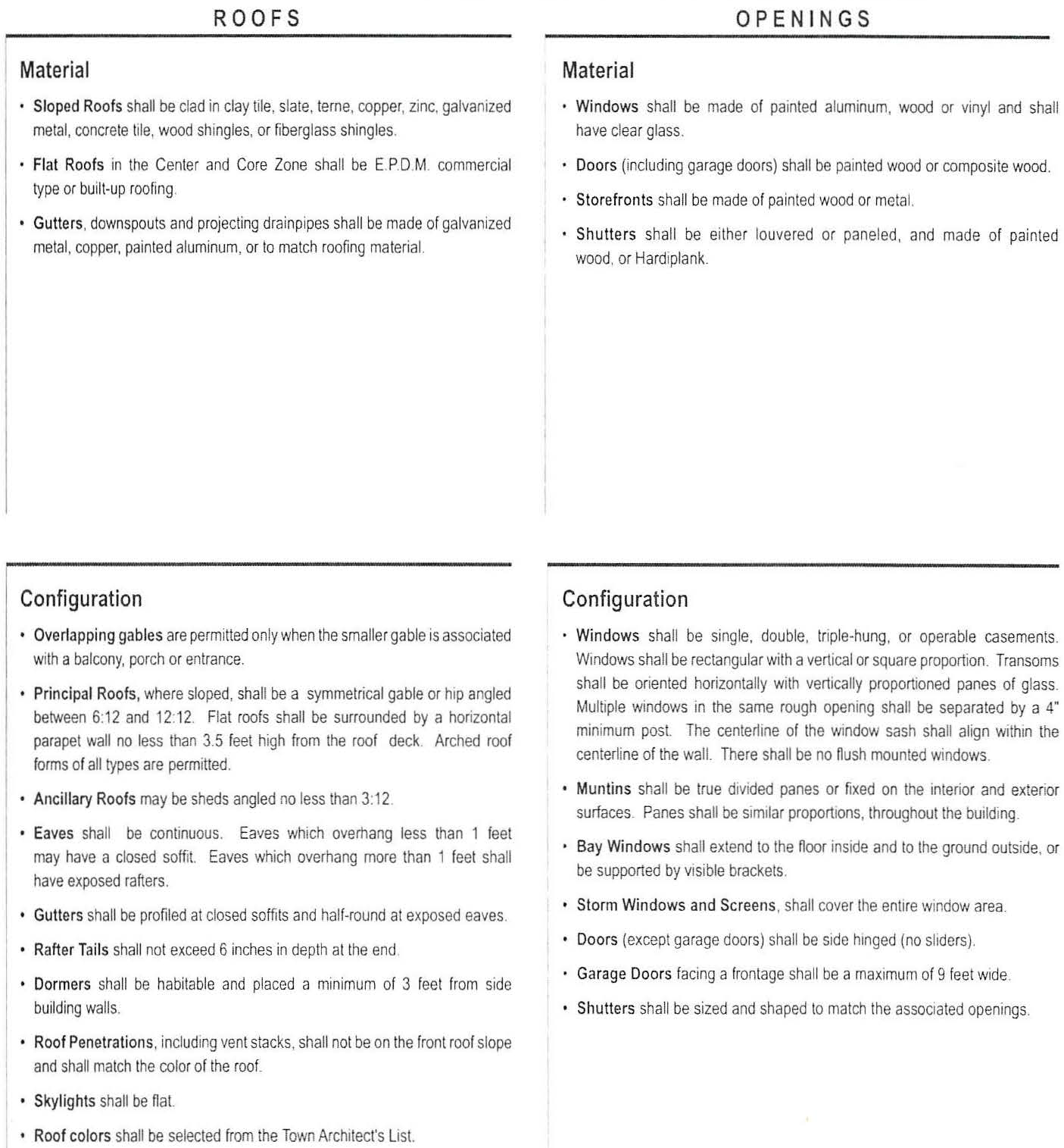
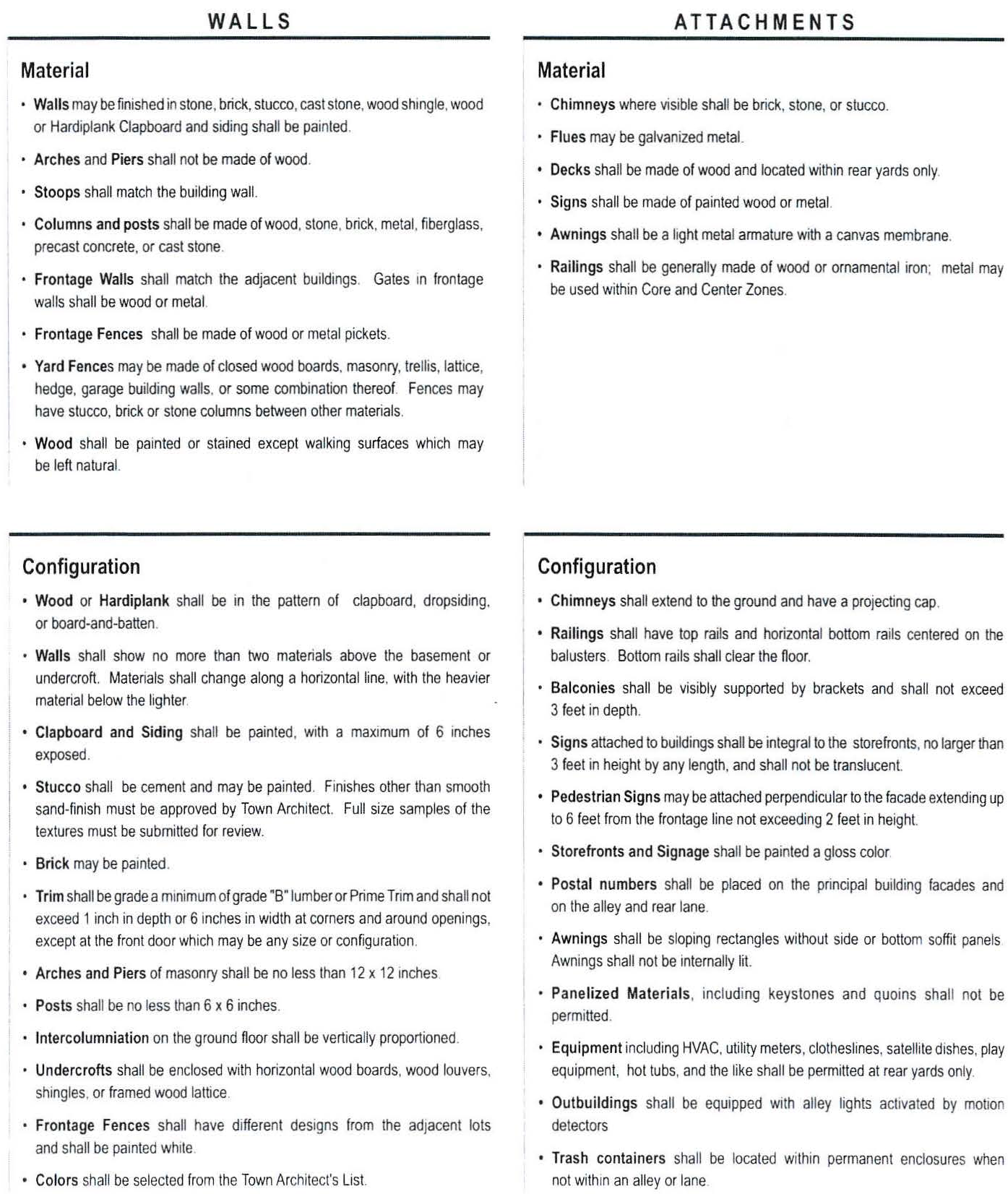
Attachment D: Thoroughfare Standards
Thoroughfare types within Clark's Grove are shown on the regulating plan and defined below.
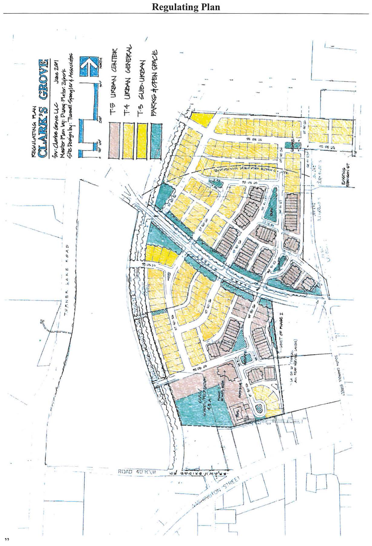
(Ord. date 9/4/18, § 1)