
Dade City City Zoning Code
ARTICLE 6
- DEVELOPMENT STANDARDS
SECTION 6.10 - OPEN SPACE STANDARDS
This section addresses the character and design of those portions of development that are not occupied by platted lots or streets and that are reserved for parks, trails, landscaping, and open space uses. The standards of this section apply regardless of whether or not the land involved will be dedicated to the City, and regardless of whether or not such open space will be open to the public or to other residents of the development.
SECTION 6.11 - GENERAL COMMERCIAL DESIGN STANDARDS[1]
Editor's note— Ord. No. 2016-02, § 3 (Exh. A), adopted Feb. 23, 2016, set out provisions intended for use as § 6.6.1. Inasmuch as there were already provisions so designated, said section has been codified herein as § 6.11.1 at the discretion of the editor.
6.1.1 - Purpose and Intent
It is the purpose and intent of these LDRs that the public health, safety, and welfare requires development be provided with adequate off-street parking facilities for the use of occupants, employees, visitors, customers, or patrons. It is also the purpose and intent of these LDRs that the public health, safety, and welfare require that certain uses provide adequate off-street loading facilities. All required off-street parking and off-street loading facilities shall be maintained and continued as long as the development continues.
6.1.2 - Applicability
(A)
General. The provisions of this Section 6.1, Off-Street Parking and Loading Standards, shall apply to all development within the City.
(B)
Time of Compliance: Plan Required. A plan shall be submitted with an application for a site and construction plan (Section 2.4.9, Site and Construction Plan), subdivision (Section 2.4.10, Subdivision), planned development (Section 2.4.3, Planned Development Districts), or building permit, whichever occurs first, for any development or change in use that is required to provide off-street parking in accordance with this section. The plan shall accurately designate the required parking spaces, access aisles, and driveways, and the relation of the off-street parking facilities to the uses or structures such facilities are designed to serve.
6.1.3 - General Standards for Off-Street Parking and Loading
(A)
Development in Existence on August 12, 2014.
(1)
No Enlargement in Floor Area. Development in existence on August 12, 2014, that is altered or remodeled is not required to provide additional off-street parking or off-street loading facilities if the floor area is not increased.
(2)
Enlargement in Floor Area. Development in existence on August 12, 2014, that is enlarged in floor area, shall provide the off-street parking and off-street loading facilities required by the standards of this section for the floor area added to the development.
(3)
Change in Use. Development in existence on August 12, 2014, in which there is a change in use shall comply with the standards of this section (provide additional off-street parking or loading facilities if there is a difference between the off-street parking or off-street loading facilities required by this section and the off-street parking and loading facilities on-site prior to the change in use).
(B)
Off-street Parking Not Used for Sales or Display, Dead Storage, Repair, Dismantling, or Servicing. Required off-street parking facilities shall not be used for sales or display, dead storage, repair, dismantling, or servicing of any type or kind, nor shall areas devoted to such uses be used to comply with the off-street parking standards of this section.
(C)
Off-Street Parking in Required Yards. Unless otherwise specified and subject to meeting required landscape buffer standards (Section 6.2), all required yards may be used for off-street parking.
(D)
Identified as to Purpose and Location. Required off-street parking and off-street loading standards shall be identified as to purpose and location when not clearly evident. Paved public parking areas shall include painted lines, bumper stops, or other methods of identifying individual parking spaces and distinguishing such spaces from aisleways.
(E)
Surfacing of Off-Street Parking.
(1)
General. Required off-street parking and off-street loading areas shall, at a minimum, be surfaced with structurally adequate asphaltic concrete or concrete surface course, and maintained in a smooth, well-graded condition (driveways, access aisles, and parking spaces for all churches, public and private schools offering academic courses may be surfaced with grass or lawn).
(2)
Alternative Surfacing Materials. The DRC may approve the use of pervious or semi-pervious parking area surfacing materials, including but not limited to grass, semi-pervious concrete block planted with grass, gravel, crushed stone, and recycled materials such as glass, rubber, used asphalt, brick, block and concrete for off-street parking spaces which exceed the minimum standards provided that such areas are properly maintained. Where possible, such materials should be used in areas proximate to and in combination with on-site stormwater control devices. Asphalt millings are not permitted for parking areas.
(F)
Drained to Avoid Nuisances. Required off-street parking shall be drained so as not to cause any nuisance on adjacent property.
(G)
Lighted to Prevent Glare. Required off-street parking shall be lighted to prevent glare or excessive light on adjacent property, in accordance with Section 6.4, Exterior Lighting Standards.
(H)
Arrangement. Required off-street parking shall be arranged for convenient access and safety of pedestrians and vehicles.
(I)
Curb Breaks. Required off-street parking shall be designed to conform to curb break requirements (see Section 7.3.1: Streets.)
(J)
Arranged So No Vehicles Back onto Streets. Required off-street parking shall be arranged so no vehicle shall be required to back from such facilities directly onto public streets.
(K)
Curbs and Motor Vehicle Stops. Required off-street parking shall be designed to provide curbs or motor vehicle stops or similar devices to prevent vehicles from overhanging on or into public right-of-way or adjacent property.
(L)
Maintained in Good Repair. Required off-street parking shall be maintained in good repair and in safe condition at all times, so as not to constitute a hazard to public safety or a visual or aesthetic nuisance to surrounding properties.
(M)
Portions Do Not Apply to One- and Two-Family Dwellings. The design, construction, and arrangement requirements set forth in this section for off-street parking and off-street loading facilities do not apply to one- and two-family (duplex) dwellings.
(N)
Large Retail Establishments. Off-street surface parking serving a Large Retail Establishment shall be located and configured in accordance with the standards of this section and Section 6.6.1(C)(1), Off-Street Parking.
6.1.4 - Off-Street Parking Standards
(A)
General Requirements.
(1)
Location. Off-street parking, loading, and unloading facilities shall be provided to lessen congestion in the streets. The facilities required herein shall be available throughout the hours of operation of the particular business or use for which such facilities are provided.
As used herein, the term "parking space" includes either covered garage space or uncovered parking lot space located off the public right-of-way.
(2)
Exception. Notwithstanding subsection (1) above, the DRC may allow the establishment of off-street parking facilities within 300 feet of the premises they are intended to serve when:
(a)
Practical difficulties prevent the placing of the facilities on the same lot as the premises they are designed to serve;
(b)
The owner/developer of the parking area enters into a written agreement with the City, with enforcement running to the City, providing that the land comprising the parking area shall never be disposed of except in conjunction with the sale of the building that the parking area serves, so long as the facilities are required; and
(c)
The owner/developer agrees to bear the expense of recording the agreement and agrees that the agreement shall be voided by the City if other off-street facilities are provided for the development in accordance with the requirements of this section.
(B)
Amount Required.
(1)
Minimum Off-Street Parking Required. All development allowed in accordance with Table 4.1-1, Table of Allowed Uses, shall provide at least the minimum amounts of off-street parking shown in Table 6.1-1, Minimum Off-Street Parking Standards.
(2)
Exceptions for Certain Zone Districts.
(a)
Notwithstanding the requirements of subsection (1) above, no parking shall be required for any uses and activities in the CBD district.
(b)
Notwithstanding the requirements of subsection (1) above, no additional off-street parking shall be required for any use or activity existing on August 12, 2014. However, if a residential use existing at the time of August 12, 2014, is changed, then off-street parking shall be provided as required in accordance with this section. In addition, uses in buildings constructed after the effective date of these LDRs shall provide off-street parking as required in accordance with this section.
(3)
Unlisted Uses. In the event a use is not listed in Table 6.1-1: Minimum Off-Street Parking Standards, the minimum required off-street parking requirement shall be that of the use with parking requirements or characteristics that are most similar to the unlisted use, as determined by the Community Development Director.
(4)
Alternative Minimum Requirement. Regardless of any other requirement of these LDRs, including without limitation the requirements of Table 6.1-1: Minimum Off-Street Parking Standards, each and every separate individual store, office, or other business shall be provided with at least one (1) off-street parking space, unless specific provision to the contrary is made.
(5)
Maximum Off-Street Parking Allowed.
(a)
For any use categorized in Table 6.1-1: Minimum Off-Street Parking Standards, off-street automobile parking spaces shall not be provided in an amount that is more than 150 percent of the minimum requirements established in Table 6.1-1. For example, a use required to provide a minimum of 30 off-street parking spaces based on Table 6.1-1 shall not provide more than a total of 45 spaces (30 x 1.50 = 45).
(b)
The maximum number of allowable parking spaces may be adjusted by the DRC if the applicant provides a parking study that supports a different number of parking spaces than is required by the City.
(C)
Parking of Certain Vehicles and Major Recreational Equipment.
(1)
Automotive Vehicles or Trailers. In residential districts, automotive vehicles or trailers of any type without current license plates shall not be parked or stored other than in completely enclosed buildings.
(2)
Major Recreational Equipment. No major recreational equipment shall be used for living, sleeping, or housekeeping purposes when parked or stored on a lot in a residential district, or in any other location not approved for such use. In residential districts, major recreational equipment may be parked or stored in a rear or side yard, provided that the side yard is not adjacent to a street. No major recreational equipment may be parked or stored in the required front yard; provided however, that such equipment may be parked anywhere on residential premises for a period not to exceed 24 hours during loading and unloading. For the purposes of this section, major recreational equipment is defined as including boats and boat trailers, travel trailers, pickup campers or coaches (designed to be mounted on automotive vehicles), motorized dwellings, tent trailers, houseboats, POD units for moving, and the like, and cases or boxes used for transporting recreational equipment, whether occupied by such equipment or not.
(3)
Storage or Overnight Parking of Commercial or Industrial Vehicles. Storage or overnight parking of commercial or industrial vehicles in excess of one (1) ton capacity is prohibited in all residential districts. Storage or overnight parking of commercial or industrial vehicles in excess of one (1) ton capacity is prohibited in business districts unless said location within the business district is approved for such use.
(4)
Storage or Overnight Parking of Recreational Vehicles. No recreational vehicle, as defined above, shall be stored or parked overnight in business districts, unless said location within the business district is approved for such use.
(D)
Bicycle Parking.
(1)
Required Improvements. All development with off-street surface parking lots with 100 or more parking spaces shall provide bicycle parking facilities in accordance with the following standards:
(a)
Rate of Provision. Bicycle parking spaces shall be provided at a rate of one (1) space for every 1,000 square feet of building area;
(b)
Located Within 50 Feet of Entrance. Bicycle parking facilities shall be located within 50 linear feet of the building's main entrance, and located outside of vehicular use areas and pedestrian travel ways; and
(c)
Securing Device. Bicycle parking areas shall be equipped with a rack or other device to enable bicycles to be secured.
(2)
Incentives for Bicycle Parking Facilities. For developments served by fewer than 100 off-street parking spaces, the minimum number off-street parking spaces required in Table 6.1-1, Minimum Off-Street Parking Standards, may be reduced by up to five percent (5%) based on the provision of at least 5 bicycle parking spaces in accordance with the standards in Section 6.1.4(D)(1).
6.1.5 - Off-Street Loading Standards
Off-street loading facilities are required by these LDRs so that vehicles engaged in unloading will not encroach on or interfere with public use of streets and alleys.
(A)
In addition to the off-street parking space required above, any building erected, converted, or enlarged in any district for commercial, office building, manufacturing, wholesale, hospital, or similar uses, shall provide adequate off-street areas for loading and unloading of vehicles. The minimum size loading space shall be fifty (50) feet in depth, twelve (12) feet in width, with an overhead clearance of fourteen (14) feet.
(B)
All commercial and industrial establishments shall provide loading and unloading and commercial vehicle storage space adequate for their needs. This required space will be provided in addition to established requirements for patron and employee parking.
(C)
In no case where a building is erected, converted, or enlarged for commercial, manufacturing, or business purposes shall the public right-of-way be used for parking or loading and unloading of materials.
6.1.6 - Design and Maintenance Standards
(A)
Parking Dimensions - General. Each off-street parking space, with the exception of handicapped parking spaces, shall be a minimum of nine (9) feet by eighteen (18) feet in size. Compact parking spaces shall not be less than eight (8) feet wide and seventeen (17) feet long. Commercial and industrial parking may be at a ratio of seventy-five (75) percent full-size to twenty-five (25) percent compact parking spaces. Minimum aisle width shall be as shown in the following table.
(B)
Loading Space Dimensions. Each off-street loading space shall have clear horizontal dimensions of 12 feet by 50 feet exclusive of platforms and piers and a clear vertical dimension of 14 feet.
(C)
Unique Site Constraints. Where unique site configurations or constraints preclude the construction of some parking spaces meeting the minimum dimensions set forth in this subsection, the DRC may authorize the replacement of up to five (5) percent of required parking spaces by parking spaces with reduced dimensions, provided that:
(1)
Minimum Dimensions. No such parking space approved by the DRC shall have dimensions smaller than 8 feet in width by 15 feet in length; and
(2)
Marked for Use for Compact Cars Only. Each such parking space shall be required to be clearly marked for use only by compact vehicles.
(D)
Landscaping and Screening. All required off-street parking and loading areas shall comply with the provisions of Section 6.2: Tree Protection/Landscape Standards, as they apply to parking and loading areas.
6.1.7 - Vehicle Stacking Spaces
The development and design standards of this subsection shall apply to all drive-in and drive-through facilities and other auto-oriented uses.
(A)
Minimum Number of Vehicle Stacking Spaces. Off-street stacking spaces shall be provided as follows:
(B)
Design and Layout. Required drive-through lanes and facilities and vehicle stacking spaces are subject to the following design and layout standards:
(1)
Vehicle Stacking Spaces.
(a)
Size. Vehicle stacking spaces shall be a minimum of nine (9) feet by 20 feet in size.
(b)
Location. Stacking spaces shall not impede on- or off-site traffic movements, nor impede movements into or out of off-street parking spaces.
(c)
Design.
a.
Stacking spaces shall be separated from other internal driveways by raised medians if the DRC determines the median is necessary for traffic movement and safety.
b.
Vehicle stacking areas adjacent to public streets or sidewalks shall be separated from such streets or sidewalks by walls or landscaping with berms.
(2)
Drive-In and Drive-Through Facilities and Lanes.
(a)
Drive-in facilities (e.g., order stations, pick-up windows, bank teller windows, money machines, etc.) shall be located on the side or rear of principal structures to minimize their visibility from public streets.
(b)
To the maximum extent practicable, drive-in lanes shall not be located between the principal structure and adjacent public streets or sidewalks, or other public gathering places (such as a park or a bus stop). If this is not possible, drive-in lanes and facilities shall be set back a minimum of 15 feet from any adjacent public street or sidewalk or other public place. The entire 15-foot setback shall be landscaped and bermed to screen the drive-in lane and facility from adjacent streets.
(c)
Car wash facilities and gas station auto service bays shall be located on the side or rear of principal structures to minimize their visibility from public streets.
(d)
In addition to any screening required by Section 6.2, Tree Protection/Landscape Standards, drive-in lanes adjacent to residential uses shall be separated from such uses by an opaque wall at least six (6) feet high, located so that required buffer landscaping is between the wall and the adjacent residential use.
(e)
A full double by-pass lane shall be provided.
(3)
Primary Drive Aisles. Primary drive aisles are required within off-street surface parking lots of 300 or more spaces, and shall be configured to appear as an extension of the public street network through the provision of:
(a)
Sidewalks, parallel to the building façade;
(b)
At least one designated crosswalk connecting the sidewalks near the primary entrance of each building served;
(c)
Canopy trees, spaced no less than 40 feet on center, located on both sides of the aisle, within 3 feet of the curb, and extending the full length of the aisle; and
(d)
A road crown in the center of the aisle to encourage positive drainage and to simulate a public street.
(Ord. No. 2016-02, § 3 (Exh. A), 2-23-2016)
6.1.8 - Accessible Parking for Disabled Persons
(A)
Amount of Accessible Spaces. Except as otherwise specified in these LDRs, required off-street parking areas shall be provided as required and have a number of level parking spaces that do not exceed a two (2) percent grade. These spaces shall be included in the required number of parking space required in Table 6.1-1: Minimum Off-Street Parking Standards. Each parking space so reserved shall be not less than 12 feet in width and 18 feet in length. The number of parking spaces shall be determined by the Building Official.
(B)
Location of Handicapped Spaces. Parking spaces for the physically handicapped shall be located as close as possible to elevators, ramps, walkways, and entrances. These parking spaces should be located so that physically handicapped persons are not compelled to wheel or walk behind parked cars to reach entrances, ramps, walkways, and elevators.
6.1.9 - Pedestrian Facilities
Required Improvements. Pedestrian pathways shall be provided in off-street surface parking lots with ten (10) or more parking spaces in accordance with the following standards:
(A)
Pedestrian crosswalks, at least ten (10) feet in width, either raised above the adjacent pavement, striped, or otherwise designated through the use of alternative materials, shall be located between all primary building entrance(s) and the parking areas serving those entrances; and
(B)
Within parking lots of ten (10) or more spaces, improved pedestrian pathways, with a minimum width of three (3) feet, located in continuous landscaped parking islands, shall be provided in at least every fourth (4th) row of parking spaces.
6.1.10 - Alternative Compliance
(A)
Combined Off-Street Parking. Two (2) or more owners or operators of buildings or uses requiring off-street parking facilities may make collective provision for such facilities, provided that the total of such parking spaces when combined or used together shall not be less than the sum of the requirements computed separately.
(B)
Combined Off-Street Loading. Collective, joint, or combined provisions for off-street loading facilities for two (2) or more buildings or uses may be made, provided that such off-street loading facilities are equal in size and capacity to the combined requirements of the several buildings or uses and are designed, located, and arranged to be usable by such uses.
(C)
Shared Parking Plan. If a property owner in a business district believes that, (a) the full number of off-street parking spaces required by Table 6.1-1: Minimum Off-street Parking Standards, is not necessary to provide adequate off-street parking for the proposed use because of unique characteristics of the site or the proposed uses; or (b) desires to share parking spaces with nearby uses in a manner that is not authorized by subsection (A) above; or (B) desires to have two or more adjacent properties considered as a single parcel for purposes of compliance with parking requirements, and the sum of the available parking on such lots is sufficient to meet the sum of the minimum off-street parking requirements for each use on such properties, the property owner may apply to the DRC for approval of a shared parking plan. The DRC may approve such an application, or approve it with modifications, if it is determined the shared parking plan provides adequate off-street parking for the proposed uses, and would not significantly increase on-street parking in the area. The DRC may condition the approval of a shared parking plan on the applicant adopting restrictions on hours of operation of one or more participating use in order to ensure that the shared parking is adequate for anticipated needs.
(D)
Agreements. Any use of any of the parking or loading alternatives identified in the Section, 6.1.10, Alternative Compliance, shall be subject to the filing of a deed restriction satisfactory to the City Attorney ensuring that such off-street parking or loading will be maintained in the future so long as a use or uses requiring such off-street parking or loading continue. If all or a portion of the parking required to serve a use is located on a property under different ownership, the City may require the execution of an agreement among the property owners involved as a pre-condition to approval of the requested parking alternative, and may record such agreement in the title records of the properties involved.
6.2.1 - Tree Protection Standards
(A)
Purpose. The purpose of tree protection standards is to limit the destruction of and ensure the survival of as many trees as possible in the City of Dade City. The maintenance of existing trees and replanting of new trees in necessary to promote the value of property and the quality of life of its citizens; to ensure the stabilization of soil by prevention of erosion; to reduce stormwater runoff and the costs associated with it; to replenish groundwater supply; to cleanse the air of harmful pollutants; and, to provide greenbelts and buffers to screen against noise pollution, artificial light, and glare. It is the intent of this section to prohibit the unnecessary clearing of land so as to achieve no net loss of trees and to preserve, as much as possible, the existing tree canopy.
(B)
Findings. The City Commission finds that:
(1)
The protection and preservation of trees on public and private property within the City is not only desirable for aesthetic value, but essential to present and future health, safety, and welfare of its citizens; and
(2)
Trees absorb a high percentage of carbon dioxide and return oxygen, a vital ingredient to life, to the environment; and
(3)
Trees are a valuable property asset that can affect an area economically; and
(4)
A tree protection section in these LDRs is necessary in order to promote community welfare through regulating the removal and destruction of trees prior to and during construction and occupancy.
(C)
Applicability. The terms and provisions of this Section shall apply to all real property lying within the incorporated limits of the City, including publicly owned lands, rights-of-way and easements, subject to certain exemptions specifically provided for in this section.
(D)
Exemptions.
(1)
Transplant of trees.
(2)
Trees less than four (4) inches diameter at breast height.
(3)
Utilities and other governmental agencies that are acting in the public interest; however, these agencies will be required to follow ANSI standards.
(4)
During any period of emergency, such as hurricanes, windstorms, floods, freezes, or other natural disasters, the requirements of this section may be waived for a definite period of time by the City Manager with respect to cutting and removing damaged trees in all areas affected by such disaster.
(5)
Any tree determined to be in a hazardous condition by the City Manager, so as to endanger the health, safety, and welfare of persons and property, and require immediate removal shall be exempt from the requirement of this section. Such tree may be cut and removed upon verbal authorization by the City Manager, or in his or her absence, the Community Development Director.
(6)
Any land recognized by the City upon which bona fide agricultural uses and practices as recognized by the Pasco County Property Appraiser are being conducted.
(7)
Plant or tree nurseries with regard to those trees grown specifically for sale to the general public in the ordinary course of such plant and tree nursery business.
(8)
Lands owned by Dade City, including right-of-way.
(E)
Tree Removal Application and Permit.
(1)
Tree Removal Permit Required. It shall be unlawful for any person to remove or effectively remove any tree as defined herein and which is located within the City limits without first obtaining a tree removal permit from the building department. A fee shall be charged for the issuance of such permit, which fee shall be paid at time of application. Trees in excess of 40' inches DBH may not be removed.
(2)
Permit Application. Any person wishing to obtain a permit to remove a tree(s) shall file an appropriate application with the Building Official consistent with the following:
(a)
For tree removal around an established single-family residence or place of business:
(i)
A sketch of the land involved indicating the location of all structures, drives, walks, existing trees, and those trees to be removed; and
(ii)
A list of type/species and size of those trees desired for removal; and
(iii)
A list of trees by size and type to remain, or to be replanted; and
(iv)
An explanation of the reason for requesting the removal of subject tree(s).
(b)
For tree removal, replanting, or retention on undeveloped sites proposed for new residential, commercial or other developments, and expansions of existing nonresidential improvements on previously platted or subdivided sites, a tree removal permit application shall be filed concurrent with the submittal of the preliminary site plan. The tree removal permit application shall contain a site plan which shall include the following:
(i)
Location, name/species and size of all trees proposed to be removed and/or replanted; and
(ii)
Location, name/species and size of all trees to be retained on-site; and
(iii)
Location of all planned roadways, drives or other paved areas, all structures, all utility easements and lines; and
(iv)
Any planned grade changes that might endanger survival of any existing tree(s) or trees to be retained; and
(v)
An explanation as to the reason for requesting the removal of the subject tree(s).
(F)
Permit review standards. The Building Official or his designee shall be guided by the following standards when determining which, if any, trees may be removed in connection with any development:
(1)
Trees in excess of twelve (12) inches diameter at breast height but less than forty (40) inches DBH may be removed only where a development configuration or alignment designed to preserve such tree(s) would create an unnecessary hardship for the developer.
(2)
In conjunction with any development, building or land clearing, with the exception of trees over twelve (12) inches diameter at breast height, a percentage of other trees, as defined herein, may be removed in accordance with the following table. Removal of any trees over these percentages shall require replacement on an inch-per-inch basis or financial contribution to the City's tree bank.
(3)
In connection with tree removal on individual lots or residential properties, those trees which may be removed without replacement are as follows:
(a)
Trees which are determined by City staff to be diseased, dead, or severely damaged or which are a hazard, or trees located within eight (8) feet of any structure or improvement to be constructed.
(b)
Tree removal may not be done on any property other than that developed with a single-family home, for which no site plan or preliminary plan has been approved.
(G)
Tree Planting, Relocation, Replacement, Credit, Banking.
(1)
Any tree(s) removed in excess of that allowed above shall, as a condition to approval of the tree removal permit shall be relocated or replaced on an inch-for-inch basis. Replacement trees shall be of the shade/canopy type as recommended in Appendix A. The replacement tree shall be no less than eight (8) feet in height, two (2) inches DBH and with an appropriate canopy as consistent with the Florida Grades and Standards for Nursery Stock. If replacement trees are installed, the applicant shall guarantee the survival of the replacement trees and a follow-up, on-site inspection by the building department six (6) months after planting shall be done. Failure to comply with these provisions will subject the applicant to either civil or criminal penalties, or both.
(2)
In lieu of tree replacement or relocation on the subject property, the applicant, at the City's option, may replant approved trees on City owned property or contribute a per tree monetary fee as follows. Fees collected in lieu of replacement shall be placed by the City in a fund for a tree bank for tree replacement or for the use of a trained arborist or horticulturist, educational purposes and/or for the enforcement or for advancement of this Section. Such fees are hereby established as follows:
Individual single-family residential lots:
(a)
Four-inch to less than ten-inch DBH, $25.00 per inch removed.
(b)
Ten-inch to less than 20-inch DBH, $50.00 per inch removed.
(c)
20-inch to less than 30-inch DBH, $75.00 per inch removed.
(d)
30-inch and greater DBH, $100.00 per inch removed.
All other development:
(a)
Four-inch to less than ten inch DBH, $50.00 per inch removed.
(b)
Ten inch to less than 20 inch DBH, $100.00 per inch removed.
(c)
Twenty inch to less than 30 inch DBH, $125.00 per inch removed.
(d)
Thirty-inch and greater DBH, $150.00 per inch removed.
(3)
The Building Official may waive the requirements for replacement described in this Section if the tree or tree cluster is located within that portion of the driveway which is within eight (8) feet as measured perpendicular to the garage or carport entrance.
(H)
Variance. Where strict adherence to the provisions of this Section is impossible or impractical and the owner/developer can demonstrate sufficient evidence of hardship other than financial hardship which is caused by his own actions, he may apply for a variance from the provisions of this Section. Such variance shall be processed and administered in accordance with Section 2.4.5 Variance Permits. The application for variance shall clearly and specifically state what adjustment is being requested and the reasons why such adjustment is warranted. Any applicable fee shall be paid upon application for the variance. Tree replacement costs or fees associated with this requirement shall not be grounds for issuance of a variance.
(I)
Tree Protection During Construction/Development: It shall be unlawful for any person, during the development of any property, or during the construction of any structures or the improvement of any property, to place solvents, material, machinery, or temporary soil deposits within the drip line of any tree (4) four inches or more DBH. During construction, improvement, or development of the property, the owner, or his agent(s), shall be required to place visible physical protective barriers around all trees designated for retention, and these protective structures, where required, shall remain until such time as they are authorized to be removed by the Building Official or issuance of final certificate of occupancy. Protective structures shall be provided as described in this Section and the Florida Department of Agriculture, Division of Forestry, publication Tree Protection Manual for Builders and Developers. Barriers shall not be required in the following situations:
(1)
Road right-of-way, utility easements, etc. These areas may be ribboned by placing stakes a minimum fifty (50) feet apart and tying ribbon, plastic tape, rope, etc., from stake to stake along the outside perimeters of such areas to be cleared.
(2)
Large property areas separate from the construction or land clearing area into which no equipment will venture may also be ribboned off as above.
(J)
Rights-of-way.
(1)
It shall be unlawful to plant any tree or shrub in any unpaved portion of the public right-of-way or parkway or other public place without first having permission in writing from the Public Works Director, and any tree or shrubs planted shall be planted and placed as specifically directed by the City.
(2)
It shall be unlawful to injure or destroy any tree or shrub in any public right-of-way or parkway or other public place. Offenders shall be subject to penalties as provided in this Code.
6.2.2 - Landscaping General
(A)
Purpose. The purpose of these landscaping standards is to provide an aesthetically pleasing environment for the residents of the City. The standards are intended to maintain and enhance property values, enhance the appearance of development, provide adequate buffers between incompatible uses, improve the character and appearance of the City, and reduce erosion and stormwater runoff.
(B)
Applicability. These standards shall apply to the following development in the City:
(1)
Single-Family Lots or Dwellings. The subdivision or development of 10 or more single-family residential lots or dwellings.
(a)
Single-Family Attached Dwellings. The subdivision or development of five (5) or more single-family attached dwellings.
(2)
Two- to Four-Family Dwellings. The subdivision or development of five (5) or more two- to four-family dwellings.
(3)
Manufactured Home Park. Subdivision for a manufactured home park.
(4)
New and Existing Multi-Family Structure. Development of a multi-family structure or redevelopment of an existing multi-family structure that results in an increase in building square footage of 50 percent or more.
(5)
Nonresidential. Development of a non-residential structure or redevelopment of a nonresidential structure that results in an increase in building square footage or impervious surface by 50 percent or more.
(6)
Parking Lot. Development of a new parking lot for 10 or more spaces.
(7)
Existing Parking Lot. Redevelopment or expansion of an existing parking lot that results in an increase of 25 or more spaces. Redevelopment or expansion includes items such as repaving, changes in ingress or egress, and reconstruction of stormwater drainage systems.
(C)
Landscape Plan and Approval Required. A landscape plan shall be submitted with an application for a site plan and construction plans (Section 2.4.8, Site and Construction Plans), subdivisions (Section 2.4.7, Subdivision), planned developments (Section 2.4.3, Planned Development Districts), or building permit, whichever occurs first, for any development or change in use that is required to provide landscaping in accordance with this section. The landscape plan shall contain the following information which spells out how the development proposed will comply with this section:
(D)
Identification of Existing Trees. The location, common name, and size existing regulated trees. (For a development that is greater than 10 acres, an aerial photograph, or a print of equal quality, may be substituted instead of the inventory if it provides essentially the same information as the tree survey.)
(E)
Identification of Existing Trees to be Maintained. The location, common name, and estimated size of existing trees that are to be maintained as part of a tree protection zone or preserved for credit.
(F)
Parking Areas, Buffers Areas, and Other Planting Areas. The locations and dimensions of parking areas, perimeter buffer areas, and other planting areas.
(G)
Identification of New Plant Materials. The size, botanical name, common name, and spacing of new plant materials.
(H)
Fences, Walls, or Earthen Berms. The location and design of any fence, wall, or earthen berm indicating size, and materials.
(I)
Barriers Required to Protect Existing Vegetation. The location and description of any barriers required to be erected to protect any existing vegetation from damage, both during and after construction.
(J)
Maintenance. Provisions for watering and other long-term maintenance to assure serviceability, soil stabilization, and plant protection.
(K)
Xeriscape. Explanation of how xeriscape principles are utilized.
6.2.3 - Landscape Standards
(A)
Site Landscaping. The following site landscaping shall be required for the following development.
(1)
Multi-Family and Townhouses.
a.
Four (4) canopy trees per acre, planted on the primary or street-facing side, and two (2) canopy trees per acre planted on each of the sides and rear of each structure. An existing canopy tree that is a native species and in very good to excellent health can be utilized to fulfill this requirement. It is encouraged that the tree be located so that it may provide shade on the structure during the summer afternoon.
b.
Eight (8) ornamental/understory trees per acre, with 50 percent planted in front and 25 percent on each side.
c.
A row of shrubs along the front façade of the structure, with consideration given to access to utility meters or mechanical equipment. Shrubs shall not be planted directly against the structure, but a minimum of two (2) feet from the façade to facilitate adequate air circulation.
d.
A combination of solid sod, seeding, and sprigs shall be used to cover 100 percent of the lot site disturbed by construction activities. Areas of native vegetation are not required to be sodded. An area within 20 feet of the front building façade shall be sodded with other disturbed areas to be sodded, seeded or sprigged.
(2)
Public and Institutional Uses.
a.
Four (4) canopy trees per acre, planted on the primary or street-facing side, three (3) canopy trees per acre planted on each of the sides and rear of each structure, and an additional four (4) canopy trees for each 100 lineal feet of façade, planted in front of the facade. An existing canopy tree that is a native species and in very good to excellent health can be utilized to fulfill this requirement if it is located within 25 feet of the building. It is encouraged that the tree be located, so that it may provide shade on the structure during the summer afternoon.
b.
Eight (8) ornamental/understory trees per acre, with 50 percent planted in front of the structure and 25 percent planted on each side.
c.
A row of shrubs planted along all façades of the structure, with consideration given to access to utility meters or mechanical equipment. In lieu of a horizontal line of shrubs along the front façade, shrub masses of three (3) or more species may be utilized. Shrubs shall not be planted directly against the structure, but a minimum of two (2) feet from the façade to facilitate adequate air circulation.
d.
A combination of solid sod, seeding, and sprigs to cover 100 percent of the lot site disturbed by construction activities. Areas of native vegetation do not have to be sodded. An area within 20 feet of the front building façade shall be sodded with other disturbed areas to be sodded, seeded or sprigged.
(3)
Business Uses.
a.
Three (3) canopy trees per acre, planted on the primary or street-facing side, two (2) canopy trees per acre planted on each of the sides and rear of each structure, and an additional four (4) canopy trees for each 100 lineal feet of façade, planted in front of the facade. An existing canopy tree that is a native species and in very good to excellent health can be utilized to fulfill this requirement if it is located within 25 feet of the building. It is encouraged that the tree be located so that it may provide shade on the structure during the summer afternoon.
b.
Six (6) ornamental/understory trees per acre, with 50 percent planted in front of the structure and 25 percent planted on each side.
c.
A row of shrubs planted along all façades of the structure, with consideration given to access to utility meters or mechanical equipment. In lieu of a horizontal line of shrubs along the front façade, shrub masses of three (3) or more species may be utilized. Shrubs shall not be planted directly against the structure, but a minimum of two (2) feet from the façade to facilitate adequate air circulation.
d.
A combination of solid sod, seeding, and sprigs to cover 100 percent of the lot site disturbed by construction activities. Areas of native vegetation do not have to be sodded. An area within 20 feet of the front building façade shall be sodded with other disturbed areas to be sodded, seeded, or sprigged.
(4)
Alternative Placement. In cases where the configuration or topographical constraints of an existing site make the placement of required site landscaping impractical, the Community Development Director may approve up to 50 percent of the required landscaping to be planted on adjacent public property in accordance with Section 6.2.3 (H), Alternative Landscape Plan.
(B)
Parking Lot Landscaping.
(1)
Interior Landscaping. All parking lots shall provide and maintain the following landscaped planting areas within the interior of the parking lot. These standards shall not apply to parking structures or vehicle display areas.
a.
Each planting area shall contain an area adequate to accommodate the root growth of the plant material used. The size of the planting area and size of plant material at maturity shall allow for a two and one-half foot bumper overhang from the face of the curb.
b.
Interior planting areas shall be designed within parking areas as: (1) islands located at the end of parking bays; (2) islands located between parallel rows of cars, used to visually separate parking areas; or (3) driveway medians, which shall have a minimum width of four (4) feet for medians with shrubs, six (6) feet for medians with shrubs and intermediate trees and nine (9) feet for medians with large trees.
c.
Trees shall be required at the minimum rate of one canopy or ornamental/understory tree for every 2,000 square feet, or portion thereof, of the total parking lot area;
d.
Shrubs shall be required at the minimum rate of 10 shrubs per canopy or ornamental/understory tree. They may be massed around the tree(s), and are encouraged to be planted toward the interior of the islands, so as not to interfere with vehicle doors opening and closing;
e.
Reserved.
f.
As a general guide, one (1) tree island should be located at approximately ten (10) space intervals;
g.
No parking space shall be separated from the trunk of an interior parking lot ornamental or canopy tree by more than 90 feet;
h.
In cases where the configuration or topographical constraints of an existing site make the placement of required site landscaping impractical, the Community Development Director may approve up to 50 percent of the required landscaping to be planted on an adjacent public property in accordance with Section 6.2.3 (H) Alternative Landscape Plan.
i.
All planting areas shall be stabilized with ground covers, mulching, or other approved materials to prevent soil erosion and allow rainwater infiltration, and shall be irrigated or utilize a xeriscape irrigation alternative.
j.
Landscape planting areas shall be distributed throughout the parking area for the purpose of heat abatement.
k.
All planting areas shall be protected from vehicle damage by the installation of curbing, wheel stops, or other comparable methods.
l.
Earthen berms may also be incorporated into the design of any required planting area. Any berm installed shall have a side slope of no greater than 2:1.
(2)
Parking Lot Buffer. All parking lots shall have landscape buffers around their exterior perimeter that shall be composed of trees, shrubs, groundcover and turf grass.
a.
The buffer shall form a continuous visual screen, excluding required site clearances at driveways. It shall be placed and located to assure visibility and safety of pedestrians on the public street and persons in the parking lot.
b.
The buffer for the parking lot shall be located on the exterior of the parking lot adjacent to the curbed and paved areas.
c.
The buffer for the parking lot shall be a minimum of five (5) feet. An average of seven (7) feet in width is encouraged where possible. The parking lot buffer shall be for the entire length of the perimeter of the parking lot. The width of the buffer may vary to allow for design creativity, as long as a minimum width of five (5) feet is maintained.
d.
The parking lot buffer shall have a minimum of:
1.
Four (4) canopy trees for every 100 lineal feet of buffer.
2.
Two (2) understory/ornamental trees per 100 lineal feet of buffer;
3.
A continuous opaque screen of shrub material parallel to the parking lot area. The shrubs may be arranged in a linear or curvilinear pattern, as long as the screen does not have any visual breaks. The parking lot screen shall reach 36 inches in height within three (3) years.
4.
Any area of the parking lot buffer that is not covered in trees or shrubs shall be planted in groundcover, turf grass, or mulch. It is recommended that the area adjacent to the wheel stop be planted in turf grass for maintenance purposes.
5.
Except for Large Retail Establishments, up to fifty percent (50%) of the parking lot buffer on any single lot side may be replaced with a short fence or wall that is a minimum height of three (3) feet. The wall may be wood, decorative stucco or brick that matches the theme or materials of the development it is associated with. The minimum tree canopy requirements still apply.
(3)
Perimeter Buffers
a.
Development subject to the standards of this section shall provide a perimeter buffer to separate that use from adjacent land uses in accordance with Table 6.2-1, Perimeter Buffer Classifications. The perimeter buffer shall have the width, amount of vegetation, and other features to properly mitigate negative effects of continuous uses.
b.
Development located within the OUA, CBD, and PD districts shall not be required to provide a perimeter buffer in accordance with the requirements of this section.
i.
Types of Buffers. Table 6.2-1, Perimeter Buffer Classifications, below describes the four (4) different types of buffers and their optional configurations. Any one of the three (3) optional configurations may be utilized to meet the standards of this subsection. In cases where an option utilizing a fence is selected, the fence shall comply with the standards of Section 6.3, Fencing Standards.
ii.
Buffer Class Application. Table 6.2-2, Buffer Class Application, below specifies the type of landscaped perimeter buffer that must be installed adjacent to an existing use or vacant land. The proposed uses are designated with their associated use class and cross-referenced with the numbered columns along the horizontal row under the "Adjacent Use" heading. The buffer type is indicated by letter and the total buffer width in feet is indicated by number.
iii.
Responsibility for Perimeter Buffer InstallationWhere a developing parcel is adjacent to a vacant parcel, the developing parcel may provide one-half of the perimeter buffer required adjacent to the vacant land in accordance with Table 6.2-2, Buffer Class Application. Determination of the required buffer width and type shall be based upon the highest use classification available for the vacant property based upon its current zoning. Where a developing parcel is adjacent to an existing use, then the developing parcel shall provide the full buffer required adjacent to the existing use as indicated in Table 6.2-2, Buffer Class Application, unless a perimeter buffer meeting the standards of this section already exists on either lot. Where a perimeter buffer exists, but does not meet the standards of this section, the developing use shall be responsible for providing all the additional planting material necessary to meet the standards of this section.
iv.
Location of Perimeter Buffers.
a.
The perimeter buffers required by this section shall be located along the outer perimeter of the parcel and shall extend to the parcel boundary line or right-of-way line; however, the buffers may be located along shared access easements between parcels in non-residential developments.
b.
Within shopping centers or other non-residential centers/developments, the perimeter buffer area between outparcels in the same development may be provided, totally or in part, elsewhere on the site. For example, a 20-foot buffer between uses may be shifted elsewhere on the site (preferably within the site's interior) as long as the total area is provided for. The intent of this subsection is to provide for more flexibility in site design and to potentially save large natural areas that may exist elsewhere on the site.
v.
Development Within Perimeter Buffers.
a.
The required buffer shall not contain any development, impervious surfaces, or site features that do not function to meet the standards of this section or that require removal of existing vegetation, unless otherwise permitted in these LDRs.
b.
No grading, development, or land-disturbing activities shall occur within the buffer unless approved by the Community Development Director.
c.
Sidewalks and trails may be placed in perimeter buffers provided damage to existing vegetation is minimized.
d.
Utilities, including stormwater management facilities or other best management practices, are permitted in perimeter buffers.
(C)
Credits for Preservation of Existing Trees. Canopy or ornamental/understory trees that are in very good to excellent health, that are protected before and during development of the site and maintained thereafter in a healthy growing condition, can be used to comply with the landscaping standards for site landscaping (Section 6.2.2(D)(1)), parking lot landscaping (Section 6.2.2(D)(2)), or perimeter buffers (Section 6.2.2(D)(3)). Credits for the preservation of existing canopy or ornamental/understory trees will be based on the standards in Table 6.2-3: Credit for Existing Trees.
(D)
Credits for the Provision of Pedestrian Amenities. The amount of required site landscaping or required vegetation in a perimeter buffer may be reduced by up to ten percent (10%) based on the provision of three (3) or more of the following pedestrian amenities, which shall be located adjacent to a sidewalk or multi-use trail.
(1)
Benches;
(2)
Exercise equipment;
(3)
Playground equipment;
(4)
Fountains or other water features;
(5)
Gazebos or other gathering places;
(6)
Pedestrian-scale lighting;
(7)
Raised planters; or
(8)
Public art features.
(E)
Xeriscape.
(1)
Purpose and Intent.
(a)
Purpose. The purpose of xeriscape standards is to establish minimum standards for the development, installation, and maintenance of landscaped areas on a site with water use efficiency as a goal, without inhibiting the use of creative landscape design. Xeriscape encourages specific water conservation measures including the re-establishment of native plant communities, the use of site specific plant materials, and the use of native vegetation.
(b)
Intent. The intent of this section is to: Recognize the need for and protection of groundwater as a natural resource through the application of enhanced xeriscape practices; Ensure water-efficient landscaping is used to the maximum extent practicable to maximize the conservation of water by using site adapted plants; and ensure efficient watering methods are used that will generally result in a reduction of irrigation requirements, costs, energy, and maintenance.
(2)
Standards. Development requiring landscaping or perimeter buffers in accordance with this section shall comply with the following xeriscape standards.
a.
Preserve and Maintain Native Vegetation. Existing and native vegetation shall be maintained and preserved, to the maximum extent practicable.
i.
Group Plant Material Into Water Use Zones Based on Water Needs. Plant material shall be located in water use zones according to the water needs of the genus and species, as follows:
a.
High water use zones, where plant material associated with moist soils is located that requires supplemental water in addition to natural rainfall. Plant material that falls in the high water use zone shall be limited to less than 50 percent of the total landscaped area of the site.
b.
Moderate water use zones, where plant material can survive on natural rainfall with supplemental water during seasonal dry periods. Low water use zones, where plant material can survive on natural rainfall with no supplemental water.
ii.
Ensure Plant Types are Appropriate for Soils. Plant types appropriate for the soils on the site shall be used, and enhanced, if needed, to give the soil more moisture retention capabilities.
iii.
Use of Mulch. Mulches shall be used and maintained around all trees located in landscaped areas not planted or not appropriate for growing turfgrass or groundcover, and in all planted areas.
iv.
Use of Low Water Use Plants. Plants shall be selected based on their adaptability to the site based on water use, desired effect, color, texture, and mature size. The landscape should be designed to give the desired aesthetic effect and plants should be grouped in accordance with their respective water needs. The use of native plants shall be used, to the maximum extent practicable. A list of xeriscape plant material that should be used is identified in Appendix 6.2.2-A: Plant Types.
v.
Efficient Irrigation. The irrigation system used for landscape shall be designed to correlate to the water use plant zones established in the landscape design. The following standards for irrigating the site shall be used in the design of the system. In the high water use zone, all portions of the zone shall be provided with an automatic irrigation system with low volume heads that are timed to produce no more than two inches of water per week in established landscapes.
In the moderate water use zone, all portions of the zone shall be provided with a readily available water supply within 100 feet, to supplement natural rainfall when needed, and to help ensure that watering will take place until the plant material is established.
In low water use zones, all portions of the zone shall be provided with a readily available water supply within 50 feet, to supplement natural rainfall when needed, and to help ensure that watering will take place until the plant material is established.
Rain sensor devices shall be required on all automatic irrigation systems to avoid irrigation during periods of sufficient rainfall.
The irrigation system shall be designed to minimize irrigation overthrow onto impervious surfaces and to negate any ponding effects.
vi.
Maintenance. Proper maintenance shall be used to preserve and enhance the quality of the landscape. Included in the maintenance schedule should be the time periods for the following: the checking, adjusting, and repairing of the irrigation system, and resetting of the irrigation schedule according to the season, remulching, fertilizing, weeding, and pruning.
vii.
Drip Irrigation or Emitters. Landscapes that apply all of the xeriscape principles may use drip irrigation or emitters for the planted area until the plant material is established.
(F)
Time for Installation of Landscaping.
(1)
Accepted by City. The installation of landscape for all development projects shall be complete and accepted by the City prior to the issuance of a certificate of occupancy.
(2)
Completeness. Completeness shall be based on compliance with the standards of this section and the landscape plan. The landscape of the subject development site shall be free from trash or construction debris, plastic pots or containers from the installation and miscellaneous debris associated with the landscape installation.
(G)
Plantings. Landscape plantings shall comply with the following standards:
(1)
Plant Types. Plant types are identified in Appendix 6.2.2-A: Plant Types.
(2)
Plant Size. All materials shall be a minimum quality of Florida Nursery and Grade Standard.
(3)
Canopy trees shall be a minimum of eight (8) feet in height with the caliper based on the tree type per Florida Nursery and Grade Standard.
(4)
Ornamental or understory trees shall have a caliper of one and one- half inches at four (4) inches above grade at time of planting.
(5)
Shrubs which are upright in nature shall be a minimum of 24 inches in height at time of planting, and shrubs which are spreading in nature shall be a minimum of 18 inches in diameter at the time of planting.
(6)
To curtail the spread of disease or insect infestation in plant species, new plantings shall comply with the following standards:
i.
When fewer than 20 trees are required on a site, no more than 50 percent shall be of one type; or
ii.
When more than 20 but fewer than 40 trees are required to be planted on-site, no more than 50 percent shall be of one single species; or
iii.
When 40 or more trees are required on a site, no more than 50 percent of the required trees shall be of a single species.
(7)
Landscape plant materials shall be placed in accordance with either the standardized landscape specifications or best practices adopted by the Florida Nurserymen's Association or the Florida Society of Landscape Architects.
(H)
Alternative Landscape Plan.
(1)
General. An Alternative Landscape Plan may be used where unreasonable or impractical situations would result from application of this section, or to replace a damaged tree pursuant to these LDR's. Alternative plans, materials, or methods may be justified from natural conditions, such as streams, natural rock formations, topography, and physical conditions related to the site. Also, the lot configuration and utility easements may justify an Alternative Landscape Plan.
(2)
Allowable Deviations. The Community Development Director shall approve an Alternative Landscape Plan. Allowable deviations from the standards of this section include, but are not limited to the following:
a.
A reduction in the total number of required trees and/or alteration of the spacing requirements between trees when underground connections to public facilities or public utilities, or public easements or rights-of-way, are located upon or in close proximity to the parcel or whenever a fewer number of trees would be more desirable in terms of good landscape planning practice.
b.
A reduction in the count, spacing, or species diversity standards which would be more desirable in terms of good landscape planning practice considering the nature of the parcel and adjacent parcels.
c.
Up to a 25 percent reduction in the total number of required trees provided that the cumulative caliper size of all trees to be planted meets or exceeds the total caliper inches that would have been provided otherwise.
(I)
Installation of Landscaping.
a.
Time Limit. All landscaping, including mulching and seeding, shall be completed in accordance with the approved site plan (see Section 2.4.9), subdivision (see Section 2.4.10), planned development (Section 2.4.3), or building permit, prior to issuance of an occupancy permit unless the Community Development Director grants an exception to meeting this requirement due to extreme weather conditions. In this case, an irrevocable letter of credit shall be in place to ensure that all landscaping requirements will be met at a predetermined later date. The installation of these requirements shall comply with the required planting standards set forth in this section.
b.
Extensions and Exceptions. The Community Development Director may grant exceptions and extensions to the above time limit in the following circumstances and under the following conditions:
i.
Exceptions may be granted due to unusual environmental conditions, such as drought, or inappropriate planting season for the plant species. In such cases, the Building Official may issue a temporary occupancy permit for a period of 30 to 180 days, depending on the Community Development Director's recommendation for the next earliest planting season.
ii.
Exceptions may be granted due to the substitution or unavailability of plant species or acceptable plant size as specified in the Landscape Plan in cases where such materials are not commercially available within a reasonable time.
iii.
Exceptions may be granted due to circumstances beyond the developer's or landowner's control, such as incomplete construction or utility work to occur in a proposed landscaped area within 30 days after expected site completion, provided the developer or landowner submits a letter from the utility company stating the estimated installation date. In such cases, the Community Development Director may issue a conditional occupancy permit for a defined period not to exceed 30 days.
(J)
Maintenance of Landscaping. The landowner or a tenant shall be jointly and severally responsible for the maintenance of all landscaping installed to comply with the standards of this section for a period of one year after the occupancy permit is issued. Such areas shall be maintained in accordance with the approved Landscape Plan. All plant life shown on a Landscape Plan shall be replaced if it dies, is seriously damaged, or removed.
(1)
Damage Due to Natural Occurrence. In the event that any vegetation or physical element functioning to meet the standards of this section is severely damaged within the first year after issuance of the occupancy permit due to an unusual weather occurrence or natural catastrophe, or other natural occurrence such as damage by wild or domestic animals, the landowner shall be required to replant if the landscaping standards are not being met. The landowner shall have one growing season to replace or replant. The Community Development Director shall consider the type and location of the landscape buffer or required vegetation area as well as the propensity for natural re-vegetation in making a determination on the extent of replanting.
(2)
Protection During Operations. The landowner should take actions to protect trees and landscaping from unnecessary damage during all facility and site maintenance operations. Plants must be maintained in a way that does not obstruct sight distances at roadway and drive intersections, obstruct traffic signs or devices, and/or interfere with the use of sidewalks or pedestrian trails.
(3)
Inspections. The development project shall be inspected on a periodic basis during the first year after the issuance of the certificate of occupancy to assure that all of the plant material is healthy and vigorous. Any plant material that appears to be dead or dying shall be replaced at the landowner's expense with an identical plant in genus, species, and size to match the plant that is replaced.
(K)
Screening Standards.
(1)
Applicability.
a.
General. Screening shall be required to provide a visual buffer around the following accessory uses. Screens shall be opaque and consist of vegetation and walls and/or fences. Screens shall be maintained in perpetuity by the landowner in a form acceptable to the City.
b.
Time of Compliance. A landscape plan shall be submitted with an application for a Site and Construction Plan (Section 2.4.9, Site Plan), subdivision (Section 2.4.10, Subdivision), planned development (Section 2.4.3, Planned Development), or building permit, whichever occurs first, for any development that is required to comply with the standards of this section, demonstrating how the development proposes to comply.
c.
Waste Receptacles. Waste receptacles shall be screened with either a solid wood fence at least six (6) feet in height or landscaping using evergreen materials, capable of providing a substantially opaque, hedge-like barrier and attaining a minimum height of six (6) feet within three (3) years of planting.
d.
Service Areas. Service areas shall be screened with a either a solid wood fence at least six (6) feet in height or landscaped using evergreen materials capable of providing a substantially opaque hedge-like barrier and attaining a minimum height of six (6) feet within three (3) years of planting.
(2)
Mechanical Equipment and Utility Meters. Mechanical equipment and utility meters located at ground level shall be screened with a either a solid wood fence at least three (3) feet in height or a landscaping screen, using evergreen materials, capable of providing a substantially opaque, hedge-like barrier and attaining a minimum height of three (3) feet within two (2) years of planting.
(3)
Arterial Frontage. Arterial frontage shall be screened with a series of canopy and understory trees, shrubs and groundcover, as follows:
a.
Canopy Trees. Five (5) canopy trees every 100 lineal feet of arterial frontage;
b.
Understory/Ornamental Trees. Three (3) understory/ornamental trees every 100 lineal feet of arterial frontage;
c.
Shrubs and Groundcover. A continuous row of shrubs or groups of shrubs that forms an opaque screen for the entire length of arterial frontage; or
d.
Alternative Screening. An alternative screen consisting of a solid wood fence at least six (6) feet in height with the minimum number of canopy trees to provide a substantially opaque barrier.
(4)
Screening Methods. The following items are permitted for use as screening materials. Alternative screening materials that are not listed may be used if it is determined by the Community Development Director they are comparable to the screening materials required by this subsection.
(5)
Vegetative Material. Planting materials that are listed on the approved plant species list and that meet the size and height requirements after three (3) years.
(6)
Wooden Fence. When wood fences are used, a solid wood fence of treated wood or rot-resistant wood, such as cypress or redwood, shall be used. Chain link, barbed wire, stock wire, hog wire, chicken wire, and similar type fences are not permitted.
(7)
Masonry Walls. When masonry walls are used, they shall be constructed of brick, textured concrete masonry units, or stucco block.
6.3.1 - Applicability
(A)
General. The provisions of this Section 6.3, Fencing Standards, shall apply to all construction, substantial reconstruction, or replacement of fences, retaining walls not required for support of a primary or accessory structure, or any other linear barrier intended to delineate different portions of a lot. In the event of any inconsistency between the provisions of this Section 6.3, Fencing Standards, and any screening requirement under Section 6.3.3, the latter shall govern.
(B)
Time of Compliance. A plan shall be submitted with an application for a site and development plan (Section 2.4.8, Site and Construction Plan), subdivision (Section 2.4.7, Subdivision), planned development (Section 2.4.3, Planned Development), or building permit, whichever occurs first, for any development that is required to comply with the standards of this section, demonstrating how the development proposes to comply.
6.3.2 - General Standards
(A)
Location. Fences are permitted on the property line between two (2) or more parcels of land held in private ownership.
(B)
Temporary Fences. Temporary fences for construction sites or for a similar purpose shall comply with requirements of the Building Code adopted by the City.
(C)
Fences in Easements. Fences may be permitted within easements. However, the City shall not be responsible for the repair or replacement of fences that must be removed to access such easements.
(D)
Blocking Natural Drainage Flows. No fence shall be installed so as to block or divert a natural drainage flow onto or off of any other property.
(E)
Fences on Retaining Walls or Berms. If a fence is constructed on top of a wall or berm, the combined height of the fence and wall or berm shall not exceed the maximum height that would apply to a fence or wall alone.
(F)
Fences and Walls within Buffers and Streetscape Landscaping Areas. Fences and walls shall be installed so as not to disturb or damage existing vegetation or installed plant material.
6.3.3 - Height
All fences and walls shall conform to the following standards. In all cases, heights are measured from natural grade.
(A)
Residential Districts. Fences and walls shall not exceed a height of four (4) feet in front yards and six (6) feet in side and rear yards. Any fence installed in a front yard shall be of no greater than 50 percent opacity (that is, shall obscure no more than 50 percent of the view into the property). If a fence is constructed on top of a retaining or other wall, the combined height of the fence and wall shall not exceed the maximum height that would apply to a fence or wall alone.
(B)
Business Districts. Fences and walls shall not be permitted in front setback areas, and shall not exceed a height of four (4) feet on the remainder of front yards no more than six (6) in side or rear yards. If a fence is constructed on top of a retaining or other wall, the combined height of the fence and wall shall not exceed the maximum height that would apply to a fence or wall alone.
(C)
Exemption for Recreational Fencing. Customary fencing provided as a part of a tennis court, ball field, or other recreational facility shall be exempt from the height restrictions of this section. Nothing in this subsection shall be construed to exempt the remainder of a recreational facility in a residential district from the applicable height standards.
(D)
Exemption for Security Plan. The owner or tenant of any property in the business districts may submit to the DRC a site security plan that indicates fences or walls taller than those permitted by subsection (B) above. The DRC shall only approve the site security plan, or approve it with conditions.
(1)
Materials or Property in Significantly Greater Danger Than Surrounding Properties. The condition, location, or use of the property, or the history of activity in the area, indicate the property or any materials stored or used on the property are in significantly greater danger of theft or damage than the surrounding properties; and
(2)
Additional Height of Fences or Walls Not Have Adverse Effect. The additional height of fences or walls indicated in the site security plan will not have a significant adverse effect on the security, functioning, appearance, or value of adjacent properties or the surrounding area as a whole.
6.3.4 - Perimeter Fences Abutting Public Rights-of-Way
For purposes of this subsection, "perimeter fences and walls" shall mean any fence or wall that is 42 inches (3.5 feet) or more in height and within 50 feet of the edge of the right-of-way of an arterial or collector road. Development that abuts arterial or collector roads is not generally required to have perimeter fences and walls between the primary structures and the abutting arterial or collector road, except where such fences or walls are required to meet the screening requirements of Section 6.3.3. Where a landowner/developer chooses to install perimeter fences and walls, they shall comply with the following standards.
General Standards.
(1)
Uniform Style. The perimeter fences and walls for a single development shall be of a uniform style that meets the standards of this subsection in order to provide visual interest in an orderly manner.
(2)
Not located Between Utility Easement and Arterial or Collector Road. Perimeter fences and walls shall not be located between the utility easement and an arterial or collector road.
(3)
Maintained in Safe and Attractive Condition. Perimeter fences and walls shall be maintained in a safe and attractive condition, including but not limited to replacement of missing, decayed, or broken structural and decorative elements, structural maintenance to prevent and address sagging, and repainting.
(4)
Materials. Perimeter fences and walls visible from the public right-of-way shall consist of the following materials: wood, stone, brick, wrought iron, or products designed to resemble these materials; chain link is prohibited.
(5)
Maximum Length of Unbroken Wall Plane.
6.3.5 - Prohibited Fences
(A)
Materials. Fences shall be constructed of customary fencing materials, including solid wood, masonry, stone, or decorative metal materials. Where materials are specified for particular types of screening or buffering for fences or walls, all other fence materials are prohibited.
(B)
Barbed Wire and Above-Ground Electrified Fences Prohibited. Barbed wire fences and above-ground electrified fences are prohibited in all zone districts, except the agricultural district when used to contain livestock. Underground electric fences designed for control of domestic animals are permitted.
(C)
Debris, Junk, Rolled Plastic, Sheet Metal, and Other Waste Materials. Fences or walls made of debris, junk, rolled plastic, sheet metal, plywood, or waste materials are prohibited in all zone districts, unless such materials have been recycled and reprocessed into building materials marketed to the general public and resembling new building materials.
6.3.6 - Appearance
When fences face a public street, if one side of the fence appears more "finished" than the other (i.e., one side has visible support framing and the other does not), then the more "finished" side of the fence shall face the perimeter of the lot, rather than facing the interior of the lot. This provision is not required for fencing installed in agricultural zones for the purpose of fencing in agricultural animals.
6.3.7 - Maintenance
All fences and walls shall be maintained in good repair. Any deteriorated, damaged or decayed fence material shall be promptly repaired, and any fence or wall post or section that leans more than 20 degrees from vertical shall be promptly repaired to correct that condition.
6.4.1 - Purpose
All site lighting should be designed and installed to maintain adequate lighting on-site and provide security for people and land, through the use of fixtures that are durable, yet avoid the use of tall light fixtures that unnecessarily disperse light and glare to surrounding lands.
6.4.2 - Applicability
(A)
General. The provisions of this section shall apply to development of any multi-family dwellings, townhome dwellings, two- to four-family dwellings, public and institutional uses, business uses, or recreational features associated with a single-family use.
(B)
Time of Compliance. A photometric plan shall be submitted with an application for a site and development plan (Section 2.4.8, Site and Construction Plan), subdivision (Section 2.4.7, Subdivision), planned development (Section 2.4.3, Planned Development), or building permit, whichever occurs first, for any development that is required to comply with the standards of this section, demonstrating how the development proposes to comply.
6.4.3 - General Standards
Hours of Illumination. Lands on which public and institutional uses or business uses are located (see Table 4.1-1, Table of Allowed Uses), that are adjacent to existing residential development or vacant land in residential districts, shall turn off all lighting during non-operating hours, except lighting that is necessary for security, safety, or identification purposes. The public and institutional uses and business uses may activate on-site by motion sensor devices for emergency purposes.
6.4.4 - Design Standards
(A)
Wall-Mounted Lights. Wall-mounted lights shall have fully shielded luminaries (such as shoebox or can-style fixtures) to direct all light downward, and to prevent the light source from being visible from any adjacent residential development, vacant land in a residential district, or public street. Wall pack lights visible from any location off of the site are prohibited.
(B)
Direction of Lighting.
(1)
No Light Source Directed Outward. No light sources shall be directed outward toward property boundaries or adjacent rights-of-way.
(2)
No Light Source Shall Directly Illuminate Building Facades Visible from Residential Development. No light source shall directly illuminate facades of buildings which are visible from adjacent residential development.
(3)
Direct Lighting of Nonresidential Development Downward. Lighting of nonresidential development in all residential districts shall be directed downward, except for low-voltage architectural lighting.
(4)
Illumination of Flags, Statues, or Other Objects. Architectural, landscape, and decorative lighting used to illuminate flags, statues, or any other objects shall use a narrowly directed light whose light source is not visible from adjacent residential lands or public streets.
(C)
Maximum Horizontal Illumination. Maximum initial horizontal illumination shall not exceed:
(1)
Residential Districts. Five (5) footcandles at building entries and parking lots for any use located in Residential districts;
(2)
Business Districts. Ten (10) footcandles at building entries and five (5) footcandles in parking lots in the Business districts; and
(3)
Under Canopies in CBD, CG, CH, and ILW Districts. Twenty (20) footcandles under canopies in any CBD, CG, CH and ILW zone districts.
(D)
Maximum Initial Lamp Lumens. Maximum initial lamp lumens shall not exceed:
(1)
Residential Districts. 3,500 lumens (50 watt) for five (5) or less parking spaces and 8,500 lumens (70 watts) for six (6) or more parking spaces, in Residential districts.
(2)
Business Districts. 21,500 lumens (250 watt) for five (5) or less parking spaces and 24,000 lumens (400 watt) for six (6) or more parking spaces, in the Business districts.
(E)
Uniformity Ratios. The ratio of maximum to minimum lighting on a given parcel or site, measured at ground level, shall not exceed 15:1 in any Residential district, and shall not exceed 10:1 in all other districts.
(F)
Shielding.
(1)
Exterior. Light fixtures in excess of 60 watts or 100 lumens shall use full cut-off lenses or hoods to prevent glare and spillover from the site onto adjacent lands and roads.
(2)
Interior. No interior light source shall emit light directly onto adjacent residential development or vacant lands in residential districts.
(3)
Canopies. No light source in a canopy structure shall extend downward further than the lowest edge of the canopy ceiling.
(G)
Hue. Lighting sources shall be color-correct types such as halogen or metal halide. Light types of limited spectral emission, such as low-pressure sodium or mercury vapor lights, are prohibited.
6.4.5 - Height Standards
General. Lighting fixtures, other than lighting for architectural purposes, shall be no more than 15 feet high, whether mounted on poles or walls or by other means, except that:
(A)
Parking Lots with 100 to 250 Spaces. Light fixtures in parking lots with 100 to 250 spaces shall be no more than 25 feet in height; and
(B)
Parking Lots with More Than 250 Spaces. Light fixtures in parking lots with more than 250 spaces shall be no more than 45 feet in height.
6.4.6 - Lighting for Canopies
(A)
No Projection Below Canopy. Lighting for canopies shall be restricted to lighting fixtures (including lenses) that do not project below the bottom of the canopy. Lighting for canopies for service stations and other similar uses shall not exceed an average of 12 foot-candles as measured at ground level at the inside of the outside edge of the canopy.
(B)
No Internal Illumination. Canopies used for building accents over doors, windows, etc. shall not be internally lit (i.e., from underneath or behind the canopy).
6.4.7 - Floodlights and Spotlights
Lighting fixtures used as floodlights or spotlights shall be selected, located, aimed, and shielded so that direct illumination is focused exclusively on a portion of the building façade or other intended site feature and away from adjoining land or the right-of-way. On-site lighting may be used to accent architectural elements but shall not be used to illuminate entire portions of building(s). Such lighting shall be installed in a fixture that is shielded so that no portion of the light bulb extends below the bottom edge of the shield, and the main beam from the light source is not visible from adjacent lands of the adjacent right-of-way. Floodlights or other types of lighting attached to light poles that illuminate the site and/or building(s) are prohibited.
6.4.8 - Illumination of Outdoor Sports Fields and Performance Areas
Lighting of outdoor sports fields and performance areas shall be installed in accordance with the following standards:
(A)
Glare Control Package. All lighting fixtures shall be equipped with a glare control package (e.g., louvers, shields, or similar devices), and the fixtures shall be aimed so that their beams are directed and fall within the primary playing or performance area; and
(B)
Hours of Operation. The hours of operation for the lighting system for any game or event shall not exceed one (1) hour after the end of the game or event.
6.5.1 - Purpose
This section establishes standards for the area, location, and character of signs that are permitted as principal or accessory uses. No signs shall be permitted in any location except in conformity with this section and these LDRs. The purpose of this section is to achieve a balance among the following goals:
(A)
Communication. To encourage the effective use of signs as a means of communication for businesses, organizations, and individuals in the City of Dade City;
(B)
Way-finding. To provide a means of way-finding in the City, thus reducing traffic confusion and congestion;
(C)
Business Identification and Advertising. To provide for adequate business identification and advertising;
(D)
Protect Economic and Social Well-being. To prohibit signs of excessive size and number that they obscure one another to the detriment of the economic and social well-being of the City;
(E)
Protect Public Safety and Welfare. To protect the safety and welfare of the public by minimizing the hazards to pedestrian and vehicular traffic;
(F)
Preserve Property Values. To preserve property values by preventing unsightly and chaotic placement of signs that have a blighting influence upon the City;
(G)
Protecting Public Interest. To prohibit most commercial signs in residential areas, while allowing residents to use signs to communicate their opinions on matters they deem to be of public interest;
(H)
Eliminate Signs Which Have the Potential to Cause Driver Distraction. To differentiate among those signs that, because of their location, may distract drivers on public streets and those that may provide information to pedestrians and to drivers in their cars;
(I)
Minimize Adverse Impacts. To minimize the possible adverse effects of signs on nearby public and private property; and
(J)
Consistency with the Comprehensive Plan. To implement the following specific goals of the Comprehensive Plan:
(1)
To maintain a high quality of life for all of its present and future citizens.
(2)
To utilize innovative design standards to provide an attractively built environment; and
(3)
To manage future growth and development.
6.5.2 - Applicability
(A)
Sign Permit Required. Signs permitted under this Section shall require the issuance of a sign permit. No person shall erect or assist in the erection, construction, maintenance, alteration, relocation, repair or do any work upon any sign for which a building permit has not been obtained. Any such non-permitted sign shall be illegal and is a violation of this Section. In addition, structural and safety features and electrical systems shall be in accordance with the City's adopted construction/building code. No sign shall be approved for use unless it has been inspected and found to be in compliance with all the requirements of these Land Development Regulations and the applicable building codes.
(B)
Exemptions. The following signs are exempted from permit requirements, provided, however, that such signs are erected in conformance with all other requirements of this Section. All signs set forth in this Ordinance that do not meet the requirements set forth herein for an exemption or permit are prohibited.
(1)
A permit is not required to change or replace the advertising copy, message or sign face on changeable copy signs. However, the change or replacement of advertising copy, message or sign face must not enlarge or increase the sign surface area, sign structure area, nor adversely affect the original design integrity. If, in order to change or replace the advertising copy, message or sign face, the supporting sign structure must be unfastened, loosened or removed, then a sign permit shall be required. Copy shall not be replaced such that the sign changes from an on-site sign to an off-site sign.
(2)
Government signs.
(3)
Flags, emblems, or insignia of any nation, state, or political subdivision, religious, charitable, political, social or fraternal organization when displayed on a single pole or other supporting structure. When the United States Flag is displayed on a flag pole it shall be maintained in good condition in compliance with the National Flag Standard.
(4)
Holiday, seasonal, or commemorative decorations provided that such signs are not displayed for a period of more than sixty (60) days.
(5)
Memorial signs or tablets, names of buildings, and date of erection when cut into any masonry surface or when constructed of bronze or other noncombustible materials.
(6)
In nonresidential districts, two (2) directional signs per driveway, which signs shall be located on and pertaining to a parcel of private property. Each sign shall not exceed four (4) square feet in sign surface area and thirty (30) inches in height. If such sign is to be illuminated, then an electrical permit shall be obtained. Directional signs may be placed with a one (1) foot setback from the right-of-way provided that such signs meet all other applicable regulations. The square footage of directional signs shall not be counted as part of the maximum allowable square footage for any parcel.
(7)
In residential districts, one (1) non-illuminated identification sign used to identify the address and occupant of the residence not to exceed two (2) square feet in sign surface area. This sign may not be used to advertise any home occupation.
(8)
One (1) non-illuminated real estate sign may be displayed per street frontage, subject to the following restrictions:
(a)
In residential zoning districts: Maximum four and one-half (4½) square feet per sign face, where the property being advertised or developed has a street frontage of less than two hundred fifty (250) feet.
Maximum eight (8) square feet per sign face, where the property being advertised or developed has a street frontage of more than two hundred fifty (250) feet.
Such signs shall not exceed six (6) feet in height, shall not be posted prior to the listing of the property for sale or lease, or the filing of applications for the development of the property, and shall be removed within thirty (30) days after the sale or lease of the property, or the completion of development as evidenced by the issuance of a certificate of occupancy.
(b)
In nonresidential districts: Maximum thirty-two (32) square feet in sign surface area.
Such signs shall not exceed ten (10) feet in height, shall not be posted prior to the listing of the property for sale or lease or the filing of applications for the development of the property, and shall be removed within thirty (30) days after the lease or sale of the property, or the completion of development as evidenced by the issuance of a certificate of occupancy. Additional signs may be allowed with DRC approval on parcels in excess of five (5) acres.
(c)
Multiple listing strips, broker identification strips, and sold signs are allowed when attached to a real estate sign. Signs shall be removed when ownership has changed or the property is no longer for sale or lease or under development. Multiple listing strips, broker identification strips and sold signs shall not be counted as part of the maximum square footage permitted for real estate signs nor shall real estate signs be considered as part of the maximum square footage permitted on any parcel.
(9)
Window signs which comprise, in aggregate, twenty-five (25) percent of the total window area or less.
(10)
Signs incorporated on machinery or equipment at the manufacturer's or distributor's level, which identify or advertise only the product or service dispensed by the machine or equipment, such as signs customarily affixed to vending machines, newspaper racks, telephone booths, and gasoline pumps. Such signs shall not be counted as part of the maximum square footage permitted on any parcel.
(11)
Interior signs which are displayed on the inside of a building and not visible from a public place. Such signs shall not be counted as part of the maximum square footage permitted on any parcel.
(12)
"No Trespassing" or "No Dumping" signs, not exceeding one (1) sign every one hundred (100) feet along boundaries of and at each corner of the posted property, four (4) in number per acre, and no one (1) sign exceeding two (2) square feet in sign surface area.
(13)
Noncommercial, on-site signs not included in this subsection such as yard sales, block party, etc., which are less than four (4) square feet in sign surface area and thirty (30) inches in height, provided that they are not displayed for more than three (3) consecutive days nor more than twelve (12) days per year.
(14)
Warning signs, provided that warning signs do not exceed four (4) square feet in sign surface area.
(15)
Temporary directional signs related to construction located within the development where building or development permits/approvals have been issued by the City, not to exceed four (4) square feet in sign surface area and thirty (30) inches in height.
(16)
One construction sign per street frontage provided that the following conditions are met:
(a)
Such sign is not illuminated; and
(b)
Such sign shall be allowed only during active building or construction on-site; and
(c)
Such sign shall contain only on-site advertising; and
(d)
All such signs shall be removed or made to conform to the provisions of this Section when a certificate of occupancy is issued; and
(e)
The height and size of all construction signs shall be limited according to the following restrictions:
In residential zoning districts:
Maximum four and one-half (4½) square feet in sign surface area where the property being constructed has a street frontage of less than two hundred fifty (250) feet. The sign shall not exceed six (6) feet in height.
Maximum eight (8) square feet in sign surface area where the property being constructed has a street frontage of more than two hundred fifty (250) feet. The sign shall not exceed six (6) feet in height.
In all other districts:
Maximum eight (8) square feet in sign surface area, where the property being constructed has a street frontage less than two hundred (200) feet. The sign shall not exceed ten (10) feet in height.
Maximum sixteen (16) square feet in sign surface area, where the property being constructed has a street frontage of two hundred (200) feet or more. The sign shall not exceed ten (10) feet in height.
(17)
Two (2) non-illuminated political campaign signs per candidate or issue for each residential or nonresidential parcel not to exceed eight (8) square feet in total sign face area.
(18)
In nonresidential zoning districts, one (1) sandwich sign per business establishment having a certificate of occupancy placed on the sidewalk or ROW, if there is no sidewalk, in from the main entrance door of the structure of the establishment or shopping plaza, and with a maximum height of three and one- half (3½) feet and maximum sign structure width of two (2) feet. The sign shall not be placed in the public right-of-way and shall not be placed so as to obstruct pedestrian traffic along the sidewalk.
(19)
Temporary signage approved as part of a permitted special event.
(20)
Banners for not-for-profit events and organizations. Such banners must be submitted for review to confirm compliance with these LDR's.
(C)
Compliance with Ordinances and Codes. In addition to the provisions of this section, signs or other advertising structures shall be constructed and maintained in accordance with the following City, State, and Federal ordinances and codes:
(1)
Florida Building Code, as amended from time to time.
(2)
Federal Highway Administration's (FHWA) Manual on Uniform Traffic Control Devices (MUTCD) adopted by the State of Florida as Rule 14-15.010, F.A.C.
(D)
On-site Signs; permit required.
(1)
For the purpose of determining the spacing requirements found in this section, distances shall be measured from the leading edge of the sign structure to the property line of the property from which the distance is being measured.
(2)
Backlighting and interior illumination of signage is prohibited in residential districts unless specifically addressed below. Exposed neon tubing shall not be permitted on any ground signs.
(3)
Signs shall not be placed in the clear sight triangle as defined in the Section 7.2.6.
6.5.3 - Computation of Sign Area and Sign Height
The following principles shall control the computation of sign area and sign height:
(A)
Computation of Area of Individual Signs
(1)
For signs with fixed boundaries, frames and edges: The area shall be computed by calculating the area within and including the exterior boundaries, frames, or edges enclosing the letters or graphics which compose each sign surface.
(2)
For signs with no fixed boundaries, frames, or edges: The area shall be computed on the basis of the smallest triangle, rectangle, square, or circle encompassing the outermost exteriors of the outermost letters, words, numbers, or graphics which yields the least total square footage area.
This provision would apply to signs which are composed of separate letters which are placed or painted upon or against a building, window, or other surface not designed, framed, or edged specifically for sign presentation.
(3)
For double-faced signs: The area shall be computed by calculating the area of the larger of the two faces.
(4)
For multi-faced signs: The area shall be computed by adding the square footage of each sign face.
(B)
Computation of Freestanding Sign Height. The height of a freestanding sign shall be computed as the distance from the base of the sign at normal grade to the top of the highest attached component of the sign. For the purposes of this measurement, normal grade shall be construed to be the lower of (1) existing grade prior to sign construction, or (2) the newly established grade after sign construction exclusive of any filling, berming, mounding, or excavating solely for the purpose of locating the sign.
6.5.4 - Permit Requirements
(A)
Standards for on-site signs in residential districts. The following signs may be erected in residential zoning districts:
(1)
One (1) double-faced or two (2) single-faced permanent subdivision sign(s) may be located at each entrance to a platted subdivision provided that all of the following requirements are met:
(a)
The sign shall not create a physical or visual hazard for pedestrians or motorists entering or leaving the subdivision and shall be set back a minimum of five (5) feet from the right-of-way line and twenty (20) feet from the intersection of the rights-of-way.
(b)
An individual firm, partnership, association, corporation, or other legal entity other than the City of Dade City shall be designated as the entity responsible for perpetual maintenance of the subdivision sign.
(c)
Each sign shall not exceed ten (10) feet in height and forty (40) square feet in sign surface area.
(d)
If single-faced, the two signs shall be located on opposite sides of the entry drive.
(e)
Signs authorized by this Section may be located within the rights-of-way provided that the appropriate right-of-way use, maintenance and license agreements, and permits are obtained from the City or the State.
(f)
One (1) additional subdivision sign may be placed at each terminus or farthest edge of the subdivision, if located at least one thousand (1,000) feet from the main subdivision sign, up to a maximum of two (2) additional signs.
(2)
One (1) entryway wall sign or one (1) double-faced or two (2) single-faced ground identification signs may be located at each entrance to a multiple-family residential development or RV/mobile home park, provided that all of the following requirements are met:
(a)
Such signs shall not exceed two (2) square feet in sign structure area for each dwelling unit up to and including sixteen (16) units. In no event shall the sign exceed thirty-two (32) square feet of sign structure area.
(b)
Such signs shall not exceed ten (10) feet in height.
(c)
Such signs shall be set back five (5) feet from the right-of-way line and twenty (20) feet from the intersection of the rights-of-way.
(d)
If single-faced, the two signs shall be located on opposite sides of the entry drive. Backlighting or interior illumination is prohibited. One projecting sign may be substituted for each wall sign pursuant to this Ordinance.
(e)
Signs authorized by this Ordinance may be located within the rights-of-way provided that the appropriate right-of-way use, maintenance and license agreements, and permits are obtained from the City or the State.
(3)
Directional Signs. One directional sign per subdivision entrance with a maximum height of five (5) feet for the structure, twelve (12) inches for the copy, and thirty-two (32) square feet of sign structure area. The directional sign shall meet the separation and setback requirements of on-site signs. Additional directional signs may be placed where necessary to locate subdivision amenities.
(B)
Standards for on-site signs in nonresidential districts. On-site signs on properties in nonresidential districts which abut a residential district shall not be erected closer than ten (10) feet from any residential zoning district. Finishing materials shall be consistent with those used on the structure to which the sign relates.
(1)
Regulations for ground signs. Ground signs shall be allowed in nonresidential districts, provided the following specific regulations are met, in addition to the general regulations stated above:
(a)
One (1) ground sign is permitted for each parcel having frontage on a public street. If a parcel has public street frontage in excess of three hundred (300) feet, one (1) additional ground sign shall be permitted for each additional three hundred (300) feet of public street frontage.
(b)
The maximum allowable sign structure area for each ground sign shall not exceed one (1) square foot of sign structure area for each lineal foot of frontage along the street the sign faces or two hundred ten (210) square feet in sign structure area, whichever is less.
(c)
No ground sign shall exceed eleven (11) feet in height, except as specified below.
(d)
If a parcel is entitled to more than one (1) sign as allowed above and is a multiple occupancy parcel, then all allowable ground signs may be combined into a single ground sign not to exceed three hundred (300) square feet in sign structure area. Such a combined sign may not exceed fifteen (15) feet in height. The combined sign may be divided into two signs, if the frontage of the parcel exceeds fifteen hundred (1,500) feet. The total area of the combined signs shall not exceed three hundred (300) square feet in sign structure area and the height of each sign shall not exceed fifteen (15) feet.
(e)
Ground signs shall be placed no closer than three hundred (300) feet apart on the same parcel.
(f)
All ground signs shall be set back five (5) feet from the right-of-way line and twenty (20) feet from the intersection of the rights-of-way, except when ground signs are located on one-way streets the setback from the intersection may be fifteen (15) feet so long as the sign does not interfere with the clear sight triangle.
(2)
Regulations for wall signs. Wall signs shall be allowed in nonresidential districts provided the following specific regulations are met, in addition to the general regulations stated above:
(a)
The maximum allowable sign structure area for wall signage shall not exceed one and a half (1½) square feet per linear foot of establishment frontage, excluding parking garages, facing a public street. Notwithstanding the foregoing, the maximum total sign structure area shall not exceed one hundred fifty (150) square feet for each frontage.
(b)
One (1) projecting sign may be substituted for each wall sign, provided that the sign structure area of the projecting sign shall not exceed the maximum allowable sign structure area of the wall sign that the projecting sign replaces.
(c)
Wall signs shall not project beyond the roofline or sidewalls of the establishment to which the wall sign is attached, nor shall the wall sign project more than twelve (12) inches out from the wall to which it is attached.
(d)
One (1) wall sign shall be permitted for each establishment in a multiple-occupancy parcel. Establishments located at a corner shall be allowed one (1) wall sign for each side of the establishment that faces a public street.
(3)
Regulations for projecting signs. Projecting signs shall be allowed in nonresidential districts, provided the following specific regulations are met, in addition to the general regulations stated above:
(a)
Projecting signs may be substituted for the permitted wall sign referenced above, provided that the sign structure area of the projecting sign is not greater than the maximum sign structure area permitted for a wall.
(b)
Projecting signs shall not project more than four (4) feet from the building wall to which the projecting sign is attached.
(c)
Projecting signs shall not be located above the roofline of the building.
(d)
The supporting hardware of a projecting sign shall not be visible from the street or sidewalk.
(e)
Projecting signs shall not be constructed in violation of the public space encroachment limitations specified in this Chapter.
(f)
Projecting signs shall not be erected closer than ten (10) feet from an interior lot line or an adjacent establishment.
(g)
Projecting signs which project over any public or private pedestrian way shall be elevated a minimum of nine (9) feet above such pedestrian way. Projecting signs which project over any public or private street shall be elevated a minimum of fifteen (15) feet above such street.
(4)
Regulations for marquee, canopy and awning signs. Marquee, canopy and awning signs shall be allowed in nonresidential districts, provided the following specific regulations are met, in addition to the general regulations stated above:
(a)
One (1) sign located on a marquee, canopy or awning shall be affixed flat to the surface and shall not rise in vertical dimension above the marquee, canopy or awning.
(b)
The maximum allowable sign structure area for awning, canopy and marquee signs shall not exceed two (2) square feet per linear foot of building frontage facing a public street. However, the aggregate surface area of all shapes, letters, numbers, symbols, and illustrations shall not exceed twenty-five percent (25%) of the total area of the awning or canopy surface. The awning or canopy sign may be illuminated only if the material of which it is made is opaque.
(c)
Canopy and awning signs shall be permitted only when in lieu of a wall sign.
(5)
Directory signs. One directory sign per entrance into a nonresidential development or subdivision with a maximum height of five (5) feet for the structure, twelve (12) inches for the copy, and thirty-two (32) square feet in sign structure area. The directory sign shall meet the separation and setback requirements of on-site signs.
(6)
Colonnade signs. One colonnade sign per establishment may be suspended at least nine (9) feet above the walkway if limited to pedestrian traffic and at least fifteen (15) feet above the walkway if open to vehicular traffic, with a maximum six (6) square feet of sign structure area.
(C)
Signs Specifically Prohibited. Any sign not specifically permitted, exempted, or authorized by these LDRs is prohibited; provided, however, that any authorized or permitted sign under these LDRs are allowed to contain non-commercial speech in lieu of any other speech. The following types of signs are specifically prohibited except as otherwise provided by this Ordinance:
(1)
Activated signs and devices. This shall not include an electronic reader board or similar sign.
(2)
Revolving signs.
(3)
Snipe signs.
(4)
Swinging signs.
(5)
Vehicle signs used for off-site signage.
(6)
Signs that imitate or resemble any official traffic or government sign, signal or device. Signs that obstruct, conceal, hide, or otherwise obscure from view any official traffic or government sign, signal or device.
(7)
Any sign which:
(a)
Has unshielded illuminated devices that produce glare or are a hazard or nuisance to motorists or occupants of adjacent properties.
(b)
Due to any lighting or control mechanism, causes radio, television, or other communication interference.
(c)
Is erected or maintained so as to obstruct any fire-fighting equipment, window, door, or opening used as a means of ingress or egress for fire escape purposes including any opening required for proper light and ventilation.
(d)
Projects in excess of eighteen (18) inches over a dedicated public street, alley, sidewalk, or private or public roadway.
(e)
Is erected on public property or a public right-of-way, except government signs or other signs as expressly allowed in the Code.
(8)
Bench signs, unless allowed pursuant to an approved agreement with the City Commission.
(9)
Abandoned signs.
(10)
Illegal signs.
(11)
Beacon lights.
(12)
Roof signs.
(13)
Back-to-back sign faces at an angle that exceeds 45 degrees.
(14)
Window signs which, in aggregate, cover more than twenty-five (25) percent of the total window surface.
(15)
Signs in or upon any navigable river, bay, lake, or other body of water within the incorporated limits of the City of Dade City including signs attached to or painted on piers or seawalls, other than official regulatory or warning signs.
(16)
Pole signs.
(17)
Multi-prism signs.
(18)
Portable signs.
(19)
Banner signs and advertising balloons that do not comply with this Section. This does not include use of such signs for temporary use only.
(20)
Outdoor advertising signs.
(21)
Suggestive or sexually explicit signs.
Notwithstanding any ordinance or Code provision to the contrary, neither the City Commission nor the Board of Adjustment may grant a variance allowing the erection of any of the prohibited signs expressly enumerated in these LDRs.
(D)
Signs on Rights-of-Way.
(1)
Allowance of Certain Signs. The following signs may be erected in rights-of-way within the City and shall be exempt from the regulatory provisions of this Ordinance. Such structures also require a permit and must comply with applicable provisions of the City of Dade City Right-of-way Use Ordinance and the Building Code.
(a)
Government signs.
(b)
Traffic-control devices.
(c)
Temporary event signs for not-for-profit or governmental organizations. Such signs must be removed within five (5) days after the event they advertise.
(d)
Directional signs for governmental or not-for-profit organizations. Any new signs erected or signs replaced after the adoption date of this ordinance shall be no larger than 4.5 square feet in total surface area, six (6) feet or less in height, and such signs must appear historical in styling. The Community Development Director or his designee shall pre-approve all sign designs prior to issuance of a permit.
(2)
Prohibition of all other signs on rights-of-way. With the exception of the above signs, it shall be unlawful for any person, firm, corporation or other entity, for its own or the benefit of another, to erect, place, post, install, affix, attach or in any other way locate or maintain a sign upon, within or otherwise encroaching on a right-of-way or upon a structure located within such a right-of-way. Information contained in any sign, including names, addresses or phone numbers of persons or entities benefiting from or advertising on the sign shall be sufficient evidence of ownership or beneficial use or interest for purposes of enforcing this section. More than one person or entity may be deemed jointly and severally liable for the placement or erection of the same sign. Each unlawful sign shall be deemed a separate violation of this Ordinance.
(E)
Temporary Signs. Temporary signs require a permit and may be allowed provided the following requirements are met:
(1)
Time of Display. If not otherwise specified in this Ordinance, all temporary signs shall not be posted more than fifteen (15) calendar days prior to the time of the event or activity to which they related, and shall be removed no later than five (5) calendar days after the conclusion of that event or activity. For the purposes of these LDRs, the maximum duration of an event or activity shall be no longer than two (2) weeks. Political campaign signs may be posted no earlier than thirty (30) days before the date of the election, and must be removed no later than fifteen (15) calendar days after the election to which they relate.
(2)
Nonresidential Districts. Temporary signs, including banner signs, pennants or advertising balloons, may be displayed in non-residential districts for a period not to exceed twenty-four (24) calendar weeks provided no free standing ground sign shall exceed thirty-two (32) square feet in total sign surface area and eight (8) feet in height. One (1) ground sign is permitted for each parcel having frontage on a public street. If a parcel has public street frontage in excess of three hundred (300) linear feet of public street frontage, one (1) additional ground sign shall be permitted for each additional three hundred (300) feet of public street frontage.
Sign surface area for banner signs may not exceed forty (40) square feet. A sign permit shall be obtained for such banner or advertising balloon, and the permit number and expiration date shall be displayed on the banner or advertising balloon as provided in the permit.
(3)
Location on Parcel. All signs shall be located behind the right-of-way line and shall not be located within the clear sight triangle as defined in this Ordinance.
(4)
Special Event Signs. Shall be allowed as follows:
(a)
Two (2) non-illuminated temporary, ground, or wall sign per frontage on the site of the institution where the event is to take place.
(b)
Such signs shall not exceed eight (8) square feet in sign surface area and six (6) feet in height in residential districts and thirty-two (32) square feet in sign surface area, and eight (8) feet in height in nonresidential districts.
(c)
Signs announcing public or semipublic events or functions shall be set back a minimum of five (5) feet from the right-of-way line and twenty (20) feet from the intersection of the rights-of-way.
(d)
Decorative banner signs erected by a government agency in the downtown CRA area.
(F)
Model Signs. Signs erected for the purpose of marketing new housing developments shall be allowed as follows:
(1)
One (1) model sign is permitted per residential sales center and shall be located at such sales center. Such signs shall have a maximum sign structure area of sixteen (16) square feet and a maximum height of four (4) feet. Said sign shall be removed when the residential sales center ceases operations.
(2)
One (1) directional sign is permitted per development entrance. Such sign shall designate the location of the pods or parcels and shall be located along the collector roads for the development. Such signs shall have a maximum sign structure area of six (6) square feet and a maximum height of four (4) feet. Said sign shall be removed before or upon build out of the development.
(3)
One (1) model sign is permitted per model home or unit type and shall be located at the model home or unit type it identifies. Such sign shall have a maximum sign structure area of four and one-half (4.5) square feet and a maximum height of four (4) feet. Said sign shall be removed before or upon sale of said model home.
(4)
One (1) warning sign is permitted per pod, out parcel or development entrance that provides instructions to contractors working therein. Such signs shall be located at such entrance. Such signs shall have a maximum sign structure area of twenty (20) square feet and a maximum height of six (6) feet. Said sign shall be removed upon completion of construction within said pod, out parcel, or development.
(G)
Nonconforming Signs.
(1)
Any sign, lawfully erected within the City of Dade City on the effective date of this Ordinance that does not conform to the requirements of this Ordinance, shall be treated as a nonconforming sign.
(2)
The following signs shall be removed or made to conform to this Ordinance within ninety (90) days from the effective date thereof:
(a)
All temporary signs other than those allowed herein.
(b)
All prohibited signs except outdoor advertising structures.
(3)
Any nonconforming on-site sign that is destroyed or substantially damaged shall not be repaired or rebuilt except in conformity with this Ordinance.
(4)
A nonconforming on-site sign shall not be replaced by another nonconforming sign. However, substitution of letters, poster panels, and painted boards, or demountable material on nonconforming signs shall be allowed. The provisions of this Ordinance do not apply to signs relocated or reconstructed as a result of condemnation action by any governmental agency as provided for in this Ordinance. Routine repair and maintenance is allowed as long as it does not increase the sign surface area, sign structure area or height of the sign.
(H)
Abandoned Signs. An abandoned sign is prohibited and is a violation of this Ordinance. Permanent on-site signs applicable to a business temporarily suspended because of a change in ownership or management shall not be deemed to be abandoned unless the property remains vacant for a period of twelve (12) consecutive months or more. During that time, the owner shall maintain the sign as required by this Chapter, and shall replace or cover the copy relating to the prior business with an opaque covering, ensuring that all internal fixtures of the sign remain covered.
(I)
Maintenance of Signs.
(1)
General Maintenance Requirements. All signs for which a permit is required by this Ordinance, including their supports, braces, guys, and anchors, shall be maintained so as to present a neat, clean appearance. Painted areas and sign surfaces shall be kept in good condition and illumination, if provided, shall be maintained in safe and good working order. Trash, rubbish, and debris shall be kept clear in front of, behind, underneath, and around the base of signs for a distance of five (5) feet.
(2)
Maintenance of Outdated On-Site Signs. On-site signs that are not currently being used to identify an activity on the property, but that are not abandoned signs as defined by this Ordinance, shall be maintained, including the inner fixtures or workings of the sign. Copy that does not relate to a current activity on the property shall be removed or covered with an opaque covering, so such signs maintain a neat and clean appearance.
(J)
Removal.
(1)
Removal of Signs on Rights-of-Way. Except as provided otherwise in this Ordinance, any sign on a right-of-way in violation of this Ordinance in addition to any other penalties, shall be subject to immediate removal and impounding without notice by the Community Development Director or his designee at the joint and several expense of the owner, agent, lessee or other person having beneficial use of the sign, the sign contractor or, if non-City or non-public right-of-way, the owner or lessee of the land upon which the sign is located.
(a)
Illegal signs of negligible or no value; destruction. Any sign placed or erected in a right-of-way in violation of this Ordinance, which has negligible or no value due to its perishable or nondurable composition, including, but not limited to, those made out of paper, cardboard or poster board, may be destroyed by the City immediately after removal. No notice or opportunity to reclaim such a sign shall be given by the City.
(b)
Recovery of impounded signs; abandonment and destruction. Except for those signs described above, any sign removed and impounded by the City shall be held in storage and the owner, if the owner's identity and whereabouts are known to City, shall be provided with written notice via certified mail and regular mail of impoundment and fifteen (15) days from the date of notice to reclaim any such sign. Any impounded sign stored by the City may be destroyed if not reclaimed within fifteen (15) calendar days of the written notice date or within fifteen (15) calendar days of the date of removal if the identity and whereabouts of the owner is not known to the City.
(2)
Removal of Signs on Private Property for Immediate Peril. The Community Development Director or his designee may cause without notice, the immediate removal of any sign which is an immediate peril to persons or property at the joint and several expense of the owner, agent, lessee or other person having beneficial use of the sign, the sign contractor, or the owner or lessee of the land upon which the sign is located.
(K)
Enforcement. Violations of this Article shall be prosecuted pursuant to Chapters 166 and 162, Florida Statutes, as amended, in addition to any other remedies available at law. The Community Development Director, or his designee, shall be responsible for administration of this these LDRs, and is authorized to give any notice required by law.
(Ord. No. 2016-02, § 3 (Exh. A), 2-23-2016)
6.6.1 - Applicability
(A)
Use Type. These standards shall apply to all single tenant Retail Sales and Services uses located within buildings forty-five thousand (45,000) square feet in size or larger.
(B)
Purpose. These standards are intended to provide developers of large-scale commercial buildings and large-scale commercial development projects with guidelines for creating safer, efficient, pedestrian-friendly projects with human scale orientation, while discouraging large, nondescript buildings and "unfriendly" pedestrian design, limited landscaping, and vast non-shaded parking lots. As a basis for developing such guidelines, Dade City citizens and visitors alike will benefit from enhanced large-scale commercial building and large-scale commercial development project design, which accomplishes the following objectives:
(1)
To encourage large-scale commercial buildings and large-scale commercial development projects to have good architectural design rather than enormous, warehouse appearance with unbroken, blank walls. Good design encourages clearly defined entryways, articulated roof lines to prevent monotony, pedestrian amenity areas, and concealment of unsightly mechanical structures from public view.
(2)
To encourage pedestrian-oriented design which effectively resolves the incompatibility between pedestrians and motorists, while providing interconnectivity between buildings, parking areas, and other internal/external components.
(3)
To encourage parking lot design which meets vehicular needs, while providing a safe, efficient and comfortable pedestrian flow.
(4)
To encourage adequate landscaping that allows large buildings and their components to blend with their surroundings, while providing screening and shade for the public benefit.
(5)
To encourage enhanced lighting and compatible signage design, to avoid forms of nuisance and intrusiveness into adjacent areas, while enhancing public safety.
(C)
Additional Standards. The following additional development standards shall be required for all large-scale commercial buildings and all buildings within large-scale commercial development projects:
(1)
Facades. No uninterrupted and/or unadorned length of any portion of the facade shall exceed 100 linear feet (this measurement shall not apply to the backs of buildings that are not visible to the public). Interruptions of such continuous lengths of the facade shall include wall plane projections and/or recesses of not less than five feet in off-set and 20 feet in length, and one or more of the following: architectural features such as pilasters, columns, canopies/porticos, arcades, colonnades, and/or parapets. At least one architectural feature shall be required on each wall plane visible to the public.
(a)
Multiple Stores. Within a Single Building. Where the large-scale commercial building contains multiple stores with separate exterior customer entrances, the street level façade of each store shall provide fenestration such as windows between the height of a minimum of three feet and eight feet above the walkway grade for no less that 60 percent of the horizontal length of the building façade of each store.
(b)
Detail Features. All facades shall include patterns at intervals of no more than 30 feet either horizontally or vertically. Such patterns shall include windows, color changes, texture changes or material module changes, and/or surface modeling changes such as offsets, reveals, or ribs of no less than 12 inches in width.
(2)
Materials. Predominant exterior building material shall include architectural or split face block, brick, glass, wood, stucco, artificial stucco, stone or concrete with architectural finish.
(3)
Entryways. All facades shall include at least one customer entrance, or be screened from public view with no less than a ten foot wide buffer with foundation landscaping in planters or planting beds which extend a minimum of 18 inches from the building along the entire length of the ten foot wide buffer with a minimum of one over-story tree every 30 feet. Customer entrances shall be clearly defined and include at least two of the following features: canopies/porticos, overhangs, recesses/projections, arcades, raised above-the-doorway cornice parapets, peaked roof forms, arches, outdoor patios, display windows, integrated architectural details such as tile work, moldings, planters or wing walls, and/or landscaped seating areas. This provision applies in addition to the landscaping requirements of the Land Development Code.
(4)
Service Areas. Service areas, which include areas designated for loading and unloading of goods and refuse collection, shall be buffered from rights-of-way and lesser intensity zoned areas by a masonry wall a minimum of eight feet in height and extending the entire length of the service area. A landscaped area six (6) feet in width containing evergreen plants a minimum of six feet in height and spaced no more than six feet apart shall be provided along the exterior of the wall. This provision shall not apply to facades incorporating service areas that face adjoining property zoned for an equal or greater intensity, provided that the adjoining property's building façade(s) facing the proposed large-scale commercial buildings or large-scale commercial development project's building(s) also incorporate service area(s).
(5)
Roofs. Flat roof lengths, longer than 100 feet in length, shall be concealed or addressed utilizing at least one of the following options:
(a)
Effective concealment of flat roof lines, rooftop equipment and heating, ventilating, and air conditioning (HVAC) units from any facade view by adjacent land uses of lesser intensity and public right-of-way by constructing a parapet. The parapet design shall be a minimum of three feet in height and shall incorporate a three-dimensional cornice treatment. Alternative designs such as varying the parapet height for a minimum linear distance of 100 feet, and a minimum vertical height of two feet shall be subject to approval by the Community Development Director or his designee.
(b)
Two or more sloping roof planes that extend a minimum of three feet above the eave.
(6)
Pedestrian Circulation. Large-scale commercial buildings and large-scale commercial development projects shall encourage pedestrian-oriented ingress and egress through design features that enhance pedestrian safety, efficiency and clear connectivity, including connectivity to pedestrian walkways/bike paths on adjacent roadways, with a clear definition between vehicular areas and pedestrian walkways.
(a)
Sidewalks. Pedestrian connectivity between the building façade and each grouping of parking spaces, public sidewalks, out parcel buildings, and transit stops shall be clearly indicated through the use of landscaped areas and covered sidewalks. Along each façade with a customer entrance there shall be a sidewalk a minimum of eight feet wide along the full length of the façade. For multiple store buildings, all facades with multiple customer entrances shall include a covered sidewalk a minimum of eight feet wide connecting all entryways. For single store buildings, a covered canopy shall be provided from the entryways to edge of the sidewalks connecting to the remote parking area. Sidewalks remote from the building shall be a minimum of five feet in width and provide a minimum of 3 feet of green/landscaped area between each edge of sidewalk and the vehicle use area.
(b)
Pedestrian Amenity Area. Large-scale commercial buildings and large-scale commercial development projects shall include a pedestrian amenity area that includes landscaped sitting areas with design components such as covered seating elements and/or other elements in shaded areas. At least one pedestrian amenity area shall be required for large-scale commercial buildings. For large-scale commercial buildings with a total gross building area equal to or in excess of 100,000 square feet a pedestrian amenity area shall be provided for each customer entrance. The pedestrian amenity areas shall be placed in areas which have the highest pedestrian traffic.
(7)
Parking Areas. Parking lots and access aisle-ways shall be designed utilizing the following standards:
(a)
Parking Lot Design. Vast unbroken parking lots are prohibited. Parking areas shall be designed so that no more than 100 spaces (150 spaces for uses that require 501 or more parking spaces according to this Code) of the total required spaces are part of a clearly defined grouping of spaces. Such groups shall be broken into individual areas and/or clearly separated by landscaped or geographic features and/or by design components of the proposed building(s). The design of these separators shall consider pedestrian movements, conflict points with vehicles, site distance and angles, security site lighting and safety within the parking lot area. Separations shall be no less than eight feet in width at any point. A pedestrian access way shall be provided for every customer entrance. The parking lot shall be designed with traffic calming features along the fire lanes fronting the building facades. Parking lots shall be designed to reduce vehicle movement along the fire lane. Design features may include cross driveways, 90 degree parking space design, and consideration of site access points. At least 20 percent of the required parking spaces shall be placed in the rear or side areas of the proposed development.
(b)
Parking Spaces. The number of parking spaces shall be determined in accordance with the provisions of the Land Development Code. Each parking space in excess of the minimum required parking spaces shall require an additional landscaped area of ten square feet to be placed within the internal parking area, and/or right-of-way buffer.
(8)
Landscaping. The following landscaping standards shall also be incorporated into the design of all large-scale commercial buildings and large-scale commercial development projects.
(a)
Foundation. Foundation landscaping shall be required for at least 50 percent of the facade length and located between the drive aisle and the first vertical wall of the building facade. A minimum of 25 percent of the required foundation landscaping shall be placed between the required sidewalk and the first vertical wall of the building facade. The foundation landscaping shall be in planters or planting beds that extend a minimum of 18 inches from the building. This provision applies in addition to the landscaping requirements set forth in the Land Development Code.
(b)
Perimeter Buffer. A perimeter buffer shall be required along the full length of the frontage on all streets serving large-scale commercial buildings and large-scale commercial development projects. The buffer shall be an average of 35 feet in width.
(9)
Compatible Signage. Signage shall be compatible with the associated large-scale commercial buildings and/or large-scale commercial development projects. The location(s) design shall be reviewed and approved as part of the overall construction plan. The predominate sign material shall include architectural or split faced block, brick, glass, wood, stucco, artificial stucco, or stone and be compatible with the principal building design. Where construction plan approval for large-scale commercial buildings or large-scale commercial development projects has been granted, signage location shall be reviewed and approved during the sign permit process.
(10)
Outdoor Display and Sales. Any permanent display areas not within the building, which face a public right-of-way, parking area, or residential zoning district, shall be shielded from view by a wall made from architectural or split face block, brick, glass block, wood, stucco, artificial stucco, stone, concrete with an architectural finish or a combination of the foregoing materials and incorporated into the overall design of the building. The wall shall extend a minimum of four feet in height. As an alternative, an evergreen landscape buffer a minimum of four feet in height and opaque at time of planting may be utilized. Any exterior amplified sound shall be limited so as to control migration of sound off-site.
(11)
Lighting. All outdoor light fixtures emitting 2050 or more lumens shall be shielded as follows:
(a)
Within 50 feet of the property boundary, lights must be full-cutoff light fixtures.
(b)
All other outdoor lighting fixtures shall be semi-cutoff or full-cutoff light fixtures.
(12)
Compliance. In addition to the application requirements of the Land Development Code, a colored façade rendering shall be submitted at time of application submission to ensure that the standards required herein are adhered to. The colored façade rendering shall be submitted as a part of the site development permit, or submitted and approved prior to submittal of a building permit application.
6.7.1 - Purpose
The purpose of this section is to ensure development in the City is designed and arranged to protect environmentally sensitive areas on the site and in the vicinity of the site and to locate development, where possible, in areas that do not have environmental limitations. This section implements the policies contained in the Comprehensive Plan and is intended to promote, preserve, and enhance the important hydrologic, biological, ecological, aesthetic, recreational, and educational functions that waterways, drainage systems, wetlands, natural groundwater aquifer recharge areas, and groundwater provide.
6.7.2 - Applicability
6.7.3 - Stormwater Management Standards
(A)
Purpose. This subsection establishes design and performance standards for stormwater management systems. Its purpose is to ensure stormwater management systems are established that minimize flooding, minimize erosion and sedimentation, protect and enhance water resources, and where possible preserve natural features.
(B)
Compliance with Applicable State and Water Management District Regulations. In addition to compliance with the standards of this subsection, development shall also comply with applicable state and South West Florida Water Management District (SWFWMD) regulations. In all cases, the strictest of the applicable standards shall apply.
(C)
Exemptions.
(1)
General. The following development is exempt from the standards of this subsection:
(a)
The clearing of land that is to be used solely for agriculture, silviculture, floriculture, or horticulture provided no obstruction or impoundment of surface water will take place.
(b)
The construction, maintenance, and operation of self-contained agricultural drainage systems, provided adjacent properties will not be impacted and sound engineering practices are followed.
(c)
The construction, alteration, or maintenance of a private residence or agricultural building, provided the total impervious area is less than 10,000 square feet (i.e., house, barn, driveways), and provided further that the residence or agricultural building does not drain into a surface water body, canal, or stream, or empties into a sinkhole.
(d)
The connection of a system to an existing permitted system provided the existing system has been designed to accommodate the proposed system.
(e)
The placement of culverts whose sole purpose is to convey sheet flow when an existing facility is being repaired or maintained, provided the culvert is not placed in a stream or wetland.
(f)
Existing systems that are operated and maintained properly and pose no threat to public health and safety.
(g)
Connections to existing surface water management systems that are owned, operated, and maintained by a public entity, provided under ordinance, the proposed connections comply with a surface water management plan compatible with the SWFWMD's requirements.
(h)
Any development within a subdivision if each of the following conditions have been met:
a.
Stormwater management provisions for the subdivision were previously approved and remain valid as part of a final plat or development plan; and
b.
The development is constructed in accordance with the stormwater management provisions submitted with the construction plan.
(i)
Action taken under emergency conditions to prevent imminent harm or danger to persons, or to protect property from imminent fire, violent storms, hurricanes, or other hazards. A report of the emergency action shall be made to the City Commission and SWFWMD as soon as practicable.
(2)
Development Draining into Surface Water, Canal, Stream, or Sinkhole. In addition, steps to control erosion and sedimentation must be taken for all development, including exempt development as cited above, that is adjacent to or drains into a surface water, canal, or stream, or that empties into a sinkhole, by first allowing the runoff to enter a grassed swale or other conveyance designed to percolate 80 percent of the runoff from a three (3) year, one (1) hour design storm within 72 hours after a storm event.
6.7.4 - Stormwater Management System
(A)
General. Development shall be constructed and maintained so that post-development runoff rates and pollutant loads do not exceed pre-development conditions. While development is underway and after it is completed, the characteristics of stormwater runoff shall approximate the rate, volume, quality, and timing of stormwater runoff that occurred under the site's natural unimproved or existing state, except that the first one-half (1/2) inch of stormwater runoff shall be treated in an off-line retention system or according to other best management practices as described in the SWFWMD's Surface Water Management Permitting Manual, as amended. In addition:
(1)
No development shall be constructed or maintained so that such development impedes the natural flow of water from higher adjacent properties across the development, which could cause substantial damage to such adjacent lands of higher elevation; and
(2)
No development shall be constructed or maintained so that stormwater from the development is collected and channeled onto adjacent lands of lower elevation.
(B)
Natural Draining System. To the extent practicable, all development shall conform to the natural contours of the land. In addition, natural and preexisting man-made drainage ways shall remain undisturbed.
(C)
Lot Boundaries. To the extent practicable, lot boundaries shall be made to coincide with natural and preexisting man-made drainage ways within subdivisions to avoid the creation of lots that can be built upon only by altering such drainage ways.
(D)
Developments To Drain Properly. Development shall be provided with a drainage system that is adequate to prevent the undue retention of stormwater on the development site. Stormwater shall not be regarded as unduly retained if:
(1)
The retention results from a technique, practice or device, deliberately installed as part of a sedimentation or stormwater runoff control plan approved by the SWFWMD; or
(2)
The retention is not substantially different in location or degree than that experienced by the development site in its pre-development stage, unless such retention presents a danger to health or safety.
(E)
Sedimentation and Erosion Control. Final plat approval for subdivisions may not be given with respect to any development that would cause land disturbing activity, subject to the jurisdiction of the SWFWMD, unless the District has certified to the City, either that:
(1)
The proposed construction plans are approved for permitting by the SWFWMD; or
(2)
The SWFWMD has examined the preliminary plat for the subdivision and it reasonably appears that permits for such subdivision improvements can be approved, upon submission of the subdivider of construction plans. However in this case, construction of the development may not begin until the SWFWMD issues its permit.
(F)
Water Quality.
(1)
The proposed development will not violate the water quality standards as set forth in Chapter 62-3, Florida Administrative Code.
(2)
Facilities that directly discharge into an Outstanding Florida Water shall include an additional level of treatment equal to the runoff of the first one and one-half (1.5) inches of rainfall from the design storm consistent with Chapter 62-25.025(9), Florida Administrative Code, in effect upon adoption of the Comprehensive Plan, in order to meet the receiving water quality standards of Chapter 62-302, Florida Administrative Code, in effect upon adoption of the Comprehensive Plan. Stormwater discharge facilities shall be designed so as not to lower the receiving water quality below the minimum conditions necessary to assure the suitability of water for the designated use of its classification as established in Chapter 62-302, Florida Administrative Code, in effect upon adoption of the Comprehensive Plan.
(G)
Design Standards. To comply with the foregoing standards the proposed stormwater management system shall conform to the following:
(1)
Detention and retention systems shall be designed in conformance with the SWFWMD's Surface Water Management Permitting Manual, as amended.
(2)
Natural systems shall be used to accommodate stormwater, to the maximum extent practicable.
(3)
The proposed stormwater management system shall be designed to accommodate the stormwater that both originates within the development and the stormwater that flows onto or across the development from adjacent lands.
(4)
Design and construction of the proposed stormwater management system shall be certified as meeting the requirements of these LDRs and the SWFWMD's Surface Water Permitting Manual, as amended, by a professional engineer, licensed in the State of Florida.
(5)
No stormwater may be channeled or directed into a sanitary sewer.
(6)
The proposed stormwater management system shall coordinate with and connect to the drainage systems or drainage ways on surrounding properties or roads, whenever practicable.
(7)
Use of drainage swales rather than curb and gutter and storm sewers in subdivision is provided for in Article 7: Subdivision Standards. Private roads and access ways within unsubdivided developments shall utilize curb and gutter and storm drains to provide adequate drainage if the grade of such roads or access ways is too steep to provide drainage in another manner or if other sufficient reasons exist to require such construction.
(8)
Stormwater management systems shall be designed and constructed to provide retention of run-off volumes such that the peak discharge from the developed site shall not exceed the equivalent peak discharge from the natural or undeveloped site.
(9)
The City Commission may require any water retention areas to be fenced and screened by trees and/or shrubs.
(10)
In areas where high groundwater and other conditions exist, subsurface drainage facilities shall be installed. If a wearing surface (see Article 7.3.1, Subdivision Standards) and subsurface drainage facilities are required, all subsurface drainage facilities shall be installed by the subdivider prior to the paving of the street.
(11)
All required improvements shall be installed to maintain natural watercourses.
(12)
Construction specifications for drainage swales, curbs and gutters are contained in Article 7.3.1, Subdivision Standards.
(13)
The banks of detention and retention areas shall be sloped to accommodate plantings, and shall be planted with vegetation that will maintain the integrity of the bank.
(14)
Dredging, clearing of vegetation, deepening, widening, straightening, stabilizing, or otherwise altering natural surface waters shall be minimized.
(15)
Natural surface water shall not be used as sediment traps during or after development.
(16)
For aesthetic reasons, the shorelines of detention and retention areas shall be curving rather than straight.
(17)
Water reuse and conservation shall, to the maximum extent practicable, be achieved by incorporating the stormwater management system into irrigation systems serving the development, if any.
(18)
Vegetated buffers of sufficient width to prevent erosion shall be retained or created along the shores, banks, or edges of all natural or man-made surface waters.
(19)
In phased developments, the stormwater management system for each integrated stage of completion shall be capable of functioning independently as required by these LDRs.
(20)
All detention and retention basins, except natural water bodies used for this purpose, shall be accessible for maintenance from streets or public rights-of-way.
(H)
Dedication and Maintenance of Stormwater Management Systems.
(1)
Dedication. If a stormwater management system that complies with this subsection is proposed to function as an integral part of the City's stormwater management system, the facilities may be dedicated to the City in a form recommended by the City Attorney and approved by the City Commission.
(2)
Maintenance by an Acceptable Entity. All stormwater management systems that are not dedicated to the City shall be operated and maintained by one (1) of the following entities:
(a)
A local governmental unit including a school board, special district, or other governmental unit.
(b)
A regional water management agency or an active water control district created pursuant to Chapter 298, Florida Statutes, or drainage district created by special act, or special assessment district created pursuant to Chapter 170, Florida Statutes.
(c)
An officially franchised, licensed, or approved communication, water, sewer, electrical or other public utility.
(d)
The property owner or developer if:
i.
Written proof is provided through either a letter or resolution, that a governmental entity as set forth in subsections (a) through (c) above, will accept the operation and maintenance of the stormwater management and discharge facility at a time certain in the future.
(ii)
A surety bond or other assurance of continued financial capacity to operate and maintain the system is submitted and approved by the City Commission. The developer shall maintain and repair all improvements that these stormwater management standards require the developer to construct. The developer shall post a maintenance bond to cover at least 10 percent of the estimated costs of all required stormwater improvements for a period of not less than three years.
(e)
For-profit or non-profit corporations, including homeowners associations, property owners associations, condominium owners associations or master associations if:
(i)
The owner or developer submits documents constituting legal capacity and a binding legal obligation between the entity and the City in which the entity affirmatively takes responsibility for the operation and maintenance of the stormwater management facility.
(ii)
If an association is used, the association has sufficient powers reflected in its organizational or operational documents to:
a.
Operate and maintain the stormwater management system as permitted by the SWFWMD;
b.
Establish rules and regulations;
c.
Assess members;
d.
Contract for services; and
e.
Exist perpetually, with the articles of incorporation providing that if the association is dissolved, the stormwater management system will be maintained by an acceptable entity as described above.
(f)
A state or federal agency.
(3)
Phased Projects.
(a)
If a development project is to be constructed in phases and subsequent phases will use the same stormwater management systems as the initial phase or phases, the operation/maintenance entity shall have the ability to accept responsibility for the operation and maintenance of the stormwater management systems of future phases of the project.
(b)
In phased developments that have an integrated stormwater management system, but employ independent operation/maintenance entities for different phases, the operation/maintenance entities, either separately or collectively, shall have the responsibility and authority to operate and maintain the stormwater management system for the entire project. That authority shall include cross easements for stormwater management and the authority and ability of each entity to enter and maintain all facilities, should any entity fail to maintain a portion of the stormwater management system within the project.
(4)
Applicant as Responsible Entity. The applicant shall be an acceptable entity and shall be responsible for the operation and maintenance of the stormwater management system from the time construction begins until the stormwater management system is dedicated to and accepted by another acceptable entity.
6.7.5 - Flood Prone Area Standards
(A)
Purpose. This purpose of the City having Flood Plain standards is to protect the health and safety of the landowners and citizens of the City by minimizing public and private losses in areas subject to flood hazards, promoting wise use of flood prone areas, and achieving the following goals:
(1)
Reduce Hazards of Floods. Reduce the hazards of flood to human life, health and property;
(2)
Protect Occupants of Flood Prone Areas. Protect occupants of flood prone areas from a flood that is or may be caused by their own or other land uses;
(3)
Avoid Financial Expenditures. Protect the public from the burden of avoidable financial expenditures for flood control and relief;
(4)
Protect Storage Capacity of Floodplains. Protect the storage capacity of flood plains and assure retention of sufficient floodway areas;
(5)
Protect Hydraulic Characteristics of Small Watercourses. Protect the hydraulic characteristics of the small watercourses, including gulches, sloughs and artificial water channels used for conveying flood waters; and
(6)
Protect Against Purchase of Unsuitable Flood Prone Lands. Protect individuals from purchasing flood prone lands for purposes that are not suitable.
(B)
Standards: The standards of Flood Plain protection regulations can be found as an Appendix to these LDRs.
6.7.6 - Wetlands Standards
(A)
Purpose. The purpose of this subsection is to promote, preserve, and enhance the important hydrologic, biological, ecological, aesthetic, recreational, and educational functions that wetlands and associated riparian areas provide to the City.
(B)
Standards—General. Generally, all development shall be directed away from wetlands. There shall be no development or dredging and filling activity that alters the natural function of wetlands, if a development alternative exists under these LDRs that allows the clustering of development to the non-wetland portion of a site. If no such alternative exists, development of the site may occur that only minimally impacts wetlands. All wetland requirements found in the City's comprehensive plan shall be ensured.
(C)
Delineation of Wetlands. The wetlands designation on the land cover and classification maps published by the Southwest Florida Water Management District (SWFWMD) and the Wetland Map on the FLU Map (Map 2-5: Wetlands) The SWFWMD shall serve as a conceptual indicator of wetlands. All applications for land use amendments, Developments of Regional Impact, rezoning, site and construction plans, and preliminary development plans shall include a map/plan that conceptually categorizes, identifies, and calculates the size of all wetlands on-site, by category. The applications shall also identify proposed wetland impacts, categorized by wetland type. If, at the time of the Planned Development (PD) rezoning an applicant disputes the accuracy of Geographic Information System data, the applicant shall be required to submit a SWFWMD delineation identifying the location and size of the wetlands. Such request is for the purpose of determining density and intensity as well as identifying potential impacts on the Master Plan for a PD.
(D)
Standards - Specific. The precise delineation of wetlands shall be determined through site specific studies and field determinations by the Applicant and the SWFWMD prior to mass grading. Stormwater Management Plan and Report, fill construction plan or any other operating permit. Delineation boundaries shall be submitted at the time of application. The City may defer to the SWFWMD to the delineation of wetland boundaries. Where impacts to wetlands are to be proposed, required mitigation shall be identified and approved prior to the authorization of the wetland impact. The delineation of wetlands on any proposed development shall be determined prior to any site development approval or the state of any filing, grading or construction associated with the proposed development.
(E)
Impacts to Wetlands and Mitigation. In addition to meeting the requirements of this section for protection of wetlands, all applications for development orders shall also comply with applicable Federal, State and SWFWMD regulations. No permit authorizing construction shall be issued until the City receives copies of the SWFWMD, the FDEP and/or ACOE permits as applicable, authorizing the wetland impacts. Except as otherwise permitted in this section and by regulatory agencies with jurisdiction, no development activity or grading clearing, grubbing or tree removal shall be undertaken within wetlands and required post-development upland and wetland buffers.
(1)
Category I Wetlands
(a)
Impacts. The removal alteration, encroachment, dredging, filling, borrowing, or changes to the natural hydro period or water quality (hereinafter collectively referred to as "impacts") within Category I wetlands may only be authorized in cases where no other feasible and practicable alternative exists that will permit a reasonable use of the land except for public roadway infrastructure. Where any impact to a Category I wetland is proposed, the application shall include a narrative statement demonstrating that no other feasible and practical alternative exists and describing the proposed mitigation. The protection, preservation, and continuing viability of Category I wetlands shall be the prime objective of the basis for review of all proposed impacts within these areas.
(b)
Mitigation. In circumstances where impacts to Category I Wetlands are authorized, mitigation for the impacts shall be required. A mitigation plan shall be submitted for review by the County. Mitigation shall be based on providing mitigation of equal or better ecological function and water quality. Acceptable forms of mitigation shall be of equal, ecological function and water quality or better. If these criteria are met, the County shall authorize impacts to Category I wetlands as part of the preliminary development plan approval or preliminary site plan approval only and designate the required mitigation. Mitigation may consist of the preservation, enhancement, and/or restoration of uplands and wetlands located:
(i)
Within or immediately adjacent to Critical Linkages;
(ii)
Immediately adjacent to existing public conservation lands;
(iii)
Immediately adjacent to rivers and named tributaries;
(iv)
Within the seasonal high waterline of natural lake systems in which the open water portions of the lakes are greater than ten (10) acres in size; or
(v)
Contiguous with coastal marsh systems.
(2)
Category II Wetlands.
(a)
Impacts. Impacts to Category II wetlands may be authorized as part of a construction plan approval where SWFWMD rule criteria for impacts to wetlands are met. Where an impact to a Category II wetland is proposed, the application shall include a narrative statement of the proposed impact and the proposed mitigation for the said impact, or shall provide a copy of the issued SWFWMD Permit.
(b)
Mitigation. Where possible, it is preferred that mitigation be within or immediately adjacent to Critical Linkages; parcels immediately adjacent to existing, public conservation lands; or within ecological planning units in areas that are adjacent to conservation lands.
(3)
Category III Wetlands. Impacts to Category III wetlands may be allowed. Where an impact to a Category III wetland is proposed, the application shall include a narrative statement of the proposed impact and shall provide a copy of the issued SWFWMD Permit.
(F)
Public Roadways. Public roadway to include any non-gated roadway that is open to public travel, regardless of whether it is privately owned or maintained, improvements shall be where feasible and practicable as determined by the Community Development Director or his designee, located and designed to minimize the acreage of adversely altered jurisdictional wetland areas, minimize direct and indirect impacts on lakes and streams, and minimize impacts on listed species. Further mitigation for impacts shall be as required by the regulatory agencies with jurisdiction. These objectives shall be deemed to be met with other regulatory agencies with jurisdiction have issued the necessary permits and required mitigation.
(G)
Upland Buffers.
(1)
A minimum of a 30 foot average upland buffer is required around post-development Category I wetlands unless the applicant has an unexpired SWFWMD, FDEP or ACOE Permit and a City Development Order issued prior to adoption of this Code, August 12, 2014. These upland buffers are integral to maintaining wetland structure and function and are necessary to protect the natural wetland ecosystem from significant, adverse impacts. The upland buffer is not required at the location where an impact to a wetland is permitted, because it is not appropriate to have greater wetland impacts in order to provide upland buffers. However, project design shall recognize the importance of upland buffers to wetland function.
(2)
Activities/Items Within Upland Buffers around Category I Wetlands.
(a)
Drainage features such as spreader swales are permitted.
(b)
Wetland creation/mitigation areas and floodplain compensation areas are permitted if the presence of such areas enhances the function of the wetland.
(c)
Stormwater retention and detention facilities are discouraged. Any retention or detention facilities allowed shall be planted with native plantings that require minimal maintenance.
(d)
The City may require or the developer may elect, the planning and maintenance of suitable native species to promote recovery of impaired or previously damaged wetlands or to off-set any impact/removal of vegetation for drainage features allowed.
(e)
Elevated boardwalks where specific approval is granted by the Community Development Director, or his designee.
(3)
For Category II and III wetlands, upland buffers and allowed/prohibited uses within said upland buffers shall be as required by the SWFWMD or other regulatory agencies with jurisdiction.
(H)
Restrictions on Post-development Wetlands and Upland Buffers Within Residential Lots and Nonresidential Parcels.
(1)
Except where a relief is granted specifically stating otherwise, post-development wetlands and the required upland buffers shall not be platted within residential lots within Residential Future Land Use Map classifications. These areas shall be platted as conservation tracts.
(2)
Post-development wetlands and the required upland buffers may be platted within residential lots greater than one (1) acre within Conservation subdivisions; however, building setbacks will be measured from the upland buffer line and a conservation easement pertaining to the post-development wetland and upland buffer shall be conveyed to the homeowners' association (HOA) or Community Development District (CDD).
(3)
When a nonresidential project is platted, the post-development wetlands and required upland buffer shall be platted as a conservation tract.
(4)
All wetland and upland buffer areas platted as conservation tracts shall be concurrently deeded to a mandatory HOA/CDD/merchants' association. The HOA/CDD/merchants' association documents shall provide that the HOA/CDD/merchants' association be responsible for the payment of taxes, if any, on and maintenance of the conservation areas. To the extent not inconsistent with requirements of issued permits/approvals from regulatory agencies with jurisdiction, maintenance shall be specifically defined in said documents and prohibit activity within the wetlands and upland buffers; that the buffers retain the existing undisturbed vegetation and remain in their undisturbed condition except for planting of native vegetation, removing invasive vegetation, controlling and removing litter from the wetlands and upland buffers, and maintenance of features allowed.
(5)
When a nonresidential project is not required to be platted, the post-development wetlands and required upland buffer may be within the nonresidential parcel; however, building setbacks will be measured from the upland buffer line and a conservation easement shall be conveyed to the County for the post-development wetlands and the required upland buffer prior to issuance of the first Certificate of Occupancy (CO) or where a CO is not required prior to final inspection.
(6)
Nothing contained in this section shall require the platting, deeding, or conveyance of wetlands and wetland buffers within conservation subdivision open space, which is governed by other regulations within this Code.
6.7.7 - Groundwater Aquifer Recharge Standards
(A)
Purpose. The purpose of this subsection is to provide standards to protect natural groundwater aquifer recharge areas that provide potable water to the City and others who depend on the Floridian Aquifer System for drinking water.
(B)
High Natural Groundwater Aquifer Recharge Areas—Designated. For the purposes of these LDRs, these High Natural Groundwater Aquifer Recharge Areas are identified in the SWFWMD HARC Map.
(C)
High Natural Groundwater Aquifer Recharge Area Standards. Development within areas designated as High Natural Groundwater Aquifer Recharge Areas shall comply with the following standards:
(1)
No Drainage Wells or Sinkholes for Stormwater Management. Stormwater management practices shall not include drainage wells and sinkholes for stormwater disposal where recharge is into potable water aquifers.
(2)
Development in Areas with Existing Wells. Where development is proposed in areas with existing wells, these wells shall be abandoned, including adequate sealing and plugging according to Chapter 62-28, Florida Administrative Code. The site and development plan shall clearly indicate that the proposed stormwater disposal methods meet requirements established in this subsection.
(3)
Well Closure. Well closure shall be regulated in accordance with the criteria established by SWFWMD and the Florida Department of Health and Rehabilitative Services.
(4)
Abandoned Wells. Abandoned wells shall be closed in accordance with the criteria established by Chapter 62-28, Florida Administrative Code.
(5)
No Discharge of Regulated Material. No person shall discharge or cause to or permit the discharge of a regulated material, (see Chapter 442, Florida Statutes) to the soils, groundwater, or surface water of any High Natural Groundwater Aquifer Recharge Area.
(6)
Regulated Material Storage System. No person shall tamper or bypass or cause or permit tampering with or bypassing of the containment of a regulated material storage system, within any High Natural Groundwater Recharge Area, except as is necessary for maintenance or testing of those components.
(7)
Landfill and Storage Facilities. Landfill and storage facilities for hazardous/toxic wastes shall also require approval as a Conditional Use (See Section 2.4.4, Conditional Use Permit).
6.7.8 - Potable Water Wellfield Protection Standards
(A)
Wellfield Protection Zone—Established. In order to protect potable water wellfields and the Floridan Aquifer, wellfield protection zones shall be established around community water facility wellheads as identified in the Comprehensive Plan. Primary wellfield protection zones shall be no development zones, except for development related to the utility.
(B)
Wellfield Protection Standards. Within the wellfield protection zones, property owners shall comply with the following standards:
(1)
Regulated Materials Prohibited. No development shall be permitted that requires or involves storage, use or manufacture of regulated materials.
(2)
Discharge Prohibited. No person shall discharge or cause to or permit the discharge of a regulated material to the soils, groundwater, or surface water of any wellfield protection zone.
(3)
Sanitary Sewer Plants Prohibited. New domestic and/or industrial wastewater treatment facilities shall be prohibited within any wellfield protection zone.
a.
Transportation of Regulated Materials Prohibited. Transportation of regulated materials is prohibited within any wellfield protection zone except local traffic serving facilities within any wellfield protection zone.
(C)
Notification Upon Sale or Transfer. Landowners with land located either partly or entirely within any wellfield protection zone shall, at the time of any transfer of interest in such land, create in any deed, lease, or other document conveying such interest a notation that the land is subject to the provisions for potable water wellfield protection of this subsection and these LDRs.
6.8.1 - Development Assurances or Guarantees
(A)
General. The City shall require adequate financial assurance (performance guarantees), in a form and manner that it approves, for off-site private improvements such as parking and loading, landscaping, exterior lighting, open space set-asides, and other relevant features shown on or described in a site and development plan (Section 2.4.8, Site and Construction Plans), subdivision (Section 2.4.7, Subdivision), planned development (Section 2.4.3, Planned Development), Conditional Use permit (Section 2.4.4, Conditional Use Permits), Special Permit (Section 2.4.13, Special Permit), or building permits.
(B)
Waiver of Guarantee for Public Improvements. In situations where the amount of improvements to be constructed is of a minimal nature, the DRC may waive the requirement for financial security if the completion of all improvements to be constructed is guaranteed by requirement of completion prior to issuance of any building permit or certificate of occupancy permit.
6.8.2 - Form of Performance Guarantees
The owner or developer shall furnish a performance guarantee in any of the following acceptable forms:
(A)
Cash Deposit. Cash deposit with the City of Dade City.
(B)
Guarantee from a Lender. Guarantee from a lender based upon a cash deposit, in a form acceptable to the City Attorney;
(C)
Irrevocable Letter of Credit. Irrevocable letter of credit from a banking institution in a form acceptable to the City Attorney;
(D)
Performance Bond. Performance bond from a banking institution in a form acceptable to the City Attorney; or
(E)
Other Acceptable Security. Any other financial security found acceptable by the City Attorney.
6.8.3 - Performance Guarantees for Common and Private On-Site Improvements
(A)
Common Improvements. Common private improvements on parcels not maintained by the City shall be guaranteed at 125 percent of the materials and labor for all improvements prior to recording the plat for the subdivision, unless waived or reduced by the City.
(B)
Improvements Not Installed Prior to Occupancy. During certain seasons of the year, it may be impractical for some common and private improvements, such as off-street parking and loading, landscaping, or open space set-aside elements to be timely installed. When a certificate-of-occupancy permit is requested prior to the completion of such, the City may accept financial security for the completion of the improvements if it is in the best interest of the City to do so and when the following apply:
(1)
Improvements Cannot be Timely Completed. The DRC determines the subject improvements cannot be timely completed because of weather, season, or other unavoidable circumstance;
(2)
No Threat to Health, Safety, and Welfare. The site can function without the subject improvements, without creating a threat to health, safety, and welfare, and without detrimental impacts to surrounding lands and City service provision in the area;
(3)
Contracts Executed and Will be Timely Completed. The owner/developer demonstrates that contracts have been executed for the work and such work shall be timely completed on or before a certain date; and
(4)
Financial Security. The owner/developer submits financial security in the amount of 125 percent of the estimated cost of labor and materials for the subject improvements to ensure such improvements are timely completed.
6.8.4 - Maintenance Guarantees
Unless otherwise provided for in these LDRs, either at the time of the City's acceptance of a performance guarantee for the private improvements or at the issuance of an occupancy permit, the City may require the owner or developer to furnish a maintenance guarantee in a form approved by the City, so as to guarantee the proper functioning and structural integrity of any private on-site improvement.
6.8.5 - Release of Guarantees for Common and Private Improvements
Upon the owner's or developer's completion of the improvements, the owner or developer shall provide written notice to the DRC requesting an inspection. Upon determination that the improvements fully comply with the approved site and development plan, plat for subdivision, planned development, special exception permit, special permit, or building permit, the full amount of financial security shall be released, less the City's costs of additional inspections and other means to secure compliance.
6.8.6 - Forfeiture of Security
(A)
Failure to Install Improvements. If an owner or developer fails to properly install all required improvements within the time-frames established by these LDRs, the DRC shall give 30-days written notice to the owner/developer (if different) by certified mail, after which time the City may draw on the security and use the funds to complete the required improvements.
(B)
Report of Expenditures. After completing the required improvements, the City shall provide a complete accounting of the expenditures to the landowner or developer (as appropriate) and, as applicable, refund all unused security deposited, without interest, to the party posting the guarantee. If the costs to complete the required improvements are greater than the amount of the security, the City may assess the additional costs to the affected landowner(s) or responsible association.
6.9.1 - Coordination with Pasco County
In order to adequately address regional transportation impacts of planned unit developments (PUD) regardless of size and commercial projects in excess of 30,000 square feet ("big box"), the City agrees to hold 50% of its New Development Fair Share Contribution for Road Improvement (Transportation Impact) assessments in a separate impact fee account to be used by the City and Pasco County for joint, qualifying road improvement projects. A list of such projects shall be updated on an annual basis. The previous year's list shall remain in effect if the parties fail to update said list. To also address transportation efficiency, the parties agree that commercial and residential developments of Pasco County and the City will provide interconnectivity to include: vehicular, sidewalk and trail uses. In addition, the City shall require all property developed within the City limits having a proposed direct connection to a County road, to obtain a County Right-Of-Way use permit and provide evidence of compliance with the Pasco County Access Management Ordinance prior to construction plan approval.
6.9.2 - Access Connection Required
The following projects must comply with the access management regulations set forth in this Section:
(A)
Roadway Connection. Roadway Connection projects include any project connecting directly or indirectly to collector, arterial, or controlled access roadways. This includes projects connecting to collector, arterial, and controlled access roadways on the state highway system (unless compliance with these regulations is specifically prohibited or deemed not permittable by the FDOT) and projects connecting to County-owned or maintained right-of-way, provided, however, the City Engineer, on behalf of the DRC, shall consult with the FDOT and/or the County in the application of these regulations to projects connecting to roadways on the state highway system or on County roads. In the event of a conflict between these regulations and State or County access management regulations, permits, or approvals, the more restrictive regulations shall apply.
(B)
Local Project Connection. Local Project Connection includes any project connecting to a local City roadway, and deemed to require access management review by the City Engineer. If access management review is required, standards for collector roads shall apply to local roads.
6.9.3 - General Requirements
All accesses shall be functional at the time of or before a Certificate of Occupancy. A functional access shall be defined as a constructed two-lane connection to a Type 1 street or a street functionally classified as a collector or arterial by the Dade City Comprehensive Plan Traffic Circulation Element. Unless otherwise approved at the time of preliminary plan approval, an emergency access is a constructed single-lane connection (which may be barricaded) to a Type 1 street or a street functionally classified as a collector or arterial by the Dade City Comprehensive Plan Traffic Circulation Element.
(A)
Minimum Access Requirements for Residential Projects:
An emergency access may also be provided by adding a lane to any Type 1, 2, 3, or 4 street. A four-lane street may be considered as two functional accesses. Additional functional accesses shall be preferred in lieu of emergency accesses.
(B)
Access Management Analysis/Traffic Impact Study. All projects subject to the terms of this Section shall complete the access management analysis information form following this section as Appendix B and complete any analysis required pursuant to Appendix B. Also, if otherwise required, the project shall be required to complete a traffic impact study. Notwithstanding any requirement to the contrary, the DRC may require more detailed access management information or a more detailed access management study where they determine: (1) that the information on the access management analysis information form or in the traffic impact study is inadequate to determine compliance with these access management regulations, or (2) that the information or study is necessary to protect the public health, safety or general welfare. The City shall establish a review fee for the detailed access management study by separate resolution. Based on the information or study provided, the DRC may impose conditions on any access permit or project approval granted, including, but not limited to, conditions requiring improvements, such as turn lanes.
(C)
Access Order. The order of preference for providing access to collector, arterial and controlled access roadways for all land uses shall be as follows:
(1)
Connections in accordance with corridor access management plans, where adopted and approved by the City, by the County for roads on the County road system, or approved by the Florida Department of Transportation (FDOT) for roads on the state highway system.
(2)
Connections to existing or extended local public streets where such access will not create an operational or safety conflict with residential uses and accesses.
(3)
Access to collector roadways.
(4)
Access to arterial roadways.
(5)
Access to controlled access roadways.
(D)
Driveway Design Criteria. Driveway design and construction shall be in substantial conformance with the standards outlined in the American Association of State Highway and Transportation Officials Manuals, the FDOT Roadway and Traffic Design Standards Manual, latest edition, and the FDOT Manual on Uniform Minimum Standards (Green Book).
(E)
Number and Spacing of Driveways. One driveway shall be permitted as a minimum for ingress/egress purposes to any project. For projects proposing more than one two-way driveway, based upon parcel size, projected trip generation of the site, amount of roadway frontage and other design considerations, additional drives may be permitted, if approved by the DRC. Notwithstanding the foregoing, the DRC may require any project which is permitted one or more driveway connections to provide cross-access or a frontage/reverse-frontage road connecting such project to neighboring projects or properties, and if such project later has reasonable access to a collector or arterial roadway through such cross-access or frontage/reverse-frontage road, the DRC may terminate the permit(s) for the original driveway(s). In addition, where the DRC anticipates that a future access for a project will: a) be safer; b) create better traffic circulation; c) create less traffic conflicts; and/or d) be more consistent with these access management regulations, but such future access is not feasible at the time such project is reviewed, the DRC may issue one or more temporary access permits for the project. Accordingly, the issuance of any access permit pursuant to these regulations is not a vested right or property right and is subject to modification or termination by the City, provided that each project maintains reasonable access.
(F)
Access Control.
Table 1. Arterial/Collector Standards
Note 1: Corner clearance and connection spacing are measured from the edge of pavement
on one connection to the closest edge of pavement of the neighboring roadway or connection.
Note 2: Distance between median openings and signals are measured from the center
of the opening or intersection to the center of the adjacent opening or intersection.
Note 3: Up to ten percent variations from these requirements may be permitted for
good cause upon approval by the DRC for commercial projects less than 50,000 square
feet, single-family residential projects less than 224 dwelling units, or other projects
with equivalent or less daily driveway trips. Variations for projects greater than
or equal to such thresholds, or variations greater than or equal to ten percent will
require additional DRC approval.
(G)
Isolated Corner Properties. If, due to a property's size, corner clearance standards cannot meet Table 1, and where cross access which meets or exceeds the minimum corner clearance standards cannot be obtained with a neighboring property, or is not feasible in the opinion of the DRC, then the following minimum corner clearance measurements can be used to permit connections:
Table 2. Corner Clearance for Isolated Corner Properties
Note 1: Corner clearance and connection spacing are measured from the edge of pavement
on one connection to the closest edge of pavement of the neighboring roadway or connection.
Note 2: Up to ten percent variations from these requirements may be permitted for
good cause upon approval by the DRC for commercial projects less than 50,000 square
feet, single-family residential projects less than 224 dwelling units, or other projects
with equivalent or less daily driveway trips. Variations for projects greater than
or equal to such thresholds, or greater than or equal to ten percent, will require
additional DRC approval.
(H)
Throat Distances. The length of driveways or "throat length" shall be designed in accordance with the anticipated storage length for entering vehicles to prevent vehicles from backing into the flow of traffic on the public street or causing unsafe conflicts with on-site circulation.
Variations from these requirements shall be permitted for good cause upon approval by the DRC.
(I)
Driveway Width and Radii. The following minimum standards shall be utilized for all driveways:
(1)
Access width for any type of access with or without curbs shall be measured exclusive of the radii or flared sections.
(2)
One-way access shall have a minimum width of 15 feet.
(3)
A minimum 24 feet in width shall be used for any two-way access.
(4)
The initial 50 feet of the inbound lane from a collector road into the project shall be a minimum 15 feet in order to facilitate the movement of traffic off high-speed facilities with a posted speed equal to or greater than 45 miles per hour.
(5)
A minimum 34 feet of width shall be used for any two-way access when one or more of the following apply to the access:
(a)
Multi-unit vehicles are intended to use the access.
(b)
Single unit vehicles in excess of 30 feet in length will use the access.
(6)
Maximum widths shall be determined during the plan review process.
(7)
No access shall have a turning radius of less than 25 feet.
(8)
Radii on collector or arterial roads shall have a minimum radius of 35 feet. A 50-foot radius may be required for an access when multiunit or single unit vehicles exceeding 30 feet in length are intended to use the access or on high-speed facilities with a posted speed equal to or greater than 45 miles per hour. Wheel tracking diagrams shall be submitted to determine radii used to support entrance geometrics.
(J)
Traffic Control Devices. All traffic-control devices installed within City and/or County rights-of-way including signage and striping, shall conform to the County's traffic control device standards and Section 316.0745, Florida Statutes, Uniform Signals and Devices. The design of traffic-control devices shall be in conformance with the Manual of Uniform Traffic Control Devices, latest edition.
(K)
Cross-Access/Frontage/Reverse-Frontage Roads.
(1)
General Requirements. To further the goals of reducing conflict points and improving traffic circulation along collector and arterial roadways, each project shall be required to provide one or more minimum 24-foot wide paved travel lane(s) connecting the project to neighboring properties, projects, travel lanes or roadways in a location to be determined by the DRC during the review of the project, except in cases where all neighboring properties or projects are existing platted single-family residential subdivisions with no legally available roadway points of connection. Such travel lane(s) shall be free and clear of buildings, parking spaces (except as permitted by the cross-access/parking standards set forth below), landscaping, retention ponds, or any other obstruction that would prevent the free flow of traffic between the project and neighboring properties, projects or roadways. The DRC may determine that a travel lane or frontage/reverse-frontage road wider than 24 feet is required if warranted based on the size and trip generation of the project and adjacent projects or if required pursuant to an adopted frontage/reverse-frontage road or access management plan or other approved master roadway plan.
(2)
Cross Access/Parking Standards. For properties with an existing developable depth less than or equal to 400 feet along arterials and collector roadways, parking spaces may connect to the 24-foot travel way but shall not obstruct the connection point between the properties.
(a)
For properties with an existing developable depth less than or equal to 400 feet along arterials and collector roadways, parking spaces may connect to the 24-foot travel way but shall not obstruct the connection point between the properties.
(b)
For properties along arterial and collector roadways exceeding a developable depth of 400 feet, or for properties otherwise required to provide for a frontage/reverse frontage road pursuant to the comprehensive plan, rezoning or development of regional impact (DRI) conditions of approval, an approved frontage/reverse frontage roadway plan, access management plan, or other approved master roadway plan, parking spaces shall not connect to the 24-foot travel way and shall not obstruct the connection point between properties.
(c)
For infill development, parking space connections to the 24-foot travel way shall be similar to the adjacent property(ies).
(L)
Right-of-Way Use Permits. No construction underground or above ground shall be accomplished on any city or county rights-of-way without written approval from the City of Dade City or Pasco County. The said approval shall be in the form of a right-of-way use permit by either the City of Dade City or Pasco County.
(M)
Median Openings. To ensure traffic safety, capacity, and control, median openings shall be spaced the maximum distance apart that will allow safe and adequate traffic circulation.
Median openings may be permitted only where the need and location is justified, taking into consideration, but not limited to the following:
(1)
Potential number of left turns into or out of the driveway.
(2)
Length of frontage along the street right-of-way line of the property proposed to be developed.
(3)
Distance of proposed opening from intersections or other openings.
(4)
Lengths and widths of proposed storage lanes as functions of the estimated maximum number of vehicles to be in the lane during peak hour.
(5)
Safety concerns.
(N)
Requirements for Turning Lanes. Turning lanes shall be required in accordance with the standards outlined in Appendix B. All required turning lanes shall also be designed and constructed in accordance with FDOT Indexes 301 and 526, current edition as amended.
(O)
Drainage.
(1)
Each access shall be constructed in a manner that shall not cause water to enter onto the roadway and shall not interfere with the existing drainage system on the right-of-way (FDOT Index 515).
(2)
The permittee shall provide, at the permittee's expense, drainage structures for the permittee's access which will become an integral part of the existing drainage system. The type, design, and condition of these structures must be in accordance with FDOT standards and meet the approval of the City Engineer.
(3)
The City drainage system is designed for the protection of the City roadway system. It is not designed to serve the drainage requirements of abutting properties beyond that which has historically flowed to the City right-of-way. Drainage to the City system shall not exceed the undeveloped historical flow.
(P)
Access Violations.
(1)
Notice and corrective action. Upon determination by the City Engineer or his designee that a project or owner or occupant of property is in violation of these regulations or permit conditions, the City shall make a demand, in writing, on the owner or occupant of such property or project, notifying the owner or occupant, or both, of the City Engineer's determination and demanding that the condition(s) in violation be corrected. Such demand shall be posted on the property, mailed by certified mail, or served upon the property owner. The notice shall identify the condition(s) in violation and demand that the condition(s) be corrected within 30 calendar days from the date of service/posting/mailing. The notice shall inform the owner or occupant that if the condition(s) are not corrected within 30 calendar days of the date of posting, the condition(s) may be corrected by the City or an independent contractor, and the costs thereof, plus administrative costs, interest, and recording fees, shall be assessed as a lien against the property if payment is not made by the owner(s) within 30 days of the date of the invoice. The lien shall be of the same priority as liens for ad valorem taxes, and as it represents costs expended for the benefit of the property itself, the lien shall be superior to all other encumbrances, whether secured and regardless of priority. In the alternative, the City may also prosecute an uncorrected violation in county court pursuant to the provisions of Chapter 162, Florida Statutes. Such election may be made in lieu of, or in addition to, other enforcement measures taken pursuant to these regulations.
(2)
Correction without Notice to Owner. Notwithstanding the foregoing, conditions that present an immediate and serious threat to the public health, safety, or welfare may be immediately corrected by the City through closure or modification of driveway connections or other means without prior notice to the owner(s) or occupant(s) of the property or project, and the costs and penalties shall be assessed against the property owner as a lien as set forth in Paragraph (1) above.
(3)
The authority to correct dangerous conditions provided by this section does not impose any affirmative duty on the City to warn of or to correct such conditions. Making such repairs does not create a continuing obligation on the part of the City to make further repairs or to maintain the property and does not create any liability against the local governing body for any damages to the property if such repairs were completed in good faith.
(Q)
Variance Procedures. Except where these regulations specifically allow for deviation by the DRC or the City Engineer, an applicant who wishes to seek a variance from the requirements of these regulations must submit a written request for variance to the Board of Adjustment through the Community Development office. The City Engineer shall provide the Board of Adjustment with a written recommendation on the variance application. Before making a recommendation on any variance affecting the state highway system or within the County, the City Engineer shall consult with the FDOT and/or the County as applicable. In all cases, however, the granting of a variance shall be in harmony with the purpose and intent of these regulations and the comprehensive plan and shall not be considered until every feasible option for complying with these regulations is explored.
Applicants for a variance from these regulations must provide proof of unique or special conditions that make strict adherence to the regulations impractical. This shall include proof that:
(1)
Indirect or restricted access cannot be obtained;
(2)
No feasible engineering or construction solutions can be applied to satisfy the regulation; or
(3)
No alternative access is available from a street with a lower, functional classification than the primary roadway.
(R)
Liberal Construction. The provisions of this Section shall be liberally construed in order to effectively carry out the purpose of these Land Development Regulations in the interest of the public health, welfare, and safety of the citizens and residents of the City.
6.10.1 - Applicability
(A)
General. The provisions of this section shall apply to all development in the City, except agricultural uses.
(B)
Time of Compliance. A plan shall be submitted with an application for a site and development plan (Section 2.4.8, Site and Construction Plans), subdivision (Section 2.4.10, Subdivision), planned development (Section 2.4.3, Planned Development), or building permit, whichever occurs first, for any development that is required to set-aside open space in accordance with the standards of this section, demonstrating how the development project proposes to comply.
6.10.2 - General Standards
(A)
Amounts of Open Space Required. Development shall provide at least the minimum amounts of open space set-aside identified in Table 6.10-1: Open Space Set-Aside.
(B)
Calculations. For purposes of complying with this section:
(1)
Unique Features. Natural features (riparian areas, wetlands, native upland ecosystems, wildlife corridors, etc.), natural hazard areas (floodplains, karst areas, etc.), water features (drainage canals, ditches, lakes, natural ponds, etc.), and wildlife habitat areas for threatened and endangered species shall be counted towards the open space set-aside.
(2)
Required Landscaping and Tree Protection Zones. Areas occupied by required landscaping and tree protection zones shall be counted towards the open space set-aside.
(3)
Active Recreation Areas. Land occupied by active recreational uses such as pools, playgrounds, tennis courts, jogging trails, and clubhouses used primarily for recreational purposes, shall be counted towards the open space set-aside.
(4)
Passive Recreation Areas. Passive recreation areas shall be counted towards the open space set-aside.
(5)
Stormwater Management and Similar Systems. Land occupied by stormwater management systems, including retention and detention ponds, sand filters, and other retention devices shall be counted toward the open space set-aside.
(6)
Land Within Lot Subject To Easement. Land within the boundary of a private lot, if it is subject to a conservation easement shall be counted towards the open space set-aside.
(7)
Not Counted as Open Space. The following shall not be counted as open space set-aside:
(a)
Private yards not subject to a conservation easement.
(b)
Land located within the boundary of a private lot, unless subject to a conservation easement.
(c)
Public or private streets or rights-of-way, including sidewalks.
(d)
Parking areas and driveways.
(e)
Designated outdoor storage areas.
(8)
Accelerated Credits for Greenway and Trail Provision. Land within greenways and land used for improved multi-purpose trails shall be credited towards the open space set-aside percentage requirement at an accelerated rate of 1.5 times the amount of land within the greenway or trail.
6.10.3 - Design Standards
Land set-aside as open space shall comply with the following standards:
(A)
Location. Where relevant and appropriate, open space set-aside area should be readily accessible and usable by residents and users of the development. Where possible, a portion of the open space set-aside should provide focal points for the development.
(B)
Configuration. The lands should be configured to the maximum intended purposes of the open space.
(C)
Prioritization of Features for Open Space Set-Aside. To the maximum extent practicable, open space set-asides should be located and organized to include, protect, or enhance as many of the following features as possible:
(1)
Natural Features. Natural features such as wetlands, riparian areas, mature trees (6 inch caliper or greater), native upland ecosystems, and wildlife corridors.
(2)
Water Features. Water features such as drainages, canals, ditches, lakes, natural ponds, and retention and detention ponds.
(3)
Natural Hazard Areas. Natural or geologic hazard areas or soil conditions, such as karst areas, other potentially unstable soils, or floodplains.
(4)
Habitat for Endangered or Threatened Species. Habitat for threatened or endangered species listed, or proposed for listing, by either the federal or state governments.
(5)
Multiple Compatible Open Space Uses. Areas that accommodate multiple compatible open space uses rather than a single use.
6.10.4 - Allowable Uses
Open space set-aside areas shall not be disturbed, developed, or improved, with any structures or buildings, except for the limited purposes allowed below.
(A)
Active Recreation Uses. Facilities for active recreation, including but not limited to: pools, playgrounds, tennis courts, and clubhouses used primarily for recreational purposes (equipment or structures for such uses shall be indicated on the site and development plan or subdivision plat).
(B)
Passive Recreation Uses. Passive recreational and educational purposes, including but not limited to walking, jogging, biking, picnicking, fishing, preservation of natural areas and scenic resources, parks, environmental education, and wildlife habitat protection.
6.10.5 - Protection and Maintenance
(A)
Dedicated to Homeowner's or Property Owner's Association. Wherever possible, all open space set aside areas shall be owned jointly or in common by the owners of the development through a recognized Homeowner's or Property Owner's Association, which should be established in accordance with the following:
(1)
Review of Document Creating Association. The landowner shall submit documents for the creation of the Homeowners or Property Owners Association to the City for review and approval, including its bylaws, and all documents governing ownership, maintenance, and use restrictions for the open space set-aside, including a legal description of such areas.
(2)
Landowner Responsibility. The landowner shall agree that the association shall be established by the landowner or applicant and shall be operating (with financial subsidization by the owner or applicant, if necessary) before approval of the first record plat for the land.
(3)
Association Membership. Membership in the association shall be automatic (mandatory) for all purchasers of dwelling units, lots, or other structures therein and their successors in title.
(B)
Retained on Private Lots. All required open space set-aside areas maintained on individual building lots shall be protected as open space through the use of an easement prohibiting future development of the open space. Such open space shall be clearly marked on the site and development plan or plats for subdivision.
(C)
Dedicated. In some cases, the landowner may propose that certain lands designated as open space set aside areas, such as wetlands, floodplains, or other natural areas be dedicated to a non-profit organization, the City, or a similar entity, who shall be responsible for managing the open space. To ensure adequate management of the open space set-aside, such a dedication shall be reviewed and approved by the City Commission as part of the development review process.
6.11.1 - Applicability
A)
All new buildings, renovations or add-on construction shall be designed to have an exterior appearance of conventionally built structures on walls facing public roads and alleys. Other exterior walls shall have a minimum of 50% of the conventional treatment. Exterior surfaces must include either stucco, plaster, glass, stone, brick, wood or decorative masonry to be considered as conventional treatment. Exterior walls abutting rear alleys are not required to have conventional treatment.
B)
The use of trim bands, wing walls, parapets, fascias, entry recess design elements, pop- outs, reveals, copings, covered entries and window walls are examples of design features that are encouraged to enhance the appearance of new construction or renovated buildings.
C)
Any exposed walls along portions of any building that will be used for vehicular uses such as loading/unloading or drive-through or walk-up windows, shall be treated with design features appropriate to the overall design of the building.
D)
Large wall or roof areas exposed to view from the street or right-of-way shall be designed with architectural relief through the use of various materials, varying setbacks, accent colors and landscaping.
E)
All new construction, renovations or add-on construction shall comply with existing landscaping regulations.
(Ord. No. 2016-02, § 3 (Exh. A), 2-23-2016)
APPENDIX A - —PLANT LIST
PLANT LIST\—RECOMMENDED TREES/PLANTS AND NUISANCE TREES
APPENDIX B - —CITY OF DADE CITY ACCESS MANAGEMENT ANALYSIS INFORMATION
The following information is required from all applicants directly or indirectly accessing any collector or arterial road or as otherwise directed by the Development Review Committee:
Basic information:
1.
Name of project: _______
Project location (road name/vicinity): _______
Speed limit: _______
2.
Existing property use (size in square feet and/or the number of units, etc.): _______
3.
Proposed property use (size in square feet and the number of units, etc.): _______
4.
Provide the location of all existing and proposed connections to the property. This will include a location map and site plan of any physical features (existing and/or proposed) that will have an impact on traffic circulation and sight distance on the City, County or State road system and may include an aerial photograph. Examples of such physical features are walls, fences, trees, gates, utility poles, etc. _______
5.
Describe any unique, traffic-safety issues with the access; i.e., sight-distance problems: _________________________
6.
Trip generation data and total daily trip generation: The Institute of Transportation Engineers (ITE) Handbook, latest edition, is acceptable as a source. Other sources may be requested by the City Engineer or City Planner as representative of the DRC.
Source: _______
ITE code (if used): _______
Existing maximum daily trip generation: _______ (1)
Net increase in maximum daily trip generation: _______ (2)
Total maximum daily trip generation: _______ (Add 1 and 2)
If the total maximum daily trip generations from Step 6 above does not generate 100 daily driveway trips," no further information is required.
If the total maximum daily trip generation from Step 6 above generates 100 daily driveway trips, or greater the following additional information (steps 7 and 8) is required. Step 7 is required prior to proceeding with turn-lane warrants and design criteria and Step 8 is required to address any substandard road issues.
A project may be required to complete TIS. Notwithstanding the foregoing, the City Engineer, as representative of the DRC, may require more detailed access management information or a more detailed access management study where the City Engineering determines: 1) that the information on the Access Management Analysis Information form or in the traffic impact study is inadequate to determine compliance with the access management regulations, or 2) that the information or study is necessary to protect the public health, safety, or general welfare.
7.
Existing counts on the public roadway:
(a)
P.M. peak NB SB EB WB
A.M. peak NB SB EB WB
Total daily count: _______
Date and source of the count: _______
(b)
Using the ITE Trip Generation Handbook or trip rates as approved by the City, provide trip generation of the proposed site during a.m. and p.m. peak periods of the adjacent public road.
P.M. peak hour trips: _______
A.M. peak hour trips: _______
(c)
Provide a sketch illustrating the distribution of the project traffic during the a.m. and p.m. peak periods of the adjacent public road.
Proceed with warrants and turn-lane design criteria.
Turn-Lane Warrants and Design Criteria
Definitions of Terms
Access road. Driveways or roads connecting developments, such as shopping centers or office parks to major roads and do not serve major road through traffic.
Vehicles per hour (VPH). The design hourly volume during the peak 15 minutes of the highest peak hour expressed in terms of vehicles per hour (peak 15-minute volume x 4).
Major road. Any roadway classified in the comprehensive plan as collector or arterial.
VA—Approaching volume (VPH). Total volume approaching the intersection from the subject direction includes right- and left-turning and through vehicles.
VO—Opposing volume (VPH). Total volume approaching the intersection from the opposite direction.
VL—Left-turning volume (VPH). Volume of vehicles turning left at the subject intersection.
VR—Right-turning volume (VPH). Volume of vehicles turning right at the subject intersection.
% of Left-Turns in VA. Volume of left-turning vehicles divided by the approaching volume at the subject intersection.
Table 1. Right-Turn Warrants
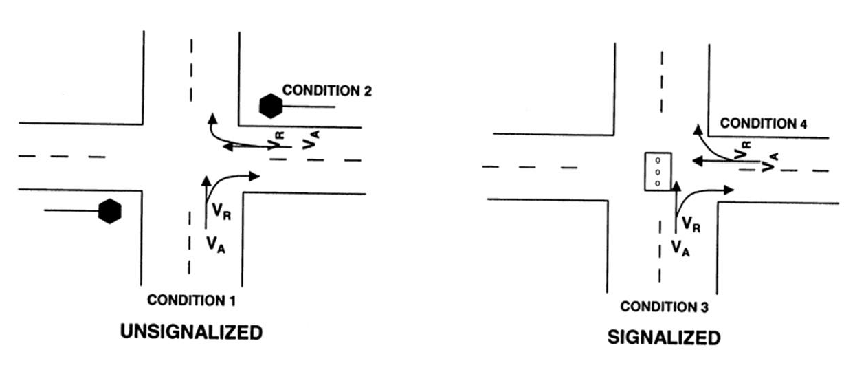
Right-Turn Warrants
Notes:
1. When public safety so requires due to site specific conditions, such as limited
sight distance, high traveling speed, and presence of a significant percentage of
heavy vehicles, a turn lane may be required even though the criteria in Graph No.
1 is not met.
2. The provisions of the right-turn warrants may be modified by the engineering services
director or his designee if it is determined that due to site specific constraints,
the implementation will not be feasible or practical.
Table 2. Left-Turn Warrants
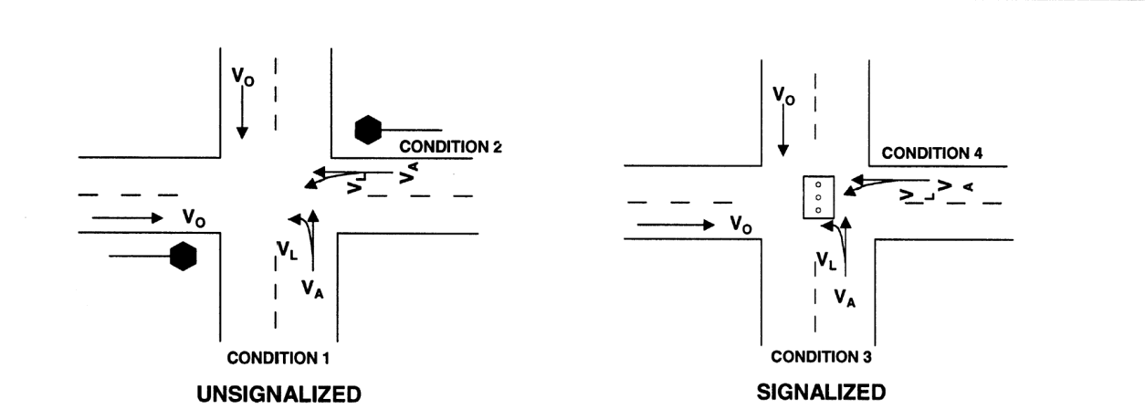
Left-Turn Warrants
Notes:
1. An exclusive left-turn lane at signalized intersections or on access roads and
through roads with stop control are more often needed to reduce the total delay to
the approaching vehicles; therefore, use of traffic engineering software, with the
approval of the engineering services director or his designee, may be used.
2. When public safety so requires, due to site specific conditions, such as limited
sight distance, high traveling speed, and presence of a significant percentage of
heavy vehicles, a turn lane may be required even though the criteria in Graph No.
2 is not met.
3. The provisions of the left-turn warrants may be modified by the engineering services
director or his designee if it is determined that due to site specific constraints,
the implementation will not be feasible or practical.
4. A dual left-turn lane should be considered when the left-turn volume exceeds 300
VPH.
5. At high speed (greater than 45 mph), rural, unsignalized/signalized intersections,
a separate left-turn lane should be considered for safe operations.
Table 3. Right-Turn Lane Lengths
(Deceleration and Storage)
Notes:
1. In many instances, the storage length of a right-turn lane at signalized intersections
or access/major roads with stop control is dictated by the required storage length
for left and/or through movements. Refer to left-turn section for determining the
storage length for left-turn.
2. If the right-turn flow is limited due to heavy volume of conflicting movements,
then the storage length should be based on the left-turn, storage-length formula.
3. The provision of storage lengths and deceleration lengths may be modified or waived
by the engineering services director or his designee if it is determined that due
to site specific constraints, the implementation will not be feasible or practical.
4. Traffic engineering software, with the approval of the engineering services director
or his designee, may be used to determine the storage length for right turns.
Table 4. Left-Turn Lane Lengths
(Deceleration and Storage)
Notes:
1. N = The number of traffic signal cycles per hour. Use 30 as a default (assumes
120-second cycle length).
2. If the formula yields a storage length of less than 50 feet for unsignalized intersections,
then a minimum storage of 50 feet should be provided.
3. If the formula yields a storage length of less than 100 feet for signalized intersections,
then a minimum storage of 100 feet should be provided.
4. The provision of storage and deceleration lengths may be modified or waived by
the engineering services director or his designee if it is determined that due to
site specific constraints, the implementation will not be feasible or practical.
5. In some instances at signalized intersections or on access/major roads with stop
control, the storage length of the left-turn is dictated by the through or right movements.
It is advised that the storage length for all movement be calculated and the highest
length be used. For through storage length, the same formula as the left-turn can
be used. Refer to right-turn section for determining the storage length for right
turns.
6. Traffic engineering software, with the approval of the engineering services director
or his designee, may be used to determine the storage length for left turns.
Note: For posted speeds at or under 45 mph, peak hour right turns greater than 40 VPH, and total peak hour approach less than 300 VPH, adjust right-turn volumes. Adjust peak hour right turns = peak hour right turns - 20.
Note: For application on high speed highways.
Graph 1A and 1B—Source: From National Cooperative Highway Research Program Report No. 279.
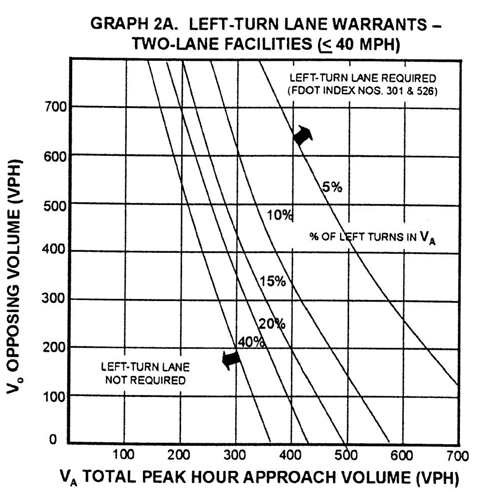
Note: Left-turn lane not required when intersection of V A and V O is below the curve corresponding to the percent of left turns in V A .
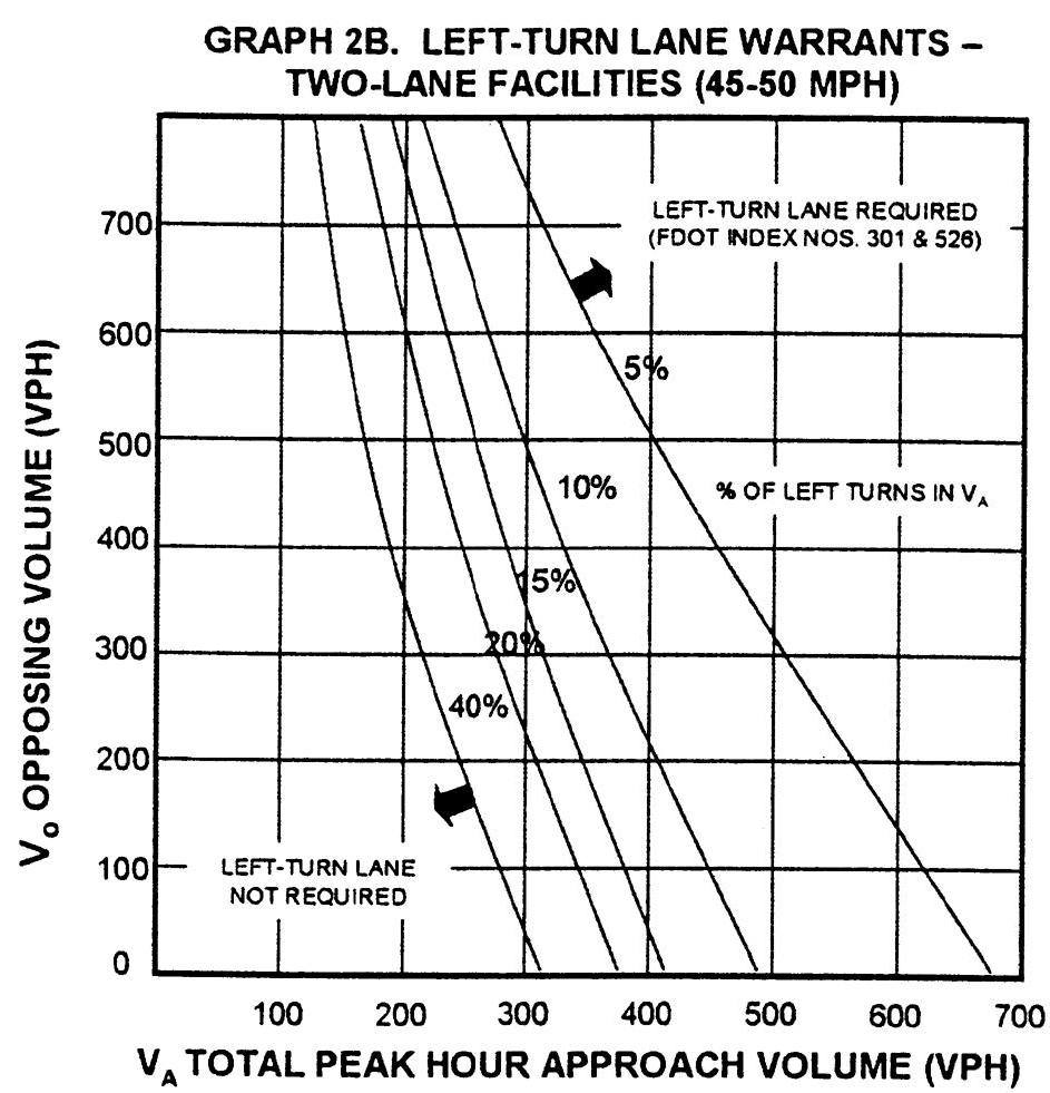
Note: Left-turn lane not required when intersection of V A and V O is below the curve corresponding to the percent of left turns in V A .
Graph 2A and 2B—Source: Derived from National Cooperative Highway Research Program Report #279.
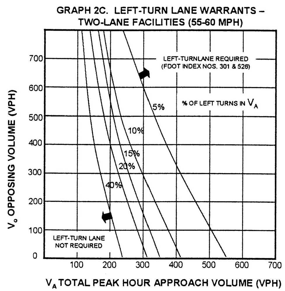
Note: Left-turn lane not required when intersection of V A and V O is below the curve corresponding to the percent of left turns in V A .
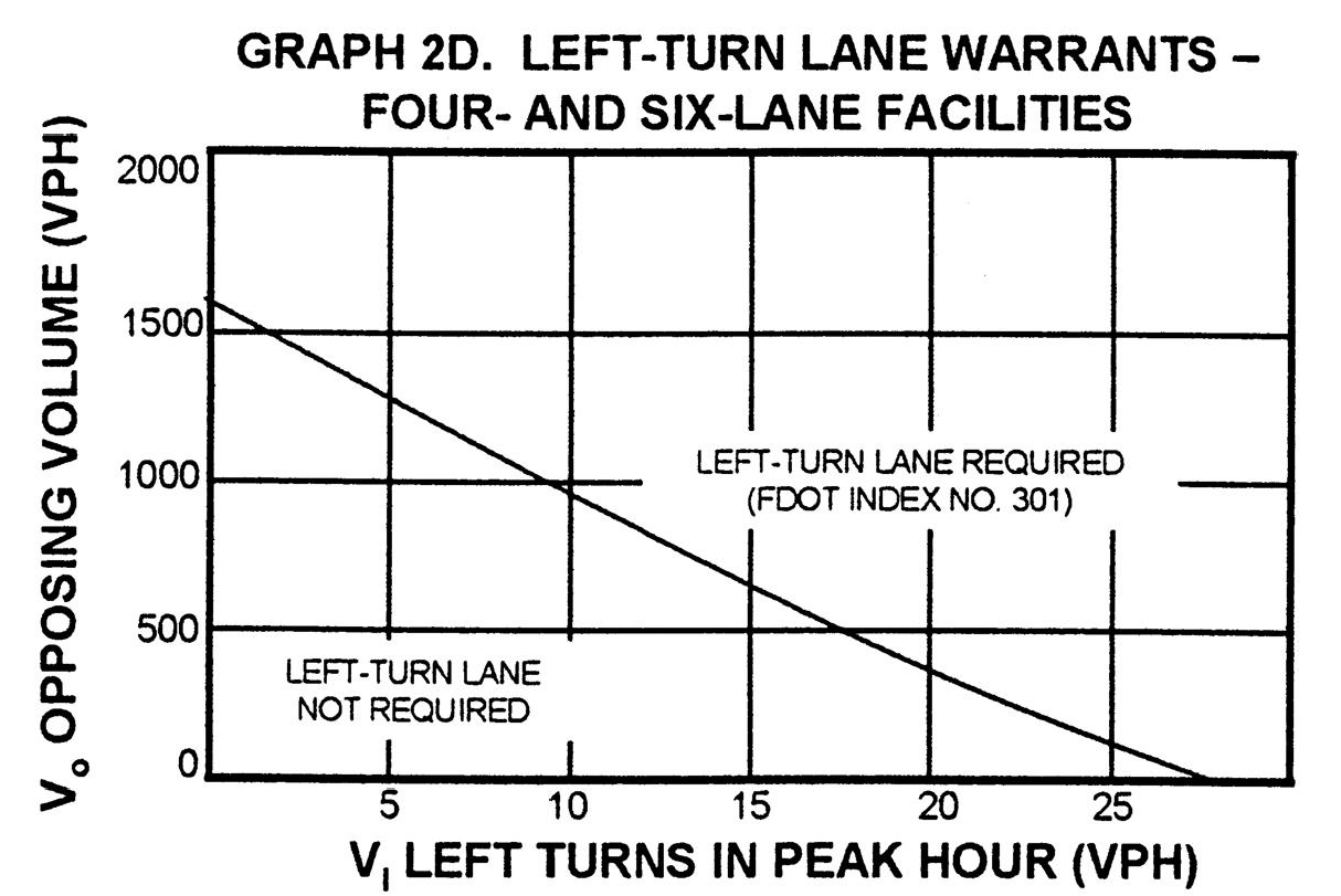
Note: When V O < 400VPH, a left-turn lane is not normally warranted unless the advancing volume (V A ) in the same direction as left-turning traffic exceeds 400 VPH (V A > 400 VPH).
Graph 2C and 2D—Source: Derived from National Cooperative Highway Research Program Report #279.

