
Dade City City Zoning Code
ARTICLE 7
- SUBDIVISION STANDARDS
SECTION 7.5 - RECORDATION
The final plat shall be prepared and recorded in a form acceptable to the City, in compliance with Florida law.
7.1.1 - Purpose
These subdivision standards are established:
(A)
Economically Sound Community. To encourage the development of an economically sound and stable community.
(B)
Provision of Streets, Utilities, and Other Facilities. To ensure the provision of required streets, utilities, and other facilities and services for development.
(C)
Safe and Convenient Access and Circulation. To ensure the adequate provision of safe and convenient access and circulation, both vehicular and pedestrian, and to help ensure that all lots will be accessible to firefighting equipment and other emergency service and utility vehicles.
(D)
Provision of Land for Recreation, Education, Open Space, and Other Public Purposes. To ensure the provision of land for recreation facilities, education facilities, open space, and related public purposes.
(E)
Protect and Conserve Natural and Scenic Resources. To ensure the protection and conservation of natural and scenic resources.
(F)
Safe and Healthy Environment. To promote a safe and healthy environment.
(G)
Identification of Land on Public Records. To ensure the adequate identification of land on the public records.
(H)
Development Consistent with the Comprehensive Plan. To ensure the development of the community in ways that are consistent with the Comprehensive Plan.
7.1.2 - Applicability and Other Relevant Provisions
(A)
General. All land required to be subdivided in accordance with Section 2.4.7, Subdivision, shall comply with the standards of this article.
(B)
Additional Requirements. In addition to the standards for subdivision established in this article (Sections 7.2 to 7.8), all final plats for subdivision shall also comply with the following laws, rules, and regulations:
(1)
Land Development Regulations. All relevant and appropriate provisions of these LDRs.
(2)
Other City Laws. All other relevant and appropriate City laws and regulations.
(3)
Building Code. Florida Building Code, as amended.
(4)
Comprehensive Plan. The Comprehensive Plan in effect at the time of submission.
(5)
All Other Relevant State and Federal Laws and Regulations. Rules and regulations of the FDEP, FDOT, the Southwest Florida Water Management District and other appropriate regional, State and Federal agencies, and all other relevant Florida and federal statutes and regulations.
7.2.1 - Layout and Design Generally
Where required by these LDRs, the subdivider shall grade and improve streets; install sidewalks, street name signs, street lights, fire hydrants, curbs and gutters; place monuments and corner stakes and install sanitary sewer and water mains and stormwater facilities in accordance with the specifications of these LDRs and any other specifications established by ordinance or resolution of the City Commission. The City Commission may, if conditions warrant, coordinate with an owner/subdivider to construct public improvements that are capable of accommodating community or system-wide needs in accordance with the standards in Section 7.3.11(B), Oversizing and Reimbursement.
7.2.2 - Residential and Non-Residential Subdivisions—Use of Subdivided Lots
(A)
Use of Lots Comply with LDRs and Comprehensive Plan. The proposed use of lots within a subdivision shall comply with the requirements of Article 4: Use Regulations, these LDRs, and shall be consistent with the Comprehensive Plan.
(B)
Site Outside Flood Prone Area If Alternative Available. Where other alternatives are available for the siting of residential dwellings within a subdivision, they shall not be located in a flood prone area as required by Ordinance_______
7.2.3 - Block Standards
(A)
Block Width. Blocks shall have sufficient width to provide for two (2) tiers of lots of appropriate lengths. Exceptions to this prescribed block width shall be permitted in blocks adjacent to existing streets, railroads, waterways or along property boundaries.
(B)
Block Length.
(1)
General. The lengths, widths, and shapes of blocks shall be consistent with the context in which the development is proposed, as well as the type of development contemplated.
(2)
Residential Areas. Block lengths in residential areas shall not exceed 600 feet, nor be less than 300 feet in length.
(3)
Easements Through Long Blocks. On blocks that are more than 400 feet in length, the City Commission may require the reservation of an easement through the block to accommodate utilities, stormwater management facilities, and/or pedestrian traffic.
(4)
Pedestrian Access Through Long Blocks. Pedestrian ways or crosswalks, not less than 10-feet wide, may be required through the center or other locations of blocks more than 400 feet long, if it is determined they are essential to provide non-vehicular circulation or access to schools, playgrounds, parks, other recreation facilities, retail areas, transportation facilities, or other community facilities.
7.2.4 - Lot Standards
(A)
Arrangement.
(1)
General. Lots shall be arranged in such a way to minimize difficulties, due to natural, topographical, or other conditions, to development of the lot consistent with the standards of this article and these LDRs, and all other relevant state and federal laws and regulations.
(2)
Access to Street. All lots shall have sufficient frontage so there can be driveway access to primary structures placed on the lots from a public or private street.
(B)
Dimensions and Design.
(1)
General. Lot dimensions shall comply with the minimum standards established in the Article 5: Density, Intensity, and Dimensional Standards.
(2)
Lot Depth. The depth of any lot within a subdivision shall not exceed three (3) times the width of said lot within the subdivision.
(3)
Side Lot Lines. In general, side lot lines shall be at right angles to street lines (or radial to curving street lines), unless it is demonstrated variation will provide a more efficient and environmentally sensitive street or lot design.
(4)
Entry of Autos From Lot to Street. The entrance of automobiles from the lot to the street shall be approximately at right angles or radial to street lines.
(5)
Corner Lots. Corner lots shall be designed in accordance with Section 5.2.2(A)(7)(c).
(6)
Drainage. Lots shall be laid out to provide positive drainage away from all buildings. Individual lot drainage shall be coordinated with the general stormwater drainage pattern for the area in accordance with approved construction plans, and shall comply with the standards of Section 6.7.3, Stormwater Management Standards.
(C)
Double Frontage Lots. Double frontage and reverse frontage lots shall be prohibited except where necessary to provide separation of single-family dwellings from existing streets or to overcome specific disadvantages of topography and orientation. Corner lots shall not be considered "Double Frontage Lots."
(D)
Access. Lots shall not access an existing street except in a minor subdivision.
(E)
Lot Corners. The subdivision shall adhere to the requirements of Chapter 177, Florida Statutes, regarding the placement of all lot corners.
7.2.5 - Streets
(A)
General. The arrangement, character, extent, width, grade, and location of all streets shall be consistent with the Comprehensive Plan, where applicable, and shall be considered in relation to existing and planned streets, topographical conditions, safety, public convenience, and the uses of land to be served by the streets.
(B)
Topography.
(1)
Original Topography. Streets shall conform, to the maximum extent practicable, to the original topography of the land they traverse.
(2)
Locate Building Sites Above Grade of Street. Streets shall be designed and located, to the maximum extent practicable, so that as many building sites as possible are located at or above the grades of the streets.
(3)
Avoid Combination of Steep Grades and Curves. Street design should avoid a combination of steep grades and curves that cause site distance problems.
(C)
Arrangement.
(1)
Continuation of Arterial and Collector Streets Between Subdivision and Adjacent Lands. The arrangement of streets shall provide for the continuation of arterial and/or collector streets between the proposed subdivision and adjacent lands when such continuation is necessary for convenient movement of traffic, effective fire protection, efficient provision of utilities, and where such continuation is consistent with the Comprehensive Plan.
(2)
Lay-Out of Local Streets. Local streets shall be laid out to utilize traffic calming techniques, permit efficient stormwater management and utility systems, and require the minimum number of streets necessary to provide convenient and safe access to the lots within the subdivision.
(3)
Form. A rectangular grid street pattern is encouraged, but not required, and the use of curvilinear streets, cul-de-sacs, or U-shaped streets is encouraged where such configuration will result in a lay-out that is more efficient and reduces impacts on natural resources and features.
(4)
Connectivity. Streets shall be extended to the boundary lines of the tract to be subdivided and connected with adjacent streets, unless such a lay-out is prevented by topographical or other physical or environmental conditions, or unless it is demonstrated such extension is neither necessary nor desirable for the coordination of the layout or the most advantageous future development of adjacent tracts.
(5)
Business and Mixed Use Developments. In business and mixed use developments, the streets, access ways, and pedestrian ways shall be designed and laid out in connection with the groupings of buildings, the parking and loading areas, pedestrian ways, and other loading and maneuvering areas, to ensure there is an efficient and safe on-site traffic circulation system that is coordinated with a system of pedestrian ways.
(6)
Dedication. Except for Section 7.2.5(F): Private Streets, streets within a subdivision shall be dedicated to the perpetual use of the public.
(D)
Temporary Street Stub.
(1)
General. If the land adjacent to the subdivision is undeveloped, a street extending to the boundary of the subdivision shall temporarily be established as a stub street (a street planned for future continuation), and shall be designed to comply with the following standards:
(a)
Stub streets which are 250 feet or less shall have a temporary T- or L-shaped turnabout.
(b)
Stub streets which are greater than 250 feet shall have a temporary cul-de-sac turnabout.
(2)
Connection When Adjacent Property Developed.
(a)
There shall be a notation on the final plat that land used for a temporary T- or L-shaped cul-de-sac or turnabout shall be converted to a traffic circle, speed table, or other traffic calming device upon extension of the street to adjacent lands.
(b)
The subdivider of the adjacent land connecting to the temporary T- or L-shaped cul-de-sac or turnabout shall pay the cost of restoring the stub street to its original design cross-section, installing an appropriate traffic-calming device, and extending the street.
(c)
The City Commission may limit the length of temporary stub streets, and shall require a turnabout for public safety purposes approximately mid-way if such street exceeds 600 feet in length.
(E)
Access to Existing Streets. Where a subdivision borders on or is traversed by an existing street, access shall be provided by one (1) of the following ways:
(1)
Lots Back-Up to Existing Street. If the lots of the subdivision back onto the existing street, no access shall be provided from the existing street to the lots. Screening shall be provided on a strip of land along the rear property line of the lots in accordance with Section 6.2.3(K); (look for screening standards).
(2)
Marginal Access Streets. A marginal access street, if it is separated from the existing street by a grass strip that provides access to the existing street at points that ensure safe and adequate access from the subdivision lots; or
(3)
Series of Cul-de-sac or U-Shaped Streets. A series of cul-de-sacs, or U-shaped streets, entered from and designed generally at right angles to the existing street. Each proposed cul-de-sac or U-shaped street shall be located no less than 1,000 feet apart where such streets connect with the existing street, and shall be designed to ensure safe and adequate access.
(F)
Private Streets. The City Commission may approve a private street when adequate provision for initial installation, improvement, and future private maintenance of the private street is assured through a development agreement.
(1)
Development Agreement. The development agreement to construct and maintain a private street or easement for private street use shall constitute a covenant by the City and the developer or owner of the subdivision, the terms and conditions of which shall run with the land and be binding upon all successors-in-interest to the developer or owner.
(2)
Private Streets Shall be Identified as Private Streets. All private streets shall be clearly identified as private streets on the face of the final plat and the final plat shall provide for an appropriate easement based on street type for each private street.
(G)
Dead-End Streets Prohibited. Dead-end streets are not permitted in any subdivision. Cul-de-Sacs and stub streets (streets planned for future continuation) are not considered dead-end streets.
(H)
Cul-de-Sacs. If cul-de-sac streets are used in a subdivision, they shall:
(1)
Dimensions. Be provided with a turnaround having an outside roadway diameter of at least 80 feet, and a street property line diameter of at least 100 feet.
(2)
Length. Not exceed the length standards outlined in Table 7.2-1, including the turnaround, unless topographical or environmental conditions, such as the geometry of the land or the character of the adjacent land, make it impracticable to design the cul-de-sac streets according to these standards.
(3)
Pedestrian Connectivity. Be connected to the adjacent public sidewalk, greenway, or other pedestrian network with a sidewalk meeting the standards of Section 7.3.2: Sidewalks, or a 10-foot wide multi-purpose trail, located within a public right-of-way or access easement granted to the City.
(I)
Street Intersections.
(1)
General Lay-out.
(a)
Streets shall be laid out to intersect as nearly as possible at right angles.
(b)
An intersection of two (2) new streets at an angle of less than 75 degrees is prohibited.
(c)
Oblique streets should be curved approaching an intersection and should be approximately at right angles for at least 100 feet.
(d)
No more than two (2) streets shall intersect at any one (1) point unless it is demonstrated that no other alternative is reasonably available, and the applicant demonstrates the intersection design is safe.
(2)
Intersections Along One Side of Existing Street. A new intersection along one (1) side of an existing street shall, wherever practicable, coincide with any existing intersections on the opposite side of such street. Where proposed streets intersect major streets, their alignment shall be continuous.
(3)
Curb Radii.
(a)
Curb radii at the intersection of two (2) local streets shall be at least 20-feet.
(b)
Curb radii at an intersection involving a collector street shall be at least 25 feet.
(c)
Abrupt changes in alignment within a block shall have the corners cut off in accordance with standard engineering practice to permit safe vehicular movement.
(J)
Widening and Realignment of Existing Roads.
(1)
Road Right-of-Way. Where a subdivision borders on an existing street or when the Comprehensive Plan or these LDRs, or other local, regional or State agency plans or programs, such as the Dade City Capital Improvements Plan, Pasco County MPO Plan or a plan of the Florida Department of Transportation, indicates plans for realignment or widening a street that would require use of some of the land in the subdivision for ROW, the City Commission may require the owner/subdivider to deed the land to the City necessary for such ROW as part of the approval process.
(2)
ROW for Frontage Roads. Right-of-way for frontage roads and streets shall be dedicated by the subdivider in accordance with the standards in this article.
(K)
Bicycle Lanes. Bicycle lanes, a minimum of 5 feet in width, shall be required along all arterial streets unless an alternative facility is determined by the Community Development Director to provide the same or higher level of mobility.
7.2.6 - Visibility Clearance
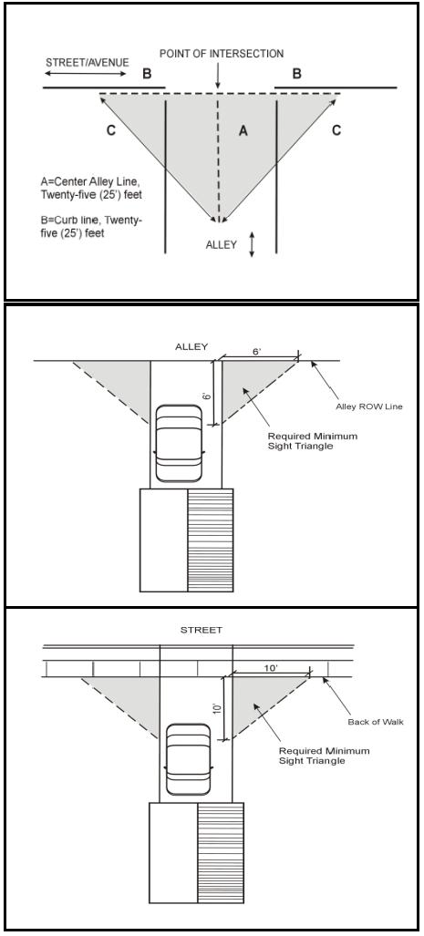
Fences and walls and other visual barriers shall comply with the following sight distance standards. The Public Works Director is authorized to vary these standards depending on site conditions if no adverse impacts are created on adjacent lands.
(A)
Street/Street Intersection Sight Distance Triangle. No fence, wall, or other visual barrier over three (3) feet in height above grade shall be erected, placed, planted, or allowed to grow that obstructs the view of pedestrians on the sidewalk or obstructs the traffic vision at intersections within the 25-foot sight distance triangle created at the intersection of a street and a street. The Public Works Director shall determine safe and adequate street/intersection sight distance triangle requirements based on site conditions.
(B)
Street/Alley Sight Distance Triangle. No visual obstruction over three (3) feet in height above grade shall be permitted within the 25-foot sight distance triangle created at the intersection of an alley and street. The triangle is measured from a point where the curb line and the center line of the alley meet 25-feet along the alley center line ("A"). The third side of the triangle ("C") connects these two (2) sides, creating the sight distance triangle.
(C)
Garage Entrance/Alley Sight Distance Triangle. No visual obstruction over three (3) feet in height above grade shall be permitted within the six (6) foot sight distance triangle created at the intersection of a garage entrance and alley.
(D)
Driveway/Street Sight Distance Triangle. No visual obstruction over three (3) feet in height above grade shall be permitted within the 10-foot sight distance triangle created at the intersection of a driveway and street. When no sidewalk exists, the sight triangle shall be determined by the Public Works Director.
7.3.1 - Streets
Work performed involving road ROW clearing and grubbing, earthwork, stabilizing, and construction of a base and surface course shall meet the minimum requirements of AASHTO, American Association of State Highway and Transportation Official's, latest manual edition and amendments, where applicable, unless stated otherwise in this article and the requirements of the City. These specifications are intended to govern the equipment, materials, construction methods, and quality control of the work, unless otherwise provided. They are not intended to apply to the basis of payment provisions.
(A)
Street Type Improvement Schedule. For the purposes of this section, the following types of subdivisions shall be given the following classifications (street type standards). Each subdivision shall comply with the required improvement standards for which it is classified.
(1)
Street Type/Standard A for subdivisions with business, or public and institutional uses.
(2)
Street Type/Standard B for subdivisions with residential uses, where any lot is 20,000 square feet or less.
(3)
Street Type/Standard C for subdivisions with residential uses, where all lots are greater than 20,000 square feet.
(4)
Street Type/Standard D for subdivisions with residential uses, with private streets with a maximum of 10 lots using ingress and egress. Where the proposed subdivision includes an existing street, the existing street shall conform to the standards in this section. (This standard shall not apply to any abutting street which is not connected to the proposed subdivision's street system.)
(B)
Standard Street Improvements. The following standards apply to all street improvements.
(1)
Wearing Surface Width/Right-of-Way Standards.
(a)
Arterial Streets.
(i)
For Street Types/Standards A, B, C, and D: Two (2), 24-foot wearing surfaces with a 20-foot median.
(ii)
The subdivider shall be required to install the second 24-foot wearing surface only in subdivisions where projected average daily traffic generated on the arterial by the subdivision exceeds 5,000 vehicles.
(iii)
Minimum ROW shall be 100 feet for streets with curb and gutter, or 120-feet for streets with swale.
(b)
Collector Streets.
(i)
For Street Types/Standards A, B, C, and D: Twenty-four (24) foot wearing surface.
(ii)
Minimum ROW (easement for private streets) of 60 feet.
(c)
Local Streets.
(i)
For Street Types/Standards A, B, and C: Twenty-four (24) foot wearing surface.
(ii)
Minimum ROW or easement of 50 feet for streets with curb and gutter.
(iii)
For Street Type/Standard D: Minimum easement of 40 feet.
(d)
Marginal Access Streets.
(i)
For Street Types/Standards A, B, and C: Twenty (20) foot wearing surface.
(ii)
Minimum ROW or easement of 40 feet, or 60 feet if it includes a swale.
(iii)
For Street Type/Standard D: Minimum easement of 40 feet.
(e)
Wearing Surface and Right-of-Way Width Summary Table. These standards are summarized in Table 7.3-1, Wearing Surface and ROW Width Standards, below.
(2)
Curb and Gutter.
(a)
Curb and gutter shall be provided in accordance with Table 7.3-2, Curb and Gutter Standards, below.
(b)
Curb and gutter shall be provided on Type A, B, and C streets, but is not required on Type D streets.
(c)
If curb and gutter is not required, the subdivider shall comply with the ROW width requirements for roadside swales and the standards for improvements set forth in subsection (5) below.
7.3.2 - Sidewalks
(A)
Location. Sidewalks meeting the standards of this subsection shall be located on both-sides of all Type A, B, and C arterial and collector streets, and on at least one (1) side of any other street for subdivisions exceeding one (1) unit per acre.
(B)
Configuration. If sidewalks are required, they shall be concrete, installed by the subdivider, provide curb cuts for bicycles and handicapped access, and be at least six (6) feet wide and four (4) inches thick. To meet best engineering practices, other or additional standards may be required by the City Engineer.
(C)
Connection. All multiple-family and non-residential development shall provide at least one (1) improved pedestrian connection between the on-site pedestrian circulation system and the adjacent public sidewalk or greenway network, with an additional connection required for each additional five (5) acres of development area.
7.3.3 - Road and Street Signs
(A)
Road and Street Signs. Road and street signs are traffic control signs such as stop signs, speed limit signs, etc. For all subdivisions, all road and street signs shall be designed in number and location to meet the USDOT Manual for Uniform Traffic Control Device standards and shall be shown on the preliminary plan. The subdivider shall install such road and street signage and shall maintain and repair such signage through the warranty period, until transfer to the Homeowners Association. In lieu of installation of such signage, the posting of a surety device in accordance with Section 6.8, Guarantees for Private Improvements, shall be filed, approved, and accepted by the City Commission.
(B)
Street Name Signs. Street name signs are signs within a subdivision that identify street names. Street name signs shall be placed, by the subdivider, at all intersections within or abutting the subdivision. The type and location of the street name signs shall be submitted as part of the preliminary plan and shall conform to the Pasco County's street naming and addressing system.
7.3.4 - Street Lights
Installation of street lights is required on all public streets. Street lights shall be designed and installed by the subdivider in accordance with the requirements of the City Engineer.
7.3.5 - Reserve Strips
The creation of reserve strips shall not be permitted adjacent to a proposed public street in such a manner as to deny access to such street from property adjacent to the proposed subdivision, or to landlock adjacent properties.
7.3.6 - Stormwater Management and Flood Protection Requirements
Subdivider shall comply with all stormwater management requirements set forth in Section 6.7.3, Stormwater Management Standards.
7.3.7 - Sanitary Sewer
(A)
Sanitary Sewer Available and Reasonably Accessible. Where a publicly owned sanitary sewer system is available and reasonably accessible, the subdivider shall provide sanitary sewer services to each lot within the subdivision. All sewer lines serving lots within the subdivision shall be designed to operate on a gravity flow basis wherever possible. If a wearing surface and sanitary sewer lines are required, all sewer lines shall be installed by the subdivider prior to the paving of the street.
(B)
Publicly-Owned Sanitary Sewer Unavailable. Where lots cannot be served by the extension of an existing publicly-owned sanitary sewer, an alternate method of sewage disposal for each lot may be used if it complies with all applicable standards of the Pasco County Health Department, the Florida Department of Health and Rehabilitative Services, the Florida Department of Environmental Protection and any other regional, State or Federal agency, as applicable. Alternative methods of sewage disposal shall be designed and installed as to enable subsequent connections to a publicly owned sanitary sewer system as service becomes available.
(C)
Complies with Requirements of Pasco County Health Department. The subdivider shall furnish written proof demonstrating compliance with the provisions for sanitary sewage disposal for the entire subdivision prior to approval of a preliminary plan and construction plans for the subdivision.
7.3.8 - Water Supply
(A)
Publicly-Owned Water Supply Available. Where a publicly owned water supply is available and within a quarter mile, the subdivider shall provide a system of water mains and shall connect the system to such supply. If a wearing surface and water mains are required, all water lines shall be installed by the subdivider prior to the paving of the street.
(B)
Publicly-Owned Water Supply Unavailable. Where no publicly owned water supply is available within a quarter mile, an alternate supply may be used if it is in compliance with all applicable standards of the Pasco County Health Department, the Florida Department of Health, the South West Florida Water Management District, the Florida Department of Environmental Protection and the City of Dade City.
(C)
Complies with Requirements of Pasco County Health Department. In cases where the development is not connected to a publicly owned water supply, the subdivider shall furnish written proof demonstrating compliance with the provisions for water supply for the entire subdivision prior to approval of a preliminary plan and construction plans for the subdivision.
7.3.9 - Fire Protection Improvements
Fire protection improvements shall be provided when the subdivision is connected to a publicly-owned water system and shall include the installation of fire hydrants to water mains with a minimum pipe size of six (6) inches in diameter.
If fire protection improvements are required, then:
(A)
Fire Hydrants Spacing.
(1)
Fire hydrants shall be located on the same side of any arterial road as the development for which they serve.
(2)
Fire hydrant spacing shall be as follows:
(a)
RV Parks: 500 feet apart as measured along the centerline of the street.
(b)
Residential: 500 feet apart as measured along the centerline of the street.
(c)
Multiple Family and Commercial/Business: 500 feet apart as measured along the centerline of the street; and
(d)
Industrial: 500 feet apart as measured along the centerline of the street.
(3)
Where deemed necessary by the authority having jurisdiction, hydrant spacing may be varied by NFPA Code No. 24. All structures shall be located within one-half of the above-listed distances.
(B)
Residual Pressures. The distribution system shall be capable of delivering, in addition to domestic requirements, residual pressures of not less than 20 pounds per square inch and fire flows of at least 500 gallons per minute.
(C)
Complies with ISO Standards. The distribution system shall be designed to comply with the ISO standards for the development.
7.3.10 - Water and Sanitary Sewer Systems
New potable water and sanitary sewer systems, where required by the City, shall be designed by a Florida registered engineer in accordance with all applicable regulations of the City of Dade City and the Florida Department of Environmental Protection.
7.3.11 - Utilities
(A)
Location of Utility Easements.
General.
(1)
Utilities shall be located within the street ROW, as shown in Technical Standards Manual.
(2)
Normally, the City will not permit utility easements across lots or centered on rear or side lot lines, except where, due to topography or other circumstances beyond the control of the subdivider, such utility easements are determined necessary for the reasonable development of the property. If approved, they shall be at least 15 feet wide and centered as near as practical between the lots.
(B)
Fiber Optic Conduit.
For each new subdivision the subdivider or the subdivider's developer shall install fiber optic conduit within the public right-of-way along the entire frontage of each property in the subdivision which adjoins a public street. Such construction shall meet all specifications of the City Engineer, shall be designed to allow adjacent properties to access the fiber optic conduit and shall be designed and constructed at the subdivider's expense or at the expense of the subdivider's developer.
(1)
Reimbursements. Reimbursements to the owner/developer on oversized public improvements shall be in accordance with existing City policy in place at the time of installation.
(Ord. No. 2016-02, § 3 (Exh. A), 2-23-2016)
7.3.12 - Adequate Off-Site Facilities and Services
Where the City concludes that a proposed subdivision will create impacts on surrounding streets, utilities, or other facilities that cannot be adequately offset through the construction of on-site facilities, the construction of off-site facilities sufficient to offset the anticipated impacts of the proposed development may be required. In no event, however, shall a subdivider be required to provide off-site facilities for purposes of granting a general public benefit beyond offsetting the impacts of the proposed subdivision.
7.3.13 - Monumentation and Control Points
The subdivider shall comply with the requirements of Chapter 177, Florida Statutes, regarding the placement of all monuments.
7.4.1 - Posting of Surety Device for Public Improvements
(A)
A final plat shall neither be approved by the City Commission nor accepted for filing until a surety device in accordance with the forms explained in Section 6.8.2, Form of Performance Guarantees, has been posted.
(B)
The surety device for public infrastructure improvements shall cover at least 125% of the estimated cost of all required improvements such as streets, stormwater management facilities, potable water facilities, wastewater facilities, recreation, and other public improvements. Estimated costs for public infrastructure improvements shall be provided by the subdivider's registered engineer. This estimated cost shall represent the total estimated cost of installing all required public improvements.
(C)
The surety device shall be conditioned upon the faithful performance by the subdivider of all work required to complete all improvements and installations for the subdivision or phases thereof, in compliance with these LDRs, and the approved preliminary plan, construction plans, and final plat within a specified time as determined in the Subdivider's Agreement.
(D)
The surety device shall be payable to, and for the indemnification of, the City of Dade City.
7.6.1 - Public Right-of-Way Dedication
A dedication to the public by the owners of the subdivision for all streets, drainage easements, and other rights-of-way needed to serve the subdivision however designated and shown on the plat for perpetual use for public purposes, including vehicular access rights shall be required. If the property is encumbered by a mortgage, the owner of the mortgage shall join in the dedication or in some other manner subordinate the mortgagee's interest to the dedication of public ROW.
7.6.2 - Public Purpose Sites Dedication
The City Commission may require the dedication of land for school sites, parks, playgrounds, or other public areas, as are attributable to the demand for such facilities created by the subdivision. The subdivider may be required to pay an in-lieu fee in an amount equal to the fair market value of such sites, said fair market value to be estimated on the basis of platted land without improvements. In no event, however, shall a subdivider be required to provide land or payment in-lieu for such facilities beyond offsetting the impacts of the proposed subdivision.
7.7.1 - Declaration of Covenants—Self-Imposed Restrictions
If the subdivider places restrictions on any of the land contained in the subdivision greater than those required by these LDRs, such restriction or reference shall be indicated on the final plat for the subdivision and through a declaration of covenants.
7.7.2 - Declaration Contents
The declaration of covenants shall include, but not be limited to the following:
(A)
Establishment of Owners Association. A requirement that the property or homeowners association be established before the homes are sold.
(B)
Mandatory Membership. Membership in the association shall be mandatory for owner and any successive buyer.
(C)
Responsibility for Liability Insurance, Local Taxes, and Maintenance. Provisions establishing that the association or, if applicable, the developer shall be responsible for providing for local taxes (if any), and the continuing maintenance of common areas, recreational facilities, and all other community facilities, and disclosing that the City provides no liability insurance for any common areas or recreational facilities.
(D)
Payment of Costs. Provisions establishing that the property or homeowners shall pay their pro rata share of the costs incurred by the association unless the covenants provide for a different means of assessment.
(E)
Assessments. Provisions establishing that assessments levied by the association can become a lien on the property if allowed in the master deed establishing the property or homeowners association.
7.7.3 - Proof of Establishment of Association
With the submittal of the recorded plat, the applicant shall submit evidence that the property or homeowners association has been legally established, typically in the form of articles of incorporation.
7.8.1 - Subdivider Responsible for Maintenance
(A)
General. The subdivider shall maintain and repair all improvements which this article and these LDRs require the subdivider to construct in the subdivision for a period of one (1) year after the completion of the improvements, in accordance with the provisions of Section 2.4.7(G)(6), Inspection of Public Improvements, and Section 2.4.7(G)(7), Warranty Period Following Passing Inspection. Prior to the initiation of the warranty period, the subdivider shall post a maintenance bond to cover at least 10 percent of the estimated costs of all required improvements for a period of one (1) year. All defects which occur within one (1) year after completion and acceptance of all required improvements shall be remedied and corrected at the subdivider's expense.
(B)
No City Maintenance of Improvements Unless Expressly Accepted by City Commission. Nothing in these LDRs shall be construed as meaning that the City Commission shall take over for maintenance any road, street, utilities, public parking or other public area, or stormwater management facilities related thereto, except those designed and built in accordance with the requirements of this article, these LDRs, and other City laws and ordinances, that are expressly accepted for maintenance by specific action of the City Commission.
(C)
Landscaping Maintenance. The Homeowners Association or entity responsible for common areas shall be responsible for the maintenance of all landscape areas to present a healthy, neat and orderly appearance at all times and to replace dead plant materials according to the standards set forth in Section 6.2.2, Landscaping Standards.
(D)
Signs. The Homeowners Association or entity responsible for non-public (i.e., subdivision) signs shall be responsible for the maintenance of all signs approved in accordance with these LDRs.
(E)
Fences. The Homeowners Association or entity responsible for fencing shall be responsible for the maintenance of all fencing in common areas approved in accordance with these LDRs.
7.9.1 - Purpose and Intent
The purpose and intent of this section is to provide landowners in the Open Use Agriculture(OUA) and RS-2, RS-2 and RS-3 zone districts a development option that provides additional development flexibility when additional open space is provided, and the development is designed and located in a way that protects the natural and historic features on the site. This is done in order to:
(A)
Conserve Open Land. Conserve open land, including those areas containing unique and sensitive natural features such as floodplains, wetlands, soils subject to slumping and sinkholes, river and stream corridors, and steep slopes;
(B)
Retain and Protect Natural Resources. Retain and protect existing environmental, natural, and cultural resources;
(C)
Link Open Spaces. Create a linked network of open spaces;
(D)
Promote Rural Character. Promote existing rural character within the Agricultural (A) zone district; and
(E)
Provide Reasonable Use of Property. Provide reasonable economic use of the property.
(Ord. No. 2016-02, § 3 (Exh. A), 2-23-2016)
7.9.2 - Applicability
This conservation subdivision option may be used as a development option for single-family residential development on lands in the Open Use Agriculture(OUA) and RS-1. RS-2 and RS-3 zone districts.
7.9.3 - Procedure
Development utilizing the conservation subdivision option shall be approved in accordance with the procedures and standards in Section 2.4.7(F), Minor Subdivision, after approval of a conservation plan in accordance with this section.
(A)
Yield Plan. Prior to review of a Minor Subdivision for a conservation subdivision option, an applicant shall have a yield plan for the land reviewed and approved, or approved with conditions by the Technical Advisory Committee (TAC) in accordance with this section and the standards of Section 7.9.4, Conservation Subdivision Standards, and Section 7.9.5, Delineation of Conservation Areas and Development Areas Within the Conservations Subdivision. Deviation from an approved yield plan without obtaining prior approval from the Community Development Director shall void the development order for Minor Subdivision.
(B)
Yield Plan Requirements.
(1)
Step 1—Site Analysis/Existing Features Map. The applicant shall prepare a site analysis/existing features map that provides information about existing site conditions and context, and that comprehensively analyzes existing conditions both on the land proposed for the development site and on land within 500 feet of the site, and submit the site analysis map to the Community Development Director. It is the intent of this section that the information required to be presented in the site analysis map be produced primarily from existing sources, maps, and data.
(2)
Step 2—Site Inspection. After receipt of the site analysis/existing features map, the Community Development Director shall schedule a site inspection of the land with the applicant. The applicant or the applicant's representative shall attend the site inspection with the Community Development Director. The purpose of this site visit is to:
(a)
Familiarize the Community Development Director, City staff and the TAC with the existing site conditions and natural and historic features of the site;
(b)
Identify potential site development issues; and
(c)
Provide an opportunity to discuss site development concepts, including the general layout of conservation areas and potential locations for proposed structures, utilities, roads, and other development features. Comments made by the Community Development Director or other City staff during the site inspection shall be interpreted as being only suggestive. No official decision on the conservation plan shall be made during the site inspection.
(3)
Step 3—Conservation and Development Areas Map. Based on the site analysis map and the information obtained during the site inspection, the applicant shall prepare a conservation and development areas map that depicts proposed primary conservation areas, secondary conservation areas, and development areas, in accordance with Section 7.9.5, Delineation of Conservation Areas and Development Areas Within Conservation Subdivision.
(4)
Step 4—Yield Plan. Based on the site analysis map, the information obtained during the site inspection, and the conservation and development areas map, the applicant shall prepare and submit to the Community Development Director a yield plan. The yield plan shall include the following:
(a)
A site analysis/existing features map;
(b)
A conservation and development areas map;
(c)
A preliminary site improvements plan, showing proposed site development, including utilities, roads, other development features, and lot lines located in the proposed development area(s).
(C)
Review of Yield Plan. The Community Development Director shall review the application in accordance with the procedures and requirements of Section 2.2.13, Review by Community Development Director. The yield plan shall comply with the standards of Section 7.9.5, Conservation Subdivision Standards, and Section 7.9.6, Delineation of Conservation Areas and Development Areas Within the Conservation Subdivision.
(D)
Review and Approval of Conservation Subdivision. Following review and approval or approval with conditions of the yield plan by the Community Development Director, the application for Minor Subdivision shall be submitted and reviewed in accordance with Section 2.4.7 (F), Minor Subdivision.
7.9.4 - Incentives for Conservation Subdivisions
To encourage the development of Conservation Subdivisions the City is providing the following density bonuses.
A)
Density Bonuses
(1)
Encouraging additional open space.
One additional dwelling unit per each additional 5% of open space preserved.
(2)
Encouraging connected trails.
(3)
Encouraging landscaping between building lots.
One additional dwelling unit for maintenance of natural buffers along parcel lines.
B)
Reduction of fees and charges
To encourage the development of Conservation Subdivisions, the City is providing the following reductions in fees and charges.
(1)
Transportation impact fees.
(2)
Park impact fees.
(3)
Development review fees.
(Ord. No. 2016-02, § 3 (Exh. A), 2-23-2016)
7.9.5 - Conservation Subdivision Standards
A conservation subdivision shall:
(A)
Minimum Project Size
Be at least ten (10) acres in area;
(B)
Required Conservation Area
Set aside a minimum of fifty percent (50%) of the total acreage of the site as conservation area to be permanently maintained and protected;
(C)
Maximum Residential Density
Not exceed a gross density of 0. 2 dwelling units per acre;
(D)
Lot Area.
Have no maximum individual lot size, but be subject to a minimum lot area of .25 acres per building lot;
(E)
Setbacks.
(1)
Front Yard Setbacks.
Provide a minimum front yard setback of fifteen feet, however upon demonstrating good cause, the front setback can be reduced to less than fifteen (15) feet;
(2)
Side and Rear Yard Setbacks.
Not be subject to side yard and rear yard setback standards; and
(3)
Setbacks from Water.
Provide a minimum setback of thirty-five (35) feet from any water body.
(F)
Exempt from Other Development Standards
Be exempt from the following standards:
(1)
Minimum off-street parking requirements (Table 6.1-1, Minimum Off-Street Parking Standards);
(2)
Retention of the existing tree canopy outside the primary and secondary conservation areas (Section 6.2.1, Tree protection Standards)
(3)
Site landscaping (Section 6.2.2(D)(1) General Landscape Standards);
(4)
The block standards (Section 7.2.3, Block Standards) and
(5)
The sidewalk standards (Section 7.3.2, Sidewalks), provided an internal trail system is developed as part of the subdivision.
(Ord. No. 2016-02, § 3 (Exh. A), 2-23-2016)
7.9.6 - Delineation of Conservation Areas and Development Areas Within the Conservation Subdivision.
The conservation areas and development areas on the conservation and development areas map and within the conservation subdivision shall comply with the following standards:
A)
Primary Conservation Areas.
1)
Features to be Preserved.
The following features shall be located and delineated on the conservation and development areas map, and shall be preserved in the following priority order as primary conservation areas:
a)
The 100-year floodplain;
b)
Wetlands having regulatory jurisdiction of the Army Corps. of Engineers, and/or the State of Florida;
c)
Habitat utilized by endangered or threatened species;
d)
Soils subject to slumping and sinkholes;
e)
Areas subject to karst topography;
f)
Non- jurisdictional wetlands not under the jurisdiction of the Army Corps. of Engineers or the State of Florida;
g)
River and stream corridors (including public water reservoirs); and
h)
Steep slopes (slopes greater than 25-8%).
2)
Amount to be Preserved.
All areas occupied by features comprising a primary conservation area shall be set aside and reserved for conservation purposes in accordance with the following standards:
a)
Primary Conservation Area is Less Than Fifty Percent of Set-Aside
In cases where the geographic area occupied by all features comprising the primary conservation area is less than fifty percent (50%) of the site, then all lands comprising the primary conservation area shall be set aside.
b)
Primary Conservation Area Exceeds Fifty Percent of Set-Aside
i)
In the event the geographic area of all features identified and prioritized as the primary conservation area results in a primary conservation area exceeding the fifty percent 50%) set-aside requirement (for example, conservation of the preceding prioritized features constitute forty-seven percent (47%) of a site, and the next prioritized feature consists of five percent (5%), the applicant may identify which portions of the feature exceeding the fifty percent 50%) set-aside will be designated for conversion to development area. To the maximum extent practicable, priority for retention shall be given to the highest quality portion of the features to be conserved.
ii)
Development on lands made available for conversion to development area shall be in accordance with the standards in these LDRs.
3)
Allowable Uses
Uses located within a primary conservation area shall be limited to:
a)
Unpaved pedestrian trails and walkways;
b)
Docks and other water-related features as allowed in these LDRs;
c)
Above and below ground public utilities and associated easements, provided no feasible alternative exists; and
d)
Street and/ or driveway crossings provided such crossings do not violate these LDRs, or other state or federal laws.
B)
Secondary Conservation Areas
1)
Features to be Preserved
In addition to primary conservation areas, the conservation and development areas map shall also depict secondary conservation areas, which shall be preserved in the following priority order:
a)
Historic, archeological, and cultural resources;
b)
Existing and mature woodland forests, natural fields, and meadows (especially those greater than 5 acres);
c)
Prime agricultural lands, including existing pastures (whether in use or otherwise);
d)
Scenic corridors and views; and
f)
Areas that could serve to extend existing greenways, trails; parks or recreation areas.
2)
Locations to be Preserved
All areas occupied by features comprising a secondary conservation area shall be set aside and reserved as a part of the conservation area in accordance with the following standards:
a)
Primary Conservation Area Occupies Fifty Percent of Site Area
In the event that the geographic area set aside as the primary conservation area is fifty percent (50%) or more of the total site area, no additional lands occupied by secondary conservation features shall be required to be included in the conservation area.
b)
Primary Conservation Area Occupies Less Than Fifty Percent of Site Area
In the event the geographic area set aside as the primary conservation area is less than fifty percent (50%) of the total site area, then lands containing secondary conservation features shall be set aside as part of the conservation area in priority order based upon the following:
c)
Connect Primary Resource Areas
To the maximum extent practicable, the geographic area containing secondary conservation features shall be set aside so as to connect and surround the primary resource area.
i)
Primary and Secondary Conservation Areas Do Not Equal Fifty Percent of Site Area
In the event the combined area occupied by the primary conservation area and geographic area occupied by all secondary resource conservation features does not equal the fifty percent (50%0) set-aside requirement, then additional lands necessary to meet the fifty percent (50%) set-aside requirement for the conservation area shall be designated for set-aside. Such lands may be selected by the applicant in accordance with the standards in Section 6.7.4(G), Design Standards, and shall be designated for inclusion within the conservation area.
ii)
Primary and Secondary Conservation Areas Exceed Fifty Percent of Site Area
In the event the area occupied by the primary conservation area and the geographic area of all features identified and prioritized as the secondary conservation area results in a combined conservation area exceeding the fifty percent (50%) set- aside requirement, the applicant may identify which portions of the secondary conservation feature(s) will be designated for conversion to development area. To the maximum extent practicable, priority for retention shall be given to the highest quality portion of the feature(s) to be conserved. In no instance shall any portion of the primary conservation area be designated for conversion to development area.
3)
Allowable Uses
Uses located within a secondary conservation area shall be limited to:
a)
All uses allowed in a primary conservation area;
b)
All uses allowed in open space set- asides
c)
Uses allowed in the Agriculture, Animal Husbandry, and Horticulture Use Classifications in Table 4.1-1, Table of Allowed Uses;
d)
Individual or community water supply and septic systems;
e)
Stormwater management systems, where no feasible alternative exists;
f)
Required drainage or other utility easements;
g)
Mitigation of development activities, including restoration of disturbed or degraded areas to enhance habitat and scenic value.
C)
Ownership/Management Plan for Open Space
1.
The conservation area shall be considered as an open space set-aside
D)
Development Areas
After identifying the primary and secondary conservation areas, the development area shall be identified. It is the area within which development may occur, and shall include the area within the site where:
1)
Any clearing or grading activities will take place;
2)
Ingress and egress will be located;
3)
Individual or community wells and septic systems may be located if not located within the secondary conservation area); and
4)
Where roads, utilities, and other similar structures will be located.
Nothing in this section shall prevent a series of multiple and noncontiguous development areas from being established, provided the development standards in these LDRs are met.
(Ord. No. 2016-02, § 3 (Exh. A), 2-23-2016)

