
Daphne City Zoning Code
ARTICLE VIII
DEFINITION OF TERMS
8-1 - Usage.
a.
Except as otherwise provided herein, all words shall have the customary dictionary meaning.
b.
The present tense includes the future tense and the future tense includes the present tense.
c.
The singular number includes the plural and the plural includes the singular.
d.
The word "herein" means "in these regulations".
e.
The terms "this Ordinance", "regulations", or "these regulations" mean the "Land Use and Development Ordinance of the City of Daphne, Alabama".
f.
The word "person" includes an individual, as well as a firm, corporation, association, incorporated association of persons such as a club, company, organization, trust, partnership or other legal entity.
g.
The word "lot" includes "plot" or "parcel".
h.
The word "structure" shall include the word "building", and "building" shall include "structure"; and, the words "building" or "structure" includes any part thereof.
i.
The word "shall" is always mandatory.
j.
The word "may" is always discretionary.
k.
The word "used", "used for", or "occupied" as applied to any land or buildings shall be construed to include the words "intended, arranged, or designed to be used, designated to be used or occupied".
l.
The words "zoning map" mean the official zoning district map of the City of Daphne.
m.
The terms "council", "commission", and "board" shall mean the "Daphne City Council", "City of Daphne Planning Commission", and "City of Daphne Board of Zoning Adjustment," respectively, unless otherwise indicated.
n.
"The New Illustrated Book of Development Definitions" latest addition by Harvey S. Moskowitz and Carl G. Lindbloom shall be adopted as a reference and shall become a part of the Land Use and Development Ordinance as an expansion of the definition of terms not contained in this article.
8-2 - Words and terms defined.
As used in this Ordinance, the following words and terms shall have the meaning defined:
A-frame sandwich sign. A movable on-premise sign not secured or attached to the ground and has two (2) faces connected at the top by a hinge mechanism that allows the base to be expanded outward to form an "A" shape, used to display products, services, menu items, daily specials, upcoming events or to advertise sales or bargains.
Abandoned sign. A sign advertising an activity, product, or business no longer conducted or located on the premises upon which the sign is located.
Abutting/contiguous property. Any real property that is immediately adjacent to, touching, or immediately across any road, easement, or public right-of-way from the property in question.
Accessory structure. A detached subordinate structure, the use of which is customarily incidental to that of the principal structure and which is located on the same parcel or lot as the principal structure.
Accessory structure compound. A fenced, secured enclosure in which a wireless telecommunications facility and its equipment, buildings, access roads, parking area and other accessory devices/auxiliary structures are located.
Accessory structures, prefabricated. An accessory structure that is pre-built or purchased in a kit in prefabricated sections. It is not designed or intended to be used as a habitable unit and is not designed to be served by central heat or sanitary plumbing and does not need to be placed on a permanent foundation. A non-habitable unit that is pre-built in a kit in prefabricated sections.
Accessory use. A use of land or buildings which is normally incidental, subordinate to and related exclusively to the principal use of the premises.
Adjacent. Either abutting or on opposite sides of a thoroughfare or right-of-way that separates it from the subject property. However, properties separated by a freeway or railroad R.O.W shall not be considered "adjacent".
Adult cabaret/entertainment facility. A nightclub, bar, theater, concert hall, auditorium, restaurant or similar establishment which, having entertainment, staff, live performances or appearances by nude or topless females, or entertainment, live performances or appearances characterized by their emphasis on matters depicting, describing or relating to nudity or sexual activity as permitted in chapter 13, article XV, Community Standards Ordinance.
Adult companionship establishment. An establishment of business which provides the service of engaging in or listening to conversation, talk or discussion between an employee of the establishment and a customer, if such service is distinguished or characterized by their emphasis on matters depicting, describing or relating to nudity or sexual activity as permitted in chapter 13, article XV, Community Standards Ordinance.
Adult novelty/book store. An establishment which, as one (1) of its profit centers, offers for sale or rental books, magazines, periodicals or other printed matter, or photographs, films, motion pictures, videocassettes, slides, tapes, records, compact disks or other form of visual or audio representations or instruments, devices, games, costumes, props or paraphernalia (excluding contraceptives) which are distinguished or characterized by their emphasis on matters depicting, describing or relating to nudity or sexual activity as permitted in chapter 13, article XV, Community Standards Ordinance.
Adult theater. A commercial establishment where films, motion pictures, or other photographic reproductions are regularly shown or created which are distinguished or characterized by their emphasis on matters depicting, describing or relating to nudity or sexual activity as permitted in chapter 13, article XV, Community Standards Ordinance.
Advertisement. The calling of a service, product, or activity to the attention of the public, including identifying such service, product, or activity.
Advertising statuary sign. Any sign which is modeled or a sculptured likeness of an animate or inanimate object intended to be used as an advertising device. This would include an imitation, representation, or similitude of a person or thing which is sculptured, molded, modeled or cast in any solid or plastic substance, material, or fabric which for advertising or identifying purposes is erected on or attached to the ground. See also Three-dimensional (3-D) sign or emblem.
Agriculture. The use of land for farming, dairying, pasturage, agriculture, horticulture, floriculture, viticulture, and animal poultry husbandry and the necessary accessory uses for packing, treating, or storing the produce; provided, however, the operation of any such accessory uses shall be secondary to that of normal agricultural activities and provided further the above uses shall not include the commercial feeding of garbage or offal to swine or other animals.
Alley. A public street which affords only a secondary means of access to abutting property and not intended for general traffic circulation.
Alter, alteration, altered. These terms shall include any changes in structural parts, stairways, type of construction, kind of class of occupancy, light or ventilation, means of ingress and egress, or other changes affecting or regulated by the building code or this Ordinance, including extension or expansion, except for minor changes or repairs not involving the aforesaid features.
Alternative support structure. Any structure other than a wireless telecommunications tower, which may include, but is not limited to, buildings, water towers, light poles, power poles, telephone poles, and other essential public utility structures.
Ambient light. Light existing on all sides: encompassing.
Antenna. An electromagnetic device which conducts radio signals, through an attached cable or waveguide, to or from a radio transmitter or receiver. Typically this includes "whips," "cornucopia horns," "panels," and parabolic "dishes."
Antenna support structure. Any structure on which telecommunications antennas and cabling can be attached. Typically this includes steel towers with guy-wires (guyed towers); wooden, steel or concrete single poles (monopoles); self-supporting steel towers with three (3) or four (4) "legs" (self-supporting/lattice towers); rooftops of existing buildings or structures (such as elevated water storage tanks). (See also Tower).
Aquifer. A layer of permeable rock, sand, or gravel through which ground water flows, containing enough water to supply wells and springs.
Architect. A professional architect licensed in the State of Alabama.
Arterial street. A street designed or utilized primarily for high speed vehicular movements and heavy volumes of traffic.
Assisted living facility. A licensed facility in which room, board, meals, laundry, and assistance with personal care and other services are provided for not less than twenty-four (24) hours in any week to a minimum of two (2) ambulatory adults not related by blood or marriage to the owner and/or administrator.
Atrium. An open area within a building surrounded on all four sides by the building walls and open and unobstructed from the first floor level to the roof or sky except as otherwise provided herein.
Automobile repair. The repair, rebuilding or reconditioning of motor vehicles or parts thereof, including collision service, painting, and steam cleaning of vehicles.
Automobile wrecking. The dismantling or wrecking of used motor vehicles, mobile homes, trailers, or the storage, sale or dumping of dismantled, partially dismantled, obsolete or wrecked vehicles or their parts.
Awning. Detachable frame work covered by cloth or other light materials, supported from the walls of a building for protection from sun or weather.
Bank, stream or creek. The terrain alongside the bed of a river, creek, or stream.
Banner. Any sign of lightweight fabric or similar material that is mounted to a pole or a building at one or more edges.
Banner, event. A banner containing a sign or message regarding a public event or a season of celebration.
Banner, neighborhood. A banner containing a sign or message identifying the neighborhood association or non-profit educational institution within a neighborhood where they are located.
Base flood. The flood having a one (1) percent chance of being equaled or exceeded in any given year.
Basement. A story all or partly underground but having at least one-half of its height below the average level of the adjoining ground.
Beach shelter. An accessory structure, temporary or permanent, consisting of one or more columns and a roof, not including walls or permanent facilities of any type. Placement of a beach shelter shall be subject to the regulations of the Coastal Area Management Program.
Bed and breakfast. The renting of rooms in a private residence for brief periods of time together with the provision of breakfast for the guests by the home owner in an establishment having one to three guest rooms which are subordinate and incidental to the main, owner occupied, single-family residential use. All service is to be provided by the home owner.
Berm. A planted or landscaped elevated ground area between two other areas, generally designed to restrict view and to deflect or absorb noise. Berms with ground cover that necessitates moving shall have a slope not greater than one (1) foot of rise per three (3) feet of run.
Best management practice (BMPs). Permanent or temporary structural practices and vegetative measures which, when properly designated, installed and maintained by property owners or contractors, provide erosion and sedimentation control for rainfall events. The result of which is to reduce non-point source inputs to receiving waters in order to achieve water quality protection goals.
Big box retail store. A retail establishment with gross floor area exceeding fifty thousand (50,000) square feet in area. This definition shall also include warehouse retailing.
Billboard. An off-premises or off-site sign advertising an establishment, merchandise, product, service, or entertainment which is not sold, provided, manufactured, or furnished on the property on which said sign is located.
Biochemical oxygen demand or BOD5. A measure of the organic strengths of wastes in wastewater/sewage.
Bio-retention. An engineered process which manages stormwater runoff, using the chemical, biological and physical properties afforded by a natural, terrestrial-based community of plants, microbes and soil. Bio-retention provides water quantity (flood) controls and improves water quality through removal of pollutants and nutrients associated with runoff.
Block. A piece or parcel of land entirely surrounded by public highways or streets, other than alleys.
Board of zoning adjustment or board. A board appointed by the Daphne City Council as authorized by state statute to hear and decide appeals, special exceptions and variances from the terms of the Land Use and Development Ordinance. Also known as the BZA or board of adjustment.
Boarding house. A building or part thereof, other than a hotel, motel, or restaurant, where meals and/or lodging are provided for compensation, where no cooking or dining facilities are provided in individual rooms.
Boat repair. Major overhauling or repair of small craft and pleasure boats that requires open air, partially covered or enclosed dry dock facilities and such heavy equipment, yard space, and dock facilities as may be necessary.
Buffer. Land which is maintained in either a natural or landscaped state and is used to screen and/or mitigate the impacts of incompatible development on surrounding areas, properties or rights-of-way. Buffers may include berms, shrubs, trees, fences or walls, other screening devices, or a combination of such devices as required by Article XIX, Landscape and Tree Protection.
Buildable area. The portion of a lot remaining after required yards have been provided.
Buildable area, net. The total horizontal area of a parcel, in square feet, less the area of any waterway, less the area of any wetlands, less the area of any submerged lands, less any conservation easements, and less the area required for setbacks. For the purposes of computing net buildable area all waterways, wetlands, submerged lands, conservation easements and setback area square footage shall be rounded up to the next highest whole number.
Building. Any structure attached to the ground and intended for shelter, housing or enclosure for persons, animals, or chattels.
Building, accessory. A subordinate building, the use of which is incidental to that of the principal use of the main building.
Building, alterations. Any change in the supporting members of a building (such as bearing walls, beams, columns, and girders) except such change as may be required for its safety; any addition to a building; any changes in use resulting from moving a building from one location to another.
Building area. The portion of a lot or tract of land occupied by the principal building, including porches, carports, accessory buildings, and other structures.
Building code. The International Building Code published by the International Code Council, Inc., as adopted by the City of Daphne, and amended from time to time.
Building coverage. The percent of total lot area covered by buildings and structures but excluding roof overhangs, unenclosed balconies, and unenclosed walkways which do not project more than six (6) feet from the exterior walls of a building or from walls enclosing an atrium.
Building face or wall. All window and wall area of a building in one plane or elevation.
Building height. The vertical extent of a structure measured (in feet) from the average elevation of the finished grade surrounding the structure to the highest point of the structure. The highest point of the structure will vary with the type of roof as follows: The vertical distance from the finished grade of the highest roof beams on a flat or shed roof, to the deck level or a mansard roof; and the average distance between the eaves and ridge level for gable, hip and gambrel roofs.
In a V-zone, building height will be measured from the bottom of the lowest supporting girder.
Building line. The extreme overall dimensions of a building as staked on the ground, including porches, chimneys, and similar projections at grade level, whichever is nearest to the property line. The front building line shall refer to that portion of the building nearest the front lot line.
Building official. Individual or designee thereof appointed by the City of Daphne to carry out inspections required by the building code, latest edition.
Building permit. A permit issued by the building official which allows construction, moving, alteration or repair of a building or structure including accessory structures and the placement of temporary field offices.
Building, principal. A building in which is conducted the main or principal use of the lot or parcel for which said building is situated. A principal building shall be a permanent building which has a roof supported by columns or walls which completely enclose the principal building area.
Build-to line or setback line. A line parallel to the front lot line, which establishes the maximum setback allowed within the applicable district. Example: A build-to line of twenty (20) feet requires that the front building line can be no less than twenty (20) feet from the front lot line. A corner lot shall be considered to have two such build-to-lines in applicable districts.
Bulk. Height and percentage of land coverage of a building.
Bulkhead. A structure separating land and water areas, primarily designed to resist earth pressures.
Business/commercial center. A group of two (2) or more owners, occupants or tenants with common customer and employee parking provided onsite, and/or connected together by common walls, interior aisles or malls.
Business/office park. A planned development of one (1) or more office(s) and/or business(es) in a park-like setting.
Cabana. An accessory structure usually used in connection with outdoor bathing or recreation providing enclosed space for showering or changing clothes, with recreational cooking and/or bar facilities including storage facilities, but no sleeping rooms.
Caliper. The diameter of a tree trunk measured in inches. Caliper determines the minimum size of trees planted to fulfill this Ordinance.
Camp site. A development for the accommodation of tourists or vacationers on a short-term basis, providing rental spaces for each individual trailer, camper, motor home, recreation, and service facilities for the use of the tenants.
Canopy. A detachable, roof-like cover, supported from the ground, or deck or floor of a building, and from the walls of a building, for protection from sun or weather.
Carport. An accessory structure having a roof with one or more open sides and intended for the sheltering of motor vehicles.
Cemetery. Land used or intended to be used for the burial of the human and animal dead and dedicated for cemetery purposes, including crematories, mausoleums, and mortuaries if operated in connection with and within the boundaries of such cemetery.
Central sewer system. All equipment and property involved in the operation of a sanitary sewer utility, including waste water lines and appurtenances, pumping stations, treatment works, disposal facilities, and general property necessary for the operation of such utility, which shall be fully installed, operable, and providing service in compliance with applicable Alabama laws and regulations.
Central water system. All of the equipment and property involved in the operation of a water utility, including water lines and appurtenances, pumping stations, treatment works, disposal facilities, and general property necessary for the operation of such utility, which shall be fully installed, operable, and providing service in compliance with applicable Alabama laws and regulations.
Certificate of occupancy. Official certification that a premise conforms to provisions of the zoning ordinance and building code, and may be used or occupied. Such certificate is granted for new construction or for the substantial alteration or additions to existing structures. A structure may not be occupied unless such certificate is issued by the building official.
Change in use. Any activity resulting in a change in land use, intensity of use, or expansion of the sizes or numbers of structures, or the amount of land affected by a use.
Change of occupancy. A discontinuance of an existing use and the substitution therefore of a use of a different kind or class. Additionally, a change of tenants or proprietors is included if and when there is also a change in the type, kind or class of use.
Channel. A natural or artificial water course of perceptible extent, with bed and banks to confine and conduct continuously or periodically flowing water.
Channel letters or open letter sign. A sign consisting of a logo or symbol, individual letters or connected lettering mounted on a building in a raceway or similar mounting or on the surface of an integral architectural element, which is a part of the building. Individual letters may be illuminated. The display area of an open letter sign shall not exceed the maximum permitted area for building signs on the property.
Child development facility. Any child development program or club that promotes extended educational services that is funded partially or completely by federal, state, or local government revenue. (i.e.: Head Start Programs, Boys and Girls Clubs, etc.). The definition of "child development facility" shall also include any day care center licensed by the Alabama Department of Human Resources.
City. The City of Daphne.
City council. The chief legislative body of the City of Daphne.
City engineer. The individual or entity hired to provide engineering services for the City of Daphne.
Clearing. An activity wherein vegetative or existing hard surface cover is removed.
Clinic. A place used for the care, diagnosis and treatment of sick, ailing, infirm, injured persons, and those who are in need of medical or surgical attention, but who are not provided with board.
Club. A building or portion thereof or premises owned or operated for a social, literary, political, educational, or recreational purpose primarily for the exclusive use of members and their guests.
Club, private. Any association or organization of a fraternal or social character not operated or maintained for profit. This does not include casinos, night clubs, or other institutions operated for a profit.
Coastal area. The coastal waters, including the lands therein and thereunder, and the adjacent shore lands, including the waters therein and thereunder, strongly influenced by each and in proximity to the shorelines of Alabama and including transitional and intertidal areas, salt marshes, wetlands, and beaches within the jurisdiction of Alabama. They extend inland to a point approximately ten (10) feet above mean sea level, and shall include all lands and waters between that point and mean high tide.
Coastal bluff. A naturally formed precipitous landform located along Mobile Bay and generally has a gradient of at least two hundred (200) percent one to two (1:2) slope with a vertical elevation of at least ten (10) feet. These bluffs may be within or adjacent to the coastal area.
Coastal resources. Valuable human, natural, cultural or historical assets within the coastal area, such as water quality, air quality, wetlands and submerged grass bed, beaches and dunes, wildlife habitats, biological resources, cultural resources, public access areas, and water resources.
Co-location. The placement of more than one (1) wireless communications antenna by one (1) or more telecommunications service providers on a single existing or new antenna support structure.
Collector street. A street which carries medium volumes of traffic collected primarily from minor streets and delivered to arterial streets.
"Coming Soon" sign. An advertising sign calls attention to an establishment, merchandise, product, or service which is sold, provided, manufactured, or furnished on the premises as "coming soon."
Commercial vehicle. Any vehicle designed and used for transportation of people, goods, or things, other than private passenger vehicles and trailers for private nonprofit transport of goods and boats.
Commission. The City of Daphne Planning Commission.
Common grounds. An area of development shared by all owners and managed by either the subdivider/developer or a home/property owner's association. This area may include recreation facilities, stormwater management area, buffers and other landscaped areas as designated by plat or site plan.
Common areas. Land within a development, owned by the developer or the property owners or home owner's association, that is designed and intended for the common benefit of the residents and that may include complementary drainage structures, landscaping, community signs and improvements, etc. Ownership of common areas shall be delineated in restrictive covenants and noted the record plat. The City of Daphne shall not be responsible for the maintenance of any residential common areas.
Common open space, informal. Areas designated for undisturbed natural features, including wetlands, rock outcrops, pastoral areas, floodplains, lakes, streams, rivers, and wildlife habitat; utility and conservation easements; used for passive recreation uses including walking trails, pathways, and picnic areas.
Common open space, formal. Formal open space is a generally planned and structured area that includes formally designed landscape plantings. The space is regularly maintained and may include streetscape furnishings (e.g., benches, lighting, and sculptures), recreational improvements (e.g., playground, swimming pool, tennis courts), and street improvements at the least.
Comprehensive plan. The community development plan including land use, housing, public facilities and other plan elements currently in use by the City of Daphne.
Concealed towers. Communication towers on developed property disguised to appear as either a part of the structure housing, a principal use, or an accessory structure which is normally associated with the principal use occupying the property. Concealed towers developed on unimproved property must be disguised to blend in with the existing vegetation. Ex. monopine.
Concealment techniques. Design techniques used to blend a wireless telecommunications facility, including any antennas thereon, unobtrusively into the existing surroundings so as to not have the appearance of a wireless telecommunications facility. Such structures shall be considered wireless telecommunications facilities and not spires, belfries, cupolas, or other appurtenances usually required to be placed above the roof level for purposes of applying height such as building bulk, massing, and architectural treatment of both the wireless telecommunications facility and surrounding development.
Condominium. A building, or group of buildings, in which residential dwelling units, offices or floor area that are owned individually, and the structure, common areas, and facilities are owned by all the owners on a proportional, undivided basis.
Condominium, high-rise. A condominium containing eight (8) but not exceeding sixteen (16) stories in which dwelling units, offices, or floor area are owned individually and the structures, common area and facilities are owned by all owners or a proportional, undivided basis. Underground parking facilities are not counted in the height; however, ground level parking beneath the building shall be counted as a story.
Condominium, mid-rise. A condominium containing three (3) to seven (7) stories. Underground parking facilities are not counted in the height; however, ground level parking beneath the building shall be counted as a story.
Conservation easement. An encumbrance—sometimes including a transfer of usage rights (easement)—which creates a legally enforceable land preservation agreement between a landowner and a government agency (municipality, county, state, federal) or a qualified land protection organization (often called a "land trust"), for the purposes of conservation. It restricts real estate development, commercial and industrial uses, and certain other activities on a property to a mutually agreed upon level. The property remains the private property of the landowner.
Conservation subdivision. A subdivision of single-family detached dwellings, wherein portions of the site containing environmental features are left substantially undeveloped for preservation and/or recreation but where the developer may otherwise build the maximum number of lots permissible under the base zoning district for the entire site by clustering such dwellings on the portion(s) of the site not containing said environmental features. Refer to Article XXIX, Innovative Design Provisions.
Construction site identification sign. A temporary sign located on the site of a construction project which identifies the owners, architects, engineers, contractors, mechanics, artisans, craftsmen, financial institutions, and other individuals or firms involved with the construction, but does not include any advertisement of any product, service, or activity, except that such sign may include information regarding sale or leasing, and words announcing the name or character of the building enterprise or the purpose for which the building is intended.
Contiguous. See "abutting".
Convalescent or nursing home. A building, or portion thereof, wherein for compensation, living accommodations and care are provided for persons suffering from illness, other than mental or contagious, which is not of sufficient severity to require hospitalization, or for persons requiring further institutional care after being discharged from a hospital other than a mental hospital; including extended care facilities.
Convenience store. A retail establishment which offers the retail sales of an assortment of container food items (snacks, grocery items), refrigerated food items stored in display coolers, tobaccos, toiletries, accessory items, and other convenience items; and which may offer the sale of beer and wine, but not liquor, in unopened containers, for off-site consumption, as an accessory part of the principal establishment being retail sales of other products; and which may or may not include the sale of automotive fuels dispensed by the purchaser, but not including bays, other than drive-through car washes, for automobile service or repair.
Crown. The branches and leaves of a tree or shrub with the associated upper trunk.
Cul-de-sac. The dead-end street terminated by a vehicle turnaround area.
Cultural resources. Any district, building, site, object or other material in American history, architecture, archaeology, or culture which is of national, state, or local significance.
Curb and curb line. The inside vertical faces of a masonry curb, the center line of a valley gutter, or the edge of the pavement where no curb or gutters exist.
D.B.H. or diameter at breast height. The diameter of a tree trunk measured in inches at a height of four and one-half (4½) feet above the ground. If a tree splits into multiple trunks below four and one-half (4½) feet, then the trunk is measured at its most narrow point beneath the split.
Day care center. A facility for the day care and instruction of young or elderly persons not remaining overnight, licensed and regulated by the Alabama Department of Human Resources, receiving thirteen (13) or more children or elderly persons for care during all or part of the day. The term does not include: programs operated as part of public or private schools; programs operated on federal governmental premises; and special activities programs such as athletics, crafts, and similar activities conducted on an organized and periodic basis by civic, charitable and governmental organizations.
Day care, home family. A child care facility, licensed and regulated by the Alabama Department of Human Resources, within a single-family dwelling, which receives on a regular basis not more than six (6) children for care during part of the day.
Day care, home group. A child care facility, licensed and regulated by the Alabama Department of Human Resources, within a single-family dwelling, which receives on a regular basis at least seven (7) but no more than twelve (12) children for care during part of the day, has at least two (2) adults present and supervising the activities.
Deciduous plants. Plants that shed their leaves during their dormant season and produce new leaves the following growing season.
Deck. A flat covered or uncovered area generally adjoining a house, building or pool, and which may be used as an outdoor sitting or recreation area.
Decorative street banner. A banner which is mounted on street light poles or utility poles on privately owned property. The purpose of which is to (1) advertise on-premises or (2) promote projects of community or civic or regional fairs or celebrations or special events, seasonal or holiday decorations, or projects of community organizations or other public events, that may be of interest to the entire city.
Dedication. The deliberate assignation of land by its owner(s) for any general or public use(s), reserving to himself no other rights than such as being compatible with the full exercise and enjoyment of the public use(s) to which the property has been devoted.
Degrade. To affect the coastal area in such a manner as to produce a continuing reduction of destruction of present levels of coastal resources.
Density. The number of dwelling units per acre of land.
(a)
Gross density—The number of dwelling units per acre of the total area of land to be developed.
(b)
Maximum density—The density allowable in a given zoning district not otherwise limited by other applicable requirements of this Ordinance.
(c)
Net density—The number of dwelling units per acre of land when the acreage involved includes only the land devoted to residential uses.
Detailed plans. Either a site plan or subdivision plat.
Detention, underground. Detention storage located in underground pipe systems or vaults designed to provide water quantity control through detention and/or extended detention of stormwater runoff.
Detention basin. An artificial flow control structure that is used to contain flood water for a limited period of time.
Development. Any manmade change to improved or unimproved real estate including but not limited to buildings or other structures, mining, dredging, filling, grading, paving, excavating, or drilling operations. Agricultural activities such as plowing or cultivating and gardening activities are not included in this definition of development.
Development permit. A permit required for any development activity in the City of Daphne that requires a building permit, and/or land disturbance permit. (See also Permit.)
Differential runoff. The difference in rate and volume of stormwater runoff from a parcel or project in its undeveloped natural condition and its developed condition.
Digital sign. An electronic sign used to advertise products or information. Digital signage includes LCD, LED, plasma and front-projection displays to target audiences. A network of digital displays that are centrally managed and addressable for advertising. Also referred to as (synonyms): dynamic signage, digital signs, electronic signage, digital media advertising, digital signage network. See also Electronic sign.
Dirt pit. An open land area, surface mine, or excavation site used for the removal of sand, gravel, or fill dirt for sale or for use off-premises.
District. A section of the area zoned, within which the zoning regulations are uniform.
Drip line. The circumference of a tree's natural unaltered canopy extended vertically to the ground.
Driveway. A vehicular access, or curb cut, in private ownership intended for use by vehicles entering or leaving an off-street parking area.
Drive-in restaurant. A restaurant or public eating business so conducted that food, meals, or refreshments are brought to the motor vehicles for consumption by the customer or patron.
Dredging. Removal or excavation of any materials from lands underlying coastal waters.
Dry well. A cavity of sufficient size, filled to the surface with compacted rocks to allow water storage capacity.
Dwelling or dwelling unit. Any building, portion thereof, or other enclosed space or area used as or intended for use as the home of one (1) family, with separate cooking and housekeeping facilities, either permanently or temporarily, but not including units in hotels or other structures designed for transient residence.
(a)
Multiple family. A building or structure designed, arranged or used for residential occupancy by three (3) or more families, with or without common or separate kitchen or dining facilities, including apartment houses, apartment hotels, rooming houses, boarding houses, fraternities, sororities, dormitories, row houses, town houses, and similar housing types, but not including hotels, motels, hospitals, or nursing homes.
(b)
Multiple family, garden apartments. One (1) or more two- or three-story, multi-family structures containing eight (8) to twenty (20) dwelling units and including related off-street parking, open space and recreation facilities, and not exceeding fifty (50) feet in height. Structures shall not exceed two hundred (200) feet in length. Access may be from a common hall or individual entrance. Dwelling units may be located back to back, adjacent, and on top of one another.
(c)
Single-family. A detached building designed for and occupied by one (1) family as a home, with cooking and housekeeping facilities.
(d)
Town house—Single-family. A one-family dwelling with ground floor outside access, attached to three (3) or no more than five (5), one-family dwellings by common vertical fire resistant walls without openings, and not exceeding two and one-half (2½) stories or thirty-five (35) feet in height. (See also definition of building height).
(e)
Two-family, duplex. A building designed and arranged to provide sleeping, cooking and kitchen accommodations and toilet facilities for occupancy by two (2) families living independently of each other, the structure having two (2) dwelling units. The dwellings are totally separated from each other by an unpierced wall extending from basement to roof, and does not exceed two and one-half (2½) stories or thirty-five (35) feet in height.
Earthwork. The breaking of ground, except common gardening and grounds care.
Easement. A grant by a property owner of the use of land for a specific purpose or purposes by the general public or a corporation or a certain person or persons. Such uses and reasons may include drainage, utilities, telecommunications, access, ingress or egress. Such easements may be temporary or may be attached to the property in perpetuity.
Electronic sign. An electronic sign used to advertise products or information. Digital signage includes LCD, LED, plasma and front-projection displays to target audiences. A network of digital displays that are centrally managed and addressable for advertising. Also referred to as (synonyms): Dynamic signage, digital signs, electronic signage, digital media advertising, digital signage network. See also Digital sign.
Engineer or applicant's design engineer. A professional engineer licensed in the State of Alabama.
Erect. Construct, including built, reconstruction, alteration, moved upon or any physical operations on the premises required for the building, principal structure, sign or accessory structure or use. Excavation, earthwork, fill, drainage work, utilities installations and other work as it relates to the construction or use of a building, principal structure, sign or accessory use shall be considered within the meaning of erect.
Erected. The word "erected" includes built, constructed, reconstructed, moved upon or any physical operations on the premises required for building. Excavations fill drainage, and the like shall be considered a part of erection.
Erosion control plan. Measures which prevent and/or minimize the wearing away of land, sediment or rock caused by stormwater run-off.
Essential services. Public utility facilities related to water, stormwater sewers, sanitary sewers, solid waste disposal, telephone, cable television, gas and electrical collection or distribution systems serving the City of Daphne; but not including buildings housing employees, or public safety facilities such as fire and/or police stations.
Establishment A commercial, industrial, institutional, educational, office, business, or financial entity.
Exception. Relief of design standards on non-zoning requirements in the ordinance by the planning commission. Exceptions often refer to design standards such as cul-de-sac length, location and type of improvements, and landscaping requirements. They are dictated by the circumstances related to the specific application that makes the design requirement for which the exception is requested unnecessary or unreasonable. A waiver of zoning requirements usually requires a variance.
Existing facilities. Facilities which may cause or threaten to cause environmental pollution within a well field's recharge area which include, but are not limited to facilities with underground storage tanks (U.S.T) facilities with hazardous waste permits granted by ADEM.
Expansion, building or use. The addition of enclosed or unenclosed rooms or storage spaces, porches, or parking area, to an existing building or use on a parcel of land.
Extended stay hotel facility. A building or structure under a single management that provides no fewer than five (5) rental room or suite units intended primarily as short term lodging accommodations for public rental on a daily, weekly, or other short term basis for registered guests.
Family. One (1) or more persons related by blood, adoption or marriage occupying a single dwelling unit and using common cooking facilities.
Fill. All soil or other solid material added to any land surface during site development.
Fill activity. To use fill in order to provide support, establish an even grade.
Filling station. (See Service Station).
Final plat. The completed PUD or subdivision plat with appropriate official signatures in form for approval and recording in the Office of the Probate Judge of Baldwin County, Alabama.
Financial guarantee. A financial surety submitted to the City of Daphne by a property owner/developer to assure that minimum improvements will be installed.
First flush. The initial inch of surface runoff of a rainstorm.
Fixed dwelling. A dwelling unit (or structure containing several units) attached to a permanent foundation.
Flood or flooding. A general and temporary condition of partial or complete inundation of normally dry land areas not ordinarily covered by water from either the overflow of inland or tidal waters; or the unusual and rapid accumulation or runoff of surface waters from any source.
Flood frequency. The average frequency statistically determined, for which it is expected that a specific flood level may be equaled or exceeded.
Flood plain. Any land area susceptible to flooding. Those areas defined by the U.S. Geological Survey or the U.S. Army Corps of Engineers as subject to flooding once in one hundred (100) years, based on topography.
Floodproofing. Any combination of structural or non-structural additions, changes, or adjustments which reduces or eliminates flood damage to real estate, improved real property, water supply and sanitary sewer facilities, electrical systems, and structures and their contents.
Flood prone area. Any area subject to inundation by the regulatory flood.
Floodway. The channel of a watercourse and the adjacent land areas that must be reserved in order to discharge the base flood without cumulatively increasing the water surface more than one (1) foot. For the purpose of these regulations, floodways shall be defined as follows:
(a)
The floodways as identified or delineated in the flood insurance study for Baldwin County, Alabama.
(b)
Along small streams and watercourses, all lands lying within twenty-five (25) feet of the top of the bank of the channel (measured horizontally), unless the developer demonstrates to the satisfaction of the planning commission that a lesser distance (but not less than fifteen (15) feet) is adequate based on the watershed characteristics and probable storm runoff for the base flood.
Floodway, regulatory floodway. The channel of a river or other watercourse and the adjacent land areas that must be reserved in order to discharge the base flood without cumulatively increasing the water surface elevation more than one (1) foot.
Floor area, gross. The sum of the gross enclosed horizontal area of all the floors of a building, except a basement or area under the first habitable story, measured from the exterior faces of exterior walls and/or supporting columns.
Food processing. The preparation, storage, or processing of food products on a large scale. Examples of these activities include bakeries, dairies, canneries, and other similar activities or businesses.
Foot candle. A unit for measuring illumination that equals one (1) lumen per square foot.
Frontage, building. The outside wall surface of a building or of an enclosed porch on a building that is nearest to the front lot line, or, in the case of a wall surface not parallel to the front lot lines, the average of the longest and shortest distance of the wall from the front lot line.
Garage, commercial. A building or portion thereof used for equipping, servicing, repairing, rental, selling and/or storage of self-propelled motor vehicles. Gasoline, oil, grease, batteries, tires and motor vehicle accessories may be supplied and dispensed at retail.
Garage, private. A building or part thereof designed and/or used for inside parking of self-propelled private passenger vehicles by the occupants of the house or other principal structure on the premises or by the occupants of or employees of a particular firm.
Garage, public. A building or part thereof designed or used for indoor or partially indoor (covered) parking of self-propelled private passenger vehicles, operated as a commercial enterprise, accessory to a commercial enterprise, or as a governmental service and providing only incidental services for such vehicles.
Gas station. Any building, structure or land at which the sale of combustible and flammable fuels is conducted. Gas stations which also have motor vehicle repair services as a component of the business shall be considered "gas/service stations".
Golf course. A tract of land for playing golf, improved with tees, greens, fairways, hazards, and which may include clubhouses and shelters. Included would be executive or par three golf courses. Specifically excluded would be independent driving ranges and any miniature golf course.
Grade level. For buildings, the average level of the finished grade at the front building line. For detached signs, the lower of (1) existing, average grade at the sign edge prior to construction or (2) the newly established average grade at the sign edge after construction, exclusive of any filling, berming, mounding, or excavating solely for the purpose of locating the sign. For trees, landscaping, and light fixtures, the level of finished grade at the base of the tree, plant, or fixture.
Grading. Excavation or fill of material, including the resulting conditions thereof.
Green space. An area of land covered in grass or other vegetation or a natural water feature. Uses in green space may include stormwater areas, wooded slopes, graded and re-vegetated slopes, required yards on both residential and non-residential lots, landscaped areas, and other land covered in vegetation.
Grinder pump. A mechanical waste management device that shreds solids and raises sewage to a higher elevation through pressure sewers and pumps it to the central sewer system.
Group development. A development comprising two or more structures built on a single lot, tract or parcel of land and designed for occupancy by separate families, firms, businesses, or other enterprises.
H2S or hydrogen sulfide gas. A toxic and corrosive gas with a highly offensive smell produced in wastewater and sanitary sewer collection systems.
Habitable rooms. All living spaces within a dwelling unit (house, apartment, townhouse, condominium, mobile home) arranged in such a fashion as to be commonly described as kitchen, dining room, living room, dinette, family room, den, music room, library, bedroom and/or any other partitioned area that is designed to be used, or that may be used, in the opinion of the governing body, as a room for the carrying on of general family activities.
Height of building. (See building, height).
Height of telecommunications tower. When referring to a tower or other structure, the distance measured from the ground level at the base of the tower to the highest point on the tower or structure, including if said highest point is an antenna placed on a structure or tower.
Home owner's association (or property owner's association). An incorporated, nonprofit organization operating under recorded land agreements through which, (a) each lot and/or homeowner in a planned or other described land area is automatically a member, and (b) each lot is automatically subject to a charge for a proportionate share of the expenses for the organization's activities, such as maintaining a common property, and, (c) the charge if unpaid becomes a lien against the property.
Home occupation. Any occupation for gain or support customarily conducted entirely within a dwelling and carried on solely by the inhabitant thereof, and which use is clearly incidental and secondary to the use of the dwelling for dwelling purposes, and does not change the character thereof.
Home owners association or property owners association (HOA or POA). A legal entity created by a real estate developer for the purpose of developing, managing and selling a development of homes. It allows the developer to exit financial and legal responsibility of the community, typically by transferring ownership of the association to the homeowners or property owners after selling off a predetermined number of lots.
Hotel. A transient commercial lodging establishment consisting of one or more buildings used for this purpose, including accessory uses such as eating and drinking facilities, recreation facilities and parking. This category includes motels and motor hotels. Lodgings may consist of sleeping rooms only or may include cooking facilities also, but are not intended for long-term occupancy.
Hotels can generally be classified as limited service or full service. Limited-service hotels provide only lodgings and do not provide any restaurant or food service, recreation facilities and the like. Full-service hotels always have restaurants and possibly a bar or lounge with entertainment, personal services, health club, and retail stores. (See also extended stay hotel facility definition).
Illicit discharges. Any discharge to the municipal separate storm sewer system that is not composed entirely of stormwater, except for discharges allowed under a NPDES permit or waters used for firefighting operations.
Improvement. Any permanent structure that becomes part of, placed upon, or is affixed to real estate.
Institution or institutional. A nonprofit organization building, or use, publicly or privately owned, for the benefit of the public (schools, churches, temples, hospitals, clubs, fire stations, police stations, sewerage lift pumps, libraries, museums, city offices, etc.).
Integral land use unit. A community comprised of residential developments of multiple or mixed housing types, including multi-family dwellings, attached and detached single-family dwellings, or office parks or complexes, commercial uses, service centers, or any appropriate combination of uses which may be planned, developed or operated as a PUD.
Jurisdictional wetland. See Wetland, jurisdictional.
Junk yard. Place, structure or lot where junk, waste, discarded, salvaged, or similar materials such as old metals, wood, slush, lumber, glass, paper, rags, cloth, bagging, cordage, barrels, containers, etc. are bought, sold, exchanged, baled, packed, disassembled, or handled, including auto wrecking yards, used lumber yards, house-wrecking yards, and yards or places for storage or handling of salvaged house-wrecking and structural steel materials.
This definition shall not include pawn shops and establishments for the sale, purchase, or storage of usable secondhand cars, salvaged machinery, used furniture, radios, stoves, refrigerators or similar household goods and appliances. Nor shall it apply to the processing of used, discarded, or salvaged materials as part of manufacturing operations.
Kennel. Any place or premises where four (4) or more dogs over four (4) months of age are kept.
Land use. The purpose for which any parcel or tract of land, or any building or structure is designed, maintained, renovated, occupied or used. It is the basic character or nature of the occupation or utilization of land or a building.
Landscaping. Trees, shrubs, ground covers, vines, walkways, ponds, fountains, benches, sculptures, and similar materials used for creating an attractive appearance. No artificial plants, trees or like materials may be counted toward meeting the landscaping requirements of this Ordinance.
Landscaping, foundation. Those landscape areas provided against the front of the principal structure.
Landscaping, interior. Those landscape areas provided within an off-street parking area.
Landscaping, perimeter. Those landscape areas provided between an off-street parking area and adjoining properties. Perimeter landscaping shall exclude landscaping between an off-street parking area and buildings on the same legal lot.
Landscape plan. A component of a development plan on which is shown proposed landscape species, such as number, spacing, size at time of planting, and planting details; proposals for protection of existing vegetation during and after construction; proposed treatment of hard and soft surfaces; proposed decorative features; grade changes; buffers and screening devices.
LEED-certified. A rating system developed by the U.S. Green Building Council. The rating system provides guidelines and standards for environmentally sustainable construction.
Licensee. Any person licensed to operate and maintain a mobile home park under the provisions of this Ordinance.
Lodging. Transient or short-term living accommodations provided by a hotel, motel, extended stay hotel facility, or bed and breakfast facility or through the short-term rental of a dwelling unit.
Logo. A recognizable and distinctive graphic design, stylized name, unique symbol, or any other device used for identifying any organization, commercial entity and/or business. A logo shall be construed as a sign and shall count towards the number of signs allowed and the maximum applicable square footage requirements. In this Ordinance, a logo does not refer to brand-identification of products or goods.
Lot. A piece, parcel, or plot of land occupied or intended to be occupied by one (1) main building, accessory buildings, uses customarily incidental to such main buildings and such open spaces as are provided in this Ordinance, or as are intended to be used with such piece, parcel, or plot of land and having its principal frontage upon an existing or proposed right-of-way conforming to the requirements of this Ordinance.
(a)
Lot, corner. A lot abutting upon two (2) or more streets at their intersection or upon two (2) parts of a street which form an interior angle of less than one hundred thirty-five (135) degrees. The point of intersection of the street lines is the corner. On corner lots the front yard shall be considered as parallel to the street upon which the lot has its least dimension. On all corner lots the rear yard shall be at the opposite end of the lot from the front yard. On corner lots, the side yard shall be considered as parallel to the street upon which the lot has its greatest dimension.
(b)
Lot, flag. A flag lot is a lot with two (2) distinct parts: 1. The flag, which is the only building site; and is located behind another lot; and 2. The staff, which connects the flag to the street; provides the only street frontage for the lot; and at any point is less than the minimum lot width for the zone.
(c)
Lot, interior. A lot other than a corner lot.
(d)
Double frontage or through lot. A lot or plot, but not a corner lot, that abuts upon two (2) parallel streets, the two (2) frontages being noncontiguous.
Lot of record. A lot which is a part of a recorded plat or a plot described by metes and bounds, the map and/or description of which has been recorded according to Alabama law.
Lot line. The lot line which abuts a street or separates the lot from a street.
(a)
Lot line, front. The lot line contiguous to the street right-of-way line of the principal street on which the lot abuts.
(b)
Lot line, rear. The lot line opposite to and most distant from the front lot line.
(c)
Lot line, side. Any lot line other than a front or rear lot line.
i.
A side lot line of a corner lot separating a lot from a street is called a side street lot line.
ii.
A side lot line separating a lot from another lot is called an interior lot line.
Lot depth. The mean (average) horizontal distance between the front and rear lot lines, measured at right angles to the street lines.
Lot width. The mean (average) horizontal distance between the side lot lines, measured at right angles to the lot depth, with the minimum to comply with this code to be measured at the front setback line.
Low impact development.
Luminosity. The quality or state of being luminous: brightness.
Maintenance and storage facilities. Land, buildings, and structures devoted primarily to the maintenance and storage of construction equipment and material.
Mall. Any concentration of two (2) or more retail stores and/or service establishments which share customer parking areas and is located within an enclosure having public walkways whereby a customer in one (1) store or establishment may walk to another store or establishment without leaving the enclosure.
Maneuvering space. The space entirely on private property required for maneuvering vehicles into and out of spaces in such a manner as to preclude the backing of any vehicle into any street right-of-way.
Manufactured home. A structure constructed in accordance with the National Manufactured Housing Construction and Safety Standards Act of 1974 as amended, U.S.C. 5401. Motor homes, house trailers, travel trailers, campers, mobile homes, mobile homes made to HUD standards and similar towed, transported, or self-propelled units are not manufactured homes.
Manufacturing, extractive. Any mining, quarrying, excavating, processing, storing, separating, cleaning, marketing or any mineral natural resource.
Manufacturing, general. Manufacturing, processing, assembling, storing, testing, and similar industrial uses which are generally major operations and extensive in character; require large sites, open storage and service areas, extensive services and facilities, ready access to regional transportation and normally generate some nuisances such as smoke, noise, vibration, dust, glare, air pollution, and water pollution, but not beyond the zoning district boundary.
Manufacturing, light. Manufacturing or other industrial uses which are usually controlled operations; relatively clean, quiet, and free of objectionable or hazardous elements such as smoke, noise, odor, or dust; operating and storing within enclosed structures; and, generating little industrial traffic and no nuisances.
Marina. A harbor or boat basin providing moorage, docking facilities, supplies and minor services for pleasure boats.
Marina, full service. A place for docking pleasure boats or providing services to pleasure boats and the occupants thereof, including minor servicing and minor repair to boats while in the water, sale of fuel and supplies, water, electricity and sewer services, and the provision of lodging, food, beverages, and entertainment as accessory uses. Dry boat storage may also be provided, but not major boat repair. A yacht club shall be considered as a marina, but a hotel, or similar use, where docking of boats and provision of services thereto is incidental to other activities, shall not be considered a marina, nor shall boat docks accessory to a multi-family structure where no boat related services are rendered.
Marquee. Any permanent roof-like structure projecting beyond a building or extending along and projecting beyond the wall of the building, designed and constructed to provide protection from the weather.
Mini-warehouse. A building or group of buildings in a controlled access compound that contain varying sizes of individual, compartmentalized, and controlled-access stalls, cubicles and/or lockers used for storage only.
Mixed use. A zoning district which allows the combination of high density residential use with a commercial use. A mixed use building may include retail stores on the first floor and offices and/or apartments on the upper floors.
Mobile home. Any vehicle or similar portable structure having been constructed with wheels (whether or not such wheels have been removed) and capable of being towed on a public street and so constructed as to permit occupancy for dwelling or sleeping purposes.
Mobile home park. A residential development on a parcel of land in one (1) ownership providing rental spaces for two (2) or more mobile homes on a long-term basis, with recreation and service facilities for the tenants, whether or not a charge is made for such accommodation.
Mobile home space. A plot of ground within a mobile home park designed for the accommodation of one (1) mobile home or travel trailer.
Mobile home subdivision. A residential development designed for the accommodation of mobile homes on individually-owned lots or in condominium or cooperative ownership, including recreation and open space areas held in common ownership, but not including developments serving tourist or vacation-oriented travel, motor homes, campers, etc.
Modified master plan. A land development scheme authorized by the appropriate body to change the PUD general plan previously approved by the planning commission.
Monopine. A communication tower of such design and treated with architectural material so camouflaged to resemble a woody tree with a single trunk and branches on its upper part.
Motel, motor hotel. An establishment providing sleeping accommodations for transients. Traditionally, the motel (motor hotel) are one- or two-story accommodation catering to the automobile traveling public, with a majority of all rooms having direct access to the outside without the necessity of passing through the main lobby of the building. Rentals range across the entire economic spectrum, multistory structures are common and motels may offer a full range of services, including restaurants, meeting rooms, entertainment, and recreational facilities.
Multi-use building. A building containing two (2) or more distinct commercial uses.
Net buildable area (see buildable area (net)).
Net residential acreage. Land used or proposed to be used for the placement of dwelling units and their accessory uses, private open spaces, parking areas, etc. Does not include streets or public recreation or open spaces or stormwater management facilities.
New construction sign. A sign for new construction, renovation or expansion of an existing building as specified herein.
Nightclub. A restaurant, dining room, bars, or other similar establishment providing food or refreshments wherein floor shows or other forms of entertainment by persons are provided for guests.
Nit. A nit is a measurement of light emissions and surface area.
No clear zone. An area designed to visually and physically set one (1) area apart from another. Said area shall be perpetually preserved in its naturally wooded state and shall not be cleared, cut, timbered, or altered within twenty-five (25) feet of the rear property line of either underbrush or vegetation or trees, except to the extent necessary to install a fence or wall along the property line(s), to install utilities within a utility easement, or remove trees that have died naturally shall be allowed. Any allowable modifications or alterations in a no clear zone must be permitted by the building inspections department. Replanting and reforestation shall be required when more than one-half (½) of the utility easement is destroyed or removed by a utility company.
North American Vertical Datum of 1988 or NAVD 88. The vertical control datum of orthometric height established for vertical control surveying in the United States of America based upon the General Adjustment of the North American Datum of 1988.
Nonconforming use. A use of land existing lawfully at the time of the enactment of this Ordinance, or at the time of a zoning amendment and which does not conform with the regulations of the district in which it is located.
Nuisance. Any use or result thereof which would cause noise, smoke, gas, vibration, fumes, dust or other objectionable conditions which would have a negative impact on City of Daphne.
Nursing home. A home for aged, chronically ill, or incurable persons in which three or more persons not of the immediate family are received, kept, or provided with food and shelter or care for compensation, but not including hospitals, clinics, or similar institutions devoted primarily to the diagnosis and treatment of the sick or injured.
Nursery, plant materials. Land, building, structure, or combination thereof for the storage, cultivation, transplanting of live trees, shrubs, or plants offered for wholesale or retail sale on the premises including products used for gardening or landscaping.
Nursery school. A place for the day care and instruction of children not remaining overnight; includes day care centers.
Offices. Space or rooms used for professional, administrative, clerical, and similar uses.
Open house. A house in which a selling agent is present and the house is offered for sale to the general public.
Open letter sign. A sign consisting of a logo or symbol, individual letters or connected lettering mounted on a building in a raceway or similar mounting or on the surface of an integral architectural element, which is a part of the building. Individual letters may be illuminated. The display area of an open letter sign shall not exceed the maximum permitted area for building signs on the property.
Open space. Land, not covered by parking areas, rights-of-way or buildings other than recreational structures, which is landscaped or left in a natural state as required within this Ordinance or the Subdivision Regulations and which is intended for natural or scenic preservation and/or passive recreational uses. The area may include, along with the natural environmental features, swimming pools, tennis courts or any other recreational facilities. Streets, structures for habitation, and the like shall not be included.
Open space, common. Land area within a planned development held in common ownership and maintained by a property owners or homeowners or condominium association of all of the residents for recreation, protection of natural features, amenities or buffers; is freely accessible to all residents/owners of the development; and is protected by covenant and the provisions of this Ordinance to ensure that it remains in such use(s). For the purposes of calculation, common open space shall not include surface water bodies nor land occupied by common driveways, parking areas, or rights-of-way; nor shall it include areas within lots for single-family dwellings or duplexes. Common open spaces shall be left in a natural state or landscaped, and may include recreational structures. Formal or informal open space used for active or passive recreational uses or resource protection purposes and not including the minimum lot area required for any housing type or street right-of-way.
Open space lot. A single lot or group of lots intended to contain formal or informal open space areas.
Outdoor amusement use or facility. A public, private, or semi-private property which is used exclusively for recreational and amusement purposes, generally these activities are not enclosed within a building.
Overlay zone. A zoning district that encompasses one or more underlying zones that imposes additional requirements above that required by the underlying zone.
Parking space, off-street. For the purpose of this Ordinance, an off-street parking space shall consist of an area adequate for parking an automobile with room for opening doors on both sides, together with properly related access to a public street or alley and maneuvering room, but shall be totally outside of any street or alley right-of-way.
Permanently stabilized. The state of any disturbed area that once a practice is implemented for stabilization, it shall be resistant to erosion.
Permanent vegetation. Plant growth that is sufficient in controlling erosion and remains without essential change throughout the year.
Permit. Any written authorization by a duly appointed City of Daphne representative for an individual, firm, trust, partnership, association or corporation to undertake activities related to subdivisions, zoning, PUD's, land use, building or other actions permitted in this Ordinance or by other City of Daphne authorization.
Permit, active. A permit issued through the building department that work has commenced within one hundred and eighty (180) days of issuance and the proposed work has not been suspended for more than one hundred eighty (180) days after commencing or any permit issued by the department of community development which has not expired.
Permittee. Any individual, firm, trust, partnership, association or corporation to whom a permit is granted, including any person to whom a temporary permit is issued, such as that to maintain and operate a mobile home park under the provisions of this Ordinance.
Person. Any and all persons, including, but not limited to, any individual, partnership, association, society, joint stock company, firm, company, corporation, institution, trust, estate, other legal entity, business organization, any state or local governmental entity, and any successor of the foregoing.
Pervious paving. Materials used for surfacing parking lots and driveways such as porous concrete or modular porous paver systems that are designed to allow infiltration of stormwater and are consistent with construction best management practices. Pervious paving areas are not considered as impervious surface areas for the purpose of calculating impervious surface coverage.
Planned unit development. Land development guided by a total design plan in which one (1) or more of the zoning or subdivision regulations, may be waived or varied to allow flexibility and creativity in site and building design and location in accordance with general guidelines.
Planned unit development (PUD) zoning district. A zoning district intended to provide an opportunity for a land development process with the greatest flexibility available to the developer, consistent with the provisions of the Land Use and Development Ordinance, and the PUD general plan for the subject property.
Planning commission. The City of Daphne Planning Commission as authorized by state statute to be responsible for reviewing and approving site plan and subdivision applications and for making recommendations to the city council regarding annexations, zoning, vacation of easement and/or right-of-way, street acceptances and other duties as specifically provided by the state enabling act.
Plat. A map, plan, or layout of a county, city, town, section, or subdivision indicating the location and boundaries of properties. There are three (3) types of plats: preliminary, preliminary/final and final.
a.
Preliminary plat. A tentative plan of the complete proposed subdivision submitted to the planning commission for its consideration and public hearing.
b.
Preliminary/final plat. A subdivision with frontage to an existing publicly maintained street or common ingress/egress easement, not involving any new street, drainage or other public improvements, only the division of land into two (2) or more lots.
c.
Final plat. A plat submitted to the planning commission for its consideration with construction as-built drawings of a completed subdivision prior to final recording in the Baldwin County Judge of Probate Office.
Porch. A roofed-over space attached to the outside of an exterior wall of a building, which has no enclosure other than the exterior walls of such building. Open mesh screening shall not be considered an enclosure.
Prefabricated (prefab or factory built). Any structure, which is wholly or in substantial part, made, fabricated, formed or assembled in manufacturing facilities for installation or assembly and installation on a building site. A building which is wholly or in substantial part manufactured at an off-site location to be assembled on-site.
Principal use or building. The principal purpose for which a lot, the principal building thereon, or establishment therein is designed, arranged or intended, and for which it is or may be used, occupied or maintained. The principal use of an establishment, building, or lot shall be determined, for retail and service uses, by the majority—more than fifty (50) percent—of the gross sales receipts during any ninety-day period. In other cases, the use with the greatest square footage shall be considered the principal use.
Private road. A street or road which has not been accepted and granted legal status as a city right-of-way or street in accord with Article XVII, Procedures for Subdivision Review subsection 17-4(h).
Promotional tent. Any tent that is sited within a development which is customized to contain characteristics of an advertising sign or identifies or draws attention to a business, profession, or industry, to the type of products sold, manufactured, or assembled, or to the type of services or entertainment offered or available on the premises.
Public hearing. A hearing before the Daphne City Council, planning commission, or zoning board of adjustments held pursuant to Code of Ala. 1975, title 11, ch. 52.
Public land uses. Any land use operated by or through a unit or level of government, either through lease or ownership, such as municipal administration and operation, county buildings and activities, state highway offices and similar land uses; and federal uses such as post offices, bureau of public roads, internal revenue offices, military installations, etc.
Public nuisance. A class of common law offense in which the injury, loss or damage is suffered by the local community as a whole rather than by individual victims.
Public utility. Any person, firm, corporation, municipal department or board, duly authorized by the Alabama Public Services Commission or other governing entity with such jurisdiction, to provide electricity, gas, steam, telephone, telegraph, transportation, water or sewer service to the general public.
Public well/well field. The area described within the Well Head Protection Plan describing the potentiometric surface from which a well draws water for public usage and is owned and operated by a public or private community water utility.
PUD documents. A collection of documents including a narrative description of the PUD general plan, associated maps, etc. that depict proposed site development, which the city will rely upon to formulate decisions regarding PUD zoning and land development. The PUD documents shall be the zoning control for features depicted graphically on the PUD general plan map.
PUD general plan. The PUD general plan consists of a narrative description and map(s) upon which the permitted uses, conditional uses, and site development regulations for a planned unit development are established.
Qualified credentialed professional (QCP). A certified and/or accredited individual who is employed to prepare and implement CBMP plans and to provide monitoring maintenance, continued inspection of construction sites and receiving waters, BMPs, remediation/cleanup and provide for reclamation or effective stormwater quality remediation that meet or exceed recognized technical standards and guidelines.
Recharge area. The land area which contributes water to a well by infiltration of water into the subsurface and movement with groundwater to a well. The surface land or water area through which an aquifer is replenished.
Recreational areas. Any area designed for active or passive leisure time activities, requiring equipment and taking place at prescribed sites. Passive activities involve relatively inactive or less energetic activities, such as walking, sitting, picnicking, board and table games.
Recreational vehicle. A self-propelled vehicle used for temporary housing of individuals and families during travel. This category, in this Ordinance is assumed to include also campers, camping trailers, motor homes and smaller mobile homes (up to a length of twenty-eight (28) feet exclusive of hitch) capable of being towed by a passenger motor car.
Regulatory flood. The flood which is representative of large floods known to have occurred generally in the area and reasonably characteristic of what can be expected to occur. The regulatory flood generally has a flood frequency of approximately one hundred (100) years as determined from an analysis of floods at a particular site and other sites in the same general region.
Regulatory flood protection elevation. The elevation of the regulatory flood plus one (1) foot of freeboard to provide a safety factor. See also floodway, regulatory definition.
Regulatory floodway (See floodway, regulatory).
Residential dock or pier. A dock or pier constructed adjacent to a residential lot for gratis (without charge or fee) recreational purposes and/or mooring of private boats.
Residential identification sign. A sign that identifies the name of a residential subdivision, condominium development, townhouse or apartment complex.
Responsible party. Any person, firm, corporation, utility, entity or agent thereof that engages in any site preparation and/or construction activities liable for construction activity and resultant damages caused. This term shall not be construed to include the City of Daphne.
Restrictive covenants. Private regulations recorded with the final plat, which limit or otherwise govern the use, intensity and development patterns of the land within a subdivision or parcel of land for a specified time.
Retention basin. Also known as a stormwater pond. An area used to contain stormwater and runoff from the drainage area.
Retaining wall. A wall of wood, brick, concrete or other suitable material designed to prevent erosion of soil from sharply sloping land or from around pools, decks, foundations and other similar structures.
Revetment. A facing of stone, concrete, etc., built to protect a scarp, embankment, or shore structure against erosion by wave action or current.
Right-of-way (ROW). A strip of land taken or dedicated for use as a public way. In addition to the roadway, it normally incorporates the curbs, lawn strips, sidewalks, lighting, and drainage facilities, and may include special features (required by the topography or treatment) such as grade separation, landscaped areas, viaducts, and bridges.
Roadside stand. A temporary structure designed or used for the display or sale of agricultural and related products.
Roadway. That portion of a street between the regularly established curb lines or that part of a street devoted to vehicular traffic.
Rooming/boarding house. Any building or portion thereof, other than a hotel or motel, which contains not less than three (3) or more than nine (9) guest rooms which are designed or intended to be used, let, or hired out for occupancy, more or less transiently, by individuals for compensation whether paid directly or indirectly, and without provisions for cooking by guests or meals for guests.
Satellite receiving dishes. A dish-shaped antenna designed to receive television broadcasts relayed by microwave signals from earth-orbiting communications satellites. This definition also includes satellite earth stations, or television dish antennas.
Satisfactory stand of vegetation. Temporary or permanent vegetation sufficient to cover eighty (80) percent or more of the total disturbed soil surface with no more than one (1) square foot of area void of vegetation.
Schedule of fees. The schedule of fees assessed by the City of Daphne Planning Department with regard to the administration of the Land Use and Development Ordinance as specifically enumerated in Article XXXIV, Schedule of Fees.
Screening. A method of shielding, obscuring or buffering one (1) use or building from another use or building by fencing, walls, densely planted vegetation, natural vegetation, including a transitional buffer or other means; a visual and acoustical barrier which is of such nature and density that provides year-round maximum capacity from the ground to a height as required by Article XIX, Landscape Standards and Tree Protection.
Self-storage facility, limited-access. A self-storage facility with limited access points from the exterior of the building to interior halls that provide the only access to individual storage units.
Self-storage facility, multi-access. A self-storage facility with access points from the exterior of the building(s) to individual storage units.
Seat. For purposes of determining the number of off-street parking spaces for certain uses, the number of seats is the number of seating units installed or indicated, or each twenty-four (24) linear inches of benches, pews, or space for loose chairs.
Sediment control. Measures that prevent and/or minimize eroded sediments from leaving the site.
Semi-public land uses. Philanthropic and charitable land uses including: YMCA's, YWCA's, Salvation Army, churches and church institutions, orphanages, humane societies, private welfare organizations, nonprofit lodges and fraternal orders, hospitals, Red Cross, and other general charitable institutions.
Service station, automobile. Any building or land used for retail sale and dispensing of automobile fuels or oils; may furnish supplies, equipment and minor services to private passenger vehicles incidental to sale and dispensing of automobile fuels and oils.
Setback line. A line established by the subdivision regulations and/or zoning ordinance, generally parallel with and measured from the lot line, defining the limits of a yard in which no building, other than accessory building, or structure, may be located above ground, except as may be provided in said Ordinance.
Sewers, public or community. An approved sewage disposal system which provides a collection network and disposal system and central sewage and treatment facility for a single community, development, or region.
Sewers, on-site. A septic tank or similar installation on an individual lot which utilizes an aerobic bacteriological process or equally satisfactory process for the elimination of sewage and provides for the proper and safe disposal of the effluent, subject to the approval of health and sanitation officials having jurisdiction.
Sexually oriented businesses. Adult cabaret/entertainment facilities, adult companionship establishment, adult novelty/book stores or adult theaters as permitted in chapter 13, article XV, Community Standards Ordinance.
Sexually oriented business permit. As defined in section 13-342.
Shelter, fall-out. A structure or portion of a structure intended to provide protection of human life during periods of danger from nuclear fall-out, air raids, storms, or other emergencies.
Shopping center. Two (2) or more retail stores, commercial establishments, service establishments, and/or a combination of the above. Sharing: customer parking, common walls, and/or common walkways.
Shrub. A woody plant, generally multi-stemmed, smaller than a tree; consisting of several small stems or small branches near the ground; and either deciduous or evergreen.
Sidewalk area. That portion of a street not included in the roadway, and devoted in whole or in part to pedestrian traffic.
Sign. Any words, lettering, parts of letters, figures, numerals, phrases, sentences, emblems, devices, designs, trade names or marks or combinations thereof, by which anything is made known, such as the designation of an individual, a firm, an association, a profession, a business, a commodity, or product which are visible from any public way and used as an outdoor display.
(a)
Banner. Any sign of lightweight fabric or similar material that is mounted to a pole or a building at one (1) or more edges.
(b)
Billboard. A sign that directs attention to a business, commodity, service, or entertainment conducted, sold, or offered at a location other than the premises on which the sign is located.
(c)
Changeable copy sign/reader board. A sign or portion thereof with characters, letters or illustrations that can be changed or rearranged without altering the face of the surface of the sign. A sign on which the message changes more than eight (8) times per day shall be considered an animated sign and not a changeable copy sign for purposes of this Ordinance.
A sign on which the only copy that changes is an electronic or mechanical indication of time or temperature shall be considered a "time and temperature" portion of a sign and not a changeable copy sign for purposes of this Ordinance.
(d)
Construction sign. Any sign giving the name or names of principal contractors, architects, and lending institutions responsible for construction on the premises during the time actual construction work is in progress.
(e)
Flashing, electronic and/or intermittent illuminating signs. Signs which contain intermittent illumination and the changes occur more than twelve (12) times per hour.
(f)
Legal nonconforming sign. (See Article XXXIII, Sign Provisions, for definition).
(g)
Marquee sign. Any sign mounted to extend vertically below a marquee or canopy.
(h)
Nonconforming sign. (See Article XXXIII, Sign Provisions, for definition).
(i)
Off-premises sign. A billboard or other sign relating its subject matter or any portion thereof to premises other than the premises on which said sign is located.
(j)
On-premises sign. A sign relating its subject matter to the premises on which said sign is located.
(k)
Permanent sign. A sign permanently affixed to a building or the ground.
(l)
Political sign. A sign identifying and urging voter support for or in opposition to a particular issue, political party, or candidate for public office.
(m)
Portable sign. Any sign whether on its own trailer, wheels, or otherwise, which is designed to be transported from one place to another.
(n)
Premises. An area of land with its appurtenances and buildings which, because of its unity of use, may be regarded as the smallest conveyable unit of real estate.
(o)
Real estate sign. A sign which advertises the sale, rental or development of the premises upon which it is located.
(p)
Sandwich sign. Any sign, double or single faced, which is portable and may readily be moved from place to place.
(q)
Temporary sign. A sign or advertising display intended to be displayed for a short period of time, not to exceed thirty (30) calendar days (See temporary use).
(r)
Wall sign. A sign attached to or erected against the wall of a building with the face parallel to the plane of the building wall.
(s)
Window sign. Any sign placed inside or upon a window facing the outside and which is intended to be seen from the exterior.
Sign height. The vertical distance from the finished grade at the base of the supporting structure to the top of the sign, its frame, or supporting structure, whichever is higher. Such grade shall not be altered from the natural ground elevation.
Sign surface area. The surface area of a sign shall be computed for the area within the periphery of regular geometric forms, comprising all of the display area of the sign and including all the elements of the matter displayed, but not including structural elements of the sign bearing no advertising matter or other supporting structure. The surface area of a sign shall also be referred to as the "sign face."
Sign walker(s). A person who wears, holds, or balances a portable sign, or who wears a commercial logo or other identification on shirts, hats and other apparel that conveys a commercial advertisement message to vehicular traffic.
Significant increase in trip generation. A change in the use of a property, including land, structures, or facilities, or an expansion of the size of structures or facilities, causing an increase in the trip generation of the property exceeding ten (10) percent (either peak or daily) and one hundred (100) vehicles per day more than the existing use for adjacent thoroughfares under local jurisdiction; or exceeding twenty-five (25) percent (either peak or daily) and one hundred (100) vehicles per day more than the existing use for all thoroughfares under state jurisdiction.
Single-use building or tenant. Property which is occupied by one tenant for the purpose of conducting business.
Site disturbance permit. Authorization from the director of community development or designee thereof for an individual, firm, trust, partnership, association or corporation to undertake activities related to subdivisions, zoning, PUD's, land use, building or other actions permitted in this Ordinance or by other City of Daphne authorization.
Site plan. A plan, as required by Article XV, Procedures for Site Plan Review, that provides detailed information about the layout of private land development and required public improvements prior to preparation of construction drawings for a land development that does not include subdivision of property that would otherwise be subject to a preliminary plat.
Sketch plan. An informal plan indicating existing features of a tract and its surroundings, including the general layout of a proposed development or subdivision.
Sod. Various types of grasses planted and maintained in a lawn condition.
Special exception. A land use which may be permitted that is not similar in nature to the uses permitted in a district, but that is desired in the community and for which a suitable district is not available. Such use may be permitted in the most nearly appropriate district where a location is available, upon appeal to and approval by the board of zoning adjustment, which may set forth special conditions under which the use may be allowed.
Spot zoning. The rezoning of a lot, lots, or parcel of land, located within the limits of an existing zoning district, to benefit an owner for a use incompatible with surrounding land uses and that does not further the comprehensive zoning plan.
Stabilization. Practices implemented to prevent the erosion of exposed soils.
Staining materials. All soils and fill materials that have more than ten (10) percent by weight passing through a two hundred (200) mesh sieve.
Start of construction. The initiation of land disturbance as permitted by a site disturbance permit. Such disturbance includes land preparation, clearing, excavation, grading and/or filling.
State owned submerged lands. Those lands including but not limited to, tidal lands, sand bars, shallow banks, and lands water ward of the mean low water line beneath navigable fresh water or the mean high tide line beneath tidally-influences waters, to which the State of Alabama has acquired.
Stormwater management facility. Any combination of landscape and structural features that retain, detain or convey stormwater runoff from a specific drainage area.
Story. That portion of a building included between the surface of any floor and the surface of the next floor above it, or if there is no floor above it, then the space between such floor and the ceiling next above it.
Story, habitable. A story having its floor elevated at or above base flood elevation, as established by the City of Daphne, regardless of the intended use of the story or its floor area and complying with applicable building codes.
Stream, 303(d) listed. Alabama Department of Environmental Managements priority ranking (as amended) of stream sections that do not meet applicable state water quality standards, established pursuant to Section 303(d) of the Clean Water Act on 1972. 303(d) Listed Streams within the Daphne jurisdiction include D' Olive Creek, Joe's Branch, the Upper Tributary to D' Olive Creek, the Upper Tributary to Tiawasee Creek, and Tiawasee Creek.
Stream bank. The terrain alongside the bed of a river, creek, or stream.
Stream, impaired. Any stream or segment thereof listed by the Alabama Department of Environmental Management "as 303(d)".
Street. Any public or private way set aside for common travel more than thirty (30) feet in width if such existed at the time of enactment of this Ordinance, or such right-of-way fifty (50) feet or more in width if established thereafter.
(a)
Collector street. A street used to carry traffic from minor streets to the system of major streets.
(b)
Cul-de-sac or dead end street. A street having one (1) end open to traffic and one (1) terminating in a vehicular turnaround.
(c)
Major street, arterial street or highway. A street or highway or exceptional continuity designed to carry high volume traffic considerable distances.
(d)
Minor street or local street. A street used primarily for access to abutting properties.
Street line. The property on the side of a street between two intersecting streets (crossing or terminating), or if the street is dead ended, then all the property abutting on one side between an intersecting street and the dead end of the street.
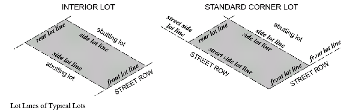
Structural alteration. Any change, except for repair or replacement, in supporting members of a building or structure, such as bearing walls, columns, beams or girders, and which complies with applicable building codes.
Structure. Anything constructed or erected, the use of which requires a location on the ground, or attached to something having a location on the ground.
Structure, existing. Any structure the construction of which was initiated and all required state, local and federal authorizations were obtained prior to the effective date of this Ordinance.
Structure, new. Any structure which is not an existing structure.
Subdivider. Any individual, firm, association, syndicate co-partnership, corporation, trust, or any other legal entity commencing proceedings to effect a subdivision of land hereunder.
Subdivision. The division of a lot, tract, or parcel of land into two (2) or more lots, plats, sites, or other division of land for the purpose, whether immediate or future, of sales or of building development. It includes re-subdivision and, when appropriate to the context, relates to the process of subdividing or to the land or territory being subdivided. It shall include all divisions of land involving the dedication of a new street or a change in existing streets. However, the following shall not be included within this definition or be subject to the requirements thereof:
(a)
Property that is divided by probated family estates;
(b)
The public acquisition by gift or purchase of strips or parcels of land for the widening or opening of streets or for other public uses.
Subdivision—Extraterritorial planning jurisdiction. The division of a lot, tract, or parcel of land into two (2) or more lots, plats, sites, or other division of land for the purpose, whether immediate or future, that is divided by an individual and given and/or sold to parents, spouses, sisters, brothers, children, or grandchildren, either adopted or natural, where no streets or roadway access to the lots is involved and where lots are less than the minimum lot size as herein required.
Submerged lands. Those lands situated below the mean low waterline or all of the lands covered by the mean high waterline.
Substantial improvement. Any addition, extension, enlargement, or expansion, repair, reconstruction, or improvement of any permanent structure, the cost of which equals or exceeds fifty (50) percent of the fair market value of the structure either before the repair, reconstruction, or improvement is started or if the structure has been damaged and is being restored before the damage occurred. For the purpose of this Ordinance, substantial improvement is considered to occur when the alterations of any wall, ceiling, floor or other structural part of the building commences, whether or not that alteration affects the external dimensions of the structure.
The term does not, however, include either (1) any project for improvement of a structure to comply with existing state or local health, sanitary, or safety code specifications which are solely necessary to ensure safe living conditions, or (2) any alterations or restoration of a structure listed on the National Register of Historic Places or a State Inventory of Historic Places.
Surveyor or applicant's surveyor. A professional surveyor licensed in the State of Alabama.
Swale. A depression in the ground which channels stormwater runoff, where the side slopes are no steeper than four (4) to one (1) run to rise.
Tattoo facility. A use as permitted in chapter 13, article XV, Community Standards Ordinance. The geographic location at which an individual does one (1) or more of the following for compensation: places an indelible mark upon the body of another individual by the insertion of a pigment in or under the skin; places an indelible design upon the body of another individual by production of scars; the perforation of human tissue other than ear for a nonmedical purpose.
Temporary BMPs. Temporary best management practices are designed to remain effective for a relatively short duration of time, usually until the construction site is complete and permanent BMPs have been established. Temporary BMPs are only effective if they are installed correctly and maintained. These include but are not limited to silt fences, hay bales and mulch.
Temporary use. A short period of time; not to exceed thirty (30) calendar days.
Telecommunications facility. A facility owned or operated by a public utility or a business, that transmits and/or receives electromagnetic waves, including antennas, microwave dishes, horns, and other types of equipment for the transmission or receipt of such signals, telecommunications towers, or alternative supporting structures and uses.
Telecommunications tower. Any structure that is designed and constructed primarily for the purpose of supporting one (1) or more antenna, including self-supporting lattice towers, guyed towers, or monopole towers. The term includes radio and television transmission towers, microwave towers, common carrier towers, cellular telephone towers, and the like (See also Antenna support structure).
Three-dimensional (3-D) logo sign or emblem. Any three-dimensional form shaped into a work of art, fountain, sculpture, or similar object that is sited within a development which does either of the following: contains characteristics of an advertising sign or identifies or draws attention to a business, profession, or industry, to the type of products sold, manufactured or assembled, or to the type of services or entertainment offered or available on the premises. See also Advertising statuary sign.
Tourist home. A building, or part thereof, other than a motel or hotel, where sleeping accommodations are provided for transient guests, with or without meals, and which also serves as the residence of the operator.
Townhouse. An individually-owned, single-family attached dwelling unit having a separate ground floor entrance and separate private yard space, with common side walls on one (1) or both sides of the dwelling unit, and not exceeding two and one-half (2½) stories or thirty-five (35) feet in height.
Travel trailer park. A development for the accommodation of tourists or vacationers on a short-term basis, providing rental spaces for each individual trailer, camper, motor home, and recreation and service facilities for the use of the tenants, whether publicly or privately owned and whether operated for or without compensation.
Tree. A self-supporting woody plant, usually having a single woody trunk and a potential DBH of two (2) inches or more, and normally attaining a mature height of twenty-five (25) feet or more. For the purposes of this Ordinance, trees may be categorized as follows:
(a)
Overstory tree. Trees which, at maturity, comprise the canopy of a natural forest. Generally greater than fifty (50) feet at mature height.
(b)
Public/city tree. Any tree located on city or public property including city right-of-way.
(c)
Significant tree. Any tree that has aged and grown to an impressive stature, for its species, to be considered an integral part of the city's natural heritage.
(d)
Understory tree. Trees which, at maturity, comprise the sub-canopy of a natural forest. These are generally under fifty (50) feet at a mature height. Suggested list of understory trees include: Japanese Maple, Redbud, Fringe Tree, Crape Myrtle, Oriental Magnolia, Vitex, Sweet Bay Magnolia, American Holly, Loquat, Cherry Laurel, Japanese Evergreen Oak, East Palatka Holly, or Savannah Holly.
Tree credits. An incentive to preserve existing trees whereby on-site trees may be counted toward the landscape requirements of this Ordinance. Such credits may be used to offset the number of new required trees that would otherwise have to be planted.
Trust indentures. A bond indenture that includes provisions for the appointment of trustees who may act on behalf of the bondholders.
Use. The specific purpose for which land or a building is designated, arranged, intended, or for which it is or may be occupied or maintained.
Utility, water. Any public community water supplier serving customers and owning and operating public water wells within the city limits and its planning jurisdiction.
Variance. A modification of the strict terms of the relevant regulations in a district with regard to placement of structures, developmental criteria or provision of facilities.
Examples would be:
(a)
Allowing smaller yard dimensions because an existing lot of record is of substandard size.
(b)
Waiving a portion of required parking and/or loading space due to some unusual circumstances.
(c)
Allowing fencing and/or plant material buffering different from that required, due to some unusual circumstances. This is available only on appeal to the board of zoning adjustment.
Waiver. Permission to depart from the requirements of an ordinance with respect to the submission of required documents based upon findings and conclusions of the planning commission.
Watercourse. Any body of water, including but not limited to creeks, rivers, streams, and bays.
Waterway. A dry or wet channel that directs surface runoff to a watercourse or to the public storm drain.
Well. A hole or shaft sunk into the earth to tap an underground supply of water.
Well field. See Public well.
Well head protection area (WHPA). The surface and subsurface area surrounding a water well or well field, supplying a public water system, through which contaminants are likely to move toward and reach such water well or well field.
Wetlands. An area or areas that are inundated or saturated by surface or ground water at a frequency and duration sufficient to support, and that under normal circumstances do support a prevalence of vegetation typically adapted for life in saturated soil conditions and generally include swamps, marshes, bogs and similar areas.
Wetlands, jurisdictional. A wetland area that meets the definitional requirements for wetlands to include the hydrology, hydric soil types and wetland vegetation as determined by the U.S. Army Corps of Engineers, 1987 Federal Wetland Delineation Manual.
Wholesale establishment. Business establishments that generally sell commodities in large quantities or by the place to retailers, jobbers, other wholesale establishments, or manufacturing establishments. These commodities are basically for further resale, for use in the fabrication of a product, or for use by a business service.
Yard. A space on the same lot with a main building, such space being open, unoccupied and unobstructed by buildings or structures from ground to sky, except where encroachments and accessory buildings are expressly permitted.
(a)
Yard, front. An open, unoccupied space on the same lot with the main building, extending the full width of the lot and situated between the right-of-way line and the front line of the building projected to the side lines of the lot. The depth of the front yard shall be measured between the front lines of the building and the right-of-way line.
Covered porches, whether enclosed or unenclosed, shall be considered as a part of the main building and shall not project into a required front yard.
(b)
Yard, rear. An open space on the same lot with the main building, such space being unoccupied except possibly by an accessory building and extending the full width of the lot and the rear line of the main building projected to the side lines of the lot.
(c)
Yard, side. An open, unoccupied space on the same lot with a main building, situated between the side line of the building and the adjacent side line of the lot extending from the rear line of the front yard to the front line of the rear yard. If no front yard is required, the rear boundary of the side yard shall be the rear line of the lot.
(d)
Yard, minimum. That yard space remaining if the property is developed to the fullest extent allowable under applicable ordinances.
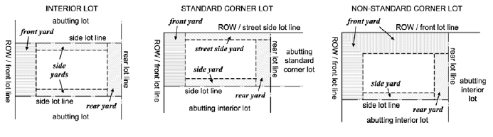
Zero lot line. A developmental approach in which a dwelling unit is cited along one (1) or more lot lines.
Zoning administrator. The administrative officer designated to administer the zoning ordinance and issue land use certificates.
Zoning district. A section of the City of Daphne designated in this Ordinance text and delineated on the zoning map wherein all requirements for use of land and building and development standards must be uniform.
Zoning district map. The map or maps, which are a part of this Zoning Ordinance, and which delineate the boundaries of zoning districts.
(Ord. No. 2013-03, § I, 1-22-13; Ord. No. 2013-46, §§ II, III(A), 9-3-13; Ord. No. 2014-11, § 1.0, 3-17-14; Ord. No. 2015-17, § I, 4-6-15; Ord. No. 2021-08, § I, 3-1-21; Ord. No. 2023-43, § 1(A), 1-2-24)
8-3 - Acronyms/abbreviations.
ac - acre(s)
ACAMP - Alabama Coastal Area Management Plan
ADCNR - Alabama Department of Conservation and Natural Resources
ADEM - Alabama Department of Environmental Management
AHC - Alabama Historical Commission
ALDOT - Alabama Department of Transportation
ANSI - American National Standards Institute
ATM - automated teller machine
BFE - base flood elevation
bldg - building
BMP - best management practices
BR - bedroom
CBMPP - construction best management practices plan
DBH - diameter at breast height
EQ - equal
FAA - Federal Aviation Administration.
FCC - Federal Communications Commission
fc - foot candle
ft - foot or feet
GFA - gross floor area
HOA - Home Owners Association
Hwy - highway
ITE - Institute of Transportation Engineers
lf - linear feet
LEED - Leadership in Energy and Environmental Design
LID - Low Impact Development
MS4 - city's municipal separate storm sewer system
max - maximum
min - minimum
mph - miles per hour
na - not applicable
NAVD 88 - North American Vertical Datum of 1988
NFA - net floor area
NPDES - National Pollutant Discharge Elimination System
NRCS - National Resources Conservation Service
POA - Property Owners Association
PUD - Planned Unit Development
ROW - right-of-way
sf - square feet
St - street
USACE United States Army Corps of Engineers.
USDA - United States Department of Agriculture
USFWS - United States Fish and Wildlife Services
% - percent
§ - section, subsection, paragraph or item within this Ordinance or other regulations, as specified

