
Dawsonville City Zoning Code
ARTICLE XXXIV
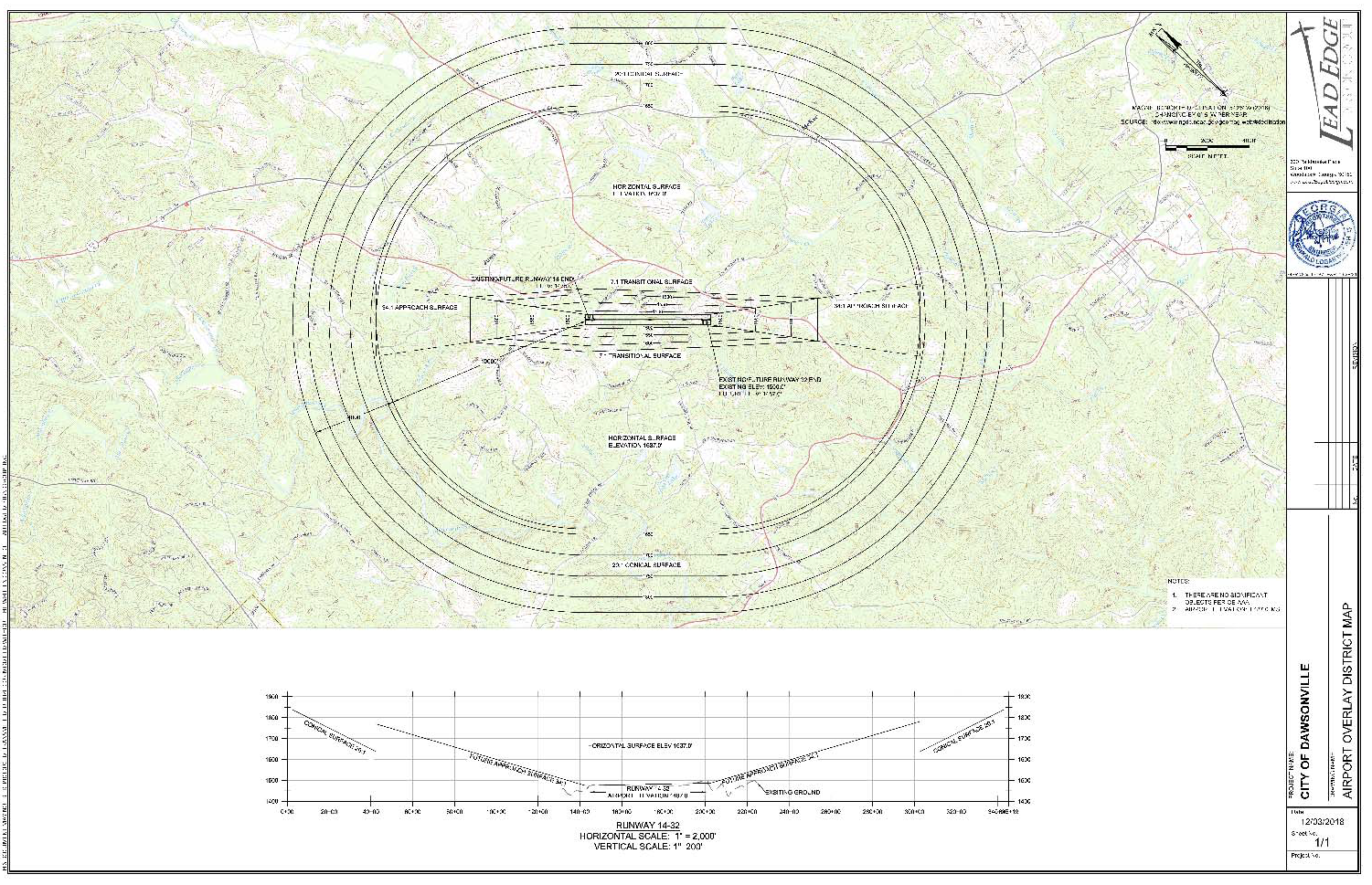
AIR, AIRPORT OVERLAY DISTRICT
Sec. 3401.- Purpose and intent.
The purpose of the airport overlay zone is to impose height and use restrictions necessary to ensure that obstructions or hazards will not impair flight safety or decrease the operational capability of Elliott Field Airport. These zones overlay the various zoning districts and are intended to provide greater restrictions than the zoning districts otherwise provide with regard to heights and aircraft navigation.
(Ord. of 12-3-2018)
Sec. 3402. - Definitions.
Airport: Elliott Field Airport.
Airport elevation: 1487 feet above mean sea level.
Airport overlay zones: Areas located on the ground that are defined in their boundaries by the airport surfaces overhead, including:
(1)
Primary surface zone: That area on the ground that coincides with the primary surface for each runway.
(2)
Approach surface zone: That area on the ground directly beneath an approach surface.
(3)
Horizontal surface zone: That area on the ground directly beneath the horizontal surface.
(4)
Conical surface zone: That area on the ground directly beneath the conical surface.
(5)
Transitional surface zone: That area on the ground directly beneath the transitional surfaces.
(6)
Navigable airspace zone: That area on the ground within six nautical miles of the airport reference point, and not included in any of the other airport zones.
Airport reference point: A horizontal reference point calculated in accordance with Federal Aviation Administration. (For the airport configuration on December 1, 2018, the position is 34°27'30.37" N, 84°10'49.42" W.)
Airport surfaces: Imaginary planes that define the lower limit of aircraft operational areas round an airport, including:
(1)
Primary surface: A surface longitudinally centered on a runway and extending 200 feet beyond each end of that runway. The elevation of any point on the primary surface is the same as the elevation of the nearest point on the runway centerline.
(2)
Approach surface: A surface centered on the extended runway centerline, extending outward and upward from the end of the primary surface at a slope designated by the Federal Aviation Administration.
(3)
Horizontal surface: A horizontal plane 150 feet above the established airport elevation, the perimeter of which in plan is established by swinging arcs of 10,000 feet radii from the center of each end of the primary surface of each runway and connecting the adjacent arcs by drawing lines tangent to those arcs.
(4)
Conical surface: A surface extending outward and upward from the periphery of the horizontal surface at a slope of 20 to 1 for a horizontal distance of 4,000 feet.
(5)
Transitional surfaces: These surfaces extend outward at 90-degree angles to the runway centerline and the runway centerline extended at a slope of seven feet horizontally for each foot vertically from the sides of the primary and approach surfaces to where they intersect the horizontal surfaces.
Airport zone structure: An object, including a mobile object, constructed or installed by man, including but without limitation, buildings, towers, cranes, smokestacks, earth formation, and overhead transmission lines.
Hazards and obstructions to air navigation: A hazard or obstruction determined to have substantial adverse effect on the same and efficient utilization of the navigable airspace.
Height datum: The vertical distance above mean sea level elevation.
Runway: A defined area on an airport prepared for landing and takeoff of aircraft along its length.
Runway designations: Runways are numbered by the compass heading of approach for landing aircraft. At Elliott Field, runways are: 14, at an approach heading of 139°; 32, at an approach heading of 319.
(Ord. of 12-3-2018)
Sec. 3403. - Airport zones established.
In order to carry out the provisions of this chapter, there are hereby created and established certain zones within the airport overlay zone which include all of the land lying beneath the primary surfaces, approach surfaces, transitional surfaces, horizontal surfaces, and conical surfaces as they apply to Elliott Field Airport. An area located in more than one of the following zones is considered to be only in the zone with the more restrictive height limitation.
The airport zones are:
(a)
Primary surface zone. For runways 14 and 32, the primary surface is centered on the runway, 500 feet wide, and extends 200 feet beyond each end of the runway.
(b)
Approach surface zone—Runways 14. The inner edge of this approach zone coincides with the width of the primary surface which is 500 feet wide. The approach zone expands outward uniformly to a width of 3,500 feet at a horizontal distance of 10,000 feet from the primary surface. Its centerline is the continuation of the centerline of the runway.
(c)
Approach surface zone—Runway 32. The inner edge of this approach zone coincides with the width of the primary surface which is 500 feet wide. The approach zone expands outward uniformly to a width of 3,500 feet at a horizontal distance of 10,000 feet from the primary surface. Its centerline is the continuation of the centerline of the runway.
(d)
Reserved.
(e)
Transitional surface zones. The inner edge of this transitional zone coincides with the width of the primary surface, which is 500 feet wide, and extends upward at a slope of 7 to 1 until it intersects the horizontal surface at an elevation of 1637.
(f)
Horizontal surface zone. The horizontal zone is established by swinging arcs of 10,000 feet radii from the center of each end of the primary surface of each runway and connecting the adjacent arcs by drawing lines tangent to those arcs. The horizontal zone does not include the approach and transitional zones.
(g)
Conical surface zone. The conical zone is established as the area that commences at the periphery of the horizontal zone and extends outward at a slope of 20 to 1 for a horizontal distance of 4,000 feet, reaching an elevation of 1837.
(Ord. of 12-3-2018)
Sec. 3404. - Airport overlay district map.
Airport overlay district boundaries are defined as all areas within the conical surface located in the city. The various airport zones established by this chapter are illustrated on the airspace plan of Elliott Field Airport which is hereby adopted and made a part of this chapter.
(Ord. of 12-3-2018)
Sec. 3405. - Airport zone height limitations.
No structure or tree shall be placed, altered, or maintained that penetrates any airport zone to a height in excess of the maximum height established for such zone.
(Ord. of 12-3-2018)
Sec. 3406. - Permitted uses.
In the airport district the following uses are permitted:
(1)
Aviation facilities, including airport terminal air cargo facilities, hangars, aircraft refueling, parking facilities, and other uses integral to airport operations.
(2)
Commercial or industrial uses that are related to aviation and require access to an airport facility or aviation services, including assembly or sale of aircraft, air frames, aircraft engines, aircraft parts or associated components, radios or navigational equipment, and similar products or services.
(3)
Service establishments such as auto rental and travel agencies, hotels, commercial parking lots and garages, automobile service stations, car washes, banks, restaurants, medical offices, and similar facilities available to airport users and airport employees.
(4)
Public and institutional uses that support the aviation industry such as aviation technical schools, security services, and inspection facilities.
(5)
Warehousing and storage facilities that support the aviation industry.
(6)
Public transportation and freight facilities.
(7)
Uses shall be allowed only upon first obtaining a recommendation for approval by the city. As a condition of this authorization, a sound attenuation may be required.
(Ord. of 12-3-2018)
Sec. 3407. - Use restriction.
No use shall be located within any airport zone that would create electrical interference with navigational signals or radio communication between the airport and aircraft, make it difficult for pilots to distinguish between airport lights and others, result in glare in the eyes of pilots using the airport, impair visibility in the vicinity of the airport, create bird strike hazards, or otherwise in any way endanger or interfere with the landing, takeoff, or maneuvering of aircraft intending to use the airport. Any use not specifically permitted in section 3406.
Additionally, the following uses are specifically prohibited:
(1)
Churches, schools, lodges, clubs, theaters, and other places of public assembly.
(2)
Multi-family dwellings in excess of four units.
(3)
Hospitals and institutions, including any type of group or congregate homes, including personal care homes.
(4)
Any other similar uses where concentrations of persons are customary.
(Ord. of 12-3-2018)
Sec. 3408. - Hazards and obstructions shall not be increased.
No permit shall be granted that would allow the establishment or creation of a hazard or obstruction or permit a nonconforming use, structure, or tree to become a greater hazard or obstruction to air navigation, than it was on the effective date of this chapter or any amendments thereto or a greater hazard or obstruction than it is when the application for a permit is made.
(Ord. of 12-3-2018)
Sec. 3409. - Marking and lighting.
The owner of any existing nonconforming structure or tree within an airport zone must permit the installation, operation, and maintenance thereon of such markers and lights as shall be deemed necessary by the city to indicate to the operators of aircraft in the vicinity of the airport the presence of such hazard or obstruction. Such markers and lights shall be installed, operated, and maintained at the expense of the city.
Sec. 3410. - Nonconforming uses abandoned or destroyed.
Whenever the city determines that a nonconforming tree or structure has been abandoned or more than 50 percent torn down, physically deteriorated, or decayed, such tree or structure shall be removed or modified to the extent necessary to comply with the applicable height limit.
(Ord. of 12-3-2018)
Sec. 3411. - Variances.
No variances are permitted unless those which would improve the safety and usability of the airport overlay district. Variances may only be granted by the mayor and council upon the advice and recommendation of city staff and the city's airport consultant.
(Ord. of 12-3-2018)
Sec. 3412. - Staff review of application for variance.
Variance applications pursuant to this chapter shall be reviewed by city staff along with the city airport consultant, and their response or recommendation must be received by the planning director and forwarded to the mayor and council prior to action on any such variance.
(Ord. of 12-3-2018)