
Dayton City Zoning Code
7.2.1 Land
Use Zoning
665
656
655-Temporary
657
645
666
7.2.101.01 Interpretation Of Uses
- Types of Uses. Within each zone, uses are classified as "permitted," "special permitted" and "conditional." Further, uses are functionally classified by description of the particular activity (such as "single-family residence").
- Interpretation of Uses. Where a use is not otherwise defined in Section 7.1.2, the words of this zoning Code describing such use are to be given their ordinarily accepted meaning, except where the context in which they are used otherwise clearly requires.
- Prohibited Uses. Uses not specifically identified as permitted, special permitted or conditionally permitted within the zone, or, otherwise allowed through interpretation, shall be considered prohibited uses.
7.2.102.01 Purpose
The purpose of the R-1 zone is to allow the development of single-family homes, duplexes, and single-room occupancies on individual lots provided with urban services at urban densities. Other uses compatible with residential development are also appropriate. These areas are designated as Residential in the Comprehensive Plan.
Amended by Ord. 665 on 3/3/2025
7.2.102.02 Permitted Uses
The following uses are permitted in the R-1 zone, when developed under the applicable development standards in this Code:
- One detached single family dwelling on a separate lot or parcel.
- One two-family (duplex) dwelling on a single lot or parcel.
- Residential care homes.
- Single room occupancies with up to six units on a lot.
- Child day care service, including family day care provider, for 12 or fewer children.
- The following uses, subject to the applicable standards in Section 7.2.4:
- Accessory structures and uses allowed in Section 7.2.203 and subject to the provisions in Section 7.2.309.
- Accessory dwelling units - Section 7.2.402
- Attached dwelling units - Section 7.2.403.
- Manufactured homes on individual lots - Section 7.2.404.
- Manufactured home parks with Site Development Review and subject to Section 7.2.405.
- Home occupations - Section 7.2.406.
- Owner-occupied short-term rentals - Section 7.2.417.
Amended by Ord. 665 on 3/3/2025
7.2.102.03 Special Permitted Uses
The following uses, when developed under the applicable standards in this Code and special development requirements, are permitted in the R-1 zone:
- Partitions, subject to the provisions in Section 7.2.307.
- Subdivision, subject to the provisions in Section 7.2.307.
- Accessory Dwelling Unit (one per detached single-family dwelling), subject to the provisions in Section 7.2.402. (Added ORD 642-Effective 07/02/18)
- Accessory structures and uses prescribed in Section 7. 2.203 and subject to the provisions in Section 7.2.309.
- Two-family dwellings (duplexes) subject to the following:
- The duplex shall be located on a corner lot.
- Access shall be subject to the following:
- Where both adjacent streets are of the same street designation (e.g. local street) the duplex may obtain access from each adjacent street or share a single access.
- Where the adjacent streets are of a different street designation (e.g. local and collector) a shared access shall be required from the lower street designation.
- The following uses, subject to the applicable standards in Section 7.2.4:
- Manufactured homes on individual lots (Section 7.2.404)
- Home occupations (Section 7.2.406).
- Owner occupied short-term rentals (Section 7.2.417) (Amended ORD 533-Effective 06/06/16)
7.2.102.04 Conditional Uses
The following uses require approval of a Conditional Use Permit and are subject to a Site Development Review:
- Private or public elementary schools.
- Public parks, playgrounds, community clubs including swimming, tennis and similar recreation facilities; and other public or semi-public uses.
- Child day-care services for 13 or more children.
- House of Worship and the reasonable use of the real property for activities customarily associated with the practices of the religious activity, including but not limited to the uses set forth in Section 7.2.407. (Amended ORD 642-Effective 07/02/18)
- Small wind energy systems, subject to the provisions in Section 7.2.413.
- A manufactured home on a residentially zoned individual lot or parcel immediately adjacent to a significant historical resource as identified in the Dayton Comprehensive Plan subject to the provisions of Section 7.2.404.E.
Amended by Ord. 665 on 3/3/2025
7.2.102.05 Dimensional Standards
- Minimum Lot Dimension and Height Requirements (Revised ORD 541 - Effective 07/03/02)
DIMENSION Residential Uses Non-Residential Uses Lot Size 7,000 sq. ft. (1) Width 50 (1) Depth 80 (1) Maximum Height 35 feet 35 feet - Adequate to comply all applicable development standards
- Adequate to comply all applicable development standards
- Minimum Yard Setback Requirements
SETBACKS Residential Uses Non-Residential Uses Front 15 feet 20 feet Side 5 feet 10 feet Rear 15 feet 20 feet 20 feet Garage (1) 20 feet 20 feet - The garage setback shall be measured from the property line or the edge of a private access easement. The length of the driveway shall be determined by measuring along the centerline of the driveway.
- See Sections 7.2.308.06.C and 7.2.308.07.E for standards that apply to decks and patios.
Amended by Ord. 656 on 11/6/2023
Amended by Ord. 665 on 3/3/2025
7.2.102.06 Development Standards
All development in the R-1 Zone shall comply with the following development requirements:
- Off-street Parking: Parking shall be as specified in Section 7.2.303.
- Yards and Lots: Yards and lots shall conform to the standards of Section 7.2.308.
- Site Development Review: Manufactured home parks and non-residential uses shall require a Site Development Review, pursuant to Section 7.3.1.
- Lot Coverage: The maximum coverage allowed for buildings, accessory structures, and paved parking shall be 65% of the site area.
- Landscaping: Areas of the property not covered by buildings, accessory structures, and paved parking shall be landscaped, including all required yards. Landscaping shall be provided pursuant to the requirements in Section 7.2.306.
- Land divisions shall be permitted at a minimum density of four lots per net acre and a maximum density of six lots per net acre.
- Redevelopment Plan: A redevelopment plan shall be required when units are proposed at densities less than four units per net acre. The following shall apply:
- The redevelopment plan shall indicate how the remaining undivided or undeveloped portion of the property could be developed with four units per net acre
- A redevelopment plan shall be required to place a single-family home or duplex on a lot containing more than 1 acre. This plan shall be approved by the City before the issuance of a building permit.
- Plansplan may be revised or modified at the time of development provided the revised plan complies with the applicable development requirements of the R-1 zone.
Amended by Ord. 665 on 3/3/2025
7.2.103.01 Purpose
The R-2 zone is intended to provide single family homes, middle housing , and multiple family development on lots at an intermediate density. Other uses compatible with residential development are also appropriate. R-2 zones are located in areas designated Residential in the Comprehensive Plan.
Amended by Ord. 665 on 3/3/2025
7.2.103.02 Permitted Uses
The following uses are permitted in the R-2 zone when developed under the applicable development standards in the Code:
- Single-family dwellings, attached and detached.
- Middle housing types, including single room occupancies.
- Multiple family development.
- Residential care homes and facilities.
- Child daycare service, including family daycare provider, for 12 or fewer children.
- The following uses, subject to the applicable standards in Section 7.2.4:
- Accessory structures and uses allowed in Section 7.2.203 and subject to the provisions in Section 7.2.309.
- Accessory dwelling units - Section 7.2.402.
- Attached dwelling units - Section 7.2.403.
- Manufactured homes on individual lots - Section 7.2.404.
- Manufactured home parks according to Section 7.2.405 with Site Development Review.
- Home occupations - Section 7.2.406.
- Short-term rentals - Section 7.2.417.
Amended by Ord. 665 on 3/3/2025
7.2.103.03 Special Permitted Uses
The following uses, when developed under the applicable standards in the Code and special development requirements, are permitted in the R-2 zone:
- Partitions, subject to the provisions in Section 7.2.307.
- Subdivision, subject to the provisions in Section 7.2.307.
- Accessory structures and uses prescribed in Section 7.2.203 and subject to the provisions in Section 7.2.309.
- The following uses, subject to the applicable standards in Section 7.2.4:
- Accessory dwelling unit (Section 7.2.402). (Amended Effective 06/06/16, Ord 633)
- Attached dwelling units (Section 7.2.403).
- Manufactured homes on individual lots (Section 7.2.404).
- Manufactured home parks (Section 7.2.405).
- Home occupations (Section 7.2.406).
- Owner occupied short-term rentals (Section 7.2.417). (Amended ORD 633-Effective 06/06/16)
7.2.103.04 Conditional Uses
The following uses require approval of a Conditional Use Permit and are subject to a Site Development Review:
- Public or private elementary schools.
- Public parks, playgrounds, community clubs including swimming, tennis and similar recreational facilities, and other public and semi-public uses.
- Child day-care services for 13 or more children.
- House of Worship and the reasonable use of the real property for activities customarily associated with the practices of the religious activity, including but not limited to the uses set forth in Section 7.2.407. (Amended ORD 642-Effective 07/02/18)
- Assisted living centers, nursing homes and similar institutions. These facilities are subject to the development provision for multiple family residential development. (Amended ORD 584-Effective 12/3/07)
- Small wind energy systems, subject tothe provisions in with Section 7.2.413.
Amended by Ord. 665 on 3/3/2025
7.2.103.05 Dimensional Standards
- Minimum Lot Dimension and Height Requirements.
DIMENSION Detached single family middle housing, multiple family and manufactured home parks Attached Single Family (Townhomes) Non-Residential Lot Size 6000 sq. ft. 3500 sq. ft. 9000 sq. ft. Lot Width 50 feet 25 feet 50 feet Lot Depth 80 feet 80 Feet 80 feet Maximum Height 35 feet 35 feet 35 feet - Multiple family development and manufactured home parks must comply with the density standard in Section 7.2.103.06.
- Minimum Yard Setback Requirements
SETBACKS Single family and middle Multi-Family Non-Residential Front 15 feet 15 feet 20 feet Side 5 feet (1) 10 feet 10 feet Rear 15 feet 15 feet 20 feet Street-side 15 feet 15 feet 20 feet Garage (2) 20 feet 20 feet N/A - Zero side yard dwelling units are subject to the setback provisions in Section 7.2.404.
- The garage setback shall be measured from the property line or the edge of a private access easement. The length of the driveway shall be determined by measuring along the centerline of the driveway.
- See Sections 7.2.308.06.C and 7.2.308.07.E for standards that apply to decks and patios.
Amended by Ord. 656 on 11/6/2023
Amended by Ord. 665 on 3/3/2025
7.2.103.06 Development Standards
All development in the R-2 Zone shall comply with the following development requirements:
- Offstreet Parking: Parking shall be as specified in Section 7.2.303.
- Yards and Lots: Yards and lots shall conform to the standards of Section 7.2.308.
- Site Development Review: Manufactured home parks, multiple family residential development and non-residential uses shall require a Site Development Review, pursuant to Section 7.3.1.
- Lot Coverage: The maximum coverage allowed for buildings, accessory structures and paved parking shall be 70% of the site.
- Landscaping: Undeveloped areas of the property shall be landscaped, including all required yards. Landscaping shall be provided pursuant to requirements in Section 7.2.306. Multiple family developments shall comply with provisions in Section 7.2.306.06.
- Density: The following density provisions shall apply:
- Land divisions shall be required to provide a minimum of 5 lots per net acre and the maximum density of 7 lots per net acre.
- Manufactured home parks and multiple family development: The minimum density shall be 6 units per net and; the maximum density shall be 12 units per net acre.
- Redevelopment Plan: A redevelopment plan shall be required to place a single family home, duplex or single room occupancy on a parcel containing more than 1 acre. This plan shall be approved by the City prior to the issuance of a building permit. The following shall apply:
- The redevelopment plan shall indicate how the remaining undeveloped portion of the property can be developed at a density consistent with the requirements of the R-2 zone.
- The plan may be revised or modified at the time of development provided the revised plan complies with the density requirement of the R-2 zone.
Amended by Ord. 665 on 3/3/2025
7.2.104.01 Purpose
The R-3 zone is intended for multiple family development at higher residential densities. Other uses compatible with residential development are also appropriate. R-3 zoned property is suited to locations near commercial areas and along arterial streets. The appropriate Comprehensive Plan designation is Residential.
Amended by Ord. 665 on 3/3/2025
7.2.104.02 Permitted Uses
The following uses, when developed under the applicable development standards in the Code, are permitted in the R-3 zone:
- Multiple family development and residential buildings containing two or more dwelling units.
- Attached single family dwellings.
- Single room occupancies.
- Residential care homes and facilities.
- Child daycare service, including family daycare provider, for 12 or fewer children.
- Accessory structures and uses prescribed in Section 7.2.203 and subject to the provisions in Section 7.2.309.
- Manufactured home parks - Section 7.2.405.
- Home occupations - Section 7.2.406.
- Owner-occupied short-term rentals - Section 7.2.417.
Amended by Ord. 665 on 3/3/2025
7.2.104.03 Reserved
The following uses, when developed under the applicable standards in the Code and special development requirements, are permitted in the R-3 zone:
- Partitions, subject to the provisions in Section 7.2.307.
- Subdivision, subject to the provisions in Section 7.2.307.
- Accessory structures and uses prescribed in Section 7.2.203 and subject to the provisions in Section 7.2.309.
- The following uses subject to the applicable standards in Section 7.2.4:
- Manufactured home parks (Section 7.2.405).
- Home occupations (Section 7.2.406).
- Owner occupied short-term rentals Section (7.2.417). (Amended Effective 06/06/16, Ordinance 633)
Amended by Ord. 665 on 3/3/2025
7.2.104.04 Conditional Uses
The following uses require a Conditional Use Permit and are subject to a Site Development Review:
- Public or private schools.
- Public parks, playgrounds, community clubs including swimming, tennis and similar recreational facilities, and other public and semi-public uses.
- Child daycare service for 13 or more children.
- House of Worship and the reasonable use of the real property for activities customarily associated with the practices of the religious activity, including but not limited to the uses outlined in Section 7.2.407.
- Assisted living centers, nursing homes and similar institutions. These facilities are subject to the development provisions for multiple family residential development. (Amended ORD 584-Effective 12/3/07)
- Small wind energy systems, subject to theprovisionscompliance in Section 7.2.413.
Amended by Ord. 665 on 3/3/2025
7.2.104.05 Dimensional Standards
- Minimum Lot Dimensions and Height Requirements
DIMENSION Residential Non-Residential Lot Size 6,000 square feet Adequate to comply with all applicable development standards Maximum Height 35 feet 35 feet - Multiple family development must comply with the density standard in Section 7.2.104.06.
- Manufactured home parks must comply with the density requirements in Section 7.2.104.06 and the minimum area requirements in Section 7.2.403.
- Minimum Yard Setback Requirements
SETBACKS Residential Non-Residential Front and street side 15 feet where the front of the dwelling units face the street; otherwise 20 feet 20 feet Side 10 feet 10 feet Rear 15 feet 20 feet Garage (2) 20 feet N/A - Non-residential setbacks may be increased with a Conditional Use Permit.
- The garage setback shall be measured from the property line or the edge of a private access easement. The length of the driveway shall be determined by measuring along the centerline of the driveway.
- See Sections 7.2.308.06.C and 7.2.308.07.E for standards that apply to decks and patios.
Amended by Ord. 656 on 11/6/2023
Amended by Ord. 665 on 3/3/2025
7.2.104.06 Development Standards
All development in the R-3 Zone shall comply with the applicable provisions of this Code. The following references additional development requirements:
- Offstreet Parking: Parking shall be as specified in Section 7.2.303.
- Yards and Lots: Yards and lots shall conform to the standards of Section 7.2.308.
- Site Development Review: All uses shall require a Site Development Review, pursuant to Section 7.3.1.
- Lot Coverage: The maximum coverage allowed for buildings, accessory structures and paved parking shall be75% of the site area:
- Landscaping: Undeveloped areas of the property shall be landscaped, including all required yards. Landscaping shall be provided pursuant to requirements in Section 7.2.306. Multiple family developments shall comply with provisions in Section 7.2.306.06. (Amended ORD 530 06/04/01, Effective 07/04/01)
- Density: The following density provisions shall apply:
- Manufactured home park: The minimum density shall be 6 units per acre; the maximum density shall be 10 units per acre.
- Multiple family development: The minimum density shall be 12 units per acre; the maximum density shall be 20 units per acre.
Amended by Ord. 665 on 3/3/2025
7.2.105.01 Purpose
To provide areas for the development of a mixture of single family, multiple family, and manufactured homes, and limited retail and service commercial uses.
Amended by Ord. 665 on 3/3/2025
7.2.105.02 Permitted Uses
The following uses, when developed under the applicable development standards in the Code, are permitted in the CR zone:
- The following residential uses are permitted in the CR zone:
- Detached single family dwellings.
- Middle housing types.
- Multiple family development.
- Residential units over ground floor commercial.
- The following uses, subject to the applicable standards in Section 7.2.4:
- Accessory structures and uses allowed in Section 7.2.203 and subject to the provisions in Section 7.2.309.
- Accessory dwelling unit (Section 7.2.402).
- Attached dwelling units (Section 7.2.403).
- Manufactured homes on individual lots (Section 7.2.404).
- Home occupations (Section 7.2.406).
- Owner occupied short-term rentals (Section 7.2.417).
- Short-term rentals (Section 7.2.417).
- Small wind energy systems, subject to the provisions in Section 7.2.413.
- Residential care homes and facilities
- Child daycare service, including family daycare provider, for 12 or fewer children.
- Assisted living centers, nursing homes and similar institutions. These facilities are subject to the development provisions for multiple family residential development. (Amended ORD 584, Effective 12/3/07)
- The following commercial uses are permitted:
- Business offices including, but not limited to, insurance, real estate and title insurance; credit agencies, brokerages, loan companies, and investment companies; television and radio broadcast studios (excepting a broadcast antennae or dish), and, miscellaneous offices such as detective agencies, drafting services or contractors offices.
- Professional offices and clinics including, but not limited to, medical, dental, engineering and legal services, but excluding veterinary clinics.
- Banks and other financial institutions.
- Retail sales outlet including, but not limited to, food stores, pharmacy, furniture store, artist supplies, hobby or photography store, florist, hardware store, appliance or stereo equipment store, pet shop, sporting goods, department store, clothing, jewelry, gift, and other types retail activities but excluding liquor stores.
- Restaurants, bakeries, coffee and snack shops but excluding taverns, bars and similar establishments.
- Retail and service related stores such as TV and radio sales and service, bicycle shop, gunsmith, upholstery shop or other similar activities where a service department is customarily a secondary activity to the retail use.
- Service-related businesses such as barber shops, beauty shops, tailors, advertising agencies, travel agencies, art or craft studios, self-serve laundry, dry cleaning (except bulk dry cleaning plants), parcel service, printing or photocopying, video rental, or other activities where the primary activity is the providing of a service to retail customers.
- Accessory structures and uses customarily provided for retail activities.
(Amended ORD 584, Effective 12/3/07)
Amended by Ord. 665 on 3/3/2025
7.2.105.03 Special Permitted Uses
The following uses, when developed under the applicable standards in the Code and special development requirements, are permitted in the CR zone:
- Partitions, subject to the provisions in Section 7.2.307.
- Subdivision, subject to the provisions in Section 7.2.307.
- Accessory structures and uses prescribed in Section 7.2.203 and subject to the provisions in Section 7.2.309.
- The following uses subject to the applicable standards in Section 7.2.4:
- Accessory dwelling units (Section 7.2.402). (Added Effective 03/08/17 – Ordinance 639)
- Attached dwelling units (Section 7.2.403).
- Manufactured homes on individual lots (Section 7.2.404).
- Home occupations (Section 7.2.406).
- Owner occupied short-term rentals (Section 7.2.417). (Amended Effective 06/06/16, Ordinance 633)
- Short-term rentals (Section 7.2.417). (Amended Effective 06/06/16, Ordinance 633)
- Small wind energy systems, subject to the provisions in Section 7.2.413. (Amended ORD 608, Effective 10/06/11)
- Drive-through windows and walk-up windows as part of a permitted use, subject to the provisions in Section 7.2.414 and 7.2.415 respectively. (Added ORD 610 effective 4/2/12)
7.2.105.04 Conditional Uses
The following uses require a Conditional Use Permit:
- Public or private schools.
- Public parks, playgrounds, community clubs including swimming, tennis and similar recreational facilities, and other public and semi-public uses.
- Child daycare service for 13 or more children.
- House of Worship and the reasonable use of the real property for activities customarily associated with the practices of the religious activity, including but not limited to the uses set forth in Section 7.2.407. (Amended ORD 642-Effective 07/02/18)
- Park and Ride Lot: Parking spaces cannot count as required parking or be used for vehicle storage. (Amended ORD 589, Effective 4/2/09)
- Commercial activities which do not comply with the provisions in Section 7.2.105.02.B. (Amended ORD 610, Effective 4/2/12)
- Wineries with retail sales. (Amended ORD 583, Effective 9/6/07)
(Amended ORD 589, Effective 4/2/09)
Amended by Ord. 665 on 3/3/2025
7.2.105.05 Dimensional Standards
The following dimensional standards shall be the minimum requirements for all development in the CR District.
- Minimum Lot Area and Density Standards
Single-family dwelling, detached 7,000 square feet Single-family dwellings, attached 3,500 square feet Other middle housing types and multiple family development 7,000 square feet 3. Multiple family 9,000 square feet Commercial Use 3,500 square feet Mixed commercial and residential: 7,000 square feet Public utility structures: Lot area shall be adequate to contain all proposed structures within the required yard setbacks. - Minimum Yard Setback Requirements
Residential Commercial Mixed Residential/Commercial Public Front Yard 15 feet None 5 feet 15 feet Rear Yard 10 feet 15 feet Abutting non-residential
None 5 feet Abutting a residential district
10 feet 10 feet Side Yard 5 feet 5 feet Abutting non-residential
None 5 feet Abutting a residential district
10 feet 10 feet Street Side 15 feet 15 feet Garage - See Sections 7.2.308.06.C and 7.2.308.07.E for standards that apply to decks and patios.
- Maximum Structure Height
1. Principal Structure 35 feet 2. Accessory Structure 20 feet
Amended by Ord. 656 on 11/6/2023
Amended by Ord. 665 on 3/3/2025
7.2.105.06 Development Standards
- Use Restrictions. No permitted or conditionally permitted use shall in any way involve any of the slaughter, rendering or processing of animals. The processing of grains, fruits, vegetables, or dairy products for breads, wines, jams, cheeses and similar products may be allowed as part of a permitted or conditionally permitted commercial business. (Amended ORD 583, Effective 9/6/07)
- Commercial Uses. Commercial uses in the CR zone shall comply with the following additional standards: (Amended ORD 630, Effective 12/2/15)
- All business, service, processing or merchandise displays shall be conducted wholly within an enclosed building, except for the following:
- Off-street parking and loading.
- Temporary display and sales of merchandise; provided it does not interfere with pedestrian or automobile circulation, or areas of a permitted drive-through window or walk-up window.
- Outdoor seating for a permitted eating and drinking establishment, subject to screening and buffering provisions in Section 7.2.306.04. The greater of 12 seats or 75 percent of the indoor seating capacity of the establishment is allowed for outdoor seating. (Added ORD 630, Effective 12/2/15)
- The maximum lot size for any commercial use shall be one acre.
- Any new commercial structure shall maintain a residential appearance. Metal buildings, pole barns and similar structures are prohibited within the CR zone.
- Commercial uses shall not engage in the manufacturing, processing, assembly or compounding of products other than those incidental to the business conducted on the premises.
- Any outside storage space maintained in the CR Zone shall be enclosed by a 6-foot sight-obscuring fence or a hedge row not less than 3 feet high and capable of attaining a height of 6 feet.
- All business, service, processing or merchandise displays shall be conducted wholly within an enclosed building, except for the following:
- Mixed Commercial and Residential Uses. Development of mixed commercial and residential uses shall be subject to the provisions in item B., above.
- Unless otherwise exempted, all development in the CR Zone shall comply with the applicable provisions of this Code. The following references additional development requirements:
- Off-street parking. Parking shall be as specified in Section 7.2.303.
- Yards and Lots. Yards and lots shall conform to the standards of Section 7.2.308.
- Subdivisions and Partitions. Land divisions shall be reviewed in accordance with the provisions of Section 7.2.307.
- Site Development Review: Multi-family and/or commercial uses within the CR Zone shall be subject to the Site Development Review requirements and procedures in Section 7.3.1. In addition, any conversion of an existing residence that includes a commercial use shall require a site development review.
- Lot Coverage: The maximum coverage allowed for buildings, accessory structures and paved parking shall be as follows:
75% Commercial and Mixed Residential and Commercial 85 - Landscaping: All areas covered by buildings, accessory structures, and paved parking shall be landscaped. Landscaped areas shall be landscaped as provided in Section 7.2.306.
Multiple family developments shall comply with provisions in Section 7.2.306.06.
Amended by Ord. 665 on 3/3/2025
7.2.106.01 Purpose
The Commercial (C) Zone is the primary commercial zone within the City. The zone is specifically designed to provide area for commercial activities to serve the residents of the City and the surrounding area. The Commercial Zone is suitable for the Commercial Plan designation.
7.2.106.02 Permitted Uses
The following uses, when developed under the applicable development standards in the Zoning Code, are permitted in the C zone:
- Pre-schools, nurseries and kindergartens.
- Non-profit member organizations, such as business associations, labor unions, political organizations or fraternal lodges.
- Public and semi-public buildings, structures and uses, such as parks, parking, municipal offices, libraries, police and fire stations and hospitals.
- Public utility structures and buildings, such as pump stations, reservoirs, electric substations, and necessary right-of-way for public utilities.
- Business offices including, but not limited to, insurance, real estate and title insurance; credit agencies, newspaper, periodical, publishing and printing offices, and, similar business offices.
- Professional offices and clinics including, but not limited to, medical, dental, engineering and legal services, but excluding veterinary clinics.
- Banks services, brokerages, loan companies, investment companies and other financial institutions.
- Hotels and motels.
- Retail sales outlet including, but not limited to, food stores, pharmacy, furniture store, hobby or photography store, florist and garden supply including greenhouse, liquor store, hardware store, appliance or stereo equipment store, pet shop, sporting goods, department store, jewelry, gift, and other types retail activities.
- Restaurants, drive-in, taverns, snack shops and other types of eating and drinking establishments, including entertainment facilities. (Amended ORD 610 effective 4/2/12)
- Retail and service related stores such as TV and radio sales and service, bicycle shop, equipment rental or other similar activities where a service department is customarily a secondary activity to the retail use.
- Service related businesses such as barber shops, beauty shops, advertising agencies, printing or photocopying, or other activities which provide a service to retail customers.
- Residences limited to second or upper stories.
- Wineries with retail sales. (Amended ORD 583, Effective 9/6/07)
- House of Worship and the reasonable use of the real property for activities customarily associated with the practices of the religious activity, including but not limited to the uses set forth in Section 7.2.407. (Amended ORD 642-Effective 07/02/18)
(Amended ORD 583, Effective 9/6/07)
7.2.106.03 Special Permitted Uses
The following uses, when developed under the applicable standards in the Code and special development requirements, are permitted in the C zone:
- Partitions, subject to the provisions in Section 7.2.307.
- Subdivision, subject to the provisions in Section 7.2.307.
- Accessory structures and uses prescribed in Section 7.2.203 and subject to the provisions in Section 7.2.309.
- The following uses subject to the applicable standards in Section 7.2.4:
- Home occupations (Section 7.2.406).
- RV Parks (Section 7.2.408).
- Owner occupied short-term rentals (Section 7.2.417). (Amended Effective 06/06/16, Ordinance 633)
- Short-term rentals (Section 7.2.417). (Amended Effective 06/06/16, Ordinance 633)
- Small wind energy systems, subject to the provision in Section 7.2.413. (Added ORD 608 effective 10/06/11)
- Drive-through windows and walk-up windows as part of a permitted use, subject to the provisions of Section 7.2.414 and 7.2.415 respectively. (Added ORD 610 effective 4/2/12)
7.2.106.04 Conditional Uses
The following uses require a Conditional Use Permit:
- Automobile service station, including towing service and vehicle washing and polishing facilities, and services.
- Automobile, truck, motorcycle, trailer, agricultural equipment, recreational vehicle and boat sales, lease and rentals.
- Tractor, farm equipment, heavy construction equipment, and logging equipment, rental, sales and service.
- Vehicle repair and maintenance, including electric motor repair, paint and body shop, tire recapping and similar automotive repair facilities.
- Part and accessory sales for automobiles, trucks, motorcycles, trailers, agricultural equipment, recreational vehicles and boats, including retail tire sales; but, specifically prohibiting junk yards, wrecking yards, or auto salvage and restoration yards.
- Laundry or dry cleaning.
- Warehouse for short-term storage, including mini-warehouse.
- Lumber yard and contracting supplies for lumber, stone, masonry or metal.
- Special trade contracting facilities such as; floor laying, building equipment, masonry and stone, plumbing, electrical, metal work or painting.
- Cabinet shop where activities are conducted wholly within a building.
- Welding and blacksmith shop.
- Mortuary
- Small-scale manufacturing businesses conforming to requirements in Section 7.2.411. (Amended ORD 583, Effective 9/6/07)
- Park and Ride Lot: Parking spaces cannot count as required parking or be used for vehicle storage. (Amended 4/2/09, Ordinance #589)
- Wireless Communication Facility, subject to the provisions in Section 7.2.412. (Added ORD 608 effective 10/06/11)
- Marijuana Producers, Marijuana Processors, Marijuana Wholesalers, and Marijuana Retailers, subject to the provisions in Section 7.2.416. (Amended Effective 06/06/16, Ordinance 633)
- Licensed Psilocybin service centers and manufacturing facilities as defined in Section 7.1.200.03 and by the Oregon Health Authority.
(Amended ORD 583, Effective 9/6/07)
Amended by Ord. 655-Temporary on 12/5/2022
7.2.106.05 Dimensional Standards
- Lot Dimension and Height Requirements
- Lot Size. The parcel size shall be adequate to comply with setback requirements and applicable development standards.
- Maximum Height. The maximum height shall be 35 feet.
- Minimum Yard Setback Requirements
- Front: None.
- Side, Rear Yard: None, provided the setback shall be no less than the minimum rear yard setback of the zone on the adjacent property.
7.2.106.06 Development Standards
- Development Exemptions: Commercial property located in the Central Business Area shall be subject to the requirements in Section 7.2.111.
- Use Restrictions. The following use restrictions shall apply:
- No permitted, special permitted or conditionally permitted use shall in any way involve any of the slaughter, rendering or processing of animals. The processing of grains, fruits, vegetables, or dairy products for breads, wines, jams, cheeses and similar products may be allowed as part of a commercial business or small-scale manufacturing where permitted in the zone. (Amended ORS 583, Effective 9/6/07)
- All business, service, processing or merchandise displays shall be conducted wholly within an enclosed building, except for the following:
- Off-street parking and loading.
- Walk-up and drive-through windows as part of a permitted use with the window meeting the required standards of Sections 7.2.414 and 7.2.415 respectively. (Amended ORD 610 effective 4/2/12)
- Temporary display and sales of merchandise; provided it does not interfere with pedestrian or automobile circulation, or areas used for an approved drive-through or walk-up window. (Amended ORD 610 effective 4/2/12)
- Outdoor cooking and seating for a permitted eating and drinking establishment, subject to screening and buffering provisions in Section 7.2.306.04. The greater of 12 seats or 75 percent of the indoor seating capacity of the establishment is allowed for outdoor seating. (Amended ORD 630, Effective 12/2/15)
- Outdoor display customary to a business (e.g. auto sales).
- Unless otherwise exempted, all development in the C Zone shall comply with the applicable provisions of this Code. The following references additional development requirements:
- Off-street parking. Parking shall be as specified in Section 7.2.303.
- Yards and Lots. Yards and lots shall conform to the standards of Section 7.2.308.
- Site Development Review: Development within the C Zone shall be subject to the Site Development Review requirements and procedures in Section 7.3.1.
- Lot Coverage: The maximum coverage allowed for buildings, accessory structures and paved parking shall be 90 percent. (Amended ORD 610 effective 4/2/12)
- Landscaping: All required yards shall be landscaped. Landscaped areas shall be landscaped as provided in Section 7.2.306. A minimum 10 percent of the property shall be landscaped. (Amended ORD 610 effective 4/2/12)
7.2.107.01 Purpose
The purpose of the I Zone is to provide areas suitable for warehousing, primary and secondary processing, packaging, fabricating of finished goods and equipment with related outdoor storage and incidental sales. The Industrial zone is appropriate in those areas designated Industrial in the Comprehensive Plan where the location has access to an arterial street or highway and where the noises, lights, odors, and traffic will not conflict with residential areas.
7.2.107.02 Permitted Uses
The following uses, when developed under the applicable development standards in this Zoning Code, are permitted in the I zone:
- Dwelling for a caretaker or watchman on the premises being cared for or guarded.
- Commercial activities:
- Vehicle repair and maintenance, including electric motor repair, paint and body shop, tire recapping and similar automotive repair facilities.
- Warehouse for short-term storage, including mini-warehouse.
- Lumber yard and contracting supplies for lumber, stone, masonry or metal.
- Special trade contracting facilities, such as; floor laying, building equipment, masonry and stone, plumbing, electrical, metal work or painting.
- Cabinet shop.
- Tractor, farm equipment, heavy construction equipment, and logging equipment, rental, sales and service.
- Welding and blacksmith shop.
- Machine shop, and sales, service and repair of machinery
- Manufacturing and Assembly, Secondary Processing
- Food processing, including canning, freezing, drying, dairy products and similar food processing and preserving, beverage bottling facility, including warehousing and distribution. BUT EXCLUDING processes which involve the slaughter of animals.
- Textile mill products including apparel and other finished products made from fabrics and similar materials.
- Furniture and fixtures including retail wood products.
- Printing, publishing, and allied industries.
- Rubber and miscellaneous plastics.
- Leather and leather goods (31) BUT EXCLUDING leather tanning and finishing.
- Cement, glass, clay and stone products manufacturing.
- Fabricated metal products, BUT EXCLUDING metal forgings, metal plating, coating and engraving, ordnance and accessories.
- Electrical and electronic equipment, machinery and supplies BUT EXCLUDING storage batteries and primary batteries, dry and wet.
- Measuring, analyzing, and controlling instruments; photographic, medical, and optical goods; watches and clocks.
- Freight terminals, including loading docks, storage, warehousing and wholesale distribution, cold storage lockers and similar personal storage facilities such as mini-storage warehouses.
- Wholesale trade and distribution facilities, BUT EXCLUDING trade and distribution involving:
- Metals and minerals
- Machinery and equipment
- Scrap and waste material
- Farm-product raw materials
- Chemicals and allied products
- Petroleum and petroleum products
7.2.107.03 Special Permitted Uses
The following uses, when developed under the applicable standards in the Code and special development requirements, are permitted in the I zone:
- Partitions, subject to the provisions in Section 7.2.307.
- Subdivision, subject to the provisions in Section 7.2.307.
- Accessory structures and uses prescribed in Section 7.2.203 and subject to the provisions in Section 7.2.309.
- Small wind energy systems, subject to the provision in Section 7.2.413. (Added ORD 608 effective 10/06/11)
7.2.107.04 Conditional Uses
The following uses shall require a Conditional Use permit:
- Recycling depots, excluding composting.
- Wrecking, demolition, junk yards.
- Battery manufacture, sales and service.
- Petroleum products storage and distribution, including asphalt plants.
- Feed and seed facilities, grain elevators and storage; including agricultural chemical, fertilizer, insecticide storage and distribution
- Chemical manufacturing including agricultural chemicals, fertilizers and insecticides.
- Manufacture of primary and secondary wood products, including sawmills, paper and allied products.
- Auction yard.
- Park and Ride Lot: Parking spaces cannot count as required parking or be used for vehicle storage. (Added Ordinance 589, Effective 3/2/09)
- All uses not specifically identified as a permitted use in, or specifically excluded from, Section 7.2.107.02 or Section 7.2.107.03 may be established by a conditional use permit. (Added Ord 589, Effective 3/2/09)
- Wireless Communication Facility, subject to the provisions in Section 7.2.412. (Amended ORD 608 effective 10/06/11)
- Marijuana Producers, Marijuana Processors, Marijuana Wholesalers, and Marijuana Retailers, subject to the provisions in Section 7.2.416. (Amended ORD 633-Effective 06/06/16)
- Licensed Psilocybin service centers and manufacturing facilities as defined in Section 7.1.200.03 and by the Oregon Health Authority.
Amended by Ord. 655-Temporary on 12/5/2022
7.2.107.05 Dimensional Standards
- Lot Dimension and Height Requirements
- Lot Size. The parcel size shall be adequate to comply with setback requirements and applicable development standards.
- Maximum Height. 45 feet.
- Minimum Yard Setback Requirements
ADJACENT PROPERTY USE SETBACKS Single Family or Duplex Multi-Family Commercial Industrial Front 20 feet 20 feet 20 feet 20 feet Side (1), (2) (1), (2) (1) (1) Rear (1), (2) (1), (2) (1) (1) Street-side 20 feet 20 feet 20 feet 20 feet - The setback shall be no less than the minimum rear yard setback of the zone on the adjacent property. For the I zone, the rear yard setback is 0 feet.
- Yards adjacent to residential zones shall be contained by a sight-obscuring fence, wall, or hedge a minimum of 8 feet in height.
7.2.107.06 Development Standards
All development in the I Zone shall comply with the applicable provisions of this Code. The following includes referenced items as well as additional development requirements:
- Off-street Parking. Parking shall be as specified in Section 7.2.303.
- Yards and Lots. Yards and lots shall conform to the standards of Section 7.2.308.
- Site Development Review: Development within the I Zone shall be subject to the Site Development Review procedures in Section 7.3.1.
- Landscaping: A minimum of 10% of the property shall be landscaped, including all required setback areas. Landscaped areas shall be landscaped as provided in Section 7.2.309.
- Lot Coverage: The combined maximum building and parking area coverage shall not exceed 90%.
- Open Storage: Open storage of equipment and materials used for the manufacture or assembly of goods is prohibited in required setback areas. Otherwise, such storage shall be enclosed within a sight-obscuring fence, wall or berm a minimum of 8 feet in height.
7.2.108.01 Purpose
The purpose of the P (PUBLIC) zone is to provide areas appropriate for specific public and semi-public uses and to ensure their compatibility with adjacent uses. The Public zone is applicable to those properties designated Public in the Comprehensive Plan.
7.2.108.02 Permitted Uses
The following uses, when developed under the applicable development standards in this Zoning Code, are permitted in the P zone:
- Parks, playgrounds and other recreational facilities.
- All public and governmental buildings such as fire stations, police stations, libraries, schools, hospitals, clinics, and community centers.
- Utility facilities necessary for public service except public power generation and treatment facilities.
7.2.108.03 Special Permitted Uses
The following uses, when developed under the applicable standards in the Code and special development requirements, are permitted in the I zone:
- Partitions, subject to the provisions in Section 7.2.307.
- Accessory structures and uses prescribed in Section 7.2.203 and subject to the provisions in Section 7.2.309.
- Wireless Communication Facility, subject to the provisions in Section 7.2.412 and reviewed according to Section 7.3.106 (Site Development Review) and the evaluation requirements of subsection 7.3.106.06. (Added ORD 608 effective 10/06/11)
- Small wind energy systems, subject to the provisions in Section 7.2.413. (Added ORD 608 effective 10/06/11)
7.2.108.04 Conditional Uses
The following uses shall require a conditional use permit:
- Power generating facilities.
- Water and sewage treatment facilities.
- Park and Ride Lot: Parking spaces cannot count as required parking or be used for vehicle storage.
- Cemetery.
7.2.108.05 Dimensional Standards
- Lot Dimension and Height Requirements
- Lot Size. The parcel size shall be adequate to comply with setback requirements and applicable development standards.
- Maximum Height. 45 feet.
- Minimum Yard Setback Requirements
ADJACENT PROPERTY USE
SETBACKS Single Family or Duplex Multi-Family Commercial Industrial Front 20 feet 20 feet 20 feet 20 feet Side (1) (1) (1) (1) Rear (1) (1) (1) (1) Street-side 20 feet 20 feet 20 feet 20 feet - The setback shall be no less than the minimum rear yard setback of the zone on the adjacent property. For the P zone, the rear yard setback is 10 feet.
7.2.108.06 Development Standards
All development in the P Zone shall comply with the applicable provisions of this Code.The following references additional development requirements:
- Off-street Parking. Parking shall be as specified in Section 7.2.303.
- Yards and Lots. Yards and lots shall conform to the standards of Section 7.2.308.
- Site Development Review: Development within the P Zone shall be subject to the Site Development Review procedures in Section 7.3.1. Development of property for public uses consistent with a Master Plan adopted by the Dayton City Council shall not require a Site Development Review.
- Lot Coverage: The combined maximum building and parking area coverage shall not exceed 80%.
- Landscaping: A minimum of 20% of the property shall be landscaped, including all required setback areas. Landscaped areas shall be landscaped as provided in Section 7.2.309.
- Open Storage: Open storage of equipment and materials used for the manufacture or assembly of goods is prohibited in required setback areas. Otherwise, such storage shall be enclosed within a sight-obscuring fence, wall or berm a minimum of 8 feet in height.
7.2.110.01 Purpose
The purpose of the Limited Use Overlay Zone is to reduce the list of permitted uses in a zone to those that are suitable for a particular location. Zones permit a number of uses without notification or opportunity for a hearing. These uses are included in the zone because they are considered basically equivalent in terms of the type and intensity of activity. However, on a particular property certain permitted uses may conflict with adjacent land uses. Rather than reject an otherwise acceptable zone change request because the proposed zone would permit an objectionable use, the Limited Use Overlay can be used to identify the appropriate uses and require a conditional use permit for other uses normally permitted in the zone. It is the intent that the maximum number of acceptable uses be permitted so that the use of the property is not unnecessarily limited.
7.2.110.02 Overlay Zone Requirements
When the Limited Use Overlay zone is applied, the uses permitted in the underlying zone shall be limited to those permitted uses specifically referenced in the order or ordinance adopting the Limited Use Overlay zone. Until the Overlay zone has been removed or amended, the only permitted uses in the zone shall be those specifically referenced in the adopting ordinance. Uses that would otherwise be permitted may only be allowed if a conditional use permit is approved.
7.2.110.03 Procedures And Criteria
The Limited Use Overlay zone is applied at the time the underlying zone is being changed. It shall not be necessary to mention in the hearing notice of a rezoning application that this overlay zone may be applied. The order or ordinance adopting the overlay zone shall include findings to the following:
- No zone has a list of permitted uses where all uses would be appropriate.
- The proposed zone is the best suited to accommodate the desired uses.
- It is necessary to limit the uses permitted in the proposed zone.
- The maximum number of acceptable uses in the zone have been identified and will be permitted.
The order or ordinance adopting the overlay zone shall by section reference, or by name, identify those permitted uses in the zone that will remain permitted uses. A permitted use description may be segmented to require a conditional use for distinct uses that may not be compatible.
7.2.110.04 Official Zoning Map
The official zoning map shall be amended to show an LUO suffix on any parcel where the Limited Use Overlay zone has been applied.
7.2.110.05 Site Plan Requirement
In addition to limiting the uses in the zone, it may be necessary to require City approval of the location of buildings, access and parking, screening and other site planning considerations in order to ensure the compatibility of the permitted uses with the area. This requirement may be added by specific reference in the adopting order or ordinance. The document shall indicate any special concerns or locational requirements that must be addressed in the site plan and approved by the City.
7.2.110.06 Recorded Provisions
When a LUO zone is applied to a property, a copy of the decision and restrictions shall be recorded against the deed record of the property at Yamhill County.
7.2.111.01 Purpose
The purpose of the Central Business Area Overlay Zone is to establish development requirements which are specifically designed to address the unique challenges the City's downtown.
7.2.111.02 Central Business Area Defined
For the purposes of this Section, the Central Business Area Overlay Zone shall be defined as follows: C and CR zoned land located south of Church Street, east of Fifth Street, north of Alder Street, and west of Second Street. (Amended ORD 610 effective 4/2/12)
Amended by Ord. 657 on 2/5/2024
7.2.111.03 Development Requirements
- General Requirements: Not withstanding provisions contained elsewhere in this Code, the following regulations shall apply to the development of new buildings and modifications to existing buildings requiring Site Development Review within the Central Business Area Overlay Zone.
- Change of use or development within the Central Business Area Overlay Zone must comply with the development standards applicable in the underlying zone and the development standards set forth in this section. The development standards in this section are in addition to, and not in lieu of, all other applicable development standards in the underlying zone. Where a development standard in this section conflicts with a development standard applicable in the underlying zone, the development standard in this section shall be the applicable development standard. None of the provisions of this Chapter shall relieve an applicant from meeting the requirements that apply to Designated Landmarks in the Historical Property Overlay Zone.
Permitted Uses. Unless specifically modified by this Section, regulations in this Section do not prohibit or restrict, nor alter the development requirements of, permitted, specially permitted or conditionally permitted uses within the underlying zone. - Use Restrictions. In addition to the use limitations in Section 7.2.106.06.B., facilities with drive-through and drive-in windows, and wireless communication facilities shall be prohibited. An exception for a drive-through window may be granted by the City Manager if the property or business owner provides a written request for an exception containing written, historical evidence or photographic documentation (which documentation includes a date) that the drive-through window or a drive-in existed and was used as part of a permitted or conditional use prior to October 6, 2011 and evidence that the owner meets the requirements of Section 7.2.414. If the City Manager determines at the time the exception is requested that additional interpretation is needed, the Manager may require that the Planning Commission make a determination regarding the exception under a Type II process. (Amended ORD 610 effective 4/2/12)
Amended by Ord. 657 on 2/5/2024
7.2.111.04 Dimensional Standards
Table 7.2.111.04 Central Business Area Overlay Zone Dimensional Standards
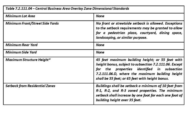
*Projections that are not subject to the maximum height limit are described in Section 7.2.202.01 of the DLUDC.
Adopted by Ord. 657 on 2/5/2024
7.2.111.05 Building Orientation
New buildings shall comply with the following standards:
- The building shall comply with the dimensional standards in subsection 7.2.111.04.
- Provide at least one primary building entrance facing an abutting street that shall open onto a sidewalk, pedestrian plaza or courtyard, and a walkway shall connect the primary entrance to the plaza and sidewalk.
- Building entrances shall be recessed or otherwise covered by a pedestrian shelter.
- Off-street parking and loading areas shall not be required within the Central Business Area. Off-street parking, loading areas, trash pick-up, and above ground utilities, including but not limited to utility vaults and propane tanks, shall not be placed between building entrances and the street(s) to which they are oriented, but shall be oriented internally to the block, screened, and accessed by alleys to the extent practicable.
- Where off-street parking is provided, it shall conform to the dimensional standards and landscape standards of Section 7.2.303.
- Where a development contains multiple buildings and there is insufficient street frontage to which buildings can be oriented, a primary entrance may be oriented to plaza, courtyard, or similar space containing pedestrian amenities. When oriented this way, the primary entrance(s), plaza, or courtyard shall be connected to the street by a landscaped and lighted walkway with an approved surface not less than five (5) feet wide.
- Buildings on corner lots shall have a corner entrance not more than 20 feet from the corner of the building and contain architectural features that emphasize the corner (e.g., chamfered/rounded edge, windows, molding, art).
- Primary building entrances shall be at least fifty percent (50%) transparent so that two-way views, in and out of a building, are possible. This standard can be met by a door with a window, a transom window above the door, or sidelights beside the door.
Amended by Ord. 657 on 2/5/2024
7.2.111.06 Building Height Bonus
The following standards are intended to support the urban design objectives for downtown and facilitate mixed-use development through increased building height, while protecting the historic integrity of downtown buildings. All the standards in this section must be met for approval of a building height bonus:
- The maximum allowable height may be increased from 45 feet to 55 feet when the standards under this section are met.
- The portion of the building exceeding 45 feet shall cover not more than 50 percent of the building floor plate, as defined by the building foundation perimeter. Except the portion of the building subject to the height bonus may exceed 50 percent of the building floor plate for a mixed-use building that includes multifamily dwelling units or overnight accommodations above the ground floor.
- The portion of the building exceeding 45 feet shall step-back from (recess behind) the building plane of the ground floor by one foot for each foot of building height above 45 feet.
- Special Design Requirements. Due to the unique location of the properties at the corner of Ferry Street (OR 155) and Third Street (OR 221), the following height standards shall apply to the properties fronting the north side of Ferry Street, between Second and Third Streets:
- Building Height. 55 feet maximum building height. The maximum building height may be increased to 65 feet when the standards in subsection 2 and 3 are met.
- The portion of the building exceeding 55 feet shall cover not more than 50 percent of the building floor plate, as defined by the building foundation perimeter. Except the portion of the building subject to the height bonus may exceed 50 percent of the building floor plate for a mixed-use building that includes multifamily dwelling units or overnight accommodations above the ground floor.
- The portion of the building exceeding 55 feet shall step-back from (recess behind) the building plane of the ground floor by one foot for each foot of building height above 55 feet.
Adopted by Ord. 657 on 2/5/2024
7.2.111.07 Building Design
- Horizontal Articulation. Buildings more than 60 feet wide facing a street or plaza shall be visually divided into proportional bays similar in scale to historic building patterns and the historic lot widths of the Dayton Town Plat. Front elevations should be articulated (e.g., offset, recess, projection, or similar "break" in the wall plane) not less than once every 30 feet. Acceptable methods to satisfy the standard include offsets in a building elevation, roofline and/or the placement of windows, pilasters, awnings/canopies, trim, art/medallions, or other detailing and ornamentation. Changes in paint color do not satisfy this standard.
- Horizontal Rhythm. The main façade of the building shall be visually compatible with adjoining buildings. The standard may be met through either similar height and width, or with design elements that provide visual continuity with the height and width of adjoining buildings. Examples of such design elements include but are not limited to the base below a series of storefront windows; an existing awning or canopy line; a belt course between building stories; an existing cornice or parapet line. Where adjacent buildings do not provide a historically appropriate reference, the development may establish new horizontal lines consistent with historical precedent. This standard shall not be interpreted to prohibit building up to the allowed height limit.
- Storefronts (that portion of the building that faces a public street) shall include the following basic features of a historic storefront:
- A belt course separating the upper stories from the first floor;
- A bulkhead or kickplate at the street level;
- A recessed entry and transom with transparent door; and
- Decorative cornice or cap at the roofline.
- Pedestrian Shelters. Awnings, canopies, recesses or similar pedestrian shelters shall be provided along at least 60 percent of a building's ground floor elevation(s) where the building abuts a sidewalk or civic space (e.g., plaza).
- Pedestrian shelters used to meet the above standard shall extend at least 5 feet over the pedestrian area, be proportionate to the building in its dimensions, and not obscure the building's architectural details.
- Pedestrian shelters shall align with one another to the extent practicable.
- Shelters shall not conflict with mezzanine or transom windows.
- Colored canvas (not plastic) awnings and metal or plexi-glass canopies, when consistent with historical styles, are allowed.
- Color of the pedestrian shelter shall be compatible with the main building.
- Where signs are proposed as part of pedestrian shelters, they shall be required to meet the provisions of Chapter 7.4.1 Sign Regulations
Exceptions: Pedestrian shelters are not required where historical precedent dictates otherwise. In addition, the Planning Commission may reduce the minimum shelter depth upon finding that existing right-of-way, easements, or building code requirements preclude a standard shelter.
Figure 7.2.111.07. Typical Storefront Components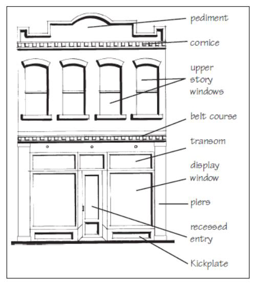
- Windows
- Windows shall be recessed and not flush or project from the surface of the outer wall. In addition, upper floor window orientation primarily shall be vertical.
- A minimum of 60 percent of the ground floor building elevations facing a street shall be comprised of transparent windows.
- All side and non-ground floor building elevations not otherwise subject to the provisions of Subsection 2, above, shall be comprised of not less than 30 percent transparent windows; except zero-lot line/common wall elevations are not required to provide windows.
The predominate roof form of buildings on Ferry Street shall be a flat roof with appropriately scaled cornice or stepped parapet top. - Rooftop mechanical equipment as described in Section 7.2.202.01.B shall be setback and screened so as to not be visible to a person standing within an adjacent, at-grade public right of way, park, or open space.
Adopted by Ord. 657 on 2/5/2024
7.2.111.08 Building Materials And Colors
- Building Materials.
- Exterior building materials shall consist of materials found on historic buildings in the downtown area including decorative block, brick, painted wood, smooth stucco, or natural stone. The use of high intensity colors such as, neon, metallic or florescent colors for the façade of the building are prohibited.
The following materials are prohibited for use on visible surfaces on non-residential structures: - Vinyl and aluminum;
- Asphalt or fiberglass shingles;
- Structural ribbed metal panels;
- Corrugated metal panels;
- Plywood sheathing, to include wood paneling such as T-111;
- Plastic sheathing; and
- Reflective or moderate to high grade tinted glass.
Colors. Exterior building colors shall be compatible with those traditionally seen in the Commercial Business Area Overlay District. - Primary building colors shall be of low reflective, subtle, earth tones or other natural color shades. Permitted colors include shades brick red, brick cream, tan, brown, and dark to light shades of gray (including shades of blue-gray and green-gray) that conform to the Dayton Central Business Area Overlay District color palette in Figure 7.2.111.08.B.
- The use of high intensity colors that are reflective, sparkling, or florescent for the façade of the building are prohibited. Metals shall be matte finish, earth-tone, or burnished/non-reflective colors.
Painting brick on a non-residential building listed as Designated Landmark subject to the Historical Property Overlay Zone in Chapter 7.2.112 is prohibited.
Figure 7.2.111.08.B. Dayton Central Business Area Overlay District color palette.

Adopted by Ord. 657 on 2/5/2024
7.2.111.09 Landscaping
All new development within the Central Business Area fronting a public or private street shall provide street trees and landscaping in accordance with the following:
- Type of Trees. Street trees shall be limited to an approved City of Dayton list. The list of acceptable tree species and planting methods shall be established by the Department of Public Works.
- Minimum Size to be Installed. Street trees shall have a minimum caliper of 2 inches when measured 4 feet in height at the time of installation.
- Spacing. The spacing of street trees by tree size shall be as follows:
- Small sized trees (under 25' tall and less than 16' wide) shall be spaced no greater than 20 feet apart.
- Medium sized trees (25' - 40' tall and more than 16' wide) shall be spaced no greater than 30 feet apart.
- Large trees (over 40' tall and more than 35' wide) shall be spaced no greater than 40 feet apart.
- Placement. The placement of trees is subject to the site design review process. Tree placement shall not interfere with utility poles, light standards, power lines, utility services, visual clearance areas or sidewalk access.
- Exemption to Street Tree Requirements. Exemptions to these requirements are subject to the site design review process and may be granted if:
- The location of the proposed tree would cause potential problems with existing utility lines; or,
- The tree would cause visual clearance problems; or,
- There is not adequate space in which to plant the trees; or,
- Street trees are already in place on the site.
- Landscaping, General. Those areas not constructed upon or devoted to parking and access shall be landscaped in accordance with provisions in Section 7.2.306.
Adopted by Ord. 657 on 2/5/2024
7.2.111.10 Modification Of Site Design Standards
The Planning Commission, as part of the site design review process, may allow modification to the site design requirements in the Central Business Area Overlay when both of the following criteria are satisfied:
- The modification is necessary to provide design flexibility where:
- Conditions unique to the site require such modification; or,
- Parcel shape or configuration precludes compliance with provisions; or,
- A modification is necessary to preserve trees, other natural features or visual amenities determined by the Planning Commission to be significant to the aesthetic character of the area.
- Modification of the standards in this Section shall only be approved if the Planning Commission finds that the specific design proposed is substantially in compliance with the intent and purpose of the Central Business Area Overlay design provisions.
Amended by Ord. 657 on 2/5/2024
7.2.112.01 Purpose
The purpose of this Overlay Zone is to:
- Promote the historic, educational, architectural, cultural, economic, and general welfare of the public through the preservation, restoration and protection of those buildings, structures, sites, districts, and objects of historic interest within the city;
- Foster civic pride in the accomplishments of the past;
- Carry out the provisions of the Dayton Comprehensive Plan; and
- Carry out the provisions of the Land Conservation and Development Commission, Statewide Planning Goal 5.
- Provide an Historical Property Overlay Zone that applies to each Designated Landmark site individually.
Amended by Ord. 645 on 2/12/2020
7.2.112.02 Conformance Required
No land shall be used, and no building, site, object, district, or structure of significance, or part thereof, shall be demolished, moved, or altered, nor shall any new construction take place within a district or on a landmark site except in conformity with this Code.
7.2.112.03 Definitions
The following definitions shall apply to this Section: Affirmative Maintenance: Maintaining a building in such a manner as to not create deterioration of the structure and/or dwelling unit. See Deterioration, Prohibited. Alteration: An addition, removal, or reconfiguration which significantly changes the exterior character (including windows and doors) of an historic resource. Archaeological Artifact: An item being at least 75 years old and is the physical record of an indigenous or other cultures or the material remains of past human life or activity. Archaeological Site: A site with 10 or more artifacts or a feature likely to have been generated by patterned cultural activity. Archaeological Site of Significance: An archaeological site that is currently, or potentially eligible to be included on the National Register of Historic Places, or any archaeological site that has been on the National Register of Historic Places, or any archaeological site that has been determined significant by any of Oregon’s nine federally designated Native American Tribes. Cultural Resource Survey and Inventory: The record of information about resources evaluated for listing in the Designated Landmarks Register or National Register of Historic Places within the City of Dayton. Demolition: The razing, destruction, or dismantling of a resource to the degree that its historic character is substantially obliterated.
Designated Landmark: Any site, object, buildings, or structure officially recognized and designated by the City Council under DMC 7.2.112.05.
Designated Landmarks Register: The list of historic building or sites and archaeological resources identified as “significant” and the record of information about properties officially recognized by the City of Dayton as important in its prehistory and history. Deterioration, Prohibited: Prohibited conditions of deterioration include, but are not limited to moisture infiltration through the exterior roof, walls, openings and foundations; unchecked damage by animals or vandalism, un-maintained or unsafe mechanical, electrical, or plumbing systems, and any conditions on the property that endangers the resource. See Affirmative Maintenance. Historic District: A geographically defined area possessing a significant concentration of buildings, objects, and/or sites which are unified historically by plan or physical development, the boundaries of which have been adopted by the Council under DMC 7.2.112.05. Historic Preservation Committee (HPC): A committee established by the City Council under Ordinance No. 592 (October 2009) to work with the Planning Commission and City Council to make recommendations that will ensure the City continues to preserve, protect, and identify properties with historic value.
Historical Property Overlay Zone: An overlay zone applying regulations related to historic resources which is applied to properties with a Designated Landmark.
Historic Resource: A building, structure, object, site, or district which meets the significance and integrity criteria for designation as a landmark. Resource types are further described as:
Building: A construction made for purposes of shelter or habitation, e.g. house, barn, store, theater, garage, school, and etc. Structure: A construction made for functions other than shelter or habitation, e.g. bridge, dam, highway, boat, and etc. Object: A construction which is primarily artistic or commemorative in nature and not normally movable or part of a building or structure, e.g. statue, fountain, milepost, monument, sign, and etc. Site: The location of a significant event, use, or occupation which may include associated standing, ruined, or underground features, e. g. battlefield, shipwreck, campsite, cemetery, natural feature, garden, food-gathering area, and etc. District: See Historic District above.
Major Public Improvement: The expenditure of public funds or the grant of permission by a public body to undertake change in the physical character of a Designated Landmark on property within the Historical Property Overlay Zone, or on property within an historic district, except for the repair or maintenance of existing public improvements.
Amended by Ord. 645 on 2/12/2020
7.2.112.04 Cultural Resource Survey And Inventory
- The Planning Commission and/or Historic Preservation Committee shall periodically survey and inventory resources potentially eligible for listing in the Designated Landmarks Register and/or National Register of Historic Places with the City of Dayton.
- Survey and inventory documents shall be maintained, periodically updated, and open to the public.
- Survey and inventory documents and processes shall be compatible with the practices of the Oregon State Historic Preservation Office for maintaining the Oregon Inventory of Historic Sites.
- Records concerning archaeological sites shall NOT be made available to the public.
- Properties included in the Cultural Resource Inventory are not subject to the provisions of 7.2.112.02 (Conformance Required), 7.2.112.06 (Demolition and Moving), 7.2.112.07 (Exterior Alteration and New Construction), or 7.2.112.08 (Notice of Public Hearing) of this Land Use and Development Code unless they are already listed on the National Register.
7.2.112.05 Landmark And District Designation
- Process. The process for designating a landmark or historic district may be initiated by the City Council, the Planning Commission, or by any interested person who submits an application for designation to the City Manager. At the time of application the City Manager shall provide the property owner and applicant with information regarding the benefits and restrictions of designation.
- Information. The following information shall be required in an application:
- The applicant's name and address and the applicant's signature;
- The owner's name and address, and evidence of legal and recorded ownership of the subject property and the owner's signature;
- A written description of the boundaries of the proposed district or the location of the proposed landmark;
- A map, drawn to scale, illustrating the boundaries of the proposed district, or a site plan, drawn to scale, indicating the location of structures on the subject property including the proposed landmark, and the dimensions of the structures and distances from the structures to the property lines;
- A statement explaining the following:
- The reason(s) why the proposed district or Designated Landmark should be designated under the decision criteria specified in DMC 7.2.112.05, E.
- The reason(s) why the boundaries of the proposed historic district are appropriate for designation;
- The potential impact, if any, of the proposed historic district or Designated Landmark on the residents or other property owners in the area.
- Any other information deemed necessary by the City Manager to address the approval criteria.
- Historic Preservation Committee (HPC) Review: After the application is deemed complete, the Historic Preservation Committee shall review the application at a regularly scheduled meeting or at a special meeting. The Historic Preservation Committee shall provide to the Planning Commission and the City Council a written recommendation based on the approval criteria in DMC 7.2.112.05, E. The Committee serves in an advisory capacity.
- Planning Commission Action. After the application is deemed complete, the City Manager shall schedule the application to be considered at a Planning Commission meeting. The application shall be processed in accordance with the Type IV process pursuant to DMC 7.3.2 (Administrative Procedures). The City Manager shall forward the application and any comments from the Historic Preservation Committee to the Planning Commission. The Planning Commission, after notice and public hearing held in accordance with provisions in DMC 7.3.2 (Administrative Procedures), shall pass an oral motion recommending the City Council approve or disapprove the application. The Planning Commission shall consider the Historic Preservation Committee's recommendation. The Planning Commission serves in an advisory capacity.
- City Council Action. After the application is deemed complete, the City Manager shall schedule the application to be considered at a City Council meeting. The application shall be processed in accordance with the Type IV process pursuant to DMC 7.3.2 (Administrative Procedures). The City Manager shall forward the application, any comments from the Historic Preservation Committee and the Planning Commission's recommendation to the City Council. The City Council, after notice and public hearing held in accordance with provisions in DMC 7.3.2 (Administrative Procedures), shall approve or disapprove the application. The City Council shall consider the Historic Preservation Committee and Planning Commission recommendations.
- Decision Criteria. To approve the application the City Council shall consider the following criteria to determine if the proposed Designated Landmark or historic district should be approved:
- The property is associated with events that have made a significant contribution to the broad patterns of local, state, or national history;
- The property is associated with the lives, persons, or groups of people, significant in local, state, or national history;
- The property embodies the distinctive characteristics of an architectural type, style, period, or method of construction or that represents the work of a master, or that possesses high artistic values, or that represent a significant and distinguishable entity whose components may lack individual distinction;
- The property yielded or is likely to yield information which is significant to local, state, or national history;
- The property is a significant visual landmark;
- The property contributes significantly to the continuity or historic character of the street, neighborhood, and/or community;
- The resource is listed on the National Register of Historic Places.
- Removal of Designation. The process for removing a landmark designation or historic district designation may be initiated by the City Council, the Planning Commission, or by any interested person who submits to the City Manager an application for removal of the designation. The City Council may amend or rescind an existing designation by following the procedures set forth in DMC 7.2.112.05 for designating a landmark or historic district, and determining the property no longer meets the criteria set forth in DMC 7.2.112.05, F, including the adoption of findings.
- If the property is listed on the National Registry of Historic Places, the removal shall be completed in cooperation with the State Historic Preservation Office (SHPO) and according to federal statute under CFR Part 60.15.
- In accordance with Oregon Revised Stature 197.772;
- A property owner may refuse to consent to any form of historic property designation at any point during the designation process. Such refusal to consent shall remove the property form any form of consideration for historic property designation under ORS 358.480 to 358.545 or other law except for consideration or nomination to the National Register of Historic Places pursuant to the National Historic Preservation Act of 1966, as amended (16 U.S.C. 470 et seq.).
- No permit for the demolition or modification of property removed from consideration for historic property designation under DMC 7.2.112.05, I.(1), shall be issued during the 120-day period following the date of the property owner's refusal to consent.
Amended by Ord. 645 on 2/12/2020
7.2.112.06 Demolition And Moving
- Planning Commission Approval. No person shall move or demolish, or cause to be moved or demolished, an historic resource on the National Register of Historic Places, a Designated Landmark in the Historical Property Overlay Zone or in an historic district, unless approved by the Planning Commission. A separate permit must be obtained from the Building Official to demolish or move the structure.
- Application Process. An application for moving or demolishing an historic resource on the National Register of Historic Places, a Designated Landmark in the Historical Property Overlay zone or in an historic district shall be filed on a form provided by the City. The following information shall be required in an application:
- The applicant's name and address and the applicant's signature;
- The owner's name and address, evidence of legal and recorded ownership of the subject property and the owner's signature;
- A written description of the proposed moving or demolition and an explanation of how the moving or demolition meets the approval criteria set forth in DMC 7.2.112.06, E;
- A site plan, drawn to scale, indicating the location of structures on the subject property, the dimensions of the structures and the distances from the structures to the property lines;
- Statements indicating the intended re-use of the subject property;
- Any other information deemed necessary by the City Manager to address the approval criteria.
- Historic Preservation Committee (HPC): After the application is deemed complete, the Historic Preservation Committee shall review the application at a regularly scheduled meeting or at a special meeting. The Historic Preservation Committee shall provide to the Planning Commission a written recommendation based on the approval criteria. The Historic Preservation Committee serves in an advisory capacity.
- Review Process. Upon receipt of a completed application, the City Manager shall schedule the application to be considered at a Planning Commission meeting. The Planning Commission shall hold a Type II public hearing pursuant to DMC 7.3.2 (Administrative Procedures). The Planning Commission shall consider the Historic Preservation Committee's recommendation.
- Approval Criteria. To approve the application to move or demolish a Designated Landmark, the Planning Commission must find one of the following criteria are met:
- No prudent and feasible alternative exists; or
- The Designated Landmark is deteriorated beyond repair; or
- The value to the community of the proposed use of the property outweighs the historical or architectural value of retaining the Designated Landmark.
- Planning Commission Approval. The Planning Commission may approve, or approve with conditions, the application where the application materials show at least one approval criterion is met. If no appeal is filed, the decision is effective on the day following the last day of the appeal period.
A permit shall not be issued unless the applicant provides evidence of legal and recorded ownership of the subject property - Planning Commission Denial. The Planning Commission may deny the application where the application materials do not show at least one approval criterion is met. If not appeal is filed, the decision is effective on the day following the last day of the appeal period.
- Planning Commission Continuance. The Planning Commission may continue the final action in accordance with DMC 7.2.112.06, K, below, and consistent with the State of Oregon 120-day rule for making a final decision on an application.
- Appeals. A decision by the Planning Commission to approve, approve with conditions or deny the application to may be appealed to the City Council by an aggrieved party who appeared orally or in writing, in person or through an attorney at the Planning Commission hearing and presented or submitted testimony related to the application under consideration. The appeal shall comply with the requirements in DMC 7.3.2. (Administrative Procedures).
- Alternative Actions. At the time a demolition or moving application is filed the City Manager shall review alternatives to demolition or moving with the owner of the resource, including local, state and federal preservation programs.
- Additional Requirements. During a period of continuance, the Planning Commission may require the property owner to:
- List the resource for sale with a real estate agent for a period of time to allow for final decision within 120-days. The real estate agent shall advertise the resource in local and state newspapers of general circulation in the area for a minimum of 10 days and over a period of time that allows for a final decision within 120 days.
- Give public notice by posting the hearing notice on-site in addition to a "For Sale" sign which shall read: HISTORIC BUILDING TO BE MOVED OR DEMOLISHED - FOR SALE. Lettering on the sign shall be at least one foot in height. The sign shall be provided by the City and be posted by the applicant in a prominent and conspicuous place within ten feet of a public street abutting the premises on which the resource is located. The applicant is responsible for ensuring the sign is posted continuously within the time frame specified in DMC 7.2.112.06, K, 1, above.
- Prepare and make available any information related to the history and sale of the property to all individuals, organizations, and agencies who inquire.
- Ensure that the owner has not rejected the highest bona fide offer for sale and removal of the resource.
- Press Notification. Prior to issuance of a demolition permit, the City Manager shall issue a press release to local or state newspapers of general circulation in the county. The press release shall include, but not limited to, a description of the significance of the resource, the reasons for the proposed Moving or demolition, and possible options for preserving the resource.
- Permit Conditions. As a condition for approval of a demolition permit, the Planning Commission may:
- Require photographic documentation, preparation of architectural drawings, and other graphic data or history as it deems necessary to preserve an accurate record of the resource. The historical documentation materials shall be the property of the City or other party determined appropriate by the Planning Commission.
- Require that specific artifacts, materials, or equipment be protected and saved. The owner may keep all such materials or donate or sell them to the City or other party determined appropriate by the Planning Commission. The applicant shall be provided with a list of persons capable of salvaging the resource.
- Dangerous Building. DMC 7.2.112 shall not be construed to make it unlawful for any person, without prior approval of the Planning Commission, to comply with an order by the City Council to remove or demolish any Designated Landmark determined by the City Council to be dangerous to life, health, or property.
Amended by Ord. 645 on 2/12/2020
7.2.112.07 Exterior Alteration And New Construction
- City Manager or Planning Commission Approval. No person shall alter the exterior of an historic resource on the National Register of Historic Places, or a Designated Landmark in the Historical Property Overlay Zone or in an historic district nor shall any new building or structure be constructed on a property on the National Register of Historic Places, or in the Historical Property Overlay Zone or in an historic district where the City Manager determines it is minor unless approved by the City Manager. No person shall alter the exterior of an historic resource on the National Register of Historic Places, or a Designated Landmark in the Historical Property Overlay Zone or in an historic district nor shall any new building or structure be constructed on a property on the National Register of Historic Places, or on a Designated Landmark site in the Historical Property Overlay Zone or in an historic district where the City Manager refers the application to the Planning Commission unless approved by the Planning Commission. A Building Permit may be required for certain exterior alterations and new construction. In addition, no major public improvements shall be made on a property on the National Register of Historic Places, or on a Designated Landmark site or in an historic district unless approved by the Planning Commission.
- Application Process. An application for the exterior alteration of a Designated Landmark or new construction on property on the National Register of Historic Places, or in the Historical Property Overlay Zone, or in an historic district shall be filed on a form provided by the City. The following information shall be required in an application:
- The applicant's name and address, and the applicant's signature;
- The owner's name and address, and evidence of legal and recorded ownership of the subject property and the owner's signature;
- Name of the person(s), title, or relationship to the project who will verify that the exterior alteration or new construction, if approved, has been completed according to the City’s requirements;
- A written description and explanation of the proposed exterior alteration or new construction;
- A site plan, drawn to scale, indicating the location or proposed location of structures on the subject property, the dimensions of the structures and the distances from the structures to the property lines;
- Photographs, other pictorial and schematics information, sample materials and colors, if available, to represent the proposed exterior alterations or new construction;
- Written explanation of the proposed exterior alteration or new construction in comparison with the City’s 1993 Advisory Guidelines and the US Secretary of Interior Guidelines. (An on-line copy of the latter document is available for review at the following site: (www.nps.gov/history/hps/tps/standguide/index.htm). At the site, click on the tab "Education and Training," then click on "Online Training," then click on "Illustrated Rehabilitation Guidelines."
- Any other information deemed necessary by the City Manager to address the approval criteria.
- Historic Preservation Committee (HPC): After the application is deemed complete, the Historic Preservation Committee shall review the application at a regularly scheduled meeting or at a special meeting. The Historic Preservation Committee shall provide a written recommendation based on the approval criteria to the City Manager and the Planning Commission.. The Historic Preservation Committee serves in an advisory capacity.
- City Manager Decision. Where the City Manager determines the application meets at least one of the following criteria 1, 2 or 3, for a minor exterior alteration or new construction, the City Manger may approve, approve with conditions, or deny the application. The City manager shall consider the Historic Preservation Committee's recommendation.
- No change in the exterior appearance or material of the Designated Landmark as it exists or the proposed work is building maintenance; or
- The proposed exterior alteration or new construction duplicates or restores the affected exterior features and materials as determined from historic photographs, original building plans, or other evidence of original features or materials; or
- The exterior alteration is on a side or rear elevation of a Designated Landmark or is not visible from public rights-of-way, or the new construction is not visible from public rights-of-way.
- Planning Commission Action. Where the City Manager determines the application is not a minor exterior alteration or is not a minor new construction, the City Manager shall forward the application and the Historic Preservation Committee's recommendation to the Planning Commission. The Planning Commission shall consider the Historic Preservation Committee's recommendation. The Planning Commission, after notice and public hearing held in accordance with provisions in DMC 7.3.2 (Administrative Procedures), shall approve, approve with conditions or deny the application.
- Decision Criteria. To approve the application for exterior alteration of a Designated Landmark or new construction on property on the National Register of Historic Places, or in the Historical Property Overlay Zone, or in an historic district the Planning Commission shall consider the following criteria:
- The proposed new use is similar to the historical use of the property or the proposed new use requires minimal change to the Designated Landmark's or its property's distinctive, materials, features, spaces, and spatial relationships.
- Historic character of the property is retained and preserved. The relocation of distinctive materials or alterations of exterior features, spaces, and spatial relationships that characterize the property shall be avoided.
- Use of the property recognizes the physical record of its time, place, and use. Changes that create a false sense of historic development, such as adding conjectural features or elements from other historic properties, shall not be undertaken.
- Changes acquiring historic significance in their own right are retained and preserved.
- Alterations preserve distinctive materials, features, finishes, and construction techniques or examples of craftsmanship that characterize the property.
- Historic features are repaired versus replaced. Where the severity of deterioration requires replacement of a distinctive feature, the new feature shall match the old in design, color, texture, and, where possible, materials. Replacement of missing features shall be substantiated by documentary and physical evidence.
- Use of chemical and physical treatments, if appropriate, are undertaken by the gentlest means possible. Treatments that cause damage to historic materials shall not be used.
- Alteration, including new additions, exterior alterations, or related new construction, do not destroy historic materials, features, and spatial relationships that characterize the property. The new work shall be differentiated from the old and shall be compatible with the historic materials, features, size, scale, and proportions, and massing to protect the integrity of the property and environment
- New additions and adjacent or related new construction on the subject property are undertaken in such a manner that, if removed in the future, the essential form and integrity of the historic property and its environment are unimpaired.
- Consider design guidelines such as applicable sections of the City’s 1993 Advisory Guidelines or the U.S. Secretary of Interior’s Standards; (www.nps.gov/history/hps/tps/standguide/index.htm).
- Repair and Maintenance Provisions. No provision of DMC 7.2.112 shall be construed to prevent the ordinary maintenance or repair of a Designated Landmark including, but not limited to an exterior architectural feature which does not involve a change in design, material or appearance of such feature. The City Manager shall determine if the proposed activity is required for the public safety due to an unsafe or dangerous condition.
- Building Code Leniency. Property owners may request the City Building Official or designee grant leniency for non-conforming exterior alterations, repairs, additions, and changes of occupancy for existing Designated Landmark structures in accordance with the current Oregon Structural Specialty Code, or Oregon Residential Specialty Code. In accordance with the statute, the Building Official or designee may seek guidance from the Oregon State Historic Preservation Office in the application of this provision.
Amended by Ord. 645 on 2/12/2020
7.2.112.08 Notice And Public Hearing
- Application Process. In accordance with DMC 7.3.101.01, D, an application for a minor exterior alteration or minor new construction on a property on the National Register of Historic Places, or on the site of a Designated Landmark in the Historical Property Overlay Zone on in an historic district, is a Type I process. In accordance with DMC 7.3.101.02, F, an application for a major exterior alteration or major new construction on a property on the National Register of Historic Places, or on the site of a Designated Landmark in the Historical Property Overlay Zone or in an historic district, is a Type II process.
Amended by Ord. 645 on 2/12/2020
7.2.112.09 Affirmative Maintenance
Designated Landmarks and their sites shall be maintained. DMC 7.2.112.03, Definitions—Affirmative Maintenance and Deterioration, Prohibited. Properties with Designated Landmarks deemed deficient in maintenance are subject to the violation provisions and other applicable ordinances of the City. (See DMC 7.1.102.06, Violations, and DMC 4.5, Dangerous Buildings.)
Amended by Ord. 645 on 2/12/2020
7.2.112.10 Enforcement Of State Preservation Laws
The City of Dayton City Council, Planning Commission and Historic Preservation Committee shall support the enforcement of all State laws relating to historic preservation. These include but are not limited to ORS 197.772 (Consent for designation as historic property), ORS 358.653 (Conservation Programs, Leases), and ORS 358.475 through 358.541 (Special Assessment).
Amended by Ord. 645 on 2/12/2020
7.2.113.01 Purpose
The flood hazard areas of Dayton preserve the natural and beneficial values served by floodplains but are subject to periodic inundation which may result in loss of life and property, health and safety hazards, disruption of commerce and governmental services, extraordinary public expenditures for flood protection and relief, and impairment of the tax base, all of which adversely affect the public health, safety, and general welfare.
These flood losses may be caused by the cumulative effect of obstructions in special flood hazard areas which increase flood heights and velocities, and when inadequately anchored, cause damage in other areas. Uses that are inadequately floodproofed, elevated, or otherwise protected from flood damage also contribute to flood loss.
The purpose of the Flood Plain Overlay District (FPO) is to promote public health, safety, and general welfare, and to minimize public and private losses due to flooding in special flood hazard areas by provisions designed to:
- Protect human life and health;
- Minimize expenditure of public money for costly flood control projects;
- Preserve natural and beneficial floodplain functions;
- Minimize the need for rescue and relief efforts associated with flooding and generally undertaken at the expense of the general public;
- Minimize prolonged business interruptions;
- Minimize damage to public facilities and utilities such as water and gas mains; electric, telephone and sewer lines; and streets and bridges located in special flood hazard areas;
- Help maintain a stable tax base by providing for the sound use and development of flood hazard areas so as to minimize blight areas caused by flooding;
- Notify potential buyers that the property is in a special flood hazard area;
- Notify those who occupy special flood hazard areas that they assume responsibility for their actions;
- Participate in and maintain eligibility for flood insurance and disaster relief.
7.2.113.02 Methods Of Reducing Flood Losses
In order to accomplish its purposes, this ordinance includes methods and provisions for:
- Restricting or prohibiting development which is dangerous to health, safety, and property due to water or erosion hazards, or which result in damaging increases in erosion or in flood heights or velocities;
- Requiring that development vulnerable to floods, including facilities which serve such uses, be protected against flood damage at the time of initial construction;
- Controlling the alteration of natural floodplains, stream channels, and natural protective barriers, which help accommodate or channel flood waters;
- Controlling filling, grading, dredging, and other development which may increase flood damage;
- Preventing or regulating the construction of flood barriers which will unnaturally divert flood waters or may increase flood hazards in other areas.
- Employing a standard of “no net loss” of natural and beneficial floodplain functions.
Adopted by Ord. 666 on 6/2/2025
7.2.113.03 Definitions
For the FPO only, the following terms, words or phrases shall be interpreted so as to give them the meaning they have in common usage.
Appeal: A request for a review of the interpretation of any provision of this ordinance or a request for a variance.
Area of shallow flooding: A designated Zone AO, AH, AR/AO or AR/AH on a community’s Flood Insurance Rate Map (FIRM) with a one percent or greater annual chance of flooding to an average depth of one to three feet where a clearly defined channel does not exist, where the path of flooding is unpredictable, and where velocity flow may be evident. Such flooding is characterized by ponding or sheet flow.
Area of special flood hazard: The land in the floodplain within a community subject to a 1 percent or greater chance of flooding in any given year. It is shown on the Flood Insurance Rate Map (FIRM) as Zone A, AO, AH, A1-30, AE, A99, AR. “Special flood hazard area” is synonymous in meaning and definition with the phrase “area of special flood hazard.”
Base flood: The flood having a one percent chance of being equaled or exceeded in any given year. Base flood elevation (BFE): The elevation to which floodwater is anticipated to rise during the base flood.
Basement: Any area of the building having its floor subgrade (below ground level) on all sides.
Development: Any man-made change to improved or unimproved real estate, including but not limited to buildings or other structures, mining, dredging, filling, grading, paving, excavation or drilling operations or storage of equipment or materials.
Fill: Placement of any materials such as soil, gravel, crushed stone, or other materials that change the elevation of the floodplain. The placement of fill is considered “development.”
Fish Accessible Space: The volumetric space available to fish to access.
Fish Egress-able Space: The volumetric space available to fish to exit or leave from.
Flood or Flooding:
- A general and temporary condition of partial or complete inundation of normally dry land
areas from:
- The overflow of inland or tidal waters.
- The unusual and rapid accumulation or runoff of surface waters from any source.
- Mudslides (i.e., mudflows) which are proximately caused by flooding as defined in paragraph (a)(2) of this definition and are akin to a river of liquid and flowing mud on the surfaces of normally dry land areas, as when earth is carried by a current of water and deposited along the path of the current.
- The collapse or subsidence of land along the shore of a lake or other body of water as a result of erosion or undermining caused by waves or currents of water exceeding anticipated cyclical levels or suddenly caused by an unusually high water level in a natural body of water, accompanied by a severe storm, or by an unanticipated force of nature, such as flash flood or an abnormal tidal surge, or by some similarly unusual and unforeseeable event which results in flooding as defined in paragraph (a)(1) of this definition.
Flood elevation study: an examination, evaluation and determination of flood hazards and, if appropriate, corresponding water surface elevations, or an examination, evaluation and determination of mudslide (i.e., mudflow) and/or flood-related erosion hazards.
Flood Insurance Rate Map (FIRM): The official map of a community, on which the Federal Insurance Administrator has delineated both the special hazard areas and the risk premium zones applicable to the community. A FIRM that has been made available digitally is called a Digital Flood Insurance Rate Map (DFIRM). Flood Insurance Study (FIS): See “Flood elevation study.”
Floodway: The channel of a river or other watercourse and the adjacent land areas that must be reserved in order to discharge the base flood without cumulatively increasing the water surface elevation more than a designated height. Also referred to as "Regulatory Floodway."
Functionally Dependent Use: A use which cannot perform its intended purpose unless it is located or carried out in proximity to water. The term includes only docking facilities, port facilities that are necessary for the loading and unloading of cargo or passengers, and ship building and ship repair facilities, but does not include long-term storage or related manufacturing facilities.
Green Infrastructure: Use of natural or human-made hydrologic features to manage water and provide environmental and community benefits. Green infrastructure uses management approaches and technologies that use, enhance, and/or mimic the natural hydrologic cycle processes of infiltration, evapotranspiration, and reuse. At a large scale, it is an interconnected network of green space that conserves natural systems and provides assorted benefits to human populations. At a local scale, it manages stormwater by infiltrating it into the ground where it is generated using vegetation or porous surfaces, or by capturing it for later reuse. Green infrastructure practices can be used to achieve no net loss of pervious surface by creating infiltration of stormwater in an amount equal to or greater than the infiltration lost by the placement of new impervious surface.
Habitat Restoration Activities: Activities with the sole purpose of restoring habitats that have only temporary impacts and long-term benefits to habitat. Such projects cannot include ancillary structures such as a storage shed for maintenance equipment, must demonstrate that no rise in the BFE would occur as a result of the project and obtain a CLOMR and LOMR, and have obtained any other required permits (e.g., CWA Section 404 permit).
Hazard Trees: Standing dead, dying, or diseased trees or ones with a structural defect that makes it likely to fail in whole or in part and that present a potential hazard to a structure or as defined by the community.
Highest adjacent grade: The highest natural elevation of the ground surface prior to construction next to the proposed walls of a structure.
Historic structure: Any structure that is:
- Listed individually in the National Register of Historic Places (a listing maintained by the Department of Interior) or preliminarily determined by the Secretary of the Interior as meeting the requirements for individual listing on the National Register;
- Certified or preliminarily determined by the Secretary of the Interior as contributing to the historical significance of a registered historic district or a district preliminarily determined by the Secretary to qualify as a registered historic district;
- Individually listed on a state inventory of historic places in states with historic preservation programs which have been approved by the Secretary of Interior; or
- Individually listed on a local inventory of historic places in communities with historic preservation programs that have been certified either:
- By an approved state program as determined by the Secretary of the Interior or
- Directly by the Secretary of the Interior in states without approved programs.
Hydraulically Equivalent Elevation: A location (e.g., a site where no net loss standards are implemented) that is approximately equivalent to another (e.g., the impacted site) relative to the same 100-year water surface elevation contour or base flood elevation. This may be estimated based on a point that is along the same approximate line perpendicular to the direction of flow.
Hydrologically Connected: The interconnection of groundwater and surface water such that they constitute one water supply and use of either results in an impact to both.
Impervious Surface: A surface that cannot be penetrated by water and thereby prevents infiltration and increases the amount and rate of surface water runoff, leading to erosion of stream banks, degradation of habitat, and increased sediment loads in streams. Such surfaces can accumulate large amounts of pollutants that are then “flushed” into local water bodies during storms and can also interfere with recharge of groundwater and the base flows to water bodies.
Low Impact Development: An approach to land development (or redevelopment) that works with nature to manage stormwater as close to its source as possible. It employs principles such as preserving and recreating natural landscape features and minimizing effective imperviousness to create functional and appealing site drainage that treats stormwater as a resource rather than a waste product. Low Impact Development refers to designing and implementing practices that can be employed at the site level to control stormwater and help replicate the predevelopment hydrology of the site. Low impact development helps achieve no net loss of pervious surface by infiltrating stormwater in an amount equal to or greater than the infiltration lost by the placement of new impervious surface. LID is a subset of green infrastructure.
Lowest floor: The lowest floor of the lowest enclosed area (including basement). An unfinished or flood resistant enclosure, usable solely for parking of vehicles, building access or storagein an area other than a basement areais not considered a building’s lowest floor, provided that such enclosure is not built so as to render the structure in violation of the applicable non-elevation design requirements of this ordinance.
Manufactured dwelling: Aa structure, transportable in one or more sections, which is built on a permanent chassis and is designed for use with or without a permanent foundation when attached to the required utilities. The term "manufactured dwelling" does not include a "recreational vehicle" and is synonymous with “manufactured home.”
Manufactured dwelling park or subdivision:A parcel (or contiguous parcels) of land divided into two or more manufactured dwelling lots for rent or sale.
Mean Higher-High Water: The average of the higher-high water height of each tidal day observed over the National Tidal Datum Epoch.
Mean sea level: For purposes of the National Flood Insurance Program, the National Geodetic Vertical Datum (NGVD) of 1929 or other datum, to which Base Flood Elevations shown on a community's Flood Insurance Rate Map are referenced. New construction: For floodplain management purposes, “new construction” means structures for which the “start of construction” commenced on or after the effective date of a floodplain management regulation adopted by the City of Dayton and includes any subsequent improvements to such structures.
No Net Loss: A standard where adverse impacts must be avoided or offset through adherence to certain requirements so that there is no net change in the function from the existing condition when a development application is submitted to the state, tribal, or local jurisdiction. The floodplain functions of floodplain storage, water quality, and vegetation must be maintained.
Offsite: Mitigation occurring outside of the project area.
Onsite: Mitigation occurring within the project area.
Ordinary High Water Mark: The line on the shore established by the fluctuations of water and indicated by physical characteristics such as a clear, natural line impressed on the bank; shelving; changes in the character of soil; destruction of terrestrial vegetation; the presence of litter and debris; or other appropriate means that consider the characteristics of the surrounding areas.
Qualified Professional: Appropriate subject matter expert that is defined by the community.
Reach: A section of a stream or river along which similar hydrologic conditions exist, such as discharge, depth, area, and slope. It can also be the length of a stream or river (with varying conditions) between major tributaries or two stream gages, or a length of river for which the characteristics are well described by readings at a single stream gage.
Recreational vehicle: A vehicle which is:
- Built on a single chassis;
- 400 square feet or less when measured at the largest horizontal projection;
- Designed to be self-propelled or permanently towable by a light duty truck; and
- Designed primarily not for use as a permanent dwelling but as temporary living quarters for recreational, camping, travel, or seasonal use.
Riparian: Of, adjacent to, or living on, the bank of a river, lake, pond, or other water body.
Riparian Buffer Zone (RBZ): The outer boundary of the riparian buffer zone is measured from the ordinary high water line of a fresh waterbody (lake; pond; ephemeral, intermittent, or perennial stream) or mean higher-high water line of a marine shoreline or tidally influenced river reach to 170 feet horizontally on each side of the stream or 170 feet inland from the MHHW. The riparian buffer zone includes the area between these outer boundaries on each side of the stream, including the stream channel. Where the RBZ is larger than the special flood hazard area, the no net loss standards shall only apply to the area within the special flood hazard area.
Riparian Buffer Zone Fringe: The area outside of the RBZ and floodway but still within the SFHA.
Silviculture: The art and science of controlling the establishment, growth, composition, health, and quality of forests and woodlands.
Special flood hazard area: See “Area of special flood hazard” for this definition.
Start of construction: Includes substantial improvement and means the date the building permit was issued, provided the actual start of construction, repair, reconstruction, rehabilitation, addition, placement, or other improvement was within 180 days from the date of the permit. The actual start means either the first placement of permanent construction of a structure on a site, such as the pouring of slab or footings, the installation of piles, the construction of columns, or any work beyond the stage of excavation; or the placement of a manufactured dwelling on a foundation. Permanent construction does not include land preparation, such as clearing, grading, and filling; nor does it include the installation of streets and/or walkways; nor does it include excavation for a basement, footings, piers, or foundations or the erection of temporary forms; nor does it include the installation on the property of accessory buildings, such as garages or sheds not occupied as dwelling units or not the main structure. For a substantial improvement, the actual start of construction means the first alteration of any wall, ceiling, floor, or other structural part of a building, whether or not that alteration affects the external dimensions of the building.
Structure: For floodplain management purposes, a walled and roofed building, including a gas or liquid storage tank, that is principally above ground, as well as a manufactured dwelling.
Substantial damage: Damage of any origin sustained by a structure whereby the cost of restoring the structure to its before damaged condition would equal or exceed 50 percent of the market value of the structure before the damage occurred.
Substantial improvement: Any reconstruction, rehabilitation, addition, or other improvement of a structure, the cost of which equals or exceeds 50 percent of the value of the structure before the "start of construction" of the improvement. This term includes structures which have incurred "substantial damage," regardless of the actual repair work structuresperformed The term does not, however, include ei
- Any projectfor improvement of a structure to correct existing violations of state or local health, sanitary, or safety code specifications which have been identified by the local enforcement official and which are the minimum necessary to assure safe living conditions; or
- Any alteration of a "historic structure," provided that the alteration will not preclude the structure's continued designation as a "historic structure.”
Undeveloped Space: The volume of flood capacity and fish-accessible/egress-able habitat from the existing ground to the Base Flood Elevation that is undeveloped. Any form of development including, but not limited to, the addition of fill, structures, concrete structures (vaults or tanks), pilings, levees and dikes, or any other development that reduces flood storage volume and fish accessible/egress-able habitat must achieve no net loss.
Variance: A grant of relief by City of Dayton from the terms of a floodplain management regulation.
Violation: The failure of a structure or other development to be fully compliant with the community’s floodplain management regulations. A structure or other development without the elevation certificate, other certifications, or other evidence of compliance required in this ordinance is presumed to be in violation until such time as that documentation is provided.
Amended by Ord. 666 on 6/2/2025
7.2.113.04 Applicability
- Lands to which this Ordinance applies: This ordinance shall apply to all special flood hazard areas within the jurisdiction of the City of Dayton.
- Basis for Establishing the Areas of Special Flood Hazard. The special flood hazard areas identified by the Federal Insurance Administrator in a scientific and engineering report entitled “The Flood Insurance Study for Yamhill County, Oregon and Incorporated Areas, dated March 2, 2010," with accompanying flood insurance map (FIRM) is hereby adopted by reference and declared to be part of this chapter. The flood insurance study and the FIRM are on file at the City Hall.
- Coordination with State of Oregon Specialty Codes. Pursuant to the requirement established in ORS 455 that the City of Dayton administers and enforces the State of Oregon Specialty Codes, the City of Dayton does hereby acknowledge that the Oregon Specialty Codes contain certain provisions that apply to the design and construction of buildings and structures located in special flood hazard areas. Therefore, this ordinance is intended to be administered and enforced in conjunction with the Oregon Specialty Codes.
- Compliance. All development within special flood hazard areas is subject to the terms of this ordinance and required to comply with its provisions and all other applicable regulations.
- Penalties for Noncompliance. No structure or land shall hereafter be constructed, located, extended, converted, or altered without full compliance with the terms of this ordinance and other applicable regulations. Violations of this ordinance are subject to enforcement by the City of Dayton under Section 7.04.06.
- Abrogation. This ordinance is not intended to repeal, abrogate, or impair any existing easements, covenants, or deed restrictions. However, where this ordinance and another ordinance, easement, covenant, or deed restriction conflict or overlap, whichever imposes the more stringent restrictions shall prevail.
- Severability. This ordinance and the various parts thereof are hereby declared to be severable. If any section clause, sentence, or phrase of the Ordinance is held to be invalid or unconstitutional by any court of competent jurisdiction, then said holding shall in no way effect the validity of the remaining portions of this Ordinance.
- Interpretation. In the interpretation and application of this ordinance, all provisions shall be:
- Considered as minimum requirements;
- Liberally construed in favor of the governing body; and
- Deemed neither to limit nor repeal any other powers granted under state statutes.
Amended by Ord. 666 on 6/2/2025
7.2.113.05 Warning And Disclaimer Of Liability
- Warning. The degree of flood protection required by this ordinance is considered reasonable for regulatory purposes and is based on scientific and engineering considerations. Larger floods can and will occur on rare occasions. Flood heights may be increased by man-made or natural causes. This ordinance does not imply that land outside the areas of special flood hazards or uses permitted within such areas will be free from flooding or flood damages.
- Disclaimer of liability. This ordinance shall not create liability on the part of the City of Dayton, any officer or employee thereof, or the Federal Insurance Administrator for any flood damages that result from reliance on this ordinance or any administrative decision lawfully made hereunder.
Amended by Ord. 666 on 6/2/2025
7.2.113.06 Administration
- Designation of the Floodplain Administrator. The City Manager (or designee) is hereby appointed to administer, implement, and enforce this ordinance by granting or denying development permits in accordance with its provisions. The Floodplain Administrator may delegate authority to implement these provisions.
- Duties and Responsibilities of the Floodplain Administrator. Duties of the floodplain administrator, or their designee, shall include, but not be limited to:
- Permit Review. Review of all floodplain development permits to:
- Determine that the permit requirements of this ordinance have been satisfied;
- Determine that all other required local, state, and federal permits have been obtained and approved;
- Determine if the proposed development is in a floodway.
- If located in the floodway assure that the floodway provisions of this ordinance in Section 7.113.09 are met; and
- Determine if the proposed development is in an area where Base Flood Elevation (BFE) data is available either through the Flood Insurance Study (FIS) or from another authoritative source. If BFE data is not available then ensure compliance with the provisions of Section 7.113.09; and
- Provide to building officials the Base Flood Elevation (BFE) applicable to any building requiring a floodplain development permit.
- Determine if the proposed development qualifies as a substantial improvement as defined in Section 7.113.03.
- Determine if the proposed development activity is a watercourse alteration. If a watercourse alteration is proposed, ensure compliance with the provisions in section 7.113.09.A.
- Determine if the proposed development activity includes the placement of fill or excavation.
- Determine whether the proposed development activity complies with the no net loss standards in Section 7.113.11.
- Permit Review. Review of all floodplain development permits to:
- Information to be obtained and maintained.
The following information shall be obtained and maintained and shall be made available for public inspection as needed:
- The actual elevation (in relation to mean sea level) of the lowest floor (including basements) and all attendant utilities of all new or substantially improved structures where Base Flood Elevation (BFE) data is provided through the Flood Insurance Study (FIS), Flood Insurance Rate Map (FIRM), or obtained in accordance with Section 7.113.09.H.
- The elevation (in relation to mean sea level) of the natural grade of the building site for a structure prior to the start of construction and the placement of any fill and ensure that the requirements of Sections 7.113.06.B.1 and 7.113.07 are adhered to.
- Upon placement of the lowest floor of a structure (including basement) but prior to further vertical construction, documentation, prepared and sealed by a professional licensed surveyor or engineer, certifying the elevation (in relation to mean sea level) of the lowest floor (including basement).
- Where base flood elevation data are utilized, As-built certification of the elevation (in relation to mean sea level) of the lowest floor (including basement) prepared and sealed by a professional licensed surveyor or engineer, prior to the final inspection.
- Maintain all Elevation Certificates (EC) submitted to the community.
- The elevation (in relation to mean sea level) to which the structure and all attendant utilities were floodproofed for all new or substantially improved floodproofed structures where allowed under this ordinance and where Base Flood Elevation (BFE) data is provided through the FIS, FIRM, or obtained in accordance with Section 7.113.09.H.
- All floodproofing certificates required under this ordinance.
- All variance actions, including justification for their issuance.
- All hydrologic and hydraulic analyses performed as required under Section 7.113.10.D.
- All Substantial Improvement and Substantial Damage calculations and determinations as required under Section 7.113.06.D.4.
- Documentation of how no net loss standards have been met (see Section 7.113.11.A).
- All records pertaining to the provisions of this ordinance.
- Requirement to notify other entities and submit new technical data.
- Community Boundary Alterations.
- The Floodplain Administrator shall notify the Federal Insurance Administrator in writing whenever the boundaries of the community have been modified by annexation or the community has otherwise assumed authority or no longer has authority to adopt and enforce floodplain management regulations for a particular area, to ensure that all Flood Hazard Boundary Maps (FHBM) and Flood Insurance Rate Maps (FIRM) accurately represent the community’s boundaries. Include within such notification a copy of a map of the community suitable for reproduction, clearly delineating the new corporate limits or new area for which the community has assumed or relinquished floodplain management regulatory authority.
- Watercourse Alterations.
- The Floodplain Administrator shall notify adjacent communities, the Department of Land Conservation and Development, and other appropriate state and federal agencies, prior to any alteration or relocation of a watercourse, and submit evidence of such notification to the Federal Insurance Administration. This notification shall be provided by the applicant to the Federal Insurance Administration as a Letter of Map Revision (LOMR) along with either:
- A proposed maintenance plan to assure the flood carrying capacity within the altered or relocated portion of the watercourse is maintained; or
- Certification by a registered professional engineer that the project has been designed to retain its flood carrying capacity without periodic maintenance.
- The applicant shall be required to submit a Conditional Letter of Map Revision (CLOMR) when required under Section 7.113.06.D.
- The Floodplain Administrator shall notify adjacent communities, the Department of Land Conservation and Development, and other appropriate state and federal agencies, prior to any alteration or relocation of a watercourse, and submit evidence of such notification to the Federal Insurance Administration. This notification shall be provided by the applicant to the Federal Insurance Administration as a Letter of Map Revision (LOMR) along with either:
- Requirement to Submit New Technical Data. A community’s base flood elevations may increase or decrease resulting from physical changes affecting flooding conditions. As soon as practicable, but not later than six months after the date such information becomes available, a community shall notify the Federal Insurance Administrator of the changes by submitting technical or scientific data in accordance with Title 44 of the Code of Federal Regulations (CFR), Section 65.3. The community may require the applicant to submit such data and review fees required for compliance with this section through the applicable FEMA Letter of Map Change (LOMC) process. The Floodplain Administrator shall require a Conditional Letter of Map Revision prior to the issuance of a floodplain development permit for:
- Proposed floodway encroachments that increase the base flood elevation; and
- Proposed development which increases the base flood elevation by more than one foot in areas where FEMA has provided base flood elevations but no floodway.
- An applicant shall notify FEMA within six (6) months of project completion when an applicant has obtained a Conditional Letter of Map Revision (CLOMR) from FEMA. This notification to FEMA shall be provided as a Letter of Map Revision (LOMR).
- Substantial Improvement and Substantial Damage Assessments and Determinations.
- Conduct Substantial Improvement (SI) (as defined in Section 7.113.03) reviews for all structural development proposal applications and maintain a record of SI calculations within permit files in accordance with Section 7.113.06.C. Conduct Substantial Damage (SD) (as defined in Section 7.113.03) assessments when structures are damaged due to a natural hazard event or other causes. Make SD determinations whenever structures within the special flood hazard area (as established in Section 7.113.06.B are damaged to the extent that the cost of restoring the
structure to its before damaged condition would equal or exceed 50 percent of the market value of the structure before the damage occurred.
- Community Boundary Alterations.
)
Amended by Ord. 656 on 11/6/2023
Amended by Ord. 666 on 6/2/2025
7.2.113.07 Floodplain Development Permit
- Floodplain Development Permit Required.
- A floodplain development permit shall be obtained before construction or development begins within any area horizontally within the special flood hazard area established in 7.113.06.B. The floodplain development permit shall be required for all structures, including manufactured dwellings, and for all other development, as defined in Section 7.113.03, including fill and other development activities.
- Application for Floodplain Development Permit.
- Application for a floodplain development permit may be made on forms furnished by the Floodplain Administrator and may include, but not be limited to, plans drawn to scale showing the nature, location, dimensions, and elevations of the area in question; existing or proposed structures, fill, storage of materials, drainage facilities, and the location of the foregoing. Specifically, the following information is required:
- In riverine flood zones, the proposed elevation (in relation to mean sea level), of the lowest floor (including basement) and all attendant utilities of all new and substantially improved structures; in accordance with the requirements of Section 7.113.06.C.
- Proposed elevation in relation to mean sea level to which any non-residential structure will be floodproofed.
- Certification by a registered professional engineer or architect licensed in the State of Oregon that the floodproofing methods proposed for any non-residential structure meet the floodproofing criteria for non-residential structures in Section 7.113.10.C.3.
- Description of the extent to which any watercourse will be altered or relocated.
- Base Flood Elevation data for subdivision proposals or other development when required per Sections 7.113.06.B.1 and 7.113.09.G.
- Substantial improvement calculation for any improvement, addition, reconstruction, renovation, or rehabilitation of an existing structure.
- The amount and location of any fill or excavation activities proposed.
- Application for a floodplain development permit may be made on forms furnished by the Floodplain Administrator and may include, but not be limited to, plans drawn to scale showing the nature, location, dimensions, and elevations of the area in question; existing or proposed structures, fill, storage of materials, drainage facilities, and the location of the foregoing. Specifically, the following information is required:
Amended by Ord. 666 on 6/2/2025
7.2.113.08 Variance Procedure
- A variance as described in this section is for floodplain management purposes only. Flood insurance premium rates are determined by federal statute according to actuarial risk and will not be modified by the granting of a variance.
- Conditions for variances.
- Generally, variances may be issued for new construction and substantial improvements to be erected on a lot of one-half acre or less in size contiguous to and surrounded by lots with existing structures constructed below the base flood level, in conformance with the provisions of Sections 7.113.08.B.3 and 5, and 7.113.08.C. As the lot size increases beyond one-half acre, the technical justification required for issuing a variance increases.
- Variances shall only be issued upon a determination that the variance is the minimum necessary, considering the flood hazard, to afford relief.
- Variances shall not be issued within any floodway if any increase in flood levels during the base flood discharge would result.
- Variances shall only be issued upon finding:
- A showing of good and sufficient cause;
- A determination that failure to grant the variance would result in exceptional hardship to the applicant; and,
- A determination that the granting of a variance will not result in increased flood heights, additional threats to public safety, extraordinary public expense, create nuisances, cause fraud on or victimization of the public, or conflict with existing laws or ordinances.
- Variances may be issued by a community for new construction and substantial improvements and for other development necessary for the conduct of a functionally dependent use provided that the criteria of this section are met, and the structure or other development is protected by methods that minimize flood damages during the base flood and create no additional threats to public safety.
- Variances shall not be issued unless it is demonstrated that the development will not result in net loss of the following proxies for the three floodplain functions in the SFHA: undeveloped space; pervious surface; or trees 6 inches dbh or greater (see Section 7.113.11 and associated options in Table 1).
- Variance Notification
- Any applicant to whom a variance is granted shall be given written notice that the issuance of a variance to construct a structure below the Base Flood Elevation will result in increased premium rates for flood insurance and that such construction below the base flood elevation increases risks to life and property. Such notification and a record of all variance actions, including justification for their issuance shall be maintained in accordance with Section 7.113.06.C.
- Any applicant to whom a variance is granted shall be given written notice that the issuance of a variance to construct a structure below the Base Flood Elevation will result in increased premium rates for flood insurance and that such construction below the base flood elevation increases risks to life and property. Such notification and a record of all variance actions, including justification for their issuance shall be maintained in accordance with Section 7.113.06.C.
Amended by Ord. 666 on 6/2/2025
7.2.113.09 Provisions For Flood Hazard Reduction
General Standards. In all special flood hazard areas, the no net loss standards (see Section 7.113.11.A) and the following standards shall be adhered to:
- Alteration of Watercourses.
- Require that the flood carrying capacity within the altered or relocated portion of said watercourse is maintained. Require that maintenance is provided within the altered or relocated portion of said watercourse to ensure that the flood carrying capacity is not diminished. Require compliance with Section 7.113.06.D.2. and 7.113.06.3.
- Anchoring.
- All new construction and substantial improvements shall be anchored to prevent flotation, collapse, or lateral movement of the structure resulting from hydrodynamic and hydrostatic loads, including the effects of buoyancy.
- All manufactured dwellings shall be anchored per Section 7.113.10.C.4.
- Construction Materials and Methods.
- All new construction and substantial improvements shall be constructed with materials and utility equipment resistant to flood damage.
- All new construction and substantial improvements shall also be constructed using methods and practices that minimize flood damage.
- Water Supply, Sanitary Sewer, and On-Site Waste Disposal Systems.
- All new and replacement water supply systems shall be designed to minimize or eliminate infiltration of flood waters into the system. New and replacement sanitary sewage systems shall be designed to minimize or eliminate infiltration of flood waters into the systems and discharge from the systems into flood waters. On-site waste disposal systems shall be located to avoid impairment to them or contamination from them during flooding consistent with the Oregon Department of Environmental Quality.
- Electrical, Mechanical, Plumbing, and Other Equipment.
- Electrical, heating, ventilating, air-conditioning, plumbing, duct systems, and other equipment and service facilities shall be elevated at or above the base flood level or shall be designed and installed to prevent water from entering or accumulating within the components and to resist hydrostatic and hydrodynamic loads and stresses, including the effects of buoyancy, during conditions of flooding. In addition, electrical, heating, ventilating, air- conditioning, plumbing, duct systems, and other equipment and service facilities shall meet all the requirements of this section if replaced as part of a substantial improvement.
- Tanks. Underground tanks shall be anchored to prevent flotation, collapse and lateral movement under conditions of the base flood. Above-ground tanks shall be installed at or above the base flood level or shall be anchored to prevent flotation, collapse, and lateral movement under conditions of the base flood.
- Subdivision proposals and other proposed developments.
- All new subdivision proposals and other proposed new developments (including proposals for manufactured dwelling parks and subdivisions) greater than 50 lots or 5 acres, whichever is the lesser, shall include within such proposals Base Flood Elevation data.
- All new subdivision proposals and other proposed new developments (including proposals for manufactured dwelling parks and subdivisions) shall:
- Be consistent with the need to minimize flood damage.
- Have public utilities and facilities such as sewer, gas, electrical, and water systems located and constructed to minimize or eliminate flood damage.
- Have adequate drainage provided to reduce exposure to flood hazards.
- Comply with no net loss standards in Section 7.113.11.A.
- Use of Other Base Flood Elevation Data.
- When Base Flood Elevation data has not been provided in accordance with Section 7.113.04.B, the local floodplain administrator shall obtain, review, and reasonably utilize any Base Flood Elevation data available from a federal, state, or other source, in order to administer Section 7.113.09. All new subdivision proposals and other proposed new developments (including proposals for manufactured dwelling parks and subdivisions) must meet the requirements of Section 7.113.09.G.
- Base Flood Elevations shall be determined for development proposals that are 5 acres or more in size or are 50 lots or more, whichever is lesser in any A zone that does not have an established base flood elevation. Development proposals located within a riverine unnumbered A Zone shall be reasonably safe from flooding; the test of reasonableness includes use of historical data, high water marks, FEMA provided Base Level Engineering data, and photographs of past flooding, etc., where available. Failure to elevate at least two feet above grade in these zones may result in higher insurance rates.
- Structures Located in Multiple or Partial Flood Zones. In coordination with the State of Oregon
- Structures Located In Multiple Or Partial Flood Zones
- In coordination with the State of Oregon Specialty Codes:
- When a structure is located in multiple flood zones on the community’s Flood Insurance Rate Maps (FIRM) the provisions for the more restrictive flood zone shall apply.
- When a structure is partially located in a special flood hazard area, the entire structure shall meet the requirements for new construction and substantial improvements.
- In coordination with the State of Oregon Specialty Codes:
Amended by Ord. 666 on 6/2/2025
7.2.113.10 Specific Standards For Riverine Flood Zones
These specific standards shall apply to all new construction and substantial improvements in addition to the General Standards contained in Section 7.113.09 of this ordinance and the no net loss standards (see Section 7.113.11.A).
- Flood Openings.
- All new construction and substantial improvements with fully enclosed areas below the lowest floor (excluding basements) are subject to the following requirements. Enclosed areas below the Base Flood Elevation, including crawl spaces shall:
- Be designed to automatically equalize hydrostatic flood forces on walls by allowing for the entry and exit of floodwaters;
- Be used solely for parking, storage, or building access;
- Be certified by a registered professional engineer or architect or meet or exceed all of the following minimum criteria:
- A minimum of two openings;
- The total net area of non-engineered openings shall be not less than one square inch for each square foot of enclosed area, where the enclosed area is measured on the exterior of the enclosure walls;
- The bottom of all openings shall be no higher than one foot above grade;
- Openings may be equipped with screens, louvers, valves, or other coverings or devices provided that they shall allow the automatic flow of floodwater into and out of the enclosed areas and shall be accounted for in the determination of the net open area; and,
- All additional higher standards for flood openings in the State of Oregon Residential Specialty Codes Section R322.2.2 shall be complied with when applicable.
- All new construction and substantial improvements with fully enclosed areas below the lowest floor (excluding basements) are subject to the following requirements. Enclosed areas below the Base Flood Elevation, including crawl spaces shall:
- Garages
- Attached Garages. Attached garages may be constructed with the garage floor slab below the Base Flood Elevation (BFE) in riverine flood zones, if the following requirements are met:
- If located within a floodway the proposed garage must comply with the requirements of section 7.113.10.D;
- The floors are at or above grade on not less than one side;
- The garage is used solely for parking, building access, and/or storage;
- The garage is constructed with flood openings in compliance with section 7.113.10.A to equalize hydrostatic flood forces on exterior walls by allowing for the automatic entry and exit of floodwater;
- The portions of the garage constructed below the BFE are constructed with materials resistant to flood damage;
- The garage is constructed in compliance with the standards in section 7.113.09.I and,
- The garage is constructed with electrical, and other service facilities located and installed so as to prevent water from entering or accumulating within the components during conditions of the base flood.
- Detached Garages. Detached garages must be constructed in compliance with the standards for appurtenant structures in Section 7.113.10.C.6 or non-residential structures in section 7.113.10.C.3 depending on the square footage of the garage.
- Attached Garages. Attached garages may be constructed with the garage floor slab below the Base Flood Elevation (BFE) in riverine flood zones, if the following requirements are met:
- For Riverine Special Flood Hazard Areas with Base Flood Elevations.
- In addition to the general standards listed in Section 7.113.10. A the following specific standards shall apply in Riverine (non-coastal) special flood hazard areas with Base Flood Elevations (BFE): Zones A1-A30, AH, and AE.
- Before Regulatory Floodway.
- In areas where a regulatory floodway has not been designated, no new construction, substantial improvement, or other development (including fill) shall be permitted within Zones A1-30 and AE on the community’s Flood Insurance Rate Map (FIRM), unless it is demonstrated that the cumulative effect of the proposed development, when combined with all other existing and anticipated development, will not increase the water surface elevation of the base flood more than one foot at any point within the community and will not result in the net loss of flood storage volume. When determined that structural elevation is not possible and where the placement of fill cannot meet the above standard, impacts to undeveloped space must adhere to the no net loss standards in Section 7.113.11.A.
- Residential Construction.
- New construction, conversion to, and substantial improvement of any residential structure shall have the lowest floor, including basement, elevated at or above the Base Flood Elevation (BFE). Enclosed areas below the lowest floor shall comply with the flood opening requirements in Section 7.113.10.A.
- Non-Residential Construction.
- New construction, conversion to, and substantial improvement of any commercial, industrial, or other non-residential structure shall:
- Have the lowest floor, including basement elevated at or above the Base Flood Elevation (BFE); or
- Together with attendant utility and sanitary facilities:
- Be floodproofed so that below the base flood level the structure is watertight with walls substantially impermeable to the passage of water; b) Have structural components capable of resisting hydrostatic and hydrodynamic loads and effects of buoyancy; and, c) Be certified by a registered professional engineer or architect that the design and methods of construction are in accordance with accepted standards of practice for meeting provisions of this section based on their development and/or review of the structural design, specifications and plans. Such certifications shall be provided to the Floodplain Administrator as set forth Section 7.113.06.C.
- Non-residential structures that are elevated, not floodproofed, shall comply with the standards for enclosed areas below the lowest floor in Section 7.113.10.A
- Applicants floodproofing non-residential buildings shall be notified that flood insurance premiums will be based on rates that are one (1) foot below the floodproofed level (e.g., a building floodproofed to the base flood level will be rated as one (1) foot below).
- New construction, conversion to, and substantial improvement of any commercial, industrial, or other non-residential structure shall:
- Manufactured Dwellings.
- Manufactured dwellings to be placed (new or replacement) or substantially improved that are supported on solid foundation walls shall be constructed with flood openings that comply with Section 7.113.10.A.
- The bottom of the longitudinal chassis frame beam shall be at or above Base Flood Elevation;
- Manufactured dwellings to be placed (new or replacement) or substantially improved shall be anchored to prevent flotation, collapse, and lateral movement during the base flood. Anchoring methods may include, but are not limited to, use of over-the-top or frame ties to ground anchors (Reference FEMA’s “Manufactured Home Installation in Flood Hazard Areas” guidebook for additional techniques), and;
- Electrical crossover connections shall be a minimum of twelve (12) inches above Base Flood Elevation (BFE).
- Recreational Vehicles.
- Recreational vehicles placed on sites are required to:
- Be on the site for fewer than 180 consecutive days, and
- Be fully licensed and ready for highway use, on its wheels or jacking system, is attached to the site only by quick disconnect type utilities and security devices, and has no permanently attached additions; or
- Meet the requirements of Section 7.113.10.C.4, including the anchoring and elevation requirements for manufactured dwellings.
- Recreational vehicles placed on sites are required to:
- Appurtenant (Accessory) Structures.
- Relief from elevation or floodproofing requirements for residential and non-residential structures in Riverine flood zones may be granted for appurtenant structures that meet the following requirements:
- Appurtenant structures located partially or entirely within the floodway must comply with requirements for development within a floodway found in Section 7.113.10.D.
- Appurtenant structures must only be used for parking, access, and/or storage and shall not be used for human habitation;
- In compliance with State of Oregon Specialty Codes, appurtenant structures on properties thatpropertiesthat are zoned residential are limited to one story structures less than 200 square feet, or 400 square feet if the property is greater than two (2) acres in area and the proposed appurtenant structure will be located a minimum of 20 feet from all property lines. Appurtenant structures on properties that are zoned as non-residential are limited in size to 120 square feet;
- The portions of the appurtenant structure located below the Base Flood Elevation must be built using flood resistant materials;
- The appurtenant structure must be adequately anchored to prevent flotation, collapse, and lateral movement of the structure resulting from hydrodynamic and hydrostatic loads, including the effects of buoyancy, during conditions of the base flood;
- The appurtenant structure must be designed and constructed to equalize hydrostatic flood forces on exterior walls and comply with the requirements for flood openings in Section 7.113.10.A.
- Appurtenant structures shall be located and constructed to have low damage potential;
- Appurtenant structures shall not be used to store toxic material, oil, or gasoline, or any priority persistent pollutant identified by the Oregon Department of Environmental Quality unless confined in a tank installed incompliance with Section 7.113.09.F; and,
- Appurtenant structures shall be constructed with electrical, mechanical, and other service facilities located and installed so as to prevent water from entering or accumulating within the components during conditions of the base flood.
- Relief from elevation or floodproofing requirements for residential and non-residential structures in Riverine flood zones may be granted for appurtenant structures that meet the following requirements:
- Before Regulatory Floodway.
- In addition to the general standards listed in Section 7.113.10. A the following specific standards shall apply in Riverine (non-coastal) special flood hazard areas with Base Flood Elevations (BFE): Zones A1-A30, AH, and AE.
- Floodways.
- Where the floodway is an extremely hazardous area due to the velocity of the floodwaters which carry debris, potential projectiles, and erosion potential, the following provisions apply:
- Prohibit encroachments, including fill, new construction, substantial improvements, and other development within the adopted regulatory floodway unless:
- Certification by a registered professional civil engineer is provided demonstrating through hydrologic and hydraulic analyses performed in accordance with standard engineering practice that the proposed encroachment shall not result in any increase in flood levels within the community during the occurrence of the base flood discharge; or
- A community may permit encroachments within the adopted regulatory floodway that would result in an increase in base flood elevations, provided that conditional approval has been obtained by the Federal Insurance Administrator through the Conditional Letter of Map Revision (CLOMR) application process, all requirements established under 44 CFR 65.12 are fulfilled, and the encroachment(s) comply with the no net loss standards in section 7.113.11.A.
- If the requirements of Section 7.113.10.D. are satisfied, all new construction, substantial improvements, and other development shall comply with all other applicable flood hazard reduction provisions of Sections 7.113.09 and 7.113.11.
- Prohibit encroachments, including fill, new construction, substantial improvements, and other development within the adopted regulatory floodway unless:
- Standards for Shallow Flooding Areas.
- Shallow flooding areas appear on FIRMs as AO zones with depth designations or as AH zones with Base Flood Elevations. For AO zones the base flood depths range from one (1) to three (3) feet above ground where a clearly defined channel does not exist, or where the path of flooding is unpredictable and where velocity flow may be evident. Such flooding is usually characterized as sheet flow. For both AO and AH zones, adequate drainage paths are required around structures on slopes to guide floodwaters around and away from proposed structures.
- Standards for AH Zones.
- Development within AH Zones must comply with the standards in 7.113.09 and 7.113.10.
- Standards for AO Zones.
- In AO zones, the following provisions apply in addition to the requirements in 7.113.10.
- New construction, conversion to, and substantial improvement of residential structures and manufactured dwellings within AO zones shall have the lowest floor, including basement, elevated above the highest grade adjacent to the building, at minimum to or above the depth number specified on the Flood Insurance Rate Maps (FIRM) or at least two (2) feet if no depth number is specified. For manufactured dwellings the lowest floor is considered to be the bottom of the longitudinal chassis frame beam.
- New construction, conversion to, and substantial improvements of nonresidential structures within AO zones shall either:
- Have the lowest floor (including basement) elevated above the highest adjacent grade of the building site, at minimum to or above the depth number specified on the Flood Insurance Rate Maps (FIRMS) or at least two (2) feet if no depth number is specified; or
- Together with attendant utility and sanitary facilities, be completely floodproofed to or above the depth number specified on the FIRM or a minimum of two (2) feet above the highest adjacent grade if no depth number is specified, so that any space below that level is watertight with walls substantially impermeable to the passage of water and with structural components having the capability of resisting hydrostatic and hydrodynamic loads and the effects of buoyancy. If this method is used, compliance shall be certified by a registered professional engineer or architect as stated in section 5.2.3.3(A)(4)
- Recreational vehicles placed on sites within AO Zones on the community’s Flood Insurance Rate Maps (FIRM) shall either:
- Be on the site for fewer than 180 consecutive days, and
- Be fully licensed and ready for highway use, on its wheels or jacking system, is attached to the site only by quick disconnect type utilities and security devices, and has no permanently attached additions; or
- Meet the elevation requirements of Section 7.113.10.E.2 and the anchoring and other requirements for manufactured dwellings of Section 7.113.10.E.2(c).
- In AO zones, new and substantially improved appurtenant structures must comply with the standards in Section 7.113.10.C.6
- In AO zones, enclosed areas beneath elevated structures shall comply with the requirements
in Section 7.113.10.A
- In AO zones, the following provisions apply in addition to the requirements in 7.113.10.
- Standards for AH Zones.
- Shallow flooding areas appear on FIRMs as AO zones with depth designations or as AH zones with Base Flood Elevations. For AO zones the base flood depths range from one (1) to three (3) feet above ground where a clearly defined channel does not exist, or where the path of flooding is unpredictable and where velocity flow may be evident. Such flooding is usually characterized as sheet flow. For both AO and AH zones, adequate drainage paths are required around structures on slopes to guide floodwaters around and away from proposed structures.
- Where the floodway is an extremely hazardous area due to the velocity of the floodwaters which carry debris, potential projectiles, and erosion potential, the following provisions apply:
Amended by Ord. 666 on 6/2/2025
7.2.113.11 Standards For Protection Of SFHA Floodplain Functions
The standards described below apply to all special flood hazard areas as defined in Section 7.113.03.
- No Net Loss Standards.
- No net loss of the three proxies for the floodplain functions is required for development in the special flood hazard area that would reduce undeveloped space, increase impervious surface, or result in a loss of trees that are 6-inches dbh or greater. No net loss can be achieved by first avoiding negative effects to floodplain functions to the degree possible, then minimizing remaining effects, then replacing and/or otherwise compensating for, offsetting, or rectifying the residual adverse effects to the three floodplain functions. Prior to the issuance of any development authorization, the applicant shall:
- Demonstrate a legal right by the project proponent to implement the proposed activities to achieve no net loss (e.g., property owner agreement);
- Demonstrate that financial assurances are in place for the long-term maintenance and monitoring of all projects to achieve no net loss;
- Include a management plan that identifies the responsible site manager, stipulates what activities are allowed on site, and requires the posting of signage identifying the site as a mitigation area.
- No net loss of the three proxies for the floodplain functions is required for development in the special flood hazard area that would reduce undeveloped space, increase impervious surface, or result in a loss of trees that are 6-inches dbh or greater. No net loss can be achieved by first avoiding negative effects to floodplain functions to the degree possible, then minimizing remaining effects, then replacing and/or otherwise compensating for, offsetting, or rectifying the residual adverse effects to the three floodplain functions. Prior to the issuance of any development authorization, the applicant shall:
- Compliance with no net loss for undeveloped space or impervious surface is preferred to occur prior to the loss of habitat function but, at a minimum, shall occur concurrent with the loss. To offset the impacts of delay in implementing no net loss, a 25 percent increase in the required minimum area is added for each year no net loss implementation is delayed.
- No net loss must be provided within, in order of preference:
- The lot or parcel that floodplain functions were removed from,
- The same reach of the waterbody where the development is proposed, or
- The special flood hazard area within the same hydrologically connected area as the proposed development. Table 1 presents the no net loss ratios, which increase based on the preferences listed above.
- Undeveloped Space.
- Development proposals shall not reduce the fish-accessible and egress-able undeveloped space within the special flood hazard area.
- A development proposal with an activity that would impact undeveloped space shall achieve no net loss of fish-accessible and egress-able space.
- Lost undeveloped space must be replaced with fish-accessible and egress-able compensatory volume based on the ratio in Table 1 and at the same flood level at which the development causes an impact (i.e., plus or minus 1 foot of the hydraulically equivalent elevation).
- Hydraulically equivalent sites must be found within either the equivalent 1-foot elevations or the same flood elevation bands of the development proposal. The flood elevation bands are identified as follows:
- Ordinary High Water Mark to 10-year,
- 10-year to 25-year,
- 25-year to 50-year,
- And 50-year to 100-year
- Hydrologically connected to the waterbody that is the flooding source;
- Designed so that there is no increase in velocity; and
- Designed to fill and drain in a manner that minimizes anadromous fish stranding to the greatest extent possible.
- Hydraulically equivalent sites must be found within either the equivalent 1-foot elevations or the same flood elevation bands of the development proposal. The flood elevation bands are identified as follows:
- Development proposals shall not reduce the fish-accessible and egress-able undeveloped space within the special flood hazard area.
- Impervious Surfaces. Impervious surface mitigation shall be mitigated through any of the following options:
- Development proposals shall not result in a net increase in impervious surface area within the SFHA, or
- Use low impact development or green infrastructure to infiltrate and treat stormwater produced by the new impervious surface, as documented by a qualified professional, or
- If prior methods are not feasible and documented by a qualified professional stormwater retention is required to ensure no increase in peak volume or flow and to maximize infiltration, and treatment is required to minimize pollutant loading. See Section 7.113.11.G for stormwater retention specifications.
- Trees.
- Development proposals shall result in no net loss of trees 6-inches dbh or greater within the special
flood hazard area. This requirement does not apply to silviculture where there is no development.
- Trees of or exceeding 6-inches dbh that are removed from the RBZ, Floodway, or RBZ-fringe must be replaced at the ratios in Table 1.
- Replacement trees must be native species that would occur naturally in the Level III ecoregion of the impact area.
- Development proposals shall result in no net loss of trees 6-inches dbh or greater within the special
flood hazard area. This requirement does not apply to silviculture where there is no development.
- Stormwater Management.
- Any development proposal that cannot mitigate as specified in Section 7.113.11.E.1. and 2. must include the following:
- Water quality (pollution reduction) treatment for post-construction stormwater runoff from any net increase in impervious area; and
- Retention facilities that must:
- Limit discharge to match the pre-development peak discharge rate (i.e., the discharge rate of the site based on its natural groundcover and grade before any development occurred) for the 10 year peak flow using a continuous simulation for flows between 50 percent of the 2- year event and the 10-year flow event (annual series).
- Treat stormwater to remove sediment and pollutants from impervious surfaces such that at least 80 percent of the suspended solids are removed from the stormwater prior to discharging to the receiving water body.
- Be designed to not entrap fish and drain to the source of flooding.
- Be certified by a qualified professional.
- Stormwater treatment practices for multi-parcel facilities, including subdivisions, shall have an enforceable operation and maintenance agreement to ensure the system functions as designed.
This agreement will include:
- Access to stormwater treatment facilities at the site by the City of Dayton for the purpose of inspection and repair.
- A legally binding document specifying the parties responsible for the proper maintenance of the stormwater treatment facilities. The agreement will be recorded and bind subsequent purchasers and sellers even if they were not party to the original agreement.
- For stormwater controls that include vegetation and/or soil permeability, the operation and maintenance manual must include maintenance of these elements to maintain the functionality of the feature.
- The responsible party for the operation and maintenance of the stormwater facility shall have the operation and maintenance manual on site and available at all times. Records of the maintenance and repairs shall be retained and made available for inspection by the City of Dayton for five years.
- Any development proposal that cannot mitigate as specified in Section 7.113.11.E.1. and 2. must include the following:
- Activities Exempt from No Net Loss Standards.
- The following activities are not subject to the no net loss standards in Section 7.113.11.A; however, they may not be exempt from floodplain development permit requirements.
- Normal maintenance of structures, such as re-roofing and replacing siding, provided there is no change in the footprint or expansion of the roof of the structure;
- Normal street, sidewalk, and road maintenance, including filling potholes, repaving, and installing signs and traffic signals, that does not alter contours, use, or alter culverts. Activities exempt do not include expansion of paved areas;
- Routine maintenance of landscaping that does not involve grading, excavation, or filling;
- Routine agricultural practices such as tilling, plowing, harvesting, soil amendments, and ditch cleaning that does not alter the ditch configuration provided the spoils are removed from special flood hazard area or tilled into fields as a soil amendment;
- Routine silviculture practices that do not meet the definition of development, including harvesting of trees as long as root balls are left in place and forest road construction or maintenance that does not alter contours, use, or alter culverts;
- Removal of noxious weeds and hazard trees, and replacement of non-native vegetation with native vegetation;
- Normal maintenance of above ground utilities and facilities, such as replacing downed power lines and utility poles provided there is no net change in footprint;
- Normal maintenance of a levee or other flood control facility prescribed in the operations and maintenance plan for the levee or flood control facility. Normal maintenance does not include repair from flood damage, expansion of the prism, expansion of the face or toe or addition of protection on the face or toe with rock armor.
- Habitat restoration activities.
- The following activities are not subject to the no net loss standards in Section 7.113.11.A; however, they may not be exempt from floodplain development permit requirements.
- Riparian Buffer Zone (RBZ)
- The Riparian Buffer Zone is measured from the ordinary high-water line of a fresh waterbody (lake; pond; ephemeral, intermittent, or perennial stream) or mean higher-high water of a marine shoreline or tidally influenced river reach to 70 feet horizontally on each side of the stream or inland of the MHHW. The riparian buffer zone includes the area between these outer boundaries on each side of the stream, including the stream channel.
- Habitat restoration activities in the RBZ are considered self-mitigating and are not subject to the no net loss standards described above.
- Functionally dependent uses are only subject to the no net loss standards for development in the RBZ. Ancillary features that are associated with but do not directly impact the functionally dependent use in the RBZ (including manufacturing support facilities and restrooms) are subject to the beneficial gain standard in addition to no net loss standards.
- Any other use of the RBZ requires a greater offset to achieve no net loss of floodplain functions, on top of the no net loss standards described above, through the beneficial gain standard.
- Under FEMA’s beneficial gain standard, an area within the same reach of the project and equivalent to 5% of the total project area within the RBZ shall be planted with native herbaceous and shrub vegetation and designated as open space.
- Table 1 No Net Loss Standards
| Basic Mitigate Ratios | Undeveloped Space (ft3) | Impervious Surface (ft2) | Trees (6"<dbh<20") | Trees (20"<dbh<39") | Trees (39"dbh) |
| RBZ and Floodway | 2:1* | 1:1 | 3:1* | 5:1* | 6:1* |
| RBZ - Fringe | 1.5:1* | 1:1 | 2:1* | 4:1 | 5:1 |
| Mitigation Multipliers | |||||
| Mitigation onsite to Mitigation offsite, same reach | 100% | 100% | 100% | 100% | 100% |
| Mitigation onsite to Mitigation offsite, different reach, same watershed (5th filed) | 200%* | 200%* | 200%* | 200% | 200% |
Notes(table above):
- Ratios with asterisks are indicated in the BiOp
- Mitigation multipliers of 100% result in the required mitigation occurring at the same value described by the ratios above, while multipliers of 200% result in the required mitigation being doubled.
- For example, if only 500 square feet of the total 1000 square feet of required pervious surface mitigation can be conducted onsite and in the same reach, the remaining 500 square feet of required pervious surface mitigation occurring offsite at a different reach would double because of the 200% multiplier.
- RBZ impacts must be offset in the RBZ, on-site or off-site.
- Additional standards may apply in the RBZ (See Riparian Buffer Zone)
Amended by Ord. 666 on 6/2/2025
7.2.114.01 Purpose
There are environmentally sensitive areas within the City of Dayton which include unique natural habitat areas, lands valued for their aesthetic qualities and lands which cannot be developed under ordinary standards due to physical limitations. It is the intent and purpose of this zone boundary to maintain and protect the integrity of the natural resources of the City by implementing the goals and policies of the Comprehensive Plan.
7.2.114.02 Application
The provisions of this overlay district shall apply to all lands designated as "Open Space Overlay" on the City of Dayton Comprehensive Plan Map and identified within the Restricted Development Boundary (RD).
7.2.114.03 Review Of Uses
Within the RD Overlay a conditional use permit shall be required for all new uses, use changes, intensification of uses or site alteration for uses otherwise permitted in the underlying zone except for the following activities which are not subject to review:
- Reasonable emergency procedures necessary for the safety or protection of property.
- Maintenance and repair necessary, and usual, for the continuance of an existing use.
- The placing by a public agency of signs, markers, aids, etc. to serve the public.
- Activities to protect, conserve, enhance, and maintain public recreational, scenic, historical and natural uses of public lands, identified in a public park master plan approved by the City Council. Also see Chapter 7.2.112. (Revised 11/4/10 ORD 600)
- Public utilities and facilities in conjunction with an approved development or identified as part of a master utility plan approved by the City Council.
7.2.114.04 Review Process
- Unless otherwise permitted in Section 7.2.111.03, all development within the RD Overlay District, shall be require approval of a Conditional Use, pursuant to Section 7.3.107. The application may be processed separately or in conjunction with other required land use actions.
- In addition to the submittal requirements for a Conditional Use application, the applicant shall supply the following:
- Plot plan showing the following:
- Location of the Overlay District Boundary.
- The proximity of the activity to any adjacent streams or drainage corridors.
- The location of any existing vegetative fringe along the stream or drainage and other significant vegetation.
- Statements addressing the additional review standards and criteria in Section 7.2.114.05.
- Any additional information determined by the City Manager to be necessary to demonstrate compliance with this zone. (Amended ORD 608 effective 10/06/11)
- Plot plan showing the following:
- With the exception of partitionings, subdivisions and planned unit developments, a parcel located within the RD Overlay District is not subject to a conditional use review if the proposed development will be located entirely outside the boundary of the Overlay District.
7.2.114.05 Review Standards And Criteria
In addition to the Conditional Use criteria in Section 7.3.107, a conditional use permit within the RD Overlay District shall indicate how: (a) the proposal will not affect the following factors; (b) the proposal can be mitigated in some manner to minimize or eliminate potential harmful impacts regarding the following factors; or, (C) the factors do not apply to the request. The factors include:
- Development shall be directed away from adjacent streams and drainage corridors to the greatest possible extent.
- The development, change, or intensification of use shall provide the maximum possible landscaped area, open space, or vegetation between the activity and adjacent streams or drainage corridors.
- The fringe along streams and drainage corridors shall be maintained to the maximum extent practical in order to assure scenic quality, protection of wildlife habitat, and protection from erosion. Management of the natural vegetative, including trees or forest cover, shall be subject to the requirements of Section 7.2.114.06.
- Areas of annual flooding, flood plains, and wetlands shall be preserved in their natural state to the maximum possible extent to protect water retention, overflow and other natural functions. The development shall comply with the flood plain or floodway development requirements of the Dayton Land Use and Development Code.
7.2.114.06 Riparian Vegetation
For both permitted uses and conditionally permitted uses, vegetative removal and within the RD Overlay District shall be subject to the following guidelines:
- Where a stream or river is identified, the vegetation shall be preserved by maintaining an area 50 feet adjacent, and parallel to, the high water line. No trees over 6 inches in caliper, as measured 4 feet above the ground, shall be removed from this RD Overlay area.
- Where there is no natural stream flow or identified high water mark (e.g. drainage ditch), vegetation shall be preserved by maintaining an area 50 feet parallel to the centerline of the corridor. No trees over 6 inches in caliper, as measured 4 feet above the ground, shall be removed from this RD Overlay area.
- Any commercial forestry operations shall be conducted in a manner consistent with the requirements under the Forest Practices Act.
7.2.114.07 Residential Density
RD Overlay areas may be included in the calculation of permitted residential density within a planned unit development when the applicable density is proposed to be transferred to areas outside the Overlay District boundary.
7.2.114.08 Preservation Methods
Where preservation is required as a condition of approval or proposed by the applicant to mitigate development impacts, any one of the following methods shall be employed to guarantee the preservation of the resource:
- Dedication to the City for public park or open space if recommended by the planning Commission and accepted by the City Council.
- Platting of the affected area within a subdivision or Planned Unit Development as an open space tract to be commonly owned and maintained by a home owners association. Such association shall show evidence of liability insurance, provide public safety coverage for the area and maintain the physical condition of the area as required by this Section.
- Creation of conservation easements, or other similar deed restrictions recommended by the Planning Commission, and adopted by the City Council which effectively prohibits construction of structures and other unauthorized uses and activities within the RD Overlay District.