Decatur City Zoning Code
ARTICLE II
ZONING DISTRICTS AND ZONING MAP
Sec. 42-42.- Relationship of chapter to community master plan.
This chapter is enacted to regulate the use of private and public property and structures with the purpose of protecting public health, safety and welfare. Standards and regulations within this chapter regulate the amount, type and use of a building allowable on a piece of land. This chapter is a tool used by the community to effectuate the recommendations of the community master plan, which is a guide for the long-term physical development of the village.
(Ord. No. 202, art. 4, § 1, 11-6-2017)
Sec. 42-43. - Districts established.
The village is hereby divided into the following districts, which shall be known as:
(Ord. No. 202, art. 4, § 2, 11-6-2017)
Sec. 42-44. - One and Two Family Residential (R-1).
The purpose of this district is to provide for one- and two-family residential development of spacious character, together with such churches, recreational facilities, and accessory uses as may be necessary or are normally compatible with residential surroundings and, at the same time, to preserve open spaces. This district is located to protect existing development and contains vacant land considered appropriate for such residential development in the future.
(Ord. No. 202, art. 4, § 3, 11-6-2017)
Sec. 42-45. - Multiple Family District (R-2).
The purpose of this district is to maintain a residential environment while permitting a wide variety of dwelling types. Single-family, two-family, and multiple-family dwelling units are permitted on medium sized lots, together with such churches, recreational facilities, and accessory uses as may be necessary or are normally compatible with residential surroundings. Population densities and height of buildings permitted are low enough to be generally compatible with single-family development in the same general neighborhood.
(Ord. No. 202, art. 4, § 4, 11-6-2017)
Sec. 42-46. - Central Business District (B-1).
The purpose of this district is to encompass the retail service and office area of the central business district and permit a wide variety of uses to provide basic trade and services to the village and the area surrounding the village. This district is intended to provide a centralized location for trade and service activities having regional influence.
(Ord. No. 202, art. 4, § 5, 11-6-2017)
Sec. 42-47. - General Business District (B-2).
The purpose of this district is to provide sufficient space in appropriate locations for a wide variety of commercial and miscellaneous service activities, including certain uses requiring large land areas which are not desirable in the central business district. These uses are located particularly along certain existing major thoroughfares where a general mixture of commercial and service activity now exists, but which uses are not characterized by extensive warehousing, frequent heavy trucking activity, open storage of material, or the nuisance factors of dust, odor and noise, associated with manufacturing.
(Ord. No. 202, art. 4, § 6, 11-6-2017)
Sec. 42-48. - Industrial District (I).
The purpose of this district is to provide for a wide variety of light manufacturing, fabricating, processing wholesale distributing, and warehousing uses appropriately located for access by major thoroughfares or railroads. Commercial uses and open storage of materials are permitted but new residential development is excluded.
(Ord. No. 202, art. 4, § 7, 11-6-2017)
Sec. 42-49. - Compliance with district regulations.
Compliance with district regulations shall be required as follows:
(1)
No building or structure shall be erected, converted, enlarged, reconstructed, relocated or structurally altered, nor shall any building or land be used, except for a purpose or use permitted in the district in which the building or land is located, nor in excess of the height and bulk limits established for such district.
(2)
No building or structure intended for a dwelling use shall be erected, converted, enlarged, reconstructed or structurally altered except in conformity with the floor area regulations of the district in which it is located.
(3)
No building or structure shall be erected, converted, enlarged, reconstructed, relocated or structurally altered except in conformity with the yard and lot area regulations and the off-street parking and loading regulations of the district in which such building is located.
(4)
The minimum yards, parking space and other open spaces, including lot area per family, required by this chapter for any building hereafter erected or structurally altered, shall not be encroached upon or considered open space or lot area requirement for any other building, nor shall any other lot area be reduced beyond the district requirements of this chapter.
(5)
Every building or structure hereafter erected or structurally altered shall be located on a lot as defined, and in no case shall there be more than one main building on one lot, except as provided in parts of this chapter.
(Ord. No. 202, art. 4, § 8, 11-6-2017)
Sec. 42-50. - Map.
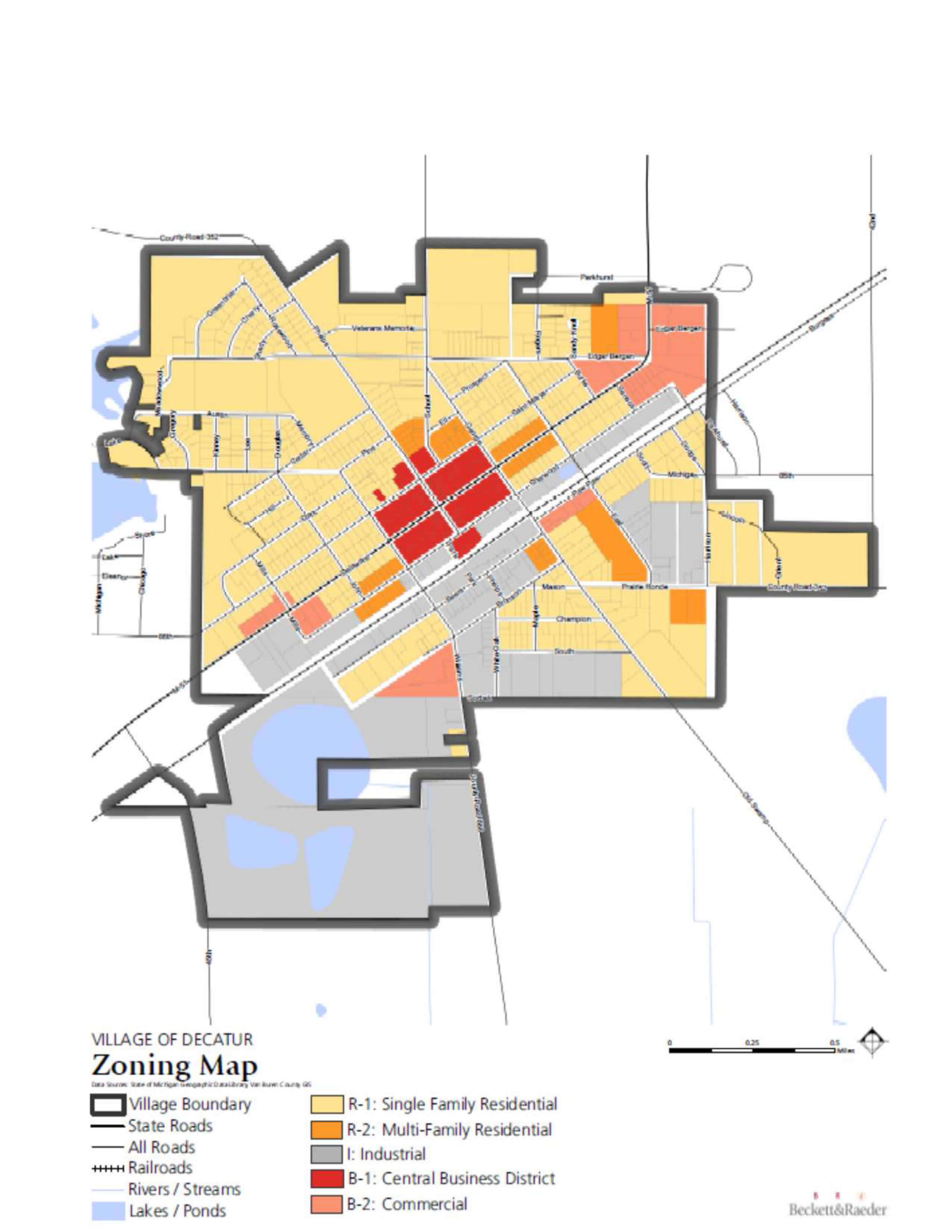
The boundaries of these districts are shown upon the zoning district map which accompanies and is made a part of this chapter. Said map and all the information shown thereon shall have the same force and effect as if all were fully set forth or described herein. The original of this is properly attested and is on file with the village clerk.
(Ord. No. 202, art. 4, § 9, 11-6-2017)
Sec. 42-51. - Annexed territory.
All territory which may hereafter be annexed to the village shall be classified in the R-1 Residential District, until, within a reasonable time after annexation, the annexed territory shall be appropriately classified by ordinance, in accordance with article XI of this chapter.
(Ord. No. 202, art. 4, § 10, 11-6-2017)
Sec. 42-52. - Vacated street or public way.
Whenever any street or other public way is vacated by official action of the village, the zoning district adjoining each side of such street or public way shall be automatically extended to the center of such vacation and all area included in the vacation shall then and henceforth be subject to all appropriate regulations of the extended districts.
(Ord. No. 202, art. 4, § 11, 11-6-2017)
Sec. 42-53. - Interpretation of district boundaries.
Where uncertainty exists with respect to the boundaries of the various districts as shown on the zoning district map, the following rules shall apply:
(1)
Where a boundary line is given a position within a street, alley or non-navigable stream, it shall be deemed to be in the center of the street, alley, or stream, and if the actual location of such street, alley, or stream varies slightly from the location as shown on the zoning district map, then the actual location shall control.
(2)
Where a boundary line is shown as being located a specific distance from a street line or other physical feature, this distance shall control.
(3)
Where a boundary line is shown adjoining or coincident with a railroad, it shall be deemed to be in the center of the railroad right-of-way and distances measured from a railroad shall be measured from the center of the designated main line track.
(4)
Where the district boundaries are not otherwise indicated and where the property has been or may hereafter be divided into blocks and lots, such boundaries shall be construed to be the lot lines and where the districts are bounded approximately by lot lines, said lot lines shall be construed to be the boundary of such districts unless said boundaries are otherwise indicated on the map.
(5)
In un-subdivided property, unless otherwise indicated, the district boundary line shall be determined by the use of the scale contained on such map.
(Ord. No. 202, art. 4, § 12, 11-6-2017)
Sec. 42-54. - Properties with multiple zoning designations.
When an individual recorded parcel, which exists at the time of adoption of the ordinance from which this chapter is derived, has more than one zoning classification, the zoning designation which comprises the majority of the parcel area shall be applied to the entire parcel.
(Ord. No. 202, art. 4, § 13, 11-6-2017)
Sec. 42-55. - Uses contrary to federal, state or local statutes, laws, and/or ordinances.
Uses for enterprises or purposes that are contrary to federal, state, and village statutes, laws, and/or ordinances are prohibited.
(Ord. No. 202, art. 4, § 14, 11-6-2017)