
Deer Lodge City Zoning Code
CHAPTER 11
03: ANNEXATION
§ 11.03.010.010 INTRODUCTION.
(A) The city hereby recognizes that state law has established municipal governments for the purpose of providing local government services essential for sound urban development of communities, as well as for the protection of health, safety and welfare in areas, either already being intensively used or undergoing development for residential, commercial, industrial, institutional and governmental purposes.
(B) Per the state’s annexation laws, an evaluation, November 1980, the Montana Legislative Council, “historically, the purpose of Montana’s annexation statutes have been simply to provide expanding communities with:
(1) A united and effective single form of government;
(2) Orderly growth through uniform regulations such as building codes, planning and zoning standards; and
(3) An equal sharing of community resources and financial responsibility for those resources by people living in an area united by social, political, and economic interests.”
(Prior Code, § 11.03.010.010) (Res. 150, passed 6-18-2016; Ord. 2021-15, passed 12-20-2021)
§ 11.03.010.020 LONG RANGE PLAN.
(A) As required by MCA § 7-2-4732, this annexation plan anticipates development for a period of at least ten years into the future. The U.S. Census Bureau 2010 Decennial Census lists the population of the city at 3,111. The city growth policy update 2015 noted a historic growth rate of negative 0.69% annually. Recent preliminary engineering reports for water and wastewater systems estimate a population in 2025 of 3,365, a positive annual growth rate of 0.7%.
(B) In addition to considering the impacts and additional needs created by individual growth and development projects on a case-by-case basis, plans and studies for the following facilities and services will be consulted when annexation is considered.
(1) The city growth policy update, 2015. While the population projections in the city growth policy update are based on historic averages, the growth policy calls for the city to be prepared for a slow shift towards an increasing population. In the meantime, the document calls for the need to annex in order to accommodate new business opportunities and allow for subdivisions that will market newer housing options. The growth policy establishes policies and general land use patterns desired in newly annexed areas.
(2) The city zoning regulations. This document, which may be updated from time to time, establishes the type and intensity of development that can occur in newly annexed areas based on the guidance in the growth policy.
(3) Sewer. The city operates a wastewater collection and treatment system that provides capacity within the city boundary and on a limited basis outside the city boundary. The city’s wastewater treatment system has been operating below state and federal standards. In addition, the system is near the end of its lifespan. The city is in the process of upgrades to the treatment system. When the upgrades are complete, the city intends to operate and maintain sewer facilities in accordance with state and federal standards. The existing system is over designed for the population of the community. The system that is being constructed will reduce the size of the facility to accommodate a population of 4,500. The city also plans to study and upgrade the collection system which is prone to infiltration.
(4) Water. The city operates a municipal water supply and distribution system that provides capacity within the city boundary and on a limited basis outside the city boundary. The system is capable of meeting the design maximum day demand of 1,223 GPM in year 2033. The current system suffers from excessive leakage. The city plans to continue to identify leaks and improve the delivery system to reduce leakage. The city also plans to develop a new water source to replace a well that is out of service due to quality issues. The city intends to operate and maintain water facilities in accordance with state and federal standards.
(5) Streets and sidewalks. The city maintains streets and sidewalks within the city boundary. The city does not have plans for the extension of streets and sidewalks outside of its boundaries. The extension of streets and sidewalks will be made on an individual basis.
(6) Parks and trails. The city growth policy identifies areas for trail expansions and for future parks. The city will continue to explore options for trails and parks development.
(7) Storm drainage. The city maintains a small disconnected storm sewer system. There are no plans for the extension of this system. Storm drainage in areas to be annexed will be considered on an individual basis.
(8) Street lighting. Street lighting is provided in the city through lighting districts. No plans have been created to expand the districts. Instead, when new development occurs, lighting districts will be expanded or developed to fund the maintenance of new streetlights.
(9) Public safety. The city provides police and fire protection. In the area immediately outside the city limits in the county, the city provides fire services to a rural fire district through an interlocal agreement. At this time, there are no specific plans for expansion. Instead, additional equipment and personnel will be added as needed over time in accordance with city policies in effect at the time of development.
(10) Solid waste collection. Solid waste is collected by the City Solid Waste Department. Additional equipment and personnel will be added as needed over time in accordance with city policies in effect at the time of development.
(11) Capital improvements plan. The city has adopted a capital improvements plan which identifies a schedule and financing options for capital projects and equipment purchases. The capital improvements plan will be updated in 2016.
(Prior Code, § 11.03.010.020) (Res. 150, passed 6-18-2016; Ord. 2021-15, passed 12-20-2021)
§ 11.03.010.030 GENERAL ANNEXATION POLICES.
(A) The following are general policies the city plans to use to guide annexation.
(1) (a) The city may seek to utilize any and all methods for annexation authorized under state law (MCA Title 7, Chapter 2). All annexation proceedings will follow the requirements of state law in every respect.
(b) The city will consider, in a timely manner, any property owner’s petition requesting annexation of land that is eligible for annexation in accordance with state statutes.
(2) All municipal services will be available to property that is annexed within a reasonable time (generally not to exceed five years) on substantially the same basis and in the same manner as such services are available to the rest of the municipality. All municipal services should be available when development occurs and demand for sewer, water, streets and other services begins. If it is likely that the area proposed to be annexed will not have municipal services available when development occurs, the area should not be annexed.
(3) Properties outside of the city municipal boundary will not be connected to or receive service from the city’s water and/or sewer systems without either annexation or the property owner submitting a waiver of the right to protest annexation as a requirement for receiving service.
(4) For those properties currently receiving water and/or sewer service that are not within the city limits, the city may require the property owner(s) to consent to annexation or waive the right to protest annexation as a condition of continued water and/or sewer service.
(5) The city has no plans to extend services to specific annexation areas at this time. The city cannot predict the exact future extensions and requirements for new services because new mains and streets and the need for other services are typically initiated by private parties based on the market for new development, and the exact specifications needed for such facilities and services will be determined when development takes place.
(6) The city does not plan to extend services and add new areas to the community each and every year, but instead when expansion is in the best interest of the citizens of city in accordance with the policies in effect when annexation and development are proposed.
(7) In addition to the use of special improvement districts, and payback or recapture agreements (divisions (F) and (G) below) and in accordance with MCA § 76-3-510, the developer(s) or property owner(s) of annexed property will generally be required to extend all infrastructure improvements, including, but not limited to, water lines, sewer lines, fire hydrants, reservoirs, pump stations, lift stations, culverts, storm drainage systems, streets, sidewalks, parks and trails, street lighting, traffic-control devices, street name signs, and such other improvements, as may be required by the city, at the developer’s or property owner’s expense.
(a) The infrastructure improvements will be constructed in accordance with the city subdivision regulations, the most recent edition of the Montana Public Works Standard Specifications, and Montana Department of Environmental Quality (DEQ) requirements.
(b) The infrastructure improvements shall be in compliance with applicable codes and standards, and be of adequate size and design to accommodate the needs of the proposed development.
(c) All proposed infrastructure shall be reviewed and approved by the City Public Works Director, and as-built drawings as required by the City Public Works Director shall be submitted to the city prior to final acceptance of the infrastructure.
(d) All infrastructure necessary to serve newly annexed areas shall be in place concurrently with occupancy of the areas.
(8) The developer(s) or property owner(s) shall be responsible for providing fire protection appurtenances and required water flow pressures and volume, at the developer’s or property owner’s expense, as required by the applicable Fire Code enforced by the city and reviewed and approved by the City Fire Chief and the State Fire Marshal, based on the use of land and the type of construction employed.
(9) Municipal services of police, fire, garbage collection, and streets and street maintenance services, street lighting, parks and recreation facilities, and all general administrative services shall be provided to annexed property on substantially the same basis and in the same manner as provided to the rest of the municipality.
(10) Once newly developed facilities have been installed and areas annexed, the entire municipality will tend to share the tax burden for these facilities and services, and if so, no new city-wide bond issue is planned for the sole purpose of financing provision of municipal services to annexed areas.
(11) Properties proposed for development in areas which do not have immediate access to city water and/or sewer, but where services are in close proximity, may be required to install dry water and sewer lines in anticipation of the extension of city water and sewer into the area within a reasonable time, generally not to exceed five years. Once adequate water and sewer facilities are within 200 feet of the site, or if a new subdivision lot is within 500 feet of city water and sewer, connection may be required at the property owner’s or developer’s expense.
(12) As new city streets and sidewalks are constructed, and as existing streets are improved, storm drainage infrastructure shall be installed or improved to city site design, DEQ and Environmental Protection Agency standards.
(a) It is the responsibility of the developer(s) or property owner(s) to convey stormwater from their property to an appropriate point of disposal as approved by the Public Works Director.
(b) If there is no storm sewer conveyance system available to the site, stormwater generated as a result of the development shall be retained on site in accordance with applicable DEQ requirements.
(13) The developer(s) or property owner(s) shall provide all necessary right-of-way and/or easements, or additional right-of-way or easements if less than adequate right-of-way or easements exist in property proposed for annexation.
(14) The city has adequate water supply and sewer treatment and disposal facilities, funded by existing taxpayers and rate payers, to support existing development and, where city capacity is not sufficient for new development, the city intends to increase capacity as soon as possible.
(15) All property owners located in a newly annexed area will be required to comply with all city, state, and federal laws, statutes, regulations, ordinances, and resolutions, including but not limited to, zoning, building codes, fire prevention ordinance and fire codes, fireworks ordinances, dog license ordinance, business license ordinance, and all other laws, statutes, regulations, ordinances, and resolutions.
(B) Policies for providing services in existing developed areas.
(1) (a) Property that is proposed for annexation and has existing infrastructure shall generally be required to upgrade the infrastructure to city standards as a condition of annexation.
(b) However, the city may choose to participate in upgrades to existing infrastructure, may waive upgrade requirements, or may allow phased improvements in certain instances based on the policies provided in this plan and additional, location-specific factors.
(2) Prior to annexation, the city may require the developer(s) or property owner(s) to provide the City Council with a report describing the following:
(a) The approximate year or period in which the existing area was developed;
(b) The location, size and condition of the existing infrastructure, including, but not limited to, water and sewer lines, fire hydrants, and streets and storm drainage;
(c) The size and location and legal purpose of all existing right-of-ways and easements;
(d) 1. The report shall also include the estimated costs associated with correcting the deficiencies and bringing the utility or improvement to city standards.
2. The city may require such a report to be prepared by a professional engineer at the cost of the developer(s) or property owner(s).
(C) (1) In certain instances, it may be appropriate to require areas within the city limits, including recently annexed areas, to connect to city services which are available over a stated period of time generally not to exceed five years.
(2) This would provide the opportunity to phase out individual and private systems utilizing on-site facilities or other antiquated systems, which operate at a marginal level and which may not be compatible with city standards.
(Prior Code, § 11.03.010.030) (Res. 150, passed 6-18-2016; Ord. 2021-15, passed 12-20-2021)
§ 11.03.020.010 OFF-SITE INFRASTRUCTURE REQUIREMENTS.
(A) In the event that annexation necessitates off-site infrastructure improvements, the developer(s) or property owner(s) of the property proposed for annexation will be responsible for bearing the initial costs of such improvements, unless otherwise determined by the City Council.
(B) The city may require reimbursement from a developer(s) or property owner(s) for city financed infrastructure that was installed in anticipation of future development on property that is proposed for annexation. Reimbursement costs shall be proportional to the additional capacity and facilities made necessary or used by the new development.
(1) It shall be the responsibility of the developer(s) or property owner(s) to extend all roadways and utilities from the existing city facilities to the site of development in accordance with all city standards and specifications, including the provision for appropriate easements.
(2) It shall further be the responsibility of the developer(s) or property owner(s) to construct all streets and utilities to the furthest boundary of the property to be developed or annexed when it is deemed appropriate by the City Council or Public Works Director in order to facilitate future development.
(Prior Code, § 11.03.020.010) (Res. 150, passed 6-18-2016; Ord. 2021-15, passed 12-20-2021)
§ 11.03.020.020 SPECIAL IMPROVEMENT DISTRICTS.
(A) The City Council, in its discretion, may approve the formation of a Special Improvement District to pay for the installation, construction and upgrading of infrastructure improvements.
(B) The boundaries of the Special Improvement District shall be the area benefiting from the improvements in accordance with the laws of the state.
(Prior Code, § 11.03.020.020) (Res. 150, passed 6-18-2016; Ord. 2021-15, passed 12-20-2021)
§ 11.03.020.030 PAYBACK OR RECAPTURE AGREEMENT.
If a developer(s) or property owner(s) of property annexed pays the entire cost of infrastructure improvements, and such improvements will benefit other property that may be developed or annexed in the future, the City Council may, in its discretion, authorize a payback or recapture agreement.
(A) The agreement may provide that developer(s) or property owner(s) that connect to the infrastructure improvements in the future shall reimburse the developer(s) or property owner(s) that initially paid for the improvement a portion of the cost of the improvement.
(B) The agreement shall include a method of calculating the amount of reimbursement.
(C) The method of reimbursement may be based upon lot size, front footage, or other means that the City Council deems reasonable.
(D) The payback period shall not exceed ten years from the date of completion of construction or installation of the improvement.
(E) The agreement shall set forth the specific area that may benefit from the improvement and that will be subject to the agreement.
(F) In addition to capital improvements, the costs that may be reimbursed under an agreement may include engineering, design and inspection fees.
(G) Any and all terms and conditions of an agreement are subject to approval by the City Council.
(Prior Code, § 11.03.020.030) (Res. 150, passed 6-18-2016; Ord. 2021-15, passed 12-20-2021)
§ 11.03.030.010 PETITION FOR ANNEXATION.
(A) If a property owner(s) petitions the city to have property annexed pursuant to MCA Title 7, Chapter 2, Part 46, the property owner(s) shall submit a petition(s) for annexation in a form provided at city hall.
(B) The petitioner(s) shall also provide the city with the following:
(1) A map depicting all of the tracts of land proposed for annexation;
(2) A notarized list with the legal description, and the names and mailing addresses of the owner(s) of each tract of land in the area proposed for annexation from the records of the County Clerk and Recorder or a licensed title company; and
(3) Concurrent with a petition for annexation, the petitioner shall also propose one or more zoning designations in accordance with the land use designation in the city growth policy for the property to be annexed, and a site plan or preliminary plat indicating the sizes of lots, proposed land uses and density of development anticipated for the property.
(Prior Code, § 11.03.030.010) (Res. 150, passed 6-18-2016; Ord. 2021-15, passed 12-20-2021) ANNEXATION AREAS
§ 11.03.040.010 AREAS CONSIDERED FOR ANNEXATION.
(A) Generally. Currently, there are several areas adjacent to and near the perimeter of the city that are natural extensions of the city, but which are not presently located within the corporate boundaries.
(1) Some of these areas are already extensively developed and are deriving benefits from the city without paying their just and equal share for municipal services.
(2) Other areas are not extensively developed, but given the projected demand for residential, commercial and industrial development, certain areas will be attractive for development in the future.
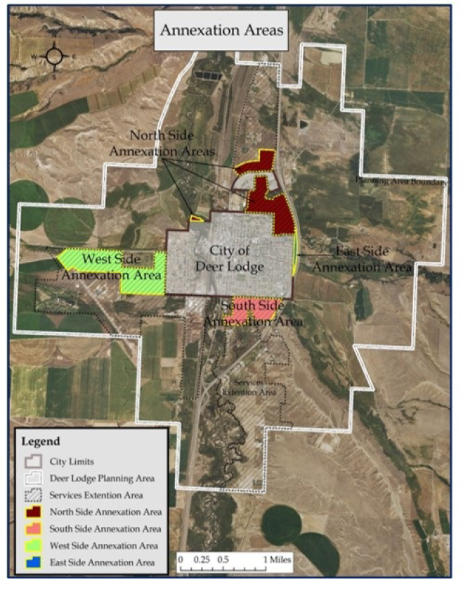
(B) Potential areas. As part of this plan, potential annexation areas were created so that the city could evaluate where annexation might naturally occur within the next five to ten years, and where the city might want to encourage or even pursue annexation and development. The map titled annexation areas illustrates the four areas adjacent to the city that are identified as potential areas with attributes that lend them to consideration for annexation, either partially or completely, depending on conditions at the time of proposed annexation and development. These areas total ±501 acres (±0.78 square miles). The attributes considered during creation of this plan include, but are not limited to:
(1) Proximity to the current city limits and developed areas of the community;
(2) The city 2015 growth policy land use designations;
(3) The city 2015 growth policy services extension area;
(4) Proximity to municipal and other public infrastructure, including transportation facilities and water and sewer lines (infrastructure maps located in § 11.03.050.010);
(5) Expected needs for new development in terms of acreage, proximity to services and qualities of the land in the vicinity of the city; and
(6) Benefits of including municipal properties and infrastructure into the city.
(C) North side annexation areas.
(1) (a) The north side annexation area is comprised of three distinct areas totaling 172 acres north of the boundary of the city.
(b) The land use designations include 55 acres of commercial and residential, 53 acres of high density residential, 60 acres of low density residential, and four acres of public.
(2) (a) The north side annexation areas is a mix of developed and undeveloped parcels. Generally, the area is desirable for extension of services to existing residential development and undeveloped platted lots, extension of services to existing commercial development, new residential development and new commercial development.
(b) The city owns land identified in the 2015 city growth policy as a potential city park that may also be desirable for annexation.
(D) West side annexation area.
(1) (a) The west side annexation area is a continuous area of 223 acres west of the city.
(b) The area is adjacent to the Deer Lodge - Powell County Airport. The land use designations include 111 acres of industrial, 40 acres of high density residential and 73 acres of low density residential.
(2) The west side annexation area is primarily undeveloped, however some existing development exists adjacent to the city boundary.
(a) Generally, the area is desirable for extension of services to existing residential development, new residential development and new industrial development.
(b) A portion of the area with a land use designation of industrial is a potential site of an industrial park.
(E) South side annexation area.
(1) (a) The south side annexation area is a continuous area of 97 acres south of the city between I-90 to the east and Valley View Drive to the west.
(b) The land use designations include 25 acres of high density residential and 71 acres of low density residential.
(2) (a) The south side annexation area is primarily comprised of existing development of large lot residential parcels.
(b) Generally, the area is desirable for extension of services to existing residential development.
(F) East side annexation area.
(1) The east side annexation area is a small sliver of land on the east side of the city between the city limits and I-90.
(a) The land use designation is agricultural.
(b) The area is about five acres.
(2) The east side annexation area is primarily comprised of existing development of residential parcels.
(a) Some of these parcels have water and sewer services.
(b) Annexation may be desirable to bring the parcels enjoying city services into the city.
(Prior Code, § 11.03.040.010) (Res. 150, passed 6-18-2016; Ord. 2021-15, passed 12-20-2021)
§ 11.03.040.020 ANNEXATION AREA MAP.
The growth policy land use.
(Prior Code, § 11.03.040.020) (Res. 150, passed 6-18-2016; Ord. 2021-15, passed 12-20-2021)
§ 11.03.040.030 NORTH SIDE ANNEXATION AREAS MAP.

(Prior Code, § 11.03.040.030) (Res. 150, passed 6-18-2016; Ord. 2021-15, passed 12-20-2021)
§ 11.03.040.040 WEST SIDE ANNEXATION AREAS MAP.

(Prior Code, § 11.03.040.040) (Res. 150, passed 6-18-2016; Ord. 2021-15, passed 12-20-2021)
§ 11.03.040.050 SOUTH SIDE ANNEXATION AREA MAP.

(Prior Code, § 11.03.040.050) (Res. 150, passed 6-18-2016; Ord. 2021-15, passed 12-20-2021)
§ 11.03.040.060 EAST SIDE ANNEXATION AREAS MAP.

(Prior Code, § 11.03.040.060) (Res. 150, passed 6-18-2016; Ord. 2021-15, passed 12-20-2021)
11.03.050.010 FUTURE LAND USE MAP.
Future land use map from 2015 growth policy.

(Prior Code, § 11.03.050.010) (Res. 150, passed 6-18-2016; Ord. 2021-15, passed 12-20-2021)
§ 11.03.050.020 WATER DISTRIBUTION SYSTEM.
May 2012 water distribution system map.

(Prior Code, § 11.03.050.020) (Res. 150, passed 6-18-2016; Ord. 2021-15, passed 12-20-2021)
§ 11.03.050.030 WASTEWATER COLLECTION SYSTEM.
January 2009 wastewater collection system map.

(Prior Code, § 11.03.050.030) (Res. 150, passed 6-18-2016; Ord. 2021-15, passed 12-20-2021))
§ 11.03.050.040 STORM SEWER SYSTEM.
January 2009 wastewater collection system map.

(Prior Code, § 11.03.050.040) (Res. 150, passed 6-18-2016; Ord. 2021-15, passed 12-20-2021)

