
Delano City Zoning Code
CHAPTER 20
3 - SPECIAL DISTRICTS
Sections:
20.3.10 - Planned development (PD) district.
1.
Purpose and Intent.
a.
The General Plan outlines the goals, objectives and policies establishing the character and location of land uses throughout the City. It is the purpose of this Section to establish regulations consistent with Government Code Section 65450, which serves to implement General Plan goals, objectives and policies, provide for superior development, and allow a greater degree of design and land use flexibility within the framework of a site specific development plan.
b.
The provisions of this Section establish procedures that provide for large-scale, multi-phased residential, commercial or industrial mixed-use developments. These provisions permit the clustering of units, the mixing of land use and building types, and the formulation of specific development standards and design criteria that respond to the particular features or conditions affecting a site.
c.
Applicability. The PD zone district is intended to be applied when:
(1)
The objectives of the General Plan would be more effectively achieved through the design flexibility of a PD zone district; or
(2)
The physical characteristics of a site necessitate restricting conventional development opportunities to preserve a significant amenity or natural feature or mitigate a manmade or natural hazard; or
(3)
It is necessary to ensure land use compatibility and appropriate design by requiring the merging of areas or parcels into a single overall land use plan and site design that might otherwise be developed separately.
2.
Use Regulations.
a.
Uses within a PD zone district shall be established by a development plan approved for the site.
b.
Uses established by a development plan shall be consistent with the text and land use map of the General Plan and any applicable planned development or specific plan for the project site.
c.
Prior to the approval of a zone change to "Planned Development," the conditions of approval for the development plan, approved in accordance with the provisions of this Title, shall establish the permitted, and the conditionally permitted primary and accessory uses for a planned development project.
3.
Application Procedures. An application for change of zone to a PD zone district shall involve the following:
a.
An application for a district change to PD shall be accompanied by a preliminary development plan that addresses all land included with the proposed PD district.
b.
The application for development shall describe all land within that PD district boundary.
c.
The preliminary development plan, required by Sections 20.3.10.3.a. and 3.b. above, shall be prepared in accordance with the requirements and information established in Sections 20.3.10.4.a. and 4.b. of this Chapter.
d.
Prior to the formal submission of a planned development application, the project applicant shall meet with the Community Development Director at a pre-application conference. The pre-application conference is intended to acquaint the applicant with the procedural requirements of this Chapter, provide an opportunity to discuss the proposed development concept and the plan's compatibility with or variance from, any applicable policies, issues, or development regulations.
e.
The application for a change of zone to the PD zone district shall be acted upon by the Planning Commission and City Council in a manner consistent with the provisions of Section 20.2.40 of this Title.
f.
Following approval by the City Council of the PD district, a final development plan, prepared in accordance with Sections 20.3.10.4.a through 20.3.10.4.d of this Chapter shall be submitted for review and action by the City Council.
(1)
The City Council shall read the enabling ordinance for the district change to (PD) prior to approval of a final development plan.
(2)
In the event a PD is carried out in phases and separate final development plans are to be approved for each phase, the City Council shall have read the enabling ordinance for the entire project prior to the approval of the final development plan for the first phase.
(3)
An application for a final development plan may be for a portion of the land included within the PD or a phase thereof, provided that:
(a)
Each phase shall function as a complete and separate development from the remaining phases;
(b)
Any densities proposed or open space areas provided within the subject phase shall not result from a transfer of density from adjoining phases; and
(c)
Other improvements that may be necessary to protect public health, safety, and welfare have been required.
4.
Preliminary and Final Development Plans Content.
a.
The development plan shall function as a development suitability analysis and land use concept plan that achieves the following:
(1)
Identifies and quantifies the constraints and opportunities for development posed by:
(a)
The physical characteristics of the site;
(b)
Available public services and facilities;
(c)
The capacity of the existing circulation system; and
(d)
The existing and planned land use of adjacent properties.
(2)
Establishes a list of specific limits, parameters and planning objectives to guide development based on the identified development constraints and opportunities.
(3)
Describes one or more potential development schemes derived from the limits, parameters, and planning objectives controlling development. Each proposed development scheme shall describe the following:
(a)
Proposed land uses and approximate distribution of such land uses;
(b)
Proposed density of residential use;
(c)
Estimated population;
(d)
Estimated service demands;
(e)
The anticipated impact on the existing circulation system;
(f)
The anticipated impact on adjacent properties; and
(g)
The relationship of various elements to the General Plan.
b.
The development plan shall function as an overall comprehensive plan of development for the PD zone district that sets forth a written text, maps and/or diagrams, a detailed plan of development based upon the application of the established limits, parameters, and planning objectives controlling development. Said plan shall describe in detail:
(1)
Proposed land uses and building types, the functional management of such uses and building types and relationship to site, site grading, circulation, lighting, paving, parking, screening, setbacks, recreation and open space areas, and adjacent properties;
(2)
How the established limits, parameters and planning objectives have been adhered to;
(3)
The level of public services and facilities required by the proposed development and the program for providing, operating and maintaining such services and facilities;
(4)
Access and circulation requirements;
(5)
Known manmade and natural hazards and methods for mitigation of such hazards;
(6)
Significant natural features and areas to be retained for common open space, and provisions for the preservation, conservation, utilization and maintenance of such areas;
(7)
How the plan conforms to the objectives of the General Plan and the PD provisions of this Chapter.
c.
The development plan shall set forth the location and dimensions of all uses and structures in sufficient detail to permit preparation of construction drawings.
d.
If ambiguity exists as to the specific dimensions or extent of any designated area on the development plan, the specific boundaries shall be set by the filing of a legal description and map of the parcel in question.
5.
Findings.
a.
Prior to approving a request for a zone district change to PD, the Planning Commission and the City Council shall find that all of the following are true:
(1)
That the proposed plan is consistent with the General Plan and any applicable specific plan.
(2)
That the physical characteristics of the site have been adequately addressed and that the site is adequate to accommodate all proposed land uses and the general arrangement of such uses.
(3)
That the plan adequately addresses and reflects all natural and manmade hazards associated with the project site.
(4)
That the capacity of the circulation system is adequate or can feasibly be improved to accommodate the anticipated requirements of the proposed development.
(5)
That realistic, feasible methods exist to accommodate the public service and facilities requirements of the proposed development.
(6)
That the proposed land uses and proposed arrangement of such uses will be compatible with the existing and planned land use character of adjacent properties.
(7)
That the plan carries out the intent of the PD provisions of this Title.
b.
Prior to approving an application for a final development plan, the City Council shall make the following findings:
(1)
That the proposed development is consistent with the General Plan and any applicable community plan or specific plan.
(2)
That the site for the proposed development is adequate in size and shape to accommodate proposed uses and proposed development standards for all yards, open spaces, setbacks, walls and fences, parking areas, loading areas, landscaping, and other features.
(3)
That the improvements required by the conditions of approval and the proposed manner of development adequately address any natural and manmade hazards affecting the proposed development and the project site.
(4)
That the site for the proposed development has adequate access, i.e., the conditions of the site design and development plan considers the limitations of existing and proposed streets and highways.
(5)
That adequate public services exist, or will be provided in accordance with the conditions of approval, to serve the proposed development; and that approval of the proposed development will not result in a reduction of such public services to properties in the vicinity in a manner that is detrimental to the public health, safety and welfare.
(6)
That the proposed development, as conditioned, will not have a substantial adverse effect on surrounding property or the permitted use thereof, and will be compatible with the existing and planned land use character of adjacent properties.
(7)
The proposed development carries out the intent of the PD provisions of this Title by providing a more efficient use of the land and an excellence of design superior to that which could be achieved through the application of conventional development standards.
(8)
The final plan is in substantial compliance with the approved development plan.
(Ord. No. 2008-1174, § 1(Exh. A), 5-5-2008)
20.3.20 - Community facilities (CF) district.
1.
Purpose and Intent.
a.
The General Plan outlines the goals, objectives, and policies establishing the location and character of public, quasi-public and institutional land uses, and activities within the City.
b.
It is the purpose of this Section to provide regulations that implement those goals, objectives and policies of the General Plan and to assure the availability and adequacy of lands suitable for future public, quasi public and institutional facilities, uses and activities.
2.
Use Regulations.
a.
Table 3.A of this Chapter identifies those land uses or activities that may be permitted, or conditionally permitted in the CF zone district, subject to the provisions of this Title and the General Plan. Table 3.A also depicts the permit procedure and the type of approval required by which each listed land use or activity may be permitted in said CF zone district.
Table 3.A
Uses Permitted Within Community Facilities District
Legend
P Permitted subject to Consistency Assessment
C Permitted Subject to approval of a Conditional Use Permit
3.
Development Standards.
a.
General Requirements. The minimum property development standards for all land, buildings, and structures constructed or placed within the CF zone district shall be equivalent to the requirements of the zone district(s) of adjacent properties. When there is a conflict between adjacent zone districts and the CF zone district, the Community Development Director shall make the final determination as to the applicable development standards to be applied. The decision of the Community Development Director may be appealed to the Planning Commission in accordance with the provisions of Section 20.2.180 of this Title.
b.
Special Requirements.
(1)
Where off-street parking areas are situated such that they are in visual corridor, as may be defined in a precise plan adopted by the City Council, screening such as a wall or earthen berm two feet in height shall be erected between the street right-of-way and parking areas.
(2)
Except as otherwise permitted, a street side building setback area shall be used only for landscaping, pedestrian walkways, driveways, and off-street parking.
(3)
Except as otherwise permitted, required rear and interior side building setback areas shall be used only for landscaping, pedestrian walkways, driveways, off-street parking or loading, storage of materials (when provided in accordance with the provisions of this Title), recreational activities or facilities, and similar accessory activities.
(Ord. No. 2008-1174, § 1(Exh. A), 5-5-2008)
20.3.21 - Airport (AP) district.
1.
Purpose and Intent.
a.
The Delano Municipal Airport is a valued public facility owned and operated by the City. The primary purpose of the AP district is to protect the existing airport from incompatible development and uses which may be deleterious to the long term function and operation of the facility. The AP district achieves this purpose by permitting ancillary uses that are supportive of the airport's primary use. Typical of these uses would be aircraft associated activities, aircraft related manufacturing, repair and maintenance, and air fields, heliports, runways, taxiways and related structures.
b.
Other permitted uses are commercial, service and light industrial uses which are compatible with the operation of the airport, including vehicle and equipment sales and service, warehousing and supportive facilities such as restaurants, aviation museums and public safety facilities.
2.
Use Regulations. Table 3.C of this Chapter identifies those land uses or activities that may be permitted or conditionally permitted in the AP zone district, subject to the provisions of this Title and the General Plan. Table 3.C also depicts the permit procedure and the type of approval required by which each listed land use or activity may be permitted in said AP zone district.
Table 3.C
Uses Permitted Within Airport District
Legend
P Permitted subject to Consistency Assessment
c Permitted Subject to approval of a Conditional Use Permit
(Ord. No. 2013-1270, § 1(Exh. A), 11-18-2013)
20.3.22 - Parks (PA) district.
1.
Purpose and Intent. The primary purpose of the PA district is to provide land area for parks and recreational uses by the citizens of Delano, and to promote their long-term benefit to the City. Related purposes include the preservation of land in a natural state where appropriate, and to provide open areas as a visual relief from developed areas of the City. Supportive facilities such as cultural venues, performing arts centers, libraries and museums are also permitted in this zone.
2.
Table 3.D of this Chapter identifies those land uses or activities that may be permitted or conditionally permitted in the A zone district, subject to the provisions of this Title and the General Plan. Table 3.D also depicts the permit procedure and the type of approval required by which each listed land use or activity may be permitted in said PA zone district.
Table 3.D
Uses Permitted Within Park District
Legend
P Permitted subject to Consistency Assessment
C Permitted Subject to approval of a Conditional Use Permit
20.3.30 - Airport approach height combining (H) district.
1.
Purpose and Intent. The Airport Safety Regulations are established to provide greater safety to both aviators and the general public by establishing requirements for land use compatibility reviews within designated areas depicted in Table 3.B (Delano Municipal Airport Compatibility Measures) of this Chapter.
2.
Permitted Uses. Permitted uses in an H district are those uses permitted by the base district with which the H district is combined.
3.
Uses Permitted with a conditional use permit. Uses permitted with a conditional use permit in an H district are those conditional uses permitted by the base district with which the H district is combined.
4.
Prohibited Uses. Prohibited uses in an H district are those uses prohibited by the base district with which the H district is combined.
5.
Minimum Lot Size. Minimum lot size requirements in an H district shall be in compliance with the requirements of the base district with which the H district is combined.
6.
Minimum Lot Area per Dwelling Unit. Requirements for minimum lot area per dwelling unit in an H district shall be in compliance with the requirements of the base district with which the H district is combined.
7.
Yards and Setbacks. Yard and setback requirements in an H district shall be in compliance with the requirements of the base district with which the H district is combined.
8.
Height Limits. The height of structures, trees and other objects, in the H district, shall be no less restrictive than requirements of Part 77 of the Federal Aviation Regulations of the Federal Aviation Administration (FAA), Department of Transportation, or of any corresponding rules or regulations of the Federal Aviation Administration, as amended. When there is conflict between the regulations of the FAA and the requirements of the base district with which the H district is combined, the regulations of the FAA shall prevail. When there is no such conflict, the permitted height shall be in accordance with the requirements of the base district with which the H district is combined.
9.
Minimum Distance Between Structures. The minimum distance between structures in an H district shall be in compliance with the requirements of the base district with which the H district is combined.
10.
Parking. Parking requirements in an H district shall be in compliance with the requirements of Chapter 20.13 of this Title.
11.
Signs. Sign requirements in an H district shall be in compliance with the requirements of Chapter 20.14, of this Title.
12.
Landscaping. Landscaping requirements in an H district shall be incompliance with the requirements of the base district with which the H district is combined.
13.
Location Requirements.
a.
The Airport Safety Regulations apply to the Delano Municipal Airport and any future airports that may be established in the City.
b.
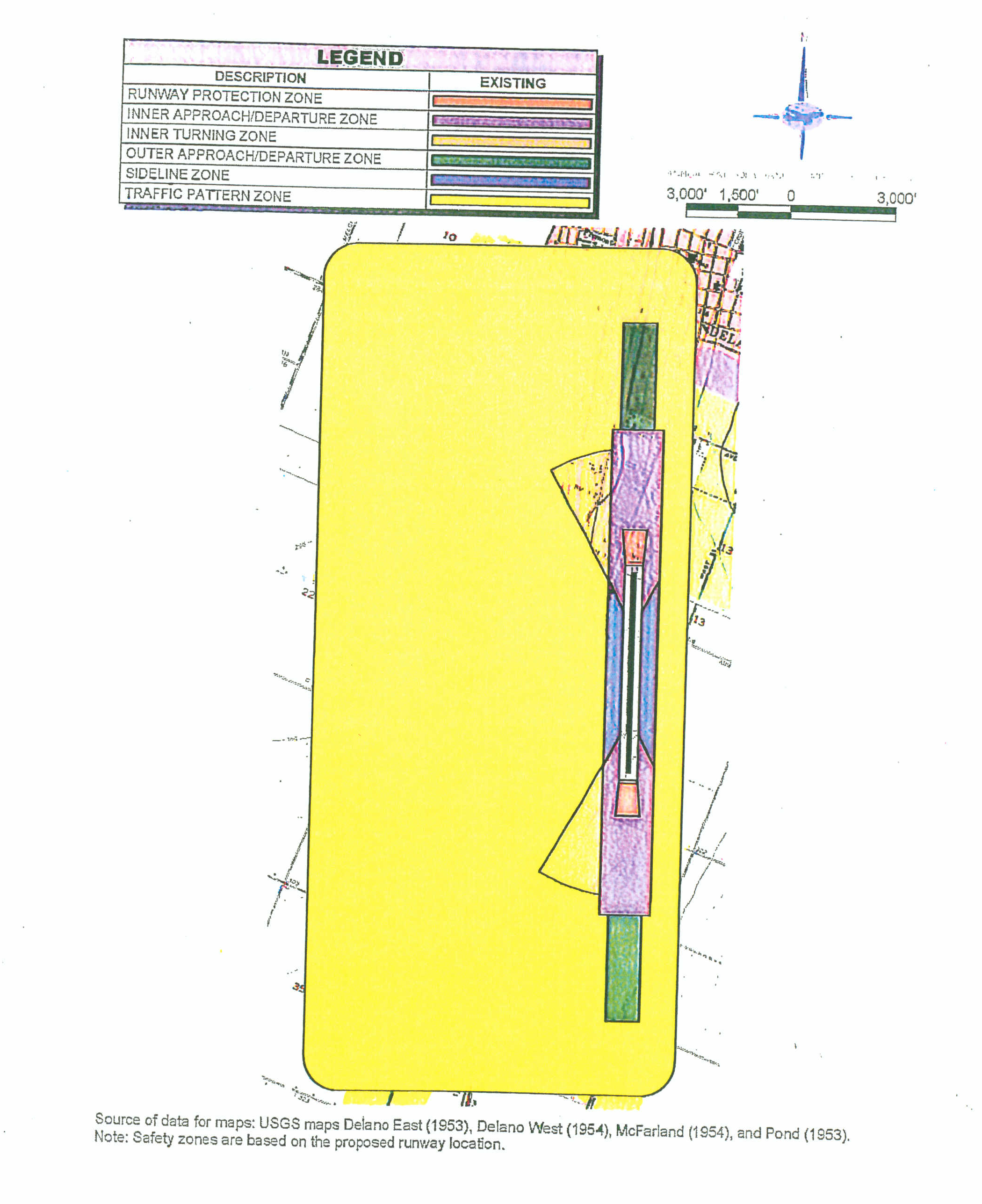
The area subject to these Airport Safety Regulations is the "Airport Influence Area" consistent with the definitions and criteria published in the 2002 edition of the California Airport Land Use Planning Handbook which is reflected in the "Basic Safety Compatibility Qualities and Safety Compatibility Criteria Guidelines" table (refer to Table 3.B) and the "Caltrans Safety Zones Applied to Delano Municipal Airport" map (refer to Table 3.C) of this Chapter.
c.
In all other cases, the applicable area may include all that area as defined in the Federal Aviation Regulations, Part 77. (FAR Part 77), which depicts imaginary surfaces for "objects affecting navigable airspace", as applicable to the specific FAA approved Airport Layout and Approach Plan, as well as the State of California's "Airport Land Use Planning Handbook." In the event FAR requirements or the State's Handbook change, the most current provisions shall apply.
Table 3.B
Basic Safety Compatibility Qualities
Zone 1: Runway Protection Zone
Risk Factors/Runway Proximity
> Very high risk
> Runway protection zone as defined by FAA criteria
> For military airports, clear zones as defined by AlCUZ criteria
Basic Compatibility Qualities
> Airport ownership of property encouraged
> Prohibit all new structures
> Prohibit residential land uses
> Avoid nonresidential uses except if very low intensity in character and confined to the sides and outer end of the area
_____
Zone 2: Inner Approach/Departure Zone
Risk Factors/Runway Proximity
> Substantial risk: RPZs together with inner safety zones encompass 30% to 50% of near-airport aircraft accident sites (air carrier and general aviation)
> Zone extends beyond and, if RPZ is narrow, along sides of RPZ
> Encompasses areas overflown at low altitudes — typically only 200 to 400 feet above runway elevation
Basic Compatibility Qualities
> Prohibit residential uses except on large, agricultural parcels
> Limit nonresidential uses to activities which attract few people (uses such as shopping centers, most eating establishments, theaters, meeting halls, multi-story office buildings, and labor-intensive manufacturing plants unacceptable)
> Prohibit children's schools, day care centers, hospitals, nursing homes
> Prohibit hazardous uses (e.g., above ground bulk fuel storage)
_____
Zone 3: Inner Turning Zone
Risk Factors/Runway Proximity
> Zone primarily applicable to general aviation airports
> Encompasses locations where aircraft are typically turning from the base to final approach legs of the standard traffic pattern and are descending from traffic pattern altitude
> Zone also includes the area where departing aircraft normally complete the transition from takeoff power and flap settings to a climb mode and have begun to turn to their en route heading
Basic Compatibility Qualities
> Limit residential uses to very low densities (if not deemed unacceptable because of noise)
> Avoid nonresidential uses having moderate or higher usage intensities (e.g., major shopping centers, fast food restaurants, theaters, meeting halls, buildings with more than three aboveground habitable floors are generally unacceptable)
> Prohibit children's schools, large day care centers, hospitals, nursing homes
> Avoid hazardous uses (e.g., above ground bulk fuel storage)
_____
Zone 4: Outer Approach/Departure Zone
Risk Factors/Runway Proximity
> Situated along extended runway centerline beyond Zone 3
> Approaching aircraft usually at less than traffic pattern altitude
> Particularly applicable for busy general aviation runways (because of elongated traffic pattern), runways with straight-in instrument approach procedures, and other runways where straight-in or straight-out flight paths are common
> Zone can be reduced in size or eliminated for runways with very-low activity levels
Basic Compatibility Qualities
> In undeveloped areas, limit residential uses to very low densities (if not deemed unacceptable because of noise); if alternative uses are impractical, allow higher densities as infill in urban areas
> Limit nonresidential uses as in Zone 3
> Prohibit children's schools, large day care centers, hospitals, nursing homes
_____
Zone 5: Sideline Zone
Risk Factors/Runway Proximity
> Encompasses close-in area lateral to runways
> Area not normally overflown; primary risk is with aircraft (especially twins) losing directional control on takeoff
> Area is on airport property at most airports
Basic Compatibility Qualities
> Avoid residential uses unless airport related (noise usually also a factor)
> Allow all common aviation-related activities provided that height-limit criteria are met
> Limit other nonresidential uses similarly to Zone 3, but with slightly higher usage intensities
> Prohibit children's schools, large day care centers, hospitals, nursing homes
_____
Zone 6: Traffic Pattern Zone
Risk Factors/Runway Proximity
> Generally low likelihood of accident occurrence at most airports; risk concern primarily is with uses for which potential consequences are severe
> Zone includes all other portions of regular traffic patterns and pattern entry routes
Basic Compatibility Qualities
> Allow residential uses
> Allow most nonresidential uses; prohibit outdoor stadiums and similar uses with very high intensities
> Avoid children's schools, large day care centers, hospitals, nursing homes
_____
Definitions
As used in this table, the follow meanings are intended:
> Allow: Use is acceptable
> Limit: Use is acceptable only if density/intensity restrictions are met
> Avoid: Use generally should not be permitted unless no feasible alternative is available
> Prohibit: Use should not be permitted under any circumstances
> Children's Schools: Through grade 12
> Large Day Care Centers: Commercial facilities as defined in accordance with state law; for the purposes here, family day care homes and noncommercial facilities ancillary to a place of business are generally allowed.
> Above ground Bulk Storage of Fuel: Tank size greater than 6,000 gallons (this suggested criterion is based on Uniform Fire Code criteria which are more stringent for larger tank sizes)
Safety Compatibility Criteria Guidelines
Land Use Densities and Intensities
Table 3.C
Caltrans Safety Zones Applied to
Delano Municipal Airport
14.
Findings. The Community Development Director shall determine that all of the following are true prior to approving any land use application or issuing any development permit within the Airport Safety Review Areas. If the findings cannot be made, a conditional use permit shall be required. Such conditional use permit shall find that the proposed use will not adversely affect the safety of persons residing, working or traveling within the review areas or affect the viability of the airport, prior to approval of the project.
a.
The proposed use is consistent with the General Plan, Zoning Ordinance, and the Delano Municipal Airport Master Plan.
b.
The proposed use is consistent with the Kern County Airport Land Use Compatibility Plan.
c.
The proposed use does not involve the storage or dispensing of volatile or otherwise hazardous substances that would endanger aircraft operations and public safety.
d.
The proposed use does not attract a large concentration of birds, produce smoke, generate electrical interference, reflect glare or light, or emit radio transmissions that may endanger aircraft operations.
e.
The proposed use promotes the public interest to provide for the development of the public-use airport and the area around the airport in such a manner, among other things, to comply with the noise standards adopted pursuant to the General Plan and the provisions of Section 20.10.180 of this Title and to prevent the creation of new noise and safety hazards.
f.
The proposed use enhances the protection of public health, safety and welfare, by ensuring the orderly expansion of the airport and the adoption of land use measures or development standards that minimize the public's exposure to excessive noise and safety hazards within the area around the airport to the extent that such areas are not already devoted to incompatible uses.
g.
The proposed use will not adversely affect safe air navigation, airport operations, or interfere with airport communications.
h.
The proposed use complies with the development standards specified by this Chapter.
15.
Development Standards. When a land use is proposed within an area governed by this Chapter, the following standards and criteria shall apply:
a.
Proposed structures and the normal mature height of any vegetation shall not exceed the height limitations provided by the requirements of Federal Aviation Regulations (FAR), Part 77 or with the requirements of this Chapter. Existing topographic elevations, as compared to the elevation of the centerline of the runway (primary surface), shall be considered in determining the permitted height of an affected structure.
b.
Proposed uses shall be consistent with the General Plan, this Title, The Delano Municipal Airport Master Plan, and the Kern County Airport Land Use Compatibility Plan.
c.
The proposed use or the structure shall not reflect glare, emit electronic interference or produce smoke that would endanger aircraft operations.
d.
All heliports shall be constructed pursuant to FAA Advisory Circular 150/5390-1B.
e.
The provisions of the California Airport Land Use Planning Handbook shall be met.
(Ord. No. 2011-1234, § 1(Exh. A), 9-6-2011)
20.3.40 - Drilling island (DI) District.
1.
Purpose and Intent. The purpose of the Drilling Island (DI) district is to designate single lots and relatively small areas within the boundaries of final map subdivisions and mobilehome parks that contain productive or potentially productive petroleum resources to promote the development of such resources in a manner compatible with surrounding development. Uses in the DI district are limited to oil and gas exploration and development, production, storage, transmission, and treatment, and any accessory or ancillary equipment, structure, or facilities thereto and compatible open space and recreational uses.
2.
Permitted Uses. The following uses and all others determined to be similar to these uses, pursuant to Section 20.1.90 (Determination of Similar Use) of this Title, are permitted in the DI district:
a.
Oil or gas exploration and development, production, storage, transmission, and treatment, and any accessory or ancillary equipment, structure, or facilities thereto, pursuant to the provisions of Section 20.9.40 (Development Standards and Conditions) of this Title.
b.
Subdivision drainage sump, as part of an application for a tentative tract map, provided that mineral rights owners have given written consent.
3.
Uses Permitted with a Conditional Use Permit. The following uses are permitted in the DI district subject to obtaining an approved conditional use permit:
a.
Parks.
(1)
Any such park shall be "passive" with improvements limited to landscaping, picnic tables and/or barbecue facilities.
(2)
A sign shall be erected, in accordance with the provisions of Section 20.14.30 (Sign Standards) of this Title, stating, in essence, that the site is in a DI zone district and is subject to future drilling and production activities.
(3)
The mineral rights owners of the subject property shall be given notification of the application for a conditional use permit in accordance with the provisions of Section 20.2.140 (Public Hearing and Notification Procedures) of this Title. Said mineral rights owners shall also be given a copy of the draft environmental documents in accordance with the provisions of Section 6.05 (for a draft Negative Declaration) or Section 7.04 (for a DEIR) of the City's Local Guidelines Implementing the California Environmental Quality Act.
b.
Parking lots.
(1)
A sign shall be erected, in accordance with the provisions of Section 20.14.30 (Sign Standards) of this Title, stating, in essence, that the site is in a DI zone district and is subject to future drilling and production activities.
(2)
The mineral rights owners of the subject property shall be given notification of the application for a conditional use permit in accordance with the provisions of Section 20.2.140 (Public Hearing and Notification Procedures) of this Title. Said mineral rights owners shall also be given a copy of the draft environmental documents in accordance with the provisions of Section 6.05 (for a draft Negative Declaration) or Section 7.04 (for a DEIR) of the City's Local Guidelines Implementing the California Environmental Quality Act.
c.
Drainage sump, except for the provision of Section 20.3.40.2.b (Permitted Uses) of this Chapter, provided that mineral rights owners have given written consent.
4.
Prohibited Uses. All other uses not permitted by Sections 20.3.40.2 (Permitted Uses) and 20.3.40.3 (Uses Permitted with a Conditional Use Permit) of this Chapter are prohibited in the DI district.
5.
Minimum Lot Size. No portion of any lot within the DI district shall contain less than two and one-half gross acres in size.
6.
Minimum Lot Area Per Dwelling Unit. There is no requirement for minimum lot area per dwelling unit in the DI district. Dwellings are not permitted.
7.
Yards and Setbacks. Pursuant to Section 20.9.40 (Development Standards and Conditions) of this Title, no oil or gas well shall be drilled within one hundred feet of the right-of-way of any public highway, proposed public highway, Official Plan Line, or Specific Plan Line in the DI District.
8.
Height Limits. Height limits in the DI district are as follows:
a.
None on derricks and other equipment used during the exploration and drilling phase of development.
b.
Pumping units shall not exceed thirty-five feet in height.
9.
Minimum Distance Between Structures. Minimum distance between structures in the DI district shall be as provided in the requirements of Section 20.9.40 (Development Standards and Conditions) of this Title.
10.
Parking. There is no minimum requirement for parking in the DI district; provided, however, all vehicle parking and maneuvering areas shall be treated and maintained with oiled sand or a similar dust binding material.
11.
Signs. The following signs are permitted in the DI district in accordance with the requirements of Chapter 20.14 (Sign Regulations) of this Title:
a.
Directional signs, warning signs, and identification signs, not to exceed two square feet each in accordance with the provisions of Section 20.14. 90 (Public Safety Signs) of this Title.
b.
Temporary real estate signs advertising the property for sale or rent, not to exceed six square feet each, excluding the area of any vertical and/or horizontal support members, in accordance with the requirements of Section 20.14.50 (Temporary Signs) of this Title.
12.
Special Review Procedures and Development Standards. All drilling and other hydrocarbon development activity in the DI district shall be carried out in accordance with the standards and procedures set forth in Section 20.9.40 (Development Standards and Conditions) of this Title.
20.3.50 - Petroleum extraction (PE) combining district.
1.
Purpose and Intent. The purpose of the Petroleum Extraction (PE) Combining District is to designate lands containing productive or potentially productive petroleum resources to promote the development of such resources in a manner compatible with surrounding development. The PE district may be applied only to those areas that are zoned Residential Agricultural (RA), Neighborhood Commercial (NC), General Commercial (GC), and Community Retail Commercial (CRC). The uses allowed and the regulations established by the PE district shall be in addition to the regulations of the base district with which the PE district is combined.
2.
Permitted Uses. The following uses and all other uses determined to be similar to these uses pursuant to Section 20.1.90 (Determination of Similar Use) of this Title are permitted in the PE district:
a.
Wells for the exploration and development, production, storage, transmission, and treatment, and any accessory or ancillary equipment, structure, or facilities thereto, of oil, gas, or other hydrocarbon substances if the well(s) are located more than three hundred feet away from any existing dwelling or existing building utilized for commercial purposes, excluding those premises utilized solely for storage of equipment, material, household goods, or similar material.
b.
Deepening or redrilling, within the existing well bore, of any well used for the production or development of oil, gas, or other hydrocarbon substances, or the replacement of any production facility which did not require a conditional use permit on the date drilling began or the date the facility was installed.
c.
Drilling of a replacement well when the original well did not require a conditional use permit, and when the original well has been abandoned in accordance with California Division of Oil, Gas and Geothermal Resources regulations and drilling of a replacement well commences within one year of the conclusion of abandonment procedures, and the replacement well is located within twenty feet of the original well or is farther from any existing dwelling or commercial building than the original well.
d.
Uses permitted by the base district with which the PE district is combined.
3.
Uses Permitted by a Conditional Use Permit. The following uses and all others determined to be similar to these uses, pursuant to Section 20.1.90 (Determination of Similar Use) of this Title, are permitted in a PE district subject to securing a conditional use permit in accordance with the provisions of Section 20.2.50 (Conditional Use Permits) of this Title:
a.
Wells for the exploration and development, production, storage, transmission, and treatment, and any accessory or ancillary equipment, structure or facilities thereto, of oil, gas, or other hydrocarbon substances if the well(s) are located within three hundred feet of any existing dwelling or existing building utilized for commercial purposes, excluding those premises utilized solely for storage of equipment, material, household goods, or similar material.
b.
Conditional uses permitted by the base district with which the PE district is combined.
4.
Prohibited Uses. All other uses not permitted by Sections 20.3.50.2 (Permitted Uses) and 20.3.50.3 (Uses Permitted by Conditional Use Permit) of this Chapter, or of uses not permitted in the base district with which the PE district is combined, are prohibited in a PE district.
5.
Minimum Lot Size. Minimum lot size is per the requirements of the base district within which the PE district is combined.
6.
Minimum Lot Area per Dwelling Unit. Minimum lot area per dwelling unit is per the requirements of the base district with which the PE district is combined.
7.
Yards and Setbacks.
a.
No oil or gas well shall be drilled within one hundred feet of the right-of-way of any existing or proposed public highway or street, Official Plan Line, or Specific Plan Line.
b.
All other uses permitted by the base district shall conform to the yard and setback requirements of the base district with which the PE district is combined.
8.
Height Limits.
a.
No height limit on derricks and other equipment used during the exploration and drilling phase of development.
b.
Pumping units shall not exceed thirty-five feet in height.
c.
All other uses permitted by the base district shall conform to the height limits of the base district with which the PE district is combined.
9.
Minimum Distance Between Structures.
a.
Per the requirements of Chapter 20.9 (Oil and Gas Production) of this Title.
b.
All other uses shall comply with the base district with which the PE district is combined.
10.
Parking.
a.
No minimum requirement for drilling and production activities; provided, however, that all vehicle parking and maneuvering areas shall be treated and maintained with oiled sand or a similar dust binding material.
b.
All other uses permitted by the base district shall conform to the requirements of the base district with which the PE district is combined.
11.
Signs. The following signs are permitted in a PE district in accordance with the requirements of Chapter 20.14 (Sign Regulations) of this Title:
a.
Directional signs, warning signs, and identification signs not to exceed two square feet each in accordance with the provisions of Section 20.14.90 (Public Safety Signs) of this Title.
b.
Signs permitted by the base district with which the PE district is combined.
12.
Landscaping. Landscaping requirements in a PE district are per the requirements of the base district with which the PE district is combined.
13.
Special Review Procedures and Development Standards. All drilling and hydrocarbon development activities in a PE district shall be carried out in accordance with the standards and procedures set forth in Section 20.9.40 (Development Standards and Conditions) of this Title.