
Deltona City Zoning Code
ARTICLE III
- ESTABLISHMENT OF CLASSIFICATIONS AND OFFICIAL ZONING MAP2
Editor's note— Ord. No. 13-2024, § 1(Exh. A), adopted April 7, 2025, amended Art. III in its entirety to read as herein set out. Former Art. III, §§ 110-300—110-320, pertained to similar subject matter, and derived from Ord. No. 06-2003, adopted Nov. 3, 2003; Ord. No. 31-2004, adopted Jan. 24, 2005; Ord. No. 06-2007, adopted April 16, 2007; Ord. No. 07-2010, adopted June 21, 2010; Ord. No. 19-2011, adopted Nov. 7, 2011; Ord. No. 06-2013, adopted June 17, 2013; Ord. No. 18-2013, adopted Feb. 3, 2014; Ord. No. 16-2015, adopted Oct. 5, 2015; Ord. No. 04-2016, adopted April 4, 2016; Ord. No. 06-2017, adopted Nov. 20, 2017; Ord. No. 04-2018, adopted May 7, 2018; Ord. No. 08-2018, adopted Aug. 20, 2018; Ord. No. 02-2025, adopted Dec. 13, 2024.
Sec. 110-300. - Official zoning map.
Identification of official zoning map. The official zoning map of the City of Deltona, Florida, adopted by Ordinance No. 30-98, as it has been amended from time to time, is hereby repealed; and a new official zoning map is hereby adopted. The official zoning map shall consist of a cover page and a series of map pages and a master map or maps of the entire city, depicting the incorporated area of the city. The cover page and each master map depicting half or more of the city, shall bear the city seal and the following words: "This is the official zoning map of the City of Deltona referred to in Section 110-300, Code of Ordinances, City of Deltona, Florida, as it may be amended from time to time, adopted on November 3, 2003."
Copies of the official zoning map shall be displayed and available for public viewing and purchase from the planning and development services department. File copies of the official zoning map shall be maintained by the city clerk.
Amendments. Approved amendments to the official zoning map shall be promptly noted on the official zoning map and the copies located in planning and development services department by inserting the correct zoning classification, and the case number on or near the affected lot. Approved annexations of unincorporated areas into the city shall be promptly noted by inserting the correct municipal limit line and the city ordinance number annexing the property, if applicable.
(a)
Retention of earlier zoning maps. All zoning maps and regulations or portions thereof which have had official force and effect in the city after the date of its incorporation and prior the date of adoption of this article shall be retained as public records. A true copy of the official zoning map in force prior to the date of adoption of this article shall be retained as public records by the city clerk and the planning and development services department.
(b)
Replacement of official zoning map. If a map page of the official zoning map is damaged, destroyed, lost or difficult to interpret because of the nature or number of changes and additions, the city commission may adopt, after due public notice, a replacement page for the official zoning map which will supersede the prior official zoning map page. The replacement page of the official zoning map may correct drafting or other errors or omissions in the prior official zoning map page, but no such corrections shall have the effect of amending the adopted official zoning map, except that the map page shall bear the following words:
"This map page, dated (insert date map was replaced) supersedes and replaces the official zoning map page adopted on the effective date of this ordinance."
Unless the prior official zoning map has been lost or has been destroyed, the prior map or any significant parts thereof remaining shall be preserved, together with all available records pertaining to its adopting or amendment.
(Ord. No. 13-2024, § 1(Exh. A), 4-7-25)
Sec. 110-301. - Establishment of classifications.
The city is hereby divided into the zoning classifications specified in this article, in the manner shown on the official zoning map. That map and the explanatory material contained on its face is incorporated in this chapter by reference.
The following classifications and their included regulations are established:
Table 110-1: Zoning Districts
and Classifications
(Ord. No. 13-2024, § 1(Exh. A), 4-7-25)
Sec. 110-302. - RP, Resource Protection.
(a)
Purpose and intent. It is intended that the RP, Resource Protection, classification be applied to certain lands which are either owned or controlled by a government agency, but it may be applied to privately owned lands upon request of the owner. It is the purpose of this classification to protect and preserve.
(1)
Fishing, wildlife, or forest management areas;
(2)
Historic or archaeological sites;
(3)
Parks, recreation or similar areas;
(4)
The natural environment of other selected public lands such as wellfields; and
(5)
Any other unusual or unique feature or areas such as governmentally designated canoe trails, wild, or scenic watercourses.
(b)
Permitted principal uses and structures. In the RP classification, no premises shall be used except for the following uses and their customary accessory uses or structures as depicted in permitted use table, unless approved by the director of planning and development services or designee:
(Ord. No. 13-2024, § 1(Exh. A), 4-7-25)
Sec. 110-303. - P, Public Use classification.
(a)
Permitted principal uses and structures. In the P Public Use classification, no premises shall be used except for the following uses and their customary uses and structures as depicted in permitted use table, unless approved by the director or designee of planning and development services that are deemed to be similar in character and purposes to those enumerated in this section. Any decision made by the director of planning and development services or designee may be appealed in accordance with section 74-5(g).
(b)
Dimensional requirements.
(1)
Minimum lot size:
Area: One acre.
Width: No minimum.
Maximum building height: 45 feet.
(c)
Landscape buffer requirements. At least a ten-foot-wide natural landscape buffer shall be maintained around the perimeter of the property.
(d)
Off-street parking and loading requirements. Off-street parking and loading areas meeting the requirements of sections 110-828 and 110-811 shall be constructed.
(e)
Types of signs permitted. Signs shall be permitted in accordance with the City of Deltona Sign Code, chapter 102, as it may be amended from time to time.
(Ord. No. 13-2024, § 1(Exh. A), 4-7-25)
Sec. 110-304. - A, Transitional Agriculture classification.
(a)
Purpose and intent. The purpose and intent of the A, Transitional Agriculture classification, is to preserve and protect small farms for personal and limited agricultural production, to provide a transitional agriculture production, or to provide a transitional agricultural zone between more intensive agriculture use areas and residential areas.
(b)
Permitted principal uses and structures. In the Agriculture classification, no premises shall be used except for the following uses and their customary accessory uses or structures as depicted in permitted use table, unless approved by the director of planning and development services or designee that are deemed to be similar in character and purposes to those enumerated in this section. Any decision made by the director of planning and development services or designee may be appealed in accordance with section 74-5(g).
(c)
Activity center permitted uses. Only the following land uses are permitted in the area zoned within the activity center designated in the adopted Deltona Comprehensive Plan, as they may be amended from time to time, unless approved by the director of planning and development services or designee that are deemed to be similar in character and purposes to those enumerated in this section. Any decision made by the director of planning and development services or designee may be appealed in accordance with section 74-5(g):
(1)
Medical or dental clinics.
(2)
Motion picture or live performance theater, but not adult entertainment establishments.
(3)
Retail type uses.
(4)
Office type uses.
(5)
Restaurants, cafeterias, lounges, coffee shops, and similar eating establishments; bars, taverns, brewery, or microbrewery for on-premises consumption of alcoholic beverages.
(6)
Service type establishments including, but not limited to, barber or beauty shops, photography shops, or gymnasium; business school; and establishments determined by the enforcement official to have substantially the same characteristics as those specifically listed herein, but not adult entertainment establishments.
(7)
Daycare centers (refer to section 110-817(f))
(8)
Private clubs, including, but not limited to golf courses, country clubs, swim clubs, tennis clubs, etc.(refer to section 110-817(m))
(9)
Public markets.
(10)
Recreational uses (refer to section 110-817(c))
(d)
Conditional uses. Additional regulations/requirements governing permitted conditional uses are located in sections 110-817 and 110-1102 of this chapter.
(1)
Bed and breakfast homestay (refer to section 110-817(s)).
(2)
Communication towers, other than towers used by licensed amateur radio operators, over 70 feet high, other than the permitted licensed amateur radio accessory towers, in accordance with chapter 82, Code of Ordinances, as it may be amended from time to time.
(3)
Excavations only for stormwater retention ponds for which a permit is required by this chapter.
(4)
Houses of worship and cemeteries (refer to section 110-817(d)).
(5)
Off-street parking areas (refer to section 110-817(n)).
(6)
Public utility uses and structures (refer to section 110-817(a)).
(7)
Publicly or privately owned municipal or public water supply wells of eight inches diameter or greater.
(8)
Riding stables (minimum parcel size requirement of five acres).
(9)
Schools, parochial and private (refer to section 110-817(d)).
(e)
Dimensional requirements.
(f)
Off-street parking and loading requirement. Off-street parking and loading areas meeting the requirements of sections 110-828 and 110-811 shall be constructed.
(f)
Off-street parking and loading requirement. Off-street parking and loading areas meeting the requirements of sections 110-828 and 110-811 shall be constructed.
(g)
Types of signs permitted. Signs shall be permitted in accordance with the City of Deltona Sign Code, chapter 102, as it may be amended from time to time.
(Ord. No. 13-2024, § 1(Exh. A), 4-7-25)
Sec. 110-305. - RE-5, Residential Estate Five classification.
(a)
Purpose and intent. The purpose and intent of the RE-5, Residential Estate Five classification is to provide for development, in a manner that is consistent with the comprehensive plan, in areas of the city that are characterized by extensive large lot development, and to provide for future low density subdivisions that may include trails, open space, golf courses, equestrian amenities, and accessory uses. The low density subdivisions permitted by the RE-5 district are intended to be placed in areas of the city that separate it from agricultural, forestry, and open lands situated in the unincorporated area of Volusia County, and sited to take advantage of existing and planned trails, recreational facilities and equestrian amenities, or on large enough tracts of land to allow the creation of new golf courses, trails, parks, equestrian trails, common stable areas, polo fields, riding tracks, and similar amenities. Equestrian developments are required to meet applicable nationally recognized standards for the types of equestrian development proposed. Equestrian amenities are not required but are permitted, and the development contemplated by this zoning district will occur on large tracts of land.
(b)
Permitted principal uses and structures. In the RE-5 Residential Estate Five classification, no premises shall be used except for the following uses and their customary accessory uses or structures as depicted in permitted use table, unless approved by the director of planning and development services or designee that are deemed to be similar in character and purposes to those enumerated in this section. Any decision made by the director of planning and development services or designee may be appealed in accordance with section 74-5(g):
(c)
Maximum density. The maximum development density permitted is one dwelling unit per five net acres, with the exceptions permitted herein.
(1)
When protected resources are set aside in common ownership as open spaces protected for at least 50 years in a conservation easement approved by the city, and no drainage or utilities are permitted to encroach into the easement area, the area of the easement shall be credited one dwelling unit per four acres of the easement area, which credit shall be increased to one dwelling unit per three acres of conservation area when the entire area is conveyed to public ownership. The density credits shall be increased by one-half dwelling unit for the creation of interconnected wildlife habitat greenways suitable for the movement of wildlife through the site. The resulting density credit may be transferred to the upland development area within the project boundaries.
(2)
A credit of one dwelling unit per four acres shall be given for the area established for commonly owned golf courses, parks, and recreational facilities, which credit shall be increased to one dwelling unit per three acres when such facilities are open to the general public through deed restriction or dedication to the city. The density credits for golf courses and recreational facilities shall be computed as allowable dwelling units to be permitted in upland areas of the site.
(3)
The additional units permitted herein as density credits may be applied in upland areas above the one dwelling unit per five net acres maximum limit established herein, but not above the maximum permitted gross density established by the Deltona Comprehensive Plan.
(d)
Dimensional requirements.
(e)
Off-street parking and loading requirements. Off-street parking and loading areas meeting the requirements of sections 110-828 and 110-811 shall be constructed.
(f)
Types of signs permitted. Signs shall be permitted in accordance with the Sign Code, Chapter 102, Code of Ordinances, City of Deltona, as it may be amended from time to time.
(Ord. No. 13-2024, § 1(Exh. A), 4-7-25)
Sec. 110-306. - RE-1, Residential Estate One classification.
(a)
Purpose and intent. The purpose and intent of the RE-1, Residential Estate One classification is to provide for development, in a manner which is consistent with the comprehensive plan, in areas of the city that are characterized by extensive large lot development or large vacant parcels of land, and to provide for future large lot subdivisions that may or may not include equestrian amenities and accessory uses.
(b)
Permitted principal uses and structures. In the RE-1 classification, no premises shall be used except for the following uses and their customary accessory uses or structures as depicted in permitted use table, unless approved by the director of planning and development services or designee that are deemed to be similar in character and purposes to those enumerated in this section. Any decision made by the director of planning and development services or designee may be appealed in accordance with section 74-5(g).
(c)
Maximum density. The maximum development density permitted is one dwelling unit per net acre, with the exceptions permitted herein. When protected resources are set aside as open spaces protected for at least 50 years in a conservation easement approved by the city, and no drainage or utilities are permitted to encroach into the easement area, the area of the easement shall be credited one dwelling unit per three-fourths protected acre. The resulting density credit may be transferred to upland development area within the project boundaries. A credit of one dwelling unit per park/recreational acre will be given for the area established for commonly owned golf courses, parks, and recreational facilities, which credit shall be increased to one dwelling unit per three-fourths park/recreational acre when such facilities are open to the general public through deed restriction or dedication to the city.
(d)
Dimensional requirements.
(e)
Off-street parking and loading requirements. Off-street parking and loading areas meeting the requirements of sections 110-828 and 110-811 shall be constructed.
(f)
Types of signs permitted. Signs shall be permitted in accordance with chapter 102, Code of Ordinances of the City.
(Ord. No. 13-2024, § 1(Exh. A), 4-7-25)
Sec. 110-307. - R1-AAA, AA, A, and R1, Single-Family classifications.
(a)
Purpose and intent. The Single-Family classifications are established within the city to provide areas for single-family dwellings and customary accessory buildings. The regulations for this classification are designed to promote the construction and continued use of land for single-family dwellings, and to provide as conditional uses certain structures and uses required to serve the residents, such as churches and noncommercial recreational areas. Prohibited are uses of land that would create potential nuisances to residential areas, adversely affect residential property values, overburden public facilities, or create potentially adverse individual or cumulative impacts to adjacent lakes that would diminish their water quality or aesthetic appeal.
(b)
Permitted principal uses and structures. In the R1, R-1AAA, AA and A districts, no premises shall be used except for the following principal uses and their customary accessory structures or uses as depicted in permitted use table, unless approved by the director of planning and development services or designee that are deemed to be similar in character and purposes to those enumerated in this section. Any decision made by the director of planning and development services or designee may be appealed in accordance with section 74-5(g).
(c)
Maximum density. With septic tanks, maximum one dwelling unit per acre. With community or public water and sewer (except community septic tanks):
(1)
R-1AAA: Two dwelling units per acre.
(2)
R-1AA: Three dwelling units per acre.
(3)
R-1A: Four dwelling units per acre.
(4)
R-1: Six dwelling units per acre.
(d)
Dimensional requirements.
(Ord. No. 13-2024, § 1(Exh. A), 4-7-25)
Sec. 110-308. - R1-B, Single-Family Residential classification.
(a)
Purpose and intent. The purpose and intent of the R-1B, Single-Family Residential classification is to provide for medium density single-family development, in a manner which is consistent with the comprehensive plan and preserve the character of existing small lot subdivisions.
(b)
Permitted principal uses and structures. In the R1-B, Urban Single-Family Residential classification, no premises shall be used except for the following uses and their customary accessory uses or structures as depicted in permitted use table, unless approved by the director of planning and development services or designee that are deemed to be similar in character and purposes to those enumerated in this section. Any decision made by the director of planning and development services or designee may be appealed in accordance with section 74-5(g).
(c)
Maximum density. The maximum development density permitted is six dwelling units per net acre, with the exceptions permitted herein. When protected resources are set aside as open spaces protected for at least 50 years in a conservation easement approved by the city, and no drainage or utilities are permitted to encroach into the easement area, the area of the easement shall be credited three dwelling units per protected acre, but not more than the gross density permitted by the Future Land Use Map. The resulting density credit may be transferred to upland development area within the project boundaries. A credit of three dwelling units per park/recreational acre will be given for the area established for commonly owned golf courses, parks, and recreational facilities, which credit shall be increased to four dwelling units per park/recreational acre when such facilities are open to the general public through deed restriction or dedication to the city. No density credits shall allow the site to exceed the maximum gross density limits established in the Comprehensive Plan Future Land Use Map.
(d)
Dimensional requirements.
(e)
Off-street parking and loading requirements. Off-street parking and loading areas meeting the requirements of sections 110-828 and 110-811 shall be constructed.
(f)
Types of signs permitted. Signs shall be permitted in accordance with chapter 102, Code of Ordinances of the City of Deltona, as it may be amended from time to time.
(Ord. No. 13-2024, § 1(Exh. A), 4-7-25)
Sec. 110-309. - R-2, Two-Family (Duplex) Dwelling District.
(a)
Purposed and intent. The purpose of the R-2, Two-Family Dwelling District zoning is to allow, single-family dwellings, single-family detached patio homes, and duplex consistent with the development standards and density requirements of the Low Density Residential Future Land Use Category.
(b)
Permitted uses. Within the R-2, Two-Family (Duplex) Residential Dwelling District, no building, structure, land, or water shall be used except for one or more of the following uses and their customary, incidental, and subordinate accessory uses as depicted in permitted use table, unless approved by the director of planning and development services or designee that are deemed to be similar in character and purposes to those enumerated in this section. Any decision made by the director of planning and development services or designee may be appealed in accordance with section 74-5(g).
(c)
Building height regulation. No building shall exceed a height of 35 feet.
(d)
Density.
1.
No development shall be permitted to exceed the maximum density limits established for the development site by the Low Density Residential Future Land Use Map Category established in the Deltona Comprehensive Plan, as it may be amended from time to time.
2.
Maximum density: Six dwelling units/acre.
(e)
Dimensional requirements.
(f)
Off-street parking and loading requirements. Off-street parking and loading areas meeting the requirements of sections 110-828 and 110-811 shall be constructed.
(g)
Types of signs permitted. Signs shall be permitted in accordance with chapter 102, as it is amended from time to time.
(Ord. No. 13-2024, § 1(Exh. A), 4-7-25)
Sec. 110-310. - RM-1, Multiple Family Residential Dwelling District.
(a)
Purpose and intent. The purpose of the RM-1, Multiple Family Residential Dwelling District zoning is to allow single-family detached patio homes, duplex dwellings, and multiple-family dwellings consistent with the development standards and density requirements of the Medium Density Residential Future Land Use Category.
(b)
Permitted uses. Within the RM-1, Multiple Family Residential Dwelling District, no building, structure, land, or water shall be used except for one or more of the following uses and their customary, incidental, and subordinate accessory uses as depicted in Permitted Use Table, unless approved by the Director of Planning and Development Services or designee that are deemed to be similar in character and purposes to those enumerated in this section. Any decision made by the Director of Planning and Development Services or designee may be appealed in accordance with Section 74-5(g).
(c)
Density.
(1)
No development shall be permitted to exceed the maximum density limits established for the development site by the Future Land Use Map Category established in the Deltona Comprehensive Plan, as it may be amended from time to time. No development shall be approved with less than the minimum density established for the property by the Future Land Use Map Category in the Deltona Comprehensive Plan, as it may be amended from time to time.
(2)
Maximum density: 12 dwelling units/acre.
(3)
Minimum density: Six dwelling units/acre.
(d)
Dimensional requirements.
(e)
The first floor of each multiple family dwelling building shall be nonresidential and all floors must be built out in one phase. The nonresidential use shall have a certificate of occupancy before the residential use is given a certificate of occupancy.
(f)
At least two uses are required in each multi-family building, both residential and high end commercial or class-A office. Home-based businesses or institutional uses are not appropriate second uses. "HIGH END COMMERCIAL" means specialty retail stores focusing on certain categories of goods. "CLASS-A-OFFICE" means premier office space with high quality finishes, amenities, and technology systems.
(g)
The first floor of each multiple family dwelling building must be concrete.
(h)
Minimum multi-family and condominium unit size: one-bedroom must be larger than 750 square feet; two bedrooms must be larger than 1,000 square feet, three or more bedrooms must be larger than 1,350 square feet.
(i)
Minimum multi-family and condominium building setback: 50 feet for buildings greater than 35 feet or when adjacent to single-family residential use or zoning.
(j)
Amenities required within multiple family dwelling developments include:
(1)
Each unit must have an in-unit washer/dryer and an independent balcony. All balconies shall be a minimum of 54 square feet of clear, unobstructed space, at least six feet in depth. Balconies may be covered and screened but cannot be fully enclosed. False, Faux, Juliet/Juliette, Balconette, and other similar ornamental or standing type balconies shall not be considered a balcony and are prohibited where a balcony is referenced in this section.
(2)
Pool with restrooms.
(3)
Gymnasium.
(4)
Doggy runs (if pets are allowed).
(5)
Internal concierge trash service.
(6)
Enhanced landscaping to include a minimum-ten-foot planting area for building foundation landscaping, with a minimum of two understory trees and five shrubs for every 40 feet of façade length. The remainder of the planting area shall be landscaped with groundcover or other landscape treatment. A minimum ten-foot-wide landscape strip is required where four or more rows of parking spaces abut; one canopy tree, one understory tree and three shrubs must be planted in every 100 feet in length.
(7)
Minimum eight-foot-wide sidewalks.
(8)
Flex office space.
(9)
Parking garages must be provided for all units. An additional 0.25 spaces per dwelling unit for guests, provided either on-street internal to the development or in an off-street parking lot. A minimum of one electric vehicle charging station must be provided for a development requiring more than 50 parking spaces. The charging station shall serve two parking spaces.
(k)
Enhanced architectural standards are required to be integrated into the building form to break up a large building mass and long walls. Architectural features shall be displayed on all sides of a building, incorporating a base, middle and top to maintain pedestrian scale. The building mass shall be proportionate to the site, streets, open space, and surrounding developments.
(1)
Buildings shall include a minimum of three architectural elements on facades fronting a right-of-way, and two elements on other facades. Architectural elements shall include, but not be limited to porticos, balconies, columns, awnings, canopies, recessed/projected access.
(2)
Integrated ornamental and structural building articulation, including projections and recesses with a minimum depth of 24 inches.
(3)
Varied roof line and form, stepped or decorative parapets, cornices and eaves, and belt courses must be utilized in the building design.
(4)
Building facades shall have a minimum of 30 percent fenestration elements (windows, doors and openings). Windows and doors shall include surrounds, casing or headers.
(5)
Building material and finishes shall be consistent on all facades. High quality materials and finishes, such as brick, stone, vertical board or batten siding shall be used; stucco is only acceptable for a maximum of 40 perfect of the building facades; EIFIS shall not be used as a primary material. Prohibited material include unfinished concrete or block, corrugated fiberglass or metal, sheet or tin siding.
(6)
Light fixtures shall be consistent throughout the development and shall complement the building architecture. Light fixtures shall be decorative with concealed light sources, and light poles shall have fluted bases. The use of illuminated bollards in lieu of poles is encouraged in exclusively pedestrian areas.
(7)
Accessory structure not design or incorporated as part of the principal building or as part of the amenities listed in this section are prohibited.
(l)
Transportation demand management standards apply, including, but not limited to, strategies to reduce trips and parking demand, pedestrian-oriented design elements, bicycles facilities, pay to park, or other fees based on demand.
(m)
Elements utilized to satisfy amenities required within multi-family developments listed in this section shall not be credited as satisfying other design requirements or standards.
(n)
Off-street parking and loading requirements. Off-street parking and loading areas meeting the requirements of sections 110-828 and 110-811 shall be constructed.
(o)
Types of signs permitted. Signs shall be permitted in accordance with chapter 102, Code of Ordinances of the City of Deltona.
(Ord. No. 13-2024, § 1(Exh. A), 4-7-25)
Sec. 110-311. - RM-2, Multiple Family Residential Dwelling District.
(a)
Purpose and intent. The purpose of the RM-2, Multiple Family Residential Dwelling District zoning is to allow single-family detached patio homes, duplex dwellings, and multiple-family dwellings consistent with the development standards and density requirements of the high density residential future land use category.
(b)
Permitted uses. Within the RM-2, Multiple Family Residential Dwelling District, no building, structure, land, or water shall be used except for one or more of the following uses and their customary, incidental, and subordinate accessory uses as depicted in permitted use table, unless approved by the director of planning and development services or designee that are deemed to be similar in character and purposes to those enumerated in this section. Any decision made by the director of planning and development services or designee may be appealed in accordance with section 74-5(g).
(c)
Density.
(1)
No development shall be permitted to exceed the maximum density limits established for the development site by the Future Land Use Map Category established in the Deltona Comprehensive Plan, as it may be amended from time to time. No development shall be approved with less than the minimum density established for the property by the Future Land Use Map Category in the Deltona Comprehensive Plan, as it may be amended from time to time.
(2)
Maximum density: 20 dwelling units/acre.
(3)
Minimum density: 12 dwelling units/acre.
(d)
Dimensional requirements.
(e)
The first floor of each multiple family dwelling building shall be nonresidential and all floors must be built out in one phase. The nonresidential use shall have a certificate of occupancy before the residential use is given a certificate of occupancy.
(f)
At least two uses are required in each multi-family building, both residential and high end commercial or class-A office. Home-based businesses or institutional uses are not appropriate second uses. "HIGH END COMMERCIAL" means specialty retail stores focusing on certain categories of goods. "CLASS-A-OFFICE" means premier office space with high quality finishes, amenities, and technology systems.
(g)
The first floor of each multiple family dwelling building must be concrete.
(h)
Minimum multi-family and condominium unit size: one-bedroom must be larger than 750 square feet; two bedrooms must be larger than 1,000 square feet, three or more bedrooms must be larger than 1,350 square feet.
(i)
Minimum multi-family and condominium building setback: 50 feet for buildings greater than 35 feet or when adjacent to single-family residential use or zoning.
(j)
Amenities required within multiple family dwelling developments include:
(1)
Each unit must have an in-unit washer/dryer and an independent balcony. All balconies shall be a minimum of 54 square feet of clear, unobstructed space, at least six feet in depth. Balconies may be covered and screened but cannot be fully enclosed. False, Faux, Juliet/Juliette, Balconette, and other similar ornamental or standing type balconies shall not be considered a balcony and are prohibited where a balcony is referenced in this section.
(2)
Pool with restrooms.
(3)
Gymnasium.
(4)
Doggy runs (if pets are allowed).
(5)
Internal concierge trash service.
(6)
Enhanced landscaping to include a minimum-ten-foot planting area for building foundation landscaping, with a minimum of two understory trees and five shrubs for every 40 feet of façade length. The remainder of the planting area shall be landscaped with groundcover or other landscape treatment. A minimum ten-foot-wide landscape strip is required where four or more rows of parking spaces abut; one canopy tree, one understory tree and three shrubs must be planted in every 100 feet in length.
(7)
Minimum eight-foot-wide sidewalks.
(8)
Flex office space.
(9)
Parking garages must be provided for all units. An additional 0.25 spaces per dwelling unit for guests, provided either on-street internal to the development or in an off-street parking lot. A minimum of one electric vehicle charging station must be provided for a development requiring more than 50 parking spaces. The charging station shall serve two parking spaces.
(k)
Enhanced architectural standards are required to be integrated into the building form to break up a large building mass and long walls. Architectural features shall be displayed on all sides of a building, incorporating a base, middle and top to maintain pedestrian scale. The building mass shall be proportionate to the site, streets, open space, and surrounding developments.
(1)
Buildings shall include a minimum of three architectural elements on facades fronting a right-of-way, and two elements on other facades. Architectural elements shall include, but not be limited to porticos, balconies, columns, awnings, canopies, recessed/projected access.
(2)
Integrated ornamental and structural building articulation, including projections and recesses with a minimum depth of 24 inches.
(3)
Varied roof line and form, stepped or decorative parapets, cornices and eaves, and belt courses must be utilized in the building design.
(4)
Building facades shall have a minimum of 30 percent fenestration elements (windows, doors and openings). Windows and doors shall include surrounds, casing or headers.
(5)
Building material and finishes shall be consistent on all facades. High quality materials and finishes, such as brick, stone, vertical board or batten siding shall be used; stucco is only acceptable for a maximum of 40 percent of the building facades; EIFIS shall not be used as a primary material. Prohibited material include unfinished concrete or block, corrugated fiberglass or metal, sheet or tin siding.
(6)
Light fixtures shall be consistent throughout the development and shall complement the building architecture. Light fixtures shall be decorative with concealed light sources, and light poles shall have fluted bases. The use of illuminated bollards in lieu of poles is encouraged in exclusively pedestrian areas.
(7)
Accessory structure not design or incorporated as part of the principal building or as part of the amenities listed in this section are prohibited.
(8)
Transportation demand management standards apply, including, but not limited to, strategies to reduce trips and parking demand, pedestrian-oriented design elements, bicycles facilities, pay to park, or other fees based on demand.
Elements utilized to satisfy amenities required within multi-family developments listed in this section shall not be credited as satisfying other design requirements or standards.
(l)
Off-street parking and loading requirements. Off-street parking and loading areas meeting the requirements of sections 110-828 and 110-811 shall be constructed.
(m)
Types of signs permitted. Signs shall be permitted in accordance with chapter 102, Code of Ordinances of the City of Deltona.
(Ord. No. 13-2024, § 1(Exh. A), 4-7-25)
Sec. 110-312. - MH, Mobile Home Park classification.
(a)
Purpose and intent. The purpose and intent of the MH Mobile Home Park classification is to provide areas for the use and development of mobile home parks.
(b)
Permitted principal uses and structures. In the Mobile Home Park classification, no premises shall be used except for the following uses and their customary accessory uses or structures as depicted in permitted use table, unless approved by the director of planning and development services or designee that are deemed to be similar in character and purposes to those enumerated in this section. Any decision made by the director of planning and development services or designee may be appealed in accordance with section 74-5(g).
(c)
Dimensional requirements for mobile home park.
(d)
Final site plan requirements. Final site plan approval meeting the requirements of chapter 75, Code of Ordinances, as it may be amended from time to time, is required.
(e)
Off-street parking and loading requirements. Off-street parking and loading areas meeting the requirements of sections 110-828 and 110-811 shall be constructed.
(f)
Landscape buffer requirements. A landscaped buffer area meeting the requirements of section 110-808 shall be constructed.
(g)
Skirting requirement. The area between the ground and floor level of the mobile home dwelling shall be enclosed with block or decorative skirting.
(h)
Types of signs permitted. Signs are permitted in accordance with the requirements of the Deltona Sign Ordinance, chapter 102, Code of Ordinances, as it may be amended from time to time.
(Ord. No. 13-2024, § 1(Exh. A), 4-7-25)
Sec. 110-313. - OR, Office Residential Zoning District.
(a)
Purpose and intent. The purpose of the OR, Office Residential Zoning District is to meet two objectives. First, the district is intended to be established in single-family residential areas where road expansions and/or high traffic volumes, nearby nonresidential development, and existing or developing nuisances (noise, lights, vibrations, etc.) decrease or potentially diminish the future potential for the continued use of the area for single-family residential purposes. Second, the OR District is intended to be established as a buffer between existing or proposed single-family residential development and existing or proposed commercial development and high traffic volume streets, and other nuisance producing areas. Designation of an area as an OR zoning district recognizes that the area is a transitioning commercial area, as referenced in the adopted Deltona Comprehensive Plan, as it may be amended from time to time.
(b)
Permitted uses. In the Office Residential Zoning District, no land, building, structure, or water shall be used for any purpose except for the following land uses and their customary, incidental and subordinate accessory uses, which are permitted as depicted in permitted use table, unless approved by the director of planning and development services or designee that are deemed to be similar in character and purposes to those enumerated in this section. Any decision made by the director of planning and development services or designee may be appealed in accordance with section 74-5(g).
(c)
Dimensional requirements.
(d)
Off-street parking regulations. See section 110-828, except that the permitted internet sales businesses shall have the same parking requirements as offices.
(e)
Landscaped buffer requirements. Landscaped buffer areas meeting the requirements of section 110-808 shall be constructed prior to locating a non-residential use on a site in the OR Zoning District. Except that when an existing building encroaches within the minimum required perimeter landscaped buffer area, then the required buffer width shall be the distance between the building and the lot line. Access shall be provided in the building encroachment area for maintenance of the building and landscaping.
(f)
Final site plan requirements. Final site plan approval is required meeting all applicable requirements of the Land Development Code, Subpart B, Code of Ordinances, City of Deltona, prior to constructing a business use, or converting a residential structure to a business use.
(g)
Types of signs permitted. Signs are permitted in accordance with the Deltona Sign Code, Chapter 102, Code of Ordinances, City of Deltona, as it may be amended from time to time.
(Ord. No. 13-2024, § 1(Exh. A), 4-7-25)
Sec. 110-314. - PB, Professional Business Zoning District.
(a)
Purpose and intent. The purpose of the PB, Professional Business Zoning District is to establish a transitional zone between high volume streets and single-family residential areas, and between higher intensity development and single-family residential areas. The Professional Business Zoning District is established in areas that are transitional in character. Therefore, a mix of single-family and compatible office development, with some retail sales, is permitted. The Professional Business (PB) Zoning District was first established in the original Deltona Lakes Community Development Plan to serve this purpose in the planned development. It may be applied to achieve a zoning transition in all other appropriate areas of the city, including those areas that were not included in the original Deltona Lakes Community Development Plan, consistent with the commercial future land use designations on the adopted future land use map.
(b)
Permitted uses. In the Professional Business (PB) Zoning District, no building, structure, land, or water shall be used except for one or more of the following uses as depicted in permitted use table, unless approved by the director of planning and development services or designee that are deemed to be similar in character and purposes to those enumerated in this section. Any decision made by the director of planning and development services or designee may be appealed in accordance with section 74-5(g).
(c)
Residential density. No residential construction shall exceed a density of nine dwelling units per acre.
(d)
Dimensional requirements.
(e)
Off-street parking regulations. See section 110-828 of the Code of Ordinances, City of Deltona, as it may be amended from time to time.
(f)
Landscaped buffer requirements. Landscaped buffer areas meeting the requirements of section 110-808 of the Code of Ordinances as it may be amended from time to time, shall be constructed prior to locating a non-residential use on any site.
(g)
Final site plan requirements. Final site plan approval meeting the requirements of chapter 75, Code of Ordinances, City of Deltona, as it may be amended from time to time, is required prior to constructing a business use, or converting a residential structure to a business use.
(h)
Types of signs permitted. Signs are permitted in accordance with chapter 102, Code of Ordinances, City of Deltona, as it may be amended from time to time.
(i)
General provisions, exceptions, and prohibitions.
(1)
See article VIII. Supplementary regulations.
(2)
All professional business, district sites must be located on a thoroughfare roadway as identified in Deltona Comprehensive Plan as it may be amended from time to time.
(Ord. No. 13-2024, § 1(Exh. A), 4-7-25)
Sec. 110-315. - C-1, Retail Commercial District.
(a)
Purpose and intent. The purpose of the C-1, Retail Commercial Zoning District is to establish neighborhood commercial development along high-volume roads that is compatible with nearby single-family residential areas. The C-1-Retail Commercial Zoning District is not suitable for transitional areas. Therefore, low intensity commercial development with no residential mix is permitted. The C-1-Retail Commercial Zoning District was first established in the original Deltona Lakes Community Development Plan to serve this purpose in the planned development. It may be applied to achieve a commercial development suitable for serving surrounding single-family residential development in all other appropriate areas of the city, including those areas that were not included in the original Deltona Lakes Community Development Plan. The C-1 Zoning District shall only be applied to areas that are designated in the Commercial Future Land Use category on the adopted Future Land Use Map in the Deltona Comprehensive Plan, as it may be amended from time to time.
(b)
Permitted uses. Within the C-1, Retail Commercial district, no building, structure, land, or water shall be used except for one or more of the following uses as depicted in Permitted Use Table, unless approved by the director of planning and development services or designee that are deemed to be similar in character and purposes to those enumerated in this section. Any decision made by the director of planning and development services or designee may be appealed in accordance with section 74-5(g).
(c)
Dimensional requirements.
(d)
Off-street parking regulations. See sections 110-828(f) through 828(j).
(e)
Landscape buffer requirements. Landscape buffer areas meeting the requirements of section 110-808 shall be constructed.
(f)
Final site plan requirements. Final site plan approval meeting the requirements of article III of the Land Development Code [chapter 75, Code of Ordinances], is required.
(g)
Types of signs permitted. Signs are permitted in accordance with the city's sign code chapter 102, Code of Ordinances, as it may be amended from time to time.
(h)
General provisions, exceptions, and prohibitions. See article VIII.
(Ord. No. 13-2024, § 1(Exh. A), 4-7-25)
Sec. 110-316. - C-2, General Commercial.
(a)
Purpose and intent. The purpose and intent of the C-2, General Commercial classification is to encourage the development of intensive commercial areas providing a wide range of goods and services, located adjoining at least one major collector or arterial road. The C-2 classification is intended to be applied to strip retail areas and may be applied to Interstate Highway interchange areas and other intersections that are characterized by high traffic volumes appropriate for highway-oriented commercial development and shopping centers. This district is not intended to be applied within established residential areas, except when those areas are either in transition, blighted, or designated in the commercial future land use category on the adopted future land use map. This zoning district shall only be applied to areas designated in the commercial future land use category on the adopted Deltona Comprehensive Plan Future Land Use Map.
(b)
Permitted uses. In the C-2, General Commercial zoning district, no premises shall be used except for one of the following uses and their customary accessory uses and structures as depicted in permitted use table, unless approved by the director of planning and development services or designee that are deemed to be similar in character and purposes to those enumerated in this section. Any decision made by the director of planning and development services or designee may be appealed in accordance with section 74-5(g).
(c)
Dimensional requirements.
(d)
Off-street parking and loading requirements. Off-street parking and loading areas meeting the requirements of section 110-828 shall be constructed.
(e)
Landscape buffer requirements. Landscaped buffer areas meeting the requirements of section 110-808 shall be constructed.
(f)
Final site plan requirements. Final site plan approval meeting the requirements of the Land Development Code, chapter 75, Code of Ordinances, as it may be amended from time to time, is required.
(g)
Types of signs permitted. Signs are permitted in accordance with the requirements of the City's sign code, chapter 102, Code of Ordinances, as it may be amended from time to time.
(Ord. No. 13-2024, § 1(Exh. A), 4-7-25)
Sec. 110-317. - C-3, Heavy Commercial classification.
(a)
Purpose and intent. The purpose and intent of the C-3, Heavy Commercial classification is to provide areas for commercial uses and structures that are not generally compatible with intensive C-1 or C-2 uses and structures.
(b)
Permitted principal uses and structures. In the C-3, Heavy Commercial classification, no premises shall be used except for the following uses and their customary accessory uses or structures as depicted in permitted use table, unless approved by the director of planning and development services or designee that are deemed to be similar in character and purposes to those enumerated in this section. Any decision made by the director of planning and development services or designee may be appealed in accordance with section 74-5(g).
(c)
Dimensional requirements.
(d)
Off-street parking and loading requirements. Off-street parking and loading areas meeting the requirements of section 110-828 shall be constructed.
(e)
Landscape buffer requirements. Landscaped buffer areas meeting the requirements of section 110-808 shall be constructed.
(f)
Final Site Plan requirements. Final site plan approval meeting the requirements of the Land Development Code chapter 75, Code of Ordinances, as it may be amended from time to time.
(g)
Types of signs permitted. Signs are permitted in accordance with the requirements of the city's sign code chapter 102, Code of Ordinances, as it may be amended from time to time.
(Ord. No. 13-2024, § 1(Exh. A), 4-7-25)
Sec. 110-318. - I, Industrial District.
(a)
Purpose and intent. The purpose and intent of the I, Industrial classification is to provide lands for manufacturing, processing, storage and warehousing, wholesaling, and distribution. Service and commercial activities that are related to manufacturing, processing, storage and warehousing, wholesaling, and distribution activities are also permissible in the I, Industrial zoning classification.
(b)
Permitted principal uses and structures. In the I, Industrial classification, no premises shall be used except for the following uses and their customary accessory uses or structures as depicted in permitted use table, unless approved by the director of planning and development services or designee that are deemed to be similar in character and purposes to those enumerated in this section. Any decision made by the director of planning and development services or designee may be appealed in accordance with section 74-5(g).
(c)
Dimensional requirements.
(d)
Off-street parking regulations. See section 110-828.
(e)
Landscape buffer requirements. Landscape buffer areas meeting the requirements of section 110-808 shall be constructed, except for the increased requirements noted above in the activity center.
(f)
Final site plan requirements. Final site plan approval meeting the requirements of article III of the Land Development Code, Ordinance No. 96-25 [Chapter 75, Code of Ordinances], as it may be amended from time to time, is required.
(g)
Types of signs permitted. Signs are permitted in accordance with the requirements of the city's sign ordinance, Ordinance No. 12-97 [Chapter 102, Code of Ordinances], as it may be amended from time to time.
(h)
General provisions, exceptions, and prohibitions.
(1)
See article VIII.
PERMITTED USE TABLE
;adv=q;(Ord. No. 13-2024, § 1(Exh. A), 4-7-25)
Sec. 110-319. - PUD, planned unit development.
(a)
Purpose and intent. The purpose of the PUD planned unit development is to offer an alternative to the residential, commercial and industrial districts of this Land Development Code. A PUD district may deviate from the definitive and precise requirements of established zoning districts if the particular areas to be developed can offer greater value to the community and can preserve the community's health, welfare and safety than if those same areas were to be developed as a single purpose zoning district. A PUD district may also be mixed-use so that it not only contains residential, commercial, office or industrial uses, but a combination of these uses.
The purpose of a planned unit development is to:
(1)
Encourage flexibility in the development of land and in the design of structures.
(2)
Encourage planned diversification in the location of structures.
(3)
Encourage a creative approach to the use of land that results in better development and design than might otherwise be accomplished under the strict application of the Land Development Code.
(4)
Provide for the efficient use of land to facilitate a more effective arrangement of land uses, buildings, circulation systems and utilities.
(5)
Provide for more usable and suitably located open space and recreation areas than might otherwise be provided under the application of the Land Development Code.
(6)
Encourage the construction of appropriate aesthetic amenities which will enhance the character of the site.
(7)
Guarantee quality construction commensurate with other developments within the community, and compatible with the character of the surrounding area and adjoining properties.
(8)
Facilitate implementation of the comprehensive plan.
(9)
Provide for the development of unique land areas and sites that would not be possible under the strict application of this Land Development Code.
(10)
Encourage quality construction and design. PUDs that were in existence prior to the effective date of this chapter [November 16, 1998] shall continue in accordance with their original approval and shall be deemed to be lawful conforming land uses. To the extent of any specific amendment to these PUDs, the amendment must comply with the requirements of this chapter. Terms previously used in said the approved PUDs may continue to be employed.
(b)
General standards.
(1)
The PUD is under common ownership and/or unified control. If there are two or more owners, the application for the PUD must be filed jointly by all such owners.
(2)
The minimum parcel size shall be five acres.
(3)
The rezoning authorizing the PUD may grant exceptions to the regulations contained in this Land Development Code including, but not limited to, use, density, area, bulk, off street parking and loading, landscaping and signs, as may be desirable to achieve the objectives of the proposed planned development, provided that such exception are fully consistent with and authorized by this Land Development Code.
(4)
PUD must be compatible with the purposes and intent of this land development code and the city's comprehensive plan. A PUD must not substantially diminish the market value of surrounding properties, and it must not cause substantial impairment of the use of the properties.
(5)
The PUD must not adversely affect the natural environment of the community as a whole. Natural assets and features, such as existing trees and native vegetation, must be protected and preserved to the greatest extent practical.
(6)
Stormwater detention and retention areas not screened from view from any public right-of-way by a building or wall shall be screened by a hedge maintained at a four-feet height installed in a landscape area a minimum of four feet in width. In addition, a bald cypress tree of at least four caliper inches shall be planted within the stormwater area for each 50 linear feet of the stormwater area.
(7)
The PUD must be accessible to public streets that are adequate to carry the traffic that will be generated by the proposed development. The streets and driveways within the proposed development must be adequate to serve the uses within the development,
(8)
All proposed streets, alleys and driveways must be adequate to serve the residents, occupants, visitors or other anticipated traffic. The PUD may be, subject to city commission approval, designed to discourage outside through traffic from traversing the development. Access points to public streets, and the location of private streets, alleys and driveways are subject to the approval of the city commission.
(9)
The pedestrian circulation system and its related walkways must provide for separation of pedestrian and vehicular movement and for maximum pedestrian safety.
(10)
The construction and maintenance of all utilities, roadways, parking facilities and other site improvement must be in accordance with the requirements of this Land Development Code and other regulations of the city. All roadways and utilities within a PUD must be constructed to specifications established by the Land Development Code. All lift stations shall be elevated, equipped with a generator, and have sufficient space for fuel storage. An agreement for the completion of this work may be established by the city and the developer.
(11)
A Transportation Impact Analysis (TIA) report shall be required for any project that is anticipated to generate in excess of 1,000 trips per day, as defined by the current edition of the Institute of Transportation Engineers (ITE) Trip Generation Manual or if a PUD is located in an area that has traffic safety or congestion concerns. The contents of the TIA report shall, at a minimum, be consistent with a locally accept methodology,
(12)
Nothing in this section or this Code may be interpreted as negating the necessity of filing a plat as required by Article II. Subdivision Regulations of the Land Development Code.
(13)
The burden of justification for any PUD project is the exclusive responsibility of the applicant. The applicant is responsible for providing the information and data required in this section. In addition, as the PUD is intended to be an innovative approach, the applicant must provide any other data or information required by the planning and zoning board or the city commission to assist in decision-making.
(c)
Exceptions from district regulations.
(1)
Permitted bulk and setback regulation exceptions. Exceptions to the bulk and setback district regulations may be granted as part of PUD rezoning. A PUD is subject to the current district regulations, including any overlay districts and designated areas, unless such exception is granted. Exceptions from district regulations may be granted for a PUD with respect to district bulk regulations, required setbacks, off-street parking and loading, landscaping and screening, and signs of the city commission finds that such exceptions:
a.
Enhance the overall merit of the PUD.
b.
Promote the objectives of both the city and the development.
c.
Enhance the quality of the design of the structures and the site plan.
d.
Enable the development to offer environmental and pedestrian amenities.
e.
Will not cause such an adverse impact on neighboring properties so as to outweigh the benefits of the development.
f.
Is compatible with comprehensive plan.
g.
Provide a public benefit to the city as described in section (d) below
(d)
Public benefits and amenities. A PUD must demonstrate a substantial benefit to the city as part of the rezoning approval. No rezoning to a PUD may be approved unless the planning and zoning board and city commission determine that a public benefit has been provided to the city as part of the PUD design. Design characteristics and amenities that would qualify for this determination include, but are not limited to, the following:
(1)
Landscaping, buffering or screening within or around the perimeter of the PUD over and above the minimum required by the Land Development Code.
(2)
Additional landscaping and screening of parking lots and structures over and above the minimum required by the Land Development Code.
(3)
Reduce use of impervious surface materials, including cluster development and use of semi-pervious materials such as grass-crete and pervious pavers.
(4)
Design characteristics including, but not limited to, mixed-use development, circulation systems that utilize alleys or traffic-calming techniques, and a pedestrian-oriented environment.
(5)
Community amenities including plazas, malls, formal gardens, places to congregate, outdoor seating, public art, and pedestrian and transit facilities.
(6)
Preservation of environmental features.
(7)
Open space and recreational amenities that are available to the public such as:
a.
Swimming pools.
b.
Tennis courts.
c.
Recreational open space accessory buildings.
d.
Jogging trails and fitness courses.
e.
Playgrounds.
f.
Natural water features, wetlands and conservation areas.
g.
Detention areas which are accessible to occupants or the public via nature trails, boardwalks, and/or perimeter walkways, but only if they are designed as natural water features and are landscaped with native vegetation.
(8)
Additional public infrastructure improvements in addition to the minimum required by the PUD, such as new or repaved streets, installation of gutters and sewers, and traffic control devices to improve traffic flow.
(e)
Planned unit development regulations. The following regulations shall apply to all planned unit developments (PUDs):
(1)
Unified ownership. All land within the PUD shall be under the ownership of one entity, either by deed, agreement for deed or contract for purchase. PUD applicants shall present either an opinion of title by an attorney licensed in Florida or a certification by an abstractor or a title company, authorized to do business in Florida, that, at the time of initial application, unified ownership of the entire area within the proposed PUD is in the name of the applicant, or contract seller. Unified ownership shall thereafter be maintained until after the recording of the development agreement and master development plan.
(2)
Utility distribution lines. All utility distribution lines within an RPUD and the residential portions of a MPUD shall be located underground, where possible. Aboveground utility connections may be permitted where there is hardship, as determined by the city engineer, and the permissibility shall be recorded in the development agreement.
(3)
Open space requirements. A minimum of 25 percent of the open space shall be designated as common open space. Common open space shall meet the following standards:
a.
Its location, shape, size and character shall be illustrated on the PUD plan.
b.
It shall be dedicated to and maintained by a HOA or POA. Maintenance guarantees shall be included in the development agreement.
c.
Open space shall not include parking areas or driveways and shall be usable outdoor area for recreation and landscaping.
d.
Required stormwater retention ponds, wetlands, and lakes that do not have recreation amenities shall not count towards open space requirements.
(4)
Time limit. The construction of the planned unit development shall be started within two years of the effective date of approval of the plan by the commission. Failure to begin the development within said two years shall automatically void the development and the land shall revert to the same zoning classification which existed immediately preceding the approval of the planned unit development.
(5)
Procedure for rezoning to PUD.
a.
Pre-application stage. A pre-application meeting shall be conducted before a PUD rezoning application can be accepted. After the pre-application meeting, a conceptual plan may be submitted for review and comment prior to filing the application for rezoning.
1.
Pre-application meeting. The pre-application meeting is intended to provide for an informational exchange between the applicant and the administrative staff and will be arranged by the planning and development services department. No fee shall be charged. The applicant need not submit any plans or other information. However, the more information provided to staff for the proposed PUD will assist staff in providing guidance. At a minimum, the applicant will be advised of the PUD procedures and requirements, forms, application materials, guidelines, checklists, the comprehensive plan, zoning and other land development regulations. This information will be made available at a reasonable cost.
2.
Written development agreement (DA). As part of the PUD plan, a written development agreement shall be prepared, following a general format supplied by the planning and development services department at the pre-application meeting. The DA, along with the PUD plan, shall govern the development of the PUD and shall regulate the future use of the land. The DA shall include any statements or information requested by any reviewing department or agency at the pre-application meeting, such as:
aa.
Evidence of unified ownership and control.
bb.
Statement agreeing to:
1)
Proceed with the proposed development according to all regulations;
2)
Provide appropriate performance and maintenance guarantees;
3)
Follow all other provisions of this chapter to the extent not expressly inconsistent with the written DA, and bind the applicant's successors in title to his commitments.
cc.
The acreage and percentage of the total land area devoted to each of the proposed land uses.
dd.
Maximum density for each type of dwelling.
ee.
Maximum building heights.
ff.
Minimum building spacing and floor areas.
gg.
Lot sizes, yard areas and buffer areas, including perimeter buffers.
hh.
Statement regarding the disposition of sewage and stormwater, and arrangements for potable water.
ii.
Statement regarding ingress/egress controls to the site.
jj.
Statement regarding any road improvements to be made and the thresholds for the traffic impact analysis.
kk.
When the PUD is planned for phased development, a schedule of the phases.
ll.
The proposed language of any covenants, easements or other restrictions.
mm.
Environmental considerations.
nn.
Any additional information or statements subsequently deemed necessary by any reviewing department or agency.
b.
Master development plan (MDP). After the pre-application meeting, a MDP shall be submitted to the planning and development services department. When submitted, written comments on the MDP shall be made within 20 business days by the planning and development services department and any other departments. The planning and development services department shall coordinate this review. A MDP shall indicate general land use categories and the approximate height, location, architectural character and site intensities/density of dwelling units, and other structures. The MDP shall show the proposed street layout, approximate street widths, school sites, open space areas, parks, existing structures, natural/conservation areas, floodplain areas (if applicable), total acreage and the existing zoning. Finally, the MDP shall include a vicinity map, and any other salient information deemed appropriate by the applicant.
c.
RPUD application stage. A completed and signed application for rezoning to a RPUD, together with a PUD master development plan, development agreement, and all related fees shall be submitted to the planning and development services department. If a rezoning applicant desires concurrent review under the Land Development Code, the applicant shall state it at the time of application and shall submit any additional applications and information as required by those regulations.
The RPUD master development plan shall consist of an illustrative plan and a written development agreement. Those documents shall include the following information:
1.
RPUD plan exhibits. The plan shall consist of the following:
aa.
Name of project and name, address, telephone number of the developer and his professional project engineers, architects, planners, etc.
bb.
The date the plan was drawn, its scale, and a north arrow.
cc.
Names and location of adjoining streets and names of abutting property owners.
dd.
Legal description of property, boundary survey and the location of all existing streets, buildings, railroads, bulkhead lines, easements, and other important features on or adjoining the property.
ee.
The general topography and physical conditions of the site, including natural areas of vegetation and type, general soil types, wetland areas, 100-year floodplain areas, watercourses, water bodies, and natural drainage patterns.
ff.
Conceptual configuration of proposed streets, which depict access into and traffic flow within the development, with particular reference to the separation of vehicular traffic from pedestrian or other types of traffic.
gg.
General feasibility plans for potable water, sewage disposal, and stormwater drainage.
hh.
Approximate location and area encompassed for each proposed land use within the development.
ii.
Approximate location and size of common open space.
jj.
Additional material, maps, studies, or reports deemed necessary by any reviewing department or agency.
d.
CPUD, IPUD or MPUD requirements—Application stage. An application for rezoning to CPUD, IPUD or MPUD, together with a PUD master development plan, development agreement, and all related fees set at the pre-application meeting, shall be submitted to the planning and development services department. If an applicant for rezoning desires concurrent review under the Land Development Code Ordinance No. 96-25 as it may be amended from time to time, the applicant shall so state at the time of application and shall submit any applications and additional information as required by those regulations. The master development plan shall include:
1.
CPUD, IPUD, and MPUD plan exhibits. The master development plan shall be drawn to an appropriate engineer's scale to include the location and boundary of the site referenced by the legal description and boundary survey; the date the plan was drawn, its scale, and a north arrow; and the name, address and telephone number of the developer and his professional project engineers, architects and planners. In addition, the MDP shall include all of the following, if applicable:
aa.
The approximate size and location of all proposed buildings and other structures, the specified use of buildings and structures may be indicated, if known.
bb.
Generalized off-street parking and loading plans, including circulation plans for vehicular movement.
cc.
Driveway and access controls, including number and approximate location of driveways.
dd.
Approximate location, size and description of open spaces, landscaped areas, or buffers.
ee.
Approximate location and size of all easements, rights-of-way, or drainage facilities and structures.
ff.
Approximate boundary lines and dimensions of parcels proposed to be subdivided.
gg.
The general topography and physical conditions of the site, including features such as water bodies, wooded areas, wetland areas, vegetation types, soils, 100-year floodplain areas, and steep grades or depressions on the site.
hh.
General location of signs.
ii.
Environmental considerations.
jj.
Any other conditions of development, specifications, limitations, constraints, standards or proposed physical features not specifically included in items a. through h. above.
(6)
Post-approval stage.
a.
Recording PUD plan. After city commission approval of the rezoning application to PUD, the master development plan, and the written development agreement, both signed by the mayor, and attested by the city clerk, shall be recorded in the public records of Volusia County, Florida, by and at the expense of the applicant.
b.
Subdivision and/or final site plan approval. After the MDP and development agreement is recorded, a subdivision and/or final site plan applications shall be prepared and submitted in the manner required by the Land Development Code.
c.
Construction. During permitting and construction, the enforcement official shall enforce compliance with the approved final site plan or the final plat.
d.
Amendments. Minor amendments not altering the intent and purpose of the approved master development plan or development agreement may be approved by the appropriate enforcement official after departmental review and comment. Examples of minor amendments include de-minimis design oriented changes to landscaping, parking or building elevation. PUD amendments that are determined to be major revisions to the MDP and/or DA will need to be reviewed and processed under section 110-1101 of the Land Development Code. Major amendments can be described as materially altering proposals that involve changes of uses, density/intensity, reconfiguration of lots, etc.
The PUD classification has been divided into four sub-classifications for land uses of residential, commercial, industrial and mixed use.
(f)
Commercial planned unit development. It is the intent of these regulations to provide for the development of business, office and commercial establishments in appropriate locations, in conformance with the goals, objectives and policies of the comprehensive plan and the standards set forth herein. CPUDs may provide a range of office facilities and services appropriate to the general need of the area served.
(g)
Industrial planned unit development. It is the intent of these regulations to encourage complimentary groupings of manufacturing, processing, assembly, research, distribution, office and associated uses, on sites with adequate frontage and depth, adjacent to major streets, or streets serving industrial areas.
(h)
Mixed use planned unit development. It is the intent of these regulations to encourage a compatible mix of uses, rather than a separation of uses, in accordance with the comprehensive plan. MUPUD are defined for purposes of these regulations as planned development districts for the establishment of complimentary groupings of residential, commercial, office, industrial, or other uses. Residential uses shall be at a proposed density that is complementary to the non-residential development and shall be incorporated into the project, so that development of the residential component of the master development program is achieved. MPUD's shall ensure that commercial development is completed either before or concurrently with any residential development. The certificate of occupancy for the commercial property shall be issued prior to the residential property.
(i)
Residential planned unit development. It is the intent of these regulations to provide for residential development areas adequately served, or which can be served, by necessary utilities and services, in locations that are compatible with adjacent and surrounding land uses, in accordance with the goals, objectives and policies of the comprehensive plan and standards set forth herein.
(j)
Residential planned unit development regulations. The following regulations apply to all residential planned unit developments (PUDs):
(1)
Architectural features.
a.
The following features shall be required:
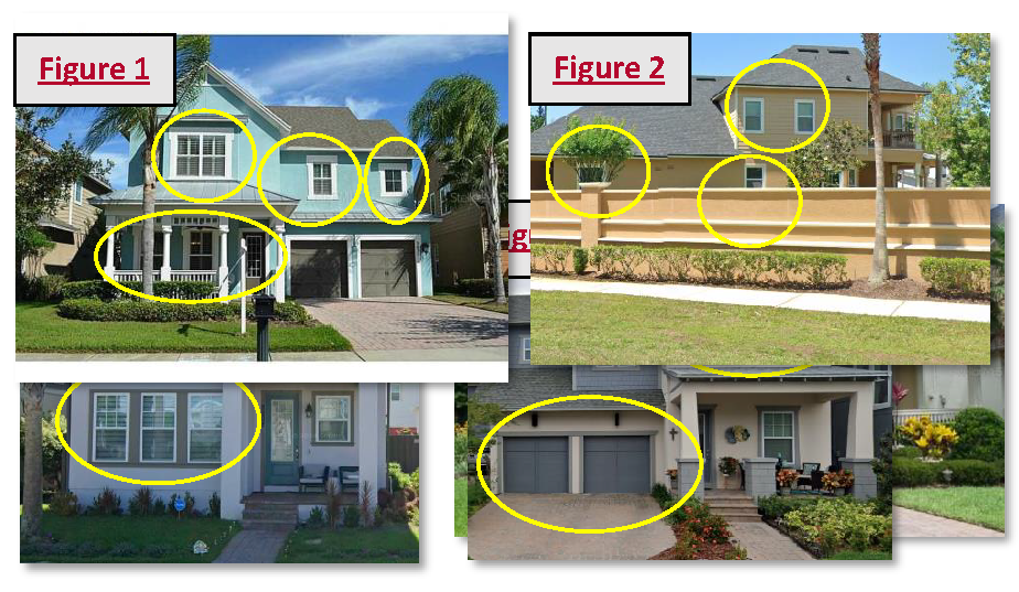
i.
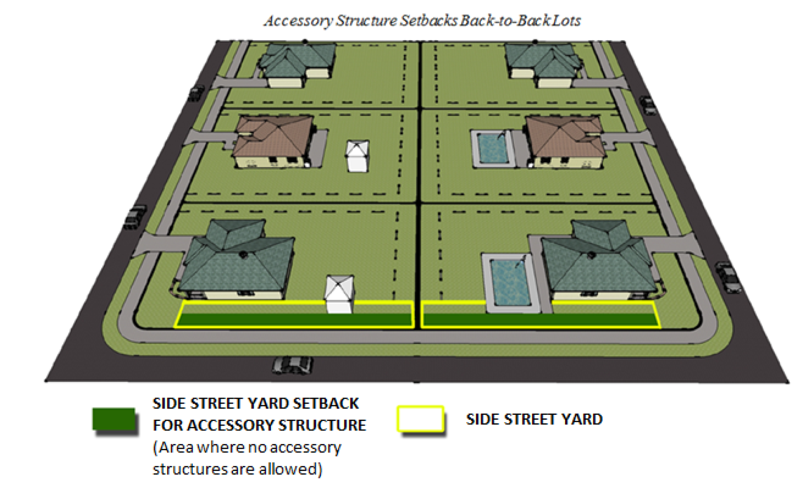
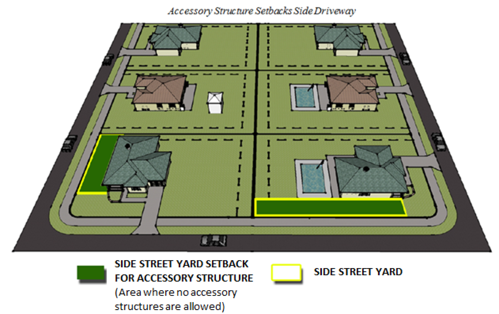
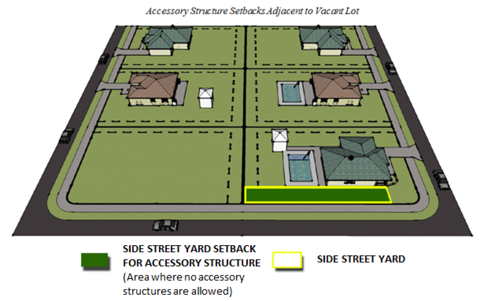
Window and door fenestrations on all sides of structures located along the perimeter of the development or facing a right-of-way. See Figure 1 and 2.
ii.
Contrasting color schemes used to create visual depth around windows, doors and building corners. See Figure 3 and 4.
iii.
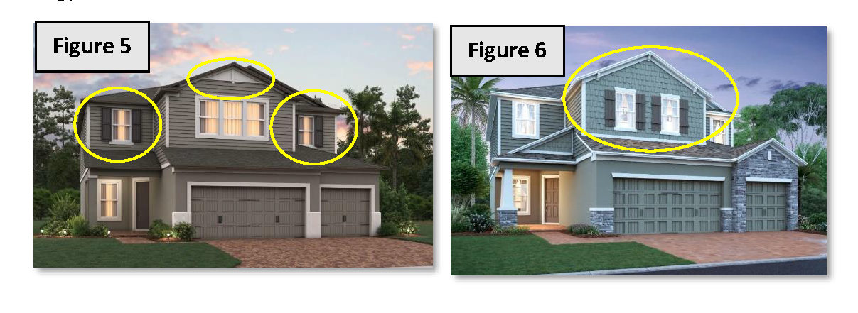
A minimum of one principal window treatment on every elevation (front, side or rear) that faces any right-of-way (public or private) or open space area that may include, but is not limited to: pop-outs, decorative wrought iron, wood trim, shutters, plant shelves, and other features or embellishments to vary and soften the visual exteriors. See Figure 5 and 6.
iv.
All outdoor mechanical equipment, such as heating, air conditioning ventilation systems, propane gas tanks, pool equipment and other similar appurtenances shall be located in rear yards on lots with lots less than 7.5 on side yard. They shall not be adjacent to the right-of-way whenever possible; if such appurtenances are visible from the right-of-way they shall be visually screened.
b.
In addition to the require features in 1.a above, a minimum of three of the following design features shall also be required:
i.
Enhanced corners (pop-outs, embellishments, varying textures etc.) See Figure 7.
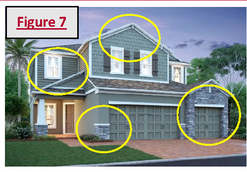
ii.
Deep recessed garages. See Figure 8 and 9.
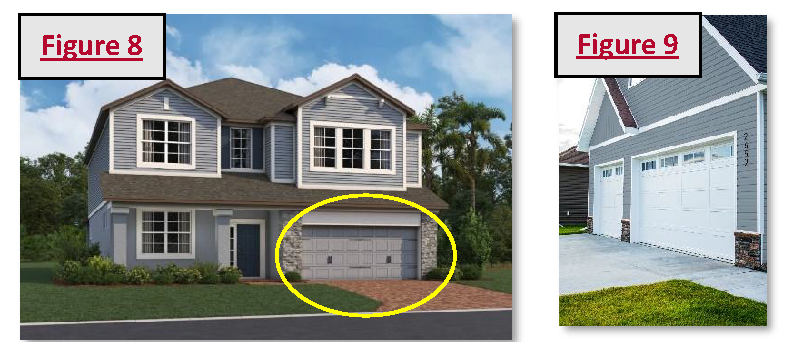
iii.
Low roof (first story roofs on multi-level structures). See Figure 10 and 11.
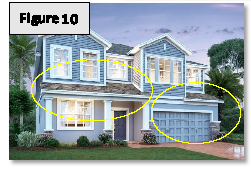
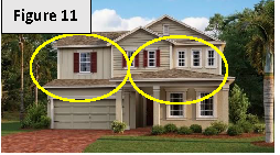
iv.
Second story of structure stacked at a greater setback than the first floor to facilitate a first-floor feature, especially located immediately above the garage. See Figure 12.
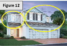
v.
Offset garage doors. See Figure 13 and 14.
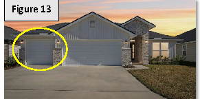
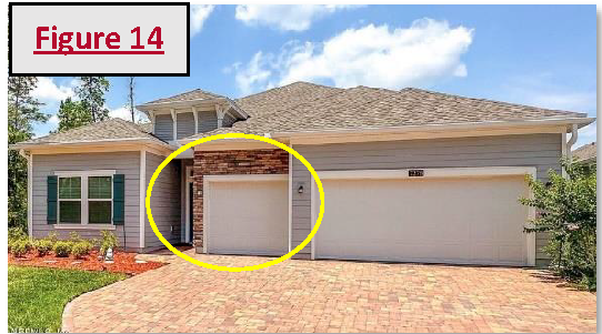
vi.
Extended roof overhangs. See Figure 15.
vii.
Enhanced window fenestrations on all front elevations and all second story windows facing a right-of-way or open space area shall use principal window treatments. See Figure 16.
viii.
Covered patio, and/or balcony option. See Figure 17 and 18.
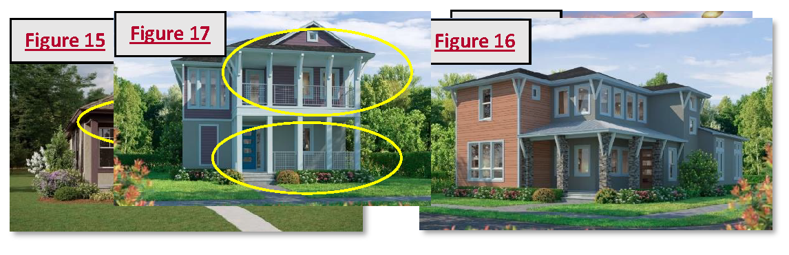
(2)
Streetscapes.
a.
Sidewalks meeting city standards shall be installed on both sides of the right-of-way.
b.
A minimum of two pedestrian connections to nodes such as trail system, public facilities, transit stops, or a public street network to promote connectivity.
c.
Lighting shall be required along property line along any open underdeveloped right-of-way leading up to entry of subdivision.
d.
Decorative street lighting—Street and site lighting shall be decorative and blend with the architectural style of the development. Sufficient lighting shall be provided consistent throughout the PUD minimizing adverse impacts such as glare and overheard sky glow.
e.
All trees planted near sidewalks shall be planted with deep root barriers to prevent cracked pavements and/or sidewalks; planting trees with tap roots rather than fibrous roots will help eliminate cracking. Trees shall comply with Table 110-7 Approved Plant Species List.
(3)
Perimeter landscaping. Landscaping shall comply with section 110-808. In addition, a masonry wall, a minimum four feet in width, shall be constructed along al subdivision perimeter unless otherwise negotiated.
(4)
Tree protection. It is prohibited and unlawful to remove or in any way damage any protected tree without first obtaining an arbor permit from the city.
a.
A historic tree is any tree of any size or protected species that has been designated by the city commission as one of notable historical interest and value to the city because of its location or historical association with the community.
b.
A specimen tree is any tree of any protected species with a diameter of 36 inches or greater. The applicant for a permit to remove a specimen tree shall provide findings to the administrative official that the tree is a hazard or that is not economically practically feasible to develop the subject parcel without removing the tree.
c.
The PUD design must attempt to preserve specimen and historic trees.
d.
No permit for the removal of a protected tree shall be granted unless the developer demonstrates one or more of the following conditions.
i.
A permissible use of the site cannot reasonably be undertaken unless specific trees are removed or relocated.
ii.
The tree is located in such proximity to an existing or proposed structure that the safety, utility or structural integrity of the structure is materially impaired.
iii.
The tree materially interferes with the location, servicing or functioning of existing utility lines or services.
iv.
The tree creates a substantial hazard to motor, bicycle or pedestrian traffic by virtue of physical proximity to traffic or impairment of vision.
v.
The tree is diseased, insect ridden, or weakened by age, abuse, storm or fire and is likely to cause injury or damage to people, buildings or other improvements.
e.
Removed protected trees shall be replaced at a 3:1 ratio with Florida Department of Agriculture Nursery Grade No. 1 or better at the expense of the developer.
(5)
Detention and retention ponds. The following landscaping is required:
a.
A decorative and functional fountain shall be installed in all wet retention ponds as part of development approval which approval shall provide for ongoing maintenance requirements and responsibilities upon the appropriate party, but not the city.
b.
Pond configuration shall be incorporated into the natural topography of the site. When not practical, the pond shall be shaped to emulate a natural formed "free form" depression and shall be part of the natural landscape and recreation open system of the PUD.
c.
Plantings shall replicate a natural environment trees and shrubs shall be clustered around the basin and contain a variety of plant material.
d.
Trees and shrubs shall be planted in a natural pattern and are not limited to strict placement along the edge of the pond. Trees and shrubs planted below the water line of the pond must be tolerant of wet or moist soil conditions.
e.
Plantings shall be provided as determined by staff review and city commission approval.
(6)
Passive and active space requirements. For higher density and smaller residential lots, passive and active space requirements shall be provided based on the following lot sizes:
a.
Common, usable passive and active open space shall be provided per each residential unit based on the following lot sizes:
i.
Lots 5,000 square feet or greater—200 square feet per lot.
ii.
Lots 4,000 to 4,999 square feet—400 square feet per lot.
iii.
Lots 3,999 or less square feet—600 square feet per lot.
b.
Passive and active space shall not include improvements required by code including but not limited to the following: require street landscaping, drives or driveways, streets and sidewalks, parking lots, retention ponds, canals, ditches and drains, and utility or service areas. Buffer and entrance landscaping shall not be included in the open space calculation.
c.
Types of passive and active space. Recreation common open space must provide active recreation open space areas designed for recreation (i.e., picnic area, children's play areas, etc.), but may additionally include passive open spaces. Recreation common open spaces may be comprised of one or more of the following and shall be accessible to all of the residential units it serves:
i.
Courtyard.
ii.
Dog park.
iii.
Nature trails.
iv.
Tot lots.
v.
Large lawn area, pocket parks; mews.
vi.
Playground.
vii.
Tennis court/Pickle ball.
viii.
Basketball court.
ix.
Swimming pool.
x.
Splash pad.
xi.
Similar outdoor recreation facilities as approved by the city commission.
d.
Greenways, courtyards and open space shall have a minimum 40 feet average width, with a minimum 20 feet dimension.
e.
A pedestrian pathway wall, a minimum five feet in width, shall be provided within the common open space.
f.
Open space shall be recorded as separate tracts owned and maintained by a homeowners association created in accordance with controlling law.
g.
Alternative amenities may be considered in lieu of the required minimum lot size calculations if determined to enhance the overall design and quality of the development.
(k)
Commercial planned unit development regulations. The following regulations shall apply to all commercial planned unit developments (CPUDs):
(1)
All CPUDS shall at a minimum have two principal buildings or two principal uses on site to qualify as a PUD.
(2)
Uses permitted in CPUDS as per Table XX.
(3)
Floor area ratio calculations and ground coverage shall be provided to determine scale, density and impact of the project
(4)
When abutting any residential land use or zoning district, the PUD should provide for landscape buffers along the entire common boundary with the residential land use or zoning district. The visual screen should be of sufficient width and elevation so as to afford an effective visual barrier and transition between land uses.
(5)
Within the CPUD, pedestrian movement and safety shall be given priority. Internal roadways shall be "pedestrian friendly" including the use of pavers, wide sidewalks, narrow vehicular lanes and parallel or angled parking. Major parking areas shall be located to encourage walking and discourage internal vehicle trips among the various buildings and uses.
(6)
No parking shall be permitted in the front yard of any structure constructed on an individual lot unless such parking area is landscaped with trees, shrubs and grass island to prevent the appearance of open parking lots.
(7)
Lighting shall be designed and located so as to prevent glare onto adjacent properties or nearby roadways and yet afford a well-lighted site.
(8)
Street frontage shall be landscaped except for curb openings.
(9)
Truck loading/unloading areas shall be screened by architectural and/or landscape elements consistent with the design of the structure.
(10)
Architectural style is important and shall follow architectural design guidelines.
a.
A consistent architectural them including, but not limited to, scale, colors, textures and materials shall be required.
b.
Setbacks within the project shall be determined at the time or project review to encourage an urban pedestrian scale.
c.
Setbacks to adjacent properties shall be the larger of the existing underlying zoning district or the adjacent district, whichever is larger.
d.
Outdoor uses and public places shall be designed to connect various buildings and promote pedestrian activity. Active use of the public spaces is desired to encourage increasing average length of stay within the project area.
e.
First floor facades shall be "active" to encourage pedestrian traffic throughout the project area.
f.
Signage shall be at a scale and aesthetic design appropriate to the size and type of project.
g.
Streetscape design shall compliment and be consistent with the project's architectural theme.
(11)
A maintenance plan for all common areas including but not limited to, parking, sidewalks, public plazas, building facades and programming shall be required as part of the approval of the project.
(l)
Industrial planned unit development regulations. The following regulations shall apply to all industrial planned unit developments (IPUDs):
(1)
An IPUD shall be designed and organized to encourage a combination of multiple industrial uses, compatible uses or tenants that complement each other.
(2)
Uses permitted in IPUDS as per Table XX.
(3)
All IPUDs shall at a minimum have two principal buildings or two principal uses on site to qualify as a PUD.
(4)
Design guidelines shall be required establishing development standards for the proposed development, including illustrations of proposed architectural, urban design, streetscape, and landscape concepts, thematic design elements such as architectural materials, building colors and landscape plans, any proposed variation from the design standards or guidelines contained in this section.
a.
Floor area ratio calculations and ground coverage shall be provided to determine scale, density and impact of the project.
b.
A description of the allowable uses.
c.
An accessibility plan showing means of ingress and egress to adjacent thoroughfares.
d.
Setbacks and buffer yards for the project shall be determined at the time of project review to ensure compatibility with and protection of adjacent uses.
e.
A uniform sign plan for the development shall be included in the design guidelines. Signage shall be at a scale and design appropriate to the size and type of project.
f.
A consistent architectural theme including, but not limited to, scale, colors, textures and materials shall be required. Streetscape designs hall compliment and be consistent with the project's architectural theme.
g.
A plan or design for the screening of outdoor uses.
h.
A maintenance plan for all common areas including but not limited to, parking, sidewalks, public plazas, building facades and programming shall be required as part of the approval of the project.
(5)
No building or structure, or part thereof, shall be erected or used, in whole or in part, in any manner that is obnoxious, objectionable, a nuisance or a hazard to adjoining properties, as it relates to sound, vibrations, odors, glare, material, smoke and particular matters.
(6)
When abutting any residential land use or zoning district, the PUD should provide for landscape buffers along the entire common boundary with the residential land use or zoning district. The visual screen should be of sufficient width and elevation so as to afford an effective visual barrier and transition between land uses.
(7)
Street frontage shall be landscaped except for curb openings.
(8)
Truck loading/unloading areas shall be screened by architectural and/or landscape elements consistent with the design of the structure.
(m)
Mixed-use planned unit development regulations. The following regulations shall apply to all mixed-use planned unit developments (MUPUDs):
(1)
Uses in a mixed-use planned unit development shall consist of two or more uses.
(2)
The vertical mixing of residential uses with nonresidential uses within a single project or building, with residential development is required. The horizontal mixing of stand-alone residential developments and adjacent stand along nonresidential may be provided by the city commission, provided the development are well integrated in terms of complementary uses, access and circulation and compatible design. See Figure 19 and 20.
(3)
Stand-alone uses within a mixed-use project shall be integrated with an overall project design and connected to other adjoining uses by plazas, promenades, and landscape corridors.
(4)
Additional or stand-alone auto oriented uses (i.e., gasoline filling stations, automotive repair and servicing, automotive sales, care washes, self-storage facilities, large retail establishments, uses with drive through service) are prohibited.
(5)
A mixed-used project shall include a minimum amount of commercial building areas as follows:
(6)
Within the MPUD, pedestrian movement and safety shall be given priority. Internal roadways shall be "pedestrian friendly" including the use of pavers, wide sidewalks, narrow vehicular lanes and parallel parking. Major parking areas shall be located to encourage walking and discourage internal vehicle trips among the various buildings and uses.
(7)
Parking garages, loading docks, and service areas shall be directly accessible from major roadways and appropriately screened to promote a pedestrian scale and safety.
(8)
Architectural requirements.
a.
A consistent architectural theme including, but not limited to, scale, colors, textures and materials shall be required.
b.
Setbacks within the project shall be determined at the time of project review to encourage an urban pedestrian scale.
c.
Setbacks to adjacent properties shall be the larger of the existing underlying zoning district or the adjacent district, whichever is larger. The design of the project shall be required to consistent with adjacent uses and structures.
d.
Outdoor uses and public places shall be designed to connect various buildings and promote pedestrian activity. Active use of the public spaces is desired to encourage increasing average length of stay within the project area.
e.
First floor facades shall be "active" to encourage pedestrian traffic throughout the project area.
f.
Signage shall be at a scale and aesthetic design appropriate to the size and type of project.
g.
Streetscape design shall compliment and be consistent with the project's architectural theme.
(9)
A maintenance plan for all common areas including but not limited to, parking, sidewalks, public plazas, building facades and programming shall be required as part of the approval of the project.
(Ord. No. 05-2025, § 2(Exh. A), 4-7-25)
Sec. 110-320. - EO, Enterprise Commercial Overlay District.
(a)
Purpose. Gateway corridors serve as primary entrances to the city. The Enterprise community has recognized historical significance. The purpose of this section is to ensure the design of non-residential sites, landscaping, site appurtenances, and building architecture at the gateways to Deltona and Enterprise along Doyle Road, DeBary Avenue, and Enterprise Road near and within the Enterprise Community is consistent with the historical character of Enterprise. Gateway areas are the area within a one-quarter-mile radius of the intersection of I-4 and DeBary Avenue, and the area within a one-quarter-mile radius of the intersection of Providence Boulevard with Doyle Road/DeBary Avenue.
(b)
Basis guidelines, elevated guidelines, and applicability. Basis guidelines consist of existing, or hereafter amended, development guidelines presently contained in the City Code of Ordinances and/or Land Development Regulations.
Elevated guidelines consist of development guidelines hereafter set forth in sections 110-320(c) and 110-320(d). In case of a conflict in the applicability of guidelines, the most stringent and restrictive shall apply.
(c)
Elevated architectural guidelines.
(1)
Applicability. The architectural guidelines shall apply to all new development and redevelopment within the Enterprise area, and gateways to both Deltona and the Enterprise community, except for additions, renovations, replacement or redevelopment of an existing structure or project, where the cost of such additions, renovations, replacement or redevelopment does not exceed 50 percent of the value of the existing structure(s), or 35 percent of the square footage of the existing structure(s), unless the use of the structure(s) or project has ceased for a period of more than 365 consecutive days, or unless cumulative additions, renovations, replacement or redevelopment initiated during any five-year period meet the thresholds listed above, whereupon the provisions herein shall apply.
(2)
Submittal and approval requirements. The architectural guidelines shall be monitored and enforced by the city. All development proposals shall be submitted to the city for approval in accordance with all applicable laws, rules, and ordinances. No development proposal shall be submitted to the city that does not comply with all applicable requirements. Deviations from these requirements shall require a variance approved by the city commission in accordance with the ordinance procedures and standards for zoning variance.
(3)
Elevated guidelines (appearance criteria). Compliance with the intent, guidelines and provisions of this article shall be as provided for below:
a.
Architectural style and application. It is the intent of this article to ensure a harmonious streetscape and compatibility between structures within the Enterprise Road/Doyle Road/DeBary Avenue corridors, and at the Deltona/Enterprise gateways at the intersections of Deltona Boulevard and DeBary Avenue and Providence Boulevard with Doyle Road and DeBary Avenue, sympathetic and respectful of commercial structures in and around Enterprise, which will serve as a guide for the aesthetic of new development. The styles that accomplish this are the Florida Cracker, a subset of the Florida Vernacular, and the Florida Victorian. (Examples of Interpretation, Figure 1.)
1.
Structures shall reflect similar styles, materials, details, and colors.
2.
In the, the following guidelines shall be implemented for new structures and renovations.
3.
All construction shall conform in street orientation and massing to pre-approved site plan.
b.
Building mass.
1.
For structures less than 5,000 square feet in gross building area on the ground floor, no uninterrupted horizontal length of a building facade shall exceed 20 linear feet.
2.
For structures greater than 5,000 square feet in gross building area on the ground floor, no uninterrupted horizontal length of a building facade, (defined as the front of a building), shall exceed 35 linear feet.
3.
Blank wall areas for each floor-to-floor relationship (those without relief or uninterrupted) shall incorporate the use of landscaping to break up the monolithic appearance of such areas. Blank wall areas uninterrupted by landscaping shall not exceed ten feet in vertical direction or 20 feet in horizontal direction of any building facade.
4.
Elements acceptable for the interruption of blank wall surfaces are belt courses, trim bands, and related horizontal and vertical recessed and protruding elements.
5.
For structures where verandahs, (defined as a usually roofed open porch on the exterior of the building), have been included, a change from grade to finish floor of structure of 12 inches will be included in the design.
c.
Design detail. Buildings shall be designed to enhance the attractiveness of the city's streetscape. Buildings shall, through use of architectural details and scale, have architectural features and patterns that provide visual interest from the perspective of the pedestrian and the motorist. The following techniques shall be incorporated into building design in order to accomplish such requirements (see Illustration No. 2):
1.
All buildings shall be required to provide the following exterior design elements:
a)
Canopies or porticos, integrated with, and responsive to, building massing and style at entryways—see 1.1.3.3(D).
b)
Trim elements of appropriate materials and profiles at entries and fenestration.
2.
Building elevation configurations and techniques: For structures greater than 5,000 square feet in gross building area on the ground floor, eaves, cornices, facades shall include detailing, (i.e., raised access bands, cap elements, etc.), emphasizing horizontal lines.
3.
Windows (may be active or fixed) shall be placed along at least 50 percent of any facade that is visible from a public right-of-way. Windows shall be recessed (set to the inside of the building face wall) and shall include prominent sills and some form of framing or trim as outlined below. (Examples of Interpretation, Figure 2)
a)
Windows at street level elevation shall be un-tinted.
b)
Windows shall be of square, vertical proportion, or horizontal.
c)
Windows shall be divided lite (true or simulated). Picture pane and storefront glazing will not be allowed.
• Simulated division of windows requires full profile muntin's, (defined as the strip separating panes of glass in a sash).
• Windows immediately adjacent to commercial entrances shall have a sill height of between 12 inches and 36 inches above finish floor.
• No window on any facade shall be lower than 12 inches above finish floor.
d)
One accent window with decorative glass per building facade may be circular or hexagonal. Additionally, each facade of a cupola or entry tower may act as a facade for this window type, i.e., a six-sided cupola may have six accent windows of circular of hexagonal shape.
e)
Windows in stucco or wood facades shall have molded or squared casings, respectively, keeping with the architectural style of the structure.
f)
Windows in brick facades shall be trimmed with brick moldings but not cased. Windows in brick facades shall have either brick jack or segmented arches and classic brick sills, preferably a molded shape, not rowlock or headers.
g)
Palladian semi-circular window arches are not allowed.
h)
Retail frontages, which require storefront styled window areas, can use exposed steel, or aluminum clad in wood.
d.
Entryways/customer entrance design. Entryways shall be designed to provide project focal points. Entryways shall be designed in accordance with the techniques listed below. In the event that the entryway is not oriented toward the major road that, as determined by the city, provides access to the building, the side of the building facing such road shall also be designed to comply with item a. below.
1.
Entryways shall be differentiated from the remainder of the facade through at minimum the use of color, change in materials, application of architectural features (arches, columns, colonnades, etc.), setbacks, offsets, level changes and the like.
2.
Entryway design shall incorporate landscaping, landscape planters or wing walls with landscaped areas.
3.
Entryway areas shall be provided with structural or vegetative shading features and benches or other seating components.
e.
Building orientation. Buildings shall be oriented so as to enhance the appearance of the city's streetscape. This requirement shall be met by incorporating the following techniques into project design and shall be approved in site plan development review.
1.
Buildings shall be designed and oriented, so the entrance is visible from the public road from which driveway access is provided.
2.
Either each the building's primary facade shall face parallel to the public road from which driveway access is provided, or each facade, which is clearly visible from a public right-of-way, or public area of adjoining properties shall be designed with full architectural treatment.
3.
Building orientation shall be such that service areas are placed out of view from public rights-of-way, parking areas and adjacent properties. Structural screening and/or landscape screening to comply with these guidelines shall be used to visually encapsulate service areas.
f.
Exterior materials and colors. Exterior building materials and colors contribute significantly to the visual impact of a building on a community, which, in turn, individually and collectively reflect upon the visual character and quality of a community. In order to project an image of high-quality city aesthetics, building materials and colors shall conform to the following requirements (Examples of Interpretation, Figure 3):
1.
All buildings shall be faced with materials that exhibit a durable, high-quality appearance.
2.
Materials shall be of a low maintenance type, retaining a consistent, clean appearance.
3.
Generally accepted exterior facing materials shall relate to the mass of the structure and be prioritized in their use based on square footage as follow:
a)
For structures less than 5,000 square feet in gross building area on the ground floor acceptable materials shall include on all facades that are or will be exposed to the general public:
(1)
Brick.
(2)
Cellulose fiber-reinforced cement building boards.
(3)
Stone.
(4)
Stucco, if used shall be flat finish or sand finish.
(5)
Wood.
b)
For structures greater than 5,000 square feet in a gross building area on the ground floor acceptable materials shall include on all facades that are or will be exposed to the general public:
(1)
Brick.
(2)
Cellulose fiber-reinforced cement building boards.
(3)
Stone may be used at foundations and structural pier locations.
(4)
Stucco, if used shall be flat finish or sand finish.
(5)
Wood.
c)
Two wall materials may be combined on any facade, up to all four facades, horizontally. The visually heavier facade material must be below and can cover the first third of the overall wall height only.
4.
Exterior colors shall not be specifically limited but shall be consistent with historically appropriate tones and hues, as is consistent with paint manufacturer's produced palettes of historic colors and combinations on file with city staff. Variation from established combinations should be discouraged. Corporate colors not included on historic palettes, shall be limited to logo signage only.
5.
Building materials and colors shall be consistent around the entire building.
6.
Metal building structures are acceptable if clad in the approved materials as outlined above.
g.
Reserved.
h.
Roof design and materials. Roof features shall be in scale with the building's mass and complement the character of the structure, developments, and neighborhoods. Roofs shall be constructed of durable, high-quality materials in order to enhance the appearance and attractiveness of the community. Roofs shall incorporate the design elements and materials listed below: (Examples of Interpretation, Figure 4).
1.
For structures less than 5,000 square feet in gross building area on the ground floor the design of roof structures shall be of flat, hip, or gable. If roof surface is visible, hipped, or gabled, the material shall be metal standing seam or "V" crimp.
2.
For structures greater than 5,000 square feet in gross building area on the ground floor the design of roof structures shall be flat with parapet wall. The parapet wall and cornice shall include decorative caps and brackets that do not act as waterproofing elements.
3.
Parapets when provided will be broken with a minimum of one-stepped pediment articulated with a centered entry below or no more than two per 50 feet of length centered on a main entry below and centered over side windows.
4.
Roof-like appurtenances such as false roofs, parapets and other similar features may be allowed if, such features are required for mechanical equipment screening or acoustical control that cannot be accomplished through utilization of approved roof styles. Application of such-roof like features shall be accomplished in such a manner as to minimize the appearance of a flat roof design.
5.
Roofs shall be designed to be of such height, bulk, and mass so as to appear structural even when the design is non-structural.
6.
Cupolas shall only be included on roof structures when windows are for natural light illumination of a space beyond or through louver venting of an attic volume.
7.
If the use of a flat roof is desired, the exterior of the building shall be clad in brick or stucco.
i.
Fence and wall design. Design and construction quality of fences and non-building walls are important visual reflections of community character and quality. In order to promote quality site aesthetics, fence and wall design and construction shall comply with the following requirements:
1.
Fences and walls, whether required for project approval or whether incorporated into overall project design, shall be designed as an integral part of the principal structure(s). Such design shall include the use of similar materials, colors and finishes as the principal structure.
2.
Fences and walls shall be architecturally designed with offsets, raised elements and landscape pockets to avoid an expansive monolithic appearance.
3.
Chain link fencing, plastic fencing panels, and vinyl fencing is not permitted.
j.
Perimeter planting. Plantings located around the perimeter of buildings enhance site aesthetics and increase green space. All projects shall incorporate perimeter plantings into project design in accordance with the requirements listed below:
1.
This section supplements and does not supersede the city Landscaping Code requirements. All minimum requirements of the city Landscaping Code must be met, notwithstanding anything to the contrary that may be contained in this section.
2.
Perimeter landscape plantings shall be located adjacent to the primary facade(s) and along any blank facade wall areas that are, or will be, exposed to the general public. Such plantings shall also be included at entrance areas, plazas, and courtyards.
3.
Perimeter landscaping shall consist of a combination of trees, palms, shrubs, and ground covers. Planting material type, size and spacing shall, at a minimum, be consistent with the requirements of the city's tree and landscape ordinance.
k.
Screening of mechanical equipment. Lack of, or inadequate screening of, mechanical equipment can have negative visual impacts on the city's streetscape, ambient landscape, or community image. Such impacts shall be minimized through compliance with the following requirements:
1.
Mechanical equipment located on the ground, such as air conditioning units, heating units, satellite dishes, irrigation pumps, propane tank displays and refilling areas, utilities lift stations, and the like shall be screened from public view. Screening shall, at a minimum, be at the same height as the equipment. Structural screening shall be architecturally integrated into the overall project design and shall be compatible, in terms of style, construction materials, colors, and finish, with the principal structure(s). Landscaping may be substituted for structural screening if plantings are compatible with the landscape plan for the project and are of such size and maturity as to be able to provide a fully opaque screen at time of planting.
2.
Equipment and appurtenances mounted on rooftops shall be kept to a minimum. All exposed rooftop mounted equipment and appurtenances shall be fully screened from view from any public right-of-way. All screening shall, at a minimum, be at the same height as the equipment and appurtenances. Screening shall be an integral part of the design of the building(s) and shall be architecturally consistent with the style, colors, construction materials and finish of the building(s).
l.
Lighting. Lighting fixture design and placement are important components of an attractive urban environment as well as important to public safety. In order to enhance site aesthetics and minimize visual distraction, yet maintain adequate public safety, project lighting shall comply with the requirements listed below:
1.
An exterior building and site lighting master plan detailing areas and structures requiring illumination, lighting fixture styles, light source and light levels shall be included as part of a project's submittal for approval.
2.
Recessed lighting fixtures shall be required in order to conceal the actual light source, reduce glare, and direct light to specific areas while shielding other areas.
3.
Lighting of parking areas, access drives and vehicular circulation areas shall follow LDC section 110-828.
4.
Neon lighting and fiber optic lighting, signs, or company logos/slogans, or neon or fiber optic lighting of any use is not permitted.
5.
Building illumination and architectural lighting shall be indirect and with no visible light source.
6.
Ground level light fixtures shall be of the burial vault type or shall be fully screened by landscaping materials.
7.
Lighting fixtures will not create ambient lighting or trespassing lighting scenarios.
m.
Utilities. The location and aesthetic treatment of utilities is an important factor in creating an attractive urban environment. In order to enhance and maintain the image of quality in the urban environment, utilities construction and placement shall comply with the following requirements:
1.
All utility lines, whether new or relocated, shall be installed underground.
2.
Utility conduit and utility panels/boxes shall be painted to match the color of the building on which they are placed. Additionally, panels/boxes shall be located on the same facade considered the service side or entrance.
3.
Water and sewer lift stations, pump houses and similar features shall be located at the rear of the project site and shall be fully screened from view by structural or vegetative means. Where screening is accomplished structural means, such screening shall be compatible in design and color with the main building.
n.
Outdoor storage. Outdoor storage areas are not permitted.
o.
Accessory uses and structures. Structures and uses accessory to principle structures and uses shall be integrated into project design in a manner such that they will not detract from site aesthetics. Such structures and uses shall comply with the requirements listed below:
1.
Accessory structures shall be designed and constructed so as to be compatible, (i.e., similar in style and image), with the architectural design of the principal structure(s). Exterior finishes, colors and materials on accessory structures shall be similar to those used on the principal structure(s).
2.
Outdoor display and sales areas are not permitted.
3.
Site furnishings such as benches, bicycle racks, newspaper racks, trash receptacles and the like shall be compatible with the architectural design of the principal structure. Permanent shopping cart storage shall be contained within the principal structure. Any site furnishings as listed above will be painted black, so as to blend in with the existing landscape and environment.
4.
Except for cellular and other communications towers and antennas that shall be regulated pursuant to chapter 82 of the Code of Ordinances, as it may be amended from time to time, no accessory wireless communications towers or antennas are permitted within these guidelines for the Enterprise Commercial Overlay District to be ground mounted, (i.e., placed on concrete pads with appropriate anchoring systems on grade). Dishes and antennas required for the operation of the principal business will be located on a roof structure and will not be visible from the R.O.W. Such placements shall comply with the following requirements:
a)
For facilities mounted on an existing or new building, the tower, and antenna must be of a color that is identical to, or closely compatible with, the color of the building so as to make them as visually unobtrusive as reasonably possible. In addition, supporting electrical and mechanical equipment shall be screened from view or otherwise camouflaged.
b)
No such wireless telecommunication antennas shall exceed 20 feet in height from the top of the building, existing tower or other structure.
c)
For all wireless telecommunication antennas mounted on an existing building, the maximum height of such antenna's support structure shall not exceed ten feet from the top of the building.
d)
The diameter of roof-mounted dish antennas shall not exceed 12 feet, provided that no such antenna shall be visible as stated in 1.1.3.3(O)4. and the color, location and design shall blend into and not detract from the character and appearance of the building and surrounding properties.
e)
The diameter of a tower-mounted dish antenna shall not exceed four and one-half feet.
f)
Aesthetic effects, devices, and techniques. The purpose of this subsection is to assist the city in determining whether or not a proposed tower is camouflaged and/or concealed appropriately in a given area. The applicant shall submit the following documentation:
(i)
Colorized pictorial representation, artist rendering, or similar representation drawn to scale.
(ii)
Design specifications of the various proposed techniques (if drawings, plans and/or other graphic representations are included, they shall be drawn to scale).
(iii)
A corresponding statement explaining what the nature and character of the area is within which the tower is proposed with respect to land use, surrounding environment, building heights and design, and how the proposed camouflaging and/or concealment agent(s) will blend in and harmonize with the nature and character of the area.
(d)
Elevated site guidelines. Elevated guidelines shall consist of the following:
(1)
Location and design of parking areas. All parking areas and access ways and driveways shall be designed in accordance with the requirements of the zoning and Land Development Code of the city, as they may be amended from time to time. Parking areas shall be located, designed, and visually screened/landscaped so as to minimize potential impacts on adjacent property owners. Parking areas shall be located and designed so as to maximize traffic circulation patterns and minimize traffic hazards.
(2)
Cross access. Driveways, curb cuts, parking and internal roadway/traffic circulation shall be designed so that uninterrupted vehicular access from parcel to parcel is achieved. Cross access easements shall be provided as detailed elsewhere in this section and in the Deltona Land Development Code.
(3)
Pedestrian access. A clear, safe, and convenient pedestrian path shall be provided from the sidewalk along the corridor right-of-way to the main entry door of each principal structure. The pedestrian path shall be functionally delineated by using construction materials that are different than the materials used for the construction of the parking area (e.g., use of brick or concrete for the pedestrian access when the parking lot is an asphalt surface). Sidewalks shall meet the minimum design and construction standards for sidewalks contained in the Deltona Land Development Code, as it may be amended from time to time. Bikeways and other bicycle facilities shall be provided as required by the Deltona Comprehensive Plan and the Deltona Land Development Code, as they may be amended from time to time.
(4)
Lighting. General—Recessed lighting fixtures shall be required in order to conceal the actual source of the light so as to reduce glare and direct the light to specific areas while shielding other areas. Lighting shall be of the metal halide type.
a.
Backlighting—Backlit awnings/canopies are not permitted.
b.
Parking areas—Parking lot lighting shall be designed as follows:
1.
Light poles shall be located only within landscaped strips, interior landscape islands, or terminal landscape islands. Light poles are not allowed in corridor buffers.
2.
Illumination on to adjacent properties shall not exceed one foot-candle.
3.
The maximum height of the light pole shall be 20 feet, including the basis.
4.
The minimum setback of the light source from the property line shall be a horizontal distance of ten feet.
5.
The character of style selected for the Enterprise Commercial Overlay District will be used on all properties for all structures through the entire visible surrounding area of the Enterprise Commercial Overlay District. Examples of acceptable styles are included as Figure 5.
(5)
Outside storage. No outside storage of materials, equipment or merchandise shall be allowed.
(6)
Utilities. All utilities, new or relocated, shall be installed underground. Underground utilities shall be installed in accordance with the procedures and requirements of the City of Deltona Land Development Code, as it may be amended from time to time.
(7)
Screening (roof top). All roof top equipment shall be screened from public view. The screen shall consist of a material, and shall be designed, so as to be compatible and consistent with the building on which the equipment is located and in keeping with the architectural portion of these guidelines.
(e)
Examples of interpretation. Figures referenced in sections 110-320(c) and 110-320(d):
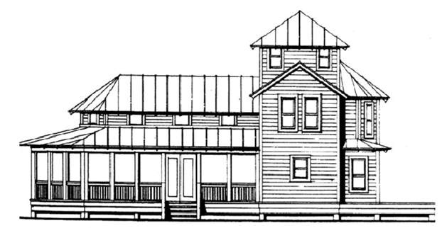
Figure 1 (Referenced in 110-320(c)(3)a.
Architectural Style and Application)
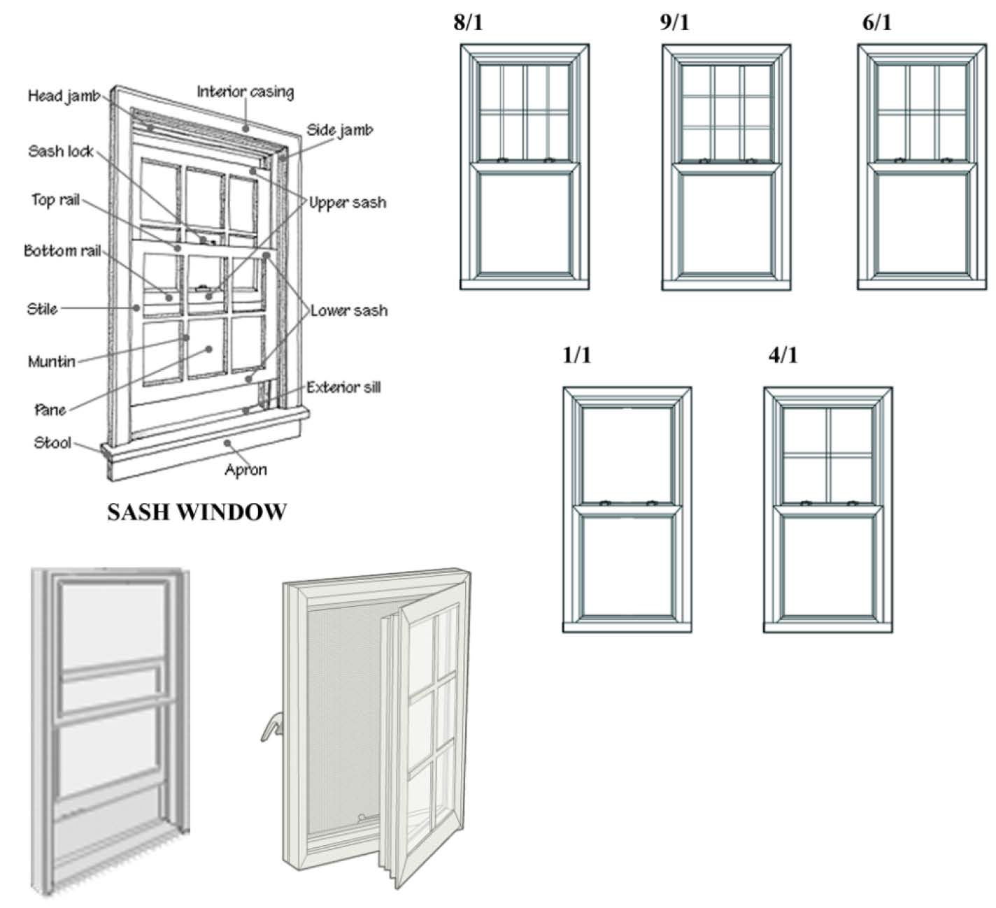
Figure 2 (Referenced in 110-320(c)(3)c. Design Detail)
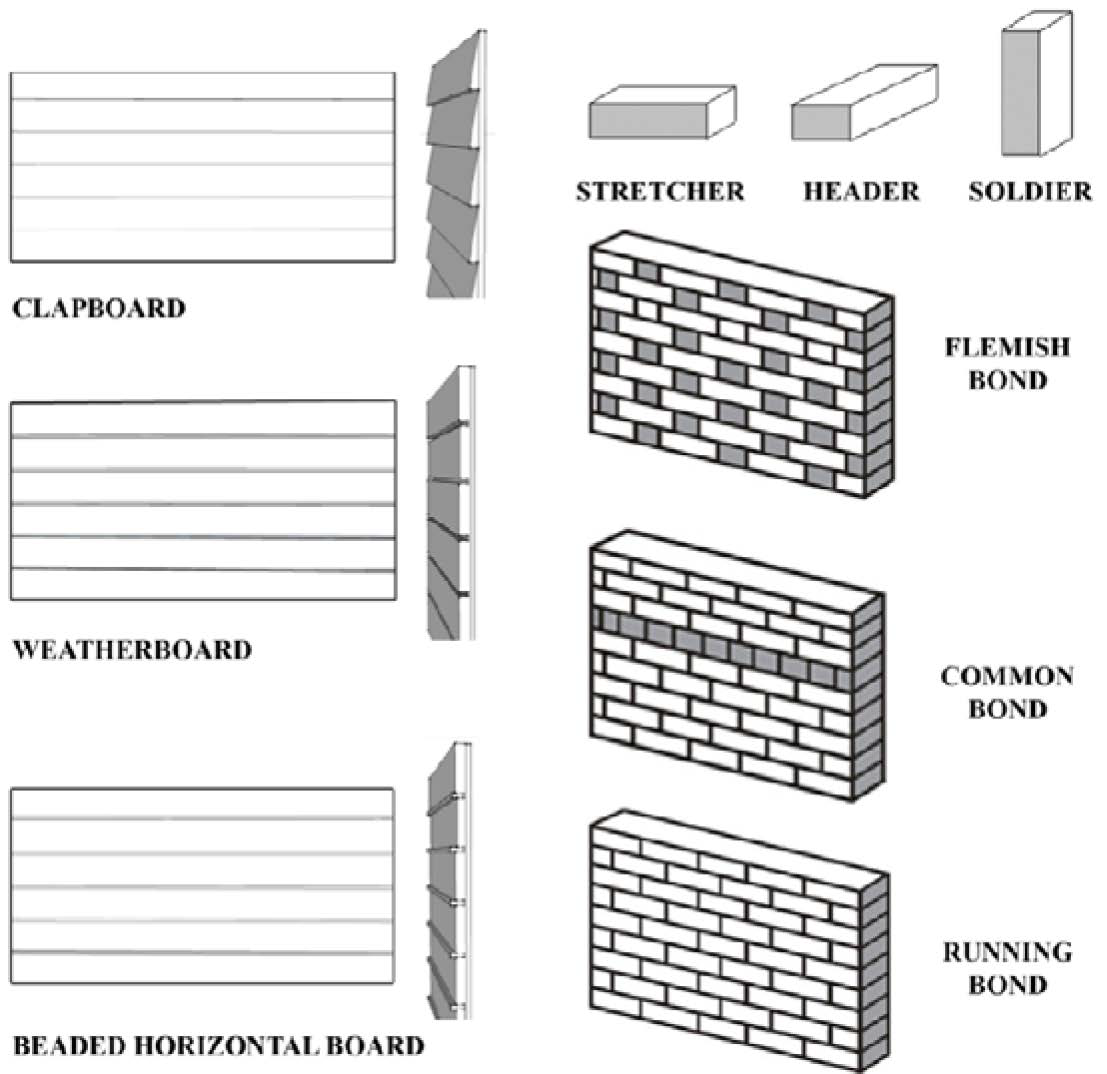
Figure 3 (Referenced in 110-320(c)(3)f.
Exterior Materials and Colors)
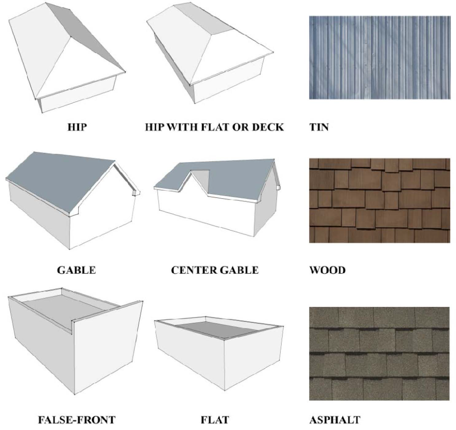
Figure 4 (Referenced in 110-320(c)(3)h. Roof Design and Materials)
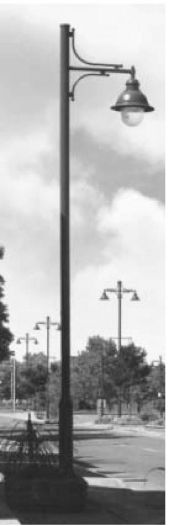
This is an example only for reference of acceptable aesthetic style. This specific style may not be able to meet the city light code.
(Ord. No. 13-2024, § 1(Exh. A), 4-7-25)
Sec. 110-321. - Statutory uses.
Statutory uses: Mixed use multi-family development pursuant to the Live Local Act, F.S. § 166.04151, as it may be amended. For purposes of this section, "mixed use" means a combination of residential uses and their amenities with nonresidential uses, where the percentage of FAR devoted to nonresidential uses is at least 35 percent of the total FAR. The nonresidential uses shall be those uses allowed as permitted or conditional uses provided in the underlying zoning district.
(Ord. No. 02-2025, § 3(Exh. A), 12-13-24)