
Dickinson City Zoning Code
ARTICLE IV
ZONING DISTRICTS
Sec. 18-41.- Establishment of zoning districts and boundaries.
For the purpose of regulating and restricting the use of land and the erection, construction, reconstruction, altering, moving, or use of buildings and structures, the corporate area of the city is divided into zoning districts as follows:
(Ord. No. 420-2001, § 1, 7-24-01; Ord. No. 615-2007, § 2, 7-10-07; Ord. No. 867-2017, § 2, 1-10-17; Ord. No. 884-2017, § 2, 6-27-17)
Sec. 18-42. - Official zoning district map.
The location and boundaries of the various zoning districts are shown on the official zoning district map. The zoning official is responsible for custody of the map and will promptly make any changes approved by the city council. The provisions of an chapter establishing a district, amending a district classification, or amending a district boundary controls over any conflicting information shown on the official zoning district map. The official zoning district map, together with all notations, references and other information shown thereon and all amendments thereto, shall be as much a part of this chapter as if fully set forth and described herein. The official zoning district map, properly attested, is on file in the office of the zoning official and is fully accessible to the public during normal business hours.
(Ord. No. 420-2001, § 1, 7-24-01)
Sec. 18-43. - Interpretation of district boundaries.
Where uncertainty exists with respect to the boundaries of any of the districts shown on the official zoning district map, the following rules apply:
(1)
Where district boundaries are so indicated that they approximately follow the center lines of streets or highways, the street center lines or highway rights-of-way lines are construed to be the boundaries;
(2)
Where district boundaries are so indicated that they approximately follow lot lines, the lot lines are construed to be the boundaries;
(3)
Where district boundaries are so indicated that they are approximately parallel to street center lines or street right-of-way lines, such district boundaries shall be construed as being parallel thereto and at such distance therefrom as indicated on the zoning map. If no distance is given, such dimension shall be determined by the use of the scale on said zoning map or by the ordinance establishing the district boundaries;
(4)
On unsubdivided land or when a district boundary follows no identifiable feature, the location of district boundaries shall be determined by the ordinance establishing the district boundaries or by using the map scale appearing on the official map, unless the district line is indicated by dimensions printed on the official map, in which case the printed dimensions shall control;
(5)
Where streets or alleys on the ground differ from streets or alleys shown on the zoning map, the streets or alleys on the ground control; and
(6)
The zoning official shall interpret the district boundaries in cases of conflict or question.
(Ord. No. 420-2001, § 1, 7-24-01)
Sec. 18-44. - Compliance with district regulations.
No building or structure shall be erected, constructed, enlarged, reconstructed or altered for use nor shall any building, structure or land be used or changed in such a way that it does not comply with all the district regulations established by this chapter for the district in which the building or structure or land is located.
(Ord. No. 420-2001, § 1, 7-24-01)
Sec. 18-45. - New and unlisted uses.
If the zoning official determines that a proposed use is not listed, or if there is ambiguity as to its proper classification within the respective zoning districts, the zoning official shall make an official determination as to the appropriate district or districts for the use. This decision may be appealed by an applicant to the board of adjustment for a final determination as to the appropriate district for the use to be located. In the event the determination requires a text amendment, the proposed use must be sent to the commission and city council for their consideration and action in accordance with the procedures for amending the text of these zoning regulations.
(Ord. No. 420-2001, § 1, 7-24-01)
Sec. 18-46. - Classification of annexed areas.
Within sixty (60) days following the annexation of territory into the corporate limits of the city, the commission shall initiate proceedings to establish permanent zoning classifications for all of the area annexed. Pending completion of such proceedings, the annexed territory shall be classified as "CR" conventional residential district. Such temporary zoning classification shall remain in effect only until the city council establishes the permanent zoning classification. The procedure for establishing the permanent zoning classification of annexed territory shall be as prescribed by Chapter 211, Texas Local Government Code, and this chapter. The zoning classification or classifications assigned to newly annexed territory shall be appropriate to its existing use and consistent with the city's land use and development policies.
(Ord. No. 420-2001, § 1, 7-24-01)
Sec. 18-47. - District and use matrix.
Land and structures in each zoning district may only be used for the listed uses specified as a permitted use in that district as shown in Attachment 1—District and Use Matrix*. In interpreting the District-Use Matrix:
(1)
A blank rectangle below a zoning district designation indicates that the corresponding listed land use is prohibited in that district.
(2)
An "X" in a rectangle below a zoning district designation indicates that the corresponding listed land use is permitted in that district.
(3)
Except as specifically provided herein, all governmental facilities shall be permitted as matter of right in all districts.
(Ord. No. 420-2001, § 1, 7-24-01; Ord. No. 508-2003, § 3, 1-13-04)
*Note—Attachment 1 is not set out herein, but is on file as an attachment to Ord. No. 420-2001.
Sec. 18-48. - Height and area matrix.
The height of structures, lot areas, dimensions and coverage, and yards and setbacks are regulated for each zoning district. Except as provided in article VI, the permitted minimum and/or maximum measures are specified in Attachment 2—Height and Area Matrix*.
(Ord. No. 420-2001, § 1, 7-24-01)
*Note—Attachment 2 is not set out herein, but is on file as an attachment to Ord. No. 420-2001.
Sec. 18-48.1. - Designated open space "DOS" district.
The zoning of property as "DOS," designated open space, is intended to provide open space for outdoor recreational activities. The purpose of the "DOS" district is to create an aesthetically pleasing environment that may improve the quality of life for the citizens, enhance property values, provide adequate light and air space, prevent overcrowding of land, provide visual buffering between roadways and structures, and promote the beautification of the city.
(a)
Permitted uses. No building, structure or land shall be used, and no building or structure shall be erected, constructed, reconstructed, moved or altered except for one (1) or more of the uses identified below, subject to all applicable provisions of these zoning regulations.
(1)
Playgrounds;
(2)
Meditation areas;
(3)
Gardens;
(4)
Walking trails made of porous material;
(5)
Picnic tables;
(6)
Park benches;
(7)
Lighting for security purposes;
(8)
Specific use permitted pursuant to article V hereof.
(b)
Height and area regulations. The maximum height of buildings and structures, the minimum dimensions of lots, setbacks for yards and parking lots, and the minimum lot area per dwelling unit shall be as follows, except as otherwise provided in article VI, supplemental regulations:
(1)
Minimum lot area: No minimum.
(2)
Minimum lot width: No minimum.
(Ord. No. 557-2005, § 3, 8-9-05)
Sec. 18-49. - Rural residential "RR" district.
The zoning of property as rural residential "RR" is intended to provide for conventional detached single-family dwellings at a density not exceeding one (1) dwelling unit per acre. Property zoned "RR" should include existing large lots, un-platted tracts of land, areas where adequate public facilities are not available to support higher density urban development, and areas that are appropriate for large lot development given the surrounding land use and zoning.
(1)
Permitted uses. No building, structure, or land shall be used, and no building or structure shall be erected, constructed, reconstructed, moved or altered except for one (1) or more of the uses identified below, subject to all applicable provisions of these zoning regulations.
a.
Accessory residential uses, as provided in article VII, Accessory and Temporary Uses.
b.
Agricultural use and accessory agricultural uses, subject to all provisions of chapter 4, Animals, of the city's Code of Ordinances.
c.
Conventional detached single-family residences.
d.
Home occupations incidental to a residential permitted use.
e.
Private recreational facilities owned and operated by or on behalf of a residential subdivision or development.
f.
Specific uses permitted pursuant to article V hereof.
(2)
Height and area regulations. The maximum height of buildings and structures, the minimum dimensions of lots, setbacks for buildings and parking lots, and the minimum lot area per dwelling unit shall be as follows, except as otherwise provided in article VI, Supplemental Regulations:
a.
Maximum height of structures. Maximum thirty-five (35) feet from grade or base flood elevation, whichever is higher, subject to development and performance standards.
b.
Minimum lot area. One (1) acre.
c.
Minimum setbacks.
1.
Front: Fifty (50) feet.
2.
Side: Twenty-five (25) feet.
3.
Corner: Thirty (30) feet.
4.
Rear: Fifty (50) feet.
d.
Minimum lot width. One hundred twenty-five (125) feet.
(3)
Development and performance standards.
a.
No off-street parking area or driveway for permitted nonresidential uses shall be within twenty (20) feet of a lot line of property zoned "RR".
b.
Permitted nonresidential structures located at least twenty-five (25) feet from a residential property line may increase height at a ratio of one (1) foot for each additional two (2) feet of setback.
c.
Uses that are proposed for the benefit of or as an amenity to a rural subdivision and not for use by the general public, such as neighborhood pools and clubhouses, shall be located adjacent to a collector street.
d.
Each dwelling, at the time of issuance of a certificate of occupancy, shall have permanent screening around its perimeter to screen from view any openings in the foundation, e.g. pier and beams. All screening materials shall be of durable quality, shall be compatible in appearance with the dwelling, and shall allow for adequate ventilation and drainage.
(Ord. No. 420-2001, § 1, 7-24-01; Ord. No. 900-2018, § 2(Exh. A), 3-13-18)
Sec. 18-50. - Conventional residential "CR" district.
The zoning of property as conventional residential "CR" is intended to provide for conventional detached single-family dwellings. The purpose of the "CR" district is to provide for development of standard low-density residential developments, in areas where adequate public facilities exist, and residential development is appropriate given the surrounding land uses and neighborhoods.
(1)
Permitted uses. No building, structure, or land shall be used, and no building or structure shall be erected, constructed, reconstructed, moved or altered except for one (1) or more of the uses identified below, subject to all applicable provisions of these zoning regulations.
a.
Accessory residential uses, as provided in article VII, accessory and temporary uses.
b.
Agricultural use or accessory agricultural uses on lots of one-acre of more.
c.
Conventional detached single-family residences.
d.
Home occupations incidental to a residential permitted use.
e.
Private recreational facilities owned and operated by or on behalf of a residential subdivision or development.
f.
Specific use permitted pursuant to article V hereof.
(2)
Height and area regulations. The maximum height of buildings and structures, the minimum dimensions of lots, setbacks for buildings and parking lots, and the minimum lot area per dwelling unit shall be as follows, except as otherwise provided in article VI, supplemental regulations:
a.
Maximum height of structures. Maximum thirty-five (35) feet from grade or base flood elevation, whichever is higher, subject to development and performance standards.
b.
Minimum lot area. Six thousand (6,000) square feet per dwelling unit.
c.
Minimum setbacks.
1.
Front.
i.
Twenty-five (25) feet from street right-of-way unless the lot is located within a cul-de-sac.
ii.
In the event that the lot is within a cul-de-sac, the setback shall be allowed at twenty (20) feet from right-of-way.
2.
Side. Five (5) feet.
3.
Corner. Ten (10) feet.
4.
Rear. Fifteen (15) feet.
d.
Minimum lot width.
1.
Except for a fifty-foot-wide lot or lots that were platted before July 24, 2001 or in the case of those dwellings located on a cul-de-sac, each lot shall have a minimum width of not less than sixty (60) feet.
2.
Each lot shall abut a street for a distance of not less than twenty (20) feet.
e.
Minimum lot depth. One hundred (100) feet.
(3)
Accessory structures.
a.
Setbacks. Detached accessory structures shall be located to the rear or to the side of the principal structure and in no case shall any part of an accessory structure be located within the required front yard setback. Except for corner lots, detached accessory structures shall not be less than five (5) feet from any side lot line when the accessory building is located in the rear yard; otherwise, a detached accessory structure shall observe the same side setbacks as specified for the principal structure. Accessory structures shall not be less than eight (8) feet as measured from the rear lot line to the accessory structure provided that the required setback may be reduced to five (5) feet when adjacent to an alley.
b.
Easements. No accessory structures or other obstructions including decks, pools, landscaping structures or trees and fountains may be erected within any utility easement.
c.
Height. Accessory structures shall not exceed a maximum height of eighteen (18) feet at roof eave.
d.
Coverage. Accessory structures shall not occupy more than thirty (30) percent of a required rear yard setback.
e.
No trailers, containers, shipping containers, commercial boxes, vehicles, or similar structures shall be used as accessory buildings.
(4)
Development and performance standards.
a.
Where a lot within the conventional residential district abuts railroad rights-of-way, a high pressure oil or gas line, an arterial street or highway, or a nonresidential district or use, the minimum lot depth shall be one hundred fifty (150) feet. The commission may require a lot depth not to exceed one hundred seventy-five (175) feet, and in the case of a side yard abutting the above features may require a lot width not to exceed two hundred (200) feet.
b.
Agricultural accessory structures shall be located no closer than fifty (50) feet from any lot line.
c.
No off-street parking area or driveway for permitted nonresidential uses shall be within twenty (20) feet of a lot line of property zoned conventional residential.
d.
Permitted nonresidential structures located at least twenty-five (25) feet from a residential property line may increase height at a ratio of one (1) foot for each additional two (2) feet of setback.
e.
Uses that are proposed for the benefit of or as an amenity to a standard low-density subdivision and not for use by the general public, such as neighborhood pools and clubhouses, shall be located adjacent to a collector roadway and within the interior of the subdivision.
f.
Each residential dwelling unit is hereby required to have a garage. Such garage shall be permanently affixed to the land. The minimum floor space for the garage is two hundred fifty (250) square feet.
g.
Each dwelling, at the time of issuance of a certificate of occupancy, shall have permanent screening around its perimeter to screen its foundation, e.g. pier and beams, from view. All screening materials shall be of durable quality, shall be compatible in appearance with the dwelling, and shall allow for adequate ventilation and drainage.
(Ord. No. 420-2001, § 1, 7-24-01; Ord. No. 508-2003, § 4, 1-13-04; Ord. No. 570-2006, § 1, 1-10-06; Ord. No. 901-2018, § 2(Exh. A), 3-13-18)
Sec. 18-51. - Small lot residential "SR" district.
The zoning of property as Small Lot Residential "SR" is intended to provide for conventional detached single-family dwellings on small lots and patio homes with zero lot lines. Zero lot line development allows homes on one (1) side lot line to consolidate yard space and enhance privacy in exchange for an increase in lot coverage. The purpose of the "SR" district is to allow efficient utilization of land, encourage affordable housing opportunities, and allow traditional neighborhood developments.
(1)
Permitted uses. No building, structure, or land shall be used, and no building or structure shall be erected, constructed, reconstructed, moved or altered except for one (1) or more of the uses identified below, subject to all applicable provisions of these zoning regulations.
a.
Accessory residential uses, as provided in article VII, accessory and temporary uses.
b.
Conventional detached single-family residences.
c.
Home occupations incidental to a residential permitted use.
d.
Private recreational facilities owned and operated by or on behalf of a residential subdivision or development.
e.
Patio homes.
f.
Specific use permitted pursuant to article V hereof.
(2)
Height and area regulations. The maximum height of buildings and structures, the minimum dimensions of lots, setbacks for buildings and parking lots, and the minimum lot area per dwelling unit shall be as follows, except as otherwise provided in article VI, supplemental regulations:
a.
Maximum height of structures. Maximum thirty-five (35) feet from grade or base flood elevation, whichever is higher, subject to development and performance standards.
b.
Minimum lot area. Five thousand (5,000) square feet per dwelling unit.
c.
Minimum setbacks.
1.
Front. Twenty (20) feet from street right-of-way.
2.
Side.
i.
Five (5) feet for conventional residences.
ii.
Zero (0) feet on one side and six (6) feet on the other side for patio homes.
3.
Corner. Ten (10) feet.
4.
Rear. Fifteen (15) feet.
d.
Minimum lot width.
1.
Fifty (50) feet.
2.
Fifty-five (55) feet for a corner lot.
e.
Minimum lot depth. One hundred (100) feet.
f.
Lot coverage. Sixty-five (65) percent of lot area, including principal and accessory structures.
(3)
Accessory structures.
a.
Setbacks. Detached accessory structures shall be located to the rear or to the side of the principal structure and in no case shall any part of an accessory structure be located within the required front yard setback. Except for corner lots, detached accessory structures shall not be less than five (5) feet from any side lot line when the accessory structure is located in the rear yard; otherwise, a detached accessory structure shall observe the same side setbacks as specified for the principal structure. Accessory structures shall not be less than eight (8) feet as measured from the rear lot line to the accessory structure provided that the required setback may be reduced to five (5) feet when adjacent to an alley.
b.
Easements. No accessory structures or other obstructions including decks, pools, landscaping structures or trees and fountains may be erected within any utility easement.
c.
Height. Accessory structures shall not exceed a maximum height of sixteen (16) feet at the roof eave.
d.
Coverage. Accessory structures shall not occupy more than thirty (30) percent of a required rear yard.
e.
No trailers, containers, shipping containers, commercial boxes, vehicles, or similar structures shall be used as accessory buildings.
(4)
Development and performance standards.
a.
Where a lot within the small lot residential district abuts railroad rights-of-way, high-pressure oil or gas line, an arterial street or highway, or a nonresidential district, the minimum lot depth shall be one hundred fifty (150) feet. The commission may require a lot depth not to exceed one hundred seventy-five (175) feet, and in the case of a side yard abutting the above features may require a lot width not to exceed two hundred (200) feet.
b.
No off-street parking area or driveway for permitted nonresidential uses shall be within twenty (20) feet of a lot line of property zoned small lot residential.
c.
Permitted nonresidential structures located at least twenty-five (25) feet from a residential property line may increase height at a ratio of one (1) foot for each additional two (2) feet of setback.
d.
Uses that are proposed for the benefit of or as an amenity to a standard low-density subdivision and not for use by the general public, such as neighborhood pools and clubhouses, shall be located adjacent to a collector roadway and within the interior of the subdivision.
e.
Each residential dwelling is required to have a garage. Such garage shall be permanently affixed to the land. The minimum floor space for the garage shall be two hundred fifty (250) square feet.
f.
Each dwelling, at the time of issuance of a certificate of occupancy, shall have permanent screening around its perimeter to screen from view openings in the foundation, e.g. pier and beams. All screening materials shall be of durable quality, shall be compatible in appearance with the dwelling, and shall allow for adequate ventilation and drainage.
(Ord. No. 420-2001, § 1, 7-24-01; Ord. No. 508-2003, § 5, 1-13-04; Ord. No. 902-2018, § 2(Exh. A), 3-13-18)
Sec. 18-52. - High density residential "HR" district.
The zoning of property as high density residential "HR" is intended for various types of residential development, including conventional single- and two-family residences and multiple family dwellings such as duplexes, triplexes, town homes, condominiums, and apartments. The purpose of the "HR" district is to provide for development of quality apartments in a high density setting, while ensuring livability, property values, open space, design quality and landscaping, safety and the general welfare of its residents. This district allows development up to eighteen (18) units per acre.
(1)
Permitted uses. No building, structure, or land shall be used, and no building or structure shall be erected, constructed, reconstructed, moved or altered except for one (1) or more of the uses identified below, subject to all applicable provisions of these zoning regulations.
a.
Accessory residential uses, as provided in article VII, accessory and temporary uses.
b.
Conventional detached single-family residences.
c.
Multiple family dwellings such as triplexes, townhouses, condominiums, and apartments.
d.
Private recreational facilities owned and operated by or on behalf of a residential subdivision or development.
e.
Two-family dwellings.
f.
Specific use permitted pursuant to article V hereof.
(2)
Conventional detached single-family residence. The height, area, and accessory building regulations and standards for development and performance applicable to conventional detached single-family residences shall be as set forth in section 18-50, conventional residential "CR" district.
(3)
Height and area regulations. The maximum height of buildings and structures, the minimum dimensions of lots, setbacks for buildings and parking lots, and the minimum lot area per dwelling unit for two-family dwellings, condominiums, and multi-family dwellings shall be as follows, except as otherwise provided in article VI, supplemental regulations:
a.
Maximum height of structures.
1.
Maximum forty-five (45) feet from grade or base flood elevation, whichever is higher, subject to development and performance standards.
2.
Single- and two-family dwellings: Maximum thirty-five (35) feet from grade or base flood elevation, whichever is higher, subject to development and performance standards.
b.
Minimum lot area.
1.
Two thousand four hundred twenty (2,420) square feet per dwelling unit.
2.
Single-family dwelling unit: Six thousand (6,000) square feet per dwelling unit.
3.
Duplexes: Three thousand six hundred (3,600) square feet per dwelling unit.
c.
Minimum setbacks.
1.
Front: Twenty-five (25) feet.
2.
Side: Ten (10) feet.
3.
Corner: Twenty (20) feet.
4.
Rear: Twenty-five (25) feet.
d.
Lot coverage. Sixty (60) percent of lot area, including principal and accessory structure.
e.
Minimum separation between principal structures. Fifteen (15) feet.
(4)
Accessory structures. Two-family dwelling, condominiums, and multi-family dwellings.
a.
Setbacks. Detached accessory structures shall be located to the rear or to the side of the principal structure and in no case shall any part of an accessory structure be located within the required front yard setback. Detached accessory structures shall observe the same side setbacks as specified for the principal structure. Accessory structures shall observe the same rear yard setback as specified for the principal structure.
b.
Easements. No accessory structures or other obstructions including decks, pools, landscaping structures or trees and fountains may be erected within any utility easement.
c.
Height. Accessory structures shall not exceed a maximum height of sixteen (16) feet at the roof eave.
d.
Coverage. Accessory buildings shall not occupy more than thirty (30) percent of a required rear yard.
e.
No trailers, containers, shipping containers, commercial boxes, vehicles, or similar structures shall be used as accessory buildings.
(5)
General development and performance standards.
a.
Where a lot within the high density residential "HR" district abuts railroad rights-of-way, a high pressure oil or gas line, an arterial street or highway, or a nonresidential district, the minimum lot depth shall be one hundred fifty (150) feet. The commission may require a lot depth not to exceed one hundred seventy-five (175) feet, and in the case of a side yard abutting the above features may require a lot width not to exceed two hundred (200) feet.
b.
Multiple family dwellings with more than ten (10) units shall have an on-site manager or post and maintain in a conspicuous place in such dwelling a legible sign identifying the owner and managing agent, together with the residence and business addresses and telephone numbers of the owner and managing agent. Where the owner is a corporation, the sign shall contain the business telephone numbers of the corporation.
c.
The minimum living area of apartments shall be six hundred fifty (650) square feet for single story apartment units plus two hundred fifty (250) square feet for each additional story.
d.
High-density residential developments shall have frontage and main access directly on an arterial or a collector street.
e.
High-density residential developments shall have a minimum of ten (10) percent of the net site area as common area such as a playground, tennis court, swimming pool, exercise path, or natural preserve area, for use by all persons who reside on the premises.
f.
Uses that are proposed for the benefit of or as an amenity to a high density residential development and not for use by the general public, such as common areas, pools and club houses, shall be located within the interior of the development.
g.
Pedestrian circulation systems (sidewalks and walkways) within high-density residential developments shall be located and designed to provide adequate pedestrian access within the development and to adjacent parcels.
h.
No off-street parking area or driveway shall be within twenty (20) feet of a lot line of property zoned "RR", "CR" or "SR".
i.
All multi-family dwellings shall provide an opaque screen fence or wall of wood or masonry construction not less than six (6) feet in height along all rear and side property lines that are common to property zoned "RR", "CR" or "SR". Screening shall not be required where similar screening exists on the abutting residential property. Off-street parking areas shall be screened in accordance with article VIII, tree protection, landscaping and screening.
j.
All buildings shall be designed and constructed in accordance with the building design standards provided for in article VI, supplemental regulations.
k.
Each residential dwelling unit is hereby required to have some enclosed, lockable area for outdoor storage of bicycles and other storage items. Such enclosed storage area shall be roofed and sided to match the main structure.
l.
Each dwelling, at the time of issuance of a certificate of occupancy, shall have permanent screening around its perimeter to screen from view any openings in its foundation. All screening materials shall be of durable quality, shall be compatible in appearance with the dwelling, and shall allow for adequate ventilation and drainage.
(Ord. No. 420-2001, § 1, 7-24-01; Ord. No. 903-2018, § 2(Exh. A), 3-13-18)
Sec. 18-53. - Manufactured home "MH" district.
The zoning of property as "MH" manufactured home, is intended for the development of a manufactured home subdivision or manufactured home community meeting all requirements of this chapter and the city's Code of Ordinances, and any applicable state law. The purpose of the "MH" district is to allow for a means of affordable housing within a well-managed, compatible and cohesive manufactured home environment.
(a)
Permitted uses. No building, structure, or land shall be used, and no building or structure shall be erected, constructed, reconstructed, moved or altered except for one (1) or more of the uses identified below, subject to all applicable provisions of these zoning regulations.
(1)
Accessory residential uses, as provided in article VII, accessory and temporary uses.
(2)
Home occupations incidental to a residential permitted use.
(3)
Manufactured homes.
(4)
Private recreational facilities owned and operated by or on behalf of a manufactured home subdivision or manufactured home community.
(5)
Specific use permitted pursuant to article V hereof.
(b)
Height and area regulations. The maximum height of buildings and structures, the minimum dimensions of lots, setbacks for yards and parking lots, and the minimum lot area per dwelling unit manufactured homes shall be as follows, except as otherwise provided in article VI, supplemental regulations:
(1)
Minimum area for a manufactured home subdivision or manufactured home community: Four (4) acres, with not less than four (4) manufactured home lots.
(2)
Minimum lot area: Four thousand six hundred (4,600) square feet per manufactured home unit.
(3)
Minimum lot width: Forty (40) feet.
(4)
Minimum lot depth: One hundred fifteen (115) feet.
(5)
Maximum height of structures: Two and one-half (2½) stories, maximum thirty-five (35) feet from finished grade.
(6)
Spacing: Manufactured homes shall be located not less than twenty (20) feet from any exterior wall to the closest exterior wall of the nearest manufactured home. The distance from a manufactured home to a common area or street shall be not less than twenty-five (25) feet.
(7)
Minimum yards:
a.
Front: Fifteen (15) feet.
b.
Side: Ten (10) feet.
c.
Corner: Fifteen (15) feet.
d.
Rear: Ten (10) feet.
(c)
General development and performance standards.
(1)
Each manufactured home, at the time of issuance of a certificate of occupancy, shall have permanent skirting around its perimeter to screen its wheels and undercarriage from view. All skirting materials shall be of durable quality, shall be compatible in appearance with the home, and shall allow for adequate ventilation and drainage.
(2)
The average height of a manufactured home frame above ground elevation, measured at ninety (90) degrees to the frame, shall not exceed four (4) feet from the top of the foundation pad.
(3)
All manufactured homes shall be served with sanitary sewer, water, and electrical power.
(4)
All manufactured homes shall be provided with a foundation pad, which shall provide for the placement and tie-down of one (1) single-family manufactured home, thereby securing the superstructure against uplift, sliding, rotation, and overturning. The requirement for a foundation pad shall not apply to the placement of a manufactured home on a lot within a manufactured home community lawfully existing on the date of adoption of this provision or the authorized replacement of a manufactured home with another manufactured home. The foundation pad shall:
a.
Be constructed of material which shall adequately support the weight of the manufactured home;
b.
Provide anchors and tie-downs such as cast-in-place concrete "dead men," eyelets embedded in concrete foundations, runway screw augers, arrowhead anchors, or other devices which secure the stability of the manufactured home, and shall be placed at least at each corner of the manufactured home; and
c.
Cover an area of at least two hundred forty (240) square feet or at least one-third (⅓) the area of the largest manufactured home to be placed on the lot, whichever is greater. No surface provided for a purpose other than the foundation of a manufactured home shall be considered a part of the foundation pad.
(5)
Each manufactured home subdivision or manufactured home community may have a sign at its entrances, bearing its name. The signs shall be of a monument style, shall not exceed five (5) feet in height, and shall not exceed forty (40) square feet in area. Such signs shall not be electrical; provided, however, lighting from the base of the sign shall be allowed. Illumination shall not cause glare or other nuisance on any adjacent property.
(6)
Each residential dwelling unit is hereby required to have a garage or some enclosed, lockable area for outdoor storage of lawn equipment, bicycles, and other storage items. Such garage or enclosed storage area shall be permanently affixed to the land. The minimum floor space for a storage area which is not designed to enclose or house an automobile shall be eighty (80) square feet.
(d)
Screening requirements.
(1)
Greenbelt. A greenbelt/landscape buffer of not less than twenty-five (25) feet in width shall be located along all manufactured home community or manufactured home subdivision boundary lines. Such greenbelt/landscape buffer shall be continuously maintained and shall be devoted exclusively for common open space and landscaping, as provided in article VIII, tree protection, landscaping and screening.
(2)
Fencing. A solid fence of wood or masonry construction, at least six (6) feet in height and of a uniform size, shall be constructed and maintained along the boundaries of the manufactured home subdivision or manufactured home community. Such fencing shall be constructed of materials such as wood, brick, stone, split-face concrete block, or other similar material. In no instance will plain concrete block, fiberglass, or metal sheeting be allowed.
(e)
Recreational areas. All manufactured home subdivisions or manufactured home communities shall have at least one (1) recreational area, as follows:
(1)
Recreational areas may include space for community buildings and community use facilities, such as indoor recreational areas, swimming pools, and service buildings. Playground areas shall be so designated and must be protected from traffic, thoroughfares and parking areas. Such areas shall be maintained in a sanitary condition and free of safety hazards. A four (4) foot fence, to restrict the movement of children, shall be installed around the area and shall have self-closing gates.
(2)
Manufactured home subdivisions or manufactured home communities with less than twelve (12) manufactured home lots shall have not less than five (5) percent of the gross site area devoted to recreational facilities, provided in a central location. Manufactured home subdivisions or manufactured home communities with twelve (12) or more manufactured home lots shall provide a recreational area of not less than four thousand six hundred (4,600) square feet, plus two hundred seventy (270) square feet per lot.
(3)
Lots for common facilities shall be of such size to meet the minimum setbacks established in this section, and such that no more than fifty (50) percent of the common lot is covered by building area, exclusive of parking.
(Ord. No. 420-2001, § 1, 7-24-01)
Sec. 18-54. - Neighborhood commercial "NC" district.
The zoning of property as "NC" neighborhood commercial, is intended to provide for small-scale, limited impact retail and office businesses. The uses permitted within the "NC" district are meant to be compatible with nearby residential areas and serve the retail and personal service needs of nearby residents. The nature of the permitted uses and scale of buildings are intended to blend with adjacent and nearby properties without causing adverse impacts.
(a)
Permitted uses. No building, structure, or land shall be used, and no building or structure shall be erected, constructed, reconstructed, moved or altered except for one (1) or more of the uses identified below, subject to all applicable provisions of these zoning regulations.
(1)
Antique, camera and book stores.
(2)
Bakeries.
(3)
Barber and beauty shops.
(4)
Coin operated laundries.
(5)
Day Care Services.
(6)
Dry cleaning shops, customer pick-up and delivery only.
(7)
Florist shops.
(8)
Libraries.
(9)
Membership organizations.
(10)
Museums and galleries.
(11)
Offices, including medical, legal, professional and other similar office uses.
(12)
Post offices.
(13)
Restaurants, not including drive-through or drive-in service or the sale of alcoholic beverages for consumption on the premises.
(14)
Shoe repair shops.
(15)
Studios—Art, teaching, dance, music, drama, photography.
(16)
The above uses are not intended to be all-inclusive. Additional commercial and noncommercial uses may be permitted, which are similar, have comparable impact on adjacent property, and correspond with the purpose and restrictions of this district.
(17)
Specific uses permitted pursuant to article V hereof.
(b)
Height and area regulations. The maximum height of buildings and structures, the minimum dimensions of lots, setbacks for yards and parking lots shall be as follows, except as otherwise provided in article VI, supplemental regulations:
(1)
Minimum lot area. Nine thousand (9,000) square feet.
(2)
Maximum height of structures. Two (2) stories, maximum thirty-five (35) feet from finished grade.
(3)
Minimum yards:
a.
Front: Twenty-five (25) feet.
b.
Side: Ten (10) feet or ten (10) percent of the lot width, whichever is greater, but not more than twenty five (25) feet.
c.
Corner: Twenty (20) feet.
d.
Rear: Ten (10) feet.
Twenty-five (25) feet when adjacent to a residential district.
(4)
Minimum lot width: Seventy-five (75) feet.
Eighty-five (85) feet corner lot.
(5)
Minimum lot depth: One hundred (100) feet.
(6)
Minimum parking lot setback. Ten (10) feet from street right-of-way
Ten (10) feet from property lines of any commercial or industrial district.
Fifteen (15) feet when adjacent to a residential district.
(c)
Development and performance standards.
(1)
Official lighting used to illuminate the premises and/or signage shall be directed away from adjacent residential properties.
(2)
No merchandise shall be stored or displayed outside a building, and no equipment or vehicles, other than passenger vehicles, shall be stored outside a building.
(3)
A development allowable in this district shall provide and maintain perpetually a vegetative buffer meeting the provisions of section 18-69 along all rear and side property lines that are common to property zoned "RR," "CR," "SR," "HR," and "MH". Off-street parking areas shall be screened in accordance with chapter 16.10, tree preservation and landscaping, of this Code.
(4)
All buildings shall be designed and constructed in accordance with the building design standards provided for in article VI, supplemental regulations.
(5)
Sidewalks, located in the platted street right-of-way, shall be provided adjacent to all public and private streets and service roads. Sidewalks shall be no less than four (4) feet in width, shall comply with the specifications of the city, and shall comply with the requirements and specifications of the American's with Disabilities Act (ADA).
(Ord. No. 420-2001, § 1, 7-24-01; Ord. No. 508-2003, § 6, 1-13-04; Ord. No. 557-2005, § 5, 8-9-05; Ord. No. 747-2012, § 2, 9-11-12; Ord. No. 947-2020, § 3, 1-14-20))
Sec. 18-54.1. - Interstate commercial ("IC") district.
The purpose of the Interstate Commercial Zoning "IC" District is intended to provide adequate space and development of a well-designed and diverse mixture of commercial uses. That serve the needs of the traveling public along Interstate 45, while also providing benefits to city residents as well. The businesses located in this district include those that benefit from interstate highway access, visibility and suitable vehicle parking. The construction standards, landscape requirements, signage requirements, setback and screening regulations are established and enforced to provide for consistency and stability of development, increased accessibility and creation of aesthetic qualities.
(1)
Permitted uses. No building, structure, or land shall be used, and no building or structure shall be erected, constructed, reconstructed, moved or altered except for one (1) or more of the uses identified below, subject to all applicable provisions of these zoning regulations.
a.
Bowling alleys;
b.
Convenience stores (with or without gasoline sales);
c.
General merchandise stores, including department and variety stores;
d.
General office;
e.
Grocery or food stores;
f.
Hospitals, clinics;
g.
Hotels;
h.
Liquor stores;
i.
Motion picture theaters;
j.
Restaurants, including drive-through or full service and the sale of alcoholic beverages for consumption on the premises;
k.
Retail stores.
(2)
Height and development standards. The maximum height of buildings and structures, the minimum dimensions of lots, setbacks for yards and parking lots shall be as follows, except as otherwise provided in article VI, supplemental zoning regulations:
a.
Maximum height of structures.
1.
Six (6) stories, seventy (70) feet from finished grade, subject to development and performance standards.
b.
Minimum lot area.
1.
Ten thousand (10,000) square feet.
c.
Minimum setbacks.
1.
Front.
i.
Twenty-Five (25) feet unless the Front Yard setback is located adjacent to the Interstate 45 right-of-way.
ii.
In the event the front yard setback is located adjacent to the Interstate 45 right-of-way a minimum of fifty (50) feet is from I.H. 45 right-of-way.
2.
Side.
i.
Ten (10) feet or ten (10) percent of the lot width, whichever is greater, but not more than twenty five (25) feet.
ii.
Twenty (20) feet when adjacent to a residential district. Buildings over thirty (30) feet in height shall set back to thirty-five (35) feet.
3.
Corner.
i.
Twenty-Five (25) feet unless the corner yard setback is located adjacent to the Interstate 45 right-of-way.
ii.
In the event the corner yard setback is located adjacent to the Interstate 45 right-of-way a minimum of fifty (50) feet is from I.H. 45 right-of-way.
4.
Rear.
i.
Ten (10) feet.
ii.
Twenty-five (25) feet when adjacent to a residential district. Buildings over thirty (30) feet in height shall set back to thirty-five (35) feet.
d.
Minimum lot coverage.
1.
The combined area occupied by all main and accessory structures, parking, loading and other paved areas shall not exceed eighty (80) percent of the total lot area.
2.
At least twenty (20) percent of the total lot area shall be devoted to non-vehicular open space for landscaping purposes.
e.
Minimum lot width.
1.
One hundred (100) feet.
2.
One hundred ten (110) feet corner lot.
f.
Minimum lot depth.
1.
One hundred (100) feet.
g.
Minimum parking lot setback.
1.
Fifteen (15) feet from street right-of-way.
2.
Ten (10) feet from property lines of any commercial or industrial zoning districts.
3.
Twenty (20) feet when adjacent to a residential zoning district.
(3)
Development and performance standards. The following design requirements shall apply in the "IC" district:
a.
All buildings shall be designed and constructed in accordance with the building design standards provided for in article VI, supplemental regulations.
b.
Lighting:
1.
Artificial lighting used to illuminate the premises and/or signage shall be positioned downward and directed away from adjacent residential properties and zoning districts.
2.
Lighting within the parking lot must follow the guidelines in section 18-102.
3.
No exposed LED lights or other similar light bars in or framing windows, including attached to the window frames.
c.
Signage:
1.
Pole signs.
i.
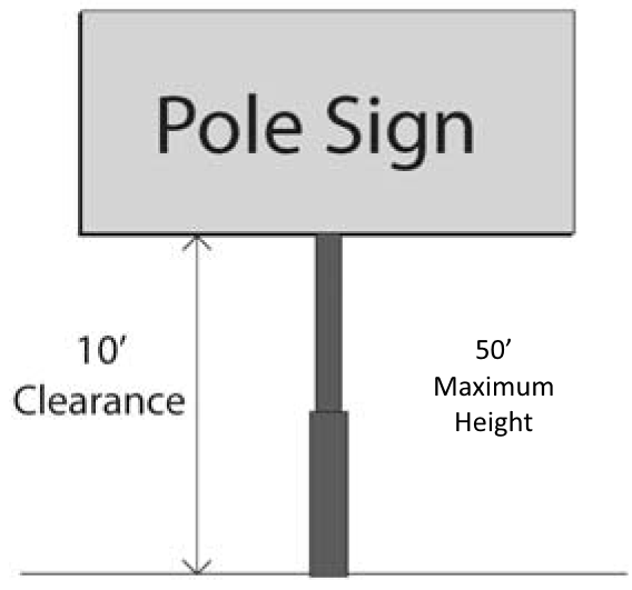
Each freestanding business establishment with frontage on I-45, or its frontage road, is permitted one (1) pole sign not exceeding two hundred fifty (250) square feet in area and not exceeding fifty (50) feet in height, including the supporting structure, above the surrounding finished grade level. The bottom of such sign shall not be less than ten (10) feet above the surrounding finished grade level. Such pole sign may have a reader panel attached to it, however, a reader panel shall be included in the calculation of total sign area. The pole or support structure shall be visibly marked if such pole sign is located in a parking area.
ii.
In lieu of and not in addition to a pole sign, for a freestanding business establishment that is on the corner of an intersection of I-45, or its frontage road, or on State Highway 517 and a city street. A low-profile monument sign is required on State Highway 517 and an additional monument sign or pole sign will be permitted on the adjacent street of the business.
iii.
A pole sign shall be located such that all parts of such sign are a minimum of ten (10) feet from all property lines or driveway entrances as to not impede with traffic flow throughout the parking lot. All pole and monument signs must be spaced a minimum of one hundred (100) feet apart.
iv.
All signs shall maintain a minimum clearance from electric power lines of fifteen (15) feet horizontally or as otherwise may be required by the utility provider.
2.
Low-profile monument signs.
i.
In lieu of and not in addition to a pole sign, each freestanding business establishment is permitted one (1) single or double-faced monument sign not exceeding sixty (60) square feet in area. Not exceeding six (6) feet in height above the surrounding finished grade level.
ii.
The location of a low-profile monument sign is subject to approval by the sign administrator to ensure that such location does not cause an obstruction to the view of traffic or create a hazard to traffic or pedestrians; provided, however, all monument signs shall be located not less than five (5) feet from all property lines and, provided further, monument signs shall be located not less than fifteen (15) feet from the edge of the property line on the corner of an intersection of two (2) streets.
iii.
An additional monument sign may be permitted for a freestanding business establishment that is on the corner of an intersection of State Highway 517 and a city street. Such additional sign shall not exceed six (6) feet in height above the surrounding finished grade level. Such additional sign shall not exceed sixty (60) square feet in area.
3.
High-profile monument signs.

i.
If a business is located within a shopping center or integrated business development, the use of one (1) high-profile monument sign is required.
ii.
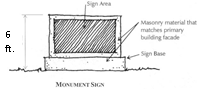
The height of the high-profile monument sign will not exceed forty (40) feet. Each business within the shopping center or integrated business development will be permitted a space on the high-profile sign with two (2) sign faces only. The structure of the sign shall be constructed of materials and colors compatible with those utilized on the primary building's façade. In the event the materials of the primary building's façade are changed, the high-profile monument sign must be changed to conform.
iii.
The location of a high-profile monument sign is subject to approval by the sign administrator to ensure that such location does not cause an obstruction to the view of traffic or create a hazard to traffic or pedestrians; provided, however, all monument signs shall be located not less than ten (10) feet from all property lines and, provided further, monument signs shall be located not less than fifteen (15) feet from the edge of the property line on the corner of an intersection of two (2) streets. In no circumstance may a high-profile monument sign be located within a utility easement.
iv.
Maximum area shall be two-hundred twenty-five (225) square feet per face.
v.
High-profile monument signs shall be spaced a minimum of two-hundred fifty (250) feet from a pole sign.
4.
Wall signs.
i.
Each business establishment is permitted one (1) wall sign per exterior wall, not exceeding in total square feet fifteen (15) percent of the facade to which it is affixed.
ii.
A wall sign may not project above the roof line of a building, unless signs are to be affixed to the parapet wall.
5.
Window signs.
i.
Window signs may be placed so as not to obscure more than twenty-five (25) percent of the visible window area available; otherwise they shall be considered wall signs and must meet the regulations established herein.
ii.
Where multiple signs exist, fronting on the single elevation, then seventy five (75) percent visibility shall be maintained for the total window area on said elevation.
6.
Wayfinding signs.
i.
The sign shall not exceed four (4) feet in height and two (2) feet in width; may only be used to direct vehicles or pedestrians. These signs are not to be used for the purposes of advertisement.
ii.
Up to two (2) wayfinding signs per entrance will be permitted for properties with one (1) entrance to the facility from I-45 frontage road or FM 517.
d.
Sidewalks.
1.
Sidewalks shall be no less than six (6) feet in width, shall comply with the specifications of the city, and shall comply with the requirements and specifications of the American's with Disabilities Act (ADA).
2.
Sidewalks must be adjacent to the building front and shall be no less than six (6) feet in width throughout the development to connect all right-of-way sidewalks, parking and business entrances.
e.
Off-street parking and loading requirements.
1.
Off-street parking shall be provided in accordance with the provisions in article IX, parking regulations.
2.
All off-street loading requirements must comply with section 18-104.
f.
Landscaping.
1.
A minimum ten (10) foot wide planting strip for a vegetative screen is required within non-residential zoning districts when adjacent to residential zoning districts.
2.
The owner of the property shall maintain the trees and shrubs in such a manner as to prevent visual obstruction, within the visibility triangle, the triangular area formed by the right-of-way lines of intersecting streets and a line connecting points twenty-five (25) feet on either side of such intersecting rights-of-way, including triangles formed from centerlines of driveways.
3.
Trees must not be planted within thirty (30) feet of intersections or utility poles. The zoning official may require a greater setback for safety based on line of sight issues.
4.
No trees may be planted directly under utility lines. Only landscaping of mature heights of ten (10) feet or less may be planted under utility lines.
g.
Screening of dumpsters and equipment.
1.
All solid waste disposal facilities must be placed at a location not visible from a public street or from the property line of an adjacent residential district boundary, enclosed with walls constructed of the same material as the building, or completely screened by solid fencing, so that the facility will not be visible at any time to any person, either a pedestrian or inside a passing vehicle.
2.
All utility service meters and electrical power breaker boxes must be either enclosed with materials similar to those used on the building or located not to be visible from a public street right-of-way or public easement within this zoning.
3.
All mechanical and utility equipment shall be located on roofs or in the rear of the property and must be screened from view of the interstate highway or ground level from adjacent property.
4.
All screening, landscaping and vegetation shall be maintained and up kept by the property owner.
h.
Outdoor display of merchandise.
1.
Except as authorized by sections 18-76 through 18-78, no merchandise shall be stored or displayed outside a building, and no equipment or vehicles, other than passenger vehicles, shall be stored outside a building.
2.
Customary passenger vehicles, trailers, recreational vehicles, motor vehicles and other motorized machinery and equipment for sale or lease may be displayed on an unlimited basis outside a building on a paved display area or lot, provided that the display area shall not be placed within a required parking/paving setback area and shall not reduce the capacity of a parking lot below that required by this chapter for the use.
(Ord. No. 884-2017, § 3, 6-27-17; Ord. No. 938-2019, § 4, 8-13-19)
Sec. 18-55. - General commercial "GC" district.
The zoning of property as "GC" general commercial is intended to provide for a variety of commercial uses including wholesale sales and services, general retail and service businesses, and office uses. This district is primarily intended for use in high traffic areas adjacent to arterial streets and highways and is appropriate for high volume commercial centers.
The zoning of property as "GC" general commercial is intended to provide for a variety of commercial uses including wholesale sales and services, general retail and service businesses, and office uses. This district is primarily intended for use in high traffic areas adjacent to arterial streets and highways and is appropriate for high volume commercial centers.
(a)
Permitted uses. No building, structure, or land shall be used, and no building or structure shall be erected, constructed, reconstructed, moved or altered except for one (1) or more of the uses identified below, subject to all applicable provisions of these zoning regulations.
(1)
All uses permitted in the "NC" district.
(2)
Appliance and home furnishing stores.
(3)
Parts supply stores.
(4)
Banks, credit unions, and other depository institutions.
(5)
Bowling alleys and other entertainment centers.
(6)
Reserved.
(7)
Cemeteries, funeral homes, mortuaries, and crematories.
(8)
Day care services.
(9)
Commercial printing shops.
(10)
Computer stores and related services.
(11)
Convenience stores (with or without gasoline sales).
(12)
Dry cleaning services.
(13)
Reserved.
(14)
Food stores, all types.
(15)
Gasoline service stations, including mechanical repair.
(16)
General merchandise stores, including department and variety stores.
(17)
Golf courses, including miniature courses and golf driving ranges.
(18)
Hardware stores.
(19)
Hospitals, clinics, or sanitariums.
(20)
Reserved.
(21)
Liquor stores.
(22)
Lumber and building material dealers-retail.
(23)
Office buildings, all types.
(24)
Commercial and nonprofit recreation facilities, including assembly facilities and sports and recreation clubs.
(25)
Radio and television broadcasting stations or studios.
(26)
Repair shops, miscellaneous.
(27)
Restaurants, including drive-through or drive-in service and the sale of alcoholic beverages for consumption on the premises.
(28)
Retail nurseries.
(29)
Retail stores, not elsewhere classified.
(30)
Reserved.
(31)
Taxidermies.
(32)
Theaters.
(33)
Upholstery shops, not including furniture manufacturing facilities.
(34)
Veterinary clinics and kennels, excluding outdoor runs and provided that no building or kennel shall be closer than fifty (50) feet to any residential district.
(35)
Wholesaling and warehousing establishments, limited to uses that are similar and no more objectionable than the uses enumerated in this district.
(36)
The above uses are not intended to be all-inclusive. Additional commercial and noncommercial uses may be permitted, which are similar, have comparable impact on adjacent property, and correspond with the purpose and restrictions of this district.
(37)
Specific uses permitted pursuant to article V hereof.
(b)
Height and area regulations. The maximum height of buildings and structures, the minimum dimensions of lots, setbacks for yards and parking lots shall be as follows, except as otherwise provided in article VI, supplemental regulations:
(1)
Minimum lot area. Nine thousand (9,000) square feet.
(2)
Maximum height of structures. Three (3) stories, maximum forty-five (45) feet from finished grade, subject to development and performance standards.
(3)
Minimum yards:
a.
Front: Twenty-five (25) feet.
Fifty (50) feet from I.H. 45 right-of-way.
b.
Side: Ten (10) feet or ten (10) percent of the lot width, whichever is greater, "but not more than twenty five (25) feet."
Twenty (20) feet when adjacent to a residential district. Buildings over twenty (20) feet in height shall set back an additional one (1) foot for each additional two (2) feet in height.
c.
Corner: Twenty-five (25) feet.
Fifty (50) feet from I.H. 45 right-of-way.
d.
Rear: Ten (10) feet.
Twenty-five (25) feet when adjacent to a residential district. Buildings over twenty (20) feet in height shall set back an additional one (1) foot for each additional two (2) feet in height.
(4)
Lot coverage: Forty (40) percent of lot area, including principal and accessory buildings.
(5)
Minimum lot width: Seventy-five (75) feet.
Eighty-five (85) feet corner lot.
(6)
Minimum lot depth: One hundred (100) feet.
(7)
Minimum parking lot setback: Fifteen (15) feet from street right-of-way.
Ten (10) feet from property lines of districts zoned "NC" through "GI", inclusive.
Twenty (20) feet when adjacent to a residential district.
(c)
Development and performance standards:
(1)
Hotels and motels shall not contain less than two hundred (200) square feet of floor area in each living unit and shall have at least one (1) complete bathroom for each room or suite of rooms.
(2)
Except as authorized by sections 18-76 through 18-78, no merchandise shall be stored or displayed outside a building, and no equipment or vehicles, other than passenger vehicles, shall be stored outside a building.
(3)
Artificial lighting used to illuminate the premises and/or signage shall be directed away from adjacent residential properties.
(4)
Customary passenger vehicles, trailers, recreational vehicles, motor vehicles and other motorized machinery and equipment for sale or lease may be displayed on an unlimited basis outside a building on a paved display area or lot, provided that the display area shall not be placed within a required parking/paving setback area and shall not reduce the capacity of a parking lot below that required by this chapter for the use.
(5)
A development allowable in this district shall provide and maintain perpetually a vegetative buffer meeting the provisions of section 18-69 along all rear and side property lines that are common to property zoned "RR," "CR," "SR," "HR," and "MH". Off-street parking areas shall be screened in accordance with chapter 16.10, tree preservation and landscaping, of this Code.
(6)
Order boxes for drive-up and drive-through service associated with a restaurant shall be located a minimum of thirty (30) feet from property zoned "RR", "CR", "SR" and "MH".
(7)
All buildings shall be designed and constructed in accordance with the building design standards provided for in article VI, supplemental regulations.
(8)
Sidewalks, located in the platted street right-of-way, shall be provided adjacent to all public and private streets and service roads. Sidewalks shall be no less than four (4) feet in width, shall comply with the specifications of the city, and shall comply with the requirements and specifications of the American's with Disabilities Act (ADA).
(Ord. No. 420-2001, § 1, 7-24-01; Ord. No. 508-2003, § 7, 1-13-04; Ord. No. 557-2005, §§ 6, 9, 8-9-05; Ord. No. 747-2012, § 3, 9-11-12; Ord. No. 849-2016, § 2, 7-12-16; Ord. No. 868-2017, § 2, 1-10-17; Ord. No. 946-2020, § 2, 1-14-20)
Sec. 18-55.1. - Light industrial ("LI") district.
The zoning of property as "LI" light industrial is intended to provide for areas of large-scale industrial development that focus on research and development, warehousing, assembling, high technology, and small-scale distribution and processing. The uses in this district shall be limited to ensure that they do not create any offensive noise, vibration, smoke, dust, and/or odor.
(1)
Permitted uses. No building, structure, or land shall be used, and no building or structure shall be erected, constructed, reconstructed, moved or altered except for one (1) or more of the uses identified below, subject to all applicable provisions of these zoning regulations.
a.
Apparel and other finished products, manufacturing.
b.
Boat/RV storage.
c.
Bottling operations.
d.
Electrical appliances and equipment manufacturing.
e.
Electronic components and accessories manufacturing.
f.
Equipment sales, leasing, service.
g.
General building contractors, including heavy construction contractors.
h.
General warehousing and storage.
i.
Gyms.
j.
Laboratories, medical and dental.
k.
Leather product manufacturing.
l.
Linen suppliers.
m.
Measuring, analyzing, and controlling instruments; photographic, medical and optical goods; watches and clocks, manufacturing.
n.
Motor freight transportation and warehousing facilities.
o.
Motor vehicle supplies and new parts.
p.
Paper and allied paper products.
q.
Printing and publishing industries.
r.
Radio and television broadcasting stations and studios.
s.
Research and testing services.
t.
Storage facilities.
u.
Trucking and other courier services.
v.
Veterinary clinics and kennels without outdoor runs, provided that no kennel or building shall be closer than fifty (50) feet to any residential district.
w.
Wholesale and warehouse distribution centers.
x.
Wholesale trade, durable goods: furniture, lumber and construction materials, commercial equipment and supplies, electrical goods, hardware, and miscellaneous durable goods.
y.
Wholesale trade, non-durable goods: paper products; drugs; apparel; groceries and related products; beer, wine, and distilled alcoholic beverages; and miscellaneous non-durable goods.
z.
The above uses are not intended to be all-inclusive. Additional industrial uses may be permitted, which are similar, have comparable impact on adjacent property, and correspond with the purpose and restrictions of this district.
aa.
Specific use permitted pursuant to article V.
(2)
Height and area regulations. The maximum height of buildings and structures, the minimum dimensions of lots, setbacks for yards and parking lots shall be as follows, except as otherwise provided in article VI, supplemental regulations:
a.
Minimum lot area. Twenty thousand (20,000) square feet.
b.
Maximum height of structures. Three (3) stories, maximum forty-five (45) feet from finished grade, subject to development and performance standards.
c.
Minimum yards.
1.
Front. Forty (40) feet.
2.
Side. Fifteen (15) feet or ten (10) percent of the lot width, whichever is greater, but not more than twenty-five (25) feet except as otherwise provided herein.
Thirty (30) feet when adjacent to a residential district. Buildings over twenty (20) feet in height shall set back an additional one (1) foot for each additional two (2) feet in height.
3.
Corner. Twenty-five (25) feet.
4.
Rear. Fifteen (15) feet or ten (10) percent of the lot width, whichever is greater, but no more than twenty-five (25) feet except as otherwise provided herein.
Thirty (30) feet when adjacent to a residential district. Buildings over twenty (20) feet in height shall set back an additional one (1) foot for each additional two (2) feet in height.
d.
Lot coverage. Fifty (50) percent of lot area, including principal and accessory buildings.
e.
Minimum lot width. One hundred (100) feet.
f.
Minimum lot depth. One hundred (100) feet.
g.
Minimum parking lot setback. Fifteen (15) feet from street right-of-way. Ten (10) feet from property lines of any commercial or industrial district.
Twenty-five (25) feet when adjacent to a residential district.
(3)
Development and performance standards.
a.
All business activities must be conducted within a fully enclosed building. Materials or equipment not offered for sale or rent but used in the business may be stored outside the permanent building if they are located on a paved surface and screened from public view.
b.
Artificial lighting used to illuminate the premises and/or signage shall be directed away from adjacent residential properties.
c.
A development allowable in this district shall provide and maintain perpetually a vegetative buffer meeting the provisions of section 18-69 along all rear and side property lines. Off-street parking areas shall be screened in accordance with chapter 16.10, tree preservation and landscaping.
d.
All uses and activities permitted in this district shall conform to the environmental standards of noise, vibration, smoke emissions, odors, toxic or noxious matter, nuclear radiation, electromagnetic radiation and interference, and heat or glare, as provided in article VI, supplemental regulations.
e.
All buildings shall be designed and constructed in accordance with the building design standards provided for in article VI, supplemental regulations.
f.
Sidewalks, located in the platted street right-of-way, shall be provided adjacent to all public and private streets and service roads. Sidewalks shall be no less than five (5) feet in width, shall comply with the specifications of the city, and shall comply with the requirements and specifications of the American's with Disabilities Act (ADA).
(Ord. No. 867-2017, § 3, 1-10-17)
Sec. 18-56. - General industrial "GI" district.
The zoning of property as "GI" general industrial is intended to provide for a wide variety of light and heavy industrial uses including office warehousing, manufacturing, and product assembly. Most activities shall occur inside a building, however, outside storage of materials and displays may be permitted subject to performance standards.
(a)
Permitted uses. No building, structure, or land shall be used, and no building or structure shall be erected, constructed, reconstructed, moved or altered except for one (1) or more of the uses identified below, subject to all applicable provisions of these zoning regulations.
(1)
Agricultural related mill products, manufacturing.
(2)
Apparel and other finished products, manufacturing.
(3)
Boat/RV storage, sales, leasing and service.
(4)
Bottling operations.
(5)
Chemical and allied products.
(6)
Drugs and pharmaceutical products manufacturing.
(7)
Electrical appliances and equipment manufacturing.
(8)
Electronic components and accessories, manufacturing.
(9)
Equipment sales, leasing and service.
(10)
Food and kindred product manufacturing.
(11)
Furniture and fixtures manufacturing.
(12)
General building contractors, including heavy construction contractors.
(13)
General warehousing and storage.
(14)
Industrial machinery and equipment, including transportation.
(15)
Laboratories, medical and dental.
(16)
Leather product manufacturing.
(17)
Linen suppliers.
(18)
Lumber and building materials yards.
(19)
Lumber and wood products manufacturing.
(20)
Machinery, equipment and supplies—Wholesale distribution.
(21)
Measuring, analyzing, and controlling instruments; photographic, medical and optical goods; watches and clocks— Manufacturing.
(22)
Motor freight transportation and warehousing facilities.
(23)
Oil field equipment storage and sales.
(24)
Paper and allied paper products.
(25)
Petroleum products, (bulk) storage and dispensing.
(26)
Printing and publishing industries.
(27)
[Reserved].
(28)
Research and testing services.
(29)
Stone, clay, and glass products—Manufacturing, storage and distribution.
(30)
Storage facilities.
(31)
Textile mill products, manufacturing.
(32)
Tobacco products, manufacturing.
(33)
Trucking and other courier services.
(34)
Veterinary clinics and kennels with outdoor runs, provided that no kennel or building shall be closer than fifty (50) feet to any residential district.
(35)
Welding and machine shops.
(36)
Wholesale and warehouse distribution centers.
(37)
Wholesale trade, durable goods: furniture, lumber and construction materials, commercial equipment and supplies, electrical goods, hardware, and miscellaneous durable goods.
(38)
Wholesale trade, non-durable goods: paper products; drugs; apparel; groceries and related products; beer, wine, and distilled alcoholic beverages; and miscellaneous non-durable goods.
(39)
The above uses are not intended to be all-inclusive. Additional industrial uses may be permitted, which are similar, have comparable impact on adjacent property, and correspond with the purpose and restrictions of this district.
(40)
Specific use permitted pursuant to article V hereof.
(b)
Height and area regulations. The maximum height of buildings and structures, the minimum dimensions of lots, setbacks for yards and parking lots shall be as follows, except as otherwise provided in article VI, supplemental regulations:
(1)
Minimum lot area. Twenty thousand (20,000) square feet.
(2)
Maximum height of structures. Three (3) stories, maximum forty-five (45) feet from finished grade, subject to development and performance standards.
(3)
Minimum yards:
a.
Front: Forty (40) feet.
Fifty (50) feet from I.H. 45 right-of-way.
b.
Side: Twenty (20) feet or ten (10) percent of the lot width, whichever is greater, but not more than twenty-five feet except as otherwise provided herein.
Thirty (30) feet when adjacent to a residential district. Buildings over twenty (20) feet in height shall set back an additional one (1) foot for each additional two (2) feet in height.
c.
Corner: Twenty-five (25) feet.
Fifty (50) feet from I.H. 45 right-of-way.
d.
Rear: Twenty-five (25) feet.
Forty (40) feet when adjacent to a residential district. Buildings over twenty (20) feet in height shall set back an additional one (1) foot for each additional two (2) feet in height.
(4)
Lot coverage: Fifty (50) percent of lot area, including principal and accessory buildings.
(5)
Minimum lot width: One hundred (100) feet.
(6)
Minimum lot depth: Two hundred (200) feet.
(7)
Minimum parking lot setback. Fifteen (15) feet from street right-of-way. Ten (10) feet from property lines of any commercial or industrial district.
Twenty-five (25) feet when adjacent to a residential district.
(c)
Development and performance standards:
(1)
Artificial lighting used to illuminate the premises and/or signage shall be directed away from adjacent residential properties.
(2)
Materials and equipment not offered for sale or rent may be stored outside if they are within an area that is one hundred (100) percent screened on all sides from public view.
(3)
Customary passenger vehicles, trailers, recreational vehicles, motor vehicles and other motorized machinery and equipment for sale or lease may be displayed on an unlimited basis outside a building on a paved display area or lot, provided that the display area shall not be placed within a required parking/paving setback area and shall not reduce the capacity of a parking lot below that required by this chapter for the use.
(4)
A development allowable in this district shall provide and maintain perpetually a vegetative buffer meeting the provisions of section 18-69 along all rear and side property lines that are common to property zoned "RR," "CR," "SR," "HR," "MH," "NC," and "GC". Off-street parking areas shall be screened in accordance with chapter 16.10, tree preservation and landscaping, of this Code.
(5)
All uses and activities permitted in this district shall conform to the environmental standards of noise, vibration, smoke emissions, odors, toxic or noxious matter, nuclear radiation, electromagnetic radiation and interference, and heat or glare, as provided in article VI, supplemental regulations.
(6)
All buildings shall be designed and constructed in accordance with the building design standards provided for in article VI, supplemental regulations.
(7)
Sidewalks, located in the platted street right-of-way, shall be provided adjacent to all public and private streets and service roads. Sidewalks shall be no less than four (4) feet in width, shall comply with the specifications of the city, and shall comply with the requirements and specifications of the American's with Disabilities Act (ADA).
(Ord. No. 420-2001, § 1, 7-24-01; Ord. No. 508-2003, § 8, 1-13-04; Ord. No. 557-2005, § 7, 8-9-05; Ord. No. 747-2012, § 4, 9-11-12)
Sec. 18-56.1. - Planned development ("PD") district.
(a)
Intent. The planned development ("PD") district is intended to provide for combining and mixing of uses allowed in various districts with appropriate regulations and to permit growth flexibility in the use and design of land and buildings in situations where modification of specific provisions of this chapter is not contrary to its intent and purpose or significantly inconsistent with the planning on which it is based and will not be harmful to the neighborhood. A PD district may be used to permit new and innovative concepts in land utilization.
While great flexibility is given to provide special restrictions which will allow development not otherwise permitted, procedures are established herein to ensure against misuse of the increased flexibility.
(b)
Permitted uses. Any use shall be permitted if such use is specified in the ordinance granting a planned development district. The size, location, appearance, and method of operation may be specified to the extent necessary to ensure compliance with the purpose of this chapter.
(c)
Development requirements.
(1)
Development requirements for each separate PD district shall be set forth in the ordinance granting the PD district and may include, but not be limited to, uses, density, lot area, lot width, lot depth, yard depths and widths, building size, building height, building elevations, coverage, floor area ratio, parking, access, screening, landscaping, accessory buildings, signs, lighting, management associations, and other requirements as the city council and planning and zoning commission may deem appropriate.
(2)
If uses in the PD district conform to the standards and regulations of the zoning district to which it is most similar, the particular district must be stated in the application. All applications to the city shall list all requested variances from the standard requirements set forth throughout this chapter. Applications without this list will be considered incomplete.
(3)
The PD district shall conform to all other sections of the zoning ordinance, unless specifically excluded in the granting ordinance.
(4)
The minimum acreage for a PD district request shall be five (5) acres for non-residential development and ten (10) acres for residential development.
(5)
For high-density residential uses, a common open space shall be designated for the leisure and recreational use of the occupants. The open space shall be a minimum of twenty (20) percent of the total land area devoted to the high-density residential use. This requirement may be varied downward by the city council when a lesser amount of open space would be more appropriate based on the density of the development, the installation of private recreational amenities, or where the availability and nature of adjacent public open space is such that a lesser amount would adequately accommodate the development.
(6)
For non-residential uses, a common open space shall be designated for the use of the occupants. The open space shall be a minimum of ten (10) percent of the total land area devoted to the non-residential use. This requirement may be varied downward by the city council when a lesser amount of open space would be more appropriate based on the density of the development, the installation of private recreational amenities, or where the availability and nature of adjacent public open space is such that a lesser amount would adequately accommodate the development.
(d)
Approval process. In establishing a PD district in accordance with this section, the city council shall approve and file, as part of the amending ordinance, appropriate plans and standards for each PD district. During the review and public hearing process, the planning and zoning commission and city council shall require a conceptual plan and/or a detailed site plan.
(1)
Conceptual plan. This plan shall be submitted by the applicant. The plan shall show the applicant's intent for the use of the land within the proposed PD district in a graphic manner and as may be required, supported by written documentation of proposals and standards for development.
a.
A conceptual plan for residential land use shall show general use, thoroughfares, and preliminary lot arrangements. For residential development which does not propose platted lots, the conceptual plan shall set forth the size, type and location of buildings and building sites, access, density, building height, fire lanes, screening, parking areas, landscaped areas, and other pertinent development data.
b.
A conceptual plan for uses other than residential uses shall set forth the land use proposals in a manner to adequately illustrate the type and nature of the proposed development. Data which may be submitted by the applicant, or required by the planning and zoning commission or city council, may include, but is not limited to, the types of use(s), topography and boundary of PD area, physical features of the site, existing streets, alleys and easements, location of future public facilities, building height and location, parking ratios, and other information to adequately describe the proposed development and to provide data for approval which is to be used in drafting the final detailed site plan.
(2)
Detailed site plan. This plan shall set forth the final plans for development of the PD district and shall conform to the data presented and approved on the conceptual plan. Approval of the detailed site plan shall be the basis for issuance of a building permit. The detailed site plan may be submitted for the total area of the PD or for any section or part as approved on the conceptual plan. The detailed site plan must be submitted to the city council upon recommendation of the planning and zoning commission.
The detailed site plan shall include:
a.
A site inventory analysis including a scale drawing showing existing vegetation, natural watercourses, creeks or bodies of water, and an analysis of planned changes in such natural features as a result of the development. This should include a delineation of any flood-prone areas.
b.
A scale drawing showing any proposed public or private streets and alleys, building sites or lots, and areas reserved as parks, parkways, playgrounds, utility easements, school sites, street widening and street changes, the points of ingress and egress from existing streets, general location and description of existing and proposed utility services including size of water and sewer mains, the location of all fire hydrants, the location and width for all curb cuts, and the land area of all abutting sites and the zoning classification thereof on an accurate survey of the tract.
c.
A site plan for proposed building complexes showing the location of separate buildings and the minimum distance between buildings, and between buildings and property lines, street lines and alley lines. Also to be included on the site plan is a plan showing the arrangement and provision of off-street parking.
d.
A landscape plan showing screening walls, ornamental planting, wooded areas, and trees to be planted.
e.
An architectural plan showing elevations and signage style to be used throughout the development in all districts except single-family and two-family may be required by the planning and zoning commission or city council, if deemed appropriate.
f.
Any or all of the required information may be incorporated on a single drawing if one (1) drawing is clear and can be evaluated by the city manager or her designated representatives.
(3)
Supplemental data. All concept or detailed site plans may have supplemental data describing standards, schedules, or other data pertinent to the development of the PD district which is to be included in the text of the amending ordinance. Additional information needed to adequately analyze the development may be required by city staff, the planning and zoning commission or the city council.
(e)
Establishment of district. The procedure for establishing a PD district shall follow the procedure for zoning amendments as set forth in this Code. This procedure is further expanded as follows for approval of conceptual and development plans:
(1)
Separate public hearings shall be held by the planning and zoning commission and city council for the approval of the conceptual plan and the detailed plan or any section of the detailed plan unless such requirement is waived by the city council when it is determined a single public hearing is adequate. A single public hearing is adequate when:
a.
The applicant submits adequate data with the request for the PD district to fulfill the requirements for both plans.
b.
Information on the concept plan is sufficient to determine the appropriate use of the land and the detail site plan will not deviate substantially from this plan.
c.
The requirement is waived at the time the amending ordinance is approved. If the requirement is waived, the conditions shall be specifically stated in the amending ordinance.
(2)
The ordinance establishing the PD district shall not be approved until the conceptual plan is approved unless the conceptual plan step is bypassed by affirmative action by the planning and zoning commission and/or the city council.
The detailed site plan may be approved in phases. When the detailed site plan is approved in phases, then separate approvals by the planning and zoning commission and city council for the initial and subsequent phases will be required. If the detailed site plan is approved in phases, a conceptual plan for the entire site shall be submitted to the city council upon recommendation of the planning and zoning commission.
(f)
Staff report. When a PD district is being considered, a written staff report shall be submitted to the planning and zoning commission and city council discussing the impact on planning, engineering, water utilities, the environment, sanitation, building inspection, tax, police, fire, and traffic.
(g)
Zoning map. All PD districts approved in accordance with the provisions of this chapter in its original form, or by subsequent amendments thereto, shall be referenced on the zoning district map, and a list of such PD districts shall be maintained in the appendix of this chapter.
(h)
Minor amendments to a detailed plan. Upon request of the applicant, the city administrator, or his or her designee, may authorize minor amendments to a detailed site plan so long as such minor amendments do not change the land use or substantially change the character, development standards, or design of the development as shown on the approved detailed site plan. For purposes of this provision, a "substantial change" shall mean a change that will increase the number of proposed dwelling units, increase the floor-to-area ratio, size of structure, height, lot coverage, or number of stories or buildings, reduce lot, yard, or space size, decrease the amount of required off-street parking spaces, change types of buildings, setback, street access points, or lots, or increase density, change traffic patterns, or alter the basic relationship of the proposed development to adjacent properties. The city administrator or his or her designee shall make such authorization only in writing, and such document shall be placed in the ordinance file governing the specific plan.
(Ord. No. 615-2007, § 3, 7-10-07)