
Dundee City Zoning Code
ARTICLE 2
REGULATIONS FOR SPECIFIC DISTRICTS
2.01.00.- GENERAL PROVISIONS
The purpose of this section is to set forth the general provisions concerning land use. The provisions established herein shall regulate land use, density and intensity, establish building lot and yard requirements, establish land use districts which identify the location of land uses in the City [Town] of Dundee, establish standards for land use in the city, and provide for a map locating the permitted land uses in the city. All land in Dundee shall be subject to the provisions of this section, and shall be shown on the official zoning map as provided in section 8.05.00.
2.02.00. - ESTABLISHMENT OF DISTRICTS
In order to classify, regulate, and restrict the uses of land, water, buildings, and structures; to regulate and restrict the height and bulk of buildings; to regulate the area of yards, courts, and other open spaces between buildings; and to regulate the intensity of land use, all the area of the Town of Dundee is classified into one of the following districts:
(Ord. No. 04-42, 5-13-04; Ord. No. 13-09, § 1(Exh. A), 12-10-13)
2.03.00. - COMPATIBILITY, LANDSCAPING AND BUFFERING STANDARDS
The town commission finds that landscaping makes important contributions to the public safety and the general welfare of the town. The purpose and intent of this section is to set forth requirements and standards for the provision of canopy trees, buffer yards, the conservation of native plants and trees, and the conservation of water resources in the town. Specifically, it is intended that buffer yards will aid in reducing the potential negative impacts caused by glare, noise, dust, dirt, litter, odors and view of various land uses on adjacent land uses. It is further intended that the planting of canopy trees will aid in lowering the ambient temperature of the air through increased shading; in conserving water; in enhancing the appearance of properties; in improving property values; and generally in protecting the health, safety and welfare of the public through the improvement of the quality of the human environment. As part of the development approval process, the Town of Dundee shall ensure that all new development is properly buffered to prevent adverse impacts on surrounding land uses. The requirements of this section shall apply to:
1.
The construction of any new building or improvements that require off-street parking and other impervious surfaces to be constructed on the site.
2.
The alteration of existing structures or improvements, where the alteration adds usable floor area that requires additional off-street parking and other impervious surfaces to be constructed on the site.
3.
The construction or expansion of offstreet parking and/or loading areas.
4.
The paving of any existing unpaved offstreet parking and/or loading areas.
Prior to issuance of any development permit covered, a landscape plan shall be submitted showing tree canopy and bufferyard information required by this section. The landscape plan shall be drawn to a scale with sufficient clarity and detail to indicate the type, nature and character of the improvements on the site, and the relative location of all landscaping in relation to said improvements. The landscape plan may be submitted separately, but shall be a part of the site development plan, when a site development plan is required under section 7.02.00.
(Ord. No. 06-05, § 1(Exh. A), 2-14-06; Ord. No. 12-12, § 1, 2-14-12)
2.01.01. - General regulations for single-family detached dwellings.
(1)
Every single-family dwelling shall have a two-car, enclosed garage served by a two-car wide driveway with a minimum width of 16 feet. Said garage shall never be permitted to be enclosed as living space, unless the addition of a new garage is part of the same permit.
(2)
Every single-family dwelling shall comply with the off-street parking requirements as set forth in section 3.03.00 of this Code.
(3)
At a minimum, the front yard of every single-family dwelling shall be equipped with an underground irrigation system for lawn and landscaping consistent with the requirements of section 2.04.00.
(4)
At a minimum, the landscaping of every single-family dwelling shall include one large canopy tree, plus four small trees/large shrubs and 12 small shrubs in the front yard. For approved landscape materials, see section 2.03, Tables 2.03(A), (B) and (C).
2.01.01.01. Reconstruction of existing residence of record:
For any owner/occupied single family dwelling either (a) on a lot depicted by a plat recorded on or before the date of initial adoption of Ordinance No. 92-10 or (b) existing prior to the date of initial adoption of Ordinance No. 92-10:
If such single family dwelling is demolished with the intent on constructing with public assistance a replacement single family dwelling, only the lot owner/occupant who will be receiving public assistance may apply to the development director for an administrative waiver of the following standards for construction of said replacement owner/occupied single family dwelling:
i.
The garage requirement of section 2.01.01(1) of this Code, if the previous structure did not have an existing garage; and
ii.
The front yard irrigation system requirement of section 2.01.01(3) of this Code;
Provided however, that all other single family dwelling construction requirements shall be met. In passing on an application for waiver, the development director shall consider, by the totality of the circumstances, (a) the character of the then-existing neighborhood, (b) whether the proposed replacement structure is intended to mimic or copy the previous structure (if said previous structure is historic in design), and (c) whether the proposed replacement single family dwelling is to be financed by public assistance.
(Ord. No. 06-16, § 1(Exh. A), 6-13-06; Ord. No. 08-12, § 1(Exh. A), 9-8-08; Ord. No. 21-13 , § 2(Exh. A), 7-27-21)
2.01.02. - General regulations for accessory uses.
Accessory uses, as defined in article 9, are those which are incidental and secondary to a principal use which is permitted within a given zoning district. It is the purpose of this section to regulate the construction, placement, and use of accessory structures, in order to ensure that they do not adversely affect nearby residents and/or surrounding properties. In addition to the standards provided below, accessory structures shall meet all requirements set forth in individual zoning districts and other applicable provisions of this Code.
One or more accessory structures may be permitted on a development site, provided that the following requirements are met:
(A)
Accessory structures shall not be constructed prior to the principal structure.
(B)
All accessory structures shall comply with the Standard Building Code and all standards of this Code pertaining to the principal use.
(C)
Accessory structures shall not be located in a required landscape buffer or minimum building setback area. Provided, however that:
1.
Swimming pools, and decks and patios adjoining swimming pools, may be located within a rear yard subject to a minimum rear yard setback of 15 feet from any lot line; and
2.
Accessory buildings in rear yards which are adjacent to an alley shall be located a minimum of one foot from any lot line; and
3.
Accessory buildings located in rear yards which are adjacent to nonpublic property shall be located a minimum of five feet from any nonpublic property.
(D)
Accessory structures shall be included in all calculations of impervious surface and storm water runoff.
(E)
All accessory structures shall be shown on a site development plan required under section 7.02.00 of this Code.
(F)
In residential districts, accessory structures shall not be located forward of the front building line or, on a corner lot, within the required side street setback area, except as permitted through [section] 2.01.14.
(G)
Accessory structures shall not be served by an electrical meter separate from that of the principal use.
(H)
Except where otherwise provided, accessory structures shall be separated from each other and from the principal structure by no less than five feet.
(I)
No mobile home, trailer, or vehicle of any kind shall be permitted as an accessory structure on any development site.
(Ord. No. 93-02, § 1, 3-9-93; Ord. No. 19-19 , § 1(Exh. A), 12-10-19)
2.01.03. - Fence height limitations.
(A)
No fence or solid wall on any property shall exceed six feet in height in any residential zoning district, or eight feet in any commercial or industrial zoning district.
(B)
In all residential zoning districts, fences or walls shall be limited to four feet in height within required front or side street setback areas.
(C)
No fence or other obstruction, including signs (having less than eight feet of ground clearance), walls, hedges, or other structures shall exceed four feet in height within 25 feet of a street intersection.
(D)
Where a residential subdivision abuts a public roadway classified as an arterial, a collector, or a local road, the developer shall construct a fence or wall along the entire length of the abutting property line. Subdivision walls and fences shall be constructed to resist high winds up to hurricane strength and shall meet the following minimum standards:
(1)
Be constructed of reinforced concrete block, stone, brick or other masonry building materials in combination with wrought aluminum or other metal features, rigid composite and other similar materials, as approved by the town commission.
a.
Coated chain link fencing green or black in color may be permitted in combination with a dense landscape buffer.
b.
Specifically in regard to PVC panel fencing, the minimum standard shall be concrete block columns no more than 30 feet apart on center, constructed with reinforced, concrete footings. The PVC portion of the fence shall be constructed with PVC posts in concrete nor more than six feet on center and steel inserts in the top and bottom stringers.
(2)
May be constructed in combination with a landscaped buffer and/or berm. In the case of the landscaping, the homeowners association shall be responsible for the irrigation and care of all landscaping installed facing the public roadways. See section 2.03.02.01 of this Code for selection of plant materials.
(E)
Where a through or double-fronting lot, other than a corner lot, abuts an arterial road, a six-foot fence may be erected on the property line if it precludes vehicular access to the arterial road. Where no adjoining property has ingress/egress to the arterial road, the property line on which the six-foot fence is constructed shall be considered the rear lot line for setback purposes.
(F)
Berms within the front setback, or within 25 feet of a street intersection, used in conjunction with fences or walls, shall be considered as included in the height restriction for such fences or walls. The height of a fence or wall shall be measured from finished grade prior to berming. Fences or walls that exceed the height limits established in this section shall meet side and rear setback requirements applicable to accessory structures, and front setback requirements applicable to principal structures.
(Ord. No. 96-09, § 1, 9-10-96; Ord. No. 05-70, § 1(Exh. A), 8-9-05; Ord. No. 12-12, § 1, 2-14-12)
2.01.04. - Special parking restrictions in residential districts.
2.01.04.01. Reserved.
2.01.04.02. Parking of boats and recreational vehicles.
Within any residential district, recreational vehicles exceeding 25 feet in length may be parked for storage purposes only within the side yard area not less than five feet from the side property line, and within the rear yard area not less than five feet from the rear property line. No such recreational vehicle may be parked between any public street and the living area of the principal building, except on a paved driveway.
(Ord. No. 98-04, § 1, 6-9-98)
2.01.05. - Alteration of lot size.
Except as noted in this section, no existing lot shall be reduced in area or dimension below the minimum requirements applicable to such lot under the provisions of this Code. When a lot which conforms to the requirements of this Code is reduced in dimension or total area by 20 percent or less by the voluntary dedication and acceptance of a portion of such lot for a public use, the lot shall be considered to contain the dimensions and area it contained prior to such dedication. However, for purposes of measuring compliance with setback requirements of this Code, the dimensions and area of such lot as it exists after the voluntary dedication shall apply.
2.01.06. - Limitations on animals.
No person shall breed or maintain any wild animal or poisonous reptile which, in the opinion of the development director, poses a threat to human safety in Dundee. Excluded from this restriction are zoos, pet shops, animal shelters, medical or scientific facilities, or other locations where the showing or maintenance of such animals is a permitted use under the provisions of this Code.
2.01.07. - Moving of buildings.
Any structure moved from one development site to another shall, at the new location, comply with all applicable provisions of this Code.
2.01.08. - Requirements for lots divided by a right-of-way.
Where a single lot or parcel which has been recorded in the public records of Polk County under a unified legal description is divided by a public or private right-of-way, road, alley or easement, the following standards shall apply:
1.
Where the land area on each side of the right-of-way meets the minimum size requirement of the applicable zoning district, the property shall be considered two lots for the purposes of this Code.
2.
Where the land area on one or both sides of the right-of-way fails to meet the minimum size requirement, then the property shall be considered one lot for the purposes of this Code. The principal structure shall be located on the larger portion of the property.
3.
No subdivision plat which includes a lot divided by a right-of-way shall be approved unless such lot meets the applicable size requirement on at least one side of the right-of-way.
4.
For any corner lot, the required setback for a side yard adjoining a secondary street shall be increased by an amount equal to ten percent of the actual lot width, provided that the maximum side yard setback requirement shall not exceed the requirement for a front yard as applied to said lot.
(Ord. No. 95-01, § 1, 3-14-95)
2.01.09. - Temporary sales tents.
Sales tents may be erected temporarily on property in a commercial district where a commercial structure is already established, subject to the following requirements:
1.
Sales tents may not be erected more than two times per year, for periods not exceeding two weeks.
2.
No more than ten percent of the existing parking area is used, and the tent does not block any point of ingress or egress to the development site.
3.
All electrical connections must be inspected and approved by the building department.
4.
The tent must be inspected and approved by the Dundee fire department.
2.01.10. - Responsibility of property owners abutting public right-of-way.
The owner of any real property which abuts a public right-of-way may construct a driveway across such right-of-way for the purpose of gaining egress and ingress from such private property to a public thoroughfare. Any person desiring to construct such driveway shall present acceptable plans therefore to the town building official, which shall be subject to approval by such official in compliance with existing codes adopted by the town. Upon approval of such plans, the town building official shall be authorized to issue the applicant-property owner a building permit to construct such driveway. All construction costs, and subsequent maintenance of such driveway shall be the sole responsibility of the owner of such private property. The property owner's failure to property construct such driveway according to the plans for which the building permit was issued, or to maintain the driveway, once constructed, shall be enforced by the town through appropriate action by the code enforcement board.
(Ord. No. 93-11, § 1, 7-13-93)
2.01.11. - Temporary closing of public rights-of-way.
A.
Any person, firm, or corporation desiring to temporarily close any sidewalk, street, alley, or other public thoroughfare or right-of-way for a temporary period of time, shall first file a formal application for such closure with the town clerk at least ten days prior to such requested closing.
B.
The town commission shall thereafter review the application, including the purpose for such requested temporary closing. If the commission determines that the requested closing is in the best interest of the town, the commission shall grant the applicant permission to temporarily close such public thoroughfares for a period not to exceed 72 consecutive hours.
C.
As a condition precedent to the issuance by the town clerk of a permit to close the thoroughfare pursuant to the commission's direction, the applicant shall (1) pay the town clerk a sum equal to $50.00 for each 24-hour period, or any part thereof, that the public thoroughfare is to be closed; (2) provide the clerk satisfactory evidence that all neighbors within two city blocks in each direction of the area sought to be closed have been notified of the closing; and, (3) if required by the town commission, deposit a sum equal to $25.00 for each hour the commission determines it necessary to provide for the services of an off-duty Dundee police officer to control the traffic in and around the thoroughfare sought to be closed.
D.
The commission may, in its discretion, waive the fee for closure if the purpose of the closure is for a nonprofit for public cause.
(Ord. No. 98-04, § 1, 6-9-98; Ord. No. 12-12, § 1, 2-14-12)
2.01.12. - Additional design standards and requirements for farmers' markets and fruit and vegetable stands.
(A)
Applicability. The following design standards and application requirements shall apply to farmer's markets and fruit and vegetable stands shall take precedence over any other town code or land development regulation when in conflict herewith. The design standards and application requirements set forth herein are in addition to other requirements of the town set forth in the code and land development regulations.
(B)
Design standards.
1.
An application for the farmer's market or fruit and vegetable stand shall be submitted to the building department along with a plan of the proposed site showing the location of any tents in relation to entryways to businesses and any other features that affect accessibility to the site. The plan shall show any tables, display areas, or other equipment that will not be under tents.
2.
Restroom facilities shall be provided for fruit and vegetable stands.
3.
Parking areas must be on site and clearly marked. No parking shall be allowed on the right-of-way or street.
4.
Adult material is prohibited from being sold or purchased at farmer's markets or fruit and vegetable stands. Adult material for purposes of this chapter is: any one or more of the following regardless of whether it is new or used:
(a)
Books, magazines, periodicals, other printed matter, photographs, films, motion pictures, videotapes, slides, computer digital graphic recordings, other visual representations, tape recordings, or other audio matter which have as their primary or dominant theme matter depicting, illustrating, describing, or relating to specified sexual activities or specified anatomical areas; or
(b)
Instruments, novelties, devices, or paraphernalia which are designed for use in connection with specified sexual activities.
5.
If canopies, tents, or other temporary facilities are utilized they shall be secured for safety and removed at the end of the day. If fire rated commercial tents are used, they must be in compliance with all relevant fire code regulations.
6.
The farmer's market must comply with the provisions concerning noise set forth in section 34-91 of the city's Code of Ordinances.
7.
Mobile food vendors must display all state and health department permits.
(Ord. No. 12-17, § 1(Exh. A), 8-28-12)
2.01.13. - Continued use of identified existing locations in the CC, CH, and CS zoning districts eligible for warehouse/light industrial uses.
(A)
Applicability. The locations identified on the official zoning map as existing locations eligible for warehouse and light industrial uses in the CC, CH, and CS zoning districts are permitted to continue and/or incorporate the uses identified in the Table of [Land] Uses as (P**) under the following conditions:
1.
The uses identified on the Table of [Land] Uses as (P**) related to this Section are not permitted uses in the respective zoning districts except for the parcels identified on the official zoning map.
2.
Operations should be fully enclosed with no outside storage of goods or materials. If outside storage of goods or materials are requested, the request must be reviewed and approved by the planning and zoning board and the town commission as a special exception.
3.
No noise, vibration, odor, smoke, and dust should impact adjacent properties in conformance with the performance standards in section 3.05.00.
4.
The use may be enlarged or intensified through the erection of additional structures with the review and approval by the planning and zoning board and the town commission.
(Ord. No. 15-13, § 1(Exh. A), 6-9-15)
2.01.14. - Front carports for single-family residential uses.
Carports may be allowed within the minimum required front yard when reviewed and authorized by the planning and zoning board provided that all of the following conditions are met:
(A)
Carports which meet all setback, height, and area regulations of the zoning district and all requirements of section 2.01.02 need only have additionally, a lawfully issued building permit to be allowable under the zoning ordinance.
(B)
Carports which are requested to be located forward of the front building line or, on a corner lot, within the required side street setback area and/or infringe in whole or in part upon the front yard setbacks established by the zoning district may be allowed within the minimum required front yard when approved by the planning and zoning board provided that all of the following conditions are met:
(1)
Vehicular access to the side or rear yard is not reasonably available.
(2)
There is insufficient space for placement of a carport in a side yard.
(3)
The carport, which may be attached to the structure or freestanding, shall be compatible with the neighborhood and does not negatively affect other nearby properties. A detailed drawing of the site and proposed structure and material list must accompany the request for approval.
(4)
If the carport is to be located on a corner lot, then no portion of the carport may extend into the area required to meet visibility standards as set out in the land development regulations.
(4)
Each site is limited to one front carport per residential dwelling unit on the site.
(5)
The carport shall be used solely for sheltering and the parking of vehicles, and not for any other purpose, including storage of any type.
(6)
A front carport meeting the above requirements may be located within a required front yard setback provided that it is setback at least three feet from the front and side property lines, as measured from the outboard face of the closest structural member or the outboard edge of the eave, whichever component forms the outermost edge of the structure. No carport may be located so as to create a sight hazard for traffic on streets, alleys, and other public roadways. The carport must not intrude or overhang into any type of public utility or public drainage easement.
(7)
A carport must be made of rigid materials and shall have no more than six supporting columns and they shall not exceed eight feet in height from grade level. The roof height shall not exceed the height of the primary structure or one story, whichever is lower. The vertical plane from the ground to seven feet above grade on the street facing end/side and its two adjacent ends/sides shall be left clear of any walls or sheathing and shall remain open at all times for the movement of air, light, and preservation of the view shed to neighboring properties.
(12)
The total gross floor area of the carport shall not exceed 400 square feet in area under roof in any configuration that will provide the equivalent of a maximum of two parking spaces meeting the size requirements of section 3.03.04 in single-family residential districts and/or any zoning district where the primary use of the lot is for a single-family dwelling.
(13)
Carports shall be constructed over an existing driveway or a driveway extension constructed for the purpose of situating the carport on the lot. The area under the carport shall be a non-combustible, paved or stabilized all-weather surface which connects to an adjacent street or alley.
(14)
Carports shall have a gutter system or drainage design that drains toward the street or the nearest drainage facility. Rainwater shall not drain onto adjacent property.
(15)
Construction shall be in accordance with the requirements of the Florida Building Code.
(16)
This subsection does not allow portable carports.
( Ord. No. 19-19 , § 1(Exh. A), 12-10-19)
2.01.15. - Model homes.
Model home dwelling units and temporary sales offices shall be subject to the following requirements. The term model home shall be deemed to include temporary sales offices ("sales trailer") unless stated otherwise herein:
(A)
The phase or site where model homes are to be built shall have an approved set of final construction plans and an approved and recorded final plat. All improvements to be publicly dedicated and not yet constructed shall be secured via surety according to town regulations before a model home or temporary sales office permit can be issued.
(B)
Model homes shall meet all lot area, setbacks, square footage, and all other zoning code requirements of the district in which they are located and the plat within which they lie.
(C)
The number of model homes shall not exceed five or the greater of ten percent of the total building lots within any single platted phase, not to exceed ten total units. Fractions shall be rounded to the nearest whole number.
(D)
Model homes and temporary sales offices may continue operation until all lots or houses within that subdivision are sold. Construction of temporary sales offices shall not commence until a performance bond adequate to ensure the removal of the structure has been posted with the administrative official and approved by the town attorney.
(E)
Fire protection:
(1)
Each model home shall be accessible by a stabilized road base meeting the minimum requirements of the latest edition of the NFPA 1 Fire Code.
(2)
Prior to start of construction on any model home or temporary sales office site, fire suppression water shall be available from a fully functioning hydrant within 1,000 feet of the structure measured by the route of vehicle travel along approved roadways and/or stabilized road base. These fire protection facilities shall be in place and approved by the fire agency having jurisdiction to the model home lot(s) prior to the issuance of the model home building permit.
(F)
There shall be no water, electric, or sanitary sewer service to individual model homes until the utility systems have been accepted for service by the Town of Dundee and the final plat is recorded.
(G)
Parking:
(1)
One off-street parking space shall be provided for each employee plus one per model dwelling unit.
(2)
Parking areas including drive aisles shall be provided on the same lot as the model dwelling unit or on a contiguous lot, and shall be maintained as long as the model dwelling unit is used as such. Parking areas must be surfaced with non-dust producing materials such as asphalt, concrete, or gravel.
(3)
In addition, one space shall be provided for handicapped parking. The handicapped parking space shall meet ADA requirements for size, grade slope, and accessibility via an ADA-compliant travel path to the sales office and any other areas used for sales activities. The handicapped parking space and travel path shall be paved with concrete, asphalt, or ADA-compliant pavers.
(H)
Signs shall not be illuminated after 9:00 p.m.
(I)
The model dwelling units shall not be used for any business activity later than 9:00 p.m.
(J)
The requirements above assume that the constructed model home will be converted for residential sale after the need for model homes has passed. If, however the model home is not intended for future sale, and is displayed for advertising purposes only but not intended to be sold or occupied as a dwelling, construction shall not commence until a performance bond adequate to ensure the removal of the structure has been posted with the administrative official and approved by the town attorney.
(K)
In those zoning districts where multi-family dwelling uses are permitted, a temporary structure ("sales trailer") may be used as a preconstruction sales office for the purpose of displaying a typical dwelling unit arrangement, subject to the following restrictions:
(1)
Adequate off-street parking facilities (a minimum of five spaces) and access driveways shall be developed within those locations approved for such facilities in conjunction with the permanent apartment structure, and no additional parking areas or access driveways shall be permitted.
(2)
At least one handicapped parking space shall be provided in accordance with the requirements listed above in this section.
(3)
The structure shall be completely and totally removed within six months from the date of the issuance of a building permit for the permanent residential dwelling structure or upon the completion of the permanent residential dwelling structure whichever date is later.
(4)
In the event that the temporary structure is not removed by the owner or other parties in interest within the terms of this section, the Town of Dundee, to the extent permitted by law, acting through its building inspector, is authorized to vacate, demolish, or remove, either with forces or by independent contractor submitting the lowest and best bid, any such building or structure. The town shall assess the entire costs of such vacation, demolition, or removal against the owner or other parties in interest.
(Ord. No. 22-21 , § 1(Exh. A), 6-28-22)
2.02.01. - Zoning district summary tables.
The tables on the following pages present, in a quick-reference form, information regarding permitted and special exception land uses, and development standards for all zoning districts. Permitted uses are designated by the letter "P". Special exception uses are designated by the letter "S". Uses designated by the letter "D" are also permitted, but require the submission and approval of a site development plan prior to application for a development permit. Article 7 governs review of an application for approval of a site development plan. These tables must be read in conjunction with the regulations for specific zoning districts in section 2.02.02.
TABLE 2.02.01(A), TABLE OF LAND USES
Table 2.02.01(B), Table of Development Standards
(Ord. No. 96-06, 7-9-96; Ord. No. 04-42, § 1(Exh. A), 5-13-04; Ord. No. 05-09, § 1(Exh. A), 3-8-05; Ord. No. 05-70, § 1(Exh. A), 8-9-05; Ord. No. 07-17, § 2, 9-11-07; Ord. No. 08-02, § 1(Exh. A), 3-11-08; Ord. No. 12-17, § 1(Exh. A), 8-28-12; Ord. No. 14-01, § 1(Exh. A), 3-11-14; Ord. No. 15-13, § 1(Exh. A), 6-9-15; Ord. No. 19-08 , § 1(Exh. A), 7-9-19; Ord. No. 19-09 , § 2(Exh. A), 8-13-19)
2.02.02. - Establishment of zoning districts.
The following zoning designations are hereby established within the Town of Dundee:
2.02.02.01. AL limited agricultural district.
(A)
FLUM designation: Low-density residential.
(B)
Purpose: To locate and establish areas which are suited for the conservation of open space and the natural environment, and for limited agricultural use compatible with existing and future urban development.
(C)
Permitted principal uses: See table of land uses.
(D)
Accessory uses: Uses secondary and incidental to a permitted use, provided there is full compliance with all setback, height, building coverage, and offstreet parking and loading requirements. Swimming pools and related decks and patios may be located within a rear yard, subject to a minimum rear yard setback of 15 feet. Other accessory uses, buildings, or structures may be located in required rear yards not less than one foot from any lot line. Accessory structures shall not be located in any required yard or setback area adjoining a public or private street.
(E)
Special exception uses: See table of land uses.
(F)
Minimum lot requirements: All structures erected after the effective date of this Code shall be located on a lot having an area of not less than one acre and a minimum width of 100 feet.
(G)
Maximum building coverage: See table of development standards.
(H)
Maximum building height: 35 feet, provided that broadcasting towers and transmission stations shall be exempt from said requirements.
(I)
Minimum floor area: See table of development standards.
(J)
Minimum yard requirements: See table of development standards.
2.02.02.02. RSF1 low-density single-family residential.
(A)
FLUM designation: Low-density residential.
(B)
Purpose: The purpose of the RSF1 single-family residential zoning district shall be to locate and establish areas within the Town of Dundee which are deemed suited for the development and maintenance of low-density residential living of an urban character; to designate those uses and services deemed appropriate and proper for location and development within said zoning district; and to establish such development standards and provisions as are necessary to ensure proper development in a low-density residential environment. It is intended that the maximum residential density within the district shall be 3.2 dwelling units per acre of land.
(C)
Permitted principal uses and structures: Uses permitted in this district are detailed in the Table of Land Uses in section 2.02.01(A).
(1)
Permitted in this district, as of amendment of this Code on June 13, 1995, are newly annexed parcels with agricultural uses that have been previously qualified for the agricultural tax exemption as defined by F.S. § 193.461, "which includes, but is not limited to, horticulture; floriculture; viticulture; forestry; dairy; livestock; poultry; bee, pisciculture, when the land is used principally for the production of tropical fish; aquaculture; sod farming; and all forms of farm products and farm production." (See section 2.01.06.)
(D)
Accessory uses: As set forth in section 2.01.02.
(E)
Special exception uses: Uses listed in the Table of Land Uses with an "S" in the table. Uses may be permitted only following the review and specific approval as set forth in section 7.05.00.
(F)
Minimum lot requirements:
(1)
Single-family dwelling: See Table of Development Standards.
(2)
All other uses: Minimum 15,000 square feet; and minimum lot width of 120 feet.
(G)
Other development standards:
(1)
Every single-family structure shall have a two-care, enclosed garage served by a two-car wide driveway with a minimum width of 16 feet. Said garage shall never be permitted to be enclosed as living space, unless the addition of a new garage is part of the same permit.
(2)
Other off-street parking requirements as set forth in section 3.03.00.
(3)
At a minimum, the front yard of every single-family structure shall be equipped with an underground irrigation system for lawn and landscaping.
(4)
At a minimum, the landscaping of every single-family structure shall include one large canopy tree, plus four small trees/large shrubs and 12 small shrubs in the front yard. For approved landscape materials, see section 2.03, Tables 2.03(A), (B), (C).
2.02.02.03. RSF2 moderate-density single-family residential.
(A)
FLUM designation: Low-density residential.
(B)
Purpose: The purpose of the RSF2 single-family residential zoning district shall be to locate and establish areas within the Town of Dundee which are deemed to be suited for the development and maintenance of moderately low-density residential living of an urban character; to designate those uses and services appropriate and proper for location and development within said zoning district; and to establish such development standards and provisions as are appropriate to ensure proper development in a moderately low-density residential environment. It is intended that the maximum residential density within the district shall be 4.0 dwelling units per acre of land.
(C)
Permitted principal uses and structures: Uses and structures listed in the Table of Land Uses.
(D)
Accessory uses: As set forth in section 2.01.02.
(E)
Special exception uses: Uses listed in the Table of Land Uses with an "S" in the table. Uses may be permitted only following the review and specific approval as set forth in section 7.05.00.
(F)
Minimum lot requirements:
(1)
Single-family dwelling: See Table of Development Standards.
(2)
All other uses: Minimum 15,000 square feet; and minimum lot width of 120 feet.
(G)
Other development standards:
(1)
Every single-family structure shall have a two-car, enclosed garage served by a two-car wide driveway with a minimum width of 16 feet. Said garage shall never be permitted to be enclosed as living space, unless the addition of a new garage is part of the same permit.
(2)
Other off-street parking requirements as set forth in section 3.03.00.
(3)
At a minimum, the front yard of every single-family structure shall be equipped with an underground irrigation system for lawn and landscaping.
(4)
At a minimum, the landscaping of every single-family structure shall include one large canopy tree, plus four small trees/large shrubs and 12 small shrubs in the front yard. For approved landscape materials, see section 2.03, Tables 2.03(A), (B), (C).
2.02.02.04 RSF3 moderate-density single family residential
(A)
FLUM designation: Low density residential.
(B)
Purpose: The purpose of the RSF3 single-family residential zoning district shall be to locate and establish areas within the Town of Dundee that are deemed to be suited for the development and maintenance of moderately, low density residential living of an urban character on minimum 55-foot wide lots; to designate those uses and services appropriate and proper for location and development within said zoning district; and to establish such development standards and provisions as are appropriate to ensure proper development in a moderately, low density residential environment. It is intended that the maximum residential density within the district shall be 5.0 dwelling units per net acre of land.
(C)
Permitted principal uses and structures: Uses and structures listed in the Table of Land Uses.
(D)
Accessory uses: As set forth in section 2.01.02.
(E)
Special exception uses: Uses listed in the Table of Land Uses with an "S" in the table. Uses may be permitted only following the review and specific approval as set forth in section 7.05.00.
(F)
Minimum lot requirements:
(1)
Single-family dwelling: See Table of Development Standards.
(2)
All other uses: Minimum 15,000 square feet; and minimum lot width of 120 feet.
(G)
Other development standards:
(1)
Every single-family structure shall have a two-car, enclosed garage served by a two-car wide driveway with a minimum width of 16 feet. Said garage shall never be permitted to be enclosed as living space, unless the addition of a new garage is part of the same permit.
(2)
Other off-street parking requirements as set forth in section 3.03.00.
(3)
At a minimum, the front yard of every single-family structure shall be equipped with an underground irrigation system for lawn and landscaping.
(4)
At a minimum, the landscaping of every single-family structure shall include one large canopy tree, plus four small trees/large shrubs and 12 small shrubs in the front yard. For approved landscape materials, see section 2.03, Tables 2.03(A), (B) and (C).
2.02.02.05. RTF two-family residential.
(A)
FLUM designation: Medium-density residential or downtown transitional.
(B)
Purpose: The purpose of the RTF two-family residential zoning district shall be to locate and establish areas within the Town of Dundee which are deemed to be suited for the development and maintenance of medium-density residential living of an urban character; to designate those uses and services appropriate and proper for location and development within said zoning district; and to establish such development standards and provisions as are appropriate to ensure proper development in a medium-density residential environment. It is intended that the maximum residential density within any portion of the district shall be nine dwelling units per net acre of land.
(C)
Permitted principal uses and structures: The following principal uses and structures are permitted:
(1)
Citrus grove, crop raising, horticulture, including noncommercial greenhouses (but excluding the care and handling of animals and/or fowl); and including a residence occupied only by the owner or tenant and his immediate family;
(2)
Park or playground, or other recreational or cultural facility (public);
(3)
Public administrative or safety facility, including a police or fire station;
(4)
School (public), kindergarten and grades 1 through 12;
(5)
Single-family dwelling;
(6)
Two-family dwelling.
(D)
Accessory uses: As set forth in section 2.01.02.
(E)
Special exception uses: The following uses may be permitted only following the review and specific approval as set forth in section 7.05.00:
(1)
Church or other place of worship, including related educational and training facilities;
(2)
College or technical school;
(3)
Day care center;
(4)
Golf course (not including miniature golf course) and country club;
(5)
Public utility or maintenance facility, including water pumping plant and/or storage tank, reservoir, electrical transmission lines and substations;
(6)
Recreational facility (private or nonprofit);
(7)
School (private or parochial) offering a curriculum substantially equivalent to that of a public school, with comparable grades and meeting the requirements of the state board of education;
(8)
Townhouse, subject to special provisions of section 3.07.00.
(F)
Minimum lot requirements:
(1)
Single-family dwelling: 6,000 square feet and width of 50 feet;
(2)
Townhouse dwelling complex: 43,560 square feet;
(3)
Two-family dwelling: 9,000 square feet and width of 75 feet;
(4)
All other use: 12,000 square feet and width of 100 feet.
(G)
Maximum building coverage: 35 percent, unless otherwise provided by this ordinance.
(H)
Maximum building height: 35 feet.
(I)
Minimum floor area:
(1)
Single-family dwelling: See table of development standards.
(2)
Townhouse dwelling: See table of development standards.
(3)
Two-family dwelling: See table of development standards.
(J)
Minimum yard requirements:
(1)
Front yard: 25 feet, unless otherwise provided by this ordinance.
(2)
Side yard:
a.
Two-family dwelling: Nine feet;
b.
All other uses: Seven feet, unless otherwise provided by this ordinance.
(3)
Rear yard: 25 feet, unless otherwise provided by this ordinance.
(4)
Buffering: Where applicable, buffering shall be provided in accordance with the provisions of section 2.03.00.
(K)
Other requirements:
Offstreet parking and service requirements: As set forth in section 3.03.00.
2.02.02.06. RMF multiple-family residential.
(A)
FLUM designation: Medium-density residential or downtown transitional.
(B)
Purpose: The purpose of the RMF multifamily residential zoning district shall be to locate and establish areas within the Town of Dundee which are deemed to be suited for the development and maintenance of high-density multifamily residential areas properly served by community facilities and commercial service areas; to designate those uses and services appropriate and proper for location and development within said zoning district; and to establish such development standards and provisions as are appropriate to ensure proper development in a high-density residential environment. It is intended that the maximum dwelling unit density within any portion of the district shall be 12 dwelling units per net acre of land.
(C)
Permitted principal uses and structures: The following principal uses and structures are permitted:
(1)
Citrus grove, crop raising, horticulture, including noncommercial greenhouses (but excluding the care and handling of animals and/or fowl); and including a residence occupied only by the owner or tenant and his immediate family;
(2)
Multifamily dwelling;
(3)
Park or playground, or other recreational or cultural facility (public);
(4)
Public safety facility, including a police or fire station;
(5)
Public utility facility, limited to substation and related facilities necessary to serve the immediate area;
(6)
School (public), kindergarten and grades 1 through 12;
(7)
Single-family dwelling;
(8)
Two-family dwelling.
(D)
Accessory uses: As set forth in section 2.01.02.
(E)
Special exception uses: The following uses may be permitted only following the review and specific approval as set forth in section 7.05.00:
(1)
Church or other place of worship, including related educational and training facilities;
(2)
Clinic (medical);
(3)
Club or lodge (private);
(4)
College or technical school;
(5)
Day care center;
(6)
Foster care home;
(7)
Group care home;
(8)
Nursing or convalescent home;
(9)
Hospital;
(10)
Recreational facility (private or nonprofit);
(11)
School (private or parochial) offering a curriculum substantially equivalent to that of a public school, with comparable grades and meeting the requirements of the state board of education;
(12)
Townhouse, subject to special provisions of section 3.07.00.
(F)
Minimum lot requirements:
(1)
Multifamily dwelling: 12,000 square feet, plus an additional 3,000 square feet for each dwelling unit in excess of four, and a width of 100 feet;
(2)
Single-family dwelling: 6,000 square feet and a width of 50 feet;
(3)
Townhouse dwelling complex: 43,560 square feet;
(4)
Two-family dwelling: 9,000 square feet and a width of 75 feet;
(5)
All other uses: 12,000 square feet and a width of 100 feet.
(G)
Maximum building coverage: 35 percent, unless otherwise provided by this ordinance.
(H)
Maximum building height: 35 feet.
(I)
Minimum floor area:
(1)
Multiplefamily: See table of development standards.
(2)
Single-family dwelling: See table of development standards.
(3)
Townhouse dwelling: See table of development standards.
(4)
Two-family dwelling: See table of development standards.
(J)
Minimum yard requirements:
(1)
Front yard: 25 feet, unless otherwise provided by this ordinance.
(2)
Side yard: Six feet, unless otherwise provided by this ordinance.
(3)
Rear yard: 20 feet, unless otherwise provided by this ordinance.
(4)
Buffering: Where applicable, buffering shall be provided in accordance with the provisions of section 2.03.00.
(K)
Other requirements:
Offstreet parking and service requirements: As set forth in section 3.03.00.
2.02.02.07. RMH1 mobile home subdivision.
(A)
FLUM designation: Low-density residential.
(B)
Purpose: To establish locations suitable for mobile home development on platted lots; to designate those uses and activities which are appropriate for and compatible with such areas; and to establish standards and provisions necessary to ensure proper development and public safety in a mobile home residential environment.
(C)
Permitted principal uses and structures: See table of land uses.
(D)
Accessory uses. Docks, boat houses, swimming pools, private garages and other customer uses which are secondary and incidental to the principal use. The total floor area of all accessory structures when added to the floor area of the principal structure shall not exceed 35 percent of the area of the property. Accessory structures including pool decking shall be set back no less than 7.5 feet from side and rear lot lines. Minimum spacing between structures shall be five feet. No structure or pool deck shall be placed within a public utility easement.
(E)
Special exception uses: See table of land uses.
(F)
Minimum lot requirements: See table of development standards.
(G)
Maximum building coverage: See table of development standards.
(H)
Maximum building height: See table of development standards.
(I)
Minimum floor area: See table of development standards.
(J)
Minimum yard requirements: See table of development standards.
(K)
Other requirements:
1.
Clubhouses and similar facilities are permitted within platted subdivisions on parcels retained by the developer or dedicated to and maintained by a homeowners' association. Appropriate development standards will be determined by the development director.
2.
Private golf courses are permitted in conjunction with platted subdivisions of 50 lots or more.
3.
Private schools offering a general curriculum in any or all of grades K through 12 are permitted on property abutting a 60-foot right-of-way.
4.
Except on active construction sites, the parking of vehicles or motorized equipment exceeding 35 feet in length or 1.5 tons in capacity is prohibited.
2.02.02.08. RMH2 mobile home park.
(A)
FLUM designation: Medium-density residential.
(B)
Purpose: The purpose of this district is to establish locations suitable for mobile home development on undivided property, along with open space and other amenities for the common use of residents; to designate those uses and activities which are appropriate for and compatible with such areas; and to establish standards and provisions necessary to ensure proper development and public safety in a mobile home park setting.
(C)
Permitted principal uses and structures: Mobile home parks.
(D)
Accessory uses:
1.
Clubhouse, laundry, swimming pool, and other shared facilities for the common use of the residents of the park.
2.
No more than one single-family home, at least 800 square feet in size, for the use of a resident manager.
3.
Carports, porches, and awnings which are physically attached to mobile homes. Such structures shall not exceed a cumulative total of 35 percent of the lot area.
4.
Storage area for boats, recreational vehicles, and other types of vehicles which exceed 30 feet in length. Storage area is for the use of park residents only, and shall be fenced and landscaped. Storage of these units shall be prohibited on individual mobile home sites or on park roads.
(E)
Special exception uses: Recreational vehicle park, group home, church, public service facilities (see table of land uses).
(F)
Minimum lot requirements:
1.
Minimum size for development site: Five acres, with a width of not less than 150 feet and a depth of not less than 200 feet.
2.
Minimum size for mobile home site: 4,000 square feet, with a width of not less than 40 feet.
(G)
Maximum density: 6.6 units per acre.
(H)
Maximum building height: 35 feet.
(I)
Minimum floor area: 800 square feet.
(J)
Minimum yard requirements:
1.
No mobile home or structure shall be placed less than 50 feet from the front lot line or 30 feet from other lot lines. Where the development site adjoins property with a commercial or industrial zoning designation, the required side and rear setback shall be 15 feet.
2.
Mobile homes and structures shall be placed at least 20 feet from the pavement edge of private park roads.
3.
Mobile homes and freestanding structures serving as common facilities shall be at least 15 feet apart. No carport or other appurtenant structure may be installed on a mobile home less than ten feet from another mobile home or appurtenant structure. This distance shall be measured between the closest points of the units.
(K)
Other requirements:
1.
Ownership. Mobile home parks may not be platted or otherwise divided by fee simple ownership; however, the sale of interests or memberships on a condominium basis is permitted. All facilities, including roads, shall be privately owned or owned in common by residents of the park, and shall not occupy parcels of land which are deeded separately from the rest of the park. The Town of Dundee shall not be responsible for maintenance and/or repair of common facilities within a mobile home park.
2.
Parking. For each mobile home site, two paved offstreet parking spaces of ten feet by 20 feet each shall be provided.
3.
Common open space. An area comprising 20 percent of the development site or five acres, whichever is less, shall be set aside as common open space as defined in article 9.
4.
Nonconformities. No new mobile homes may be added to an existing mobile home park in an RMH district which does not comply with applicable requirements of this Code. However, previously installed units may be moved and additional property and common facilities may be incorporated into the site if such activities will eliminate nonconforming conditions or reduce the degree of nonconformity. See section 7.07.00.
5.
Site development plan. No mobile homes, structures or facilities shall be installed or constructed until a site development plan meeting the requirements of section 7.02.00 of this Code has been submitted to and approved by the Town of Dundee. All improvements, regardless of timing or project phasing, shall be substantially consistent with the approved site development plan.
Where an existing mobile home park in an RMH district has no site development plan, such a plan shall be prepared and submitted to the town prior to the addition, improvement, rearrangement or replacement of park facilities or mobile homes.
2.02.02.09. CC general retail commercial.
(A)
FLUM designation: Commercial or downtown transitional.
(B)
Purpose: The purpose of the CC community commercial zoning district shall be to locate and establish areas within the Town of Dundee which are deemed suited for the development and maintenance of general retail, business, and personal service uses intended to serve the daily shopping and business needs of community residents; to designate those uses and services deemed appropriate for location and development within said zoning district; and to establish such development standards and provisions as are necessary to ensure proper development and functioning of uses within the district.
(C)
Permitted principal uses and structures: The uses and structures marked as "P" in the Table of Land Uses are permitted.
(D)
Accessory uses: As set forth in section 2.01.02 and including business signs.
(E)
Special exception uses: The uses and structures marked as "S" in the Table of Land Uses may be permitted only following the review and specific approval thereof by the planning and zoning board and town commission. The following information is further clarification to some of the uses specified as "S" in the Table of Uses:
(1)
Marine engines and other small engine sales, repairs and overhaul.
(2)
Minor automotive repair providing that all such activity is conducted wholly within an enclosed area surrounded by an opaque fence at least six feet in height.
(F)
Minimum lot requirements: None, provided that any lot shall be of adequate size and proportions to meet all applicable requirements of this ordinance.
(G)
Maximum building coverage: 50 percent.
(H)
Maximum building height: 35 feet.
(I)
Minimum floor area: Not applicable in this district.
(J)
Minimum yard requirements:
(1)
Front yard: None, except as may otherwise be required by this ordinance;
(2)
Side yard: No setback is required, provided that a minimum setback area of 25 feet shall be maintained adjacent to any residential zoning district or to a public street right-of-way;
(3)
Rear yard: Each lot shall have a rear setback yard with a minimum depth of 20 feet;
(4)
Buffering: Where applicable, buffering shall be provided in accordance with the provisions of section 2.03.00.
(K)
Other requirements:
Offstreet parking and service requirements: As set forth in section 3.03.00.
2.02.02.10. CH highway commercial.
(A)
FLUM designation: Commercial or downtown transitional.
(B)
Purpose: The purpose of the CH highway commercial zoning district shall be to locate and establish areas within the Town of Dundee which are deemed suited for the development and maintenance of business and commercial activities highly dependent upon immediate access to major highways; to designate those uses and services deemed appropriate for location and development within said zoning district; and to establish such development standards and provisions as are necessary to ensure proper development and functioning of uses within the district.
(C)
Permitted principal uses and structures: The uses and structures marked as "P" in the Table of Land Uses are permitted. The following information is further clarification to some of the uses specified as "P" in the Table of Uses:
(1)
Any use listed as being permitted with a CC zoning district;
(2)
Minor Automotive sales and/or repair, provided that all repair activity is conducted wholly within an enclosed building;
(3)
Engine sales and service, provided that all service is conducted entirely within an enclosed building.
(D)
Accessory uses: As set forth in section 2.01.02.
(E)
Special exception uses: The uses and structures marked as "S" in the Table of Land Uses may be permitted only following the review and specific approval thereof by the planning and zoning board and town commission.
(F)
Minimum lot requirements: None, provided that any lot shall be of adequate size and proportions to meet all applicable requirements of this ordinance.
(G)
Maximum building coverage: 50 percent.
(H)
Maximum building height: 35 feet.
(I)
Minimum floor area: Not applicable in this district.
(J)
Minimum yard requirements:
(1)
Front yard: 25 feet.
(2)
Side yard: A combined total of 25 feet for both side yards, and a minimum width of ten feet for one yard.
(3)
Rear yard: 25 feet.
(4)
Buffering: Where applicable, buffering shall be provided in accordance with the provisions of section 2.03.00.
(K)
Other requirements:
Offstreet parking and service requirements: As set forth in section 3.03.00.
2.02.02.11. CS service commercial.
(A)
FLUM designation: Commercial/industrial or downtown transitional.
(B)
Purpose: The purpose of the CS service commercial zoning district shall be to locate and establish areas within the Town of Dundee which are deemed suited for the development and maintenance of commercial service facilities to meet the general community-wide need for said facilities, to designate locations for services deemed appropriate for development within the district; and to establish such development standards and provisions as are necessary to ensure proper development and functioning of uses within the district.
(C)
Permitted principal uses and structures: The uses and structures marked as "P" in the Table of Land Uses are permitted. The following information is further clarification to some of the uses specified as "P" in the Table of Uses:
(1)
Any use listed as being permitted within a CC zoning district;
(2)
Automotive sales and/or repair, provided that any repair activity is conducted wholly within an enclosed building.
(D)
Accessory uses: As set forth in section 2.01.02 and including business signs.
(E)
Special exception uses: The uses and structures marked as "S" in the Table of Land Uses may be permitted only following the review and specific approval thereof by the planning and zoning board and town commission.
(F)
Minimum lot requirements: None, provided that any lot shall be of adequate size and proportions to meet all applicable requirements of this ordinance.
(G)
Maximum building coverage: 50 percent.
(H)
Maximum building height: 35 feet.
(I)
Minimum floor area: Not applicable in this district.
(J)
Minimum yard requirements:
(1)
Front yard: 25 feet.
(2)
Side yard: A combined total of 25 feet for both side yards, and a minimum width of ten feet for one yard.
(3)
Rear yard: 25 feet.
(4)
Buffering: Where applicable, buffering shall be provided in accordance with the provisions of section 2.03.00.
(K)
Other requirements:
Offstreet parking and service requirements: As set forth in section 3.03.00.
2.02.02.12. IL industrial district.
(A)
FLUM designation: Commercial/industrial or downtown transitional.
(B)
Purpose: The purpose of the IL light industrial zoning district shall be to locate and establish areas within the Town of Dundee which are deemed suited for the development and maintenance of limited industrial activities of light intensity; to designate those uses and services deemed appropriate for location and development within said zoning district; and to establish such development standards as are necessary to ensure proper development and functioning of uses within the district.
(C)
Permitted principal uses and structures: The uses and structures marked as "P" in the Table of Land Uses are permitted.
(D)
Accessory uses: As set forth in section 2.01.02.
(E)
Special exception uses: The uses and structures marked as "S" in the Table of Land Uses may be permitted only following the review and specific approval thereof by the planning and zoning board and town commission.
(F)
Minimum lot requirements: None, provided that any lot shall be of adequate size and proportions to meet all applicable requirements of this ordinance.
(G)
Maximum building coverage: 50 percent.
(H)
Maximum building height: 35 feet.
(I)
Minimum floor area: Not applicable in this district.
(J)
Minimum yard requirements: No building, structure or land shall be located or used in connection with the operations of any establishment within 75 feet of any portion of a lot within a residential district; provided, however, that offstreet parking and offstreet loading spaces may be located within this setback area. In addition, the following requirements shall apply:
(1)
Front yard: 25 feet.
(2)
Side yard: A combined total of 25 feet for both side yards, and a minimum width of ten feet for one yard.
(3)
Rear yard: 25 feet.
(4)
Buffering: Where applicable, buffering shall be provided in accordance with the provisions of section 2.03.00.
(K)
Other requirements:
Offstreet parking and service requirements: As set forth in section 3.03.00.
Site plan review requirement: All permitted and special exception uses shall be subject to the site plan review requirements and procedures set forth in article 7.
2.02.02.13. PI public institutional.
(A)
FLUM designation: Public buildings and grounds or downtown transitional.
(B)
Purpose: To establish locations for properties and/or facilities owned by government and private entities used for purposes related to the public health, safety and welfare.
(C)
Permitted principal uses and structures: Buildings, facilities or activities owned or operated by governments, other public agencies and private clubs, corporations and similar entities. Where residential uses are established, allowable density shall not exceed that of the underlying land use designation, as depicted on the Future Land Use Map of the Dundee Comprehensive Plan. See Table of Land Uses.
(D)
Accessory uses: Customary uses which are secondary and incidental to principal uses, including caretakers' residences, dining facilities, and playing fields and other recreational facilities located on school grounds. Accessory structures shall be subject to the same setback requirements as principal structures. Minimum building spacing shall be 15 feet.
(E)
Special exception uses: See Table of Land Uses.
(F)
Site development plan requirement: Each application for the PI zoning designation shall be accompanied by a site development plan.
2.02.02.14. PR public recreation.
(A)
FLUM designation: Parks and lake boulevards.
(B)
Purpose: To establish locations for publicly owned recreation facilities and properties reserved for open space.
(C)
Permitted principal uses and structures: Lands, structures, and facilities owned and/or operated by government or other public agencies for recreational or open space uses. (See table of land uses). Provided however, that horses broken to ride which are actually being used as an integral part of an ongoing camping experience by governmental or recognized charitable organizations may be permitted in a PR zone during the months of June, July, and August of each year, beginning in 1996.
(D)
Accessory uses: Customary uses which are secondary and incidental to principal uses, including bathhouses, caretakers' residences, pavilions, and boat docks. Accessory structures shall be subject to the same setback requirements as principal structures. Minimum building spacing shall be 15 feet.
(E)
Special exception uses: None.
(F)
Site development plan requirements: Each application for the PR zoning designation shall be accompanied by a site development plan.
2.02.02.15. CON Conservation.
(A)
FLUM designation: Conservation
(B)
Purpose: The purpose of the conservation district is to protect natural resources, improve lake and groundwater quality. The conservation designation includes land within the 100-year floodplain, wetlands, soils-limited areas, wellhead protection areas and ancient scrub lands of the Lake Wales Ridge as identified by the United States government for the Lake Wales Ridge National Wildlife Refuge.
(C)
Permitted principal uses: Uses permitted in this district are detailed in the Table of Land Uses in Section 2.04.01(A) and designated by the letter "P". Permitted uses are as follows:
(1)
Passive recreational land uses, such as boat docks, public beaches and hiking trails are permissible, as long as the disturbance of the natural area is minimum. Large areas of non-permeable pavement and paved parking are not allowed. All parking areas in the conservation district should be stabilized and covered in a permeable type of material.
(2)
The approximate range of density/intensity for this land use category shall not exceed one residential unit per 20 acres. Single-family residences allowed in this category shall be accessory and integral to the recreation use such as a facility manager, ranger residence, caretaker or security guard.
(3)
No other forms of non-conservation uses are allowed in this zoning district.
(4)
Commercial and industrial uses are not permissible within conservation areas.
(D)
Accessory uses: Accessory uses and structures customarily incidental and subordinate to permitted principal uses and structures are permitted. Customary uses that are secondary and incidental to the conservation use, including restrooms, caretakers' residences, pavilions, boardwalks, pedestrian/bicycle paths, equipment storage sheds, and the like are permitted. Section 2.01.02 contains detailed guidance and regulations for permitted accessory uses.
(E)
Special exception uses: None allowed.
(F)
Other requirements: None.
(Ord. No. 93-06, § 1, 6-7-93; Ord. No. 93-07, § 1, 6-7-93; Ord. No. 95-16, § 1, 11-14-95; Ord. No. 96-05, § 1, 6-11-96; Ord. No. 04-42, § 1(Exh. A), 5-13-04; Ord. No. 05-09, § 1(Exh. A), 3-8-05; Ord. No. 05-70, § 1(Exh. A), 8-9-05; Ord. No. 06-06, § 1(Exh. A), 3-14-06; Ord. No. 07-10, § 1, 8-14-07; Ord. No. 07-16, § 1, 9-11-07; Ord. No. 07-17, § 1, 9-11-07; Ord. No. 08-02, § 1(Exh. A), 3-11-08; Ord. No. 15-13, § 1(Exh. A), 6-9-15; Ord. No. 19-04 , § 4(Exh. A, § 1(d)), 3-26-19)
2.02.03. - Planned unit development.
2.02.03.01. Intent and purpose.
Planned unit development (PUD) districts are intended for specialized purposes, where a proposed project warrants greater flexibility than a standard district provides; when the comprehensive plan requires a planned unit development review process; or when the ability to attach conditions to a site plan is warranted.
Planned unit development (PUD) districts may be used as a vehicle to permit developments when the innovative use of buffering and modern design techniques mitigate the external impacts of development and create a helpful physical environment. Through the utilization of a PUD, the Commission may allow mixed dwelling types and/or housing densities; provide for the safe, efficient, convenient, harmonious groupings of structures, uses, facilities, and support uses; for appropriate relationships of space, inside and outside buildings, for intended uses; for preservation of desirable natural features; and minimum disturbance of natural topography.
Within planned unit development districts, regulations adapted to such unified planning and development are intended to accomplish the purposes of zoning and other applicable regulations to an equivalent or higher degree than where such regulations are intended to control unscheduled development on individual lots; to promote economical and efficient land use; improve levels of amenities for harmonious, creative design, and a better environment.
In view of the substantial public advantage of planned unit development, it is the intent of these regulations to promote and encourage development in this form, where appropriate, in location and character.
The planned unit development (PUD) district is established to provide for well-planned and/or orderly mixed-use development in any area of the town. Further, PUDs are intended to:
(1)
Promote flexibility in development design;
(2)
Promote the efficient use of land;
(3)
Preserve, as much as possible, existing landscape features and amenities;
(4)
Provide for more usable and suitably located recreation facilities and other public and common facilities than would otherwise be provided;
(5)
Combine and coordinate architectural styles, building forms, and building relationships within the planned development;
(6)
Lessen the burden of traffic conflict on streets and highways;
(7)
Provide for a balanced land use mixture.
2.02.03.02. Relationship of PUD regulations to the comprehensive plan, land development code, or other applicable regulations.
The development of land uses within a PUD shall be consistent with the pattern of land use designations established on the future land use map of the comprehensive plan. Residential densities in a PUD shall not exceed the permitted densities established in the comprehensive plan. Non-residential intensities shall not exceed permitted floor area ratios established in the comprehensive plan.
Where there are conflicts between these special PUD provisions and other regulations in this Code, these special regulations shall apply. Where no standard is designated in this section for a particular element of a PUD, appropriate regulations set forth in other sections of this Code shall apply. In a unique situation where no standard is specified, the town commission shall determine the appropriate standard.
2.02.03.03 Development within PUDs.
All development within a PUD district shall comply strictly with its approved Master Development Plan, this Code, and the Comprehensive Plan. Platting of property for residential or nonresidential uses shall be carried out according to the requirements of section 7.01.00. Development on individual sites, other than single-family development, shall be reviewed and approved according to the requirements of section 7.02.00.
(A)
Permitted uses. The permitted uses are determined based on the future land use district of the property and will be established through the Master Development Plan approval process.
2.02.03.04. Planned unit development districts.
Planned unit development districts: Five planned unit development districts are provided within the town and include:
Planned unit development—Residential (PUD-R).
Planned unit development—Office (PUD-O).
Planned unit development—Commercial (PUD-C).
Planned unit development—Industrial (PUD-I).
Planned unit development—Mixed use (PUD-MU).
Details for each district are provided in the subsections below.
2.02.03.04.01 Planned unit development district—Residential (PUD-R).
(A)
Purpose: It is the intent of these regulations to provide for development of residential areas in areas adequately served or in areas which can be served by necessary utilities and services, in locations that are compatible with adjacent and surrounding land uses in accord with the goals, objectives, and policies of the comprehensive plan and in compliance with the standards set forth herein. It is further the intent to permit the establishment of such districts only where planned development with carefully located buildings, parking, and service areas, and landscaped open space will provide for internal convenience and ease of use as well as external compatibility. It is further intended that PUD-R districts may provide a broad range of housing types appropriate to the general need of the area served.
(B)
Permitted uses: Uses in PUD-R districts shall be consistent with comprehensive plan requirements regarding use, type, locational criteria, and other applicable comprehensive plan criteria. Uses and structures which are customarily and clearly incidental to permitted principal uses and structures shall be also permitted.
(1)
Commercial uses. For projects ten acres or larger in size, he PUD-R designation allows those commercial uses which are permitted in the CC district. Commercial development shall adhere to development standards established in that district. Such uses shall be permitted only on parcels or tracts labeled on the Master Development Plan as being for commercial use, and shall be subject to site development plan requirements established in section 7.02.00. Commercial uses shall primarily serve residents of the development.
No more than five percent of the overall PUD site shall be designated for commercial use. Clubhouses, swimming pools, community centers, and other recreational facilities owned in common by residents of the PUD shall not be included in this limitation. However, nothing stated in this Code shall preclude the establishment of a public golf course in a PUD.
(C)
Density: PUD-R districts shall be consistent with the comprehensive plan density requirements.
2.02.03.04.02 Planned unit development district—Office (PUD-O).
(A)
Purpose: It is the intent of these regulations to provide for development of offices at appropriate locations, in conformance with the goals, objectives, and policies of the comprehensive plan and in compliance with standards set forth herein. It is further the intent to permit the establishment of such districts only where planned development with carefully located buildings, parking, and service areas, and landscaped open space will provide for internal convenience and ease of use which is compatible with adjacent and surrounding land uses. It is further intended that PUD-O districts shall provide a broad range of office facilities and services appropriate to the general need of the area served. Uses in PUD-O districts shall be consistent with the comprehensive plan requirements regarding permissible uses, intensity, locational criteria, and other applicable standards.
(B)
Location: PUD-O districts shall be located to facilitate ease and convenience of use; and where negative impacts on the surrounding transportation systems, public services, and surrounding land uses will be minimized; where the use is compatible with surrounding land uses; where the development will not encourage the expansion of office or commercial strip development along adjacent streets; and where the intensity of the project is consistent with the use that is provides.
(C)
Permitted uses: Uses in PUD-O districts shall be consistent with comprehensive plan requirements regarding use, type, locational criteria, and other applicable comprehensive plan criteria. Uses and structures which are customarily and clearly incidental to permitted principal uses and structures shall be also permitted.
(D)
Intensity: PUD-O districts shall be consistent with the comprehensive plan intensity requirements. In evaluating proposals, the criteria contained in articles 2 and 7 shall provide a basis for intensity determinations (floor area ratio, height, square footage, and setbacks).
2.02.03.04.03 Planned unit development district—Commercial (PUD-C).
(A)
Purpose: It is the intent of these regulations to provide for development of commercial centers in scale with surrounding market areas, at appropriate locations, in conformance with the goals, objectives, policies and locational criteria of the comprehensive plan and in compliance with standards set forth herein. It is further the intent to permit the establishment of such districts only where planned development with carefully located buildings, parking and service areas, and landscaped open space will provide for internal convenience and ease of use which is compatible with adjacent and surrounding land uses. It is further intended that PUD-C districts shall provide a broad range of commercial facilities and services appropriate to the general need of the area served.
PUD-C districts shall be consistent with comprehensive plan requirements regarding permissible uses, maximum floor area ratio, maximum project size, intensity, locational requirements, and other applicable standards.
(B)
Location: PUD-C districts shall be located where they will facilitate ease and convenience of use; where negative impacts on the surrounding transportation systems, public services, and surrounding land uses; where the use is compatible with surrounding land uses will be minimized; where the development will not encourage the expansion of office or commercial strip development along adjacent streets; and where the intensity of the project is consistent with the use that it provides.
(C)
Permitted uses: Uses in PUD-C districts shall be consistent with comprehensive plan requirements regarding use, type, locational criteria, and other applicable comprehensive plan criteria. Uses and structures which are customarily and clearly incidental to permitted principal uses and structures shall be also permitted.
(D)
Intensity: PUD-C districts shall be permitted at a range of floor area ratios consistent with the comprehensive plan intensity requirements. In evaluating proposals, the criteria contained in articles 2 and 7 shall provide a basis for intensity determinations (floor area ratio, height, square footage, and setbacks).
2.02.03.04.04 Planned unit development district—Industrial (PUD-I).
(A)
Purpose: It is intended that PUD-I districts shall encourage concentration of complimentary uses grouped adjacent to major streets or streets serving industrial areas, providing well planned development on sites with adequate frontage and depth to permit controlled access to streets and reduce marginal traffic friction; serve as an alternative to further extensions of industrial zoning allowing disorderly strip development; protect stability and property values in surrounding neighborhoods; and to establish complimentary groupings of related manufacturing, processing, assembly, research activities, distribution activities, offices and associated uses.
Uses must be consistent with the comprehensive plan permitted uses, locational criteria, project size, intensity and other criteria.
(B)
Location: PUD-I districts shall be located where they will facilitate ease and convenience of use; where negative impacts on the surrounding transportation systems, public services, and surrounding land uses will be minimized; where the use is compatible with surrounding land uses; and where the intensity of the project is consistent with the use that it provides.
(C)
Permitted uses: Uses in PUD-I districts shall be consistent with comprehensive plan requirements regarding use, type, locational criteria, and other applicable comprehensive plan criteria. Uses and structures which are customarily and clearly incidental to permitted principal uses and structures shall be also permitted.
(D)
Intensity: PUD-I districts shall be permitted at a range of floor area ratios consistent with the comprehensive plan intensity requirements. In evaluating proposals, the criteria contained in articles 2 and 7 shall provide a basis for intensity determinations (floor area ratio, height, square footage, and setbacks).
2.02.03.04.05 Planned unit development district—Mixed use (PUD-MU).
(A)
Intent: The planned unit development mixed use district (PUD-MU) is enacted to provide for and encourage a compatible mix of uses, rather than a separation of uses, in accordance with the Dundee Comprehensive Plan. Planned unit development mixed use districts are defined for purposes of these regulations as planned development districts for the establishment of complimentary groupings of residential, commercial, office, industrial, or other uses.
It is the intent of these regulations to provide for development of such districts at appropriate locations, in accord with the goals, objectives, policies, and locational criteria of the comprehensive plan, and in accord with the requirements herein. It is further intended that PUD-MU development shall be in complexes with carefully located buildings, parking and service areas, open space and use mixtures which are scaled and balanced to reduce general traffic congestion, by providing interdependent uses and uses which are compatible with adjacent and surrounding land uses.
Uses must be consistent with the comprehensive plan permitted uses, locational criteria, project size, intensity and other criteria.
(B)
Location: PUD-MU districts shall be located where they will facilitate ease and convenience of use; where negative impacts on the surrounding transportation systems, public services, and surrounding land uses will be minimized; where the use is compatible with surrounding land uses; and where the intensity of the project is consistent with the use that it provides.
(C)
Permitted uses: All uses must be consistent with the comprehensive plan permitted uses, project size, intensity, density, locational criteria, and other factors. In the determination of what a primary use in a PUD-MU district is, percentage of land area, percentage of building square footage, and percentage of impacts such as traffic shall be considered. Exceeding 51 percent shall be considered to be a primary use.
PUD-MU districts shall not be used when other single use PUD districts can accommodate the proposed uses. However, if a proposed development cannot be applied to other single use PUD Districts, then a PUD-MU may be used if a master development plan, which meets the criteria of articles 2 and 7, is also approved.
(D)
PUD-MU districts shall:
1.
Provide appropriate areas for and facilitate quality mixed use development in activity centers that are consistent with the comprehensive plan's land use and transportation goals, objectives, policies and strategies;
2.
Accommodate intensities and patterns of development that can support multiple modes of transportation, including public transit and walking;
3.
Group and link places used for living, working, shopping, schooling, and recreating, thereby reducing vehicle trips and relieving traffic congestion in the town;
4.
Provide a variety of residential housing types and densities to assure activity in the district to support a mix of uses and enhance the housing choices of town residents; and
5.
Integrate new mixed use development with its surroundings by encouraging connections for pedestrians and vehicles and by assuring sensitive, compatible use, scale, and operational transitions to neighboring uses.
(E)
Intensity: Application of appropriate review criteria shall be based upon the specific facts of the proposal. The ranges of intensity controls shall generally be approved according to the guidelines set forth in the other single use PUD districts corresponding to the uses in the PUD-MU district. In no event shall uses permitted in a PUD-MU district exceed the maximum intensity controls established in the future land use categories.
2.02.03.05. Density and intensity.
The total number of permitted dwelling units within a PUD shall be based on the gross acreage of the overall development site, including all open space, recreation areas, drainage facilities, road rights-of-way, and areas proposed for commercial use. These units may be clustered or otherwise arranged according to sound planning principles throughout the PUD site, providing a mixture of housing types, densities, and price ranges in a creative development design, which is appealing to residents and beneficial to the Town as a whole.
Where a PUD site lies within more than one land use designation, as shown on the future land use map, separate dwelling unit calculations shall be made, using the appropriate permitted density value for each. Dwelling units permitted under each category shall be located on portions of the site lying within the respective land use designation. This requirement may be waived by the town commission. In this situation, both bodies shall find that the distribution of residential units without regard to land use designation boundaries is in harmony with the intent of the comprehensive plan, will not create adverse impacts on surrounding properties, and is justified in order to fulfill a beneficial development concept. In no case, however, shall the total number of units exceed the number allowable under the provisions of the comprehensive plan.
Non-residential intensities shall be determined in the same fashion as described above for residential densities.
2.02.03.06. Landscaping.
(A)
Landscaping requirements for vehicle use areas shall be as set forth in section 2.03.00.
(B)
Landscaping requirements for residential and commercial tracts shall be based on the standards set forth in section 2.03.00.
(C)
Unless otherwise conditioned in the PUD ordinance, along public or private rights-of-way, including those bordering the perimeter of the PUD, one canopy tree shall be planted for every 50 feet of right-of-way. Such trees shall be no less than ten feet in height at the time of planting, and shall be placed within five feet of the right-of-way. Along internal roads, the trees shall be planted alternately on either side of the street.
(D)
The town commission shall be permitted to impose any additional landscaping requirements which it determines are necessary, either within the PUD or along its perimeter, to prevent or minimize adverse impacts between potentially incompatible land uses.
2.02.03.07 General regulations and requirements.
(A)
Unified control. All land included for the purpose of development within a Planned Unit Development shall be owned or under the control of the applicant, whether that applicant is an individual, partnership, or corporation.
(B)
Subdivision of property. Property in a planned unit development shall be platted in accordance with section 7.01.00 prior to the issuance of building permits. In the case of lands that have been platted prior to the adoption of this Code, the landowner shall request that the town commission vacate the previous plat or preplatted lands before any rezoning and Master Development Plan approval will be considered, unless the existing plat will be honored. In addition, all payments, easements, and dedications required by this Code and other town ordinances will be applicable to any development within a planned unit development, whether vacating an existing plat or replatting, or unplatted lands, so that all new development within the town will bear its fair share of provision of public services.
(C)
Public easements. The Town of Dundee shall be granted easements allowing access to and use of tracts designated for open space, recreation, drainage facilities, sewer and water facilities and private roads, should public maintenance and/or repair become necessary.
(D)
Access. All residential, commercial, industrial, office, or mixed-use properties shall have direct frontage on a public right-of-way or private right-of-way dedicated to common use by all residents of the development.
(E)
Private roads. Internal roads serving the PUD may remain in the private ownership of the developer or may be conveyed to a property owner's association or similar entity created under the provisions of section 7.09.06, "ownership and maintenance of common property." However, such roads must be designed and constructed to meet all standards applicable to a public road serving the same function, including right-of-way widths. No private road that constitutes the primary access to residential or commercial properties within a PUD shall be built on an easement.
2.02.03.08 Common properties.
(A)
Common properties. Common properties which serve as amenities to the residents or users of a PUD with five or more acres of land or as required by the district shall be provided and classified as follows:
1.
Designated open space. Designated open space shall be defined as the total area within the PUD which has been set aside for recreational use, stormwater management, or for preservation in its natural condition, for the benefit of the residents or users of the development. Open space shall be shown on the master development plan. The minimum open space required in a PUD shall be 30 percent of the gross site area, and may include, but shall not be limited to, the following:
a.
Common recreation areas, as defined in subparagraph 2. below.
b.
Areas equivalent to no more than 50 percent of the total acreage of wetlands, lakes, drainage retention/detention areas, and other permanent or semi-permanent water bodies.
c.
Scrub or other natural areas to be set aside for the preservation of endangered plant or animal species.
d.
Golf courses.
e.
Stormwater retention/detention areas, but not ditches and swales.
Designated open space shall not include the following:
a.
Lands designated for residential or commercial use (regardless of density or intensity of these uses).
b.
Parking areas except those accessory to recreational uses.
c.
Utility easements and road rights-of-way.
d.
Perimeter setback areas, unless developed with bicycle or pedestrian trails.
e.
Sewer and/or water treatment plant sites.
f.
Land which has been or is to be conveyed to a public agency for public use via a purchase agreement or dedication for schools, parks, community buildings, or other public facilities (excluding drainage facilities).
2.
Common recreation area. Common recreation area shall be designated as such on the master development plan, shall be distributed throughout the PUD, and shall be integrated into its overall design.
Common recreation area shall constitute not less than one-half of the total area qualifying as designated open space as defined in 1. above. Recreation areas shall be usable and accessible, and shall be improved with facilities to allow a specific use or range of uses. Types of recreation facilities and the acreage assigned to each shall be shown in tabular form on the plan.
Common recreation area may include the following uses and associated facilities:
a.
Swimming pools, tennis courts and playing fields.
b.
Playgrounds.
c.
Picnic areas and pavilions (up to 20 percent of total required common recreation area acreage).
d.
Golf courses (up to 50 percent of total required common recreation area acreage).
e.
Rights-of-way for nature trails, jogging/bicycle paths, or other pedestrian facilities, up to 15 feet in width (excluding sidewalks in residential or commercial areas).
The following shall not be included in common recreation areas:
a.
Streets, road right-of-way, and parking areas.
b.
All easements.
c.
Water bodies and wetlands, except within designated right-of-way for nature trails.
d.
Ditches, swales, retention areas and other stormwater management facilities.
e.
Areas of less than 50 feet in width and 5,000 square feet in size, unless incorporated into a pedestrian or bicycle circulation system. (B) Common recreation areas for residential projects less than five acres must meet the requirements for public uses in section 6.03.01.
(Ord. No. 06-04, § 1(Exh. A), 2-14-06; Ord. No. 12-12, § 1, 2-14-12; Ord. No. 14-01, § 1(Exh. A), 3-11-14)
2.03.01. - Classification of land uses.
For the purposes of this section, all land uses are classified in accordance with the following list. Classifications are based upon the incompatibilities present between various types of land uses. Uses with similar density, intensity, offstreet parking, paved areas, and traffic generation make up classifications I through IX.
LAND USE CLASSIFICATIONS
2.03.02. - Landscaping.
Landscaping shall include the conservation of native plants and trees; the selection and planting of canopy trees to shade parking areas and other impervious surfaces; and the design, the selection of trees and shrubbery, the planting and the establishment of bufferyards.
2.03.02.01. Selection of new trees and shrubs.
Canopy trees, small trees for bufferyards, and shrubbery that are best acclimated to the environment in the town are listed in tables 2.03(A) through 2.03(C). Canopy areas shown in table 2.03(A) are for the mature growth canopy of each tree, which shall be the credit for canopy at the time of planting. In order to satisfy the requirements of this section, trees and shrubs from these lists must be selected for new landscape installations.
2.03.02.02. Preservation of existing trees and shrubs.
An existing canopy tree shall be preserved whenever possible and its canopy calculated as it exists or from table 2.03(A), whichever is greater. When a buffer is to be provided by preserving existing trees and shrubs, all healthy species growing in the location shall be acceptable to the town, and shall be maintained in their natural setting.
2.03.03. - Canopy trees.
Canopy trees shall be required for the purpose of shading impervious surfaces associated with all development in the town. Structures shall not be used in calculating or estimating the area of impervious surface. This subsection requires the calculation of the total impervious surface on a given site and the shading of one-third of that total impervious surface. To standardize the calculation, each paved parking space shall require 200 square feet of canopy area. Loading zones, sidewalks and other paved surfaces, with the exception of swimming pool decks and aprons, shall be calculated separately and one-third of the total area shall be shaded with canopy trees.
1.
Canopy trees shall be selected from table 2.03(A) and planted no closer than five feet to any paved surface.
2.
Planting areas for canopy trees shall be no less than 100 square feet in area.
3.
Planting areas under canopy trees shall be planted in compatible shrubs from table 2.03(C) or ground covers, but not planted in grass.
TABLE 2.03(A). CANOPY TREES
TABLE 2.03(B). SMALL TREES FOR BUFFERYARDS
TABLE 2.03(C). SHRUBS
(Ord. No. 06-05, § 1(Exh. A), 2-14-06)
2.03.04. - Bufferyards.
A bufferyard is a landscaped strip along parcel boundaries that serves as a buffer between incompatible or potentially incompatible uses and zoning districts. The purpose of this subsection is to establish minimum bufferyard widths and landscaping requirements, in order to ensure compatibility between adjacent properties and land uses. The minimum required width of the bufferyard is therefore based on the potential degree of incompatibility between two abutting land uses. In no case shall the bufferyard width be less than the minimum setback required by the zoning district.
2.03.04.01. Establishment of bufferyards.
Table 2.03(D) establishes the bufferyard between a proposed and an existing land use. Table 2.03(E) establishes the bufferyard between a proposed land use and a vacant property. A buffer is required for vacant property based on its zoning district classification at the time of the proposal to develop the abutting property. Bufferyards are intended as landscaped open space, therefore, they shall be free of pavement and permanent structures other than fences, play equipment, unpaved pedestrian paths, and drainage and retention facilities.
2.03.04.02. Bufferyard width and landscaping requirements.
The number of trees and shrubs required in a bufferyard depends on the nature of the adjoining land uses. The standards for bufferyard width and the associated number of trees and shrubs are set forth in figures A, B, C, and D at the end of this section that specify the number of each type of plant required per 100 linear feet. For each bufferyard standard several options as to the width are offered and different numbers of each type of plant are specified, depending on the width. As bufferyard width increases, planting requirements are reduced. Trees and shrubs may be spaced evenly along the length of the bufferyard or grouped to best display the plant material. When natural plant material is present, it counts toward fulfilling the total requirement for trees and shrubs.
TABLE 2.03(D). LANDSCAPE REQUIREMENTS BETWEEN
PROPOSED AND EXISTING LAND USES
N = No landscaping required.
TABLE 2.03(E). LANDSCAPE REQUIREMENTS BETWEEN PROPOSED
LAND USES AND VACANT PROPERTY
N = No landscaping required.
2.03.05. - Installation, irrigation and maintenance.
Installation of plants. All plants shall be "Florida No. 1" or better, and shall be healthy and free of diseases and pests, and shall be selected from tables 2.03(A) through 2.03(C). The trunks of canopy trees shall be a minimum of three inches in diameter, 12 inches above the ground; and small trees shall be a minimum of 1½ inches in diameter, 12 inches above the ground.
1.
Plants shall be installed during the period of the year most appropriate for planting the particular species. If this requirement results in the planting of some or all of the landscaping subsequent to development approval, a performance bond shall be posted prior to the issuance of a certificate of occupancy which will be sufficient to pay the costs of the required landscaping.
2.
Landscape plants shall not interfere, at or before maturity, with power, cable television, or telephone lines, sewer or water pipes, or any other existing or proposed overhead or underground utility service.
3.
The developer shall provide sufficient soil and water to sustain healthy growth of all plants.
Irrigation and maintenance. All landscaped areas shall be provided with an appropriate irrigation system, consistent with the needs of the plants contained therein and the requirements of section 2.04.04(C). Properties on which required landscape areas are in disrepair or improperly maintained shall be subject to code enforcement action.
1.
All required plants shall be maintained in a healthy, pest-free condition.
2.
Within six months of a determination by the town commission that a plant is dead or severely damaged or diseased, the plant shall be replaced by the developer in accordance with the standards specified in this Code.
(Ord. No. 12-12, § 1, 2-14-12; Ord. No. 21-13 , § 2(Exh. A), 7-27-21)
2.03.06. - Exemptions.
The following shall be exempted from all landscaping provisions of this section:
1.
Alteration of an existing development site which qualifies as a minor modification under section 7.02.07.
(Ord. No. 06-05, § 1(Exh. A), 2-14-06)
FIGURE A
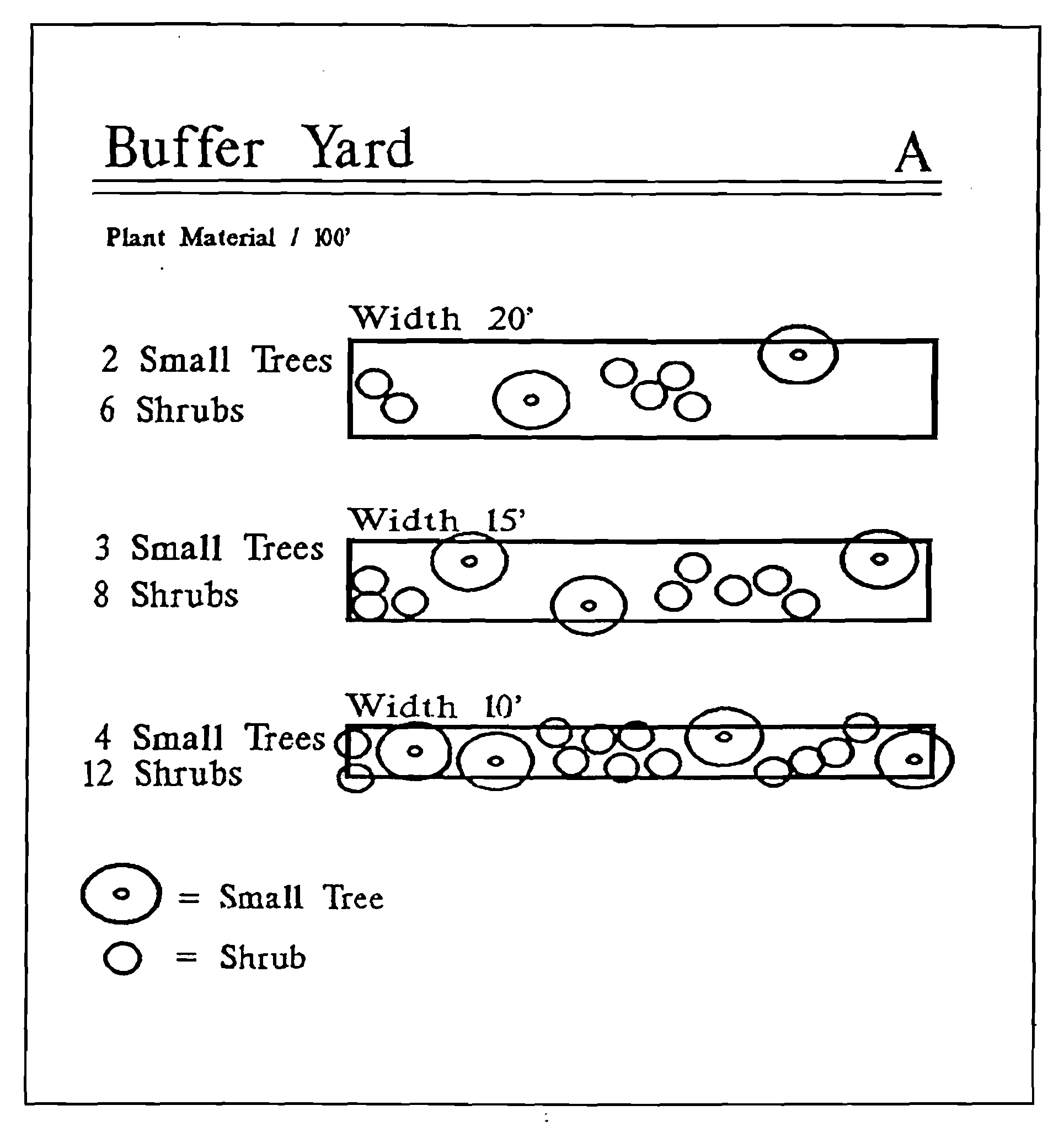
FIGURE B
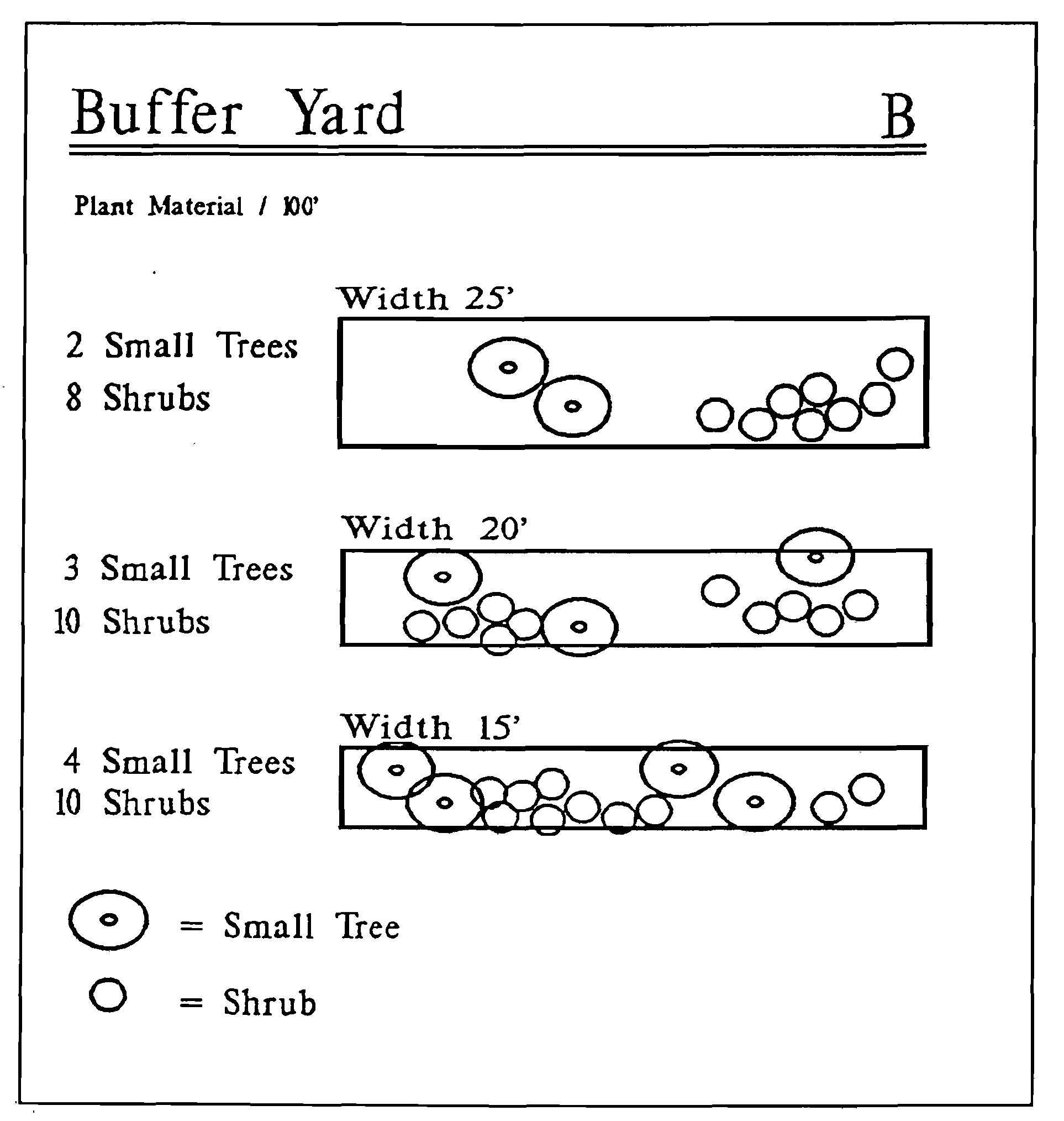
FIGURE C
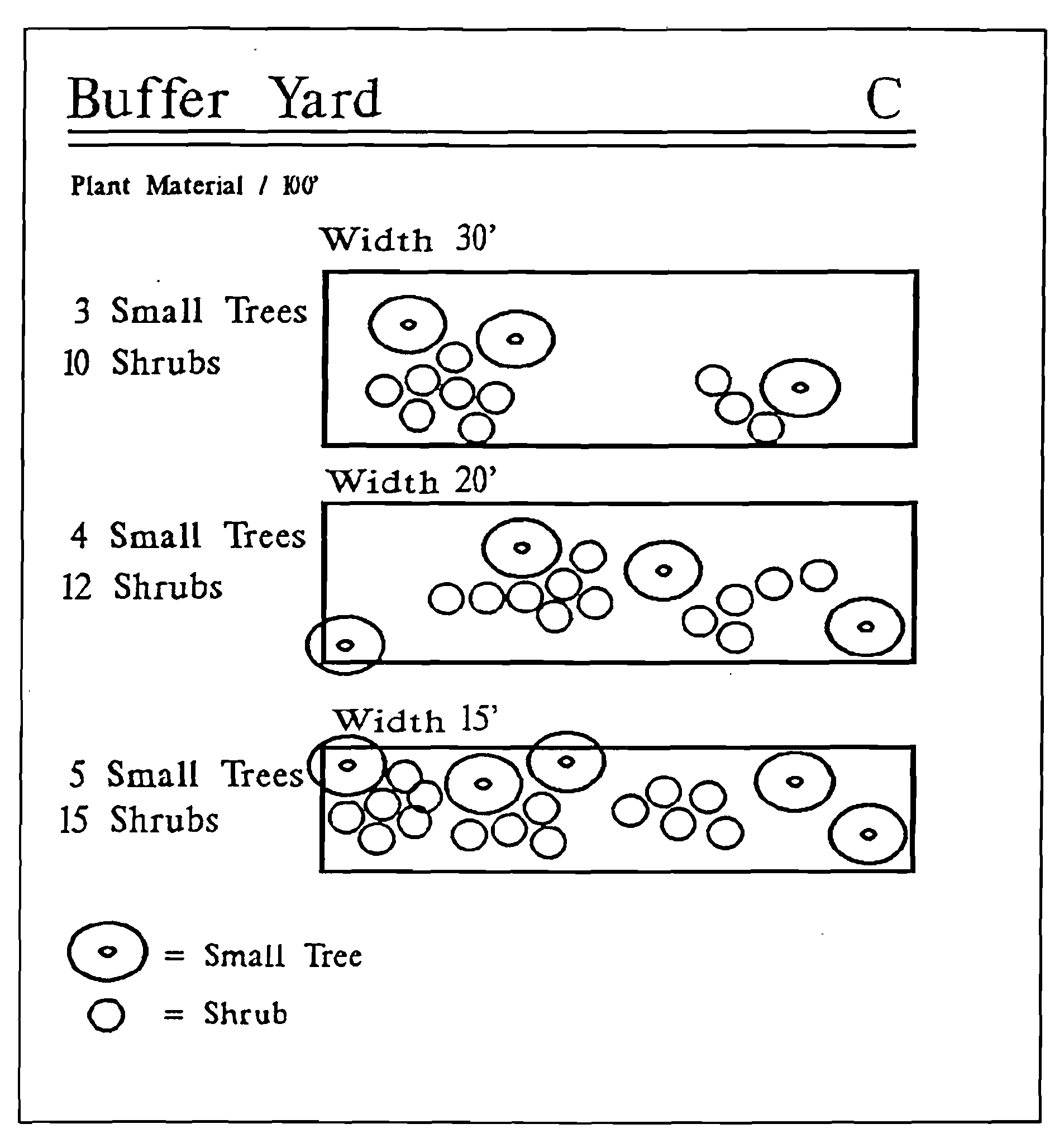
FIGURE D
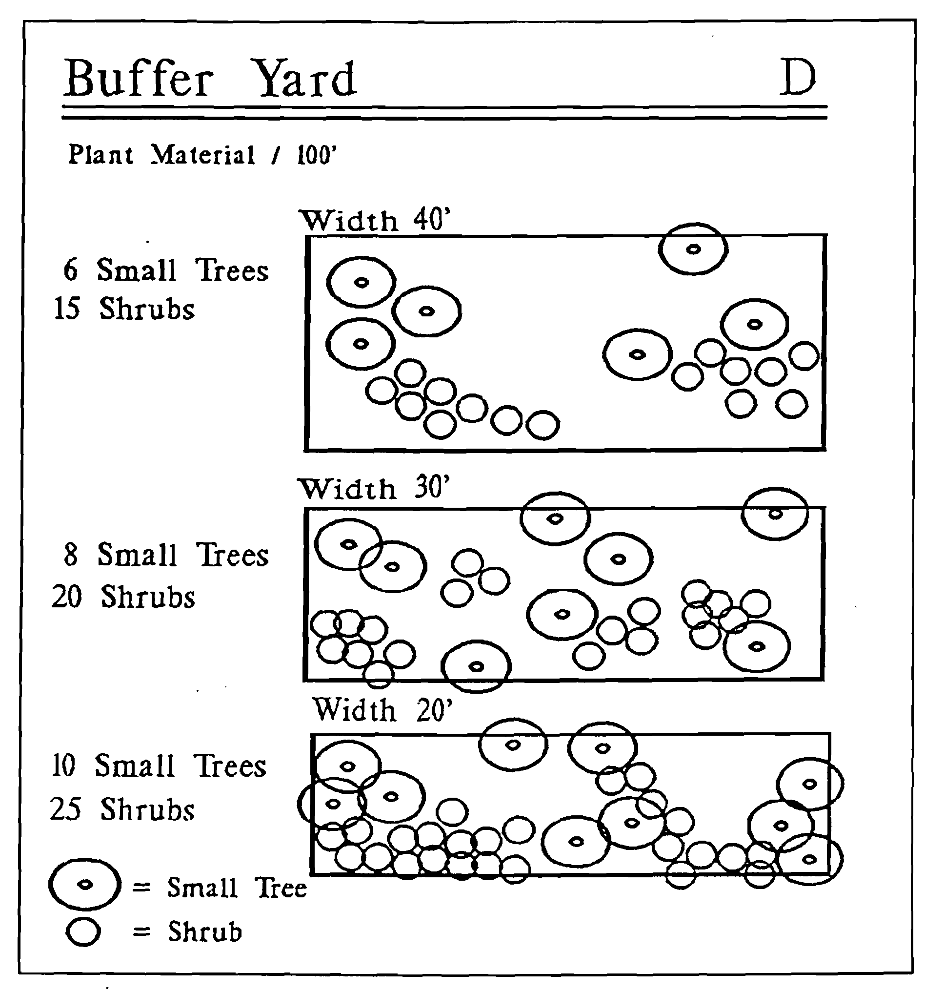
2.04.01. - Intent and purpose.
It is the intent and purpose of this section to implement uniform procedures that promote water conservation through more efficient landscapes and irrigation systems and methods and the installation of more efficient plumbing fixtures and appliances.
(Ord. No. 21-13 , § 2(Exh. A), 7-27-21)
2.04.02. - Efficient plumbing requirements.
(A)
Contractors obtaining Town of Dundee building permits, for all new residential, commercial, and institutional construction, no more than 60 days after the effective date of this section, shall incorporate WaterSense plumbing fixtures (faucets, showerheads and toilets) and ENERGY STAR appliances (clothes washer and dishwasher) into said construction. All new construction shall incorporate WaterSense plumbing fixtures and ENERGY STAR appliances prior to issuance of certificate of occupancy.
(B)
In appliances where WaterSense plumbing fixtures and ENERGY STAR appliances are not available, a written request for an exception must be submitted and approved by the town. For exception to be approved, a best alternative water and/or energy conservative fixture and/or appliance must be identified in the submittal.
(Ord. No. 21-13 , § 2(Exh. A), 7-27-21)
2.04.03. - Florida Water Star Certification effect.
Florida Water Star is a water conservation certification program for new and existing homes and commercial developments that meet specific water-efficiency criteria for indoor fixtures and appliances, landscape design and irrigation systems. Residential and commercial properties obtaining the Florida Water Star Certification will exceed conservation requirements imposed by this section.
Upon receipt of certification from the Florida Water Star program that a residential or commercial property has obtained the Florida Water Star Certification, the town will not require the submission of the letter of certification of the design for an irrigation system, or the letter of completion certifying compliance with design for an irrigation system.
(Ord. No. 21-13 , § 2(Exh. A), 7-27-21)
2.04.04. - Irrigation system design and installation standards.
(A)
Applicability. Irrigation system design and installation standards shall apply to the following:
(1)
All new residential, commercial, and institutional construction where a new landscape irrigation system is required.
(2)
Where significant rehabilitation (50 percent or greater) of an existing landscape irrigation system will be conducted.
(B)
General.
(1)
Nothing within this section shall require the installation of an irrigation system. Requirements for installing irrigation systems are specified in other locations within sections 2.01.01 and 2.03.05 of the Land Development Code.
(2)
All irrigation systems shall be designed by an irrigation professional consistent with the irrigation systems standards and as set forth in this section.
(3)
Where Florida Water Star Certification will not be obtained, a "letter of certification of the design for an irrigation system" signed by the contracted irrigation professional certifying the design is consistent with the requirements of this section shall be required to obtain a building or irrigation permit before issuance of said permit.
(4)
Florida Water Star Certification or a "letter of completion certifying compliance with design for an irrigation system" signed by the contracted irrigation professional certifying the installation is consistent with the design shall be required before issuance of a certificate of occupancy.
(5)
Consistent with section 2.04.05, all irrigation systems must be properly installed and maintained and must operate technology such as rain and/or soil moisture sensors that inhibit or interrupt operation of the irrigation systems during periods of sufficient moisture.
(6)
Compliance with this section shall not exempt an individual from any other local, state, or federal requirements.
(C)
System design and installation standards. Irrigation system design and installation shall be consistent with the irrigation system standards and the following requirements:
(1)
The maximum total irrigated area on residential lots, regardless of lot size, shall not exceed 0.5 acres. This provision does not apply to temporary irrigation such as portable hoses and sprinklers.
(2)
High-volume irrigation area shall not exceed 60 percent of the landscaped area. This standard is applicable on residential lots over 1/8 acre and commercial lots over 1/8 acre. This standard applies to common areas and open space in developments. This standard excludes vegetable gardens and fruit or nut trees on individual lots or community gardens.
(3)
Narrow areas, four feet wide or less, shall not be irrigated unless correctly installed low-volume irrigation or correctly installed side-strip irrigation are used.
(4)
High-volume irrigation shall not be used for trees, shrubs, or groundcover beds. Permanent micro-irrigation may be used in these areas. The town encourages the use of temporary establishment irrigation.
(5)
Irrigation zones shall be divided according to vegetated groupings (e.g., turfgrass, shrubs, native plants, trees) and the water requirements of the plants. Turf grass and landscaped beds, such as trees, shrubs, and groundcover beds, shall not be irrigated in the same zone as each other.
(6)
Sprinkler head types, such as spray heads and rotors, shall not be mixed in the same zone.
(7)
Distribution equipment in each zone shall have matched precipitation rates.
(8)
Rotors and spray sprinkler heads in turfgrass areas shall be spaced to provide head-to-head coverage.
(9)
A minimum separation of four inches shall be required between distribution equipment and pavement.
(10)
A minimum separation of 24 inches shall be required between distribution equipment and buildings and other vertical structures, except fences.
(11)
Technology that inhibits or interrupts operation of the irrigation system during periods of sufficient moisture shall be required on all irrigation systems to avoid irrigation during periods of sufficient rainfall. Examples of such devices include soil moisture sensors, weather stations, and rainfall shut off devices. The technology shall override the irrigation cycle when adequate rainfall has occurred. Technology that depends on rainfall for bypassing irrigation shall be placed where it is exposed to unobstructed natural rainfall and in compliance with F.S. § 373.62, as amended.
(12)
Permanent irrigation systems shall be equipped with an automatic control system to provide the following minimum capabilities:
a.
Ability to be programmed in minutes, by day of week, season, and time of day;
b.
Ability to accommodate multiple start times and programs;
c.
Automatic shut off after adequate rainfall;
d.
Ability to maintain time during power outages; and
e.
Operational flexibility to meet applicable year-round water conservation requirements.
(13)
Sprinklers in low-lying areas have check valves to prevent head drainage.
(14)
Irrigation system equipment shall be installed in accordance with manufacturer's specifications.
(15)
No direct spray shall be allowed onto walkways, buildings, roadways, drives and impervious surfaces.
(16)
Pipelines shall be designed to provide the system with the appropriate pressure required for maximum irrigation uniformity.
(17)
All sprinkler heads with spray nozzles (non-rotary) shall be pressure-regulated at the head or zone valve.
(18)
All irrigation system underground piping shall have minimum soil cover of six inches.
(19)
Sprinklers shall rise above turfgrass height: a minimum of six-inch pop-up for sprays and four-inch pop-up for rotors for St. Augustine, Zoysia and Bahia grasses; a minimum of a four-inch pop-up for sprays and rotors for Centipede, Bermuda and Seashore Paspalum grasses.
(Ord. No. 21-13 , § 2(Exh. A), 7-27-21)
2.04.05. - Maintenance of irrigation systems.
(A)
An irrigation professional responsible for installing or substantially modifying an irrigation system shall provide the property owner with a maintenance checklist affixed to or near the controller and accompanied by a recommended maintenance schedule, proper irrigation system settings according to season, recommendations for checking technology that inhibits or interrupts operation of the system during periods of sufficient moisture, filter cleaning recommendations, if applicable, and information on the current water restrictions.
(B)
A property owner shall ensure that irrigation systems on their property are inspected at least annually for leaks, overspray, maladjusted heads, and heads that may be capped due to changes in the landscape, such as maturity or changes in plants. Technology that inhibits or interrupts operation of the system during periods of sufficient moisture may need to be replaced every few years and shall be correctly functioning to be in compliance with this article. Irrigation systems with known leaks shall not be operated until the leaks are repaired, except for testing purposes.
(C)
Within 60 calendar days after landscape installation, the property owner shall ensure that the irrigation controller is adjusted to operate according to normal, established landscape conditions or irrigation restrictions, if the irrigation system is installed as part of newly established landscaping.
(Ord. No. 21-13 , § 2(Exh. A), 7-27-21)
2.04.06. - Exemptions.
The following are exempted from the provisions of this article, but should follow the Florida Department of Environmental Protection's applicable "Florida-Friendly Best Management Practices for the Protection of Water Resources by the Green Industries":
(1)
Bona fide agricultural activities;
(2)
Vegetable gardens and fruit and nut trees;
(3)
Athletic fields;
(4)
Golf course play areas;
(5)
Cemeteries;
(6)
Nurseries; and
(7)
Temporary establishment irrigation. The temporary use of irrigation for the establishment of new vegetation that shall be removed once the plants are established or within two years, which occurs first.
(Ord. No. 21-13 , § 2(Exh. A), 7-27-21)
2.04.07. - Alternative compliance.
(A)
An applicant may submit a proposal that varies from the strict application of the requirements of this section (also known as "alternative compliance") in order to accommodate unique site features or characteristics, utilize innovative design, prevent extraordinary hardship, or to promote the overriding public interest or general public welfare. Diminished value of property or inconvenience is not an extraordinary hardship.
(B)
An applicant seeking authorization for alternative compliance shall have the burden of demonstrating to the town the reasons why the strict application of the requirements of this section should not apply.
(C)
Requests for alternative compliance shall be submitted as part of the irrigation system approval process.
(D)
The town may approve an alternative compliance plan upon finding that the alternative compliance plan fulfills the purpose and intent of this section at least as well as a plan that strictly adheres to the requirements of this section.
(E)
The town may require a site inspection and corresponding site inspection fee for systems which are installed according to a department-approved alternative compliance plan.
(Ord. No. 21-13 , § 2(Exh. A), 7-27-21)
2.04.08. - Enforcement.
Violation of any provision of this article shall be subject to enforcement and penalties as provided for by the Code of Ordinances of the Town of Dundee, the Town of Dundee Unified Land Development Code, and/or applicable law. Each remedy provided for is an additional and supplemental means of enforcing the Code of Ordinances of the Town of Dundee and may be used for the enforcement of this code singularly or in tandem. Nothing contained herein shall prohibit the Town of Dundee, Florida, from enforcing the Code of Ordinances of the Town of Dundee by any other means available at law or equity.
(Ord. No. 21-13 , § 2(Exh. A), 7-27-21)