
Effingham City Zoning Code
APPENDIX C
COMPREHENSIVE PLAN
CHAPTER 1 - INTRODUCTION
"The future belongs to those who prepare for it." (Anonymous)
The City of Effingham sets an example for communities across the United States in the area of comprehensive planning. Since 1959, Effingham has regularly prepared and adopted new comprehensive plans to guide its growth and development. Previous plans were completed in 1959, 1974 and 1984. This document represents the City's latest achievement in its long tradition of successful comprehensive planning.
To adapt to changing times, the City employed a slightly different approach for this new Comprehensive Plan. Three separate geographic areas were identified for study. The first, the Primary Area, includes both incorporated Effingham and the unincorporated area immediately around it. The Environs Area is the unincorporated area around the Primary Area. Finally, due to its close ties with the City, Lake Sara is included in the Comprehensive Plan. These study areas are depicted on Plate 1.
Divided into sections dealing with each of these geographic areas, the plan covers demographics, land use, transportation, housing, community facilities, public safety and utilities. Maps and tables are provided to illustrate key points throughout the text.
In addition to the facts and analysis it offers, the Plan is:
•
a Statement of Policy;
•
a Physical Plan;
•
a Vision of the Future; and
•
a Tool to Guide Decisions.
The Comprehensive Plan is an advisory document to be used by elected officials, the Plan Commission, City staff, other boards and commissions, and members of the community. Its purpose is to provide guidance on a daily basis. Everyday, the City will be confronted with decisions to allocate its limited resources. Should new roads be built and, if so, where? Is this site a good location for industry or should it be used for single-family residential use? What should the City's capital improvement priorities be in the next five years? Effingham's Comprehensive Plan serves as a primary resource in the City's "tool box." It offers coherent guidance and direction so that daily, incremental decisions can be made within the context of a larger purpose.
The completion of the Comprehensive Plan is only the first step. Its value to the community lies in its use and implementation during the next five years.
CHAPTER 2 - GOALS AND OBJECTIVES
"We are faced not with one vision of the unknowable future, but with a multitude of possible futures." (Natalie Halprin)
Appendix A - Plates
PLATE 1 STUDY AREAS
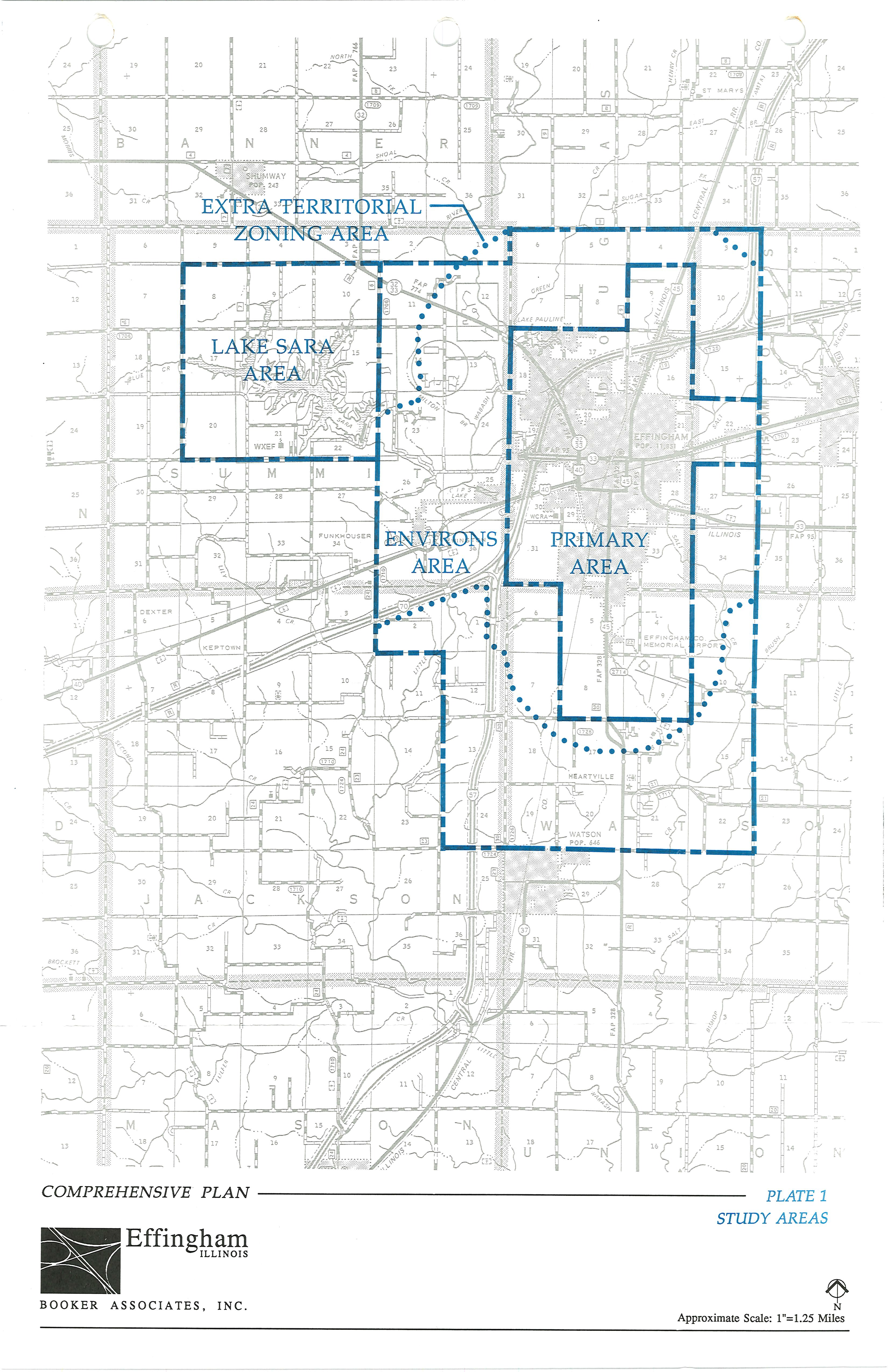
PLATE 2 PHYSICAL CONDITIONS
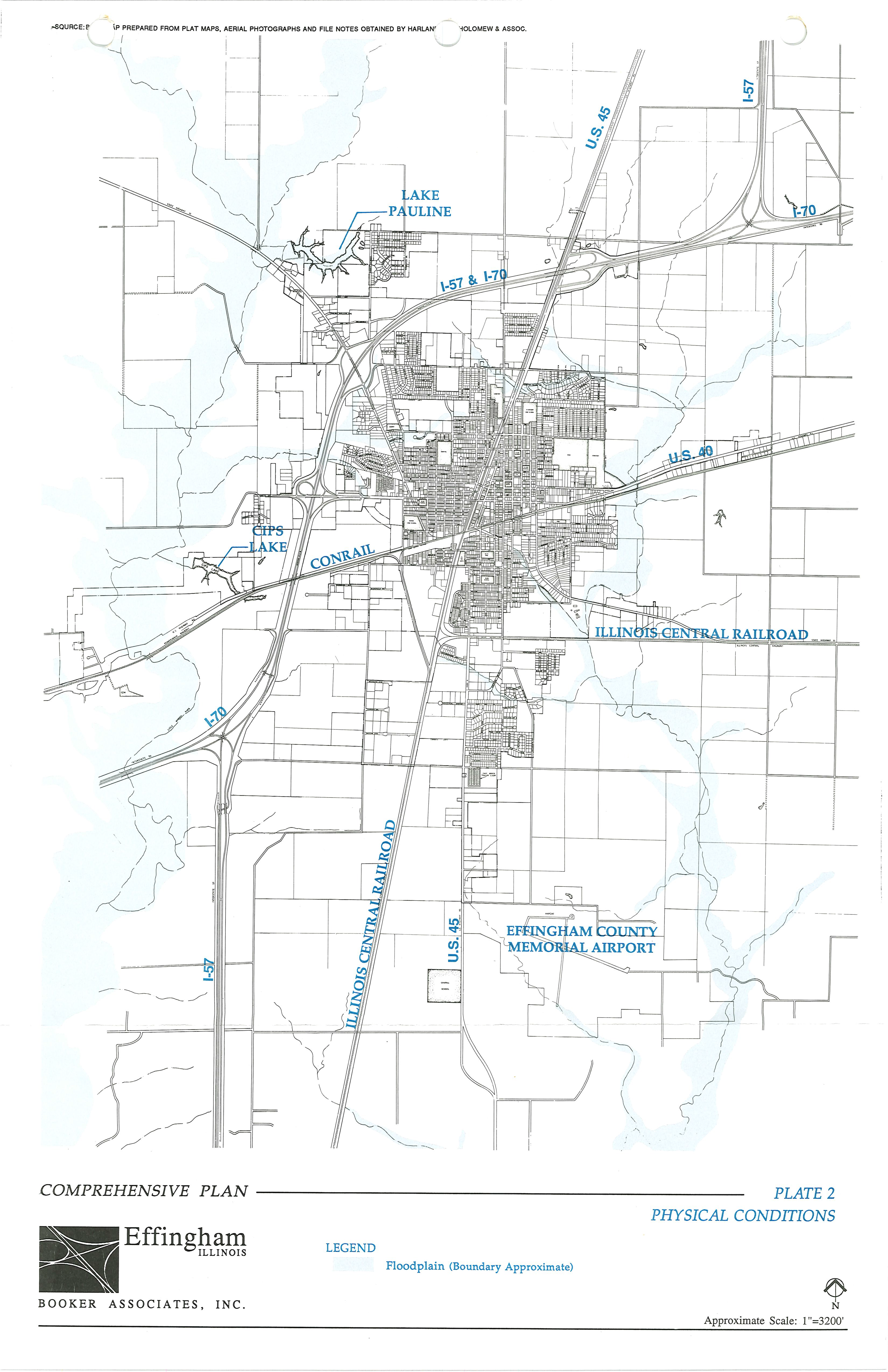
PLATE 3 EXISTING LAND USE, CITY OF EFFINGHAM
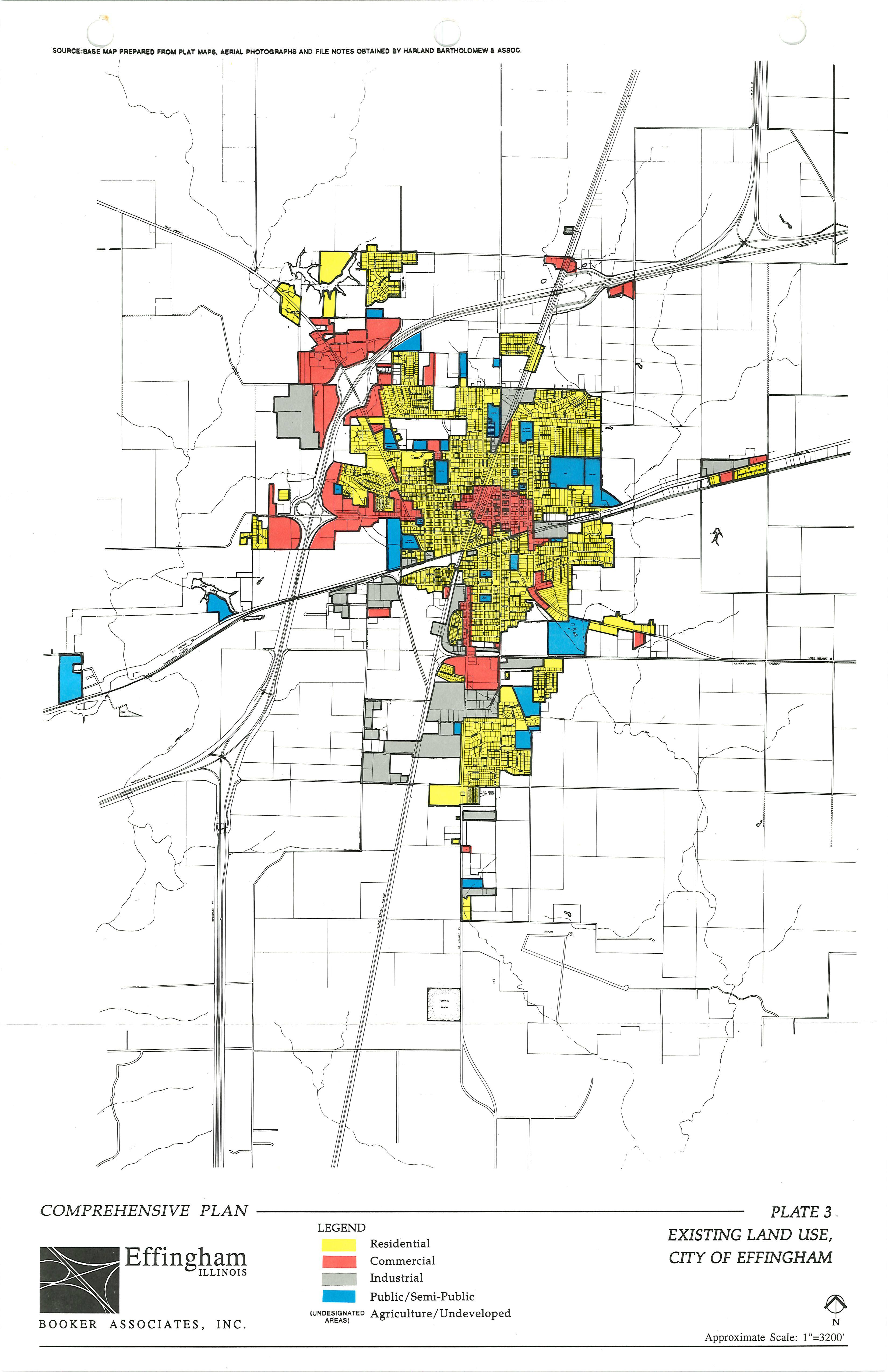
PLATE 4 EXISTING LAND USE, SURROUNDING AREAS OF STUDY
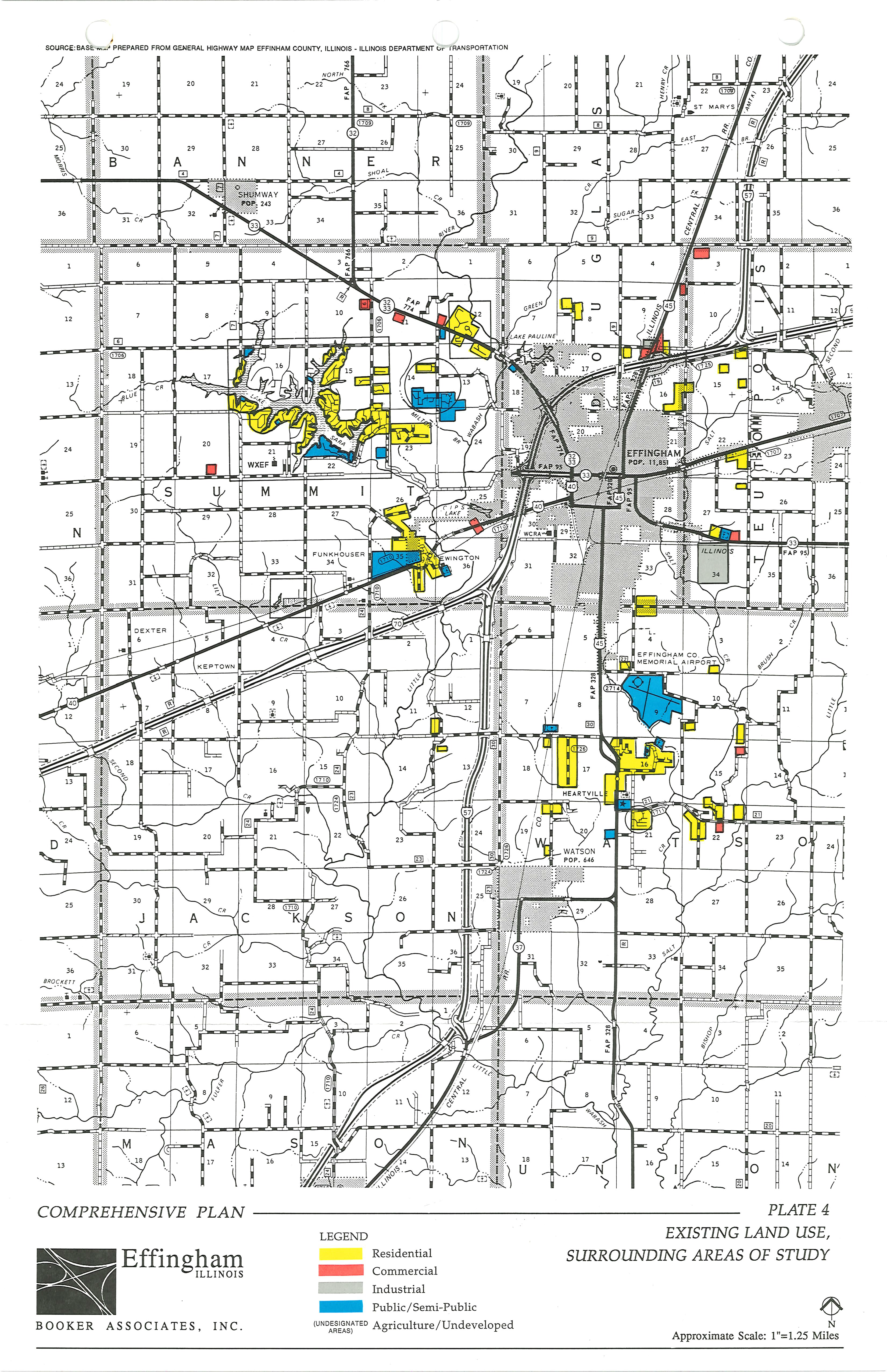
PLATE 5 SPECIAL DISTRICTS
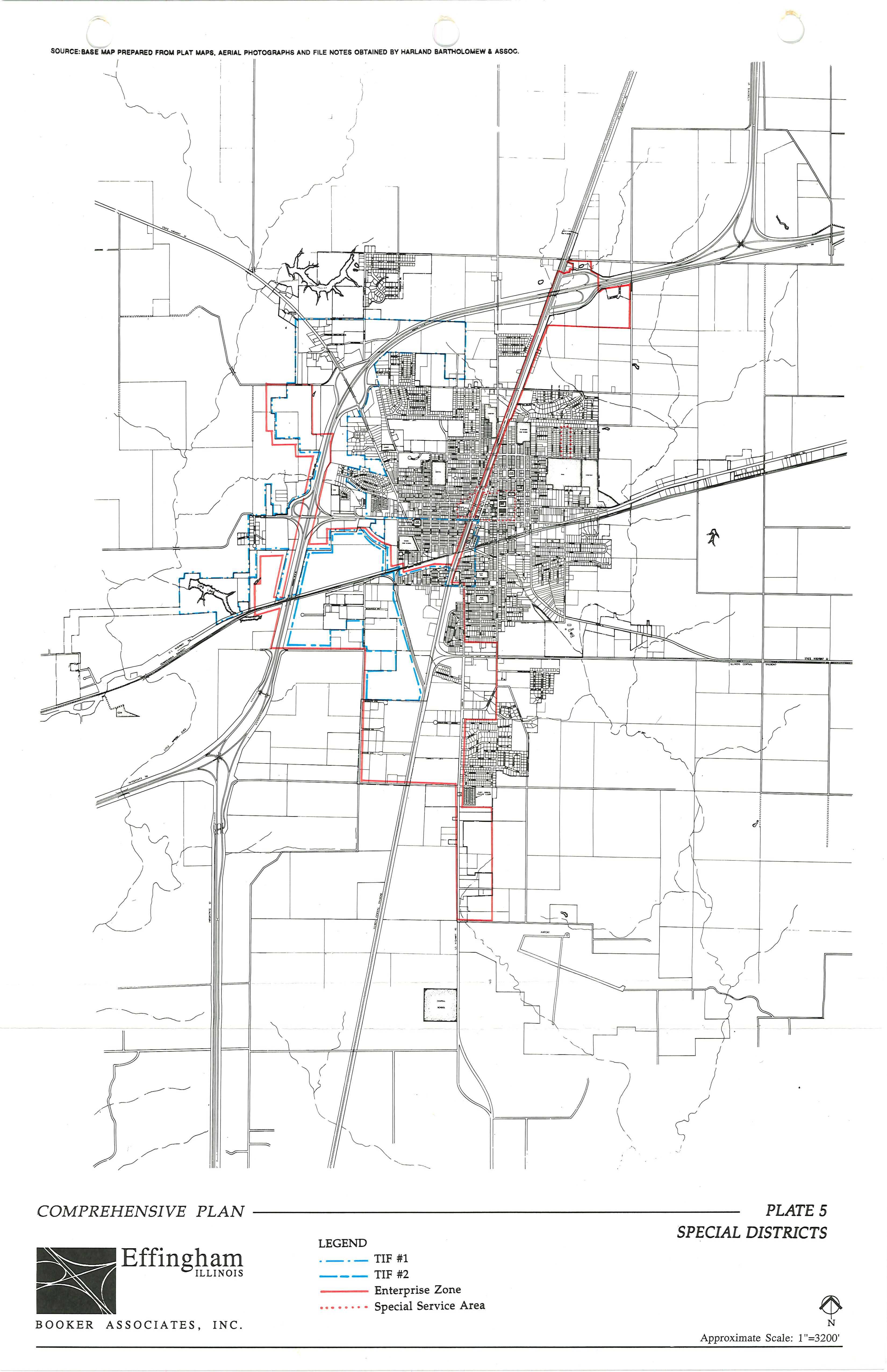
PLATE 6 TIF GENERALIZED LAND USE PLAN
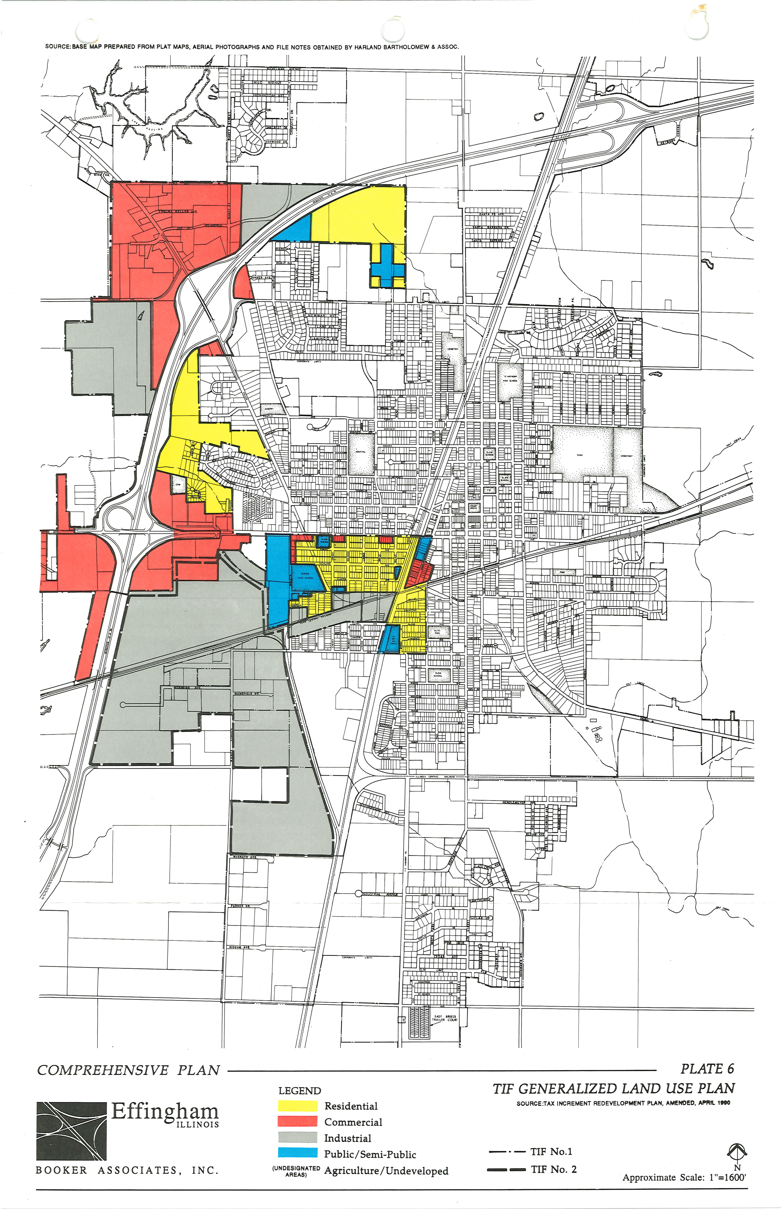
PLATE 7 FUTURE TRANSPORTATION PLAN
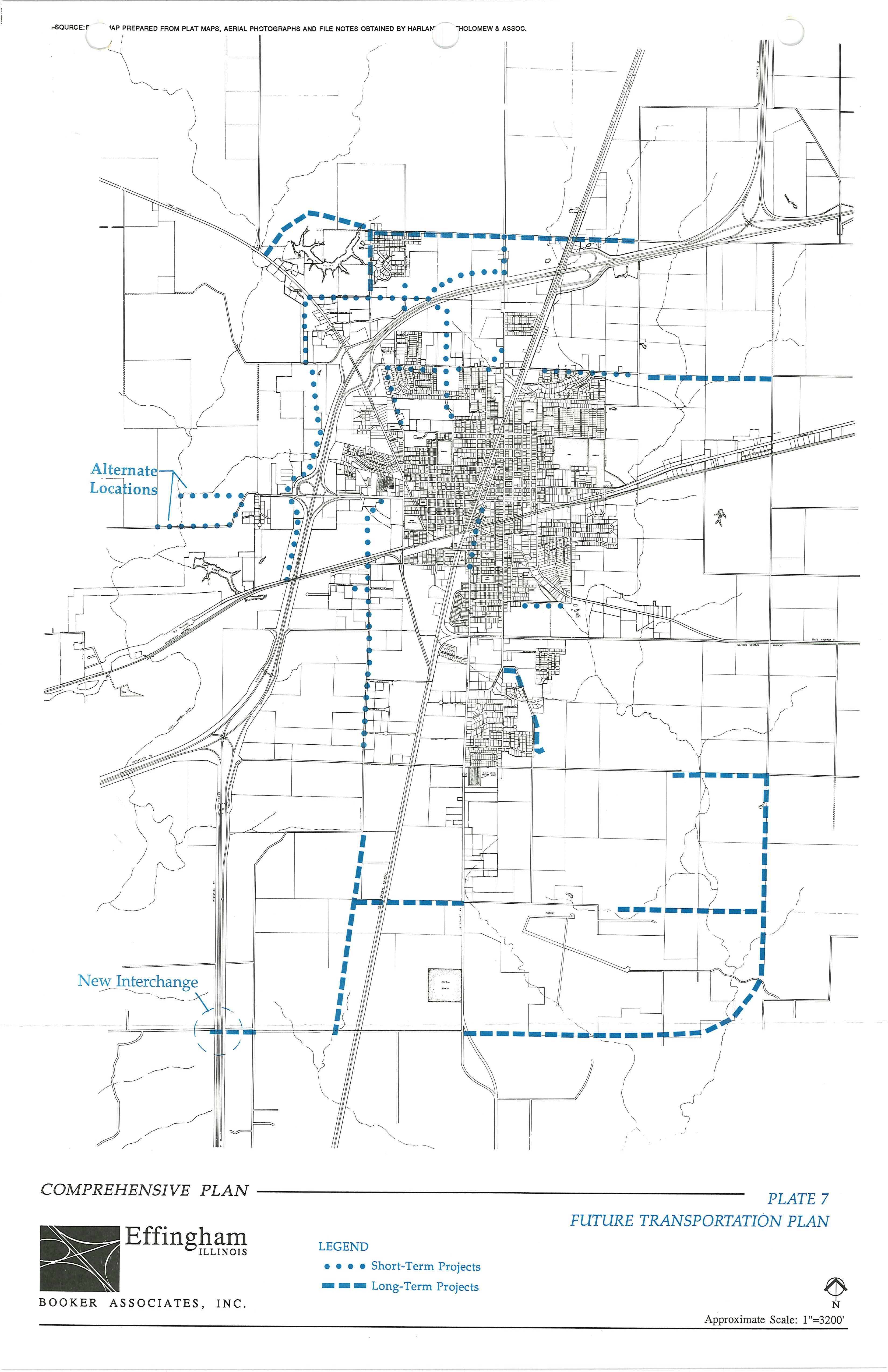
PLATE 8 PROPOSED ACCESS TO LAKE SARA
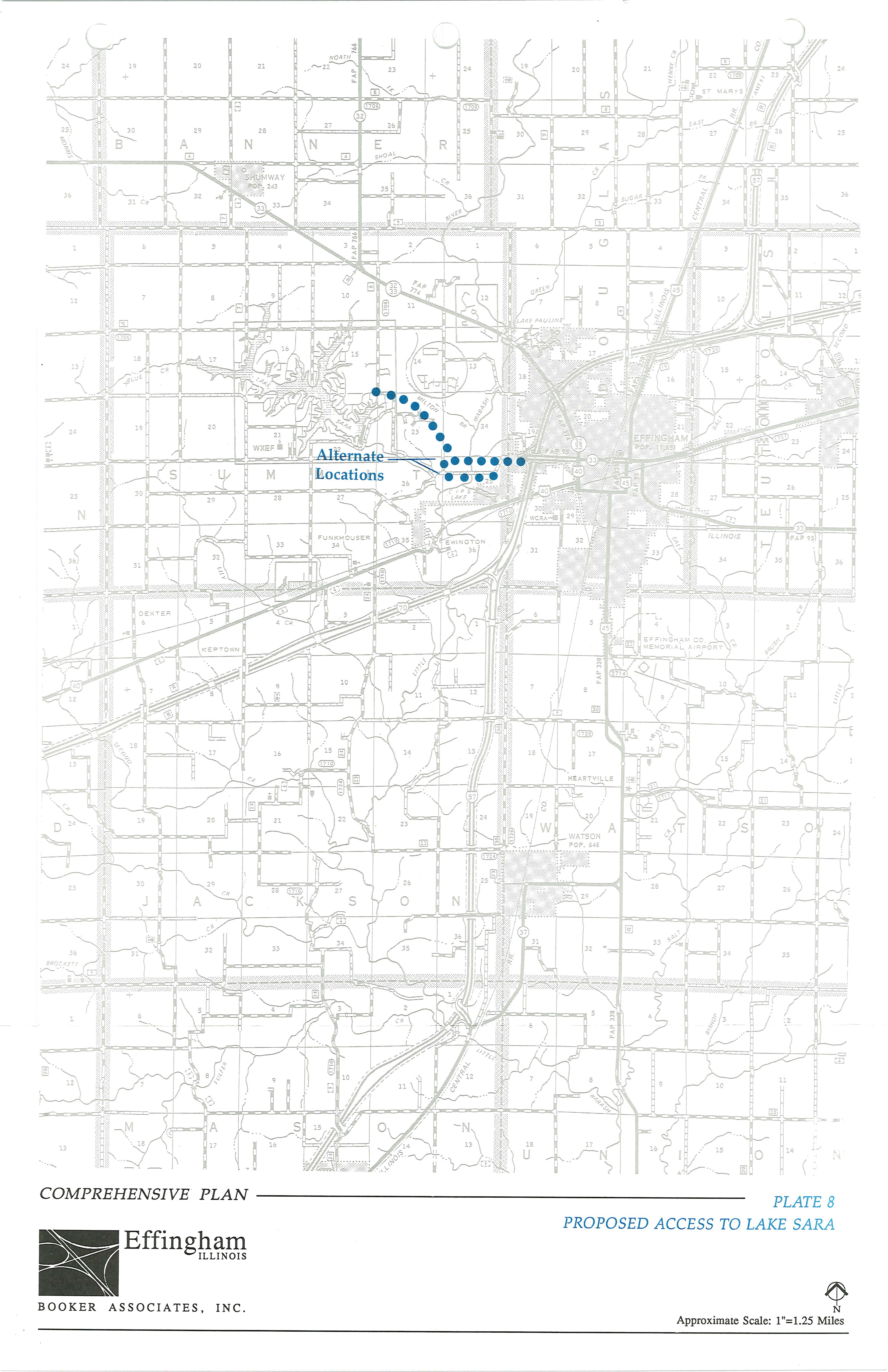
PLATE 9 WATER SERVICE DISTRICTS
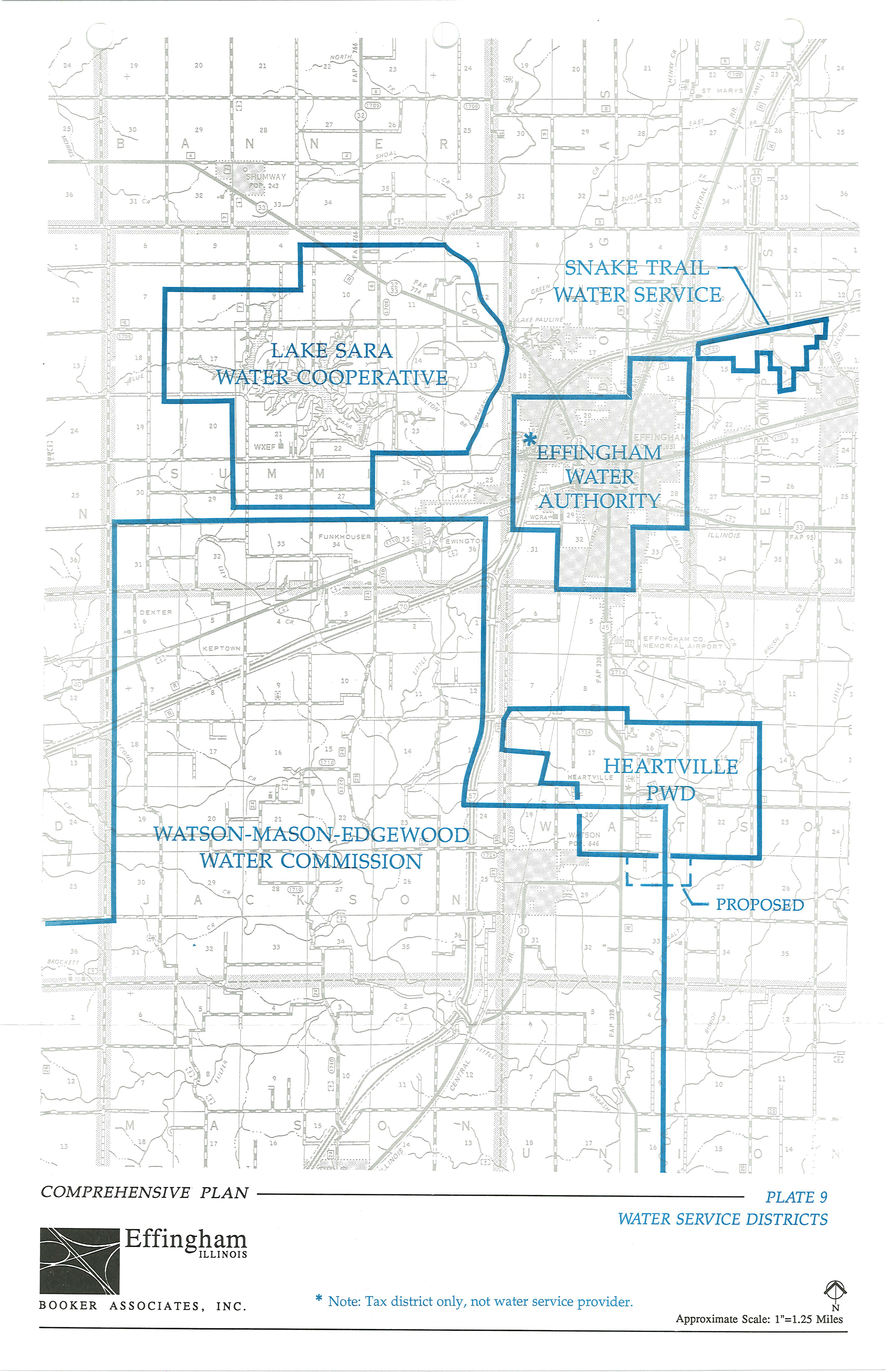
PLATE 10 FIRE DISTRICTS
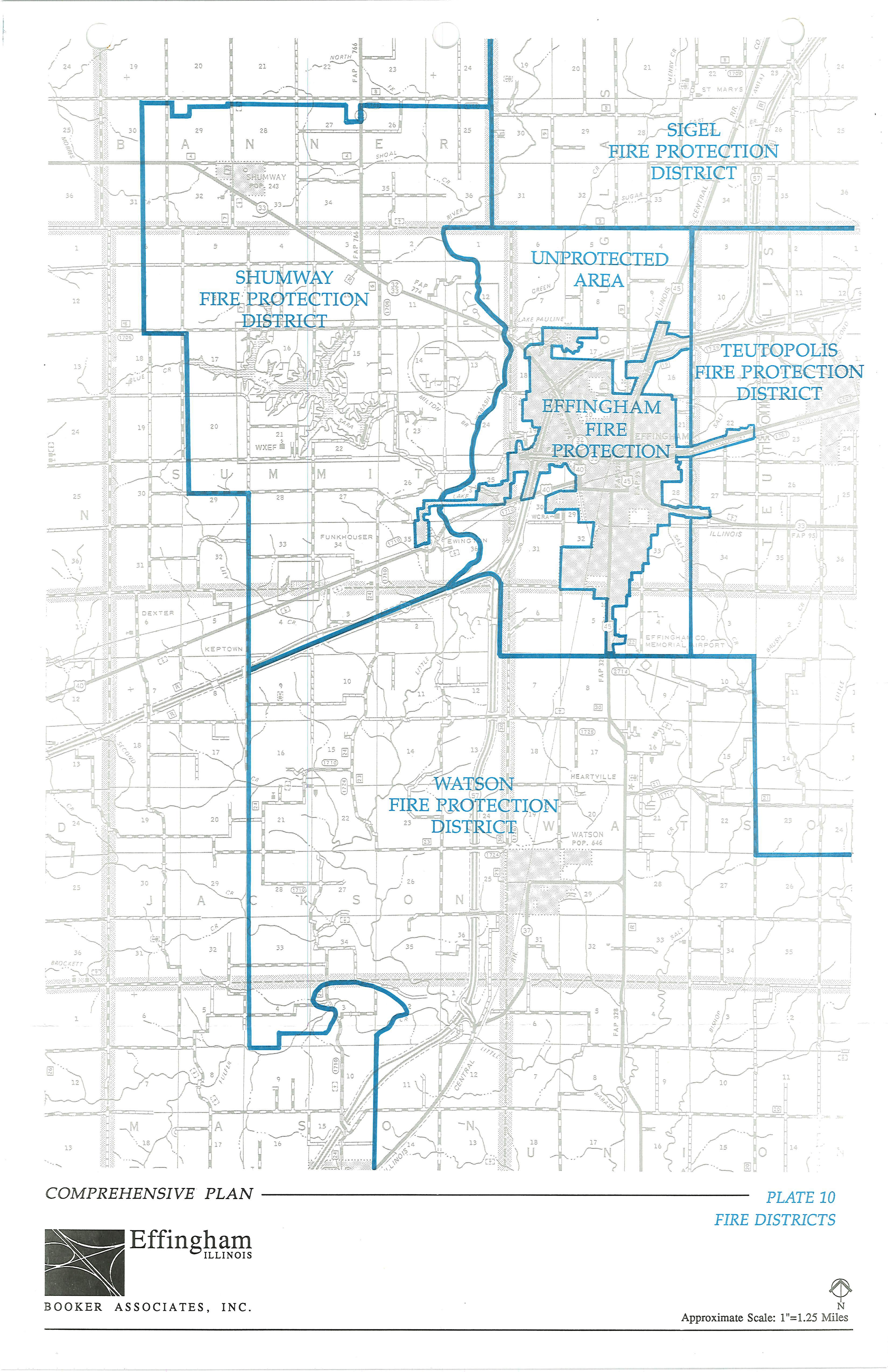
PLATE 11 HOUSING SURVEY RESULTS
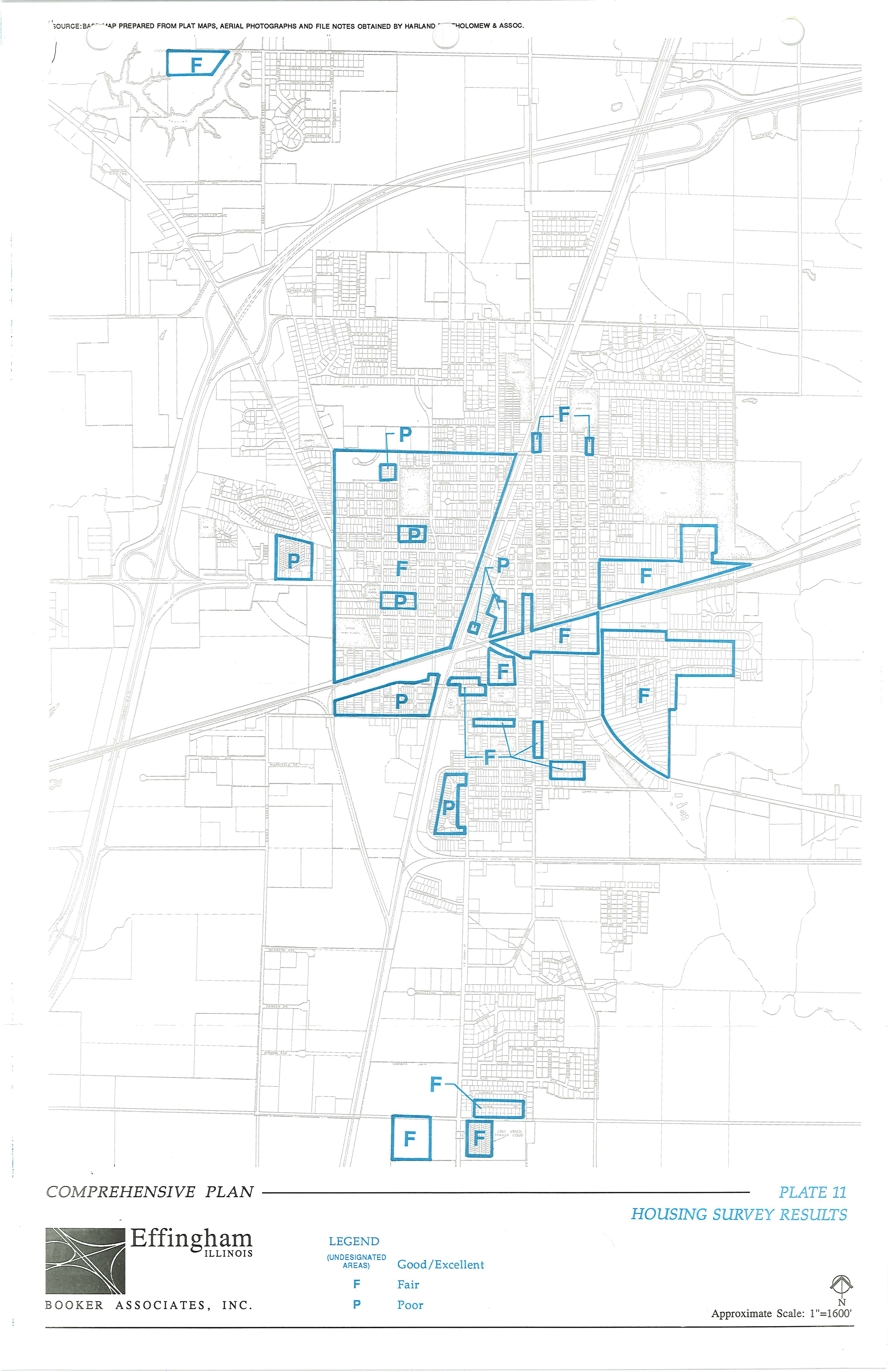
PLATE 12 HOUSING REHABILITATION AREAS
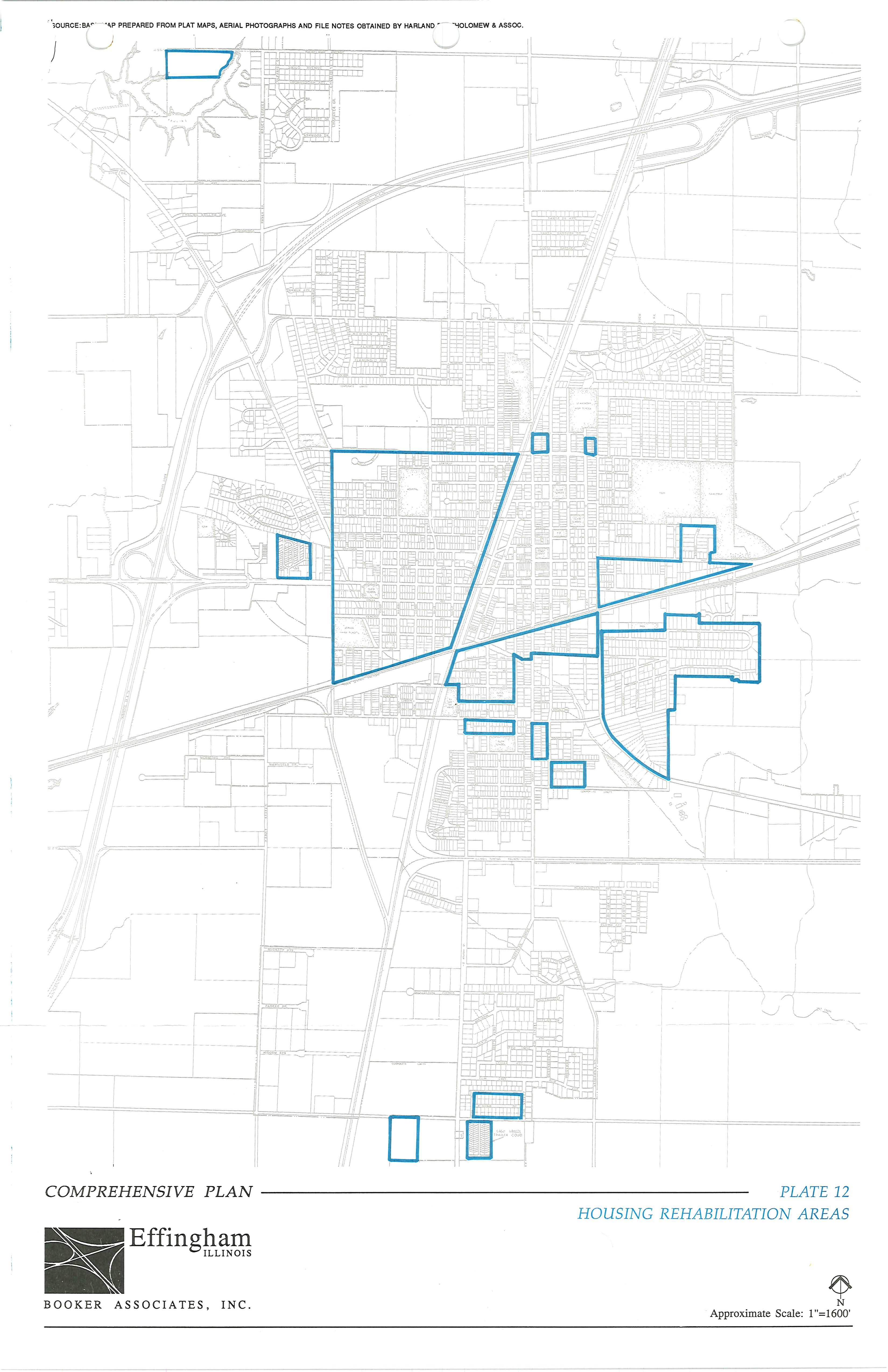
PLATE 13 COMMUNITY FACILITIES
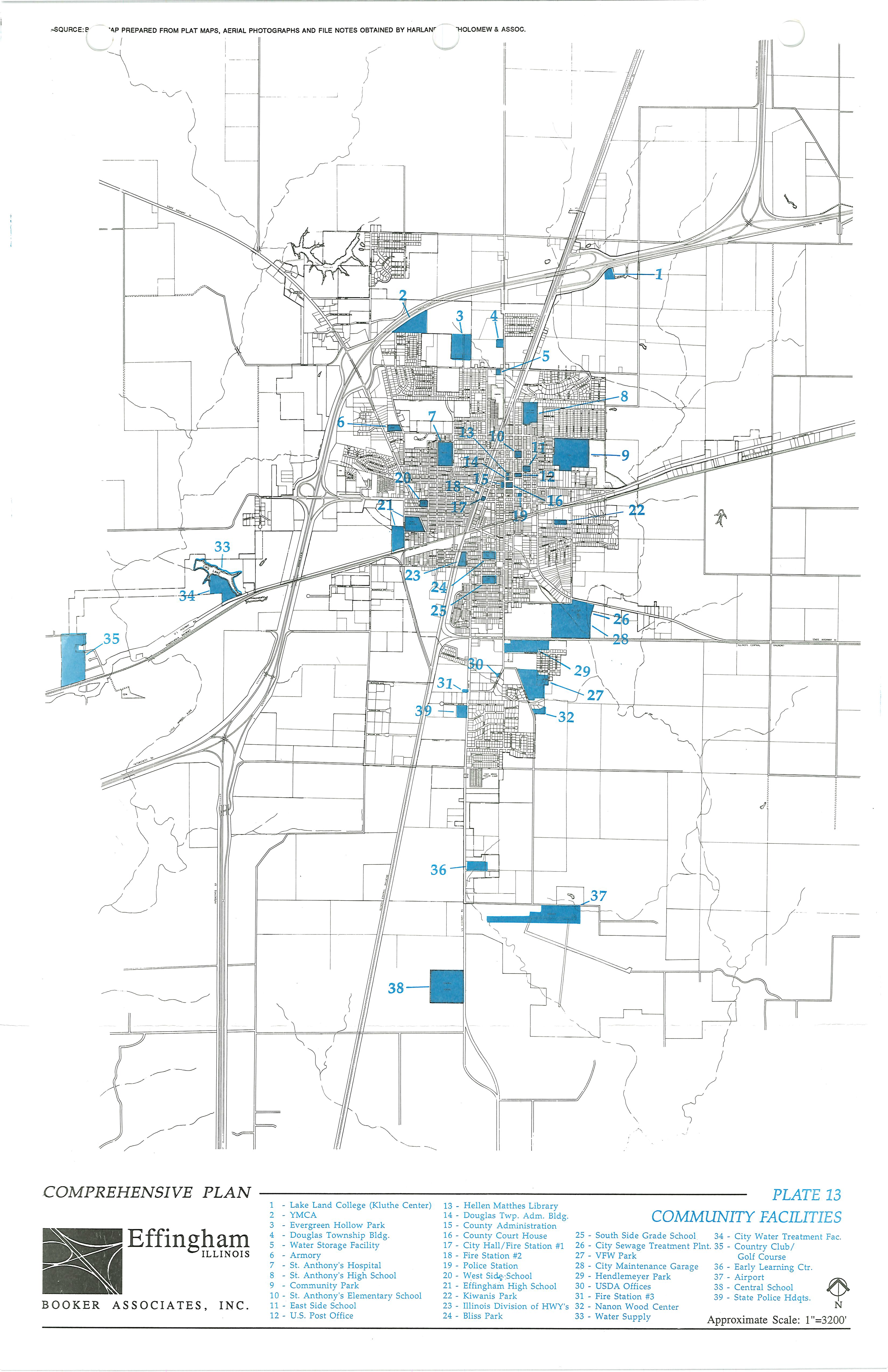
PLATE 14 SCHOOL DISTRICT BOUNDARIES
PLATE 15 DEVELOPMENT PLAN, CITY OF EFFINGHAM
PLATE 16 DEVELOPMENT PLAN, SURROUNDING AREAS OF STUDY
[Appendix C] - Growth Management
EXECUTIVE SUMMARY
What is the Growth Management Element? The Growth Management Element updates and supplements the City of Effingham's Comprehensive Plan (adopted in 2000) and replaces the Development Plan (an element of the Plan). The Implementation and Administration component identifies actions the City should undertake to ensure that recommended growth management goals and policies are implemented.
This document describes the City of Effingham's preferred growth scenario to achieve the community's goals and address the following challenges and needs to:
•
Prepare for long-term growth;
•
Effectively respond to new growth to opportunities and challenges;
•
Achieve coordinated growth strategies;
•
Minimize traffic congestion from external development and inefficient growth patterns;
•
Protect and preserve rights-of-way for future roadway needs as identified in the Future Land Use Plan;
•
Fund future roadways;
•
Plan for and provide adequate public facilities;
•
Promote development of quality urban and suburban neighborhoods;
•
Provide opportunities for attainable housing;
•
Have economic development strategies and incentives to ensure a balanced, vigorous economy;
•
Revitalize and rehabilitate the Central Area (downtown) to maintain the abutting residential neighborhoods and central business core;
•
Develop and encourage attractive gateways;
•
Maintain and improve community character by providing adequate parks and recreation facilities, libraries, schools, cultural facilities, and public art.
Future Land Uses. The Growth Management Element describes the locations, types and intensities of land uses required to serve projected growth through the year 2025. It also provides for strategies to protect lands from inappropriate development in areas where the City projects growth beyond the year 2025.
From Goals to Implementation. The Growth Management Element builds upon the goals adopted in the Comprehensive Plan, by identifying additional objectives (narrowly defined statements of public purpose used to help clarify and define broad-based goals), policies (statement of government intent against which actions and decision are evaluated) and strategies (specific actions taken to achieve goals). These strategies are expressed as a "to do" list or plan implementation program for decision-makers.
This Growth Management Element:
1.
Advocates the timely provision of public facilities commensurate with growth and expansion of the City particularly into the northern part of the unincorporated County. The cost of providing needed community services will be significant. The Growth Management Element guides the development, future community facility needs, and ultimately, an efficient expenditure of public funds, as identified in the Implementation Element. The City must demonstrate when it will provide the public facilities, and how it will pay for them, before development orders can be issued. This is the concept of "concurrency" and should be administered through continued adequate public facilities policies.
2.
Establishes a multi-center land use pattern that will encourage the development of an efficient transportation system. Employment centers, commercial uses and residential development are encouraged to locate within close proximity to each other. The three types of activity centers are distinguished to achieve this concept are mixed-use regional activity centers, commercial activity centers, and neighborhood activity centers. Criteria for the location of neighborhood-serving commercial uses are established in the Implementation Element. These criteria and the criteria for other types of activity centers are provided in recognition that other activity centers may develop over time. The Plan's intent is to prescribe the appropriate scale, intensity and range of uses for each type of activity center.
3.
Promotes growth in areas where it can be served by existing infrastructure. Infill development is encouraged, particularly around and within activity centers. Public and private investments, including the use of tax increment financing, enterprise zones, and Business Districts, are necessary to revitalize blighted or declining commercial and residential neighborhoods.
4.
Advocates enhanced development design to promote compatible transitions between land uses. Community design considerations have been incorporated into the Plan through the Community Design Component of the Growth Management Element. This subsection addresses the issues of designing attractive transportation corridors and gateways to the City, and the use of design to improve residential neighborhoods as well as commercial and industrial development areas. Community identities will be defined, maintained, and enhanced through the adoption of development standards, historic preservation, and could be further enhanced with special area plans.
5.
Advocated a strong arts and culture program to encourage expansion of arts, culture and cultural tourism in the City. The Implementation Element makes recommendations about the creation of alliances with and the coordination of activities between the City the Tourism Advisory Board, FACE, other area not-for-profit groups and state agencies. A strong cultural program will require leveraging public- and private-sector funding to accomplish the goals of providing arts and culture that enrich the lives of citizens and visitors to the City. Illinois ranks 9 th in the nation in the number of historic and cultural tourists. It is important that the City and arts and cultural groups take advantage of available programs to attract visitors and tourists to arts, cultural and historic venues in Effingham, encouraging stay-over visits, fostering the community's growing restaurant and hotel industry, and encouraging the potential for increased retail and service sales to cultural and historic-minded visitors shopping in the region.
6.
Advocates a systematic approach to environmental resource protection. The concept of focused activity center development will facilitate the preservation of environmental areas. Development pressures on environmentally sensitive areas will ease as intensities ordinances to protect wetland and woodland areas that provide significant or essential vegetative and wildlife habitats are adopted. A significant amount of land bordering the City's east and west sides is designated as floodplain by FEMA and subsequently confirmed in targeted studies conducted by the City. Floodplains present constraints to development but also may be a resource in terms of providing vegetative and animal habitats.
7.
Provides a framework for urban reinvestment in areas critical to the preservation of City's economic strength and future. The Growth Management Element stresses the importance of reinvestment in and revitalization of the Central Area, the St. Anthony's Memorial Hospital area, the housing stock, and the City's industrial and commercial base including the Effingham County Memorial Airport. In addition, these elements also address the need to expand the City's parks and recreation facilities to sustain a high quality of life.
8.
Advocates the need for intergovernmental coordination to manage growth while providing adequate public facilities as development occurs. The Growth Management Element stresses the need to focus public expenditures for the provision of water, sewage, stormwater management, parks and roads in an efficient manner tied to the Capital Improvements Plan and budget. The objective is to time growth and development in order to prevent the use of wells and septic tanks.
[Appendix D] - Bicycle and Pedestrian Plan
Introduction
The City of Effingham is a thriving, growing community in central Illinois. Situated at the convergence of major highways and railroads, the city takes pride in being the "crossroads of opportunity." Just as those transportation options have contributed to Effingham's success in the past, improving conditions for pedestrians and cyclists will ensure that residents and visitors have even more choices for getting around in the future—from children walking to school, to adults biking for errands, to retirees using the trails to stay active.
People choose to live, work and play in Effingham because of its vibrant mix of housing, education, recreation and employment opportunities. Site Selection Magazine recently ranked it in the top 10 of small US towns for companies striving to provide a better quality of life for their employees. With great schools and parks, including nearby Lake Sara, it is no surprise that Effingham has enjoyed steady population growth in recent decades.
Figure 1 This plan aims to make it easier, safer and more pleasant to walk or bike
to local businesses
Improving the environment for walking and biking will help Effingham meet the transportation and recreation needs of residents and visitors, while making the city even more competitive in terms of attracting new businesses and investments. Sidewalks, bikeways and trails are assets that can spur development and strengthen a sense of community.
Already, Effingham is on its way to developing an extensive trail system (Trail Recreation Effingham County, or TREC) that will help connect the City to the popular recreation activities in and around Lake Sara. It is also working with IDOT to improve access at two key points across I-57/70, currently a major barrier to people on foot or two wheels. Building on this momentum, the City has partnered with area residents and the League of Illinois Bicyclists to develop this Bicycle and Pedestrian Plan.
Figure 2 Busy intersections, such as the one at Evergreen and Keller, can be intimidating
to people using their feet, a wheel chair or a bicycle.
The overall goals and guiding principles for this plan are to:
•
Provide safer, more pleasant conditions for those who already walk and bike in Effingham by choice or by necessity.
•
Encourage more residents to use their feet or bikes for short distance travel through education and the improvement of conditions.
•
Ensure new development and transportation projects address walking and cycling amenities from the start, instead of having to be retrofitted.
This plan outlines potential improvements in Effingham to facilitate walking and bicycling for both recreation and transportation, and is comprised of the following sections:
•
Complete Streets: Provides context and presents policy tools for creating transportation corridors that work for all users.
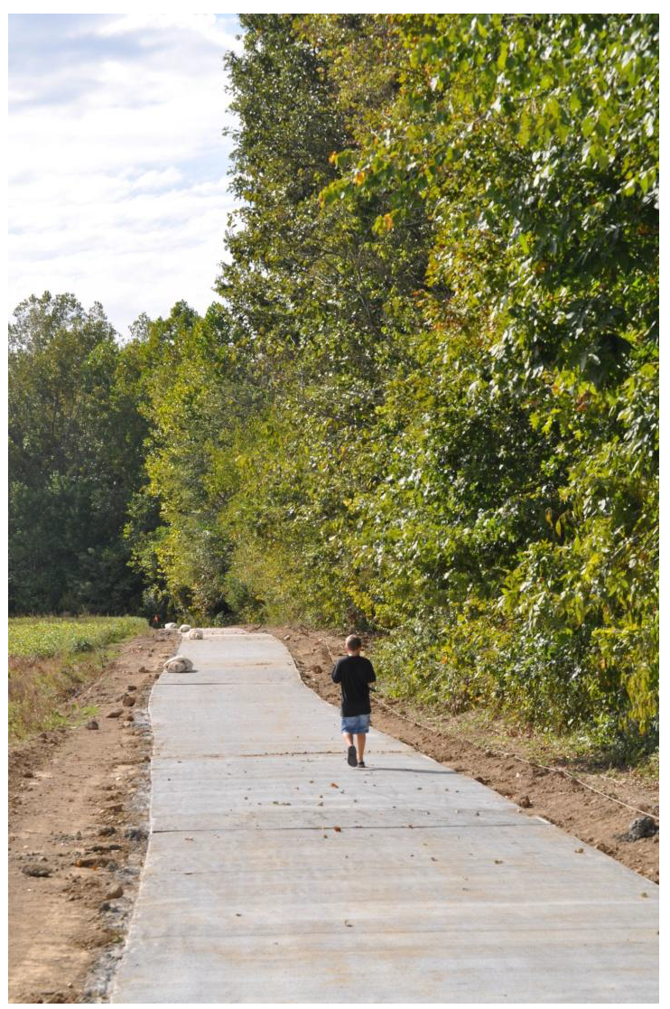
Figure 3 The newly built Phase 1 of the TREC Trail is inviting to people of all ages.
•
Bikeways: Explains the range of on and off road bicycle facilities that can be used to complete a "bikeways network" and the methodology used to create a planned network for Effingham.
•
Safe Routes to School: Pays particular attention to the travel needs of Effingham's youngest residents, and proposes high priority areas of improvement.
•
Recommended Projects: Provides maps of existing conditions; recommended projects; projects by priority and readiness; and the proposed bikeway network and increased sidewalk coverage for the future. It also includes a table listing recommended on and off road projects by street name.
•
Other Recommendations: While much of the plan addresses infrastructure and engineering, this section focuses on the "Other E's" - Education, Encouragement, and Enforcement. Bicycle parking is also addressed here.
•
Implementation: Provides funding, staffing and evaluation strategies to help move the plan from paper to the streets.
Complete Streets
Introduction
Complete Streets refers to a way of thinking about roadways that emphasizes the needs of all the people who travel along and across them—whether they are in a car, on a bike, on foot, in a wheelchair, or pushing a stroller. For example, a busy street that efficiently moves cars but provides no safe and convenient crossing for school children is "incomplete." Intersection improvements, such as pedestrian countdown signals, center medians and/or curb extensions can help complete the street.
In recent years, jurisdictions and DOTs at all levels of government have developed policy and planning tools to ensure that transportation projects accommodate people of all ages, abilities and modes. In Illinois, a Complete Streets bill passed the legislature in 2007 with resounding support (Public Act 95-0665). It states: "Bicycle and pedestrian ways shall be given full consideration in the planning and development of transportation facilities, including the incorporation of such ways into State plans and programs." The intent of the law, which went into full effect on July 1, 2008, is to help make State-maintained roadways safe and convenient for all modes of travel, including those who walk or bike by choice or necessity.
In March, 2010, the US Department of Transportation also voiced support for Complete Streets with a new bicycle and pedestrian accommodation policy statement, "Every transportation agency, including DOT, has the responsibility to improve conditions and opportunities for walking and bicycling and to integrate walking and bicycling into their transportation systems. Because of the numerous individual and community benefits that walking and bicycling provide — including health, safety, environmental, transportation, and quality of life — transportation agencies are encouraged to go beyond minimum standards to provide safe and convenient facilities for these modes."
Figure 4 Filling in sidewalk gaps and improving intersections helps complete a street
for pedestrians.
By developing a Bicycle and Pedestrian Plan, the City of Effingham has established priorities for transportation corridors that need improvement (see later sections). However, to ensure that transportation projects—whether or not they are addressed specifically in this plan—consider the needs of all potential travelers, the plan recommends adopting "Complete Streets" policies.
Plan Recommendations
Local Roads: Pass a Complete Streets Policy to help guide transportation and development projects in Effingham. Suggested language:
The City of Effingham establishes a "policy statement" to ensure that all streets shall be designed, built, maintained and operated to enable safe and convenient access for all users, to the extent practical. Pedestrians, bicyclists and motorists of all ages and abilities, including people who require mobility aids, must be able to safely move along and across Effingham's streets.
Development Ordinances: In addition to passing an overall Complete Streets resolution, create development guidelines to help new developments contribute to Effingham's efforts to become more pedestrian and bicycle friendly. Suggested language:
Developments shall contribute to the City of Effingham's efforts to become more pedestrian and bicycle friendly. This includes:
•
Considering bicycle and pedestrian traffic and facilities during the traffic impact analysis process.
•
Consulting Effingham's Bicycle and Pedestrian Plan, including referring to AASHTO guidelines for pedestrian and bicycle facilities.
•
For developments in City limits, installing sidewalks. The minimum preferred width is 5 ft. Consult FHWA New Sidewalk installation guidelines.
•
Considering pedestrian and bicycle access within the development as well as connections to adjacent properties and existing and planned pedestrian and bicycle facilities.
•
Considering connectivity between developments for pedestrians and bicyclists to minimize short-distance trips by motor vehicles. These can be provided as "cut through" easements in suburban cul-de-sac developments, and as part of connected street grids in traditional neighborhood development.
•
Building out pedestrian and bicycle facilities concurrent with road construction, or in an otherwise timely manner, to prevent gaps and accommodate non-motorized access within and through the development while the project is being completed.
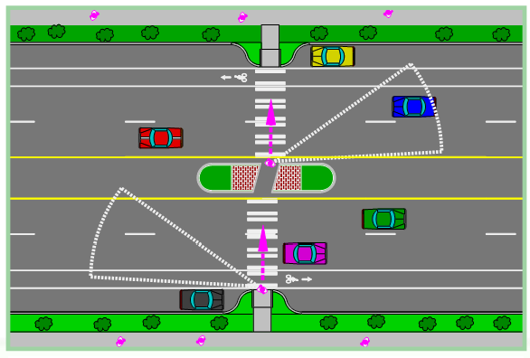
Figure 5 Design treatments that can complete a street include bike lanes, crosswalks,
a pedestrian refuge island, and curb extensions. Image courtesy of the Pedestrian
and Bicycle Information Center (PBIC).
Easements: Effingham already has utility easements along roadways. The easements could be rewritten to include sidewalks, trails, and/or sidepaths.
IDOT and Other Agency Roadways: Work closely with IDOT and other appropriate agencies to identify opportunities to improve roadways as part of new, reconstruction and maintenance projects. Each road occasionally has to be maintained, and sometimes intersection or expansion projects are done. These are the most cost-efficient opportunities to also make improvements (as needed) for those walking and biking. The Complete Streets philosophy is that a roadway's condition should not only be measured by motorist level-of-service and pavement condition, but also by safe accommodation of other users. Suggested policy language:
Resurfacing:When Effingham works with other agencies (such as IDOT or the county) to do a simple resurfacing (overlay) of an arterial road through Effingham, with no widening of the asphalt, seek opportunities to include bicycle and pedestrian improvements, such as:
•
For multilane roads, installing 5-ft (with gutter pan) bike lanes. If needed, inside travel lanes can be narrowed. If there is not sufficient width for striping a bike lane, stripe a wide outside curb lane, with no less than 14 usable feet, to at least accommodate more advanced cyclists. These treatments also provide larger turning radii for right-lane trucks.
•
Filling sidewalk gaps wherever a sidewalk exists but is incomplete. If no sidewalk exists on either side of the road, consider at least one side in the project scope. The preferred minimum width for sidewalks is five feet. Consult the FHWA "New Sidewalk Installation" guidance on the number of sides with sidewalks as a function of various roadway classifications and land uses. (see table below).
•
Improving crossings: Examples at signalized intersections include ADA retrofits, pedestrian signalization and crosswalks, and (if possible at larger intersections) right-turn corner islands. Priority mid-block crossings may also be improved through raised median islands, pedestrian hybrid beacons, pavement markings and/or other treatments.
Reconstruction/Expansion:When Effingham works with another agency (such as IDOT or the county) to do a reconstruction or expansion of an arterial road through Effingham, include bicycle and pedestrian improvements such as:
•
Fill sidewalk gaps wherever a sidewalk exists but is incomplete.
•
If sidewalks are lacking on one or both sides, add sidewalks as part of the project consulting the FHWA "New Sidewalk Installation " guidance (as a function of roadway classification and land use). The preferred minimum width for sidewalks is five feet.
•
Include crossing improvements in scope. Examples at signalized intersections include ADA retrofits, pedestrian signalization and crosswalks, and (if possible at larger intersections) right-turn corner islands. Priority mid-block crossings may also be improved through raised median islands, pedestrian hybrid beacons, and/or other treatments.
•
Consult IDOT's bikeway selection table and AASHTO bicycle facility guidelines for the appropriate bikeway treatment for the situation. For sidepath trails separate but parallel to the road, design to reduce the inherent conflicts at intersections and entrances. For bike lanes, either reconfigure and narrow travel lanes or widen pavement to allow the 5 or 6-ft (with gutter pan) for bike lanes. If there is not sufficient width for striping a bike lane, stripe a wide outside curb lane, with no less than 14 usable feet, to at least accommodate more advanced cyclists. These treatments also provide larger turning radii for right-lane trucks.
FHWA Guidelines for New Sidewalk Installation
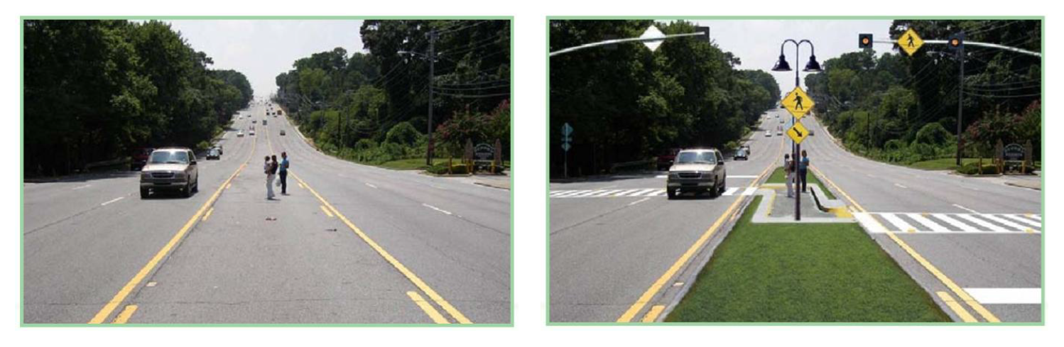
Figure 6 Pedestrian refuge islands break the street crossing into more manageable
sections while providing a physical buffer from fast moving traffic. The stop bar
is pulled back to help motorists in the inside travel lanes see crosswalk activity.
Images courtesy of PBIC.
Bikeways
Introduction
Biking is a popular activity, a moderate form of exercise within the physical capabilities of most people. However, it need not be limited to weekend outings on designated trails. Although cycling is often thought of as just for recreation and exercise, nearly half (43%) of all bike trips are destination-based—and many more would be if better facilities existed. [7]
Biking can be a great form of transportation, especially for short, local trips. National data indicate that 27% of all car trips are one mile or shorter; 40% are less than two miles. When cycling conditions are improved, people are more willing to use bikes instead of cars for these short trips—which benefits their health, pocketbooks and surrounding air quality.
Besides those who bicycle by choice, there are residents - including children, many teenagers, and some low-income workers - who depend on cycling as a transportation necessity.
This section of Effingham's Bicycle and Pedestrian Plan explains the types of bicycle facilities that can help people use two wheels for safe and pleasant transportation and recreation, and the methodology used to propose a network of bikeways for Effingham. The bikeways network (discussed in the Recommended Projects section of the plan) reflects public input and a detailed analysis of existing street conditions, significant barriers and priority destinations. The plan recommends a mixture of on-road bikeways and off-road sidepaths and trails to provide a network of bicycle routes linking the various areas in and around Effingham, including Lake Sara.
It should be noted that while the bikeways network highlights key routes to facilitate travel in and around Effingham, all streets—unless otherwise noted—are open to cyclists.
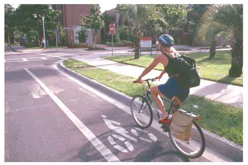
Figure 7 Image courtesy of PBIC.
Bikeway Types
Standards and Guidelines
The 1999 Guide for the Development of Bicycle Facilities by the American Association of State Highway and Transportation Officials (AASHTO) forms the technical basis for the plan's recommendations. An updated version is scheduled to be released in late 2011.
The AASHTO guidelines are generally recognized by the industry - and the court system - as the standard for bicycle facility design. The Illinois Department of Transportation encourages communities to consult these guidelines and the Manual of Uniform Traffic Control Devices (MUTCD) when developing bicycle plans.
A general overview of bicycle facility options follows; more engineering details are in the publications.
Trails
Multi-use trails are physically separated from motor vehicle traffic, except at road crossings. Trails accommodate a variety of users, including pedestrians, bicyclists, and others—for both recreation and transportation purposes. Trails away from roads, on easements or in their own rights-of-way tend to be pleasant and popular.
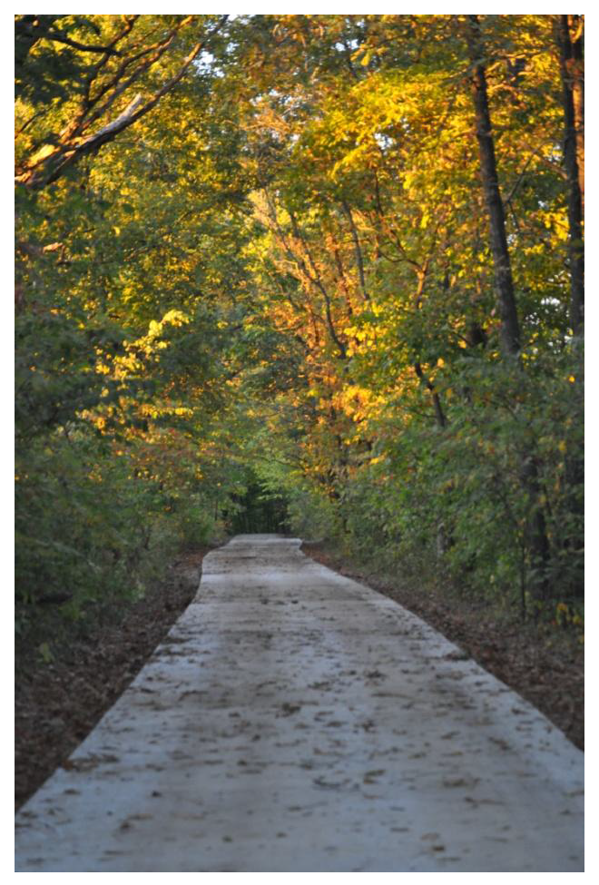
FIgure 8 The Calico Trail
In the Effingham area, the TREC (Trail Recreation of Effingham County) organization is developing a trail system, in partnership with the City of Effingham and other local agencies. Through extensive community fundraising and various state and federal grants, the first segment opened in late 2010 with several other phases being planned. See figure 8. Connections are being developed to the west and northwest parts of the City in addition to Lake Sara subdivisions.
Sidepaths
Sidepaths are trails that run immediately parallel to a roadway, like a sidewalk. Many believe sidepaths or sidewalks are always safer than on-road bicycling. Surprisingly, this is not the case where there are many side streets, residential driveways, and commercial entrances - especially for "contra-flow" cyclists biking against the flow of traffic. Turning motorists often do not expect a fast moving cyclist in the space that is usually used by slower pedestrians. That speed difference between walkers and cyclists can also lead to conflicts when sharing the space.
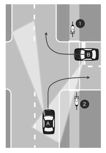
Figure 9 Right turns across sidepaths.
Figures 9 and 10 illustrate the visibility problems leading to intersection conflicts with cyclists using a sidepath. Note that in each case, an on-road cyclist on the right side of the road would be within the motorist's viewing area.
In Figure 9, Car B crosses the sidepath to turn right onto the parallel street. Rarely do motorists stop at the stopline - usually stops are in the crosswalk or at the street edge. Many do not fully stop and will look only to their left. Cyclist 2 might be seen, but Cyclist 1 is much less likely to be seen. Car A turns right off the parallel road, then crosses the sidepath. Again, Cyclist 2 might be seen but Cyclist 1 is less visible. Particularly where a large turning radius permits fast turns, many motorists do not yield to cyclists entering or already in the crosswalk.
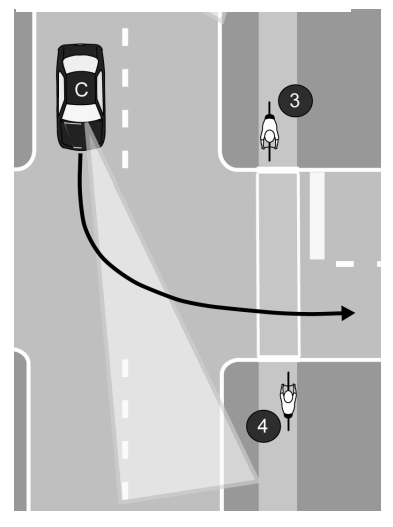
Figure 10 Left-turn across sidepath.
In Figure 10, Car C looks ahead, waiting for a traffic gap to turn left, then accelerates through the turn while crossing the crosswalk. Cyclist 4 might be seen. Again, the contra-flow cyclist (3) is less likely to be seen. If the traffic gap is short, sudden stops would be difficult.
Effingham currently has a sidepath along Keller, which is a high traffic, high volume road that provides key access over Interstates 57 and 70 (Figure 11). Another was just completed along Outer Belt West, just south of Fayette. Being planned now is a sidepath along Fayette Avenue, as part of a road widening project. Although Fayette has many intersections, IDOT proposed a sidepath as the best facility, due to the high truck volumes on the route. IDOT's recently revised facility selection table indicates that a bike lane could also be an option.
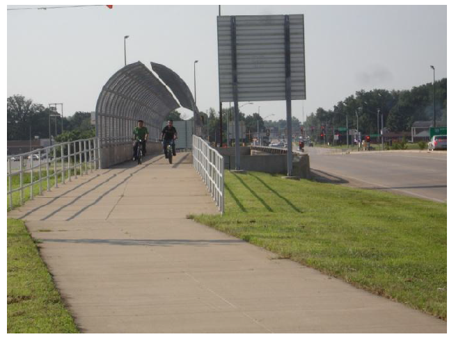
Figure 11 Keller Sidepath over I 57/70
The AASHTO guide cites these and other sidepath issues as reasons to discourage their use in inappropriate locations. This plan considers the feasibility of the sidepath option in specific cases, such as faster, busier roads without lots of crossings and with well-designed intersections.
Sidepath conflicts can be reduced by:
•
Bringing the sidepath closer to the road at intersections, for better visibility during all turning motions and better stopline adherence for right-turners.
•
Using pedestrian refuge islands to break up major crossings and right-in-right-out entrances.
•
Using high visibility crosswalks or color differences - at commercial entrances, too
•
Using experimental signs, such as those used in some communities throughout IL (below).
•
Occasional police enforcement of stopline adherence at sidepath crossings.
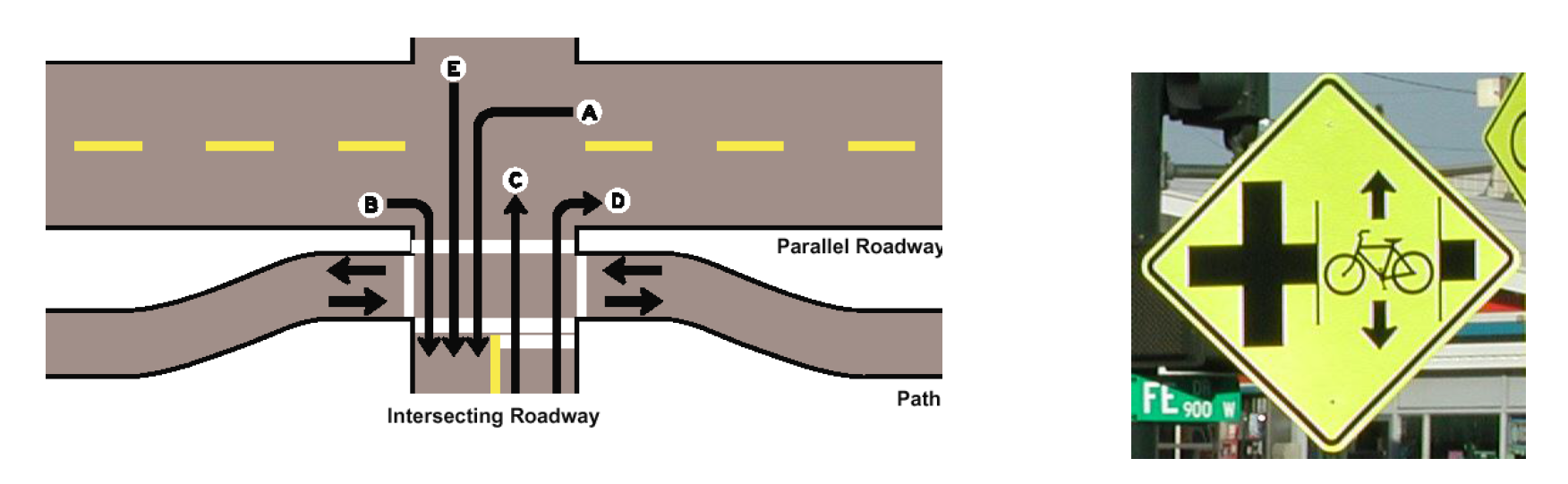
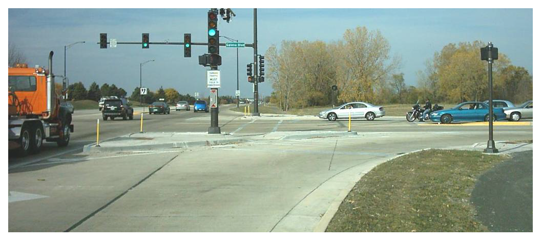
Figure 12 Intersection design methods to reduce sidepath conflicts. Top left: bringing
crossing closer. Top right: warning signage. Bottom left: right-turn refuge islands.
Bike Lanes
Bike lanes are portions of the roadway designated for bicyclist use. Bike lanes are at least five feet wide (including gutter pan) on each side of the road with a stripe, signage, and pavement markings. The minimum cross section needed for bike and travel lanes is 30 feet (44 feet if parking lanes are included, which is not the case on most Effingham streets). Consult AASHTO and MUTCD guidelines for details on design, including pavement markings.
Cyclists in each bike lane travel one-way with the flow of traffic. Sample results around the country for roads with bike lanes include:
•
More predictable movements by both cars and bikes.
•
Better cyclist adherence to laws about riding on the right side of the road.
•
Dramatic increases in bike usage with lower car-bike crash rates—at a relatively low cost.
•
Decreased car-car crashes, too - possibly from a traffic calming effect.
•
Easier, safer movements for turning trucks due to increased pavement width between the travel lane and sidewalk.
Parking is not permitted in designated bicycle lanes. When a road has bike lanes and adjacent parking, the bike lanes should be striped between the parking space and the travel lanes. Regular sweeping is important, as bike lanes tend to collect debris.
Many of the roads in Effingham are prime candidates for bike lanes (Figure 13). Vehicle travel lanes will have to be narrowed, but widths will still be up to standards without compromises to safety and capacity. Reallocating roadway width to add a bike lane also facilitates turning movements of large vehicles and can have an overall traffic calming effect.
Figure 13 These digitally enhanced images preview bike lanes in Effingham, minus pavement
markings indicating that they are designated for cyclists: Evergreen (above) and Maple
(below).
Bike Routes
Some roads may be identified by signage as preferred bike routes, because of particular advantages to using these routes compared to others. These "signed shared roadways" may be appropriate where there is not enough room or less of a need for dedicated bike lanes. A road does not require a specific geometry to be signed as a Bike Route, providing flexibility. A Bike Route may be an unstriped street, or a road with paved shoulders.
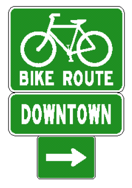
Figure 14 MUTCD signs D11-1 and D1-1
There are three permitted signage styles available in the Manual of Uniform Traffic Control Devices (MUTCD). The standard D11-1 "Bike Route" signs (Figure 14) can also provide wayfinding assistance at intersections with supplemental destination plates (MUTCD D1-1) and arrows (MUTCD M7 series) placed beneath them. The 2009 version of the MUTCD manual includes a sign (D11-1c) that combines bike route designation with wayfinding information (Figure 15). Some Illinois towns have put two or three destinations on a single sign, with mileages. See MUTCD D1-C3 (Figure 16).
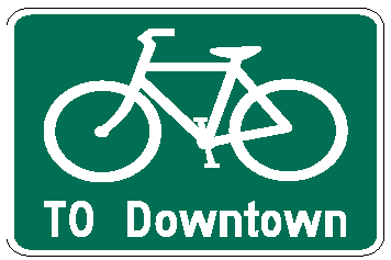
Figure 15 MUTCD signs D11-1c
Wayfinding signs are useful throughout the bikeways network, whether along a trail, sidepath, bike lane or route. Consult MUTCD for spacing and placement specifications.
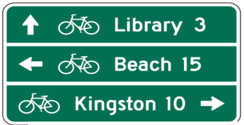
Figure 16 MUTCD sign D1-C3
Figure 17 Virginia from Willow to Community Park (background of photo above) is recommended
as a signed bike route.
Pavement Markings
Pavement markings inform cyclists of optimum lane positioning while reminding drivers of the possibility that they will see a cyclist in the road.
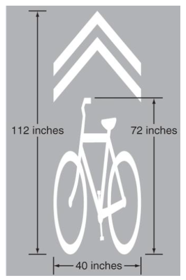
Figure 18 Shared Lane Marking
Bicycle positioning on the roadway is key to avoiding crashes with cars turning at intersections and doors opening on parked cars. Figure 18 shows a Shared Lane Marking (or "sharrow"), now approved in the MUTCD. Urbana is one of the Illinois cities using these.
The marking is used only for streets without bike lanes but with occupied on-street parallel parking and speed limits below 40. Often, this treatment is used when there is insufficient width for bike lanes. The center of the marking shall be 11 feet (or more) from the curb, placed right after an intersection and spaced at intervals of 250 feet thereafter. See MUTCD chapter 9 for more installation guidance. The shared lane marking also can be used to indicate correct straight-ahead bicycle position (Figure 19) at intersections with turn lanes.
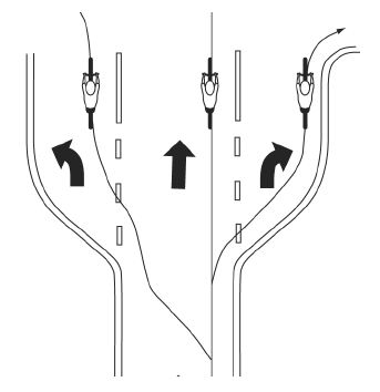
Figure 19 Proper turn lane positioning.
Signal Activation by Bicycles
Both bicycles and motorcycles have difficulty activating demand-actuated traffic signals. Cars may not be present to trip the signal, or cars may be stopped too far back of a bike. Pedestrian push-button actuation, if present, is often inconveniently located for on-road bikes.

Figure 20 Signal activation marking and sign
The MUTCD-approved Bicycle Detector Pavement Marking (MUTCD 9C-7) in Figure 20, together with the R10-22 Bicycle Signal Actuation Sign, can indicate a detector trigger point for actuating the signal. Correct tuning of the detector is needed. Quadruple loop detectors or camera detection could be used, too, as they are more sensitive to bikes and motorcycles.
The detector marking also serves to indicate proper bicycle position at an intersection.
On-road Bikeway Liability
Since 1998, Illinois towns have faced a liability disincentive for on-road bikeways, such as those listed above. When towns designate that a particular route is "intended" for use by bikes, they raise their liability for cyclist injury due to road condition from zero to a negligence standard of care. This has dissuaded many communities from adding on-road bikeways.
In March 2007, two major insurers of Illinois local government agencies (IPARKS and St. Paul-Travelers) were asked how much insurance premiums would rise for hypothetical additions of: a) 10 miles of off-road bike path; b) 10 miles of on-road bike lanes; and c) 10 miles of signed road routes. Both responded that there would be ZERO increase for each case, assuming that proper engineering design standards were met.
At least 30 Illinois towns and jurisdictions have proceeded to install designated bicycle facilities since the 1998 decision, despite the disincentive. [8]
Signed bike routes from before 1998 remain in dozens of other towns. The number of known lawsuits resulting from these on-road bikeways has been minimal, demonstrating that the reaction of the more risk-averse towns may be out of proportion with the actual risk exposure.
Local governments regularly weigh risk exposure against policy implications and services provided to residents for all sorts of facilities and programs. Places with a much higher rate of liability exposure (number of cyclists, miles of on-road bikeways) than is proposed for Effingham have years of experience demonstrating this issue to be negligible. The City may proceed with the on-road bikeways listed in this plan, after verifying the risk exposure involved.
Guidelines for Developing the City of Effingham's Bikeway Network
Introduction
A bikeways network is comprised of routes that are particularly important because they serve key destinations and facilitate travel across barriers. Although all city streets, except where prohibited, will be used by cyclists, a designated bikeways network helps direct them to particularly favorable routes, especially for mid and long distance trips. Developing a plan for a bikeways network establishes priorities for improvements, such as restriping for bike lanes, completing trails, adding wayfinding signs and improving crossings.
Effingham's bikeways network was developed with a variety of inputs:
•
Public Involvement: On February 3, 2010, a "Public Brainstorming Workshop" was attended by over 25 residents. The purposes of the workshop included: a) gather local resident knowledge on biking and walking needs; b) prioritize road corridors and other routes to study for potential improvements; c) build community support for the plan and its implementation. Each attendee marked individual maps with suggestions. A group exercise followed in which top priorities from the South, Northeast, and Northwest regions of the City were discussed and reported. See appendix 2.
•
Consultation with City staff and steering committee: In addition to the workshop, two meetings were held with a steering committee consisting of City and other agency staff, and residents (See Appendix 1). The steering committee guided the project approach, while City staff provided much valuable input on existing conditions, future transportation projects and other plans, and more.
•
Bicycle Level of Service Analysis: The Bicycle Level Of Service [9] (BLOS) measure quantifies the "bike-friendliness" of a roadway, helping to remove a wide range of subjectivity on this issue. The measure indicates adult bicyclist comfort level for specific roadway geometries and traffic conditions. Roadways with a better (lower) score are more attractive - and usually safer - for cyclists. BLOS has been used in IDOT's bicycle maps for years, and it was recently added to the Highway Capacity Manual. More information and an on-line calculator is at http://www.bikelib.org/bike-planning/bicycle-level-of-service/ BLOS is used in the Effingham Bicycle and Pedestrian Plan to measure existing and future conditions, to set standards for the bikeway network, and to justify recommendations.
•
Review of standards, guidelines and best practices: The plan draws heavily from AASHTO, MUTCD, FHWA and other nationally recognized resources for bicycle facility design. See Bikeways Types discussion in the previous section.
Guiding Principles
The following guiding principles informed the development of Effingham's bikeway network.
•
Plan for a target audience of casual adult cyclists. At the same time, address the needs of those who are more advanced and those who are less traffic-tolerant, including children.
•
Select a network that is continuous. Form a grid throughout the City with target spacing of ½ to 1 mile. Consider both on-road and off-road improvements, as appropriate.
•
As much as possible, choose routes with lower traffic, ample width, directness, fewer turns and stop signs, 4-way stops or stoplights at busy roads, and access to destinations.
•
Look for spot improvements, short links, and other small projects that make an impact.
•
Provide grade separated crossings across major barriers, such as the interstate. All crossings should be bicycle accessible. Also, where appropriate, seek opportunities to improve the at-grade crossings of other barriers, such as US 40, US 45 and IL 33, as well as the rail corridors.
•
Be opportunistic, implementing improvements during other projects and development.
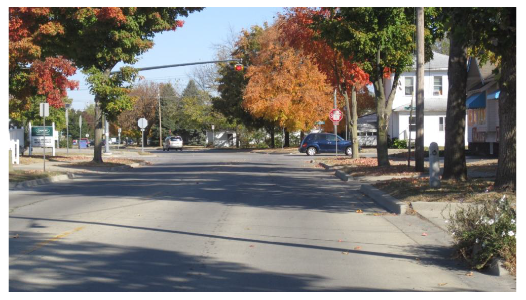
Figure 21 Maple Street is recommended as a bikeway since it is a continuous route
north/south through Effingham with ample room for bike lanes.
Selecting Bikeway Type
These guidelines were used for specific route segments:
•
Where on-road bikeways are recommended, try to achieve a BLOS rating of High C or better for designation in the network. This is an appropriate goal for accommodating the casual adult bicyclist. Depending on the situation, use Bike Lane or Bike Route signage (and wayfinding directional signage) to indicate inclusion in the network.
•
For the roads in the network (Bike Routes and Bike Lanes), raise the priority of filling sidewalk or sidepath gaps on at least one side of the road. If these routes are important for cyclists, they are important for pedestrians as well. Also, this recognizes that children - and more traffic-intolerant adults - will ride on the sidewalk. However, do not mark sidewalks as Bike Routes.
•
Do not recommend sidepaths where there are too many crossing conflicts (driveways, entrances, cross streets). Where sidepaths are recommended, use the design techniques described above to somewhat reduce the risks at intersections.
•
Where there is sufficient width and need, stripe roads for dedicated bike lanes - with no parking permitted in these lanes.
•
Use shared lane marking and bike signal actuation pavement markings to indicate proper on-road bicycle position, especially where heavy bicycle traffic is expected.
Generating Public Support
To improve public support for plan implementation, these approaches are suggested:
•
Achieve early, easy successes ("low-hanging fruit") to gather momentum.
•
Do not remove on-road parking if at all possible.
•
Where appropriate, use road striping to serve not only bicyclists but adjacent residents, as well. Cite the traffic calming (slowing) and other benefits of striped, narrower roads.
•
Try to avoid widening sidewalks to 10' sidepath widths where at least some residential front yards would be impacted.
•
Do not widen residential roads solely for bikeways.
•
Work with local businesses and media outlets to help promote the plan and celebrate progress.
Safe Routes to School
Introduction
Safe Routes to School (SRTS) was a new program included in the 2005 federal transportation bill; the program has two primary goals:
•
Increase the number of students in grades K-8 who walk or bicycle to school, and;
•
Improve the safety of those students as they travel between school and home.
Implementation of the SRTS concept has several other benefits, including reductions in:
•
childhood obesity
•
air pollution as a result of fewer parent drop-offs
•
school transportation costs as a result of fewer children travelling via school bus
•
traffic congestion near schools during arrival/dismissal times
SRTS funding, which is administered by IDOT, can be spent on a wide variety of local activities, as long as those activities occur within a 2-mile radius of a school serving any grade(s) K-8. In addition, the SRTS program emphasizes the five "E's:" Engineering, Education, Encouragement, Enforcement, and Evaluation. Any project using SRTS funds must fulfill at least one of the five E's. SRTS funding is available from the Illinois Department of Transportation at a 100% state/federal share, with periodic grant cycles.
Figure 22 Walking and biking to school fosters health and independence.
Engineering is also known as the Infrastructure category; all construction projects fit into this category, including sidewalks, trails, traffic lighting, signage, etc. The other four E's are collectively referred to as the Non-Infrastructure category, since they do not involve construction. In the case of Infrastructure applications, the State of Illinois highly encourages applicants to simultaneously pursue and implement SRTS activities that fulfill a Non-Infrastructure category. For example, Effingham could apply for SRTS funding to construct a new sidewalk, but should at the same time apply for SRTS funding to educate students on safe walking and bicycling practices, or to implement a "walking-bus" program.
Increasing the number of Effingham students that walk and/or bicycle to school, and making it safer for the children to do so, was determined by the Committee to be a key goal of this plan. In response, trends and issues with safe routes to Effingham schools were researched; that work is detailed in the following sections on Data Collection, Key Findings/Issues, and SRTS Recommendations.
Data Collection
Schools studied for this Safe Routes to School plan included: Southside Elementary, Sacred Heart Elementary (SHES), Effingham Junior High School (EJHS), Effingham High School (EHS), and St. Anthony High School (SAHS). Other schools exist in the District, but they are located in other communities or several miles outside of the City of Effingham. The first step in developing the Safe Routes to School plan for Effingham was to collect data about students' current transportation habits; student, parent, and school staff concerns; and current community and school-zone infrastructure conditions. This information was gathered via several different methods:
•
Interviews with District Transportation Director: The Transportation Director was interviewed to learn about where students typically walk or bike; where problem areas exist; typical bus pick-up/drop-off procedures; bus ridership; and concerns the bus drivers have over students' walking and biking habits.
•
Interviews with Principals: Several school Principals and Assistant Principals were interviewed to learn about their concerns over student safety; key issues in the area immediately surrounding the schools; bus and parent pick-up/drop-off procedures; and ideas for school participation in encouraging student walking/biking and safety improvements.
•
Survey of EJHS Students: Surveys were administered to all Effingham Junior High School and Effingham High School students near the end of the 2009-10 school year. The survey focused on current travel habits; safety perceptions and concerns; and ideas to encourage student biking/walking.
•
Survey of EJHS Parents: A survey was mailed to the parents/guardians of all EJHS students, asking questions about their children's travel habits, and the parents' own perceptions of safety and ideas to encourage their children to walk or bike to school safely.
•
On-Site Analysis: Site visits were made to each public and parochial school in Effingham, as well as the neighborhoods surrounding the schools. Site visits focused on inspecting the walking and bicycling conditions; observing student pedestrian and cyclist behavior; and observing vehicular patterns and behavior.
Key Findings/Issues
Data collection through the methods mentioned above yielded several concerns and impediments to safely walking or bicycling to school in Effingham. Many of these were mentioned by multiple groups of people: students, staff, and parents, including those from different schools. Key Issues include:
•
Highway Crossings: The City of Effingham is bisected on a North-South axis by U.S. Highway 45 (S. Banker Street/3 rd Street), as well as on an East-West axis by U.S. Highway 40 (Henrietta Street/Fayette Avenue). Given that EHS, EJHS, and SHES are all located on the far Southwest corner of the community, students walking or biking to any of these three schools must cross at least one, if not both, of these State routes. These highways are commonly considered the major impediment to student safety in walking or biking to school. See Figure 23. An example is Henrietta and Grove, discussed below.
•
Railroad Crossings: Effingham is also bisected by railroad tracks. There is an existing pedestrian bridge over Fayette, near downtown Effingham, but there is no pedestrian-only crossing over the railroad tracks to get pedestrians safely from East to West. In addition, some of the railroad tracks run near EJHS, EHS, and SHES.
•
Intersection of Henrietta and Grove: This is the primary intersection near EJHS, EHS, and SHES. With the amount of bus traffic, parent vehicular traffic, through-truck traffic, and student pedestrian and bicycle traffic, the intersection is extremely busy. This is particularly true in the afternoon when the three schools dismiss.
•
Driver Behavior: Driver behavior was a common issue found in all data collection methods. This includes speeding, ignoring traffic control devices like stop signs and crosswalks, and disregard or unawareness of pedestrian traffic, particularly at intersections and in crosswalks.
•
Sidewalks: A lack of sidewalks in some areas, and deteriorating conditions of the infrastructure in other areas, was commonly cited.
•
Pedestrian-Activated Signals: Although these have been installed at a number of key intersections, many other intersections would benefit from their installation, and some of the units already installed are reported to be in non-working condition.
Figure 23 Intimidating intersections and crumbling sidewalks can discourage walking
and biking to school. These images are from Cherry and Fayette.
•
Congestion in School Areas: Congestion, particularly in drop-off/pick-up areas during arrival and dismissal, was cited frequently as a safety concern, particularly surrounding the schools serving younger grades (SHES and Southside Elementary).
•
Crime/Bullying: Real or perceived levels of crime, bullying, and child abduction/assault was commonly mentioned in EJHS student and parent surveys. Perception is likely more an issue than real crime occurring, but the issue remains important.
•
Location of Central Grade School: The grade levels taught at Central are 3-5, prime ages for encouraging students to walk or bike to school. Unfortunately, Central Grade School is located several miles south of the City of Effingham, on U.S. Hwy 45. This distance is a significant barrier to students being able to walk or bike to school. However, some students travel to South Side Elementary to take a bus to Central. An opportunity exists to encourage more of these students to walk or bike to the bus stop.
•
Distance: Effingham's schools draw students from a wide geographic area, including several other small towns and a large rural area. Far and away the top reason cited by students and parents for not currently walking or bicycling to school was "I live too far away." The vast majority of these respondents self-reported that they live "more than 2 miles away" from school, with some living as far as 20 miles away. To encourage walking and biking, Effingham will need to focus primarily on students that live within the City of Effingham, especially those that live within two miles of school.
SRTS Recommendations
This plan presents a number of Safe Routes to School recommendations. Some are specific to an individual school, but most would serve multiple schools and can be considered community-wide projects. They are categorized below as Infrastructure and Non-Infrastructure Recommendations.
Infrastructure Recommendations
Establish Clear Highway Crossings: Improved crossings of U.S. Highways 40 and 45 would help students navigate these road crossings safely. Improvements can include treatments such as traffic lights and pedestrian-activated signals (if not already present), marked crosswalks, pedestrian refuge islands, curb extensions, and signage for both pedestrians and motorists. Priority intersections include:
•
Maple Street at Fayette
•
Fourth Street at Fayette
•
Cherry Street at Fayette (see below for details)
•
Grove Avenue at Henrietta (see below for details)
•
Wabash Avenue at Banker
•
Temple Avenue at Third
•
Clark Street at Banker
Cherry Street at Fayette: This is an existing crossing, with a flashing school crossing light, a striped crosswalk, and crossing guards. However, these traffic controls fall short of an ideal crossing. For this intersection to be considered a good crossing, stoplights are recommended; otherwise, the crossing can be moved east to Maple Street to improve safety. The Fayette Avenue reconstruction project, being scoped now by IDOT, is an opportunity to significantly improve crossing conditions, perhaps with a pedestrian refuge area and a manually-activated Pedestrian Hybrid Beacon. Special consideration should also be given to Maple and Fourth, which are listed above and, like Cherry, proposed as "Safe Routes to School."

Figure 24 A Pedestrian Hybrid Beacon (or HAWK), included in the MUTCD, helps pedestrians
cross busy roads with minimum disruption to vehicular traffic. Images courtesy of
PBIC.
Grove Avenue at Henrietta: The intersection of Grove and Henrietta, the primary intersection near SHES, EJHS, and EHS, is extremely busy with vehicular and pedestrian traffic during afternoon dismissal. The intersection was frequently cited as dangerous for pedestrians and a significant obstacle to non-motorized school travel. See Figure 25. While the intersection does witness significant volumes of pedestrian, parent, and school bus traffic, on-site analysis found that the intersection design and infrastructure is largely sufficient; it has relatively narrow traffic lanes, stoplights, pedestrian-activated signals, sidewalks, and crosswalks. The issues at this intersection appear to be primarily behavioral, rather than infrastructure. As such, several recommendations were identified:
•
Lengthen the pedestrian "walk" signal and increase its frequency - or use an all-red pedestrian phase. Groups of students were commonly seen waiting for several minutes for a walk signal, and when it came, they did not have time to cross before the "Don't Walk" signal flashed. As a result, many EHS students skipped the lights and crosswalks altogether; instead walking half-a-block north, and crossing Henrietta mid-block to EJHS while dodging heavy vehicular traffic on the U.S. Route. This created serious safety issues for pedestrians and vehicles alike. Another signalization option, for school day arrival and dismissal times only, is a manually-activated all-red vehicular signal phase with Walk signals for pedestrians and bicyclists to cross the intersection. This has worked well in locations with many pedestrians and turning vehicles, such as Wright and Green Streets at the University of Illinois in Champaign.
•
Police Enforcement. Drivers in the area were commonly seen speeding, running yellow or red lights, pulling through crosswalks, and not giving right-of-way to pedestrians. Additionally, pedestrians were jaywalking. Police enforcement of laws for both drivers and pedestrians during arrival and dismissal periods could help reduce dangerous behavior.
•
Mid-Block Pedestrian Controls. This recommendation should be taken as a second alternative to the above recommendations, and could go one of two directions. 1) Add a mid-block pedestrian crossing from the EHS/SHES side of Henrietta to EJHS. 2) Install barriers to impede pedestrians from crossing Henrietta mid-block between EHS and EJHS. Either option would require close participation from Illinois Department of Transportation.
Figure 25 Henrietta and Grove was frequently cited as an intersection of concern,
due to heavy pedestrian and vehicle traffic after school.
Establish Primary Bicycle/Pedestrian School Routes: Clearly designated North-South and East-West routes (in conjunction with the improved Highway crossings), would help encourage and accommodate non-motorized travel to school. These routes should be upgraded to include sidepaths, bicycle lanes, or bike route signage, as specified elsewhere in this plan. Signage should be used to inform pedestrian, bicycle and vehicular traffic that the corridor is a school route.
•
Maple Street
•
Fourth Street
•
Cherry Street
•
Wabash Avenue
•
Temple Avenue
•
Grove Avenue
Establish Clear Railroad Crossings: Clearly marked crossings over railroad tracks, including improved safety controls, will help attract students to safe crossings, and reduce the number of students crossing or walking along tracks in dangerous places. Crossings of particular concern include:
•
South Maple Street
•
Wabash Avenue
Grade-Separated Tunnel (or Bridge) near the Amtrak Station: This high-cost, long-term solution would help connect the school areas with downtown and most of the rest of the community and entice children away from at-grade crossings and/or walking along the railroad tracks. Further study is needed to determine ideal structure placement—especially since pedestrians are very detour averse, but near the Amtrak Station between Fayette and Grove Avenues would seem to be the best fit from a SRTS perspective.
Sidewalk Construction/Reconstruction: Lack of sidewalks, or condition of sidewalks, was one of the most commonly-cited ways to increase safety, as identified by EJHS students who do not currently walk or bike to school. In many areas of the City sidewalks exist, but are commonly described by students as "bumpy," "dangerous," or "bad." In some areas, sidewalks simply don't exist; one area that was frequently mentioned is along Fayette Ave. Constructing and/or repairing sidewalks in these areas, especially along the proposed "School Routes" above, will help encourage walking and biking to school. Sidewalk construction should be prioritized to address the most dangerous areas, serve the largest number of students, or some other rational criteria. The project recommendation section of this plan includes new and reconstructed sidewalks and sidepaths at key locations throughout Effingham.
School Zone Traffic Calming: With the high levels of vehicular and bus traffic in and around pick-up/drop-off areas, pedestrians and bicyclists need additional levels of protection. Raised pedestrian crosswalks, corner bump-outs, signage, and flashing lighting are all examples of infrastructure that can be used. Educational materials and messages targeted at parents can also be of value.
Improve Bicycle Parking Facilities: Bicycle parking facilities could be improved in three primary ways: additional storage, increased security, and, over time, upgrades to higher quality racks. (See Figure 26 and discussion of bicycle parking in the "Three E's" section, later in the plan.) Bike racks were found at most schools, and all had bicycles parked in them on the day of the on-site visit. Parking appeared to be sufficient for current levels of ridership (up to 20 cyclists per day in nice weather), but as the number of cyclists grows, more bike parking will be needed. In addition, security should be considered: several student-surveys reported concern over damage to or theft of their bicycles. As part of an Encouragement program, perhaps bike locks and other deterrents could be prizes or rewards.
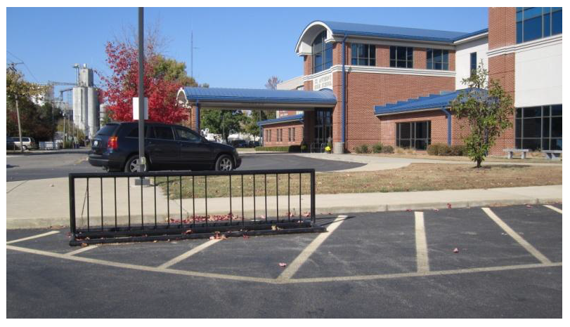
Figure 26 Bike parking at St. Anthony High School. This style of rack should eventually
be replaced by one that provides more support and security. See also Figure 31.
Non-Infrastructure Recommendations
Increase People Presence: Among EJHS students who walk or bike to school at least occasionally, the most commonly cited reason why they feel safe is because they are with friends, a parent or adult, or other people. The presence of friends, family and acquaintances not only makes the student feel safer, but likely makes the activity more enjoyable for the student. Specific ideas to pair students with other people include:
•
Walking School Bus: Coordinated groups of students walk or riding together from a common neighborhood area, led by a parent or adult volunteer to increase safety, lead the route, and ensure safe biking and walking practices.
•
International Walk/Bike to School Day: Coordinating school encouragement efforts around this day can help give a single-day boost to participation levels; some of these "first-timers" or sporadic student-pedestrians may choose to walk or bike more often once they participate and have fun with classmates and friends.
City-Wide Crossing Guard Program: Among EJHS students who do not ever walk or bike to school, the most commonly cited activity identified to increase safety is more crossing guards. The City of Effingham already has a crossing guard program, with guards located at Fifth & Fayette, Cherry & Fayette, Wabash & Fifth, Fourth & Kreke, and Third and St. Louis. Moving guards from these intersections should be considered carefully, but crossing guards should be added and/or moved to correspond with the primary Highway crossings, or in other areas where high levels of student pedestrian traffic is observed.
Target EJHS and SHES students: Students in grades 3-8 are the "sweet spot" for SRTS activities; they are old enough to be able to walk or bicycle to school, but young enough that they are not settled into transportation habits or prone to serious peer pressure. Therefore, targeting SRTS activities at students in EJHS and SHES is likely most effective. Ideally, students in grades 3-5 at Central Middle School would also be targeted, but the school's proximity makes it unlikely for these students to walk or bike to their school. However, since approximately 100 Central students are picked-up and/or dropped-off by bus at South Side Elementary and many then walk or bike home from that location. Non-Infrastructure activities should also be targeted at Central students.
Safety Education: Safety education programs or materials for students are needed. In addition to general safety information and "rules of the road" for cyclists, students need to be educated on how and where to properly travel and cross streets. Educating students on safe walking and riding techniques, safe routes, and proper behavior will help to greatly improve student safety. Specific recommendations include:
•
Mentorship Programs: Administrators at EHS suggested that their existing mentorship programs pairing high school athletes with Central Grade School students could be utilized to encourage and educate the younger students about bicycling and walking. This program offers great potential, and could be expanded to include EHS-EJHS, or SAHS-SHES mentorships.
•
Physical Education: Bike trails and bike routes (both existing and new) can be utilized in Physical Education programs to promote the health benefits of walking and biking while delivering safety information.
•
Educational Materials: The League of Illinois Bicyclists, the Illinois Secretary of State, and the Illinois State Police are resources for bicycle safety education. See the Additional Recommendations section of this plan for more details.
•
Route-Finding: A common suggestion in EJHS student and parent surveys was to publicize and sign "Safe Route to School" Routes on the City's roads and sidewalks. In combination with this signage, maps, directions, or other way-finding materials can be distributed showing the best way to find and navigate the Effingham SRTS Routes.
Increase Police Enforcement: Partnering with the Effingham Police Department to increase police patrols in and around school zones during arrival and dismissal times will help reduce actual crime, traffic violations, and bullying, and also help diminish the perceived problems of crime felt by both students and parents.
School Travel Plan: IDOT requires a school travel plan (www.dot.state.il.us/saferoutes) to be completed and approved before a school district or City can receive SRTS funding. Regardless of whether or not an application for a specific project is actually submitted or approved, completion of the School Travel Plan can aid school and City officials in making travel conditions safer for students on foot or bike.
School Zone Traffic Enforcement: State motor vehicle law allows for increased fines for traffic violations in school zones, with those funds going directly to the school district in which the violation occurred. Those funds can then be used to pay for safety programs and improvements to increase the safety of children walking or biking to school. Effingham's Police Department and School District should partner to more strictly enforce traffic violations within school zones, and then use the revenue generated to implement SRTS recommendations within that school or school zone.
Recommended Projects
Introduction
The Effingham Bicycle and Pedestrian Plan proposes a network of bicycle and walking routes to facilitate travel to all sections of the city and beyond. The network builds on existing strengths, and so includes routes that already work reasonably well for pedestrians and/or cyclists. The recommended projects in this section will help fill gaps, tackle barriers and improve conditions to complete the network. Some projects are relatively easy, such as striping bike lanes on Maple. Others will require a longer term vision, such as building the "Missing Mile" from Evergreen to Teutopolis (Figure 27). See the earlier Bikeways Guidelines section for more information on how routes and projects were selected.
Figure 27 Completing the "Missing Mile" to Teutopolis is a long term project.
Opportunities to improve conditions for walking and cycling in Effingham are not limited to the projects discussed below or even the network as a whole. See the Complete Streets section for strategies to ensure that all future transportation projects meet the needs of pedestrians and cyclists, whether or not they are specifically included in this plan.
Understanding the Maps
The plan's maps provide a snapshot of needs and recommendations. "Mapping 4 th Street" (next page) shows how the maps can work together.
•
Existing Conditions—Sidewalks/Trails and On-Road Comfort (BLOS - Bicycle Level of Service): Shows existing on-road conditions for bicyclists on key roads throughout Effingham, including, but not limited to, all routes in the proposed network. It also provides information on sidewalk gaps, sidepaths and trails.
•
Recommended Projects: Includes on and off road bike facilities, new sidewalks and sidepaths, intersection improvements and long range improvements beyond the scope of this plan. The TREC trails map is also included.
•
Priority and Implementation: Differentiates projects by priority and readiness to be implemented. Ready projects have no significant barriers to implementation. Conditional ones are linked to the progress of other road projects or developments.
•
Future Conditions: Sidewalks/Trails and On-Road Comfort (BLOS): Portrays how level of service for cyclists will change if the recommended projects are implemented, as well as the increased sidewalk coverage. Future BLOS scores are not shown for "longer term improvement" projects, because of their uncertain status.
Mapping 4thStreet
The existing conditions map shows that 4thStreet south of Temple is currently a mix of low and high C in terms of Bicycle Level of Service. Sidewalks are continuous on both sides of the street, except south of Eiche.
Figure 28 4th Street is a great candidate for bike lanes.
The recommended projects map calls for bike lanes. 4this shown as high priority and ready to go in the implementation map. With bike lanes, 4thstreet moves up a grade to a low B south of Fayette and a high B downtown, both meeting the target level for the bikeway network.
North of Evergreen, the plan calls for shared lane markings to improve motorist awareness of on-road cyclists using 4th. In addition, the east sidewalk gap north of the interstate is categorized as high priority, but conditional on development at the location.
Figure 29 Bike lanes and sidewalks provide for cycling and walking along 4th Street.
Intersection improvements, such as more visible crosswalks, will help travel across.
Using Merchant to bridge the gap between Temple and Evergreen is treated as a long range project, with Maple being the nearest bikeway network segment until then.
Travel across 4thshould be considered as well, as discussed in the Complete Streets and Safe Routes to School sections. Higher visibility crosswalks and other intersection features will help "complete" 4thStreet.
Existing conditions: sidewalks/trails and on-road comfort (BLOS)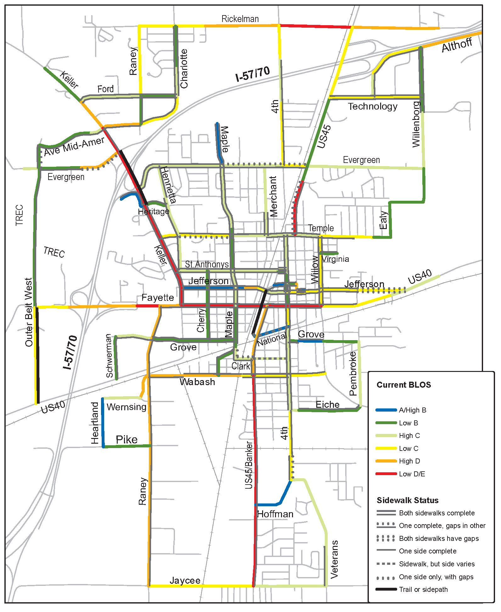
Effingham Ped/Bike Plan - Recommended Projects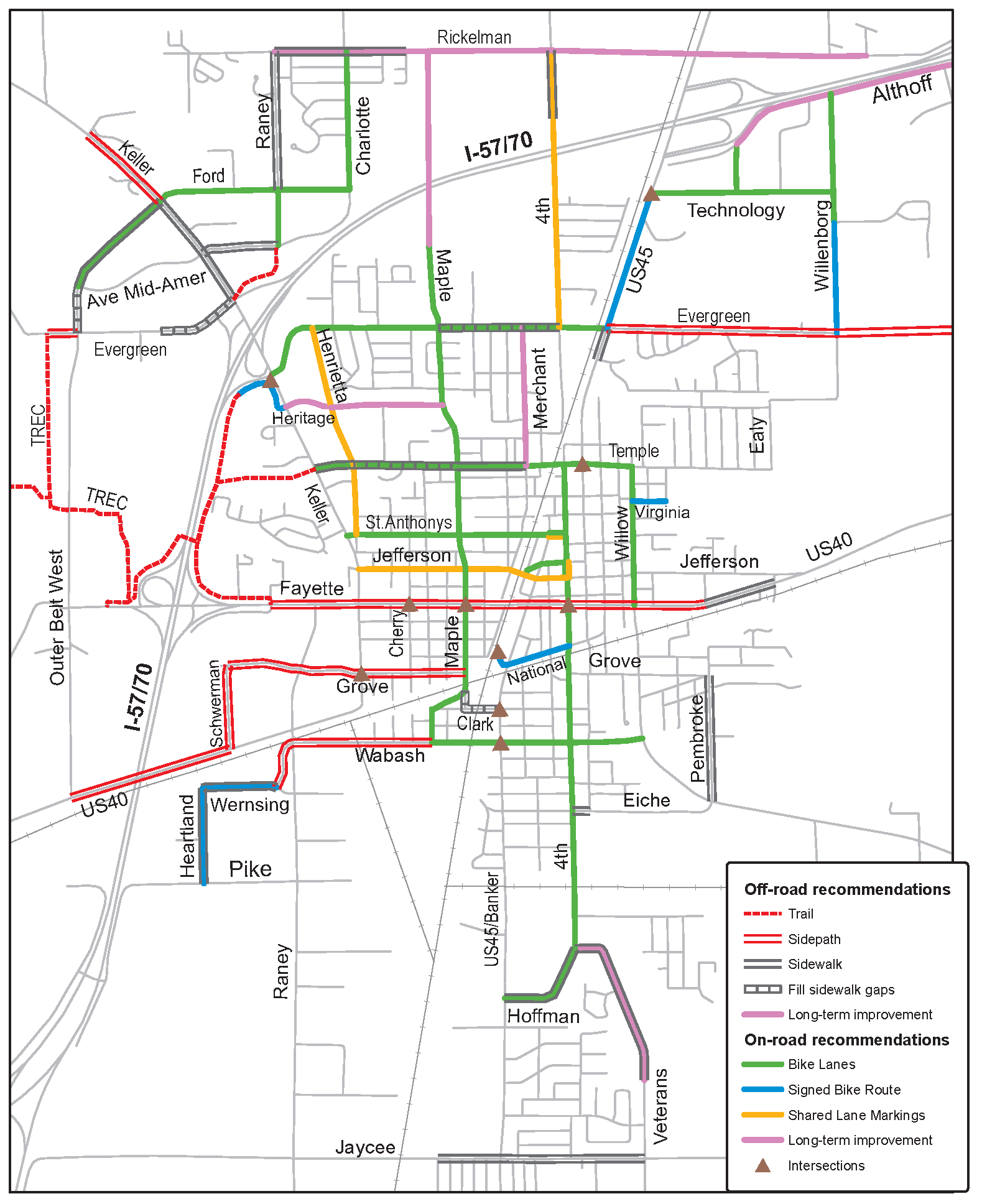
Effingham Ped/Bike Plan - Priority and Implementation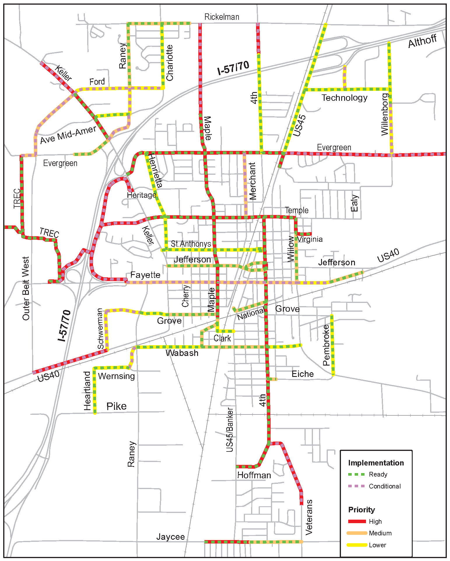
Future conditions: sidewalks/trails and on-road comfort (BLOS)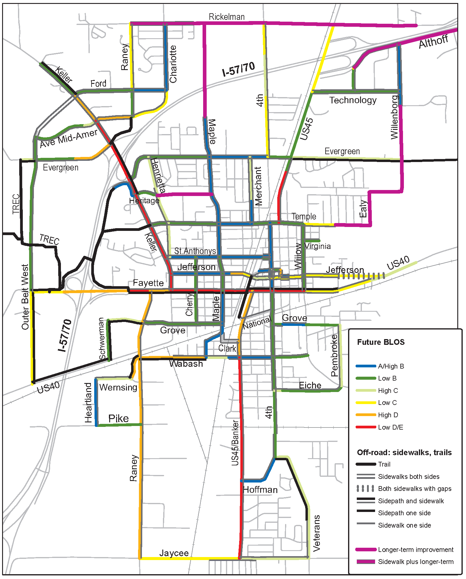
TREC Trail Network
Understanding the Project List
Extensive data collection on existing walking and cycling conditions informed the development of this plan. Most of this information, such as Bicycle Level of Service scores, sidewalk coverage, project readiness and implementation notes, is housed in a spreadsheet that helps generate the maps. Examples of high priority and "Ready to Go" projects include:
•
Bike Lanes for Hoffman, Willow, Temple, Evergreen, Maple, 4 th .
•
Sidewalks along sections of Hoffman, Keller, Temple, Evergreen, Jaycee and US 45.
The table that follows lists recommended projects by road name. Please note the exceptions below. See Appendix 3 for the entire dataset by road segment:
•
Safe Routes to School: All of the routes proposed as safe routes are included in the networks, but are not specifically labeled in the map and spreadsheet as Safe Routes improvements. They are: Maple, Fourth, Cherry, Wabash, Temple and Grove.
•
Intersections: The spreadsheet stores information on road segments, but not information about key intersections that need improvements. However, they are reflected on the recommended projects map. Most are also part of the Safe Routes to Schools proposal: Fayette at Maple, Fourth and Cherry (figure 25); Banker at Wabash and Clark; Grove at Henrietta; Temple at Third; Keller at Evergreen/Hampton (south of I-57/70); and US 45 at Technology.
•
Long Term Projects: Projects identified as long range are on the maps and spreadsheet, but not in the table below. They are included in the maps to reflect awareness of missing gaps that either can not be addressed in the near future or need further study, such as extending Maple over I -57/70.
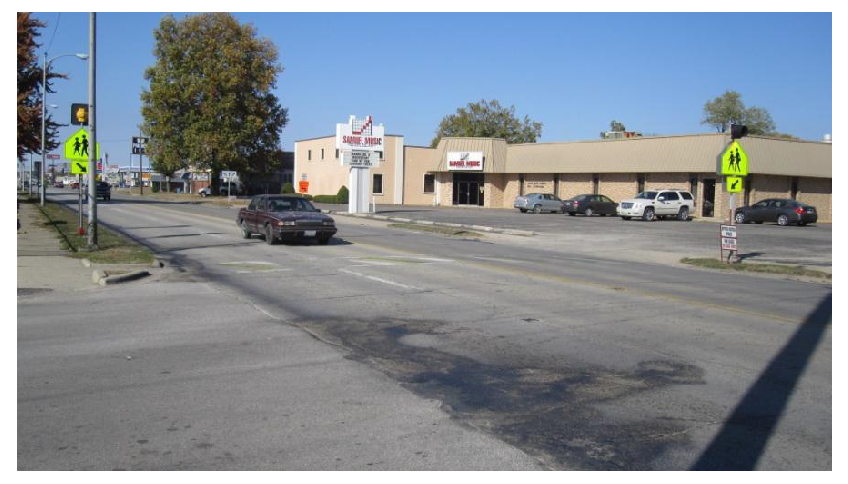
Figure 30 Improved pedestrian crossings of Fayette are part of the Safe Routes to
School proposals in this plan. They would also help make Fayette a "Complete Street."
Recommended Bicycle and Pedestrian Projects for Effingham, IL
(Does not include intersections and long range projects. Projects along a proposed Safe Route to School are starred.)
Additional Recommendations: Bike Parking and the Other "E's"
Introduction
Engineering improvements to the physical environment for walking and cycling should be accompanied by work in the "other E's": Education, Encouragement and Enforcement. The recommendations below will raise awareness of new facilities and motivate more people to safely and comfortably walk and bike in Effingham. Bicycle Parking is treated as a separate category, given the breadth of the topic and its relationship to both engineering and encouragement.
Bicycle Parking
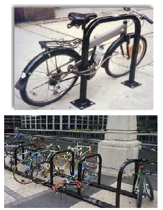
Figure 31 Inverted U, single (top) and in a series (bottom)
Secure bicycle parking is a necessary part of a bikeway network, allowing people to use their bikes for transportation and reducing parking in undesirable places. Successful bicycle parking requires a solid bike rack in a prime location. It is recommended that the City address bike parking by adopting a development ordinance requirement and by retrofitting racks at strategic locations in town.
General bicycle parking considerations are covered below. For more details, consult Bicycle Parking Guidelines, 2nd Edition: A Set of Recommendations from the Association of Pedestrian and Bicycle Professionals, 2010, available at www.apbp.org.
Style: A good bicycle rack provides support for the bike frame and allows both the frame and wheels to be secured with one lock. The most common styles include the inverted "U" (two bikes, around $150-300) and the wave or continuous curve style (more than two). The preferred option for multiple spaces is a series of inverted "U" racks, situated parallel to one another. These can be installed as individual racks, or as a series of racks connected at the base, which is less expensive and easier to install and move, if needed. See Figure 31.
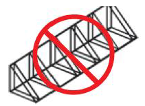
Figure 32 This style of rack is not recommended.
Old-fashioned "school racks," which secure only one wheel, are a poor choice for today's bicycles (Figure 32). Securing both the wheel and frame is difficult, and bicycles are not well supported, sometimes resulting in bent rims.
Locations: The best locations for bike parking are near main building entrances, conveniently located, highly visible, lit at night, and—when possible—protected from the weather. When placing a bicycle rack in the public right-of-way or in a parking lot, it should be removed from the natural flow of pedestrians, avoiding the curb and area adjacent to crosswalks. Racks should be installed a minimum of 6 feet from other street furniture and placed at least 15 feet away from other features, such as fire hydrants or bus stop shelters.
The installation recommendations below come from the Kane County Bicycle and Pedestrian Plan:
•
Anchor racks into a hard surface
•
Install racks a minimum of 24" from a parallel wall
•
Install 30" from a perpendicular wall (as measured to the closest inverted U.)
•
Allow at least 24" beside each parked bicycle for user access, although adjacent bicycles may share this access.
•
Provide a 6 feet aisle from the front or rear of a bicycle parked for access to the facility.
Ordinances: Ideally, all multi-family and non-residential buildings should provide bike parking. A simple ordinance may call for one bike parking space for every 10 or 20 required car spaces, with a minimum of two spaces. The City of Naperville has a very good ordinance (Section 6-9-7) specifying bike rack standards and a detailed list of required spaces per land use. Most uses call for 5% of car spaces, with higher amounts for multi-family dwellings, schools, recreation facilities, etc. For suggestions on bike parking requirements according to land use type, consult the APBP bicycle parking guide referenced above.
Existing Conditions: Bike racks currently exist at locations throughout the City, including most schools. Locations that need new or upgraded bike parking include, but are not limited to:
•
Post Office
•
County Building
•
Government Building
•
City Hall
•
Library (replace existing)
•
Mall, both the east and west side
•
Hendelmeyer Park
•
Bliss Park
•
Community Park
•
Wal Mart
•
K Mart
Figure 31 Over time, the school yard style of rack, such as this one in Community
Park, should be replaced by more secure racks, as discussed above.
Education
Education of bicyclists, pedestrians and motorists is crucial to improving real and perceived bicycling and walking safety in Effingham. Many adults and children are afraid to bike, or bike only on off-road trails, because of their concern about safety. Many parents fear letting their children walk along or across busy streets. Improving education can lessen these concerns and instill the skills and confidence to bike and walk around town more safely. Some possibilities include:
Bicyclists and Pedestrians: Distribute safety materials through schools and PTAs; at public places such as City Hall, the library, and the Park District; and on the City's and park districts' websites:
•
Kids on Bikes in Illinois (www.dot.state.il.us/bikemap/kidsonbikes/cover.pdf), a free pamphlet from IDOT's Division of Traffic Safety.
•
League of Illinois Bicyclists' single-page summaries for children and their parents at http://www.bikelib.org/safety-education/kids/bike-safety-sheet.
•
Safe Bicycling in Illinois (www.dot.state.il.us/bikemap/safekids/cover.pdf), a free booklet directed to teens and adults, from IDOT Traffic Safety.
•
Teaching Children to Walk Safely as They Grow and Develop: A Guide for Parents and Caregivers, a free guide from the National Center for Safe Routes to School: http://www.saferoutesinfo.org/resources/education_teachingchildren.cfm.
Other resources for kids and adults are listed at http://www.bikelib.org/safety-education , ranging from bike safety classes to videos to a bike rodeo guide. Also, grant funding for grades K-8 education programs is available from the Illinois Safe Routes to School program.
Motorists: Educate motorists on sharing the road with bicyclists and avoiding common mistakes that lead to crashes. Include a link to the League of Illinois Bicyclists' "Share the Road: Same Road, Same Rights, Same Rules" video (http://www.bikelib.org/safety-education/motorists/driver-education and available as a DVD) on the City and park district websites. Show the video on the local cable channel, especially during the warmer months, and encourage local high schools and private driver education programs to include the video and other materials from LIB's driver education lesson plans, which include a road rage case study for classroom discussion.
Motorists also need to be vigilant about pedestrians, especially at intersections and other crossing points. Recently enacted state law requires motorists to STOP for pedestrians in crosswalks. In the coming years, look for more education resources to help drivers (and bicyclists) understand their responsibilities towards pedestrians.
Articles meant to educate the public on the above are available on the League of Illinois Bicyclists website. These are suitable for newspapers, local newsletters, and the City website.
Encouragement
Suggestions for encouraging visitors or residents to explore Effingham by feet or two wheels include:
•
Create a city map of Effingham's bikeways network, including TREC, as more facilities are developed. The map can show existing and proposed bikeways. Partner with local businesses to produce—and be listed—on the map.
•
Work with schools and PTA's to develop Safe Routes to School maps and Walking School Buses.
•
Proclaim the City's observance of National Bike Month in May (or June, when weather is more dependable).
•
Declare a Bike to Work day to encourage bicycling to work, errands, or other destinations. Offer token incentives, such as refreshments at City Hall or coupons for ice cream, for example.
•
Work with the school district to observe International Walk and Bike to School Day, the first Wednesday of each October.
Figure 32 Local stakeholders can help promote walking and biking in Effingham.
•
Work with the park districts, public health officials and other partners, such as local bike shops and TREC volunteers, to organize bike tours, running events and walks.
•
Promote Effingham as a bicycle-friendly community in the City's advertising.
Enforcement
A vital component of a safe bicycling and walking environment is enforcement with education to reduce common collision types.
According to Illinois law, bicycles have both the rights and responsibilities of other vehicle users. Many bicyclists do not know about the law as it applies to bikes, and how following the law leads to safe cycling. Other cyclists ignore the law while riding in traffic, not only creating dangerous situations but also causing motorist resentment toward other cyclists trying to share the road safely. Police are encouraged to stop cyclists if the situation dictates, to educate, issue warning citations, or issue tickets. Changing their behavior could save their lives. Resources include Illinois bike law cards and warning citations from the League of Illinois Bicyclists. See www.bikelib.org/safety-education/enforcement-resources
In a car-bike crash, the motor vehicle does the most damage. Some aggressive motorists intentionally harass cyclists, while others simply don't know how to avoid common crash types. Police are encouraged to learn the common crash types and enforcement techniques to help ensure safer roads for bicycling. The League of Illinois Bicyclists offers a Safe Roads for Bicycling police training presentation, including the video referenced above: "Share the Road: Same Road, Same Rights, Same Rules" (http://www.bikelib.org/safety-education/motorists/driver-education and available as a DVD).
Some communities also conduct "stings" to educate all road users about various issues, such as stopping for pedestrians in crosswalks. These stings sometimes start off as education, where during the first week drivers are given warnings and information. During a subsequent week, violators are ticketed. These efforts should be publicized via local media outlets; the goal is to inform as many people as possible about state law and safe usage of the roadway.
Plan Implementation
Introduction
The key recommendation of this plan is to develop a way to ensure its implementation. Continued progress will require a commitment of time and financial resources over many years. Little by little, project by project, the City of Effingham will become a more walkable and bikeable community.
Committee or Staff Time
Perhaps the most important implementation tool is time. The plan recommends dedicating some fraction of a staff member's time as the City's bicycle and pedestrian coordinator. This individual would work on plan implementation projects and other active transportation issues. Also, the coordinator would regularly collaborate with other City staff and relevant agencies to ensure their work conforms to the goals of the plan. Routine review of development plans and road project designs is a prime example.
In addition, consider establishing an on-going Effingham Bicycle and Pedestrian Advisory Committee, perhaps from the plan steering committee membership. Other communities, such as Naperville and Urbana, have found that volunteer involvement by a few energetic, knowledgeable, and dedicated residents can greatly leverage their staff time investment.
Organizing regular, such as quarterly, meetings with this advisory committee can also be an effective way to keep up momentum.
Technical Resources and Training
The staff person or persons in charge of plan implementation should have access to up to date resources to help with the details of design and implementation. In addition to adding the printed resources below to the city planner's library, seek out opportunities to participate in webinars and workshops on best practices. Not only do these events provide useful information, they are an opportunity to interact with other planners and engineers grappling with similar issues.
Manuals and Guidelines:
•
AASHTO Guide for the Development of Bicycle Facilities, 3rd Edition, 1999 (new edition expected in 2011) available at www.transportation.org
•
AASHTO Guide for the Planning, Design, and Operation of Pedestrian Facilities, 1st Edition, 2004 available at www.transportation.org
•
Bicycle Parking Guidelines, 2nd Edition: A Set of Recommendations from the Association of Pedestrian and Bicycle Professionals, 2010, available at www.apbp.org.
Websites and Professional Organizations:
•
League of Illinois Bicyclists: A planning and advocacy resource, with many on-line materials focused on best practices nationally as well as issues unique to Illinois: www.bikelib.org
•
The Pedestrian and Bicycle Information Center: Offers a wealth of information on engineering, encouragement, education and enforcement, including archived webinars and quarterly newsletters: www.pedbikeinfo.org
•
The Association of Pedestrian and Bicycle Professionals: provides continuing education, technical resources and an online forum for exchanging questions and ideas. http://www.apbp.org/
•
National Center for Safe Routes to School: A clearing-house of resources to improve walking and cycling conditions around schools, educate children and caregivers, and organize events. http://www.saferoutesinfo.org/
•
National Complete Streets Coalition: Policy and advocacy tools to help communities across the country develop streets that work for all users. http://www.completestreets.org/
Multi Year Work Plan
This plan recommends a variety of strategies, from adopting policies to coordinating with other agencies, to quickly implementing "high priority, ready to go" projects. One of the first steps of plan implementation should be to go through the listed recommendations (See Complete Streets, Safe Routes to School, Recommended Projects, and the Three E's) and draft a five year work plan. Projects that don't get completed on a given year move into a future year's work plan. Dividing plan implementation across a span of years makes it more manageable, especially in terms of funding.
Implementation Funding
Recommendations in this plan range from low-cost or no-cost improvements to major capital investments. Project costs depend on myriad factors. It is usually most cost effective to address pedestrian and cycling improvements as part of larger projects, instead of retrofitting. Estimates for projects are below. [10]
•
Trail or Sidepath: The cost of developing trails varies according to land acquisition costs, new structures needed, the type of trail surface, the width of the trail, and the facilities that are provided for trail users. Construction costs alone can run $40,000 per mile for a soft surface trail to more than $1,000,000 per mile in an urban area for a paved trail.
•
Bike Lanes: The cost of installing a bike lane is approximately $3,100 to $31,000 per kilometer ($5,000 to $50,000 per mile), depending on the condition of the pavement, the need to remove and repaint the lane lines, the need to adjust signalization, and other factors. It is most cost efficient to create bicycle lanes during street reconstruction, street resurfacing, or at the time of original construction.
•
Sidewalks: The cost for concrete curbs and sidewalks is approximately $49/linear meter ($15/linear foot) for curbing and $118/square meter ($11/square foot) for walkways. Asphalt curbs and walkways are less costly, but require more maintenance, and are somewhat more difficult to walk and roll on for pedestrians with mobility impairments.
These may be funded in a number of ways. First, the City of Effingham may dedicate an annual budget for a bicycle and pedestrian implementation program. If needed, one strategy may entail a smaller first year budget for the highest priority projects, as a way to build momentum for following years. Additional funding may come from the Effingham Park District, Effingham County, Illinois Department of Transportation, and other relevant agencies.
Another major builder of bikeways and sidewalks is developers. Plan recommendations may be implemented opportunistically when a new subdivision or commercial development is added, as described in the Complete Streets section.
Other opportunities include road projects by the City, County, or State. Addressing intersection improvements, bikeways and sidewalks as part of a larger road project is substantially cheaper and easier than retrofitting. Even resurfacing work can be used to add on-road bikeway striping, sometimes at no additional cost.
Finally, outside government funding sources can be used for bikeway and sidewalk retrofit projects. A number of state and federal grant programs are available and summarized in Appendix 4.
Annual Evaluation and Celebration
Another way to keep up momentum and public support is to plan for a yearly evaluation (often called the fifth "E") and celebration of plan progress. For example, work with the Advisory Committee to publish a yearly plan update in conjunction with a ribbon cutting ceremony or community event, such as Walk and Bike to School Day, a community bike ride, or something related to TREC, such as a trail clean-up day. This keeps local stakeholders focused on the progress that has been made and energizes everyone to keep moving forward. Also consider updating this plan every 5-10 years to reflect progress and reevaluate priorities.
Appendix 1:
Effingham Bicycle and Pedestrian Plan Steering Committee
MEMBERS
Frank Brummer, TREC
*
Dean Keller, Effingham Community Unit Schools Dist. 40
Larry Micenheimer, Effingham City Council
Greg Palmer, IDOT District 7
Mike Seay, resident
Angela Woods, resident
Dan Woods, resident
CITY STAFF
Steve Miller, City of Effingham
Hank Stephens, City of Effingham
CONSULTANTS
Ed Barsotti, League of Illinois Bicyclists
John Chambers, League of Illinois Bicyclists
Gin Kilgore, League of Illinois Bicyclists
* Special thanks to Tara Flaig for providing many of the photographs in this plan.
Appendix 2:
Public Brainstorming Workshop Results
On February 3, 2010, a "Public Brainstorming Workshop" was attended by over 25 residents. The purposes of the workshop included: a) gather local resident knowledge on biking and walking needs; b) prioritize road corridors and other routes to study for potential improvements; c) build community support for the plan and its implementation.
Each attendee marked individual maps with suggested "routes to study" for improvements. The map on the following page shows the results of this input, with each recommended segment color-coded by the number of participants suggesting that it be considered. A group exercise followed in which top priorities from the South, Northeast, and Northwest regions of the City were discussed and reported. These include:
South
1)
Effingham Junior High and High School - find alternative to walking along railroad tracks. (Map shows Grove to Clinton to north side of National.) Perhaps a Safe Routes to School grant.
2)
Loop: 4 th from Jefferson to Hendelmeyer Park, then Veterans, Jaycee, Raney (signage on Pike "spur" to cross), Wabash back to 4 th .
3)
Jefferson from US40 from east.
Northeast
1)
Evergreen: Build the Missing Mile to Teutopolis, then continue west all the way to the interstate.
2)
4 th Street from north of the interstate (Rickelman Ave.), across interstate, all the way to the south end of town.
3)
Maple: From Rinkelman, over the planned overpass of the interstate, to Grove, then west along Grove to the schools and beyond.
4)
Improve Willow's crossing of Fayette.
5)
Bike racks at Joe Sipper's and Homewood Grill.
6)
Intersection of Technology Drive and US45.
7)
Temple Ave, Maple to east end.
Northwest
1)
Maple St: Grove to swimming pool to future overpass to Rinkelman [same as Northeast #3]
2)
Proposed bike/pedestrian overpass north of Fayette from Calico to east side of interstate, then north along interstate, then east to connect with either Temple or Heritage.
3)
Evergreen, from west end to Missing Mile to Teutopolis [same as Northeast #1].
4)
Outer Belt West.
2/3/10 Public Brainstorming Workshop Results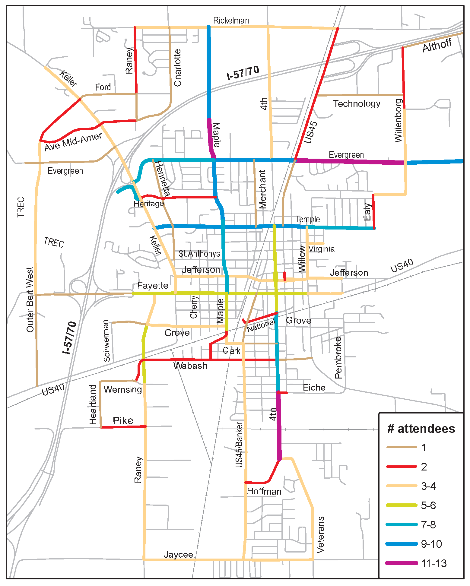
Appendix 3: Road Segment Data
Appendix 4:
Summary of Major Funding Sources
Some of the most commonly used funding sources for bicycle and pedestrian projects are listed below. The funding landscape is always evolving. Check http://www.bikelib.org/bike-planning/bikeway-funding-tips/ for updates.
Illinois Transportation Enhancements Program (ITEP)
•
Federal source with 80% federal/state, 20% local cost shares.
•
Administered by IDOT. Irregular application cycle averaging every two years.
•
Overall historical average of $12M/year in Illinois for bikeway projects, but widely varying including $49M in October, 2010.
•
Very high demand to supply ratio (averaging 8:1), but geographic diversity in grant selections would generally favor Effingham area projects.
•
In October, 2010, Effingham County and TREC were awarded $1,171,560 for the third phase of the TREC trail.
With more stringent federal engineering standards and review processes, this source is better suited for larger ($500K to $1M+) bikeway projects and those requiring substantial engineering work, such as bridges.
Illinois State Bike Grant Program
•
State source with 50% state, 50% local cost shares.
•
Reimbursement grant administered annually (March 1) by IDNR.
•
Averages $2.5M per year, with a $200K limit (except for land acquisition projects). However, the program was cancelled 2008-2010 due to the State's financial crisis.
•
Typically a 2:1 ratio of applications to grants.
•
Only off-road trails and bikeways are eligible.
Much simpler process and standards as these remain local, not IDOT, projects. Good for simpler projects and those that can easily be phased. Some agencies prefer these over ITEP.
Recreational Trails Program
•
Federal source with 80% federal/state, 20% local cost shares.
•
Administered by IDNR with IDOT. Annual March 1 deadline. Long delays between application and grants, in recent years.
•
$1-2M per year. About half is dedicated for non-motorized, off-road trails emphasizing underserved user groups. $200K limit (except for land acquisition projects).
•
Much less competitive, with application demand usually not much more than grant supply.
•
In addition to government agencies, non-profit organizations may apply.
•
TREC received $410,000 in RTP funds to help construct the Calico Trail.
This has been an underutilized source. Trails serving other user groups (equestrian, hiking, cross-country ski, snowmobile) get priority, so partnering with these uses will increase chances for funding. A good target range is $100-300K.
Illinois Safe Routes to School program
•
Federal source paid entirely (100%) by federal/state, with no local cost share.
•
Administered by IDOT. Grant cycles have been held once every 1-2 years.
•
Usually $7M per year; reimbursement grants.
•
70-90% for infrastructure projects within 2 miles of schools serving any K-8 grades, with an application maximum of $250K for up to 3 projects.
•
10-30% for education and encouragement programs for the same grades, with an application maximum of $100K for up to 3 projects. Schools, school districts, and non-profits may also apply for these non-infrastructure funds.
•
Demand to supply ratio was 10:1 in 2007 and then 2:1 in 2008, when current application maxima were adopted. Non-infrastructure grants are much less competitive.
•
Preparation of IDOT's on-line "School Travel Plan" is a prerequisite for grant applications.
All of the Safe Routes to School recommendations, plus many others in this plan, are eligible for this funding source. Again, geographic diversity in grant selections gives Effingham an advantage.
Non-Government Sources
Private foundations, local businesses and individual donors can be another resource, especially for high profile projects. TREC has already raised over $500,000 in private contributions from these sources, demonstrating a widespread level of community support rarely seen around the state. The national focus on public health is also creating more opportunities for active transportation. Many high profile organizations, such the Robert Wood Johnson Foundation, are committing resources to projects that promote public health.
2001 National Household Travel Survey
--- (8) ---
"On-Road Bicycle Routes and Illinois' Liability Disincentive", League of Illinois Bicyclists, 2008.
--- (9) ---
Landis, Bruce, "Real-Time Human Perceptions: Toward a Bicycle Level of Service," Transportation Research Record 1578 (Washington DC, Transportation Research Board, 1997).
--- (10) ---
Explanations and figures from http://www.walkinginfo.org/engineering/roadway.cfm
2.1 - INTRODUCTION
The key function of a comprehensive plan is to provide direction. The plan should "paint a picture" of a community's future. It defines where the community should be heading and what is important.
Each community faces a number of choices to make regarding what should be emphasized during the next planning horizon. Some communities focus on the central business district, others on infrastructure, some on neighborhood revitalization, and others on the attraction of new industry. All are correct. Each represents a statement of policy about how limited resources are to be allocated to meet the priorities of that particular community.
Effingham's sense of direction is stated in the goals and objectives of this Comprehensive Plan. As statements of policy, these goals and objectives identify what the community feels is important and what should be accomplished during the next five years. The objectives identify general actions to be taken to support the goals. Recommendations throughout the plan are based upon how the community has defined where it wants to go, i.e. its goals and objectives.
Community input is critical in the determination of a plan's goals and objectives. This input must be received at the beginning of the planning process. Effingham accomplished this by holding a series of three community workshops at the outset of the planning process. Materials used at each of the three workshops are included in the appendix to this document.
The result of the three workshops was a set of draft goals and objectives statements. Both the Steering Committee and the Plan Commission reviewed and discussed these statements. Their comments were incorporated into a revised set of goals and objectives to guide the Comprehensive Plan. The order of the listing of both the goals and the objectives does not infer an order of priority.
GOALS AND OBJECTIVES
3.1 - INTRODUCTION
Examination of the socio-economics of a community provides a picture of trends and other important characteristics. The information used in this analysis is principally from the 1990 U.S. Census and has been updated as appropriate. Available data is analyzed in this chapter for both the City of Effingham proper, as well as for the Primary Area, which includes the City Limits plus surrounding unincorporated areas. Comparisons are made with both Effingham County and State of Illinois figures, recognizing that the County reflects a more rural-type population while the State reflects both urban and rural type populations. Important data includes not only population size, but statistics which yield information on the characteristics of the population.
3.2 - POPULATION CHARACTERISTICS
The 1990 population for the City of Effingham was 11,927, a 5.8 percent increase over the 1980 population of 11,270. Table 1 displays growth trends for both the City of Effingham and Effingham County. The 1960s and 1970s were times of growth for the City of Effingham. Percentage increases over each 10-year period was in the mid to upper teens. The rate of increase, however, dropped dramatically between 1980 and 1990, suggesting a significant change in growth patterns for the City. While the City is still growing, it is growing at a slower rate. It is interesting to note that Effingham County's growth was slower in the time period between 1980 and 1990. This indicates that Effingham is not necessarily losing population to Effingham County. Over the past thirty years, the City of Effingham has comprised 35 to 38 percent of Effingham County's population.
TABLE 1
LOCAL POPULATION TRENDS
1960—1990
Source: U.S. Census Bureau
Similar trends are found in the information available for the Primary Area. In 1990, the Primary Area population was 12,654. Only 727 persons, therefore, lived in the Primary Area beyond City Limits. It is estimated that the population of the Primary Area reached 12,890 persons by 1993. 1 Projections for the next five year period to 1998 indicate that the Primary Area population will reach 13,254. 2 This would represent a 5% an increase of 600 people or 4.7 percent since 1990. It is projected that population of the Primary Area will reach approximately 14,600 persons by the year 2015.
The racial distribution of both City and Primary Area is 99 percent plus white. All minorities constitute less than one percent of the population. This racial distribution is comparable to Effingham County.
Note— 1, 2 Source: CACI Marketing Systems
3.3 - POPULATION AGE
The 1990 median age in the City of Effingham was 34.6 years. This indicates a slightly older population than that for Effingham County or Illinois. The median age of the Primary Area was 34 years. Table 2, Age Distribution Comparison, compares City, County and State percentages for four age groups. Table 3 provides a more detailed breakdown of age distribution by the various age groups for the City of Effingham.
TABLE 2
AGE DISTRIBUTION COMPARISON—1990
Source: U.S. Census Bureau
TABLE 3
AGE DISTRIBUTION—1990
CITY OF EFFINGHAM
Source: U.S. Census Bureau
These tables reflect Effingham's higher percentage of persons over the age of 65 than is found throughout the County or State. Comparably, Effingham's under-20 population is correspondingly smaller than County and State figures. This can be attributed, at least in part, to two factors. First is the number of retirees moving into the City from rural areas. Second is that Effingham has a number of nursing home facilities which serve it and the surrounding area. In any case, this aging of the population, while following national trends, is an important factor when considering future growth and service needs for the City of Effingham.
3.4 - HOUSEHOLD CHARACTERISTICS
A "household" is defined by the U.S. Census as the person or persons occupying an individual dwelling unit. A family is a special type of household in which the members are related. A single person can only be a household, not a family, as defined by the Census Bureau.
The average number of persons per household was lower in the City of Effingham than for the County and State. In 1990, the average number of persons per household was 2.38 within the City, 2.69 for Effingham County and 2.66 for Illinois. Average household size for the Primary Area was also lower than County and State figures at 2.42 persons per household.
Table 4 displays the household size distribution for City, County and State.
TABLE 4
HOUSEHOLD SIZE DISTRIBUTION COMPARISON—1990
Source: U.S. Census Bureau
Interestingly, 65 percent of all households in Effingham are one or two person households. This is considerably higher than the totals for the County or State. At the County level, 54 percent of all households are one and two persons. The Illinois figure is 56 percent. The percentage of all households which were non-family households was 34 percent for the City, 26 percent for the County, and 30 percent for the State of Illinois. These figures correspond to the comparatively lower number of average persons per household for the City of Effingham.
Examining these figures in greater detail, Table 5 displays data for single person households over the age of 65.
TABLE 5
SINGLE PERSON HOUSEHOLDS OVER AGE 65 COMPARISON—1990
Source: U.S. Census Bureau
Within the City of Effingham, 49 percent of all single person households are individuals over the age of 65. This is 16 percent of all households in Effingham, a significant percentage. These figures bear out that Effingham has a significantly older adult population in the smallest households. This characteristic of the population may significantly affect future growth.
Figures describing the number of families with children in Effingham indicate the City is following state-wide trends. As shown in Table 6, 37 percent of all married couples have children under age 18.
TABLE 6
PERCENT OF MARRIED COUPLES WITH
CHILDREN UNDER AGE 18 COMPARISON—1990
Source: U.S. Census Bureau
It is interesting to note that the actual number of children enrolled in the public school system has stayed approximately the same since the 1987-1988 school year. While these figures are influenced by children entering the private school system, it does indicate a stable number of families with children in and around Effingham.
TABLE 7
ENROLLMENT FIGURES
* Figures as of the end of September.
** 1985-1987 does not include Sacred Heart
Since 1988, the public student population has increased about 1 percent.
3.5 - EDUCATION
Educational attainment levels for the City of Effingham are comparable to what was found County and State-wide. These figures are displayed in Table 8 as percent of total persons age 25 and over.
TABLE 8
LEVEL OF EDUCATION COMPARISON
PERCENT OF PERSONS AGE 25 AND OVER—1990
Source: U.S. Census Bureau
About 74 percent of the City of Effingham's population has attained a minimum of a high school graduate certificate or equivalent. This would indicate that Effingham can offer an educated labor pool to industry.
3.6 - OCCUPATIONS AND INCOMES
Located at the convergence of two interstate highways as well as major rail lines, the City of Effingham has been able to develop a strong economic base. Employment levels in 1990 were very high. Unemployment was recorded by the 1990 Census at a low of 3 percent, significantly lower than the figure recorded for the State of Illinois of 6.6 percent.
Effingham is home to a number of significant industries and provides employment for itself and the surrounding region. The City's ability to develop a diverse local economy has enabled it to be a strong employment center. The manufacturing, service and retail sectors of the economy are each well-represented. Major employers include Crossroads Press, employing 1,000 people; Fedders U.S.A., employing 850; and St. Anthony's Memorial Hospital, employing 650. Additional industries include printing firms, typesetting firms, computer software, a leather glove manufacturer, and a company which produces telephone directories. Effingham's ability to continue to attract new industry into its industrial parks has enabled it to maintain a strong manufacturing employment base. The use of fiber optic communication lines, distance learning information, and a hook-up with the super computer at the University of Illinois has added a high-tech element to Effingham's industrial diversity.
The 1990 Census reports occupations for persons over the age of 16. This data is conveyed by Table 9. It is interesting to note that employment is generally distributed evenly between managerial and professional specialties as well as technical, sales and administrative support. The percentages employed in these professions are generally comparable to those found at the County and State levels. Manufacturing jobs are classified by the U.S. Census in the category described as "All Others." This composite category is higher than other sectors of the employment base. This reflects, in part, Effingham's strength in manufacturing.
In spite of this strong employment base and numerous opportunities for jobs, income levels within the City of Effingham were generally lower than those found at the County and State levels. Table 10, Various Income Indicators Comparison, compares several income indicators for City, County and State 1990 Census data collected for the year 1989.
TABLE 9
PERCENT OF TOTAL EMPLOYED PERSONS AGE 16 AND OVER
BY OCCUPATION COMPARISON—1990
Source: U.S. Census Bureau
TABLE 10
VARIOUS INCOME INDICATORS COMPARISON—1989
Source: U.S. Census Bureau
It is interesting that in almost every category, Effingham's income levels were lower than County and State figures. The only exception was the per capita income for the City, which was slightly higher than that of the County for 1989. Median household income, median family income as well as average household and family income figures were lower, in some cases significantly, than County and State figures. Figures for the Primary Area as a whole, while higher than that of the City, were still lower than the County and State.
Median household income for the Primary Area was $26,010. Its average household income was $33,193. Per capita income for the Primary Area was slightly higher than for the City at $13,353.
These figures bear out the trend that income levels of the City are generally lower than those found throughout the County and State levels. The complete explanation for this is unclear at this time. Part of it is attributable to the higher percentage of persons over the age of 65 who are likely to be on fixed incomes. This factor bears some additional consideration when planning for the community's long-term economic growth. An additional factor may be the significantly higher income levels found outside the City at Lake Sara. Data for income levels at Lake Sara suggests that income levels of the lake residents is generally higher than found in the City (see Chapter 10, Lake Sara, Existing Conditions).
Table 11, Household Income Distribution Comparison, and Table 12 provide some additional detail regarding the distribution of incomes within the City as well as comparisons with County, State and Primary Area figures.
TABLE 11
HOUSEHOLD INCOME DISTRIBUTION COMPARISON—1989
Source: U.S. Census Bureau
TABLE 12
HOUSEHOLD INCOME
CITY AND PRIMARY AREA COMPARISON—1989
Source: U.S. Census Bureau
* Figures do not total 100% due to rounding.
3.7 - TAX BASE
Like other mid-sized Illinois municipalities, Effingham receives most of its general revenue through the state sales tax. In Effingham, the City's portion of sales tax monies received back from the state constitutes approximately 66% of all general fund revenues. As shown in Table 13, annual sales tax revenues now hover around three million, due in part to revenues generated by highway-related commercial enterprises.
TABLE 13
CITY OF EFFINGHAM
ANNUAL SALES TAX RECEIPTS
The real estate property tax provides approximately 23% of general revenue. Property taxes are also the principle means of local finance for the public school district. Economic growth results in higher assessed value of property which, in turn, can generate higher property tax revenues under certain tax levies without raising the tax levy. The total assessed value of property has been rising during the past five years and indicates continuous local growth beyond inflation. The growth in assessed value is identified in Table 14.
TABLE 14
CITY OF EFFINGHAM
GROWTH IN ASSESSED VALUE
* Unusually large increase due to change in multiplier and reassessment of property
Source: City of Effingham Financial Statements
It is anticipated that figures for 1993 will continue to show an increase in value.
The other mechanism that the City has to directly capture the fiscal benefits of economic growth is its existing Tax Increment Financing (TIF). Through a TIF District, a portion of all revenues generated therein are allocated to a special fund, as opposed to being allocated to other taxing jurisdictions or to the general revenue fund. These dollars must be used for improvements and programs in the TIF District. All economic growth in the TIF District directly increases TIF revenues which must then be spent in the District. The City of Effingham has recently added a second TIF.
3.8 - SUMMARY
This background information should be kept in mind when evaluating current issues and planning options. The following points are particularly significant:
•
The City of Effingham's population increased 6 percent from 1980 to 1990. While this does indicate good, continued growth, it is a lesser rate than the City experienced in the 1960s and 1970s. Population growth can be expected to continue at about this same rate or slower.
•
Approximately 18 percent of the City's population is over the age of 65. Forty-nine percent of all single person households are individuals over the age of 65. This is also equivalent to 16 percent of all households in the City.
•
Sixty-five percent of all households in Effingham are one or two person households. The average number of persons per household was 2.38, lower than the average for the Primary Area, County and State figures.
•
Twenty-five percent of all households and 37 percent of all Effingham families are married couples with children under the age of 18.
•
Public school enrollment has been at about 2,900 students since 1986.
•
Overall income levels in the City of Effingham are slightly lower than the levels recorded for the Primary Area, the County and the State of Illinois.
•
The direct benefit of growth accrued to municipal government for enhanced service delivery is seen in the property tax revenues and in the revenues generated by the TIF District.
Although U.S. Census data is now three to four years old, the trends and parameters these numbers suggest are as important today for planning purposes as they were in 1990.
4.1 - INTRODUCTION
It is important to understand existing land use patterns in order to plan for future development. Land use and major transportation arteries develop together. Sometimes, it is a "chicken or the egg" question as to which came first. In the City of Effingham, land use has generally followed the transportation corridors. This pattern is also influenced by key physical features.
4.2 - PHYSICAL FEATURES OF THE PRIMARY AREA
The development of vacant land is affected by the constraints and opportunities presented by the physical environment. Physical features influencing development in and around the City of Effingham are primarily the floodplains of the Little Wabash River and Salt Creek as well as existing transportation facilities. Physical features influencing development in each subarea are discussed below and displayed on Plate 2, Physical Conditions.
Natural Features
The Primary Area is approximately 18 square miles situated between the Little Wabash River and Salt Creek valleys. Plate 2 displays the approximate floodplain areas designated by the Federal Emergency Management Agency (FEMA). Development to the east and west of Effingham is constrained by these floodplain areas. Tributaries to these waterbodies traverse to the southeast and northwest quadrants of the Primary Area. Topography is generally flat except adjacent to the rivers where slopes may reach 10 percent. Environmentally sensitive areas within the subarea include floodplains and bottomland forested areas, some of which may meet wetland criteria.
There are three manmade lakes in the Effingham area, each created by damming a tributary of the Little Wabash River. CIPS Lake and Lake Sara were constructed as water supply reservoirs. Lake Pauline was developed as a small recreational lake.
Wetlands
Within the two river valleys, the U.S. Department of Interior, Fish and Wildlife Service, has identified a number of potential wetland areas. These are identified on the National Wetlands Inventory maps. Wetlands can only be identified with certainty through a wetlands delineation study of the specific site.
Wetlands are now a nationally recognized and protected resource. While previously thought to be wasteland, wetlands are now clearly understood as valuable parts of the ecosystem. There are six primary benefits of wetlands. These include:
•
Flood storage or conveyance;
•
Groundwater recharge;
•
Erosion reduction and sediment control;
•
Pollution control;
•
Wildlife habitat; and
•
Recreation and education.
Under federal law, private citizens are responsible for protecting wetlands on their property. Prior to any alteration, such as filling or draining, an individual is required to obtain approval from the U.S. Army Corps of Engineers. The Corps then verifies whether or not the area is a jurisdictional wetland, if it can be altered, and if mitigation is required. If an individual does not obtain Corps of Engineers approval, he may be required to replace the damaged wetland. This law pertains to private property whether or not federal or any other public dollars are involved. It is also important to note that there is no distinction made under the law if the wetlands are natural or manmade.
Inasmuch some development proposals will occur in these areas, the City should consider the adoption of provisions which will provide for the proper review and permitting in potential wetlands.
Soils
Cisne and Hoyleton soils are the predominant soils of the Primary Area. These silt loams are poorly drained, have seasonally high water levels and high shrink-swell potential. These characteristics present some limitations for development which can be compensated for through proper design.
Manmade Features
Railroads and highways also have influenced the development of this area. Interstate Highways 57 and 70 converge with U.S. and State Routes 32, 33, 40 and 45 in Effingham. Both the Illinois Central Railroad (I.C.R.R.) and the Consolidated Rail Corporation (ConRail) trunk lines cross the area. These rail lines and associated facilities offer both opportunity (rail access) and constraints (conflicting land uses) for future development.
Another manmade physical constraint is the Effingham County Memorial Airport, located south of the City limits. An airport has corresponding protected areas along and at the ends of the runways. These surfaces are mandated and regulated by the Federal Aviation Administration. Land which falls under the Runway Safety Area, the Object Free Area and the Runway Protection Zone must be clear of other uses. These "surfaces" are defined in the Airport Layout Plan (ALP).
The ALP for Effingham County Memorial Airport is now being revised. The current proposal calls for runway extensions which will ultimately move the Runway Protection Zone out to State Highway 45. Future land use planning will need to take these existing and proposed protected areas into account. Although no noise studies have been completed as of this writing, noise from airport operations should be considered as well.
4.3 - EXISTING LAND USE
Existing land uses were surveyed in May of 1993. These uses were mapped and classified according to type. The classifications used within this document are:
•
Agricultural/Undeveloped
•
Residential
•
Commercial
•
Industrial
•
Public/Semi-Public
The survey results are displayed on Plate 3, Existing Land Use, City of Effingham, and Plate 4, Existing Land Use, Surrounding Areas of Study.
4.4 - OTHER LAND USE PLANS AND STUDIES
There are several existing plans which have a direct bearing upon future land use planning. While the following discussion is not meant to be all encompassing, five of these key plans are addressed below. For greater detail, the original documents should be consulted.
4.5 - SUMMARY
Existing land use patterns in Effingham reflect the major transportation corridors and the constraining physical features. In particular, major roadways and railroad corridors have directed the City's pattern of growth. The two major waterways, the Little Wabash and Salt Creek, have limited development to the east and west, emphasizing the pattern of development in a north/south direction. It is expected that these factors will continue to be the primary influences on future land use patterns.
Recommendations for action include adoption of local regulatory procedures to identify and protect wetlands. This will become more important as growth moves towards the two major waterways, although wetlands occur outside the floodplain, as well.
The City should consider participation in the Illinois Historic Preservation Agency's Certified Local Government Program to facilitate protection of historic resources. Identification of which resources should be preserved will greatly assist future land use planning, particularly in the central business district.
5.1 - INTRODUCTION
A good transportation system is critical for the City of Effingham's growth. The existing access to the interstate highway system and major rail lines has made Effingham home to many trucking and related industries. Unfortunately, the increased truck traffic and numerous at-grade railroad crossings deter circulation throughout the City.
Land use and development are inextricably linked. The function of a road system is to provide access to and from development. There is ongoing debate as to which comes first, road access or development. The bottom line, however, is that the two are totally dependent upon one another.
There is an inverse relationship between access and mobility. Local roads, such as subdivision streets, provide high access and low mobility. Arterials, such as Fayette Avenue, provide high mobility and low access. Collector streets, which provide transition from local to arterial streets, such as Wabash Avenue, balance access and mobility.
Analysis of a transportation system focuses upon the issues of the core of the inverse relationship between access and mobility and the need to provide both these functions.
5.3 - RECOMMENDED IMPROVEMENTS
The primary goal of the major street plan, as identified in 1984's Effingham Comprehensive Plan, is "...a functional system of continuous streets, evenly spaced, and permanently constructed to standards adequate to carry traffic efficiently throughout the City."
This has been Effingham's ongoing transportation goal for a decade and should continue throughout the life of this document. The recommendations suggested in this plan follow this goal and specifically attempt to improve circulation by working with existing and proposed land use (see Chapter 11, Development Plan). The proposed major improvements which follow are shown on Plate 7.
5.4 - SUMMARY
These recommended roadway improvements are designed to enhance circulation and access throughout Effingham. Current traffic volumes, road design and circulation patterns, as well as existing development, are each taken into consideration. Importantly, the proposed future land use patterns, described in the Development Plan, are also a major driving force in the formulation of these recommendations. As discussed in the Introduction to this chapter, it is difficult to separate an analysis of a road network from an analysis of development. How these improvements support future development patterns is integrated into the Development Plan discussion in Chapter 11.
6.1 - INTRODUCTION
Utilities are a critical component of the City of Effingham's supporting infrastructure. Growth and development can be limited absent the ability to provide basic services. Relative to the water system, capacity includes supply, treatment and distribution. Sanitary sewage disposal includes collection and treatment. Though not a utility, storm water drainage is included in most discussions of utilities as another critical supporting infrastructure element.
The discussion in this chapter addresses existing systems and the current plans for system improvements. These are examined with respect to the proposed Future Land Use Plan and proposed Transportation Plan improvements. Additional improvement recommendations are made to support these proposed plans. These are incorporated into the capital improvements plan in Chapter 13, as appropriate.
6.2 - WATER SERVICE
Effingham owns and operates a municipal water system. Service is provided to approximately 5,750 customers, of which 4,230 or 73 percent are located within the municipal limits. Outside the City, Effingham supplies water to the Lake Sara Services Cooperative, the Village of Teutopolis, the Heartville Public Water District, and the Snake Trail Water Service District as well as to some individual customers.
The water supply for the City of Effingham is generated at three sources. The main source is the Little Wabash River, which lies west of the current City limits. CIPS Lake, a 20-acre manmade body of water, is adjacent to the City's water treatment plant. Lake Sara, covering 750 acres, was constructed in the late 1950s as the City's secondary water supply source. This lake is owned and operated by the Effingham Water Authority (EWA). Water from Lake Sara is used principally during the low rainfall months of July, August and September or when the Little Wabash River is low.
Other Providers
Plate 9, Water Service Districts, displays service areas of local providers. The boundaries of the Effingham Watert Authority (EWA), which owns and operates Lake Sara, approximate municipal boundaries when it was chartered in the 1950s. Revenues for the operation of Lake Sara and bond retirement are generated from property taxes levied within the EWA boundaries. The Lake Sara Services Cooperative provides water service for the customers around Lake Sara. The Cooperative purchases water from the City of Effingham but develops and maintains its distribution system. Revenues are derived from user fees.
To the south, the Heartville Public Water District supplies water for single-family residential customers. Like the Lake Sara Services Cooperative, Heartville purchases water from Effingham, but independently provides its distribution system. The District does not have the capacity to serve commercial or industrial customers.
The EJ Water Corporation is a private company, generally located east of Teutopolis. Current plans are to add infrastructure to serve the eastern portion of Effingham County. The EJ Water Corporation also sells water to the Watson-Mason-Edgewood Water Commission, which is constituted to provide water distribution to a large area in the southeast section of the County. Its system is now in place in portions of its eastern service area.
Individual Customers
In addition to its service agreements with other providers, the City of Effingham also supplies water to individual customers who do not have access to another public water system. Most of these accounts are at private residences, although there are several businesses on Effingham water service along U.S. Highway 45 north of the City. There are approximately 65 individual accounts being served beyond the municipal limits.
These households and businesses are served by request. The intent is that they will be annexed into the City on a voluntary basis once these properties become contiguous with the municipal limits. Theoretically, the City is not providing long-term service outside its taxing jurisdiction. However, to date, no effort has been made to assure that careful records are kept of these properties and that annexation is pursued. The City of Effingham should pursue this service delivery question and develop a firm policy and program to address it. This will become more important as the Effingham area grows. It also establishes precedent for delivery of other types of services to areas outside of the City.
Water Treatment
Water treatment for the City of Effingham is accomplished at the municipal treatment plant. Constructed in 1987, the facility has an average design flow of three million gallons per day. Its maximum capacity is six million gallons per day. Water is treated from all three supply sources to meet Environmental Protection Agency standards.
The storage of water to respond to fire and peak usage needs is a critical component of a water system. Effingham now uses three ground storage tanks and one elevated tank. The ground storage tanks have a capacity of one million gallons each. The 130-foot high elevated tank holds 500,000 gallons. In 1993, the City of Effingham issued revenue bonds for improvements to the water system. Funding for a new 750,000 gallon elevated storage tank is included in this bond issue. In addition, bonds issued as a part of the Tax Increment Financing District for the K Square Outlet Mall included construction of another 750,000 gallon elevated tank. Both of these improvements in water storage capacity will assist the City in lowering its fire insurance rating.
Planned Improvements
The storage capacity improvements are recommended in an engineering report dated September 30, 1991 by Crawford, Murphy & Tilley, Inc. In addition to the tanks, the following three projects will be completed under the two bond issues:
•
Replace pump station at Evergreen with two 1,000 gallons per minute (gpm) pumps (Waterworks Bond Issue).
•
Replace pump station at Grove with two 1,000 gpm pumps (TIF Bond Issue).
•
Study of new source of water supply storage.
The following projects are also identified in the engineering report and need to be undertaken as future projects.
•
7,300' of 12" water main from the 20" water main on Route 40 to the 12" water main at Raney and McGrath.
•
1,380' of 8" distributor line from south of railroad between Vine and Mulberry
•
1,350' of 8" distributor line from north of railroad between Henrietta and Mulberry
•
600' of 6" distributor line from end of Glenwood between Rosewood and Oakwood
•
650' of 6" distributor line from end of Grove between Gordon and Lynn
•
350' of 6" distributor line from Third between Hawthorne and Slate Creek
•
350' of 6" distributor line from the end of Poplar between Poplar and Pine
•
300' of 6" distributor line from Southernaire to 12" H.S.L.
•
600' of 8" distributor line from South Hamilton to 12" H.S.L.
•
4,400' of 12" primary feeder at Evergreen between Henrietta and North Tank
•
6,200' of 10" primary feeder south of I-57/70 between Moto Station and YMCA
•
3,440' of 10" primary feeder at North Fourth Road between Santa Maria and Rickelman
•
3,800' of 12" primary feeder at Raney between Industrial Park and Wernsing
•
1,300' of 10" secondary feeder at Mulberry between St. Anthony and Temple
•
1,400' of 12" primary feeder at Cherry between Fayette and St. Anthony
•
3,200' of 10" primary feeder from LK Knagge Road, Raney to I-57/70
•
2,000' of 10" primary feeder along I-57/70, LK Knagge Road to Route 40
6.3 - SANITARY SEWAGE TREATMENT
The City of Effingham operates a public sanitary sewer system comprising a collection system and a sewage treatment plant. The sewer system principally serves the incorporated area of Effingham. The City is following an engineering report by Milano & Gunloh Engineers, Inc. entitled Sanitary Sewage System Facility Plan, April 1991. The unincorporated portions of the Primary Area are served by individual disposal systems, usually septic tanks or aeration systems, which are required to meet the standards imposed by the Illinois Department of Public Health Private Sewage Disposal Licensing Act and Code.
The Sanitary Sewage System Facility Plan also contains a review of the municipal sanitary treatment plant. The report recommends two major projects for the treatment facility. The first project is for substantial maintenance work. This is necessary given the plant's length of continuous operation. The second project is to expand treatment capacity from 2.50 to 3.75 million gallons per day. The report found that the plant is nearing capacity. In order for the City of Effingham to be able to continue its growth and development, particularly relative to industrial and commercial uses, the plant's capacity must be enhanced.
The following projects are identified in the engineering report and are identified by the City as planned future projects.
•
Relocate discharge of airport road lift station. Requires approximately 2,200' of 6" diameter force main and boring of U.S. Route 45.
•
Relocate discharge of Industrial Park #2 lift station. Requires approximately 2,200' of 6" diameter force main and boring of U.S. Route 45.
•
Tegeler Sewer. Requires approximately 3,800' of 10" diameter sanitary sewer and a boring of the ICGRR and the ICG-Conrail connection.
•
Holste/Goldstein Sewer. Requires approximately 5,200' of 15" diameter sewer (much of it 15' to 20' deep) and 2,400' of 12" diameter sewer.
•
East Route 40 lift station. Requires approximately 4,900' of 8" diameter sewer, 5,500' of 6" diameter force main and a submersible lift station.
•
Relocate discharge of Banker Street lift station. Requires approximately 1,900' of 6" diameter force main and the boring of South Banker Street.
•
Abandon Rolling Hills lift station. Requires approximately 900' of 8" diameter sewer and the conversion of the existing lift station.
•
Replace outdated, obsolete or worn-out mechanical equipment at sewage treatment plant.
•
Expand sewage treatment plant to treat 4 to 5 million (12.5 million peak) of wastewater per day.
•
Continue upgrading sewage collection to eliminate storm water inflow/infiltration.
6.4 - STORMWATER
Stormwater management is an integral component of urban development. Nature provides a complex system for directing and absorbing stormwater drainage. Following natural topography, surface water flows toward creeks, steams, rivers, lakes, wetlands, etc. Some of it is absorbed through the soil eventually reaching groundwater. The manmade environment alters this natural flow and creates the need for stormwater management.
There are two primary ways in which human activities alter the natural drainage system. The first is the direct transformation of the natural topography to support agriculture or development. The second influence is attributable to the fact that developments, be they buildings, parking lots, roads or any other structure, create vast impervious areas which no longer can absorb water through the soil. This forces a higher volume of runoff seeking a path for reabsorption into the hydrologic cycle. By sending higher volumes of water into creeks and streams, flood events are created or intensified. Sheet runoff from impervious surfaces also contributes to localized flooding situations.
Stormwater Management Plan
The City of Effingham has dealt with stormwater management, on an incremental basis, through the use of drainage structures and retention basins. However, by dealing only with localized circumstances or problems, greater or new problems can be created downstream. The first step toward a comprehensive solution is to prepare a stormwater management study for the City and surrounding area. From the findings of this study, the City should adopt an official policy for stormwater management and develop a long-range program of improvements. This will enable the City to approach stormwater management in a consistent and coordinated manner as well as establish appropriate standards for new development.
There are several areas within the municipal limits which do not have any stormwater drainage structures or where existing facilities are inadequate. Areas which lack facilities include the Keller Drive commercial area; the industrial area in the southwest quadrant of the City; the commercial/industrial area near the Interstate Highway 57/70 and U.S. Highway 45 interchange; and several residential areas. In many of these areas, problems may not now exist but could develop as Effingham continues to grow.
Planned Improvements
Several projects have already been identified and are planned by the City of Effingham to address existing problems. These include:
•
Third Street and Market Avenue
Convert inlets to combined storm and sanitary sewer to storm only; requires 300' of 12" storm sewer
•
North Fourth Street and St. Louis Avenue
Convert inlet to combined storm and sanitary sewer to storm only.
•
Banker Street and National Avenue
Requires approximately 1,700' of 15" storm sewer and 500' of 12" storm sewer; convert inlets to combined storm and sanitary sewer to storm only
•
First Street and Washington Avenue
Convert inlets to combined storm and sanitary sewer to storm only; requires 350' of 12" storm sewer
These projects have been included in the recommended Capital Improvements Program.
7.1 - INTRODUCTION
The City of Effingham is, most importantly, a place to live. As such, its housing stock is one of the community's most valuable assets. It is also one which is often taken for granted. The quality and diversity of housing stock impacts:
•
Property values;
•
Property tax revenues, particularly important to the school district;
•
Neighborhood quality;
•
Housing marketability;
•
Ability of the community to attract business and residents;
•
Community pride; and
•
Ability to provide varied housing types, such as single-family and multifamily units, to provide for "cradle to grave" residency in Effingham.
Housing is usually the most important investment an individual makes in a lifetime. The predominance of home ownership in America is based upon the fundamental principle that "a man's home is his castle." Today, however, we recognize that there is also a community interest in the quality of housing stock.
For this reason, examination of the City of Effingham's housing stock is a major component of the Comprehensive Plan. Information on housing was gathered from both the 1990 Census and a housing condition survey conducted for this study. Housing is also discussed from a land use perspective in Chapter 4, Existing Land Use and Physical Features.
7.2 - EXISTING CONDITIONS
Statistics can help quantify the composition of the City of Effingham's housing. The numbers of units, owners, renters, as well as vacancy rates and housing types, are each important characteristics which should be considered. The physical condition of the units is a critical component when evaluating existing and future housing quality.
7.3 - HOUSING SURVEY
In May of 1993, an exterior housing conditions survey was conducted. Exterior conditions have been found to generally reflect interior conditions. Using windshield survey methodology, housing conditions were rated on the basis of "Good," "Fair" or "Poor" using the criteria identified in Table 18. Results are analyzed on a block level and displayed on Plate 11, Housing Survey Results.
It is important to recognize that the analysis is conducted on a block face basis, not house-by-house. What this means is that not all the houses in each of the individual areas is fair or poor, but rather that these housing conditions are predominant. The values of the well-cared for homes in these areas are influenced by the surrounding housing conditions.
The survey results indicate that much of the City's housing in the older core is in fair condition. This is particularly true for the area bounded by Temple Avenue on the north, the railroad tracks on the east and south, and Henrietta Street on the west. There are also significant fair condition areas south of the railroad tracks, particularly to the southeast.
Housing designated as "fair" does not necessarily indicate that there are no major problem areas. It does indicate that problems are beginning to appear. The question to be asked is: What will these areas be like in ten years?
Areas of the City that are now identified as poor are much smaller in scale, but are also found primarily in the older core of Effingham. The largest of these neighborhoods is immediately south of the railroad tracks. In the past, the City has provided assistance to the area by funding the necessary improvements for sanitary sewers. This neighborhood, as well as several others identified as "poor," are areas which are slowly transitioning to another type of use. Typically, such areas are found along railroad tracks.
Mobile home parks are typically very difficult to maintain over the long term. Several of the City's mobile home parks are classified as fair or poor. While manufactured housing is generally lesser expensive type housing, the quality of the units and of the park need to be maintained.
TABLE 18
HOUSING CONDITIONS RATING CRITERIA
GOOD (Rating = 1)
Absence of any visible signs of deterioration or required maintenance or slight indication of a potential minor/intermediate fault 1 ; highly desirable for residential use.
FAIR (Rating = 2)
One or two minor/intermediate types of faults; inhabitable, desirable and attractive; requires only normal maintenance measures.
POOR (Rating = 3)
Two or more minor/intermediate types of faults and one major/critical fault 2 , or one or two major/critical types of faults; inhabitable; requires extensive repair; deteriorating.
1MINOR/INTERMEDIATE FAULTS (COSMETIC):
-
deteriorating paint on exterior wall material, windows or doors
-
falling or missing gutters and downspouts
-
cracked window glass or broken windows or doors
-
missing or deteriorating roofing materials
-
missing, cracked or broken, dented or otherwise damaged exterior wall materials
-
hairline foundation cracks
2MAJOR/CRITICAL FAULTS (STRUCTURAL):
-
large foundation cracks
-
bulging, sagging, tilting foundations
-
rotting, loose, missing exterior wall materials
-
bulging, sagging, tilting exterior walls
-
out-of-plumb windows or doors resulting in open cracks, bulging or sagging
-
rotting, loose, missing chimney materials
-
bulging, tilting chimney
-
sagging roof
-
large porch cracks
-
rotting, loose, missing porch materials
-
bulging, sagging porch ceilings
7.4 - ACTION RECOMMENDATIONS
Recommendations for action focus upon two issues: 1) maintenance of housing and neighborhood quality, and 2) increasing the supply and diversity of the housing stock. The Goals and Objectives of the Comprehensive Plan provide direction for the approach to both of these issues. As they indicate, an emphasis on the quality and supply of the City's housing stock is a major component of economic growth.
7.5 - SUMMARY
Demand for housing in Effingham is high, a sign of a good local economy. With over 5,000 housing units, the City has a low vacancy rate. While approximately 70 percent of the units are single-family, there are opportunities for multifamily renter housing, zero lot line type units, mobile homes and some available public housing.
At least 50 percent of the City's housing stock is 30 years or older. Housing conditions, particularly in the older core of the City, are showing signs of requiring additional attention. The housing results indicate that many areas are now in "fair" condition.
The action recommendations provide a means to both maintain housing quality and to seek alternative means to facilitate the housing market. While many communities rely solely on market forces to deal with each of these issues, the importance of a community's housing stock usually necessitates an increased role on the part of local government and the use of new tools to address housing quality and supply issues.
8.1 - INTRODUCTION
Community facilities and services are an important aspect of comprehensive planning. This includes examination of facilities such as parks, schools and other public buildings as well as questions and issues related to the impact of growth on services such as police and fire protection. Planning for the future of such facilities, particularly as they relate to land use planning and transportation planning, is a critical element of the overall process. Both the planning of the expansion of existing facilities as well as proposals for new facilities need to be taken into account when developing future land use plans.
One issue that arises when dealing with community facilities relates to "semi-public institutions" such as golf courses, private schools and hospitals. For purposes of this analysis, these facilities are considered a community resource recognizing, however, that the City of Effingham will have little or no control of the future of these institutions. Understandably, this represents a gray area. However, it is necessary to include these important facilities to gain a clear picture of Effingham's community resources. The plans of these institutions may have a direct bearing on future community land use as well.
A map of community facilities is displayed on Plate 13.
8.2 - PUBLIC SAFETY
Growth and development of a community have direct impacts upon those services which respond to public safety needs. In particular, this means police, fire, ambulance and emergency management services. Responding to the needs of an increasing geographic area and population, as well as larger industrial uses, can place higher service demands on these particular public safety services. For this reason, it is important to examine their current status and evaluate the future impacts of growth.
8.3 - PARKS AND RECREATION
Parks and recreation services are provided by both public and private entities. Providers include the Effingham Park District, the City of Effingham, YMCA, the local country club, and others. These are explored in further detail below.
8.4 - EDUCATION
The public school system is centered in the City of Effingham. The district, Community Unit 40, provides public education for approximately 3,000 students annually. With approximately 150 teachers, the District averages a pupil-teacher ratio of 22.7 to 1 in grades K-8 and 20.0 to 1 in grades 9-12. The average operating expenditure per pupil was $3,489 in 1992-93, below the state average of $5,327 for the same year.
District boundaries are displayed on Plate 14. In addition, there are several private school facilities available within the City.
8.5 - MUNICIPAL SERVICES
The City of Effingham provides a number of services which are important to the planning process. These are described below.
8.7 - COUNTY ADMINISTRATION
The City of Effingham is also the seat of government for Effingham County as well as its largest municipality. Constructed in 1871, the County Courthouse in the public square is listed on the National Register of Historic Places. The new Administration Building is across the street on Fourth Street. Consideration is now being given to expansion of the Administration Building on an adjacent site.
There are various other county offices throughout Effingham such as the Health Department, Heartland Human Services, Home Base/Headstart, Housing Authority, Veterans Assistance Commission, and the WIC clinic. One of the major county facilities serving the City is the Effingham County Memorial Airport discussed in greater detail in the Transportation chapter. Effingham is home to various state and township offices as well.
8.8 - ACTION RECOMMENDATIONS
The following is a summary of the action recommendations for community facilities and services:
•
The impact of growth on the level and quality of police services should be assessed as new development and/or annexation occurs. This requires ongoing consultation with the police department.
•
Follow through on the ISO recommendations. Construction of a new fire station to the north should be a priority.
•
An advisory committee of business, education and local government should be formed to strengthen communication and maximize the potential of the business/education partnership and relationship. Educational opportunities along these lines is one of Effingham's greatest strengths.
•
A new City Hall is needed which will provide ADA accessibility and adequate space for public meetings and offices.
•
A new library is needed to provide adequate space for the growing collection. This effort should be coordinated with the several other bond issue projects now being planned.
•
A local recycling program should be explored and implemented, if feasible. This could be accomplished by a local organization and/or corporation.
•
The City and the Park District should develop a parks and recreation plan which identifies future needs and realistically recommends a program for improvements.
•
The City should encourage the use of common open space as a private means to create additional neighborhood passive recreation space.
9.1 - INTRODUCTION
The Environs Area, a "collar" encircling the Primary Area, is rural in character and, therefore, lightly populated. Some residential growth has been occurring to the south and along Route 32/33 toward Lake Sara. The Country Club, located off of Highway 40, has served as the focal point for new residential development. Plate 1 depicts the Environs Study Area.
9.2 - POPULATION CHARACTERISTICS
The Environs Area population was 2,107 in 1990. With 675 households, average household size was 3.12 persons, significantly greater than the 2.42 persons per household found in the Primary Area. Eight-four percent of these households were classified as families (570 families). Like the Primary Area, the racial composition was 99.7 percent white. Interestingly, the median age of this area was 30.3 years, as opposed to 34.6 years in the City of Effingham and 34 in the whole Primary Area. This can be explained by new single-family residential development that is attracting young families. Age distributions, as reported by Table 21, indicate that within the Environs Area 74.4 percent of the population is 44 years old or younger. This is notably larger than the 65 percent below age 44 in the Primary Area.
TABLE 21
ENVIRONS AREA
AGE DISTRIBUTION—1990
Source: 1990 U.S. Census
Generally speaking, 1989 household income levels in the Environs Area were higher than in the Primary Area. The median income for the Environs Area households was $33,438, as opposed to $26,010 in the Primary Area. The average household income was $40,901 in the Environs Area but only $33,193 in the Primary Area. Table 22 displays the 1989 distribution of household incomes in the Environs Area.
TABLE 22
ENVIRONS AREA
DISTRIBUTION OF HOUSEHOLD INCOMES—1989
Source: 1990 U.S. Census
Another measure, per capita income, was also higher in the Environs Area. The 1990 Census reported 1989 per capita income for the Environs Area as $13,797. A figure of $13,353 was reported for the Primary Area.
9.3 - EXISTING LAND USE
Study Area land use was surveyed in May of 1993. The results are indicated by Plate 4. Uses were classified according to the same categories used in the Primary Area:
•
Agricultural/Undeveloped
•
Residential
•
Commercial
•
Industrial
•
Public/Semi-Public
Most of the land in the Environs Area is undeveloped.
Single-family residential uses comprise most of the development in the Environs Area. New subdivisions are particularly concentrated to the southeast. There is also considerable subdivision development to the northwest, especially in areas which have access to Route 32/33. Additional new residential development is located in the area near the Effingham Country Club.
Scattered commercial uses are found on the major arterials of Route 32/33 and 33, U.S. Highway 40 and Route 45. Two commercial uses are located off of Effingham County road. Otherwise, residential areas are found to the southeast. There are a few churches and cemeteries scattered throughout the Environs Area. The largest public/semi-public use, however, is the Effingham Country Club and 18-hole golf course. There is a State Highway Police Station located at the intersection of South Banker Street (U.S. Route 45) and Industrial Avenue. The only industrial use is the landfill off of Route 33.
Land which lies within the mile and a half extraterritorial zoning limit is zoned by the City of Effingham. Its ordinance designates land within the extraterritorial limit as non-urban, unless otherwise rezoned. Land outside the mile and a half limit is not zoned.
9.4 - DEVELOPMENT OPPORTUNITIES/CONSTRAINTS
In addition to current land use and demographic patterns, existing physical features and systems play a role in shaping development opportunities and constraints. Identification of these factors enhances the ability to determine appropriate future land uses.
9.5 - SUMMARY
There are several salient points to consider when planning for the Environs Area. Fist, the area is now relatively undeveloped. Second, the river valleys bordering the east and west will be definite constraints to growth in those directions. Third, the service providers, particularly water and fire protection, are established to service low density rural uses. Continued growth will begin to stress the capability of these services, necessitating changes in service delivery systems. These factors will have definite impacts on the future growth and development of the Environs Area.
10.1 - INTRODUCTION
The demographics and land use of Lake Sara and its surroundings, hereafter termed the "Lake Sara Study Area," are rooted in the purpose and history of this manmade body of water. In 1952, the City of Effingham determined it needed to supplement its primary water supply source, the Little Wabash River. In June of 1955, the Effingham Water Authority (EWA) was created to issue revenue bonds for the construction of a water supply lake. By damming Blue Point Creek, the lake was completed in 1957 and named Lake Sara. Bond retirement is expected in four to five years. Today, EWA owns most of the land around the lake, leasing land to "homeowners" on a 99-year basis. According to EWA staff, the Authority now administers about 600 acres.
As a result, Lake Sara is principally a single-family residential area. Much of the lakefront area has already been platted and developed. Aside from the lakefront properties, however, the rest of the Study Area is undeveloped and rural in character. Most of the Study Area lies in Summit Township. See Plate 1 for the Study Area boundaries.
10.2 - POPULATION CHARACTERISTICS
The population of the Lake Sara Study Area in 1990 was 938 persons. The census recorded 346 households, of which 293 (84 percent) were families. Average household size was 2.71. Following local patterns, 99.7 percent of the Lake Sara population was white.
The median age at Lake Sara was 32.3 years, with 70 percent of the population 44 years or younger. Age distribution is displayed in Table 23.
TABLE 23
LAKE SARA STUDY AREA
AGE DISTRIBUTION—1990
Source: 1990 U.S. Census
While Lake Sara is a resort-type community, it apparently does not have a significantly high number of retirees as evidenced by the average age, age distribution of the community, and the number of families in the area.
Income levels bear this out. The 1990 U.S. Census compiled 1989 income data. Median household income was $35,227 and average household income was $44,198. This is significantly higher than the figures for the City of Effingham, the Primary Area and the Environs Area. Household income distribution is reported by Table 24.
TABLE 24
LAKE SARA STUDY AREA
DISTRIBUTION OF HOUSEHOLD INCOME—1989
Source: 1990 U.S. Census
Per capita income figures are also higher than the levels found in the other study areas. At Lake Sara, per capita income levels reached $15,488 in 1990. The table below compares this figure for the City, Primary Area and Environs Area.
TABLE 25
PER CAPITA INCOME COMPARISON—1990
Source: 1990 U.S. Census
From the data, it appears that the Lake Sara population includes families with some of the higher income levels in Effingham County. These are generally wage earners who commute in order to take advantage of the lake setting. This should be taken into account when evaluating long-term plans for the lake area.
10.3 - EXISTING LAND USE
The principle land use surrounding Lake Sara comprises single-family residential development constructed as subdivisions along the shore (see Plate 4). The EWA retains ownership of all the land under its original jurisdiction. It contracts with a developer to subdivide on a specific section of land and subsequently leases the lots to "custodians" (renters) on a 99-year basis. These leases can be bought and sold.
Residential development at Lake Sara is governed by a set of covenants. The covenants establish minimums for floor and lot area elevations in relation to the lake as well as setbacks and standards for boat docks, swim decks, and garages and other accessory structures. These covenants are also detailed in the lease contracts.
The remaining land uses around the lake are public/semi-public type uses. The largest of these is the public fishing and picnic area near the dam at the southeast end of the lake. A lake custodian is on site to maintain these facilities. There is a second smaller public picnic area, camping, marina and beach area on the north side of the lake. Cardinal Golf Course is also on the north side of the lake. This is an 18-hole, privately-owned course which is open to the public. There are no plans to expand this 20 year old course.
Both the Boy Scouts of America and the Girl Scout Council hold land on the lake's north shore. The Summit Township Town Hall is on the south side of the lake, relocated there when construction of the lake flooded its original location. Station #2 of the Shumway Fire Protection District is located on the lake's east shore. A cemetery containing graves from the 1800s is located off of Cardinal Lane to the north. The only other public/semi-public type use is a retreat facility off of South Shore Drive and 9th Avenue named the "Alf and Betty Thompson Milliken University Retreat Center." It is used for classes, retreats and meetings.
Open to members only, Effingham Sportsmen's Club is a semi-public use located southeast of the lake. Resting on a site of 150 to 200 acres, it offers a club house; trap and skeet; and ranges for rifle, pistol and archery shooting. There is also a public lake on the site. There are now approximately 400 members.
Development away from the lake, outside the jurisdiction of the EWA, is generally rural residential, i.e. scattered, very low-density, single-family development. The major commercial development is the gas station/quick shop near the exit from Highway 32/33 to Lake Sara.
Most importantly, Lake Sara is a regional recreation resource. The lake includes 27 miles of shoreline and offers fishing, boating, horseback riding, hiking, golf, and picnicking opportunities. This is the only recreational lake of its size in this portion of Illinois. Its close proximity to the City of Effingham enhances its importance. In addition, it provides a unique residential environment within a reasonable journey to work time to local employment centers.
10.4 - DEVELOPMENT OPPORTUNITIES AND CONSTRAINTS
Physical features and supporting infrastructure have a significant impact upon development opportunities. The next section deals with the opportunities and constraints existing conditions present for the Lake Sara Study Area.
10.5 - SUMMARY
Water quality and storage capacity are key issues for Lake Sara in its role as a secondary water supply. A precipitous loss of storage and surface area would impact the recreational viability of Lake Sara. Its integrity must be maintained in order to preserve its recreational and residential attractiveness. While these factors have not seriously threatened Lake Sara, wise planning requires careful recognition and ongoing evaluation of these potential problems in order to be able to take appropriate preventative actions.
11.1 - INTRODUCTION
This chapter describes the recommended Development Plan for the City of Effingham and surrounding area. Inasmuch as growth and development in the Primary Area, Environs Area and Lake Sara are closely interrelated, the plan recommendations for each are consolidated and presented for the integrated region. The recommended Development Plan incorporates findings of the previous chapters. Moreover, it is designed in the context of the plan goals and objectives.
Successful economic development can be accomplished best by addressing the needs of both new growth and existing development. To allocate resources exclusively toward one and not the other allows needs to go unmet and to worsen over time. As such, Effingham must address not only the requirements of new growth, but also the issues and problems of its older developed areas. The recommended Development Plan addresses both of these avenues of economic growth. The Development Plan concept for the City of Effingham is displayed on Plate 15 and for the balance of the Primary Area, Environs Area and Lake Sara, on Plate 16.
11.2 - DEVELOPMENT PLAN
Effingham's years of consistent land use planning have resulted in land use patterns which evidence sound developmental principles. The proposed land use plan follows these established patterns and is intended to strengthen and refine land use relationships.
While the Development Plan map is largely self-explanatory, there are several items which merit discussion.
11.3 - SUMMARY
Effingham must focus its efforts through a two-pronged approach. Addressing the needs of the older areas of the City and facilitating the types of redevelopment projects noted above are keys to also stimulating outward expansion. This includes attending to all the supporting functions as well, including infrastructure and the quality of existing residential development. If new growth occurs without addressing these existing internal needs, it will eventually deplete the inner areas and will be unable to sustain itself. The proposed Development Plan provides this type of critical balance.
12.1 - INTRODUCTION
The goals and objectives defined in Chapter 2, along with an analysis of existing conditions in Effingham, have been the guiding factors in developing the Plan recommendations. The suggestions throughout the document interrelate and ultimately lead back towards fulfilling the goals and objectives. This chapter summarizes how these elements fit together and describes additional implementation strategies not covered elsewhere in this document.
The decision-making process is a daily phenomenon. As events and new information unfold, recommendations contained herein will need to be modified, revised or perhaps even disregarded. Changing circumstances will require such adaptation over time. The goals and objectives provide a baseline on which to guide incremental decision-making. A successfully used plan is one which is reevaluated and modified as situations require in order to meet with changing circumstances. Such use of a plan creates a "living" and "dynamic" document.
The ultimate responsibility for Plan implementation lies with the City Council. However, the document must be used as a tool by City staff, boards and commissions, and the private sector if it is to be successful. All these groups make decisions and provide advisory functions which should be done in the context of the community's adopted plan for itself.
Plan implementation should begin immediately. It is the users of this document who lead the community closer toward fruition of its vision that will make this Plan a success. Formal adoption of the Plan is the first step along a continuous road.
12.3 - RECOMMENDED CHANGES TO CITY REGULATIONS
Changes as a result of the recommendations in the Comprehensive Plan, technologies and new land use issues require revision of a community's development control regulations. As a part of the planning process, there are a number of regulatory modifications which the City should consider as a component of Plan implementation. These recommended changes are addressed in this section.
The zoning ordinance is the principal legal mechanism the City has to control land use. It is important that the ordinance be kept abreast of changes as a result of new land issues. By keeping current, many land use problems can be avoided.
12.4 - SUMMARY
These recommended strategies and regulatory changes all focus on the implementation of the Plan Goals and Objectives. Together with the recommendations throughout this document, they form the basis for actions over the next five years to accomplish the plan. The challenge to the community is to bring the plan to fruition.
13.1 - INTRODUCTION
Capital Improvements Programming (CIP) is a long term financial strategy tool. Because of the decreasing availability of federal and state funds to assist with large capital projects, municipalities must often plan several years in advance of major projects. In addition, the fiscal constraints on cities require them to careful consider and evaluate project priorities. More than ever before, undertaking one project means forgoing another. The CIP process provides a structured and defensible approach to making these determinations.
First used in 1909 in Chicago, Illinois, today capital improvements programming has become the recommended mechanism to methodically determine capital expenditures. The process of developing a CIP enables a city to assess priorities, costs, and financing options and to reach decisions on the future allocation of funds. This chapter describes how a CIP is developed and presents a draft CIP as result of the Comprehensive Planning process.
13.2 - HOW CIP WORKS
A capital improvement is a physical project that is large, expensive and permanent. Examples include a street improvement project, a new public building, or a major piece of new equipment such as a new street cleaner. A CIP should not include items which are normally funded through the operating budget, such as the purchase of salt, routine office equipment, and routine services. CIP projects are projects most likely to only be done once, not projects that are actually routine maintenance.
A CIP is the multi-year scheduling of capital improvements, generally for a five year planning period. The five-year CIP provides overall priorities and direction. It is reviewed and updated each year. The first year of each five year period becomes the actual capital improvements budget and is developed in greater detail because it delineates the current year's expenditures.
This is a continuous process each year. On a annual basis, the CIP is evaluated, updated and extended for another year as a part of the routine budget process. For example, if a city has a 1994-1998 CIP, the program for 1994 reflects current budgeting and 1995-1998 reflects what is planned. The next year, the CIP is produced for the period 1995-1999.
The CIP is a tool which reflects public policy. It is does not have legal significance, and does not mean that the adopted plan represents mandated spending. The final CIP must be adopted by the Council, however, in order for it to be implemented.
13.3 - CIP PREPARATION
There are four major steps in CIP preparation. While each city must work out the details of the particular process for themselves, these major steps universally apply. CIP development must become a part of the annual budget development process. The Mayor or a staff person should be designated to lead the process.
The most difficult part of establishing a CIP is setting project priorities. There are many models of various point systems and other methods used to prioritize projects. The complexity of evaluation methodology is up to the community. It is always particularly difficult, of course, to quantify benefits. At a minimum, we recommend that projects be evaluated against the following factors:
•
Fiscal impacts (on costs and revenues);
•
Health and safety effects;
•
Environmental, aesthetic and social effects;
•
Amount of disruption and inconvenience caused;
•
Brings project up to local minimum standards;
•
Distributional effects—who is affected and how;
•
Feasibility, including public support on project readiness;
•
Implications of deferring the project;
•
Responds to a state or federal mandate;
•
Advantages accruing from relation to other capital projects;
•
Responds to an urgent need or opportunity; and
•
Is in accordance with the comprehensive plan.
13.4 - RECOMMENDED CAPITAL IMPROVEMENTS PROGRAM
The Capital Improvements Program (CIP) provided as a part of this document represents a point of departure for additional discussion and refinement by appropriate City officials. It also can be used as one example of how to structure Effingham's CIP. In this case, the source of funding was used to help categorize projects. Other possible classifications could include sorting by project type, such as street projects, without regard to funding source. In other words, streets, if funded by motor fuels, TIF or general funds, would fall into the same classification.
The following tables display the plan's CIP. Fund types used include:
•
General Fund
•
Tax Increment Financing
•
Sanitary Sewers and Treatment
•
Water
•
Motor Fuels Tax
•
Various Sources
A summary chart by fund is also provided.
CITY OF EFFINGHAM
CAPITAL IMPROVEMENTS PROGRAM
FUND: SUMMARY OF ALL FUNDS
CITY OF EFFINGHAM
CAPITAL IMPROVEMENTS PROGRAM
FUND: GENERAL FUND
CITY OF EFFINGHAM
FIVE-YEAR CAPITAL IMPROVEMENTS PROGRAM
FUND: TAX INCREMENT FINANCING
TIF REDEVELOPMENT AREA NO. 1
TIF REDEVELOPMENT AREA NO. 2
CITY OF EFFINGHAM
CAPITAL IMPROVEMENTS PROGRAM
FUND: SANITARY SEWERS AND TREATMENT
CITY OF EFFINGHAM
CAPITAL IMPROVEMENTS PROGRAM
FUND: WATER
CITY OF EFFINGHAM
FIVE-YEAR CAPITAL IMPROVEMENTS PROGRAM
FUND: MOTOR FUEL TAX
CITY OF EFFINGHAM
CAPITAL IMPROVEMENTS PROGRAM
FUND: VARIOUS SOURCES
Workshop No. 1 - ISSUES AND VALUES
"We are faced not with one vision of the unknowable future, but with a multitude of possible futures." (Natalie Halprin)
The following questions relate to individual and group perceptions of values, priorities and issues for the City of Effingham. They are deliberately open-ended and, as such, have no "right" answers. We want to know what you think. We are looking for a consensus (general agreement) from each table. Please work as a group in responding to the following questions.
1.
Please identify the three features that you like best about Effingham. Then identify the three things you like the least.
2.
Each of the items listed below can, in some way, affect the future of the community. Rank these areas of concern in order of their importance. For each of these areas, identify a specific issue that needs to be addressed. (Railroad crossings are a long-standing, recognized priority and the City is continuing to address this issue as funds become available. Please state other priorities.)
3.
Growth is a major concern for most cities today. What do you think are the major growth issues and priorities in Effingham? List as many as you wish.
___________________
4.
What is the one important thing Effingham should accomplish during the next five years?
___________________
The following questions relate to individual and group perceptions of values, priorities and issues for the City of Effingham. They are deliberately open-ended and, as such, have no "right" answers. We want to know what you think. We are looking for a consensus (general agreement) from each table. Please work as a group in responding to the following questions.
1.
Please identify the three features that you like best about Effingham. Then identify the three things you like the least.
2.
Each of the items listed below can, in some way, affect the future of the community. Rank these areas of concern in order of their importance. For each of these areas, identify a specific issue that needs to be addressed. (Railroad crossings are a long-standing, recognized priority and the City is continuing to address this issue as funds become available. Please state other priorities.)
3.
Growth is a major concern for most cities today. What do you think are the major growth issues and priorities in Effingham? List as many as you wish.
4.
What is the one important thing Effingham should accomplish during the next five years?
Workshop No. 2 - CHOICES
"We must welcome the future, remembering that soon it will be the past; and we must respect the past, remembering that once it was all that was humanly possible." (George Santayana)
The following questions relate to individual and group perceptions of values, priorities and issues for the City of Effingham. They are deliberately open-ended and, as such, have no "right" answers. We want to know what you think. We are looking for a consensus (general agreement) from each table. Please work as a group in responding to the following questions.
1.
The buildings and grounds that comprise the Effingham public schools were clearly identified as a priority community issue. What is the role of municipal government in the public school district? What specific actions could the City of Effingham take? What is the role of the private sector (industry) in public education? What specific actions can private industry take?
___________________
2.
Improvements to the vehicular circulation system in Effingham were also accorded a high priority. Issues mentioned included a new rail overpass, enhanced north/south access, and easing of congestion, particularly in the Keller Drive area. Recognizing that limited financial assistance is available from federal and state resources, would you be willing to increase taxes to address these issues? If not, why?
___________________
3.
The Mayor has appointed you chairperson of the new citizens "Community Image Enhancement Committee." What specific aspects of Effingham's community image need to be enhanced? What specific steps would you take to enhance Effingham's community image? How would you raise funds?
___________________
4.
Health care is a major industry in Effingham, generating employment and providing services to a large regional market. In addition to being a regional center for health care, can you identify other areas in which you perceive Effingham to be a regional leader? Are there new arenas in which the City of Effingham can or should assume a regional leadership role?
___________________
5.
Lake Sara is an important part of the Effingham community. Are there any improvements or changes you would like to see there? How do you envision Lake Sara's future?
___________________
Workshop No. 3 - July 27, 1993
Goals statements are policy statements. They reflect the direction, focus, and emphasis of the Comprehensive Plan as well as define community needs and desires. Review the following goals and objectives and determine if the people at your table agree or disagree with each statement. Please edit the statements if you disagree with the wording. Mark "agree" if you concur with the basic principle of the statement, even if you have done some editing. If you disagree, tell us why and give us a revised statement. Please feel free to add goals and/or objectives statements.
BACKGROUND SHEET
Business Incubator Program
New business start-ups are a major component of economic growth, yet new businesses have a very high failure rate. A "business incubator" is designed to provide support to new businesses by providing inexpensive space; common support functions such as secretarial assistance, fax and copy machines, etc.; and technical assistance. After a business reaches a specified point in its development, it must leave the incubator and go out on its own. This kind of program has proven to be very successful in other localities.
Residential Occupancy Permit Program
Housing is a community's greatest asset. The quality of the housing stock is critical to future viability. Of particular concern is the ongoing maintenance and upkeep of older housing units. Other than inspections as a result of complaints, there are no mechanisms in place in Effingham for ongoing code enforcement. A residential occupancy permit program requires that all housing units, both owner and rental, be inspected whenever occupancy changes. This means that before a home or apartment can be occupied by a new resident, it must pass inspection. This program has been successful in small and large communities nationwide as a tool to maintain quality housing.
DRAFT
GOALS AND OBJECTIVES
CITY OF EFFINGHAM, ILLINOIS
Planning and Zoning
Municipal Growth
Housing
Community Image, Facilities and Services
Transportation and Infrastructure
APPENDIX
Strategies and Actions to Make the Plan a Reality.
Implementation of the Growth Management Element is critical to transform "plans" into actions. Growth is guided through recommendations for new development regulations, policies and studies. Policies guide the application of the City's rezoning, subdivision, site plan ordinances and annexation and guide the location of expanded public infrastructure and facilities investments. Effingham's past experiences implementing policies through the use of programs targeted for specific areas and special districts will enhance the City's ability to implement the Smart Growth Strategy of the Growth Management Element. These tools can be used to target areas needing economic development and substantial reinvestment, and should be linked to the Capital Improvements Program (CIP) and annual budget process.
1.
Tax Increment Financing (TIF). TIFs are based on the premise that "but for" this type of assistance, development on a particular site will not occur. TIF provides the City with the opportunity to allow developers to fund certain public and private site improvements costs with the incremental increase in taxes due to new development being used to pay the costs. TIFs have been used by the City for areas abutting I-57/I-70 on the City's west side (TIF District #1) and to revitalize the Central Area (downtown), rehabilitate and conserve existing housing and provide attainable housing (TIF District #3).
2.
Enterprise Zones. These districts provide incentives for business, economic expansion employment opportunities primarily in the industrial areas and along major corridors mostly in the Developed Area.
3.
Other Special Area Designations. There are other special area designations available to the City as incentives to encourage desired development and redevelopment actions (and discourage undesirable development actions).
a.
Special Service Areas have been used by Effingham to revitalize the Central Area (downtown) and nearby core area residential.
b.
Redevelopment Overlay Districts can be used to conserve and revitalize the Central Area.
c.
Environmental Overlay Districts can be used to maximize open space and greenway potential of the floodplain areas.
d.
Historic Preservation Districts can be used to preserve significant buildings and sites.
e.
Tax Increment Financing District can be used in the Central Area and the downtown to pay for improvements and upgrade infrastructure.
f.
Business Districts can also be used in the Central Area and the downtown to develop new projects as well as pay for improvements and upgrade infrastructure.
4.
Incentives, Limitations and Administrative Guides. Additional recommended actions to ensure implementation of the Plan that are addressed in the Growth Management Element include:
a.
A Comprehensive Plan Update and its maintenance with a complete review and update every 3 to 5 years;
b.
An Update of Development Code and Subdivision Regulations that includes landscape standards and revised residential development standards to permit flexibility;
c.
Inter-jurisdictional Coordination wherein the provision of public facilities is coordinated with the pace of development at the appropriate level for the type of area being developed (agriculture/rural, suburban, low-density residential); and
d.
The CIP and Budget which establishes when the improvements are to be in place and how they will be paid for - the implementation matrix (Exhibit 9 in the Growth Management Element) will be the initial list that will provide guidance for the Capital Improvement Plan.
4.3.1 - Corporate Limits
The older core area of Effingham follows a street grid pattern, disrupted by the criss-crossing railroads. Single-family residential uses surround the central business district (CBD). The central focus of the community's central business district is the County Square and Courthouse.
The 1959 Comprehensive Plan depicted Effingham as almost a square-shaped city bounded by Temple Avenue on the north, existing corporate limits on the east, the Illinois Central Railroad spur on the south, and Henrietta Street on the west. Since that time, Effingham has grown to the north and to the south along State Highway 45. Key development has also occurred at the two major interchanges with Interstate Highways 57 and 70 at Fayette Avenue and at Keller Drive.
Development to the due north has principally been residential. One exception is the new business park, Network Center, located just east of the intersection of Interstate Highways 57 and 70 and U.S. Highway 45. Rickelmann Avenue is becoming the northern limit of development.
The two interchanges have become major nodes for general commercial and highway commercial development. Many of these uses cater to the City's extensive trucking business, such as truck stops and repair centers. Taking advantage of the traffic volume at the Keller Interchange, a major new retail outlet mall is now in operation off of Keller Drive.
Development to the south has traveled down the spine of U.S. Highway 45. The City's largest industrial parks are accessed from this major artery. In addition, new residential subdivisions are being constructed in the southeast quadrant.
Parks and public/semi-public uses are found throughout the City. Public/semi-public uses include schools, government buildings and community-type facilities such as golf courses and churches which are privately owned but operated in a public sense. Parks are indicated as a recreation area regardless of ownership.
4.3.2 - Unincorporated Area
The unincorporated portion of the Primary Area is very lightly developed. Effingham County Memorial Airport, located to the south, is the largest non-agricultural land use outside of the municipal limits. Concept plans are now being prepared for the expansion of this facility.
To the north, at the intersection of U.S. Highway 45 and Rickelman Avenue, there is a mix of commercial and non-industrial development taking advantage of this access. Some additional commercial development is found to the north along U.S. Highway 45. South of Rickelman Avenue is single-family residential development. Clusters of single-family housing are found along U.S. Highway 40 on the east and south of the City limits along Jaycee Avenue and just north of the airport. The rest of the unincorporated portion of the Primary Area is undeveloped.
4.4.1 - Comprehensive Plan, 1984
The Land Use and Major Street Plan in this document was the City's previous guide. Topics addressed include goals, land use, transportation, housing, community facilities, utilities, the central business district and an infrastructure improvement program. This work serves as a useful reference tool, particularly for historical information and documentation.
4.4.2 - Central Business District
The plan for the Central Business District (CBD) was included in the 1972 Comprehensive Plan. Plan implementation has been ongoing since that time. A Special Service Area was established under Illinois statutes to raise funds for the improvements (see Plate 5, Special Districts). Improvements to date have included tree planting, sidewalks, street lighting and parking lots. Phase IV is now underway and an application for Phase V funding through the U.S. Department of Transportation's Intermodal Surface Transportation Efficiency Act of 1991 (ISTEA) was submitted by the City. The Phase V project is along Fayette Street and Third Street.
Downtown Effingham is an active commercial center with a number of retail and service enterprises. It continues in its role as the County seat of Effingham County and the center of municipal government, as well. The historic old courthouse and public square are the focal points of downtown. Adjacent to the square is the new County Administration building for which expansion is being considered. A new City Hall is planned near the existing police station in the block bounded by Jefferson Avenue, Second Street, Section Avenue and Third Street.
4.4.3 - Tax Increment Financing District
In 1986, Effingham adopted a Tax Increment Financing (TIF) Redevelopment Plan. The plan was amended in 1990. According to Illinois statute, a municipality may establish a TIF district in which certain tax revenues are captured for public improvements therein. In order to utilize this redevelopment tool, a plan must be prepared and adopted which meets all the statutory criteria.
The boundaries of the City's TIF District are displayed on Plate 5, Special Districts. The TIF plan details the public capital improvements to be implemented in the District and the generalized land use it is designed to support. The TIF Generalized Land Use Plan is also displayed on Plate 6.
Use of Tax Increment Financing is an economic development tool that has been very beneficial to the City of Effingham. Not only have new businesses and industries been attracted to the TIF District, but a number of capital improvement projects have been undertaken, as well. This includes improvements to the water treatment plant, water distribution line improvements, road improvements, and improvements to public school facilities located in the District.
The City Council is now establishing a TIF No. 2 Redevelopment Area in the industrial area bounded on the north by Fayette Avenue, the south by McGrath Avenue, the east by the Interchange Track, and the west by I-57/70. This area comprises approximately 500 acres.
4.4.4 - Enterprise Zone
Through the Enterprise Act of 1982, the State of Illinois has authorized eighty-two (82) enterprise zones. One of these was designated in Effingham in 1988. The boundaries of the resulting Enterprise Zone covers both portions of incorporated Effingham and adjacent unincorporated areas. The purpose of the Enterprise Zone is to stimulate business development and job retention and creation through state and local tax incentives, regulatory relief and improved government services to businesses in the Enterprise Zone.
The boundaries of Effingham's Enterprise Zone are displayed on Plate 5, Special Districts. All of the City's major industrial parks are located in the zone, including Network Center and the industrial parks south of the railroad tracks. The Enterprise Zone is administered by both the City and the County.
Unlike the TIF District, no specific plans or improvement programs need to be adopted. Rather, the Enterprise Zone Program offers a set of incentives to businesses located in the Zone which new or existing businesses may utilize. It is understood that this area was designated an enterprise zone in order to encourage land use for commercial and industrial purposes.
4.4.5 - Effingham County Plan
In 1971, Effingham County prepared a Comprehensive Land Use Plan. Now over 20 years old, the plan was never implemented because the County did not adopt a zoning ordinance to provide legal enforcement mechanisms. Due to its age and lack of use, the Plan provides little guidance for future land use in unincorporated areas. The City of Effingham has exercised extraterritorial zoning powers for 30 years in the unincorporated areas within one and a half miles of its corporate limits.
4.4.6 - Historically Significant Sites
Historically significant sites play a role in land use planning, also. Significant sites may be designated because of an important structure or because of an event that occurred on the site. A site may be important for archaeological reasons, as well. There are also various levels of significance, including local, state, national, and, ultimately, National Register certification. The Effingham County Courthouse (1871) is on the National Register of Historic Places.
Efforts to begin identification of historic properties was undertaken by the Effingham Regional Historical Society. The result of their work is compiled in a volume entitled "Effingham County: A Pictorial Survey of Distinctive Structures More Than 50 Years Old" completed in 1986. While only a few of these structures have been certified as historically significant, it provides an excellent resource.
Over 75 sites are identified in this study in the City of Effingham. Again, the sites identified in this research have not necessarily been certified as historically significant. The majority of these are residences, many of which date prior to the turn of the century. Other structures include:
•
Masonic Temple (1866)
300 North Fifth Street
•
St. Anthony's Catholic Church (1875)
417 North Third Street
•
Grand Central Hotel (1880s)
300 West Jefferson Avenue
•
Jansen's Department Store (1893)
206 West Jefferson Avenue
•
Kingwood Apartments (1880s) (now being remodeled as a bed and breakfast)
South Fourth and Wabash Street
•
Effingham City Hall (1910)
201 South Banker Street
•
Heart Theater (1940)
133 East Jefferson Avenue
There are many other sites, many of which are located in the downtown area that are too numerous to mention.
In addition to the structures, there are several cemeteries in the unincorporated portion of the Primary Area which also may be historically significant. An inventory was begun in the 1975 publication by the Effingham County Bicentennial Commission entitled "Location of Effingham County, Illinois Cemeteries." This booklet identifies cemeteries by township, some of which contain grave sites dating back to the Civil War.
What these studies do not contain is information on the actual significance of these identified properties. This determination is important, from a planning perspective, in order to make judgments on how these structures are to be integrated into future land use planning. This assessment of significance is important in order to be able to exercise some control over the preservation of historic properties.
The principal source of funding for such an assessment is through the Illinois Historic Preservation Agency's Certified Local Government Program. Participation in the program would require that a city meet certain criteria, including active leadership in historic preservation on the part of the city and adoption of a historic preservation ordinance. This program provides for complete local control over its operation in the determination of the level of significance.
5.2.1 - Roadway
The City of Effingham is fortunate to have both north-south (Interstate Highway 57) and east-west (Interstate Highway 70) highways serving the City. Interstate Highway 57 and Interstate Highway 70 join southwest of the City, transit around its northwest corner together, and then split northeast of Effingham.
Major access points to the City from the interstate system occur at U.S. Route 40 (Fayette Avenue), Route 32/33 (Keller Drive) and U.S. Route 45. These routes, in turn, become the major arterials through Effingham.
Traffic volumes in 1993, as provided by IDOT, along I-70 range from 17,300 vehicles per day just west of the junction with I-57 south, to over 30,000 vehicles per day around the City to 15,000 vehicles per day east of the I-57 north junction. Volumes for the same time period along I-57 were 13,000 vehicles per day south of the I-70 junction and 14,500 vehicles per day north of the I-70 junction. These figures, along with other volumes for major streets, are summarized and compared with earlier volumes in Table 15. This table shows 1983 to 1993 increases ranging from no growth to 100 percent on the City's major streets.
U.S. Route 45, a major north-south arterial through the City, makes several jogs in Effingham. This arterial enters the municipality from the south along Banker Street, where the typical section is five lanes with a speed limit of 40 to 45 mph. There is one at-grade railroad crossing with the Illinois Central spur in this section of U.S. Route 45. At Wabash, U.S. Route 45 jogs approximately three blocks east to Fourth Street. This section of U.S. Route 45 is four lanes with a 35 mph speed limit.
U.S. Route 45 then runs north from Wabash Avenue to Fayette Avenue, along Fourth Street, a two-lane section with a 30 mph speed limit. There is an at-grade crossing with the Conrail mainline in this segment. At Fayette Avenue (U.S. Route 40), U.S. Route 45 jogs another block east to Third Street. U.S. Route 45 continues north following Third Street through its interchange with Interstate Highway 70 and further north. The section of U.S. Route 45 from Fayette Avenue to Interstate Highway 70 serves two lanes of traffic with speed limits varying from 30 to 45 miles per hour.
TABLE 15
TRAFFIC VOLUME CHANGES ON MAJOR STREETS
CITY OF EFFINGHAM
* = Under Construction at Time of Count
▲ = To Be Counted
Source: 1971 and 1983 Counts—Effingham Comprehensive Plan, May 1984
1988 and 1993 Counts—Illinois Department of Transportation, Traffic Volume Maps
Average daily traffic volumes from 1988 along U.S. Route 45 range from 8,700 (1993—10,300) just south of Jaycee Avenue to 19,500 (1993—20,400) just south of Wabash. South of the Interstate Highways 57/70 junction, 1988 volumes were around 6,600 vehicles per day.
U.S. Route 40, the major east-west arterial, also makes several jogs within Effingham. Approaching the City from the west, but lacking access to Interstate Highways 57/70, U.S. Route 40 jogs north at Henrietta Street. At Fayette Avenue, U.S. Route 40 joins Route 33 and continues west out of the City. There is one grade separated intersection with the Illinois Central Railroad along this route.
Average 1988 daily traffic volumes vary from 5,600 (1993—5,700) vehicles per day west of Henrietta Street to over 13,000 vehicles per day near Maple Street. 1988 volumes along U.S. Route 40 at the eastern City limits were 7,700 vehicles per day.
Route 32/33 (Keller Drive) provides access to the northwest portion of Effingham from Interstate Highways 57/70 and the Lake Sara area. Route 33 traverses the City along Fayette Avenue. At Willow Street, Route 33 splits from U.S. Route 40 and follows Willow out of the southeast portion of the City.
The highest average daily traffic volumes along Route 32/33 occur at the Interstate Highways 57/70 interchange. The 1988 volumes were between 18,300 and 22,400 vehicles per day in the immediate interchange area. The 1993 volumes were between 20,300 and 26,700. This locale is the most heavily travelled area in the City.
Traffic volumes in 1988 along Route 33/Willow vary from 9,000 (1993—9,600) vehicles per day immediately south of Fayette to under 5,000 (1993—5,900) vehicles per day near the City limits. The typical section along Willow provides two lanes with curbs and gutters.
The majority of the other streets in Effingham seem reasonably sufficient for current traffic. Some consideration should be given to providing a wider typical section (more than 20 feet wide for two-lane roadways) and possibly shoulders, curbs and gutters (to improve stormwater runoff) as well as improved turning radii and sidewalks in certain locations. Several roadways, including Eiche Avenue, could be improved by rebuilding with a better vertical alignment.
Sight distance for drivers in Effingham generally appear to be adequate for posted speed limits. One exception would be the intersection of U.S. Route 40 (Fayette Avenue) and Jefferson Avenue.
According to municipal officials, there are no known problems with the structural capacity of any of the City's bridges. This needs to be monitored so that no such problems are allowed to develop.
5.2.2 - At-Grade Railroad Crossings
The conflicts between vehicles and trains is a major concern in Effingham. The trains cause delays for drivers and create safety problems as well. The City has been successful in working with the railroads to minimize delays during peak times. These efforts need to be continued.
Most of the at-grade crossings in the City have signals and gates. There are still problems with drivers going around the gates. The City should monitor this situation and more actively deter this behavior, if necessary.
5.2.3 - Parking
City staff believes the only parking shortage is in Effingham's Central Business District. This is being addressed in a separate plan. If permissible, the removal of on-street parking on certain streets is an inexpensive method of improving the street capacity.
5.2.4 - Accidents
Information provided by the City of Effingham indicates no particular high-accident locations. If certain intersections develop increased accidents, they should be studied to determine if existing geometrics or traffic control devices could be revised to reduce accidents.
5.2.5 - Traffic Control Devices
Traffic control devices, including signage, signals and striping, appear to conform with the "Manual on Uniform Traffic Control Devices" issued by the Federal Highway Administration. These guidelines are continually being updated and Effingham needs to maintain current standards. An updated inventory of the City's traffic control devices may enable the municipal staff to determine compliance with evolving standards.
In addition, this manual provides guidelines for the installation of new stop signs and signals. Also included are factors which should be considered for setting proper speed limits. The City of Effingham should follow these guidelines, where appropriate.
5.3.1 - Interstate Highways 57/70 at Route 32/33 (Keller Drive)
The main objective in this area is to provide alternative routes to this interchange, decreasing congestion. Proposed development in this area will continue to adversely impact circulation unless some improvements are undertaken:
•
Extension of Ford Avenue easterly from the intersection of Ford Avenue and Raney paralleling Interstate Highways 57/70 connecting with Fourth Street north of I-57/70 near the "touchdown point" of the downgrade of the Fourth Street overpass over 1-57/70.
•
Connection of Charlotte Street to the Avenue of Mid-America
•
Connection of Rickelman Avenue around Lake Pauline to Route 32/33
•
A new frontage road along the west side of Interstate Highways 57/70 connecting Route 32/33 to Fayette Avenue with possible continuation to U.S. Route 40
•
Additional access to Lake Sara using the Fayette Avenue interchange (see Plate 8)
5.3.2 - North-South Circulation
The completion of the following recommendations would provide more continuous circulation patterns for north-south traffic throughout the City of Effingham:
•
Maple Street extension north to I-57/70
•
Extension of Merchant Drive to Fourth Street
•
Extension of Banker Street from National Avenue to Wabash Avenue, providing a grade separated railroad crossing (currently underway)
•
Raney Street extension north to Fayette Avenue providing a grade separated railroad crossing
•
Rerouting of U.S. Route 45 between Wabash Avenue and Temple Avenue. Several alternatives were discussed in the "Highway/Rail Grade Separation Study for 3rd-4th Street Corridor", August 1989. These alternatives, along with another alternative using Banker Street as part of paired one-way streets, should be studied in greater detail including the impact on existing land use and possible roadway geometrics.
•
Henrietta Street—Temple to Evergreen.
•
Raney Street—Ford to Rickelman.
•
Blohn Street/Veterans Drive—Fourth Street to Jaycee Avenue.
5.3.3 - East-West Circulation
The completion of the following recommendations would provide more continuous circulation patterns for east-west traffic through Effingham:
•
Realignment of Wernsing Avenue and Mansfield Drive
•
Connection of Grove Avenue from Mulberry Street to Maple Street
•
Ford Avenue—Keller Drive to Fourth Street
•
Avenue of Mid-America—Raney Street to Ford Avenue
•
Grove Connection—Mulberry to westerly of Henrietta Street
•
Evergreen Avenue Upgrade—Route 45 east to Willenborg Street
•
Eiche Avenue—Fourth to Pembroke
•
Evergreen Avenue—Pelican Street to Henrietta
•
Rickelman Avenue—Raney to Willenborg Street
•
Upgrading Raney Street—Jaycee to Wernsing
5.3.4 - Future Growth Area
The following recommendations should be reviewed in conjunction with future land use and expansion of the City of Effingham. The corridors shown on Plate 7 south and east of the City are conceptual only and would need to be studied further to determine specific alignments. Included are:
•
Evergreen Avenue extension east to Crystal Street
•
Jaycee Avenue extension east to Crystal Street
•
Outer roadway connecting Dutch Lane to Crystal Street at Jaycee Avenue extension
•
Airport service road extension east to new outer roadway
•
New Interstate Highway 57 interchange at Dutch Lane
7.2.1 - Existing Housing Inventory
The 1990 U.S. Census recorded 5,097 housing units in Effingham. Of these, 3,501 or 69 percent were single-family units. Since that time, the City has added more than 183 units through new construction.
TABLE 16
CITY OF EFFINGHAM
BUILDING PERMITS ISSUED SINCE 1990
FOR NEW HOUSING UNITS
Note: 1993 data is unavailable.
Of the new housing since 1990, 74 percent has been single-family construction, following previous patterns. Approximately 42 percent of the 12,189 units in the County are in the City of Effingham.
Data available for 1990 shows that Effingham had a very low vacancy rate. Of the 5,097 units counted, 4,846 units were occupied, yielding a 5 percent vacancy rate. From a market perspective, a vacancy rate of this low means very limited housing availability. Interviews with local developers/builders confirm the tight housing market. This indicates a very strong demand for housing in Effingham.
Nearly 64 percent of the housing units were occupied by owners. Units occupied by renters equaled 31 percent of the total. Again, 5 percent were vacant. County-wide data indicates owner-occupancy reached 72 percent in 1990 and 22 percent were renter-occupied with a 6 percent vacancy rate. This difference can easily be attributed to the larger percentage of multi-family housing found in urban, as opposed to rural, environments.
The high percentage of renter-occupied units in Effingham is significant, however, in that many of the City's single-family units are renter-occupied. While an apartment building often has an on-premise owner or manager, single-family renter units are, in essence, an absentee landlord situation. This may have ramifications for the long-term maintenance and quality of this type of single-family housing stock.
The diversity of housing types is also an important component. Multifamily buildings with five or more units comprised 14 percent of the housing stock. This compares favorably with County figures of 7 percent for this housing type.
None of the multifamily housing in either the City or County were condominiums. Home ownership is, therefore, confined to single-family type housing. This can pose a housing problem for both the growing population over 65 and for those seeking to be first-time homeowners. Condominiums offer an often less expensive and easier maintenance arrangement and often provide an ideal situation for those no longer able to maintain a home or for those trying to enter the market. This means that it is more difficult for both these groups to gain or retain the advantages of home ownership in Effingham.
The City of Effingham is facilitating, through its zoning and subdivision ordinances, development of single-family attached units, otherwise known as zero lot line developments. This type of housing is less dense than typical multifamily structures, yet provides for easier yard maintenance with the advantages of home ownership. To date, there are approximately 48 single-family attached (zero lot line) units in Effingham.
Another housing alternative is mobile homes, or "manufactured housing." In Effingham, 332 units or 7 percent are mobile homes. County figures indicate nearly 9 percent of the units are mobile homes. Mobile homes in Effingham are confined to mobile home parks, usually located on what is now the perimeter of the City.
The Effingham County Housing Authority (HA) administers 104 public housing units in the City of Effingham. Twenty-nine of these units are for families and are located at Circle Drive and Temple Avenue. Another 41 units for the elderly and disabled are in a high-rise building on North Banker. The HA also administers another 44 units of housing operated under the FHA program. Outside of the City, there are another 63 family units.
In addition, there are five complexes of assisted housing for qualified low-income and elderly residents. Providing a total of 290 units, these developments include:
•
Slate Creek Apartments (113 units)
•
Effingham Village Apartments (48 units)
•
Colonade Apartments (89 units)
•
Fourth Street Village Apartments (23 units)
•
Golden Oaks Living Center (17 units)
These type of subsidized residences fulfill a housing need in Effingham.
The HA reports that it actually has a difficult time finding elderly eligible occupants for the public housing units for the elderly, although as of this writing, they are 100 percent occupied by elderly, and younger mentally and physically challenged residents. There are no plans for construction of additional public housing units.
The City's zoning ordinance, governing the density of housing development, provides for seven types of housing densities. These are identified as follows:
TABLE 17
CITY OF EFFINGHAM
RESIDENTIAL ZONING/MINIMUM LOT SIZES
The R-1 Single-Family District lots must meet a minimum of about a fifth of an acre. This District is intended to facilitate low density residential development for urbanizing areas (new development) where full utilities and services exist or are planned. The R-2 Single-Family District, just under 14 percent of an acre in size, is intended for the older areas of the City and the extension of those existing subdivisions principally found in the City's core.
The R-3 Districts are designed for higher density type housing. R-3A is for duplex type units. R-3B is for attached single-family units, also known as zero lot line developments. R-3C provides for multiple family type buildings such as apartment buildings or condominium developments. R-3D is similar to R-3C except that, in addition, it provides for community medical services such as hospitals. It also allows for the conversion of single-family units and apartments to another use.
As an overlay type district, the PRD Planned Residential Development District is used in conjunction with an R-1, R-2 or R-3 classification. The density and use criteria of the primary district applies, but the use of the PRD allows for flexibility of design. This type zoning applies to large-scale residential developments.
The cost of housing is also an important factor when considering housing opportunities. The median home value in 1990 for the City of Effingham was $57,400. This was slightly higher than the County median of $54,600. Median monthly rent, however, was $290, slightly lower than the County figure of $299.
The value of owner-occupied units was higher than that for all units. The average value for owner-occupied units was $64,018 in the City and $60,753 in the County. As could be expected, these numbers clearly indicate that single-family owner-occupied units in Effingham and the County have a higher value than renter-occupied single-family units.
Age of housing is a good indicator of potential maintenance needs. Housing 25 years and older generally requires major reinvestments such as new roofs, structural corrections from settling, tuckpointing, etc. The year in which the median (50 percent below, 50 percent above) were built was 1964. Therefore, at least 50 percent of the City's stock is 30 years or older. The most number of units were built in 1970-1979, when 1,321 or 26 percent of the units were constructed. Twenty-two (22) percent were constructed prior to 1940.
7.2.2 - Code Enforcement
Code enforcement is the most important tool a City has to regulate housing quality. Effingham is now using the 1981 BOCA Code; the current national electrical code; and the current state plumbing code. Inspections are conducted whenever a new home is built or when a major improvement is constructed. Homes are also inspected when a complaint is called in to City Hall or when an inspector in the field views a problem.
7.4.1 - Housing Rehabilitation Areas
Housing rehabilitation areas are small zones in a community designated for rehabilitation. These areas are targeted because they exhibit poor or deteriorating housing conditions. Once specific housing problems are cited, the City can work out a viable program and schedule of improvements to remedy them. Housing units found to be dilapidated and beyond repair should be condemned and demolished. A Housing Rehabilitation Program assists in maintaining property values and protects this valuable community resource. The recommended Housing Rehabilitation Areas are displayed on Plate 12.
Some areas where unsatisfactory housing conditions exist are residential areas transitioning to another use. The process in these areas should be encouraged and facilitated wherever possible. The recommended future land uses for transitional areas is dealt with in Chapter 11, Development Plan.
Means of assistance should be sought of a cooperative nature with the owner. Assistance from local groups, community development block grant funds, and other creative sources should be sought to assist homeowners unable to otherwise make necessary improvements.
7.4.2 - Community Development Block Grant
Community Development Block Grant (CDBG) funds continue to be the best available source of assistance for housing. Effingham is eligible to apply for these funds which are awarded on a competitive basis by the State. The Federal government, through the Department of Housing and Economic Development, distributes CDBG grant monies to the states. Illinois then distributes funds to local jurisdictions. The State's program provides for various competitive rounds, depending on the nature of the proposed use; in other words, separate competitions are scheduled for economic development projects, ADA, public facilities, and housing projects.
The CDBG housing funds can be used to subsidize housing rehabilitation, enabling landlords to bring buildings up to code while keeping rents at an affordable level. These funds can also be used to assist homeowners who are otherwise unable to bring their homes up to code. Those receiving assistance must qualify as low and moderate income households according to the federal guidelines. If Effingham were to participate in this program, these funds could be used in concert with the Housing Rehabilitation Areas program to assist homeowners and landlords who could not otherwise rehabilitate their units.
Effingham's application to the State should clearly identify the need and should propose a program which will meet that specific need. For example, the City could offer an outright grant program or they could develop a revolving loan program, if it could be demonstrated that potential applicants had the resources to pay off a low interest loan. Each application is reviewed on its merits, i.e. on the potential of the proposed program to meet the needs of the community. Applications should be well documented with photographs, census data and other available material. Applications for housing assistance are generally due in the fall.
The State requires a local match of 25% which could take the form of in kind services; a contribution by the owner; or contributions from local businesses or not-for-profit organizations, for example. It is generally preferred that these programs be targeted to specific geographic areas of need, as recommended for the Housing Rehabilitation Areas program, in order for a community to demonstrate visible progress and impact in a neighborhood.
Synergism
One of the benefits of housing rehabilitation is the concept of synergism. The idea is that if improvements are made to one house, neighboring owners will voluntarily also reinvest and make improvements. For example, when one house receives a new coat of paint, it is quite common for several neighboring homes to soon be repainted, as well. This "ripple effect" of home improvement is well-documented and is an excellent vehicle for improving and maintaining neighborhood quality. Maintaining case files, watching "before" and "after" pictures can also help to demonstrate program progress and successes.
7.4.3 - Housing Supply
As the 1990 Census figures bear out, there are two housing supply issues in Effingham. The first is the tight housing market; the second, the need for higher density, affordable housing. Interviews with developers/builders indicate that, in the older portions of the City, the lack of affordable land and the inability of a developer/builder to successfully assemble appropriate parcels are the two main contributing factors. The developers/builders indicated that demand for affordable and higher density units is acute in the older areas of town. Market conditions, however, do not permit them to assemble affordable property so they can construct affordable and marketable units.
The options available to deal with these issues require the use of redevelopment tools authorized by Illinois statute to facilitate housing redevelopment. These tools particularly facilitate parcel assembly. The Illinois Neighborhood Redevelopment Corporation Law is the principal program designed to assist in the development of affordable housing. Briefly, the regulations provide for the establishment of not-for-profit corporations whose purpose is to develop affordable housing. Funding typically comes from a mix of sources, including banks, foundations, public subsidy, corporate donations and donations from major institutions. The law also confers the power of eminent domain upon the not-for-profit corporation, thus giving it the ability to facilitate parcel assembly. This corporation is a separate organization from municipal governments, but the not-for-profit corporation is required to submit a development plan for the entire project for the city's review and approval.
The details of the use and implementation, as well as examples of the use of this mechanism, require much greater space than what can be allotted in this chapter. The use of this and other statutory provisions for redevelopment should be explored in detail in relationship to a specific project.
8.2.1 - Police Protection
The City of Effingham provides police protection services. Housed in the station on Section Street downtown, its police department has 24 officers. The City is patrolled 24 hours per day and is divided into four patrol sectors. Staffing includes three investigators and six sergeants, four of whom are patrol sergeants. The police department serves incorporated Effingham only. The County and State share law enforcement responsibilities beyond its borders.
Jail facilities are located in the County Building. The City does not have a jail or holdover facility at the police station. The only other police facility is a small pistol range being constructed on the City's water treatment plant site.
Average response time for a municipal police officer is about two minutes. An additional asset to the City's protection services, the State Headquarters is located in the old World Color Press Building on Route 45. This enhances opportunities for cooperation and efficiency.
Current police facilities appear to be adequate at this time. Some remodeling should occur within the building to reallocate space. However, it does not appear that new space is required. Current equipment, including computer-aided dispatching, levels appear to be meeting existing needs.
Future Needs
Assessing appropriate manpower levels is a matter of ongoing debate in most communities. Limited general fund resources rarely permit police manpower staffing at optimal levels. The U.S. Census, however, does provide some guidance as to what other Illinois communities do in regard to police staffing.
In September of 1992, the U.S. Census released its report entitled "Public Employment: 1991" (GE/91-1). Through surveys of state and local governments, it has compiled data on public employment patterns. Its research shows that in the State of Illinois, the average ratio of full-time police officers is 2.61 per 1,000 residents. This figure does not include support staff functions. Applying this guideline to Effingham's current population of 11,927 yields a need for 31 full-time officers.
The figure of 2.61/1,000 is the average of other cities in the State of Illinois. Obviously, need varies from city to city depending upon staffing patterns, crime rates, geographic layouts, etc. However, this statistic does provide some overall guidance and a means to estimate the impact of growth on police services.
Continued growth will generate the need for additional patrolmen. The City should be careful that additional population growth does not lower the overall level of police protection for the community. To insure the ability to provide adequate future police protection, it is recommended that annexations and major new residential development be coordinated with the police department. This will give it an opportunity to reallocate patrol sectors and manpower, if needed, in order to provide adequate protection. The City should also take into consideration, as part of its benefits and cost evaluation, the impact of annexation on its police services. For planning purposes, it takes about $50,000 annually to place a patrol officer on the street. This includes salary, benefits, equipment, training and a vehicle.
8.2.2 - Fire Protection Services
Effingham provides complete fire protection services. In addition to the chief and assistant chief, there are 14 paid, full-time firefighters. Also, there are 23 firefighters who are used on an on-call basis. The volunteer fire department is authorized a maximum of 28 firefighters. The service area is designated on Plate 10, Fire Districts.
Fire dispatching is through the police dispatch system. There is one dispatcher allocated to police and one to fire. Through the dispatch system, the fire department is also able to gain access to the City's computer. Through a database and special software, the department is able to get a table format printout of cross streets, hydrant locations and water main sizes for an area. This provides instantaneous critical data that the firefighters need at a fire site. This system does not have map capability, however.
The 911 dispatching system has just been approved by voters. Inasmuch as Effingham already maintains its own dispatching system for both police and fire, it does not appear that a new 911 system will have a major impact on response times.
Fire Stations
Two of the City's three fire stations are located near the center of Effingham. Station Number 1, Headquarters, is located at City Hall. The 50-foot aerial truck is housed at Station Number 1. Station Number 2, across the railroad tracks on Merchant Avenue, is now unmanned. This station is used to house extra equipment, including two reserve main line pumpers. Station Number 3 is located on the south side of the City in the industrial park. This station is manned by one firefighter, full-time. The facility houses the 100-foot aerial truck. It also is the base for the 1,000 gallon pumper and a rescue pumper. The 100-foot aerial truck would preferably be stored at Station Number 1, but space there is inadequate.
Fire Station No. 1 should be moved to a location about 3 miles north of Fire Station No. 3. Fire Station No. 2 would be abandoned. Fire Station No. 1 and 3 would be equally equipped and manned. The ladder truck would be housed in Station No. 1 with the "Quint" truck (pumper, hose, personnel, water, elevating boom ladder).
This method of locating the two stations in the central north and central south side, provides maximum protection to the City, utilizes overpasses and minimizes personnel needs.
The ability to access all parts of the City quickly is a critical aspect of fire protection. Unlike police, which are in the field on patrol, fire departments must respond from a fire house of fixed location. In Effingham, the railroad tracks are a large potential concern. However, to date, railroad traffic has not impeded the fire department's ability to respond to a fire call.
The fire chief does have immediate access to the train master if there should ever be a need to move or stop a train. In addition, the railroads have provided training sessions for the department on train schedules and operation. The principal manned station is located in the northeast quadrant of town. Accordingly, the railroad tracks must be crossed for the fire department to access almost any other portion of the City. The ability to easily cross the tracks is an important consideration in the ability to deliver fire protection services.
Insurance Services Office (ISO) Rating
The Insurance Services Office, previously noted, is an insurance rating service which reviews public fire suppression facilities. Fire protection is rated using a Public Protection Classification System, a relative scale ranging from 1 to 10, with 10 representing less than the minimum recognized protection. The ISO rating is a major tool used by insurance companies when developing fire insurance rates for individual properties. Generally speaking, the lower an ISO rating, the lower fire insurance costs may be for individual property owners.
The ability for the City's water system to supply the water required to fight fires is particularly important. Water pressure problems have existed in the past and are now in the process of being resolved. The City has been looping the water system to assure its ability to deliver adequate water pressure. In addition, the City is undertaking a new bond issue for two additional water storage tanks. One will be to the north and one will be to the south. This will help with the City's future Insurance Services Office (ISO) rating.
The Fire Chief works very closely with the Director of the Water Department. Frequently, the Director also responds to fire calls to assist the chief in identifying adequate water mains. This kind of cooperation greatly enhances Effingham's fire protection services. In addition, the Chief and Director of the Water Department review new subdivision petitions. Their review includes examination of the number of hydrants allocated for that particular project. In Effingham, residential hydrant spacing is a maximum of 500 feet. In industrial areas, 300 feet is the maximum hydrant spacing.
At the last ISO rating in 1984, Effingham was rated 5. The City is now working toward a 4 rating in order to provide better protection. The recently constructed improvements to the City's water treatment plant will help the future ISO rating tremendously, as will the two new water towers. Once the towers are completed, it is anticipated that the City will request a new ISO rating. Hopefully, property owners will be able to save additional funds at that time.
At the last ISO review, it was recommended that the City of Effingham construct a new fire station, near the previously proposed Maple Street extension at Evergreen, in order to serve growing development on the north side.
This fire station is included in the Five Year Capital Improvements Program. This proposed fire station will be located along Evergreen Avenue in the vicinity of proposed Maple Street.
Future Needs
Future industrial and residential growth to the south will also increase demands on the single-manned Station #3. Continued growth to the south will undoubtedly require an increase in the level of service delivered from the only firehouse south of the railroad tracks. Manpower and physical adequacy of Fire Station No. 3 should be assessed in conjunction with development of the north fire station.
The U.S. Census has collected data on staffing patterns for firefighters, also. Figures for the State of Illinois indicate that municipalities employ an average of 1.19 full-time firefighters per 1,000 people served. This is equivalent to the department's current staffing pattern. This figure has only approximate applicability in Effingham's case because the City uses a volunteer fire department, rather than full-time personnel. Because fire protection is a "fixed base" service, geography, station locations, and equipment and manpower distribution play a critical role in manpower assessment. This number, however, can be used as a rough guide when evaluating the impact of future growth on the department.
An additional related growth issue is the provision of fire service to the unincorporated area around Effingham. Effingham's fire service is delivered as a City function, not a separate incorporated district. Fire service is paid for through taxes levied by the City. Because the unincorporated area does not pay taxes to the City, they are charged user fees per fire call response.
The City's department serves the unincorporated area because it is too distant from the surrounding incorporated fire districts for them to provide service. To date, Effingham's service of this area has not been a problem. However, as growth continues to occur toward the south in the unincorporated area, responding to such fire calls may place a heavier service burden on the department, especially due to the single manning of the southern station. This situation should be closely monitored by the City as residential growth continues outside the corporate boundaries.
8.2.3 - Ambulance Services
Effingham City-County Ambulance Services, Inc. is located on North Main Street. This is a private operation subsidized by both the City and County. It serves all of the City of Effingham and roughly 90% of Effingham County. During the 1991-1992 fiscal year, the service responded to 3,122 service calls. Almost all of the individuals were transported to St. Anthony's Hospital. Dispatching is handled through an answering service which is in direct radio contact with the company.
The service has seven full-time employees and 15 part-time personnel. One two-person crew is on duty per 24-hour shift. Four ambulances are employed. Demand has been increasing so an additional two-person shift during the day may soon be added. Emergency response time now averages about 4.7 minutes per call in most of the City of Effingham. According to ambulance service personnel, response time can be hindered due to the difficulty of north-south travel over the railroad tracks, chronic congestion along Keller Avenue and, of course, rush hour traffic.
Currently, the ambulance service is at the intermediate level. It is hoped that with additional training and emergency medical technicians that it will be able to provide advanced life support which will increase its ability to stabilize individuals at the scene before transport.
8.2.4 - Emergency Management Services
Disaster planning and preparedness is an important component of public safety. The Emergency Services Disaster Agency (ESDA) is the City-County organization that coordinates disaster response. It has a part-time director and 12 volunteer members trained in CPR, first aid and traffic control. ESDA coordinates closely with fire and police services, particularly in the City.
In 1989, an emergency operations plan was prepared for Effingham County. This document is now being updated. It includes services available for emergency medical response, evacuation procedures, law enforcement planning, public health planning, etc. that would be required in an emergency. To date, ESDA has responded to train derailments including hazardous materials, small-scale evacuations, and four major blizzards requiring emergency shelter for up to 120 persons stranded on nearby roadways.
It is not anticipated that additional growth and development will pose additional service demands for ESDA. The only facility involved is the City's warning system that can be expanded in any direction to accommodate new population growth. Should the City attract a new business or industry where there might potentially be a particular problem or concern in the future, it would be advisable to notify the ESDA director to allow him to initiate future disaster planning.
8.3.1 - Public Recreation Facilities
The Effingham Park District is the principal body responsible for providing parks and recreation services to the Effingham community. The boundaries of the park district, established in 1940, are basically coterminus with the incorporated boundaries of Effingham, except that the northern boundary extends to the limit of Douglas Township. The park district receives its funding through a property tax levy which is now approximately $.30 per $100 of assessed valuation. The district collects approximately $400,000 per year through this tax. The district is administered by a park board and a director.
There are three public parks that fall under the jurisdiction of the park district: Community Park, Hendelmeyer Park and Evergreen Hollow Park. Community Park is the oldest park and is located near the central business district. Hendelmeyer Park is located at the south side of town and is the site of the City's new recreation center. Evergreen Hollow Park is located near the northern limits of the City.
Community Park is the site of the City's outdoor swimming pool. This facility is aging and in need of extensive repairs. The Park District is proposing to construct a new pool at Evergreen Hollow Park. A fund drive has been started in the community to raise money for construction of the swimming pool. The goal is to raise $1.5 million for this project. $1.2 million had been pledged by November 1, 1994. The Park District has applied for a $200,000 grant from the Illinois Department of Conservation. It is felt that the goal will be reached if the grant is awarded.
Other Facilities
There are three other parks in the City. Bliss Park, located just south of the railroad tracks in an older section of the City, is a city park. This facility does not come under the park district's jurisdiction. It is owned and maintained by the City. Kiwanis Park is located off of Gordon Avenue on the eastern side of Effingham. The land is privately-owned by Farm Services (FS) and will be used as a park facility until the company needs the land for expansion. The equipment is owned by the Kiwanis Club and the site is maintained by the City. The Kiwanis Club provides improvements to the park, while the City conducts ongoing maintenance. VFW Park, located off of Veterans Drive immediately south of Hendelmeyer Park, is owned, operated and maintained by the VFW for its membership.
In addition to the park facilities, the City has begun developing a system of bicycle ways along existing streets. As street improvements are made to collector streets, bicycle lanes have been provided where public right-of-way and funding are available. This system should be extended as opportunity permits.
Future Needs
There are no apparent plans by any group to develop additional parks within the City. The Effingham Park District's biggest project on the near horizon is the construction of a new outdoor swimming pool. Money is being raised in the community by a volunteer donation to construct the pool at Evergreen Hollow Park.
In spite of limited resources, it is important to examine the need for new facilities. The National Recreation and Park Association (NRPA) sets recommended standards for open space. Their comparison with Effingham's existing facilities provides a basis for future planning, as presented by Table 19. Park space is classified according to function. Park size and facilities define the intended level of service a park is intended to provide. Effingham's parks do not fit the standards exactly. For example, Hendelmeyer Park, while a neighborhood park in scale, is the home of the City-wide recreation center. Community Park, rather than serving several neighborhoods, serves the entire city. These classifications do help, however, when evaluating current open space.
TABLE 19
COMPARISON TO NRPA STANDARDS
*
LOCAL/CLOSE TO HOME SPACE
The parks listed in Table 20 are classified as "Local/Close to Home Space." The NRPA recommends overall space of 6.25 to 10.5 acres per 1,000 population. Effingham, with a total of approximately 12,000 persons, should have 78-126 acres of park land according to these guidelines. Total available acreage is now at 75 acres, on the low side of the guidelines.
The next higher park classification are "Regional Parks." These are areas of 200 + acres within one hour's driving time which serve several communities. Boating, fishing, camping and trails are typical types of facilities found at such parks. Lake Sara is an example of a regional park facility.
In addition to the public park facilities, recreation space is also provided by the local public and private schools and at Lake Sara. Table 20 lists the facilities available in the Effingham area by the various providers.
An alternative solution would be to develop a larger regional-type park facility at a new location. A facility of this scale could be accomplished through a partnership with Community Unit #40 and its new high school project and bond issue. Such a joint use recreation complex could include an indoor/outdoor swimming pool as well as ball fields, a track, tennis courts, racquetball court and other facilities. This possibility represents a unique opportunity for the entire Effingham community. It is recommended that this possibility be aggressively explored.
TABLE 20
RECREATION FACILITIES
The comparison of current facilities to NRPA standards indicates that Effingham also needs:
•
Additional mini-parks throughout the City.
•
Expansion of Hendelmeyer Park and Evergreen Hollow Park. These are neighborhood-type parks with City-wide service levels.
•
Expansion of Community Park. This park serves the entire City and points beyond, yet it is the size and scale of a community, instead of a regional type of facility. An alternative would be to develop additional community size parks.
A detailed assessment should be made of the community's recreation needs, incorporating the facilities available through the public and private schools. It is recommended that a thorough study be undertaken to determine:
•
condition of existing facilities;
•
potential new park sites;
•
future open space and facility needs; and
•
alternative funding resources and implementation methods.
Such a study would give the Effingham Park District concrete objectives and a mechanism to begin working with the City of Effingham and other organizations to obtain parkland before new development eliminates various possibilities.
Common Open Space
One tool the City has at its disposal is the use of common open space. Common open space is land within a private development which is dedicated for the use of all residents of the development. Such space could be used for such facilities as a swimming pool or club house or, more often, to provide a playground and/or other passive recreation for the residents. The common open space is owned and maintained by the development's trusteeship. This method facilitates the creation of neighborhood-oriented space in residentially growing areas at no cost to the City or park district.
The provision of common open space can be accomplished through the use of the City's existing "PRD" Planned Residential District in the zoning ordinance. The flexibility in subdivision layout that this mechanism permits enables developers to establish land for common open space in their projects. The City should encourage the use of this tool and should work with the park district to establish standards for common open space to ensure productive use of such space. It is incumbent upon the City, through its review process, to enforce the necessary safeguards so that common open space is not used merely to increase densities where portions of the site are otherwise undevelopable, leaving only the undesirable areas for common open space.
8.3.2 - Semi-Public Facilities
Indoor recreation facilities are provided by the YMCA located in the northwest corner of the City. The YMCA has a full gymnasium, lockers and sauna facilities, a fitness center, two indoor racquetball courts, and a multi-purpose room which is used for pre-school. The facility sits on eight acres. Expansion plans have been addressed on a concept basis for new indoor pool facilities and additional facility expansion. These plans were put on hold, however, due to the need for a new outdoor pool for the entire community. Collaboration efforts are possible between the YMCA and Effingham Park District. This question is now being explored.
The Effingham Country Club is a private club located in the far western portion of the City. It offers an 18-hole golf course, restaurant/lounge, tennis courts, an outdoor pool and fishing facilities on a private lake. The facility is open to "members only" which now encompasses about 400 persons. There are no plans for expansion.
A second privately-owned golf course is located at Lake Sara. Known as the Cardinal Golf Course, this 18-hole facility is located on the north side of the lake.
8.4.1 - Public Schools
The public school system has one senior high, one junior high, four elementary schools and one kindergarten center. All school facilities, except for the junior high and two elementary schools, are located within the City of Effingham. The student-teacher ratio in 1990 was 18:1. Expenditures per pupil amount to $3,105. The enrollment figures reviewed in Chapter 3, Demographic and Economic Characteristics, indicate that overall enrollment within the public school system has been increasing at a very modest rate. However, the district has a long-standing problem of cramped facilities. Plans are now underway to develop a long-term facility program. In addition to overcrowding, physical aspects of the buildings need attention. Funds from Effingham's tax increment financing district are now being used to make improvements to the high school.
Future planning will take into consideration the possibility of a new high school building. The current junior high program would be moved to the existing high school building and the junior high school facility reused. Planning for this new facility is in the preliminary stages. No sites have been identified as of this writing. Construction of this new building would require a bond issue subject to voter approval.
Recent improvements include the purchase of the old World Color Press Research Building in the industrial park at the south end of the City for a new kindergarten center, was placed in service in January 1994.
8.4.2 - Private Education
Private education options include two elementary schools and a senior high school. Sacred Heart Elementary is a co-educational school serving grades 1-8. Enrollment is now at about 200 students and it is expected to remain at that level for the next several years. The facility has nine classrooms, a library, a gymnasium, a cafeteria, a computer room, and a remedial reading room. School representatives feel there is adequate space to meet foreseeable needs and have no plans for expansion.
St. Anthony's Grade School also serves grades 1-8. Enrollment, which has been increasing, is expected to reach 475 students in the 1993-94 school year. This is attributed by school representatives to both more children in the area and larger percentage of them in private school. An additional classroom may be needed by the 1994-95 school year, but this would be accomplished through remodeling. There are no other plans for facility expansion.
St. Anthony's High School now serves 200 students. It expects that number to increase to 250 in five years. The high school, built in the 1960s, uses the gymnasium and cafeteria at St. Anthony's Grade School. A long-range planning process is now underway to evaluate the future physical and educational needs of both the grade school and high school. One of the goals is to begin evaluating the concept of a new cafeteria and gymnasium for the high school. School representatives noted that the rest of the school facilities are in good condition and that there are no other plans for expansion.
8.4.3 - Higher Education
A new and major asset to the community is the new campus for Lake Land College, called Kluthe Center, located at the Network Center, the technology business park. Lake Land, based in Mattoon, Illinois, now offers classes locally. Programs will be expanded to include daytime classes as well as to support junior and senior level educational programs offered through universities and other colleges. Upper level programs could include a bachelor's degree from the Board of Governor's liberal arts studies program as well as nursing and physical therapy degrees in support of the local health care industry.
The location of Kluthe Center will enable it to take advantage of the fiber optics system, already in place at the high tech park. This will enable the college to construct a Distance Learning Classroom, a video conferencing facility which enables remote classes to be delivered on a live and interactive basis. This technology opens endless possibilities for providing all types of classes locally. This will be particularly helpful to Effingham businesses needing specialized classes for employees. A similar type of classroom already is in operation at Consolidated Directories in the business park.
In addition to this special classroom, Kluthe Center will offer three computer labs, including one equipped for desktop publishing and computer-aided design (CADD), and a college level science laboratory. The building will also have a large meeting room for workshops and conventions.
Business/Education Partnership
The support shown by the community for Kluthe Center is an excellent indicator of the enthusiasm and priority that Effingham gives to both education and to business. Over three-fourths of a million dollars was raised locally in two years to finance construction of Kluthe Center. There is a clear recognition on the part of the community of the importance of education and how local programs are needed to train employees for local industry. This recognition carries through to both the public school system through high school and to the community's private schools. It provides a wonderful and unique marketing opportunity as well as the foundation for creative expansion of the partnership between education and business.
It is one of the goals of the Comprehensive Plan to develop an aggressive industry/education partnership. The existing Community Partnership for Education, operated by the Chamber of Commerce, is a strong step in this direction.
A mechanism should be developed, however, for coordination and communication between business, education and local government. Perhaps it could be along the lines of an advisory committee of these three groups, sponsored by local government. Representatives of each group should sit on the committee which ought to include industry, local retailers, public and private schools, and municipal government including the TIF Commission, Plan Commission and the Industrial Commission. Regular meetings of such a "think tank" would enhance communication and allow an easy exchange of ideas, needs and plans by each group. Such an exchange on a regular basis would allow for some creative programming, funding and opportunities to be developed to serve the needs of the entire community.
8.5.1 - City Hall
City Hall is the location for all administrative services. Located on South Banker Street on the edge of downtown, this facility is old and does not meet current Americans with Disabilities Act (ADA) requirements. The City Council chambers are located on the second floor and no elevator is provided. In fact, steps must be navigated in order to enter the building. Office space is very cramped to the point where offices must be provided in the Council Chambers. Meeting room space for Council Chambers is also limited. Seating for approximately 20-30 can be accommodated.
The existing City Hall no longer meets Effingham's growing needs. Its inaccessibility and lack of space for ample public participation hinders its ability to provide the appropriate level of services needed by the growing City of Effingham. This inadequate City Hall also plays an important role in the community's marketability. Such a facility does not enhance the City's overall image.
In a sense, City Hall is the "public face" of the community. The need for a new City Hall is quite evident and should be addressed over the next five year planning period. The new City Hall should be centrally located. It should provide ease of access and adequately sized chamber facilities in order to allow adequate public participation in Effingham government. A recommended new site for the new City Hall is in the same block as the existing police station.
8.5.2 - Library
The City of Effingham's public library has 60,000 volumes in a 9,000 square foot facility. It is funded by a City-levied property tax. The mayor appoints a library board which administers the facility. Known as the Helen Matthes Library, a larger facility is needed but there are no plans for replacement as of this date. The possibility of expanding the current building or moving to a new facility is now being evaluated by the library board. Projections need to be made regarding the size of the facility required. The current library has a program underway to remove all architectural barriers in the bathrooms and meeting facilities, in compliance with the Americans with Disabilities Act (ADA).
8.6.1 - St. Anthony's Memorial Hospital
Effingham is a regional leader in health care due to the presence of St. Anthony's Memorial Hospital. This 146-bed facility admitted 5,604 patients in 1982 and is usually 50 to 53 percent occupied. Generally speaking, 50 percent of all admissions are residents outside of Effingham County. Fifty percent of all patients are cared for on an outpatient basis. St. Anthony's is the major referral hospital for the outlying counties. One of the major employers in Effingham, the hospital directly provides jobs for 650 personnel.
St. Anthony's is operated by the Sisters of the Third Order of St. Francis. The hospital provides medical care on a regional basis. Its current facility was expanded recently and a new out-patient center is scheduled for completion in the fall of 1994. This new out-patient center will have an emergency department, expanded radiological services and physician specialty clinics.
Related to the presence of the hospital, a number of doctors' offices and affiliated services are located in the City of Effingham. The area immediately around the hospital has begun to develop as a center for medical offices and medical care facilities. This centralization of medical services benefits the community and should be encouraged.
8.6.2 - Effingham City/County Committee on Aging
The Effingham City/County Committee on Aging, located on South Merchant, provides services to the older population. These services include County-wide transportation, social activities, legal advice, medical advice, physical fitness programs, nursing home visitation, social activities, a monthly newsletter, and information and referral assistance. Transportation is provided on a regional basis for persons wishing to come into Effingham for medical care, shopping, etc. Two vans serve such areas as Altamont and neighboring communities and provide transportation to and from Effingham on a bi-weekly basis. Transportation services are provided to about 350 persons per year.
About 50 people per day use the facility itself. There has been a gradual increase in the number of clients served during the past four to five years. This is generally attributed to the increase in population over the age of 65.
The Effingham City/County Committee on Aging is funded through state and federal grants, with local matches. Funding, as is true with most social service agencies in the 1990s, is very tight.
8.6.3 - Solid Waste Disposal
Disposal of solid wastes is accomplished on a private contractual basis. Property owners contract directly with private haulers. The haulers, in turn, then dispose of the solid waste on a private contractual basis, as well.
Most haulers use the local private landfill, called Landfill 33. This is a regional 80-acre landfill serving a 35-mile radius. With a projected 35-year life span, the landfill began operations in 1981. This means that at its current size, the landfill can accept waste for another 27 years. The landfill accepts regular waste and some waste classified as "special waste" by Illinois. It is not a hazardous waste landfill. The site is engineered according to regulations, including ground water monitoring and leachate collection. There have been no environmental problems at the site to date.
Recycling
Recycling is an important component of solid waste management. The South Central Planning Agency (the regional council of governments organization) is now preparing a County-Wide Solid Waste Disposal Plan for completion in 1995. It is not known if its recommendations will include a regional recycling program.
In the interim, it would be advisable to begin a local program. Public support for such an effort is evident, including comprehensive planning workshop recommendations to explore options for a recycling program. This could be accomplished through local organizations or corporations, or by the municipal government. If the program is sponsored by a non-governmental group, municipal leadership and support still would be required to launch it. A committee should be established to review local options for such a program and provide necessary leadership.
9.4.1 - Physical Features
The Environs Area is large (approximately 30 square mile) and is traversed by both Salt Creek and the Little Wabash River. Uplands are generally flat. Slopes in the river valleys range from approximately 10 to 15 percent. Soils are dominated by Cisne silt loam on the uplands and Holten silt loam in the bottomland. Environmentally sensitive areas, such as woodlands, floodplains and wetlands, are prevalent throughout the Environs Area except its southwest corner where broad, flat open land is available.
Of particular prominence is the Little Wabash River Valley (see Plate 2, Physical Conditions). This river, associated tributaries and floodplains, greatly constrain development to the west. To the east, the Salt River and its extensive system of tributaries provide natural stormwater drainage. Good planning and federal regulations, mandate that the development of floodplain areas be controlled, if not prohibited in certain circumstances. In addition, roadway construction becomes increasingly expensive due to the number of bridges and culverts which must be constructed to cross the river and its tributaries.
Access to the Environs Area is gained by the use of Effingham County roads, many of which form a type of grid system. These are generally two-lane roads without shoulders and lacking pavement markings. They are designed to carry light traffic. Extensive development would require major road improvements to handle larger volumes.
9.4.2 - Water and Other Public Services
The lack of an adequate water supply for new development is a major development constraint in the Environs Area. Some portions of it are served by extensions of the City of Effingham's water system. Others are served by private wells which supply individual needs. Some of it is served by other water districts (see Plate 9, Water Service Districts). Much of the southern section of the Environs Area is served by the Heartville Public Water District. Heartville purchases its water from the City of Effingham. The purpose of this district is to provide potable water for rural or low-density residential development. The water distribution system is not designed, however, to provide adequate water supplies and pressures for fire protection. For both these reasons, this locale is inappropriate for commercial, industrial or other intensive types of use.
The Watson-Mason-Edgewood Water Commission serves the southern and southeastern portions of the Environs Area. It purchases its water from a private concern, the EJ Water Corporation. Like the Heartville District, its purpose is to provide potable water for low-density residential development and rural uses. Again, there is no capacity to serve high intensity uses or provide fire protection.
The small Snake Trail Water Service District serves 35 homes. Located immediately south of Interstate Highway 70, it was incorporated solely to provide residential water service to this group of homes. Its service area is bisected by the Environs Area boundary.
The Environs Area is served by three distinct fire districts (see Plate 10, Fire Districts). The Effingham Fire Department covers the area west to the Little Wabash River. West of the Little Wabash River, fire protection is provided by the Shumway Fire Protection District. Shumway is an all-volunteer district staffed by 20-25 firefighters. As described in more detail in Chapter 10 on Lake Sara, this district is intended to protect an area which is lightly developed with residential uses only. The district averages only 30 calls per year.
The Watson Fire Protection District provides service to the southern portion of the Environs Area, including the Effingham County Airport. An all-volunteer force of 24 is dispatched through a private answering service. Averaging only 20-25 calls per year, it still averages a five-minute response time.
Only the Heartville Water District and the City of Watson have fire hydrants. Water is brought in by tanker everywhere else. As the new Watson-Edgewood-Mason Water District constructs water lines, it will be installing flush hydrants. At least one will be placed within a mile of all residences. It will be possible to use these to fill tanker trucks rather than returning to the firehouse.
Most of the Environs Area lies within the Community Unit 40 School District, although the Teutopolis District encompasses the eastern portion of the study area (see Plate 14, School District Boundaries).
Police protection is provided by Effingham County.
10.4.1 - Physical Features
The Lake Sara Study Area comprises nine square miles. Ava silt loam and Hickory loam are the predominant soils on the side slopes and ridge crests adjacent to the shoreline. These soils are generally not suited for development because of the slopes. Upland soils are dominated by Bluford silt loam. The seasonally high water table and slow permeability of this soil must be considered before development occurs. Woodlands, potential wetland areas and flowage easement lands are development constraints. All of these soils are classified by the U.S. Soil Conservation Service (SCS) as inappropriate for septic tank absorption fields. The SCS has rated them as "severe" due to both wetness and slow percolation rates.
The shoreline elevation at normal pool for Lake Sara has been established at 580 feet msl. According to the Lake Sara covenants, development must occur at or above 590 feet msl and not be within 70' of the normal shoreline. This provides for some flooding protection.
Roadway access is provided by a series of local roads feeding into small collectors along the lake. These are generally two-lane, unstriped roads usually without a shoulder. The roads are designed to serve residential development and recreational uses. U.S. Highway 32/33 and Moccasin Road combine to form the main route to and from the City of Effingham.
10.4.2 - Utilities and Other Services
Potable water is supplied by the Lake Sara Water Cooperative. The cooperative provides water for residential-type uses only. Now serving between 750-760 customers, the cooperative is governed by a Board of Directors and managed by a private engineering firm. Water is purchased from the City of Effingham.
The Shumway Fire Protection District covers the entire Lake Sara Study Area (see Plate 10, Fire Districts). It operates two fire stations to serve 64 square miles. Station #1 is located in Shumway; Station #2 is located at the east end of Lake Sara. This is an all volunteer district, staffed by 20-25 individuals, who are dispatched through a private answering service by pager. Response time is an average of 6-7 minutes, with an average of 30 calls per year. Most are grass and leaf fire calls.
The Insurance Services Office (ISO) has assigned the Shumway Fire Protection District a rating of "9," a comparatively low rating. One of the main problems has been the need to haul water for firefighting because the water system had not been designed to accommodate fire flows. The Lake Sara Cooperative is working to resolve this problem by installing seven "flushing" hydrants around the lake. The firefighters will be able to fill their trucks from the flushing hydrants rather than having to return to a fire station. It is anticipated that this project will improve the ISO rating.
Lines have recently been installed by the Central Illinois Public Service Co. (CIPS) to provide natural gas service for the first time. Electric service is provided by the Norris Electric Coop. Effingham County provides police protection services. In addition, the EWA retains two deputies who patrol the lake.
The Lake Sara Study Area is served by two school districts. Community Unit 40 (Effingham) generally serves households east of Cardinal Lane. West of Cardinal Lane, students attend Community Unit 20 (Beecher City School System) (see Plate 14, School District Boundaries).
Sewage is processed by individual treatment facilities which must meet the requirements of the Illinois Private Sewage Disposal Licensing Act and Code. Today, sand filter type systems or aeration units are usually installed. These systems are inspected by the Effingham County Health Department.
10.4.3 - Lake Conditions
Lake Sara has a surface area of 760 acres, a normal pool storage volume of 13,600 acre-feet, and a shoreline of 27 miles. Its watershed drains 7,900 acres (12.3 square miles). Lake Sara is the secondary water supply for the City of Effingham and its water quality and storage volume are critical concerns. The two potential sources which can negatively impact water quality most are contamination as a result of individual sewage treatment system failures and contamination from fertilizer runoff. In addition, both the volume and the depth of Lake Sara can be impacted by siltation due to erosion in the watershed.
Individual Sewage Treatment
Information from the Effingham County Health Department, the agency responsible for monitoring water quality, indicates that there have been no major contamination problems, to date, due to septic system failures. It is important to note that the newer sand filter type systems are a much improved treatment process. If a problem does occur, the individual property owner is responsible for the repairs to bring the system into compliance.
Any effluent entering the watershed will eventually reach Lake Sara. This would most likely occur if there are problems with the lateral lines which leach sewage into absorption fields. If these lines are inadequate or are clogged because the septic tank has not been pumped out as frequently as needed, the system will fail to properly absorb the sewage and it may drain to the lake. As with any mechanical system, septic units are more prone to failure with age. In addition to mechanical failure, homes constructed on too small lots or a deficient absorption base, such as poorly draining soils or rock, can lead to inadequate treatment.
Given these potential problems, it is generally not recommended that individual treatment systems be used near the water. At this time, however, there are no sanitary sewer facilities at Lake Sara, so that individual treatment systems have been the only available methodology. The Lake Sara Study Area is fortunate in that, to date, these problems have not occurred.
Nutrients
Nutrient input into Lake Sara originates with runoff from agricultural lands in the watershed. Excessive nutrients impact water quality by stimulating algae "blooms" and the growth of aquatic "weeds." The overgrowth of aquatic plants and algae can result in the loss of lake storage capacity and surface area as well as cause taste and odor problems. Currently, these problems have been dealt with through water treatment processes.
Sedimentation
Lake Sara experiences sedimentation attributable to erosion from the surrounding agricultural land. The sediment is carried by stormwater runoff and settles upon reaching Lake Sara. Sedimentation gradually decreases the volume, water supply capacity, and surface area of any standing body of water. The Soil Conservation Service operates a program to encourage soil conservation practices on the surrounding croplands to inhibit potential erosion.
11.2.1 - Central Business District
The Central Business District (CBD) continues to be Effingham's focal point, in spite of stiff competition from the highway/service area along Keller Drive. The physical improvements to the downtown area have greatly contributed to the CBD's role as the center for government activity.
As described in the land use chapter, the Special Service Area has provided the financing mechanism for many CBD improvements. This special district is managed by municipal staff on an as-needed basis. A specific individual should be identified as coordinator of the downtown area as a part of their regular duties. These responsibilities should include not only managing new improvements, but also addressing the ongoing maintenance needs of existing improvements. This person would also be a point of contact for any comments, complaints or problems coming from the community and businesses regarding downtown.
Due to both its age and prominence, the CBD contains a number of structures which could be officially designated as being historically significant. Several of these buildings contribute to the unique character of downtown, including the old courthouse and the Heart Theatre. The preservation and rehabilitation of some of these buildings would reinforce the significance of Effingham's core business district. The CBD should be studied as a potential historic district or as an area which proudly recognizes and identifies its historic structures.
Parking issues in the CBD are addressed in the existing Central Business District Plan. A number of new lots have been constructed and are nicely landscaped and maintained. Many of the older lots are not attractive, however. For example, most are generally devoid of landscaping and, as a result, present vast expanses of unrelieved asphalt. Trees and other plant materials can be used to make these lots visually appealing as well as provide screening and shade. Effingham should consider developing standards for landscaping materials on future public and private lots, as well as address the need to enhance the existing lots.
The public sign program discussed in Chapter 12, Implementation Strategies, would greatly enhance the CBD's image. A public sign program establishes a coordinated design standard for public signs, particularly building identification signs. This coordinated design system will project an image of unity and recognition toward relating the various public buildings in the downtown area.
11.2.2 - Hospital Area
St. Anthony's Hospital is a major local employer and, by itself, represents a large land use. As the region's only hospital, doctors' offices, clinics and medical testing facilities have concentrated in this vicinity. These related uses have intruded upon the surrounding single-family residential uses, adversely impacting the quality of these neighborhoods. As noted in Chapter 7, Housing, residences in this area are generally in need of assistance. Also, there is a shortage of multi-family housing near the hospital to serve as housing for medical related personnel.
One method to address this set of circumstances is to designate a new special zoning district, a "Planned Hospital District." Such a district would provide a means to integrate medical related uses in a planned fashion as well as define a geographic area where such uses are to be encouraged (i.e., protecting surrounding neighborhoods from additional haphazard intrusion). By way of example, the City of Creve Coeur, Missouri has adopted a Planned Hospital District with an Intent and Purpose defined as:
"The "PH" Planned Hospital District shall provide, by Site Concept and Site Development Plan approval by Planning and Zoning Commission and City Council, for the orderly planned development of major health care facilities consisting of hospitals, clinics, medical offices, extended care facilities and residences for medical center employees, research facilities, laboratories, and other related ancillary or support facilities, as provided for in Section 26-115." (Zoning Ordinance, City of Creve Coeur, May 1993, Section 26-40, "PH" Planned Hospital District)
Permitted uses in the above-referenced example include:
"(a)
Hospital and clinics for both inpatients and outpatients.
(b)
Medical offices, research laboratories or testing facilities.
(c)
Churches and other places or worship.
(d)
Child and adult day care center.
(e)
Residential facilities designed and occupied exclusively by medical center employees and their families.
(f)
Extended care facilities.
(g)
Public or private not-for-profit schools including medical teaching facilities.
(h)
Accessory uses as provided in Section 26-51."
Conditional uses include nursing or retirement homes as well as orphanages or childrens' homes.
The health industry continues to be one of the major growth sectors in America's economy. The types of medical facilities and how these services are delivered is changing rapidly and will continue to evolve, especially with the advent of some kind of national health insurance. The use of a Planned Hospital District will permit Effingham to use innovative means to support this critical industry while protecting the integrity and value of surrounding land uses.
11.2.3 - Expansion of Public School District Facilities
Community Unit 40, the local public school district, should be encouraged to locate the new senior high school facility in the vicinity of the existing building. Although a feasible site for this new building has not yet been determined, the district should consider the impact of surrounding land uses and circulation patterns as it makes its determination.
One area which the district should consider for some type of future expansion activities is the land south of the existing senior high building between Grove Avenue on the north, Henrietta Street on the west, the railroad tracks on the south, and Cherry Street on the east. Related school district uses have already intruded into this residential neighborhood. Given the housing conditions and the railroad tracks, it is doubtful that this area could be reasonably revived as a viable, quality neighborhood. The district should be encouraged to make use of this area for other related offices and facilities.
The Unit 40 School Board is investigating the purchase of 60 to 100 acres of land at one of three possible locations in the City. These are 1) along Evergreen Avenue near Evergren Hollow Park, 2) along Route 45 south near Central School, and 3) along Route 40 west of the high school.
11.2.4 - Western Addition Neighborhood
The Western Addition Neighborhood is a single-family residential area south of the railroad tracks and north of Wabash Avenue. Community Development Block Grant monies have been used to assist housing rehabilitation. However, housing quality in the area continues to be a problem. Given the neighborhood's location adjacent to the tracks and along Wabash Avenue, its long-term viability as a residential neighborhood is doubtful. Though now zoned M-1 and located in the Enterprise Zone, there has been no effort to initiate a redevelopment project.
In order to facilitate the enhancement of this portion of Effingham, it should be designated a redevelopment area. The various redevelopment programs available should be evaluated to see which mechanism best fits possible redevelopment projects for the area. The proposed reworking of the road network through this area is described in Chapter 5, Transportation Analysis, and will support reuse of this area.
One possible mechanism for consideration is to amend the TIF area boundaries to include the Western Addition Neighborhood. TIF funds could be used then to support the proposed roadway improvements. Moreover, the use of eminent domain could facilitate parcel assembly. To do this, the boundaries of the Enterprise Zone would likely need to be modified, as well.
Once the City of Effingham has made some decisions regarding the use of redevelopment tools, a Request for Proposals (RFP) to be submitted to developers would need to be prepared. This process allows the City to begin interesting prospective developers in the area. To obtain the broadest range of prospects with experience in redevelopment projects, the RFP list should include developers from larger urban areas, such as Peoria, Champaign/Urbana, Springfield and Metropolitan St. Louis.
11.2.5 - Outward Development
Effingham's overall development thrust will continue to be along a north/south axis. Several factors contribute to this pattern. The floodplains to both the east and the west tend to constrain development because of the additional costs of construction associated with the risk of flooding. The existing road network also encourages development in a north/south direction.
It is anticipated that growth will continue to occur around Effingham's existing boundaries. Due to the terrain, rivers and streams, and existing transportation network, it is expected that much of this development will be low density residential in character.
This is particularly true to northwest, north, and southeast. Such development does not require great expanses of flat land and is able to take advantage of hilly terrain. These areas will maintain a low density residential/rural mix for a long time.
Development to the south will take on a more urban complexion, however. The existing pattern of industrial development in the southwest quadrant of Effingham should continue to be expanded. Inasmuch as the necessary infrastructure is already in place, the City should capitalize on this investment and continue to concentrate such uses in this quadrant. This will also continue to protect other uses from the disturbing impacts typically associated with industrial uses. The rail lines and intensity of existing uses make this area unsuitable for other types of quality development.
Effingham County Municipal Airport
Effingham County Municipal Airport, owned and operated by Effingham County, is located to the south of the City of Effingham. A three-person County Airport Commission administers the facility and retains an on-site manager to coordinate daily operations. Classified as a General Utility Airport by the Federal Aviation Administration (FAA), the main runway is 4,500 feet long and the secondary runway is 3,400 feet long. The facility can be around the clock. Its function are facilitated by a "localizer," a major piece of navigational equipment.
Corporate aircraft are the principle users of the airport. Approximately 20-25 planes are based at Effingham County's only airport. Non-local corporate jet planes utilize the facility as well. Twelve T-hangars are in place to house some of the home based aircraft.
The County Airport Commission is in the process of developing a new plan for the airport's expansion. The plan, called an Airport Layout Plan (ALP), is a set of engineering drawings which layout the planned improvements to runways, taxiways, hangars, etc. This plan is in the process of receiving FAA approval. Once approved, the County Airport Commission will be able to apply for funding to begin these projects.
The proposed improvements now under review call for the extension of the existing main runway to an ultimate length of 5,500' with a width of 100'. Two sites on airport property are designated for new hangars, as well. Implementation of the ALP would enable larger aircraft to make use of the facility. The ALP includes provisions for expansion of Airport-owned property to accommodate the longer runway.
Economic Development Opportunities
Airports are major development anchors and contributors toward economic growth. Even now, the Effingham County facility serves many local industries and is a key selling point to attract new businesses. The airport's expansion will continue to contribute to the marketability of sites in Effingham. The ease of access that a local airport offers industry is becoming more important as the global economy takes shape. Business and industry need large tracts of undeveloped land for production and processing as well as surface transportation options for freight. They also require air access to conduct business throughout the country and world. Effingham is able to offer prospects all of these advantages.
In addition, airports serve as excellent anchors for air-related industrial parks. The Effingham County Airport could be a prime location for new industry. As the only airport in the area, the airport can attract new industry which requires ease of access to the facility or serves air field related activity, such as repair, installations suppliers, etc. A promising location for a new industrial park adjacent to the airport is identified on the Development Plan map. The proposed road network to the south is designed to serve this new growth. The new interchange at Dutch Lane and I-57 and the proposed outer road would greatly facilitate access to this area, also encouraging new development. With the proposed improvements, the airport could serve as a major focal point for new growth and development.
Surrounding Land Use Protection
In order to comply with FAA safety requirements, it is recommended that land use around the airport be restricted to uses compatible with the facility. As explained in more detail in the chapter on Implementation Strategies, uses around an airport should be closely regulated so as to protect the public from the noise and safety hazards associated with air operations. As such, surrounding uses should be restricted to agricultural, industrial, and commercial type uses. Noise levels generated by air operations can be expected to increase with the new improvements and increased activity level. Generally, uses which result in large concentrations of people should not be permitted in the runway approach zone and departure areas. Residential developments, schools, churches, hospitals should not be located near an air facility because they are noise sensitive.
Future land use around the airport is designated so as to be compatible with the new Airport Layout Plan. The recommended means for regulating this area is to establish a new zoning overlay district called an Airport Protection Zone. This will enable the City to regulate uses near the airport. This mechanism is also described in Chapter 12, Implementation Strategies. This technique can be adopted now because Effingham exercises extra territorial zoning.
Annexation
Effingham should continue its endeavor to annex contiguous developed parcels, particularly those parcels which it completely or partially surrounds. An effort should also be made to annex those water customers who are now outside the city limits. These steps will help to clarify several municipal service issues.
In the future, however, Effingham should consider a more assertive approach to annexation and move to annex land to the south around the airport. This would enable the City to extend its services to facilitate development. Ultimately, the City should be able to capture a full share of the new tax revenues such growth would bring. Illinois statutes provide a procedure whereby cities may attempt to annex large areas. How large the annexation should be, and how it should be phased are dependent upon the costs to service the area balanced against the potential revenues.
There needs to be a detailed analysis which would examine all implications for municipal service delivery. Such an annexation feasibility study should examine the costs to extend utilities and infrastructure as well as the costs to provide police and fire services. The possibility of creating a new TIF District around the airport should be considered as a means to facilitate the financing of service extensions.
Fire protection services will be heavily impacted by new growth to the south. Inasmuch as Effingham has only one single-manned station south of the railroad tracks, new growth will require an upgrade in fire protection service for the southern portion of the City. It should be noted that whether or not Effingham annexes new growth areas to the south, there will be new service demands placed on the City. Effingham provides water outside the municipal limits and the need to provide adequate water for fire protection in such areas will grow. The City is also already committed to providing fire protection services to a large area outside the community on a user fee basis. Given of all these factors, the City of Effingham should conduct an annexation feasibility study to assess the impacts of potential new growth with or without annexation.
Lake Sara
Due to its distance and the inherent difficulties of providing services, the City of Effingham should not consider annexing the Lake Sara area at this time. However, the area is, and will continue to be, a very important part of the Effingham community. As a result of the analysis of existing conditions in Chapter 10, two principle recommendations are made in regard to the Lake Sara area.
In order to protect local water supplies, first priority should be accorded a feasibility study to determine the costs of constructing a public sanitary sewer system at Lake Sara. Inasmuch as Effingham's sanitary treatment plant already will require expansion, the possibility exists for some form of a joint project. Because the EWA bonds will soon come due, it is timely to consider the possibility of an expanded combined system. Only a thorough evaluation can determine the true benefits and costs of constructing such a system. It is recognized that as of today, there are no major problems which warrant the immediate need for a Lake Sara sanitary sewer system. Experience indicates, however, that the use of individual treatment systems adjacent to a water supply source can be risky, particularly as these systems age. It is recommended therefore, that the City of Effingham, in conjunction with the EWA conduct a feasibility analysis to determine the potential benefits and costs of a sewer system.
As a lesser priority, enhanced access to Lake Sara is recommended. This will not only serve to facilitate ties to the Effingham community, but will encourage continued residential development at Lake Sara. Easier access will assist the growing number of residents who work in Effingham. This improvement will also serve to ease traffic through the Keller Drive area. The recommended route as described in the Transportation Analysis, takes advantage of existing right-of-way in order to help lower the costs of construction.
12.2.1 - Planning and Zoning
The Council's adoption of the Comprehensive Plan can be accomplished by either resolution or ordinance. The city's attorney should review the legal ramifications of these two options for Effingham. Because adoption by ordinance carries with it a greater force of law, it is generally recommended that this option be used. This provides greater legal protection should the City need to go to court in defense of zoning decisions.
It should be clarified that adoption of the plan by ordinance does not make its recommendations mandatory. A comprehensive plan is a tool to guide the community. The plan in and of itself is not a law. Action recommendations are to be considered and evaluated in the context of changing events and new information.
The Effingham Plan Commission is the principle body responsible for ongoing land use planning in the City. There are two components to city planning as indicated in the Illinois statutes. Both are equally important to the community and both come under the purview of the Plan Commission. One component, which Effingham's Plan Commission is intimately familiar, is the regular review of zoning and subdivision petitions, including site plan review and evaluating rezoning requests. The second is the charge of being the primary body within the City responsible for coordinating land use planning.
As such, the annual review and periodic updating of the Comprehensive Plan is a responsibility of the Plan Commission. There are no set procedures for this review, however many communities establish a comprehensive plan subcommittee which undertakes this role. Other city's with large staffs delegate this job to professional personnel who report back to the Commission. As an advisory body, the Plan Commission reports it findings and recommendations to the City Council.
Given its role as the primary body responsible for advising the Council on land use planning, it is important for other city boards and commissions to coordinate related efforts with the Plan Commission. This includes the TIF Review Board and Enterprise Zone Commission. Informal relationships should be cultivated with those agencies outside the city's jurisdiction, such as the School District and the Park District.
The Plan Commission should also develop recommendations for Council as to how to best inform the community of the contents of the Plan. Such steps could include periodic press releases on implementation progress, public dissemination of the document to public and school libraries, and having copies available for public review at City Hall. Such efforts at public education should be ongoing, not only at initial adoption and use of the Plan. Separate Executive Summaries for distribution or informational brochures have been found to be very valuable tools in this regard.
The availability of current and accurate information is a key variable in the planning process. The better the information base, the better the ultimate decision-making process. Today, both large and small municipalities are investing in some type of computerized mapping system to support city activities. The level of effort and investment can vary dramatically between various types of both hardware and software. As Effingham grows, the ease of accessibility to current data on utilities, land uses, existing structures, land use history, etc. will become increasingly valuable as a decision-making tool. It is recommended that the city contact software vendors and begin to explore how it could use such as system and the feasibility of developing such a system with other potential users to defray the costs.
Recommendations for changes in the City's land use control mechanisms are discussed in detail in Section 12.3 of this chapter. It is important to recognize that such ordinances and procedures are the tools at the City's disposal to implement the plan.
As addressed in earlier discussions on Lake Sara, the City should take an increasingly active interest and role in the activities at Lake Sara, especially regarding any land use activities which will impact water quality. The recommendations regarding a sanitary sewer feasibility study and other improvements should be acted upon in the near future in order to begin to prepare for long term needs. The Effingham Water Authority (EWA) is the lead agency with responsibility for the Lake, and as such the City should immediately begin develop a closer, daily working relationship with that organization.
12.2.2 - Municipal Growth
The City's ties to Lake Sara are an important part of Effingham's growth. Not only does the area offer a unique living experience to attract workers to the City, but it also brings tourists to the area; some of which will "spill over" into Effingham. While it is not recommended that the City attempt to officially annex the Lake area, it is still an important social and cultural part of the community. In addition to developing a closer working relationship with the EWA, the City could initiate efforts to enhance communications with Lake Sara residents. Sending flyers or an occasional letter from the Mayor on City activities would be very helpful. Posting signs advertising City events is also an excellent tool to strengthen community ties.
The attraction, growth, and retention of higher paying businesses is a key concern for cities outside large metropolitan areas. Good salaries, with opportunities for advancement, retain and attract workers to the community. Without them, cities often experience population exodus as workers, particularly young workers, look for better opportunities elsewhere. As this occurs, a community's growth resources are expended merely trying to compensate for these losses. Effingham has an extensive and successful program of outreach to potential businesses. This program's success is clearly evident in the new industries filling the industrial parks, such as the recent location of Roadmaster to the community. The difficult task of attracting more higher paying industry still confronts the City.
One mechanism found to be very helpful is to prepare a target industry study. This analysis sets goals for what the optimal characteristics of new industry is desirable in Effingham, and then defines, very specifically, what types of industries fit these optimal characteristics that have locational needs that Effingham might fulfill. A program for outreach to these specific industries is then developed.
Another method to enhance local economic development is to focus on new business formation in addition to the attraction of new existing businesses. Studies have shown that new businesses represent the greatest growth sector of the economy, yet they also suffer from extremely high failure rates. One tool available at the local level to facilitate new entrepreneurial efforts is the Small Business Incubator. This is a multi-tenant facility operated by a not-for-profit organization. The Incubator provides a cushion of financial and technical services to help new businesses become established. This assistance is provided through below market rents, shared support services, business assistance and enhanced access to financing resources. Each Incubator establishes its own operational procedures, including the length of time a business is allowed to remain before it must go out on its own.
There are several potential sources of funding for Business Incubators. Like funding for all projects today, dollars are limited and in high demand. Such sources include, however: foundations; Community Development Block Grant funds; the Illinois Community Development Assistance Program; and the Illinois Enterprise Zone Program. A principle source of funding is the Illinois Small Business Incubator Program operated by the Department of Commerce and Community Affairs. There are several successful business incubators in Illinois, including examples in Champaign, Rockford, Galesburg, Macomb, Monmouth, Quincy and Chicago. The Department of Commerce and Community Affairs should be contacted directly for details.
Another available tool to assist small businesses is the Small Business Development Center Network. One of these Centers is operated in association with Lake Land College, so its resources are accessible to Effingham businesses. The Centers are designed to provide prospective and existing businesses with management, financial, and marketing counseling to enhance their chances of success. Direct assistance is provided to business owners in development of business plans, financial analysis, and accessing specialized services such as exporting and government contracts.
The Illinois Development Finance Authority (IDFA) is another state agency created to help businesses. Its purpose is to finance business expansion projects which create new or retain existing jobs. It serves small and medium sized businesses, not-for-profit agencies, and municipalities, helping to lower the cost of borrowing money. The IDFA sponsors a number of various programs which it can customize to meet the borrowers needs. Its principle revenue resources include industrial revenue bonds and direct loans.
Business retention is also an important aspect of economic development. Outreach by the City to identify needs of existing businesses is a critical function. Effingham's efforts to retain Fedder's is an example of such an effort. However, this outreach to existing businesses should be an ongoing program, not just an effort that occurs when a business is in crisis. A program should be established to create a structure for an ongoing dialogue, including small retail operations as well as large industry. It is far easier and requires less resources to retain a business than to attract new ones to the community.
Support of the hospital and the surrounding area is an example of such an effort. The recommendations outlined in the Development Plan are designed to promote the growth of an existing and rapidly growing sector of the local economy. These recommendations are also an example of how the City can provide support without having to commit financial resources.
Tourism is another example of a potential growth industry in Effingham. The establishment of a Convention and Visitors Bureau is one step in this direction. There are several key questions which should be addressed when looking at the potential of this sector of the economy. These include:
•
Besides being a rest stop for overnight truckers, what tourist attractions does Effingham offer?
•
What type of market will these attractions generate?
•
What type of attractions could be developed to develop a market?
•
How can the City take greater economic advantage of the visitors to Lake Sara?
It should be noted that community image plays a major role in the attraction of visitors to a community. The recommendations in the community image section of this chapter will contribute to this goal. In particular, the suggestions relating to a public sign program and entrance signs will play a role in the region's image of Effingham.
Municipal growth also includes expansion of a city's boundaries. The suggestions in the Development Plan offer a goal oriented approach to annexation, capitalizing on potential growth opportunities in the long term.
Resources for municipal growth should be channeled into a number of efforts. Business retention, creation of new businesses, the targeting and attraction of businesses, support of existing growth sectors, and increasing the availability of land which can be supported by municipal services are all equally critical components of municipal growth. Effingham's stated goals cover all these areas and each one should be seriously evaluated and addressed.
12.2.3 - Housing
Today, the quality and condition of a community's housing stock is recognized as a major component of a city's viability. The value of residential property plays a key role in the financial health of the school district which relies on locally generated property tax dollars. Residents are concerned with not only their own homes, but the quality, integrity and value of the neighborhood. From a economic perspective, the availability of quality, affordable housing can play a key role in a firm's location decision.
The use of the city's zoning ordinance to permit zero lot line and other higher density forms of housing is an excellent step. Such types of development should continue to be encouraged by the Plan Commission. Ongoing feedback from developers can be an excellent means to be sure that the requirements in the zoning and subdivision ordinances do not unnecessarily or unreasonably restrict such development as market conditions change.
Effingham is also a shining example of a community which has been supportive of group home situations. These units are fully integrated into the community and proven to be assets to their neighborhoods. The city should be very proud of its success and should continue to encourage quality independent living situations.
As the Plan Commission makes land use decisions, it should be recognized that housing is the most sensitive of land uses. Providing for appropriate land use transitions (commercial to multifamily to single family, for example) is the optimal means of protecting single family uses. This land use pattern, however, is not always possible. When land use transitioning is not an option, extensive use of buffering should be required of developers. Buffering can incorporate elements of fencing, trees and other plant material, berms, and the use of spacing between structures. Whether the project be a new commercial operation going in adjacent to an existing subdivision or a new subdivision contemplated behind a major arterial, the principle applies. Such protections allow for optimal value of the subdivision as well as the ability to use the commercial site without generating neighborhood complaints and opposition.
12.2.4 - Community Image, Facilities and Services
Within Effingham, there are several different providers of community type services. The two key organizations are the School District and the Park District. The ability to maximize the limited resources available and to provide the best service to the community is going to increasingly be dependent upon the ability of these separate jurisdictions to work together and combine resources. As such, several of these objectives stress cooperative efforts in dealing with parks and recreation facilities and in educational facilities and their support.
Growth and development place increased service delivery demands on a community. This is particularly true for police and fire protection services. A component of the price of growth is the need to upgrade services to match higher demand. Growth also presents numerous opportunities to take advantage of certain economies of scale. The City needs to be sure however, that the level of service provided does not decrease with new demands as a result of new development.
Service delivery should also take into account the needs of a growing segment of the population, persons over the age of 65. For example, when evaluating park and recreation program, a large proportion of senior adults might also indicate a need for greater amounts of passive recreation space, walking trails, and fitness programs for seniors. Police and fire emergency response teams might need extra training or perhaps some different types of equipment to deal more effectively with typical older adult emergencies. Decisions regarding service delivery options should take into account the impact of this demographic trend.
Because of the increased awareness of the importance of the environment, it has become the trend for municipalities to provide some type of recycling services. Federal law has mandated that Effingham County prepare a County-wide Solid Waste Plan. This is now underway by the South Central Regional Planning Agency. In the interim, the City should explore its own options and opportunities which can be coordinated with County-wide activities two years from now.
Community image plays a very important role in community pride and in marketability for economic development. The visual image the community presents is fashioned in large part by the signs found throughout. Active enforcement of the city's sign ordinance, therefore should always be a priority. In addition, however, the city should develop a public sign program which will provide for a coordinated sign system on all city public buildings. This could be carried through to the school district and park district also. Carefully placed signs at all the city's major entranceways, particularly from the highways, will help develop Effingham's identity and image and give the community a strong sense of place. This is particularly important in community's such as Effingham with large numbers of visitors on a daily basis.
12.2.5 - Transportation and Infrastructure
Specific recommendations for road and infrastructure improvements are made in the previous chapters. The challenge to the City is to balance and prioritize these many needs, including setting priorities between improving existing infrastructure and the construction of new improvements. Funding resources are, of course, the limiting factor in meeting these identified needs. The adoption and implementation of a Capital Improvements Program should help provide the basis and a system for making these priority setting decisions.
Funding through the new ISTEA program may enhance local opportunities for projects. Only after all other resources are exhausted should the community consider the possibility of a local tax increase to finance transportation improvements. Certainly, the priority level of projects for which this is being considered must be taken into account.
Lake Sara will play an increasing role in infrastructure development in the area. The potential new access to the lake and the study of the feasibility of sanitary sewer construction are all projects which are important to the City of Effingham, not just convenience for the lake residents and visitors.
12.3.1 - Zoning Ordinance Definitions
The definition section of the ordinance is often under appreciated in its importance. It is, however, a very critical component of the zoning ordinance. Any terms used in typical zoning proceedings which have a meaning specific to its use in the ordinance should be defined.
Commonly used terms which should be added to the ordinance and their possible definitions are:
"Buffer Zone: A strip of land with or without improvements or landscaping used to visually separate one type of land use from another with which it is incompatible, or to shield or block noise, lights or other nuisances.
Convenience Store: A retail establishment having a gross floor area of 5,000 square feet or less primarily selling foods or other household goods customarily sold in larger supermarkets or groceries. Should automobile fuel be sold at a convenience store, then the convenience store shall be classified as a gasoline station.
Mini-Mall: A shopping center of between 80,000 to 150,000 square feet on a site of 8 to 15 acres where tenants are located on both sides of a covered walkway with direct pedestrian access to all establishments from the walkway.
Mini-Warehouse: A structure containing separate storage spaces of varying sizes leased or rented on an individual basis.
Variance: Permission to depart from the literal requirements of a zoning ordinance.
Variances, Bulk: A departure from any provision of a zoning ordinance except use.
Variances, Hardship: A departure from provisions of a zoning ordinance relating to setbacks, side yards, frontage requirements and lot size, but not including the actual use or structure."
New technology has brought communications towers to the forefront of land use planning. New cellular phone towers are being constructed across the country as the cellular phone network is developed. These towers can reach 250 feet in height in rural areas and 100 to 120 feet in urban areas and rest on a site usually about 70 feet by 70 feet. This new land use is not covered in most zoning ordinances and requires specific definitions and regulatory measures to provide for appropriate local land use control. Because such a definition and regulatory measures should include other forms of communication installations. One possible definition is:
"Earth Terminal Antenna or Earth Terminal: Any apparatus or device, commonly known as an earth terminal antenna, earth terminal, earth station, satellite communications antenna, satellite antenna, microwave disk antenna, dish antenna, microwave tower or cellular telephone tower and including as part of such apparatus or device the main reflector, subreflector feed, amplifier and support structure, which is designed for the purpose of transmitting and/or receiving microwave television, radio, satellite or other electromagnetic energy signals into or from space, but does not include conventional television, radio and amateur radio antennae."
It is generally recommended that this be classified as a special use in industrial or intensive commercial type districts.
12.3.2 - General Regulatory Trends
Two current trends in the regulation of land use should also be considered for addition to the ordinance. First, because of the Americans with Disabilities Act of 1990 (ADA), the public's awareness of meeting the needs of disabled persons has increased tremendously. Effingham follows the Illinois Accessibility Code, adopted by the Capital Development Board, which implements the Environmental Barriers Act (EBA) (Ill. Rev. Stat. 1985, Ch. 111 1/2, pars. 3711 et seq.). These standards should be referenced in both the zoning and subdivision ordinances for clarification.
Another trend is the regulation of adult uses in the zoning ordinance. The purpose is not to promote such businesses, but rather to be sure that the community has the appropriate regulatory measures on its books to assure that it can control such uses should the issue arise. Regulations should include appropriate definitions, classifications of uses and conditions for use. Typical conditions cover mandatory distance from residential uses, schools, public parks and religious institutions; mandatory distance between adult uses; access; screening and buffering; and signage. Adoption of such regulation does not indicate that a community has a problem, but rather that it wants to be sure it can prevent one.
12.3.3 - Overlay Zones
It is recommended that the City consider the adoption of three overlay zones. Overlay zones apply an additional layer of regulation to meet a special circumstance or condition. The trend in municipal zoning regulations today is an increasing use of special zoning districts which allow the design of requirements specifically tailored to meeting the needs of a distinctive area. This provides for enhanced flexibility and a greater degree of land use protection, efficiency and appropriate regulation which classic zoning does not permit. These special districts often take the form of overlay zones.
As development progresses east and west, it will begin to encroach upon the designated floodplain. Regulation of development in the floodplain should be incorporated into the zoning ordinance. This should include definitions and regulatory measures to be followed in addition to the standard zoning. The floodplain area controlled by the ordinance (particularly the floodway) should be mapped as an overlay zone on the City's official zoning map. In this way, it will be very clear as to what land is covered by floodplain protection regulation and what requirements are to be followed.
Development to the south will soon intrude upon the area surrounding the airport. This issue is discussed in detail in Chapter 11, Development Plan. An airport overlay zone would give the City the regulatory authority to assure that the surrounding land use is compatible with the airport. This district should incorporate the FAA height restrictions now in effect, but should also control uses so that uses are prohibited (1) where people congregate such as churches, schools, movie theaters, malls, etc., (2) which create a potential for a bird strike hazard such as landfills, (3) create electrical interference with navigational signals or aircraft, and (4) make it difficult for pilots to distinguish between airport lights and others or impair visibility. Such regulation will protect and facilitate the growth of the airport and protect the surrounding land uses, as well. FAA regulations are stringently followed because of the potential safety risks to both the plane and those on the ground. Airfield expansions are permitted only when all the safety requirements are met. Effingham would not want to jeopardize future expansion of this facility because of land use conflicts with the safe operation of the airport. An overlay zone will assist the City in meeting this need.
The need for a "Planned Hospital District" overlay zone is addressed in the chapter on the Development Plan. Use of such a special zone will allow the City enhanced flexibility and opportunities for innovation necessary to effectively encourage medical industry. Adaptability, which such a zone would allow, is critical to supporting the rapidly changing facility needs of the industry.
12.3.4 - Ordinance Updating
Effingham's last major zoning ordinance update took place in 1989, amending the 1983 ordinance. Given the passage of time and in light of the regulatory suggestions contained herein, it is recommended that the City undertake a complete review of the ordinance so that it can be updated to meet more current needs. Zoning ordinances should be thoroughly reviewed about every five years, as should comprehensive plans. Rapid changes in the development landscape, new types of uses, a changing market place and new case law all contribute to the need to review ordinances and to update them with greater frequency.
12.3.5 - Floodplain Regulation
Control of development in the floodplain is mandatory in order for a city to participate in the Federal Flood Insurance Program. As a participant in this program, Effingham adopted the Standard Flood Damage and Prevention Control Ordinance which sets the criteria for development in the floodplain. Determination of the location of the floodplain and its components, the floodway and the floodway fringe, is to be taken from maps developed by the Federal Emergency Management Agency.
Unfortunately, maps prepared for Effingham are poor and not precise. The area of the 100-year flood base elevation and flood hazard areas have not been truly determined. The areas designated for flood insurance purposes are rough approximations only.
FEMA has indicated that, given their limited resources, that this was as much mapping information as the City required in 1985. This may have even been debatable in 1985, but today, with Effingham's growth and the greater potential for floodplain encroachment, the need for accurate data has greatly increased. There are three basic options available to the City to remedy this problem.
To obtain the most accurate data and to determine the location of the floodway and the floodway fringe, a complete survey and hydrologic analysis (HEC-1 and HEC-2) must be performed. This is a very expensive approach, but provides the necessary information to revise the maps. FEMA would work closely with the City to undertake this approach.
The second option is to use regional hydrologic equations to estimate the base flood elevation. Those numbers can then be used to determine if a site is impacted by the regulatory provisions. This information does not actually change the map. The Illinois State Water Survey, Department of Energy and Natural Resources, may be able to provide assistance in using this method. Problems can arise for homeowners using this approach, however, because the maps will continue to show that they are located in the floodplain and it is their burden to provide they are not so located.
A third option open to the City is to document the need for new maps to FEMA. If FEMA should concur that this is a high enough need, the City will be placed on a waiting list. It is estimated that it would take at least three to six years before the study was completed. Any funding that the City could contribute would aid in expediting this process.
It is recommended that the City begin by attempting to document the need for new mapping. If FEMA accepts the petition, then the City should work with FEMA to contribute funding to expedite the process. If the petition is rejected then, optimally, the City should proceed with its own analysis.
12.3.6 - Wetlands Protection
Wetlands are protected by Federal law and are not directly considered a local government responsibility. Any alteration of a wetland, including filling or draining, requires prior approval from the U.S. Army Corps of Engineers (COE). Thus, if any type of improvement or development is being undertaken which may possibly impact a potential wetland, the COE should first be contacted. They will then make a determination if the site is a jurisdictional wetland; if the proposed alterations are acceptable; and if any mitigation is required. If alterations are made without approval, the owner can be subjected to fines or required to implement mitigative improvements.
This has not been much of an issue in Effingham in the past. However, as development pushes toward the river valleys, it is apparent from existing available data that this will become a greater concern. The U.S. Department of Interior's National Wetlands Inventory Maps clearly indicate potential wetlands along the region's rivers, streams and their tributaries.
Just as federal regulation of floodplains requires local involvement, wetlands protection also generates a role for municipal government. Because municipal government is the first and often only regulatory reviewing development plans, it becomes the first line of defense in wetlands protection. This not only serves as a protection for the area's citizens against unknowingly damaging a wetland for which they are responsible, but also helps to protect the critical role wetlands have on the local environment. One solution would be for the City to adopt a wetlands ordinance. This does not have to be more stringent than the federal requirements but would serve as an administrative tool to ensure review of development plans to assure that wetlands are not involved, or if they are, that the developer obtains the proper permitting. Such an ordinance would be incorporated into the City's existing floodplain ordinance which mandates review for floodplain impacts.
An alternative would be to incorporate such review on a purely administrative level as a part of routine site plan review. Though this option is easier to initially execute, it obviously does not carry the force of local law which could cause complications at a later time.
A. - Purpose and Background
The Growth Management Element updates and supplements the City's Comprehensive Plan (adopted in 2000), and replaces the Development Plan (adopted as part of the Plan). The Implementation and Administration Element, following the Growth Management Element, also updates and refines the Plan and identifies actions the City should undertake to ensure that recommended growth management goals and policies are implemented. The Growth Management Element established priorities to promote decisions that integrate the goals and policies of all Plan Elements.
Because Effingham recognizes the vital role of private development shaping the community's future, the Growth Management Element also coordinates the orderly provision of public facilities with public and private development activities in a manner that is consistent with the fiscal resources of the City. Public and private investment in public facilities will ensure that there are adequate streets, utilities and parks to serve new growth at adopted levels of service. Land use policies will be implemented through the City's regulations, capital improvements, and other partnerships with private investors in Effingham.
As part of the update and refinement process, a report commissioned by the City identified changing socio-economic conditions in Effingham and provided the foundation for the Growth Management Element - the Alternatives Analysis. The report addresses the City's ability to provide public facilities and services for new development occurring at the edge of the City, within and adjacent to Effingham's extra-territorial jurisdiction, and indicated existing and projected deficiencies and needs. The Alternatives Analysis compared the impacts of alternative growth strategies. A preferred alternative was selected that identified a preferred growth scenario that would best achieve the community's goals, as identified in the Comprehensive Plan and revised during the Growth Management Element update and refinement process.
The preferred alternative is referred to as the Future Land Use Plan, which forms the basis for the objectives, policies and implementation tools presented in the Growth Management Element. Objectives and policies are guidelines for community decision-makers. They help decision-makers more effectively coordinate and guide the type, intensity, timing and character of development that will be needed to support the projected population and employment growth, improve the quality of life for residents and help the City plan and budget for major public facilities expenditures. The Future Land Use Plan incorporated the following community goals, identified during the Alternatives Analysis processes:
•
Improve the physical environment of the community for human activities and the protection of natural resources;
•
Focus growth and expansion near existing infrastructure or where infrastructure can be efficiently extended;
•
Require appropriate densities and levels of services in the different growth tiers;
•
Encourage urban reinvestment in areas critical to the preservation of the City's economic strength and future;
•
Ensure that long-range impacts are considered for short-range actions;
•
Promote intergovernmental coordination and political cooperation when planning and providing public facilities;
•
Encourage enhanced and coordinated development design to promote compatible transitions between uses;
•
Promote and encourage expansion of the culture, arts, and tourism in the City;
•
Facilitate the fair application of development policies by balancing the common good with individual interests;
•
Foster a healthy, stable and vigorous local economy;
•
Protect the public health, safety and welfare, and promote the common good; and
•
Protect transportation corridors.
Planning is forethought in action. Effective plans guide decision-makers as they weigh competing objectives. The short-term interest of today must be balanced with the long-term considerations for the future. Private benefits must be weighed against public costs and benefits. The Growth Management Element is structured as a guide to manage the development of land and to time the provision of public facilities to adequately service the expanding population. It sets out in one document the basic parameters that must be considered when managing the use of the land. To avoid inefficient sprawl development patterns and to be fiscally responsible, the amount, type and location of development must be coordinated with the efficient extension of public facilities and utilities.
The Future Land Use Plan proposed efficient development patterns that focus growth in activity centers and along key corridors. An activity center is a focal point within the context of a larger, contiguous area surrounding it. It is an area of boundaries for purposes of interaction within that area. Corridors are the paths that connect the activity centers and encourage interaction between different activity centers. Activity centers in one area of the community will differ from activity centers in other areas based on location-specific needs. The Future Land Use Plan delineates areas, which are eligible for development to accommodate the projected population and employment growth over the next 20 years.
B. - Community Challenges
1.
Scope of Issues that Challenge the Community. There are distinct differences between the Rural, Developing and Developed Areas, which offer a variety of choices for businesses and residents in the Effingham area. While it is agreed that these distinctions should be maintained and encouraged, land use in the growth area must be coordinated with the provision of public facilities and services (water, sewage, stormwater management, parks and roads). Public facilities and services must be provided at appropriate levels of service in a timely, cost-effective manner. However, as the population has grown in outlying areas, demands for land and public facilities and services are changing the character of once rural areas. Residents are concerned about long-term impact of these trends on the quality of life within the City of Effingham and the larger community. Exhibit 1, Community Challenges, identifies the issues that challenge the community.
Exhibit 1: Community Challenges
The policies and recommendations of this Plan are essential to address the following challenges facing Effingham:
a.
The need to prepare for long-term growth. The relatively low capital costs associated with rural and suburban subdivisions (no sidewalks, curb, gutters, limited fire flow, etc.) create an incentive for low intensity development. When land is developed at low intensities at the edge of the City, it can create a political and physical barrier to growth at urban intensities. Physically, the costs of extending urban facilities through suburban subdivisions can be very costly. Politically, residents who feel that they live in a rural environment are likely to protest urban intensity development. The City may wish to ensure that rural development in long-term growth corridors is configured to allow for future urbanization. Rural clusters can be used to allow some interim development while retaining the option for future urbanization.
b.
The need to effectively respond to new growth opportunities and challenges. Effingham's strong political leadership in recent years has resulted in remarkably economic and infrastructure development successes. However, the commission form of government exposed the City to the risk of instability with each election cycle. The creation of a more stable county and departmental management structure could enhance the City's ability to respond consistently and professionally to new opportunities and challenges and more effectively build on the successes of recent Administrations.
c.
The need to achieve coordinated growth strategies. While the City has the authority to apply zoning and subdivision regulations within the City limits and within 1.5 miles of its corporate boundaries, much of the residential development has been occurring beyond the City's jurisdiction. Intergovernmental coordination is essential to ensure that the County, Townships and other communities will be able to provide and maintain adequate public facilities to support anticipated growth. Through better coordinating on growth issues, service providers can determine what levels of growth they can afford to serve and which areas are best suited for urban, suburban and rural development intensities and to avoid a sprawl pattern of development.
d.
The need to minimize traffic congestion from external development and inefficient growth patterns. Being at the "crossroads of opportunity" presents advantages as well as disadvantages. Though Effingham has limited influence on the volume of traffic generated beyond its borders, the City can control the impact of traffic on the quality of life within the City, impacts that affect residents and visitors alike. The community can plan for improvements and circulation patterns that address peak volumes at key intersections and along critical corridors. The City has planned for an expanded arterial network that will provide connections around the Airport, to and through the future industrial corridor, and to the future interchange at I-57, between U.S. 45 and State Highway 33 (north of I-57/I70) and between State Highway 33 and Highway 40. The City must ensure that future development in these corridors is consistent with the proposed roadway cross-sections and alignments to avoid costly acquisitions or roadway realignments in the future. In Addition to protecting rights-of-way through official maps, major street plans and setbacks, the City must exercise greater control of access to arterial streets (e.g., driveways, local and collector streets) to preserve street capacity.
e.
The need to protect and preserve rights-of-way for future roadway needs as identified in the Future Land Use Plan. As the community grows and development occurs, accessibility becomes a critical determinant of land utilization. The Future Land Use Plan is but one tool to prepare for appropriate timing and location of growth. While the benefits of using other long-range tools to prepare for roadway needs is obvious (such as transportation plans and area plans), other day-to-day actions that implement plans play an equally important role. These actions include ensuring that the site plan review process addresses the need for future rights-of-way.
f.
The need to fund future roadways. The City has developed its existing street system through partnerships with the State and the private sector. Past reliance on state and federal arterial roadways and tax increment finance has mitigated the costs of major roadway construction and maintenance. As the City develops its proposed arterial connectors, the local share of costs is likely to be greater than for past projects. Consequently, the City will need to explore all of its funding options to pay for future transportation needs generated by new development. These options include a percentage of fair-share from new development, facilities-benefit assessments, annexation, and/or development through contribution of transportation facilities.
g.
The need to plan for and provide adequate public facilities. As a regional provider of water and wastewater services, the City can play a significant role in growth management. Extension and funding policies should be consistent with growth policies to ensure that the City does not foster undesirable growth patterns. Connections and capacity availability fees should be structured so that subsidies for investment in lines and treatment plants are limited to the highest priority development consisting of corridors, centers, contiguous development, rural clusters, and industrial/commercial development. The City must be able to provide potable water to serve people and businesses in the community. Similarly, Effingham will need to ensure that wastewater is safely treated; either through centralized services or on-site systems. On-site systems will need to be location- and use-appropriate for existing development as well as for future neighborhood development.
h.
The need to promote development of quality urban and suburban neighborhoods. As new neighborhoods are developed, the City should ensure that there are adequate public facilities to promote long-term neighborhood quality. In addition to streets, drainage, emergency services and utilities, the City should ensure that new neighborhoods have adequate infrastructure for recreation (e.g., parks, open space and cultural activities) and pedestrian/bicycle traffic. The City must ensure that its regulations do not pose obstacles to development of a mix of housing types, sizes and price ranges for people of all age groups and family types.
i.
The need to provide opportunities for attainable [2] housing. New housing is often priced beyond the reach of many of Effingham's residents. The existing housing stock provides dwellings that are more attainable as starter homes and rental units for many residents. Many of these units are at the edges of commercial development areas. Protection of neighborhoods can be fostered by licensing rental, multi-family and attached accessory units, housing code enforcement, and upgrades of sidewalks, curbs, streetscapes and street lighting. Providing opportunities to reduce housing development costs may include providing development incentives, such as reduced lot sizes or increased densities.
j.
The need for economic development strategies and incentives to ensure a balanced, vigorous economy. Through its partnerships with the private sector and the use of its tax increment financing (TIF) districts, enterprise zones, and the future use of other tools such as formation of Business Districts, Effingham is successfully spurring extensive industrial development south of U.S. 40. The City should ensure that targeted commercial and industrial lands are adequate to meet future demands and provide for market flexibility. Market flexibility is essential to maintain competitive real estate prices and ensure that property can be assembled in the appropriate size and configurations to service the needs of end users. Joint public/private development may be used at future and existing interchanges particularly the proposed future southern I-57 interchange as an incentive to promote high quality industrial growth. Similarly, some limitation to growth and sprawl occurring north of I-70 may be appropriate. Job growth for all pay levels is as dependent upon supporting and retaining existing businesses as attracting new employers to the City.
k.
The need to revitalize and rehabilitate the Central Area (downtown) to maintain the abutting residential neighborhoods and central business core. Public and private investments have created an attractive downtown, known as the Central Area, which is an asset to the community's quality of life and consequently a valuable economic development tool. To maintain this asset, the community needs to retain high aesthetic standards and the underlying infrastructure (streets, sidewalks, stormwater drainage, water and wastewater systems). It also needs to ensure that intensive highway commercial and industrial development does not threaten the vitality of downtown businesses, offices, retail and cultural/entertainment uses.
l.
The need to develop and encourage attractive gateways. Gateways, such as Effingham's primary gateways along I-57/I-70, are important because they provide visitors with an initial impression of the City. Over a period of time, continuing development of businesses and commercial activity at the key interchanges has created a hodge-podge of signs that often do more to overwhelm than direct visitors. Increased attention to the design of public streetscape, private landscape and signs can enhance the community's appeal to business visitors and tourists, and help to foster community pride for residents.
m.
The need to maintain and improve community character by providing adequate parks and recreation facilities, libraries, schools, and cultural facilities and public art. There is general agreement that Effingham has a positive character, based on a sense of community pride and the quality of life residents enjoy. Enhancing community character begins with ensuring land use compatibility between existing and new uses, promoting safe, friendly neighborhoods, and providing and encouraging a broad array of facilities, services, cultural activities, and public art that offer residents opportunities and an environment for healthy, rewarding lifestyles.
Attainable means affordable for working households in Effingham. The term affordable has specific meaning under HUD.
C. - Scope of the Growth Management Element
1.
General Scope. The 2000 Comprehensive Plan and Future Land Use Plan project growth and land use through the year 2025. The Goals and Objectives Element of the Plan is the general statement of the Plan Commission's and the City Council's desire for the future environment of the community. The Future Land Use Plan, in conjunction with each of the other elements of the Plan, serves as means for guiding public and private decision making on zoning and development issues. The Growth Management Element updated objectives and policies. The implementation component of the Growth Management Element section assigns a schedule and responsible entities to ensure that tasks are completed within a particular time period. Administrative procedures are addressed to ensure that the Plan as a whole is reviewed on a regular basis and updated at certain points in time.
2.
Relationship to Private Development. This plan balances the rights of private property owners with their responsibilities to their neighbors and the community at large. The policies for guiding and coordinating the development of privately-owned land are limited to actions that the Council has determined to be the least intrusive means of achieving the community's goals. The Growth Management Element provides direction and coordination in a manner that will not discourage individual initiative and creativity, but will protect the health, safety and welfare of the entire community. Land use policies presented graphically on the Future Land Use Plan will be implemented through regulations, incentives, programs and activities adopted by the City.
3.
Public Facilities. Public facilities, as referenced within the Growth Management Element, include but are not limited to transportation, sanitary sewers, potable water, drainage and parks. The Growth Management Element, through the Tiers Strategy, will coordinate the orderly provision of public facilities with public and private development activities in a manner that is compatible with the fiscal resources of the City.
4.
Land Use and Growth Assumptions. The Effingham Comprehensive Plan Growth Management Element reflects a plan for growth that, ultimately, is based on series of choices from the Comprehensive Plan and the Alternatives Analysis. While some of these assumptions have some margin of error, it is unlikely that any error will significantly impact the community's growth plan, which is the vision of its future.
a.
Natural Environment. Unplanned, rapid population growth will degrade the environment of both the City and the unincorporated County. Unplanned development will encroach upon valuable wildlife habitat, woodlands and wetlands, and leaking septic tanks will pollute the groundwater. One of the City's major needs is to assure the protection and viability of open spaces and environmentally significant areas, including floodplains and lakes, woodlands and wetlands that are crucial to the community's quality of life and economic health.
b.
Land Use Development Patterns. Land use development patterns dictate the costs of providing services such as water, sewer, roads, schools, and fire and police protection. The costs of these services are much higher per capita in low-density areas than in urbanized areas. Concentration of new development in areas with adequate levels of service for public facilities will create a move effective, efficient use of man-made and natural resources. Such concentration will encourage the full use and immediate expansion of existing public facilities while protecting the natural environment, slopes and floodplains from encroachment. New development should be concentrated in areas with adequate levels of service to discourage urban sprawl.
c.
Activity Centers. The Growth Management Element is predicated upon a growth scenario that uses activity centers to serve the needs of the residents of Effingham. The activity centers have begun to form an urban structure that encourages the cohesiveness of the neighborhood unit while facilitating the connection and interdependence of the region as a whole. Activity centers include regional mixed-use activity centers, community activity centers, and neighborhood activity centers.
d.
Economy. The City's economy will continue to expand throughout the next 20 years, because of its location on I-57/I-70 and because it draws from a large geographic area that includes communities such as Vandalia, Strasburg, Neoga, Louisville, and Newton. The 2004 income within the primary trade area was estimated to be over $1.3 billion. $635 million in registered sales volume was recorded in Effingham in 2004. Of that amount, approximately $566.8 million dollars was generated from the immediate Effingham area. [3]
e.
Employment. Effingham's non-farm employment base is growing at an annual rate of 1.6%. The greatest growth in employment is occurring in the manufacturing, services and retail employment sectors. The City will continue to experience an increasing employment base if growth is directed to the City's commercial and industrial areas. Approximately 6,658 [4] new jobs, projected by the year 2020, will require an additional 442 acres for the projected total employment of 25,853 employees.
f.
Population. Effingham's population is growing but at a slower rate than it did between 1960 and 2000. The Plan assumes that both the City and the County populations will grow at an annual rate of about 0.7% through the year 2025, increasing by 2,649 persons. If current trends continue, most of the increase in population will locate at or beyond the edge of the existing City limits.
g.
Land Allocation. Implementation of the Growth Management Element will help ensure that adequate amounts of land will be available to satisfy future land use needs. In addition to providing for anticipated growth, that also includes a margin for market choice - by allocating in excess of anticipated land needs, the plan helps ensure that development potential is not constrained by quirks in the real estate market. Thus, the City will be able to provide adequate supplies of residential land to meet projected growth demands as well as offering residents varied housing options. Similarly, non-residential land will be available to meet the City's long term needs, including needs extending beyond the 20-year planning horizon.
h.
Housing. The Future Land Use Plan provides for a variety of housing choices responding to different markets in the community. The majority of existing residential development is located within the urbanized area south of I-70, north of Jaycee Avenue and west of the Douglas Township line. Suburban residential development is occurring north and northwest of I-57/I-70 and around Heartville in the southeast quadrant. Rural residential is scattered on large lots throughout the outlying unincorporated areas. Though the persons per household will decrease to 2.2, the number of new dwelling units is expected to increase to 1,337 in the City for a total of 6,667 dwelling units.
i.
Extraterritorial Zoning Area: Planned Outward Expansion of the City. Expansion of the City included annexation coordinated with capital improvements programming of public facilities expansion; provision of access and sanitary sewer service to Lake Sara; annexation of existing City water service customers; and the provision of water supply also necessary for adequate fire/EMS services; and police service. Accommodation of additional residential and non-residential development will require inter-jurisdictional coordination to ensure that development occurs when and where adequate public facilities are provided.
j.
Quality of Life. The City's and the unincorporated County's potential to maintain and improve the quality of life for Effingham's residents will be contingent upon adequately providing for existing and future demands for services. Anticipated demand upon City services must be met with adequate (adopted) levels of service in place to meet those needs. The City's goal is to assure an improvement to the quality of life while adequately managing the public cost (whether that cost is physical, social or economic terms). Quality of life includes the panoply of elements that include adequate infrastructure, health care, attractive entries to the City, streets and developed areas, and the arts.
5.
Plan Alternatives. The Effingham Comprehensive Plan Growth Management Element reflects a plan for growth that is based on the synthesis of three unique growth strategies. Alternative growth scenarios were developed and analyzed to help the City select a future growth alternative consistent with community values and resources by identifying policies and strategies that best achieve the community's goals. The alternatives analysis evaluated several possible growth scenarios from various perspectives - fiscal, environmental, quality of life, economic and legal - and was designed to accomplish the following objectives:
•
The alternatives reflected a clear understanding of existing conditions in the community;
•
The alternatives proposed realistic growth trends and development patterns for the City and community as a whole, recognizing Effingham's regional influence;
•
The alternatives described future land uses with sufficient details to permit quantitative analysis; and
•
The alternatives posed distinct land use and policy options that reflect the goals of various constituencies within the City.
The alternatives reflected a series of choices. In some cases, variables were held constant among the alternatives. In other instances, it was important to alter other variables so that the analysis would reveal how policy changes will impact the future of the community. The analysis was designed to explore the advantages and disadvantages of each alternative, by comparing their distinctions and identifying their implementation strategies and policy implications. The alternative growth strategies evaluated are summarized below:
a.
Compact Development Alternative. This alternative was characterized by a mix of uses and densities in development that establishes a distinct edge that separates urban development from the rural landscape and provides residents with greater access to retail and employment opportunities. Public investments would be focused on providing an attractive environment within the growth areas. Increased coordination between the City, County, and Township would limit extra-territorial growth. Other than build-out of existing subdivisions, there would be few opportunities for new residential development in rural areas other than extremely low density growth to maintain the agricultural and rural life style. Commercial development in rural areas would be limited to small-scale service businesses needed to service existing development.
b.
Corridors/Centers Alternative. This alternative was characterized by a focus on development along entry corridors into the City and at activity centers. Effingham would continue to be the center for most employment in the region, but employment opportunities would be concentrated in the industrial corridor and in business parks along key entry corridors and activity centers. This alternative also would offer opportunities for limited suburban residential cluster development and limited retail growth centers in outlying areas.
Descriptive Analysis of Alternatives
c.
Regional Provider Alternative. This alternative emphasized the City's role as a regional provider of services throughout the planning area. Development surrounding the City's planning urban area would be allowed to occur, though it would bear a greater proportion of public improvement costs than development within the planned urban area. The City would be able to sell water, wastewater treatment service and emergency services to extra-territorial development.
After reviewing the impacts of each alternative, the City distilled certain aspects of the three alternatives into a preferred alternative which served as the basis for the Comprehensive Plan Growth Management Element. The preferred alternative incorporates "smart growth" aspects of both the compact development and corridors/centers alternatives.
The "smart growth" alternative provides the City with a strategy to establish planning policies and manage spending to optimize investments in services and infrastructure protect the natural environment, reduce potential loss of life and property from natural hazards and provide a clear direction to achieve an efficient pattern.
In addition to identifying developed, developing and rural areas, the smart growth strategy designates a future development area to the north of the City. While this area will be treated like the rural areas, the City will ensure that interim development does not limit the potential for long-term urbanization.
6.
Defining the Smart Growth Strategy. Public facilities and services are essential to the orderly and rational development of undeveloped areas in the urban fringe. As development moves farther away from the center of the City, or as new development "leapfrogs" to less expensive, outlying rural land, the cost of providing public facilities and services increases. The Smart Growth Strategy designates areas that are appropriate for development due to the availability of urban-type services (i.e., public water, sewer and off-site wastewater treatment and paved roads). Development will be encouraged in areas where facilities exist and accommodated in areas where facilities can be provided in a cost-effective manner. Development in rural areas is minimized to reduce demands for road improvements and other public facilities and services.
The Smart Growth Strategy is characterized by the following three types of development areas within the City and its extra-territorial planning jurisdiction, as follows:
•
The Rural Area. The Rural Area is the unincorporated area located outside the area that the City identified as being efficiently developed within the 20-year planning horizon, and is planned to remain in long term agriculture or large lot residential development. The Rural Area includes the future growth area north of the City that will serve residential growth projections beyond the year 2025.
•
The Developing Area. The Developing Area is the area within which adequate public facilities should be available within the life of the Plan, by the year 2025. The Developing Area is positioned between the City limits and one and one-half miles from the City limits, within the unincorporated area.
•
The Developed Area. The Developed Area is that portion of the City where resources and services are maximized. It is mostly developed but has significant opportunities for infill development, and redevelopment. Such infill and redevelopment should efficiently use, maintain, and expand the existing infrastructure. The Central Area, as well as St. Anthony's Memorial Hospital, is where the City wishes to encourage planning and development of a larger Planned Medical Park. The Central Area and Planned Medical Park are key portions of the Developed Area, requiring significant attention during the life of the Plan in order to enhance the stability and vitality of the adjacent neighborhoods.
Additionally, the Southern Area (that portion of the City adjacent to South Banker Street, generally south of Wabash Avenue) will be the focus of public investment including the use of tax incentives, and other public/private partnership programs, designed to encourage redevelopment and rehabilitation of this portion of the City.
7.
Future Land Use Categories. Plans for future land uses mapped in Exhibit 2 shape the character as well as the potential population, housing and employment of the community. The Smart Growth alternative reflects the locations, types, and intensities of land uses determined by the community to be the preferred growth scenario, and was developed subject to the following assumptions about future land use:
•
Future land use categories are generalized—they are not as detailed as zoning categories;
•
Future land use categories are intended to provide guidance for future zoning decisions; and
•
Future land use categories recognize existing zoning and existing uses, but propose a significant reduction in development potential in rural areas.
More-detailed future land use categories have been developed and either supplement or replace those in the Development Plan to provide the City with the opportunity to be better informed about the impacts of alternative growth scenarios. A description of the future land use categories is provided below. Allowable densities and recommended uses are shown in Exhibit 3, which follows the Future Land Use descriptions.
a.
Rural-Agricultural (RUR). Agricultural-agribusiness, and very low intensity residential uses, are most appropriate uses in rural areas to minimize public service costs and avoid premature conversion of farmland. The City should allow for limited infill development through the planned development process and limited farmstead development. Additionally, some non-residential development such as plant nurseries and orchards, which require limited public facilities and services, may be accommodated. RUR areas are intended for long-term development at Suburban Residential and Low Density Residential intensities. Interim development should anticipate centralized water and wastewater services.
Exhibit 2: Future Land Use City of Effingham, Illinois
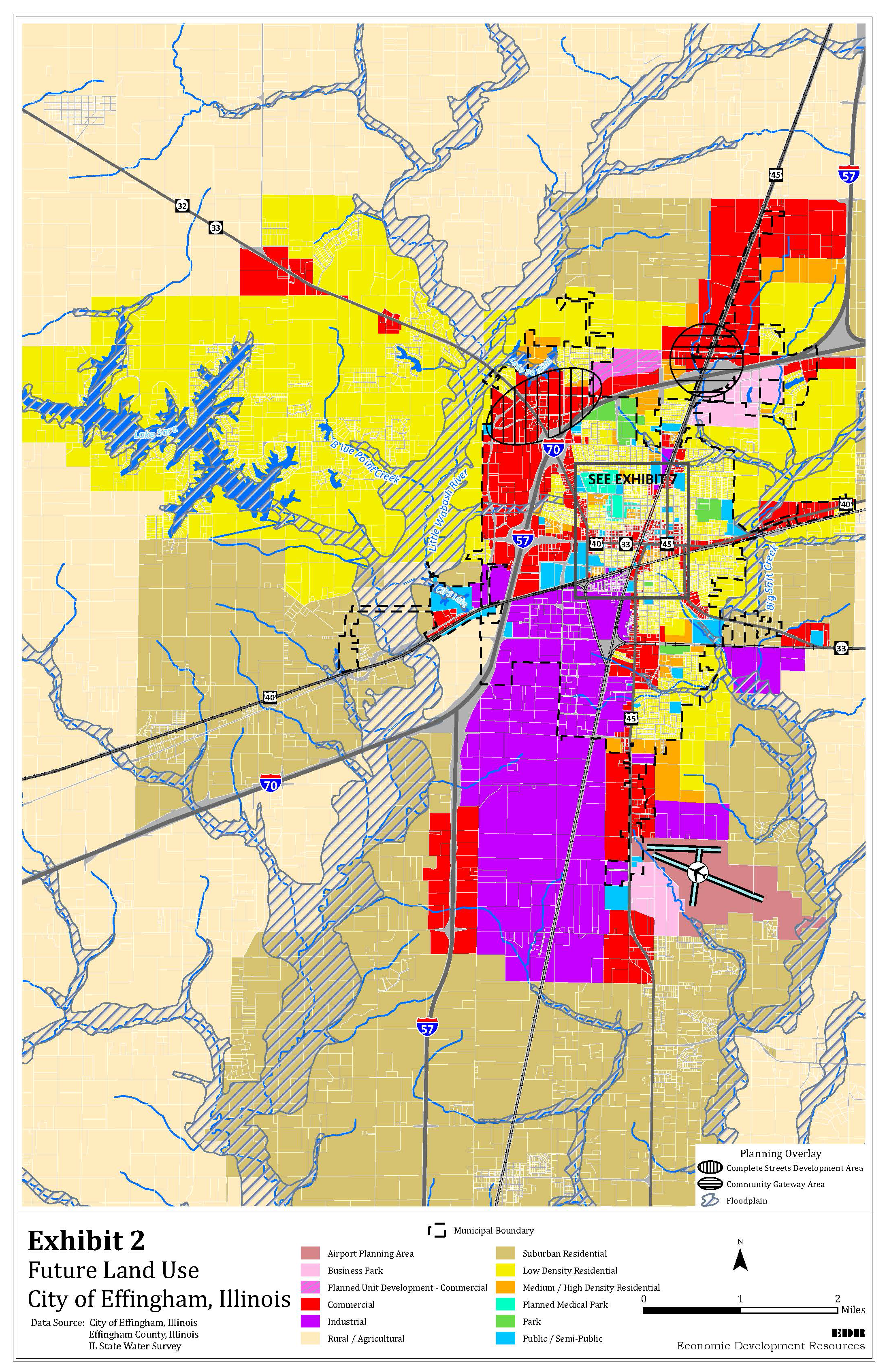
b.
Suburban Residential (SR). The Suburban Residential areas are characterized by scattered residential development with lower concentrations of population than urbanized residential areas. SR areas use on-site wastewater systems and receive lower levels of other services than urban areas. Cluster development patterns should be encouraged in these areas. Generally, SR areas are served by the commercial services within the adjacent suburban/urban communities.
c.
Low Density Residential (LDR). LDR areas are located in the developing or developed areas, and consist of single-family lots and other low-density residential development. A full range of urban services are provided.
d.
Medium/High Density Residential (M/HDR). M/HDR areas are located in the developing or developed areas and include, townhomes, apartments and some adult care facilities. These areas tend to buffer LDR areas from more intensive development.
e.
Commercial (C). Commercial development areas will be located along I-57/I-70, especially at interchanges, along major arterials, and in the Central Area (Downtown). Future strip commercial development will be discouraged. Commercial development will occur at an appropriate scale for planned land uses in the area, will be integrated with adjacent uses, and will provide an attractive setting for provision and sale of goods and services to the public.
f.
Business Park (BP). BP areas generally will be located adjacent to I-57/I-70. These areas provide an attractive setting for non-retail and non-industrial businesses and their support services. BP areas frequently buffer industrial areas from arterial streets and other development.
g.
Industrial (I). The Industrial areas will be expanded, especially on the east side of I-57 from north of Dutch Lane to the CSX railroad tracks. Additional smaller industrial areas will be located adjacent to the airport. These areas are intended for heavy industrial activity and should limit encroachment by commercial uses not directly serving such industrial uses.
h.
Airport Planning Area. This will serve as an expansion area for Effingham County Memorial Airport and ancillary airport services.
i.
Planned Medical Park (PMP). The PMP will provide for planned expansion of medical and health care services, as well as support and complementary uses, while protecting and linking viable neighborhoods and the remainder of the Central Area.
j.
Public/Semi-Public. Public/Semi-Public areas are located throughout the developed part of the City, and proposed for locations where neighborhood services will be provided.
k.
Parks. Parks are publicly-owned recreational sites. Parks are generally located adjacent to residential development and with access to arterials, as well as areas utilized for Trail Recreation Effingham County (TREC).
l.
Planned Unit Development—Commercial (PUD-C). Planned Unit Development—Commercial allows for a range of commercial uses in a variety of settings that can assist in the development of property and benefit the citizens of Effingham, and the City as a whole. PUD-C encourages a creative and unified planning process that allows clustering of commercial buildings on a site, as opposed to the standardized building setbacks required in conventionally planned commercial areas. PUD-C allows for the creative arrangement of parking facilities, and green spaces, on a site. This land use may also provide for additional density of development on a site if a portion of the site is dedicated to a "public good" (i.e. park or school, retention of open space, or the reservation of environmentally sensitive land).
8.
Planning Overlay. Planning overlays are applied over one or more previously established future land use categories, establishing additional standards and criteria for covered properties in addition to those of the underlying future land use category.
a.
Community Gateway Overlay. Certain transportation corridors act as primary "gateways" into the City of Effingham. These Community Gateways are major entries into the City, and provide the City's initial statement to, and impression on, visitors and investors. Such Community Gateways are of significant commercial development potential.
Enhancement of these Community Gateways comes through defining their respective functional land use (commercial, industrial, etc.) and providing quality public (landscaping, lighting, entryway monumentation) improvements, as well as quality private improvements (in building facades, parking lots, landscaping, other site improvements). Architectural and design standards for all such improvements within the Community Gateways should be considered.
b.
Complete Streets Overlay. Include the needs of "all users" (pedestrians, bicyclists, and transit passengers, of all ages and abilities), as well as a full range of vehicles (buses, emergency vehicles, delivery vehicles and automobiles) in a right-of-way designed to create a comprehensive, integrated, connected network for all modes of transportation, and transportation consumers, through such Planning Overlay areas. Potentially for use in areas of both new development and redevelopment, Complete Streets includes design, planning, maintenance and operations for the entire right-of-way.
Design criteria and planning guidelines should be employed in the creation of such streets, while recognizing the need for flexibility in balancing users' needs.
The objective of Complete Streets is to have the right-of-way complement the context of the area of the community in which such streets will be situated.
c.
Floodplain Areas. Will be protected from encroachment of inappropriate development. The Floodplain Areas constrain development but offer opportunities as areas reserved and preserved for storm water drainage, wildlife habitats, natural vegetation, and limited recreation.
Exhibit 3: Future Land Uses
4
Density does not equate to minimum lot sizes which are established in the zoning
regulations. Density measures the allowable dwelling per acre. For example, the total
number of dwelling units or total density permitted is calculated as follows:
TD = P x (A)
TD = Total permitted dwelling units
P = Permitted Density
A = Total Site Area (Acres)
5 DU = dwelling unit
6 FAR = floor area ratio-See Exhibit 5.
Cluster development is a design technique whereby buildings are concentrated on a part of the site to allow the remaining land to be used for recreation, common open space and preservation of environmentally-sensitive features. Exhibit 4 compares conventional subdivision with cluster subdivision. A cluster subdivision is a form of development that provides reduced lot area and bulk without an increase in the number of lots provided or overall density under a conventional subdivision and with the remaining land area devoted to open space, active recreation, preservation of environmentally-sensitive area, or agriculture.
Exhibit 4: Clustering

Floor area ratio, as illustrated in Exhibit 5 is the gross floor area of all buildings on a lot divided by the lot area on which the building or buildings are located. Floor area is defined a the amount of floor space within the outside line of walls and includes the total of all space on all floors of a building. It does not include porches, garages, or space in a basement or cellar when said basement or cellar space is used for storage or incidental uses.
Exhibit 5: Floor Area Ratio
(Ord. No. 85-2017, § 1(Exh. A), 9-5-2017; Ord. No. 024-2020, § II(Exh. A), 4-7-2020)
City of Effingham, 2005 Trade Area Study; Illinois Department of Revenue, 2004 Annual SIC Report.
--- (4) ---
Projection based on Bureau of Labor Statistics and Federal Reserve data, 1.5% growth.
A. - Goals
One new goal, that of Economic Development, emerged from the collective vision of Effingham in 2005 to make a total of six Comprehensive Plan goals. These are outlined below.
1.
Planning and Zoning:Adopt and implement a Comprehensive Plan which provides policy guidance for land use, planning, zoning, transportation, housing, municipal growth, quality of life and related issues. Provide support to economic development and managed growth activities.
2.
Municipal Growth:Municipal growth shall be encouraged to increase the local tax base and to provide for local employment/business opportunities. The City will increase its capacity to manage growth within the municipality and extra-territorial jurisdiction.
3.
Economic Development:Maximize the locational advantages and potential afforded by Effingham's numerous transportation systems. Assist area businesses with their expansion plans by providing infrastructure and utilities planning, coordinating services concerning incentives and cooperative arrangements, and implementing related construction. Retain valued area businesses that provide opportunities in a regional shopping hub and positively promote the City.
4.
Housing:Maintain and promote quality housing stock as a critical community asset.
5.
Community Image, Facilities and Services:To make Effingham "the best place in the world" to live, learn, work, play and worship. To the extent possible, the "small city atmosphere" of the community is to be valued and retailed. The role of development is a positive one, essential for the future economic health of the community.
6.
Transportation and Infrastructure:Provide for efficient transportation, circulation and utility capacities to meet growing demands. Continue to support public and private maintenance and development of the local interstates and railroads that provide the city with its economic opportunities.
B. - Policies
1.
Environmental Policies. Environmental policies address areas crucial to preserving the community's quality of life and economic viability. The policies for floodplains, drainage, watershed protection and wetlands seek to protect water quality and supply from potential degradation by unplanned and insensitive development practices.
1.1.
Use Geographic Information System (GIS) to Monitor, Track, and Evaluate Zoning, Land Uses, and Use of Resources for Services. Develop City's capacity to use GIS software for all community planning and as a tool to assist in evaluating development applications. Coordinate with other service providers in developing GIS-based mapping.
1.2.
Use Development Standards to Protect Floodplains. Conduct, or cause to conduct, a new study to determine limits of the natural riverine environment, flood plain elevations to guide public and private development. Maintain development standards consistent with FEMA guidelines that minimize flooding and promote retention of the natural riverine environment.
1.3.
Limit Development of Critical Resource Areas.[5] Regulate cut and fill activities to prevent erosion, risk of injury to persons and loss of life, to protect wetlands, and address surface water runoff from impervious surfaces into lakes. Encourage all-weather permanent surfaces in new developments (asphalt/concrete). Require Operation and Maintenance (O&M) plans for private detention ponds.
1.4.
Continue to Identify and Preserve Natural Hazard Areas for Use as Open Space and Greenways. Promote cluster development and other techniques to encourage the protection of open space and conservation.
1.5.
Use State Permitting Process to Protect Natural Drainage Ways, Groundwater Areas (open gravel seams) from Surface Water Run-off.
1.6.
Reduce Risk of Agricultural Contamination of Water Resources. Work with the Natural Resources Conservation Service and various farm agencies actively promoting best farm management practices.
1.7.
Encourage Private Sector Provision of Solid Waste Removal and Recycling.
2.
Residential Policies
2.1.
Encourage Clustered Development in Rural and Suburban Residential Areas. Encourage residential development to cluster in Rural Areas in order to preserve open space that protects natural resources and to help retain the rural character.
2.2.
Allow for Limited Development at SR Densities through the Planned Development Process in the R and RR Areas. On sites that have adequate road and utility capacity, significant suburban residential development on adjacent parcels and limited agricultural value, allow the creation of cluster of large lot developments through the planned development process.
2.3.
Provide a Simplified Process to Create Farmstead Splits that are Consistent with Density Limitations and Continued Agricultural Operations.
2.4.
Create Transitions Between Residential Areas and More Intensive Development. Identify areas with incompatible uses that need to receive buffering, particularly areas where residential uses are to be conserved and protected from intensive non-residential/commercial uses. Require buffering and other techniques to soften transitions between residential and more intensive development.
2.5.
Develop Design Options for Range of Housing Types. Encourage the use of alternative lot configurations, compact housing types, universal design, and other flexible techniques to provide a variety in price, size and style of housing in the Developing and the Developed Areas.
2.5.1.
Encourage the Provision of Attainable Housing and Monitor Housing Prices within the City. Encourage the development of attainable housing for low- and moderate-income persons, families and seniors. Consider density bonuses for infill development, and the use of accessory dwelling units, attached single-family dwellings, zero lot line development and manufactured housing in the Developed Areas. Monitor balance/ratio of younger families to older families living in the city to preserve housing stock of community.
2.5.2.
Encourage Developers to Build High Quality, Upper Middle Income, Urban Housing in the City. Target areas for new housing in the city; maximize potential for higher housing value that is in green corridors, parks/open space.
2.6.
Protect Existing Neighborhoods and Residential Districts. Ensure that proposed development and redevelopment encourages private and public investment in surrounding properties and enhances neighborhood stability. Encourage use of federal and state grants and tax credit programs to provide resources for home repairs and energy-savings installations for eligible residents.
2.7.
Maintain Compatibility. Ensure that new development will be compatible with existing and planned development. For instance, use planned unit development zoning to permit mixed-use development; require neighborhood commercial development to be designed in appropriate scale; and require buffering areas between developments of differing intensities.
2.8.
Enforce Code Compliance by Residential Property Owners. Increase City's capacity to practice code enforcement to prevent community decline, deterioration in housing stock and lowering property valuations.
2.9.
Ensure that Group Home and Congregate Living Situations are Available, Safe, and Habitable. Monitor locations and building conditions of group homes.
2.10.
Collaborate with Community Service Groups Providing Workshops in Property Maintenance. Assist community housing groups providing workshops on home repairs; provide code compliance information; identify home improvement resources such as funding and tax credits as they become available.
3.
Commercial Policies
3.1.
Direct Commercial Development to Activity Centers. Locate commercial development adjacent to major arterials and intersections in the developing and developed areas. Identify commercial development opportunity areas for Outer Belt West, Route 45 Corridor, and North Maple Street Extension. Expand commercial opportunities near Dutch Lane, Route 45 (South of the Airport), and Raney Street.
3.2.
Limit Commercial Uses in Rural Areas. Limit commercial development in Rural Areas to small-scale sales and services that directly assist and serve agricultural and rural interests.
3.3.
Buffer between Non-Residential and Residential Development. Require buffering between intensive non-residential uses and less-intensive residential development. Use buffers and screening to separate uses and provide visual transitions.
3.4.
Develop Regional Commercial Adjacent to Major Arterial Intersections and I-57/I-70 Interchanges. Encourage regional commercial development to cluster at major arterial street intersections and at the interchanges to efficiently serve the needs of the traveling public.
3.4.1.
Develop Commercial Opportunities: Along I-70 North of Evergreen, West of Highway 45, North along Highway 45 up to Silver Lake Estates, and along South 4thStreet Corridor to Airport Road. Install infrastructure and a frontage road south of Interstate 70/I-57 from Technology Drive to Maple St. Extension and Evergreen Avenue; extend 4 th Street. Allow development on frontage parcels.
3.4.2.
Continue to Broaden Products Available. Progressively seek name brand, quality retailers to meet demand of middle income consumers to retain these households in the city and region.
3.4.3.
Support the Promotion of the Interstate Market Area. Work with the Illinois Department of Commerce and Equal Opportunity, DCEO's Bureau of Tourism, and other organizations to market outside of Effingham area (billboards, regional calendar and event brochures, etc.).
3.4.4.
Foster the Tourism Industry by Encouraging the Development of a Trained Workforce with this Specialty. Encourage industry training of hospitality workers to increase their skills.
3.5.
Encourage Neighborhood Commercial/Retail. Encourages the development of neighborhood retail sales and services to be clustered to serve adjacent residential development.
3.6.
Discourage Strip Development. Discourage commercial/retail strip or linear development where not yet constructed and encourage clustering of such development to reduce automobile dependence and excessive driveway cuts where that has not occurred.
3.7.
Encourage Shared Access/Parking to Reduce Congestion. Encourage commercial/retail sales, service, restaurants, hotel/motels, and similar businesses to share common access and parking lots to reduce the number of entrances/exits and driveways with access to arterials and collector streets.
3.8.
Maintain a Labor-Ready Workforce. Actively cooperate and work with the Chamber of Commerce, the school district and Lakeland College, area business and industry to develop training programs to help the labor force maintain the latest technical skills. Develop and support an advisory board to assist with this effort.
3.9.
Support Start-Up Business and Local Entrepreneurs Ready for Expansion. Work with the Chamber of Commerce and others to address needs of local entrepreneurs and develop the entrepreneurial environment (patient capital for expansions, specific skills in labor force, etc.) to encourage the growth and development of small businesses. Consider providing space for shared office functions and other components needed by local growth-industry entrepreneur groups moving out of home offices or minor business spaces. Consider potential of dry lab or wet lab incubators to develop satellite businesses to the agricultural industries targeted for the area, e.g. food processing, agri-chemicals, etc.
3.10.
Encourage Business Retention/Expansion. Work with the Chamber of Commerce and the Economic Development Corporation to help existing businesses expand and grow in the City by identifying business needs and more funding sources. Identify tax incentives and resources for land assembly for expansions and relocations.
3.10.1.
Attract Meeting Industry and Business/Recreation Traveler through Trade Shows, Conferences, Conventions, and Special Events. Conduct a feasibility study to determine costs and benefits of constructing an event center. If benefits outweigh costs, begin construction and promotion of facility.
3.11.
Restrict Angled Parking and Related Backing up on Any Vehicles Except in the Central Business Area. Discourage backing up on city streets except in the Central Business Area. Reduce the number of angled parking areas. Eliminate use of streets for loading areas for businesses.
3.12.
Target information technology (IT) companies for relocation or expansion in Effingham. Meet with area employers to determine latest information technologies being used by them and their competition. Match area needs with expansion efforts of local IT providers and/or target providers capable of meeting employers' needs.
3.13.
Implement Central Area Strategic Plan to Create Office and Service Areas. Assemble parcels of land as directed in the Central Area Strategic Plan. Research the feasibility of using Illinois Business District legislation to develop new office and services projects within a new "Business District".
4.
Industrial Policies
4.1.
Direct Heavy Industry to Areas with Limited Visibility. Buffer heavy industrial area from high visibility corridors with business parks and other developments that project a more attractive image of Effingham.
4.2.
Enhance Access to Industrial Areas. Develop an efficient network of industrial streets providing access to major arterials, I-57/I-70 Corridor, railroads and the Airport environs.
4.3.
Reserve Industrial Areas for Industrial Uses. Restrict non-industrial land uses to those uses that support industrial.
4.4.
Expand Industrial Opportunities Near Dutch Lane, Route 45 (South of the Airport), and Raney Street. Identify funding sources to assemble land for expansions and relocations. Continue Developing the Business Park South of City.
4.5.
Ascertain Benefit-Cost Ratios Prior to Awarding Business Incentives. Determine Public Benefits such as Job Creation and the Ratio of Private-to-Public Investment by Requiring and/or Conducting Impact Analyses.
4.6.
Create Development Covenants for City-owned Industrial Properties.
4.7.
Encourage All-weather Permanent Surfaces in New Developments (asphalt/concrete).
4.8.
Work with Illinois Department of Commerce and Employment Opportunity (DCEO) to Identify Economic Development Opportunities that Might Arise from Recent New Advances in the Coal Industry. Investigate business growth potential from new computerized coal mining technologies (wet scrubbing technologies to remove sulphur impurities) and mine-to-mouth power plants being introduced into Illinois in Washington County. Monitor introduction of additional new coal plants in Illinois and their potential to make Illinois an energy center of the country/continent.
5.
Public Facilities/Utilities Policies. Public facilities/utilities include water, wastewater, stormwater detention and management, fire/EMS, police, community facilities, parks and open space, and schools. Levels of services for public facilities/utilities are described in the tables below. Adequate public facilities and utilities shall be provided concurrent with new development in the Developing and Developed Areas to serve the current and planned population needs. Departments will participate in a Design Review process to assure adequacy of public facilities and utilities in developments proposed within the City's service Areas.
5.1.
Adopt Minimum Levels of Service and Adequacy for the Provision of Water.
* For example, an Illinois Environmental Protection Agency (IEPA) public water supply entity.
5.2.
Adopt Minimum Levels of Service and Adequacy for the Provision of Wastewater Treatment. (Centralized on-site package system or lift station may be required if development is clustered as an interim measure until public service is required by ordinance.)
* An IEPA or public health approved facility
5.3.
Limit Increases in Stormwater Runoff. Except when a regional facility is available, require on-site mitigation of increased stormwater runoff.
5.4.
Control Erosion and Surface Water Runoff. Amend the land development regulations to: include grading and construction standards to control erosion and sedimentation resulting from private and public construction projects; require on-site stormwater detention; and to manage stormwater, ground and surface water runoff and maintenance of private detention ponds.
5.5.
Require Operation and Maintenance Plans for Detention Ponds.
5.6.
Adopt Minimum Levels of Service and Adequacy for Fire Protection. If property is not within a city or fire protection district, then zoning or development permits will need special consideration.
X Required
* On-site water source required.
** On-site water source required and fire protection contract necessary.
*** On-site water source required if there are structures.
5.7.
Adopt Minimum Levels of Service and Adequacy for Police Protection.
5.8.
Plan Improvements for 911 Emergency Response. Research possible solutions, develop plan for implementation.
5.9.
Support Police in Efforts to Extricate and Prevent any and all Illegal Drug Manufacturing and Sales. Work with county, state, and federal law enforcement agencies in similar efforts.
5.10.
Adopt NRPA [6] Minimum Standards for Public parks, Recreation and Open Space for the Developing and Developed Areas.
5.11.
Create a Master Plan for Parks & Trails. Coordinate with Parks District to create a master plan for park expansion and trail development.
5.11.1.
Create Master Trails Plan. Coordinate with Parks District to create a Master Trails plan with linkages to trails outside of City's boundaries by coordinating with County and Illinois Department of Natural Resources.
5.12.
Identify and Secure Parks/Recreation Sites. Work with the Parks District to implement the Park Master Plan by assisting with identifying and securing parks and recreation sites to attain the minimum level of standards established for cities by the NRPA to serve existing and future populations of the City.
5.13.
Support the School Districts. Assist schools with centralization activities. Coordinate with school districts on the selection and development of school sites and supporting infrastructure. Assist with the disposition of sites and buildings in manner compatible with surrounding neighborhoods. Identify facility and service needs of School Districts and Lakeland College.
5.13.1.
Expand the College Campus. Assist Lakeland Community College with campus development.
5.14.
Encourage Joint School/Park Facilities. Cooperate with the Park District and School Districts, both public and private, in the siting of schools with parks for multi-functional use.
5.15.
Support Higher Education. Work with Lakeland College - Kluthe Center to expand distance learning programs and to coordinate skills and training programs with area businesses to maintain ready labor pool and upgrade skills of existing labor pool.
5.16.
Permit Alleys in Residential Areas and Non-Residential Developments.
5.17.
Prevent Flooding. Use a citywide stormwater master plan that includes the Extraterritorial Area to plan infrastructure improvements for management of flooding.
5.18.
Diversify Water Supply By Coordinating with Other Regional Water Providers. Work with others to secure alternate water sources.
5.19.
Secure Park Forestation Funding. Update Land Development Regulations, Landscape Section requirements, and collaborate with Parks District in applications for Urban Forestry grants.
5.20.
Expand Library Facilities.
5.21.
Public Facilities/Utilities Provide for Up-to-Date Information Technology Infrastructure to Serve the Population. Facilitate tele-commuting jobs within community to allow more of the population to work from home offices.
5.22.
Accommodate New and Existing Commercial and Residential Expansion. Upgrade water and wastewater infrastructure.
6.
Transportation. Policies for the transportation system for the arterial and collector street system and pedestrian walkways and bicycle paths seek to provide safe and adequate access for all transportation modes. It is essential that the transportation system provide for the current population as well as projected needs. Exhibit 6 shows the City's functional street classifications.
Exhibit 6: Proposed Roadway Improvements
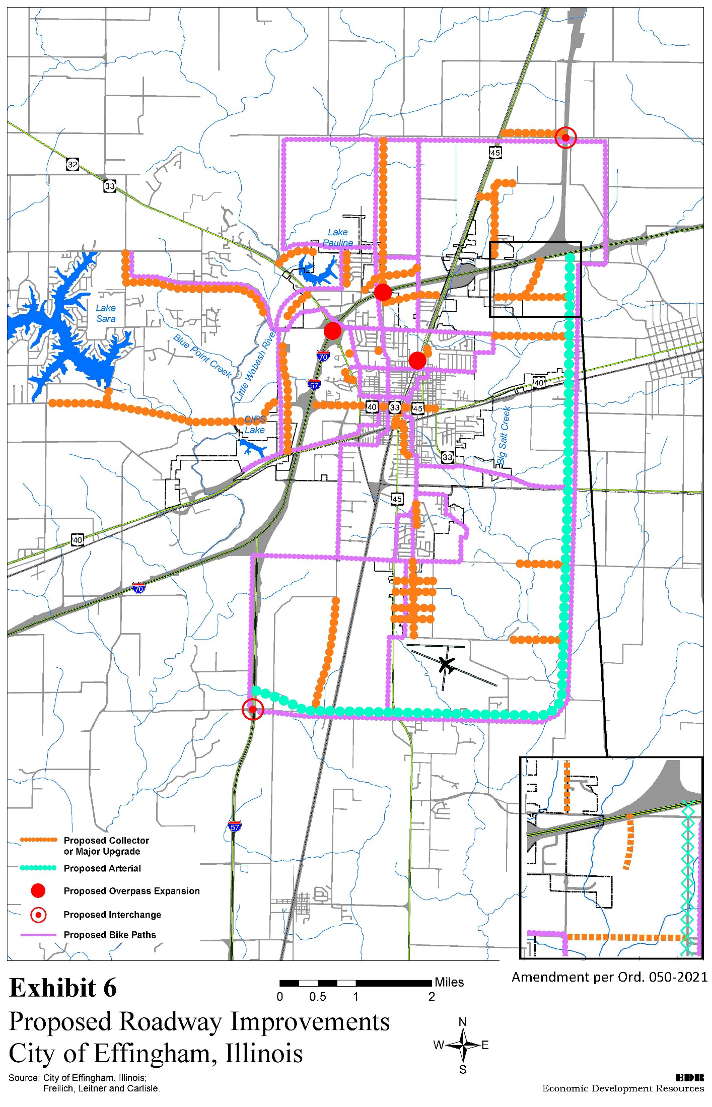
6.1.
Restrict Current and Future Access to Arterials. Restrict direct access to arterial and collector roadways from development projects when access can be provided via a collector or local street, or joint access facility. Anticipate effects of new developments on rush hour surges.
6.2.
Adopt Minimum Road Improvements**.
* Concrete or asphalt curb and gutters, including storm sewers.
** Include improvements at railroad crossing.
6.3.
Protect Rights-of-Way for Future Needs. The City shall protect planned right-of-way from encroachment by development.
6.4.
Schedule Future Rights-of-Way Acquisition/Improvement. Coordinate land use and transportation plans to schedule acquisition and improvement of road rights-of way in Capital Improvements Plan and budget. Identify sources of funds for future transportation improvements.
6.5.
Design/Construct Streets in Accordance with the Functional Street Classification.
6.6.
Prioritize Capital Improvement Projects. Coordinate with other transportation divisions to develop criteria for capitalizing road improvements.
6.7.
Comprehensively Plan Transportation Improvements. Include sidewalks, bicycle lanes, lighting, and landscaping when designing or causing design of road improvements.
6.8.
Adopt Access Management Standards. Control curb cuts and intersections on new and existing arterial and collector roadways through access management standard adopted as part of the land development regulations.
6.9.
Require Connectivity Within and Between Developments. New developments shall be designed to connect with the adjacent street system and subdivisions linking them with the developed and developing areas to compatibly facilitate the efficient movement of traffic. Connectivity standards shall be defined within the City's land development regulations and shall include street stub-outs to connect adjacent neighborhoods.
6.10.
Expand Pedestrian Trails and Bike Routes. Work with the Park District, other school districts, and other townships to pursue expansion of bicycle route designations.
6.11.
Reserve Rights-of-way for Trails. As new roadways are designed and built, provide for safe bicycling, walking and expansion of the trails system.
6.12.
Beautify Entryways into Community. Work with IDOT and others to: (1) research contemporary treatments for interstate overpasses in areas near neighborhoods and commercial areas, and (2) plan improvements for landscaping and public art at targeted entryways and community arterials.
6.13.
Permit Alleys in Residential Areas and Other Key Locations.
6.14.
Create Alternate Routes for Trucks to By-Pass Community Streets. Continue to develop by-pass routes such as Outer Belt West and Dutch Lane. Study feasibility of creating a Salt Creek By-Pass to allow north- and eastbound Route 45 truck traffic to move smoothly and avoid community streets.
6.15.
Support I-57 Interchange. Work with IDOT and others to add an interchange at I-57 and Dutch Lane to serve the southern part of Effingham providing access to the Industrial Corridor and the Airport.
6.16.
Monitor Supply and Demand for Public Transportation. Evaluate ridership of various transportation services as demographics change. Support providers of income-based services. Coordinate with service-providers to identify interim solutions (taxis, older-adults transportation service (OATS), attracting shuttle bus service companies, etc.). Research available resources for additional providers.
6.17.
Improve West Highway 32/33. Conduct a feasibility study on improvements needed along West Highway 32/33 in combination with other efforts to reduce traffic west of the city, generally, and to Lake Sara, specifically.
6.18.
Improve East and West Arterials through City and Beyond City Limits. Improve widths, extensions, and amenities such as bicycle paths, landscaping, etc.
6.18.1.
Work with County to Provide Alternate Transportation Routes to Lake Sara Including Paths, Bicycle Trails and Roads. Work with County to expand Evergreen Avenue West.
6.19.
Develop Long Term Plans for Parkway Drives around the City. Use these to foster economic development.
7.
Special Areas. Special Areas include specific areas that require particular attention to ensure the City's continuing economic health and quality of life. Policies have been developed for the following areas: Central Area (downtown); St. Anthony's Memorial Hospital and its environs; targeted development areas - residential, commercial and industrial that require infill and incentives; the Industrial Corridor that follows the alignment of the railroad tracks east of I-57/I-70 and south of Highway 40; the I-57/I-70 Highway that physically forms the "Crossroads of Opportunity" and the Effingham Memorial Airport.
7.1.
Use Development Incentives for Central Area Infill. Consider using the following types of incentives to encourage infill and rehabilitation of Downtown residential and non-residential development:
(a)
Overlay District that permits for flexible zoning bulk and density;
(b)
Streamlined permitting process;
(c)
Density bonuses; and
(d)
Creation of a State-legislated Business District to assist with redevelopment projects and improvements.
7.2.
Continue Targeting Incentives to the Central Area. Use tax abatement and approve tax increment financing district to promote redevelopment, neighborhood improvement and conservation and infill to revitalize Central Area (downtown) business and residential areas.
7.3.
Coordinate with the Downtown Merchant's Association. Support the Downtown Merchant's Association in their effort to market, manage and maintain the Central Area (downtown); to implement the Central Area Strategic Plan Exhibit 7; to re-establish the Downtown Special Service Area to generate funding for downtown improvements.
7.3.1.
Develop Long Range Parking Plan in Central Business Area. Monitor parking demand and maintenance. Develop a long range plan for provision of parking in Central Business Area as it is developed with more offices and services.
7.3.2.
Improve the Central Area image to encourage infill and redevelopment.
7.3.3.
Continue Improving the Downtown Special Service Area and Re-Use Incentives for Identified Historically Significant Buildings. Re-establish the Downtown Special Service Area to encourage the adaptive re-use of historically significant and structurally sound buildings, such as the County Courthouse, Register Building, and the Heart Theatre, through incentives as recommended in the Central Area Strategic Plan for the downtown and surrounding area, such as the use of TIF and a redevelopment overlay district.
Exhibit 7: Future Land Use—Central Area
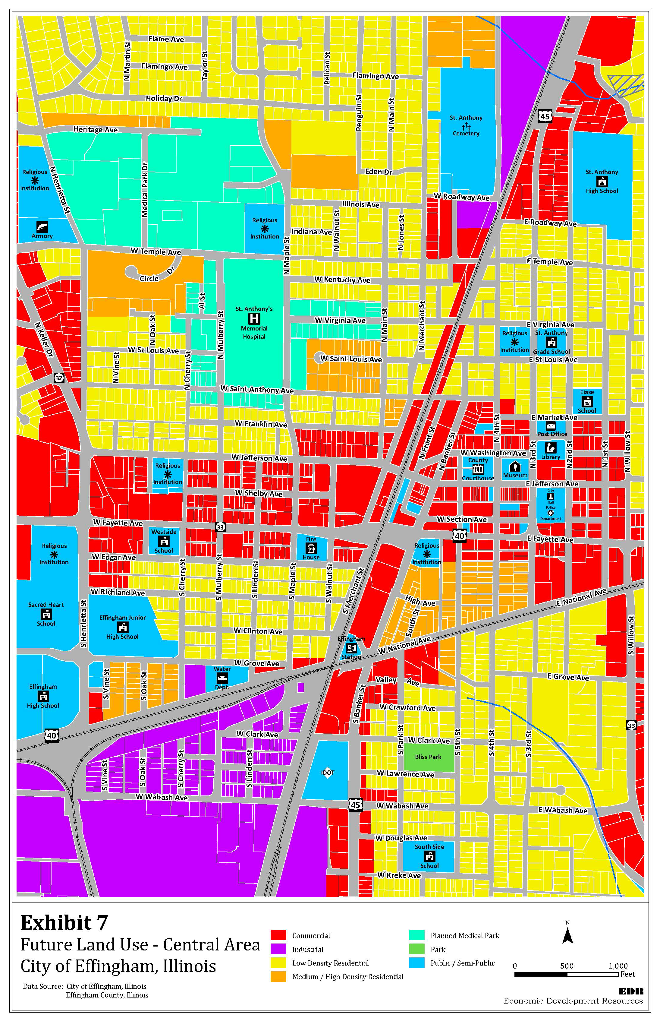
7.4.
Support St. Anthony's Hospital in its Efforts to Become a Regional Cardiac Center.
7.4.1.
Adopt a Planned Hospital District and Hospital Area Zoning Overlay. Designate St. Anthony's Memorial Hospital as a Planned Hospital District. Adopt a Hospital District Zoning Overlay for the adjacent area in order to establish development standards for infill in residential neighborhoods to mitigate the negative impacts of mixed-use development needed to expand the hospital facility and to encourage quality attainable multi-family housing for the hospital employees and others.
7.4.2.
Prepare Hospital District Plan Area. Work with St. Anthony's Memorial Hospital to study the hospital environs and review developer's plan that addresses the provision of major health care facility, medical offices, extended care facilities, extended-stay lodging for families of patients, research laboratories, multi-family housing, limited retail to supplement the theme of the district, parking, and linkages to other parts of the community, especially neighborhoods and Central Area (downtown).
7.4.3.
Improve Connection between St. Anthony's Hospital and Central Business Area with Signage to Orient Visitors. Use urban design principles to encourage traffic to Central Business Area from St. Anthony's Hospital via Mulberry and Virginia Streets.
7.4.4.
Monitor Hospital's Labor Force Issues. Follow reports by Bureau of Labor Statistics for the County and join discussions with the Hospital and Lakeland College.
7.5.
Monitor Changes in Community's Population Related to Mental Health Care. Identify number of facilities available; encourage providers to meet demand.
7.6.
Target Areas for Clearance to Create Attainable Housing. Consider condemnation, clearance, and redevelopment of dilapidated areas to be developed as attainable housing.
7.7.
Adopt Performance Covenants for Industrial Districts. Amend the land development regulations to include performance covenants for industrial and heavy commercial uses to reduce potential nuisances.
7.8.
Encourage Campus Settings. Encourage the development of office, warehouse and light industrial uses to be developed in business or parks with a campus-type setting, especially in the area immediately adjacent to the high school surrounded by the industrial park.
7.9.
Update the CIP to Include Street Improvements. Update the capital improvements program and budget to improve the streets abutting the Industrial Corridor to industrial standards to support heavy truck usage.
7.10.
Monitor Land Uses around the Airport. Amend the Future Land Use Plan, the Zoning Map and the land development regulations to restrict land uses around the airport shown in Exhibit 6. Develop locational standards to ensure compatibility between non-airport and airport land uses. Encourage the location of industrial, commercial and agricultural land uses and discourage residential uses, churches, schools and hospitals.
7.11.
Support Growth of County Airport. Assist County with development and expansion of area around the airport. Implement plan for South 4 th Street and Veterans Drive Corridor. Restrict incompatible uses nearby to protect expansion plans. Build commercial linkages.
7.11.1.
Support Efforts to Attract Complimentary Business to the Airport Area. Work with the Chamber of Commerce and the Economic Development Corporation, and private sector to attract businesses that are complementary to the Airport and the nearby Industrial Corridor.
7.11.2.
Increase Airport's Capacity, Passenger Services, Links to Larger Markets such as Springfield, Chicago, St. Louis, Memphis. Encourage and support Airport Board's efforts to construct runway dimensions required by commercial airlines.
7.11.3.
View the Airport as a Marketing Tool. Retain existing business and attract new business by supporting the Airport and using its transportation/shipping potential as a marketing tool.
7.12.
Improve Property Abutting Highway Frontage Roads. Consider working with IDOT and others to develop a beautification master plan and landscape regulations to improve the frontage roads that can be implemented through the development and design standards in the land development regulations.
7.13.
Develop a Land Assembly Strategic Plan. Identify areas for land assembly using criteria such as blight, need of economic stimulus (job creation, housing development, etc.), business retention and expansion planning, and housing development to meet future demand. Encourage assembly of parcels when these criteria are met.
7.14.
Preserve Old Court House after New One is Built. Work with State of Illinois to develop programs for building - museum, poss. State office, etc., and to access any resources that might be available.
8.
Community Character. The character of the community is expressed in many ways ranging from City entries, to the use of urban design techniques, landscaping, screening and public art, all of which give the City a 'sense of place' helping differentiate the City from other cities. The use of design standards and program guidelines helps improve the visual and physical quality of the City. An attractive community image can be used as a visual incentive to encourage development to locate in Effingham. Community image can be enhanced with landscaping, lighting and signage along transportation corridors dressing up the corridors and providing friendly, attractive entries to the City. Gateway entry design and urban corridor landscaping should be done to create corridors leading to focal points that draw the visitor or resident to particular areas that link with other areas. In addition to these strategies is the upgrading of the City's cultural facilities and expansion of the City's cultural tourism program. The implementation of development and design guidelines will improve the quality of the built environment and attract new business and residents.
8.1.
Improve Key Entries and Corridors. Identify key entries and corridors and adopt entry/corridor overlay guidelines addressing landscaping, signage, outdoor storage and other visual concerns along key interstate and arterial corridors and at gateways to the City. Continue working with IDOT to improve visual components of plans. Target key areas such as railroad crossing and old railroad station for similar improvements.
8.1.1.
Maintain Clean Streets and Physical Environment Generally. Investigate costs and revenue sources for street-cleaning programs.
8.2.
Promote the "Crossroads of Opportunity" Image. Continue promoting the City's image as a regional leader by using welcome signage at key entries and gateways such as "Welcome to Effingham - Crossroads of Opportunity".
8.3.
Require Transitions between Land Uses of Different Intensities. Provide gradual transitions between land uses of differing intensities through the use of professional site planning, buffering and screening techniques and control of specific land uses.
8.4.
Adopt New Sign Regulations. Update the land development regulations with new sign regulations that are designed to improve the character of the City, reduce clutter and distraction to improve safety, and lessen visual blight. Eliminate use of portable signs.
8.5.
Develop Special Signage for Public Streets, Civic Areas, Special Districts and Similar Areas. Use special signage to highlight certain areas and districts, such as the original downtown core and expansion area of downtown, the Hospital District and Industrial Corridor, through banners and coordinated signage for streets, public and institutional buildings and sites.
8.6.
Adopt Landscaping Requirements for Public and Private Development. Incorporate street trees and landscaping into all public and private development projects. Provide illustrations in zoning regulations.
8.7.
Use Green Corridor Strategy in Targeted Areas to Improve Property Values. Identify areas in the community with interesting topography as candidates for a green corridor strategy. Link these corridors into the new trail system being developed to increase interest and investment in properties within the targeted areas.
8.8.
Improve Architecture and Aesthetics along Primary View Corridors to Foster Positive Image of Effingham. Create design standard overlay. Identify targeted view corridors. Work with developers and anchor stores to provide this type of quality in high-traffic areas near the interstates.
8.9.
Screen Equipment. Develop screening requirements for mechanical and electrical equipment, utility equipment enclosures, temporary storage areas and trash enclosures with materials, colors and architectural appearance similar or complementary to the building within a development.
8.10.
Encourage Culture and Arts. Work with FACE and other groups to expand cultural and arts programs and to seek grants to improve programs.
8.11.
Encourage the Development of a Culture and Arts Master Plan. Encourage FACE and other groups to develop a plan for improving cultural and arts events and installation of public art, including coordination of programs with state tourism, art, culture and historic preservation agencies and other public and private agencies to attract tourists and others to cultural and arts venues and events. Continue collecting a portion of the hotel/motel sales tax to use for funding culture and arts events by public art installations that are planned by FACE and the Tourism Board.
8.12.
Maximize Effingham's Potential as a Regional Tourism and Shopping Destination. Continue hosting and promoting various traditional and new festivals and promoting area shopping; provide signage helpful to visitors (directions to amenities, visitor services, attractions, kiosks, emergency services, etc.).
8.13.
Maximize Recreational Assets of the City and Region to Retain Skilled Labor Force and Management, and to be a Regional Recreation Destination (organized sports tournaments, etc.). Develop a mixed-use events/recreation complex with a civic center for theatrical and other cultural performances and special events.
8.14.
Develop Leadership Capacity within City Population. Work with others to train young workers/professionals in leadership skills.
8.15.
Increase Capabilities for Outreach Communications. Educate citizens on changing needs of City and County through media, public and private.
8.16.
Assist Schools Addressing Problems Related to Increasing Number of Low-Income Student Population. Support and encourage programming to improve adult/parent participation, skill development, achievement, and successes of students.
9.
Growth Coordination. Coordination and planning of growth is critical to a city. Coordination between all jurisdictions having an interest in an area and constituencies to serve must work together so that growth is planned in a smart and efficient manner. Intergovernmental administration and annexation policies are addressed.
9.1.
Create Intergovernmental Agreements. Enter into agreements with Effingham County, Effingham Water Authority, and the Douglas, Watson, and Summit Townships to manage growth and expenditures for infrastructure and services.
9.1.1.
Establish City as Wastewater Treatment Service Provider for Lake Sara Residents. Begin Discussions with Lake Sara Residents to Develop Terms for a New Agreement to Convert their Septic Tank System into a Modern Sewer System.
9.1.2.
Develop Public Facility Services across the Wabash River. Work with County to extend Evergreen Avenue to Lake Sara Road. Discuss future provision of public facility services with Lake Sara residents and others in Developing Areas.
9.2.
Study Annexation. Conduct an annexation study to address the feasibility and timing of annexation throughout the Plan period. Address:
(a)
Annexation of the Airport environs to allow extension of City services to facilitate development;
(b)
Establishment of an Enterprise Zone and other incentive programs around the Airport as a means of financing service extensions;
(c)
Annexation of the land north of the City limits; and
(d)
Costs of public facilities and service extensions and the potential benefits through increased tax revenue and potential economic development.
9.2.1.
Annex Contiguous Areas within the Developing Area. Continue to annex contiguous property including Effingham water customers and the Airport and its environs.
9.3.
Maintain Public Administration that Fosters a Proactive Business Climate. Evaluate the restructuring of City Government according to contemporary Best Practices.
9.4.
Improve Coordination among Governments and Authorities. Host quarterly meetings among service providers. Coordinate with County's efforts to create a 20-year plan.
9.5.
Support County Efforts to Promote Tax Increases for Public Facilities. Continue to educate public on cost of providing public facilities.
9.6.
Equalize Rates for Provision of Public Services among all Users. Education public on inequities arising from current practices (increase in effect of urban dwellers paying for some of suburban dwellers' benefits).
(Ord. No. 024-2020, § II(Exh. A), 4-7-2020; Ord. No. 050-2021, § II, 9-21-2021)
Includes areas such as ground recharge areas (e.g. open gravel seams), natural drainage ways and the like.
--- (6) ---
National Recreation and Park Association
A. - General
The goals of the Comprehensive Plan can only be achieved through systematic action. This element of the Comprehensive Plan transforms the goals and policies into implementation strategies which identify a work program or a "to do list" for decision-makers. It establishes a roadmap for Plan implementation and:
•
describes specific strategies required to achieve the Plan's goals and policies;
•
schedules Plan implementation strategies; and
•
establishes processes for monitoring and amending the Plan as circumstances change.
B. - Administration
The Comprehensive Plan is intended to guide public and private development and land use decisions. As local and regional conditions (which are the base data used to formulate Plan policies and strategies) change, amendments to the Plan will be required to keep the Plan current. While specific procedures for amendment should be adopted by ordinance, the following paragraphs outline the process for monitoring and amending the Plan.
1.
Plan Monitoring: Periodic Review. In order to determine the Plan's effectiveness in response to changing the needs and conditions, the City will need to monitor development activity and periodically reassess growth projections.
2.
Plan Monitoring: 5-Year Review. To ensure that the Plan remains an effective guide for decision-makers, the City should conduct periodic evaluations of Plan policies and strategies. These evaluations should be conducted every three to five years, depending on the rate of change in the community, and should consider the following:
•
progress in implementation the Plan;
•
changes in community needs and other conditions that form the basis of the Plan;
•
fiscal conditions, and the ability to finance public investment recommended by the Plan;
•
community support for the Plan's goals and policies; and
•
changes in State or federal laws that affect the City's tools for Plan implementation.
The 5-year review process should encourage input from merchants, neighborhood groups, developers and other community interests through the creation of a Citizen Review Committee. Any Plan amendments that appear appropriate as a result of this review should be processed according to the Plan amendment process.
3.
Plan Amendments. Changing conditions (e.g., market conditions, economic development initiatives, redevelopment prospects, etc.) will result in the need to periodically amend the Comprehensive Plan and the Future Land Use Map. While amendments may occur more frequently than policy changes, they should not occur more than twice per year. By limiting opportunities to amend the Plan and the Map, the City will reduce the potential for incremental land use changes that result in unintended policy shifts. As proposed Plan amendments are considered, the City will need to determine:
•
whether the amendment will be consistent with the adopted Comprehensive Plan's goals and policies,
•
whether the amendment will result in a change in policy direction, and
•
what impact the amendment will have upon the community.
4.
Planning, the CIP and Budgeting. During periods of change and growth, citizens request the government to provide new or additional services. However, that response to changing needs must be made within the limits of available financial resources. Ideally, land use planning influences fiscal planning by providing the City with the opportunity to anticipate community needs for public facilities and services. Conversely, how the City invests in facilities and services plays a large role determining the timing, location, quality and quantity of development activity.
C. - Relationship between Land Use Planning and Fiscal Planning
The relationship between the key implementation strategies and fiscal planning is shown in Exhibit 8. Fiscal impact is assessed from the standpoint of the cost of the measure and its net budgetary impact. Integrating land use and fiscal planning uses City resources more efficiently, optimizes taxpayers dollars, improves inter-departmental (and inter-governmental) cooperation, and helps ensure financial stability. Traditional resistance to integrating land use and fiscal planning - different players, departments, goals and purposes, long-range land use plans vs. short-range, annual budgets - can be minimized by:
•
shortening the long-range land use planning process by incorporating annual and 5-year reviews; and
•
lengthening the annual fiscal planning and 5-year CIP processes by identifying anticipated budgetary demands based on future land use plans and projected growth.
Exhibit 8: Relationship between Land Use Planning and Fiscal Planning
D. - Implementation
Implementation strategies are a key component of the Comprehensive Plan - they determine how the Plan's goals and objectives become reality. Successful implementation of a Plan is not a short-term or clearly defined event. Implementation does not end with Plan adoption, but rather, adoption begins the implementation phase of the Comprehensive Plan. Successful implementation is an on-going process that requires the collaboration of City, County and State decision-makers, as well as public support, throughout the life of the Plan.
While goals and objectives describe how the community believes decision-makers should respond to various circumstances, implementation strategies provide a work program for decision-makers. Exhibit 9 includes the Goals and Policies and describes and recommends numerous actions and implementation tools (i.e., a work program) available to the City to bring to fruition the Comprehensive Plan goals and policies. The exhibit is intended to accomplish the following:
•
Translate the Comprehensive Plan goals and policies into 12 key implementation tools;
•
Identify implementation tasks as categorized by each tool/approach;
•
Identify a proposed implementation action schedule for each task; and
•
Identify the strategy's action/review schedule to identify the nature of the implementation task and to facilitate ongoing land use, budgetary and fiscal planning; and
•
Identify responsible entities that are assigned to implement scheduled tasks, as well as other entities that should be involved in the process.
Plan implementation is not limited to tasks identified in the following exhibit. The recommendations identified in the exhibit provide decision-makers with a prioritized list of implementation tasks that can be accomplished over the course of the next few years. Some recommendations incorporate existing City programs and procedures, some complement existing programs and procedures and some identify new programs and procedures. Because the Comprehensive Plan should not be viewed as a finished product, but rather as a dynamic document that responds to changing needs and conditions, implementations efforts should be similarly responsive. The City may pursue other strategies and adjust priorities as circumstances change and opportunities develop. Many communities find that a key time for decision-makers to evaluate Plan effectiveness and implementation measures is during the annual program and budgetary review processes.
Economic Development Resources Implementation Matrix
(Ord. No. 31-2014, § 1(Exh. A), 5-22-2014)