
Ellensburg City Zoning Code
DIVISION III
ZONING DISTRICTS AND LAND USE
CHAPTER 15.350 - AIRPORT OVERLAY ZONE (A-O) STANDARDS[3]
Note— The information contained in this chapter may not be the most current information and should be confirmed at the Ellensburg or Kittitas County planning departments.
15.300.010 - Purpose.
The city is divided into zones established in this code for the following purpose:
A.
To provide for the geographic distribution of land uses into zones that reflect the goals and policies of the comprehensive plan.
B.
To protect and promote the public's health, safety, and the general welfare.
C.
To maintain a stability in land use designation with similar characteristics and level of activity through the provisions of harmonious groupings of zones together.
D.
To provide an efficient and compatible relationship of land uses and zones.
(Ord. 4656 § 1 (Exh. O2), 2013)
15.300.020 - Zoning map and boundaries.
A.
The location and boundaries of the zones defined by this chapter shall be shown and delineated on zoning maps adopted by ordinance.
B.
Changes in the boundaries of the zones, including application or amendment of interim zoning, shall be made by ordinance adopting or amending a zoning map.
C.
Zoning maps are available for public review at the department of community development permit center during business hours. Zoning maps are available online at http://www.ci.ellensburg.wa.us/DocumentCenter/View/713.
(Ord. 4656 § 1 (Exh. O2), 2013)
15.300.030 - Zone and map designation purpose.
The purpose statements for each zone and map designation set forth in the following sections shall be used to guide the application of the zones and designations to all lands in the city. The purpose statements also shall guide interpretation and application of land use regulations within the zones and designations, and any changes to the range of permitted uses within each zone through amendments to this title.
(Ord. 4656 § 1 (Exh. O2), 2013)
15.300.040 - Residential zones and map designations.
A.
Residential suburban zone (R-S). The R-S zone is intended to provide for a mix of predominantly single-family detached dwelling units in a walkable neighborhood setting. These purposes are accomplished by:
1.
Allowing detached single-family dwellings as the predominant use, with options to integrate accessory dwelling units, duplexes, townhomes, and other compatible housing types in a relatively low urban density.
2.
Providing standards and guidelines that reinforce Ellensburg's established pattern of attractive and walkable residential neighborhoods.
3.
Providing standards and guidelines that promote the integration of usable open space for residential uses.
4.
Providing standards and guidelines that encourage parks, trails, open spaces, and natural features to be integrated with the design of new development.
5.
Providing an opportunity to integrate compatible small-scaled retail and service uses in strategic locations that serve the surrounding neighborhood.
6.
Providing a flexible system of bonus incentives (see ECC 15.330.020) that allows for an increase in density in exchange for:
a.
Energy efficient building and site design;
b.
Mix of housing types;
c.
Off-street trails;
d.
Preservation of historic buildings; and/or
e.
Affordable housing.
7.
Use of this zone is appropriate for areas designated residential neighborhood in the comprehensive plan.
B.
Residential low density zone (R-L). The R-L zone is intended to protect and enhance the character of existing low density residential neighborhoods while allowing for compatible infill development. These purposes are accomplished by:
1.
Allowing detached single-family dwellings as the predominant use, with options to integrate accessory dwelling units, duplexes, townhomes and cottage housing.
2.
Providing standards and guidelines that reinforce Ellensburg's established pattern of attractive and walkable residential neighborhoods.
3.
Providing standards and guidelines that promote the integration of usable open space for residential uses.
4.
Providing standards and guidelines that encourage parks, trails, open spaces, and natural features to be integrated with the design of new development.
5.
Providing a minimum density standard to avoid large scale low density sprawl.
6.
Providing a flexible system of bonus incentives (see ECC 15.330.020) that allows for an increase in density in exchange for:
a.
Energy efficient building and site design;
b.
Mix of housing types;
c.
Off-street trails;
d.
Preservation of historic buildings; and/or
e.
Affordable housing.
7.
Use of this zone is appropriate for areas designated residential neighborhood or blended residential neighborhood in the comprehensive plan.
C.
Residential medium density zone (R-M). The R-M zone is intended to provide for a mixture of housing types in a walkable neighborhood setting. These purposes are accomplished by:
1.
Allowing a variety of housing types including detached single-family dwellings, cottage housing, townhouses, and multifamily;
2.
Providing standards and guidelines to help ensure that new infill development will be compatible in scale and character with existing development;
3.
Providing standards and guidelines that reinforce and/or enhance the character and walkability of streets within the zone;
4.
Providing standards and guidelines that promote the integration of usable open space for residential uses;
5.
Providing standards and guidelines that encourage parks, trails, open spaces, and natural features to be integrated with the design of new development on large sites;
6.
Providing a minimum density standard to avoid large scale low density sprawl; and
7.
Use of this zone is appropriate for areas designated residential neighborhood, blended residential neighborhood, neighborhood mixed-use or community mixed-use in the comprehensive plan.
D.
Residential high density zone (R-H). The R-H zone is intended to comprise areas for high density multifamily residential development in areas served by transit and within walking distance from commercial services. These purposes are accomplished by:
1.
Allowing multifamily dwellings and providing a minimum density limit;
2.
Providing standards and guidelines that promote compact and walkable development patterns that are well integrated with surrounding multifamily developments;
3.
Providing standards and guidelines that promote the integration of usable open space for residential uses; and
4.
Use of this zone is appropriate for areas designated residential neighborhood, blended residential neighborhood, urban neighborhood, neighborhood mixed-use, or community mixed-use in the comprehensive plan.
E.
Manufactured home park zone (MHP). The MHP zone comprises areas developed or suitable for development for placement and occupancy of manufactured homes for residential purposes on rented or leased sites in manufactured home parks. These purposes are accomplished by:
1.
Establishing regulations to establish, stabilize, and protect the residential character of the zone and to prohibit all incompatible activities;
2.
Establishing provisions for common open space; and
3.
Establishing standards for a safe and connected circulation system.
(Ord. No. 4953, § 6, 1-21-2025; Ord. No. 4935, § 7, 12-18-2023; Ord. 4887 § 18, 2022; Ord. 4807 § 42, 2018; Ord. 4798 § 1, 2018; Ord. 4656 § 1 (Exh. O2), 2013)
15.300.050 - Commercial and industrial zones.
A.
Commercial neighborhood zone (C-N). The C-N zone is intended to provide small scale shopping areas to serve the residential neighborhoods in outlying areas of the city. These are intended to be pedestrian-oriented areas in convenient locations and designed compatible with the surrounding neighborhood. These purposes are accomplished by:
1.
Allowing small scale retail, personal services and other compatible uses that serve the surrounding residential neighborhood;
2.
Providing a minimum separation of neighborhood commercial zones of 2,000 feet to minimize their overuse, while providing the opportunity for such uses to be within reasonable walking distance of all residential uses;
3.
Providing a maximum size of five acres for neighborhood commercial zones to maintain a small scale and compact, pedestrian-oriented design;
4.
Allowing townhouses and multifamily uses as a secondary use due to their complementary nature and ability to enhance the walkability of these zones;
5.
Providing standards and guidelines that enhance the appearance and function of neighborhood center uses and their compatibility with surrounding residential uses; and
6.
Use of this zone is appropriate areas designated residential neighborhood, blended residential neighborhood, blended residential neighborhood, urban neighborhood, neighborhood mixed-use, or neighborhood commercial in the comprehensive plan.
B.
Commercial highway zone (C-H). The C-H zone is intended to accommodate diversified commercial establishments and multifamily residential as a conditional use. In addition, specific areas of the C-H zone which are in the regional retail overlay may have regional retail commercial uses if special development criteria in chapter 15.390 ECC are met. These purposes are accomplished by:
1.
Allowing a broad range of commercial uses that serve the community including retail, personal and general services, and office uses;
2.
Allowing small to large scale retail uses, but excluding super scale retail (over 60,000 square feet of floor area) unless associated with a regional retail commercial project meeting the provisions of chapter 15.390 ECC;
3.
Allowing multifamily residential as a conditional use; and
4.
Providing standards and guidelines that enhance the appearance and function of commercial highway uses and their compatibility with surrounding uses.
5.
Use of this zone is appropriate for areas designated community mixed-use, mixed business park, or general commercial and services in the comprehensive plan.
C.
Light industrial zone (I-L). The I-L zone is intended to accommodate certain industrial structures and uses having physical and operational characteristics which might adversely affect the economic welfare of adjoining residential and commercial uses. These purposes are accomplished by:
1.
Allowing a range of general service and light industrial uses which can be operated in a relatively clean, quiet and safe manner compatible with adjoining industrial uses and without serious effect, danger or hazard to nearby residential uses;
2.
Providing for eating and drinking establishments that serve other permitted uses in the zone;
3.
Providing for offices as an accessory use;
4.
Providing design standards and guidelines that enhance the appearance and function of uses in the zone and their compatibility with surrounding uses;
5.
Promoting mixed-use residential as a secondary use in areas identified as industrial residential in the comprehensive plan; and
6.
Use of this zone is appropriate for areas designated light industrial or industrial residential in the comprehensive plan.
D.
Heavy industrial zone (I-H). The I-H zone is intended to accommodate certain industrial structures and uses including large scale or very specialized industrial operations which might have external physical effects of an offensive or hazardous nature. These purposes are accomplished by:
1.
Allowing the processing of raw materials and the manufacturing, processing, storing, and compounding of semi-finished or finished durable or nondurable products; and
2.
Providing design standards and guidelines that provide for flexibility in the layout of buildings and site features, yet enhance the appearance of I-H zone uses and their compatibility with surrounding uses.
3.
Use of this zone is appropriate for areas designated heavy industrial in the comprehensive plan.
(Ord. No. 4953, § 7, 1-21-2025; Ord. No. 4935, § 8, 12-18-2023; Ord. 4887 § 19, 2022; Ord. 4807 § 43, 2018; Ord. 4798 § 2, 2018; Ord. 4769 § 12, 2017; Ord. 4656 § 1 (Exh. O2), 2013)
15.300.060 - Mixed-use zones.
A.
The general purposes of the mixed-use zones are as follows:
1.
Fostering a development pattern offering direct, convenient pedestrian, bicycle, and vehicular access between residences and businesses, in order to facilitate pedestrian and bicycle travel and reduce the number and length of automobile trips;
2.
Encouraging new development that supports the safe and efficient movement of goods and people;
3.
Providing for a compatible mix of multifamily housing and neighborhood commercial businesses and services, with an emphasis on promoting multistory structures with commercial uses on the ground floor and multifamily housing on upper floors;
4.
Promoting a compact growth pattern to efficiently use the developable land, and to enable cost-effective extensions of utilities, services, and streets; frequent transit service; and to help sustain neighborhood businesses;
5.
Fostering the development of mixed-use areas that are arranged, scaled, and designed to be compatible with surrounding land uses and which provide transitions between significantly different land use;
6.
Ensuring that buildings and other development components are arranged, designed, and oriented to facilitate pedestrian access.
B.
The purpose of the specific mixed-use zones are as follows:
1.
The Residential-Office (R-O) zone is intended to serve as a transition zone separating more intensive uses from single-family residential districts. This purpose is accomplished by:
a.
Avoiding large scale low density sprawl;
b.
Allowing a variety of housing types;
c.
Providing for nonresidential uses that are compatible in scale and character with residential uses;
d.
Reinforcing the character and walkability of streets within the zone;
e.
Encouraging historic preservation and adaptive reuse of historic properties; and
f.
Use of this zone is appropriate for areas designated as residential neighborhood, urban neighborhood, neighborhood mixed-use, community mixed-use, or neighborhood commercial in the comprehensive plan.
2.
The Central-Commercial (C-C) zone is intended to encourage and accommodate the development and redevelopment of a viable central business district serving a broad trade area. The intended physical form of the district is an intensive concentration of compatible business, professional and commercial, and high density residential activities. This purpose is accomplished by:
a.
Allowing a range of commercial uses that serve the broad trade area;
b.
Promoting office uses, which provide for local employment and complement other commercial uses;
c.
Promoting residential as a secondary use, including upper floors on storefront dominated streets;
d.
Providing standards and guidelines that preserve and/or enhance the historic character and scale of buildings; and
e.
Providing standards and guidelines that reinforce and/or enhance the character and walkability of streets.
f.
Use of this zone is appropriate for areas designated urban center in the comprehensive plan.
3.
The Central-Commercial II (C-C II) zone is intended to provide for orderly expansion of the downtown commercial core. The zone is not to be used to allow strip commercial development or C-C II zones physically separate from the downtown commercial core. These purposes are accomplished by:
a.
Allowing a range of commercial uses that serve the broad trade area;
b.
Promoting office uses, which provide for local employment and complement other commercial uses;
c.
Promoting residential as a secondary use;
d.
Providing standards and guidelines that preserve and/or enhance the historic character and scale of buildings;
e.
Providing standards and guidelines that promote compatibility between uses;
f.
Providing standards and guidelines that reinforce and/or enhance the character and walkability of streets; and
g.
Use of this zone is appropriate for areas designated urban center in the comprehensive plan.
4.
The Neighborhood Center mixed-use (NCMU) zone provides for a compatible mix of neighborhood-scaled commercial and employment uses and medium density multifamily housing. These purposes are accomplished by:
a.
Promoting neighborhood identity; and
b.
Providing a range of commercial, retail, and service opportunities.
c.
Use of this zone is appropriate for areas designated community mixed-use in the comprehensive plan.
5.
The Regional Center mixed-use (RCMU) zone is intended to provide a broad mix of uses that offer a variety of commercial and employment opportunities and medium to high density multifamily housing. These purposes are accomplished by:
a.
Promoting neighborhood identity; and
b.
Providing a range of commercial, retail, and service opportunities.
c.
Use of this zone is appropriate for areas designated community mixed-use in the comprehensive plan and within a half-mile radius of the center of Interstate 90 interchange.
(Ord. No. 4935, § 9, 12-18-2023; Ord. 4887 § 20, 2022)
15.300.070 - Special districts.
A.
Public reserve zone (P-R). The P-R zone is a special use classification established to provide existing and future areas where public uses, such as, but not limited to, governmental, educational, recreational, cultural, and other public uses operated by a public entity may be allowed to develop. It is anticipated that the uses allowed may be unique and may involve a combination of uses not permitted outright in any other zoning districts. These purposes are accomplished by:
1.
Allowing a full range of public uses including parks, schools, community centers, and governmental facilities;
2.
Providing viable options for the adaptive reuse of surplus public facilities provided new uses can be integrated with the surrounding communities in a compatible manner; and
3.
Use of this zone is appropriate for:
a.
Areas designated public institutional or parks and open space in the comprehensive plan; and
b.
Other sites planned to accommodate public uses allowed in the zone.
B.
Downtown historic district.
1.
Designated. The geographic area identified in figure 15.300.070(B) is designated an Ellensburg landmark district, hereafter to be known as the downtown historic district. The requirements of this chapter and chapter 15.280 ECC shall apply to all existing structures or structures hereafter constructed within this district; and
2.
No person, firm or corporation shall construct any new, or reconstruct, alter, remodel, paint, repair or demolish, any existing structure within the downtown historic district prior to completing the review process required by the city landmarks and design ordinance (chapter 15.280 ECC).
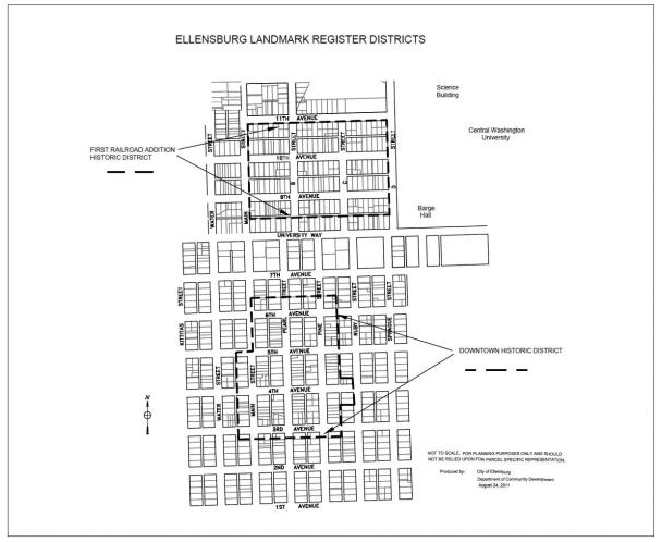
Figure 15.300.070(B). Downtown and First Railroad Addition historic district boundaries.
C.
First railroad addition historic district.
1.
Designated. The geographic area identified in figure 15.300.070(B) is designated as an Ellensburg landmark district, hereafter to be known as the First Railroad Addition historic district. The requirements of this chapter and chapter 15.280 ECC shall apply to all existing structures or structures hereafter constructed within this district; and
2.
No person, firm or corporation shall construct any new, or reconstruct, alter, remodel, paint, repair or demolish, any existing structure within the First Railroad Addition historic district prior to completing the review process required by the city landmarks and design ordinance (chapter 15.280 ECC).
D.
Airport overlay zone (A-O). The airport overlay (A-O) zone encompasses properties located on, adjacent to, and in the vicinity of Bowers Field, in order to protect the health, welfare, safety, and quality of life of the general public, property owners, airport operators, and aviation community. The intent is also to ensure compatible land uses in the vicinity of the affected environments of the airport overlay zone.
Properties within the A-O overlay zone (see figure 15.300.070(D)) are subject to the standards in chapter 15.350 ECC, airport overlay zone (A-O) standards, in addition to the provisions of the underlying zoning district. Where there is a conflict between the provisions of the A-O overlay zone and the underlying zoning district, the provisions of the A-O overlay zone shall apply.
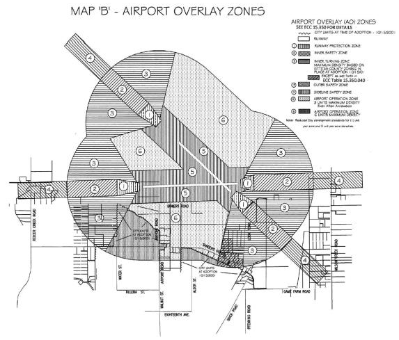
Figure 15.300.070(D). Airport overlay zone and applicable airport safety zones as
described in Chapter 15.350 ECC.
(Ord. 4887 § 21, 2022; Ord. 4798 § 3, 2018; Ord. 4656 § 1 (Exh. O2), 2013; Formerly 15.300.060)
15.310.010 - Purpose.
A.
The purpose of this chapter is to establish the uses generally permitted in each zone which are compatible with the purpose of the zone and other uses allowed within the zone.
B.
The use of a property is defined by the activity for which the building or lot is intended, designed, arranged, occupied, or maintained.
C.
The use is considered permanently established when that use will be or has been legally established in continuous operation for a period exceeding 60 days. A use which will operate for less than 60 days is considered a temporary use, and subject to the requirements of a temporary use permit (see ECC 15.250.010).
(Ord. 4656 § 1 (Exh. O2), 2013)
15.310.020 - Interpretation of land use tables.
A.
The land use tables in this chapter determine whether a use is allowed in a zoning district. The zoning district is located on the vertical column and the use is located on the horizontal row of these tables.
B.
If no symbol appears in the box at the intersection of the column and the row, the use is not allowed in that district, except for certain temporary uses.
C.
If the letter "P" appears in the box at the intersection of the column and the row, the use is allowed in that district subject to the Type I review procedures set forth in chapter 15.210 ECC plus other applicable requirements in this title. Where the use is associated with new development, it is subject to the Type II review procedures, also set forth in chapter 15.210 ECC.
D.
If the letter "C" appears in the box at the intersection of the column and the row, the use is allowed subject to the conditional use review procedures specified in ECC 15.250.040 and the general requirements of the code.
E.
If the letter "A" appears in the box at the intersection of the column and the row within the P-R zone column, the use is allowed as an accessory use to the primary permitted public on the property and is allowed in the district subject to the Type I review procedures set forth in chapter 15.210 ECC plus other applicable requirements in this title.
F.
Clarification of uses and special conditions.
1.
If a * appears after the use, then the use is defined in chapter 15.130 ECC;
2.
Where an ECC reference/link appears after a use, then the use is subject to standards set forth in that section or chapter;
3.
If a number appears in the box at the intersection of the column and the row, the use may be allowed subject to the development condition with the corresponding number immediately following the land use table. If there are multiple numbers, then the use is subject to all applicable development conditions; and
4.
If more than one letter-number combination appears in the box at the intersection of the column and the row, the use is allowed in that zone subject to different sets of limitation or conditions depending on the review process indicated by the letter, the general requirements of the code and the specific conditions indicated in the development condition with the corresponding number immediately following the table.
(Ord. 4656 § 1 (Exh. O2), 2013)
15.310.030 - Accessory uses.
An accessory use, as defined in ECC 15.130.010 and identified on the use tables in ECC 15.310.040 by an "A," is permitted in any zone if:
A.
It is on the same lot as the principal use to which it is accessory; and
B.
It is of a nature customarily incidental and subordinate to, the principal use or structure.
(Ord. 4656 § 1 (Exh. O2), 2013)
15.310.040 - Use tables.
Table 15.310.040-1
Residential Uses
Development conditions:
1.
Subject use may be permitted subject to density bonus incentives set forth in table 15.320.030 and chapter 15.330 ECC.
2.
Duplexes and townhomes are permitted in the R-L and R-S zones on infill lots (preexisting legal lots of record as of December 31, 2021) notwithstanding the maximum density limits in table 15.320.030. For lots recorded after this date, duplexes and townhomes are permitted in the R-L and R-S zones but must meet the density requirements of ECC 15.320.030.
3.
Residential uses are permitted in the C-N zone provided nonresidential uses occupy the ground floor of all buildings fronting on the street. For example, residential uses could be on upper levels of buildings fronting on the street or, for deep lots, subject residential uses may occupy any buildings away from the street and behind the buildings that front onto the street.
4.
Nonresidential uses may be permitted within live-work dwellings subject to the permitted uses in the underlying zoning district.
5.
Multifamily dwelling units shall not be located adjacent to existing single-family dwellings, except where such uses were approved on an individual plat.
6.
All uses permitted in the P-R zone must be either outright permitted and operated as a public use or must be an accessory use to the primary public use (see ECC 15.310.050).
7.
Except for lobbies or similar entrances, all permitted residential uses in the C-C and C-C II zones are prohibited within 30 feet of the sidewalk on the ground floor of properties fronting on storefront streets per ECC 15.510.050(E).
8.
Yard sales are permitted as an accessory use to a dwelling; provided, that the following conditions are met:
a.
Only two yard/garage sales per dwelling unit not exceeding three consecutive days in duration are allowed per year;
b.
The occupant or tenant of the dwelling unit shall supervise and be responsible for the yard/garage sale activities including ensuring that there is no impediment to the passage of traffic on public roads and sidewalks adjacent to the sale;
c.
No goods are to be displayed in public rights-of-way without first obtaining a right-of-way use permit from the public works department; and
d.
Signs advertising the sale shall not be attached to any public structure, sign, sign or utility pole or traffic control devices and shall be removed within 24 hours of the sale completion.
9.
Subject to the permanent supportive, transitional housing, emergency housing and emergency shelter facilities standards set forth in ECC 15.340.080.
Table 15.310.040-2
Nonresidential Uses
Development conditions:
1.
Vehicle battery charging stations are permissible for the primary use of residents and their guests in all residential zones. Battery charging station clusters are permitted for multifamily uses located in the R-M and R-H zones.
2.
Use must be enclosed entirely within a building.
3.
Grocery stores shall be the only retail uses permitted with more than 20,000 square feet of gross floor area.
4.
Office uses that are accessory to a permitted use.
5.
Subject nonresidential uses are permitted in these zones if the planned uses are at least 1,200 feet from a commercial zone or mixed-use zone. Residential rental, leasing or management offices shall be permitted in the R-H zone for multifamily dwelling units on the same property.
6.
All uses permitted in the P-R zone must be either outright permitted and operated as a primary public use or must be an accessory use to that primary public use. See ECC 15.310.050.
7.
Includes light industrial activities that result in the production of goods placed for on-site retail sale. Special restrictions:
a.
No power tools or equipment are allowed which by their decibel, frequency, and/or other feature of their operation would negatively impact the surrounding area by reason of decibel levels, light (see chapter 15.580 ECC for standards), dust or other physical effect; and
b.
Production or manufacturing activity shall not occur between the hours of 10:00 p.m. and 6:00 a.m.
8.
Regional retail is administered as an overlay zone pursuant to chapters 15.390 and 15.390A ECC, and only permitted within the designated boundaries identified in figure 15.390.040(A), the south interchange area, and figure 15.390.040(B), the west interchange area. Permitted uses and use restrictions within a regional retail commercial project are described in ECC 15.390.030. Design criteria for regional retail is governed by chapter 15.390A ECC.
9.
All marijuana retail, production and processing facilities are subject to the requirements of chapter 15.370 ECC.
10.
All marijuana cooperatives are subject to the requirements of ECC 15.370.030, chapter 314-55 WAC and chapter 69.51A RCW.
11.
Use is only permitted on a lot abutting the intersection multiple public street frontages, such as a corner lot.
Table 15.310.040-3
Special Uses
Development conditions:
1.
Lighting for structures and fields shall be directed away from residential areas through the use of exterior full cut-off shields or through optics within the fixture.
2.
Adult entertainment is regulated pursuant to chapter 6.72 ECC. Zoning locational standards within the C-H zone for adult entertainment establishments are:
All such establishments must be at least 1,000 feet from any residential zone, parks, schools, historic district, any dwelling, freeway, highway, interstate, or major arterial (see map on file in the city clerk's office).
3.
Limited to "storefront" police offices. Such offices shall not have:
a.
Holding cells;
b.
Suspect interview rooms (except in the C-N zone); or
c.
Long-term storage of stolen properties.
4.
Public agency or utility yard conditions:
a.
Utility yards are only on sites with utility district offices; or
b.
Public agency yards are limited to material storage, vehicle maintenance, and equipment storage for road maintenance, facility maintenance, and parks facilities.
5.
Excluding private or nonprofit commercial schools or universities, for which the principal course work is business, vocational, or technical.
6.
A conditional use permit is required for the following uses:
a.
Facilities to sell, service and store airplanes, service airport patrons, and those ordinarily incidental and essential to operation of a municipal airport; and
b.
Airport landing areas.
7.
All uses permitted in the P-R zone must be either outright permitted and operated as a public use or must be an accessory use to the primary public use; see ECC 15.310.050. Subject uses must be managed by a public agency.
8.
Wireless communication facilities, including wireless communication support towers and antenna arrays, are subject to the provisions of ECC 15.340.070 and chapter 15.395 ECC.
9.
Agriculture uses are permitted in the subject zone provided the following conditions are met:
a.
The raising of swine, poultry or goats shall be restricted to youth educational projects or limited household consumption occurring on the same lot, or lots of record;
b.
No nuisances, such as noise, odor, air pollution, wastes, vibration, traffic or physical hazards, shall result therefrom; and
c.
Fencing and housing adequate to certain livestock shall be provided where livestock are kept, and all livestock shall be kept and maintained in accordance with applicable laws and regulations.
10.
Small wind energy systems on properties listed in the Ellensburg landmarks register are subject to landmarks and design commission certificate of appropriateness.
11.
Subject use shall be permitted only if it is a public facility.
12.
Museums within the R-S, R-L, R-M and R-H zoning districts are permissible within existing buildings, or if for new construction only if the building is 2,000 square feet or less, and for both options through approval of a conditional use permit.
13.
Subject nonresidential uses are permitted in these residential zones if the planned uses are at least 1,200 feet from a commercial zone or mixed-use zone.
(Ord. No. 4975, § 49, 11-17-2025; Ord. No. 4955, § 111, 2-18-2025; Ord. No. 4953, § 8, 1-21-2025; Ord. No. 4929, § 3, 11-6-2023; Ord. 4887 § 22, 2022; Ord. 4807 § 44, 2018; Ord. 4804 § 3, 2018; Ord. 4769 § 13, 2017; Ord. 4728 § 4, 2016; Ord. 4724 § 4, 2016; Ord. 4696 § 3, 2015; Ord. 4669 § 3, 2014; Ord. 4656 § 1 (Exh. O2), 2013; Ord. No. 4936, § 5, 2-5-2024)
15.310.050 - Supplemental P-R zone provisions.
A.
Permitted accessory uses.
1.
Services such as food, pharmacies, gift shops, bookstores, newsstands, flower shops and similar uses, and facilities such as vehicle service and repair, storage yards, and physical plants, that are associated with a permitted use, integral to the operation of the permitted use itself, and owned and operated by the public institution involved or conducted through a lease or contract with a private individual or entity.
2.
Facilities accessory to an institution, such as housing and dining facilities for students, staff or faculty of colleges, universities, and hospitals, are allowed within the principal building(s).
3.
Retail services, such as concessions and rental facilities usually associated with public parks, fairgrounds, other public recreation facilities, and public educational institutions.
4.
Helipads operated in conjunction with a public hospital.
5.
Human medical offices, such as doctor or dentist facilities, operated in conjunction with a primary permitted use.
B.
Conditional use. Buildings located within 100 feet of a residential zone and intended to be higher than 35 feet may be permitted within the P-R zone through the granting of a conditional use permit according to the procedures set out in ECC 15.250.040.
C.
Master planning. Recognizing that some institutions require long-range development plans and consist of large areas of land with multiple land uses, a master plan may be prepared for all, or a portion, of an entity's land area which is subject to this chapter and which master-planned land encompasses an area of three acres or more. See ECC 15.250.080 for application requirements, review procedures, and decision criteria for such master plans.
D.
Rezone of P-R property when no longer used for public purposes. Recognizing that over time some land and structures that are zoned P-R and are used for P-R purposes may change uses to non-public uses or may become obsolete or surplussed out of active public use and occupancy, the property owner may in such situations seek a rezone out of P-R zoning pursuant to the terms and processes set forth in ECC 15.250.100, subject to the following:
The rezone applicant may request that the P-R zoned property be rezoned to any zoning district classification that abuts the subject property.
1.
In the event that the P-R zoned property is developed with a structure that is not consistent with the development allowed in the abutting zones, such as a large school in the middle of a single-family residential zone, the rezone applicant may request to rezone the property to a different zoning classification other than the abutting zones; provided, that a concomitant agreement that identifies the types of future uses that will be permitted in the structure has been proposed by the applicant and agreed to by city council as part of any rezone approval.
2.
In the event that the P-R zoned property is developed with a structure that has been identified on the Ellensburg historic resource inventory and the property owner desires to demolish all or part of the structure, a certificate of appropriateness for such demolition must first be applied for and approved by the landmarks and design commission pursuant to ECC 15.280.090(D) before the rezone permit review can be initiated.
(Ord. 4807 § 45, 2018; Ord. 4656 § 1 (Exh. O2), 2013)
15.320.010 - Purpose.
A.
To promote forms of development that reinforce and/or enhance the desired character of Ellensburg neighborhoods;
B.
To promote compatibility between developments; and
C.
To minimize environmental impacts of development.
(Ord. 4807 § 46, 2018; Ord. 4656 § 1 (Exh. O2), 2013)
15.320.020 - Interpretation of tables.
A.
The building setback and intensity standards tables address the building setback and intensity of development specific to individual zoning districts. The zoning district is located on the vertical column and the form/intensity topic being addressed is located on the horizontal row of these tables.
B.
Where an ECC reference/link appears after the building setback and intensity topic, then the use is subject to standards set forth in that section or chapter.
C.
If a number appears in the box at the intersection of the column and the row, refer to the development condition with the corresponding number immediately following the table. If there are multiple numbers, then all development conditions apply.
D.
ECC 15.320.050 through 15.320.130 provide clarification and exceptions to the building setback and intensity standards herein.
(Ord. 4807 § 46, 2018; Ord. 4656 § 1 (Exh. O2), 2013)
15.320.030 - Building setback and intensity standards table—Residential zones.
Table 15.320.030
Building Setback and Intensity Standards Table—Residential Zones
Development conditions:
1.
Lot sizes may be variable provided they are sized and shaped sufficient to accommodate permitted uses and conform to applicable design and density standards.
2.
New lots shall have access directly to a public right-of-way or may obtain access from a courtyard access (ECC 15.420.050(C)) or shared driveway (ECC 15.420.060(A)(2)).
3.
The density minimum shall apply only to new subdivisions greater than one acre in size.
4.
Exception: Projects complying with net zero energy provisions may exceed the maximum density limits as set forth in ECC 15.330.020(A).
5.
For buildings, or portions thereof, with pitched roofs, the maximum height may be increased by five feet. Applicable roof slopes must be at least 4:12 to qualify for this additional height.
6.
Porches and covered entries may project up to six feet into the front yard.
7.
No front yard is required for buildings adjacent to designated "storefront streets."
8.
Base maximum density refers to the maximum density allowed without utilizing density bonuses. Per ECC 15.310.040, duplexes and townhomes are permitted in R-S and R-L zones on preexisting legal lots of record as of December 31, 2021, notwithstanding the maximum density requirements of this chapter. For lots recorded after this date, duplexes and townhomes must meet the density standards of this chapter.
9.
Townhouses and zero lot line homes are exempt from side yard standards internal to a development. However, such uses shall meet applicable side yard standards for adjacent lots outside of the development.
10.
Accessory buildings or accessory dwelling units, where built on top of an existing garage, may be built to a property line abutting an alley, provided sufficient turning movement and emergency vehicle access is provided within the alley.
11.
For lots 6,000 square feet or less in these zones, the minimum side yard shall be five feet on each side. For all other lots, the sum of side yard setbacks in the R-S and R-L zones shall be a minimum of fifteen feet with each side yard a minimum of five feet; and each side yard a minimum of 10 feet in the R-H zone.
12.
Co-living housing sleeping units are calculated as 0.25 dwelling units for the purpose of maximum density calculations in the R-S and R-L zones.
(Ord. No. 4975, § 50, 11-17-2025; Ord. 4887 § 24, 2022; Ord. 4807 § 46, 2018; Ord. 4656 § 1 (Exh. O2), 2013)
15.320.040 - Building setback and intensity standards—Commercial, industrial, and public reserve zones.
Table 15.320.040
Building Setback and Intensity Standards Table—Commercial, Industrial, and Public
Reserve Zones
Development conditions:
1.
Lot sizes may be variable provided they are sized and shaped sufficient to accommodate permitted uses and conform to applicable design and density standards.
2.
For exceptions and detailed standards, see chapter 15.510 ECC, site orientation.
3.
For areas within 100 feet of a residential zone, the maximum building height shall be 35 feet, except where provided for in ECC 15.310.050(B).
4.
For P-R zoned sites adjacent to residential zones, setback standards shall be the same as the adjacent residential zone. Where more than one zone borders the applicable site, setback standards shall be the same as the zone closest to the proposed structures. Where a nonresidential zone is closest to the applicable structure, then there are no side or rear setback requirements.
5.
Where the subject property borders a residential zone, the minimum side or rear setbacks shall be the same as the adjacent residential zone.
(Ord. 4887 § 25, 2022; Ord. 4807 § 46, 2018; Ord. 4769 § 14, 2017; Ord. 4656 § 1 (Exh. O2), 2013)
15.320.045 - Building setback and intensity standards—Mixed-use zones.
Table 15.320.045
Building Setback and Intensity Standards Table—Mixed-Use Zones
Development conditions:
1.
Lot sizes may be variable provided they are sized and shaped sufficient to accommodate permitted uses and conform to applicable design and density standards.
2.
New lots shall have access directly to a public right-of-way or may obtain access from a courtyard access (ECC 15.420.050(C)) or shared driveway (ECC 15.420.060(A)(2)).
3.
The density minimum shall apply only to new subdivisions greater than one acre in size.
4.
For buildings, or portions thereof, with pitched roofs, the maximum height may be increased by five feet. Applicable roof slopes must be at least 4:12 to qualify for this additional height.
5.
For exceptions and detailed standards, see chapter 15.510 ECC, site orientation.
6.
Where the subject property shares any portion of a border with a residential zone, the minimum side or rear setbacks shall be the same as the adjacent residential zone.
7.
Where subject property shares any portion of a border with a residential zone the maximum building height is 45 feet.
8.
Accessory buildings or accessory dwelling units, where built on top of an existing garage, may be built to a property line abutting an alley, provided sufficient turning movement and emergency vehicle access is provided within the alley.
9.
For lots 6,000 square feet or less in this zone, the minimum side yard shall be five feet on each side. For all other lots in this zone, the sum of side yard setbacks shall be a minimum of 15 feet, with each side yard a minimum of five feet.
10.
Townhouses and zero lot line homes are exempt from side yard standards internal to a development. However, such uses shall meet applicable side yard standards for adjacent lots outside of the development.
11.
The maximum building height in the downtown Ellensburg local landmark district is 45 feet.
12.
There is no minimum residential density for vertical mixed-use. Minimum residential density applies to any portion(s) of the development where ground floor residential uses are proposed with the following standards:
a.
The area used to calculate residential density includes all area dedicated to parking and landscaping required for the ground-floor residential uses.
b.
Where ground-floor residential uses are part of a mixed-use development, area used to calculate the residential density does not include land dedicated to right-of-way.
13.
The secondary street standards in ECC 15.510.060 shall apply to all new streets in the neighborhood center and regional center mixed-use zones.
(Ord. No. 4975, § 51, 11-17-2025; Ord. 4887 § 25, 2022; Ord. 4807 § 46, 2018; Ord. 4769 § 14, 2017; Ord. 4656 § 1 (Exh. O2), 2013)
15.320.050 - Density calculations.
A.
Calculations for determining minimum density—Net area. All site areas shall be used in the calculation of minimum allowed residential density or project floor area except:
1.
Street rights-of-way, easements, or other areas reserved or dedicated for public use (such as parks, open space, and stormwater retention facilities) except private easements that serve as primary access to no more than five lots; and
2.
Submerged lands, landslide hazard areas and buffers, Category I-IV wetlands and buffers, and Type 1, 2, 3 and 4 streams and buffers.
B.
Calculations for determining maximum density—Gross developable acreage.
1.
All site areas may be used in the calculation of the maximum allowed residential density or project floor area except as outlined under the provisions of subsection (B)(2) of this section.
2.
Submerged lands, landslide hazard areas and buffers, Category I-IV wetlands and buffers, and Type 1, 2, 3 and 4 streams and buffers shall not be credited toward the maximum density or floor area calculations. Property used for new roadways, trails, stormwater facilities, or other features used by residents may be counted as part of the site area for density calculations. Property transferred to the city for the construction of public roadways or other public feature shall be counted as part of the site area if the city and property owner reach such an agreement as part of the transfer.
C.
Density calculations. Minimum and maximum density for an individual site shall be calculated by multiplying the gross developable acreage by the applicable number of dwelling units. When calculation results in a fraction, the fraction shall be rounded to the nearest whole number as follows:
1.
Fractions of 0.50 and above shall be rounded up.
2.
Fractions below 0.50 shall be rounded down.
D.
Prohibited reduction. Any portion of a lot that was used to calculate compliance with the standards and regulations of this title shall not be subsequently subdivided or segregated from such lot.
(Ord. 4807 § 46, 2018; Ord. 4656 § 1 (Exh. O2), 2013)
15.320.060 - Height exceptions.
The following structures may be erected above the height limits set forth in ECC 15.320.030, 15.320.040 and 15.320.045:
A.
An additional two feet in height is allowed for structures with green roofs occupying at least 50 percent of the area of the roof;
B.
Roof structures housing or screening elevators, stairways, tanks, rooftop wind generators, ventilating fans or similar equipment required for building operation and maintenance may exceed the height limit by up to ten feet in the C-C and C-C II zones. Such structures constructed for nonresidential or multifamily uses are subject to screening standards in ECC 15.520.060;
C.
Fire or parapet walls may exceed the height limit by up to ten feet in the C-C and C-C II zones; and
D.
Skylights, flagpoles, chimneys, church steeples, crosses, spires, communication transmission and receiving structures, and similar structures.
E.
Freeway-oriented on-premise signs in the C-H zone as provided in ECC 3.12.240(C).
F.
Small wind energy systems as provided in ECC 15.340.060.
G.
Wireless communication facilities as provided in ECC 15.340.070 and chapter 15.395 ECC.
(Ord. No. 4975, § 52, 11-17-2025; Ord. 4887 § 25, 2022; Ord. 4807 § 46, 2018; Ord. 4769 § 14, 2017; Ord. 4656 § 1 (Exh. O2), 2013)
15.320.070 - Setback measurements.
A.
Front yard setback. The front yard is measured from the street right-of-way or the edge of a surface improvement (sidewalk) which extends beyond a right-of-way, whichever is closer to the proposed structure, to a line parallel to and measured perpendicularly from the street right-of-way or the edge of the surface improvement at the depth prescribed for each zone. For dual frontage properties, the front yard is measured from the street right-of-way that is the property's street address and primary access.
B.
Side yard setback. The side yard setback is measured from the side lot line adjacent to another private property to a line parallel to and measured perpendicularly from the side lot lines at the depth prescribed for each zone.
C.
Rear yard setback. The rear yard setback is measured from the rear lot line adjacent to another private property or an alley to a line parallel to and measured perpendicularly from the rear lot lines at the depth prescribed for each zone.
D.
Corner lots. For corner lots with two street frontages, setbacks from the addressed street side shall conform to the front yard setback for the underlying zoning district. The setbacks for the flanking side shall conform to the exterior side yard setbacks for the underlying zoning district.
E.
Pointed/irregular lot. For measurements on a pointed or irregular lot refer to definition of lot line in ECC 15.130.120.
F.
Setback modifications. The following modifications apply to measurement of setbacks:
1.
In addition to providing the standard street setback, a lot adjoining a half-street or designated arterial shall provide an additional width of street setback sufficient to accommodate construction of the planned half-street or arterial.
2.
For residential lots adjacent to designated local streets and built to applicable standards set forth in section 3, street standards, of the city's public works development standards, setbacks shall be measured from the back of the sidewalk rather than the right-of-way edge, provided no residential structures are built within the public right-of-way.
(Ord. No. 4975, § 53, 11-17-2025; Ord. 4807 § 46, 2018; Ord. 4656 § 1 (Exh. O2), 2013)
15.320.080 - Permitted projections into yards.
The following structures may extend into or be located in required setbacks:
A.
Fireplace structures, bay or garden windows, enclosed stair landings, closets, or similar structures may project 30 inches into any yard, provided such projections are:
1.
Limited to two per facade;
2.
Not wider than ten feet; and
3.
A minimum five feet of separation is maintained between these projections and a side or rear property line.
B.
Eaves, cornices, and signs may not project more than 30 inches beyond a required setback or structural projection permitted by this section.
C.
Enclosed porches and enclosed covered entries may project up to six feet into the front or rear yard subject to conformance with any required site vision standards set forth in section 3, street standards, of the city's public works development standards applicable to the lot. A minimum five feet of separation must be maintained between these projections and a rear property line.
D.
Unenclosed covered porches, similar entry features, and covered decks (with or without entries) may project up to six feet into the front, side or rear yards. A minimum five feet of separation must be maintained between these projections and a side or rear property line.
E.
Storefront weather protection projections into the public right-of-way are acceptable, provided they don't interfere with street trees or extend beyond the edge of the sidewalk.
F.
The following features may project into any front yard or any external side yard:
1.
Mailboxes and newspaper boxes;
2.
Fire hydrants and associated appendages;
3.
Bus shelters; and
4.
Monument signs.
G.
The following features may project into any yard:
1.
Telephone poles and lines;
2.
Power poles and lines;
3.
Cable TV and internet lines;
4.
Light and flagpoles;
5.
Sprinkler systems;
6.
Trellises not exceeding eight feet in height, not wider than ten feet;
7.
Culverts and underground water, sewer, and accessory facilities for the provision of utilities, such as drains;
8.
Electrical equipment cabinets and similar utility boxes and vaults;
9.
Surface and stormwater water management facilities;
10.
Fences per ECC 15.320.130;
11.
Uncovered patios and decks not exceeding 18 inches above the finished grade; and
12.
Rockeries, retaining walls and curbs provided these structures do not exceed a height of six feet from the property line grade.
H.
No projections are allowed into a regional utility corridor or access easement.
(Ord. No. 4975, § 54, 11-17-2025; Ord. 4807 § 46, 2018; Ord. 4656 § 1 (Exh. O2), 2013)
15.320.090 - Setbacks from alleys.
Accessory buildings and accessory dwelling units may be built to a property line abutting an alley, provided sufficient turning movement and emergency vehicle access is provided within the alley. Minimum side yard setbacks as required by table 15.320.030 would still apply.
(Ord. No. 4953, § 9, 1-21-2025; Ord. 4807 § 46, 2018; Ord. 4656 § 1 (Exh. O2), 2013)
15.320.100 - Administrative variances for setbacks and heights.
A.
Purpose. To allow limited flexibility in the application of the development standards herein.
B.
Applicability. The director may allow an administrative variance for proposals that are within ten percent of compliance of applicable dimensional standards set forth for building height and building placement.
C.
Procedures. An administrative variance is subject to the Type II review process set forth in chapter 15.210 ECC.
D.
Decision criteria. Proposals shall fall within the scope of the definition for "variance" set forth in ECC 15.130.220, and shall meet the purpose(s) of the applicable development standards.
(Ord. No. 4975, § 55, 11-17-2025; Ord. 4807 § 46, 2018; Ord. 4656 § 1 (Exh. O2), 2013)
15.320.110 - Lot or site divided by zone boundary.
When a lot is divided by a zone boundary, the following rules shall apply:
A.
When a lot contains both residential and nonresidential zoning, the zone boundary between the zones shall be considered a lot line for determining permitted building height and required setbacks on the site.
B.
When a lot contains residential zones of varying density:
1.
Any residential density transfer within the lot shall be allowed from the portion with the lesser residential density to that of the greater residential density.
2.
Compliance with these criteria shall be evaluated during review of any development proposals in which such a transfer is proposed.
C.
Uses on each portion of the lot shall only be those permitted in each zone pursuant to chapter 15.310 ECC.
(Ord. 4807 § 46, 2018; Ord. 4656 § 1 (Exh. O2), 2013; Formerly 15.320.120)
15.320.120 - Fences, walls, and hedges.
A.
Residential uses and zones.
1.
Front yard and between facade and street: 42 inches maximum height. Homes with accessory day care uses are allowed fences up to 48 inches tall, provided the portion of the fence above 42 inches is at least 50 percent transparent;
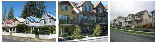
Figure 15.320.130(A)(1). Acceptable fences and walls for the front yard of residential
uses. The left image uses a picket fence. The middle image uses a low wrought iron
fence. The right image uses a low masonry retaining wall.
2.
Corner lot, side yard, flanking street: 42 inches maximum fence or wall height for areas less than five feet from the property line or sidewalk, whichever is less (but not within the right-of-way). For homes with accessory day care uses, the maximum height in this area may be increased to 48 inches, provided the portion of the fence above 42 inches is at least 30 percent transparent. For areas at least five feet from the property line or sidewalk, whichever is less (but not within the right-of-way), the maximum fence or wall height is eight feet;
3.
Side and rear yards: eight feet maximum fence or wall height, except that the maximum height of any fence less than five feet from a sidewalk shall be 42 inches. For homes with accessory day care uses, the maximum height in this area may be increased to 48 inches, provided the portion of the fence above 42 inches is at least 30 percent transparent;
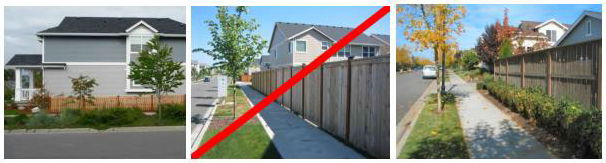
Figure 15.320.130(A)(2). Acceptable and unacceptable fences on corner lots for side
yard/flanking streets or along reverse frontage lots where the back yard abuts a street.
The left example is a low picket fence. Taller fences like that in the middle image
are acceptable along the side and rear yard, but are not allowed within five feet
of a sidewalk. The right image shows an acceptable example where the fence is set
back away from the sidewalk to allow space for landscaping.
4.
Fences, walls and hedges less than three feet from an alley are limited to 42 inches in height. Fences or walls set back three feet or more from the alley may be up to six feet in height. Fences or walls at least ten feet from an alley may be up to eight feet in height;
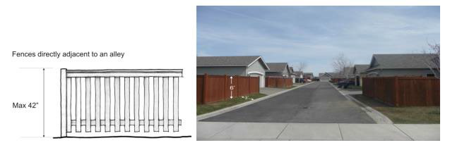
Figure 15.320.130(A)(3). Acceptable fences along an alley. The 42-inch fence on the
left is allowed along the edge of an alley. The taller six-foot fence in the middle
is allowed with a three-foot minimum setback from the alley.
5.
Residential developments are subject to edges and fences provisions as set forth in ECC 15.420.030, which addresses gated communities and reverse frontage lots; and
6.
Multifamily uses are subject to the following provisions:
a.
Side/rear yard design provisions set forth in ECC 15.520.020; and
b.
Blank wall treatment provisions as set forth in ECC 15.530.060.
B.
All other uses and zones.
1.
Fences less than ten feet from a streetfront property line or sidewalk, whichever is less (but not within the right-of-way), are limited to 42 inches in height. Day care uses are allowed fences up to 48 inches tall in this area, provided the portion of the fence above 42 inches is at least 30 percent transparent. Otherwise, the maximum height for fences shall be eight feet. Also see section 3, street standards, of the city's public works development standards for sight distance requirements along streets and site access points;
2.
Nonresidential uses are subject to side/rear yard design provisions set forth in ECC 15.520.020; and
3.
Nonresidential uses are subject to blank wall treatment provisions as set forth in ECC 15.530.060.
C.
Fence and wall measurements.
1.
Fence and freestanding wall height shall be measured from the horizontal projection of the predominant ground level of either the finished grade where such grade has been established, or from the horizontal projection of the predominant existing grade in the vicinity of the fence; and
2.
Fence height shall be measured to the upper surface of the fence panel.
D.
Fence material standards.
1.
Chain link fences:
a.
Chain link fences are prohibited in residential zones and in yards associated with residential uses; and
b.
Chain link fences are allowed in nonresidential zones subject to height limits set forth in subsection (B) of this section. Where visible from the street, such fences taller than 42 inches shall be screened with landscaping per the blank wall treatment standards set forth in ECC 15.530.060. Chain link fences visible from the street are encouraged to use blue or black vinyl coating.
2.
No fence, wall or hedge shall contain barbed wire, electrical current or charge of electricity, broken glass or similar hazardous materials or devices except where livestock is to be contained by barbed or electrically charged wire, in which case the fence shall be located not closer than five feet from the property line. Where an adjacent existing fence, wall, or hedge on a property line dividing properties under separate ownership establishes a barrier, then such barbed wire fence or electrically charged fence may be placed on the property line with the mutual consent of the property owners. Fences enclosing storage areas in industrial zones (I-L and I-H) may use barbed wire so long as such wire is located not less than six feet above grade.
(Ord. 4807 § 46, 2018; Ord. 4656 § 1 (Exh. O2), 2013; Formerly 15.320.130)
15.330.010 - Purpose.
A.
To promote a variety of housing types;
B.
To promote green building policies and practices;
C.
To promote compact development patterns that encourage the use of nonmotorized forms of transportation;
D.
To promote the integration of trails into the design of new developments;
E.
To promote the preservation of historic resources;
F.
To promote the integration of affordable housing into new development; and
G.
To encourage the preservation of valuable resource lands outside of the city.
(Ord. 4656 § 1 (Exh. O2), 2013)
15.330.020 - Density bonus system for the R-S and R-L zones.
Table 15.330.020 summarizes the types of bonus elements and the range of density bonuses by percentages for each element. Details and conditions for each bonus element are provided in subsections (A) through (E) of this section. Developments may use a combination of bonus elements provided they comply with the maximum density provisions set forth for the zone in table 15.320.030. An exception to the maximum density provisions is only provided for projects complying with net zero energy standards as set forth in subsection (A) of this section.
Table 15.330.020
Density Bonuses for the R-S and R-L Zones
A.
Energy efficient construction.
1.
Table of green building and energy efficient density bonuses. Four tiers of density incentives are employed to promote increasing levels of green building performance and higher energy efficiencies (via a green building rating system) in new developments. Applicable green building rating systems shall be indicated on the plat and confirmed with individual building permit application as directed in subsection (A)(2) of this section, project certification. The following table outlines density bonuses associated with specific green building rating systems for single-family, duplex and townhouse developments in the R-S and R-L zones.
Table 15.330.020(A)
Energy Efficiency Density Bonuses for the R-S and R-L Zones
Conditions/notes:
* Equivalent rating systems which require third party verification maybe be approved at the discretion of reviewing authority.
2.
Project certification.
a.
Building permit. The applicant shall submit a building permit that is consistent with all conditions of the land use permit approval. The applicant shall also submit documentation that the project has applied for certification by a green building rating system, such as LEED or Built Green. Proof of ongoing certification shall be required during construction and project certification must be completed prior to final occupancy.
b.
Living Building Challenge. For projects pursuing the Living Building Challenge for the purpose of a density bonus, the applicant must show proof of pursuing ongoing certification during construction for all required elements. After construction and prior to issuance of the certificate of occupancy, the applicant must show proof of initial project compliance as to the site, materials, indoor quality and beauty/inspiration components of the Living Building Challenge and that the project is likely to achieve the elements of energy and water following 12 months of occupancy as required under Living Building Challenge certification. For those elements of energy and water that require occupancy of the building for 12 months for Living Building Challenge certification, the applicant must submit a report to the city following 12 months of occupancy, demonstrating its progress towards meeting these remaining elements of the Living Building Challenge standard. If certification of those elements has not been achieved, the applicant must provide quarterly reports of progress towards certification of these elements, including additional steps and timeline that will be taken to achieve certification.
B.
Mix of housing types. Up to a 15 percent density bonus may be provided for providing a diversity of housing types.
1.
Housing mix density bonus table.
Table 15.330.020(B)
Housing Mix Density Bonuses
2.
Alternative housing types include:
a.
Accessory dwelling units (ADU) complying with design provisions set forth in ECC 15.540.040. Also note that while ADUs do not count as a unit for the purpose of calculating density, they may be counted as an alternative housing type for the purpose of calculating the percentage of alternative housing types to total permitted units;
b.
Small detached single-family dwelling units. This includes dwellings no larger than 1,400 square feet in gross floor area, excluding an attached or detached garage or other nonhabitable floor area. Such dwellings must comply with design provisions set forth in ECC 15.540.020;
c.
Cottage dwelling units, complying with design provisions set forth in ECC 15.540.050. Also note that each cottage shall count as one-half of a dwelling unit for the purpose of calculating allowed density. However, for the purpose of determining the percentage of alternative housing types, each cottage dwelling may be counted as a single unit;
d.
Duplexes complying with design provisions set forth in ECC 15.540.030;
e.
Townhouses complying with design provisions set forth in division V and notably ECC 15.540.060; and
f.
Multifamily buildings, where permitted in the applicable zoning district, complying with design provisions set forth in division V.
3.
The specific location, mixture, and amount of housing shall be indicated on the plat to ensure compliance with the density bonus provisions herein.
C.
Off-street trails.
1.
Density bonus. The density bonus percentage is based on the type and length of off-street trail with respect to the size of the development.
Table 15.330.020(C)
Off-street Trail Density Bonuses
2.
Standards for trails. Trails may either be a soft surface walking path, a hard surfaced walking path, or a wider hard surfaced multi-use pathway. As referenced in the nonmotorized transportation plan, federal, state, and professional guidance exists to ensure the system is designed to provide safe and accommodating facilities. Ellensburg relies primarily on:
a.
The Federal Highway Administration's (FHWA's) National Bicycling and Walking Study: Case Study No. 24—Current Planning Guidelines and Design Standards Being Used by State and Local Agencies for Bicycle and Pedestrian Facilities, has detailed engineering solutions for many nonmotorized situations.
b.
AASHTO Guide for the Development of Bicycle Facilities, 3rd Edition, offers guidelines and minimum design criteria for safe bicycle facilities.
c.
AASHTO Guide for the Planning, Design, and Operation of Pedestrian Facilities, 1st Edition, has guidelines and minimum design criteria for pedestrian facilities.
d.
WSDOT's Bicycle Facility Design Guidance (Chapter 1020) provides uniform minimum standards and criteria for the design and construction of bicycle facilities.
e.
WSDOT's Pedestrian Design Guidance (Chapter 1025) serves as a standard for construction and design of pedestrian facilities.
f.
The John Wayne Pioneer Trail, The Ellensburg Greenway: Reconnection Study (2001) will guide the planning and design of that trail.
g.
ADA Accessibility Guidelines for Transportation Facilities is consulted to ensure facilities are available to everyone.
h.
Manual on Uniform Traffic Control Devices for Streets and Highways, USDOT, FHWA; as adopted and modified by chapter 468-95 WAC provides standards for signs and other traffic control devices.
i.
National Association of City Transportation Officials (NACTO) Urban Bikeway Design Guide.
3.
Context. The trails must be integrated into the design of the development as an amenity. To accomplish this goal, tall fences separating dwellings from trails are prohibited. Fences that separate dwellings in the subdivision from trails shall be less than 42 inches in height or at least 33 percent transparent (those portions of the fence taller than 42 inches in height). Notes referencing these standards shall be included on the plat. Fences adjacent to mid-block trails that run alongside yards are exempt from this standard.
D.
Historic preservation.
1.
Density bonus. For each building that is preserved, the development shall qualify with a minimum of 15 percent and a maximum of 50 percent increase in on-site density for one acre of development. For example, if the development site covers ten acres, the density bonus qualifies for one of the ten acres.
2.
Eligibility. Properties eligible for this density bonus option must feature a property that is eligible for historic landmark listing under the Ellensburg landmarks register, per ECC 15.280.080. Subject properties must be in habitable condition, or improved to habitable condition. Developments may also receive the density bonus credit if they are moved to another site within the city provided the applicable building/site meets applicable standards set forth in this title.
E.
Affordable housing.
1.
Density bonus. The available density bonus increase is based on the percentage of affordable housing units integrated into the subdivision, with a minimum of 15 percent to qualify and a maximum density bonus increase of 100 percent. The percentage shall be based on the number of affordable housing units divided by the base maximum density. Up to 50 percent bonus is available for developments affordable to residents earning up to 80 percent of the Kittias County Area Median Income (AMI) as identified annually by the U.S. Department of Housing and Urban Development (HUD).
To receive density bonuses of more than 50 percent and up to 100 percent, the same calculation applies; plus at least 20 percent of the affordable-designated units must be restricted to and affordable for people earning no more than 60 percent of AMI.
Table 15.330.020(E)-1
Bonus example 1: A project is eligible for a base maximum density of 60 units. To qualify for a 30 percent density bonus, or 18 additional units (78 total project units), at least 18 units across the project (30 percent of base) must be affordable up to 80 percent AMI. The affordable housing density bonus will be measured against the base maximum density, not the total density of other density bonuses.
Bonus example 2: A project is eligible for a base maximum density of 20 units. To qualify for a 75 percent density bonus, or an additional 15 units (35 total project units), at least 15 units across the project (75 percent of base) must be affordable up to 80 percent AMI; of the 15 affordable units, at least three (20 percent of bonus) must be affordable at not more than 60 percent AMI.
Table 15.330.020(E)-2 Example Density Bonus Calculations
2.
Affordable housing unit requirements.
a.
Affordability. Units must be affordable (rent or mortgage and utility allowance do not exceed 30 percent of designated income) to persons with incomes at or below 80 percent of the median income for Kittitas County residents for a density bonus of 15 to 50 percent. For density bonuses of more than 50 and up to 100 percent, at least 20 percent of affordable units must be affordable (rent or mortgage and utility allowance do not exceed 30 percent of designated income) to persons with incomes at or below 60 percent of Kittias County median income.
b.
Duration. Affordable-designated units shall serve only income-eligible households for a minimum period of 25 years from the later of the date when the affordability agreement between the housing owner and the city, as referenced in subsection (F)(3) of this section, is recorded, or the date when the affordable housing becomes available for occupancy as determined by the city.
c.
Designation of affordable housing units. Prior to the issuance of any permit(s), the director shall review and approve the location and unit mix of the affordable housing units consistent with the following standards:
i.
Location. The location of the affordable housing units shall be disbursed throughout the development, not separated in physical access or orientation from market rate units;
ii.
Tenure. The tenure of the affordable housing units (ownership or rental) shall be the same as the tenure for the rest of the housing units in the development; and
iii.
Size (bedroom). The affordable housing units shall consist of a range of number of bedrooms that are comparable to units in the overall development.
d.
Design. The exterior design of the affordable housing units must be compatible and comparable with the rest of the dwelling units in the development and must comply with project design provisions specified in division V.
e.
Timing/phasing. The affordable housing units shall be available for occupancy in a time frame comparable to the availability of the rest of the dwelling units in the development.
3.
Affordability agreement. Prior to issuing any building permit, an agreement in a form approved by the director that addresses price restrictions, homebuyer or tenant qualifications, phasing of construction, monitoring of affordability, duration of affordability, and any other applicable topics of the affordable housing units shall be recorded with Kittitas County auditor's office. This agreement shall be a covenant running with the land and shall be binding on the assigns, heirs and successors of the applicant. The city may agree, at its sole discretion, to subordinate any affordable housing regulatory agreement for the purpose of enabling the owner to obtain financing for development of the property.
4.
Monitoring and fee. The city reserves the right to establish in the affordability agreement referred to in subsection (E)(3) of this section, monitoring fees for the affordable housing unit, which can be adjusted over time to account for inflation. The purpose of any monitoring fee is for the review and processing of documents to maintain compliance with income and affordability restrictions of the affordability agreement.
(Ord. No. 4953, § 10, 1-21-2025; Ord. 4807 § 47, 2018; Ord. 4656 § 1 (Exh. O2), 2013)
15.330.030 - Floor area ratio (FAR) bonus system for the R-M, R-H, and R-O zones.
Repealed by Ord. 4807.
(Ord. 4656 § 1 (Exh. O2), 2013)
15.340.010 - Bed and breakfasts.
Bed and breakfasts shall be permitted in accordance with the use tables in ECC 15.310.040, subject to the following:
A.
An approved floor plan shall be kept on file with the inspections department;
B.
There shall be no substantial modifications to the exterior appearance of the structure; however, fire escapes, handicapped entrances and other features may be added to protect public safety;
C.
Meals shall be available on the premises only for guests and employees of the inn. Rooms may not be equipped with cooking facilities; and
D.
Parking shall not be allowed between the building and the street.
(Ord. 4656 § 1 (Exh. O2), 2013)
15.340.020 - Home occupations.
A.
Purpose. This section establishes standards for operation of home occupations in dwelling units within residential districts; ensures that such home occupations are compatible with adjacent and nearby residential properties and uses; and allows residents of the community to use their residences as places to enhance or fulfill personal economic goals.
B.
Applicability. This section applies to any activity undertaken for gain or profit that results in a product or service and is carried on in a dwelling or building accessory to a dwelling.
1.
No home occupation, except as otherwise provided in this section, may be initiated, established, or maintained in a dwelling except in conformance with the regulations and performance standards set forth in this section.
2.
If the proposed activity consists entirely of office procedures and tasks in support of a particular business, and furthermore involves no customer or delivery traffic to the residence in conjunction with the business, such activity shall be considered as an accessory residential use. Accessory residential uses do not require a home occupation permit.
C.
Procedures. Home occupations are subject to the Type I review process as set forth in chapter 15.210 ECC.
D.
Application contents. Applications for a home occupation shall contain the following:
1.
The minimum application requirements set forth in ECC 15.220.020 and a completed home occupation application form provided by the department; if the applicant is not the owner, the application shall include written authorization from the legal owner(s).
2.
Payment of the application fee in the amount established in the city's adopted fee schedule.
3.
A general site plan that shows:
a.
The proposed home occupation dimensions in relation to the residence footprint;
b.
How the property is located in reference to existing streets, alleys, and sidewalks;
c.
The proposed project and dimensions in relation to all existing and proposed development on the property;
d.
All existing buildings or structures on the subject property which are proposed to be utilized for the home occupation with setback dimensions and distances between buildings; and
e.
Present and additional off-street parking, if required.
E.
Standards of performance. Home occupations shall be permitted in accordance with the use tables in ECC 15.310.040, subject to the following:
1.
There shall not be structural alteration that would alter the outward appearance from a residential to commercial nature to accommodate the occupation. An example would be large storefront windows and/or a flat roof with a traditional cornice (see figure 15.340.020);
Figure 15.340.020. Examples of commercial architecture that would not be appropriate
for a home occupation in a residential zone.
2.
The use, including all storage space, shall not occupy more than 33 percent of the residence's floor area which is finished for living purposes;
3.
Only members of the family who reside on the premises and no more than one nonresident shall be engaged in the occupation(s) at any one time; provided, that home occupations with a nonresident employee shall provide off-street parking for the employee on site;
4.
There shall be no window display nor shall sample commodities be displayed outside the building;
5.
No materials or mechanical equipment shall be used which will have a negative impact on the residential area because of vibration, noise, dust, smoke, odor, interference with radio or television reception, or other factors;
6.
If materials or commodities delivered to or from the residence require delivery by a commercial vehicle larger than a small parcel delivery van or truck, or if the parking of customers' automobiles in a manner or frequency causes disturbance or inconvenience to nearby residences, or if a public parking lot is necessary to accommodate the business, the occupation shall be termed a primary business and not a home occupation;
7.
For purposes of this section, use of the defined term "residence" contained in this code for the purpose of considering a home occupation in an accessory building shall be limited to single-family uses. Home occupations in multifamily dwellings shall be confined to the principal dwelling unit buildings and not be allowed in accessory structures;
8.
Any home occupation granted would be personal to the person to whom it is granted and under no circumstances shall any home occupation be carried over as a result of a change in ownership of the business activity; and
9.
Only one sign is permitted for a home occupation in a residential zone. A sign permit is required; the size of the sign shall conform to the requirements of ECC 3.12.300(D).
F.
Final decision. The final decision to grant or deny the permit will be issued by the director, as provided in chapter 15.210 ECC (Type I permits).
(Ord. No. 4975, § 56, 11-17-2025; Ord. 4807 § 49, 2018; Ord. 4656 § 1 (Exh. O2), 2013)
15.340.030 - Manufactured homes.
A new designated manufactured home is allowed in all zoning districts that allow single-family residences (see ECC 15.130.130, definitions), and meets the following criteria:
A.
Is comprised of at least two fully enclosed parallel sections each of not less than 12 feet wide by 36 feet long;
B.
Was originally constructed with and now has a composition or wood shake or shingle, coated metal, or similar roof of nominal 3:12 pitch; and
C.
Has exterior siding similar in appearance to siding materials allowed on conventional site-built single-family residences that are built pursuant to the applicable building code.
D.
A manufactured home (see ECC 15.130.130, definitions) is allowed in a manufactured home park pursuant to ECC 15.340.040.
(Ord. 4656 § 1 (Exh. O2), 2013)
15.340.040 - Manufactured home park.
Manufactured home parks shall be permitted in accordance with the use tables in ECC 15.310.040, subject to the following property development standards:
A.
Minimum area shall be three acres.
B.
Developments are subject to building setback and intensity standards for the applicable zoning district as set forth in chapter 15.320 ECC unless otherwise directed herein.
C.
Setback standards.
1.
Minimum front yard: five feet from internal private roads; otherwise, the minimum front yard shall be the same as set forth in chapter 15.320 ECC;
2.
Minimum separation of manufactured homes on the site: ten feet;
3.
Side and rear setbacks to the manufactured home park property line (or manufactured home park boundary line as shown on the site development plan) shall meet the setbacks for the applicable zone in chapter 15.320 ECC; and
4.
Accessory structures shall be located no closer than:
a.
Ten feet to mobile or manufactured homes on adjacent spaces, unless constructed of noncombustible materials, in which case the minimum setback shall be five feet;
b.
Five feet to accessory structures of mobile or manufactured homes on adjacent spaces; and
c.
Five feet to the mobile or manufactured home or other accessory structures on the same space, except a carport or garage may be attached to the mobile or manufactured home, and the separation may be waived when such structures are constructed of noncombustible materials.
D.
Development shall include common open space that meets the design criteria of ECC 15.520.030(E)(1) and equals no less than five percent of the net project area.
E.
Internal access roads must conform to one of the three local access street design options as referenced in ECC 15.410.040, including auto lanes, parking lanes, planting strips (between the road and sidewalk only for private roads), and sidewalks. Through roads (streets that extend from one end of the lot to the other) shall be dedicated as public streets and must comply with section 3, street standards, of the city's public works development standards
F.
Developments shall comply with block and connectivity standards set forth in ECC 15.420.020.
G.
Developments shall provide an appropriate side and rear yard design treatment along the manufactured home park property line (or manufactured home park boundary line as shown on the site development plan) that meets the provisions of ECC 15.520.020.
H.
At least one of the off-street parking spaces required for each manufactured home shall be located on or adjacent to each manufactured home pad.
I.
All utility distribution and service lines located within the boundaries of a manufactured home park, including electric power, water supply, sewage disposal, natural gas, telephone, and television antenna cable, shall be installed underground in accordance with applicable city codes.
J.
Every manufactured home shall be permanently connected to electric power, water supply, sewage disposal, gas, and telephone service lines in compliance with applicable city codes.
K.
Mobile homes may be sited within the manufactured home park provided they comply with manufactured home setbacks and other development standards herein. Mobile homes must also pass a fire safety inspection performed by the Washington State Department of Labor and Industries before an installation permit will be issued.
L.
All mobile homes supported by piers shall be fully skirted.
M.
A manufactured home park may include a storage area for RVs owned by residents of the park, provided the storage area contains no utility hook-ups and no RV within the storage area shall be used as living quarters.
N.
Recreational vehicles, used as a primary residence, are permitted within manufactured home park per RCW 35A.21.312, provided they meet the service and utility provisions per subsection (J) of this section or ECC 15.340.050(M).
(Ord. 4807 § 50, 2018; Ord. 4656 § 1 (Exh. O2), 2013)
15.340.050 - Recreational vehicle park.
Recreational vehicle parks shall be permitted in accordance with the use tables in ECC 15.310.040, subject to the following performance standards:
A.
Minimum size of the recreational vehicle park. One hundred thousand square feet.
B.
Maximum gross density. One recreational vehicle space per each 2,000 square feet of land area.
C.
Recreational space. Eight percent of the total site area shall be provided as defined recreation space. The recreation space shall be easily accessible and shall be improved and maintained in such a manner so as to provide adequate recreational facilities for the residents of the recreational vehicle park.
D.
Minimum width. Each recreational vehicle space shall have a minimum width of 25 feet.
E.
Interior private streets.
1.
Twelve feet of width per each travel lane and ten feet of width per each parking lane. A minimum of 20 feet shall be provided for one-way systems; and
2.
The streets shall be improved in accordance with section 3, street standards, of the city's public works development standards. In addition, all streets shall be well-drained, well-lighted, and continuously maintained in operable condition.
F.
Spacing between units. There shall be a minimum side-to-side dimension of 12 feet between units and a minimum end-to-end dimension of ten feet between units.
G.
Minimum setbacks required. The following setback requirements shall apply:
1.
Twenty-five feet from a public street;
2.
Five feet from an interior private street; and
3.
Fifteen feet from the park boundary.
H.
Off-street parking. A minimum of one off-street parking space shall be required for each recreational vehicle space. It shall be located within the recreational vehicle space. In addition, one off-street parking space per each three recreational vehicle spaces shall be required for guest parking. The guest parking spaces shall be grouped and distributed evenly throughout the park.
I.
Pedestrian walkways. Pedestrian walkways having a width of not less than four feet shall be provided from the recreational vehicle spaces to all service buildings, and facilities, refuse collection areas, and recreation areas. The walkways shall be hard-surfaced, well-drained, and well-lighted.
J.
Landscaping. See chapter 15.570 ECC for applicable landscaping standards.
K.
Limit of stay. No recreational vehicle shall remain within in a recreational vehicle park for more than 120 days in any one-year period;
L.
Solid waste disposal. The storage, collection and disposal of solid waste in recreational vehicle parks shall be so conducted as to create no health hazards, rodent harborage, insect breeding areas, or accident or fire hazards. Individual or grouped refuse containers must be screened from view except on collection day.
M.
Utilities. The following requirements for utilities shall apply:
1.
Water system. A water supply system shall be provided in the recreational vehicle park for each recreational vehicle space designed to accommodate the park user occupying a self-contained recreational vehicle, the water system for a recreational vehicle park shall be constructed and maintained in accordance with all applicable state and local codes and regulations.
2.
Watering stations. Each recreational vehicle park shall be provided with one or more accessible water supply outlets for filling recreational vehicle water storage tanks.
3.
Sewage disposal system. An adequate and safe sewage disposal system shall be provided in a recreational vehicle park for each recreational vehicle space designed to accommodate the park user occupying a self-contained vehicle and shall be connected to the public sewage system. The sewage disposal system in a recreational vehicle park shall be constructed and maintained in accordance with all applicable state and local codes and regulations.
4.
Sanitary stations. Each recreational vehicle park shall be provided with sanitary dumping stations in the ratio of one for every 100 recreational vehicle spaces or fractional part thereof. The construction of the sanitary station shall be in accordance with the appropriate county department of health. Sanitary stations shall be screened from other activities by a visual barrier such as fences, walls, or natural growth and shall be separated from any recreational vehicle space by a distance of not less than 50 feet.
5.
Electrical supply system. Each recreational vehicle park shall be provided with an underground electrical system which shall be installed and maintained in accordance with all applicable state and local codes and regulations.
6.
Other utility systems. If other utility systems such as natural gas, television cable, or telephone are installed in a recreational vehicle park, such installation shall be in accordance with state and local codes and regulations.
N.
Visibility. All recreational vehicle spaces shall be well marked and numbered.
(Ord. 4656 § 1 (Exh. O2), 2013)
15.340.060 - Small wind energy systems.
A.
Purpose. To facilitate the installation and construction of wind energy systems in the city of Ellensburg for private landowners, subject to reasonable restrictions.
B.
Applicability. The requirements set forth herein shall govern the siting of small wind energy systems (SWES) used to generate mechanical or electrical energy to perform work, and which may be connected to the utility grid pursuant to chapter 80.60 RCW, net metering of electricity, serve as an independent source of energy, or serve as part of a hybrid system.
The requirements of this title shall apply to all new small wind energy systems (SWES) proposed after the effective date of the ordinance codified in this title. Any SWES for which a required permit has been properly issued prior to the effective date of the ordinance codified in this title shall not be required to meet the requirements of this title; provided, however, that any such pre-existing SWES that is not producing energy for a continuous period of 12 months shall meet the requirements of this title prior to recommencing production of energy. No modification that increases the height of the system or significantly increases its output shall be allowed without full compliance with this title.
C.
Where permitted.
1.
One SWES system per parcel is permitted in all zones subject to satisfying all requirements as set forth in this chapter, except:
a.
Where otherwise noted in ECC 15.310.040; and
b.
On properties listed in the Ellensburg landmarks register which must first undergo landmarks and design commission approval as a Type II permit per ECC 15.210.050(B).
2.
Multiple SWES per parcel are permitted in all zoning districts (except where otherwise noted in ECC 15.310.040) subject to the issuance of a conditional use permit per ECC 15.250.040.
D.
General requirements for small wind energy systems. In addition to the general requirements listed below, the applicant must provide documentation showing that the SWES meets the AWEA Small Wind Turbine Performance and Safety Standards as promulgated by the American Wind Energy Association.
1.
Visual appearance—Lighting and power lines.
a.
Wind turbines shall be painted a nonreflective, nonobtrusive color such as the manufacturer's default color option or a color that conforms to the environment and architecture of the community, unless FAA standards require otherwise. The reviewing authority may require a photo of a SWES of the same model as that proposed in the landowner's application, adjacent to a building or some other object illustrating scale (e.g. manufacturer's photo).
b.
No SWES shall be artificially lighted, except to the extent required by the FAA or other applicable authority.
c.
No SWES shall be used for displaying any advertising except for reasonable identification of the manufacturer or operator of the wind turbine.
d.
Electrical controls, control wiring and power lines shall be wireless or underground, except where SWES wiring is brought together for connection to the transmission or distribution network adjacent to that network.
2.
Setbacks and height limits. The following setback requirements shall apply to all SWES towers:
a.
SWES structures up to 40 feet shall be allowed in all zones as a Type I review project (see chapter 15.210 ECC). SWES structures exceeding 40 feet, but no more than a maximum of 100 feet, are allowed in the P-R zone and all commercial and industrial zones with a conditional use permit per ECC 15.250.040;
b.
Property lines. Each tower shall be set back from the nearest property line a distance no less than 1.1 times its tower height unless appropriate easements are secured from adjacent property owners, or other acceptable mitigation is approved by the reviewing authority;
c.
Communication and electrical lines. Each SWES shall be set back from the nearest above-ground public or private nonparticipating utility a distance no less than 1.1 times its tower height determined from the existing power line or telephone line. Each SWES shall be set back from the nearest above-ground public or private participating utility a distance as specified by said utility; and
d.
Setbacks shall be measured to the outer edge of the base of the SWES structure towers. Guy cables and other accessory support structures may be located within setback areas.
3.
Sound levels and measurement. Audible sound due to SWES operations shall not exceed 55 dBA for any period of time, when measured at the property line of any abutting property. The level, however, may be exceeded during short-term events such as utility outages and/or severe windstorms.
4.
Safety.
a.
The blade tip of any wind turbine shall, at its lowest point, have ground clearance of no less than 15 feet, as measured at the lowest point of the arc of the blades.
b.
Wind turbine towers shall not provide step bolts or a ladder readily accessible to the public and all step bolts, ladder or access apparatus shall be a minimum height of ten feet above ground level.
c.
All electrical equipment shall be safely and appropriately enclosed from unintentional access by means such as barrier fencing, equipment cabinetry or similar. All access doors to wind turbine towers and electrical equipment shall remain locked until access is necessary.
d.
Appropriate warning signage (e.g. electrical hazards) shall be placed on wind turbine towers, and electrical equipment.
e.
All SWES shall be equipped with over speed controls to limit rotation of blades to a speed below the designed limits of the system. No changes or alterations from the certified design shall be permitted unless accompanied by a licensed professional engineer's statement of certification.
f.
Any SWES found to be unsafe by the building official shall be repaired by the landowner to meet federal, state and local safety standards or removed within three months.
5.
Federal, state and local requirements.
a.
SWES shall comply with all current adopted city of Ellensburg codes and ordinances, including but not limited to ECC titles 3, 4, and 15.
b.
SWES must comply with regulations of the Federal Aviation Administration (FAA).
c.
All SWES electrical systems shall comply with requirements per the Washington State Department of Labor and Industries and the current adopted edition of the National Electrical Code (NEC).
d.
All SWES with the intention to tie to their respective utility provider's grid system shall meet the requirements of chapter 80.60 RCW, net metering of electricity.
E.
Abandonment process.
1.
At such time that a SWES is scheduled to be abandoned or discontinued, the applicant will notify the building official by certified U.S. mail of the proposed date of abandonment or discontinuation of operations.
2.
Upon abandonment or discontinuation of use, the owner shall physically remove the SWES within 90 days from the date of abandonment or discontinuation of use. This period may be extended at the request of the owner and at the discretion of the building official. The term "physically remove" shall include, but not be limited to:
a.
Removal of the wind turbine and tower and related above grade structures.
b.
Restoration of the location of the SWES to its natural condition, except that any landscaping, grading or below grade foundation may remain in the after-conditions.
3.
In the event that an applicant fails to give such notice as required in subsection (E)(1) of this section, the SWES shall be considered abandoned or discontinued if it has been out-of-service for a continuous 12-month period. After the 12 months of inoperability, the building official may issue a notice of abandonment to the owner of the SWES. The owner shall have the right to respond to the notice of abandonment within 30 days from notice receipt date. The building official shall withdraw the notice of abandonment and notify the owner that the notice has been withdrawn if the owner provides information that demonstrates the SWES has not been abandoned.
4.
If the owner fails to respond to the notice of abandonment or if after review by the building official it is determined that the SWES has been abandoned or discontinued, the owner of the small wind energy system shall remove the SWES at the owner's sole expense within three months of receipt of the notice of abandonment.
5.
As a condition of initial SWES permit approval, the applicant may be required to provide a form of surety (e.g. post a bond, letter of credit or establish an escrow account or other) at the time of building permit approval to cover costs of the removal in the event the city must remove the facility. The applicant shall submit a fully inclusive estimate of the costs associated with removal, prepared by a qualified engineer. The amount shall include a mechanism to accommodate the rate of inflation over 15 years.
(Ord. 4656 § 1 (Exh. O2), 2013)
15.340.070 - Commercial wireless communication support towers, antenna arrays and facilities.
A.
Residential zones—Type I review process. Commercial wireless communication support towers, antenna arrays and facilities which do not exceed 47 feet in height from adjacent grade shall be permitted in all residential zones subject to the setback requirements as set forth for other buildings and structures in the zone. Said commercial wireless facilities which exceed 47 feet in height from adjacent grade shall be permitted uses in all residential zones; provided, however, they shall maintain a minimum setback of 300 feet from any property line.
B.
Commercial, industrial and public reserve zones—Type II review process. Commercial wireless communication support towers, antenna arrays and facilities shall be permitted uses in all commercial, industrial and public reserve zones of the city; provided, that they are not greater than 12 feet in height above the buildings on which they are located, or 12 feet in height above adjacent buildings. Such commercial wireless communication support towers, antenna arrays and facilities greater than 12 feet in height above the building on which they are located or greater than 12 feet in height above adjacent buildings shall be permitted; provided, however, they are located at least 150 feet from any residential zone. In addition, commercial wireless communication antenna arrays shall be permitted uses on the city of Ellensburg water tower, located in the northeast quarter of the northwest quarter, Section 1, Township 17 North, Range 18 East, Willamette Meridian, commonly referred to as Craig's Hill; provided, that they do not extend more than four feet in height above the tallest point of the water tower. Associated facilities shall also be permitted uses. Associated facilities shall not exceed 12 feet in height from ground elevation and shall be contained with a defined and vegetated, screened, city-maintained compound, approximately 8,000 square feet in size. Self-supporting towers and associated facilities must adhere to all the conditions set forth in this section.
C.
Subject to building permit review. All wireless communication support towers, antenna arrays and facilities shall require a city of Ellensburg building permit if the tower or facility is greater than six feet in height measured from adjacent grade, and all such towers over six feet shall submit the manufacturer's structural engineered plans for the erection of such towers. Any such towers or facilities located on public reserved zoned property shall be reviewed by KITTCOM prior to the issuance of a building permit.
D.
Facilities within an Ellensburg landmark district. Construction of a wireless communication support tower, wireless communication antenna array or wireless communication facility within an Ellensburg landmark district are subject to the procedures set forth in ECC 15.280.090 and are reviewed as a Type II permit per ECC 15.210.050(B).
(Ord. 4807 § 51, 2018; Ord. 4656 § 1 (Exh. O2), 2013)
15.340.080 - Standards for permanent supportive housing, transitional housing, emergency housing and emergency shelter facilities.
A.
Purpose and applicability. The purpose of this section is to establish reasonable standards for the safe operation and appropriate siting of supportive housing facilities within the city of Ellensburg so as to protect public health and safety for both facility residents and the broader community. As used in this chapter, "supportive housing facility" includes emergency housing, emergency shelters, permanent supportive housing, and transitional housing in buildings or other permanent structures.
B.
Performance standards.
1.
Requirements for all supportive housing facilities.
a.
General.
i.
When a site includes more than one type of supportive housing facility, the more restrictive requirements of this section shall apply.
ii.
All supportive housing facilities must comply with the provisions of the Building and Fire Code under ECC title 4, the public works development standards, and are subject to the provisions of crime prevention through environmental design (CPTED) in ECC 15.420.040(C).
b.
Site and transit.
i.
Facilities shall match the bulk and scale of residential uses allowed in the zone where the facility is located. The design, construction, appearance, physical integrity, and maintenance of the facility shall provide an environment that is sustainable, functional, and conducive to tenants' stability.
ii.
If provided, exterior lighting must comply with chapter 15.580 ECC and be directed downward, and glare must be contained within the facility site to limit the impact on neighboring properties.
iii.
The minimum number of off-street parking spaces required for each facility will be determined by the decision maker through the approval process taking into consideration factors such as the potential number of residents, site constraints, impact on the surrounding neighborhood, and consistency with parking requirements for similarly sized multifamily developments.
iv.
A description of transit, pedestrian, and bicycle access from the subject site to medical, behavioral health, substance use disorder treatment, and employment and other similar services must be provided at time of application by the sponsor and/or managing agency.
c.
Facility operations. The sponsor or managing agency shall comply with all federal, state, and local laws and regulations, including Kittitas County Department of Health regulations. The sponsor or managing agency shall be subject to inspections by local agencies and/or departments, consistent with state law, to ensure such compliance and shall implement all directives resulting therefrom within the specified time period.
2.
Additional requirements for emergency housing and emergency shelters. In addition to the requirements under subsection (B)(1) of this section, emergency housing and emergency shelters are required to comply with the following:
a.
Facility standards. Facilities are subject to the occupancy limits established by the most current editions of the International Building Code and International Fire Code.
b.
Facility operations.
i.
Trash receptacles must be provided in multiple locations throughout the facility and site. A regular trash patrol in the immediate vicinity of the site must be provided.
ii.
Residents and staff must comply with all Kittitas County Health Department requirements related to food donations.
iii.
No children under the age of 18 are allowed to stay overnight in the facility, unless accompanied by a parent or guardian, or unless the facility is licensed to provide services to this population. If a child under the age of 18 without a parent or guardian present attempts to stay in a facility not specifically licensed for providing housing to youth, the sponsor and/or managing agency shall immediately contact Child Protective Services and actively endeavor to find alternative housing for the child.
c.
Facility services.
i.
Residents should have access to the following services on site, if feasible; if not provided on site, transportation shall be provided:
(A)
For all facilities, medical and behavioral health services, including mental and behavioral health counseling.
(B)
For emergency housing facilities, access to resources on obtaining permanent housing and access to employment and education assistance.
(C)
For emergency shelter facilities, substance use disorder assistance.
ii.
All functions associated with the facility, including adequate waiting space, must take place within a building or on the site proposed to house the facility.
iii.
Facilities serving more than five residents should have dedicated spaces for residents to meet with service providers.
iv.
The sponsor or managing agency shall coordinate with the homelessness service providers for referrals to their program and with other providers of facilities and services for people experiencing homelessness to encourage access to all appropriate services for their residents.
3.
Additional requirements for permanent supportive and transitional housing. In addition to the requirements under subsection (B)(1) of this section, permanent supportive housing and transitional housing are required to comply with the following:
a.
Facility standards. Individual facilities are subject to the density standards for residential uses in the zone where the facility is located.
b.
Facility services.
i.
All residents shall have access to appropriate cooking and hygiene facilities.
ii.
Residents should have access to the following services on site, if feasible, or should be provided transportation to such services by the sponsor or managing agency:
(A)
Medical and behavioral health and substance use disorder services.
(B)
Employment and education assistance.
(Ord. No. 4936, § 6, 2-5-2024)
15.350.010 - Purpose.
A.
The purpose of the airport overlay zone is to protect the viability of Kittitas County Airport (Bowers Field) as a significant resource to the community by encouraging compatible land uses and densities, reducing hazards to lives and properties, and ensuring a safe and secure flying environment.
B.
The airport overlay zone and subdistricts therein are based on aircraft accident data from the National Transportation Safety Board (NTSB) as depicted in the airport master plan safety zones, the Federal Aviation Regulation (FAR) Part 77 Imaginary Surfaces and FAA AC 150/5200-33A, Hazardous Wildlife Attractants on or near Airports.
C.
As the name implies, this overlay zone is laid over the existing zoning districts. It is shown outside of the current city limits as advisory to adjacent jurisdictions.
D.
The airport overlay zone modifies the density and land use requirements of the underlying zoning districts. These modifications are based on the guidelines within the WSDOT Aviation Division's "Airports and Compatible Land Use, Volume 1" and provide for maximum protection to the public, health, safety and general welfare of the community, airport users, and citizens working and residing within the airport protection district.
(Ord. 4656 § 1 (Exh. O2), 2013)
15.350.020 - Statutory authority.
This chapter is adopted pursuant to RCW 36.70.547 and 36.70A.510 that require a county, city or town to enact development regulations to discourage the siting of incompatible land uses adjacent to general aviation airports.
(Ord. 4656 § 1 (Exh. O2), 2013)
15.350.030 - Airport overlay zone.
In order to carry out the purpose of this chapter there is hereby created an airport overlay zone (A-O) that is composed of the following surface and safety zones. The zones cover a geographic area that is affected by airport activities and are defined on the basis of factors including, but not limited to, aircraft noise, aircraft flight patterns, airport safety zones, local circulation patterns and area development patterns. The boundaries of the airport surface and safety zones are shown on airport overlay zone (A-O) map "B," "Safety Zones" (see figure 15.300.070(D)) which shall be on file and open for inspection in the Kittitas County public works department, Kittitas County planning department and city of Ellensburg community development department. The surface and safety zones are overlaid on top of the existing underlying zoning that remains in full force and effect. Where the requirements imposed by the surface and safety zones conflict with the requirements of the underlying zoning, the more restrictive requirement shall be enforced.
A.
Surface zones. In order to carry out the provisions of this chapter, there are created and established certain surface zones which include all of the land lying beneath the approach surfaces, transitional surfaces, horizontal surfaces, and conical surfaces as they apply to Kittitas County Airport (Bowers Field). Such zones are shown on Kittitas County Airport (Bowers Field) overlay zone map "A," "Part 77," as amended, which is on file and open for inspection in the Kittitas County public works department. Within each of the surface zones there are hereby established certain height restrictions for structures and trees. The surface zones are established and defined as follows:
1.
Runways 07, 25, and 11—Larger than utility with a visibility minimum greater than three-fourths-mile nonprecision instrument approach zone. The 500-foot inner edge coincides with the width of the primary surface and slopes 34 feet outward for each one foot upward beginning at the end of and at the same elevation as the primary surface and expands to a horizontal distance of 3,500 feet at a horizontal distance of 10,000 feet along the extended runway centerline. Its centerline is the continuation of the runway centerline as depicted on map "A." Height restrictions: no object shall penetrate the imaginary line created by a slope 34 feet outward for each one foot upward beginning at the end of and at the same elevation as the primary surface and extending to a horizontal distance of 10,000 feet along the extended runway centerline.
2.
Runway 29—Larger than utility with a visibility minimum lower than three-fourths-mile precision instrument approach zone. The 1,000-foot inner edge of this approach zone coincides with the width of the primary surface. The approach zone expands uniformly to a width of 16,000 feet at a horizontal distance of 50,000 feet from the primary surface. Its centerline is the continuation of the centerline of the runway as depicted on map "A." Height restrictions: no object shall penetrate the imaginary line created by a slope 50 feet outward for each one foot upward for the first 10,000 feet of this zone and 40 feet outward for each one foot upward for the remaining 40,000 feet of this zone.
3.
Transitional zones. This zone is defined by a slope seven feet outward for each one foot upward beginning at the sides of and at the same elevation as the primary surface and the approach surface, and extending to a height of 150 feet above the airport elevation which is 139 feet above mean sea level, as depicted on map "A." Height restrictions: no object shall penetrate the imaginary line created by a slope seven feet outward for each one foot upward beginning at the sides of and the same elevation as the approach surface, and extending to where they intersect the conical surface. Further, where the precision instrument runway approach zone projects beyond the conical zone, no object shall penetrate the imaginary line created by a slope seven feet outward for each one foot upward beginning at the sides of and the same elevation as the approach surface, and extending a horizontal distance of 5,000 feet measured at 90-degree angles to the extended runway centerline.
4.
Horizontal zone. This zone is established at 150 feet above the airport elevation or at a height of 1,916 feet above mean sea level by swinging arcs of 5,000 feet radial for all runways designated utility or visual and 10,000 feet for all other runways from the centers of the primary surface of each runway and connecting adjacent arcs by drawing lines tangent to those arcs, as depicted on map "A." The horizontal zone does not include the approach and transitional zones. Height restrictions: no object shall penetrate the imaginary horizontal line created at 150 feet above the airport elevation or at a height above the airport of 1,916 feet above mean sea level.
5.
Conical zone. The conical zone is established as the area that commences at the periphery of the horizontal zone and extends outward there for a horizontal distance of 4,000 feet as depicted in map "A." Height restrictions: no object shall penetrate the imaginary line created by a slope 20 feet outward for each one foot upward beginning at the periphery of the horizontal zone and at 150 feet above the airport elevation and extending to a height up to 3,500 feet above the surface of the land.
B.
Safety zones. In order to carry out the provisions of this chapter and to promote land use compatibility on lands within and adjacent to and in the vicinity of the Kittitas County Airport (Bowers Field), there are created and established certain safety zones. Such safety zones are shown on Kittitas County Airport (Bowers Field) overlay zone map "B," "Safety Zones," as amended and shall also be identified on the city of Ellensburg official zoning map by inclusion of the prefix "Airport" attached to the corresponding underlying zone name. Within each of the safety zones certain land use limitations are hereby established and certain development standards are hereby imposed in addition to the land uses and development standards of the underlying zoning district. Where the requirements imposed by these safety zones conflict with the requirements of the underlying zoning, the more restrictive requirement shall be enforced. The safety zones are established and defined as follows:
1.
Runway protection zone 1. An area extending beyond the centerlines of runways 11, 29, 07 and 25 as depicted on map "B" (shaded area no. 1). This zone begins from the outer boundaries of the primary surface, 200 feet from the ends of the runways and extends out 1,700 feet to its widest point, which measures 1,010 feet across, 505 feet on either side of the runway centerline.
2.
Inner safety zone 2. An area extending beyond the centerlines of runways 11, 29, 07 and 25 as depicted in map "B" (shaded area no. 2). This zone begins at the end of the runway protection zone 1 and extends out 2,800 feet. The zone measures 1,010 feet across, 505 feet on either side of the runway centerline.
3.
Inner turning zone 3. A fan-shaped area extending beyond the centerlines of runways 11, 29, 07 and 25 as depicted on map "B" (shaded area no. 3). This zone begins at the primary surface, 200 feet from the end of the runway centerline, and extends out with a 60-foot radius arc on either side of the runway centerline to 4,500 feet and connects to the centerline of the inner safety zone with sweeping arcs.
4.
Outer safety zone 4. An area extending beyond the centerlines of runways 11, 29, 07 and 25 as depicted on map "B" (shaded area no. 4). This zone begins at the end of the inner safety zone and extends out 3,000 feet. The zone measures 1,000 feet across, 500 feet on either side of the runway centerline.
5.
Sideline zone 5. An area adjacent to runways 11, 29, 07, and 25 as depicted on map "B" (shaded area no. 5). This zone begins from the outer boundaries of the primary surface, and extends out 1,000 feet perpendicular to the primary surface and connects to the 60-degree sector of the inner turning zone.
6.
Airport operations zone 6. This zone is depicted on map "B" (shaded area no. 6) and begins from the outer boundaries of the sideline zone and extends out 5,000 feet perpendicular to the primary surface and connects to the 60-degree sector of the inner turning zone.
(Ord. 4887 § 28, 2022; Ord. 4656 § 1 (Exh. O2), 2013)
15.350.040 - Uses, development requirements and restrictions.
A.
General development requirements and restrictions applicable to all zones.
1.
Underlying zoning requirements. In addition to the airport overlay zone (A-O) development requirements and restrictions set forth in subsections (A)(2) through (9) of this section and in table 15.350.040, all uses and activities are at all times subject to the requirements of the underlying zoning district. Where the requirements and restrictions imposed by the airport overlay zone (A-O) safety zones conflict with the requirements of the underlying zoning district, the more restrictive requirement shall be applied.
2.
Height. All uses shall be subject at all times to the height restrictions set forth in ECC 15.350.030(A).
3.
Signal and radio communication interference. Electrical interference with navigational signals or radio communication between the airport and aircraft is prohibited and will be regulated in accordance with rules and regulations promulgated and enforced by the Federal Communications Commission (FCC) and Federal Aviation Administration (FAA).
4.
Lighting and glare. Activities or uses that create lighting which makes it difficult for pilots to distinguish between airport lights and nonairport lights or that create glare in the eyes of pilots using the airport are prohibited and will be regulated in accordance with rules and regulations promulgated and enforced by Federal Aviation Administration (FAA) regulations. All newly installed outdoor lighting fixtures shall be arranged and shielded so that area lighting shall not shine into the sky.
5.
Visibility. Activities or uses that create excessive amounts of dust, smoke, or other emissions that may result in impairment of visibility in the vicinity of the airport are discouraged and will be regulated in accordance with rules and regulations promulgated and enforced by the Washington State Department of Ecology under the Clean Air Act and other state and federal regulations.
6.
Large bodies of water. Activities or uses that create large areas of standing water are discouraged and shall be reviewed and regulated in accordance with the provisions set forth in the city's SEPA regulations as set forth in chapter 15.270 ECC.
7.
Flammable and combustible materials. Flammable and combustible liquids and specifications for fuel storage shall be in accordance with the International Fire Code (IFC) as adopted in ECC title 3.
8.
Noise insulation. Noise insulation for new structures shall be in accordance with the International Building Code and the Washington State Energy Code as adopted in ECC title 3.
9.
Subdivision. When any division of land including short plats, plats, subdivisions, planned unit developments, or boundary line adjustments occurs on any land within the airport overlay zone (A-O) safety zones 1 through 6, a note shall be recorded with the county auditor as follows: "This property is located within the airport overlay zone in which a variety of airport aviation activities occur. Such airport aviation activities may impact the use of your property."
B.
Additional safety zone uses, development requirements and restrictions. In addition to the general development requirements and restrictions set forth in subsection (A) of this section, certain additional development requirements and restrictions are necessary in specific safety zone areas in order to protect the health, welfare, safety, and quality of life of the general public, property owners, airport operators, and aviation community, and also to ensure compatible land uses in the vicinity of the airport. Those additional development requirements and restrictions are set forth in table 15.350.040.
Table 15.350.040
Additional Safety Zone Uses, Development Requirements and Restrictions
Note:
1.
All aviation uses are permitted in all zones but only when located on property owned by the Kittitas County Airport.
2.
When calculating densities and available dwelling units in accordance with the requirements set forth in table 15.350.040, if the number of dwelling units available on a property is not a whole number, then it shall be rounded down to the nearest whole number if the fraction is 0.49 or less and rounded up to the nearest whole number if the fraction is 0.5 or greater.
3.
Required development standards for public infrastructure shall be consistent with the established city standards in effect at the time of development permitting. An exception is made for those properties that are designated with a density of either three dwelling units per acre or one dwelling unit per acre as determined by table 15.350.040. For those excepted properties, new local residential streets shall only be required to provide for sidewalk improvements on one side of a street and street lighting improvements at street intersections. All other standards, including but not limited to those for community arterial and collector streets, municipal utilities and any other required improvements, shall be consistent with the established city standards in effect at the time of development permitting.
(Ord. 4807 § 52, 2018; Ord. 4656 § 1 (Exh. O2), 2013)
15.350.050 - Permits.
A.
Future uses and supplemental permit review requirements. In addition to compliance with LDC provisions for uses and structures in the underlying zone per ECC 15.110.050, no material change shall be made in the use of land, no structure shall be erected or otherwise established, and no tree shall be planted in any zone created by this chapter unless a permit therefor has been applied for to the city of Ellensburg community development department and granted by the reviewing authority, except as specifically provided in subsections (A)(1), (2) and (3) of this section. Permits for such activities shall be processed as a Type I decision per chapter 15.210 ECC, except where otherwise specified by applicable activity in underlying zone. Supplemental A-O zone permit requirements:
1.
Hereafter, no use shall be conducted, and no building, structure and appurtenance shall be erected, relocated, remodeled, reconstructed, altered or enlarged unless in compliance with the provisions of the LDC, and then only after securing all permits and approvals required hereby. It shall be unlawful to build or use any building or structure or to use premises in the city for any purpose or use other than the uses listed as being permitted in the zone in which such building, land, or premises is located;
2.
Each application for a permit shall indicate the purpose for which the permit is desired, with sufficient particularity to permit it to be determined whether the resulting use, structure, or tree is consistent with the provisions of this chapter;
3.
A certificate from an engineer or land surveyor that clearly states that no airspace obstruction will result from the proposed use;
4.
All construction on airport property and any construction that penetrates Federal Regulation Part 77 surfaces shall prepare and submit FAA form 7460; and
5.
A site plan showing the following shall be submitted:
a.
The location of the project in relation to the Kittitas County Airport.
b.
The location and height of all proposed buildings, structures, and natural vegetation as measured from the established airport surface elevation.
No permit for a use inconsistent with the provisions of this chapter shall be granted unless a variance has been approved in accordance with subsection (E) of this section.
B.
Exceptions to permit requirements.
1.
In the area lying within the limits of the horizontal zone and conical zone, no permit shall be required for any tree or structure less than 75 feet of vertical height above the ground except when, because of terrain, land contour, or topographic features, such tree or structure would extend above the height limits prescribed for such zones.
2.
In areas lying within the limits of the approach zones but at a horizontal distance of not less than 4,200 feet from each end of the runway, no permit shall be required for any tree or structure less than 75 feet of vertical height above the ground, except when such tree or structure would extend above the height limit prescribed for such approach zones.
3.
In the areas lying within the limits of the transition zones beyond the perimeter of the horizontal zone, no permit shall be required for any tree or structure less than 75 feet of vertical height above the ground, except when such tree or structure, because of terrain, land contour, or topographic features, would extend above the height limit prescribed for such transition zones.
C.
Existing uses. No permit shall be granted that would allow the establishment or creation of an obstruction or permit a nonconforming use, structure, or tree to become a greater hazard to air navigation than it was on the effective date of the ordinance codified in this chapter, as amended, or than it is when the application for a permit is made.
D.
Nonconforming uses abandoned or destroyed. Whenever the director determines that a nonconforming tree or structure has been abandoned or more than 80 percent torn down, physically deteriorated, or decayed, no permit shall be granted that would allow such structure or tree to exceed the applicable height limit or otherwise deviate from the zoning regulations.
E.
Variances. Any person desiring to erect or increase the height of any structure, or permit the growth of any tree, or use property not in accordance with the regulations prescribed in this chapter may apply for a variance from such regulations per ECC 15.250.050. Such a variance application shall be accompanied by a determination from the Federal Aviation Administration as to the effect of the proposal on the operation of air navigation facilities and the safe, efficient use of navigable airspace. Prior to considering an application for variance to the requirements of this chapter, the board of adjustment (or other decision-maker) shall furnish a copy of the application to the Kittitas County Airport manager for advice as to the aeronautical effects of the variance. If the Kittitas County Airport manager does not respond to the application within 30 days after receipt, the board of adjustment (or other decision-maker) may act on its own to grant or deny said application.
(Ord. 4656 § 1 (Exh. O2), 2013)
15.360.010 - Annexations.
All lands annexed to the city shall automatically and immediately upon annexation be classified consistent with the comprehensive plan designation for the applicable site(s). Where the comprehensive plan designation includes more than one implementing zone, city council shall classify the land pursuant to the Type V review process set forth in chapter 15.210 ECC, to the zone that best suits the site based on the zoning designation criteria set forth in chapter 15.300 ECC and the context of the site. Annexations shall be governed by the requirements of chapter 35A.14 RCW.
(Ord. 4656 § 1 (Exh. O2), 2013)
15.370.005 - Purpose.
The purpose of these regulations is to regulate marijuana producers, processors and retailers regulated under chapters 69.50 and 69.51A RCW by identifying appropriate land use zones and establishing development and performance standards. Marijuana producers, processors and retailers shall only be permitted when licensed by the Washington State Liquor and Cannabis Board. Marijuana cooperatives shall only be permitted when they are registered with the Washington State Liquor and Cannabis Board.
(Ord. 4728 § 6, 2016; Ord. 4724 § 5, 2016)
15.370.010 - Findings.
The following findings are made in support of this chapter:
A.
Through its amendment/adoption of chapter 69.51A RCW, the state of Washington has found that there is medical evidence to show that some patients with terminal or debilitating medical conditions benefit from the medical use of cannabis.
B.
The state of Washington has determined that qualifying patients with terminal or debilitating medical conditions, who, in the judgment of their health care professionals, may benefit from the medical use of cannabis, shall not be arrested, prosecuted or subject to other criminal sanctions or civil consequences under state law, based solely on their medical use of cannabis, notwithstanding any other provision of law.
C.
Nothing in this chapter shall be construed to supersede Washington State law prohibiting the acquisition, possession, manufacture, sale or use of cannabis for nonmedical purposes. Nothing in this chapter shall be construed to supersede legislation prohibiting persons from engaging in conduct that endangers others, or to condone the diversion of cannabis for nonmedical purposes.
D.
Cannabis plants, whether grown indoors or outdoors, especially as they mature prior to harvest, may produce a distinctive odor that may be detectable far beyond property boundaries.
E.
Where cannabis plants have been grown outdoors in other states, local authorities have received a significant number of formal complaints of odor that may be detectable far beyond property boundaries.
F.
Cannabis, whether grown for medicinal purposes or diverted to the black market, may be sold for thousands of dollars per pound.
G.
The strong smell of cannabis may create an attractive nuisance, alerting persons to the location of the valuable plants, and creating a risk of burglary, robbery and armed robbery.
H.
Cannabis that is grown indoors may require excessive use of electricity which may overload standard electrical systems, creating an unreasonable risk of fire.
I.
The ability of qualified patients to cultivate cannabis in cooperatives for medical purposes does not confer upon them the right to create or maintain a public nuisance.
J.
Pursuant to RCW 69.51A.130, no civil or criminal liability may be imposed by any court on cities, towns, or counties or other municipalities and their officers and employees for actions taken in good faith under this chapter and within the scope of their assigned duties.
(Ord. 4728 § 6, 2016; Ord. 4724 § 5, 2016; Ord. 4656 § 1 (Exh. O2), 2013)
15.370.020 - Applicability.
No part of this chapter is intended to or shall be deemed to conflict with federal law, including, but not limited to, the Controlled Substances Act, 21 U.S.C. § 800 et seq., or state law, including, but not limited to, the Uniform Controlled Substances Act (chapter 69.50 RCW) and the Cannabis Patient Protection Act (chapter 69.51A RCW), nor to otherwise permit any activity that is prohibited under either act, or any other local, state or federal law, statute, rule or regulation.
(Ord. 4728 § 6, 2016; Ord. 4724 § 5, 2016; Ord. 4656 § 1 (Exh. O2), 2013)
15.370.030 - Marijuana cooperatives.
Nothing in this chapter shall be construed to require the filing of an application for, or the issuance of, a permit from the city of Ellensburg as a condition of engaging in an activity which is subject to the provisions of this section; provided, however, all marijuana cooperatives must comply with the following provisions:
All cooperatives shall comply with the applicable requirements of chapter 314-55 WAC, including but not limited to the following:
A.
All members must be at least 21 years of age. The designated provider of a qualifying patient under 21 years of age may be a member of a cooperative on the qualifying patient's behalf.
B.
All members must hold valid recognition cards.
C.
A member can only belong to one cooperative.
D.
A member may only grow plants in the cooperative and may not grow plants elsewhere.
E.
Members must participate in growing plants. A monetary contribution or donation is not considered assistance. Members must provide nonmonetary resources and assistance in order to participate.
F.
Members may grow up to the total amount of plants for which each member is authorized on their recognition cards. At the location, the qualifying patients or designated providers may possess the amount of useable marijuana that can be produced with the number of plants permitted, but no more than 72 ounces.
G.
Members may not sell, donate, or otherwise provide marijuana, marijuana concentrates, useable marijuana, or other marijuana-infused products to a person who is not a member of the cooperative.
H.
A cooperative may not be located within a one-mile radius of a marijuana retailer.
I.
A cooperative must be located in the domicile of one of the members. Only one cooperative may be located per property tax parcel.
J.
To obscure public view of the premises, outdoor marijuana production must be enclosed by a sight obscuring wall or fence at least eight feet high.
K.
Cooperatives must be registered with the WSLCB, per the criteria and guidelines outlined in WAC 314-55-410.
(Ord. 4728 § 6, 2016; Ord. 4724 § 5, 2016; Ord. 4656 § 1 (Exh. O2), 2013)
15.370.040 - Marijuana operations.
A.
All recreational marijuana producers, processors and retail outlets are subject to all applicable definitions and requirements of chapters 69.50 and 69.51A RCW, chapter 314-55 WAC and other state statutes, as they now exist or may be amended, and must also operate in compliance with the following provisions:
1.
Marijuana producers, processors and retail outlets shall be subject to all applicable standards of city development regulations.
2.
Marijuana producers, processors and retail outlets shall obtain a city business license. All such businesses shall first obtain an appropriate license issued by the State Liquor and Cannabis Board before applying for a city business license.
3.
Any applicant for a marijuana producer, processor or retailer's license under chapter 69.50 RCW shall, no later than 60 days prior to issuance of its license by the state liquor and cannabis board, provide individual notice of the license which includes contact information for the state liquor and cannabis board to any elementary or secondary school, recreation center or facility, child care center, church, public park, public transit center, library, or any game arcade, admission to which is not restricted to persons aged 21 years or older, that is located within 1,000 feet of the of the perimeter of the grounds of the proposed marijuana business location.
4.
Marijuana producers and processors shall not be permitted within 1,000 feet of the perimeter grounds of the following entities:
a.
Elementary or secondary schools;
b.
Playground;
c.
Recreation center or facility;
d.
Child care center;
e.
Public park;
f.
Public transit center;
g.
Library; or
h.
Any game arcade (where admission is not restricted to persons age 21 or older).
5.
Marijuana retail outlets shall not be permitted within either:
a.
One thousand feet of the perimeter grounds of the following entities:
i.
Elementary or secondary schools; or
ii.
Playground.
b.
Five hundred feet of the perimeter grounds of the following entities:
i.
Recreation center or facility;
ii.
Child care center;
iii.
Public park;
iv.
Public transit center;
v.
Library; or
vi.
Any game arcade (where admission is not restricted to persons age 21 or older).
B.
No recreational marijuana producer, processor or retail operation may locate within any residentially zoned district or within any residential unit in the city.
C.
For purposes of the distance restrictions in this chapter, the distance shall be measured as the shortest straight line distance from property line to property line between the marijuana facility and the restricted entity, or from property line to property line between two separate marijuana facilities.
D.
Signage shall comply with chapter 314-55 WAC and chapter 3.12 ECC requirements, whichever is more restrictive, with no off-site signage permitted.
E.
There shall be no exterior display of marijuana or marijuana cultivation outside of the premises of a marijuana producer, processor or retail outlet that is visible from the public right-of-way or public place.
F.
Marijuana retail outlets.
1.
No drive-through marijuana retail outlets are allowed.
2.
Marijuana retail outlets shall be permitted only in the commercial zoning districts, designated as C-N, C-T, C-H, C-C, and C-CII, as set out in table 15.310.040 ECC.
3.
Marijuana retail outlets shall not be located closer than 500 feet from another marijuana retailer. In addition:
a.
If two or more marijuana retail outlet applicants seek licensing from the state and propose to locate within 500 feet of each other, the city shall consider the entity who is licensed first by the state liquor and cannabis board to be the "first-in-time" applicant who is entitled to site the retail use. First-in-time determinations will be based on the date and time of the state-issued license or conditional license, whichever is issued first. The director shall make the first-in-time determination, whether in connection with an application for an administrative conditional use permit or as otherwise appropriate.
b.
First-in-time determinations are location-specific and do not transfer or apply to a new property or site, unless the new site is within the same tax parcel.
G.
Marijuana producers and processors.
1.
Recreational marijuana producers and/or processors are permitted only within the I-L and I-H zoning districts, as set out in table 15.310.040 ECC.
2.
The production and processing of marijuana shall take place indoors, entirely within a permanent enclosed structure with a roof. The structure shall comply with all applicable code requirements.
3.
Waste products must be disposed of in a secure manner that would prevent exposure to the public or create a nuisance.
H.
Odor and ventilation. No odor shall be emitted that is detectable at or beyond the walls of any marijuana producer, processor or retailer, in such a concentration or of such duration as to cause a public nuisance, or threaten health or safety, or to unreasonably infringe upon the use and enjoyment of neighboring uses. Adequate ventilation shall be provided for all facilities to eliminate odors of marijuana from being detected by a person with a normal sense of smell from any abutting use or property.
I.
Conflicts. In the event of a conflict between chapters 69.50 and 69.51A RCW, chapter 314-55 WAC, and this section, the most restrictive provision shall apply.
(Ord. 4728 § 6, 2016; Ord. 4724 § 5, 2016)
15.370.060 - Violations.
A.
It is a violation of this chapter for any person owning, leasing, occupying or having charge or possession of any parcel of land within any incorporated area of the city of Ellensburg to cause or allow such parcel of land to be used for the cultivation of marijuana or cannabis plants for medicinal purposes in excess of or contrary to the limitations and restrictions set forth herein.
B.
The cultivation of more than the number of cannabis plants set forth in this chapter on any one legal parcel housing unit within the city of Ellensburg, regardless of whether the persons growing the cannabis is/are a "qualified patient," or members of a "collective garden medical cannabis cooperative" as defined herein, is hereby prohibited.
C.
Civil penalties. The violation or failure to comply with any provision of this chapter shall constitute a civil violation and may be enforced under the provisions of chapter 1.80 ECC; provided, however, that this chapter shall not be construed as preventing the enforcement of alternative criminal penalties under applicable provisions of the city code of Ellensburg, or state or federal law.
D.
Any violations of this chapter may also be enforced as set forth in chapter 15.290 ECC, code enforcement, or, as applicable, the Uniform Controlled Substances Act, chapter 69.50 RCW.
E.
Violations of this chapter are deemed to be a public nuisance as set forth in chapter 5.40 ECC and may be abated by the city of Ellensburg under the procedures set forth in chapter 5.40 ECC or state law for the abatement of public nuisances.
(Ord. 4728 § 6, 2016; Ord. 4724 § 5, 2016; Ord. 4656 § 1 (Exh. O2), 2013; Formerly 15.370.040.)
15.380.010 - Authority.
The city may enter into a development agreement with a person having ownership or control of real property within the city limits. The city may also enter a development agreement for real property outside of the city limits but within the urban growth area (UGA) as part of a proposed annexation or a service agreement.
(Ord. 4656 § 1 (Exh. O2), 2013)
15.380.020 - General provisions of development agreements.
A.
A development agreement shall be consistent with the applicable policies and goals of the city of Ellensburg's comprehensive plan and all applicable development regulations adopted by the city pursuant to chapter 36.70A RCW. The development agreement shall specify the following:
1.
Project elements such as permitted uses, residential densities, and nonresidential densities and intensities or building sizes;
2.
The amount and payment of impact fees imposed or agreed to in accordance with any applicable provisions of state law, any reimbursement provisions, other financial contributions by the property owner, inspection fees, or dedications;
3.
Mitigation measures, development conditions and other requirements of chapter 43.21C RCW (SEPA);
4.
Design standards such as maximum heights, setbacks, drainage and water quality requirements, landscaping and other development features;
5.
Provisions for affordable housing, if applicable;
6.
Parks and common open space preservation;
7.
Review procedures and standards for implementing decisions;
8.
Phasing, if applicable;
9.
A build-out or vesting period for applicable standards; and
10.
Any other appropriate development requirement or procedure.
B.
As provided in RCW 36.70B.170, the development agreement shall reserve authority to impose new or different regulations to the extent required by a serious threat to public health and safety.
(Ord. 4656 § 1 (Exh. O2), 2013)
15.380.030 - Enforceability.
Unless amended or terminated, a development agreement is enforceable during its term by a party to the agreement. A development agreement and the development standards in the agreement govern during the term of the agreement, or for all or that part of the build-out period specified in the agreement. The agreement may not be subject to an amendment to a zoning ordinance or development standard or a new zoning ordinance or development standard or regulation adopted after the effective date of the agreement. The permit approval issued by the city after the execution of the agreement must be consistent with the development agreement.
(Ord. 4656 § 1 (Exh. O2), 2013)
15.380.040 - Approved procedure for development agreements.
A development agreement is a Type V development project permit application and shall be processed in accordance with the procedures established in this title. A development agreement shall be approved by the Ellensburg city council after a public hearing.
(Ord. 4656 § 1 (Exh. O2), 2013)
15.380.050 - No deadline for final decision, form of agreement, term, recordation.
A.
No deadline. Development agreements are not "project permit applications" as defined in RCW 36.70B.020. Therefore, there is no deadline for processing a development agreement. If an applicant requests that the city execute a development agreement as part of its approval of a project permit application, the applicant must first sign a written waiver of the deadline for issuance of a final decision of the project permit application.
B.
Form. No development agreement shall be presented to the decision-making body unless in a form approved by the city attorney. Every development agreement shall be signed by the property owner and all other parties with a substantial beneficial interest in the property that is the subject of the development agreement, prior to any public hearing held for the purpose of authorizing execution of the development agreement.
C.
Term.
1.
Development agreements may be approved for a maximum period of five years.
2.
In determining the appropriate term for a development agreement, the city council should consider the type, size and location of the development and phasing if proposed.
3.
Extensions. A one-time extension for up to five years may be requested if authorized in the development agreement. If extensions are authorized in a development agreement, an applicant must request the extension at least 60 days prior to expiration. All extension requests shall be reviewed by the city council after a public hearing on the request, unless another process is expressly provided for in the development agreement.
D.
Recordation. A development agreement shall be recorded against the real property records of the Kittitas County assessor's office. During the term of the development agreement, the agreement is binding on the parties and their successors, including any area that is annexed to the city.
(Ord. 4656 § 1 (Exh. O2), 2013)
15.380.060 - Judicial appeal.
If the development agreement relates to a project permit application, the provisions of chapter 36.70C RCW shall apply to the appeal of the decision on the development agreement.
(Ord. 4656 § 1 (Exh. O2), 2013)
15.390.010 - Purpose.
A.
The purpose of the regional retail overlay zone is to provide areas of land within the city that can accommodate the demand for new retail development in a way that preserves the community's identity and does not detract from the vitality of the downtown core.
B.
The policies herein include measures to mitigate the impacts from development at the freeway interchanges without detracting from the existing businesses in the downtown historic district. Design standards as set forth in chapter 15.390A ECC have also been incorporated to aid in creating an appropriate and attractive community entry at both interchanges.
(Ord. 4769 § 15, 2017)
15.390.020 - Regional retail overlay zone.
The regional retail overlay zone is laid over the city's existing zoning districts. Regardless of the underlying zoning district, regional retail commercial projects are permissible within the designated boundaries identified in figure 15.390.040(A), the south interchange area, and figure 15.390.040(B), the west interchange area.
(Ord. 4769 § 15, 2017)
15.390.030 - Uses, exceptions and limitations.
A.
Uses within a regional retail commercial project must be consistent with its definition in ECC 15.130.180 and with the purpose statement of ECC 15.390.010. Permitted uses include those within the nonresidential use table (ECC 15.310.040) that fall within the categories of "retail," "personal and general services," and "business services." Under the category of "business services" the use "office, business or professional" (of any size), as defined in ECC 15.130.150, is permitted within regional retail only if the business owner can demonstrate a direct relationship between the services being offered and an on-site retail component ancillary to the services. An example might be an optometrist's office that not only offers medical services, but also offers a retail component by selling eyeglasses on site.
B.
Notwithstanding the foregoing, the following uses within the nonresidential use table (ECC 15.310.040) are not permitted within a regional retail commercial project: auto sales, farmers' markets, heavy services, marijuana retailers, hospitals, kennels, nursing homes, places of assembly, and mini warehouse facilities, along with all uses in the category of "industrial."
C.
The maximum height limit for buildings located within an approved regional retail commercial master site plan is 50 feet.
(Ord. 4769 § 15, 2017)
15.390.040 - Master site plans for regional retail commercial projects—Special review process.
A.
Purpose. The purpose of this section is to provide procedures for the review and decision on master site plan applications for regional retail commercial projects.
B.
Application submittal requirements. In addition to the submittal requirements set forth in ECC 15.220.020(B), a complete master site plan application for regional retail commercial projects shall consist of the following:
1.
A SEPA checklist and payment of the appropriate SEPA application fee, if required;
2.
A complete application form provided by the city, which shall include a title and location of the proposed development, together with the names, addresses and telephone numbers of:
a.
The recorded owners of the land and the applicant; and
b.
Any architect, planner, designer, or engineer responsible for the preparation of the plan.
3.
Payment of the appropriate application fee;
4.
A written description, corresponding to the site plan, addressing:
a.
The scope of the project.
b.
Location and gross floor area of each proposed structure.
c.
Category of permitted, conditional or accessory uses proposed in terms of square feet to be covered by impervious surfaces.
5.
A vicinity map showing:
a.
The site boundaries;
b.
Existing roads and accesses within and adjacent to the site; and
c.
Adjacent parcels, including current zoning and current uses thereof.
6.
A topographic map, at two-foot intervals, showing existing and proposed contours, with locations and classifications of any existing streams, wetlands, steep slopes and other natural features and/or critical areas;
7.
Plans drawn to a scale approved by the director as appropriate for the size of the project showing the general location and square footages of proposed uses, buildings, buffer areas, yards, open spaces and landscaped areas;
8.
A circulation plan drawn to a scale acceptable to the city engineer illustrating all access points for the site and the proposed size and location of driveways, streets and roads that have immediate impact on public rights-of-way, and the location and number of all off-street parking spaces;
9.
Plans for all utilities, including drainage and stormwater retention and detention;
10.
A statement demonstrating how the proposed plan is consistent with and implements the city of Ellensburg comprehensive plan, the land use designation under the comprehensive plan, and the criteria for approval as set forth below; and
11.
Building elevations and landscaping plans are not required for an application to be deemed complete; however, those final plans are required to be approved prior to issuance of any building or development permits for the project. If building elevation and landscaping plans are submitted subsequent to the master site plan application, those designs are subject to the statement requirements in subsection (B)(10) of this section.
C.
Procedures. Master site plans for regional retail commercial projects follow the general Type IV review process in ECC 15.210.010(B) and are also subject to the following provisions:
1.
Concurrent applications and optional consolidated project permit application processing.
a.
If an application for a regional retail commercial master site plan is related to a rezone, a subdivision application, a short subdivision application, or a binding site plan application (when in accordance with the provisions of ECC 15.260.180 and RCW 58.17.035(1)), upon the applicant's written request for consolidation, there shall be one open record predecision public hearing before the hearing examiner, following which the hearing examiner shall make a recommendation on each of the consolidated matters to the city council. The city council shall then conduct a closed record public decision hearing on the hearing examiner's recommendations. If an applicant requests that the city consolidate the review process for applications related to a regional retail commercial master site plan, the applicant must first sign a written waiver of the deadlines for review of the consolidated applications and issuance of a final decision on the consolidated applications.
b.
If an applicant makes a written request to consolidate the master site plan application processing with the processing of other permit applications related to the master site plan project application, the city may consolidate the regional retail commercial master site plan application process with any or all permit applications, utility service agreements, building permit applications or other city approval processes associated with the master site plan application pursuant to the consolidation requirements in ECC 15.210.020 to the extent that procedural requirements allow, or as otherwise set forth herein. In the event consolidation is granted by the city, the vesting of rights associated with any of the consolidated actions shall be per applicable statutes unless otherwise provided in a development agreement entered into pursuant to chapter 15.380 ECC.
2.
Expiration of regional retail commercial master site plan. Within ten years after the date of regional retail commercial master site plan approval, or at the expiration of any approved extension granted by the city in subsection (C)(3) of this section, a complete building permit application shall be submitted for no less than 100,000 square feet; otherwise the regional retail commercial master site plan approval shall expire and be of no further effect.
3.
Extensions. A regional retail commercial master site plan not subject to a development agreement for phasing may be extended once, for a period of up to five years after the original date of approval. In granting the extension, the city council may condition approval on the extended regional retail commercial master site plan being subject to any new or amended regulations, requirements, policies or standards which have been adopted after the original of approval, unless 50 percent or more of the on-site work has commenced on all phases.
a.
Deadline for filing application. Requests for an extension of the regional retail commercial master site plan must be submitted to the city no more than 180 days prior to expiration and no less than 60 days prior to the expiration of the approval.
b.
Complete application. A complete application for a regional retail commercial master site plan extension shall consist of the following:
i.
The length of extension being requested; and
ii.
A textual description demonstrating how the request complies with the criteria for approval in subsection (C)(3)(d) of this section.
c.
Procedure. An application for an extension of a regional retail commercial master site plan shall be processed as a Type III permit.
d.
Criteria for approval. An applicant may be granted the one-time extension of the regional retail commercial master site plan, for up to five years, with or without conditions, if the applicant demonstrates compliance with the following criteria:
i.
That there is still adequate provision made for water, sanitary sewer and/or public utilities (electric, gas, phone and cable) if the extension is granted.
ii.
The applicant demonstrates good cause for the delay in not commencing construction during the original ten-year period based on circumstances beyond the control of the applicant.
4.
Master site plan revisions. Revisions to a regional retail commercial master site plan may be approved through the Type I review process so long as the revision does not result in an increase in the number of on-site parking spaces by more than ten percent of the amount originally approved or an increase in the square footage of building gross floor area by more than ten percent of the amount originally approved. Revisions of approved retail commercial master site plans in excess of the above amount shall require a Type IV review process as described herein and in chapter 15.210 ECC.
D.
Decision criteria. Applicants proposing a regional retail commercial master site plan shall demonstrate that the site plan application is able to satisfy all of the applicable code requirements. The regional retail commercial master site plan may only be approved if the city finds that all applicable code requirements are met, and that all of the following are satisfied:
1.
Where permitted.
a.
Table 15.310.040 sets forth the zones in which regional retail commercial master site plans are permitted, with the uses, exceptions and limitations set forth in ECC 15.390.030; provided, that the property is within the designated boundaries of the regional retail commercial areas as shown in figures 15.390.040(A) and (B).
b.
Regional retail commercial master site plans shall not be allowed on any property which is less than 40 acres in size, and which consists of one parcel or separate and contiguous parcels, separated only by a public right-of-way.
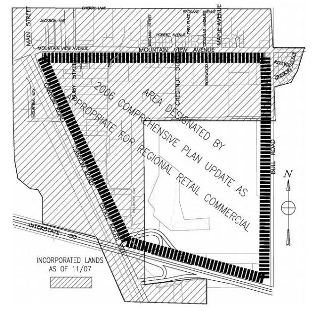
Figure 15.390.040(A). South interchange area.
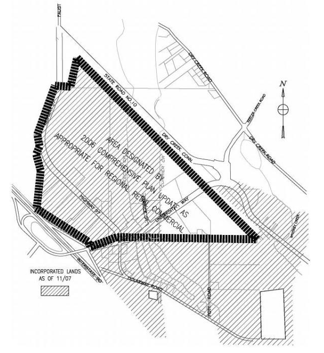
Figure 15.390.040(B). West interchange area.
2.
The site access, proposed on-site circulation and off-street parking meet all public works development standards, regional retail commercial design standards (chapter 15.390A ECC), and make adequate provision for roads, streets, alleys and other public ways. All streets, roads, sidewalks and other amenities shall be constructed as required by the city's public works development standards. The streets and sidewalks shall be suitable and adequate to handle anticipated traffic within the proposed regional retail commercial master site plan and in the vicinity of the development. Adequate access shall include at least three points of entrance onto the 40-acre project site, one of which must be from an arterial street, and two must be from different compass directions or sides of the property, or at least one street connection to each neighboring parcel.
3.
The regional retail commercial master site plan makes adequate provision for all public utilities, including, but not limited to, water, sanitary sewer, and stormwater drainage. The water and sanitary sewer facilities shall be suitable and adequate to provide service within the proposed regional retail commercial master site plan and in the vicinity of the development.
4.
The regional retail commercial master site plan is consistent with the city's comprehensive plan.
5.
The fire marshal and the building official have provided a recommendation demonstrating compliance with the applicable fire and building codes of the city.
6.
The perimeter of the regional retail commercial master site plan is compatible with the existing land use or properties that abut or are directly across the street from the subject property. Compatibility includes but is not limited to size, scale and mass.
7.
Each phase of the proposed regional retail commercial master site plan, as it is planned to be completed, contains the required parking spaces, open space, landscaping and utility area necessary for creating and sustaining a desirable and stable environment.
8.
Types of uses and development permitted. Uses defined as "regional retail commercial" development in ECC 15.130.180 are permitted as specified in ECC 15.390.030.
9.
The regional retail commercial master site plan and subsequent development shall comply with applicable project design provisions of chapter 15.390A ECC. Where there is a conflict between the provisions of chapter 15.390A ECC and this section, the provisions of this section shall apply.
E.
Phasing. An applicant may request that a development agreement be entered into with the city for development of the regional retail commercial master site plan to be phased over a period not to exceed ten years. In addition to the requirements for a development agreement in chapter 15.380 ECC, approval of any phased regional retail commercial master site plan shall include, but not be limited to, the following conditions:
1.
The proposed development contains a minimum of 100,000 square feet of enclosed gross floor area of commercial uses; provided, that at least 50,000 square feet must be constructed for and used by one retailer;
2.
In the first phase of the regional retail commercial master site plan, development of permitted uses other than regional retail commercial allowed in the C-T and C-H zones (such as hotel/motel, eating and drinking, office and other uses) are not subject to the minimum enclosed gross floor area requirement;
3.
The minimum enclosed gross floor area in the first phase may be satisfied by combining the gross floor area of separate buildings within the regional retail commercial master site plan, including buildings separated by a road; and
4.
There is no minimum size requirement for subsequent phases of development.
F.
Designation of regional retail commercial master site plans. The city council has designated the areas of the city which are eligible to develop with regional retail commercial projects in the comprehensive plan land use map and the comprehensive plan commercial land use policy statements. Modification of any boundaries or institution of any additional areas eligible for regional retail commercial projects shall follow the comprehensive plan amendment process.
(Ord. No. 4975, § 57, 11-17-2025; Ord. 4769 § 15, 2017)
15.390A.010 - Purpose.
To establish design criteria for the review and approval of master site plans for regional retail commercial projects pursuant to ECC 15.390.070(D)(9).
(Ord. 4769 § 16, 2017; Ord. 4656 § 1 (Exh. O2), 2013; Formerly 15.590.010)
15.390A.020 - Applicability.
The provisions herein apply to all master site plans for regional retail commercial projects pursuant to chapter 15.390 ECC and subsequent development activity within the master site plan area. Such master site plans and subsequent development are exempt from the standards in chapters 15.510 through 15.580 ECC unless otherwise noted herein.
(Ord. 4769 § 16, 2017; Ord. 4656 § 1 (Exh. O2), 2013; Formerly 15.590.020)
15.390A.030 - Site planning.
A.
Responding to the site characteristics.
1.
Develop the site plan in response to specific site characteristics, including natural features, vegetation, topography, or existing amenities and location within the community.
Design techniques:
a.
Commercial development should enhance valued neighborhood amenities such as stream corridors, trees and natural areas.
b.
Siting should acknowledge and reinforce desirable existing spatial patterns of the neighborhood.
2.
Coordinate adequate public services and utilities in the design phase to serve the proposed uses.
B.
Transitions to surrounding neighborhoods. Link proposed development to walkways, trails, and bicycle systems in the surrounding area by connecting and lining up directly to existing linkages, closing gaps and treating crossings of barriers on development site with special design treatment, minimizing barriers, designing with consistent materials, widths and locations, and providing safe, easy and clearly identifiable access to and along the linkages. Safe, convenient and attractive connections to downtown linkages should be provided.
C.
Streetscape compatibility. Develop the site plan in response to safety, interaction/activity, informal surveillance.
Design techniques:
1.
Ensure shared access and coordination of internal driveways and parking areas.
2.
Cooperate in a welcoming gateway to the city from interstate highways and incorporate directional signage to historic downtown and Central Washington University (subject to federal, state and local ordinances).
D.
Transitions to sidewalks, streets and buildings.
1.
Design of building massing, height, and scale should provide a sensitive transition to adjoining residential neighborhoods.
2.
New commercial developments, whose bulk and scale may negatively impact adjacent residential areas, should mitigate the effect through careful site planning and architectural design.
Design techniques: Possible mitigation techniques include:
a.
Locating open space on the site's edge to further separate the building from less intensive uses.
b.
Stepping down the massing of the building along the site's edge.
c.
Limiting length of, or articulating building facades to reflect adjacent residential patterns.
d.
Creative use of landscaping.
E.
Street frontages and building orientation. Orient the building toward the principal street frontage, and face the primary entrance toward that frontage.
Design techniques:
1.
Commercial architecture in Ellensburg has traditionally maintained a strong relationship to the street.
2.
Buildings in the mixed use retail and office park areas should abut the sidewalks on at least one side.
3.
Orienting the building's formal facade and primary entrance toward the principal street frontage creates pedestrian interaction, minimizes automobile dominance, and results in a lively streetscape.
4.
Avoid facing buildings to the side with the resultant erosion of the streetscape.
5.
Site entrances shall be emphasized with landscape treatments to strongly indicate the pedestrian orientation of these areas.
6.
Consideration should be given to the relationship between buildings and adjacent open space areas. All design should appear as an integrated part of an overall site plan.
7.
Roadways should be designed to reduce the visual impact of pavement area through siting of structures, berms and landscaping.
F.
Human activity.
1.
Design the project to human scale in order to provide pedestrian interest and facilitate pedestrian activity.
Design techniques:
a.
Use setback areas for pedestrian activities such as outdoor seating or dining, for a plaza or recessed entity, or for landscaping.
b.
Arcades, colonnades, or awnings at ground floor level provide pedestrian interest and can provide protection.
c.
Create clear and safe pedestrian pathways from the sidewalks to the building's entrance.
d.
Include public gathering spaces throughout the site, locating smaller retail buildings close to streets, and developing quality landscaping along street frontages.
e.
Appropriate pedestrian amenities could include benches, planters, decorative paving, artwork, lighting, and/or bicycle racks.
2.
The design should provide for a sense of enclosure and safety along commercial streets including the provision of sidewalks, benches, public transportation and a clear pedestrian and bicycle access to all buildings including both internal connections and linkages to city's planned and existing sidewalk and trail network.
3.
Column and bay spacing along street fronts should be provided at intervals no greater than 36 feet apart in order to maintain a pedestrian-oriented scale and rhythm.
G.
Respect for adjacent sites. Structures should be scaled to other structures and spaces.
H.
Phased developments.
1.
Future development pads shall be designed to relate to the rest of the project's architecture and will provide pedestrian-scale exterior features.
2.
Each phase of the development shall be designed to be consistent with, but not necessarily the same as, the balance of the project architecture, including materials, colors, and general style.
I.
Transition between uses and streetscape.
1.
Use open spaces to assist in the organization of architectural elements.
2.
Provide common garden elements and/or human activity focus points.
3.
Lessen the impact of parking by creating a prominent street front which is desirable for development attractiveness, public safety and pedestrian access.
(Ord. 4769 § 16, 2017; Ord. 4656 § 1 (Exh. O2), 2013; Formerly 15.590.030)
15.390A.040 - Landscaping and hardscape features.
A.
Reinforcing design continuity with neighboring and adjacent sites.
1.
Select plant materials that are suitable to the site and to Ellensburg's climate zone, and provide a viable stationary irrigation system.
Design techniques:
a.
Choice of plant materials and their placement on the site are critical to the valley's windy, semi-arid climate.
b.
Install a stationary irrigation system that provides full coverage of the landscaped area.
2.
Building entries, primary vehicular entries and building perimeters should be enhanced with landscaping which could include ornamental vines, groundcovers, shrubs and/or trees selected for their screening, canopy, spatial enclosure and seasonal variation.
3.
Benches, kiosks, signs, bollards, waste receptacles, street vending carts, water fountains, lighting standards, perch walls, sidewalks, pathways, trails and special water features should be designed to be compatible elements of like materials and design.
4.
Streetscape plantings should be simplified to allow adequate visibility from automobiles to businesses.
5.
The use of potted plants and flowers as well as street trees are encouraged, but should not impede pedestrian traffic.
6.
The landscape design character of Ellensburg should be reinforced by using:
Design techniques:
a.
Street trees. Ellensburg has a long-term "Tree City" designation. If a street has a uniform planting of street trees, or an area of distinctive species, plant additional street trees that match the planting pattern or species.
b.
Similar plant materials. When many lots on a block feature similar landscape materials, emphasis on these materials will help a new project fit into the local context.
c.
Similar construction materials textures, colors or elements. Extending a low brick wall, using paving similar to a neighboring use or employing similar stairway construction are ways to achieve design continuity.
7.
Use landscaping to integrate the commercial development with the community, through the establishment of sidewalks, street trees per city of Ellensburg street tree list, and street lighting.
Design techniques:
a.
Plant regularly spaced trees to shade the sidewalk and street, and consider the use of planters to create a safety barrier between street and sidewalk, or between sidewalk and setback.
b.
Utilize the city of Ellensburg's street tree list to select climate-appropriate species.
c.
Street lighting designs should reflect the scale of the neighborhood.
8.
Provide landscaping of appropriate scale in the area of the required setbacks, in conformance with city code.
Design techniques:
a.
Incorporate landscape materials into the design of setbacks to help define pedestrian spaces, circulation, and building access.
b.
Landscaping can be effectively used to denote property edges and to accent architectural elements of street facades.
c.
Use landscaping to soften the effect of blank walls.
B.
Landscaping to enhance a large commercial building and/or site.
1.
Enhance the site with landscaping.
Design techniques:
a.
Softening the form of the building by screening blank walls, terracing retaining walls, etc.
b.
Providing a framework such as a trellis or arbor for plants to grow on.
c.
Incorporating a planter guard or low planter wall as part of the architecture.
d.
Distinctively landscaping open areas created by building modulation.
e.
Incorporating upper story planter boxes or roof planters.
f.
Including a special feature such as a courtyard, fountain or pool.
g.
Emphasizing entries with special planting in conjunction with decorative paving and/or lighting.
h.
Screening a building from view by its neighbors, or an existing use from the new building.
2.
Screen dumpsters, utilities, and service areas from view with landscaping.
Design techniques:
a.
Where service elements cannot be located away from the street front, they should be screened from view and not encroach upon the pedestrian right-of-way.
b.
Use an effective combination of landscape materials with fencing to screen the service area, and locate its opening away from the sidewalk.
C.
Landscaping to address special site conditions.
1.
High bank front yard. Where the building's ground floor is elevated above a sidewalk pedestrian's eye level, landscaping can help make the transition between grades.
Design techniques:
a.
Rockeries with floral displays, live ground cover or shrubs.
b.
Terraces with floral displays, ground covers or shrubs.
c.
Low retaining walls with raised planting strips.
d.
Stone or brick masonry walls with vines or shrubs.
2.
Barrier-free access. Where wheelchair ramps must be provided on a street front, the ramp structure might include a planting strip on the sidewalk side of the elevated portions of the ramp.
3.
Steep banks or stream bed topography. Special plantings or erosion control measures may be necessary to prevent site destabilization and/or to enhance the visual qualities of the site in connection with neighboring improvement programs.
4.
Boulevards. Incorporate landscaping which reflects and reinforces the sense of streetscape.
5.
Greenbelt or other natural setting. Protect or preserve greenbelts and other settings by:
Design techniques:
a.
Minimizing the removal of significant trees.
b.
Replacing trees that were removed with new trees.
c.
Emphasizing naturalized or native landscape materials.
d.
Retaining natural greenbelt vegetation that contributes to greenbelt preservation.
e.
Selecting colors that are more appropriate to the natural setting.
(Ord. 4769 § 16, 2017; Ord. 4656 § 1 (Exh. O2), 2013; Formerly 15.590.040)
15.390A.050 - Parking lots and structures.
Reduce the visual impact of parking lots and parking structures.
A.
Parking—Surface.
1.
Where possible, break up or divide large parking lots. Employee and overflow parking may be located behind buildings and away from areas of high public visibility. Handicap stalls should be located throughout the development.
Design techniques:
a.
The relationship of building facade to the street, and safe pedestrian access to the building entrances, are of primary consideration in commercial development.
b.
Parking must not dominate the street front.
2.
Parking areas should include landscape areas. The size and location of parking areas should be minimized and related to the group of buildings served.
Design techniques:
a.
All parking lots visible from public rights-of-way, or located within 20 feet of residential property, should be screened using a combination of trees, shrubs, walls, and/or trellis structures with plants.
b.
Screening need not be sight-obscuring, and need not be uniform along the property frontage.
3.
Minimize long, straight, monotonous rows and effect of large paved areas by visually breaking up the parking lot with landscaped islands. Landscape islands shall be distributed throughout the parking lot at a rate of 24 square feet per stall.
4.
Landscaping shall be provided to screen surface parking areas and provide transition between the project and surrounding areas. Landscape and screen surface parking areas visible to the public.
5.
Pedestrian access from parking areas and vehicle circulation through parking areas should be safe and clearly defined.
6.
Landscaped medians are encouraged where access and traffic allow.
7.
Open space and landscaping should be coordinated and linked wherever possible, particularly in relation to public areas and the pedestrian system.
8.
Design and locate parking areas in a manner that will break up large areas of parking and provide for shared parking among businesses.
9.
Locate off-street parking to the rear or side of the building, whenever possible.
Design techniques:
a.
The site plan should minimize the number and width of driveways and curb cuts along the street and should consider alleyway access.
b.
Various parking lot configurations may be possible, depending upon site constraints; large lots may be broken into several smaller lots.
10.
Minimize the visual impact of parking surface run-off treatments, and incorporate them into landscaping where possible.
11.
Allow surface parking in front of large retail structures and anchor retailers but reduce visibility of parking from public streets with landscaping and the location of smaller structures.
B.
Parking structures.
1.
The presence and appearance of garage or large door entrances should be minimized so that they do not dominate the street or building frontage.
Design techniques:
a.
Recess the portion of the facade where the entry is located to help conceal it.
b.
Extend portions of the structure over the garage entry to help conceal it.
c.
Emphasize other elements of the facade to reduce the visual prominence of the garage entry.
2.
Structured parking should be designed to avoid undifferentiated planes. The scale of parking structures should be modulated by interruptions of the facades, setbacks, and lowering the first level below the existing grade (where the water table allows) to reduce total height.
3.
Facades of parking structures should include a landscape treatment in addition to architectural screening.
Design techniques:
Parking structures should have landscaping around the ground level perimeter and the top floor which will correspond to adjacent land uses and activities. Landscaping should include, but not be limited to, a combination of shade trees, evergreen trees, shrubs, groundcovers, deciduous native and ornamental shrubs, and vines to further screen the structures.
4.
Provide walkways in parking floors with barriers to protect pedestrians from vehicles.
Design techniques:
For security, pedestrian routes should be visible and avoid enclosed, hidden areas. Emergency call boxes should be available.
5.
Parking structures should be enclosed with retail or office uses on the exterior or where this enclosure is not feasible, the visual impact should be softened with landscaping or screening.
C.
Exterior lighting.
1.
An exterior lighting plan for the development area shall be provided and approved.
Design techniques:
a.
The plan should encourage nighttime pedestrian movement through and around the development area.
b.
Street lighting should relate in scale to the pedestrian characters of the area.
c.
The design of the light standards and luminaries should enhance the design theme.
d.
Exterior lighting installations shall be designed to avoid harsh contrasts in lighting levels.
2.
In order to direct light downward and minimize the amount of light spilled into the dark night sky, all lighting fixtures shall be full cut-off fixtures as defined by the Illuminating Engineering Society of North America (IESNA).
3.
Fixtures used to accent architectural features, materials, colors, styles of buildings or art shall be located, aimed and shielded so that light is directed only on those features. Such fixtures shall be aimed or shielded so as to minimize light spill into the dark night sky.
Design techniques:
a.
Lighting fixtures shall not generate excessive light levels, cause glare or direct light beyond the facade onto neighboring property, streets or the night sky.
b.
Flags of the United States or Washington State may be illuminated from below provided such lighting is focused primarily on the individual flag or flags so as to limit light trespass and spill into the dark night sky.
4.
Illumination of landscaping shall utilize diffused or muted lighting, avoid glare, and minimize light trespass and escape beyond landscaping onto neighboring property, streets, or the night sky.
Design techniques:
a.
Select plants that will not overgrow security lighting.
b.
Vegetation and landscaping shall be maintained in a manner that does not obstruct security lighting and minimizes possible entrapment spaces.
5.
Fuel service station and truck stop exterior lighting levels should be adequate to facilitate only the activities taking place in such locations.
Design techniques:
a.
Canopy light shall be fully recessed or fully shielded so as to ensure that no light source is visible from or causes glare on public rights-of-way or adjacent properties. Lights shall not be mounted on the top or sides of the canopy.
b.
Lighting shall not be used to attract attention to the business.
6.
Security lighting should be designed and used to discourage crime and undesirable activity.
Design techniques:
a.
Install full cut-off fixtures as defined by the Illuminating Engineering Society of North America (IESNA).
b.
Use the lowest possible illumination to effectively allow surveillance.
c.
Use sensor technologies, timers or other means to activate lighting during times when it will be needed to conserve energy, provide safety, and promote compatibility between different land uses.
d.
Aim lighting fixtures so that illumination is directed to the designated areas.
D.
Architectural design.
1.
Building height, bulk and scale.
a.
The height, bulk and scale of buildings should be compatible with one another in the development and with neighboring property buildings. Compatibility could be accomplished by:
Design techniques:
i.
Architectural context—the use of architectural style, details (such as roof lines or fenestration), color or materials that derive from neighboring uses.
ii.
The creative use of landscaping or other screening.
iii.
The location of features on-site to facilitate transition, such as locating required open space or the most compatible uses on the edge of the development area.
iv.
Treating topographic conditions in ways that minimize impacts on neighboring development, such as by using a rockery rather than a retaining wall to give a more human scale to a project, or stepping a project down a hillside.
2.
Architectural elements and materials.
a.
The building as an individual structure or as part of a series of buildings should respect architectural context of the development area.
Design techniques:
i.
Facade articulation.
ii.
Building scale and proportion.
iii.
Complementary architectural style.
iv.
Roof forms.
v.
Building details and fenestration patterns.
vi.
Complementary materials.
b.
Design roof lines to reflect traditional commercial roof configurations.
Design techniques:
i.
Commercial architecture in Ellensburg has traditionally included various roof forms, most often characterized by a decorative parapet wall;
ii.
Various roof configurations such as gabled, flat, or shed are possible behind the parapet wall; however, mansard roofs are not traditionally found in Ellensburg and their use is discouraged;
iii.
Avoid roof configurations which overly mimic residential styles;
c.
Rooftop utilities and mechanical systems should not be visible from the street; regional retail commercial project buildings have a building height limit of 50 feet which includes any building mechanical equipment.
d.
The roofline of buildings should be modulated to avoid the appearance of large areas of flat roof and should include interesting architectural features. Consideration should be given to the appearance.
e.
The scale of all structures in relationship to other structures and spaces is important. Multiple stories or the appearance of multiple stories may be used up to the maximum height limit. Some variation in heights contributes to the variety and complexity of the environmental experience, and is encouraged.
Design techniques:
Consider from among a wide range of wall treatments derived from traditional commercial architecture: pediments, cornice molding, cresting, or a stepped false-front design.
f.
Organize multi-story commercial building facades with three-part horizontal division and vertical column division.
g.
The ground floor of buildings should provide pedestrian interest and activity.
h.
Use traditional storefront components and proportions on the ground-floor levels of street-facing facades.
i.
Facade designs should include some contemporary translations of traditional commercial facade elements, such as:
Design techniques:
i.
Recessed entries.
ii.
Kick plates as bases.
iii.
Plate glass display windows, commercial in scale.
iv.
Transoms.
v.
Canopies, marquees, and awnings.
j.
Include windows on the second-floor levels of street-facing facades.
Design techniques:
i.
Second-story windows create an important rhythm of solid-to-void.
ii.
Alignment, proportions, and groupings of second-floor windows should relate to first-floor building elements.
iii.
Provide second-story windows with architectural detailing of appropriate scale.
k.
Modulate, or break up, blank street-facing walls over 40 feet in width with windows, artwork, recesses, columns, bands, textural treatment, landscaping, or a combination of these techniques.
l.
Avoid design features of incompatible scale such as:
Design techniques:
i.
Residential design features, such as wood-frame porches.
ii.
Blank second-story walls;
iii.
Box-like design, especially on large buildings.
3.
Architectural features.
a.
Give special architectural treatment to primary building entrances and corner entrances. Special attention should be given to architectural features, fenestration patterns, and the building's proportions.
Design techniques:
i.
Recessed entry.
ii.
Roof line emphasis.
iii.
Windows above entry.
iv.
Canopy, marquee, or awning above entry.
v.
Head molding or decorative lintel above doorway.
vi.
Contrasting, decorative finish materials.
vii.
Beveling.
viii.
Roof accentuation or height increase.
ix.
Sculptural relief.
x.
Landscape emphasis.
b.
Create building articulation by:
Design techniques:
i.
Modulating the facade by stepping back or extending forward a portion of the facade.
ii.
Repeating the window patterns at an interval that equals the articulation interval.
iii.
Providing features such as a marquee, patio, deck or covered entry.
iv.
Providing a balcony or bay window for each interval.
v.
Changing the roofline by alternating dormers, stepped roofs, gables or other roof elements to reinforce the modulation or articulation interval.
vi.
Changing the materials with a change in the building plane.
vii.
Providing a lighting fixture, trellis, tree or other landscape feature with each interval.
c.
Maintain a consistent architectural concept that reflects a human scale by:
Design techniques:
i.
Articulating the building's facades vertically and horizontally in intervals that conform to an existing structural pattern.
ii.
Utilizing recessed spaces at ground level.
iii.
Reducing the bulk of the main building by building upper floors.
iv.
Grouping in a campus setting.
v.
Limiting the length of, or otherwise modifying facades, to imply a group of smaller scale buildings.
vi.
Reducing or varying the height of the structure to imply a smaller scale building.
4.
Exterior finish material.
a.
Building exteriors should be constructed of durable and maintainable materials that are typically commercial in character. Exterior should be attractive even when viewed up close. Materials that have texture, pattern, or lend themselves to a high quality of detailing are encouraged.
b.
Commercial building materials and exterior finish typical to Ellensburg include:
Design techniques:
i.
Clear or painted wooden storefront ornamentation/fenestration.
ii.
Metal beaming and columns, decorative iron or visible metal exterior support structure which is incorporated into the building facade.
iii.
Brick work with pattern articulation, simple corbelling and accent materials.
iv.
Stone columns, fenestration, and accent combined with brick.
v.
Cement work that has embossed ornamentation, architectural accent or structural column division.
vi.
Ceramic and terra-cotta (pattern/relief molded), tile ornamentation or decorative panels.
vii.
Brick, stone, clay tile, and stucco.
viii.
Also acceptable are concrete, EIFS, and wood.
ix.
Varying patterns, textures, and combinations of materials and colors encouraged.
c.
Select exterior color schemes that are appropriate for large scale development and fall within a traditional commercial range (see color notebook on file at city).
d.
Building design must relate in material, colors, scale and form, which are harmonious with the surrounding environment.
e.
Buildings should be constructed of materials that minimize light reflection and glare.
f.
Green building practices or environmentally sensitive and innovative design and materials are encouraged and should comply with Leadership in Energy and Environmental Design (LEED) standards.
E.
Commercial signage. A sign plan shall be submitted with the design review application. The plan at a minimum shall show locations, dimensions and designs of the proposed signs. (Please refer to chapter 3.12 ECC, sign code, for sign regulations in the C-T and C-H zones and the Washington State Department of Transportation for state highway sign regulations).
(Ord. 4769 § 16, 2017; Ord. 4656 § 1 (Exh. O2), 2013; Formerly 15.590.050)
15.395.010 - Purpose.
The purpose of this chapter is to set forth the regulations for the placement, development, permitting, and removal of wireless communication facilities, including support structures and antennas. Among the purposes included are to:
A.
Minimize potential adverse visual, aesthetic and safety impacts of wireless communication facilities.
B.
Establish objective standards for the design and placement of wireless communication facilities.
C.
Ensure that such standards allow competition and do not unreasonably discriminate among providers of functionally equivalent services.
D.
To the extent possible, the design of such facilities shall be aesthetically and architecturally compatible with the surrounding built and natural environments where possible.
E.
To the extent possible, the location of large scale wireless communication support structures shall be in industrial, nonresidential mixed use and commercial areas outside of the historic districts.
F.
To the extent possible, the collocation or attachment of wireless communication antennas shall be on existing support structures to help minimize the total number and impact of such structures throughout the community.
(Ord. 4846 § 1, 2020)
15.395.020 - Definitions.
See ECC 11.41.020 for additional definitions for terms utilized in this chapter.
Antenna, antenna equipment, and antenna facility are defined in accordance with 47 CFR sections 1.6002(b), (c) and (d).
Antenna height means the vertical distance measured from average building elevation to the highest point of the antenna, or if on a rooftop or other structure, from the top of the roof or structure to the highest point of the antenna.
Antenna support structure means a freestanding structure or device specifically designed, constructed and/or erected to support a WCF antenna and may include, but is not limited to, a monopole or guy-wire support tower. Lattice towers are specifically prohibited. Antenna support structure does not include attachment support structures, nor a preexisting utility pole not built for the sole or primary purpose of supporting any Federal Communication Commission (FCC) licensed or authorized antenna.
Collocation, when used in the context of an eligible facilities request in chapter 11.80 ECC, means the mounting or installation of transmission equipment on an eligible support structure for the purpose of transmitting and/or receiving radio frequency signals for communication purposes. When used in the small wireless permitting process, "collocation" means mounting or installing an antenna facility on a preexisting structure and/or modifying a structure for the purpose of mounting or installing an antenna facility on that structure.
Equipment structure means a facility, shelter, cabinet or vault used to house and protect electronic or other associated equipment necessary for processing wireless communication signals. "Associated equipment" may include, for example, air conditioning, backup power supplies and emergency generators.
Macro facility means a wireless communication facility other than a small wireless facility.
Small wireless facilities are facilities that meet each of the following conditions:
1.
The facilities:
a.
Are mounted on structures 50 feet or less in height including their antennas as defined in 47 CFR Section 1.1320(d);
b.
Are mounted on structures no more than ten percent taller than other adjacent structures; or
c.
Do not extend existing structures on which they are located to a height of more than 50 feet or by more than ten percent, whichever is greater.
2.
Each antenna associated with the deployment, excluding associated antenna equipment (as defined in 47 CFR Section 1.1320(d)) is no more than three cubic feet in volume;
3.
All other wireless equipment associated with the structure, including the wireless equipment associated with the antenna and any preexisting associated equipment on the structure, is no more than 28 cubic feet in volume;
4.
The facilities do not require antenna structure registration under 47 CFR part 17;
5.
The facilities are not located on Tribal lands, as defined under 36 CFR section 800.16(x); and
6.
The facilities do not result in human exposure to radio frequency radiation in excess of the applicable safety standards specified in 47 CFR Section 1.1307(b).
Structure means a pole, tower, base station, or other building, whether or not it has an existing antenna facility, that is used or to be used for the provision of personal wireless service (whether or not on its own or commingled with other types of service).
Transmission equipment means equipment that facilitates transmission for any FCC-licensed or authorized wireless communication service, including, but not limited to, radio transceivers, antennas, coaxial or fiber-optic cable, and regular and backup power supply. The term includes equipment associated with wireless communication services including, but not limited to, private, broadcast, and public safety services, as well as unlicensed wireless services and fixed wireless services such as microwave backhaul.
Unified enclosure means a small wireless facility providing concealment of antennas and equipment within a single enclosure.
Utility pole means a structure designed and used primarily for the support of electrical wires, telephone wires, television cable, traffic signals, or lighting for streets, parking areas, or pedestrian paths.
Wireless communication facilities (WCF) means an unstaffed facility for the transmission and/or reception of radio frequency (RF), microwave or other signals for commercial communications purposes, typically consisting of one or more antennas, an antenna support structure or attachment support structure, and an equipment enclosure.
(Ord. 4846 § 1, 2020)
15.395.030 - General provisions.
A.
Wireless telecommunication facilities shall not be considered nor regulated as essential public facilities.
B.
Wireless telecommunication facilities located outside of the public right-of-way may be either a primary or a secondary use. A different use of an existing structure on the same lot shall not preclude the installation of a wireless telecommunication facility.
(Ord. 4846 § 1, 2020)
15.395.040 - Applicability.
A.
Wireless telecommunication facilities shall be permitted as established in the underlying zoning district use table; provided, however, that small wireless facilities located pursuant to a valid small wireless facility permit are outright permitted uses in every zone of the city.
B.
The following are exempt from the provisions of this chapter:
1.
Wireless communication facilities utilized by a governmental agency for governmental purposes and not for resale or lease to the public within its area of jurisdiction.
2.
Amateur radio towers and antenna arrays to the full extent necessary to entitle the holder of the license to utilize the rights granted by the Federal Communications Commission; provided, that this exemption applies only if an antenna and supporting structure are greater than 35 feet in height in order for the full enjoyment of licensed activity and is of a telescoping or crank-up configuration and which, when not in use, is fully retracted to a level at or below 35 feet in height.
3.
Television antennas, television dish antenna array and similar small-scale communication antenna array less than ten feet in height when measured from its base.
(Ord. 4846 § 1, 2020)
15.395.050 - Location considerations.
The location priority for new wireless telecommunication facilities shall be in the following order:
A.
In all zoning districts, collocate on existing wireless telecommunication facilities.
B.
In all zoning districts, collocate antennas on utility structures (i.e. power poles), or other existing buildings and structures, such as water towers.
C.
Place new wireless telecommunication facilities in districts zoned for industrial or nonresidential mixed use.
D.
Place new wireless communication facilities in the public reserve zone.
E.
Place within residential zoning districts only when collocating or an applicant has proven that denial of the location would be a prohibition or effective prohibition of telecommunications services in violation of 47 U.S.C. §§ 253 and 332.
F.
Place within the historic districts as a last resort only when no other site is available, and denial of the location would be a prohibition of telecommunications services in violation of 47 U.S.C. §§ 253 and 332.
(Ord. 4846 § 1, 2020)
15.395.060 - Application requirements.
In addition to other applicable requirements established by ordinance or rule for any other approval or permit consolidated with an application for review, applications shall include the following:
A.
Site and landscape plans drawn to scale, including the location of existing structures, trees, and other significant site features; proposed color of the facility; method of fencing; finished color and, if applicable, the method of camouflage and illumination.
B.
A report including description of the facility with technical aspects for its design.
C.
Documentation establishing the structural integrity for the facility's proposed use.
D.
The general capacity of the tower and information necessary to assure that ANSI standards are met.
E.
A statement of intent on whether the excess space on the facility will be leased.
F.
Proof of ownership of the proposed site or authorization to utilize it.
G.
Copies of any easements necessary.
H.
An analysis of the area containing existing topographical contours.
I.
Photo simulations of the proposed facility from affected properties and public rights-of-way.
(Ord. 4846 § 1, 2020)
15.395.070 - Development standards for wireless communication facilities other than small wireless facilities.
A.
Landscaping and screening.
1.
In all zones, equipment shelters, cabinets and other on-the-ground ancillary equipment shall be constructed with a use separation buffer of a minimum of 20 feet in residential zones and ten feet in all other zones. The director or his/her designee may increase the width of this buffer if it is determined additional buffering is necessary to further mitigate the impact of the ground equipment. Further, the buffer shall be contained in a recorded easement.
2.
Fencing shall be required around the ground facilities and be located within the required separation buffer. The fence shall be constructed in accordance with the requirements of ECC 15.320.120.
3.
In residential zones, and in other zones where the wireless telecommunication facility is within 300 feet of a residential zone, the ground level view of support structures shall be mitigated by the retention of existing trees with sufficient height that will provide a functional screen of a substantial portion of the facility. Additional landscaping and screening may be required by the director or his/her designee to mitigate the visual impact of the ground level view of the support structure if the existing trees do not provide an adequate functional screen or if no trees are on the subject site to provide the functional screen. A street tree permit is required per ECC 4.36.300 for any planting, removal, topping, and/or major pruning of street trees. Existing trees on adjacent properties or within right-of-way cannot be utilized to meet this requirement.
B.
Visual impact.
1.
Wireless communication facilities shall be camouflaged by employing the best available concealment technology. This may be accomplished by use of compatible materials, location, color, stealth technologies, and/or other strategies to minimize visibility of the facility as viewed from public streets or residential properties to the maximum extent feasible and consistent with the technology and intended use of the facility. When attached to an existing building, the wireless telecommunication facility shall be placed and colored so as to blend into the architectural detail and coloring of the structure.
2.
A visual impact analysis shall be required when a new wireless telecommunication facility is proposed to be located within a residential zone or within 300 feet of a residential zone, or if the facility is anticipated to constitute more than a moderate visual impact as described above. The impact analysis will be accomplished through:
a.
Erection of a crane;
b.
A balloon (of a size not less than four feet); or
c.
Similar device used to simulate the proposed dimensions and height of the structure.
3.
Ten working days prior to the demonstration, the applicant shall notify the city and provide a courtesy informational notice to properties within 300 feet of the subject site upon which the visual impact test will be conducted. The potential impact shall be documented through submittal of maps, photographs, photo-simulation, and other appropriate methods.
4.
Ground-mounted equipment cabinets shall meet all applicable standards relating to sight triangle and sight visibility to ensure these facilities do not obstruct or affect vehicular or pedestrian traffic.
C.
Color and lighting.
1.
Wireless telecommunication facilities shall be painted in a nonreflective color that best allows them to blend into the surroundings.
2.
Flashing red, solid red, or white strobe lighting shall not be allowed on any support structure except those included in permanent 911 public safety communication facilities, located at ground elevations above 700 feet, and more than one-half mile from any residential zone. Any structure subsequently determined by the Federal Aviation Administration (FAA) to require flashing red, solid red, or white strobe lighting shall be altered to avoid the lighting requirements.
3.
Appropriately down-shielded security lighting which is directed away from adjoining properties is permitted for the equipment shelters, cabinets, and/or other ground ancillary equipment. No more than one foot-candle of illumination may leave the property boundaries.
D.
Electromagnetic field/radio frequency radiation standards. The applicant shall provide certification by a qualified radio frequency (RF) engineer that installation of wireless telecommunication facilities will conform to the standards required by the FCC regulations and the Telecommunication Act of 1996.
E.
Collocation of facilities. All new wireless telecommunication facilities shall be designed to accommodate collocation of at least two additional carriers. Further, an approved wireless telecommunication provider cannot deny a wireless provider the ability to collocate on an approved facility at a fair market value or at another cost agreed to by the affected parties.
F.
Discontinuation of use. Any wireless telecommunication facility that is no longer needed and its use is discontinued shall be reported immediately by the service provider to the city. Discontinued facilities shall be completely removed by the service provider or the property owner within six months from the time of discontinuance.
G.
Small wireless facilities. Small wireless facilities are regulated pursuant to chapter 11.70 ECC and ECC 15.395.090 et seq.
(Ord. 4846 § 1, 2020)
15.395.080 - Administrative use findings.
In addition to the requirements in ECC 15.395.050, the following findings relative to wireless telecommunication facilities are hereby required:
A.
The proposed wireless telecommunication facility and ground facilities have been reviewed appropriately, have satisfied all the provisions of this chapter and any negative aesthetic impacts have been adequately mitigated.
B.
Failure to approve any proposed significant deviation from aesthetic standards established by this chapter would have the effect of effectively prohibiting the provider from providing telecommunication service in violation of 47 U.S.C. §§ 253 and 332.
C.
In applying these criteria, the director shall not interpret and apply them in a manner which dictates use of a particular technology. When strict application of these requirements would unreasonably impair the function of the technology chosen by the applicant, alternative forms of concealment or deployment may be permitted which provide similar or greater protection of the visual environment.
(Ord. 4846 § 1, 2020)
15.395.090 - Aesthetic design and concealment standards for small wireless facilities deployments.
Small wireless facilities deployments permitted pursuant to chapter 11.70 ECC shall conform to the following aesthetic design and concealment standards:
A.
Small wireless facilities attached to nonwooden poles. Small wireless facilities attached to existing or replacement nonwooden light poles and other nonwooden poles in the right-of-way or poles outside of the right-of-way shall conform to the following design criteria:
1.
Antennas and the associated equipment enclosures shall be sited and installed in a manner which minimizes the visual impact on the streetscape either by fully concealing the antennas and associated equipment fully within the pole or through a concealment element plan which provides an equivalent or greater impact reduction. This requirement shall be applied in a manner which does not dictate the technology employed by the service provider nor unreasonably impair the technological performance of the equipment chosen by the service provider.
2.
All conduit, cables, wires and fiber must be routed internally in the light pole. To the full extent technically feasible, full concealment of all conduit, cables, wires and fiber is required within mounting brackets, shrouds, canisters or sleeves if attaching to exterior antennas or equipment.
3.
An antenna on top of an existing pole may not extend more than six feet above the height of the existing pole and the diameter may not exceed 16 inches, measured at the top of the pole, unless the applicant can demonstrate that more space is needed. The antennas shall be integrated into the pole design so that it appears as a continuation of the original pole, including colored or painted to match the pole, and shall be shrouded or screened to blend with the pole except for canister antennas which shall not require screening. All cabling and mounting hardware/brackets from the bottom of the antenna to the top of the pole shall be fully concealed and integrated with the pole.
4.
Any replacement pole shall substantially conform to the design of the pole it is replacing or the neighboring pole design standards utilized within the contiguous right-of-way.
5.
The height of any replacement pole may not extend more than ten feet above the height of the existing pole or the minimum additional height necessary for adequate clearance from electrical wires, whichever is greater.
6.
The diameter of a replacement pole shall comply with the city's setback and sidewalk clearance requirements, Americans with Disabilities (ADA) requirements, and if a replacement light standard then with the city's lighting requirements.
7.
The use of the pole for the siting of a small wireless facility shall be considered secondary to the primary function of the pole. If the primary function of a pole serving as the host site for a small wireless facility becomes unnecessary, the pole shall not be retained for the sole purpose of accommodating the small wireless facility and the small wireless facility and all associated equipment shall be removed.
B.
Wooden pole design standards. Small wireless facilities located on wooden poles shall conform to the following design criteria:
1.
The wooden pole at the proposed location may be replaced with a taller pole for the purpose of accommodating a small wireless facility; provided, that the replacement pole shall not exceed a height that is a maximum of ten feet taller than the existing pole, unless a further height increase is required and permission is confirmed in writing by the pole owner and that such height extension is the minimum extension possible to provide sufficient separation and/or clearance from electrical and wireline facilities.
2.
A pole extender may be used instead of replacing an existing pole but may not increase the height of the existing pole by more than ten feet unless a further height increase is required and permission is confirmed in writing by the pole owner and that such height increase is the minimum extension possible to provide sufficient separation and/or clearance from electrical and wireline facilities. A "pole extender" as used herein is an object affixed between the pole and the antenna for the purpose of increasing the height of the antenna above the pole. The pole extender shall be painted to approximately match the color of the pole and shall substantially match the diameter of the pole measured at the top of the pole.
3.
Replacement wooden poles may either match the approximate color and materials of the replaced pole or shall be the standard new wooden pole used by the pole owner in the city.
4.
Antennas, equipment enclosures, and all ancillary equipment, boxes and conduit shall be colored or painted to match the approximate color of the surface of the wooden pole on which they are attached.
5.
Panel antennas shall not be mounted more than 12 inches from the surface of the wooden pole.
6.
Antennas should be placed in an effort to minimize visual clutter and obtrusiveness. Multiple antennas are permitted on a wooden pole; provided, that each antenna enclosure shall not be more than three cubic feet in volume.
7.
A canister antenna may be mounted on top of an existing wooden pole, which may not exceed the height requirements described in subsection (B)(1) of this section, unless a greater height is required to meet the technical requirements of the facility; provided, that such greater height shall not exceed the minimum necessary to meet the technical need and requirements. A canister antenna mounted on the top of a wooden pole shall not exceed 16 inches, measured at the top of the pole, and shall be colored or painted to match the pole. The canister antenna must be placed to look as if it is an extension of the pole. In the alternative, the applicant may propose a side-mounted canister antenna, so long as the inside edge of the antenna is no more than 20 inches from the surface of the wooden pole. All cables shall be concealed either within the canister antenna or within a sleeve between the antenna and the wooden pole.
8.
An omni-directional antenna may be mounted on the top of an existing wooden pole, provided such antenna is no more than four feet in height and is mounted directly on the top of a pole or attached to a sleeve made to look like the exterior of the pole as close to the top of the pole as technically feasible. All cables shall be concealed within the sleeve between the bottom of the antenna and the mounting bracket.
9.
All related equipment, including but not limited to ancillary equipment, radios, cables, associated shrouding, microwaves, and conduit, which is mounted on wooden poles shall not be mounted more than six inches from the surface of the pole, unless a further distance is technically required, and is confirmed in writing by the pole owner.
10.
Equipment for small wireless facilities must be attached to the wooden pole, unless otherwise permitted to be ground mounted pursuant to subsection (D)(5) of this section. The equipment must be placed in the smallest enclosure possible for the intended purpose. The equipment enclosure and all other wireless equipment associated with the antenna and any preexisting associated equipment on the pole may not exceed 28 cubic feet in total volume. The applicant is encouraged to place the equipment enclosure behind any banners or road signs that may be on the pole if such banners or road signs are allowed by the pole owner.
11.
An applicant who desires to enclose its antennas and equipment within a unified enclosure may do so, so long as the facility meets the volumetric requirements of a small wireless facility. To the extent possible, the unified enclosure shall be placed so as to appear as an integrated part of the pole or behind banners or signs. The unified enclosure may not be placed more than 20 inches from the surface of the pole unless a further distance is technically required and confirmed in writing by the pole owner.
12.
The visual effect of the small wireless facility on all other aspects of the appearance of the wooden pole shall be minimized to the greatest extent possible.
13.
The use of the wooden pole for the siting of a small wireless facility shall be considered secondary to the primary function of the pole. If the primary function of a pole serving as the host site for a small wireless facility becomes unnecessary, the pole shall not be retained for the sole purpose of accommodating the small wireless facility and the small wireless facility and all associated equipment shall be removed unless retention of the pole is necessary to prevent an effective prohibition of service.
14.
All cables and wires shall be routed through conduit along the outside of the pole. The outside conduit shall be colored or painted to match the pole. The number of conduit shall be minimized to the number technically necessary to accommodate the small wireless facility.
C.
Small wireless facilities attached to existing buildings. Small wireless facilities attached to existing buildings shall conform to the following design criteria:
1.
Small wireless facilities may be mounted to the sides of a building if the antennas do not interrupt the building's architectural theme.
2.
The interruption of architectural lines or horizontal or vertical reveals is discouraged.
3.
New architectural features such as columns, pilasters, corbels, or other ornamentation that conceal antennas may be used if it complements the architecture of the existing building.
4.
Small wireless facilities shall utilize the smallest mounting brackets necessary in order to provide the smallest offset from the building.
5.
Skirts or shrouds shall be utilized on the sides and bottoms of antennas in order to conceal mounting hardware, create a cleaner appearance, and minimize the visual impact of the antennas. Exposed cabling/wiring is prohibited.
6.
Small wireless facilities shall be painted and textured to match the adjacent building surfaces.
7.
Upon review by city staff, it may be determined that an application for a small wireless facility proposing to locate on an individually landmarked structure, or on a structure within a historic district, may also meet the criteria in chapter 15.280 ECC requiring an application for a certificate of appropriateness (a Type II review process) from the landmarks and design commission.
D.
Strand-mounting. Small wireless facilities mounted on cables strung between existing utility poles shall conform to the following standards:
1.
Each strand-mounted facility shall not exceed three cubic feet in volume;
2.
Only one strand-mounted facility is permitted per cable between any two existing poles on existing cable;
3.
The strand-mounted devices shall be placed as close as possible to the nearest utility pole, in no event more than five feet from the pole unless a greater distance is technically necessary or is required by the pole owner for safety clearance;
4.
No strand-mounted device shall be located in or above the portion of the roadway open to vehicular traffic;
5.
Ground-mounted equipment to accommodate a shared mounted facility is not permitted except when placed in preexisting equipment cabinets;
6.
Pole-mounted equipment shall comply with the requirements of subsection (B) of this section and this subsection (D); and
7.
Such strand-mounted devices must be installed to cause the least visual impact and without excess exterior cabling or wires (other than the original strand).
E.
General requirements.
1.
Ground-mounted equipment in the rights-of-way is prohibited, unless such facilities are placed underground or the applicant can demonstrate that pole-mounted or undergrounded equipment is technically infeasible. If ground-mounted equipment is necessary, then the applicant shall submit a concealment element plan. Generators are prohibited on the public rights-of-way.
2.
No equipment shall be operated so as to produce noise in violation of chapter 5.60 ECC.
3.
Small wireless facilities are not permitted on traffic signal poles unless denial of the siting could be a prohibition or effective prohibition of the applicant's ability to provide telecommunications service in violation of 47 U.S.C. §§ 253 and 332.
4.
Replacement poles and new poles shall comply with the ADA, city construction and sidewalk clearance standards, and state and federal regulations in order to provide a clear and safe passage within the rights-of-way.
5.
Replacement poles shall be located as near as possible to the existing pole with the requirement to remove the abandoned pole at the applicant's cost.
6.
The design criteria as applicable to small wireless facilities described herein shall be considered concealment elements and such small wireless facilities may only be expanded upon an eligible facilities request described in chapter 11.80 ECC, when the modification does not defeat the concealment elements of the facility.
7.
No signage, message or identification other than the manufacturer's identification or identification required by governing law is allowed to be portrayed on any antenna, and any such signage on equipment enclosures shall be of the minimum amount possible to achieve the intended purpose and in conformance to the public works development standards for small wireless facilities.
8.
Antennas and related equipment shall not be illuminated except for security reasons, required by a federal or state authority, or unless approved as part of a concealment element plan.
9.
Side arm mounts for antennas or equipment are prohibited. No antenna, antenna equipment or equipment box may extend more than 20 inches from the face of the pole or support structure.
10.
The preferred location of a small wireless facility on a pole is the location with the least visible impact.
11.
Antennas, equipment enclosures, and ancillary equipment, conduit and cable shall not dominate the building or pole upon which they are attached.
12.
The city may consider the cumulative visual effects of small wireless facilities mounted on poles within the right-of-way when assessing proposed siting locations so as to not adversely affect the visual character of the city. This provision shall not be applied to limit the number of permits issued when no alternative sites are reasonably available nor to impose a technological requirement on the service provider.
13.
These design standards are intended to be used solely for the purpose of concealment and siting. Nothing herein shall be interpreted or applied in a manner which dictates the use of a particular technology. When strict application of these requirements would unreasonably impair the function of the technology chosen by the applicant, alternative forms of concealment or deployment may be permitted which provide similar or greater protections from negative visual impacts to the streetscape.
F.
New poles in the rights-of-way for small wireless facilities and installations in the historic districts.
1.
New poles within the rights-of-way are only permitted if the applicant can establish that:
a.
The proposed small wireless facility cannot be located on an existing utility pole or light pole in an alley, electrical transmission tower or on a site outside of the public rights-of-way such as a public park, public property, building, transmission tower or in or on a nonresidential use in a residential zone whether by roof or panel-mount or separate structure;
b.
The proposed wireless communication facility receives approval for a concealment element design, as described in subsection (F)(3) of this section;
c.
The proposed wireless communication facility also complies with SEPA, if applicable; and
d.
No new poles shall be located in a critical area or associated buffer required by the city's critical areas ordinance (division VI of this title), except when determined to be exempt pursuant to said ordinance.
2.
An application for a new pole in the right-of-way is subject to an administrative use permit Type I review.
3.
The concealment element design shall include the design of the screening, fencing or other concealment technology for a tower, pole, or equipment structure, and all related transmission equipment or facilities associated with the proposed wireless communication facility, including but not limited to fiber and power connections, and subject to the following additional requirements:
a.
The concealment element design should seek to minimize the visual obtrusiveness of wireless communication facility installations. The proposed pole or structure should have similar designs to existing neighboring poles in the rights-of-way, including to the extent technically feasible similar height. Other concealment methods include, but are not limited to, integrating the installation with architectural features or building design components, utilization of coverings or concealment devices of similar material, color and texture—or the appearance thereof—as the surface against which the installation will be seen or on which it will be installed, landscape design, or other camouflage strategies appropriate for the type of installation. Applicants are required to utilize designs in which all conduit and wirelines are installed internally in the structure or otherwise integrated into the design of the structure. Use of a unified enclosure equal to or less than four cubic feet in volume may be permitted in meeting these criteria.
b.
If the director has already approved a concealment element design either for the applicant or another wireless communication facility along the same public right-of-way or for the same pole type, then the applicant shall utilize a substantially similar concealment element design, unless it can show that such concealment element design is not physically or technologically feasible, or that such deployment would undermine the generally applicable design standards.
4.
Even if an alternative location is established pursuant to subsection (F)(1)(a) of this section, the conditional use permit process may determine that a new pole in the right-of-way is in fact a superior alternative based on the impact to the city, the concealment element design, the city's comprehensive plan and the added benefits to the community.
5.
Prior to the issuance of a permit to construct a new pole or ground-mounted equipment in the right-of-way, the applicant must obtain a site-specific agreement from the city to locate such new pole or ground-mounted equipment. This requirement also applies to replacement poles that are higher than the replaced pole, and the overall height of the replacement pole and the proposed wireless communication facility is more than 50 feet.
6.
Installation of small wireless facilities in the historic districts shall be permitted by an administrative approval of a concealment plan utilizing the design and concealment standards contained in this chapter.
7.
These design standards are intended to be used solely for the purpose of concealment and siting. Nothing herein shall be interpreted or applied in a manner which dictates the use of a particular technology. When strict application of these requirements would unreasonably impair the function of the technology chosen by the applicant or effectively prohibit service, alternative forms of concealment or deployment may be permitted which provide similar or greater protections of the streetscape.
(Ord. 4846 § 1, 2020)
15.395.100 - Independent technical review of wireless communication facilities applications.
The city may retain the services of an independent technical expert of its choice to provide technical evaluation of permit applications for WCFs. The applicant shall pay all the costs of said review. Such third-party expert review is intended to be a site-specific review of technical aspects of the WCF permit application and not a subjective review of the WCF proposal. The city reviewing authority shall consider the request when imposing conditions on approval. Nothing herein shall be interpreted to permit regulation of radio frequency emissions or interference to limit or dictate the applicant's technological choices.
(Ord. 4846 § 1, 2020)
15.395.110 - Wireless communication facilities removal.
A.
Owners and operators of wireless communication facilities shall provide the director with copies of any notice of intent to cease operations provided to the Federal Communications Commission.
B.
Any antenna support structure that has not been mounted with an antenna for a period of 180 successive days, or if the antennas mounted on an antenna support structure are not operated for a period of 180 successive days, the antenna support structure shall be considered abandoned. The owner shall remove such structure and any accompanying equipment enclosure within 90 days after receipt of notice from the city to do so. If an abandoned structure and equipment enclosure are not removed in a timely manner, the city may seek and obtain a court order directing such removal and imposing a lien upon the equipment and/or the real property upon which such structures are situated in an amount equal to the cost of removal. Any notice given under this section is subject to an open record appeal to the hearing examiner. In the event that more than one wireless communication service provider is using the support structure, then the lien on the real property shall not become effective until all users cease use of the antenna support structure.
C.
Removal upon undergrounding. A wireless communication facility shall be removed at the owner's expense if collocated on a utility support structure that is subsequently undergrounded. No utility support structure may be maintained for the sole purpose of supporting a wireless communication facility unless an administrative use permit is obtained as provided herein or pursuant to ECC 15.395.080. Retention of the utility support structure shall be based upon a showing that no other support structure is reasonably available, and retention of the utility support structure is required to prevent an effective prohibition of service.
(Ord. 4846 § 1, 2020)
15.395.120 - Appeals.
Wireless communication facilities permit decisions other than administrative approvals relating to small wireless permits and eligible facilities requests are final Type III decisions. Approvals relating to small wireless facilities and eligible facilities requests are Type I administrative approvals and are not subject to administrative appeal. Appeal of a hearing examiner decision shall proceed directly to Kittitas County Superior Court. The timely filing of an appeal of a wireless communication facility permit decision shall stay the effective date of the decision until such time as the appeal is concluded or withdrawn.
(Ord. 4846 § 1, 2020)