
Emigration Canyon City Zoning Code
CHAPTER 19
73 FOOTHILLS AND CANYONS SITE DEVELOPMENT AND DESIGN STANDARDS
19.73.010 Purpose And Intent
- The general purpose of these standards is to promote development that will balance the rights of the landowner with protection of the county's sensitive lands, especially its irreplaceable foothill and canyon environments. Many of these standards are broad in nature to allow flexibility in design so development can be evaluated on a site by site basis, while insuring that development will be compatible with the natural landscape, and consistent with the public welfare.
- The development standards contained herein are intended specifically to accomplish the following purposes:
- Preserve and enhance the beauty of the landscape by encouraging the maximum retention of natural topographic features, such as drainage swales, streams, slopes, ridge lines, rock outcroppings, vistas, natural plant formations, trees, and similar features;
- Encouraging planning, design, and development of building sites in a manner that provides the maximum in safety and enjoyment while adapting development to, and taking advantage of, the best use of natural terrain;
- Establish a foundation for development in sensitive lands to insure a more harmonious relationship between man-made structures and the natural setting;
- Direct new development in the canyons and foothills toward areas meeting suitability criteria as outlined in the Wasatch Canyons general plan suitability analysis, and other applicable general or community plans.
(Ord. 1473 (part), 2001: Ord. 1417 § 3 (part), 1998)
19.73.020 Using This Chapter
The development and design standards set forth in this chapter fall into two categories:
- Mandatory standards, which are identified by a "+" notation in the left-hand margin; and
- Advisory standards that are strongly encouraged, but not mandatory, which are identified by a "o" in the left-hand margin.
Subdivisions and development subject to this chapter shall comply with all of the "+" standards and shall attempt to incorporate, to the extent feasible or practical, all of the "o" standards.
(Ord. 1417 § 3 (part), 1998)
19.73.030 Site Selection And Planning Standards
- To the maximum extent feasible, match the development program to the available land on the site:
+ 1. A site shall be selected that is suitable for the type of building or use being planned without major alterations to the site. o 2. The minimum and maximum slope gradients that can work with each type of land use in the development program shall be considered. Compare the amount of land needed for the program with the amount of buildable land on the site. Select a site that best suits the type of building or use recognizing the particular opportunities and disadvantages of the site. + 3. Avoid sites that show evidence of slope instability, landslides, avalanche, flooding, or other natural or man-made hazards. (See Chapters 19.75, "Natural Hazard Areas," and 19.74, "Floodplain Hazard Regulations.") - Site buildings in a manner that preserves existing land forms (See Figure 1.):
o 1. Each building shall be located so that it does not dominate the site. + 2. To the maximum extent feasible, the most prominent areas of the site shall be left in their natural condition. Structures shall be screened using existing land forms and vegetation. (See Section 19.72.030H, "Tree and Vegetation Protection.") + 3. To the maximum extent feasible, buildings should be placed in the following locations on a site: a. Within tree masses to screen buildings; b. At the edge of trees or land masses overlooking open space; or c. In open areas where they are not visible from roads, trails, or other public lands.
Figure 1. Canyon Foothill continues to serve as a visual element in the site and surrounding areas.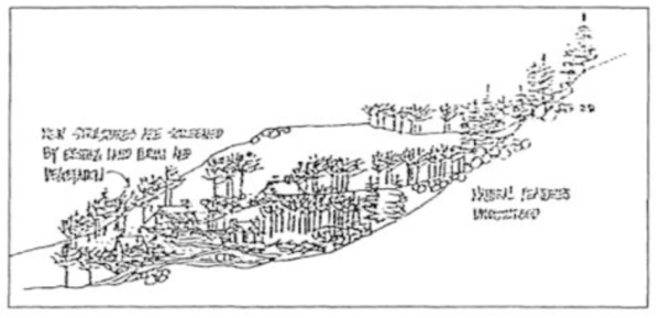
- Site buildings in a manner that preserves significant views (See Figure 2.):
o 1. Buildings should be designed to fit their sites and to leave natural massing and features of the landscape intact. Treat each building as an integral part of the site rather than an isolated object at odds with its surroundings. + 2. To the maximum extent feasible, views both to the site and to features beyond, as seen from public rights-of-way, trails, and other public lands, shall be maintained. To the maximum extent feasible, new construction shall not dominate views or obscure the views of others.
Figure 2. Site buildings in a manner that preserves significant views.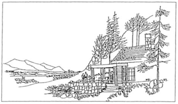
- Site buildings so their form does not break prominent skylines (See Figure 3.):
+ 1. Buildings shall be sited off of highly visible places and designed so they are not obtrusive, do not loom out over the hillside, and do not break prominent skylines. Skylines are ridges or hilltops that do not have backdrops behind them. Heavily traveled roads or public areas are key vantage points.
Figure 3. NO: Site structures so their form does not break prominent skylines.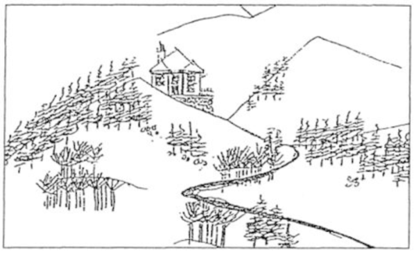
- Site buildings in a manner that preserves significant trees and vegetation (See Figure 4.):
+ 1. The building shall be sited in a place where a minimum amount of trees and vegetation will need to be removed. (See Section 19.72.040, "Establishment of limits of disturbance.") + 2. New construction shall comply with Section 19.72.030H, "Tree and Vegetation Protection," and Section 19.73.060 of this chapter, "Landscaping and Vegetation."
Figure 4. Site buildings in a manner that preserves significant vegetation.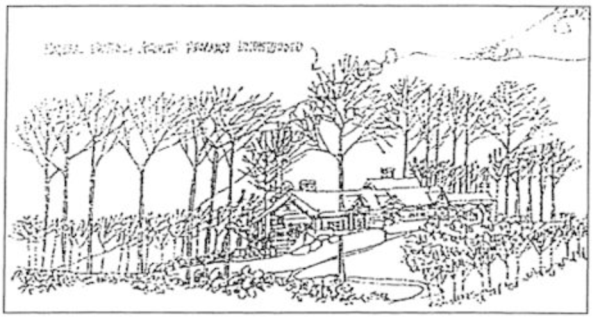
- Cluster buildings and parking, and coordinate neighboring developments (See Figures 5 and 6.):
o 1. Clustering is encouraged to reduce the amount of land being disturbed and to share the cost of providing services, road and parking area maintenance, snow removal, etc. (See Section 19.73.090, "Access, circulation and off-street parking" of this chapter.) o 2. Cooperation among adjoining land owners to achieve coordinated development is strongly encouraged. For example, clustering buildings and combining or sharing services into a central location reduces the number of access roads and parking areas within a site.
Figure 5. Cluster residential buildings and driveways to minimize disruption of natural features.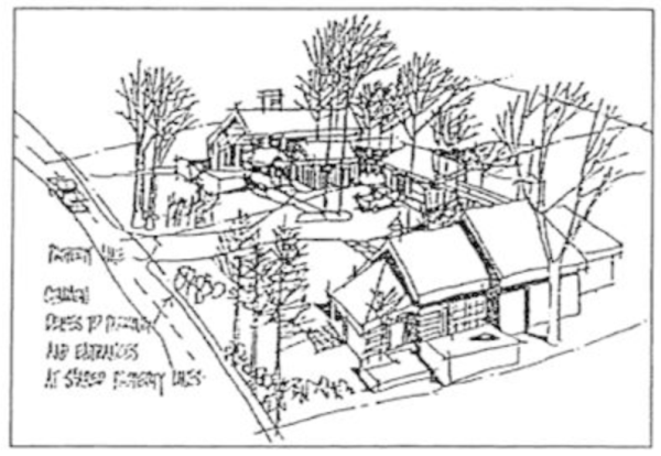
Figure 6. Cluster businesses and access drive to minimize disruption of natural features.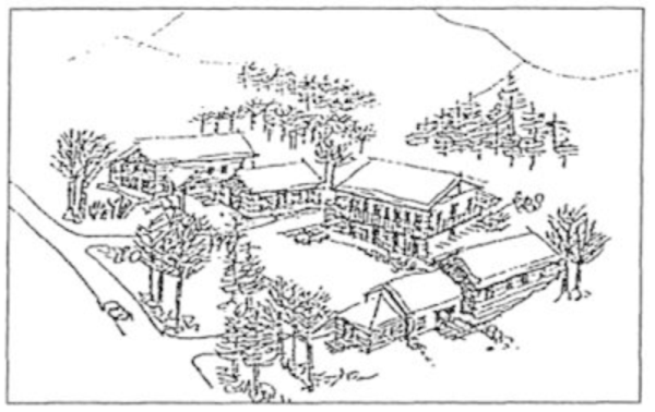
- Locate parking facilities to minimize their visual impact (See Figure 7.):
+ 1. Parking facilities shall be located so that they can be screened to blend into the natural environment and will not require backing onto a public street. (See Section 19.73.090 of this chapter, "Access, circulation and off-street parking.") + 2. To the maximum extent feasible, parking facilities shall be located to the rear or side of main buildings facing away from a public street or where they can be screened so they do not dominate the streetscape. Parking facilities shall be designed to follow the existing topography and to provide adequate snow storage areas.
Figure 7. Locate parking facilities to minimize their visual impact.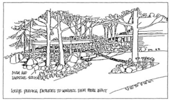
- Place utility lines underground.
+ 1. To the maximum extent feasible, utilities shall be placed underground and within existing roadways or in established shoulders in order to minimize the impact to existing natural features such as natural vegetative patterns and land forms. (See Figure 8.) + 2. Tree cutting for utility corridors shall be feathered to reduce visual impacts. All disturbed areas shall be revegetated. (See Section 19.73.060, "Landscaping and Revegetation" and Section 19.72.030H, "Tree and Vegetation Protection.")
Figure 8. Place utility lines underground.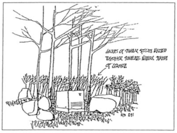
(Ord. 1417 § 3 (part), 1998)
19.73.040 Building Scale And Design
- Design buildings so they solidly meet the ground plane (See Figures 9 and 10.):
+ 1. Building designs requiring a strong structural statement such as extensive cantilevers or cuts and fills on sensitive hillsides shall be prohibited. + 2. To the maximum extent feasible, placing buildings on piers such that exterior walls do not continue down to the ground shall be prohibited because of aesthetic and energy efficiency concerns. o 3. Buildings that firmly meet the ground convey an appearance of greater permanence, and shall be strongly encouraged. 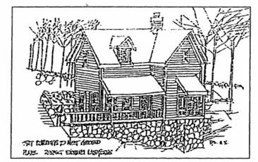 Figure 9. Design buildings so they solidly meet the ground plane.
 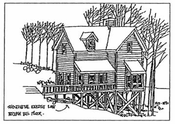 Figure 10. NO: This building is not designed to follow natural terrain contours.
 - Design buildings on hillsides to follow the natural terrain (See Figure 11.):
+ 1. Buildings shall be located to minimize earth work and land disturbance. + 2. To the maximum extent feasible, buildings shall be sited in locations that are sympathetic to existing contours rather than those that require a building solution that would dominate the site. Buildings shall be designed to follow natural contours rather than modifying the land to accept a building design not tailored to the site. (See Section 19.73.070, "Grading" and Section 19.72.030C, "Grading Standards.") 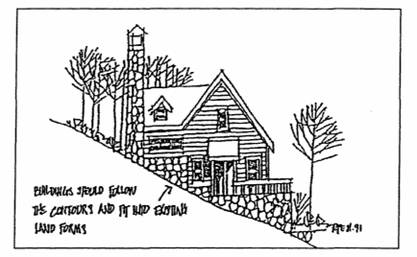 Figure 11. Design buildings on hillsides to follow the natural terrain.
 - Design buildings to minimize mass and scale (See Figures 12-15.):
+ 1. To the maximum extent feasible, building design shall incorporate changes in the planes of walls and changes in the slope and height of roof lines to add variety, create visual interest, and minimize scale. 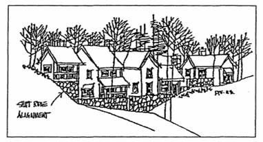 Figure 12. Building design should minimize its scale
 o 2. Buildings can be made to seem larger or smaller depending on the proportional relationship of separate building elements. Human-scale buildings create a comfortable and friendly atmosphere. Building scale should complement rather than dominate the landscape. + 3. To the maximum extent feasible, the massing of buildings shall be scaled to harmonize and balance with the specific site and its natural features, especially when buildings are located at tree or land mass edges or in the open, by incorporating the following design principles: o a. Roof lines and building mass should echo the angles and shapes repeated in the natural landscape, and shift or bend to change directions; and + b. Building mass and wall lines shall be broken up to conform to existing slope and avoid unbroken expanses of building mass and walls that can intrude into the natural canyon setting and dominate a site. 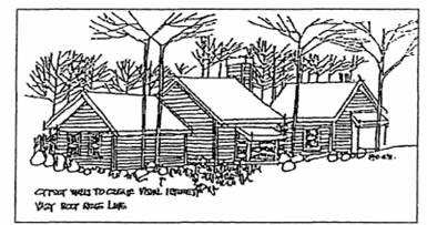 Figure 13. Building design should minimize its scale.
 .png) Figure 14. Building design should minimize its scale.
Figure 14. Building design should minimize its scale. .png) Figure 15. Building design should minimize its scale.
Figure 15. Building design should minimize its scale.
(Ord. 1417 § 3 (part), 1998)
19.73.050 Building Materials And Colors
- Use exterior wall colors that harmonize with the landscape and surrounding buildings;
+ 1. Indigenous materials and colors shall be used in order to mimic natural textures. + 2. To the maximum extent feasible, predominant tones on exterior walls shall tend toward neutral colors such as warm earthy hues, dark green of forests, whites, greys and grey-brown of the mountains, the tan of grasses, and similar colors. Bright, harshly contrasting color combinations shall be avoided. - Use roof surfacing materials that blend with the colors of the adjacent landscape and that are composed of materials which reduce the risk of fire;
+ 1. The color of roof surfacing materials shall be either brown, dark green, grey, or other color that blends in with the surrounding landscape. + 2. Wood roofing shingles shall not be allowed in the canyons or foothills because of their potential to ignite during wildfires and increase structural damage.
(Ord. 1417 § 3 (part), 1998)
19.73.060 Landscaping And Vegetation
See also Section 19.72.030H, "Tree and Vegetation Protection" for those properties located in the foothills and canyons overlay zone.
- Preserve existing trees and vegetation;
+ 1. To the maximum extent feasible, existing concentrations of significant trees and vegetation shall be preserved and remain undisturbed as an important site amenity. For the purposes of this chapter, "significant trees and vegetation" shall be defined as set forth in Section 19.72.070. (See also Section 19.73.030E of this chapter.) + a. Notwithstanding the provisions set forth in this section, existing vegetation located within thirty feet of the primary structure on a site shall be thinned and regularly maintained to help minimize the risk of property damage from wildfire, and to provide space for fire-fighting equipment and personnel. o b. When landscaping within this thirty-foot fire-break area, use of fire-resistant plants is strongly encouraged. (For a list of fire-resistant plants, contact the Wasatch-Cache National Forest, Salt Lake Ranger District, or the Utah Division of Forestry, Fire, and State Lands.) See also Section 19.72.030(H)(3)(c), "Wildfire Hazards and Tree/Vegetation Removal." + 2. To the maximum extent feasible, dryland species shall be selected for slope revegetation, and irrigation will be minimized to reduce potential problems. - Landscape to retain harmony between the various elements of a landscape and to preserve its original character:
+ 1. Landscaping for new development shall incorporate natural features in the landscape such as trees, significant vegetative patterns, interesting land forms, rocks, water, views and orientation. + 2. Landscaped areas shall be an integral part of the development project, and not simply located in left-over space on the site. New planting shall blend in with the existing landscape. + 3. All disturbed areas shall be revegetated using native or adapted plant species and materials characteristic of the area. o 4. Use of fire-resistant plants is also strongly encouraged. (For a list of fire-resistant plants, contact the Wasatch-Cache National Forest, Salt Lake Ranger District, or the Utah Division of Forestry, Fire, and State Lands.)
(Ord. 1417 § 3 (part), 1998)
19.73.070 Grading
- Limit site grading for buildings to preserve existing land forms. See Section 19.72.030C, "Grading Standards." (See Figures 16 and 17.):
+ 1. To the maximum extent feasible, building designs that require extensive cut and fills shall not be allowed. + 2. To the maximum extent feasible, modification of the natural terrain shall be minimized by retaining the natural landscape, including existing trees and vegetation. + 3. To the maximum extent feasible, slopes steeper than thirty percent shall not be disturbed. + 4. To the maximum extent feasible, buildings, driveways, and roads shall follow the natural contours of the site. Site grading shall follow Appendix Chapter 33, "Excavation and Grading," of the Uniform Building Code (1994 edition, as amended from time to time) and "Best Management Practices" (1977) as set forth in the Salt Lake County Erosion-Sediment Control Handbook (1981 edition and as amended from time to time). 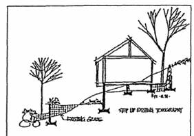 Figure 16. YES: Buildings should be designed to limit site grading
 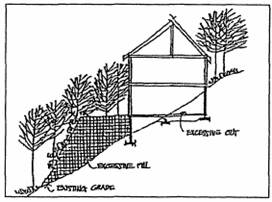 Figure 17. NO: Buildings shall not be designed with extensive cut or fill.
(Ord. 1417 § 3 (part), 1998)
19.73.080 Drainage
- Site design shall not change natural drainage patterns. (See Figure 18.):
+ 1. All final grading and drainage shall comply with Appendix Chapter 33, "Excavation and Grading" of the Uniform Building Code (1994 edition and as amended from time to time) and "Best Management Practices" (1977) as set forth in the Salt Lake County Erosion-Sediment Control Handbook (1981 and as amended from time to time). + 2. To the maximum extent feasible, development shall preserve the natural surface drainage pattern unique to each site as a result of topography and vegetation. Grading shall ensure that drainage flows away from all structures, especially structures that are cut into hillsides. Natural drainage patterns may be modified on site only if the applicant shows that there will be no significant adverse environmental impacts on site or on adjacent properties. If natural drainage patterns are modified, appropriate stabilization techniques shall be employed. 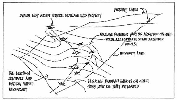 Figure 18. Site design shall not change natural drainage patterns.
+ 3. Development shall mitigate all negative or adverse drainage impacts on adjacent and surrounding sites. + 4. Standard erosion control methods shall be used during construction to protect water quality, control drainage, and reduce soil erosion. Sediment traps, small dams, or barriers of straw bales shall be located wherever there are grade changes to slow the velocity of runoff. - Locate buildings outside stream corridor buffer zones;
+ 1.
Permanent structures shall be located a minimum of one hundred feet horizontally (plan view) from the ordinary high-water mark of stream corridors or other bodies of water. (See Figure 19.) At the discretion of the development services director, and based on site-specific studies such as soils or vegetation, set-back distances may be reduced according to the modification provisions and criteria set forth in Section 19.72.060B, or greater setback distances may be required. The Salt Lake County development services, engineering section, and the city/county board of health should be consulted in determining appropriate site-specific setback requirements. See also Section 19.72.030J, "Stream Corridor and Wetlands Protection."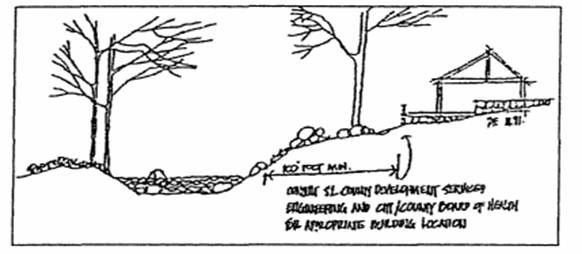 Figure 19. Buildings should not be located within stream buffer zone.
+ 2. To the maximum extent feasible, developments shall not alter natural waterways. - Bridges for stream crossings are recommended. (See Figures 20 and 21.)
+ 1. To the maximum extent feasible, the use of culverts to cross perennial streams shall not be allowed. Culverts may be used on small side drainages, across swales, and on ephemeral or intermittent streams. See Section 19.72.030J, "Stream Corridor and Wetlands Protection." + 2. Bridges and culverts shall be sized to pass one hundred-year storm events. Concrete or stone head walls and side walls shall be required to maintain the integrity of the bridge structure. See also Chapter 17, Flood Control and Water Quality, Section 17.08.090, "Replacement and New Bridge and Culvert Design Criteria." 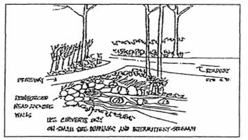 Figure 20. Culverts are allowed on small side drainages across swales and on ephemeral or intermittent streams.
 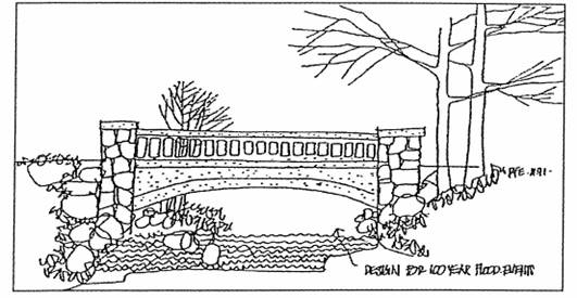 Figure 21. Bridges for stream crossings are recommended.
(Ord. 1417 § 3 (part), 1998)
19.73.090 Access, Circulation And Off-Street Parking
- Design traffic circulation to respect existing topography, achieve acceptable slopes, and adhere to minimum width and turning standards:
+ 1. Safe and adequate access shall be provided in all new development. Access shall be of adequate width to allow for snowplowing and snow storage; + 2. Access roads shall avoid steep grades and sharp turning radii that can make access, especially in the winter, difficult; + 3. Roads and driveways which run perpendicular to the contours of a site shall be prohibited. (See Figures 22-24;) 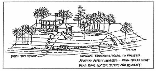 Figure 22. Driveways to residences shall avoid steep grades and respect the contours of the site.
 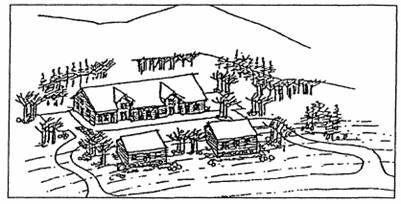 Figure 23. YES: Driveway access and circulation to commercial buildings should respect the site's contours.
 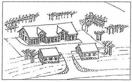 Figure 24. NO: Roads and driveways which run perpendicular to the contours of the site shall be prohibited.
+ 4. To the maximum extent feasible, driveways and covered parking shall be sited on flatter ground and, if necessary, pathways shall be provided to principal buildings. Cars need not have direct access to the front door of a principal building. - Provide safe, adequate off-street parking with year-round access (See Figures 25 and 26.):
+ 1. New development shall provide off-street parking as required by this zoning ordinance. o 2. Shared driveways and shared parking areas with adjoining owners are strongly encouraged in order to reduce maintenance costs and overall impacts on the environment. + 3. Access to off-street parking areas shall be from a private driveway or roadway and not directly from a public street or road. Off-street parking areas shall be large enough such that persons accessing or leaving the site are not required to back out onto a public street unless the development services director or the planning commission determines that the street is not a major thoroughfare and that no safety or traffic flow problems will result. 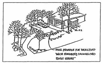 Figure 25. Provide adequate off-street parking with year around access.
 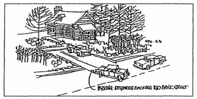 Figure 26. Off-street parking requiring backing onto major roads is discouraged.
+ 4. The location of off-street parking facilities shall comply with this chapter. Such areas shall be properly screened and be located on land proven to be suitable for development. - Design new roads and driveways to reduce their visual impact:
+ 1. To the maximum extent feasible, roads and driveways shall be screened using existing land forms and vegetation and any cuts and fills shall be regraded to repeat adjacent land forms. To the maximum extent feasible, long tangents shall be avoided in favor of curvilinear alignments reflecting topography, and curve side roads as soon as possible after intersection with arterial roads or highways. + 2. Cuts and fills for new roads and driveways shall be revegetated with native plant materials.
(Ord. 1417 § 3 (part), 1998)
19.73.100 Fences
- Place fences to respect existing land forms, follow existing contours, and blend into the natural setting of the site (See Figures 27-29.):
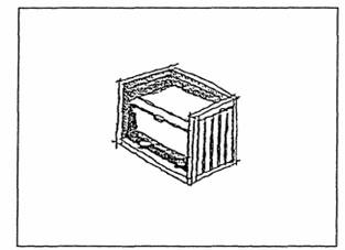 Figure 27. Opaque fence may be used to screen service areas.
 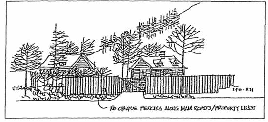 Figure 28. Walls and fences should respect existing land forms.
 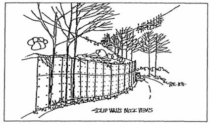 Figure 29. NO: Solid barrier walls are out of character with the natural canyon setting.
(Ord. 1417 § 3 (part), 1998)
2023-06-01
19.73.110 Purpose
- The purposes of this Chapter are to:
- Encourage lighting practices that minimize light pollution, glare, light trespass, and sky glow to preserve and enhance views of the night sky.
- Maintain the rural atmosphere and community character of the Metro Township.
- Protect ecological conditions and nocturnal wildlife within the Metro Township.
- Maintain nighttime safety, utility, and security.
- Encourage lighting practices that promote energy conservation.
19.73.111 Definitions
For the purpose of this Chapter, certain words, phrases, and terms used herein shall have the meanings assigned to them by this section:
Accent Lighting: Lighting of building surfaces, landscape features, statues, and similar items for the purpose of decoration or ornamentation, or lighting that does not contribute to the safety or security of residents, guests, employees, or customers on a property.
Adaptive Controls: Devices such as motion sensors, timers, and dimmers used in concert with outdoor lighting equipment to vary the intensity or duration of the operation of lighting.
Ambient light: The general overall level of lighting in an area.
Backlight: All the light emanating behind a light fixture.
Ballast: A device used with a discharge lamp to obtain the necessary voltage, current, and/or waveform for starting and operating the lamp.
Basement: The area of a building having its floor below ground level on all sides.
Brightness: Strength of the sensation that results from viewing surfaces from which the light comes to the eye.
BUG Rating: A BUG Rating stands for backlight, uplight, and glare. Backlight (B) is the light directed behind the light fixture, uplight (U) is any light directed upward above the horizontal plane of the light fixture, and glare (G) is the amount of light emitted from the light fixture “at high angles” (greater than 60-degrees from nadir). 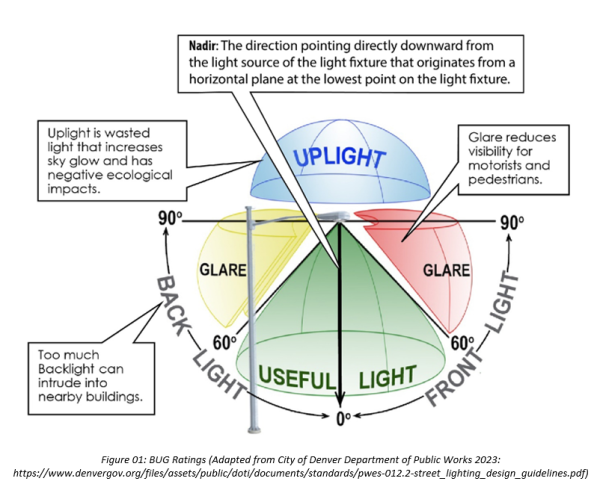
Bulb or lamp: The source of electric light. To be distinguished from the whole assembly (see light fixture).
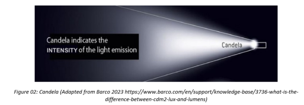
Candela (cd): The intensity of light emitted from a fixture in a certain direction.
Commercial Property: Any parcel zoned C-1 Commercial, C-V Commercial, or C-2 Commercial Zone.
Constant Lighting. Lighting that does not flash, blink, strobe, or otherwise emit bright bursts of light.
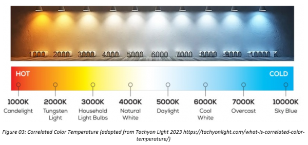
Correlated Color Temperature (CCT, Color Temperature): A specification of the color appearance of the light emitted by a lamp, relating its color to the color of light from a reference source when heated to a particular temperature, measured in degrees Kelvin (K).
Cut-off angle, of a light fixture: The angle measured up from the nadir (i.e. straight down) between the vertical axis and the first line of sight at which the bulb or lamp is not visible.
Diffuser: A device used to distribute light from a source.
Dimmer: A device for varying the brightness of electric light.
Direct Illumination: Illumination resulting from light emitted directly from a lamp or reflector. This does not include light reflected from other surfaces, such as the ground or building faces.
Director: The Greater Salt Lake Municipal Services District Director of Planning and Development Services or planning staff as so designated.
Dusk: The darker part of twilight. Timetables identifying specific hours for dusk on any given day are located at: https://www.gaisma.com/en/location/salt-lake-city-utah.html.
Efficiency: A measure of the effective or useful output of a system compared to the input to the system.
Energy (radiant energy): Unit is erg, or joule, or kWh.
Facade lighting: The illumination of the exterior of a building. (See also Accent Lighting.)
Fixture Lumens: A light fixture’s total light output after passing through the optics in that fixture.
Fixture Watts: The total power consumed by a fixture. This includes the power consumed by the lamp(s) and ballast(s). 
Floodlight: A fixture designed to “flood” a well-defined area with light.
Footcandle: A footcandle is a measurement of light intensity. One footcandle is defined as enough light to illuminate a one-foot square located one foot from the light source with one lumen of light. 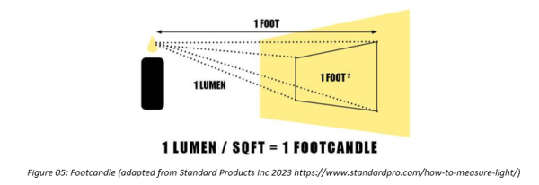
Full Cut-off fixture (Fully-shielded fixture): An outdoor light fixture constructed and mounted so that the installed fixture emits no light (zero intensity) at or above horizontal (90° above nadir).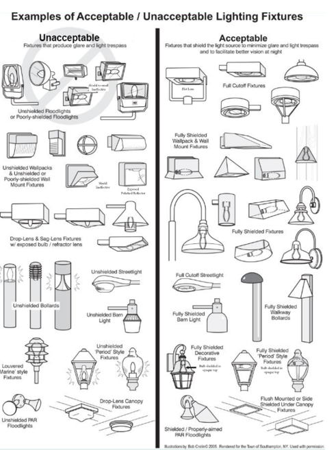 Figure 06: Examples of Unacceptable and Acceptable Light Fixtures (Adapted from International Dark-Sky Association 2023 https://www.darksky.org/)
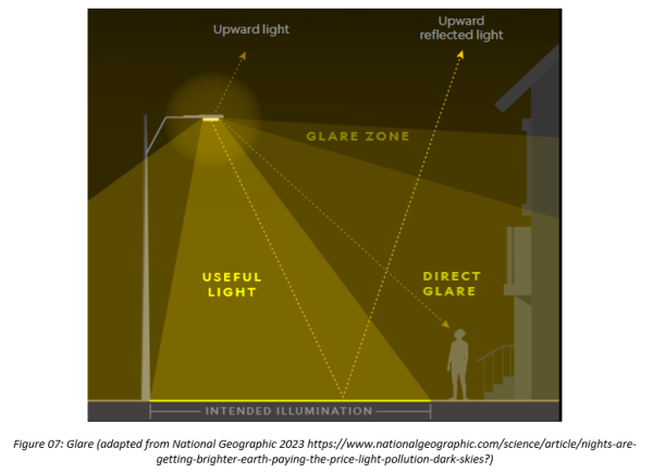
Glare: The visual sensation caused by excessive brightness, and which causes annoyance, discomfort, or a loss in visibility.
Government Properties: Includes any form of real or personal property in which the National, State, County, or local government has an ownership, leasehold, or other property interest as well as a right or other intangible interest that is purchased with Government funds, including the services of contractor personnel. by National, State, County, or local government institutions.
Hardscape: Any non-living horizontal site element, including but not limited to patios, decks, walkways, sidewalks, driveways, and steps.
House-side Shield: Opaque material applied to a fixture to block the light from illuminating a residence or other structure being protected from light trespass.
Illuminance: Light level measured in footcandles, lux, or lumens.
Illuminating Engineering Society of North America (IES or IESNA): The professional society of lighting engineers, including those from manufacturing companies, and others professionally involved in lighting.
Incandescent lamp: A lamp in which light is produced by a filament heated to a high temperature by an electric current.
Indoor Lighting: Any lamp, pendant, or fixture used to illuminate the interior of any structure.
Intensity: The degree or amount of energy or light.
Internally Illuminated: As it relates to signs, any sign which has a light source entirely enclosed within the sign and not directly visible.
International Dark-Sky Association (IDA, Inc.): A non-profit organization whose goals are to build awareness of the value of dark skies, and of the need for quality outdoor lighting.
kWh (Kilowatt-hour): A measure of electrical energy equivalent to a power consumption of 1,000 watts for one hour.
Lamp: A generic term for a manufactured source created to produce optical radiation, meaning ultraviolet radiation (UV), visible light (VIS), and infrared radiation (IR).
Lamp Life: The average lifespan for a specific type of lamp.
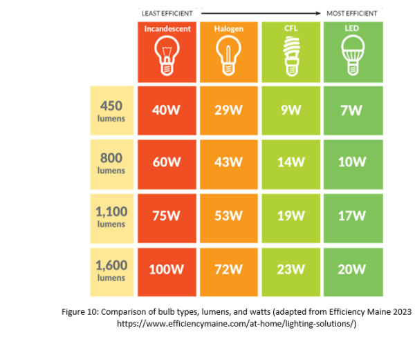
LED: Stands for Light Emitting Diode. LED lighting products produce light up to 90% more efficiently than incandescent light bulbs.
Light Pollution: Brightening of the night sky caused by man-made sources which has a disruptive effect on natural cycles and inhibits the observation of stars and planets.
Light Fixture (Luminaire): A complete lighting unit that typically includes components such as a fixture housing, ballast, reflector, shield or diffuser, and a lamp or lamps.
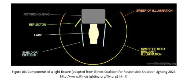
Light Source: The part of a light fixture that produces light, e.g., the bulb, lamp, or diode.
Light Spill: Unwanted spillage of light onto adjacent areas including residential properties and ecological sites. (See also: Light Trespass.)
Light Trespass: Light falling where it is not wanted or needed. (See also: Light Spill.)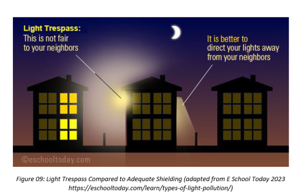
Lighting Controls: Devices used for either turning lights on and off or for dimming. Photocell Sensors automatically turn lights on and off in response to natural light levels. Some advanced modes can slowly dim or increase the lighting level. See also: Adaptive Controls.
Lumen: A measurement of light intensity. One lumen is approximately equal to the amount of light emitted by one candle at a one-foot distance. A light source with higher lumens emits brighter light.
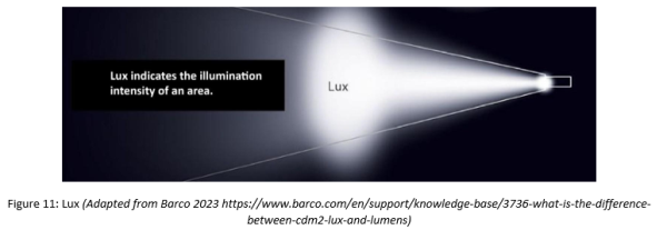
Lux: (symbol: lx) The unit of illuminance equal to one lumen per square meter.
Manufacturer’s Catalog Cut: A publication or other printed material of a lamp or lighting manufacturer offering visual and technical information about a lighting fixture or lamp.
Mounting height: The height of the light fixture as measured from the point at which light is emitted above the ground plane (pole-mounted) or lowest finished floor elevation (structure-mounted).
Multi-Family Residential Property: Any parcel having a building containing five or more dwelling units, or any parcel zoned R-M Residential.
Nadir: The direction pointing directly downward from the light source of the light fixture that originates from a horizontal plane at the lowest point on the light fixture.
Optic: The components of a light fixture such as reflectors, refractors, and protectors which make up its light emitting section.
Outdoor Light Fixture (Outdoor Lighting, Exterior Lighting): An outdoor, electric, or solar-powered illuminating lamp, or similar device used for lighting structures, parking lots, pathways, service canopies, recreational areas, signs, or other similar outdoor uses.
Partially Shielded Light Fixture: An outdoor light fixture constructed and mounted so that the installed fixture emits most, but not all, of its light below the horizontal plane.
Pathway Lights: A light fixture, or collection of light fixtures, less than eighteen inches (18") in height, lining one or both sides of an outdoor path or walkway that provides illumination to guide persons along the outdoor path or walkway.
Photometry: The quantitative measurement of light level and distribution.
Photocell: An electronic device that changes the light output of a light fixture dynamically in response to the ambient light level around the light fixture.
Pool Lighting: Light fixtures located below the surface of the water in a swimming pool, hot tub, reflecting pool, fountain, or other water features.
Recreational Lighting: Lighting used to illuminate playing fields, courts, playgrounds, ice rinks, or similar outdoor recreational facilities.
Reflector: An optic that achieves control of light by means of reflection (using mirrors).
Refractor: An optic that achieves control of light by means of refraction (using lenses).
Religious Institutions Property: Property containing a religious or spiritually-oriented structure(s) or accessory structure(s), where persons regularly assemble for religious or spiritual purposes and related social events.
Security Lights: Lighting designed to illuminate a property or grounds for the purpose of security.
Shielding: An opaque material that blocks the transmission of light.
Single-Family Residential Property: Any parcel zoned FR-0.5, FR-1, FR-2.5, FR-5, FR-10, FR-20, FR-50, FR-100, and for Planned Unit Developments.
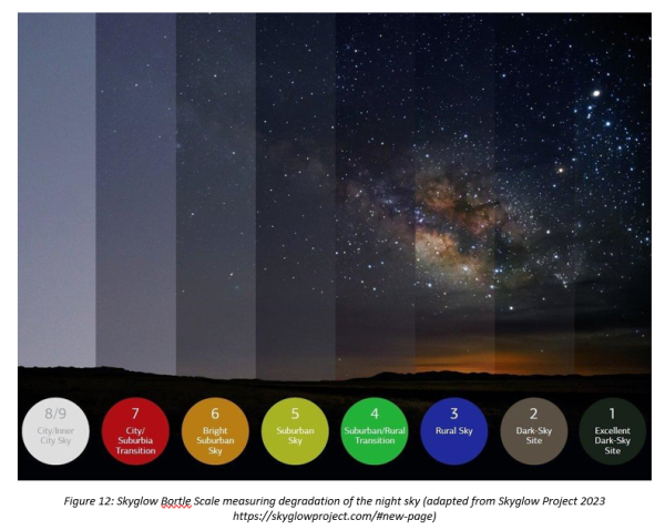
Skyglow: The brightening of the nighttime sky resulting from the scattering and reflection of artificial light by moisture and dust particles in the atmosphere. Skyglow is caused by light directed or reflected upwards or sideways, reducing one’s ability to view the nighttime sky.
Spotlight: A fixture or lamp designed to light a small area very brightly. See the definition of Floodlight.
Stationary Lighting. Lights that are fixed in a non-moving position.
Task Lighting: Task lighting is used to provide direct light for specific activities without illuminating the entire area.
Tower: Any monopole, antenna or the like that exceeds eighteen feet (18’) in height.
Unshielded Light Fixture: A fixture that allows light to be emitted above the horizontal plane, either directly from the lamp or indirectly from the fixture or reflector.
Visibility: The distance one can see horizontally as determined by light and weather conditions.
Wall Pack: A light fixture, typically affixed to the side of a structure, used for area lighting.
19.73.112 Scope And Applicability
- Compliant Lighting.
- Lighting installed and/or replaced after the effective date hereof in all zones in the Metro Township shall comply with the requirements established by this Chapter.
- Given the steep and variable topography of the Metro Township, it is possible that lighting that is compliant with this ordinance could cause unwanted effects of light pollution, glare, light trespass, sky glow, and degradation of the night sky environment. In these instances, the Metro Township encourages property owners to consider taking steps to mitigate such conditions.
- Non-compliant Lighting.
- Lighting that does not meet the requirements of this Chapter shall be considered non-compliant lighting.
- Amortization. All non-compliant exterior lighting fixtures shall be brought into compliance no later than five (5)-years from the effective date of this Chapter. The Metro Township encourages property owners to voluntarily bring non-compliant lighting into compliance with this Chapter as soon as possible.
- Lighting Modifications.
- When a Building Permit is required:
- If the proposed structural modifications necessitate the removal of a non-compliant light fixture, the light fixture shall be replaced or modified to bring it into compliance with the requirements of this Chapter.
- If the proposed structural modifications represent a value of fifty percent (50%) or more of the building value at the time of submittal, a lighting plan for the property shall be submitted subject to the requirements in Section 19.73.118.
- When a building permit is not required and a non-compliant light fixture is replaced, destroyed, damaged, or modified, the replacement fixture shall comply with the requirements of this Chapter.
- When a Building Permit is required:
- Conflicts.
- In the event any federal, state, or county statute or regulation conflicts with any requirement of this Chapter, the most restrictive statute, regulation, or requirement shall govern unless otherwise required by law. In the event any requirement of the Metro Township’s other ordinances conflicts with the requirements of this Chapter, the most restrictive requirement shall govern.
19.73.113 Standards
- Minimum Necessary.
- The intensity of outdoor (exterior) lighting shall be the minimum necessary to provide for safety and functionality. The lowest-lumen light source necessary for a lighting application shall be used.
- All lighting shall be purpose-driven:
- Useful: All light used shall have a specific purpose.
- Targeted: Light shall be directed only to where needed.
- Low Light Levels: Light shall be no brighter than necessary.
- Controlled: Light shall be used only when it is useful.
- Color: Where possible, warmer color lights shall be used.
- All lighting shall be purpose-driven:
- The intensity of outdoor (exterior) lighting shall be the minimum necessary to provide for safety and functionality. The lowest-lumen light source necessary for a lighting application shall be used.
- Allowable Applications.
- Outdoor lighting in compliance with this Chapter shall only be allowed in the following applications:
- To illuminate the entrances to buildings (including garage entrances).
- To illuminate pathways and walkways.
- To illuminate parking areas and parking area access lanes.
- To illuminate gathering areas, such as patios, pool and hot tub areas, dining areas, and recreation areas.
- For security purposes, provided all the following conditions are met:
- The lighting is activated by motion sensors and shuts off, within or before, fifteen (15) minutes after each activation or when the activity involved is completed.
- The lighting is placed and directed such that no direct illumination falls outside the property boundaries where the security lighting is placed.
- Sensors are adjusted to meet site conditions to avoid repetitive activation by wildlife, wind, and/or other disturbances.
- To illuminate signage.
- For Accent Lighting, provided all the following conditions are met:
- All accent lighting is mounted on and illuminates only building facades visible from an adjacent public right of way.
- The accent lighting is sufficiently shielded such that the light source is not visible beyond the property boundaries.
- The accent lighting is directed such that all light shines on the building facade, not on the adjacent property or the night sky.
- The accent lighting is not used to illuminate the landscape, landscape elements, statues, or other similar features.
- To illuminate outdoor water features, provided all the following conditions are met:
- The lighting is angled below the horizontal plane.
- The lighting is placed underneath or behind the water such that the water diffuses the light from all points where the light is visible.
- Temporary exterior or decorative lighting utilized for holidays or special events shall be extinguished by 10:00 pm. When in use, the lighting shall not exceed the allowed footcandle limit for the property. This can be accomplished by reducing light usage in other areas of the property. Temporary lighting shall be limited to the following:
- The period of time between Thanksgiving Day and January 8th each calendar year; and,
- Periods of time outside the month of December shall not exceed seven (7) days per calendar month for other holidays and special events.
- Lighting for the U.S. flag.
- It is preferred that the U.S. flag not be illuminated and that the traditional raising of the flag after dawn and lowering of the flag before sunset be utilized.
- The U.S. flag may be illuminated from above, provided all the following conditions are met:
- The fixture must shine down at 90° and be fully shielded.
- The total number of lumens output from any light fixture mounted on top of a flagpole is limited to 450 lumens.
- The U.S. flag may be illuminated from below, provided all the following conditions are met:
- Flag lighting shall use not more than two (2) fixtures, such fixtures to project narrow beams of light only on the flag.
- Flag lighting shall not utilize more than 450 total lumens.
- Light sources shall not trespass or be visible from more than five feet (5') measured horizontally from the center of the light source at three feet (3') above grade.
- All flag poles and Mountings installed to fly the U.S. flag shall be limited to 25 ft. in height measured from the ground plane to the top of the pole.
- Flag poles shall be set back from property lines at a distance equal to two and one-half (2.5) times the height of the pole.
- Outdoor lighting in compliance with this Chapter shall only be allowed in the following applications:
- Total Light Output.
- Commercial, Government, and Religious Institutions Properties: The total amount of outdoor lighting, whether shielded or unshielded, shall not exceed two (2.0) footcandles per square foot of hardscape.
- Multi-Family Residential Properties: The total amount of outdoor lighting, whether shielded or unshielded, shall not exceed one and one-half (1.5) footcandles per square foot of hardscape.
- Single-Family Residential Properties: The total amount of outdoor lighting, whether shielded or unshielded, shall not exceed one (1.0) footcandle per square foot of hardscape.
- Single-Family Residential Properties used for overnight accommodations or commercial uses shall comply with Single-Family Residential Property standards for total light output.
- For all Properties – Light output from outdoor sources shall not exceed point one (0.1) footcandle at the property line.
- Maximum Color Temperature of All Outdoor Lighting Fixtures.
- The correlated color temperature of any outdoor lighting fixture shall not exceed three thousand degrees Kelvin (3000°K).
- Fully-Shielded Fixture Requirements.
- Unless specifically exempted by this Chapter, all outdoor lighting shall use fully-shielded fixtures that are designed and constructed so that:
- No light is emitted and/or reflected above the horizontal plane of the fixture.
- Light emitted is limited to a value not exceeding ten percent (10%) of lamp lumens at or above eighty degrees (80°) nadir and zero lumens above the horizontal plane (90° nadir).
- Lighting is placed and/or directed at a location, angle, and/or height to prevent direct illumination outside the property boundaries where the light fixtures are located.
- When a light manufacturer provides a BUG rating, the uplight rating (U) shall equal zero (0).
- Characteristics:
- To qualify as a fully-shielded fixture, the top and sides of a light fixture shall be made of completely opaque material, such that light only escapes through the bottom of the fixture. Fixtures with translucent or transparent sides, or sides with perforations or slits, do not qualify as fully-shielded. Any glass or diffuser on the bottom of the fixture must be flush with the fixture (no drop lenses) and must not reflect light that breaks the horizontal plane established at the bottom of the shield. Merely placing a light fixture under an eave, canopy, patio cover or other similar cover does not qualify the fixture as being fully-shielded.
- Unless specifically exempted by this Chapter, all outdoor lighting shall use fully-shielded fixtures that are designed and constructed so that:
- Exemptions to Fully-shielded Fixture Requirements. All lighting described in this Section shall be included in calculating the total footcandle output allowed unless otherwise noted and as set forth in Section 19.73.113. C.
- Spotlights:
- Spotlights controlled by motion sensors having a light output of less than one thousand (1000) lumens per lamp are exempt from the fully-shielded requirement, provided:
- The fixture is a spotlight or other type of directed light that shall be directed at a forty-five-degree (45°) angle or less, where the zero (0) angle is pointing straight down, and
- The fixture must not be placed in such a manner that results in light trespass, and
- The lighting elements controlled by motion sensors shall not be triggered by movement or activity located off the property on which it is located.
- The fixture is hooded or shielded to the extent necessary to prevent glare on adjacent properties or roadways.
- The lighting is activated by motion sensors and shuts off, within or before, fifteen (15) minutes after each activation or when the activity involved is completed.
- The fixture is a spotlight or other type of directed light that shall be directed at a forty-five-degree (45°) angle or less, where the zero (0) angle is pointing straight down, and
- Spotlights controlled by motion sensors having a light output of less than one thousand (1000) lumens per lamp are exempt from the fully-shielded requirement, provided:
- Pathway Lights:
- Pathway lights less than eighteen inches (18") in height are exempt from the fully-shielded fixture requirement if:
- The total light emitted by all pathway light fixtures as measured along the centerline of the pathway lighted does not exceed one (1.0) footcandle; and
- The lights have opaque caps that direct light below the horizontal plane.
- Pathway lights less than eighteen inches (18") in height are exempt from the fully-shielded fixture requirement if:
- Temporary Exterior or Decorative Lighting:
- Temporary exterior or decorative lighting, provided that individual lamps do not exceed seventy (70) lumens, the total output of temporary lighting does not cause the property to exceed total footcandle levels allowed in this Chapter, and the lighting does not cause light trespass or interfere with the reasonable use and enjoyment of surrounding properties.
- Law Enforcement Lighting, Traffic Control Signals, and Traffic Safety Devices:
- Traffic control signals, traffic safety devices, and law enforcement lighting used by a government agency, is exempt from and not governed by the requirements of this Chapter.
- Temporary Emergency Lighting:
- Temporary emergency lighting in use by law enforcement or government agencies, or at their direction, is exempt from and not governed by the requirements of this Chapter.
- Pool Lighting:
- Underwater lighting fixtures providing illumination to all underwater areas of a swimming pool, hot tub, reflecting pool, fountain, or other such water feature provided they are shielded to the greatest extent feasible to prevent light trespass beyond the surface of the water.
- Spotlights:
- Restrictions on Total Amount of Unshielded Lighting.
- Outdoor lighting that is exempt from the shielding requirement in this Chapter shall not contribute more than the equivalent of:
- Zero point two (0.2) footcandle per square foot of hardscape for Commercial, Government, or Religious Institutions Properties.
- Zero point fifteen (0.15) footcandle per total square foot of hardscape for Multi-Family Residential Properties.
- Zero point one (0.1) footcandle per square foot of hardscape for Single-Family Residential Properties.
- All lighting fixtures shall be fully-shielded when installed within twenty-five (25) feet of adjacent residential property lines.
- Outdoor lighting that is exempt from the shielding requirement in this Chapter shall not contribute more than the equivalent of:
19.73.114 Night Lighting Limitations
- Commercial, Government, and Religious Institutions Properties.
- Shall turn off all outdoor lighting within one (1) hour after closing until 6:00 a.m. the following morning, except those listed below:
- Lighting to illuminate the entrance(s).
- Parking lot and pathway lighting required for the safety of customers, employees, and guests.
- Shall turn off all outdoor lighting within one (1) hour after closing until 6:00 a.m. the following morning, except those listed below:
- Multi-Family and Single-Family Residential Properties.
- Shall be turned off one (1) hour after dusk until 6:00 am the following morning, except those listed below:
- Lighting to illuminate entrances.
- Parking lot and pathway lighting required for the safety of residents or guests.
- Outdoor gathering spaces when in use.
- Shall be turned off one (1) hour after dusk until 6:00 am the following morning, except those listed below:
- Recreational Lighting.
- Shall be turned off when not in use, and from (1) hour after dusk until 6:00 am the following morning, except to conclude a community-approved event that is underway.
19.73.115 Specialized Outdoor Lighting
- Roadway/Streetlights.
- Roadways and streetlights are prohibited unless recommended by the County Engineer or required by the Utah Department of Transportation (UDOT). When deemed necessary, streetlights shall utilize lamp types that are fully-shielded light fixtures that minimize sky glow, light trespass, and other unintended impacts of artificial lighting. All street lights shall utilize the lowest light levels accepted by the County Engineer and/or UDOT.
- Parking Lots.
- Spot or flood lighting of parking lots from a building or other structure is prohibited.
- The mounting height of any pole-mounted light fixture used to illuminate parking lots in commercial, government, or religious institution properties shall not exceed fourteen feet (14').
- The mounting height of any pole-mounted light fixture used to illuminate parking lots in all residential properties shall not exceed six feet (6').
- All pole-mounted parking lot lights shall be set back from property lines at a distance equal to two and one-half (2.5) times the height of the pole unless an internal or external shield prevents the fixture from being visible from outside the property boundaries.
- All parking lot lighting shall use fully-shielded fixtures.
- Internal or external shields shall prevent the light source from being visible from outside the relevant parking lot.
- Recreational Lighting.
- All proposals for recreational lighting for playing fields or court areas shall be submitted to the Director or designee, who may approve such requests only after finding:
- The recreational lighting has met the requirements for minimizing glare, light spill, light trespass, and uplight using louvers, hoods, or shielding.
- The recreational lighting only illuminates the playing field or court area and is shielded to prevent illumination from falling outside of those areas.
- Lighting on the playing field or court area shall not exceed twenty (20) footcandles per square foot.
- The light source for recreational lighting is not visible from adjacent properties.
- Pole-mounted recreational lighting is limited to eighteen feet (18') in mounting height. Pole-mounted recreational lighting must be set at a distance equal to two and one-half (2.5) times the height of the pole installed from any adjacent property line unless an internal or external shield prevents the fixture from being visible from outside the property boundaries.
- All proposals for recreational lighting for playing fields or court areas shall be submitted to the Director or designee, who may approve such requests only after finding:
- Amphitheater Lighting.
- Outdoor amphitheaters may use illumination to light the performance area of the amphitheater and provide public safety. The following requirements apply to all amphitheater lighting:
- Lighting used to illuminate the performance area must be either directed spotlighting or fully-shielded lighting. If directed spotlighting, the light source must be located and designed such that it is not visible beyond the property boundaries.
- Lighting used to illuminate the performance area may only be turned on during performances or rehearsals.
- Lighting used to illuminate the seating areas, pathways, and other areas of the amphitheater must meet all the requirements of this Chapter.
- Outdoor amphitheaters may use illumination to light the performance area of the amphitheater and provide public safety. The following requirements apply to all amphitheater lighting:
- Signs.
- Where other municipal ordinances are in conflict with the requirements of this Chapter, the more restrictive requirements shall apply.
- Signs may be unlighted, lighted externally, lighted internally, or backlit. All sign lighting must be designed, directed, and shielded in such a manner that the light source is not visible beyond the property boundaries where the sign is located. Lighting for signs must be directed such that only the sign’s copy area is illuminated.
- Lighting for signs must be stationary and constant.
- All signage elements must be stationary.
- Standards for Externally Illuminated Signs:
- Lighting for externally illuminated signs must be aimed and shielded so that light is directed only onto the sign face and does not intrude onto adjacent streets, roads, or properties or into the night sky.
- Lighting for externally illuminated signs must be mounted at the top of the sign (or within two (2) feet of the top of a building-mounted sign).
- Standards for Internally Illuminated Signs:
- Lighting Is Visible on Both Sides of the Sign:
- Only sign copy areas and logos may be illuminated on an internally illuminated sign.
- Internally illuminated signs shall use semi-opaque materials for sign copy such that the light emanating from the sign is diffused. Transparent or clear materials are not allowed for sign copy. Non-copy portions of the sign (e.g., background and graphics) shall be made of completely opaque material.
- Lighting Is Visible on Both Sides of the Sign:
- Standards for Backlit Signs:
- Only One Side of Sign Is Lit:
- Backlit signs shall be designed such that the light source is not visible.
- Backlit signs shall be designed such that direct illumination does not emanate out of the sign. Rather, the backlighting shall only allow indirect illumination to emanate from the sign. For example, signs that create a "halo" effect around sign copy are allowed.
- Backlit signs shall use low-lumen light sources (450 lumens maximum).
- Only One Side of Sign Is Lit:
- Illuminated Window Signage:
- Illuminated window signs positioned to be primarily visible outside all structures are allowed only if there are no more than two (2) signs. Each sign shall measure less than three and one-half (31/2) square feet in area.
19.73.116 Prohibited Lighting
- Accent Lighting that is directed upward above the horizontal plane to illuminate building structures, landscape, landscape features, statues or similar features, vegetation, or for any other use.
- Flashing, blinking, intermittent, or other lights that move or give the impression of movement.
- Unshielded Floodlights or Spotlights affixed to buildings for the purpose of lighting parking lots.
- Searchlights and laser source lights.
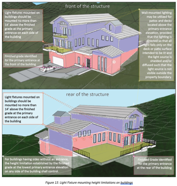
- Building-mounted light fixtures in residential properties at a mounting height of more than fourteen (14) feet above the finished grade at the primary entrance to the corresponding side of the building (i.e., front, sides, rear.)
- For buildings having sides without an entrance, the mounting height limitation established by the finished grade at the lowest primary entrance elevation on any side of the structure shall control.
- Wall-mounted lighting may be utilized for patios and decks located above the primary entrance elevation, provided that the lighting is directed so that all light falls only on the deck or patio surface intended to be lit and the light source is shielded and/or diffused such that the light source is not visible outside the property boundary.
19.73.117 Towers
- All monopole, antenna, tower, or support facility lighting not required by the Federal Aviation Administration (FAA), the Federal Communications Commission (FCC), or Municipal Fire and Police is prohibited.
- When lighting is required by the FAA, FCC, or Municipal Fire and Police, such lighting shall not exceed the minimum requirements of those agencies.
- All other lighting used on the property not regulated by the FAA, FCC, or Municipal Fire and Police shall conform to the requirements of this Chapter.
19.73.118 Application And Review Procedures
- Lighting Plan Required.
- In any application for a sign permit, building permit for new development, and building permit for renovation subject to 19.73.112.D of this Chapter, conditional use permit, subdivision, design/development review, and any other development application within any zoning district, including all municipal projects, the applicant shall, as part of the application process, submit a Lighting Plan including sufficient information to enable the Director or designee to determine whether the proposed lighting complies with the requirements of this Chapter.
- Lighting Plans shall include the following:
- Site plans or drawings indicating the proposed location of all outdoor lighting fixtures, both proposed and any already existing on-site, including:
- mounting height of all light fixtures on the premises, and
- type of light fixture, lamps, supports, shielding, and reflectors used and,
- installation and electrical details.
- A description of each light fixture, lamp, support, and shield, both proposed and existing. The description shall include but is not limited to, the Manufacturer’s Catalog Cuts and illustrations (including sections where required); lamp types, wattages, initial lumen outputs, diffusers, shielding mechanisms, and other accessories. A BUG rating must be included if supplied for each light fixture.
- A table showing the total number of proposed exterior lights, by fixture type, lumens, and lamp type, including a Manufacturer’s Catalog Cuts whenever possible.
- The Lighting Plan must demonstrate that no more than the allotted footcandle of light shall be utilized on the property or properties, as specified in section 19.73.113.C.
- Such other information that the Director or designee may determine is necessary to ensure compliance with the requirements of this Chapter.
- Site plans or drawings indicating the proposed location of all outdoor lighting fixtures, both proposed and any already existing on-site, including:
- If the Director or designee determines that any proposed lighting described in a lighting plan does not comply with the requirements of this Chapter, the lighting plan shall not be approved, and the specific permit applied for shall not be issued.
- In the event lighting installed pursuant to an approved lighting plan is nonetheless not compliant with the requirements of this Chapter, the property owner shall bring the lighting into compliance.
19.73.119 Appeals, Violations, Enforcement, And Penalties
- Appeal.
- In the event the Director or designee denies the Lighting Plan, the applicant may appeal the decision with the Director or designee.
- The Director or designee may approve a lighting plan that does not comply with this Chapter if the applicant demonstrates that compliance with the Chapter constitutes an undue hardship.
- In the event the Director or designee approves the lighting plan, they may attach other conditions to such approval that will make the proposed lighting comply with the spirit of this Chapter.
- In the event the Director or designee does not approve the proposed lighting plan, the applicant may appeal that decision pursuant to the requirements of Chapter 19.92.050 Appeals of the Emigration Canyon Municipal Code.
- The Director or designee may approve a lighting plan that does not comply with this Chapter if the applicant demonstrates that compliance with the Chapter constitutes an undue hardship.
- In the event the Director or designee denies the Lighting Plan, the applicant may appeal the decision with the Director or designee.
- Violations.
- The following constitute violations of this Chapter:
- Failing to comply with the night lighting limitations set forth in Section 19.73.114.
- The installation, maintenance, or operation of any outdoor lighting fixture not in compliance with the requirements of this Chapter if such fixture is installed after the effective date of this Chapter.
- The alteration of any outdoor lighting fixtures after the approval of a lighting plan by the Director or designee, when such alteration does not conform to the requirements of this Chapter.
- Failure to shield, correct or remove lighting that is installed, operated, maintained, or altered in violation of the requirements of this Chapter.
- The following constitute violations of this Chapter:
- Enforcement.
- If, after investigation, the Director or designee finds that any requirement of this Chapter is being violated, the Director or designee shall give notice by hand delivery or by certified mail, return receipt requested, of such violation to the owner and/or occupant of such premises, demanding that the violation be abated within thirty (30) days of the date of hand-delivery or of the date of mailing of the notice. Planning and Development Services staff shall be available to assist in working with the violator to correct the violation. If the violation is not abated within the 30-day period, the Director or designee may institute actions and proceedings, either legal or equitable, to enjoin, restrain or abate any such violations and to collect penalties for such violations.
- Penalties.
- Penalties: A violation of the requirements of this Chapter shall be punishable by a civil penalty of $50.00 per day after the expiration of the 30-day abatement period set forth in Section 19.73.119.C.1.