
Emigration Canyon City Zoning Code
CHAPTER 19
72 FOOTHILLS AND CANYONS OVERLAY ZONE
19.72.010 Purpose
The general purpose of the Foothills and Canyons Overlay Zone is to promote safe, environmentally sensitive development that strikes a reasonable balance between the rights and long-term interests of property owners and those of the general public. Specifically, these standards are intended to:
- Preserve the visual and aesthetic qualities of Emigration Canyon and prominent ridgelines, as defined herein, contributing to the general attractiveness and, where appropriate, the commercial viability of these areas.
- Protect public health and safety by adopting standards designed to reduce risks associated with natural and man-made hazards.
- Provide efficient, environmentally sensitive, and safe vehicular and pedestrian movement.
- Encourage development that conforms to the natural contours of the land and minimizes the scarring and erosive effects of cutting, filing and grading on hillsides, ridgelines, and steep slopes.
- Balance private and commercial needs against the risk of destabilizing fragile soils, defacing steep slopes, and degrading water quality.
- Minimize disturbance to existing trees and vegetation, conserve wildlife habitat, protect aquifer recharge areas, and otherwise preserve environmentally sensitive natural areas by encouraging clustering, the transfer of development rights, or other design techniques to preserve the natural terrain.
- Reduce flooding by protecting streams, drainage channels, absorption areas, and floodplains.
- Protect property rights and commercial interests.
- Recognize the link between environmental protection and economic prosperity in the canyons.
(Ord. 1417 § 2 (part), 1998)
19.72.020 Applicability
- Geographic Area of Application. Maps delineating the boundaries of the Foothills and Canyons Overlay Zone are on file with the Planning and Development Services Division. Such maps, as amended, are incorporated into this Ordinance as if fully described and detailed herein.
- Development Activities Covered. The standards and requirements of the Foothills and Canyons Overlay Zone apply to all development that occurs within the mapped Foothills and Canyons Overlay Zone. Development includes all land disturbance activities such as grading, clearing, and excavation.
- Jurisdictional Exemptions. These provisions do not apply to properties owned by the State of Utah or the government of the United States, except as specifically authorized by state or federal statute or regulation, intergovernmental agreement, or other form of cooperative agreement.
- Watershed Protection. Emigration Canyon Metro Township recognizes that water companies, both public and private, have an interest in protection of their watersheds located in the canyon. All development in the Metro Township impacting surface water, wells, storage facilities, or aquifers located within the watershed area of Salt Lake City Public Utilities, Emigration Canyon Improvement District, Spring Glen Water Company, or Pinecrest Pipeline Company shall be referred to the respective water company for recommendation regarding compliance with applicable ordinances and watershed protection standards. If a recommendation is not received within the time prescribed by this ordinance for processing applications, the planning commission or director may approve the application subject to a recommendation being received prior to a building permit being issued.
(Ord. 1473 (part), 2001: Ord. 1454 § 4 (part), 1999; Ord. 1417 § 2 (part), 1998)
19.72.030 FCOZ Development Approval Procedures
- Purpose. The purpose of this section is to outline the site plan application and approval process required for all development or construction activity, including tree/vegetation removal and grading, or subdivision of land, in the Foothills and Canyons Overlay Zone.
- Joint Applications. Where a process is already established by ordinance or agreement for review and approval of a land use application in the Foothills and Canyons (such as a subdivision, conditional use or permitted use site plan, development agreement, or variance process), applicable FCOZ standards shall be applied concurrently with the related application. If there is no related land use application under review, the applicant shall be subject to the following process.
- Application Process.
- Pre-Application Meeting.
- Purpose. An informal pre-application meeting with the Director is required prior to submitting a site development plan application. The purposes of the pre-application meeting are to provide an opportunity for the parties to discuss:
- The application submittal, review and approval process; and
- The proposed development of the site and its relationship to site conditions and area characteristics, including geologic, hydrologic, and environmental issues.
- Scheduling of Pre-Application Meeting. To request a pre-application meeting, the applicant shall submit a pre-application meeting request on a form provided by the Director, together with any required fees and materials. Upon submittal of a complete application, the development proposal shall be scheduled for discussion at a pre-application meeting.
- Attendance. In addition to the Director, other participants in the pre-application meeting may include representatives from the Health Department, County Engineers Office, Fire Department, Salt Lake Department of Public Utilities, and any other person or entity the Director deems appropriate.
- Purpose. An informal pre-application meeting with the Director is required prior to submitting a site development plan application. The purposes of the pre-application meeting are to provide an opportunity for the parties to discuss:
- Site Development Plan.
- Application.
- Upon conclusion of the pre-application meeting process, an applicant seeking approval of a development plan shall submit an application form, together with required maps, plans, reports, special requests, and fees, to the Director. All submitted materials shall be available for public review.
- Following documentation of assurances provided at the pre-application meeting or field inspections, the Director may waive or modify submittal requirements deemed unnecessary.
- The Director may require additional information, as necessary, to substantiate compliance with the provisions and standards of this Chapter and other applicable codes and ordinances. For example, the Director may seek technical and policy recommendations from other public agencies with related legal jurisdiction such as the local health department; Utah Division of Wildlife Resources; Utah Division of Forestry, Fire, and State Lands; U.S. Forest Service; and U.S. Soil Conservation Service.
- Staff Review. The Director shall review the development proposal for compliance with the standards and processes of this ordinance, including Paragraph D below, and shall document findings in a written report. The report shall specify all areas of noncompliance with regulations together with any recommended modifications or conditions of approval to mitigate detrimental impacts and bring the plan into compliance, and shall be made available to the public and provided to the applicant (unless specifically waived by the applicant) no less than 3 business days prior to any applicable planning commission meeting.
- Application.
- Pre-Application Meeting.
- Approval Standards. The following is a summary of site development plan review standards. An applicant’s failure to document compliance with any of the following may result in denial of a site development application.
- A building permit issued pursuant to the FCOZ site development plan approval process must reference all conditions or stipulations applicable to such approval. All development, construction, and use shall be in accordance with the approved site development plan.
- An approved site development plan shall be valid for a period of twelve (12) months from the date of the final approval of the plan, unless authorized as a multi-phase development.
- A building permit may be obtained at any time within the twelve (12) month period beginning with the final approval of the site development plan. If substantial progress towards obtaining a building permit is not made within the twelve (12) month period, the final approval of the site development plan automatically lapses and the plan is null and void.
- A building permit issued for any phase of a development that has received site development plan final approval may extend the life of the site development plan for the entire development for an additional twelve (12) months from the date of issuance of the building permit. If any succeeding twelve (12) month period expires before a building permit application is filed for a subsequent phase or phases, then the site development plan approval automatically lapses and the plan is null and void as to all undeveloped or un-built phases of the development, unless substantial progress toward obtaining a building permit is demonstrated.
- Notwithstanding the requirements of subparagraph D.4, a twelve (12) month extension of the life of any phase of an approved site development plan may be obtained subject to paying an extension fee equal to the conditional use and subdivision extension fee in the Township Fee Schedule.
- Appeals. Pursuant to section 19.92.050 of this Title, any person adversely affected by a final decision of the director or planning commission may appeal that decision to the land use hearing officer.
(Ord. 1473 (part), 2001: Ord. 1454 § 4 (part), 1999; Ord. 1417 § 2 (part), 1998)
19.72.040 Underlying Zoning District
- Conflicts. Unless specifically exempted or modified pursuant to the relevant ordinance for the underlying zone, all development shall comply with the standards and requirements of this Chapter.
- Division of Consolidated Lots. Previously platted lots that are consolidated into one taxable parcel may not be re-divided into lots smaller than the minimum area required in the underlying zone.
- Setbacks. Setbacks from property lines are established by the underlying zone. If no setbacks are established, an applicant seeking permission to locate a structure closer than ten (10) feet to a property line shall demonstrate that the structure will not place additional burden(s) on neighboring properties by addressing the following factors: snow storage and removal, drainage, access, fire protection, and building code.
(Ord. 1417 § 2 (part), 1998)
19.72.050 Cluster Development
- General Requirements. Cluster development is the grouping of residential properties on lots smaller than allowed in the underlying zone to reduce infrastructure costs and environmental impacts and to reserve otherwise developable land for open space or recreation. Whether proposed by an applicant or required by the Planning Commission, cluster development may only be approved upon satisfaction of all of the following conditions:
- The proposed cluster development meets all other applicable requirements set forth in the Foothills and Canyons Overlay Zone or in other applicable ordinances or regulations.
- The proposed cluster development, compared with a more traditional site plan, better attains the policies and objectives of the Foothills and Canyons Overlay Zone, such as providing more natural open space, preserving existing trees and vegetation coverage, and preserving sensitive environmental areas such as stream corridors, slide areas, prominent ridgelines, wetlands, and steep slopes.
- The proposed cluster development shall have minimal adverse impacts on adjacent properties, or, if such impacts may result, the applicant has agreed to implement appropriate mitigation measures such as landscape, screening, illumination standards, and other design features as recommended by the Director to buffer and protect adjacent properties from the proposed cluster development.
- The architecture, height, building materials, building colors, and other design features of the proposed cluster development blend with the surrounding natural landscape and are compatible with adjacent properties.
- Density Bonus for Cluster Development.
- A cluster development density bonus of up to twenty-five percent (25%) over the base density permitted in the underlying zone may be available for cluster developments that satisfy the above standards in 19.72.050.A while taking into account the bonus density.
- The allowable density bonus for a cluster development is equal to twenty-five percent (25%) of the “net developable acreage”, and must be rounded to the nearest whole number, but in no case less than one (1).
- Cluster Development Design.
- The undeveloped area of the cluster development site shall be preserved as active or passive natural open space. Natural open space areas shall conform to any adopted open space and/or trail plans, provide contiguity with adjacent natural open space and/or conservation areas, protect unique natural, historic, or cultural site features and resources, and avoid fragmentation of conservation areas within the cluster development site.
- The maximum number of lots allowed in a single cluster development is twenty (20) lots. Each cluster development shall be separated from other residential clusters by a minimum of one-hundred (100) feet.
- The layout of a cluster development site shall protect significant natural resources on or adjacent to the site. Significant natural resources include riparian areas, wetlands, ecological resources, steep slopes and ridgelines, and wildlife habitat and corridors. The overall cluster development site design shall employ the site’s natural topography to hide multiple residential clusters from the sight of adjacent cluster developments.
- The layout of a cluster development site shall preserve the open sky backdrop above any ridgelines and, where possible, significant views of the natural landscape as viewed from adjacent streets.
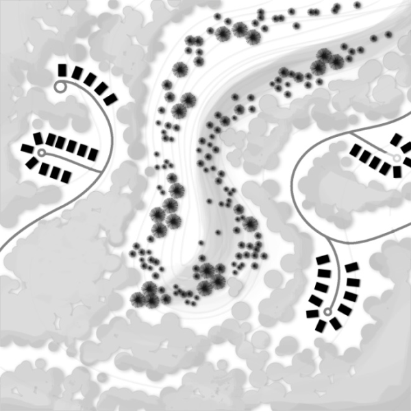
- Illustration of Cluster Development.
Figure 19.72.1: Cluster Development illustrates recommended cluster development.
(Ord. No. 1758, § IX, 9-24-2013; Ord. 1473 (part), 2001; Ord. 1454, § 4 (part), 1999; Ord. 1417, § 2 (part), 1998)
19.72.060 Slope Protection
- Slope Protection Standards.
- Unless otherwise allowed in this Title, no development activities, including clearing, excavation, grading, and construction, are allowed on slopes greater than thirty percent (30%).
- Structures shall be set back from ascending or descending slopes greater than thirty percent (30%) in accordance with the requirements of the current adopted building code.
- Development on Ridgelines. Unless otherwise allowed in this Chapter, no development may break the horizon line, defined as the point where the ridge visibly meets the sky as viewed from public rights-of-way or trails.
- Unless otherwise allowed in this Chapter, no development may be located within one hundred (100) feet (map distance) from either side of the crest of a protected ridgeline designated as such in an adopted general plan or incorporated by other ordinance.
- Figure 19.72.2: Ridgeline Development illustrates recommended ridgeline development.
FIGURE 19.72.2: RIDGELINE DEVELOPMENT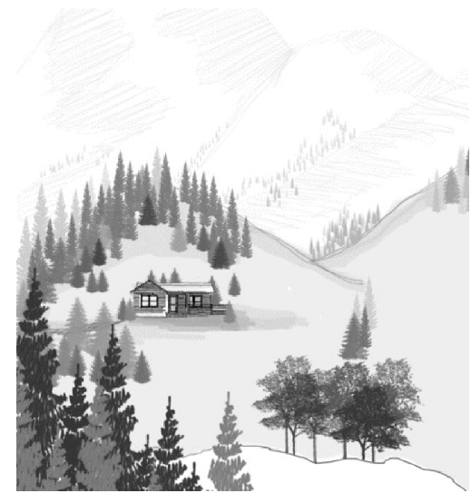
- Natural Open Space within Steep Slopes. Unless expressly allowed in this Chapter, all areas with a slope or slopes greater than thirty percent (30%) must remain in natural private or public open space, free of any development activities.
- Waiver of Slope Protection Standards for Lots of Record.
- The Planning Commission may only waive or modify the following slope protection standards as applied to development on lots of record and in subdivisions that were approved prior to the effective date of this Chapter:
- Slope protection standards prohibiting development activities on slopes greater than thirty percent (30%) as set forth above in 19.72.060.A or in ridge line protection areas, as set forth above in 19.72.060.B(2).
- Limitations on the crossing of slopes greater than thirty percent (30%) by any street, road, private access road or other vehicular route, as set forth in Subsection 19.72.080.
- The Planning Commission may only waive or modify these standards upon satisfaction of the following criteria:
- Strict compliance with the above slope protection standards
- renders the site undevelopable;
- results in substantial economic hardship not created by the applicant or otherwise self-imposed; or
- results in a building location that requires excessive grading, vegetation removal, or driveway distances in conflict with the purposes of this Chapter and
- The development (and related development activities) substantially conforms to all other development, site design, and environmental standards of this Chapter and in all other applicable ordinances and codes.
- Strict compliance with the above slope protection standards
- In granting a waiver or modification from the slope and ridge line protection standards on lots of record, the Planning Commission may impose reasonable conditions to mitigate the impacts, if any, that the Planning Commission determines the proposed development has on adjacent properties and the surrounding environment.
- Notwithstanding its discretion to grant waivers or modifications for lots of record from the slope protection standards set forth in this Chapter, in no case shall the Planning Commission permit development other than roads on slopes greater than forty percent (40%).
- The Planning Commission may only waive or modify the following slope protection standards as applied to development on lots of record and in subdivisions that were approved prior to the effective date of this Chapter:
(Ord. No. 1758, § X, 9-24-2013; Ord. No. 1724, § II, 3-6-2012; Ord. 1473 (part), 2001; Ord. 1454, § 4 (part), 1999; Ord. 1417, § 2 (part), 1998)
19.72.070 Grading Standards
- Prior to the issuance of a building permit in accordance with a grading and excavation plan and report for the site approved by Planning and Development Services on behalf of the Township; no grading, excavation, or tree/vegetation removal is permitted, whether to provide for a building site, for on-site utilities or services, or for any roads or driveways.
- Figure 19.72.3: Cutting and Grading illustrates recommended development that minimizes cuts.
FIGURE 19.72.3: CUTTING AND GRADING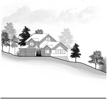
- The original, natural grade of a lot may not be raised or lowered more than four (4) feet at any point for construction of any structure or improvement, except:
- The site's original, natural grade may be raised or lowered eight (8) feet if a retaining wall is used to reduce the steepness of man-made slopes, provided that the retaining wall complies with the requirements of subsection I below.
- The site's original, natural grade may be raised or lowered more than eight feet with terracing, as specified in subsection I below.
- Separate building pads for accessory buildings other than private garages (such as barns, or recreational structures such as tennis courts, swimming pools, and similar facilities) are prohibited except where the natural slope is twenty percent (20%) or less.
- The following limits apply to graded or filled man-made slopes:
- Slopes of twenty-five percent (25%) or less are encouraged wherever possible.
- Graded or filled man-made slopes may not exceed a slope of fifty percent (50%).
- Cut man-made surfaces or slopes may not exceed a slope of fifty percent (50%) unless it is substantiated, on the basis of a site investigation and submittal of a soils engineering or geo-technical report prepared and certified by a qualified professional, that a cut at a steeper slope will be stable and will not create a hazard to public or private property.
- All cut, filled, and graded slopes shall be re-contoured to the natural, varied contour of the surrounding terrain.
- Any slope exposed or created in a new development shall be landscaped or re-vegetated pursuant to the standards and provisions of this Chapter.
- Excavation for footings and foundations shall be minimized to lessen site disturbance and ensure compatibility with hillside and sloped terrain. Intended excavation must be supported by detailed engineering plans submitted as part of the application for site plan approval.
- Use of retaining walls is encouraged to reduce the steepness of man-made slopes and to provide planting pockets conducive to re-vegetation.
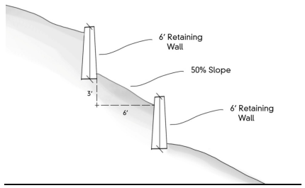
- If a single retaining wall is used, one (1) vertical retaining wall of up to eight (8) feet in height is permitted to reduce excavation and embankment.
- Terracing is limited to two (2) walls with a maximum vertical height of six (6) feet each. The width of a terrace shall be a minimum of a one to one (1:1) ratio with the height of the wall. Terraces are measured from the back of the lower wall to the face of the upper wall. Terraces created between retaining walls shall be permanently landscaped or re-vegetated as required by this Chapter.
Figure 19.72.4: Terracing and Retaining Walls illustrates recommended terracing.
FIGURE 19.72.4: TERRACING & RETAINING WALLS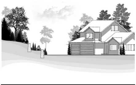
- Retaining walls shall be faced with stone or earth-colored materials similar to the surrounding natural landscape, as required by the design standards of this Chapter.
- All retaining walls shall comply with the minimum standards of the International Building Code.
- Except for restoration and maintenance activities authorized by the State Engineer (Utah Division of Water Rights) and County Flood Control Division, filling or dredging of water courses, wetlands, gullies, stream beds, or storm water runoff channels is prohibited. Bridge construction is allowed pursuant to the standards set forth in this Section.
- Where detention basins and other storm and erosion control facilities are required, any negative visual and aesthetic impacts on the natural landscape and topography shall be minimized. See Figure 19.72.5: Recommended Detention Basin Treatment which illustrates recommended treatment.
- Detention basins shall be free form, following the natural land forms. If such forms do not exist, the basin shall be shaped to emulate a naturally formed depression.
- Redistributing soils from detention basin construction to natural side slopes around the perimeter of the basin is encouraged. Side slopes are limited to a maximum slope of 3:1. These slopes are created to filter, redirect or soften views of the detention basin. Total screening of detention basins is not required. Side slopes shall be varied to replicate natural conditions.
- Naturalized planting themes are required for detention basins. Trees and shrubs may be grouped in informal patterns to emulate the natural environment but may not reduce the volume of the basin.
- The ground surface of the detention basin and surrounding disturbed areas shall be covered with native grass mixture or other appropriate groundcover. It is the intent to provide a natural cover that does not require regular mowing or fertilization.
- Appropriate erosion control measures are required on all slopes.
FIGURE 19.72.5: RECOMMENDED DETENTION BASIN TREATMENT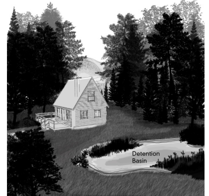
(Ord. No. 1724, § III, 3-6-2012; Ord. 1454, § 4 (part), 1999; Ord. 1417, § 2 (part), 1998)
19.72.080 Site Access
- Motor vehicle access to a building or development site shall be by road (including private access road), street, alley, or driveway. Any road, street, alley, or driveway constructed after the enactment of this Chapter shall comply with the applicable requirements of this section.
- Streets, roads, alleys, or driveways shall comply with the Township Highway ordinance and fire authority regulations.
- Streets, roads, alleys, or driveways may not cross slopes averaging (in any fifty feet interval) between thirty percent (30%) and fifty percent (50%) unless specifically authorized by the Planning Commission, upon the favorable recommendation of the Director and Public Works Engineer, after finding that all of the following conditions and constraints are met:
- No alternate location for access is feasible or available.
- No individual segment or increment of the street, road, alley, or driveway in excess of one hundred (100) feet in length may cross slopes averaging between thirty percent (30%)and fifty percent (50%).
- The cumulative (total) length of individual segments or increments that cross slopes averaging between thirty percent (30%) and fifty percent (50%) may not exceed ten percent (10%) of the total length of the street, road, alley, or driveway.
- All crossings shall be designed and constructed to eliminate significant adverse environmental or safety impacts.
- Under no circumstances shall any segment of a street, road, alley, or driveway cross slopes averaging greater than fifty percent (50%).
- Streets, roads, alleys, or driveways shall follow natural contour lines where possible. If the natural contour lines do not reasonably facilitate access to the development site, a private access road or driveway may be designed and submitted for approval with a slope not to exceed the requirements set forth in Title 14 of the Township Code.
Figure 19.72.6: Recommended Access Route Configuration illustrates the access route following natural contours.
FIGURE 19.72.6: RECOMMENDED ACCESS ROUTE CONFIGURATION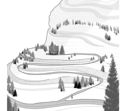
- Grading for streets, roads, alleys, or driveways shall be limited to the paved portion of the right-of-way, plus up to an additional ten (10) feet on either side of the pavement as approved. However, when developing access on slopes in excess of twenty-five percent (25%), only the paved portion of the right-of-way used for vehicular travel, plus the minimum area required for any additional improvements, such as curb, gutter or sidewalk, may be graded. The remainder of the access right-of-way must be left undisturbed.
- Streets or roads may be required to provide access or maintain existing access to adjacent lands for vehicles, pedestrians, emergency services, and essential service and maintenance equipment.
- Private access roads and driveways shall ensure safe, convenient and adequate access to individual buildings. Driveway access to a development must be consistent with Township general plans. In addition, the provision of private access road and driveway access is subject to the following requirements:
- All private access roads and driveways shall comply with the Township Highway ordinances and fire authority regulations.
- All private access roads and driveways greater than one-hundred fifty (150) feet in length shall meet the following requirements:
- Provide a turnaround that meets the Township's road/street and fire authority standards.
- Provide an adequate number of spaced turn-outs along the length of the private access road or driveway, as determined by the Public Works Engineer in consultation with the fire authority.
- If variation from the above standards is sought, the applicant shall apply for a written Code Modification Approval from the fire authority that specifies any additional requirements that must be completed prior to construction.
- Shared private roads and driveways are encouraged between adjacent lots.
- Private access roads and driveways to a building site shall have direct access to a public street or to a private right-of-way previously approved by the Planning Commission.
- Finished grades shall comply with the following:
- Finished private access roads and driveways are limited to a maximum grade of twelve percent (12%), or as determined by the Public Works Engineer on a case-by-case basis based on health and safety concerns and the need for adequate access for Township service providers. In no case, however, may the Public Works Engineer approve a maximum grade greater than fifteen percent (15%).
- Private access road and driveway grades within twenty (20) feet of the roadway are limited to ten percent (10%) slope.
- The Director, in behalf of the Township, has discretion to administratively offer relief of the driveway access standards by a maximum of twenty-five percent (25%) where applicable upon satisfaction of the following criteria:
- The modification is designed to yield:
- More effective preservation of existing mature trees, vegetation, riparian areas, rock outcrops, or other significant natural features of the site;
- Less visual impact on the property or on the surrounding area; or
- Better protection of wildlife habitat; OR,
- Strict application of the standard(s) would render a site undevelopable.
- The modification is designed to yield:
19.72.090 Trails
- All proposed development in the Foothills and Canyons Overlay Zone shall be platted consistent with Township general plans regarding designated public trails, including those portions of the adopted Parks and Recreation Master Plan that designate public trails and public trail(s) access locations. A dedication of private land may be required for public trails and/or access to public trails if the required dedication complies with the exaction requirements set forth in Utah Code section 17-27a-507(1).
- All land offered for dedication for public trails or public access to trails must be verified on the ground by the Director before approval of the site plan. The Township has the option of rejecting an applicant's offered land dedication if the proposed dedication does not comply with the exaction requirements set forth in Utah Code section 17-27a-507(1), and all three requirements set forth in subsection (C) below, Further, in determining whether a proposed dedication may be accepted, the Township may identify more suitable land for the applicant’s consideration as a proposed dedication, provided that the proposed dedication complies with all three requirements set forth in subsection C.
- Land offered for dedication for public trails and/or access to public trails must be located so that:
- Proposed trail construction and maintenance is feasible;
- Side slopes do not exceed seventy percent (70%); and
- Rock cliffs and other insurmountable physical obstructions are avoided.
- At the Township's sole option, dedications for public trails or access to public trails may be of a fee or less-than-fee interest to either the Township, another unit of government, or nonprofit land conservation organization approved by the Township.
- The Township may allow a density bonus up to twenty-five percent (25%) of the maximum allowable density attributable to areas of the site with greater than thirty percent (30%) slope to be transferred to the developable areas of the site where the applicant demonstrates that the offered dedication is beyond what would be roughly proportional to the demand for such public trails or public trail access generated by the proposed development. The Township may reduce the applicable minimum lot area requirement within the site's developable area if necessary to accommodate the transferred density.
19.72.100 Fences
- No fence may be constructed or installed unless shown on an approved site plan.
- Fences shall conform to the design standards of 19.72.170(W).
- Except as allowed in this section, no fence in excess of forty-two (42) inches in height may be constructed or installed. Fences are subject to the Intersecting Streets and Clear Visibility restrictions of this Title.
- Exceptions:
- Fences within the established limits of disturbance, which are used to screen outdoor patio or services areas up to 900 square feet, may exceed 42 inches in height, provided they do not block identified wildlife corridors.
- Privacy barriers along Emigration Canyon Road may exceed 42 inches in height provided:
- The visual impact is mitigated by providing a 5-foot minimum horizontal articulation a minimum of every 40 feet of linear fence or wall, or by providing landscaping between the fence or wall and the road;
- The fence or wall is set back a minimum of 20 feet from the paved surface of the road;
- The fence or wall is compliant with section 19.76.160 - Intersecting streets and clear visibility; and,
- The fence or wall contains a wildlife crossing opening at least 6 feet wide a minimum of every 100 linear feet. This opening may be accomplished between fences or walls on adjoining properties by setting each fence or wall 3 feet from the adjoining side property line.
- The planning commission may approve fences that exceed the limits set forth in this Chapter as necessary to corral animals, to secure telecommunication facilities, public utilities, or other similar facilities, or to secure property upon finding that:
- There are topographic hardships unique to the property;
- Overriding public safety issues justify the proposed fence; or,
- The purposes of the Foothills and Canyons Overlay Zone respecting protection of sensitive slopes, wildlife habitat, streams, and/or natural vegetation are better served by approval of a site development plan that includes the proposed alternative fencing design.
- In no case shall a fence or wall allowed under D.1 through D.3 above be taller than 7 feet in height.
- Fences within the established limits of disturbance, which are used to screen outdoor patio or services areas up to 900 square feet, may exceed 42 inches in height, provided they do not block identified wildlife corridors.
19.72.110 Tree And Vegetation Protection
- Purpose. Protection of existing tree and vegetation cover is intended to:
- Preserve the visual and aesthetic qualities of the canyon.
- Encourage site design techniques that preserve the natural environment and enhance the developed environment.
- Control erosion, slippage, and sediment run-off into streams and waterways.
- Increase slope stability.
- Protect wildlife habitat and migration corridors.
- Conserve energy, in proximity to structures, by reducing building heating and cooling costs.
- Applicability. These provisions apply to all development in the Foothills and Canyons Overlay Zone, with the following exceptions:
- The removal of dead or naturally fallen trees or vegetation to protect public health, safety, and welfare.
- The selective and limited removal of trees or vegetation necessary to obtain clear visibility at driveways or intersections, to perform authorized field survey work, or to protect structures from fire consistent with the Utah Wildland-Urban Interface Code.
- The removal of trees or vegetation on land zoned or lawfully used for agricultural and forestry activities, including tree farms, or pursuant to approved forest management programs. In the event a site is substantially cleared of trees pursuant to such legitimate activities, no development or site plan applications for other types of development may be accepted by the Township within thirty-six (36) months from the date of the clearing.
- The Director, in behalf of the Township, has discretion to administratively offer relief of the standards in this section by up to 25% if either of the following circumstances applies:
- The modification is designed to yield:
- More effective preservation of existing mature trees, vegetation, riparian areas, rock outcrops, or other significant natural features of the site;
- Less visual impact on the property or on the surrounding area; or
- Better protection of wildlife habitat; OR,
- Strict application of the standard(s) would render a site undevelopable.
- The modification is designed to yield:
- Tree/Vegetation Removal.
- Outside the Limits of Disturbance. No trees or vegetation may be removed outside the approved limits of disturbance unless specifically exempted by this Section.
- Within the Limits of Disturbance Significant trees removed from within the limits of disturbance shall be replaced as set forth in this Section.
- Wildfire Hazards and Tree/Vegetation Removal Defensible space is defined as the required space between a structure and wildland area that, under normal conditions, creates a sufficient buffer to slow or halt the spread of wildfire to a structure. Appropriate defensible space surrounding a structure is established in Utah Wildland-Urban Interface Code incorporated in UFA Wildland-Urban Interface Site Plan/Development Review Guide. A copy of the approved fire protection plan shall be submitted to the Director for incorporation into the final approval documents.
- Tree/Vegetation Removal for Views Prohibited. No trees or vegetation may be removed solely for the purpose of providing open views to or from structures on a site.
- Replacement of Significant Trees.
- When a significant tree, as defined in Section 19.72.200, is removed from inside the established limits of disturbance, which removal is not required by wildland-urban interface standards referenced in C.3 above, the applicant or developer shall replace such tree(s) on the development site, according to the following schedule and requirements:
- A significant tree that is removed shall be replaced by two trees with a minimum size of one inch caliper for deciduous trees and a minimum height of four feet for coniferous trees in locations on the lot that are appropriate, feasible, and practical, and that comply with fire requirements and standards, as determined by the Director.
- Replacement trees shall be maintained through an establishment period of at least two (2) years. The applicant shall post a bond in the amount of ten percent (10%) of the value of all replacement trees guaranteeing their health and survival during the first year of the establishment period.
- If the remainder of the lot outside the permitted limits of disturbance is heavily wooded, defined as areas of trees with canopies that cover eighty percent (80%) of the area, and is not suitable to the planting of replacement trees, the requirement to plant replacement trees requirement may be waived by the Director.
- Planting replacement trees may be allowed by the Director on parcels within the subdivision or adjoining open space or forest service land upon the written consent of the property owner or representative of the property owner of the parcel(s) where the trees are being planted. In order to minimize disturbance of public land, saplings may be used in lieu of the larger trees listed in 1(a) above at the rate of 10 saplings per required replacement tree, for trees planted on publicly owned land.
- When a significant tree, as defined in Section 19.72.200, is removed from inside the established limits of disturbance, which removal is not required by wildland-urban interface standards referenced in C.3 above, the applicant or developer shall replace such tree(s) on the development site, according to the following schedule and requirements:
- Revegetation and Land Reclamation Plan.
- On a parcel of land that has been or will be altered from its natural condition by man-made activities, a revegetation and land reclamation plan prepared and certified by a qualified professional may be required for review and approval by the Director. The plan shall incorporate the elements of the fire protection plan, and shall indicate a time frame for revegetation that is acceptable to the Township and that takes into account optimal seasonal growing conditions.
- The revegetation and land reclamation plan shall depict the type, size, number, and location of any vegetation and trees to be planted and illustrate how the site will be recontoured with sufficient topsoil to ensure that vegetation is successful. All new trees shown on the plan shall:
- Comply with the Vegetation Clearance Guidelines of the Wildland-Urban Interface Code,
- Be spaced no closer than twenty (20) feet on center, and,
- Be on the Utah Fire Resistive Species list in the Wildland-Urban Interface Code.
- Any slope exposed or created in new development shall be landscaped or revegetated with native or adapted trees and plant material. New vegetation shall be equivalent to or exceed the amount and erosion-control characteristics of the original vegetation cover in order to mitigate adverse environmental and visual effects.
- On man-made slopes of twenty-five percent (25%) or greater, plant materials with deep rooting characteristics shall be selected to minimize erosion and reduce surface runoff. The planting basin shall be kept level with a raised berm around the base of the plant to help retain moisture.
- Topsoil that is removed during construction may be conserved for later use on areas requiring revegetation or landscaping, such as cut-and-fill slopes.
- The land reclamation plan may not include landscaping or other elements that conflict with the approved fire protection plan.
- Tree/Vegetation Protection During Construction and Grading Activities.
- Limits of disturbance, as established in Section 19.72.160, shall be shown on the final plans for development and shall be clearly delineated on site with fencing or other separation methods approved by the Director prior to the commencement of excavation, grading, or construction activities on the site.
- Within the limits of disturbance, fencing, at a minimum, shall be placed around each significant tree that will not be removed and around stands of twelve (12) or more smaller trees. Such fencing shall be placed at the edge of the individual or outermost tree's drip zone. No construction, grading, equipment or material storage, or any other activity is allowed within the drip zone, and the fencing must remain in place until all land alteration, construction, and development activities are completed.
- If it is necessary to fill over the root zone, compacted soils shall be avoided by sandwiching fabric, rocks, and more fabric under the area to be filled.
- If fill creates a tree well or depression around a tree or shrubs, such area shall be filled in or drained so that the vegetation is not drowned by the pooling of rainfall or irrigation.
- If a significant tree that will not be removed has roots that are cut, the branches shall be trimmed by an amount equal to the percent of roots that were lost. Cutting more than thirty percent (30%) is prohibited. Roots shall be pruned cleanly prior to digging and not ripped off by heavy equipment. If the tree whose roots have been cut dies within a two (2) year period, the replacement provision in section D above applies.
- Utility trenches near trees shall be avoided. If a line must be near a tree, tunneling, auguring, or other mitigation measures shall be used.
- Tree Removal Not Authorized by this Section.
- If a significant tree(s) is removed contrary to any provision in this section, the person(s) responsible for the removal shall pay to the Township the value of the tree(s).
- The value of the tree(s) shall be determined by a tree appraiser who is an ISA (International Society of Arboriculture) certified arborist with at least five years of experience appraising trees using the appraisal methods outlined in the current edition of “The Guide for Plant Appraisal,” authored by the Council of Tree and Landscape Appraisers (CTLA). The appraiser shall prepare an appraisal report using these methods, and adding to the value from these methods an analysis of the tree(s) contributory value, i.e., the value that the tree(s) contributed to the overall value of the property on which they were located.
- The appraiser shall be chosen by the person(s) responsible for the removal and the Director, in behalf of the Township.
- The person(s) responsible for the removal shall pay the cost of the appraisal.
- If a significant tree(s) is removed contrary to this section, all development and permitting and processing of the relevant land use application shall be put on hold for up to sixty (60) days from the date of Township’s discovery of removal. During that time, the Director, in behalf of the Township, will inventory the significant tree(s) that were removed, and the process of valuing the tree(s) that were removed shall commence, pursuant to paragraph 1 above.
- The person(s) responsible for removing the significant tree(s) shall pay for the cost of site restoration, including the removal of the stump(s). The stump(s) may not be removed until an appraisal is completed pursuant to paragraph 1 above.
- The person(s) responsible for removing the significant tree(s) shall also replace the tree(s) in accordance with the provisions in this section. The bond referenced in subsection (D)(1)(b) of this section shall be a surety bond for those that unlawfully remove trees. In addition to the civil penalties provided in paragraphs 1 – 4 of this subsection (G), the person(s) responsible for removing the significant tree(s) may also be subject to criminal prosecution as a Class B misdemeanor for each significant tree unlawfully removed.
- If a significant tree(s) is removed contrary to any provision in this section, the person(s) responsible for the removal shall pay to the Township the value of the tree(s).
19.72.120 Natural Hazards
A natural hazards report, together with geo-technical, slope, soils, and grading reports, may be required as provided in 19.75,030 “Geological Hazards” and Chapter 19.74 “Floodplain Hazards.” The Director may require, consistent with the above ordinances, that preliminary conditions be satisfied prior to final approval of the site plan.
19.72.130 Stream Corridor And Wetlands Protection
- Purpose. The following requirements and standards are intended to promote, preserve, and enhance the important hydrologic, biological, ecological, aesthetic, recreational, and educational functions of stream corridors, associated riparian areas, and wetlands.
- Applicability. Unless previously delineated by Township, boundaries for stream corridors and wetland areas are delineated according to the following standards:
- Stream corridor and wetland area delineation shall be performed by a qualified engineer or other qualified professional with demonstrated experience and expertise to conduct the required site analysis. Delineations are subject to the approval of the Director.
- Stream corridors shall be delineated at the ordinary high-water mark. Stream corridors do not include irrigation ditches that do not contribute to the preservation and enhancement of fisheries or wildlife.
- Boundary delineation of wetlands are established using the current Federal Manual for Identifying and Delineating Jurisdictional Wetlands jointly published by the U.S. Environmental Protection Agency, the Fish and Wildlife Service, the Army Corps of Engineers, and the Soil Conservation Service.
- Prohibited Activities. No development activity may be conducted that disturbs, removes, fills, dredges, clears, destroys, or alters, stream corridors or wetlands, including vegetation, except for restoration and maintenance activities allowed in this Chapter as approved by Salt Lake County Flood Control, the Utah State Engineer’s Office (Division of Water Rights), and other applicable authorities.
- Setbacks.
- Perennial Stream Corridors. All buildings, accessory structures, parking lots, and all on-site wastewater disposal systems shall be set back at least one-hundred (100) feet horizontally from the ordinary high-water mark of perennial stream corridors. (See Figure 19.72.7: Setback from Stream Corridor)
FIGURE 19.72.7: SETBACK FROM STREAM CORRIDOR Wetlands. All buildings, accessory structures, and parking lots shall be set back at least fifty (50) feet, and all on-site wastewater disposal systems shall be set back at least one-hundred (100) feet horizontally from the delineated edge of a wetland.
- Ephemeral Streams. Leach fields shall be set back 100 feet from the channel of an ephemeral stream. All buildings, accessory structures, and parking areas or parking lots shall be set back at least 50 feet from the channel of an ephemeral stream. The Director may recommend to the land use authority modifications to this prohibition upon finding that the modification is likely to cause minimal adverse environmental impact or that such impact may be substantially mitigated. For properties located within the Salt Lake City watershed, the Director shall consult with Salt Lake City Public Utilities prior to making a recommendation.
- Natural Open Space/Landscape Credit for Setback Areas. All setback areas are credited toward any relevant private natural open space or landscape requirements, but are not credited toward public trail access dedication requirements.
- Perennial Stream Corridors. All buildings, accessory structures, parking lots, and all on-site wastewater disposal systems shall be set back at least one-hundred (100) feet horizontally from the ordinary high-water mark of perennial stream corridors. (See Figure 19.72.7: Setback from Stream Corridor)
- Preservation of Vegetation. All existing vegetation within the stream corridor or wetland setback area shall be preserved to provide adequate screening or to repair damaged riparian areas, supplemented where necessary with additional native or adapted planting and landscaping.
- Bridges. Any bridge over a stream corridor and within the stream setback area may be approved, provided the Director affirms that the bridge is planned and constructed in such a manner as to minimize impacts on the stream corridor.
- Modification of Setbacks.
- The Director, in behalf of the Township, has discretion to administratively reduce the perennial stream corridor and wetlands setbacks by a maximum of twenty-five percent (25%) where applicable upon satisfaction of the following criteria:
- The modification is designed to yield:
- More effective preservation of existing mature trees, vegetation, riparian areas, rock outcrops, or other significant natural features of the site;
- Less visual impact on the property or on the surrounding area; or
- Better protection of wildlife habitat; OR,
- Strict application of the standard(s) would render a site undevelopable.
- The modification is designed to yield:
- The Director, in behalf of the Township, has discretion to administratively reduce the perennial stream corridor and wetlands setbacks by a maximum of twenty-five percent (25%) where applicable upon satisfaction of the following criteria:
- Perennial Stream Corridor and Wetland Setback Requirements for Lots of Record.
- Existing Legally-Established Structures. A structure legally existing on the effective date of this Ordinance that is within fifty (50) feet of a perennial stream corridor or wetland may be renovated, altered, or expanded or reconstructed if damaged or destroyed by fire, flood, or act of nature as follows:
- Renovations or alterations or reconstruction of a damaged or destroyed structure that will not increase the gross floor area of the original, existing structure are permitted.
- Renovations, alterations, or expansions that will increase the gross floor area of the original, existing structure are limited to a cumulative total expansion of no more than 250 square feet of gross floor area located closer than 50 feet to a perennial stream corridor or wetland.
- Renovations, alterations, expansions, or reconstruction of a damaged or destroyed structure that increase the gross floor area of the original, existing structure but which are no closer than fifty (50) feet to a perennial stream corridor or wetland are permitted, subject to compliance with all other applicable regulations and standards.
- New Structures. For new developments, the Director may authorize construction to no closer than fifty (50) feet from a perennial stream corridor or to no closer than twenty-five (25) feet from a wetland subject to the following criteria:
- Denial of an encroachment of more than the twenty-five percent (25%) into the stream or wetlands setback area allowed by 19.72.130(G) would render the site undevelopable.
- No alternative location for the development further away from the stream or wetland is feasible or available.
- Creative architectural or environmental solutions have been incorporated into the development proposal in order to ensure that the purposes of stream corridor protection, as set forth in Subsection 19.72.130 are achieved.
- No federal or state laws, or other County ordinances or regulations are violated.
- Limitation. In allowing for the preceding improvements, the Director may not:
- Increase the maximum limits of disturbance set forth in Subsection 19.72.160.
- Authorize the encroachment of more than five-hundred (500) square feet of gross floor area of structural improvements (cumulative total) within the land area between seventy-five (75) feet and fifty (50) feet from a perennial stream corridor or within the land area between fifty (50) and twenty-five (25) feet of a wetland.
- Existing Legally-Established Structures. A structure legally existing on the effective date of this Ordinance that is within fifty (50) feet of a perennial stream corridor or wetland may be renovated, altered, or expanded or reconstructed if damaged or destroyed by fire, flood, or act of nature as follows:
19.72.140 Wildlife Habitat Protection
- Purpose. The Township’s foothills and canyon areas provide important wildlife habitat for a wide variety of animal and bird species. In combination with the tree/vegetation and stream corridor/wetlands protection standards, the following requirements have been developed to promote and preserve valuable wildlife habitats and to protect them from adverse effects and potentially irreversible impacts.
- Development Limitations in Areas of Critical Habitat. All development subject to these provisions shall incorporate the following principles in establishing the limits of disturbance and siting buildings, structures, roads, public trails, and other similar facilities:
- Facilitate wildlife movement across areas dominated by human activities by:
- Maintaining connections between adjacent natural open space parcels and areas, and between natural open space parcels and areas in close proximity.
- Prohibiting fencing types that inhibit the movement of wildlife species.
- Mimic features of the local natural landscape by:
- Minimizing disturbance to trees, the under story, and other structural landscape features during construction.
- Providing selective plantings on the property that enhance the habitat value for the endemic wildlife population.
- Facilitate wildlife movement across areas dominated by human activities by:
19.72.150 Traffic Studies
- Traffic and Parking Impact Study Required. A traffic and parking impact study is required as part of the site plan application for the following developments in the Foothills and Canyons Overlay Zone:
- All residential development that creates a projected increase in traffic volumes equal to or greater than ten percent (10%) of current road/street capacity as determined by the Public Works Engineer.
- All non-residential development that creates a projected increase in traffic volumes equal to or greater than fifty (50) trip-ends per peak hour.
- All development that affects a roadway identified by the Transportation Engineering Manager as having an unacceptable level of service (LOS) based on AASHTO guidelines and the Highway Capacity Manual.
- Review and Improvements. The applicant of a proposed development that is subject to the traffic and parking impact study requirements of Section A must demonstrate that the peak hour levels of service on adjacent roadways and at impacted intersections after development will comply with current Township transportation and impact mitigation policies and recommendations.
- Circulation and Access Plan. The applicant of a proposed development that is subject to the traffic and parking impact study requirements of Section A must also provide a circulation and access plan to ensure free-flowing access to the development site and avoid congestion and unsafe conditions on adjacent public roads and streets. The circulation and access plan may be combined with the required traffic and parking impact study.
19.72.160 Limits Of Disturbance
- Scope and General Requirements. "Limits of disturbance" must be established on the site plan application, indicating the specific area(s) of a site where construction and development activity must be contained. (See FIGURE 19.72.8: ILLUSTRATION OF LIMITS OF DISTURBANCE)
FIGURE 19.72.8: ILLUSTRATION OF LIMITS OF DISTURBANCE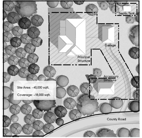
- Purpose for Limits of Disturbance. Limits of disturbance are established for the following purposes:
- Minimizing visual impacts from the development including, but not limited to: screening from adjacent and downhill properties, ridgeline area protection, and protection of scenic views.
- Erosion prevention and control including, but not limited to, protection of steep slopes and natural drainage channels.
- Fire prevention and safety including, but not limited to, location of trees and vegetation near structures.
- Preservation of tree cover, vegetation, and the site’s natural topography.
- Conservation of water including, but not limited to, preservation of existing native vegetation, reduction in amounts of irrigated areas, and similar considerations.
- Wildlife habitat protection including, but not limited to, preservation of critical wildlife habitat and migration corridors and routes.
- Stream corridor and wetland protection and buffering.
- Limits of Disturbance May Be Noncontiguous. Limits of disturbance necessary to accommodate a proposed development may be noncontiguous in order to best achieve the above purposes.
- Maximum Limits of Disturbance.
- For single family residential uses on lots or parcels less than one (1) acre in size, the limits of disturbance are limited to twenty thousand (20,000) square feet.
- For single family residential uses on lots or parcels one (1) acre in size or greater, the limits of disturbance are limited to twenty thousand (20,000) square feet, plus additional area equal to twenty percent (20%) of the acreage over one (1) acre but less than five (5) acres, five percent (5%) of the acreage over five (5) but less than ten (10) acres, and two percent (2%) of the acreage over ten (10) acres.
- For all other uses, the maximum limits of disturbance shall be determined by the Director on a case by case basis in harmony with the purposes of FCOZ as set forth in Section 19.72.010 and in subsection B of this section.
- Modification of Limits of Disturbance.
- The Director, in behalf of the Township, has discretion to administratively increase the limits of disturbance by a maximum of twenty-five percent (25%) where applicable upon satisfaction of the criteria set forth below:
- The modification is designed to yield:
- More effective preservation of existing mature trees, vegetation, riparian areas, rock outcrops, or other significant natural features of the site;
- Less visual impact on the property or on the surrounding area; or
- Better protection of wildlife habitat; OR,
- Strict application of the standard(s) would render a site undevelopable.
- The modification is designed to yield:
- The Director, in behalf of the Township, has discretion to administratively increase the limits of disturbance by a maximum of twenty-five percent (25%) where applicable upon satisfaction of the criteria set forth below:
19.72.170 FCOZ Design Standards
- Purpose. As stated in 19.72.010, the general purpose of design standards is to promote development that balances the rights of the landowner with protection of the foothill and canyon environment. These standards are intentionally broad to allow flexibility in design, compatibility with varying features of the natural landscape, and consistency with the following purposes:
- Preserve and enhance the beauty of the landscape by encouraging the retention of natural topographic features, such as drainage swales, streams, slopes, ridge lines, rock outcroppings, vistas, natural plant formations, trees, and similar features.
- Encourage planning and design of development and building sites that balances safety, recreational opportunity, economic development, and enjoyment of property rights, while adapting development to, and preserving natural terrain.
- Establish a foundation for development in sensitive lands to insure a more harmonious relationship between man-made structures and the natural setting.
- Direct new development in the canyons and foothills toward areas meeting suitability criteria, as outlined in the Emigration Canyon General Plan.
- Advisory or Mandatory Design Standards. The development and design standards set forth in this Chapter fall into two (2) categories: “advisory” standards and “mandatory” standards. Design standards that are advisory encourage voluntary adaptation. Development within the Foothills and Canyons Overlay Zone shall comply with all of the mandatory standards unless alternative design is approved by the Planning Commission upon a finding that the alternative design is in harmony with the purposes of FCOZ. as stated in Section 19.72.010. The design standards and categories are summarized below in Table 19.72.1: FCOZ Design Standards.
SALT LAKE COUNTY, UTAH
TABLE 19.72.1: FCOZ DESIGN STANDARDS DESIGN STANDARDSSALT LAKE COUNTY, UTAH TABLE 19.72.1: FCOZ DESIGN STANDARDS DESIGN STANDARDS Mandatory Advisory A. Select an appropriate site X A site must be suitable for the type of building or use being planned
without major alterations to the site.X Buildings or uses shall comply with this Ordinance and all applicable state and federal laws, recognizing the natural or man-made restraints on particular sites such as slope, soil instability, landslides, avalanche, or flooding. (See, for example, Section 19.72.120 (Natural Hazards) and Chapter 19.74 (Floodplain Hazard Regulations).) Mandatory Advisory B. Site buildings in a manner that preserves existing landforms
See Figure 19.72.9
FIGURE 19.372.9: PRESERVE EXISTING LAND FORMS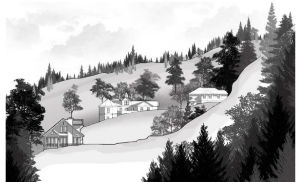
X Each building should be located so that it does not dominate the
landscape. The best way to decrease visual impacts is to locate the
project as far away from prominent viewing locations as possible.X Visually prominent areas of the site shall be left in their natural condition with the exception of areas necessary for access. Structures shall be screened using existing land forms and vegetation. (See Subsection 19.72.110 (Tree and Vegetation Protection).) X Where practical, buildings should be placed in the following locations on a site:
1. Within tree masses to screen buildings. 2. At the edge of trees or land masses overlooking natural open space. 3. In open areas where they are not visible from roads, trails, or other public lands.Mandatory Advisory C. Site buildings so they do not protrude into significant viewscapes.
See Figure 19.72.10
FIGURE 19.72.10: PRESERVE SIGNIFICANT VIEWS
X Buildings should be designed to fit their sites and to leave natural
massing and features of the landscape intact. Each building should be designed as an integral part of the site rather than an isolated object at
odds with its surroundings.X Where feasible, views should be maintained both to the site and to
features beyond, as seen from public rights-of-way, trails, and
other public lands. Projects should not be located on prominent
topographic features where they dominate views or unnecessarily
obscure the views of others.Mandatory Advisory D. Site buildings so their form does not break prominent skylines
See Figure 19.72.11
FIGURE 19.72.11: RIDGELINE DEVELOPMENT
X Buildings shall be sited at less visible places and designed so they are
not obtrusive, do not loom over the hillside, and do not break prominent skylines from key vantage points. Skylines are ridges or hilltops on the horizon line that do not have backdrops behind them as viewed from key vantage points. Heavily traveled public roads located below skylines or hilltops are key vantage points.Mandatory Advisory E. Site buildings to preserve significant trees and vegetation.
See Figure 19.72.12
FIGURE 19.72.12: PRESERVE SIGNIFICANT VEGETATION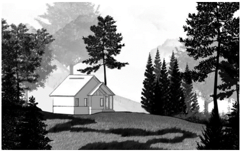
X Buildings shall be sited to keep removal of significant trees and
vegetation to a minimum. (See section 19.72.160 (Limits of disturbance), 19.72.110 (Tree and vegetation protection.)Mandatory Advisory F. Cluster buildings and parking, and coordinate neighboring
developments.
See Figure 19.72.1X Clustering is encouraged to reduce land disturbance and the cost of
providing services, road and parking area maintenance, snow removal,
etc. (See Section 19.72.080 (Site Access).)X Cooperative, coordinated development and the sharing of services, infrastructure, facilities, and parking among adjoining landowners is encouraged. Mandatory Advisory G. Locate parking facilities to minimize their visual impact.
See Figure 19.72.13
FIGURE 19.72.13: PARKING LOCATION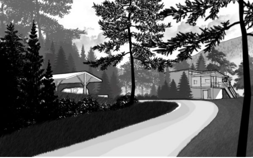
X When visible from publicly used roads, parking facilities shall be
screened to blend into the natural environment. Parking lot design that requires backing onto a public street is prohibited. (See Section
19.72.080 (Site Access)X Parking facilities should be located to the rear or side of main buildings if possible when a site has a lot width of 100 feet or more. X Parking facilities shall be designed consistent with the existing topography. X Parking facilities shall provide adequate snow storage areas. Mandatory Advisory H. Place utility lines underground. X When possible, utilities shall be placed underground and within existing roadways or in established shoulders to minimize the impact to existing natural features, such as natural vegetative patterns and land forms. X Tree cutting for utility corridors shall be minimized to reduce visual
impacts. All disturbed areas shall be re-vegetated. (See Section
19.72.110 (Tree and Vegetation Protection).)Mandatory Advisory I. Design buildings to solidly meet the ground plane.
See Figure 19.72.14
FIGURE 19.72.14: STRUCTURES MEET THE GROUND PLANE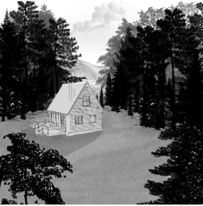
X Building designs that require a strong structural statement, such as
extensive cantilevers or cuts and fills, are prohibited on sensitive
hillsides with slopes greater than thirty percent (30%), wetlands,
streams, or hillsides with soil instability consistent with this Ordinance.X Buildings shall firmly meet the ground. Placing buildings on piers such
that exterior walls do not continue down to the ground is prohibited, with
the exception of piers that support decks.Mandatory Advisory J. Design buildings on hillsides to follow the natural terrain.
See Figure 19.72.15
FIGURE 19.72.15: STRUCTURE FOLLOWS HILLSIDE TERRAIN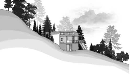
X Buildings shall be located to minimize earth work and land disturbance. X Buildings shall be designed to follow natural contours rather than
modifying the land to accept a building design not tailored to the site.
(See Section 19.72.070 (Grading))Mandatory Advisory K. Design buildings to minimize mass and scale
See Figure 19.72.16
FIGURE 19.72.16: MASS AND SCALE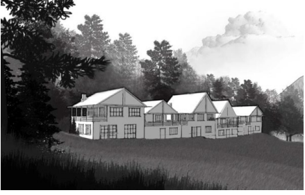
X Building designs shall incorporate changes in the planes of walls and
changes in the slope and height of roof lines to add variety, create visual interest, and minimize scale.X The massing of buildings shall be scaled to harmonize and achieve
balance with the natural features of the specific site.X Roof lines and building mass shall echo the angles and shapes repeated
in the natural landscape.X Building mass and wall lines shall be broken up to complement natural
canyon settings and slopes.Mandatory Advisory L. Select appropriate building materials and colors X Predominant tones on exterior walls shall tend toward neutral colors, replicating natural textures—for example, warm earthy hues; dark green
of forests; whites, greys, and grey-brown of the mountains; the tan of grasses; and similar colors. Bright, harshly contrasting color combinations
are prohibited. Paint finishes shall have low levels of reflectivity.X The use of self-weathering metals is encouraged. Chemically treating
wood so that it can be allowed to self-weather is also encouraged.Mandatory Advisory M. Use fire-resistant roof surfacing materials that blend with the
colors of the adjacent landscape.X The color of roof surfacing materials shall blend with the surrounding landscape such as brown, tan, dark green, grey, etc. X Flammable wood roofing shingles are prohibited in the canyons or
foothills.Mandatory Advisory N. Preserve existing trees and vegetation. X Significant trees and vegetation shall be preserved as provided in Section 19.72.110. X When landscaping within the thirty (30)-foot fire-break area, the use of fire-resistant plants is strongly encouraged. X Dryland species of plants shall be selected for slope re-vegetation. Mandatory Advisory O. Landscape in order to retain the original character and
harmony among the various elements of a site.X Landscaping shall incorporate natural features such as trees, significant vegetative patterns, interesting land forms, rocks, water, views, and orientation. X Landscaped areas should be an integral part of the development project,
and not simply located in left-over space on the site. New planting should blend in with the existing landscape.X All disturbed areas shall be re-vegetated using native or adapted plant species and materials characteristic of the area. X Use of fire-resistant plants is encouraged. Mandatory Advisory P. Limit site grading for buildings to preserve existing land forms.
See Figure 19.72.17
FIGURE 19.72.17: BUILDINGS DESIGNED TO LIMIT GRADING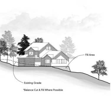
X Building designs that require extensive cut and fills are prohibited. See Section 19.72.070. X Modification of the natural terrain should be minimized. X Slopes steeper than thirty percent (30%) shall not be disturbed except as allowed by this Chapter. X Buildings, driveways, and roads shall follow the natural contours of the
site as feasible, and comply with county excavation, grading, and erosion control standards.Mandatory Standard Advisory Standard Q. Preserve natural drainage patterns in site design.
See Figure 19.72.18.
FIGURE 19.72.18: PRESERVE NATURAL DRAINAGE PATTERNS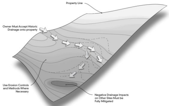
X All final excavation, grading, and drainage plans shall conform to
applicable county excavation, grading, and erosion control standards.X Development shall preserve the natural surface drainage pattern unique
to each site. Grading plans shall ensure that drainage flows away from structures, especially structures that are cut into hillsides.X Development must prevent negative or adverse drainage impacts on
adjacent and surrounding sites.X Standard erosion control methods are required during construction to
protect water quality, control drainage, and reduce soil erosion. Sediment traps, small dams, or barriers of straw bales shall be generally required to slow the velocity of runoff.Mandatory Advisory R. Locate buildings outside stream corridor buffer zones X Permanent structures shall be located a minimum of one-hundred (100) feet horizontally (plan view) from the ordinary high-water mark of stream corridors or other bodies of water. At the discretion of the Director and based on site-specific soils, water, or vegetation studies, setback distances may be reduced as provided in Section 19.72.130 (Stream Corridor and Wetlands Protection). X Where feasible, developments shall not alter natural waterways. Mandatory Advisory S. Construct bridges for stream crossings.
See Figure 19.72.19
FIGURE 19.72.19: CULVERTS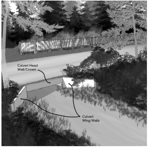
X Culverts may only be installed on small side drainages, across swales, and on ephemeral or intermittent streams. (See Section 19.72.130, (Stream Corridor and Wetlands Protection)). Culverts are prohibited to cross perennial streams; bridges to cross perennial streams are permitted. X Bridges and culverts shall be sized to withstand one-hundred (100) year storm events. Concrete or stone head walls and side walls are required to maintain the integrity of the bridge structure. (See Chapter 19.74 (Floodplain Hazards). Mandatory Advisory T. Design traffic circulation to respect existing topography,
achieve acceptable slopes, and adhere to minimum width
and turning standards.
See Figure 19.72.20
FIGURE 19.72.20: DRIVEWAY DESIGN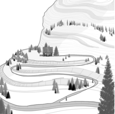
X Vehicular access shall be safe and have adequate width to allow for snowplowing and snow storage. X Access roads shall avoid steep grades and sharp turning radii that can
make access, especially in the winter, difficult.Mandatory Advisory U. Provide safe, adequate off-street parking with year-round access X New development shall comply with off-street parking requirements
provided in this Ordinance.X Shared driveways and shared parking areas with adjoining owners are encouraged. X Off-street parking areas shall be large enough to avoid vehicles having to back out onto a public street. Mandatory Advisory V. Design new roads and driveways to reduce their visual impact. X Roads and driveways should be screened using existing land forms and vegetation. Long tangents, including on side roads intersecting with arterial roads or highways, should be avoided in favor of curvilinear alignments reflecting topography. X Cuts and fills shall be re-graded to reflect adjacent land forms and re-
vegetated with native plants. See Section 19.72.070.Mandatory Advisory W. Respect existing land forms, contours, and natural settings in the placement of fences.
See Figures 19.72.21 and 19.77.22
FIGURE 19.72.21: QPAQUE FENCE FOR SCREENING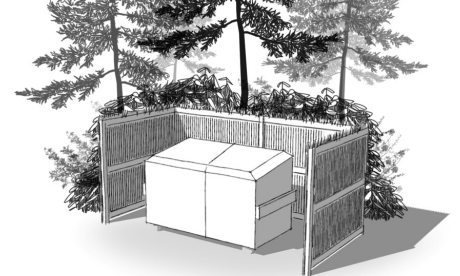
FIGURE 19.72.22: FENCES RESPECT EXISTING LAND FORMS
X Fences may be erected to screen service and outdoor areas or provide a safety barrier. (See Section 19.72.070 (Grading Standards—Retaining Walls)) X Fencing used to screen patios, other outdoor areas, and service areas may be composed of the following fencing materials:
a. Natural or stained wood b. Brick c. Rock d. Stone e. Pre-cast fences or walls textured and colored to imitate any of the above materials f. Wrought ironX The following fencing materials are prohibited:
a. Solid board b. Concrete or concrete block c. Chain link, except around telecommunications facilities, public utility compounds, and other related or similar facilities where security concerns and terrain make this type of fencing practical, as approved by the Planning Commission for fences around conditional uses and approved by the Director for fences around permitted uses. Where a chain link fence is used, a powder or dull coating of the fence is required. d. Plywood e. Painted materials f. Vinyl, except rail fences for containment of horsesX Subject to the height limits of 19.72.100, rail fences and low rock walls are permitted along property lines. X Except as allowed under 19.72.100.D, fences located along arterial roads or highways are limited to a maximum height of 42 inches in height. X Walls and fences are to be reviewed on a site-by-site basis, and require compliance with the International Building Code. Mandatory Advisory X. Select and locate lighting fixtures only where needed to provide for the safe movement of people on the site.
See Figure 19.72.23
FIGURE 19.72.23: SHIELDED LIGHTING
X Light poles for public outdoor recreational facilities are limited to 24 feet in height. Light poles for outdoor recreational facilities on private residential property are limited to 18 feet in height. Both require site plan review which may require restrictions on locations and hours of illumination based upon impacts on adjoining properties. X With the exception of light poles for outdoor recreational facilities, lights poles, and building-mounted fixtures shall be designed with fully shielded luminaires directed downward.
19.72.190 Waivers For Public Uses
- Authority to Grant Waivers. The topographic conditions, soil characteristics, hydrologic patterns, climatic constraints, susceptibility to natural hazards, vegetation, wildlife habitat concerns, and aesthetic considerations of foothill and canyon areas often create circumstances in which strict compliance with adopted standards is not only difficult but sometimes impossible to achieve. As these challenges are frequently created by the very nature and operational characteristics of many public uses, and are therefore most often self-imposed, other avenues of administrative relief are sometimes necessary and appropriate. Accordingly, the planning commission may waive or modify the development standards for these uses.
- Waiver Request Procedures.
- A petition or request for a waiver or modification of an FCOZ development standard may be submitted in writing by the owner or authorized agent of the subject property. The petition or request shall be made concurrent with the related land use permit application-- for example, conditional use application. The petition or written request shall clearly explain:
- Those aspects or elements of the development proposal that are strictly prohibited.
- All FCOZ requirements requested to be waived or modified in order for the development to reasonably proceed.
- The basis, justification or grounds for granting the waiver or modification.
- Why other common designs or improvements that may be less impactful on the environment and adjacent properties are not being considered.
- Each requested waiver or modification is to be referred for decision to the planning commission. The waiver or modification petition is to be accompanied by a written staff report with recommendations.
- When a public hearing is required, the notice shall be given 14 days in advance of the hearing and shall specify the waivers or modifications requested, the relevant ordinance provisions from which the waivers or modifications are sought, and the general nature of the development that is proposed if the requested waivers or modifications are granted.
- A petition or request for a waiver or modification of an FCOZ development standard may be submitted in writing by the owner or authorized agent of the subject property. The petition or request shall be made concurrent with the related land use permit application-- for example, conditional use application. The petition or written request shall clearly explain:
- Approval Standards. In deciding whether to grant requested waivers or modifications to the development standards of the Foothills and Canyons Overlay Zone, the planning commission shall consider the following standards as deemed applicable by the planning commission:
- Whether the requested waiver and improvements would contribute to the overall use, operation, and maintenance of the property, and whether reasonable alternative means exist to reduce or mitigate adverse impacts.
- Whether strict compliance with these regulations may result in substantial economic hardship or practical difficulties for the owner of the property.
- Whether strict or literal interpretation and enforcement of the specified regulation may result in a development approach inconsistent with the intent and objectives of this Chapter.
- Whether the requested waivers or modifications may result in a development proposal that better preserves area views, reduces adverse impacts on existing trees and vegetation, reduces the overall degree of disturbance to steep slopes, protects wildlife habitat, or reflects a greater degree of sensitivity to stream corridors, wetlands, rock outcrops, and other sensitive environmental features in the vicinity of the proposed improvements.
- Whether the granting of the requested waiver or modification may have neutral or beneficial impact to the public health, safety, or welfare, or to properties or improvements in the vicinity.
- Whether the proposed development, as modified by the requested waiver, is consistent with the goals, objectives, and policies of the adopted community general plan applicable.
- Whether creative architectural or environmental solutions may be applied to alternatively achieve the purposes of this Chapter.
- Whether the development in all other respects conforms to the site design, development, and environmental standards set forth in the Foothills and Canyons Overlay Zone and in all other applicable ordinances and codes.
- Whether the requested waivers or modifications do not violate other applicable federal, state, and local laws.
- Waivers. Slope waivers are not required for facilities or uses with slopes of thirty percent (30%) or less. Slope waivers are required for eligible development activities associated with such land uses according to Table 19.16.2.
TABLE 19.16.2: PERMISSIBLE SLOPE RANGES FOR ELIGIBLE DEVELOPMENT ACTIVITIES Authority to Grant Waivers Slope Range Eligible Development Activities 30% or less No slope waiver required Greater than 30% up to 40% All development activities associated with allowed uses Greater than 40% up to 50% Pedestrian Trails
Non-motorized vehicle trails
Motorized vehicle roads and trails for emergency
or maintenance purposesGreater than 50% Pedestrian Trails
Non-motorized vehicle trails
- Action on Waiver Requests.
- The requested waiver or modification may be approved as proposed, denied, or approved with conditions.
- The decision on the requested waiver or modification shall include the reasons for approval or denial.
- In granting a waiver from or modification of development standards, conditions may be imposed to mitigate the impacts of the proposed development on adjacent properties and the area. These may include, for example, measures to:
- protect scenic vistas, especially views from public rights-of-way and public lands,
- protect natural settings in the vicinity of site improvements, and
- enhance the relationship to and compatibility with other structures and open spaces in the vicinity of the proposed improvements.
- All development shall comply with approved plans. Any proposed revisions or changes to plans requires a re-submittal and request for final action.
19.72.200 Definitions
For the purposes of this Chapter, the following terms shall have the following meanings:
Alteration Any change or rearrangement in the supporting members of an existing structure, such as bearing walls, columns, beams, girders, or interior partitions, or any change in the dimensions or configurations of the roof or exterior walls.
Building site A space of ground occupied or to be occupied by a building or group of buildings.
Caliper A standard for trunk measurement of nursery stock, determined by measuring the diameter of the trunk six inches above the ground for up to and including five-inch (5”) caliper size, and twelve inches (12”) above the ground for larger trees.
Clustering A development or subdivision design technique that concentrates buildings or lots on a part of the site to allow the remaining land to be used for recreation, common open space, and/or preservation of environmentally sensitive areas.
Development site A space of ground within an approved limits of disturbance which has been developed or is proposed for development as defined in section 19.02.165.
Driveway A private area used for ingress and egress of vehicles, which allows access from a street or road to a building, structure, or parking spaces.
Engineering geologist
A geologist who, through education, training and experience, is able to conduct field investigations and interpret geologic conditions to assure that geologic factors affecting engineered works are recognized, adequately interpreted, and presented for use in engineering practice and for the protection of the public.
Expansion An increase in the size of an existing structure or use, including the physical size of the property, building, parking, and other improvements.
Fence A structure erected to provide privacy or security, which defines a private space or is used to constrain domestic animals.
Geo-technical engineer A professional engineer licensed in the State of Utah, whose education, training, and experience is in the field of geo-technical engineering.
Grading Any change of existing surface conditions by excavating, placing of any soils or rocks, or stripping of vegetation.
Landscape architect A person who is licensed to practice landscape architecture by the state of Utah.
Limits of disturbance The area(s) in which construction and development activity are to be contained, including development and construction of the principal building, accessory structures, recreation areas, utilities, services, driveways, septic tank drain fields and related system requirements, storm drainage, and other similar services or improvements. The following need not be included in limits of disturbance:
- Up to ten (10) feet of paved or unpaved shoulders for driveways.
- Areas consisting of natural ponds, streams, trees, and other vegetation where no grading work is done.
Lot of Record A lot or parcel of land established in compliance with all applicable state statutes, county ordinances, and/or other legal requirements at the time of its creation and recorded in the office of the Salt Lake County recorder either as part of a recorded subdivision or as described on a deed, having frontage upon a street, a right-of-way approved by the Land use hearing officer, or a right-of-way not less than twenty feet wide.
Natural open space Land in a predominantly open and undeveloped condition that is suitable for any of the following: natural areas; wildlife and native plant habitat; important wetlands or watershed lands; stream corridors; passive, low-impact activities; little or no land disturbance; or trails for non-motorized activities. Net developable acreage “Net developable acreage” is defined as land with all of the following:
- An average slope less than thirty percent (30%).
- Soils of a suitable depth and type based on soil exploration and percolation tests in accordance with the regulations of the Utah Department of Environmental Quality in order to ensure against adverse impacts on surface and groundwater quality.
- Minimum distance from any stream corridor as defined in this Chapter.
- Free from any identified natural hazards such as flood, avalanche, landslide, high water table and similar features. (See Chapter 19.74 (Floodplain Hazard Regulations) and Section 19.72.120 (Natural Hazards).
Open Space Any area of a lot that is completely free and unobstructed from any man-made structure or parking areas.
Ordinary high water mark
- The line on the bank to which the high water of a stream ordinarily rises annually in seasons, as indicated by changes in the characteristics of soil, vegetation, or other appropriate means, taking into consideration the characteristics of the surrounding areas.
- Where the ordinary high water mark cannot be found, the top of the channel bank shall be substituted.
- In braided channels, the ordinary high water mark shall be measured to include the entire stream feature.
Overlay zone A zoning district that encompasses one or more underlying zones and that imposes additional or alternative requirements to that required by the underlying zone.
Public Trails A type of natural open space that is a system of public recreational pathways located within the unincorporated county for use by the public for walking, biking, and/or horseback riding as designated
Qualified professional A professionally trained person with the requisite academic degree, experience, and professional certification or license in the field(s) relating to the subject matter being studied or analyzed.
Retaining wall A wall designed and constructed to resist the lateral displacement and erosion of soils or other materials.
Ridge line protection area An area consisting of a prominent ridge line that is highly visible from public rights-of-way or trails, and that includes the crest of any such designated prominent hill or slope, plus the land located within one-hundred feet (100’) horizontally (map distance) on either side of the crest.
Significant trees Live trees of six-inch (6”) caliper or greater, groves of five or more smaller live trees, or clumps of live oak or maple covering an area of fifty (50) square feet to the drip line perimeter.
Site plan
An accurately scaled plan that illustrates the existing conditions on a land parcel and the details of a proposed development, including but not limited to: topography; vegetation; drainage; flood plains; wetlands; waterways; landscaping and open space; walkways; means of ingress and egress; circulation; utility easements and services; structures and buildings; lighting; berms, buffers and screening devices; development on adjacent property; and any other information that may be required to make an informed decision on a development application.
Slope The level of inclination from the horizontal, determined by dividing, in fifty (50) foot intervals, the average horizontal run of the slope into the average vertical rise of the same slope and converting the resulting figure into a percentage value.
Stream, Ephemeral Those channels, swales, gullies, or low areas that do not have flow year-round or are not shown on United States Geological Services (U.S.G.S.) topographic maps as perennial streams. These are generally channels that are tributary to perennial streams, other ephemeral streams, terminal low areas, ponds, or lakes. They are typically dry except during periods of snow-melt runoff or intense rainfall. (Contrast with “Stream, Perennial.”)
Stream, Perennial Those streams, excluding ephemeral streams, or ditches and canals constructed for irrigation and drainage purposes, which flow year-round during years of normal rainfall, and that are identified on the appropriate United States Geological Services (U.S.G.S.) topographic maps as perennial streams. (Contrast with “Stream, Ephemeral.”)
Stream corridor The corridor defined by a perennial stream’s ordinary high water mark.
Substantial economic hardship A denial of all reasonable economic use of a property.
Trails A recreational pathway for walking, biking, and/or horseback riding as designated.
Undevelopable Undevelopable means strict application of this title prevents the minimum development necessary to establish a permitted or conditional use in the underlying zone on the property.
Vegetation Living plant material, including but not limited to trees, shrubs, flowers, grass, herbs, and ground cover.
Waiver Permission to depart from the requirements of an Ordinance with respect to the application of a specific regulation.