
Estacada City Zoning Code
Division II
Zoning Districts
Chapter 16.52 PLANNED DEVELOPMENT (P-D)
Prior code history: Prior code § 10.230.
2019-005
2025-013
2018-007
2022-010
2023-003
2023-007
2025-010
2023-008
2025-001
2025-008
2024-005
2020-004
2025-004
16.12.010 Classification Of Zones
For the purpose of this title, the following zones are established in the city:
Map Designations and Abbreviations.
- Residential Zones.
Low Density Residential R-1 Medium Density Residential R-2 Multiple Family Residential R-3 North City Residential NCR - Commercial Zones.
General Commercial C-1 Riverfront Commercial R-C Highway Commercial H-C Outdoor Commercial O-C - Mixed-Use Zones.
Downtown D Residential Commercial C-2 Mill Area Mixed-Use MMU Central Mixed-Use CMU - Industrial Zones.
Light Industrial M-1 Airport A-P - Open Space/Public Facility Zones.
Open Space/Public Facilities O-S - Special Overlay Zones.
Historic Resources H-R Planned Development P-D Airport Safety And Compatibility ASC Wetland Resources W-R (Prior code § 10.211) (Ord. No. 2012-005, § 1, 9-10-2012)
16.12.020 Location Of Zones
The boundaries for the zones listed above are appended to the ordinance codified in this chapter as an appendix to this development code and marked as such with the area or areas of every zone, particularly described and are also indicated on the map entitled "Estacada, Oregon Zoning." Official maps are on file in the office of the city recorder in a book or place kept for that purpose and open to public inspection. These maps are incorporated into and made part of this development code.
(Prior code § 10.212)
16.12.030 Zoning Boundaries
Unless otherwise specified, zone boundaries are section line, subdivisions, lot lines, centerlines or road rights-of-way, or such lines extended or other similar lines.
(Prior code § 10.213)
16.12.040 Zoning Maps
Maps of zones or amendments to location of zones adopted pursuant to requirements of this title shall be prepared by authority of the city to the map amendment so prepared. The map or amendment shall be dated with the effective date of the ordinance that adopts the amendment.
(Prior code § 10.214)
16.12.050 Zoning Of Annexed Areas
Areas annexed to the city shall be zoned in accordance with the adopted comprehensive plan and may be reviewed by the planning commission to determine if the proposed use is compatible with the proposed zoning designation. The planning commission may recommend a different zone designation to the city council for consideration during the annexation procedure.
(Prior code § 10.215)
16.12.060 Zone Descriptions
- Low Density Residential (R-1): Intended primarily for lower-density residential uses, including single-family dwellings and small-scale middle housing, but also allows home occupations, short-term rentals with standards, and certain public nonprofit conditional uses.
- Medium Density Residential (R-2): Intended for residential use at a moderate density, including single-family dwellings and middle housing.
- Multiple Family Residential (R-3): Intended for residential use as a high density residential district allowing some conditional uses with standards.
- North City Residential (NCR): Intended to establish a variety of housing types to meet the City's rental and affordable housing needs, while focusing multi-family housing nearer to major roads, protecting natural features and existing residential land uses, and providing for open space.
- Downtown (D): Intended to implement the Estacada Downtown and Riverside Area Plan (adopted 2011). The zone encourages a mix of office, service, retail, light manufacturing, and governmental uses. The D zone also allows residential uses in upper stories of commercial buildings, and high density residential and mixed-use (residential and commercial) development oriented to the Clackamas River.
- General Commercial (C-1): Intended to promote economic diversification. It accommodates certain commercial, light industrial, and governmental uses that are not conducive to locating in the D zone, such as those with large, unenclosed sales or storage areas, and those requiring large parcels of land.
- Residential Commercial (C-2): Designed for a mixture of office, retail, personal or business service, and residential uses, in order to promote the most productive capacity of property.
- Mill Area Mixed-Use (MMU): Intended to provide flexible opportunities for the development of a mix of land uses that are safe, clean, and compatible with existing and planned land uses at the core of the City.
- Riverfront Commercial (R-C): Intended to promote local tourism and history, outdoor recreation, and the use of adjacent park facilities, the Clackamas River, and connecting multi-use paths with a variety of commercial uses that attract local and out-of-town customers while enhancing the area's natural aesthetics and protecting adjacent open spaces.
- Highway Commercial (H-C): Intended to provide for large-footprint and vehicle-oriented commercial uses that are not appropriate for Downtown or other commercial areas, while ensuring that new development is appropriately screened and restricting residential uses, industrial uses, and excessive signage.
- Central Mixed-Use (CMU): Intended to establish small-footprint commercial uses, intermixed with denser residential uses, that cater primarily to customers in nearby residential areas and that do not detract from Downtown, while developing Eagle Creek Rd as a tree-lined, pedestrian- and bicycle-friendly corridor.
- Outdoor Commercial (O-C): Intended to preserve and enhance the area's natural aesthetic and establish commercial and public uses that attract local and out-of-town visitors, while protecting natural wetlands and adjacent residential land uses and ensuring that the area's commercial uses do not detract from Downtown.
- Light Industrial (M-1): Created for the expansion of light industrial uses. Permits wholly enclosed light industrial uses and compatible commercial uses which are compatible to the surrounding area.
- Airport (A-P): Created to encourage and support the continued operation and vitality of public-use airports by allowing certain airport-related commercial, residential, and recreational uses in accordance with state law.
- Open Space/Public Facilities Overlay (O-S): Created to ensure public greenways, pathways, and parks, and to allow governmental uses including public schools.
- Planned Development Overlay (P-D): Intended to permit the application of new technology and greater freedom than may be possible under a strict interpretation of the provisions of the development code.
- Airport Safety and Compatibility Overlay (ASC): Intended to encourage and support the continued operation and vitality of Estacada’s public-use airport(s) by establishing compatibility and safety standards to promote air navigational safety, and to reduce potential safety hazards for persons living, working or recreating near the airport.
- Historical Resources Overlay (H-R): Intended to encourage property owners to enhance and maintain historically designated resources within the community.
- Wetlands Resources Overlay (W-R): Intended to protect designated wetland resources within the community.
(Prior code § 10.218; Ord. No. 2012-005, § 2, 9-10-2012; Ord. No. 2016-003, § 1(Exh. A), 5-23-2016)
16.16.010 Purpose
The R-1 zone is intended primarily for lower-density residential uses, including single-family dwellings and small-scale middle housing, but also allows home occupations, short-term rentals with standards, and certain public nonprofit conditional uses. In an R-1 zone, the following regulations shall apply.
(Ord. 2000-26 §1 (part): prior code § 10.220 (part); Ord. No. 2016-003, § 1(Exh. A), 5-23-2016; Ord. No. 2017-006, § 2, 11-13-2017; Ord. No. 2018-001, § 1, 6-11-2018; Ord. No. 2018-002, § 1, 8-13-2018)
16.16.020 Uses Permitted Outright
The following uses and their accessory uses are permitted in an R-1 zone:
- A single-family dwelling built on site;
- A manufactured home that meets the following minimum standards:
- Compliance with all the standards as set by the underlying zoning district;
- The manufactured home shall be certified by the manufacturer to have an exterior thermal envelope meeting the performance standards which reduce heat loss to levels equivalent to the performance standards required of single-family dwellings constructed under the state building code as defined in ORS 455.010. Evidence demonstrating that the manufactured home meets "Super Good Cents" energy efficiency standards is deemed to satisfy the exterior thermal envelope certification requirement. Additional manufacturer certification shall not be required;
- Duplex;
- Commonwall dwellings up to two units;
- Agricultural use of land provided that no livestock shall be raised or kept on the premises and that no commercial structure shall be constructed or maintained on the premises;
- A travel trailer or recreation vehicle stored unoccupied on a lot in combination with an approved dwelling and complies with residential setback requirements;
- Small childcare facility as defined in EMC 16.08;
- Youth support services facility as defined in EMC 16.08;
- Large childcare facility as defined in EMC 16.08, located within an existing church or school facility;
- Public park;
- Residential home as defined in EMC 16.08;
- Short-term rental subject to the provisions of EMC 16.62;
- Home occupation as defined in EMC 16.92 that involves no customer traffic, retail sales, signs or any other outward appearance of a business;
- Accessory dwelling unit (ADU) subject to the provisions of EMC 16.61.
(Ord. 2007-6 § 2; Ord. 2000-26 § 1(1): prior code § 10.220(1); Ord. No. 2016-003, § 1(Exh. A), 5-23-2016; Ord. No. 2017-006, § 2, 11-13-2017; Ord. No. 2018-001, § 1, 6-11-2018; Ord. No. 2018-002, § 1, 8-13-2018)
16.16.030 Conditional Uses Permitted
The following uses and accessory uses may be permitted in a low density residential district subject to EMC 16.88.020 and the review procedures in EMC 16.132.010 through EMC 16.132.050:
- Cemetery;
- Church, nonprofit religious or philanthropic institution;
- Community center, nursery school, kindergarten or similar facility;
- Governmental structure or use of land;
- Public utility substation as required with safeguards against harm to adjacent or abutting property owners;
- Home occupation subject to the provisions of EMC 16.92;
- Golf course or country club, but excluding miniature golf course or similar types of amusement facilities;
- Private noncommercial recreation club such as tennis, swimming or archery club, but excluding commercial amusement or recreation enterprises;
- Lodge of civic or fraternal organizations;
- New public school or any private school offering curriculum similar to public school;
- Temporary real estate office offering residential property in the immediate vicinity for sale, rent or lease;
- Large childcare facility as defined in EMC 16.08, not located within an existing church or school facility;
- Professional office or medical facility;
- Public transportation facility not otherwise listed in EMC 16.16.020 Subsection L;
- Transportation facility not identified in the city's transportation system plan or active transportation plan.
(Ord. 2007-6 § 3; Ord. 2000-26 § 1(2): prior code § 10.220(2); Ord. No. 2012-008, § 4, 1-14-2013; Ord. No. 2016-003, § 1(Exh. A), 5-23-2016; Ord. No. 2017-006, § 2, 11-13-2017; Ord. No. 2018-002, § 1, 8-13-2018; Ord. No. 2018-003, § 3(Exh. 6), 10-8-2018)
16.16.035 Alteration Or Expansion Of Public Schools
Alteration or expansion of a public school, including, but not limited to, placement of portable or temporary modular classrooms on-site, when the following standards are met:
- The public school was legally established prior to December 21, 2012.
- The alteration or expansion complies with the standards listed in EMC 16.16.040
(Ord. No. 2012-008, § 5, 1-14-2013; Ord. No. 2017-006, § 2, 11-13-2017)
16.16.037 Prohibited Uses
Marijuana production, marijuana processing, marijuana wholesaling, and marijuana retailing are prohibited in the R-1 zone.
(Ord. No. 2016-005, § 2, 8-22-2016; Ord. No. 2017-006, § 2, 11-13-2017)
16.16.040 Standards
The following standards shall apply in an R-1 zone:
- Lot Size and Dimensions.
- The minimum lot size shall be seven thousand five hundred (7,500) square feet.
- Minimum lot frontage for a flag lot shall be twenty-five (25) feet.
- No lot area, yard, off-street parking or loading area, or other required open space for one use shall be used as the required lot area, yard, off-street parking or loading area, or other required open spaces for another use.
- Parking Requirements. The number of parking spaces as required by EMC 16.76 shall be provided.
- Setbacks.
- The front setback shall be a minimum of twenty (20) feet.
- Side setbacks for commonwall dwellings shall be as follows:
- The minimum side setback for the common side of attached dwellings is zero (0) feet.
- Two-unit commonwall dwellings shall meet the side setback standard provided in Subsection 3 for sides that are not attached.
- Minimum side setbacks shall be five (5) feet, except:
- The common side of a commonwall dwelling, which is zero (0) feet.
- Dwellings with a second story bedroom window that faces a side yard and is situated more than fifteen (15) feet above the ground level. As demonstrated in Figure 1 below, the minimum side setback is calculated by dividing the lower windowsill height (the distance from the lower windowsill to grade level directly below the center of the window) by three. Such windows used for egress must have minimum dimensions of at least three feet by three feet. The bedroom may instead be equipped with an automatic fire sprinkler system, unless otherwise approved by the City.
- If a public utility easement (PUE) exists on the side property line, the side yard setback shall be equal to the width of the PUE, if greater than the side yard setback required above.
Figure 1.
- The rear setback shall be a minimum of fifteen (15) feet except:
- An accessory structure not used for human habitation and separated from the main building may be located up to five (5) feet from a rear property line.
- On a corner lot, setbacks required from the rear property line shall be the same as required for side yards.
- Detached accessory dwelling units are allowed exceptions to rear setbacks as provided in EMC 16.61.060.C.3.a.
- Sidewalks. Sidewalks, driveways and service driveways shall conform to standards established by this code.
- Fences.
- Fences and sight-obscuring fences, with the exception of evergreen plantings, cannot exceed seven (7) feet in height without a building permit.
- Fences described above are subject to clear vision regulations of EMC 16.60.010 and EMC 8.12.050 limiting the use of barbed wire and electrical fences.
- Drainage. An applicant for a building permit shall submit a plan showing width, depth, and direction of flow of all drainage channels on property. In addition, the location, size and type of conduit used in drainage channels and driveway accesses shall be clearly delineated. Water from roof drains and other impervious surfaces shall not be concentrated and directed so as to cause damage to property and shall be disposed of in accordance with EMC 13.08.010.
- Excavation/Fill. A plan shall be submitted showing cubic yards removed or filled. The plan shall be certified by a registered professional engineer for the removal or fill of more than fifty (50) cubic yards of material.
- Building Height.
- No building shall exceed a height of thirty-five (35) feet, except public schools or churches which may be forty-five (45) feet.
- When a property in the R-1 zone is located in the Airport Safety and Compatibility Overlay Zone, all buildings thereupon shall comply with the height limitations in EMC 16.54.030. Whenever height limitations in this section are more restrictive than those in EMC 16.54.030, the height limitations of this section shall control.
- Lot Coverage. Except as provided below, buildings including accessory structures and garages shall not occupy more than fifty-five (55) percent of the total lot area.
- Each commonwall dwelling may occupy up to seventy (70) percent of an individual lot.
- Accessory dwelling units are allowed exceptions to rear setbacks as provided in EMC 16.61.060.A.5.
- Geological Analysis Requirement. Any property identified as a geological natural hazard area as listed in EMC 16.68.030 or any property that has a slope of thirty-three (33) percent or greater, as defined by a 3:1 ratio, 3 horizontal: 1 vertical, will require a geotechnical analysis of the property as outlined in EMC 16.68.030.
- Structure and Facade Design. Each structure containing a dwelling unit, except temporary dwellings approved pursuant to EMC 16.80, shall include at least three (3) of the following features visible to the street (if on a corner lot, visible to the street where the dwelling takes access):
- A covered porch at least two feet deep;
- An entry area recessed at least two feet from the exterior wall to the door;
- A bay or bow window (not flush with the siding);
- An offset on the building face of at least sixteen (16) inches from one exterior wall surface to the other;
- A dormer;
- A gable;
- Roof eaves with a minimum projection of twelve (12) inches from the intersection of the roof and the exterior walls;
- Roof line offsets of at least sixteen (16) inches from the top surface of one roof to the top surface of the other;
- An attached garage;
- Orientation of the long axis and front door to the street;
- Cupolas;
- Tile or shake roofs;
- Horizontal lap siding.
- Housing Mix Requirements in Subdivisions. In the R-1 zone, subdivisions that are five (5) acres or larger shall provide a mix of housing types, unless they are entirely composed of single-family detached dwellings or manufactured homes. Housing types other than single-family detached dwellings and manufactured homes are limited based on the size of the overall subdivision site, as provided below:
- Five (5) or more acres in area, but less than ten (10) acres: no more than thirty percent (30%) of the lots shall be developed with any single type of housing.
- Ten (10) or more acres in area: no more than twenty percent (20%) of the lots shall be developed with any single type of housing.
- Open Spaces and Natural Resource Protections.
- Development of structures within seventy (70) feet of the mean high water line of Currin Creek is prohibited.
- Notwithstanding EMC 16.16.040(M)(1), the following are allowed within the required buffer area, provided they are authorized as required by relevant state and federal authorities:
- Trails, boardwalks, and other pedestrian and/or bicycle amenities; and
- Culverts and public stream crossings.
- Divisions of land that are in the R-1 zone and are either crossed by or adjacent to Currin Creek shall include the dedication of a buffer strip along the creek that includes all areas within seventy (70) feet of the mean high-water line of the portions of the creek crossing or adjacent to the subject property.
(Ord. 2004-2 § 3; Ord. 2000-26 § 1(3): prior code § 10.220(3); Ord. No. 2010-004, § 1, 3-28-2011; Ord. No. 2017-006, § 2, 11-13-2017; Ord. No. 2018-001, § 1, 6-11-2018; Ord. No. 2018-002, § 1, 8-13-2018)
16.16.050 Exceptions To Standards
The standards of this section pertaining to accessory structures and setbacks may be modified as provided for in EMC 16.60.030 through EMC 16.60.050.
(Ord. 2000-26 § 1(4): prior code § 10.220(4); Ord. No. 2017-006, § 2, 11-13-2017)
16.20.010 Purpose
The R-2 zone is intended for residential uses at a moderate density, including single-family dwellings and middle housing. In an R-2 zone, the following regulations shall apply.
(Ord. 2000-26 § 2 (part) prior code § 10.221 (part); Ord. No. 2017-006, § 3, 11-13-2017; Ord. No. 2018-002, § 1, 8-13-2018)
16.20.020 Uses Permitted Outright
The following uses and their accessory uses are permitted in an R-2 zone:
- A use permitted outright in the R-1 zone;
- Triplex;
- Commonwall dwellings up to three units;
- Cottage cluster up to three units.
(Ord. 2004-2 § 4: Ord. 2000-26 § 2(1): prior code § 10.221(1); Ord. No. 2017-006, § 3, 11-13-2017; Ord. No. 2018-002, § 1, 8-13-2018)
16.20.030 Conditional Uses Permitted
The following uses and accessory uses may be permitted in a medium density residential district subject to EMC 16.88.020 and the review procedures in EMC 16.132.010 through EMC 16.132.050:
- A use permitted as a conditional use in the R-1 zone;
- Middle housing types with four dwelling units;
- Manufactured dwelling park.(Ord. 2000-26 § 2(2): prior code § 10.221(2); Ord. No. 2017-006, § 3, 11-13-2017; Ord. No. 2018-002, § 1, 8-13-2018)
16.20.035 Prohibited Uses
Marijuana production, marijuana processing, marijuana wholesaling, and marijuana retailing are prohibited in the R-2 zone.
(Ord. No. 2016-005, § 3, 8-22-2016; Ord. No. 2017-006, § 3, 11-13-2017)
16.20.040 Standards
The following standards shall apply in an R-2 zone:
- Lot Size and Dimensions.
- Except as provided in Subsection 2,the minimum lot size shall be as follows:
Single-family dwelling 5,000 square feet Duplex, triplex or fourplex 2,500 square feet per dwelling unit Commonwall dwellings 2,500 square feet per lot for each dwelling unit Cottage cluster 2,500 square feet per dwelling unit - Exception for Conversions. When a triplex or fourplex is created by internally converting, or expanding the floor area of an existing single-family dwelling, the minimum lot size shall be 7,500 square feet.
- Minimum lot frontage for a flag lot shall be twenty-five (25) feet.
- No lot area, yard, off-street parking or loading area, or other required open space for one use shall be used as the required lot area, yard, off street parking or loading area, or other required open spaces for another use.
- Except as provided in Subsection 2,the minimum lot size shall be as follows:
- Parking Requirements. The number of parking spaces as required by EMC 16.76 shall be provided.
- Setbacks.
- The front setback shall be a minimum of fifteen (15) feet, but a minimum of twenty (20) feet to any garage door or carport motor vehicle entry.
- Side setbacks for commonwall dwellings shall be as follows:
- The minimum side setback for the common side of attached dwellings is zero (0) feet.
- Two-unit and three-unit commonwall dwellings shall meet the side setback standard provided in Subsection 3 for sides that are not attached.
- Commonwall dwellings with four units shall have a minimum side setback of ten (10) feet for the sides that are not attached.
- Minimum side setbacks shall be five (5) feet, except:
The common side of a commonwall dwelling, which is zero (0) feet. - Dwellings with a second story bedroom window that faces a side yard and is situated more than fifteen (15) feet above the ground level. As demonstrated in Figure 1 below, the minimum side setback is calculated by dividing the lower windowsill height (the distance from the lower windowsill to grade level directly below the center of the window) by three. Such windows used for egress must have minimum dimensions of at least three feet by three feet. The bedroom may instead be equipped with an automatic fire sprinkler system, unless otherwise approved by the City.
- If a public utility easement (PUE) exists on the side property line, the side yard setback shall be equal to the width of the PUE, if greater than the side yard setback required above.
Figure 1.
- The rear setback shall be a minimum of fifteen (15) feet except:
- An accessory structure not used for human habitation and separated from the main building may be located up to five (5) feet from a rear property line.
- On a corner lot, setbacks required from the rear property line shall be the same as required for side yards.
- Detached accessory dwelling units are allowed exceptions to rear setbacks as provided in EMC 16.61.060.C.3.a.
- Sidewalks. Sidewalks, driveways and service driveways shall conform to standards established by this code.
- Fences.
- Fences and sight-obscuring fences, with the exception of evergreen plantings, cannot exceed seven (7) feet in height without a building permit.
- Fences described above are subject to clear vision regulations of EMC 16.60.010 and EMC 8.12.050 limiting the use of barbed wire and electrical fences.
- Drainage. An applicant for a building permit shall submit a plan showing width, depth, and direction of flow of all drainage channels on property. In addition, the location, size and type of conduit used in drainage channels and driveway accesses shall be clearly delineated. Water from roof drains and other impervious surfaces shall not be concentrated and directed so as to cause damage to property and shall be disposed of in accordance with EMC 13.08.010.
- Excavation/Fill. A plan shall be submitted showing cubic yards removed or filled and the plan should be certified by a registered professional engineer for the removal or fill of more than fifty (50) cubic yards of material.
- Building Height.
- No building shall exceed a height of thirty-five (35) feet, except public schools or churches which may be forty-five (45) feet.
- When a property in the R-2 zone is located in the Airport Safety and Compatibility Overlay Zone, all buildings thereupon shall comply with the height limitations in EMC 16.54.030. Whenever height limitations in this section are more restrictive than those in EMC 16.54.030, the height limitations of this section shall control.
- Lot Coverage. Except as provided below, buildings including accessory structures and garages shall not occupy more than fifty-five (55) percent of the total lot area.
- Each commonwall dwelling may occupy up to seventy (70) percent of its individual lot.
- Accessory dwelling units are allowed exceptions to rear setbacks as provided in EMC 16.61.060.A.5.
- Geological Analysis Requirement. Any property identified as a geological natural hazard area as listed in EMC 16.68.030 or any property that has a slope of thirty-three (33) percent or greater, as defined by a 3:1 ratio, 3 horizontal:1 vertical, will require a geotechnical analysis of the property as outlined in EMC 16.68.030.
(Ord. 2000-26 § 2(3): prior code § 10.221(3); Ord. No. 2010-004, § 2, 3-28-2011; Ord. No. 2017-006, § 3, 11-13-2017; Ord. No. 2018-002, § 1, 8-13-2018)
16.20.050 Exceptions To Standards
The standards of this section pertaining to accessory structures and setbacks may be modified as provided for in EMC 16.60.030 through EMC 16.60.050.
(Ord. 2000-26 § 2(4): prior code § 10.221(4); Ord. No. 2017-006, § 3, 11-13-2017; Ord. No. 2018-002, § 1, 8-13-2018)
16.24.010 Purpose
The R-3 zone is intended for residential use as a high density residential district allowing some conditional uses with standards. In an R-3 zone, the following regulations shall apply.
(Ord. 2000-26 § 3 (part): prior code § 10.222 (part); Ord. No. 2017-006, § 4, 11-13-2017)
16.24.020 Uses Permitted Outright
The following uses and their accessory uses are permitted in an R-3 zone:
- A use permitted outright in the R-1 or R-2 zone, except for new single-family dwelling or manufactured home;
- Single-family dwelling or manufactured home legally existing and assessed as dwellings on January 12, 2022;
- Alterations to a legally-established dwelling described in EMC 16.24.020 Subsection B, as well as the replacement of such a dwelling, provided the dwelling to be replaced has remained a dwelling on the subject property, with intact walls and roof structure, indoor plumbing connected to a sanitary waste disposal system, interior wiring for interior lights, and a heating system, without a gap of twelve (12) consecutive months since January 12, 2022;
- Multi-family dwelling;
- Commonwall dwellings;
- Cottage cluster:
- Large childcare facility as defined in EMC 16.08 not within the area south-west of HWY 224 and north-west of SW Dogwood Street.
(Ord. 2000-26 § 3(1): prior code § 10.222(1); Ord. No. 2017-006, § 4, 11-13-2017)
16.24.030 Conditional Uses Permitted
The following uses and accessory uses may be permitted in the R-3 zone subject to EMC 16.88.020 and the review procedures in EMC 16.132.010 through EMC 16.132.050:
- A use permitted as a conditional use in the R-1 or R-2 zone;
- Hotel, motel or resort;
- Recreational vehicle park;
- Hospital, nursing home, retirement home, convalescent care facility or similar facility;
- Large childcare facility as defined in EMC 16.08 within the area south-west of HWY 224 and north-west of SW Dogwood Street.
(Ord. 2000-26 § 3(2): prior code § 10.222(2); Ord. No. 2017-006, § 4, 11-13-2017)
16.24.035 Prohibited Uses
Marijuana production, marijuana processing, marijuana wholesaling, and marijuana retailing are prohibited in the R-3 zone.
(Ord. No. 2016-005, § 4, 8-22-2016; Ord. No. 2017-006, § 4, 11-13-2017)
16.24.040 Standards
The following standards shall apply in an R-3 zone:
- Lot Size and Dimensions:
- Except as provided in Subsection 2, the minimum lot size shall be as follows:
Duplex, triplex or fourplex 2,500 square feet per dwelling unit Commonwall Dwellings 2,500 square feet per lot for each dwelling unit Cottage Cluster 2,500 square feet per dwelling unit Multi-family dwelling See Maximum Residential Density under Section 16.24.040.B. Motel, hotel, or resort 1,500 square feet per guest unit - Exception for Conversions. When a duplex, triplex, or fourplex is created by internally converting, or expanding the floor area of an existing single-family dwelling, no minimum lot size shall apply.
- Minimum lot frontage for a flag lot shall be twenty-five (25) feet.
- No lot area, yard, off-street parking or loading area, or other required open space for one use shall be used as the required lot area, yard, off-street parking or loading area, or other required open spaces for another use.
- Except as provided in Subsection 2, the minimum lot size shall be as follows:
- Maximum Residential Density. Maximum residential density for multi-family dwellings shall be 30 dwelling units per net acre. See EMC 16.60.060.
- Minimum Residential Density. New residential subdivisions and new multi-family dwellings are subject to the minimum density standards of EMC 16.60.070.
- Parking Requirements. The number of parking spaces as required by EMC 16.76 shall be provided.
- Setbacks.
- The front setback shall be a minimum of fifteen (15) feet, but a minimum of twenty (20) feet to any garage door or carport motor vehicle entry.
- Side setbacks for commonwall dwellings shall be as follows:
- The minimum side setback for the common side of attached dwellings is zero (0) feet.
- Two-unit and three-unit commonwall dwellings shall meet the side setback standard provided in Subsection 3 for sides that are not attached.
- Commonwall dwellings with four units shall have a minimum side setback of ten (10) feet for the sides that are not attached.
Minimum side setbacks shall be five (5) feet, except: - Commonwall dwellings as provided for in Subsection 2.
- Dwellings with a second story bedroom window that faces a side yard and is situated more than fifteen (15) feet above the ground level. As demonstrated in Figure 1 below, the minimum side setback is calculated by dividing the lower windowsill height (the distance from the lower windowsill to grade level directly below the center of the window) by three. Such windows used for egress must have minimum dimensions of at least three feet by three feet. The bedroom may instead be equipped with an automatic fire sprinkler system, unless otherwise approved by the City.
- If a public utility easement (PUE) exists on the side property line, the side yard setback shall be equal to the width of the PUE, if greater than the side yard setback required above.
Figure 1.
- The rear setback shall be a minimum of fifteen (15) feet except:
- An accessory structure not used for human habitation and separated from the main building may be located up to five (5) feet from a rear property line.
- On a corner lot, setbacks required from the rear property line shall be the same as required for side yards.
- Detached accessory dwelling units are allowed exceptions to rear setbacks as provided in EMC 16.61.060.C.3.a.
- Sidewalks. Sidewalks, driveways and service driveways shall conform to standards established by this code.
- Fences.
- Fences and sight-obscuring fences, with the exception of evergreen plantings, cannot exceed seven (7) feet in height without a building permit.
- Fences described above are subject to clear vision regulations of EMC 16.60.010 and EMC 8.12.050 limiting the use of barbed wire and electrical fences.
- Drainage. An applicant for a building permit shall submit a plan showing width, depth, and direction of flow of all drainage channels on property. In addition, the location, size and type of conduit used in drainage channels and driveway accesses shall be clearly delineated. Water from roof drains and other nonimpervious surfaces shall not be concentrated and directed so as to cause damage to property and shall be disposed of in accordance with EMC 13.08.010.
- Excavation/fill. A plan shall be submitted showing cubic yards removed or filled and the plan should be certified by a registered professional engineer for the removal or fill of more than fifty (50) cubic yards of material.
- Building Height.
- No building shall exceed a height of thirty-five (35) feet, except multi-family dwellings, public schools or churches which may be forty-five (45) feet.
- When a property in the R-3 zone is located in the Airport Safety and Compatibility Overlay Zone, all buildings thereupon shall comply with the height limitations in EMC 16.54.030. Whenever height limitations in this section are more restrictive than those in EMC 16.54.030, the height limitations of this section shall control.
- Lot Coverage. Except as provided below, buildings including accessory structures and garages shall not occupy more than fifty-five (55) percent of the total lot area.
- Each commonwall dwelling may occupy up to seventy (70) percent of its individual lot.
- Accessory dwelling units are allowed exceptions to rear setbacks as provided in EMC16.61.060.A.5.
- Geological Analysis Requirement. Any property identified as a geological natural hazard area as listed in EMC 16.68.030 or any property that has a slope of thirty-three (33) percent or greater, as defined by a 3:1 ratio, 3 horizontal : 1 vertical, will require a geotechnical analysis of the property as outlined in EMC 16.68.030.
(Ord. 2000-26 § 3(3): prior code § 10.222(3); Ord. No. 2010-004, § 3, 3-28-2011; Ord. No. 2017-006, § 4, 11-13-2017; Ord. No. 2018-002, § 1, 8-13-2018)
16.24.050 Exceptions To Standards
The standards of this section pertaining to accessory structures and setbacks may be modified as provided for in EMC 16.60.030 through EMC 16.60.050.
(Ord. 2000-26 § 3(4): prior code § 10.222(4); Ord. No. 2017-006, § 4, 11-13-2017)
16.25.010 Purpose
The NCR zone implements the North City Residential Comprehensive Plan policies. The zone is intended to establish a variety of housing types to meet the City's rental and affordable housing needs, while focusing multi-family housing nearer to major roads, protecting natural features and existing residential land uses, and providing for open space.
16.25.020 Uses Permitted Outright
The following uses and their accessory uses are permitted in the NCR zone:
- Single-family dwelling built on site and not within 200 feet of SE Eagle Creek Rd;
- Single-family factory-built (modular) dwelling not within 200 feet of SE Eagle Creek Rd;
- Single-family dwelling within 200 feet of SE Eagle Creek Rd legally existing and assessed as a dwelling on December 1, 2019;
- Alterations to a legally-established dwelling described in EMC 16.25.020 Subsection C, as well as the replacement of such a dwelling, provided the dwelling to be replaced has remained a dwelling on the subject property, with intact walls and roof structure, indoor plumbing connected to a sanitary waste disposal system, interior wiring for interior lights, and a heating system, without a gap of twelve (12) consecutive months since December 1, 2019;
- Duplex and two-unit commonwall dwellings;
- Multi-family dwelling within 200 feet of Eagle Creek Rd, Hinman Rd, or a street with a major collector classification or higher classification;
- Triplex, fourplex, or commonwall dwelling with three or more dwelling units within 200 feet of Eagle Creek Rd, Hinman Rd, or a street with a major collector classification or higher classification;
- Cottage cluster;
- Small childcare facility as defined in EMC 16.08;
- Large childcare facility as defined in EMC 16.08, within 200 feet of SE Eagle Creek Rd, Hinman Rd, a street with a major collector classification or higher classification, or located within an existing church or school facility;
- Youth support services facility as defined in EMC 16.08, within 200 feet of SE Eagle Creek Rd, Hinman Rd, a street with a major collector classification or higher classification, or located within an existing church or school facility;
- Public park;
- Residential home as defined in EMC 16.08;
- Short-term rental subject to the provisions of EMC 16.62;
- Community garden;
- Home occupation as defined in EMC 16.92 that involves no customer traffic, retail sales, signs, or any other outward appearance of a business;
- Pedestrian and multi-use trail, path, or boardwalk.
16.25.030 Accessory Uses Permitted
- Travel trailer or recreational vehicle stored unoccupied and not within required residential setbacks on a lot in combination with an approved dwelling; and
- Accessory dwelling unit (ADU) subject to the provisions of EMC 16.61.
16.25.040 Conditional Uses Permitted
- Church, nonprofit religious or philanthropic institution;
- Fraternal organization or other private membership club;
- Large childcare facility as defined in EMC 16.08, not within 200 feet of SE Eagle Creek Rd, Hinman Rd, a street with a major collector classification or higher classification, nor located within an existing church or school facility;
- Youth support services facility as defined in EMC 16.08, not within 200 feet of SE Eagle Creek Rd, Hinman Rd, a street with a major collector classification or higher classification, nor located within an existing church or school facility;
- New public school or any private school offering curriculum similar to public school.
.
16.25.050 Standards
- Lot Size and Dimensions:
- Except as provided in Subsection 2, the minimum lot size shall be as follows:
Single-family dwelling 5,000 square feet Duplex, triplex or fourplex 2,500 square feet per dwelling unit Commonwall dwellings 2,500 square feet per lot for the first five dwelling units
1,500 square feet per lot for each unit above fiveMulti-family dwellings See Maximum Residential Density under EMC 16.25.050.B. Cottage clusters 2,500 square feet per cottage - Exception for Conversions. When a duplex, triplex, or fourplex is created by internally converting, or expanding the floor area of an existing single-family dwelling, no minimum lot size shall apply.
- Except as provided in Subsection 2, the minimum lot size shall be as follows:
- Maximum Residential Density. Maximum residential density for multi-family dwellings shall be thirty (30) dwelling units per net acre. See EMC 16.60.060.
- Minimum Residential Density. New residential subdivisions and new multi-family dwellings are subject to the minimum density standards of EMC 16.60.070.
- Setbacks:
- The front setback shall be a minimum of fifteen (15) feet, but a minimum of twenty (20) feet to any garage door or carport motor vehicle entry.
- Minimum side setbacks shall be five (5) feet, except:
- The common side of a commonwall dwelling, which is zero (0) feet.
- Dwellings with a second story bedroom window that faces a side yard and is situated more than fifteen (15) feet above the ground level. As demonstrated in Figure 1 below, the minimum side setback is calculated by dividing the lower windowsill height (the distance from the lower windowsill to grade level directly below the center of the window) by three. Such windows used for egress must have minimum dimensions of at least three feet by three feet. The bedroom may instead be equipped with an automatic fire sprinkler system, unless otherwise approved by the City.
- If a public utility easement (PUE) exists on the side property line, the side yard setback shall be equal to the width of the PUE, if greater than the side yard setback required above.
Figure 1.
- The rear setback shall be a minimum of fifteen (15) feet, except:
- An accessory structure not used for human habitation or for a commercial use, and that is separated from the main building may be located up to five (5) feet from a rear property line.
- On a corner lot, setbacks required from the rear property line shall be the same as required from Eagle Creek Rd.
- Detached accessory dwelling units are allowed exceptions to rear setbacks as provided in EMC 16.61.060.C.3.a.
- Notwithstanding other provisions of this chapter, no minimum setback distance is required from Eagle Creek Rd.
- Fences.
- Fences and sight-obscuring fences, with the exception of evergreen plantings, cannot exceed seven (7) feet in height without a building permit.
- Fences described above are subject to clear vision regulations of EMC 16.60.010 and EMC 8.12.050 limiting the use of barbed wire and electrical fences.
- Parking Requirements:
- The number of parking spaces as required in EMC 16.76 shall apply in the NCR zone.
- Motor vehicle parking areas fronting Eagle Creek Rd, and motor vehicle parking areas separated from Eagle Creek Rd only by landscaping and/or fencing, are prohibited.
- Sidewalks and Driveways: Sidewalks, driveways, and service driveways shall conform to standards established by this code.
- Building Height: Buildings shall not exceed the maximum height of thirty-five (35) feet, except that multi-family dwellings may be forty-five (45) feet in height.
- Landscaping:
- A minimum of five percent of the area developed with an authorized conditional use shall be landscaped. "Area developed" includes but is not limited to areas developed for off-street parking, driveways, and above-ground utility facilities.
- In addition to the five-percent minimum landscaping requirement, authorized conditional uses adjacent to Eagle Creek Rd, Hinman Rd, or a major collector shall have landscaping that includes trees with canopies that provide shade to pedestrians along those adjacent streets' rights-of-way.
- Open spaces and natural resource protections:
- Development of structures within seventy (70) feet of the mean high water line of Currin Creek is prohibited.
- Notwithstanding EMC 16.25.050(J)(1), the following are allowed within the required buffer area, provided they are authorized as required by relevant state and federal authorities:
- Trails, boardwalks, and other pedestrian and/or bicycle amenities;
- Culverts and public stream crossings.
- Divisions of land that are in the NCR zone and are either crossed by or adjacent to Currin Creek shall include the dedication of a buffer strip along the creek that includes all areas within seventy (70) feet of the mean high-water line of the portions of the creek crossing or adjacent to the subject property.
- Access and Circulation:
- Vehicle access shall conform to EMC 16.116 Design Standards and Improvements.
- Development shall conform to all of the standards for pedestrian access and circulation in EMC 16.75.020.
16.26.010 Downtown Zone (D)
The D zone is intended to implement the Estacada Downtown and Riverside Area Plan (adopted 2011). The zone encourages a mix of office, service, retail, light manufacturing, and governmental uses. The D zone also allows residential uses in upper stories of commercial buildings, and mixed-use (residential and commercial) development oriented to the Clackamas River.
(Ord. No. 2012-005, § 3, 9-10-2012; Ord. No. 2015-006, § 1, 1-11-2016; Ord. No. 2016-003, § 1(Exh. A), 5-23-2016; Ord. No. 2017-006, § 5, 11-13-2017)
16.26.020 Uses Permitted Outright
The following uses and their accessory uses are permitted in the D zone:
- Retail store or shop such as food stores, drug stores, apparel stores, hardware stores, furniture stores or similar establishments;
- Repair shop for the type of goods offered for sale in retail trade establishments permitted in the D zone provided all repair and storage shall occur entirely within an enclosed building;
- Personal or business service establishment such as barber or beauty shop, laundry or dry cleaning establishment, print shop or similar establishment;
- Multi-family dwelling, triplex, or fourplex, provided that the following standards are met:
- Ground floor residential uses do not front Broadway Street, Main Street, or OR 224. Ground floor residential uses are prohibited in all areas of the Downtown Zone located south of OR 224;
- The residential density of the development is not less than sixteen (16) dwelling units per acre; and
- The standards of EMC 16.26.040 Subsection H are met.
- Ground floor residential uses do not front Broadway Street, Main Street, or OR 224. Ground floor residential uses are prohibited in all areas of the Downtown Zone located south of OR 224;
- Professional office or medical facility;
- Hotel, motel or resort;
- Short-term rental subject to the provisions of EMC 16.62;
- Indoor commercial amusement or recreation establishment such as a bowling alley, theater or pool hall;
- Mortuary;
- Private museum, art gallery or similar facility;
- Restaurant, bar or tavern; includes brewery or distillery in conjunction with a primary permitted use;
- Automobile service station, existing as of September 1, 2012, subject to EMC 16.26.040 Subsection H;
- Governmental use such as city hall, fire station, police station or governmental office;
- Public park or plaza;
- Live/work space provided that work activities are uses permitted outright and work space exclusively fronts the street most likely to receive the most pedestrian traffic;
- Manufacturing in conjunction with retail trade establishments permitted in the D Zone, except for processing and packaging of explosive chemical materials and environmentally hazardous materials, provided retail trade exclusively fronts the street most likely to receive the most pedestrian traffic;
- Small childcare facility as defined in EMC 16.08;
- Large childcare facility as defined in EMC 16.08;
- Youth support services facility as defined in EMC 16.08;
- No more than two food carts on a lot of record, subject to EMC 16.66.
(Ord. No. 2012-005, § 3, 9-10-2012; Ord. No. 2015-006, § 2, 1-11-2016; Ord. No. 2016-003, § 1(Exh. A), 5-23-2016; Ord. No. 2017-006, § 5, 11-13-2017)
16.26.030 Conditional Uses Permitted
The following uses and accessory uses may be permitted in the D zone subject to EMC 16.88.020 and the review procedures in EMC 16.132.010 through EMC 16.132.050:
- Any nonresidential conditional use in the R-1, R-2, or R-3 zone which is not already listed above as permitted outright ;
- Outdoor commercial amusement or recreation establishment such as miniature golf courses or drive-in theaters, but not including uses such as racetracks or automobile speedways;
- Cabinet or similar woodworking shop;
- Lumber or building materials, sales or storage; except within one hundred (100) feet of Broadway Street;
- Mini-warehouse, except within one hundred (100) feet of Broadway Street;
- Processing and packaging of non-explosive chemical materials and non-environmentally hazardous materials;
- Auto detail shop, except within one hundred (100) feet of Broadway Street;
- Automobile service station, except within one hundred (100) feet of Broadway Street, and subject to EMC 16.26.040 Subsection H;
- Drive-through facility, including car wash, drive-up window, coffee/food kiosk, automatic teller machine, and similar uses not otherwise listed, provided such uses shall conform to EMC 16.26.040 Subsection H;
- Radio, television or cellular transmission tower;
- Transportation facility not identified in the city's transportation system plan or active transportation plan;
- More than two food carts on a lot of record, subject to EMC 16.66.
(Ord. No. 2012-005, § 3, 9-10-2012; Ord. No. 2017-006, § 5, 11-13-2017; Ord. No. 2018-003, § 3(Exh. 6), 10-8-2018)
16.26.035 Prohibited Uses
Marijuana production, marijuana processing, marijuana wholesaling, and marijuana retailing are prohibited in the D zone.
(Ord. No. 2016-005, § 5, 8-22-2016; Ord. No. 2017-006, § 5, 11-13-2017)
16.26.040 Development Standards
The following standards shall apply in the D zone:
- Lot Size and Dimensions. The minimum lot size and dimensions in the D zone shall be as follows:
- Minimum lot size: none.
- Parking Requirements.
- There is no minimum off-street parking requirement for uses located within one hundred (100) feet of Broadway Street between OR 224 and 2nd Avenue.
- Uses in the D zone but located outside the above described area are required to provide off-street parking in accordance with EMC 16.76, except that the number of required off-street parking spaces may be reduced by twenty (20) percent in the D zone, per EMC 16.76.010(Q)(2).
- Off-street parking shall not be located between a primary building entrance and the street(s) to which it is oriented; off-street parking shall be oriented internally to the block (beside or behind a building) and accessed by an alley or local street to the extent practicable, except where:
- The existing pattern of commercial development along OR 224 precludes compliance with the above standard; in which case, the proposed parking lot shall connect to, and establish by deed, reciprocal access easements for adjoining parking lots wherever feasible.
- A use is oriented to the Clackamas River.
- Setbacks.
- Front and Street Side setbacks: Zero (0) feet minimum and five (5) feet maximum, except five (5) feet minimum and ten (10) feet maximum for development abutting 2nd Avenue or 224.
The maximum setback standard is met when a minimum of fifty (50) percent of a primary structure is placed within the required yard area. The maximum setback may be extended where the city approves plaza space between building and sidewalk. Where a setback is provided, the area shall be landscaped or otherwise improved as an extension of the sidewalk or plaza space. - Side setback: Zero feet for common wall development and ten (10) feet if abutting a residential zone; otherwise setback shall conform to building code.
- Rear setback: Zero feet for common wall development and ten (10) feet if abutting a residential zone; otherwise setback shall conform to building code.
- Special Street Setbacks: Additional setback dimensions may be required where a structure or building addition is proposed adjacent to an existing or planned street, and that street is proposed for widening or relocation. In such cases, the setback shall be the minimum prescribed above, plus one-half of the ultimate planned street right-of-way width, as measured from the street centerline.
- Front and Street Side setbacks: Zero (0) feet minimum and five (5) feet maximum, except five (5) feet minimum and ten (10) feet maximum for development abutting 2nd Avenue or 224.
- Sidewalks. Sidewalks, driveways and service driveways shall conform to standards established by this code and shall be consistent with the street cross sections of the Estacada Transportation System Plan.
- Fences and Walls.
- A solid fence or wall of not less than six (6) feet in height, or other screening approved by the city decision-making body, shall be required along a property line that is the district boundary with an abutting residential district.
- Fences and sight-obscuring fences, with the exception of evergreen plantings, cannot exceed seven (7) feet in height without a building permit.
- Fences described above are subject to clear vision regulations of EMC 16.60.010 and EMC 8.12.050 limiting the use of barbed wire and electrical fences.
- Building Height. Buildings shall exceed the minimum height of seventeen (17) feet and shall not exceed the maximum height of sixty-five (65) feet.
- Landscaping.
- A minimum of five percent (5%) of the area developed, which includes but is not limited to areas developed for off-street parking, driveways, and above-ground utility facilities, shall be landscaped.
- New public streetscape improvements such as plazas and extended sidewalks width adjacent to a proposed project shall be credited toward the required landscape area, provided such improvements include 1) street trees or planters; and 2) street furnishings, such as benches or other pedestrian amenities, as defined in EMC 16.08.010 consistent with the street cross sections of the Estacada Transportation System Plan.
- Where outdoor storage is permitted, it shall be screened with either a sight-obscuring fence or a buffer strip of vegetation, as required by the city decision-making body.
- Access and Circulation.
- Vehicle access shall conform to EMC 16.116, Design Standards and Improvements. In addition, the following standards apply within the Downtown District:
- No direct vehicle access is allowed from Broadway Street between OR 224 and 3rd Avenue;
- Access to Main Street, Acacia Road, Currin Street, and OR 224 between Broadway Street and Acacia Street shall be subject to the South Downtown Circulation and Access Plan (Downtown and Riverside Area Plan);
- Access in other locations shall be minimized by providing shared access, interconnected driveways (with reciprocal access easements), and other methods, to the greatest extent practicable.
- Drive-through facilities.
- Where drive-through facilities (including drive-up window, teller machine, vehicle queuing area, and similar facilities) are permitted, they shall not be located adjacent to Broadway Street and shall not be placed between any street sidewalk and any primary building entrance used to conform to the Downtown Design Guidelines or Building Orientation standards outlined in EMC 16.26.050.
- The driveway access(es) and vehicle queuing area(s) for a drive-through facility shall be screened to reduce off-site impacts such as vehicle noise/fumes, and light spillover/glare at night, and designed to avoid parked, waiting, or backing vehicles from encroaching onto any pedestrian walkway or public right-of-way.
- The Planning Commission may require other mitigation measures to protect the public health, safety, and welfare pursuant with EMC 16.88 Conditional Uses.
- Vehicle access shall conform to EMC 16.116, Design Standards and Improvements. In addition, the following standards apply within the Downtown District:
- Clackamas Riverside. In order to implement the Transportation System Plan, new development on parcels adjacent to or containing the Lakeshore Trail shall conform to all of the following standards:
- Compliance with Clackamas River setbacks and erosion control measures shall be provided. The City of Estacada shall consult applicable State and Federal natural resource regulatory agencies and Portland General Electric in determining applicable mitigation measures for riverside development;
- Development shall provide public access to the Lakeshore Trail; the Public Works Director shall require the provision of a public access easement of not less than ten (10) feet in width and a minimum six-foot wide paved surface connecting the subject development and any adjacent sidewalk to the Lakeshore Trail, in conformance with the City's Public Works Standards;
- An area equal to not less than ten (10) percent of the subject site shall be reserved as a common open space between the development (building and paved area) and the Lakeshore Trail. The open space shall be landscaped to serve as a partially sight-obscuring screen between the development and the path and to provide an area for surface water management.
- Exceptions. The standards of this section pertaining to accessory structures and setbacks may be modified as provided for in EMC 16.60.030 through EMC 16.60.050.
(Ord. No. 2012-005, § 3, 9-10-2012; Ord. No. 2012-008, § 3, 1-14-2013; Ord. No. 2015-006, §§ 3, 4, 1-11-2016; Ord. No. 2017-006, § 5, 11-13-2017)
16.26.050 Downtown Design Guidelines And Standards
- Purpose. The Downtown Design Guidelines and Standards are intended to facilitate downtown development and revitalization through the application of development and design standards, consistent with the Estacada Downtown and Riverside Area Plan (adopted 2011).
- Applicability. The standards of EMC 16.26.050 apply to new structures and exterior remodels of structures in the Downtown zone, as follows:
- Site plan approval by the City of Estacada is required prior to building permit approval and prior to commencing any exterior building remodel in the Downtown zone.
- City staff shall review proposed site plans for compliance with the requirements of this chapter. Proposed site plans are subject to the review procedures in EMC 16.132.015.
- Design Review shall be conducted accordingly:
- Type 1: Staff Review. Type 1 review applies to exterior alterations or additions on any existing buildings. Approval of an application subject to Type 1 review will be determined by city staff within forty-five (45) calendar days of the submittal of a complete application. Staff's determination may be appealed pursuant to the provisions of EMC 16.132.050 Appeals.
- Type 2: Committee Review. Design review of all new construction shall be performed by a staff-appointed committee composed of no fewer than five (5) members to assist and advise the City in applying the Downtown Design Guidelines and Standards. At least three (3) committee members must be downtown property owners, downtown merchants, design professionals, Planning Commissioners, and/or City Councilors; two (2) committee members may be any resident living within Estacada city limits. For this committee, a quorum is considered to be four (4) members. If the quorum requirement is not met for the review of a particular application, the Planning Commission shall be tasked with conducting said review at its earliest convenience. Type 2 review shall also be applied to alterations or additions on existing buildings if:
- The applicant submits written request for Type 2 review to the City; or
- Staff determines the review will involve sufficient discretion to warrant committee review. The more a development proposal deviates from standards, the greater the burden on the applicant to demonstrate that their request complies with the standards' intent. Notice of the Design Review Committee meeting shall be published in the local paper at least twenty (20), but not more than forty (40) days, prior to the date of hearing, in accordance with EMC 16.132. The public notice shall include meeting date, time, topic, applicable approval criteria, information on when and how the staff report may be obtained, and contact information for relevant staff.
- Approval of an application subject to Type 2 review will be determined by the Committee within sixty (60) calendar days of the submittal of a complete application. The Committee's determination may be appealed pursuant to the provisions of EMC 16.132.050 Appeals. Staff may defer the Committee’s determination to the City Council upon findings that the determination may be inconsistent with the requirements of this Title.
- A design review application shall be considered to be compatible if and only if:
- All relevant criteria under EMC 16.26.050.B-G are met;
- A minimum of sixty-five (65) percent of the total possible points in Table 16.26.051 are accumulated; and
- At least one point in each category on Table 16.26.051 is received.
- Time Limit For Design Review Approval. The time limit for design review approval validity is one (1) year from the time it is approved. No more than thirty (30) days prior to the expiration date of design review approval, the applicant must notify the City Recorder in writing of the request for time extension. A maximum of one time extension of a design review approval may be approved by Staff for a period of up to one (1) year. The applicant must demonstrate that:
- The approval is consistent with the current requirements of this code and any other applicable regulations.
- There is a reasonable expectation that all development, alterations, and/or improvements related to the approval will be completed within the one-year extension period.
- Building Materials. Exterior cladding shall be consistent with historic building design. Consistent materials include brick, brick veneer, stone, stone veneer, stucco, clapboard (horizontal) siding, board and batten (vertical) siding, or split-face concrete block with wood accents or elements. Up to 50% of a building’s exterior may consist of wood shake siding if coupled with brick, brick veneer, or stucco. Other materials may be approved by City Staff or the Design Review Committee upon the applicant's demonstration that the proposed design is consistent with historic building design and applicable goals and policies of the Comprehensive Plan.
- Exterior Color.
- Color Choices.
- Any structure in the D zone to be painted or otherwise coated shall only utilize colors identified in the Downtown Estacada Pre-Approved Paint Palette, which includes colors in the Benjamin Moore "Historic Collection" palette, but excludes: HC-181 Heritage Red; HC-182 Classic Burgundy; HC-183 Country Redwood; HC-184 Cottage Red; HC-185 Tudor Brown; HC-186 Charleston Brown; HC-187 Black Forest Green; HC-188 Essex Green; and HC-189 Chrome Green. Paint of any brand/manufacturer may be applied, provided they match in color with those on the Downtown Estacada Pre-Approved Paint Palette.
- Notwithstanding EMC 16.26.050(D)(1)(a), alternative colors may be approved, provided they utilize low reflectance, are subtle and historically-referential, and either complement or do not detract from other D zone structures.
- In all cases, the transition between base and accent colors shall relate to changes in building materials or the change of building surface planes. Separate colors shall not meet or change without some physical change or definition to the surface plane.
- Application Requirements.
- No person shall paint or coat the exterior of any new or existing structure in the D zone without having first obtained approval from the City of Estacada of their selected color(s). Note: Repainting of structures using paint colors and schemes that match those approved by the City does not require additional city approval.
- An application to paint or coat a structure in the D zone shall be made by submitting a Downtown Design Review Application. The application shall indicate the proposed colors, and identification of which structural components will be painted which colors.
- The Downtown Design Review Application fee shall be waived when color or coating is the only proposed building modification.
- Exterior Color Approval Process.
- Approval of an application will be determined by city staff, within 10 calendar days of the submittal of a complete application.
- Staff's determination may be appealed pursuant to the provisions of EMC 16.132 Appeals.
- Color Choices.
- Signs. Signs shall comply with requirements of EMC 16.72 Signs. If visible from Hwy 224, signs may require ODOT approval per ORS Chapter 377.
- Building Entrances.
- Primary entrances shall face the street likely to have the greatest pedestrian traffic. Exception: Buildings adjacent to the Clackamas River need not have their primary entrance oriented to a street, provided that the building itself is oriented to the river; this standard is met when proposed offices, overnight accommodations, restaurant, dwellings, or other permitted use incorporates a river overlook and pedestrian connection to the river pathway.
- Development abutting Broadway Street shall orient to Broadway Street. Where a development does not abut Broadway Street, it shall provide a primary entrance facing the street that is likely to have the most pedestrian traffic, as determined by the Design Review Committee.
- Transparent elements allow for visibility in and out of buildings, which contributes to a pedestrian-oriented downtown aesthetic. Buildings shall meet the following transparency criteria:
- Fifty (50) percent of the face of a building's ground floor, and forty (40) percent of the face of all upper floors along a street shall be transparent elements. The area of a floor's "face," for the purposes of applying Table 16.26.051, shall be determined by multiplying the horizontal length of the subject building wall by either the height of that floor from its average finished grade to its ceiling, or by ten (10) feet, whichever height is shorter.
- The top of ground floor transparent elements shall not be lower than 84 inches above the average exterior finished grade of the building wall. Display windows for merchandise that do not provide views into the store can satisfy the transparent element requirement if the display windows are at least 24 inches deep and can contain three-dimensional objects, such as product displays or mannequins.
- Upper floor transparent elements shall not themselves be less than 36 inches in height, as measured from the bottom of the transparent element to its top.
- Glass blocks, opaque glazing, reflective windows, tinted windows, privacy windows, or any other element with a Visible Transmittance (VT) value below sixty (60) percent is not considered a "transparent element" for the purposes of this section.
- Existing buildings with less transparent elements than specified in this section shall not decrease the total amount of transparent element area during any renovation.
- City planning staff may provide an adjustment to transparency requirements for parking garages without a variance, provided the building design incorporates openings, screening, or other desirable design elements, subject to site plan review.
TABLE 16.26.051
| CRITERIA | Scores | |||
| BUILDING LOCATION AND ORIENTATION | ||||
| All building entrances are recessed or covered by pedestrian shelters: No = 0, Yes = 2 | N/A | 0 | 1 | 2 |
| Primary building entrances are at least fifty (50) percent transparent so that two-way views, in and out of a building, are possible. This standard can be met by a door with a window, a transom window above the door, or sidelights beside the door: No = 0, Yes = 2 | N/A | 0 | 1 | 2 |
| Possible ____________ Received ____________ | ||||
| BUILDING OPENINGS | ||||
| Architectural detailing defines building entrances: No = 0, Yes = 2 | N/A | 0 | 1 | 2 |
| Windows on buildings fronting Broadway Street incorporates trim, reveals or recesses of not less than four (4) inches in width or depth: No = 0, Yes = 2 | N/A | 0 | 1 | 2 |
| Wall-mounted lighting consistent with the architecture of the building illuminates primary building entrances and building mounted signage: No = 0, Yes = 1 | N/A | 0 | 1 | 2 |
| Possible ____________ Received ____________ | ||||
| BUILDING LINE AND RHYTHM | ||||
| New building design follows prominent horizontal lines on existing adjacent buildings, including elements such as window trim, parapet line, or awning line: No = 0, Yes = 2 | N/A | 0 | 1 | 2 |
| New buildings maintain clear visual division between ground floor and upper floors: No = 0, Yes = 1 | N/A | 0 | 1 | 2 |
| New buildingsincorporate rhythmic divisions relating to historic building patterns and proportions. For example, front elevations may be be articulated (e.g. defined by an offset, recess, projection or similar "break" in the wall plane) not less than once every twenty-five (25) feet: No = 0, Yes = 2 | N/A | 0 | 1 | 2 |
| New buildings reflect vertical orientation through volume, roof form, and/or surface detail, including elements such as vertically oriented sash windows, brick or stucco cladding and trim, or board and batten siding: No = 0, Yes = 2 | N/A | 0 | 1 | 2 |
| Possible ____________ Received ____________ | ||||
| MATERIALS AND COLOR | ||||
| All four sides of the building incorporate complementary exteriors: No = 0, Yes = 1 | N/A | 0 | 1 | 2 |
| Pitched roofs are wood, slate, cement tile, asphalt shingles, flat metal or standing rib seam sheet metal: No = 0, Yes = 2 | N/A | 0 | 1 | 2 |
| Buildings fronting Broadway Street have cornices or parapets that incorporate materials that are consistent with overall composition of the building: No = 0, Yes = 2 | N/A | 0 | 1 | 2 |
| Possible ____________ Received ____________ | ||||
| PEDESTRIAN SHELTERS, PUBLIC SPACE | ||||
| Buildings fronting Broadway Street contain pedestrian shelters such as awnings, canopies, or recesses at least five (5) feet over the pedestrian area along a minimum sixty percent (60%) of ground floor elevation: No = 0, Yes = 2 | N/A | 0 | 1 | 2 |
| At least three percent (3%) and not less than three hundred (300) square feet of each new development site is designated and improved as ADA accessible civic space: No = 0, Yes = 1 | N/A | 0 | 1 | 2 |
| Street frontages are improved with pedestrian amenities, as defined in EMC 16.08.010, equal to or greater than 0.5% of the estimated construction cost of the proposed building(s): No = 0, Yes = 2 | N/A | 0 | 1 | 2 |
| Possible ____________ Received ____________ | ||||
Total Possible ____________ Total Received ____________ Percentage ____________
Is a minimum of one point in each category received? Y ____________ N ____________
Are the standards in EMC 16.26.050.B.4.b-c met? Y ____________ N ____________
(Ord. No. 2012-005, § 3, 9-10-2012; Ord. No. 2015-006, § 5, 1-11-2016; Ord. No. 2017-006, § 5, 11-13-2017; Ord. No. 2018-001, § 1, 6-11-2018)
16.28.010 Purpose
The C-1 zone is intended to promote economic diversificationby accommodating certain commercial, light industrial, and governmental uses that are not conducive to locating in the D zone; such as those with large, unenclosed sales or storage areas, and those requiring large parcels.
(Ord. 2000-26 § 4 (part): prior code § 10.223 (part); Ord. No. 2012-005, § 4, 9-10-2012; Ord. No. 2016-003, § 1(Exh. A), 5-23-2016)
16.28.020 Uses Permitted Outright
The following uses and their accessory uses are permitted in a C-1 zone:
- Retail store or shop such as a food store, drug store, apparel store, hardware store, furniture store or similar establishment;
- Repair shop for the type of goods offered for sale in retail trade establishments permitted in a C-1 zone provided all repair and storage shall occur entirely within an enclosed building or shall be located not less than one hundred (100) feet from a residential zone;
- Personal or business service establishment such as barber or beauty shop, laundry or dry cleaning establishment, print or copy shop or similar establishment;
- Professional office or medical facility;
- Hotel, motel or resort;
- Short-term rental subject to the provisions of EMC 16.62;
- Indoor commercial amusement or recreation establishment such as a bowling alley, theater or pool hall;
- Mortuary;
- Private museum, art gallery or similar facility;
- Restaurant, bar or tavern;
- Automobile service station, including those supplying gasoline, oil, accessories, services, and auto repair work (excluding body and fender repair) at retail direct to the customer and where inoperative car storage is limited to thirty (30) days;
- Governmental use such as fire station, police station and governmental office;
- Public park;
- Public transportation facility including transit stop, transit station, and bicycle or pedestrian facility;
- Assisted living facility;
- Residential care facility;
- No more than two food carts on a lot of record, subject to EMC 16.66;
- Manufacturing in conjunction with retail trade establishments permitted in the C-1 Zone, except for processing and packaging of explosive chemical materials and environmentally hazardous materials, provided retail trade exclusively fronts the street most likely to receive the most pedestrian traffic;
- Small childcare facility as defined in EMC 16.08;
- Large childcare facility as defined in EMC 16.08;
- Youth support services facility as defined in EMC 16.08.
(Ord. 2007-6 § 4; Ord. 2000-26 § 4(1): prior code § 10.223(1); Ord. No. 2012-005, § 5, 9-10-2012; Ord. No. 2016-003, § 1(Exh. A), 5-23-2016; Ord. No. 2018-001, § 1, 6-11-2018; Ord. No. 2018-002, § 1, 8-13-2018)
16.28.030 Conditional Uses Permitted
The following uses and accessory uses may be permitted in a C-1 zone subject to EMC 16.88.020 and the review procedures in EMC 16.132.010 through EMC 16.132.050:
- A nonresidential use permitted as a conditional use in the R-1, R-2, or R-3 zone, and not permitted as an outright use listed above;
- Outdoor commercial amusement or recreation establishment such as miniature golf course or drive-in theater, but not including uses such as race track or automobile speedway;
- Cabinet, furniture, shed, or similar small structure woodworking/metalworking/assembly shop;
- Lumber or building material sales or storage;
- Self-storage, mini-storage, warehousing, or similar facility;
- Processing and packaging of non-explosive chemical materials, and non-environmentally hazardous materials;
- Car wash;
- Auto detail shop;
- RV storage or similar commercial establishment;
- Auto sales;
- Radio, television, or cellular transmission tower;
- Park and ride facility or other public transportation facility not otherwise listed in EMC 16.28.020 Subsection M;
- Marijuana retailing authorized by state law and regulated by EMC 16.65;
- Bulk printing, publishing, or labeling, or the production of cards, labels, packaging materials, printed signage, or related systems or products;
- Multi-family dwelling, triplex, or fourplex;
- Public or private addiction treatment facility and/or rehabilitation facility providing walk-in services, vocational training services, religious services, and/or overnight accommodation to patients staying for no more than one year, and not licensed by the Oregon Department of Human Services or providing medical care;
- Transportation facility not identified in the City's Transportation System Plan or Active Transportation Plan;
- More than two food carts on a lot of record, subject to EMC 16.66;
- Drive-through facilities, provided such uses shall conform to EMC 16.28.040 Subsection H.
(Ord. 2007-6 § 5; Ord. 2000-26 § 4(2): prior code § 10.223(2); Ord. No. 2015-002, § 4, 4-28-2015; Ord. No. 2015-003, § 3, 4-13-2015; Ord. No. 2016-003, § 1(Exh. A), 5-23-2016; Ord. No. 2016-005, § 6, 8-22-2016; Ord. No. 2018-001, § 1, 6-11-2018; Ord. No. 2018-002, § 1, 8-13-2018; Ord. No. 2018-003, § 3(Exh. 6), 10-8-2018)
16.28.035 Prohibited Uses
- Marijuana production, marijuana processing, and marijuana wholesaling.
- Automobile body shop, including major repair and maintenance of motor vehicles, major mechanical and body work, straightening of body parts, painting, welding, or storage of motor vehicles not in operating condition.
(Ord. No. 2016-005, § 7, 8-22-2016)
16.28.040 Standards
The following standards shall apply in a C-1 zone:
- Lot Size and Dimensions. The minimum lot size and dimensions in a C-1 zone shall be as follows:
- Minimum lot size: none.
- Parking Requirements. The number of parking spaces as required in EMC 16.76 shall apply in the C-1 zone.
- Setbacks. None required with the following exceptions:
- Side setback: ten (10) feet if abutting a residential zone;
- Rear setback: ten (10) feet if abutting a residential zone.
- Sidewalks. Sidewalks, driveways and service driveways shall conform to standards established by this code.
- Fences and Walls.
- A solid fence or wall of not less than six (6) feet in height shall be required along a property line which is the district boundary with an abutting residential district.
- Fences and sight-obscuring fences, with the exception of evergreen plantings, cannot exceed seven (7) feet in height without a building permit.
- Fences described above are subject to clear vision regulations of EMC 16.60.010 and EMC 8.12.050 limiting the use of barbed wire and electrical fences.
- Building Height. No building shall exceed a height of forty-five (45) feet.
- Landscaping. A minimum of five percent (5%) of the area developed, which includes but is not limited to areas developed for off-street parking, driveways, and above-ground utility facilities, shall be landscaped. Outdoor storage shall be screened with either a sight-obscuring fence, or a buffer strip of vegetation.
- Drive-through facilities.
- Where avoidable, a drive-through facility (including drive-up window, teller machine, vehicle queuing area, and similar facilities) shall not be placed between any street sidewalk and any primary building entrance.
- The driveway access(es) and vehicle queuing area(s) for a drive-through facility shall be designed to avoid parked, waiting, or backing vehicles from encroaching onto any pedestrian walkway or public right-of-way.
- The Planning Commission may require other mitigation measures to protect the public health, safety, and welfare pursuant with EMC 16.88 Conditional Uses
(Ord. 2000-26 § 4(3): prior code § 10.223(3); Ord. No. 2012-005, § 6, 9-10-2012)
16.28.050 Exceptions To Standards
The standards of this section pertaining to accessory structures and setbacks may be modified as provided for in EMC 16.60.030 through EMC 16.60.050.
(Ord. 2000-26 § 4(4): prior code § 10.223(4))
16.32.010 Purpose
The C-2 zone is intended for a mixture of office, retail, personal or business service, plus allowing residential uses. C-2 was created to promote the most productive capacity of property. Several areas of the city have developed into a combination of residential and commercial use zones. The purpose of this zoning district is to recognize and to continue this development pattern.
(Ord. 2000-26 § 5 (part): prior code § 10.224 (part); Ord. No. 2016-003, § 1(Exh. A), 5-23-2016)
16.32.020 Uses Permitted Outright
The following uses and their accessory uses are permitted in a C-2 zone:
- Commercial establishment allowed as a use permitted outright in the C-1 zone;
- Single-family dwelling and manufactured home legally existing and assessed as dwellings on January 12, 2022;
- Alterations to a legally-established dwelling described in EMC 16.32.020 Subsection B, as well as the replacement of such a dwelling, provided the dwelling to be replaced has remained a dwelling on the subject property, with intact walls and roof structure, indoor plumbing connected to a sanitary waste disposal system, interior wiring for interior lights, and a heating system, without a gap of 12 consecutive months since January 12, 2022;
- Duplex;
- Triplex;
- Fourplex;
- Commonwall dwellings;
- Cottage cluster;
- Residential occupancy, provided such an occupancy is clearly an accessory use and incidental to the primary commercial use;
- Short-term rental subject to the provisions of EMC 16.62;
- Residential home as defined in EMC 16.08;
- Manager/caretaker residence;
- Accessory dwelling unit (ADU) subject to the provisions of EMC 16.61, though an ADU may not be made accessory to a residential occupancy that is itself accessory to a primary commercial use on the property pursuant to Subsection C of this section;
- No more than two food carts on a lot of record, subject to EMC 16.66;
- Small childcare facility as defined in EMC 16.08;
- Large childcare facility as defined in EMC 16.08;
- Youth support services facility as defined in EMC 16.08.
(Ord. 2007-6 § 6; Ord. 2003-10 § 2; Ord. 2000-26 § 5(1): prior code § 10.224(1); Ord. No. 2016-003, § 1(Exh. A), 5-23-2016; Ord. No. 2018-001, § 1, 6-11-2018)
16.32.030 Conditional Uses Permitted
The following uses and accessory uses may be permitted in a residential commercial district subject to EMC 16.88.020 and the review procedures in EMC 16.132.010 through EMC 16.132.050:
- A nonresidential use permitted as a conditional use in the C-1 zone, with the exception of marijuana retailing;
- Multi-family dwelling;
- Park and ride facility or other public transportation facility not otherwise listed in EMC 16.32.020 Subsection G;
- More than two food carts on a lot of record, subject to EMC 16.66.
(Ord. 2007-6 § 7; Ord. 2000-26 § 5(2): prior code § 10.224(2); Ord. No. 2016-003, § 1(Exh. A), 5-23-2016; Ord. No. 2016-005, § 8, 8-22-2016)
16.32.035 Prohibited Uses
Marijuana production, marijuana processing, marijuana wholesaling, and marijuana retailing are prohibited in the C-2 zone.
(Ord. No. 2016-005, § 9, 8-22-2016)
16.32.040 Standards
The following standards shall apply in a C-2 zone:
- Except as provided in Subsection B, the minimum lot size shall be as follows:
Single-family dwelling 5,000 square feet Duplex, triplex or fourplex 2,500 square feet per dwelling unit Commonwall dwellings 2,500 square feet per lot for each dwelling unit Cottage Cluster 2,500 square feet per dwelling unit Multi-family dwelling See Maximum Residential Density under Section 16.32.040.B. Motel, hotel, or resort 1,500 square feet per guest unit - Exception for Conversions. When a duplex, triplex, or fourplex is created by internally converting, or expanding the floor area of an existing single-family dwelling, no minimum lot size shall apply.
- Maximum Residential Density. Maximum residential density for multi-family dwellings shall be 30 dwelling units per net acre. See EMC 16.60.060.
- Minimum Residential Density. New residential subdivisions and new multi-family dwellings are subject to the minimum density standards of EMC 16.60.070.
- Setbacks. The minimum setback requirements in the C-2 zone shall be as follows:
- The front setback shall be a minimum of fifteen (15) feet, but a minimum of twenty (20) feet to any garage door or carport motor vehicle entry.
- Minimum side setbacks shall be five (5) feet, except:
- The common side of a commonwall dwelling, which is zero (0) feet.
- Dwellings with a second story bedroom window that faces a side yard and is situated more than fifteen (15) feet above the ground level. As demonstrated in Figure 1 below, the minimum side setback is calculated by dividing the lower windowsill height (the distance from the lower windowsill to grade level directly below the center of the window) by three. Such windows used for egress must have minimum dimensions of at least three feet by three feet. The bedroom may instead be equipped with an automatic fire sprinkler system, unless otherwise approved by the City.
- If a public utility easement (PUE) exists on the side property line, the side yard setback shall be equal to the width of the PUE, if greater than the side yard setback required above.
Figure 1.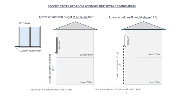
- The rear setback shall be a minimum of fifteen (15) feet except:
- An accessory structure not used for human habitation and separated from the main building may be located up to five (5) feet from a rear property line.
- On a corner lot setbacks required from the rear property line shall be the same as required for side yards.
- Detached accessory dwelling units are allowed exceptions to rear setbacks as provided in EMC 16.61.060.C.3.a.
- No lot area, yard, off-street parking or loading area, or other required open space for one use shall be used as the required lot area, yard, off-street parking or loading area, or other required open spaces for another use.
- Parking Requirements. The number of parking spaces as required in EMC 16.76 shall apply in the C-2 zone.
- Sidewalks. Sidewalks, driveways and service driveways shall conform to standards established by this code.
- Fences and Walls.
- A solid fence or wall of not less than six (6) feet in height shall be required along a property line which is the district boundary with an abutting residential district.
- Fences and sight-obscuring fences, with the exception of evergreen plantings, cannot exceed seven (7) feet in height without a building permit.
- Fences described above are subject to clear vision regulations of EMC 16.60.010 and EMC 8.12.050 limiting the use of barbed wire and electrical fences.
- Building Height. No building shall exceed a height of forty-five (45) feet.
- Landscaping. A minimum of five percent (5%) of the area developed, which includes but is not limited to areas developed for off-street parking, driveways, and above-ground utility facilities, shall be landscaped. Outdoor storage shall be screened with either a sight-obscuring fence, or a buffer strip of vegetation.
(Ord. 2000-26 § 5(3): prior code § 10.224(3))
16.32.050 Exceptions To Standards
The standards of this section pertaining to accessory structures and setbacks may be modified as provided for in EMC 16.60.030 through EMC 16.60.050.
(Ord. 2000-26 § 5(4): prior code § 10.224(4))
16.33.010 Purpose
The MMU zone implements the Mill Area Mixed-Use Comprehensive Plan policies. It is intended to provide flexible opportunities for the development of a mix of land uses that are safe, clean, and compatible with existing and planned land uses at the core of the City.
16.33.020 Development Plans
- Before development of properties can occur in the MMU zone, a Facilities Plan must be approved by the Planning Commission and a Master Development Plan must be approved by the City Council after review by the Planning Commission. The Facilities Plan may be reviewed and approved prior to or concurrent with the submitted Master Development Plan.
- Facilities Plan: The Facilities Plan shall show how the area proposed for development will be served by roads and utilities. The Facilities Plan shall, at a minimum, include:
- The boundaries of the area within the MMU zone proposed for development, and adjacent development;
- A map of existing and planned water and sewer facilities to serve the development area, including line sizes, general location or routes, and how the lines will tie in with adjacent areas;
- A map indicating existing and planned streets adjacent to the development area, the general route of planned streets through the development area, and where those streets will connect with the City's existing street system;
- Such other utility and transportation information as the City may determine are necessary;
- The function and location of any private utility systems;
- A written narrative that explains or describes how the Facilities Plan meets the following approval criteria:
- The proposed water, sewer, and street system will be adequate to serve the type and size of development planned for the subject area;
- The location and sizing of facilities on site will be consistent with the existing and planned utilities; and
- Adequate water flow volumes will be provided to meet fire flow and domestic demands.
- Master Development Plan: The minimum acreage for an MMU zone Master Development Plan is 10 acres unless specifically exempted as described in EMC 16.33.020 Subsection E. The Master Development Plan shall include:
- A plan view drawing, with dimensions, that shows the following elements and how they fit together as a functional design:
- Building envelopes;
- Parking area location, size, and access;
- Access points to streets;
- Pedestrian and bicycle facilities;
- Landscaped areas;
- Plans for day-lighting all portions of Wade Creek that cross or are adjacent to the subject area;
- Open spaces and common areas;
- Park land, to be provided according to the standards of EMC 16.116.020;
- The expected uses to be developed and approximate square footage of buildings;
- Any private development covenants, conditions, or restrictions that will be recorded with the property; and
- Any other information the City and other relevant regulatory authorities may require, including, but not limited to, a Phase I and Phase II Environmental Site Assessment and Remediation Plan.
- A written narrative demonstrating that the proposal:
- Creates a stimulating and attractive mixed-use environment through the use and inter-relationship of open spaces, building locations, building scale and design, and pedestrian amenities;
- Provides pedestrian access and movement to and through the site in a manner that maximizes foot traffic exposure to goods and services and minimizes conflicts with vehicle circulation areas;
- Encourages access to Downtown, adjacent residential areas, and/or the CMU zone;
- Provides for traffic and service vehicle circulation between on-site uses, as appropriate;
- Improves the aesthetics, and capitalizes on the locational advantages of, the MMU zone;
- Reduces to a minimum any negative impacts of proposed uses on adjacent properties and ensures the livability of residential areas, when applicable; and
- Is consistent with the goals and policies for the MMU area in the City's Comprehensive Plan, the Transportation System Plan, and Active Transportation Plan.
- A traffic impact study.
- A plan view drawing, with dimensions, that shows the following elements and how they fit together as a functional design:
- Upon approval of an MMU zone Master Development Plan, all subsequent building and site development must comply with the approved MMU zone Master Development Plan and the applicable stands and conditions in this code. Minor alterations to an approved MMU zone Master Development Plan may be approved by the Planning Commission using the stands in this section. A minor alteration to a master plan may include adjustments to local street and pedestrian corridor alignments, alterations to site design guidelines, changes to lot configurations, and the relocation of plaza and open space within the master plan area, provided the approved MMU zone Master Development Plan concept is not compromised.
- Exemptions: Properties less than 10 acres in size that are not a part of a previously approved and valid MMU zone Master Development Plan and cannot practicably be combined with surrounding properties in MMU zone may apply independently for MMU zone Master Development Plan approval in accordance with Subsection C of this section.
16.33.030 Building And Site Development Standards
- In addition to the required Master Development Plan approval by the City Council, the development of individual buildings, and related areas within the Master Development Plan area shall comply with the following standards, as assessed from development plans and approved by the City prior to the issuance of any required development permits, with such determination by the City appealable to the Planning Commission:
- Building Design: Buildings and structures shall have architectural elements and features which are in scale with each other. The colors and exterior material of buildings within the Master Development Plan shall be compatible. Buildings housing retail uses shall provide ample window area oriented toward pedestrian walkways or plazas.
- Landscaping and Open Space: The design and development of landscaping and open space shall:
- Emphasize the use of trees, shrubs, and other plants native to the Estacada area;
- Include street trees and parking area trees which are in scale with the development;
- Provide a cohesive open space and pedestrian network within the development, with appropriate connections to surrounding properties and uses;
- Provide pleasing transitions between uses, soften and buffer utility and lading areas, and provide pleasing textures and variety particularly next to buildings, along walkways, and within pedestrian plazas; and
- Include open spaces and plazas which are in scale with the development and invite activity appropriate to adjoining uses.
- Refuse Collection and Recycling: Refuse collection and recycling areas for businesses shall be enclosed with a fence, wall, or structure high enough to screen all collection bins.
- Outside mechanical equipment: Industrial or commercial heating, ventilation, air conditioning, or other mechanical equipment on rooftops or on the ground shall be screened with a material that is visually compatible with the building.
- Utility services, including water, sewer, electrical, telephone, and cable lines, shall be installed underground.
- Lot Size and Dimensions:
- Except as provided in EMC 16.33.020(C)(2), the minimum lot size shall be as follows:
| Single-family dwelling or duplex | 4,000 square feet |
| Triplex or fourplex | 2,500 square feet per dwelling unit |
| Commonwall dwellings | 2,500 square feet per lot for the first five dwelling units 1,500 square feet per lot for each unit above five |
| Cottage cluster | 2,500 square feet per dwelling unit |
| Multi-family dwelling | See Maximum Residential Density under Section 16.33.030.D. |
2. Exception for Conversions. When a duplex, triplex, or fourplex is created by internally converting, or expanding the floor area of, an existing single-family dwelling, no minimum lot size shall apply.
D. Maximum Residential Density. Maximum residential density for multi-family dwellings shall be 40 dwelling units per net acre. See EMC 16.60.060.
E. Minimum Residential Density. New residential subdivisions and new multi-family dwellings shall meet a minimum density standard of 15 dwelling units per net acre. See EMC 16.60.070.
F. Setbacks:
- The front setback shall be a minimum of fifteen (15) feet, but a minimum of twenty (20) feet to any garage door or carport motor vehicle entry.
- Minimum side setbacks shall be five (5) feet, except:
- The common side of a commonwall dwelling, which is zero (0) feet.
- Dwellings with a second story bedroom window that faces a side yard and is situated more than fifteen (15) feet above the ground level. As demonstrated in Figure 1 below, the minimum side setback is calculated by dividing the lower windowsill height (the distance from the lower windowsill to grade level directly below the center of the window) by three. Such windows used for egress must have minimum dimensions of at least three feet by three feet. The bedroom may instead be equipped with an automatic fire sprinkler system, unless otherwise approved by the City.
- If a public utility easement (PUE) exists on the side property line, the side yard setback shall be equal to the width of the PUE, if greater than the side yard setback required above.
Figure 1.
- The rear setback shall be a minimum of fifteen (15) feet, except:
- An accessory structure not used for human habitation or for a commercial use, and that is separated from the main building may be located up to five feet from a rear property line.
- On a corner lot, setbacks required from the rear property line shall be the same as required for side yards.
- Detached accessory dwelling units are allowed exceptions to rear setbacks as provided in EMC 16.61.060.C.3.a.
- Notwithstanding other provisions of this chapter, no minimum setback distance is required from Eagle Creek Rd.
G. Fences and Walls.
- A solid fence or wall of not less than six (6) feet in height shall be required along a property line which is the district boundary with an abutting residential district.
- Fences and sight-obscuring fences, with the exception of evergreen plantings, cannot exceed seven (7) feet in height without a building permit.
- Fences described above are subject to clear vision regulations of EMC 16.60.010 and EMC 8.12.050 limiting the use of barbed wire and electrical fences.
H. Parking Requirements:
- The number of parking spaces as required in EMC 16.76 shall apply in the MMU zone.
- Motor vehicle parking areas fronting Eagle Creek Rd, and motor vehicle parking areas separated from Eagle Creek Rd only by landscaping and/or fencing, are prohibited.
I. Sidewalks and Driveways: Sidewalks, driveways, and service driveways shall conform to standards established by this code.
J. Building Height: Buildings shall not exceed a height of sixty-five (65) feet.
K. Landscaping:
- A minimum of five percent (5%) of the area developed, which includes but is not limited to areas developed for off-street parking, driveways, and above-ground utility facilities, shall be landscaped.
- Development adjacent to Eagle Creek Rd shall have landscaping that includes trees with canopies that provide shade to pedestrians along the Eagle Creek Rd right-of-way.
L. Access and Circulation:
- Vehicle access shall conform to EMC 16.116 Design Standards and Improvements.
- Development shall conform to all of the standards for pedestrian access and circulation in EMC 16.75.020.
16.33.040 Daylighting Of Wade Creek
All portions of Wade Creek that cross or are adjacent to master-planned area shall be daylit concurrent with initial development of the planned area.
16.33.050 Land Divisions
- In the MMU zone, only areas with an approved master plan may be divided.
- Land divisions shall be consistent and approved in accordance with the requirements of EMC 16.75, 16.104, 16.108, 16.112, 16.116, and 16.120, and shall be consistent with the approved master plan.
16.33.060 Permitted Uses
- A use permitted outright in the CMU zone;
- Single-family dwelling legally existing and assessed as a dwelling on January 12, 2022;
- Alterations to a legally-established single-family dwelling described in EMC 16.33.060 Subsection B, as well as the replacement of such a dwelling, provided the dwelling to be replaced has remained a dwelling on the subject property, with intact walls and roof structure, indoor plumbing connected to a sanitary waste or disposal system interior wiring for interior lights, and a heating system, without a gap of twelve (12) consecutive months since January 12, 2022;
- School;
- Governmental use;
- Outdoor farmers' market;
- Restaurant, cafe, bar, tavern, bakery, or similar on-site eating/drinking establishment;
- Brewery or distillery providing on-site retail sales of beverages brewed or distilled on-site;
- Hotel, motel, or resort;
- Art gallery;
- Short-term rental subject to the provisions of EMC 16.62;
- Public-use parking facility;
- Publicly-accessible park, plaza, or pedestrian/multi-use path, trail, or bridge;
- Small childcare facility as defined in EMC 16.08;
- Large childcare facility as defined in EMC 16.08;
- Youth support services facility as defined in EMC 16.08;
- Indoor recreational facility or play area for activities such as basketball, dance, gymnastics, martial arts, racquetball, skating, soccer, swimming, tennis, or similar. Such a facility may be used for instruction, practice, and competitions. Health and fitness clubs are excluded from this category.
16.33.070 Accessory Uses
16.33.080 Conditional Uses
16.33.090 Prohibited Uses
- Unenclosed industrial use;
- Single-family dwelling;
- Marijuana retailing;
- Outdoor storage, unless associated with an approved farmers' market, conducted by a public agency, or supportive of and incidental to a retail use permitted outright;
- Commercial indoor storage facility;
- Commercial services involving vehicle maintenance, servicing, or repair; and
- Drive-thru commercial uses.
16.34.010 Purpose
The R-C zone implements the Riverfront Commercial Comprehensive Plan policies. It is intended to promote local tourism and history, outdoor recreation, and the use of adjacent park facilities, the Clackamas River, and connecting multi-use paths with a variety of commercial uses that attract local and out-of-town customers while enhancing the area's natural aesthetics and protecting adjacent open spaces.
16.34.020 Uses Permitted Outright
- Sales and rentals of outdoor recreation equipment, such as kayaks and bicycles, and of hunting, horse-riding, and fishing supplies;
- Restaurant, cafe, bar, tavern, bakery, or similar on-site eating/drinking establishment;
- No more than two food carts on a lot of record, subject to EMC 16.66;
- Guiding services;
- Visitor center or tourist information services;
- Hotel, motel, or resort;
- Governmental use;
- Public institution of higher learning;
- Art gallery;
- Museum;
- Swimming pool;
- Short-term rental subject to the provisions of EMC 16.62;
- Public-use parking facility;
- Publicly-accessible park, plaza, or pedestrian/multi-use path, trail, or bridge;
- Legally-established industrial uses existing on December 1, 2019;
- Alterations to a legally-established industrial use existing on December 1, 2019, on the same lot of record, provided the existing industrial use to be altered has not discontinued for twelve (12) consecutive months since December 1, 2019;
- Small childcare facility as defined in EMC 16.08;
- Large childcare facility as defined in EMC 16.08;
- Youth support services facility as defined in EMC 16.08;
- Indoor recreational facility or play area for activities such as basketball, dance, gymnastics, martial arts, racquetball, skating, soccer, swimming, tennis, or similar. Such a facility may be used for instruction, practice, and competitions. Health and fitness clubs are excluded from this category.
16.34.030 Accessory Uses
- Event space or meeting facility accessory and subordinate to a use permitted outright;
- Indoor and outdoor storage of goods retailed on-site by a commercial retail use permitted outright;
- Indoor and outdoor storage conducted by a public agency;
- Electric vehicle charging station.
16.34.040 Conditional Uses
- Drive-thru restaurant, cafe, bakery, or similar establishment that includes an on-site outdoor seating area for customers;
- Brewery or distillery providing on-site retail sales of beverage brewed or distilled on-site;
- Community center;
- Multi-family dwelling, provided the ground floor includes a commercial use permitted outright;
- Event space or meeting facility not accessory to a use permitted outright; and
- More than two food carts on a lot of record, subject to EMC 16.66.
16.34.050 Prohibited Uses
- Industrial uses - including manufacturing, wholesaling, marijuana production, and marijuana processing - unless otherwise listed;
- Marijuana retailing;
- Indoor storage facility not operated by a public agency or supportive of and incidental to an enclosed retail use permitted outright;
- Outdoor storage not conducted by a public agency or supportive of and incidental to an on-site enclosed retail use permitted outright.
16.34.060 Standards
- Setbacks: None.
- Fences and Walls.
- A solid fence or wall of not less than six (6) feet in height shall be required along a property line which is the district boundary with an abutting residential district.
- Fences and sight-obscuring fences, with the exception of evergreen plantings, cannot exceed seven (7) feet in height without a building permit. Fences described above are subject to clear vision regulations of EMC 16.60.010 and EMC 8.12.050 limiting the use of barbed wire and electrical fences.
- Chain-link fencing with or without slats, electric fencing, and fences, walls, or similar barriers with barbed wire, razor wire, concertina coils, anti-climb spikes, or any other similar security feature designed to discourage ingress through the potential of causing bodily harm, are prohibited.
- Parking Requirements: The number of parking spaces as required in EMC 16.76 shall apply in the R-C Zone, except that a use may transfer its required off-street motor vehicle parking spaces to a public-use parking facility located in the R-C Zone, provided the use is connected to the public-use parking facility by way of a sidewalk or other pedestrian walkway.
- Sidewalks and Driveways: Sidewalks, driveways, and service driveways shall conform to standards established by this code.
- Connection to Parks, Trails, and Natural Areas: Development shall include ADA-accessible pedestrian and/or paved bicycle access facilities, such as a pedestrian walkway or multi-use path that allows for their connection to the Lakeshore Trail, Timber Park, Milo McIver State Park, and/or the Clackamas River, consistent with the design guidelines of the Active Transportation Plan.
- Building Height: Buildings shall not exceed a height of sixty-five (65) feet.
- Landscaping:
- A minimum of five percent (5%) of the area developed, which includes but is not limited to areas developed for off-street parking, driveways, and above-ground utility facilities, shall be landscaped.
- Any development, including parking areas, that can be seen from Hwy 224 shall have maintained landscaping between the development and the highway that includes trees, shrubs, and/or boulders.
- Access and Circulation:
- Vehicle access shall conform to EMC 16.116 Design Standards and Improvements.
- Driveway access(es) and vehicle queuing area(s) for a drive-thru facility shall be screened to reduce off-site impacts such as vehicle noise/fumes, and light spillover/glare at night, and designed to avoid parked, waiting, or backing vehicles from encroaching onto any pedestrian walkway or public right-of-way.
- Development shall conform to all of the standards for pedestrian access and circulation in EMC 16.75.020.
- Signs:
- Signs shall comply with the requirements of EMC 16.72 and, if visible from Hwy 224, may require ODOT approval per ORS Chapter 377;
- Pole signs, as defined in EMC 16.72.020, are prohibited.
16.35.010 Purpose
The H-C zone implements the Highway Commercial Comprehensive Plan policies. It is intended to provide for large-footprint and vehicle-oriented commercial uses that are not appropriate for Downtown or other commercial areas, while ensuring that new development is appropriately screened and restricting residential uses, industrial uses, and excessive signage.
16.35.020 Uses Permitted Outright
- Retail store or shop, including food stores, drug stores, apparel stores, furniture stores, and similar establishments;
- Automobile services station, including fueling stations, oil-change services, and similar establishments;
- Hotel, motel, or resort;
- Retail or wholesale nursery;
- A use authorized by a conditional use permit approved prior to November 1, 2019, if such a use was established before January 1, 2024 and subject to the development conditions of the respective permit;
- Pedestrian and multi-use trail, path, or boardwalk;
- Small childcare facility as defined in EMC 16.08;
- Large childcare facility as defined in EMC 16.08;
- Youth support services facility as defined in EMC 16.08;
- Indoor recreational facility or play area for activities such as basketball, dance, gymnastics, martial arts, racquetball, skating, soccer, swimming, tennis, or similar. Such a facility may be used for instruction, practice, and competitions. Health and fitness clubs are excluded from this category.
16.35.030 Conditional Uses
- Drive-thru commercial use;
- A single building occupied by more than two businesses, provided:
- Each business in the building has its own storefront accessed from the outside from an off-street parking area that is shared by the building's other businesses;
- The Planning Commission determines that the building design is visually appealing from Hwy 224 and that its design is consistent with the policies for the H-C zone in the Comprehensive Plan; and
- The building incorporates all of the following elements:
- Recessed, projected, or alternately staggered storefront facades;
- Variable heights on front elevation;
- Pedestrian amenities as defined in EMC 16.08;
- Awnings or canopies of city-approved color and material;
- Fifty percent (50%) transparent elements on each ground-floor storefront facade;
- Primary building colors or building materials differentiating component storefronts.
- Self-storage, mini-storage, or similar facility, provided:
- The Planning Commission determines that each building associated with the storage use is visually appealing from Hwy 224 and that their designs are consistent with the policies for the H-C zone in the Comprehensive Plan;
- Buildings with a storage use on the ground-floor shall incorporate at least four (4) of the following elements:
- Pitched roofs;
- Pedestrian overhangs;
- City-approved murals;
- Brick or stone facing:
- Recessed, projected, or alternately staggered facade features.
- Buildings with a storage use above the ground-floor of a separate commercial use that incorporates all of the elements listed in EMC 16.35.030(B)(3) may be approved by the Planning Commission only if the building's upper stories include exterior windows and no fewer than three (3) of the following elements:
- Pitched roofs;
- Pedestrian overhangs;
- City-approved murals;
- Brick or stone facing;
- Recessed, projected, or alternately staggered facade features.
- Marijuana retailing authorized by state law and regulated by EMC 16.65.
16.35.040 Prohibited Uses
- Industrial uses;
- Commercial indoor storage facilities;
- Outdoor storage, unless associated with and incidental to a permitted indoor use on the same property;
- Dwellings;
- Short-term rentals;
- Discount stores as defined in EMC 16.08.
16.35.050 Standards
- Lot Size and Dimensions: No minimum.
- Setbacks: None required, with the following exceptions:
- Side setback: ten (10) feet for sides abutting the CMU, OC, or NCR Zones;
- Rear setback: ten (10) feet if rear abuts the CMU, OC, or NCR Zones.
- Fences and Walls.
- A solid fence or wall of not less than six (6) feet in height shall be required along a property line which is the district boundary with an abutting residential district.
- Fences and sight-obscuring fences, with the exception of evergreen plantings, cannot exceed seven (7) feet in height without a building permit.
- Fences described above are subject to clear vision regulations of EMC 16.60.010 and EMC 8.12.050 limiting the use of barbed wire and electrical fences.
- Parking Requirements: The number of parking spaces as required in EMC 16.76 shall apply in the H-C zone.
- Sidewalks and Driveways: Sidewalks, driveways, and service driveways shall conform to standards established by this code.
- Building Height: Buildings shall not exceed a height of forty-five (45) feet.
- Landscaping:
- A minimum of five percent (5%) of the area developed, which includes but is not limited to areas developed for off-street parking, driveways, and above-ground utility facilities, shall be landscaped.
- All parking areas shall be screened from view from Hwy 224 by trees, hedges, and/or other living natural elements.
- Access and Circulation:
- Vehicle access shall conform to EMC 16.116 Design Standards and Improvements;
- Any new intersection with Hwy 224 shall be approved by ODOT;
- Development shall conform to all of the standards for pedestrian access and circulation in EMC 16.75.020.
- Signs:
- Signs shall comply with the requirements of EMC 16.72 and, if visible from Hwy 224, may require ODOT approval per ORS Chapter 377;
- Pole signs, as defined in EMC 16.72.020, are prohibited;
16.37.010 Purpose
The CMU zone implements the Central Mixed-Use Comprehensive Plan policies. It is intended to establish small-footprint commercial uses, intermixed with denser residential uses, that cater primarily to customers in nearby residential areas and that do not detract from Downtown, while developing Eagle Creek Rd as a tree-lined, pedestrian and bicycle-friendly corridor.
16.37.020 Uses Permitted Outright
- Outpatient clinic or office for healthcare services, such as acupuncture, chiropractic, counseling, dental, massage therapy, medical, naturopathic, optometric, physical therapy, psychiatric, occupational therapy, and speech therapy;
- Personal service establishment, including barber and beauty shops, hair salons, nail salons, and similar establishments;
- Health and fitness club;
- Dry cleaner or laundromat;
- Bank or credit union;
- Small childcare facility as defined in EMC 16.08;
- Large childcare facility as defined in EMC 16.08;
- Youth support services facility as defined in EMC 16.08;
- Assisted living facility as defined in EMC 16.08;
- Residential care facility as defined in EMC 16.08;
- Restaurant, cafe, bakery, or similar on-site eating/drinking establishment in a leased or owned building space of no more than 1,500 square feet, but with accessory outdoor seating areas not subject to any square footage limitation;
- Professional office not associated with an outright permitted use in a leased or owned building space of no more than 1,500 square feet;
- Public park;
- Pedestrian or multi-use trail, path, or boardwalk;
- Swimming pool;
- Community garden;
- Short-term rental subject to the provisions of EMC 16.62;
- Duplex;
- Triplex;
- Fourplex;
- Multi-family dwelling;
- Commonwall dwellings;
- Cottage cluster;
- Single-family dwelling legally existing and assessed as a dwelling on December 1, 2019;
- Alterations to a legally-established single-family dwelling described in EMC 16.37.020 Subsection X, as well as the replacement of such a dwelling, provided the dwelling to be replaced has remained a dwelling on the subject property, with intact walls and roof structure, indoor plumbing connected to a sanitary waste disposal system, interior wiring for interior lights, and a heating system, without a gap of twelve (12) consecutive months since December 1, 2019;
- Transportation facility providing access to the H-C or MMU zones.
16.37.030 Accessory Uses
16.37.040 Conditional Uses
- Restaurant, cafe, bakery, and similar on-site eating/drinking establishment in a leased or owned building space greater than 1,500 square feet;
- Professional office in a leased or owned building space greater than 1,500 square feet;
- Outdoor farmers' market;
- Food cart, subject to EMC 16.66.
16.37.050 Prohibited Uses
- Industrial uses;
- Outdoor storage, unless associated with an approved farmers' market;
- Commercial indoor storage facilities;
- Commercial services involving vehicle maintenance, servicing, or repair; and
- Drive-thru commercial uses.
16.37.060 Standards
- Lot Size and Dimensions:
- Except as provided in Subsection 2, the minimum lot size shall be as follows:
Single-family dwelling or duplex 4,000 square feet Triplex or fourplex 2,500 square feet per dwelling unit Commonwall dwellings 2,500 square feet per lot for the first five dwelling units;
1,500 square feet per lot for each unit above five
Cottage cluster 2,500 square feet per dwelling unit Multi-family dwelling See Maximum Residential Density under Section 16.37.060.B.
- Exception for Conversions. When a duplex, triplex, or fourplex is created by internally converting, or expanding the floor area of, an existing single-family dwelling, no minimum lot size shall apply.
- Except as provided in Subsection 2, the minimum lot size shall be as follows:
- Maximum Residential Density. Maximum residential density for multi-family dwellings shall be 40 dwelling units per net acre. See EMC 16.60.060.
- Setbacks:
- The front setback shall be a minimum of fifteen (15) feet, but a minimum of twenty (20) feet to any garage door or carport motor vehicle entry.
- Minimum side setbacks shall be five (5) feet, except:
- The common side of a commonwall dwelling, which is zero (0) feet.
- Dwellings with a second story bedroom window that faces a side yard and is situated more than fifteen (15) feet above the ground level. As demonstrated in Figure 1 below, the minimum side setback is calculated by dividing the lower windowsill height (the distance from the lower windowsill to grade level directly below the center of the window) by three. Such windows used for egress must have minimum dimensions of at least three feet by three feet. The bedroom may instead be equipped with an automatic fire sprinkler system, unless otherwise approved by the City.
- If a public utility easement (PUE) exists on the side property line, the side yard setback shall be equal to the width of the PUE, if greater than the side yard setback required above.
Figure 1.
- The rear setback shall be a minimum of fifteen (15) feet, except:
- An accessory structure not used for human habitation or for a commercial use, and that is separated from the mail building may be located up to five feet from a rear property line.
- On a corner lot, setbacks required from the rear property line shall be the same as required for side yards.
- Detached accessory dwelling units are allowed exceptions to rear setbacks as provided in EMC 16.61.060.C.3.a.
- Notwithstanding other provisions of this chapter, no minimum setback distance is required from Eagle Creek Rd.
- Fences and Walls.
- A solid fence or wall of not less than six (6) feet in height shall be required along a property line which is the district boundary with an abutting residential district.
- Fences and sight-obscuring fences, with the exception of evergreen plantings, cannot exceed seven (7) feet in height without a building permit.
- Fences described above are subject to clear vision regulations of EMC 16.60.010 and EMC 8.12.050 limiting the use of barbed wire and electrical fences.
- Parking Requirements:
- The number of parking spaces as required in EMC 16.76 shall apply in the CMU zone.
- Motor vehicle parking areas serving commercial uses fronting Eagle Creek Rd, and motor vehicle parking areas separated from those streets only by landscaping and/or fencing, are prohibited.
- Sidewalks and Driveways: Sidewalks, driveways, and service driveways shall conform to standards established by this code.
- Building Height: Buildings shall not exceed the maximum height of sixty-five (65) feet.
- Landscaping:
- A minimum of five percent (5%) of the area developed with non-residential uses, which includes but is not limited to areas developed for off-street parking, driveways, and above-ground utility facilities, shall be landscaped.
- Development adjacent to Eagle Creek Rd or the extension of River Mill Rd connecting to NE Currin Creek Dr planned for in the City's Transportation System Plan shall have landscaping that includes trees with canopies that provide shade to pedestrians along those streets' adjacent rights-of-way.
- Access and Circulation:
- Vehicle access shall conform to EMC 16.116 Design Standards and Improvements.
- Development shall conform to all of the standards for pedestrian access and circulation in EMC 16.75.020.
16.38.010 Purpose
The O-C zone implements the Outdoor Commercial Comprehensive Plan policies. It is intended to preserve and enhance the area's natural aesthetic and establish commercial and public uses that attract local and out-of-town visitors, while protecting natural wetlands and adjacent residential land uses and ensuring that the area's commercial uses do not detract from Downtown.
16.38.020 Uses Permitted Outright
16.38.030 Accessory Uses
- Laundry facilities, arcades, recreation rooms, swimming pools, meeting spaces, and similar uses accessory to a campground approved as a conditional use according to EMC 16.38.040(A), provided the accessory uses predominantly serve the campers at the campground;
- Commercial retail uses accessory and incidental to campgrounds, cabins, yurts, and similar rented structures approved as conditional uses according to EMC 16.38.040(A); and
- One caretaker's residence accessory to a campground approved as a conditional use according to EMC 16.38.040(A) on the same lot of record.
16.38.040 Conditional Uses
- Campgrounds, including RV campgrounds, as well as cabins, yurts, and similar structures that are rented to the same person(s) for no more than twenty-one (21) consecutive days and for no more than thirty (30) days in a calendar year, unless otherwise allowed by the Planning Commission with a maximum allowable rental period of one-hundred eighty (180) days, with a minimum of ten (10) separately-rentable units (e.g., campground spaces, RV spaces, cabins, yurts);
- Commercial storage of recreational vehicles when such storage is entirely screened from view by natural elements (e.g., trees, shrubs) from all public rights-of-way and adjacent residential areas.
16.38.050 Prohibited Uses
16.38.060 Standards
- Lot Size and Dimensions: No minimum.
- Setbacks: None required, with the following exceptions:
- Side setback: ten (10) feet if abutting the H-C or NCR zones;
- Rear setback: ten (10) feet if abutting the H-C or NCR zones.
- Fences and Walls.
- A solid fence or wall of not less than six (6) feet in height shall be required along a property line which is the district boundary with an abutting residential district.
- Fences and sight-obscuring fences, with the exception of evergreen plantings, cannot exceed seven (7) feet in height without a building permit. Fences described above are subject to clear vision regulations of EMC 16.60.010 and EMC 8.12.050 limiting the use of barbed wire and electrical fences.
Chain-link fencing with or without slats, electric fencing, and fences, walls, or similar barriers with barbed wire, razor wire, concertina coils, anti-climb spikes, or any other similar security feature designed to discourage ingress through the potential of causing bodily harm, are prohibited.
- Parking Requirements: The number of parking spaces as required in EMC 16.76 shall apply in the O-C zone.
- Sidewalks and Driveways: Sidewalks, driveways, and service driveways shall conform to standards established by this code.
- Landscaping:
- A minimum of five percent (5%) of the area developed, which includes but is not limited to areas developed for off-street parking, driveways, and above-ground utility facilities, shall be landscaped.
- All commercial uses and parking areas shall be at least partially screened from view from Hwy 224 by existing trees, native vegetation, boulders, and/or wood elements with a natural color. Commercial storage of recreational vehicles shall be entirely screened, as required by EMC 16.38.040 Subsection B.
- Access and Circulation:
- Vehicle access shall conform to EMC 16.116 Design Standards and Improvements;
- Any new intersection with Hwy 224 shall be approved by ODOT;
- Development shall conform to all of the standards for pedestrian access and circulation in EMC 16.75.020.
- Signs:
- Signs shall comply with the requirements of EMC 16.72 and, if visible from Hwy 224, may require ODOT approval per ORS Chapter 377;
- Pole signs, as defined in EMC 16.72.020, are prohibited.
16.39.010 Purpose
The M-1 zone is intended for the expansion of light industrial uses. It permits wholly enclosed light industrial uses and commercial uses which are compatible to the surrounding area, subject to conditions.
(Ord. 2000-26 § 6 (part): prior code § 10.225 (part))
16.39.020 Uses Permitted Outright
The following uses and their accessory uses are permitted in the M-1 zone:
- Light industry as defined in EMC 16.08;
- A use wholly enclosed in a permitted structure involving manufacture, research, repair, assembly, processing, fabricating, packing, distribution, warehousing, wholesaling or storage; provided that the use does not create a public nuisance or an unreasonable hazard to health or property because of excessive noise, smoke, odor or dust, or because it constitutes a fire, explosion or other physical hazard;
- Agricultural use of land;
- Forestry, including the management, production and harvesting of forest products and of related natural resources in forest areas;
- Public facilities, including government uses, offices of governmental agencies and public utility substations;
- Industrial trade school;
- Data center;
- Auto body shop;
- Facilities, including office and enclosed storage and work spaces, for construction, maintenance, cleaning, welding, landscaping, decking, and building systems (e.g., plumbing and electrical) service providers and contractors with low customer traffic;
- No more than two food carts on a lot of record, subject to EMC 16.66;
- Indoor recreational facility or play area for activities such as basketball, dance, gymnastics, martial arts, racquetball, skating, soccer, swimming, tennis, or similar. Such a facility may be used for instruction, practice, and competitions. Health and fitness clubs are excluded from this category;
- Large childcare facility as defined in EMC 16.08.
(Ord. 2007-6 § 8; Ord. 2000-26 § 6(1): prior code § 10.225(1); Ord. No. 2016-005, § 10, 8-22-2016; Ord. No. 2018-002, § 1, 8-13-2018)
16.39.025 Accessory Uses
The following are allowed as accessory uses in the Light Industrial zone:
- Employee lounges, indoor recreation areas and facilities and cafeterias catering to employees of the primary industrial use;
- Indoor area for display and sale of products manufactured by the same business occupying the building, provided that the floor area of such display area constitutes no more than fifteen percent (15%) of the floor area of the industrial use;
- Indoor area for display and wholesale sales of products warehoused or distributed by the same business entity operating the primary industrial use on the site, provided that the floor area of such display area constitutes no more than five percent (5%) of the floor area of the industrial use;
- On lots of record no larger than five (5) acres, temporary outdoor storage of goods produced, manufactured, or repaired on the subject lot of record or on an adjacent lot of record, provided the outdoor storage is entirely screened, with permanent vegetation at least six (6) feet in height, walls, and/or fencing that does not include slatted chain link fencing, from view from public rights-of-way and areas zoned Open Space (O-S);
- Owner/manager residence subject to EMC 16.60.030(D).
(Ord. No. 2011-004, § 1, 1-9-2012)
16.39.030 Conditional Uses Permitted
The following uses and accessory uses may be permitted in the M-1 zone subject to EMC 16.88.020 and the review procedures in EMC 16.132.010 through EMC 16.132.050:
- Unenclosed light industrial uses;
- Commercial uses in conjunction with light industrial uses; except in the Northwest Industrial Sanctuary as defined in EMC 16.39.040(H) and shown on Map 16-1;
- Accessory uses that exceed the standards identified in EMC 16.39.025(B) or EMC 16.39.025(C);
- The manufacturing, processing, compounding, packaging, or assembling of products, the process of which requires that permits be issued by the Oregon State Department of Environmental Quality for the associated emissions, discharges, or storage of materials;
- Radio, television and/or cellular transmission tower;
- Other commercial uses which meet the following requirements:
- The proposed use will not attract traffic which would substantially conflict with industrial traffic or have a substantial adverse effect on other neighboring uses and has adequate access to the highway.
- The development standards applicable to permitted uses in this zoning district shall apply to conditional uses, except as provided below:
- All on-site lighting shall be designed, located or deflected so as not to shine into off-site structures or impair driving vision.
- All developments shall be subject to site plan review.
- Off-street parking shall be provided as required by EMC 16.76.
- The following additional standards shall apply in the Northwest Industrial Sanctuary as defined in EMC 16.39.040(H) and shown on Map 16-1:
- The total floor area within an individual building occupied by the commercial use shall not exceed fifteen (15) percent of the total floor area occupied by a primary industrial use.
Formula: 0.15 x industrial floor area = allowable commercial floor area.
- The total floor area within an individual building occupied by the commercial use shall not exceed fifteen (15) percent of the total floor area occupied by a primary industrial use.
- Park and ride facility or other public transportation facility not otherwise listed in EMC 16.39.020(E);
- Transportation facility not identified in the City's Transportation System Plan or Active Transportation Plan;
- More than two food carts on a lot of record, subject to EMC 16.66;
- Auto wrecking yard or junkyard;
- Extraction and processing of rock, sand, gravel or earth projects or batch plants;
- Cannabis production, cannabis processing, and cannabis wholesaling regulated by EMC 16.65.
(Ord. 2007-6 § 9; Ord. 2000-26 § 6(2): prior code § 10.225(2); Ord. No. 2011-004, § 2, 1-9-2012; Ord. No. 2018-003, § 3(Exh. 6), 10-8-2018)
16.39.035 Prohibited Uses
The following uses are prohibited in the M-1 zone:
- Commercial uses in the Northwest Industrial Sanctuary as defined in EMC 16.39.040(H) except as provided for in EMC 16.39.025 and EMC 16.39.030 Subsection F;
- Marijuana retailing.
(Ord. No. 2011-004, § 3, 1-9-2012; Ord. No. 2016-005, § 11, 8-22-2016)
16.39.040 Standards
- Setbacks. The setback from any property line abutting a residentially zoned property shall be a minimum of twenty (20) feet.
- Fences and Walls.
- A solid fence or wall of not less than six (6) feet in height shall be required along a property line which is the district boundary with an abutting residential district.
- Fences and sight-obscuring fences, with the exception of evergreen plantings, cannot exceed seven (7) feet in height without a building permit. Fences described above are subject to clear vision regulations of EMC 16.60.010 and EMC 8.12.050 limiting the use of barbed wire and electrical fences.
- Parking Requirements. The number of parking spaces as required in EMC 16.76 shall apply in the M-1 zone.
- Sidewalks. Sidewalks, driveways and service driveways shall conform to standards established by this code.
- Landscaping. A minimum of five percent (5%) of the area developed, which includes but is not limited to areas developed for off-street parking, driveways, and above-ground utility facilities, shall be landscaped.
- Outdoor storage abutting or facing a street, highway, residential zone shall be screened with a sight-obscuring fence or a buffer strip of vegetation six (6) feet in height.
- Noise. The applicant shall demonstrate the proposed activity will meet the applicable standards for noise emissions as required by the Oregon State Department of Environmental Quality.
- The following additional standards shall apply to development within the Northwest Industrial Sanctuary (one hundred thirty and four tenths (130.4) acres) as shown on Map 16-1. The Northwest Industrial Sanctuary is located west of Highway 211-224, east of Farmstead Road, north of the Estacada Industrial Campus, and south of the city limits of Estacada.
- Master Plan: A Master Plan for development within the Northwest Industrial Sanctuary shall be required. The master plan shall be submitted to the city for review and approval prior to the first phase of development. The master plan shall be a conceptual plan for the entire site and shall, at a minimum, include:
- Boundary lines and dimensions of the subject property;
- All proposed lot lines;
- Size (in acres) of new lots;
- Location of delineated wetlands;
- Location, dimensions and names of all proposed streets.
- Master Plan: A Master Plan for development within the Northwest Industrial Sanctuary shall be required. The master plan shall be submitted to the city for review and approval prior to the first phase of development. The master plan shall be a conceptual plan for the entire site and shall, at a minimum, include:
(Ord. 2000-26 § 6(3): prior code § 10.225(3); Ord. No. 2011-004, § 4, 1-9-2012; Ord. No. 2012-008, § 1, 1-14-2013; Ord. No. 2018-001, § 1, 6-11-2018)
16.39.050 Exceptions To Standards
The standards of this section pertaining to accessory structures and setbacks may be modified as provided for in EMC 16.60.030 through EMC 16.60.050.
(Ord. 2000-26 § 6(4): prior code § 10.225(4))
16.42.010 Purpose
The purpose of the Airport Zone is to encourage and support the continued operation and vitality of public-use airports by allowing certain airport-related commercial, residential, and recreational uses in accordance with state law.
16.42.015 Conformance With Airport Overlay Zone
All uses, activities, facilities and structures allowed in the Airport Zone shall comply with the requirements of the Airport Safety and Compatibility Overlay Zone established in EMC 16.54. In the event of a conflict between the requirements of this zone and those of the Airport Safety and Compatibility Overlay Zone, the requirements of the overlay zone shall control.
16.42.020 Uses Permitted Outright
The following uses and accessory uses are permitted outright in the A-P zone:
- Customary and usual aviation-related activities, including but not limited to takeoffs and landings; aircraft hangars and tie-downs; construction and maintenance of airport facilities; fixed based operator facilities; a residence for an airport caretaker or security officer; and other activities incidental to the normal operation of an airport. Except as provided in this ordinance, "customary and usual aviation-related activities" do not include residential, commercial, industrial, manufacturing and other uses.
- Air passenger and air freight services and facilities, at levels consistent with the classification and needs identified in the Oregon Department of Aviation Airport System Plan.
- Emergency medical flight services, including activities, aircraft, accessory structures, and other facilities necessary to support emergency transportation for medical purposes. Emergency medical flight services do not include hospitals, medical offices, medical labs, medical equipment sales, and other similar uses.
- Law enforcement and firefighting activities, including aircraft and ground-based activities, facilities and accessory structures necessary to support federal, state or local law enforcement or land management agencies engaged in law enforcement or firefighting activities. Law enforcement and firefighting activities include transport of personnel, aerial observation, and transport of equipment, water, fire retardant and supplies.
- Search and rescue operations, including aircraft and ground based activities that promote the orderly and efficient conduct of search or rescue related activities.
- Flight instruction, including activities, facilities, and accessory structures located at airport sites that provide education and training directly related to aeronautical activities. Flight instruction includes ground training and aeronautic skills training, but does not include schools for flight attendants, ticket agents or similar personnel.
- Aircraft service, maintenance and training, including activities, facilities and accessory structures provided to teach aircraft service and maintenance skills and to maintain, service, refuel or repair aircraft or aircraft components. "Aircraft service, maintenance and training" includes the construction and assembly of aircraft and aircraft components for personal use, but does not include activities, structures or facilities for the manufacturing of aircraft or aircraft-related products for sale to the public.
- Aircraft rental, including activities, facilities and accessory structures that support the provision of aircraft for rent or lease to the public.
- Aircraft sales and the sale of aeronautic equipment and supplies, including activities, facilities and accessory structures for the storage, display, demonstration and sales of aircraft and aeronautic equipment and supplies to the public but not including activities, facilities or structures for the manufacturing of aircraft or aircraft-related products for sale to the public.
- Crop dusting activities, including activities, facilities and structures accessory to crop dusting operations. Crop dusting activities include, but are not limited to, aerial application of chemicals, seed, fertilizer, defoliant and other chemicals or products used in a commercial agricultural, forestry or rangeland management setting.
- Agricultural and Forestry Activities legally existing on or before January 8, 2024 or accessory to a primary outright-permitted use, including activities, facilities and accessory structures that qualify as a "farm use" as defined in ORS 215.203 or "farming practice" as defined in ORS 30.930.
16.42.030 Conditional Uses Permitted
The following uses and accessory uses are permitted in the Airport Zone subject to EMC 16.88.020 and the review procedures in EMC 16.132.010 through EMC 16.132.050:
- Upon demonstration of acceptance by the airport sponsor: Aeronautic recreational and sporting activities, including activities, facilities and accessory structures at airports that support recreational usage of aircraft and sporting activities that require the use of aircraft or other devices used and intended for use in flight. Aeronautic recreation and sporting activities authorized under this paragraph include, but are not limited to, fly-ins; glider flights; hot air ballooning; ultralight aircraft flights; displays of aircraft; aeronautic flight skills contests; and gyrocopter flights, but do not include flights carrying parachutists or parachute drops (including all forms of skydiving).
- Upon demonstration of acceptance by the airport sponsor: Flights carrying parachutists, and parachute drops (including all forms of skydiving) onto an airport, but only upon demonstration that the parachutist business has secured approval to use a drop zone that is at least 10 contiguous acres. The configuration of the drop zone shall roughly approximate a square or a circle and may contain structures, trees, or other obstacles only if the remainder of the drop zone provides adequate areas for parachutists to land safely.
- Governmental structure or use of land; and
- Public utility substations as required with safeguards against harm to adjacent or abutting property owners.
16.42.040 Standards
The following standards shall apply in the A-P zone:
- Lot Size and Dimensions.
- The minimum lot size shall be fifty (50) acres.
- Minimum lot frontage for a flag lot shall be twenty-five (25) feet.
- No lot area, yard, off-street parking or loading area, or other required open space for one use shall be used as the required lot area, yard, off-street parking or loading area, or other required open spaces for another use.
- Parking Requirements. The number of parking spaces as required in EMC 16.76 shall apply in the A-P zone.
- Sidewalks. Sidewalks, driveways and service driveways shall conform to standards established by this code.
- Non-Residential Uses. For all non-residential uses in the A-P zone, the following standards shall apply:
- Setbacks from Residential Zones. All yards abutting a lot in a residential zone shall provide a minimum of twenty (20) feet between the residential zone boundary and any structure or use regulated by this Section.
- Landscaping. A minimum of five percent (5%) of the area developed, which includes but is not limited to areas developed for off-street parking, driveways, and above-ground utility facilities, shall be landscaped.
- Outdoor storage abutting or facing a street, highway, or residential zone shall be screened with a sight-obscuring fence or a buffer strip of vegetation six (6) feet in height.
- Residential Uses. For all residential uses in the A-P zone, the following standards shall apply:
- Setbacks.
- Dwellings shall be located a minimum of two hundred (200) feet from the edge of the runway.
- The front setback shall be a minimum of twenty (20) feet.
- .Minimum side setbacks shall be five feet, except:
- The common side of a commonwall dwelling, which is zero (0) feet.
- Dwellings with a second story bedroom window that faces a side yard and is situated more than 15 feet above the ground level. As demonstrated in Figure 1 below, the minimum side setback is calculated by dividing the lower windowsill height (the distance from the lower windowsill to grade level directly below the center of the window) by three. Such windows used for egress must have minimum dimensions of at least three feet by three feet. The bedroom may instead be equipped with an automatic fire sprinkler system, unless otherwise approved by the City.
- If a public utility easement (PUE) exists on the side property line, the side yard setback shall be equal to the width of the PUE, if greater than the side yard setback required above.
Figure 1.
- The rear setback shall be a minimum of fifteen (15) feet except:
- An accessory structure not used for human habitation and separated from the main building may be located up to five feet from a rear property line.
- On a corner lot, setbacks required from the rear property line shall be the same as required for side yards.
- Setbacks.
- Fences and Walls.
- Fences and sight-obscuring fences, with the exception of evergreen plantings, cannot exceed seven (7) feet in height without a building permit.
- Fences described above are subject to clear vision regulations of EMC 16.60.010 and EMC 8.12.050 limiting the use of barbed wire and electrical fences.
- Drainage. An applicant for a building permit shall submit a plan showing width, depth, and direction of flow of all drainage channels on property. In addition, the location, size and type of conduit used in drainage channels and driveway accesses shall be clearly delineated. Water from roof drains and other impervious surfaces shall not be concentrated and directed so as to cause damage to property and shall be disposed of in accordance with EMC 13.08.010.
- Building Height. No building shall exceed a height of thirty-five (35) feet.
- Lot Coverage. Except as provided below, buildings including accessory structures and garages shall not occupy more than twenty (20) percent of the total lot area.
- Geological Analysis Requirement. Any property identified as a geological natural hazard area as listed in EMC 16.68.030 or any property that has a slope of thirty-three (33) percent or greater, as defined by a 3:1 ratio, 3 horizontal: 1 vertical, will require a geotechnical analysis of the property as outlined in EMC 16.68.030.
16.44.010 Purpose
This zone is created to ensure public greenways, pathways, and parks and to allow for public facilities, under certain conditions.
(Prior code § 10.227 (part))
16.44.015 Uses Permitted Outright
- Public pedestrian and multi-use trails, paths, and boardwalks identified in the 2018 Active Transportation Plan;
- Public facilities, and uses identified in the Waterfront Concept Plan of the 2018 Parks Master Plan.
16.44.020 Conditional Uses
Planning Commission, after public hearing, may permit the following uses, where such uses are deemed essential or desirable to the public convenience or welfare and are consistent with the goals, objectives and policies of the comprehensive plan.
- Educational institutions;
- Governmental buildings;
- Public libraries and museums;
- Public utilities, services, and structures;
- Informational and promotional kiosk or centers;
- Public parks.
(Prior code § 10.227(1))
16.44.025 Prohibited Uses
Marijuana production, marijuana processing, marijuana wholesaling, and marijuana retailing are prohibited in the O-S zone.
(Ord. No. 2016-005, § 13, 8-22-2016)
16.44.030 Standards
- Off-street parking shall be provided as required in EMC 16.76.
- Structures shall be setback from residential zones a minimum of twenty (20) feet.
- Outdoor storage abutting or facing a street, highway, or residential zone shall be screened with a sight-obscuring fence, or a buffer strip of vegetation six (6) feet in height.
- Landscaping. At least ten (10) percent of the total area developed shall be landscaped.(Prior code § 10.227(2))
16.48.010 Purpose
The intent and purpose of this overlay district is to implement the goals and policies of the comprehensive plan and encourage property owners to enhance and maintain historically designated resources within the community. In the H-R zone, the following regulations shall apply.
The provisions of this section are intended to:
- Facilitate restoration and upkeep of historic buildings;
- Encourage public knowledge, understanding and appreciation of the city's history and culture;
- Preserve diverse architectural styles reflecting phases of the city's history; and encourage complementary design and construction impacting historic resources.
(Prior code § 10.228 (part))
16.48.020 Applicability
- The provisions of this chapter shall apply to all structures designated as historic resources on the city's inventory of historic structures.
(Prior code § 10.228(A))
16.48.030 Historic Resource Review Committee
- The historic resources review committee shall consist of five members. Until such time as the city council appoints specific members to this committee, the planning commission shall act in this capacity.
- When a specific committee is appointed, members shall serve for three years, except the first term, of which two members shall serve for three years; three members shall serve for two years.
- All demolition and alteration permit requests shall be reviewed by the committee. These permit requests must be reviewed and approved by the historic resource review committee prior to a permit for demolition or alteration being approved.
(Prior code 10.228(B))
16.48.040 Uses Permitted
Designated historic resources may be used for any use which is allowed in the underlying district. This includes both primary and conditional uses. For a conditional use to be approved, the proposed use must be found not to be detrimental to the historic resource.
(Prior code § 10.228(C))
16.48.050 Alterations And Exterior Remodel
- Maintenance and minor alterations shall not require review by the historic resource review board. Maintenance and minor alterations include:
- Painting and related preparation of the structure;
- Repair, replacement and/or change of roofing material;
- Grounds care and maintenance required for the permitted use of the property;
- Replacement of fences, shrubs, or other yard fixtures or landscaping;
- Installation and maintenance of irrigation systems;
- Addition of gutters and downspouts;
- Repairing or providing a compatible new foundation that does not result in raising or lowering the building elevation;
- Change in material to match original type of material on the structure;
- Placement or replacement of storm windows or doors.
- The historical resource review committee shall review all building permits for additions to existing designated structures and new buildings on the designated site. Review and approval of building permits shall be based on the following criteria:
- The design of the proposed structure or addition is compatible with the design of the designated structure considering scale, style, height, and architectural detail, materials and colors.
- All applications subject to review shall be accompanied by plans and specifications of the proposed addition or new building. The applicant may be requested to provide additional sketches and other information deemed necessary to allow an informed decision.
- All applications subject to review by the historic resources review committee shall be subject to the notice and hearing standards identified in EMC 16.132.
(Prior code § 10.228(D))
16.48.060 Demolition
All applications for demolition of a designated historic resource shall be reviewed by the historic resource review committee. The applicant for the demolition permit shall submit the following information:
- A statement identifying the structure's state of repair or disrepair;
- A statement as to the feasibility of repairing the structure as opposed to demolition;
- Identification of restoration costs. The historic resource review committee shall review the information submitted by the applicant and make a finding that the structure cannot be reasonably restored or repaired prior to approval. If this finding is satisfied, the demolition permit shall be issued. The review process shall in no case be exercised so as to impose upon any property owner any peculiar or undue hardship, nor to prevent the removal or demolition of any structure which cannot be economically maintained or restored, giving due consideration to all potential uses to which the structure might reasonably be put to use upon restoration by a private property owner.
All demolition permits subject to review by the historic resources review committee shall be subject to the notice and hearing procedures identified under EMC 16.132.
(Prior code § 10.228(E))
16.52.010 Purpose
- To permit the application of new technology and greater freedom than may be possible under a strict interpretation of the provisions of this title.
- To facilitate the efficient use of land.
- To promote an economic arrangement of land use, buildings, circulation systems, open space and utilities.
- Encourage a more creative approach in the development of land, and a more efficient, aesthetic and desirable use of common open space areas.
- Allow flexibility in design, placement of buildings, use of open spaces, circulation facilities, off-street parking areas for sites with natural features such as streams and wetland and other physical characteristics including geography, topography, size and shape.
- Provide flexibility to allow for the transfer and mixture of densities between zoning districts in order to provide better housing and transportation options than can be achieved through conventional development practices.
- Improve the protection of open spaces, wetlands, riparian corridors and other natural features.
(Ord. 2005-6 § 1 (part))
16.52.020 Review Procedures And Approval Process
- There are three steps required for a planned development approval:
- Approval of an overlay zone and concept plan;
- Approval of a detailed development plan and/or preliminary subdivision plat;
- Approval of a final subdivision plat(s), and building permits in accordance with the detailed development plan.
- An application for an overlay zone/concept plan and development plan and/or preliminary subdivision plat may be heard concurrently.
- Within two years after the date of final approval of an overlay zone and concept plan, a detailed development plan and/or preliminary subdivision plan shall be filed with the city.
- Planned developments shall be subject to all the requirements of the underlying zoning districts in which the development is located, applicable zoning regulations in EMC Division III and land division standards in EMC Division IV of this title except as modified through this review procedure.
- Planned developments shall be reviewed by the planning commission and city council pursuant to EMC 16.132. The planning commission shall recommend denial, approval or approval with conditions to the city council. The city council shall conduct a public hearing and render a final decision on the application.
- Approval may be made subject to such conditions the city finds necessary to carry out the purposes of this chapter. These conditions may include, but are not limited to, the following:
- Increasing the required setbacks;
- Limiting height of buildings;
- Controlling location and number of vehicular access points;
- Establishing new streets, increasing right-of-way or roadway widths or existing streets, requiring curbs and sidewalks, and, in general, improving traffic circulation systems;
- Increasing number of parking spaces and improving design standards for parking areas;
- Limiting number, size, location and lighting of signs;
- Designating additional sites for open space and recreational development, and, in general, improving proposed landscaping;
- Requiring additional view-obscuring screening or fencing;
- Requiring a performance agreement to assure that the planned development is completed as approved within the time limit as established by this section.
- Building permits for all or any portion of a planned development shall be issued on the basis of the approved plan. An application for a building permit shall be preceded or accompanied by submission of any required performance agreements, deeds for public dedication or contractual agreements for developments of public facilities and services.
- A planned development approval shall be valid for five years after the date of the final decision on the detailed development plan or tentative land division. The city may approve a time schedule for developing the site in phases not to exceed ten (10) years. If no building permits have been issued within five years from the date of adoption of the P-D overlay zone, it shall be terminated and the overlay zone shall automatically be repealed, unless a request to extend the time limit is approved by the planning commission. Time extensions shall be subject to EMC 16.108.050.
(Ord. 2005-6 § 1 (part))
16.52.030 Submittal Requirements
- General Application Requirements. An application for a P-D overlay zone/concept plan shall include:
- A statement of the planning objectives to be achieved by the planned development. The statement shall include a description of the character of the proposed development and the reasoning to support the design and any modifications of the city code related to proposed land uses, building types and densities, setbacks, open spaces, streets, etc.;
- A development schedule indicating any phasing proposals and approximate dates when construction of the planned development is expected to be initiated and completed;
- Maps and supporting narrative identifying the following:
- Existing site conditions,
- A site concept plan,
- A grading concept plan,
- A landscape concept plan,
- A sign concept plan;
- A copy of any proposed restrictions or covenants.
- Development Review Application Requirements. An application for a detailed development plan or land division shall include the following:
- A tentative plan including all the information listed in EMC 16.120.020 Subsection B;
- A specific list and description of standards proposed to be modified;
- Other technical information necessary to address the standards of this section and other applicable requirements of the city code. This may include traffic impact studies, environmental studies, geologic or engineering studies and sewer, water and surface water studies;
- Any other information necessary to determine compliance with the proposed or approved concept plan.
(Ord. 2005-6 § 1 (part))
16.52.040 General Requirements
- A P-D zone may be established in combination with any other zone.
- Planned developments may be established in single-family residential, multifamily residential, commercial, industrial and open space districts.
- A P-D zone may contain only a planned development that has been approved in accordance with the provisions of this chapter.
- A P-D zone shall not be less than five acres.
- A planned development may include any uses permitted outright or conditionally in any zone with the following exceptions:
- Residential uses shall not be permitted in the M-1 zone;
- Uses permitted only in the M-1 zone shall not be permitted in any other zone.
- The following uses also may be allowed, when developed in conjunction with a primary use:
- Recreational facilities including, but not limited to, tennis courts, swimming pools and playgrounds;
- Open space uses including, but not limited to, nature trails, bird sanctuaries and nature conservatories.
- Requirements pertaining to density shall be based on the standards of the zone in which the property is located. Other standards of the zone may be modified as they apply to streets, lot size, lot coverage, setbacks and landscaping.
- No building shall exceed a height that is fifty (50) percent greater than that of the maximum building height limitation of the zone in which the planned development is proposed. Such height increases may be approved by the planning commission, provided the proposed height is not detrimental, incompatible or otherwise undesirable with respect to existing or future area development, and provided that one of the following two situations is determined to exist:
- That the height increase can be justified on the basis of unique lot characteristics, topographical conditions or other natural features; or
- That the height increase can be justified on the basis of amenities provided or concessions made by the developer for which some bonus incentive is warranted.
- Open Space and Park Land. At least twenty (20) percent of the land area will be dedicated or reserved as common open space or park land in residential, recreational or combination residential-commercial developments.
- Open space may include bicycle or pedestrian trails, natural or landscaped buffer areas, significant natural vegetation or landscape, and community recreation facilities such as tennis courts, recreation buildings or swimming pools.
- Open space shall not include parking areas, except those areas in conjunction with recreation facilities, or roadways.
- Filling or placement of debris within open space area is prohibited, unless specifically authorized by the city.
- Private vehicle access easements serving neighboring properties are prohibited within park and open space areas.
- Developments shall be designed so that no dwelling unit, as measured from the nearest point on the property line, is located more than one thousand (1,000) feet from a park or open space area, via publicly accessible right-of-way.
- Open space areas shall contain a minimum of five thousand (5,000) square feet. Parks shall contain a minimum of ninety thousand (90,000) square feet.
- All improvements associated with park and open space areas, such as recreation centers, swimming pools and tennis courts shall be constructed before platting, or a guarantee shall be posted per EMC 16.116.050.8.
- Prior to acceptance of proposed park or open space, the City may require the developer to submit a Phase I Environmental Site Assessment completed by a qualified professional according to American Society of Testing and Materials (ASTM) standards (ASTM E 1527), the results of which shall indicate a clean environmental record.
- All utilities, electric and telephone facilities, fire alarm conduits, street light wiring and other wiring, conduits and similar facilities shall be placed underground unless waived by the city.
- The city may require easements necessary for orderly extension of public utilities to future adjacent developments.
- Lands and structures not dedicated to the public but reserved for use by owners or tenants and their guests must be subject to an association of owners or tenants created to form a nonprofit corporation under the laws of the state of Oregon. This association shall be formed and continued for the purpose of maintaining such common areas and structures.
(Ord. 2005-6 § 1 (part))
16.52.050 Special Considerations
- Before approval of a P-D overlay zone application, the planning commission shall determine that:
- The development will be consistent with the comprehensive plan provisions and zoning objectives of the area;
- The development will be compatible with adjacent and nearby land uses and accommodate planned and necessary transportation and utility services and facilities to serve the area. For purposes of this evaluation, the lands at least two hundred fifty (250) feet from the outside boundary of the lot upon which the development is proposed shall be considered;
- The streets are adequate to support the anticipated traffic and the development will not overload the streets outside the planned development area;
- Proposed utility and drainage facilities are adequate for the population densities and type of development proposed and will not create a drainage or pollution problem outside the planned area.
- In considering a proposed planned unit development, all requirements of the city code shall apply, except as modified below:
- Site Adaptation. To the maximum extent possible, the plan and design of the development shall ensure that natural or unique features of the land are preserved.
- Lot Arrangement. All lots within the development shall have reasonable access to open space or recreation areas, as defined in EMC 16.52.040(I)(5).
- Density of Development. For purposes of determining residential density, computations involving residential land shall be subject to the underlying zoning district.
- Lot Size. Individual lot size is unrestricted, provided that the overall density of the development shall not exceed the density in the underlying zoning district.
- Community Services. The city may request the dedication of proposed open space land that is reasonably suited for use as a city park or for recreation purposes, taking into consideration such factors as size, shape, topography, geology, access, location, and applicable comprehensive plan policies, when such dedication is consistent with the ability of the city to maintain such parks.
- Structure Setback Provision.
- Setbacks for lots on the perimeter of the plat area shall be the same as that required for the underlying zoning district.
- Minimum front yard setback is twenty (20) feet. This standard may be modified for residential dwellings, providing any garage structure facing a street maintains a twenty (20) foot setback.
- All detached structures shall maintain a minimum side yard setback of three feet or meet the Uniform Building Code requirement for firewalls.
- Minimum rear yard setback is three feet for all detached and attached structures or meets the Uniform Building Code requirement for firewalls.
- Individual Lot Street Frontage. No individual lot street frontage is required when such lots are shown to have adequate access in a manner that is consistent with the purposes and objectives of this section.
- Parking Standards.
- Two off-street parking spaces per dwelling unit shall be established, except for duplexes, which require one off-street parking space per unit
- Off-street parking may be provided on each lot or in parking areas in proximity to the dwelling units they serve.
- Guest parking may be required after consideration of street type, width, traffic, volume, transit amenities and pedestrian circulation.
- Sufficient parking space may be required for storage of residents' recreational vehicles. If required, recreational vehicle parking shall be located so as to be compatible with the surrounding development. If located on the perimeter of the development, it shall be screened from adjacent properties.
- Homeowners' Association. A nonprofit incorporated homeowners' association, or an alternative acceptable to the city, shall be required if other satisfactory arrangements have not been made for improving, operating and maintaining common facilities, including open space, streets, drives, service and parking areas, park and recreation areas, and for snow removal and storage. The following principles shall be observed in the formation of any homes association and shall be reviewed by the city attorney's office.
- A homeowners' association shall be established prior to approval and recording of the final plat, or any portion thereof.
- Membership shall be mandatory for each homebuyer and any successive buyer.
- Any park or open space restrictions shall continue in perpetuity.
- The homeowners' association shall be responsible for liability insurance, local taxes, and the maintenance of recreational and other facilities.
- Homeowners shall pay their pro rata share of the cost or the assessment levied by the association shall become a lien on the property.
- The homeowners' association shall be able to adjust the assessment to meet changes needed.
- No change in park or open space use or dissolution of the homeowners' association shall occur without a public hearing before the city council.
- An alternative to a homeowners' association may include deed restrictions or conservation easements, when the city determines such will protect the intent and purposes of this chapter and be in the public's interest.
(Ord. 2005-6 § 1 (part))
16.54.010 Purpose
The purpose of this overlay zone is to encourage and support the continued operation and vitality of Estacada’s public-use airport(s) by establishing compatibility and safety standards to promote air navigational safety, and to reduce potential safety hazards for persons living, working or recreating near the airport.
16.54.020 Notice Of Land Use And Permit Applications Within Overlay Zone
Except as otherwise provided herein, written notice of applications for land use or limited land use decisions as defined in ORS 197.015 (12), including comprehensive plan or zoning amendments and development applications, in an area within this overlay zone, shall be provided to the airport sponsor and the Oregon Department of Aviation (ODAV) in the same manner as notice is provided to property owners entitled by law to written notice of land use or limited land use applications.
- Notice shall be provided to the airport sponsor and the ODAV when the property, or a portion thereof, that is subject to the land use or limited land use application is located within 5,000 feet of the sides or ends of a runway.
- Notice of land use or limited land use applications involving public hearings shall be provided prior to the public hearing at the same time that written notice of such applications is provided to property owners entitled to such notice.
- Notice of land use or limited land use applications not involving public hearings shall be provided at least 20 days prior to entry of the initial decision on the land use or limited land use application.
- Notice of the decision on the land use or limited land use application shall also be provided to the airport sponsor within the same timelines that notice is provided to parties to the proceeding.
- Notices required under Paragraphs A-C of this section need not be provided to the airport sponsor or the ODAV where the land use or limited land use application meets all of the following criteria:
- Would only allow structures of less than 35 feet in height above ground level (AGL);
- Involves property located entirely outside the approach surface;
- Does not involve industrial uses, mining or similar uses that emit smoke dust or steam; sanitary landfills or water impoundments; or radio, radiotelephone, television or similar transmission facilities or electrical transmission lines; and
- Does not involve wetland mitigation, creation, enhancement or restoration.
16.54.030 Height Limitations On Allowed Uses In Underlying Zone
All uses permitted by the underlying zone shall comply with the height limitations in this Section. When height limitations of the underlying zone are more restrictive than those of this overlay zone, the underlying zone height limitations shall control.
- Except as provided in subsections B and C of this Section, no structure or tree, plant or other object of natural growth shall penetrate an airport imaginary surface. Refer to OAR 660 Division 13, Exhibit 1 for a description of public use airport overlay surfaces and zones.
- For areas within airport imaginary surfaces but outside the approach and transition surfaces, where the terrain is at higher elevations than the airport runway surfaces such that existing structures and permitted development penetrate or would penetrate the airport imaginary surfaces, a local government may authorize structures up to 35 feet in height above ground level (AGL).
- Other height exceptions or variances may be permitted when supported in writing by the airport sponsor, the Oregon Department of Aviation and the Federal Aviation Administration. Applications for height variances shall follow the procedures for other variances and shall be subject to such conditions and terms as recommended by the ODAV and the FAA.
16.54.040 Land Use And Building Application Requirements
- An applicant seeking a land use or limited land use approval, such as a structural building permit, in an area within this overlay zone shall provide the following information in addition to any other information required in the permit application:
- A map or drawing showing the location of the property in relation to the airport imaginary surfaces. The City shall provide the applicant with appropriate base maps upon which to locate the property.
- Elevation profiles and a site plan, both drawn to scale, including the location and height of all existing and proposed structures, measured in feet above ground level (AGL).
- If a height variance is requested, letters of support from the airport sponsor, the Oregon Department of Aviation and the Federal Aviation Administration.
- Other information or materials necessary to demonstrate compliance with or exemption from the following requirements:
- Noise. Within airport noise impact boundaries, land uses shall be established consistent with the levels identified in OAR 660, Division 13, Exhibit 5. A declaration of anticipated noise levels shall be attached to any subdivision or partition approval or other land use approval or building permit affecting land within airport noise impact boundaries. Noise levels shall be measured in Ldn, or Day Night Average Sound Level, which is the average sound level over a 24-hour period, with a 10 decibel (dB) penalty added for noise during the nighttime hours of 22:00 to 07:00.
- In areas where the noise level is anticipated to be at or above 55 Ldn, prior to issuance of a building permit for construction of a noise sensitive land use (real property normally used for sleeping or as a school, church, hospital, public library or similar use), the permit applicant shall be required to demonstrate that a noise abatement strategy will be incorporated into the building design that will achieve an indoor noise level equal to or less than 55 Ldn.
- Outdoor Lighting. No new or expanded industrial, commercial, residential, or recreational use shall project lighting directly onto an existing runway or taxiway or into existing airport approach surfaces except where necessary for safe and convenient air travel. Lighting for these uses shall incorporate shielding in their designs to reflect light away from airport approach surfaces. No use shall imitate airport lighting or impede the ability of pilots to distinguish between airport lighting and other lighting.
- Glare. No glare producing material, including but not limited to unpainted metal or reflective glass, shall be used on the exterior of structures located within an approach surface or on nearby lands where glare could impede a pilot's vision.
- Industrial Emissions. No new industrial, mining or similar use, or expansion of an existing industrial, mining or similar use, shall, as part of its regular operations, cause emissions of smoke, dust or steam that could obscure visibility within airport approach surfaces, except upon demonstration, supported by substantial evidence, that mitigation measures imposed as approval conditions will reduce the potential for safety risk or incompatibility with airport operations to an insignificant level. The review authority shall impose such conditions as necessary to ensure that the use does not obscure visibility.
- Communications Facilities and Electrical Interference. No use shall cause or create electrical interference with navigational signals or radio communications between an airport and aircraft. Proposals for the location of new or expanded radio, radiotelephone, and television transmission facilities and electrical transmission lines within this overlay zone shall be coordinated with the Oregon Department of Aviation and the Federal Aviation Administration prior to approval. Approval of cellular and other telephone or radio communication towers on leased property located within airport imaginary surfaces shall be conditioned to require their removal within 90 days following the expiration of the lease agreement. A bond or other security shall be required to ensure this result.
- Noise. Within airport noise impact boundaries, land uses shall be established consistent with the levels identified in OAR 660, Division 13, Exhibit 5. A declaration of anticipated noise levels shall be attached to any subdivision or partition approval or other land use approval or building permit affecting land within airport noise impact boundaries. Noise levels shall be measured in Ldn, or Day Night Average Sound Level, which is the average sound level over a 24-hour period, with a 10 decibel (dB) penalty added for noise during the nighttime hours of 22:00 to 07:00.
16.54.050 Limitations And Restrictions On Allowed Uses
- The land uses identified in Table 1, and their accessory uses, are either permitted, permitted under limited circumstances, or prohibited in the manner described in the Table and in the numbered list of table notes below. In the event of conflict with the underlying zone, the more restrictive provisions shall control. As used in this section, a limited use means a use that is allowed subject to special standards specific to that use.
Table 1: Limitations & Restrictions On Allowed Uses.
Key: P = Use is Permitted; L = Use is allowed under Limited circumstances described under the corresponding number in the list below; N = Use is Not allowed. | ||||
| Use Category | RPZ | Approach surface | Direct impact area | Secondary impact area |
| Public airport | L | L | P | P |
| Residential | N | L | L | P |
| Commercial | N | L | L | P |
| Industrial | N | L | P | P |
| Institutional | N | L | L | P |
| Farm use | P | P | P | P |
| Roads/parking | L | P | P | P |
| Utilities | L | L | L | L |
| Parks/open space | L | P | P | P |
| Athletic field | N | L | L | P |
| Mining | N | L | L | L |
| Water impoundment | N | N | N | N |
| Wetland mitigation | N | L | L | L |
Limitations and restrictions on the allowed uses in Table 1 include:
- No structures shall be allowed within the Runway Protection Zone (RPZ). Exceptions shall be made only for structures accessory to airport operations whose location within the RPZ has been approved by the Federal Aviation Administration.
- In the RPZ, public airport uses are restricted to those uses and facilities that require location in the RPZ.
- Roads and parking areas are permitted in the RPZ only upon demonstration that there are not practicable alternatives. Lights, guardrails, and related accessory structures are prohibited. Cost may be considered in determining whether practicable alternatives exist.
- In the RPZ, utilities, powerlines and pipelines must be underground. In approach surfaces and in airport direct and secondary impact areas, the proposed height of utilities shall be coordinated with the airport sponsor and Oregon Department of Aviation.
- Public assembly facilities are prohibited in the RPZ.
- Within 10,000 feet from the end of the primary surface of a non-precision instrument runway, and within 50,000 feet from the end of the primary surface of a precision instrument runway.
- Public assembly facilities may be allowed in an approach surface only if the potential danger to public safety is minimal. In determining whether a proposed use is appropriate, consideration shall be given to: proximity to the RPZ; density of people per acre; frequency of use; level of activity at the airport; and other factors relevant to public safety. In general, high density uses should not be permitted within airport approach surfaces, and residential structures should be located outside approach surfaces unless no practicable alternatives exist.
- Residential densities within approach surfaces shall not exceed the following densities:
- Within 500 feet of the outer edge of the RPZ, 1 unit per acre;
- Within 500 to 1,500 feet of the outer edge of the RPZ, 2 units per acre;
- Within 1,500 to 3,000 feet of the outer edge of the RPZ, 4 units per acre.
- Mining operations involving the creation or expansion of water impoundments shall comply with the requirements of this document regarding water impoundments.
- Water impoundments are prohibited within 5,000 feet from the edge or end of a runway.
- Wetland Mitigation required for projects located within an approach surface, the airport direct or secondary impact area shall be authorized only upon demonstration, supported by substantial evidence, that it is impracticable to provide mitigation outside of these areas. Proposals for wetland mitigation shall be coordinated with the airport sponsor, the Oregon Department of Aviation, the Federal Aviation Administration and the wetland-permitting agencies prior to the issuance of required permits. Wetland mitigation shall be designed and located to avoid creating a wildlife hazard or increasing hazardous movements of birds across runway and approach surfaces. Conditions shall be imposed as appropriate and necessary to prevent in perpetuity an increase in hazardous bird movements across runway and approach surfaces.
- Within the transitional surface, residential uses and athletic fields are not permitted.
- Within the transitional surface, overnight accommodations, such as hotels, motels, hospitals and dormitories, are not permitted.
- See EMC 16.54.060 prohibiting or regulating water impoundments within 5,000 or 10,000 feet of the end or edge of a runway.
16.54.060 Water Impoundments
Any use or activity that would result in the establishment or expansion of a water impoundment shall comply with the requirements of this section.
- No new or expanded water impoundments of one-quarter acre in size or larger are permitted:
- Within an approach surface and within 5,000 feet from the end of a runway; or
- On land owned by the airport sponsor that is necessary for airport operations.
16.54.070 Nonconforming Uses
- These regulations shall not be construed to require the removal, lowering or alteration of any structure not conforming to these regulations. These regulations shall not require any change in the construction, alteration or intended use of any structure, the construction or alteration of which was begun prior to the effective date of this overlay zone.
- Notwithstanding subsection A. of this section, the owner of any existing structure that has an adverse effect on air navigational safety as determined by the Oregon Department of Aviation shall install or allow the installation of obstruction markers as deemed necessary by the ODAV, so that the structures become more visible to pilots.
- No land use or limited land use approval or other permit shall be granted that would allow a nonconforming use or structure to become a greater hazard to air navigation than it was on the effective date of this overlay zone.
16.56.010 Purpose
The intent and purpose of this overlay is to implement the goals and policies of the comprehensive plan and protect the designated wetland resources within the community.
(Prior code § 10.231 (part))
16.56.020 Designation Of Wetland Areas
Wetland areas within the Estacada urban growth boundary are identified on inventory maps prepared by the U.S. Department of the Interior, Fish and Wildlife Service.
Pursuant to OAR 660-16-000(5)(b), the city shall designate the wetlands and riparian habitat areas identified on the National Wetlands Inventory (NWI) as potential resource sites and rely on state and federal permits for proposed development on the sites.
(Prior code § 10.231 (part))