
Farragut City Zoning Code
CHAPTER 3
- SPECIFIC DISTRICT REGULATIONS
Sec. I. - Agricultural district (A).
A.
General description. This district provides space for agricultural uses which comprise an important part of the economy and land use of the Town of Farragut. The intent is to permit lands best suited for agriculture to be used for agriculture purposes and also to prevent the encroachment of urban and other incompatible land uses on farm lands and thereby protect the physical and economic well-being of agricultural operations.
B.
Permitted uses and structures.
1.
Agricultural uses.
2.
Detached single-family dwellings.
3.
A second single-family detached dwelling may be permitted on an existing lot of record provided all the following criteria are met:
a.
The lot is a lot of record that is at least five acres.
b.
The lot of record does not have more than one existing dwelling unit.
c.
The lot of record must front directly on an existing public street for at least 100 feet.
d.
The existing and additional dwelling unit shall meet the setback requirements for principal dwelling units in the (A) District.
e.
The second dwelling unit shall be situated so that it is at least 50 feet from the existing dwelling unit.
f.
The second dwelling unit will not create an additional access to a public street. The access will have to be shared with the existing dwelling unit.
g.
The second dwelling unit shall be able to satisfy all applicable utility, code, and fire suppression requirements.
4.
Schools, public and private, and churches and other places of worship provided the following development criteria are met:
a.
Access shall be directly to a street having a designated classification of local collector or greater, or a local street which is not interior to a subdivision. The street on which the school or church accesses must meet the minimum design standards established in the Farragut Subdivision Regulations.
b.
There shall be a minimum lot size of five acres.
c.
There shall be a buffer strip which meets the following minimum development criteria:
1)
The buffer strip shall be a minimum of 25 feet in width on all side and rear property lines;
2)
Existing, mature vegetation shall be preserved and incorporated into the buffer strip;
3)
No grading shall occur in the buffer strip; and
4)
Detention basins, measured from top-of-slope to top-of-slope, and associated structures shall not be located within any buffer strips.
d.
The following setback requirements are met:
1)
Front yard. All buildings and structures, excluding signs, shall be set back from the nearest point of any right-of-way no less than 50 feet. For the purposes of this ordinance, the interstate highway right-of-way shall be considered a side or rear lot line.
2)
Side and rear yards.
a)
All buildings shall be set back a minimum of 50 feet. Setbacks shall be measured from the nearest point of any property line; and
b)
All accessory structures, excluding signs and fences, shall be set back a minimum of 30 feet. Setbacks shall be measured from the nearest point of any property line.
e.
The maximum coverage for the total building area shall not exceed 35 percent and the total lot coverage shall not exceed 60 percent.
f.
A site plan and landscape plan shall be submitted as regulated in Chapter 4.
5.
Accessory uses and structures.
6.
Customary Home Occupations as regulated in Chapter 4.
7.
Cemeteries and historical monuments.
8.
Signs as regulated in the [Farragut] Municipal Code.
9.
Utility uses.
C.
Area regulations.
1.
Front yard. All structures, excluding fences and certain utility structures, shall be set back from the nearest point of any right-of-way a minimum of 50 feet, except as provided for elsewhere in this ordinance or the [Farragut] Municipal Code. Electrical substations, utility offices, or any other utility building shall meet the front yard setback requirements.
2.
Side yard.
a.
All principal buildings used as a residence shall be set back a minimum of 25 feet;
b.
All agricultural structures, excluding fences, shall be set back a minimum of 35 feet; and
c.
All non-agricultural accessory structures, excluding fences, shall be set back a minimum of 20 feet.
3.
Rear yard.
a.
All principal buildings used as a residence shall be set back a minimum of 35 feet;
b.
All agricultural structures, excluding fences, shall be set back a minimum of 35 feet; and
c.
All non-agricultural accessory structures, excluding fences, shall be set back a minimum of ten feet.
4.
Lot width. Each lot shall front on a public road for a minimum of 100 feet.
5.
Maximum lot coverage.
a.
Total building area: 15 percent, except as provided for elsewhere in this section; and
b.
Total lot coverage: 25 percent, except as provided for elsewhere in this section.
6.
Size regulations. No non-agricultural accessory building shall exceed 30 percent of the footprint of the principal building used as a residence or 600 square feet in size, whichever is greater.
7.
Land area. Minimum lot size of five acres.
D.
Height regulations.
1.
No principal building shall exceed 2½ stories, or 35 feet in height, except as provided for elsewhere in this ordinance or the [Farragut] Municipal Code; and
2.
No accessory structure shall exceed 15 feet in height, except as provided for elsewhere in this ordinance or the [Farragut] Municipal Code.
E.
Parking. As regulated in Chapter 4.
(Ord. No. 86-16, 4-1986; Ord. of 2-2006; Ord. No. 21-17, § 1, 12-9-2021)
Sec. II. - Buffer District (B-1).
A.
General description. It is the intent of this zone to provide for a higher intensity land use to occur adjacent to a lower intensity land use while at the same time protecting the lower intensity land use from the negative impacts of the higher intensity land use. The land zoned Buffer District is to serve as a cushion or shield between these conflicting land uses. These areas should be retained in their natural state and should be supplemented with additional landscaping so as to provide a visual and aesthetic separation between the conflicting land uses.
B.
Permitted uses and structures.
1.
Signs per the Farragut Municipal Code.
2.
Fences and decorative brick or rock walls, provided they are set back a minimum of ten feet from all property lines.
3.
Utility structures, provided all landscaping requirements can be met.
C.
Landscaping. Each 100 linear feet of area zoned Buffer District of width 50 feet or greater shall be landscaped per the 50-foot-wide buffer strip provisions established in this ordinance. Existing, mature vegetation shall be preserved and incorporated into the landscape plan.
(Ord. No. 86-16, 4-1986; Ord. of 2-2006)
Sec. III. - Rural single-family residential district (R-1).
A.
General description. It is the intent of this zone to provide for low density residential use in designated areas of the town, and especially in areas where natural factors such as steep slopes, high erosion potential, etc., or public service considerations such as narrow and inadequate collector streets impose high public, dollar, and environmental costs on intense urban development.
B.
Permitted uses and structures.
1.
Detached single-family dwellings.
2.
A second detached single-family dwelling unit may be permitted on an existing lot of record provided all of the following criteria are met:
a.
The lot is at least one and one-half acres.
b.
It has been determined by Town staff that the lot could not be further subdivided in compliance with the Town's Subdivision Regulations.
c.
The second dwelling unit shall meet the setback requirements for principal dwelling units in the (R-1) District.
d.
The second dwelling unit shall be situated so that it is at least 40 feet from the existing dwelling unit.
e.
The second dwelling unit shall not create an additional access to a public street. The access shall be shared with the existing dwelling unit.
f.
The second dwelling unit shall be able to satisfy all applicable utility, code, and fire suppression requirements.
g.
The second dwelling unit shall be served with sanitary sewer and water provided by a public utility.
3.
Agricultural uses on lots larger than one acre.
4.
Recreational facilities and open space which are developed as an integral part of the residential development provided the following development criteria are met:
a.
The maximum coverage for the total building area shall not exceed 35 percent and the total lot coverage shall not exceed 60 percent;
b.
Site plan and landscape plan shall be submitted as regulated in Chapter 4; and
c.
That all non-building structures, except for arbors, are setback a minimum of 20 feet from all front property lines and ten feet from all side and rear property lines. Arbors shall be set back a minimum of ten feet from all property lines.
5.
Schools, public and private, and churches and other places of worship provided the following development criteria are met:
a.
Access shall be directly to a street having a designated classification of local collector or greater, or a local street which is not interior to a subdivision. The street on which the school or church accesses must meet the minimum design standards established in the Farragut Subdivision Regulations.
b.
There shall be a minimum lot size of five acres.
c.
There shall be a buffer strip which meets the following minimum development criteria:
1)
The buffer strip shall be a minimum of 25 feet in width on all side and rear property lines;
2)
Existing, mature vegetation shall be preserved and incorporated into the buffer strip;
3)
No grading shall occur in the buffer strip; and
4)
Detention basins, measured from top-of-slope to top-of-slope, and associated structures shall not be located within any buffer strips.
d.
The following setback requirements are met:
1)
Front yard. All buildings and structures, excluding signs, shall be set back from the nearest point of any right-of-way no less than 50 feet. For the purposes of this ordinance, the interstate highway right-of-way shall be considered a side or rear lot line.
2)
Side and rear yards.
a)
All buildings shall be set back a minimum of 50 feet. Setbacks shall be measured from the nearest point of any property line; and
b)
All accessory structures, excluding signs and fences, shall be set back a minimum of 30 feet. Setbacks shall be measured from the nearest point of any property line.
e.
The maximum coverage for the total building area shall not exceed 35 percent and the total lot coverage shall not exceed 60 percent.
f.
A site plan and landscape plan shall be submitted as regulated in Chapter 4.
6.
Agricultural accessory uses and structures, provided there is a minimum lot size of one acre.
7.
Accessory uses and structures.
8.
Customary Home Occupations as regulated in Chapter 4.
9.
Cemeteries and historical monuments.
10.
Signs as regulated in the [Farragut] Municipal Code.
11.
Utility uses.
12.
Existing off-premises outdoor advertising as regulated in Chapter 4.
C.
Uses permitted as special exception. The following uses may be permitted on review by the Board of Zoning Appeals in accordance with provisions contained in Tennessee Code Annotated § 13-7-207 [T.C.A. § 13-7-207]. The board shall state, in writing, its determination and the reasons for either accepting (with or without modification) or rejecting the proposal. Please refer to Chapter 4, section II. Administration and Enforcement, E. Special Exceptions, 3. General Review Standards, for review criteria.
1.
Country clubs with a nine or more hole golf course, but not miniature golf courses or driving ranges operated for commercial purposes, provided a site plan and landscape plan shall be submitted as regulated in Chapter 4.
2.
Mobile homes, provided such shall not be placed within developed subdivisions with existing single-family dwellings.
D.
Area regulations.
1.
Front Yard. All structures, excluding fences, detention basin structures, subdivision walls, entrance pillars, landscaping structures, and certain utility structures, shall be set back from the nearest point of any right-of-way a minimum of 35 feet, except as provided for elsewhere in this ordinance or the [Farragut] Municipal Code. Detention basin structures, subdivision walls, entrance pillars, and landscaping structures shall be set back from the nearest point of any right-of-way a minimum of ten feet. Electrical substations, utility offices, or any other utility building shall meet the front yard setback requirements.
2.
Side yard.
a.
All principal buildings used as a residence shall be set back a total on two sides of at least 40 feet, but not less than 15 feet on any one side;
b.
All agricultural structures, excluding fences, shall be set back a minimum of 35 feet; and
c.
All non-agricultural accessory structures, excluding fences, shall be set back a minimum of five feet.
3.
Rear yard.
a.
All principal buildings used as a residence shall be set back a minimum of 25 feet;
b.
All agricultural structures, excluding fences, shall be set back a minimum of 35 feet; and
c.
All non-agricultural accessory structures, excluding fences, shall be set back a minimum of five feet.
4.
Buffer strip.
a.
When a grouping or clustering of dwelling units is approved as a special exception and the Board of Zoning Appeals requires a buffer strip, such strip shall be a minimum of 25 feet in width on all front, side, and rear peripheral property lines of the entire tract. The buffer strip shall be planted and platted at the time of subdivision;
b.
Existing, mature vegetation shall be preserved and incorporated into the buffer strip;
c.
A landscape plan shall be submitted as regulated in Chapter 4; and
d.
Detention basins, measured from top-of-slope to top-of-slope, and associated structures shall not be located within any buffer strip.
5.
Lot width.
a.
Each lot shall front on a public road for a minimum of 75 feet, except in special circumstances such as a cul-de-sac, in which case each lot shall front on a public road for a minimum of 60 feet; and
b.
The lot length of each lot that is less than 150 feet in width shall not be greater than three times the lot width.
6.
Maximum lot coverage.
a.
Total building area: 25 percent, except as provided for elsewhere in this section; and
b.
Total lot coverage: 35 percent, except as provided for elsewhere in this section.
7.
Size regulations. No non-agricultural accessory building shall exceed 30 percent of the footprint of the principal building that is used as a residence or 600 square feet in size, whichever is greater.
8.
Land area.
a.
Each lot and/or dwelling unit served by a sanitary sewer system: 20,000 square feet; or
b.
Each lot and/or dwelling unit not served by a sanitary sewer system: One acre, or greater as may be required by the Health Department.
E.
Height regulations.
1.
No principal building shall exceed 2½ stories, or 35 feet in height, except as provided for elsewhere in this ordinance or the [Farragut] Municipal Code; and
2.
No accessory structure shall exceed 15 feet in height, except as provided for elsewhere in this ordinance or the [Farragut] Municipal Code.
3.
Accessory residential buildings constructed on a slope in excess of 4:1 (run/rise) may exceed 15 feet in height (up to a maximum of 20 feet in height), provided such building is situated on a lot of record that is at least one acre and the building is set back two additional feet from the standard accessory building setback for each foot the building is in excess of 15 feet in height.
F.
Off-street parking. As regulated in Chapter 4.
(Ord. No. 86-16, 4-1986; Ord. of 2-2006; Ord. No. 06-34, § 2, 1-11-2007; Ord. No. 07-29, § 1, 7-19-2007; Ord. No. 12-03, § 1, 2-23-2012; Ord. No. 18-05, § 1, 6-28-2018; Ord. No. 24-19, § 1, 3-13-2025)
Sec. IV. - Open space mixed residential overlay district (OSMR).
A.
General description. It is the intent of this overlay district to provide for greater flexibility and design freedom in order to encourage a better living environment and the conservation of environmentally sensitive areas. The increased flexibility that allows both detached and attached single-family dwellings will provide a variety of housing options and should generate a superior design that provides extensive common open space that capitalizes on the inherent physical characteristics of the property and its surrounding area.
B.
Application of the district.
1.
The OSMR overlay district may be applied over the Rural Residential District (R-1).
2.
Any application for rezoning to OSMR shall include a Concept Layout Plan that clearly addresses the plan of development for the proposed rezoning area, including but not limited to; the location of all proposed permitted uses and structures, transportation networks, public and private open-space areas, and environmentally sensitive areas. The plan shall be prepared by a Tennessee licensed engineer or landscape architect, and/or a physical planner with comparable education, background, and experience. At a minimum, the concept plan shall be prepared at a scale of not less than 1" = 100', laid-out for printing on sheets of 24 inches by 36 inches, and shall include the following information:
a.
A title block which specifically indicates that this plan is for rezoning application purposes and contains "conceptual information" which is "not intended for construction purposes."
b.
Location map, property address(s), tax map and parcel number(s), graphic scale, approximate north arrow, map legend, and preparation and revision date information.
c.
The names, addresses, and contact information for the property owners, representatives, and professionals involved in the plan. The professional seal of the individual principally responsible for preparing the plan shall also be affixed.
d.
Property boundaries, acreage of the property in question, existing zoning, the approximate location of existing utilities expected to service the property and an indication of their availability and capacity to do so, and the locations and widths of any rights-of-way providing access to the property.
e.
Sufficient information on the existing development within 150 feet from the boundaries of the subject property to indicate their relationships with the proposed development related to land uses, lot lines, open space corridors, vehicular and pedestrian circulation systems, environmentally sensitive areas, and other unique natural features of the landscape.
f.
Site topography (KGIS), the general locations and acreage of tree covered areas, and the approximate location and extent of all other environmentally sensitive areas on the site including but not limited to springs, streams, and water courses, identified floodplains and flood hazard areas, wetlands, slopes more than fifteen (15) percent, surface depressions, sinkholes and caves, and known endangered species habitat.
g.
The general location of all proposed buildings and property lines, along with the proposed density of the overall development.
h.
The general location and acreage of all proposed open-space areas.
i.
The proposed location and approximate grade of streets, sidewalks, and shared-use paths (also referred to in the Subdivision Regulations as bike paths) and how these proposed transportation elements will be connected to both the existing transportation systems and adjacent properties. The location and distances between any existing intersecting roadways and driveways and those being proposed shall also be shown.
j.
A signed statement by the owner/applicant that they are aware of the Town's development requirements and standards and that they will be required to meet all applicable standards during development.
3.
It is understood that a Concept Layout Plan is based on readily available information and that some modifications are possible as more detailed evaluation is completed for the subdivision platting process. Since a rezoning to the OSMR overlay district requires a Concept Layout Plan namely to establish the general breakdown of envisioned attached vs. detached dwelling units and where they may be proposed, should changes be necessary to the Concept Layout Plan as more detailed analyses are conducted, it is necessary to establish what would constitute a major vs. a minor change. Major changes, as identified during the subdivision review process, shall require a re-review and approval from the Board of Mayor and Aldermen and would include the following:
a.
The general distribution and placement of attached vs. detached housing substantially differs from the Concept Layout Plan that was provided for the rezoning.
b.
An increase of more than 5% in the provision of the overall number of attached housing units that were shown on the Concept Layout Plan that was provided for the rezoning is proposed.
Minor changes are those that would generally be associated with the subdivision review process and adherence to the Subdivision Regulations and that would not functionally alter the general breakdown of attached vs. detached housing and where they are generally placed on the property. These changes may be approved by the Planning Commission as part of the subdivision review process and would not be required to have additional review and approval from the Board of Mayor and Aldermen.
4.
Consistent with the foregoing distinction between major changes and minor changes to the Concept Layout Plan, an initial rezoning to OSMR by the Farragut Board of Mayor and Aldermen is conditioned upon there being no major changes to the Concept Layout Plan before the approval by the Planning Commission of the preliminary plat for the proposed development. In the event major changes, as defined herein, to the Concept Layout Plan or the preliminary plat are proposed after the conditional rezoning of the property by the Farragut Board of Mayor and Aldermen, then the proposed major changes must be submitted for approval by the Farragut Board of Mayor and Aldermen.
When a major change to a Concept Layout Plan or a preliminary plat, based thereon, has not been approved by the Farragut Board of Mayor and Aldermen, then the condition precedent to the rezoning to OSMR has not occurred. Thus, the rezoning to OSMR has not been accomplished.
C.
Permitted uses and structures.
1.
Detached single-family dwellings.
2.
Attached single-family dwellings.
3.
Detached garages if there is not an attached garage to the dwelling.
4.
Recreational facilities which are developed as an integral part of the residential development provided the development criteria established in the base zone are met.
5.
Accessory uses and structures.
6.
Customary Home Occupations as regulated in Chapter 4.
7.
Signs as regulated in the [Farragut] Municipal Code.
8.
Utility uses.
D.
General development requirements.
1.
A Concept Plan, as regulated in the Farragut Subdivision Regulations, shall be submitted to the planning commission for review and approval. All applicable requirements shall be included as part of the development plan submission. The Concept Plan shall be of the entire development and is required whether the project is developed in multiple phases or not.
2.
A preliminary plat and a final plat shall be submitted as regulated in the Farragut Subdivision Regulations. All applicable requirements shall be included as part of the plat submissions.
3.
The approved plan shall be in compliance with the Farragut Land Use and Transportation Policy Plan, the Pedestrian Circulation Plan, and all other adopted plans and ordinances of the Town of Farragut.
4.
Common open space.
a.
Common open space shall be created as an integral part of the overall design. The development shall conserve, in so far as practical, natural and manmade features on the site, including, but not limited to, trees, floodplains, sinkholes, wetlands, springs, streams, wet weather conveyances, endangered species habitat, steep slopes, rock formations and other unique topographic features, and historic features.
b.
The common open space shall be pedestrian friendly.
c.
Common open space may be improved for active or passive recreation uses, but open space containing natural features worthy of preservation must be left unimproved.
d.
All land shown on the approved Concept Plan as common open space shall be conveyed to a property owners' association for ownership and maintenance. Such association shall have mandatory membership of all property owners and have mandatory dues paying responsibilities. The common open space must be conveyed subject to covenants. The town attorney shall approve those provisions of the covenants which restrict the common open space to the uses specified on the approved Concept Plan and which provide for the maintenance of the common open space in a manner which ensures its maintenance for its intended purpose in perpetuity. The property owners' association shall not dispose of any common open space, by sale or otherwise.
e.
The land designated as common open space shall be included in the final plat of the first phase, if phasing is considered.
5.
Roadways shall be designed to reduce the grading of the site and preserve the natural topography as much as practical while still meeting the town's minimum Subdivision Regulations for streets.
6.
The development design shall provide reasonable visual and acoustical privacy for dwelling units located within and adjacent to the development.
7.
In the development of attached single-family dwellings, there shall be a maximum of eight units per building. There shall be no more than two adjacent units with the same front view building elevation, or there shall be no more than two adjacent units with the same front yard setback line. Building elevations shall be reviewed at time of building permit application. The minimum front yard setback difference between adjacent units shall be three feet.
8.
All units and/or lots shall front on a public street.
9.
Building envelopes established for attached dwellings shall be shown on the recorded final plat shall be the maximum building envelope for each unit.
10.
All dwelling units shall be provided reasonable visual privacy. Each attached dwelling unit shall have exclusive enjoyment of a private yard area immediately adjacent or contiguous to the dwelling unit and shall contain not less than 400 square feet. Fences and/or landscaping shall be used in providing the protection and privacy of the private outdoor areas.
E.
Area regulations.
1.
Front yard setbacks.
a.
If the street is classified as an arterial on the Major Road Plan, all buildings shall be set back from the nearest point of any such right-of-way a minimum of 50 feet;
b.
If the street is classified as a major collector on the Major Road Plan, all buildings shall be set back from the nearest point of any such right-of-way a minimum of 40 feet;
c.
If the street is classified as a local collector on the Major Road Plan, all buildings shall be set back from the nearest point of any such right-of-way a minimum of 30 feet;
d.
If the street is classified as a local street on the Major Road Plan, all buildings shall be set back from the nearest point of any such right-of-way a minimum of 20 feet. Front facing garages shall be set back from the nearest point of any such right-of-way a minimum of 30 feet;
e.
All accessory structures, excluding fences, detention basin structures, subdivision walls, retaining walls, entrance pillars, and certain utility structures, shall be set back from the nearest point of any right-of-way a minimum of 20 feet, except as provided for elsewhere in this ordinance or the [Farragut] Municipal Code. Detention basin structures, subdivision walls, retaining walls, and entrance pillars shall be set back from the nearest point of any right-of-way a minimum of ten feet. Electrical substations or any other utility building or structure shall meet the front yard setback requirements.
2.
Side yard setbacks—Attached dwellings. In order to eliminate the appearance of row housing with the attached dwellings, the distance between buildings when sides of buildings are adjacent shall be varied. The total minimum distance between buildings shall be based on the total number of buildings constructed in a row multiplied by 12 feet. The minimum distance between two adjacent buildings shall be ten feet. For example, if four buildings are located in a row, the total minimum separation between the four buildings shall be 48 feet.
3.
Minimum distance between buildings—Detached dwellings. There shall be a minimum of 20 feet between all freestanding buildings.
4.
Rear yard setbacks—Attached dwellings. There shall be a minimum of 20 feet between freestanding buildings.
5.
Peripheral property line setbacks. All buildings shall be set back a minimum of 50 feet from peripheral side and rear property lines.
6.
Density. The number of dwelling units permitted shall be determined by dividing the gross land area by the minimum lot size of the base zone.
7.
Maximum lot coverage. The maximum building and lot coverages shall be based on the total tract size of the development, not the individual lots, as prescribed below:
a.
Total building area for each dwelling unit equals 75 percent of the gross land area multiplied by the maximum building coverage established in the base zone divided by the total number of dwelling units in the development
b.
Total lot coverage for each dwelling unit equals 75 percent of the gross land area multiplied by the maximum lot coverage established in the base zone divided by the total number of dwelling units in the development.
8.
Land area. Minimum tract size for such a development shall be five acres.
9.
Common open space. A minimum of 35 percent of the gross land area of the development shall be reserved as common open space. Such common open space is to include environmentally sensitive lands, historic features, buffer strips, stormwater detention facilities, recreational facilities associated with the development, and other natural features as may be beneficial to the development and the community.
10.
Buffer strips. Buffer strips are not mandatory. The planning commission may require a buffer strip at various locations in a development, however, when it is determined that a buffer strip is necessary to promote compatibility with an abutting land use. When a buffer strip is required by the planning commission, the following criteria shall be followed:
a.
The buffer strip shall be a minimum of 25 feet in width, shall be included in the required peripheral building setback, shall be planted and platted at the time of final plat, and shall be owned and maintained by the property owners' organization;
b.
Existing, mature vegetation shall be preserved and incorporated into the buffer strip. The buffer strip shall be landscaped per the landscaping requirements of this ordinance or the planning commission may permit the required number of plantings to be clustered rather than distributed evenly throughout the buffer strip; and
c.
Detention basins, measured from top-of-slope to top-of-slope, and associated structures shall not be located within any buffer strips.
F.
Height regulations.
1.
No principal building shall exceed 2½ stories, or 35 feet in height, except as provided for elsewhere in this ordinance or the [Farragut] Municipal Code; and
2.
No accessory structures shall exceed 15 feet in height, except as provided for elsewhere in this ordinance or the [Farragut] Municipal Code.
G.
Parking. Parking shall be provided as regulated in Chapter 4.
(Ord. No. 06-05, § 1, 3-23-2006; Ord. No. 12-03, § 2, 2-23-2012; Ord. No. 21-09, § 1, 6-24-2021)
Sec. V. - Rural single-family acre residential district (R-1-S-A).
A.
General description. It is the intent of this zone to provide for low density single-family residential use in designated areas of the town, and especially in areas where natural factors such as steep slopes, high erosion potential, etc., and public service considerations such as narrow and inadequate collector streets impose high public, dollar, and environmental costs on intense urban development.
B.
Permitted uses and structures.
1.
Detached single-family dwellings.
2.
Agricultural uses on lots larger than one acre.
3.
Recreational facilities and open space which are developed as an integral part of the residential development provided the following development criteria are met:
a.
The maximum coverage for the total building area shall not exceed 35 percent and the total lot coverage shall not exceed 60 percent;
b.
A site plan and landscape plan shall be submitted as regulated in Chapter 4; and
c.
That all non-building structures, except for arbors, are setback a minimum of 20 feet from all front property lines and ten feet from all side and rear property lines. Arbors shall be set back a minimum of ten feet from all property lines.
4.
Schools, public and private, and churches and other places of worship provided the following development criteria are met:
a.
Access shall be directly to a street having a designated classification of local collector or greater, or a local street which is not interior to a subdivision. The street on which the school or church accesses must meet the minimum design standards established in the Farragut Subdivision Regulations.
b.
There shall be a minimum lot size of five acres.
c.
There shall be a buffer strip which meets the following minimum development criteria:
1)
The buffer strip shall be a minimum of 25 feet in width on all side and rear property lines;
2)
Existing, mature vegetation shall be preserved and incorporated into the buffer strip;
3)
No grading shall occur in the buffer strip; and
4)
Detention basins, measured from top-of-slope to top-of-slope, and associated structures shall not be located within any buffer strips.
d.
The following setback requirements are met:
1)
Front yard. All buildings and structures, excluding signs, shall be set back from the nearest point of any right-of-way no less than 50 feet. For the purposes of this ordinance, the interstate highway right-of-way shall be considered a side or rear lot line.
2)
Side and rear yards.
a)
All buildings shall be set back a minimum of 50 feet. Setbacks shall be measured from the nearest point of any property line; and
b)
All accessory structures, excluding signs and fences, shall be set back a minimum of 30 feet. Setbacks shall be measured from the nearest point of any property line.
e.
The maximum coverage for the total building area shall not exceed 35 percent and the total lot coverage shall not exceed 60 percent.
f.
A site plan and landscape plan shall be submitted as regulated in Chapter 4.
5.
Agricultural accessory uses and structures, provided there is a minimum lot size of one acre.
6.
Accessory uses and structures.
7.
Customary Home Occupations as regulated in Chapter 4.
8.
Cemeteries and historical monuments.
9.
Signs as regulated in the [Farragut] Municipal Code.
10.
Utility uses.
11.
Existing off-premises outdoor advertising as regulated in Chapter 4.
C.
Uses permitted as special exception. The following uses may be permitted on review by the board in accordance with provisions contained in Tennessee Code Annotated § 13-7-207 [T.C.A. § 13-7-207]. All specially permitted uses shall be adjacent and contiguous to the right-of-way of collector or arterial streets. The board shall state, in writing, its determination and the reasons for either accepting, with or without modification, or rejecting the proposal. Please refer to "General Review Standards," Chapter 4, Administration and Enforcement, Special Exceptions, General Review Standards, for review criteria.
1.
Parks, playgrounds and playfields, and neighborhood and municipal buildings.
2.
Libraries.
3.
Country clubs with a nine or more hole golf course, but not miniature golf courses or driving ranges operated for commercial purposes.
D.
Area regulations.
1.
Front Yard. All structures, excluding fences, detention basin structures, subdivision walls, entrance pillars, and certain utility structures, shall be set back from the nearest point of any right-of-way a minimum of 35 feet, except as provided for elsewhere in this ordinance or the [Farragut] Municipal Code. Detention basin structures, subdivision walls, and entrance pillars shall be set back from the nearest point of any right-of-way a minimum of ten feet. Electrical substations, utility offices, or any other utility building shall meet the front yard setback requirements.
2.
Side yard.
a.
All principal buildings used as a residence shall be set back a total on two sides of at least 50 feet, but not less than 15 feet on any one side;
b.
All agricultural structures, excluding fences, shall be set back a minimum of 35 feet; and
c.
All non-agricultural accessory structures, excluding fences, shall be set back a minimum of five feet.
3.
Rear yard.
a.
All principal buildings used as a residence shall be setback a minimum of 25 feet;
b.
All agricultural structures, excluding fences, shall be set back a minimum of 35 feet; and
c.
All non-agricultural accessory structures, excluding fences, shall be set back a minimum of five feet.
4.
Lot width.
a.
Each lot shall front on a public road for a minimum of 75 feet, except in special circumstances such as a cul-de-sac, in which case each lot shall front on a public road for a minimum of 60 feet; and
b.
The lot length of each lot that is less than 150 feet in width shall not be greater than three times the lot width.
5.
Maximum lot coverage.
a.
Total building area: 25 percent, except as provided for elsewhere in this section; and
b.
Total lot coverage: 35 percent, except as provided for elsewhere in this section.
6.
Size regulations. No non-agricultural accessory building shall exceed 30 percent of the footprint of the principal building that is used as a residence or 600 square feet in size, whichever is greater.
7.
Land area. Minimum lot size of one acre, or greater as may be required by the Health Department if sanitary sewer is not available.
E.
Height regulations.
1.
No principal building shall exceed 2½ stories, or 35 feet in height, except as provided for elsewhere in this ordinance or the [Farragut] Municipal Code; and
2.
No accessory structure shall exceed 15 feet in height, except as provided for elsewhere in this ordinance or the [Farragut] Municipal Code.
F.
Off-street parking. As regulated in Chapter 4.
(Ord. No. 86-16, 4-1986; Ord. of 2-2006; Ord. No. 12-03, § 3, 2-23-2012)
Sec. VI. - General single-family residential district (R-2).
A.
General description. It is the intent of this zone to provide for the development of moderate density single-family uses in areas suited for such development. These areas should be free from severe natural environmental limitations and provide access to a street which meets the minimum design standards established in the Farragut Subdivision Regulations.
B.
Permitted uses and structures.
1.
Detached single-family dwellings.
2.
Recreational facilities and open space which are developed as an integral part of the residential development provided the following development criteria are met:
a.
The maximum coverage for the total building area shall not exceed 35 percent and the total lot coverage shall not exceed 60 percent;
b.
A site plan and landscape plan shall be submitted as regulated in Chapter 4; and
c.
That all non-building structures, except for arbors, are setback a minimum of 20 feet from all front property lines and ten feet from all side and rear property lines. Arbors shall be set back a minimum or ten feet from all property lines.
3.
Schools, public and private, and churches and other places of worship provided the following development criteria are met:
a.
Access shall be directly to a street having a designated classification of local collector or greater, or a local street which is not interior to a subdivision. The street on which the school or church accesses must meet the minimum design standards established in the Farragut Subdivision Regulations.
b.
There shall be a minimum lot size of five acres.
c.
There shall be a buffer strip which meets the following minimum development criteria:
1)
The buffer strip shall be a minimum of 25 feet in width on all side and rear property lines;
2)
Existing, mature vegetation shall be preserved and incorporated into the buffer strip;
3)
No grading shall occur in the buffer strip; and
4)
Detention basins, measured from top-of-slope to top-of-slope, and associated structures shall not be located within any buffer strips.
d.
The following setback requirements are met:
1)
Front yard. All buildings and structures, excluding signs, shall be set back from the nearest point of any right-of-way no less than 50 feet. For the purposes of this ordinance, the interstate highway right-of-way shall be considered a side or rear lot line.
2)
Side and rear yards.
a)
All buildings shall be set back a minimum of 50 feet. Setbacks shall be measured from the nearest point of any property line; and
b)
All accessory structures, excluding signs and fences, shall be set back a minimum of 30 feet. Setbacks shall be measured from the nearest point of any property line.
e.
The maximum coverage for the total building area shall not exceed 35 percent and the total lot coverage shall not exceed 60 percent.
f.
A site plan and landscape plan shall be submitted as regulated in Chapter 4.
4.
Public buildings provided all area and height regulations established in the C-1 General Commercial District are met and that a site plan and landscape plan shall be submitted as regulated in Chapter 4.
5.
Public or private golf course provided the following development criteria are met:
a.
Access shall be directly to a street having a designated classification of local collector or greater, or a local street which is not interior to a subdivision. The street on which the facility accesses must meet the minimum design standards established in the Farragut Subdivision Regulations; and
b.
A site plan and landscape plan shall be submitted as regulated in Chapter 4.
6.
Agricultural crops, but not nursery sales or the raising of farm animals or poultry, provided there is a minimum lot size of five acres.
7.
Agricultural accessory uses and structures, provided there is a minimum lot size of five acres.
8.
Accessory uses and structures.
9.
Customary Home Occupations as regulated in Chapter 4.
10.
Cemeteries and historical monuments.
11.
Signs as regulated in the [Farragut] Municipal Code.
12.
Utility uses.
C.
Minimum development requirements.
1.
The development shall conserve, in so far as practical, natural and manmade features on the site, including, but not limited to, trees, historic features, and wetlands.
2.
A survey of the natural features shall be completed where appropriate. Natural features shall include, but are not limited to, wetlands, rock formations, trees, sink holes, streams, topographic features, and endangered species habitats. Development shall comply with the Tree Preservation Ordinance [now chapter 113 of the Farragut Municipal Code].
3.
Roadways shall be designed to reduce the grading of the site and preserve the natural topography as much as practical while still meeting the town's minimum Subdivision Regulations for streets. Site design should preserve large, existing trees when possible and reduce the clearing necessary for building sites.
4.
All lots shall have access to a public street which meets the minimum design standards established in the Farragut Subdivision Regulations.
5.
Building envelopes established per these regulations and shown on the recorded final plat shall be the maximum building envelope for each lot.
6.
If common recreational facilities and open spaces are developed as part of a subdivision, site plans must be submitted as regulated in Chapter 4. These common areas which may include driveways, parking areas, walkways, and steps should be lighted for night use where appropriate. The means of preserving and maintaining the common open space and other common property shall be assured as part of the development.
7.
Sidewalks shall be constructed per the Farragut Subdivision Regulations.
8.
Subdivision plats shall be submitted as regulated in the Farragut Subdivision Regulations. All applicable requirements of this section shall be included as part of the plat submission.
D.
Area regulations.
1.
Front yard. All structures, excluding fences, detention basin structures, subdivision walls, entrance pillars, landscaping structures, and certain utility structures, shall be set back from the nearest point of any right-of-way a minimum of 30 feet, except as provided for elsewhere in this ordinance or the [Farragut] Municipal Code. Detention basin structures, subdivision walls, entrance pillars, and landscaping structures shall be set back from the nearest point of any right-of-way a minimum of ten feet. Electrical substations, utility offices, or any other utility building shall meet the front yard setback requirements.
2.
Side yard.
a.
All principal buildings shall be set back a total on two sides of at least 30 feet, but not less than ten feet on any one side;
b.
All agricultural structures, excluding fences, shall be set back a minimum of 35 feet; and
c.
All accessory structures, excluding fences, shall be set back a minimum of five feet, except as provided for elsewhere in this ordinance or the [Farragut] Municipal Code.
3.
Rear yard.
a.
All principal buildings shall be set back a minimum of 25 feet;
b.
All agricultural structures, excluding fences, shall be set back a minimum of 35 feet; and
c.
All accessory structures, excluding fences, shall be set back a minimum of five feet, except as provided for elsewhere in this ordinance or the [Farragut] Municipal Code.
4.
Lot width.
a.
Each lot shall front on a public road for a minimum of 75 feet. If a lot is located on a cul-de-sac, each lot shall front on a public road for a minimum of 60 feet; and
b.
The lot length of each lot that is less than 150 feet in width shall not be greater than four times the lot width.
5.
Maximum lot coverage.
a.
Total building area: 30 percent, except as provided for elsewhere in this ordinance; and
b.
Total lot coverage: 40 percent, except as provided for elsewhere in this ordinance.
6.
Size regulations. No accessory building shall exceed 30 percent of the principal building footprint or 600 square feet in size, whichever is greater.
7.
Land area.
a.
Each lot served by a sanitary sewer system: 15,000 square feet; or
b.
Each lot not served by a sanitary sewer system: 25,000 square feet, or greater as may be required by the Health Department.
E.
Height regulations.
1.
No principal building shall exceed 2½ stories, or 35 feet, in height; and
2.
No accessory structure shall exceed 15 feet in height, except as provided for elsewhere in this ordinance or the [Farragut] Municipal Code.
F.
Parking. Parking shall be provided as regulated in Chapter 4.
(Ord. No. 86-16, 4-1986; Ord. of 2-2006; Ord. No. 12-03, § 4, 2-23-2012)
Sec. VII. - Open space residential overlay district (OSR).
A.
General description. It is the intent of this overlay district to provide for greater flexibility and design freedom in order to encourage a better living environment and the conservation of environmentally sensitive areas. The increased flexibility should generate a superior design that provides extensive common open space that capitalizes on the inherent physical characteristics of the property and its surrounding area.
B.
Application of the district. The OSR overlay district may be applied over the Rural Residential District (R-1).
C.
Permitted uses and structures.
1.
Detached single-family dwellings.
2.
Detached garages if there is not an attached garage to the dwelling.
3.
Recreational facilities which are developed as an integral part of the residential development provided the development criteria established in the base zone are met.
4.
Customary Home Occupations as regulated in Chapter 4.
5.
Signs as regulated in the [Farragut] Municipal Code.
6.
Utility uses.
D.
General development requirements.
1.
A Concept Plan, as regulated in the Farragut Subdivision Regulations, shall be submitted to the planning commission for review and approval. All applicable requirements shall be included as part of the development plan submission. The Concept Plan shall be of the entire development and is required whether the project is developed in multiple phases or not.
2.
A preliminary plat and a final plat shall be submitted as regulated in the Farragut Subdivision Regulations. All applicable requirements shall be included as part of the plat submissions.
3.
The approved plan shall be in compliance with the Farragut Land Use and Transportation Policy Plan, the Pedestrian Circulation Plan, and all other adopted plans and ordinances of the Town of Farragut.
4.
Common open space.
a.
Common open space shall be created as an integral part of the overall design. The development shall conserve, in so far as practical, natural and manmade features on the site, including, but not limited to, trees, floodplains, sinkholes, wetlands, springs, streams, wet weather conveyances, endangered species habitat, steep slopes, rock formations and other unique topographic features, and historic features.
b.
The common open space shall be pedestrian friendly.
c.
Common open space may be improved for active or passive recreation uses, but open space containing natural features worthy of preservation must be left unimproved.
d.
All land shown on the approved Concept Plan as common open space shall be conveyed to a property owners' association for ownership and maintenance. Such association shall have mandatory membership of all property owners and have mandatory dues paying responsibilities. The common open space must be conveyed subject to covenants. The town attorney shall approve those provisions of the covenants which restrict the common open space to the uses specified on the approved Concept Plan and which provide for the maintenance of the common open space in a manner which ensures its maintenance for its intended purpose in perpetuity. The property owners' association shall not dispose of any common open space, by sale or otherwise.
e.
The land designated as common open space shall be included in the final plat of the first phase, if phasing is considered.
5.
The development design shall provide reasonable visual and acoustical privacy for dwelling units located within and adjacent to the development.
E.
Area regulations.
1.
Front yard setbacks.
a.
If the street is classified as an arterial on the Major Road Plan, all buildings shall be set back from the nearest point of any such right-of-way a minimum of 50 feet;
b.
If the street is classified as a major collector on the Major Road Plan, all buildings shall be set back from the nearest point of any such right-of-way a minimum of 40 feet;
c.
If the street is classified as a local collector on the Major Road Plan, all buildings shall be set back from the nearest point of any such right-of-way a minimum of 30 feet;
d.
If the street is classified as a local street on the Major Road Plan, all buildings shall be set back from the nearest point of any such right-of-way a minimum of 20 feet. Front facing garages shall be set back from the nearest point of any such right-of-way a minimum of 30 feet;
e.
All accessory structures, excluding fences, detention basin structures, subdivision walls, entrance pillars, and certain utility structures, shall be set back from the nearest point of any right-of-way a minimum of 20 feet, except as provided for elsewhere in this ordinance or the [Farragut] Municipal Code. Detention basin structures, subdivision walls, and entrance pillars shall be set back from the nearest point of any right-of-way a minimum of ten feet. Electrical substations, utility offices, or any other utility building shall meet the front yard setback requirements.
2.
Peripheral property line setbacks. All buildings shall be set back a minimum of 50 feet from peripheral side and rear property lines.
3.
Minimum distance between buildings. There shall be a minimum of 20 feet between all freestanding buildings.
4.
Density. The number of dwelling units permitted shall be determined by dividing the gross land area by the minimum lot size of the base zone.
5.
Maximum lot coverages. The maximum building and total lot coverage values for all house/building lots shall be based on the approved plan/plat for the entire development area/tract, including all phases where applicable. All building and lot coverage values shall be calculated and platted as follows:
a.
The total building coverage and total lot coverage area values shall first be calculated for the entire development area/tract as follows:
These values shall be included and shown on all approved plans/plats.
b.
The maximum building coverage and maximum total lot coverage area value for each individual lot within the development shall then be determined and allocated as follows:
The total building and lot coverage area allocations for the entire development area (see calculation from part a, above) shall be divided and apportioned between all planned and approved/platted lots within the entire development.
The developer may choose to divide and apportion these coverage areas equally between all such lots (e.g. total development building and lot coverage areas divided by total number of lots = individual lot coverage areas), or unequally (variably) between all such lots to account for differing lot design and size characteristics.
c.
The apportioned total building coverage area and total lot coverage area value for each lot within the entire development shall be included and identified as a development restriction on all approved plans and plats. Where the developer chooses to divide and apportion the development's total coverage areas on an unequal (variable) lot basis, a table shall be provided documenting that the coverage areas allocated to each lot (in total) do not exceed the applicable total area values for the development as a whole.
In the case of a phased development, the total building coverage and total lot coverage areas for the entire development shall first be divided and apportioned by phase and then by all planned and approved/platted lots within each phase. All phase and individual lot coverage allocation values shall be included and identified as development restrictions on all approved plans and plats.
d.
Where existing lots of record are combined and replatted, the planning commission may permit the reallocation of their respective building and lot coverages. In such cases, the permitted coverage area values of the new larger lot(s) shall not be increased more than 50% above those of any of the affected (original) lots. All new building and lot coverage calculations and values shall be included on the plat of record.
6.
Land area. Minimum tract size for such a development shall be five acres.
7.
Common open space. A minimum of 35 percent of the gross land area of the development shall be reserved as common open space. Such common open space is to include environmentally sensitive lands, historic features, buffer strips, stormwater detention facilities, recreational facilities associated with the development, and other natural features as may be beneficial to the development and the community.
8.
Buffer strips. Buffer strips are not mandatory. The planning commission may require a buffer strip at various locations in a development, however, when it is determined that a buffer strip is necessary to promote compatibility with an abutting land use. When a buffer strip is required by the planning commission, the following criteria shall be followed:
a.
The buffer strip shall be a minimum of 25 feet in width, shall be included in the required peripheral building setback, shall be planted and platted at the time of final plat, and shall be owned and maintained by the property owners' organization; and
b.
Existing, mature vegetation shall be preserved and incorporated into the buffer strip. The buffer strip shall be landscaped per the landscaping requirements of this ordinance or the planning commission may permit the required number of plantings to be clustered rather than distributed evenly throughout the buffer strip.
F.
Height regulations.
1.
No principal building shall exceed 2½ stories, or 35 feet in height, except as provided for elsewhere in this ordinance or the [Farragut] Municipal Code; and
2.
No accessory structures shall exceed 15 feet in height, except as provided for elsewhere in this ordinance or the [Farragut] Municipal Code.
G.
Parking. Parking shall be provided as regulated in Chapter 4.
(Ord. No. 86-16, 4-1986; Ord. of 2-2006; Ord. No. 12-03, § 5, 2-23-2012; Ord. No. 19-21, § 1, 6-27-2019)
Sec. VIII. - Small lot single-family residential district (R-3).
A.
General description. It is the intent of this zone to provide for the development of small lot single-family developments in areas suited for such development. The maximum area to be considered for a rezoning to this district shall not exceed 25 acres and it shall serve as a transition area between more intense land uses or major roads and less intense land uses. These areas should be free from severe natural environmental limitations and shall provide access to a street which meets the minimum design standards established in the Farragut Subdivision Regulations and which is not interior to an existing lower density residential subdivision.
B.
Permitted uses and structures.
1.
Detached single-family dwellings.
2.
Recreational facilities and open space which are developed as an integral part of the residential development provided the following development criteria are met:
a.
The maximum coverage for the total building area shall not exceed 35 percent and the total lot coverage shall not exceed 60 percent;
b.
A site plan and landscape plan shall be submitted as regulated in Chapter 4; and
c.
That all non-building structures, except for arbors, are setback a minimum of 20 feet from all front property lines and ten feet from all side and rear property lines. Arbors shall be set back a minimum of ten feet from all property lines.
3.
Schools, public and private, and churches and other places of worship provided the following development criteria are met:
a.
Access shall be directly to a street having a designated classification of local collector or greater, or a local street which is not interior to a subdivision. The street on which the school or church accesses must meet the minimum design standards established in the Farragut Subdivision Regulations.
b.
There shall be a minimum lot size of five acres.
c.
There shall be a buffer strip which meets the following minimum development criteria:
1)
The buffer strip shall be a minimum of 25 feet in width on all side and rear property lines;
2)
Existing, mature vegetation shall be preserved and incorporated into the buffer strip;
3)
No grading shall occur in the buffer strip; and
4)
Detention basins, measured from top-of-slope to top-of-slope, and associated structures shall not be located within any buffer strips.
d.
The following setback requirements are met:
1)
Front yard. All buildings and structures, excluding signs, shall be set back from the nearest point of any right-of-way no less than 50 feet. For the purposes of this ordinance, the interstate highway right-of-way shall be considered a side or rear lot line.
2)
Side and rear yards.
a)
All buildings shall be set back a minimum of 50 feet. Setbacks shall be measured from the nearest point of any property line; and
b)
All accessory structures, excluding signs and fences, shall be set back a minimum of 30 feet. Setbacks shall be measured from the nearest point of any property line.
e.
The maximum coverage for the total building area shall not exceed 35 percent and the total lot coverage shall not exceed 60 percent.
f.
A site plan and landscape plan shall be submitted as regulated in Chapter 4.
4.
Agricultural crops, but not nursery sales or the raising of farm animals or poultry, provided there is a minimum lot size of five acres.
5.
Agricultural accessory uses and structures, provided there is a minimum lot size of five acres.
6.
Accessory uses and structures.
7.
Customary Home Occupations as regulated in Chapter 4.
8.
Signs as regulated in the [Farragut] Municipal Code.
9.
Utility uses.
C.
Minimum development requirements.
1.
The development shall conserve, in so far as practical, natural and manmade features on the site, including, but not limited to, trees, historic features, and wetlands.
2.
A survey of the natural features shall be completed where appropriate. Natural features shall include, but are not limited to, wetlands, rock formations, trees, sink holes, streams, topographic features, and endangered species habitats. Development shall comply with the Tree Preservation Ordinance [now chapter 113 of the Farragut Municipal Code].
3.
Roadways shall be designed to reduce the grading of the site and preserve the natural topography as much as practical while still meeting the town's minimum Subdivision Regulations for streets. Site design should preserve large, existing trees when possible and reduce the clearing necessary for building sites.
4.
All lots shall have access to a public street which meets the minimum design standards established in the Farragut Subdivision Regulations.
5.
Building envelopes established per these regulations and shown on the recorded final plat shall be the maximum building envelope for each lot.
6.
If common recreational facilities and open spaces are developed as part of a subdivision, site plans must be submitted as regulated in Chapter 4. These common areas which may include driveways, parking areas, walkways, and steps should be lighted for night use where appropriate. The means of preserving and maintaining the common open space and other common property shall be assured as part of the development.
7.
Sidewalks shall be constructed per the Farragut Subdivision Regulations.
8.
Subdivision plats shall be submitted as regulated in the Farragut Subdivision Regulations. All applicable requirements of this section shall be included as part of the plat submission.
D.
Area regulations.
1.
Front yard.
a.
If the street is classified as an arterial on the Major Road Plan, all principal buildings shall be set back from the nearest point of any right-of-way a minimum of 50 feet;
b.
If the street is classified as a major collector on the Major Road Plan, all principal buildings shall be set back from the nearest point of any right-of-way a minimum of 40 feet;
c.
If the street is classified as a minor collector on the Major Road Plan, all principal buildings shall be set back from the nearest point of any right-of-way a minimum of 30 feet;
d.
If the street is classified as a local street on the Major Road Plan, all principal buildings shall be set back from the nearest point of any right-of-way a minimum of 20 feet; and
e.
All agricultural structures, excluding fences, shall be set back a minimum of 35 feet; and
f.
All accessory structures, excluding fences, detention basin structures, subdivision walls, entrance pillars, and certain utility structures, shall be set back from the nearest point of any right-of-way a minimum of 25 feet, except as provided for elsewhere in this ordinance or the [Farragut] Municipal Code. Detention basin structures, subdivision walls, and entrance pillars shall be set back from the nearest point of any right-of-way a minimum of ten feet. Electrical substations, utility offices, or any other utility building shall meet the front yard setback requirements.
2.
Side yard.
a.
All principal buildings shall be set back a minimum of ten feet; and
b.
All agricultural structures, excluding fences, shall be set back a minimum of 35 feet; and
c.
All accessory structures, excluding fences, shall be set back a minimum of five feet.
3.
Rear yard.
a.
All principal buildings shall be set back a minimum of 25 feet, except when the rear yard abuts a required buffer strip and then all principal buildings shall be set back a minimum of 20 feet.
b.
All agricultural structures, excluding fences, shall be set back a minimum of 35 feet; and
c.
All accessory structures, excluding fences, shall be set back a minimum of five feet.
4.
Lot width.
a.
Each lot shall front on a public road for a minimum of 75 feet. If a lot is located on a cul-de-sac, it shall front on a public road for a minimum of 50 feet and shall be a minimum of 60 feet wide at the building setback line; and
b.
The lot length shall not be greater than four times the lot width, except in the case of lots located on a cul-de-sac in which case the lot length shall not be greater than five times the lot width.
5.
Maximum lot coverage.
a.
Total building area: 30 percent, except as provided for elsewhere in this section; and
b.
Total lot coverage: 40 percent, except as provided for elsewhere in this section.
6.
Land area.
a.
Each lot served by a sanitary sewer system: 8,500 square feet; or
b.
Each lot not served by a sanitary sewer system: 25,000 square feet or greater as may be required by the Health Department.
7.
Buffer strips.
a.
There shall be a buffer strip a minimum of 25 feet in width on all side and rear peripheral property lines of the entire R-3 tract. The buffer strip shall be planted and platted at the time of subdivision and shall be owned and maintained by the property owners' organization;
b.
Existing, mature vegetation shall be preserved and incorporated into the buffer strip;
c.
A landscape plan is submitted as regulated in Chapter 4; and
d.
Detention basins, measured from top-of-slope to top-of-slope, and associated structures shall not be located within any buffer strip.
E.
Height regulations.
1.
No principal building shall exceed 2½ stories, or 35 feet in height, except as provided for elsewhere in this ordinance or the [Farragut] Municipal Code; and
2.
No accessory structures shall exceed 15 feet in height, except as provided for elsewhere in this ordinance or the [Farragut] Municipal Code.
F.
Parking. Parking shall be provided as regulated in Chapter 4.
(Ord. No. 86-16, 4-1986; Ord. of 2-2006; Ord. No. 06-34, § 5, 1-11-2007; Ord. No. 12-03, § 6, 2-23-2012)
Sec. IX. - Attached single-family residential district (R-4).
A.
General description. It is the intent of this zone to provide for the development of attached single-family developments in areas suited for such development. These areas should be free from severe natural environmental limitations and provide access to a street having a designated classification of local collector or greater, or a local street which is not interior to a subdivision. The street on which the development accesses must also meet the minimum design standards established in the Farragut Subdivision Regulations.
The town encourages the spacing and orientation of units to promote aesthetics, buffering and open spaces to enhance the quality of life for the community, and recreational and common facilities for the enjoyment of the residents of the development.
B.
Permitted uses and structures.
1.
Attached single-family dwellings.
2.
Recreational facilities and open space which are developed as an integral part of the residential development provided the following development criteria are met:
a.
The maximum coverage for the total building area shall not exceed 35 percent and the total lot coverage shall not exceed 60 percent;
b.
A site plan and landscape plan shall be submitted as regulated in Chapter 4; and
c.
That all non-building structures, except for arbors, are setback a minimum of 20 feet from all front property lines and ten feet from all side and rear property lines. Arbors shall be set back a minimum of ten feet from all property lines.
3.
Agricultural crops, but not nursery sales or the raising of farm animals or poultry, provided there is a minimum lot size of five acres.
4.
Agricultural accessory uses and structures, provided there is a minimum lot size of five acres.
5.
Accessory uses and structures.
6.
Customary Home Occupations as regulated in Chapter 4.
7.
Signs as regulated in the [Farragut] Municipal Code.
8.
Utility uses.
C.
Minimum development requirements.
1.
There shall be a maximum of eight units per building. There shall be no more than two adjacent units with the same front view building elevation, or there shall be no more than two adjacent units with the same front yard setback line. Building elevations shall be reviewed at time of building permit application. The minimum front yard setback difference between adjacent units shall be three feet.
2.
The development should consider providing centralized mailbox facilities.
3.
The development shall conserve, in so far as practical, natural and manmade features on the site, including, but not limited to, trees, historic features, and wetlands.
4.
A survey of the natural features shall be completed where appropriate. Natural features shall include, but are not limited to, wetlands, rock formations, trees, sink holes, streams, topographic features, and endangered species habitats. Development shall comply with the Tree Preservation Ordinance [now chapter 113 of the Farragut Municipal Code].
5.
Roadways shall be designed to reduce the grading of the site and preserve the natural topography as much as practical while still meeting the town's minimum Subdivision Regulations for streets. Site design should preserve large, existing trees when possible and reduce the clearing necessary for building sites. The maximum slope created as a result of a proposed development shall not be greater than 3:1 (run/rise). Terracing may be permitted per the Town Engineer's approval.
6.
All units shall have access to a public street.
7.
Development shall directly access a street having a designated classification of local collector or greater, or a local street which is not interior to a subdivision. The street on which the development accesses shall meet the minimum design standards established in the Farragut Subdivision Regulations.
8.
The means of preserving and maintaining the common open space and other common property shall be assured as part of the development.
9.
Building envelopes established per these regulations and shown on the recorded final plat shall be the maximum building envelope for each unit.
10.
Internal access and circulation shall provide for adequate ingress/egress of firefighting equipment, service deliveries, furniture moving vans, and refuse collection vehicles.
11.
The development should consider providing street lighting. All street lights shall conform with approved town standards. Such street lighting located on private streets shall be owned and maintained by the same entity responsible for maintenance and ownership of the common open space.
12.
Common driveways, parking areas, walks and steps shall be provided, maintained, and lighted for night use where appropriate.
13.
Sidewalks shall be constructed per the Farragut Subdivision Regulations.
14.
Landscape plans shall be submitted as regulated in Chapter 4.
15.
Utility plans shall be submitted.
16.
Subdivision plats shall be submitted as regulated in the Farragut Subdivision Regulations. All applicable requirements of this section shall be included as part of the plat submission.
D.
Area regulations.
1.
Setback requirements.
a.
Peripheral property lines. All buildings shall be set back a minimum of 50 feet from peripheral front, side, and rear property lines. The buffer strip shall be included in the required peripheral building setback.
b.
Front yard. All buildings and/or dwelling units shall be set back a minimum of 20 feet from all streets interior to the development when a dwelling unit's garage faces the street, when no garages are constructed for a dwelling unit, and/or when additional parking spaces are provided in front of a dwelling unit.
All buildings and/or dwelling units shall be set back a minimum of 15 feet from all streets interior to the development when garages are rear loaded and do not face the street and when no additional parking spaces are provided in front of the dwelling unit. Please refer to Illustration 14 (see Chapter 1). This illustration depicts the intent of the regulation.
In order to provide for an opportunity for a dwelling unit to more effectively engage the public street, a covered porch overhang may be extended so that the furthermost projection could be up to ten feet from the street. Such overhang shall not encroach into the public right-of-way, interfere with landscaping along the street edge, and/or conflict with any utilities or pedestrian facilities. Such overhangs shall be shown as part of the residential site plan and are only an option where garages are rear loaded and do not face the street and when no additional parking spaces are provided in front of the dwelling unit.
c.
Side yard. In order to eliminate the appearance of row housing, the distance between buildings when sides of buildings are adjacent shall be varied. The total minimum distance between buildings shall be based on the total number of buildings constructed in a row multiplied by 12 feet. The minimum distance between two adjacent buildings shall be ten feet. For example, if four buildings are located in a row, the total minimum separation between the four buildings shall be 48 feet. Please refer to Illustration 14 (see Chapter 1). This illustration depicts the intent of the regulation.
d.
Rear yard. The minimum distance between buildings when rears of buildings are adjacent shall be 40 feet.
e.
Side/rear yard. The minimum distance between buildings when sides/rears of buildings are adjacent shall be 25 feet.
f.
[Accessory structures.] All accessory structures, excluding fences, flatwork, subdivision walls, entrance pillars, and certain utility structures, shall meet the front yard building setback requirements and shall not extend any closer to the side property line than the principal building, Accessory structures shall be set back a minimum of ten feet from the rear property line.
Subdivision entrance walls and entrance pillars shall be set back a minimum of ten feet from all property lines. Electrical substations utility offices, or any other utility buildings shall meet all building setback requirements. In all cases, the setbacks for accessory structures shall comply with the adopted building and fire codes and this must be demonstrated as part of the building permit application.
2.
Buffer strips.
a.
There shall be a buffer strip a minimum of 25 feet in width on all front, side, and rear peripheral property lines. The buffer strip shall be included in the required peripheral building setback, shall be planted and platted at the time of subdivision, and shall be owned and maintained by the property owners' organization;
b.
Existing, mature vegetation shall be preserved and incorporated into the buffer strip.
c.
Detention basins, measured from top-of-slope to top-of-slope, and associated structures shall not be located within any buffer strips.
3.
Maximum lot coverage. Total lot coverage: 50 percent, except as provided for elsewhere in this ordinance.
4.
Land area. Minimum lot size of five acres.
5.
Density.
a.
Maximum overall density shall not exceed six units per acre. This density of six units per acre is a maximum number only, and is permitted only if all requirements of the Town of Farragut have been met.
b.
The maximum number of units per building shall not exceed eight.
6.
Open space. A minimum of ten percent of the gross land area of the development shall be reserved as open space as regulated in the Farragut Subdivision Regulations.
E.
Height regulations.
1.
No principal building shall exceed 2½ stories, or 35 feet in height, except as provided for elsewhere in this ordinance or the [Farragut] Municipal Code; and
2.
No accessory structure shall exceed 15 feet in height, except as provided for elsewhere in this ordinance or the [Farragut] Municipal Code.
F.
Parking. Parking shall be provided as regulated in Chapter 4. Off-street parking shall generally be located in close proximity to the dwelling units intended to be served. All overflow off-street parking shall be centrally located or uniformly distributed throughout the development.
(Ord. No. 86-16, 4-1986; Ord. of 2-2006; Ord. No. 06-02, § 1, 2-2-2006; Ord. No. 06-34, § 6, 1-11-2007; Ord. No. 09-24, § 2, 1-14-2010; Ord. No. 12-03, § 7, 2-23-2012; Ord. No. 16-20, § 1, 8-11-2016; Ord. No. 16-23, §§ 1, 2, 12-8-2016)
Sec. X. - Two-family residential district (R-5).
A.
General description. It is the intent of this zone to provide for the development of two-family and single-family developments in areas suited for such development. The maximum area to be considered for a rezoning to this district shall not exceed 20 acres and it shall serve as a transition area between more intense land uses or major roads and less intense land uses. These areas should be free from severe natural environmental limitations and shall provide access to a street which meets the minimum design standards established in the Farragut Subdivision Regulations.
B.
Permitted uses and structures.
1.
Attached two-family dwellings.
2.
Detached single-family dwellings.
3.
Recreational facilities and open space which are developed as an integral part of the residential development provided the following development criteria are met:
a.
The maximum coverage for the total building area shall not exceed 35 percent and the total lot coverage shall not exceed 60 percent; and
b.
A site plan and landscape plan shall be submitted as regulated in Chapter 4.
c.
That all non-building structures, except for arbors, are setback a minimum of 20 feet from all front property lines and ten feet from all side and rear property lines. Arbors shall be set back a minimum of ten feet from all property lines.
4.
Schools, public and private, and churches and other places of worship provided the following development criteria are met:
a.
Access shall be directly to a street having a designated classification of local collector or greater, or a local street which is not interior to a subdivision. The street on which the school or church accesses must meet the minimum design standards established in the Farragut Subdivision Regulations.
b.
There shall be a minimum lot size of five acres.
c.
There shall be a buffer strip which meets the following minimum development criteria:
1)
The buffer strip shall be a minimum of 25 feet in width on all side and rear property lines;
2)
Existing, mature vegetation shall be preserved and incorporated into the buffer strip;
3)
No grading shall occur in the buffer strip; and
4)
Detention basins, measured from top-of-slope to top-of-slope, and associated structures shall not be located within any buffer strips.
d.
The following setback requirements are met:
1)
Front yard. All buildings and structures, excluding signs, shall be set back from the nearest point of any right-of-way no less than 50 feet. For the purposes of this ordinance, the interstate highway right-of-way shall be considered a side or rear lot line.
2)
Side and rear yards.
a)
All buildings shall be set back a minimum of 50 feet. Setbacks shall be measured from the nearest point of any property line; and
b)
All accessory structures, excluding signs and fences, shall be set back a minimum of 30 feet. Setbacks shall be measured from the nearest point of any property line.
e.
The maximum coverage for the total building area shall not exceed 35 percent and the total lot coverage area shall not exceed 60 percent.
f.
A site plan and landscape plan shall be submitted as regulated in Chapter 4.
5.
Agricultural crops, but not nursery sales or the raising of farm animals or poultry, provided there is a minimum lot size of five acres.
6.
Agricultural accessory uses and structures, provided there is a minimum lot size of five acres.
7.
Accessory uses and structures.
8.
Customary Home Occupations as regulated in Chapter 4.
9.
Signs as regulated in the [Farragut] Municipal Code.
10.
Utility uses.
C.
Minimum development requirements.
1.
The development shall conserve, in so far as practical, natural and manmade features on the site, including, but not limited to, trees, historic features, and wetlands.
2.
A survey of the natural features shall be completed where appropriate. Natural features shall include, but are not limited to, wetlands, rock formations, trees, sink holes, streams, topographic features, and endangered species habitats. Development shall comply with the Tree Preservation Ordinance [now chapter 113 of the Farragut Municipal Code].
3.
Roadways shall be designed to reduce the grading of the site and preserve the natural topography as much as practical while still meeting the town's minimum Subdivision Regulations for streets. Site design should preserve large, existing trees when possible and reduce the clearing necessary for building sites.
4.
All lots shall have access to a public street which meets the minimum design standards established in the Farragut Subdivision Regulations.
5.
Building envelopes established per these regulations and shown on the recorded final plat shall be the maximum building envelope for each lot.
6.
If common recreational facilities and open spaces are developed as part of a subdivision, site plans must be submitted as regulated in Chapter 4. These common areas which may include driveways, parking areas, walkways, and steps should be lighted for night use where appropriate. The means of preserving and maintaining the common open space and other common property shall be assured as part of the development.
7.
Sidewalks shall be constructed per the Farragut Subdivision Regulations.
8.
Subdivision plats shall be submitted as regulated in the Farragut Subdivision Regulations. All applicable requirements of this section shall be included as part of the plat submission.
D.
Area regulations.
1.
Front yard.
a.
If the street is classified as an arterial on the Major Road Plan, all principal buildings shall be set back from the nearest point of any right-of-way a minimum of 50 feet;
b.
If the street is classified as a major collector on the Major Road Plan, all principal buildings shall be set back from the nearest point of any right-of-way a minimum of 40 feet;
c.
If the street is classified as a minor collector on the Major Road Plan, all principal buildings shall be set back from the nearest point of any right-of-way a minimum of 30 feet;
d.
If the street is classified as a local street on the Major Road Plan, all principal buildings shall be set back from the nearest point of any right-of-way a minimum of 20 feet;
e.
All agricultural structures, excluding fences, shall be set back a minimum of 35 feet; and
f.
All accessory structures, excluding fences, detention basin structures, subdivision walls, entrance pillars, and certain utility structures, shall be set back from the nearest point of any right-of-way a minimum of 25 feet, except as provided for elsewhere in this ordinance or the [Farragut] Municipal Code. Detention basin structures, subdivision walls, and entrance pillars shall be set back from the nearest point of any right-of-way a minimum of ten feet. Electrical substations, utility offices, or any other utility building shall meet the front yard setback requirements.
2.
Side yard.
a.
All principal buildings shall be set back a minimum of ten feet;
b.
All agricultural structures, excluding fences, shall be set back a minimum of 35 feet; and
c.
All accessory structures, excluding fences, shall be set back a minimum of five feet.
3.
Rear yard.
a.
All principal buildings shall be set back a minimum of 25 feet, except when the rear yard abuts a required buffer strip and then all principal buildings shall be set back a minimum of 20 feet;
b.
All agricultural structures, excluding fences, shall be set back a minimum of 35 feet; and
c.
All accessory structures, excluding fences, shall be set back a minimum of five feet.
4.
Lot width.
a.
Each lot shall front on a public road for a minimum of 75 feet. If a lot is located on a cul-de-sac, it shall front on a public road for a minimum of 50 feet and shall be a minimum of 60 feet wide at the building setback line; and
b.
The lot length shall not be greater than four times the lot width, except in the case of lots located on a cul-de-sac in which case the lot length shall not be greater than five times the lot width.
5.
Maximum lot coverage.
a.
Total building area: 25 percent, except as provided elsewhere in this section; and
b.
Total lot coverage: 35 percent, except as provided for elsewhere in this section.
6.
Land area.
a.
Each lot served by a sanitary sewer system: 15,000 square feet; or
b.
Each lot not served by a sanitary sewer system: 25,000 square feet or greater as may be required by the Health Department.
7.
Buffer strips.
a.
There shall be a buffer strip a minimum of 25 feet in width on all side and rear peripheral property lines of the entire R-5 tract. The buffer strip shall be planted and platted at the time of subdivision and shall be owned and maintained by the property owners' organization;
b.
Existing, mature vegetation shall be preserved and incorporated into the buffer strip;
c.
A landscape plan is submitted as regulated in Chapter 4; and
d.
Detention basins, measured from top-of-slope to top-of-slope, and associated structures shall not be located within any buffer strip.
E.
Height regulations.
1.
No principal building shall exceed 2½ stories, or 35 feet in height, except as provided for elsewhere in this ordinance or the [Farragut] Municipal Code; and
2.
No accessory structures shall exceed 15 feet in height, except as provided for elsewhere in this ordinance or the [Farragut] Municipal Code.
F.
Parking. Parking shall be provided as regulated in Chapter 4.
(Ord. No. 86-16, 4-1986; Ord. of 2-2006; Ord. No. 06-34, § 7, 1-11-2007; Ord. No. 12-03, § 8, 2-23-2012)
Sec. XI. - Multi-family residential district (R-6).
A.
General description. Consistent with adopted plans and policies of the Town, this district is intended primarily to provide for the development of multi-family developments, such as apartments. This district shall serve as a transition area between more intense land uses or major roads and less intense land uses. These areas should be free from severe natural environmental limitations and provide access to a street having a designated classification of arterial, or a street which is not interior to a subdivision and which directly accesses a street having a designated classification of arterial. The street on which the development accesses must also meet the minimum design standards established in the Farragut Subdivision Regulations.
B.
Permitted uses and structures.
1.
Apartment buildings.
2.
Recreational facilities and open spaces which are developed as an integral part of the development.
3.
Day care facilities as regulated in Chapter 4.
4.
Schools, public and private, and churches and other places of worship provided the following development criteria are met:
a.
Access shall be directly to a street having a designated classification of local collector or greater, or a local street which is not interior to a subdivision. The street on which the school or church accesses must meet the minimum design standards established in the Farragut Subdivision Regulations.
b.
There shall be a minimum lot size of five acres.
c.
There shall be a buffer strip which meets the following minimum development criteria:
1)
The buffer strip shall be a minimum of 25 feet in width on all side and rear property lines;
2)
Existing, mature vegetation shall be preserved and incorporated into the buffer strip;
3)
No grading shall occur in the buffer strip; and
4)
Detention basins, measured from top-of-slope to top-of-slope, and associated structures shall not be located within any buffer strips.
d.
The following setback requirements are met:
1)
Front yard. All buildings and structures, excluding signs, shall be set back from the nearest point of any right-of-way no less than 50 feet. For the purposes of this ordinance, the interstate highway right-of-way shall be considered a side or rear lot line.
2)
Side and rear yards.
a)
All buildings shall be set back a minimum of 50 feet. Setbacks shall be measured from the nearest point of any property line; and
b)
All accessory structures, excluding signs and fences, shall be set back a minimum of 30 feet. Setbacks shall be measured from the nearest point of any property line.
e.
The maximum coverage for the total building area shall not exceed 35 percent and the total lot coverage shall not exceed 60 percent.
f.
A site plan and landscape plan shall be submitted as regulated in Chapter 4.
5.
Agricultural crops, but not nursery sales or the raising of farm animals or poultry, provided there is a minimum lot size of five acres.
6.
Agricultural accessory uses and structures, provided there is a minimum lot size of five acres.
7.
Accessory uses and structures.
8.
Customary Home Occupations as regulated in Chapter 4.
9.
Signs as regulated in the [Farragut] Municipal Code.
10.
Utility uses.
C.
Minimum development requirements.
1.
The development shall conserve, in so far as practical, natural and manmade features on the site, including, but not limited to, trees, historic features, and wetlands.
2.
A survey of the natural features shall be completed where appropriate. Natural features shall include, but are not limited to, wetlands, rock formations, trees, sink holes, streams, topographic features, and endangered species habitats. Development shall comply with the Tree Protection Ordinance [now chapter 113 of the Farragut Municipal Code].
3.
Access ways and parking areas shall be designed to reduce the grading of the site and preserve the natural topography as much as practical. Site design should preserve large, existing trees when possible and reduce the clearing necessary for building sites. The maximum slope created as a result of a proposed development shall not be greater than 3:1 (run/rise). Terracing may be permitted per the Town Engineer's approval.
4.
Developments shall directly access a street having a designated classification of arterial, or a street which is not interior to a subdivision and which directly accesses a street having a designated classification of arterial. The street on which the development accesses must meet the minimum design standards established in the Farragut Subdivision Regulations.
5.
Internal access and circulation shall provide for adequate ingress/egress of firefighting equipment, service deliveries, furniture moving vans, and refuse collection vehicles.
6.
Internal pedestrian access and circulation shall be provided where deemed appropriate by the planning commission.
7.
Parking areas and sidewalks shall be lighted for night use where appropriate. All lighting shall comply with Town of Farragut lighting provisions.
8.
A site plan of the development shall be submitted as regulated in Chapter 4.
9.
The approved plan shall be in compliance with the Farragut Comprehensive Land Use Plan, the Pedestrian and Bicycle Plan, and all other adopted plans and ordinances of the Town of Farragut.
10.
If common recreational facilities and/or open spaces are developed as part of a development, details must be included in the site plan submittal. These common areas which may include driveways, parking areas, walkways, and steps should be lighted for night use where appropriate. The means of preserving and maintaining the common open space and other common property shall be assured as part of the development.
11.
A landscape plan for the development shall be submitted as regulated in Chapter 4.
D.
Area regulations.
1.
Setback requirements.
a.
Front yard. All buildings (principle and accessory) shall be set back a minimum of 50 feet from front property lines. Parking shall be set back a minimum of 20 feet from front property lines. Detention basin structures, subdivision walls, entrance pillars, and certain utility structures shall be set back a minimum of ten feet from front property lines. Electrical substations, utility offices, or any other utility building shall meet the required 50-foot front yard setback.
b.
Side/rear yard. All principle buildings that are positioned along a side or rear property line shall be set back a minimum of 35 feet from the nearest side or rear property line(s).
Where surface parking is arranged along a side or rear property line, all principle buildings and parking lots shall be set back a minimum of 50 feet from the nearest side or rear property line(s).
c.
Accessory structures. Where the adjacent property is zoned residential or agricultural, accessory structures shall be set back from the nearest point of any side or rear property line a minimum of 100 feet.
Where the adjacent property is zoned non-residential or non-agricultural, accessory structures shall be set back from the nearest point of any side or rear property line a minimum of 35 feet.
2.
Buffer strips.
a.
Front yard. A buffer strip is not required in a front yard but the development must provide for a landscape design that, at a minimum, would include plant material distributed within the area 20 feet from the front property line(s). The landscape design shall be approved by the Visual Resources Review Board.
b.
Side/rear yard. Whenever a principle building is positioned along a side or rear property line and the adjacent property is zoned residential or agricultural, there shall be a buffer strip a minimum of 35 feet in width. If the area within this buffer strip is not wooded, the area shall be planted to the requirements of a 50-foot buffer strip as provided for in the landscaping requirements of Chapter 4.
Whenever a surface parking lot is arranged along a side or rear property line and abuts property zoned residential or agricultural, there shall be a buffer strip a minimum of 50 feet in width as provided for in the landscaping requirements of Chapter 4.
c.
Whenever a side or rear property line abuts property that is zoned non-residential or non-agricultural, there shall be a buffer strip a minimum of 25 feet in width as provided for in the landscaping requirements of Chapter 4.
d.
Other than an approved fence or masonry screen wall used for buffering purposes or a utility or pedestrian facility that bisects a buffer strip in a perpendicular manner, no structures are permitted within a required buffer strip.
e.
Existing, mature vegetation shall be preserved and incorporated into the buffer strips.
f.
Detention basins, measured from top-of-slope to top-of-slope, and associated structures shall not be located within any buffer strips.
3.
Maximum lot coverage. Total lot coverage: 50 percent, except as provided for elsewhere in this ordinance.
4.
Minimum distance between buildings. There shall be a minimum of 20 feet between all freestanding buildings, as measured from the closest point between two buildings.
5.
Land area. Minimum lot size of five acres.
6.
Density. Maximum overall density shall not exceed 12 units per acre. This density of 12 units per acre is a maximum number only and is permitted only if all requirements of the Town of Farragut have been met.
E.
Height regulations.
1.
Whenever the adjacent property is zoned residential or agricultural, no buildings to be constructed within 100 feet of a periphery property line shall exceed the maximum height permitted for principal dwelling units in the adjacent zoning district(s).
When abutting all other zoning districts or where buildings are greater than 100 feet from a periphery property line such buildings shall not exceed three stories, or 45 feet in height.
2.
No accessory structures, other than a clubhouse or comparable amenities building, shall exceed 15 feet in height. A clubhouse or comparable amenities building shall not exceed 25 feet in height.
F.
Parking. Parking shall be provided as regulated in Chapter 4. All overflow parking shall be centrally located or uniformly distributed throughout the development.
G.
Building facade requirements. Building facade requirements shall be in accordance with Farragut Architectural Design Standards, as amended.
H.
Low impact development requirements. The development shall incorporate a minimum of one of the following Low Impact Development (LID) practices into the design:
1.
25 percent of the parking lot being constructed with permeable pavers;
2.
Stormwater runoff draining to rain gardens;
3.
A building(s) being constructed with a vegetated roof, commonly referred to as a green roof;
4.
Stormwater draining to bioswales/bioretention facilities; or
5.
Rainwater being harvested for irrigation or gray water uses.
(Ord. No. 86-16, 4-1986; Ord. of 2-2006; Ord. No. 06-34, § 7, 1-11-2007; Ord. No. 12-03, § 9, 2-23-2012; Ord. No. 14-11, § 1, 9-9-2014; Ord. No. 16-05, § 2, 3-24-2016; Ord. No. 17-04, § 1, 4-27-2017; Ord. No. 19-19, § 2, 6-17-2019)
Sec. XII. - General commercial district (C-1).
A.
General description. This district provides space for commercial uses which provide services primarily to community residents of the Town of Farragut. The intent is to permit lands adjacent to major arterial highways as designated by the Farragut Major Road Plan to be used for the provision of general commercial and business services to the community. These commercial uses are intended to be designed to minimize disruption of traffic flows and negative impacts on adjacent residential uses.
B.
Permitted principal and accessory uses and structures (Non-Mixed Use Town Center as identified in the Comprehensive Land Use Plan). Unless provided for elsewhere in this section, property and structures located in the General Commercial District (C-1) shall be used only for the following purposes:
1.
Generally recognized retail sales. This excludes flea markets and the sale of automobiles and the sale and/or rental of boats, trucks, trailers, construction equipment, mobile homes, and other similar uses as determined by the Board of Zoning Appeals.
The outdoor sale and/or storage of merchandise and/or any other materials shall be permitted provided the following development criteria are met:
a.
Such merchandise and/or materials are displayed or stored in a permanent area designed for such use;
b.
Such merchandise and/or materials are not displayed or stored on any sidewalks, walkways, parking spaces, or other vehicle ways;
c.
Required yard setbacks for buildings are met for the storage/display area;
d.
Access to the display/storage area shall be restricted by means of a physical barrier such as a fence, a berm, landscaping, or other similar means; and
e.
The total area reserved for outdoor display/storage shall not exceed 2,000 square feet if the net indoor retail floor area is greater than 25,000 square feet, and it shall not exceed 1,000 square feet if the net indoor retail floor area is less than 25,000 square feet.
2.
The retail sale of alcoholic beverages, as provided for in the Farragut Municipal Code.
3.
Retail outlets for the sale of general farm implements and lawn care equipment such as tractors (less than 10,000 pounds), riding lawn mowers, and related accessories.
a.
The outdoor display and/or storage of such implements and/or lawn care equipment and related accessory attachments shall be permitted provided the following development criteria are met:
(1)
The outdoor display of implements and/or lawn care equipment and related accessory attachments shall be situated so that they are at least 20 feet from the front property line and no more than 50 feet from the front plane of the building, excluding any protrusions beyond the primary front plane. Outdoor display shall only occur during business hours. It is the responsibility of the property owner to coordinate with Town staff on identifying and marking the 20-foot and 50-foot setback lines for clarity and compliance purposes.
(2)
The implements and/or lawn care equipment and related accessory attachments to be displayed outdoors must be removed from the crate or cartons and displayed in such a way as to allow for viewing and inspection, but so as not to prevent passage on sidewalks, walkways, or other vehicle ways.
(3)
Such businesses necessarily involve the use of outdoor areas on the premises for the unloading, uncrating, positioning, and repositioning of items that are often larger and more cumbersome than most retailer's handle. The temporary use of outdoor areas of the premises for such purposes during hours of operation shall not be a violation of this ordinance; and
(4)
Such businesses necessarily utilize packaging that is to be destroyed or reused. Such packaging materials shall be stored in areas on the premises to which access shall be restricted by means of a physical barrier such as an opaque fence or similar to a dumpster enclosure and shall comply with Chapter 4, Section I.B. of this ordinance.
b.
The outdoor display of merchandise, except as provided for above, is permitted provided such merchandise is displayed in a permanent, covered porch. Such covered porch shall be attached to the principal building and shall meet all setback requirements of the principal building.
4.
Financial and real estate services.
5.
Professional, personal, and business services.
6.
Restaurants, tea rooms, cafes, coffee houses, or other similar establishments serving food or beverage that is primarily consumed within the principal building or in designated outdoor seating areas associated with the principal building.
Coffee houses with drive-through service lanes that serve as the principal means for service. The principal location for consumption is offsite.
7.
Automotive services, provided such services are for automobiles and light trucks only. Such services may include fuel sales and repairs. Facilities designed to accommodate the refueling and/or servicing of trucks with more than three axles or more than ten wheels are prohibited.
8.
Retail rental and leasing of automobiles provided the following development criteria are met:
a.
Such business is located in a freestanding building; and
b.
If the premises are fenced, such fencing shall be decorative, shall not exceed three feet in height, and shall be of such design so as not to prevent the ability to see through the fence.
9.
Public, governmental, and general offices.
10.
Medical, dental, and veterinary facilities.
11.
Medical spas.
12.
Commercial kennels, provided the following development criteria are met:
a.
Any outdoor structures (e.g., fences) associated with the kennel shall not be visible from public streets;
b.
Boarding of animals shall be confined to the interior of a structure designated for this purpose;
c.
Outdoor fences are permitted solely to provide an area for exercise and waste elimination and shall be used only with on-site supervision. Outdoor fences shall adhere to the following specifications:
1.
Opaque with no openings as viewed from the outside of the fence and a minimum of six feet in height;
2.
Properly maintained and constructed of durable, low maintenance materials that are earth tone, black, or white in color and contain no signage. No chain link fencing shall be permitted;
3.
Set back at least 25 feet from an adjacent property that is not zoned residential or agriculture and the area abutting the kennel property is not shown as a residential land use on the Future Land Use Map. Such measurement shall be a straight line distance from the nearest portion of the fence to the nearest portion of the property that is not zoned residential or agriculture or to the nearest portion of an area on an adjacent property that is not shown as a residential land use on the Future Land Use Map;
4.
Set back at least 250 feet from an adjacent property that is zoned residential or agriculture or the area abutting the kennel property is shown as a residential land on the Future Land Use Map. Such measurement shall be a straight line distance from the nearest portion of the fence to the nearest portion of the property that is zoned residential or agriculture or to the nearest portion of an area on an adjacent property that is shown as a residential land use on the Future Land Use Map;
5.
Shall be reviewed as part of a site plan process through the planning commission and shall not interfere parking spaces, access ways, and/or pedestrian access;
d.
The square footage of fenced areas shall not exceed one-fourth of the gross square footage of the interior space associated with the commercial kennel;
e.
Fenced areas shall be properly maintained in a clean and sanitary condition so as to be free from offensive odors or other nuisances and shall not adversely affect public health;
f.
Fenced areas with a non-vegetated surface shall be designed and constructed to drain to the sanitary sewer. An alternative would be for the wash water to drain to an infiltration area (rain garden, bioswale, pervious concrete, etc.) adjacent to the impervious area to promote infiltration, reduce runoff, and provide treatment of the wash water before it reaches a stream or other waterway. Fenced areas, regardless of their size, that are associated with a commercial kennel shall be covered by the Town's Special Pollution Abatement Permit to ensure proper stormwater practices are maintained on the site;
g.
The indoor space devoted to the kennel shall be sound proofed to prevent the noise of barking dogs from exceeding 80 decibels (dB) inside and yielding no more than 30 dB outside the facility. A certification from a registered engineer qualified to make such an assessment shall be provided to verify compliance with these decibel requirements; and
h.
Such facility shall be subject to an unannounced annual inspection to assess compliance with the provisions of this ordinance.
13.
Mortuary establishments.
14.
Commercial greenhouses, nurseries, and other similar uses as determined by the Board of Zoning Appeals provided the following development criteria are met:
a.
There shall be a minimum lot size of two acres;
b.
Merchandise and/or any other material are displayed or stored in a permanent area designed for such use;
c.
Merchandise and/or any other materials are not displayed or stored on any sidewalks, walkways, parking spaces, or other vehicle ways;
d.
The outdoor storage and/or sale of mulch and other landscaping related materials is permitted as accessory to commercial greenhouses and nurseries, but not permitted as stand-alone businesses.
e.
Required yard setbacks for buildings are met for the storage/display area and for all temporary structures;
f.
Access to the display/storage area shall be restricted by means of a physical barrier such as a fence, a berm, landscaping, or other similar means;
g.
Outdoor areas used for the growing of products must be set back a minimum of 30 feet in the front yard and 25 feet in the side and rear yards. Setbacks shall be measured from the nearest point of any property line;
h.
A minimum of a 25-foot buffer strip along rear and side property lines shall be developed and maintained per the buffer strip requirements of this ordinance;
i.
Security fencing located in the front yard shall be screened with a minimum of one large evergreen shrub per five linear feet of fence. Such large shrubs shall be on the visual resources review board's recommended large shrubs list and shall be a minimum of three feet in height at the time of planting; and
j.
A maximum of one wall sign shall be permitted. Such wall sign shall meet all other sign requirements of the district.
15.
Day care facilities as regulated in Chapter 4.
16.
Nursing homes as regulated in Chapter 4.
17.
Brewpub, provided the following development criteria are met:
1.
All manufacturing, processing, packaging, and distribution equipment shall be maintained within completely enclosed structures. All related storage shall also be contained completely within enclosed structures.
2.
Loading areas in a newly constructed facility shall be screened with opaque materials and shall not be visible from adjacent rights-of-way or residential districts. Such screening shall be architecturally compatible with the building.
3.
For adaptive reuse of existing buildings, newly constructed loading areas should be located to minimize impacts on surrounding rights-of-way and residential areas and screened to the extent feasible. Existing loading areas should be screened to the extent feasible from view from rights-of-way or any adjacent residential district.
4.
The use is conditioned upon obtaining necessary permits from the Town of Farragut Beer Board.
18.
Churches and other places of worship.
19.
Schools, public and private, provided the following development criteria are met:
a.
Access shall be directly to a street having a designated classification of local collector or greater, or a local street which is not interior to a subdivision. The street on which the school accesses must meet the minimum design standards established in the Farragut Subdivision Regulations;
b.
There shall be a minimum lot size of three acres; and
c.
The lot on which the school is located is a free-standing parcel.
20.
Theaters, indoor only.
21.
Cultural activities.
22.
Parks, playgrounds, play fields, neighborhood buildings, and community buildings.
23.
Indoor recreational facilities.
24.
Outdoor recreational facilities such as miniature golf courses, golf courses, driving ranges, batting cages, tennis courts, swimming pools, skating/skateboard facilities, paintball facilities, and other similar non-motorized recreational facilities as determined by the Board of Zoning Appeals. Seasonal inflatable playground structures shall not be considered a similar non-motorized recreational facility. The following development criteria shall be met:
a.
A minimum of a 40-foot front yard setback is maintained for any recreational facility that does not require the construction of a structure;
b.
A minimum of a ten-foot rear and side yard setback is maintained for any recreational facility that does not require the construction of a structure; and
c.
All structures developed as an integral part of a recreational facility/use are set back a minimum of 40 feet in the front yard and ten feet in the side and rear yards. Setbacks shall be measured from the nearest point of any property line.
25.
Utility uses.
C.
Area regulations. The purpose of these setback regulations is to create a flexible building envelope that will enable the creative possibilities for development of a parcel to be maximized and to allow consideration of the natural features of a parcel as it is being developed. Please refer to Illustrations 6, 7 and 8 (see Chapter 1). These illustrations depict the intent of the following regulations. Setbacks shall be measured from the nearest point of any property line and all structures shall comply with the following setback requirements:
1.
Front Yards.
a.
Where a parking lot is situated in the front yard between a building and an abutting street, all buildings shall be set back from the nearest point of any right-of-way a minimum of 80 feet;
b.
Where only a driveway aisle is situated in the front yard between a building and an abutting street, all buildings shall be set back from the nearest point of any right-of-way a minimum of 60 feet; or
c.
Where neither a parking lot nor a driveway aisle is situated in the front yard between a building and an abutting street, all buildings shall be set back from the nearest point of any right-of-way a minimum of 20 feet.
d.
All accessory structures, excluding signage (which would be subject to the provisions in the sign ordinance), detention basin structures (if associated with a low impact development measure), and/or non-roofed structures that provide for pedestrian engagement with the public street (such as outdoor patios, pedestrian facilities, sitting areas, public art), shall be set back from the nearest point of any right-of-way a minimum of 20 feet, except as provided for elsewhere in this ordinance or the [Farragut] Municipal Code.
With the exception of linear pedestrian facilities that connect to similar facilities in the right-of-way, no structures shall encroach into the public right of way and/or platted utility easements. Detention basin structures that are not associated with a low impact development measure shall be set back from the nearest point of any right-of-way a minimum of ten feet. Electrical substations, utility offices, or any other utility building shall meet the front yard building setback requirements.
Service areas and their associated structures (e.g., dumpsters, loading areas, utility building) shall be located to the side or rear of a building so as to minimize visual impacts from the street and foster a more pedestrian friendly streetscape.
2.
Side yards. All buildings shall be set back a combined total of at least 60 feet on the two sides, but not less than 20 feet on any one side.
3.
Side and rear yards. All accessory structures shall be set back a minimum of ten feet, except as provided for elsewhere in this ordinance or the [Farragut] Municipal Code.
4.
Rear yards. All buildings shall be set back a minimum of 30 feet.
5.
Buffer strips.
a.
There shall be a buffer strip a minimum of 35 feet in width on all front property lines when the street adjacent to that front property line is classified as a collector or local street on the Major Road Plan and the property on the opposite side of the street is zoned residential or agricultural;
b.
There shall be a buffer strip a minimum of 35 feet in width on all side and rear property lines when the abutting property is zoned residential or agricultural unless such property is shown as a non-residential land use on the adopted Future Land Use Map. In this case, the Planning Commission may consider a modification to the buffer strip based on the surrounding built environment and context. This may include whether the property is adjacent to a major arterial street or surrounded by non-residential development;
c.
Existing, mature vegetation shall be preserved and incorporated into the buffer strip; and
d.
Detention basins, measured from top-of-slope to top-of-slope, and associated structures shall not be located within any buffer strips.
6.
Maximum lot coverage. Total lot coverage: 70 percent.
7.
Land area. Minimum lot size of one acre.
D.
Height regulations. No structure shall exceed 2½ stories, or 35 feet in height, except as provided for elsewhere in this ordinance.
E.
Parking. As regulated in Chapter 4.
In order to minimize the visual impact of surface parking, where parking is situated between a building and a street or is parallel with a building along a street, a berm shall be constructed or landscaping shall be planted so as to limit the viewability of the parking lot from the street. A minimum of 60 percent of the total parking lot length adjacent to the front property line shall be screened from view with a berm or landscaping.
F.
Mixed Use Town Center.
1.
General Description and Purpose.
In the Town's adopted Comprehensive Land Use Plan (CLUP), Strategy 1 describes the community's desire to Bring About a Downtown. Also included in the CLUP are land use descriptions related to the intent, uses, and character of what is described as a Mixed Use Town Center (MUTC). The CLUP also includes a future land use map which identifies locations for a MUTC.
The purpose of this section is to ensure that properties zoned C-1 that are within (i.e., at least half of the existing parcel) the area shown as Mixed Use Town Center are developed and redeveloped in a manner that is consistent with the CLUP.
Where a property is zoned C-1 and is shown to be within the area identified as MUTC on the Future Land Use Map, the following provisions shall apply.
2.
Permitted Principal and Accessory Uses and Structures. (If a use is not listed below it shall not be permitted unless it is approved by the Board of Zoning Appeals as a Special Exception and the proposed use is consistent with the CLUP as it relates to the MUTC.)
a.
Generally recognized retail sales. This excludes all outdoor sales or storage (unless part of an approved Farmers Market or similar seasonal pedestrian oriented use) and any "big box" entities where the total gross square footage exceeds 25,000 square feet.
b.
Restaurants, tea rooms, cafes, coffee houses, bistros, or other similar establishments serving food or beverage that is primarily consumed within the principal building or in designated outdoor seating areas associated with the principal building. A drive-through lane may be permitted provided the following criteria are satisfied:
1.
The property is a minimum of two acres and is a lot of record that has existing frontage on a street classified as a major arterial on the Major Road Plan;
2.
The drive-through is limited to one lane;
3.
The drive-through is located to the rear of the building or behind the building so that it is not visible from any abutting public rights-of-way;
4.
The drive-through is limited to one menu board which shall be permitted provided all of the following criteria are satisfied:
a)
The menu board and any associated apparatus shall be architecturally compatible with the principal building;
b)
The menu board and any associated apparatus shall be screened with opaque materials (which may include evergreen plant material) so that, throughout the year, they are not visible from adjacent properties and/or rights-of-way;
c)
The screening plan for such menu board and associated apparatus shall be reviewed as part of the site and landscape plan review with the applicable standards in the Architectural Design Standards (ADS) also being applied; and
d)
The menu board shall not exceed 36 square feet in size and 6 feet in overall height.
5.
The entrance and exit to the drive-through leads to a parking area or service drive. The drive-through lane shall not be directly connected to a public street; and
6.
The design shall minimize vehicle/pedestrian conflicts. The drive-through lane shall not separate parking lots from rear building pedestrian access doors or other pedestrian access ways.
7.
The planning commission may approve alternative drive-thru lane configurations and minor modifications to the requirements of parts 1—6 above where an existing permitted establishment is being remodeled/redeveloped without a change of use. This includes but is not limited to the addition of split ordering lanes; the use of more than one menu board provided, however, that the aggregate square footage (sign area) of all such boards per lane shall be restricted to 30 square-feet with no single board to exceed 20 square-feet; and a relaxation of the menu board screening requirement. In granting such approvals, the planning commission shall consider and ensure that they are based on the following:
a)
The physical nature of the preexisting site;
b)
The extent of the redevelopment project;
c)
A finding that the proposed alternative design and/or modifications serve a related public purpose, such as improved traffic flow; and
d)
That the alternative design/modification is consistent with the general intent of these standards and represents the minimum modification necessary given the nature of the site and project.
c.
Financial and real estate services. This excludes drive-through service lanes and windows.
d.
Professional, personal, and business services.
e.
Public, governmental, and general offices.
f.
Medical, dental, and veterinary facilities (indoors only).
g.
Medical spas.
h.
Adult education and training facilities, indoors only.
i.
Cultural activities.
j.
Theaters.
k.
Indoor recreational facilities.
l.
Parks and community facilities.
m.
Residential, provided it is located in the upper floors of a building that has been designed and constructed for a mix of uses, or on any floors if it is part of an approved horizontally configured mixed-use town center development plan that is within the Planned Commercial Development (PCD) Zoning District.
n.
Bed and breakfasts/inns.
o.
Hotels, provided the gross square footage does not exceed 25,000 square feet.
p.
Churches and other places of worship, provided they are not located in freestanding buildings.
q.
Day care facilities, provided they are not located in freestanding buildings.
r.
Schools, public and private, provided they are not located in freestanding buildings.
s.
Utility uses. This excludes substations and telecommunication towers. These utility uses shall not be permitted.
t.
Other uses similar to any of the above, as approved by the Board of Zoning Appeals as a Special Exception. Any use approved as a Special Exception in this section shall be compatible with the CLUP as it relates to the Mixed-Use Town Center.
3.
Building Facade Requirements.
New construction shall comply with the Town of Farragut Architectural Design Standards, as amended and, in addition, the requirements provided for in Chapter 107, Article 2. - Town Center Design Requirements, Sections 107-26 and 107-27, as amended.
Where re-development involves improvements (interior and/or exterior) to an existing building(s) which exceed 50 percent of the current value (as determined by a certified appraisal) of such building(s), the building(s) facade(s) shall be modified to use high-quality, durable, materials that are architecturally compatible and include a significant masonry element. Such building facades shall not use fabricated metal panels or vinyl siding and shall include only very limited use of synthetic stucco (EIFS) or panelized brick.
4.
Low Impact Development Requirements. Any new development or redevelopment where at least half of the existing site improvements are being modified (e.g., half of the existing parking lot is being altered from its current configuration), shall incorporate a minimum of one of the following Low Impact Development (LID) practices into the design:
a.
Twenty-five percent of the parking lot being constructed with permeable pavers;
b.
Stormwater runoff draining to rain gardens;
c.
A building(s) being constructed with a vegetated roof, commonly referred to as a green roof;
d.
Stormwater draining to bioswales/bioretention facilities; or
e.
Rainwater being harvested for irrigation or gray water uses.
5.
Area Regulations.
a.
Front yards.
1.
All principal buildings shall be set back a minimum of ten feet from all property lines and access easements.
2.
Unless otherwise provided, all accessory structures, such as parking garages, dumpsters, HVAC units and generators, shall be set back a minimum of 20 feet from all property lines and access easements. This excludes signage, detention basin structures (if associated with a low impact development measure), or structures typically associated with a store front or furnishing zone as described in the TCD Zoning District.
Where abutting an arterial street, no portion of a parking lot shall be closer to such street than the principal building(s). The minimum setback for a parking lot shall be 20 feet from all property lines and access easements. On street parking shall be exempt from setback requirements.
b.
Side and rear yards.
1.
All principal buildings shall be set back a minimum of zero feet if part of a larger plan to join a building on an adjoining property. Where a building is planned to be joined with another building to form a series of buildings the design requirements provided for in Title 14, Chapter 3 [see now chapter 107, article 2] of the Farragut Municipal Code shall apply.
Where the adjacent property is zoned residential or agricultural, principal buildings shall be set back from the nearest point of any side or rear property line a minimum of 35 feet.
2.
All accessory structures shall be set back a minimum of ten feet, unless a greater setback is otherwise required in this ordinance or the [Farragut] Municipal Code.
6.
Buffer Strips.
a.
There shall be a buffer strip a minimum of 35 feet in width on all side and rear property lines when the abutting property is zoned residential or agricultural.
7.
Maximum Lot Coverage. Total lot coverage: 80 percent.
8.
Land Area. Minimum lot size of one acre.
9.
Height Regulations.
a.
Unless provided for otherwise, buildings shall be a minimum of two stories in height or have the appearance, as viewed from all building elevations, of a building that is at least two stories in height. The minimum height requirement shall apply only to new buildings.
Where a building's height is proposed to be more than two stories, a concept plan shall first be provided to visually demonstrate where the building(s) is (are) envisioned, the uses proposed in the building(s), and a clear indication of what the building(s) will look like and how it (they) will be situated within the development. The concept plan shall first be approved before a site plan is submitted. In their review of the concept plan, the Planning Commission will consider the surrounding plan of development, the relationship of the proposed building(s) to its (their) context, and the community objectives achieved with the additional height and the uses proposed therein. In no case shall a building exceed four stories in height.
b.
For existing lots of record that are not part of a larger development and that are less than three acres, the planning commission may consider allowing a building height that is less than two stories. This shall only be permitted if the proposed building is in compliance with all other building facade requirements that apply to the Mixed-Use Town Center and the applicable provisions of the Architectural Design Standards. An applicant shall also clearly demonstrate that the building(s) will advance and be consistent with the building design objectives of the Town Center District.
c.
Whenever the adjacent property is zoned residential (other than multi-family), or agricultural, no buildings to be constructed within 100 feet of a periphery property line shall exceed the maximum height permitted for principal dwelling units in the adjacent zoning district(s).
d.
Parking garages shall not exceed three stories or 45 feet in height. Parking garages may not access streets classified as arterial. Other accessory structures shall not exceed 25 feet in height.
10.
Parking spaces required.
a.
Number of parking spaces required. Unless the building is mixed use, the number of parking spaces required shall be as regulated by Chapter 4, Section XX of the Zoning Ordinance.
Mixed use buildings shall be governed by the following parking space provisions:
1.
One parking space per 250 square feet of gross floor area for the first [ground] floor;
2.
One parking space per 500 square feet of gross floor area for the second floor; and
3.
One parking space per 750 square feet of gross floor area for the third and fourth floors.
b.
Required bicycle parking. One bicycle space per 5,000 square feet of gross floor area. Bicycle racks shall be provided in desirable locations and shall be conveniently located at each building. The rack placement should not impede pedestrian movement and should not cause conflicts between bicycles and pedestrians.
c.
Shared parking. Shared parking within the area identified as MUTC shall be encouraged. The parking and access easements must be identified as part of the site plan review and a plat prepared and recorded which memorializes such easements prior to the issuance of a building permit.
11.
Streetscape and Outdoor Open Space. An active and interconnected streetscape with visually appealing and functional public spaces shall be provided and specifically addressed in the site plan submittal. Some specific design objectives are as follows:
a.
Provide for pedestrian and bicycle connections between properties and connections to existing pedestrian and bicycle facilities. Provide for a development that creates a pleasant and functional pedestrian experience.
b.
Encourage vehicular connections between adjoining properties.
c.
Locate and orient outdoor open space (e.g., plazas, courtyards, patios, outdoor seating and benches, small park spaces or landscaped features) to provide a focal point to be actively used.
d.
Provide landscape enhancements (e.g., bioswales, rain gardens, planters, flower gardens) to add visual interest, screen parking areas, and complement outdoor open spaces.
12.
Outdoor Site Lighting. As regulated in Chapter 4, Section XIII of the Zoning Ordinance with the following additional provisions in the MUTC:
a.
New exterior lighting associated with new development or re-development within the MUTC shall have a consistency.
b.
Street lighting shall follow the requirements in Chapter 3, Section XXVII.K.2. of the Zoning Ordinance.
c.
Parking lot lights shall have decorative posts and brackets and a decorative fixture, such as a bell shaped style fixture. The bulbs shall be contained within the fixture so that they are not visible.
d.
Building mounted lights shall be decorative, such as the acorn, lantern, or bell shaped styles. The bulbs shall be contained within the fixture so that they are not visible.
e.
Bollard lighting shall be permitted provided the bulbs are contained within the fixture so that they are not visible.
13.
Signage. As regulated in the Farragut Sign Ordinance, with the following additional provisions which shall specifically govern all wall signage:
a.
Box or cabinet style signs on new buildings shall not be permitted;
b.
Lighting for all new wall signs shall be consistent and shall be limited to external or back lit illumination; and
c.
Signage shall be consistent with the applicable provisions of the Town's Architectural Design Standards.
F-1.
Streetscape and outdoor open space. As part of a site plan review, a context appropriate (i.e., appropriate in relation to the proposed development and its physical surroundings) and interconnected streetscape with visually appealing and functional public spaces is encouraged. Some specific design objectives would be as follows:
1.
Locate and orient outdoor open space (e.g., plazas, courtyards, patios, outdoor seating and benches, small park spaces or landscaped features) to provide a focal point to be actively used.
2.
Provide landscape enhancements (e.g., bioswales, rain gardens, planters, flower gardens) to add visual interest, screen parking areas, and complement outdoor open spaces.
G.
Connectivity. Development shall provide for context appropriate (i.e., appropriate in relation to the proposed development and its physical surroundings) pedestrian and vehicular connectivity. This shall include providing connections within the property and to abutting properties, pedestrian connections into the development from the public street(s), and the construction of pedestrian facilities along the public street(s) frontages.
H.
Low Impact Development. Development shall incorporate a minimum of one of the following Low Impact Development (LID) practices into the design:
1.
Twenty-five percent of the parking lot being constructed with permeable pavers;
2.
Stormwater runoff draining to rain gardens;
3.
A building(s) being constructed with a vegetated roof, commonly referred to as a green roof;
4.
Stormwater draining to bios wales/bioretention facilities; or
5.
Rainwater being harvested for irrigation or gray water uses.
(Ord. No. 86-16, 4-1986; Ord. of 2-2006; Ord. No. 07-09, § 1, 5-10-2007; Ord. No. 07-20, §§ 1—4, 5-24-2007; Ord. No. 07-39, § 1, 1-10-2008; Ord. No. 08-01, § 1, 2-28-2008; Ord. No. 08-18, § 1, 1-8-2009; Ord. No. 11-21, § 2, 11-15-2011; Ord. No. 12-02, §§ 1, 2, 2-23-2012; Ord. No. 12-13, §§ 1, 2, 9-27-2012; Ord. No. 14-21, § 2, 1-22-2015; Ord. No. 15-02, §§ 1, 2, 3-26-2015; Ord. No. 16-13, §§ 1, 2, 7-28-2016; Ord. No. 16-17, § 1, 7-28-2016; Ord. No. 16-19, § 1, 7-28-2016; Ord. No. 16-25, § 1, 12-22-2016; Ord. No. 17-11, § 1, 8-10-2017; Ord. No. 19-19, § 3, 6-17-2019; Ord. No. 19-23, § 1, 8-22-2019; Ord. No. 20-16, §§ 2, 3, 9-10-2020; Ord. No. 20-25, § 1, 1-14-2021; Ord. No. 21-03 § 1, 1-28-2021; Ord. No. 22-03, § 1, 3-24-2022; Ord. No. 23-16, § 1, 12-14-2023; Ord. No. 25-02, § 1, 3-27-2025)
Editor's note— Ord. No. 16-13, § 2 added subsections F—H to ch. 3, § XII. As a subsection F already existed, the added subsection F has been editorially designated as subsection F-1.
Sec. XIII. - Neighborhood/Convenience Commercial District (NCC)
A.
General description. This district is intended for small to medium commercial sites and areas located near existing or developing residential neighborhoods. The emphasis of the district is on uses which provide goods and services to nearby residential areas. Uses are intentionally limited in size and intensity to promote a local market orientation and to limit adverse impacts on nearby residential areas. Development is expected to be predominantly auto accommodating, except where the site is well connected to surrounding residential areas by pedestrian and bicycle facilities.
B.
Application of the district.
1.
Since the NCC District provides for the opportunity to mix residential and non-residential uses, any application for rezoning to NCC shall include a Concept Layout Plan that clearly addresses the plan of development for the proposed rezoning area, including but not limited to; the envisioned location of all proposed permitted uses and structures, transportation networks, public and private open-space areas, and environmentally sensitive areas. The plan shall be prepared by a Tennessee licensed engineer or landscape architect, and/or a physical planner with comparable education, background, and experience. At a minimum, the concept plan shall be prepared at a scale of not less than 1" = 100', laid-out for printing on sheets of 24 inches by 36 inches, and shall include the following information:
a.
A title block which specifically indicates that this plan is for rezoning application purposes and contains "conceptual information" which is "not intended for construction purposes."
b.
Location map, property address(s), tax map and parcel number(s), graphic scale, approximate north arrow, map legend, and preparation and revision date information.
c.
The names, addresses, and contact information for the property owners, representatives, and professionals involved in the plan. The professional seal of the individual principally responsible for preparing the plan shall also be affixed.
d.
Property boundaries, acreage of the property in question, existing zoning, the approximate location of existing utilities expected to service the property and an indication of their availability and capacity to do so, and the locations and widths of any rights-of-way providing access to the property.
e.
Sufficient information on the existing development within 150 feet from the boundaries of the subject property to indicate their relationships with the proposed development related to land uses, lot lines, open space corridors, vehicular and pedestrian circulation systems, environmentally sensitive areas, and other unique natural features of the landscape.
f.
Site topography (KGIS), the general locations and acreage of tree covered areas, and the approximate location and extent of all other environmentally sensitive areas on the site including but not limited to springs, streams, water courses, identified floodplains and flood hazard areas, wetlands, slopes more than fifteen (15) percent, surface depressions, sinkholes and caves, and known endangered species habitat.
g.
The envisioned uses and the general location and scale of proposed buildings and residential building envelopes, along with the proposed residential density of the overall development. For purposes of calculating the residential density, the concept plan shall establish the portion of the development devoted to residential uses. This shall also include vertical mixed-use buildings with residential on the non-ground floor. Remaining land areas that are not devoted to residential uses shall not be included in the area used to calculate the residential density. The proposed delineation of the residential portion of the property will be evaluated by the planning commission as to whether the limits are logical and appropriate.
h.
The general location of proposed outdoor open-space areas and streetscaping.
i.
The type and location of proposed transition areas.
j.
The proposed location of streets, sidewalks, and shared-use paths and how these proposed transportation elements will be connected to both the existing transportation systems and adjacent properties. The location and distances between any existing intersecting roadways and driveways and those being proposed shall also be shown.
k.
A signed statement by the owner/applicant that they are aware of the Town's development requirements and standards and that they will be required to meet all applicable standards during development.
2.
It is understood that a Concept Layout Plan is based on readily available information and that some modifications are possible as more detailed evaluation is completed. Since a rezoning to the NCC requires a Concept Layout Plan namely to establish the general type and location of envisioned uses, should changes be necessary to the Concept Layout Plan as more detailed analyses are conducted, it is necessary to establish what would constitute a major vs. a minor change. Major changes, as identified during the review process, shall require a re-review and approval from the Board of Mayor and Aldermen and would include the following:
a.
The type, scale, and/or mixture of buildings and/or uses substantially differs from the Concept Layout Plan that was provided for the rezoning.
Minor changes are those that would generally be associated with the site plan review process and adherence to the applicable provisions of the NCC District and that would not functionally alter the general scale, distribution and/or type of buildings and/or uses within the development. These changes may be approved by the Planning Commission as part of the site plan review process and would not be required to have additional review and approval from the Board of Mayor and Aldermen.
3.
Consistent with the foregoing distinction between major changes and minor changes to the Concept Layout Plan, an initial rezoning to NCC by the Farragut Board of Mayor and Aldermen is conditioned upon there being no major changes to the Concept Layout Plan before the approval by the Planning Commission of the site plan for the proposed development. In the event major changes, as defined herein, to the Concept Layout Plan or the site plan are proposed after the conditional rezoning of the property by the Farragut Board of Mayor and Aldermen, then the proposed major changes must be submitted for approval by the Farragut Board of Mayor and Aldermen.
When a major change to a Concept Layout Plan or a site plan, based thereon, has not been approved by the Farragut Board of Mayor and Aldermen, then the condition precedent to the rezoning to NCC has not occurred. Thus, the rezoning to NCC has not been accomplished.
C.
Permitted principal and accessory uses and structures. Unless provided for elsewhere in this section, property and structures located in the Neighborhood/Convenience Commercial District shall be used only for the following purposes and in accordance with all applicable requirements:
1.
Generally recognized retail sales. This excludes all outdoor sales or storage (unless part of an approved Farmers Market or similar seasonal retail pedestrian-oriented use), petroleum product fuel centers, and any "big box" entities where the total gross square footage exceeds 25,000 square feet.
2.
Personal and professional services.
3.
Financial and real estate services.
4.
Restaurants, tea rooms, cafes, coffee houses, bistros, or other similar establishments serving food or beverage that is primarily consumed within the principal building or in designated outdoor seating areas associated with the principal building.
5.
The retail sale of alcoholic beverages, as provided for in the Farragut Municipal Code.
6.
Bed and breakfasts/inns.
7.
Day care facilities.
8.
Veterinary facilities (indoor facilities only).
9.
Schools, public and private.
10.
Public, governmental, and general offices.
11.
Cultural activities.
12.
Parks and community facilities.
13.
Churches and other places of worship
14.
Utility uses. This excludes substations and telecommunication towers. These utility uses shall not be permitted.
15.
Residential uses, including both detached and attached single family dwellings, not to exceed eight-units per acre for the portion of the development devoted to residential uses and provided they are developed as part of a transition area in this district; and/or residential units in mixed-use buildings provided they are not located on the ground floor.
16.
Permitted uses that may include drive-through facilities. A drive-through may be permitted for any of the uses permitted in this zoning district provided the following criteria are satisfied:
a.
The drive-through is oriented so that stacking lanes do not extend across the front of the building;
b.
Stacking lanes shall be separated from parking lots by landscaped raised islands or landscaped bioretention areas;
c.
If a menu board is used, the following criteria shall be satisfied:
1)
The menu board and any associated apparatus shall be architecturally compatible with the principal building;
2)
The area around the menu board and any associated apparatus shall be landscaped and screened so that, throughout the year, they are not visible from adjacent properties that are zoned residential and/or public rights-of-way;
3)
The screening plan for such menu board and associated apparatus shall be reviewed as part of the site and landscape plan review with the applicable standards in the Architectural Design Standards (ADS) also being applied.
4)
Menu board signage shall comply with the requirements in the Farragut Sign Ordinance.
d.
The entrance and exit to the drive-through leads to a parking area or service drive. The drive-through lane shall not be directly connected to a public street; and
e.
The design shall minimize vehicle/pedestrian conflicts. The drive-through lane shall not separate parking lots from rear building pedestrian access doors or other pedestrian access ways. Pedestrian routes shall be well delineated and provide direct access from public streets and sidewalks and parking lots to building entrances.
17.
Brewpub, provided the following development criteria are met:
a.
All manufacturing, processing, packaging, and distribution equipment shall be maintained within completely enclosed structures. All related storage shall also be contained completely within enclosed structures.
b.
Loading areas in a newly constructed facility shall be screened with opaque materials and shall not be visible from adjacent rights-of-way or residential districts. Such screening shall be architecturally compatible with the building.
c.
For adaptive reuse of existing buildings, newly constructed loading areas should be located to minimize impacts on surrounding rights-of-way and residential areas and screened to the extent feasible. Existing loading areas should be screened to the extent feasible from view from rights-of-way or any adjacent residential district.
d.
The use is conditioned upon obtaining necessary permits from the Town of Farragut Beer Board.
D.
Maximum Building Size and Height. These maximum building size and height standards are intended to limit the size and intensity of development and to promote a local market orientation. The district is intended to provide for a range of small and medium sized businesses as a convenience to surrounding residential districts in the immediate area.
1.
The maximum footprint area for a single-use freestanding building shall be 25,000 square feet.
2.
The maximum footprint area for a single multi-use/shopping center building shall be 50,000 square feet with no individual use exceeding 50 percent of the total footprint area of the entire multi-use/shopping center building.
3.
Where an abutting property is zoned for detached single family residential development the maximum footprint area for any non-residential building proposed within 75 feet of a peripheral side or rear property line shall be limited to 5,000 square feet. This maximum footprint area may be increased to 7,500 square feet where the abutting property is zoned for attached single family or two family residential development.
4.
Where the property located on the opposite side of an abutting public street is zoned residential, the maximum footprint area for any non-residential building proposed within 75 feet of a peripheral front property line shall be 5,000 square feet where said street is classified as a local street on the Town's Major Road Plan; and 7,500 square feet where said street is classified as a collector.
5.
No principal building shall exceed 2½ stories or 35 feet in height. No accessory structure shall exceed 15 feet in height, except as provided for elsewhere in this section.
E.
Area regulations.
1.
Setback requirements.
a.
Front yard. All structures, including parking lots, shall be set back a minimum of 20 feet from the nearest point of any public right-of-way. This excludes signage (which would be subject to the provisions in the sign ordinance), detention basin structures (if associated with a low impact development measure), and/or non-roofed structures that provide for pedestrian engagement with the public street (such as outdoor patios, pedestrian facilities, sitting areas, public art). With the exception of linear pedestrian facilities that connect to similar facilities in the right-of-way, no structures shall encroach into the public right-of-way and/or platted utility easements. Service areas and their associated structures (e.g., dumpsters, loading areas, utility buildings) shall be located to the side or rear of a building to minimize visual impacts from the street and foster a more pedestrian friendly streetscape.
b.
Side and rear yards. Unless provided for otherwise in this section, where an adjacent property is zoned residential, all principal buildings that are positioned along a side or rear property line shall be set back a minimum of 25 feet from the nearest side or rear property line(s). Where an adjacent property is zoned non-residential, all structures shall be set back a minimum of ten feet from the nearest side or rear property line(s).
c.
Accessory structures. Unless specified otherwise in this section, where an adjacent property is zoned residential, all accessory structures, excluding fences, pedestrian facilities, signage, and structures associated with low impact development stormwater measures, shall be set back a minimum of 25 feet from the nearest side or rear property line.
Mechanical units five tons or greater, dumpsters, and other service areas, and drive-thru lanes, as measured from the outer edge of the outermost vehicle stacking lane, shall be set back a minimum of 50 feet from all side or rear property lines where the abutting property is zoned residential.
In all cases, site related components that could create a potential nuisance to adjoining existing residential developments shall be arranged on the site and buffered to prevent such nuisance from occurring.
2.
Transition areas. The intent of this zoning district is to provide smaller scale and less intense development that, in comparison with other commercial zoning districts, will transition more appropriately to nearby residential development.
a.
Unless specified otherwise in this section, where an abutting property is zoned residential, a transition area of at least 25 feet in width shall be provided. The intent of a transition area is to provide for a visually appealing interface to an abutting residential area that will serve to establish protection for but also context appropriate integration with the surrounding area and plan of development. Transition areas shall accommodate the connectivity requirements of this district. This will result in some modest breaks in the transition element. As provided for in this district, transition areas shall include, at a minimum, any one of the following or a combination thereof:
1)
A landscaped low impact development stormwater management area, such as a rain garden(s), bioswale(s), or naturalized areas with existing and/or new tree plantings that, in total, consume the full depth of the transition area. At a minimum, such an area shall include a plant unit count that equals the count required for a 25-foot buffer strip, as provided for in chapter 4 of this section. Under this option, the arrangement of plant material may include more flexibility than a traditional buffer strip planting, provided this arrangement best promotes the intended stormwater function of the low impact development measure(s);
2)
A heavily landscaped pocket park area designed for passive use and that is approved as part of a site and landscape plan as an equivalent to other natural transition measures provided for in this subsection. Such area could serve as a shared amenity between a use in this district and an abutting residential neighborhood;
3)
A traditional planted buffer strip area that complies with the 25-foot buffer strip plantings provided for in chapter 4 of this section;
4)
An existing tree covered area that consumes largely the full depth of the transition area and where the existing tree count within such area clearly exceeds the plant unit count and minimum tree sizes for a 25-foot buffer strip per 100 linear feet;
5)
Integrated planned residential development. Residential development may be proposed as a transitional element within a larger overall development plan. The type, placement, scale, and general arrangement of residential building(s) shall be evaluated as provided for in the Transition Area Plan required for this zoning district. The planning commission shall consider both the context of the surrounding area and the plan proposed by the applicant during the evaluation process. Proposed residential building envelopes shall be shown on all concept and final site plans and platted as part of any final subdivision plat. Appropriate legal documentation shall also be provided for review and recorded to assure that all present and future owners are appropriately bound to the approved development plan.
Where a development combines different transition elements, they shall be reflected on the site and landscape plans. Such an approach must clearly fulfill the intent of the transition area provision. Existing tree covered areas within transitions shall be protected. Exceptions would apply for the removal of invasive exotic plant material and context appropriate pedestrian and/or vehicular connections and utilities adjacent to such improvements that bisect the transition area in a generally perpendicular manner.
b.
A transition area plan shall be provided as part of any site plan submittal where a proposed development abuts residentially zoned property. This plan shall specifically demonstrate how the selected transition element(s) and overall development will be compatible with an adjacent residential district. Some key considerations would include an assessment of the surrounding plan of development, how buildings are arranged on the applicant's site, the size of buildings on different portions of the applicant's site, and the placement of structures or other design elements that may create a nuisance in terms of noise, light, smell, or other negative conditions. The planning commission shall refer to the Neighborhood Building Design Transitions section of the Farragut Architectural Design Standards for guidance on evaluating an applicant's proposed transition area plan. Where an applicant does not demonstrate compatibility, the planning commission shall have the authority to deny the site plan.
3.
Maximum lot coverage. Total lot coverage: 60 percent
4.
Land area. The minimum lot size for a Neighborhood/Convenience Commercial district zone shall be one acre.
F.
Streetscape and outdoor open space. As part of a site plan review, a context appropriate active and interconnected streetscape with visually appealing and functional public spaces is encouraged. Some specific design objectives would be as follows:
1.
Locate and orient outdoor open space (e.g., plazas, courtyards, patios, outdoor seating and benches, small park spaces or landscaped features) to provide a focal point to be actively used.
2.
Provide landscape enhancements (e.g., bioswales, rain gardens, planters, flower gardens) to add visual interest, screen parking areas, and complement outdoor open spaces.
G.
Connectivity. Development shall provide for context appropriate pedestrian and vehicular connectivity. This shall include providing connections within the property and to abutting properties, pedestrian connections into the development from the public street(s), and the construction of pedestrian facilities along the public street(s) frontages.
H.
Low Impact Development. In terms of stormwater management for new developments, at least 25 percent of the development's total area shall be designed so that its runoff will be accommodated through Low Impact Development (LID) measures which would rely on infiltration, evapotranspiration, or capture/reuse of stormwater runoff. Such measures may include, but are not limited to, permeable pavers, rain gardens, bioswales, vegetated roofs, rainwater capture systems and/or a combination thereof. The use of LID measures to meet this requirement shall be demonstrated on the drainage plan and in the drainage calculations for the development and the applicable LID measures specified as part of the site and landscape plan submittals.
I.
Parking. Parking, as regulated in chapter 4.
J.
Lighting. Lighting, as regulated in chapter 4; except that the maximum number of footcandles permitted at the property line shall be reduced to 0.0 where a use/development is located adjacent to property that is zoned residential.
(Ord. No. 18-03, § 1, 6-28-2018; Ord. No. 20-16, § 4, 9-10-2020; Ord. No. 22-04, § 1, 3-24-2022)
Editor's note— Ord. No. 18-07, § 1, adopted June 28, 2018, repealed the former Sec. III, and enacted a new Sec. III as set out herein. The former Sec. III pertained to General Commercial Storage District (CS-1) and derived from Ord. No. 07-22, § 1, 6-28-2007.
Sec. XIV. - General commercial district, three stories (C-1-3).
A.
Description. This district provides identical use and area requirements as the General Commercial District (C-1), except that no building shall exceed three stories, or 42 feet, in height and that any three-story building constructed in a C-1-3 zone which abuts a residential district or B-1 zone have a minimum building setback of 70 feet. In all such cases, this 70-foot setback is from the C-1-3 zoning line, regardless of property ownership.
(Ord. No. 86-16, 4-1986; Ord. of 2-2006)
Sec. XV. - Regional commercial district (C-2).
A.
General description. This district provides space for commercial uses which provide services to regions including and surrounding the Town of Farragut. The intent is to permit lands adjacent to interstate highway interchanges to be used for the provision of general commercial and business services to both interstate travelers and residents of the region. These commercial uses are intended to be designed to minimize disruption of traffic flows and negative impacts on adjacent residential uses.
B.
Permitted principal and accessory uses and structures. Property and structures located in the regional commercial district (C-2) shall be used only for the following purposes:
1.
Generally recognized retail sales. This excludes flea markets and other similar uses as determined by the Board of Zoning Appeals.
The outdoor sale and/or storage of merchandise and/or any other materials shall be permitted provided the following development criteria are met:
a.
Such merchandise and/or materials are displayed or stored in a permanent area designed for such use;
b.
Such merchandise and/or materials are not displayed or stored on any sidewalks, walkways, parking spaces, or other vehicle ways;
c.
Required yard setbacks for buildings are met for the storage/display area; and
d.
Access to the display/storage area shall be restricted by means of a physical barrier such as a fence, a berm, landscaping, or other similar means.
2.
The retail sale of alcoholic beverages, as provided for in the Farragut Municipal Code.
3.
The retail sale of alcoholic beverages, as provided for in the Farragut Municipal Code.
4.
Financial and real estate services.
5.
Professional, personal, and business services.
6.
Restaurants, tea rooms, cafes, or other similar places serving food and beverage.
Outdoor seating shall be permitted provided the total number of outdoor seats does not exceed 40 percent of the total number of indoor seats, excluding banquet seating.
Outdoor bar areas shall be permitted provided the parcel, tract, or lot on which the restaurant is located is a minimum of 800 feet from any residentially zoned land. The planning commission may require the outdoor bar area to be fenced or that some other type of physical barrier be installed to restrict free access to the outdoor bar area.
7.
Hotels and motels.
8.
Automotive services, provided such services are for automobiles and light trucks only. Such services may include fuel sales and repairs. Facilities designed to accommodate the refueling and/or servicing of trucks with more than three axles or more than ten wheels as well as heavy equipment are prohibited.
9.
Public, governmental, and general offices.
10.
Medical spas.
11.
Medical, dental, and veterinary facilities.
12.
Indoor kennel facilities, provided the following development criteria are met:
a.
The building shall be sound proofed to prevent the noise of barking dogs being heard outside the building. A certification verifying the sound proofing capabilities must be submitted with the site plan; and
b.
No outdoor fencing shall be located on the premises.
13.
Mortuary establishments.
14.
Commercial greenhouses, nurseries, and other similar uses as determined by the Board of Zoning Appeals, provided the following development criteria are met:
a.
There shall be a minimum lot size of two acres;
b.
Merchandise and/or any other material are displayed or stored in a permanent area designed for such use;
c.
Merchandise and/or any other material are not displayed or stored on any sidewalks, walkways, parking spaces, or other vehicle ways;
d.
The outdoor storage and/or sale of mulch and other landscaping related materials is permitted as accessory to commercial greenhouses and nurseries, but not permitted as stand-alone businesses.
e.
Required yard setbacks for buildings are met for the storage/display area and for all temporary structures;
f.
Access to the display/storage area shall be restricted by means of a physical barrier such as a fence, a berm, landscaping, or other similar means;
g.
Outdoor areas used for the growing of products must be setback a minimum of 30 feet in the front yard and 20 feet in the side and rear yards. Setbacks shall be measured from the nearest point of any property line; and
h.
A maximum of one wall sign shall be permitted. Such wall sign shall meet all other sign requirements of the district.
15.
Brewpub, provided the following development criteria are met:
1.
All manufacturing, processing, packaging, and distribution equipment shall be maintained within completely enclosed structures. All related storage shall also be contained completely within enclosed structures.
2.
Loading areas in a newly constructed facility shall be screened with opaque materials and shall not be visible from adjacent rights-of-way or residential districts. Such screening shall be architecturally compatible with the building.
3.
For adaptive reuse of existing buildings, newly constructed loading areas should be located to minimize impacts on surrounding rights-of-way and residential areas and screened to the extent feasible. Existing loading areas should be screened to the extent feasible from view from rights-of-way or any adjacent residential district.
4.
The use is conditioned upon obtaining necessary permits from the Town of Farragut Beer Board.
16.
Day care facilities as regulated in Chapter 4.
17.
Nursing homes as regulated in Chapter 4.
18.
Drug treatment, and pain management clinics or facilities, provided the following development criteria are met:
1.
The approval by the town of a pain management or drug treatment clinic or facility shall be contingent upon the receipt of the appropriate license and certificate of need by the State of Tennessee Department of Health or Department of Mental Health and Substance Abuse.
2.
Applicants seeking approval of a pain management or drug treatment clinic or facility shall provide written documentation that the Knox County Sheriff's Department has been notified in writing regarding the facility's proposed location, hours of operation, programs and treatment methods offered, and staffing levels and qualifications.
3.
The clinic or facility shall not be located within 1,000 feet of any public or private school, child-care facility as regulated in chapter 4, public library, community center or public park, as measured from property line to property line.
4.
For newly constructed free-standing facilities, off-street parking shall be provided for the facility at a rate of five spaces per 1,000 square feet of clinic floor area.
5.
The facility shall see patients on the basis of appointments only.
6.
The clinic or facility shall have its own separate and exclusive exterior public entrance to the building.
19.
Churches and other places of worship.
20.
Theaters, indoor only.
21.
Cultural activities.
22.
Parks, playgrounds, play fields, neighborhood buildings, and community buildings.
23.
Indoor recreational facilities.
24.
Motorized wakeboard cable system provided the following development criteria are met:
a.
The system is installed per the manufacturer's specifications and inspected by the town;
b.
The motor is electric powered;
c.
The stanchions are fenced or barricaded so as to prevent open access;
d.
The stanchions and cables are removed during the off season; and
e.
The stanchions are set back from all structures and property lines a minimum of one foot for each one foot of stanchion height.
25.
Outdoor recreational facilities such as miniature golf courses, golf courses, driving ranges, batting cages, tennis courts, swimming pools, skating/skateboard facilities, paintball facilities, and other similar non-motorized recreational facilities as determined by the Board of Zoning Appeals. Seasonal inflatable playground structures shall not be considered a similar non-motorized recreational facility. The following development criteria shall be met:
a.
A minimum of a 40-foot front yard setback is maintained for any recreational facility that does not require the construction of a structure;
b.
A minimum of a ten-foot rear and side yard setback is maintained for any recreational facility that does not require the construction of a structure; and
c.
All structures developed as an integral part of a recreational facility/use are setback a minimum of 40-feet in the front yard and ten feet in the side and rear yards. Setbacks shall be measured from the nearest point of any property line.
26.
Parking lots.
27.
Utility uses.
C.
Area regulations. The purpose of these setback regulations is to create a flexible building envelope that will enable the creative possibilities for development of a parcel to be maximized and to allow consideration of the natural features of a parcel as it is being developed. Please refer to Illustrations 11, 12 and 13 (see Chapter 1). These illustrations depict the intent of the following regulations.
Setbacks shall be measured from the nearest point of any property line and all structures shall comply with the following setback requirements. For the purposes of this ordinance, the interstate highway right-of-way shall be considered a side or rear lot line.
1.
Front yards.
a.
Where a parking lot is situated in the front yard between a building and an abutting street, all buildings shall be set back from the nearest point of any right-of-way a minimum of 75 feet;
b.
Where only a driveway aisle is situated in the front yard between a building and an abutting street, all buildings shall be set back from the nearest point of any right-of-way a minimum of 55 feet; or
c.
Where neither a parking lot nor a driveway aisle is situated in the front yard between a building and an abutting street, all buildings shall be set back from the nearest point of any right-of-way a minimum of 20 feet.
d.
All accessory structures, excluding signage (which would be subject to the provisions in the sign ordinance), detention basin structures (if associated with a low impact development measure), and/or non-roofed structures that provide for pedestrian engagement with the public street (such as outdoor patios, pedestrian facilities, sitting areas, public art), shall be set back from the nearest point of any right-of-way a minimum of 20 feet, except as provided for elsewhere in this ordinance or the [Farragut] Municipal Code.
With the exception of linear pedestrian facilities that connect to similar facilities in the right of way, no structures shall encroach into the public right of way and/or platted utility easements. Detention basin structures that are not associated with a low impact development measure shall be set back from the nearest point of any right-of-way a minimum of ten feet. Electrical substations, utility offices, or any other utility building shall meet the front yard building setback requirements.
Service areas and their associated structures (e.g., dumpsters, loading areas, utility building) shall be located to the side or rear of a building so as to minimize visual impacts from the street and foster a more pedestrian friendly streetscape.
2.
Side yards. All buildings shall be set back a combined total of at least 80 feet on the two sides, but not less than 35 feet on any one side.
3.
Side and rear yards. All accessory structures shall be set back a minimum of ten feet, except as provided for elsewhere in this ordinance or the [Farragut] Municipal Code.
4.
Rear yards. All buildings shall be set back a minimum of 35 feet.
5.
Buffer strips.
a.
There shall be a buffer strip a minimum of 35 feet in width on all front property lines when the street adjacent to that front property line is classified as a collector or local street on the Major Road Plan and the property on the opposite side of the street is zoned residential or agricultural;
b.
There shall be a buffer strip a minimum of 50 feet in width on all side and rear property lines when the abutting property is zoned residential or agriculture;
c.
Existing, mature vegetation shall be preserved and incorporated into the buffer strip; and
d.
Detention basins, measured from top-of-slope to top-of-slope, and associated structures shall not be located within any buffer strips.
6.
Maximum lot coverage. Total lot coverage: 70 percent.
7.
Land area. Minimum lot size of one acre.
D.
Height regulations. No structure shall exceed 35 feet in height, except as provided for elsewhere in this ordinance or the [Farragut] Municipal Code.
Buildings may be increased to 50 feet in height, provided that for each one foot in height over 35 feet, the building shall be set back one additional foot.
Buildings may be increased to 70 feet in height, provided that for each one foot in height over 35 feet, the building shall be set back one additional foot and the building is located a minimum of 200 feet from any buffer zoned land or residentially zoned land.
E.
Parking. As regulated in Chapter 4.
In order to minimize the visual impact of surface parking, where parking is situated between a building and a street or is parallel with a building along a street, a berm shall be constructed or landscaping shall be planted so as to limit the viewability of the parking lot from the street. A minimum of 60 percent of the total parking lot length adjacent to the front property line shall be screened from view with a berm or landscaping.
F.
Streetscape and outdoor open space. As part of a site plan review, a context appropriate (i.e., appropriate in relation to the proposed development and its physical surroundings) active and interconnected streetscape with visually appealing and functional public spaces is encouraged. Some specific design objectives would be as follows:
1.
Locate and orient outdoor open space (e.g., plazas, courtyards, patios, outdoor seating and benches, small park spaces or landscaped features) to provide a focal point to be actively used.
2.
Provide landscape enhancements (e.g., bioswales, rain gardens, planters, flower gardens) to add visual interest, screen parking areas, and complement outdoor open spaces.
G.
Connectivity. Development shall provide for context appropriate (i.e., appropriate in relation to the proposed development and its physical surroundings) pedestrian and vehicular connectivity. This shall include providing connections within the property and to abutting properties, pedestrian connections into the development from the public street(s), and the construction of pedestrian facilities along the public street(s) frontages.
H.
Low Impact Development. Development shall incorporate a minimum of one of the following Low Impact Development (LID) practices into the design:
1.
Twenty-five percent of the parking lot being constructed with permeable pavers;
2.
Stormwater runoff draining to rain gardens;
3.
A building(s) being constructed with a vegetated roof, commonly referred to as a green roof;
4.
Stormwater draining to bios wales/bioretention facilities; or
5.
Rainwater being harvested for irrigation or gray water uses.
(Ord. No. 86-16, 4-1986; Ord. of 2-2006; Ord. No. 07-09, §§ 3, 4, 5-10-2007; Ord. No. 07-20, §§ 5—8, 5-24-2007; Ord. No. 07-30, § 1, 9-27-2007; Ord. No. 07-39, § 2, 1-10-2008; Ord. No. 11-10, § 1, 7-28-2011; Ord. No. 11-21, § 3, 11-15-2011; Ord. No. 12-02, §§ 3, 4, 2-23-2012; Ord. No. 16-14, §§ 1, 2, 7-28-2016; Ord. No. 18-08, § 1, 6-28-2018; Ord. No. 19-19, § 4, 6-17-2019; Ord. No. 20-08, § 2, 8-13-2020; Ord. No. 20-16, § 5, 9-10-2020)
Sec. XVI. - Business district, four stories (BD-4).
A.
General description. This district provides space for general office and limited commercial uses. The office uses will provide regional employment opportunities and the commercial uses will primarily serve the residents of the Town of Farragut and immediate surrounds. These office and commercial uses are intended to be designed to minimize negative impacts on nearby residential uses and to strengthen our sense of community.
B.
Permitted Principal and Accessory Uses and Structures.
1.
Generally recognized retail sales. This excludes all outdoor sales or storage.
2.
Retail sale of alcoholic beverages, as provided for in the Farragut Municipal Code.
3.
Financial and real estate services.
4.
Professional, personal, and business services.
5.
Restaurants, tea rooms, cafes, coffee houses, or other similar establishments serving food or beverage that is primarily consumed within the principal building or in designated outdoor seating areas associated with the principal building. This excludes drive-through service lanes and windows.
6.
Public, governmental, and general offices.
7.
Medical, dental, and veterinary facilities.
8.
Medical spas.
9.
Adult education and training facilities, indoors only.
10.
Theaters, indoors only.
11.
Indoor recreational facilities.
12.
Cultural activities.
C.
Building Facade Requirements. Building construction shall comply with Title 14, Chapter 3, Section 14-305 and Section 14-306(1) and (2), [see now §§ 107-26 and 107-27] of the Farragut Municipal Code.
D.
Low Impact Development Requirements. The development shall incorporate a minimum of one of the following Low Impact Development (LID) practices into the design:
1.
Twenty-five percent of the parking lot being constructed with permeable pavers;
2.
Stormwater runoff draining to rain gardens;
3.
The building being constructed with a vegetated roof, commonly referred to as a green roof;
4.
Stormwater draining to bioswales/bioretention facilities; or
5.
Rainwater being harvested for irrigation or gray water uses.
E.
Area Regulations.
1.
Front yards.
a.
Building setbacks shall be determined based on the building height and the location of the street edge of pavement. Anticipated roadway improvements such as additional travel lanes, turn lanes, and bikes lanes shall be taken into consideration in determining the location of the street edge of pavement. The building setback shall be calculated as follows:
Building setback = (equals) total building height/(divided by) 1.618
The setback shall be measured from the street edge of pavement. At a minimum, all buildings shall be set back a minimum of 20 feet from all front property lines and access easements.
b.
All accessory structures, excluding detention basin structures, shall be set back from the nearest point of any right-of-way a minimum of 40 feet, except as provided for elsewhere in this ordinance or the [Farragut] Municipal Code. Detention basins, measured from the exterior toe-of-slope, and all associated structures shall be set back from the nearest point of any right-of-way a minimum of ten feet.
2.
Side and rear yards.
a.
All buildings shall be set back a minimum of 20 feet. When the abutting property is zoned residential or agricultural, buildings shall be set back a minimum of 100 feet. When the abutting property is zoned buffer district and the property immediately adjacent to such buffer district is zoned residential or agricultural, buildings shall be set back a minimum of 100 feet from the residentially or agriculturally zoned land. All buildings shall be set back a minimum of 20 feet from all access easements.
b.
All accessory structures shall be set back a minimum of ten feet, except as provided for elsewhere in this ordinance or the [Farragut] Municipal Code.
3.
Buffer strips.
a.
There shall be a buffer strip a minimum of 35 feet in width on all front property lines when the street adjacent to that front property line is classified as a collector or local street on the Major Road Plan and the property on the opposite side of the street is zoned residential or agricultural;
b.
There shall be a buffer strip a minimum of 35 feet in width on all side and rear property lines when the abutting property is zoned residential or agricultural;
c.
Existing, mature vegetation shall be preserved and incorporated into the buffer strip; and
d.
Detention basins, measured from the exterior toe-of-slope, and all associated structures shall not be located within any buffer strips.
4.
Maximum lot coverage. Total lot coverage: 60 percent.
5.
Land area. Minimum lot size of one acre.
6.
Height regulations. No building shall exceed four stories, or 70 feet in height. All buildings shall be a minimum of two stories. Except as provided for elsewhere in this ordinance or the [Farragut] Municipal Code, no accessory structure shall exceed ten feet in height.
7.
Parking. As regulated in Chapter 4.
When a parking lot is constructed adjacent to a front property line, a berm shall be constructed or landscaping shall be planted so as to limit the viewability of the parking lot from the street. A minimum of 60 percent of the total parking lot length adjacent to the front property line shall be screened from view with a berm or landscaping.
(Ord. No. 12-22, § 1, 1-24-2013)
Sec. XVII. - Office district (O-1).
A.
General description. This district provides space for office and community uses which provide services primarily to residents of the Town of Farragut. The intent is to permit lands adjacent to arterial roads to be used for the provision of office related and community services to the neighborhood. These uses are intended to be designed to minimize disruption of traffic flows and negative impacts on adjacent residential uses.
B.
Permitted principal and accessory uses and structures. Property and structures in the Office District (O-1) shall be used only for the following purposes:
1.
Financial and real estate offices.
2.
Professional services.
3.
Public, governmental, and general offices.
4.
Medical, dental, and veterinary facilities. An indoor kennel may accompany a veterinary facility provided the following development criteria are met:
a.
The building shall be sound proofed to prevent the noise of barking dogs being heard outside the building. A certification verifying the sound proofing capabilities must be submitted with the site plan; and
b.
No outdoor fencing shall be located on the premises.
5.
Medical spas, provided the building space and/or tenant space shall not exceed 1,500 gross square feet.
6.
Barber shop/beautician/hair salon and art and fitness studio, provided the building space and/or tenant space shall not exceed 1,500 gross square feet.
7.
Cultural activities.
8.
Day care facilities as regulated in Chapter 4.
9.
Churches and other places of worship provided the following development criteria are met:
a.
Access shall be directly to a street having a designated classification of local collector or greater, or a local street which is not interior to a subdivision. The street on which the church accesses must meet the minimum design standards established in the Farragut Subdivision Regulations;
b.
There shall be a minimum lot size of five acres; and
c.
The lot on which the church is located is a free-standing parcel.
10.
Schools, public and private, provided the following development criteria are met:
a.
Access shall be directly to a street having a designated classification of local collector or greater, or a local street which is not interior to a subdivision. The street on which the school accesses must meet the minimum design standards established in the Farragut Subdivision Regulations;
b.
There shall be a minimum lot size of three acres; and
c.
The lot on which the school is located is a free-standing parcel.
11.
Parks, playgrounds, play fields, neighborhood buildings, and community buildings.
12.
Utility uses.
C.
Area regulations. The purpose of these setback regulations is to create a flexible building envelope that will enable the creative possibilities for development of a parcel to be maximized and to allow consideration of the natural features of a parcel as it is being developed. Please refer to Illustrations 15, 16 and 17 (see Chapter 1). These illustrations depict the intent of the following regulations.
Setbacks shall be measured from the nearest point of any property line and all structures shall comply with the following yard requirements. For the purposes of this ordinance, the interstate highway right-of-way shall be considered a side or rear lot line.
1.
Front yards.
a.
Where a parking lot is situated in the front yard between a building and an abutting street, all buildings shall be set back from the nearest point of any right-of-way a minimum of 70 feet;
b.
Where only a driveway aisle is situated in the front yard between a building and an abutting street, all buildings shall be set back from the nearest point of any right-of-way a minimum of 55 feet; or
c.
Where neither a parking lot nor a driveway aisle is situated in the front yard between a building and an abutting street, all buildings shall be set back from the nearest point of any right-of-way a minimum of 20 feet.
d.
All accessory structures, excluding signage (which would be subject to the provisions in the sign ordinance), detention basin structures (if associated with a low impact development measure), and/or non-roofed structures that provide for pedestrian engagement with the public street (such as outdoor patios, pedestrian facilities, sitting areas, public art), shall be set back from the nearest point of any right-of-way a minimum of 20 feet, except as provided for elsewhere in this ordinance or the [Farragut] Municipal Code.
With the exception of linear pedestrian facilities that connect to similar facilities in the right of way, no structures shall encroach into the public right of way and/or platted utility easements. Detention basin structures that are not associated with a low impact development measure shall be set back from the nearest point of any right-of-way a minimum of ten feet. Electrical substations, utility offices, or any other utility building shall meet the front yard building setback requirements.
Service areas and their associated structures (e.g., dumpsters, loading areas, utility building) shall be located to the side or rear of a building so as to minimize visual impacts from the street and foster a more pedestrian friendly streetscape.
2.
Side yards. All buildings shall be set back a combined total of at least 50 feet on the two sides, but not less than 20 feet on any one side.
3.
Side and rear yards. All accessory structures shall be set back a minimum of ten feet, except as provided for elsewhere in this ordinance or the [Farragut] Municipal Code.
4.
Rear yards. All buildings shall be set back a minimum of 30 feet.
5.
Buffer strips.
a.
There shall be a buffer strip a minimum of 25 feet in width on all side and rear property lines when the abutting property is zoned residential or agriculture;
b.
Existing, mature vegetation shall be preserved and incorporated into the buffer strip; and
c.
Detention basins, measured from top-of-slope to top-of-slope, and associated structures shall not be located within any buffer strips.
6.
Maximum lot coverage. Total lot coverage: 70 percent.
7.
Land area. Minimum lot size of one acre.
D.
Height regulations. No structure shall exceed 2½ stories, or 35 feet in height, except as provided for elsewhere in this ordinance.
E.
Parking. As regulated in Chapter 4.
In order to minimize the visual impact of surface parking, where parking is situated between a building and a street or is parallel with a building along a street, a berm shall be constructed or landscaping shall be planted so as to limit the viewability of the parking lot from the street. A minimum of 60 percent of the total parking lot length adjacent to the front property line shall be screened from view with a berm or landscaping.
F.
Streetscape and outdoor open space. As part of a site plan review, a context appropriate (i.e., appropriate in relation to the proposed development and its physical surroundings) active and interconnected streetscape with visually appealing and functional public spaces is encouraged. Some specific design objectives would be as follows:
1.
Locate and orient outdoor open space (e.g., plazas, courtyards, patios, outdoor seating and benches, small park spaces or landscaped features) to provide a focal point to be actively used.
2.
Provide landscape enhancements (e.g., bioswales, rain gardens, planters, flower gardens) to add visual interest, screen parking areas, and complement outdoor open spaces.
G.
Connectivity. Development shall provide for context appropriate (i.e., appropriate in relation to the proposed development and its physical surroundings) pedestrian and vehicular connectivity. This shall include providing connections within the property and to abutting properties, pedestrian connections into the development from the public street(s), and the construction of pedestrian facilities along the public street(s) frontages.
H.
Low Impact Development. Development shall incorporate a minimum of one of the following Low Impact Development (LID) practices into the design:
1.
Twenty-five percent of the parking lot being constructed with permeable pavers;
2.
Stormwater runoff draining to rain gardens;
3.
A building(s) being constructed with a vegetated roof, commonly referred to as a green roof;
4.
Stormwater draining to bios wales/bioretention facilities; or
5.
Rainwater being harvested for irrigation or gray water uses.
(Ord. No. 86-16, 4-1986; Ord. of 2-2006; Ord. No. 07-20, §§ 9—12, 5-24-2007; Ord. No. 11-21, § 4, 11-15-2011; Ord. No. 16-15, §§ 1, 2, 7-28-2016; Ord. No. 20-06, § 2, 5-21-2020)
Sec. XVIII. - Office district, three stories (O-1-3).
A.
Description. This district provides identical use and area requirements as the Office District (O-1), except that no building shall exceed three stories, or 42 feet, in height and that any three-story building constructed in an O-1-3 zone which abuts a residential district or B-1 zone have a minimum building setback of 70 feet. In all such cases, this 70-foot setback is from the O-1-3 zoning line, regardless of property ownership.
(Ord. No. 86-16, 4-1986; Ord. of 2-2006)
Sec. XIX. - Open space/park district (OS-P).
A.
General description. This district provides for publicly and not-for-profit owned open spaces and recreational areas. It is the intent of this zone to identify areas that have been designated for open space, greenways, and parks in the community.
B.
Permitted uses and structures.
1.
Parks.
2.
Nature trails, park trails, and greenways.
3.
Historic monuments and structures.
4.
Cemeteries.
5.
Community facilities.
6.
Accessory uses and structures.
7.
Signs per the Farragut Municipal Code.
8.
Utility uses.
C.
Area regulations.
1.
Front yard. All structures, excluding detention basin structures, fences, grave sites, and certain utility structures, shall be set back from the nearest point of any right-of-way a minimum of 25 feet, except as provided for elsewhere in this ordinance or the [Farragut] Municipal Code.
Detention basin structures and grave sites shall be set back from the nearest point of any right-of-way a minimum of ten feet. Electrical substations, utility offices, or any other utility building shall meet the front yard setback requirements.
2.
Side and rear yards. All structures, excluding fences, shall be set back a minimum of 25 feet, except as provided for elsewhere in this ordinance or the [Farragut] Municipal Code. Setbacks shall be measured from the nearest point of any property line.
3.
Buffer strips. Buffer strips may be required by the Board of Mayor and Aldermen. Such buffer strips shall be determined on the basis of the proposed uses and shall meet the minimum planting requirements of this ordinance.
4.
Maximum lot coverage. Total lot coverage: 40 percent.
D.
Height Regulations. No building shall exceed 35 feet in height.
E.
Parking. As regulated in Chapter 4.
(Ord. No. 86-16, 4-1986; Ord. of 2-2006)
Sec. XX. - Community service district (S-1).
A.
General description. Consistent with adopted plans and policies of the Town, this district is intended primarily to provide for the development of community and public types uses. This district is also intended as a transitional district to lower density residential by providing for low impact quasi institutional/residential uses that have minimal traffic demands. Key to this district is continuity in general building and site development form.
B.
Permitted principal and accessory uses and structures. Property and buildings in the Community Service District (S-1) shall be used only for the following purposes:
1.
Assisted-care living facilities.
2.
Cemeteries and historical monuments.
3.
Churches and other places of worship.
4.
Community facilities.
5.
Cultural activities.
6.
Independent living and care facility.
7.
Nursing homes.
8.
Parks.
9.
Schools, public and private.
10.
Senior living community.
11.
Utility uses.
C.
Application of the district.
1.
Given the potential scale of buildings permitted within the S-1 District and its ability to serve as a transitional district to abutting lower density residential, any application for rezoning to S-1 shall include a Concept Layout Plan that clearly addresses the plan of development for the proposed rezoning area. This plan would generally show the location of all proposed permitted uses and structures, transportation networks, public and private open-space or transition areas, and environmentally sensitive areas. The plan shall be prepared by a Tennessee licensed engineer or landscape architect, and/or a physical planner with comparable education, background, and experience. At a minimum, the concept plan shall be prepared at a scale of not less than 1" = 100', laid-out for printing on sheets of 24 inches by 36 inches, and shall include the following information:
a.
A title block which specifically indicates that this plan is for rezoning application purposes and contains "conceptual information" which is "not intended for construction purposes."
b.
Location map, property address(s), tax map and parcel number(s), graphic scale, approximate north arrow, map legend, and preparation and revision date information.
c.
The names, addresses, and contact information for the property owners, representatives, and professionals involved in the plan. The professional seal of the individual principally responsible for preparing the plan shall also be affixed.
d.
Property boundaries, acreage of the property in question, existing zoning, the approximate location of existing utilities expected to service the property and an indication of their availability and capacity to do so, and the locations and widths of any rights-of-way providing access to the property.
e.
Sufficient information on the existing development within 150 feet from the boundaries of the subject property to indicate their relationships with the proposed development related to land uses, lot lines, open space corridors, vehicular and pedestrian circulation systems, environmentally sensitive areas, and other unique natural features of the landscape.
f.
A site inventory of the natural features on the property from readily available information including the topography (KGIS), the general locations and acreage of tree covered areas, and the approximate location and extent of all other environmentally sensitive areas on the site including but not limited to springs, streams, and water courses, identified floodplains and flood hazard areas, wetlands, slopes more than fifteen (15) percent, surface depressions, sinkholes and caves, and known endangered species habitat. The inventory will help to determine those areas that should be preserved and those that may be most appropriate for development. This inventory should be discussed with the Town staff prior to finalizing the Concept Layout Plan. The inventory should demonstrate that the Town's adopted land use related documents, such as the Tree Protection Ordinance, the Sinkhole Ordinance, the Stormwater Ordinance, and other adopted documents that may be applicable to the proposed development have been referenced.
The site inventory should be used to establish potential building locations that would minimize site grading and preserve to the greatest extent possible the natural topography, especially where tree covered areas exist. The road and trail systems would then be connected through the development and to abutting properties. The maximum slope created for a proposed development shall not be greater than 2.5:1 (run/rise.
g.
The general location and use(s) within all proposed buildings.
h.
The footprint area and overall height of proposed buildings.
i.
The general location and type of transitional area to be used consistent with the S-1 requirements.
j.
The proposed location and approximate grade of streets, sidewalks, and shared-use paths (also referred to in the Subdivision Regulations as bike paths) and how these proposed transportation elements will be connected to both the existing transportation systems and adjacent properties. The location and distances between any existing intersecting roadways and driveways and those being proposed shall also be shown.
k.
A signed statement by the owner/applicant that they are aware of the Town's development requirements and standards and that they will be required to meet all applicable standards during development.
2.
It is understood that a Concept Layout Plan is based on readily available information and that some modifications are possible as more detailed evaluation is completed for the site plan submittal process. Since a rezoning to the S-1 district requires a Concept Layout Plan namely to establish the location, scale (height and footprint area), and uses within proposed buildings and other improvements, should changes be necessary to the Concept Layout Plan as more detailed analyses are conducted, it is necessary to establish what would constitute a major vs. a minor change. Major changes, as identified during the site plan review process with the Planning Commission, shall require a re-review and approval from the Board of Mayor and Aldermen and would include any of the following:
a.
Uses are different from the Concept Layout Plan.
b.
Building footprints are more than 10% larger than those shown on the Concept Layout Plan.
c.
Building heights are more than five feet higher than those shown on the Concept Layout Plan.
d.
Buildings are more than ten feet closer to the boundary of a property that is zoned residential.
Minor changes are those that would generally be associated with the site plan review process and that would not functionally alter the general composition, scale, or arrangement of buildings and other improvements shown on the Concept Layout Plan. These changes may be approved by the Planning Commission as part of the site plan review process and would not be required to have additional review and approval from the Board of Mayor and Aldermen.
3.
Consistent with the foregoing distinction between major changes and minor changes to the Concept Layout Plan, an initial rezoning to S-1 by the Farragut Board of Mayor and Aldermen is conditioned upon there being no major changes to the Concept Layout Plan before the approval by the Planning Commission of the site plan for the proposed development. In the event major changes, as defined herein, to the Concept Layout Plan or the site plan are proposed after the conditional rezoning of the property by the Farragut Board of Mayor and Aldermen, then the proposed major changes must be submitted for approval by the Farragut Board of Mayor and Aldermen.
When a major change to a Concept Layout Plan or a site plan, based thereon, has not been approved by the Farragut Board of Mayor and Aldermen, then the condition precedent to the rezoning to S-1 has not occurred. Thus, the rezoning to S-1 has not been accomplished.
D.
Minimum development requirements.
1.
The property must directly access a street that is classified on the Major Road Plan as a collector or arterial.
2.
A site plan and landscape plan for the development shall be submitted as regulated in Chapter 4.
3.
The approved plan shall be in compliance with the Farragut Comprehensive Land Use Plan, the Pedestrian and Bicycle Plan, the Architectural Design Standards, and all other adopted plans and ordinances of the Town of Farragut, as amended.
E.
Area regulations.
1.
Setback requirements.
a.
Front yard. All structures, including parking lots, shall be set back a minimum of 20 feet from the nearest point of any right-of-way. This excludes signage (which would be subject to the provisions in the sign ordinance), detention basin structures (if associated with a low impact development measure), and/or non-roofed structures that provide for pedestrian engagement with the public street (such as outdoor patios, pedestrian facilities, sitting areas, public art). With the exception of linear pedestrian facilities that connect to similar facilities in the right of way, no structures shall encroach into the public right of way and/or platted utility easements.
Service areas and their associated structures (e.g., dumpsters, loading areas, utility buildings) shall be located to the side or rear of a building so as to minimize visual impacts from the street and foster a more pedestrian friendly streetscape.
b.
Side and rear yards. Unless provided for otherwise in this ordinance, where an adjacent property is zoned residential and/or agriculture, all principal buildings that are positioned along a side or rear property line shall be set back a minimum of 50 feet from the nearest side or rear property line(s).
Where an adjacent property is zoned non-residential and/or non-agriculture, all structures shall be set back a minimum of 25 feet from the nearest side or rear property line(s).
c.
Accessory structures. Unless specified otherwise in this ordinance, where an adjacent property is zoned residential and/or agriculture, all accessory structures, excluding fences, pedestrian facilities, signage, and structures associated with low impact development stormwater measures, shall be set back a minimum of 50 feet from the nearest side or rear property line. Mechanical units five tons or greater, dumpsters, and other service areas shall be set back a minimum of 100 feet from all side or rear property lines where the abutting property is zoned residential and/or agriculture.
2.
Transition areas.
a.
Unless specified otherwise in this ordinance, where an abutting property is zoned residential and/or agriculture, a transition area of at least 50 feet in width shall be provided. The intent of a transition area is to provide for a visually appealing interface to an abutting residential area that will serve to establish protection for but also context appropriate integration with the surrounding plan of development. Transition areas shall accommodate the connectivity requirements of this district. This will result in some modest breaks in the transition element. As provided for in this district, transition areas shall include, at a minimum, any one of the following or a combination thereof:
1.
A landscaped low impact development stormwater management area, such as a rain garden(s), bioswale(s), or naturalized areas with existing and/or new tree plantings that, in total, consume the full depth of the transition area. At a minimum, such an area shall include a plant unit count that equals the count required for a 35-foot buffer strip, as provided for in Chapter 4 of this ordinance. Under this option, the arrangement of plant material may include more flexibility than a traditional buffer strip planting, provided this arrangement best promotes the intended stormwater function of the low impact development measure(s);
2.
A heavily landscaped pocket park area designed for passive use and that is approved as part of a site and landscape plan as an equivalent to other natural transition measures provided for in this subsection. Such area could serve as a shared amenity between a use in this district and an abutting residential neighborhood;
3.
A traditional planted buffer strip area that complies with the 35-foot buffer strip plantings provided for in Chapter 4 of this ordinance;
4.
An existing tree covered area that consumes largely the full depth of the transition area and where the existing tree count within such area clearly exceeds the plant unit count and minimum tree sizes for a 35-foot buffer strip per 100 linear feet;
5.
Where freestanding attached and detached independent and catered living residential buildings are proposed around the periphery of a senior living community that abuts property zoned residential and/or agriculture, such buildings may be proposed as the transitional element. In order to qualify as such, buildings shall be generally consistent with the predominant size, scale, height, and arrangement of residential structures that abut that portion of the senior living community. Where the abutting property is undeveloped and zoned residential and/or agriculture and transitional buildings are proposed along this interface in the senior living community, the size, scale, height, and arrangement of residential structures shall be reviewed as part of the concept plan that is required for the senior living community.
As part of the analysis of appropriateness of the transitional buildings along the undeveloped properties, the planning commission shall consider the surrounding context and the overall concept plan proposed by the applicant. Buildings proposed for transitional elements shall comply with the setbacks, platted building envelopes, and landscape planting required in association with a senior living community. These specific provisions are addressed in Chapter 4 of this ordinance.
Where a development combines different transition elements these shall be considered as part of the Concept Layout Plan and then reflected on the site and landscape plans. Such an approach must clearly fulfill the intent of the transition area provision. Existing tree covered areas within transitions shall be protected. Exceptions would apply for the removal of invasive exotic plant material and context appropriate pedestrian and/or vehicular connections and utilities adjacent to such improvements that bisect the transition area in a generally perpendicular manner.
Transition areas shall not be required for developments that abut properties that are not zoned residential and/or agriculture.
F.
Streetscape and outdoor open space. As part of a site plan review, a context appropriate active and interconnected streetscape with visually appealing and functional public spaces is encouraged. Some specific design objectives would be as follows:
1.
Locate and orient outdoor open space (e.g., plazas, courtyards, patios, outdoor seating and benches, small park spaces or landscaped features) to provide a focal point to be actively used.
2.
Provide landscape enhancements (e.g., bioswales, rain gardens, planters, flower gardens) to add visual interest, screen parking areas, and complement outdoor open spaces.
G.
Connectivity. Development shall provide for context appropriate pedestrian and vehicular connectivity. This shall include providing connections within the property and to abutting properties, pedestrian connections into the development from the public street(s), and the construction of pedestrian facilities along the public street(s) frontages.
H.
Low Impact Development. Development shall incorporate a minimum of one of the following Low Impact Development (LID) practices into the design:
1.
Twenty-five percent of the parking lot being constructed with permeable pavers;
2.
Stormwater runoff draining to rain gardens;
3.
A building(s) being constructed with a vegetated roof, commonly referred to as a green roof;
4.
Stormwater draining to bioswales/bioretention facilities; or
5.
Rainwater being harvested for irrigation or gray water uses.
I.
Maximum lot coverage. Total lot coverage: 60 percent, except as provided for elsewhere in this ordinance.
J.
Land area. Minimum lot size of three acres, except as provided for elsewhere in this ordinance.
K.
Height. No principal building shall exceed 2½ stories or 35 feet in height, except as provided for elsewhere in this ordinance. No accessory structure shall exceed 15 feet in height, except as provided for elsewhere in this ordinance.
L.
Parking, as regulated in Chapter 4.
M.
Lighting, as regulated in Chapter 4.
(Ord. No. 86-16, 4-1986; Ord. of 2-2006; Ord. No. 16-05, § 1, 3-24-2016; Ord. No. 23-11, § 1, 8-24-2023)
Sec. XXI. - Flood plain district (FPD).
A.
General description. The flood plain district is established as an overlay district of flood damage prevention regulations, the intent of which is to protect the health, safety, and welfare of the citizens by requiring that development within this district be governed by regulations found in Chapter 4, Section VIII of this ordinance. These regulations are in accordance with the National Flood Disaster Act of 1973 and all subsequent amendments.
The appearance of the Flood Plain District on the Farragut Zoning Map is intended only to provide a general location of flood hazard within the community. The flood plain consists of the 100-year regulatory "Floodway" and the Special Flood Hazard Areas (SFHAs) Subject to Inundation by The 1% Annual Chance Flood [commonly known as the 100-year flood] and the Other Flood Areas (Zone X), areas of 0.2% annual change flood [commonly known as the 500-year flood], as defined in Chapter 4, Section VIII. and depicted on the Flood Insurance Rate Maps for Knox County, Tennessee and Incorporated Areas. Elevations Maps. The flood elevation maps discussed in Chapter 4, Section VIII shall be used to establish individual project requirements as determined by the Town Administrator or his/her designee.
B.
Uses permitted. The regulations of any zoning district underlying the Flood Plain District shall prevail; except that, no building, development, or improvement project shall be commenced within the Flood Plain District unless a permit has been obtained from the town administrator, or his/her designee, stating such project plans meet the requirements of Chapter 4, section VIII of this ordinance.
(Ord. No. 86-16, 4-1986; Ord. of 2-2006; Ord. No. 07-16, § 1, 5-10-2007)
Sec. XXII. - Historic overlay zone (HOZ).
A.
General description. The historic overlay zone is established for the purpose of preserving and protecting the history and cultural heritage of the Town of Farragut, Knox County, the State of Tennessee and the United States of America, as provided in Tennessee Code Annotated § 13-7-401 et seq. [T.C.A. § 13-7-401 et seq.], and which includes buildings, structures, objects, sites and areas. This zone is also established to assist in stabilizing and improving property values in historic areas, by encouraging rehabilitation or new construction that is harmonious with a historic area. Additionally, the use of this zone promotes the education, pleasure and welfare of the present and future generations of Farragut and Knox County. Through this zone, historic buildings, structures, objects, sites and areas of historic or architectural significance are designated for public protection. It is the intent of this zone to regulate the construction, repair, alteration, rehabilitation, relocation or demolition of any building or other structure or object which is located or proposed to be located in a historic overlay zone.
B.
Permitted principal and accessory uses and structures. It is not the intent of this zone to regulate the use of land, buildings or structures. Property and buildings shall be used for purposes permitted by the base zone or subsequent base zoning districts legislatively approved for the site. It is the intent of the historic overlay to harmonize with any town open space, recreation or park facilities which may be within or adjacent to such zoning district, and not to limit their construction or improvement.
C.
Area and height regulations. The base zone requirements, or subsequent amendments, and the adopted design review guidelines for the historic overlay zone shall prevail.
D.
Parking. As regulated in Chapter 4.
E.
Criteria of selection for a historic overlay zone. A historic overlay zone shall be a geographically definable area which possesses a significant concentration, linkage or continuity of sites, buildings, structures or objects. The property(ies) in a zone should illustrate a common theme of history or development and meet one or more of the following criteria:
1.
It is associated with an event which has made a significant contribution to local, state or national history;
2.
It includes structures associated with the lives of persons significant in local, state or national history;
3.
It contains structures or groups of structures which embody the distinctive characteristics of a type, period, or method of construction, or that represent the work of a master, or that possess high artistic values, or that represent a significant and distinguishable entity whose components lack individual distinction;
4.
It has yielded or may be likely to yield archeological information important to history or prehistory; and/or
5.
It is listed in the National Register of Historic Places.
F.
Applications for building permits and issuance of certificates of appropriateness. All applications for permits to allow construction, alteration, repair, rehabilitation, relocation or demolition of any building, structure, object or other improvement to real estate located within a historic overlay zone shall be referred to the historic zoning commission. No building permit for a new building or improvements within a historic overlay zone shall be issued without being thoroughly reviewed by the historic zoning commission and without a recorded Certificate of Appropriateness being issued by the commission.
(Ord. No. 86-16, 4-1986; Ord. of 2-2006)
Sec. XXIII. - Telecommunication tower overlay zone (T).
A.
General description. The telecommunication tower overlay zone is established for the purpose of regulating the location of commercial telecommunication towers and related equipment within the Town of Farragut. The intent is to permit lands that are visually screened from nearby residential developments to be used for telecommunication towers.
B.
Permitted principal and accessory uses and structures. Property, buildings, and structures located in the Telecommunication Tower Overlay Zone (T) shall be used for the purposes permitted by the base zone or subsequent base zoning districts legislatively approved for the site. In addition to such uses and structures, the following uses and structures are permitted:
1.
Monopole commercial telecommunication tower(s).
2.
Antennae, equipment shelters, cabinets, fencing, and all other structures accessory to monopole commercial cellular towers.
C.
Minimum development requirements.
1.
The overlay zone shall not be permitted in residentially zoned property or within the Mixed Use Town Center area as identified on the future land use map in the Comprehensive Land Use Plan.
2.
When the base use of a lot is non-residential, the tower and accessory structures may be the sole use of such lot or a secondary use to the uses and structures permitted within that base zone.
3.
A tower shall have a minimum of one user immediately after construction of the tower is completed.
4.
New communication towers shall be constructed to accommodate a minimum of three primary cellular/personal communication systems/antenna and must be made available for co-location to more than one commercial communications company. In addition, the site size must be suitable to accommodate additional telecommunication equipment shelters, cabinets, or additions to existing structures. If a tower is less than 50 in height, such co-location requirements may be waived.
5.
To further encourage co-location, additional users and associated equipment, which do not add to the tower height, may be added without additional planning commission approval. However, building code regulations shall apply and all setback requirements shall be met.
6.
Each applicant shall show that no suitable existing towers within the coverage area are available to the applicant and that no additional towers could be constructed on sites already zoned for towers. Adequate documentation shall include maps, letters from adjacent tower owners, or calculations.
7.
A site plan, per the requirements of Chapter 4 of this ordinance, shall be submitted and approved prior to the issuance of a grading permit or building permit for a tower.
8.
Towers shall not be lighted unless required by the Federal Aviation Administration (F.A.A.). Documentation from the F.A.A. which requires lighting shall be submitted with the site plan application.
9.
A landscape plan, per the requirements of Chapter 4 of this ordinance, shall be submitted and approved prior to the issuance of a grading permit or building permit for a tower. The responsibility for long term maintenance of the required landscaping shall be specified on the landscape plan. In lieu of the landscaping requirements specified in Chapter 4 of this ordinance, the following landscaping requirements shall apply to towers:
a.
Fences and/or other related equipment located at the base of the tower shall be screened by shrubs. Such shrubs shall be fast growing, shall be a minimum of 4½ feet high at time of planting, and shall be capable of reaching a height of at least eight feet at maturity;
b.
One shade tree, as defined in Chapter 4 of this ordinance, shall be planted for each 15 feet of tower height. Such trees shall be planted within the radius of the tower height from the base of the tower; and
c.
Existing shade trees may be counted toward the tree planting requirement.
10.
A certified survey shall be submitted which shall verify tower and antennae heights and setbacks for the tower, antennae, and all accessory structures.
11.
All telecommunication towers and related equipment shall be removed when the facility has not been in service for more than six months. The legal responsibility of such removal shall be specified on the site plan.
D.
Area regulations.
1.
Front, side, and rear yard.
a.
Town of Farragut owned land. All towers and antennae shall be set back a minimum of ten feet plus an additional one-third of a foot for each one foot of tower and antenna height. Setbacks shall be measured from the farthest most protrusion of the tower and antenna to the nearest point of any property line;
b.
All other land. All towers and antennae shall be set back a minimum of one-half of a foot for each one foot of tower and antenna height or 50 feet, whichever is greater. Setbacks shall be measured from the farthest most protrusion of the tower and antenna to the nearest point of any property line;
c.
All equipment shelters, cabinets, fencing, and all other structures accessory to monopole commercial telecommunication towers shall be set back a minimum of 50 feet. Setbacks shall be measured from the farthest most protrusion of the structure to the nearest point of any property line; and
d.
All access ways leading to a tower and/or its accessory structures shall be set back a minimum of ten feet from all side and rear property lines.
2.
Maximum lot coverage. Lot coverage shall not exceed the maximum lot coverage of the base zone.
3.
Land area. Each lot shall meet the minimum lot size of the base zone.
4.
Height regulations.
a.
Towers and attached antennae shall be less than 200 feet in height; and
b.
No accessory building or structure shall exceed 15 feet in height.
5.
Parking. Parking shall be provided as regulated in Chapter 4.
(Ord. No. 86-16, 4-1986; Ord. of 2-2006; Ord. No. 14-24, § 2, 1-22-2015)
Sec. XXIV. - Outlet drive regional entertainment and employment district (OD-RE/E).
A.
General description. The Outlet Drive corridor is uniquely situated on the north side of Interstate 40 between the Lovell Road and Campbell Station Road Interchanges. Much of the area that surrounds the corridor is outside the town limits. The town's portion of the corridor includes excellent interstate visibility and proximity to two interchanges. These notable characteristics provide an opportunity to attract family entertainment venues that serve both a local and regional market. The corridor's location and existing development also supports local and regional employment and includes an architecture that differentiates itself from most of the town.
The Outlet Drive Regional Entertainment and Employment District (OD-RE/E) is intended to capitalize on the corridor's characteristics by creating an opportunity to provide for uses, architectural flexibility, and signage that take into account the surrounding context.
B.
Permitted principal and accessory uses and structures. Property and structures located in the Outlet Drive Regional Entertainment and Employment District (OD-RE/E) shall be used only for the following purposes:
1.
Generally recognized retail sales, subject to the following:
a.
Any outdoor storage or sales shall be contained within areas specifically designed and approved for such storage or sales as part of a site plan review. Such areas shall be screened from public rights-of-way with opaque materials that are architecturally compatible with the primary materials used on the building they are serving. Such screened areas shall meet the setback requirements for accessory structures; and
b.
Warehousing and wholesaling associated with on-site retail establishments are permitted, provided the warehousing and wholesaling constitutes less than 80 percent of the gross square footage of the building(s).
2.
Restaurants.
3.
Hotels.
4.
Offices.
5.
Theaters, indoor only.
6.
Indoor recreational facilities.
7.
Regional Recreational and Entertainment Facility, as defined in Chapter 2, and subject to the following development criteria:
a.
The tract shall be at least five acres;
b.
The tract shall abut the Interstate 40 right-of-way;
c.
The permissible height of accessory structures that are integral to the function of the regional entertainment venue shall be evaluated using the following criteria:
i.
The structure's role in the operational function and inherent safety related requirements of the establishment;
ii.
The structure(s) being non-illuminated and concealed to the greatest extent practicable;
iii.
The structure(s) being a minimum of 100 feet from property developed as residential; and
iv.
The structure(s) being in compliance with any applicable state or federal requirements.
d.
For a building in excess of 40,000 square feet, compliance with the Town's Architectural Design Standards (ADS) shall be evaluated using the following criteria:
i.
The building containing a minimum masonry percentage of 10 percent on the net facade area of the building;
ii.
The building being comprised of at least three other materials with no single material exceeding 40 percent of the net facade area and that collectively contribute to an appearance that segments the building visually into smaller modules that soften the building's scale; and
iii.
The building clearly demonstrating compliance with all other ADS provisions.
e.
For a building in excess of 40,000 square feet and with at least one building elevation of more than 400 feet in length, wall signage shall be provided for as follows:
i.
Up to two signs (with sign areas calculated separately) may be permitted on the building elevation that is in excess of 400 feet. The cumulative permitted sign area for the two signs combined shall be established with a 2:1 ratio of sign area to building width on which the sign is to be mounted. One of the two signs may be a canopy sign protruding from the main building wall more than 12 inches, provided such sign is mounted on a structural canopy that is integral to the architecture of the building and such sign is not a cabinet style sign but rather a sign with channel letters; and
ii.
One wall sign is permitted on two other building elevations with the sign area on each of these elevations being established with a 2:1 ratio of sign area to building width on which the sign is to be mounted.
f.
Outdoor site lighting shall be in accordance with Chapter 4 of the Farragut Zoning Ordinance with the following exceptions:
i.
Parking lot pole lights shall not exceed 35 feet in height, including the supporting base;
ii.
Lighting that may be unique for this use and required for the operation shall be directed inward onto the facility property so as not to shine onto adjacent properties or rights-of-way;
iii.
The maximum number of footcandles at all property lines (including the Interstate right-of-way) shall not exceed .1 footcandles; and
iv.
A lighting impact analysis shall be provided as part of the site plan review and approval process. The analysis shall specifically demonstrate how lighting specific to this venue will not create glare, as defined in the town's outdoor site lighting requirements. Once lighting has been installed per the approved lighting plan and prior to the issuance of a certificate of occupancy, a verification from a licensed electrical engineer shall be provided to demonstrate compliance with the approved lighting plan.
8.
Master sign for a unified development is subject to the following criteria:
a.
The unified development includes, as reflected in a recorded declaration approved by the Town Attorney, a regional recreational and entertainment facility and at least two additional regional oriented businesses or tenants in the OD-RE/E Zoning District that will have the opportunity for signage on the master sign for a unified development. The layout of the initial sign face shall take this into consideration and any modifications to the recorded declaration shall be approved by the Town Attorney;
b.
Existing off-premise advertising signs (billboards) along the town's portion of the Outlet Drive corridor shall be removed;
c.
The minimum size of a development eligible for consideration as a unified development shall be 40,000 square feet of gross floor area and must contain three or more businesses or tenants;
d.
Only one sign is permitted between the Lovell Road and Campbell Station Road interchanges and such sign shall be situated a minimum of 3,000 feet from the nearest portion of both the Lovell Road and the Campbell Station Road interchange rights-of-way;
e.
The sign face shall not exceed 800 square feet per side and shall be designed to include at least three businesses or tenants;
f.
The sign shall not exceed 50 feet in overall height;
g.
The sign shall be setback a minimum of 20 feet and a maximum of 50 feet from the interstate highway right-of-way. Otherwise, the sign shall meet the setbacks for an accessory structure;
h.
The sign shall have no digital or moving messages;
i.
The sign shall not be a monopole; and
j.
The sign shall be assessed in terms of its visual and architectural compatibility with the buildings and tenant spaces which it advertises.
9.
Utility uses.
10.
Signs, as regulated in the Farragut Municipal Code, or as provided for otherwise in this district.
11.
Brewpub, provided the following development criteria are met:
1.
All manufacturing, processing, packaging, and distribution equipment shall be maintained within completely enclosed structures. All related storage shall also be contained completely within enclosed structures.
2.
Loading areas in a newly constructed facility shall be screened with opaque materials and shall not be visible from adjacent rights-of-way or residential districts. Such screening shall be architecturally compatible with the building.
3.
For adaptive reuse of existing buildings, newly constructed loading areas should be located to minimize impacts on surrounding rights-of-way and residential areas and screened to the extent feasible. Existing loading areas should be screened to the extent feasible from view from rights-of-way or any adjacent residential district.
4.
The use is conditioned upon obtaining necessary permits from the Town of Farragut Beer Board.
C.
Area regulations. The purpose of these setback regulations is to create a flexible building envelope that will enable the creative possibilities for development of a parcel to be maximized and to allow consideration of the natural features of a parcel as it is being developed.
Setbacks shall be measured from the nearest point of any property line and all structures shall comply with the following setback requirements. For the purposes of this ordinance, the interstate highway right-of-way shall be considered a rear lot line.
1.
Front yards.
a.
Where a parking lot is situated in the front yard between a building and an abutting street, all buildings shall be set back from the nearest point of any right-of-way a minimum of 75 feet;
b.
Where only a driveway aisle is situated in the front yard between a building and an abutting street, all buildings shall be set back from the nearest point of any right-of-way a minimum of 55 feet; or
c.
Where neither a parking lot nor a driveway aisle is situated in the front yard between a building and an abutting street, all buildings shall be set back from the nearest point of any right-of-way a minimum of 20 feet.
d.
All accessory structures, excluding detention basin structures (if associated with a low impact development measure), and/or non-roofed structures that provide for pedestrian engagement with the public street (such as outdoor patios, pedestrian facilities, sitting areas, public art), shall be set back from the nearest point of any right-of-way a minimum of 20 feet, except as provided for elsewhere in the Farragut Municipal Code.
e.
With the exception of linear pedestrian facilities that connect to similar facilities in the right-of-way, no structures shall encroach into the public right-of-way and/or platted utility easements. Detention basin structures that are not associated with a low impact development measure shall be set back from the nearest point of any right-of-way a minimum of ten feet. Electrical substations, utility offices, or any other utility building shall meet the front yard building setback requirements.
f.
Service areas and their associated structures (e.g., dumpsters, loading areas, utility building) shall be located to the side or rear of a building so as to minimize visual impacts from the street and foster a more pedestrian friendly streetscape.
2.
Side yards. Buildings (non-accessory) within the OD-RE/E District shall be a minimum of 20 feet apart. Where the abutting property is not within the OD-RE/E District the side setback shall be a minimum of 35 feet.
3.
Rear yards. Buildings (non-accessory) shall be set back a minimum of 35 feet.
4.
Side and rear yards. All accessory structures shall be set back a minimum of 10 feet, except as provided for elsewhere in this ordinance or the [Farragut] Municipal Code.
5.
Buffer strips.
a.
There shall be a buffer strip a minimum of 50 feet in width on all side and rear property lines when the abutting property is developed as residential;
b.
Existing, mature vegetation shall be preserved and incorporated into the buffer strip; and
c.
Detention basins, measured from top-of-slope to top-of-slope, and associated structures shall not be located within any buffer strips.
6.
Maximum lot coverage. Total lot coverage: 75 percent.
7.
Land area. Minimum lot size of one acre, unless provided for otherwise in this District.
D.
Height regulations. Buildings within the OD-RE/E District shall not exceed four stories or 60 feet in height. Buildings proposed within 100 feet of property developed as residential shall not exceed three stories or 45 feet in height. Unless provided for otherwise in this District, accessory structures shall not exceed 35 feet in height.
E.
Parking. As regulated in Chapter 4.
In order to minimize the visual impact of surface parking, where parking is situated between a building and a street or is parallel with a building along a street, a berm shall be constructed or landscaping shall be planted so as to limit the viewability of the parking lot from the street. A minimum of 60 percent of the total parking lot length adjacent to the front property line shall be screened from view with a berm or landscaping.
F.
Streetscape and outdoor open space. As part of a site plan review, a context appropriate (i.e., appropriate in relation to the proposed development and its physical surroundings) active and interconnected streetscape with visually appealing and functional public spaces is encouraged. Some specific design objectives would be as follows:
1.
Locate and orient outdoor open space (e.g., plazas, courtyards, patios, outdoor seating and benches, small park spaces or landscaped features) to provide a focal point to be actively used.
2.
Provide landscape enhancements (e.g., bioswales, rain gardens, planters, flower gardens) to add visual interest, screen parking areas, and complement outdoor open spaces.
G.
Connectivity. Development shall provide for context appropriate (i.e., appropriate in relation to the proposed development and its physical surroundings) pedestrian and vehicular connectivity. This shall include providing connections within the property and to abutting properties, pedestrian connections into the development from the public street(s), and the construction of pedestrian facilities along the public street(s) frontages.
H.
Low Impact Development. Development shall incorporate a minimum of one of the following Low Impact Development (LID) practices into the design:
1.
Twenty-five percent of the parking lot being constructed with permeable pavers;
2.
Stormwater runoff draining to rain gardens;
3.
A building(s) being constructed with a vegetated roof, commonly referred to as a green roof;
4.
Stormwater draining to bioswales/bioretention facilities; or
5.
Rainwater being harvested for irrigation or gray water uses.
I.
Architectural Materials. Unless provided for otherwise in this District, buildings that are or exceed two stories and 25,000 square feet shall provide a minimum of 25 percent masonry on the net facade area of the building. All other buildings shall provide a minimum of 60 percent masonry on the net facade area of the building. All buildings, regardless of height and size, shall comply with all other provisions in the ADS.
(Ord. No. 19-24, § 2, 8-22-2019; Ord. No. 20-16, § 6, 9-10-2020; Ord. No. 21-19, § 1, 1-13-2022)
Editor's note— Ord. No. 19-24, § 2, adopted August 22, 2019, repealed the former § XXIV, and enacted a new § XXIV as set out herein. The former § XXIV pertained to regional commercial district, retail/warehousing (C-2-R/W) and derived from Regional commercial district, retail/warehousing (C-2-R/W).
Sec. XXV. - Office district, five stories (O-1-5).
A.
General description. This district provides space for offices which provide regional services. The intent of this district is to permit lands adjacent to the interstate and/or Parkside Drive to have taller buildings.
B.
Permitted principal and accessory uses and structure. This district provides identical use requirements as the Office District (O-1).
C.
Area regulations.
1.
Front yard, side yard, rear yard, buffer strips, and land area. This district provides identical area requirements as the Office District (O-1), except that any building taller than 35 feet which abuts a residential district or B-1 Buffer Zone shall have a minimum building setback of 70 feet. In all such cases, this 70-foot setback is from the O-1-5 zoning line, regardless of property ownership.
2.
Maximum lot coverage. The total lot coverage shall be 60 percent. If a parking garage which accommodates a minimum of 20 percent of the required parking spaces is constructed as part of the development, the total lot coverage may be increased to 70 percent.
D.
Height regulations. No structure shall exceed 75 feet in height, except as provided for elsewhere in this ordinance.
(Ord. No. 86-16, 4-1986; Ord. of 2-2006)
Sec. XXVI. - Planned commercial development district (PCD).
A.
General description. The planned commercial development district (PCD) is established to encourage creative and resourceful projects for interrelated commercial, office and residential uses unified by a Development Plan. The PCD district is intended to provide for variety and flexibility in design necessary to implement integrated planned development projects. It is intended that the PCD district be established along streets having a designated classification of arterial on the Farragut Major Road Plan or a street which directly accesses a street having a designated classification of arterial on the Farragut Major Road Plan.
B.
Objectives. The Planned Commercial Development District (PCD) shall have the following characteristics:
1.
Open space. Encourage ingenuity, creativity, and resourcefulness in land planning techniques by developing functional common open spaces. Locate and orient outdoor open spaces (e.g. plazas, courtyards, patios, outdoor seating and benches, small park spaces or landscaped features) to provide focal points to be actively used. Provide landscape enhancements (e.g., bioswales, rain gardens, planters, flower gardens) to add visual interest, screen parking areas, and complement outdoor open spaces.
2.
Sense of place. Allow the design of commercial, office and residential developments that are architecturally and environmentally innovative and that achieve more efficient use of land than is possible through the application of conventional zoning and subdivision standards.
3.
Protection of natural resources. Ensure the conservation of the natural environment including trees, floodplains, sinkholes, wetlands, springs, streams, wet weather conveyances, endangered species habitat, steep slopes, rock formations, other unique topographic features, and historic features per federal, state, and the Town of Farragut's laws and/or ordinances. Protect geological resources such as groundwater, soils, and drainage areas.
4.
Efficient and innovative land use practices. Encourage efficient and innovative use of land, street networks, utility locations, and parking. In terms of stormwater management for new developments, at least twenty-five (25) percent of the development's total area shall be designed so that its runoff will be accommodated through Low Impact Development (LID) measures which would rely on infiltration, evapotranspiration, or capture/reuse of stormwater runoff. Such measures may include, but are not limited to, permeable pavers, rain gardens, bioswales, vegetated roofs, rainwater capture systems and/or a combination thereof. The use of LID measures to meet this requirement shall be demonstrated on the drainage plan and in the drainage calculations for the development and the applicable LID measures specified as part of the site and landscape plan submittals.
5.
Connectivity. Provide for context appropriate (i.e., appropriate in relation to the proposed development and its physical surroundings) pedestrian and vehicular connectivity. This shall include providing connections within the property and to abutting properties pedestrian connections into the development from the public street(s), and the construction of pedestrian facilities along the public street(s) frontages.
6.
Compatibility and consistency. Maintain compatibility with nearby development and consistency with the Farragut Comprehensive Land Use Plan Update, Pedestrian and Bicycle Plan, and all other adopted plans and ordinances of the Town of Farragut and any subsequent amendments.
C.
Minimum standards.
1.
Land uses.
a.
Unless otherwise prohibited through the approved Development Plan, any use permitted within the general commercial and office districts may be allowed within the PCD district. Residential and mixed use may also be permitted as part of the Development Plan. Where a property is zoned PCD and is shown to be within the area identified as Mixed-Use Town Center (MUTC) on the Future Land Use Map, the use may be permitted and comply as established in Chapter 3, Section XII.F.;
b.
Uses within a PCD that are automobile oriented, such as fuel centers, drive-throughs, automobile services, retail rental and leasing of automobiles, etc., shall be arranged so that they are situated internal to the development;
c.
The total land area of the PCD shall be designed as a planned development and, for the purposes of building and parking lot setbacks and landscaping requirements, shall be treated as a single parcel/lot;
d.
The development shall be designed in a manner that ensures compatibility with adjacent land uses; and
e.
Traffic circulation shall not route traffic through adjacent residential areas.
f.
Notwithstanding Section C.1.b. above, if the proposed automobile-oriented use has frontage on a street classified as a major arterial on the Major Road Plan, then a drive-through may be permitted for any of the uses permitted in this zoning district provided the following criteria are satisfied:
1)
The drive-through is oriented so that stacking lanes do not extend across the front of the building;
2)
If a menu board is used, the following criteria shall be satisfied:
(i)
The menu board and any associated apparatus shall be architecturally compatible with the principal building;
(ii)
The area around the menu board and any associated apparatus shall be landscaped and screened so that, throughout the year, they are not visible from adjacent properties that are zoned residential and/or public rights-of-way;
(iii)
The screening plan for such menu board and associated apparatus shall be reviewed as part of the site and landscape plan review with the applicable standards in the Architectural Design Standards (ADS) also being applied; and
(iv)
Menu board signage shall comply with the requirements in the Farragut Sign Ordinance.
3)
The entrance and exit to the drive-through leads to a parking area or service drive. The drive-through lane shall not be directly connected to a public street; and
4)
The design shall minimize vehicle/pedestrian conflicts. The drive-through lane shall not separate parking lots from rear building pedestrian access doors or other pedestrian access ways. Pedestrian routes shall be well delineated and provide direct access from public streets and sidewalks and parking lots to building entrances.
2.
General conditions. By acceptance of approval of the PCD zoning, the applicant agrees to the conditions set forth in this section as part of such approval. As part of the approval of the PCD district, the town may require the following:
a.
Rearrangement of structures, open space, driveways, and parking areas;
b.
Modification of density, setbacks, and buffering; and
c.
Limitation of specific commercial uses.
3.
Area regulations.
a.
Front yard.
1)
Unless provided for elsewhere in this ordinance or the [Farragut] Municipal Code, all structures shall be set back from the nearest point of any right-of-way a minimum of 20 feet;
2)
If the street is classified as a local street on the Major Road Plan and is constructed as part of the approved Development Plan, all buildings shall be set back from the nearest point of any right-of-way a minimum of ten feet;
3)
Driveway aisles, access ways, parking lots, and other vehicular ways shall be set back a minimum of 20 feet from all public rights-of-way and a perimeter parkway shall be maintained;
4)
In order to minimize the visual impact of surface parking, where parking is situated between a building and a street or is parallel with a building along a street, a berm shall be constructed or landscaping shall be planted so as to limit the viewability of the parking lot from the street. A minimum of 60 percent of the total parking lot length adjacent to the front property line shall be screened from view with a berm or landscaping.
b.
Peripheral side and rear property lines. All buildings shall be set back a minimum of 35 feet from all peripheral side and rear property lines, except as provided for elsewhere in this ordinance or the [Farragut] Municipal Code. Any required buffer strip shall be included in the required peripheral structure setback.
c.
Transition areas. Unless specified otherwise in this ordinance, where an abutting property is zoned residential and/or agriculture, a transition area of at least 50 feet in width shall be provided. The intent of a transition area is to provide for a visually appealing interface to an abutting residential area that will serve to establish protection for but also context appropriate integration with the surrounding plan of development. Transition areas shall accommodate the connectivity requirements of this district. This will result in some modest breaks in the transition element. As provided for in this district, transition areas shall include, at a minimum, any one of the following or a combination thereof:
1)
An existing tree covered area that consumes largely the full depth of the transition area and where the existing tree count within such area clearly exceeds the plant unit count and minimum tree sizes for a 35-foot buffer strip per 100 linear feet;
2)
A landscaped low impact development stormwater management area, such as a rain garden(s), bioswale(s), or naturalized areas with existing and/or new tree plantings that, in total, consume the full depth of the transition area. At a minimum, such an area shall include a plant unit count that equals the count required for a 35-foot buffer strip, as provided for in Chapter 4 of this ordinance. Under this option, the arrangement of plant material may include more flexibility than an traditional buffer strip planting, provided this arrangement best promotes the intended stormwater function of the low impact development measure(s);
3)
A heavily landscaped pocket park area designed for passive use and that is approved as part of a site and landscape plan as an equivalent to other natural transition measures provided for in this subsection. Such area could serve as a shared amenity between a use in this district and an abutting residential neighborhood;
4)
A traditional planted buffer strip area that complies with the 35-foot buffer strip plantings provided for in Chapter 4 of this ordinance;
Where a development combines different transition elements, these shall be considered as part of the concept plan and then reflected on the site and landscape plans. Such an approach must clearly fulfill the intent of the transition area provision. Existing tree covered areas within transitions shall be protected. Exceptions would apply for the removal of invasive exotic plant material and context appropriate (i.e. appropriate in relation to the proposed development and its physical surroundings) pedestrian and/or vehicular connections and utilities adjacent to such improvements that bisect the transition area in a generally perpendicular manner. Transition areas shall not be required for developments that abut properties that are not zoned residential and/or agriculture.
d.
Maximum lot coverage. Total lot coverage for the entire development: 70 percent.
e.
Land area. Minimum development size of five acres.
f.
Minimum common open space. A minimum of ten percent of the gross land area of the development shall be reserved as common open space.
4.
Common open space ownership regulations. Provision for the permanent ownership, operation, and maintenance of the common open space shall be provided by covenant, deed restriction, and/or easement. Ownership shall be a property owners association, land trust, or other legal authority.
5.
Height regulations.
a.
In order to provide for an appropriate transition in terms of building scale and height within the PCD development, whenever the adjacent property is zoned residential or agricultural, buildings proposed within 100 feet of a periphery property line shall generally not exceed the maximum height permitted for principal dwelling units in the adjacent zoning district(s). The planning commission may consider alternatives to this due to site specific considerations such as, but not necessarily limited to, topography or the existing built environment abutting the property.
When abutting all other zoning districts or where buildings are greater than 100 feet from a periphery property line, such buildings shall not exceed three stories, or 45 feet in height, except as provided for elsewhere in this ordinance of the [Farragut] Municipal Code; and
b.
No accessory structure, other than a clubhouse or comparable amenities building, shall exceed 15 feet in height, except as provided for elsewhere in this ordinance or the [Farragut] Municipal Code. A clubhouse or comparable amenities building shall not exceed 25 feet in height.
6.
Street frontage. All lots created as part of the development shall have a minimum of 25 feet street frontage. Access to individual properties and establishments shall be restricted to shared access easements.
7.
Parking. Parking requirements as defined in Chapter 4 shall serve as a guide only. All parking areas shall be shared parking easements for the total PCD development.
8.
Landscaping. As regulated in Chapter 4, requirements shall apply to the total PCD development.
9.
Outdoor site lighting. As regulated in Chapter 4.
10.
Signs. As regulated in the Farragut Municipal Code, requirements shall apply to the total PCD development.
11.
Development controls. As regulated in this ordinance, the Farragut Municipal Code, and the Farragut Subdivision Regulations.
D.
Application for rezoning to Planned Commercial Development District (PCD). The application for rezoning to PCD shall include a Development Plan, which shall consist of [the following] three primary components:
1.
A survey of the total land area for consideration of rezoning.
2.
A written narrative statement describing the planned development shall include the following information:
a.
A general statement of objectives to be achieved by the Planned Commercial Development District. This statement shall indicate the responsible person/entity for the development, indicate a description of the character of the proposed development, the market for which the development is oriented, and how the PCD district would be consistent with the Farragut Comprehensive Land Use Plan Update, Pedestrian and Bicycle Plan, and all other adopted plans and ordinances of the Town of Farragut and any subsequent amendments;
b.
A statement describing the project phasing, including:
1)
A development schedule indicating the phases in which the project will be built and the dates when construction of each phase can be expected to begin;
2)
A statement of the intended schedule for the selling or leasing of each phase of the project; and
3)
A description of how each phase shall be self-contained and self-sustaining with regard to access, traffic circulation, parking, utilities, common open spaces, and landscaping, as well as capable of substantial occupancy, operation, and maintenance upon completion of construction and development of each phase;
c.
A schedule by which the developer will complete all open space and landscaping features;
d.
Quantitative data for site development standards, including, but not limited to, density, setbacks, maximum heights, proposed lot coverage of buildings, parking lots and other structures, parcel sizes, gross densities per acre, and total amount of common open space;
e.
An explanation and construction schedule for the utility and infrastructure requirements of the Planned Commercial Development, including all utilities serving the site, surface water runoff, and other pertinent information;
f.
A statement pertaining to any architectural and community design guidelines to provide information on building designs, orientations, styles, lighting plans, landscape plans, signs, etc.; and
g.
Specific provisions, including appropriate legal forms, to assure the permanent ownership, operation, and maintenance of common open space, parking lots, access ways, etc. This can be achieved through covenant, deed restriction, easement, or ownership by a property owners association, land trust, or other legal authority.
3.
Concept master plan. The concept master plan shall demonstrate compliance with the objectives of this district and shall be prepared by a professional team that includes a Tennessee licensed engineer, a Tennessee licensed landscape architect, and/or a physical planner with a comparable background and experience. At a minimum, the plan shall require the seal of at least one of the above listed professionals. The concept master plan shall be of sufficient clarity and scale to accurately identify the location, nature, and character of the proposed total development. At a minimum, the concept master plan shall include the following information:
a.
Site location map;
b.
GIS topography of the site;
c.
The approximate density, predominant species, general distribution of predominant species, and predominant level of maturity of trees within all tree covered area. Maturity levels shall be classified per the Tree Protection Ordinance [now chapter 113 of the Farragut Municipal Code];
d.
All environmentally sensitive areas, including, but not limited to, floodplains, sinkholes, wetlands, springs, streams, wet weather conveyances, endangered species habitat, steep slopes, rock formations, other unique topographic features, and historic features;
e.
Sufficient information on the existing development within 150 feet from the boundaries of the subject property to indicate their relationships with the proposed development related to land uses, lot lines, open space corridors, vehicular and pedestrian circulation systems, environmentally sensitive areas, and other unique natural features of the landscape;
f.
General location of proposed buildings, including building uses;
g.
Boundaries of the total development, including all proposed interior property lines and boundaries for the proposed development phases;
h.
Location of existing and proposed public streets and access easements;
i.
Existing and proposed general vehicular circulation system including all points of access to the proposed development and existing driveways and intersections within the vicinity of the proposed points of access;
j.
Location of proposed off-street parking and loading facilities;
k.
Location of proposed internal and external alignments of existing and proposed sidewalks, bicycle and pedestrian facilities, and greenways/walking trails;
l.
Location of existing utilities;
m.
Proposed treatment of surface water runoff flow from and through the site;
n.
Specific locations and sizes of all areas to be reserved as common open space;
o.
Proposed landscaping plan;
p.
Proposed signage plan;
q.
Calculations of lot coverage for the total development; and
r.
Certification that all requirements of the Tree Protection, Sinkhole, Aquatic Buffer, and the Stormwater Ordinances can be met.
E.
Future modifications.
1.
Revisions of plans after final approval.
a.
If it becomes necessary for an approved concept plan or site plan to be changed, then the changes shall be defined as "minor" or "major" by the Town staff. If a proposed change, in the opinion of the Town staff, will not substantially affect the terms of the original approval, then the change will be defined as "minor." Minor changes may be reviewed and approved by Town staff. If a proposed change, in the opinion of the Town staff, will substantially affect the terms of the original approval, then the change shall be defined as "major." Major changes require review and approval by the planning commission and the Board of Mayor and Aldermen. In both cases, full sets of revised site plans in accordance with the Town site plan submittal requirements along with a narrative describing the need for the changes shall be submitted.
(1)
Minor Changes Defined. Minor modifications are changes that do not substantially affect the character or intensity of the development, vehicular or pedestrian circulation, drainage patterns, the demand for public services, or the vulnerability to hazards. Town staff shall report any request defined as minor to the planning commission and Board of Mayor and Alderman. Examples of minor modifications include, but are not limited to, the following:
(a)
Adding or deleting parking spaces.
(b)
Constructing additional stories that do not substantially affect other ordinance requirements of the development.
(c)
An increase or decrease in floor space by no more that 25 percent in the overall development that does not dramatically affect the other ordinance requirements, intent, and nature of the overall development.
(d)
Re-occupancy of a building by a similar use permitted by the ordinance.
(e)
Changes to building height/facade that do not add an additional floor.
(f)
Additions or alterations to the landscape plan or landscape materials.
(g)
Relocation or resizing of utility supply lines or service connections.
(h)
Relocation or screening of utilities, HVAC equipment, transformers, or trash receptacles.
(i)
Alterations to the internal parking layout of an off-street lot in which the total available spaces are unchanged.
(2)
Major Modifications Defined. Major modifications are changes that substantially affect the character or intensity of the use, vehicular or pedestrian circulation, drainage patterns, the demand for public services, or the vulnerability to hazards or natural terrain features. Examples of major modifications include, but are not limited to, the following:
(a)
Request for a variance.
(b)
Construction of a new building or structure which will substantially affect the ordinance requirements of the development.
(c)
Increase in the overall density of the development.
(d)
Introduction or deletion of curb cuts into a public roadway.
2.
[Additional area to PCD.] Additional area may be added to an established Planned Commercial Development District if it adjoins and forms a logical addition to the approved development.
a.
The procedure for the addition of land to the PCD district shall be the same as if an original application was filed.
b.
All requirements of the PCD district shall apply except for minimum lot area requirement.
F.
Annual review. To ensure continued progress toward completion, the approved Development Plan shall be submitted to the Farragut Municipal Planning Commission for annual review.
(Ord. No. 06-08, § 1, 5-11-2006; Ord. No. 07-21, § 1, 5-24-2007; Ord. No. 14-25, § 2, 1-22-2015; Ord. No. 17-03, § 1, 4-27-2017; Ord. No. 22-05, § 1, 3-24-2022; Ord. No. 25-03, § 1, 3-27-2025)
Sec. XXVII. - Town center district (TCD).
A.
General description, purpose, and intent. The purpose of this zoning district is to create a downtown that is a pedestrian oriented mixed use district. Farragut has developed as a suburban community with no centralized core. The intent is to create a district that mandates the design for people, rather than the automobile. This district shall be located in areas that are surrounded by higher density residential developments and be free from severe natural environmental limitations. Development within this district is not to be a shopping mall, a big box, nor a commercial strip center, it is to develop as a downtown main street(s). In addition to the requirements spelled out in this zoning district, Title 14, Chapter 3 of the Farragut Municipal Code also includes additional criteria aimed at achieving the purpose and intent of this zoning district.
B.
Objectives. The Town Center District (TCD) shall have the following characteristics:
1.
Sense of place. Develop a sense of place that is unique to Farragut. Create a downtown for Farragut with the understanding that appearance is important to a healthy downtown area. The streetscape is not to look homogenized, contrived, or sterile. Diversity is the key to long term success and sustainability.
2.
Public spaces. Public spaces shall be designed to accommodate crowds, but function on normal days. Structures constructed within the public spaces shall have a functional purpose and shade trees shall be planted to promote outdoor activities.
3.
Open space. Environmentally sensitive areas shall be preserved as undisturbed open space.
4.
Pedestrian connections. Pedestrian connections shall be developed between the main street(s), adjacent developments and land uses, parking lots, and across streets.
5.
Pedestrian friendly streets. Streets shall be designed to not only accommodate automobiles, but pedestrians and bicyclists as well.
6.
Consistency. Maintain consistency with the Farragut Land Use and Transportation Policy Plan, the Pedestrian Circulation Plan, and all other adopted plans and ordinances of the Town of Farragut.
C.
Permitted uses and structures.
1.
Generally recognized retail sales. The outdoor sale and/or storage of merchandise and/or any other materials shall be prohibited.
2.
Restaurants, tea rooms, cafes, bistros, and other similar places serving food or beverage. Outdoor seating and walk-up windows are permitted provided design criteria established elsewhere in the town ordinances are met.
3.
Professional, personal, and business services.
4.
Medical and dental facilities.
5.
Medical spas.
6.
Financial and real estate services.
7.
Public, governmental, and general offices.
8.
Cultural activities.
9.
Theaters, indoor only.
10.
Bed and breakfasts/inns. Such facilities are distinguished from hotels/motels because they are smaller and have a more personal atmosphere.
11.
Residential, provided located in upper stories.
12.
Indoor recreational facilities, provided not located in freestanding buildings.
13.
Parking lots.
14.
Parking garages, provided the following development criteria are met:
a.
If located on a primary or secondary street, the parking can only be located in the upper stories or the below ground stories; or
b.
If not located on a primary or secondary street, the facades shall be architecturally compatible with nearby buildings, but parking can be located on all stories.
15.
Parks and community facility.
16.
Churches and other places of worship, provided they are not located in freestanding buildings.
17.
Schools, public and private, provided they are not located in freestanding buildings.
18.
Drive-through windows/lanes, provided the following development criteria are met:
a.
Serve a bank or pharmacy;
b.
Are a maximum of two lanes;
c.
Any associated canopy shall be architecturally compatible with the building to which it is attached or which it is adjacent/nearby;
d.
Be located to the rear of the building or behind the building;
e.
Lanes are separated from adjacent parking areas with a minimum of an eight-foot-wide landscaped area that is landscaped with grass, shrubs, and trees;
f.
The exits and entrances to the drive-through lead to a parking area or service drive. These lanes shall not be directly connected to a public street; and
g.
The design minimizes vehicle/pedestrian conflicts. The drive-through lanes shall not separate parking lots from rear building pedestrian access doors or other pedestrian access ways.
19.
Accessory uses and structures.
D.
Streets.
1.
Right-of-way widths. As part of the Concept Plan that is submitted with the rezoning, all streets within a TCD shall be classified as primary or secondary. Primary streets shall include all streets, or portions thereof, on which buildings front. Secondary streets, or portions thereof, shall include all streets that have parking lots or open space fronting, but no buildings. The right-of-way width for streets classified as primary shall accommodate the travel lanes, on-street parking (both sides), and 20-foot-wide sidewalks (both sides). Secondary streets shall accommodate the travel lanes, eight-foot-wide grass strips (both sides), eight-foot-wide sidewalks/asphalt trails (both sides), and two-foot-wide maintenance strips for the walking surfaces adjacent to the property lines.
2.
Safety. In order to facilitate the safe co-use of streets by vehicles, bicycles, and pedestrians, the maximum design speed of all streets within a TCD shall be 25 miles per hour. There shall be no boulevards or other design features that are not pedestrian friendly. Non-pedestrian friendly designs include such designs that increase walking distance between two destination points and/or that increases vehicle/pedestrian conflicts. Pedestrian crossings shall be provided at regular intervals and be clearly defined.
3.
Street tree planting. Trees planted adjacent to streets provide shade for pedestrians and parked cars. One tree shall be required for every 50 linear feet of street frontage. The intent is that there shall be no more than 50 feet between trees. The tree placement can be averaged, however, to accommodate sight distance at intersections. The minimum distance between two trees shall be 35 feet. A variety of tree species shall be planted and should be chosen with thought to mature size and tree canopy. Adequate soil area shall be provided for each tree.
4.
Access/curb cut spacing. To improve walkability and decrease vehicle/pedestrian conflict, curb cuts across sidewalks and/or asphalt trails shall be limited. The number of curb cuts permitted shall be based on a ratio of one curb cut per 400 linear feet of street frontage. The minimum distance between curb cuts shall be 300 feet.
E.
Pedestrian circulation.
1.
Overall connectivity. All buildings, parking lots, adjacent developments, and adjacent vacant properties shall be connected by sidewalks or asphalt trails. Sidewalks or asphalt trails shall also front on all streets. Regularly spaced pedestrian connections shall be maintained from parking lots to the primary streets within the development. This shall be accomplished with pedestrian pass-throughs or building separations with sidewalk connections from the back to the front of buildings. These pedestrian connections shall be a minimum of eight feet in width.
2.
Sidewalks on primary streets. On streets classified as primary within the TCD, the minimum sidewalk width adjacent to building fronts shall be 20 feet. This 20 feet shall consist of a five-foot furnishing zone, a ten-foot walking zone, and a five-foot store front zone (Diagram TCD-1).
a.
Furnishing zone.
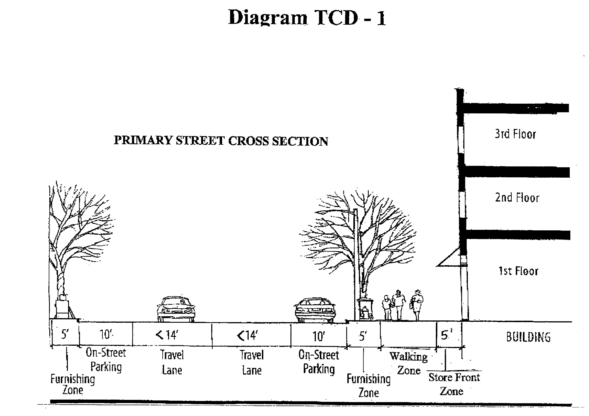
The five-foot furnishing zone shall accommodate street trees and street furniture. Street furniture shall include public elements such as street lights, benches, trash containers, tree guards, bike racks, above-ground planters, and sculptural pieces and private elements such as news stands, mailboxes, and express delivery service drop-offs. Such furniture should be functional and durable. Functionalism in placement is essential. Pedestrian access to the parking spaces shall not be obstructed. Benches and other street furnishings shall be placed in ways that facilitate use. For example, good seating arrangements include angled configurations that encourage conversation. Seating placed in a manner to create a visual pattern of repetition in the sidewalk will not achieve their functional potential. Public elements of street furniture shall have design coordination and require low maintenance.
b.
Walking zone. The ten-foot walking zone shall remain free of any obstructions so as to maintain a clear passage for pedestrians.
c.
Store front zone. The five-foot store front zone of the sidewalk is the area where private and public spaces meet. Building canopies, awnings, balconies, tables, chairs, window planting boxes, hanging baskets, and other similar type features associated with the adjacent business entities are allowed to encroach into the store front zone. Adjacent restaurants are also allowed to place ornamental railings/fencing within the store front area for enclosing outdoor seating area.
3.
Sidewalks/asphalt trails on secondary streets. On streets classified as secondary within the TCD, the minimum sidewalk or asphalt trail width adjacent to a roadway shall be eight feet. In order to accommodate street trees and to provide a separation between the vehicle travel way and pedestrians, an eight-foot-wide grass strip shall be provided between the sidewalk/asphalt walking trail and the street.
4.
Crosswalks. Curb ramps shall connect directly to all crosswalks. A diagonal ramp should not be built to give access to two perpendicular crosswalks. Where possible, sidewalks should be extended into the intersection to create shorter crosswalks. Mid-block crosswalks shall also be provided where deemed necessary.
F.
Parking space requirements.
1.
Minimum number of parking spaces required:
One parking space per 250 square feet of gross floor area for the first floor;
One parking space per 500 square feet of gross floor area for the second floor for space not designed, constructed, and used for residential occupancy; and
One parking space per 750 square feet of gross floor area for the third and fourth floors for space not designed, constructed, and used for residential occupancy;
One and a half parking spaces per unit designed, constructed, and used for residential occupancy;
Shared parking throughout the Town Center District shall be encouraged. Required parking spaces may be reduced when two or more establishments share the same parking area, whether on the same lot or on abutting lots, subject to the following conditions:
a.
That some portion of the shared off-street parking area lies within 500 feet of an entrance, regularly used by patrons, into the buildings served by the shared parking facilities.
b.
That access and parking easements must be identified as part of the site plan review and a plat prepared and recorded which memorializes such easements prior to the issuance of a building permit.
Off-street and on-street parking shall count toward meeting minimum parking requirements within the TCD development. Basement parking and parking garages are encouraged and such spaces shall also count toward meeting minimum parking requirements.
2.
Required bicycle parking. One bicycle space per 5,000 square feet of gross floor area.
Bicycle racks shall be provided in desirable locations and shall be conveniently located at each building. The rack placement should not impede pedestrian movement and should not cause conflicts between bicycles and pedestrians.
G.
Parking lots. Parking lots should be well lit, landscaped, and attractive destinations.
1.
Location. Parking lots shall be located to the rear of buildings. Parking lots may only front on streets classified as secondary within the development and shall not front on streets classified as primary within the development.
2.
Site design. Parking lots shall comply with minimum site design requirements established in Chapter 4, Section XX of the Zoning Ordinance.
3.
Landscaping requirements. In addition to complying with all landscaping requirements established in Chapter 4, Section XII of the Zoning Ordinance, parking lots shall be lined with shade trees when adjacent to a public street or sidewalk/asphalt trail. The trees shall be planted at 35 feet on center adjacent to the street or sidewalk/asphalt trail. This tree planting requirement shall be in addition to the standard tree planting requirement for a parking lot.
4.
Construction and maintenance. Parking lots shall comply with off-street parking lot construction and maintenance requirements established in Chapter 4, Section XX of the Zoning Ordinance.
5.
Pedestrian accommodations. Parking lots shall be designed to accommodate pedestrians. If the parking lot is designed so that the interior parkways run perpendicular to the rear of buildings, a five-foot-wide sidewalk must be added to each interior parkway. If the interior parkways run parallel to the rear of buildings, a five-foot-wide sidewalk must be added to interior landscape islands or at some other points within a parking row. These sidewalks must be a continuous connection from the farthest parking space areas to the buildings.
H.
Parking garages. Parking garages may not access streets classified as primary within the TCD development.
I.
Service areas. In addition to complying with Chapter 4, Section I of the Zoning Ordinance, garbage dumpster and recycling containers shall be located in the rear of buildings, centrally located, and shared by tenants. Off-street loading areas and other service areas shall also be located in the rear of buildings and shall be designed to accommodate the anticipated service vehicles. All ground HVAC units shall comply with Chapter 4, Section I of the Zoning Ordinance and all rooftop HVAC shall be placed in penthouses.
J.
Landscaping. As regulated in Chapter 4, Section XII of the Zoning Ordinance, requirements shall apply to the total TCD development.
K.
Lighting.
1.
Outdoor site lighting. As regulated in Chapter 4, Section XIII of the Zoning Ordinance, requirements shall apply to the total TCD development.
2.
Street lighting. Streetlight fixtures shall comply with the following requirements:
a.
Have a maximum pole height of 16 feet;
b.
Be dark sky compliant;
c.
Designed so that light does not shine into upper stories;
d.
Use milky/frosted/white acrylic globes;
e.
Have a maximum of 78 watts per fixture. If the bulb is recessed into the fixture/housing/box and the globe is flush with the fixture/housing/box, the wattage may be increased to 156 watts per fixture; and
f.
Use a white light (vs. yellow/high pressure sodium).
Streets shall not be over-illuminated to the point that building interiors are negatively affected. Pedestrian walks should be provided with pools of lights at a higher level of illumination than the road surface. Bollard lighting that complies with the outdoor site lighting requirements may supplement pedestrian walks. Lighting from storefront displays should be used as an adjunct to pedestrian-scale pole lighting to provide pedestrian illumination.
L.
Signs. Signs shall be defined, maintained, removed, administered, enforced, and measured as regulated in Title 9, Chapter 4 of the Farragut Municipal Code. The approval and application process shall also comply with Title 9, Chapter 4, of the Farragut Municipal Code. Signs shall be permitted per Title 14, Chapter 3 of the Farragut Municipal Code.
M.
Utilities. All utilities shall be underground. Utility locations shall not conflict with required tree plantings.
On site stormwater detention/retention facilities shall be shared and may be constructed above or below ground. An above ground stormwater detention/retention facility may be incorporated into the open space amenity, but the detention area cannot count toward meeting minimum open space reservation requirements. If green roofs are incorporated into the development, a credit for stormwater detention/retention will be given on a 1:1 ratio.
N.
Area regulations.
1.
Setback requirements.
a.
Peripheral property lines. All structures, excluding signs and fences, shall be set back a minimum of 40 feet from all peripheral property lines. Any required buffer strips shall be included in the required peripheral structure setback.
b.
Front yard. All buildings shall be set back a minimum of zero (0) feet and a maximum of ten feet from street rights-of-way internal to the TCD development.
c.
Side and rear yard. All buildings shall be set back a minimum of zero (0) feet.
2.
Building facade widths. The width of building facades shall vary and there shall be varying facade widths adjacent to each other. The goal is to create a randomness in front facades that resembles traditional main streets. The maximum facade width shall be 75 feet. Large footprints shall consist of numerous buildings rather than a single large building.
Facade and building construction shall comply with Title 14, Chapter 3 of the Farragut Municipal Code.
3.
Height regulations. Buildings shall be a minimum of two stories in height and a maximum of four stories in height. Buildings located within 100 feet of existing developed residential subdivisions at the time of rezoning the land to TCD shall not exceed two stories in height.
Accessory structures shall not exceed 15 feet in height.
4.
Street frontage. All lots created as part of the development shall have a minimum of 25 feet street frontage. Vehicular access to individual properties and establishments shall be restricted to shared access easements.
5.
Maximum lot coverage. Total lot coverage for the entire development: 80 percent.
6.
Land area. Minimum development size of one acre.
7.
Buffer strips.
a.
There shall be a buffer strip a minimum of 35 feet in width on all front property lines when the street adjacent to that front property line is classified as a local street on the Major Road Plan, is not constructed as part of the TCD development, the property on the opposite side of the street is not part of the TCD development, and the property on the opposite side of the street is zoned residential or agricultural;
b.
There shall be a buffer strip a minimum of 35 feet in width on all peripheral side and rear property lines when the abutting property is zoned residential or agriculture;
c.
Existing, mature vegetation shall be preserved and incorporated into the buffer strip; and
d.
Detention basins, measured from toe-of-slope to toe-of-slope, and associated structures shall not be located within any buffer strips.
8.
Open space. A minimum of ten percent of the gross land area of the total TCD development shall be reserved as open space.
Open space shall be created as an integral part of the overall design. In addition to conserving environmentally sensitive areas, public open spaces that are useable, functional, and accessible shall be created as part of the development and per an approved site plan. A minimum of 70 percent of the gross open space shall serve as potential public gathering areas. These open spaces shall provide for flexibility of use and shall be public spaces improved by the developer and owned by the town. The conveyance of the public spaces to the town shall occur at the time of final plat.
A maximum of 30 percent of the open space may serve as a visual focal point. Stormwater detention/retention facilities, unless designed as an amenity feature, do not count toward meeting the minimum open space requirement. These open space areas shall be created as part of the development, per an approved site plan, and be owned and maintained by the property owners association.
O.
Application for rezoning to town center district (TCD). The application for rezoning to TCD shall include a Concept Plan, which shall be of the entire development. Such plan shall be prepared by a professional team that includes a minimum of three of the following: a Tennessee licensed engineer, a Tennessee registered land surveyor, a Tennessee licensed landscape architect, or a land planner.
The Concept Plan shall be drawn to a scale of not less than one inch equals 100 feet on sheets 24 inches by 36 inches in size and shall include the following:
1.
A boundary survey of the total land area for consideration of rezoning:
2.
A site location map, property identification information, acreage, property ownership information, and developer information;
3.
GIS topography of the site;
4.
The approximate density, predominant species, general distribution of predominant species, and predominant level of maturity of trees within all tree covered area. Maturity levels shall be classified per the Tree Protection Ordinance [now chapter 113 of the Farragut Municipal Code];
5.
The location of all environmentally sensitive areas;
6.
Sufficient information on the existing development within 150 feet from the boundaries of the subject property to indicate their relationships with the proposed development related to land uses, lot lines, open space corridors, vehicular and pedestrian circulation systems, environmentally sensitive areas, and other unique natural features of the landscape;
7.
A vehicular circulation plan, which includes location of existing and proposed streets, access easements, intersections within the vicinity of the proposed points of access, and all other pertinent connections;
8.
A pedestrian circulation plan, which includes locations of proposed walking trails, sidewalks, connections from buildings to parking lots, connections to adjacent properties, connections to nearby walking trails and sidewalks, and all other pertinent connections;
9.
The designation of all proposed streets as primary or secondary;
10.
Footprint locations of proposed buildings;
11.
Location of all proposed parking;
12.
Location of proposed stormwater detention/retention facilities;
13.
Locations and sizes of all areas to be reserved as open space; and
14.
Calculations of lot coverage for the total development.
P.
Future modifications and annual review. To ensure continued progress toward completion, the approved Concept Plan shall be submitted to the planning commission for annual review. If changes are proposed from the approved Concept Plan, this shall be considered an amendment to the TCD zoning and shall be approved by the planning commission and the Board of Mayor and Aldermen.
(Ord. No. 07-31, § 1, 10-25-2007; Ord. No. 11-21, § 5, 11-15-2011; Ord. No. 14-23, § 2, 1-22-2015; Ord. No. 15-09, §§ 1, 2, 9-27-2015)
Sec. XXVIII. - Open space multi-family residential overlay (OSMFR).
A.
General description. It is the intent of this overlay district to provide for greater flexibility and design freedom in order to encourage a better living environment and the conservation of environmentally sensitive areas. The increased flexibility associated with this overlay district allows for additional height and increased density along with lessened setbacks and buffer strips. In exchange, the multi-family development shall generate a superior design that provides extensive common open space that capitalizes on the inherent physical characteristics of the property and its surrounding area.
B.
Application of the district. The Open Space Multi-Family Residential Overlay District may be applied over the Multi-Family Residential District (R-6).
C.
Permitted uses and structures.
1.
Apartment buildings.
2.
Recreational facilities and open spaces which are developed as an integral part of the development.
3.
Reserved.
4.
Nursing homes as regulated in Chapter 4.
5.
Accessory uses and structures.
6.
Customary Home Occupations as regulated in Chapter 4.
7.
Signs as regulated in the [Farragut] Municipal Code.
8.
Utility uses.
D.
General minimum development requirements.
1.
A site plan, as regulated in the Farragut Zoning Ordinance, shall be submitted to the planning commission for review and approval. All applicable requirements shall be included as part of the development plan submission. The site plan shall be of the entire development and is required whether the project is developed in multiple phases or not.
2.
The approved site plan shall be in compliance with the Farragut Comprehensive Land Use Plan, the Pedestrian and Bicycle Plan, and all other adopted plans and ordinances of the Town of Farragut.
3.
Common open space.
a.
Common open space shall be created as an integral part of the overall design. Within the designated open space, the development shall conserve, natural and manmade features on the site, including, but not limited to, trees, floodplains, sinkholes, wetlands, springs, streams, wet weather conveyances, endangered species habitat, steep slopes, rock formations and other unique topographic features, and historic features.
b.
In order to identify the areas to be designated as common open space, a survey of the natural features shall be completed. Natural features shall include, but are not limited to, wetlands, rock formations, trees, sinkholes, streams, topographic features, and endangered species habitats. Development shall comply with the Tree Protection Ordinance [now chapter 113 of the Farragut Municipal Code].
c.
Common open space may be improved for certain passive recreation uses, but open space containing natural features worthy of preservation (e.g., wetlands, woodlands, steep slopes, streams, springs, sinkholes, etc.) must be left unimproved and undisturbed. Areas within approved common open space that are not considered environmentally sensitive, such as historic features, buffer strips, stormwater detention facilities, and approved passive recreational facilities (such as walking or hiking trails) may be maintained as approved by the Town staff or the planning commission.
d.
Common open space shall be designated as permanent on the approved site plan and referenced as an exhibit in a covenant that runs with the land and that is recorded at the Register of Deeds.
4.
Access ways and parking areas shall be designed to reduce the grading of the site and preserve the natural topography as much as practical. Site design should preserve large, existing trees when possible and reduce the clearing necessary for building sites. The maximum slope created as a result of a proposed development shall not be greater than 2½:1 (run/rise). Terracing may be permitted per the Town Engineer's approval.
5.
Developments shall directly access a street having a designated classification of arterial, or a street which is not interior to a subdivision and which directly accesses a street having a designated classification of arterial. The street on which the development accesses must meet the minimum design standards established in the Farragut Subdivision Regulations.
6.
Internal access and circulation shall provide for adequate ingress/egress of firefighting equipment, service deliveries, furniture moving vans, and refuse collection vehicles.
7.
Internal pedestrian access and circulation shall be provided where deemed appropriate by the planning commission.
8.
Parking areas and sidewalks shall be lighted for night use where appropriate. All lighting shall comply with Town of Farragut lighting provisions.
9.
A landscape plan for the development shall be submitted as regulated in Chapter 4.
E.
Area regulations.
1.
Setback requirements.
a.
Front yard. All buildings (principle and accessory) shall be set back a minimum of 35 feet from front property lines. Parking shall be set back a minimum of 20 feet from front property lines. Detention basin structures, subdivision walls, entrance pillars, and certain utility structures shall be set back a minimum of ten feet from front property lines. Electrical substations, utility offices, or any other utility building shall meet the required 35-foot front yard setback.
b.
Side/rear yard. All principle buildings that are positioned along a side or rear property line that is adjacent to property that is zoned residential or agricultural shall be set back a minimum of 35 feet from the nearest side or rear property line(s).
Where surface parking is arranged along a side or rear property line and the adjacent property is zoned residential or agricultural, all principle buildings and parking lots shall be set back a minimum of 50 feet from the nearest side or rear property line(s).
Whenever a side or rear property line abuts a non-residential or non-agricultural zone, all principle buildings and parking lots shall be set back a minimum of 20 feet from the nearest side or rear property line(s).
c.
Accessory structures. Where the adjacent property is zoned residential or agricultural, accessory structures shall be set back from the nearest point of any side or rear property line a minimum of 100 feet.
Where the adjacent property is zoned non-residential or non-agricultural, accessory structures shall be set back from the nearest point of any side or rear property line a minimum of 35 feet.
2.
Minimum distance between buildings. There shall be a minimum of 20 feet between all freestanding buildings, as measured from the closest point between two buildings.
3.
Density. Maximum overall density shall not exceed 12 units per acre. This density of 12 units per acre is a maximum number only, and is permitted only if all requirements of the Town of Farragut have been met.
4.
Land area. Minimum tract size for such a development shall be five acres.
5.
Common open space. A minimum of 50 percent of the gross land area of the development shall be preserved as common open space. Such open space is to include environmentally sensitive lands, historic features, buffer strips, stormwater detention facilities, passive recreational facilities (such as walking or hiking trails) and other natural features as may be beneficial to the development and the community.
6.
Buffer strips.
a.
Front yard. A buffer strip is not required in a front yard but the development must provide for a landscape design that, at a minimum, would include plant material distributed within the area 20 feet from the front property line(s). The landscape design shall be approved by the Visual Resources Review Board.
b.
Side/rear yard. Whenever a principle building is positioned along a side or rear property line and the adjacent property is zoned residential or agricultural, there shall be a buffer strip a minimum of 35 feet in width as provided for in the landscaping requirements of Chapter 4. If the area within this buffer strip is not wooded the area shall be planted to the requirements of a 50-foot buffer strip as provided for in the landscaping requirements of Chapter 4.
Whenever a surface parking lot is arranged along a side or rear property line and abuts property zoned residential or agricultural, there shall be a buffer strip a minimum of 50 feet in width as provided for in the landscaping requirements of Chapter 4.
c.
Whenever a side or rear property line abuts property that is zoned non-residential or non-agricultural, there shall be a buffer strip a minimum of ten feet in width.
d.
Other than an approved fence or masonry screen wall used for buffering purposes or a utility or pedestrian facility that bisects a buffer strip in a perpendicular manner, no structures are permitted within a required buffer strip.
e.
Existing, mature vegetation shall be preserved and incorporated into the buffer strips.
f.
Detention basins, measured from top-of-slope to top-of-slope, and associated structures shall not be located within any buffer strips.
F.
Height regulations.
1.
Whenever the adjacent property is zoned residential or agricultural, no buildings to be constructed within 100 feet of a periphery property line shall exceed three stories, or 45 feet in height.
2.
When abutting all other zoning districts or where buildings are greater than 100 feet from a periphery property line, such buildings shall not exceed four stories, or 55 feet in height.
3.
No accessory structures, other than a clubhouse or comparable amenities building, shall exceed 15 feet in height. A clubhouse or comparable amenities building shall not exceed 25 feet in height.
G.
Parking. Parking shall be provided as regulated in Chapter 4. All overflow parking shall be centrally located or uniformly distributed throughout the development.
H.
Building facade requirements. Building facade requirements shall be in accordance with Farragut Architectural Design Standards, as amended.
(Ord. No. 14-12, § 1, 10-9-2014; Ord. No. 17-05, § 1, 4-27-2017; Ord. No. 19-19, § 5, 6-17-2019)