
Floyd County Unincorporated
City Zoning Code
City Zoning Code
ARTICLE 6
- SUBDIVISION AND PROJECT STANDARDS
6.1.1.- PURPOSE OF ARTICLE 6
This Article sets out:
a.
The minimum requirements and standards for construction of land development projects, including general principals of design and layout and requirements for such public facilities as streets and utilities.
b.
The requirements that apply to carrying out the land development process, including: site grading and land disturbance activities; addressing flood hazard and environmentally sensitive areas; the installation of streets, drainage facilities and public utilities; and building construction.
c.
The standards that control the separation between incompatible uses, landscaping and tree conservation, the provision of vehicular parking and access, and other requirements relating to a site design for an individual property.
6.1.2.- APPLICABILITY
All persons proposing construction within the public right-of-way or within easements dedicated to the City of Rome or Floyd County shall perform all construction in accordance with these specifications and standard design drawings.
6.1.3.- STANDARDS INCORPORATED BY REFERENCE
a.
Unless otherwise specially set forth herein, all of the materials, methods of construction, and workmanship for the work covered in reference to street construction and storm drainage construction shall conform to the latest standard specifications of the State Department of Transportation.
b.
Design criteria and standards for streets and traffic control not specifically set forth herein shall conform to the latest edition of the ASHTO Policy on Geometric Design of Highways and Streets and the U.S. Manual of Uniform Traffic Control Devices, as appropriate.
c.
Construction plans for all facilities covered by these regulations shall conform to the Rome-Floyd County Standard Drawings, where applicable.
6.1.4.- SUBDIVISION DEVELOPMENT OVERVIEW
a.
City-County Coordination.
In order to assure full coordination between all affected departments and agencies and to increase efficiency in the processing of permits, all applications for subdivision platting, shall be submitted to the Public Works Department of the respective jurisdiction for handling.
b.
Subdivisions with Public Improvements.
The division of land into two or more lots that will require the construction or extension of public streets, water, or sanitary sewerage (other than the direct connection of buildings to existing facilities) shall be conducted as follows:
(1)
Project Approval is granted by the Public Works Department upon review and approval of a Preliminary Subdivision Plat.
(2)
A Development Permit is issued by the Chief Building Official based on the review and approval by the Public Works Department of a Development Plan for construction of the subdivision.
(3)
Receipt by the Public Works Department of accurate surveys of the as-built condition of public improvements is required in order to allow filing of a Final Plat.
(4)
Approval of a Final Subdivision Plat by the Planning Commission will authorize recordation of the plat with the Clerk of the Superior Court.
(5)
After recordation of the Final Plat, the lots may be sold and building permits on the lots may be obtained.
(6)
A maintenance period will extend for one year after acceptance of all public improvements, as described in Section 6.4.7.
c.
Minor Subdivisions.
The division of land into four or fewer lots, each of which will be adequately served by existing public streets, water, and sanitary sewerage; and which meet all other requirements of the Ordinance, shall be conducted as follows:
(1)
Administrative Approval of a Final Subdivision Plat by the Planning Director will authorize recordation of the plat with the Clerk of the Superior Court.
(2)
After recordation of the Final Plat, the lots may be sold and building permits on the lots may be obtained.
d.
Private Subdivisions.
The procedures for approval of private subdivisions are the same as those for subdivisions with public improvements.
e.
Multi-family and Non-residential projects are approved for development in accordance with the procedures described in Article 2.
6.2.- PRELIMINARY PLAT AND DEVELOPMENT PLAN APPROVAL FOR SUBDIVISIONS
The Public Works Department must first approve the preliminary plat prior to either public or private subdivision activity, prior to the issuance of a development permit and prior to the initiation of any land disturbing or construction activities.
6.2.1.- RESPONSIBILITY
a.
The Director of Public Works is responsible for administering the review and approval for preliminary subdivision plats. The Director of Public Works shall forward a copy of the project approval application to appropriate City or County Departments, the Georgia Department of Transportation, or others as appropriate, for their review and comment. The Director of Public Works shall provide all comments to the applicant for resolution, who shall work with each City or County Department or other agency as necessary to resolve all issues.
b.
A preliminary plat may be prepared by a professional engineer, a land surveyor, or a landscape architect registered to practice in the State of Georgia.
6.2.2.- PROCEDURE FOR PROJECT APPROVAL
a.
An application for subdivision approval may be processed independently or in conjunction with an application for issuance of a development permit.
b.
An application for project approval shall be submitted to the Public Works Department by the property owner or their authorized representative. The application shall include:
(1)
A properly completed application form, as furnished by the Public Works Department, requesting review for project approval.
(2)
Copies of the preliminary subdivision plat showing the entire ownership drawn to the specifications of this Section, in a number as required by the Public Works Department.
(3)
Copies of the development plans prepared in accordance with the requirements of this code, in a number as required by the Public Works Department.
(4)
Payment of all applicable application and review fees, as established by the Governing Body from time to time.
c.
The Public Works Department shall review the application for completeness at the time of submission. Incomplete applications will be returned to the applicant.
d.
Within two weeks following receipt of the application, the Public Works Department shall return to the applicant, on the drawing or in writing, all comments related to compliance with this Development Code.
e.
The owner shall be responsible for compliance with all codes, regulations, and zoning requirements and for the satisfaction of all the noted and written comments.
f.
The Public Works Department may not approve any preliminary subdivision plat whereon is shown a lot or situation that would clearly require a variance to order to be reasonably useable, whether due to the presence of floodplain, unusual configuration, zoning compliance, lack of public utilities, or for any other reason.
g.
When the Public Works Department has determined that the preliminary subdivision plat is in compliance with the requirements, purpose, and intent of this Development Code, it shall be approved. The Director or his designee shall sign and date the CERTIFICATE OF PROJECT APPROVAL stamped or printed on a reproducible copy of the preliminary subdivision plat. One copy of the approved drawing shall be transmitted to the applicant and one copy shall be retained by the Public Works Department.
h.
The Certificate of Project Approval shall remain in effect for a period of twelve (12) consecutive months after which time it shall become null and void and a new Certificate may be required if either no permit has been issued or a permit has been issued but no development activity has begun.
6.2.3.- GENERAL STANDARDS
a.
The proposed name of the development and proposed street names shall not duplicate or too closely approximate, phonetically, the name of any other street in the city or county. If shown to the contrary, the Public Works Department may refuse to accept such development or street names. The development may use letter designations in place of proposed street names at the option of the applicant.
b.
The preliminary plat shall be prepared on a boundary survey of the entire tract to be subdivided or developed showing the location of the boundaries and dimensions of the tract to be developed.
c.
The preliminary subdivision plat shall be clearly and legibly drawn at a scale of 100 feet or less to one (1) inch. The recommended maximum dimensions of the sheet size are 36 inches by 48 inches and the minimum dimensions of 17 inches by 22 inches; however, the Director of Public Works may approve other sheet sizes and scales as appropriate.
d.
For property of over 100 acres, a smaller scale may be used where, in the judgment of the Director of Public Works, presentation of detailed data is not necessary to evaluate the entire project. It is the intent of this provision that in all cases sufficient information shall be provided for an adequate evaluation of the public and private improvements.
6.2.4.- PRELIMINARY PLAT REQUIREMENTS
a.
Proposed name of development. If the proposed development is a private subdivision, "Private Subdivision" shall be included in the title.
b.
Name and address of the property owner and developer.
c.
Name, address, and telephone number of the applicant.
d.
Date of survey, north point and graphic scales, source of datum, date of plan drawing, and revision dates, as appropriate.
e.
Proposed use of the property.
f.
Location (Land District and Land Lot) and size of the property in acres (or in square feet if less than an acre).
g.
Location sketch of the property in relation to the surrounding area with regard to well-known landmarks such as arterial streets, railroads, or others. Sketches may be drawn in freehand and at a scale sufficient to show clearly the information required, but not less than one inch equal to 2,000 feet. U.S. Geological Survey maps may be used as a reference guide for the location sketch.
h.
Name and boundary of former approved subdivision if any or all of the land in the preliminary subdivision plat or site plan has been previously subdivided, showing boundaries of the lots to be re-subdivided.
i.
Zoning district classification of the subject property and all adjacent properties, and zoning district boundaries as appropriate.
j.
Delineation of required buffers, landscape areas, tree protection areas, and river corridor buffers, as possible.
k.
Rezoning or conditional use application number, date of approval, and conditions of approval, as applicable. Variances obtained on the property by application number, date of approval, and conditions of approval, as applicable.
l.
Recorded deed names of adjoining property owners or subdivisions.
m.
Natural features within, affecting, or affected by the property, including wetlands, drainage channels, bodies of water, wooded areas, and other significant natural features such as rock outcroppings. On all water courses entering or leaving the property, the direction of flow shall be indicated. The 100-year floodplain and wetlands, if any, shall be outlined. The location of the site within a protected groundwater recharge area shall be noted if applicable.
n.
Man-made features within and adjacent to the property, including street right-of-way and pavement widths, names of existing streets, all easements, city and county political boundary lines, and other significant information such as location and dimensions of bridges, utility lines, existing buildings to remain, and other features.
o.
The proposed projected layout including:
(1)
For subdivisions, lot lines and street right-of-way lines, with proposed street names or letter designations and right-of-way widths, along with the front building setback line and the dimension of its length on each lot (i.e., the lot width).
(2)
For multi-family and nonresidential development site plans, the outline and location of all buildings, and the location of all minimum building setback lines, outdoor storage areas, buffers, parking areas, driveways, curb cuts, and designated fire lanes.
p.
The proposed phasing of the development if it is proposed to be built in sections.
q.
A statement as to the source of domestic water supply.
r.
A statement as to the provision for sanitary sewage disposal. For those properties that will not be served by a public sanitary sewerage system, written approval by the Floyd County Health Department shall be submitted.
s.
The approximate location of proposed storm water detention facilities.
t.
Such additional information as may be reasonably required to permit an adequate evaluation of the development activity proposed in the application.
6.2.5.- DEVELOPMENT PLAN REQUIREMENTS
a.
General Requirements.
(1)
Persons seeking to undertake development activity shall not commence or proceed until development plans are approved and a Development Permit is issued by the Chief Building Official. The process for approval of a development permit is presented in Section 2.5.
(2)
The development plans for a project shall conform in all respects with the requirements of this Development Code, and shall contain each of the plans in this Section as appropriate to the project, including:
(a)
Erosion and Sediment Control Plan;
(b)
Grading Plan;
(c)
Storm water Management Plan;
(d)
Street Improvement Plan;
(e)
Buffer Plan;
(f)
Public Utility Plan.
(3)
All development plans and supporting studies shall be prepared by or under the supervision of a professional engineer registered in Georgia.
b.
Provide the Erosion and Sediment Control Plan, Grading Plan, Storm water Management Plan, and Buffer/Landscaping/Tree Conservation Plan in accordance with all requirements in this Section, as well as Article 2 of this Development Code.
c.
Street Improvement Plan.
(1)
Centerline profiles and typical street sections of all proposed streets shall be required. Profiles shall be drawn on the standard plan and profile sheet with plan section showing street layout, and pavement and right-of-way width, curvature, and required drainage facilities. Typical street sections shall be provided for street widening.
(2)
Where sanitary sewer or storm water sewers are to be installed within a street, the grade, size, location and bedding class of pipe, and the location and invert elevation of manholes shall be indicated on the road profile.
(3)
Centerline profiles covering streets shall include elevations at 50-foot intervals or such distance as may be adequate to provide continuity consistent with the standards required by this Development Code for street improvements, but no less than 200 feet.
(4)
All plan elevations shall be coordinated and sited into U.S. Coast and Geodetic Survey or Georgia Department of Transportation benchmarks where feasible or into reference monuments established by the Federal Emergency Management Agency.
(5)
A street striping plan, showing striping in accordance with the Manual on Uniform Traffic Control Devices, latest edition as published by the Federal Highway Administration, shall be prepared for any street newly constructed or widened to four (4) or more lanes.
d.
Public Utility Plan.
(1)
Sewage Disposal Plan.
(a)
If connection to a public system is proposed, sewage disposal plans are to include:
1)
Sanitary sewerage plans, including profiles of all mains and outfalls, lift station and force main details, typical manhole construction details, and other information as may be required by the Director of Public Utilities.
(b)
For projects approved by the Governing Body to be served by on-site sewage disposal systems, location of septic tank, extent of drain field and attendant structures, location of percolation tests or soil data test locations, and other information shall be shown as required by the County Health Department.
(2)
Domestic Water Supply Plan.
For projects to be served by public water, the domestic water supply plan shall depict all water system improvements, water mains, fire hydrants, valves and other appurtenances, and other information as may be required by the Director of Public Utilities.
6.2.6.- EVIDENCE OF PROJECT APPROVAL
Each preliminary subdivision plat shall carry the following certificates printed or stamped on the plat.
a.
Signed approval from the County Health Department (if septic tanks will be allowed by the Governing Body).
b.
Certificate of Project Approval, to read as follows:
6.2.7.- ISSUANCE OF DEVELOPMENT PERMIT
a.
Upon approval of the Preliminary Plat and Development Plans, the Chief Building Official shall issue a Development Permit authorizing development activities to begin based on the approved documents and in accordance with Article 2 of this Development Code.
b.
Development permits for subdivisions shall expire if the development activity described in the permit is not begun within 12 months of the date of issuance. Renewal of the permit after expiration shall be in accordance with the requirements of Article 2 of this Development Code.
c.
If the subdivision is located outside of the city, certification is required by the Community Development Department that the proposed subdivision has applied for installation of street lighting in accordance with the County street lighting ordinance.
6.3.1.- RESPONSIBILITY
a.
The Director of Public Works shall be responsible for coordination of the approval process for all final subdivision plats for public and private subdivisions.
b.
The final subdivision plat shall be certified and sealed by a registered land surveyor.
c.
The owner is responsible for compliance with all code requirements of this Development Code. Approval of a final subdivision plat and acceptance of the public improvements and dedications therein shall not relieve the owner of this responsibility.
6.3.2.- PROCEDURES FOR FINAL PLAT APPROVAL
a.
Prior to submission of an application for final subdivision plat approval, one of the following conditions must be met:
(1)
For minor subdivisions, the Public Works Director shall have certified that all lots are adequately served by existing streets and public utilities; or
(2)
All public improvements shall have been properly installed and completed in accordance with all requirements and standards of this Development Code; or
(3)
A guarantee in lieu of completed improvements shall have been received by the Public Works Department and approved by the Governing Body as provided under Section 6.4.6. of this Development Code.
b.
Prior to submission, the applicant shall provide to the Public Works Department:
(1)
As-built surveys for all public improvements as required by this Article if the installation of said improvements varies from the approved development plans.
(2)
Payment for materials and installation of traffic signs and street name signs. Payment of the cost of street striping or signalization, if required and not completed by the owner, shall also be included in the application.
(3)
A maintenance bond providing adequate surety for the maintenance of all public improvements required by this Development Code in the subdivision for a period of 12 months following the date of final acceptance of said improvements.
c.
Application for a final subdivision plat approval shall be made to the Public Works Department. The application shall include:
(1)
A properly completed application form, as furnished by the Public Works Department, requesting final subdivision plat review.
(2)
The original, two (2) reproducible copies, and nine (9) prints of the final subdivision plat drawing prepared in conformance with the specifications in this Section.
(3)
Payment of all applicable final subdivision plat application and review fees, as established by the Governing Body from time to time.
(4)
Evidence of payment for traffic and street name signs, and maintenance bond, to the Public Works Department.
d.
The Public Works Department shall review the application for completeness within five (5) business days of submission. Incomplete applications will be returned to the applicant.
e.
Within two (2) weeks following receipt of the application, the Public Works Department shall indicate on the drawing or in writing all comments related to compliance with this Development Code. The Director of Public Works shall have sole authority to determine the applicability of any provisions of this Development Code to the final plat.
f.
The owner shall be responsible for compliance with all codes, regulations, and zoning requirements, and for the satisfaction of all the noted and written comments of the Public Works Department. Resubmission of all revised drawings shall be made to the Public Works Department.
g.
When all of the requirements of this Development Code, and any conditions of zoning approval, have been met, the Director of Public Works shall certify approval with signature and date on the plat.
h.
Once the final subdivision plat has been so certified, it shall be forwarded to the Planning Commission for approval after which the Director of Planning shall sign and date the CERTIFICATE OF FINAL PLAT APPROVAL stamped or printed on a reproducible copy of the final subdivision plat. The plat shall then be recorded by the Planning Department, or by the applicant with the Planning Director's approval, with the Clerk of the Superior Court. An executed original of the approved drawing shall be transmitted to the applicant.
i.
The final subdivision plat shall be submitted in digital form in a file format compatible with the Planning Department's GIS mapping system.
6.3.3.- GENERAL STANDARDS
a.
The final subdivision plat shall be drawn on an appropriate material and sheet size, and using minimum line weights and letter heights as required by Georgia law for the recordation of maps and plats (O.C.G.A. § 15-6-67, as amended), and as acceptable to the Clerk of the Superior Court.
b.
The final subdivision plat shall substantially conform to the preliminary subdivision plat and may constitute only that portion of the approved preliminary subdivision plat that the owner proposes to record at any one time, provided that such portion conforms to the requirements of this Development Code.
6.3.4.- FINAL PLAT REQUIREMENTS
The final subdivision plat shall contain the following information:
a.
All data required by Georgia law pertaining to the recordation of maps and plats (O.C.G.A. § 15-6-67, as amended).
b.
Name of the subdivision. If the development is a private subdivision, "Private Subdivision" shall be included in the title.
c.
Street names including both the name and the suffix such as "Street," "Avenue," etc.
d.
Name of the former subdivision if any or all of the property has been previously subdivided.
e.
Location sketch.
f.
Lot lines with dimensions to the 1/100 (0.01) foot; necessary internal angles, arcs, and chords; and tangent or radii of rounded corners.
g.
Building front setback lines with dimensions as to length across each lot and distance from the street right-of-way.
h.
Lots or sites numbered in numerical order and blocks lettered alphabetically.
i.
Location, dimensions and purpose of all easements, if required, and any areas to be reserved, donated, or dedicated to public use.
j.
A listing of the private covenants recorded with each lot or a statement of the location of such covenants recorded with each lot or a statement of the location of such covenants, if applicable.
k.
The extent of any area of special flood hazard, as defined in this Development Code.
l.
The street address number of each lot, as assigned by the local government.
m.
All maps or plats shall show the width and the former widths, if pertinent, of all rights-of-way adjacent to any point of reference.
n.
Curve data shall be required for all curves of greater than ten degrees on new roads. Pertinent data including radius, central angle, and tangent distance must be given for regular curves on pre-existing roads.
o.
All land lot lines, land district lines, land section lines, and city and county boundaries intersecting or adjacent to the surveyed property shall be indicated by lines drawn upon the plat with appropriate words and figures.
p.
All plats shall show the state plane coordinates of at least two permanent monuments thereon, when a United States Coastal and Geodetic Survey monument is within 500 feet of any point on the property platted, or any point of reference shown thereon.
6.3.5.- PRIVATE SUBDIVISION REQUIREMENTS
In addition to all other requirements of this Section, private subdivisions shall comply with the following:
a.
As part of any final subdivision plat submission, the following documents must be filed for approval with the Public Works Department as a part of the development plan:
(1)
The form of all agreements between the developer and property owners relative to development standards and property ownership and common area ownership and maintenance with a written statement by the City or County Attorney that this document has been reviewed by that office.
(2)
The form of all agreements between and among individual property owners relative to the ownership and maintenance of privately owned properties and common areas with a written statement by the City or County Attorney that this document has been reviewed by that office.
(3)
Certification by the Director of Public Works that all improvements have been installed in accordance with the requirements of this Code.
b.
The following language shall appear on the plats, deeds, and covenants to be recorded which concern the subdivision: "Required notice to all subsequent property owners: The grantee herein recognizes that any and all means of ingress and egress to the property conveyed hereby, and any water or sewer utilities servicing the property which are provided by the grantor or his successors or assigns are considered to be private facilities not maintainable by any local government. Therefore, the property owner herby agrees that he or she will be responsible for his or her share of the upkeep and maintenance of said private facilities, holding Floyd County and the City of Rome completely harmless of any necessity for such upkeep and maintenance." A copy of the covenants as recorded must be provided to the Building Inspections Department prior to issuance of any building permits.
6.3.6.- SURVEYOR AND OWNER CERTIFICATES
Each Final Subdivision Plat shall carry the following certificates printed or stamped the plat and signed and dated in black ink.
a.
Surveyor's Certificate, to read and be completed as follows:
b.
Surveyor's Seal. The original final subdivision plat drawing shall bear the original signature, in black ink, of the registered land surveyor placed across the surveyor's seal in order to be valid and recordable.
c.
Owner's Certificate, to read and be completed as follows, and signed in black ink on the original drawing:
6.3.7.- CERTIFICATION BY HEALTH DEPARTMENT
Certification by the Health Department that the water supply or sewerage systems installed or proposed to be installed fully meet the requirements of the Health Department's regulations. (These certifications may be submitted on a separate form as specified by the Planning Department.) The Health Department certification statement shall include written notice that each lot not on public sewer must have a septic tank permit prior to the start of construction. For developments with public sewerage and public water systems this certification may be omitted.
6.3.8.- CERTIFICATE OF FINAL SUBDIVISION PLAT APPROVAL
The following shall be stamped or printed on the final subdivision plat for execution upon its approval by the Planning Commission:
6.4.1.- EXEMPTIONS
The subdivision of land in the A-R district into four (4) or fewer lots, all of which have the minimum required frontage on a public street and meet all other minimum requirements of this Ordinance, shall be exempt from the improvement requirements of this section, except that a minimum right-of-way of fifty (50) feet shall be provided on all adjacent streets.
6.4.2.- MINIMUM REQUIREMENTS
The following improvements shall be provided by the developer or at the developer's expense in every subdivision or development:
a.
Survey documentation of the public streets and lot lines in a subdivision.
b.
Streets providing access to a development and to all lots in a subdivision, including the extension of streets required to provide access to adjoining properties.
(1)
Streets contained wholly within a subdivision shall be improved to the full standards contained in this Article. Existing streets that adjoin a subdivision shall be improved to the minimum standards provided in this Article from the centerline of the street along the subdivision's frontage as a project improvement. Right-of-way shall be dedicated to provide for street improvement, as prescribed in Section 6.6.1 of this Development Code.
(2)
Streets within or adjacent nonresidential subdivisions, or serving residential subdivisions with 200 dwelling units or more shall be improved to collector street standards; however, adjacent streets that are classified as arterials shall be improved to arterial standards. All other streets shall be improved to local street standards.
(3)
The Jurisdiction may participate in sharing the costs of construction and installation to the extent that improvements are needed to bring the street to a higher level of classification than required to exclusively serve the subdivision or development.
(4)
Curb and gutter or swale ditches along all roadways, as applicable.
c.
Storm water drainage and detention facilities.
d.
Sidewalks along each side of any curb and gutter street within or adjacent to a subdivision, or adjacent any development, if inside the City of Rome. Sidewalks are not required for developments located within the unincorporated areas of Floyd County.
e.
Street name signs, stop bars, and traffic control signs shall be installed by the Jurisdiction at the developer's expense.
f.
Where public water is available at the property being subdivided, public water service shall be provided to every lot in a subdivision and to every development for both domestic use and fire protection. Water mains shall be connected to the existing public water system and extended past each lot. When the water main is located in the street right-of-way and it will be necessary to cut into the street surface to serve the adjacent lot, a connection shall be stubbed out to the property line to serve each lot prior to surfacing the street. Water mains and fire hydrants shall be installed according to plans and specifications approved by the Public Works Director, the County Board of Health, and the State Department of Natural Resources Environmental Protection Division. Fire protection systems shall be installed to current Insurance Services Office (ISO) specifications and requirements. A contractor approved by the Jurisdiction shall install all elements of the water system, including mains, valves, and hydrants at the developer's expense. The Jurisdiction may participate in sharing the costs of construction and installation to the extent that pipe sizes are needed in excess of that size required to exclusively serve the subdivision or development.
g.
Fire hydrants shall be located along the streets in every subdivision and within every development project.
h.
Every lot in a subdivision and every development shall be connected to a public sanitary sewerage system unless on-site disposal is allowed by the Floyd County Health Department. Sewer lines shall be connected to the existing sanitary sewerage system and extended past each lot. Every element of the sanitary sewer system, including mains, lift stations, outfalls, and laterals shall be installed at the developer's expense by a contractor approved by the Public Utilities Department. The Jurisdiction may participate in sharing the costs of construction and installation to the extent that sewer mains or related improvements are needed in excess of the facilities required to exclusively serve the subdivision or development.
i.
Street lights in a subdivision in the unincorporated portion of the county, in accordance with County Ordinances.
6.4.3.- PRIVATE SUBDIVISIONS
Private subdivisions shall meet all requirements and standards that apply to public subdivisions except as follows:
a.
In private residential subdivisions the Typical Residential Roadway Cross-Section without Curb & Gutter, as shown in Figure 6.5, using green infrastructure/low impact development (GI/LID) engineering design may be used (City Only).
b.
Reserved.
6.4.4.- SURVEY MONUMENTS
Concrete monuments with aluminum or brass marking shall be placed at all corners of the exterior boundaries of the subdivision being developed and shall be set flush or up to six (6) inches above the finished grade. Existing permanent monuments, which in the professional opinion of a registered land surveyor, or the city or county engineer are of sufficiently durable construction may be maintained in lieu of a new concrete monument as described above. All other street or lot corners or angle points and points of curve in each street shall be marked with an iron pipe or surveyor's marker at least 24 inches long and driven no less than one (1) inch or up to six (6) inches above the finished grade. All such monuments shall be properly set in the ground and shall be approved by a registered land surveyor prior to the time of a final plat approval by the Planning Commission.
6.4.5.- STREETS
a.
A publicly approved street, that has been opened and accepted for maintenance; that has been designated by the city or county as a public street; or whose construction has been guaranteed, as provided under Section 6.4.6 of this Development Code, and meeting the requirements of this Article, shall serve every development and every lot within a subdivision.
b.
Every subdivision shall have access to the public street system via a paved roadway. Subdivision projects containing more than 200 lots must have at least two points of access.
c.
When land is subdivided into larger parcels than ordinary building lots, such parcels shall be arranged and designed so as to provide access to those areas not presently served by streets.
d.
No subdivision or development shall be designed in a way that would completely eliminate street access to adjoining parcels of land.
e.
Where, in the opinion of the Public Works Department, it is necessary to provide for street access to adjoining property, proposed streets shall be extended by dedication of right-of-way to the boundary of such property through the development.
f.
Where an arterial street adjoins or is included in a residential subdivision, the responsible city and/or county engineer may limit access to the arterial street. Lots that abut the arterial shall be provided with another means of access, such as: (1) platting reverse frontage lots, (2) platting a separate street parallel to the arterial, or (3) platting a loop street or cul-de-sac.
6.4.6.- GUARANTEE IN LIEU OF COMPLETED IMPROVEMENTS
No final subdivision plat shall be approved by the Rome/Floyd County Planning Commission or accepted for recordation by the Clerk of the Superior Court until one of the following conditions has been met:
a.
All required improvement have been constructed or funded in a satisfactory manner and approved by the Director of Public Works, or
b.
The Governing Body has received in escrow 110% of the estimated cost of installation of the required improvements, and has approved an executed contract for installation of the improvements by a qualified contractor. The executed contractor shall call for completion of the improvements within one (1) year of approval of the final subdivision plat.
6.4.7.- ACCEPTANCE OF PUBLIC IMPROVEMENTS
a.
If construction of any required public improvements was deferred at the time of final plat approval, said work must be completed during the one-year maintenance period for the subdivision.
b.
Prior to end of the maintenance period, a final acceptance inspection of the public improvements shall be conducted by the Public Works Department.
c.
The owner must correct all defects or deficiencies in materials or workmanship and make such repairs as necessary to approximate the as-built condition of the improvements.
d.
Upon certification by the Public Works Director that the public improvements depicted on the as-built surveys are in conformance with the specifications of this Development Code and are in good repair, the Governing Body shall accept the public improvements into perpetual maintenance.
6.5.1.- SUITABILITY OF THE LAND
Land physically unsuitable for subdivision or development because of flooding, poor drainage, steep slopes, rock formations, or other such features that may endanger health, life or property, aggravate erosion, increase flood hazard, or necessitate excessive expenditures of public funds for supply and maintenance of services shall not be approved for subdivision or development unless adequate methods are formulated by the developer for solving the problems. Such land shall be set aside for such uses as shall not involve such a danger.
6.5.2.- CONFORMANCE TO THE COMPREHENSIVE PLAN
a.
All proposed subdivisions shall conform to the Comprehensive Plan and development policies in effect at the time of submission to the Public Works Department.
b.
All highways, streets, and other features of the Comprehensive Plan shall be platted by the developer in the location and the dimension indicated on the Comprehensive Plan.
c.
In subdivisions or developments related to or affecting any State or U.S. numbered highway, the Public Works Department shall require the approval of the Georgia Department of Transportation and Public Works Department.
6.5.3.- NAME OF SUBDIVISION
The name of each subdivision must have the approval of the Public Works Department. The name shall not duplicate nor closely approximate the name of an existing subdivision.
6.5.4.- BLOCKS
a.
Length:
(1)
Residential Blocks.
(a)
Blocks shall be at least 600 feet but not more than 1,800 feet in length, except as the Building Inspection Department considers necessary to secure efficient use of land or desired features of street pattern.
(b)
In blocks greater than 1,000 feet in length, the Building Inspection Department may require one or more public easements of not less than 20 feet in width to extend entirely across the block for pedestrian crosswalks, fire protection, or utilities.
(2)
Nonresidential Blocks.
(a)
Blocks for other than residential use shall be of such length and width as may be suitable for the prospective use, including adequate provisions for off-street parking and service.
b.
Width:
Blocks shall be wide enough to allow two rows of lots, except where reverse frontage lots on arterial streets are provided, or when prevented by topographic conditions or size of the property, or for lots along the periphery of the subdivision, in which case the Building Inspection Department may approve a single row of lots.
6.5.5.- LOTS
a.
Authority of Health Department.
Nothing contained in this Article shall be construed as preventing the Health Department, after study of the conditions existing in a proposed subdivision, from requiring that all or any portion of the area of such subdivision shall not be built upon or that the minimum lot sizes set forth in this Ordinance are inadequate and must be increased to ensure the protection of the public health. The developer is encouraged to consult with the Health Department regarding lot size requirements prior to submitting a development plan.
b.
Adequate building sites.
Each lot shall contain a site large enough for a normal building that will meet all building setback requirements and not be subject to flood or periodic inundation.
c.
Street frontage.
Each lot must abut a street that has been opened and accepted for public maintenance; that has been designated by the City or County as a private street; or whose construction has been guaranteed, as provided under Section 6.4.6 of this Development Code, for a distance of no less than 60 continuous feet, except lots abutting cul-de-sac turnarounds which must have no less than 25 feet, and townhouse lots as provided in Section 4.1.23.
d.
Arrangement.
Insofar as practical, side lot lines shall be at right angles to straight street lines or radial to curved street lines.
e.
Minimum lot dimensions and areas.
All lots proposed in a subdivision shall meet or exceed the area and dimensional requirements of the Development Code for the zoning district in which the lots are located.
f.
Residential lots shall not be platted to front directly on the right-of-way of a major arterial, unless adequate provisions for access have been established.
g.
City limits and lot lines.
Corporate boundary lines shall not divide lots.
h.
Corner lots.
Corner lots shall be sufficiently large to permit the location of buildings so as to conform to the front building lines on both streets.
i.
Double and reverse frontage lots.
Double frontage and reverse frontage lots should be avoided except where specifically required to provide separation of residential development from an arterial street or to overcome specific disadvantages of topography and orientation of property. An easement of at least 10 feet across which there shall be no right of access, shall be provided where required by the Building Inspection Department along the line of lots abutting such arterial streets, or to overcome the disadvantageous orientation of property.
j.
Each lot shall have a viable home-site above the 100-year floodplain.
6.5.6.- STREETS
a.
The street pattern within a subdivision shall provide for the continuation or appropriate projection of the existing street pattern at the same or greater width, but in no case less than the required minimum width in the section of the community involved, unless the Building Inspection Department deems such extension undesirable.
b.
Existing streets that adjoin a development or subdivision boundary shall be deemed a part of the subdivision. The proposed street system within a subdivision shall have the right-of-way of existing streets extended no less than the required minimum width. Subdivisions that adjoin only one side of an existing street shall dedicate one-half of the additional right-of-way needed to meet the minimum width requirement for the street. If any part of subdivision includes both sides of an existing street, all of the required additional right-of-way shall be dedicated.
c.
Subdivision streets that intersect an arterial street shall do so at intervals of not less than 800 feet, or as required by the Georgia Department of Transportation, whichever is greater.
d.
Reserve strips that prohibit access to streets from adjoining property shall be prohibited.
e.
Design standards for all subdivision streets shall meet all requirements for street construction in accordance with Section 6.6.
6.6.1.- STREET ACCESS AND RIGHT-OF-WAY
a.
Every development shall have access to the public street system via a publicly maintained roadway.
b.
Existing streets that adjoin a development shall be deemed a part of the development. Developments that adjoin only one side of an existing street shall dedicate one-half of the additional right-of-way needed to meet the minimum right-of-way requirement for the street. If any part of the development includes both sides of an existing street, all of the required additional right-of-way shall be dedicated.
(1)
New developments on existing lots of record that adjoin only one side of an existing street shall dedicate one-half of the additional right-of-way width of 50 feet, which is the minimum right-of-way width for public streets under current city and county standards. If any part of the development includes both sides of an existing street, all of the required additional right-of-way shall be dedicated. In addition, if a deceleration is required, sufficient additional right-of-way shall be dedicated provide for the lane.
(2)
New development on an existing lot of record that adjoins an existing street listed in the Floyd-Rome Urban Transportation Study (FRUTS), Long Range Transportation plan (LRTP), and/or Transportation Improvement Program (TIP) shall dedicate the additional right-of-way necessary to provide for the planned improvement, except that only one-half of the additional right-of-way shall be dedicated if the development adjoins only one side of the street.
6.6.2.- TURNING LANES
Turning lanes shall be required at all entrances to subdivisions and multi-family, industrial, office and commercial developments that front on arterial streets and may be required on collector streets. Turning lanes shall be 11.5 feet in width plus curb and gutter for a minimum distance of 200 feet measured from the intersection of the right-of-way lines or the edge of the driveway.
6.6.3.- SIDEWALKS
a.
Sidewalks shall be provided along arterial and collector streets to provide a safe and convenient means for pedestrian movements if inside the City of Rome. Sidewalks are not required for developments located within the unincorporated areas of Floyd County.
b.
Where provided, sidewalks shall be located not less than one foot from the property line to prevent interference or encroachment by fencing, walls, hedges, or other plantings or structures placed on the property line at a later date. In single-family residential areas sidewalks shall be no less than four (4) feet in width, constructed of concrete no less than four (4) inches in depth, and located no less than three (3) feet from the back of the curb. In commercial areas sidewalks shall be no less than five (5) feet in width, and constructed of concrete no less than four (4) inches in depth.
c.
Concrete shall be 2,000 PSI at 28 days strength.
d.
Sidewalks shall be backfilled and grassed.
6.6.4.- CURB AND GUTTER
a.
In the unincorporated area of the county curb and gutter are required on new roads in residential subdivisions where the average width of lots are less than 200 feet and the average lot size does not exceed 1½ acres, and along all multi-family and nonresidential uses.
b.
Curb and gutter shall be required on all streets in the City, except where the road serves only as a collector for the development of property, and where access and public services to more than one parcel are provided from other streets.
c.
Where required, curb and gutter shall be provided as specified in the Design Standards for Streets. No variance of the requirement to provide curb and gutter shall be available unless specific approval is given by the Public Works Director, if inside the City of Rome. Due to unique circumstances created by topography within unincorporated Floyd County, alternatives to providing curb and gutter may be available, subject to approval by the Public Works Director.
6.6.5.- EASEMENTS
Easements shall be required in connection with subdivisions or developments for the following purposes, among others:
a.
Utility Easements.
Whenever it is necessary or desirable to locate a public utility line outside of the street right-of-way, the line shall be located in an easement dedicated to the Jurisdiction for such purpose. Easements for water and sanitary sewers shall be a minimum of 20 feet wide, and may be required to be wider depending on the depth of the cut.
b.
Water course and Drainage Easements.
(1)
A publicly dedicated storm water right-of-access or drainage easement is to be provided along any drainage channel, stream or water impoundment within a development. The easement shall be substantially centered on the watercourse or shall surround the high water line of the impoundment, and shall be of such width as the Public Works Director deems necessary for adequate access by maintenance equipment. All easements shall be no less than 20 feet wide when used as an open ditch. Piped storm drainage shall have a minimum easement width of 15 feet wide.
(2)
Drainage easements shall be opened at the time of development to control surface water runoff.
(3)
Drainage easements off the street right-of-way shall be clearly defined on the plat and deed of the individual property owner, and such property owner shall keep the easement free of obstructions and maintain that part of the easement within the property owner's boundary line so that free and maximum flow is maintained at all times.
c.
Overlapping Easements.
Easements for water and sanitary and drainage purposes shall not overlap unless approved by the Public Works Department.
6.6.6.- UTILITIES
a.
Sanitary Sewerage.
(1)
Each developer shall be required to pay for the installation of a sanitary sewerage collection system connected to the public system serving his subdivision or development, if it is available in a timely manner. All dwellings shall connect to public sewer when such sewer is within 300 feet of the property being subdivided. No septic tanks shall be allowed if public sewerage is available. The layout and specifications of the system shall be in accordance with specifications approved by the Public Utilities Director, and shall be installed by a contractor certified by the State of Georgia for utility installation.
(2)
When the sewer is located in a street right-of-way and it will be necessary to cut into the street to serve the abutting lots, a connection shall be stubbed out to the property line to serve each lot prior to surfacing the street.
(3)
Where connection to the sanitary sewerage system is not feasible in the view of the Public Utilities Director, the lot shall contain adequate area for the installation and safe operation of a specific tank and disposal field, as approved by the county health officer.
(4)
Prior to the construction of any private community sewerage disposal system, the location, size, plans and specifications of such a facility shall be approved by the appropriate city and/or county official, the health department and the State Department of Natural Resources, Environmental Protection Division.
b.
Public Water.
(1)
Each subdivision or development shall connect to the Jurisdiction's public water system where available, and shall provide service to each lot or the development as a whole, as appropriate, at the expense of the developer.
(2)
The layout and specifications of the system shall be in accordance with Jurisdiction specifications, as approved by the Public Utilities Director, and shall be installed by a contractor certified by the State of Georgia for utility installation.
(3)
Fire hydrants in subdivisions shall be installed and spaced no more than 1,000 feet apart, and meet the requirements of the Fire Department.
(4)
When the water main is located in the street right-of-way and it will be necessary to cut into the street surface to serve the abutting lot, a connection shall be stubbed out to the property line and a meter box installed to serve each lot prior to surfacing the street. Alternatively, lines may be bored at the builder's expense.
c.
Location of Utilities in Streets.
(1)
Above-Ground Utilities.
Telephone poles, street light poles, telephone junction boxes, and other public or private utility structures placed above ground within a street right-of-way must meet the Utilities Protection Standardized Street Profile.
(2)
Underground Utilities.
Utilities placed underground shall be placed within the right-of-way as shown in Figure 6.1 at the end of Section 6.19 of this Article or in accordance with County standards for roads with swale ditches.
(a)
All utilities beneath pavement shall be installed and the ditch backfilled and thoroughly compacted before any pavement or base is installed, or the pipes shall be bored if installed after street construction.
(b)
All utility manholes and valve boxes shall be brought to the finished grade within the roadway section.
(c)
All utility locations shall correspond to the typical layout shown by Standard Drawings.
(d)
All private utilities that will cross under pavement shall be installed completely throughout the subdivision prior to any roadway base being applied. Installation of approved utility sleeves shall be considered as an alternate.
6.6.7.- PAVEMENT CUTS
a.
All utility street cuts within public rights-of-way shall be reviewed and approved by the appropriate engineering department before construction begins.
b.
Pavement cuts for the installation of utilities shall be avoided whenever possible. Utility crossing shall be bored across any arterial, subject to the approval of the Georgia DOT, and across any collector unless a pavement cut is approved by the Director of Public Works.
c.
Pavement cuts across local streets shall be permitted, provided the road is repaired with at least six (6) inches of 3,000 psi Portland cement and topped with at least two (2) inches of E or F hot plant mix asphaltic cement. The top of the concrete pad shall not exceed the elevation of the aggregate base course of the original road construction.
d.
Pavement cuts across local streets shall conform to Figure 6.2 at the end of Section 6.19 of this Article.
6.6.8.- LIGHTING
To reduce light trespass, obtrusive light, and light pollution; to conserve energy and resources; to reduce extreme variations of illumination, to which elderly drivers are particularly sensitive; and to enhance enjoyment of the night sky, the following standards shall apply to all exterior lighting with an illumination level above 230 lumens in residential zones and 500 lumens (600 lumens for fluorescent) in non-residential zones:
a.
All new or replacement lighting shall be of such a design, type, location, direction and shielding as to protect adjacent properties from excessive light. The level of lighting generated by a property shall not exceed 0.5 foot-candles beyond any property line shared with a residential use or 1.0 foot-candles beyond any property line shared with a non-residential or public use.
b.
No direct light shall be allowed onto adjacent residential property or public way.
c.
All permanent area lights shall be full cut-off fixtures, downward directed, and shielded so that the angle of luminance does not result in light projecting beyond the area being lit. Except for outdoor recreation attractions, lights may be mounted at a height of no more than 25 feet from grade.
d.
Accent lighting of structures and architectural features, such as steeples, monuments, or flagpoles, should be downward directed if feasible; however, upward directed lighting may be allowed provided light projecting above or beyond the feature is minimized.
e.
Light fixtures illuminating signs shall be downward directed and shielded so that the angle of luminance does not result in light projecting above or beyond the sign being lit. Upward-directed sign lighting is prohibited except for monument signs of less than six (6) feet overall height.
f.
Lighting which presents a clear hazard to pilots, motorists, cyclists or pedestrians is prohibited.
g.
High intensity, laser, and any similar lighting is prohibited.
h.
Definitions:
Cutoff Fixture: An outdoor light fixture shielded or constructed in such a manner that no more than two and one-half (2½) percent of the total light emitted by the fixture is projected above the horizontal plane of the fixture.
Direct Light: Light emitted directly from the lamp, off of the reflector or reflector diffuser, or through the refractor or diffuser lens, of a light fixture.
Foot-candles: A unit of measure of the intensity of light falling on a surface, equal to one lumen per square foot and originally defined with reference to a standardized candle burning at one foot from a given surface.
Indirect Light: Direct light that has been reflected or has scattered off of other surfaces.
Light Trespass: The shining of light produced by a fixture beyond the boundaries of the property on which it is located.
6.6.9.- CEMETERIES AND BURIAL GROUNDS
Georgia law (O.C.G.A. §§ 27-3-133; and 12-6-176) prohibits disturbance of any known burial place for human remains for development or for change of land use unless a permit is obtained from the governing body (City or County) or from the superior court. No such permit will be issued by the governing body without approved re-internment.
6.7.1.- GENERAL
a.
Arterial Streets.
All major and minor arterial streets shall meet all design requirements of the Georgia Department of Transportation.
b.
Local and Collector Streets.
All local and collector streets shall comply with the design and construction requirements of this Ordinance.
c.
Street Names.
(1)
Proposed streets that are obviously in alignment with others already existing and named shall bear the names of existing streets. In no case shall the name for a proposed street duplicate existing street names in the city or county, irrespective of the use of the suffix street, avenue, boulevard, road, pike, drive, way, place, court, or other derivatives.
(2)
The entire county is divided into four street number quadrants designated "N.E.," "N.W.," "S.E.," and "S.W." All streets shall bear the proper quadrant suffix.
(3)
All street names are subject to the approval of the respective Public Works Department.
(4)
Property address numbers shall be provided by the Public Works Department.
d.
Street name and traffic control signs.
Street name signs of a type approved by the Jurisdiction are to be placed at all intersections. Traffic control signs shall be placed by the Jurisdiction and conform to the U.S. Manual on Uniform Traffic Control Devices, latest edition.
6.7.2.- MINIMUM WIDTH OF RIGHT-OF-WAY
Minimum width of right-of-way measured from lot line to lot line shall be as follows:
Table 6-1
Minimum Right-of-Way Width
6.7.3.- VERTICAL AND HORIZONTAL ALIGNMENT OF STREETS
a.
Vertical alignment of streets.
(1)
The maximum grade and vertical curve allowed for a street are shown on the following Table, except that the grade across a cul-de-sac in all directions shall not exceed one and one-half (1.5) percent. All streets shall have a minimum grade of one (1) percent.
Table 6-2
Vertical Alignment
(2)
All changes in grade shall be connected by a vertical curve so constructed as to afford a minimum sight distance, said sight distance being measured from the driver's eyes, which are assumed to be three and one-half (3.5) feet in height above the pavement surface, to an object six (6) inches high on the pavement.
The minimum sight distance shall be as follows:
Table 6-3
Minimum Sight Distance
b.
Horizontal alignment of streets.
(1)
Where a deflection angle of more than 10 degrees in the alignment of a street occurs, the radius of curvature of the centerline of said street shall not be less than as follows:
Table 6-4
Horizontal Alignment
(2)
Curved streets shall have a minimum tangent of 100 feet at intersections as measured from the centerline of cross streets. A tangent of at least 200 feet in length shall be introduced between reverse curves on collector streets, and 100 feet on local streets.
(3)
Adjoining street intersections shall be spaced at least 200 feet apart measured from edge of right-of-way to edge of opposing right-of-way. Street jogs with centerline offsets of less than 150 feet shall not be allowed.
(4)
Intersections.
The centerline of no more than two streets shall intersect at any one point. All streets shall intersect at no less than sixty (60) degrees, and as neat a right angle as possible. The angle of intersection is to be measured at the intersection of the street centerlines. Such intersecting streets shall provide an uninterrupted line of sight from the center point of the intersection for not less than the minimum sight distance required in accordance with this Development Code.
(5)
Islands at intersections shall be subject to individual approval by the appropriate engineer of the city and/or county. In no case shall anything extend more than three (3) feet above the back of the curb within the right-of-way of the intersecting street.
(6)
Curb lines at street intersections shall have a radius of curvature of not less than 25 feet.
(7)
Intersecting street right-of-way lines shall be rounded with a radius no less than 25 feet.
c.
Design Speed.
Horizontal curves and super elevation shall be designed in accordance with the following minimum design speeds:
Table 6-5
Design Speeds
6.7.4.- DEAD-END STREETS
a.
A cul-de-sac shall be no more than 1,600 feet long unless necessitated by topographic or other conditions and approved by the Building Inspection Department.
b.
Cul-de-sacs shall terminate in a circular turnaround having a minimum right-of-way of at least 100 feet in diameter and a paved turnaround with a minimum diameter of 80 feet to the edge of the pavement.
c.
A reverse curve joining a cul-de-sac turnaround to a street section is to have a right-of-way radius of 29 feet and a radius to the back of curb of 40 feet (42 feet to edge of pavement).
d.
A dead-end street other than a cul-de-sac shall not be allowed except as a temporary stage of construction of a street that is intended to be extended in a later stage of construction. Such temporary dead-end street shall be provided with a temporary turnaround having a diameter of 80 feet, within the right-of-way if:
(1)
One or more lots front exclusively on the street; and
(2)
Extension of the street is not under construction when the Final Plat is submitted for recording.
e.
Temporary turnarounds shall consist of a tack coat and one (1) inch of asphalt.
6.7.5.- ALLEYS AND SERVICE DRIVES
Alleys may be provided in residential blocks where the subdivider produces evidence satisfactory to the Planning Commission of the need for alleys. Where an alley has been specifically authorized or required by the Building Inspection Department, it shall comply with the following minimum design standards:
a.
The roadbed width shall be no less than 20 feet, containing a paved roadway of no less than 16 feet exclusive of gutters.
b.
Dead-end alleys shall be provided with a turnaround having a radius of at least 40 feet.
6.7.6.- HALF STREETS
Half streets are prohibited. Whenever a street is planned adjacent to the proposed subdivision tract boundary, the entire street right-of-way shall be platted within the proposed subdivision.
a.
Split Level Streets and One-way Streets.
Streets which are constructed so as to have two traffic-ways, each at a different level within the same right-of-way, shall provide a paved traffic surface of at least 20 feet on each level and a slope between the two traffic-ways of not less than three (3) to one (1). One-way streets and split streets will be allowed when:
(1)
Topographic conditions are such that alternatives to the typical street construction would be more desirable.
(2)
The shape and size of the parcel could be more efficiently developed.
In either case, approval must be obtained from the Building Inspection Department and the appropriate Public Works Department.
6.7.7.- PAVEMENT DESIGN
a.
Minimum width of pavement.
The minimum pavement width, measured from curb edge of gutter to edge of gutter (or edge of pavement to edge of pavement for swale ditch section) required for collectors and local streets shall be as follows:
Table 6-6
Minimum Pavement Width
b.
Street base.
(1)
Street base material shall conform to the following specifications:
Table 6-7
Street Base
(2)
For streets without curbs, the base shall extend at least 12 inches beyond the edge of pavement.
c.
Asphaltic Concrete Pavement.
(1)
Streets shall be paved with asphaltic concrete meeting the following standards:
Table 6-8
Pavement Topping
6.7.8.- CURB AND GUTTER
a.
Where required, curb and gutter shall be of vertical, roll back or "Rome" type and shall conform to D.O.T. standard Class B Curb Mix.
b.
Whenever necessary to permit the construction of a curb having a desirable radius without curtailing the sidewalk at a street corner to less than normal width, the property line at such street corner shall be round or otherwise set back sufficiently to permit such construction.
c.
Where curb and gutter are not required, a 60-foot street right-of-way with approved drainage facilities will be required. The appropriate city or county official shall, according to plans and specifications, approve installation of curb and gutter or alternative facilities.
d.
Curbing along streets shall meet the following standards:
(1)
Developer's engineer or surveyor shall set line and grade.
(2)
One-half (½) inch expansion joints of pre-molded bitumastic expansion joint material shall be provided at all radius points and at intervals not to exceed 50 feet in the remainder of the curb and gutter.
(3)
The appropriate engineer shall individually approve special curbing design (center islands, etc.).
(4)
Curb and gutter shall be set true to line and grade and finished by skilled workers to the section shown on the plans.
(5)
Inferior workmanship or construction methods resulting in unsightly curb and gutter will be cause for rejection of the finished work.
(6)
All curbing shall be backfilled and grassed.
(7)
Adequate storm drainage structures shall be provided. The curb and gutter shall be constructed so as to present a smooth, even line both horizontally and vertically.
e.
Valley gutters shall not be allowed across streets at street intersections.
6.7.9.- STORM DRAINAGE
a.
Street Cross Drains or Culverts.
(1)
Pipe size for culverts under streets (street cross drains) shall be determined by design runoff and hydraulic capacity. The minimum allowable street cross drain diameter shall be 18 inches, with a minimum slope of one (1) percent.
(2)
Street cross drains shall be constructed of Class III reinforced concrete.
(3)
Street cross drains shall be sized to handle the runoff of a 25-year, 24-hour storm. Cross drains shall be designed to handle the peak rate of discharge associated with a 100-year storm with at least 1-foot of freeboard from the top of the roadway shoulder.
(4)
Velocity at design flow shall be sloped so as to maintain a minimum velocity of at least three (3) feet per second but not more than the velocity that would cause erosion damage to the conduit.
(5)
Street cross drain design shall be in accordance with the methods contained in the State Highway Standard 1030D, latest edition.
(6)
Street cross drains carrying live streams shall extend to where the crown of the pipe intersects the street embankment slope and shall have flared end sections with a one (1) foot wide collar of six (6) inch thick concrete.
(7)
Maintain full shoulder width across all cross drains as the minimum length.
(8)
Street water shall be limited to a maximum distance as follows: 400 feet on grades up to seven (7) percent; 300 feet on grades from seven (7) to ten (10) percent; 250 feet on grades over ten (10) percent.
(9)
Bridges shall be designed to span a 100-year storm frequency.
(10)
Junction boxes having access to the pipe shall be constructed to meet the requirements of the Georgia DOT Standard 1030D (or most current).
b.
Traffic and Erosion.
Before any traffic over a storm drain is allowed the developer shall provide an adequate depth and width of compacted backfill to protect the structure from damage or displacement. The developer shall remove any debris or silt that constricts the flow through a pipe as often as necessary to maintain drainage. All pipe structures shall be cleaned before the work is accepted. Any damage or displacement that may occur due to traffic or erosion shall be repaired or corrected at the developer's expense. The developer's obligation to clean and repair pipes ceases after acceptance of the system by the proper authority.
c.
Inlets and Catch Basins.
(1)
Inlets and catch basins shall be designed in accordance with the Georgia Department of Transportation's Drainage Manual for Highways, latest edition, and in accordance with the Standard Drawings.
(2)
Frames and grates shall be as selected by the Public Works Director based upon site conditions.
(3)
Storm water catch basins shall be spaced as approved by the Public Works Department.
(4)
Catch basins shall be located at all low points of streets and as approved by the Public Works Department.
d.
Piped Systems.
(1)
Design runoff and hydraulic capacity shall determine pipe size. The minimum allowable pipe diameter shall be 18 inches under a street and 15 inches under a driveway.
(2)
Minimum Clearance.
Minimum clearances are: One (1) foot between the bottom of the roadway base and the exterior crown of the culvert, and a minimum of six (6) inches between underground utilities and exterior crown of culverts.
(3)
Trench Construction.
Trench construction for storm drainage pipe shall be in accordance with standard drawings.
(4)
Storm drainpipes shall be constructed of Class III reinforced concrete pipe, if within the right-of-way. Outside of the right-of-way, storm drainpipes may be constructed of aluminized Type II or steel corrugated pipe; or of smooth wall-corrugated PVC or HDPE plastic pipe.
(a)
Concrete Pipe.
1)
Concrete pipe shall be reinforced within the right-of-way but may be plain pipe outside of the right-of-way.
2)
Flat bottom and circular pipe sections shall be laid in a prepared trench with the socket ends pointing upstream. Sections shall be joined in accordance with manufacturer's recommendations.
(b)
Corrugated Aluminum or Steel Pipe.
1)
Metal pipe shall be fully bituminous coated.
2)
Corrugated aluminum or steel pipe and pipe arches sections shall be laid in a prepared trench with outside laps of circumferential joints pointing upstream and with longitudinal joints at the sides. Coupling bands, fastened by two or more bolts, shall join the sections. The space between adjoining sections shall be not more than the width of one corrugation.
3)
All damaged spots in galvanized coating that expose the base metal shall be repaired before the structure is backfilled. All damaged spots in bituminous coating that expose the base metal shall be re-coated with asphalt before the structure is backfilled.
(c)
PVC or HDPE Plastic Pipe.
1)
PVC and HDPE plastic pipe shall be seamless with a smooth inner wall and corrugated outer wall. PVC pipe shall meet the requirements of ASTM F949. HDPE pipe shall meet the requirements of AASHTO M252 or M294, Type S. The pipe shall be manufactured as a single extrusion with annular corrugations. Joints shall be bell and spigot type with elastomeric gasket seals.
2)
Plastic pipe shall be laid in a prepared trench and adjusted to grade in accordance with ASTM D2321. Connections to manholes or other structures shall be made with a flexible connector secured with stainless steel bands, grouted in place according to the manufacturer's recommendations.
(d)
Elongation.
Elongation of metal pipes shall be as shown on the plans. The contractor shall order the elongation of the vertical axis of the pipe to be done in the shop. Corrugated metal pipe shall be shipped with wire-tie in the pipe ends. Wire-ties shall be removed as soon as possible after the fill is completed.
(5)
The design of piped storm water collection systems shall be based upon conveyance of the peak rate of discharge associated with a 25-year, 24-hour storm.
(6)
Storm water pipes that do not carry live streams shall extend at least 50 feet beyond the front building setback lines, and may be required to extend farther where necessary to provide an adequately protected building site on the property.
(7)
Any storm drainage pipe dedicated to the public that extends outside of the street right-of-way shall be located within a 20-foot-wide easement.
(8)
All storm drainage pipes shall be at least 18 inches below the surface and shall have a slope of at least one (1) percent. Sub-drainage will be installed to control the surplus ground water by intercepting side hill seepage or by lowering or regulating the ground water level where such conditions exist.
(9)
Pipe bedding shall be provided as specified in Design and Construction of Sanitary and Storm Sewers, prepared by the American Society of Civil Engineers (Manuals and Reports on Engineering Practice No. 37), latest edition.
(10)
Development storm drain outlet systems shall connect to a public storm water conveyance system or to a free-flowing stream. The developer shall be required to provide evidence of acceptable capacity to receive additional flow.
(11)
Under no circumstances shall structures be constructed over an existing or proposed storm drain, whether public or private.
(12)
Maximum continuous length of pipe shall be 300 feet.
e.
Headwalls.
(1)
Headwalls or flared end sections with concrete collars are required at the inlet and outlet on all street cross drains and storm drain pipes.
(2)
Headwalls are to be pre-cast concrete, stone masonry with reinforced concrete footings, or poured-in-place, reinforced concrete with reinforced concrete footings.
(3)
Flared end sections shall be constructed of the same material as the drainage pipe to which they are being concreted.
(4)
High water elevation contour is to be based on a 25-year storm at the entrance of each head wall.
(5)
Energy dissipation devices, such as splash pads, rip-rap, stilling basins, etc., shall be provided at the outlet of every street cross drain and storm drainpipe.
f.
Open Channels.
(1)
All storm water channels shall be designed to carry at least the 25-year frequency storm with one (1) foot of freeboard.
(2)
Velocity at design flow shall be not less than six (6) inches per second but not greater than four (4) feet per second. A higher velocity may be allowed if actions are taken that would avoid erosion or scouring of the channel.
(3)
All storm water channels must be designed to convey flows that prevent dwelling flooding, property damage, or public access and/or utility interruption.
(4)
The Public Works Director may determine that the expected long-term maintenance of a surface drainage system could prove impractical, and storm water pipe collection system may be required.
(5)
Any storm drainage channel that extends outside of the street right-of-way shall be located within a 20-foot wide easement.
(6)
In cases in which a subdivision or development is traversed by a stream, there shall be provided an easement extending ten (10) feet from each side of the stream bank.
(7)
All drainage easements, natural ditches, and drainage areas shall be grassed and/or rip-rapped as necessary to control erosion.
(8)
Cross drains under driveways shall meet the standards for street cross drains.
6.7.10.- CURB RAMP DESIGN STANDARDS
In order to comply with the curb ramp design standards established by the Americans with Disabilities Act, all new construction funded by the City of Rome shall require installation of curb ramps. All new private commercial development, multi-family development, and residential subdivision development shall require curb ramp installation. When existing sidewalks or intersections are disturbed by utility repair or installation curb ramps shall be installed, and existing curb ramps shall be repaired.
6.8.- OFF-STREET PARKING
At the time of the establishment of any use, or erection of any building, or at the time that any principal building is enlarged or increased in capacity by adding dwelling units, guest rooms, seats or floor area, there shall be provided permanent off-street parking spaces improved with an asphalt or concrete surface in accordance with the following requirements:
6.8.1.- CENTRAL BUSINESS DISTRICT PARKING AND URBAN MIXED USE PARKING
a.
Nonresidential uses.
Due to the availability of on-street parking in the downtown and urbanized areas that are devoted to customer use, off-street parking shall not be required for any nonresidential use in the C-B-C and U-M-U zoning districts.
b.
Residential uses.
In the C-B-C and U-M-U districts, no off-street parking shall be required for three (3) or fewer dwelling units on a property. For more than three dwelling units, off-street parking shall be provided for the property at the rate of 1.25 spaces per dwelling unit (rounded up to the nearest whole number of spaces).
6.8.2.- DEDICATED TO PARKING USE
Areas provided to meet the minimum requirements of this Section as to handicapped and other parking spaces, along with the aisles and driveways necessary to provide access to those spaces, shall not be used for any other purpose than the temporary parking of vehicles. Specifically, no such parking area may be used for the sale, repair, dismantling or servicing of any vehicles, equipment, materials, or supplies.
6.8.3.- COMBINATION OF REQUIRED PARKING SPACES
The required parking spaces for any number of separate uses may be combined in one lot by the required spaces assigned to each use may not be assigned to another use, except as follows:
a.
One-half of the parking spaces required for a church, theater, or assembly hall whose peak attendance will be at night or on Sundays may be assigned to a use that will be closed at night or on Sundays.
b.
Parking spaces may be shared by more than one use if the Chief Building Inspector finds the total number of spaces will be adequate at the peak hours of the uses they serve.
6.8.4.- PROXIMITY OF OFF-STREET PARKING SPACES TO USE
a.
All required parking for all uses shall be either on the same lot or within a walking distance of 500 feet of the main entrance to the building or use it is to serve, provided, however, that no required parking spaces may be located across any State or U.S. highway or arterial street from the use they are intended to serve.
b.
Where provision of the required parking spaces is not on the lot on which the principal use is located, the developer shall submit with his application for a development permit or building permit an instrument that subjects the parking spaces to the principal use they serve. The developer shall pay all necessary recording fees and the Building Inspection Department shall have the instrument recorded in the office of the Clerk of Superior Court. Such parking spaces shall be within 300 feet of an entrance to the principal use.
6.8.5.- REQUIREMENTS FOR DESIGN OF PARKING LOTS
a.
Backing into streets.
(1)
Except for parcels of land devoted to one-family, two-family, or townhouse residential uses, all areas devoted to off-street parking shall be so designed and be of such size that no vehicle is required to back into a public street to obtain access.
(2)
In all cases, including parcels of land devoted to one-family, two-family, or townhouse residential uses, all areas devoted to off-street parking shall be so designed and of such size that no vehicle is required to back into an arterial or collector street.
b.
Off-street parking lots.
(1)
No parking spaces may be located within the sight triangle required under Section 6.16.
(2)
No parking spaces shall be accessible from an access driveway within the first 20 feet of the driveway back from the street right-of-way line.
(3)
Every parking space shall provide a usable rectangular area at least nine (9) feet wide by 18 feet long. Access aisles shall not encroach into this minimum rectangular area. Every parking space shall be clearly demarcated.
(4)
Access aisles in parking lots must be at least 26 feet wide for two-way traffic, and 18 feet wide for one-way traffic. One-way traffic aisles must be clearly marked with directional arrows on the pavement at each intersection with another aisle.
c.
Handicapped parking spaces.
(1)
Handicapped parking spaces shall have an adjacent aisle five (5) feet wide, and one in every eight (8) handicapped spaces shall be adjacent to an aisle eight (8) feet wide and the space shall be signed "van accessible." Handicapped parking space aisles shall be clearly demarcated.
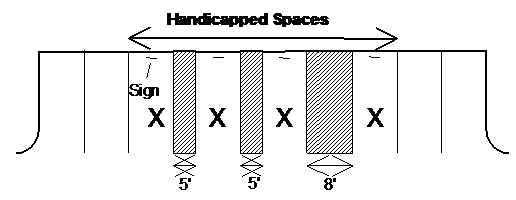
(2)
Handicapped spaces shall be provided in each parking lot in the following ratio to the total number of spaces required for the use:
Table 6-9
Handicapped Spaces Required
(3)
In addition to the requirements of this subsection, all handicapped parking shall comply with the requirements of the Federal Americans with Disabilities Act.
6.8.6.- OFF-STREET PARKING REQUIREMENTS BY USE
In all zoning districts other than the C-B-C zoning district, the minimum number of off-street parking spaces required for each type of land use shall be determined by the following, in addition to the number of spaces required for handicapped parking.
a.
Residential uses:
(1)
Single-family and two-family dwellings (including patio homes, manufactured, and mobile home): Two (2) spaces per dwelling.
(2)
Multi-family dwellings (dwelling unit types allowed in the M-R and C-C zoning districts): Two (2) spaces for each dwelling unit.
(3)
Retirement Community: One and one-half (1.5) space per unit.
(4)
Group residences, nursing homes, convalescent homes, personal care home: in residential districts (A-R, S-R, HT-R, LT-R, D-R): one (1) space for each four (4) beds plus two (2) spaces for staff and visitors. In all other districts where personal care homes are allowed, the parking requirement shall be two (2) spaces for each five (5) beds or fraction thereof.
b.
Office uses:
(1)
General and professional offices, studios, insurance and real estate offices: Three (3) spaces for 1,000 square feet of gross floor area.
(2)
Medical and dental clinics: Five (5) spaces for each 1,000 square feet of gross floor area.
c.
Retail services and sales uses:
(1)
Amusement parlor, recreational attraction, roller skating or ice skating rink: Five (5) spaces for each 1,000 square feet of gross floor area.
(2)
Automobile service station, automotive service business, auto and truck repairs or maintenance: Three (3) spaces for each service bay, plus one (1) space for each 200 square feet of gross floor area devoted to retail sales or showroom.
(3)
Automobile, truck, manufactured home, recreational vehicle, and utility structure sales: One (1) space for each 600 square feet of gross floor area of indoor sales and showroom space, plus one (1) space for each 2,500 square feet of outdoor display area, plus three (3) spaces for each service bay devoted to vehicle repairs or maintenance.
(4)
Banks and other financial service establishments: Four and one-half (4.5) spaces for each 1,000 square feet of gross floor area.
(5)
Bar or nightclub: One (1) space for each three (3) seats.
(6)
Bowling center: Four (4) spaces for each bowling lane.
(7)
Daycare center: One (1) space for each 400 square feet of gross floor area.
(8)
Funeral home: Thirty-five (35) spaces for each viewing room.
(9)
Furniture and carpet sales: One and one-half (1.5) spaces for each 1,000 square feet of gross floor area.
(10)
Health club or fitness center: Four and one-half (4.5) spaces for each 1,000 square feet of gross floor area.
(11)
Hospital: One and three-quarters (1.75) spaces for each bed licensed for patients' use, exclusive of basinets.
(12)
Motels, hotels, and bed and breakfast inns, rooming houses and boarding houses: One (1) space for each room to be rented, plus spaces as required under this Section for meeting space or restaurants open to the public.
(13)
Motion picture and other theaters: One (1) space for each three (3) seats.
(14)
Restaurant with seating (indoor or outdoor): One (1) space for each three (3) seats.
(15)
Restaurant without seating (indoor or outdoor): One (1) space per 100 square feet of gross floor area, minimum ten (10) spaces.
(16)
Shopping center:
(a)
Gross floor area of 25,000 to 100,000 square feet: Four (4) spaces per 1,000 square feet of total, plus three (3) spaces per 100 seats in a movie theater, plus ten (10) spaces per 1,000 square feet of food service area.
(b)
Gross floor area of 100,000 to 200,000 square feet: Four (4) spaces per 1,000 square feet of total, plus three (3) spaces per 100 seats above the initial 450 in a movie theater, plus six (6) spaces per 1,000 square feet of food service area.
(c)
Gross floor area of 200,000 to 400,000 square feet: Four (4) spaces per 1,000 square feet of total, plus three (3) spaces per 100 seats above the initial 750 in a movie theater.
(d)
Gross floor area of 400,000 to 600,000 square feet: Four and one-half (4.5) spaces per 1,000 square feet of total, plus three (3) spaces per 100 seats above the initial 750 in a movie theater.
(e)
Gross floor area of more than 600,000 square feet: Five (5) spaces per 1,000 square feet of total, plus three (3) spaces per 100 seats above the initial 750 in a movie theater.
(17)
Supermarket: Four (4) spaces for each 1,000 square feet of gross floor area.
(18)
Retail sales and services businesses not listed above: One (1) space for each 200 square feet of gross floor area and permanent outdoor sales area.
(19)
Mini-warehouses: 1 space for every 25 units, plus 1 for every 200 square feet of gross floor area devoted to office use.
(20)
Indoor Athletic Training or Fitness Facility: Three (3) spaces for each 1,000 square feet of gross floor area.
(21)
Recreational Vehicle Park and Campground: One and one-half (1.5) spaces per campsite.
d.
Semi-public uses:
(1)
Auditoriums, places of worship, stadiums, and similar places of public assembly: One (1) space for each three (3) seats, or for each 12 feet of benches, or for each 25 square feet of usable floor area in the public assembly room (whichever is greater).
(2)
Civic clubs, private clubs, lodges, libraries, museums, and fraternal lodges: One (1) space for each 100 square feet of gross floor area.
(3)
Schools:
(a)
Elementary and Middle School: Two (2) spaces for each classroom.
(b)
High School: Five (5) spaces for each classroom.
(c)
Two-year College, Business or Vocational School: Twenty (20) spaces for each classroom.
(d)
Four-year Colleges or Universities: Ten (10) spaces per classroom.
(e)
Other schools: as determined by the Director of Building Inspection.
e.
Industrial and manufacturing uses:
(1)
Wholesale and office-warehouse uses: One (1) space for each 200 square feet of gross floor area devoted to sales or office use, plus one (1) space for each 2,000 square feet of gross floor devoted to storage.
(2)
Warehouse, transfer, and storage uses: One (1) space for each 2,000 square feet of gross floor area and outdoor storage area.
(3)
Manufacturing uses: Two and one-half (2.5) for each 1,000 square feet gross floor area.
6.9.1.- INTERNAL ACCESS EASEMENTS REQUIRED
For any office or retail sales or services use, the property owner shall grant an access easement as described in this Section to each adjoining property that is zoned or used for an office or retail sales or services use. The purpose of the easement is to facilitate movement of customers from business to business without generating additional turning movements on the public street.
6.9.2.- ACCESS EASEMENT PROVISIONS
a.
The easement shall permit automobile access from the adjoining property to driveways and parking areas intended for customer or tenant use; but parking spaces may be restricted to use by the owner's customers and tenants only.
b.
The granting of such easement shall be effective upon the granting of a reciprocal easement by the adjoining property owner.
c.
Upon the availability of access to driveways and parking areas of the adjoining lot, pavement or other surfacing of the owner's driveways and parking areas shall be extended to the point of access on the property line.
6.9.3.- RELIEF
The Governing Body's Manager or Director of Public Works or their designee may grant an exception to the requirements of this article upon a determination that the proposed land use is such that adverse impact of the required easement on use of the property would outweigh the reduced impact on the public street provided by the reciprocal easements; or that changes in grade of other physical obstacles make interparcel connection unreasonable.
6.10.1.- APPROVAL REQUIRED
No curbs or medians on public streets or rights-of-way shall be cut or altered for access without a curb cut permit issued by Public Works Department.
6.10.2.- DRIVEWAY CONNECTIONS
a.
Vehicular access from properties to streets shall comply with the following dimensional requirements, measured at the right-of-way line:
Table 6-10
Driveway Width Requirements
* Includes divided entrances with center islands.
b.
Driveway aprons.
Driveway connections shall be provided between the edge of the pavement or back of curb to the right-of-way line. No property may be afforded access from a public street except as follows:
(1)
Curb and gutter streets shall be provided with a driveway apron constructed of 3,000 psi concrete at least six (6) inches thick. Sidewalks, where provided, shall be warped to the driveway apron and are to be identified across the driveway apron by construction joints or control joints.
(2)
Swale ditch section streets shall be provided with a driveway apron constructed of 3,000 psi concrete at least six (6) inches thick, or asphaltic concrete of the same thickness and type as the paving course(s) for the street.
(3)
All driveway aprons shall have a radius connecting the driveway to the curb line or pavement edge as follows:
Table 6-11
Driveway Apron Radii
(4)
All driveway aprons shall slope away from the roadway to the right-of-way line (for curb and gutter streets) and to the centerline of the drainage ditch (for swale ditch sections).
6.10.3.- LIMITATIONS ON ACCESS
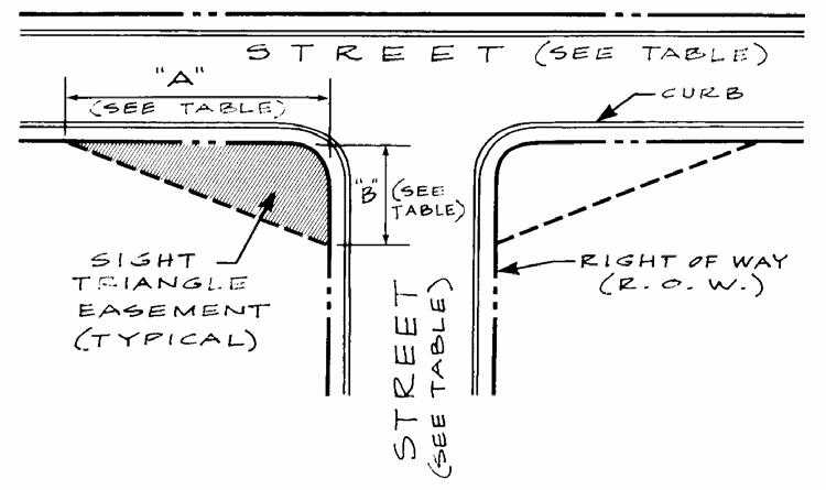
a.
Requirements of the Georgia Department of Transportation shall apply whenever more restrictive than the standards in this code.
b.
No point of access shall be allowed within 35 feet of the right-of-way line of any street intersections for single-family and two-family residential lots and within 50 feet for multi-family and nonresidential properties.
c.
In office, commercial and industrial zoning districts, no curb cut shall be less than 40 feet from another curb cut, measured along the right-of-way line, nor less than 20 feet from any property line. In cases of practical difficulty, these distances may be reduced upon approval of the Director of Public Works if adequate traffic safety conditions can be maintained.
d.
Along State or U.S. highways, no more than one (1) point of vehicular access from a property shall be permitted for each 300 feet of lot frontage, or fraction thereof.
e.
Along major streets other than State or U.S. highways, no more than two (2) points of vehicular access from a property to each abutting public street shall be permitted for each 200 feet of lot frontage, or fraction thereof; provided however, that lots with less than 100 feet of frontage shall have no more than one point of access to any one public street. The Public Works Department shall determine whether the points of access may be unrestricted or will have to be designed for right-in, right-out traffic flow.
6.10.4 - SWALE DITCHES WITHIN THE UNINCORPORATED AREAS OF THE COUNTY
a.
In addition to the aforementioned requirements of Section 6.10 Street Access Control, these standards are hereby enacted to supplement driveway access within unincorporated areas of the county. Before the grading, paving, construction, and repair of any driveway, the Chief Building Official must be notified and must make, or cause to be made, an inspection thereof; and the proposed improvements must receive approval of Floyd County Public Works.
b.
All work shall conform to the following specifications and standards. These standards are implemented by Floyd County for the purpose of ensuring proper driveway installation and avoiding future problems with the county road system.
(1)
Driveway Standards:
(a)
Maximum driveway width shall comply with Section 6.10.2 Driveway Connections, Table 6-10.
(b)
Angle of driveway into the county road right-of-way must be between sixty (60) and ninety (90) degrees.
(c)
Maximum grade, which shall be permitted, is fifteen (15) percent with the right-of-way.
(d)
The driveway surface connecting the county road must have a minimum five (5) percent slope down and away from the edge of pavement for the lesser of a distance of six (6) feet, or to the centerline of a roadside ditch, to prevent surface water drainage from the driveway flowing into the county road surface.
(e)
The driveway shall not obstruct or impair drainage in roadside ditches or roadside areas. The driveway piping shall be adequate for surface water drainage along the roadway and in no case less than fifteen-inch-diameter pipe.
(f)
Driveway pipe, if required, shall be Class III reinforced concrete and shall have a minimum installed length of twenty-four (24) feet.
(g)
No landscaping, fences, terraces, or other natural or artificial features adjacent to the driveway shall impair visibility from approaching vehicular traffic where that visibility is a threat to safety.
(h)
The driveway shall be located on the property so as to provide proper sight distance. Minimum sight distance requirements must comply with Section 6.7.3. Vertical Alignment of Streets, Table 6-3.
(2)
Application for permit:
(a)
The Office of the Floyd County Engineer shall be responsible for issuance of driveway permits separate from other building permits.
(b)
Upon application for a driveway permit, the Applicant will be given two (2) stakes to mark the proposed driveway location at the site.
(c)
Floyd County Public Works will inspect the location and the state the required pipe size and other special notes on the location of the driveway.
(d)
Any property with an existing driveway that requires a building permit for a new construction shall comply with these requirements herein.
(3)
Driveway Connection Installation: With the exception of State Routes, all driveway connection installations within unincorporated Floyd County will be inspected by Floyd County Public Works.
(a)
At the request of the Applicant, Floyd County Public Works will install driveway connections on the road right-of-way. A fee schedule for materials and installation shall be set by the Floyd County Board of Commissioners for any driveway with pipe up to 36 inches in diameter. All fees shall be paid in full at the Office of the Floyd County Engineer.
(b)
The Applicant may elect to install their own driveway connection; however, Floyd County Public Works must inspect and approve any driveway connection not installed by them. Any development that fails to comply with the driveway standards herein shall not receive a final electrical inspection until such time that the driveway has been inspected and approved by Floyd County Public Works.
(4)
Maintenance of Driveway:
(a)
The Public Works Department will be responsible for the maintenance of the drainage pipe under the driveway and will also be responsible for providing a smooth transition from the county road to the driveway with the road right-of-way.
(b)
The property owner is responsible for maintaining the surface of the driveway and any associated improvements to the property, which has encroached upon the county right-of-way such as landscaping, fences, etc.
(c)
If any improvements encroaching on the county right-of-way are found to be in violation of this section or are a safety hazard, the property owner will be notified in writing to remove such improvement. If the property owner does not comply within a reasonable period of time, the Floyd County Public Works will remove such improvement.
(5)
Variances:
(a)
A variance may be requested in cases where these requirements might create an undue hardship.
(b)
Before a variance can be considered, a letter must be submitted to the Public Works Director stating the reasons for requesting a variance.
(c)
Within five (5) working days, a decision on granting the variance will be made by the Public Works Director. The party requesting the variance will be notified by letter if the variance is to be granted or not. Any special conditions attached to the variance will also be stated in this letter.
(d)
The decision of the Public Works Director may be appealed to the County Manager, who shall have the authority to reverse the decision. An appeal to the County Manager shall be decided in a timely manner.
(e)
If the decision of the Public Works Director is upheld by the County Manager, the applicant may further appeal to the Board of Commissioners by submitting a written notice of appeal. An appeal submitted to the Board of Commissioners shall be considered and decided within thirty (30) days.
6.11.- SIGHT TRIANGLE
a.
A sight triangle (typical) shall be defined at every street intersection with another street.
(1)
At public street intersections, the sight triangle is delineated by the two intersecting street right-of-way lines and a line connecting the right-of-way lines at the points indicated in the Sight Triangle Table. The connecting points shall be measured from the right-of-way lines extended to their point of intersection.
Table 6-12 Sight Triangle Table
(See Drawing)
b.
Within the sight triangle, the planting of trees or other vegetation or the location of structures exceeding 30 inches in height that would obstruct the clear sight across the area of the easement shall be prohibited.
6.12.1.- GENERAL
a.
Clearing and grading shall not proceed until issuance of an approved development permit by the Building Inspection Department.
b.
Grading shall be done in accordance with the lines and grades drawn on the approved grading plan.
6.12.2.- EROSION AND SEDIMENTATION CONTROL MEASURES (SEE SECTION 6.13)
Required erosion and sedimentation control measures must be installed in accordance with the most recent locally adopted erosion and sedimentation control ordinance and the approved soil erosion and sedimentation control plan prior to any major development activity and as development progresses.
6.12.3.- INSTALLATION OF STORM DRAIN FACILITIES
Construction of the storm drain facilities shall be initiated as part of the grading of the site and in accordance with the approved storm water management plan. Storm water detention facilities shall be constructed prior to the installation of any other site improvements, and may be utilized under proper design as sedimentation basins during development. Installation of all other storm drainage pipes, culverts, headwalls, and ditches, shall be coordinated with the construction of streets and other site improvements, as appropriate.
6.12.4.- EARTHEN EMBANKMENTS
Earthen embankments shall be placed in uniform layers not to exceed a compacted thickness of six (6) inches per layer and shall be compacted to a density of 95 percent of the maximum laboratory dry weight per cubic foot as determined by AASHTO Method T-99 in an areas where structures, parking lots and drives, streets, and utilities are to be placed. All other embankments are to be compacted to at least 90 percent. Proof rolling shall be accomplished prior to placement of embankments to detect soft spots.
6.12.5.- SLOPES AND SHOULDER IMPROVEMENTS
a.
The maximum slope for all fill or cut slopes shall be 2:1.
b.
The depth of cut shall be construed to be the maximum cut or fill occurring in any one section of cut or fill. The slope on cut or fill shall be uniform throughout for each section of cut or fill. When a cut is made in rock that requires blasting, slope may be changed to vertical slope upon the written approval of the appropriate City or County Engineer.
6.12.6.- STREET CONSTRUCTION AND UTILITIES
a.
Basic Requirements for All Streets.
(1)
Grading.
(a)
All streets, roads, and alleys shall be graded to their full width by the developer so that pavement extensions or sidewalks, where required or if installed, can be constructed on the same level plane.
(b)
Preparation of roadway: Before grading is started the entire area to be paved shall be first cleared of all stumps, roots, brush, and other objectionable materials. In all areas to be graded or filled, the developer shall stockpile the topsoil later to be spread in all disturbed areas.
(c)
Grading shall be accurately done to the lines and grades shown on the plans. Embankments shall be placed in uniform layers not to exceed six (6) inches and compacted to a density of 95 percent of the maximum laboratory dry weight per cubic foot as determined by an approved method. Proof rolling shall be accomplished prior to placement of embankments to detect soft spots.
(2)
Slopes and Shoulder Improvements.
(a)
The minimum width for all shoulders from back edge of the curb shall be eight (8) feet. All shoulders shall slope one-fourth (.25) inch to the foot toward the roadway.
(b)
On streets with swale ditch drainage, the shoulders shall slope three-quarters (.75) inch to the foot away from the roadway for at least five (5) feet to the drainage channel.
(c)
When all construction is completed, all slopes and shoulders shall be cleared of all rubbish and shall have a stand of grass to prevent undue erosion, either by sprigging or seeding.
(d)
If any sections of the subgrade are composed of unsuitable or unstable material, such material shall be removed to the depth directed by the appropriate Public Works Department and replaced with suitable, thoroughly compacted material.
(e)
When the street is to be used for construction traffic before paving work is completed, a layer of No. 5 stone can be laid as a traffic surface if the developer so desires.
(1)
This material shall not be used as part of the base material.
(2)
If may be worked into the subgrade; or it shall be removed before the base course is set up for paving.
(3)
Provision shall be made to drain low points in road construction when the final paving surface is delayed.
(f)
Abutting property shall be suitably sloped to the right-of-way line.
(3)
Protection of Cut or Fill Slopes.
Immediately after grading and filling and re-spreading of topsoil, all areas of disturbed soil shall be fertilized and seeded (or in steep areas sodded or otherwise appropriately treated) with suitable vegetative cover to retard erosion.
(4)
Installation of Utilities.
(a)
After grading is completed and approved, the curb lines or edge of pavement lines, as applicable, shall be staked by the developer's Registered Land Surveyor. Before any base is applied, all of the underground utilities-water mains, sewer mains, gas mains, or any other underground utilities, and all service connections related thereto-shall be installed completely and provided throughout the length of the street and across the flat section. Service connections for sanitary sewer and water shall be extended to the right-of-way lines.
(b)
No private improvements, such as private lawn sprinkler systems, yard lighting, and the like, shall be installed within a public right-of-way except by authorization of the Public Works Director. Such authorization, if issued, shall require the owner to assume all repair costs of the owner's facilities should they become damaged.
(5)
Preparation of subgrade.
Prior to placement of the street base, the subgrade shall be compacted to 95 percent density.
(6)
Street base, curbing, and paving.
Street base, curbing, and paving shall be installed by the developer in accordance with the requirements and standards of this Development Code.
b.
Testing Requirements.
It is the responsibility of the developer to ensure that all required tests are made and reported to the Public Works Department. The cost of all testing and quality control shall be performed at the expense of the developer by qualified testing laboratories.
Table 6-13
Testing Requirements
6.12.7.- TRAFFIC CONTROL DEVICES AND STREET LIGHTS
a.
Streets signs, traffic control signs, and devices such as striping and signalization, shall be provided through payment of fees to the Public Works Department. Traffic control devices may also be installed by the developer after receiving written approval from the Director of Public Works.
b.
The installation of all street lighting fixtures within the City right-of-way must be approved by the Public Works Director prior to such installation.
c.
Outside of the City, street lights are to be installed by the developer in accordance with the County's requirements regarding street lighting.
6.13.1.- EXEMPTIONS
a.
This Section shall apply to any land-disturbing activity undertaken by any person on any land except for the following:
(1)
Surface mining, as same as defined in O.C.G.A. § 12-4-72.
(2)
Granite quarrying and land clearing for such quarrying.
(3)
Such minor land-disturbing activities as home gardens and individual home landscaping, repairs, maintenance work, and other related activities, which result in minor soil erosion.
(4)
Single-family detached dwellings, as follows:
(a)
The construction of single-family residences, when such are constructed by or under contract with the owner for his or her own occupancy; or
(b)
The construction of single-family residences not a part of a platted subdivision, a planned community, or an association of other residential lots consisting of more than two lots and not otherwise exempted under this paragraph; provided, however, that construction of any such residence shall conform to the minimum requirements as set forth in this Section.
For single-family detached dwelling construction covered by the provisions of this subparagraph, there shall be a greenway zone between the residence and any state waters classified as trout streams pursuant to Article 2 of Chapter 5 of the Georgia Water Quality Control Act. In any such greenway zone, no land-disturbing activity shall be constructed between the residence and the point where vegetation has been wrested by normal stream flow or wave action from the banks of the trout waters. For primary trout waters, the greenway zone shall be at least 50 horizontal feet, and no variance to a smaller greenway shall be granted. For secondary trout waters, the greenway zone shall be 50 horizontal feet, but the EPD Director may grant variances to no less than 25 feet. Regardless of whether a trout stream is primary or secondary, for first order trout waters, which are streams into which no other streams flow except for springs, the greenway shall be at least 25 horizontal feet, and no variance to a smaller greenway shall be granted.
b.
Where this Section requires compliance with the minimum requirements of this Development Code and the most recently adopted local Erosion and Sedimentation Control Ordinance, issuing authorities shall enforce compliance with the minimum requirements as if a development permit had been issued and violations shall be subject to the same penalties as violations by development permit holders.
6.13.2.- MINIMUM REQUIREMENTS FOR EROSION AND SEDIMENTATION CONTROL
a.
General Provisions.
Excessive soil erosion and resulting sedimentation can take place during land-disturbing activities. Therefore, plans for those land-disturbing activities which are not excluded by this Section shall contain provisions for application of soil erosion and sediment control measures. The provisions shall be incorporated into the erosion and sediment control plan. Soil erosion and sedimentation control measures shall conform to the requirements of this Section. The application of measures shall apply to all features of the site, including street and utility installations, drainage facilities and other temporary and permanent improvements. Measures shall be installed to prevent or control erosion and sediment pollution during all stages of any land-disturbing activity.
b.
Best Management Practices.
(1)
Best managements practices as set forth in this Section shall be required for all land-disturbing activities. Proper design, installation, and maintenance of best management practices shall constitute a complete defense to any action of the EPD Director or to any other allegation of noncompliance with paragraph (2) of this subsection or any substantially similar terms contained in a development permit for the discharge of storm water. As used in this subsection, the terms "proper design" and "properly designed" mean designed to control soil erosion and sedimentation for all rainfall events up to and including a 25-year, 24-hour rainfall event.
(2)
A discharge of storm water runoff from disturbed areas where best management practices have not been properly designed, installed, and maintained shall constitute a separate violation of any development permit for each day on which such discharge results in the turbidity of receiving waters being increased by more than 25 nephelometric turbidity units for waters supporting warm water fisheries or by more than ten (10) nephelometric turbidity units for waters classified as trout streams. The turbidity of the receiving waters shall be measured in accordance with guidelines issued by the EPD Director.
(3)
Failure to properly design, install, or maintain best management practices shall constitute a violation of any development for each day on which such failure occurs.
(4)
The EPD Director may require, in accordance with regulations adopted by the Board of Natural Resources, reasonable and prudent monitoring of the turbidity level of receiving waters into which discharges form land-disturbing activities occur.
c.
Minimum Requirements.
Land-disturbing activities shall, at a minimum, be undertaken using best management practices, including sound conservation and engineering practices to prevent and minimize erosion and resultant sedimentation, which are consistent with, and no less stringent than, those practices contained in the Manual for Erosion and Sedimentation Control in Georgia in effect at the time the land-disturbing activity was permitted, as well as the following:
(1)
Stripping of vegetation, re-grading and other development activities shall be conducted in a manner so as to minimize erosion.
(2)
Cut-fill operations must be kept to a minimum.
(3)
Development plans must conform to topography and soil type so as to create the lowest practical erosion potential.
(4)
Whenever feasible, natural vegetation shall be retained, protected, and supplemented.
(5)
The disturbed area and the duration of exposure to erosive elements shall be kept to a practical minimum.
(6)
Disturbed soil shall be stabilized as quickly as practical.
(7)
Temporary vegetation or mulching shall be employed to protect exposed critical areas during development.
(8)
Permanent vegetation and structural erosion control measures shall be installed as soon as practical.
(9)
To the extent necessary, sediment in run-off water must be trapped by the use of debris basins, sediment basins, silt traps or similar measures until the disturbed areas is stabilized. As used in this paragraph, a disturbed area is stabilized when it is brought to a condition of continuous compliance with the requirements of this Section.
(10)
Adequate provisions must be provided to minimize damage from surface water to the cut face of excavations or the sloping surface of fills.
(11)
Cuts and fills may not endanger adjoining property.
(12)
Fills may not encroach upon natural watercourses or constructed channels in a manner so as to adversely affect other property owners.
(13)
Grading equipment must cross flowing streams by means of bridges or culverts except when such methods are not feasible and provided, in any case, that such crossings are kept to a minimum.
(14)
Land-disturbing activity plans for erosion and sedimentation control shall include provisions for treatment or control of any source of sediments and adequate sedimentation control facilities to retain sediments on-site or preclude sedimentation of adjacent waters beyond the levels specified in Subsection 6.13.2.b(2).
(15)
Land-disturbing activities shall not be conducted within the 100-year floodplain except in compliance with Section 6-14 of this Development Code.
d.
Greenways.
(1)
Along State Waters: Land-disturbing activities shall not be conducted within 100 feet of the banks of a major river tributary as established under Section 6.19 of this Code, or within 25 feet of the banks of any other state waters, as measured from the point where vegetation has been wrested by normal stream flow or wave action, except:
(a)
Where the EPD Director determines to allow a variance that is at least as protective of natural resources and the environment; or
(b)
Where otherwise allowed by the EPD Director; or
(c)
Where a drainage structure must be constructed, provided that adequate erosion control measures are incorporated in the project plans and specifications and are implemented; provided however, that greenways of at least 25 feet established pursuant to the Metropolitan River Protection Act shall remain in force unless a variance is granted by the EPD.
(2)
Along Trout Streams: Land-disturbing activities shall not be conducted within 100 horizontal feet, as measured from the point where vegetation has been wrested by normal stream flow or wave action, of the banks of any state waters classified as "trout streams" unless a variance for such activity is granted by the EPD Director, except where a roadway drainage structure must be constructed, provided that adequate erosion control measures are incorporated in the project plans and specifications and are implemented.
e.
The fact that land-disturbing activity for which a development permit has been issued results in injury to the property of another shall neither constitute proof of nor create a presumption of a violation of the standards provided for in this Development Code or the terms of the development permit.
6.14.- FLOOD DAMAGE PREVENTION
The flood damage protection ordinances enforced by the City of Rome (adopted in October of 2009 as Section 10-1 thru 10-7 of the Code of the City of Rome) and Floyd County (adopted in September of 2009 as Sections 2-6-30 thru 2-6-36 of the Code of Floyd County) were both approved by the Georgia Department of Natural Resources in March of 2010. These ordinances may be revised from time to time and will be readopted every 10 years, as mandated by the State of Georgia.
6.15.1.- APPLICABILITY AND EXEMPTIONS
a.
All persons proposing development or construction in the jurisdiction shall prepare a Storm Water Management Plan. No final subdivision plat shall be approved and no development or building permit shall be issued until and unless the Storm Water Management Plan has been reviewed and approved by the Director of Public Works, except as exempt below.
b.
The following development activities are exempt from the provisions of this Section and the requirement of providing a storm water management plan:
(1)
Agricultural land management.
(2)
Additions or modifications to existing single-family detached dwellings.
(3)
Developments with a total land area of 0.4 (four-tenths) of an acre or less.
(4)
Residential development consisting of single-family houses, each on a lot of three (3) acres or greater.
(5)
Residential development consisting of single-family houses, each on a lot of 1 to 3 acres where it is demonstrated that each lot will have no more than 10% impervious surface.
(6)
Single-family residential construction on a lot platted prior to March 26, 1991.
6.15.2.- VARIANCES
Requests for variances from the requirements of this section shall be made in accordance with Section 2.11.
6.15.3.- STORM WATER MANAGEMENT PLAN
a.
The Storm Water Management Plan shall be prepared under the supervision of, and certified by, a professional engineer registered in the state and consistent with all provisions of the most currently adopted local storm water management ordinance. The Storm Water Management Plan shall also address Water Quality as required by General NPDES Storm Water Permit No. GAG610000, or the currently adopted General NPDES Storm Water Permit for the State of Georgia applicable to the City of Rome and Floyd County.
b.
The Storm Water Management Plan shall include sufficient information to evaluate the environmental characteristics of the affected areas, the potential impacts of the proposed development on water resources, and the effectiveness and acceptability of measures proposed for managing storm water runoff. The developer shall certify on the drawings that all clearing, grading, drainage, construction, and development shall be conducted in strict accordance with the plan.
c.
The minimum information submitted for support of a Storm Water Management Plan shall be as follows:
(1)
Site plan.
Provide a site plan drawn to a scale of not less than one inch equals 50 feet with the following characteristics and information:
(a)
Graphic scale, north arrow, and date. The north arrow shall be identified as magnetic, true, or grid north.
(b)
Vicinity map showing the site location relative to surrounding landmarks, highway intersections, rivers, and streams.
(c)
Topography showing existing and proposed elevations in accordance with the following:
1)
For sites smaller than one (1) acre in size, show the direction of drainage and spot elevations at all breaks in grade and along drainage channels or swales at selected points not more than 100 feet apart.
2)
For sites of one (1) acre and larger with slopes of less than approximately two (2) percent, show contours at intervals of not more than two feet and spot elevations at all breaks in grade along drainage channels or swales at selected points not more than 100 feet apart.
3)
For sites of one (1) acre and larger with slopes of more than two (2) percent, show contours with an interval of not more than five (5) feet.
4)
Elevations shall be based on the datum plane established by the United States Coastal and Geodetic Survey.
(d)
Delineation of property lines and deed record names of adjacent property owners.
(e)
Locations and right-of-way of streets, roads, railroads and utility lines, either on or adjacent to the property to be developed. Specify whether utility lines are in easements or rights-of-way and show the location of towers and poles.
(f)
Size and location of existing sewers, water mains, drains, culverts or other underground facilities within the tract or within the right-of-way of streets or roads adjoining the tract. Grades and invert elevations of sewers shall be shown.
(g)
Location of existing buildings and other improvements.
(h)
Proposed conditions:
1)
Layout of proposed streets, roads, alleys, drives, paved areas and public crosswalks, with widths and road names or designations.
2)
Preliminary plans of storm sewer system with grade, pipe size and location of outlet.
3)
Location of proposed buildings and other improvements.
4)
Certification by a registered land surveyor or professional engineer attesting that the site plan has been prepared in conformity with the minimum standards of this Section.
(2)
An adequate drainage system for the property or development, including necessary ditches, pipes, culverts, drains, inlets, bridges, etc., shall be provided for the proper drainage of all surface water. The location and size of all proposed drainage improvements shall be designed in accordance with and meet all standards relating to Storm Water Drainage under Article 6 of this Development Code. The Storm Water Management plan shall include:
(a)
Location and profiles of all storm drainage pipes and slopes of receiving channels. Hydraulic grade lines to be shown on all pipes that cross streets and on all detention basin outfalls.
(b)
Storm water detention facility design and construction details.
(c)
Location and typical construction details of all inlets and catch basins, headwalls and other drainage structures.
(d)
The 100-year ponding limits above each street cross drain.
(e)
The hydrologic and hydraulic analysis required for the system design under Section 6.15.4.
(f)
When required by the Director of Public Works, provides a soils investigation for all sites proposed as ponds or impoundments or for storm water detention. Locate all soil borings on the site plan required in section 6.15.3.a.(1) above.
(g)
Provide a reconstruction schedule for both temporary and permanent facilities. Reference the schedule to other development activities such as clearing, rough grading, construction, final grading, and vegetation establishment.
(h)
Provide a plan for maintenance of the Storm Water and/or Water Quality facilities. Describe specific actions and a recommended schedule of maintenance required to maintain the facilities at a satisfactory level of service. All Storm Water and/or Water Quality Facilities which will not be maintained by the City of Rome, or Floyd County, will require a Storm Water Facility Maintenance Agreement to be executed and placed on record in the Office of Clerk of Superior Court of Floyd County prior to the issuance of a Certificate of Occupancy for the project, or the approval of a Final Plat.
(i)
Provide a cost estimate for construction of the Storm Water/Water Quality management facilities. Provide a separate estimate of the annual cost for maintenance of the proposed facilities.
6.15.4.- HYDROLOGIC AND HYDRAULIC ANALYSIS
a.
Analyses and design shall be performed in accordance with the publication entitled Manual for Erosion and Sediment Control in Georgia published by the Soil and Water Conservation Commission, and the most recent edition of the Georgia Storm Water Management Manual.
b.
In order to obtain a Development Permit, a hydrology report shall be prepared that includes appropriate calculations for the 2-year, 10-year, 25-year, and 100-year design frequency storms. The report shall show detailed calculations indicating the formula used, along with co-efficient of runoff, the time of concentration, the rainfall intensity, the discharge velocity, and the source of all data used.
c.
The hydrology report shall include a map outlining the areas and showing the acreage of all on-site and off-site drainage basins contributing flow through the project for both the pre- and post-development conditions.
d.
Runoff peak rate of discharge for drainage areas up to 50 acres in size may be calculated using the Rational Method. Flows from drainage areas larger than 50 acres in size shall be calculated using the SCS Method.
e.
Rainfall intensities used in hydrologic analyses shall not be less than those shown by applicable rainfall curves published within the most recent edition of the Georgia Storm Water Management Manual by the National Oceanic and Atmospheric Administration (NOAA) for the city and county area. Those curves are on file and available for inspection in the Department of Engineering Services.
f.
Runoff coefficients used for pre- and post-development activity conditions for the Rational Method shall be consistent with local conditions. For the SCS method, the runoff curve numbers found in the most recent edition of the Georgia Storm Water Management Manual for Erosion and Sediment Control in Georgia shall be used.
g.
Hydraulic capacity for open channel flow, pipes, and ditches shall be determined using the Manning Equation.
h.
The controlled release of storm water runoff shall be required for all developments or construction in order to prevent any increase in excess of 10 percent of 1 cubic foot per second of the predevelopment rate of runoff for a ten-year frequency storm. Where controlled release is required, such releases shall prevent any increase in the predevelopment rate of runoff of less frequent storms up to and including the 100-year storm event.
6.15.5.- STORM WATER DETENTION FACILITIES
a.
Reservoir routing methods shall be used for all detention facility design.
b.
The drainage system being developed shall have adequate capacity to bypass through the development the flow from all upstream areas for a storm of 25-year design frequency for the land off-site and upstream under existing development. The 25-year flow rate is of record or computed using a runoff coefficient of not less than 0.50.
c.
The Public Works Department may permit several developers to construct joint facilities. The Public Works Department shall approve or disapprove the waiver of on-site drainage or detention facilities on the basis of the engineering feasibility of a combined facility. No use of land or occupancy of buildings within the properties served by these facilities shall be permitted until completion of the retention and drainage structures, except upon specific approval.
d.
The Public Works Department shall be authorized to approve of alternative methods of storm water detention based on appropriate engineering studies that do demonstrate equal or better performance in accordance with the jurisdiction's storm water management practices. Approved alternatives may include well maintained and landscaped lakes that may be provided to act jointly as detention reservoirs and recreation facilities or aesthetic focal points within forest preserve areas, public or private parks, housing developments, shopping centers, and industrial parks. Other control methods to regulate the rate of storm water discharge which may be acceptable include, but are not limited to, detention on flat roofs, parking lots, streets, lawns, underground storage, and oversized storm drains with restricted outlets.
e.
Detention facilities and drainage structures shall, where possible, use natural topography and natural vegetation. In lieu thereof these shall have planted trees and vegetation such as shrubs and permanent ground cover on their borders. All on-site facilities shall be properly maintained by the owner in such a way that they do not become nuisances. Nuisance conditions shall include: improper storage resulting in uncontrolled runoff and overflow; stagnant water with concomitant algae growth, insect breeding, and odors; discarded debris, and safety hazards created by the facility's operation.
f.
Principal outlets such as weirs shall be constructed of concrete block or reinforced concrete with watertight joints. Outlet pipes shall be at least six (6) inches in diameter. Riser pipes, if used, shall be at least eight (8) inches in diameter.
g.
No portion of any detention facility shall be located in any required buffer, street right-of-way, or within a flood hazard.
h.
The 100-year ponding limits of a detention facility shall not encroach upon a public street.
i.
Storm Water Detention Facilities.
Storm water detention facilities shall be constructed on a separate lot from all buildings in the development, and shall be dedicated to the City or County as a public improvement for maintenance in areas zoned AR, SR, HTR, LTR, and DR.
A dedicated access corridor of at least 25 feet in width shall be required to provide access to the detention facility from a public street.
Facilities shall be located on tracts of land designated on the recorded plat, with sufficient area around the perimeter to provide access for maintenance purposes and shall have an all-weather access road constructed from the public street to the detention facility. Said all-weather access road shall at a minimum be constructed of gravel and shall be approved by the Director of Public Works or their representative.
Facilities that do not exclusively serve residential developments located within areas zoned AR, SR, HTR, LTR, and DR, are the perpetual responsibility of the landowner.
j.
Detention facilities shall be enclosed with a minimum 4-foot high permanent fence around all facilities having a maximum water or undercut depth of more than four (4) feet or a bank slope greater than 1.5 to 1 and shall be equipped with a gate of sufficient width to permit entrance of equipment necessary to allow periodic maintenance activities. Fencing may be waived by the Director of Public Works in areas zoned other than residential and where the pond is more than 500 feet from a residential district or single or multi-family residence.
k.
Construction of the storm water management facilities shall be initiated as part of the grading of the site. Storm water detention facilities shall be constructed prior to the installation of any other site improvements, and may be utilized under proper design as sedimentation basins during development. Installation of all other storm drainage pipes, culverts, headwalls, and ditches shall be coordinated with the construction of streets and/or other site improvements, as appropriate.
6.15.6.- MAINTENANCE RESPONSIBILITIES
a.
It shall be the responsibility of the developer to maintain all facilities required by the storm water management plan during construction. The developer shall be responsible for removing temporary structures or facilities on the completion of the construction. The developer and all subsequent owners shall also be responsible for maintaining the permanent facilities identified by the storm water management plan to remain after construction is complete except as provided in Section 6-15.8 for residential developments located within areas zoned AR, SR, HTR, LTR, and DR.
b.
Should an owner fail to maintain the storm water management facilities in a state of service intended by the storm water management plan, then the Director of Public Works shall notify the owner in writing of the deficiencies and specific minimum maintenance requirements to remedy such deficiencies.
c.
If the owner fails to perform the required maintenance work within a reasonable period of time (30 days maximum) the owner shall be in violation of the provisions of this Code.
6.15.7.- STORM WATER PERFORMANCE SURETY
a.
Upon approval of the Storm Water Management Plan, but before the issuance of a building permit or subdivision plat approval, the applicant shall be required to post a performance bond, cash escrow, certified check, or other acceptable form of performance.
b.
The amount of the surety shall not be less than the total estimated construction cost of the facilities required by the Storm Water Management Plan.
c.
The performance bond or other securities shall not be released until the following requirements have been met. The Director of Public Works shall:
(1)
Perform a final inspection of the facilities and determine that they have been constructed in compliance with the Storm Water Management Plan.
(2)
Determine that all provisions of the Storm Water Management Plan have been faithfully executed.
d.
A provision may be made for partial release of the amount of the bond pro rata upon completion and acceptance of various stages of development as specifically delineated, described and scheduled in the Storm Water Management Plan. The applicant shall notify the Public Works Department upon completion of each stage that is ready for inspection.
6.15.8.- ACCEPTANCE OF FACILITIES
a.
Developments and properties inside the City of Rome:
(1)
In the case of residential developments located within areas zoned AR, SR, HTR, LTR, and DR approved after December 2, 1985, the City shall assume responsibility for the functional maintenance of facilities one year after the release of the performance bond required by this Development Code. At the end of the developer's maintenance period all detention structures shall have a positive slope to the outlet in order to facilitate complete drainage.
(2)
Detention facilities in residential areas zoned AR, SR, HTR, LTR, and DR, constructed prior to December 2, 1985, will not be accepted for maintenance, as provided in Subsection 6.15.8.a.(1), unless individually approved by and at the discretion of the City Commission and unless suitable access easements are provided.
(3)
Prior to acceptance of a detention facility for functional maintenance, an all-weather access road access easement shall be constructed in accordance with Section 6.15.5.
b.
Developments and properties in Unincorporated Floyd County:
(1)
In the case of single-family residential subdivisions approved after March 26, 1991, the County shall assume responsibility for the functional maintenance of facilities one year after the release of the performance bond required by this Development Code. At the end of the developer's maintenance period all detention structures shall have a positive slope to the outlet in order to facilitate complete drainage.
(2)
Detention facilities in single-family residential subdivisions constructed prior to March 26, 1991, will not be accepted for maintenance, as provided in Subsection b.(1), unless individually approved by and at the discretion of the County Commission and unless suitable access easements are provided.
6.15.9.- INSPECTION AND ENFORCEMENT
The Chief Building Official shall have the power and authority to perform any inspection necessary to ensure conformance with this section and to employ Stop Work and/or Cease and Desist Orders until compliance with this section has been satisfied. Such inspection and enforcement shall be conducted in accordance with Section 7.5 of this Code.
6.15.10.- VIOLATIONS AND PENALTIES
Any person or developer who fails to comply with the requirements of this section is subject to the penalties described in Section 7.5 of this Code, including but not limited to revocation of permits and forfeiture of performance surety.
6.15.11.- NPDES REQUIREMENTS
All construction of off-site or on-site improvements shall adhere to National Pollution Discharge Elimination system (NPDES) best management practices to prevent deleterious material or pollutants from entering the City or County storm drain systems.
6.16.1.- BUFFERS REQUIRED
A buffer shall be required in any multi-family or nonresidential development project along a side or rear lot line that abuts a less intense land zoning district, as follows:
Table 6-14
Situations Where Buffer Required
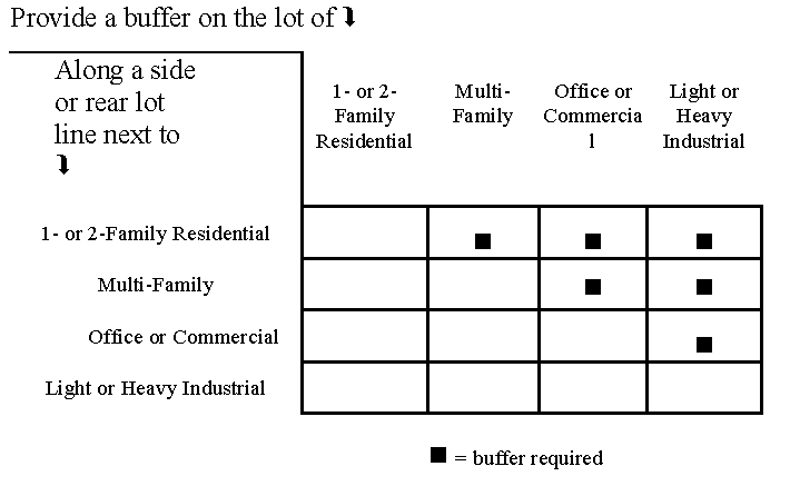
6.16.2.- BUFFER DESIGN STANDARDS
a.
General.
Buffer areas shall contain no driveways, parking areas, patios, storm water detention facilities, or any other structures or accessory uses except for a fence, wall, or earthen berm constructed to provide the visual screening required to meet the standards of this Ordinance. Underground utilities may be permitted to cross a buffer if the screening standards of this Ordinance will be subsequently achieved. Required vehicular access through a buffer may be allowed as a condition of a zoning, Special Use, or Planned Development approval by the Governing Body.
b.
Natural Buffers.
Natural buffers may contain deciduous or perennial vegetation, but shall contain evergreen shrubs and trees suitable to local growing conditions that will provide an opaque visual screen during all seasons of the year.
c.
Structural Buffers.
Structural buffers shall meet the following criteria:
(1)
Structural buffers shall be vegetated throughout the minimum area required for the buffer around in fences or walls and upon any earthen berms, which may include grass, ground covers, shrubs, and trees.
(2)
All earthen berms shall have a maximum side slope of two (2) horizontal to one (1) vertical. Earthen berms shall not be constructed within the drip line of any existing trees that will remain on the property.
(3)
Trees shall be located or planted within any structural buffer at a density of no less than one tree for each 20 feet of buffer length or portion thereof. New trees shall have a caliper of no less than two (2) inches upon planting, and may be clustered for decorative effect following professional landscaping standards for spacing, location, and design.
(4)
Fences and freestanding walls shall present a finished and decorative appearance to the abutting property, and shall be located no closer to the property line than two (2) feet. Shrubs, ground covers, or other vegetation shall be provided between the fence or wall and the property line so as to provide a decorative effect, following professional landscaping standards for spacing, location, and design.
(5)
Fences used in buffers must be made of rot-resistant material or protected from deterioration with water-proofing material.
d.
Examples of Buffers.
The following illustration provides examples of natural and structural buffers. Other solutions meeting the minimum requirements of this Section are also acceptable, if approved by the Building Official.
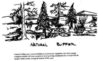 | 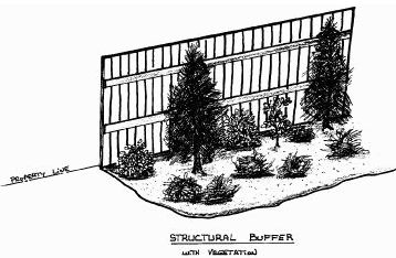 |
 | |
6.16.3.- MINIMUM BUFFER REQUIREMENTS
A buffer required by this Ordinance shall meet the following criteria:
a.
Width of Buffer.
(1)
Side Lot Line. Buffer required along any side lot line shall be no less than the minimum required width of the side principal building setback, or ten (10) feet, whichever is greater.
(2)
Rear Lot Line. Buffers required along any rear lot line shall be no less than the minimum required width of the rear principal building setback, or ten (10) feet, whichever is greater.
b.
Minimum Required Screening.
Minimum required screening shall consist of a natural buffer utilizing existing vegetation or a natural structural buffer, whichever provides an opaque visual screen to a height of six (6) feet, or any combination of existing and replanted vegetation which can be reasonably be expected to create an opaque visual screen six (6) feet high with two growing seasons.
c.
Maintenance.
Every buffer required by this Ordinance shall be maintained by the owner of the property where the buffer is located, so as to provide an opaque visual screen to the height of six (6) feet on a continuous, year-round basis.
6.16.4.- BUFFER MODIFICATIONS
a.
The Board of Adjustment having jurisdiction may reduce the width of the buffer to no less than 15 feet if the buffer includes the combination of fence, vegetation, and berm that will provide effective separation and adequate visual and audial screening.
b.
Buffers may be located on the site to best achieve the screening required.
c.
The Board of Adjustment having jurisdiction may waive a buffer requirement if the Comprehensive Plan anticipates future development on the adjoining property in a land use category such that a buffer would not be required by this Ordinance.
6.17.1.- LANDSCAPING STRIPS
a.
Frontage Landscape Strips.
A minimum 20 foot wide landscape strip shall be provided along the full length of any street frontage of a multi-family or nonresidential development (except in the C-B-C zoning district).
(1)
Frontage landscape strips shall contain no structures, parking areas, patios, storm water detention facilities, or any other accessory uses except for the following:
(a)
Retaining walls or earthen berms constructed as part of an overall landscape design.
(b)
Pedestrian-oriented facilities such as sidewalks and bus stops.
(c)
Underground utilities.
(d)
Driveways required in order to access the property.
(e)
Signs otherwise permitted by this Code.
(2)
One tree shall be provided within the frontage landscape strip for every 40 feet of length of street frontage, or portion thereof. Such trees may be deciduous or evergreen, but must be of a type that is suitable to local growing conditions and that will normally reach at least 12 inches at diameter breast height upon maturity. The trees may be clustered for decorative effect following professional landscaping standards for spacing, location, and design.
(3)
All portions of a frontage landscape strip shall be planted in trees, shrubs, grass, or ground cover, except for those ground areas that are mulched or covered by permitted structures.
(4)
Upon planting, new trees shall have a caliper of no less than two (2) inches, and may be clustered for decorative effect following professional landscaping standards for spacing, location, and design.
(5)
Plant materials in the frontage landscape strip are not to extend into the street right-of-way unless specifically allowed by the Public Works Department.
b.
Side Yard Landscape Strips.
A minimum of five (5) foot wide landscape strip shall be provided along any side lot of a nonresidential development (except in the C-B-C zoning district). The landscape strip is to extend from the front principal building setback line to the rear of the property (unless a buffer is required along the side lot line).
(1)
Side yard landscape strips shall contain no structures, parking area, patios, storm water detention facilities, or any other uses except for the following:
(a)
Retaining walls or earthen berms constructed as part of an overall landscape design.
(b)
Underground utilities.
(c)
Driveways required to access neighboring property.
(2)
All portions of a side yard landscape strip shall be planted in trees, shrubs, grass, or ground cover, except for those ground areas that are mulched or covered by permitted structures.
(3)
The side yard landscape strip shall contain at least one (1) tree for every 40 feet of length, or be planted in a continuous hedge or junipers (except for approved access drives and utility easements).
6.17.2.- PARKING LOT TREES
Deciduous shade trees shall be provided within any parking lot designed or intended to accommodate five (5) cars or more, in accordance with the requirements of this Section.
a.
One deciduous tree shall be provided within the parking lot for every 20 parking spaces, or portion thereof. There shall be a maximum distance of one hundred (100) feet between any parking space and shade tree. Trees provided to meet the minimum requirements of any landscape strip or buffer may not be counted toward this requirement.
b.
A landscaping island shall be located at the end of every parking bay between the last parking space and an adjacent travel aisle or driveway. The island shall be no less than eight (8) feet wide for at least one-half the length of the adjacent parking space. The island shall be planted in trees, shrubs, grass, or ground cover except those areas that are mulched.
c.
Tree planting areas shall be no less than eight (8) feet in width and shall provide at least 100 square feet of planting area per tree. No tree shall be located less than 2½ feet from the back of the curb. All parking lot landscape islands shall be curbed with minimum 6-inch high vertical curbs. The barrier may contain breaks to help manage storm water runoff, if approved by the Public Works Manager or Director, or their designee.
d.
Landscaping islands and tree planting areas shall be well drained and contain suitable soil and natural irrigation and characteristics for the planting materials they contain.
e.
Sustainable design features, such as the creation of storm water swales, are encouraged for all landscaping islands. Such features that are designed to function as infiltration cells that are approved by the Governing Body's Public Works Manager or Director, or their designee, may credit towards storm water detention requirements.
6.17.3.- LANDSCAPING PLAN
For each multi-family residential and non-residential development where front yard or side yard landscaping is required a landscaping plan shall be approved as part of the permitting process. The landscaping plan shall show all existing and proposed features, including trees, buffer, and other relevant features of the landscape that will be part of the final landscaping design. Native plant materials, protection of existing trees and vegetation, and retention of existing natural features should be integrated into the landscaping plan to the maximum extent possible.
a.
Landscaping shall be installed in accordance with the approved landscape plan.
b.
Landscaping shall be maintained as needed. Plants that have died shall be replaced in kind.
6.18.1.- APPLICABILITY
a.
Tree Conservation Zone.
The tree conservation zone applies to the entirety of a tract of land for which no tree conservation plan has been approved. After such approval, the tree conservation zone shall correspond to that part of a tract of land designated on said approved plan.
b.
Exemptions.
Any construction, paving, or other activity on a property that will damage trees in a public right-of-way is subject to the restrictions under "Protection of existing trees," below.
Otherwise, the tree conservation zone shall not apply to the following:
(1)
A lot on which a single-family or two-family dwelling is being constructed.
(2)
A lot on which this Code imposes no yard requirements and permits 100% coverage of the lot by the buildings.
(3)
Property already occupied by an owner-occupied single-family or two-family dwelling, unless nonresidential uses or additional dwelling units are proposed for such property.
(4)
Public utility companies conducting operations on public and utility rights-of-way and easements or on-site for electric power substations and similar facilities, which operations are for the purpose of assuring uninterrupted utility service.
(5)
Property in use for the following:
(a)
Tree farming: The planting, cultivating, and harvesting of trees in a continuous cycle as a regular practice on a tract of land; not including the removal of trees for purposes of development.
(b)
Agricultural activities:
1)
Good-faith commercial production of agricultural products, including horticultural, floricultural, dairy, livestock, poultry, and apiarian products; and
2)
Clearing trees for the purpose of planting crops, providing pasture for livestock, or constructing buildings accessory to production of agricultural products.
6.18.2.- MEASUREMENT STANDARD: "TREE UNITS"
a.
The diameter of a tree's trunk will be measured and a value assigned in "tree units" in accordance with Tables 6-15 and 6-16. The values assigned to trees of the same size will be different for existing and new trees, as indicated in the two Tables.
b.
One "unit" is not the same as one "tree." For existing trees, the "units" assigned is the cross-sectional area of the trunk at DBH in square feet. For new trees, credit is given reflecting a size that will be achieved after several years of growth.
Table 6-15
Table of Values for Existing Trees26
* Diameter Breast Height
26
An increase in unit value of 15% will be allowed for significant trees, as defined in this Section.
Table 6-16
Table of Values for New (Replacement) Trees
27
A "large species" is one that will have a height at maturity of 40 feet or more.
6.18.3.- SIGNIFICANT TREE: DEFINED
a.
A significant tree is a tree in fair or better condition which has been determined to be of a high value by a knowledgeable person because of its species, size, age, or other professional criteria. A tree is considered in fair or better condition if:
(1)
Its life expectancy is greater than 15 years;
(2)
It has a relatively sound and solid trunk with no extensive decay or hollow with less than 29 percent radial tip die-back; and
(3)
It has no major insect or pathological problems.
b.
Hardwood trees such as oaks and hickories and soft-wood trees such as pines and cedars whose diameters are 18 inches DBH or more and small hardwoods such dogwoods, redbuds, or sourwoods, whose diameter are 8 inches DBH or more shall be considered significant trees due to size. A tree of lesser size than the preceding shall be significant if it is a rare or unusual species or is of historical significance or is specifically used by design as a landscape focal point of the project.
6.18.4.- NUMBER OF TREES UPON COMPLETION OF DEVELOPMENT
a.
Upon completion of development, all properties shall have a number of trees equivalent to 15 units per acre of development site (not including land areas covered by buildings).
b.
Existing significant trees or any other trees 10 inches+ DBH or larger that are in excess of the required 15 units per acre of development site (not including land area covered by buildings) but outside the construction area (buildings, accessory uses, parking area) shall not be removed unless adjacent development would cause irreparable damage to the critical root zones.
c.
Where the proposed construction area (the buildings, accessory uses, parking area) is so large that the number of trees equivalent to 15 units per acre of development site (not including land area covered by buildings) can't be accommodated, the tree conservation area shall be established by removing parking spaces in excess of the minimum number required, placing additional planting islands within the development area, or reducing the area to be occupied by buildings.
d.
Counting Parking Lot and Buffer Trees.
Trees required by this Code in relation to parking lot landscaping or the provision of a structural buffer may be included in calculating the required 15 units per acre. However, trees existing or planted in a natural buffer required under this Article are not to be counted as part of the minimum 15 units per acre requirement.
6.18.5.- CRITERIA FOR REPLACEMENT TREES
a.
Spacing and the potential size of species chosen shall be compatible with spatial limitations of the site.
b.
The species must be ecologically compatible with the specifically intended growing site.
c.
The trees must have the potential for size and quality comparable to those removed.
d.
The trees must be compatible in extent of crown and root systems at maturity with nearby utilities.
e.
Planting preference shall be given to specimens no more than three (3) inches DBH.
f.
Where trees must be added to achieve the required 15 units per acre of development site (not including land area covered by buildings), pines may not comprise fifty percent or more of the required units. Where existing pines already compromise fifty (50) percent or more of the required units, no more pines may be credited toward the required units.
g.
Authority for questions of tree characteristics shall be publications of the Georgia Forestry Commission, publications of the Cooperative Extension Service of the University of Georgia College of Agriculture, or other authority acceptable to the Planning Director.
6.19.1.- WATERSHED PROTECTION
a.
Protected Water Supply Watersheds; Defined.
The Oostanaula River, Etowah River, Armuchee Creek, and Woodward Creek watersheds are recognized above their respective City of Rome and Floyd County municipal water supply intakes. All lands within the Oostanaula River, Etowah River, Armuchee Creek, and Woodward Creek watersheds located within a 7-mile radius upstream of the City of Rome and Floyd County municipal water supply intakes are established as protected watershed areas.
b.
Protected Watershed Areas; Restrictions.
(1)
Within a protected watershed area: Any new facility that handles hazardous materials of the types listed in Section 312 of the Resource Conservation and Recovery Act of 1976 (excluding underground storage tanks) and amounts of 10,000 pounds or more of on any one day, shall perform their operations on impermeable surfaces having spill and leak collection systems as prescribed by DNR.
(2)
For Large Water Supply Watersheds, the corridors of all perennial streams within a 7-mile radius of the reservoir boundary shall be protected as follows:
(a)
A buffer shall be maintained for a distance of 100 feet on both sides of the stream as measured from the stream banks.
(b)
No impervious surface shall be constructed within a 150-foot setback on both sides of the stream as measured from the stream banks.
(c)
Septic tanks and septic tank drain fields are prohibited in the 150-foot setback.
(3)
Small Water Supply Watersheds are protected as follows:
(a)
The corridors of all perennial streams within a 7-mile radius upstream from a public water supply intake of a reservoir:
1)
A buffer shall be maintained for a distance of 100 feet on both sides of the stream as measured from the stream banks.
2)
No impervious surface shall be constructed within a 150-foot setback on both sides of the stream as measured from the stream banks.
3)
Septic tanks and septic tank drain fields are prohibited in the 150-foot setback.
(b)
The corridors of all perennial streams beyond a 7-mile radius upstream from a public water supply intake of a reservoir are protected as follows:
1)
A buffer shall be maintained for a distance of 50 feet on both sides of the stream as measured from the stream banks.
2)
No impervious surface shall be constructed within a 75-foot setback on both sides of the stream as measured from the stream banks.
3)
Septic tanks and septic tank drain fields are prohibited in the 75-foot setback.
(c)
No new sanitary landfills are allowed unless they have synthetic liners and leachate collection systems.
(d)
New hazardous waste treatment or disposal facilities are prohibited.
6.19.2.- RIVER CORRIDOR BUFFER
a.
Major River Corridors Recognized.
The portions of the Coosa, Etowah, and Oostanaula Rivers, flowing through Floyd County, are hereby recognized as natural and cultural resources requiring conservation under O.C.G.A. § 12-2-8.
b.
River Tributary Corridors Recognized.
All portions of Horseleg Creek, Silver Creek, Armuchee Creek, Little Dry Creek, Big Dry Creek, Big Cedar Creek, Johns Creek, Dykes Creek, and Woodward Creek flowing through Floyd County, are hereby recognized as natural and cultural resources requiring conservation under O.C.G.A. § 12-2-8.
c.
River Corridor Greenway Established.
In order to preserve the quality of the water and viability of the rivers as animal habitats and important recreation resources to the region, a natural vegetative greenway is established as follows:
(1)
The greenway shall include all lands within 100 feet of each major river and 40 feet of each river tributary, inclusive of any islands, as measured horizontally from the uppermost part of the riverbank.
(2)
No land may be used, and no vegetation shall be disturbed, within the greenway by building construction, development activity, septic tanks or septic tank drainage fields, the handling of hazardous wastes, or for any other purpose except for the following permitted uses:
(a)
Land uses existing prior to the adoption of this Code.
(b)
A single-family dwelling, provided that:
1)
Each dwelling shall be located on a lot having an area of at least two (2) acres, not including any area that lies between the banks of the protected area.
2)
Only one dwelling is located on the lot.
3)
No septic tank drain field may be located within the River Corridor Greenway.
(c)
Timber production and harvesting subject to the following conditions:
1)
Forestry activity shall be consistent with Best Management Practices established by the Georgia Forestry Commission.
2)
Forestry activity shall not impair the drinking quality of the river water as defined by the Federal Clean Water Act, as amended.
(d)
Wildlife and fisheries management activities consistent with the purposes of O.C.G.A. § 12-2-8, as amended, of Article 1, Chapter 2, Title 12 of the Official Code of Georgia Annotated.
(e)
Public road and utility crossings meet all requirements of the Georgia Soil Erosion and Sedimentation Control Act.
(f)
Recreational usage consistent with either the maintenance of a natural vegetative greenway or with river dependent recreation such as a boat ramp.
(g)
Agricultural production and management, provided that: the activity is consistent with Best Management Practices established by the Georgia Soil and Water Conservation Commission; will not impair the drinking quality of the river water; will be consistent with all State and Federal laws; and will be consistent with all regulations promulgated by the Georgia Department of Agriculture.
(h)
Public wastewater treatment and natural water quality treatment or purification.
(i)
Utilities, other than public water or sewerage facilities, provided that:
1)
The utilities shall be located as far from the riverbank as reasonably possible.
2)
Installation and maintenance of the utilities shall be such as to protect the integrity of the greenway as is reasonably possible.
3)
Utilities shall not impair the drinking quality of the river water.
(j)
Other uses permitted by the zoning district and by DNR under Section 404 of the Clean Water Act.
(3)
The natural vegetative greenway shall be restored as quickly as possible following any land-disturbing activity within the River Corridor Greenway.
6.19.3.- WETLANDS PROTECTION
a.
Protected Wetlands; Defined.
(1)
"Wetlands" are freshwater areas that are inundated or saturated by surface or groundwater at a frequency and duration sufficient to support, and that under normal circumstances do support, a prevalence of vegetation typically adapted for life in saturated soil conditions. Wetlands generally include swamps, marshes, bogs, and similar freshwater areas.
(2)
Protected wetlands are those wetlands identified and mapped in the Comprehensive Plan, based on criteria defined, identified and mapped by the Georgia Department of Natural Resources (DNR), or based on other credible data provided by a qualified Professional Engineer.
b.
Protected Wetlands; Restrictions.
Within any protected wetlands area, the following shall apply:
(1)
Alteration or degradation of a protected wetland requires prior approval by the U.S. Army Corps of Engineers under Section 404 of the Federal Clean Water Act.
(2)
Hazardous or toxic waste receiving, treatment, or disposal facilities are prohibited.
(3)
Sanitary landfills are prohibited.
(4)
Land uses that may be allowed if permitted by the zoning district and by the Section 404 permit include:
(a)
Timber production and harvesting.
(b)
Wildlife and fisheries management.
(c)
Camping, hiking, hunting, and fishing recreation facilities.
(d)
Public wastewater treatment and natural water quality treatment or purification facilities.
(5)
Other uses permitted under Section 404 of the Federal Clean Water Act.
6.19.4.- GROUNDWATER RECHARGE AREA PROTECTION
a.
Protected Groundwater Recharge Areas; Defined.
(1)
Significant recharge areas.
Significant recharge areas are defined by the Georgia Department of Natural Resources (DNR) using criteria developed by them, and have been mapped on DNR's Hydrologic Atlas 18 (1989 edition, or as may be amended by DNR from time to time).
(2)
Pollution susceptibility category.
Categories of relative vulnerability of an aquifer to pollution (classified as "higher," "average," or "lower") are defined by the DNR using criteria developed by them, and have been mapped on DNR's Hydrologic Atlas 20 along with the most significant recharge areas.
b.
Protected Groundwater Recharge Area Restrictions; General.
Within any significant recharge area, as defined and delineated by the DNR, the following shall apply:
(1)
New hazardous waste treatment or disposal facilities are prohibited.
(2)
New sanitary landfills, if permitted, shall have synthetic liners and leachate collection systems.
(3)
Any new facility that involves the treatment, storage, or disposal of hazardous waste, if permitted by DNR and the zoning district, shall perform such operations on an impermeable surface having a spill and leak collection system.
(4)
Any new facility that handles hazardous materials of the types listed in Section 312 of the Resource Conservation and Recovery Act of 1976 (excluding underground storage tanks) and in amounts of 10,000 pounds or more on any one day, shall perform their operations on impermeable surfaces having spill and leak collection systems as prescribed by DNR.
(5)
A new above ground chemical or petroleum tank must have secondary containment of 110% of the volume of the tank or 110% of the volume of the largest tank in a cluster of tanks. This requirement does not apply to:
(a)
Any tank having a maximum capacity of less than 660 gallons; and
(b)
Any tank used for agricultural purposes, provided in complies with all Federal requirements.
c.
Protected Groundwater Recharge Area Restrictions; By Classification.
(1)
Lower Pollution Susceptibility Areas.
Within a significant recharge area classified as having "lower" susceptibility to pollution, the following applies:
(a)
New agricultural waste impoundment sites larger than 50 acre-feet must be lined. The liner must be constructed of compacted clay having a thickness of one (1) foot and a vertical hydraulic conductivity of less than 5 × 10.7 cm/sec or other criteria established by the U.S. National Resource Conservation Service.
(b)
A new home served by a septic tank/drain field system must be approved by the County Health Department and must have a lot or space that is at least 110% of the minimum lot or space size required by Table MT-1 of the Department of Human Resource's Manual for On-Site Sewage Management Systems.
(c)
A new manufactured home park served by a septic tank/drain field system must be approved by the County and must have a lot or space that is at least 110% of the minimum lot or space size required by Table MT-2 of the Department of Human Resource's Manual for On-Site Sewage Management Systems.
(2)
Average Pollution Susceptibility Areas.
Within a significant recharge area classified as having "average" susceptibility to pollution, the following applies:
(a)
New agricultural waste impoundment sites larger than 15 acre-feet must be lined. The liner must be constructed of compacted clay having a thickness of one (1) foot and a vertical hydraulic conductivity of less than 5 × 10.7 cm/sec or other criteria established by the U.S. Natural Resource Conservation Service.
(b)
A new home served by a septic tank/drain field system must be approved by the County Health Department and must have a lot or space that is at least 125% of the minimum lot or space size required by Table MT-1 of the Department of Human Resource's Manual for On-Site Sewage Management Systems.
(c)
A new manufactured home park served by a septic tank/drain field system must be approved by the County and must have a lot or space that is at least 125% of the minimum lot or space size required by Table MT-2 of the Department of Human Resource's Manual for On-Site Sewage Management Systems.
(3)
Higher Pollution Susceptibility Areas.
Within a significant recharge area classified as having "higher" susceptibility to pollution, the following applies:
(a)
All new agricultural waste impoundment sites must be lined. The liner must be constructed of compacted clay having a thickness of one (1) foot and a vertical hydraulic conductivity of less than 5 × 10.7 cm/sec or other criteria established by the U.S. Natural Resource Conservation Service.
(b)
A new home served by a septic tank/drain field system must be approved by the County Health Department and must have a lot or space that is at least 150% of the minimum lot or space size required by Table MT-1 of the Department of Human Resource's Manual for On-Site Sewage Management Systems.
(c)
A new manufactured home park served by a septic tank/drain field system must be approved by the County and must have a lot or space that is at least 150% of the minimum lot or space size required by Table MT-2 of the Department of Human Resource's Manual for On-Site Sewage Management Systems.
(d)
Spray irrigation of wastewater or the land spreading of wastewater sludge's must be approved by DNR.
(e)
Permanent storm water infiltration basins are prohibited.
(f)
New wastewater treatment basins (except for mining settling basins) must have an impermeable liner and be approved by DNR.
Figure 6.1: Standard Detail for Utility Placement
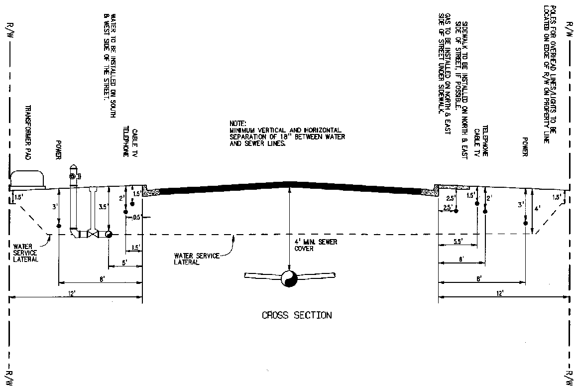
Figure 6.2: Pavement Replacement for Utility Installations and Other Cut-ins
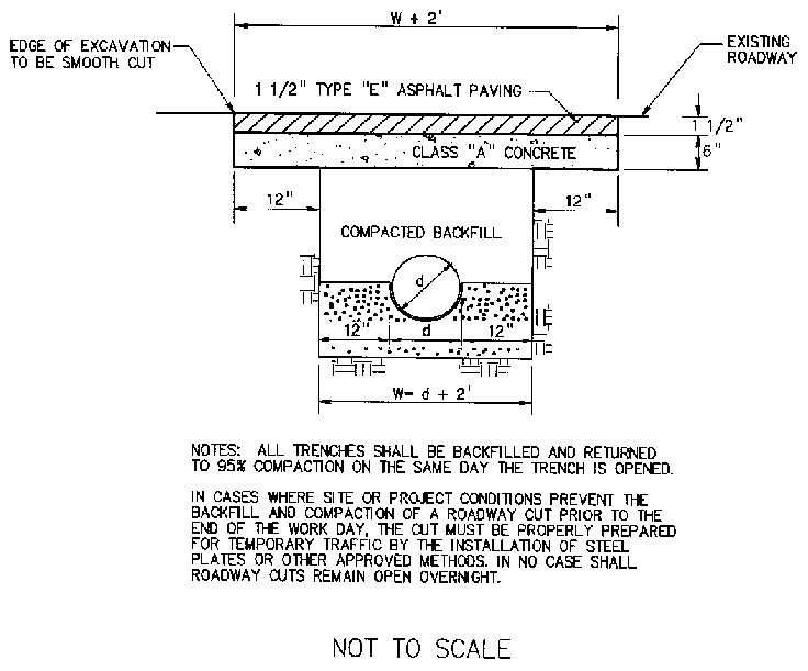
Figure 6.3
Typical Residential Roadway
Cross-Section With Curb & Gutter
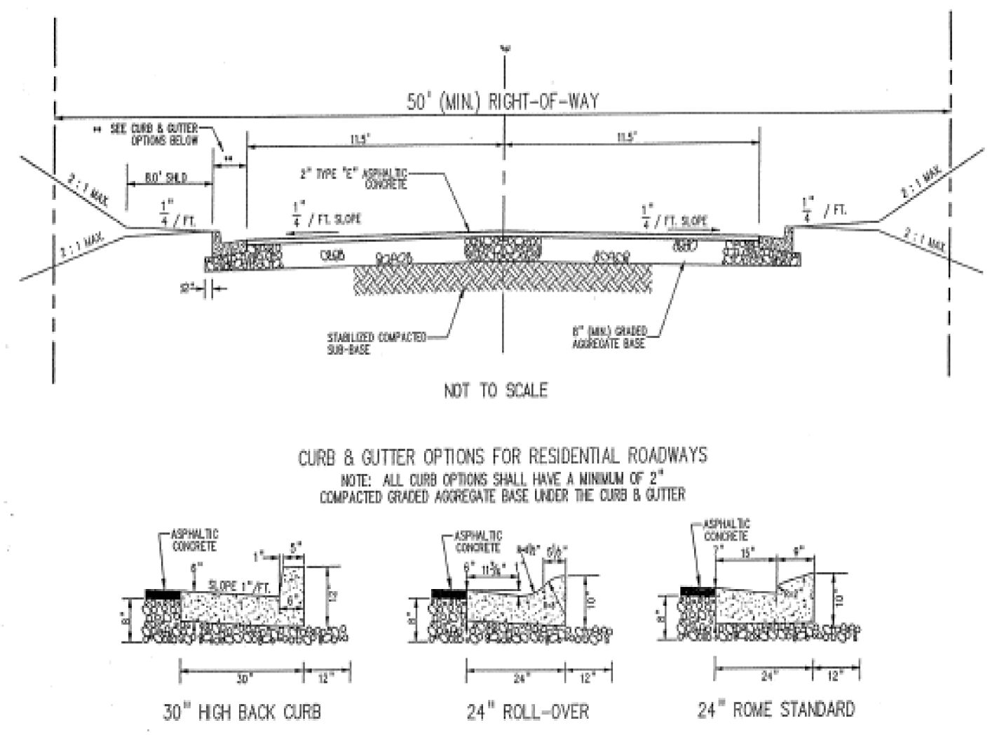
Figure 6.4
Typical Residential Roadway
Cross-Section Without Curb & Gutter
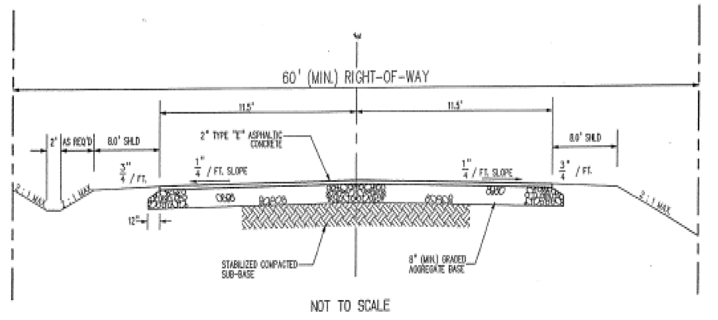
Figure 6.5 (City Only)
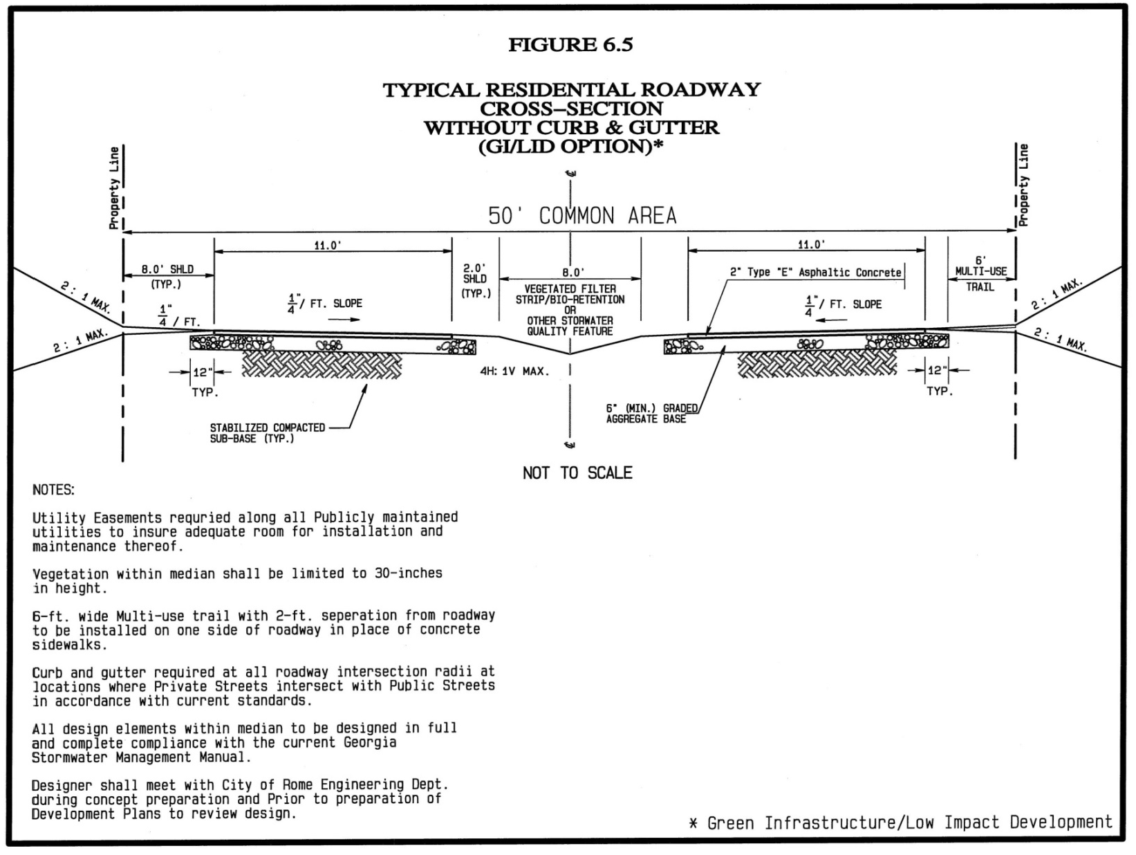
6.20.1.- PURPOSE AND INTENT
It is the purpose and intent of Section 6.20 to encourage the preservation of open space within residential development; to protect culturally and environmentally critical resources; to provide flexibility to allow creative developments; to provide for a permanent, interconnected open space network; to encourage efficient development that minimizes removal of vegetation, disturbance of soil, and encroachment into environmentally sensitive areas while reducing the need for infrastructure construction; to encourage street design that decreases traffic speed; to encourage neighborhood interaction; and to promote construction of convenient and accessible trails and sidewalks within a subdivision and connecting to adjacent communities, businesses and other facilities in order to reduce reliance on automobiles.
6.20.2.- APPLICABILITY
The Residential Cluster Subdivision Option is available for the following zoning districts:
a.
H-TR High-density Traditional Residential,
b.
L-TR Low-density Traditional Residential,
c.
NOC Neighborhood Office Commercial (where small scale, low activity, neighborhood oriented businesses may be permitted in a residential setting),
d.
S-R Suburban Residential (where public water is available), and
e.
A-R Agricultural Residential (where public water is available) zoning districts.
6.20.3.- COMPLIANCE WITH APPLICABLE ORDINANCES
Compliance with all applicable City of Rome and Floyd County ordinances, regulations, or codes is required; however, when in conflict, this Article shall prevail. Final plat and Cluster Development Plan approval shall be by the Planning Commission.
6.20.4.- LAND RESERVE AREA REQUIREMENT
a.
Each subdivision developed under this option shall include Land Reserve Area equal to no less than 40% of the gross acreage of the parcel. The Land Reserve Area shall be designated on the Cluster Option Plan and recorded on the final plat.
b.
Definition: The Land Reserve Area is defined as the portion of the subdivision that has been set aside for permanent protection. Activities within Land Reserve Areas are restricted in perpetuity through the use of an approved legal instrument.
c.
Land Reserve Area Configuration: The minimum standards for Land Reserve Areas are:
(1)
The minimum dimension at any point shall be 50 feet (measured along the chord if on an arced boundary) and at least 75% of the Land Reserve Area shall be in a contiguous tract.
(2)
All lots within the subdivision shall be provided with safe, convenient pedestrian access to the Land Reserve Area.
(3)
The Land Reserve Area shall provide connectivity with any adjacent Land Reserve Areas.
(4)
Where trails and sidewalks connecting the Land Reserve Area cross internal subdivision streets or public streets, access points shall be directly across from each other. Crossings and access points shall be clearly identified to pedestrians and motorists and may include traffic control devices, bridges, and tunnels.
(5)
Natural vegetation and soils within the Land Reserve Areas shall be protected from disturbance during development activities, except as permitted in Section 6.20.
(6)
Development in the Land Reserve Area designated as Primary and Secondary Critical areas shall be limited to passive recreation facilities such as trails/sidewalks, picnic areas, benches, fishing and non-power boat launching platforms, or playgrounds.
(7)
Non-critical areas approved for Land Reserve Area protection by the Planning Department staff may also be used as community gardens, playing fields, landscaped storm water management areas (ponds, swales, rain gardens, etc.), drain or drip field for a community sewage treatment system, crop growing, or pastures.
(8)
In no case shall more than 10% of the Land Reserve Area so used be covered with impervious surface.
(9)
Improvements must be constructed and maintained using methods and materials designed to be low impact and to have little or no adverse impact on the environment.
(10)
Mature trees within the Land Reserve Area shall not be harvested or removed, unless such harvesting or removal is recommended by a Certified Forester or by the Georgia Forestry Commission in order to control disease or insect infestation, or to eliminate danger to persons or property.
(11)
No motorized vehicles, including, but not limited to, motor bikes, four wheelers, and motorcycles, shall be allowed within the Land Reserve Area, except that maintenance vehicles shall be permitted to carry out activities approved by the owner; and electrically powered scooters, wheelchairs, and golf carts shall be permitted to use hard surfaced trails and facilities within the Land Reserve Area.
d.
Form of Land Reserve Area: The Land Reserve Area shall consist of Primary Critical Preservation Areas, Secondary Critical Preservation Areas, and Other Preservation Areas (as approved by the Planning Department Staff).
Primary Critical Preservation Areas: Primary Critical Preservation Areas form the core of the Land Reserve Areas and are required, if present, to be included within the Land Reserve Area. These include, but are not limited to:
(1)
Cemeteries, historic sites, archaeological sites, and other culturally important areas.
(2)
Habitat for rare, threatened or endangered species as defined by the Georgia Department of Natural Resources.
(3)
Wetlands as identified by the National Wetlands inventory maps prepared by the U.S. Fish and Wildlife Service, the County Soil Survey maps prepared by the United States Department of Agriculture (USDA) Natural Resources Conservation Service, or by means of a certified wetlands delineation using data from the U.S. Army Corps of Engineers, pursuant to the Clean Water Act.
(4)
Alluvial soils and 100-year floodplains as identified by the federal Emergency Management Agency; however, floodway areas shall not count toward the Land Reserve Area minimum because development is not allowed.
(5)
Existing lakes, rivers, streams, ponds, as approved by the governing body; however, such areas shall not count toward the Land Reserve Area minimum because development is not practical.
(6)
Riparian and watershed protection buffers as required by Section 6.19 of this Code.
(7)
Existing slopes that exceed 25% over a contiguous areas of at least 5,000 square feet.
Secondary Critical Preservation Areas: Secondary Critical Preservation areas shall also be counted as part of the Land Reserve Area to the maximum extent possible. Secondary Critical Preservation Areas include, but are not limited to, the following:
(1)
Stands of significant trees as defined by Section 6.18.3 of this Code. At least 50% of the trees in the stand must meet the definition of "significant tree".
(2)
Individual existing healthy trees greater than 8 inches caliper, as measured from their outermost drip line.
(3)
Other significant natural features and scenic view sheds, with the approval of Planning Department Staff.
Other Preservation Areas: With Planning Department Staff approval, land that does not meet the definition of "Primary Critical Preservation Area" or "Secondary Critical Preservation Area" may be set aside as part of the Land Reserve Area.
e.
Land Reserve Area Protection: The required Land Reserve Area shall be protected in perpetuity from further development or unauthorized use by a conservation easement held by a qualified conservation organization as defined in the Georgia Uniform Conservation Easement Act, O.C.G.A. § 44-10-1 et seq.; or by the local government. The easement documentation shall include photos and maps to record the status and condition of the Land Reserve Area.
f.
The City of Rome and Floyd County reserve the right to enforce all instruments and conservation easements, and to charge the cost of enforcement or corrective activities to the responsible party. Such costs shall become a lien on any properties titled in the name of the owner of the Land Reserve Area.
g.
Ownership of Land Reserve Areas: All Land Reserve Areas shall be permanently protected and held in fee simple interest by:
(1)
A qualified conservation organization as defined in The Georgia Uniform Conservation Easement Act, O.C.G.A. § 44-10-1 et seq.;
(2)
A homeowner's association established in accordance with the Georgia Property Owners Association Act, O.C.G.A. § 44-3-220 et seq.; or
(3)
A land trust.
6.20.5.- DEVELOPMENT STANDARDS
a.
Housing Density: The maximum number of lots in the subdivision shall be determined by either one of the following two methods:
(1)
Calculation: The maximum number of building lots shall be determined by dividing the area of the parcel, minus property located within the floodway, required river and tributary greenway buffers, bodies of open water that exceed 5,000 square feet of contiguous area, wetlands as defined by the Army Corps of Engineers pursuant to the Clean Water Act, or existing utility easements, by the minimum lot size specified by the zoning district.
(2)
Yield Plan: The maximum number of building lots is based on a conventional subdivision design plan, prepared by the applicant, in which the area of the parcel, minus property located within the floodway, required river and tributary greenway buffers, bodies of open water that exceed 5,000 square feet of contiguous area, wetlands as defined by the Army Corps of Engineers pursuant to the Clean Water Act, or existing utility easements, is subdivided in a manner intended to yield the highest number of lots possible. The plan does not have to meet all of the formal requirements of a subdivision plan, but must show a plan capable of actual construction.
Density Bonus: Regardless of which of the above density determination methods is used, up to 10% more lots may be created under the cluster option, provided that lot width, frontage, and setback requirements are met.
b.
Lots: All building lots created under this subdivision option shall front on an open, publicly maintained interior road that is classified as a "local" or a "collector" road.
c.
Lot Area: No minimum building lot area shall apply, as long as lot width, lot frontage, and building setback requirements are provided; except that lot sizes are subject to approval by the Floyd County Health Department if private sewer systems are used.
d.
Lot Dimensions: The minimum building lot width shall be 50 feet, the minimum frontage requirement shall be 25 feet.
e.
Setbacks: Front building setbacks shall be a minimum of 10 feet from the property line along local roads, 15 feet from the property line along collector roads, and 25 feet from the property line along arterial roads. Rear building setbacks shall be a minimum of 10 feet from the property line.
Side yard setbacks shall be a minimum of 5 feet from the property line; however, at the discretion of the developer, side yard setbacks may be reduced below 5 feet if a minimum separation of 10 feet between structures is provided. If side yard setbacks are reduced below 5 feet, the final plat shall delineate the buildable area of each building lot that will accommodate 10 feet of separation between structures.
All structures shall be setback a minimum of 25 feet from the outer boundary line of the subdivision.
f.
Sidewalks: If sidewalks are provided on both sides of all streets adjacent residential lots, the width of the paved street may be reduced to 20 feet for local streets, and 25 feet for collectors. Subdivision sidewalk systems shall connect with existing, adjacent sidewalks. Provision shall be made for sidewalk connection with future, adjacent development if practical.
g.
Multi-Use Trails: If a Multi-Use Trail at least 10 feet wide, with separation from driving lanes, is provided on one side of all streets adjacent residential lots, with safe and convenient, marked crossing points; the width of the paved street may be reduced to 20 feet for local streets, and 25 feet for collectors. Where sidewalks would otherwise be required, a Multi-Use Trail at least 10 feet wide on one side with safe and convenient, marked crossing points may be provided in lieu of sidewalks.
h.
Streets: New streets shall follow a rectilinear or curvilinear pattern to ensure interconnectivity and walkability. New streets shall align with existing, adjacent streets. Street segments ending in cul-de-sacs shall serve no more than 8 buildings lots. Provision shall be made for street connection with future, adjacent development if practical.
Excepting specific design standards listed in Section 6.20, streets and sidewalks shall be constructed in conformance with the standards listed in Sections 6.6 and 6.7.
i.
Within the area of the subdivision that is designated for building lots, all reasonable efforts shall be made to preserve mature vegetation and other natural features.
6.20.6.- REQUIRED DOCUMENTS
An application for Planning Commission approval of the cluster option subdivision shall include the following documents. Planning Department Staff shall ensure the completeness of the submitted documents.
a.
Cluster Development Plan: A Cluster Development Plan shall be created by the Developer and shall include the following elements:
(1)
Property Boundaries.
(2)
Streams, rivers, lakes, wetlands as described elsewhere in this Article, and all other hydrologic features.
(3)
Topographic contours of no less than 10 feet intervals.
(4)
All Primary and Secondary Critical Preservation Areas labeled by type, as described elsewhere in this Article; photographed and described.
(5)
General vegetation characteristics.
(6)
General soil types.
(7)
Planned location of Land Reserve Areas, with dimensions and areas.
(8)
Existing and proposed roads, sidewalks, trails, and transit stops.
(9)
Locations and dimensions of any developed areas within Land Reserve Areas.
(10)
Connections with existing streets, green space, trails, public areas, commercial areas, recreation areas, or Land Reserve Areas within adjacent developments.
(11)
Location, size, and number of proposed lots with buildable area delineated.
(12)
Proposed utility sites and corridors if outside of ROW area.
The Cluster Development Plan, as amended and approved by the Planning Commission, shall be binding on the developer.
b.
Land Reserve Area Maintenance, Management, Ownership and Protection Plan (MMOPP): The MMOPP shall include the following elements and shall be recorded as a permanent instrument following approval of the Cluster Option Subdivision by the Planning Commission.
(1)
Clearly delineated Land Reserve Areas with clear description of the property boundary by survey with a written legal description.
(2)
Description of features to be permanently protected.
(3)
Legal name and address of owner.
(4)
Legal name and address of easement holder.
(5)
List of parties with rights to enforce the easement (owner of the property, holder of the easement (if any), and the governing body).
(6)
Method of transferring the easement if necessary.
(7)
Proposed uses, with restrictions as applicable.
(8)
Provision for inspections of the property by the owner, the holder of the easement (if any), and the governing body.
(9)
Provision for maintenance of the Land Reserve Area including responsible party and projected budget.
(10)
Provision for amendment only with the express written permission of the property owner, the holder of the easement (if any), and the governing body.
(11)
Provision for transfer of the Land Reserve Area ownership if necessary.
The MMOPP shall be approved by the Planning Department staff prior to final approval by the Planning Commission.
c.
Homeowners Association Requirements: If the Land Reserve Area will be held, protected and managed by a Homeowners' Association, the developer shall include in the MMOPP a Description of the Homeowners' Association that includes:
(1)
By-laws;
(2)
Method and plan for maintenance of the Land Reserve Areas;
(3)
Mandatory membership of each landowner;
(4)
Responsibility for maintenance, insurance and taxes on the Land Reserve Area;
(5)
Provision for transfer of ownership of the Land Reserve Area in case of dissolution of the association.
The Description of the Homeowners' Association shall be approved by the Planning Department Staff prior to final approval by the Planning Commission.
6.20.7.- APPROVAL OF FINAL PLAT
Approval of the final plat and subdivision by the Planning Commission shall be conditioned on the acceptance of the conservation easement by a qualified conservation organization, as described in Section 6.20.4.
6.20.8.- TAX ASSESSMENT OF LAND RESERVE AREAS
Once an approved, legal instrument for permanent protection of Land Reserve Areas is in place, and the final plat and subdivision have been approved by the Planning Commission, the Floyd County Tax Assessor shall reassess the value of the open space.
6.20.9.- VARIANCES AND SPECIAL EXCEPTIONS
Notwithstanding the provisions of Section 2.11, variances, special exceptions, or appeals from any of the requirements, standards, and conditions of this article must be approved by the Planning Commission.