
Fluvanna County Unincorporated
City Zoning Code
City Zoning Code
ARTICLE 14
- PLANNED UNIT DEVELOPMENT DISTRICT PUD2
Editor's note— See Section 22-14-16 of this Code and the associated note for rules of construction affecting this article.
Sec. 22-14-1.- Statement of intent.
Planned unit developments (PUDs) are intended to promote the efficient use of land by allowing flexibility in design standards and variety in densities and land uses to preserve the rural areas of the County. Development of such districts shall be in accordance with an approved PUD Application Package which should provide a variety and range of uses and densities in designated areas of the site.
Planned unit developments must be located within the Zion Crossroads Community Planning Area, as set forth in the Comprehensive Plan. Planned unit developments should provide unified development that incorporates new urbanism and traditional neighborhood development principles, which includes a mix of residential and commercial uses, an interconnected system of internal roads, pedestrian sidewalks and walkways and well planned access points along existing roadways. In addition to a mix of residential and commercial uses, planned developments should also provide a mix and variety of housing types.
The PUD District is intended to be applied to privately initiated zoning map amendments for land located within the Zion Crossroads Community Planning Area and the designated Zion Crossroads Urban Development Area (UDA). The Zion Crossroads† UDA is located internal to the Zion Crossroads Community Planning Area, as depicted on the Future Land Use Map, as amended.
(Ord. 8-5-09; Ord. 11-16-11; Ord. 6-21-17)
†Editor's note—Corrected by the editor. Appears as "Crossroad" in the original.
Sec. 22-14-2. - Procedure for rezoning.
(1)
Prior to submitting an official rezoning application for a PUD, the applicant shall schedule a pre-application meeting with the Planning Director for an introductory work session to discuss the key elements and impacts of the proposed project.
The Planning Director and other County agency representatives may provide specific guidance on: (a) application requirements, (b) timeframe for processing of the zoning map amendment application, (c) Comprehensive Plan compliance considerations, (d) identification issues related to public infrastructure and facilities, and (e) other matters as may be uniquely related to the applicant's property.
At this meeting, the applicant shall present a preliminary sketch plan and other exhibits that depict the following: (a) general boundary and location of property subject to the PUD rezoning application, (b) land area to be contained within the PUD District, (c) graphic representation of the arrangement of interior sub-areas, (d) planned mix of land uses and densities, and (e) general approach to addressing transportation, infrastructure and community facilities.
(2)
After the pre-application meeting with staff, the applicant shall submit an application for rezoning with the Fluvanna County Planning Department. The PUD Application Package shall consist of the following primary sections: a narrative, an existing conditions map, a PUD Application Plan, a transportation plan, street design guidelines, lot development criteria, community design guidelines, and a traffic impact analysis.
(i)
PUD Application Package Narrative.
a)
A general statement of objectives to be achieved by the PUD district including a description of the character of the proposed development and the market for which the development is oriented;
b)
A list of all adjacent property owners;
c)
Site and lot development standards, including but not limited to mix of land uses, density for individual residential land uses, floor area ratios for non-residential uses, building setbacks and yard regulations, maximum heights, maximum project density, and lot coverage;
d)
Proposed utilities and implementation plan, including documentation of adequate public facilities;
e)
Phased implementation plan;
f)
Comprehensive signage plan;
g)
Descriptions of any architectural and community design guidelines including but not limited to a code of development, building designs, orientations, styles, lighting, etc.;
h)
Specific proffers and conditions (if proposed).
(ii)
Existing Conditions Map.
a)
Topography, including the identification of steep slopes (>20 percent), to be prepared with minimum two-foot contour elevations and 100-foot horizontal scale, and current boundary survey of the property subject to the PUD district;
b)
Water features, including existing stream buffers and stormwater or erosion control measures;
c)
Roadways;
d)
Structures;
e)
Tree lines;
f)
Major utilities;
g)
Significant environmental features, including unsuitable soils for land development purposes, wetlands, and FEMA designated 100-year floodplains;
h)
Existing and proposed ownership of the site along with all adjacent property owners;
i)
Zoning of the site and adjacent properties;
j)
Locations of public improvements and facilities, including rights-of-way and easements, as may be recognized by the Comprehensive Plan, the Future Land Use Map, the Official Transportation Map, or state transportation plans, as may be applicable.
(iii)
PUD Application Package. The PUD Application Package shall include a PUD Application Plan (master plan) to be prepared to a horizontal scale of 1″=100′ or as otherwise may be approved by the Planning Director to be of sufficient clarity and scale to accurately identify the location, nature, and character of the proposed planned unit development (PUD) district. At a minimum, the PUD Application Plan shall include the following:
a)
Proposed PUD master plan layout and supporting land use documentation (tables, charts, etc.) for all proposed land uses within the PUD district, including the general location of uses, types of uses, mix of uses, lot types, density range of uses, and floor area ratio ranges;
b)
Methods of access from existing state maintained roads to proposed areas of development;
c)
General street alignments and parking areas, including proposed street sections and standards;
d)
General alignments of sidewalks, bicycle and pedestrian facilities;
e)
Schematic utility plans, indicating the infrastructure and facilities to serve the development, including but not limited to: water, sewer and storm drainage improvements, pump stations, treatment facilities, offsite improvements as needed, electrical substations, etc.;
f)
A general plan showing the location and acreage of the active and passive recreation spaces, parks, civic areas, and other public open areas;
g)
A general overall landscaping layout that includes methods of screening and buffering from adjacent properties and existing public rights-of-way, as well as stream buffers;
h)
A general stormwater management and best management practices master plan that includes how negative impacts to nearby streams, wetlands, surface water, and groundwater resources as a result of development would be avoided and mitigated;
i)
Phased development areas. Subsequent subdivision plats and site plans should be closely correlated with master plan phases;
j)
A schematic grading plan for the area of the PUD property proposed for development, with finished grades to be prepared at a five-foot contour interval;
k)
Documentation and plan demonstrating general compliance with VDOT State Secondary Street Acceptance requirements and other requirements for public streets and intersections.
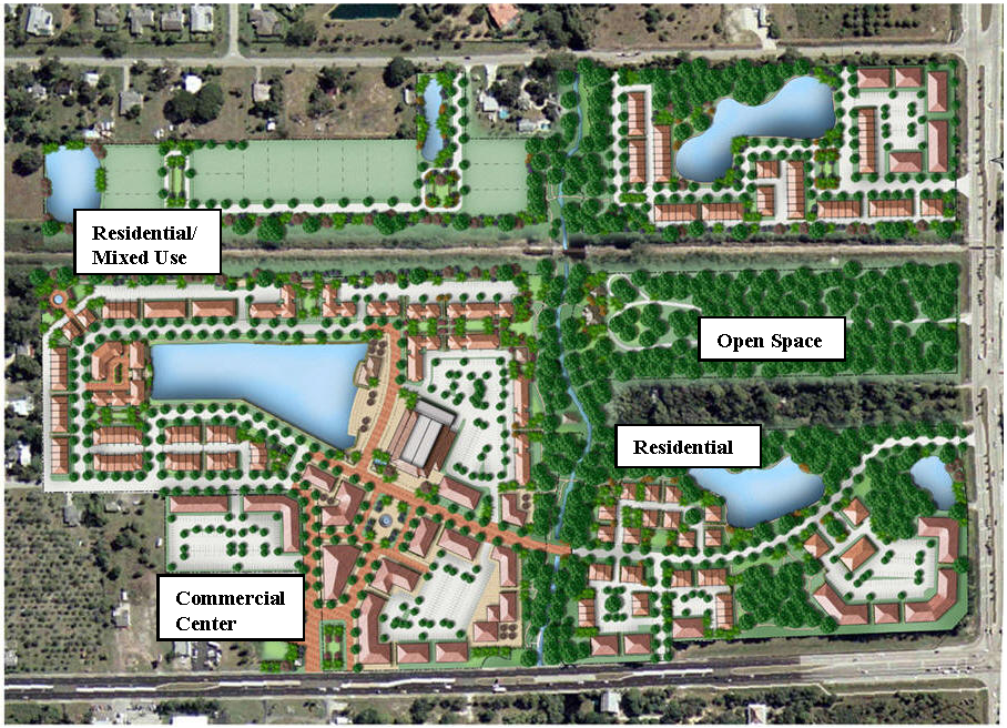
Planned Unit Development Master Plan
(iv)
Traffic Impact Analysis.
a)
The Planning Director shall determine whether or not the subject PUD District project shall require a traffic impact statement to be prepared consistent with VDOT 527 regulations.
b)
If a 527 traffic impact analysis is required, the Applicant shall prepare and submit a Pre-Scope of Work Meeting Form to the County on or before the date of formal submission of the zoning district amendment application. The Pre-Scope form shall be processed, reviewed by and between the County, VDOT and the Applicant in accord with adopted regulations and procedures.
c)
If a 527 Traffic Impact Analysis is not required, the Applicant shall meet with the Planning Director to determine the required scope for a traffic analysis for the PUD project. The Planning Director shall approve the elements to be addressed in the study scope. The traffic analysis shall be submitted with the zoning amendment application. Minimum requirements may include the following:
1)
Existing traffic counts (AM and PM peak hour) at intersections to be identified by the County;
2)
Trip generation estimates for the planned land uses within the proposed development, employing Institute of Transportation Engineers (ITE) methodologies;
3)
Trip distribution and assignments to the existing road network of traffic projected for the development at full-buildout;
4)
Estimates of background traffic growth on impacted streets and highways;
5)
Analysis of future conditions, to include Highway Capacity Manual (HCM) level-of-service calculations for impacted intersections;
6)
Signal warrants analysis;
7)
Statement of recommended transportation improvements to provide adequate levels of service for the traffic generated by the proposed project.
(3)
The PUD application package shall not be scheduled for consideration by the Planning Commission until the Planning Director has determined that the package is complete. Except as the Planning Director may determine otherwise in a particular case, for reasons beyond the control of the applicant, any application package which is not complete within 30 days after its submission shall be deemed to have been withdrawn and shall not be further processed. Once the Planning Director has determined the application package to be complete, the following process shall commence:
(i)
The Planning Commission shall receive a public presentation on the proposed development at a regularly scheduled meeting, prior to advertising for a public hearing;
(ii)
The Planning Commission may schedule one or more work sessions to discuss the proposed development;
(iii)
Once a public hearing has been conducted by the Planning Commission, a recommendation shall be forwarded to the Board of Supervisors for their consideration;
(iv)
The Board of Supervisors may schedule one or more work sessions to discuss the proposed development and the Planning Commission recommendation, prior to conducting their public hearing;
(v)
The plan approved by the Board of Supervisors shall constitute the final master plan for the PUD district.
(4)
All conditions and elements of the plan as submitted, including amendments and revisions thereto, shall be deemed to be proffers once the Board of Supervisors has approved the final master plan. All such conditions and elements shall be enforceable by the County pursuant to Section 22-17-9 of this Code.
(5)
The approved final master plan shall serve as the sketch plans for the subdivision and site plan process.
(6)
Prior to development of the site, a final site development plan pursuant to Article 23* of the zoning ordinance, shall be submitted for administrative review and approval for any business, limited industrial, or multi-family development.
(7)
Additionally, if any land within the district is to be subdivided, preliminary and final subdivision plats pursuant to the subdivision regulations of Chapter 19 of the Fluvanna County Code shall be submitted for administrative review and approval prior to development of the site. Staff will determine if the submitted preliminary plats are in accordance with the approved final master plan.
(8)
If staff determines that the preliminary or final subdivision plats or final site plan are not in accord with the approved final master plan, such plans will be sent to the Planning Commission for review. If the Planning Commission determines that such plans are not in accord with approved final master plan, the applicant shall then submit sketch plans for review and approval by the Planning Commission. The sketch plans shall either be in accord with the approved final master plan, or a master plan amendment shall be applied for, in which case the amendment procedure set out in the zoning ordinance shall be followed.
(Ord. 8-5-09; Ord. 11-16-11)
*Editor's note—Conformed to numbering convention of this Code by the editor. Appears as "Article 22-23" in the original.
Sec. 22-14-3. - Character of development.
The goal of the PUD district is to allow for and encourage development that incorporates new urbanism principles which includes:
(1)
Pedestrian orientation;
(2)
Neighborhood friendly streets and paths;
(3)
Interconnected streets and transportation networks;
(4)
Parks, recreation improvements, and open space as amenities;
(5)
Neighborhood centers and civic space;
Planned Unit Development
(6)
Buildings and spaces of appropriate scale;
(7)
Relegated parking;
(8)
Mixture of uses and use types;
(9)
Mixture of housing types and affordability;
(10)
Clear boundaries with any surrounding rural areas;
(11)
Environmentally sensitive design (i.e., sustainability and energy efficiency);
(12)
Adequate public facilities and infrastructure to serve the community.
An application is not necessarily required to possess every characteristic of the PUD district as delineated above in order to be approved. The size of the proposed district, its integration with surrounding districts, or other similar factors may prevent the application from possessing every characteristic.
(Ord. 8-5-09; Ord. 11-16-11)
Sec. 22-14-4. - Uses permitted by-right.
In the PUD district, all uses permitted by-right in the residential (R-1, R-2, R-3 and R-4), business (B-1 and B-C) and limited industrial (I-1) zoning districts may be permitted as enumerated in the final PUD application package. Uses not specified within the PUD application package shall not be permitted. (See Planning Staff for matrix for use by applicant to designate proposed by-right land uses to be included in the PUD district. The applicant's completed table shall be established as a condition of approval of the PUD Application Package.)
(Ord. 8-5-09; Ord. 11-16-11)
Sec. 22-14-5. - Uses permitted by special use permit.
One or more of the uses permitted by special use permit in the residential and business zoning districts may be permitted in the PUD district, as enumerated in the final PUD application package, upon issuance of a special use permit by the Board of Supervisors. Uses not specified within the PUD application package shall not be permitted. (See Planning Staff for a matrix for use by applicant to designate proposed special use permit uses to be included in the PUD district. The applicant's completed table, including special conditions imposed during the zoning application process, shall become an element of the PUD application package.)
(Ord. 8-5-09; Ord. 11-16-11)
Sec. 22-14-6. - Minimum area required for a planned unit development.
(1)
PUD districts shall be located on a single parcel of land or separate but contiguous parcels which are, or proposed to be, under common ownership, subject to approval of the rezoning application. The minimum area required for a PUD district shall be as follows:
(i)
Zion Crossroads Community Planning Area: 20 acres.
(ii)
Zion Crossroads Urban Development Area (applicable to a PUD district application on designated UDA land located within the Zion Crossroads Community Planning Area*): no minimum area required.
(2)
Additional land area may be added to an established PUD district if it is adjacent to and forms a logical addition to the approved development. The procedure for an addition shall be the same as if an original PUD zoning amendment application was filed, and the requirements of this article shall apply, except the minimum acreage requirement.
(Ord. 8-5-09; Ord. 11-16-11; Ord. 6-21-17)
*Editor's note—The editor has replaced "CPA" in the original with "Community Planning Area" to conform to usage in the Code.
Sec. 22-14-7. - Open space, recreation, parks and civic areas.
(1)
In the Zion Crossroads Community Planning Area, not less than 30 percent of the gross area of a PUD district shall be preserved as open space, provided that supplemental regulations for application to the Zion Crossroads UDA apply as indicated herein below. The required 30 percent open space may include private common and public open areas; perimeter open space; buffers between various uses, densities and adjacent properties; recreational space, neighborhood parks, civic areas; easements; water bodies and any undisturbed land not occupied by building lots, structures, streets, and parking lots. By way of this section, yards of individual residences shall not be considered open space.

Open Space
(2)
Land designated for future facilities (i.e., schools, fire and rescue stations, places of worship, daycare centers, etc.) shall not be included toward the open space.
(3)
Not less than 15 percent of the total open space shall be provided for active and/or passive recreational activities.
(4)
Private common open areas shall be owned, maintained and operated by a property owner's association. A property owner's association document shall be prepared declaring and specifying the care and maintenance of the common areas. This document shall be reviewed and approved by the Fluvanna County Attorney prior to final approval.
(5)
Upon request of the Applicant, the Planning Commission, at its sole discretion, (a) may decrease or eliminate certain requirements for open space and recreation land and improvements in a PUD District project, provided that the revised regulations shall be established and conditioned by the PUD Application Package.
(6)
For PUD projects in the Zion Crossroads UDA that are less than 15 acres in gross area, the Applicant may contribute to a pro-rata share fund lieu of provision for all or a portion of the required open space. The County shall reserve and employ these funds for the purpose of community open space, park, recreation, or civic space development within the Zion Crossroads Community Planning Area.
(7)
For PUD projects in the Zion Crossroads UDA with a gross area of 15 acres or greater, the quantity, location, mix, type, quality and phasing of open space, civic space, parks, recreation areas, buffer areas, and protected natural areas shall be consistent with the policies of the Comprehensive Plan or other criteria for traditional neighborhood development as may be established by the County. These areas shall be delineated on the PUD Application Plan and may include greens, squares, plazas, community centers, club houses, swimming facilities, outdoor recreational fields, trails, pocket parks, or community gardens.
(Ord. 8-5-09; Ord. 11-16-11; Ord. 6-21-17)
Sec. 22-14-8. - Density.
(1)
The maximum residential base density permitted for individual land uses to be located in the PUD districts shall be as follows in Table 1 below.
(2)
The allowable density for individual uses within the PUD District shall be calculated based on the Net Acreage of the land subject to the PUD zoning amendment application. The calculation of minimum and maximum yield for individual uses shall be based on the application of the minimum and maximum density for each use (see Table 1) to an adjusted Net Acreage. The Net Acreage reduces the gross area of the PUD land by the total of the non-qualifying land components within property. The Net Acreage = Gross Acreage - Non-Qualifying Area (acreage of the sum of the Non-Qualifying land components.) The components that comprise the Non-Qualifying areas include:
•
Area of existing dedicated public rights-of-way and easements;
•
Areas depicted on an adopted Official Transportation Map for future public improvements;
•
Area of existing land uses and structures, including platted lots, that are intended to remain as a part of the PUD project;
•
Areas deemed unbuildable due to geological, soils, or other environmental deficiencies;
•
Areas of wetlands and floodplains (as defined by FEMA 100-year floodplain or engineering study);
•
Area of existing ponds, stormwater management facilities, and water features that are not defined as wetlands or floodplains; and
•
Area of terrain with slopes in excess of 30 percent.
(3)
An increase in the maximum residential density for a PUD district may be permitted in the following instances:
Open Space:
If 50 percent or more of the gross area of a PUD is preserved as open space, then a 20 percent increase in density may be permitted. If 75 percent or more of the gross area of a PUD is preserved as open space, then a 30 percent increase in density may be permitted.
Affordable Housing (as defined in the Comprehensive Plan):
If between ten percent and 15 percent of the total number of dwelling units within a PUD are reserved for affordable housing, then a 20 percent increase in density may be permitted. If more than 15 percent of the total number of dwelling units within a PUD are reserved for affordable housing, then a 30 percent increase in density may be permitted.
Open Space and Affordable Housing:
Density bonuses may also be permitted with a combination of both open space and affordable housing. The increase in density that may be permitted shall be based on the following combinations of open space and affordable housing:
Transfer/Purchase of Development Rights:
(Reserved for future Transfer of Development Rights/Purchase of Development Rights density bonuses.)
(Ord. 8-5-09; Ord. 11-16-11; Ord. 12-16-15; Ord. 6-21-17)
Sec. 22-14-9. - Setbacks.
(1)
Minimum setbacks and yard regulations for each planned land use within the PUD district shall be specifically enumerated in a table to be included in the PUD Application Package.
(2)
Lots at the perimeter of the PUD district shall conform to the setback requirements of the adjoining district, or to the setback requirements of the planned district, whichever is greater.
(3)
Refer to the Comprehensive Plan for illustrative examples of residential lot types for traditional neighborhood development projects.
(Ord. 8-5-09; Ord. 11-16-11)
Sec. 22-14-10. - Streets.
(1)
Streets within the PUD district may be either public or private, but shall conform to VDOT road design standards. Private subdivision streets shall be permitted in accordance with the provisions of Section 19-18-1(C) of this Code.
(2)
Alleys may be allowed within the PUD district provided they conform to either VDOT design standards or as otherwise prescribed in the master plan.
(3)
Sidewalks shall generally be provided on both sides of any streets, public or private, within the PUD district. Sidewalks shall conform to VDOT standards.
(4)
Traffic access and circulation within the PUD district shall be designed to provide safe accommodation of all users of the transportation network including pedestrians and bicyclists. Sidewalks, bicycle lanes and multi-use trails shall be provided where appropriate. Mixed-use areas of the development shall be designed to give priority to pedestrian and bicycling traffic.
(5)
Internal streets within the PUD district shall be permitted to intersect with existing public streets to the extent necessary. Such intersections shall provide reasonable access and service to uses contained within the development and shall be developed using VDOT principles of access management.
(6)
Refer to the Comprehensive Plan for illustrative examples of residential streets for traditional neighborhood development projects.
(Ord. 8-5-09; Ord. 11-16-11)
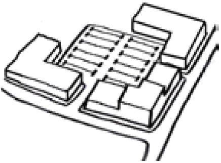
Sec. 22-14-11. - Parking.
(1)
Off-street parking facilities in mixed-use, business, industrial, and multi-family residential areas shall generally be relegated behind the front building line.
Relegated Parking
(2)
On-street parking shall be permitted, where appropriate.
(3)
In addition to the regulations included herein, all off-street parking shall be provided in accordance with the off-street parking and loading requirements of Article 26* of the zoning ordinance.
(4)
The provisions of Article 26* for the application of individual parking standards for projects located within the Zion Crossroads UDA may be modified at the discretion of the Planning Commission, provided that the Applicant submits a parking impact study that fully justifies the modification to the standards based on the mix of uses, the phasing of development, and other factors, including relationship of parking location to individual land uses within the project.
(Ord. 8-5-09; Ord. 11-16-11)
*Editor's note—Conformed to numbering convention of this Code by the editor. Appears as "Article 22-26" in the original.
Sec. 22-14-12. - Height of buildings.
The height regulations for the PUD district shall be as follows:
1 Corrected by the editor. Appears as "Areas" in original.
2 "Community Planning Area" inserted by the editor.
(1)
For purposes of this section, height shall be the vertical distance of a structure measured from the highest finished grade to the highest point of the structure.
(2)
Spires, belfries, cupolas, monuments, water towers, chimneys, flues, flagpoles, television antennae and radio aerials: 60 feet from grade, unless otherwise enumerated in the master plan.
(3)
Roof-mounted mechanical equipment (i.e., air conditioners, condensers, ductwork, etc.) shall not be visible at any point from ground-level. Parapet walls shall not extend more than four feet above the maximum height permitted for buildings within the PUD district.
(4)
Buildings with a mixture of business and residential uses are subject to the height regulations of business, industrial and non-residential buildings.
(Ord. 8-5-09; Ord. 11-16-11; Ord. 6-21-17)
Sec. 22-14-13. - Utilities.
(1)
All uses and structures within a PUD district shall be served by both public water and public sewer systems.
(2)
No overhead utility lines shall be permitted within a PUD district. All utility lines, including but not limited to, electric, telephone, cable television lines, etc., shall be placed underground.
(3)
Telecommunications facilities are encouraged on the roofs of buildings within a PUD district to provide coverage to the district and surrounding area.
(Ord. 8-5-09; Ord. 11-16-11; Ord. 6-21-17)
Sec. 22-14-14. - Building design and architecture.
(1)
Within the multi-family residential, business, industrial, and mixed-use areas of a PUD district, building design styles shall be compatible with each other and shall exhibit consistency in terms of their exterior materials, architectural style, size, shape, scale, and massing.
(2)
With the exception of detached single family dwellings, building facades shall maintain a consistent street edge. The street elevation of principal structures shall have at least one street-oriented entrance and contain the principal windows of the structure, with the exception of structures in a courtyard style.
(3)
Site plans shall include drawings, renderings, or perspectives of a professional quality which illustrate the scale, massing, roof shape, window size, shape and spacing, and exterior materials of the structure.
(Ord. 8-5-09; Ord. 11-16-11)
Sec. 22-14-15. - Amendment.
(1)
The Planning Director may approve a minor change to an approved PUD Application Package and Application Plan at the written request of the owner of the development. For purposes of this section, a "minor change" refers to changes of location and design of buildings, structures, streets, parking, recreational facilities, open space, landscaping, utilities, or similar details which do not significantly change the character of the approved PUD application package and PUD master plan.
(2)
If the Planning Director determines that the requested change constitutes a significant change, or something more than a minor change to the approved zoning application package, then the owner may seek an amendment to the PUD Application Package and Application Plan from the Board of Supervisors. The application procedure for such an amendment shall be the same as the application procedure for the original approval.
(Ord. 8-5-09; Ord. 11-16-11)
Sec. 22-14-16. - Construction of article.*
The provisions of this article shall be construed in such manner as to be consistent with other provisions of this Code to the extent that such construction may be reasonably applied. To the extent that any provision of this article shall be inconsistent with any other provision of this Code, the provisions of this article shall be deemed to be controlling.
(Ord. 8-5-09; Ord. 11-16-11)
*Note—The term "shall generally", as used in the context of this section of the ordinance, indicates that the stated requirement is expected unless there are compelling, specific, and extenuating circumstances for why it cannot be met. (Editor's note: "this section of the ordinance" refers to Article 14 as a whole.)