
Fort Lauderdale City Zoning Code
ARTICLE II
- ZONING DISTRICT REQUIREMENTS
SECTION 47-13.- REGIONAL ACTIVITY CENTER DISTRICTS[1]
Editor's note—Ord. No. C-10-50, § 1, adopted January 4, 2011, amended the title of Section 47-13 to read as herein set out. Prior to inclusion of said ordinance, Section 47-13 was entitled, "Downtown Regional Activity Center Districts."
SECTION 47-14.- GENERAL AVIATION DISTRICTS[2]
Editor's note—Ord. No. C-21-06, § 3, adopted March 2, 2021, amended Section 47-14 in its entirety to read as herein set out. Former Section 47-14, §§ 47-14.1, 47-14.2, 47-14.10, 47-14.11, 47-14.12, 47-14.12A, 47-14.12B, 47-14.20, 47-14.21, 47-14.30, 47-14.31, pertained to similar subject matter, and derived from Ord. No. C-97-19, §§ 1(47-14.1), 1(47-14.2), 1(47-14.3), 1(47-14.3), 1(47-14.4), 1(47-14.5), 1(47-14.6), 1(47-14.7), adopted June 18, 1997; Ord. No. C-99-18, § 2, adopted March 16, 1999; Ord. No. C-00-15, § 2, adopted Feb. 15, 2000; Ord. No. C-03-19, § 4, adopted April 22, 2003; Ord. No. C-12-24, § 4, adopted July 10, 2012; Ord. No. C-14-43, §§ 1—5, adopted November 4, 2014; Ord. No. C-15-36, § 10, adopted October 20, 2015; Ord. No. C-16-24, §§ 1—4, adopted November 1, 2016; Ord. No. C-18-05, § 6, adopted March 6, 2018;
Sec. 47-4.1.- Listing.
For the purpose of regulating the use of land, and height and bulk of buildings and location of buildings for specific purposes to limit the population and density, and the intensity of use and open space, the city is hereby divided into the following zoning districts:
(Ord. No. C-97-19, § 1(47-4), 6-18-97)
Sec. 47-4.2. - Abbreviations.
The abbreviations included in the residential zoning district titles have meaning as follows:
(Ord. No. C-97-19, § 1(47-4), 6-18-97)
Sec. 47-5.1.- List of districts.
A.
Residential zoning districts.
1.
RS-4.4 - Residential Single Family/Low Density District.
2.
RS-8 - Residential Single Family/Low Medium Density District.
3.
RD-15 - Residential Single Family Duplex/Medium Density District.
4.
RDs-15 - Residential Single Family/Medium Density District
5.
RC-15 - Residential Single Family Cluster Dwellings/Medium Density District.
6.
RCs-15 - Residential Single Family/Medium Density District.
7.
RM-15 - Residential Multifamily Low Rise/Medium Density District.
8.
RMs-15 - Residential Low Rise Multifamily/Medium Density District.
9.
RML-25 - Residential Multifamily Low Rise/Medium High Density District.
10.
RMM-25 - Residential Multifamily Mid Rise/Medium High Density District.
11.
RMH-25 - Residential Multifamily High Rise/Medium High Density District.
12.
RMH-60 - Residential Multifamily High Rise/High Density District.
13.
MHP - Mobile Home Park District.
B.
Residential office zoning districts.
1.
RO - Residential Office District. See Section 47-5.60.
2.
ROA - Limited Residential Office District. See Section 47-5.60.
3.
ROC - Planned Residential Office Districts. See Section 47-5.60.
(Ord. No. C-97-19, § 1(47-5.1), 6-18-97; Ord. No. C-99-27, § 1, 5-4-99)
Sec. 47-5.2. - Intent and purpose of each district.
A.
Residential zoning districts.
1.
RS-4.4 district is intended to provide areas within the city for single family detached residences and accessory uses. The RS-4.4 district has a maximum density of four and four-tenths (4.4) dwelling units per net acre, which is consistent with the density permitted by the residential low category of the city's comprehensive plan.
2.
a.
RS-8 district is intended to provide areas within the city for single family detached residences and accessory uses. The RS-8 district has a maximum density of eight dwelling units per net acre, which is consistent with the density permitted by the residential low-medium category of the city's comprehensive plan.
b.
RS-8A district is intended to preserve the existing character and integrity of RS-8 neighborhoods by reducing the potential for increased bulk, height and mass of single family detached residences which is permitted in an RS-8 zoning district. Further restriction on bulk, height and mass will promote the preservation of existing tree canopy and provide for additional landscaping.
3.
RD-15 district is intended to provide areas within the city for single family detached dwellings and for duplex units or two family residences where two units are either attached or semi-attached. The RD-15 district permits single family dwelling units including zero lot line dwellings and cluster dwellings designed in a manner that is compatible and complementary to the surrounding area. This provides for a more efficient use of land resources by allowing for a modification of yards to provide for innovative site design and open space on lots which, because of their size and/or configuration, could not be efficiently used otherwise. The RD-15 district has a maximum density of15 dwelling units per net acre, which is consistent with the density permitted by the residential medium category of the city's comprehensive plan.
4.
RC-15 district is intended to provide areas within the city for single family detached and attached residences and accessory uses. The RC-15 district is also intended to provide for a variety of one family residences, such as zero lot line dwellings, townhouses, and the clustering of dwellings, in a manner which provides for a more efficient use of land resources by allowing for a modification of yards, providing for innovative site design and open space on lots which, because of their size and/or configuration, could not be efficiently used otherwise. The RC-15 district has a maximum density of15 dwelling units per net acre, which is consistent with the density permitted by the residential medium category of the city's comprehensive plan.
5.
RDs-15, RCs-15, RMs-15 are zoning districts intended to limit new residential development to single family detached residences. Duplex, townhouse and multifamily uses that exist and are located on property that was zoned RD-15, RC-15 or RM-15 on April 21, 1998, can be redeveloped as duplex, townhouse or multifamily uses, subject to the provisions provided in Section 47-18.39.
6.
RM-15 district is intended to provide areas in the city for single family residences and low-rise multifamily residences in a manner which ensures, to the greatest extent possible, compatibility with adjacent development and existing residential neighborhoods. Parcels so designated shall serve as a transition from medium high and high density multifamily housing to single family neighborhoods, and shall be limited to locations on or within reasonable proximity to arterial or collector streets or generally near community facilities, office or commercial development. The RM-15 district has a maximum density of15 dwelling units per net acre, which is consistent with the residential medium category of the city's comprehensive plan.
7.
RML-25 district is intended for single family residences and low-rise multifamily residences and hotel/motels in a manner which ensures, to the greatest extent possible, compatibility with adjacent development and existing residential neighborhoods. Parcels so designated shall serve as a transition from high density multifamily housing and hotel development to single family neighborhoods, and shall be located in proximity to arterial or collector streets or near community facilities, office or commercial development. The RML-25 district has a maximum density of 25 dwelling units per net acre and a maximum density of 30 hotel/motel rooms per net acre, which is consistent with the density permitted by the residential medium high category of the city's comprehensive plan.
8.
RMM-25 district is intended for mid-rise multifamily residences and tourist accommodations. The RMM-25 district has a maximum density of 25 dwelling units per net acre and a maximum density of 30 hotel/motel or nursing home rooms per net acre, which is consistent with the residential medium high category of the city's comprehensive plan. Parcels so designated shall serve as a transition from medium high density multifamily housing and hotel development to single family and midrise multifamily residential neighborhoods and shall be located in proximity to arterial or collector streets or adjacent or near to commercial shopping and office facilities or services.
9.
RMH-25 district is intended for high-rise multifamily residences and tourist accommodations. Parcels so designated shall serve as a transition from medium high density multifamily housing and hotel development and single family and low to midrise multifamily residential neighborhoods and shall be located in proximity to arterial or collector streets or adjacent or near to commercial shopping and office facilities or services. The RMH-25 district has a maximum density of 25 dwelling units per net acre and a maximum density of 30 hotel/motel or nursing home rooms per net acre, which is consistent with the residential medium high category of the city's comprehensive plan.
10.
RMH-60 district is intended for high-rise, high density multifamily residences and hotels. The RMH-60 district has a maximum density of 60 dwelling units per net acre and one hundred twenty (120) hotel/motel rooms per net acre, and eighty-seven (87) nursing home rooms per net acre which is consistent with the residential high category of the city's comprehensive plan.
11.
MHP district is intended for the establishment of residential mobile home parks which are or will be convenient to major traffic arterials. Mobile home parks may be located in areas of the city that are west of the Seaboard Coast Line Railroad, at a maximum density of 25 dwelling units per net acre, consistent with the residential medium high category of the city's comprehensive plan.
B.
Residential office zoning districts.
1.
RO - Residential Office District: See Section 47-5.60.
2.
ROA - Limited Residential Office District: See Section 47-5.60.
3.
ROC - Planned Residential Office Districts: See Section 47-5.60.
(Ord. No. C-97-19, § 1(47-5.2), 6-18-97; Ord. No. C-99-27, § 2, 5-4-99; Ord. No. C-08-05, § 1, 2-5-08)
Sec. 47-5.10. - List of permitted and conditional uses, RS-4.4 Residential Single Family/Low Density District.
District Categories—Residential Dwellings, Public Purpose Facilities, Child Day Care Facilities, and Accessory Uses, Buildings and Structures.
(Ord. No. C-97-19, § 1(47-5.3.1), 6-18-97; Ord. No. C-12-24, § 4, 7-10-12; Ord. No. C-15-36, § 1, 10-20-15; Ord. No. C-17-47, § 1, 1-3-18; Ord. No. C-18-11, § 4, 4-17-18)
Sec. 47-5.11 - List of permitted and conditional uses, RS-8 and RS-8A Residential Single Family/Low Medium Density District.
District Categories—Residential Dwellings, Public Purpose Facilities, Child Day Care Facilities, and Accessory Uses, Buildings and Structures.
(Ord. No. C-97-19, § 1(47-5.3.2), 6-18-97; Ord. No. C-08-05, § 2, 2-5-08; Ord. No. C-12-24, § 4, 7-10-12; Ord. No. C-15-36, § 1, 10-20-15; Ord. No. C-17-47, § 2, 1-3-18; Ord. No. C-18-11, § 4, 4-17-18)
Sec. 47-5.12. - List of permitted and conditional uses, RD-15 Residential Single Family/Duplex/Low Medium Density District.
District Categories—Residential Dwellings, Public Purpose Facilities, Child Day Care Facilities, and Accessory Uses, Buildings and Structures.
(Ord. No. C-97-19, § 1(47-5.3.3), 6-18-97; Ord. No. C-12-24, § 4, 7-10-12; Ord. No. C-15-36, § 1, 10-20-15; Ord. No. C-17-47, § 3, 1-3-18; Ord. No. C-18-11, § 4, 4-17-18)
Sec. 47-5.13. - List of permitted and conditional uses, RDs-15 Residential Single Family/Medium Density District.
District Categories—Residential Dwellings, Public Purpose Facilities, Child Day Care Facilities, and Accessory Uses, Buildings, and Structures.
(Ord. No. C-99-27, § 3(47-5.3.3b), 5-4-99; Ord. No. C-12-24, § 4, 7-10-12; Ord. No. C-15-36, § 1, 10-20-15; Ord. No. C-17-47, § 4, 1-3-18; Ord. No. C-18-11, § 4, 4-17-18)
Sec. 47-5.14. - List of permitted and conditional uses, RC-15 Residential Single Family/Cluster Dwellings/Low Medium Density District.
District Categories—Residential Dwellings, Public Purpose Facilities, Child Day Care Facilities, and Accessory Uses, Buildings, and Structures.
(Ord. No. C-97-19, § 1(47-5.3.4), 6-18-97; Ord. No. C-12-24, § 4, 7-10-12; Ord. No. C-15-36, § 1, 10-20-15; Ord. No. C-17-47, § 5, 1-3-18; Ord. No. C-18-11, § 4, 4-17-18)
Sec. 47-5.15. - List of permitted and conditional uses, RCs-15 Residential Single Family/Medium Density District.
District Categories—Residential Dwellings, Public Purpose Facilities, Child Day Care Facilities, and Accessory Uses, Buildings, and Structures.
(Ord. No. C-99-27, § 3(47-5.3.4b), 5-4-99; Ord. No. C-12-24, § 4, 7-10-12; Ord. No. C-15-36, § 1, 10-20-15; Ord. No. C-17-47, § 6, 1-3-18; Ord. No. C-18-11, § 4, 4-17-18)
Sec. 47-5.16. - List of permitted and conditional uses, RM-15 Residential Low Rise Multifamily/Medium Density District.
District Categories—Residential Dwellings, Lodging, Mixed Use Development, Public Purpose Facilities, Child Day Care Facilities, and Accessory Uses, Buildings and Structures.
(Ord. No. C-97-19, § 1(47-5.3.5), 6-18-97; Ord. No. C-12-24, § 4, 7-10-12; Ord. No. C-15-36, § 1, 10-20-15; Ord. No. C-17-47, § 7, 1-3-18; Ord. No. C-18-11, § 4, 4-17-18)
Sec. 47-5.17. - List of permitted and conditional uses, RMs-15 Residential Low Rise Multifamily/Medium Density District.
District Categories—Residential Dwellings, Lodging, Mixed Use Development, Public Purpose Facilities, Child Day Care Facilities, and Accessory Uses, Buildings and Structures.
(Ord. No. C-99-27, § 3(47-5.3.5b), 5-4-99; Ord. No. C-12-24, § 4, 7-10-12; Ord. No. C-15-36, § 1, 10-20-15; Ord. No. C-17-47, § 8, 1-3-18; Ord. No. C-18-11, § 4, 4-17-18)
Sec. 47-5.18. - List of permitted and conditional uses, RML-25 Residential Low Rise Multifamily/Medium High Density District.
District Categories—Residential Dwellings, Lodging, Mixed Use Development, Public Purpose Facilities, Child Day Care Facilities, and Accessory Uses, Buildings and Structures.
(Ord. No. C-97-19, § 1(47-5.3.6), 6-18-97; Ord. No. C-12-24, § 4, 7-10-12; Ord. No. C-15-36, § 1, 10-20-15; Ord. No. C-17-47, § 9, 1-3-18; Ord. No. C-18-11, § 4, 4-17-18)
Sec. 47-5.19. - List of permitted and conditional uses, RMM-25 Residential Mid Rise Multifamily/Medium High Density District.
District Categories—Residential Dwellings, Lodging, Mixed Use Development, Public Purpose Facilities, Child Day Care Facilities, Nursing Home Facilities, and Accessory Uses, Buildings and Structures.
(Ord. No. C-97-19, § 1(47-5.3.7), 6-18-97; Ord. No. C-12-24, § 4, 7-10-12; Ord. No. C-15-36, § 1, 10-20-15; Ord. No. C-17-47, § 10, 1-3-18; Ord. No. C-18-11, § 4, 4-17-18)
Sec. 47-5.20. - List of permitted and conditional uses, RMH-25 Residential High Rise Multifamily/Medium High Density District.
District Categories—Residential Dwellings, Lodging, Mixed Use Development, Public Purpose Facilities, Child Day Care Facilities, Nursing Home Facilities, and Accessory Uses, Buildings and Structures.
(Ord. No. C-97-19, § 1(47-5.3.8), 6-18-97; Ord. No. C-12-24, § 4, 7-10-12; Ord. No. C-15-36, § 1, 10-20-15; Ord. No. C-17-47, § 11, 1-3-18; Ord. No. C-18-11, § 1, 4-17-18)
Sec. 47-5.21. - List of permitted and conditional uses, RMH-60 Residential High Rise Multifamily/High Density District.
District Categories—Residential Dwellings, Lodging, Mixed Use Development. Public Purpose Facilities, Child Day Care Facilities, Nursing Homes, and Accessory Uses, Buildings and Structures.
(Ord. No. C-97-19, § 1(47-5.3.9), 6-18-97; Ord. No. C-12-24, § 4, 7-10-12; Ord. No. C-15-36, § 1, 10-20-15; Ord. No. C-17-47, § 12, 1-3-18; Ord. No. C-18-11, § 4, 4-17-18)
Sec. 47-5.22. - List of permitted and conditional uses, MHP Mobile Home Park District.
District Categories—Residential Dwellings, and Accessory Uses, Buildings and Structures.
(Ord. No. C-97-19, § 1(47-5.3.10), 6-18-97; Ord. No. C-12-24, § 4, 7-10-12; Ord. No. C-15-36, § 1, 10-20-15; Ord. No. C-17-47, § 13, 1-3-18)
Sec. 47-5.30. - Table of dimensional requirements for the RS-4.4 district. (Note A)
Note A: Dimensional requirements may be subject to additional regulations, see Section 47-23, Specific Location Requirements, and Section 47-25, Development Review Criteria.
*Allowances for modifications of lot widths may be permitted in accordance with the requirements of Section 47-23.10, Specific Location Requirements.
**An increase in the maximum FAR or lot coverage may be permitted subject to the requirements of a site plan level III, see Section 47-24.2.
(Ord. No. C-97-19, § 1(47-5.4), 6-18-97)
Sec. 47-5.31. - Table of dimensional requirements for the RS-8 district. (Note A)
Note A: Dimensional requirements may be subject to additional regulations, see Section 47-23, Specific Location Requirements, and Section 47-25, Development Review Criteria.
*Allowances for modifications of lot widths may be permitted in accordance with the requirements of Section 47-23.10, Specific Location Requirements.
**An increase in the maximum FAR or lot coverage may be permitted subject to the requirements of a site plan level III, see Section 47-24.2.
***All other regulations relating to district RS-8 shall apply to RS-8A.
(Ord. No. C-97-19, § 1(47-5.4), 6-18-97; Ord. No. C-99-26, § 1, 4-20-99; Ord. No. C-99-62, § 1, 9-21-99; Ord. No. C-04-67, § 1, 1-4-05; Ord. No. C-08-05, § 3, 2-5-08)
Sec. 47-5.32. - Table of dimensional requirements for the RD-15 and RDs-15 districts. (Note A)
Note A: Dimensional requirements may be subject to additional regulations, see Section 47-23, Specific Location Requirements, and Section 47-25, Development Review Criteria.
(Ord. No. C-97-19, § 1(47-5.4), 6-18-97; Ord. No. C-99-27, § 4, 5-4-99; Ord. No. C-17-47, § 14, 1-3-18; Ord. No. C-23-40, § 2, 10-17-23)
Sec. 47-5.33. - Table of dimensional requirements for the RC-15 and RCs-15 districts. (Note A)
Note A: Dimensional requirements may be subject to additional regulations, see Section 47-23, Specific Location Requirements, and Section 47-25, Development Review Criteria.
(Ord. No. C-97-19, § 1(47-5.4), 6-18-97; Ord. No. C-99-27, § 4, 5-4-99; Ord. No. C-17-47, § 15, 1-3-18; Ord. No. C-23-40, § 3, 10-17-23)
Sec. 47-5.34. - Table of dimensional requirements for the RM-15 and RMs-15 districts. (Note A)
Note A: Dimensional requirements may be subject to additional regulations, see Section 47-25, Development Review Criteria.
Note B: May be increased to 300 feet subject to criteria provided in Section 47-23.13.
(Ord. No. C-97-19, § 1(47-5.4), 6-18-97; Ord. No. C-99-21, § 1, 3-16-99; Ord. No. C-99-27, § 4, 5-4-99; Ord. No. C-17-47, § 16, 1-3-18; Ord. No. C-23-40, § 4, 10-17-23)
Sec. 47-5.35. - Table of dimensional requirements for the RML-25 district. (Note A)
Note A: Dimensional requirements may be subject to additional regulations, see Section 47-23, Specific Location Requirements, and Section 47-25, Development Review Criteria.
Note B: May be increased to 300 feet, subject to criteria provided in Section 47-23.13.
(Ord. No. C-97-19, § 1(47-5.4), 6-18-97; Ord. No. C-99-21, § 1, 3-16-99; Ord. No. C-17-47, § 17, 1-3-18; Ord. No. C-23-40, § 5, 10-17-23)
Sec. 47-5.36. - Table of dimensional requirements for the RMM-25 district. (Note A)
Note A: Dimensional requirements may be subject to additional regulations, see Section 47-23, Specific Location Requirements, and Section 47-25, Development Review Criteria.
Note B: Yard dimensions in this district are the minimum requirements. In no case shall the dimensional requirements be less than an amount equal to one-half (½) the height of the building, when this is greater than the above specified yard minimums. Modification of required yards may be permitted subject to the requirements of Modification of Yards, Section 47-23.11.
Note C: May be increased to 300 feet subject to criteria provided in Section 47-23.13.
(Ord. No. C-97-19, § 1(47-5.4), 6-18-97; Ord. No. C-99-21, § 1, 3-16-99; Ord. No. C-17-47, § 18, 1-3-18; Ord. No. C-23-40, § 6, 10-17-23)
Sec. 47-5.37. - Table of dimensional requirements for the RMH-25 district. (Note A)
Note A: Dimensional requirements may be subject to additional regulations, see Section 47-23, Specific Location Requirements, and Section 47-25, Development Review Criteria.
Note B: Yard dimensions in this district are the minimum requirements. In no case shall the dimensional requirements be less than an amount equal to one-half (½) the height of the building, when this is greater than the above specified yard minimums. Modification of required yards may be permitted subject to the requirements of modification of yards, Section 47-23.11.
Note C: May be increased to 300 feet subject to criteria provided in Section 47-23.13.
(Ord. No. C-97-19, § 1(47-5.4), 6-18-97; Ord. No. C-99-21, § 1, 3-16-99; Ord. No. C-17-47, § 19, 1-3-18; Ord. No. C-23-40, § 7, 10-17-23)
Sec. 47-5.38. - Table of dimensional requirements for the RMH-60 district. (Note A)
Note A: Dimensional requirements may be subject to additional regulations, see Section 47-23, Specific Location Requirements, and Section 47-25, Development Review Criteria.
Note B: Yard dimensions in this district are the minimum requirements. In no case shall the dimensional requirements be less than an amount equal to one-half (½) the height of the building, when this is greater than the above specified yard minimums. Modification of required yards may be permitted subject to the requirements of Section 47-23.11, Specific Location Requirements.
Note C: May be increased to 300 feet subject to criteria in Section 47-23.13.
Note D: East of the Intracoastal Waterway, maximum height is one hundred twenty (120) feet, and may be increased to two hundred forty (240) feet subject to a conditional use permit and density is forty-eight (48) dwelling units per acre.
*Requires conditional use permit for heights greater than one hundred fifty (150) feet, up to 300 feet.
**Site plan level III approval for hotel sleeping rooms greater than eighty-seven (87) sleeping rooms up to one hundred twenty (120) sleeping rooms per net acre, see Section 47-24.2.
(Ord. No. C-97-19, § 1(47-5.4), 6-18-97; Ord. No. C-99-21, § 1, 3-16-99; Ord. No. C-04-10, § 2, 4-7-04; Ord. No. C-17-47, § 20, 1-3-18; Ord. No. C-23-40, § 8, 10-17-23)
Sec. 47-5.39. - Table of dimensional requirements for the MHP district. (Note A)
Note A: Dimensional requirements may be subject to additional regulations, see Section 47-25, Development Review Criteria, and Section 47-5.50, Mobile Home Park Requirements.
(Ord. No. C-97-19, § 1(47-5.4), 6-18-97)
Sec. 47-5.50. - Mobile home park requirements.
A.
Mobile home parks may be located in areas of the city that are west of the Seaboard Coast Line Railroad.
B.
The land may be used only for rental of mobile home sites for occupancy for living quarters where the park is operated as a unit, and for accessory uses and structures not involving the conduct of business.
C.
The mobility of the homes shall be maintained at all times. Any attached accessory structures, such as porches and screened enclosures shall be securely attached to the mobile home and be in compliance with all applicable provisions of the building code or, if they are of a collapsible type, must be approved by the building inspector. The maximum allowable width of any accessory structure shall not exceed ten feet nor be longer than eighty percent (80) of the length of the mobile home, and can be constructed only on one side of the mobile home. No accessory structures shall be placed in the required yards.
D.
All mobile home sites shall be accessible from an unobstructed driveway at least 30 feet in width and have a hard surfaced driveway at least20 feet in width.
E.
A wall or fence shall be required to be constructed in accordance with the requirements of Section 47-19.5, Fences, Walls and Hedges, which shall be erected on all property lines of the park.
(Ord. No. C-97-19, § 1(47-5.5), 6-18-97)
Sec. 47-5.60. - Residential office zoning districts.
A.
List of districts.
1.
RO: Residential Office District.
2.
ROA: Limited Residential Office District.
3.
ROC: Planned Residential Office Districts.
B.
Restrictions on future rezonings.
1.
No rezoning to RO, ROA or ROC shall be permitted unless such rezoning is in compliance with the mixed use regulations of Section 47-18.21 and Section 47-28, Flexibility Rules, except when located in a Regional Activity Center (RAC) land use designation.
C.
Compatibility requirements.
1.
All non-residential uses in the Residential Office (RO), Limited Residential Office (ROA) and Planned Residential Office (ROC) Zoning Districts are permitted to allow vehicular use areas to encroach into the bufferyard requirements subject to Section 47-21.9, Landscape requirements for vehicular use areas, and may provide a fence in lieu of a wall as indicated in Section 47-25.3.A.3.d., Bufferyard Requirements, of Section 47-25.3, Neighborhood Compatibility Requirements of the Unified Land Development Regulations.
D.
Residential Office (RO) District.
1.
Uses permitted. No building or structure, or part thereof, shall be erected, altered or used, or land or water used, in whole or in part, for other than any use hereinafter set out:
a.
Any use permitted in RMH-60 district of the ULDR.
b.
Professional, business and financial offices, not including sale, display, storage or handling of merchandise on the premises.
c.
Office and headquarters of trade, business, labor, political, social, religious, economic or other similar organization, not including sale, display, storage or handling of merchandise on the premises.
d.
Retail and service facilities within an office building which may include barbershops, beauty shops, newsstands, and retail stores for sale of books, gifts, flowers, tobacco, drugs and sundries. Such uses shall occupy no more than twenty-five percent (25) of the floor space of the building.
e.
Medical and dental clinics and hospitals.
f.
Bed and breakfast dwellings.
g.
Active and Passive Park, see Section 47-18.44.
2.
Uses prohibited. The permissible uses enumerated above shall not be construed to include, either as a principal or accessory use, any of the following, which are listed for emphasis:
a.
Sale, display, storage or handling of merchandise on the premises, except as permitted in subsection C.1.d.
b.
Trade or vocational schools.
c.
Trade or personal service shops, including appliance repair or service, pest control, animal hospital, shoe repair, tailor, dressmaker, milliner, jewelry repair.
d.
Mortuaries.
e.
Employment agencies.
3.
Limitations on permitted uses. The limitations on permitted uses are as follows:
a.
Except for accessory parking, all uses permitted under this section shall be conducted entirely within a completely enclosed building.
b.
Signs accessory to a permitted use shall be limited as follows:
i.
No roof sign, projecting sign, marquee sign, billboard sign, banner sign or animated sign shall be permitted.
ii.
Each building occupied by such use as a principal use may have one wall sign not exceeding two feet in width or ten feet in length.
iii.
Each building site occupied by such use may have one ground sign not exceeding three feet in width or five feet in length, the top of which shall not be over five feet above the ground.
iv.
Each building site may have directional signs each not over two square feet in area and not extending over three feet above the ground.
c.
There shall be no show windows or display windows, nor shall any door or window be used for display purposes in any occupied building.
4.
Building height limits. No building shall exceed fifty-five (55) feet in height, or thirty-three (33) feet in height when the plot is adjacent to or separated only by an alley from residential property zoned more restrictive than RMM-25.
5.
Building site requirements. Every building erected or structurally altered shall provide a land area not less than the following:
a.
Per dwelling unit: The same as in RMM-25 district.
b.
Total site:
i.
Residential buildings: Five thousand (5,000) square feet in area and 50 feet in width.
ii.
Business, professional or financial offices: Five thousand (5,000) square feet in area or 50 feet in width.
iii.
Other uses: Ten thousand (10,000) square feet in area and 100 feet in width.
6.
Yards.
a.
Front yard: Shall be a minimum of 25 feet in depth measured from the property line. Where a corner parcel is involved the twenty-five-foot regulation shall apply only to the front yard and the side street yard shall be15 feet or half the height of the tallest building, whichever is greater. On a plot occupied by a one- or two-family dwelling, the street side yard may be reduced to one-quarter of the parcel width, but shall not be less than ten feet. No accessory buildings shall be located in front or street side yards. Such yards may be used for refuse containers only at locations authorized by the city sanitation department.
b.
Side yard: Shall be a minimum of ten feet in width or half the height of the tallest building, whichever is greater.
c.
Rear yard: Shall be a minimum of20 feet.
d.
Yard dimensions are the minimum requirements. In no case shall the requirement be less than an amount equal to one-half the height of the building, when this is greater than the above minimum.
e.
The minimum distance between buildings on the same plot shall be 25 feet or the height of the tallest building, whichever is greater, except for permitted accessory buildings.
f.
All yards shall be measured at ground level and be unoccupied and unobstructed from the ground upward except for parking structures and other encroachments specifically authorized.
7.
Minimum floor area.
a.
Single family dwellings shall have a minimum floor area of seven hundred fifty (750) square feet exclusive of porches, terraces, carports and garages.
b.
Two family and multiple-family dwellings shall have a minimum floor area of 400 square feet per dwelling unit exclusive of porches, terraces, carports and garages.
c.
Sleeping rooms for rental purposes shall have a minimum floor area of one hundred twenty (120) square feet exclusive of bathrooms, toilets, closets or similar appurtenances.
8.
Lot coverage. Total ground coverage of all principal and accessory buildings shall not exceed the percentages given on the following chart:
9.
Property line wall. A six foot, six inch high masonry block or concrete wall shall be erected and maintained on any property line abutting RS-4.4 or RS-8 zoned property, if the RO zoned property is used for other than a single family or two family dwelling.
10.
Existing buildings. Existing buildings not conforming to required setbacks, height limits or ground coverage may be used for offices or bed and breakfast dwellings but may not be enlarged if this increases the extent of the violation. The amount of outdoor living space and landscaping may be reduced below thirty percent (30) if necessary in such cases.
E.
Limited Residential Office (ROA) District.
1.
Uses permitted.
a.
Professional, business and financial offices, not including sale, display, storage or handling of merchandise on the premises.
b.
Single family dwellings.
c.
Public buildings and land uses and those of public utilities, subject to the provisions of, as provided in Public Purpose Uses, Section 47-18.26.
d.
House of worship, subject to the requirements of Section 47-18.17.
e.
Flower and vegetable gardens.
f.
Public and parochial schools.
g.
Active and Passive Park, see Section 47-18.44.
2.
Uses prohibited. The permissible uses enumerated above shall not be construed to include, either as a principal or accessory use, any of the following, which are listed for emphasis:
a.
Sale, display, storage or handling of merchandise on the premises, except as permitted in subsection D.1.e.
b.
Trade or vocational schools.
c.
Trade or personal service shops, including appliance repair or service, pest control, animal hospital, shoe repair, tailor, dressmaker, milliner, jewelry repair.
d.
Mortuaries.
e.
Employment agencies.
3.
Limitations on permitted uses.
a.
Signs for each building with a nonresidential principal use shall be limited to one wall sign not exceeding two feet in width or five feet in length.
b.
Signs for each development site occupied by a nonresidential use shall be limited as follows:
i.
One (1) ground sign not exceeding three feet in width or five feet in length, the top of which shall not be over five feet above the ground.
ii.
Directional signs each not over two square feet in area, and not extending over three feet above the ground.
c.
Nonresidential building design shall be by an architect registered under the laws of Florida and such that the building substantially resembles a house in the opinion of the director.
4.
Building requirements.
a.
The maximum height of a building shall be two stories and not exceed thirty-five (35) feet.
b.
The maximum length of a building shall not exceed 80 feet.
c.
The maximum gross floor area of a nonresidential building shall not exceed five thousand (5,000) square feet.
d.
Use of existing nonresidential buildings shall be limited to five thousand (5,000) square feet of floor area for a nonresidential use.
5.
Site requirements. Every building erected or structurally altered shall provide a land area not less than the following:
a.
Single family dwellings: Six thousand (6,000) square feet and 50 feet in width.
b.
Office buildings: Six thousand (6,000) square feet and 50 feet in width.
c.
Other uses: Ten thousand (10,000) square feet in area and 100 feet in width.
6.
Yards.
a.
Front yard: Shall be a minimum of 25 feet in depth measured from the property line. Where a corner parcel is involved the twenty-five-foot regulation shall apply only to the front yard and the side street yard shall be15 feet or half the height of the tallest building, whichever is greater. On a plot occupied by a one or two-family dwelling, the street side yard may be reduced to one-quarter (¼) of the parcel width, but shall not be less than ten feet. No accessory buildings shall be located in front or street side yards. Such yards may be used for refuse containers only at locations authorized by the city sanitation department.
b.
Side yard: Shall be a minimum of ten feet in width or half the height of the tallest building, whichever is greater.
c.
Rear yard: Shall be a minimum of15 feet or one-half (½) the height of the tallest building, whichever is greater.
d.
The minimum distance between buildings shall be ten feet or one-half (½) the height of the tallest building, whichever is greater.
e.
All yards shall be measured at ground level and be unoccupied and unobstructed from the ground upward.
7.
Minimum floor area. All residential and office buildings shall have a minimum floor area of one thousand two hundred (1,200) square feet.
8.
Lot coverage.
a.
Total lot coverage of all principal and accessory buildings shall not exceed the following percentages:
b.
No parking areas or driveways shall be permitted within ten feet of a property line abutting RS-4.4, RS-8, or RD-15 property.
9.
Property line wall.
a.
A six foot, six inch high masonry wall shall be erected and maintained on any property abutting RS-4.4 or RS-8 zoned property, if the property is used for office buildings.
b.
Existing fences and walls or landscaping which the department considers adequate may be approved in lieu of the wall.
10.
Existing buildings. Existing buildings not conforming to required setbacks, height limits or lot coverage may be used for offices but may not be enlarged if this increases the extent of the violation.
F.
Planned Residential Office (ROC) District.
1.
Purpose of district. The ROC district is a planned office and residential district. It is intended for tracts which due to relationship to low density residential areas, traffic and transportation facilities and availability of community facilities require special provisions to be used for office use and insure a development consistent with the zoning pattern and present and probable future land use in the area. These provisions depend on the details of site and building design and include the use, appearance, height, bulk and location of principal and accessory buildings, and the location and design of landscaping, open space, land and water areas, recreational areas, parking areas, roadways and other features. Review and approval of a development plan are required to insure such provisions will be provided.
2.
Uses permitted. Uses shall be consistent with those uses as permitted or prohibited in the Residential Office (RO) zoning district.
3.
Building height limit. No building or structure or part thereof shall be erected or altered to a height exceeding that permitted in the RO district or as shown on the approved development plan.
4.
Building site requirements. Every building erected or structurally altered shall provide a land area not less than required in the RO district, or a greater building site requirement as shown on the approved development plan.
5.
Yards. Yards shall meet the minimum requirements specified in the RO district or a greater setback as shown on the approved development plan. Accessory buildings or structures may encroach on these yards only where authorized by the board.
6.
Existing buildings. Existing buildings not conforming to these regulations may be approved for use by the planning and zoning board but may not be enlarged if this increases the extent of the violation.
7.
Minimum floor area. Shall be the same as for the RO district.
8.
Lot coverage. Lot coverage shall be as specified by the planning and zoning board and not less than required in the RO district.
9.
Approval of development plan. No building or structure, or part thereof, shall be erected, or used, or land or water used, or any change of use consummated, nor shall any building permit be issued therefor, unless a development plan for such building, structure or use has been reviewed in accordance with Section 47-24.21., Table 1, development permits and procedures and as provided in Section 47-24.2, Site Plan Development Permit.
(Ord. No. C-97-19, § 1(47-5.6), 6-18-97; Ord. No. C-99-17, § 1, 3-16-99; Ord. No. C-00-12, § 1 3-7-00; Ord. No. C-00-66, § 1, 11-7-00; Ord. No. C-13-19, § 1, 6-4-13; Ord. No. C-24-20, § 2, 4-16-24)
Sec. 47-6.1.- List of districts.
A.
CB - Community Business.
B.
B-1 - Boulevard Business.
C.
B-2 - General Business.
D.
B-3 - Heavy Commercial/Light Industrial Business.
E.
PCC - Planned Commerce Center.
(Ord. No. C-97-19, § 1(47-6.1), 6-18-97; Ord. No. C-99-38, § 1, 5-18-99)
Sec. 47-6.2. - Intent and purpose of each district.
A.
CB - Community Business District is intended to meet the shopping and service needs of the community. The size and scale of development and allowable uses within the CB district are intended to limit impact on the surrounding residential neighborhoods to be served by the commercial business. The CB district is located on collector and arterial streets, providing for both vehicular and pedestrian traffic.
B.
B-1 - Boulevard Business District is intended to provide for the location of commercial business establishments dependent upon high visibility and accessibility to major trafficways, in a manner which maintains and improves the character of the major arterials of the city through landscaping and setback requirements. The B-1 district limits certain uses which could have a detrimental effect on abutting residential neighborhoods if these uses were permitted to exist without certain standards being met. The B-1 district is located primarily on major trafficways.
C.
B-2 - General Business District is intended to provide for the location of commercial business uses which cater infrequently to households but are necessary for the city's economic vitality and to meet the general business needs of the community. The B-2 district limits certain uses which could have a detrimental effect on abutting land uses if these uses were permitted to exist without certain standards being met. The B-2 district is located on sites concentrated on or around major trafficways.
D.
B-3 - Heavy Commercial/Light Industrial Business District is intended for heavy commercial business uses, wholesale, warehousing, storage operations and establishments conducting activities of the same general character. The B-3 district is located along major transportation arterials which have convenient access to the interstate yet are limited in their accessibility to local streets thereby limiting high traffic generating commercial business uses at such locations. The B-3 district is also located on sites concentrated around other major transportation draws, such as airports, ports and railways.
E.
PCC - Planned Commerce Center District (see Section 47-6.30).
(Ord. No. C-97-19, § 1(47-6.2), 6-18-97; Ord. No. C-99-38, § 1, 5-18-99)
Sec. 47-6.10. - List of permitted and conditional uses, Community Business (CB) District.
District Categories—Automotive, Boats, Watercraft and Marinas, Commercial Recreation, Food and Beverage Sales and Service, Lodging, Mixed Use Developments, Public Purpose Facilities, Retail Sales, Services/Office Facilities, and Accessory Uses, Buildings and Structures.
(Ord. No. C-97-19, § 1(47-6.3.1), 6-18-97; Ord. No. C-11-14, § 7, 6-21-11; Ord. No. C-12-24, § 4, 7-10-12; Ord. No. C-12-45, § 2, 12-4-12; Ord. No. C-13-29, § 1, 8-20-13; Ord. No. C-15-36, § 2, 10-20-15)
Sec. 47-6.11. - List of permitted and conditional uses, Boulevard Business (B-1) District.
District Categories—Automotive, Boats, Watercraft and Marinas, Commercial Recreation, Food and Beverage Sales and Service, Lodging, Mixed Use Developments, Public Purpose Facilities, Retail Sales, Services/Office Facilities, and Accessory Uses, Buildings and Structures.
(Ord. No. C-97-19, § 1(47-6.3.2), 6-18-97; Ord. No. C-11-14, § 7, 6-21-11; Ord. No. C-12-24, § 4, 7-10-12; Ord. No. C-12-45, § 3, 12-4-12;Ord. No. C-13-29, § 1, 8-20-13; Ord. No. C-15-36, § 2, 10-20-15; Ord. No. C-17-09, § 1, 5-16-17)
Sec. 47-6.12. - List of permitted and conditional uses, General Business (B-2) District.
District Categories—Automotive, Boats, Watercraft and Marinas, Commercial Recreation, Food and Beverage Sales and Service, Lodging, Mixed Use Developments, Public Purpose Facilities, Retail Sales, Services/Office Facilities, Wholesale Trade, Storage and Warehousing, and Accessory Uses, Buildings and Structures.
(Ord. No. C-97-19, § 1(47-6.3.3), 6-18-97; Ord. No. C-11-14, §§ 2, 7, 6-21-11; Ord. No. C-12-24, § 4, 7-10-12; Ord. No. C-12-45, § 4, 12-4-12 ; Ord. No. C-15-10, § 1, 3-3-15; Ord. No. C-15-36, § 2, 10-20-15; Ord. No. C-17-09, § 2, 5-16-17; Ord. No. C-17-44, § 2, 11-7-17; Ord. No. C-22-46, § 2, 10-18-22)
Sec. 47-6.13. - List of permitted and conditional uses, Heavy Commercial/Light Industrial (B-3) District.
District Categories—Automotive, Boats, Watercraft and Marinas, Commercial Recreation, Food and Beverage Sales and Service, Light Manufacturing, Lodging, Public Purpose Facilities, Retail Sales, Services/Office Facilities, Wholesale Trade, Storage and Warehousing, and Accessory Uses, Buildings and Structures.
(Ord. No. C-97-19, § 1(47-6.3.4), 6-18-97; Ord. No. C-97-26, § 2, 7-15-97; Ord. No. C-11-14, §§ 3, 7, 6-21-11; Ord. No. C-12-24, § 4, 7-10-12; Ord. No. C-12-45, § 5, 12-4-12; Ord. No. C-13-29, § 1, 8-20-13; Ord. No. C-14-42, § 2, 10-21-14; Ord. No. C-15-36, § 2, 10-20-15; Ord. No. C-17-09, § 3, 5-16-17; Ord. No. C-17-44, § 3, 11-7-17; Ord. No. C-22-46, § 3, 10-18-22)
Sec. 47-6.20. - Table of dimensional requirements. (Note A)
Note A: Dimensional regulations may be subject to additional requirements, see Section 47-23, Specific Location Requirements, and Section 47-25, Development Review Criteria.
Note B: East of the Intracoastal Waterway, height for all districts is limited to one hundred twenty (120) feet.
*
Where the height of a building in a business zoning district exceeds nine feet measured from the ground floor elevation, that portion of the building may extend into the front yard area.
(Ord. No. C-97-19, § 1(47-6.4), 6-18-97; Ord. No. C-04-10, § 3, 4-7-04)
Sec. 47-6.30. - PCC-Planned Commerce Center District.
A.
Intent and purpose. The Planned Commerce Center (PCC) District is a zoning district which may only be initiated by the owner of the property proposed to be rezoned. The use of the property is restricted to those uses applied for and approved in connection with the rezoning and the property may only be used in conformance with an approved site plan. It is the intent of this section to protect the character of existing residential neighborhoods adjacent to commercial land use areas while supporting the viability of the commercial areas which, due to unique site locational characteristics (such as access constraints and impact created by the design of the Interstate 95 highway system), are inappropriate for high traffic-generating commercial retail and service uses. The PCC district provides a carefully regulated opportunity for certain commercial uses to be placed within a commercial area in a manner compatible with the nearby residential area.
B.
Conditions for rezoning.
1.
The rezoning of property to a PCC district for a specified permitted use or uses shall meet all of the following conditions:
a.
The property has a commercial or industrial land use designation.
b.
There is a grade change between the development site and adjacent right-of-way which restricts direct access to the primary roadway.
c.
Any portion of the property abuts residential property or is separated by not more than a 60 foot right-of-way from residential property.
d.
An application which meets the requirements of subsection D is submitted by the owner of the property to be rezoned and is approved by the city commission.
C.
Permitted uses. The uses permitted in a PCC district shall be one or more of the uses listed in this section which are requested by the applicant to be approved in conjunction with the rezoning of the property to PCC, and shall only be permitted when conducted in accordance with an approved site plan. Uses which may be approved in connection with the establishment of PCC districts are:
*Limited to showroom/warehouse only, which area shall not exceed fifty percent (50) of the gross floor area per tenant, and total square footage per tenant not to exceed fifty thousand (50,000) square feet. No outdoor display or storage is permitted. Showroom/warehouse means the display or exhibition of samples of goods or merchandise adjacent to the warehouse or storage area containing goods or merchandise for sale to the general public.
**Retail sales listed in e. above which are not a part of a showroom/warehouse; accessory restaurant/cafeteria or service/office facility uses shall each not exceed twenty percent (20) of total gross floor area of a development. The total area for all such uses shall not exceed sixty percent (60) of the total gross floor area.
***Fully enclosed within a building.
D.
Rezoning.
1.
Application. Rezoning to a Planned Commerce Center District may only be initiated by application of the owner(s) of the property proposed to be rezoned. The application shall include the following:
a.
All information required for an application for a site plan level IV permit pursuant to Section 47-24, Development Permits and Procedures, and for a rezoning development permit.
b.
Identification of the permitted use or uses proposed for the property to be rezoned.
c.
A general vicinity map consisting of an eight and one-half (8½) inch by 11 inch street map at a scale of not less than one inch equals 500 feet identifying the parcel proposed to be rezoned, and all lots located within a 700 foot radius of the parcel to be rezoned. The map shall show existing zoning, all residential uses and the heights of all structures in the 700 foot area.
d.
A site plan for the proposed use which shows how the proposed use will meet the performance criteria provided herein, including, if applicable: elevations; surrounding commercial and residential areas; location and sizes of signs; location of landscaping and other buffers in compliance with Section 47-25.3; vehicular use area; loading zones, if required; turning radii for loading zones; internal vehicular and pedestrian circulation, including driving lanes; landscape buffering required for vehicular use areas in compliance with Section. 47-21.9, and vehicular (and public transit, if provided) access and movement between the proposed parcel to be rezoned and the surrounding areas.
e.
All studies required to be submitted as provided in this section.
2.
The review process for a rezoning to PCC shall be as provided in Section 47-24.4 and shall include a site plan review as part of the rezoning review.
3.
Criteria. In addition to the criteria provided for a rezoning approval, the following criteria shall apply:
a.
The proposed site and use meet the conditions and performance criteria provided in this section.
b.
The height, bulk, shadow, mass and design of any structure located on the site is compatible with surrounding properties and is consistent with the goals and objectives for the location of the property as provided in the comprehensive plan.
c.
The city commission may include conditions on the property which are a part of the application proposed to be rezoned to PCC. All such conditions shall relate to the preservation of the character and integrity of the neighboring property and mitigate adverse impacts which arise in connection with the approval of the rezoning. Conditions for approval may relate to any aspect of the site plan including the property proposed to be rezoned and the business property, including but not limited to height, bulk, shadow, mass and design of any structure, parking, access, public transit and landscaping requirements.
E.
Design and performance standards for permitted uses.
1.
The design and performance standards shall apply to the uses identified herein and such uses shall comply with the performance standards as a condition for approval of a PCC district.
a.
Access.
i.
Public transit. Where access is constrained and total trips are projected to exceed 1,000 per day for a property located along a public transit route, a bus bay shall be provided on the proposed PCC property which shall connect to the principal street fronting the property, unless a Broward County Transit approved bus bay exists along a safe pedestrian walkway within a ten minute walk of the pedestrian access to the site, or Broward County Transit either does not need the bus bay or requests transit circulation on the site itself. A safe pedestrian walkway shall connect a bus bay provided by the applicant to the main entrance of the principal structure.
ii.
Vehicular access to a use in a PCC zoning district shall comply with Section 47-20, Parking and Loading Requirements, and any applicable FDOT requirements when in proximity to an interstate access ramp. Where access is constrained by imposition of a condition imposed in accordance with this section, a traffic study shall be required to be submitted by applicant documenting the adequacy of circulation on site and adjacent public rights-of-way to accommodate the traffic to be generated by the proposed use.
b.
Yards. Shall be as required in the B-3 zoning district. All other yards for a business use shall be that necessary to meet the requirements provided in Section 47-9.22.C.1.b.
c.
Architectural features. The façade of any side of a business use structure which is on a parcel which is abutting or separated by a right-of-way or body of water no greater than 60 feet in width from a residential property shall feature a minimum of two building mass changes, including projection, recession, building terracing or cantilevering, and shall feature multiple types and angles of roofline, canopies and/or awnings. Color and material banding compatible with the residential neighborhood shall be provided. If metal grates are featured over windows, the metal grates shall be decorative. A minimum of four of the above described architectural elements shall be included on all façades of a structure which are facing and within 200 feet of residential property. The façade treatment shall be required to continue around the corner onto the adjoining wall for a distance of20 feet.
d.
Height. Structures shall be limited to a height of sixty-five (65) feet.
e.
Landscaping and bufferyards. Landscaping and bufferyards shall be provided as necessary to make the site compatible with surrounding properties based on the height, bulk, shadow, mass and design of the structure. When a use which is subject to the requirements of this section is contiguous to any residential property, the property proposing to be rezoned to PCC shall be required to have a ten foot landscape strip area and a physical barrier consisting of either a fence or a wall between the residential property and the PCC. The landscape strip shall include trees, shrubs and ground cover as provided in the landscape provisions of Section 47-21, Landscape and Tree Preservation Requirements. Any shrub or hedge material installed on a side of the PCC property which faces residential property shall be thirty-six (36) inches at time of installation. The landscaping shall be installed and maintained in accordance with Section 47-21, Landscape and Tree Preservation Requirements and Section 47-25.3, Development Review Criteria. If the physical barrier installed is a wall, it shall incorporate decorative features on the residential side according to the requirements of Section 47-19.5 and shall be a minimum of six feet in height. If a fence is used as the physical barrier, it shall be six feet, six inches in height and shall be of opaque durable material, and constructed according to the requirements of Section 47-19.5.
f.
Open space. A minimum of ten percent (10) of the development site shall be open space and used for walkways, landscaping or both. See also Section 47-21, Landscape and Tree Preservation Requirements. Vehicular use areas shall not count toward open space requirements.
g.
Parking. Parking space requirements shall be governed by Section 47-20, Parking and Loading Requirements.
h.
Signage. No signage shall be permitted on any side of a PCC property which is abutting or separated by a right-of-way or body of water no greater than sixty (60) feet in width from a residential property. On other frontages, one (1) flat or wall sign as defined by Section 47-22.2, Sign Requirements, shall be permitted per street frontage of the lot. One freestanding ground sign shall be permitted for a PCC zoned site, and ground sign dimensions shall comply with Section 47-22.3.D.1. One (1) Directory Sign may be provided near each entry point but shall be located a minimum of twenty (20) feet from the right-of-way and shall be no taller than ten (10) feet nor larger than one hundred (100) square feet. One (1) sign per tenant not exceeding twenty-four (24) inches in height, one hundred twenty (120) square feet shall be permitted. A uniform sign design plan for the development site shall be provided. No additional signage shall be permitted.
i.
Waterway use. When located on a waterway, a PCC use shall be required to meet the requirements of Section 47-23.8, Waterway Use.
j.
Screening of rooftop mechanical equipment. All rooftop mechanical equipment shall be designed as an integral part of the building volume and/or adequately screened so that they are not visible from abutting residential property or public rights-of-way.
F.
General design and performance standards. The general design and performance standards shall apply to all of the uses permitted in an PCC district and such uses shall comply with the performance standards as a condition for approval of a rezoning to a PCC district.
1.
Noise.
a.
Maximum permitted level in decibels. Noise associated with a use in a PCC district shall not exceed the maximum sound levels as follows:
No public address systems or other devices for recording or amplifying voices or music which is audible outside of the building or structure shall be permitted.
b.
Exemptions. The following uses and activities shall be exempt from the maximum sound levels provided above.
i.
Noises not under the direct control of the PCC district property user.
ii.
Noises emanating from construction and maintenance activities between 7:00 a.m. and 10:00 p.m.
iii.
Sounds produced by emergency generating systems or emergency warning systems, such as fire and burglar alarms, sirens and the like.
iv.
Transient noises of moving sources such as automobiles on streets, trucks, airplanes and railroads.
c.
Method of measurement. Noise shall be measured in accordance with the provisions of Chapter 17 of Volume I of the Code.
2.
Pedestrian and driver safety enhancements.
a.
Property to be rezoned PCC which abuts a street shall provide the following off-site public improvements:
i.
Public transit improvements and internal pedestrian circulation plans as specified in subsection E.
ii.
Street trees shall be planted and maintained along the street abutting the property proposed to be rezoned. The type of street trees may include shade, flowering and palm trees. The trees shall be planted at a minimum height and size in accordance with the requirements of Section 47-21, Landscape and Tree Preservation Requirements. The location and number of trees shall be determined based on the height, bulk, shadow, mass and design of the structures on the site and the proposed development's compatibility to surrounding properties and the existence of utility easements.
iii.
Vehicular access to a PCC site shall be designed to meet all safety requirements of the city engineer and the Florida Department of Transportation needed when access is constrained due to the site's proximity to Interstate 95 or such other constraint, including, when deemed necessary for public safety, but not limited to, the installation of pedestrian signalization by the PCC property owner as a condition of approval.
3.
Lighting. Lighting of a parking lot or parking garage on a PCC zoned property shall comply with the requirements of Section 47-20, Parking and Loading Requirements. In addition, light fixtures shall be shielded, angled or both so that any direct or indirect light shall not cause illumination in excess of one footcandle onto any residential property which is adjacent to the PCC property. Security lighting shall be provided for structures as required as a condition of approval.
G.
Application of standards to proposed uses.
1.
Noise.
a.
In order to determine if a proposed use will comply with the required noise standards, a noise study shall be submitted of the same use at a different location, with noise levels documented as follows:
i.
For a two week period, on at least one peak day of use during the week and one peak day of use during the weekend, noise levels shall be documented from 6:00 a.m. to 8:00 a.m., noon to 2:00 p.m., 5:00 p.m. to 7:00 p.m., 10:00 p.m. to midnight and 2:00 a.m. to 4:00 a.m.
ii.
If the proposed use has seasonal peak usage, noise levels for the similar use shall also be documented during the peak and off-peak seasons, for a two week period, on one peak day of use during the week and one peak day of use during the weekend, as described above.
iii.
If the noise study indicates that a similar use exceeds the required maximum noise levels, the site plan shall reflect design features which are intended to reduce the noise levels to those required, and the noise study shall include documentation of similar uses which employed these design features to successfully reduce noise levels.
b.
It may be required that the noise study be reviewed by an independent consultant contracted by the city to determine whether the required noise levels will be met. The cost of review by said consultant shall be reimbursed to the city by the applicant.
H.
Modification of approved development plan. If the applicant wishes to change to a permitted use in the PCC district which use was not approved as part of the rezoning, a new application for rezoning must be approved in accordance with the provisions of this section. If the applicant wishes to amend a site plan previously approved as part of a rezoning to PCC, such amendment shall be done in accordance with the provisions for amending a site plan level IV permit as provided in Section 47-24.2.A.5, Development Permits and Procedures.
(Ord. No. C-99-38, § 1, 5-18-99; Ord. No. C-00-65, § 2, 11-7-00; Ord. No. C-03-19, § 2, 4-22-03; Ord. No. C-12-24, § 4, 7-10-12; Ord. No. C-15-36, § 2, 10-20-15; Ord. No. C-18-05, § 5, 3-6-18)
Sec. 47-7.1.- List of districts.
General Industrial (I).
(Ord. No. C-97-19, § 1(47-7.1), 6-18-97)
Sec. 47-7.2. - Intent and purpose of district.
General Industrial District (I) is intended for industrial, manufacturing and related uses not involving potential nuisances in terms of noise, odor, emissions of particulate matter, lighting and other potential nuisance factors.
(Ord. No. C-97-19, § 1(47-7.2), 6-18-97)
Sec. 47-7.10. - List of permitted and conditional uses, General Industrial (I) District. (Notes A, B & C)
District Categories—Automotive, Aircraft, Boats and Watercraft (Wholesale Sales, Service and Repair), Manufacturing, Public Purpose Facilities, Storage Facilities, Wholesale Sales/Rental Services, and Accessory Uses, Buildings and Structures.
Note A: Only wholesale sales of products shall be permitted.
Note B: Retail sales and services, including offices are permitted only when accessory to manufacturing, processing, assembly, maintenance, repair or warehousing operation.
Note C: Any industrial use within 300 feet of residential property shall be subject to the requirements of a Conditional Use Permit, see Section 47-24.3.
(Ord. No. C-97-19, § 1(47-7.3), 6-18-97; Ord. No. C-97-26, § 3, 7-15-97; Ord. No. C-12-24, § 4, 7-10-12; Ord. No. C-15-10, § 2, 3-3-15; Ord. No. C-15-36, § 3, 10-20-15; Ord. No. C-17-44, § 4, 11-7-17)
Sec. 47-7.20. - Additional requirement for conditional uses in the Industrial (I) District.
A.
In addition to complying with the requirements for a conditional use permit as provided in Section 47-24.3, the following information shall be required for a conditional use permit, as provided in Section 47-24.3, for any industrial conditional use:
1.
Requirements for an operational plan. An operational plan shall be submitted in conjunction with an application for a conditional use permit including, but not limited to, the following information, where applicable:
a.
Methods and hours of the proposed operation;
b.
Distance of buildings and outside storage areas to nearby waterways, residences, schools, houses of worship, hospitals or parks;
c.
Design of access streets to accommodate any heavy equipment associated within the operation.
2.
Risk management study. A study shall be submitted which identifies impacts of the proposed or existing use and the proposed mitigation of such impacts as it relates to the neighborhood compatibility requirements, as provided in Section 47-25.3. In addition, the study shall document and support methods for controlling the impacts of the use and shall certify the effectiveness of such methods. The methodology for such study shall be submitted to the department for approval prior to initiation of the study in conjunction with the site plan level IV review. The methodology shall include the weeks and day the study will be conducted, the number of days and duration of the study, and the time intervals and locations for data collection. The department may require the application to be reviewed by an independent licensed professional engineer contracted by the city to determine whether the study supports the basis for the methods to be used in controlling the impacts of the use.
3.
Environmental standards. A site plan for the proposed uses which shows how the proposed use will meet the following performance criteria:
a.
Air pollutants. Air pollutants which when measured by the pollutant standard index (PSI) related to five major air pollutants sulfur dioxide, nitrogen dioxide, carbon monoxide, ozone and total suspended particulate will not be greater than 100 as measured by the PSI scale and measures to monitor such air pollutants. Demonstration that, if beryllium, mercury, asbestos and vinyl chloride are utilized, they will meet the National Emissions Standards for Hazardous Air Pollutants (NESHAP).
b.
Water quality. Demonstration that water quality standards as established by the national pollutant standards, are being met.
c.
Industrial wastes. Identification of the presence of the toxic wastes, reactive wastes, ignitable wastes which may result from industrial and manufacturing processes, including but not limited to emission of gaseous wastes, and emission of pollutants and how the disposal or management of such waste and materials will be controlled to ensure that such operation will not pose substantial hazards to human health or the environment. If corrosive wastes are present, such wastes will be stored in special containers that cannot corrode, or controlled by some other measure to separate such wastes from other waste materials.
d.
Prohibition on the use of certain industrial chemicals. No polychlorinated biphenyls (PCBs), toxic industrial chemicals, shall be used in the manufacture of any products.
e.
Management of industrial materials. Demonstration that if mercury, explosives, pesticides, radioactive, flammable materials, infectious materials, arsenic, benzene and radio nuclides are being utilized, that measures are being made to ensure that the use of such materials will not pose substantial hazards to human health or the environment.
4.
Description of best management practices utilized in the industrial operation. Best management practices that aid in controlling pollution that derives from a proposed Industrial operation shall be utilized in meeting the requirements of this section. Such practices may include, but not be limited to structural controls, nonstructural controls and procedures for operation and maintenance of such uses.
(Ord. No. C-97-19, § 1(47-7.4), 6-18-97)
Sec. 47-7.30. - Table of dimensional requirements for the I district. (Note A)
Note A: Dimensional regulations may be subject to additional requirements, see Section 47-23, Specific Location Requirements, and Section 47-25, Development Review Criteria.
*Where the height of a building exceeds nine feet measured from the ground floor elevation, that portion of the building may extend into the front yard area.
(Ord. No. C-97-19, § 1(47-7.5), 6-18-97)
Sec. 47-8.1.- List of districts.
A.
CF - Community Facility Districts.
B.
P - Parks, Recreation and Open Space.
C.
T - Transportation.
D.
U - Utility.
(Ord. No. C-97-19, § 1(47-8.1), 6-18-97)
Sec. 47-8.2. - Intent and purpose of each district.
A.
CF - Community Facility Districts are intended to provide suitable locations for institutions serving public needs, including the administrative activities of a municipal, state or federal agency, religious facilities, educational facilities and other public purpose facilities which generally benefit the community, consistent with the community facility land use designation of the city's comprehensive plan. Community facilities shall be limited at certain locations to specific uses, as identified by the list of permitted and conditional uses for each of the following community facility districts:
1.
CF - Community Facility.
2.
CF-H - Community Facility-House of Worship.
3.
CF-S - Community Facility-School.
4.
CF-HS - Community Facility-House of Worship and School.
B.
P - Parks, Recreation and Open Space District is intended to provide suitable locations for parks, recreation and open space areas, including conservation areas, consistent with the city's comprehensive plan.
C.
T - Transportation District is intended to provide suitable locations for expressways, railroads, airports and ports which are not governed by other special zoning districts within the city, consistent with the transportation land use designation of the city's comprehensive plan.
D.
U - Utility District is intended for utilities provided to the public, such as water, wastewater, electric and solid waste disposal facilities as necessary to provide an adequate level of utility services to meet the needs of the residents of the city, consistent with the utility land use designation of the city's comprehensive plan.
(Ord. No. C-97-19, § 1(47-8.2), 6-18-97)
Sec. 47-8.10. - List of permitted and conditional uses, Community Facility (CF) District.
District Categories—Public Facilities, Utilities, and Accessory Uses, Buildings and Structures.
(Ord. No. C-97-19, § 1(47-8.3.1.A), 6-18-97; Ord. No. C-12-24, § 4, 7-10-12; Ord. No. C-14-42, § 3, 10-21-14; Ord. No. C-15-36, § 4, 10-20-15; Ord. No. C-17-44, § 5, 11-7-17)
Sec. 47-8.11. - List of permitted and conditional uses, Community Facility—House of Worship (CF-H) District.
(Ord. No. C-97-19, § 1(47-8.3.1.B), 6-18-97; Ord. No. C-03-10, § 1, 3-4-03; Ord. No. C-12-24, § 4, 7-10-12; Ord. No. C-14-42, § 4, 10-21-14; Ord. No. C-15-36, § 4, 10-20-15; Ord. No. C-17-44, § 6, 11-7-17)
Sec. 47-8.12. - List of permitted and conditional uses, Community Facility—School (CF-S) District.
(Ord. No. C-97-19, § 1(47-8.3.1.C), 6-18-97; Ord. No. C-12-24, § 4, 7-10-12; Ord. No. C-14-42, § 5, 10-21-14; Ord. No. C-15-36, § 4, 10-20-15; Ord. No. C-17-44, § 7, 11-7-17)
Sec. 47-8.13. - List of permitted and conditional uses, Community Facility—House of Worship/School (CF-HS) District.
(Ord. No. C-97-19, § 1(47-8.3.1.D), 6-18-97; Ord. No. C-12-24, § 4, 7-10-12; Ord. No. C-14-42, § 6, 10-21-14; Ord. No. C-15-36, § 4, 10-20-15; Ord. No. C-17-44, § 8, 11-7-17)
Sec. 47-8.14. - List of permitted and conditional uses, Parks, Recreation and Open Space (P) District.
District Categories—Parks, Recreation and Open Space Uses and Facilities, and Accessory Uses, Buildings and Structures.
(Ord. No. C-97-19, § 1(47-8.3.2), 6-18-97; Ord. No. C-97-26, § 5, 7-15-97; Ord. No. C-99-22, § 1, 3-16-99; Ord. No. C-12-24, § 4, 7-10-12; Ord. No. C-15-36, § 4, 10-20-15)
Sec. 47-8.15. - List of permitted and conditional uses, Transportation (T) District.
District Categories—Transportation Facilities, and Accessory Uses, Buildings and Structures.
(Ord. No. C-97-19, § 1(47-8.3.3), 6-18-97; Ord. No. C-12-24, § 4, 7-10-12)
Sec. 47-8.16. - List of permitted and conditional uses, Utilities (U) District.
District Categories—Utilities, and Accessory Uses, Buildings and Structures.
(Ord. No. C-97-19, § 1(47-8.3.4), 6-18-97; Ord. No. C-12-24, § 4, 7-10-12)
Sec. 47-8.30. - Table of dimensional requirements. (Note A)
Note A: Dimensional regulations may be subject to additional requirements, see Section 47-23, Specific Location Requirements, and Section 47-25, Development Review Criteria.
*An increase in the maximum dimensional requirements, as provided herein, is subject to the requirements of a site plan level III permit, see Section 47-24.2, except for the height of any building or structure within a T district which is located within an airport boundary at which time the height of such building or structure shall be regulated by the height limits specified by the Federal Aviation Administration (FAA) Regulation No. FAR Part 77.
(Ord. No. C-97-19, § 1(47-8.4), 6-18-97; Ord. No. C-10-13, § 1, 4-20-10)
Sec. 47-9.1.- Intent and purpose.
The X-Exclusive Use District is a zoning district which may only be initiated by the owner of the property proposed to be rezoned. The use of the property is restricted to those uses applied for and approved in connection with the rezoning and the property may only be used in conformance with an approved site plan. It is the intent of this section to protect the character of existing residential neighborhoods adjacent to commercial areas while supporting the viability of the commercial areas. The X district provides a carefully regulated opportunity for certain low intensity commercial uses to be placed within a residential area in a manner compatible with the residential character of the area. The X district is also intended to act as a buffer between existing residential and commercial areas.
(Ord. No. C-97-19, § 1(47-9.1), 6-18-97)
Sec. 47-9.2. - Conditions for rezoning.
A.
The rezoning of property to an X district for a specified permitted use or uses shall meet all of the following conditions:
1.
The property is not zoned RS-4.4, RS-8 or RC-15 except as follows:
a.
Property which is zoned RS-4.4, RS-8 or RC-15 which was legally permitted to be used as a parking lot prior to the effective date (June 28, 1997) of the ULDR and served a nonresidential use or a use which had been permitted in R-1, R-2, R-3 and R-4 districts prior to the effective date (June 28, 1997) of the ULDR but is no longer permitted in RS-4.4, RS-8 or RC-15 may apply to be rezoned to exclusive use parking lot. All conditions for rezoning to exclusive use parking lots as provided herein must be met except as follows:
i.
Parking lots which served a use which was permitted to be located in an R-1, R-2 or R-3-B zoning district on October 1, 1996 which is no longer a permitted use in RS-4.4, RS-8 and RC-15 will not be required to meet the conditions provided in subsections A.5, 6 and 7.
b.
Property which is zoned RS-8 or RC-15 and abuts a right-of-way greater than20 feet in width may apply for rezoning to Exclusive Use Parking Lot/Residential (X-P-R) or Exclusive Use Parking Garage/Residential (X-G-R), with required residential units, subject to the provisions of Section 47-9.21.F.
2.
The property is located in an area with available commercial flexibility acreage pursuant to the comprehensive plan and flex acreage is allocated pursuant to Section 47-28, Flexibility Rules, as part of the rezoning.
3.
If the property is contiguous to property which has already been granted commercial flexibility in accordance with the comprehensive plan, the total acreage of the contiguous property previously approved for commercial flexibility and the total acreage of the property proposed for exclusive use shall not exceed ten acres.
4.
The property is designated for residential use on the LUP.
5.
The property proposed for exclusive use abuts or is separated by a right-of-way no greater than20 feet in width from business property as defined in Section 47-35, Definitions, which has a front yard abutting a street.
6.
The property proposed for exclusive use and business property must share at least 50 feet of the same property line or if separated by an alley, at least 50 feet of a property line of the exclusive use property is parallel to a property line of business property.
7.
Property proposed to be zoned exclusive use shall extend no more than one hundred eighty (180) feet into a residentially zoned district, except property located on the north side of Sunrise Boulevard, between the Florida East Coast Railway and Powerline Road, may extend no more than 500 feet into a residentially zoned district, but in no case shall the exclusive use zoning in this area go north of the south right-of-way line of N.E. and N.W. 11th Street.
8.
An application which meets the requirements of this section is submitted by the owner of the property to be rezoned and is approved by the city commission.
9.
If the property proposed for exclusive use is to be used for business use as provided in Section 47-9.10 in addition to the above, the property proposed for exclusive use and business property described in subsection A.5 must be submitted as a single site plan and the owner of the business property must join in the application for rezoning of the proposed exclusive use property.
10.
Property located within the following described area may not be rezoned to exclusive use for a period ending June 30, 1998 unless sooner terminated by ordinance adopted by the city commission: The area bounded on the east by Federal Highway, the west by the Florida East Coast Railway, the north by Tarpon River and the south by State Road 84.
(Ord. No. C-97-19, § 1(47-9.2), 6-18-97; Ord. No. C-97-28, § 1, 9-3-97; Ord. No. C-99-29, § 1, 5-4-99)
Sec. 47-9.10. - Permitted uses.
A.
The uses permitted in an X district shall be one or more of the uses listed in this section which are requested by the applicant to be approved in conjunction with the rezoning of the property to exclusive use, and shall only be permitted when conducted in accordance with an approved site plan.
B.
Uses which may be approved in connection with the establishment of X districts are:
1.
Parking lot ("X-P").
2.
Parking lot with required residential units ("X-P-R").
3.
Parking garage ("X-G").
4.
Parking garage with required residential units ("X-G-R").
5.
Business ("X-B") uses as follows:
a.
Commercial Recreation:
i.
Indoor motion picture theater, less than five screens.
b.
Food and Beverage Service:
i.
Bakery store.
ii.
Bar, cocktail lounge, nightclub.
iii.
Cafeteria.
iv.
Candy, nuts store.
v.
Delicatessen.
vi.
Food and beverage.
vii.
Fruit and produce store.
viii.
Grocery/food store.
ix.
Ice cream/yogurt store.
x.
Liquor store.
xi.
Meat and poultry store.
xii.
Restaurant.
xiii.
Seafood store.
xiv.
Supermarket.
c.
Retail Sales:
i.
Antiques store.
ii.
Apparel/clothing, accessories store.
iii.
Arts and crafts supplies store.
iv.
Art galleries, art studio.
v.
Bait and tackle store.
vi.
Bicycle shop.
vii.
Book store.
viii.
Camera, photographic supplies store.
ix.
Card and stationery store.
x.
Cigar, tobacco store.
xi.
Computer/software store.
xii.
Consignment, thrift store.
xiii.
Cosmetic, sundries store.
xiv.
Department store.
xv.
[Reserved.]
xvi.
Fabric, needlework, yarn shop.
xvii.
Flooring store.
xviii.
Florist shop.
xix.
Furniture store.
xx.
Gifts, novelties, souvenirs store.
xxi.
Glassware, china, pottery store.
xxii.
Hardware store.
xxiii.
Hobby items, toys, games stores.
xxiv.
Holiday-related merchandise, outdoor sales, see Section 47-18.15.
xxv.
Household appliances store.
xxvi.
Jewelry store.
xxvii.
Linen, bath, bedding store.
xxviii.
Luggage, handbags, leather goods store.
xxix.
Music, musical instruments store.
xxx.
Newspapers, magazines store.
xxxi.
Optical store.
xxxii.
Paint, wallpaper store.
xxxiii.
Party supply store.
xxxiv.
Pet store.
xxxiv-1.
Pharmacy.
xxxv.
Shoe store.
xxxvi.
Sporting goods store.
xxxvii.
Tapes, videos, music CD's stores.
d.
Services/Office Facilities:
i.
Film processing store.
ii.
Formal wear, rental.
iii.
Hair salon.
iv.
Health and fitness center.
v.
Instruction: fine arts, sports and recreation, dance, music, theater.
vi.
Interior decorator.
vii.
Mail, postage, fax service.
viii.
Massage therapist.
ix.
Medical clinic.
x.
Nail salon.
xi.
Photographic studio.
xii.
Professional office.
xiii.
Shoe repair, shoe shine.
xiv.
Tailor, dressmaking store, direct to the customer.
xv.
Tanning salon.
xvi.
Watch and jewelry repair.
e.
Accessory Uses, Buildings and Structures:
i.
Outdoor dining and sidewalk cafés, see Section 47-19.9.
6.
Parking lot, parking garage, business uses or any combination of same with optional residential units ("X-P-OR," "X-G-OR" or "X-B-OR").
7.
Active and Passive Park, see Section 47-18.44 ("X-P", "X-P-R", "X-G", "X-G-R", "X-B", "X-P-OR," "X-G-OR" or "X-B-OR").
(Ord. No. C-97-19, § 1(47-9.3), 6-18-97; Ord. No. C-97-28, § 2, 9-3-97; Ord. No. C-11-14, § 7, 6-21-11; Ord. No. C-15-36, § 5, 10-20-15)
Sec. 47-9.20. - Rezoning.
A.
Application. Rezoning to an X district may only be initiated by application of the owner(s) of the property proposed to be rezoned and when the property to be rezoned will be used for business uses with the owner of the business property as co-applicant. The application shall include the following:
1.
All information required for an application for a site plan level II permit pursuant to Section 47-24, Development Permits and Procedures, and for a rezoning development permit.
2.
Identification of the permitted use or uses proposed for the property to be rezoned.
3.
A general vicinity map consisting of an eight and one-half (8½) inch by 11 inch street map at a scale of not less than one inch equals 500 feet identifying the parcel proposed to be rezoned and, if business is proposed, the business property to which the exclusive use property is to be joined, and all lots located within a 700 foot radius of the parcel to be rezoned. The map shall show existing zoning, all residential uses and the heights of all structures in the 700 foot area.
4.
An area map showing the parcel proposed for rezoning and all new, existing or proposed redevelopment. If the parcel to be rezoned exclusive use is to be used as a parking facility which will serve a particular use, the area map shall show all new, existing or proposed redevelopment on the site which the parking is intended to serve. If the parcel is to be used for a business use, the area map shall show the business property to which the property proposed for exclusive use will be joined.
5.
A site plan for the proposed use which shows how the proposed use will meet the performance criteria provided herein including if applicable, elevations, surrounding commercial and residential areas, location and sizes of signs, location of landscaping and other buffers, and vehicular and pedestrian movement between the proposed parcel to be rezoned and the surrounding areas.
6.
All studies required to be submitted as provided in this section.
B.
The review process for a rezoning to exclusive use shall be as provided in Section 47-24.4 and shall include a site plan review as part of the rezoning review.
C.
Criteria. In addition to the criteria provided for a rezoning approval, the following criteria shall apply:
1.
The proposed site and use meet the conditions and performance criteria provided in this section.
2.
The height, bulk, shadow, mass and design of any structure located on the site is compatible with surrounding properties and is consistent with the goals and objectives for the location of the property as provided in the comprehensive plan.
3.
If the application is for rezoning to exclusive use district/business, the city commission may include conditions on the business property which are a part of the application in addition to the conditions on the property proposed to be rezoned to exclusive use. All such conditions shall relate to the preservation of the character and integrity of the neighboring property and mitigate adverse impacts which arise in connection with the approval of the rezoning. Conditions for approval may relate to any aspect of the site plan including the property proposed to be rezoned and the business property, including but not limited to height, bulk, shadow, mass and design of any structure and parking and landscaping requirements.
(Ord. No. C-97-19, § 1(47-9.4), 6-18-97)
Sec. 47-9.21. - Performance standards for permitted uses.
A.
Applicability. The design and performance standards shall apply to the uses identified herein and such uses shall comply with the performance standards as a condition for approval of an X district.
B.
Parking lot. The following performance standards shall apply to parking lots.
1.
Parking lots must meet the requirements for parking lots provided in Section 47-20, Parking and Loading Requirements.
2.
Access.
a.
Pedestrian. When a parking lot parcel does not abut the parcel which it is intended to serve the principal pedestrian access to the X district property shall be along a safe pedestrian path as defined in Section 47-20.4, from the uses it is intended to serve. Off-site public pedestrian amenities may be required as a condition to rezoning in order to provide a safe pedestrian path.
b.
Vehicular. Shall comply with Section 47-20, Parking and Loading Requirements.
3.
Landscape and bufferyards. A parking lot shall comply with the landscape and buffering provisions of Section 47-21, Landscape and Tree Preservation Requirements, and Section 47-25.3, Development Review Criteria, for parking lots. Parking lots which are part of an X-P-OR or X-P-R rezoning shall be required to meet the provisions of subsection E or F as applicable.
4.
Lighting. Lighting of a parking lot shall comply with the requirements of Section 47-20, Parking and Loading Requirements.
5.
Noise. Noise levels shall conform to the performance standards provided in Section 47-9.22.B.
6.
Signage. Signage shall comply with the requirements in Section 47-22, Sign Requirements.
7.
Pedestrian enhancements shall be provided in accordance with Section 47-9.22.C.
8.
Waterway use. When located on a waterway, a parking lot shall be required to meet the requirements of Section 47-23.8, Waterway Use.
9.
Lighting. Lighting shall comply with the requirements of Section 47-20, Parking and Loading Requirements.
C.
Parking garage. The following performance standards shall apply to parking garages:
1.
Parking garages must meet the applicable requirements provided in Section 47-20, Parking and Loading Requirements.
2.
Access.
a.
Pedestrian. The principal pedestrian access to the X district property shall be along a safe pedestrian path as defined in Section 47-20.4, from the uses it is intended to serve. Off-site public pedestrian amenities may be required as a condition to rezoning in order to provide a safe pedestrian path.
b.
Vehicular. Shall comply with Section 47-20, Parking and Loading Requirements.
3.
Architectural features. The façade of any side of a parking garage which is on a parcel which is abutting or separated by a right-of-way or body of water no greater than 60 feet in width to a residential property shall be constructed to compliment a residential structure and shall include the following:
a.
Fenestration such as windows, doors and openings in the wall; and
b.
Shall contain a minimum of one feature from each of the following architectural feature groups with a total of four architectural features from the following list:
i.
Detail and embellishments:
a)
Balconies,
b)
Color and material banding,
c)
Decorative metal grates over windows,
d)
Cornices,
e)
Verandas, porches.
ii.
Form and mass:
a)
Building mass changes including projection and recession,
b)
Multiple types and angles of roofline.
iii.
Functional space at ground level:
a)
Arcades,
b)
Terraces and courtyards,
c)
Plazas that include landscaped areas and benches,
d)
Fountains, sculpture.
c.
The above required façade treatment shall be required to continue around the corner onto the adjoining wall for a distance of20 feet.
d.
Residential units which are part of a parking garage submitted as an X-G-OR or X-G-R development, shall be required to have architectural features as provided in subsection E or F as applicable.
4.
Any portion of the first floor of any parking garage which is used for parking vehicles shall be constructed with opaque material which screens vehicles from view. The façade shall include fenestration such as windows and doors in the wall. Screening shall not be required across openings used for ingress and egress to public rights-of-way.
5.
Height. Parking garages shall be permitted up to sixty-five (65) feet in height, except for an Exclusive Use Parking Garage/Residential ("X-G-R") garage, the maximum permitted height shall be thirty-nine (39) feet.
6.
Landscaping and bufferyards. Landscaping and bufferyards shall be provided as necessary to make the site compatible with surrounding properties based on the height, bulk, shadow mass and design of any on-site structure. The landscaping shall be installed and maintained in accordance with Section 47-21, Landscape and Tree Preservation Requirements, and Section 47-25.3, Development Review Criteria.
7.
Yards. A parcel or lot which abuts a residentially used or vacant residential property shall provide a20 foot yard on the side of the parcel which abuts the residential property, except for the sides of a parcel to be rezoned X-G-OR or X-G-R. Yards required for residential units in an X-G-OR or X-G-R zoning district are provided in subsection E and F as applicable. All other yards for a parking garage shall be that necessary to meet the street tree requirements provided in Section 47-9.22.C.1.b.
8.
Lot coverage. A minimum of ten percent (10) of the site shall be in open space and used for walkways, landscaping, or both.
9.
Lighting. Lighting shall comply with the requirements of Section 47-20, Parking and Loading Requirements.
10.
Noise. Noise levels shall conform to the performance standards provided in Section 47-9.22.B.
11.
Signage. No signage shall be permitted except an eight square foot wall sign as defined by Section 47-22, Sign Requirements, located on the first floor of a parking garage, one sign per street front.
12.
Pedestrian enhancements shall be provided in accordance with Section 47-9.22.C. In addition, a one thousand four hundred (1,400) square foot public plaza as described in Section 47-9.22.C located at the principal pedestrian access to the parking garage shall be provided.
13.
Waterway use. When located on a waterway, a parking garage shall be required to meet the requirements of Section 47-23.8, Waterway Use.
14.
Residential units which are part of an X-G-OR or X-G-R development shall be required to meet the provisions of subsection E or F as applicable.
D.
Business uses. The following performance standards shall apply to business uses:
1.
Relationship of exclusive use property to business property. An application for rezoning to exclusive use/business must include a site plan which includes the business property as described in Section 47-9.2.A.5. The application for rezoning shall be signed by both the owner of the property proposed to be rezoned to exclusive use and if different, the owner of the business property. The owner of the business property shall acknowledge in the application that the business property may be subject to development restrictions and conditions which may be imposed on the property as a result of the approval of the X district rezoning on the parcel to which the business property is joined.
2.
Access.
a.
Pedestrian. The principal pedestrian access to the X district property shall be from the business property and connect to the street fronting the business property.
b.
Vehicular access to a business use shall comply with Section 47-20, Parking and Loading Requirements.
3.
Yards. A parcel or lot which abuts a residentially used or vacant residential property shall provide a20 foot yard on the side of the parcel which abuts the residentially used or vacant residential property, except for the sides of a parcel to be rezoned X-B-OR. Yards required for optional residential units in an X-B-OR zoning district are provided in subsection E. All other yards for a business use shall be that necessary to meet the street tree requirements provided in Section 47-9.22.C.1.b.
4.
Architectural features. The façade of any side of a business use structure which is on a parcel which is abutting or separated by a right-of-way or body of water no greater than 60 feet in width to a residential property shall meet the requirements of Section 47-9.21.C.3. Residential units which are part of a business use submitted as an X-B-OR development shall be required to have the architectural features as provided in subsection E.
5.
Height. Business structures shall be limited to a height of sixty-five (65) feet.
6.
Landscaping and bufferyards. Landscaping and bufferyards shall be provided as necessary to make the site compatible with surrounding properties based on the height, bulk, shadow, mass and design of the structure. The landscaping shall be installed and maintained in accordance with Section 47-21, Landscape and Tree Preservation Requirements, and Section 47-25.3, Development Review Criteria.
7.
Open space. A minimum of ten percent (10) of the lot shall be in open space and used for walkways, landscaping or both. See also Section 47-21, Landscape and Tree Preservation Requirements.
8.
Parking. Parking space requirements shall be governed by Section 47-20, Parking and Loading Requirements. Parking may be provided within a retail or office structure proposed for approval within an X district. In such instances, the portion of the building used as a parking structure shall also meet the design requirements provided in Section 47-9.21.C for parking garages.
9.
Signage. No signage shall be permitted except one wall sign as defined by Section 47-22, Sign Requirements, per street frontage of the lot. Wall signs shall not exceed eight square feet in area and may be illuminated, but shall not contain flashing lights. Multiple tenant buildings may have one under each canopy sign as provided in Section 47-22.3(W), Sign Requirements, for each tenant.
10.
Pedestrian enhancements shall be provided in accordance with Section 47-9.22.C.
11.
Waterway use. When located on a waterway, a business use shall be required to meet the requirements of Section 47-23.8, Waterway Use.
12.
Residential units which are part of an X-B-OR development shall be required to meet the provisions of subsection E.
E.
Parking lot, parking garage, business uses or any combination of same with optional residential units. The following performance standards shall apply:
1.
A parking lot, parking garage or business use with optional residential units shall comply with all other provisions of this section applicable to a parking lot, parking garage or business use, except where different requirements are specifically provided.
2.
When residential units are located on the perimeter of a parking lot, parking garage or business use between such use and a right-of-way or waterway greater than20 feet in width, the yard requirement at the front of the residential unit shall be that necessary to accommodate street trees in accordance with Section 47-9.22.C.1.b and a minimum five foot sidewalk located along the entire length of the parcel on the side where the residential units are located, but in no case shall less than five feet nor more than15 feet be required. The type, the location and number of trees shall meet the requirements of Section 47-9.22.C.1.b. Side and rear yards for residential units located on the boundary of the parcel shall be as follows:
a.
If the parcel abuts a residentially zoned property the yard for the portion of the parcel abutting the residential parcel shall be the same as the yard requirement for the portion of the residentially zoned property abutting the parcel; or
b.
Ten (10) feet.
All other yards for the portion of a use without residential units located on the perimeter of the parcel shall be that required for such use as provided in this Section 47-9.
3.
Residential units on a waterway shall be required to meet the provisions of Section 47-23.8, Waterway Use.
4.
The bufferyard and landscape requirements as described in subsection C.6 shall apply to:
a.
The area between the parking lot, parking garage or business use and the optional residential units, except when the garage or business structure is in such proximity to the residential units that the development functions as a singular structure; and
b.
The side or portion of the side of a parcel without residential units.
5.
The height of residential structures shall not exceed the following:
a.
X-P-OR, X-G-OR or X-B-OR: sixty-five (65) feet.
6.
Architectural features. If a parking lot, garage or business use is submitted as part of a proposed X-P-OR, X-G-OR or X-B-OR development and the residential units are located on the perimeter of the parcel between the parking lot, garage or business and the right-of-way, the façade of the residential units shall be required to have architectural features as provided in subsection C.3.
F.
Exclusive Use Parking Lot/Residential (X-P-R) and Exclusive Use Parking Garage/Residential (X-G-R) with required residential units.
1.
Exclusive Use Parking Lot/Residential (X-P-R) and Exclusive Use Parking Garage/Residential (X-G-R) applications shall be limited to parking and residential uses only. Business uses shall not be permitted.
2.
Application for X-P-R or X-G-R shall comply with all other provisions of this section applicable to parking lots and parking garages, except where different requirements are specifically provided.
3.
Residential units. Parking lots in an X-P-R or X-G-R zoning district shall be required to have residential units located along the entire side of the parcel which abuts a right-of-way or waterway greater than20 feet in width. The residential units shall be located on the perimeter of the parcel between the parking lot or garage and the right-of-way or waterway. The front of the residential units shall be required to face the right-of-way or waterway.
4.
In an X-P-R zoning district the height of the residential units shall be no greater than thirty-five (35) feet. In an X-G-R zoning district the height of the residential units shall equal the height of the garage, but in no case shall be greater than thirty-nine (39) feet.
5.
The depth of a residential unit shall be at least15 feet measured from the front to the rear of the unit.
6.
The yard requirement for the front of the residential unit shall be that necessary to accommodate street trees in accordance with Section 47-9.22.C.1.b and a five foot sidewalk along the entire length of the parcel, but in no case shall the yard be less than five feet and no more than15 feet. The type of trees and the location and number shall meet the requirements of Section 47-9.22.C.1.b. Side and rear yards for residential units located on the boundary of the parcel shall be as follows:
a.
If the parcel abuts a residentially zoned property, the yard for the portion of the parcel abutting the residential parcel shall be the same as the yard requirement for the portion of the residentially zoned property abutting the parcel; or
b.
Ten (10) feet.
7.
Residential units on a waterway shall be required to meet the provisions of Section 47-23.8, Waterway Use.
8.
The bufferyard and landscape requirements as described in subsection C.6 shall apply to:
a.
The area between the parking lot or parking garage and the required residential units, except when the lot, or garage structure is in such proximity to the residential units that the development functions as a singular structure; and
b.
The side or portion of a side of a parcel without residential units.
9.
Architectural features. The façade of the residential units for a proposed X-P-R or X-G-R development shall be required to have architectural features as provided in subsection C.3.
(Ord. No. C-97-19, § 1(47-9.5), 6-18-97; Ord. No. C-97-28, § 3, 9-3-97; Ord. No. C-00-65, § 3, 11-7-00)
Sec. 47-9.22. - General design and performance standards.
A.
Applicability. The general design and performance standards shall apply to all of the uses permitted in an X district except residential uses and such uses shall comply with the performance standards as a condition for approval of a rezoning to an X district.
B.
Noise.
1.
Maximum permitted level in decibels. Noise associated with a use in an X district shall not exceed the maximum sound levels as follows:
No public address systems or other devices for recording or amplifying voices or music which is audible outside of the building or structure shall be permitted.
2.
Exemptions. The following uses and activities shall be exempt from the maximum sound levels provided above.
a.
Noises not under the direct control of the X district property user.
b.
Noises emanating from construction and maintenance activities between 7:00 a.m. and 10:00 p.m.
c.
Sounds produced by emergency generating systems or emergency warning systems, such as fire and burglar alarms, sirens and the like.
d.
Transient noises of moving sources such as automobiles on streets, trucks, airplanes and railroads.
3.
Method of measurement. Noise shall be measured in accordance with the provisions of Chapter 17 of Volume I of the Code.
C.
Pedestrian enhancements.
1.
Property to be rezoned exclusive use which abuts a street shall provide the following off-site public improvements:
a.
A minimum seven foot wide sidewalk along the street abutting the property proposed to be rezoned in a location approved by the city engineer. The city engineer may approve a lesser width of the sidewalk if one or more of the following conditions exists:
i.
Narrower sidewalks exist on either side of the parcel to be improved, which sidewalks abut a public improvement such as a bridge or park and permitting a narrower sidewalk along the parcel to be improved provides a safer transition from the sidewalk abutting the public improvement; or
ii.
Approving a narrower sidewalk will preserve existing specimen trees located within an area where the required sidewalk would be located; or
iii.
A public interest exists which outweighs the public purpose supporting the required sidewalk width and permitting a narrower sidewalk will in no way compromise the safety of sidewalk for pedestrian usage; or
iv.
In no instance will a sidewalk be permitted to be less than five feet.
b.
Street trees shall be planted and maintained along the street abutting the property proposed to be rezoned to provide a canopy effect. The type of street trees may include shade, flowering and palm trees. The trees shall be planted at a minimum height and size in accordance with the requirements of Section 47-21, Landscape and Tree Preservation Requirements. The location and number of trees shall be determined by the department based on the height, bulk, shadow, mass and design of the structures on the site and the proposed development's compatibility to surrounding properties.
2.
Business use. When the property to be rezoned is proposed for a business use the following public pedestrian enhancements shall be provided:
a.
When the exclusive use property is separated from the business property by an alley, a continuous public pedestrian walkway a minimum of ten feet in width beginning at the business property street frontage and continuing through the business property to the exclusive use property.
b.
A 400 square foot public plaza connected to the business property street frontage shall be provided on the business property. For purposes of this section, public plaza shall mean one continuous area for the use of the public, open to the sky which includes pedestrian amenities such as landscaping, benches and fountains; is available to the public for use during business hours; shall be well lit for use after dark; may have awnings which do not exceed twenty percent (20) of the width of the public area; and at no time shall have a dimension of less than ten feet. The surface of the public plaza shall be paver, brick or similar material.
c.
When the property lines of the property proposed for exclusive use do not directly extend from the property lines of the business property and one or more are offset by more than twenty-five percent (25) of the business property's width, an additional 1,000 square feet of public plaza as described in subsection C.2.b shall be provided.
(Ord. No. C-97-19, § 1(47-9.6), 6-18-97; Ord. No. C-97-51, § 1, 11-4-97)
Sec. 47-9.23. - Application of standards to proposed uses.
A.
Noise.
1.
In order to determine if a proposed use will comply with the required noise standards, a noise study shall be submitted of the same use at a different location, with noise levels documented as follows:
a.
For a two week period, on at least one peak day of use during the week and one peak day of use during the weekend, noise levels shall be documented from 6:00 a.m. to 8:00 a.m., noon to 2:00 p.m., 5:00 p.m. to 7:00 p.m., 10:00 p.m. to midnight and 2:00 a.m. to 4:00 a.m.
b.
If the proposed use has seasonal peak usage, noise levels for the similar use shall also be documented during the peak and off-peak seasons, for a two week period, on one peak day of use during the week and one peak day of use during the weekend, as described above.
If the noise study indicates that a similar use exceeds the required maximum noise levels, the site plan shall reflect design features which are intended to reduce the noise levels to those required, and the noise study shall include documentation of similar uses which employed these design features to successfully reduce noise levels.
2.
The DRC may require the noise study to be reviewed by an independent consultant contracted by the city to determine whether the required noise levels will be met. The cost of review by said consultant shall be reimbursed to the city by the applicant.
(Ord. No. C-97-19, § 1(47-9.7), 6-18-97)
Sec. 47-9.24. - Modification of approved development plan.
If the applicant wishes to change to a permitted use in the X district which was not approved as part of the rezoning, a new application for rezoning must be approved in accordance with the provisions of this section. If the applicant wishes to amend a site plan previously approved as part of a rezoning to exclusive use, such amendment shall be done in accordance with the provisions for amending a site plan level IV permit as provided in Section 47-24.2.A.5, Development Permits and Procedures.
(Ord. No. C-97-19, § 1(47-9.8), 6-18-97)
Sec. 47-10.1.- List of districts.
CC - Commerce Center.
(Ord. No. C-97-19, § 1(47-10.1), 6-18-97)
Sec. 47-10.2. - Intent and purpose.
CC - Commerce Center District is intended to provide locations suitable for planned corporate and business park development geared to employment generating uses such as: light industrial; research and development; corporate offices; conference center; and complementary business retail and service uses. The CC district encourages large, unified developments within an aesthetically pleasing environment and with controlled vehicular access and internal traffic flow. This district is located near major transportation facilities. The CC district is consistent with and implements the employment center land use designation of the city's comprehensive plan.
(Ord. No. C-97-19, § 1(47-10.2), 6-18-97)
Sec. 47-10.10. - List of permitted and conditional uses, Commerce Center (CC) District.
District Categories—Communication Broadcast and Production Facilities, Community Facilities, Food and Beverage, Light Manufacturing, Research and Development, Wholesale Distribution Facilities, Lodging, Mixed Use Development, Service/Office Uses, and Accessory Uses, Buildings, and Structures.
(Ord. No. C-97-19, § 1(47-10.3), 6-18-97; Ord. No. C-97-26, § 4, 7-15-97; Ord. No. C-97-51, § 2, 11-4-97; Ord. No. C-12-24, § 4, 7-10-12; Ord. No. C-15-36, § 6, 10-20-15)
Sec. 47-10.20. - Table of dimensional requirements for the CC district. (Note A)
Note A: Dimensional requirements may be subject to additional regulations, see Section 47-23, Specific Location Requirements, and Section 47-25, Development Review Criteria.
(Ord. No. C-97-19, § 1(47-10.4), 6-18-97)
Sec. 47-11.1.- List of districts.
CR - Commercial Recreation.
(Ord. No. C-97-19, § 1(47-11.1), 6-18-97)
Sec. 47-11.2. - Intent and purpose.
A.
CR - Commercial Recreation District is intended to regulate both outdoor and indoor sports and recreational activities of a commercial nature, in which the participants are actively engaged, but which may also provide entertainment for spectators. These facilities are usually privately owned, but may be publicly owned, and may have related accessory uses. Additionally, certain compatible or appropriate secondary uses may also be permitted as allowed by the land use designation for the property, subject to review and approval as provided herein. The CR district is consistent with and implements the commercial and the commercial recreation land use designations of the city's comprehensive plan. Specifically, this district is established to provide areas primarily for active recreation facilities with some commercial use. The regulations for this district are intended to:
1.
Promote the development of high quality, planned recreational facilities, primarily within the private sector;
2.
Protect adjacent land uses from the wide range of impacts that these diverse recreational facilities may create;
3.
Promote economic growth and revitalization of sites that are affected by constraints that prevent their development as residential, commercial or other land uses;
4.
Increase the diversity of recreationally based commercial attractions that enhance the overall quality of life within the city.
B.
A CR district may be within, or located in close proximity to residential property, public recreational areas or scenic areas. Due to the nature of the uses involved and the variety of arrangement of uses and facilities on the development plan, regulations for maximum plot size, yards, setbacks and height requirements cannot be specified. For these reasons, and to assure efficient functioning of the development in relation to its surrounding uses, the uses and site plans for development, improvement and operation are made subject to review and approval as provided herein. The CR district is consistent with and implements the commercial and the commercial recreation land use designations of the comprehensive plan.
C.
Definitions. For purposes of this section, the following terms are defined as follows:
1.
Adjacent. When used herein, adjacent shall mean abutting or separated by a right-of-way or water body no greater than 60 feet in width.
2.
Residential property. When used herein, residential property shall refer to property with the following zoning designations: RS-4.4, RS-8, RD-15, RC-15, RM-15, RML-25, RMM-25, RMH-25, RMH-60, RO, ROA, ROC, and MHP.
3.
Secondary use. A second principal use is a use which is only permitted in connection with the commercial recreation use.
(Ord. No. C-97-19, § 1(47-11.2), 6-18-97)
Sec. 47-11.10. - List of permitted and conditional uses, Commercial Recreation (CR) District.
District Categories—Commercial Recreation Uses, Secondary Uses, and Accessory Uses, Buildings and Structures.
(Ord. No. C-97-19, § 1(47-11.3), 6-18-97; Ord. No. C-12-24, § 4, 7-10-12; Ord. No. C-15-36, § 7, 10-20-15; Ord. No. C-24-01, § 1, 1-23-24)
Sec. 47-11.20. - Limitations on permitted and conditional uses.
A.
Plot size, use, phasing and arrangement.
1.
Commercial recreation developments shall have uses arranged as a unified site by methods which may include but not be limited to shared infrastructure, ingress and egress for vehicles and pedestrians and parking.
2.
Secondary uses may be developed only during or after the first phase of development of a commercial recreation use.
3.
There shall be a single vehicular access to the development. Vehicular access to secondary uses within a development shall be internal to the overall site.
4.
No driveway shall be permitted within 25 feet of any adjacent property line.
5.
A bufferyard adjacent to any residential property shall be required in accordance with the requirements of Section 47-25.3.3.d, Neighborhood Compatibility—Bufferyard Requirements.
6.
Notwithstanding the Parking and Loading Requirements provided in Section 47-20, a development permit may be issued for development that requires more than the required off-street parking if it is shown that additional parking is necessary to support the proposed use and reduce impacts of the development on adjacent properties.
(Ord. No. C-97-19, § 1(47-11.4), 6-18-97; Ord. No. C-99-18, § 1, 3-16-99)
Sec. 47-11.21. - Table of dimensional requirements for the CR district. (Note A)
Note A: Dimensional requirements may be subject to additional regulations, see Section 47-23, Specific Locational Requirements, and Section 47-25, Development Review Criteria.
*No building or structure, or part thereof, shall be erected or altered to height exceeding that indicated on the approved development plan.
**The minimum lot size for a commercial recreation use with one or more permitted secondary uses shall be six acres.
***At least 50 feet of a development site shall abut upon and have access to a public right-of-way which is at least 60 feet in width.
****The maximum amount of the total development site that may be used for all secondary uses shall not exceed twenty-five percent (25).
(Ord. No. C-97-19, § 1(47-11.5), 6-18-97)
Sec. 47-11.30. - Development plan approval requirements.
A.
Approval of a CR development shall be subject to a site plan level III, as provided in Section 47-24.2, Development Permits and Procedures.
B.
The application shall include a management and operation plan with the following information:
1.
The hours of operation, including time open for business and all service operation times.
2.
A solid waste management plan.
3.
Loading and servicing operations plan.
4.
Lighting and sound systems design and operations.
5.
Event schedules and operations plans.
6.
A description of the proposed uses and activities of the facilities.
7.
A description of the proposed transportation shuttle system plans.
8.
An analysis, performed by a qualified licensed engineer, of the anticipated levels of sound that the proposed development may generate and a plan for the mitigation of projected sound.
(Ord. No. C-97-19, § 1(47-11.6), 6-18-97)
Sec. 47-12.1.- List of districts.
A.
PRD - Planned Resort.
B.
ABA - A-1-A Beachfront Area.
C.
SLA - Sunrise Lane.
D.
IOA - Intracoastal Overlook Area.
E.
NBRA - North Beach Residential Area.
F.
SBMHA - South Beach Marina and Hotel Area.
(Ord. No. C-97-19, § 1(47-12.1), 6-18-97)
Sec. 47-12.2. - Intent and purpose of each district.
A.
Applicability. The provisions of this section shall apply to all development and reuse of land in the Central Beach area, except for painting, cleaning and other activities incidental to ordinary maintenance.
1.
PRD - Planned Resort Development District is established for the purpose of promoting the development and redevelopment of the area immediately north of Las Olas Boulevard, generally between the Atlantic Ocean and the Intracoastal Waterway, as a high quality, public and private mixed use area that is the focal point of the Central Beach as a destination resort and county-wide asset. The district is intended to permit and facilitate the redevelopment of the area as a world-class resort that is commensurate with the character and value of the Atlantic Ocean and the city's long-time reputation as a tourist destination.
2.
ABA - A-1-A Beachfront Area District is established for the purpose of promoting high quality destination resort uses that reflect the desired character and quality of the Fort Lauderdale beach and improvements along A-1-A. The district is intended as a means of providing incentives for quality development and redevelopment along a segment of A-1-A and to ensure that such development is responsive to the character, design and planned improvements as described in the revitalization plan.
3.
SLA - Sunrise Lane Area District is established for the purpose of encouraging the preservation, maintenance and revitalization of existing structures and uses that make up the distinct neighborhood south of Sunrise Boulevard. Existing residential and commercial uses and transient accommodations represent a substantial resource of this Central Beach area to be protected, preserved and enhanced.
4.
IOA - lntracoastal Overlook Area District is established for the purpose of encouraging the preservation, maintenance and revitalization of existing structures and uses that front on the eastern Intracoastal Waterway. Existing residential uses and transient accommodations represent a substantial element of the Central Beach housing stock to be protected, preserved and enhanced.
5.
NBRA - North Beach Residential Area District is established for the purpose of encouraging the preservation, maintenance and revitalization of existing structures and uses that make up the distinct neighborhood that occurs in the center of the north beach area. Existing residential and transient accommodations represent a substantial resource of the Central Beach area to be protected, preserved and enhanced.
6.
SBMHA - South Beach Marina and Hotel Area District is established for the purpose of promoting high quality destination resort uses including the Swimming Hall of Fame that reflect the character and quality of the Fort Lauderdale Beach, the Intracoastal Waterway and the marinas that have been developed to the north and south of Bahia Mar. The district is intended as a means of providing incentives for quality development and redevelopment along the Intracoastal Waterway and to preserve, protect and enhance the existing character, design and scale of the area along A-1-A.
(Ord. No. C-97-19, § 1(47-12.2), 6-18-97)
Sec. 47-12.3. - Definitions.
A.
The following words when used in this section shall, for the purposes of this section, have the following meanings:
1.
Allocable capacity trips. Also referred to as ACTs, the average daily trips on roadway links identified in the interlocal agreement and allocable to development within the Central Beach area pursuant to the provisions of this section.
2.
Beach development permit. An authorization to apply for a building permit to carry out development within the Central Beach area.
3.
Central beach area. Also referred to as the "CBA," the area lying south of Sunrise Boulevard, west of the Atlantic Ocean, east of the Intracoastal Waterway and north of the south boundary of the plat of Bahia Mar lying west of State Road A-1-A.
4.
Active use. A use designed to encourage human presence, with the intent to create visual engagement between the building facade and the public realm. Active uses can include, but are not limited to residential dwellings, office space, restaurant, retail or commercial uses, lobby or building amenities with the intent to enliven building facades that front a street by creating a sense of human presence, safety, and comfort, especially at the ground floor.
5.
County interlocal agreement. The interlocal agreement between the county and the city relating to traffic capacity in the Central Beach area effective on August 1, 1989.
6.
Design Compatibility Point System. A system evaluating a project's design for compatibility and community scale on the basis of points allocated or accumulated in accordance with criteria set forth in the ULDR.
7.
Design guidelines. The private sector design and architectural guidelines provided in this section.
8.
Design professional. An architect or landscape architect as defined in the Florida Statutes or a member of the American Institute of Certified Planners, however, such person shall not be required to be licensed to practice in the State of Florida.
9.
Development. The use of any structure, the change, expansion or addition to any use, the carrying out of any building activity, or the making of any change in the appearance of any structure, land or water, or the subdividing of land into two or more parcels; provided, however, that building activity that is carried out exclusively within a previously constructed structure or affects only the exterior color of the structure shall not be considered development.
10.
Floor area ratio. Also referred to as FAR, the gross floor area of a structure on any parcel divided by the area of that parcel.
11.
High-rise structure. Any structure greater than four stories.
12.
North Beach Area. Those portions of the "North Beach Area" as defined and bounded by State Road A-1-A on the East, the historic property known as Bonnet House on the North, the Intracoastal Waterway on the West and by Bayshore Drive, inclusive of the remainder of the Fort Lauderdale Surf Club Co-op subdivision #504201PY, more specifically described as Lots 11, 12, 13 and the south 100 feet of Lot 14 of the Birch Estates Plat recorded in PB 24, Page 24 of the public records of Broward County, Florida, on the South.
13.
Parcel of land. Any quantity of land and water capable of being described with such definiteness that its location and boundaries may be established, which is designated by its owner or developer as land to be used or developed as a unit or which has been used or developed as a unit.
14.
Person. An individual, corporation, governmental agency, business trust, estate, trust, partnership, association, two or more persons having a joint or common interest or any other legal entity.
15.
Planned resort development district. Also referred to as the "PRD," the zoning district created and defined within the Central Beach area as provided in this section.
16.
Planning department. The department of planning, zoning and building of the city under the direction of the head of such department.
17.
Plaza/gathering area. An area located outside of the right-of-way, typically between a building and a street, or along a pedestrian path which promotes visual and pedestrian access onto the site and provides pedestrian-oriented amenities and landscaping to enhance the public's use of the space for activities such as resting, reading, and outdoor dining.
18.
Podium. The portion of the building extending from the ground to the shoulder, also referred to as "pedestal".
19.
Primary Street. Primary streets are characterized by active uses at the ground floor with taller and more intensive buildings fronting the street creating a consistent streetwall. Primary Streets typically feature a full complement of pedestrian amenities, including wide sidewalks, on street parking, and a well-developed streetscape, which may include open space for public use. Primary Streets are the principal urban streets and are intended to be well used by vehicles and pedestrians and to be the primary transit routes.
20.
Public right-of-way. The entire width between the boundary lines of every way or place of whatever nature when any part thereof is or may be opened to the use of the public for purposes of vehicular or pedestrian traffic.
21.
Reserve capacity trips. Also referred to as RCTs, the average daily trips on each of three roadway links which results from the roadway improvements as identified in the interlocal agreement.
22.
Restaurant. A building or room where food is prepared and served for pay and for consumption on the premises, and where alcoholic beverages may be served in conjunction with the sale of food.
23.
Reviewing authority. The planning department, planning and zoning board or city commission authorized to review a development as provided in Section 47-24, Development Permits and Procedures.
24.
Secondary Street. Streets other than primary streets which support a smaller scale of compatible uses transitioning from the higher intensity primary streets that are more urban in nature to existing residential and commercial neighborhoods, which are lower in scale and intensity. Secondary streets offer a combination of a mix of uses, but at less intensity and with less vehicular traffic while, maintaining a pedestrian friendly environment.
25.
Setback or yard. Setbacks and yards shall be defined as provided in Section 47-2, Measurements, except as provided herein. Yards are the distance between the boundary line of a lot and structure measured at ground level. Setbacks are the distance between the boundary line of a lot and structure measured above ground level. The distance required for yards and setbacks as provided in this section shall be the same except when a setback or yard requirement is based on the height of a structure, different setbacks for different portions of a structure may be established and shall be based on the distance from the ground to such heights of the structure where a setback is to be determined and measured between the boundary line and the structure at such height.
26.
Shoulder. The portion of a building below the horizontal stepback between a tower and a pedestal.
27.
Stepback. The horizontal dimension that defines the distance between the face of the tower and the face of the pedestal, also referred to as "Shoulder stepback" or "Tower Stepback".
28.
Streetwall. The building facade adjacent to the street, along and generally parallel to the lot-line.
29.
Tower. The portion of a building extending upward from the pedestal.
(Ord. No. C-97-19, § 1(47-12.3), 6-18-97; Ord. No. C-01-10, § 1, 4-5-01; Ord. No. C-11-40, § 1, 12-20-11; Ord. No. C-22-05, § 2, 5-17-22)
Sec. 47-12.4. - List of permitted, conditional and prohibited uses, Central beach district.
A.
List of permitted and condition uses, Planned Resort (PRD), A-1-A Beachfront Area (ABA); Sunrise Lane (SLA); Intracoastal Overlook Area (IOA); North Beach Residential Area (NBRA); South Beach Marina and Hotel Area (SBMHA).
B.
Prohibited Uses. The following use limitations shall apply to all the districts within the Central Beach area, notwithstanding the provisions of Section 47-1.14 - Interpretation of permitted and conditional uses regarding prohibited uses:
1.
The following nonresidential uses are prohibited uses:
a.
Fortunetellers, clairvoyants, mind readers, faith healers or other persons claiming to be able to see into the future.
b.
Headshops or stores supplying paraphernalia primarily used with illicit drugs.
c.
Service stations, automobile repair or parts sales.
d.
Motorcycle sales, rental or service.
e.
Drive-thru food and beverage establishments.
f.
Sales or service of guns, knives, or other weapons.
g.
Pinball machines, video games and similar games and amusement devices as a principal use.
h.
Bingo parlors or similar game rooms.
i.
Bars and nightclubs, except when accessory to a hotel with 100 or more guest rooms or accessory to a commercial retail structure which provides services or goods for sale to tourists and visitors when approved as a Conditional Use approval and shall only be permitted in the PRD, ABA, SLA and SBMHA districts.
j.
Vending machines which are visible from a public right-of-way except when approved as a development of limited impact. For purposes of this section machines which dispense newspapers shall not be considered a vending machine.
k.
Social Service Facilities (SSF).
2.
The following residential uses shall not be permitted:
a.
Trailers and mobile homes.
b.
Social Service Residential Facilities (SSRF).
(Ord. No. C-97-19, § 1(47-12.4), 6-18-97; Ord. No. C-00-26, § 1, 6-6-00; Ord. No. C-04-4, § 2, 1-21-04; Ord. No. C-22-05, § 3, 5-17-22)
Sec. 47-12.4.1. - Table of dimensional requirements for the Central Beach zoning districts.
Note A: Dimensional regulations may be subject to additional requirements, see Section 47-23 of the ULDR, Specific Location Requirements, and Section 47-25 of the ULDR, Development Review Criteria.
Note B. For purposes of minimum distances between buildings within this subsection,
a parking garage shall be considered a building.
Note C. Front and corner yard may be reduced in accordance with the minimum design
standards set forth in Section 47-12.5.D.
(Ord. No. C-22-05, § 3, 5-17-22)
Sec. 47-12.5. - Central Beach district requirements and limitations.
A.
Residential Use Requirements.
l.
ABA Residential. The following requirements shall apply to all developments that incorporate multifamily residential dwelling units or residential dwelling units with non-residential uses within the ABA zoning district:
a.
Building frontages adjacent to streets, with the exception of alleys, shall include street level architectural details and uses such as residential, restaurant, retail, cultural or recreational uses that encourage public interaction and minimizes visual exposure of parking facilities.
b.
Building frontages abutting Fort Lauderdale Beach Boulevard (A-1-A) must provide on the ground floor adjacent to A-1-A non-residential uses that offer goods or services to residents and tourists such as restaurants, entertainment, retail, cultural or commercial recreation destinations.
c.
A minimum of sixty (60) percent of the total number of dwelling units within any building exceeding two hundred (200) feet in height and contains a residential component shall be set aside and designated as hotel rooms.
2.
IOA and NBRA Districts. The density permitted in IOA zoning may be transferred to development in the NBRA zoning district as provided in Section 47-12.4.1. An increase in the maximum density may be permitted if approved as part of a Site Plan Level IV development permit if the following conditions are met:
a.
The increased units are transferred from property zoned IOA; and
b.
The IOA property is within three hundred (300) feet of the parcel in NBRA proposed for development; and
c.
A single development plan is submitted for development of the IOA and NBRA parcels; and
d.
The transfer of density from IOA to NBRA will result in protection of the view from and to the Intracoastal Waterway; and
e.
A document executed by the department is recorded in the Public Records of Broward County evidencing the revised density limitations for both development sites.
B.
Design Compatibility and Community Character Scala— PRD and ABA district.
1.
The design of the development may deviate from the maximum requirements of the FAR in the ABA zoning district and height in the PRD and ABA zoning districts when approval is sought through the use of the Design Compatibility Point System. The design compatibility of the proposed development shall be rated in accordance with the following design compatibility and community scale criteria:
a.
Line parking facility above first floor with habitable space (two (2) points);
b.
Provide parking that serves a valid municipal purpose (two (2) points);
c.
Implement sustainable practices that include, but are not limited to flood resiliency, additional stormwater storage capacity in flood prone areas, solar access to reduce demands for cooling and lighting, cool roofs, and green roofs (two (2) points);
d.
Internalize loading zone (two (2) points);
e.
Provide twenty (20) percent more open space above the minimum standard outlined in Section 47-12.5.C (2 points);
f.
Seventy-five (75) percent of the front facade at ground level along a right-of-way is dedicated to active uses (two (2) points);
g.
Provide durable exterior materials such as but not limited to stone, masonry, metal paneling, and glass or a combination of, for a minimum of eighty (80) percent of the building facades (two (2) points);
h.
Providing a minimum of four (4) expressive building tower top articulation elements such as, but not limited to: sculpted roof forms, terraced upper levels, integrated vertical architectural elements, viewing decks at upper levels, and expressive tower top design (two (2) points).
2.
Floor area ratio - ABA District. Notwithstanding the floor area ratio limitations of Section 47-12.4.2., a beach development permit may be issued for development that exceeds the floor area ratios set out therein according to the following provisions:
a.
An increase in the floor area ratio on any parcel of land proposed for development of five (5) percent if the proposed development has a rating of at least eight (8) points on the design compatibility and community character scale in subsection B.
b.
An increase in the floor area ratio on any parcel of land proposed for development of ten (10) percent if the proposed development has a rating of at least ten (10) points on the design compatibility and community character scale in subsection B.
c.
An increase in the floor area ratio on any parcel of land proposed for development of twenty (20) percent if the proposed development has a rating of at least twelve (12) points on the design compatibility and community character scale in subsection B.
3.
Height - PRD and ABA District.
a.
No portion of a structure in excess of thirty-five (35) feet in height shall exceed the limitations provided in Section 47-23.6 of the ULDR, Beach Shadow Restrictions.
b.
Notwithstanding the height limitation provided in Section 47-12.4.1, a beach development permit may be issued that exceeds the height limitations set out therein according to the following provisions:
i.
An increase in the maximum height on any parcel of land proposed for development by five (5) percent if the proposed development has a rating of at least eight (8) points on the design compatibility and community character scale in subsection B.
ii.
An increase in the maximum height on any parcel of land proposed for development by ten (10) percent if the proposed development has a rating of at least ten (10) points on the design compatibility and community character scale in subsection B.
iii.
An increase in the maximum height on any parcel of land proposed for development of twenty (20) percent if the proposed development has a rating of at least twelve (12) points on the design compatibility and community character scale in subsection B.
C.
Open Space. Open space, for the purposes of this section, shall include all areas on the development site not covered by structures, other than covered arcades, or not covered by vehicular use area. Open spaces can include, but are not limited to public plazas and pocket parks. Covered, double-story arcades with a minimum width of ten (10) feet and at least one (1) side open to a street shall be credited towards open space requirements. The required open space shall be shaded through the use of trees, canopies, trellises or other unenclosed shade structures and may include seating, fountains and other elements that enhance the public realm. A minimum of twenty-five (25) percent of the required open space at grade shall be in pervious landscaped area. At least forty (40) percent of the required open space shall be provided at-grade and the remaining open space may be accessible to individual residential units or through common areas, or both. Pervious surface area, for the purposes of this requirement, may include, but not limited to open planting beds, porous paving systems, sand-set pavers, or any combination thereof. The total amount of open space required shall be calculated based on the size and density of the development, as follows:
1.
Open Space for Residential Uses. For any residential development in the Central Beach districts, open space shall be required as follows:
a.
A minimum of two hundred (200) square feet of open space shall be required for each dwelling unit in a development consisting of fifty (50) residential units or less;
b.
One hundred fifty (150) square feet of open space shall be required for each dwelling unit in a development consisting of between fifty-one (51) and one hundred fifty (150) residential units. In no case shall the minimum open space provided pursuant to this subsection be less than ten thousand (10,000) square feet;
c.
One hundred (100) square feet of open space shall be required for each dwelling unit in a development consisting of more than one hundred fifty (150) residential units. In no case shall the minimum open space provided be less than twenty-two thousand five hundred (22,500) square feet.
2.
Open space for nonresidential uses. Twenty (20) percent of the gross lot area of any development in the Central Beach districts that does not include residential uses shall be open space. No more than fifty (50) percent of the open space may be provided above grade.
3.
Open space for Mixed-use Development. Any mixed-use development in the Central Beach districts is required to provide open space in accordance with the provisions of either subsection 47-12.5.C.1 for open space for residential uses or Subsection 47-12.5.C.2 open space for nonresidential uses, whichever provides the greater square feet of open space.
4.
Open Space General. Up to fifty (50) percent credit towards the required landscaping as defined in Section 47-12.5.C for landscaping improvements proposed in the right-of-way may be applied subject to approval by the agency with jurisdiction over the subject right-of-way.
D.
Central Beach Streetscape Design. Streetscape may be required to mitigate, avoid or minimize the impacts caused by the development to surrounding public spaces in a manner that is roughly proportionate to the actual impact of the development. All streetscape improvements shall consider the incorporation of travel lanes, on-street parking, landscape strips, and sidewalks. Alternative streetscape designs may be considered if conflicts with existing utilities prevent placement of street trees Placement of on-street parking shall be subject to City Engineer review and approval.
Development shall meet the following streetscape design requirements:
1.
Streetscape improvements. Streetscape improvements are required to be designed and installed as part of the development of a development site abutting that portion of the right-of-way that is impacted by the proposed development site.
2.
Streetscape improvements may deviate from the streetscape design requirements in order to preserve natural barriers, avoid of interference with utility lines or other obstructions or based on an alternative design found to achieve the underlying intent of the streetscape design as approved by the DRC. The DRC shall make best effort to ensure that any approved deviation or modification of the streetscape design requirement are the minimum change necessary to accomplish the intent of this subsection.
3.
There are hereby identified streets within the Central Beach Area which are accommodating, or are intended to accommodate, intensive pedestrian traffic, or which serve as major pedestrian streets and major vehicular entryways, or major gateways into the Central Beach Area and which will, therefore, require development on said streets to accommodate said pedestrian and vehicular usage aesthetic considerations. The streets are identified below:
a.
Primary streets:
i.
A-1-A
b.
Secondary streets:
i.
Southeast 5th Street
ii.
Las Olas Boulevard
iii.
Cortez Street
iv.
Sebastian Street
v.
Granada Street
vi.
Riomar Street
vii.
Terramar Street
viii.
Vistamar Street
ix.
Las Olas Circle Loop
x.
Seabreeze Boulevard
xi.
Birch Road
4.
All other streets not identified in subsection 47-12.5.D.3 are required to meet basic street design cross section as identified within subsection 47-12.5.D.5.
5.
Street Design. The design of the streetscape abutting a development site shall provide a minimum width for landscaping, sidewalks and on-street parking as provided in this section. Alternative designs may be considered based on existing conditions or when there is an identified conflict with infrastructure and shall be subject to approval by the City Engineer. The setback of structures shall be increased to accommodate the minimum landscape, sidewalk and on-street parking requirements through the establishment of an access easement on private property, should the existing right-of-way width prove insufficient to accommodate.
a.
Travel Lane. Travel lanes are required to be a minimum eleven (11) foot width.
b.
On-Street Parking. On-Street Parking shall be designed in accordance with this section or adopted streetscape plans.
c.
Sidewalks.
i.
Primary Street. Sidewalks are required to be a minimum of twenty (20) foot width.
ii.
Secondary Streets. Sidewalks are required to be a minimum of seven (7) foot width.
iii.
Other streets not identified as primary or secondary streets. Sidewalks are required to be a minimum of five (5) feet.
d.
Street Trees. Street trees shall be planted and maintained along the street abutting the property to provide a canopy effect. The trees shall be planted at a minimum height and size in accordance with the requirements of Section 47-21, Landscape and Tree Preservation Requirements. The requirements for street trees, as provided herein, may be located within the public right-of-way, as approved by the entity with jurisdiction over the abutting right-of-way.
i.
Plant selection should be based on the plant's adaptability to the existing coastal conditions and native plant communities, particularly considering appropriate hardiness zone, soil type and moisture conditions, light, mature plant size, desired effect, color, and texture. Plant species are required to be tolerant to salt and able to withstand salt exposure and prevailing winds.
ii.
In addition to the requirements of Section 47-21, to accommodate proper root growth, street trees shall require the use of a sub-grade soil medium, such as CU Structural Soil® or similar, to be provided to support root growth for trees adjacent to pedestrian pavement and the use of a modular subgrade block system, such as Silva Cell® or similar, to be provided to support root growth for trees adjacent to traffic loads and utilities, and other amenities including but not limited to irrigation, up lighting, porous paving systems.
iii.
Street trees shall be shade trees maintained at a minimum twelve (12) foot horizontal clearance from buildings. Shade trees shall be provided at maximum of every thirty (30) lineal feet on-center along the street frontage. Palm trees may be provided at intersections where streets with street trees converge and spaced to provide maximum visibility. Provide tall palms at the immediate corners to provide a visual marker and to frame the street. Small canopy trees and small palms may be permitted when existing or proposed physical conditions may prevent the proper growth of shade trees or tall palms, as determined by the DRC, at maximum of every fifteen (15) lineal feet along the street frontage. All trees shall satisfy the following standards at the time of planting:
a)
Shade trees: Minimum sixteen (16) feet in height and eight (8) foot spread, with minimum seven (7) foot vertical clearance.
b)
Palm trees: Minimum eighteen (18) feet in height, with a minimum of eight (8) foot of clear trunk.
c)
Small canopy tree or small palm trees: Minimum twelve (12) feet in height and six (6) foot spread, with a minimum six (6) foot vertical clearance.
iv.
Landscape Strip with Street Trees. Landscape strip area for street trees does not represent the soil volume requirement for root growth and shall be subject to approval by the Department Street trees as defined by Section 47-21.2 of the ULDR, Landscaping and Tree Preservation and minimum dimensions for landscape strip to accommodate tree trunk growth shall be provided as follows:
a)
Shade trees having an average mature canopy spread of greater than thirty (30) feet shall be provided with two hundred twenty-five (225) square foot planted area, with a minimum nine (9) foot width being the smallest dimension; or
b)
Trees having an average mature canopy spread between twenty (20) and thirty (30) feet shall be provided with a ninety (90) square foot planted area, with a minimum seven (7) foot width being the smallest dimension; or
c)
Trees having an average mature canopy spread less than twenty (20) feet shall be provided with sixty-four (64) square foot planted area, with a minimum six (6) foot width being the smallest dimension; or
d)
Palms shall be provided with a twenty-five (25) square foot planted area and shall provide a minimum five (5) foot width being the smallest dimension except for a sixteen (16) square foot planted area with four (4) foot minimum width being the smallest dimension for Coccothrinax, Thrinax, Saba/ and Ptychosperma spp.
E.
Design Features.
1.
Architectural features in Central Beach zoning districts. Architectural features such as eaves, cornices, unenclosed balconies, open railings, windows, awnings, bay windows, and dormers are permitted to extend into a required yard area a maximum distance of three (3) feet from the face of the building. Unenclosed balconies are permitted to extend into a required yard area a maximum distance of five (5) feet from the face of the building, subject to Section 47-26.A.2, City Commission Request for Review.
2.
Non-habitable lobby entry features such as porte-cochere are exempt from yard requirements.
F.
Height - SLA, IOA, NBRA, SBMHA.
1.
Notwithstanding the maximum structure height as provided in Section 47-12.4.1, a beach development permit may be issued for a development with a height that exceeds the maximum structure height as provided in Section 47-12.4.1 by up to twenty (20) percent but not exceeding a height of one hundred forty-four (144) feet, provided that the structure has a maximum floorplate of sixteen thousand (16,000) square feet and the development permit is subject to city commission approval pursuant to Section 47-12.6.
G.
SLA Side Yard.
1.
Notwithstanding the minimum side yard setback provided in Section 47-12.4.1, a beach development permit may be issued for a development with a side yard setback of zero (0) feet if:
a.
The development site is located adjacent to and abutting Sunrise Boulevard; and
b.
The development site is located west of Breakers Avenue; and
c.
The maximum building height of the development is eighty (80) feet; and
d.
The development is subject to Site Plan Level IV approval
(Ord. No. C-97-19, § 1(47-12.5), 6-18-97; Ord. No. C-99-31, § 1, 5-4-99; Ord. No. C-00-26, §§ 2, 3, 6-6-00; Ord. No. C-01-10, § 1, 4-5-01; Ord. No. C-04-10, § 1, 4-7-04; Ord. No. C-11-40, § 2, 12-20-11; Ord. No. C-11-41, § 1, 12-20-11; Ord. No. C-15-36, § 8, 10-20-15; Ord. No. C-15-44, § 1, 1-5-16; Ord. No. C-22-05, § 4, 5-17-22)
Sec. 47-12.5.1. - Reserved.
Editor's note— Ord. No. C-22-05, § 4, adopted May 17, 2022, repealed § 47-12.5.1, which pertained to list of permitted uses; ABA and NBRA Districts in the North Beach Area and derived from Ord. No. C-11-40, § 3, 12-20-11; Ord. No. C-12-24, § 4, 7-10-12.
Sec. 47-12.6. - Central beach development permitting and approval.
Applications for development permit in Central Beach District shall be reviewed consistent with process identified in Table 1. Table 1 identifies the department, committee, board or commission with authority to review and approve the issuance of a Central beach development permit. Table 1 also identifies which permits may be reviewed by the city commission upon city commission request, and the appropriate body to consider an appeal from a denial of a development permit.
Table 1 Central Beach Development Permits and Procedures
LEGEND:
DRC - Development Review Committee
PZ - Planning and Zoning Board
Dept. - Department
DP - Development Permit issued
R - Review and recommendation requirement
A - Appeal by applicant of a denial
CRR - City commission request for review
CRR/PZ - City commission request for review of planning and zoning board action
CRR/PZ or Dept. - City commission request for review of planning and zoning board
action or of department action
CRR/PZ or DRC - City commission request for review of planning and zoning board action
or of Development Review Committee action
A.
Beach Development Permit Required. No person shall carry out any development nor shall any person use any parcel of land for any purpose in the Central Beach area without first obtaining a beach development permit from the city in accordance with the provisions and requirements of the ULDR. All development within the Central Beach Area zoning districts shall be subject to all of the provisions of the ULDR and development permits shall be issued in accordance with Section 47-24 and this Section 47-12 of the ULDR. The reviewing authority shall determine if the proposed development is consistent with the development standards for the proposed development under the provisions of the zoning district in which the development is located. In addition to the criteria for review provided in Section 47-24 and Section 47-12, applications for development in the Central Beach Area zoning districts shall be subject to the design and community compatibility criteria provided in Section 47-25.3.
The purpose of the design and community compatibility criteria is to provide criteria for the review of a development application to determine:
1.
Whether the architectural design of the proposed development is compatible with the design guidelines provided in Section 47-25.3; and
2.
Whether the proposed development incorporates design or architectural elements which address and mitigate the impact, if any, of the proposed development or use upon existing uses in the immediate vicinity of the proposed use.
B.
Site Plan Level II with City Commission Request for Review.
1.
Criteria.
a.
Uses identified in the table of Permitted and Conditional uses in Section 47-12.4.A shall be reviewed as a Site Plan Level II subject to City Commission Request for Review pursuant to Section 47-26A.2 and Public Participation Meeting Requirements in accordance with Section 47-24.1.K.2.
b.
An application for a Site Plan Level II approval shall be reviewed for compliance with the standard dimensional requirements of Section 47-12.4.1 and applicable requirements to the proposed development as provided in the ULDR.
2.
The Public Participation Notice for Site Plan Level II with City Commission Request for Review shall be provided in accordance with Section 47.27.4.
3.
Effective Date of Approval. Approval of a Site Plan Level II with City Commission Request for Review development shall not be final until thirty (30) days after preliminary DRC approval and then only if no motion is approved by the city commission seeking to review the application pursuant to the process provided in Section 47-26.A.2 of the ULDR. The action of the DRC shall be final and effective after the expiration of the thirty (30) day period if no action is taken by the city commission.
C.
Modifications to Central Beach Zoning Districts Dimensional Requirements.
1.
Criteria for Modification of Dimensional Requirements. The planning and zoning board shall upon written application for site plan level III approval, as provided in Section 47-12.6, Central Beach Development Permitting and Approval, consider a request to approve a development plan with modifications to the following dimensional requirements: building length and width, tower stepback, floorplate size, tower separation, and yards as specified in the Table of Dimensional Regulations within the Central Beach zoning districts. An application for modification of dimensional requirements shall be reviewed in accordance with the following criteria:
a.
Modification of Building Length or Width. Modification of Building Length or Width may be approved if the proposed development plan demonstrates that:
i.
The modification of building length or width results in a lower podium profile and the building facade plane is articulated through incorporation of design elements that break up the building to mitigate the extended length or width; or
ii.
The modification of building length or width results in a development that better harmonizes with buildings located on neighboring properties through incorporation of elements that divide the building facade planes, and create a visual play of light and shadow. Long, uninterrupted horizontal elements are discouraged. Building articulation shall be accomplished with facade projections and recesses as well as design elements such as changes in building materials and distinctive window and balcony patterns that correspond to a change in building plane, including changes in roofline by alternating parapet heights; and,
iii.
Building corner frontages abutting the intersection of streets shall incorporate special corner treatments, both vertically and horizontally, to emphasize the building corner and provide a notch or curved facade at the ground level, setting the building back with a generous space for pedestrians; and,
iv.
The ground floor of building facades along primary and secondary streets includes windows or doors that allow views into and out of the interior of the buildings. No less than fifty (50) percent of the ground floor of buildings along primary streets shall include a double-story height, especially for lobby entries and commercial space. Blank walls shall not be visible from a public street or public plaza or open space
b.
Modification of Tower Stepback. The stepback requirement may be modified if the applicant demonstrates that compliance with the stepback requirement of Section 47-12 is not feasible due to site constraints, such as a small or irregularly shaped lot, and that the proposed development plan demonstrates the following:
i.
Vertical articulation is used to moderate the scale and bulk of buildings; and,
ii.
The design considers the overall height of the building in respect to the width of the street and does not negatively impact light and air passing through to the street; and,
iii.
The design of the building shall emphasize corner features and ground-level elements and include a double-story height along primary streets to offset the stepback modification; and,
iv.
Proposed development is harmonized with buildings on neighboring properties by maintaining compatibility of scale with neighboring properties.
c.
Modification of Floorplate Size. The floorplate size requirement may be modified if the development plan demonstrates the following:
i.
The proposed development is designed, sited and massed in a manner sensitive to, proportional with and fits harmoniously within the surrounding context and skyline; and,
ii.
The building shall incorporate creative design features such as sculpting, variation in tower shape, orientation and architectural expression, and should avoid boxy, dominant massing so the towers remain slender in appearance to offset the floorplate size modification; or,
iii.
The average size of all floorplates above sixty-five (65) feet cannot exceed the maximum floorplate size outlined in Section 47-12.4.1
d.
Modification of Tower Separation. The tower separation requirement may be reduced to a minimum of twenty (20) feet subject to the following:
i.
The tower portion of the building is designed to maximize the distance and architectural differentiation from any nearby tower; and,
ii.
Towers shall be located to ensure the reduced tower separation does not negatively impact light and air between the subject towers and maximizes access to views while maintaining privacy for the users of each building.
e.
Modification of Yards.
i.
Definitions. For purposes of this subsection, 47-12.6.C.1 e, the following words shall have the following meanings:
a)
Adjacent Properties. Shall mean buildings located on the same side of and fronting the same right-of-way as the proposed development and within a six-hundred (600) foot distance on one (1) side or three hundred (300) foot distance on both sides of the proposed development.
b)
Continuity. Shall mean that the same setback or feature exists on adjacent properties to an extent which furthers a sense of order and harmony along the street front.
ii.
The required yards may be modified under the following conditions.
a)
It is demonstrated by an architectural and/or engineering study that graphically represents that a superior site development as relating to shadows will result from the proposed adjustment to the location of the structure on the site; or
b)
It is demonstrated that the adjustment of the location of the structure on a site abutting the Intracoastal Waterway or other permanent public open space, land or water is compatible with adjacent properties, as defined in this section; or
c)
The adjustment of yards.
1.
Creates a continuity of yards between the proposed development and adjacent properties; and
2.
Creates continuity of architectural features with adjacent properties designed to encourage public pedestrian interaction between the proposed development and the public street; or instead of subsections 47-12.6.C.1.e.ii.c).1. and 2, it is found that;
3.
There is continuity of urban scale with adjacent properties. Urban scale includes height, proximity to street front and relationship of building size to the lot size;
4.
In addition to the reduction in minimum yards meeting subsections 47-126, C.1.e.ii.c).1 and 2 or subsection 47-12.6.C.1.e.ii.c).3, the development includes a minimum of four (4) of the following architectural features: Terracing; variation in rooflines; cantilevering; angling; balconies; arcades; uniform cornice heights; color and material banding; building mass changes; courtyards; plazas and landscaped areas which encourage pedestrian interaction between the development site and a public street.
5.
A structure with a required yard proposed to be modified that is located on a development site abutting or separated only by a right-of-way from the Intracoastal Waterway or other permanent public open space, land or water shall not cast a shadow that exceeds fifty (50) percent of such public water or land area at any time between the hours of 9:00 a.m. and 5:00 p.m. on March 21 (vernal eguinox). For sites along the Atlantic Ocean, the public area subject to review shall be the sandy beach westward of the mean high water line as defined in Section 47-2, Measurements. The public open space, land or water as described in this section shall be measured by extending a line from the points where the property lines intersect at the corners of the development site abutting the public area or separated from the area by a right-of-way, and extending those lines across the public area perpendicular to the development site.
D.
Effect of Other ULDR Provisions. Unless otherwise provided in this Section 47-12, the provisions of the ULDR with general applicability to development within the city shall apply as requirements of the development of property within the CBA districts described in this Section 47-12. However, any provision of this Section 47-12 of the ULDR shall prevail when any provision elsewhere in the ULDR shall conflict.
E.
Application for Plat Approval or Beach Development Permit Outside of the PRD District but Within the Central Beach Area (CBA).
1.
No plat of property or beach development permit for development of property located outside of the PRD district but within the CBA shall be approved nor ACTs designated for development of property unless a finding of adequacy that traffic capacity is adequate to support the proposed development is made. Upon submission of an application for development, a concurrency evaluation shall be conducted and a finding of adequacy made in accordance with the Adequacy Requirements, Section 47-25.2. In the event that the impact of a proposed development necessitates the designation of ACTs, upon issuance of a finding of adequacy, ACTs will be reserved for the proposed development. The ACTs will continue to be reserved as long as the finding of adequacy and beach development permit are valid.
2.
Upon issuance by the city of a certificate of occupancy within the time provided in Section 47-12.8, the city will designate the ACTs, the county shall be advised of the designation of the ACTs to the development and the designated ACTs shall be subtracted from the total ACTs available for development.
3.
The city may designate RCTs for development outside of the PRD, but within the CBA and may designate ACTs within the PRD district if such designation is found to promote the revitalization and redevelopment goals of the city.
F.
Development and permitting for PRD districts.
1.
Application for plat approval within the PRD district.
a.
No plat of property located within the PRD district which requires the use of Reserve Capacity Trips (RCTs) to meet traffic concurrency requirements shall be approved nor RCTs designated for development of property to be platted unless development of the property is proposed and completed in accordance with a beach development permit issued in accordance with the provisions of this section and the provisions of this regulation. RCTs shall be allocated in connection with the approval of a plat of property located within the PRD district in accordance with the following procedure:
i.
An applicant for approval of a plat of property located within the PRD district shall submit, simultaneously with the submission of an application for plat approval, an application for a beach development permit.
ii.
The application shall include a proposal for development of the property proposed to be platted and shall include all information as required pursuant to this section.
iii.
An applicant shall submit an application for concurrency evaluation in accordance with Adequacy Requirements, Section 47-25.2. Upon review of the application it will be determined whether RCTs will be required in order for the proposed development to meet traffic concurrency requirements. If RCTs are required, a finding of concurrency will be made in conjunction with the reservation of RCTs as provided in this section.
iv.
A plat shall only be approved by the city simultaneously with the issuance of a beach development permit. Upon initial DRC approval of the application for plat and beach development permit approval, RCTs will be reserved for the proposed development. The RCTs will continue to be reserved until the expiration of the time for approval or recordation of the plat as provided by Broward County Code or expiration of the beach development permit, whichever occurs first.
v.
Upon recordation of the plat or issuance of a certificate of occupancy, whichever occurs later, the RCTs shall be finally deducted from the RCT total.
vi.
If a plat is not approved or recorded within the time provided in accordance with the Broward County Code, or a beach development permit expires for a proposed development, the RCTs reserved for such development shall be voided, added back to available RCT total and a new application for plat approval, beach development permit and concurrency evaluation must be submitted and approved by the authorized city agency prior to the applicant commencing or continuing development.
2.
Application for a beach development permit within the PRD district.
a.
RCTs shall be allocated in connection with the approval of a beach development permit for development of property located within the PRD district in accordance with the following procedures:
i.
An applicant for approval of a beach development permit shall submit an application for a beach development permit in accordance with the provisions of this section.
ii.
An applicant shall submit an application for concurrency evaluation in accordance with Section 47-25.2, Adequacy Requirements. Upon review of the application it will be determined whether RCTs will be required in order for the proposed development to meet traffic concurrency requirements. If RCTs are required, a finding of concurrency will be made in conjunction with the reservation of RCTs as provided in this section.
iii.
Upon issuance of a beach development permit, RCTs will be reserved for the proposed development. The RCTs will continue to be reserved as long as the development is completed in accordance with the beach development permit and within the time provided in this section.
iv.
Upon issuance by the city of a certificate of occupancy within the time provided in this section, the city will designate the RCTs, the county shall be advised of the designation of the RCTs to the development and the designated RCTs shall be subtracted from the total RCTs available for development.
v.
If a beach development permit expires for a proposed development, the RCTs reserved for such development shall be voided, added back to available RCT total and a new application for beach development permit and concurrency evaluation must be submitted and approved by the authorized city agency prior to the applicant commencing or continuing development.
G.
Development Permit, Density, Effective Date of Approval of Existing Site Plan.
1.
Density and within the Central Beach Regional Activity Center zoning districts is limited in accordance with the number of units and vehicle trips as provided in the City of Fort Lauderdale adopted Comprehensive Plan, as amended from time to time.
2.
Dwelling units and vehicle trips are allocated at the time of development permit approval. Upon expiration of a development permit the dwelling units shall be returned to the allocation pool for future allocation.
3.
The allocation of dwelling units and vehicle trips shall be subject to all applicable provisions of the ULDR at the time of development permit approval. Dwelling units and vehicle trips are allocated on a first come, first serve basis.
4.
Density may be increased through the allocation of bonus density provisions for affordable housing and shall comply with provisions on limitation as outlined in the City's Comprehensive Plan.
5.
Effective Date. The development permit shall not take effect until the thirty (30) day city commission request for review has expired. Effective date shall be the 30-day expiration, or the day of city commission action.
6.
Existing Site Plans in Central Beach Regional Activity Center. Development applications received and pending review by the city or approved by the city on or before May 17, 2022, may be approved, amended and modified through the use of provisions of the zoning regulations in effect at the time the development application was submitted.
(Ord. No. C-97-19, § 1(47-12.6), 6-18-97; Ord. No. C-01-10, § 1, 4-5-01; Ord. No. C-22-05, § 5, 5-17-22; Ord. No. C-24-37, § 1, 9-3-24)
Editor's note— It should be noted that the provisions of former Section 47-12.7, Design and community compatibility criteria, have been included in the amended version of Section 47-12.6 by Ord. No. C-01-10, adopted April 5, 2001. See the Code Comparative Table.
Sec. 47-12.7. - Central Beach parking facility fee.
A.
A person who applies for and receives a beach development permit which includes a requirement for the provision of parking may, as an alternative to providing all or a portion of the required parking, pay a parking facility fee as follows:
1.
The applicant may provide up to one hundred (100) percent of the total required parking by payment of the fee provided in this subsection A.1 when:
a.
The number of parking spaces required in connection with the beach development permit does not exceed fifty (50); or
b.
The number of parking spaces required in connection with the beach development permit added to the number of required parking spaces existing on the parcel(s) at the time the application for a beach development permit is submitted does not exceed fifty (50).
2.
The applicant may provide up to fifty (50) parking spaces and up to fifty (50) percent of the required parking spaces over 50 spaces by payment of the fee provided in this subsection A.2 when:
a.
The number of parking spaces required as a result of the beach development permit exceeds fifty (50); or
b.
The number of parking spaces required as a result of the beach development permit added to the number of required parking spaces existing on the parcel(s) at the time the application for a beach development permit is submitted exceeds fifty (50).
3.
This subsection shall not be applicable to beach development permits for residential development.
4.
The amount of the fee that may be paid as an alternative to providing required parking shall be established by resolution. The amount of this fee shall be reviewed on a yearly basis by the planning, zoning and building department and may be adjusted by the city commission based on estimates of the actual cost of providing parking spaces in the Central Beach area.
5.
The fee shall be paid at the time of issuance of the certificate of occupancy for the development.
6.
All fees collected shall be deposited into an account designated for the provision of parking spaces in the Central Beach area and such funds shall only be used for such purposes. These purposes may include, but not be limited to, the cost of all labor and materials; the cost of land, leases, rights, easements and franchises; financing charges; interest prior to and during construction; discount on the sale of municipal bonds; cost of plans and specifications; cost of engineering and legal services and all other expenses necessary or incidental to determining the feasibility or practicability of such construction, reconstruction or use, administrative expenses and such other expense as may be necessary or incidental to the provision of public parking spaces.
7.
The city may, within its sole discretion, accept an interest in land in lieu of accepting all or a portion of the parking facility fee provided in this section. In making a determination whether to accept land as an alternative to the fee the city may consider the size of the land and the feasibility of constructing a parking facility on the land; the location of the land and its proximity to the parking needs on the Central Beach area; and the value of the land which shall be at least equal to the parking facility fee that would be assessed. The land may only be accepted if utilized in connection with the provision of parking in the Central Beach area. Acceptance of an interest in land in lieu of payment of the parking facility fee shall be by resolution adopted by the city commission.
(Ord. No. C-97-19, § 1(47-12.9), 6-18-97; Ord. No. C-01-10, § 1, 4-5-01)
Sec. 47-12.8. - Central beach area trip designation regulations.
A.
Definitions. For the purpose of this Section 47-12, the following terms and words shall have the meaning herein prescribed unless the context clearly requires otherwise:
1.
Act. Part III of the Community Redevelopment Act of 1969 (F.S. § 163.330 et seq.), as amended.
2.
Allocable capacity trips. Also referred to as ACTs, the average daily trips on roadway links identified in the interlocal agreement and allocable to development within the Central Beach area pursuant to the provisions of this section.
3.
Beach development permit. An authorization to apply for a building permit to carry out development within the Central Beach area as provided in this Section 47-12.
4.
Central beach area. Also referred to as the "CBA," the area lying south of Sunrise Boulevard, west of the Atlantic Ocean, east of the Intracoastal Waterway and north of the south boundary of the plat of Bahia Mar lying west of State Road A-1-A.
5.
Central beach community redevelopment area. Also referred to as the "CBCRA," that approximate one hundred twenty-five (125) acre area within the CBA which has been determined by the city to be in need of rehabilitation or redevelopment pursuant to the act which area is generally described as lying east of the eastern channel line of the Intracoastal Waterway, west of the mean high water line of the Atlantic Ocean, south of the northern right-of-way line of Alhambra Street east of Birch Road and the northern limit of Sebastion Street West of Birch Road, and north of the southern property line of Bahia Mar extended eastward to the mean high water line of the Atlantic Ocean.
6.
County interlocal agreement. The interlocal agreement between the county and the city relating to traffic capacity in the Central Beach area effective on August 1, 1989.
7.
Planned resort development district. Also referred to as the "PRD," the zoning district created and defined within the Central Beach area as provided in this Section 47-12.
8.
Reserve capacity trips. Also referred to as RCTs, the average daily trips on each of three roadway links which results from the roadway improvements as identified in the interlocal agreement.
B.
Designation of reserve capacity trips.
1.
Application for plat approval within the PRD district.
a.
No plat of property located within the PRD district which requires the use of RCTs to meet traffic concurrency requirements shall be approved nor RCTs designated for development of property to be platted unless development of the property is proposed and completed in accordance with a beach development permit in accordance with this Section 47-12.
b.
RCTs shall be allocated in connection with the approval of a plat of property located within the PRD district in accordance with the following procedure:
i.
An applicant for approval of a plat of property located within the PRD district shall submit, simultaneous with the submission of an application for plat approval, an application for a beach development permit.
ii.
The application shall include a proposal for development of the property proposed to be platted and shall include all information as required pursuant to this Section 47-12.
iii.
Upon review of the application in accordance with the Adequacy Requirements, Section 47-25.2, it will be determined whether RCTs will be required in order for the proposed development to meet traffic concurrency requirements. If RCTs are required, a finding of concurrency will be made in conjunction with the reservation of RCTs as provided in this section.
iv.
A plat shall only be approved by the city simultaneous with the issuance of a beach development permit. Upon initial DRC approval of the application for plat and beach development permit approval, RCTs will be reserved for the proposed development. The RCTs will continue to be reserved until the expiration of the time for approval or recordation of the plat as provided by Broward County Code or expiration of the beach development permit, whichever occurs first.
v.
Upon recordation of the plat or issuance of a certificate of occupancy, whichever occurs later, the RCTs shall be finally deducted from the RCT total.
vi.
If a plat is not approved or recorded within the time provided in accordance with the Broward County Code, or a beach development permit expires for a proposed development, the RCTs reserved for such development shall be voided, added back to available RCT total and a new application for plat approval, beach development permit and concurrency evaluation must be submitted and approved by the authorized city agency prior to the applicant commencing or continuing development.
C.
Application for a beach development permit within the PRD district.
1.
RCTs shall be allocated in connection with the approval of a beach development permit for development of property located within the PRD district in accordance with the following procedures:
a.
An applicant for approval of a beach development permit shall submit an application for a beach development permit in accordance with the provisions of this Section 47-12.
b.
Upon review of the application in accordance with Adequacy Requirements, Section 47-25.2, it will be determined whether RCTs will be required in order for the proposed development to meet traffic concurrency requirements. If RCTs are required, a finding of concurrency will be made in conjunction with the reservation of RCTs as provided in this section.
c.
Upon issuance of a beach development permit, RCTs will be reserved for the proposed development. The RCTs will continue to be reserved as long as the development is completed in accordance with the beach development permit and within the time provided in this Section 47-12.
d.
Upon issuance by the city of a certificate of occupancy, the city will designate the RCTs, the county shall be advised of the designation of the RCTs to the development and the designated RCTs shall be subtracted from the total RCTs available for development.
e.
If a beach development permit expires for a proposed development, the RCTs reserved for such development shall be voided, added back to available RCT total and a new application for beach development permit and concurrency evaluation must be submitted and approved by the authorized city agency prior to the applicant commencing or continuing development.
D.
Designation of allocable trips for development within the Central Beach revitalization.
1.
Application for plat approval or beach development permit outside of the PRD district but within the CBA.
a.
No plat of property or beach development permit for development of property located outside of the PRD district but within the CBA shall be approved nor ACTs designated for development of property unless a finding of adequacy that traffic capacity is adequate to support the proposed development is made. An application shall be subject to the requirements of Adequacy Requirements, Section 47-25.2. In the event that the impact of a proposed development necessitates the designation of ACTs, upon issuance of a finding of adequacy, ACTs will be reserved for the proposed development. The ACTs will continue to be reserved as long as the finding of adequacy and beach development permit are valid.
b.
Upon issuance by the city of a certificate of occupancy, the city will designate the ACTs, the county shall be advised of the designation of the ACTs to the development and the designated ACTs shall be subtracted from the total ACTs available for development.
(Ord. No. C-97-19, § 1(47-12.10), 6-18-97; Ord. No. C-01-10, § 1, 4-5-01; Ord. No. C-22-05, § 6, 5-17-22)
Editor's note— It should be noted that Ord. No. C-01-10, § 1, adopted April 5, 2001, repealed former Section 47-12.8, which pertained to development completion and review. Said ordinance also renumbered Sections 47-12.9—47-12.11 as Sections 47-12.7—47-12.9. See the Code Comparative Table.
Sec. 47-12.9. - Reserved.
Editor's note— Ord. No. C-22-05, § 7, adopted May 17, 2022, repealed § 47-12.9, which pertained to nonconforming use and derived from Ord. No. C-97-19, § 1(47-12.11), 6-18-97; Ord. No. C-01-10, § 1, 4-5-01.
Sec. 47-12.10. - North Beach Area Interim Uses.
Editor's note— Ord. No. C-22-05, § 8, adopted May 17, 2022, amended the title of § 47-12.10 to read as herein set out. The former § 47-12.10 title pertained to 'North Beach Area.'
Sec. 47-12.10.1. - North Beach Area interim uses purpose and intent.
A.
Purpose and intent. The North Beach interim uses ("interim use") are intended to provide property owners with the opportunity to develop vacant properties in the North Beach Area for uses serving the neighborhood on a temporary basis prior to development of a more permanent type. The North Beach Area is one geographical area including three zoning districts which contain and permit a mixture of types of residential as well as nonresidential uses. The purpose of permitting interim uses within the North Beach Area is to foster an active pedestrian friendly environment while maintaining the established character and atmosphere of the area.
To this end, the zoning districts lying within the North Beach Area will allow plaza areas and other openly accessible space to serve the high quality destination resorts in that portion of the ABA zoning district within the North Beach Area and to revitalize and serve the residents and visitors occupying the existing structures in that portion of the IOA zoning district within the North Beach Area. This will be accomplished by requiring that an interim use development meet the following:
1.
Site improvements with hardscape and landscape must be consistent with the color palate and architectural resources present in the North Beach Area.
2.
The development site must provide accessibility to those using the open space.
3.
Site fixtures including tables, chairs, shade structures and other seating must be consistent with the North Beach Area character.
4.
The City ULDR lighting and noise regulations shall apply.
5.
Maintenance plans must be provided to ensure the health and safety of the interim use development.
6.
Size limitations shall apply to the area where amenities and accessory structures will be permitted in order to ensure adequate open areas.
7.
Interim uses shall be permitted on a temporary basis ensuring that long term development as permitted by the underlying zoning district is not impeded when the economic circumstances supporting long term investment are reestablished as determined by the city commission.
Permitting interim uses as defined herein, will serve the hotels and the neighborhoods within the North Beach Area, support the activation and revitalization of the Central Beach Area and afford the public greater opportunities to enjoy the natural outdoor beauty that is part of the City of Fort Lauderdale's beach amenities.
The interim uses are intended to activate and improve the character and aesthetics of vacant properties, while also providing desirable community amenities to portions of the North Beach neighborhood.
Further, it is recognized that encouraging increased pedestrian accessible activities and amenities within certain areas of the beach stimulates the economic growth and revitalization of the city.
Sec. 47-12.10.2. - Definitions.
A.
The following words when used in this section shall, for the purposes of this section, have the following meanings:
1.
Interim use. A use permitted in accordance with this Section 47-12.10.
(Ord. No. C-11-41, § 2, 12-20-11; Ord. No. C-22-05, § 8, 5-17-22)
Sec. 47-12.10.3. - Permitted uses.
A.
The following uses shall be permitted on properties zoned ABA or IOA and located within the North Beach Area:
1.
Site Plan Level I with City Commission approval.
a.
Open space for public congregation accessible and visible from the abutting public right-of-way. The open space may include the following amenities:
fountains, including interactive fountains
waterfalls
sculptures
trellises
arbors
seating facilities
landscape features
tables, chairs and umbrellas
other site furnishings consistent with passive outdoor recreational uses
passive recreation
b.
The open space use identified in subsection a. may be used as a gathering space for passive recreation uses and for the daily use as a place of congregation and relaxation.
c.
Accessory structures and uses. The following accessory structures and uses shall be permitted in association with the open space use provided in subsection a.
i.
Take out restaurant that may be located within a permanent or mobile structure.
ii.
Docks are permitted as an accessory to a principal open space use if located on the Intracoastal Waterway in accordance with the regulations contained in Section 47-19.3 and Section 8-91 of the Code. Only 50 percent of the linear water frontage of a development site shall be available to dock vessels. Jet skis or live-aboard vessels are prohibited.
d.
Parking lots serving existing permitted uses within 700 feet of such use and within the North Beach Area in accordance with Section 47-20.22, Temporary parking lots.
2.
Other uses not listed as approved as a Site Plan Level IV development permit.
(Ord. No. C-11-41, § 2, 12-20-11; Ord. No. C-22-05, § 8, 5-17-22)
Sec. 47-12.10.4. - Conditions for interim use.
A.
An interim use or uses may be permitted if the development site meets the following conditions:
1.
The development site is a minimum of ten thousand (10,000) square feet. A development site in excess of ten thousand (10,000) square feet may be considered if adequate parking is provided as recommended by the Director and approved by the city commission.
2.
The development site is located in the North Beach Area as defined in Section 47-12.3.A.13. and zoned either ABA or IOA.
3.
The applicant acknowledges and agrees that the permitted interim use approval is for a limited period of time as provided in section 47-12.10.5.D. and that by approval of an interim use permit the applicant has no vested interest in the use of the property for the interim use nor shall the owner claim such interest or claim that the city is estopped from terminating the use in accordance with the applicable provisions.
(Ord. No. C-11-41, § 2, 12-20-11; Ord. No. C-22-05, § 8, 5-17-22)
Sec. 47-12.10.5. - Interim use approval.
A.
Application. Approval of an interim use may only be initiated by application of the owner(s) of the property proposed to be used. The application shall include the following:
1.
All information required for an application for site plan level I permit pursuant to Section 47-24, Development Permits and Procedures;
2.
Identification of the permitted interim use or uses proposed for the property to be used;
3.
A drawing (minimum scale of one-fourth (¼) inch equals one foot) showing the layout and dimensions of the property, proposed location, size and number of passive recreation fixtures, tables, chairs, umbrellas, aesthetic amenities, location of trees, parking meters, trash receptacles, landscaping, utility boxes, poles, guidelines and any other proposed amenities;
4.
Photographs, drawings or manufacturers' brochures fully describing the appearance of all proposed passive recreation fixtures, tables, chairs, umbrellas or other objects relating to the interim use;
5.
A programming plan describing programmed activities which may include activities such as artists, performance, art, solo musicians and background music with amplification having a limited decibel level and limited low frequency sound amplitude levels. Such programming plan shall specify days and hours of each proposed programmed activity;
6.
A plan for the maintenance and cleaning of the interim use including but not limited to the development site, the passive recreation fixtures, tables and chairs; and where and when any trash or food on or about the passive recreation fixtures, tables and chairs and development site will be disposed. If the proposed interim use is adjacent to a commonly owned permanent development then a plan outlining common maintenance may be presented. The maintenance plan shall provide that the parcel owner shall clean and remove debris from the property on a daily basis, and shall collect trash daily. This maintenance shall apply to any city sidewalks located adjacent to the interim use parcel;
7.
A lighting plan showing the proposed location and type and intensity of lighting;
8.
A narrative describing the treatment of any structure or fixture and its consistency with the architectural design and style of the North Beach Area;
9.
Hours of operation (maximum allowed: 7:00 a.m. to 12:00 a.m.);
10.
Any permits or approvals required from any other governmental agency necessary to operate an interim use. This may be submitted after interim use approval;
11.
A copy of a valid business tax license for food and beverage service in conjunction with the interim use which is the subject of the application. This may be submitted after interim use approval;
12.
Applications shall be accompanied by a non-refundable application fee of one thousand three hundred fifty dollars ($1,350.00); and
13.
A declaration of restrictions executed by the applicant acknowledging that approval of an interim use is for a limited period of time as provided in subsection d. of Section 47-12.10.5. and that the interim use permit terminates in accordance with the regulations provided herein. Further, that by approval of an interim use permit the applicant has no vested interest in the use of the property for the interim use nor shall the owner claim such interest or claim that the city is estopped from terminating the use in accordance with the applicable provisions. As a condition of the approval of an interim use, the declaration must be executed by the applicant, approved as to form by the City Attorney and recorded in the public records of Broward County at applicant's expense.
B.
Review process.
1.
An application for a development permit for an interim use shall be submitted to the department and undergo the same review as applicable to a Site Plan Level I development permit. A recommendation whether the application meets the criteria provided in the section shall be prepared by the department and forwarded to the city commission for consideration at a regular meeting. An application for an interim use that is recommended for approval by the department shall be placed on that portion of the city commission agenda known as the consent agenda where items are approved by a single motion. If any City Commissioner or member of the public requests removal of the application for an interim use from the consent agenda for further review and discussion by the city commission, the application shall be removed and public comment and discussion on the application shall occur.
2.
If the city commission approves the application by consent motion, the development permit shall be issued with such conditions as recommended by the department. If the city commission considers the application after removal from the consent agenda, and if the city commission determines that the proposed interim use meets the standards and requirements of the ULDR for an interim use, the city commission may approve the interim use or approve with conditions necessary to ensure compliance with the standards and requirements of the ULDR. If the city commission determines that the proposed interim use does not meet the standards, requirements and criteria, the city commission shall deny the application.
C.
Standards and criteria.
1.
The following standards and criteria shall apply to the interim uses and such uses shall comply with the standards and criteria as a condition for approval of an Interim Use.
2.
Open space. The open space shall comply with Section 47-25.3 A.3.e.iv.g Pedestrian Circulation: Urban Open Spaces/Plazas.
3.
Open space uses.
a.
Only passive recreation or relaxation uses will be permitted.
b.
Programmed activities may only be permitted as part of a permitted interim use or as part of a special event permit. Music may be permitted at any time if there is no amplification or speakers. Amplified music or speakers may be permitted during hours specified in the development permit as identified and approved in the programming plan. Any programmed activities that are approved by the city commission as part of the interim use may be modified by the city commission if it is found not to be compatible with surrounding uses.
4.
Amenities. The open space amenities provided therein shall comply with Section 47-25.3. A.3.e.iv.i, Site Furnishings.
5.
Accessory structures. Accessory structures, mobile or permanent are subject to the following standards:
a.
Only one (1) accessory structure shall be permitted on a ten thousand (10,000) square foot development site. Each additional ten thousand (10,000) square feet may have one (1) additional structure meeting the requirements of this section.
b.
The height of a structure shall not exceed eleven (11) feet. The length shall not exceed twenty-seven (27) feet.
c.
The design of the exterior façade of the structure shall incorporate architectural design consistent with the character and style of the North Beach Area in accordance with the following:
i.
The color and composition reflect the natural colors and location of the North Beach Area;
ii.
The character reflects a sensitivity to the history and culture of the North Beach Area which has been in the Central Beach Master Plan.
iii.
Awnings or other window treatments are used which reflect this color, composition and character of the North Beach Area.
d.
In lieu of façade enhancements, the side or sides of a structure that are not accessed by the public shall be screened with landscaping that fully buffers the façade. Any proposed structure shall be reviewed for material composition and aesthetics in keeping with the Private Sector Design Guidelines set forth in Section 47-25.3.A.3.e.iv.g of the ULDR.
6.
Hours of operation shall be provided and shall not exceed 8:00 a.m. to 12:00 a.m. or such earlier hours as approved in the development plan; and
7.
Music. Any music provided is permitted and if amplified shall be required to direct amplification internal to the property and shall comply with the conditions of the development plan approval and noise ordinances of the city as to hours of music and decibel level.
8.
Parking. Parking: An interim use parcel less that is one-half (½) an acre or less shall be exempt from the parking requirements set forth in the ULDR.
9.
Maintenance. Property shall be maintained in a clean and attractive manner. Daily cleaning and trash removal on the property consistent with the standards implemented by the City's Business Improvement District (BID) and in accordance with the approved maintenance plan.
10.
Paving. Notwithstanding anything herein to the contrary, improvement of an interim use site shall not include asphalt as part of any hardscape.
11.
Signage. Signage on any interim use parcel shall be limited to one flat sign located on a permitted structure, not to exceed one and one-half (1.5) feet in width and four feet in length; and one freestanding ground sign, not to exceed four (4) feet in height and four (4) feet in width.
D.
Interim Use Approval. An authorization to issue an interim use permit shall be approved by the city commission by resolution containing the following:
1.
Legal Description of the location
2.
Name of Applicant to whom authorization is provided.
3.
Hours of operation
4.
Duration of the interim use period
5.
A statement that by approval of an interim use permit the applicant has no vested interest in the use of the property for the interim use nor shall the owner claim such interest or claim that the city is estopped from terminating the use in accordance with the applicable provision.
(Ord. No. C-11-41, § 2, 12-20-11; Ord. No. C-22-05, § 8, 5-17-22)
Sec. 47-13.1.1.- List of Districts—Downtown.
A.
City Center (RAC-CC).
B.
Arts & Sciences (RAC-AS).
C.
Urban Village (RAC-UV).
D.
Residential and Professional Office (RAC-RPO).
E.
Transitional Mixed-Use (RAC-TMU)—(RAC-EMU, RAC-SMU and RAC-WMU).
(Ord. No. C-97-19, § 1(47-13.1), 6-18-97; Ord. No. C-10-50, § 1, 1-4-11)
Note— Formerly § 47-13.1.
Sec. 47-13.1.2. - List of Districts—South Regional Activity Center.
A.
South Regional Activity Center South Andrews (SRAC-SA).
1.
SRAC-SA(e).
2.
SRAC-SA(w).
Sec. 47-13.1.3. - List of Districts—Northwest Regional Activity Center.
A.
Northwest Regional Activity Center—Mixed Use (NWRAC-MU).
1.
Northwest Regional Activity Center—Mixed Use northeast (NWRAC-MUne).
2.
Northwest Regional Activity Center—Mixed Use east (NWRAC-MUe).
3.
Northwest Regional Activity Center—Mixed Use west (NWRAC-MUw).
Sec. 47-13.2.1. - Intent and purpose of each district.
A.
Downtown Regional Activity Center (RAC). This land use designation applies to the geographic area containing a mixture of large scale business, cultural, educational, governmental and residential uses which are in close proximity to mass transit resources (airport, port, rail and bus terminal). The purpose is to foster an active downtown within which one can work, live, entertain and shop without commuting to other districts in the city. The various RAC districts are described below.
1.
RAC-CC City Center District is the city's high-intensity downtown zoning district, and is intended to be applied to the central downtown core area as a means of accommodating a wide range of employment, shopping, service, cultural, higher density residential and other more intense land uses. The RAC-CC zoning district will permit mixed use development including high intensity commercial uses, as well as downtown residential housing. Commercial retail uses will be required on the ground floor of buildings on those streets where pedestrian activity is encouraged. In order to ensure that development along the boundaries of the RAC-CC district will be compatible with adjacent zoning districts, properties abutting the edges of the RAC-CC district will be subject to regulations that provide a transition from the very intense and dense uses found within the central urban core.
2.
RAC-AS Arts and Sciences District is the city's downtown arts and sciences cultural district. It is located in those areas where cultural, civic entertainment, institutional and other complementary high-activity land uses draw patrons from the surrounding region.
3.
RAC-UV Urban Village District is intended to support the RAC-CC district by providing a mix of uses including institutional, office, commercial and residential. This area will encourage housing for the Downtown RAC. The RAC-UV regulations require ground floor retail, service and arts activity on the main street where pedestrians are encouraged. Also, residential uses will be permitted above business uses and encouraged to be located abutting the public street/sidewalk to promote an urban character.
4.
RAC-RPO Residential and Professional Office District is intended to promote the preservation and enhancement of existing low-density residential neighborhoods south of the downtown area while providing for the continued development of neighborhood-serving commercial land uses, and professional and office uses similar to those which typically complement nearby governmental, judicial and medical centers.
5.
RAC-TMU Transitional Mixed-Use District is intended to provide three transition areas between the high intensity RAC-CC, district and the lower intensity residential neighborhoods which abut the RAC. The area is intended to support the city center by allowing a wide range of employment, shopping, service, cultural and higher density residential neighborhoods. This area includes the expansion area where the downtown's urban core was expanded so as to provide a transition area surrounding the central urban core in order to protect the adjacent areas. There are three TMU areas identified along the perimeter of the higher intensity RAC districts.
a.
The East Mixed Use (EMU) is located east of the RAC-CC district, and includes residential areas on either side of Las Olas Boulevard and commercial business uses along Federal Highway and Las Olas Boulevard. Regulations within the EMU are designed to provide for a transition from intense uses permitted within the RAC-CC district to those established neighborhoods east of the EMU.
b.
The West Mixed Use (WMU) is located north of the RAC-AS district and encompasses portions of the Sailboat Bend neighborhood fronting on NW 7 Avenue. Regulations within the WMU are designed to blend with adjacent neighborhoods such as City View, Dorsey Riverbend and Regal Trace and promote mixed use development to support the RAC-CC district, as well as create a "gateway" to the RAC-CC district.
c.
The Southwest Mixed Use (SMU) is located south of the RAC-AS district, along the New River to S.W. 7th Street. Development in this area is intended to preserve marine related uses, as well as promote mixed use development to support the RAC-CC district while blending with the Tarpon River community.
B.
South Regional Activity Center (SRAC).
1.
South Regional Activity Center (SRAC). This land use designation applies to the geographical area containing a mixture of professional office, small to medium scale businesses, cultural and residential uses. The purpose is to foster an active pedestrian friendly environment while maintaining the established eclectic atmosphere of the area.
a.
SRAC-SA is intended to promote an active urban environment with a mix of uses characteristic of the traditional character of the South Andrews neighborhood. To this end, the district will allow residential and mixed-use development to create a true urban area complete with both daytime and evening activity. This will be accomplished by requiring the following: high quality buildings with minimal setbacks and oriented to provide light and air at the street level, active occupied spaces at the ground floor and enhanced streetscape consisting of tree-lined streets encouraging an active and comfortable pedestrian environment. Landscaping should be consolidated into useable park-like areas consisting of plazas and open space. On-site parking will be designed in such a way that the vehicle will be as imperceptible as possible and interference with pedestrian pathways minimized. Crime Prevention through Environmental Design (CPTED) principles shall be incorporated in the design of the streets, parking areas and public areas in a manner that makes the area less attractive to criminal activities. SRAC-SA has been further refined to distinguish between SRAC-SA east (SRAC-SAe) and SRAC-SA west (SRAC-SAw) zoning district.
i.
The SRAC-SAw zoning district is intended to be an area of more intensive uses consisting of heavy non-residential business uses, wholesale, warehousing, storage operations and establishments conducting activities of the same general character as well as those uses intended to meet the shopping and service needs of the community. Residential uses are permitted and encouraged to promote a diverse character. The SRAC-SAw zoning district is located west of those properties abutting SW 1st Avenue and follows the zoning line of the previous Heavy Commercial/Light Industrial Business District (B-3) zoning district of the area to the east portion of the FEC corridor.
ii.
The SRAC-SAe zoning district is intended to meet the shopping and service needs of the community as well as limited wholesale uses. Residential uses are permitted and encouraged to promote a diverse character. The SRAC-SAe zoning district is generally located within the same zoning boundaries of the previous Community Business District (CB) zoning district of the area.
C.
Northwest Regional Activity Center (NWRAC). This land use designation applies to the geographical area containing a mixture of small to medium scale businesses, cultural and residential uses. The purpose is to foster an active pedestrian friendly environment while maintaining the established historic and eclectic atmosphere and cultural diversity of the area through long-term sustainable redevelopment and adaptive reuse.
1.
NWRAC-MU Northwest Regional Activity Center Mixed Use is intended to promote and enhance the existing commercial and residential character of the main corridors of the NWRAC by providing a wide range of employment, shopping, services, cultural and residential opportunities through allowing a mix of residential and non-residential uses. These areas include higher densities along the corridors transitioning to the lower densities and intensities of the surrounding zoning districts subject to adopted regulations.
(Ord. No. C-97-19, § 1(47-13.2), 6-18-97; Ord. No. C-10-50, § 1, 1-4-11; Ord. No. C-14-51, § 1, 1-21-15)
Note— Formerly § 47-13.2.
Sec. 47-13.10. - List of permitted and conditional uses, Regional Activity Center-City Center (RAC-CC); Regional Activity Center-Arts and Science (RAC-AS); Regional Activity Center-Urban Village (RAC-UV); Regional Activity Center-Residential Professional Office (RAC-RPO); Regional Activity Center-Transitional Mixed Use (RAC-TMU); South Regional Activity Center-South Andrews east (SRAC-SAe); South Regional Activity Center-South Andrews west (SRAC-SAw); Northwest Regional Activity Center-Mixed Use northeast (NWRAC-MUne), Northwest Regional Activity Center-Mixed Use east (NWRAC-MUe) & Northwest Regional Activity Center-Mixed Use west (NWRAC-MUw) collectively known as NWRAC-MU.
District Categories—Automotive; Boats, Watercraft and Marinas; Commercial Recreation; Food and Beverage Sales and Service; Light Manufacturing; Lodging; Manufacturing; Public Purpose Facilities; Residential Uses; Retail Sales; Services/Office Facilities, Including Wholesale Service; Services/Office Facilities; Storage Facilities; Wholesale Sales; and Accessory Uses, Buildings and Structures.
(Ord. No. C-10-50, § 1, 1-4-11; Ord. No. C-11-14, § 7, 6-21-11; Ord. No. C-11-24, § 1(Exh. 1), 9-20-11; Ord. No. C-12-24, § 4, 7-10-12; Ord. No. C-14-42, § 7, 10-21-14; Ord. No. C-14-51, § 1, 1-21-15; Ord. No. C-15-36, § 9, 10-20-15; Ord. No. C-17-44, § 9, 11-7-17; Ord. No. C-20-38, § 1, 11-5-20)
Editor's note— Ord. No. C-10-50, § 1, adopted January 4, 2011, repealed former §§ 47-13.10—47-13.14. Said ordinance enacted provisions designated as new §§ 47-13.10, 47-13.30 47-13.31, 47-13.46 and 47-13.47. See also the Unified Land Development Code Comparative Table for a detailed analysis of inclusion.
Sec. 47-13.20. - Downtown RAC review process and special regulations.
A.
Applicability. The following regulations shall apply to those uses permitted within the Downtown RAC district, as shown on the List of Permitted and Conditional Uses, Sections 47-13.10 to 47-13.14.
1.
Downtown Master Plan Design Guidelines. The guidelines contained in Chapter 4 of the Consolidated Downtown Master Plan for the City of Fort Lauderdale, Florida (herein "Downtown Master Plan") as accepted by the city commission on November 18, 2003 (Resolution No. 03-170) and updated revisions approved by the city commission on June 19, 2007 (Resolution 07-120) are hereby incorporated and referred to as Downtown Master Plan Design Guidelines.
2.
Intent. The Downtown Master Plan Design Guidelines are form-based, graphic guidelines intended to guide development within the Downtown Regional Activity Center zoning districts. The Downtown Master Plan includes intent driven language that is not meant to be prescriptive in all situations, to allow for a qualitative design-oriented approach to development and redevelopment proposals.
3.
Downtown Master Plan Chapter 4 Sections. The Downtown Master Plan Design Guidelines consist of ten (10) sections established in Chapter 4 of the Downtown Master Plan. Any proposed development or redevelopment shall be reviewed against these sections of Chapter 4. These ten (10) sections consist of:
a.
Principles of Street Design
b.
Street Design Examples
c.
Principles of Building Design
d.
Quality of Architecture
e.
Principles of Storefront Design
f.
Character Area Guidelines
g.
Neighborhood Transition Areas
h.
Thematic Planning Districts
i.
Principles of Riverfront Design
j.
Implementation
B.
Downtown Master Plan Standards. Development within the Downtown Regional Activity Center shall be required to meet the following minimum standards, as specified by the geographical boundaries of the character area in which the development or redevelopment proposal is located:
1.
Maximum Building Height
2.
Maximum Building Streetwall Length
3.
Maximum Building Tower Stepback
4.
Maximum Building Podium (Pedestal) Height
5.
Minimum Building Tower Separation Distance
6.
Maximum Building Tower Floorplate Square Footage
7.
Minimum Open Space Square Footage
8.
Transition Zones
9.
Local Street Cross Section
C.
Downtown Character Areas. In addition to the RAC Districts described in Section 47-13.2.1 the Downtown Regional Activity Center shall be further characterized by three (3) distinct character areas. The character areas are defined by geographic boundaries and are intended to create a variety of urban experiences throughout the Downtown Regional Activity Center through guidelines that set maximum building height, maximum podium height, podium stepback, and floorplate square footage for development in each area. Each character area exhibits unique urban form and characteristics while sharing common themes relating to pedestrian oriented design. Character areas consist of the following:
1.
The Downtown Core character area is a mixed-use central business district that encourages a variety and higher intensity of commercial, entertainment, office, civic uses and high-density housing. It is characterized by vertical slender towers with minimum stepbacks, and includes the following Downtown Regional Activity Center zoning districts which guide specific uses:
a.
RAC-CC
b.
RAC-AS
c.
RAC-WMU
2.
The Near Downtown character area is made up of a variety of institutional, retail, and office uses, and offers a variety of housing options. It is characterized by intermediate scale buildings that frame the street with a defined building shoulder height and towers stepped back above, and includes the following Downtown Regional Activity Center zoning districts which guide specific uses:
a.
RAC-CC
b.
RAC-UV
c.
RAC-WMU
d.
RAC-EMU
e.
RAC-SMU
f.
RAC-AS
3.
The Urban Neighborhood area is primarily residential in nature, with supporting community retail, employment opportunities, local amenities and services. It is characterized by varied scale buildings with defined podium heights and some towers stepped back above, and includes the following Downtown Regional Activity Center zoning districts which guide specific uses:
a.
RAC-UV
b.
RAC-RPO
c.
RAC-AS
d.
RAC-EMU
e.
RAC-WMU
f.
RAC-SMU
4.
Character Area Boundaries. The specific geographical boundaries of each character area are shown on the Addendum "A" of the "Official Downtown Character Area Map of the City of Fort Lauderdale."
D.
Development Permit, Density, Effective Date of Approval of Existing Site Plans.
1.
Density within the Downtown Regional Activity Center zoning districts is limited in accordance with the number of units as provided in the City of Fort Lauderdale adopted Comprehensive Plan, as amended from time to time, and as per Section 47-28. of the ULDR, Flexibility Rules, or compliance with Broward County Land Use Plan Policy 2.16.4. and Section 47-23.16. of the ULDR, Affordable Housing Regulations, and any other applicable provisions in the Unified Land Development Regulations. Density may be increased as provided for in the City's Comprehensive Plan.
2.
With exception to the TDR Program in Section 47-36.1, dwelling units are allocated at the time of development permit approval. Upon expiration of a development permit the dwelling units shall be returned to the density pool for future allocation.
3.
For the purposes of the TDR program in Section 47-36.1, Comprehensive Plan Future Land Use (FLU) category density pool units may be allocated from a sending site to a receiving site in perpetuity with the approval and recordation of a Certificate of Transfer in accordance with meeting all requirements under Section 47-36.1.
4.
The allocation of dwelling units shall be subject to all applicable provisions of the ULDR at the time of development permit approval. Dwelling units are allocated on a first come, first serve basis.
5.
Density in the RAC-TMU District and RAC-RPO District.
a.
All development within the TMU (RAC-EMU, RAC-SMU and RAC-WMU) district that is greater in density than twenty-five (25) dwelling units per net acre shall be eligible to apply for additional dwelling units subject to the following. Such approval shall be based upon consideration of the number of additional dwelling units available under the City's Comprehensive Plan, the number of additional dwelling units requested, the impact of the proposed development on abutting residential areas, the proposed residential density of the proposed development, location of the proposed development, sensitivity to adjacent development of the site design and proposed orientation of the proposed development, including proposed setbacks, pedestrian movements associated with the proposed development, proposed landscaping, and traffic and parking impacts of the proposed development on the transportation network. Approval for allocation of any additional dwelling units, hotel rooms or both, for multifamily dwellings, hotels and mixed-use developments shall conform to the City's Comprehensive Plan and may be granted subject to approval of a Site Plan Level II permit, subject to the considerations for such review as prescribed above. A minimum setback of twenty (20) feet from all property lines for every building used exclusively for residential purposes may be required. Such minimum setback may also be required for mixed use buildings in which residential use exceeds fifty-nine percent (59%) of the total floor area, exclusive of parking garages.
b.
All development within the RAC-RPO district that is greater in density than thirty-five (35) dwelling units per net acre.
i.
Up to fifty (50) dwelling units per net acre shall be reviewed subject to the requirements of Section 47-24.3., Conditional Use; or
ii.
Up to fifty (50) dwelling units per net acre for the purposes of the Transfer of Development Rights (TDR) program may be allocated from a sending site to a receiving site in accordance with meeting all requirements under Section 47-36.1.
6.
A development permit requesting the allocation of flex and reserve units shall comply with Section 47-28.1, Flexibility Rules. Density may be increased through the allocation of bonus density provisions for affordable housing or sleeping rooms and shall comply with provisions on limitation as outlined in the City's Comprehensive Plan.
7.
Effective date. The development permit shall not take effect until the 30-day city commission request for review has expired. Effective date shall be the 30-day expiration, or the day of city commission action.
8.
Existing Site Plans in DRAC. Development applications received and pending review by the city or approved by the city on or before November 5, 2020, may be approved, amended, or modified through the use of provisions of the zoning regulations in effect at the time the approved application or application pending review was submitted.
E.
Open Space Regulations. Open space, for the purposes of this section, shall include all areas on the site not covered by structures, other than covered arcades, or not covered by vehicular use area. Covered arcades with a minimum width of ten (10) feet and at least one (1) side open to a street shall be credited towards open space requirements. The required open space shall be shaded through the use of trees, canopies, trellises or other unenclosed shade structures and may include seating, fountains and other elements that enhance the public realm. A minimum of twenty-five percent (25) of the required open space shall be in pervious landscape area. At least forty percent (40) of the required open space shall be provided at-grade and the remaining open space may be accessible to individual residential units or through common areas, or both. Pervious surface area, for purposes of this requirement, may be provided through open planting beds, porous paving systems, sand-set pavers, or any combination thereof.
The total amount of open space required shall be calculated based on the size and density of the development, as follows:
1.
Open Space for Residential Uses. For development in the RAC districts, except for RAC-CC, open space shall be required for any development that includes residential uses as follows.
a.
For developments of fifty (50) residential units or less, or developments of twenty-five (25) dwelling units per acre or less density: A minimum of two hundred (200) square feet of open space per unit;
b.
For developments of between fifty-one (51) and one hundred fifty (150) residential units, or developments of greater than twenty-five (25) dwelling units per acre and up to sixty (60) dwelling units per acre density: A minimum of one hundred fifty (150) square feet of open space per unit. The minimum total amount of open space shall be no less than the maximum square footage of open space as defined in Section 47-13.20.E.1.a. In no case shall the minimum open space provided be less than ten thousand (10,000) square feet;
c.
For developments of more than one hundred fifty (150) residential units, or developments of greater than sixty (60) dwelling units per acre density: A minimum of one hundred (100) square feet of open space per unit. The minimum total amount of open space shall be no less than the maximum square footage of open space as defined in Section 47-13.20.E.1.b. In no case shall the minimum open space provided be less than twenty-two thousand five hundred (22,500) square feet.
2.
Open space general. For development within the Downtown Regional Activity Center zoning districts that do not include residential uses or for all development within the RAC-CC, open space shall be required at a minimum equivalent of ten (10) percent of the gross lot area. Up to fifty (50) percent credit towards the required landscaping as defined in Section 47-13.20.E for landscaping improvements proposed in the right-of-way may be applied if approved by the agency with jurisdiction over the subject right-of-way. For development sites of 1.5 acres or less, up to seventy-five (75) percent credit may be applied towards the required landscaping as defined in Section 47-13.20.E for landscaping improvements proposed in the right-of-way if approved by the agency with jurisdiction over the subject right-of-way.
3.
For projects that include both residential and non-residential uses the lesser of the calculations above shall apply.
F.
Transition Zones. Where a proposed use is of larger scale and mass than existing adjacent uses, the design of the structure shall place significant consideration to transition, architectural articulation, superior lining with habitable space and screening of parking garage structures to effectively transition between higher and lower density districts. Transition zones shall be established to ensure a suitable transition from those more intensive zoning districts within the Downtown Regional Activity Center to those less intensive zoning districts outside of the Downtown Regional Activity Center.
1.
Commercial Transition Zone:
a.
Proposed maximum height at the boundary of the RAC-CC district shall be one hundred fifty (150) feet and may be increased one (1) foot for every one (1) foot of setback from the RAC-CC district boundary, for a distance of one hundred (100) feet from the RAC-CC district.
b.
A transition zone shall be required for any development or redevelopment located within the Downtown Regional Activity Center that is within one hundred (100) feet of a nonresidential property outside of the Downtown RAC. This transition zone shall only be required if the height limitation of the Downtown Regional Activity Center zoning district is greater than that of the neighboring zoning district and shall consist of the following: a maximum of one hundred and fifty (150) feet for that portion of the structure that is within one hundred (100) feet of the zoning district boundary abutting the RAC and the height may increase a maximum of one (1) foot for each one (1) foot of setback from the boundary for a distance of one hundred (100) feet.
2.
Residential Transition Zone: A transition zone shall be required for any development of redevelopment located within the Downtown Regional Activity Center that is within two hundred (200) feet of a residential property. This transition zone shall only be required if the height limitation of the Downtown Regional Activity Center zoning district is greater than that of the neighboring zoning district and shall consist of the following:
a.
No structure may exceed a height limitation two and one-half times the height of the maximum height of the zoning district outside of the RAC for a distance equal to mid-block of the development site or for a depth of two hundred (200) feet as measured from the zoning district boundary abutting the zoning district of the RAC, whichever is less.
G.
RAC Landscape Requirements. Surface parking lots within the RAC district shall meet the landscape requirements for vehicular use areas as specified in Section 47-21, Landscaping and Tree Preservation Requirements. All other landscape requirements shall comply with the Downtown Master Plan Chapter 4 Design Guidelines.
H.
RAC Streetscape Design. All streetscape cross sections shall comply with Chapter 4 of the Design Guidelines of Fort Lauderdale for those streets under City of Fort Lauderdale jurisdiction. Streets not under Fort Lauderdale jurisdiction shall comply with the Downtown Master Plan Chapter 4 Design Guidelines to the greatest extent possible. Alternative streetscape designs may be considered if conflicts with existing utilities prevent placement of street trees and result in the building being placed more than seven (7) feet away from the build to line as prescribed by the street cross sections of the Design Guidelines.
Development shall meet the following streetscape design requirements:
1.
VUA landscaping. Surface parking lots shall meet the landscape requirements for vehicular use areas as provided in Section 47-21, Landscaping and Tree Preservation Requirements.
2.
Streetscape improvements. Streetscape improvements are required to be made as a part of a development in accordance with the Downtown Master Plan design standards applicable to the abutting right-of-way. The required streetscape improvements shall be required to be made to that portion of the right-of-way abutting the proposed development site. Developer shall be responsible for making the streetscape improvements in accordance with the Downtown Master Plan design standards applicable to the abutting right-of-way.
Modification to the required streetscape improvements may be permitted based on the preservation of natural barriers, avoidance of interference with utility lines or other obstructions as approved by the DRC or may be modified based on an alternative design found to achieve the underlying intent of the streetscape design as indicated in the adopted design standards. Streetscape improvements shall include but are not limited to the following:
a.
Street Trees. Street trees shall be planted and maintained along the street abutting the property to provide a canopy effect. The trees shall be planted at a minimum height and size in accordance with the requirements of Section 47-21, Landscape and Tree Preservation Requirements. The requirements for street trees, as provided herein, may be located within the public right-of-way, as approved by the entity with jurisdiction over the abutting right-of-way.
i.
In addition to the requirements of Section 47-21, to accommodate proper root growth, street trees shall require the use of a sub-grade soil medium, such as CU Structural Soil® or similar, to be provided to support root growth for trees adjacent to pedestrian pavement and the use of a modular sub-grade block system, such as Silva Cell or similar, to be provided to support root growth for trees adjacent to traffic loads and utilities, and other amenities including but not limited to irrigation, up lighting, porous paving systems.
ii.
Street trees shall be shade trees maintained at a minimum twelve (12) foot horizontal clearance from buildings. Shade trees shall be provided at maximum every thirty (30) lineal feet on-center along the street frontage. Palm trees may be provided at intersections where streets with shade trees converge. Provide tall palms at the immediate corners to provide a visual marker and to frame the street. Small canopy trees and small palms may be permitted when existing or proposed physical conditions may prevent the proper growth of shade trees or tall palms, as determined by the DRC, at maximum every fifteen (15) lineal feet along the street frontage. All trees shall satisfy the following standards at the time of planting:
iii.
Shade trees: Minimum sixteen (16) feet in height, with a minimum seven (7)-foot ground clearance. Palms are to be single-trunk and a minimum of 7-foot ground clearance and spaced to provide maximum visibility at intersection.
b.
Sidewalk. A minimum 7-foot clear sidewalk shall be provided along all streets defined as local streets in the Downtown Master Plan Chapter 4 Design Guidelines.
c.
RAC Fencing. Within RAC districts, chain-link fencing shall not be permitted along street frontages.
d.
Maintenance Agreement: Applicant shall be required to execute a maintenance agreement providing for the repair, replacement and maintenance of required off-site improvements in form approved by the City Engineer, to be recorded in the public records of Broward County at applicant's expense. The City Engineer is authorized to execute said agreement on behalf of city.
I.
New River Waterfront Corridor. Except in the RAC-TMU zoning district, development on parcels located within one hundred (100) feet of the New River shall be reviewed pursuant to the process for a site plan level IV development permit (section 47-24.2) without planning and zoning board review, and shall be required to meet the following regulations:
1.
Within the RAC-CC and RAC-AS districts a principal structure shall provide a minimum sixty (60) foot setback from the seawall or the high water mark of the river's edge if no seawall exists, or less if the existing right-of-way or easement is less than sixty (60) feet in width, but in no case shall there be less than a forty-five (45) foot setback, except for the following:
a.
A residential use or marine-related use as specified in sections 47-13.10 and 47-13.11, Boats, Watercraft and Marinas, that have portions of structures devoted to those uses that are no higher than thirty-five (35) feet in height may encroach within the setback specified above, but shall in no case be less than twenty (20) feet from the seawall or the high water mark, if no seawall exists.
If the minimum or greater setbacks specified in subsection J.1. are provided, the development plan shall be reviewed giving consideration to the location, size, height, design, character and ground floor utilization of any structure or use, including appurtenances; access and circulation for vehicles and pedestrians, streets, open spaces, relationship to adjacent property, proximity to New River and other factors conducive to development and preservation of a high quality downtown regional activity center district. No approval shall be given to the setbacks shown on the development plan unless a determination is made that the setbacks conform to all applicable provisions of the ULDR, including the requirements of section 47-13, Downtown Regional Activity Center Districts, that the safety and convenience of the public are properly provided for and that adequate protection and separation are provided for contiguous property and other property in the vicinity. Approval of the setbacks of a development plan may be conditioned by imposing one (1) or more setback requirements exceeding the minimum requirements.
b.
Within the RAC-CC and RAC-AS districts, structures may provide less than the minimum setback specified in subsection J.1., above or exceed the thirty-five (35) foot height limitation, as specified above, if approved in accordance with the requirements of a site plan level IV development permit, (Section 47-24.2) without planning and zoning board review, subject to the review criteria as provided in Section 47-25.3, Neighborhood Compatibility, as provided in Section 47-25.3.A.3.e.iii, and the following additional criteria and limitations are met:
i.
Principal structures shall provide a minimum of one (1) or more setbacks totaling a minimum of twenty (20) feet, between a height of twelve (12) feet and fifty-five (55) feet.
ii.
No portion of a structure in excess of thirty-five (35) feet in height shall encroach upon a 1:1 height-to-setback plane, as measured from a line twenty (20) feet from the seawall or high water mark, if no seawall exists, up to a height of ninety-five (95) feet. Portions of structures above ninety-five (95) feet in height may proceed vertically without additional setback, subject to the provisions of subsection J.2.c.
iii.
Principal structures shall also provide a minimum of five (5) of the following architectural features: variation in rooflines, terracing, cantilevering, angling, balconies, arcades, cornices, architectural ornamentation, color and material banding, or courtyards, plazas or landscaped areas which encourage pedestrian interaction between the development site and the New River.
2.
Additional criteria.
a.
Within the RAC-CC district only, all principal structures located on the south side of the New River shall provide a minimum setback as required so as to not produce a shadow pattern that shadows a point on the river's edge for more than four (4) hours between the hours of 9:00 a.m. and 4:00 p.m. on March 21 (spring equinox).
b.
Within the RAC-CC district only, ground level design and amenities shall functionally and visually coordinate with and complement existing public improvements along the New River adjacent or abutting the development site, including pedestrian access and landscaping.
J.
Review process. Except as provided in Section 47-24, Table 1. Development Permits and Procedures, development within the following zoning districts shall be reviewed as a Site Plan Level II permit.
1.
A Site Plan Level II approval of a development for which a site plan has been approved by the city commission, or which has been the subject of an agreement with the city shall not be final until thirty (30) days after final DRC approval and then only if no motion is adopted by the city commission seeking to review the application pursuant to the process provided in Section 47-26.A.2 of the ULDR. The action of the DRC shall be final and effective after the expiration of the thirty-day period if no action is taken by the city commission.
2.
Approval of all other Site Plan Level II developments within the RAC shall not be final until thirty (30) days after preliminary DRC approval and then only if no motion is adopted by the city commission seeking to review the application pursuant to the process provided in Section 47-26.A.2 of the ULDR.
3.
In the event the developer of a parcel of land in the Downtown RAC districts desires to deviate from the requirements of Section 47-13.20.B., the developer may submit the design of the proposed development for review and approval by the city commission, if the alternative design meets the overall intent of the Downtown Master Plan.
K.
Definitions.
1.
Density Pool: The total number of residential dwelling units permitted by the City's Comprehensive Plan for land within a regional activity center land use designation that has not been allocated to a particular development.
2.
Floorplate: The gross square footage (GSF) for any floor of a tower. This does not include balconies that are open on three (3) sides.
3.
Pedestal: The portion of a building extending from the ground to the shoulder. Also referred to as "podium".
4.
Shoulder: The portion of a building below the horizontal stepback between a tower and a pedestal.
5.
Stepback: The horizontal dimension that defines the distance between the face of the tower and the face of the pedestal.
6.
Streetscape: Exterior public space beginning at the face of a building extending into the adjacent right-of-way, which includes travel lanes for vehicles and bicycles, parking lanes for cars, and sidewalks or paths for pedestrians. Streetscape may also include, but not be limited to, landscaped medians and plantings, street trees, benches, and streetlights as well as fences, yards, porches, and awnings.
7.
Streetwall: The building façade adjacent to the street, along or parallel to the lot-line.
8.
Story: The complete horizontal section of a building, having one (1) continuous or practically continuous floor.
9.
Tower: The portion of a building extending upward from the pedestal.
(Ord. No. C-97-19, § 1(47-13.4), 6-18-97; Ord. No. C-97-65, § 1, 12-16-97; Ord. No. C-99-7, § 1, 2-16-99; Ord. No. C-99-15, § 1, 3-16-99; Ord. No. C-99-20, § 2, 3-16-99; Ord. No. C-99-75, § 1, 12-21-99; Ord. No. C-99-76, § 5, 11-16-99; Ord. No. C-00-57, § 1, 10-17-00; Ord. No. C-01-17, § 2, 5-1-01; Ord. No. C-03-19, § 3, 4-22-03; Ord. No. C-04-4, § 3, 1-21-04; Ord. No. C-04-33, § 1, 7-7-04; Ord. No. C-07-101, § 1, 11-20-07; Ord. No. C-07-107, § 1, 12-4-07; Ord. No. C-13-16, § 1, 6-4-13; Ord. No. C-17-35, § 1, 10-3-17; Ord. No. C-20-38, § 2, 11-5-20; Ord. No. C-22-04, § 1, 2-15-22; Ord. No. C-23-10, § 2, 3-23-23; Ord. No. C-25-20, § 1, 5-20-25; Ord. No. C-25-48, § 2, 12-2-25)
Sec. 47-13.21. - Table of dimensional requirements for the RAC District.
Notes:
*
Refer to Section 47-13.20.F, Transition Zones, for additional criteria.
**
Heights above six (6) floors and up to twelve (12) floors in the Urban Neighborhood
Character Area and RAC-RPO zoning districts shall be reviewed subject to the requirements
of Section 47-24.3, Conditional Use Permit, except that parcels abutting Andrews Ave. and Federal Hwy.
shall be exempt from Conditional Use Review for height.
(Ord. No. C-97-19, § 1(47-13.5), 6-18-97; Ord. No. C-20-38, § 3, 11-5-20)
Sec. 47-13.29. - Design standard applicability.
A.
Sections 47-13.30 through 47-13.60 shall be read in conjunction with the following adopted design standards. Should a conflict between the requirements of the ULDR and the adopted design standards be found, the design standards shall take precedence.
1.
SRAC-SA Illustrations of Design Standards.
2.
NWRAC-MU Illustrations of Design Standards.
B.
Development shall be subject to, but shall not be limited by the following to meet the intent of the design standards as indicated in Section 47-13.29.A. above.
1.
Development shall be required to meet all design standards including but not limited to the following:
a.
Building orientation,
b.
Architectural requirements,
c.
Open Space,
d.
Vehicular and pedestrian access,
e.
Building materials,
f.
Active ground floor uses, and
g.
Façade.
2.
Parking Facilities.
a.
Off-street parking regulations are as provided in Section 47-20, Parking and Loading Requirements.
b.
Parking garage. The minimum design standards for a parking garage are:
i.
Sloped garage ramps facing public rights-of-way shall have ornamental grating or other architectural features which screen the sloped ramp from view of the right-of-way.
ii.
Parked vehicles shall be screened from view from abutting public rights-of-way, excluding alleys. Screening may be provided by intervening buildings, architectural detailing such as ornamental grating, or landscaping.
iii.
Pedestrian walkways shall be provided between a parking garage and any principal or accessory building it serves and to abutting public rights-of-way and public spaces.
iv.
When a parking garage is provided for a principal structure on the same plot, the design of the parking garage shall complement and contain architectural features consistent with the principal structure.
3.
Landscaping. Development shall meet the following landscape requirements:
a.
VUA landscaping. Surface parking lots shall meet the landscape requirements for vehicular use areas as provided in Section 47-21, Landscaping and Tree Preservation Requirements.
b.
Location of Street Trees. The requirements for street trees, as provided herein, may be located within the public rights-of-way, as provided by the entity with jurisdiction over the abutting right-of-way.
c.
All other landscape requirements in accordance with the SRAC-SA Design Standards and the NWRAC-MU Design Standards.
4.
Signage.
a.
Development shall be required to meet the signage requirement applicable in the Community Business (CB) zoning district as provided in Section 47-22, Sign Requirements.
5.
Streetscape.
a.
Streetscape improvements are required to be made as a part of a development. The required streetscape improvements shall be required to be made to that portion of the right-of-way abutting the proposed development site. If a development is located on two Primary Streets or a Primary Street and a Secondary Street, street improvements shall be required to be made to both rights-of-way. These streetscape improvements may include but are not limited to the following:
i.
Street Trees.
ii.
Sidewalk.
iii.
Parking.
iv.
Medians.
v.
Curb and gutter.
vi.
Landscaping.
vii.
Street furniture.
viii.
Transit Stop.
ix.
Traffic control devices.
b.
Each applicant shall be responsible for making the streetscape improvements in accordance with the adopted design standards applicable to the abutting right-of-way.
If a right-of-way is not under City of Fort Lauderdale jurisdiction and the authority with jurisdiction will not permit the improvement, or if, as determined by the City Manager, the streetscape improvement cannot reasonably be made at the time the development is constructed, the department shall estimate the cost of the streetscape improvement and the sum shall be paid by the applicant to the city to be held and earmarked for such streetscape improvement to be made in the future. If the streetscape improvement is unable to be made within five years of development approval, the sum shall be refunded to the applicant including interest accrued at a rate accrued on similar city funds.
c.
Modification to the required streetscape improvements may be permitted based on the preservation of natural barriers, avoidance of interference with overhead lines or other obstructions as approved by the City's Landscape Planner or may be modified based on an alternative design found to achieve the underlying intent of the streetscape design as indicated in the adopted design standards.
d.
Applicant shall be required to execute maintenance agreement providing for the repair, replacement and maintenance of required off-site improvements in form approved by the City Engineer, to be recorded in the public records of Broward County at applicant's expense. The City Engineer is authorized to execute said agreement on behalf of city.
6.
Accessory structures.
a.
Fencing. Chain-link fencing shall not be permitted abutting any Primary or Secondary street. In all other areas of the RAC, all chain-link fencing shall be black vinyl coated. Temporary fencing may be permitted pursuant to Section 47-19.5.B.
Sec. 47-13.30. - Table of Dimensional Requirements for the SRAC Districts.
Sec. 47-13.31. - Table of Dimensional Requirements for the NWRAC-MU District.
Sec. 47-13.50. - General regulations.
A.
The following regulations shall apply to all development permitted within the zoning districts as indicated herein and as specified in Section 47-13.10, List of Permitted and Conditional Uses:
1.
South Regional Activity Center-South Andrews east (SRAC-SAe)
2.
South Regional Activity Center-South Andrews west (SRAC-SAw)
3.
Northwest Regional Activity Center-Mixed Use (NWRAC-MUe)
4.
Northwest Regional Activity Center-Mixed Use (NWRAC-MUw)
5.
Northwest Regional Activity Center-Mixed Use (NWRAC-MUne)
B.
Definitions.
1.
Density Pool: The total number of residential dwelling units permitted by the city's Comprehensive Plan for land within a regional activity center land use designation that has not been allocated to a particular development.
2.
Floorplate: The gross square footage (GSF) for any floor of a tower. This does not include balconies that are open on three sides.
3.
NWRAC-MU Design Standards: NWRAC-MU Illustrations of Design Standards as part of the creation of the NWRAC-MU zoning districts adopted as part of the ordinance adopted on January 21, 2015 incorporated as if fully set out herein and on file with the department.
4.
Pedestal: The portion of a building extending from the ground to the shoulder.
5.
Shoulder: The portion of a building below the horizontal stepback between a tower and a pedestal.
6.
SRAC-SA: The overall area comprised of both the SRAC-SAw and SRAC-SAe zoning districts.
7.
SRAC-SA Design Standards: SRAC-SA Illustrations of Design Standards as part of the creation of the SRAC-SA zoning districts adopted as part of the ordinance adopted on January 4, 2011, incorporated as if fully set out herein and on file with the department.
8.
Stepback: The horizontal dimension that defines the distance between the face of the tower and the face of the pedestal.
9.
Streetscape: Exterior public space beginning at the face of a building extending into the adjacent right-of-way, which includes travel lanes for vehicles and bicycles, parking lanes for cars, and sidewalks or paths for pedestrians. Streetscape may also include, but not be limited to, landscaped medians and plantings, street trees, benches, and streetlights as well as fences, yards, porches, and awnings.
10.
Streetwall: The building façade adjacent to the street, along or parallel to the lot-line.
11.
Story: The complete horizontal section of a building, having one continuous or practically continuous floor.
12.
Tower: The portion of a building extending upward from the pedestal.
C.
Density. Density within the applicable zoning districts is limited in accordance with the number of units as provided in the adopted Comprehensive Plan, as amended from time to time, as per Section 47-28, Flexibility Rules, and any other applicable provisions in the Unified Land Development Regulations.
1.
Density may be increased as provided in the Comprehensive Plan.
2.
With exception to the TDR Program in Section 47-36.1, dwelling units are allocated at the time of development permit approval. Upon expiration of a development permit the dwelling units shall be returned to the density pool for future allocation.
3.
For the purposes of the TDR Program in Section 47-36.1, Comprehensive Plan Future Land Use (FLU) category density pool units may be allocated from a sending site to a receiving site in perpetuity with the approval and recordation of a Certificate of Transfer in accordance with meeting all requirements under Section 47-36.1.
4.
The allocation of dwelling units shall be subject to all applicable provisions of the ULDR at the time of development permit approval.
5.
Dwelling units are allocated on a first come, first serve basis.
6.
A development permit requesting the allocation of flex and reserve units shall comply with Section 47-28.1, Flexibility Rules, and shall not exceed a density of 50 units per gross acre. Density may be increased through the allocation of bonus density provisions for affordable housing or sleeping rooms, and shall comply with provisions on limitation as outlined in the city's Comprehensive Plan.
D.
Streetscape Regulations and Classification.
1.
The purpose of the streetscape regulations is to create a safe, comfortable and visually interesting experience for the pedestrian, thereby encouraging more street level activity by creating a well landscaped street corridor defined by a consistent streetwall.
The regulations are intended to accomplish streetscape goals by requiring or encouraging the following:
a.
Delineation of a streetwall through the limitation of space between buildings along the street.
b.
Enhancing pedestrian and vehicular safety through traffic calming measures and regulation of sidewalk width and quality as well as vehicular crossings and the location of off-site parking;
c.
Providing sufficient light and air through stepback regulations, while providing weather protection from rain and sunshine through the use of natural shade trees, canopies and awnings;
d.
Sidewalks that are safe to travel by regulating the width and quality of sidewalk and vehicular crossings, and the location of off-site parking;
e.
The provision of an interesting experience for pedestrian activity by locating non-residential, active uses on the first floor, principal building access to be oriented toward the street, requiring transparent glazing, architectural features or both on the first floor of a building fronting toward the street, and encouraging consolidated open areas along the street front along with street furniture.
f.
Permitting a mix of housing, retail and business uses that will create an active urban environment.
g.
Light and view to those occupying a building above a specified height by requiring stepbacks at this height.
(Ord. No. C-14-51, § 1, 1-21-15; Ord. No. C-17-34, § 1, 10-3-17; Ord. No. C-25-20, § 2, 5-20-25)
Sec. 47-13-51. - SRAC-SA special regulations.
A.
Applicability. In addition to the regulations provided for in Section 47-13.50, General Regulations, the following additional regulations shall apply to all development permitted within the SRAC-SAw and SRAC-SAe zoning districts as shown on the List of Permitted and Conditional Uses, Section 47-13.10 As used herein, the SRAC-SA Design Standards shall refer to the SRAC-SA: Illustrations of Design Standards on file with the Department and incorporated herein as if fully set out in those sections of the ULDR that refer to the SRAC-SA Design Standards.
1.
Street Classifications. All streets are classified as primary or secondary. This classification is made according to various functional characteristics of the street such as width, traffic volume, and suitability for human-scale, pedestrian-friendlystreet life. The form of development that occurs on any given street is in part determined by the street classification. The regulations for development arising from street classifications encourage development of both sides of the street in a consistent manner. The SRAC-SA Design Standards establishes development provisions intended to reinforce the qualities described for primary and secondary streets. For each street type, the right-of-way width and particular street section may vary depending on available space and other existing constraints.
a.
Primary Streets: Primary streets are characterized by active commercial and retail frontage at the ground floor, taller and more intensive buildings fronting the street, and a consistent streetwall. Primary Streets typically feature a full complement of pedestrian amenities, including wide sidewalks, on street parking, and a well-developed streetscape, which may include open space for public use. Primary Streets are the principal urban streets and are intended to be well used by vehicles and pedestrians and to be the primary transit routes. In the SRAC, the Primary streets are:
i.
South Andrews Avenue.
ii
Davie Boulevard.
iii.
South East 17th Street.
b.
Secondary Streets: Secondary streets are more residential in nature, and have smaller scale non-residential uses transitioning between the more urban areas and the existing residential and commercial neighborhoods. Secondary streets offer a combination of a mix of uses, but at less intensity and with less vehicular traffic while maintaining a pedestrian friendly environment. Secondary streets are streets other than Primary Streets listed in subsection (a) above.
B.
Performance standards and criteria for additional height bonus.The following performance standards and criteria shall be met by developments requesting an increase in maximum height pursuant to Note A of Section 47-13.30 - Table of Dimensional Requirements for the SRAC Zoning Districts:
1.
Site Plan Level II permit with city commission request for review for heights greater than one hundred ten (110) feet, up to two hundred (200) feet, with adherence to Section 47-23,16.B.1. - Affordable Housing Height Incentives.
or;
2.
Site Plan Level II permit, with city commission approval, for heights greater than one hundred ten (110) feet, up to one hundred fifty (150) feet,
and,
3.
Additional Height Criteria:
In addition to the performance standards outlined herein, the following additional criteria shall apply:
a.
Land uses within the development shall be appropriate in their proposed location, compatible with their relationship to each other, and with uses and activities on abutting and nearby properties;
b.
Where a proposed use is of larger scale and mass than existing adjacent uses, the design of the structure shall place significant consideration to transition, architectural articulation, superior lining with habitable space and screening of parking garage structures; effective transition between higher and lower density uses; and,
c.
Street and alley vacations shall not be considered unless the applicant demonstrates no decrease to the pedestrian and functional connectivity previously provided and increases options for pedestrian and/or multimodal connectivity.
4.
Development that demonstrates substantial, significant, and recognizable improvements and long-term beneficial effect to the community and city, Such as:
a.
Preservation/adaptive-reuse of historically significant structures not otherwise protected;
b.
Superior architectural design, placement and orientation of buildings and attainment of Leadership in Energy and Environmental Design-Neighborhood Development ("LEED ND") certification for the development or LEED certification of individual buildings and/or other similar state, national or city-recognized programs;
c.
Provisions of public facilities and public usable open space such as plazas, parks, provision for waterfront public access, greenway features, etc., and may include amenities such as playgrounds, special event space, etc., where the quality and programming of the space shall be emphasized over quantity;
d.
Landscaping shall be provided in a manner which maximizes tree canopy, emphasizes native vegetation, improves the aesthetic appearance, and provides opportunities for storm water infiltration, including innovative design usage such as Low Impact Development ("LID"), which is an ecologically-based stormwater management approach favoring soft engineering to manage rainfall on site through a vegetated treatment network; and
e.
Preservation or restoration of environmental or natural resources that would not otherwise be protected, including environmental remediation/brownfield redevelopment.
(Ord. No. C-10-50, § 1, 1-4-11; Ord. No. C-14-51, § 1, 1-21-15; Ord. No. C-22-18, § 3, 9-22-22)
Note— Formerly § 47-13.46.
Sec. 47-13.52. - NWRAC-MU regulations.
A.
Applicability. In addition to the provided for in Section 47-13.50 General Regulations, the following additional regulations shall apply to all development permitted within the NWRAC-MU zoning districts as shown on the List of Permitted and Conditional Uses, Section 47-13.10. As used herein, the NWRAC-MU Design Standards shall refer to the NWRAC-MU: Illustrations of Design Standards on file with the Department and incorporated herein as if fully set out in those sections of the ULDR that refer to the NWRAC-MU Design Standards.
1.
Street Classifications. In the NWRAC-MU all streets are classified as primary or secondary. This classification is made according to various functional characteristics of the street such as width, traffic volume, and suitability for human-scale, pedestrian-friendly street life. The form of development that occurs on any given street is in part determined by the street classification. The regulations for development arising from street classifications encourage development of both sides of the street in a consistent manner and in character with the established residential areas of the NWRAC-MU or development that is compatible with zoning districts outside of the NWRAC-MU. The NWRAC-MU Design Standards establishes development provisions intended to reinforce the qualities described for primary and secondary streets. For each street type, the right-of-way width and particular street section may vary depending on available space and other existing constraints.
a.
Primary Streets: Primary streets are characterized by an active commercial ground floor, which includes walk-up residential, commercial and retail uses with taller and more intensive buildings fronting the street creating a consistent streetwall. Primary Streets typically feature a full complement of pedestrian amenities, including wide sidewalks, on street parking, and a well-developed streetscape, which may include open space for public use. Primary Streets are the principal urban streets and are intended to be well used by vehicles and pedestrians and to be the primary transit routes. In the NWRAC, the Primary streets are:
i.
7 th Avenue.
ii.
6 th Street (Sistrunk Boulevard).
iii.
Sunrise Boulevard.
iv.
Broward Boulevard.
v.
Andrews Avenue.
vi.
Progresso Drive.
b.
Secondary Streets: Secondary streets are more residential in nature, and have smaller scale compatible non-residential uses transitioning from the higher intensity primary streets that are more urban in nature to the existing residential and commercial neighborhoods, which are lower in scale and intensity. Secondary streets offer a combination of a mix of uses, but at less intensity and with less vehicular traffic while maintaining a pedestrian friendly environment. Secondary streets are: streets other than Primary Streets listed in subsection (a) above.
2.
All dimensional requirements shall be as provided in Section 47-13.31.
3.
Dumpsters shall be located to allow access from existing alleys and away from existing residential property to the greatest extent possible.
B.
Performance standards and criteria for additional height bonus.
The following performance standards and criteria shall be met by developments requesting an increase in maximum height pursuant to Note B of Section 47-13.31, Table of Dimensional Requirements for the following NWRAC-MU zoning districts:
• NWRAC-MUe (west of NW 2 nd Avenue)—up to one hundred ten (110) feet
• NWRAC-MUw—up to sixty-five (65) feet
1.
Adherence to Section 47-23.16.-Affordable Housing Regulations.
2.
Additional Height Criteria:
In addition to the performance standards outlined herein, the following additional criteria shall apply:
a.
Land uses within the development shall be appropriate in their proposed location, compatible with their relationship to each other, and with uses and activities on abutting and nearby properties;
b.
Where a proposed use is of larger scale and mass than existing adjacent uses, the design of the structure shall place significant consideration to transition, architectural articulation, superior lining with habitable space and screening of parking garage structures; effective transition between higher and lower density uses; and,
c.
Street and alley vacations shall not be considered unless the applicant demonstrates no decrease to the pedestrian and functional connectivity previously provided and increases options for pedestrian and/or multimodal connectivity;
3.
Development that demonstrates substantial, significant and recognizable improvements and long-term beneficial effect to the community and city. Such as:
a.
Preservation/adaptive-reuse of historically significant structures not otherwise protected;
b.
Superior architectural design, placement and orientation of buildings and attainment of Leadership in Energy and Environmental Design—Neighborhood Development ("LEED ND") certification for the development or LEED certification of individual buildings and/or other similar state, national or city-recognized programs;
c.
Provision of public facilities and public usable open space such as plazas, parks, provision for waterfront public access, greenway features, etc. and may include amenities such as playgrounds, special event space, etc. where the quality and programming of the space shall be emphasized over quantity;
d.
Landscaping shall be provided in a manner which maximizes tree canopy, emphasizes native vegetation, improves the aesthetic appearance, and provides opportunities for storm water infiltration, including innovative design usage such as Low Impact Development ("LID"), which is an ecologically-based stormwater management approach favoring soft engineering to manage rainfall on site through a vegetated treatment network; and;
e.
Preservation or restoration of environmental or natural resources that would not otherwise be protected, including environmental remediation/brownfield redevelopment.
(Ord. No. C-14-51, § 1, 1-21-15; Ord. No. C-22-18, § 4, 9-22-22)
Sec. 47-13.60. - Permit approval.
A.
Review process. Except as provided in Section 47-24, Table 1. Development Permits and Procedures, development within the following zoning districts shall be reviewed as a Site Plan Level II permit.
1.
SRAC-SA zoning districts.
a.
In addition to any other notice of consideration of an application for development permit in the SRAC-SAe and SRAC-SAw zoning districts pursuant to Section 47-27 of the ULDR, posting of a sign notice as provided in Section 47-27.4.A.3. shall be required prior to DRC review of an application for Site Plan Level II permit.
2.
NWRAC-MU zoning districts.
B.
Criteria. An application for a development permit within the zoning districts specified in Section 47-13.60.A shall be reviewed for compliance with the criteria applicable to the proposed development as provided in the ULDR. The development shall also be reviewed to determine whether it is consistent with the principals and standards provided in the adopted design standards as indicated in Section 47-13.29. In the event compliance with the ULDR would not permit consistency with the adopted design standards, the adopted design standards shall govern.
C.
Effect of other ULDR provisions. Unless otherwise provided in the provisions applicable to development within the zoning districts specified in Section 47-13.60.A, the provisions of the ULDR with general applicability to development within the city shall apply as requirements for the development of property and shall not be modified unless specifically provided herein.
D.
Effective Date of Approval. Approval of a Site Plan Level II development within the zoning districts specified in Section 47-13.60.A shall not be final until 30 days after preliminary DRC approval and then only if no motion is approved by the city commission seeking to review the application pursuant to the process provided in Section 47-26.A.2 of the ULDR.
E.
Appeal. An appeal of a denial of a development application within the zoning districts specified in Section 47-13.60.A shall be to the Planning and Zoning Board pursuant to Section 47-26.B.
(Ord. No. C-10-50, § 1, 1-4-11; Ord. No. C-11-24, § 4, 9-20-11; Ord. No. C-14-51, § 1, 1-21-15)
Sec. 47-14.1.- Conflicting regulations.
In event of conflict between any airport zoning regulations adopted herein and any other regulations applicable to the same area, whether the conflict be with respect to the height of structures or vegetation, the use of land, or any other matter, and whether such regulations were adopted by the city or other regulatory body, the more stringent limitation or requirement shall govern and prevail in accordance with Section 333.04(2), Florida Statutes, as amended.
(Ord. No. C-21-06, § 3, 3-2-21)
Sec. 47-14.2. - List of districts.
A.
GAA General Aviation Airport.
B.
AIP Airport Industrial Park.
(Ord. No. C-97-19, § 1(47-14.1), 6-18-97; Ord. No. C-14-43, § 1, 11-4-14; Ord. No. C-21-06, § 3, 3-2-21)
Sec. 47-14.3. - Intent and purpose of each district.
A.
GAA General Aviation Airport is intended to provide for public airport uses and any other uses generally compatible with a public airport operation. Included are those uses that do not preclude or restrain the aeronautical use of the surrounding area and are designed primarily to serve the needs of airport users and airport employees, aircraft and aircraft operation, maintenance of facilities, cargo distribution terminals, transit warehousing and other compatible land uses and are in compliance with the noise requirements of F.A.R. Part 150 and with Sections 333.03(2)(c), 333.03(2)(d), and 333.03(3), Florida Statutes, as amended.
B.
AIP Airport Industrial Park is intended to permit certain types of industrial, manufacturing and distribution uses that are often found in close proximity to general aviation airports, and to prohibit certain types of uses which may adversely impact the operation of the Fort Lauderdale Executive Airport.
(Ord. No. C-97-19, § 1(47-14.2), 6-18-97; Ord. No. C-14-43, § 2, 11-4-14; Ord. No. C-21-06, § 3, 3-2-21
Sec. 47-14.4. - Definitions.
A.
Definitions: The following definitions shall apply to Section 47-14. of the ULDR.
1.
Above Mean Sea level (AMSL): The elevation or altitude of any object, relative to the average sea level.
2.
Aeronautical Study: A Federal Aviation Administration study, conducted in accordance with the standards of 14 CFR part 77, subpart C, and Federal Aviation Administration policy and guidance, on the effect of proposed construction or alteration upon the operation of air navigation facilities and the safe and efficient use of navigable airspace.
3.
Airport: Any area of land or water designed and set aside for the landing and taking off of aircraft and used or to be used in the interest of the public for such purpose.
4.
Airport Hazard: An obstruction to air navigation which affects the safe and efficient use of navigable airspace or the operation of planned or existing air navigation and communication facilities.
5.
Airport hazard area: Any area of land or water upon which an airport hazard might be established. As illustrated in figures in 47-14.24. of the ULDR included herein.
6.
Airport Height/Airport Elevation: The officially designated elevation of an airport above mean sea level. It is the elevation of the highest point on any of the runways of the airport.
7.
Airport land use compatibility zoning: Airport zoning regulations governing the use of land on, adjacent to, or in the immediate vicinity of airports.
8.
Airport layout plan: A set of scaled drawings that provide a graphic representation of the existing and future development plan for the airport and demonstrate the preservation and continuity of safety, utility, and efficiency of the airport.
9.
Airport master plan: A comprehensive plan of the Fort Lauderdale Executive Airport which describes the current and future plans for the Fort Lauderdale Executive airport development designed to support existing and future aviation demand.
10.
Airport obstruction: Any existing or proposed object, terrain, or structure construction or alteration that exceeds the federal obstruction standards contained in 14 CFR part 77, subpart C. The term includes:
(a)
Any object of natural growth or terrain:
(b)
Permanent or temporary construction or alteration, including equipment or materials used and any permanent or temporary apparatus; or
(c)
Alternation of any permanent or temporary existing structure by a change in the structure's height, including appurtenances, lateral dimensions, and equipment or materials used in the structure.
11.
Airport protection zoning regulations: Airport zoning regulations governing airport hazards.
12.
Approach surface: A surface longitudinally centered on the extended centerline of the runway beginning at the end of the Primary Surface. Dimensions of the specified approach surface are predicated on the type of approach (i.e., precision instrument, non-precision instrument, visual) and the approach visibility minimums.
13.
Approach zone: The Approach Zone is the area under the Approach Surface which is described as an area longitudinally centered on the extended runway centerline extending outward from each end of the primary surface. An approach zone is designated for each runway based upon the type of approach available or planned for that runway end.
14.
Boiling process: The manufacturing process of heating a substance at high temperatures to the point of liquification or vaporization.
15.
Conical zone: The Conical Zone is the area under the Conical Surface which is described as the area extending outward from the periphery of the horizontal zone for a horizontal distance of 4,000 feet.
16.
Conical surface: A surface, which extends upward and outward from the outer limits of the Horizontal Surface for a horizontal distance of 4,000 feet. The slope of the conical surface is 20-1 (5 percent) measured in a vertical plane.
17.
Day night sound level (DNL): A noise metric which describes an annual day-night average sound level. The DNL metric is used by the Federal Aviation Administration ("FAA") to quantify aircraft noise exposure in the vicinity of an airport.
18.
Department: The Florida Department of Transportation ("FDOT").
19.
Educational facility: Any structure, land, or use that includes a public or private kindergarten through 12th grade school, charter school, magnet school, college campus, or university campus. The term does not include space used for educational purposes within a multi-tenant building.
20.
Heliport: The same meaning as provided in 47-35.1 of the ULDR. The term heliport shall be used interchangeably with the term "helistop" in Section 47-14. of the ULDR.
21.
Helistop: The same meaning as provided in 47-35.1 of the ULDR. The term "helistop" shall be used interchangeably with the term "heliport" in Sections 47-3.12 and 47-14. of the ULDR.
22.
Heliport elevation: The highest point of the touchdown and liftoff area, on which the helicopter lands and/or takes off, expressed as the distance above mean sea level.
23.
Heliport hazard area: Any area of land or water upon which a heliport hazard might be established.
24.
Heliport protection zone: An area off the end of the final approach and takeoff area, which is a defined area over which the pilot completes the final phase of the approach to a hover or a landing and from which the pilot initiates takeoff, and under the approach/departure path intended to enhance the protection of people and property on the ground.
25.
Horizontal surface: A horizontal plane one hundred fifty (150) feet above the established Airport Elevation, the perimeter of which is constructed by swinging arcs of specified radii from the center of each end of the Primary Surface of each runway. Tangents then connect the adjacent arcs.
26.
Horizontal zone: The Horizontal Zone is the area under the Horizontal Surface which is described as the area around each civil airport with an outer boundary, the perimeter of which is constructed by swinging arcs of specified radii from the center of each end of the primary zone of each airport's runway and connecting the adjacent arcs by lines tangent to those arcs.
27.
Landfill: The same meaning as provided in Section 403.703, Florida Statutes, as amended.
28.
Noise level reduction ("NLR"): The amount of noise level reduction in decibels achieved through incorporation of noise attenuation (between outdoor and indoor levels) in the design and construction of a structure.
29.
Person: Any individual, firm, co-partnership, corporation, company, association, joint-stock association, or body politic, and includes any trustee, receiver, assignee, or other similar representative thereof.
30.
Political subdivision: The local government of any county, municipality, town, village, or other subdivision or agency thereof, or any district or special district, port commission, port authority, or other such agency authorized to establish or operate airports in the state.
31.
Primary surface: A surface longitudinally centered on a runway. For paved runways, the primary surface extends two hundred (200) feet beyond either end of the that runway. The elevation of any point on the Primary Surface is the same as the elevation of the nearest point on the runway centerline.
32.
Primary zone: Area on ground, which falls within the extents of the CFR 14, Part 77 Obstruction Identification Surface - Primary Surface. The primary zone is the area under the Primary Surface which is described as an area longitudinally centered on a runway extending two hundred (200) feet beyond each end of that runway with the width so specified for each runway for the most precise approach existing or planned for either end of the runway.
33.
Public-use airport: An airport, publicly or privately owned, licensed by the state, which is open for use by the public.
34.
Runway protection zone: An area at ground level beyond the runway end to enhance the safety and protection of people and property on the ground.
35.
Structure: Any object, constructed, erected, altered, or installed, including, but not limited to, buildings, towers, smokestacks, utility poles, power generation equipment, and overhead transmission lines.
36.
Substantial modification: Any repair, reconstruction, rehabilitation, or improvement of a structure when the actual cost of the repair, reconstruction, rehabilitation, or improvement of the structure equals or exceeds fifty (50) percent of the market value of the structure.
37.
Terminal instrument procedures ("TERPS"): The Purpose of the United States Standard for is to prescribe the criteria for the formulation, review, approval and the publishing of procedures for IFR (Instrument Flight Rules) operations to and from civil and military airports. TERPS criteria specify the minimum measure of obstacle clearance that is considered by the FAA to supply a satisfactory level of vertical protection from obstructions and are predicated on normal aircraft operations.
38.
TERPS surface: TERPS Surface as described in Order 8260.3. United States Standards for Terminal Instrument Procedures ("TERPS").
39.
TERPS zone: The area under the TERPS departure surface. Guidance on design for establishment of runway thresholds and departure ends is based on a detailed analysis considering the requirements of Order 8260.3. United States Standards for Terminal Instrument Procedures ("TERPS"). Departure surfaces, when clear, allow pilots to follow standard departure procedures.
40.
Transitional surface: A surface extending outward and upward, starting from the runway threshold from the edge of the Approach Surface.
41.
Transitional zone: Area on ground, which falls within the extents of the CFR 14, Part 77 Obstruction Identification Surface - Transitional Surface.
(Ord. No. C-21-06, § 3, 3-2-21)
Sec. 47-14.5. - Acronyms.
(1)
Acronyms. The following Acronyms may be used in Chapter 47 of the ULDR:
(Ord. No. C-21-06, § 3, 3-2-21)
Sec. 47-14.10. - List of permitted, conditional uses, and accessory uses, general aviation airport (GAA) district.
District Categories—Aeronautical/Aircraft/Aviation, Automotive, Commercial Recreation Uses, Public Purpose Facilities, Lodging, Research and Development, Services/Office Uses, Wholesale Operations, Urban Agriculture and Accessory Uses.
(Ord. No. C-97-19, § 1(47-14.3), 6-18-97; Ord. No. C-12-24, § 4, 7-10-12; Ord. No. C-14-43, § 3, 11-4-14; Ord. No. C-15-36, § 10, 10-20-15; Ord. No. C-16-24, § 1, 11-1-16; Ord. No. C-21-06, § 3, 3-2-21; Ord. No. C-22-19, § 1, 6-21-22)
Sec. 47-14.11. - List of permitted, conditional uses, and accessory uses in the airport Industrial Park (AIP) District.
District Categories—Aeronautical/Aircraft/Aviation, Food and Beverage, Lodging, Manufacturing, Public Purpose Facilities, Research and Development, Services/Office Uses, Wholesale Operations, Urban Agriculture, and Accessory Uses.
(Ord. No. C-97-19, § 1(47-14.3), 6-18-97; Ord. No. C-12-24, § 4, 7-10-12; Ord. No. C-15-36, § 10, 10-20-15; Ord. No. C-16-24, § 2, 11-1-16; Ord. No. C-21-06, § 3, 3-2-21; Ord. No. C-22-19, § 2, 6-21-22)
Sec. 47-14.12. - Limitations on permitted and conditional uses.
A.
The following use limitations shall apply to those uses permitted within the GAA district by the List of Permitted and Conditional Uses, Section 47-14.10 of the ULDR, as specified below:
1.
All uses shall be completely confined in an enclosed building except for outdoor storage of aircraft and commercial recreation uses. Aircraft stored outside shall have the appearance of being whole.
2.
Aircraft undergoing extensive overhaul, where major assembly or disassembly is necessary, shall be stored in an enclosed structure, or within a fenced area that will substantially hide the aircraft from view.
3.
No uses must preclude or restrain the aeronautical use of the surrounding area.
4.
All uses must not preclude or restrain aircrafts, aircraft operation, aircraft maintenance facilities, cargo distribution terminals, or transit warehousing, and must be in compliance with F.A.R. Part 150.
B.
The following use limitations shall apply to those uses permitted within the AIP district by the List of Permitted and Conditional Uses, Section 47-14.11 of the ULDR, as specified below:
1.
No manufacturing permitted in the AIP district shall involve a boiling process.
2.
Restaurants are permitted as a principal use in the AIP district, only in conjunction with and lying within development consisting of a minimum of five hundred thousand (500,000) square feet of improved land held under one (1) ownership, provided, however, that the sale or dispensing of preparing food or beverages by the glass for consumption off premises is prohibited. For the purpose of this section, a freestanding restaurant means a restaurant which provides waiter or waitress table side service, printed menus from which selections are made by patrons, and silverware, glassware and chinaware for dining use.
3.
All raw materials and supplies, finished or semi-finished products, shall be stored in a completely enclosed building, or shall be enclosed by a solid masonry wall of such height as to completely shield such material from view.
(Ord. No. C-21-06, § 3, 3-2-21)
Sec. 47-14.13. - Nonconforming obstruction
For nonconforming obstruction, refer to Section 47-3.12 of the ULDR, Nonconforming Obstructions.
(Ord. No. C-21-06, § 3, 3-2-21)
Sec. 47-14.14. - Regulation of airport hazards and incompatible uses.
Pursuant to Section 333.02, Florida Statutes, as amended, certain activities and uses of land in the immediate vicinity of airports are not compatible with normal airport operations, and may, if not regulated, also endanger the lives of the participants, adversely affect their health, or otherwise limit the accomplishment of normal activities.
A.
Land use restrictions. Notwithstanding any other provision of the ULDR, no use may be made of land or water within the corporate limits of the City of Fort Lauderdale in such a manner as to interfere with the operation of an airborne aircraft.
1.
Use restrictions. The following requirements shall be adhered to for the uses as specified herein and are in addition to any other requirements in the ULDR for the zoning district where the use is located.
2.
All lights or illumination used in conjunction with street, parking, signs or use of land and structures shall be arranged and operated in such a manner that it is not misleading or dangerous to aircraft operating from a public airport or in the vicinity thereof.
3.
No operations of any type shall produce smoke, glare or other visual hazards within three (3) statute miles measured from the edge of any usable runway of a public airport or public heliport landing area.
4.
No operations of any type shall produce electronic interference with navigation signals or radio communication between the airport and aircraft.
5.
The following uses are deemed incompatible land uses and activities and are prohibited within runway protection zones (RPZs):
i.
All buildings and structures
ii.
Transportation facilities
iii.
Fuel storage facilities (above or below ground)
iv.
Hazardous material storage (above or below ground)
v.
Wastewater treatment facilities
vi.
Above ground utility infrastructure (i.e. electrical substations), including any type of solar panel installations)
vii.
Other uses that would encourage a congregation of people.
B.
Landfills: Landfills are prohibited, and existing landfills may not be enlarged:
1.
Within ten thousand (10,000) feet from the nearest point of any runway used or planned as defined by the Airport Layout Plan to be used by turbine engines; or
2.
Within five thousand (5,000) feet from the nearest point of any runway used by non-turbine aircraft, within the lateral limits of the civil airport imaginary surfaces defined in 14 CFR s 77.19 as determined by a review of the Airport.
3.
If the landfill is located and constructed in a manner that attracts or sustains hazardous bird movements from feeding, water or roosting areas into, or across, the runways or approach and departure patterns of aircraft, unless the landfill operator incorporates bird management techniques or practices to minimize bird hazards to airborne aircraft.
C.
Nonconforming Uses - The airport protection zoning regulation adopted herein will not require the removal, lowering, or other change or alteration of any obstruction not conforming to the regulations when these regulations are adopted or amended, or otherwise interfere with the continuance of any existing nonconforming use except as provided in Section 333.06(3), Florida Statutes, as amended.
(Ord. No. C-21-06, § 3, 3-2-21)
Sec. 47-14.21. - Dimensional requirements for GAA and AIP districts.
A.
Height. No building or structure shall exceed the height limits specified by the Federal Aviation Agency Regulation No. FAR Part 77, as amended, and Chapter 333.07, Florida Statutes, as amended and Section 47-24.1 of the ULDR.
B.
Plot size. There shall be no minimum plot size for the GAA and AIP districts, except as required below:
1.
Commercial recreation uses that are also an outdoor use require a minimum plot size of ten (10) acres.
C.
Setback/yards. A minimum yard as herein specified shall be provided in the GAA and AIP districts:
1.
The following yards shall apply to the GAA district:
a.
No building or structure within the GAA district shall be placed closer than fifty (50) feet from the one hundred (100) foot easement retained by the city north of Commercial Boulevard. The entire fifty (50) feet may be used for landscaping, automobile parking, and identification signs only, and not for any form of display or storage.
b.
N.W. 62nd St. (south side) shall have a one hundred (100) foot building line setback.
c.
Where a property line of an adjacent lot or parcel has a common boundary with land reserved for the runway system of the airport, the building setback line for such lot or parcel will be determined by the current transitional slope of Federal Aviation Administration Regulation No. FAR Part 77 as now existing or may hereafter be set.
d.
Location of yards, setbacks and landscaping on all other GAA zoned land shall be governed by the Federal Aviation Administration and the city.
2.
The following yards shall apply to the AIP district:
a.
No building or structure within the AIP district shall be placed closer to the abutting right-of-way of the following named streets or avenues than hereinafter noted:
b.
On any street not named in the above list, the required setback in the AIP district shall be forty (40) feet.
c.
Adjacent property. All buildings and structures within the AIP district shall be located not less than thirty (30) feet from any side, rear, or adjacent property line or the right-of-way line of any secondary abutting street.
(Ord. No. C-21-06, § 3, 3-2-21)
Sec. 47-14.22. - Minimum design standards.
A.
Fences and walls.
1.
Fences and walls located in the GAA and AIP districts and not otherwise required in accordance with the city's buffer-yard regulations, shall be constructed of concrete, masonry or metal according to the requirements of Section 47-19.5 of the ULDR, Fences, Walls and Hedges. In AIP metal fences shall be of the open-weave chain link type. In GAA and AIP, whenever an open-weave chain link fence is constructed there shall be an abutting hedge that will screen the fence from the street abutting the property.
2.
Fences and walls shall not exceed ten (10) feet in height.
3.
Fences and walls shall not be located within the required setback on any street.
4.
Barbed wire may be on brackets for the top one-quarter of a fence or wall within the maximum height allowed. Barbed wire fencing shall comply with the provisions of Section 47-19.5 of the ULDR, Fences, Walls and Hedges.
5.
A fence or landscaping barrier may be constructed in the required setback area from any street, provided that the height of any such fence shall not exceed three (3) feet as measured in accordance with Section 47-2.2.G.2 of the ULDR, Measurements.
6.
It is the intent of this provision that any such barrier in the form of fences, berms, hedges, trees, reflecting pools or any combination thereof, be integrated as part of the landscaping plan for the total parcel and in no way detract from open space effect required by the applicable provisions of the district.
7.
Fences and walls shall be in accordance with the requirements of Section 47-14. of the ULDR.
B.
Lighting, light pole standards, electrical wiring requirements for the GAA and AIP districts.
1.
Lighting. All lighting (parking lots, streets, et cetera) shall be so installed as to prevent any nuisance to adjoining residential property, adjoining fixed base operations and to aircraft in flight.
2.
Light standards. All light poles shall be constructed of masonry or metal. No wooden light poles shall be permitted.
3.
Electrical wiring. Electrical wiring shall be placed underground. No exposed electrical overhead wires shall be permitted.
4.
Lights or illumination uses shall be in accordance with the requirements of Sections 47-14.14.A.2 and 47-14.14.A.3 of the ULDR (See Section 47-14.14 of the ULDR).
C.
Parking and loading requirements. Parking and loading requirements shall be in accordance with the requirements of Section 47-20 of the ULDR.
D.
Sign regulations.
1.
Signs shall be regulated in the GAA and AIP districts in accordance with Section 47-22 of the ULDR, Sign Requirements.
2.
Ground signs. Within the AIP district signs shall be limited to one (1) ground sign facing a public street on the same lot or plot or the business site. Such ground sign shall not exceed one hundred twenty (120) square feet in area, nor shall it extend more than five (5) feet above finished street level. One (1) additional sign may be attached to the main structure. This provision shall not be interpreted to allow signs painted directly on the wall, but are to be constructed with, or constructed and placed on the structure. Such sign shall not extend above the roof level of the wall upon which it is placed, but in no event shall such sign be greater than sixty (60) square feet in size. Signs shall not be illuminated by exposed tubes, bulbs or similar light sources, nor may they be of the flashing, rotating, or animated type. Signs may, however, be illuminated by shielded spotlighting. All signage in the AIP zoning district is subject to site plan level I approval and the signage must be consistent with the purpose and intent of the GAA district. No signage may be erected in the AIP zoning district without site plan level I approval.
3.
Signs shall be in accordance with the requirements of Sections 47-14.14.A.2 and 47-14.14.A.3 of the ULDR (See Section 47-14.14 of the ULDR).
(Ord. No. C-21-06, § 3, 3-2-21)
Sec. 47-14.23. - Additional requirements.
Requirements for the GAA and AIP districts are subject to additional location requirements, see Section 47-23 of the ULDR, Specific Location Requirements, Section 47-24 of the ULDR, Development Permits and Procedures, and Section 47-25 of the ULDR, Development Review Criteria. Requirements for development within an airport hazard area, outside the GAA and AIP districts are subject to additional regulations, see Section 47-23 of the ULDR, Specific Location Requirements, and Section 47-25.2, Adequacy Requirements of the ULDR, Development Review Criteria.
(Ord. No. C-21-06, § 3, 3-2-21)
Sec. 47-14.24.1.- Airport and heliport protection zones.
A.
For the purpose of regulating airport obstructions within an airport and heliport hazard area there are hereby created and established the following airport and heliport protection zones consistent with Title 14 Code of Federal Regulations (CFR) Part 77, Safe, Efficient Use, and Preservation of the Navigable Airspace:
1.
Airports shall have the following protection zones:
a.
Primary Zone
b.
Approach Zone
c.
Transitional Zone
d.
Horizontal Zone
e.
Conical Zone
2.
Heliports shall have the following protection zones:
a.
Primary Zone
b.
Approach Zone
c.
Transitional Zone
B.
The boundary of each airport and heliport protection zone is shown on the "Fort Lauderdale Executive Airport (FXE) - Airport Protection Zone Map" (Figure 1) and "John Fuhrer Downtown Helistop (DT1) - Heliport Protection Zone Map" (Figure 2), which are attached to the ordinance codified in this section and made a part hereof.
An area located in more than one (1) of the described zones is governed by the more restrictive height limitation.
C.
Where due to scale or illegibility of the airport and other navigation facilities protection zone map or if there is any uncertainty, contradiction or conflict as to the intended location of any protection zone boundary, the zoning administrator shall have the power and duty of interpreting the intent of said protection zone map so as to determine and designate the proper location of such protection zone boundary with use of Table 1. Figures 3, 4, and 5 and provide a general graphical representation of the surfaces. Figure 6 provides a general graphic representation of a TERP zone.
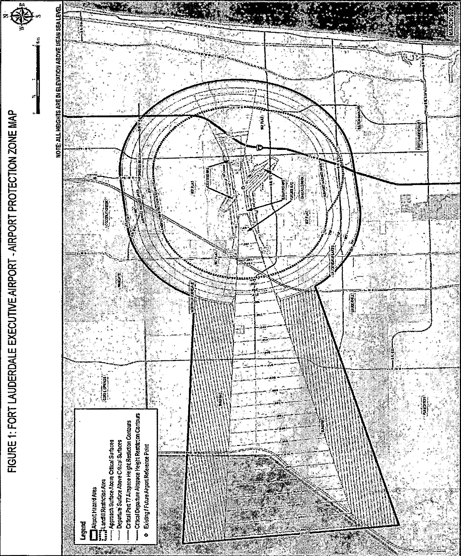
Note: Original color graphic is available at Fort Lauderdale Executive Airport administrative
office.
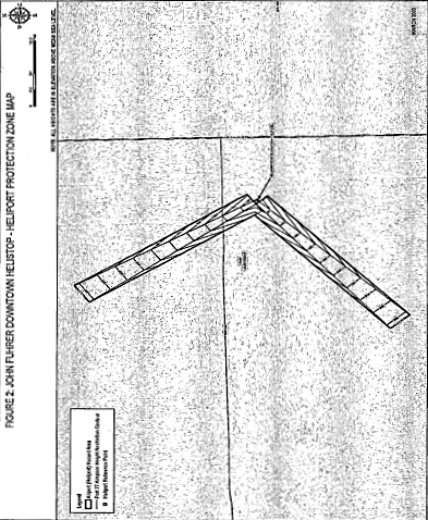
Note: Original color graphic is available at Fort Lauderdale Executive Airport administrative
office
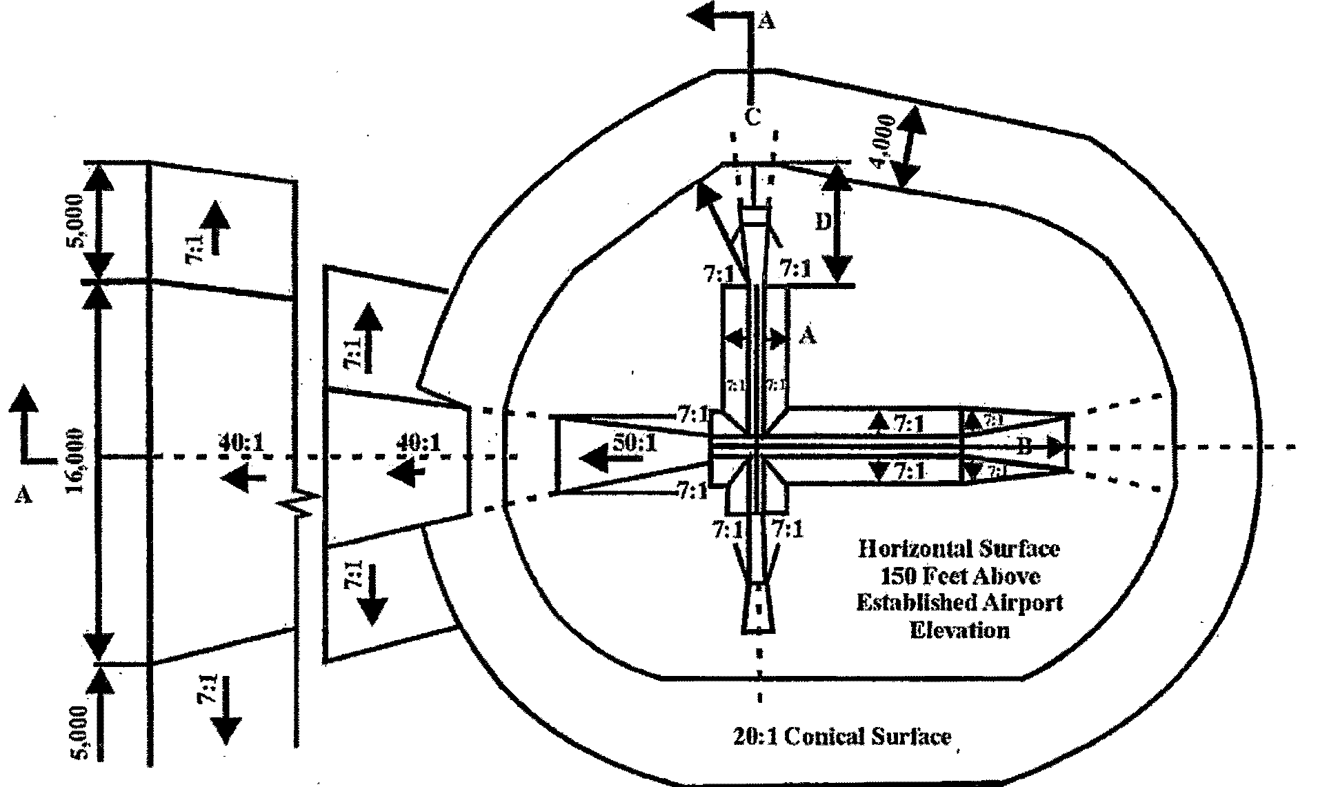
Figure 3 Title 14 CFR Part 77 Surfaces for Airports - Plan View
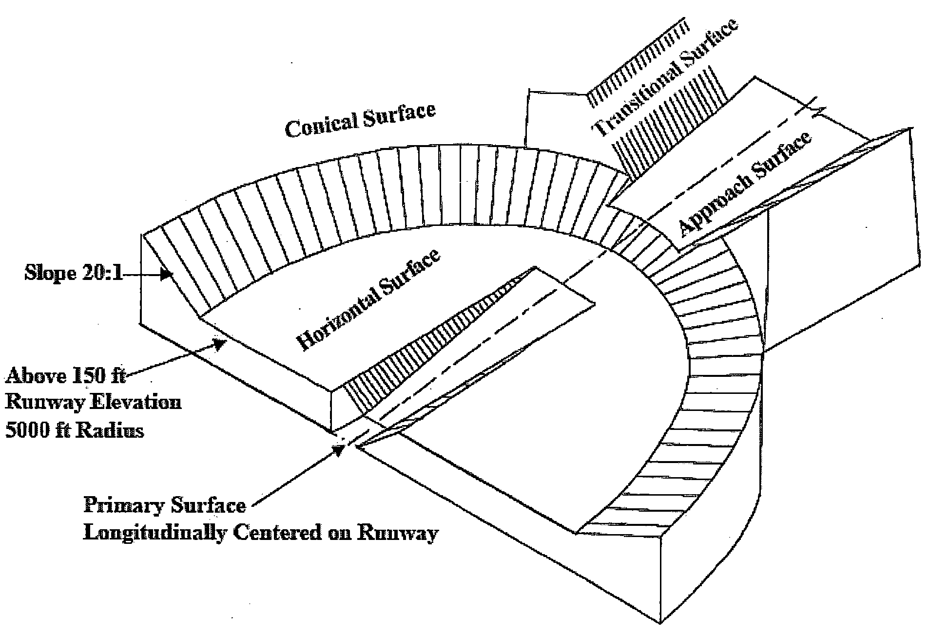
Figure 4 Title 14 CFR Part 77 Surfaces for Airports - Isometric View
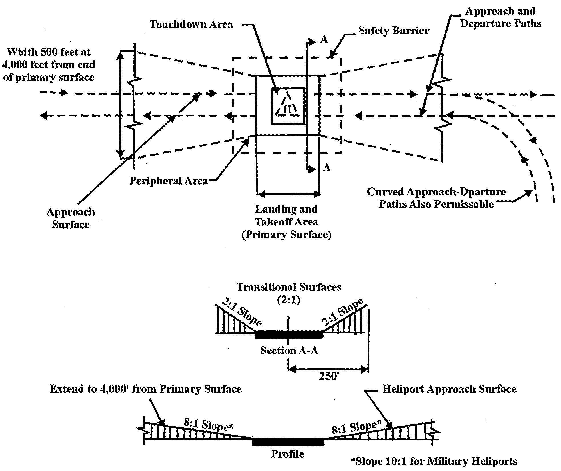
Figure 5 Title 14 CFR Part 77 Surfaces for Heliports - Plan View
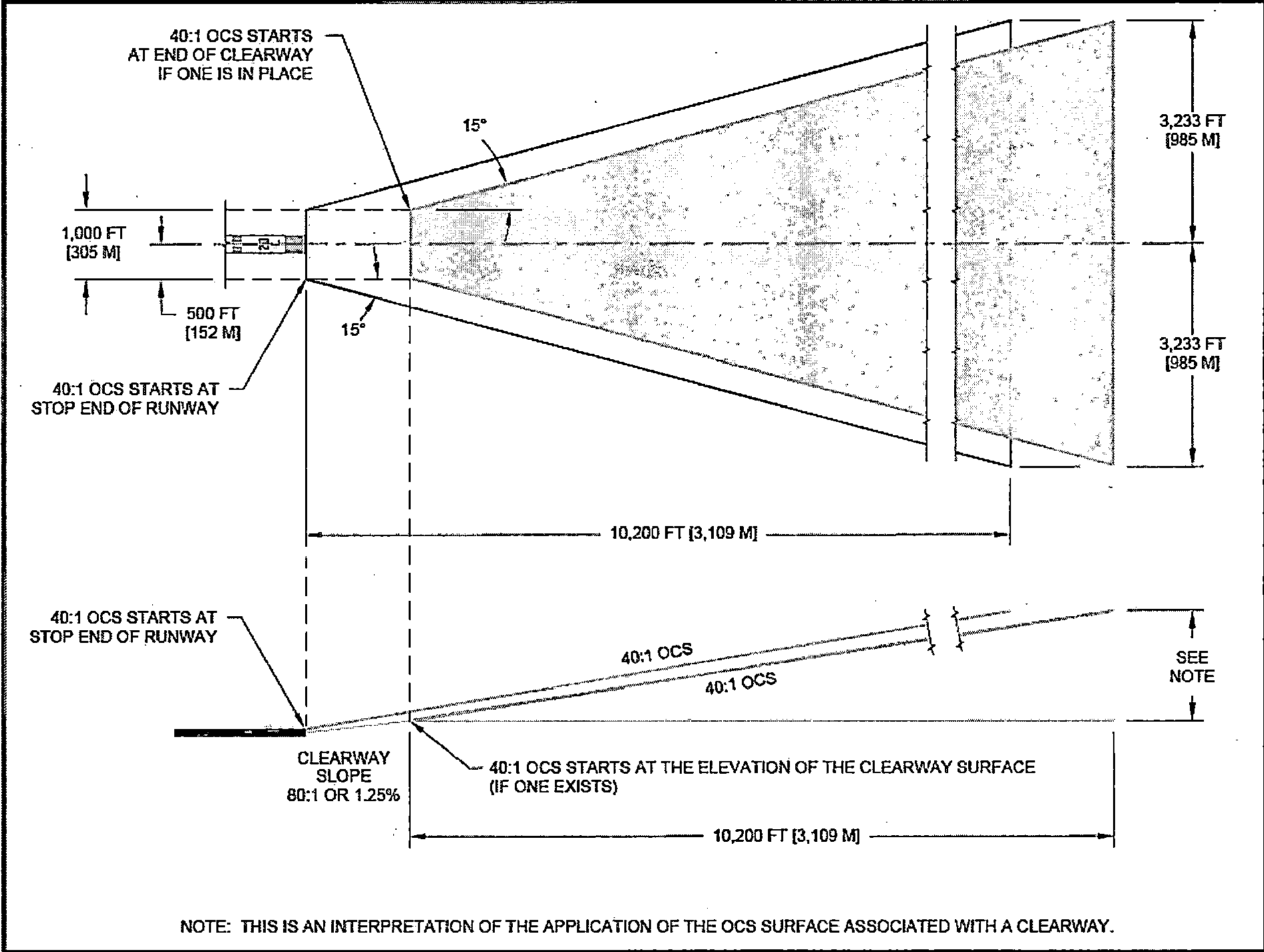
Figure 6 Depiction of TERPS Zone
D.
Other areas. In addition to the height limitations imposed in Table 1, no structure or obstruction will be permitted within the city that would cause a minimum obstruction clearance altitude, a minimum descent altitude, a decision height or a minimum vectoring altitude to be raised.
E.
Other restrictions. In addition to the height limitations imposed in Title 14 Code of Federal Regulations (CFR) Part 77, Safe, Efficient Use, and Preservation of the Navigable Airspace, the FAA may issue a determination of hazard to air navigation for obstructions. In order to determine if the proposed construction or alteration of structures is an obstruction requiring an airspace evaluation by the FAA and if FAA needs to be notified regarding the proposed development, the FAA's Notice Criteria Tool should be used. This tool can be found at the FAA's Obstruction Evaluation/Airport Airspace Analysis (OE/AAA) portal on the FAA's website. If any part of the proposed construction or alteration is identified as exceeding notice criteria, a formal airspace analysis request must be filed with the FAA via the OE/AAA site. Applicants shall comply with Title 14 CFR Part 77.9, as amended. Applicants must file notice with the FAA, if requested by the FAA or when anyone proposes any of the following types of construction or alteration:
1.
Any construction or alteration exceeding two hundred (200) feet above ground level; or
2.
Any construction or alteration that exceeds an imaginary surface extending outward and upward at any of the following slopes; or
3.
One hundred (100) to one (1) for a horizontal distance of twenty thousand (20,000) feet from the nearest point of the nearest runway of each airport described in 14 CFR 77.9(b) with its longest runway more than thirty-two hundred (3,200) feet in actual length, excluding heliports; or
4.
Fifty (50) to one (1) for a horizontal distance of ten thousand (10,000) feet from the nearest point of the nearest runway of each airport described in 14 CFR 77.9(b) with its longest runway no more than thirty-two hundred (3,200) feet in actual length, excluding heliports; or
5.
Twenty-five (25) to one (1) for a horizontal distance of five thousand (5,000) feet from the nearest point of the nearest landing and takeoff area of each heliport described in 14 CFR 77.9(b); or
6.
Any highway, railroad or other traverse way for mobile objects, of a height which, if adjusted upward as defined in 14 CFR 77.9(c) would exceed a standard of 14 CFR 77.9 (a) or (b); or
7.
Any construction or alteration located on an airport described in 14 CFR 77.9(d).
The city may not approve a permit for the construction or alteration of an obstruction unless the applicant submits documentation showing both compliance with the federal requirement for notification of proposed construction or alteration and a valid aeronautical study. A permit may not be approved solely on the basis that the Federal Aviation Administration determined that the proposed construction or alteration of an obstruction was not an airport hazard in accordance with Section 333.025(8), Florida Statutes, as amended.
F.
Any person or entity proposing to construct, alter, or allow an airport obstruction in an airport or heliport hazard area in violation of the airport or heliport protection zoning regulations adopted herein must apply for a permit. A permit may not be issued if it would allow the establishment or creation of an airport hazard or if it would permit a nonconforming obstruction to become a greater hazard to air navigation than it was when the applicable airport protection zoning regulation was adopted which allowed the establishment or creation of the obstruction, or than it is when the application for a permit is made in accordance with Section 333.07(1)(a), Florida Statutes, as amended. Refer to Table 47.24. of the ULDR.
(Ord. No. C-21-06, § 3, 3-2-21)
Sec. 47-14.24.2. - Noise contour zones standards.
A.
Aircraft noise control zones are established as follows: The city has conducted a noise study at the Fort Lauderdale Executive Airport in accordance with 14 CFR Part 150. As such any lands under the noise contours greater than or equal to 65 DNL for the Fort Lauderdale Executive Airport as shown in Figure 7 shall be considered a part of the aircraft noise control zone.
B.
The City of Fort Lauderdale prohibits certain uses within each of the aircraft noise control zones. within the aircraft noise control zones, the following land uses restrictions and noise level reductions apply as shown in Table 2.
Note: Original color graphic is available at Fort Lauderdale Executive Airport administrative
office.
Key for Table 2
Notes for Table 2
C.
Conflict. This Section shall prevail in the event of a conflict with Chapter 17 of the Code of Ordinances.
(Ord. No. C-21-06, § 3, 3-2-21)
Sec 47-14-25. - Airport obstruction permits.
Generally. Any person or entity proposing to construct, alter, or allow an airport obstruction in an airport hazard area in violation of the airport protection zoning regulations adopted herein must apply for an airport obstruction permit. An airport obstruction permit may not be issued if it would allow the establishment or creation of an airport hazard or if it would permit a nonconforming obstruction to become a greater hazard to air navigation than it was when the applicable airport protection zoning regulation was adopted which allowed the establishment or creation of the obstruction, or than it is when the application for a permit is made in accordance with Section 333.07(1)(a), Florida Statutes, as amended. Refer to Table 47.24. of the ULDR.
A.
Applicant. The owner of property on which the structure or obstruction is being proposed or authorized representative who has provided a notarized letter to the city, executed by all the owners of the property stating that all property owners have consented to the authorized representative's submission of the application, correspondence with the city, and subsequent appearance at any public hearing regarding the subject property.
B.
Application. An application for an airport obstruction permit shall be submitted to the department. The application shall include the information required in Sec. 47-24.1.F. of the ULDR and the following:
1.
Site survey should include site elevation, with an FAA accuracy code of 1A, which certifies the site coordinates and elevations with an accuracy of ± 20-feet horizontal and ± 3-feet vertical. All site coordinates must be based on North American Datum of 1983 (NAD 83) and North American Vertical Datum of 1988 (NAVD 88).
2.
Site plan and elevation that includes the highest point(s) of any and all structures including but not limited to parapet walls, mechanical/electric rooms, HVAC units, antennae, spires, etc.
3.
Federal notification compliance: A person proposing to construct, alter, or allow an airport obstruction in an airport hazard area must submit, documentation showing compliance with the federal requirement for notification of proposed construction or alteration of structures and a valid aeronautical study in order to obtain a building permit. Notification of proposed construction or alteration of structures must be filed at the FAA's Obstruction Evaluation/Airport Airspace Analysis (OE/AAA) website located on: www.faa.gov. Upon reviewing the proposed construction/alteration, the FAA will issue a letter of determination, which must be submitted to the city in order to apply for a building permit. If, however, the notice criteria tool does determine that the proposed construction or alteration does not exceed Notice Criteria, a print of such determination must be submitted to the city in order to obtain a building permit in accordance with Section 333.025(8), Florida Statutes, as amended.
4.
Frequency broadcast review by the FAA: Any equipment that introduces new radio frequencies being broadcast outside an enclosed structure and within the airport hazard area require frequency analysis by the FAA and a form 7460-1 filing is required. Provide a FAA determination letter that addresses every proposed frequency at every proposed antenna location.
C.
Review process. The review process for an airport obstruction permit shall be the same as required for a site plan level I approval.
D.
Criteria. In determining whether to issue or deny a permit, the city will consider the following, as applicable in accordance with Section 333.07(2), Florida Statutes, as amended:
1.
The safety of persons on the ground and in the air.
2.
The safe and efficient use of navigable airspace.
3.
The nature of the terrain and height of existing structures.
4.
Permissible land use within the Noise Control Zone.
5.
The effect of the construction or alteration on the state licensing standards for a public-use airport contained in Chapter 330, Florida Statutes, as amended, and rules adopted thereunder.
6.
The character of existing and planned flight operations and developments at public-use airports.
7.
Federal airways, visual flight rules, flyways and corridors, and instrument approaches as designated by the Federal Aviation Administration.
8.
The effect of the construction or alteration of the proposed structure on the minimum descent altitude or the decision height at the affected airport.
9.
The cumulative effects on navigable airspace of all existing structures and all other known proposed structures in the area.
10.
All applicable criteria provided in Sections 47-24 and 47-25.2, Adequacy Requirements of the ULDR.
11.
The applicant must demonstrate, and it must be found by the reviewing body that the following have been met:
a.
The location of the use or structure is not in conflict with the city's comprehensive plan.
b.
Off-site or on-site conditions exist which reduce any impact of permitting the use or structure.
c.
On-site improvements have been incorporated into the site plan which minimize any adverse impacts as a result of permitting the use or structure.
d.
The location of the use in proximity to a similar use does not impact the character of the zoning district in which the use is locate.
e.
There are no adverse impacts of the use which effect the health, safety and welfare of adjacent properties.
E.
Marking and lighting of obstructions. In issuing a permit under this section, the city shall require the owner of the obstruction to install, operate, and maintain thereon, at his or her own expense, marking and lighting in conformance with the specific standards established by the Federal Aviation Administration in accordance with Section 333.07(3), Florida Statutes, as amended.
F.
Amendment. If the applicant wishes to change an airport obstructions use or development that was approved by the final body, the proposed amendment to the development or use will be required to be reviewed by the department and forwarded to the body which gave final approval to the original development permit for its approval.
G.
Acquisition of air rights. If a nonconforming obstruction is determined to be an airport hazard and the owner will not remove, lower, or otherwise eliminate it; the approach protection necessary cannot, because of constitutional limitations, be provided by airport zoning regulations herein; or it appears advisable that the necessary approach protection be provided by acquisition of property rights rather than by airport zoning regulations, the city within which the property or nonconforming obstruction is located, or the political subdivision owning or operating the airport or being served by it (City of Fort Lauderdale in this case), may acquire, by purchase, grant, or condemnation in the manner provided by Chapter 73, Florida Statutes, as amended, such property, air right, avigation easement, or other estate, portion, or interest in the property or nonconforming obstruction or such interest in the air above such property, in question, as may be necessary to effectuate the purposes of this section and in so doing, if by condemnation, to have the right to take immediate possession of the property, interest in property, air right, or other right sought to be condemned, at the time, and in the manner and form, and as authorized by Chapter 74, Florida Statutes. In the case of the purchase of any property, easement, or estate or interest therein or the acquisition of the same by the power of eminent domain, the city in making such purchase or exercising such power shall, in addition to the damages for the taking, injury, or destruction of property, also pay the cost of the removal and relocation of any structure or any public utility that is required to be moved to a new location as provided in Section 333.12, Florida Statutes, as amended.
H.
Appeals. If the final approving body denies or approves with conditions unacceptable to the applicant, or if the city commission wishes to review an application for an airport obstructions use permit in accordance with the ULDR, the provisions of Section 47-26B of the ULDR, Appeals, shall apply.
I.
Penalties. The city can institute in any court of competent jurisdiction an action to prevent, restrain, correct, or abate any violation of Chapter 333, Florida Statutes, as amended or the airport zoning regulations adopted under this section or of any order or ruling made in connection with their administration or enforcement of this section or Chapter 333, Florida Statutes, as amended and the court shall adjudge to the city such relief, by way of injunction, which may be mandatory, or otherwise, as may be proper under all the facts and circumstances of the case in order to fully effectuate the purposes of this section or Chapter 333, Florida Statutes, as amended and of the regulations adopted and orders and rulings made in accordance with Chapter 333, Florida Statutes, as amended.
J.
Jurisdictions outside of the City of Fort Lauderdale.
1.
Generally. Based on interlocal agreement, any person or entity proposing to construct, alter, or allow an airport obstruction in a City of Fort Lauderdale airport hazard area located wholly or partly outside the territorial limits of the City of Fort Lauderdale in violation of the airport protection zoning regulations adopted herein must apply for a permit. A letter of no objection from Fort Lauderdale Executive Airport may not be issued if it would allow the establishment or creation of an airport hazard or if it would permit a nonconforming obstruction to become a greater hazard to air navigation than it was when the applicable airport protection zoning regulation was adopted which allowed the establishment or creation of the obstruction, or than it is when the application for a permit is made in accordance with Section 333.07(1)(a), Florida Statutes, as amended.
2.
Applicant. Means the owner of property on which the structure or obstruction is being proposed or authorized representative who has provided a notarized letter to the city, executed by all the owners of the property stating that all property owners have consented to the authorized representative's submission of the application, correspondence with the city, and subsequent appearance at any public hearing regarding the subject property.
3.
Request for airport obstruction permit review. A request for an airport obstruction permit shall be submitted to the city's department of sustainable development. The request shall include the following:
i.
A Site survey that is dated no later than six (6) months prior to the date submitted to the city. The site survey must include site elevation, with an FAA accuracy code of 1A, which certifies the site coordinates and elevations with an accuracy of ± 20-feet horizontal and ± 3-feet vertical. All site coordinates must be based on North American Datum of 1983 (NAD 83) and North American Vertical Datum of 1988 (NAVD 88).
ii.
Site plan and elevation that includes the highest point(s) of any and all structures including but not limited to parapet walls, mechanical/electric rooms, HVAC units, antennae, spires, etc.
iii.
Federal notification compliance: A person proposing to construct, alter, or allow an airport obstruction in an airport hazard area must submit, documentation showing compliance with the federal requirement for notification of proposed construction or alteration of structures and a valid aeronautical study in order to obtain a building permit. Notification of proposed construction or alteration of structures must be filed at the FAA's obstruction evaluation/airport airspace analysis (OE/AAA) website located on: www.faa.gov. Upon reviewing the proposed construction/alteration, the FAA will issue a letter of determination, which must be submitted to the city in order to apply for a building permit. If, however, the notice criteria tool does determine that the proposed construction or alteration does not exceed notice criteria, a print of such determination must be submitted to the city in order to obtain a building permit in accordance with Section 333.025(8), Florida Statutes, as amended.
iv.
Frequency broadcast review by the FAA: Any equipment that introduces new radio frequencies being broadcast outside an enclosed structure and within the airport hazard area require frequency analysis by the FAA and a form 7460-1 filing is required. The applicant must provide a FAA determination letter that addresses every proposed frequency at every proposed antenna location.
4.
Criteria. In determining whether to issue a letter of no objection, the city will consider the following, as applicable in accordance with Section 333.07(2), Florida Statutes, as amended:
i.
The safety of persons on the ground and in the air.
ii.
The safe and efficient use of navigable airspace.
iii.
The nature of the terrain and height of existing structures.
iv.
Permissible land use within the Noise Control Zone.
v.
The effect of the construction or alteration on the state licensing standards for a public-use airport contained in Chapter 330, Florida Statutes, as amended, and rules adopted thereunder.
vi.
The character of existing and planned flight operations and developments at public-use airports.
vii.
Federal airways, visual flight rules, flyways and corridors, and instrument approaches as designated by the Federal Aviation Administration.
viii.
The effect of the construction or alteration of the proposed structure on the minimum descent altitude or the decision height at the affected airport.
ix.
The cumulative effects on navigable airspace of all existing structures and all other known proposed structures in the area.
x.
The applicant must demonstrate, and it must be found by the reviewing body that the following have been met:
a.
The location of the use or structure is not in conflict with the City of Ft. Lauderdale's comprehensive plan.
b.
Off-site or on-site conditions exist which reduce any impact of permitting the use or structure.
c.
On-site improvements have been incorporated into the site plan which minimize any adverse impacts as a result of permitting the use or structure.
d.
The location of the use in proximity to a similar use does not impact the character of the zoning district in which the use is locate.
e.
There are no adverse impacts of the use which effect the health, safety and welfare of adjacent properties.
5.
Fees. Fees shall be in accordance with the city's most recently adopted Fee Schedule.
(Ord. No. C-21-06, § 3, 3-2-21)
Sec. 47-15.1.- List of districts.
PEDD - Port Everglades Development District.
(Ord. No. C-97-19, § 1(47-15.1), 6-18-97)
Sec. 47-15.2. - Intent and purpose.
PEDD - Port Everglades Development District is intended to provide for and encourage appropriate and consistent land use patterns where applied within the jurisdictional boundaries of Port Everglades, irrespective of whether the land being regulated lies within the municipal boundaries of the cities of Hollywood, Fort Lauderdale or Dania or within the unincorporated territory of the county. The uses and standards allowed within this district recognize the need to accommodate the use of the lands within Port Everglades which is a major regional facility essential to the continued economic vitality of the cities and the county. It is anticipated that the intent of the district will be accomplished by concurrent adoption of the regulations by three cities and the county.
(Ord. No. C-97-19, § 1(47-15.2), 6-18-97)
Sec. 47-15.10. - List of permitted and conditional uses, Port Everglades Development District (PEDD).
District Categories—PEDD Uses, and Accessory Uses, Buildings and Structures.
(Ord. No. C-97-19, § 1(47-15.3), 6-18-97; Ord. No. C-12-24, § 4, 7-10-12; Ord. No. C-15-36, § 1, 10-20-15)
Sec. 47-15.20. - Limitations on permitted and conditional uses.
A.
Whenever application is made for a building permit to erect any building or improvement upon any site in the PEDD district wherein the premises may be or are contemplated to be used for industries or uses involving any processes, substances or mixture of substances which is toxic, corrosive, an irritant, a strong sensitizer, or which generates pressure through decomposition, heat or other means, if such substances or mixture of substances may cause substantial personal injury or substantial illness during, or as a proximate result of, any customary or reasonably foreseeable handling or use, or which is identified as hazardous by state or federal legislation, the building inspector shall not issue such building permit until the use of such site for such purpose has been approved by resolution of the city commission, after written report by the city and Port fire departments and any other governmental agency having jurisdiction. In determining whether to approve such use, the city commission shall consider its compatibility with other uses in the vicinity and the potentially harmful or dangerous effects of such use on persons and property.
B.
The process for review of uses permitted in this section are limited to the provisions of this section.
C.
The following criteria shall be required, and the city commission must make findings in connection with the approval of a conditional use as follows:
1.
That the land upon which the use is proposed is not necessary for future industrial uses.
2.
That the proposal will not adversely affect the future use of surrounding industrially designated lands for industry.
3.
That the proposal is designed in such a manner as to preserve, perpetuate and improve the natural environmental character of the proposed site and surrounding area.
4.
That the regional transportation system will have capacity to serve the proposed development at or above service level "D."
These criteria shall replace those provided in Section 47-24.3 for a conditional use permit.
(Ord. No. C-97-19, § 1(47-15.4), 6-18-97)
Sec. 47-15.21. - Table of dimensional requirements for the PEDD District.
NOTES:
* No building or structure shall exceed a height prescribed by the Federal Aviation Administration
** Except that there shall be a15 foot wide landscaped area on side of parcel contiguous to residentially zoned property.
(Ord. No. C-97-19, § 1(47-15.5), 6-18-97)
Sec. 47-15.22. - Required off-street parking and loading.
A.
Off-street parking shall be provided as follows:
1.
Educational facility—One (1) space for every 200 square feet of gross floor area.
2.
Hotels and motels—One (1) space for every unit.
3.
Manufacturing—One (1) space for every 400 square feet of gross floor area.
4.
Shipyard—In addition to spaces required for buildings within the yard, ten spaces for each ship berth in excess of 300 feet in length or for each dry dock.
5.
Marinas—One (1) space for every boat slip, except for dry marinas where the requirements shall be one space for every 1,000 square feet of gross floor area of stowage structure.
6.
Museums, art galleries, libraries—One (1) space for every 200 square feet of gross floor area.
7.
Offices—One (1) space for every 200 square feet of gross floor area.
8.
Places of public assembly—One (1) space for every four seats or for every 60 square feet of net floor area available to the public, whichever is greater.
9.
Restaurant—One (1) space for every 50 square feet of net floor area available for seating.
10.
Retail sales—One (1) space for each 200 square feet of gross floor area.
11.
Warehouses—One (1) space for every 1,000 square feet of gross floor area.
12.
Freezer warehouses—One (1) space for each five thousand (5,000) square feet of gross floor area.
13.
Wholesale sales—One (1) space for every 1,000 square feet of gross floor area.
14.
Convention and conference facilities—Exhibit halls: one space for every two hundred fifty (250) square feet of gross floor area; meeting rooms: one space for every 100 square feet of gross floor area; ballrooms: one space for every 100 square feet of gross floor area.
15.
Uses not specifically listed—The requirements for off-street parking for any uses not specifically listed above shall be the same as provided in this section for the use most similar to the one sought.
16.
Mixed uses—In the case of mixed uses, the total requirements for off-street parking shall be the sum of the requirement of the various uses computed separately, except where specific requirements are stipulated in this article. Off-street parking spaces for one use shall not be considered as providing the required off-street parking for any other use.
17.
Handicapped parking—Parking spaces for the handicapped shall be provided as required by state and county regulations and the Florida Building Code.
B.
Required loading spaces.
1.
On the same plot with every structure or use hereafter erected or created, there shall be provided and maintained adequate space for loading and unloading of materials, goods or things and for delivery and shipping, so that vehicles for these services may use this space without encroaching on or interfering with the public use of streets and alleys by pedestrians and vehicles.
2.
Where any structure is enlarged or any use is extended so that the size of the resulting occupancy comes within the scope of this section, the full amount of off-street loading space shall be supplied and maintained for the structure or use in its enlarged or extended size. Where the use of a structure or land or a part thereof is changed to a use requiring off-street loading space under this section, the full amount of off-street loading space shall be supplied and maintained to comply with this section.
3.
For the purposes of this section, an off-street loading space shall be an area at the grade level at least ten feet wide by 25 feet long with fourteen-foot vertical clearance. Each off-street loading space shall be directly accessible from a street or alley without crossing or entering any other required off-street loading space, and arranged for convenient and safe ingress and egress by motor truck and trailer combination. Such loading space shall also be accessible from the interior of any building it is intended to serve.
4.
Off-street loading spaces shall be provided and maintained in accordance with the following schedule:
For any use not specifically mentioned this section, the requirements for off-street loading for a use which is so mentioned and to which the unmentioned use is similar shall apply.
5.
Off-street loading facilities supplied to meet the needs of one use shall not be considered as meeting off-street loading needs of any other use.
6.
No area or facilities supplied to meet the required off-street parking facilities for a use shall be utilized or be deemed to meet the requirements of this section for off-street loading facilities.
7.
Nothing in this section shall prevent the collective, joint or combined provision of off-street loading facilities for two or more buildings or uses, provided that such off-street loading facilities are equal in size and capacity to the combined requirements of the several buildings or uses and are so located and arranged as to be usable thereby.
8.
Plans for buildings or uses requiring off-street loading facilities under the provisions of this section shall clearly indicate the location, dimensions, clearance and access of all such required off-street loading facilities.
(Ord. No. C-97-19, § 1(47-15.6), 6-18-97; Ord. No. C-03-23, § 2, 7-1-03)
Sec. 47-15.23. - Sign restrictions.
All signs must comply with the standards set forth in Table 1.
TABLE 1. GENERAL COMMERCIAL AND INDUSTRIAL SIGNS
(Ord. No. C-97-19, § 1(47-15.7), 6-18-97)
Sec. 47-15.24. - Landscaping requirements.
A.
All parcels developed under these regulations shall provide well-maintained landscaped areas equal to ten percent (10) of the total parcel area except those parcels used for the following purposes:
1.
Marine cargo handling.
2.
Ship berthing.
3.
Open storage areas.
4.
Shipbuilding and repair.
5.
Rail and trucking terminals.
(Ord. No. C-97-19, § 1(47-15.8), 6-18-97)
Sec. 47-15.25. - Subdivision review requirements.
Subdivision of land within this district shall be subject exclusively to Article IX, Chapter 5 of the Broward County Code of Ordinances with local review as required in Chapter 5 thereof. Subdivision regulations of any city within which the property is located shall not apply.
(Ord. No. C-97-19, § 1(47-15.9), 6-18-97)
Sec. 47-15.26. - Site plan review exemption.
Uses allowable within this article are exempt from the provisions of any site plan review ordinances.
(Ord. No. C-97-19, § 1(47-15.10), 6-18-97)
Sec. 47-15.27. - Variance.
Any variance of the regulations contained within this section shall be processed pursuant to the variance procedures established within the applicable city zoning regulations.
(Ord. No. C-97-19, § 1(47-15.11), 6-18-97)
Sec. 47-15.28. - Building permits.
Any development within this district shall be subject to the Florida Building Code, the National Electrical Code, the National Fire Protection Association 101 Life Safety Code, the Fire Prevention Code of the American Insurance Association and the Broward County Fire Code. Permits shall be obtained and inspections made by building and fire department personnel of the city or county jurisdiction within which the property being developed is located.
(Ord. No. C-97-19, § 1(47-15.12), 6-18-97; Ord. No. C-03-23, § 2, 7-1-03)
Sec. 47-15.29. - Amendment of text or application of district.
The provisions of the Port Everglades Development District shall control land uses within the port only when approved by the cities of Hollywood, Dania and Fort Lauderdale, and Broward County. Any subsequent proposal for amendment of the district regulations, use variance or removal of port authority property from the provisions thereof must be approved jointly by the jurisdiction within which such provisions apply, with specific notification to other jurisdictions initially adopting the regulations.
(Ord. No. C-97-19, § 1(47-15.13), 6-18-97)
Sec. 47-16.1.- List of districts.
H-1 - Historic Preservation.
(Ord. No. C-97-19, § 1(47-16.1), 6-18-97)
Sec. 47-16.2. - Intent and purpose.
H-1 - Historic Preservation District is intended to promote the cultural, economic, educational and general welfare of the people of the city and of the public generally, through the preservation and protection of historically worthy structures. These regulations are intended to insure a harmonious outward appearance of structures and premises, to encourage uses which will lead to their continuance, conservation and improvement in a manner appropriate to the preservation of the cultural and historic heritage of the city, to protect against destruction of or encroachment upon such area, structure or premise, to prevent creation of environmental influences adverse to such purposes, and to assure that new structures, uses and premises within historic districts will be in keeping with the character to be preserved and enhanced.
(Ord. No. C-97-19, § 1(47-16.2), 6-18-97)
Sec. 47-16.3. - Declaration of public policy.
A.
It is the policy of the city that the preservation, protection, perpetuation of a historic district is a public necessity because it will have a special historic, architectural, archeological, aesthetic or cultural interest and value and thus will serve as a visible reminder of the history and heritage of the city, state and nation. The city commission hereby finds that this ordinance benefits the residents and property owners of the city and declares as a matter of public policy that this ordinance is required in the interest of the health, safety, general welfare and economic well-being of its residents.
(Ord. No. C-97-19, § 1(47-16.3), 6-18-97)
Sec. 47-16.4. - Applicability.
(Reserved)
Sec. 47-16.5. - Building regulations.
A.
Building regulations shall be applicable to and commensurate with the permitted uses as specified in Section 47-16.10. For the purpose of this district, each building shall be identified as belonging to only one of the three use categories: residential, business or other.
1.
Building height and length.
a.
No building in any use category shall exceed two stories or 25 feet in height.
b.
No building in any use category shall exceed 100 feet in any dimension.
2.
Building site.
a.
Residential uses. Every building erected, relocated, structurally altered or converted for residential use shall provide a minimum lot size of five thousand (5,000) square feet and 50 foot in width. The maximum number of dwelling units per net acre of plot area shall not exceed15.
b.
Business uses. No minimum requirements for a building site area.
c.
Other uses. The historic preservation board shall determine the minimum site area by considering the use and structural bulk in relation to site area and surrounding area while providing parking, landscaping and appurtenant elements for the safety and welfare of the general public. All required or non-required parking must meet the parking requirements of Section 47-20, Parking and Loading, and is subject to the criteria and guidelines provided in Section 47-24.11.D.
3.
Yards, lot coverage and open space. Existing buildings not conforming to required setbacks, height limits or ground coverage may be used for any permitted use but shall not be enlarged without the approval of the historic preservation board.
a.
Residential uses shall provide yards as specified below:
i.
Front yard: 25 feet.
ii.
Corner yard: one-fourth (¼) of the lot width but not less than ten feet for single family and duplex;20 feet all other residential uses.
iii.
Side yard: ten feet.
iv.
Rear yard:20 feet.
v.
Distance between buildings: ten feet.
vi.
Accessory buildings shall not be located in front or street side yards. Such yards may be used for refuse containers only at locations authorized by the city public services department.
b.
Residential uses shall abide by lot coverage and open space as specified below:
i.
Maximum percent of total nonpermeable area: sixty-five percent (65).
c.
Business uses shall provide yards as specified below:
i.
Front yard: five feet for any portion of the structure less than nine feet in height; zero (0) feet above nine feet in height.
ii.
Corner yard: five feet.
iii.
Side yard when abutting nonresidential uses: none.
iv.
Side yard abutting residential uses: ten feet.
v.
Rear yard when abutting nonresidential uses: none.
vi.
Rear yard abutting residential uses:15 feet.
d.
Other uses shall provide yards and landscaped open space that enhance and promote the peculiar characteristics and aesthetic qualities of the site, its use and the purpose of the historic district as approved by the historic preservation board.
e.
Modification of yards. The historic preservation board may reduce any of the specified yard or setback requirements provided that such modifications shall not increase the lot coverage or decrease the open space and would be in keeping with the visual continuity, character, setting and appearance of adjacent and surrounding properties.
4.
Minimum floor area.
a.
Residential uses shall provide minimum floor area of:
i.
Single family: seven hundred fifty (750) square feet.
ii.
Duplex: 400 square feet each dwelling unit.
iii.
Townhouse: seven hundred fifty (750) square feet each dwelling unit.
iv.
Multifamily: 400 square feet each dwelling unit.
b.
Business uses: no requirements for minimum floor area.
c.
Other uses: shall provide minimum floor area relative to its use and the health and safety of the public as approved by the historic preservation board.
(Ord. No. C-97-19, § 1(47-16.5), 6-18-97; Ord. No. C-99-14, § 2, 3-16-99; Ord. No. C-19-33, § 3, 10-2-19)
Sec. 47-16.6. - Certificate of appropriateness.
A.
No person shall undertake any of the following actions affecting property in an H-1 district without first obtaining a certificate of appropriateness from the historic preservation board in accordance with Section 47-24.11.D, Certificate of Appropriateness:
1.
Alteration of an archeological site or the exterior part of a building or a structure or designated interior portion of a building or structure,
2.
New construction,
3.
Demolition,
4.
Relocation,
5.
Ordinary repairs and maintenance that are otherwise permitted by law may be undertaken without a certificate of appropriateness, provided this work on a designated landmark, a designated landmark site, or a property in a designated historic district does not alter the exterior appearance of the building, structure or archeological site, or alter elements significant to its architectural or historic integrity.
B.
All provisions of Section 47-24.11.D, Certificate of Appropriateness, shall apply in the H-1 district.
C.
After a certificate of appropriateness is issued in accordance with Section 47-24.11.D, Development Permits and Procedures, all other applicable permits, licenses and certificates of compliance must be obtained before any use of the land occurs.
(Ord. No. C-97-19, § 1(47-16.6), 6-18-97; Ord. No. C-99-14, § 3, 3-16-99; Ord. No. C-19-33, § 4, 10-2-19)
Sec. 47-16.10. - List of permitted uses.
A.
No buildings or structures or part thereof or items such as furniture placed outdoors, push carts, mobile or non-mobile vending machines or trolley cars placed on private property shall be erected, altered, located or used, or land or water used either in a permanent or temporary manner, in whole or in part, for other than the following uses and then only when permitted by the city plan and to the degree permitted by the city plan, the requirements of this section shall not apply to vehicles used solely for the travel purposes of the vehicle operation.
1.
Residential:
a.
Single family dwelling.
b.
Two family dwelling (duplex).
c.
Multiple-family dwelling and apartments.
2.
Business retail sales:
a.
Antique shop.
b.
Apothecary.
c.
Apparel shop.
d.
Arts and handicraft shop.
e.
Bakery.
f.
Bicycle sales and/or repair shop.
g.
Candle shop.
h.
Candy shop.
i.
Ceramic, pottery shop.
j.
Cigar store.
k.
Delicatessen.
l.
Gasoline sales on restored premises originally designed for this purpose.
m.
Florist shop.
n.
Flower, fruit and vegetable sales.
o.
General store in character with historic district.
p.
Gift and souvenir shop.
q.
Ice cream parlor.
r.
Jewelry shop.
s.
Linens, fabrics, draperies shop.
t.
Meat and grocery shop.
u.
Millinery and modistes.
v.
Shoe shop.
w.
Silversmith.
x.
Woodcraft shop.
y.
Sale of reproduced or restored antique cars.
3.
Business services:
a.
Barber and beauty shop.
b.
Photographic studio.
c.
Rental of unpowered boats, see Section 47-23.8, Waterway Uses.
d.
Shoe repair, shoe shining, hat cleaning.
e.
Tailor or dressmaking shop.
f.
Watch and jewelry repairs.
g.
Fine arts, music, dancing and dramatic schools.
h.
Interior decorator shop.
4.
Professional offices:
a.
Financial institutions.
b.
Insurance and real estate.
c.
Legal, dental, medical, scientific, architectural, accountant and engineering office.
d.
Post office.
e.
Governmental offices.
f.
Telegraph office.
5.
Other uses:
a.
Civic building.
b.
Dual residential/business building.
c.
Establishments licensed for sale of alcoholic beverages for consumption on premises only.
d.
Flower and vegetable gardens, greenhouses and groves.
e.
Hotels, no greater than 100 sleeping rooms, see Section 47-18.16, Bed and Breakfast Dwellings, see Section 47-18.6.
f.
Tearoom or restaurant, except take-out or drive-in restaurants.
g.
Museum relating to the history, culture and character of the historic district.
h.
Park area and public park associated with passive recreational activities.
i.
Playhouse, less than 300 seats.
j.
Public dock and landing wharf excluding launching, storage and overnight docking, see Section 47-23.8, Waterway Uses.
k.
Public Purpose Use, see Section 47-18.26.
l.
Refreshment stand.
m.
Uses judged similar in characteristics to any of the above by the board.
6.
Accessory uses & outdoor site furnishings:
a.
Sidewalk cafés. (See Section 47-19.9.)
b.
Mobile vendors. (See Chapter 23, Article IV of Volume I of the Code.)
(Ord. No. C-97-19, § 1(47-16.7), 6-18-97; Ord. No. C-99-14, § 4, 3-16-99)
Sec. 47-16.20. - Limitations on permitted uses.
A.
The following use limitations shall apply:
1.
Retail businesses that do not enhance the flavor and character of an historic atmosphere because the large amount of floor area required for operation; examples include department stores, supermarkets, furniture stores, variety stores which shall not be permitted.
2.
Retail businesses whose merchandise or bizarre atmosphere is the result of modern technology to the extent that the products do not promote or preserve an harmonious aura of historic character shall not be permitted. Examples: prohibit sale and display of modern new and used cars as opposed to that of reproduced or restored antique cars; prohibit the operation of a "head shop" as opposed to that of a general store.
3.
Service establishments whose service was not performed or is not presently performed in a manner compatible with the culture and character of the historic period shall not be permitted. Examples include laundry and dry cleaning pickup agency, self-service laundry, dry cleaning establishments, service stations except restorations, travel agencies, tire and automotive repair shop except as necessary to sale of antique cars.
4.
Sale, storage or display of used or secondhand merchandise except in antique shop or museum and except as reasonable antiques used to promote the sales of other merchandise or service shall not be permitted.
5.
Outdoor sale or storage of goods or merchandise except in connection with permitted accessory uses shall not be permitted.
6.
Package liquor stores and drive-in or take out restaurants shall not be permitted.
7.
Motion picture theaters shall be prohibited.
(Ord. No. C-97-19, § 1(47-16.8), 6-18-97; Ord. No. C-99-14, § 5, 3-16-99)
Sec. 47-16.21. - Sign regulations.
A.
Sign definitions. The definition of signs are those listed under Section 47-22, Sign Requirements.
B.
Sign regulations.
1.
The location, type, size, material, text, visual impact, shape, character, height and orientation of all signs in addition to the number and total area of signs on a given structure or at a given location shall be approved by the board. No more than two (2) signs shall be permitted at each place of business or premises.
2.
Except for temporary signs allowed under Section 25-24, Temporary Signs, signs may be lighted but only by external, incandescent light bulbs illuminating the text of the sign from the exterior. The intent of this subsection is to prohibit light box signs and the use of tube-light lighting.
C.
No sign in whole or in part shall contain or utilize directly or indirectly neon lighting nor shall it be of the scintillating, moving, flashing, rotating or animated types. Scintillating or black lights, including animated flashing or moving signs subject to view from a public right-of-way or pedestrian mall shall not be permitted.
D.
The following signs are prohibited within the historic district: Marquee signs, banner signs, horizontal projecting signs, outdoor advertising display signs, pylon signs, sidewalk signs, sandwich signs, snipe signs, balloons which are used for advertising and are anchored either temporarily or permanently to any structure or premise, outdoor advertising display signs or billboards and all other signs prohibited by Section 47-22, Sign Requirements.
E.
Detailed requirements governing signs and advertising displays are set forth in Section 47-22, Sign Regulations; if a conflict exists, the provisions of this section shall prevail.
F.
Where uncertainty exists as to any aspect of this section pertaining to signs, the decision of the board, made in accordance with the spirit, intent and purpose of this ordinance, shall prevail.
(Ord. No. C-97-19, § 1(47-16.9), 6-18-97; Ord. No. C-99-14, § 6, 3-16-99; Ord. No. C-18-05, § 7, 3-6-18)
Sec. 47-16.22. - Site amenity requirements.
The minimum site amenities for any building or use, erected, altered, relocated, installed or maintained, shall conform to all applicable ULDR. The board shall consider the protection and separation of contiguous and nearby property and the interest of public safety and convenience; therefore, the board may specify additional requirements for the relocation of walks, malls, yards, terraces, open space, landscaping, walls, fences, hedges, parking areas, loading areas and outdoor waste disposal facilities.
(Ord. No. C-97-19, § 1(47-16.10), 6-18-97)
Sec. 47-16.23. - Parking exemption.
The H-1 district, as described in Section 47-20.3.E., is exempt from the ULDR's parking & loading requirements, however, all non-required parking spaces shall meet the requirements of Section 47-20, Parking and Loading Requirements, and is subject to the criteria and guidelines provided in Section 47-24.11.D.
(Ord. No. C-99-14, § 7, 3-16-99; Ord. No. C-19-33, § 5, 10-2-19)
Sec. 47-17.1.- List of districts.
SBHD - Sailboat Bend Historic District.
(Ord. No. C-97-19, § 1(47-17.1), 6-18-97)
Sec. 47-17.2. - Intent and purpose.
A.
SBHD - Sailboat Bend Historic District is intended to provide additional guidelines for the review of an application for a certificate of appropriateness for buildings and structures within the SBHD. A study was conducted of the building materials, surfaces, textures and design of buildings and structures which exemplify the historic character of the SBHD neighborhood. From this study guidelines were developed to serve as a baseline description against which plans requiring a certificate of appropriateness pursuant to Section 47-24, Development Permits and Procedures, can be reviewed for harmony, compatibility and appropriateness. The study which is the basis for these guidelines is entitled the Sailboat Bend Historic District Study ("Study"). The material and design guidelines developed as a result of this study are provided in Section 47-17.7.
1.
The purpose of the guidelines is to identify a range of material and design options which will encourage development compatible with the historic character of the SBHD and discourage introduction of incompatible features. The intent of the material and design guidelines is not to require particular architectural features or dictate architectural style. Contemporary designs and materials may be permitted if used in a manner compatible with the sense of the past that is being preserved. Economic feasibility and durability of proposed improvements, along with visual harmony, are primary concerns.
2.
In addition to the review of materials and design of buildings and structures within the SBHD, the study includes a review of existing yard requirements. It was found that in the RS-8 and RML-25 zones, existing yards of historically significant buildings differed from the yard requirements presently required in RS-8 and RML-25 zoned districts as provided by the ULDR. The purpose of the provisions allowing a reduction in yard requirements for buildings and structures in the SBHD, in RS-8 and RML-25 zoned districts and other residential districts when used for a use permitted in an RS-8 or RML-25 zoning district, is to promote construction which is compatible with the historic character of the district.
(Ord. No. C-97-19, § 1(47-17.2), 6-18-97; Ord. No. C-99-14, § 8, 3-16-99)
Sec. 47-17.3. - Applicability.
All provisions of Section 47-24, Development Permits and Procedures, shall be applicable to the SBHD except to the extent that such provisions are modified by this section.
(Ord. No. C-97-19, § 1(47-17.3), 6-18-97)
Sec. 47-17.4. - Application for alterations or new construction.
A.
The provisions of Section 47-24.11.D as they apply to an application for alteration or new construction of structures or buildings located in the SBHD shall be revised as follows:
1.
An application for a certificate of appropriateness for alteration or new construction shall be reviewed by the department. If such application meets the criteria provided in Section 47-24.11.D and the material and design guidelines as provided in Section 47-17.7, the department may approve the application. If the department determines that the application does not meet existing guidelines provided in Section 47-24.11.D, Certificate of Appropriateness; and the material and design guidelines, the application shall be submitted and reviewed by the historic preservation board as a new application for a certificate of appropriateness in accordance with the provisions of Section 47-24.11.D, but no additional fee will be required.
2.
No certificate of appropriateness for alteration or new construction granted by the department shall be effective for a period of fifteen (15) days subsequent to the department's decision. The department shall, within five (5) days after its grant of a certificate of appropriateness, advise the members of the historic preservation board and city commission of its decision. If during that fifteen (15) day period the historic preservation board or city commission wishes the application to be reviewed, the decision of the department shall automatically be stayed and the application shall be reviewed by the historic preservation board as a new application for a certificate of appropriateness in accordance with the procedures provided in Section 47-24.11.D, Certificate of Appropriateness, but no additional fee will be required.
(Ord. No. C-97-19, § 1(47-17.4), 6-18-97; Ord. No. C-99-14, § 9, 3-16-99; Ord. No. C-19-33, § 6, 10-2-19)
Sec. 47-17.5. - Application for yard and minimum distance separation reduction.
A.
Yards. The historic preservation board may authorize a reduction in yards and minimum distance separation requirements for residences located in RS-8, RML-25 and other residential zoning districts located within the SBHD when the historic preservation board finds a reduction in yards does not interfere with the light, air and view of adjacent properties and:
1.
Reducing the required yard is compatible with the yards or abutting properties, and yards across from the yard proposed for reduction;
2.
The yards proposed to be reduced are consistent with the yards existing in connection with contributing structures in SBHD; or
3.
A reduction in the required yard is necessary to preserve a structural or landscaping feature found by the historic preservation board to contribute to the historical character of the SBHD; or
4.
In other residential zoning districts within the SBHD, the board may authorize yard reductions subject to criteria in subsections A.1 through 3 if the proposed use and dimensions of a development are the same as those permitted in RS-8 and RML-25 zoning districts. Once a yard reduction or minimum distance separation requirement is approved, uses and structures in these zoning districts may not be altered without the issuance of a certificate of appropriateness.
B.
Reduction of yards may be permitted as follows:
1.
RS-8 zoning district. Principal residential structures: Front yard:15 feet.
2.
RML-25 zoning district. Principal residential structures: Front yard:15 feet, side yard: five feet, rear yard:15 feet.
3.
RS-8 and RML-25 zoning district. Accessory structures: Rear yard: five feet.
4.
Minimum distance between principal residential and accessory structures: five feet, unless otherwise required by the Florida Building Code.
5.
In other residential districts, when the use and dimensions meet the requirements of subsection A.4, the yards may be reduced to the dimensions provided in subsections B.1 through 4.
C.
An application for a reduction in yard requirements shall be made to the historic preservation board in the same manner, subject to the same procedures as an application for a certificate of appropriateness as provided in Section 47-24.11.D.
(Ord. No. C-97-19, § 1(47-17.5), 6-18-97; Ord. No. C-99-14, § 10, 3-16-99; Ord. No. C-03-23, § 2, 7-1-03; Ord. No. C-19-33, § 7, 10-2-19)
Sec. 47-17.6. - Alterations to nonconforming structures.
A.
Notwithstanding the provisions of Section 47-3, Nonconforming Uses, Structures and Lots, alterations to non-conforming structures which exceed fifty (50) percent of the replacement value of the structure may be permitted by the historic preservation board if it is found that:
1.
Present exterior elevations and material types are maintained; or
2.
Present exterior elevations and material types are proposed to be changed in accordance with the SBHD material and design guidelines as provided in Section 47-17.7.
B.
An application for alterations which exceed fifty (50) percent of the replacement value of the property shall be made to the historic preservation board in the same manner, and subject to the same procedures as an application for a certificate of appropriateness as provided in Section 47-24.11.D.
(Ord. No. C-97-19, § 1(47-17.6), 6-18-97; Ord. No. C-19-33, § 8, 10-2-19)
Sec. 47-17.7. - Material and design guidelines.
A.
Applicability. The SBHD material and design guidelines shall be read in conjunction with the existing guidelines provided in this section and shall be utilized as additional criteria for the consideration of an application for a certificate of appropriateness for the following:
1.
New construction. The material and design guidelines shall be used to determine if the new construction is compatible with buildings which were built prior to 1940 and which exhibit the historic character and features of the district as identified in the SBHD study.
2.
Alteration. The material and design guidelines shall be used in identifying existing features of the original structure and encourage restoration in line with these features and to encourage inclusion of historical features when compatible with the character of the original structure.
3.
Relocation. The material and design guidelines shall be used to insure that buildings moved to sites within the district are compatible with the surrounding buildings and are suitably situated on the lot.
4.
Demolition. The material and design guidelines shall be used to identify existing features of a structure which conform to the guidelines and determine the feasibility of alternatives to the demolition of a structure.
B.
Materials and designs.
1.
Exterior building walls.
a.
Materials and finish.
i.
Stucco: float finish, smooth or coarse, machine spray, dashed or trowled.
ii.
Wood: clapboard, three and one-half (3½) inches to seven inches to the weather; shingles, seven inches to the weather; board and batten, eight inches to 12 inches; shiplap siding smooth face, four inches to eight inches to the weather.
iii.
Masonry: coral, keystone or split face block; truncated or stacked bond block.
2.
Windows and doors.
a.
Materials.
i.
Glass (clear, stained, leaded, beveled and non-reflective tinted).
ii.
Translucent glass (rear and side elevations only).
iii.
Painted and stained wood.
iv.
Aluminum and vinyl clad wood.
v.
Steel and aluminum.
vi.
Glass block.
vii.
Flat skylights in sloped roofs.
viii.
Domed skylights on flat roofs behind parapets.
b.
Configurations.
i.
Doors: garage nine feet maximum width.
ii.
Windows: square; rectangular; circular; semi-circular; semi-ellipse; octagonal; diamond; triangular; limed only to gable ends.
c.
Operations.
i.
Windows: single and double hung; casement; fixed with frame; awning; sliders (rear and side only); jalousies and louvers.
d.
General.
i.
Wood shutters sized to match openings (preferably operable).
ii.
Wood and metal jalousies.
iii.
Interior security grills.
iv.
Awnings.
v.
Bahama shutters.
vi.
Screened windows and doors.
3.
Roofs and gutters.
a.
Roof—materials.
i.
Terra cotta.
ii.
Cement tiles.
iii.
Cedar shingles.
iv.
Steel standing seam.
v.
5-V crimp.
vi.
Galvanized metal or copper shingles (Victorian or diamond pattern).
vii.
Fiberglass/asphalt shingles.
viii.
Built up roof behind parapets.
b.
Gutters.
i.
Exposed half-round.
ii.
Copper.
iii.
ESP aluminum.
iv.
Galvanized steel.
v.
Wood lined with metal.
c.
Configurations.
i.
Roof: The pitch of new roofs may be matched to the pitch of the roof of existing structures on the lot. Simple gable and hip, pitch no less than 3:12 and no more than 8:12. Shed roofs attached to a higher wall, pitch no less than 3:12. Tower roofs may be any slope. Rafters in overhangs to be exposed. Flat with railings and parapets, where permitted, solar collectors and turbine fans at rear port.
4.
Outbuildings.
a.
Materials and finish.
i.
Stucco: float finish, smooth or coarse, machine spray, dashed or trowled.
ii.
Wood: clapboard, three and one-half (3½) inches to seven inches to the weather; shingles, seven inches to the weather; board and batten, eight inches to 12 inches; shiplap siding smooth face, four inches to eight inches to the weather.
iii.
Masonry: coral, keystone or split face block; truncated or stacked bond block.
5.
Garden walls and fences.
a.
Materials and style.
i.
Stucco: float finish, smooth or coarse, machine spray, dashed or trowled.
ii.
Wood: picket, lattice, vertical wood board.
iii.
Masonry: coral, keystone or split face block; truncated or stacked bond block.
iv.
Metal: wrought iron, ESP aluminum, green vinyl coated chain link.
b.
Configurations.
i.
Front: spacing between pickets maximum six inches clear.
6.
Arcades and porches.
a.
Materials and finish.
i.
Stucco (at piers and arches only): float finish, smooth or coarse, machine spray, dashed or trowled.
ii.
Wood: posts and columns.
iii.
Masonry (at piers and arches only): coral, keystone or split face block; truncated or stacked bond block.
iv.
Metal (at railings only): wrought iron, ESP aluminum.
(Ord. No. C-97-19, § 1(47-17.7), 6-18-97; Ord. No. C-99-14, § 11, 3-16-99)