
Fort Lauderdale City Zoning Code
ARTICLE III
- DEVELOPMENT REQUIREMENTS
Sec. 47-18.1.- Generally.
The following requirements shall be adhered to for the uses as specified herein and are in addition to requirements for the zoning district where the use is located and other supplemental regulations.
(Ord. No. C-97-19, § 1(47-18), 6-18-97)
Sec. 47-18.2. - Adult uses.
A.
Regulated uses.
1.
[Generally.]In the development and execution of this section it is recognized that there are some uses which, because of their very nature, are recognized as having serious objectionable characteristics, and that studies exist which demonstrate that adult uses result in adverse secondary effects on adjacent properties, particularly when several are concentrated together or are located in proximity to businesses of a community nature, residential areas and churches and school, or both thereby having a deleterious effect upon the adjacent areas. Special regulation of these uses is necessary to ensure that these adverse effects will not contribute to the blighting or downgrading of the surrounding neighborhood. These special regulations are itemized in the following subsections of this section. These regulations are for the purpose of preventing a concentration of these uses in any one (1) area and requiring a distance separation of such uses from each other, residential areas, churches, parks and schools.
2.
Purpose. It is the purpose of Ordinance No. C-04-55 to regulate sexually oriented retail establishments in order to promote the health, safety, morals, and general welfare of the citizens of the city, to establish reasonable and uniform regulations to prevent the deleterious secondary effects of sexually oriented retail establishments within the city. The provisions of this ordinance have neither the purpose nor effect of imposing a limitation or restriction on the content or reasonable access to any communicative materials, including sexually oriented materials. Similarly, it is neither the intent nor effect of this ordinance to restrict or deny access by adults to sexually oriented materials protected by the First Amendment, or to deny access by the distributors and exhibitors of sexually oriented materials to their intended market. Neither is it the intent nor effect of this ordinance to condone or legitimize the distribution of obscene material.
3.
Findings. Based on evidence of the adverse secondary effects related to sexually oriented materials presented in hearings and in reports made available to the commission, and on findings, interpretations, and narrowing constructions incorporated in numerous cases, including, but not limited to Pap's A.M. v. City of Erie, 529 U.S. 277 (2000); City of Los Angeles v. Alameda Books, Inc., 535 U.S. 425 (2002); City of Renton v. Playtime Theatres, Inc., 475 U.S. 41 (1986), Young v. American Mini Theatres, 426 U.S. 50 (1976), Barnes v. Glen Theatre, Inc., 501 U.S. 560 (1991); FW/PBS, Inc. v. City of Dallas, 493 U.S. 215 (1990); California v. LaRue, 409 U.S. 109 (1972); as well as in the cases of Artistic Entertainment, Inc. v. City of Warner Robins, 223 F.3d 1306 (11th Cir. 2000); Gary v. City of Warner Robins, 311 F.3d 1334 (11th Cir. 2002); Ward v. County of Orange, 217 F.3d 1350 (11th Cir. 2000); Boss Capital, Inc. v. City of Casselberry, 187 F.3d 1251 (11th Cir. 1999); David Vincent, Inc. v. Broward County, 200 F.3d 1325 (11th Cir. 2000); Sammy's of Mobile, Ltd. v. City of Mobile, 140 F.3d 993 (11th Cir. 1998); Lady J. Lingerie, Inc. v. City of Jacksonville, 176 F.3d 1358 (11th Cir. 1999); Lady J. Lingerie, Inc. v. City of Jacksonville, 973 F.Supp. 1428 (M.D. Fla. 1997); Grand Faloon Tavern, Inc. v. Wicker, 670 F.2d 943 (11th Cir. 1982); Board of County Commissioners v. Dexterhouse, 348 So. 2d 916 (Ct. App. Fla. 1977); International Food & Beverage Systems v. Ft. Lauderdale, 794 F.2d 1520 (11th Cir. 1986); and other cases; and reports of secondary effects occurring in and around sexually oriented businesses, including, but not limited to, Phoenix, Arizona - 1979; Minneapolis, Minnesota-1980; Houston, Texas - 1997; Indianapolis, Indiana - 1984; Amarillo, Texas - 1977; Garden Grove, California - 1991; Los Angeles, California - 1977; Whittier, California - 1978; Austin, Texas - 1986; Seattle, Washington - 1989; Oklahoma City, Oklahoma - 1986; Cleveland, Ohio - 1977 ; and Dallas, Texas - 1997; St. Croix County, Wisconsin - 1993; Bellevue, Washington, - 1998; Newport News, Virginia - 1996; St. Cloud, Minnesota - 1994; Centralia, Washington - 2003; New York Times Square study - 1994; Phoenix, Arizona -1995-98; and also on findings of physical abuse from the paper entitled "Stripclubs According to Strippers: Exposing Workplace Sexual Violence," by Kelly Holsopple, Program Director, Freedom and Justice Center for Prostitution Resources, Minneapolis, Minnesota, and from "Sexually Oriented Businesses: An Insider's View," by David Sherman, presented to the Michigan House Committee on Ethics and Constitutional Law, Jan. 12, 2000, and the Report of the Attorney General's Working Group On The Regulation Of Sexually Oriented Businesses, (June 6, 1989, State of Minnesota), the Commission finds:
a.
Sexually oriented establishments, as a category of commercial uses, are associated with a wide variety of adverse secondary effects including, but not limited to, personal and property crimes, prostitution, potential spread of disease, lewdness, public indecency, obscenity, illicit drug use and drug trafficking, negative impacts on property values, urban blight, pornographic litter, and sexual assault and exploitation.
b.
Each of the foregoing negative activities constitutes a harm which the city has a substantial government interest in preventing and/or abating.
B.
Definitions. For the purpose of this section, the following definitions shall apply:
1.
Adult bookstore. An establishment having a substantial or significant portion of its stock in trade, books, magazines and other periodicals which are distinguished or characterized by their emphasis on matters depicting, describing or relating to "specified sexual activities" or "specified anatomical areas," as defined below, or an establishment with a segment or section devoted to the sale or display of such material.
2.
Adult mini motion picture theater. An enclosed building with a capacity for accommodating less than fifty (50) persons used for presenting material distinguished or characterized by an emphasis on matter depicting, describing or relating to "specified sexual activities" or "specified anatomical areas," as defined below, for observation by patrons therein.
3.
Adult motion picture theater. An enclosed building with a capacity for accommodating fifty (50) or more persons used for presenting material having as a dominant theme or presenting material distinguished or characterized by an emphasis on matter depicting, describing or relating to "specified sexual activities" or "specified anatomical areas," as defined below, for observation by patrons therein.
4.
Adult motel. A hotel or motel presenting adult motion pictures by means of closed circuit television, the material being presented having as a dominant theme or presenting material distinguished or characterized by an emphasis on matters depicting, describing or relating to "specified sexual activities" or "specified anatomical areas," as defined below, for observation by patrons therein.
5.
Nude entertainment establishments. Any establishment which does not offer for sale or consumption alcoholic beverages but does feature male or female entertainers, performing fully clothed or partially clothed, or completely nude, displayed in a setting, section, stage or cubicle within a business, which has its principal and incidental purpose the offering for viewing to adults performances which have as their dominant or primary theme matters depicting, describing, or relating to "specified sexual activities" or to "specified anatomical areas," as described below.
6.
Encounter studios/modeling studios. An establishment offering nude, semi-nude encounter/modeling sessions, sessions between opposite or same sex adult individuals, nude dance/photo sessions, or sexual consultations, which have as their dominant or primary theme matters depicting, describing, or relating to "specified sexual activities" or to "specified anatomical areas," as described below.
7.
Adult video store. An establishment offering photographs, films, motion picture, video cassettes or video reproductions, slides, or other visual representations for sale or rent, which depict or describe "specified sexual activities" or "specified anatomical areas," as described below, and which materials consist of fifty-one (51) percent or more of their inventory at any one point in time.
8.
Adult domination/submission parlors. An adult establishment specializing in bondage, sadomasochism, humiliating activities or other similar activities which depicts, describes or relates to the "specified sexual activities" or "specified anatomical areas," as described below.
9.
Sexually oriented material. One (1) or more of the following, regardless of whether it is new or used:
a.
Books, magazines, periodicals or other printed matter, photographs, films, motion pictures, video cassettes, video representations, slides, DVD's or other forms of visual representations; recordings and other audio matter; and novelties or devices that have, as their primary or dominant theme, subject matter depicting, exhibiting, illustrating describing, or relating to specified sexual activities or specified anatomical areas; or
b.
Instruments, novelties, devices, or paraphernalia that represent a specified anatomical area which are designed for use in connection with specified sexual activities hereinafter referred to as "sexual devices."
c.
Any combination of the materials described in subsection b. and c. of this subsection 9.
10.
Sexually oriented retail establishment. An establishment having a substantial or significant portion of its sales, rental fees or stock in trade or display in sexually oriented devices and materials, or an establishment with a segment or section devoted to the sale or display of such material, or an establishment that holds itself out to the public as a purveyor of such materials based upon its signage, advertising, displays, actual sales, presence of video preview or coin operated booths, the exclusion of minors from the establishment's premises or any other factors showing that the establishment's primary purpose is to purvey such material. Substantial or significant as used herein shall be defined to include but not be limited to the number of sexually oriented materials displayed, sold or net floor area or display area used that exceed any one (1) or more of the thresholds provided in subsections a. through g. of this subsection 10. If sexually oriented material is displayed or sold, there shall be a presumption that it is a sexually oriented retail establishment unless the establishment demonstrates that:
a.
The gross income from the sale or rental of adult material comprises less than forty (40) percent of the gross income from the sale or rental of goods at the establishment; and
b.
The individual items or sexually oriented material offered for sale, rental or both comprise less than thirty (30) percent of the individual items publicly displayed in the establishment to customers as stock-in-trade, and which is not accessible to minors; and
c.
No more than one-third (⅓) of the net floor area where any inventory or stock-in trade is publicly displayed has sexually oriented material located thereon and such sexually oriented material is not accessible to minors; and
d.
No more than one-third (⅓) of a shelf area or any other display area or a combination of all display areas is used to display sexually oriented material and such sexually oriented material is not accessible to minors; and
e.
No more than twenty (20) percent of the inventory or display are sexual devices; and
f.
The non-sexually oriented materials are displayed with at least the same prominence and with at least the same ease of accessibility by the public as the sexually oriented material; and
g.
No video or pictorial representations of specified anatomical areas or specified sexual activities are displayed in areas accessible to minors in the establishment.
As used in subsection 10., "demonstrates" shall mean a sworn affidavit executed by the owner of the sexually oriented retail establishment or a person who is a principal of an entity that owns the establishment is submitted that certifies the number of items on display in the establishment and the number of these items that are sexually oriented materials. It shall also include the measurement of the display areas and net floor area where any items are publicly displayed. It shall also state the amount of gross income from the sale or rental of sexually oriented materials during the period the establishment has been operating or a six-month period immediately prior to date of execution of the affidavit, whichever is less.
Nothing in this definition shall be construed to include any pharmacy, medical clinic or any establishment primarily dedicated to providing medical or health care products or services.
11.
Specified sexual activities is defined as:
a.
Human genitals in a state of sexual stimulation or arousal;
b.
Acts of human masturbation, sexual intercourse or sodomy;
c.
Fondling or other erotic touching of human genitals, pubic region, buttock or female breast.
12.
Specified anatomical areas is defined as:
a.
Less than completely and opaquely covered:
i.
Human genitals, pubic regions;
ii.
Buttock;
iii.
Female breast below a point immediately above the top of the areola;
iv.
Human male genitals in a discernibly turgid state, even if completely and opaquely covered.
C.
Limitations. Regulated uses include but are not limited to the following:
1.
Adult bookstore;
2.
Adult motion picture theater;
3.
Adult mini motion picture theater;
4.
Adult motel;
5.
Nude entertainment establishments;
6.
Encounter studios/modeling studios;
7.
Adult video stores; and
8.
Adult domination/submission parlors.
9.
Sexually oriented retail establishment.
D.
Regulated uses shall be permitted subject to the following restrictions:
1.
No such regulated uses shall be allowed within one thousand (1,000) feet of another existing adult use;
2.
No such regulated use shall be located within five hundred (500) feet of the property line of any existing residentially zoned property, an existing church or other place of worship, any existing school or any existing public park;
3.
The distance provided for in this section shall be calculated by airline measurement from property line to property line, using the closest property lines of the parcels of land involved. The term "parcel of land" means any quantity of land capable of being described with such definiteness that its location and boundaries may be established, which is designated by its owner or developer as land to be used or developed as a unit or which has been used or developed as a unit.
4.
No adult use shall be conducted in any manner that permits the observation of any material depicting, describing or related to "specified sexual activities" or "specified anatomical areas" from any public way or from any property that does not have an adult use. This provision shall apply to any display, decoration, sign, show window or other opening.
(Ord. No. C-97-19, § 1(47-18.1), 6-18-97; Ord. No. C-04-55, § 1, 11-1-04; Ord. No. C-11-14, § 7, 6-21-11)
Sec. 47-18.3. - Automotive sales dealer, rental agency, new or used.
A.
The minimum lot size shall be one hundred (100) feet in width on the front property line and fifteen thousand (15,000) square feet in area.
B.
There shall be a completely enclosed building on the lot, which is a minimum of one thousand two hundred (1,200) square feet in gross floor area.
C.
An automotive sales dealer may have automotive leasing as an accessory use.
D.
An automotive sales dealer or automotive rental agency may have minor repair and service as an accessory use. Minor repair shall be defined as in Section 47-18.4.A.1.
E.
Outdoor uses for sale, display, storage, rental or service and repair shall be subject to the requirements for Outdoor Uses, as provided in Section 47-19.9, Accessory Uses, Buildings and Structures.
(Ord. No. C-97-19, § 1(47-18.2), 6-18-97)
Sec. 47-18.4. - Automotive repair shop.
A.
An automotive repair shop provides automotive repair service to vehicles as follows:
1.
Minor repair. Work involving tune-up, brake relining, shock absorbent and suspension, air conditioning, wheel alignment and balance, electrical system including alternator and battery, tire repair and replacement and cooling system are permitted in B-1, B-2 and I districts.
2.
Major repair work involving radiator repair, removal of engine, transmission or axle and paint and body work are permitted only in B-2, B-3 and I districts.
B.
A corner lot shall have a minimum lot size of seventy-five (75) feet in width on the front property line, and one hundred (100) feet in depth.
C.
All other lots shall have a minimum lot size of one hundred (100) feet in width on the front property line, and one hundred (100) feet in depth.
D.
When the front of a repair shop does not contain an office, the front of the building shall be set back a minimum of twenty (20) feet.
E.
All repairs shall be performed in an enclosed building, which may contain overhead doors.
(Ord. No. C-97-19, § 1(47-18.3), 6-18-97)
Sec. 47-18.5. - Automotive service station.
A.
An automotive service station shall provide fuel, oil or grease to be dispensed to vehicles.
B.
Automotive repairs may be permitted as an accessory use to an automotive service station as follows:
1.
Minor repair. Work involving tune-up, brake relining, shock absorbent and suspension, air conditioning, wheel alignment and balance, electrical system including alternator and battery, tire repair and replacement and cooling system are permitted in CB, B-1, B-2 and I districts.
2.
Major repair work involving radiator repair, removal of engine, transmission or axle and paint and body work are permitted only in B-2, B-3 and I districts.
C.
There shall be a minimum distance of three hundred (300) feet from the property boundary of an automotive service station to any house of worship, public park, hospital or school.
D.
The minimum lot size shall be seventeen thousand five hundred (17,500) square feet.
E.
The minimum lot width shall be one hundred seventy-five (175) feet at the front property line.
F.
Self-service stations must have an attendant central area with clear visibility to all pumps, and windows shall be kept clear of signs.
(Ord. No. C-97-19, § 1(47-18.4), 6-18-97)
Sec. 47-18.6. - Bed and breakfast dwelling.
A.
A bed and breakfast dwelling shall comply with the following requirements.
B.
Architectural features.
1.
For any bed and breakfast dwelling not within a historic structure, the facade shall be constructed to complement a residential structure and shall include the following:
a.
Fenestration such as windows, doors and openings in the wall; and
b.
Shall contain a minimum of one (1) feature from each of the following architectural feature groups with a total of four (4) architectural features from the following list:
i.
Group one—Detail and embellishments:
a)
Balconies,
b)
Color and/or material banding,
c)
Decorative metal grates over windows,
d)
Decorative cornice treatments,
e)
Verandas or porches.
ii.
Group two—Form and mass:
a)
Building mass changes including projection and recession,
b)
Multiple types, height and/or angles of roof line.
c.
Sleeping rooms in any new bed and breakfast dwelling shall have a minimum floor area of one hundred twenty (120) square feet.
2.
Any bed and breakfast dwelling within a structure designated as historic, as provided for in Section 47-35, Definitions, shall not be subject to the above architectural feature requirements.
C.
A bed and breakfast dwelling shall also meet the following requirements:
1.
The owner or operator shall reside on the same premises as the bed and breakfast dwelling.
2.
There shall be a maximum of nine (9) and a minimum of three (3) sleeping rooms in a bed and breakfast dwelling exclusive of one (1) owner or operator sleeping room.
3.
Signs for a bed and breakfast dwelling shall be attached to the side of the building having street frontage on a collector or arterial roadway. Only one (1) such sign shall be permitted and the area of such sign shall not exceed ten (10) square feet. Such sign shall not be internally illuminated. No other signage shall be permitted.
4.
Breakfast shall be the only meal served, and only to guests lodging for at least one (1) night.
5.
No guest shall be provided lodging for more than fourteen (14) days during any sixty (60) day period.
6.
The owner or operator, or both, shall keep a current guest register including names, addresses and dates of accommodation of all guests, which shall be made available for inspection to zoning officials during regular business hours.
D.
Locational limitations. When located within a residential zoning district, bed and breakfast dwellings shall only be permitted on parcels abutting the following rights-of-way, and shall have a minimum lot frontage of fifty (50) feet with access from the following rights-of-way. Bed and breakfast dwellings may also be located on any parcel with an Historic designation or located within an Historic district.
1.
N.W. 19th Street.
2.
Davie Boulevard (S.W. 12th St.) west of Federal Highway.
3.
Miami Road.
4.
Broward Boulevard.
5.
Sistrunk Boulevard.
6.
East Las Olas, where the parcel is not separated by a canal.
7.
N.W. and N.E. 13th Street between N.W. 9th Ave. and Federal Highway.
E.
In addition to meeting the above requirements, all bed and breakfast dwellings shall provide an operational plan, which includes but is not limited to the following:
1.
The name(s) of the owner(s) and of the person(s) operating the facility;
2.
The number and function of additional service personnel not residing on the premises;
3.
The number of guest rooms and maximum number of guests that can be accommodated daily by the facility;
4.
A traffic study which includes information such as transportation services which may be provided for guests and amount of traffic generated by vehicles delivering food, beverages, laundry or other items;
5.
A description of outdoor uses, including but not limited to dining, recreation, and entertainment;
6.
Plans for collection and disposal of refuse generated by service of food and beverages for consumption on the premises; and
7.
Any additional information which relates to impact of the bed and breakfast dwellings on surrounding development or other information which may be deemed necessary by the department.
(Ord. No. C-97-19, § 1(47-18.5), 6-18-97; Ord. No. C-18-05, § 8, 3-6-18)
Sec. 47-18.7. - Car wash, automatic.
There shall be a minimum lot size of ten thousand (10,000) square feet.
(Ord. No. C-97-19, § 1(47-18.6), 6-18-97)
Sec. 47-18.8. - Child day care facilities.
A.
It is intended that this section provide standards for the protection of the health, safety, and welfare of the citizens of the city as it relates to the location and operation of child day care facilities. The specific use of a child day care facility is to provide less than twenty-four (24) hours custodial care to minor children away from the child's permanent residence.
B.
Applicability. The provisions of this section shall apply to all child day care facilities. A child day care facility is a structure wherein child day care is provided for a child or children unrelated by blood, marriage or adoption to the owner or operator of the facility which receives payment, fee or grant to compensate for any children receiving care, whenever operated, and whether or not operated for profit. A child day care facility shall include child care facilities and family day care homes as such terms are defined in F.S. § 402.302.
C.
Child day care facilities shall not include the following:
1.
Public schools and nonpublic schools and their integral programs including any educational facility, whether private or public, which operates solely for educational purposes;
2.
Facilities operated in connection with a retail or service establishment, including on-premises drop-in babysitting services where children are not cared for on a regular basis, and are not children of employees of the retail establishment, and where the parents or custodians of the children are present on the retail or service establishment's premises or are in the immediate vicinity and immediately available;
3.
Summer camps having children in full-time residence;
4.
Programs offered by recreational centers, senior citizen centers and like facilities whose primary purposes are recreation, social interaction or medical rather than custodial care; and
5.
Bible schools normally conducted during vacation periods.
D.
Definitions. The following words, when used in this section shall, for the purposes of this section, have the following meanings:
1.
Child. A person less than eighteen (18) years of age.
2.
Child care. The care, protection and supervision of a child for less than twenty-four (24) hours a day on a regular basis and for which a payment, fee or grant is made for such child care.
3.
Child care facility. Any structure wherein child care is provided for more than five (5) children unrelated by blood, marriage or adoption to the operator, and which receives a fee, payment or grant to compensate for any of the children receiving care, wherever operated, and whether or not operated for profit.
4.
Family day care home. An occupied residence in which child care is regularly provided for no more than five (5) preschool children from more than one (1) unrelated family and which receives a fee, payment, or grant to compensate for any children receiving care, whether or not operated for profit. The maximum number of five (5) preschool children includes preschool children living in the home and preschool children received for child care who are not related to the resident care giver. Elementary school siblings of the preschool children received for child care may also be cared for outside of school hours provided the total number of children, including the caregiver's own and those related to the caregiver, does not exceed ten (10).
5.
Licensed capacity. The number of children for which a facility has been licensed by the State of Florida or such agency which the state has designated as the authority to issue such licenses to provide child care.
6.
Operator. Any person ultimately responsible for the overall operation and administration of a child day care facility, whether or not the person is the owner.
7.
Owner. The person or persons who have legal ownership of the facility.
8.
State. The State of Florida Health and Rehabilitative Services Department or such other agency authorized to regulate the provision of child care.
E.
Category of uses. For the purpose of this section, child day care facilities shall be limited to only one (1) of the following five (5) categories provided as follows based on the licensed capacity and location of the facility.
1.
Family day care home as defined herein.
2.
Small child care facility. A child care facility in a structure that has licensed capacity of six (6) through a maximum of twenty-five (25) children.
3.
Intermediate child care facility. A child care facility in a structure that has a maximum licensed capacity of fifty (50) children.
4.
Large child care facility. A child care facility in a structure that has a licensed capacity of fifty-one (51) or more children.
5.
On-site corporate/employer sponsored child day care facility. A child day care facility that is an accessory use to a proposed or existing retail, office or other commercial or industrial use that provides child care serving primarily the children of the employees, officers or agents of the corporate or employer sponsor or the children of those occupying the specific use.
6.
A child care facility that does not belong to one (1) of the five (5) categories provided in this section shall not be a permitted or conditional use.
F.
Permitted and conditional uses.
1.
Child day care facilities may be permitted or conditionally permitted as shown on the matrix below:
Legend:
P: Permitted Use.
C: Conditional Use, see Section 47-24.3, Conditional Use Permits.
N: Not Permitted.
G.
Except for family home day care facilities, child day care facilities shall be considered and subject to the limitations applicable to nonresidential uses.
H.
Indoor space requirements.
1.
Except as provided in subsection H.2, there shall be a minimum of twenty-five (25) square feet of usable floor space per child. Total usable floor space for a facility shall be calculated by multiplying the minimum square footage requirement by the licensed capacity of the facility. Indoor space shall include, but not be limited to, the indoor areas available for play, classroom, work and nap space.
2.
The minimum indoor space requirement may be reduced to a minimum of twenty (20) square feet of usable floor space per child for an on-site corporate/employer sponsored child day care facility if a determination is made as part of a site plan level III permit by the planning and zoning board that at the time the facility is proposed, the additional space is not readily available to be used in connection with the provision of child care and the reduction of the minimum requirement will not adversely impact existing uses in the area surrounding the proposed facility.
I.
Outdoor space requirements.
1.
Except as expressly provided in subsections I.2 and 3, there shall be fifty (50) square feet of usable ground level outdoor space per child with a minimum of one thousand five hundred (1,500) square feet of which three hundred (300) square feet shall be landscaping. Usable outdoor space shall not include parking areas and vehicular use or sidewalks, and shall be calculated by multiplying the minimum outdoor square footage requirement by one-half the licensed capacity of the facility.
2.
The minimum outdoor space requirement may be reduced to a minimum of forty-five (45) square feet of outdoor space per child for an on-site corporate/employer sponsored child day care facility if a determination is made as part of a site plan level III by the planning and zoning board that the additional space is not readily available to be used in connection with the provision of child care and reduction of the minimum requirement will not adversely impact existing uses in the area surrounding the proposed facility.
3.
Outdoor space area may be provided on other than the ground level for an on-site corporate/employer sponsored child day care facility if the additional space is not readily available to be used in connection with the provision of child care; the outdoor area to be provided is open to light and air; the outdoor area to be provided has a fence or other barriers adequate to ensure safety in its use for child care and allowing the outdoor space area to be above ground level will not adversely impact existing uses in the area surrounding the proposed facility.
J.
Dispersal requirements.
1.
In residentially zoned districts where child day care facilities are a permitted or conditional use, no child day care facility shall be located nor shall a child day care facility be enlarged, increased in licensed capacity as previously authorized by the state or expanded in any respect, nor converted from one (1) category of use to another, if located within one thousand five hundred (1,500) feet of any other child day care facility or any existing social service residential facility (SSRF), as described in Section 47-18.32, excluding level I SSRF located in a residential district.
2.
The dispersal requirements shall not apply to family day care homes, on-site corporate/employer sponsored child day care facilities or to child day care facilities located in nonresidential districts. However, a child day care facility proposed to be located in a nonresidential district shall be one thousand five hundred (1,500) feet from any existing child day care facility or any existing social service residential facility (SSRF), as defined in Section 47-18.32, excluding level I SSRF located in a residential district.
K.
Hours of operation.
1.
In residentially zoned districts where child day care facilities are a permitted or conditional use, hours of operation for child care shall be limited to 6:00 a.m. to 8:00 p.m.
2.
Limitation of the hours of operation shall not apply when adults and their children or children under their custodial care are present at the same time on the facility premises and child care is provided as an incident of a program offered by the facility.
3.
The hours of operation may be extended by site plan level III permit as provided in Section 47-24.2.
L.
Buffer requirements. In addition to all other applicable landscaping requirements provided in the ULDR, the following requirements shall apply to parcels of land on which child day care facilities exist:
1.
Where the ground level outdoor play area of a child day care facility is within fifty (50) feet of any other property, the following physical barriers will be required:
a.
A wall in accordance with the requirements of Section 47-19.5, Fences, Walls and Hedges, located along the property line between the outdoor space and adjacent residential property; and
b.
A landscaped fence, between the outdoor space and adjacent nonresidential property.
2.
Where the ground level outdoor play area of a child day care facility is within fifty (50) feet of any street, a landscaped fence or wall shall be required, in accordance with the requirements of Section 47-19.5, Fences, Walls and Hedges, to be located along the property line between the outdoor space and the adjacent street.
3.
A landscape fence or wall as required in this section shall be constructed in accordance with the following requirements:
a.
A landscape fence shall be constructed of wood or chainlink fence six (6) feet in height with a landscape strip at least two (2) feet wide between the fence and the adjoining property and include densely planted shrubs or trees at least four (4) feet high at the time of planting and attaining maturity at a minimum height of six (6) feet.
b.
A wall six (6) feet in height, opaque with no open areas viewed from any angle, shall be installed in accordance with the standards provided in Section 47-19.5.
M.
Parking and loading requirements. See Section 47-20.
N.
Application requirements. In addition to the requirements for applications for development permits as contained within Section 47-24, Development Permits and Procedures, an application for a development permit for a child day care facility shall also include the following:
1.
A traffic and parking plan showing the location and number of parking spaces; location of loading and unloading area; traffic circulation on and off of the parcel and relationship of potential traffic to and from the child day care facility with existing traffic on adjacent streets and roadways.
2.
Documentation evidencing compliance with all requirements of the state and any agency authorized to regulate child day care facilities.
(Ord. No. C-97-19, § 1(47-18.7), 6-18-97; Ord. No. C-99-18, § 3, 3-16-99)
Sec. 47-18.9. - Single family dwelling, attached: Cluster.
A.
For the purposes of this section, a cluster development shall include one (1) or more cluster buildings located on the same development site and land there under owned in fee simple. The site plan application process shall be the same as required for a site plan level III approval, as provided in Section 47-24.2. Permits and Procedures.
B.
A cluster building shall include a single residential structure containing two (2), three (3), or four (4) dwelling units.
C.
Site design criteria. A single family dwelling: cluster, herein referred to as cluster development, shall meet the following design criteria:
1.
Lot requirements. The minimum lot size for a cluster development shall be as required by the zoning district where it is located. The parcel upon which the group is located shall contain a minimum area as required by the regulations applicable to the zoning district where the property is located, including driveways and areas held in commmon ownership.
2.
Density. The density is determined by the regulations governing the zoning district where the cluster development is located.
3.
Access to cluster developments shall meet the following requirements:
a.
Dwelling units within cluster buildings shall have access from a shared driveway or from individual driveways fronting an alley.
b.
Parking facilities and garages for cluster buildings with a facade facing a right-of-way, other than an alley, shall be provided in the side or rear of the cluster building.
c.
Each dwelling unit shall have vehicular access to an alley, paved driveway or parking area serving the group. Private driveways shall be provided in accordance with Section 47-20.5.D. Provisions satisfactory to the city attorney shall be made for a recordable easement over the driveway for all public utilities and for use by owners within the group.
d.
Those cluster developments located on a corner lot may have one (1) garage with an opening facing toward the right-of-way abutting each corner side yard. The garage facing the right-of-way shall be subject to the following requirements:
i.
The garage shall be limited to a width equivalent to a maximum of fifty (50) percent of the width of the dwelling unit. The width shall be measured as the linear dimension of the garage that is visible from the street, such as the garage door; and,
ii.
The garage shall be set back an additional two (2) feet from the principal facade of the building or eighteen (18) feet from the property line, whichever is greater.
4.
Yard requirements. Yard requirements shall be measured from the property lines of the development site, as established in Section 47-2.2, unless otherwise noted.
a.
Front yard. The front yard of a cluster building abutting a public right-of-way shall be a minimum of fifteen (15) feet. A five-foot (5) unobstructed easement along the front property line of the cluster building is required when a fee simple lot within the cluster development does not directly abut the public right-of way. Provisions satisfactory to the city attorney shall be made for a recordable easement along the front property line of the cluster building for use by the owners of the units.
b.
Corner yards. A cluster building abutting two (2) or more public rights-of-way shall provide a minimum corner yard of fifteen (15) feet. A five (5) foot unobstructed easement shall be required along the corner property line of the cluster development when a fee simple lot within the cluster development does not directly abut the public right-of-way. Provisions satisfactory to the city attorney shall be made for a recordable easement along the corner property line of the cluster building for use by the owners of the units.
c.
Side yards. The minimum side yard shall be the same as required by the zoning district where the cluster building is located. A five (5) foot unobstructed easement shall be granted along the side property line of the cluster development.
d.
Rear yard. The minimum rear yard shall be as required by the zoning district where the cluster building is located. A five (5) foot unobstructed easement is required to be granted along the rear property line of the cluster development. Provisions satisfactory to the city attorney shall be made for a five (5) foot recordable easement along the rear property line of the cluster building for use by the owners of the dwelling units in that building.
e.
Interior separations. Buildings within the development shall be separated by a minimum of ten (10) feet from each other.
f.
Additional setbacks.
i.
A minimum of twenty-five (25) percent of the front facade shall be set back a minimum of an additional five (5) feet from the rest of the front facade.
ii.
A minimum of twenty-five (25) percent of the rear facade shall be set back a minimum of an additional five (5) feet from the rest of the rear facade.
iii.
A minimum of twenty-five (25) percent of any portion of the facade area abutting a waterway shall be set back a minimum of an additional five (5) feet from the rest of the facade facing the waterway.
iv.
A minimum of twenty-five (25) percent of an interior facade must be recessed at least two (2) feet.
v.
When any portion of a cluster building abutting the side yard for the development site exceeds twenty-two (22) feet in height, that portion of the structure shall be set back an additional one (1) foot for each foot of height above twenty-two (22) feet.
5.
Architectural elements.
a.
A cluster building shall be designed to provide a minimum of twenty-five (25) percent of the area of the front facade in the form of transparent glass.
b.
When abutting a waterway, the facade of the cluster building facing the waterway shall provide additional architectural elements such as, but not limited to, unenclosed balconies, variation of rooflines between each unit.
6.
Entrance requirements. Each dwelling unit facing a public right-of-way, other than an alley, must have its own principal entrance visible from and facing the right-of-way and shall include the following:
a.
A roofed concrete landing and;
b.
An architectural design and material similar to and integral with the principal structure and;
c.
A minimum of four (4) linear feet shall be provided between principal entrances and;
d.
The roofed landing may encroach into the front yard an additional three (3) feet and;
e.
For individual dwelling units facing more than one (1) right-of-way, only one (1) entrance will be required.
7.
Minimum floor area. Each individual dwelling unit shall have a minimum floor area of seven hundred fifty (750) square feet.
8.
Height. The maximum height shall not exceed thirty-five (35) feet. See Section 47-2, Measurements.
9.
Fence and wall requirements.
a.
Seventy-five (75) percent of all fences or walls within the front yard setback must be of non-opaque materials such as, but not limited to, vertical bars or picket fence.
b.
A wall or fence shall be installed between the development site and any neighboring residential property abutting the development site subject to the requirements of Section 47-19.5 unless this requirement is waived by approval of the planning and zoning board as part of the site plan review process.
10.
Maintenance agreement. A cluster development shall have a recorded maintenance agreement for all common areas and any required guest parking spaces.
11.
Sidewalk requirements. A cluster development shall provide the following:
a.
A minimum five (5) foot wide sidewalk along each public street abutting the property along the full length of the front property line.
b.
A minimum three (3) foot wide sidewalk shall connect the front entrances with the sidewalk along the right-of-way unless an alternative pedestrian access to the public sidewalk is approved by the department.
12.
Street tree requirements. Street trees shall be planted and maintained along the public right-of-way abutting the property to provide a canopy effect. The type of street trees may include shade, flowering and palm trees and shall be planted at a minimum height and size in accordance with the requirements of Section 47-21, Landscape and Tree Preservation Requirements. The location and number of trees shall be determined by the department based on building and site design, separation distance, utility infrastructure and the proposed plan's compatibility to surrounding properties.
13.
Landscape requirements. As required by the zoning district where located, pursuant to Section 47-21-13, Landscape requirements for all zoned districts.
14.
Solid waste, yard waste, and recycling requirements. Each cluster unit shall have incorporated into the design a designated area to locate containers that meet the requirements of Chapter 24 of the city's Code of Ordinances. The designated container area cannot infringe upon a designated parking space. The size of the containers and alternatives to these requirements may be permitted subject to approval of the public works department, sanitation division.
(Ord. No. C-97-19, § 1(47-18.8), 6-18-97; Ord. No. C-17-02, § 1, 3-7-17; Ord. No. C-17-47, § 21, 1-3-18; Ord. No. C-23-40, § 9, 10-17-23)
Sec. 47-18.10. - Multifamily dwelling: Coach home.
A.
Coach homes are condominiums built in groups of four (4), six (6) or eight (8) dwelling units, in buildings no longer than two hundred (200) feet in length, with one (1) unit located above the other. Each unit shall have a private garage with ground-floor access to that unit by means of either a door and/or stairwell.
B.
The front door of each unit shall be at finished grade level.
C.
Coach homes shall meet the minimum requirements for multifamily dwelling units for the zoning district where the coach home is located.
(Ord. No. C-97-19, § 1(47-18.9), 6-18-97; Ord. No. C-17-47, § 22, 1-3-18)
Sec. 47-18.11. - Communication towers, structures and stations.
A.
Findings.
1.
The Communications Act of 1934 as amended by the Telecommunications Act of 1996 ("the Act") grants the Federal Communications Commission (FCC) exclusive jurisdiction over all the following:
a.
Evaluating the environmental effects of radio frequency emissions from personal wireless services telecommunications facilities and the city may not regulate the placement, construction and modification of such facilities on that basis.
b.
The regulation of radio signal interference among users of the radio frequency spectrum.
2.
The city's regulation of towers and telecommunications facilities will not prohibit the provision of wireless telecommunications services.
B.
Purposes.
1.
The general purpose of this section is to regulate the placement, construction and modification of towers and telecommunications facilities in order to protect the health, safety and welfare of the public, while at the same time not unreasonably interfering with the development of the competitive wireless telecommunications marketplace in the city.
2.
Specifically, the purposes of this section are:
a.
To regulate the location of towers and telecommunications facilities in the city;
b.
To protect residential areas and other land uses from potential adverse impact of towers and telecommunications facilities;
c.
To minimize adverse visual impact of towers and telecommunications facilities through careful design, siting, landscaping, and innovative camouflaging techniques;
d.
To promote and encourage shared use (collocation) of towers and antenna support structures as a primary option rather than construction of additional single-use towers;
e.
To promote and encourage utilization of technological designs that will either eliminate or reduce the need for the erection of new towers to support antenna and telecommunications facilities;
f.
To avoid potential damage to property caused by towers and telecommunications facilities by ensuring such structures are soundly and carefully designed, constructed, modified and maintained;
g.
To ensure that towers and telecommunications facilities are compatible with surrounding land uses.
C.
Definitions.
1.
The following words, terms and phrases, when used in this section, shall have the meanings ascribed to them in this section, except where the context clearly indicates a different meaning:
a.
Antenna support structure means any building or other structure other than a tower which can be used for the location of telecommunications facilities.
b.
Applicant means any person that applies for a tower development permit.
c.
Application means all written documentation, verbal statements and representations, in whatever form or forum, made by an applicant to the city concerning a request by the owner of property within the city (or his agent) to develop, construct, build, modify or erect a tower and telecommunications facilities upon such property.
d.
Engineer means any engineer licensed by the State of Florida. Radio frequency engineers do not have to be licensed by the state, however for purposes of this section, their qualifications must include specific experience in the field and employment or retention by the telecommunications provider in a professional technical capacity.
e.
Guyed tower means a tower that is supported, in whole or in part, by guy wires and ground anchors.
f.
Monopole tower means a tower consisting of a single pole or spire self supported by a permanent foundation, and constructed without guy wires and ground anchors.
g.
Owner means any person with fee title or a long term (exceeding ten (10) years) leasehold to any property within the city who desires to develop, construct, build, modify or erect a tower upon such property.
h.
Self-support lattice tower means a tower that is constructed without guy wires and ground anchors.
i.
Stealth means any tower or telecommunications facility which is designed to enhance compatibility with adjacent uses, including, but not limited to architecturally screened roof-mounted antennas, antennas integrated into architectural elements, and towers designed to look other than like a tower such as light poles, power poles and trees. The term "stealth" does not necessarily exclude the use of uncamouflaged self-support lattice, guyed or monopole tower designs.
j.
Telecommunications facilities means any cables, wires, lines, wave guides, antennas and any other equipment or facilities associated with the transmission or reception of telecommunications which a person seeks to locate or has installed upon or near a tower or antenna support structure. However, the term telecommunications facilities shall not include:
i.
Any satellite earth station antenna two (2) meters in diameter or less which is located in an area zoned industrial or commercial; or
ii.
Any satellite earth station antenna one (1) meter or less in diameter, regardless of zoning category.
k.
Tower means a self-support lattice, guyed or monopole structure constructed from grade which supports telecommunications facilities. The term tower shall not include amateur radio operators' equipment, as licensed by the FCC.
2.
In addition, the definitions provided in Section 47-2, Measurements, and Section 47-35, Definitions, shall apply to this section, except where the context clearly indicates a different meaning or if in conflict with the definitions provided in this section.
D.
Development of towers.
1.
Towers are exempt from the maximum height restrictions of the districts where located. Towers shall be permitted to a height of one hundred fifty (150) feet. Towers may be permitted in excess of one hundred fifty (150) feet in accordance with subsection R, Criteria for Site Plan Development Modifications.
2.
No tower shall be built, constructed or erected in the city unless the tower is capable of supporting another operating telecommunications facility comparable in weight, size and surface area to the telecommunications facilities installed by the applicant on the tower within six (6) months of the completion of the tower construction.
3.
In addition to any applicable requirements set forth in Section 47-24, Development Permits and Procedures, an application to develop a tower shall include:
a.
The names, addresses and telephone numbers of all owners and the location of other towers or usable antenna support structures within a one-half (½) mile radius of the proposed new tower site, including city-owned property.
b.
An affidavit demonstrating that the applicant made diligent efforts for permission to install or collocate the applicant's telecommunications facilities on city-owned towers or usable antenna support structures located within a one-half (½) mile radius of the proposed tower site.
c.
An affidavit demonstrating that the applicant made diligent efforts to install or collocate the applicant's telecommunications facilities on towers or usable antenna support structures owned by other persons located within a one-half (½) mile radius of the proposed tower site.
d.
A description of the technological design plan proposed by the applicant in the city. Applicant must demonstrate why design alternatives to a tower, such as microcell design, cannot be utilized to accomplish the provision of applicant's proposed telecommunications services.
e.
Written, technical evidence from a qualified radio frequency engineer that the proposed tower or telecommunications facilities cannot be installed or collocated on another person's tower or usable antenna support structure located within a one-half (½) mile radius of the proposed tower site because of the coverage requirements of the applicant's wireless communications system.
f.
A written statement from a qualified radio frequency engineer that the construction and placement of the tower will not interfere with public safety communications and the usual and customary transmission or reception of radio, television, or other communications service enjoyed by adjacent residential and non-residential properties.
g.
Written, technical evidence from an engineer(s) that the proposed structure meets the standards set forth in subsection F, Structural Requirements.
h.
Written, technical evidence from a qualified engineer(s) acceptable to the fire marshall and the building official that the proposed site of the tower or telecommunications facilities does not pose a risk of explosion, fire or other danger to life or property due to its proximity to volatile, flammable, explosive, or hazardous materials such as LP gas, propane, gasoline, natural gas, corrosive or other dangerous chemicals.
i.
Full color photo-simulations showing the proposed site of the tower with photo-realistic representations of the proposed tower as it would appear viewed from nearby residential properties and from adjacent roadways.
j.
The power density of applicant's telecommunications facilities and how such facilities meet the FCC's regulations on the environmental effects of radio frequency emissions. Such information may be made available to the general public upon request and as part of the city's Internet site. Applicant shall meet or exceed all such FCC regulations now or hereinafter adopted, and in the event by federal law or regulation jurisdiction is relinquished over wireless telecommunications facilities with respect to the environmental effects of radio frequency emissions, applicant shall meet or exceed any applicable city and other governmental regulations thereafter adopted.
E.
Setbacks.
1.
All towers up to one hundred (100) feet in height shall be set back on all sides a distance equal to the underlying setback requirement in the applicable zoning district; towers in excess of one hundred (100) feet in height shall be set back one (1) additional foot per each foot of tower height in excess of one hundred (100) feet. Setback requirements may be modified pursuant to subsection R.
2.
Setback requirements for towers shall be measured from the base of the tower to the perimeter of the property on which it is located.
F.
Structural requirements. All towers must be designed and certified by an engineer to be structurally sound and, at minimum, in conformance with the Florida Building Code, and any other standards outlined in this section. All operational towers shall operate from a fixed location.
G.
Separation or buffer requirements.
1.
The separation distances between towers shall be measured by drawing or following a straight line between the base of the existing or approved structure and the proposed base, pursuant to a site plan of the proposed tower. Tower separation distances from residentially used or zoned property shall be measured from the base of a tower to the closest point of residentially used or zoned property. The minimum tower separation distances from residentially used or zoned property and from other towers shall be calculated and applied irrespective of municipal or county jurisdictional boundaries.
2.
Towers shall be separated from all residentially used or zoned property by a minimum of two hundred (200) feet or a distance equal to two hundred (200) percent of the height of the proposed tower, whichever is greater.
3.
Proposed towers must meet the following minimum separation requirements from existing towers or towers which have a development permit but not yet constructed at the time a development permit is granted pursuant to this section:
a.
Monopole towers shall be separated from all other towers, whether monopole, self-support lattice or guyed, by a minimum of seven hundred and fifty (750) feet.
b.
Self-support lattice or guyed towers shall be separated from all other self-support or guyed towers by a minimum of one thousand five hundred (1,500) feet.
c.
Self-support lattice or guyed towers shall be separated from all monopole towers by a minimum of seven hundred and fifty (750) feet.
H.
Method of determining tower height. Measurement of tower height for the purpose of determining compliance with all requirements of this section shall include the tower structure itself, the base pad, and any other telecommunications facilities attached thereto which extend more than twenty (20) feet over the top of the tower structure itself. Tower height shall be measured from grade.
I.
Illumination. Towers shall not be artificially lighted except as required by the Federal Aviation Administration (FAA). If lighting is required by federal law and the tower is to be located a distance from residentially used or zoned property equal to or less than three hundred (300) percent of the tower height, dual mode lighting shall be requested from the FAA and installed upon FAA approval.
J.
Exterior finish. Towers not requiring FAA painting or marking, shall have an exterior finish which enhances compatibility with adjacent uses, as approved by the appropriate reviewing body pursuant to the applicable provisions of the ULDR.
K.
Landscaping. All landscaping on property containing towers, antenna support structures or telecommunications facilities shall be in accordance with the applicable landscaping requirements in the zoning district where the tower, antenna support structure or telecommunications facilities are located. The city may require landscaping in excess of the requirements in Section 47-21, Landscape and Tree Preservation Requirements, in order to enhance compatibility with adjacent uses. Landscaping shall be installed on the outside of any fencing surrounding a tower or telecommunications facilities and shall be of a sufficient height and density to screen the fence.
L.
Access. Property upon which a tower is located must provide access to at least one (1) paved vehicular parking space on site, which is in compliance with applicable provisions of Section 47-20, Parking and Loading Requirements.
M.
Stealth. All towers which must be approved as a conditional use shall be of stealth design.
N.
Telecommunications facilities on antenna support structures.
1.
Any telecommunications facilities which are not attached to a tower may be permitted on any antenna support structure, regardless of the zoning restrictions applicable to the zoning district where the structure is located. The owner of such structure (or his agent) shall, by written certification to the zoning administrator, establish the following at the time plans are submitted for a building permit:
a.
That the height of the telecommunications facilities shall not exceed the height of the antenna support structure by more than twenty (20) feet.
b.
That any telecommunications facilities and their appurtenances, to be located on the primary roof of an antenna support structure, will be set back one (1) foot from the edge of the primary roof for each one (1) foot in height above the primary roof of the telecommunications facilities. This setback requirement shall not apply to telecommunications facilities and their appurtenances to be located on the primary roof of an antenna support structure, if such facilities will be appropriately screened from view through the use of panels, walls, fences or other screening techniques approved by the city. Such setback requirements shall not apply to stealth antennas to be mounted to the exterior of antenna support structures below the primary roof, and which will not protrude more than eighteen (18) inches from the side of such antenna support structure. Primary roof means the roof that has the greatest square footage.
c.
That the antenna support structure is at least fifty (50) feet in height. Requests to install telecommunications facilities on antenna support structures of less than fifty (50) feet in height will be considered by the zoning administrator upon submission of full color photo-simulations showing that such telecommunications facilities will be appropriately screened.
2.
Telecommunications facilities on an antenna support structure which were in compliance with the zoning regulations applicable at the time such facilities were established and for which all required permits were issued, may continue in existence as a nonconforming structure.
O.
Modification of towers.
1.
A tower which was in compliance with the zoning regulations applicable at the time the tower was established and for which all required permits were issued, may continue in existence as a nonconforming structure. Such nonconforming structures may be modified, or demolished and rebuilt without complying with any of the additional requirements of this section, except for subsection G, Separation or Buffer Requirements, subsection P, Certification and Inspections, and subsection Q, Maintenance, provided that:
a.
The tower is being modified or demolished and rebuilt for the sole purpose of accommodating (within six (6) months of the completion of the modification or rebuild) additional telecommunications facilities comparable in weight, size and surface area to the discrete operating telecommunications facilities of any person currently installed on the tower.
b.
An application for a development permit is made pursuant to Section 47-24.2, site plan level II review. The grant of a development permit pursuant to this section allowing the modification, demolition and rebuild of an existing nonconforming tower shall not be considered a determination that the modified, or demolished and rebuilt tower is conforming.
c.
The height of the modified or rebuilt tower and telecommunications facilities attached thereto do not exceed the maximum height allowed under this section.
2.
Except as provided in this section, nonconforming towers and telecommunications facilities shall be regulated by Section 47-3, Nonconforming Uses, Structures and Lots.
P.
Certifications and inspections.
1.
Monopole towers for which a certificate of occupancy has been issued on or after the effective date of this section shall be inspected and certified every five (5) years as being in conformance with the requirements of the Florida Building Code, National Electrical Safety Code and all FCC, state and local regulations. Existing monopole towers shall be so certified within sixty (60) days of the effective date of this section and then every five (5) years thereafter. Lattice or guyed towers for which a certificate of occupancy has been issued on or after the effective date of this section shall be inspected and certified every two (2) years as being in conformance with the requirements of the Florida Building Code, National Electrical Safety Code and all FCC, state and local regulations. Existing lattice or guyed towers shall be so certified within sixty (60) days of the effective date of this section and then every two (2) years thereafter. All such certifications and inspections shall be made by and at the sole cost of the tower owner or his agent and submitted to the city. A tower may be required by the city to be more frequently certified should there be reason to believe that the structural and electrical integrity of the tower is jeopardized.
2.
The city or its agents shall have authority to enter onto the property upon which a tower is located, between the inspections and certifications required above, to inspect the tower for the purpose of determining whether it complies with all applicable laws and regulations.
3.
The city reserves the right to conduct such inspections at any time, upon reasonable notice to the tower owner or operator. All expenses related to such inspections by the city shall be borne by the tower owner or operator.
Q.
Maintenance.
1.
Tower owners shall at all times employ ordinary and reasonable care and shall install and maintain in use nothing less than commonly accepted methods and devices for preventing failures and accidents which are likely to cause damage, injuries, or nuisances to the public.
2.
Tower owners shall install and maintain towers, telecommunications facilities, wires, cables, fixtures and other equipment in compliance with the requirements of the Florida Building Code, National Electrical Safety Code and all FCC, state and local regulations, and in such manner that will not interfere with the use of other property.
3.
All towers, telecommunications facilities and antenna support structures shall at all times be kept and maintained in good condition, order, and repair so that the same shall not menace or endanger the life or property of any person.
4.
All maintenance or construction on towers, telecommunications facilities or antenna support structures shall be performed by licensed maintenance and construction personnel.
5.
All towers shall maintain compliance with current radio frequency emission standards of the FCC or any superseding city, state and county regulations.
6.
In the event the use of a tower is discontinued by the tower owner, the tower owner shall provide written notice to the city of its intent to discontinue use and the date when the use will be discontinued.
R.
Criteria for tower development modifications.
1.
Modifications to certain tower requirements provided in this section may be approved by the planning and zoning board as a conditional use in accordance with Section 47-24.3 and in accordance with the following:
a.
In addition to the requirement for a tower application, the application for modification shall include the following:
i.
A description of how the plan addresses any adverse impact which might occur as a result of approving the modification.
ii.
A description of off-site or on-site factors which mitigate any adverse impacts which might occur as a result of the modification.
iii.
A technical study which documents and supports the criteria submitted by the applicant upon which the request for modification is based. The technical study shall be certified by a qualified radio frequency engineer and shall document the existence of the facts related to the proposed modifications and its relationship to surrounding rights-of-way and properties.
iv.
For a modification of the setback requirement, the application shall identify all property where the proposed tower could be located, attempts by the applicant to contact and negotiate an agreement for location or collocation and the result of such attempts.
v.
The development review committee may require the application to be reviewed by an independent engineer under contract to the city to determine whether the antenna study supports the basis for the modification requested. The cost of review by the city's engineer shall be reimbursed to the city by the applicant.
b.
The planning and zoning board shall consider the application for modification based on the following criteria:
i.
That the tower as modified will be compatible with and not adversely impact the character and integrity of surrounding properties.
ii.
Off-site or on-site conditions exist which mitigate the adverse impacts, if any, created by the modification.
iii.
In addition, the board may include conditions on the site where the tower is to be located if such conditions are necessary to preserve the character and integrity of the neighborhoods affected by the proposed tower and mitigate any adverse impacts which arise in connection with the approval of the modification.
2.
In addition to the requirements of subsection R.1, the applicant for the following modifications must also demonstrate with written evidence:
a.
In the case of a requested modification to the setback requirement pursuant to subsection E:
i.
That the setback requirement cannot be met on the property upon which the tower is proposed to be located and the alternative for the person is to locate the tower at another site which is closer in proximity to a residentially used or zoned property; or
ii.
That a modification to the setback requirement will reduce the visual impact of the tower, such as placement near trees.
b.
In the case of a request for modification requirements of subsection G, Separation or Buffer Requirements, with respect to the separation requirements from other towers, that the proposed site is zoned "I - General Industrial" and the proposed site has at least double the minimum separation distance from residentially used or zoned property as provided for in subsection G, Separation or Buffer Requirements.
c.
In the case of a request for modification from the requirements of subsection G, Separation or Buffer Requirements, with respect to distance from residentially used or zoned property, the person provides written technical evidence from a qualified radio frequency engineer that the proposed tower and telecommunications facilities must be located at the proposed site in order to meet the coverage requirements of the applicant's wireless communications system and if the person is willing to create approved landscaping and other buffers to screen the tower from being visible to residentially used or zoned property.
d.
In the case of a request for modification of subsection D.1 with respect to the maximum height for towers and telecommunications facilities or to subsection N.1, with respect to the minimum height requirements for antenna support structures, that the modification is necessary to:
i.
Facilitate collocation of telecommunications facilities in order to avoid construction of a new tower; or
ii.
Meet the coverage requirements of the applicant's wireless communications system, which requirements must be documented with written, technical evidence from a qualified radio frequency engineer that demonstrates that the height of the proposed tower is the minimum height required to function satisfactorily, and no tower that is taller than such minimum height shall be approved.
(Ord. No. C-97-19, § 1(47-18.10), 6-18-97; Ord. No. C-97-26, § 1, 7-15-97; Ord. No. C-03-23, § 2, 7-1-03)
Sec. 47-18.12. - Dry cleaner.
A.
A dry cleaner is a facility which may only provide dry cleaning and laundering service directly to the customer.
B.
A dry cleaning facility shall be limited to no more than two (2) dry cleaning units on the premises, each with a maximum capacity of forty-five (45) pounds.
C.
All dry cleaning on the premises must be performed within completely enclosed solvent reclaiming units.
(Ord. No. C-97-19, § 1(47-18.11), 6-18-97)
Sec. 47-18.13. - Flammable liquids and fuel storage.
A.
No person shall have, store, keep, manufacture, use, sell or give away gasoline, benzene, naphtha, or other volatile substances, except as provided in this section.
1.
Gasoline or other volatile substances shall be stored in underground tanks in accordance with the Florida Building Code and Florida Fire Prevention Code.
2.
Storage of flammable liquids in closed containers shall be regulated in accordance with the Florida Building Code and Florida Fire Prevention Code.
B.
Flammable liquid storage at Port Everglades (in the City of Fort Lauderdale.)
1.
Aboveground storage of flammable liquids shall only be permitted at Port Everglades in the area zoned PEDD.
2.
All flammable liquid storage tanks must be constructed, installed and maintained in accordance with the Port Everglades Authority, Security Regulations.
3.
Wholesale storage plants existing on September 16, 1940 shall not be affected by the provisions of this section as to the present location of such storage plants. Such existing storage plants shall not be permitted to construct new plants in any part of the city except in the Port Everglades area zoned PEDD.
C.
No person shall have, store, keep, or use, combustible liquids or liquid propane unless the following conditions are met:
1.
Aboveground tanks as an accessory use on residential properties.
a.
Aboveground tanks on residential properties shall comply with capacities as stipulated in the Florida Building Code and the Florida Fire Prevention Code and on single-family, duplex and two-family dwellings, shall only be stored for private use in an approved aboveground tank having a capacity of no more than five hundred fifty (550) gallons.
b.
Aboveground tanks on residential properties shall comply with locational requirements as set forth in Section 47-19.2, Accessory buildings and structures, general.
2.
Aboveground tanks as an accessory use for non-residential properties.
a.
Aboveground tanks shall comply with capacities as stipulated in the Florida Building Code and Florida Fire Prevention Code.
b.
Aboveground tanks on non-residential properties shall comply with the locational requirements as set forth in Section 47-19.2, Accessory buildings and structures, general.
3.
Above-ground storage tanks, as permitted by this section, must be completely enclosed on four (4) sides with a concrete block wall constructed in accordance with Section 47-19.5, or concealed by live hedge or shrubbery.
4.
Where fuel oil as described herein is stored for use by power plants, ice plants or other industrial plants, it may be stored aboveground in accordance with the Florida Building Code and Florida Fire Prevention Code.
(Ord. No. C-97-19, § 1(47-18.12), 6-18-97; Ord. No. C-03-19, § 5, 4-22-03; Ord. No. C-03-23, § 2, 7-1-03; Ord. No. C-06-33, § 1, 11-7-06)
Sec. 47-18.14. - Heliport and helistop.
A.
Heliports shall be subject to the following requirements:
1.
Review and recommendation by the airport manager.
2.
Approval by the city commission of a site plan level IV permit as provided in Section 47-24.2, Development Permits and Procedures.
3.
All heliports shall be located a minimum of three hundred (300) feet from any residentially zoned property.
4.
Specifications, design and operation of heliports shall be conducted in accordance with the Federal Aviation Authority (FAA) Heliport Design Guide and Florida Department of Transportation licensing requirements, supplemented by any additional requirements deemed necessary by the city commission.
B.
Helistops shall be subject to the following requirements:
1.
Review by the airport manager.
2.
Approval by the city commission of a site plan level IV permit as provided in Section 47-24.2, Development Permits and Procedures.
3.
The helistop landing site when located on structures must be a minimum of fifty (50) feet by fifty (50) feet. Each landing site of a helistop must be located at least three hundred (300) feet from properties zoned RM-25 or from more restrictive residential districts.
4.
The city commission may impose any requirements judged necessary to insure a safe operation which will not be offensive to nearby properties or residential areas and may revoke the permit at any time.
5.
Specifications, design and operation of helistops shall be conducted in accordance with the FAA Heliport Design Guide and Florida Department of Transportation licensing requirements, supplemented by any additional requirements deemed necessary by the city commission.
(Ord. No. C-97-19, § 1(47-18.13), 6-18-97)
Sec. 47-18.15. - Holiday-related merchandise, outdoor sales.
A.
Outdoor sales of holiday-related merchandise, specified in this section, are permitted, subject to the following restrictions:
1.
A licensee must, at the time the license is issued, pay to the city a clean-up deposit fee of two hundred fifty dollars ($250.00). The deposit will be returned if the licensee restores the licensed location to its original pre-sales condition; otherwise, the deposit will be retained by the city, in whole or in part, and used to clean the location.
2.
A license for the sale of outdoor merchandise will only be issued for items sold in connection with the following holidays:
a.
Fourth of July;
b.
Halloween (October 31);
c.
Christmas (December 25);
d.
New Year's Day (January 1).
3.
Any license issued for sales permitted under this section shall only be valid for a temporary period of time, as prescribed below:
a.
A maximum of ten (10) days preceding the Fourth of July;
b.
A maximum of thirty (30) days preceding Halloween;
c.
A maximum of thirty (30) days preceding Christmas;
d.
A maximum of thirty (30) days preceding New Year's Day.
B.
Locations for sales of merchandise permitted to be sold outdoors are subject to the following restrictions:
1.
Pyrotechnical items may only be sold at locations lying within a business zoned district, except the central beach districts. Such sales will be permitted to be made from areas located a minimum of fifty (50) feet from:
a.
Any fuel storage facility of any kind; and
b.
Any area required to provide parking in connection with a restaurant or lounge.
C.
Halloween and Christmas items may only be sold at locations lying within any business zoned district; locations within the Downtown RAC and central beach districts used for nonresidential uses, and from any property owned by a nonprofit organization or institution.
D.
A maximum of one (1) four-foot by eight-foot sign for each one hundred (100) feet of street frontage, not to exceed two (2) signs for any one (1) location, may be displayed in connection with such sales.
E.
Pyrotechnical items may be sold if each item and each sales location has been approved by the fire marshal.
(Ord. No. C-97-19, § 1(47-18.14), 6-18-97; Ord. No. C-24-39, § 1, 9-17-24)
Sec. 47-18.16. - Hotel.
A.
Hotel: A hotel is a building or establishment operated or intended as a place where sleeping accommodations are provided for pay for overnight guests, as licensed by the state, and containing a central switchboard and providing daily room cleaning service.
B.
Hotel shall also include, but not be limited to motels, hotel suites with ten (10) or more sleeping rooms.
C.
Hotel sleeping rooms shall be a minimum of one hundred twenty (120) square feet in gross floor area exclusive of bathrooms, toilets, closets or similar appurtenances. Hotel suites containing kitchen or cooking facilities shall be a minimum of four hundred fifty (450) square feet in area only when located in a residential zoning district.
D.
Hotel accessory uses are permitted as provided in Section 47-19.8.
(Ord. No. C-97-19, § 1(47-18.15), 6-18-97; Ord. No. C-97-51, § 4, 11-4-97)
Sec. 47-18.17. - House of worship.
A.
A house of worship that is conditionally permitted in any RM or RMH district and that is permitted in the CF-H or CF-HS districts shall be subject to the following requirements:
1.
The minimum lot size shall be ten thousand (10,000) square feet in area and one hundred (100) feet in parcel width.
2.
Yards shall be provided as required for a nonresidential use within the district where the house of worship is located; however, side yards shall be no less than twenty (20) feet.
3.
No parking areas serving the house of worship shall be permitted within ten (10) feet of a property line when abutting any RS, RD, or RC zoned property.
4.
A house of worship may only include the following accessory uses: offices, meeting rooms, residences for resident employees of the house of worship in addition to those permitted in accordance with Section 47-19, Accessory Uses, Buildings and Structures.
B.
A house of worship that is permitted in the CF district may include, but is not limited to, the following accessory uses: accessory uses as permitted in subsection A.4; film studios, auditorium stage, child day care facilities, schools and SSF facilities.
C.
Houses of worship that exist as of the effective date (June 28, 1997) of the ULDR, which are greater than ten thousand (10,000) gross square feet in floor area, shall be permitted in a CF-H or CF-HS zoning district in accordance with the following:
1.
Such structure is in continuous operation and not discontinued in use as provided in Section 47-3, Nonconforming Uses.
2.
When the use of such structures change to a different use, the existing house of worship cannot be reestablished, and the new use must meet the requirements of the ULDR for the new use.
3.
If such structure is damaged or destroyed by fire, explosion or other casualty or Act of God or public enemy by more than fifty (50) percent of its replacement value or fifty (50) percent of the gross floor area of the existing structure, such structure may be restored to the condition it was in prior to the damage, subject to the following conditions:
a.
The dimensional requirements for a house of worship as provided in the zoning district where it is located shall apply to structures for the purpose of reconstruction, except FAR and maximum size limitations.
b.
The total square foot area to be provided in the rebuilt structure shall not exceed the total square foot area previously existing in the same structure prior to the destruction.
c.
The parcel to be rebuilt must meet all the requirements of the ULDR.
4.
If more than fifty (50) percent of the replacement value or of the total gross floor area of an existing house of worship is demolished by other than fire, explosion or other casualty or Act of God or public enemy, then such structure may not be restored to the condition it was in prior to the damage, and any use of the property on which such structure was located shall be required to meet all of the requirements of the ULDR.
5.
Any additions to existing houses of worship are required to meet the requirements of the ULDR.
(Ord. No. C-97-19, § 1(47-18.16), 6-18-97)
Sec. 47-18.18. - Indoor firearms range.
A.
Any indoor firearms range shall comply with the following conditions and restrictions and will be reviewed and approved by the city's police department:
1.
It shall be located in a completely enclosed building.
2.
It shall be adequately soundproof so that no noise from such range shall emanate outside the building in which it is located.
3.
It shall be adequately air conditioned.
4.
Its construction shall comply with all local, state and federal safety specifications required for indoor ranges prior to the issuance of a certificate of occupancy by the city's building department.
5.
At all times it shall have in attendance at least one (1) employee, trained in the use of firearms, who shall be responsible for seeing that the operation of the range and firearms used therein are in accordance with accepted safety practices.
6.
No weapon or firearm shall be permitted upon range premises or discharged upon the range which weapon or firearm does not comply with the Florida Weapons Law, F.S. ch. 790, and the Federal Gun Control Act of 1968. Noncompliance with this section shall be grounds for revocation of the permit for such range.
(Ord. No. C-97-19, § 1(47-18.17), 6-18-97; Ord. No. C-11-28, § 4, 10-18-11)
Sec. 47-18.19. - Laundromat.
A.
A laundromat is a facility which provides washing, drying, ironing or dry cleaning service directly to the customer or provides machines for such operations on the premises for rental use by the customers.
B.
Dry cleaning on the premises is permitted provided, however, that no more than two (2) dry cleaning units, each with a maximum capacity of forty-five (45) pounds, can be located on the premises. All dry cleaning must be performed within completely enclosed solvent reclaiming units.
(Ord. No. C-97-19, § 1(47-18.18), 6-18-97)
Sec. 47-18.20. - Marine service station.
A.
Marine service stations shall be subject to the following minimum requirements:
1.
Where constructed on a corner lot facing on two (2) waterways, the minimum size of said lot shall be one hundred and fifty-foot frontage on each waterway and one hundred and fifty (150) feet deep.
2.
The minimum size of an interior lot upon which service station may be constructed shall be not less than one hundred and fifty-foot frontage on a marine waterway and not less than seventy-five (75) feet in depth.
3.
Minor repairs of watercraft, as described in Watercraft Repair Shop, Section 47-18.37, may be permitted as an accessory use within the B-1, B-2 and B-3 districts. Major repairs as described in watercraft repair shop, may only be permitted as an accessory use in B-2 and B-3 districts.
B.
Marine service stations abutting a waterway are subject to the requirements of Section 47-23.8, Waterway Uses, Specific Location Requirements.
(Ord. No. C-97-19, § 1(47-18.19), 6-18-97)
Sec. 47-18.21. - Mixed use development.
A.
Generally. To encourage diversity of compatible land uses on the same development parcel, which uses may include a mixture of residential uses in conjunction with commercial retail sales, service or office uses, the city may permit mixed use development (MXU) as a conditional use, consistent with the provisions of the city's land use plan, and in accordance with the following requirements.
B.
Definitions.
1.
Mixed use development. A mixed use development is a development parcel which includes a mixture of residential dwelling units and business uses such as commercial retail sales, service or office uses. A mixed use development may consist of the following:
a.
Mixed use—single use buildings. A mixed use development which contains both residential and commercial business uses that are housed in separate buildings.
b.
Mixed use—mixed use buildings. A mixed use development which contains a mixture of residential and commercial business uses within the same building.
2.
Qualified Road. Parcels located on Highway U.S. 1 and parcels with a future land use designation of Commercial, Employment Center, Industrial or Office Park fronting with direct access on a roadway classified as a State road or County arterial, per the Broward Highway Functional Classification map.
C.
Mixed use development on residential land use designated parcels. The city may permit a mixed use development when the development site has a residential medium, residential medium high or residential high land use designation(s), when permitted by the zoning district, subject to the following:
1.
Residential medium land use. On a development site which has a residential medium land use designation, subject to the following:
a.
The MXU shall be located in the same building and shall include residential uses only in conjunction with office use; and
b.
At least fifty percent (50) of the gross floor area of the MXU building shall be for residential uses; and
c.
Office uses shall be limited to the floor(s) of the building below the residential use.
2.
Residential medium high and residential high land use. The city may permit a MXU when the development site has a residential medium high or residential high land use designation(s) subject to the following:
a.
The MXU shall be located in the same building and shall include residential uses in conjunction with retail sales or retail services or office uses; and
b.
At least fifty percent (50) of the gross floor area of the MXU building shall be for residential uses; and
c.
Business uses, as described in subsection F.3 shall be limited to the floor(s) of the building below the residential use.
3.
Locational limitations. When located within a residential zoning district, mixed use development shall only be permitted on parcels abutting the following rights-of-way, and shall have a minimum lot frontage of fifty (50) feet with access from the following rights-of-way:
a.
N.W. 19th Street.
b.
Davie Boulevard (S.W. 12th St.) west of Federal Highway.
c.
Miami Road.
d.
Broward Boulevard.
e.
Sistrunk Boulevard.
f.
East Las Olas, where the parcel is not separated by a canal.
g.
N.W. and N.E. 13th Street, between N.W. 9th Ave. and Federal Highway.
D.
Mixed use development on commercial land use designated parcels. The city may permit a mixed use development when the development site has a commercial land use designation, subject to the following:
1.
Approval of an allocation of available flexibility units, without the need to amend the city's land use plan or rezone land. For definition of flexibility units, see Section 47-28, Flexibility Rules.
or
Compliance with Broward County Land Use Plan Policy 2.16.4 and Section 47-23.16. of the ULDR, Affordable Housing Regulations.
2.
The MXU shall include residential uses in conjunction with business uses as provided below in Section 47-18.21.F.3. of the ULDR.
3.
Developments shall meet the following requirements:
a.
At least fifty (50) percent of the ground floor of any portion of a building or development, excluding ingress and egress, facing a qualified road shall provide office and/or commercial uses.
b.
Residential uses are prohibited from ground floor frontages facing a qualified road, except for vehicular ingress and egress and lobby access.
c.
Portions of a development not facing a qualified road are not required, but encouraged, to provide office and/or business uses, except when abutting a residential zoning district.
4.
For a development site that is less than five (5) acres in size, single use multifamily residential buildings are permitted in conjunction with onsite business uses subject to Section 47-18.21.D.3. of the ULDR. No single use residential building is permitted to front a qualified road.
5.
For a development site that is greater than five (5) acres in size, single use multifamily residential buildings may be permitted in conjunction with onsite business uses subject to Section 47-18.21.D.3. of the ULDR, provided gross residential acreage does not exceed five (5) acres or forty (40) percent of the total gross acreage of the development site, whichever is greater. No single use residential building is permitted to front a qualified road.
E.
Mixed use development (MXU) on employment center land use designated parcels. The city may permit a mixed use development when the development site has an employment center land use designation, subject to the following:
1.
Approval of an allocation of available flexibility units. For definition of flexibility units, see Section 47-28, Flexibility Rules.
or
Compliance with Broward County Land Use Plan Policy 2.16.4 and Section 47.23.16. of the ULDR - Affordable Housing Regulations.
2.
The MXU includes residential uses in conjunction with the business uses as provided below in Section 47-18.21.F.3. of the ULDR.
3.
Developments shall meet the following requirements:
a.
At least fifty (50) percent of the ground floor of any portion of a building or development, excluding ingress and egress, facing a qualified road shall provide office and/or commercial uses.
b.
Residential uses are prohibited from ground floor frontages facing a qualified road, except for vehicular ingress and egress and lobby access.
c.
Portions of a development not facing a qualified road are not required, but encouraged, to provide office and/or business uses, except when abutting a residential zoning district. No single use residential building is permitted to front a qualified road.
4.
For a development site that is less than the ten (10) acres in size, single use residential buildings are permitted. No business uses are required.
5.
For a development site that is greater than ten (10) acres in size, single use multifamily residential buildings may be permitted in conjunction with onsite business uses subject to Section 47-18.21.D.3. of the ULDR, provided gross residential acreage does not exceed the ten (10) acres or forty (40) percent of the total gross acreage of the development site, whichever is greater. No single use residential building is permitted to front a qualified road.
F.
Permitted uses.
1.
The residential and business uses permitted within a mixed use development are as provided by the zoning district where the mixed use development is located.
2.
The residential density is limited as provided by the zoning district where the mixed use development is located unless flexibility units are allocated in accordance with Section 47-28. of the ULDR, Flexibility Rules, however, in no case shall residential density exceed fifty (50) dwelling units per gross acre, except where:
a.
There exists a residential dwelling; and
b.
The residential dwelling is located on property designated commercial on the city's land use plan; and
c.
The dwelling was legally permitted at a density greater than fifty (50) units per gross acre;
or
d.
The development is in compliance with Broward County Land Use Plan Policy 2.16.4. and Section 47-23.16, of the ULDR, Affordable Housing Regulations.
The maximum density for mixed use development east of the Intracoastal Waterway shall be twenty-five (25) units per gross acre.
3.
The business uses permitted in an MXU are as follows:
a.
When located in a residential zoning district, the aggregate of the business use or uses shall be no greater than an aggregate ten thousand (10,000) square feet in gross floor area:
i.
Commercial recreation:
a)
Indoor motion picture theater, less than five (5) screens.
ii.
Food and beverage service:
a)
Bakery store.
b)
Bar, cocktail lounge, nightclub.
c)
Cafeteria.
d)
Candy, nuts store.
e)
Delicatessen.
f)
Food and beverage.
g)
Fruit and produce store.
h)
Grocery/food store.
i)
Ice cream/yogurt store.
j)
Liquor store.
k)
Meat and poultry store.
l)
Restaurant.
m)
Seafood store.
n)
Supermarket.
iii.
Retail Sales:
a)
Antiques store.
b)
Apparel/clothing, accessories store.
c)
Arts and crafts supplies store.
d)
Art galleries, art studio.
e)
Bait and tackle store.
f)
Bicycle shop.
g)
Book store.
h)
Camera, photographic supplies store.
i)
Card and stationery store.
j)
Cigar, tobacco store.
k)
Computer/software store.
l)
Consignment, thrift store.
m)
Cosmetic, sundries store.
n)
Department store.
o)
[Reserved.]
p)
Fabric, needlework, yarn shop.
q)
Flooring store.
r)
Florist shop.
s)
Furniture store.
t)
Gifts, novelties, souvenirs store.
u)
Glassware, china, pottery store.
v)
Hardware store.
w)
Hobby items, toys, games stores.
x)
Holiday merchandise, outside sales, see Section 47-18.15. of the ULDR.
y)
Household appliances store.
z)
Jewelry store.
aa)
Linen, bath, bedding store.
bb)
Luggage, handbags, leather goods store.
cc)
Music, musical instruments store.
dd)
Newspapers, magazines store.
ee)
Optical store.
ff)
Paint, wallpaper store.
gg)
Party supply store.
hh)
Pet store.
hh-1)
Pharmacy.
ii)
Shoe store.
jj)
Sporting goods store.
kk)
Tapes, videos, music CD's stores.
iv.
Services/Office Facilities:
a)
Film processing store.
b)
Copy center.
c)
Formal wear, rental.
d)
Hair salon.
e)
Health and fitness center.
f)
Instruction: fine arts, sports and recreation, dance, music, theater.
g)
Interior decorator.
h)
Mail, postage, fax service.
i)
Massage therapist.
j)
Medical clinic.
k)
Nail salon.
l)
Photographic studio.
m)
Professional office.
n)
Shoe repair, shoe shine.
o)
Tailor, dressmaking store, direct to the customer.
p)
Tanning salon.
q)
Watch and jewelry repair.
b.
The following business uses may be permitted to exceed ten thousand (10,000) square feet:
i.
Department store.
ii.
Offices.
c.
Accessory Uses, Buildings and Structures, see also Section 47-19 of the ULDR.
i.
Child day care facilities, as provided by the district where the mixed use development is located and subject to the requirements of Section 47-18.8. of the ULDR.
ii.
Film processing when accessory to pharmacy or copy center.
iii.
Outdoor dining and sidewalk café, see Section 47-19.9. of the ULDR.
G.
Parking requirements. The total number of required off-street parking spaces for an MXU shall be equal to the sum of the required parking for each use as if provided separately. See Section 47-20, Parking and Loading Requirements.
H.
Landscaping and open space requirements. Street trees shall be planted and maintained along the street abutting the property where the MXU is located to provide a canopy effect. The type of street trees may include shade, flowering and palm trees. The trees shall be planted at a minimum height and size in accordance with the requirements of Section 47-21 of the ULDR, Landscape and Tree Preservation Requirements. The location and number of trees shall be determined by the department based on the height, bulk, shadow, mass and design of the structures on the site and the proposed development's compatibility to surrounding properties. Open space and landscaping shall be required in conjunction with residential uses in a mixed use development according to the following:
1.
For mixed use development in a residential zoning district, landscaping shall be as required by Section 47-21.10 of the ULDR for the zoning district in which the mixed use development is located.
2.
For development in a mixed use development in other than a residential zoning district, open space shall be required. Open space, for the purposes of this section, shall include all areas on the site not covered by structures, other than covered arcades, or not covered by vehicular use area. Covered arcades with a minimum width of ten (10) feet and at least one (1) side open to a street shall be credited towards open space requirements. The required open space shall include seating and shade provided by trees, canopies, or other unenclosed shade structures. A minimum of fifty percent (50) of the required open space shall be in living materials used in landscaping which areas may be above grade. At least forty percent (40) of the required open space shall be provided at-grade and the remaining open space shall be accessible to individual residential units or through a common area, or both. The total amount of open space required shall be calculated based on the size and density of the development, as follows:
a.
For development of twenty-five (25) residential units or less, or developments of fifteen (15) dwelling units per acre or less density: a minimum of two hundred fifty (250) square feet of open space per unit;
b.
For developments of between twenty-six (26) and one hundred (100) residential units, or developments of greater than fifteen (15) dwelling units per acre and up to twenty-five (25) dwelling units per acre density: a minimum of two hundred (200) square feet of open space per unit;
c.
For developments of more than one hundred (100) residential units, or developments of greater than twenty-five (25) dwelling units per acre density: a minimum of one hundred fifty (150) square feet of open space per unit;
d.
For developments which fall into more than one (1) of the above categories, the lesser open space requirement shall apply.
e.
For the property located east of the Intracoastal Waterway, the percentage of landscape materials provided above grade as permitted by this section shall also be provided off-site in an area impacted by the development as determined by the development review committee or an owner shall be required to pay a cash equivalent to the city to be used to landscape a public area impacted by the development.
f.
Developments shall be required to meet the vehicular use area requirements as provided in Section 47-21 of the ULDR, Landscape and Tree Preservation.
3.
A mixed use development shall contain a public plaza open to the sky which includes pedestrian amenities such as landscaping, benches and fountains. The public plaza shall be a minimum size of one thousand four hundred (1,400) gross square feet and shall be located to provide the principal pedestrian access to the mixed use development. A covered arcade with a minimum width of ten (10) feet may substitute for up to fifty percent (50) of the above public plaza requirements.
I.
Dimensional requirements. The dimensional requirements of a mixed use development shall be as follows:
1.
Density. The density shall be the same as applies in the zoning district where the development is located.
2.
Minimum lot size. Ten thousand (10,000) gross square feet.
3.
Maximum structure length. Two hundred (200) feet for single use residential buildings.
4.
Maximum height. The same as the district where the mixed use development is located.
5.
Minimum lot width. One hundred (100) feet.
6.
Minimum floor area. Four hundred (400) square feet for each multifamily dwelling unit.
7.
Yards. Yards shall be the same as the district where the mixed use development is located.
J.
Sidewalk requirements. A minimum seven-foot wide sidewalk along the street abutting the property proposed for an MXU in a location approved by the city engineer shall be required. Mixed use developments on property within a nonresidential zoning district lying east of the Intracoastal Waterway will be required to provide ten-foot sidewalks in a location and manner approved by the city engineer.
K.
Requirements for conditional review and approval. In addition to the requirements established by this section, any mixed use development shall be subject to the requirements for a conditional use permit, as provided in Section 47-24.3. of the ULDR.
(Ord. No. C-97-19, § 1(47-18.20), 6-18-97; Ord. No. C-97-51, §§ 5, 6, 11-4-97; Ord. No. C-99-16, § 1, 3-16-99; Ord. No. C-01-10, § 2, 4-5-01; Ord. No. C-11-14, § 7, 6-21-11; Ord. No. C-23-10, § 3, 3-23-23)
Sec. 47-18.22. - Mobile vendor.
Mobile vendors are subject to the requirements of Chapter 23, Article IV, Mobile Vendors, of Volume I of the Code.
(Ord. No. C-97-19, § 1(47-18.21), 6-18-97)
Sec. 47-18.23. - Nursing home.
A.
Nursing homes shall be subject to the following dispersal requirements:
1.
They shall not be located within one thousand five hundred (1,500) feet of any other nursing home.
2.
No such facility shall be enlarged, increased in bed capacity or expanded in any respect, nor converted from one (1) facility use to another, if located within one thousand five hundred (1,500) feet of any other facility.
3.
The foregoing distance requirements shall be measured and computed by following a straight line from the nearest property line of the proposed facility (or the facility proposed for enlargement, increased bed capacity, expansion or conversion) to the nearest existing facility property line.
4.
Nursing homes which are in existence on the effective date of this ordinance and which have been licensed and approved by either the State of Florida Department of Health and Rehabilitative Services or another applicable regulatory agency and which are presently located within one thousand five hundred (1,500) feet of another public or private nursing facility shall be exempt from the applicable distance requirement unless proposed for enlargement, increased bed capacity or expansion or conversion, in any respect.
(Ord. No. C-97-19, § 1(47-18.22), 6-18-97)
Sec. 47-18.24. - Outdoor pay telephone.
A.
An outdoor pay telephone may be permitted in all districts, except in any RS, RD or RC zoning district provided, however, that no outdoor pay telephone shall be installed in any yard area.
B.
All signs must be an integral part of the outdoor pay telephone design and shall not project beyond the booth, nor be attached to the pay telephone in any manner.
(Ord. No. C-97-19, § 1(47-18.23), 6-18-97)
Sec. 47-18.25. - Pet boarding/kennel facilities.
A.
Pet boarding/kennel facilities shall be limited to the boarding of a domestic variety of animals, confined to a completely enclosed building.
B.
Outdoor exercise areas for pets shall be subject to the requirements for Outdoor Uses, Section 47-19.9.
C.
Soundproofing shall be provided so that the sounds of any animals confined in the area cannot be heard outside of the property line.
D.
There shall be no exterior cages.
E.
No animals may be exercised outdoors before 7:00 a.m. or after 7:00 p.m.
F.
Pet boarding/kennel facilities shall contain an air-handling system for disinfection and odor control.
G.
Pet boarding/kennel facilities shall contain waste control facilities such as a flush system or equal.
H.
Pet boarding/kennel facilities shall contain no crematory facilities.
(Ord. No. C-97-19, § 1(47-18.24), 6-18-97)
Sec. 47-18.26. - Public purpose uses.
A.
Any provision to the contrary notwithstanding, publicly owned structures may be erected and lands used for public purposes, in any zoning district in the city unless prohibited by the city comprehensive plan; provided, however, no building or use permit shall be issued by the city for any such plans, locations or use without the prior approval of the city commission as provided herein.
B.
Consideration of the approval of a use or structure for public purposes which requires relief from a zoning regulation of the city shall be initiated by filing an application for approval with the department by the property owner or the person or entity wishing to use the property for a public purpose.
C.
An application for a public use or structure shall include:
1.
A conceptual site plan showing the size and location of all structures on or to be located on the property, including but not limited to elevations, location of vehicular and pedestrian ingress and egress, landscaping and floor plans. If the public purpose is to utilize property as a social service residential facility, the site plan shall show how the use or structure meets the requirements of Section 47-18.32;
2.
A legal description of the property;
3.
A description of the zoning regulation from which relief is necessary to conduct the public use or construct the public structure;
4.
A description of the need for the public use or structure including a description of other similar uses or structures and their locations in the city;
5.
A description of the reason why the proposed location is necessary in relation to the need for the use or structure;
6.
A description of what makes the location of the use or structure on the property desirable;
7.
A description of the economic and environmental impact on the area as a result of permitting the use or structure;
8.
A description of the impact of the use or structure on neighboring properties;
9.
A description of how the site plan addresses any negative impacts which might occur as a result of permitting the use or structure;
10.
A description of off-site or on-site factors which mitigate any negative impacts which might occur as a result of permitting the public use or structure; and
11.
A description of the efforts to locate other sites for the use or structure and reasons why other sites are not as desirable as the site proposed (factors in considering feasibility may include land use, zoning, economic, geographic factors and size).
D.
The application shall be reviewed by the city department responsible for review of development permits for a determination that the application is complete and forwarded to the development review committee (DRC). After review and comments by the DRC, the application shall be forwarded to the planning and zoning board for review. The recommendation of the DRC and the planning and zoning board shall be forwarded to the city commission.
E.
The city commission shall hold two (2) public hearings to consider an ordinance approving a public purpose use or structure and shall provide notice of hearing utilizing the same notice requirements as for a rezoning.
F.
The city commission may approve or approve with conditions the application for location of a public use or structure based on the following findings:
1.
There is a need for the use or structure to be located where proposed.
2.
The use meets a valid municipal purpose.
3.
The location of the use or structure is not in conflict with the city comprehensive plan.
4.
Off-site or on-site conditions exist which reduce any impact of permitting the public use or structure.
5.
On-site improvements have been incorporated into the site plan which minimize any adverse impact as a result of permitting the public use or structure.
6.
Alternative locations have been identified and reviewed or it has been determined that no feasible alternative locations are available.
7.
The proposed site is found to be the most feasible for location of the public use or structure.
8.
The public purposes to be met by the location of the use or structure outweigh the application of the zoning regulation and prohibiting the location of the public use or structure.
G.
The approval of a public use or facility shall terminate when the use or facility is no longer publicly owned or used, and the property upon which the use or facility is located shall be subject to the requirements of the zoning district within which it is located.
(Ord. No. C-97-19, § 1(47-18.25), 6-18-97)
Sec. 47-18.27. - Recreation vehicles and trailers, sales and rental, new or used.
A.
Recreation vehicle and trailer, sales and rental, new or used facilities shall have a minimum lot size of at least two hundred (200) feet in width and fifteen thousand (15,000) square feet in area, and shall also have a completely enclosed building on the parcel which is at least one thousand two hundred (1,200) gross square feet in area.
B.
Open storage and display of recreation vehicles and trailers for sale, rent, or service shall be permitted on the parcel, subject to the requirements for Outdoor Uses, Section 47-19.9.
(Ord. No. C-97-19, § 1(47-18.26), 6-18-97)
Sec. 47-18.28. - Single family dwelling, attached: Rowhouse.
A.
For purposes of this section, a rowhouse development shall include a dwelling unit which is attached to other units in a row, fronting on a public street, with a front door facing and opening on to the street. Interior units shall share two (2) side walls with end units sharing only one (1) side wall and which meets the requirements of this section. A group of at least five (5) single family dwelling: rowhouse (herein referred to as rowhouse) units is a rowhouse building, and one (1) or more rowhouse buildings constitutes a rowhouse development.
B.
Site and design criteria for single dwelling: rowhouse. A single family dwelling, attached: rowhouse shall meet the following site and design criteria:
1.
Lot requirements. The minimum lot size for each rowhouse in a rowhouse development shall be two thousand (2,000) square feet, with a minimum width of twenty (20) feet. Each rowhouse lot shall front on a public street.
2.
Density. As regulated by the district where the rowhouse development is located.
3.
Access requirements. All units in a rowhouse development shall have vehicular access from a rear driveway or alley, a minimum of twenty (20) feet in width, or from the front only if provided with a garage. If rear access is provided from a private drive provisions satisfactory to the city attorney shall be made to dedicate a recordable easement over the driveways for vehicular access for residents.
4.
Yard/separation requirements.
a.
Front yard. The front yard shall be a minimum of five (5) feet and a maximum of ten (10) feet. If front garages are provided, the garage only shall be set back twenty (20) feet.
b.
Side yard. The side yard shall be zero (0) feet, except an end unit which shall have a minimum of five-foot setback from property lines (or ultimate right-of-way line).
c.
Rear yard. The rear yard shall be a minimum of fifteen (15) feet. If parking is provided in the rear yard, a minimum twenty-foot deep surface parking area shall be provided between the rowhouse buildings and the rear yard line.
d.
Separation. There shall be a minimum separation between rowhouse buildings of ten (10) feet and a maximum of twenty (20) feet along a street, unless an intervening alley or driveway requires a greater separation, in which case the maximum separation shall be fifty (50) feet in width.
5.
Architectural style. The rowhouse units within a rowhouse building shall be of consistent and complementary architectural design, with uniform windows, doorways, and cornices. Windows and doors shall include decorative trim, awnings, structural eyebrows, or other ornamentation. Sloping roofs or decorative parapets providing vertical interest shall be incorporated into rowhouse buildings.
6.
Entrance requirements. Each unit of a rowhouse building shall provide a front entrance facing a public street. Front entrances may be recessed a maximum of five (5) feet from the front building facade. Entrances shall either be recessed or be sheltered with a porch or awning.
7.
Minimum floor area. Each rowhouse unit shall have a minimum floor area of seven hundred fifty (750) square feet.
8.
Height. The maximum height shall not exceed fifty-five (55) feet.
9.
Fencing. Any fencing along a public right-of-way shall be a maximum of four (4) feet in height and provide a minimum of seventy-five percent (75) non-opaque materials such as vertical bars or picket fence and all other provisions of Section 47-19.5 shall apply. Fencing of side yards not facing a street, rear yards and along alleys shall be subject to the provisions for Fences, see Section 47-19.5. All other provisions regulating fencing as provided in Section 47-19, Accessory Uses, Buildings and Structures, not in conflict herewith shall apply.
10.
Sidewalk/street tree/open space requirements. A rowhouse development shall provide the following:
a.
A minimum seven-foot sidewalk along each public street abutting the property shall be provided along the front property line, with a minimum of five (5) feet clear of utility poles, street signs, or other obstructions. Rowhouses along pedestrian priority or image streets shall satisfy the sidewalk width requirements as specified in Section 47-13.20.
b.
Street trees shall be planted and maintained along the public street abutting the property to provide a canopy effect. The type of street trees may include shade, flowering and palm trees and shall be planted at a minimum height, size, and spacing in accordance with the requirements of Section 47-13.20.H.7. The location and type of trees shall be determined by the department based on height, bulk, shadow, mass and design of the structures on the site and the proposed plan's compatibility to surrounding properties.
c.
Open space and landscaping shall be as required by the district in which located.
11.
Parking requirements. Parking spaces for rowhouses within the RAC shall be as specified in Section 47-13.20.C. In other districts, parking shall be as provided in Section 47-20, Parking and Loading Requirements.
12.
Minimum/maximum unit count. There shall be a minimum of five (5) units attached in a row to constitute a rowhouse building, and a maximum of twenty (20) units attached in a row without a building separation pursuant to subsection B.4.d.
(Ord. No. C-97-19, § 1(47-18.27), 6-18-97; Ord. No. C-17-47, § 23, 1-3-18)
Sec. 47-18.29. - Self-storage facility.
A.
Self-storage facilities shall be subject to the following requirements:
1.
Limited to storage only.
2.
Outdoor storage of boats, vacant trailers, and recreation vehicles is permitted as an accessory use provided, however, that outdoor storage areas shall be completely screened from abutting property and all public right-of-ways by a wall or opaque fence, in accordance with the requirements for fences, walls and hedges in Section 47-19.5. Such outdoor storage areas shall be located on an asphaltic concrete surface meeting the requirements of the surface of a parking lot as required in Section 47-20, Parking and Loading Requirements.
3.
Sales, service and repair uses and activities of any kind are prohibited, including but not limited to: auctions, commercial, wholesale, or retail sales, or garage sales; servicing and repair of motor vehicles, boats, trailers, lawn mowers, appliances, or similar equipment; operation of power tools, spray-painting equipment, table saws, lathes, compressors, welding equipment, or other similar equipment; and the operation of a distribution business.
4.
When individual areas are accessed from outside of the storage structure, where a common drive separates two (2) or more self-storage buildings, said drive shall be a minimum width of thirty (30) feet along the access area.
5.
When a lot on which a storage facility is located abuts a street, there shall be a minimum twenty-foot yard between the property line abutting the street or streets and the storage structure, which yard shall be landscaped in accordance with the requirements for Landscaping as provided in Section 47-21, Landscape and Tree Preservation Requirements.
6.
Individual storage units within a self storage facility shall have a maximum of four hundred (400) square feet of gross floor area.
B.
Self-storage facilities located within the RAC-CC shall only be permitted as follows:
1.
As a secondary use to a permitted RAC-CC use;
2.
Shall not exceed thirty percent (30) of the gross floor area of the principal use;
3.
Shall not front on an image or pedestrian priority street;
4.
Shall require conditional use approval, see Section 47-24.3.
(Ord. No. C-97-19, § 1(47-18.28), 6-18-97)
Sec. 47-18.30. - Senior citizen center.
A.
A senior citizen center is a facility which, for compensation provides service, meals, recreational activities and transportation for five (5) or more adults over the age of fifty-five (55).
B.
The hours of operation of a senior citizen facility shall be limited to the hours between 6:00 a.m. to 8:00 p.m. in any one (1) day.
C.
Senior citizen facilities do not include nursing homes, assisted living facilities, social service residential facilities (SSRF), or social service facilities (SSF), as described in the ULDR.
(Ord. No. C-97-19, § 1(47-18.29), 6-18-97)
Sec. 47-18.31. - Social service facility (SSF).
A.
Purpose. [Generally.] In the development and execution of this section it is recognized that there are some uses which, because of their very nature, are recognized as having serious objectionable characteristics, and that may result in adverse secondary effects on adjacent properties, particularly when several are concentrated together or are located in proximity to businesses of a community nature, residential areas, houses of worship and schools, or both thereby having a deleterious effect upon the adjacent areas. Special regulation of these uses is necessary to ensure that the location and concentration of these uses will have a minimal negative impact on the surrounding neighborhood. These regulations are intended to establish criteria by which their use will have a minimum adverse impact on the surrounding properties.
B.
Definitions. For the purposes of this section, the following definitions shall apply:
1.
Addiction treatment center. Any outpatient service, providing diagnostic or therapeutic services for alcoholism, drug abuse, or similar conditions. Clinics, professional offices or similar uses that provide addiction treatment counseling to individuals as part of a larger practice are not addiction treatment centers.
2.
City block. A subdivision of land consisting of a cluster of contiguous lots, parcels or tracts within common boundary lines as typified by a block as identified on subdivision plats recorded in the official record book of Broward County, Florida.
3.
Food distribution center. Any building or structure, or a portion thereof, of which the interior, or portion of the interior, is used to furnish meals to members of the public without cost or at a very low cost as a social service as defined herein. A food distribution center shall not be considered a restaurant.
4.
Secondary social services. Social service such as counseling, education and referral, training, indoor recreational facilities and similar services supportive to the primary social services offered at a social service facility. Secondary social services may only be provided during day and evening hours as further defined in Section C.1.a and shall not include overnight accommodations.
5.
Social services. Any service provided to the public to address public welfare and health such as, but not limited to, the provision of food; hygiene care; group rehabilitative or recovery assistance, or any combination thereof; rehabilitative or recovery programs utilizing counseling, self-help or other treatment or assistance; and day shelter or any combination of same.
6.
Social service facility (SSF). A facility that provides social services as defined herein.
7.
Social service facility—General. All social service facility uses described in this section excluding those uses further defined as an addiction treatment center, or food distribution center. Medical uses such as physical therapy or similar uses are not social service facility—general uses.
C.
Development standards.
1.
General standards.
a.
Hours of operation. An SSF shall only operate between the hours of 7:00 a.m. and 7:00 p.m. These hours may be extended if specifically approved by city commission resolution.
b.
On-site waiting areas. Any waiting areas shall be located on the premise where services are provided. The owner or operator must ensure that persons receiving service do not block public access to sidewalks, rights-of-way or private property, and that emergency access points are clearly identified and maintained. The owner or operator must demonstrate that adequate space is available to accommodate the expected number of persons using the facility.
c.
Outdoor uses. All exterior waiting areas and exterior activity areas associated with the social service facility shall be adequately buffered from abutting properties and streets with a fence, wall, or hedge that meets all ULDR requirements.
d.
Management plan. All social service facilities will provide a management plan indicating compliance with Section C.2, specific standards, as well as including but not limited to the following:
i.
Description of services provided;
ii.
Facility capacity;
iii.
Staff on premises;
iv.
Residential provisions;
v.
Security plan;
vi.
Transportation provided;
vii.
Restroom facilities;
viii.
Trash receptacles;
ix.
Lighting.
e.
No more than one (1) social service facility use shall be allowed within a city block.
2.
Specific standards. Each type of SSF use shall be subject to the following specific standards:
a.
Addiction treatment center (ATC). Shall be subject to the following:
i.
Shall not be any closer than five hundred (500) feet from any another addiction treatment center.
ii.
Shall not be any closer than five hundred (500) feet from a residential property as defined in Section 47-35 of the ULDR.
iii.
Shall not be located within five hundred (500) feet of the property line of any existing house of worship, any existing public or private school or day care facility, any existing public park or another social service facility.
b.
Food distribution center (FDC). Shall be subject to the following:
i.
Must provide an indoor dining area that meets all state, county and city requirements for food service establishments or similar uses.
ii.
Shall not be closer than five hundred (500) feet from another food distribution center.
iii.
Shall not be any closer than five hundred (500) feet from a residential property as defined in Section 47-35 of the ULDR.
iv.
FDC is permitted as an ancillary use to houses of worship within any zoning district in which houses of worship are permitted as a principal use. A FDC permitted as an ancillary use to houses of worship is not subject to the separation requirements of Section 47-18.31 of the ULDR.
v.
Shall provide restroom facilities or other similar facilities for persons preparing and serving food as well as for the persons being served food.
vi.
Shall provide equipment and procedures for the lawful disposal of waste and wastewater at the property.
vii.
Shall provide equipment and procedures at the property for hand washing.
viii.
Shall have one (1) person, who will be present at the location at all times that food is being prepared and served, who has received food service manager certification under Section 509.039, Florida Statutes.
ix.
Shall have adequate storage of food at a temperature of:
(a)
41°F or below; or
(b)
135°F or above.
x.
Shall provide service of food within four (4) hours of preparation.
c.
Social service facility—General (SSF-G). Shall be subject to the following:
i.
Shall not be any closer than five hundred (500) feet from any another social service facility.
ii.
Shall not be any closer than five hundred (500) feet from a residential property as defined in the ULDR.
3.
Exceptions to regulations. Social services may be provided in response to a declaration of a state of emergency by the city and such provisions of service shall not be subject to these requirements.
4.
State agency approval. When one is required, evidence of preliminary state agency approval, such as a temporary license, probationary license, provisional license, interim license, conditional license, or a current state agency license shall be provided to the department.
D.
Table 1—Allowable Uses by Zoning District. Permitted and conditional uses, by category. The location of all social service facilities shall be determined as designated below:
Legend:
P: Permitted.
C: Conditional Approval Required. See Sec. 47-24.3, Conditional Use Permit.
N: Not Permitted.
E.
Level of Review.
1.
Permitted Use SSF. Those SSF facilities listed as a permitted use in the zoning district as indicated in Table 1 shall be subject to review by the Development Review Committee in accordance with the standards of ULDR Sec. 47-24.2.
2.
Conditional Use SSF. The review process for a conditional use permit for a SSF shall be the same as required for a site plan level III approval, as provided in Section 47-24.2, Site Plan Development Permit, subsection A.3.c. The general conditional use criteria as stated in 47-24.3, Conditional use permit requirements, shall not apply to SSF. The following review criteria shall be applied in considering an application for a conditional use permit for any SSF.
No conditional use SSF shall be approved unless it is demonstrated that each proposed facility or use has met all of the requirements of this section, including those requirements in the specific zoning district in which the proposed SSF is to be located, in addition to the following:
a.
Meet the criteria listed above.
b.
Site plan approval.
c.
Abatement of nuisance. The activities on the property of the facility shall not create or cause a nuisance to adjacent properties or surrounding community or a public nuisance or a violation of City Code by creating adverse conditions such as noise, odor, health hazard, glare or unlawful activities.
d.
Compatibility with the character of the area. The intensity of use of the proposed facility shall not adversely impact upon existing uses or change the character of the area in which it is located. This includes ensuring the use is compatible with the neighborhood within which it is located and that will be impacted by the use and mitigating any adverse impacts which arise in connection with the approval of the use or any continuation thereof. Conditions for approval may relate to any aspect of the development, including but not limited to height, bulk, shadow, mass and design of any structure, parking, access, public transit and landscaping requirements.
(Ord. No. C-97-19, § 1(47-18.30), 6-18-97; Ord. No. C-14-42, § 1, 10-21-14; Ord. No. C-15-10, § 3, 3-3-15; Ord. No. C-17-44, § 1, 11-7-17)
Sec. 47-18.32. - Social service residential facilities (SSRF).
A.
A social service residential facility is intended to serve as a place for persons seeking habilitation, rehabilitation or recovery from any physical, mental, emotional or legal infirmity, or any combination thereof, in a family setting as part of a group habilitation, rehabilitation or recovery program utilizing counseling, self-help or other treatment or assistance.
B.
The SSRF category of uses includes, but is not limited to, foster homes; adult congregate living facilities; residential facilities for alcohol and drug rehabilitation, for spouse abuse care, for developmentally disabled or handicapped persons, for persons with mental health problems, and for dependant children. This category of uses also includes emergency shelters and juvenile and adult residential halfway houses. These facilities are to be distinguished from hotels, motels and apartments which are residences that offer living accommodations to the general public and serve no special group, nor offer special or personal services. This category of uses does not include lodging houses, nursing homes, hospitals, child or day care centers, or family day care homes, general hospitals, special hospitals, medical clinics, jails or prisons, or skilled medical service facilities. Social service residential facilities shall be categorized according to the number of residents, type or care of service provided and intensity of care provided.
C.
Definitions. For the purposes of this section, the following definitions shall apply:
1.
Accessory shelter units: Any portion of a building or a structure that is accessory to the principal use and used as temporary housing for individuals and families and may include counseling, education and referral services for the temporary residents thereof. Temporary shall mean an average length of stay not exceeding thirty (30) days. The shelter unit portion of such a building or structure shall not exceed ten percent (10) of the gross floor area of the total building or structure. However, in any case, the shelter unit floor area shall not exceed one thousand five hundred (1,500) square feet, whichever is less.
2.
Adult congregate living facility (ACLF): A facility, the specific use of which is to provide residential and habilitation services, including room and board and one (1) or more personal services to adults who require such services and are unrelated to the facility owner or operator. These facilities may offer central dining, personal and therapeutic care, and other services necessary to meet the needs of the residents. These include adult congregate living facilities as defined by F.S. § 400.402 and like residential retirement and life care facilities.
3.
Adult foster home: A full-time, family-type living arrangement, in a residence, under which a person or persons provide services of room, board, personal assistance, general supervision, and health monitoring for residents not related to the owner or operator of the dwelling unit who are aged or disabled adults placed in the home by the Florida Department of Health and Rehabilitative Services, including those defined in F.S. § 400.618.
4.
Child: A person less than eighteen (18) years of age.
5.
Emergency shelter facility for abused children and adults: A facility, the specific use of which is to provide room and board and protection, and which may offer counseling and preplacement screening for abused children or adults for an average stay of not over thirty (30) days per client.
6.
Emergency shelter facilities: A facility, the specific use of which is to provide, without charge and for a period not to exceed an average stay of thirty (30) days per person, temporary protection, room and board, counseling and placement for individuals, families, or both, displaced from their residences as a result of domestic violence or other unforeseen events. This use includes facilities offering therapy, counseling, or both, for the purpose of providing temporary shelter for persons in distress such as runaway children, pregnant women and unwed mothers.
7.
Family care homes: A facility in a residence providing support and supervisory personnel, the specific use of which is to provide room and board, personal care and habilitation services in a family environment for its residents, who because of a temporary or permanent physical, emotional or mental disability, desire a substitute home. A family care home provides one (1) or more personal services for persons not related to the owner or operator of the dwelling unit. The personal services, in addition to housing and food services, may include personal assistance with bathing, dressing, housekeeping, adult supervision, emotional security and other related services.
8.
Family foster home: A residence in which children who do not reside with their parent or legal guardian are provided with twenty-four (24) hour per day care, supervision or both. Such homes include emergency shelter homes and specialized foster homes for children with special needs, including those defined in F.S. § 409.175.
9.
Halfway house: A facility designed to provide a transitional living arrangement for persons in transition from residence in an institution or hospital, and who have special needs, such as mental patients, recovering alcoholics and individuals released from prison with the purpose of reentry into society.
10.
Resident: Any person residing in and receiving care, personal service or supervision from a social service residential facility.
11.
Resident capacity: For the purposes of determining facility capacity, resident capacity shall be considered the equivalent of "bed" capacity.
12.
Skilled medical service facility: A facility, the specific use of which is to provide care or service by in-house or on-staff certified medical professionals for the purpose of supplying continuous or routine medical attention such as physical examinations, vital sign monitoring, diagnosis, testing and prescription assignment.
13.
Social Service Residential Facility (SSRF): Is any building or buildings, section of a building, or distinct part of a building, residence, private home, structure, or other place whether operated for profit or not, which is noninstitutional in character, including but not limited to, facilities licensed, or monitored by the Florida Department of Health and Rehabilitative Services (HRS) to provide a family living environment that involves more than twenty-four (24) hour supervision or daily care or lodging, care or personal services for residents in order to meet the physical, emotional or socialization needs of the residents who are persons not related to the SSRF owner or operator. An SSRF does not include hotels, motels, apartments, boarding or rooming houses, nursing homes, hospitals, child or day care centers, or family day care homes, general hospitals, special hospitals, medical clinics, jails or prisons, or skilled medical service facilities.
14.
Treatment and rehabilitation facilities: A facility which provides diagnostic or therapeutic services for its residents. Treatment and rehabilitation facilities may include an outpatient component where a resident may receive regular treatment at a hospital or clinic while maintaining residence at a SSRF facility. This use shall include facilities for the housing of residents who are victims of diseases determined by HRS standards to be noncommunicable, and residential treatment facilities (RTF) as defined in F.A.C. 10E-4.016(2)(s).
D.
SSRFs are divided into five (5) levels based upon resident population, the care or service provided by the facility and intensity of care.
1.
Level I: A facility with a maximum of four (4) residents and not more than two (2) on-duty staff who may reside in the facility. The principal purpose of the residential facility shall be to provide a family-type living arrangement, including supervision and care necessary to meet the physical, emotional, personal and social needs designed to house certain clients of the Florida Department of Health and Rehabilitative Services or its designee.
a.
Level I shall include only the following family foster home facilities:
i.
Foster care facility for the developmentally disabled;
ii.
Adult foster home for aged and disabled adults; and
iii.
Family foster home for children (including those defined in F.S. § 409.175).
b.
Level I facilities shall be required to be licensed by the Florida Department of Health and Rehabilitative Services to meet one (1) of these three (3) housing needs.
2.
Level II: A facility with a maximum of eight (8) residents and not more than two (2) on-duty staff, one (1) of which may be the resident supervisor, or such increased staff levels as may be required by HRS in a particular instance. The principal purpose of the facility shall be to provide personal care, shelter, sustenance or other support services. Level II SSRF shall include family care homes, adult congregate living facilities, adult and family foster homes, RTF levels IV and V, as defined in the Florida Administrative Code, and residential facilities for the developmentally disabled. Level II shall also include accessory shelter units and emergency shelters for abused children and adults.
3.
Level III: A facility with a maximum of sixteen (16) residents and not more than three (3) on-duty staff, one (1) of which may be the resident supervisor, or such increased staff levels as may be required by HRS in a particular instance. The principal purpose of the facility shall be to provide personal care, shelter, sustenance or other support services.
a.
Level III social service residential facilities shall include RTF levels III, IV and V, adult congregate living facilities, adult and family foster homes, and residential facilities for the developmentally disabled. Level III shall also include accessory shelter units and emergency shelters for abused children and adults.
4.
Level IV: A facility designed to be occupied by seventeen (17) or more residents with staff levels as may be required by HRS. The principal purpose of the facility shall be to provide personal care, shelter, sustenance and other support services.
a.
Level IV shall include facilities for adult congregate living, mentally ill persons at RTF levels II, III and IV, as defined in the Florida Administrative Code, foster care, developmentally disabled.
5.
Level V: A facility, the principal purpose of which shall be to provide personal care, shelter, sustenance or other support services, or other treatment and therapy, in addition to active programmatic efforts and may be designed to encourage entry or reentry into the community.
a.
Level V shall include emergency shelter facilities, RTF levels IA and IB, as defined in the Florida Administrative Code, treatment and rehabilitation facilities and facilities for mental health care, substance abuse care, halfway houses and similar facilities not provided for in this subsection.
E.
Standards for SSRF development approval.
1.
No permitted SSRF use shall be granted development approval until the city has made a determination that the proposed SSRF has met all of the requirements of this chapter including those requirements in the specific zoning district in which the proposed SSRF is to be located. Prior to the issuance of any permits or use approval the applicant for the SSRF shall provide the city with evidence of applicable preliminary state agency approval or with a current state agency license when a license is required by state agency.
a.
Conditional use SSRF. Development approval of a conditional use SSRF may be granted by the planning and zoning board after a recommendation of the development review committee.
b.
No conditional use SSRF shall be approved unless it is demonstrated that each proposed facility has met all of the requirements of this chapter, including those requirements in the specific zoning district in which the proposed SSRF is to be located, has received applicable preliminary state agency approval or current state agency license when a license is required by any state agency and site plan approval. Recommendation and approval shall be based upon consideration of the following factors:
i.
If a facility is proposed to be located in a residentially zoned area, it shall be developed in a manner that is compatible with the character of the surrounding area. This standard applies to design density, lot size, landscaping, building height limit, building site requirements, yard requirements, minimum floor area, lot coverage and open space.
ii.
Any adverse impact on the abutting properties from the proposed facility, including but not limited to, outdoor lighting, noise and traffic generated by the proposed use, location of outdoor play area, parking, ingress and egress, loading and unloading, circulation area and location of streets and their capacity to carry the traffic generated by the proposed use.
c.
An application for SSRF conditional use approval shall be submitted and reviewed in accordance with the requirements for a conditional use permit as provided in Section 47-24.3.
F.
Schedule of permitted and conditional uses, by category of uses. The location of all SSRF shall be determined as designated on the matrix provided below:
Legend:
P: Permitted.
C: Conditional Approval Required. See Section 47-24.3, Conditional Use Permit.
N: Not Permitted.
G.
Additional requirements.
1.
Dispersal. The purpose of dispersal requirements is to further the objectives of this section by avoiding the undue concentration of SSRF facilities, thus preserving residential environment. The measurement for dispersal shall be made along a straight line from the nearest property line of the proposed facility (from the facility proposed for enlargement, increased licensed bed capacity, expansion or conversion) to the nearest property line of the closest existing facility.
a.
Level I. Dispersal requirements shall not apply to any level I SSRF.
b.
Levels II, III, IV, and V. When the proposed SSRF is to be located in a residential district, the following dispersal distances shall be applied to all SSRF, whether located in a residential district or a nonresidential district. No portion of any level II, III, IV or V SSRF shall be permitted, or shall be enlarged or expanded, or increased in size or number of persons licensed to be served by the State of Florida or Broward County when it is located within a distance of one thousand five hundred (1,500) feet from any other property with a level II, III, IV or V SSRF or from any other property containing a small, intermediate or large child day care facility as defined in Section 47-18.8 located in either a residential or nonresidential district.
c.
Dispersal requirements shall not apply to SSRF facilities on property located entirely within nonresidential districts. However, SSRF proposed to be located in nonresidential districts shall be one thousand five hundred (1,500) feet from any existing SSRF or child day care center in a residential district.
2.
Floor area requirements.
a.
Level I. No minimum, except as required by the underlying zoning district requirements and as required by state agencies.
b.
Levels II, III, IV and V. In addition to the minimum floor area requirements of the underlying zoning district, the following floor area shall be provided:
i.
Bedroom space: In a sole occupancy bedroom, a minimum of ninety (90) square feet of floor area shall be provided.
ii.
In a multiple occupancy bedroom, a minimum of sixty (60) square feet of floor area per adult resident and a minimum of fifty (50) square feet of floor area per child resident shall be provided.
iii.
Bedroom floor area requirements may be reduced by the planning and zoning board when:
a)
The size of a bedroom or bedrooms within an existing conforming structure requires such reduction; or
b)
A commensurate increase in the living and recreation space of the facility is proposed; or
c)
The relative stay of the residents dictates such reduction (i.e., facility provides primarily short term housing).
iv.
Living/dining/recreation space: A minimum of forty (40) square feet of floor area per resident shall be provided for living, dining and recreation area.
3.
Outdoor recreation space.
a.
Level I. A minimum of one thousand five hundred (1,500) square feet of outdoor recreation space, three hundred (300) square feet of which shall be landscaping, shall be required.
b.
Levels II, III, IV and V. A minimum of thirty (30) square feet of outdoor recreation space per resident shall be required. One-third (⅓) of said area shall be landscaping.
c.
Adult foster home facilities, family foster home facilities and short-term emergency facilities, including but not limited to, shelter units, emergency shelter facilities for abused children and adults, and emergency shelter facilities, as defined in this section, shall be exempt from the requirements for outdoor recreation space.
d.
When all residents of the SSRF facility are nonambulatory, the requirements of this subsection shall be met by providing one thousand five hundred (1,500) square feet of outdoor recreation space, of which three hundred (300) square feet shall be landscaping.
H.
Administrative requirements. In addition to the requirements of the ULDR, all SSRF shall comply with the applicable statutory and administrative rule requirements of the State of Florida.
I.
The director shall coordinate with applicable state and local agencies to ensure a mutual effort in the exchange of information relative to the enforcement of this section.
J.
General administration. To ensure the enforcement of this section and to protect and promote the health, safety, and welfare of SSRF residents and the citizens of the city, the department shall require that an applicant for a SSRF use provide evidence of preliminary state agency approval, such as a temporary license, probationary license, provisional license, interim license, conditional license, or a current state agency license when one is required.
K.
The applicant for a SSRF shall submit to the department information regarding the proposed facility's location, maximum number of residents, building and site plans, and all other documentation, plans, and calculations necessary to show compliance with the applicable requirements of the State of Florida and the ULDR.
(Ord. No. C-97-19, § 1(47-18.31), 6-18-97)
Sec. 47-18.33. - Single family dwelling, attached: Townhouses.
A.
For the purposes of this section, a townhouse development shall include three (3) or more attached single family dwelling units where each individual single family unit and land thereunder is owned in fee simple. A townhouse development shall include one (1) or more townhouse buildings.
B.
Site design criteria. A single family dwelling: townhouses (Herein referred to as townhouse development) shall meet the following site design criteria:
1.
Minimum lot size. The parcel upon which the group is located shall contain a minimum area of seven thousand five hundred (7,500) square feet and shall provide an average of two thousand (2,000) square feet per dwelling unit, including driveways and areas held in common ownership.
2.
Density. The density is determined by the regulations governing the zoning district where the townhouse development is located.
3.
Group limit. A townhouse group shall be limited to a maximum of eight (8) dwelling units. A minimum of twenty-five (25) percent of the townhouse group's front facade shall be set back an additional five (5) feet from the rest of the front facade. Attached units may have a common wall or individual sidewalls separated by a distance of not more than one (1) inch or as determined reasonable by the building inspector. If individual walls are used, the buildings shall have adequate flashing at the roofline.
4.
Access to townhouse developments shall meet the following requirements:
a.
Each townhouse dwelling unit shall have vehicular access to a public right-of-way, paved driveway or parking area serving the group. Private driveways shall be provided in accordance with Section 47-20.5.D. Provisions satisfactory to the city attorney shall be made for a recordable easement over the driveway for all public utilities and for use by owners within the group.
b.
Townhouse developments that abut a platted alley are encouraged to provide access from the platted alley.
5.
Yard requirements.
a.
Front yard. The minimum front yard shall be the same as that required for the zoning district where the townhouse development is located. A five (5) foot unobstructed easement along the front property line of the townhouse development shall be required if the fee simple lot of each unit does not directly abut the public right-of-way. Provisions satisfactory to the city attorney shall be made for a recordable easement along the front property line of the development for use by the owners of the units.
b.
Corner yards. A townhouse building abutting two (2) or more public rights-of-way shall provide a minimum corner yard of twenty (20) feet. A five (5) foot unobstructed easement along the corner property line of the group shall be required if the fee simple lot of each unit does not directly abut the public right-of-way. Provisions satisfactory to the city attorney shall be made for a recordable easement along the corner property line of the townhouse development for use by the owners of the units.
c.
Side yard. The side yard shall be a minimum of ten (10) feet from the side property line of the townhouse development. A five (5) foot unobstructed easement which extends from front to rear lot lines along a side lot line of the townhouse development not abutting a public street shall be required for use by owners within the development. Provisions satisfactory to the city attorney shall be made for a recordable easement along the side property line of the townhouse development for use by the owners of the units.
d.
Rear yard. The rear yard shall be a minimum of twenty (20) feet from the rear property line. A five (5) foot unobstructed easement along the rear property line of the townhouse group shall be required if the fee simple lots of each unit does not directly abut the public right-of-way. Provisions satisfactory to the city attorney shall be made for a recordable easement along the rear property line of the development for use by the owners of the units within the development.
e.
Additional requirements. When any portion of a townhouse abutting the side yard for the development site exceeds twenty-two (22) feet in height, that portion of the structure shall be set back a minimum of an additional one (1) foot for each foot of height above twenty-two (22) feet.
f.
Reduced setback. Townhouse developments that provide for parking or garage access at the rear of units may reduce the front and corner yard requirement to fifteen (15) feet subject to the following:
i.
No individual garages may face the public right-of-way except those townhouse developments located on a corner lot may have one (1) garage with an opening facing toward the right-of-way abutting each corner side yard. The garage facing the right-of-way shall be subject to the following requirements:
a.
Garages shall be set back an additional two (2) feet from the principal facade of the building or eighteen (18) feet from the property line, whichever is greater; and
ii.
Townhouse units may be accessed from one (1) two-way driveway or two (2) one-way driveways; and
iii.
Parking shall not be permitted between the townhouse buildings and any public right-of-way; and
iv.
The area between the townhouse building and the public right-of-way shall be landscaped in accordance with the requirements of Section 47-21.
6.
Architectural elements. When abutting a waterway, the facade of the townhouse development facing the waterway shall provide additional architectural elements such as, but not limited to unenclosed balconies, variation of rooflines between each unit, and variation of at least one (1) foot on twenty-five percent (25) of the area.
7.
Entrance requirements. Each dwelling unit facing a public right-of-way other than an alley must have, its own principal entrance, visible from and facing the right-of-way, and shall include the following:
a.
A roofed landing; and
b.
An architectural design and material similar to and integral with the principal structure; and
c.
A minimum of four (4) linear feet shall be provided between principal entrances; and
d.
The roofed landing may encroach into the front yard an additional three (3) feet; and
e.
For individual dwelling units facing more than one (1) right-of-way, only one (1) entrance shall be required.
8.
Minimum floor area. Each individual dwelling unit shall have a minimum floor area of seven hundred fifty (750) square feet.
9.
Height. The maximum height shall not exceed thirty-five (35) feet. See Section 47-2, Measurements.
10.
Fence and wall requirements. Fences and walls shall be provided subject to the following:
a.
Seventy-five percent (75) of all fencing or walls along the front yard of a townhouse development abutting a public right-of-way must be of non-opaque materials such as vertical bars or picket fence, and shall be subject to all other requirements of Section 47-19.5, Fences, Walls and Hedges.
b.
When parking is placed in the rear of the development site, a fence or wall shall be installed between the development site and any neighboring residential property abutting the development site subject to the requirements of Section 47-19.5.
11.
Garages. Garages facing public rights-of-way, other than an alley, shall be subject to the following requirements:
a.
Garages shall be limited to a width equivalent to a maximum of fifty percent (50) of the width of the townhouse unit. The width shall be measured as the linear dimension of the garage that is visible from the street, such as the garage door; and
b.
Garages shall be set back an additional two (2) feet from the principal facade of the building.
c.
As a result of the garage being set back an additional two (2) feet, an area equivalent to the square footage of the recessed garage may be reallocated to the front facade of the building as additional square footage to the living area and may extend into the front yard up to three (3) feet into the setback.
12.
Driveways. Driveways facing the public right-of-way shall be subject to the following criteria:
a.
These driveways shall have a minimum separation of eight (8) feet from the adjacent driveway within the same development for the entire length of the driveway.
b.
The separation of driveways can be reduced to a minimum of four (4) feet in width with the installation of structural soil or other mitigating alternative to allow space for root development of required trees, as reviewed and approved by the city's landscaping representative.
c.
The area between the driveways must be a landscaped pervious area with a minimum of one (1) canopy tree and continuous shrub planting.
13.
Sidewalk requirements. A townhouse development shall provide the following:
a.
A minimum five (5) foot wide sidewalk along each public right-of-way abutting the property along the full length of the property line.
b.
A minimum three (3) foot wide sidewalk shall connect the front entrances with the sidewalk along the right-of-way unless an alternative pedestrian access to the public sidewalk is approved by the department.
14.
Street tree requirements. Street trees shall be planted and maintained along the public right-of-way abutting the property to provide a canopy effect. The type of street trees may include shade, flowering and palm trees and shall be planted at a minimum height and size in accordance with the requirements of Section 47-21, Landscape and Tree Preservation Requirements. The location and number of trees shall be determined by the department based on building and site design, separation distance, utility infrastructure and the proposed plan's compatibility to surrounding properties.
15.
Maintenance agreement. A townhouse development shall have a recorded maintenance agreement for the common areas and any guest parking.
16.
Solid waste, yard waste, and recycling requirements. Each townhouse dwelling unit shall have incorporated into the design a designated area to locate containers that meet the requirements of Chapter 24 of the city's Code of Ordinances. The designated container area cannot infringe upon a designated parking space. The size of the containers and alternatives to these requirements may be permitted subject to approval of the public works department, sanitation division.
(Ord. No. C-97-19, § 1(47-18.32), 6-18-97; Ord. No. C-99-18, § 4, 3-16-99; Ord. No. C-17-02, § 2, 3-7-17; Ord. No. C-17-47, § 24, 1-3-18; Ord. No. C-23-41, § 2, 10-17-23)
Sec. 47-18.34. - Truck sales or rental, new or used.
A.
New or used truck sales or a truck rental agency shall have a minimum lot size of two hundred (200) feet in width and fifteen thousand (15,000) square feet in area, and shall contain a completely enclosed building on the lot which is a minimum of one thousand two hundred (1,200) gross square feet in area.
B.
New or used truck sales may operate a truck rental business as an accessory use, which may include servicing and repair of such trucks.
C.
Open storage and display of trucks for sale, rent, or service and repair shall be permitted, subject to the requirements for Outdoor Uses, Section 47-19.9.
(Ord. No. C-97-19, § 1(47-18.33), 6-18-97)
Sec. 47-18.35. - Veterinary clinic.
A.
Veterinary clinics shall be limited to treatment of animals of a domestic variety, confined to a completely enclosed, soundproofed and air-conditioned building.
B.
Outdoor exercise areas for pets shall be subject to the requirements for Outdoor Uses, Section 47-19.9.
C.
All facilities shall be contained within completely enclosed structures without windows in any area where animals are contained or treated.
D.
A veterinary clinic shall have adequate soundproofing in any area where animals are contained or treated.
E.
No exterior cages shall be permitted in a veterinary clinic.
F.
No animals may be exercised outdoors before 7:00 a.m. or after 7:00 p.m.
G.
A veterinary clinic shall contain an approved air-handling system for disinfection and odor control.
H.
A veterinary clinic shall contain adequate waste control facilities, such as a flush system or its equal.
I.
A veterinary clinic shall contain no crematory facilities.
J.
No boarding of animals shall be permitted as described in Pet Boarding/Kennel, Section 47-18.25.
K.
Overnight stay of animals shall be permitted only in conjunction with treatment of animals.
(Ord. No. C-97-19, § 1(47-18.34), 6-18-97)
Sec. 47-18.36. - Watercraft sales or rental, new or used.
A.
Watercraft sales or rental, new or used shall have a minimum lot size of one hundred (100) feet in width on the front property line and fifteen thousand (15,000) square feet in area.
B.
There shall be a completely enclosed building on the lot, which is a minimum of one thousand two hundred (1,200) square feet in gross floor area.
C.
A watercraft sales dealer may have a watercraft rental as an accessory use.
D.
A watercraft sales dealer may have minor watercraft repair and service as an accessory use. Minor repair shall be defined as in Watercraft Repair Shop, Section 47-18.37.
E.
For restrictions on outdoor sale and rental, see Section 47-19.9.
F.
If waterway craft sales or rental is located on a waterway see Section 47-19.11, Waterway Rental Concession, and Section 47-23.8, Waterway Uses.
G.
Watercraft sales or rental, new or used in an RAC-AS zoning district shall only be permitted when developed on property abutting S.W. 7th Avenue.
(Ord. No. C-97-19, § 1(47-18.35), 6-18-97; Ord. No. C-99-48, § 2, 6-15-99)
Sec. 47-18.37. - Watercraft repair shop.
A.
Minor watercraft repairs are: engine tune-up, refinishing, renovation, pipe work, canvas, rigging and detailing may be permitted in the B-1, B-2, B-3 and I districts.
B.
Major watercraft repairs are: painting, bottom scrubbing, engine and generator repair.
C.
Hull extension, fiber glass repairs, and diesel gas repairs may only be permitted in the B-2, B-3 and I districts.
D.
Outdoor display, storage, rental or service and repair shall be subject to the requirements of Section 47-19.9, Outdoor Uses.
(Ord. No. C-97-19, § 1(47-18.36), 6-18-97)
Sec. 47-18.38. - Single family dwelling: Zero-lot-line.
A.
A zero-lot-line dwelling is a single family detached unit which, instead of being centered on the lot, has one (1) side placed on one (1) of the side lot lines in order to provide for more open space on the other side of the lot.
B.
Approval process. A site plan level III permit shall be required for a single family dwelling zero-lot-line in accordance with Section 47-24.2, Development Permits and Procedures.
C.
Site design criteria. A single family dwelling zero-lot-line, herein referred to as zero-lot-line development, shall meet the following design criteria:
1.
Density. The maximum number of dwelling units permitted per net acre shall be limited by the zoning district where the zero-lot-line development is located.
2.
Minimum lot size. The minimum lot size for each dwelling shall be four thousand (4,000) gross square feet in area.
3.
Minimum lot width. The minimum lot width for each dwelling site shall be forty (40) feet for interior lots and forty-five (45) feet for corner lots.
4.
Special yards.
a.
Front yards. Shall be the same as that for a single family dwelling, as required in the zoning district where the zero-lot-line dwellings are located.
b.
Rear yards. Shall be the same as that for a single family dwelling, as required in the zoning district where the zero-lot-line dwelling is located.
c.
Side yards.
i.
For corner lots: Shall be minimum fifteen (15) feet from the side property line.
ii.
Side yard when abutting another zero-lot-line lot: Minimum side yard shall be zero (0) for one (1) side of the building, and ten (10) feet for the other side. In no instance shall a zero-lot-line dwelling be located closer than ten (10) feet from another building.
iii.
Side yard when abutting a non-zero-lot-line lot: The minimum side yard shall be the same as that for a single family dwelling, as required by the zoning district where the zero-lot-line dwelling is located.
d.
Additional setback requirements. When any portion of a zero-lot-line structure exceeds twenty-two (22) feet in height, that portion of the structure which exceeds twenty-two (22) feet in height shall be set back a minimum of an additional one (1) foot for each foot of height above twenty-two (22) feet.
5.
Height. The maximum height of a zero-lot-line structure shall not exceed thirty-five (35) feet. See Section 47-2, Measurements.
6.
Private garage. A fully enclosed garage of minimum ten (10) feet by eighteen (18) feet designed for parking at least one (1) automobile shall be required for each zero-lot-line dwelling. Vehicular access to the garage shall be from a street or driveway. No more than fifty percent (50) of the front facade of a single-story zero-lot-line dwelling shall be used for a garage. Double car garages are permitted on two-story zero-lot-line dwellings if the total area of garage door surfaces does not exceed thirty percent (30) of the total front facade area, and if at least one (1) of the following architectural features is provided on the front facade, principal entrance, porch, or habitable balcony. In no case shall the driveway exceed twenty-two (22) feet in width.
7.
Zero side yard building wall requirements. The elevation of the side wall of the zero-lot-line dwelling with a zero (0) side setback shall have the following requirements:
a.
Only clerestory windows or similar transparent openings with a sill height of at least six (6) feet, eight (8) inches above the interior finish floor of each story are permitted. Semi-opaque glass block windows are permitted at any height. The total area of window openings shall not exceed ten percent (10) of the surface area of the wall.
b.
Roof overhangs may encroach up to eighteen (18) inches over a common property line, if drainage is provided to prevent runoff onto adjacent property. Any gutter or downspout is to be located within this eighteen (18) inch dimension.
c.
An atrium or other recessed outdoor area may be permitted along the zero-lot-line building wall when a minimum eight-foot high opaque wall is provided that entirely screens the outdoor area.
d.
Provisions satisfactory to the city attorney shall be made for a zero-lot-line property owner to grant a recordable easement over a three-foot area into the yard abutting the side of the structure on the lot line for use by the owner of the adjacent property for maintenance of the building.
8.
Landscape requirements. A single family dwelling zero-lot-line shall provide the following:
a.
A minimum five-foot wide sidewalk along each public street abutting the property along the full length of the property line. A minimum three-foot wide sidewalk shall be provided from each principal entrance to the public sidewalk.
b.
Street trees shall be planted and maintained along the public street abutting the property to provide a canopy effect. The type of street trees may include shade, flowering and palm trees and shall be planted at a minimum height and size in accordance with the requirements of Section 47-21, Landscape and Tree Preservation Requirements. The location and number of trees shall be determined by the department based on height, bulk, shadow, mass and design of the structures on the site and the proposed dwelling's compatibility to surrounding properties.
9.
Driveways. Driveways serving a single family dwelling zero-lot-line may be located no closer than twelve (12) inches from a side property line.
10.
Elevations. The architectural design of adjacent single family dwelling zero-lot-line shall provide different front elevations in terms of roof-lines and entrance design. Where more than five (5) zero-lot-line dwellings are contiguous, a minimum of three (3) different front elevation designs shall be provided.
(Ord. No. C-97-19, § 1(47-18.37), 6-18-97; Ord. No. C-17-47, § 25, 1-3-18)
Sec. 47-18.39. - Existing dwelling unit structures.
A.
Dwelling units that exist as of the effective date (June 28, 1997) of the ULDR, which units are stacked one (1) above the other and which have a minimum floor area between four hundred (400) gross square feet and seven hundred fifty (750) gross square feet, shall be permitted in an RC-15 zoning district in accordance with the following:
1.
Such structure is in continuous operation and not discontinued in use as provided in Section 47-3, Nonconforming Uses.
2.
When the use of such structures change to a different residential use permitted in the RC-15 zoning district, the existing stacked units cannot be reestablished, and the new residential use must meet the requirements of the ULDR for the new use.
3.
If such structure is damaged or destroyed by fire, explosion or other casualty or Act of God or public enemy by more than fifty percent (50) of its replacement value or fifty percent (50) of the gross floor area of the existing structure, such structure may be restored to the condition it was in prior to the damage, subject to the following conditions:
a.
The stacked unit structure may only be rebuilt in accordance with the density permitted by the RC-15 zoning district or by the residential medium land use designation. If the reconstruction of that portion destroyed would result in a density greater than that permitted by the RC-15 district, such reconstruction shall not be permitted.
b.
The dimensional requirements for a multifamily dwelling as provided in the RM-15 zoning district shall apply to stacked unit structures for the purpose of reconstruction.
c.
The total number of dwelling units to be provided in the rebuilt structure shall not exceed the number of units previously existing in same structure prior to the destruction.
d.
The parcel to be rebuilt must meet all the requirements of the ULDR for multifamily dwellings, as provided in RM-15 zoning district.
4.
If more than fifty percent (50) of the replacement value or of the total gross floor area of an existing stacked unit structure is demolished by other than fire, explosion or other casualty or Act of God or public enemy, then such structure may not be restored to the condition it was in prior to the damage, and any use of the property on which such structure was located shall be required to the meet all of the requirements of the ULDR.
5.
Any additions to existing stacked dwelling units are required to meet the requirements of the ULDR.
B.
Dwelling units that exist and are located on property that was zoned RD-15, RC-15 or RM-15 on April 21, 1998 and are no longer permitted as a new use shall be permitted in an RDs-15, RCs-15, or RMs-15 zoning district in accordance with the following:
1.
Such dwelling units must have been legally permitted, in continuous use and not discontinued in use as provided in Section 47-3, Nonconforming Uses.
2.
When such dwelling units change to a different use permitted in the RDs-15, RCs-15, or RMs-15 zoning district, the existing units cannot be reestablished, and the new use must meet the requirements of the ULDR for the new use.
3.
If such dwelling units are damaged or destroyed by fire, explosion or other casualty or act of God or public enemy by more than fifty percent (50) of its replacement value or fifty percent (50) of the gross floor area of the existing structure, such structure may be restored to the condition it was in prior to the damage, subject to the following conditions:
a.
The unit structure may only be rebuilt in accordance with the density permitted by the RDs-15, RCs-15, or RMs-15 zoning district or land use designation for the property. If the reconstruction of that portion destroyed would result in a density greater than that permitted by the zoning district or land use designation, such reconstruction shall not be permitted.
b.
The dimensional requirements for a structure shall be as provided in the RDs-15, RCs-15, or RMs-15 zoning district for the purpose of reconstruction in accordance with the dimensional requirements in Section 47-5, Residential Zoning Districts and Residential Office Zoning Districts.
c.
The total number of dwelling units to be provided in the rebuilt structure shall not exceed the number of units previously existing in same structure prior to the destruction.
d.
The parcel to be rebuilt must meet all the requirements of the ULDR.
4.
If more than fifty percent (50) of the replacement value or of the total gross floor area of an existing unit structure is demolished by other than fire, explosion or other casualty or act of God or public enemy, then such structure may not be restored to the condition it was in prior to the damage, and any use of the property on which such structure was located shall be required to meet all of the requirements of the ULDR.
5.
Any additions to existing dwelling units are required to meet the requirements of the ULDR.
(Ord. No. C-97-19, § 1(47-18.38), 6-18-97; Ord. No. C-99-27, § 5, 5-4-99)
Sec. 47-18.40. - Pain management clinic.
A.
Definition and requirements. For the purposes of this section a pain management clinic shall be defined and shall meet the requirements provided in Article IX, Pain Management Clinics of Chapter 15, Business Tax Receipts and Miscellaneous Business Regulations of the Code, and the parking requirements provided in Chapter 47 of the ULDR. In addition each pain management clinic shall have the following:
1.
A waiting area at least one hundred fifty (150) gross square feet in area; and
2.
One (1) examination room at least one hundred (100) gross square feet in area.
Sec. 47-18.41. - Urban farms and community gardens.
A.
Purpose and intent. The purpose of permitting urban agriculture is to promote local food production for local consumption and promote the health, environmental and economic benefits of having such uses. Urban agriculture comprises of community and school gardens; backyard and rooftop horticulture; and other innovative food production methods that maximize production in a small area that may have the ability to supply urban farmers markets and community supported agriculture. Urban agriculture is a complex activity, addressing issues central to community food security, neighborhood development, environmental sustainability, land use planning and agricultural and food systems.
Urban farms and community gardens are types of urban agriculture. Urban farms promote the local production of food primarily for sale to local sellers and consumers residing or doing business in Broward County, Florida. Community gardens promote the local production of food for use or consumption by the individuals directly involved in the food production. Community gardens may be divided into separates plots for cultivation by one (1) or more individuals or may be farmed collective.
B.
Permitted uses.
1.
Urban farm. Urban farms shall be permitted as a principal or accessory use when the development site is located within a non-residential zoning district, with the exception of the P - Parks, Recreation and Open Space Zoning District, and the underlying City of Fort Lauderdale Comprehensive Plan land use designation is one (1) of the following:
a.
Commercial,
b.
Employment center,
c.
Employment center-high,
d.
Industrial,
e.
Local activity center,
f.
All mixed use-residential categories,
g.
All regional activity center categories,
h.
Office park, and
i.
Utilities.
2.
Community gardens. Community gardens shall be permitted as a principal or accessory use when the development site is located within any zoning district, with the exception of the P - Parks, Recreation and Open Space Zoning District, with an underlying City of Fort Lauderdale Comprehensive Plan land use designation of one (1) of the following:
a.
Commercial,
b.
Employment center,
c.
Employment center-high,
d.
Industrial,
e.
Local activity center,
f.
All mixed use-residential categories,
g.
All residential categories,
h.
All regional activity center categories,
i.
Office park, and
j.
Utilities.
C.
Conditional use. Subject to the issuance of a conditional use permit pursuant to Section 47-24.3, community gardens may be permitted to a primary recreational use on a development site located within a P - Parks, Recreation and Open Space zoning district or a development site located within any zoning district with an underlying City of Fort Lauderdale Comprehensive Plan land use designation of one (1) of the following:
1.
Commercial recreation,
2.
Community facilities,
3.
Electrical generation facilities, and
4.
Park/open space.
In addition to the information required by Section 47-24.3, the application for a conditional use permit shall include the information outlined in this section.
D.
Applicability to nonconforming urban farms and community gardens. Any use of land that is now defined as an urban farm or community garden and has been determined to be a nonconforming use pursuant to Section 47-3.1 shall be subject to and shall comply with the requirements of this section with the exception of the requirements of Section 47-18.41.B.
E.
Process.
1.
Applicant. The applicant is the owner of property proposed for the community garden or urban farm.
2.
Application. An application for a development permit to operate an urban farm or community garden shall be submitted to the department. The application shall include the information provided in Section 47-24.1.F and the following:
a.
Management plan: A management plan shall be submitted to the department and shall include a drawing or sketch of the urban farm or community garden area. The following information shall be provided in the plan:
i.
A narrative including the anticipated types of crop(s) to be grown, the hours of operation, detailed maintenance plan, and the motorized equipment to be used as part of the operation. (Hours of operation shall be limited from dawn to dusk with no machinery operated before 7:00 a.m. seven (7) days a week); and
ii.
The number of persons to be involved in the operation ("participants"). Each participant shall receive a copy of the management plan and urban farm or community garden rules and regulations. Proof of receipt shall be provided with the initial application in the form of a signed acknowledgement; and
iii.
A list of chemicals, pesticides, fertilizers or any combination of same to be used; the frequency of use and the pests, diseases or plants they will be applied to; and
iv.
On-site water source and a water management plan addressing run off to adjoining property, waterways or rights-of-way; and
v.
A description of proposed rain-capture systems including size, location and method of operation stating how water stagnation will be prevented; and
vi.
Photograph of the proposed urban farm or community garden site; and
vii.
Urban farms shall provide number of vehicles associated with the use and identification of permanent parking spaces on site; and
viii.
Description of composting activities including, location, size and means of containment; and
ix.
Complete description of any aspects of the operation that may generate noise or odor on site and that may impact neighboring residential property;
x.
Rules and regulations that govern the operations of the farm or garden.
b.
Community gardens located on private property shall include a trespass affidavit from the property owner.
c.
Community gardens shall be required to perform an annual review of the approved management plan.
d.
A letter of acknowledgment from the officially recognized homeowner's association, as identified by the city's neighborhood recognition program, which represents the area within which the proposed urban farm or community garden is proposed to be located.
F.
Review process. The review process for a community garden or urban farm shall be the same as required for a Site Plan Level I approval, as provided in Section 47-24.2, site plan development permit, subsection A.3.b., subject to a thirty-day commission request for review (CRR). Approval of a Site Plan Level I development permit shall not be final until thirty (30) days after the preliminary approval and then only if no motion is approved by the city commission seeking to review the application pursuant to the process provided in Section 47-26.A.2. of the ULDR.
G.
Notice procedures. The following notices shall be provided within ten (10) days of submittal of application for review:
1.
Mail notice to the owners of lands within three hundred (300) feet of the proposed development site for an urban farm or community garden. See Section 47-27.2.A.1.; and
2.
Sign notice. See Section 47-27.2.A.3.
H.
Criteria.
1.
The following criteria shall apply to the approval of an urban farm or community garden:
a.
The urban farm or community garden shall be compatible with, and preserve the character and integrity of adjacent neighborhoods and shall include improvements or modifications to mitigate adverse impacts such as noise, odor or other similar adverse effects.
b.
The application demonstrates how the proposed use meets all of the requirements and standards as provided in this Section 47-18.41 of the ULDR.
I.
Standards.
1.
The following standards shall apply as a condition to the approval of an urban farm or community garden:
a.
The development site for an urban farms must meet the minimum square footage required for development within the zoning district where the site is located.
b.
One (1) utility or tool shed may be a permitted accessory structure if in compliance with Section 47-19.2 EE if in a residential zoned district or Section 47-19.FF. if in a non-residential zoned district. An additional utility or tool shed may be permitted for each addition acre for an urban farm and an additional minimum lot size for a community farm but there shall be a minimum ten (10) feet distance requirement between accessory structures.
c.
A cistern or other rain catching device may be permitted on site consistent with the Broward County Board of Rules and Appeals Policy #10-01, Rainwater Harvesting Guidelines for Irrigation and other Non-potable Outdoor Domestic Uses in One and Two-family Dwellings.
d.
Equipment.
i.
Urban farms. Mechanical equipment used in the operation of an urban farm shall be limited to the following:
(1)
Riding/push mower designed for personal use;
(2)
Handheld tillers or edgers that may be gas or electrically powered;
(3)
Other handheld equipment designed for personal household use that create minimal impacts related to the operation of said equipment, including noise, odors, and vibration;
(4)
Motor vehicles associated with the operations of an urban farm shall be limited to no more than two (2) with a gross vehicle weight of ten thousand (10,000) pounds or less.
ii.
Community gardens.
(1)
Push mowers designed for personal household use;
(2)
Hand-held equipment designed for personal household use;
(3)
Loading area consisting of minimum parking stall dimensions as indicated in Section 47-20.11, geometric standards. Loading area shall not be subject to Section 47-20.13, paving and drainage, but at a minimum shall consist of a dust free surface such as grass or gravel.
(4)
One (1) two-axle vehicle with a gross vehicle weight rating (GVWR) of fourteen thousand (14,000) pounds or less may be used in the operation of the community garden but may not remain on site overnight.
e.
Signage.
i.
Loading area shall be cleared marked will a sign with the maximum dimensions of twelve (12) inches by eighteen (18) inches.
ii.
One (1) sponsorship sign shall be permitted in a community garden subject to the following criteria:
(1)
Signage shall not be visible from the public right-of-way;
(2)
Signage cannot exceed a maximum of ten (10) inches in width;
(3)
Signage cannot exceed a maximum of eight (8) inches in height; and
(4)
Signage may not be posted on higher than four (4) feet from grade.
f.
Upon approval of an application for an urban farm the applicant or his or her designee shall annually apply for business tax receipt.
Sec. 47-18.42. - Adult gaming centers.
Definition and requirements. For the purposes of this section adult gaming centers shall be defined and shall meet the requirements provided in Article IV, Amusement, Video, and Adult Entertainment and Private Performance Centers and Adult Gaming Centers, of Chapter 15, Business Tax Receipts and Miscellaneous Business Regulations of the Code. In addition each adult gaming center shall be subject to the following:
1.
Window tinting. Window tinting of any kind on the windows of an adult gaming center is prohibited. The interior of the adult gaming center shall be clearly visible at all times during business hours.
Sec. 47-18.43. - Liquor store and convenience store.
A.
The following uses and other substantially similar uses are not permitted within the Northwest Regional Activity Center land use designation:
1.
Liquor store,
2.
Package liquor store,
3.
Convenience kiosk,
4.
Convenience store,
5.
Convenience store, multi-purpose.
B.
Convenience store, multi-purpose uses may be permitted within the Northwest Regional Activity Center land use designation subject to the approval of a conditional use permit per ULDR Section 47-24.3 and when meeting the following criteria:
1.
Is located within a shopping center as defined in the ULDR and the total gross floor area of commercial use within the shopping center contains a minimum of twenty-five thousand (25,000) square feet of gross floor area and the shopping center contains at least three (3) different commercial establishments permitted pursuant to the underlying zoning; and,
2.
Contains an area that is devoted to the preparation, service, consumption and sale of fresh or freshly prepared food; and,
3.
Sells automotive fuel with fuel pumps, but offers no automotive repairs.
(Ord. No. C-13-29, § 2, 8-20-13; Ord. No. C-17-14, § 1, 7-11-17)
47-18.44. - Active and passive park.
A.
Definition.
1.
Park. Land used primarily for recreation or the maintenance of open space.
a.
Active Park—A park use developed for active recreation, such as sporting events and playgrounds that may require or include administration, schedule programs, organized events, equipment rental or similar activities as part of its standard operations.
b.
Passive Park—A low intensity park use that requires minimal development of land area, such as, but not limited to nature preserves, picnic areas and open space.
B.
Active and passive parks may include exercise equipment or exercise areas, play equipment or play areas, shade structures, picnic tables, bathrooms, or similar structures commonly associated with park use.
Sec. 47-18.45. - Single family dwelling, attached; Duplex/two (2) family dwelling.
A.
For the purposes of this section, a duplex shall include a building designed for and containing two (2) single family dwelling units entirely under one (1) roof that are completely separated from each other by one (1) dividing partition common to each unit and with each dwelling unit constructed on a separate lot. A two (2) family dwelling shall include a building constructed on a single lot that is designed for and contains two (2) single family dwelling units entirely under one (1) roof that are completely separated from each other by one (1) dividing partition common to each unit.
B.
Lot requirements. The minimum lot size for a duplex or two (2) family dwelling shall be as required by the zoning district where it is located.
C.
Density. The density shall be regulated by the zoning district where it is located.
D.
Dimensional requirements. The dimensional requirements for a duplex or two (2) family dwelling shall be listed in the table of dimensional requirement for the zoning district where it is located, unless otherwise specified in this section.
1.
Duplexes or two (2) family units that provide for parking or garage access at the rear of the units may reduce the front yard setback requirement to eighteen (18) feet and, where applicable, the corner yard setback to fifteen (15) feet subject to the following:
a.
No individual garages may face the public right-of-way.
b.
Duplex or two (2) family dwellings may be accessed from one (1) two-way driveway or two (2) one-way driveways.
E.
Design criteria. A duplex or two (2) family dwelling shall meet the following site design criteria:
1.
Entrance requirements. Each dwelling unit facing a public right-of-way must have its own principal entrance, visible from and facing the right-of-way, that:
a.
Shall have a roofed landing; and
b.
Shall be of architectural design and material similar to and integral with the principal structure; and
c.
A minimum of four (4) linear feet shall be provided between principal entrances; and
d.
The roofed landing may encroach into the front yard an additional three (3) feet from the building facade; and
e.
For individual dwelling units facing more than one (1) right-of-way, only one (1) entrance will be required.
2.
Vehicular access to duplex or two (2) family dwellings shall meet the following requirements:
a.
Each duplex or two (2) family dwelling unit shall have vehicular access to a public right-of-way, paved driveway or parking area serving the group. Private driveways shall be provided in accordance with Section 47-20.5.D.
b.
Duplex or two (2) family dwellings that abut a platted alley shall be encouraged to provide access exclusively from the platted alley.
3.
Fence and wall requirements.
a.
For new construction, seventy-five percent (75) of all fencing or walls located within the front yard setback must be of non-opaque materials such as vertical bars or picket fence, and be subject to all other requirements of Section 47-19.5, Fences, Walls and Hedges.
b.
When parking is placed in the rear of the development site, a wall or fence shall be installed between the development site and any neighboring residential property abutting the development site subject to the requirements of Section 47-19.5, Fences, Walls and Hedges.
4.
Garages facing the public right-of-way shall be subject to the following criteria:
a.
Garages shall be limited to a width equivalent to a maximum of fifty percent (50) of the width of the duplex or two (2) family dwelling unit. The width shall be measured as the linear dimension of the garage that is visible from the street, such as the garage door; and
b.
Garages shall be set back an additional two (2) feet from the furthest projection of the building to the property line. An area equivalent to the square footage of the recessed garage may be reallocated to the front facade of the building as additional square footage to the living area and may extend into the front yard up to three (3) feet into the setback.
5.
Driveways facing the public right-of-way shall be subject to the following criteria:
a.
These driveways shall have a minimum separation of eight (8) feet from the adjacent driveway within the same development for the entire length of the driveway.
b.
The separation of driveways can be reduced to a minimum of four (4) feet in width with the required installation of structural soil or other mitigating alternative to allow room for root development of required trees, as reviewed and approved by the city's landscaping representative.
c.
The area between the driveways is to be a landscaped pervious area with a minimum of one (1) canopy tree and continuous shrub planting.
6.
Sidewalk requirements. A duplex or two (2) family development shall provide the following:
a.
A minimum five (5) foot wide sidewalk along the full length of each public right-of-way excluding an alley.
b.
A minimum three (3) foot wide sidewalk shall connect the front entrances with the sidewalk along the right-of-way unless an alternative pedestrian access to the public sidewalk is approved by the department.
7.
Street tree requirements. Street trees shall be planted and maintained along the public right-of-way abutting the property to provide a canopy effect. The type of street trees may include shade, flowering and palm trees and shall be planted at a minimum height and size in accordance with the requirements of Section 47-21, Landscape and Tree Preservation Requirements. The location and number of trees shall be determined by the department based on building and site design, separation distance, utility infrastructure and the proposed plan's compatibility to surrounding properties.
8.
Solid waste, yard waste, and recycling requirements. Each unit shall have incorporated into the design a designated area to locate containers that meet the requirements of Chapter 24 of the city's Code of Ordinances. The size of the containers and alternatives to these requirements may be permitted subject to approval of the public works department, sanitation division.
(Ord. No. C-17-02, § 3, 3-7-17; Ord. No. C-17-47, § 26, 1-3-18)
Sec. 47-18.46. - Medical cannabis dispensing facilities.
A.
Regulated uses.
[Generally.] In the development and execution of this section it is recognized that marijuana (sic) is listed on Schedule I of the Comprehensive Drug Abuse Prevention and Control Act of the United States Code Annotated, 21 U.S.C.A. § 801 et seq (the "Act"). Drugs and substances listed on Schedule I of the Act are declared drugs or substances with high potential for abuse with no currently accepted medical use in treatment in the United States and that there is a lack of any accepted safe use of the drug or substance under medical supervision. 21 U.S.C.A. § 812(b)(1). Certain actions and conduct involving Schedule I drugs or substances are unlawful under federal law. Section 29 of Article X of the Florida Constitution provides that certain actions and conduct involving the medical use of marijuana are not subject to criminal or civil liability or sanctions under Florida law. Special regulation of these uses is necessary to ensure that adverse effects resulting from these uses will not contribute to the blighting or downgrading of the surrounding neighborhood. These special regulations are itemized in the following subsections of this section. These regulations are for the purpose of preventing a concentration of these uses in any one (1) area and requiring a distance separation of such uses from each other as well as other vulnerable uses identified herein.
B.
Definitions. Except as provided herein, all terms shall be defined in accordance with Section 381.986, Florida Statutes, as may be amended:
Cannabis or marijuana: All parts of any plant of the genus cannabis, whether growing or not; the seeds thereof; the resin extracted from any part of the plant; and every compound, manufacture, salt, cannabis derivative product, mixture or preparation of the plant or its seeds or resin.
Cannabis cultivation use: An establishment engaged in the planting, growing, harvesting, drying, or processing of marijuana plants or any part thereof.
Cannabis delivery device: A device utilized for the consumption of prescribed medical cannabis. Such devices can only be sold to a qualified patient that has been prescribed medical cannabis or low-THC cannabis or someone authorized by the qualified patient or the qualified patient's legal representative authorized to receive the device on the qualified patient's behalf.
Dispensing organization: An organization approved by the State of Florida to cultivate, process, transport, and dispense medical cannabis pursuant to Florida law.
Medical cannabis: All parts of any plant of the genus cannabis, whether growing or not; the seeds thereof; the resin extracted from any part of the plant; and every compound, manufacture, sale, derivative, mixture, or preparation of the plant or its seeds or resin that is dispensed only from a dispensing organization for medical use by an eligible patient.
Medical cannabis dispensing facility: The building or structure where medical cannabis, as well as cannabis delivery devices, is dispensed.
C.
Zoning requirements.
1.
Medical cannabis dispensing facilities operated by a state-licensed dispensing organization shall be permitted in the following zoning districts subject to separation requirements and approval process set forth in this section.
a.
Boulevard Business (B-1).
b.
General Business (B-2).
c.
Heavy Commercial/Light Industrial (B-3).
2.
Distance separation requirements.
a.
Five thousand two hundred eighty (5,280) feet (one (1) mile) from another medical cannabis dispensing facility.
b.
One thousand five hundred (1,500) feet from a school or child day care facility.
c.
One thousand five hundred (1,500) feet from a park.
d.
One thousand five hundred (1,500) feet from a library.
e.
The separation shall be measured from the closest point of the facility where the medical cannabis is dispensed to the closest property line of the property for the school, child day care facility, park or library.
f.
This separation will include those uses listed above in adjacent municipalities and unincorporated areas of the county.
3.
No more than one (1) medical cannabis dispensing facility shall be permitted for every forty thousand (40,000) residents as determined by population figures published by the United States Census Bureau and no more than one (1) medical cannabis dispensing facility shall be permitted to be located within each city commission district.
4.
The hours of operation shall be allowed between 7:00 a.m. and 9:00 p.m. daily pursuant to state law.
5.
Parking shall be parked at 1/150 square feet of gross floor area.
6.
Drive-through facilities associate with the use are prohibited.
7.
Marijuana plants, products, and paraphernalia (and depictions thereof) shall not be visible from a public sidewalk or public right-of-way.
8.
Odor and air quality. The applicant shall ensure that there are adequate air filtration systems in place to ensure that dust, smoke, or odors will not go beyond the confines of the occupied space.
9.
Nothing in this section shall prohibit a state-approved dispensing organization, or another entity licensed under state law to dispense cannabis, from making deliveries of cannabis or derivative products to the residence or business of an authorized individual, or to a health care facility, as permitted by other relevant ordinances and state law.
10.
All other uses related to cannabis not listed as permitted in this section, including but not limited to cannabis cultivation uses, shall be considered prohibited within the city.
D.
Review process.
1.
The approval process shall be considered a conditional use and subject to a site plan level III application per Section 47-24.3, Conditional Use Permit Requirements.
2.
The applicant shall furnish a certified survey from a registered engineer or surveyor, indicating the distance between the proposed medical cannabis dispensing facility and any existing medical cannabis dispensing facility, school, child day care facility, or library within the applicable radius to ensure the required separation distances have been met.
3.
Security plan. As part of the site plan application, the applicant shall submit a security plan that, at a minimum, provides the following:
a.
Fully operational lighting and alarms reasonably designed to ensure the safety of persons and to protect the premises from theft, both in the premises and in the surrounding rights-of-way including:
i.
A silent security alarm that notifies the police department that a crime is taking place;
ii.
A vault, drop safe or cash management device that provides a minimum access to the cash receipts; and
iii.
A security camera system capable of recording and retrieving, for at least thirty (30) days, an image which shall be operational at all times during and after business hours. The security cameras shall be located:
a)
At every ingress and egress to the dispensary;
b)
On the interior where any monetary transaction shall occur; and
c)
At the ingress and egress to any area where medical cannabis is stored.
b.
The police department shall review the applicant's operational and security plan and may impose site and operational revisions as are deemed reasonably necessary to ensure safety.
4.
Approval. If two (2) applications for medical cannabis dispensing facilities propose locations within a distance of five thousand two hundred eighty (5,280) feet (one (1) mile) and are approved at the same planning and zoning board hearing, then the first application that has been deemed complete pursuant to Section 47-24.1.I. will be granted the conditional use permit as to meeting the distance separation requirements of Section 47-18.46.C.2.
The applicant will have eighteen (18) months from the issuance of the conditional use permit to apply for any necessary permits and twenty-four (24) months to obtain said permits, otherwise the conditional use permit shall be considered null and void.
(Ord. No. C-17-09, § 5, 5-16-17)
Sec. 47-18.47. - Community residences.
A.
Applicability. All community residences of more than three (3) unrelated persons with disabilities, whether Family Community Residences or Transitional Community Residences, as defined in Section 47-35.1, prior to occupancy or construction must register the with the Department of Sustainable Development, using a form provided by the department, in order that the department may determine whether the proposed community residence is a permitted use or requires a conditional use permit, to determine the maximum number of occupants allowed under city code provisions that apply to all residential uses, and to identify whether any further accommodation is needed in accordance with Section 47-24.13, "Reasonable Accommodation Procedures" of the ULDR. Legal nonconforming community residences existing at the date of the adoption of this subsection shall be allowed to continue without regard to distance limitations and without the necessity to obtain a conditional use permit, but must shall have sixty (60) days to register and obtain certification. Legal nonconforming community residence use and structures shall be subject thereafter to the nonconformity provisions of these ULDRs.
B.
Generally. Community residences may locate in residential zoning districts as a permitted use, or with a Conditional Use Permit, or with a reasonable accommodation approval, in accordance with the following and in compliance with these ULDRs. All community residences of more than three (3) unrelated persons shall be required to be licensed as a community residence by a State of Florida licensing agency or certified by a Florida credentialing agency authorized under F.S. § 397.487, Florida Statutes, unless they are recognized or sanctioned by Congress. If the State of Florida does not offer a license or certification for the proposed kind of community residence and the population it would serve, the applicant must obtain a reasonable accommodation approval pursuant to the standards of Section 47-24.13.
C.
Approvals.
1.
Community residences of three (3) or fewer residents are considered a family as defined in the ULDR and are allowed as of right wherever a family can be housed.
2.
Community residences with more than ten (10) residents require a reasonable accommodation approval pursuant to the standards of Section 47-24.13.
3.
Family Community Residences and Transitional Community Residences are permitted based on distance separation as follows:
a.
Family Community Residence:
(1)
Family community residences with between four (4) and ten (10) residents and located less than one thousand (1,000) feet from a community residence, or from a community residential home as defined by F.S. § 419.001(1)(a), when measured from the closest point of the property line of the proposed community residence to the closest point of the property line of the nearest existing community residence or community residential home, may be permitted within all residential zoning districts subject to conditional use requirements.
(2)
Family community residences with between four (4) and ten (10) residents and located at least one thousand (1,000) feet from a community residence, or from a community residential home as defined by F.S. § 419.001(1)(a), when measured from the closest point of the property line of the proposed community residence to the closest point of the property line of the nearest existing community residence or community residential home, are permitted in any residential zoning district.
b.
Transitional Community Residence:
(1)
Transitional community residences with between four (4) and (10) residents located at least one thousand (1,000) feet from a community residence, or from a community residential home as defined by F.S. § 419.001(1)(a), when measured from the closest point of the property line of the proposed community residence to the closest point of the property line of the nearest existing community residence or community residential home, may be permitted within single family residential zoning districts subject to conditional use requirements.
(2)
Transitional community residences with between four (4) and ten (10) residents located less than one thousand (1,000) feet from a community residence, or from a community residential home as defined by F.S. § 419.001(1)(a), when measured from the closest point of the property line of the proposed community residence to the closest point of the property line of the nearest existing community residence or community residential home, may be permitted within all residential zoning districts subject to conditional use requirements.
(3)
Transitional community residences with between four (4) and ten (10) residents and located at least one thousand (1,000) feet from a community residence, or from a community residential home as defined by F.S. § 419.001(1)(a), when measured from the closest point of the property line of the proposed community residence to the closest point of the property line of the nearest existing community residence or community residential home, are permitted in all multifamily zoned property.
(Ord. No. C-18-11, § 5, 4-17-18)
Sec. 47-19.1.- General requirements.
A.
No accessory use or structure shall be permitted to be constructed, placed, erected or built on any parcel of land or water, prior to the start of construction of the principal building, except the following:
1.
A fence as permitted by Section 47-19.5. (Temporary Fences).
B.
No accessory use or structure may be located within a required yard specified by the zoning district where the development site is located, unless specifically permitted by the ULDR.
C.
No accessory use or structure shall be permitted to be used if the principal structure is no longer in use.
D.
All accessory uses or structures built in the front yard shall conform to the front and side yard restrictions for residential buildings in the district in which they are built.
E.
No accessory use or structure shall be permitted within a sight triangle except as provided in Section 47-35 of the ULDR.
F.
No accessory use or structure greater than two and one-half (2½) feet in height shall be permitted within five (5) feet of the waterway as measured in accordance with Section 47-2.2.R., unless specifically permitted, and in accordance with the ULDR or when required by the Florida Building Code.
G.
No accessory use or structure shall be permitted to be located in a manner which may cause runoff onto adjacent properties.
H.
No accessory use or structure shall be located on a corner lot within fifteen (15) feet of any side street property line. For other than corner lots, when an accessory use or structure is permitted in the front or rear yard, but is not expressly permitted in the side yard, such accessory use or structure shall be setback from the side property line a minimum distance equal to the required side yard required by the zoning district where the development site is located.
I.
Whenever the principal building is on the rear of the lot, not over twenty-five (25) percent of the front yard area shall be occupied by an accessory use or structure.
J.
An accessory use or structure may be attached to another accessory use or structure. However, in no instance shall the aggregate gross floor area of all accessory uses or structures on a parcel exceed forty-nine percent (49) of the gross floor area of a principal building on the development site, either individually or together, unless otherwise provided for herein.
K.
When a garage is constructed on a corner lot, the garage must be set back a minimum of eighteen (18) feet from any property line adjacent to a street for the purpose of providing adequate parking or stacking area in the driveway.
L.
Except as otherwise provided in this Section 47-19, the following provisions shall apply. No accessory structure shall be built in the front yard more than one (1) story, or thirteen (13) feet in height. The following accessory buildings will be permitted in residential zoning districts: Private garage, garden house, or structure of the same classification. Within a residential zoning district, no accessory use or structure shall be greater in height than the principal building and in no instance shall the height of an accessory use or structure be greater than twenty-four (24) feet in height except that on lots of greater area than one (1) acre, an accessory building shall not be more than thirty-five (35) feet in height; providing it is located not less than thirty (30) feet from every lot line. The total areas of accessory buildings shall not be greater than thirty-five percent (35) of the rear yard area. No accessory buildings shall be built closer than ten (10) feet to any rear line which is a street or alley line, or, in the case of corner lots, closer than fifteen (15) feet to any side street line except as otherwise provided herein.
M.
No private garage will be allowed in residential districts in which is conducted any business. One (1) commercial vehicle of not more than one and one-half (1½) tons' weight or capacity may be stored in any private garage in a residential district. Space shall not be leased for a commercial vehicle.
(Ord. No. C-97-19, § 1(47-19.1), 6-18-97; Ord. No. C-99-18, § 5, 3-16-99; Ord. No. C-03-19, § 6, 4-22-03; Ord. No. C-04-2, § 2, 1-12-04; Ord. No. C-04-3, § 2, 2-3-04)
Sec. 47-19.2. - Accessory buildings, structures and equipment, general.
A.
Accessory dwellings. Accessory dwellings (also known as "granny flats" or cottages) may be permitted only when accessory to a standard single family dwelling in RS-8, RD-15, RC-15, RM-15, RML-25, RMM-25, RMH-25 and RMH-60 zoning districts, and subject to the following limitations:
1.
An accessory dwelling shall not be greater than six hundred (600) gross floor area in area or forty-nine percent (49) of the gross floor area of the principal structure, whichever is less.
2.
An accessory dwelling shall be limited to either a one (1) bedroom/one (1) bath unit, or an efficiency.
3.
When an accessory dwelling is attached to another accessory structure, the accessory dwelling shall have a separate entrance than the attached accessory structure and shall be separated from the attached accessory structure by a common fire resistant wall.
4.
There shall be no more than one (1) accessory dwelling per single family lot.
5.
An accessory dwelling, together with the principal single family dwelling, shall not exceed the maximum density permitted by the zoning district within which it is located. The following minimum parcel sizes for the principal and accessory dwelling shall be required:
a.
RS-8 zoning district: ten thousand, eight hundred ninety (10,890) gross square feet.
b.
RD-15 zoning district: six thousand (6,000) gross square feet.
c.
RC-15 and RM-15 zoning districts: five thousand, eight hundred eight (5,808) gross square feet.
d.
RML-25, RMM-25, RMH-25 and RMH-60 zoning districts: five thousand (5,000) gross square feet.
6.
Parking spaces shall be provided for each dwelling unit in accordance with the requirements set forth in Section 47-20, Parking and Loading Requirements.
7.
No accessory dwelling shall be built on any lot in an RS-8 and RD-15 district except servant's quarters for persons other than the immediate family employed on the premises.
B.
Architectural features in residential districts. Architectural features such as eaves, cornices, unenclosed balconies with open railings, window sills, awnings, chimneys, bay windows, and dormers accessory to a residential use are permitted to extend into a yard area a maximum distance of three (3) feet from the face of the building, or one-third (⅓) of the required yard, whichever is less. Unenclosed balconies with open railings may extend into the front yard a maximum distance of five (5) feet from the face of the building and may extend the entire linear length of the front facade. Accessory uses which encroach into any yard area, excluding unenclosed balconies encroaching into the front yard, are permitted to have a total combined linear facade length not greater than twenty (20) percent of the total linear length of the facade to which they are attached. Items such as windowsills or belt courses which extend six (6) inches or less into the yard area shall not be considered for the length limitation. Eaves shall not be subject to the length limitation. The dimensional limitations of this subsection shall not apply and the provisions of subsection C. shall apply to awnings accessory to a residential use in a nonresidential zoning district.
C.
Awnings and entrance canopies in nonresidential districts.
1.
Awnings accessory to a nonresidential use in any zoning district or a multifamily use in a nonresidential zoning district are permitted to be located in the yard and extend to the property line abutting a street subject to city engineering standards. When located within five (5) feet of a property line adjacent to a street, such awnings shall maintain a minimum eight (8) feet clearance between the lowest rigid point of the structure and the sidewalk immediately below and are subject to city engineering standards. When there is no sidewalk, the clearance shall be measured from natural elevation. A flexible valance attached to an awning requires a seven-foot clearance when located within five (5) feet of a property line adjacent to a street.
2.
Entrance canopies.
3.
Awnings may be permitted within the right-of-way in accordance with Section 25 of the Code.
D.
Boat davits, hoists and similar mooring devices. See Section 47-19.3.
E.
Caretaker, watchman dwelling. A caretaker unit may be permitted as an accessory use only to a nonresidential use, subject to the yard requirements of the zoning district where it is located. The application of flexibility or reserve units is not required for a caretaker dwelling.
F.
Chimneys and flues. Chimneys and flues may encroach into required yards in all zoning districts for an area not to exceed five (5) square feet.
G.
Decks.
1.
At-grade decks shall be permitted in all zoning districts within the front, rear or side yards, but shall not exceed the finished floor elevation of the ground floor of the principal building or buildings. There is no required setback for an at-grade deck.
2.
Above-grade decks shall be permitted in the required front, rear or side yards but no closer than five (5) feet from any property line, and no greater in height than two and one-half (2½) feet as measured from the finished floor elevation of the ground floor of the principal building or buildings. The vertical edge of an elevated deck that is visible from the right-of-way or adjacent property shall be finished according to industry standards and with materials that are consistent with the materials used in the deck itself.
H.
Driveways. Driveways are subject to the following requirements:
1.
Driveways are permitted in the required front, corner and side yards; and
2.
Driveways are permitted in the rear yard of residentially zoned properties when the rear yard abuts a street or an alley or the driveway is in association with a townhouse, cluster, duplex, two (2) family home, or multifamily development; and
3.
In nonresidential zoning districts, driveways are permitted in any yard, except where prohibited by the ULDR; and
4.
A driveway shall be constructed at a minimum length of eighteen (18) feet measured from the property line when used as stacking or as a parking space; and
5.
Driveways shall meet all requirements of Section 47-20, Parking and Loading Requirements.
I.
Dumpsters. See Section 47-19.4.
J.
Entranceway trellis, freestanding. An open weave freestanding trellis which denotes access to an entrance or path in a residential district may be permitted in the required front yard but shall be no greater than eleven (11) feet in height, eight (8) feet in width, and four (4) feet in depth, and shall be constructed so as to be no more than fifty percent (50) opaque. Such a trellis shall meet the same setback requirements for fences, as described in Section 47-19.5, Fences, Walls and Hedges.
K.
Garages and carports (residential use). Garages and carports may extend into a required front yard in RD, RC and RM zoning districts when accessory to a single family dwelling subject to the following requirements:
1.
Garages that are accessory to a standard single family dwelling shall have minimum front yard setback of twenty (20) feet from the front property line.
2.
Carports may extend into a required front yard, when they are accessory to a standard single family dwelling, and shall have a minimum front yard setback of
fifteen (15) feet from the front property line, a maximum height of ten (10) feet, a maximum of two hundred (200) square feet of roof area within the required front yard, and
3.
Any portion of a carport encroaching into a required front yard shall be open on all sides, except where attached to the principal building.
L.
Habitation of floating homes and vessels. See Section 47-19.6.
M.
Home occupations. See Section 47-19.7.
N.
Hotel accessory uses. See Section 47-19.8.
O.
Fences, walls, and hedges. See Section 47-19.5.
P.
Freestanding shade structures. Freestanding shade structures (such as a gazebo, a tiki hut, or a trellis) may be permitted when accessory to residential uses, in the required rear yard but no closer than five (5) feet from the rear property line except where a parcel is abutting a waterway, where they shall be no closer than ten (10) feet from the waterway as measured in accordance with Section 47-2.2.R. Freestanding shade structures shall be open on all sides and shall be no greater in height than twelve (12) feet measured from the ground to the top of the structure, and shall be limited in size to a maximum of two hundred (200) gross square feet in area for that portion of the structure protruding into the required yard area. No more than one (1) freestanding shade structure per plot shall be permitted in the required rear yard.
Q.
Flag pole. Flag poles may be permitted when accessory to a residential use, and may be located in the required rear and front yards, no closer than five (5) feet from any property line, and no greater in height than twenty (20) feet. Flag poles may be permitted when accessory to a nonresidential use at a height not exceeding thirty (30) feet and subject to the yard requirements of the zoning district in which it is located. All flag poles shall be subject to the limitations set forth in the Sign Regulations, as provided in Section 47-22.
R.
Light fixtures, freestanding. Light fixtures may be permitted as an accessory to a residential use and may be located in the required front yard no closer than five (5) feet from the front property line and no greater in height than twelve (12) feet. Light fixtures shall be shielded, angled or both so that any direct or indirect light shall not cause illumination in excess of one (1) footcandle onto any abutting parcel of property except lighting of a parking facility shall comply with the requirements of Section 47-20. All light fixtures accessory to a nonresidential use shall be subject to the yard requirements of the zoning district in which it is located.
S.
Mechanical and plumbing equipment. Mechanical and plumbing equipment, such as air conditioner compressors, generators, lawn irrigation pumps, and swimming pool accessories shall not be located in the required front yard, but may be located within the required side or rear yards, but shall be no closer than five (5) feet from any property line provided that no such structure exceeds five (5) feet in height measured from the grade, eight (8) feet in length and limited to an area of forty (40) square feet.
T.
Open steps. Open steps may be permitted in all zoning districts in a required yard when such steps are no greater in height than the lowest habitable finished floor of the principal building(s) on the site.
U.
Outdoor uses. See Section 47-19.9.
V.
Patio.
1.
At-grade patios, and any other such impervious surface area, other than tennis courts, may be permitted within all zoning districts in the required front, rear and side yards when such patio is no greater in height than the lowest habitable finished floor of the principal building on the site, subject to pervious ground area requirements.
2.
Above-grade patios, and any other similar impervious surface area shall be permitted in the required front, rear or side yards but no closer than five (5) feet from any property line, and no greater in height than two and one-half (2½) feet as measured from the finished floor elevation of the ground floor of the principal building or buildings. The vertical edge of a patio that is visible from the right-of-way or adjacent property shall be finished according to industry standards and with materials that are consistent with the materials used in the patio itself.
W.
Planters. Planters may be permitted within all zoning districts in the required front, rear and side yards to a height not exceeding six and one-half (6½) feet. The combined height of the planter and mature plantings shall not exceed ten (10) feet. Height shall be measured from grade in accordance with Section 47-2.2.G.2, subject to the following:
1.
When abutting a street:
a.
Planters, including the plantings, greater than two and one-half (2½) feet in height shall be required to maintain a minimum average three-foot setback;
b.
The linear distance of any one (1) segment of the planter parallel to the property line and closer than three (3) feet from the property line cannot exceed thirty (30) percent of the length of the property line.
2.
When abutting a waterway, planters exceeding two and one-half (2½) feet in height above grade shall be located no closer than ten (10) feet from the waterway as measured in accordance with Section 47-2.2.R.
X.
Private recreation facilities. Private open space and/or indoor or outdoor recreation facilities when permitted accessory to a multifamily, cluster, or townhouse development shall be located on the same plot as the residential development and shall only be used by the persons living in the development and their guests. Within the RMH-60 district, multifamily dwellings with more than one hundred (100) units may have personal services, patio bars and food service areas for use only by persons living within the multifamily development and their guests, subject to site plan level III review as provided in Section 47-24.2, Development Permits and Procedures. Access to such special multifamily accessory uses shall be limited to the interior of the building through the main lobby of the multifamily dwelling, and there
Y.
Porch. A porch that is an accessory to a single family dwelling may be permitted to extend into the required front and corner yards in all residential zoning districts, subject to the following criteria:
1.
When accessory to a standard single family dwelling, a porch shall have a minimum setback of seventeen (17) feet measured from the furthest extent of the roofline or overhang; or
2.
When accessory to an attached single family dwelling a porch may encroach an additional three (3) feet into the required front or corner yard beyond the setback of the principal building, as measured from the furthest extent of the roofline or overhang.
3.
The porch must be open on at least two (2) sides with no screen enclosure.
Z.
Roof mounted structures.
1.
Roof mounted structures such as air conditioners and satellite dish antennae shall be required to be screened with material that matches the material used for the principal structure and shall be at least six (6) inches high above the top most surface of the roof mounted structure. Vent pipes, skylights, cupolas, solar collectors and chimneys shall not be subject to this provision.
2.
Rooftop photovoltaic solar systems shall be accessory to conforming and legal nonconforming buildings and structures in all zoning categories. Nothing contained within the ULDR, including design standards or guidelines included or referenced herein, shall be deemed to prohibit the installation of rooftop photovoltaic solar systems as accessory to conforming and legal nonconforming buildings, including buildings containing legal nonconforming uses.
a.
Installation of rooftop photovoltaic solar systems on a locally designated landmark or a property located within a designated historic district shall not be permitted without first obtaining a certificate of appropriateness from the Historic Preservation Board as indicated in Section 47-24.11, Historic designation of landmarks, landmark site or building and certificate of appropriateness.
b.
Height. The height of rooftop photovoltaic solar systems shall not exceed the highest point of the roof. For flat roofs with or without a parapet the rooftop photovoltaic solar system shall not be greater than five (5) feet above the roof.
AA.
Satellite dish antenna, ground level. Satellite dish antennae shall be placed within the building envelope and meet all required building setbacks and height controls in all yards when space is available. When space is not available or when available space does not technically meet the accepted location standard for satellite reception, then satellite dish antennae may be permitted within the required yards under the following conditions:
1.
No part of the satellite dish antenna and support structure shall exceed a height above the roof of a principal structure on a lot or to a height technically necessary to receive signals, whichever is greater; and
2.
The entire satellite dish antenna and support structure shall not protrude into an established side yard of the zoning district within which the satellite dish antenna exists unless it can be technically proven according to industry standards that no other adequate site exists on the parcel where the satellite dish antenna may be permitted in the side yard, but shall be no closer than five (5) feet from the side property line of the abutting property; and
3.
The entire satellite dish antenna and support structure shall have a rear yard setback from the property line of at least one (1) foot for each one (1) foot of height. Where a satellite dish antenna is located on a property which abuts a waterway, then the satellite dish antenna must be set back at least ten (10) feet from the property line that abuts the waterway; and
4.
The entire satellite dish antenna and structure shall not protrude into the required front yard required by the zoning district in which the satellite dish antenna is located; and
5.
The maximum diameter of satellite dish antennae shall be no greater than twelve (12) feet.
BB.
Swimming pools, hot tubs and spas.
1.
An outdoor swimming pool, hot tub, spa or similar structure and their related architectural features such as waterfalls, when accessory to a standard single-family dwelling, zero lot line dwelling, duplex or two-family dwelling, townhouse, or cluster dwelling may be permitted in the required front, rear and side yard no closer than five (5) feet from any property line. Such outdoor swimming pool or similar structure when located within the required setback shall not exceed the finished floor elevation of the ground floor of the principal building or buildings. The height of a hot tub, spa or similar structure constructed as part of an outdoor swimming pool and within the required setback shall not exceed two and one-half (2½) feet in height above the finished floor elevation of the ground floor of the principal building or buildings.
2.
A swimming pool, hot tub or spa, when accessory to a hotel or multifamily dwelling, shall be subject to the minimum yard requirements of the zoning district in which it is located.
3.
A hand-hold for bathers must be provided in accordance with the requirements of the Florida Building Code. (Moved from Section 47-19.5.E.)
4.
Swimming pool setback measurements shall be made from the outer edge of the coping of the swimming pool.
5.
Screen enclosures in the required rear or side yard of a standard single family dwelling shall be located no closer than four (4) feet from any property line, except where the property abuts a waterway the screen enclosure shall be located no closer than ten (10) feet from the property line abutting the waterway. Such screen enclosure, if utilized, shall be no greater in height than twelve (12) feet for that portion of the screen enclosure protruding into the required rear yard. No more than five (5) percent of required pervious ground area may occur within the screen enclosure.
6.
A swimming pool, hot tub or spa which is covered or enclosed by material other than a screen enclosure shall be subject to the yard requirements of the zoning district in which it is located.
7.
Hot tubs or spas may be covered by freestanding shade structures, as provided for in this section.
CC.
Tennis courts. Tennis courts accessory to a standard single family dwelling may be permitted within the required side or rear yards but no closer than ten (10) feet from any property line. Any fence enclosing the tennis court shall not exceed ten (10) feet in height and shall be screened with a continuous hedge which is maintained at seventy-five percent (75) of the height of the fence and is a minimum height of six (6) feet at installation. No glare from lighting onto adjacent properties shall be permitted. Tennis courts that are accessory to a nonresidential use shall be subject to the yard requirements of the zoning district in which it is located.
DD.
Temporary sales or construction facility. A temporary sales or construction facility may be permitted as a temporary office accessory to new construction of a residential or nonresidential development provided such facility is only used for model, display, demonstration, security or office uses in conjunction with the new development. Such facility shall not be permitted prior to final site plan approval or prior to issuance of the first building permit, whichever occurs first; and must be removed within two (2) weeks after issuance of a certificate of occupancy (CO) or termination of site plan approval, whichever occurs first; and shall be removed if the building permit has expired and has not been issued within one hundred eighty (180) days of expiration. In addition, such facility shall be reviewed in conjunction with the proposed development plan or as an amendment to an approved development plan (site plan level I review).
EE.
Utility and tool sheds, residential districts. Utility and tool sheds when accessory to a residential building may be permitted in the required rear and side yards, but no closer than five (5) feet from any property line except where property is abutting a street or waterway. Where abutting a street or a waterway, such shed shall be subject to the yard requirements of the zoning district where it is located. A shed shall be no greater than twelve (12) feet in length on any side and shall be no greater in height than ten (10) feet measured to the top of the structure and shall be no larger in area than one hundred (100) gross square feet. No more than one (1) shed shall be permitted per development site.
FF.
Utility and tool sheds, nonresidential districts. Utility and tool sheds, when accessory to nonresidential use, shall meet the yard requirements of the zoning district in which they are located and shall be subject to the size and height limitations required by the zoning district in which they are located.
GG.
Construction staging areas. The staging of public purpose construction projects including but not limited to the construction of public rights-of-way, utilities and facilities, may be permitted in all zoning districts as a temporary use, in order to allow for the safe, efficient completion of the project with minimal disruption to existing residents, businesses, and traffic, and to ensure that public services and facilities are available. Construction staging shall include the parking, placing and storing of construction materials, vehicles, equipment and support facilities required for the construction of a public project. Construction staging areas shall be permitted subject to the following review processes and conditions:
1.
Application. An application shall, in addition to the requirements provided in Section 47-24, Development permits and procedures, include the following:
a.
A description and sketch dimensioned to scale of the subject property proposed to be used as a construction staging area and a description of the proposed use of the area, including such information as the location and type of construction materials, equipment, support facilities, vehicles, trailers or other construction equipment, storage areas for materials, traffic circulation plan to and from the site, access to the site, location, type of materials and details of any required fencing.
b.
A sketch of the proposed site signage, including all contact information; and the proposed location of the sign.
c.
The time required to complete the public construction project.
d.
A statement signed by the property owner acknowledging that the property owner consents to the temporary use of the property for construction staging as provided in the temporary construction permit application and that the property owner shall be held responsible for the removal of construction staging materials and debris if the applicant fails to do so upon termination of the temporary public purpose construction staging permit.
2.
Standards.
a.
A fence of a material, design, and construction that meets building code requirements and precludes visibility through the fence, except for openings necessary for safety, shall be erected around the perimeter of the site. The fence shall have a minimum height of six (6) feet and a maximum height of ten (10) feet; such height to be determined as part of the site plan level I permit based on what height is necessary to protect adjacent properties.
b.
The site shall be posted with a sixteen (16) square foot sign clearly visible from a right-of-way identifying the project by name, the name of the contractor, and the engineer responsible for construction management, and a phone number where the applicant or its representative can be contacted on a twenty-four-hour basis.
c.
Movement of vehicles, storage materials or other activities at the site shall be limited to the hours of 7:30 a.m. to 5:30 p.m. Monday through Friday, unless otherwise specifically approved as provided in the site plan level I permit.
d.
Construction staging at the site shall be limited to the activities approved as part of the site plan level I permit and no other activities shall be permitted except as approved by amendment of the site plan level I permit.
e.
Conditions of approval may be imposed if necessary to mitigate the impact on adjacent property such as temporary paving, landscaping, and watering, all in accordance with engineering standards.
f.
A termination date for the temporary construction permit shall be established by the department based on the information provided by the applicant, but an extension of such termination date may be granted if good cause is shown by filing an amendment to the site plan level I permit.
3.
Review process.
a.
Approval of a site plan level I permit as described in Section 47-24.2.
b.
In addition to the review process applicable to a site plan level I permit, the application shall be forwarded to and reviewed by the city's public services department and the property and right-of-way committee.
A recommendation from the city's public services department and the property and right-of-way committee shall be forwarded to the department and included as part of the review of the site plan level I application.
4.
Review criteria. In addition to the review criteria for a site plan level I permit, the following shall apply:
a.
The proposed plan meets the standards provided in this Section 47-19.2; and
b.
The plan includes measures to insure there is minimal disruption to existing residents, businesses and traffic in the area.
5.
Effective date of approval. The approval of a temporary construction staging area application by the department shall not take effect nor shall a permit be issued any sooner than thirty (30) days after approval and then only if no motion is adopted by the city commission seeking to review the application or no appeal is filed as provided in Section 47-26B., Appeals.
6.
Appeal. If a temporary construction staging permit is denied or is approved with conditions unacceptable to the applicant, the applicant may appeal the decision in accordance with the procedures provided in Section 47-26B., Appeals.
7.
If, during the course of the construction of the public purpose construction project it is found that activities on the construction staging area site are detrimental to the health, safety and welfare of the public as determined by the city engineer, the applicant shall be given notice of additional measures that must be taken in order to mitigate the negative impact. If the applicant fails to institute such measures within five (5) calendar days of notice, notice shall be given of a hearing to be held before the city commission and applicant shall be required to address the impacts associated with the staging area site. If the city commission finds that negative impacts exist, it may impose conditions on the construction staging permit. If the applicant fails to demonstrate how the negative impacts will be mitigated or fails to institute the measures within the time required by the city commission, the city commission may terminate the permit.
8.
Termination of permit. The temporary construction staging permit shall terminate on the date established by the department or the city commission as provided in this subsection FF. Upon termination of a temporary construction staging permit the site applicant or property owner shall have thirty (30) days from termination to restore the site to a clean and safe condition with all construction staging materials and debris removed.
HH.
Clotheslines. See Section 9-314, Clothesline requirements.
II.
Portable storage units.
1.
A portable storage unit (PSU) or portable on-demand storage unit is any container designed for the storage of personal property that is typically rented to owners or occupants of property for their temporary use and that is typically delivered and removed by a truck. A PSU is intended for offsite storage and is therefore permitted on the property solely for the loading and unloading of goods. Portable structures designed for depositing personal goods to be donated to a non-profit charitable organization are not included in the definition of a PSU.
2.
A PSU is subject to the following conditions when located on a property in the City of Fort Lauderdale:
a.
The PSU shall not exceed eight (8) feet in width, sixteen (16) feet in length and nine (9) feet in height.
b.
There shall be no more than one (1) PSU allowed per site.
c.
A permit is required prior to the placement of the PSU on a property in conformance with the requirements of this regulation. The permit shall be posted in a conspicuous location at the site for the entire time the PSU is on the property.
d.
The PSU shall be placed on the driveway, an approved parking area, or in the buildable portion of the lot and shall not be placed in a public right-of-way.
3.
When the physical limitations of the property prohibits placement of the PSU on the lot, the PSU may be placed in the swale provided the following conditions are met:
a.
Prior written approval from the city engineering department and issuance of the required right-of-way permit.
b.
The PSU may only be placed on an area approved for parking.
c.
The area must be adjacent to the property using the PSU.
d.
The PSU shall have safety reflectors on all sides of the container.
e.
The PSU shall not obstruct the public sidewalk or roadway.
f.
The PSU shall not create a hazardous condition and shall not block the visibility of streets, intersections, traffic control devices, alleys, or driveways or interfere in any way with vehicular or pedestrian traffic.
g.
The PSU shall be removed within seventy-two (72) hours of placement in the swale or the city may remove the PSU after the expiration of this time period at the PSU owner's expense.
4.
A PSU shall not remain on a property in excess of the following duration. An event, as defined in this section, shall begin with the delivery and end with the removal of the PSU. Events may not be consecutive.
a.
Residential use: A maximum of fourteen (14) calendar days per event and two events per dwelling unit per calendar year. A residential use by any applicant may not exceed twenty-eight (28) days in a calendar year.
b.
Non-residential use: A maximum of thirty (30) calendar days per event and two events per commercial rental unit on a property per calendar year. A non-residential use by any applicant may not exceed sixty (60) days on a property per calendar year. A PSU on a commercial property must be located in a designated parking area on a portion of the site that has the least visibility from adjoining public rights-of-way.
5.
A PSU shall have the name and current telephone number and address of the company providing the PSU. No other signage shall be allowed on a PSU. Allowed signage shall not exceed thirty-three (33) percent of the area of the side of the PSU containing the signature and no more than two sides of any PSU shall contain signage.
6.
A PSU shall be locked and secured by the owner or tenant of the unit or property at all times when loading or unloading is not taking place.
7.
A PSU must be maintained in good condition, free from evidence of deterioration, weathering, discolorations, rust, ripping, tearing, or other holes or breaks.
8.
Storage of hazardous material in a PSU is prohibited.
9.
Weather conditions:
a.
If the National Weather Advisory Service or other qualified weather advisory service identifies weather conditions which are predicted to include winds of seventy-five (75) mph or greater, all PSUs shall be removed from all properties in the city and placed in approved storage locations at least twenty-four (24) hours prior to the predicted onset of such winds.
b.
As an alternative to removal, the PSU vendor may submit a tie-down proposal for approval by the chief building officials or his or her representative and each PSU that is not removed shall be tied down in the approved matter by the deadline specified by the chief building official.
10.
The period of time a PSU is removed under this provisions shall not be applied to the determination of the duration of an event under this section.
JJ.
Aboveground storage tanks.
1.
Aboveground tanks containing combustible liquids and liquid propane, residential properties. Except as provided in JJ.2., aboveground tanks when accessory to a building with a residential use shall not be located in the required front yard, but may be permitted in the required rear and side yards, but no closer than five (5) feet from any property line except where property is abutting a street or waterway. Where abutting a street or a waterway, such aboveground tanks shall be subject to the yard requirements of the zoning district where it is located. In the event that these requirements conflict with the Florida Building Code or the Florida Fire Prevention Code, the more restrictive requirement shall apply.
2.
Aboveground tanks containing combustible liquids and liquid propane, multifamily and nonresidential properties. Aboveground tanks, when accessory to multifamily and nonresidential properties, shall meet the yard requirements of the zoning district in which they are located and shall be subject to the requirements of the Florida Building Code and the Florida Fire Prevention Code. In the event that these requirements conflict with the Florida Building Code or the Florida Fire Prevention Code, the more restrictive requirement shall apply.
(Ord. No. C-97-19, § 1(47-19.2), 6-18-97; Ord. No. C-97-51, § 7, 11-4-97; Ord. No. C-99-81, § 1, 1-19-00; Ord. No. C-00-37, § 1, 9-6-00; Ord. No. C-00-65, § 4, 11-7-00; Ord. No. C-02-13, § 1, 6-18-02; Ord. No. C-03-19, § 7, 4-22-03; Ord. No. C-04-2, § 3, 1-12-04; Ord. No. C-04-4, § 4, 1-12-04; Ord. No. C-05-12, § 1, 6-12-05; Ord. No. C-06-33, § 2, 11-7-06; Ord. No. C-08-54, § 1, 12-2-08; Ord. No. C-12-47, § 3, 12-4-12; Ord. No. C-17-02, § 4, 3-7-17)
Sec. 47-19.3. - Boat slips, docks, boat davits, hoists and similar mooring structures.
(a)
The following words when used in this section shall, for the purposes of this section, have the following meaning:
(1)
Mooring devices are devices attached to mooring structures as defined herein, including boat davits, hoists, boat lifts and similar items.
(2)
Mooring structure means a dock, marginal dock, seawall, mooring pile, finger pier, or a similar structure attached to land more or less permanently to which a vessel can be moored.
(b)
Boat davits, hoists and similar mooring devices may be erected on a seawall or dock subject to the following limitations on the number and location as follows:
(1)
Except as provided herein, only one (1) mooring device per the first one hundred (100) feet of lot width or portion thereof, and one mooring device for each additional one hundred (100) feet of lot width. A second mooring device may be permitted within the lot area greater than one hundred (100) feet but less than two hundred (200) feet if approved as a Site Plan Level II permit, subject to the following criteria:
a.
The location of the proposed mooring device will not interfere with the view from adjacent properties to a degree greater than the intrusion already permitted as a result of the berthing of a vessel at applicant's property within the setback and extension limitations provided in the Code.
b.
The type of mooring device is the least intrusive and most compatible with the view from the waterway.
c.
No conflict with a neighboring property owner's usage of the waterway will be created as a result of the additional mooring device.
Pursuant to Site Plan Level II review, the development review committee ("DRC") shall determine whether the proposed additional mooring device meets the criteria based on its location and the relationship of applicant's property to abutting properties with regard to height, angle of view of the device from abutting properties and the height, width and length of the mooring device proposed.
Approval of a Site Plan Level II development permit for an additional mooring device shall not be final until thirty (30) days after preliminary DRC approval and then only if no motion is approved by the city commission seeking to review the application pursuant to the process provided in Section 47-26. The denial of an application for an additional mooring device may be appealed to the city commission in accordance with the provisions of Section 47-26.
(2)
In addition to the mooring device described in paragraph (b)(1) of this section, one (1) lift designed and used solely for the lifting of a personal watercraft (PWC) per development site is permitted. For purposes of this subsection (2) a PWC is as defined in F.S. Ch. 327.
(3)
The cross section of the davit, hoist or other mooring device shall not exceed one (1) square foot and have a maximum height of six and one-half (6½) feet above lot grade.
(4)
The lowest appendage of a vessel may not be hoisted greater than one (1) foot above a seawall cap or if no seawall, above the average grade of the upland property and properties abutting either side of the upland property, whichever is less.
(c)
No boat slips, docks, boat davits, hoists, and similar mooring structures not including mooring or dolphin piles or a seawall, may be constructed by any owner of any lot unless a principal building exists on such lot and such lot abuts a waterway. Mooring structures, not including mooring or dolphin piles, shall not extend into the waterway more than twenty-five (25) percent of the width of the waterway or twenty-five (25) feet whichever is less as measured from the property line.
(d)
Mooring or dolphin piles, shall not be permitted to extend more than thirty (30) percent of the width of the waterway, or twenty-five (25) feet beyond the property line, whichever is less.
(e)
The city commission may waive the limitations of Sections 47-19.3.(c), 47-19.3.(d) and 47-39.A.1.b.(12).(a) and 47-39.A.1.b.(12).(b) under extraordinary circumstances, provided permits from all governmental agencies, as required, are obtained after approval of the city commission, after a public hearing and notification to property owners within three hundred (300) feet. In no event shall the extension exceed thirty (30) percent of the width of the waterway and no variance may be approved by the Board of Adjustment or other agency permitting an extension beyond the thirty percent (30) limitation. Reflector tape shall be affixed to and continually maintained on all mooring or dolphin piles authorized under this subsection to extend beyond the limitations provided in subsection (d). The reflector tape must be formulated for marine use and be in one (1) of the following uniform colors: international orange or iridescent silver. On all such piles, the reflector tape shall be at least five (5) inches wide and within eighteen (18) inches of the top of the pile.
(f)
The elevation of the top surface of a dock installed after March 23, 2023, also known as the top elevation, shall not exceed the maximum elevation allowed for a tidal flood barrier at the same location, except as provided herein. Docks installed after the adoption of this ordinance that are attached to new or reconstructed tidal flood barriers and that are not constructed monolithically with the seawall cap and that do not obstruct upland surface water flow over the seawall cap may have a top elevation of up to twelve (12) inches above the maximum top elevation allowed for a tidal flood barrier. Docks installed after the adoption of this ordinance that are attached to shoreline structures, as defined in Section 47-19.13.C of the ULDR, shall not exceed twelve (12) inches above the top elevation of the existing shoreline structure to which the dock is attached.
(g)
No boathouse, permanent covering, or temporary covering for a boat shall be permitted within the setback area required for the zoning district in which such shelter is to be located, nor shall any boathouse, permanent covering or temporary covering for a boat, or any other structure not otherwise specifically permitted, be permitted within or cover any public waterway.
(h)
No watercraft shall be docked or anchored adjacent to residential property in such a position that causes it to extend beyond the side setback lines required for principal buildings on such property, as extended into the waterway, or is of such length that when docked or anchored adjacent to such property, the watercraft extends beyond such side setback lines as extended into the waterway. The owner of real property which would be entitled to the density limitation of a maximum of forty (40) units per acre pursuant to the terms for habitation of floating homes or vessels, Section 47-19.6, may apply for an exception to the setback requirements contained herein. An application for such exception shall be heard by the Planning and Zoning Board (board) at a public hearing called for that purpose. After the public hearing, the board shall make a recommendation to the city commission that the application be granted or denied, or granted subject to conditions. If the board recommends that the application be either granted or granted subject to conditions, the City Clerk shall place the recommendation on the agenda of the city commission for a public hearing at a regular meeting. The city commission shall, by resolution, either grant the application, deny the application, or grant the application subject to such conditions as it finds necessary to the health, safety and general welfare of the citizens of the city. In deciding whether to grant or deny the application, the city commission shall consider the neighborhood within which the applicant's property lies and the effect that the exception to the setbacks would have on the following:
(1)
The surrounding property.
(2)
The ability of adjacent property owners to enjoy abutting waterways.
(i)
Waiver of limitations. Property owners of lands located on the Isle of Venice and Hendricks Isle may dock or anchor watercraft adjacent to their respective properties in a manner which extends beyond side setback lines, required by this section as approved by Resolution No. 85-270.
(Ord. No. C-97-19, § 1(47-19.3), 6-18-97; Ord. No. C-04-2, § 4, 1-12-04; Ord. No. C-10-44, § 2, 12-7-10; Ord. No. C-13-18, § 2, 6-4-13; Ord. No. C-16-13, § 1, 6-21-16; Ord. No. C-16-27, § 1, 12-6-16; Ord. No. C-23-05, § 1, 3-23-23)
Sec. 47-19.4. - Dumpsters.
A.
Intent. It is the intent of this section to regulate the location and construction of bulk container enclosures in a manner that promotes the public health and safety, and lessens or otherwise mitigates the visual impact of such bulk containers upon the community. A bulk container is a receptacle with a capacity of greater than one (1) cubic yard which purpose is for the disposal and storage of garbage, trash and any form of waste materials, not including hazardous or infectious wastes.
B.
Exemptions.
1.
Wheeled bulk containers for the disposal of solid waste or the collection of recyclables which are two (2) cubic yards or less in size, are exempt from the enclosure requirements of this section provided that, when not curbside for collection, they are positioned upon a hard surfaced pad located behind the building line(s) of the user location, and they are positioned such that the smaller side of the bulk container faces the public right-of-way, and a hard surface roll-way from the pad to the servicing area is provided to facilitate servicing. Wheeled bulk containers shall only be placed curbside for collection and shall remain curbside for a reasonable amount of time in order to facilitate collection. In no case shall wheeled bulk containers remain overnight at curbside or streetside.
2.
If two (2) or more wheeled bulk containers are used under this exemption then they shall comply with the requirements of this section and shall be placed for storage on a pad.
3.
Exclusion. For the purposes of this section, a wheeled refuse cart of one (1) cubic yard in size or smaller shall not be considered a wheeled bulk container.
4.
On sites where the container cannot be seen off-site, at a height of five (5) feet above existing grade at any property line of the site, no enclosure shall be required.
5.
No enclosure shall be required for bulk containers located on interior lots, behind the extension of the building line which directly abuts any alley.
C.
Placement.
1.
Bulk containers shall be placed for collection purposes in a location easily accessible to authorized collection vehicles. Unless in a public right-of-way for purposes of collection only, all bulk containers shall be placed within an approved enclosure as set out below in subsection D; and at any time of day on the scheduled collection day containers may be placed in position for direct pickup by the authorized agency as provided herein.
2.
It shall be unlawful for any person to place, or cause to be placed, a bulk container or receptacle that services private property upon or in any street, alley or public right-of-way; provided, however, that such container or receptacle may be placed in the public right-of-way only for the period of time necessary for collection. The container shall be returned to its approved enclosure or location on the same day that it is set out for collection.
D.
Enclosure requirements. The following enclosure requirements shall be met by all properties as described below.
1.
Where required. All residential properties of three (3) or more units and all business and industrial properties which elect to use bulk containers, shall provide an on-site enclosure for bulk containers or waste receptacles, except as provided herein.
2.
Minimum size. Each enclosure shall provide a minimum of eighteen (18) inches of clear space between each side of each bulk container (including lifting flanges) and the adjacent wall surface of that enclosure, or other containers within that same enclosure. The height of each enclosure shall be six (6) inches greater than the highest part of any bulk container therein.
3.
Service access. Placement of containers and enclosures shall be planned and constructed in a manner that allows unobstructed access to each container and the unobstructed opening of the gates during the emptying process. Containers shall not be located in such a manner that the service vehicle will block any intersection during the emptying process.
4.
Gates. All enclosures shall have gates and their construction shall be of sturdy metal frame and hinges with an opaque facing material. Servicing gates shall incorporate gate stops and latches that are functional in the full open and closed positions. Enclosures with gates that swing out from the container shall be set back from the property line at least a distance equal to the width of the gate. Hinge assemblies shall be strong and durable so that access and servicing gates function properly and do not sag. All gates for pedestrian access shall be no more than forty-eight (48) inches and no less than thirty-six (36) inches in width. Enclosure gates shall be closed at all times except for the time necessary to service the bulk container(s).
5.
Maze or baffle style openings. Maze or baffle style openings shall be permitted in place of an operating, pedestrian access gate. A maze style opening is an opaque wall or fence that can be located no more than forty-eight (48) inches and no less than thirty-six (36) inches from the enclosure opening and must be a minimum length of one and one-half (1½) times the length of the opening and shall be centered upon the opening. These openings shall be no more than forty-eight (48) inches and no less than thirty-six (36) inches in width.
6.
Pads and service drives. All enclosures shall be placed on poured concrete, solid or perforated interlocking concrete block paving (ICB), or any existing hardened paving system. A service access drive for the purpose of emptying the bulk container shall also be provided unless a hard surface that provides access to the bulk container already exists. Such pads and approach drives shall replace existing curb, gutter and sidewalk when necessary. In cases where a hard surface or drive which is adequate to support the combined full weight of the bulk container, the enclosure and service vehicles does not exist, a ten-foot wide hard surface extension directly in front of the bulk container shall be required for purposes of emptying the container.
7.
Garbage containers. All receptacles and bulk containers which receive garbage, liquid waste or food from food handling operations including, but not limited to, bakeries, meat processing plants, or any business establishment where it is determined that garbage, liquid waste, or food will be accumulated, shall have a raised concrete slab, a drain, and cleaning water facilities for said receptacles and containers and be constructed in accordance with the provisions of the Florida Building Code (Broward Edition).
8.
Maintenance. Approved enclosures shall be maintained in good condition and appearance at all times. Gates and latches shall be kept fully operable and shall be closed except during scheduled collection periods. Enclosures and containers shall be cleaned periodically to prevent noxious odors and unsanitary conditions from occurring. Enclosure pads and access drives shall be repaired or rebuilt whenever the pavement structure deteriorates.
E.
Materials and construction methods. Enclosures shall be constructed of walls or fences of the same materials as the primary material used for the principal structure and shall be painted the same color as the color used on a majority of the principal structure. Gates shall be constructed of opaque materials in the manner provided in subsection D.4.
1.
Wood lumber. Wood fences shall be of a durable species, incorporating architectural design features to enhance appearance, and of a quality and design acceptable to the director or his designee. In making this determination, the director or designee shall consider the following:
a.
Whether the wood is pressure-treated or has a finish that protects the wood from the elements;
b.
Adequacy of the supporting in-ground posts;
c.
That the lumber be a minimum of nominal one (1) inch by nominal six (6) inch boards and shall have a maximum spacing between boards of one (1) inch; and
d.
Compatibility of materials with existing materials on the subject property and the surrounding neighborhood.
2.
Plastic lumber. Lumber shall be plastic members of new or recycled materials able to withstand the climatic and ultraviolet conditions of the region and of a quality and design acceptable to the director or designee. In making this determination, the director or designee shall consider the following:
a.
Whether the material is coated or has a finish that protects the plastic from the elements;
b.
Adequacy of supporting in-ground posts;
c.
That the lumber be a minimum of nominal one (1) inch by nominal six (6) inch boards and shall have a maximum spacing between boards of one (1) inch; and
d.
Compatibility of materials with existing materials on subject property and the surrounding neighborhood.
3.
Masonry walls. All exterior faces of walls shall have a finish such as stucco, prefinished block, stacked block with struck joints, shadow blocks, painted or similar, installed according to industry standards and meeting with the approval of the director or designee.
4.
Concrete walls. Precast or poured concrete walls shall have decorative textured finish of a quality acceptable to the director or designee.
5.
Earth berms. Landscaped earth berms shall have slopes no greater than 2:1. Such earth mounding may be used in combination with other materials or methods of construction to achieve the required height to accomplish proper screening and may be used to cover the visible exterior surface of any enclosure.
6.
Landscape enclosures. The use of evergreen or non-exfoliating landscaping shrubs as an enclosure shall be permitted under the following conditions:
a.
The container to be enclosed is no more than four (4) feet in height; and
b.
The landscape material is supported on the interior side by a dark colored, vinyl coated, commercial grade (9 gauge) chain link fence or by an uncoated galvanized chain link fence with dark colored, stiff high density, virgin polyethylene with ultra violet inhibitors. Vertical inserts shall be installed and fastened or locked into place on those enclosures which can be seen from the adjacent public rights-of-way or from windows or door openings in all adjacent residential buildings. The chain link fence shall have a matching top rail that shall be a minimum of one and five-eighths (1⅝) inches, grade 1 steel, in thickness; and
c.
The landscape enclosure and chain link fence shall be installed and maintained at a minimum height of six (6) inches above the highest point of the dumpster and all shrubs shall meet American Nursery Association standards with all replacement and all new shrubs being a minimum of thirty (30) inches in height at planting and spaced no greater than thirty (30) inches on center. All planting, plant selection, soil preparation and maintenance shall be as specified in Section 47-21, Landscape and Tree Preservation Requirements.
F.
Location and screening requirements. One (1) or more of the following provisions may apply to enclosures:
1.
Existing required landscape areas. The enclosure and access drive to a bulk container may encroach into the existing required landscape areas, if it is shown that it is necessary to provide adequate space for the enclosure and access drive. Such enclosures shall be landscaped so as to form a visual barrier between the enclosure and the street.
2.
Shared between adjoining properties. Enclosures for one (1) or more containers may be located along or across adjoining property lines, and may serve two (2) or more adjacent properties, if affected property owners enter into a joint use agreement. Such joint use agreements shall be approved by the city and recorded in the public records of Broward County, Florida. If the joint use agreement is terminated, each property owner shall make separate provisions for their solid waste disposal. Enclosures may be located within or immediately adjacent to parking areas, regardless of building setback lines. Such enclosures shall be landscaped. Such landscaping may be reduced as the enclosure is located toward the rear or within low visibility areas of the property away from the public streets so long as a continuous visual barrier between the enclosure and the street is maintained.
3.
Within parking areas. Enclosures may be located within or immediately adjacent to parking areas, regardless of building setback lines and shall be landscaped. Such landscaping may be reduced as the enclosure is located toward the rear or low visibility areas of the property away from the public streets, as long as a continuous visual barrier between the enclosure and the street is maintained. Applicants shall be permitted to reduce in size up to twenty (20) existing parking spaces from the standard eight (8) feet, eight (8) inches width to eight (8) feet, six (6) inches in width, or reduce the total number of spaces required by one (1), if shown to be necessary to provide space for the enclosure, which determination shall be made by the director or designee. The overall parking ratio, however, shall not be reduced to less than one (1) space for each dwelling unit.
4.
Within yards. Enclosures may be located within building setback areas subject to the setback requirements in subsection F.5, and the enclosure shall be fully landscaped. The landscaping may be reduced if the enclosure is located toward the rear of the property or in an area which is not highly visible from public streets as long as a continuous visual barrier between the enclosure and the street is maintained. If the enclosure is located within a highly visible area within the building setback area, additional landscaping, architectural treatments or both, in addition to a visual barrier, may be required on the site as determined by the director or designee. The additional landscaping, architectural treatments or both shall be required to the extent it is found necessary to mitigate the impact of the location of the bulk container and enclosure on the site.
5.
In compliance with setbacks. Enclosures located in compliance with setbacks may be required to be fully landscaped when the enclosure is freestanding on a property in a high visibility location. Such landscaping may be reduced as the enclosure is located toward the rear or low visibility areas of the property away from the public streets, as long as a continuous visual barrier between the enclosure and the street is maintained.
G.
Camouflage/alternate screening.
1.
In locations where sufficient space does not exist to allow construction of a bulk container enclosure and the provisions of this Section 47-19.4 have been met where possible, the director or designee may determine that no other trash management option as described in this section is reasonably available, and approve the application for a decorative veneer (camouflage) or other alternate screening method which may include conditions in lieu of enclosure construction. Such application and approval shall be conditioned so that there are no company identification/advertising logos on the veneer surface, the veneer is painted or stained a color compatible with the character and appearance of surrounding properties and the main building on the site, and the bulk container is placed upon a concrete pad the purpose of which is to ensure that the bulk container is positioned such that it is not an aesthetic detriment to the community.
2.
Submittal requirements. Applications to the department shall contain the following documentation:
a.
A site plan or survey detailing the building, the number and location of living units, lot size, landscaping on site (sod, trees, bushes, etc.), the number and location of parking spaces, the location, service frequency and capacity of the existing and proposed bulk refuse containers, and the type, nature, and application methodology of the veneer surfacing for each container or a plan showing the proposed alternate screening or enclosure materials including a description of how the alternate screening meets the purpose and intent of this section; and
b.
A typewritten narrative of alternate waste disposal and other trash management options considered or available and the reasons why those options are not suitable or desirable for the location in question.
H.
Appeal to the planning and zoning board. If the property owner does not agree with the decision of the director or designee, an appeal may be made to the planning and zoning board. Appeals to the planning and zoning board for review of a decision of the director or designee shall be processed and determined in accordance with the provisions for site plan level III, Section 47-26B, Appeals, except as provided otherwise herein.
1.
Applications for a determination regarding whether bulk refuse containers, as provided for in subsection E.6, may be covered with camouflage rather than enclosed or utilize an alternate screening method not provided for herein shall be processed as follows:
a.
Who may file. The owner of a tract of land or his duly authorized agent.
b.
Where to file. Form of application—Applications shall be filed at the department on forms furnished by the department.
c.
Withdrawal of applications. An applicant may withdraw an application at any time prior to a vote on a motion before the planning and zoning board, but may forfeit all, or a portion of the application fee, dependent upon the actual amount of funds expended by the city up until the time of withdrawal.
d.
Submittal requirements. Applications shall contain the following documentation:
i.
A site plan or survey detailing the building, the number and location of living units, lot size, landscaping on site (sod, trees, bushes, etc.), the number and location of parking spaces, the location, service frequency and capacity of the existing and proposed bulk refuse containers, and the type, nature, and application methodology of the veneer surfacing for each container or a plan showing the proposed alternate screening or enclosure materials including a description of how the alternate screening meets the purpose and intent of this section; and
ii.
A typewritten narrative of alternate waste disposal and other trash management options considered or available and the reasons why those options are not suitable or desirable for the location in question.
2.
Decision of the board. If the board grants the application, the decision of the planning and zoning board shall be that the camouflage or alternate screening method may be permitted by the department. In granting camouflage requests the planning and zoning board may require conditions of the applicant such as additional landscaping on the site, or a specific placement or orientation of the enclosure on the site may be required. The action of the planning and zoning board shall be based upon consideration of the following factors:
a.
Impact on abutting properties of the proposed camouflage or alternate screening methods;
b.
Compatibility of the proposed camouflage or alternate screening with on-site and off-site improvements; and
c.
Whether the applicant's proposal adequately serves the goals and intent of this section. The planning and zoning board review of retroactive properties shall sunset and shall have no force and effect after November 30, 1995.
I.
Planning and zoning board approval of innovative techniques for garbage disposal and storage. The planning and zoning board may approve the use of bulk containers without any enclosure or screening when the container, because of its design, already includes a camouflage or aesthetically pleasing design feature which complies with the intent of this section, and therefore, no additional screening or enclosure for aesthetic purposes would be required. The procedure for and authority of the planning and zoning board relating to such approvals shall be as provided for in Section 47-24.2, site plan level III.
J.
Amortization. Existing nonconforming bulk containers shall be brought into full compliance with the enclosure requirements of this section by November 30, 1994, subject to the modifications and requirements described in subsections F, G, H, I and J.
K.
Retroactively. Subsections B, F, G, H, I and J shall only apply to those locations that utilized bulk containers on March 3, 1989. All new construction shall completely enclose bulk containers on their own property and comply with all other provisions of the ULDR.
L.
City liability. The city claims the exemption or exclusion afforded by any law of Florida now effective or hereafter enacted, which provides immunity to municipal officials and employees from actions for trespass, whether civil or criminal in nature.
(Ord. No. C-97-19, § 1(47-19.4), 6-18-97; Ord. No. C-03-23, § 2, 7-1-03; Ord. No. C-08-54, § 2, 12-2-08)
Sec. 47-19.5. - Fences, walls and hedges.
A.
The purpose and intent for the regulations in this section is to promote safety, create buffers, ease the transition between public ways and private property, and promote aesthetics while allowing flexibility and variety in the design of a fence or wall.
B.
Dimensional Requirements. The setback for a fence, wall or hedge shall depend on the height and percentage of transparency as shown in Table 1.
TABLE 1
Note A: Setbacks shall be measured from property lines, except when property abuts a waterway, the setback for the waterway shall be measured in accordance with Section 47-2 of the ULDR.
Note B: Transparency (openness) is calculated based on the fence or wall being viewed at ninety (90) degrees to the street property line. Percent is determined as follows: Total square feet of openings in fence being divided by the total fence area utilizing the top of the fence in all of its positions for varying heights.
Note C: The linear distance of any one (1) segment of the indicated accessory structure along a given property line abutting a street which is parallel to the property line and closer than three (3) feet zero (0) inches from the property line cannot exceed thirty (30) percent of the length of the property line.
Note D: Handrails or safeguards when required by federal or state codes shall be exempt from this section.
Note E: Landscaping is required between the property line and accessory structure. See subsection C. below for specific landscape requirements.
Note F: To determine the average setback distance for fences, walls, and planters, multiply the total length of the fence, wall or planter, as viewed at ninety (90) degrees to the property line, by a factor of three (3), where three (3) represents the required minimum average setback. The resulting product must be equal to or greater than the total which results when adding the sum of each fence, wall, or planter segment multiplied by its setback from the property line. Walls, fences or planters constructed at an angle to the property line shall use the distance to the center of the structure to determine the actual setback of the segment.
Note G: Exceptions to setbacks:
1.
Residential districts:
a.
In order to maintain sight visibility, the following shall apply:
i.
For properties abutting a right-of-way, no opaque fence, hedge or wall shall be permitted to exceed two and one-half (2½) feet in height when located within a sight triangle.
ii.
For properties abutting a waterway, no opaque fence, hedge or wall shall be permitted to exceed two and one-half (2½) feet in height as measured in accordance with Section 47-2.2.G, when located within ten (10) feet of the edge of the waterway.
2.
Nonresidential districts:
a.
In order to maintain sight visibility, no opaque fence, hedge or a wall shall be permitted to exceed two and one-half (2½) feet in height when located within a sight triangle.
b.
Existing nonconforming fences and walls in nonresidential districts shall be brought into full compliance with the requirements of this Section 47-19.5 within five (5) years of the effective date of such ordinance adopting a provision of this section (Ordinance No. C-78-103 and Ordinance No. C-97-19).
c.
Fences or walls abutting residentially zoned property which are required to be constructed by the ULDR, or when deemed necessary by the department to provide lateral support or protect adjoining property from dirt, dust, flying debris, noise, offensive odors or deleterious effects, shall be erected before or contemporaneously with the construction of the exterior walls of a building.
d.
For fences in the Downtown RAC, see Section 47-13.20.B.
C.
Landscaping Requirements:
1.
Residential Districts: Unless a fence is permitted to be located at the property line pursuant to Table 1, all walls and fences, including chain link, shall be required to be planted with hedges, shrubs, groundcover or a combination thereof, in the area between the property line abutting a street and the fence or wall. The plantings shall consist of varied species.
2.
Nonresidential Districts: In nonresidential districts, all fences and walls, including chain link fence, shall be required to be planted with hedges, shrubs, groundcover, trees, or a combination thereof. These plantings shall consist of varied species, and be located in the area between the property line abutting a street and the fence or wall. Trees may be standard, flowering or palms and shall be installed in accordance with Section 47-21.6, and planted an average of one (1) tree per twenty (20) lineal feet or portion thereof along such fence or wall. All fences and walls which do not provide this landscaping shall be brought into compliance no later than two (2) years of the effective date of the ULDR (June 28, 1997). Such perimeter landscaping shall not be required when a designated conservation area parcel is being fenced.
D.
Standards for walls.
1.
Except when a new wall directly abuts an existing wall or fence preventing access, walls shall be finished on both sides, with materials satisfying industry standards, such as painted stucco, prefinished block, or other prefinished materials, and shall be compatible with proposed or existing buildings. Walls shall include finishing features, such as, but not limited to, changes in texture or color, variety of materials, capstones, decorative painting or bands of tile.
2.
The top of a wall may contain architectural features and light fixtures, however such features shall not exceed eighteen (18) inches above the maximum height of a wall. The combined width of the features shall not exceed twenty percent (20) of the total linear length of the wall.
3.
Gates and entrance features shall be permitted as follows:
a.
A wall may have a pedestrian entrance with a gate. Such an entranceway, including any archway, may be no greater than eleven (11) feet in height, no more than eight (8) feet in width, and no thicker than eighteen (18) inches in depth and may be contiguous with the wall. Gates must swing or slide in a manner which does not obstruct public ways.
b.
All openings in a required wall shall have a gate of the same or greater opacity and the same height as the wall. The gate shall be kept closed, except when opening is necessary for ingress and egress.
4.
If a wall is located within the required yard adjacent to a street, the side of the wall facing the street shall be subject to the following criteria:
a.
Decorative treatments shall be required to continue around the corner of the wall for a dimension equal to the height of the feature.
b.
The wall shall be designed with changes in material, color, texture, or profile to avoid the massive, linear aspect and monotony of otherwise plain walls. Walls shall not be in a continuous straight line without an offset, change of direction, or significant vertical feature to break up the length of the wall as required by Table 1 of this subsection.
5.
All walls shall be maintained in good repair and in a secure manner. All defective structural and decorative elements shall be repaired or replaced in a workmanlike manner to match as closely as possible the original materials and construction of the wall. All walls shall have all graffiti and loose material removed; any damaged portion of a wall shall be repaired or replaced in a manner consistent with these standards and any patching or resurfacing shall match the existing materials and shall be impervious to the elements, when possible.
E.
Standards for Fences.
1.
Required fences shall not be constructed of chain link unless specifically permitted herein, and shall be a minimum height of five (5) feet above grade, as measured in accordance with Section 47-2.2.G.2.
2.
All fences may include architectural features and light fixtures along the top of the fence and gate, however such features shall not exceed eighteen (18) inches above the maximum height of a fence. The combined width of the features shall not exceed twenty percent (20) of the total linear length of the fence.
3.
A fence may have a pedestrian entrance feature with a gate. Such an entranceway, including any archway, may be no greater than eleven (11) feet in height, no more than eight (8) feet in width, and no thicker than eighteen (18) inches in depth and may be contiguous with the fence. Gates must swing or slide in a manner which does not obstruct public ways.
4.
All fences shall be finished on the side facing the neighboring property or right-of-way, except when a new fence directly abuts an existing wall or fence preventing access. When a fence is located in a manner where both sides are visible from a right-of-way, both sides of the fence shall be finished.
5.
If a fence is located within the required yard adjacent to a street, it shall be designed to reduce the linear aspect and monotony of fences. Fences shall not be in a continuous straight line without an offset or change of direction to break up the length of the fence, as described in Table 1 of this subsection.
6.
In RAC districts, see Section 47-13.20.B.5.
7.
All fences shall be maintained in good repair and in a secure manner. All defective structural and decorative element shall be repaired or replaced in a workmanlike manner to match as closely as possible the original materials and construction of the fence. All fences shall have all graffiti and loose material removed; any damaged portion of a fence shall be repaired or replaced in a manner consistent with these standards and any repairs shall match the existing materials and shall be impervious to the elements, when possible.
F.
Fences, walls, hedges and structures around swimming pools. Portions of fences, walls and structures may be erected and hedges or landscaping installed, to the waterline of a swimming pool; provided, however, that no portion of any such item may exceed six (6) feet in length, measured along the perimeter of the pool. A clear path of a minimum width of twenty-four (24) inches shall be provided to separate one (1) portion of fence, wall or hedge from any other and a clear path of the same width shall also be provided through each portion, or around each portion, which path shall be located within fifteen (15) feet of the pool perimeter.
G.
Exception to requirement for bufferyard wall.
1.
Walls required in accordance with neighborhood compatibility, bufferyard requirements, as provided in Section 47-25.3.C.4 shall not be required for a nonresidential use when:
a.
The abutting residential parcel has a wall which is a minimum of five (5) feet in height along the length of the shared property line and which is no greater than five (5) feet from the shared property line; and
b.
There is no street, alley or waterway separating the nonresidential parcel from the residential parcel; and
c.
There is a recorded agreement between the city and the nonresidential property owner(s) whereby the nonresidential property owner agrees to construct a wall in accordance with this section should the existing wall on the abutting residential parcel be removed or destroyed in such a manner so as to no longer comply with the minimum bufferyard requirements.
2.
In a B-3 or I district, when a wall is required to screen outdoor storage of goods and materials, as described in Section 47-19.9, Outdoor Uses, an opaque fence of durable wood species may be used to screen such outdoor storage by special exception approval, in accordance with Section 47-24.12, if it is found that the nature of the storage will not have adverse effects on surrounding property or the public if the requested exception is granted. However, in no instance may a fence be used to replace a required wall along the property line abutting residential property.
H.
Barbed wire fencing shall not be permitted, except as follows:
1.
Temporary barbed wire fencing may be permitted on a construction site where there is an active building permit, provided that said fencing does not obstruct any public easement or right-of-way.
2.
Barbed wire fencing may be permitted in the I, U, B-2, and B-3 zoning districts, at a height not exceeding ten (10) feet as measured in accordance with this Section, where outdoor storage of goods and materials is permitted as an accessory use, except where the nonresidential use is abutting residential property.
3.
Barbed wire fencing shall not be visible from any street.
I.
All property zoned in a PEDD or within the Port Everglades boundaries shall be exempted from the provisions of this section, except where it abuts property or streets outside the district.
J.
Temporary fences.
1.
A temporary construction fence may be permitted in conjunction with construction on a site in accordance with requirements determined by the department. The height, setback, landscaping and other requirements for a fence may be waived by the department subject to safety concerns. Such fence shall not be placed on the development site prior to final site plan approval or prior to issuance of the first building permit, whichever occurs first; and must be removed within two (2) weeks after issuance of a certificate of occupancy (CO) or termination of site plan approval, whichever occurs first; and shall be removed if the building permit has expired and has not been issued within one hundred eighty (180) days of expiration.
2.
A fence may be permitted to be located parallel to the property lines of a vacant lot subject to the following:
a.
The fence must be non-opaque; and
b.
Is not required to meet the standards for fences provided in the ULDR while the property on which it is located is vacant, except as provided herein; and
c.
Must meet site triangle requirements; and
d.
Must have an opening at least ten (10) feet wide which may be gated.
(Ord. No. C-97-19, § 1(47-19.5), 6-18-97; Ord. No. C-99-18, § 6, 3-16-99; Ord. No. C-00-15, § 3, 2-15-00; Ord. No. C-03-19, § 8, 4-22-03; Ord. No. C-04-3, § 3, 2-3-04; Ord. No. C-05-10, § 1, 6-21-05)
Sec. 47-19.6. - Habitation on floating homes and vessels.
A.
Definitions:
1.
A floating home is any waterborne structure designed for use primarily as a home or dwelling. The term also includes any vessel which has been altered or converted into a home or dwelling and which is incapable of navigation by means of self-propulsion.
2.
A vessel is any waterborne craft (other than a seaplane) used or designed and capable of being used as a means of transportation on water.
3.
Habitation aboard a floating home or vessel means overnight occupation of it by one (1) or more persons, while the home or vessel is moored, docked or anchored in any of the public waterways lying within the city.
4.
An incineration device is a facility approved by the United States Coast Guard located on a floating home or vessel which is capable of reducing waste from any floating home or vessel to clean ash. No smoke or residue or harmful discharges shall be emitted from this device.
5.
A marine sanitation system is a facility approved by all governmental authorities having jurisdiction over the marine sanitation system capable of removing waste from any floating home or vessel and discharging same into a sanitary disposal system approved by all governmental authorities having jurisdiction over the sanitary disposal system and available for use by persons living aboard a vessel or floating home.
6.
An on-shore restroom facility is an operating toilet located within an enclosed structure available for use at all times by persons who are using the adjacent property to dock or moor their vessel or floating home.
7.
An owner shall include a duly authorized agent, a purchaser, devisee, fiduciary, property holder or any other person, firm or corporation having a vested or contingent interest, or in case of leased premises, the legal holder of the lease contract, or the holder's legal representative, assign or successor. (See Section 401 of the Florida Building Code, Broward County Edition.)
B.
Habitation aboard a vessel is permitted in:
1.
Any municipal dock area;
2.
A licensed commercial marina lying within a P, CF, B-1, B-2, B-3, I or RAC district;
3.
A licensed yacht club;
4.
Waterways adjacent to property zoned B-1, B-2, B-3 or RAC; and
5.
Waterways adjacent to property zoned RM, RML, RMM, RMH or RAC.
C.
Habitation aboard a floating home (which has been certified for occupancy pursuant to Chapter 9 of Volume I of the Code) is permitted in:
1.
Any municipal dock area;
2.
A licensed commercial marina lying within a P, CF, B-1, B-2, B-3, I or RAC district;
3.
A licensed yacht club; and
4.
Waterways adjacent to property zoned B-1, B-2, B-3 or RAC.
D.
The owner of property which is adjacent to any portion of a public waterway shall not permit any vessel or floating home which is used for habitation to be moored or docked at such property unless the following conditions are met:
1.
The zoning district density limitations applicable to the real property adjacent to the vessel or floating home shall not be exceeded in residential areas (for the purpose of administration of this and the following subparagraphs, each vessel shall be considered and treated as the equivalent of a dwelling unit); provided, however, that if the waterway in which the vessel is to be located has a minimum width of one hundred (100) feet and does not terminate in a "dead end," then the density limitation shall be increased to a maximum of forty (40) units per net acre in order to accommodate habitation aboard the vessel;
2.
There is located on the property adjacent to which the vessel or floating home is moored or docked a number of parking spaces equal to the total number of the dwelling units located on such property and the vessels or houseboats moored or docked at such property;
3.
The requirements of all applicable laws and regulations, such as those governing public health, public safety, sanitation and the environment are met;
4.
Marine sanitation systems or on-shore facilities are provided if required pursuant to subsection D.5.
5.
If the owner of property is permitting any vessel or floating home equipped with a holding tank to moor or dock at such property, the property owner shall:
a.
Provide on the property at all times, one or more operable marine sanitation systems; or
b.
Provide for mobile marine wastewater disposal services through a contract between the property owner and a licensed contractor. Said contract shall provide that marine wastewater disposal services are available at least once a week to each floating home and vessel docked or moored at said owner's property. The property owner shall provide to the city a copy of the contract and provide on a monthly basis a copy of a report by the contractor identifying the number of times the contractor has serviced each floating home or vessel docked or moored at the property, the number of gallons of wastewater removed from each vessel and the location where the contractor disposed of the wastewater. Such disposal locations shall be legally authorized and approved for wastewater disposal.
c.
If the owner of property is permitting any vessel or floating home not equipped with a holding tank or an incineration device to moor or dock at such property, the property owner shall provide on the property, one (1) or more on-shore restroom facilities available for use at all times by persons living aboard the vessels or floating homes docked at the property. This on-shore restroom facility requirement shall not apply if such vessel or floating home is equipped with a marine sanitation device approved by the United States Coast Guard which disposes overboard effluents that meet standards approved for discharge by all applicable state, federal or local agencies that have jurisdiction.
d.
If the owner of property is permitting a vessel(s) or floating home(s) equipped with a holding tank and a vessel(s) or floating home(s) not equipped with a holding tank to moor or dock at such property, the owner must comply with the requirements provided in subsections D.5.a, b and c. On-shore restroom facilities and marine sanitation systems shall comply with all applicable zoning regulations. If compliance with a regulation would require the relocation of an existing exterior wall of a principal building, it shall be waived by the city only if the property owner can demonstrate that the proposed restroom facility is no larger than necessary to meet Florida Building Code, Broward County Edition, requirements and the requirements of this section and complies with the zoning regulations to the greatest extent possible as determined by the department.
e.
By February 1, 2001, all marine sanitation systems shall be equipped with a transparent sight tube at least two (2) inches in length as part of the pump-out hose assembly connecting the vessel to the pump-out station.
E.
No vessel or floating home will be moored or docked in a manner that extends more than thirty percent (30) of the width of the waterway, measured from recorded property lines, and if a vessel is moored or docked adjacent to residential property, in a manner that extends beyond applicable side setback lines, except as provided in Section 47-19.3.H.
F.
As to floating homes only after a certificate of occupancy has been issued and obtained, as required pursuant to the provisions of Article V, Chapter 9, of Volume I of the Code.
G.
Habitation aboard a floating home or vessel in any other public waterway within the city, except as provided in this law, is prohibited.
(Ord. No. C-97-19, § 1(47-19.6), 6-18-97; Ord. No. C-00-53, § 2, 10-3-00; Ord. No. C-03-23, § 2, 7-1-03)
Sec. 47-19.7. - Home occupation.
A.
A home occupation is an occupation which is conducted in a residential dwelling, which is subordinate to the use of the dwelling as a residence. A home occupation may be permitted as an accessory use to any residential use subject to the following restrictions:
1.
The occupation is carried out only by persons residing on the premises.
2.
There is no external evidence of the occupation such as the display, use or storage of any goods, materials or equipment, or exterior advertising or signage of any type or nature which is visible from the exterior of the residence.
3.
No product or service shall be sold or offered for sale from the residential dwelling.
4.
The occupation shall not occupy more than one-quarter (¼) of the area of one (1) floor of the principal structure thereof, nor be carried on in any accessory or secondary building.
5.
No traffic shall be generated by the conduct of such home occupation by other than those persons residing on the premises.
6.
No equipment or manufacturing process shall be used in such home occupation which creates noise, vibration, glare, fumes, or odor which is detectable from the exterior of the residential dwelling in which the home occupation is being conducted.
(Ord. No. C-97-19, § 1(47-19.7), 6-18-97)
Sec. 47-19.8. - Hotel accessory uses.
A.
Hotels with more than fifty (50) guest rooms when permitted within an RML, RMM or RMH district, may have the following accessory uses: dining rooms, restaurants, nightclubs, bars, retail stores, personal service shops, patio bars, outdoor food services areas.
1.
Access to such accessory use shall be limited to the interior of the building through the main lobby and there shall be no direct public access from the exterior of the building, provided that entrance doors may be located in exterior walls fronting on an interior court not visible at ground level from the adjacent property on any street except State Road A-1-A. Exit doors may be located in exterior walls.
2.
There shall be no show windows or displays relating to such accessory uses to the exterior of the building or visible from the adjacent property or any street except State Road A-1-A.
B.
Hotels with more than fifty (50) guest rooms when permitted within a nonresidential district may have, but not be limited to, the following accessory or secondary uses: dining rooms, restaurants, nightclubs, bars, retail stores, personal service shops, patio bars and outdoor food service areas. In the North Beach Area, hotels with more than ten (10) guest rooms when permitted by the zoning district may have, but not be limited to, the following accessory or secondary uses: dining rooms, restaurants, nightclubs, bars, retail stores, personal service shops, patio bars and outdoor food service areas.
C.
Watercraft Rental Concessions, see Section 47-19.11.
(Ord. No. C-97-19, § 1(47-19.8), 6-18-97; Ord. No. C-11-40, § 4, 12-20-11)
Sec. 47-19.9. - Outdoor uses.
A.
All uses, including sale, display, preparation and storage, shall be conducted within a completely enclosed building, except as follows:
1.
Garden center. Outdoor retail sales of plant materials not grown on the site, home garden supplies and related garden merchandise, may be permitted as an accessory use only to a garden center.
2.
Outdoor storage of goods and materials. Outdoor storage of goods and materials including but not limited to machinery, supplies, inventory products, equipment and the like when permitted as an accessory use shall be subject to the following conditions:
a.
Outdoor storage of goods and materials must be completely screened from abutting residential property and all public rights-of-way by a wall constructed in accordance with the requirements of Section 47-19.5, Fences, Walls and Hedges. Such wall shall be a minimum of six and one-half (6½) feet in height and a maximum of ten (10) feet in height.
b.
Outdoor storage of goods and materials must be completely screened from abutting nonresidential property by a wall in accordance with the requirements of Section 47-19.5, Fences, Walls and Hedges. Such wall shall be a minimum of six and one-half (6½) feet in height and a maximum of ten (10) feet in height.
c.
No machines, supplies, inventory products, equipment or materials other than landscaping exceeding the height of the wall shall be allowed in such permitted outdoor storage area.
d.
All outdoor storage areas shall be required to meet the paving and drainage requirements for parking lots as provided in Section 47-20, Parking and Loading.
e.
Such walls in outdoor storage areas in an Industrial (I) district may be permitted to a maximum height of fifteen (15) feet, except where such wall is abutting residential property.
f.
Surface. All outdoor storage areas shall have an adequately drained asphaltic concrete surface.
3.
Outdoor display of vehicles or watercraft for sale or rental.
a.
Outdoor display of vehicles or watercraft for sale or rental shall be used exclusively for the display of new or used motor vehicles or watercraft for the purpose of sale or rental, but shall not be used for service of vehicles or parking of vehicles used by customers, visitors, and employees of such use.
b.
All outdoor display areas shall be required to meet the paving and drainage requirements for parking lots as provided in Section 47-20, Parking and Loading Requirements.
c.
Outdoor display areas shall be considered a vehicular use area for purposes of Section 47-21, Landscaping and Tree Preservation, however no outdoor storage area shall be permitted in a required yard.
d.
Surface. All outdoor storage areas shall have an adequately drained asphaltic concrete surface.
4.
Outdoor storage of vehicles or watercraft for sale, rental, service or repair.
a.
Outdoor storage of vehicles or watercraft for sale, rental, service or repair, is permitted as an accessory use to an automotive or watercraft sales or rental use and shall be used exclusively for the storage of new or used vehicles or watercraft, for the purpose of sale, service, rental but not for parking of vehicles used by the customers, visitors, and employees of the principal use.
b.
All outdoor storage areas shall be required to meet the paving and drainage requirements for parking lots as provided in Section 47-20, Parking and Loading Requirements.
c.
Outdoor storage areas shall be considered a vehicular use area for purposes of Section 47-21, Landscaping and Tree Preservation, however no outdoor storage area shall be permitted in a required yard.
d.
Surface. All outdoor storage areas shall have an adequately drained asphaltic concrete surface.
5.
Outdoor dining.
a.
Outdoor dining areas. Outdoor seating areas used for outdoor dining as an accessory use to a restaurant where permitted by the zoning district.
b.
Sidewalk café. Outdoor seating areas used for sidewalk cafés may be permitted within the public right-of-way, as an accessory use to restaurants where permitted by the zoning district, subject to the requirements of Chapter 25, Article VII, of Volume I of the Code. Awnings located over a sidewalk café may be permitted in accordance with Section 25-22 of Volume I of the Code.
6.
Drive-thru business. Drive-thru businesses are permitted as an outdoor use as defined in Section 47-35, Definitions.
7.
Automotive service station. Automotive service station refueling is permitted as an outdoor use as an accessory to an Automotive Service Station as provided in Section 47-18.5.
8.
Heliports and helistops and airports. Heliports, helistops and airports are permitted as outdoor uses, as provided by Section 47-18.14.
9.
Holiday-related merchandise, outdoor sales. See Section 47-18.15.
10.
Outdoor television and motion picture production when ancillary to television and motion picture production. Outdoor filming and production activities are permitted as ancillary to an operating television and motion production facility, subject to the following:
a.
Outdoor filming and production shall take place no closer than one hundred (100) feet to the nearest residential property.
b.
Outdoor placement of materials and equipment shall be no closer than one hundred (100) feet to the nearest residential property.
c.
All outdoor filming and production activity is subject to the Code of Ordinances Chapter 17, Noise Control.
(Ord. No. C-97-19, § 1(47-19.9), 6-18-97; Ord. No. C-22-46, § 4, 10-18-22)
Sec. 47-19.10. - Pedestrian bridges.
Any elevated structure, the lower limit of which is more than sixteen (16) feet in height above grade, which is intended primarily for pedestrian use and bridges a city street, and which passes through airspace above city-owned property or rights-of-way when such airspace has been leased to the owner of the structure by the city, shall not be required to comply with the setback requirements contained in this section. Furthermore, such structures shall not be required to comply with the yard or setback requirements of the ULDR provided the plans for the bridges have been approved by the city commission.
(Ord. No. C-97-19, § 1(47-19.10), 6-18-97)
Sec. 47-19.11. - Watercraft rental concession.
A hotel may have one (1) or more watercraft rental concessions when operated in conformance with the provisions of Chapter 8, Article V, Division 3 of Volume I of the Code of Ordinances. Any development approval required by the ULDR shall not be applicable.
(Ord. No. C-97-19, § 1(47-19.11), 6-18-97)
Sec. 47-19.12. - Transit shelters.
1.
A transit shelter is any shade structure located at a designated transit stop associated with and for the purposes of mass transit and is designed to accommodate passengers waiting for the arrival of mass transit for the purposes of boarding or alighting. The term includes ancillary structures and any related elements, such as bench/seating area, bicycle racks, waste/recycling receptacles and the like.
2.
A transit shelter may be permitted on occupied land as an accessory structure or on vacant land as a principal structure subject to the requirements of this section.
3.
A transit shelter shall be permitted on private or public property subject to the following criteria:
a.
The location of the transit shelter shall be in conjunction with an existing transit stop associated with a recognized mass transit system approved or licensed by a governmental entity along a public right-of-way; and,
b.
A transit shelter may be placed along the property line abutting the public right-of-way along which an approved mass transit stop is located regardless of the yard or setback requirements for the zoning district in which the transit shelter is proposed; and,
c.
Applicant shall provide the city with proof of the property owner's consent in written form; and,
d.
Transit shelters proposed on city owned or controlled property shall be subject to the following additional criteria:
i.
As a condition of the permit and license agreement the applicant must agree to indemnify, hold harmless and defend the city its representatives, employees, and elected and appointed officials, from and against all liability, claims, damages, suits, losses, and expenses of any kind, including reasonable attorney's fees and costs for appeal, associated with or arising out of or from the permit and license agreement; and,
ii.
The managing agent shall provide and maintain such public liability and property damage insurance to protect the city from all claims and damage to property or bodily injury including death; and,
iii.
Such insurance, shall be provided from an insurance company with an A.M. Best rating of not less than "A" and a financial strength rating of not less than "VII," acceptable to the city's risk management division, and shall provide coverage of not less than one million dollars ($1,000,000.00) for bodily injury, and property damage respectively per occurrence. Such insurance shall be without prejudice to coverage otherwise existing and shall name as additional insured the City of Fort Lauderdale, and city commission, its officers and employees, and shall further provide that the policy shall not terminate or be canceled prior to the termination of the permit and license agreement without thirty (30) days' written notice prior to the termination to the city's risk management division and the director at the address shown in the license.
4.
All transit shelters proposed on private property shall require a site plan level I development approval.
Sec. 47-19.13. - Resiliency standards for tidal flood protection.
A.
The purpose of the regulations in this section is to establish a consistent minimum elevation for tidal flood barriers that will:
1.
Provide a standard for flood mitigation infrastructure that serves as a barrier to tidal flooding, not seepage, by accounting for water levels predicted under combined conditions of sea level rise, high tides, and storm surge through the year 2070; and
2.
Ensure new shoreline structures and major shoreline improvements are designed for use as tidal flood barriers through application of consistent standards that account for future predicted tidal flood conditions and coastal water levels associated with sea level rise in accordance with current regional sea level rise projections, as updated and adopted by the Broward County Board of County Commissioners.
B.
This section applies to all new tidal flood barriers, substantial repair or substantial rehabilitation to shorelines and shoreline structures, the installation of any fixed structures attached to tidal flood barriers (such as mooring structures), and existing shorelines or shoreline structures that allow intrusion of tidal waters. This section is not applicable to oceanfront beaches or shorelines seaward of the Coastal Construction Control Line.
C.
For the purposes of this section, the following terms, phrases, words, and their derivation shall have the meanings given herein, except when the context clearly indicates a different meaning. In the interpretation and application of this section, the definitions provided for herein shall control over definitions that may be included in other documents or manuals, including, but not limited to, the Florida Building Code. Words used in the present tense include the future tense, words in the plural number include the singular number, and words in the singular number include the plural number. The word "shall" is mandatory and the word "may" is permissive.
1.
Bank means the level space separating a waterway from an inland area, often elevated and constructed of compacted soil.
2.
Berm means an earthen mound designed with impermeability to resist the flow of tidal waters through it to an adjacent property or public right-of-way.
3.
Green-grey infrastructure or green-grey materials means a combination of engineered and natural features that provide environmental qualities and ecosystem value.
4.
Mooring structure shall have the same meaning as referenced in Section 47-19.3(a)(2).
5.
North American Vertical Datum (NAVD88) means the vertical control for datum of orthometric height established for vertical control surveying in the United States of America based upon the General Adjustment of the North American Datum of 1988.
6.
Public nuisance means a condition injurious to the public health or safety of the community or neighborhood, or injurious to any considerable number of persons, or a condition that obstructs the free passage or use, in the customary manner, of any public right-of-way.
7.
Rip-rap means a foundation of unconsolidated boulders, stone, rubble, concrete without protruding rebar, or similar materials placed on or near a shoreline to mitigate wave impacts and prevent erosion.
8.
Seawall means a vertical or near vertical (often interlocking) structure placed between an upland area and a waterway or waterbody for erosion and flood control.
9.
Seawall cap means a concrete box structure (usually reinforced) that connects seawall panels, piles, and anchoring system (if present) together at the top.
10.
Shoreline means a tidally influenced area where land meets water.
11.
Shoreline structure means any natural topographic feature (such as a bank, earthen mound, etc.) or man-made barrier (such as a berm, green-grey infrastructure, rip-rap, erosion control structure, seawall, seawall cap, tidal flood barrier, etc.) that is located at the shoreline.
12.
Substantial repair or substantial rehabilitation means:
a.
Any modification to the shoreline or a shoreline structure along more than fifty (50) percent of the length of the property's shoreline; or
b.
Any modification, or alteration of an existing shoreline structure, that exceeds fifty (50) percent of the fair market replacement cost of the existing shoreline structure.
c.
Strictly for purposes of defining "substantial repair" and "substantial rehabilitation," the term "shoreline structure" excludes docks, finger piers, piles and ancillary concrete footers but shall include concrete docks that are poured monolithically with the seawall cap.
13.
Tidal flood barrier means any structure or shoreline feature including but not limited to, banks, berms, green-grey infrastructure, seawalls and seawall caps, or other infrastructure that impedes tidal waters from flowing onto adjacent property or public rights-of-way and located within or along a tidally influenced area. This definition is not meant to include rip-rap, derelict erosion control structures, permeable earthen mounds or other similar features that inherently do not function as a substantially impermeable water barrier to tidal flooding.
14.
Tidally influenced area means the real property adjacent to, or affected by, a waterway with water level changes in response to the daily tide.
D.
Standards for shoreline structures.
1.
All new or substantially repaired or substantially rehabilitated shoreline structures shall be designed and constructed to perform as tidal flood barriers. Tidal flood barriers shall have a minimum top elevation of five (5) feet NAVD88, except as provided herein. Applications for new or substantially repaired or substantially rehabilitated tidal flood barriers submitted prior to January 1, 2035, may be permitted at a minimum top elevation of four (4) feet NAVD88, provided that the tidal flood barrier is designed to accommodate a minimum elevation of five (5) feet NAVD88, by January 1, 2050.
The city engineer may grant a waiver to waterfront properties containing a principal structure with a habitable finished floor elevation of less than four (4.0) feet NAVD88 for the construction of a tidal flood barrier with an elevation less than the minimum top elevation required in Section 47-19.13.D(1). The city engineer shall consider the potential for flooding of the habitable space as a result of the installation of the tidal flood barrier at the minimum top elevation and the prevailing maximum tidal elevations at the time of application. The waiver may be granted for a term not to exceed three (3) years. Waivers granted pursuant to this subsection shall become void either upon the expiration of the waiver's term or upon the transfer of the ownership of the property for which the waiver is granted, whichever occurs first. The city engineer may rescind a waiver or decline to grant an extension to the waiver in the event that the tidal barrier subject of the waiver was overtopped by tidal waters, failed to perform as a tidal flood barrier or if prevailing environmental conditions no longer support granting of the waiver. City engineer shall provide fifteen (15) days' notice of such revocation.
2.
All property owners shall maintain a tidal flood barrier in good repair. A tidal flood barrier is presumed to be in disrepair if it allows tidal waters to flow unimpeded through the barrier and onto adjacent property or public right-of-way. Failure to maintain a tidal flood barrier in good repair shall be a citable offense. The owner of the tidal flood barrier shall demonstrate progress towards repairing the cited defect within sixty (60) days after receiving a citation and shall complete repairs within three hundred sixty-five (365) days after receipt of the citation. If the required repair or rehabilitation meets the substantial repair or substantial rehabilitation threshold, no later than three hundred sixty-five (365) days after receipt of the citation, the property owner shall design, obtain permits, cause to be constructed, and obtain final inspection approval of seawall improvements that meet the minimum elevation and design requirements.
3.
Shoreline structures that do not prevent tidal waters from entering adjacent property or the public rights-of-way shall be improved, designed, and constructed to function as tidal flood barriers. Causing or allowing the trespass of tidal waters onto adjacent property or the public rights-of-way is hereby declared a public nuisance and a citable offense requiring abatement; however, existing tidal flood barriers that have been designed and constructed in accordance with the provisions of this section that are overtopped by tidal water shall not be considered a public nuisance or citable offense. Upon receipt of a citation, the owner shall demonstrate progress toward addressing the cited concern within sixty (60) days after receipt of the citation and complete the construction of an approved remedy no later than three hundred sixty-five (365) days after receipt of the citation.
4.
Tidal flood barriers shall be designed and constructed to prevent tidal waters from flowing through the barrier, while still allowing for the release of upland hydrostatic pressure.
5.
Caps added to an existing seawall or tidal barrier shall be at least as wide as the existing cap.
6.
To the extent practicable, tidal flood barriers shall be designed and constructed to adjoin immediately proximate tidal flood barriers to close gaps and prevent trespass of tidal water.
7.
All tidal flood barriers undergoing substantial repair or substantial rehabilitation shall be constructed along the property's entire shoreline.
8.
All vertical bulkheads or seawalls constructed in marine waters where no previous seawall existed shall be provided with natural limerock rip-rap, or other approved habitat enhancement, at the waterward face of the bulkhead or seawall.
9.
Property owners are encouraged to consider approaches and materials that enhance the biological value of traditional (flat surface) seawalls and flood barriers with the incorporation of living shoreline features, use of hybrid green-grey materials, and the use of biological forms, where practicable.
10.
This section shall not be construed to require the installation of a seawall where other flood protection measures serve as an equally effective tidal flood barrier.
11.
Tidal flood barriers capable of automatically being elevated in advance of high tides to prevent tidal flooding are permissible, provided that automation cannot require daily human intervention.
12.
The top elevation of a new or modified tidal flood barrier shall not exceed the base flood elevation (BFE) as identified in the FEMA Flood Insurance Rate Map (FIRM) or six (6) feet NAVD88, whichever is lower. For properties within an X zone, the maximum tidal flood barrier elevation shall not exceed the natural elevation of the ground, as defined in subsection 47-2.2 (g)(1)(a); however, in the event of a conflict between Section 47-19.13.D.(1) of the ULDR and this sub-section, the requirements in Section 47-19.13.D.(1) of the ULDR shall govern.
13.
The maximum top elevation of a retaining wall that is ancillary to a shoreline structure shall not exceed the top elevation of the shoreline structure. In the event of a conflict between subsection 47-19.5.B. Table 1, Note G: subsection 1.a.ii. of the ULDR and the requirements of this section, this section shall govern.
E.
Required disclosure in contracts for sale of real estate.
In any contract for the sale of real estate located in tidally influenced areas of Fort Lauderdale executed after March 23, 2023, the seller shall include in the contract or a rider to the contract the following disclosure in not less than fourteen-point, capitalized, bold-faced type:
THIS REAL ESTATE IS LOCATED IN A TIDALLY INFLUENCED AREA. THE OWNER MAY BE REQUIRED BY COUNTY OR MUNICIPAL ORDINANCE TO MEET MINIMUM TIDAL FLOOD BARRIER ELEVATION STANDARDS DURING CONSTRUCTION OR SUBSTANTIAL REPAIR OR SUBSTANTIAL REHABILITATION OF SEAWALLS, BANKS, BERMS, AND SIMILAR INFRASTRUCTURE OR WHEN REQUIRED TO ABATE NUISANCE FLOODING.
(Ord. No. C-23-05, § 1, 3-23-23)
Sec. 47-20.1.- Intent and purpose.
A.
The purpose of this section is:
1.
To establish land development regulations that address the provision of off-street parking and loading for existing and future development, the access to parking areas; adequate on-site traffic circulation and integration of on-site and off-site traffic circulation.
2.
To provide off-street parking requirements and standards for development and redevelopment of the city that achieve a balance between the parking needs and the limitation of space in a developed city.
3.
To ensure that development and redevelopment in the city includes safe, efficient and effective parking areas for the protection of existing neighborhoods and, where appropriate, to require mitigation of potential adverse impacts on adjacent uses.
4.
The requirements of this section are intended to implement and complement the city's comprehensive plan, the Florida Building Code (Broward County Edition); guidelines adopted by the Institute of Transportation Engineers; city construction standards and specifications; the Florida Accessibility Code for Building Construction, latest edition regulations issued by federal and state agencies to implement the Federal Americans with Disabilities Act (ADA); and all other related and applicable codes.
(Ord. No. C-97-19, § 1(47-20.1), 6-18-97; Ord. No. C-03-23, § 2, 7-1-03)
Sec. 47-20.2. - Parking and loading zone requirements.
A.
The off-street parking and loading required by this section shall be provided and maintained on the basis of the minimum requirements in the Table of Parking and Loading Zone Requirements ("Table"). Table 1 identifies uses and the parking and Table 2 identifies loading requirements for each use in all zoning districts except Downtown Regional Activity Center (RAC) districts, Central Beach Districts and districts within the North Beach Area as defined in Section 47-20.2.D.
B.
For the purpose of calculating parking spaces, gross floor area shall not include: covered or enclosed parking areas; exterior unenclosed private balconies; floor space used for mechanical equipment for the building; and, elevator shafts and stairwells at each floor. Customer service area is the area of an establishment available for food or beverage service or consumption, or both, calculated by measuring all areas covered by customer tables and bar surfaces and any floor area within five (5) feet of the edge of said tables and bar surfaces, measured in all directions where customer mobility is permitted. Customer service area shall include any outdoor or patio floor area used or designed for food or beverage service or consumption, or both, measured as specified above. Areas between tables or bars which overlap in measurement with another table shall only be counted once.
C.
Table 3 identifies the parking and loading requirements for the RAC and Central Beach districts.
D.
Table 4 identifies the parking and loading requirements for the North Beach Area defined as the area north of Oakland Park Boulevard, west of A-1-A, east of the Intracoastal Waterway, and south of N.E. 34th Street.
TABLE 1. PARKING AND LOADING ZONE REQUIREMENTS
TABLE 2. LOADING ZONE REQUIREMENTS PER SQUARE FOOTAGE
AND TYPE OF ZONE REQUIRED
Loading Zone Requirements for Multi-Tenant Commercial Buildings
TABLE 3. PARKING AND LOADING ZONE REQUIREMENTS - RAC AND
CENTRAL BEACH DISTRICTS
Regional Activity Center—City Center District
Regional Activity Center—Arts and Science District
Regional Activity Center—Urban Village District
Regional Activity Center—Residential and Professional Office District
Regional Activity Center—Transitional Mixed Use District
Northwest Regional Activity Center—NWRAC-MU Districts
South Regional Activity Center—SA(e) and (w) Districts
Central Beach Districts - Planned Resort; A-1-A Beachfront Area; Intracoastal Overlook Area; North Beach Residential Area; and South Beach Marina and Hotel Area Districts
Central Beach District - Sunrise Lane District
TABLE 4. PARKING AND LOADING ZONE REQUIREMENTS - North Beach Area
E.
Combined off-street parking. Nothing in this section shall be construed to prevent collective provision of, or joint use of, off-street parking facilities for two (2) or more buildings or uses by two (2) or more owners or operators, provided that, absent an approved parking reduction order as provided in this section, the total of such parking spaces when combined or used together shall be equal to the sum of the requirements of the individual uses computed separately in accordance with this Section 47-20.
F.
Multiple Uses. In the case of multiple uses, the total requirements for off-street parking shall be the sum of the requirements of the various uses computed separately, and off-street parking spaces for one (1) use shall not be considered as providing the required off-street parking for any other use unless otherwise provided herein.
G.
Parking spaces, required or optional, shall not be permitted, erected, altered or used in whole or in part without meeting the requirements of this Section 47-20.
H.
In stadiums, sport arenas, houses of worship, and other places of assembly in which occupants utilize benches, pews or other similar seating facilities, each twenty (20) lineal inches of such seating facilities shall be counted as one (1) seat for the purpose of computing off-street parking requirements.
I.
Notwithstanding the off-street parking requirements provided in this Section 47-20, a development permit may be issued for development in the CR zoning district that requires more than the required off-street parking if it is shown that additional parking is necessary to support the proposed use and reduce impacts of the development on adjacent properties.
(Ord. No. C-97-19, § 1(47-20.2), 6-18-97; Ord. No. C-98-71, § 1, 12-15-98; Ord. No. C-99-20, § 3, 3-16-99; Ord. No. C-99-76, §§ 1, 6, 11-16-99; Ord. No. C-06-24, § 1, 9-6-06; Ord. No. C-10-50, § 1, 1-4-11; Ord. No. C-11-14, § 6, 6-21-11; Ord. No. C-12-24, § 2, 7-10-12; Ord. No. C-12-39, § 1, 10-2-12; Ord. No. C-12-45, § 7, 12-4-12; Ord. No. C-13-13, § 1, 5-7-13; Ord. No. C-14-51, § 1, 1-21-15; Ord. No. C-15-36, § 12, 10-20-15; Ord. No. C-17-02, § 5, 3-7-17; Ord. No. C-17-09, § 4, 5-6-17; Ord. No. C-18-45, § 1, 12-18-18; Ord. No. C-21-27, § 2, 9-9-21; Ord. No. C-23-42, § 2, 11-7-23)
Sec. 47-20.3. - Reductions and exemptions.
A.
General parking reduction.
1.
Notwithstanding the off-street parking requirements provided in this Section 47-20, a parking reduction may be approved in accordance with the provisions of this section.
2.
Restrictions. A parking reduction shall not be permitted for a residential use, except for:
a.
Residential developments located in an area with RAC zoning designation; or
b.
Locally designated historic landmark or a contributing property within a locally designated historic district that have been designated in accordance with Section 47-24.11. of the ULDR; or
c.
Residential developments and mixed-use developments in the Uptown Urban Village Zoning Districts, herein referred to as Uptown, as described in Section 47-37B; or
d.
As provided within an adopted Planned Development District (PDD).
3.
Application. An application to approve a parking reduction shall be submitted to the department and approved as provided herein. An application for parking reduction shall be submitted on forms provided by the department. The application shall include the information required in Section 47-24.1 of the ULDR and shall in addition include the following:
a.
An eight and one-half (8½) inch by eleven (11) inch general vicinity map scale of not less than one (1) inch equals five hundred (500) feet, identifying the parcel proposed for the parking reduction and, if at a different location, the parcel that the parking will serve and all lots located within a seven hundred-foot radius of the parcel to be served by the proposed parking facility and the parcel which will be used for parking. The map shall identify existing zoning and residential uses within the seven hundred-foot area.
b.
A site plan at a scale of not less than one (1) inch equals forty (40) feet showing the parcel that the parking facilities are intended to serve and if parking is off-site, the parcel which will be used for parking; all existing and proposed improvements on the parcels including buildings, landscaped and paved areas; and an ingress and egress plan showing all walkways and drives that will be used for pedestrian and vehicular access in the development.
c.
Identification of one or more of the criteria provided in this Section 47-20.3, which the applicant submits as the basis for a parking reduction.
d.
A parking study which documents and supports the criteria submitted by the applicant for a parking reduction. The parking study shall be certified by a state licensed engineer, architect or landscape architect or American Institute of Certified Planners certified planner and shall document the existence of certain facts related to the projected use of the parking facility and its relationship to surrounding rights-of-way and properties. The methodology for conducting the study shall be submitted for review and approval by the city engineer and shall include, but not be limited to the week and day the study will be conducted, the number of days and duration of the study, and the time intervals and locations for data collection.
e.
A report by the city engineer, city's director of parking services and director regarding the parking reduction application when required in accordance with the provisions of this section.
f.
The application may be forwarded for review by an independent licensed professional engineer contracted by the city to determine whether the parking study supports the basis for the parking reduction request. The cost of review by the city's consultant shall be reimbursed to the city by the applicant.
4.
Review process.
a.
Except as provided in subsection b., the application shall be reviewed in accordance with the review process applicable to a site plan level III, as provided in Section 47-24.2.
b.
An application for a parking reduction must include the information required for a site plan level I application and is subject to the site plan level I review process as provided in Section 47-24.2 of the ULDR for the following:
i.
Northwest-Progresso-Flagler Heights Community Redevelopment Area as defined in Resolution No. 95-86 as may be amended, adopted on June 20, 1995; or
ii.
On property with non-residential zoning located within the Central City Community Redevelopment Area; or
iii.
Developments which meet the criteria for affordable housing in Section 47-23.16 of the ULDR; or
iv.
Locally designated historic landmark or a contributing property within a locally designated historic district that have been designated in accordance with Section 47-24.11. of the ULDR.
v.
On property located within the Downtown Regional Activity Center, subject to City Commission Request for Review as provided in Section 47-26A.2. Properties located in the Northwest-Progresso-Flagler Heights Community Redevelopment Area are not subject to City Commission Request for Review as provided in Section 47-26A.2.
vi.
On property located in the Uptown Zoning Districts, subject to City Commission Request for Review as provided in Section 47-26A.2.
5.
Criteria. An applicant must show that the request meets the following criteria and the reviewing body shall consider the application for parking reduction based on the criteria provided as follows:
a.
Adequacy requirements, as provided in Section 47-25.2; and
b.
The use, site, structure or any combination of same, evidences characteristics which support a determination that the need for parking for the development is less than that required by the ULDR for similar uses; or
c.
There is a public parking facility within seven hundred (700) feet of the parcel which the parking is intended to serve along a safe pedestrian path as defined by Section 47-20.4, which spaces may be used to provide parking for applicant's property without conflict with the need for public parking based on a report by the department which includes a report by the city's director of parking services and city engineer; or
d.
If the application is based on two (2) or more different users sharing the same parking spaces at different hours, that the peak hour(s) for each use will be at different hours; or
e.
If the application is based on two (2) or more different users sharing the same parking spaces at the same time because one use derives a portion of its customers as walk-in traffic from the other use, that the two (2) or more uses will share the same users; or
f.
Restrictions will be placed on the use of the property or actions will be taken such as providing company vans for car pooling of employees and patrons, or consistent use of mass transit will reduce the need for required parking and there are sufficient safeguards to ensure the restriction, action, or both, will take place; or
g.
Any combination of subsections A.5.a through e; and
h.
Notwithstanding the provisions of Section 47-20.19 and Section 47-3, Nonconforming Uses, Structures and Lots, parking legally permitted and associated with an established permitted use prior to or on the effective date of the ULDR (June 18, 1997) located within the Central Beach zoning districts of the Central Beach Regional Activity Center, and where the structure containing such permitted use is not voluntarily demolished by more than fifty (50) percent such parking shall be deemed to be conforming parking for the purposes of a change of use as regulated by Section 47-20 and Section 47-3, Nonconforming Uses, Structures and Lots and shall not be required to provide additional parking; and,
i.
In addition to the criteria provided above, that any alternative parking arrangement proposed will be adequate to meet the needs of the use the parking will serve and that reducing the required parking will be compatible with and not adversely impact the character and integrity of surrounding properties.
6.
Conditions may be required on the site where the parking facility is to be located and the site which the parking facility is intended to serve, if such conditions are necessary to preserve the character and integrity of the neighborhood affected by the proposed reduction and mitigate any adverse impacts which arise in connection with the approval of a parking reduction.
7.
Effective date of approval. The approval of an application for parking reduction shall not be effective nor shall a building permit be issued for a parking facility until thirty (30) days after approval and after the requirements in subsection A.4 are met, and then only if no motion is adopted by the city commission seeking to review the application or no appeal is filed as provided in Section 47-26B, Appeals. If no action is taken by the city commission within the thirty-day period, the approval of the parking reduction shall be final.
8.
Parking reduction order. If an application for parking reduction is approved, such approval shall be evidenced in an order executed by the department and a consent to order executed by the applicant. The order shall state the number of parking spaces required to be provided, a legal description of the property where the parking is to be provided and the property served by the parking area and the conditions upon which the parking reduction is approved. The parking reduction order shall only take effect upon the recordation of the order in the public records of Broward County at the expense of the applicant and filed with the department by applicant.
9.
The parking reduction order shall act as a restrictive covenant running with the land and be binding on any successors in interest or assigns of the property owner.
10.
If there is a failure of any condition contained in the parking reduction order, the owner of the property or agent shall:
a.
Apply for an amended parking reduction order. The application shall show that although the condition has failed, it does not adversely impact the character and integrity of surrounding properties or that additional conditions will be substituted for any failed condition. The department may require a new parking study as provided in subsection A.1.d to support the application.
b.
In the event the department agrees with the application, the department may approve the amendment to parking reduction. The approval of the amendment shall not take effect for thirty (30) days during which time the city commission may adopt a motion to review the approval in accordance with Section 47-26B, Appeals. If no motion is adopted the approval shall be final.
c.
When final, the amended order shall be prepared for execution and recording in the public records of the county at applicant's expense by the applicant.
d.
If the department determines that failure of the condition adversely impacts the character and integrity of surrounding properties, the owner will be required to comply with the condition or obtain a new parking reduction order in accordance with this section. Failure of a condition of a parking reduction order without approval of an amended or new parking reduction order as provided herein shall be a violation of the ULDR.
11.
If a parking reduction application includes the use of an off-site parcel owned by other than the applicant for parking or purposes related to parking, an off-site parking agreement in accordance with Section 47-20.18 will be required.
12.
A parking reduction order may be terminated by application of the owner of the property affected by the order to the department if it is shown that parking has been provided which meets the requirements of Section 47-20.2 and the use no longer needs a parking reduction. A termination of the parking reduction order shall be executed by the department and recorded in the public records of the county at the applicant's expense. A copy of the recorded order shall be filed with the department by the applicant.
13.
Appeal. If a parking reduction application is denied or approved with conditions unacceptable to the applicant, the applicant may appeal to the appropriate city body in accordance with the provisions of Section 47-26, Appeals and Request for Review, as provided on Table 1 in Section 47-24, Development Permits and Procedures.
B.
Central beach parking facility fee. Parking reductions in the central beach area may be granted by the payment of a parking facility fee in accordance with Section 47-12.9.
C.
Downtown Regional Activity Center. Parking for all RAC districts shall be required as provided in Table 3 of this Section 47-20.
D.
Galt Ocean Mile. All permitted uses except apartments shall receive an exemption of one (1) space for each one thousand (1,000) square feet of plot area on the following lots:
1.
The lots in the Galt Ocean Mile business area fronting on both sides of N.E. 32nd Street and N.E. 33rd Street from N.E. 32nd Avenue to State Road A-1-A.
2.
Those lots bounded on the west by the Intracoastal Waterway; on the east by a line one hundred thirty (130) feet east of N.E. 33rd Avenue; on the north by Oakland Park Boulevard; and on the south by Sailfish Lake, the north line of Lot 10, Block 25, and the south line of Lot 1, Block 23; both of Lauderdale Beach Ext. Unit "B," P.B.29, P.32.
E.
Historic landmarks and historic districts.
1.
Off-Street parking is subject to the regulations in Section 47-20.2 of the ULDR, except as provided herein. Historic landmarks designated by the city that are utilized for adaptive reuse as defined in Section 47-24.11 of the ULDR and contributing properties located within a historic district designated by the city and that are utilized for adaptive reuse as defined in Section 47-24.11 of the ULDR must comply with the following regulations:
a.
Residential Properties are required to provide at a minimum one (1) parking space per dwelling unit.
b.
Commercial Properties:
i.
Off-Street parking is not required for structures up to two thousand five hundred (2,500) gross square feet in area. All development greater than two thousand five hundred (2,500) gross square feet shall be required to provide sixty (60) percent of the parking spaces required for uses as provided in Table 1 in Section 47-20.2 of the ULDR.
ii.
Commercial properties are exempt from all parking requirements for structures located within a RAC zoning designation.
2.
H-1 district. The following legally described land, zoned H-1, is exempt from the parking requirements as provided for in this section:
a.
An area in Section 10, Township 50 South, Range 42 East, City of Fort Lauderdale, Broward County, Florida, said area bounded on the north by a line one hundred twenty (120) feet north of and parallel with the centerline of S.W. 2nd Street; on the east by S.W. 2nd Street; on the east by S.W. 2nd Avenue; on the south by New River; and on the west by S.W. 5th Avenue.
F.
On-street parking. The number of required parking spaces for developments that: (1) are non-residential located within the Northwest-Progresso-Flagler Heights Community Redevelopment Area, or (2) are non-residential properties with abutting on-street parking located within the Central City Community Redevelopment Area, or (3) are a locally designated historic landmark, or contributing properties within a locally designated historic district, or (4) located in Uptown may be reduced by the number of on-street parking spaces provided in accordance with the following criteria:
1.
The on-street parking space abuts the development site.
2.
The on-street parking space is located between the extended property lines of the property applying for the reduction, except, if a parking space straddles two (2) properties owned by different property owners each property may count the space towards required parking.
3.
There is a minimum five-foot sidewalk along the side of the property abutting the on-street parking spaces which meets City Engineering standards. A sidewalk wider than five (5) feet may be required by the City Engineer if necessary to provide a sidewalk consistent with abutting properties or if necessary to meet Engineering standards.
4.
The on-street parking spaces must meet the geometric, drainage and site clearance standards provided in Section 47-20 and such other standards determined to be necessary to provide adequate and safe parking as determined by the City Engineer.
5.
The right-of-way abutting the on-street parking spaces has sufficient width as determined by the City Engineer to maintain the on-street parking spaces safely.
6.
The on-street parking spaces remain open for use by the public.
7.
Street trees are in place along the property abutting the on-street parking spaces in accordance with the requirements of Section 47-21.
G.
Shared Parking.
1.
A parking reduction for a development site with multiple uses upon the review of a shared parking study that demonstrates that the uses are in close proximity to one another and have different peak parking demands and operating hours.
a.
Shared parking study. The shared parking study shall clearly identify the uses that will use the shared spaces at different times of the day, week, month or year subject to the following:
i.
The shared parking study shall be based on the Urban Land Institute's (ULI) methodology for determining shared parking, or other generally accepted methodology;
ii.
The shared parking study shall address the size and type of activities, the composition of tenants or, uses, the rate of turnover for proposed shared spaces, and the anticipated peak parking and traffic demands;
iii.
The shared parking study shall provide for no reduction in the number of handicapped spaces;
iv.
The shared parking study shall provide a plan to convert reserved space to required spaces; and,
v.
The shared parking study shall be approved by the City Engineer prior to submittal, based on the feasibility and observations of the uses to share the parking due to their particular peak parking and trip generation characteristics; and
vi.
Shared use parking approval shall only be valid for those uses as indicated in the study;
vii.
If a parking reduction is approved under the provisions of this section, such approval shall be evidenced by the issuance of an order in the manner prescribed in Section 47-20.3.A.8. of the ULDR.
b.
Change in use. Should any of the approved uses as indicated in the approved shared parking study change, or if any of the conditions described in the approved shared parking study or parking reduction order no longer exist, the owner of record shall have the option of submitting a revised shared parking study in accordance with the standards of this section or of providing the number of spaces required for each use as if computed separately.
H.
Active and Passive Park Use. The number of required parking spaces for active and passive park use may be reduced by the number of on-street parking spaces provided in accordance with the following criteria:
1.
The on-street parking space abuts the development site; and
2.
The on-street parking space in located between the extended property lines of the development site; and,
3.
A minimum 5-foot wide sidewalk shall be installed subject to the approval of the City Engineer. A sidewalk wider than five (5) feet may be required by the City Engineer if necessary to provide a sidewalk consistent with abutting properties or if necessary to meet Engineering standards; and,
4.
The on-street parking spaces must meet the geometric, drainage and site clearance standards provided in Section 47-20 and such other standards determined to be necessary to provide adequate and safe parking as determined by the City Engineer; and,
5.
The right-of-way abutting the on-street parking spaces has sufficient width as determined by the City Engineer to maintain the on-street parking spaces safely; and,
6.
The on-street parking spaces remain open for use by the public; and,
7.
Street trees are in place along the property abutting the on-street parking space in accordance with the requirements of Section 47-21.
I.
Uptown Urban Village Zoning Districts. The number of parking spaces for residential uses and mixed use developments may be reduced for Uptown and shall demonstrate compliance with the following criteria:
1.
Adequacy requirements, as provided in Section 47-25.2; and
2.
The use, site, structure or any combination of same, evidences characteristics which support a determination that the need for parking for the development is less than that required by the ULDR for similar uses; and
3.
An increase of twenty five percent (25%) bicycle parking and storage from the required bicycle parking and storage in Section 47-37B.6.H; or
4.
Restrictions will be placed on the use of the property or actions will be taken such as providing company vans for carpooling of employees and patrons, or consistent use of mass transit will reduce the need for required parking and there are sufficient safeguards to ensure the restriction, action, or both, will take place; or
5.
Three of the following parking mitigation measures are being provided as part of the development permit application:
a.
Cross pedestrian and vehicular access between adjacent properties; or
b.
Provide pedestrian midblock crossings on local streets with location determined during the site plan review process; or
c.
Bicycle storage facilities include locker rooms, shower rooms, repair station, bike washing stations; or
d.
Payment in lieu of providing the parking stall at established amount per stall with payment made at time of building permit submittal for the development; or
e.
Payment of an annual fee to cover the cost of a local micro transit circulator.
(Ord. No. C-97-19, § 1(47-20.3), 6-18-97; Ord. No. C-99-76, §§ 2, 4, 11-16-99; Ord. No. C-05-2, § 3, 2-15-05;Ord. No. C-12-39, § 2, 10-2-12; Ord. No. C-13-13, § 2, 5-7-13; Ord. No. C-15-36, § 12, 10-20-15; Ord. No. C-17-36, § 1, 10-3-17; Ord. No. C-18-45, § 2, 12-18-18; Ord. No. C-19-33, § 2, 10-2-19; Ord. No. C-21-27, § 3, 9-9-21; Ord. No. C-22-18, § 5, 9-22-22; Ord. No. C-25-14, § 3, 4-15-25)
Sec. 47-20.4. - Location of parking facilities and loading zones.
A.
Parking restrictions on-site.
1.
Parking shall not be permitted in the landscape buffer as required pursuant to Section 47-25.3, Neighborhood Compatibility Requirements.
2.
No parking except driveways providing access to a right-of-way facility shall be permitted in any yard which fronts on a trafficway which is subject to the Specific Location Requirements, Interdistrict Corridor Requirements as specified in Section 47-23.9.
B.
Distance from use served.
1.
The off-street parking facilities required by the ULDR shall be located on the same lot or parcel of land that such facilities are intended to serve, except as provided in this subsection.
2.
All or a portion of required parking may be located upon an off-site parcel of land as follows:
a.
For a house of worship the off-street parking facility may be located within four hundred (400) feet measured along a safe pedestrian path, as defined in subsection B.2.d from the nearest property line of the parcel it is intended to serve.
b.
For self parking except a house of worship, the off-street parking area may be located within seven hundred (700) feet measured along a safe pedestrian path, as defined in subsection B.2.d, from the nearest property line of the parcel it is intended to serve.
c.
For valet parking the off-street parking may be located within seven hundred (700) feet as measured by airline measurement of the nearest property line of the premises it is intended to serve but may not cross a right-of-way with a paved area of six (6) lanes or more, except State Road A-1-A, nor a waterway more than seventy-five (75) feet in width.
d.
As used in the ULDR, a safe pedestrian path shall be defined as a path which follows public sidewalks or walkways with a minimum four-foot width; includes either designated crosswalks or street crossings with stop signs or traffic signals at street intersection crossings; if there is a waterway, railroad track or other barrier along the path and has a pedestrian overpass crossing same; and is uninterrupted by a right-of-way with a paved area of six (6) lanes or more, except State Road A-1-A.
e.
Approval of an off-site, off-street parking facility may be granted by the department subject to the following conditions:
i.
Parking is located upon property where it is a permissible use under the ULDR;
ii.
Parking shall be designed and maintained in accordance with all provisions of the ULDR; and
iii.
An agreement is entered into in accordance with Section 47-20.18.
f.
The approval of an off-site parking agreement by the department shall not be effective nor shall a building permit be issued for a use or parking facility until thirty (30) days after approval, and then only if no motion is adopted by the city commission seeking to review the approval as provided in Section 47-26B, Appeals.
g.
Denial of an off-street parking agreement may be appealed by the applicant within the thirty (30) day period in accordance with Section 47-26B, Appeals.
C.
Zoning and land use areas where parking is permitted.
1.
Required or permitted parking for residential uses shall be located as follows:
a.
On an area with the same zoning designation as the parcel of land that the parking is to intended to serve; or
b.
On an area with a zoning designation which permits a residential density greater than that permitted on the parcel which the parking is intended to serve; or
c.
On an area zoned for commercial or industrial uses.
2.
Required or permitted parking for all uses other than residential shall be located on a parcel of land as follows:
a.
On an area with the same designation as shown on the land use plan as the parcel of land that the parking is intended to serve; or
b.
On an area with a different land use designation than the parcel intended to be served if the parcel to be used for parking is not designated residential in the plan and not residentially zoned, is contiguous to the parcel it will serve and said parcel does not extend more than one hundred fifty (150) feet into the different land use designated area or is located within the Downtown RAC. If the area proposed for parking is contiguous to residential property then the proposed parking facility must meet the criteria and be reviewed in accordance with the process provided for an exclusive use parking facility as provided in Section 47-9, X-Exclusive Use District; or
c.
On an area zoned exclusive use for parking.
D.
Disabled/handicapped parking location.
1.
The provision, reservation and location of vehicular use disabled/handicapped parking spaces and handicapped passenger loading zones shall be governed by F.S. §§ 316.1955, 316.1956 and 553.48 and the "Florida Accessibility Code for Building Construction," which requirements shall be available from the department.
2.
Disabled/handicapped parking space requirements shall not be in addition to the number of required spaces, but shall be counted as spaces which satisfy required parking.
3.
All required signs which identify disabled/handicapped parking spaces shall indicate the amount of fine assessed for illegal parking in the disabled/handicapped space.
E.
Loading zones.
1.
Loading zones shall be provided as required in Section 47-20.2, Table of Parking and Loading Zone Requirements, and located on the same parcel of land that the loading zone is intended to serve, whether parking is provided on-site or off-site.
(Ord. No. C-97-19, § 1(47-20.4), 6-18-97)
Sec. 47-20.5. - General design of parking facilities.
A.
Design plan. An application for approval of a parking facility shall include a site plan prepared by a licensed architect, licensed landscape architect or licensed engineer. The site plan shall show plans drawn to an accurate scale and dimension (minimum one (1) inch equals thirty (30) feet) and shall show the layout of the area, including entrances and exits, all sight triangles and supporting calculations, drainage provisions and supporting calculations, signs and pavement markings, surfacing, curbs or barriers and location and type of landscaping, and a table showing how the proposed parking area meets the minimum requirements in this section.
B.
Access to and from parking facilities.
1.
Entry and exit to and from off-street parking facilities and spaces, circulation within off-street parking facilities, and exit from off-street parking facilities shall conform with engineering standards which assure the safety and convenience of pedestrians and motorists.
2.
Entries and exits must be from or to an improved right-of-way a minimum of twenty (20) feet in width or an improved right-of-way designated by the city as one-way. For purposes of this section, "improved" shall mean paved and provided with drainage in accordance with engineering standards as defined in Section 47-35, Definitions.
3.
Entrances and exits.
a.
General. The location, size and number of entrances and exits shall conform with engineering standards which assure avoidance of congestion, confusion and conflicts between pedestrian and vehicular traffic. The design of entrances and exits shall be coordinated with the design of the vehicular use area landscape requirements provided in Section 47-21, Landscape and Tree Preservation Requirements.
b.
Exclusive use parking. When a parcel is to be zoned to exclusive use, all entrances and exits to the parking facility shall be located on property designated for commercial use by the LUP, except where the city engineer determines that access from the commercial parcel is undesirable or unsafe, or an existing structure prevents access, or the commercial parcel is not under common ownership with the exclusive use parcel. If the entry or exit must be located on the parcel designated for residential use by the LUP based on one (1) of the reasons identified above, then the driveway must be located as near to the commercial parcel as possible while ensuring safety, and signs may be required which direct traffic away from surrounding residential neighborhoods.
4.
All vehicular use areas shall be designed to meet the requirements of the Florida Building Code (Broward County Edition).
C.
Site circulation.
1.
If use of the parking area requires access or maneuvering on property other than the parcel where the parking area is located, a permanent cross-access easement over the other property must be provided to the city, approved as to form by the city attorney and recorded in the public records of the county at the expense of the applicant.
2.
Internal circulation within the parking area must be maintained on site and shall not be blocked by parking spaces.
3.
On-site access drives that do not directly abut parking spaces shall be provided as follows:
a.
For two-way travel:
i.
For all development except for multi-family, townhouse, or cluster development:
A minimum of twenty (20) feet in width shall be provided, except as provided in c. below, and sections of the two-way access drive may be reduced to eighteen (18) feet in width if necessary to preserve an existing tree classified as C or higher with a minimum diameter measurement of eight (8) inches as determined by the City Landscape Inspector.
ii.
For multi-family, townhouse, or cluster development:
Eighteen (18) feet in width shall be provided except as provided in c. below and sections of the two-way access drive may be increased to twenty (20) feet in width if necessary to provide adequate and safe vehicular circulation as determined by the city engineer. Access drives may be increased to twenty-four (24) feet where the drive is perpendicular to another access drive and requires additional width sufficient to maintain a safe turning radius as determined by the city engineer.
b.
For one-way travel:
i.
For all development except for multi-family, townhouse, or cluster development:
A minimum of twelve (12) feet in width shall be provided, except as provided in c. below. Sections of the one-way access drive may be referenced to ten (10) feet in width if necessary to preserve an existing tree classified as C or higher with a minimum diameter measurement of eight (8) inches as determined by the City Landscape Inspector.
ii.
For multi-family, townhouse, or cluster development:
Ten (10) feet in width shall be provided except as provided in c. below and sections of the one-way access drive may be increased to twelve (12) feet in width if necessary to provide adequate and safe vehicular circulation as determined by the city engineer.
c.
Access drives for one- or two-way travel:
May be reduced to no less than ten (10) feet in width for access to ten (10) parking spaces or less, if:
a)
necessary to preserve an existing tree classified as C or higher by the City Landscape Inspector; with a minimum diameter measurement of eight (8) inches, or
b)
There is an existing principal building proposed to be used, and requiring a wider drive would necessitate removal of a portion of such existing building.
4.
Dead-end parking areas shall be prohibited, except where the number of parking spaces in the dead end area is less than twenty-one (21) and a turnaround area is provided which will accommodate a two (2) point turn around by a standard passenger car or where the number of parking spaces in the dead end is ten (10) or less (AASHTO "P" Design Vehicle).
5.
A sight triangle shall be provided in a parking area that abuts the intersection of two (2) streets or where a street intersects with a driveway on the parking area.
6.
Minimum stacking distance. Adequate stacking distance shall be required for both inbound and outbound vehicles to facilitate the safe and efficient movement between the public right-of-way and the development. An inbound stacking area shall be of sufficient size to insure that vehicles will not obstruct the adjacent roadway, the sidewalk and the circulation within the facility. An outbound stacking area shall be required to eliminate backup and delay of vehicles within the development. The minimum number of stacking spaces shall be provided on site inclusive of the vehicle being served as applicable, except as provided for outbound vehicles.
a.
Design. A stacking area shall be designed to include a space of twelve (12) feet wide by twenty-two (22) feet long for each vehicle to be accommodated within the stacking area and so that vehicles within the stacking area do not block parking stalls, parking aisles or driveways of off-street parking facilities.
b.
Adjacent to non-trafficway. All off-street parking facilities shall provide a stacking area at the point(s) of connection of a driveway with a public right-of-way. The stacking area for any residential use other than single family detached, shall accommodate at least one percent (1) of the number of parking stalls served by the driveway up to a maximum of five (5) spaces. For parking lots with fewer than one hundred (100) cars, the stacking area shall be able to accommodate a minimum of one (1) car.
c.
Adjacent to trafficway. The number of vehicles required to be accommodated within a stacking area adjacent to a trafficway shall be in conformance with the stacking requirements as follows:
d.
For a development which generates less than five hundred (500) trips per day, a lesser number of stacking spaces may be authorized by the reviewing authority based on a traffic impact statement prepared by a licensed engineer, architect or landscape architect or American Institute of Certified Planners certified planner which indicates that characteristics of the proposed use or abutting right-of-way support a determination that the need for stacking spaces is less than that required by the ULDR. These characteristics may include, but are not limited to, the following:
i.
A deceleration lane will be located at the driveway, or
ii.
The peak hour directional traffic volumes on the abutting right-of-way do not coincide or conflict with peak hour usage on the site, or
iii.
Characteristics of the proposed use such as low traffic generation or low turnover of parking spaces support a finding that the number of stacking spaces provided will be sufficient to protect the safety of those traveling on and off site.
D.
Drive aisles.
1.
Single-Family Dwelling(s) and Duplex/Two (2) Unit Family Dwelling(s). All single-family dwellings and duplex units/two-unit family dwellings shall have frontage on a street or paved driveway serving the units. Vehicular access for parking shall be from public streets. An easement, satisfactory to the city attorney, shall be granted over the driveway for all public utilities and for use by both unit owners when one (1) single driveway for both units is to be utilized. The easement shall be recorded in the public records of the county at applicant's expense and a copy filed with the department. For dimensional requirements, refer to Section 47-20.5.C.3.
2.
Single-Family Dwelling(s), Attached, Cluster(s), and Townhouses. All units in any or all of the following groups shall have frontage on a street or paved driveway serving the group: a group of single-family dwellings attached, a group of townhouses, or a group of clusters. Such private driveway shall be ten (10) feet in width and may be increased to twelve (12) feet in width if necessary to provide adequate and safe vehicular circulation as determined by the city engineer. An easement satisfactory to the city attorney shall be granted over the driveway for all public utilities and for use by all owners of units within the group. The easement shall be recorded in the public records of the county at applicant's expense and a copy filed with the department. For dimensional requirements, refer to Section 47-20.5.C.3.
E.
Parking facility on a waterway. All parking facilities located on a waterway shall meet the requirements of and be approved in accordance with the provisions of Section 47-23.8, Waterway Uses, except parking facilities located within the Downtown RAC districts. Parking facilities on the New River within the RAC districts shall meet the requirements provided in Section 47-13, Downtown RAC Districts.
(Ord. No. C-97-19, § 1(47-20.5), 6-18-97; Ord. No. C-98-3, § 1, 1-21-98; Ord. No. C-00-65, § 6, 11-7-00; Ord. No. C-03-23, § 2, 7-1-03; Ord. No. C-04-3, § 4, 2-3-04; Ord. No. C-08-54, § 3, 12-2-08; Ord. No. C-23-42, § 3, 11-7-23; Ord. No. C-24-40, § 1, 9-17-24)
Sec. 47-20.6. - Design of loading zones.
A.
A "Type I" off-street loading zone, as required in the Table of Parking and Loading Zone Requirements in this section, may be located in a drive aisle, on parking spaces which have been provided in excess of the minimum spaces required by the Table of Parking and Loading Zone Requirements, or in a specifically designated loading area. Maneuvers required to access Type I loading zones such as backing out into public rights-of-way may be permitted based on a review of existing and projected traffic and pedestrian conditions and a determination by the city engineer that functioning of the loading zone is safe. Turning geometries utilized in the design of Type I loading zone access shall be sufficient to accommodate a standard single unit truck (AASHTO "SU" Design Vehicle).
B.
A "Type II" off-street loading zone, as required in the Table of Parking and Loading Zone Requirements shall be a minimum twelve (12) feet by forty-five (45) feet. A Type II off-street loading zone shall only be located in a specifically designated loading area which is marked by pavement markings and signage on the site. The location of a Type II loading zone shall be drawn on the parking facility site plan. No backing into a public right-of-way shall be permitted for Type II loading zones. Access to and from Type II loading zones shall be clearly indicated on the site plan. Turning geometries utilized in the design of Type II loading zones shall be sufficient to accommodate a standard, intermediate-sized semi-trailer vehicle (AASHTO "WB-40" design vehicle).
C.
Type I and Type II loading zones shall have a minimum vertical clearance of fourteen (14) feet.
D.
Loading zones may not be placed where they obstruct required fire lanes and access to hydrants. Loading zones shall be located on a parcel in a place which insures convenient and safe entry and exit for the users of the loading zone, and the convenience and safety of pedestrians and motorists using the parcel.
(Ord. No. C-97-19, § 1(47-20.6), 6-18-97)
Sec. 47-20.7. - Curbing, wheelstops and vehicular overhang.
A.
All parking spaces headed into landscaping or waterways shall be provided with a wheelstop or continuous curbing acting as a wheelstop of no more than five and one-half (5½) inches high.
B.
Vehicular overhang areas shall be no more than two and one-half (2½) feet and shall not be credited toward required sidewalk or landscape areas.
(Ord. No. C-97-19, § 1(47-20.7), 6-18-97)
Sec. 47-20.8. - Signage and pavement markings.
Pavement markings for parking facilities shall be provided in conformance with the Manual on Uniform Traffic Control Devices, latest edition.
(Ord. No. C-97-19, § 1(47-20.8), 6-18-97)
Sec. 47-20.9. - Parking garages.
A.
Parking garages shall be designed in accordance with engineering standards including the following requirements:
1.
Sloping floor grades shall not exceed five percent (5) for ninety (90) degree parking, four percent (4) for angle parking.
2.
Angle parking on sloping floors shall be sixty (60) degrees, minimum.
3.
Ramps in parking garages where the ramp does not directly access a parking space shall have twelve percent (12) maximum slope.
4.
Accessory parking garages shall be required to meet the regulations provided in Section 47-19.1.
(Ord. No. C-97-19, § 1(47-20.9), 6-18-97)
Sec. 47-20.10. - Tandem parking.
A.
Tandem parking. A tandem parking space is defined as two (2) parking spaces with one (1) space abutting behind the other. Tandem parking shall only be allowed in connection with single family, duplex and townhouse dwelling units. A tandem parking space shall not be allowed adjacent to another tandem parking space without a peninsular or island area as defined in Section 47-21, Landscape and Tree Preservation Requirements, between each tandem space.
B.
Each tandem parking area may only be allowed to be counted toward the parking requirement for a single dwelling unit within a development.
(Ord. No. C-97-19, § 1(47-20.10), 6-18-97)
Sec. 47-20.11. - Geometric standards.
A.
A standard parking space shall be a minimum of eight (8) feet, eight (8) inches in width and the length shall meet the parking geometric layout by parking angle (30, 45, 60 or 90 degrees) as shown on the Table of Parking Geometrics as follows or unless as otherwise stated herein:
PARKING GEOMETRICS—PARALLEL SELF-PARKING
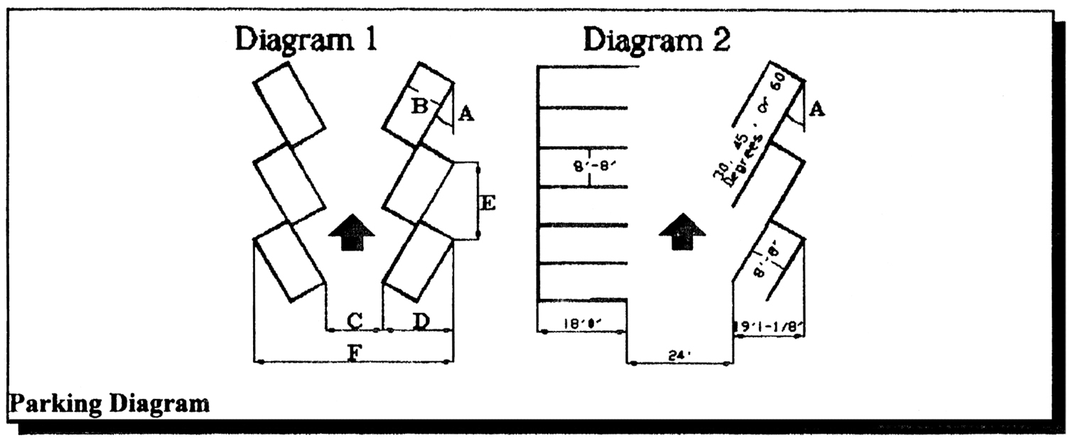
Parking Diagram
PARKING LOT GEOMETRICS—SELF PARKING
Parking geometrics for all other parking angles shall be calculated in proportion to the geometrics shown on the Table.
B.
Compact parking.
1.
When located within a commercial zoning district off-street parking may be permitted to be constructed with compact parking spaces eight (8) feet, eight (8) inches in stall width by sixteen (16) feet in length and shall not exceed twenty percent (20) of the total number of required parking spaces. Compact parking spaces shall be located throughout the parking facility and desingated to be used for parking compact cars through the use of signage and pavement markings.
2.
Parking garages permitted to be constructed with compact parking spaces seven and one-half (7½) feet by fifteen (15) feet and located within a parking exempt area of the RAC-CC or RAC-AS zoning districts may be expanded by the addition of one (1) or more floors of parking and include compact sized spaces on the new floors provided the following requirements are met:
a.
The existing garage proposed to be expanded is built to structurally support the proposed addition as certified by a structural engineer; and,
b.
The additional floor(s) shall be built on the same footprint of the existing garage; and,
c.
The number of compact parking spaces on each additional floor shall not exceed the maximum number of compact spaces on the existing floor(s) with the most compact spaces; and,
d.
The total number of compact spaces provided in the parking garage shall not exceed thirty-five percent (35) of the total number of spaces provided in the garage.
C.
Stalls for parking for the disabled/handicapped shall be designed in accordance with the requirements of the regulatory authorities with jurisdiction over disabled/handicapped parking.
D.
Motorcycle and scooter parking.
1.
Off-street Parking for motorcycle and scooter. For any nonresidential use, one (1) out of every ten (10) standard parking spaces can be converted to motorcycle parking up to a maximum of six (6) standard parking spaces. A standard off-street motorcycle and scooter parking space shall be a minimum of four (4) feet, four (4) inches in width and the length shall meet the parking geometric layout by parking angle (30, 45, 60, or 90 degrees) as shown in the Parking Lot Geometrics - Self Parking table.
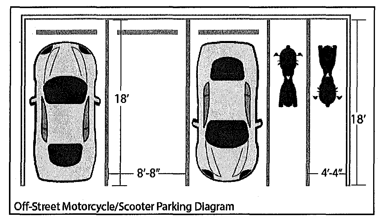
2.
On-street parking for motorcycle and scooter. On-street motorcycle and scooter parking may be perpendicular to the curb with a minimum dimension of four (4) feet in stall width and eight (8) feet, eight (8) inches in stall length as shown on the table Parking Geometrics.
a.
Motorcycle and scooter parking spaces must be identified or designated through the use of signage or pavement markings.
(Ord. No. C-97-19, § 1(47-20.11), 6-18-97; Ord. No. C-97-51, § 8, 11-4-97; Ord. No. C-18-20, § 1, 8-21-18)
Sec. 47-20.12. - Landscaping and bufferyards.
Landscaping and buffering of parking facilities shall be provided in accordance with the requirements of Section 47-21, Landscape and Tree Preservation Requirements, and Section 47-25.3, Neighborhood Compatibility Requirements.
(Ord. No. C-97-19, § 1(47-20.12), 6-18-97)
Sec. 47-20.13. - Paving and drainage.
A.
Definition. For the purposes of this section, swale area shall mean the portion of the right-of way immediately adjacent to the paved road surface and extending to the property line. The swale area is stormwater infrastructure, as the term is used in this section, and is primarily intended for the drainage of the paved roadway by percolation of the water through the soil and groundcover. Swale areas shall not be obstructed except as permitted herein. The planting of trees is permitted in swale areas subject to the issuance of required landscaping and engineering permits prior to installation. Owners of property abutting the swale areas shall maintain the swale area, including the preservation of adequate slope for stormwater purposes and containing sod or other living groundcover maintained at the appropriate height.
B.
Paving. Except as provided in subsections B and C, off-street parking facilities and spaces, including aisles and driveways, shall at a minimum be surfaced with a hard, dust free material, at least one (1) inch thick asphaltic cement on at least six (6) inch compacted limerock base course compacted to an average density not less than ninety-eight percent (98) of the maximum density obtainable under the test provided pursuant to engineering standard (AASHTO T-180) or an equivalent test. The minimum density which will be acceptable at any location within the base shall be ninety-six percent (96) of such maximum density and, in the determination of average density, the maximum density which shall be used in the calculation shall be one hundred two percent (102). Other equivalent pavement systems which will support the intended use may be approved by the city engineer. All pavement systems shall be maintained in a smooth, well-graded condition.
1.
Residential zoning district design standards. Paved areas used for access to property across public rights-of-way shall comply with the following standards:
a.
In single-family residential zoning districts and single-family sites in other districts, up to twenty-four (24) feet may be paved on a lot with a width of less than seventy (70) feet. For corner lots or lots with a width in excess of seventy (70) feet, the right-of-way frontage shall not be paved more than fifty (50) percent of the right-of-way frontage. Whenever the total pavement area in the swale area frontage on that public right-of-way is fifty (50) percent or more of the total frontage on that public right-of-way, an exfiltration trench stormwater system or an alternative drainage system approved by the city engineer shall be installed in the swale area in accordance with city construction standards and specifications.
b.
Parking facilities for single-family uses may have a gravel surface, provided the gravel surface does not extend more than forty (40) percent of the length of the property line adjacent and parallel to a right-of-way.
c.
Paving material located within the right-of-way shall match the paving material used to construct the driveway and/or parking area of the private property.
C.
Parking facilities and spaces for public and private schools offering academic courses, houses of worship, and public recreational uses when use of the lots is limited to three (3) days of the week or less may be grass over a compacted subsurface. Grass parking surfaces shall consist of at least a six (6) inch course of natural limerock, surfaced with a species of grass acceptable for high-traffic use. Other equivalent surfaces may be approved by the city engineer. The parking area shall have adequate drainage as provided herein. All requirements for landscaping vehicular use areas shall be met as well as all required interior landscaping requirements for parking areas. Grass parking areas shall not count toward satisfying any landscaping area required by Section 47-21, Landscape and Tree Preservation Requirements.
D.
Drainage. On-site stormwater retention shall be provided in accordance with the requirements of the regulatory authority with jurisdiction over stormwater retention.
E.
Grading and sodding swale area. Swale areas shall comply with the following standards:
1.
Grading and sodding of the swale area shall be required in conjunction with any swale reconstruction, any construction of right-of-way improvement permit or when a building permit is issued for work on abutting property for which the cost of the work exceeds fifty (50) percent of the value of the property.
2.
Swale areas shall be graded in accordance with the City of Fort Lauderdale Minimum Construction Standards and Standard Details issued by the office of the city engineer.
3.
Sod shall not project above the paved surface of the roadway so as to inhibit drainage into the depressed swale.
4.
The addition of sand, gravel, or other material to any sodded swale area shall not be permitted for the purposes of decreasing the minimum swale depth specified, nor shall it inhibit drainage into depressed swales.
F.
Paving in the right-of-way swale area may only be permitted for on-street public parking or driveway approaches or aprons for vehicular ingress and egress. Approved materials for paving in swale areas shall be asphalt or removable concrete/grass pavers. Loose gravel, rock or other unbound materials are prohibited with an exemption for single family properties.
G.
Permits and inspections for paving in swale areas.
1.
A construction or right-of-way improvement permit shall be obtained from the department of sustainable development prior to construction, grading, excavation, or other physical alterations within public rights-of-way, swale areas, or easements, except in the following instances:
a.
The proposed construction, grading, excavation or other physical alteration is included in plans submitted and approved for a building permit by the department of sustainable development.
b.
An emergency situation requires immediate action by a public utility to safeguard public health, safety and welfare.
(Ord. No. C-97-19, § 1(47-20.13), 6-18-97; Ord. No. C-17-02, § 5, 3-7-17)
Sec. 47-20.14. - Lighting of parking facilities.
A.
A parking lot for a nonresidential use shall provide an average maintained horizontal footcandle illumination of a minimum of 2.0, with a minimum horizontal maintained footcandle illumination of 1.0. A 12 to 1 maximum to minimum uniformity ratio shall be maintained. The average maintained horizontal footcandle measurement shall be measured using a ten-foot by ten-foot grid. A vehicular use area for a residential use shall provide an average maintained horizontal footcandle illumination of a minimum of 1.0, with a minimum horizontal maintained footcandle illumination of .5. A 12 to 1 maximum to minimum uniformity ratio shall be maintained. The average maintained horizontal footcandle measurement shall be measured using a ten-foot by ten-foot grid.
B.
When lighting fixtures greater than ten (10) feet in height are used, they shall be located a minimum of fifteen (15) feet away from shade trees.
C.
Parking garage facilities shall provide an average intensity of illumination as follows:
*With daylight infiltration factored into the calculation
**Foot Candle
D.
Parking garage facilities shall be designed and arranged so that no direct source of lighting is visible from any residential property or residentially used property. All parking garages not in full compliance with this subsection D. shall be removed or made to comply with its provisions no later than November 17, 2001, one year from the effective date of this subsection D.
E.
Lighting fixtures shall be shielded, angled, or both, so that direct or indirect light shall not cause illumination in excess of one-half (½) footcandle onto any residential property or residentially used property surrounding the parking facility, measured at the residential property line.
(Ord. No. C-97-19, § 1(47-20.14), 6-18-97; Ord. No. C-00-3, § 1, 1-19-00; Ord. No. C-00-65, § 1, 11-7-00; Ord. No. C-12-05, § 1, 4-3-12)
Sec. 47-20.15. - Backout parking.
Backout parking into public rights-of-way shall be prohibited except as follows:
1.
Backout parking shall be permitted in connection with residential or commercial uses into improved alleys. For purposes of this section, improved alleys are defined as a right-of-way twenty (20) feet in width or less surfaced with a hard, dust-free material and provided with drainage in accordance with city construction standards.
2.
Residential uses and hotels and motels located on residentially zoned property shall be permitted to have back out parking into any public right-of-way if found not to cause a traffic hazard as determined by the city engineer.
3.
Backout parking may not be located on or require vehicular movement over bufferyards, as required by Neighborhood Compatibility Requirements, Section 47-25.3. The design of backout parking shall conform with this Section 47-20, and all backout parking spaces shall be provided entirely on-site. Backout parking spaces for residential uses and hotels shall have one (1) peninsular landscape area for every two (2) spaces. For all other uses there shall be one (1) peninsular landscape area for every four (4) spaces.
4.
Backout parking may be constructed on properties in an RO, ROA, and ROC zoning district, subject to the following:
a.
The backout parking is on a roadway not classified as an arterial or collector as defined by the Transportation Element of the City's Comprehensive Plan.
b.
The backout parking is permitted on a development site with a maximum area of 12,500 square feet, with the exception of a historic structure as defined in Section 47-35 which may have a greater area.
c.
Landscape islands meeting the requirements of Section 47-21.9.A.4.c. and d. shall be provided for every six (6) parking spaces or fraction thereof. Perimeter landscape areas meeting the requirements of Section 47-21.9.A.2.b. shall be provided. If required landscape islands and perimeter landscape areas reduce the number of parking spaces available for the use, the parking requirement shall be reduced on a one (1) parking space to one (1) equivalent area of landscaping basis.
d.
Submission of a traffic statement demonstrating that backout parking for the use will not create a traffic hazard. The traffic statement shall be certified by a state-licensed engineer, architect or landscape architect or American Institute of certified Planners certified planner.
e.
A minimum five-foot wide sidewalk is located along the side of the property abutting the street where the backout parking is located, which sidewalk meets City Engineering standards. The sidewalk requirement may be eliminated or a sidewalk wider than five (5) feet may be required by the City Engineer if necessary for consistency with abutting properties or to meet engineering standards.
f.
Brick decorative pavers or similar paving material covering one hundred (100) percent of the parking surface shall be installed.
g.
The backout parking spaces must meet the geometric, drainage and site clearance standards provided in Section 47-20 and such other standards determined to be necessary to provide adequate and safe parking as determined by the City Engineer.
Backout parking pursuant to this subsection shall require a Site Plan Level II permit. Existing backout parking in RO, ROA and ROC zoning districts that meets the requirements of subsections a., b., c., e., f., and g. of this subsection 4. shall be legal and conforming and not required to apply for or receive a Site Plan Level II permit.
5.
Existing legal nonconforming backout parking may be permitted to meet required parking for existing non-residential uses that are changing to another permitted non-residential use, subject to the following:
a.
Compliance with the ULDR parking requirements of Section 47-20 requires the moving or altering of load bearing walls, columns or girders of a structure on the development site.
b.
The backout parking is existing and was previously legally permitted. Expansion of backout parking will not be permitted.
c.
No residential uses are present between the extended property lines across the right-of-way where the backout parking is located.
d.
The backout parking is on a roadway not classified as an arterial or collector as defined by the Transportation Element of the Comprehensive Plan.
e.
Landscape islands meeting the requirements of Section 47-21.9.A.4.c. and d. shall be provided for every six (6) parking spaces or fraction thereof. Perimeter landscape areas meeting the requirements of Section 47-21.9.A.2.b. shall be provided. If required landscape islands and perimeter landscape areas reduce the number of parking spaces available for the use, the parking requirement shall be reduced on a one (1) parking space to one (1) equivalent area of landscaping basis.
f.
Submission of a traffic statement demonstrating that backout parking for the use will not create a traffic hazard. The traffic statement shall be certified by a state-licensed engineer, architect or landscape architect or American Institute of Certified Planners certified planner.
g.
A minimum five-foot wide sidewalk is located along the side of the property abutting the street where the backout parking is located, which sidewalk meets City Engineering standards. The sidewalk requirement may be eliminated or a sidewalk wider than five (5) feet may be required by the City Engineer if necessary for consistency with abutting properties to meet engineering standards.
h.
Brick decorative pavers or similar paving material covering one hundred (100) percent of the parking surface shall be installed.
i.
The backout parking spaces must meet the geometric, drainage and site clearance standards provided in Section 47-20 and such other standards determined to be necessary to provide adequate and safe parking as determined by the City Engineer.
Backout parking pursuant to this subsection shall require a Site Plan Level II permit.
(Ord. No. C-97-19, § 1(47-20.15), 6-18-97; Ord. No. C-00-11, § 1, 3-7-00)
Sec. 47-20.16. - Valet parking.
A.
A parking facility which meets all other requirements of this section and which provides attendants to receive, park and deliver the automobiles of occupants, tenants, customers and visitors one hundred percent (100) of the operating hours of the parking facility may be excepted from certain provisions of the parking facilities design requirements provided in this Section 47-20 as follows:
1.
Parking spaces need not be delineated with pavement markings. Stall and aisle dimensions shall be shown on the site plan;
2.
Stalls shall be a minimum eight and one-half (8½) feet by eighteen (18) feet;
3.
Parking spaces need not be immediately accessible provided spaces are arranged so that no more than two (2) parking spaces would be crossed in parking any vehicle; and
4.
Interior, peninsular and island landscape areas required by Section 47-21, Landscape and Tree Preservation Requirements, shall not be required if landscape requirements which would otherwise have been installed on the interior of the parking lot are evenly distributed along the perimeter of the parking area to a location in public view.
B.
No person shall be permitted to provide valet parking in accordance with this section until a valet parking agreement is executed by the owner and the city in accordance with Section 47-20.18.
(Ord. No. C-97-19, § 1(47-20.16), 6-18-97)
Sec. 47-20.17. - Vehicular reservoir spaces for drive-thru facilities.
A.
A vehicular reservoir space ("VRS") is a space within a vehicular use area for the temporary stopping of a vehicle awaiting service as provided in this section. A VRS shall be twenty (20) feet long by ten (10) feet wide. A VRS shall be located in an area within a parking facility which is not used for any other vehicular use such as access, parking, site circulation or loading.
B.
The minimum number of VRSs shall be provided on-site inclusive of the vehicle being served as follows, except as provided for outbound vehicles:
C.
Each VRS shall be clearly defined on the site plan and shall be in a location that does not conflict or interfere with other traffic entering, using or leaving the site. Design configuration shall be such that there shall be no backing into the street permitted.
D.
Reservoir spaces shall be measured from the front of the service position to the rear of the VRS.
(Ord. No. C-97-19, § 1(47-20.17), 6-18-97)
Sec. 47-20.18. - Parking agreements.
A.
Off-site parking agreement.
1.
When the required off-street parking is to be provided on a site at a location different from the site which will be served by the parking as provided in Section 47-20.4.B, the owner of the off-site parcel of land and the owner of the land intended to be served by such off-site parking (if different than the owner of the parcel to be used for parking) shall enter into an agreement with the city. The off-site parking area shall never be sold or transferred except in conjunction with the sale of the parcel served by the off-site parking facilities unless:
a.
The parcel to be sold will continue to be used as provided in the off-site parking agreement and the new owner executes a consent to assume and be bound by the obligations of the owner of the parcel used for parking as provided in the agreement. The consent shall be in a form approved and executed by the department and recorded in the public records of the county at the expense of the owner. A copy of the recorded document shall be provided by owner to the department; or
b.
A different parcel complying with the provisions of the ULDR and subject to a recorded off-site parking agreement as specified herein may be substituted for the parcel of land subject to the off-site parking agreement; or
c.
The parcel being served by the off-site parking no longer requires the parking as evidenced by a written statement executed by the parties executing the off-site parking agreement and as approved by the department and a termination of the off-site parking agreement is executed by the department and recorded in the public records of the county at owner's expense.
B.
Valet parking agreement. When an owner of a parcel wishes to provide valet parking services and use the parking design requirements provided in this Section 47-20, the owner must enter into an agreement with the city which includes a legal description of the parcel where parking will be located and states the number of parking spaces which must be provided and that attendants will be provided one hundred percent (100) of the operating hours of the use. If the parcel to be used for valet parking is different than the parcel the parking serves, the provisions for off-site parking must be met.
C.
An off-site parking and valet parking agreement shall be executed on behalf of the city by the department and approved as to form by the office of the city attorney. The agreement shall be recorded in the public records of the county at owner's expense. The agreement shall be considered a restriction running with the land and shall bind the heirs, successors and assigns of said owner.
D.
For purposes of this section, "owner" shall be deemed to include lessees of property under long term leases wherein the lessee's right to possession of the property is for a period of not less than fifty (50) years from the date of the off-street parking agreement and where the fee simple owner has joined in the execution of the owner's agreement for the purposes of consenting to the terms of the agreement. Owner shall also include the owner of an exclusive easement for parking purposes as long as the fee simple owner of the property consents to the parking agreement.
(Ord. No. C-97-19, § 1(47-20.18), 6-18-97)
Sec. 47-20.19. - Nonconforming parking and loading.
A.
Any parking facility which is in existence on the effective date of this ordinance which is in compliance with the zoning regulations applicable at the time the parking facility was established and for which all permits were issued which parking facility would be prohibited, restricted or would otherwise not conform to the ULDR may continue in existence as a nonconforming parking facility in accordance with the provisions of this section.
B.
Except as provided in this section, a structure or use with nonconforming parking may not be enlarged, increased in floor area, use extended or changed to a use which is not approved in accordance with the provisions of Section 47-3.5.
C.
A nonconforming use, structure, site or parking facility which has lost its nonconforming status for termination of use as provided in Section 47-3.8 may not be reopened without the structure, use or site and the parking facility meeting the requirements of the zoning regulations in effect at the time a use is restored.
D.
Except as provided in subsection E, a structure or use with nonconforming parking or as permitted in subsection K may be enlarged in floor area or space occupied in conformance with this Section 47-20, if off-street parking and loading as specified by the ULDR is provided and maintained for the additional floor area, volume, capacity or space so created or occupied subject to the provisions of Section 47-21, Landscape and Tree Preservation Requirements.
E.
If a structure or use with nonconforming parking is reconstructed or enlarged to the extent that more than fifty percent (50) of the volume of the building is replaced, or alterations or improvements exceed fifty percent (50) of the replacement value of the structure, the full amount of off-street parking and loading spaces shall be supplied and maintained for the structure or use in its enlarged or extended size.
F.
Except as provided in subsections C and D, a structure or use with nonconforming parking may be altered or repaired in accordance with the provisions of Section 47-3, Nonconforming Uses, Structures and Lots, provided there is no increase in floor area or use extended, and there is no change in use.
G.
When the use of a nonconforming building or a nonconforming use changes to a use which is not approved in accordance with the provisions of Section 47-3.5, the full parking and loading requirements for the entire building or use shall be provided in compliance with the requirements of this section at the time the change in use occurs.
H.
Except as provided herein, a nonconforming parking facility may be maintained or repaired if the parking facility has not lost its nonconforming status.
I.
A nonconforming parking facility may increase the number of parking spaces up to fifty percent (50) of its existing spaces without losing its nonconforming status if the additional spaces conform to the provisions of the section in effect at the time a permit is issued for construction of the additional spaces subject to the provisions of Section 47-21, Landscape and Tree Preservation Requirements.
J.
Where any nonconforming parking facility is reconstructed or enlarged to the extent that greater than fifty percent (50) of the number of parking spaces is provided, or alterations or improvements exceed fifty percent (50) of the replacement value of the parking facility, the full amount of off-street parking and loading spaces shall be supplied and maintained for the structure or use.
K.
Pedestrian preservation.
1.
Notwithstanding the provisions of Section 47-20.19 and Section 47-3, Nonconforming Uses, Structures and Lots, parking lots legally permitted at the time of their establishment and existing on the effective date (June 28, 1997) of the ULDR serving a permitted use which use fronts on a right-of-way where:
a.
There are buildings fronting on both sides of the same right-of way; and
b.
There are no private parking facilities between the building and the right-of-way; and
c.
The building which the parking serves is located on one (1) of a minimum of three (3) contiguous blocks, or blocks that are separated by no more than a sixty-foot right-of-way and each block has a minimum of three (3) uses fronting on the same side of the right-of-way; shall be deemed to be conforming parking lots for purposes of a change of use as regulated by this Section 47-20 and Section 47-3, Nonconforming Uses, Structures and Lots, and such uses and parking lots shall be subject to the provisions of subsection K.2.
2.
a.
Uses served by parking lots described in subsection K.1 or building(s) located as set forth in subsection K.1 (provided such building(s) are not voluntarily demolished by more than fifty percent (50)), may be changed and required off-street parking may be provided only to the extent that the off-street parking required by this Section 47-20 for the new use exceeds the off-street parking which would have been required for the previous use had the regulations of this Section 47-20 been applicable thereto.
b.
Existing parking spaces within parking lots which meet the requirements of subsection K.1 may be used to meet required parking without meeting the design requirements provided in this Section 47-20.
c.
All off-street parking agreements approved by the city and in existence on the date of the ULDR shall remain valid and lots shall be deemed conforming with the off-street parking requirements for a change of use as provided in Section 47-3, Nonconforming Uses, Structures and Lots, and this Section 47-20.
d.
Notwithstanding the provisions of Sections 47-21, Landscape and Tree Preservation Requirements, and 47-13, Downtown Regional Activity Center Districts, if compliance with the VUA retroactive landscape requirements set forth in the landscape requirements of Section 47-21, Landscape and Tree Preservation Requirements, or if a change in use would require landscaping which would result in a loss of parking spaces or a rearrangement of any parking spaces existing on the date of adoption of the ULDR, then an existing VUA may meet the requirements set forth in Section 47-21, Landscape and Tree Preservation Requirements, by providing an equal amount of landscaping either on or off site at the option of the applicant as shown on a landscape mitigation plan which is certified by a landscape architect and accepted by the department (pursuant to site plan level I review).
e.
An application for subsection K.2.a, b, c or d shall be exempt from the application requirements of Section 47-24.1.F.3.10 and 11.
(Ord. No. C-97-19, § 1(47-20.19), 6-18-97)
Sec. 47-20.20. - Compliance.
A.
No building, use or structure shall be erected, altered or used or land or water used in whole or in part without providing required parking and loading spaces in accordance with the ULDR.
B.
No parking spaces, whether required or optional, shall be erected, altered or used without meeting the requirements of the ULDR.
C.
All required parking facilities shall be maintained and continued as long as the use which the parking serves is continued.
D.
Except as provided herein, parking facilities shall not be used for the storage or sale of merchandise, nor shall they be used for the storage, display, washing, sale or repair of vehicles or equipment. Parking facilities may be used for the sale of merchandise on a temporary basis for special events when approved as provided by Volume I of this Code.
E.
Except as otherwise provided herein, parking facilities shall only be used for the parking of motor vehicles by occupants, employees, visitors or patrons of the use or structure which the parking facility is serving.
F.
Required parking facilities shall not be used by commercial vehicles owned, operated or used in the business of such owner during regular hours of business.
G.
Except as provided herein, required parking may not be used for storage of vehicles. Storage of vehicles shall mean the placement of a vehicle in a parking space for the purpose of sale, lease, rent, repair or display of the vehicle or placement while waiting service for a period of time which exceeds twenty-four (24) consecutive hours or for a purpose unconnected with the use which the parking serves.
H.
Parking facilities shall be kept in good operating condition. All parking lots and spaces shall be maintained so as not to create a hazard or nuisance. Such maintenance includes, but is not limited to, removing glass and litter; pruning, nourishing, and watering vegetation; resurfacing and restriping surface markings; reanchoring or replacing loose and broken wheelstops; and replacing or painting signs.
I.
Maintenance of approved parking facilities, including restriping, shall conform with the plans submitted to the city upon which a building permit was issued.
J.
It shall be unlawful for an owner or operator of any building or structure or use to discontinue, change or dispense with, or to cause the discontinuance or reduction of the required parking facilities apart from the discontinuance, sale, or transfer of such structure or use, without establishing alternative parking facilities which meet the requirements of the ULDR.
K.
It shall be unlawful for any person, firm, or corporation to utilize a building, structure, or use without providing and maintaining the off-street parking facilities meeting the requirements of and being in compliance with the ULDR.
L.
It shall be unlawful for the owner or operator of a building provided with valet parking to cause or permit such parking area to be operated or used without providing the service of attendants. Each day that such attendant service is not provided for or maintained shall be a new offense.
M.
Termination of an off-street parking agreement or valet parking agreement without a release of the department recorded in the public records of the county shall constitute a violation of Section 47-20.2 which provides for required parking in accordance with the ULDR.
(Ord. No. C-97-19, § 1(47-20.20), 6-18-97)
Sec. 47-20.21. - Interpretation.
The requirements for parking and loading spaces for any uses not specifically listed in the ULDR shall be the same as provided in the ULDR for the use most similar to the use proposed.
(Ord. No. C-97-19, § 1(47-20.21), 6-18-97)
Sec. 47-20.22. - Temporary parking lots.
A.
Temporary parking lots which do not conform to the requirements of Secs. 47-20.7, 47-20.8, 47-20.12, and 47-20.13.A, may be permitted for the following purposes:
1.
To provide temporary parking limited to use by the users of an existing development which is undergoing redevelopment or persons working on the redevelopment project and the use is continuing to operate while redevelopment is underway;
2.
To provide temporary parking which is limited to use by persons working on a redevelopment project which is not continuing to operate while the redevelopment project is underway;
3.
To allow the temporary use of a cleared redevelopment site for parking while an application for a new use on the site has been submitted to the city and is undergoing review; and
4.
To provide temporary parking which is limited to use by persons visiting or working in a temporary sales trailer or sales office serving a site under construction.
B.
A temporary parking lot shall not be permitted on property in any residential zoning district, except for the purpose provided in subsection A.4.
C.
Temporary parking lots may be permitted, subject to the following:
1.
Approval is subject to issuance of a site plan level IV permit as described in Section 47-24.2.
2.
Application. An application shall, in addition to the requirements provided in Section 47-24, Development Permits and Procedures, include the following:
a.
The temporary parking plan shall identify the layout of parking spaces, aisles and all points of vehicular ingress and egress.
b.
When the proposed temporary parking lot is not located on the same site as the site it is intended to serve, the temporary parking plan shall include a vicinity map at a scale of not less than one (1) inch equal to five hundred (500) feet, showing the parcel or parcels to be served, the temporary parking site, and a safe pedestrian path connecting the temporary parking site to the use or uses proposed to be served.
c.
The plan shall include a landscape plan prepared in accordance with the standards as provided herein.
3.
Standards. A temporary parking lot shall be required to meet the following standards:
a.
The design of the parking plan shall comply with the standards of this Section 47-20, except Secs. 47-20.7, 47-20.8, 47-20.12 and 47-20.13.A.
b.
The parking surface shall consist of compacted gravel, compacted limerock with a calcium chloride additive, or similar hard and dustless surface material approved by the city engineer and capable of being continuously maintained in a clean and level condition.
c.
Landscape materials shall be installed and continuously maintained around the entire perimeter of the lot except for points of ingress and egress, and in accordance with sight triangle regulations provided in the ULDR.
d.
The landscape area shall have a minimum depth of five (5) feet and an average depth of ten (10) feet along all perimeters adjacent to rights-of-way, with a tree planted every thirty (30) linear feet and shrubs installed eighteen (18) inches in height, to be maintained at a thirty (30) inch height, planted on thirty (30) inch centers.
e.
Surface water/drainage plans shall be in accordance with the requirements of the Broward County Department of Natural Resource Protection permitting requirements.
f.
Signage shall be limited to one (1) ground sign not exceeding five (5) feet in height above the grade of the street closest to the sign, shall not exceed sixteen (16) square feet in size, and shall contain the words "Temporary Parking Lot," along with a name and telephone number of the person or agency responsible for operating and maintaining the temporary parking lot.
g.
Any temporary parking lot which will be in operation at any time during the period of one-half (½) hour after dusk to one-half (½) hour before dawn shall provide a minimum maintained footcandle illumination of two (2) footcandles throughout the lot during this period of time; however, such illumination shall not shine on adjacent properties.
h.
All temporary parking lots shall be designed to comply with the requirements of neighborhood compatibility as provided in Section 47-25, Development Review Criteria. In addition, the city commission may impose limited hours of operation for temporary parking lots located adjacent to or abutting residentially used or vacant residentially zoned property.
i.
Other improvements proposed to be made on the site of the temporary parking lot such as fences shall comply with the applicable sections of the Code.
j.
All temporary parking lot submissions shall contain a maintenance plan documenting the manner in which the parking lot surface shall be continuously maintained in a level and clean condition, and the manner in which perimeter landscaping shall be continuously maintained.
k.
The issuance of a development permit for a temporary parking lot shall be subject to the city's receipt of approval by the Broward County Department of Natural Resource Protection if required by law.
4.
Review criteria. In addition to the review criteria for site plan level IV the following shall apply:
a.
The proposed plan meets the standards provided herein; and
b.
The establishment, maintenance, or operation of the temporary parking lot shall not be detrimental to or endanger the public health, safety or general welfare; and
c.
The temporary parking lot use shall not impede the normal and orderly development, redevelopment and improvement of surrounding properties for uses permitted in the district; and
d.
The temporary parking lot shall be consistent with the character of the surrounding neighborhood in accordance with Section 47-25.3; and
e.
The temporary parking lot use is consistent with the land use plan.
D.
Duration of approval. Temporary parking lots shall be approved for operation for a period of eighteen (18) months. An extension may be granted by motion of the city commission for demonstrated exceptional circumstances such as acts of God, storm damage, death of a general partner in the redevelopment effort and events of similar nature not due to the fault of the applicant for the temporary parking lot.
(Ord. No. C-97-19, § 1(47-20.22), 6-18-97; Ord. No. C-04-3, § 5, 2-3-04)
Sec. 47-21.1.- Intent and purpose.
A.
The intent of these regulations is to protect, preserve and enhance the natural environment and beauty of the City and promote better quality of life by creating, preserving, and protecting a safe, healthy, and sustainable landscape that also helps to conserve, protect, and restore the City's water resources. These regulations are also intended to be as stringent as the tree preservation regulations enforced by Broward County pursuant to Chapter 27, Article XIV of the Broward County Code of Ordinances.
B.
The purpose of Section 47-21. - Landscape and Tree Preservation Requirements is to establish standards through regulations that:
1.
Promote the establishment and maintenance of tree canopy cover on public and private lands; and
2.
Minimize the removal or loss of trees and palms; and
3.
Ensure that trees and palms within the City of Fort Lauderdale are maintained in a healthy and non-hazardous condition through implementation of landscape and arboriculture industry standards and best management practices; and encourage the planting of landscape species that are sustainable and appropriate for existing site conditions; and
4.
Establish and maintain diversity in landscape and tree species and age classes to provide a stable and sustainable urban forest; and
5.
Reduce the use of fertilizers and pesticides through the use of Florida-Friendly Landscaping TM principles; and
6.
Preserve the community's character and quality of life well into the future through the appropriate use of landscaping; and
7.
These regulations are to establish minimum standards for the development, installation, and maintenance of Florida-Friendly Landscaping TM without inhibiting creative landscape design, construction, and management.
C.
Documents Incorporated by Reference. The following documents are adopted as standards and are incorporated in this section by reference: American Association of State Highway and Transportation Officials (AASHTO), Standard Specifications for Highway Bridges, 17th Edition, 2002; American Forests, National Registry of Champion Trees, 2020; Betrock Information Systems, Inc. Plant Finder, 2021; Council of Tree and Landscape Appraisers (CTLA), Guide for Plant Appraisal, Revised 10th Edition, Third Printing 2020; Dr. George K. Rogers, Landscape Plants for South Florida: A Manual For Gardeners, Landscapers & Homeowners, 1 st Edition, 2009; Fast Forward Fort Lauderdale Design and Construction Manual for a Sustainable and Resilient Community and Cohesive Public Realm (DCM), 2019; Florida Department of Agriculture, Division of Plant Industry, Grades and Standards for Nursery Plants, 2021; Florida Invasive Species Council List of Invasive Species, 2019; Florida Power and Light Plant the Right Tree in the Right Place brochure, 2021; Gary W. Watson and E.B. Himelick, Principles and Practices of Planting Trees and Shrubs, 1997; Gary Watson, Dan Neely, The Landscape Below Ground I & II, 1994; Gary Watson, Dan Neely, Trees & Building Sites, 1995; Gary Watson, Best Management Practices - Tree Planting, Second Edition, 2014; E. Thomas Smiley, Nelda Matheny, and Sharon Lilly Best Management Practices - Tree Risk Assessment, Second Edition (2017); Nelda Matheny and Jim Clark, Trees and Development: A Technical Guide to Preservation of Trees During Land Development, 1998; Richard Harris, James Clark, Nelda Matheny, Arboriculture: Integrated Management of Landscape Trees, Shrubs and Vines, Fourth Edition, 2004; Susan Day, Susan Dickinsen, Managing Stormwater for Urban Sustainability using Trees and Structural Soils, 2008; The American National Standards Institute (ANSI) A300 all parts, 2023 and Z-133, 2017 and all parts of ANSI Z535, 2023; Timothy K. Broschat & Alan W. Meerow, Betrock's Reference Guide to Florida Landscape Plants, Third Printing, 1994; University of Arkansas, Community Design Center, Low Impact Development, A Design Manual for Urban Areas, 2010; University of Florida, Institute of Food and Agricultural Sciences (UF/IFAS), The Florida Friendly Landscaping TM Guide to Plant Selection & Landscape Design, 2015; UF/IFAS Florida Yards & Neighborhoods Handbook, 2015; UF/IFAS Florida-Friendly Landscaping TM Pattern Book Zones 10a, 10b, and 11, 2020; UF/IFAS GI-BMP Manual, 2020. In the event of a conflict in the standards required in the above reference material, the more restrictive standards shall take precedence over directly conflicting and less restrictive standards.
(Ord. No. C-97-19, § 1(47-21.1), 6-18-97; Ord. No. C-15-09, § 1, 2-17-15; Ord. No. C-24-44, § 1, 10-15-24)
Sec. 47-21.2. - Definitions.
A.
For the purpose of this section, the following terms and words shall have the meanings herein prescribed. When not inconsistent with the context, words used in the present tense include the future tense, words in the plural number include the singular number, and words in the singular number include the plural number. Words not defined in this section shall be defined in accordance with state and federal law or otherwise shall be given their common and ordinary meaning, unless the context clearly requires otherwise:
1.
Arborist. An individual who is a specialist in the care and maintenance of trees and is a certified arborist by the International Society of Arboriculture (ISA).
2.
Arborist report. The formal written opinion on trees, palms, or both from an Arborist that includes, at minimum, the species, size, and condition rating for each tree, palm, or both and a proposed disposition of each tree on a property, justification for any recommendation for the preservation and protection, removal or relocation of any trees.
3.
Arbor street. A street designated by the City, at the request of adjacent property owners, as suitable for extensive planting of street trees.
4.
Berm. A mound of earth configured in a manner which supports landscaping.
5.
Biological control. A component of an integrated pest management strategy. It is defined as the reduction of pest populations by natural enemies and typically involves an active human role.
6.
Bioretention. An engineered process to manage stormwater runoff using the chemical, biological, physical, or any combination of the three, properties found in natural, terrestrial-based communities of plants, microbes, and soils.
7.
Bufferyard. An area or areas located on nonresidential property which extends the full length of the property lines abutting residential property which meet the requirements for a bufferyard as provided in Sec. 47-25.3.
8.
Caliper. The measurement used in specifying nursery stock for new landscape installations with a diameter less than seven (7) inches being the straight-line distance of the diameter of a tree measured horizontally and perpendicular to the trunk from one side of the tree trunk to the opposite side. The measurement is taken at a height of six (6) inches above ground for trees less than and including four (4) inches in diameter and at a height of twelve (12) inches above the ground for trees with a diameter greater than four (4) inches but smaller than seven (7) inches in diameter. See the definition for Diameter at Breast Height for measuring trees with caliper diameters greater than or equal to seven (7) inches.
9.
Canopy. The upper portion of a tree consisting of limbs, branches, and leaves.
10.
City commission protected tree(s) or palm(s). A tree(s) or palm(s) which due to its size, shape, character, age, aesthetic value, species, historical value or any combination thereof declared by the City Commission by resolution to be a locally unique example of a species.
11.
Clear trunk. The distance between the top of the root ball along the vertical trunk or trunks of a tree or palm to the point at which lateral branching begins or where the lowest untrimmed leaf base emerges from the trunk.
12.
Condition rating. The qualitative expression of plant health, structure, and form using a scale of numbers, percentages, or both used in analyzing plant condition.
13.
Conifer. Cone-bearing seed plant.
14.
Conspicuous flowering. A plant which exhibits a contrasting display of reproductive parts of size, quantity and duration.
15.
Critical root zone (crz). The area of soil surrounding a tree's trunk extending in a radius measured from the center point of the tree's trunk deemed necessary for the protection of tree roots located therein and that are critical for the future health and survival of the tree.
16.
Desirable tree or desirable palm. A tree or palm that does not meet the criteria for specimen trees but requires additional regulatory protection because it is adapted to the cultural and physical conditions at the planting site as determined by plant function and shape, aesthetics, form, longevity, ornamental traits, rarity, and other desirable attributes. Tree or palms determined to be 'heritage', 'champion', 'distinction', 'memorial', 'historic', 'old growth', 'ancient', 'veteran' and similar, as defined by the American Forests National Registry of Champion Trees, may also be considered desirable trees or desirable palm.
17.
Diameter at breast height (dbh). The measurement used in specifying existing trees, or newly installed trees with a diameter greater than seven (7) inches being the straight-line distance measured perpendicular to the angle of the direction of the upward trunk from the outside of the bark from one side of the tree trunk to the opposite side, at breast-height (4.5 feet above ground-line more specifically illustrated in the CTLA Guide for Plant Appraisal. See definition for Caliper for measuring new trees less than seven (7) inches in diameter.
18.
Dripline. The natural outside end of the branches of a tree, palm, or shrub projected vertically to the ground.
19.
Effectively destroy. To cause, suffer, allow or permit any act which will cause a tree to die or go into a period of unnatural decline within a period of one (1) year from the date of the act. Acts which may effectively destroy a tree include, but are not limited to, damage inflicted upon the root system by heavy machinery, excessive trimming, changing the natural grade above the root system or around the trunk, damage inflicted on the tree permitting infection or pest infestation, application of herbicides or other chemical agents or intentional fire damage to the tree permitting infection or pest infestation, the infliction of a trunk wound that is fifty (50) percent or greater of the circumference of the trunk, or the removal of sufficient canopy to cause the unnatural decline of the tree.
20.
Equivalent replacement. Tree(s) or palm(s) considered to be equal in species and size to the tree(s) or palm(s) removed.
21.
Equivalent value. A monetary value that reflects the calculated cost of the equivalent replacement of a tree or palm, as provided in Sec. 47-21.15.G.
22.
Excavation. To make a hole, unearth, scrape, or dig out for the purpose of construction, demolition, or removal in relation to a tree or palm drip line, critical root zone, and root system.
23.
Florida Friendly Landscapingtm. Quality landscapes that conserve water, protect the environment, are appropriate for local conditions, and are drought, wind, salt tolerant, or any combination of the three. Principles of Florida-Friendly Landscaping TM include planting the right plant in the right place, efficiently watering, appropriate fertilization, mulching, attraction of wildlife, responsible management of yard pests, recycling yard waste, reduction of stormwater runoff, and waterfront protection. Additional components of Florida-Friendly Landscaping TM include planning and design, soil analysis, use of solid waste compost, practical use of turf, and proper maintenance.
24.
Ground cover. A planting of low growing plants that covers the ground in place of grass, lawn, or turf.
25.
Hatracking. To flat-cut the top of a tree, severing the leader or leaders; or pruning a tree by stubbing off mature wood; or reducing the total circumference or canopy spread not in conformance with the American National Standards Institute, A300 standards or other accepted standards as published.
26.
Hedge. A row of evenly spaced shrubs or other vegetation planted to form a dense, continuous, unbroken visual screen.
27.
Hydrozone. A distinct grouping of plants with similar water needs and climatic requirements. Also referred to as water use zone.
28.
Integrated pest management. A pest management strategy that focuses on long-term prevention or suppression of pest problems through a combination of techniques such as encouraging biological control, use of resistant plant varieties, and adoption of alternate cultural practices to make the habitat less conducive to pest development. Pesticides are used only when careful monitoring indicates they are needed, or to prevent pests from significantly interfering with the purposes for which plants are being grown.
29.
Interior landscape area. The landscape area located within a vehicular use area further than twenty-eight (28) feet from the perimeter landscape area and not attached to the perimeter landscape area.
30.
Interior parking. Parking spaces not contiguous to, nor directly abutting a perimeter.
31.
Irrigation system. A constructed watering system designed to transport and distribute water to plants.
32.
Irrigation zone. A grouping of soakers, sprinkler heads, bubblers, or micro-irrigation emitters operated simultaneously by the control of one (1) valve.
33.
Landscape or landscaping. Any combination of living plants (such as groundcover, shrubs, vines, hedges, palms, or trees) and non-living landscape material (such as rocks, pebbles, sand, or mulch), installed at ground level and open to the sky.
34.
Landscape area. An area where landscaping has been or shall be installed.
35.
Landscape area, required. Landscape areas that are directly permeable to the subgrade through a natural drainage system unless otherwise specifically permitted by the ULDR.
36.
Landscape and tree document packet. A packet consisting of documents used to communicate technical information necessary for the review of a landscape or tree permit application as provided in Sec. 47-21.6.
37.
Lawn/turf/sod. An area of land planted with grasses or (rarely) other durable plants, which are maintained at a short height and used for aesthetic and recreational purposes.
38.
Low impact site design practices. Practices that minimize changes to the site's soil levels and composition by preserving existing landscape, shrubs, trees, or both, and other natural features.
39.
Monocotyledonous (monocot) tree. A tree having fronds with parallel venation and an indistinct, tightly held trunk surface (a palm).
40.
Mulch. An organic soil additive or topping such as compost, wood chips, wood shavings, seasoned sawdust, bark, leaves or straw, used to reduce evaporation, prevent erosion, control weeds, enrich the soil and lower soil temperature.
41.
Native vegetation. Any plant species with a geographic distribution indigenous to all, or part, of the state of Florida as identified in the Guide to the Vascular Plants of Florida, 3 rd edition, R. P. Wunderlin & B. F. Hansen, 2011, University Press of Florida, Gainesville.
42.
Natural forest communities. A vegetated area generally comprised of a canopy, subcanopy and groundcover, and which meets the criteria for the classification of an area as a Natural Forest Community under Chapter 27, Article XIV, Section 27-411 of the Broward County Code of Ordinances.
43.
Nectar-producing plant. A plant that serves as a food source by producing nectar within their flowers for mainly nectar-consuming pollinators such as butterflies, moths, bees, hummingbirds and bats.
44.
Net lot area. The total square footage of a parcel of land after subtracting the square footage area of any vehicular use area including the VUA required landscaping, building footprint, walls, curbs, walks, public utility easements, swimming pools, CRZ of any existing trees proposed to remain on site or any other impervious area.
45.
One-family residence. A building and its surrounding lot intended to be occupied by one (1) family.
46.
Nuisance tree. Any tree or palm, dead tree or stump upon any parcel of land within the city which threatens or endangers the public health, safety or welfare, or which could foreseeably cause the spread of disease or infestation to surrounding plant life.
47.
Ornamental shrub. A multi-stemmed woody plant with several permanent stems used for ornamental purposes.
48.
Overall height. Highest point in the canopy on a tree or palm measured vertically from grade, determined at the base of the trunk, to the natural position of the last fully expanded leaf.
49.
Overlift. The removal of the majority of the inner lateral branches and foliage of a tree thereby displacing weight and mass to the ends of the branches.
50.
Palm. A plant belonging to the monocot order of the family Palmae, distinguished by having unbranched single or multi-trunks crowned by large, compound pinnate, or palmate leaves/fronds.
51.
Parking garage. A building or structure consisting of more than one (1) level and used to park vehicles.
52.
Peninsular or island landscape area. A pervious area set aside for landscaping, located at the end of a parking row where it abuts an aisle or driveway, and also intermittently located within parking rows.
53.
Perimeter. The boundary line separating one (1) parcel of land from another or a parcel of land from a right-of-way. If the property is on a waterway, the perimeter shall be the bulkhead line.
54.
Perimeter landscape area. The landscape area directly abutting the perimeter of a VUA and within twenty-eight (28) feet of the property line.
55.
Perimeter parking. Parking spaces contiguous to or directly abutting a perimeter landscape area.
56.
Pervious area. That non-compacted land located at ground level, open to the sky allowing passage of air and water to the subsurface used or set aside for landscaping.
57.
Pervious paving materials. A porous asphaltic, concrete, or other surface having a high-void aggregate base which allows for rapid infiltration and temporary storage of rain on, or runoff delivered to paved surfaces.
58.
Plant bed. A grouping of trees, shrubs, groundcover, perennials, or annuals growing together in a defined area devoid of turfgrass, normally using mulch around the plants.
59.
Plant communities. An association of native plants that are dominated by one (1) or more prominent species or a characteristic physical attribute.
60.
Plant palette. A list of site appropriate plant species of various colors, textures, and mature sizes chosen to be used in the landscape design.
61.
Planting plan. Specifications, and installation details for plants, soil amendments, mulch, edging, gravel, staking materials, and other similar materials.
62.
Point of connection ("poc"). The location where an irrigation system is connected to a water supply.
63.
Protected tree or protected palm. A tree or palm which due to its size, shape, character, age, aesthetic value, species, historical value or any combination thereof declared by the city commission to be a locally unique example of the species.
64.
Protective barrier. Fences or like structures at least four (4) feet in height that are conspicuously colored and are erected to prevent or obstruct passage.
65.
Protection barricade. A fence or similar structure that encloses the critical root zone of existing trees, palms, and vegetation, and is designed to protect the roots and prevent the disturbance and compaction of the soil within the dripline of a tree .
66.
Prune. The selective removal of plant parts to meet specific goals and objectives. To remove, cut off, or cut back parts of a tree or plant which will alter the natural shape.
67.
Public lands. Any land and interest in land, within the City of Fort Lauderdale, owned by the United States, any state of the United States, the State of Florida, a political subdivision, or agency of the State of Florida, Broward County, the Broward County School District, single and multipurpose special district, single and multipurpose public authority, the City Fort Lauderdale or a separate legal entity or administrative entity created under the Florida Interlocal Cooperation Act of 1969.
68.
Registered landscape architect (RLA). A person who holds a license to practice landscape architecture in the State of Florida pursuant to Chapter 481, Part II, Florida Statutes (2023).
69.
Right-of-way. Land provided by dedication, deed or easement which is devoted to, required for or intended for the use by the public as a means of public traverse.
70.
Runoff. The water that results from and occurs following a rain event, or following an irrigation event, because the water is not absorbed by the soil or landscape and flows off from the area.
71.
Shock. A state of irregular retarded plant growth or degeneration of the vital processes resulting from, but not limited to, transplant, root damage, wounds, impact, partial or total girdling, or improper cutting.
72.
Shade tree. A single-trunked dicot or conifer tree which by virtue of its natural shape provides at maturity a minimum shade canopy thirty (30) feet in diameter as listed in the table of tree evaluation.
73.
Shrub. A multi-stemmed woody plant with several permanent stems usually maturing at less than 15 feet in height.
74.
Site appropriate plant. A plant that, after establishment, will thrive within the environmental conditions that are normal for a specific location without artificial inputs or supplements such as irrigation.
75.
Soil amendments. Materials added to soil to improve its physical or chemical properties.
76.
Specimen tree. Any tree which meets all of the following criteria:
a.
Specifically listed in the City's Tree Classification List as maintained by the Department.
b.
a condition rating of 60%, or greater, as calculated using the CTLA Guide for Plant Appraisal, 10 th edition.
c.
a diameter at breast height (DBH) in accordance with the following:
i.
Eighteen (18) inches or greater for Large Trees; or
ii.
Thirteen (13) inches or greater for Medium Trees; or
iii.
Eight (8) inches or greater for Small Trees.
d.
Trees within any of the following categories are not considered specimen trees for the purposes of this Section:
i.
Fruit trees grown for the commercial production of fruit;
ii.
Trees and palms planted and grown in a state-certified plant nursery or botanical garden for sale to the general public;
iii.
Trees and palms classified as invasive pursuant to the Department of Agriculture and Consumer Services, Chapter 5B-57, Florida Administrative Code (FAC), as amended, and the Florida Invasive Species Council (FISC) Invasive Plant Species List, Category 1, as amended;
iv.
Trees which are Class D and lower, as listed in the City's Tree Classification List as maintained by the Department;
v.
City Commission Protected Trees and Palms.
77.
Standard. A woody perennial plant with a number of stout stems, all but one (1) of which has been removed. The remaining stem then has been trained into an upright, small, tree-like form having a rounded crown usually supported by a stake.
78.
Street tree. A tree which is located within twelve (12) feet of the edge of pavement or curb of a street or such other distance as determined by the department in accordance with this section.
79.
Table of tree classification . A table prepared by the Department listing tree and palm species, size classification, and corresponding information relevant to each species, on file with the Department.
80.
Tree. A woody perennial plant, possibly shrub-like in form when young, with one (1) main stem or trunk which naturally develops diameter and height characteristics of a particular species.
81.
Tree abuse. Any action or inaction which does not follow acceptable practices as established by the American National Standards Institute, A300 standards, or as prescribed in the regulations, herein.
82.
Tree and palm survey. A document prepared by, signed, and sealed by land surveyor licensed by the State of Florida which must provide, at a minimum: the location, plotted by accurate techniques, of all existing trees and palms; a numbering system designating each tree and palm location on the survey; a corresponding list providing the tree and palm number; identification of each tree and palm; the trunk diameter of each tree; and the overall height of each palm.
83.
Tree canopy trust fund. The fund maintained by the City to which funds received by the City for the equivalent value of trees removed shall be deposited.
84.
Tree inventory. A document, prepared by an ISA Certified Arborist or a Registered Landscape Architect, that lists existing trees and palms depicted on a tree survey and identifies each tree and palm by number, common and botanical name, the trunk diameter at breast height (DBH), the overall and clear trunk height of each palm, the condition rating of each tree and palm as calculated using the CTLA Guide for Plant Appraisal, 10th edition, and the disposition status of each existing tree and palm on site (i.e., whether the tree or palm is to remain and protect in place, to be relocated, to be removed).
85.
Tree protection zone (TPZ). An area identified around a tree or palm in which construction activities are prohibited or restricted to prevent injury to trees and palms.
86.
Tree protection. Activities designed to preserve and protect tree health by avoiding damage to a tree's roots, trunk, and branches.
87.
Tree relocation. To change the location of a tree or palm.
88.
Tree risk assessment report. A document prepared by an ISA Certified Arborist, or a Registered Landscape Architect performed in accordance with the tree risk assessment procedures outlined in Best management Practices - Tree Risk Assessment, Second Edition (2017).
89.
Tree service. Any qualified person, company, corporation or service performing the removal of branches more than one inch in diameter from a tree or the removal of live palm fronds from any type of palm tree with six feet or more of clear trunk, or cutting down, digging up, destroying, effectively destroying, removing, relocating, or grinding roots of any tree.
90.
Tree removal. Any act to eliminate a tree or palm.
91.
Trim. To reduce, shorten or gradually diminish the size of a plant by removal of parts of a plant without altering the natural shape.
92.
Understory. The underlying, vegetative layer of trees and shrubs between the forest canopy and the ground cover.
93.
Unnatural decline. Deterioration of plant health due to non-natural factors.
94.
Urban forest. A collection of trees that grow within a city.
95.
Urban forestry. The sustained planning, planting, protection, maintenance, and care of trees, forests, greenspace and related resources in and around the city for economic, environmental, social, and public health benefits for people.
96.
Vehicular use area (VUA). Any area used by vehicles including, but not limited to, areas for parking, display, storage or traverse of any and all types of motor vehicles, bicycles, watercraft, trailers, airplanes or construction equipment, but shall not include areas used exclusively as an airport ramp or apron.
97.
Vine. A plant whose natural growth characteristic produces climbing stems.
(Ord. No. C-97-19, § 1(47-21.2), 6-18-97; Ord. No. C-99-15, §§ 2, 3, 3-16-99; Ord. No. C-03-19, § 9, 4-22-03; Ord. No. C-04-8, § 1, 3-2-04; Ord. No. C-08-04, § 2, 2-5-08; Ord. No. C-08-54, § 4, 12-2-08; Ord. No. C-15-09, § 2, 2-17-15; Ord. No. C-24-44, § 2, 10-15-24)
Sec. 47-21.3. - General provisions and design standards.
A.
Low impact site design practices, such as preserving existing native trees and vegetation, shall be used to the extent feasible. Irrigation shall not be required in area where established native vegetation is incorporated into the landscape design.
B.
The plant palette and irrigation system shall be site appropriate, based on current acceptable industry standards, for site conditions, taking into account that, in some cases, soil improvement can enhance water use efficiency.
C.
Plants shall be grouped together by irrigation demand. The percentage of landscaped area in irrigated high water use hydrozones shall be minimized.
D.
All landscapes must be designed and planted in accordance with Florida-Friendly Landscaping TM principles. The percentage of landscaped area, excluding turfgrass areas, in irrigated high water use hydrozones shall be no more than twenty percent (20) of the total non-turfgrass landscaped area.
E.
When designing landscapes, fruit-bearing trees and plants should be considered as part of a sustainable and edible landscape.
F.
When designing landscapes to support wildlife, nectar-producing native plants, shrubs and trees should be incorporated as much as possible to provide food-sources for nectar-consuming pollinators such as butterflies, moths, bees, hummingbirds and bats.
G.
Site designs and landscape plans shall be prepared in accordance with the requirements of all applicable Florida and local laws, rules, regulations, and ordinances. All landscape and irrigation system designs shall be consistent with the standards developed pursuant to Section 373.228, Florida Statutes, as amended.
H.
The landscape plan shall consider natural drainage features to minimize runoff. The use of pervious surfaces and areas is preferred; therefore, impervious surfaces and materials within the landscaped area shall be limited to borders, sidewalks, step stones, parking lots, and other similar materials, and shall not exceed ten percent (10) of the landscaped area. Use of pervious paving materials, where appropriate, is encouraged.
I.
The landscape plan should consider the soil requirements for trees based on their size at maturity and their distance from any adjacent paved/hardscape areas and utility infrastructure. Larger soil volumes lead to greater tree size, better tree health, longer tree life, and greater environmental benefits, such as those associated with tree replacement and damage by roots to property improvements and infrastructure.
J.
Unless otherwise authorized by Section 47-21, it is unlawful for any person to cause, suffer, permit or allow:
1.
The removal of any City Commission Protected Tree or Protected Palm without first obtaining approval from the City Commission to conduct the removal; and
2.
The removal of any tree or palm without first obtaining a Tree Permit from Department as herein provided; and
3.
Tree abuse as defined in Section 47-21.2.A.; and
4.
Any encroachments, excavations, or change of the natural grade within the drip line of a tree unless it can be demonstrated to the Department prior to the commencement of said activity, that the activity will not negatively impact any tree; and
5.
Land clearing or the operation of heavy equipment in the vicinity of a tree without placing and maintaining a protective barrier around the drip line of the tree. The protective barrier shall be conspicuous enough and high enough to be seen easily by operators of trucks and other equipment; and
6.
The storage or use of materials or equipment within the drip line of any tree, or attachments, other than those of a protective and non-damaging nature, to any tree; and
7.
Land clearing, including the removal of understory, in an area designated as a Natural Forest Community without first obtaining an appropriate license from Broward County.
K.
Critical Root Zone (CRZ) shall be calculated as an area with a minimum radius of one foot (1) for every one inch (1) of DBH measured from the surface of the tree trunk at existing grade.
L.
General exemptions.
1.
During a state of emergency for a natural emergency declared by the Governor pursuant to Section 252.363 or a local emergency declared for a natural emergency pursuant to Article IX - Emergency Preparedness Task Force, Chapter 2 of the Code of Ordinances the City Manager may suspend the enforcement of provisions of Section 47-21.
2.
Reserved.
(Ord. No. C-15-09, § 3, 2-17-15; Ord. No. C-24-44, § 3, 10-15-24)
Sec. 47-21.4. - Landscaping required.
No person shall carry out any development or use any parcel of land for any purpose, nor shall any permit for building or paving be issued unless a landscaping permit is issued in accordance with the requirements of this section.
(Ord. No. C-97-19, § 1(47-21.3), 6-18-97; Ord. No. C-15-09, § 4, 2-17-15)
Note— Formerly § 47-21.3.
Sec. 47-21.5. - Permit required.
A landscaping permit shall be required for the installation, removal, or replacement of any landscaping in accordance with the provisions of this section.
(Ord. No. C-97-19, § 1(47-21.4), 6-18-97; Ord. No. C-15-09, § 5, 2-17-15)
Note— Formerly § 47-21.4.
Sec. 47-21.6. - Landscape plan required.
A.
Prior to the issuance of a Landscape Permit, a Landscape and Tree Document Packet shall be submitted to the Department. The Landscape and Tree Document Packet shall include, as applicable to the scope of work as proposed, but not be limited to, the following:
1.
Tree and Palm Survey. A document signed, sealed, and prepared by a Florida licensed land surveyor which must provide, at a minimum:
a.
The location, plotted by accurate techniques, of all existing trees and palms;
b.
A numbering system designating each existing tree and palm location on the survey;
c.
A list containing the names of each tree, palm, or both identified by a number corresponding with the number as assigned on the survey.
d.
The trunk diameter at breast height (DBH) of each existing tree;
e.
The overall height of each existing palm; and
f.
Be prepared at no less than a one (1) inch equal to thirty (30) feet scale, and include property boundaries, north arrow, graphic scale, and date.
2.
Tree and Palm Inventory. A document, prepared by an ISA Certified Arborist or a Registered Landscape Architect, that contains at a minimum:
a.
The existing tree and palm survey;
b.
A corresponding list of existing trees and palms numbered to match the existing tree and palm survey;
c.
A graphic representation of all existing trees and palms inclusive of the canopy dripline;
d.
The common and botanical name of each existing tree and palm;
e.
The trunk diameter at breast height (DBH) of each existing tree;
f.
The overall height and clear trunk of each existing palm;
g.
Be prepared at a maximum of thirty (30) scale, and include the property boundaries, north arrow, graphic scale, and date;
h.
The signature, contact information, and certification number of ISA Certified Arborist or seal of Registered Landscape Architect; and
i.
An Arborist Report for all existing specimen trees and desirable trees or desirable palms. The Arborist report shall be prepared by an ISA Certified Arborist who will be required to affix his or her signature on the report and printed on the ISA Certified Arborist's business letterhead containing the arborist's contact information and ISA Certification number. The Arborist Report is required to be prepared within six (6) months prior to date the report is submitted. If a state of emergency for a natural disaster is declared pursuant to Chapter 252, Florida Statutes, or pursuant Section 2-274, of the City of Fort Lauderdale Code of Ordinances that impacts the City after the report has been submitted but prior to tree permit issuance, then the ISA Certified Arborist must update the report and resubmit it to the Department. This report shall reference the tree survey or tree disposition sheet with numbered trees and palms, a corresponding table which includes tree/palm number, botanical name and common name, trunk diameter at breast height (DBH) for trees in inches, clear trunk height for palms in feet, condition rating stated as a percentage using a whole number, the disposition of the tree, and a written assessment of the existing tree's characteristics explaining how and why the above information was reached. This report may also provide descriptive information on recommendations for prescriptive tree maintenance activities.
B.
Prior to the issuance of a landscape installation permit, a landscape plan shall be submitted to the department. The landscape plan shall include, but not be limited to, the following:
1.
A design that ensures that landscaping is not adversely affected by factors such as salt exposure, prevailing winds, tidal occurrence, overhead obstructions, poor sun exposure, unusual soil conditions, etc. At a minimum, such plan shall include the following:
a.
Prepared at a scale no less than one (1) inch equals thirty (30) feet. An overall project plan may be provided at a smaller scale when using it to reference section sheets provided;
b.
Title block including name and address of project, RLA contact information, RLA seal and dated signature, original and sequential revision delta with revision date and narrative, north indicator;
c.
Plan sheets layout shall be in landscape orientation;
d.
Tree protection zones, including the critical root zone, illustrated, and labeled;
2.
The tree and palm protection requirements as specified in 47-21.15.
3.
The tree and palm protection zones shall be illustrated on all plan sheets that include any underground installations, including, but not limited to, irrigation, plumbing, electrical, telecommunication or streetlight lines. The tree and palm protection zones shall be shown on all drawings that include structural installations that will require excavation(s), and for above-ground installations that may include, but not limited to, walkways, streetlights, overhead wires or other types of infrastructure.
4.
Any amendments to the Landscape and Tree Document Packet that result in the modification of tree and palm protection zones require revisions to tree and palm protection plans and re-submittal to the Department for approval prior to permit issuance.
5.
A site plan drawn at a scale of not less than one (1) inch equal to thirty (30) feet showing the property boundaries and dimensions, existing and proposed structures, pools, walks, walls, patios, VUA's, lot orientation, utility services, light poles, pad mounted transformer locations, fire hydrants, Siamese connections, existing and proposed elevations and any other factor affecting the proposed use of the property, including the use and zoning of adjacent property.
6.
A current survey when construction or alteration to a structure, or change of use or construction related to a VUA is proposed. The survey shall depict site utilization and improvements thereon and may be submitted in place of the landscape plan and site plan described in this section when the survey provides sufficient information to determine compliance with the requirements of this section.
7.
The location of all underground and overhead utilities.
8.
A landscape material schedule listing all plants being used with their botanical, common, and, where applicable, cultivar names; spacing; quantities; size of each type of plant by container size, mature height, and spread; degree of drought tolerance (as determined by the most recent edition of the South Florida Water Management District's guide Waterwise: South Florida Landscapes); and indication of whether native to Florida that will thrive in South Florida consistent with Florida-Friendly Landscaping and trade; principles.
9.
The hydrozones, as determined by the most recent edition of the South Florida Water Management District's guide Waterwise: South Florida Landscapes, shall be shown on irrigation and planting plans, as required.
10.
A table showing the total square footage(s) of the various landscape hydrozones on the plan. If more than one (1) water meter serves the site, the total hydrozone square footages of the various hydrozones must be identified with each POC and meter providing water service.
11.
A layer of organic mulch three (3) inches deep is required and shall be noted on plans in plant beds, except annual beds, and individual trees in turfgrass areas. Mulch rings should extend at least three (3) feet around freestanding trees and shrubs. Mulch should be at least six (6) inches away from any portion of a building or structure, or the trunks of trees, and at least three (3) inches away from the base of shrubs.
12.
If an irrigation plan is required it must include:
a.
A minimum scale of one (1) inch equals thirty (30) feet;
b.
The location of existing trees, vegetation, and ecological communities to remain, if applicable;
c.
The location of existing buildings, paving, and site improvements to remain;
d.
The location of proposed trees, vegetation, and ecological communities;
e.
The location of proposed buildings, paving, site improvements, and water bodies;
f.
The irrigation POCs and design capacity;
g.
The water service pressure at irrigation POCs;
h.
The water meter location and size;
i.
The major components and location of the irrigation system, including all pumps, filters, valves, and pipe sizes and lengths;
j.
Reduced-pressure-principle backflow-prevention devices for each irrigation POC on potable water systems and specifications;
k.
The locations and specifications of controllers of rain shut-off devices and soil moisture sensors;
l.
An irrigation legend with the following elements:
i.
Separate symbols for all irrigation equipment with different spray patterns and precipitation rates and pressure compensating devices;
ii.
General description of equipment; manufacturer's name and model number for all specified equipment;
iii.
Recommended operating pressure per nozzle and bubbler and low-flow emitter;
iv.
Manufacturer's recommended overhead and bubbler irrigation nozzle rating in gallons per minute or gallons per hour for low flow point applicators;
v.
Minimum (no less than seventy-five percent (75%) of maximum spray radius) and maximum spray radius per nozzle; and
vi.
Manufacturer's rated precipitation rate per nozzle at specified pounds per square inch ("psi"); and
m.
Zone layout plan (minimum scale of one (1) inch equals twenty (20) feet):
i.
Indicating headtype, specifications, and spacing; and
ii.
Indicating methods used to achieve compliance with landscape irrigation design standards as required by Section 373.228, Florida Statutes, as amended.
(Ord. No. C-97-19, § 1(47-21.5), 6-18-97; Ord. No. C-12-47, § 4, 12-4-12; Ord. No. C-15-09, § 6, 2-17-15; Ord. No. C-24-44, § 4, 10-15-24)
Note— Formerly § 47-21.5.
Sec. 47-21.7. - Soils.
A.
Where landscape plans are required, applicants shall, as determined by Zoning Administrator or designee, seek a soil test and analysis performed by a reputable soil testing lab to determine soil texture, percentage of organic matter, measurement of pH, total soluble salts, and estimated soil infiltration rate.
B.
Existing horticulturally-suitable topsoil shall be stockpiled and respread during final site grading.
C.
Any new soil required shall be similar to the existing soil in pH, texture, permeability, and other characteristics, unless demonstrated to the city that a different type of soil amendment approach is justified.
D.
The use of solid waste compost as a soil amendment is encouraged where it is appropriate.
Sec. 47-21.8. - Appropriate plant, sod, and tree selection, location, and arrangement.
A.
Plant selection should be based on the plant's adaptability to the existing conditions present at the landscaped area and native plant communities, particularly considering appropriate hardiness zone, soil type and moisture conditions, light, mature plant size, desired effect, color, and texture. Plant species that are tolerant to drought, wind, and/or salt are preferred. Determinations of prohibited and controlled plant species shall be pursuant to the Department of Agriculture and Consumer Services, Chapter 5B-57, Florida Administrative Code ("F.A.C."), as amended, and the Florida Exotic Pest Plant Council ("FLEPPC") Invasive Plant Species list. Plant species identified as prohibited and controlled according to Chapter 5B-57, F.A.C., and the FLEPPC Invasive Plant Species list may not be used, except as specifically allowed therein.
B.
Plants shall be grouped in accordance with their respective water and maintenance needs. Plants with similar water and cultural (soil, climate, sun, and light) requirements shall be grouped together. Consideration should be given to plantings that require minimal or no use of gasoline-powered maintenance equipment. Where natural conditions are such that irrigation is not required, the presence of site appropriate plants shall not be considered a high water use hydrozone.
C.
The combined size of all high water use hydrozones, other than turfgrass areas, shall be limited to twenty percent (20) of the total landscaped area. In landscapes irrigated with reclaimed water, the allowable size of all high water use zones shall not be limited. These high water use limits do not apply to landscaped areas requiring large amounts of turf for their primary functions.
D.
Plants used in accordance with this article shall conform to the standards for Florida Grade One, or better, as provided for in the most current edition of Grades and Standards for Nursery Plants, by the Division of Plant Industry, Department of Agriculture and Consumer Affairs, State of Florida. Sod shall be clean and visibly free of weeds, noxious pests, and diseases.
E.
Fifty percent (50) of all vegetation, excluding all turfgrass, required to be planted by this section shall be vegetation native to Florida that will thrive in South Florida, consistent with Florida-Friendly Landscaping™ principles.
F.
Shade Trees shall be of a species having an average mature crown spread of greater than twenty (20) feet and shall have trunks that can be maintained with over six (6) feet of clear trunk. Trees or palms having an average mature crown spread of less than twenty (20) feet may be substituted by grouping the same so as to create the equivalent of a twenty (20) foot crown spread in areas where shade trees cannot be planted, such as under overhead utilities. Such a grouping shall count as one (1) tree towards meeting tree requirements for any provision herein. If palms are used, they shall constitute no more than twenty percent (20) of the total tree requirements for any provision herein, and shall have a minimum of six (6) feet of clear trunk/gray wood at installation. On projects requiring six (6) to ten (10) trees, a minimum of two (2) species shall be utilized; for eleven (11) to twenty (20) trees required, a minimum of three (3) species shall be utilized; for twenty-one (21) to fifty (50) trees required, a minimum of four (4) species shall be utilized; and for fifty-one (51) or more trees required, a minimum of five (5) species shall be utilized.
G.
Sites with lots under three thousand (3,000) square feet or with less than five (5) feet of planting space for required buffers may use canopy trees with a mature height of twelve (12) to fifteen (15) feet, with canopy spread characteristic of the species at such height.
H.
Trees used in the required landscaping adjacent to a public street or swale are subject to approval by the city so that the sustainable character, biological diversity of tree species, and safety of the public street can be maintained, and the reduction of the urban heat island effect shall be encouraged, and "walkable" communities shall be promoted. All large trees installed within six (6) feet of public infrastructure shall utilize a root barrier system, as approved by the city. Tree root barriers shall be installed at the sidewalk edge in those circumstances where tree roots are causing, or may potentially cause, a trip hazard because of lifting of some portions of a public sidewalk.
I.
Tree and plant species on the Florida Exotic Pest Plant Council, ("FLEPPC") Invasive Plant Species list, as amended, shall not be planted as required or optional landscaping, and invasive plant species listed therein shall be removed from construction sites. Any tree not listed as an invasive tree shall require a Tree Removal Permit prior to removal.
J.
Tree species shall have a minimum height of ten (10) feet at time of installation. Minimum canopy spread shall be characteristic of the species at such height. Credit for existing native and non-invasive trees preserved on a site shall be granted toward meeting the tree requirements of any landscaping provisions of this article. No credit shall be granted for preserved trees which are in poor condition or declining health.
K.
Sites with lots under three thousand (3,000) square feet or with less than five (5) feet of non-vehicular planting space for required buffers may use canopy trees with a twelve (12) to fifteen (15) foot maturity, with canopy characteristic of the species used at such height.
L.
Shrubs used as hedges shall be a minimum height of two (2) feet at installation, full to base, and planted two (2) feet on center when measured immediately after planting. When shrubs are used as a screen around vehicular use area, said shrubs shall be a minimum of two (2) feet in height at installation above the vehicular use area that directly abuts the shrubs at time of planting. All shrubs should be placed a minimum of two and one-half (2½) feet on center from structures.
M.
Required buffer hedges shall be planted and maintained so as to form a continuous, unbroken solid visual screen, with a minimum height of three (3) feet, to be attained within one (1) year after planting.
N.
Native and non-invasive vines shall be a minimum of thirty (30) inches in supported height immediately after planting, may be used in conjunction with fences, visual screens, or walls, and shall be planted at ten (10) foot intervals to meet landscape buffer requirements.
O.
Groundcover shall be planted with a minimum of fifty percent (50) coverage, with one hundred percent (100) coverage occurring within six (6) months of installation.
P.
Topsoil shall be clear and free of construction debris, weeds, rocks, noxious pests, and diseases. The topsoil for all planting areas shall be composed of a minimum of fifty percent (50) muck or horticulturally-acceptable organic material.
Q.
All turfgrass areas shall be sodded using species suitable as permanent lawns in Broward County. Where appropriate, turf species that require minimum irrigation are encouraged. The type and location of turf areas shall be selected in the same manner as with all the other plantings. Irrigated turf areas, as opposed to non-irrigated turf areas, are considered to be a high water use hydrozone. Irrigated turf shall not be treated as a fill-in material but rather as a planned element of the landscape. Turf shall be placed so that it can be irrigated using separate zones.
R.
Irrigated turfgrass areas shall be consolidated as per Florida-Friendly Landscaping™ principles and as required by Zoning Administrator or designee. Turfgrass areas shall be identified on the landscape plan and be subject to the following requirements:
1.
No more than sixty percent (60) of the landscaped area for single-family and duplex dwellings may be in turfgrass;
2.
No more than fifty percent (50) of the landscaped area for multifamily dwellings may be in turfgrass; and
3.
No more than fifty percent (50) of the landscaped area for other development uses may be in turfgrass.
S.
Native and drought-tolerant landscaping shall be identified on the landscape plan and be subject to the following requirements:
1.
A minimum of fifty percent (50) of the non-turfgrass landscaped area of single-family and duplex dwellings must be in native or drought-tolerant landscaping; and
2.
A minimum of fifty percent (50) of the landscaped area of all other development uses must be in native or drought-tolerant landscaping.
Sec. 47-21.9. - Installation.
A.
All landscaping shall be installed in accordance with the requirements of this section within ninety (90) days of issuance of the landscape permit in accordance with the landscape plan approved by the department and the requirements of this section and prior to the issuance of a certificate of occupancy or final use approval.
B.
All landscape material shall be installed in accordance with sound landscaping practices, following all applicable Florida-Friendly Landscaping TM principles. All landscape materials shall be graded at least Florida Number One. Florida-Friendly Landscaping TM may include the use of soil amendments to increase the water holding capacity of sandy soils or improve the drainage of heavy soils, or other applicable principles or techniques. The use of turf that does not need supplemental irrigation, such as Bahia, is encouraged. Alternatives to the use of turf are also encouraged, such as drought resistant shrubs and ground cover. Codominant (V-crotched) trees are not acceptable.
C.
Unless stated otherwise, required tress shall be a species designated class "C" or higher, as defined in the table of tree evaluation compiled by the department. Existing trees which are healthy, well maintained and are in class "C" or higher may be used to meet tree planting requirements and no approval shall be given for trees in poor or damaged condition regardless of classification.
D.
New trees required to be installed shall be planted so normal growth and aesthetic appearance will not be impaired nor shall potentially large trees be planted under utility lines or lighting, too close to structures or in an area where they will obstruct emergency vehicle access.
E.
Except as otherwise required for VUA's, dicot trees shall have a minimum of ten (10) feet of height. Monocots shall have a minimum of eight (8) feet of wood, except Coconut, Thrinax, Phoenix robellini, Sago, and Livingstonia palms which shall have a minimum of three (3) feet of wood when planted.
F.
Trees shall be installed as follows:
1.
Shade trees shall be located a minimum of fifteen (15) feet away from structures.
2.
Nonshade trees and palms shall be located a minimum of seven and one-half (7½) feet away from structures. Palms may be planted closer to each other to form multiples or clusters.
3.
No large trees shall be located closer than twelve (12) feet to street lights. No palms may be closer than seven (7) feet from street lights. The spacing of trees from electric utility lines must follow "Right Tree, Right Place" guidelines as established by Florida Power and Light.
4.
Where a conflict in spacing or canopy spread occurs between required trees and existing offsite or onsite trees, the requirements of this section may be modified as determined by the director.
G.
Each tree shall have pervious area surrounding it sufficient to support the species, as determined by the department. The minimum planting area shall be for:
1.
Shade species with a minimum caliper of three (3) inches, two hundred twenty-five (225) square feet with fifteen (15) feet being the smallest dimension.
2.
Shade species with a minimum caliper of two (2) inches, ninety (90) square feet with eight (8) feet being the smallest dimension.
3.
Other dicot tree species, sixty-four (64) square feet with eight (8) feet being the smallest dimension.
4.
Palm types, twenty-five (25) square feet with five (5) feet being the smallest dimension, except Areca, Carpentaria, Cocothrinax, Phychosperma, Rhapis, and Sabal, sixteen (16) square feet with four (4) feet being the smallest dimension.
H.
Trees when braced shall be braced in such a fashion as to not girdle, scar, perforate or otherwise inflict damage to the tree.
I.
Shrubbery, when installed to screen a VUA, shall be a minimum of twenty-four (24) inches high at time of installation, be full to base, and be spaced a maximum of thirty (30) inches on center. Shrubbery shall be permitted to grow and shall be maintained at a minimum height of thirty (30) inches. Vines used in conjunction with wire fences to screen a VUA shall be a minimum of thirty (30) inches in height immediately after planting, have a minimum of three (3) runners with plants spaced a maximum of six (6) feet on center.
J.
All plant beds shall be excavated to a minimum depth of twenty-four (24) inches and back-filled with a suitable soil consisting of fifty percent (50) composted organic matter, well-mixed with native soil. Backfill material shall be free from rock, construction debris, or other extraneous material. Planting beds shall be free from construction debris and planted with ground cover or lawn or when not otherwise provided in these regulations, mulched with an appropriate organic material to a minimum depth of two (2) inches.
K.
Decorative stone or gravel may be utilized up to a maximum of ten percent (10) of the total landscape area where the stone or gravel is to be used for decorative or other approved purpose as an adjunct to planting beds.
L.
Finished grade of landscape areas shall be at or below the grade of adjacent VUA or public sidewalks, except for mounding or other surface aesthetics. Grade shall be designed to receive roof and surface runoff and to assist Florida-Friendly Landscaping™ plantings and then any overflow routed as necessary underground. Mounding or other surface aesthetics shall not inhibit or defeat intended rainwater capture, retention or percolation from a VUA.
M.
All undeveloped portions of a parcel of land shall be left undisturbed or planted with ground cover or lawn so as to leave no exposed soil in order to prevent dust or soil erosion.
(Ord. No. C-97-19, § 1(47-21.6), 6-18-97; Ord. No. C-99-15, §§ 2, 4, 3-16-99; Ord. No. C-15-09, § 9, 2-17-15)
Note— Formerly § 47-21.6.
Sec. 47-21.10. - Irrigation.
A.
Sufficient irrigation, as determined by Zoning Administrator or designee in accordance with the design of the landscaped area and the requirements of the plant material to be used, shall be supplied to all landscaped areas. When required, irrigation systems shall be installed to provide coverage to target areas, minimizing spray upon public sidewalks, streets or adjacent properties. Irrigation systems compatible with Florida-Friendly Landscaping™ principles shall be encouraged. This may include the use of low volume, low pressure, subsurface irrigation systems, and other such methods, such as rainbarrels, cisterns and handwatering, which encourage water conservation. All automatic lawn or landscape irrigation systems shall be equipped with and operate a moisture sensor or approved automatic switch which overrides the irrigation cycle when adequate rainfall has occurred.
B.
All irrigation systems shall meet the irrigation standards developed pursuant to Section 373.228, Florida Statutes, as amended. All landscape areas, excluding single-family residences and duplex dwellings, shall be provided with an automatically operating, underground irrigation system designed to have head-to-head one hundred percent (100) coverage. Drip, trickle, or other low-volume or micro-irrigation systems shall be required for non-turf areas unless the owner demonstrates and the city agrees that the size of the area makes such systems financially infeasible or a tripping hazard associated with these systems has been identified. Irrigation systems shall be designed to minimize application of water to impervious areas.
1.
Irrigation systems shall be designed to meet the needs of the plants in the landscape.
2.
Irrigation systems shall be designed to separately serve turf and non-turf areas.
3.
Irrigation system plans and specifications shall identify the materials to be used and the construction methods.
4.
Irrigation systems shall be designed to consider soil, slope, and other site characteristics in order to minimize water waste, including overspray, the watering of impervious surfaces and other non-vegetated areas, and off-site runoff.
5.
Irrigation systems shall be designed to minimize free flow conditions in case of damage or other mechanical failure.
6.
Irrigation systems shall be designed to use the lowest quality water available at the time of the installation.
7.
A recommended seasonal operating schedule and average precipitation rates for each irrigation zone for both establishment and maintenance conditions shall be provided.
8.
Control systems shall provide the following minimum capabilities:
a.
Ability to be programmed in minutes, by day of week, season, and time of day;
b.
Ability to accommodate multiple start times and programs;
c.
Automatic shut-off after adequate rainfall or detection of adequate soil moisture;
d.
Ability to maintain time during power outages for a minimum of three (3) days; and
e.
Operational flexibility to meet applicable year-round water conservation requirements and temporary water shortage restrictions.
9.
Recommended maintenance activities and schedules shall be provided.
10.
Precipitation rates for sprinklers and all other emitters in the same zone shall be matched, except that micro-irrigation emitters may be specified to meet the requirements of individual plants.
11.
Irrigation systems shall be designed to maximize uniformity, considering factors such as emitter types, head spacing, sprinkler pattern, and water pressure at the emitter.
12.
Irrigation systems with main lines larger than two (2) inches or designed to supply more than seventy (70) gallons per minute shall incorporate a means to measure irrigation water use, at a minimum of ninety-five percent (95) accuracy across the flow range.
13.
The system installer shall conduct final testing and adjustments to achieve irrigation system specifications prior to completion of the system installation and acceptance by the owner or owner's representative.
14.
The system installer shall provide property owners and users with post-construction documentation, including as-built drawings, recommended maintenance activities and schedules, operational schedules, design precipitation rates, instructions on adjusting the system to apply less water after the landscape is established, water source, water shut-off method, and the manufacturer's operational guide for the irrigation controller. Property owners are encouraged to safely store such information and make it available to subsequent property owners.
15.
All licensed contractors installing or performing work on automatic landscape irrigation systems must comply with the provisions of Section 373.62, Florida Statutes, as amended, which may be enforced by the city pursuant to this chapter.
16.
To assist the end user to operate the system properly, the following should be provided to the owner at the time of installation:
a.
A map of the system;
b.
Irrigation scheduling information, with instructions for seasonal timer and sensor changes; and
c.
An irrigation valve site map detailing valve locations, gallons per minute demands, precipitation rates, plant types within valve circuits, and operating pressure requirements for each valve.
17.
The irrigation system shall be designed to correlate to the organization of plants into hydrozones. These hydrozones shall be shown on the Irrigation Plan, as required. All plants require watering during establishment. Temporary facilities may be installed to facilitate establishment. Irrigation must be conducted in accordance with South Florida Water Management District restrictions. If local water restrictions are more restrictive, then irrigation must be conducted in accordance with the stricter restrictions.
18.
Pursuant to Section 373.62, Florida Statutes, as amended, rain shut-off switch equipment shall be required on automatic irrigation systems to avoid irrigation during periods of sufficient rainfall or soil moisture. The equipment shall consist of an automatic mechanical or electronic sensing device or switch that will override the irrigation cycle of the sprinkler system when adequate rainfall has occurred.
19.
The installation of tracer wire along main lines and laterals is strongly encouraged to permit easy location and prevent inadvertent cutting of pipes.
20.
If the water supply for the irrigation system is from a well, a constant pressure flow control device or pressure tank with adequate capacity shall be required to minimize pump "cycling".
21.
Check valves must be installed at irrigation heads, as needed, to prevent low head drainage and puddling.
22.
Nozzle precipitation rates for all heads within each valve circuit must be matched to within twenty percent (20) of one another.
23.
Water spray from irrigation systems shall be applied to landscape areas only and not directed toward structures.
24.
Irrigated areas shall not be less than four (4) feet wide, except when using micro or drip irrigation.
25.
A pressure-regulating valve shall be installed and maintained if static service pressure exceeds eighty (80) psi.
26.
Preserved ecological communities shall be only temporarily irrigated as needed for newly installed plants during an establishment period as required by the city.
27.
On lots under five thousand (5,000) square feet in size requiring landscape upgrades, irrigation may be accomplished by the installation and use of hand watering in accordance with current water restrictions.
(Ord. No. C-97-19, § 1(47-21.7), 6-18-97; Ord. No. C-99-15, § 5, 3-16-99; Ord. No. C-04-3, § 6, 2-3-04; Ord. No. C-15-09, § 10, 2-17-15)
Note— Formerly § 47-21.7.
Sec. 47-21.11. - Maintenance.
A.
The owner, tenant and their agent, if any, shall be jointly and severally responsible for the proper maintenance and protection of landscaping and irrigation systems existing or hereafter installed. Maintenance shall include watering, weeding, mowing, fertilizing, treating, mulching, trimming, removal or replacement of dead or diseased plants and removal of refuse and debris on a regular basis so as to continue a healthy growing condition and present a neat and well-kept appearance at all times.
B.
Shade trees shall be maintained at a minimum canopy diameter of thirty (30) feet in accordance with the American National Standards Institute, A-300 standards or similar accepted standards as published.
C.
A landscaped sight triangle shall be provided and visibility maintained as provided in Section 47-2.2.
D.
Plant materials which block visibility shall be removed by the property owner or maintained so as to allow clear visibility of oncoming traffic.
E.
Landscaping shall be inspected periodically by the department to insure proper maintenance. The owner, tenant or their agent shall be notified in writing, of any areas which are not being properly maintained and shall provide corrective action within thirty (30) calendar days from the time of notification.
(Ord. No. C-97-19, § 1(47-21.8), 6-18-97; Ord. No. C-15-09, § 11, 2-17-15)
Note— Formerly § 47-21.8.
Sec. 47-21.12. - Landscape requirements for vehicular use areas.
A.
In order to improve the appearance of VUA's and to protect and preserve the appearance, character and value of the surrounding neighborhoods, promote better air quality and thereby promote the general welfare by providing for installation and maintenance of landscaping, screening and aesthetic qualities, the following minimum VUA landscape requirements are established. This section is not applicable to underground or building enclosed VUA's. A landscape permit shall be issued before or in conjunction with a paving or resurfacing permit, but shall not include the application of a liquid coating for the purpose of preserving the existing pavement.
1.
Vehicular use areas. On the site of a building or structure or on an open lot providing a VUA, landscaping shall be provided in a square footage area equal to a minimum of twenty percent (20) of the gross VUA. This square footage shall abut and extend no further than ten (10) feet away from a VUA. The landscape area required from a VUA shall consist of perimeter, peninsular and interior landscape areas as follows.
2.
Perimeter landscape area.
a.
Along the perimeter of a parcel of land which abuts a street, exclusive of vehicular access points, a perimeter landscape area shall be provided. The depth of the perimeter landscape area shall be a minimum of five (5) feet, a maximum of twenty-eight (28) feet, and an average of ten (10) feet. The ten (10) feet of perimeter landscape area closest to the VUA may be counted as part of the twenty percent (20) minimum VUA landscape requirement.
b.
Along the perimeter of a parcel of land which does not abut a street the minimum depth of the landscape area shall be two and one-half (2½) feet. Parcels of land with less than one hundred-foot front width may provide a perimeter masonry wall at least thirty (30) inches in height between the VUA and the abutting property in lieu of the perimeter landscape area.
c.
When a perimeter landscape area is required pursuant to other provisions of this Code or as a condition of plat, site plan or other development approval, the greatest depth required shall prevail.
3.
Interior landscape area. At least thirty (30) square feet of interior landscape area shall be provided for every interior parking and loading space and shall not be part of any perimeter landscape area.
4.
Peninsular and island landscape areas.
a.
Peninsular and island areas shall be located at the end of a row of more than two (2) consecutive parking spaces where the row terminates at an aisle or driveway and either:
i.
Intermittently at least every ten (10) parking spaces in a row; or
ii.
Intermittently at no more than a maximum of every twenty (20) parking spaces in a row when a minimum width of eight (8) feet plus one (1) foot for every extra parking space over ten (10) is added to one or both of the adjacent islands in the row.
b.
When a row of parking spaces is located in a manner where motor vehicles back out directly onto a public right-of-way or alley, as allowed by Section 47-20, Parking and Loading Requirements, backout parking spaces for residential uses and motels and hotels shall have one (1) peninsular landscape area for every two (2) spaces. For all other uses there shall be one (1) peninsular landscape area for every four (4) spaces.
c.
Peninsular and island areas shall be a minimum of three-quarters (¾) the length of the adjacent parking space by a minimum of eight (8) feet in width.
d.
All peninsular and island landscape areas shall be planted with at least one (1) tree.
e.
Peninsular and island landscape areas placed intermittently every ten (10) parking spaces are not necessary when the landscape area adjacent to the front of the parking spaces is fifteen (15) feet or more in depth.
5.
Storage and loading areas. When portions of a VUA are utilized for storage, loading dock, tractor/trailer truck maneuvering, or aircraft maneuvering, and when it is shown that relocation of required landscaping does not defeat the purpose of the VUA landscape and parking requirements, the department may permit the relocation of peninsular and island landscape areas and other interior landscape areas to a location in public view adjacent to the internal buildings. When there are no buildings, the relocated landscape area shall be added to the minimum depth of the perimeter landscape area.
B.
VUA criteria.
1.
VUAs shall be visually separated from streets, waterways and abutting properties. A continuous visual barrier a minimum of thirty (30) inches in height is required. Visual barriers may consist of any of the following or combination thereof: a masonry wall, mounding, berm, and groupings of shrub plants.
2.
When a cross-easement agreement to operate abutting properties as essentially one (1) contiguous VUA is in force, the screening requirements between the two (2) properties shall be waived until the agreement is terminated. However, other minimum perimeter and interior landscape requirements of all parcels of land involved shall be provided.
3.
Utilities and site amenities such as walkways, flagpoles, transformers, fire hydrants, sewer and water supply lines, trash enclosures, and similar items located on the site shall not be placed in or under required tree planting areas. Lighting fixtures with an overall height of more than ten (10) feet shall be located a minimum of fifteen (15) feet away from shade trees.
4.
All landscape areas shall be protected from vehicle encroachment, including the nose of peninsular and island landscape areas.
5.
Vehicle overhangs do not count toward minimum landscape area requirements.
6.
Every effort shall be made to design around existing, large desirable trees. Parking spaces which are lost because of saved trees and supporting root system pervious area may be counted as spaces installed by the director, up to ten percent (10) of the required parking count.
7.
Parts or all of the requirements of this section may be waived by the department if the VUA is only periodically or intermittently used for vehicular parking such as parking lots at houses of worship or recreational facilities.
C.
VUA planting requirements.
1.
One (1) tree and six (6) shrubs shall be required for every one thousand (1,000) square feet, or fraction thereof, of VUA.
a.
The first twenty-five percent (25), or fraction thereof, of the required trees shall be shade species with a three and one-half (3 ½) inch minimum trunk caliper, and shall be evenly distributed between interior and perimeter landscape areas.
b.
Twenty-five percent (25) of the required trees shall be shade species with a two and one-half (2 ½) inch minimum trunk caliper.
c.
Twenty percent (20) of the required trees shall be conspicuously flowering species.
d.
Twenty percent (20) of the required trees shall be palm species.
e.
Ten percent (10) of the required trees shall be optional species.
2.
The types of trees and the percentage requirements provided in this subsection C may be varied by the department if it is found that installation of a different type of tree would create a more compatible image with trees located on adjacent sites.
3.
Where a business uses a VUA as display area, the first twenty-five percent (25) of the width of the VUA along the major street may be considered as display area. Shade trees are not required to be placed in this first twenty-five percent (25), but if not planted in the first twenty-five percent (25) these trees shall be redistributed to the other seventy-five percent (75) of the site.
D.
Failure to install. It shall be unlawful to occupy or use, or cause to be occupied or used, any VUA unless the required landscaping has been installed and approval has been obtained for the use of such VUA. Approval for use of a VUA shall be by certificate of occupancy or use approval by the director. When a VUA is used without first having obtained approval, the director shall notify the owner or occupier of the land, in writing, to stop the use. If this notice is not complied with by the owner or occupier of the land, the VUA shall be barricaded and remain unoccupied and barricaded until the required landscaping is installed and use approval issued.
E.
Exceptions. The board of adjustment may approve VUA's which do not comply with the provisions of this section for a specified length of time, not to exceed one (1) year, when the board finds that such approval is necessary to relieve hardship and would not violate the intent and purpose of these regulations. Prior to the expiration of the approved time period, the board may approve an extension of the time not to exceed one (1) year.
F.
Existing vehicular use areas. Existing VUA's shall be considered as new and brought into conformity with the minimum requirements of this section upon the occurrence of any one (1) of the following conditions:
1.
When a vehicular use area is expanded or enlarged by a cross easement agreement or by additional paving resulting in an increase of twenty-five percent (25) or more of the existing vehicular use area square footage.
2.
When there is an addition which increases the total ground floor area of all existing buildings on the property more than twenty-five percent (25).
3.
When a building or use has lost its nonconforming status in accordance with Section 47-3, Nonconforming Uses, Structures and Lots.
4.
When there has been a denial of a change of use, pursuant to Section 47-3.5 and the change of use will result in a use, structure or both being required to meet the ULDR requirements.
G.
Retroactive VUA landscaping.
1.
Any owner of a parcel of land upon which there is located a vehicular use area which existed prior to July 7, 1977 shall meet at least fifty percent (50) of the requirements of new vehicular use areas. If a vehicular use area cannot be redesigned and the owner is unable to meet this fifty percent (50) requirement without reducing the number of required parking spaces or reducing the number of parking spaces provided for use of the parcel which would be required if based on the minimum off-street parking requirements for such use in effect on March 6, 1990, the owner shall comply to the maximum extent possible without reducing the number of required parking spaces.
2.
The department shall be authorized to inspect each VUA and provide, as necessary, written notification to the owner, tenant or agent, if any, of the terms and provisions of these regulations. The owner shall submit a landscape plan to the department and obtain any required permits within thirty (30) days from receipt of notification. Installation shall be completed within ninety (90) days from receipt of the initial notification.
(Ord. No. C-97-19, § 1(47-21.9), 6-18-97; Ord. No. C-99-15, § 6, 3-16-99Ord. No. C-15-09, § 12, 2-17-15)
Note— Formerly § 47-21.9.
Sec. 47-21.13. - Landscape requirements for all zoned districts.
A.
The following is a chart which provides the landscape requirements for each zoning district:
B.
Landscape requirements.
1.
Yards and other portions of a parcel of land not utilized for structures, required walks, vehicular use area including VUA required landscaping, decking, pool and other impervious areas, shall be covered with a lawn or ground cover and shall comply with the following:
a.
There shall be at least one (1) tree for each one thousand (1,000) square feet of net lot area or portion thereof. This tree planting requirement is in addition to the VUA landscaping requirements. Twenty (20) percent of the trees shall be shade trees.
b.
For a one-family residence a minimum of four (4) trees are required. At least three (3) of the four (4) required trees shall be located in the front yard, one (1) of which must be a shade tree. At least one (1) tree shall be located in the back yard. If palms are used to meet this requirement, a cluster of three (3) palms, one of which must have at least eight-foot of trunk wood height, shall equal one (1) required tree.
c.
The director may revise the shade tree requirement provided in subsection a. and the requirements of subsection b. if it is found that the applicant is unable to meet the planting requirements for reasons such as constraints of the planting area, inconsistency with existing desirable trees, building design, existing utilities that would be compromised, safety considerations or other factors exist that support a modification of the requirements because it would further the overall purpose of the landscape regulations.
2.
When the parcel of land includes offstreet parking for other than a one family dwelling, VUA landscaping shall be required in accordance with this section.
3.
A minimum of thirty-five percent (35) of the gross lot square footage shall be in landscaping, maintained by an irrigation system. The minimum twenty percent (20) VUA landscaping may be used toward fulfilling the gross thirty-five percent (35) minimum. Sandy beach on oceanfront parcels of land may be included in the gross minimum, but need not be planted nor maintained by an irrigation system.
4.
When no parking areas or circle driveways are between the front property line and front building setback line, the minimum gross lot landscape requirement may be reduced to twenty-five percent (25) of the parcel of land.
5.
A minimum of forty percent (40) of the gross lot square footage shall be in landscaping, maintained by an irrigation system. The minimum twenty percent (20) VUA landscaping may be used toward fulfilling the gross forty percent (40) minimum. Sandy beach on oceanfront parcels of land shall be included in the gross minimum, but need not be planted nor maintained by an irrigation system. When no fences, walls or planter boxes having an overall height of more than thirty-six (36) inches, walks wider than five (5) feet, or parking areas or circle driveways are between the front property line and the front building set back line, the minimum gross lot landscape requirement may be reduced to thirty percent (30) of the total square footage of the parcel of land.
6.
The first twenty (20) feet of the yard fronting on those streets subject to the Interdistrict corridor requirements as provided in Section 47-23.9 shall be in landscaping. No paving, parking, or walkway shall be allowed in said twenty-foot area, other than necessary access from a right-of-way, unless otherwise specifically permitted in Section 47-23.9, Interdistrict corridor requirements.
7.
For parcels on a waterway, the first twenty (20) feet of the yard fronting on the waterway shall be landscaping. Measurement shall be from the existing bulkhead line. When the parcel is used for marina or yacht club purposes or for other businesses which are established primarily to repair or service watercraft, the waterway landscape area setback is not required.
8.
When a parcel of land is used for residential purposes, a minimum amount of open space and landscaping shall be provided as required by Section 47-18.21.H.2, Mixed Use Development. When the minimum twenty percent (20) VUA landscaping is provided, such landscape area may be used toward fulfilling the minimum requirement. Sandy beach on oceanfront parcels of land may be included in the gross minimum, but need not be planted nor maintained by an irrigation system.
9.
Location of landscaping on G-A-A zoned parcels shall be subject to restrictions of the Federal Aviation Administration.
10.
To reduce exposure to epidemic tree loss and maximize genetic diversity, a wide variety of trees should be planted in the urban forest. Variety also minimizes the number of trees having the same growth speed and ultimate mature age. This diversity or tree mix is based on the overall number of trees required with not more than one-half (½) of the required tree count being in one (1) genus. At least forty percent (40) of all required trees shall consist of native species. In nonresidential zoning districts lying east of the Intracoastal Waterway, if any portion of a development site is across a right-of-way from a development site with residential zoning or a residential use, shade trees shall be required along the right-of-way abutting the side of the development site across from the residential zoned or used site. The location and number of the shade trees shall be determined by the department based on the height, bulk, mass and design of the structures on the site and the proposed development's compatibility to surrounding properties. The requirement for shade trees, as provided herein, may be located within the public right-of-way as approved by the entity with jurisdiction over the abutting right-of-way. This requirement may be varied as approved by the department based on existing or proposed physical conditions which may prevent the ability to comply with the requirements of this subsection. This requirement shall be in addition to the requirements provided in Section 47-25.2., Adequacy Requirements.
11.
In the PEDD zoning district, when a fence or wall is located adjacent to a street, the setback area between the property line and the fence or wall shall be landscaped with one (1) vine, shrub, standard, or flowering tree placed at least every nine (9) running feet or portion thereof along such fence or wall.
12.
The requirements for PEDD may be modified by Section 47-15, Port Everglades Development District.
13.
The first one-half (½) of the required setback abutting the street shall be in landscaping and permanently maintained by the owner or occupant in such a manner as to provide a park-like setting for the industrial buildings. No paving, parking or walkways shall be allowed in said area other than necessary access from a right-of-way.
14.
A minimum of twenty-five percent (25) pervious area is required for single and multiple family development.
15.
For multi-family, townhouse or cluster development, there shall be at least twelve (12) ornamental shrubs for each one thousand (1,000) square feet of net lot area or portion thereof. Shrub planting requirements are in addition to the VUA requirements. At least forty (40) percent of all required shrubs shall consist of native species.
16.
Street trees. In order to provide for adequate landscaping along streets within the city, street trees shall be required along the length of the property abutting a street. Required street trees shall be planted in an area located between the roadway and the property line. Where such a planting strip does not exist or is impractical to provide, street trees may be located in a perimeter planting area where this perimeter landscaping area adjoins the street right-of-way.
A minimum of fifty percent (50) of the required street trees shall be shade trees, and the remaining street trees may be provided as flowering or palm trees. Street trees shall be provided at a ratio of one street tree per forty (40) feet of street frontage, or greater fraction thereof, not subtracting ingress and egress dimensions. Where overhead utilities exist, required street trees may be small trees provided at a ratio of one street tree per twenty (20) feet of street frontage.
The street trees shall be planted at a minimum height and size in accordance with the requirements of Section 47-21, Landscape and Tree Preservation Requirements, except in the downtown RAC districts the requirements of Sec. 47-13.20.H.8 shall apply. The requirements for street trees, as provided herein, may be located within the public right-of-way as approved by the entity with jurisdiction over the abutting right-of-way.
The use of structural soil is required in paved sites to provide adequate soil volumes for tree roots under pavements.
(Ord. No. C-97-19, § 1(47-21.10), 6-18-97; Ord. No. C-01-10, § 3, 4-5-01; Ord. No. C-02-32, § 2, 10-15-02; Ord. No. C-08-04, § 3, 2-5-08; Ord. No. C-08-54, § 5, 12-2-08; Ord. No. C-15-09, § 13, 2-17-15)
Note— Formerly § 47-21.10.
Sec. 47-21.14. - Additional landscape requirements for special uses and districts.
A.
In addition to the requirements for land zoned in certain districts, additional landscaping shall be required for certain special districts and uses as follows:
1.
Downtown Regional Activity Center (RAC).
a.
Within the RAC districts newly planted street trees shall be limited to the following species:
*Black Olive (Bucida buceras) trees existing as street trees prior to March 26, 1999 are legal and their existence shall not cause a development to be nonconforming, and shall be considered to meet the street tree requirements for any redevelopment or reconstruction of existing structures adjacent to or in front of said Black Olive trees, but such trees shall not be permitted to be planted or replaced with Black Olive subsequent to this date.
b.
When planted in non-pervious areas, dicot street trees shall be accompanied by expandable tree grates or porous aggregate system which are at least five (5) feet square, with three-eighths (⅜) inch slot openings. Area must meet current ADA standards.
c.
All newly planted dicot street trees shall have a minimum caliper of two and one half (2½) inches.
d.
All newly planted monocot street trees shall have a minimum overall height of twelve (12) feet.
e.
Planting plans shall obtain the approval of the department. The necessity for installation of an irrigation system for street trees and the type and kind to be used shall be determined by the city based on tree species requirements.
f.
The RAC requirements may be appealed by written request to the department. Such appeal shall be accompanied by a plan which shows the location, size, description and species of landscape improvements proposed. The department may find that the applicant is unable to observe planting requirements for reasons such as the lack of available plant material, constraints of the planting area or inconsistency with existing street trees or building design. In the department's discretion, when the appeal provides landscaping which is harmonious with adjacent landscaping and uses and is otherwise consistent with the intent and purpose of this subsection, they may approve modifications to Code requirements.
2.
Signs. The landscape area required by the sign regulations of this chapter shall be planted with shrubs or ground cover. Asphalt and rock shall be removed and the area refilled with clean, fertile soil, as necessary, before planting. The area shall be protected from vehicle encroachment by a barrier placed around the outside edge of the required landscape area.
3.
Townhouse developments/zero-lot-line homes/cluster dwellings. Townhouse developments/zero-lot-line homes/cluster dwellings shall be subject to the same open space and planting requirements as the district in which it is located subject to the following:
a.
The development area of the calculated in the lot coverage measurement shall be exempt from the calculation of the required landscape area.
b.
Individual lots owned in fee simple within a townhouse development, zero-lot-line development or cluster development are exempt from the requirements to provide landscaping in the rear yards except for those areas subject to common easements.
4.
Parking garages.
a.
Structures which enclose parking shall provide a landscape area between the street and that portion of structure enclosing the parking utilizing trees and ground cover. The minimum square footage of the landscape area to be provided shall be determined by multiplying by five (5) the lineal street frontage of the parcel of land upon which the parking garage is located, and adding four hundred (400) square feet for each corner of the parcels adjacent to a street.
b.
Parking garages constructed in residentially-zoned districts shall meet the landscape requirement of the district in which the garage is located. No paving or walkways shall be allowed in the yard fronting on the principal street other than necessary access from that right-of-way.
5.
House of worship. The landscaping requirements for a house of worship shall be the same as the zoning district in which the house of worship is located. VUA landscaping shall be required. A landscaping irrigation system shall be installed.
6.
Backout parking. Except when used for a single family dwelling, when a parcel of land has a VUA designed to permit motor vehicles to back directly out onto a public right-of-way, including an alley, a landscape area at the front of the parking spaces unobstructed by a fence or wall shall be provided. The landscape area shall be a minimum of five (5) feet in width and shall contain not less than ten (10) square feet for each linear foot of VUA fronting on the street. The landscaping for this area shall consist of hedges and trees. There shall be no more than two (2) parking spaces in a row without a tree island when the parking serves a residential or hotel/motel use, and no more than four (4) parking spaces in a row without a tree island when the parking serves any other use. A poured six (6) inch high concrete curb shall be placed across the nose of tree islands.
7.
Noncontiguous parking lots.
a.
Freestanding, noncontiguous, or remote VUAs shall be landscaped according to minimum VUA requirements and maintained by an irrigation system.
b.
The parcel shall contain no dumpster or structures other than fences, walls or lights poles. If a dumpster or structure is located on the property, the requirements of the zoning district where the VUA is located shall apply.
8.
Fences and walls. On a parcel of land in a non-residential district, when a fence or wall is located adjacent to a street, it shall be subject to the requirements of Section 47-19.5.
9.
Bufferyard requirement. The landscape area required by bufferyard requirement as provided in Section 47-25.3, Neighborhood Compatibility Requirements, is intended to provide a heavily-vegetated view from the residential parcel. The tree requirements for the bufferyard are in addition to trees required to be installed to comply with general tree planting requirements and trees required for a VUA and include a minimum of one (1) tree for every three hundred (300) square feet or fraction thereof of bufferyard area. Trees shall be dicot types obtaining a fifteen-foot minimum height at maturity as listed in the table of tree evaluation and monocots obtaining a twelve-foot minimum height at maturity. The species mix shall be at least two-thirds (⅔) dicots.
10.
Self storage/mini warehouse facility. The twenty-foot yard required as provided in Section 47-18.29 shall be in landscaping. A vehicular use area may also be located between the structure and street and may divide the landscape area as long as there is a total of twenty (20) feet in landscape area. This twenty (20) feet landscape area may be used to meet the landscape area required pursuant to Section 47-18.29.
(Ord. No. C-97-19, § 1(47-21.11), 6-18-97; Ord. No. C-99-15, §§ 7, 8, 3-16-99; Ord. No. C-03-19, § 10, 4-22-03; Ord. No. C-15-09, § 14, 2-17-15; Ord. No. C-17-02, § 6, 3-7-17)
Note— Formerly § 47-21.11.
Sec. 47-21.15. - Regulations for the preservation of trees and palms.
A.
Tree and Palm Protection Requirements.
1.
General. Property owners, tenants, contractor or agents thereof shall take every reasonable measure to prevent the destruction or damaging of trees and palms for which no Tree Permit has been issued on private or public property. Trees and palms destroyed or incurring irreparable damage must be replaced by trees and palms of equivalent value, as specified herein, prior to the issuance of the certificate of occupancy or certificate of use, unless removal of the trees and palms has been authorized pursuant to a Tree Permit. Tree and palm protection zones must be established for all trees and palms that remain in place on-site and for any trees and palms relocated within or to the site. When proposed development activities may damage the root systems or canopies of trees and palms to be retained or relocated on-site, alternatives to the proposed activities, or effective protective measures, shall be identified and used.
2.
Landscape and Tree Document Packet. Landscape and tree documents shall be provided as required in 47-21.6.
3.
Tree and Palm Protection Measures. The following tree and palm protection measures are required to be incorporated in all development plans submitted for permitting.
a.
Protection Barricades.
i.
Protection barricades are required to be placed around each existing and relocated tree or palm, cluster of trees or palms, and preservation areas. The placement is to include the critical root zone (CRZ) to the drip line or having a minimum radius of one (1) foot for every one (1) inch in trunk DBH, whichever is greater.
ii.
All protection barricades must be installed prior to the start of any construction or site development, including but not limited to tree or palm removal, demolition and land-clearing activities, and cannot be removed until development is completed, and the Department authorizes removal after a site inspection.
iii.
Protection barricades must:
1)
Be a minimum height of four (4) feet above grade installed at a minimum eighteen (18) inches below grade; and
2)
Be constructed of either a continuous sturdy chain link fence with minimum two (2) inch diameter metal posts installed in the ground at a maximum five (5) foot spacing, or four-by-four (4x4) inch wood posts installed in the ground at a maximum sixteen (16) linear foot spacing, with intermediate two-by-four (2x4) inch wood posts installed in the ground at a maximum eight (8) foot spacing with three (3) equally spaced two-by-four (2x4) inch wood rails; and
3)
Be sturdy with vertical posts driven firmly into the ground so as to prevent any horizonal movement; and
4)
Have a colored material enclosing the barricade structure according to ANSI Z535; and
5)
Display signage on the protection barricade to indicate that the area within the protection barricade is a tree protection zone in which activities listed in subsection b are limited. A minimum of two (2) signs shall be posted and signs shall be between one hundred and ninety-six (196) and four hundred eighty (480) square inches.
iv.
An ISA Certified Arborist or Registered Landscape Architect can provide a report with recommendations for alternative barricade solutions to be reviewed by the Department.
b.
Activity within tree and palm protection zones enclosed by protection barricades are limited as follows:
i.
No placement or storage of oil, fill, equipment, building materials, building debris, or any other construction materials is allowed in the enclosure.
ii.
No disposal of any waste materials including but not limited to paint, oil, solvents, asphalt, concrete, mortar, or any other chemical materials is allowed in the enclosure.
iii.
The natural grade of the area that existed prior to its enclosure by the protection barricades is required to be maintained in its original, pre-enclosure state.
iv.
Grading activity within the tree and palm protection zone is limited to hand digging and hand grading activities. All areas surrounding and abutting the tree and palm protection zone are required to be graded in a manner that provides for the smooth transition of grade from the abutting area outside of the tree protection zone to the nature grade within the tree protection zone.
v.
Best effort will be made to place underground lines, including, but not limited to, irrigation, plumbing, electrical, infrastructure, or telecommunication lines, outside the areas enclosed by protective barriers. If such placement is not possible, techniques such as tunneling, hand digging, excavation with an air spade, or other options determined acceptable by the Department shall be used to limit soil disturbance and avoid root damage.
vi.
No vehicles or equipment are permitted within the tree and palm protection zones.
c.
The Department may require supplemental protection measures to ensure the protection of trees and palms including but not limited to retaining walls and drywells. Retaining walls and drywells are required in accordance with ANSI A300 standards and best management practices to protect any tree, palm, or both from impacts resulting from changes to the natural grade of the site as a result of site development and are anticipated to impact the health or condition of a tree palm, or both.
d.
The applicants will provide the Department with authorization to enter the property subject of the development plan for the purposes of ensuring compliance with required tree and palm protection measures.
e.
Any tree, palm, or both designated for preservation, which is damaged during construction shall be repaired at the direction of the Department by an ISA Certified Arborist to include:
i.
Corrective pruning of canopy or root damages or both to tree or palm;
ii.
Irrigation, fertilization, soil amendments, and other treatment to support recovery.
4.
Fences, walkways, and walls shall be constructed to avoid disturbance to any tree and palm to remain. Post holes and trenches located within the CRZ shall be dug by hand and adjusted as necessary to avoid damage to major roots.
5.
No attachments, signs, chains, ropes, or wires shall be attached to any trees or palms on any property in a manner that penetrates the surface of the trunk or inhibits growth at any time.
6.
Any tree and palm which has been declared by resolution of the City Commission to be a City Commission Protected Tree shall not be removed or relocated, unless such action has been approved by resolution of the City Commission. When a protected tree and palm is on or adjacent to a site to be developed or redeveloped, the owner or agent, developer or contractor shall take all reasonable measures to prevent damage to the tree and palm and root system to the extent of the natural dripline.
B.
Root Cutting Requirements. The cutting of roots with a diameter of two (2) inches or larger is prohibited, unless there is no feasible alternative, as determined by the Department. Construction activities, such as trench lines and walkway construction, shall be redirected away from tree and palm critical root zones. Root cutting shall be done according to approved techniques as outlined herein:
1.
Trees and palms shall be evaluated by the Department, in accordance with ANSI A300 and companion BMP publications to determine whether the root cutting will destabilize the tree and palm or cause unacceptable damage to the tree and palm.
2.
Root cut within the CRZ shall be made at a distance from the trunk not less than five (5) times the DBH of the trunk.
3.
Roots shall be cleanly severed with sharp hand saw or power root saws. Roots shall not be torn off with power equipment, and cut roots shall not be left with ripped, ragged or shredded ends.
4.
When tunneling or otherwise avoiding roots is not possible, a trench shall be carefully excavated by hand or machine and, when a root with a diameter of two (2) inches or greater is encountered, a final clean cut shall be made with a saw. The cut shall be made flush with the side of the trench closest to the tree. The root pruning trench shall be backfilled with soil.
5.
When adjacent to new curbing, uncurbed paved areas, or areas of grade changes, roots shall be cut no more than eighteen (18) inches towards the tree from the back of the curb, the edge of the pavement, or the point of intersection of old and new grades, respectively. After root pruning, no excavation for the installation of forms or for any other reason may be performed any closer than six (6) inches outside of the root pruning cut. The root pruning trench shall be backfilled with soil and root barriers installed as appropriate.
C.
Tree and Palm Relocation Requirements.
1.
The issuance of a Tree Permit for tree and palm relocation is required for trees, palms, or both.
2.
Any tree or palm shall be relocated on site unless it is demonstrated that relocation on site is not a viable alternative for the particular tree or palm.
3.
Relocated trees or palms shall be transplanted to a location within the City. Tree and palm may be approved by the Department for relocation outside of the City limits, however, such relocation shall be considered a tree removal and all required equivalent replacements or equivalent value requirements shall apply.
4.
Tree, palm, or both relocation activities shall not unnecessarily damage any other tree and/or palm to remain on the property.
5.
Any tree, palm or both being relocated shall not be unnecessarily damaged during its removal, transport, or replanting.
6.
Irrigation must be present and applied effectively for two (2) to four (4) weeks prior to root pruning, through the period of root pruning, and after root pruning and transplantation until the tree and palm has been completely reestablished at the new planting space. Irrigation shall be operated by automatic timer with water being applied directly to and just outside of the remaining intact root system. Watering frequency shall be such so as to ensure that free water is available to the root system at all times. Any temporary disruption in automatic operation shall be supplemented by hand watering.
7.
Before transplanting, a relocated tree, palm or both shall be root pruned in accordance with ANSI A300 and companion BMP publications.
8.
A tree or palm on public property shall be relocated to another public property upon demonstration that the property on which the trees and palms are located lacks available space for its relocation. If relocated to another public property, written authorization from the owner of the public property is required.
9.
The tree, palm, or both when relocated, will be transplanted by the applicant following the ANSI A300 and Best Management Practices companion publications. This requirement includes all procedures, techniques, standards for minimum root ball size, and any other standards included in ANSI A300 Standards.
10.
The relocated tree, palm, or both will be guaranteed by the permit holder for one (1) year from relocation installation date as verified by landscape inspector for trees of less than or equal to six (6) inches in DBH; two (2) years from the relocation installation date as verified by landscape inspector for trees greater than six (6) inches in DBH; one (1) year from the relocation date for palms.
11.
A monetary assurance deposit may be required by the Department to ensure compliance with requirements. This monetary assurance deposit in favor of the City of Fort Lauderdale shall be computed based upon the equivalent value as defined in Section 47-21.2 and calculated in Section 47-21.15. G of the tree or palm in question. The monetary assurance deposit shall be held by the City one (1) year from relocation date for trees of less than or equal to six (6) inches in DBH; two (2) years from the relocation date for trees greater than six (6) inches in DBH; one (1) year from the relocation date for palms. The monetary assurance deposit shall be in addition to any bond required by any other governmental entity.
12.
Release of monetary assurance deposit will occur upon successful completion of guaranteed date, and tree or palm has a sixty percent (60%) condition rating or better. If the tree or palm is determined to have a thirty-nine percent (39%) condition rating or less, and no maintenance efforts have been made to complete a successful relocation, and no replacements have been proposed, the monetary assurance deposit will be deposited into the Tree Canopy Trust Fund.
13.
Replace, within sixty (60) days, a relocated tree or palm that dies within one (1) year of relocation installation date as previously verified by landscape inspector. The one (1) year maintenance period shall begin again whenever a tree or palm is replaced. The replacement trees or palms are to be determined from the equivalent value given for each at time of permitting or by the Department.
D.
Tree and Palm Pruning Requirements.
1.
Tree pruning is to be performed in accordance with ANSI A300 and Best Management Practices companion publications. Tree abuse is prohibited. The Department may require that construction activities minimize negative impacts to tree and palm canopy.
2.
Trees and palms shall be pruned in the following manner:
a.
All cuts shall always be made to the outside of the branch bark ridge and angled away from trunk. Cuts shall be made as close as possible to the trunk or parent limb, without cutting into the branch bark ridge, branch collar or leaving a protruding stub. Tree limb reduction cuts shall be the preferred option with tree limb removal cuts performed only as a last resort.
b.
Removal of dead wood, cross branches, branches with poor angles of attachment and thinning of suckers shall be accomplished simultaneously without any reduction in crown.
c.
Pruning of lateral branches that results in the removal of more than one-third (1/3) of all branches on one (1) side of a tree shall not be permissible.
d.
Lifting of lower branches or tree thinning shall be designed to distribute over half of the tree mass in the lower two-thirds (2/3) of the tree.
e.
No more than twenty-five percent (25%) of a tree's living canopy shall be removed within a one (1) year period.
3.
Tree pruning shall comply with Broward County Code of Ordinances tree trimming regulations and ANSI A300 best practices.
E.
Tree Removal, Permitting, Licensing, Preservation and Mitigation Requirements for a Natural Forest Community:
1.
A Broward County Resilient Environmental Department (BCRED) tree removal license must be obtained prior to the removal of any tree or trees from a site in areas designated as a Natural Forest Community. Damage to any tree or trees on the site in areas designated as a Natural Forest Community is prohibited.
2.
Removal of trees in areas designated as a Natural Forest Community shall be pursuant to the Broward County preservation requirements to the extent determined to be practicable by BCRED.
3.
Any proposed development activity which would negatively impact the Natural Forest Community must be mitigated through a resource management plan approved by BCRED.
4.
In an area designated as a Natural Forest Community by Broward County where preservation is required, a conservation easement shall be granted by the applicant to Broward County.
F.
Tree Permit Requirements.
1.
A development permit application for new development or redevelopment must be submitted prior to issuance of a Tree Permit for removal of all trees onsite.
2.
A Tree Permit is required for demolition and land clearing activities unless site has been previously verified by the department to be devoid of any trees utilizing site inspection, aerial photographic records and other available historic data relative to the area.
3.
The issuance of a Tree Permit for any tree and palm is required prior to the removal of:
a.
A dicot or conifer tree having a DBH of three (3) inches or more; and
b.
A monocot having eight (8) feet or more of clear trunk; and
c.
Desirable trees and palms; and
d.
City Commission protected trees and palms; and
e.
Specimen trees.
4.
Application for a Tree Permit for removal shall be made to the Department. Upon receipt of an application for tree or palm removal, the Department shall determine the equivalent replacement or equivalent value of each tree and palm to be removed, and may request such calculations to be provided by applicant.
5.
No permit nor replacements shall be required for removal of a plant species identified as prohibited and controlled pursuant to the Department of Agriculture and Consumer Services, Chapter 5B-57, Florida Administrative Code (FAC), as amended, and the Florida Invasive Species Council (FISC) Category I Invasive Plant Species List, as amended, and Araucaria heterophylla (Norfolk Island Pine).
6.
No permit will be required for the removal of a dead tree or palm on any developed property. Any dead tree or palm on developed property shall result in the complete removal including the stump and roots. If a dead tree or palm fulfilled a requirement, a replacement tree or palm is required to be installed to meet that requirement.
7.
The Department shall approve a Tree Permit for removal of a tree or palm upon reviewing the following findings:
a.
That the tree or palm removal is necessary to accommodate a proposed development after the proposed development has provided evidence that the tree or palm cannot remain, be relocated on site, or both despite every reasonable effort made to incorporate the tree or palm proposed to be removed into the development and to minimize the number of trees removed.
b.
That the tree or palm proposed to be removed is abused, diseased, injured, or otherwise of poor condition not greater than a forty percent (40%) condition rating.
c.
That the tree or palm proposed to be removed is obstructing safe vehicular cross visibility.
d.
That the proximity of the tree or palm proposed for removal to an existing structure endangers the structure or creates an ongoing safety issue for an existing development whereby risk cannot be otherwise mitigated and poses an imminent risk of failure as identified in a tree risk assessment report. The tree risk assessment report for a tree or palm shall be prepared by a Tree Risk Assessment Qualified (TRAQ) ISA Certified Arborist or a Registered Landscape Architect. The report shall be printed on the ISA Certified Arborist's business stationery and affixed with his or her signature or is signed and sealed by a Registered Landscape Architect. The ISA Certified Arborist's business stationery must contain the arborist's contact information and ISA Certification number.
e.
That the development plan designs around existing, large, desirable trees. A tree removal permit may be denied by the Department if it has been determined that large desirable existing tree(s) will be displaced by proposed site plan elements and or the placement of such site plan elements does not provide sufficient root system support for the tree(s), and such tree(s) are capable of being protected by a reasonable modification of said plan.
f.
That if a permit is sought to remove an existing, large, desirable tree because its root system is causing damage to the associated sidewalks, paved areas, or septic systems, or if falling tree debris is staining nearby surface area, then the tree removal permit may be denied by the department if alternatives such as sidewalk bridging, canopy reduction, or trimming have not been considered or attempted, and such action would address the problem while preserving the tree. An alternative or redesigned site plan shall then be submitted.
8.
After the Department has issued a Tree Permit for tree or palm removal, the applicant for such permit shall fulfill one (1) or more of the following requirements:
a.
That the tree or palm will be replaced by trees or palms of equivalent replacement planted on the site from which the tree or palm was removed. Sufficient area must be reserved on the site to allow replacements to establish a mature canopy spread, based on usual growth characteristics of the species. A replacement planting plan may be required. In the event that less than the required amount of equivalent replacement trees or palms are planted to satisfy the above, the remaining quantity of the equivalent replacement trees or palms may be addressed by payment into the Tree Canopy Trust Fund as calculated by equivalent value described in Section 47-21.15.G.
b.
That the tree or palm will be replaced by the applicant by providing the equivalent value to the City's Tree Canopy Trust Fund.
c.
That a specimen tree having a diameter at breast height measurement (DBH) of eighteen (18) inches or greater for Large Trees, thirteen (13) inches or greater for Medium Trees, and eight (8) inches or greater for Small Trees, as listed in the City's Tree Classification List as maintained by the Department and having a condition rating of sixty percent (60%), or greater, as calculated using the CTLA Guide for Plant Appraisal, 10th edition, shall provide equivalent value deposited to the Tree Canopy Trust Fund at the time the Tree Permit for removal is issued. There shall be no size requirements for palms to be considered desirable palms. A written request to install replacement trees on site for a portion or all of the equivalent value shall be presented to the Department for review and approval prior to Tree Permit issuance.
9.
Activities associated with authorized tree or palm removal shall not result in the cutting down, destroying, removing, relocating, or damaging of any other tree or palm on the site unless such action is authorized by a Tree Permit.
10.
Any tree or palm removed without a tree permit having first been issued by the Department shall be replaced by equivalent replacement or equivalent value. The equivalent replacement(s) shall be made by planting onsite the largest tree(s) or palm(s) available.
11.
In the event that insufficient trunk remains of the removed tree or palm so that equivalency cannot be determined thereby, size and equivalency shall be estimated based upon trees or palms of the same species existing within 500 feet of the location of the removed tree, considering, among other things, aerial photographic records and other available historic data relative to the area.
12.
Failure of an applicant to replace a removed tree or palm within sixty (60) days after being notified in writing by the Department shall be a violation of this section. Removals necessitated by permitted construction may be replaced after the sixty (60) day limit, but prior to the issuance of a certificate of occupancy, certificate of completion, or final use approval.
13.
Tree Permit is not required for the removal of trees or palms planted and grown in a state-certified plant nursery or botanical garden for sale to the general public for transplanting as landscape material.
14.
A monetary assurance deposit may be required to ensure compliance with code requirements. This monetary assurance deposit, in favor of the City of Fort Lauderdale, shall be computed based upon the equivalent value of the trees or palms in question and shall be held by the City for a minimum of three hundred sixty-five (365) days past the replacement planting date. The monetary assurance deposit shall be in addition to any bond required by any other governmental entity.
15.
In the event of storms, accidents, or other acts of nature of an emergency status by reason of which life, limb or property is in immediate jeopardy, or for trees or palms which have died due to lightning, disease, storm damage, or other natural causes, part or all of the terms and provisions of this section may be waived by the Department.
16.
Mitigation for trees removed within the right-of-way shall be calculated and provided separately from onsite mitigation for the Landscape and Tree Document Packet submittal and plan review. Replacement within the right-of-way shall maximize caliper inches installed with trees that have a minimum twelve (12) foot height.
G.
Tree and Palm Mitigation Calculation Requirements.
1.
The equivalent replacement for non-specimen trees is determined by multiplying the existing trunk diameter at breast height (DBH) in inches, by the tree condition rating, by the percentage assigned below according to the species classification (based on the Classification List on file with the Department) percentage as follows. The product of this calculation indicates the total caliper inches of trees to be provided as equivalent replacement. The minimum height of replacement tree shall be twelve (12) feet overall.
a.
Class A - 100%
b.
Class B - 80%
c.
Class C - 60%
d.
Class D - 40%
e.
Class E - 20%
f.
Class F - 0%
2.
The equivalent replacement for a palm with a clear trunk greater than eight (8) feet shall be a palm with a minimum eight (8) foot clear trunk. Palms with less than eight (8) feet of clear trunk and Desirable Palms are exempt from the requirement of this subsection 47-21.15.G.2.
3.
The equivalent replacement for Desirable Trees and Palms is determined an ISA Board Certified Master Arborist, ASCA Registered Consulting Arborist or Registered Landscape Architect by using a method outlined in the Council of Tree & Landscape Appraisers Guide for Plant Appraisal, 10 th edition.
4.
The equivalent replacement for City Commission Protected Trees and Palms is determined an ISA Board Certified Master Arborist, ASCA Registered Consulting Arborist or Registered Landscape Architect by using a method outlined in the Council of Tree & Landscape Appraisers Guide for Plant Appraisal, 10 th edition.
5.
The equivalent replacement for specimen trees is determined by subtracting the retail cost of the replacement tree or trees (wholesale cost multiplied by two and one half [wholesale x 2.5]) from the equivalent value of the specimen tree. The remainder of the equivalent value shall be provided by cash deposited to the Tree Canopy Trust Fund prior to Tree Permit issuance. The minimum height of replacement tree shall be twelve (12) feet overall.
6.
The equivalent value for non-specimen trees is determined by multiplying the diameter at breast height (DBH) in inches, by the tree condition rating, by the retail cost of trees (wholesale cost multiplied by two and one half [wholesale cost x 2.5] to be not less than two hundred and fifty dollars [$250.00] per inch) expressed in dollars per inch, and by the percentage assigned below according to the species classification (based on the Classification List on file with the Department). The product of this calculation indicates the dollar amount to be deposited into the Tree Canopy Trust Fund.
a.
Class A - 100%.
b.
Class B - 80%.
c.
Class C - 60%.
d.
Class D - 40%.
e.
Class E - 20%.
f.
Class F - 0%.
7.
The equivalent value of a palm, which is not protected under Desirable Palm status by the Department and has a minimum of eight (8) feet clear trunk, is determined by multiplying the clear trunk measurement of the palm to be removed by the retail cost per clear trunk foot (wholesale cost per clear trunk foot multiplied by two and one half [wholesale cost x 2.5] to be not less than twenty-five dollars [$25.00] per foot) expressed in dollars per clear trunk foot. The product of this calculation indicates the dollar amount to be deposited into the Tree Canopy Trust Fund.
8.
The equivalent value of a Desirable Tree and Palm is determined by an ISA Board Certified Master Arborist, ASCA Registered Consulting Arborist or Registered Landscape Architect using a method outlined in the Council of Tree & Landscape Appraisers Guide for Plant Appraisal, 10 th edition.
9.
The equivalent value for City Commission Protected Trees and Palms is determined by an ISA Board Certified Master Arborist, ASCA Registered Consulting Arborist or Registered Landscape Architect using a method outlined in the Council of Tree & Landscape Appraisers Guide for Plant Appraisal, 10 th edition.
10.
The equivalent value for Specimen Tree is determined by an ISA Board Certified Master Arborist, ASCA Registered Consulting Arborist or Registered Landscape Architect using a method outlined in the Council of Tree & Landscape Appraisers Guide for Plant Appraisal, 10 th edition.
11.
Money from the Tree Canopy Trust Fund shall be expended, utilized, and disbursed for:
a.
Enhancing tree canopy coverage within the City through the means below:
i.
Planting of trees or palms on public lands and rights-of-way;
ii.
Relocating trees or palms to public lands;
iii.
Distributing trees or palms to the publics; and
iv.
Replacement of hazardous trees on City projects or from within City property or rights of way as defined by Section 27-408(a)(3)(b) of the Broward County Code of Ordinances.
b.
Funding of ancillary costs associated with the planting of trees or palm on public lands shall not exceed twenty percent (20%) of any tree planting project for services and materials directly in support of tree or palm planting, which may include landscape design services, irrigation, soil amendments, or other materials necessary for the proper and successful installation and establishment of a tree planting project.
c.
Developing, publishing, and updating an Urban Forestry Master Plan to protect, preserve, and enhance the City's urban tree canopy and implementing the Master Plan recommendations. Cumulatively, the cost expenditures for this item shall not exceed fifteen percent (15%) of the Fund's balance in any given fiscal year.
d.
The cumulative expenditures from subsection b. and c. shall not exceed twenty percent (20%) of the total fund balance in any fiscal year.
12.
The Urban Forestry Master Plan (UFMP) is a strategic and long-term investment in the City's urban tree canopy. Funding from the Tree Canopy Trust Fund shall be allocated to publish and regularly update the UFMP.
H.
Tree Services and Arborist Requirements.
1.
All tree services working within the City of Fort Lauderdale shall comply with all Broward County Tree Trimmer regulations, as applicable, and ANSI A300 practices.
2.
Vehicles used by a tree service/arborist operating within the City shall be clearly marked with the name of the tree service/arborist. ISA Certified arborists shall display the certified logo and registration number, if any.
3.
A photocopy of the current business tax receipt shall be available for inspection at each job site.
4.
Standards for cutting on or repair to tree and palm species shall be in accordance with the ANSI A300 standards as published.
5.
Persons engaged in business as a tree service in the City shall adhere to the ANSI A300 standards on all tree species within the City of Fort Lauderdale.
I.
Tree Abuse.
1.
Tree abuse of any species of trees and palms for any purpose is prohibited. Abused trees may not be counted toward fulfilling landscape requirements. Tree abuse shall include:
a.
All actions not in conformance with ANSI A300 and Z-133, 2017;
b.
Any action which effectively destroys a tree or palm, which permanently reduces the function of the tree, or causes unnatural decline;
c.
Unpermitted removal and relocation of a tree or palm;
d.
Damage inflicted upon any part of a tree within the dripline, including the root system, by machinery, storage of materials, soil compaction, excavation, vehicle accidents, chemical application, change to the natural grade, or other;
e.
Damage inflicted to or cutting upon a tree which permits infection or pest infestation;
f.
Damage caused by nailing or screwing to the trunk of any tree or palm to attach lights, signs, flags, ornaments, birdhouses, etc.;
g.
Damage caused by using inappropriate equipment, including but not solely limited to, inappropriate tool for cuts being made, inadequate tool for size cuts being made, dull cutting tool, and anvil-type pruners;
h.
Damage inflicted to trunk tissue caused by string trimmers;
i.
Unapproved cutting upon a tree which permanently alters the natural shape;
j.
Hatracking;
k.
Overlifting;
l.
Bark removal of more than one-third (1/3) of the DBH;
m.
Tearing and splitting of tree parts;
n.
Use of climbing spikes other than for total tree removal;
o.
Intentional neglect of tree nutrition;
p.
Inadequate irrigation necessary for establishment and continued growth;
q.
Damage caused from improper installation of and failure to remove guying and staking materials;
r.
Pruning of live palm fronds initiating at or above the horizontal plane.
2.
Any owner of a parcel of land upon which tree abuse has occurred may be required to remove an abused tree or palm and replant an equivalent replacement upon such parcel, or at a different location selected by the Department, or, be required to make a payment into the Tree Canopy Trust Fund in the amount determined by the Department, within sixty (60) days after being notified by the Department. Additional corrective actions may also be required as determined by the Department which may include, but not be limited to, corrective structural pruning, installation and maintenance of tree protection barriers, corrective root pruning, or obtaining a written tree evaluation from an ISA certified arborist.
J.
Enforcement/Civil Remedies.
1.
Enforcement and penalties for not obtaining a Tree Permit.
a.
Civil fine for violators. The following civil fines shall be imposed for a violation of any parts of this section for those violations incurred for not obtaining a Tree Permit:
i.
First offense committed within a twelve (12)-month period: $1,000.00 per tree plus a monetary payment made to the Tree Canopy Trust Fund for the equivalent value of the tree or palm;
ii.
Repeat offense within a twelve (12)-month period: $2,000.00 per tree plus a monetary payment made to the Tree Canopy Trust Fund for twice the equivalent value of the tree or palm;
b.
Enforcement procedures shall be governed by the City of Fort Lauderdale Code of Ordinances Chapter 11 Article III.
2.
Reserved.
K.
Tree Preservation Credits.
1.
Desirable or Specimen tree(s) that are retained and protected throughout construction pursuant to this section, may be credited toward the landscape requirements for the site based on the following:
a.
For one (1) Desirable or Specimen tree preserved between twelve (12) inches to twenty-four (24) inches DBH, the one (1) preserved tree may be counted towards two (2) onsite required trees.
b.
For one (1) Desirable or Specimen tree preserved with twenty-four (24) inches or more DBH, the one (1) preserved tree may be counted towards three (3) onsite required trees.
c.
A Desirable or Specimen tree(s) credit may be applied towards the new tree requirement but may not be applied towards mitigation for trees removed, VUA required trees, required street trees, buffer yard, or Interdistrict Corridor requirements.
d.
Any Desirable or Specimen tree which has been retained and are visibly in decline as a result of construction will not be considered for credit.
e.
Any Desirable or Specimen tree for which tree preservation credits have been granted shall be maintained to good industry standards in perpetuity. At any time the Desirable or Specimen Tree for which tree preservation credits were issued is damaged or destroyed by other than "Act of God", it shall be replaced by a tree with the same dbh amount as was listed in tree preservation credit.
2.
Reserved.
(Ord. No. C-97-19, § 1(47-21.12), 6-18-97; Ord. No. C-99-15, §§ 2, 9, 3-16-99; Ord. No. C-04-8, § 2, 3-2-04; Ord. No. C-06-45, § 25, 1-4-07; Ord. No. C-08-04, § 4, 2-5-08; Ord. No. C-15-09, § 15, 2-17-15; Ord. No. C-24-44, § 5, 10-15-24)
Note— Formerly § 47-21.12.
Sec. 47-21.16. - Removal of trees and dead trees constituting a public nuisance.
A.
The existence of any tree, dead tree or stump upon any parcel of land within the city which threatens or endangers the public health, safety or welfare, or which could foreseeably cause the spread of disease or infestation to surrounding plant life, is hereby prohibited and declared to be a public nuisance.
B.
The department shall give notice to the owner upon whose parcel of land such nuisance is located, advising the owner of the same.
C.
Such notice shall be served by personal service or certified mail. In the event that the address of the owner is unknown or such certified mail is returned unclaimed or refused, such notice may be served by posting the same in a conspicuous place on the premises upon which the nuisance is located.
D.
Such notice shall command the owner to forthwith remove such tree, dead tree or stump no later than thirty (30) days after receipt or posting of the aforementioned notice, whichever is applicable. In the event that such nuisance is not removed by the owner, the city may remove the same or have the same removed and the cost thereof shall constitute a charge and lien against the owner's property to the same extent and character as the lien now granted by law for special assessments for the cost of local improvements.
E.
Liens shall be forthwith due and payable, unless the time for payment thereof shall be extended by the city commission, and there shall be applicable thereto the same penalties and rights for sale and forfeiture as may be provided by law for special assessments for the cost of local improvements.
F.
Each day any such violation exists shall constitute a separate offense.
(Ord. No. C-97-19, § 1(47-21.13), 6-18-97; Ord. No. C-15-09, § 16, 2-17-15)
Note— Formerly § 47-21.13.
Sec. 47-21.17. - Street tree planting.
A.
There are many reasons to plant street trees. Depending on canopy density, trees reduce temperatures. They provide shade and visual interest by leaf and bloom color, bark texture, profile and scaffold architecture. They also provide protection and security to the ever increasing pedestrian traffic.
1.
Sidewalk and swale tree planting. These are usually individual trees planted at or near the street curb line for aesthetic, environmental and security reasons. Many sidewalk trees are planted and/or maintained by adjacent property owners. It is their voluntary contribution to the city tree canopy.
2.
Median tree planting. Street medians form a special area of public park land. Proximity and speed of vehicular traffic influence the tree size category and placement. Tree species classification and size selection is in inverse correlation with proximity and speed of roadway traffic. As speed of traffic increases and median width narrows, size of tree selected should decrease or be moved farther into the center of the median. Median tree plantings serve to provide:
a.
Security to pedestrians crossings wide streets.
b.
A screen for drivers from headlight glare of oncoming traffic.
c.
Blockage of direct sun into the eyes of drivers, especially commuters traveling east and west. An indication of the course of the roadway in the distance.
d.
A protective barricade to head-on collisions with out-of-control vehicles which cross into the median.
3.
Arbor streets. The majority of the property owners abutting any street may request establishment of an arbor street. An arbor street is one (1) determined by the city to be suitable for extensive planting of trees. Requests shall be in writing and submitted to the department. The request shall:
a.
Be on a standard form obtainable from the city;
b.
Designate areas to be improved by tree planting;
c.
Contain names of all owners wishing trees to be planted adjacent to or upon their properties;
d.
Evidence a commitment to contribute to the cost of and provide subsequent care, feeding and maintenance of such plantings; and
e.
Contain a proposed planting plan.
B.
The department shall coordinate with and obtain recommendations from the appropriate city departments reviewing the arbor street application. Review shall take into consideration the general safety and welfare of the public, the interests of affected property owners, utilities, and municipal services, present and future and shall include but not be limited to onsite inspections of the proposed planting area.
C.
When the arbor street request has been reviewed by all departments concerned, the representative of the city shall submit any objections and amendments to the applicants. Should the area be determined by the city to be unsuitable for arbor street purposes, the applicants will be notified of the unsuitability.
D.
The application shall constitute an agreement between the city and the applicants. The city commission must approve the application by resolution. The arbor street project shall be implemented in accordance with provisions of the approved plan, and as city resources may permit. The applicants shall supply the planting labor, the city shall supply the trees, or vice versa as the approved plan provides.
E.
Trimming of arbor street plantings by adjacent property owners is permitted and all such work shall adhere to the American National Standards Institute, A-300 standards or similar accepted standards as published. Trees existing within an area designated in an arbor street agreement are not to be removed without permit.
(Ord. No. C-97-19, § 1(47-21.14), 6-18-97; Ord. No. C-15-09, § 17, 2-17-15)
Note— Formerly § 47-21.14.
Sec. 47-21.18. - Prohibited landscaping.
It shall be unlawful to install or relocate Schinus spp. (Pepper Trees, Florida Holly), Araucaria heterophyllum Metopium toxiferum (Poison Wood), Casuarinas spp. (Australian Pine, Beefwood), Melaleuca quinquinervia and M. leucadendron (Paper Bark Trees), Euphorbia tirucalli (Pencil Tree), Bischofia javanica (Bischofia, Bishopwood), Acacia auriculaeformis (Earleaf Acacia), Araucaria excelsia (Norfolk Island Pine), Cupaniopsis anacardioides (Carrotwood) or Brassia actinophylla (Schefflera).
(Ord. No. C-99-15, § 10, 3-16-99; Ord. No. C-15-09, § 18, 2-17-15)
Note— Formerly § 47-21.15.
Sec. 47-22.1.- General.
A.
The City of Fort Lauderdale has an interest in protecting the health, safety and welfare of the public through ensuring traffic safety and protecting the beauty and aesthetics of the city. That interest is furthered by limiting the proliferation of signs and the time, place and manner of their use. Except as otherwise provided in the City Code of Ordinances, all signs in the city shall be limited to on-premises signs.
B.
Purpose of section. This section is intended to provide reasonable, content-neutral regulation of signs to enhance the efficiency of land use and land use planning in the city. In general, this ordinance seeks to regulate on-premise commercial signs and to allow reasonable advertising area to commercial establishments. It is meant to eliminate conspicuous excesses in urban advertising but not to destroy the right to advertise. This control extends to signs on boats in canals in the city.
C.
Scope of section. This section regulates the time, place and manner in which a sign is erected, posted, or displayed on private property such as the height, area, location, and other similar aspects of signs and sign structures and does not in any manner regulate the content of the written or depicted copy on any individual sign, nor does this section regulate in any manner purely graphic material as herein defined; noncommercial holiday signs and decorations; noncommercial political speech, signs on products, product containers, or product dispensers; governmental signs; or signs required by local, state, or federal law; or window displays or building designs, exclusive of any commercial signage or other commercial communication. This section regulates signs intended to be viewed from public rights-of-way, vehicular travelways, and waterways. Any sign authorized by this section shall be allowed to contain noncommercial copy in lieu of commercial or other copy.
(Ord. No. C-97-19, § 1(47-22.1), 6-18-97; Ord. No. C-18-05, § 8, 3-6-18)
Sec. 47-22.2. - Definitions.
A.
For the purposes of this section, the following terms are defined as follows:
1.
Advertising bench: A bench, such as a bus or park bench used as a medium to display a sign as defined herein.
2.
Area of a freestanding sign: The area of that square or rectangle which would enclose all parts of the sign excepting the supporting columns, and strictly decorative design features or embellishment such as mansard roofs, lanterns, clocks, unless such features contain copy or logo or other advertising matter. Area of a sign shall be aggregate of both sides, unless otherwise provided herein.
3.
Area of a flat/wall sign: The total area of each square or rectangle which would enclose all parts of each letter, character, or logo which make up a sign as defined herein.
4.
Banner sign: Any sign possessing characters, letters, illustrations, or ornamentations, or designed so as to attract attention by scenic effect, with or without characters; streamers, and wind-driven whirligigs, or other devices applied to cloth, paper, fabric, or like kind of material either with or without frame and which is not of permanent construction.
5.
Boat dock and docking facility: A group of commercial boat docks with no support structures (excluding a ticket booth), wherein fishing boats, charter boats, boat rentals, boat dealers, yacht brokers, and other similar commercial boating operations, utilize water frontage and are supplied with common parking.
6.
Central beach area zoning districts: Lands zoned into the following zoning categories: Sunrise Lane Area (SLA), North Beach Residential Area (NBRA), A-1-A Beachfront Area (ABA), Planned Resort Development Area (PRD), Intracoastal Overlook Area (IOA), South Beach Hotel and Marina District (SBHMA).
7.
Detached or free-standing sign: A single or multifaced sign erected on one (1) or more poles which is wholly independent of any building for support.
8.
Directional sign: A sign within the property designed for the guidance of traffic, that is, entrance and exit signs.
9.
Flat sign: A sign parallel to the face of any building.
10.
Ground sign: A detached sign installed at ground level in low profile.
11.
Marquee sign: A sign attached to a marquee as is customarily used by a theater or hotel. A marquee is recognized as being an integral part of the building and of like material.
12.
Message center sign: An electronically controlled changeable message sign.
13.
Noncommercial copy: Any language, wording or expression not related to the economic interests of the speaker and its audience, such speech generally considered to be ideological, political or of a public interest nature.
14.
On-premise sign: A sign used to inform the general public of activities, goods, products, or services offered or rendered on the premises on which the sign is located.
15.
Outdoor advertising display: An off-premise, outdoor advertising sign, such sign being commonly referred to as a billboard, poster board, or outdoor advertising board.
16.
Outparcel sign: A ground sign referring to activities on an outparcel of a shopping center, being a separate stand-alone parcel that is located within the same larger development site boundaries of a shopping center. An outparcel is property which is planned for or contains a single building not attached to another building on the development site and shall not contain more than only one (1) tenant.
17.
Point of purchase sign: Any sign used for advertising a product or service offered for sale and/or delivered on the premises that is the primary purpose of the business.
18.
Pylon sign: Any sign structure that is an integral part of the building.
19.
Projecting sign: A sign projecting at any angle from an outside wall of any building.
20.
Roof signs: A sign erected entirely above the roof of any building.
21.
Scintillating sign: A sign with moving parts and/or lights, excepting message center signs. A scintillating sign shall also include a sign which has "chasing action" or "scintillating action." "Chasing action" is the action of a row of lights commonly used to create the appearance of motion, the effect of which is obtained by turning a sequence of lights off at timed intervals so that a group of shadows appear to flow in one (1) direction. "Scintillating action" is that effect which gives the appearance of twinkling lights with such lights blinking on and off in a random or patterned manner.
22.
Shopping center: A group of commercial establishments planned and designed with common parking and/or using a common name.
23
Sidewalk or sandwich sign: Any movable sign not secured or attached to the ground or a structure.
24.
Sign: Any display of characters, ornamentation, letters, or other display such as, but not limited to, a symbol, logo, picture, or other device used to attract attention, or to identify, or as an advertisement, announcement, or to indicate directions, including the structure or frame used in their display.
25.
Snipe sign: Any sign or any material including, but not limited to, paper, paint, cardboard, plastic, wood and metal when such sign is attached in any way to trees, motor vehicles, trailers, or waterborne craft or other objects used for advertising purposes.
26.
Strip stores: A group of commercial establishments in single or multiple buildings utilizing common parking.
27.
Supergraphics sign: A design or pictorial representation that contains no lettering or business identification or logo used as a sign as defined herein.
28.
Under-canopy sign: A sign attached to the cantilevered portion of a building whether it be on the same plane as the roof line or not.
29.
Vehicle travelway: Any alley or parking space way twenty (20) feet or more in width.
30.
Window sign: Any sign or illustrations or symbols attached to, painted on or affixed by any method directly to the interior or exterior of the glass of any door or window, or within six (6) inches of a window.
(Ord. No. C-97-19, § 1(47-22.2), 6-18-97; Ord. No. C-10-45, § 1, 12-7-10; Ord. No. C-18-05, § 9, 3-6-18)
Sec. 47-22.3. - General regulations.
A.
Advertising benches. Advertising benches may be permitted subject to regulations established by agreement with the city commission.
B.
Awning, canopy, roller curtain or umbrella signs. Awning, canopy, roller curtain or umbrella signs shall be limited to one (1) sign per tenant space, and the total lettering area shall not be over sixteen (16) inches in height nor cover more than half the surface to which applied. Such signs in RM-15, RML-25, RMM-25 and RMH-25 zones shall not exceed twenty-four (24) square feet, and in RMH-60 zones such signs shall not exceed thirty-two (32) square feet. Lettering on awnings eight (8) inches or less in height shall not count in the total number of signs located on a property, but shall comply with all other requirements of this Section 47-22.
C.
Boat dock and docking facility sign. Boat dock and docking facility shall be limited to one (1) detached, freestanding sign as regulated by this section. Such signs may identify the boat docking facility or a directory of tenants, or a combination of the two. No tenant identification may occupy more space on the sign than any other tenant. In addition, each boat or dock tenant shall be permitted one (1) sign not more than five hundred seventy-six (576) square inches and not over five (5) feet above the top of the seawall. All such signs shall be the same height above the seawall. In addition, one (1) flat sign may be placed on concession booths subject to the provisions of this section.
D.
Detached freestanding signs and pylon signs. The leading edge of a detached freestanding sign located in any zoning district shall be located a minimum of five (5) feet from the property line of the lot or plot on which the sign is located. Detached signs located within any zoning district abutting those trafficways subject to the Specific Location Requirements, Interdistrict Corridor Requirements as specified in Section 47-23.9 shall be located a minimum of twenty (20) feet from the property line of the lot or plot on which the sign is located, except for ground signs which shall have a five-foot setback, and shall not be located in the sight triangle.
1.
Business zones. Size and height of freestanding, detached signs. A sign with multiple surfaces shall be limited to an aggregate size of one (1) square foot for each lineal foot of the designated frontage abutting the right-of-way with an aggregate maximum of three hundred (300) square feet and each surface of identical size. A single-face, detached, freestanding sign shall be limited to one (1) square foot of surface for each two (2) lineal feet of the designated frontage abutting the right-of-way with a maximum size of one hundred fifty (150) square feet. No more than one (1) detached, freestanding sign on any one (1) lot or plot shall be permitted, unless otherwise specifically provided in this section. Except as provided herein, a detached, freestanding sign shall not exceed a height of ten (10) feet above the grade of the street closest to the sign, except a fourteen-foot height similarly measured shall be permitted on the following streets:
a.
Broward Boulevard, east and west;
b.
Commercial Boulevard, east and west;
c.
Federal Highway, north and south;
d.
Oakland Park Boulevard;
e.
Sunrise Boulevard, east and west;
f.
State Road 84.
No sign shall exceed a 10:1 ratio of width to height. Notwithstanding any provision to the contrary, signs to be located on a site where development of such site requires approval by the development review committee site plan level II or by the planning and zoning board by site plan level III, or conditional use permit as provided in Section 47-24, Development Permits and Procedures, signs may be permitted at a height or ratio less than the maximum height or ratio permitted by this Section 47-22, but in no instance shall the height or ratio of a sign be permitted to exceed the maximum height or ratio provided in this subsection.
2.
Residential zones. Detached, freestanding signs shall not exceed a height of ten (10) feet above the grade of the street closest to the sign. Such signs shall not exceed thirty-two (32) square feet in size, unless a more restrictive limitation is specified in this section. No more than one (1) such sign shall be permitted on any one (1) lot or plot.
3.
Landscaping requirements.
a.
All detached freestanding signs shall be landscaped underneath the sign. The landscaping shall consist of suitable vegetation and a sufficient irrigation system acceptable to the department. The dimensions of the landscaping shall be at least three (3) feet in width and extend at least the same length as the greatest dimension of the sign when measured parallel to the surface of the ground below the sign.
b.
Where the required landscaping area reduces the number of parking spaces required by applicable city regulations for existing buildings, the landscaping area shall be reduced to the extent necessary to accommodate the required parking spaces.
c.
The upper surface of the sign foundation shall be located at least eighteen (18) inches below the surface of the ground; provided, that a portion of the foundation may be exposed a maximum of four (4) inches above the surface of the ground in order to expose anchor bolts. The sign structure shall be surrounded by a curb, railroad ties, fencing or other vehicular barrier when determined by the department to be necessary to protect the sign structure and adjacent landscaping.
4.
No detached, freestanding sign shall be permitted if a building has incorporated a pylon sign into the structure, and there shall be no pylon sign permitted in conjunction with a detached, freestanding sign.
5.
A pylon sign with multiple surfaces shall be limited to an aggregate size of one (1) square foot for each lineal foot of the designated frontage abutting the right-of-way with an aggregate maximum of three hundred (300) square feet and each surface of identical size. A single-face pylon sign shall be limited to one (1) square foot of surface for each two (2) lineal feet of the designated frontage abutting the right-of-way with a maximum size of one hundred fifty (150) feet. A pylon sign shall not exceed a height of thirty (30) feet.
6.
Detached freestanding and pylon signs in RM-15, RML-25, RMM-25 and RMH-25 districts shall be limited to twenty-four (24) square feet.
E.
On-site directional signs. In residentially zoned districts, on-site directional signs shall not exceed four (4) square feet in area nor four (4) feet in height. Such signs may be directional, caution or identification and may be illuminated. In business zoned districts directional signs shall not exceed eight (8) square feet in area nor four (4) feet in height. Such signs may be illuminated. All such signs shall be located on the property served, and the number shall not be greater than two (2) per curb cut or vehicular access point.
F.
Flat signs/wall signs. A flat sign is a painted sign or any sign erected flat against the face of, or not more than eighteen (18) inches from the face of the outside wall of any building and not extending more than eighteen (18) inches above the wall upon which it is placed and supported throughout its length by such wall. No protruding portion of such sign shall be nearer than nine (9) feet to a walk or any area where there is pedestrian traffic; nor shall it extend beyond the wall in a horizontal direction, nor shall it exceed twenty-five percent (25) of the size of the wall or a maximum of three hundred (300) square feet; providing, however, that a sign placed on a mansard fascia shall be permitted to be erected vertically if the bottom section of this sign does not extend more than eighteen (18) inches from the mansard fascia. Such signs in RM-15, RML-25, RMM-25 and RMH-25 zones shall not exceed twenty-four (24) square feet.
G.
Ground sign. Ground signs may be used in any zoning district, except RS-4.4, RS-8 and RD-15, where permitted by ordinance. Such signs may not exceed five (5) feet in height and may not be installed in such a manner that a total height of eight (8) feet above natural grade is exceeded. Ground signs shall conform to size specifications as shown in subsection E.1. Ground signs shall have a minimum setback of five (5) feet from the front property line and a minimum of five (5) feet from interior side property line. Such signs in RC-15, RM-15, RML-25, RMM-25 and RMH-25 zones shall not exceed twenty-four (24) square feet. Such signs shall not be located within the twenty-five-foot sight triangle as described in this section.
H.
Marquee sign. Marquee signs shall be attached to any face of a marquee but no closer than two (2) feet from the edge of the curb or sidewalk. Such signs shall not extend above or below the face of the marquee. No portion of such sign shall be nearer than nine (9) feet to a walk or any area where there is pedestrian traffic.
I.
Message center signs. Message center signs shall only be permitted in accordance with the following review processes and requirements:
1.
Application. An application for issuance of a development permit authorizing the construction of a message center sign shall, in addition to the requirements provided in Section 47-24, Development permits and procedures, include the following:
a.
A description of how the proposed message center sign meets each of the characteristics provided in subsection I.4.
b.
Provide an opinion from an expert in message center signs describing how the proposed message center sign is designed in a manner that will further the governmental interest of promoting significant cultural, social, artistic, and educational events while not compromising traffic safety or the city's aesthetics. City may have its own message sign consultant analyze a proposed message center sign at the cost of applicant.
2.
Standards. Message center signs shall only be approved in association with buildings or facilities used primarily as public assembly for the presentation of cultural, social, artistic, educational or athletic events, to hold public expositions, fairs and conventions, or some combination thereof and shall meet the following requirements, in addition to the criteria provided in subparagraph 4. below.
2.1.1.
Message center signs may only be permitted in association with facilities or locations that meet the following criteria:
a.
The message center sign is located on the same development site as and is associated with a building or facility that:
i.
Has the capacity to seat a minimum of twelve thousand (12,000) persons; and
ii.
Is a minimum of two hundred thousand (200,000) square feet in floor area; or
b.
The message center sign is located on the same development site as and is associated with multiple buildings or facilities that:
i.
The development site is a minimum of seventy (70) acres; and,
ii.
The combined capacity to seat a minimum of four thousand (4,000) persons; and,
iii.
Have a minimum total of one hundred thousand (100,000) square feet in floor area combined for all buildings and facilities located on the development site; or
c.
A message center sign may be located within a public right-of-way controlled by the City of Fort Lauderdale and located within or within three hundred (300) feet of the city's Downtown Regional Activity Center, Arts and Sciences District in association with a building or facility that meets the following criteria:
i.
The buildings and facilities are located on the property within the city's Downtown Regional Activity Center, Arts and Sciences District; and
ii.
The buildings or facilities have the capacity to seat at least four thousand (4,000) persons; and
iii.
The buildings or facilities have a minimum total combined floor area of one hundred thousand (100,000) square feet.
2.1.2.
Location. The location of a message center sign shall be as follows:
a.
A message center sign may only be located on a development site or public right-of-way that abuts a regional right-of-way with a minimum width of one hundred (100) feet as shown on the Broward County Trafficways Plan; and
b.
A message center sign shall not be permitted in a residentially zoned district nor be within three hundred (300) feet of any residentially zoned property. The measurement shall be taken from the outer-most edge of the sign closest to the residential property to the closest point located along the residential property line. In measuring the three hundred-foot distance, an intervening public right-of-way or waterway shall not be included in the measurement; and
c.
When located within the public rights-of-way, a message center sign shall be subject to the following conditions:
i.
The message center sign shall be associated with a development site located within a downtown regional activity center, arts and sciences zoning district as listed in Section 47-13.1.1.A List of Districts - Downtown; and,
ii.
The message center sign shall be associated with a development site that meets the criteria of subsections 47-22.3.I.2.1.2.a and 47-22.3.I.2.1.2.b; and,
iii.
The message center sign shall be located no further than eight hundred (800) feet from the use which it serves; and,
iv.
The message center sign shall not be located within three hundred (300) feet of any property located outside of the downtown regional activity center; and,
v.
The message center sign shall not be located within fifteen hundred (1,500) feet of any other permitted message center sign located either within a public right-of-way or within a development site; and
vi.
The message center sign shall only be permitted in public rights-of-way under the control of the City of Fort Lauderdale;
vii.
The message center sign shall be located within or within three hundred (300) feet of the city's Downtown Regional Activity Center, Arts and Sciences District;
viii.
The messages displayed on a message center sign authorized under this subsection are government speech and are subject to the approval of the City of Fort Lauderdale.
2.1.3.
Dimensional requirements. The setbacks, height and size of the sign shall be as follows:
a.
Maximum ten (10) feet in height above natural elevation of the ground adjacent to the sign;
b.
Maximum twelve (12) feet in width;
c.
Maximum one hundred twenty (120) square feet of sign face per side; and,
d.
Seventy-five (75) square feet of digital display area per side.
e.
Notwithstanding the dimensional limitations of subsection 47-22.3.I.2.1.3.a, message center signs may exceed the maximum dimensional requirements if located on Broward Boulevard, east and west; 17th Street Causeway; State Road 84 west of 1-95 and U.S. 1/Federal Highway subject to the following:
i.
Maximum of twenty (20) feet in height above natural elevation; and
ii.
Maximum of twenty (20) feet in width; and
iii.
Maximum of three hundred (300) square feet of sign face per side; and
iv.
Maximum of one hundred twenty (120) square feet of digital display area per side.
f.
The supporting structure of a message center sign shall be subject to the following:
i.
Support structure(s) shall not exceed six (6) feet in height; and,
ii.
Support structure(s) shall have a decorative finish and design.
iii.
The height of the support structure positioned for a message center sign located within a right-of-way shall be subject to the requirements of the City Engineer.
g.
Yard Setbacks for message center signs shall be subject to the following:
i.
Minimum of a ten-foot yard setback measured from the closest point of the sign to the property line or measured from the closest point of the sign and a paved walkway for public use, whichever setback is greater; and,
ii.
Message center signs shall not be placed in the required sight triangle.
iii.
When positioned within a right-of-way in association with a development site the message center sign shall be subject to the requirements of the City Engineer for location.
2.1.4.
Display characteristics. The display portion on a face of a message center sign shall comply with the following:
a.
Sequencing, or the rate at which frames of information change, shall be a minimum rate of one and one-half (1½) and shall not exceed the rate of three (3) seconds.
b.
Delay time at the end of a sequence of frames shall be a minimum of one and one-half (1½) and shall not exceed three (3) seconds.
c.
There shall be no exposed incandescent light bulbs. All lamps or bulbs shall be covered.
d.
In no case shall any incandescent bulb exceed four (4) watts.
e.
Letters may scroll only from left to right, from top to bottom or from bottom to top. Letters may also "coalesce" or fade in and out. No flashing, zooming, twinkling, sparkling, scintillating or revolving sequencing may be displayed. No delivery method that resembles flashing shall be permitted. No display or illumination resembling traffic signals or implying the need or requirement to stop may be displayed. Video shall not be permitted.
f.
Messages shall be limited to providing information for on-premise events.
g.
No message center sign shall incorporate into the graphic display any use of colors identical to or similar to colors used for traffic signalization or used by police, and no message shall include graphics and words which are identical to or similar to signage used for traffic direction and control.
h.
Illumination shall be limited to a level no greater than 0.3 foot candles above the ambient light levels at the given location. Foot candle readings shall be taken at the ground level at a maximum of one hundred fifty (150) feet from the face of the sign.
i.
Signs shall be equipped with both a dimmer control and a photocell, which will automatically adjust the display's intensity according to the natural ambient lighting conditions and maintain the display within the illumination intensity as described in this section.
j.
Signs shall not produce noise such as audio tracks, sound effects, etc. Noise emitting from the operation of the sign itself shall be minimal.
k.
Signs shall contain a default mechanism that shall automatically freeze the image or turn the sign off in the case of a malfunction or the sign shall be turned off within twenty-four (24) hours of a malfunction.
l.
Applicant shall submit a certificate issued by a recognized sign professional certifying that all of the requirements provided in this subsection (a) through (k) have been met.
2.1.5.
Additional requirements.
a.
Freestanding message center signs shall comply with the landscaping requirements of Section 47-22.3.D.3.
b.
Message center signs shall be constructed of materials that are compatible with the principal structure, and of similar, compatible architectural design as the principal structure.
c.
Message center signs located at government owned or government operated facilities may provide public service messages about governmental, public service, cultural or educational activities, sponsored by the same governmental entity, scheduled to take place either at the location where the sign is located or at governmental facilities of the same governmental entity other than the facility where the message center sign is located.
3.
Review process.
a.
Message center signs when located on a development site shall be subject to the following review process:
i.
Approval of a Site Plan Level I permit as described in Section 47-24.2 and review and approval by the city commission.
ii.
A review of the application from the department shall be forwarded to the city commission and scheduled on a city commission agenda within thirty (30) days of the completion of the department review or such date thereafter as soon as the same may be scheduled.
b.
Message center signs, when located within a right-of-way, shall be subject to the following review process:
i.
Approval of a Site Plan Level II permit as described in Section 47-24.2 and approval by the city commission.
ii.
Approval of the message center sign shall be subject to an executed revocable license agreement between the applicant and the city.
4.
Criteria. An applicant must show that the request for approval of a message center sign meets the following criteria and the reviewing body shall consider the application based on such criteria:
a.
The proposed sign meets the standards provided in this Section 47-22, subject to modification in accordance with the following:
b.
As applicable to the display portion of the sign:
i.
The duration of the message change interval is controlled so that the interval is not obtrusive.
ii.
No message shall appear to be written on or erased from the display piecemeal unless required by the technology in which case the maximum time limit shall be set for the complete message change so that passing motorists cannot read the message during the change.
iii.
The driver is given sufficient time to read the complete message and can be reassured that he has seen the entire display.
iv.
The brightness and contrast does not cause a motorist disabling or discomforting glare or lead to the inability of the driver to read nearby official signs or negatively impact night vision.
v.
The size of the lettering spacing and typeface message is conveyed to the motorist quickly, clearly and unambiguously given the constraints imposed by vehicle speed and vibration, changing lighting and weather conditions.
Signs that display not more than four (4) lines of text with letters at one (1) time, with all letters at least six (6) inches high, shall be deemed to have met the criteria in subsections i. through v. above.
c.
Design features are added that minimize contrast between the message center sign, the building on the development site, the natural environment surrounding the development site and adjacent development. Additional landscaping, modification of location, height and size, color and shape and other elements of the sign, and the display including the lettering, are all examples of what may be varied in a development order approving a message center sign.
d.
Section 47-25.3.A.e. Neighborhood compatibility and preservation shall apply.
5.
Effective date of approval. The approval of a message center sign shall take effect on the date a resolution is adopted by the city commission approving such sign with whatever conditions necessary to ensure that the requirements of this subsection I. have been met.
J.
Outdoor advertising display signs. Reserved.
K.
Point of purchase signs. Point of purchase signs may be any type of sign permitted by ordinance, but do not include business identification or directional signs as permitted by this ordinance. No more than four (4) points of purchase provided on the lot or plot where the sign is located may be advertised on the sign. Business identification or directional signs are not point of purchase signs for purposes of this section. Area of point of purchase signs, with the exclusion of business identification or directional signs, are to be calculated as part of the allowed flat/wall sign.
L.
Pylon signs. Pylon signs may be used in any zoning district where permitted by ordinance as specified in this section.
M.
Projecting signs. Projecting signs shall be permitted to project no more than three (3) feet from the building wall and no more than eighteen (18) inches above the roof or parapet. Such signs shall be no closer than two (2) feet from the curb or edge of the sidewalk, and no closer than nine (9) feet to the walkway below. All projecting signs shall be installed or erected in such a manner that there shall be no visible support structures such as angle irons, guy wires or braces.
N.
Roof signs. Roof signs are hereby prohibited.
O.
Shopping center or strip store signs. Shopping center or strip store signs shall be limited to one (1) detached, freestanding sign for each street front as regulated by this section. The maximum number of detached, freestanding signs shall be two (2) for any single lot or plot. Each store, office or place of business shall be permitted no more than one (1) flat sign (excluding freestanding detached signs and eight-inch lettering on awning signs), except when a store, office or place of business faces two (2) street fronts or vehicle travelways, then one (1) flat sign facing on each street front shall be permitted. If two (2) flat signs are to be erected, then the total aggregate area of the two (2) flat signs shall not exceed three hundred (300) square feet. All flat signs may only be permitted when associated with the ground floor tenants or for dedicated ground floor entrances for upper level tenants where the structure exceeds one (1) level. No sign shall be permitted at a height greater than four (4) feet above the ground floor level where the structure exceeds one (1) level in a shopping center or strip store.
P.
Scintillating signs. Scintillating signs are hereby prohibited.
Q.
Sidewalk, sandwich or movable signs. Sidewalk, sandwich or movable signs are hereby prohibited.
R.
Snipe signs. Snipe signs are hereby prohibited.
S.
Supergraphics signs. Supergraphics signs are a special permitted use on building walls in any zone; provided, however, the design for the supergraphics has been reviewed and approved by the building and zoning department under the criteria as follows:
1.
The proposed general design, arrangement, texture, material, colors, lighting, placement, and the appropriateness of the proposed sign in relationship to other signs and the other structures both on the premises and in the surrounding areas, and only approve signs which are consistent with the intent, purposes, standards, and criteria of the sign regulations.
2.
The number of items (scenes, symbols, shapes) shall be consistent with the amount of information which can be comprehended by the viewer and avoid visual clutter.
3.
The shape of the sign shall not create visual clutter.
4.
The size, style, and location of the sign shall be appropriate to the activity of the message.
5.
The sign shall complement the building and adjacent buildings by being designed and placed to enhance the architecture.
6.
The sign should be consolidated into a minimum number of elements.
T.
Under-canopy sign. The bottom of any sign installed under a canopy shall not be less than seven (7) feet six (6) inches above grade over public property, nor shall such sign extend beyond the outside edge of the canopy nor be closer than eighteen (18) inches to the outside edge of the curb or sidewalk. Under-canopy signs in a shopping center or a group of strip stores shall be a minimum of seven (7) feet six (6) inches from the bottom of the sign to the private sidewalk or other surface below. No sign shall be permitted on the upper surface of any canopy. No under-canopy signs shall exceed eight (8) square feet and all such signs shall be perpendicular to the face of the building. Under-canopy signs shall not be counted in determining the maximum number of signs permitted at a location pursuant to this Section 47-22.
U.
Window signs.
1.
No window signs shall exceed twenty percent (20) of the glass surface to which it is directly applied.
V.
Sandwich signs. Sandwich signs, including sidewalk, sandwich and movable signs, shall only be permitted in accordance with the following review process and requirements:
1.
Location. The location of a sandwich sign must comply with the following requirements:
The sandwich sign is:
a.
Located in a place associated with an on-site permitted retail sales, service use or both; and
b.
Located on a paved private walkway in a manner that a minimum five-foot clear pedestrian path on the walkway is maintained at all times and the walkway continues to meet minimum ADA requirements; and
c.
Removed and brought inside a building when there are storm warnings so as not to become a hazard during a storm event; and
d.
Not located within a parking facility, within required landscaping or on public right-of-way or public sidewalk; and
e.
Placed in a location directly abutting the tenant or business for which it is associated; and
f.
Is removed and brought indoors during the hours the business is closed.
2.
Dimensional requirements. The setbacks, height and size of a sandwich sign shall be as follows:
a.
Maximum of forty-three (43) inches in height; and
b.
Maximum of thirty-six (36) inches in width.
3.
Display characteristics:
a.
No sandwich sign shall display or incorporate into the graphic display colors identical to or similar to colors used for traffic signalization, direction or control; and
b.
All information advertised must directly relate to the business being conducted in the tenant space for which the sign is associated.
4.
Number. One (1) sandwich sign shall be permitted per tenant or business located on a development site.
5.
Review process:
a.
Approval of a site plan level I permit as described in Section 47-24.2.
(Ord. No. C-97-19, § 1(47-22.3), 6-18-97; Ord. No. C-04-3, § 7, 2-3-04; Ord. No. C-04-61, § 1, 11-16-04; Ord. No. C-06-04, § 1, 2-7-06; Ord. No. C-10-45, § 2, 12-7-10; Ord. No. C-10-46, § 3, 12-7-10; Ord. No. C-12-17, § 1, 6-5-12;Ord. No. C-13-34, § 1, 9-17-13; Ord. No. C-13-50, § 1, 12-17-13; Ord. No. C-16-10, § 1, 6-21-16; Ord. No. C-18-05, § 9, 3-6-18)
Editor's note— It should be noted that § 2 of Ord. No. C-12-17 provides, "That the duration of the initial twenty (20) month period of the Pilot Program as described in Sections 2 and 4 of Ordinance No. C-10-46 is hereby extended an additional twelve (12) month from the original expiration date of August 7, 2012."
Sec. 47-22.4. - Maximum number of signs at one location and special requirements in zoning districts.
A.
Business, General Aviation, and RMH-60 zoning districts. The following regulations shall apply in all business, general aviation, and RMH-60 zoning districts:
1.
Single business buildings. The total number of signs on any one (1) lot or plot shall not exceed four (4). The signs shall be limited and oriented to be viewed from the streets and vehicle travelways abutting the lot or plot as follows (streets and vehicle trafficways that are located parallel to one (1) another are considered separate):
2.
Multiple tenant office buildings. Any building which contains two (2) or more office tenants will be permitted one (1) building identification flat sign on each street frontage and only one (1) building identification ground sign. However, when located on three (3) street fronts then two (2) building identification ground signs shall be permitted. Ground signs may contain street number and street name. A wall directory sign will be permitted at each building entrance provided that such directory sign may not exceed a total of eight (8) square feet.
3.
Multiple tenant office buildings with ground level stores. Any building as defined in subsection A.2, which contains ground level store(s), shop(s) or bay tenant(s) shall be permitted one (1) sign for each individual store, shop or bay per street front or vehicular travelway. Such signs shall not extend beyond the ground floor level. All such signs shall be identical in color and installed at a uniform height above ground level. Letters for all signs shall not exceed twenty-four (24) inches in height and shall be identical in physical design.
B.
Residential zones. As used in this section, the term "location" means that area for which a site plan has previously been filed with the city.
1.
The maximum number of signs for any one (1) location in multi-residential zones shall be as follows:
a.
RM-15: one (1) sign.
b.
RML-25: one (1) sign.
c.
RMM-25: one (1) sign.
d.
RMH-25: one (1) sign.
2.
However, if any location has more than one (1) street frontage, one (1) sign shall be permitted on each street frontage not exceeding a total of four (4) signs, three (3) of which must be placed and situated on the existing building at any such location.
C.
Special regulations. The following special regulations shall apply in the zoning districts indicated and shall prevail over any conflicting regulations contained in the ULDR:
1.
In the RM-15, RML-25 and RMM-25 districts, only on-premise signs are permitted.
2.
In the RMH-25 district, the location, size, character, height and orientation of signs shall be included in a development plan subject to department Permits and Procedures, site plan level I, as provided in Section 47-24.2.
3.
In the RMH-60 and RMH-25 districts, signs relating to uses which are accessory to hotels or motels located on the same lot or plot shall be limited as follows:
a.
For each street front, one (1) sign, not to exceed fifteen (15) square feet in area shall be allowed for each one hundred (100) feet of street frontage or fraction thereof, but in no case shall the total number of such signs exceed two (2) signs per street frontage.
4.
In the RMH-60 district, the location, size, character, height and orientation of signs shall be included in a development plan subject to department Permits and Procedures, site plan level I, as provided in Section 47-24.2.
5.
In the RO and ROA districts, no roof sign, projecting sign, marquee sign, billboard sign, banner sign or animated sign shall be permitted; each building occupied by a permitted use as a principal use may have one (1) wall sign not exceeding two (2) feet in width or ten (10) feet in length; each building site occupied by a permitted use may have one (1) ground sign not exceeding three (3) feet in width or five (5) feet in length, the top of which shall not be over five (5) feet above the ground; and each building site may have directional signs each not over two (2) square feet in area and not extending over three (3) feet above the ground.
6.
In the ROC district, the location, size, character, height and orientation of all signs shall be included in a development plan in accordance with the site plan subject to department Permits and Procedures, site plan level I, as provided in Section 47-24.2.
7.
In any zoning district abutting those trafficways subject to the requirements for Specific Location Requirements, Interdistrict Corridor Requirements as specified in Section 47-23.9, ground signs and directional signs as described in this section may be permitted in the setback area, but in no case closer than five (5) feet from a property line.
8.
If a sign is part of an overall development which requires a development permit the location, size, character, height, and orientation of such sign(s) shall be included in the development plan and approved pursuant to the same provisions as that which apply to the overall development.
9.
AIP district. Signs located in the AIP zoning district shall be limited to ground signs. Any such ground sign shall not exceed one hundred twenty (120) square feet in area, nor shall it extend more than five (5) feet above the finished street level of the nearest street. One (1) flat sign for each business may be attached to the main structure. This provision shall not be interpreted to include signs painted directly on the wall, but are to be constructed with, or constructed and placed on, the structure. Such flat sign shall not extend above roof level of the wall upon which it is placed, and in no event shall exceed sixty (60) square feet in size. Signs shall not be illuminated by exposed tubes, bulbs or similar light sources, nor may they be of the flashing, rotating, or animated type. Signs may, however, be illuminated by shielded spotlighting. All signage in the AIP zoning district must first be approved by the department as a site plan level I, as being consistent with the purpose and intent of the AIP district.
10.
GAA district. All signs must first be approved by the department as a site plan level I, as being consistent with the purposes and intent of the GAA district.
11.
H-1 district. All signs located within the H-1 district shall comply with the requirements set out in Section 47-16, Historic Preservation District.
12.
In any parking lot located in a residential zoning district, all signs shall be nonilluminated ground signs, each not exceeding six (6) square feet in area and four (4) feet in overall height above the ground. Such signs shall be of the caution, directional or owner-identification type.
13.
In the Central Beach Districts, as described in Section 47-12, and in the Regional Activity Center (RAC) Districts, as described in Section 47-13, all signs shall comply with the following:
a.
Freestanding detached signs, pylon signs, projecting signs, roof signs, billboards, window signs, message center signs and time and temperature units shall be prohibited. Notwithstanding this prohibition, ground signs shall be permitted in accordance with the requirements of this section.
b.
Marquee signs shall be limited to an area of ten percent (10) of the marquee area upon which the sign is to be erected or sixty (60) square feet, whichever is less.
c.
Ground signs shall be permitted and shall be limited to five (5) feet in height and thirty-two (32) square feet in surface area and shall be set back five (5) feet from any property line if both sides of such a sign have copy. If copy appears only on a single side of such sign, then two (2) such signs of sixteen (16) square feet each shall be permitted on either side of an entranceway and said signs shall be setback five (5) feet from property line and not within five (5) feet of the edge of any pavement or sidewalk.
d.
Flat signs shall be permitted and shall be limited as follows:
i.
If such sign is to be located within sixty (60) feet of ground level, then such sign shall be no larger than ten percent (10) of the wall area upon which it is to be erected or one hundred twenty (120) square feet, whichever is less.
ii.
If such a sign is to be located between sixty-one (61) feet and one hundred (100) feet above ground level, then such a sign shall be no larger than ten percent (10) of the wall area upon which it is to be erected or two hundred (200) square feet, whichever is less.
iii.
If such sign is to be located over one hundred (100) feet above ground level, then such a sign shall be no larger than ten percent (10) of the wall area upon which it is to be erected or three hundred (300) square feet, whichever is less.
iv.
A flat sign is a painted sign or any sign erected flat against the face of, or not more than eighteen (18) inches from the face of the outside wall of any building and not extending more than eighteen (18) inches above the wall upon which it is placed and supported throughout its length by such wall. No protruding portion of such sign shall be nearer than nine (9) feet to a walk or any area where there is pedestrian traffic; nor shall it extend beyond the wall in a horizontal direction; provided, however, that a sign placed on a mansard fascia shall be permitted to be erected vertically if the bottom section of this sign does not extend more than eighteen (18) inches from the mansard fascia.
e.
Accessory use signs shall be permitted in accordance with subsection C.3.
f.
Undercanopy signs shall be permitted in the ABA zoning district and within the RAC districts. Signs shall be limited to one (1) sign per separate entranceway for a business and such signs shall not exceed eight (8) square feet in total area.
g.
Directional signs shall be permitted and shall be limited to four (4) square feet in total, two (2) square feet per side, four (4) feet in height.
h.
Flags shall be permitted and shall be limited in number to one (1) flag for each fifteen (15) lineal feet of street frontage per building site.
i.
Boat docking facilities having no supporting facilities shall be permitted to erect one (1) ground sign per facility which sign shall be limited to thirty-two (32) square feet. Each boat or boat slip shall be permitted a sign of four (4) square feet that shall not exceed five (5) feet in height above the top of the seawall.
j.
Awning signs shall be permitted and shall be limited to sixteen (16) square feet and shall be erected in accordance with the provisions of Section 47-22.3.B.
k.
The number of signs at each site shall be limited in accordance with the provisions of this section.
l.
When any sign is proposed to be constructed or erected which does not comply in all respects with the requirements for signs in the Central Beach Districts and in the Regional Activity Center (RAC) Districts, then such signs shall only be permitted when reviewed as a Site Plan Level II permit subject to a fifteen (15) day period for Commission Request for Review (CRR).
14.
Shopping Center or strip stores shall be permitted additional ground signs in accordance with the following:
a.
An outparcel associated with a shopping center shall be permitted one (1) ground sign per right-of-way up to a maximum of two (2) ground signs when abutting two (2) or more rights-of-way.
b.
An outparcel permitted to have two (2) ground signs shall locate each sign abutting each respective right-of-way.
(Ord. No. C-97-19, § 1(47-22.4), 6-18-97; Ord. No. C-13-17, § 1, 6-4-13; Ord. No. C-18-05, § 9, 3-6-18)
Sec. 47-22.5. - Reserved.
Editor's note— Ord. No. C-18-05, § 9, adopted March 6, 2018, repealed § 47-22.5, which pertained to political campaign signs and derived from Ord. No. C-97-19, § 1(47-22.5), 6-18-97.
Sec. 47-22.6. - Detailed requirements governing signs.
A.
Not to interfere with public. Any sign or any item, device, seating arrangement, structure or any movable object shall not create a traffic or fire hazard, or be dangerous to the general welfare or interfere with the free use of public streets or sidewalks.
B.
Avoidance of fire hazard. There shall be no weeds within a radius of ten (10) feet of any sign or advertising display or billboard, and no rubbish or debris shall be permitted so near thereto that the same shall constitute a fire hazard.
C.
Imprint of owner's name or maker's name. All signs shall be marked with the maker's name, registry number of permit and, for incandescent lamp signs, the number of lamp holders; and for electric discharge signs with an indication of the input amperes at full load and input voltage. All transformers shall be marked with the maker's name and the input rating in amperes or volt amperes, the input voltage, and the open circuit high tension voltage. All such markings for any sign or advertising display shall be visible for inspection after installation.
D.
Obstruction of doors, windows and fire escapes. No sign shall be attached to or placed against a building in such a manner as to prevent ingress or egress through any door or window, nor shall any sign obstruct or be attached to a fire escape.
E.
Posting or tacking notices and signs.
1.
No person shall paint, paste, print, nail or fasten in any manner whatsoever any sign, notice of any kind, on any curbstone, flagstone, pavement or any other portion or part of a sidewalk or street, or upon any trees, lamppost, parking meter post, telephone or telegraph pole, hydrant, traffic sign, fence, bridge, workshop or tool shed, or upon any structure within the boundaries of any streets within the city unless otherwise permitted hereunder. The posting or tacking of any banner, sign, or notice of any kind upon any private wall, window, door, gate, fence, electric light post, telephone pole or upon any other private structure or building, other than flags on flag poles, is hereby prohibited. Legal notices required by law to be so posted are hereby excepted.
2.
An exception to this prohibition is made for holiday decorations erected in accordance with the provisions of Section 47-22.7.A.4. No person shall cause any act prohibited under this Section 47-22.6 to be attempted or accomplished by any other person.
F.
Kept in good repair. All signs must be kept in good condition and a good state of repair and must further be well painted and neatly maintained. Any sign which becomes or has become at least fifty percent (50) destroyed shall be deemed a public nuisance and shall be removed by the owner of the sign or the owner of the premises upon which the same is situated in accordance with the procedures outlined in subsection H.
G.
Vacated buildings.
1.
Any nonconforming sign shall be removed immediately upon a change of tenancy. All signs in conformance with this section shall be removed, altered or resurfaced not later than sixty (60) days after any tenancy ceases. In the event of noncompliance with the aforesaid terms and provisions, the city shall remove such signs at the expense of the property owner.
2.
Except as otherwise provided in this Section 47-22, any on premise sign which is located on property which becomes vacant and unoccupied for a period of at least three (3) months, or any sign which pertains to a time, event or purpose which is no longer imminent or pending shall be deemed to have been abandoned. Permanent signs applicable to a business temporarily suspended because of a change of ownership or management shall not be deemed abandoned unless the property remains vacant for a period of six (6) months. Abandoned signs are prohibited and shall be removed by the owner of the sign or the owner of the premises in accordance with the procedures outlined in subsection H.
H.
Removal of signs. The city reserves the right to remove any sign which is being maintained contrary to any of the terms and provisions of the Code, and any such sign or advertising display is hereby deemed a public nuisance. The building official shall give notice to the person owning such sign or advertising display and to the owner or lessee of the property upon which the same is located specifying the location of such sign or advertising display and the nature of the violation being committed by the maintenance or keeping of the same. Such notice shall also specify what is required in order to conform such sign to the requirements and provisions of this Code. Such notice shall further specify that in the event such sign is not conformed to the provisions of this Code, the city will take any and all action necessary in order to accomplish such result, all at the cost and expense of both the person owning such sign and the owner or lessee of the property upon which the same is situated. Notice shall be served by personal service or by certified mail, return receipt requested. Service by mail shall be deemed complete upon delivery. In the event that the address of the person to be notified is unknown or the certified mail is returned either unclaimed or refused, such notice may be served by posting the same on in a conspicuous place on the premises upon which the offending sign is located, in which event service shall be deemed complete as of the moment of posting. The person owning the offending sign and/or the owner or lessee of the property upon which the same is situated, within fifteen (15) days after the receipt or the posting of the aforementioned notice, whichever is applicable, shall take whatever action is necessary in order to remedy and cure the defects pointed out in the notice given by the building official. In the event of a sign which has been at least fifty percent (50) destroyed, however, a new permit shall be secured before any remedial action is undertaken with regard to any such sign. If the owner of the offending sign and/or the owner or lessee of the property upon which the same is situated shall fail to remedy the defects pointed out in the notice given by the building official within the aforementioned fifteen (15) day period, the building official may cause such sign to be removed at the expense of both the owner of said and/or the owner or lessee of the property upon which the same is located, or the building official may effect repairs to such sign and/or the owner or lessee of the property upon which the same is located, or the building official may effect repairs to such sign in order to cause the same to conform to the terms and provisions of the Code, again at the expense of the person owning such sign and the owner and/or lessee of the property upon which the same is situated. Notwithstanding anything hereinabove to the contrary, the building official may forthwith remove any sign where the same is imminently dangerous to the general health, safety and welfare of the public or where the same poses an immediate threat thereto.
I.
Illuminated signs and other lighting effects.
1.
Illuminated and other lighting effects shall not create a nuisance to adjacent property or create a traffic hazard, and all illuminated signs or other lighting effects must be disconnected or turned off when hurricane warnings are in effect. Lighting, including neon tubing or other similar devices other than indirect lighting, may be used in sign design or to outline any building.
2.
Building outlining with neon tubing or other special lighting effects will be restricted to two (2) linear feet of neon tubing to each foot of street frontage. Display of neon tubing or other special lighting effects will be limited to the maximum of two (2) parallel lines of neon tubing. Neon tubing or other special lighting effects when used in sign design will be restricted to two (2) linear feet of neon tubing or the like for each foot of street frontage.
J.
Signs under power lines. Signs or advertising displays shall not be erected or maintained under, over or adjacent to any power lines unless the following clearances are met:
1.
Under six hundred (600) volts: Three (3) feet.
2.
Over six hundred (600) volts: Eight (8) feet.
K.
Special requirements for service stations. All lights and lighting upon or from a service station building or upon or from a service station sign shall be designed and arranged so as not to cause a direct glare into residentially zoned property.
L.
Lighting requirements.
1.
The provisions of this section shall apply to the erection, installation and construction of both on- and off-premise electric signs.
2.
All electric signs constructed, erected, altered, repaired or installed under the jurisdiction of the ULDR, all exterior stationary electric lighting or illumination systems or any interior lighting or illumination systems which may be viewed from a public street, highway or other public thoroughfare used by vehicular traffic, and any signs and lighting installations which may be viewed from a main thoroughfare or a freeway, shall be installed in conformance with the applicable provisions set forth herein.
3.
No person shall construct, establish or create, and no person shall maintain any stationary exterior lighting or illumination system or any interior system which may be viewed from a public street, highway or other public thoroughfare used by vehicular traffic, which contains or utilizes the following:
a.
Any exposed incandescent lamp with a wattage in excess of forty (40) watts when the same is located within fifteen (15) feet of a street.
b.
Any exposed incandescent lamp with an internal metallic reflector.
c.
Any exposed incandescent lamp with an external reflector.
d.
Any revolving beacon light.
M.
Special promotions.
1.
Upon payment of proper permit fees, special promotions may be conducted for a period of not more than thirty (30) days. Inflatables or banners may be used as special promotions. Special promotions signs will be permitted in show windows, in lieu of a banner or inflatable. For service stations, one (1) eighteen (18) inch by twenty-four (24) inch sign may be affixed to the top of each pump, in addition to a banner or inflatable. Special promotions displays shall be limited to one (1) per location per calendar year. Inflatables are not permitted on roof tops.
2.
Upon payment of proper permit fees, promotions of the "grand opening" type will be permitted at any place of a newly licensed business for a thirty (30) day period. Signs for such promotion must be securely anchored and may not exceed an aggregate total of five hundred (500) square feet. No whirligigs, streamers or sandwich signs will be permitted. Inflatables or banners may be used as "grand opening" type signs. However, inflatable or banner type signs shall not be permitted on rooftops.
(Ord. No. C-97-19, § 1(47-22.6), 6-18-97; Ord. No. C-18-05, § 9, 3-6-18)
Sec. 47-22.7. - Exempt signs.
A.
The city has a compelling interest in allowing the following signs in order to comply with State and local laws and to promote public safety on city property or in the rights-of-way. Any sign which does not meet the criteria of this section and is not specifically permitted elsewhere in this article is prohibited. The following signs shall be exempt from the provisions of this Section 47-22 except as otherwise stated as follows:
1.
Instructional signs. Signs which provide instructions and are located entirely on the property to which they pertain and do not exceed eight (8) square feet in area.
2.
Non-commercial flags. A flag is a piece of fabric, cloth, or sturdy material usually oblong, rectangular, square or triangular attached at one edge to a pole, staff or cord that may be the symbol of a nation, state, county, municipality, civic association or corporate entity; provided, however, all flags, emblems or insignia are not exempt from the provisions of Section 47-22.6.
3.
Governmental signs. Governmental signs for control of traffic or other regulatory purposes, street signs, danger signs, railroad crossing signs and signs of public service companies indicating danger and aids to service or safety which are erected by or on the order of a public officer in the performance of his duty.
4.
Holiday decorations. Signs of a primarily decorative nature, clearly incidental and customary and commonly associated with any national, local or religious holiday; provided that such signs shall be displayed for a period of not more than forty-five (45) consecutive days nor more than sixty (60) days in any one (1) year. Such signs may be of any type, number, area, height, illumination or animation; and shall be set back ten (10) feet from all lot boundary lines, provided that a clear area must be maintained within twenty-five (25) feet of the intersection of two (2) streets. However, the ten-foot setback from all boundary lines shall not apply to holiday decorations when displayed on a utility pole, but such display must comply with the other provisions of Section 47-22.6.E. When holiday decorations are displayed on a utility pole, a letter or letters of permission from the owners of the utility poles must be obtained and filed with the city. Said letter or letters shall indemnify and hold harmless the city for any damage or injury that occurs as a result of the display of holiday decorations. Holiday decorations displayed on utility poles shall only be permitted on utility poles within ten (10) feet of a property line of an entity displaying the holiday decorations on the same side of the street as that property or, where utility poles are only located in the median, display shall be in accordance with a site plan approved by the department.
5.
House numbers and nameplates. House numbers and nameplates not exceeding two (2) square feet in area for each building.
6.
Interior signs. Signs located within the interior of any building or stadium, or within an enclosed lobby or court of any building, and signs for and located within the inner or outer lobby, court or entrance of any theater that are not visible from the public right-of-way. This does not, however, exempt such signs from any structural, electrical or material specifications set out in the ULDR.
7.
Memorial signs. Signs cut into masonry surface or inlaid so as to be a part of the building or when constructed of bronze or other incombustible material.
8.
Notice bulletin boards. Notice bulletin boards not over twenty-four (24) square feet in area when located within a Community Facility zoning district where the same are located on the premises of an associated use.
9.
No trespassing or no dumping signs. No trespassing or no dumping signs not to exceed one and one-half (1½) square feet in area per sign and not exceeding four (4) in number per lot, except that special permission may be obtained from the director for additional signs under proven special circumstances.
10.
Plaques. Plaques or nameplate signs not more than four (4) square feet in area which are fastened directly to the building.
11.
Public notices. Official notices posted by public officers or employees in the performance of their duties.
12.
Public signs. Signs required or specifically authorized for a public purpose by any law, statute or ordinance. Such signs may be of any type, number, area, height above grade, location, illumination or animation, required by the applicable law, statute or ordinance under which such signs are erected.
13.
Warning signs. Signs warning the public of the existence of danger. Such warning signs shall be removed upon subsidence of the danger for which warning is being given.
(Ord. No. C-97-19, § 1(47-22.7), 6-18-97; Ord. No. C-18-05, § 9, 3-6-18)
Sec. 47-22.8. - Special sign districts.
Merchants occupying sixty percent (60) or more of the street frontage of properties on both sides of a street in any area defined by such merchants may petition for the formation of a special sign district for such area. A committee of property owners or persons having the right of possession shall be chosen by such merchants to represent them, such committee to be limited to ten (10) members. Such committee shall comprise the governing body of the sign district and shall establish criteria for signs in the district, such criteria to be no less restrictive than the terms and conditions established by the ULDR. Such criteria may be recommended to the city commission for incorporation into the ULDR, and shall have no force or effect unless so incorporated. The city clerk shall give ten (10) days' notice to all owners or persons having the right of possession within the boundaries of such district that such criteria will be submitted to the city commission for incorporation into the ULDR. The city commission may, however, totally or partially reject any such criteria.
(Ord. No. C-97-19, § 1(47-22.8), 6-18-97)
Sec. 47-22.8.1. - New River Center special sign district.
A.
Location and Boundaries. The New River Center special sign district is generally located on the south side of East Las Olas Boulevard between SE 3rd Avenue and SE 1 st Avenue and north of the Riverwalk Linear Park and North New River Drive East and legally described as Parcels A, B, C, D and E of "New River Center" according to the Plat thereof as described in Plat Book 151, Page 15 of the Public Records of Broward County, Florida.
B.
Special requirements. In addition to the existing signage and future signage for the individual parcels within the New River Center plat pursuant to the requirements of Section 47-22 of the ULDR, the New River Center Special Sign District is permitted to have one additional ground sign to be located at the main vehicular entrance to the New River Center District within vehicular accessway known as Las Olas Way. The ground sign may contain copy advertising any of the tenants, owners or businesses located within the district and may further advertise the City of Fort Lauderdale "Riverwalk" linear park. The ground sign shall be limited to eight (8) feet in height and maximum of sixty (60) square feet in area.
C.
Existing and future signage within New River Center. It is the intent of the creation of this sign district to allow one (1) additional ground sign to advertise those businesses within New River Center and the City's Riverwalk Linear Park. Any future signage for individual parcels within the New River Center special sign district shall continue to be governed by Section 47-22 of the ULDR. Nothing contained in this section 47-22.8.1 shall be construed to prohibit or impair signage existing or any future signage proposed for parcels within the New River Center plat.
(Ord. No. C-22-17, § 1, 5-17-22)
Sec. 47-22.8.2. - Convention center special sign district.
(a)
Location and boundaries. The Convention Center special sign district is generally located on the south side of SE 17 th Street Causeway between Eisenhower Boulevard and the Stranahan River, north of SE 22 nd Street, and east of SE 14 th Avenue, and is legally described as: A portion of Parcel A, according to the Plat of "Port Everglades Plat No. 2," as described in Plat Book 108, Page 31, of the Public Records of Broward County, Florida.
(b)
Special requirements. In addition to the existing signage and future signage for the individual parcels within the Convention Center Special Sign District pursuant to the requirements of Section 47-15.23 or Section 47-22 of the ULDR, the Convention Center Special Sign District is permitted to have one (1) digital message center sign to be placed on the face of the Convention and Visitors Bureau building located at the southeast corner of Eisenhower Boulevard and SE 17 th Street Causeway. The digital message center sign shall be located forty-one (41) feet above ground level and limited to twelve (12) feet in height and maximum, seven hundred four (704) square feet in area.
(c)
Existing and future signage within convention center. It is the intent of the creation of this sign district to allow one (1) additional message center sign to provide information for events within the Convention Center Special Sign District, Hotel within the Convention Center Special Sign District and Port Everglades. Any future signage for individual parcels within the Convention Center Special Sign District shall continue to be governed by Section 47-15.23 or Section 47-22 of the ULDR, as applicable. Nothing contained in this Section 47-22.8.2 shall be construed to prohibit or impair signage, existing or future, for parcel within the Convention Center Sign District.
(Ord. No. C-25-22, § 1, 6-17-25)
Sec. 47-22.9. - Permits.
Permits must be obtained before any sign is erected. A plot plan showing location, type, size and copy of all existing signs shall be submitted, and all signs not complying fully with this ULDR shall be removed before a permit for a new sign is issued. All provisions of Chapter 42 of the Florida Building Code, Broward Edition, shall be observed.
(Ord. No. C-97-19, § 1(47-22.9), 6-18-97; Ord. No. C-03-23, § 2, 7-1-03)
Sec. 47-22.10. - Nonconforming signs.
A.
All signs not in full compliance with this section shall be removed or made to comply with its provisions no later than eighteen (18) months from the effective date of the re-enactment of Ordinance No. C-87-57 (July 31, 1987), except as follows:
1.
Any freestanding, detached sign which exceeds the height limitation specified by Section 47-22.3.D by not more than thirty-three percent (33) shall be considered as conforming to this section, provided all other requirements are met.
2.
Any wall or freestanding, detached sign which exceeds the size limitation specified by Section 47-22.3.D by not more than thirty-three percent (33) shall be considered as conforming to this section, provided all other requirements are met.
3.
In the event an existing freestanding, detached sign qualifies under subsections A.1 and 2, the setback requirements stated in Section 47-22.3.D shall be waived.
B.
The eighteen (18) month amortization period provided for in subsection A, shall not be applicable to outdoor advertising display signs. A nonconforming outdoor advertising display sign may be continued and shall be maintained in good condition as required by Section 47-22.6, but it shall not be:
1.
Structurally changed to another nonconforming sign, but its pictorial content may be changed.
2.
Structurally altered to prolong the life of a sign, except to meet safety requirements.
3.
Altered in any manner that increases the degree of nonconformity.
4.
Expanded.
5.
Continued in use after cessation for a period of sixty (60) days.
6.
Re-established after destruction.
7.
Continued in use when a conforming sign is erected on the same premises or the premise upon which the sign is erected is developed for use which consists of other than a sign use only.
(Ord. No. C-97-19, § 1(47-22.10), 6-18-97; C-18-05, § 9, 3-6-18)
Sec. 47-22.11. - Outdoor advertising display signs; landscaping.
A.
Definitions. Outdoor advertising display shall mean an off-premises detached outdoor advertising sign consisting of fabricated sign and structure, with posters, pictures, trademark, reading matter, illuminated device, panels, etc., thereon intended to attract the attention of the public to the matter displayed thereon for advertising purposes; such outdoor advertising display sign being commonly referred to as a billboard, poster board, display board, or outdoor advertising board.
B.
The objective of this section is to improve the appearance of legally erected outdoor advertising display signs and to protect and preserve the appearance, character and value of the surrounding neighborhoods and thereby promote the general welfare by providing for installation and maintenance of landscaping and/or screening and aesthetic qualities, since the city commission finds that the peculiar characteristics and qualities of the city justify regulations and to perpetuate its aesthetic appeal.
C.
Landscaping requirements.
1.
A landscape strip two and one-half (2½) feet in depth located immediately adjoining the supporting structure of the billboards and extending five (5) feet beyond each end.
2.
A hedge or other durable planting of at least two and one-half (2½) feet in height, attaining at maturity a minimum of six (6) feet, to extend the entire length of the two-and-one-half-foot landscaping strip.
3.
A tree shall be placed at each end of the billboard with a minimum of eight (8) feet—ten (10) feet overall height.
4.
Single-faced billboards with the rear viewable from residentially zoned areas shall have three (3) equally spaced eight-foot overall trees planted in the rear of the billboard.
D.
Option to landscaping. All landscape plans shall be subject to the approval of the department; however, due to the nature of outdoor advertising display sign leasing and locations whereby landscaping required by subsection C would create a hardship, a committee consisting of one (1) member of the park division, building department, planning department and a representative of the outdoor advertising industry is authorized to grant a reduction in landscaping or to accept other ornamental screening techniques compatible with the opening paragraph of this section. In cases where landscaping or ornamental screening is impossible because of area conditions, the committee may waive all requirements of this section.
E.
Prohibited signs. The following types of signs are prohibited within the city limits:
1.
Outdoor advertising display signs and billboards.
2.
Non-point of purchase signs except as expressly permitted herein.
F.
Noncommercial copy. Any sign authorized in this section is allowed to contain noncommercial copy in lieu of other copy.
(Ord. No. C-97-19, § 1(47-22.11), 6-18-97; C-18-05, § 9, 3-6-18)
Sec. 47-23.1.- Generally.
The provisions of this section shall apply when applicable to the locations set forth herein.
(Ord. No. C-97-19, § 1(47-23.1), 6-18-97)
Sec. 47-23.2. - Height and distance limits of structures near airports.
It shall be unlawful for any person to build, construct, establish or maintain any building, smokestack, chimney, flag pole, tower, derrick, or other structure or appurtenance thereto, of any kind or character unless it complies with height and distance standards as established by the Federal Aviation Authority. The height of any such building or structure shall be deemed to be the vertical distance from the topmost part thereof, including any appurtenance thereto, to the average level of the surface of the ground immediately adjacent to any such building or structure.
(Ord. No. C-97-19, § 1(47-23.2), 6-18-97)
Sec. 47-23.3. - Setback requirements at rear of business building abutting an alley.
Where the rear of a business building abuts on an alley or other public right-of-way, the building setback line shall be three (3) feet from the property line.
(Ord. No. C-97-19, § 1(47-23.3), 6-18-97)
Sec. 47-23.4. - Beach building restriction line.
All buildings and structures requiring a building permit shall have a setback of a minimum of one hundred (100) feet from the mean high water line of the Atlantic Ocean in the section of the beach bounded by the Port Everglades Inlet on the south and the north boundary line of the subdivision of Holiday Beach, PB 27, p. 39, public records of Broward County, Florida, and its extension, on the north. The mean high water line is defined in Section 47-2, Measurements.
(Ord. No. C-97-19, § 1(47-23.4), 6-18-97)
Sec. 47-23.5. - Business and industrial districts.
No buildings or structures shall be located closer than thirty (30) feet to the centerline of an abutting street.
(Ord. No. C-97-19, § 1(47-23.5), 6-18-97)
Sec. 47-23.6. - Beach shadow restrictions.
A.
Any portion of a structure in excess of thirty-five (35) feet in height shall provide a setback of at least one (1) foot per one (1) foot of height beginning the measurement at ground level of the western right-of-way line of State Road A-1-A (Fort Lauderdale Beach Boulevard) in the area between Seabreeze Boulevard and N.E. 18th Street. The foregoing is a minimum setback and if in conflict with provisions of other sections of the ULDR requiring greater setback, said other provisions of the other sections shall control.
B.
From the north boundary line of Holiday Beach, P.B. 27, p. 39, public records of the county, to the Port Everglades Inlet, any portion of a building in excess of thirty-five (35) feet in height shall provide a setback of one (1) foot per one (1) foot of height from the beach building restriction line one hundred (100) feet west of the mean high water line of the Atlantic Ocean as defined in Section 47-2, Measurements.
(Ord. No. C-97-19, § 1(47-23.6), 6-18-97; Ord. No. C-00-26, § 4, 6-6-00)
Sec. 47-23.7. - Watercraft rental concessions on the beach.
Watercraft rental concession(s) on the beach shall be subject to the requirements of Chapter 8, Article V, Division 3, of Volume I of the Code.
(Ord. No. C-97-19, § 1(47-23.7), 6-18-97)
Sec. 47-23.8. - Waterway use.
A.
Buildings and land uses on parcels abutting waterways in nonresidential districts and in multifamily districts shall be designed to preserve the character of the city and neighborhood in which they are located, harmonize with other development in the area, and protect and enhance the scenic quality and tranquility of the waterways. Special provisions are needed to realize these objectives, which can be stated only in general terms, and at the same time permit a reasonable use of land and depend on details of design of the buildings, appurtenances, yards and landscaping and their relation to the waterway and other uses on the waterway.
B.
For purposes of this Section 47-23.8, "on a waterway" means a development site which abuts a waterway. This section shall not apply to development within the downtown RAC, except for development within the RAC-RPO district, and shall not apply to the central beach area districts. Any proposed nonresidential or multifamily use on a waterway shall require a site plan level III development permit, as provided in Section 47-24, Development Permits and Procedures. The application shall include all elevations visible from the waterfront. A use on a waterway shall, in addition to all other requirements of the ULDR, meet the requirements as follows:
1.
A twenty-foot landscaped yard is required adjacent to the existing bulkhead line. The required twenty-foot yard shall not be used or developed for any purpose other than landscaping and the minimum amount of driveways or walkways reasonably necessary to serve permitted nonresidential or multifamily waterfront uses, unless specifically approved by the planning and zoning board. The twenty-foot yard shall not apply to marinas or yacht clubs.
2.
Review of Neighborhood Compatibility, Scale, Bulk and Mass, as provided in Section 47-25.3.A.3.e.i.
C.
Any property zoned B-2, B-3 or I which abuts a waterway shall be used for a marina, a hotel marina, or a shipyard, where such uses are permitted within the B-2, B-3 or I zoning districts.
(Ord. No. C-97-19, § 1(47-23.8), 6-18-97)
Sec. 47-23.9. - Interdistrict corridor requirements.
The intent of this section is to promote a spatial framework that creates an environment supportive of pedestrian and multi-modal transportation options, while maintaining sufficient landscape area to support proper shade tree growth and sustainability along certain corridors that are currently accommodating, or are intended to accommodate, intensive pedestrian traffic or which serve as major pedestrian streets and major vehicular entryways, or major gateways into the city. In addition this section shall provide criteria that allows for more flexibility in placement of buildings and associated elements including pedestrian access to amenities, creating a frontage that ensures an active and superior pedestrian environment that develops over time, while supporting the visual appearance and use of the corridors. This criteria shall encourage design of the area between the building and the street to permit direct pedestrian access from the sidewalk and allow amenities such as seating areas, shade structures, plaza elements and open space to support and animate the public realm, while permitting viable development and redevelopment that places priority on the pedestrian and maintains adequate vehicular access and circulation.
A.
A twenty-foot yard shall be required for any development on property which abuts one (1) of the following rights-of-way. No parking shall be permitted within the required yard unless specified herein.
1.
North Federal Highway—between Sunrise Boulevard and the northern city limits.
2.
East Sunrise Boulevard—between Federal Highway and one hundred (100) feet east of Bayview Drive.
3.
S.E. 17th Street—between Federal Highway and Eisenhower Boulevard.
4.
The following shall be permitted within the twenty-foot yard:
a.
Landscaping;
b.
Outdoor dining;
c.
Enhanced pedestrian amenities such as, but not limited to: plazas, benches, shade structures, pedestrian access, bus shelters, bicycle racks, multi-modal pathways.
5.
The Planning and Zoning Board shall upon written application for site plan level III approval, as provided for in Section 47-24.2, Development permits and procedures, consider a request to modify the required twenty-foot landscape yard provided, however, that the following additional criteria for such approval is met:
a.
By adjusting the location of the structure on the site, an architectural and/or engineering study can graphically demonstrate that a superior site development will result from such adjustment; or
b.
By adjusting the location of the structure there is continuity of architectural features with adjacent properties which encourages public pedestrian interaction between the proposed development and the public sidewalk; or
c.
By adjusting the location of the structure there is a demonstrable urban scale in terms of height, proximity to the street front and pedestrian sidewalks and relationship to building size to the lot size.
B.
The following shall apply to development on property abutting State Road 84 lying between the west line of Federal Highway and the east line of Interstate 95.
1.
Definitions. For the purpose of this section, the following terms and words shall have the meanings herein prescribed unless the context clearly requires otherwise:
a.
Building line. Shall mean a line along the face of the building wall closest to and facing State Road 84 and extending to the side property lines.
b.
Curb line. Shall mean a line on the edge of a curb closest to the roadway pavement or where no curb exists, from the edge of the roadway pavement closest to the development site.
2.
Requirements:
a.
Build-to line. A minimum of seventy-five percent (75) of the linear frontage of a development site along State Road 84 shall be occupied by a ground floor building wall located twenty (20) feet from the curb line. The department can approve a modification to the seventy-five percent (75) requirement to permit one (1) two-way drive aisle with a single row of parking perpendicular to State Road 84, the parking to be at least twenty (20) feet from curbline; the dimension of such parking spaces to be no greater than those specified in the Table of Parking Geometrics listed in Section 47-20.11.A.
b.
First floor transparency. A minimum of thirty-five percent (35) of the first floor facade of a building facing State Road 84 shall utilize transparent elements such as windows, doors and other fenestration.
c.
Awnings, canopies, arcades. Awnings, canopies or arcades shall be provided over all doors, windows and other transparent elements required pursuant to subsection b. of this section.
d.
Sidewalk. A minimum five-foot wide unobstructed sidewalk shall be installed between the curb line and building line at least four (4) feet from the curbline. The sidewalk shall run parallel to State Road 84, along the entire length of the development site and connect to an existing sidewalk, if any, on the abutting properties. If a sidewalk exists that meets all the requirements provided herein except the width requirement or is located closer than four (4) feet from the curbline, it may be used to meet the requirements of this section provided it is in good condition as determined by the city engineer.
e.
Pedestrian connection. Pedestrian access shall be provided between the principal entrance of a building and the sidewalk required pursuant to subsection d. of this subsection B.2. of a type and location approved by the department.
f.
Fencing. A fence may be located between a building line and State Road 84 but shall not exceed a maximum of six (6) feet, six (6) inches in height, at least seventy-five percent (75) of the fence shall be non-opaque and shall be subject to all other requirements of Section 47-19.5, Fences, walls and hedges. A wall shall not be permitted between the building line and State Road 84.
g.
Street trees. Street trees as defined by Section 47-21.2, Landscaping and tree preservation, shall be provided along the development site fronting on State Road 84 in accordance with the following:
i.
Shade or flowering canopy trees shall be installed to create a continuous canopy at maturity, spaced at intervals approved by the landscape plans examiner based upon the species so that normal growth and aesthetic appearance shall not be impaired. At the time of installation shade or flowering canopy trees shall be at least fourteen (14) feet in height, have an eight-foot spread and a minimum six-foot ground clearance and installed, within twelve (12) feet from the curbline fronting State Road 84 or as otherwise directed by FDOT and in accordance with Section 47-21.6. If existing or proposed physical conditions such as existing overhead power lines could impair the proper growth of the shade tree or canopy as determined by the landscape plans examiner, non-shade or ornamental trees may be planted in accordance with the provisions herein.
ii.
If non-shade or ornamental trees are permitted to be planted as approved by the landscape plans examiner the trees shall be spaced at twenty-five-foot intervals. At the time of installation, non-shade or ornamental trees shall be at least ten (10) feet in height, have a six-foot spread and a minimum of six-foot ground clearance and installed twelve (12) feet from the curb line fronting State Road 84, or as otherwise directed by FDOT and in accordance with Section 47-21.6.
iii.
The location of the trees may be modified by the landscape plans examiner based on the location and size of an existing sidewalk that is not required to be replaced as described in subsection d.
h.
Landscaping. Landscaping consisting of a combination of hedges and groundcover of varying species shall be provided in front of all opaque building wall sections of the first floor facade facing State Road 84.
i.
VUA. No parking or vehicular use area except driveways providing access to a right-of-way shall be permitted on the development site within twenty (20) feet of the curb line.
3.
Exception to State Road 84 Interdistrict Corridor requirements.
a.
Development sites located on State Road 84 proposed to be developed with the front of a building facing and having access onto Federal Highway are exempt from the requirements of subsection B.2.a, b, c and e. The landscape plans examiner may modify the requirements of B.2.g to permit non-shade trees in certain locations to maintain visibility and promote safety.
b.
Double-fronted, triangular shaped parcels located on State Road 84 are exempt from B.2.a, b, c and i, but must provide the following:
i.
A minimum average fifteen-foot wide landscape area no less than three-foot wide at any one point shall be installed along the entire State Road 84 street frontage between the building line and the sidewalk required pursuant to B.2.d consisting of a variety of planting materials; and
ii.
In addition to the street trees required as provided in B.2.g., an additional row of trees shall be installed and evenly distributed in the landscape area required in subsection B.3.b.i. so that the trees are installed on both sides of the sidewalk. When the site plan configuration, FDOT standards or other regulations preclude these trees from being located entirely along State Road 84, they shall be located around the perimeter of the development site, with the maximum number of trees possible located along State Road 84, as determined by the department.
c.
Developments located on State Road 84 west of S.W. 9th Avenue shall have an option to meet the following requirements in lieu of B.2.a, b and c:
i.
A minimum average fifteen-foot wide landscape area no less than three-foot wide at any one point shall be installed along the State Road 84 street frontage between the building and sidewalk required pursuant to B.2.d. consisting of a variety of planting materials; and
ii.
In addition to the street trees required as provided in B-2.g., an additional row of trees shall be installed and evenly distributed in the landscape area required in subsection B.3.c.ii. so that the trees are installed on both sides of the sidewalk. When the site plan configuration, FDOT standards or other regulations preclude these trees from being located entirely along State Road 84, they shall be located around the perimeter of the development site, with the maximum number of trees possible located along State Road 84, as determined by the department; and
iii.
An additional minimum three-foot wide meandering pedestrian pathway shall be provided in the landscaped area pursuant to B.3.c.i.
4.
Non-conforming structure. If a structure on a development site is non-conforming based solely on the regulations provided in this Section 47-23.9., notwithstanding the provisions of Section 47-3.5, Change in use, the use of such structure may be changed to a use that has a greater operational activity or requires greater parking requirements if such use is permitted within the zoning district where the property is located and otherwise meets all other ULDR requirements, subject to applicant complying with the regulations provided herein to the greatest extent possible without requiring structural alteration to the principal structure. The regulations provided in this subsection 47-23.9.B. shall be applied to the development site in the following order of priority; street trees, sidewalk improvements, landscape area and architectural elements. Approval of the changed use as described in this subsection 4 shall be subject to a site plan level I review.
(Ord. No. C-97-19, § 1(47-23.9), 6-18-97; Ord. No. C-02-32, § 1, 10-15-02; Ord. No. C-14-21, § 1, 5-6-14)
Sec. 47-23.10. - Modification of waterway lot width requirements.
A.
The department may authorize a reduction in the minimum lot width of a lot which is contiguous to or separated from a waterway by a street within the following residential zoning districts, subject to site plan level I review, in accordance with Section 47-24.2.
1.
RS-4.4: From a minimum lot width of one hundred (100) feet to a minimum lot width of seventy-five (75) feet when it is found that: At least eighty percent (80) of the single family residences lying adjacent to the subject building site have been developed on parcels less than one hundred (100) feet in width.
2.
RS-8: From a minimum lot width of less than seventy-five (75) feet to a minimum lot width of fifty (50) feet when it is found that:
a.
At least eighty percent (80) of the single family residences lying adjacent to the subject building site have been developed on parcels less than seventy-five (75) feet in width. For purposes of determining this percentage, adjacent residential properties shall be those properties located on a waterway along each side of the same street for a distance of three hundred (300) feet; or
b.
A multifamily use is located on the same street within three hundred (300) feet of the subject building site and all intervening single family residences have been constructed on building sites less than one hundred (100) feet in width; or
c.
That at the time this ordinance is adopted (March 6, 1990), a single family dwelling is located on a building site consisting of at least two (2) fifty-foot lots of record; and:
i.
The subject building site is located on a street not used exclusively for single family homes. For purposes of this subsection A.2, a street shall be defined as a public thoroughfare between two (2) cross streets or between a cross street and cul-de-sac or dead end; and
ii.
There are at least three (3) single family homes on fifty-foot building sites located within a one hundred-foot radius of the applicant's building site, which single family homes were constructed after the applicant acquired the building site.
(Ord. No. C-97-19, § 1(47-23.10), 6-18-97)
Sec. 47-23.11. - Modification of required yards.
A.
Criteria for modification of required yards. The planning and zoning board shall upon written application for site plan level III approval, as provided in Section 47-24.2, Development Permits and Procedures, consider a request to modify the required yards as specified in the Table of Dimensional Regulations within the RMM-25, RMH-25 and RMH-60 residential zoning districts, and may change such minimum yard requirements, provided, however, that the following additional criteria for such approval are met:
1.
By adjusting the location of the structure on the site, an architectural and/or engineering study can graphically prove that a superior site development as relating to shadows will result from such adjustment; or
2.
By adjusting the location of the structure on the site when the site abuts the Intracoastal Waterway or other permanent public open space, land or water and it is found that allowing a reduction is compatible with adjacent properties, as defined in this section; or
3.
By adjustment of yards it is found that:
a.
There is continuity of yards between the proposed development and adjacent properties; and
b.
There is continuity of architectural features with adjacent properties which encourages public pedestrian interaction between the proposed development and the public street; or instead of subsections A.3.a and b, it is found that;
c.
There is continuity of architectural features with adjacent properties. Architectural features include but are not limited to those listed in subsection A.3.e; and
d.
There is continuity of urban scale with adjacent properties. Urban scale includes height, proximity to street front and relationship of building size to the lot size;
e.
In addition to the reduction in minimum yards meeting subsections A.3.a and b or subsections A.3.c and d, the development includes a minimum of four (4) of the following architectural features: Terracing; variation in rooflines; cantilevering; angling; balconies; arcades; uniform cornice heights; color and material banding; building mass changes; courtyards; plazas and landscaped areas which encourage pedestrian interaction between the development site and a public street.
4.
In addition to subsection A.1, 2, or 3 the following shall be met:
a.
The applicable minimums pertaining to all other zoning requirements applicable to the development are met.
b.
A structure with a required yard proposed to be modified that is located on a development site abutting or separated only by a right-of-way from the Intracoastal Waterway or other permanent public open space, land or water shall not cast a shadow that exceeds fifty percent (50) of such public water or land area at any time between the hours of 9:00 a.m. and 5:00 p.m. on March 21 (vernal equinox). For sites along the Atlantic Ocean, the public area subject to review shall be the sandy beach westward of the mean high water line as defined in Section 47-2, Measurements. The public open space, land or water as described in this section shall be measured by extending a line from the points where the property lines intersect at the corners of the development site abutting the public area or separated from the area by a right-of-way, and extending those lines across the public area perpendicular to the development site.
c.
That the intent and spirit of the dimensional regulations, of the applicable district concerning yards as relating to air, light and shadow is maintained.
5.
Definitions. For the purpose of this subsection:
a.
Adjacent properties. Shall mean buildings located on the same side of and fronting the same right-of-way as the proposed development and within a six hundred-foot distance on one (1) side or three hundred-foot distance on both sides of the proposed development.
b.
Continuity. Shall mean that the same setback or feature exists on adjacent properties to an extent which furthers a sense of order and harmony along the street front.
(Ord. No. C-97-19, § 1(47-23.11), 6-18-97; Ord. No. C-98-30, § 1, 6-2-98)
Sec. 47-23.12. - Bonus density in the RML-25, RMM-25 and RMH-25 districts with residential high land use designation.
A.
An increase of one (1) residential dwelling unit per net acre of parcel area may be permitted in the RML-25, RMM-25 or RMH-25 districts subject to the approval of a site plan level III permit, as provided in Section 47-24.2, for each two and one-half percent (2½) of parcel area if the landscaped green area is increased beyond the required thirty-five percent (35) percent minimum provided that such density does not exceed the maximum density permitted by the city's adopted future land use element (FLUE) for such parcel, and provided that:
1.
The additional landscaped area provided results in a development which improves the character of the area, provides active or passive recreation areas, increases the light and air circulation in the area, lessens noise and friction between people and land uses, tends to enhance the value of adjacent and nearby properties, acts as a deterrent to development of blight and slums, increases the tree canopy of the area, provides increased area for groundwater percolation or otherwise has a beneficial effect on the health, welfare and safety of the community.
2.
A maximum of ten (10) additional residential dwelling units per net acre of parcel area may be permitted, if sixty percent (60) of the parcel is to be landscaped green area.
3.
It is found that the additional dwelling units authorized will not create traffic problems, strain on community facilities in the area or be detrimental to adjacent or nearby properties.
4.
Additional authorized units shall have two (2) or less bedrooms.
5.
Such landscaped green area shall be at ground level and unobstructed to the sky.
6.
Measurement of building height may be allowed from the second floor where more than one-half (½) of the ground floor is used for parking and the landscaped area increased.
(Ord. No. C-97-19, § 1(47-23.12), 6-18-97)
Sec. 47-23.13. - Building length modifications for multifamily and other buildings.
A.
The two hundred-foot building length limitation for multifamily dwellings and other buildings previously permitted and constructed to be up to three hundred (300) feet in length, may be modified to allow a maximum length equal to the length of the existing building, but in no event greater than three hundred (300) feet for the purpose of constructing additional floors if it is found that:
1.
The existing building proposed for additional floors was legally permitted; and
2.
The additional floors are to be built on the same footprint as the existing structure; and
3.
The existing building proposed to be expanded is built to structurally support the additional floors as certified by a structural engineer.
(Ord. No. C-99-21, § 2, 3-16-99)
Sec. 47-23.14. - Planned Commerce Center permitted use restrictions.
A.
Apparel/accessories retail and wholesale sales permitted within a PCC district shall be limited to the following uses: uniform supply.
B.
Contractors yards permitted within a PCC district shall be limited to the following uses: sale and leasing of contractor's equipment with no outdoor storage; electrical contractor when wholly enclosed within a building; facia board preparation and gutter preparation when wholly enclosed within a building; welding and custom fabrication of small metal components.
C.
Furniture retail and wholesale stores permitted within a PCC district shall be limited to the following uses: furniture manufacture, furniture repair, furniture refinishing.
D.
Hobby items, toys, games retail and wholesale stores permitted within a PCC district shall be limited to the following uses: radio and communication equipment sale and service; and satellite equipment sales and service.
E.
Home improvement centers permitted within a PCC district shall be limited to the following uses: bathroom remodeling, cabinet maker, flooring sales and supplies, closet designer, manufacturer and sales, door sales and installation, glass and mirrors, hurricane shutter sales and installation, kitchen remodeling, paint and wallpaper, window sales and installation.
F.
Household appliance uses permitted within a PCC district shall be limited to: repair of small appliances and electronic equipment.
G.
Lawn and garden supplies, furniture uses permitted within a PCC district shall be limited to: sale and repair of lawn equipment, machinery and furniture.
H.
Medical supply retail and wholesale uses permitted within a PCC district shall be limited to: medical and prosthetic equipment and supply sales, leasing and service.
I.
Office equipment retail and wholesale uses permitted within a PCC district shall be limited to: sale, service and installation of office machinery, including photocopiers, office furniture and communications equipment, including telephone equipment sales and installation and vending machine supply.
J.
Sporting goods retail and wholesale store uses permitted within a PCC district shall be limited to: sale and service of barbecues, camping equipment and supplies, exercise equipment, golf equipment and supplies, pool tables and scuba equipment and supplies.
K.
Auto detailing and alarm system services permitted within a PCC district shall be limited to: installation and servicing of auto stereos, radios, tape players, CD players, directional systems and alarm systems. Automobile washing and painting are prohibited. Such uses listed in this subsection shall not exceed twenty percent (20) of the gross floor area of the development.
L.
Mail, postage and fax services permitted within a PCC district shall be limited to: packaging service. Such uses listed in this subsection shall not exceed twenty percent (20) of the gross floor area of the development.
(Ord. No. C-99-38, § 2, 5-18-99)
Sec. 47-23.15. - Location of buildings and structures in a sight triangle.
No building or structure shall be permitted within a sight triangle as provided in Section 25 and Section 47 of the Code of Ordinances.
(Ord. No. C-04-3, § 8, 2-3-04)
Sec. 47-23.16. - Affordable housing regulations.
The purpose of this section is to provide regulations that implement policies and programs to maximize the attainability of housing for persons and households of moderate to lower incomes. The city finds that affordable housing incentives benefit the public health, safety and welfare by helping to maintain a balanced community that provides housing for people of all income levels and ensure the opportunity of affordable housing.
A.
Definitions.
1.
As used in this section, the following words and terms shall have the meanings specified herein:
a.
Affordable: The term affordable as used in this section refers to the cost of housing that is reasonably priced for a person or household. Housing costs are deemed affordable for:
i.
an owner-occupied housing unit when the culminative costs of mortgage, taxes, insurance, and condominium or association fees, if any, is no greater than or equal to thirty five (35) percent of a persons or household's gross annual income.
ii.
a leased housing unit when the culminative costs of common charges and heat and utility costs, excluding television, telecommunications, and information technology services is no greater than or equal to thirty (30) percent of a persons or household's gross annual income.
b.
Affordable housing categories are defined as follows:
i.
Moderate-Income: persons having a total annual anticipated income for the household that does not exceed one hundred and twenty (120) percent of the median annual income adjusted for family size for households within the county.*
ii.
Low-Income: persons having a total annual anticipated income for the household that does not exceed eighty (80) percent of the median annual income adjusted for family size for households within the county.*
iii.
Very-Low Income: persons having a total annual anticipated income for the household that does not exceed fifty (50) percent of the median annual income adjusted for family size for households within the county.*
*While occupying a rental unit, annual anticipated gross income may increase to an amount not to exceed one hundred and forty (140) percent of the applicable median income adjusted for family size,
c.
Affordable Housing Development Agreement: A written agreement between a developer of a residential or mixed-use development with a residential component and the city or county containing specific requirements to ensure the continued inclusion of affordable housing in the development.
d.
Affordable Housing Development Plan: A plan prepared by an applicant for an affordable housing development that outlines and specifies the development's compliance with the applicable requirements in this section,
e.
Affordable Housing Unit: A dwelling unit the sale or rental of which is restricted to a person or household with a gross annual income is less than or equal to one hundred twenty (120) percent of the median family income (MFI),
f.
Applicant: When used herein an applicant for an affordable housing incentive shall mean a property owner or authorized agent of the property owner of real property proposed for a development including affordable housing component.
g.
Area Median Income (AMI): Area median income shall be defined as MFI,
h.
Conversion: A change of a residential rental development or a mixed use development that includes rental dwelling units to a development that contains owner-occupied individual dwelling units, or a change of a development that contains owner-occupied individual units to a residential rental development or mixed use development,
i.
Eligible Person or Eligible Household: means a person or household who meets the income categories established herein.
j.
Market Rate Housing: Residential housing units affordable to persons or households with a gross annual income that exceeds one hundred twenty (120) percent of the MFI,
k.
Median Family Income (MFI): The estimated median family income for the Broward County Metropolitan Statistical Area as determined annually by the U.S. Department of Housing and Urban Development (HUD).
B.
Affordable Housing Incentives. Affordable Housing Height Incentives. Developments within a NWRAC-MUe, NWRAC-MUw, SRAC-SAe, and SRAC-SAw zoning district may exceed the maximum height limitations as provided in Sec, 47-13.31, - "Table of Dimensional Requirements for the NWRAC-MUe and NWRAC-MUw Districts" and Section 47-13,30. - "Table of Dimensional Requirements for the SRAC Districts", through the application of an Affordable Housing Height Bonus as provided in this subsection.
a.
An Affordable Housing Height Bonus may be applied to a development subject to the following restrictions:
i.
A minimum of ten (10) percent of dwelling units in a development to which the affordable housing height bonus is applied shall be restricted by deed to be sold or rented as affordable housing units and shall be further restricted as follows:
1.
A minimum of five (5) percent of dwelling units shall be restricted for rental or to be sold to a person or household with an annual gross income less than or equal to eighty (80) percent of the MFI; and
2.
A minimum of five (5) percent of dwelling units shall be restricted for rental or to be sold to a person or household with an annual gross income less than or equal to one hundred (100) percent of the MFI; and
3.
Minimum floor area of four hundred (400) square feet per restricted residential dwelling unit.
b.
The maximum building height for developments to which an Affordability Housing Height Bonus is applied may not exceed:
i.
One hundred and ten (110') feet for property with a NWRAC-MUe District zoning designation and located west of NW 2 nd Avenue;
ii.
Sixty-five (65') feet for property with a NWRAC-MUw District zoning designation;
iii.
One hundred and fifty (150') feet for property with a S-RAC District zoning designation;
iv.
Two hundred (200') feet for a development on property with a S-RAC District zoning designation and located north of Southeast/Southwest 18 th Court that restricts an additional five (5) percent of dwelling units in the development by deed for rental or to be sold to a person or household with an annual gross income of less than or equal to one hundred (100) percent of the MFI.
c.
An application for an affordable housing height bonus shall be reviewed as a Site Plan Level II application subject to a city commission request for review pursuant to Section 47-26A.2.- City Commission Request for Review.
d.
Affordable housing set-aside requirements for this policy are not cumulative. Applicants may satisfy the affordability requirements of this section without providing additional affordable housing units, as long as the total number of units provided as affordable meet the requirements of this section.
2.
Affordable Housing Density Incentives.
a.
Uptown Urban Village. The following regulations shall apply to the application of affordable housing density incentives to the development of parcels within the Uptown Urban Village zoning districts:
i.
Any development requesting the application of affordable housing density may exceed fifty (50) dwelling units per acre through the allocation of affordable housing units, not to exceed one hundred (100) dwelling units per acre, based on the following formula:
1.
One (1) affordable housing unit restricted to rental or sale to a person or household with an annual gross income less than or equal to eighty (80) percent of the MFI, may be allocated for every four (4) market rate units.
2.
One (1) affordable housing unit restricted to rent or sale to a person or household with an annual gross income less than or equal to one hundred (100) percent of the MFI, may be allocated for every two (2) market rate units.
3.
Minimum floor area of four hundred (400) square feet per restricted residential dwelling unit.
b.
SRAC-SA Zoning Districts. The following regulations shall apply to the application of affordable housing density incentives to the development of parcels within the SRAC-SAe, and SRAC-SAw zoning districts:
i.
Any development requesting the application of affordable housing density may exceed fifty (50) dwelling units per acre through the allocation of affordable housing units in accordance with the following limitations:
1.
For a maximum density of one hundred (100) dwelling units per acre, a minimum of ten (10) percent of dwelling units in a development to which the affordable housing height bonus is applied shall be restricted by deed to be sold or rented as affordable housing units and shall be further restricted as follows:
a.
A minimum of five (5) percent of dwelling units shall be restricted for rental or to be sold to a person or household with an annual gross income less than or equal to eighty (80) percent of the MFI; and
b.
A minimum of five (5) percent of dwelling units shall be restricted for rental or to be sold to a person or household with an annual gross income less than or equal to one hundred (100) percent of the MFI; and
c.
Minimum floor area of four hundred (400) square feet per restricted residential dwelling unit.
2.
In addition to the density bonus provided in Section 47-23.16.B.2.b,i.1, an additional fifty (50) dwellings unit per acre may be permitted for every five (5) percent increase of dwelling units restricted by deed for rental or to be sold to a person or household with an annual gross income less than or equal to one hundred (100) percent of the MFI The maximum density of the development shall not exceed two hundred (200) dwelling units per acre. Each restricted residential dwelling unit shall have a minimum floor area of four hundred (400) square feet.
3.
An application for an affordable housing density bonus within the SRAC-SAe and SRAC-SAw zoning districts shall be reviewed as a Site Plan Level II application subject to a city commission request for review pursuant to Section 47-26A.2. - City Commission Request for Review.
c.
Broward County Land Use Plan (BCLUP) Permitted Density Bonus for Affordable Housing Within parcels located on Highway U.S. 1 and parcels with a future land use designation of Commercial, Employment Center, Industrial or Office Park that front with direct access on a roadway classified as a State road or County arterial, per the Broward Highway Functional Classification map, or other road or portion thereof, as approved by the Board of County Commissioners, hereinafter referred to as a "Qualified Road," or within parcels designated Downtown Regional Activity Center, Northwest Regional Activity Center, or South Andrews Regional Activity Center, herein after referred to as "RAC," on the City of Fort Lauderdale future land use map, multi-family residential use is permitted in addition to that permitted otherwise in those designations by the BCLUP, excluding properties located east of the intracoastal, subject to the following:
i.
One or more of the affordable housing categories, as defined in Section 47- 23.16.A.1.b, must be a component of the residential development based on the following "bonus" units to "affordable" unit formula(s) described below:
1.
Moderate income: six (6) bonus units for every (1) one moderate income unit.
2.
Low income: nine (9) bonus units for every (1) one low income unit,
3.
Very-low income: nineteen (19) bonus units for every (1) one very-low income unit.
ii.
Each required affordable housing unit must be no smaller than ten (10) percent less than the average gross floor area of each bonus unit corresponding type (i.e., one-bedroom, two-bedroom, three-bedroom, etc.) in the development project.
iii.
Single-family dwelling units are not permitted. Residential units shall not be permitted on the ground floor portion of any building that fronts a Qualified Road, Studios, or efficiency housing units, no greater than five hundred (500) square feet in size or less than four hundred (400) square feet, may be counted by the local government as 0.5 dwelling units for residential density purposes. No more than fifty (50) percent of a development can consist of studio or efficiency housing units.
iv.
These additional permitted residential density provisions are conditioned on the developer or purchaser providing, in a manner acceptable to the affected unit of local government, guarantees, at a minimum, through the use of restrictive covenants, that the affordable unit(s) will be maintained as affordable to the applicable designated income group(s) for a minimum period of thirty (30) years.
v.
Within a development containing residential units, the following shall apply:
1.
Office and commercial uses may be configured in a vertically or horizontally development pattern providing the following:
a.
At least fifty (50) percent of the ground floor of any portion of a building or development, excluding ingress and egress, facing a Qualified Road shall provide office and/or commercial uses;
b.
Portions of a development not facing a Qualified Road within an RAC is not required, but encouraged, to provide for office and/or commercial uses.
2.
On parcels greater than five (5) acres, a minimum often ten (10) percent of the gross floor area, excluding parking garages, must be utilized for office and/or commercial uses not ancillary to the residential units.
vi.
Bonus residential density for affordable housing may be allocated on parcels located east of Highway U.S. 1 and west of the Intracoastal Waterway if staff finds that the additional dwelling units on said parcels will not negatively impact hurricane evacuation clearance times and/or emergency shelter capacities. Documentation is required to be submitted prior to the issuance of a Certificate of Compliance.
vii.
One hundred (100) percent of the "affordable" units shall be available for occupancy before the final twenty-five (25) percent of bonus units are available for occupancy.
viii.
Development application approval shall be reviewed as a Site Plan Level II application subject to Section 47-26A.2. of the ULDR, City Commission Request for Review.
d.
Affordable housing set-aside requirements for this policy are not cumulative. Applicants may satisfy the affordability requirements of this section without providing additional affordable housing units, as long as the total number of units provided as affordable meet the requirements of this section.
C.
Exemptions.
1.
Developments receiving assistance under a governmental program or agreement, that meet or exceed the requirements of Section 47-23.16.B of the ULDR - Affordable Housing Incentives, are exempt from the requirements of Section 47-23.16. of the ULDR - Affordable Housing Regulations. Eligible applicants shall provide the following documentation:
a.
The applicant shall provide existing or future affordability documentation, recorded deed restrictions, agreements and supporting documentation during site plan application submission to determine conformance with this section; or
b.
If it is determined by staff that affordability documentation cannot be provided during site plan application submission, affordability documentation shall be provided and reviewed prior to building permit issuance.
2.
Exemption is not permitted if the governmental program or agreement requires adherence to set-aside requirements of Section 47-23.15.B of the ULDR - Affordable Housing Incentives. This includes, but is not limited to, city and county programs and agreements.
D.
Affordable Housing General Requirements.
1.
Application and Affordable Housing Development Plan:
For applicants seeking an affordable housing height or density incentive an application for a development permit shall be submitted to the department on forms provided by the Department.
a.
As part of the application requirements, the applicant shall provide to the city an Affordable Housing Development Plan. The plan shall be subject to approval by the Department and shall be incorporated into the Affordable Housing Development Agreement. The Affordable Housing Development Plan shall contain the following:
i.
A description of the development, including whether the development will contain residential units for rent or for sale;
ii.
The total number of market-rate units and affordable housing units, separated into categories by income level;
iii.
The number of bedrooms in each market-rate unit and each affordable unit;
iv.
The square footage of each market-rate unit and of each affordable unit measured from the interior walls of the unit and including air-conditioned and non-air-conditioned areas;
v.
The location in the development of each market-rate and affordable housing unit;
vi.
If construction of dwelling units is to be phased, a phasing plan stating the number of market-rate and affordable housing units in each phase; and
vii.
The applicant shall provide the following calculations:
1.
Calculations for mortgage, taxes, insurance, and condominium or association fees for affordable housing for sale units.
2.
The estimated sale price and monthly rent of each market-rate unit and each affordable housing unit. The Affordability Plan must reflect whether utility costs are included within rental cost calculations and the estimated cost of utilities. Utility costs must be adjusted to reflect changes in common charges, heat and utility costs every two (2) years;
3.
For rental housing, housing costs include cost of rent common charges, heat, and utility costs; and exclude, television, telecommunications, and information technology services. Housing costs may not exceed thirty (30) percent of a persons or households income. If housing costs exceed thirty (30) percent of a persons or households income, utilities shall be deducted from the maximum monthly housing payment. Heat and utility costs may be calculated by reasonable estimates.
viii.
A proposed marketing plan to promote the sale or rental of the affordable units within the development to eligible households.
b.
Criteria for Location, Integration and Character of Affordable Housing Units:
i.
Affordable housing units shall be mixed with and not clustered together or segregated in any way from market-rate units;
ii.
Affordable housing units shall be distributed between unit types;
iii.
The square footage of an affordable housing unit shall not be less than four hundred (400) square feet; nor shall the square footage of an affordable housing unit have a smaller square footage than the smallest market rate unit of the same unit type within the proposed development;
iv.
If the affordable housing development plan contains a phasing plan, the phasing plan shall provide for the development of affordable housing units concurrently with the market-rate units. No phasing plan shall provide that the affordable housing units built are the last units in an affordable housing development;
v.
The exterior appearance of affordable housing units shall be made the same as market-rate units; and
vi.
Interior finishes shall be of equal or similar quality as market rate units within the same development.
vii.
Market rate and affordable housing units shall share and have access to development common areas including entrances, lobbies, elevators, and amenities such as pools and gyms.
2.
Affordable Housing Development Agreement and Deed Restriction.
a.
Prior to the issuance of a building permit for any units in a development in which an affordable unit is required pursuant to the criteria of subsection B, the applicant shall have entered into an affordable housing development agreement with the city. The development agreement shall set forth the commitments and obligations of the city and the applicant, and shall incorporate among other things, the affordable housing development plan.
b.
The applicant shall execute any and all documents deemed necessary by the city in a form to be established by the city attorney's office, including, without limitation, restrictive covenants, deed restrictions, and related instruments (including requirements for income qualification for tenants of for-rent units) to ensure the continued affordability of the affordable housing units in accordance with this section, for no less than thirty (30) years, beginning on the date the certificate of occupancy is issued for the affordable housing units.
c.
The applicant shall provide the Director of the Development Services Department or the Director's designee with written notice of transference of title via certified mail, and the notice must include the full name of the updated owner and the management company and must also include the owner and management company's address, phone number, and email address (if applicable). The applicant shall also provide Director of the Development Services Department or the Director's designee with a notarized letter between the seller and purchaser, stating that the purchaser has received a copy of the recorded affordable housing development agreement.
3.
Income Limits:
a.
On an annual basis, the Director of Sustainable Development or his designee shall publish or make available HUD's income and rental limits.
b.
Upon the sale of for-sale affordable housing units, the parties to the transaction shall execute and record such documentation as required by the affordable housing development agreement. Such documentation shall include the provisions of this ordinance and shall provide, at a minimum, each of the following:
c.
i.
The affordable housing unit shall be sold to and occupied by eligible households by restrictive covenants, deed restrictions, and related instruments from the date of the initial certificate of occupancy; and
ii.
The affordable housing unit shall be conveyed subject to restrictions that shall maintain the affordability of such affordable housing units for eligible households.
4.
Resale of For Sale Affordable Housing Units:
a.
The resale offer sale affordable housing units are limited to an annual appreciation of three (3) percent over the original purchase price, including the following sale price increases:
i.
Eligible capital improvements and repair costs shall be valued at one hundred (100) percent of reasonable costs, as determined by the DSD Director or designee. It is the responsibility of the homeowner to provide documentation of claimed capital improvements and repairs with receipts, contracts, or other supporting evidence, as requested;
ii.
Customary closing costs and real estate commissions paid by the seller if a licensed real estate salesperson is employed; and
iii.
Repairs costs covered by insurance are not permitted to be included in resale valuation calculations;
b.
To account for appreciation, an eligible purchaser's income is permitted to increase twenty (20) percent over the initially established MFI, after a time period of fifteen (15) years.
5.
Rental of Affordable Housing Units:
a.
Affordable housing units shall be leased to and occupied by an eligible person or household as required by the affordable housing development agreement from the date of the initial certificate of occupancy.
b.
A person or household initially Qualified as income eligible are permitted to have their incomes increase up to twenty (20) percent and will continue to be considered income eligible at the original Qualifying income level.
c.
If a household is no longer income eligible for the original MFI level and exceeds the permitted income increase, described above, and the household qualifies for a higher MFI level within the development, the affordable housing unit may be re-designated as a higher MFI level, permitting the household to remain in the same unit. To restore the original mix of MFI levels, the next available unit, with the same number of bedrooms, shall replace the lower MFI level that was redesignated and rented as affordable.
d.
If a household is no longer income eligible for the original MFI level and exceeds the permitted income increase, described above, and the development does not have an affordable housing unit with a higher MFI level that the household qualifies, the household may remain in the affordable housing unit if the household agrees to pay market rate rent. To restore the required set-aside requirements, the next available unit, with the same number of bedrooms, is required to be designated and rented as affordable.
6.
Annual Affidavit:
The property owner or his or her agent are required to submit an annual affidavit, provided by the DSD Director or Designee, certifying rental affordable housing units are leased to eligible persons or households. The affidavit shall state the number of units required to be set-aside, required income level restrictions, the monthly rent for each unit, monthly income for tenants of each affordable unit, and other information as required by the city, while ensuring the privacy of the tenants. The annual report shall contain information sufficient to determine whether the property owner is in compliance with the affordability requirements.
7.
Conversion:
Affordable housing rental units are permitted to be converted into for sale affordable housing units, and for sale affordable housing units are permitted to be converted into affordable housing rental units, subject to the following:
a.
The percentage of affordable housing units and income-levels established under the recorded deed restriction for affordable housing shall not change upon conversion;
b.
A converted affordable housing unit shall be sold, resold or rented to an income-eligible household, per Section B, herein;
c.
Affordable housing units shall remain income restricted for the remainder of the originally recorded restriction; and
d.
An updated deed restriction shall be reviewed and approved by the DSD Director or designee and the city attorney's office, prior to being executed and recorded in the public records of Broward County, Florida.
8.
Payment In-Lieu of Affordable Housing:
a.
Affordable housing set-aside requirements may be satisfied via an in-lieu payment to the City of Fort Lauderdale Affordable Housing Trust Fund, based on the Florida Housing Finance Corporation (FHFC) most recent "Total Development Cost Per Unit Base Limitations," as dictated by the county and updated by FHFC, Residential flexibility units are excluded from satisfying affordable housing set-aside requirements through in-lieu payments.
b.
"Affordable unit" requirements may be satisfied via an in-lieu payment to the Broward County Affordable Housing Trust Fund** based on the Florida Housing Finance Corporation (FHFC) most recent "Total Development Cost Per Unit Base Limitations," as updated by the FHFC. The per unit in-lieu payment option shall be the Broward County FHFC average of the "garden ESS," "mid-rise ESS" and "high rise" total development cost divided by seven (7).
c.
Payment in-lieu of fees shall apply to the total number of units in a development. The applicant shall provide an analysis of the payment in-lieu of affordable housing fees, to be provided at the time of application submission.
d.
City affordable housing set-aside requirements, per Sections 47-23.16.B.1, 47-23.16.B.2.a., and 47-23.16.B.2.b. of the ULDR may be satisfied via an in-lieu payment to the City of Fort Lauderdale Affordable Housing Trust Fund equal to ten thousand dollars ($10,000.00) per unit for the total number of units within the development which sum shall increase by three (3) percent annually. Residential flexibility units are excluded from satisfying affordable housing set-aside requirements through in-lieu payments. In-lieu of fees shall be paid at the time of issuance of building permits.
e.
County "affordable unit" requirements, per Section 47-23.16.B.2.c. of the ULDR may be satisfied via an in-lieu payment to the Broward County Affordable Housing Trust Fund based equal to ten thousand dollars ($10,000.00) per unit for the total number of units within the development which sum shall increase by three (3) percent annually.
Fifty (50) percent of in-lieu fees may be paid into the City of Fort Lauderdale Affordable Housing Trust Fund, provided the city requires said monies to be used for the construction of new affordable units or home repair. All in-lieu payments shall be made at the time of issuance of building permits.
f.
Payment in-lieu of fees shall apply to the total number of units in a development. The applicant shall provide an analysis of the payment in-lieu of affordable housing fees, to be provided at the time of application submission.
g.
In-lieu of payments shall be placed into an affordable housing trust fund based on the policy used for unit distribution. If unit distribution is based on Section 47-23.16.B.2.c. of the ULDR, in-lieu payments shall be equally split between the Broward County Affordable Housing Trust Fund and the City of Fort Lauderdale Affordable Housing Trust Fund. If unit distribution is based on Section 47-23.16.B.1. of the ULDR, Section 47-23.16.B.2.a. of the ULDR, or Section 47-23.16.B.2.b. of the ULDR for units distributed from a Regional Activity Center unit pool, in-lieu payments shall be placed into the City of Fort Lauderdale Affordable Housing Trust Fund.
E.
Expedited Review Process:
1.
An application containing affordable housing units shall be identified for expedited review processing. Expedited processing may include, but shall not be limited to the following:
a.
Identify zoning regulations applicable to the proposed development.
b.
Oversight of the development will be conducted from application to certificate of occupancy.
c.
Assist the applicant with any incomplete portions of the development application.
d.
Where applicable identify resources, which may assist the applicant in meeting the requirements for development permit approval.
(Ord. No. C-22-18, § 6, 9-22-22; Ord. No. C-23-10, § 4, 3-23-23)