
Fort Mill City Zoning Code
ARTICLE I
- IN GENERAL
Sec. 1. - Definitions.
Rules of interpretation. The following rules shall apply for construing or interpreting the terms and provisions of this ordinance:
Meanings and intent. All provisions, terms, phrases, and expressions contained in this ordinance shall be construed according to the general purposes set forth in section 19-1.3 and the specific purpose statements set forth throughout this ordinance. When a specific section of this ordinance gives a different meaning than the general definition provided in this article 19-11, the specific section's meaning and application of the term shall control.
Headings, illustrations, and text. In the event of a conflict or inconsistency between the text of this ordinance and any heading, caption, figure, illustration, table, or map, the text shall control.
Lists and examples. Unless otherwise specifically indicated, lists of items or examples that use terms such as "for example," "including," and "such as," or similar language are intended to provide examples and are not exhaustive lists of all possibilities.
Computation of time. The time in which an act is to be done shall be computed by excluding the first day and including the last day. If a deadline or required date of action falls on a Saturday, Sunday, or holiday observed by the town, the deadline or required date of action shall be the next day that is not a Saturday, Sunday, or holiday observed by the town. References to days are calendar days unless otherwise stated.
References to other regulations/publications. Whenever reference is made to a resolution, ordinance, statute, regulation, or document, it shall be construed as a reference to the most recent edition of such regulation, resolution, ordinance, statute, regulation, or document, unless otherwise specifically stated.
Delegation of authority. Any act authorized by this ordinance to be carried out by the administrator may be carried out by a designee of the administrator.
Technical and non-technical terms. Words and phrases shall be construed according to the common and approved usage of the language, but technical words and phrases that may have acquired a peculiar and appropriate meaning in law shall be construed and understood according to such meaning.
Public officials and agencies. All public officials, bodies, and agencies to which references are made are those of the Town of Fort Mill, unless otherwise indicated.
Mandatory and discretionary terms. The words "shall," "must," and "will" are mandatory in nature, establishing an obligation or duty to comply with the particular provision. The words "may" and "should" are permissive in nature.
Conjunctions. Unless the context clearly suggests the contrary, conjunctions shall be interpreted as follows:
(a)
"And" indicates that all connected items, conditions, provisions or events apply; and
(b)
"Or" indicates that one or more of the connected items, conditions, provisions or events apply.
Tenses, plurals, and gender. Words used in the present tense include the future tense. Words used in the singular number include the plural number and the plural number includes the singular number, unless the context of the particular usage clearly indicates otherwise. Words used in the masculine gender include the feminine gender, and vice versa.
Accessory use. A use of land or building (or a portion thereof) that is subordinate to, and customarily associated with, the principal use.
Accessory structure. A detached subordinate structure the use of which is incidental to, and customarily associated with, the principal structure and located on the same lot as the principal structure.
Addition. A new structure on a site with an existing structure, or a new component to an existing structure, which causes an extension or increase in floor area or height of a building or structure.
Administrator. The person or persons designated by the town manager to interpret, implement, and enforce all or portions of this ordinance.
Alley. A street designed to accommodate a maximum ADT of 200 vehicles with access limited to the rear or side of properties otherwise abutting a street.
Alteration. Any horizontal or vertical enlargement of a building or structure or a change to the exterior architectural features of a structure.
Annual exceedence probability (AEP). The statistical probability that an event will occur during a 365-day period expressed as a percentage.
Appeal. A request for review of an administrative official's or decision-making body's interpretation or decision made under this ordinance.
Applicant. The land owner of record or a person, business or organization having rights in contract in a subject property or their designated representative.
Art, dance, or photography studio or gallery. Work space for artists or artisans including persons engaged in the application, teaching, or performance of fine arts such as, but not limited to: drawing; dance; vocal or instrumental music; painting; sculpture; and, writing. This definition includes galleries for the display of visual arts but does not include theaters.
Artisan production establishment. The use of land, confined within an enclosed building, engaged in the design and production by carving, painting, casting, or assembling of component parts of finished products which are: (1) customarily used in residences, offices, restaurants, or retail establishments: (2) intended to have an aesthetic and artistic appeal in addition to a functional use; and, (3) produced either one-at-a-time or in small lots. The use may include a show room and retail sales of the products. The use does not emit vibrations, noises, odors, or dangerous gases.
As-built plan. The construction plans with any field changes identified and shown on the plan.
Automobile parts store. The use of any land area for the display and sale of new or used parts for automobiles, panel trucks or vans, trailers, or recreation vehicles.
Automobile rental and sales. Premises on which new or used passenger automobiles, trailers, or trucks in operating condition are displayed for sale, lease, or rental.
Automobile repair. General repair, rebuilding, or reconditioning of engines, motor vehicles, or trailers, including body and fender work, framework, welding, and painting service.
Automobile servicing. The replacement of any part or repair of any part that does not require removal of the engine head or pan, engine transmission, or differential; and oil change and lubrication.
Automobile tire store. The use of any land area for the display, sale, and installation of new or used tires for automobiles, trailers, or trucks.
Automobile wash and detailing. The use of a site for washing, cleaning, and detailing of passenger vehicles, recreational vehicles, or other light duty equipment.
Bank or financial institution. An establishment that provides retail banking services, mortgage lending, or similar financial services to individuals and businesses. This classification includes automated teller machines (ATM's) but does not include check-cashing facilities and bail bond brokers.
Banner. A sign having copy applied to paper, cloth, vinyl or other similar material with only such non-rigid material for backing.
Bar. An establishment having as its principal use the serving of beer, wine, or liquor for consumption on the premises. Sandwiches, light meals, snacks, and/or full service meals are available for consumption on the premises but are not the principal use of the establishment.
Base flood. The flood having a one percent chance of being equaled or exceeded in any given year. Also referred to as either the "100-year flood" or the "1% AEP."
Base flood elevation (BFE). The highest predicted flood elevation of a stream during the 100-year flood or the 1% AEP event.
Basement. A story having not less than one-half its height below grade. A basement is counted as a story for the purpose of height regulation if subdivided and used for business or dwelling purposes.
Bed and breakfast inn. An owner-occupied dwelling having ten or fewer guest rooms where overnight accommodations and a morning meal are provided to transients for compensation.
Berm. An earthen mound formed to shield undesirable views, decrease noise, or add topographical interest.
Bingo halls. A facility wholly enclosed in a building that offers bingo (or other similar games of skill) to the general public for a fee for entertainment.
Blank masking. The portion of a sign face without copy.
Block. A parcel or group of parcels of land entirely surrounded by public or private streets or alleys.
Boardinghouse. A building other than a use classified as "visitor accommodations" where, for compensation and by prearrangement for definite periods, lodging or lodging and meals are provided for three or more persons.
Bodily fluid collection establishment. A business or other use that pays compensation for the collection of blood or other bodily fluids. Blood donation establishments and sites, such as the American Red Cross, are not included in this definition.
Body piercing. The creation of an opening in the body of a human being so as to create a permanent hole for the purpose of inserting jewelry or other decoration. This includes, but is not limited to, piercing of an ear, lip, tongue, nose, or eyebrow, but does not include piercing an ear lobe with a disposable, single-use stud or solid needle that is applied using a mechanical device to force the needle or stud through the ear lobe.
Buffer. Open spaces, landscaped areas, fences, walls, berms, or any combination thereof used to physically separate or screen one use or property from another.
Buffer yard. The designated area used to soften the impact of dissimilar land uses and provide screening to satisfy the requirements of this ordinance.
Building. Any structure having a roof supported by columns or walls and which is designed for shelter, storage, or enclosure of persons, animals, or property of any kind.
Building setback line. A line establishing the minimum allowable distance between the nearest portion of any building and the property line when measured parallel thereto.
Business school. A specialized instructional establishment that provides on-site training of business, commercial, or trade skills, such as accounting, data processing, and computer repair.
Caretaker's residence. An accessory use which, due to the nature and operating characteristics of the principal use, may be authorized for residential occupancy to provide security and safekeeping of the principal use.
Casino or gambling establishment. Any business, regardless of primary use, having within a single structure the operation for gambling purposes of more than five player stations for machines that are subject to licensing under S.C. Code 1976, § 12-21-2720(A)(3). The term shall also mean any two or more establishments having such machines, regardless of number, and located within 100 feet of each other when the licenses for such establishments are issued to the same person or to a business entity having the same principals.
Cemetery, columbarium, mausoleum. A place used for the internment of human or animal remains or cremated remains, including a cemetery for earth internments, a columbarium for cinerary internments, a mausoleum for vault internments, or a combination thereof.
Certificate of appropriateness. A document issued by the administrator, following a prescribed review procedure, certifying that the proposed actions by the applicant are found to be acceptable in terms of design criteria relating to the individual property and the preservation district.
Check cashing establishment. A use other than a bank or financial institution that cashes checks, drafts, and money orders for a fee, service charge, or other consideration regulated pursuant to the provisions of Chapter 41 of Title 34 of the SC Code of Laws.
Civic club. A membership organization that holds regular meetings and that may, subject to other regulations controlling such uses, maintain dining facilities, serve alcohol, or engage professional entertainment for the enjoyment of dues paying members and their guests. There are no sleeping facilities. Also called "lodge." This definition shall not include fraternities or sororities.
Cluster subdivision. A form of residential subdivision that permits housing units to be grouped on sites or lots with dimensions, frontages, and setbacks reduced from conventional sizes, provided the density of the tract as a whole shall not exceed the density allowed by the district under existing regulations and the remaining land area is devoted to common open space.
College or university. An institution other than a business/vocational school that provides full-time or part-time education beyond high school.
Columbarium. See "cemetery, columbarium, mausoleum."
Comprehensive plan. The Town of Fort Mill's Comprehensive Plan, developed by the planning commission and adopted by the town council intended to guide the physical development of the town, including any unit or part of such plan separately adopted and any amendment to such plan or parts thereof.
Commercial message. Any wording, logo, or other representation that directly or indirectly names, advertises, or directs attention to business operations (profit or nonprofit), or to a product, service, sale or sales event, or to any other commercial interest or activity.
Commercial vehicle. Any propelled or non-propelled vehicle designed or used for commercial purposes.
Common open space. Land and/or water within or related to a cluster residential development, not individually owned, which is designed and intended for the common use or enjoyment of the residents of the development or the public which may contain such accessory structures and improvements as are necessary and appropriate for recreational purposes and utilities. A condition of the cluster residential development approval shall be that common open space may not be further subdivided.
Communication tower, freestanding. A structure erected on the ground and used primarily for the support of broadcast and/or receiving equipment and utilized by commercial, governmental, or other public or quasi-public users. A communication tower does not include private home use of satellite dishes and television antennas or amateur radio operators as licensed by the Federal Communications Commission.
Communication tower, roof-mounted. A structure placed on a building used primarily for the support of broadcast and/or receiving equipment and utilized by commercial, governmental, or other public or quasi-public users. A communication tower does not include private home use of satellite dishes and television antennas or amateur radio operators as licensed by the Federal Communications Commission.
Community center. A building to be used as a place of meeting, recreation, or social activity and not operated for profit and in that neither alcoholic beverages nor meals are normally dispensed or consumed.
Community garden. A private or public facility for cultivation of fruits, flowers, vegetables, or ornamental plants by more than one person or family.
Community park. See "park, community."
Condomimium. A type of development in which the dwellings, offices, floor area, etc. are owned individually and the structure, common area, and joint facilities are owned by all of the individual owners on a proportional and undivided basis.
Construction. Any preparation, building, or erection of a structure.
Contractor's materials. Wholesaling, retailing, or rental of building supplies or equipment. This use type includes lumberyards, tool and equipment sales or rental establishments, and building contractor's yards.
Contractor's office with on-site storage. A room or group of rooms used for conducting the affairs of business for a builder, contractor, subcontractor, or similar that includes storage facilities on the premises.
Convenience store. A general retail store that sells goods and services and that may include the sale of ready-to-eat food products (not intended for on-premises consumption), gasoline, groceries, and sundries.
Copy. All words, letters, numbers, figures, characters, artwork, symbols, or insignia that are displayed on a sign face.
County. The County of York, South Carolina.
Cul-de-sac. A street having one end open to traffic and being permanently terminated by a permanent vehicular turnaround. Culs-de-sac are designed to accommodate a maximum of 400 ADT and to have a minimum length of 150 feet.
Day care center (13+ people). A facility providing care for 13 or more children or adults who do not reside in the facility, are present primarily during daytime hours, do not regularly stay overnight, and that may include some instruction.
Day care home (six or fewer people). A home occupation (accessory use) in which a permanent occupant of the dwelling provides for the care of up to six children or adults. Those receiving care are not all related to the occupant or to each other by blood or marriage and are not the legal wards or foster children of the attendant adults. Those receiving care and who are not dependents of the occupant do not reside on the site.
Day labor service agency. A use that recruits, dispatches, or otherwise facilitates the temporary employment of individuals for no longer than the period of time required to complete the assignment and which makes direct or indirect payment to the individuals for the work undertaken by the individuals. Day labor does not include professional or clerical employment.
Deferred presentment lenders. A transaction pursuant to a written agreement involving the following combination of activities in exchange for a fee: accepting a check dated on the date it was written, and holding the check for a period of time before presentment for payment or deposit.
Demolition. The razing of any structure, in whole or in part, including its ruin by neglect of maintenance or repairs.
Department or discount store. A business that is conducted under a single owner's name in which a variety of unrelated merchandise and services are housed, enclosed, exhibited, and sold directly to the consumer.
Design and specification manual. The manual approved by the planning commission outlining the procedures and criteria by which designers and the administrator design and evaluate utilities, streets, storm drainage and other improvements required by this ordinance.
Designer. A person permitted to prepare plans and studies required by this ordinance.
Detention center. A facility for the judicially-required detention or incarceration of people, where inmates and detainees are under 24-hour supervision by sworn officers, except when on an approved leave. Provided that the use otherwise complies with this definition, a detention center may include by way of illustration a prison, jail, probation center, or juvenile detention home. Detention centers do not qualify as group living facilities.
Developable acreage (as it pertains to cluster developments). Land that is located outside of designated floodplains and has a slope of less than 30 percent.
Developed land use conditions. The land use conditions reflected on the current town zoning map or a proposed development plan.
Development. Any manmade change to improved or unimproved real estate, including but not limited to: subdivision of land; construction or alteration of structures, roads, utilities, and other facilities; installation of septic systems; mining, dredging, grading, paving, excavation or drilling operations; deposit of refuse, debris, or fill materials; and, clearing of natural vegetative cover.
Developer. Any person who acts in his own behalf, or as an owner or as an agent for an owner of property, and who makes application for the permit necessary to disturb land or vegetation.
Direct glare. The effect causing visual discomfort resulting from insufficiently shielded light sources in the field of view.
Direct illumination. Center of a beam or main beam angle of a lighting fixture.
District. One of any number of continuous and contiguous geographic areas within which the provisions and regulations of this ordinance apply uniformly to each class or kind of structure or land.
Dormitory. A building intended or used principally for sleeping accommodations where such building is related to an educational or public institution, including religious institutions.
Drainage. A general term applied to the removal of surface or subsurface water from a given area either by gravity, natural means, or by systems constructed to remove water.
Drive-in restaurant. An establishment designed, in whole or in part, to accommodate the ordering and consumption of food and/or beverage in automobiles parked on the premises of such establishment in contradistinction to a restaurant with a drive-through window.
Dwelling, multiple-family. A residential building containing two or more dwelling units located on a single lot.
Dwelling, multiple-family (high rise). A building containing two or more dwelling units and that exceeds five stories.
Dwelling, single-family. A building used exclusively as a place of residence for one family.
Dwelling, single-family attached. Two or more single-family dwelling units located on separate lots each with its own outside entrance which are joined together by a common party wall or connecting permanent structures such as breezeways, carports or garages.
Dwelling, single-family detached. A residential building containing not more than one dwelling unit and not physically attached to any other principal structure, specifically excluding manufactured homes.
Dwelling unit. A building or portion of a building designed and used as independent living facilities for a single household and that includes permanent provisions for living, sleeping, cooking, eating, and sanitation.
Dwelling, upper story. A dwelling unit located on the second floor or higher of a building and usually located above a ground floor commercial use.
Easement. A grant or reservation of one or more property rights by the owner of land for the use of such land by others.
Elevated building. A building without a basement built to have its lowest floor elevated above the ground level by means of fill, solid foundation perimeter walls, pilings, columns (posts or piers), shear walls, or breakaway walls.
Emergency response facility. A building or portion of a building used for police, fire, and/or medical equipment and personnel.
Extended advertising space. The area on outdoor advertising signs that extends beyond the normal rectangular shape of the sign face.
Exterior architectural feature. The general architectural arrangement of such portion of the exterior of any structure or the site improvements related thereto, or both including but not limited to:
(a)
The kind, color, and texture of the building material of such portion so open to view.
(b)
The type and design of all windows, doors, lights, signs, walls, fences and other fixtures appurtenant to such portion.
(c)
The location, adequacy and treatment of any vehicular access to such structure and so open to view.
Family. A person living alone, or a group of people, including domestic employees, living together as a single nonprofit housekeeping unit and sharing common living, sleeping, cooking, eating and sanitary facilities as distinguished from a group occupying a boardinghouse or other group living facility or visitor accommodations.
Fee. Generally, the monetary amount charged by the town for processing and review of an application for development under this ordinance.
Financial institution. See "bank or financial institution."
Flag, advertising. A flag displaying the name, insignia, emblem, or logo of a profit-making entity.
Flag, governmental. A flag displaying the name, insignia, emblem, or logo of any nation, state, municipality or noncommercial organization.
Flood. A general and temporary condition of partial or complete inundation of normally dry land areas from the unusual and rapid accumulation of runoff or surface waters from any source.
Flood hazard boundary map (FHBM). An official map of a community on which the Federal Emergency Management Agency has delineated the boundaries of the special flood hazard areas.
Flood insurance rate map (FIRM). An official map of a community on which the Federal Emergency Management Agency has delineated both the special flood hazard areas and the risk premium zones applicable to the community.
Flood insurance study. The official report provided by the Federal Emergency Management Agency. The report contains flood profiles, as well as the flood hazard boundary-floodway map and the water surface elevation of the base flood.
Floodway. The channel of a river or other watercourse and the adjacent land areas that must be reserved in order to discharge the base flood without cumulatively increasing the water surface elevation more than one foot during the 100-year flood.
Floodway fringe. The area between the floodway and the boundary of the 100-year flood.
Flood light. Any light fixture or lamp that incorporates a reflector or a refractor to concentrate the light output into a directed beam in a particular direction.
Floor. As used in this ordinance, any floor usable for living purposes, which includes working, sleeping, eating, cooking or recreation, or a combination thereof.
Footcandle (FC). A quantitative unit measuring the amount of light cast onto a given point, measured as one lumen per square foot.
Footprint. The area of land surface on the site that will be covered by the planned building. It shall equal the outside dimensions of the structures depicted on the plans used by the builder or contractor.
Frontage. The distance between the side lot lines measured at the street right-of-way.
Full cutoff fixture. An outdoor light fixture shielded or constructed in such a manner that it emits no light above the horizontal plane of the fixture.
Golf course. A large unobstructed acreage with at least nine holes for playing a game of golf which may be available for public use and may be improved with tees, greens, fairways, and hazards.
Grade. A reference plane representing the average of finished ground level adjoining the building at all exterior walls. When the finished ground level slopes away from the exterior walls, the reference plane shall be established by the lowest points within the area between the building and the lot lines or between the building and a point six feet from the building, whichever is closer to the building.
Grading. Altering surfaces to specified elevations, dimensions, and/or slopes; includes stripping, cutting, filling, stockpiling, and shaping or any combination thereof.
Grocery store. A retail establishment that primarily sells food, but may also sell other convenience and household goods.
Gross floor area. The total horizontal area of all floors of a building, including interior balconies and mezzanines, measured from the interior faces of the exterior walls of a building.
Group day care home (seven to 12 people). A dwelling in which a permanent occupant of the dwelling provides for the care of a minimum of seven and a maximum of 12 children or adults. Those receiving care do not reside on the premises, are not related to the occupant or to each other by blood or marriage, and are not the legal wards or foster children of the attendant adults.
Group home. An establishment where four or more persons, not regularly employed due to age or disability and not related by blood or marriage to the owner or operator of such an establishment, are lodged, kept or temporarily confined, whether such persons be supported by charity or fees charged therefore, as opposed to a rooming house or boardinghouse.
Health club or spa. A building or portion of a building designed and equipped for the conduct of sports, exercise, leisure time activities, or other customary and usual recreational activities. It may be operated for profit or not-for-profit and may be open only to bona fide members and guests of the organization or open to the public for a fee.
Heavy equipment sales or rental. The display, sales, or rental of products and services outside of a building or structure including, but not limited to, farm and construction equipment.
Heavy manufacturing. See "manufacturing, heavy."
Height of building, maximum. The vertical distance between the average grade at the base of a structure and the highest part of the structure, but not including the following: belfries; spires; cupolas; domes; chimneys; smokestacks; water towers; conveyors; flag poles; television and radio masts, aerials, towers; firewalls; sky lights; roof structures for elevators, stairways, tanks, heating, ventilation and air-conditioning equipment, or similar equipment for the operation and maintenance of a building; any device (no more than five feet in height) used to screen only the immediate area around a roof top structure or equipment; any other exceptions per article I, section 7 L. Carports, garages, decks, raised planters and other uninhabited additions to structures that may increase the building footprint are not included in calculation of average grade.
Height of building, minimum. The vertical distance between the average grade at the base of a structure and the lowest part of the top of the structure, including parapets, but not including the following: porches, porte-cocheres, other unheated appurtenances that enhance the building architecture or features that are deemed appropriate by the planning commission as determined in the commercial appearance review process.
Heliport. An area used or intended to be used for the landing and takeoff of helicopters, including operations facilities such as maintenance, loading and unloading, storage, fueling, or terminal facilities.
Heritage tree. Any tree located on either public or private property and either within a tree protective zone or not having a trunk of 20 inches or more in diameter measured six inches above the normal ground level or, if of an ornamental variety, any tree having a trunk of ten inches or more in diameter measured four feet six inches above the normal grade.
Highway. A street or traffic way serving and designated as a South Carolina or United States route.
Historic tree. Any tree with a trunk of 30 inches or more measured at four feet six inches above the normal ground level, wherever located.
Home occupation. An occupation, profession, or trade customarily and commonly carried out by an occupant in a dwelling unit as an accessory use which is clearly incidental and subordinate to the principal residential use.
Homeowners association. A private non-profit association which is organized by the developer or land owners of a residential development in which individual owners share common interests in open space and/or facilities and are responsible for preserving, managing, and maintaining the common property and enforcing certain covenants and restrictions.
Hospital. An establishment providing physical or mental health services with overnight accommodations for the sick and injured including as an integral part of the establishment related facilities such as laboratories, outpatient facilities, training facilities, and medical offices.
Hotel or motel. A building or group of buildings in which sleeping accommodations in six or more rooms, with or without meals, but without separate cooking facilities, are provided and offered to the public for compensation, and which is open to transient or permanent guests.
Household. A family living together in a single dwelling unit with common access to and common use of all living and eating areas and facilities for the preparation and serving of food within the dwelling unit.
IESNA. The Illuminating Engineering Society of North America, a non-profit professional organization of lighting specialists that has established recommended design standards for various lighting applications.
Indoor entertainment facility. An establishment having as its principal or predominant use the offering of participatory or spectator entertainment and which may sell alcohol for consumption on the premises. Sandwiches, light meals, snacks, and/or full service meals are available for consumption on the premises but are not the principal or predominant use of the establishment. Examples include, without limitation: cinemas, theaters, arcades, coliseums, and bowling alleys.
Internal refractive lens. A glass or plastic lens installed between the lamp and the sections of the outer fixture globe or enclosure. Refractive refers to the redirection (bending) of the light as it goes through the lens, softening and spreading the light being distributed from the light source thereby reducing direct glare.
Junk and salvage yard. Any use involving storage and/or sale of disused, dismantled, or wrecked vehicles, equipment or machinery or the storage or processing of scrap metal, wastepaper, rags, wastes, construction wastes, industrial wastes or other scrap, salvage, waste or junk materials.
Kennel. A facility where four or more dogs, cats, or other animals over three months of age are kept, raised, sold, boarded, bred, shown, treated, or groomed. Such facilities may be entirely indoors or may have both indoor and outdoor components.
Lamp. The component of a luminaire that produces the light.
Land. Any ground, soil or earth, including marshes, swamps, drainageways and areas not permanently covered by water within the Town.
Land disturbing activity. Any activity involving the clearing, cutting, excavating, filling, or grading of land or any other activity that alters land topography or vegetative cover.
Landscape nursery. The growing, storage, and sale of garden plants, shrubs, trees, or vines for resale, including incidental retail sales conducted from within a building not exceeding 20 percent of the combined wholesale and retail sales volume during any year.
Landscape plan. A site plan depicting planned locations of trees, shrubs, lawns, and other landscaping that will be established on the site.
Landscaping. That aspect of property which is used to support the growth and maintenance of vegetation, whether of woody or herbaceous species, and which can include any variety of natural or artificially propagated species of plants. Such aspect shall not be unkempt or abandoned property that is predominantly covered with noxious weeds, but may contain fences, walls, or berms.
Level of service (LOS). Qualitative measures that characterize operational conditions within a traffic stream and their perception by motorists and passengers. The descriptions of individual levels of service characterize these conditions in terms of such factors as speed and travel time; freedom to maneuver; traffic interruptions; and, comfort and convenience. Six levels of service are defined by the Highway Capacity Manual for signalized intersections based upon available procedures. They are assigned letter designations from A to F, with LOS "A" representing the best operating conditions and LOS "F" as the worst.
Library. A public facility for the use, but not sale, of literary, musical, artistic, or reference materials.
Light manufacturing. See "manufacturing, light."
Light source. The element of a lighting fixture that is the point of origin of the lumens emitted by the fixture.
Light trespass. Effects of light that strays from the intended purpose and becomes an annoyance, a nuisance, or a determent to visual performance. As such, light trespass should always be considered negative, unlike spill light, which can have positive or negative attributes. Light trespass is the encroachment of light causing annoyance, loss of privacy, or other nuisance.
Liquor store. A place of business licensed by the state alcoholic beverage commission exclusively for the retail sale of alcoholic beverages, excluding beer and wine, in original packages for consumption off the premises where sold.
Loan broker. A business or use that regularly assists consumers in finding a lending establishment, other than the broker itself, in consideration of a fee. This definition pertains only to those businesses capped by state law as to the loan amount. This definition is specific to those businesses that perform payday lending or title loan broking.
Lot. A parcel of land defined by plat or by metes and bounds description that has been legally recorded in the office of the county register of means conveyance. "Lot" includes the term "plot."
Lot, corner. A lot located at the intersection of two or more streets. A lot abutting on a curved street or streets shall be considered a corner lot if straight lines drawn from the foremost point of the side lot lines to the foremost points of the lot (or an extension of the lot where it has been rounded by a street radius) meet an interior angle of less than 135 degrees.
Lot, double frontage. A lot that extends through a block having frontage on two streets that do not intersect at the boundary of the lot. A corner lot shall be considered having double frontage if it has access on three or more sides.
Lot, flag. An interior lot located behind another lot that has a narrow strip of land that runs along one side of the front lot to provide access to the public street. A panhandle or pipe stem lot is considered a flag lot.
Lot of record. A lot that exists as shown or described on a plat or deed in the records of the county register of mesne conveyance.
Lot remnant. Lots below minimum area and width left over after subdividing tracts of land.
Lot width. The distance between the side lot lines at the front setback line as measured along a line parallel to the front lot line or parallel to the chord thereof.
Lowest finished floor. The lowest finished floor of the lowest enclosed area, including basement. An unfinished or flood-resistant enclosure usable solely for parking of vehicles, building access, or storage located in an area other than a basement is not considered a building's lowest floor provided that such enclosure is not built to render the structure in violation of the applicable non-elevation design requirements of this section.
Lumen. A unit of luminous flux.
Luminaire. A complete lighting system including a lamp or lamps and a fixture.
Manufactured home. A structure that is transportable in one or more sections, built on a permanent chassis and designed to be used with or without a permanent foundation when attached to the required utilities, and constructed to the Federal Mobile Home Construction and Safety Standards and rules and regulations promulgated by the U.S. Department of Housing and Urban Development.
Manufactured home park or subdivision. A parcel or contiguous parcels of land divided into two or more manufactured home lots for rent or sale. Sales or storage lots for unoccupied manufactured homes are not considered to be manufactured home parks.
Manufacturing, heavy. A use engaged in the mechanical or chemical transformation of materials or substances into new products, including the assemblage of component parts, the creation of products, and the blending of materials. Heavy manufacturing includes those uses that produce noise, odor, vibration, dust, or hazard discernable beyond the property. Examples include, but are not limited to: refining or initial processing of raw materials, rolling, drawing, or extruding of metals; and log decking, storage, and ponding.
Manufacturing, light. Manufacturing uses that do not produce odor, vibration, dust, or hazard discernable beyond the property. Examples include, but are not limited to: assembly of pre-fabricated parts, manufacture of electric, electronic, or optical instruments or devices; manufacture and assembly of artificial limbs, dentures, hearing aids, and surgical instruments; manufacture, processing, and packing of food products, cosmetics, and manufacturing of components, jewelry, clothing, trimming decorations, and any similar item.
Maintenance, storage, and distribution facility. A use conducted by the town or another governmental entity to provide for the operation and maintenance of public facilities and infrastructure.
Marquee. A permanent roof-like structure projecting beyond a building or extending along and projecting beyond the wall of the building.
Mausoleum. See "cemetery, columbarium, mausoleum."
Mean sea level. The average height of the sea for all stages of the tide.
Medical facility. A facility providing medical, psychiatric, or surgical service for sick or injured persons exclusively on an outpatient basis, including emergency treatment, diagnostic services, training, administration, and services to outpatients, employees, and visitors.
Modular building unit. Any building or building component of closed construction, regardless of the type of construction or occupancy classification and other than a manufactured home, constructed off-site in accordance with the South Carolina Modular Building Construction Act and Rules and Regulations and transported to the point of use for installation or erection.
Monument sign. A freestanding sign attached to or integrated into a contiguous structural base or planter box which horizontal dimensions shall be equal to, or greater than, the horizontal dimensions of the sign face.
Mortuary. An establishment engaged in undertaking services such as preparing the dead for burial or cremation and arranging and managing funerals.
Motel. See "hotel or motel."
Mulch. A protective covering, such as pine straw, shredded bark, or other materials, spread evenly around trees, shrubs and ground covers to reduce evaporation, maintain even root temperatures, prevent erosion, and control weeds.
Multiple-family dwelling. See "dwelling, multiple-family."
Multiple-family dwelling (high-rise). See "dwelling, multiple-family (high rise)."
Museum. A building having public significance by reason of its architecture or former use or occupancy, or a building serving as a repository for a collection of natural, scientific, cultural, or literary curiosities or objects of interest or works of art and designed to be used by members of the public for loaning or viewing, with or without an admission charge.
National Geodetic Vertical Datum (NGVD). The reference points established by the National Geodetic Survey based on mean sea level, as correct in 1929.
Neighborhood park. See "park, neighborhood."
Nightclub. An establishment, whether public or a private club, including cocktail lounges, etc., serving to a predominantly adult clientele and whose primary business is the sale of alcoholic beverages, including beer and wine, for consumption on the premises in conjunction with dancing or live performances. The purchase of food is at the option of the customers and not required by the operator.
Nonconforming. A term applied to lots, structures, and uses of land which were lawful before the adoption of this ordinance, or before the passage of an amendment to this ordinance, but which are prohibited by, or which are not in compliance with, the requirements of this ordinance.
North American Vertical Datum (NAVD). The datum points established at the Pointe-au-Pere on the Saint Lawrence River, Quebec Provence, Canada, based upon the mass or density of the earth. The datum listed as a reference on the community FIRMs and required to be used for elevation certificates and floodproofing certificates.
Office. A room or group of rooms used for conducting the affairs of a business, profession, or service industry. Examples include professional services such as lawyers, accountants, engineers, architects, or real estate agents; data processing; and, sales offices.
Operator. The owner, permit holder, custodian, manager, operator, or person in charge of any permitted or licensed premises.
Ordinary repair and maintenance. Any work, the purpose and effect of which is to correct or prevent any deterioration or decay of, or damage to, a structure or any part thereof and to restore the structure, as nearly as may be practicable, to its condition prior to such deterioration, decay or damage using materials which are of a design, color and outer appearance as close as practicable to the original.
Outdoor lighting. The night-time illumination of an outside area or object by any man-made device located outdoors that produces light by any means.
Outdoor storage lot. Any portion of a site where items are regularly stored including but not limited to items such as: pipe, building materials, lumber, plumbing supplies, damaged vehicles, or salvaged construction equipment. Not included in this definition is the short-term storage for sale of seasonal items such as grass seed, fertilizer, and plants.
Owner. The individual, partnership, firm, association, joint venture, public or private corporation, trust, estate, commission, board, public or private institution, utility, cooperative, state agency, municipality or other political subdivision, any interstate body, or any legal entity, who owns a legal interest in the property or the person in control of the property.
Oversized vehicle. Any propelled or non-propelled vehicle that exceeds two tons rated capacity, exceeds 85 inches in height, or exceeds 250 inches in length, excluding a recreational vehicle.
Parapet. That portion of a building wall that rises above the roofline.
Park, community. Public parkland intended to serve the recreation needs of people living or working within a two-mile radius of the park.
Park, neighborhood. Public parkland land intended to serve the recreation needs of people living or working within one-half mile radius of the park.
Park or playground. An area or facility to be used for recreation, exercise, sports, education, rehabilitation, or similar activities, or an area intended to enhance the enjoyment of natural features or natural beauty, specifically excluding commercially operated amusement parks.
Park, regional. A park typically 150 to 500 acres in size focusing on activities and natural features not typically included in neighborhood or community parks and often based on specific scenic or recreational opportunities.
Parking lot. Any area, paved or unpaved, used for egress or ingress or to store or park vehicles. The areas designated for the display of new and used vehicles for sale are not included in this definition.
Parking structure. A structure designed to accommodate vehicular parking spaces that are fully or partially enclosed or located on the deck surface of a building. This definition includes parking garages, deck parking, and underground or underbuilding parking areas.
Parking space, off-street. An area not located within a street right-of-way adequate for parking a motor vehicle with room for opening doors on both sides, together with properly-related access to a public street arranged so that no maneuvering incidental to parking shall occur on any public street and so that a vehicle may be parked or un-parked without moving any other automobile.
Passenger terminal (surface transportation). A facility or location that receives and discharges passengers and at which facilities and equipment required for their operation are provided. Examples include terminals for bus, trolley, taxi, light rail, railroad, shuttle van, or other similar vehicular services.
Pawn shop. A business or use that regularly loans money on the security of pledged tangible goods such as jewelry, cameras, or like personalty or that purchases such goods on the condition that they may be redeemed or repurchased by the seller for a fixed price within a fixed period of time.
Pedestrian pathway. A sidewalk, trail or other facility designated for use by pedestrians. Constructed alongside streets, roads, parking areas or through public or private spaces, a pedestrian pathway has a paved surface and is designed to meet ADA requirements. Such facility may also accommodate bicycles, roller and inline skates, skateboards, and other non-motorized vehicles provided, however, that the restriction on motorized vehicles shall not apply to motorized wheelchairs. Where permitted by the town council or this ordinance, battery powered golf carts and self-balancing personal transport vehicles may also be allowed on pedestrian pathways. Typically separate from motor vehicle traffic, it may serve both transportation and recreation purposes.
Pennant. Any lightweight plastic, fabric, or other material, whether or not containing copy, suspended from a rope, wire or string usually in a series and designed to move in the wind. Strings of lights shall be considered a pennant.
Permit. The authorization necessary to begin a land use activity under the provisions of this ordinance.
Person. Any individual, partnership, firm, association, joint venture, public or private corporation, trust, estate, commission, board, public or private institution, utility, cooperative, state agency, municipality or other political subdivision of this state, any interstate body, or any legal entity.
Personal services, general. An establishment primarily engaged in the provision of frequent or recurrent needed services of a personal nature. Examples include, without limitation: beauty and barbershops, shoe repair shops, and tailor shops.
Planned development. A use of land that is planned, developed, operated, and maintained as a single entity and containing one or more structures to accommodate commercial, industrial, residential uses, or a combination of such uses, and appurtenant common areas.
Planning commission. The Town of Fort Mill Planning Commission.
Post office. A use which provides service windows for mailing packages and letters, post office boxes, offices, vehicle storage areas, and sorting and distribution facilities for mail.
Predeveloped conditions. Those land use conditions that existed before any development had taken place on the site, when the site was in its natural undisturbed condition.
Prefabricated building display and sales. A retail sales and service use in which prefabricated buildings (fabricated off-site and transported to the use location) are displayed and sold.
Preliminary plat. The preliminary plat of a subdivision submitted pursuant to the subdivision regulations.
Preschool. A school for children primarily between birth and five years of age.
Principal structure. A structure or building having significant or primary use and justifying its own utilization, such as a dwelling or office building, as contrasted to accessory structures which are incidental or subordinate to primary structures and do not alone justify their utilization, such as a tool shed or auto garage used in conjunction with a dwelling. Certain structures may be either principal or accessory depending upon utilization, such as a parking garage as an accessory structure to a high-rise apartment or as a principal structure when operated commercially in a business area.
Principal use. The significant or primary activity carried out within a structure or upon land.
Privacy wall. A continuous visual screen not less than six feet in height. The screen shall be a windowless wall, fence or other type of impenetrable and opaque material that is aesthetically compatible with existing development.
Property owner of record. The person identified as owner by county tax records.
Public building. Any building owned, leased or held by the United States, the state, the county, the town, any special purpose district, any school district, or any other agency or political subdivision of the state or the United States, which building is used for governmental or other public purposes.
Public park or recreation area. Public premises which have been designated for park or recreational activities, including but not limited to a park, playground, nature trails, swimming pool, gymnasium, recreational center, reservoir, athletic field, basketball or tennis courts, pedestrian/bicycle paths, open space, wilderness areas or similar public premises within the town which are under the control, operation or management of the town park and recreation authorities or the equivalent state, county or recreation district authorities.
Public property. Includes that property of the town or a town agency, including that owned entirely by such public body, or over which it holds a right-of-way or easement on any streets, roads, parks, malls, or other public land. Private property that is subject to ad valorem property taxes and all easements and rights-of-way across such property are excluded from this definition.
Radio or TV broadcasting studio. A facility for the staging, recording, and broadcasting of audio or television productions.
Recreational trails. A way designed for and used by equestrians, pedestrians, and cyclists using nonmotorized bicycles.
Recreational vehicle. Any vehicle designed and or used for temporary living and sleeping or recreational purposes, including pick-up coaches (cab-over camper), motorized homes, boats, travel trailers, camping trailers, jet skis, and snowmobiles, and which does not meet the specifications required for a manufactured home.
Recreational vehicle rental and sales. The display and sales or rental of recreational vehicles.
Recycling drop-off center. A parcel of land on which wastes or used and secondhand materials are bought, sold, exchanged, stored, processed, or handled. Materials include but are not limited to: scrap iron, paper, rags, rubber tires, bottles, discarded goods, machinery, or two or more inoperable motor vehicles.
Regional park. See "park, regional."
Registered civil engineer. A civil engineer properly registered and licensed in South Carolina by the state board of engineering examiners.
Registered land surveyor. A land surveyor properly registered and licensed in South Carolina by the state board of land surveyors.
Registered landscape architect. A landscape architect properly registered and licensed in South Carolina by the state board of licensing examiners.
Religious institution. A structure or place in which worship, ceremonies, rituals, and education pertaining to a particular system of beliefs are conducted, together with its accessory buildings and uses (including buildings used for educational and recreational activities), and which are operated, maintained, and controlled under the direction of a religious group. Accessory uses may include school facilities, parking, daycare, cemeteries, columbaria, mausoleums, caretaker's housing, pastor's housing, and group living facilities such as convents.
Repetitive loss. Flood-related damages sustained by a structure on two separate occasions during a ten-year period for which the cost of repairs at the time of each such flood event, on the average, equals or exceeds 25 percent of the market value of the structure before the damage occurred.
Research laboratory. A facility for scientific research, investigation, testing, or experimentation, but not facilities for the manufacture or sale of products, except as incidental to the main purpose of the laboratory. Examples include plastics, genetics, biotechnology, pharmaceuticals, and polymers.
Restaurant. An establishment having as its predominant use the on-premises consumption of food and beverages. Restaurants have a designated full-service kitchen, dining room equipment, and persons to prepare and serve meals and food to guests in consideration of payment. Restaurants may have a combination of seating options, including indoor, outdoor, both indoor/outdoor, or no seating.
Retail sales and services, general. A commercial enterprise that provides goods and/or services directly to the consumer where such goods are available for immediate purchase and removal from the premises by the purchaser. Examples include, without limitation: stores selling, leasing, or renting consumer, home, and business goods such as art, art supplies, bicycles, cameras, clothing, dry goods, electronic equipment, fabric, furniture, gifts, hardware, home improvements, household products, jewelry, pet food, pharmaceuticals, indoor plants, printed material, stationary and videos; wineries; and, auction services.
Right-of-way. An interest in land to the town or SCDOT which provides for the perpetual right and privilege of the town or SCDOT, its agents, franchise holders, successors, and assigns to construct, install, improve, reconstruct, remove, replace, inspect, repair, maintain, and use a public street, including related and customary uses of street rights-of-way such as sidewalks, bike paths, landscaping, mass transit facilities, traffic control, traffic control devices and signage, sanitary sewer, storm water drainage, water supply, cable television, electric power, gas, and telephone transmission and related purposes in, upon, over, below, and across the rights-of-way.
Roadway. That portion of a street intended for the use by vehicular traffic.
Runoff. That portion of precipitation falling within a watershed basin that is not: evaporated into the atmosphere; captured by vegetation; collected in depressions; or, infiltrated into the soil that results in its flowing over the surface of the ground or collecting in channels or storm sewers.
Runway. A defined area on an airport prepared for landing and takeoff of aircraft along its length.
SCDOT. South Carolina Department of Transportation.
School, public or private. An institution at the elementary, middle, or high school level that provides educational instruction to students. This definition does not include business schools or colleges.
Screening. Any constructed wall, fence, building or living plant material used for the purpose of visually or functionally separating adjacent land uses as required by this ordinance.
Sediment. Solid material, both mineral and organic, that:
(a)
Is in suspension;
(b)
Is being transported; or,
(c)
Has been moved from its site of origin by air, water, ice, or gravity as a product of erosion.
Sediment control plan. A plan(s) for the control of soil erosion and sedimentation resulting from land disturbing activity.
Sedimentation. The processes which operate at or near the surface of the ground that deposit soils, debris, and other materials either on other ground surfaces or in stream channels.
Self-service storage facility. A building or group of buildings divided into sections for use for storage of items, either temporary or long-term, and not to be used for any other purpose (such as small offices, garages, etc.). Also called "mini-warehouse."
Semi-cutoff fixture. An outdoor light fixture shielded or constructed in such a manner that it emits no more than five percent of its light above the horizontal plane of the fixture and no more than 20 percent of its light ten degrees below the horizontal plane of the fixture.
Service and repair establishment. Establishments primarily engaged in the provision of repair services to individuals and households, rather than businesses, but excluding automotive and equipment repair types. Typical uses include appliance repair shops, shoe repair, watch, or jewelry repair shops or repair of musical instruments.
Setback. The minimum distance by which any building or structure must be separated from a street right-of-way or lot line.
Sexually oriented business. An adult arcade, adult bookstore, adult novelty shop, adult video store, adult cabaret, adult motel, adult motion picture theater, adult theater, sexual encounter center, or nude model studio.
Adult arcade. Any place to which the public is permitted or invited wherein coin-operated or slug-operated or electronically, electrically or mechanically controlled still or motion picture machines, projectors or other image-producing devices are maintained to show images to five or fewer persons per machine at any one time, and where the images so displayed are distinguished or characterized by the depicting or describing of specified sexual activities or specified anatomical areas.
Adult bookstore, adult novelty store, and adult video store. A commercial establishment which has as a significant or substantial portion of its stock in trade or derives a significant or substantial portion of its revenues from or devotes a significant or substantial portion of its interior business or advertising to the sale or rental, for any form of consideration, of any one or more of the following:
(a)
Books, magazines, periodicals or other printed matter, or photographs, film, motion pictures, videocassettes, slides or other visual description of specified sexual activities or specified anatomical areas.
(b)
Instruments, devices or paraphernalia that are designed for use in connection with specified sexual activities or marketed primarily for stimulation of human genital organs or for sadomasochistic use or abuse of themselves or others.
(c)
An establishment may have other principal business purposes that do not involve the offering for sale, rental or viewing of materials depicting or describing specified sexual activities or specified anatomical areas, and still be categorized as an adult bookstore, adult novelty store or adult video store. Such other business purposes will not serve to exempt such establishments from being categorized as an adult bookstore, adult novelty store or adult video store so long as one of its principal business purposes is offering for sale or rental, for some form of consideration, the specified materials which depict or describe specified anatomical areas or specified sexual activities.
Adult cabaret. A nightclub, bar, restaurant, bottle club or similar commercial establishment, without regard to whether or not alcoholic beverages are served, which regularly features:
(a)
Persons who appear nude or nearly nude;
(b)
Live performances which are characterized by the exposure of specified anatomical areas or by specified sexual activities; or
(c)
Films, motion pictures, videocassettes, slides or other photographic reproductions that are characterized by the depiction or description of specified sexual activities or specified anatomical areas.
Adult motel. A motel, hotel, or similar commercial establishment that:
(a)
Offers public accommodations, for any form of consideration, and which provides patrons with closed circuit television transmissions, films, motion pictures, videocassettes, slides or other photographic reproductions which are characterized by the depiction or description of specified sexual activities or specified anatomical areas and which advertises the availability of this sexually oriented type of material by means of a sign visible from the public right-of-way, or by means of any off-premises advertising, including but not limited to newspapers, magazines, pamphlets or leaflets, radio or television;
(b)
Offers a sleeping room for rent for a period of time less than ten hours; or
(c)
Allows a tenant or occupant to subrent the sleeping room for a time period of less than ten hours.
Adult motion picture theater. A commercial establishment where films, motion pictures, videocassettes, slides or similar photographic reproductions which are characterized by the depiction or description of specified sexual activities or specified anatomical areas are regularly shown for any form of consideration. This use is regulated as a "sexually oriented business" in this ordinance.
Adult theater. A theater, concert hall, auditorium or similar commercial establishment which, for any form of consideration, regularly features persons who appear in a state of nudity or near nudity or regularly features live performances which are characterized by exposure of specified anatomical areas or by specified sexual activities. This use is regulated as a "sexually oriented business" in this ordinance.
Employee. As used in the context of a sexually oriented business, a person who works for or performs in and/or for a sexually oriented business, regardless of whether or not the person is paid a salary, wage, or other compensation by the operator of the business.
Establishment. As used in the context of a sexually oriented business, any of the following:
(a)
The opening or commencement of any such business as a new business;
(b)
The conversion of an existing business, whether or not a sexually oriented business, to any of the sexually oriented businesses defined in this article;
(c)
The addition of any of the sexually oriented businesses to any other existing sexually oriented business; or
(d)
The relocation of any such sexually oriented business.
Nearly nude. A state of dress in which clothing covers no more than the genitals, pubic region, and areolae of the female breast, as well as portions of the body covered by supporting belts, strips of cloth, straps or like devices, or a state of dress which leaves exposed a substantial portion of the buttocks so that the effect of achieved by such appearance is approximately the same as viewing nudity.
Nude model studio. Any place where a person who appears nude or nearly nude or displays specified anatomical areas is provided to be observed, sketched, drawn, painted, sculptured, photographed or similarly depicted by other persons who pay money or any form of consideration. This use is regulated as a "sexually oriented business" in this ordinance.
Nude, nudity, and state of nudity.
(a)
The appearance of the human bare buttock, anus, male genitals, female genitals or the areola or nipple of the female breast; or
(b)
A state of dress which fails to opaquely and fully cover the human buttocks, anus, male or female genitals, pubic region or areola or nipple of the female breast.
Permitted or licensed premises. Any premises that requires a license and/or permit and that is classified as a sexually oriented business.
Permittee and licensee. A person in whose name a permit and/or license to operate a sexually oriented business has been issued, as well as the individual listed as an applicant on the application for a permit and/or license.
Sexual encounter center. A business or commercial enterprise that, as one of its primary business purposes, offers, for any form of consideration:
(a)
Physical contact in the form of wrestling or tumbling between persons of the opposite sex; or
(b)
Other activities between persons of the opposite sex or persons of the same sex, or both, when one or more of the persons are likely to be touching, fondling or caressing other persons on the genitals, pubic area, buttocks or female breast in a manner that would stimulate sexual arousal.
Specified anatomical areas. Any of the following:
(a)
Less than completely and opaquely covered human genitals, pubic region, buttocks, anus, or female breasts below a point immediately above the top of the areolae; or
(b)
Human male genitals in a discernibly turgid state, even if completely and opaquely covered.
Specified sexual activities. Any of the following:
(a)
The fondling or other intentional touching of human genitals, pubic region, buttocks, anus or female breasts, regardless of whether such areas of the body are covered or not;
(b)
Sex acts, normal or perverted, actual or simulated, including intercourse, oral copulation, or sodomy;
(c)
Masturbation, actual or simulated;
(d)
Human genitals in a state of sexual stimulation, arousal or tumescence; or
(e)
Excretory functions as part of or in connection with any of the activities set forth in paragraphs (a) through (d) of this definition.
Substantial enlargement of a sexually oriented business. The increase in floor areas occupied by the business by more than 25 percent, as the floor areas exist on the effective date of the ordinance from which this division is derived.
Transfer of ownership or control of a sexually oriented business.
(a)
The sale, lease, or sublease of the business.
(b)
The transfer of securities that constitute a controlling interest in the business, whether by sale, exchange, or similar means.
(c)
The establishment of a trust, gift or other similar legal devise which transfers ownership or control of the business, except for transfer by bequest or other operation of law upon the death of a person possessing the ownership or control.
Shade tree. Any evergreen or deciduous tree whose mature height can be expected to exceed 35 feet and whose crown spread can be expected to exceed 30 feet according to standards set forth by the American Association of Nurserymen. Planted shade trees shall be at least eight feet in height and six ¼ inches in circumference, or two inches in diameter, measured six inches above grade. Existing trees shall be at least eight feet in height and six and ¼ inches in circumference, or two inches in diameter, measured four ½ feet above grade.
Shielding. A design feature or a device that is applied to a luminaire to prevent its luminous output from being visible from selected locations or horizontal and/or vertical angles.
Shopping center. A group of stores planned and designed for the site on which it is built, functioning as a unit, with off-street parking, landscaped areas, and pedestrian malls or plazas provided on the property as an integral part of the unit.
Shrubs. Self-supporting woody plants, either deciduous or evergreen, with several stems and a normal mature height of three to 20 feet.
(a)
Low-growing shrub means any shrub easily maintained at 30 to 40 inches in height.
(b)
Intermediate shrub means any shrub easily maintained at four to six feet in height.
(c)
Major screening shrub means any shrub easily maintained at six to 20 feet in height.
Sight triangle. Measured from the curb or edge of the pavement, the sight triangle is the triangular area created by a line connecting points on the front and side for lines at a distance as indicated in the Design and Specifications Manual.
Sign. A device designed to inform or attract the attention of persons not on the premises on which the device is located, or to advertise, promote the interest of, or attract attention to, any business, industry, individual, group, enterprise, public performance, or cause. The definition of sign includes all the components necessary for its display, including supporting structure, footings, and lighting.
Sign, abandoned. A sign structure that does not have a permanent sign face or pending sign permit application; or, a sign advertising a business activity or firm that is no longer in operation at the location identified by the sign. An abandoned sign includes all elements of the sign, including its structure, sign face and sign copy.
Sign, awning. A sign on a structure made of canvas, vinyl, metal, etc., that extends over a door, window or patio and is attached to and does not extend above the wall.
Sign, back-to-back. A single sign structure with two parallel and directly opposite sign faces.
Sign, campaign. A sign expressing support for a candidate for public office or another position regarding a public figure or a public issue relating to an upcoming election or referendum. Outdoor advertising signs shall not be considered campaign signs.
Sign, dilapidated. A sign that the administrator has determined is structurally unsound, has defective parts, or is in need of painting or maintenance.
Sign face. The area within a regular geometric shape enclosing all copy and blank masking. Structural supports not bearing information shall not be included in the computation of sign face. All decorative embellishments or appurtenances, such as directional arrows, which are not part of the sign face shall not constitute more than 20 percent of the sign face.
Sign, freestanding. A sign that is permanently affixed to the ground and that is not a part of a building or other structure having another functional purpose.
Sign, inflatable. A sign that requires air, whether contained or blown, to keep and maintain its shape including tethered balloons and blimps.
Sign, mansard roof. See "sign, wall."
Sign, movable. A sign, such as an A-frame, that is moveable by a person without aid of a motor vehicle or other mechanical equipment.
Sign, nonconforming. A sign that does not comply with the provisions of this article, but that was lawful at the time of its installation.
Sign, off-premises. A sign advertising goods, products, services, or facilities that are located on premises other than those upon which the sign is located.
Sign, outdoor advertising.
(a)
Type I. A permanent freestanding off-premises sign, commonly referred to as a billboard, and that is generally used to rent or lease advertising space.
(b)
Type II. A sign located on, and designed as an integral part of, city-approved public transportation shelters and is generally used to rent or lease advertising space.
Sign owner. A person who either owns the real property upon which a sign is located; or a person who owns the sign itself; or, a person whose products, services or cause is promoted by the sign; or, a combination of those persons.
Sign, portable. A sign that may be moved from one location to another, is not permanently affixed to the ground, and is differentiated from a movable sign in that it may be equipped for transportation by motor vehicle or other mechanical means. Trailer signs are considered to be portable signs.
Sign, projecting. A sign that projects 12 inches or more from, and is supported by, a building wall.
Sign, roof. A sign that is erected, constructed or maintained above the roof of any building.
Sign, seasonal use. A sign for a use that operates only during certain seasons or holidays of the year and is not part of a year-round business. Such uses include, but are not limited to: produce stands, Christmas tree sales, and sales of seasonal sundries.
Sign, snipe. A sign painted on, or fastened to, trees or utility poles located within a public right-of-way or other public property.
Sign structure. That portion of the sign designed to support the loads, forces and combinations thereof encountered without exceeding in any of its structural elements the stresses described in the South Carolina State Building Code. Structural supports shall be designed to provide the minimum cross-sectional area necessary to support the applied loads. With the exception of monument signs, if the structural support exceeds the minimal cross-sectional area necessary to support the loads, the structural supports shall be considered as blank masking and computed in the allowable sign face area.
Sign, suspended. A sign that is suspended from, and supported by, the underside of a horizontal plane surface.
Sign, temporary. A sign that is usually made of a relatively lightweight and inexpensive material, is easily moved, and is displayed only until the event advertised by the sign is completed. Examples of such signs include, but are not limited to: real estate signs, "sale" signs, and campaign signs.
Sign, vehicle. A sign placed on a stationary or abandoned vehicle parked on any property for the purpose of advertising. This does not include signs placed on vehicles for sale, rent, or lease.
Sign, V-type. A sign with two sign faces in the shape of the letter "V" when viewed from above; their faces oriented in different directions; and, the interior angle created by the intersection of the sign faces not exceeding 60 degrees.
Sign, wall. A sign painted on, or attached flat and parallel to, the exterior wall or surface of a building or other structure and which projects not more than 12 inches from that wall or surface. A sign located flat on a mansard roof shall be considered a wall sign.
Sign, window. A sign located near, or attached to, the interior of a window that is observable from the exterior of the building.
Single-family dwelling. See "dwelling, single-family."
Single-family attached dwelling. See "dwelling, single-family attached."
Single-family detached dwelling. See "dwelling, single-family detached."
Sky glow. The brightening of the night sky that results from the reflection of radiation (visible and non-visible) scattered from the constituents of the atmosphere (gaseous molecules, aerosols, and particulate matter), in the direction of the observer. It is comprised of two separate components: natural sky glow - that part of the sky glow attributable to radiation from celestial sources and luminescent processes in the earth's upper atmosphere; and, artificial sky glow - that part of the sky glow attributable to man-made sources of radiation (e.g., outdoor electric lighting), including radiation emitted directly upwards and radiation reflected from the earth's surface.
Slope. An incline from the horizontal expressed in an arithmetic ratio of horizontal magnitude to vertical magnitude. (Example: Slope = 3:1 means three feet horizontal to one foot vertical.)
Spa. See "health club or spa."
Special emphasis neighborhood. A land area whose boundaries are defined in accordance with the U.S. Department of Housing and Urban Development for eligibility under "area benefit activities" where at least 51 percent of the residents earn no more than 80 percent of the area median income for York County.
Start of construction. The first placement of permanent construction of a structure (other than a manufactured home) on a site such as the pouring of slabs or footings or any work beyond the stage of excavation, including the relocation of a structure. Permanent construction does not include: installation of streets and/or walkways.
State. The State of South Carolina.
Story. That portion of a building included between the surface of any floor and the surface of the floor next above it, or if there is no floor above it, then the space between the floor and the ceiling next above it.
Story, half. A space under a sloping roof that has the line of intersection of roof decking and wall face not more than three feet above the top floor level and in which space not more than two-thirds of the floor area is finished for occupancy. A half story containing independent living quarters shall be counted as a full story.
Street. A thoroughfare designed to provide the principal means of access to abutting property or designed to serve as a roadway for vehicular travel, or both, but excluding alleys. The following descriptions define the categories of streets:
(a)
"Arterial" streets are of exceptional continuity; they are designed to carry the greater portion of through-traffic from one area of the town to another.
(b)
"Collector" streets are neither "arterial" nor "local" streets; their location and design provide exceptional continuity and serve as a means of access to traffic generators or serve as routes connecting arterial streets.
(c)
"Local" streets are designed to provide access to primarily residential areas and relatively short distances of travel. The following descriptions define the sub-categories of local streets:
(1)
"Culs-de-sac" are streets having one end open to traffic and the other end being terminated with a vehicular turnaround. They are designed to accommodate a maximum of 400 ADT, a minimum length of 150 feet.
(2)
"Low volume local streets" are streets designed to accommodate a maximum of 400 ADT, limited to loop streets or similar, and designed in such a way so as to prohibit access to future streets. These streets do not serve vehicles passing through the area with neither an origin nor destination within the area.
(3)
"Medium volume local streets" are designed to accommodate an ADT of 400—1500. They are designed to provide access to adjacent residential property and to serve as connectors between local streets.
(4)
"High volume local streets" are designed to accommodate an ADT greater than 1500. They are designed to serve as "collectors" through large residential developments where the ADT cannot be accommodated by "medium volume local streets".
Street line. Dividing line between a lot, tract or parcel of land and a contiguous street.
Street width. The shortest distance between the lines delineating the rights-of-way of a street.
Structural alterations. Any change to the supporting members of a building, such as foundation, bearing walls, columns, beams, girders, rafters, etc.
Structure. Anything constructed or erected that requires permanent location on the surface of the land. The term "structure" does not include features such as ornamental pools, planting boxes, sculpture or bird baths, open terraces, walkways, driveways, walls or fences, recreational equipment, flagpoles, light standards, underground fallout shelters, mailboxes, gatehouses, burial vaults or bus shelters.
Subdivider. Any person, individual, firm, partnership, association, corporation, estate or trust or any other group, agent, or combination thereof acting as a unit, dividing or proposing to divide land so as to constitute a subdivision as defined in this section.
Subdivision. The division of a tract or parcel of land into two or more lots, building sites, or other divisions for the purpose, whether immediate or future, of sale, lease, or building development, and includes all divisions of land involving a new street or change in existing streets, and includes re-subdivision which would involve the further division or relocation of lot lines of any lot or lots within a subdivision previously made and approved or recorded according to law; or the alteration of any streets or the establishment of any new streets within any subdivision previously made and approved or recorded according to law, and includes combinations of lots of record.
Substantial damage. Damage of any origin including fire, flood, lateral earth movement, war, or wind sustained by a structure where the cost of restoring the structure to its "before-damaged" condition would equal or exceed 50 percent of its "before-damage: market value. For purposes of this ordinance, any structure flooded four or more feet above its lowest finished floor shall be considered "substantially damaged".
Substantial improvement. For a structure built prior to the enactment of the ordinance from which this section is derived, any reconstruction, rehabilitation, addition, or other improvement of a structure the cost of which equals or exceeds 50 percent of the market value of the structure before the "start of construction" of the improvement. This term includes structures that have incurred "repetitive loss" or "substantial damage," regardless of the actual repair work performed. For the purpose of this definition, "substantial improvement" is considered to occur when the first alteration of any wall, ceiling, floor or other structural part of the building commences whether or not that alteration affects the external dimensions of the structure. The term does not, however, include either: any project for improvement of a structure to comply with state or local health, sanitary or safety code specifications which are solely necessary to ensure safe living conditions; or, any alteration of a structure listed on the National Register of Historic Places or a state inventory of historic places.
Suggested plant list. The list of trees, shrubs, and ground covers approved for use in the town for compliance with this ordinance as reflected in the design and specification manual.
Sweepstakes cafes. A use where computers, devices, or software are provided by the business or patrons to access games or similar sites, whether free or by purchase, and where cash, merchandise or other items of value are redeemed or otherwise distributed whether or not the distribution is determined by games played or are predetermined.
Tattoo/tattooing. To indelibly mark or color the skin by subcutaneous introduction of nontoxic dyes or pigments. The practice of tattooing does not include the removal of tattoos, nor the practice of micropigmentation, branding, cutting, scarification, skin braiding, or the mutilation of any part of the body.
Tattoo facility. Any room, space, location, area, structure, or business, or any part of any of these places, where tattooing is practiced or where the business of tattooing is conducted.
Taxicab service. A service that offers transportation to persons via automobiles and vans.
Temporary. A specified period of time for which an activity or use is authorized.
Temporary vehicular turnaround. A designated surface area as specified by the administrator located within a right-of-way or easement that provides sufficient turning capacity for emergency vehicles.
Towing service. A business that specializes in the removal of a motor vehicle by towing, carrying, hauling, or pushing from public or private property. This shall not include an "automobile servicing" use that has a tow truck and repair vehicles on site.
Tract. An area, parcel, site, piece of land, or property that is the subject of a development proposal and application.
Trade school. A school conducted as a commercial enterprise for teaching skills such as: instrumental music, dancing, barbering, hairdressing, industrial skills in which machinery is employed as a means of instruction, etc. Incidental instructional services in conjunction with another primary use shall not be considered a business school.
Tree. Self-supporting woody plants of species that normally grow to an overall height of at least 15 feet.
(a)
Small tree means any tree normally maturing at a height of less than 30 feet.
(b)
Intermediate deciduous tree means any deciduous tree normally maturing at a height between 30 and 50 feet.
(c)
Major deciduous tree means any deciduous tree normally maturing at a height of at least 50 feet.
(d)
Small evergreen tree means any evergreen tree with a mature height of at least 15 feet.
(e)
Major evergreen tree means any evergreen tree with a mature height of at least 30 feet.
Tree density standard. A minimum number of tree density units per acre that must be achieved on a property after development.
Tree density unit. A credit assigned to a tree, based on the diameter of the tree, in accordance with tables contained in this article.
Tree form shrub. A large deciduous or evergreen shrub that has been pruned of its lower limbs and other foliage, to a minimum height of four feet, to reveal the main vertical supporting branches.
Tree protective zone. That portion of any parcel of land coinciding with the front, side and rear yard setback requirements, as established by this ordinance, and may also include specific areas within parking areas which the administrator requires to be included in site plans.
Truck or freight terminal. An area and building where buses, trucks, and cargo are stored, where loading and unloading is carried on regularly, and where minor maintenance of these types of vehicles is performed.
Truck or trailer rental. The rental of truck or trailer equipment primarily intended for individual use and minor residential gardening and construction projects. This use does not include the rental, storage, or maintenance of large construction equipment.
Unacceptable species. Plant species which will not be counted toward the total tree requirements of this ordinance.
Undeveloped multi-residential and non-residential property. Undeveloped property located within a district in which multifamily, industrial, service or commercial uses are included as permitted uses.
Undeveloped residential property. Undeveloped property in a district zoned primarily for detached single-family dwelling units and duplexes, but not including as permitted uses industrial, service, and commercial uses.
Upper story dwelling. See "dwelling, upper story."
Usable wall area. The surface area of a building's exterior wall, including doors and windows, upon which a sign is proposed.
Utility, major. Services of a regional nature that normally entail the construction of new buildings or structures such as: generating plants and sources; electrical switching facilities, stations and substations; water and waste water treatment plants; and, similar facilities.
Utility, minor. Services that are necessary to support development within the immediate vicinity and that involve only minor structures. Included in this use type are small facilities such as: transformers, relay and booster devices; and, well, water and sewer pump stations.
Utility service area. That portion of a site occupied by items such as: garbage dumpsters and compactors; large air conditioning units; aboveground storage or fuel tanks; major electrical transformers; and, similar equipment.
Variance. A grant of relief to a person from the requirements of this section which permits construction in a manner otherwise prohibited by this section where specific enforcement would result in unnecessary hardship.
Veterinary clinic. A facility for the care and treatment of small animals, including household pets. Such facilities may be entirely indoors or may have both indoor and outdoor components.
Wall, bearing. A wall supporting imposed weight (live load) in addition to its own weight (dead load).
Wall pack. A type of light fixture typically surface-mounted on a vertical wall surface.
Wall, retaining. A wall designed to prevent the lateral displacement of soil or any other material.
Warehouse. A use engaged in storage and distribution of manufactured products, supplies, and equipment, excluding bulk storage of materials that are flammable or explosive or that present hazards or conditions commonly recognized as offensive.
Waste disposal or treatment operation. A facility or group of units used for the disposal or treatment of industrial or domestic wastes and for the reduction and handling of solids and gases removed from such wastes.
Wholesale establishment. An establishment primarily engaged in: selling and distributing merchandise to retailers, industrial, commercial, institutional, or professional business users, or to other wholesalers; and, acting as agents or brokers by buying merchandise for, or selling merchandise to, such individuals or companies. Examples include, without limitation: feed mills, granaries, and elevators; household moving and general freight storage; cold storage plants, including frozen food lockers; major wholesale distribution centers; truck, or air freight terminals; bus barns; parcel services; major post offices; grain terminals; and the stockpiling of sand, gravel, or other aggregate materials.
Yard. An open space at grade between a building and the adjoining lot lines.
Yard, front. An open space between the front of a building and the front lot line, generally adjacent to a street, and extending the full width of the lot.
Yard, rear. An open space between the rear of a building and the rear lot line and extending the full width of the lot.
Yard, side. An open space between the side of a building and the side lot line extending from the front yard to the rear yard or from the front lot line to the rear lot line when a front and rear setback is not required.
Youth activity center. A boys' club, a girls' club or any other facility that is not a school but which provides entertainment, recreation, crafts, tutorials or other quality of life enhancements for minors, whether a nonprofit facility or otherwise.
Zoning district map. A map (or maps) that graphically delineate(s) the boundaries of all mapped districts within the corporate boundary of the town.
Zoning ordinance. This ordinance and any other adopted regulations of the Town of Fort Mill pertaining to the development and use of land.
(Ord. No. 03-05, § 1, 2-10-03; Amd. of 11-12-07; Ord. No. 2011-12, § I, 8-8-11; Ord. No. 2014-06, § I, 2-24-14)
Sec. 2. - Jurisdiction.
The regulations and provisions found in this ordinance shall apply to all properties located within the corporate limits of the Town of Fort Mill and any other areas under the zoning jurisdiction of the Fort Mill Planning and Zoning Commission at the adoption of this ordinance. The boundaries of the areas zoned are shown on the official zoning map.
Sec. 3. - Official zoning map.
The boundaries of the various zoning districts have been indicated on the official zoning map. Such map shall be known as the "Official Zoning Map of the Town of Fort Mill, South Carolina," and shall be certified by the signatures of the town clerk and mayor. The zoning map is hereby made a part of this ordinance. All changes to the district boundaries shown on the official zoning map shall be certified by the signature of the town manager or his designee.
Sec. 4. - Intent of districts.
A.
Each district is established as an exclusive zoning district, and only those uses which are listed as permitted are allowed. If a particular use of the land is not mentioned for a certain district, that use shall be prohibited for that district unless added by amendment.
B.
When uncertainty exists with respect to the boundaries of districts as shown on the official zoning map, the following shall apply:
1.
Delineation. District boundary lines are generally intended to be along or parallel to property lines, lot lines, the centerline of streets, alleys, railroads, easements, other rights-of-way and creeks, streams, or other water channels. In the absence of specified distances on the map, dimensions or districts shall be determined by scaling the distance on the official zoning map.
2.
Zoning board of appeals. When the street or property layout existing on the ground is at variance with that shown on the official zoning map, the zoning board of appeals shall interpret the district boundaries of this ordinance.
3.
Increase or reduction of boundaries. The entire land area within the corporate limits of the Town of Fort Mill at the time of adoption of this ordinance shall be zoned under the provisions of this ordinance. When the total land area under the jurisdiction of the Fort Mill Planning and Zoning Commission is increased or reduced by virtue of annexation by the Town of Fort Mill or some other means, the zoning district boundaries shall be adjusted in the following fashion:
A)
Then the change results in an increase in land area within the corporate limits of the Town of Fort Mill and the land area involved was previously under the jurisdiction of the Fort Mill Planning and Zoning Commission, the zoning district classification which applied to said area when it was unincorporated shall continue to apply.
B)
When the change results in an increase in land area under the jurisdiction of the Fort Mill Planning and Zoning Commission and the land area involved was not previously under the jurisdiction of the Fort Mill Planning and Zoning Commission, each land area shall be zoned for its most logical and reasonable use by the Fort Mill Planning and Zoning Commission subject to approval by the Fort Mill Town Council.
C)
When reductions are made in the total land area under the jurisdiction of the Fort Mill Planning and Zoning Commission, provisions of this ordinance shall no longer apply to that land area.
D)
In all cases, where additions or reductions in total land area require adjustments in the zoning district boundaries, such adjustments shall be made on the zoning map.
Sec. 5. - Establishment of districts.
A.
For the purpose of this ordinance, the areas under the jurisdiction of the Fort Mill Planning Commission, Board of Zoning Appeals, Historic Review Board, and the town council are hereby divided into 28 districts:
R-25 One-family residential
R-15 One-family residential
R-12 One-family residential
R-10 One-family residential
GR General residential
GR-A General residential-A
MHP Mobile home park
LC Local commercial
HC Highway commercial
GI General industrial
PCD Planned cluster development
SHPD Scenic highway planned development
HP Historic preservation
PND Planned neighborhood development
RC Resource conservation
TC Transitional commercial
LI Limited industrial
MXU Mixed use development
MID Municipal improvement
THCD Tom Hall Street corridor
UD Urban development
R-5 Residential
COD/COD-N Corridor Overlay District
RT-4 Residential district
RT-8 Residential district
RT-12 Residential district
TCP Transportation Corridor Protection Overlay District
INST Institutional District
B.
Legacy districts: Within the Town of Fort Mill, certain districts shall be referred to as legacy districts. These districts exist in order to preserve the conforming status of existing or approved developments and to allow for consistency in the future development of areas zoned to a legacy district. No new legacy district shall be added to the Official Zoning Map, nor shall any boundary of an existing legacy district be expanded.
The following district, as established in Article I, Section 5(A), shall be considered a legacy district:
R-5 Residential
(Ord. No. 2012-06, § I, 8-23-12; Ord. No. 2013-17, § I, 6-24-13; Ord. No. 2014-06, § II, 2-24-14; Ord. No. 2014-20, § I, 9-8-14; Ord. No. 2018-09, § I, 3-26-18; Ord. No. 2018-18, § I, 6-11-18; Ord. No. 2019-27, § I, 9-23-19)
Sec. 6. - Applicability of regulations.
The various zoning district regulations established and set forth in this ordinance are declared to be the minimum requirements necessary to carry out the purposes of this ordinance. Therefore, except as hereinafter provided:
A)
No lot shall be reduced in size so that the total area, lot width, necessary yards or other open spaces, lot area per dwelling unit, or other requirements of this ordinance are not maintained.
B)
No new building shall hereafter be erected, altered, or moved to create narrower or smaller front yards, side yards, rear yards, or other open spaces than required by this ordinance for the zoning district in which such building will be located.
C)
No permit for the use of any lot which is smaller in total area than the minimum size permitted for the district within which it is located shall be issued unless such lot was legally and properly recorded prior to the passage of this ordinance; provided, that such a lot may be used as the location of a single-family dwelling with the related accessory buildings providing such lot is in separate ownership and is not of continuous frontage with another lot or lots of the same ownership. However, in all cases, construction on any such lots, after the passage of the ordinance, shall be required to meet all other requirements of the district within which it is located, including front yard setbacks, side yards, rear yards, and others.
Sec. 7. - General provisions.
A.
Street access: Except as herein provided, no building shall hereafter be erected, constructed, moved, or relocated on a lot not located on a publicly dedicated, publicly accepted or publicly maintained street, or a private street approved by the Town of Fort Mill with a right-of-way of not less than 40 feet.
B.
Location of principal buildings on zoning lots and residential limitations: Every building or use hereafter erected or established, except as herein provided, shall be located on a zoning lot, and every one-or two-family residential structure, except as herein provided, shall be located on an individual zoning lot. In all cases, every building on the lot shall be located within the buildable area formed by the building lines, as defined in article I, section 1 as outer boundaries. In no case shall such buildings infringe beyond the building lines into the respective front, side, rear yards or other setbacks required for the district in which the lot is located.
C.
Corner lots: On lots having frontage on more than one street at an intersection, the minimum front yard requirement shall be provided for each street in accordance with the provisions of this ordinance.
D.
Double frontage lots: On lots having frontage on more than one street, but not located on a corner, the minimum front yard shall be provided for each street in accordance with the provisions of this ordinance.
E.
Front yard requirements: Where lots comprising forty percent or more of the frontage on one side of a street between two street intersections in any district are improved with buildings that have observed an average front yard line with a variation in depth of not more than six feet, then the average front yard so established may be observed; provided, that this regulation shall not be interpreted as requiring a front yard of more than that which would be normally required by the terms of this ordinance for the district in which the lot is situated. In such cases, the setback on such a lot may be less than the required setback but not less than the average of the existing setbacks on the developed lots.
F.
Home occupations: A home occupation, as defined in article I, section 1, shall be permitted in any residential district; provided that such occupation:
1)
Is conducted by no other person than members of the family residing on the premises,
2)
Is conducted entirely within the principal building,
3)
Utilizes not more than 25 percent of the total floor area of the principal building,
4)
Produces no alteration or change in the character or exterior appearance of the principal building from that of a dwelling,
5)
Involves no sale or offering for sale of any article not produced or assembled by members of the family, or any service not entirely performed by members of the family, residing on the premises,
6)
Creates no disturbing or offensive noise, vibration, smoke, dust, odor, heat, glare, traffic hazard, unhealthy or unsightly condition,
7)
Is not visibly evident from outside the dwelling, except for one nonilluminated sign two square feet or smaller in area, mounted against a wall of the principal building,
8)
Provides adequate off-street parking for the maximum number of vehicles encountered in the conduct of the occupation in a manner and at such a location so as not to detract from the appearance of the premises or to inconvenience the neighboring residences.
G.
Accessory uses: In addition to the principal uses which are designated herein as being permitted within the several zoning districts established by the ordinance, it is intended that certain uses customarily incidental or accessory to such principal uses shall also be permitted. Accessory uses shall not be converted to living space unless they meet the setback requirements of the principle structure for the zoning district in which they are located. For the purposes of this ordinance, therefore, each of the following uses is considered to be a customary accessory use, and, as such, may be situated on the same lot with the principal use or uses to which it serves as an accessory:
1)
Uses customarily accessory to dwellings:
A)
Private, unattached garages and carports,
B)
Open storage space or parking area for non-commercial motor vehicles. Not more than one commercial vehicle may be housed or regularly parked on any lot,
C)
Satellite dishes, provided they are restricted to the rear yard.
2)
The following customary accessory uses must not be in front of the principal structure on a lot:
A)
Unattached private garages or carports,
B)
Shed or tool room for the storage of equipment used in grounds or building maintenance,
C)
Children's playhouse and play equipment,
D)
Private kennel for family pets, provided they are of the type authorized by town Ordinance,
E)
Private swimming pool and bath house or cabana,
F)
Structures designed and used for purposes of shelter in the event of man-made or natural catastrophes,
G)
Noncommercial flower, ornamental shrub, or vegetable garden greenhouse or slat house not over eight feet in height.
3)
Uses customarily accessory to church buildings:
A)
Religious education buildings,
B)
Parsonage, pastorium or parish house, together with any use accessory to a dwelling, as listed under paragraph 1) of this subsection G.,
C)
Off-street parking area for the use, without charge, to members and visitors to the church.
4)
Uses customarily accessory to retail business, offices and commercial recreation facilities:
A)
Off-street parking or storage area for customer, client, or employee-owned vehicles,
B)
Completely enclosed building for the storage of supplies, stock, or merchandise,
C)
Light manufacturing and/or repair facility incidental to the principal use;
provided that dust, odor, smoke, noise, vibration, heat, or glare produced as a result of such manufacturing or repair operation shall not be perceptible from any boundary line of the lot on which such principal and accessory uses are located; and provided that such operation is not otherwise specifically prohibited in the district in which the principal use is located.
H.
Setback and other yard requirements for accessory uses: In any district, all accessory uses operated in structures above ground level shall observe all setbacks, yards and other requirements set forth for the district within which they are located. In any district, an accessory drive to an accessory garage, parking area or truck loading space may be located within a required side yard.
I.
Off-street parking and off-street loading requirements:
1)
Parking: Off-street parking must be provided on every lot on which any of the following uses are hereafter established. The number of parking spaces provided will be at least as great as the number specified in this section of the zoning ordinance for the particular use(s). When application of the provision results in a fractional space requirement, the next larger requirements will prevail. The zoning administrator may vary this requirement resulting in a ten percent decrease in the minimum number required. Up to 50 percent of the required parking spaces may be provided by on-street parking in conformance with subsection 11 of this section.
A)
All uses and establishments commenced hereafter shall provide the minimum number of off-street parking spaces required in this section. Establishments shall provide parking spaces according to the following schedule:
B)
The parking space requirements for a use not specifically listed will be the same as for a listed use of similar characteristics of parking demand.
C)
For uses having different parking requirements and occupying the same building or parcel, the minimum number of required spaces shall be the sum total of all the individual uses. For developments of portions of developments within the same mixed use development district designed as a single, coordinate project having at least 50,000 square feet of gross floor area, the minimum number of required spaces shall be one space for every 250 square feet of gross floor area designed for nonresidential use and occupancy.
D)
Shared parking is allowed and is encouraged in circumstances where the parking would be within 1,200 feet of each respective use.
E)
Those wishing to use shared parking as a means of satisfying off-street parking requirements must submit a shared parking analysis to the zoning administrator that clearly demonstrates the feasibility of shared parking. The study must be provided in a form established by the zoning administrator. It must address, at a minimum, the size and type of the proposed development, the composition of tenants, the anticipated rate of parking turnover and the anticipated peak parking and traffic loads for all uses that will be sharing off-street parking spaces.
F)
A shared parking plan shall be enforced through written agreement among all owners of record and included in the development agreements filed with the town. The owner of the shared parking area shall enter into a written agreement with the town with enforcement running to the town providing that the land comprising the parking area shall never be disposed of except in conjunction with the sale of the building which the parking area serves so long as the facilities are required; and that the owner agrees to bear the expense of recording the agreement and such agreement shall bind his or her heirs, successors, and assigns. An attested copy of the agreement between the owners of record shall be submitted to the zoning administrator for recordation in a form established by the town attorney. Recordation of the agreement must take place before issuance of a building permit or certificate of occupancy for any use to be served by the shared parking area. A shared parking agreement may be revoked only if all required off-street parking spaces will be provided on-site. The town shall void the written agreement if other off-street facilities are provided in accord with these zoning regulations.
2)
Handicap accessible parking: Handicap accessible parking spaces shall be provided in accordance with the table below:
3)
Minimum parking dimensions:
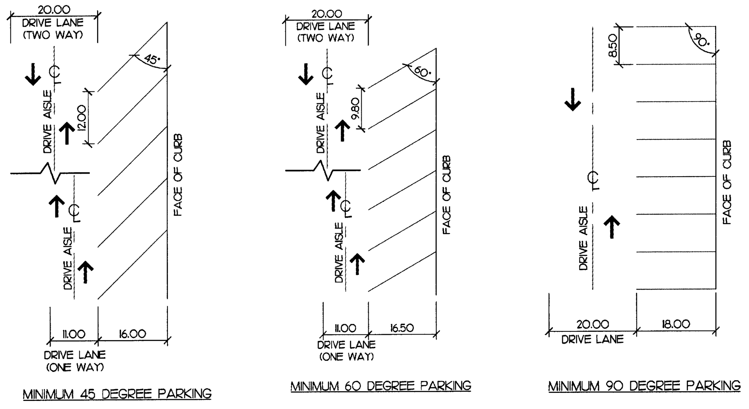
A)
Compact spaces: In parking lots having 20 or more spaces, up to 25 percent of the total required spaces may be provided as compact spaces. Such spaces shall have minimum dimensions as follows:
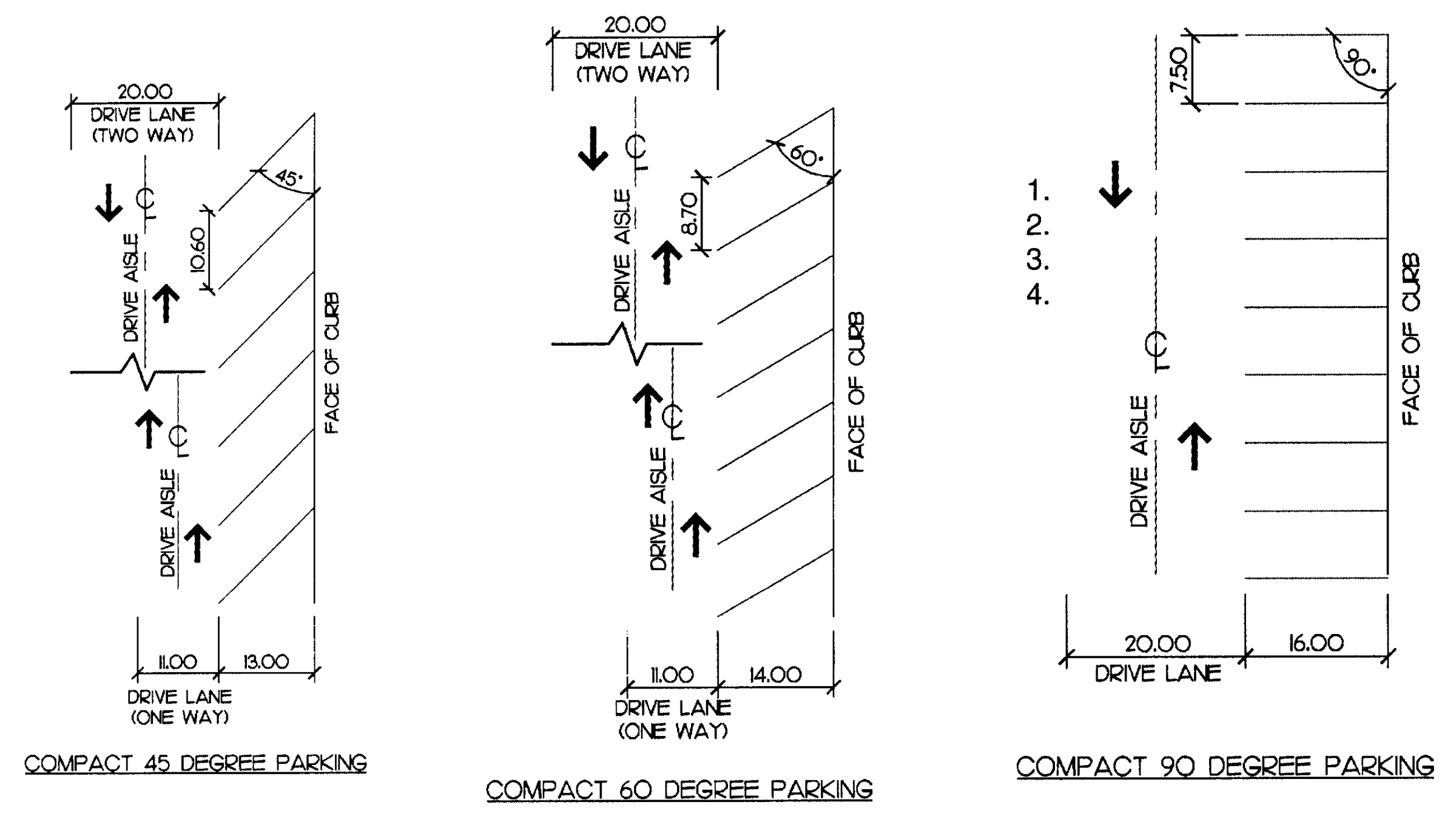
4)
Parking lot landscaping: Landscaping islands within parking areas shall be no less than the minimum dimensions of a full-size parking space (measured from edge of pavement or back of curb, if such islands are defined by curb). Islands shall be installed every 25 spaces to include a 2.5″ caliper tree (minimum). No parking space shall be further than 110 feet from a landscape island. All trees planted in landscape islands shall adhere to the standards set forth in chapter 38, division 3, tree control.
5)
On-street parking: A minimum of 50 percent of the required off-street parking must be provided on site. Where on-street parking is available or provided as part of the development, on-street parking spaces may account for up to 50 percent of the required spaces, provided:
a.
A key map is provided that delineates the location of allocated on-street spaces for a designated parcel or use.
b.
The on-street parking must be located within 1,200 feet of the primary entrance of a use.
c.
On-street parallel parking spaces shall be 7' × 20' measured from the face of curb (or edge of pavement, if curb does not exist).
d.
On-street diagonal parking with a 60-degree angle or less shall have a minimum travel lane width of 11 feet.
6)
Historic or downtown district parking: Business located in the historic or downtown district, regardless of type, shall not be required to meet the standards provided herein.
7)
Off-street loading requirement: All establishments commenced hereafter which acquire or dispense goods shall provide the minimum number of off-street loading spaces required in this ordinance. Minimum dimensional requirements for such a space shall be 15 feet by 30 feet, and there shall be adequate access to such loading space from a public street. The following schedule shall apply to all uses within the various district which are required to provide off-street loading facilities:
J.
Curb cuts: No driveway shall be located closer than fifteen feet to the intersection of any public street, as measured along the right-of-way. Driveways shall be a maximum of 30 feet in width and shall be at least 21 feet apart, except in residential districts.
K.
Corner visibility: In all zoning districts established by this ordinance, except the local commercial (LC) district, there shall be no obstruction to visibility on any corner lot within 25 feet of the intersection of any two right-of-way lines.
L.
Height limitation exceptions: The following uses are not controlled by height limitations of this ordinance: belfries, spires, cupolas, domes, chimneys, smokestacks, water towers, conveyors, flag poles, television and radio masts, aerials, towers, and similar structures.
M.
Fences:
A)
Permit requirements: Any person wishing to erect, alter, or relocate a fence must first obtain a fence permit from the code enforcement officer. Fences not meeting the standards outlined in this section may be permitted by a special use permit. The code enforcement officer may exercise the power to impose reasonable conditions in granting a special use permit under the requirements and guidelines of this ordinance.
B)
Fencing requirements:
1)
Fences shall be limited to a maximum height of six feet for rear and side yards and cannot extend beyond the principal structure into the front yard. For the property owners' protection, a six-inch setback from property lines shall be required.
2)
Front yard fences shall not exceed four feet in height and must be approved by the Code Enforcement Officer. Front yard fences cannot be located in any right-of-way.
3)
Fences shall be constructed with quality material and workmanship and be maintained in good repair. Materials must be approved by the code enforcement officer. Barbed wire, constantine wire, razor wire, or poultry wire are strictly prohibited.
4)
The finished side of fences shall face adjoining property and shall blend with the landscape.
5)
On corner lots, fences may not be permitted beyond the principal structure in side yards facing the adjoining street.
The sides and rear fence shall conform to the above guidance; however, due to the potential visibility problem, the construction of fences within the front yard will be restricted. The code enforcement officer may use the authority provided in subsection M.A). to issue a special use permit for front yards on a case-by-case basis for corner lots.
(Amd. of 10-8-07; Ord. No. 2020-02, § I, 1-27-20)
Sec. 8. - Transportation impact analyses.
Transportation impacts, and how to mitigate them, are an important consideration for our community when a development is proposed. Public policy makers, citizens, and developers all have a stake in understanding and responding to additional demands on the transportation system. A Transportation Impact Analysis (TIA) is a tool used to evaluate the incremental impacts on the surrounding transportation infrastructure and how to mitigate them to maintain safe traffic and transportation operations.
A.
TIA determination. The town shall determine the need for a TIA upon receipt of any development application (by-right or rezoning) accompanied by a sketch or schematic plan. Types of development applications could include, but are not limited to, multi-family developments, single family developments, commercial developments, mixed-use projects, rezonings, or annexation requests. If warranted, the transportation consultant assigned by the town shall prepare the TIA. At the discretion of the South Carolina Department of Transportation (SCDOT) and the town, a Transportation Technical Memorandum, in lieu of a full TIA report, may be allowed for some developments.
B.
Minimum thresholds for TIAs. A TIA will be required to accompany any development plan when expected gross trip generation is 400 total trips or more in a 24-hour period, and/or 100 total trips during either the AM or PM peak hours [prior to any trip reductions applied - see section 8.6.G.(10)]. The gross trip generation will be calculated by the town or its consultant based on information (proposed project summary and development plan) provided by the applicant, and the final determination for requiring the TIA will be made by the town. The town may also determine the need for a TIA based on special circumstances associated with the development, even if the gross trip generation falls below the identified threshold(s). This may be due to location, an intersection or thoroughfare nearby that is at or above capacity, the nature of the use, or one of the following:
1.
Traffic generated from a non-residential development that could potentially significantly impact adjacent residential neighborhoods.
2.
Traffic operation issues for current and/or future years on nearby streets are expected to be significantly worsened by traffic generated from the proposed new development.
3.
Arterials and/or collectors near the site are experiencing significant/unacceptable delays.
4.
Traffic safety issues exist at the intersection(s) or street(s) that would serve the proposed new development.
5.
The proposed land use differs significantly from the future land use designation of the town's adopted Comprehensive Plan.
6.
The internal street or access system is not anticipated to accommodate the expected traffic generation.
7.
The proposed development project includes a drive-through facility or other uses, such as schools, that require significant on-site circulation that may have an offsite impact to adjoining roads and/or intersections.
8.
The amount, behavior, and/or assignment of traffic is deemed by the town as being significantly different from a previously approved TIA, or more than 24 months have passed since completion of a previous TIA for the site.
A transportation technical memorandum (TTM) will be required for any proposed development when the conditions above are not met. In this case, the town and its consultant will determine what the TTM will address.
C.
Scoping meeting. A mandatory scoping meeting is required prior to beginning the TIA to discuss the requirements and strategies for a TIA specific to the site and the proposed development. Background information shall be submitted by the applicant and shall include a conceptual site plan showing proposed access points, access spacing/distances between one another and adjacent roads, proposed land uses and densities, structure and parking envelopes. The town, the transportation consultant assigned by the town, and the applicant(s) are required to attend the mandatory scoping meeting, and representatives from the SCDOT District 4 office, York County, and Rock Hill-Fort Mill Area Transportation Study (RFATS) will be invited and encouraged to attend as needed. The applicant may invite members of his/her development team as needed.
D.
Scoping document. A scoping document detailing the understood scope and parameters of the TIA shall be prepared by the transportation consultant assigned by the town. The Scoping Document shall be signed by the applicant, the town, and the SCDOT and/or York County (if access to a state or county road is involved) before the consultant can begin work on the TIA. Failure by the applicant to provide accurate information or failure by the assigned transportation consultant to follow the scoping document shall result in disapproval of the TIA. If significant changes are made to the parameters outlined in the scoping document, a revised scoping document will be required.
E.
Fees. Prior to the scoping meeting, the transportation consultant assigned by the town shall submit a summary of consultant fees to the town to perform the scoping portion of the TIA based upon the background information submitted by the applicant (discussed in item C. above). The applicant shall agree to provide payment in full to the town for these services prior to scheduling of the scoping meeting. After the scoping document is prepared, changes by the applicant which require updates to the scoping document, will result in additional services and must be paid for by the applicant prior to performance of the additional services. After the scoping meeting, the transportation consultant assigned by the town shall submit a summary of consultant fees for preparing the TIA to the town. Per the scoping document, the applicant shall agree to provide payment in full to the town for preparation of the TIA so that the town can release the work to the consultant. Any additional services incurred by the transportation consultant in addition to the scoping document must be approved by the town and agreed to and paid for by the applicant prior to performance of the additional services.
F.
Transportation mitigation agreement (TMA). Upon completion of the TIA, certain on- or off-site transportation mitigation measures may be required as recommended by the TIA. If so, the transportation consultant assigned by the town shall prepare a transportation mitigation agreement (TMA) which will summarize the following:
1.
Development plan.
2.
Development phasing and timing (if applicable).
3.
Site access and points of ingress/egress.
4.
On- and off-site improvements required to adequately mitigate the project impacts to the town's transportation system, including vehicular, pedestrian, and bicycle improvements.
5.
Trigger points and deadlines for construction and/or submittal of financial guarantees for any improvements.
The TMA must be signed by the applicant and town following the approval of the TIA by all applicable parties. All required mitigation measures must be implemented as prescribed in the TMA. If the development program is planned to be phased, then a development phasing analysis shall be performed, either as part of the TIA or as an additional service to the TIA, to determine the mitigation for each phase of development if mitigation phasing is desired by the applicant. The applicant shall provide a financial guarantee in a manner acceptable to the town in the amount of 150% of all phased transportation improvements as prescribed in the TMA. A planning-level opinion of probable construction cost (OPCC) will be performed by the town and its consultant as an additional service, and submitted to the applicant to provide payment. The OPCC will include costs for planning/design, utilities, permitting, construction, and right-of-way.
G.
TIA outline and contents. The outline and contents of what is required to be included in the TIA will be discussed at the scoping meeting and included in the scoping document. A detailed summary of the expected content and methodologies to be used in the TIA is discussed below:
1.
Cover/signature page. Includes the project name, location, name of the applicant, contact information for the applicant, and date of the study. The name, contact information, registration number, signature, and seal of a duly qualified and registered professional engineer in the State of South Carolina are also required to appear on this page.
2.
Table of contents. Includes a list of all section headings, figures, tables, and appendices included in the TIA report. Page numbers shall denote the location of all information, excluding appendices, in the TIA report.
3.
Executive summary. Includes a description of the study findings, a general description of the project scope, study horizon years, expected transportation impacts of the project, and mitigation measure recommendations. Technical publications, calculations, documentation, data reporting, and detailed design shall not be included in this section.
4.
Project description. Includes a detailed description of the development, including the size of the parcel, development size, existing and proposed uses for the site, anticipated completion dates (including phasing if appropriate). It shall also include the square footage of each use and/or the number and size of dwelling units proposed, and a map and copy of the site plan provided by the applicant.
5.
Site description. Includes a description of the project location within the town and region, existing zoning and use (and proposed use if applicable), and key physical characteristics of the site, including general terrain and environmentally sensitive or protected areas.
6.
Site access. A complete description of the ingress/egress of the site shall be explained and depicted. It shall include number of driveways, their locations, distances between driveways and intersections, access control (full-movement, leftover, right-in/right-out, etc.), types of driveways (two-way, one-way, etc.), traffic controls, etc. Internal streets (lanes, flow, and queuing), parking lots, pedestrian and bicycle facilities, and designated loading/unloading areas shall also be described. Similar information for adjacent properties, including topographic grade relationship, shall be provided to evaluate opportunities for internal and/or adjacent connectivity. The design, number, and location of access points to collector and arterial roadways immediately adjacent to the site must be fully analyzed. The number of access points shall be kept to a minimum and designed to be consistent with the type of roadway facility. Driveways serving the site from state roads shall be designed in accordance with the SCDOT's Access and Roadside Management Standards (ARMS) Manual and/or town standards, as applicable.
7.
Study area. The limits of the study area shall be based on the location, size and extent of the proposed project, and an understanding of existing and future land uses and traffic conditions surrounding the site. The limits of the study area for the TIA shall be reviewed and approved by the town and SCDOT staff at the mandatory scoping meeting. At a minimum, the study area shall include all streets and signalized intersections within a one-mile radius of the proposed site and/or where site traffic estimated for build-out of the project will constitute 10% or more of any signalized intersection approach during one or both peak hours. During the scoping meeting, staff may reduce the radius due to conditions specific to the site based on request by applicant and supported with valid reasoning. Unsignalized intersections between the required signalized intersections will be added to the scope as directed by the town. To initially determine the impacts, the town will maintain a database of recent peak-hour intersection turning movement counts. The applicable intersection counts will be equated to current year baseline volumes. Based on the proposed development program submitted by the applicant, a preliminary trip generation analysis, distribution, and assignment will be performed within the area surrounding the site and compared to the current year base volumes. Related impacts or current operational problems may dictate that other intersections be included in the study area as determined by town staff and/or SCDOT staff. A narrative describing the study area shall identify the location of the proposed project in relation to the existing transportation system and list the specific study intersections and/or segments. Any unique transportation plans or policies applicable to the area (e.g., CATS bus service and future plans) shall be mentioned. A site location map shall be provided and shall identify natural features, major and minor roadways within the study area, study intersections, and a boundary of the site under consideration.
8.
Existing conditions. Shall include a narrative and map that represents AM and PM peak-hour turning-movement volumes for all intersections within the study area. Traffic volumes shall represent 15-minute interval weekday turning movement counts (Tuesday through Thursday), include heavy-vehicle, pedestrian and bicycle counts, no more than twelve months old, and shall be collected during periods of the year when local schools are in session and during weeks that have no observed federal, state, or local holidays and periods unless otherwise approved by the town. The required count timeframes are from 6:30—9:00 a.m. and 3:00—7:00 p.m. The PM count timeframe is expected to cover peaking characteristics caused by local Middle and High School dismissal times, as well as typical employment peaking characteristics; however, site-specific conditions may necessitate additional or different traffic counting hours and/or days depending on the development program and location within the town. These unique circumstances will be determined and directed by the town. The town will determine if modified peak hours or weekend analyses shall be included in the TIA at the mandatory scoping meeting. For example, eight-, 12-, or 16-hour turning movement counts shall be required to complete the analysis if a full traffic signal warrant analysis is required as part of the TIA. The source of existing traffic volume information shall be explicitly stated (e.g., town counts, new counts collected by the applicant, SCDOT counts, etc.). If previous counts were obtained, only counts collected within one year of TIA submittal for the proposed site will be deemed acceptable. Summary sheets for existing turning movement counts shall be included in the appendix of the TIA report. A separate narrative and map shall be prepared to describe the characteristics of surrounding major roadways, including functional classification, number of lanes, posted speed limit, existing average daily traffic volumes, typical cross section, intersection control, and lineal distance between major roadways. Field notes for the existing conditions observation may be included in the appendix of the TIA report.
9.
Future year conditions. Unless otherwise approved by the town, future year conditions for a single-phase development shall be analyzed for the year the development is expected to be at full occupancy (build-out year). For multiple-phased developments, the scenarios shall be completed in order, with any improvements specified by development included in the subsequent build scenarios. Specific analysis periods to include in the study shall depend upon the development program, proposed project phasing plan, and significant improvements programmed for the surrounding transportation system. The approved offsite developments and transportation projects to be included in the base future-year background conditions for the transportation system within the study area shall be determined during the scoping meeting. Transportation improvements assumed in the future-year background conditions analysis may include those with an expected completion date concurrent with that of the development and funded either by the town, SCDOT, or indicated as a required condition of approval from an offsite development application. Only projects approved by the town at the scoping meeting may be included in the analysis as future existing infrastructure. Those improvements committed by other developments must be clearly identified in the report as approved offsite development road improvements. Adjacent development traffic information used in the development of the future year background traffic volumes shall be included in the appendix of the TIA report. Unfunded, planned infrastructure projects may be mentioned in the TIA, but the description shall specifically identify that these projects are not included in the background condition. Future year background traffic volumes shall be forecasted using historical growth rate information, regional models, and/or TIA reports for development(s) approved by the town but not yet built. Additional future year scenarios may be applicable in the case that there are committed offsite approved development improvements as indicated in section 8.6 G.(17). A narrative and map shall be prepared that presents turning movement volumes for each peak hour for all intersections identified within the study area. Future year base (existing plus historical growth) traffic volumes, offsite approved development volumes, and site traffic volumes shall be clearly separated and combined in the map.
10.
Trip generation. Base trip generation for the proposed land use(s) shall be calculated using data published in the latest version of the Institute of Transportation Engineers' (ITE) Trip Generation Manual. Data limitations, data age, choice of peak hour of adjacent street traffic, choice of independent variable, and choice of average rate versus equation shall be discussed at the mandatory scoping meeting. Local trip generation rates may be acceptable if appropriate validation is provided by the applicant to support them. Any deviation from ITE trip generation rates shall be discussed in the mandatory scoping meeting and documented in the scoping document if approved by the town and SCDOT.
a.
Internal capture. Base trip generation may be reduced by rate of internal capture when two or more land uses are proposed using methodology recommended in the most current Trip Generation Handbook published by ITE, or research published by the National Cooperative Highway Research Program (NCHRP) Transportation Research Board. Reductions for internal capture shall be applied to multi- or mixed-use sites only. The internal capture reduction shall be applied before pass-by trips are calculated.
b.
Pass-by trips. Pass-by trips are those made as intermediate trips between an origin and primary destination (i.e., home to work, home to shopping, etc.). However, pass-by trips are not diverted from another roadway. Base trip generation may be reduced by rate of pass-by capture using methodology recommended in the most current Trip Generation Handbook published by the ITE. Pass-by trips associated with the development program may not exceed 10% of the peak-hour background volume reported for the adjacent public street network. This network shall include the streets that provide primary access to/from the site. For example, if a site access drive that connects to a low-volume local street, which its primary access is to a major collector road, the traffic on the major collector shall be used as the adjacent street for pass-by calculation purposes. Evaluation of diverted trips may apply depending on the specifics of each site. A trip generation table shall summarize all trip generation calculations for the project.
11.
Trip distribution. External trip distribution shall be determined on a project-by-project basis using one of several sources of information available to transportation and land planning professionals. Potential sources for determining project trip distribution may include the regional travel demand model, market analysis, existing traffic patterns, and/or professional judgment. At the town's direction, multiple trip distributions may be required for differing land use types. Regardless of methodology, the procedures followed and logic for estimating trip distribution percentages must be well-documented in the TIA. Trip distribution percentages proposed for the surrounding transportation network shall be discussed during the Scoping Meeting and shall be approved by the town and SCDOT before proceeding with the TIA. A map showing the percentage of site traffic on each street included in the study area shall be included in the TIA.
12.
Trip assignment. Site traffic shall be distributed to the surrounding transportation system based on the site's trip generation estimates and trip distribution percentages. Future year build-out traffic forecasts (i.e., future year background traffic plus site traffic) shall be represented in graphic formats for AM and PM peak-hour conditions at all intersections included in the study area. If the project will be built in phases, traffic assignments shall be reported for each phase. Pass-by traffic shall be included at the driveways and access points for evaluating driveway volumes. Multiple assignment analyses may be required if the traffic control at the access drives varies (i.e., right-in/right-out vs. stop controlled vs. signalized).
13.
Operations analysis. The TIA shall include multi-modal operations analyses including vehicular, pedestrian and bicycle, to allow for the safe and convenient travel for all modes. Level-of-service (LOS) and delay are the primary measures of effectiveness for impacts to the transportation system and are defined by the most current edition of the Highway Capacity Manual (HCM). Operations analyses shall be performed for the existing and all future year scenarios, as described in section 8.6.G.(17). Impacts from the proposed project shall be measured by comparing the future year background conditions to the future year build-out conditions. Requirements for mitigation are described in Section 8.6.G.(17).
a.
Vehicular capacity analysis. Unless otherwise noted, Synchro level-of-service (LOS) and delay shall be reported for all signalized intersections and approaches identified in the study area. Based on HCM, LOS for unsignalized intersections is not defined as a whole; instead, only the individual approaches shall be reported as applicable based on the HCM reports determined through the Synchro analysis. Existing signalized intersections shall be modeled based on existing signal timing plans provided by either the town or SCDOT. Existing signal timing plans shall be included in the appendix of the TIA report. Pedestrian movements must be considered in the evaluation and adequate pedestrian clearance provided in the signal cycle split assumptions. If a traffic signal is part of a coordinated system it must be analyzed as such under all conditions. Other standard practices and default input values for evaluating signalized intersections shall be consistent with the most recent guidelines published by the SCDOT. The town may also require safety, traffic simulation, gap and/or other analyses appropriate for evaluating a development application. Additional analyses and/or traffic capacity or simulation tools (such as VISSIM or Transmodeler) required for the TIA shall be identified during the scoping meeting. All TIA reports submitted to the town shall use Synchro, SimTraffic, VISSIM, and/or Transmodeler analysis software for signalized and unsignalized intersections, or Sidra Software for roundabouts, consistent with SCDOT policies. A narrative, table, and map shall be prepared that summarizes the methodology and measured conditions at the intersections reported in LOS (LOS A—F), the intersection and approach signal delay for signalized intersections, the approach delay for unsignalized intersections, and 95th percentile queue lengths for all movements. Capacity analysis worksheets and SCDOT auxiliary turn-lane warrants for unsignalized intersections shall be included in the appendix of the TIA report.
b.
Pedestrian operations analysis. Unless otherwise noted, methodology provided in the latest edition of the Highway Capacity Manual shall be used to evaluate pedestrian LOS for the intersections identified in the study area. The current methodology is based on geometric data, demand data, and signal control data including, but not limited to:
• Number of lanes on the major street.
• Crossing distance.
• Traffic volumes.
• Motorist yielding rates to pedestrians.
• Cycle length.
• Walk time.
• Presence of pedestrian phase.
c.
Bicycle operations analysis. The bicycle LOS at intersections identified in the study area shall be evaluated using locally accepted methodology. This current methodology assesses bicyclists' comfort based on geometric and traffic signal features including, but not limited to:
• Number of lanes crossed.
• Presence of conflicting turning movements.
• Presence of bike lanes.
Under this methodology, intersection features are assigned points, where the LOS for each approach is calculated based on the accumulation of points for each geometric and traffic signal feature identified in the worksheet. Currently, this methodology does not take into account demand volumes; therefore, the bicycle LOS would not differ between AM and PM peak hours, and thus would not need to be reported for both under this methodology.
14.
Queuing analysis. 95th percentile and simulation analysis of future year queues shall be consistent with SCDOT's current practices and published Capacity Analysis Guidelines, as applicable. Turn lanes and storage lengths for the major street (uncontrolled) approaches at unsignalized intersections shall be identified using volume thresholds published in the SCDOT's 2017 Roadway Design Manual (see Guidelines for Left- and Right-Turn Lanes Nomographs, section 9.5.1). Recommendations for left- and right-turn lanes serving the site shall be designed to account for both the SCDOT warrants described above and to meet future year capacity needs identified through the capacity analyses. For projects that include drive-through facilities, pick-up/drop-off areas, or entrance gates, a queuing analysis may be required by the town to ensure that vehicle stacking will not adversely impact the public transportation system. The queuing analysis must be performed using accepted transportation engineering procedures approved by the town. If a TIA is required for a new school site, the internal circulation and ingress/egress of the site shall be modeled using a "dummy signal" in the Synchro software as prescribed by NCDOT Municipal School Transportation Assistance (MSTA) department.
15.
Crash analysis. A summary of crash data (type, number, and severity) for the most recent three-year period at each study location may be required. South Carolina Department of Public Safety reports will be requested by the town's consultant and shall be included in the appendix of the TIA report if required. For locations with prevalent crash types and/or frequency, a discussion shall be included describing factors that may be contributing to the incidents. At a minimum, the proposed development features shall not contribute to factors potentially involved in the existing crash rates. If contributing factors are identified, recommendations to eliminate or mitigate these features shall be included.
16.
Traffic signal warrants. Town staff and/or SCDOT may consider potential signal locations at the scoping meeting. However, traffic flow progression is of paramount importance when considering a new traffic signal location. A new traffic signal shall not cause an undesirable delay to the surrounding transportation system. Installation of a traffic signal at a new location shall be based on the application of warrant criteria contained in the most current edition of the Manual on Uniform Traffic Control Devices (MUTCD) and engineering judgment. Traffic signal warrants shall be included in the appendix of the TIA report. Additionally, spacing of traffic signals within the town must adhere to SCDOT requirements. If a full signal warrant analysis is recommended in the TIA, then the consultant identified by the town will perform the associated warrant analysis as an additional service if not performed as part of the TIA. The town and/or SCDOT may decide to defer a signal warrant analysis until after the development has opened to allow use of actual turning movement counts at an intersection. As such, the TIA recommendations must clearly state that this analysis shall occur at a specified date following the opening of the development. The applicant shall provide a financial guarantee as outlined in TMA for the estimated cost of the signal warrant analysis and resulting signal prior to final approval of the TIA. The cost shall be established based on an engineer's estimate provided by the consultant identified by the town.
17.
Mitigation measure recommendations. This section of the TIA report shall provide a description of the study's findings regarding impacts of the proposed project on the existing and future transportation system and describe the location, nature, and extent of all mitigation measures recommended to the applicant to improve and/or maintain the future year background level-of-service (LOS) conditions through phasing and ultimate build-out of the project. This mitigation will be identified by measuring the impact between the future year background conditions and the future year build-out conditions. The applicant is required to mitigate transportation deficiencies caused solely by the projected impact of their proposed development, and not unacceptable background conditions or other deficiencies caused by offsite development within the defined study area.
The applicant shall be required to identify mitigation improvements to the transportation network if at least one of the following conditions exists when comparing the multimodal operations analyses of future year background conditions to future year build-out conditions:
a.
The total average delay at an intersection or individual approach increases by 25% or greater, while maintaining the same LOS,
b.
The LOS degrades by at least one level,
c.
Or the LOS does not meet the identified standard (as shown below) in background conditions, and the proposed project shows a negative impact on the intersection or approach.
If the background LOS (intersection or approach) is inadequate, the applicant will be expected to mitigate only the impact caused by the proposed site. For example, if the background LOS of an intersection is LOS F with 85 seconds of delay, and the site traffic increases the delay to 95 seconds at LOS F, the applicant will be required to mitigate the added 10 seconds of delay, not the inadequate background delay. Town staff and SCDOT will review the recommendations in the final version of the TIA and will have the ultimate determination in the scope of the required mitigation measures.
The applicant shall also be responsible for committed transportation improvements by approved offsite developments included in the background and build-out scenarios in the case that they are not completed prior to build-out of the proposed site, unless additional background and build-out analyses are performed without the approved offsite development traffic and associated committed improvements, and the analyses show that such committed improvements would not be caused by the proposed site.
A transportation mitigation agreement (TMA) as outlined in Part F. of this ordinance may apply if there are mitigation requirements.
For multi-phase developments, the capacity analyses scenarios shall address the phasing of improvements for each phase of development. A narrative and table shall be prepared that summarizes the methodology and measured conditions at the intersections reported in LOS (LOS A-F) and average control delay for each intersection and approach.
A narrative and map shall also be prepared that describes and illustrates recommended improvements, by development phase if necessary, for mitigating the projected impact of the proposed development.
18.
Compliance with adopted transportation plans. All TIA reports must include a statement of compliance with plans, programs, and policies adopted by the Town of Fort Mill for maintaining a safe and efficient multi-modal transportation system.
(Ord. No. 2019-03, § I, 1-28-19; Ord. No. 2020-12, § I, 3-23-20)