
Fort Mill City Zoning Code
ARTICLE II
REQUIREMENTS BY DISTRICTS
Sec. 1. - R-25 and R-15 One-family residential districts.
1.
Purpose of districts: It is the intent of this section that the R-25 and R-15 one-family zoning districts be developed and reserved for low-to-medium density residential purposes. The regulations which apply within these districts are designed to encourage the formation and continuance of a stable, healthy environment for one-family dwellings situated on zoning lots having an area of fifteen thousand square feet or more, and to discourage any encroachment by commercial, industrial, or other uses capable of adversely affecting the residential character of the district.
2.
Permitted uses: The following uses shall be permitted in any R-25 or R-15 zoning district:
A)
One-family dwelling (other than a mobile home);
B)
Publicly owned building, facility, or land;
C)
Noncommercial horticulture or agriculture, but not including the keeping of poultry or livestock;
D)
Accessory use in compliance with the provisions of article I, section 7, subsection G.;
E)
Customary home occupations established under the regulations in article I, section 7, subsection F.;
F)
A property owner or tenant shall not permit a recreational vehicle, travel trailer, or boat to be located on his property for more than two weeks if the vehicle is being used as a dwelling;
G)
The storage of travel trailers, recreational vehicles, and boats shall be permitted, provided no more than two such units are stored on a lot of record and such units are not used for purposes of living, sleeping, or cooking while in storage.
3.
Conditional uses: The following uses shall be permitted in any R-25 or R-15 zoning district on a conditional basis:
A)
Public utility substation or subinstallation, including water towers; provided that:
(1)
Such use is enclosed by a painted or chain-link fence or wall at least six feet in height above finish grade;
(2)
There is neither office nor commercial operation nor storage of vehicles or equipment on the premises; and
(3)
A landscaped strip not less than ten feet in width is planted and suitably maintained around the facility;
B)
Temporary use in compliance with the provisions of article VI, section 4;
C)
Religious institutions;
D)
Daycare facilities;
E)
Private or Semiprivate Clubs, Lodges and Union Halls, provided that:
(1)
The minimum lot size shall be 20,000 square feet;
(2)
The lot shall have road frontage on at least two public rights-of-way, or if fronting a single public right-of-way, shall have a minimum road frontage of at least 250 linear feet; and
(3)
Such uses shall not be established or enlarged on any lot which shares a property line with one or more adjacent lots containing a single-family detached residence.
4.
More restrictive use requirements: A subdivision, zoning lot or other parcel of land of five acres or more, lying within an R-25 or R-15 residential district, may be more strictly limited as to permitted and/or conditional uses for the district in which the property is located, provided the owner submits such proposed plans, limitations, conditions, restrictions, easements, rights, and/or privileges for review and approval by the planning and zoning commission.
5.
Other requirements: Unless otherwise specified elsewhere in this ordinance, uses permitted in an R-25 and R-15 zoning district shall be required to conform to the following standards:
A)
Minimum lot area: R-25—25,000 square feet and R-15—15,000 square feet;
B)
Minimum land area per dwelling unit: R-25—25,000 square feet and R-15—15,000 square feet;
C)
Minimum lot width measured at the building line: R-25—125 feet and R-15—100 feet;
D)
Minimum front yard depth measured from the nearest street right-of-way line: R-25—50 feet and R-15—35 feet;
E)
Minimum side yard: R-25—Principal structure-20 feet with accessory uses being five feet. R-15—Principal structure-ten feet with accessory uses being five feet. For side yard requirements pertaining to corner lots, see article I, section 7, subsection C.;
F)
Minimum rear yard: R-25-Principal structure-50 feet with accessory uses being five feet. R-15-Principal structure-35 feet with accessory uses being five feet. For rear yard requirements pertaining to double frontage lots, see article I, section 7, subsection D.;
G)
Maximum building height: R-25—35 feet and R-15—35 feet. For exceptions to height regulations, see article I, section 7, subsection L.;
H)
Additional requirements: Uses permitted in R-25 and R-15 zoning districts shall meet all standards set forth in article I, section 7, subsection I., pertaining to off-street parking, loading, and other requirements.
I)
Signs: Signs permitted in R-25 and R-15 zoning districts, including the conditions under which they may be located, are set forth in article III.
(Ord. No. 2017-23, § I, 10-9-17)
Sec. 2. - R-10 One-family residential district.
1.
Purpose of district: It is the intent of the section that the R-10 one-family zoning district be developed and reserved for low-to-medium density residential purposes. The regulations which apply within this district are designed to encourage the formation and continuance of a stable, healthy environment for one-family dwellings situated on zoning lots having an area of ten thousand square feet or more, and to discourage any encroachment by commercial, industrial, or other uses capable of adversely affecting the residential character of the district.
2.
Permitted uses: The following uses shall be permitted in any R-10 zoning district: All permitted uses as shown in article II, section 1, subsection 2.
3.
Conditional uses: The following uses shall be permitted in any R-10 zoning district on a conditional basis:
A)
All conditional uses as shown in article II, section 1, subsection 3
B)
Daycare facilities or pre-school nursery, provided that plans for such facilities receive the written approval of the South Carolina Department of Social Services and the Fort Mill Planning and Zoning Commission.
4.
More restrictive use requirements: The requirements of article II, section 1, subsection 4. shall apply.
5.
Other requirements; Unless otherwise specified elsewhere in this ordinance, uses permitted in R-10 zoning districts shall be required to conform to the following standards:
A)
Minimum lot area: R-10—10,000 square feet;
B)
Minimum land area per dwelling unit: R-10—10,000 square feet
C)
Minimum lot width measured at the building line: R-10—75 feet
D)
Minimum front yard depth measured from the nearest street right-of-way line: R-10—35 feet. For exceptions to this requirement, see article I, section 7, subsection E.
E)
Minimum side yard: R-10-Principal structure is ten feet with accessory uses being five feet. For side yard requirements pertaining to corner lots, see article I, section 7, subsection C.
F)
Minimum rear yard: R-10-Principal structure is 35 feet with accessory uses being five feet. For rear yard requirements pertaining to double frontage lots, see article I, section 7, subsection D.
G)
Maximum building height: R-10—35 feet. For exceptions to height regulations, see article I, section 7, subsection L.
H)
Additional requirements: Uses permitted in R-10 zoning districts shall meet all standards set forth in article I, section 7, subsection I., pertaining to off-street parking, loading, and other requirements.
I)
Signs: Signs permitted in R-10 zoning districts, including the conditions under which they may be located, are set forth in article III.
Sec. 3. - GR Residential district.
1.
Purpose of district: It is the intent of this section that the GR zoning district be developed and reserved for medium-to-high density residential purposes. The regulations which apply within this district are designed to encourage the formation and continuance of a stable, healthy environment for several different types of dwellings and certain other compatible uses on zoning lots of ten thousand or more square feet, and to discourage unwarranted encroachment of commercial, industrial, or other uses capable of adversely affecting the residential character of the district.
2.
Permitted uses: The following uses shall be permitted in any GR zoning district:
A)
All permitted uses as shown in article 2, section 1, subsection 2;
B)
Two-family dwellings;
C)
Multi-family dwellings;
D)
Group dwellings.
3.
Conditional uses: The following uses shall be permitted in any GR zoning district on a conditional basis:
A)
All conditional uses, as shown in article II, section 2, subsection 3;
B)
Boarding facilities;
C)
Planned cluster development;
D)
Hotel or motel; provided, that:
(1)
No parking be placed within ten feet of the boundary line of any adjoining residential district; and
(2)
The regulations governing the use and location of signs, as stipulated in article III, shall apply;
E)
Other commercial services directly oriented to the operations of a specific hotel or motel activity; provided that the provisions governing hotels and motels in article II, section 4 are maintained;
F)
Bed and breakfasts provided, that such use shall not be expanded in such a way as to become a hotel or motel without conforming to the provisions of article II, section 4;
G)
Private and semiprivate club, lodge, or recreation facility; provided that the provisions governing hotels and motels in article II, section 4 are maintained;
H)
Public or private care homes; provided that such facilities shall conform with the requirements of the South Carolina Department of Health and Environmental Control;
I)
Clinics, doctors' offices, dentists' offices; provided, that they shall meet the requirements of any and all medical regulations that may apply.
4.
More restrictive use requirements: The requirements of article II, section 2, subsection 4. shall apply.
5.
Permitted density: The maximum permitted density allowed for multi-family development in a GR district is ten units per acre.
6.
Other requirements: Unless otherwise specified elsewhere in this ordinance, uses permitted in GR zoning districts shall be required to conform to the standards set forth for such uses under the provisions of article II, section 2, subsection 5.
Sec. 4. - GR-A General residential-A district.
1.
Purpose of district: It is the intent that the GR-A zoning district be developed and reserved for medium-to-high density residential purposes. The regulations which apply within the district are designed to encourage the formation and continuance of a stable, healthy environment for several different types of dwellings and certain other compatible uses on zoning lots of ten thousand or more square feet, and to discourage unwarranted encroachment of commercial, industrial, or other uses capable of adversely affecting the residential character of the district.
2.
Ppermitted uses: The following uses shall be permitted in any GR-A zoning district:
A)
All permitted uses as shown in article II, section 2, subsection 2;
B)
Two-family dwellings;
C)
Multi-family dwellings.
3.
Conditional uses: The following uses shall be permitted in any GR-A zoning district on a conditional basis: All conditional uses as shown in article II, section 2, subsection 3.
4.
More restrictive use requirements: The requirements of article II, section 2, subsection 4. shall apply.
5.
Permitted density: The maximum density allowed for multi-family development in a GR-A zoning district is eight units per acre.
6.
Other requirements: Unless otherwise specified elsewhere in this ordinance, uses permitted in GR-A zoning districts shall be required to conform to the standards set forth for such uses under the provisions of article II, section 2, subsection 5.
Sec. 5. - Planned cluster development district.
1.
Legislative purpose and intent: The legislative purpose and intent of planned cluster development is as follows:
A)
Encourage a variety and flexibility in land development and land use for residential areas;
B)
Provide for an alternative means of housing development within the regulatory guidelines stipulated herein as to density and dwelling configuration;
C)
Encourage the efficient use of those public facilities required in connection with new residential development;
D)
Encourage innovative design techniques to utilize the environment as a guide to development such as, but not limited to, zero lot lines, party walls, site location with regard to energy consumption, and other concepts where such is appropriate within the regulatory guidelines of this section
2.
Location and minimum size: Planned cluster developments shall be permitted in the following zone districts as conditional uses: GR, GR-A, LC, HC.
3.
Permitted activities and building types: Planned cluster developments shall provide for individual lots of no minimum size upon which is permitted one dwelling unit in a single structure. Up to four units may be attached (party wall, see diagram). Mobile homes are excluded except in MH districts. The diagram illustrative of the attached and detached concepts for planned cluster developments.
4.
Density and recreation area:
A)
The maximum overall density for a planned cluster development shall be in terms of the number of dwelling units per gross acre of land within the development, as provided in the table below.
B)
The minimum total recreation area (that part of the living space which is any large continuous area for recreation purposes) shall be provided at no less than a minimum ratio of recreation space area per total floor area, as provided in the table below. Recreation areas shall be of common ownership.
C)
If a planned cluster development embraces one or more zone districts requiring different maximum permitted overall densities and recreation area ratios, these values shall be calculated separately for each distinct district and a weighted average (weighing the area in each zone district in proportion to its share of the total area of said development in such district) of each of these values shall be applied to said development.
5.
Yards: Except as required in the following, there shall be no minimum yard size within planned cluster developments; however, the planning commission shall have review authority for all yard designations and may require larger or smaller yard sizes based upon the particular site plans submitted for a specific development.
A)
A perimeter boundary setback of 30 feet measured from the structures to the property line shall be maintained uniformly for the total area within the planned cluster development.
B)
Less than ten units shall abide by the setback requirements of the zoning district in which the development is planned.
6.
Minimum lot size: There shall be no required minimum lot size within planned cluster developments; however, the planning commission shall have review authority for all lot designations and may require larger, smaller, or replatted lot sizes and/or shapes based upon the particular site plans submitted for a specific development.
7.
Required accessory off-street parking: A minimum of two off-street parking spaces per dwelling unit shall be required in all planned cluster developments. All streets and parking areas shall be bordered with concrete curb and gutter. Curbs shall be six inches high.
8.
Area maintenance: Provisions shall be made for the perpetual maintenance of areas designated for use by the residents of a planned cluster development. This may be accomplished through a Homeowners Association established in accordance with and chartered by the state under the applicable regulations, or by any other means acceptable to the planning commission. Such association charter or declaration of incorporation shall be submitted with the preliminary plat for approval by the planning commission.
9.
Procedure for approval of a planned cluster development: A planned cluster development shall follow the same rules and procedures for subdivision approval as outlined in the Town of Fort Mill Subdivision Regulations. However, the submission for preliminary plat approval must include the following additional information:
A)
Transportation routes, including streets, driveways, sidewalks, pedestrian ways and bikeways, and off-street parking and loading areas;
B)
Location and dimensions of structures, including height and bulk, and the utilization of structures, including activities and the number of dwelling units;
C)
Density of the development;
D)
A tabulation of the area to be devoted to various uses and activities as needed to calculate requirements of subsection 4.;
E)
The substance of covenants, grants of easements, or other restrictions to be imposed upon the use of the land, buildings, or other structures, including proposed documents as required by subsection 8. for area maintenance;
F)
When it is proposed that the development be constructed in stages, a development schedule for the project is required.
Sec. 6. - Planned neighborhood development district.
1.
Purposes of district: The Town of Fort Mill established the planned neighborhood development (PND) zoning ordinance to allow planned neighborhood development as an option within the town's R-10, R-15, and R-25 zoning district(s). The purpose of the ordinance is to provide an alternative form of development that:
A)
Eliminates standard dimensional requirements while reserving sufficient natural open space for common use;
B)
Enhances the physical appearance of the town by preserving the town's natural assets and distinctive character;
C)
Promotes more efficient use of land and provision of public facilities, utilities, streets, and services;
D)
Provides the opportunity for innovative combinations of housing and neighborhood-oriented commercial and professional uses within a single development;
E)
Conserves natural and environmental resources and the integrity of natural systems;
F)
Encourages innovative residential development so that housing demands are met by a greater variety of types, designs, and layouts of residential character;
G)
Provides a mechanism to relate the type, design, and layout of proposed development to the specific characteristics of a particular parcel;
H)
Encourages creative and site-sensitive developments by allowing increased overall density in exchange for planned neighborhood development pursuant to this chapter.
2.
Permitted uses:
A)
All planned neighborhood developments shall permit the following residential and accessory uses:
1)
Detached single-family dwellings;
2)
Two-family dwellings;
3)
Multi-family dwellings;
4)
Accessory buildings or uses;
5)
Recreation or park facilities;
6)
Retirement facilities;
7)
Municipal buildings or uses;
8)
Schools;
9)
Churches.
B)
Planned neighborhood developments shall permit the following community and institutional uses under the terms set forth in subsection 7.D):
1)
Daycare centers;
2)
Community halls;
3)
Municipal service lots.
C)
Planned neighborhood developments comprising 50 acres or more may contain the uses permitted in subsection 2.A) as well as the following commercial uses:
1)
Neighborhood retail stores;
2)
Personal services;
3)
Business or professional offices;
4)
Neighborhood restaurants.
3.
Standards:
A)
Planned neighborhood developments shall contain not less than 20 acres;
B)
Planned neighborhood developments shall be served by municipal water and sewer service;
C)
Allowable base residential density: Overall residential density shall not exceed eight dwelling units per acre dedicated to uses other than the commercial uses set forth in article II, section 7, subsection 2.C). This base residential density may be increased by the town council pursuant to the density bonus options contained in article I, section 4.
D)
Conservation lands: Lands with the following characteristics shall not be developed and shall not be platted as part of a residential, community, institutional, or commercial lot within a planned neighborhood development: land within the 100-year flood plain; land with a natural slope in excess of 40 percent, as determined by standard slope computation methods; and nontidal wetlands. These lands shall be designated on the plat for conservation purposes. Conservation lands may be used in computing the allowable base residential density.
4.
Open space standards:
A)
Planned neighborhood developments shall reserve a minimum of 35 percent of the acreage of the parcel as dedicated natural open space;
B)
Up to 25 percent of this requirement may be satisfied with land covered by water or by stormwater detention or retention basins if the town council determines that such a water body or basin is suitable for the purposes set forth in article I, section 1. The dedicated open space shall not be included in subdivision lots or in lot size calculations. Dedicated open space shall include the land necessary to provide access to the open space;
C)
Land characterized as conservation lands in article II, section 7, subsection 3.D) of this ordinance may be used to fulfill the minimum dedicated natural open space requirement at the following ratio: one acre of conservation land may be applied to the natural open space requirement as one-half of an acre. A maximum of 50 percent of the total dedicated natural open space within a planned neighborhood development may be fulfilled with conservation lands;
D)
Dedicated open space shall have shape, dimension, character, location and topography to accomplish the open space purposes specified in article I and to ensure appropriate public access;
E)
Dedicated open space land shall be shown on the preliminary planned neighborhood development plat and shall be labeled to specify that the land has been dedicated to open space purposes. The plat shall specify that the open space land shall not be further subdivided or developed and is permanently reserved for natural open space purposes;
F)
The open space shall be conveyed by the applicant as a condition of plat approval and may be conveyed by any of the following means as determined by the town council:
1)
Deeded in perpetuity to the Town of Fort Mill;
2)
Reserved for common use or ownership of all property owners within the development by covenants in the deeds approved by the town attorney. A copy of the proposed deed covenants shall be submitted with the application;
3)
Deeded in perpetuity to a private, non-profit, tax-exempt organization legally constituted for conservation purposes under terms and conditions that ensure the perpetual protection and management of the property for conservation purposes. A copy of the proposed deeds and relevant corporate documents of the land trust shall be submitted with the application;
4)
Deeded to a property owner's association within the development upon terms and conditions approved by the town attorney that will ensure the continued use and management of the land for the intended purposes. The formation and incorporation by the applicant of one or more appropriate property owners' associations shall be required prior to plat approval. A copy of the proposed property owner's deed and the by-laws and other relevant documents of the property owner's association shall be submitted with the application. The following shall be required if open space is to be dedicated to a property owners' association:
a)
Covenants providing for mandatory membership in the association and setting forth the owner's rights, interests, and privileges in the association and the common land, must be included in the deed for each lot or unit;
b)
The property owners' association shall have the responsibility of maintaining the open space and operating and maintaining recreational facilities;
c)
The association shall have the authority to levy charges against all property owners to defray the expenses connected with the maintenance of open space and recreational facilities;
d)
The applicant shall maintain control of dedicated open land and be responsible for its maintenance until development sufficient to support the association has taken place.
G)
The applicant shall convey or restrict the open space land by a deed instrument reviewed and approved by the Fort Mill Town attorney to ensure that the land will be held and managed in perpetuity for open space purposes and shall not be further developed;
H)
If the planned neighborhood development is developed in phases, the provision of dedicated natural open space shall be phased with the construction of dwelling units and other improvements to insure that a proportionate share of the total dedicated open space is preserved with each phase;
I)
Streets and other impervious surfaces shall be excluded from the calculation of the minimum dedicated open space requirement; however, lands occupied by bike paths, landscaped grounds, or similar common recreational development (excluding tennis courts, golf courses, and buildings) may be counted as dedicated natural open space provided that impervious surfaces constitute no more than five percent of the total required open space;
J)
Open space shall be permanently dedicated for one or more of the following uses: natural resource conservation, wetland and water course conservation, selective forestry, wildlife habitat, undeveloped parkland, or scenic preservation.
5.
Off-street parking:
A)
The number, design, location and construction of parking lots, bays, spaces, and drives shall conform to the applicable requirements of the Fort Mill Zoning Code;
B)
Parking areas shall be planted with trees a minimum of three inches in caliper measured six inches above ground level, so that there is at least one tree per ten parking spaces within the parking lot. Such trees must be staked with two three-inch diameter stakes and protected by curbing against damage by vehicles. A minimum planting area, equivalent to 162 square feet per tree shall be provided;
C)
Parking areas shall have a landscaped island at each end of each row of vehicle spaces and an intermediate island for every 15 or fewer vehicle spaces. Such planting islands shall be not less than nine feet wide in the direction parallel to the row and not less than 18 feet long in the direction perpendicular to the row. Each such island shall have a suitable curb of stone or poured-in-place concrete, and shall be planted with grass or ground cover. All hydrants shall be located in such islands.
6.
Landscaping and screening:
A)
Screening of non-residential uses: Non-residential uses shall be screened from residential uses within and abutting the planned neighborhood development by a bufferyard 20 feet in width containing at least three canopy trees, six understory trees, and nine shrubs per 100 feet of length along the perimeter of the lot line abutting a residential use;
B)
Screening along public roadways: Uses within a planned neighborhood development which abut an arterial or collector street shall be screened by a bufferyard of 20 feet in width containing at least five canopy trees, ten understory trees, and 15 shrubs per 100 feet of frontage. Canopy trees shall be deciduous shade trees planted at three inches in caliper with a mature height of at least 35 feet. Understory trees shall be deciduous shade or fruit trees planted at two inches in caliper with a mature height of at least 12 feet;
C)
Existing vegetation: Notwithstanding any other provisions of this ordinance existing vegetation shall be retained and maintained to the extent feasible in order to permit existing vegetation to fulfill or contribute to buffer and screening requirements. In lieu of strict compliance with the above bufferyard requirements, a developer may submit a detailed landscaping plan which will afford a degree of buffering and screening comparable to that provided by these regulations, making use of existing and new vegetation;
D)
Screening of refuse collection facilities: Uses within a planned neighborhood development shall provide secure, safe, and sanitary facilities for the storage and pickup of refuse. Such facilities shall be convenient to collection and shall be appropriate to the type and size of use being served. All refuse storage facilities shall be screened on three sides by a solid wooden fence or masonry wall and a tight evergreen hedge. The fourth side shall be angled to minimize the view of the refuse collection facility or shall be screened by an opaque gate made of durable materials. The screening shall be of sufficient height and design to effectively screen the facility from the view of nearby residential uses, streets, adjacent properties, and recreational facilities.
7.
Density bonuses: A residential density bonus of up to 20 percent of the allowable base residential density may be approved in accordance with the following standards. Density bonuses may be granted at the discretion of the town council if it finds that a proposed density bonus promotes the purposes of the planned neighborhood development.
A)
Dedicated open space: Increasing the dedicated natural open space within the parcel by a minimum of ten percent of the gross acreage may qualify for a bonus of up to five percent above the allowable base density. Priority shall be given to protecting existing stands of mature trees.
B)
Bikeways/greenways: A system of bike paths and pedestrian greenways may qualify for a density bonus of up to five percent above the allowable base density. In order to qualify, the bike paths or greenways shall form an integrated system of access within the development and to principal off-site destinations.
C)
Walk-up housing: A dwelling unit located above the ground floor of a structure that contains a non-residential use on the ground floor may be applied toward the allowable base density as one-half of a dwelling unit. A maximum of 5 percent of the total dwelling units within a planned neighborhood development located within a structure that also contains a non-residential use on the ground floor may be applied at this one-half credit.
D)
Community and institutional uses: In a PND with 75 or more residential units, a parcel may be designated, dedicated, and developed for use as a daycare center. This lot shall have a minimum of 100 square feet per residential unit within the PND. Provision of such a facility shall qualify for a density bonus of two percent. In a PND with 100 or more residential lots or units, a community hall may be constructed with an enclosed area of no less than 25 square feet for each residential unit or lot. Provision of such a building shall qualify for a density bonus of two percent. In a PND with 50 or more residential units or lots, a municipal service lot may be designated or dedicated. The lot shall be the greater of one-half acre or one percent of the total acreage of the PND. Provision of such a lot shall qualify for a density bonus of one percent of allowable base density.
8.
Traffic improvements: Where a proposed planned neighborhood development borders on an existing street whose right-of-way, traffic carrying capacity, or sight lines are inadequate to safely and efficiently accommodate the traffic generated by the proposed development, the town council may require the applicant to dedicate land for needed realignments or widening and to undertake or fund the needed street improvements.
9.
Dimensional standards:
A)
Street setbacks: No structure shall be closer than 25 feet to a local street and no closer than 50 feet to any other street.
B)
Building separation: No structure under 30 feet in height shall be located within 15 feet of any other structure. Buildings higher than 30 feet shall be separated by a distance equivalent to 50 percent of the height of the tallest building.
C)
Height limits: The height limits within a planned neighborhood development shall be the same as the height limits set forth in the zoning code for structures in the R-10 residential district.
10.
Perimeter boundary:
A)
No portion of a building, structure, or parking area shall be located within 55 feet of abutting property that is not part of the proposed planned neighborhood.
B)
No portion of a non-residential use, multi-family residential use, community use, institutional use, or active recreational use shall be located within 110 feet of abutting property that is not part of the proposed planned neighborhood.
C)
The minimum front yard requirement of the R-10 zoning district shall apply for a minimum of 200 feet from the border of a planned neighborhood development and adjoining property that share frontage on the same side of a street.
11.
Multi-family residential development standards:
A)
Multi-family housing shall be either townhouses or multiplexes.
B)
Townhouses: The maximum number of dwelling units permitted within a townhouse structure shall be eight. Townhouse structures shall be developed in compliance with the following requirements:
1)
There shall be no less than two parking spaces for each townhouse unit.
2)
Walkways of four feet in width, constructed of concrete or brick or similar material, shall be installed from parking areas to townhouse units serves by such parking areas.
3)
Accessory buildings shall be limited to one enclosed storage shed not exceeding seven feet in height nor exceeding ten feet in length by ten feet in width.
4)
The facades of townhouse units shall have variation in materials and design so that abutting units will not have the same or essentially the same architectural treatment of facades and rooflines. Garages or carports shall not be allowed in front of townhouse units.
C)
Multiplexes: The maximum number of dwelling units permitted within a multiplex structure shall be four. Multiplex structures shall be developed in compliance with the following requirements:
1)
There shall be no less than two parking spaces for each unit.
2)
Walkways of four feet in width, constructed of concrete or brick or similar material, shall be installed from parking areas to multiplex units served by such parking areas.
3)
Accessory buildings shall be prohibited.
12.
Utilities: Utilities such as electric transmission, cable television lines, and telephone lines, serving the open space subdivision shall be installed underground unless the town council grants a waiver of this provision. The town council may grant a waiver it if finds that underground installation would be exceptionally difficult due to unusual subsurface conditions or topographic conditions that are not generally found on other property in the area and granting the waiver will not have a significant adverse effect on adjacent property.
13.
Accessory structures: Accessory structures shall not be located within any front yard or within five feet of any other structure.
14.
Neighborhood recreational uses: A minimum of 335 square feet for each residential unit shall be dedicated and developed for neighborhood recreational use to serve the recreational demands generated by the planned neighborhood development.
15.
Commercial uses development standards:
A)
The land dedicated to commercial uses shall not exceed ten percent of the total acreage of the parcel.
B)
The total gross floor area of commercial uses shall not exceed 25 square feet for each residential unit.
C)
Commercial uses shall be designed and located with the intention of serving the immediate needs and convenience of residents within and within the vicinity of the planned neighborhood development.
D)
Commercial uses shall not have frontage on any street designated as a major or minor arterial.
E)
Commercial uses shall not be located within 200 feet of the peripheral boundary of the planned neighborhood development.
F)
Commercial uses shall not receive a certificate of occupancy until building permits have been issued for 50 percent of the residential units within the planned neighborhood development.
16.
Appearance review: Appearance review in conformity with the provisions of article V of the Fort Mill Zoning Code shall be required for all proposed commercial, community, institutional, or multi-family residential development within a planned neighborhood development to ensure conformity with the appearance standards. Compliance with the requirements for appearance review shall be required in addition to all other requirements. NOTE: APPEARANCE REVIEW WILL OCCUR AFTER REZONING, NOT AS AN ELEMENT OF REZONING.
17.
Definitions:
A)
Community hall: A community hall is a structure designed and constructed for civic uses and shall include a community meeting room, a library annex, space dedicated to historical or cultural displays or uses, athletic or exercise facilities, or uses deemed by the commission to be similar in intent and function with this section.
B)
Neighborhood recreation use: This term shall include basketball courts, tennis courts, playgrounds, tot lots, picnic areas, and the like.
C)
Neighborhood restaurants: A restaurant of not more than 20 seats, nor five employees, open for business not more than 14 hours per day and not later than 10:00 p.m.
D)
Neighborhood retail store: This term shall include neighborhood-oriented retail businesses with not more than 4,000 square feet of gross floor area. The term shall include convenience stores, bookstores, dry cleaners, ice cream stores, barber and beauty shops, wearing apparel stores, bakeries, drugstores, banks, gift shops, and hardware stores. Any commercial use which allows patrons to remain in their automobile while receiving goods or services will not be allowed.
E)
Nontidal wetlands: Those wetlands other than tidal wetlands that are inundated or saturated by surface or ground water at a frequency or duration sufficient to support, and that under normal circumstances do support, a prevalence of vegetation typically adapted for life in saturated soil conditions, as defined by the U.S. Environmental Protection Agency pursuant to Section 404 of the Clean Water Act as amended.
F)
Planned neighborhood development: Planned neighborhood development (PND) is used in two contexts. Depending upon the context, planned neighborhood development refers to the development authorized by this ordinance or a project which is proposed for consideration under this ordinance.
Sec. 7. - Mobile home park district.
1.
Permitted use: A mobile home park shall be permitted as a conditional use in a zoning district subject to the provisions of these regulations.
2.
Purpose: The purpose of this article is to provide for the development of properly located and planned facilities for mobile home parks. Such areas must be carefully located and designed to meet the needs of the residents and to achieve a satisfactory relationship to adjoining and nearby property. Emphasis is given, therefore, to the location of a proposed mobile home park, the relationship of the site and the site development plan to adjoining property, and the development plan itself when evaluating the mobile home park.
3.
Reserved.
4.
Conformance with regulations:
A)
It shall be unlawful for any person to locate or cause to be located or to allow one or more mobile homes to be located on a tract owned, possessed, or otherwise controlled by him unless such act conforms to one of the following requirements or conditions:
1)
The mobile home is nonconforming as defined in article IX, section 3 of the Zoning Ordinance; or
2)
The mobile home is within an approved mobile home park; or,
3)
The mobile home is used in connection with an allowable temporary use; or
4)
The mobile home is on an individual lot in a district in which it is a permitted use.
B)
The owner or operator of a mobile home park shall not permit a recreational vehicle or travel trailer to locate within the boundaries of such park for periods greater than one week if the travel trailer is being used or intended to be used as a dwelling. The storage of travel trailers and recreational vehicles shall be permitted, provided that only one such unit is stored on a lot of record and that such units are not used for purposes of living, sleeping, or cooking while in storage.
C)
These regulations shall not be construed to prohibit parking and/or storing any mobile home or trailer for the purpose of sale by the owner or licensed dealer upon any lot or tract on which the sale of such vehicle is permitted under these regulations.
D)
Except as allowed under subsection 1. above, it shall be unlawful to store or park any unoccupied mobile home for longer than 48 hours except in an emergency, and then only after first obtaining a special permit from the building inspector. No emergency storing permits shall be issued for a period longer than seven days in duration.
5.
Permitted uses within a mobile home park:
A)
Mobile home parks and buildings when constructed, altered, extended, or used shall be arranged, intended, and designed to be used exclusively for one or more of the following uses according to the conditions specified in this ordinance:
1)
The placement of mobile homes for use as a dwelling.
2)
Caretaker's or manager's mobile home or offices.
3)
Service building to house services for occupants of mobile home park only, including management office, mail pick-up, restrooms, vending machines, washing and drying machines for domestic laundry, recreation facilities accessory to the mobile home park, and similar uses.
6.
Site planning shall provide the following:
A)
Site planning should adapt to individual site conditions. An informal park type of site planning which conforms to terrain, existing trees and shrubs is preferred. The mobile home spaces should be fitted to the terrain with a minimum disturbance of the land. Existing trees and other natural site features shall be preserved to the extent practical. Variations in the street pattern, block shapes, and location of mobile home strands should be employed. Excessive repetition of the principal elements of the plan is not acceptable.
B)
Adequate protection shall be provided against any undesirable offsite views or any adverse influence from adjoining streets and areas, and protection for offsite residential areas from undesirable views and adverse influence from areas within the park. Consideration shall be given to the location and arrangement of mobile homes and of buildings, recreation and parking areas, the nature and extent of screening, setbacks, street design, and open space in the evaluation of the site plan and its relation to the surrounding areas.
C)
All mobile home site plans must be approved by the South Carolina Department of Health and Environmental Control.
7.
Contents and review of the preliminary plan: Mobile home parks shall comply with the preliminary plot standards as established in the Town of Fort Mill Subdivision Regulations. A preliminary plan shall contain the following:
A)
A preliminary map prepared and certified by a professional engineer, landscape architect, architect, or land surveyor duly registered by the state, showing:
1)
Minimum setback lines shown with approximate dimension of mobile home lots, mobile home stands, mobile home patios, and walkways from patios to parking areas.
2)
Boundaries of the tract with course and distances, north point, graphic scale of one inch = 200 feet or larger.
3)
Accessory building dimensions and locations.
4)
Existing and finished contours at intervals of two feet.
5)
The location of the following existing and proposed facilities:
a)
Water lines and size,
b)
Sanitary sewer lines and size,
c)
Storm sewer line size,
d)
Dedicated streets showing rights-of-way, dimensions, names, driveways, entrance and exits, sight distance at intersections, private drives with dimensions,
e)
Bridges, culverts, railroads, water courses, including ditches, easements, alleys, walkways,
f)
Refuse container locations, if required,
g)
Location, arrangement, and dimensions of automobile parking spaces, width of aisles, width of bays, angle of parking and number of spaces,
h)
The locations of transformer pads, electrical poles, telephone poles, and plans for electrical distribution and connections,
i)
Street lighting for private drives and parking areas,
j)
The location and size of gas lines,
k)
Location of recreational facilities,
l)
Site location of fire hydrants.
B)
Proposed name of the mobile home park; names and addresses of owners and designers of the park; street addresses.
C)
The preliminary plan shall include US Mail delivery and pick-up locations.
8.
Contents and review of the final plan: Mobile home parks shall comply with the final plot standards as established in the Town of Fort Mill Subdivision Regulations when the development includes right-of-way dedications, easements, and/or mobile home park subdivision. The final plan shall contain the following:
A)
Same requirements as listed on the preliminary plan.
B)
Satisfactory evidence of review, comment and approval by each of the following departments or agencies:
1)
Public works-refuse collection,
2)
Fire department-fire hydrant lines and fire hydrant locations,
3)
Fort Mill Utilities—Street utilities, electrical distribution and connection, gas distribution and connection (as required), water distribution, sanitary sewer,
4)
Engineering/inspections-storm sewer, traffic circulation and parking, streets and park drives,
5)
Recreation,
6)
Health department (as required).
C)
Proposed public streets, park drives, and dedicated streets showing natural and finished grades drawn to scale of not less than one inch equals four feet vertical.
D)
Vicinity sketch drawn to scale of one inch equals 1,000 feet.
E)
Site data: Total acres, total recreational acreage, total lots, parking ratio, and density ratio.
F)
Type of buffering to be provided.
G)
A numbering plan for all mobile home lots in the proposed park.
H)
Detail of a typical mobile home lot showing water, sewer, and electrical connections.
I)
Location and extent of surface areas, lawns and planted areas.
9.
Mobile home development requirements: Development requirements for mobile home parks within the MH district shall be as specified below:
A)
The minimum area of any site to be developed for any mobile home park shall be three acres, including right-of-way, utility easements, and recreation areas.
B)
The maximum gross density of a mobile home park of sections thereof shall be six mobile homes per gross acre of the tract.
C)
There shall be no less than ten mobile home lots available at first occupancy.
D)
When a mobile home park is developed by sections, a final plan for each section shall be approved by the zoning board of appeals before any permits can be issued for that section.
E)
It shall be unlawful for any person to sell mobile homes or trailers within a mobile home park on a commercial basis, except that an individual mobile home owner shall be allowed to sell the mobile home in which the person maintains occupancy.
10.
Mobile home lot requirements: Mobile home lot requirements shall be as specified below:
A)
A mobile home park shall be divided into mobile home lots, the limits of which shall be clearly marked on the ground by permanent flush stakes. Each lot shall be of sufficient size to meet minimum dimensional area and separation requirements based upon the anticipated size and character of the mobile home and its additions to be placed on the lot. In no case however, shall a lot be less than 4,000 square feet and a minimum width of 40 feet; a lot shall have 5,000 square feet and a minimum width of 50 feet for use by a double wide mobile home. No more than one mobile home may be erected per lot.
B)
Location of lots on the ground shall be approximately the same as shown on the approved plans. Precise engineering of space limits is not required either on the plans or on the ground, except when a mobile home subdivision is proposed.
C)
Each mobile home shall be erected or located on a permanently constructed stand meeting the following requirements:
1)
The mobile home stand and the mobile home lot shall be graded to provide adequate storm drainage away from the mobile home.
2)
The location of each mobile home stand shall be at such elevation, distance, and angle in relation to the parking lot and the adjacent access private street or public street that placement and removal of the mobile home is practical by means of customary moving equipment.
3)
A mobile home stand shall consist of a rectangular plot of ground 14 feet by 70 feet or 28 feet by 70 feet with concrete patio and a concrete walk to a private drive.
4)
Mobile home stands may be located with direct access to public streets which exclusively serve the mobile home park or on private streets located within the mobile home park.
5)
For each mobile home there shall be constructed a permanent patio located adjacent to or attached to the mobile home stand, and such patio shall be of the following characteristics:
a)
Each patio shall be at least 64 square feet in area.
b)
Each patio shall have sufficient gradient to facilitate adequate drainage away from the mobile home stand.
c)
Each patio shall have a well-graded, well-drained and compacted base, and shall be concrete, or masonry construction.
6)
Each mobile home will be tied down to the stand and will have a curtain covering its base.
D)
The walkway shall be constructed for each mobile home lot and shall connect the parking lot or space and the patio where parking is provided for the mobile home lot.
1)
The width of the walkway shall be three feet.
2)
The walkway shall consist of a compacted base, and shall be constructed with concrete or masonry, in accordance with the Town of Fort Mill specifications.
11.
Mobile home general requirements: Mobile home park installations and construction requirements shall be as specified below:
A)
A permanent street address shall be assigned to all mobile homes located within a mobile home park in accordance with the Town of Fort Mill Code.
B)
All mobile home park sewer inlets for individual mobile homes or trailers must be provided with a removable, gas tight seal plug or cap to be put in use immediately when the inlet is not in service. The plug or cap shall be of the type that cannot be removed easily by children, and shall be approved by the town's plumbing inspector.
C)
Each mobile home stand shall be located at least 20 feet from any other stand and 25 feet from the right-of-way of a public dedicated street.
D)
Attached structures such as awnings, cabanas, storage cabinets, carports, windbreaks, and porches for all purposes of the separation requirements are to be considered part of the mobile home stand.
E)
Each mobile home park shall furnish access only through an approved entrance, and access to individual lots directly from a public street is prohibited.
12.
Reserved.
13.
Buffering: Shall be required in accordance with article IV of this Code.
14.
Recreation:
A)
Recreation areas serving adult and school age residents shall be provided at a ratio of 100 square feet per dwelling unit except as noted in subsection 14.B) below.
B)
The recreation requirement for a mobile home park development shall not apply if the project is within one-half mile radius of a public recreation facility, or if the project is three acres or less.
C)
Swimming pools, clubhouses, accessory buildings for recreational uses, and structures for recreational activities shall not be located within 20 feet of any adjacent property line. Swimming and wader pools shall be fenced where intended to serve resident children.
15.
Parking:
A)
Parking shall be provided in accordance with the off-street parking requirements of article I, section 7.
B)
Off-street parking space for each mobile home shall be within 150 feet of the stand it is to serve, and no parking shall be closer than five feet to any mobile home living unit.
C)
All required parking spaces shall be provided in parking lots. On street parking shall not be used toward satisfying the parking requirements.
D)
Parking spaces and lots shall be surfaced with concrete or bituminous asphalt as per the specifications of the Town of Fort Mill.
16.
Several requirements:
A)
Operating requirements: Each mobile home court or park shall be operated in accordance with the rules and regulations of the South Carolina Department of Health and Environmental Control governing the sanitation and operation of mobile home parks in South Carolina.
B)
Utility requirements: Each mobile home shall be connected to the water mains of the Town of Fort Mill in an approved manner, and to the sanitary sewer systems of the Town of Fort Mill in an approved manner. Should either or both of these facilities be unavailable, private systems of an approved type may be used.
C)
Revocation of permit: The building official may revoke any permit to maintain and operate a mobile home park when the park operator has been found guilty by a court of competent jurisdiction of violating any provision of this ordinance. After such conviction, if the circumstances leading to conviction have been remedied and the park is being maintained and operated in full compliance with the law, the permit may be reissued.
D)
Posting of certificate of occupancy: The certificate of occupancy shall be conspicuously posted in the office or on the premises of the mobile home park at all times.
Sec. 8. - LC Local commercial district.
1.
Purpose of district: It is the intent of this section that the LC zoning district be developed and reserved for local or "main street" oriented business purposes. The regulations which apply within this district are designed to:
A)
Encourage the formation and continuance of a stable, healthy, and compatible environment for uses that are located so as to provide nearby residential areas with convenient shopping service facilities,
B)
Reduce traffic and parking congestion,
C)
Avoid the development of "strip" business districts, and
D)
Discourage industrial and other encroachment capable of adversely affecting the localized commercial character of the district.
2.
Permitted uses: The following uses shall be permitted in any LC zoning district:
A)
Retail business involving the sale of merchandise on the premises, specifically including:
1)
Antique store,
2)
Appliance, radio, television store,
3)
Art supply store,
4)
Book, magazine, newspaper shop,
5)
Candy store,
6)
Clothing store,
7)
Drug store or pharmacy,
8)
Florist shop,
9)
Fruit, nut and/or vegetable store,
10)
Gift or curio shop,
11)
Grocery store,
12)
Hardware store,
13)
Hobby and/or toy shop,
14)
Household furnishing store,
15)
Millinery or hat store,
16)
Music store and/or record shop,
17)
Notion, 5-and-10-cent, general or variety store,
18)
Office supply and equipment store,
19)
Package liquor store,
20)
Paint store,
21)
Photographic and camera supply and service store and studio,
22)
Printing shop,
23)
Shoe store,
24)
Sporting goods store,
25)
Video store.
B)
Business involving the rendering of a personal service or the repair and servicing of small equipment, specifically including:
1)
Appliance, radio, television repair shop,
2)
Banks, savings and loan association, specifically excluding check cashing establishments, title loan lenders, deferred presentment lenders, pawnshops, loan brokers, and small loan companies,
3)
Barber shop, beauty shop or combination thereof,
4)
Bicycle repair and sales shops
5)
Dressmaker, seamstress, tailor,
6)
Dry cleaning, self-service and/or laundry self-service facility,
7)
Furniture repair, upholstering,
8)
Insurance agency,
9)
Jewelry and watch repair shop,
10)
Locksmith or gunsmith,
11)
Medical, dental, or chiropractic office, clinic, and/or laboratory,
12)
Office for governmental, business, professional, or general purposes,
13)
Photographic studio,
14)
Public utility business office,
15)
Real estate agency,
16)
School offering instruction in art, music, dancing, drama, or similar cultural activity,
17)
Secretarial and/or telephone answering service,
18)
Shoe repair shop,
19)
Telegraph office,
20)
Telephone exchange,
21)
Veterinary clinic.
C)
Radio and/or television station.
D)
Private or semiprivate club, lodge, union hall or social center.
E)
Church.
F)
Residential uses permitted in any GR residential district.
G)
Off-street commercial parking lot.
H)
Publicly owned and operated building, facility or land.
I)
Day care center.
J)
Accessory use in compliance with the provisions of article I, section 7, subsection G.
3.
Conditional uses: The following uses shall be permitted in any LC zoning district on a conditional basis:
A)
Auto accessory store; provided, that there shall be no storage of wrecked automobiles or scrapped or salvaged auto parts on the premises;
B)
Bakery; provided, that goods baked on the premises shall be sold only at retail on the premises;
C)
Bed and breakfast inns, provided:
1)
The use shall be located on a parcel at least two acres in size; provided, however, that the minimum acreage requirement shall be reduced to one acre for LC zoned parcels which are also located within the historic preservation district;
2)
The bed and breakfast inn shall have ten or fewer guest rooms;
3)
Meals may be served to registered guests only;
4)
No cooking facilities shall be permitted in individual guest rooms;
5)
The property owner or manager must reside on the property where the inn is located;
6)
Only short term lodging will be provided; monthly rentals shall be prohibited; and no guest(s) may stay on the premises for a period exceeding 30 consecutive days;
7)
Two parking spaces shall be provided for the operator, plus one space for each guest room as required herein, including handicap accessibility;
8)
All guest quarters and living facilities shall be located within the principal structure; and
9)
The use shall produce no alterations or changes in the character or exterior appearance of the principal building from that of a dwelling, except that one sign not exceeding 40 square feet in size and eight feet in height may be installed.
D)
Contractor's office; provided, there shall be no storage of vehicles, equipment or materials on the premises.
E)
Delicatessen, restaurant, soda fountain, or other eating, drinking and/or entertainment establishments (other than drive-in establishments) provided, that:
1)
Outdoor speaker systems and/or sound amplifying devices shall be directed away from any adjoining residential uses and/or districts; provided, however, no outdoor speaker system and/or sound amplifying devices shall be permitted within 50 feet of an adjoining residence,
2)
All lights or lighting arrangements used for purposes of advertising or night operations shall be directed away from adjoining or nearby residential properties, and
3)
Parking and/or service areas shall be separated from adjoining residential properties by a suitable planting screen, fence, or wall at least six feet in height above finish grade.
F)
Dry cleaning or laundry pick-up agency; provided, that:
1)
Any laundering, cleaning or pressing done on the premises shall involve only articles delivered to the premises by individual customers; and
2)
No applicable fire zone regulation shall be violated.
G)
Pet shop; provided, that all animals shall be housed within the principal building so that no sound is perceptible beyond the premises.
H)
Public utility substation or subinstallation including water towers, provided, that:
1)
Such use shall be enclosed by a fence or wall at least six feet in height above finish grade, or by some other screening material deemed appropriate as part of the appearance review process,
2)
There shall be no storage of vehicles or equipment on the premises, and
3)
A landscaped strip not less than five feet in width shall be planted and suitably maintained.
I)
Commercial recreation facility, specifically including: Theaters, but not including drive-in type of facility.
J)
Childcare Centers, which includes the care, supervision, or guidance of a child or children, unaccompanied by the parent, guardian, or custodian, on a regular basis, for periods of less than 24 hours a day, but more than four hours, in a place other than the child's or the children's own home or homes. Childcare Centers shall meet the following conditions:
1)
Outdoor play areas, if provided, shall not be located in any front yard.
2)
Any outdoor play area shall be protected by a fence. The fence height shall be a minimum of four feet and the top of the fence shall be free of protrusions. The requirement disallowing protrusions on the tops of fences shall not apply to fences six feet high or above. The fenced, outdoor play area shall not include fixed bodies of water such as ditches, quarries, canals, excavations, and fish ponds. Gates to the fenced, outdoor play area shall remain closed while children occupy the area.
3)
The Childcare Center shall not conduct outdoor play activities before 7:00 a.m. or after 7:00 p.m.
4)
Vehicular circulation, drop-off, and pick-up locations shall be designed and located on the site in such a way that children do not cross vehicular travel ways to enter or exit the daycare center. Such a design shall include sidewalks which enable pedestrians to remain outside of vehicular circulation areas. The drop-off and pick-up area shall be of sufficient length and design to ensure that all vehicle stacking and maneuvering occurs within the facility property and does not extend into any public street.
5)
Evidence shall be provided that all applicable requirements of the State of South Carolina governing the licensing of the facility are met and the use shall be operated at all times in accordance with state requirements.
4.
Other requirements: Unless otherwise specified elsewhere in this ordinance, uses permitted in LC local commercial zoning districts shall be required to conform to the following standards. In instances where the standards listed below conflict with standards elsewhere in this ordinance, the more restrictive standard shall apply:
A)
Minimum lot area—1,500 square feet,
B)
Minimum lot width, measured at the building line—20 feet,
C)
Minimum side yard—No side yard required,
D)
Minimum rear yard—No rear yard required,
E)
Additional requirements: Uses permitted in LC zoning districts shall meet all standards set forth in article I, section 7, subsection I, pertaining to off-street parking, loading, and other requirements. Public alleys and/or parking lots may be used to satisfy this requirement.
F)
Signs: Signs permitted in LC zoning districts, including the conditions under which they must be located, are set forth in article III.
G)
Buffers: A 20-foot wide buffer shall be required along the perimeter of the property line. At a minimum the typical 100-foot section of this 20-foot wide buffer, as measured along the property line, shall contain two canopy trees, two ornamental trees, two evergreen trees and four evergreen shrubs. Existing vegetation may be used to meet these planting requirements, but only upon submission of a tree survey by the applicant, and subsequent review and approval by the Town of Fort Mill Planning Department.
H)
Streetscapes: Except for necessary driveways, frontage roads, service drives, or walkways. a required streetscape within a yard abutting a public road shall extend the full length of the lot line. At a minimum, a required streetscape along a road shall be landscaped in accordance with the following:
1)
One canopy tree and two evergreen trees per streetscape, plus one additional canopy or ornamental tree and one evergreen tree for each 75 feet, or fraction thereof, of road frontage; and
2)
Six shrubs per each 50 feet, or fraction thereof, of road frontage.
I)
Parking lot streetscapes: The streetscape standard along the edge of a parking lot shall be landscaped in accordance with the following:
1)
On any side not facing a public road, one canopy tree, two ornamental trees, and one evergreen tree per 50 feet, or fraction thereof, of parking lot length for which the streetscape is required.
2)
On any side that faces a public road, a three-foot high continuous, sight obscuring screen, comprised of plant material, berms, masonry wall or any combination thereof shall be provided, in addition to the streetscape required above.
J)
Streetscapes—General requirements:
1)
The minimum depth of the streetscape shall correspond to the minimum building or parking setback requirement for the district, whichever is less, but shall not be less than ten feet. If located adjacent to any waters of the state, the minimum streetscape shall be 45 feet.
2)
Landscaping shall be located so it does not obstruct the vison of drivers entering or exiting a site and shall also meet sight-triangle provisions.
3)
The required streetscape landscaping, except for the sight-obscuring parking lot screen, need not be evenly spaced. Clustering of trees and plating beds is encouraged to provide a more aesthetic and natural appearance; provided, the requirements of this section are met.
4)
Existing, protected trees located within the required landscape shall be counted toward meeting the minimum requirements of this section; provided, they are in a healthy condition. Other existing trees within the required streetscape may be counted toward the minimum requirements of this section, if approved by planning commission.
5)
It berms are incorporated into the streetscape, the planning commission may reduce the required quantities of plant material by up to one-third where it is determined that the purpose of the streetscape will still be achieved.
6)
Stormwater detention retention areas may be located within a required streetscape; provided, they do not reduce the screening effect or jeopardize plant material. However, a detention/retention area shall not be located within any front yard, unless the planning commission determines that it is designed as a prominent aesthetic feature that will enhance the appearance of the site and will be properly maintained as such.
K)
Dumpster enclosures: A screened enclosure shall be required around any dumpster. The enclosure shall be constructed of brick or split face block that matches the building color with a height of six feet or at least one foot higher than the dumpster, whichever is greater. Other decorative masonry material may be approved if it matches the material used on the principal building.
L)
Sidewalks: In conjunction with new development or redevelopment, sidewalks shall be constructed across the width of the subject property. The sidewalk shall be located within the right-of-way or within the required setback area of all public and private streets to ensure current and future pedestrian connectivity. Where sidewalks are not located within the right-of-way, a public access easement shall be provided. Sidewalks shall be constructed in accordance with town specifications and standards.
M)
Traffic impact analysis: Any new development which generates 100 or more peak hour trips, based on the most recent edition of the Trip Generation Manual published by the Institute of Transportation Engineers, shall be required to submit a Traffic Impact Analysis (TIA). This TIA shall be prepared by a professional transportation engineer, licensed in the State of South Carolina.
(Ord. No. 2007-23, § 1, 11-12-07; Amd. of 11-12-07; Ord. No. 2014-17, § I, 8-25-14; Ord. No. 2015-03, § I, 4-13-15; Ord. No. 2018-30, § I, 9-24-18)
Sec. 9. - HC Highway commercial district.
1.
Purpose of district: It is the intent of this section that the HC zoning district be developed and reserved primarily as a retail service and commercial area, serving surrounding neighborhoods and larger community or citywide clientele with a wide range of commercial services, including retail, offices and business support services located in areas which are well served by collector and arterial street facilities as well as pedestrian access facilities where appropriate. The regulations which apply within this district are designed to:
A)
Encourage the formation and continuance of a compatible environment for highway-oriented uses;
B)
Ensure adequate and properly designed means of ingress and egress;
C)
Encourage pedestrian access where appropriate; and
D)
Discourage any encroachment by industrial or other uses capable of adversely affecting the specialized commercial character of the district.
2.
Permitted uses: The following uses shall be permitted in any HC zoning district:
Administrative offices.
Research, development and testing laboratories.
United States Postal Service.
Hardware stores.
Horticultural nursery.
Antique stores.
Food stores.
Convenience stores.
Apparel and accessory stores.
Home furniture, furnishing and equipment stores.
Restaurants.
Taverns.
Drug stores.
General merchandise stores such as bicycle and sporting goods, books, stationery, jewelry, toy, photography, gift, luggage, sewing, catalog, consignment shops (but not flea markets), etc.
Personal service stores such as florists, optical goods, art supplies, telephone stores, pet stores, travel agents, etc.
Pet shops.
Animal hospital specifically excluding boarding facilities.
Banking, lending institutions, security and broker services, insurance companies specifically excluding check cashing establishments, title loan lenders, deferred presentment lenders, pawnshops, title loan brokers, and small loan companies.
Real estate agencies.
Dry cleaners and laundry services.
Photographic studios, beauty shops, barbershops, shoe repair.
Funeral service and crematories.
General retail trade such as department stores, food stores, etc.
Gas stations.
Car washes.
Repair garage.
Warehouse (excluding mini-warehouses or personal storage units).
Offices for health care services, such as doctors, dentists, and nursing, and personal care facilities.
Legal services offices.
Professional offices and workshops for engineering, accounting, research, artists, etc.
Daycare centers.
Recreational activity centers such as bowling alleys, skating rinks, miniature golf courses, playhouses, and arcades.
Schools.
Hotels.
Theaters.
Religious institutions.
Seasonal or temporary uses, consistent with the character of the district and in conformance with all pertinent requirements of the municipal code.
Accessory uses in compliance with the provisions of article I, section 7, subsection G.
3.
Conditional uses: The following uses shall be permitted in any HC zoning district on a conditional basis in accordance with the provisions of article X of this ordinance:
A)
Dealerships, new and used automobiles, recreation vehicles, boats, boat trailers, and utility trailers; provided, that:
1)
Stock shall be parked no less than five feet from adjoining property lines and 15 feet from edge of streets,
2)
There shall be no storage of wrecked or dilapidated automobiles or scrapped or salvaged auto parts on the premises.
B)
Automotive wrecker service; provided, that:
1)
No wrecked automobile shall be stored on the premises outside a fenced area.
2)
The fenced area shall be screened from public view. A six-foot-high fence or wall shall enclose the area, and the area shall be paved or graveled with no grass allowed to grow in the storage area.
3)
Maximum time limit of storage shall be ten days. The date the wrecked vehicle is received shall be marked on each unit with at least four-inch-high numbers.
4)
No other parts or items may be stored in the area.
C)
Mini-warehouses or personal storage units; provided, that:
1)
Any outdoor storage shall be conducted entirely within storage yards separate from buildings. Such storage yards shall be screened from public view. A six-foot high fence or wall shall enclose the area, and the area shall be paved or graveled with no grass allowed to grow in the storage area.
2)
Storage of any items, including vehicles, in interior traffic aisles, off-street parking areas, loading areas or driveway areas is prohibited.
3)
Lighting used to illuminate any interior traffic aisle, off-street parking area, loading or unloading area, or storage area, shall be shielded or so arranged as to reflect light away from adjoining premises.
4)
Mini-warehouses shall be designed, landscaped, screened, or otherwise treated in a manner that will be aesthetically pleasing and compatible with surrounding uses.
5)
Traffic aisles shall be of sufficient width so as to allow for loading and unloading, maneuvering and circulation of vehicles, and shall in no case be less than 20 feet in width.
6)
Use of mini-warehouse compartments or yards for any purpose other than the storage of goods is prohibited.
D)
Uses permitted as conditional use: The zoning administrator shall allow the following uses, subject to compliance with conditions set forth for the use in this section:
1)
Check cashing establishments, deferred presentment lenders, and title loan companies when:
a.
The use is: (i) located no closer than 3,000 feet, measured lot line to lot line from the nearest check cashing establishment, deferred presentment lender, or title loan company, and (ii) located within a group nonresidential development or like commercial shopping center with all structures contained in it having a total floor space of 30,000 square feet or more; or
b.
The use is wholly contained within the confines of a grocery store or general merchandise retail establishment having 30,000 square feet or more of floor space, and the use has no separate access for public use to its share of the premises, and (ii) is located no closer than 3,000 feet, measured lot line to lot line from the nearest check cashing establishment, deferred presentment lender, or title loan company.
2)
Tattoo facilities, provided that:
a.
The facility shall be properly licensed by the South Carolina Department of Health and Environmental control pursuant to Section 44-34-10 et seq. of the 1976 Code of Laws of South Carolina, as amended;
b.
The facility may only provide tattooing services and may not engage in any other retail or service operations, including, but not limited to, the sale of goods or the performing of body piercing or any other form of body modification other than tattooing;
c.
Such facilities shall not be permitted within one thousand feet of a church, school, or playground. This distance shall be computed by following the shortest route of ordinary pedestrian or vehicular travel along the public thoroughfare from the nearest point of the grounds in use as part of the church, school, or playground;
d.
Any new tattoo facility shall be located a minimum of 3,000 feet, measured lot line to lot line, from the nearest tattoo facility.
3)
Tool and Equipment Rental facilities, provided that:
a.
The minimum lot size shall be three acres.
b.
The entire lot or parcel occupied by the use shall be located within 500 feet of the I-77 right-of-way.
c.
No building or structure shall be located within 75 feet of a residential or mixed use district.
d.
Outdoor storage areas for rental equipment or vehicles shall be at least 50 feet from any residential or mixed use district.
e.
Outdoor storage or display of equipment shall not be permitted within any front yard.
f.
Architectural requirements:
1.
Front facade and other elevations facing a street, parking lot or adjacent residential zoning district: A minimum of 75 percent of the building elevation shall contain brick, face brick, architectural pre-cast brick, or natural stone. Up to 25 percent may be split face block, scored block, EIFS, wood or fiber cement siding, stucco, or other similar quality building material approved by the planning commission as part of the Commercial Appearance Review Process. No metal siding or plain concrete block shall be permitted.
2.
Side and rear facades that do not face a street, parking lot or adjacent residential zoning district: Any masonry material or other similar quality material approved by the planning commission as part of the Commercial Appearance Review Process.
g.
Any outdoor storage area visible from a public right-of-way, adjoining property or parking area shall be screened by a buffer at least 20 feet in width, which buffer shall include a minimum of two canopy trees, two ornamental trees, two evergreen trees, and four shrubs per 100 linear feet of buffer zone, as measured parallel to the property line. The planning commission may allow a reduction in the buffer requirement in instances where a wall, berm or opaque fence is provided, provided the purpose of the buffer will still be achieved.
4)
Hospitals, provided that:
a.
Maximum building height shall be 75 feet.
b.
A minimum lot area of 15 acres shall be required if the site is to include a heliport or helipad.
c.
The location of the helipad shall have a separation requirement of 500 feet from any existing building not owned by the applicant at the time the site plan is approved by the town and 500 feet from any adjacent property line zoned for residential.
d.
The location of the helipad shall have a separation requirement of 500 feet from any road right-of-way.
4.
Other requirements: Unless otherwise specified elsewhere in this ordinance, uses permitted in HC zoning districts shall be required to conform to the following standards:
A)
Minimum lot area: 10,000 square feet.
B)
Minimum lot width measured at the building line: 75 feet.
C)
Minimum front yard depth measured from the nearest street right-of-way line: 35 feet.
1)
For exceptions to this requirement, see article I, section 7, subsection E.
D)
Minimum side yard:
1)
Principal structures: Ten feet.
2)
Accessory uses: Five feet.
3)
For side yard requirements pertaining to corner lots, see article I, section 7, subsection C.
E)
Minimum rear yard:
1)
Principal structures: 35 feet.
2)
Accessory uses: Five feet.
3)
For rear yard requirements pertaining to double frontage lots, see article I, section 7, subsection D.
F)
Maximum building height:
1)
For lots located 1,000 linear feet or less from Interstate 77: 60 feet.
2)
For all other lots: 35 feet.
3)
For exceptions to height regulations, see article I, section 7, subsection L.
G)
Off-street parking: Uses permitted in HC zoning districts shall meet all standards set forth in article I, section 7, subsection L, pertaining to off-street parking, loading, and other requirements.
H)
Signs: Signs permitted in HC zoning districts, including the conditions under which they may be located, are set forth in article III.
I)
Buffers: Where proposed commercial development abuts one or more lots zoned for residential use, a suitable buffer screen, wall or fence, six feet in height, shall be provided along each shared property line to restrict visibility of the commercial use from adjacent residential uses.
(Amd. of 12-27-05; Ord. No. 2007-24, § 1, 11-12-07; Amd. of 11-12-07; Ord. No. 2011-12, § II, 8-8-11; Ord. No. 2013-22, § I, 8-12-13; Ord. No. 2013-33, § I, 12-9-13; Ord. No. 2017-11, § I, 2-27-17; Ord. No. 2020-06, § I, 3-9-20; Ord. No. 2020-20, § I, 6-8-20)
Sec. 10. - GI General industrial district.
1.
Purpose of district: It is the intent of this section that the GI zoning district be developed and reserved for general industrial purposes. The regulations which apply within this district are designed to encourage the formation and continuance of a compatible environment for all types of industrial, warehouse, terminal, laboratory, and open yard storage operations of concerns, and to discourage any encroachment by residential developments or other uses capable of adversely affecting the industrial character of the district.
2.
Uses: All uses in any GI zoning district shall be conditional uses. The following uses shall be permitted on a conditional basis:
A)
Any industrial use which involves manufacturing, processing or assembly operation, or the storage and sale of materials, products or equipment, but not including junk or salvage yards or uses which may cause injurious or obnoxious noise, vibration, smoke, gas, fume, odor, dust, fire hazard, dangerous radiation or other conditions objectionable to adjacent or nearby areas,
B)
Warehouse,
C)
Research or experimental laboratory,
D)
Transportation terminal,
E)
Public building, facility or land,
F)
Public utility installation,
G)
Bulk storage of petroleum or petroleum products,
H)
Repair garage,
I)
Office building and/or offices for governmental, business, professional or general purposes,
J)
Commercial trade or vocational school,
K)
Off-street commercial parking lot or garage, as well as off-street parking or storage area for customer, client, or employee-owned vehicles,
L)
New and used car sales,
M)
Automobile service station; provided, that:
(1)
All pumps shall be set back at least fifteen feet from the right-of-way line of any street; and
(2)
That there shall be no open storage of ay type in conjunction with the operation.
N)
Wholesale business outlet; provided, that there shall be no open storage of junk or salvage material of any type in conjunction with the operation,
O)
Retail business; provided, that such business shall involve no open storage of any type,
P)
Truck terminal; provided, that:
(1)
Paved acceleration and deceleration lanes at least ten feet in width and one hundred feet in length, respectively, shall be furnished and maintained where trucks enter or leave terminal sites located adjacent to major streets or controlled access highway,
(2)
No safety hazard or impediment to traffic movement shall be produced on any access road, and
(3)
No open storage of any type shall be conducted in connection with the operation.
Q)
Watchman or caretaker's dwelling; provided, that:
(1)
Such dwelling shall be located on the premises of a permitted use; and
(2)
The head of the household is employed by the industry as a watchman or caretaker; plus accessory uses for dwelling in compliance with article I, section 7, subsection G.1).
R)
Private recreation facility; provided, that such facility shall be:
(1)
Incidental to a permitted use; and
(2)
Located on the same premises.
S)
Automotive wrecker service; provided, that no wrecked automobile shall be stored on the premises outside of a fenced area. The fenced area shall be screened from public view. A six-foot-high fence or wall shall enclose the area, and the area shall be paved or graveled with no grass allowed to grow in the storage area. Maximum time limit of storage shall be 30 days. The date the wrecked vehicle is received shall be marked on each unit with at least four-inch-high numbers. No other parts or items may be stored in the area.
3.
Other requirements: Unless otherwise specified elsewhere in this ordinance, uses permitted in GI zoning districts shall not be required to conform to additional requirements; except, that under no condition shall the requirements of article II, section 2, subsection 5. be minimized. Subsection B) under article II, section 2, subsection 5. shall not apply to this requirement.
Sec. 11. - Historic preservation district.
1.
Title: The title of this section shall be the Fort Mill Historic Preservation Ordinance.
2.
Purpose: The purpose of this section is:
A)
To protect, preserve, and enhance the distinctive architectural heritage of the Town of Fort Mill;
B)
To promote the educational, cultural, economic, and general welfare of the people of Fort Mill;
C)
To foster civic pride;
D)
To ensure harmonious, orderly, and efficient growth and development of the Town of Fort Mill;
E)
To strengthen the local economy; and
F)
To stabilize and improve property values. It is the hope of the Town of Fort Mill that by encouraging a general harmony of style, form, color, proportion, texture, and material between buildings of historic design and those of contemporary design, it will be possible for the town's historic landmarks and districts to continue to be a distinctive aspect of the town and to serve as visible reminders of the significant historical and cultural heritage of the Town of Fort Mill and the State of South Carolina.
3.
Historic review board. In order to implement the provisions of this section, there is hereby established a historic review board (HRB). The HRB shall have all the duties and responsibilities outlined within article VI, section 1(E)(1) of this ordinance. The HRB shall be comprised as outlined in article VI, section 1(E)(2) and (3).
4.
Meetings, rules, and records.
A)
Meetings: The HRB shall meet as specified in article VI, section 1(E)(4) of this ordinance.
B)
Records: The HRB shall keep and maintain public records as outlined in article VI, section 1(E)(5) of this ordinance.
C)
Public hearings: When required under the provisions of this ordinance, public hearings shall be held by the HRB. Public hearings shall be held at the earliest possible meeting; provided, however, all public hearings shall be advertised as required by law.
D)
Annual report: The HRB shall make an annual report to the town council at the end of the town's fiscal year citing applications brought before the HRB and the approvals, denials, or other resolutions issued by the HRB. This report will be a public record and will be kept along with minutes of the meetings at town hall.
E)
Survey and inventory of historic properties: The HRB may authorize an ongoing survey and inventory of historic properties, provided such survey is conducted in accordance with professional standards and under the qualified supervision of the State Historic Preservation Office. Such survey shall follow procedures described in The South Carolina Historic Preservation Program: Survey Manual.
5.
Jurisdiction of the historic landmarks HRB:
A)
Jurisdiction: The jurisdiction of the HRB to review proposed alterations to exteriors and buildings, new construction, and demolition shall be the following:
1)
Buildings or areas within the zoning authority of the Town of Fort Mill which have been accepted to the National Register of Historic Places kept by the United States Department of the Interior.
2)
Buildings or groups of buildings within the zoning authority of the Town of Fort Mill which have been designated a local historical landmark by the town council upon the recommendation of the HRB.
3)
Areas within the zoning authority of the Town of Fort Mill which have been designated a historic district by the Town of Fort Mill upon the recommendation of the HRB.
B)
Designation of historic landmarks and historic districts: The HRB may recommend to the town council the designation as historic landmark or as a historic district any individual building, group of buildings, or sites it deems to be important to the history, culture, and heritage of the people and Town of Fort Mill. When considering whether a building, structure, site, object, or district should be designated historic by the Town of Fort Mill, the following criteria should be considered: The quality of significance in American, South Carolina, York County, or Fort Mill history, architecture, archeology, engineering, and culture is present in districts, sites, buildings, structures, and objects that possess integrity of location, design, setting, materials, workmanship, feeling, and association, and:
1)
That are associated with events that have made a significant contribution to the broad patterns of our history, or
2)
That are associated with the lives of persons significant in our past, or
3)
That embody the distinctive characteristics of type, period, or method of construction, or that represents the work of a master, or that possess high artistic values, or that represent a significant and distinguishable entity whose components may lack individual distinction; or
4)
That have yielded, or may be likely to yield, information important in prehistory or history; or
5)
That are important in preserving areas which embody physical resources of unique value in the cultural development of the community.
C)
Action by town council: Designation as a historic landmark or historic district or the expansion of a historic district shall not become effective until officially adopted by the town council. Owners of properties proposed to be designated historic shall be notified in writing 30 days prior to consideration by town council. Owners may appear before the town council to voice approval or opposition to such designation.
D)
Identification on town zoning map: Any National Register Landmark, locally designated landmark or Historic District shall be superimposed on the zoning map of the Town of Fort Mill. The boundaries of any historic district designated by the town council shall be clearly shown on the zoning map.
E)
Appeal: Any property owner may appeal the decision of the town council before the Courts of the State of South Carolina.
6.
Nominations to National Register of Historic Places: The HRB may designate and recommend the nomination of buildings, structures, sites, objects, or districts to the National Register of Historic Places. When considering whether a building, structure, site, object, or district should be nominated the HRB should apply the following National Register criteria: The quality of significance in American history, architecture, archeology, engineering, and culture is present in districts, sites, buildings, structures, and objects that possess integrity of location, design, setting, materials, workmanship, feeling and association, and:
A)
That are associated with events that have made a significant contribution to the broad patterns of our history; or
B)
That are associated with the lives of persons significant in our past; or
C)
That embody the distinctive characteristics of a type, period, or method of construction, or that represent the work of a master, or that possess high artistic values, or that represent a significant and distinguishable entity whose components may lack individual distinction; or
D)
That has yielded, or may be likely to yield, information important in prehistory or history. The HRB shall conduct first review and evaluation of all proposed National Register nominations within its jurisdiction, including any which may have been submitted to the state historic preservation office, and shall forward all reviewed nominations to the SHPO with recommendations for consideration by the state board of review. Property owners will be notified when their property is being nominated to the National Historic Register and that there will be public notification for all nominations to be considered by the HRB. The HRB shall not have the authority to nominate properties directly to the National Register; only the state board of review shall have this final review authority.
7.
Permitted uses:
A)
Permitted uses: All uses permitted by the Town of Fort Mill, either by right or as a special use, shall be permitted in areas designated historic by the town council in accordance with provisions of the zoning ordinance adopted by the town council.
B)
Dimensional regulations: Structures designated historic by the town council shall observe the dimensional and other regulations provided for in the Zoning Ordinance of the Town of Fort Mill.
8.
Maintenance and repair: Nothing in this section shall be construed to prevent the ordinary maintenance or repair of any exterior architectural feature of structures designated as historic which does not involve a change in design, material, color or outer appearance thereof, nor to prevent the construction, reconstruction, alteration, demolition of any such feature which the building inspector or similar official shall certify is required by the public safety because of an unsafe or dangerous condition.
9.
Certificate of appropriateness:
A)
General: Prior to any demolition, new construction, alteration, modification, or addition to a designated historic landmark or within an area designated as a historic district by the town council, a certificate of appropriateness from the HRB shall be required. The Town of Fort Mill shall require a certificate of appropriateness to be issued by the HRB prior to the issuance of a building permit for the purposes of construction, alteration, moving or demolition for property affected by this section. Any building permit or other permit not issued in conformity with this section shall be considered void. Such certificate shall be a standard form signed by either the chairman or vice-chairman of the HRB, stating that the requested demolition, or change to the exterior appearance of a structure are approved by the HRB. Application for a certificate of appropriateness must be made by the owner of the property or by his authorized representative or agent.
B)
Interior alterations to structures: The HRB shall not consider interior arrangement or any alteration to the interior of any structure designated as historic by the town council.
C)
Requirements of municipality and public utilities: The Town of Fort Mill and all public utility companies shall be required to obtain approval from the HRB in accordance with this section prior to initiating any changes in the character of street paving, sidewalks, trees, utility installations, lighting, walls, fences, structures, and buildings on property designated historic by the town council.
D)
Contents of application: The HRB shall, by uniform rule in its rule of procedure, require data as are reasonably necessary to determine the nature of the application. The applicant shall also include an application fee, the amount of which shall be established by the town council during the adoption of the annual budget ordinance. An application for a certificate of appropriateness shall not be considered complete until all required data and the application fee have been submitted. Nothing shall keep the applicant from filing with the application relevant information bearing on the application.
E)
Notification of affected property owners: Prior to issuance or denial of a certificate of appropriateness, the HRB shall take such action as shall be reasonably required to inform the owners of any property likely to be materially affected by the application, and shall give that applicant and such owners an opportunity to be heard.
F)
HRB action on the application: The HRB shall take action on the application and in doing so shall apply the review criteria, contained in article VII of this ordinance. The HRB's action on the application shall be approved, approved with modifications, or disapproved. Prior to final action on an application, the HRB, using the guidelines in article VII shall make findings of fact indicating the extent to which the application is or is not congruous with aspects of property designated as historic by the town council.
G)
Reasons for HRB's action to appear in minutes: The HRB shall place in the minutes of its meetings the reasons for its actions, whether it be approval, approval with modifications, or denial.
H)
Time limits: If the HRB fails to take final action upon any application within 60 days after the complete application is submitted to the designated official, the application shall be deemed approved.
I)
Submission of a new application: If the HRB determines that a certificate of appropriateness should not be issued, a new application affecting the same property may be submitted only if substantial change is made in the plans for the proposed construction, reconstruction, alteration, or restoration.
J)
Pre-application review process for minor projects: The rules of procedure adopted by the HRB shall contain a provision by which projects involving repairs and alterations deemed minor by the HRB be issued a certificate of appropriateness at one review session based upon preliminary drawings and other data sufficiently clear and explicit. Should such data indicate alterations, remodeling, or repairs not changing the exterior appearance of the property, the building inspector may exempt the application from the provisions of this ordinance.
K)
Substantial hardship: In the event an application for a certificate of appropriateness is denied, the property owner may apply for an exception based on the substantial hardship of maintaining the property according to the HRB's guidelines. Substantial hardship is to be considered by the HRB where there are unusual and compelling circumstances as defined by:
1)
The property has little or no historic value,
2)
The property cannot be reasonably maintained in the manner dictated by the ordinance,
3)
There is no other reasonable means of saving the property from deterioration, or collapse, or
4)
The property is owned by a nonprofit organization and it is not financially or physically feasible to achieve the charitable purposes of the organization.
10.
Review criteria:
A)
Intent: It is the intent of this ordinance to insure, insofar as possible, that buildings or structures designated as historic shall be in harmony with the architectural and historical character of the Town of Fort Mill. In granting a certificate of appropriateness, the HRB shall take into account the architectural or historical significance of the structure under consideration and the exterior form and appearance of any proposed additions or modifications to that structure as well as the effect of such change or additions upon other structures in the vicinity.
B)
Demolition: No building or structure designated as historic shall be demolished or otherwise removed until the owner thereof has received a certificate of appropriateness from the HRB. The HRB may delay the granting of the certificate of appropriateness for a period of up to 180 days from the time of the filing of the application with the designated town official. The HRB may extend this postponement for certificate of appropriateness with regards to a request to demolish a structure for another 180 days after a finding by the HRB that the structure is of extreme historical importance to the people and Town of Fort Mill. Within the period of postponement of such demolition of any building, the HRB shall take steps to ascertain what can be done to preserve such buildings. Such steps shall include but will not be limited to, consultation with civic groups, interested citizens, and public boards and agencies. After the postponement period has elapsed and the HRB has been unable to determine an adequate alternative to demolition, the certificate of appropriateness shall be granted. If the HRB finds that a building proposed for demolition is of no particular historical significance or value towards maintaining the historical character of Fort Mill, it may issue the certificate of appropriateness in the normal manner.
C)
Alteration, repair, or restoration: When considering an application for a certificate of appropriateness for alteration, repair, or restoration, the HRB shall use the Secretary of the Interior's Standards for Rehabilitation as guidelines in making its decisions. These guidelines are to serve as the basis for determining the approval, approval with modification, or denial of certificate of appropriateness. These guidelines are:
1)
Every reasonable effort shall be made to provide a compatible use for a property which requires minimal alteration of the building, structure, or site and its environment, or to use a property for its original intended purpose.
2)
The distinguishing original qualities or character of a building, structure, or site and its environment shall not be destroyed. The removal or alteration of any historic material or distinctive architectural features should be avoided when possible.
3)
All buildings, structures, and sites shall be recognized as products of their own time. Alterations that have no historical basis and which seek to create an earlier appearance shall be discouraged.
4)
Changes which have taken place in the course of time are evidence of the history development of a building, structure, or site and its environment. These changes may have acquired significance in their own right, and this significance shall be recognized and respected.
5)
Distinctive stylistic features or examples of skilled craftsmanship which characterize a building, structure or site shall be treated with sensitivity.
6)
Deteriorated architectural features shall be repaired rather than replaced wherever possible. In the event replacement is necessary, the new material should match the material being replaced in composition, design, color, texture, and other visible qualities. Repair or replacement of missing architectural features should be based on accurate duplications of features, substantiated by history, physical, or pictorial evidence rather than on conjectural designs or the availability of different architectural elements from other buildings.
7)
The surface cleaning of structures shall be undertaken with the gentlest means possible. Sandblasting and other cleaning methods that will damage the historic building material shall not be undertaken.
8)
Every reasonable effort should be made to protect and preserve archaeological resources affected by, or adjacent to the property.
9)
Contemporary design for alterations and additions to existing properties shall not be discouraged when such alterations and additions do not destroy significant historical, architectural or cultural materials, and such design is compatible with the size, scale, color, material, and character of the property, neighborhood, or environment.
10)
Wherever possible, new additions or alterations to structures shall be done in such a manner that if such additions or alterations were to be removed in the future, the essential form and integrity of the structure would be unimpaired.
D)
Specific guidelines-new construction: In considering an application for a certificate of appropriateness for new construction within a historic district, the HRB shall take into account the following criteria, when relevant. The HRB will make a finding of fact indicating the extent to which the proposed structure is congruous with the historic aspects of the historic district.
1)
The height of the building in relation to the average height of the nearest adjacent and opposite buildings.
2)
The setback and placement on a lot of the building in relation to the average setback and placement of the nearest adjacent and opposite buildings.
3)
Exterior construction materials, including texture and pattern.
4)
Architectural detailing, such as lintels, cornices, brick bond, and foundation materials.
5)
Roof shapes, forms, and materials.
6)
Proportion, shape, positioning and location, pattern, and size of any elements of fenestration.
7)
General form and proportions of buildings and structures.
8)
Appurtenant fixtures and other features such as lighting.
9)
Structural conditions and soundness.
10)
Architectural scale.
11.
Appeal of a decision of the HRB: Pursuant to the South Carolina Code of Laws, Section 5-23-240, no suit shall be brought against the HRB or the Town of Fort Mill, and not against any individual member, it shall be dismissed as to such board member. Any persons or any officer, department, or board aggrieved by any final decision of the HRB must follow procedures for appeal as outlined in South Carolina Code of Laws, Section 5-23-340.
12.
Adoption of the Fort Mill Historic District Design Guidelines Manual. The Fort Mill Historic District Design Guidelines Manual, dated August 1, 2016, and attached hereto as Exhibit A, is hereby adopted. Pursuant to the certificate of appropriateness requirements outlined within the Zoning Ordinance for the Town of Fort Mill, the historic review board shall use the Historic District Design Guidelines Manual as part of its review and approval process for any proposed demolition, new construction, alteration, modification or addition to a designated historic landmark, or within an area designated as a historic district by the town council.
(Ord. No. 2010-12, § I, 9-20-10; Ord. No. 2013-23, § III, 8-12-13; Ord. No. 2016-27, § 1, 9-26-16)
Sec. 12. - Scenic highway planned development district.
1.
Scenic highway planned development district created: The Fort Mill Zoning Ordinance is amended to create a scenic highway planned development district (SHPDD) in accordance with the standards and provisions of this ordinance. The SHPDD shall apply to the following road segment: The planning commission may recommend and the town council may adopt further amendments to the Fort Mill Zoning Ordinance establishing additional Scenic highway planned development districts in accordance with the provisions of the zoning Ordinance.
2.
Overlay zoning district: The SHPD district shall apply as an overlay zoning district so that the standards and requirements of the SHPDD are superimposed over the standards and requirements of the existing zoning district for an area. Any use of land within any SHPD district must comply with the standards and requirements of both the underlying district and the SHPD district. The provisions of the SHPD district shall apply in addition to other requirements of the zoning ordinance. In the case of conflict, the most restrictive provisions shall govern. No land shall be used or occupied and no structure shall be erected, altered, used, or occupied within the SHPD district from the date of enactment of this ordinance except as provided in this ordinance.
3.
Location of district: The SHPD district shall apply to all land within 1500 feet of each side of the right-of-way of a designated scenic highway.
4.
Findings and purposes: The town council finds that:
A)
The protection of a scenic driving experience along selected scenic highways in the county is required in the interest of fostering economic development, civic pride, outdoor recreational opportunities, and the general welfare of the county's residents.
B)
The preservation of natural and scenic corridors along designated scenic highways will stabilize and enhance the economic vitality of the town and will enhance property values in the town.
C)
The preservation of natural and scenic corridors will protect and enhance the town's attraction to tourists, visitors, and new businesses.
D)
The preservation of scenic corridors will promote good urban design and enhance the economic vitality of established commercial districts.
E)
The control of curb cuts along highways promotes safe and efficient traffic flow along those highways. The purposes of the SHPD district therefore are:
1)
To protect and enhance the scenic beauty of Fort Mill and especially of land adjacent to designated scenic highways by exercising such reasonable control over land uses within the district to ensure that new development will not unnecessarily detract from the natural beauty of designated scenic highways.
2)
To provide for safe and efficient traffic flow on designated scenic highways by preventing the proliferation of curb cuts and turning traffic.
3)
To encourage development which is compatible with and enhances the natural beauty of designated scenic highways and their corridors.
4)
To encourage economic activity that does not reduce the natural beauty of the county's open lands.
5)
To protect scenic vistas from designated scenic highways.
6)
To encourage orderly and sensitive development as appropriate for scenic corridors.
7)
To ensure a safe and attractive driving experience and a pleasant view free of clutter and visual blight along designated highways.
8)
To protect and perpetuate Fort Mill's natural and historic heritage and to make that heritage available to the motoring public.
5.
Prohibited uses: All uses permitted within the pre-existing (underlying) zoning district are permitted with the following exceptions:
A)
Outdoor advertising displays are prohibited.
B)
Junkyards, dumps, and landfills are prohibited.
C)
Other uses as may be designated by the town council.
6.
Signs: The following requirements shall apply to signs within the SHPD district:
A)
No more than one free-standing berm or monument sign of up to 100 square feet in area visible from the designated scenic highway shall be permitted for each parcel. Such signs shall not exceed 15 feet in height.
B)
Internal lighting of signs, neon, or flashing signs and building floodlighting shall not be permitted.
7.
Height limits: The height of buildings within the SHPD district shall be limited based upon the distance of the building from the right-of-way. As the distance from the right-of-way increases, the height of buildings may increase. Between 125 feet and 300 feet of the right-of-way, no building shall exceed 35 feet. Between 300 and 750 feet, no building shall exceed 60 feet. (Buildings must be set back 125 feet from the right-of-way.)
8.
Special exception required: No structure shall be erected or use commenced unless a conditional use for the structure has been approved by the Fort Mill Planning and Zoning Commission, provided that:
1)
A public hearing on the application shall be conducted, given 15 days notice of time and place;
2)
The application shall be accompanied by a site plan presented in accordance with the requirements of Fort Mill Zoning Code; and the following additional requirements:
A)
The location of all improvements on the site plan shall be specifically indicated and no alteration or movement of a proposed improvement in excess of ten feet shall be permitted without the approval of the planning commission.
B)
The site plan shall delineate construction lines. The site plan shall indicate all building, parking, and vehicular use areas, and all areas of proposed vegetation removal. Outside of the designated construction line, the applicant shall leave undisturbed all areas of native vegetation including trees, shrubs, and understory vegetation, except as undertaken in accordance with article IV.
C)
The site plan shall show the height of all proposed structures.
D)
The site plan shall show the location of the boundary of the SHPD district (1,500 feet from highway right-of-way), the boundary of the SHPD district vegetative buffer (100 feet from highway right-of-way), the boundary of the building set back line (125 feet from highway right-of-way), and the building height adjustment line (300 feet from highway right-of-way).
9.
Development criteria: In addition to the regular development criteria prescribed for a given zoning district, the following criteria shall apply for approval of a special exception for any proposed development within a designated scenic highway planned development district. The planning commission shall only grant a special exception for a use within the SHPD district if it makes the following findings:
A)
Utilities: All utilities within the SHPD district shall be located underground unless required by utility-related considerations to be otherwise located.
B)
Materials: Buildings shall be designed to use, to the greatest extent feasible, building materials such as rock, stone, brick, and wood which are compatible with the scenic protection of the corridor. No mirrored glass with a reflectance greater than 20 percent shall be permitted.
C)
Screening: All parking areas and retention basins shall use existing vegetation or installed landscaping to screen pavement, vehicles, and retention facilities from a designated roadway and from neighboring properties. This screening shall include dense massing of evergreen trees or shrubs, existing native understory, or berms.
D)
Access: Vehicular access from any parcel to a designated roadway shall be limited to one driveway unless the parcel is approved for development of a spectator sports facility; or a traffic analysis demonstrates to the planning commission the need for an additional driveway due to potentially hazardous traffic conditions, and the South Carolina Department of Highways and Public Transportation agrees that an additional driveway is required.
E)
Vegetated buffer: A vegetated buffer shall be provided and maintained in accordance with the provisions of article IV.
10.
Vegetated buffer: No clearing of vegetation shall be permitted within 100 feet of the right-of-way of a designated scenic highway except in accordance with the provisions of this section and in accordance with an approved site plan. This requirement shall be reduced in cases where the vegetative buffer would exceed 40 percent of the acreage of a parcel or lot already in existence on the effective date of this ordinance, so that the buffer requirement shall be reduced to the extent necessary in order that the buffer shall not exceed 40 percent of any parcel existing on the effective date of this ordinance. No clearing, destruction, or removal of vegetation shall be permitted within this buffer area except in accordance with the following circumstances:
A)
In accordance with the waiver provisions of subsection 11.;
B)
As necessary to provide utilities or access to the site in accordance with an approved site plan.
C)
As part of selective tree removal carried out as part of a forest management program.
11.
Waivers: An applicant presenting a site plan for approval may request in writing a waiver from one or more of the requirements of this ordinance. Such a waiver may be granted by the planning and zoning commission upon finding one of the following conditions:
A)
That a requirement of this ordinance would eliminate all economically reasonable use or development of a parcel.
B)
That a requirement of this ordinance would serve no legitimate public purpose due to the peculiar configuration, topography, location, or surrounding conditions of the parcel.
C)
The provision of this ordinance shall exempt and shall not prohibit the construction of a single-family dwelling on a lot platted prior to the effective date of this ordinance. The planning and zoning commission may approve any waiver to the minimum extent necessary to alleviate the need for the waiver and should state the reasons for approving the waiver in writing. In addition, the zoning board of appeals may grant a variance from the terms of the ordinance in accordance with the standards set forth in article VII of the Fort Mill Zoning Ordinance.
12.
Severability: If any portion of this odinance shall be adjudged invalid, such adjudication shall apply only to such portion so adjudged, and the remainder of this ordinance shall be deemed valid and effective.
Sec. 13. - Resource conservation district.
1.
Intent: The resource conservation district is intended to be applied to the areas along watercourses and important open spaces within the town's planning jurisdiction in order to:
A)
Preserve the water quality of the town's actual or potential water supply sources,
B)
To minimize danger to lives and properties from flooding in and near the floodways,
C)
To preserve the water-carrying capacity of the town's watercourses and to protect them from erosion and sedimentation,
D)
To retain open spaces and greenways to protect their environmentally sensitive character,
E)
To preserve urban wildlife and plant life habitats from the intrusions of urbanization,
F)
To provide air and noise buffers to ameliorate the effects of development,
G)
To preserve and maintain the aesthetic qualities and appearance of the town. In the interpretation and application of this Article, all provisions shall be:
A)
Considered as minimum requirements,
B)
Strictly construed in favor of the public interest and community benefit,
C)
Deemed neither to limit nor repeal any other powers provided by town ordinance or state statute.
2.
Definitions:
3.
Establishment of resource conservation district:
A)
Resource conservation district elevation: A resource conservation district elevation is hereby established, and defined to be that elevation two feet above the 100-year floodplain elevation, as said 100-year elevation is delineated in the official town floodplain maps.
B)
Resource conservation district—Established: The resource conservation district is hereby established as a district which overlays other zoning districts established in article I, section 5. The resource conservation district shall consist of the area bounded by the resource conservation district elevation and the areas within buffer zones established as follows:
1)
Resource conservation district, open space: Areas designated to be utilized as public open space can be included in the resource conservation district if the property is intended to further the scenic, aesthetic, or recreational opportunity to the public.
2)
Other areas as designated by the town council.
C)
Reserved.
D)
Resource conservation district, interpretation: The board of appeals, upon recommendation of the town manager, is authorized to adopt such guidelines and criteria for the interpretation and application of this article, and to make such reasonable adjustments to the boundary of the resource conservation district, as shall recognize the great potential for, and severity of, flooding conditions in the resource conservation district, as well as the generally lower and flatter terrain of such district.
E)
Resource conservation district, overlay zoning: The use of any land or structure within the resource conservation district shall comply with the use regulations applicable to the underlying zoning district.
4.
Development in resource conservation district: No new development shall be permitted, nor shall any land be disturbed (other than accessory land disturbing activities ordinarily associated with single-family or duplex residential uses), within the resource conservation district except as permitted by article I, section 5 or pursuant to a variance authorized by this article and approved by the board of appeals. The status of any development existing or for which construction had substantially begun on or before the adoption of this ordinance shall be considered irrespective of the provisions of this article, except as follows:
A)
Any development existing or for which construction has substantially begun on or before the adoption of this ordinance that is damaged or destroyed to the extent of 50 percent or less of its assessed taxable value due to casualty loss from fire, storm, flood or vandalism, may be rebuilt or replaced, if otherwise permitted by law or ordinance, pursuant to any appropriate permit or approval;
B)
Any development existing or for which construction had substantially begun on or before the adoption of this ordinance that is demolished, rehabilitated or renovated to the extent of 50 percent or more of its assessed taxable value, may be rehabilitated or renovated, if otherwise permitted by law or ordinance, pursuant to any appropriate permit or approval; provided that the owner of such development shall have the burden of demonstrating to the town manager, or such body as has jurisdiction over the issuance of any appropriate permit or approval, that the entire development, as renovate, replaced or rebuilt, will benefit the public by improving
a)
The development's provision of open spaces or greenways,
b)
Its effect on maintaining the water quality of the town's actual or potential water supply sources, and
c)
Protection of persons and property from dangers caused by flooding. Notwithstanding the foregoing provisions of this section, no development or land disturbance shall be permitted within the floodway except to the minimum required by public necessity or by state or federal law.
5.
Permitted uses within resource conservation district:
A)
Permitted uses: Subject to the use regulations for the underlying zoning district, the following uses shall be permitted uses within the resource conservation district:
1)
Pasture, outdoor plant nurseries, horticulture, forestry, wildlife sanctuary, and other similar agricultural and related uses which do not require extensive land disturbing activities or fences,
2)
Ground level loading areas, parking areas, and other similar ground level area uses,
3)
Lawns, gardens, play areas and other similar uses,
4)
Golf courses, driving ranges, archery ranges, picnic grounds, parks, hiking or horseback riding trails, open space, and other similar public and private recreational uses that do not require extensive use of fences or walls,
5)
Public utility and storm drainage facilities that are public necessities,
6)
Streets, bridges, and other similar public, community uses where there is no practical alternative to their location within the resource conservation district. Permitted uses shall be subject to the provisions of article I, section 7 and article II, section 1.
B)
Site plan required: Any development or land disturbance permitted in the resource conservation district (other than accessory land disturbing activities ordinarily associated with single-family or duplex residential uses) shall be pursuant to a site plan approval or, as appropriate, pursuant to special use or planned development approval.
6.
Variance from board of appeals:
A)
An owner of property who alleges that the provisions of subsections 4. and 5. leave no legally reasonable use of his property remaining may apply to the board of appeals for a variance. An application for a variance shall be submitted to the town manager. The town manager shall prescribe the forms on which such applications shall be made. The town manager may require any information in connection with an application that is reasonably required to make a determination regarding the application for a variance. No application shall be accepted by the town manager unless it is complete. Applications which are not complete shall be returned promptly to the applicant, with a notation of the deficiencies in the application. Upon receiving a complete application, the town manager shall make an investigation of it and forward it within a reasonable period of time to the board of appeals, together with his recommendation thereon, and an evaluation by appropriate town departments, including planning and engineering, for the board's consideration.
B)
The review of the board of appeals shall extend to the entire zoning lot within which the resource conservation district lies. The board of appeals shall grant a variance, subject to the protections of this article, if it finds that the provisions of subsections 4. and 5. leave an owner no legally reasonable use of his property remaining, if such a variance is necessary or desirable in order to achieve fairness and substantial justice to such an owner, and if a failure to grant the variance would result in extreme hardship. In making such determination, the board of appeals shall consider the uses available to the owner for the entire zoning lot within which the resource conservation district lies. The board of appeals shall grant the minimum variance necessary to afford appropriate relief under this section. The board may attach such reasonable conditions to the grant of a variance as it deems necessary to achieve the purposes of this article.
C)
Variance, burden of proof: Any owner of property applying to the board of appeals for a variance from the provisions of this article shall have the burden of establishing that such variance should be granted by the board, except as such burden is altered by article II, section 13, subsection 6.E)4).
D)
Presumption of variance: If the resource conservation district overlays more than 75 percent of the area of a zoning lot, the owner of that lot shall be presumed entitled to a variance, but such presumption may be rebutted by substantial evidence before the board of appeals.
E)
Variance, reason not to grant: The board of appeals, before taking final action on an application for a variance, shall refer such application to the planning board, appearance commission, and other town boards or commissions as appropriate, for comment. The board shall not take final action on such an application until it has received and considered such comments. The board of appeals shall not grant any variance if it finds that such a variance would result in:
1)
Significantly increased flood heights,
2)
Significantly increased velocity of flow or deposit of sedimentation,
3)
Significantly increased erosion,
4)
Significant additional threats to public safety,
5)
Significant threats to water quality,
6)
The removal of significant urban wildlife habitat,
7)
Extraordinary public expense, public nuisance, or would conflict with the provisions of any other law or ordinance.
F)
Fraudulent subdivision: The board of appeals may refuse to grant any variance if it finds that the owner of a lot, or any predecessor in interest, has subdivided such lot in an attempt to avoid or evade the provisions of intent of this article.
G)
Reserved.
H)
Variances, reasons for: In passing on application of variances pursuant to this article, the board of appeals shall consider all technical evaluations, all relevant factors, other provisions of statute or ordinance, and:
1)
The danger to life and property due to flooding, sedimentation, and/or erosion damage at the site;
2)
The danger that structures or materials may be swept onto other lands to the injury of others;
3)
The danger to life and property from flood waters back up or diverted by any obstruction or by debris collected by the obstruction;
4)
The susceptibility of the proposed development and its contents to flood damage and the effect of such damage on the individual owner;
5)
The importance of the services provided by the proposed development to the community;
6)
The necessity to the facility of a waterfront location, where applicable;
7)
The availability of alternative locations, not subject to flooding or erosion damage, for the proposed use;
8)
The compatibility of the proposed use with existing and anticipated development;
9)
The relationship of the proposed use to the comprehensive plan and any flood plain management program for that area;
10)
The safety of access to the property in time of flood for ordinary and emergency vehicles;
11)
The expected heights, velocity, duration, rate of rise, and sediment transport of the flood waters expected at the site;
12)
The effects of the proposed development on the heights, velocity, duration, and rate of rise of the flood waters upstream and downstream of the proposed site;
13)
The costs of maintaining or restoring public services during and after flood conditions including maintenance and repair of public utilities and facilities such as sewer, gas, electrical, and water systems, and streets and bridges.
Sec. 14. - Transitional commercial district.
1.
Purpose of district: It is the intent of this section that the transitional commercial (TC) zoning district be developed and reserved primarily for areas which will provide for transitional zones between residential and commercial areas. They will often be placed along major traffic arteries which are in transition from residential to commercial uses. The district will accommodate single-family residential uses, light commercial uses, and office and professional uses.
2.
Permitted uses: The following uses shall be permitted in any TC zoning district:
A)
Antiques store,
B)
Bank, savings and loan association, personal loan agency, credit union, branched, and automated teller machines,
C)
Barber shop, beauty shop, manicure salon or combination thereof,
D)
Book, magazine, or newspaper shop,
E)
Day care for children or adults,
F)
Drug store or pharmacy,
G)
Dwelling, single-family, not to include mobile homes,
H)
Dwelling, group,
I)
Florist shop,
J)
Gift or curio shop,
K)
Insurance agency,
L)
Medical, dental, or chiropractic office, or clinic,
M)
Office for governmental, business, professional, or general purpose,
N)
Parks and greenways,
O)
Photographic studio,
P)
Real estate agency,
Q)
Accessory uses in compliance with the provisions of article I, section 7, subsection G.
3.
Conditional uses: The following uses shall be permitted in any TC district on a conditional basis:
A)
Public utility substation or subinstallation including water towers; provided, that:
1)
Such use shall be enclosed by a painted or chainlink fence or wall at least six feet in height above finish grade,
2)
There shall be no storage of vehicles or equipment on the premises, and
3)
A landscaped strip not less than five feet in width shall be planted and suitably maintained.
B)
Bakery, provided that goods baked on the premises shall be sold only at retail on the premises.
C)
Dry cleaning or laundry pick-up agency, provided that:
1)
Any laundering, cleaning or pressing done on the premises shall involve only articles delivered to the premises by individual customers, and
2)
No applicable fire zone regulation shall be violated.
4.
Other requirements: Unless otherwise specified elsewhere in this ordinance, uses permitted in the TC zoning district shall be required to conform to the following standards:
A)
Minimum lot area—10,000 square feet.
B)
Minimum lot width, measured at the building line—75 feet.
C)
Minimum front yard depth measured from the nearest street right-of-way—20 feet.
D)
Minimum side yard—Principal structure—Ten feet, accessory uses—Five feet.
E)
Minimum rear yard—Principal structure—15 feet, accessory uses—Five feet.
F)
Maximum building height—40 feet.
G)
Maximum building size in the TC district is 7,500 square feet of building space on a parcel.
H)
Office or commercial uses adjacent to conforming residential uses shall provide an appropriate landscaped buffer not less than five feet in width along property lines adjacent to the residential uses.
I)
Additional requirements: Uses permitted in the TC zoning district shall meet all standards set forth in article I, section 7, subsection I. pertaining to off-street parking, loading, and other requirements.
J)
Signs—Signs permitted in the TC zoning district, including the conditions under which they must be located, are set forth in article III.
Sec. 15. - Reserved.
Editor's note— Ord. No. 2012-06, § II, adopted August 23, 2012, repealed § 15, which pertained to limited industrial district. See Code Comparative Table for complete derivation.
Sec. 16. - TC Transitional commercial district.
1.
Purpose of district. It is the intent of this section that the TC zoning district be developed and reserved primarily for areas which will provide for transitional zones between residential and commercial areas. They will often be placed along major traffic arteries which are in transition form residential to commercial uses. The district will accommodate single-family residential uses, light commercial uses, and office and professional uses.
2.
Permitted uses. The following uses shall be permitted in any TC zoning district:
a.
Antique store.
b.
Bank, savings and loan association, personal loan agency, credit union, branched, and automated teller machines.
c.
Barber shop, beauty shop, manicure salon or combination thereof.
d.
Book, magazine, newspaper shop.
e.
Day care for children or adults.
f.
Drug store or pharmacy.
g.
Dwelling, single-family, not to include mobile homes.
h.
Dwelling, group.
i.
Florist shop.
j.
Gift or curio shop.
k.
Insurance agency.
l.
Medical, dental, or chiropractic office, or clinic.
m.
Office for governmental, business, professional, or general purpose.
n.
Parks and greenways.
o.
Photographic studio.
p.
Real estate agency.
q.
Accessory uses in compliance with the provisions of article I, section 7, subsection G.
3.
Conditional uses. The following uses shall be permitted in any TC District on a conditional basis:
a.
Public utility substation or subinstallation including water towers; provided, that:
(1)
Such use shall be enclosed by a painted or chainlink fence or wall at least six feet in height above finish grade,
(2)
There shall be no storage of vehicles or equipment on the premises, and
(3)
A landscaped strip not less than five feet in width shall be planted and suitably maintained.
b.
Bakery, provided that goods baked on the premises shall be sold only at retail on the premises.
c.
Dry cleaning or laundry pick-up agency, provided that:
(1)
Any laundering, cleaning or pressing done on the premises shall involve only articles delivered to the premises by individual customers, and
(2)
No applicable fire zone regulation shall be violated.
4.
Other requirements. Unless otherwise specified elsewhere in this ordinance, uses permitted in the TC zoning district shall be required to conform to the following standards:
a.
Minimum lot area—10,000 square feet.
b.
Minimum lot width, measured at the building line—75 feet.
c.
Minimum front yard depth measured from the nearest street right of way—20 feet.
d.
Minimum side yard—Principal structure—Ten feet.
Accessory uses—Five feet.
e.
Minimum rear yard—Principal structure—15 feet.
Accessory uses—Five feet.
f.
Maximum building height—40 feet.
g.
Maximum building size in the TC district is 7,500 square feet of building space on a parcel.
h.
Office or commercial uses adjacent to conforming residential uses shall provide an appropriate landscaped buffer not less than five feet in width along property lines adjacent to the residential uses.
i.
Additional requirements: Uses permitted in the TC zoning districts shall meet all standards set forth in article I, section 7, subsection I. pertaining to off-street parking, loading and other requirements.
j.
Signs—Signs permitted in the TC zoning district, including the conditions under which they must be located, are set forth in article III.
(Ord. No. 00-02, 4-10-00)
Sec. 17. - LI Limited industrial district.
1.
Purpose of district. It is the intent of this section that the LI zoning district be developed and reserved for limited industrial purposes. The district is designed to promote the economic development of the area by providing for location of light industrial, distribution, and commercial uses which do not create nuisance by noise or emissions beyond the premises. The district is intended to protect nearby residential areas from undesirable aspects of industrial development.
2.
Permitted uses. The following uses shall be permitted in any LI zoning district:
a.
Armories for meetings and training of government military organizations
b.
Automotive repair garages
c.
Automotive sales
d.
Automotive service stations and convenience stores
e.
Automotive washing establishment
f.
Auto, truck, and utility trailer rental
g.
Bakery, wholesale and retail
h.
Boat and ship sales and retail
i.
Building materials sales, wholesale and retail
j.
Cabinet shop
k.
Catalog and mail order house
l.
Clinics, medical, dental, and optical
m.
Commercial recreation use, excluding outdoor shooting ranges
n.
Commercial trade or vocational school
o.
Contractor office and accessory storage
p.
Distributive business
q.
Dry cleaning and laundry established
r.
Fence and fence material dealer
s.
Government building and use
t.
Horticultural nursery and greenhouse
u.
Laboratory for applied and basic research and testing of products
v.
Mini warehouse
w.
Office
x.
Parks and greenways
y.
Printing, publishing, and engraving establishment
z.
Public utility use, including utility substation and water tower
aa.
Recycling center for household articles
bb.
Sign manufacturing
cc.
Veterinary clinics and animal boarding
dd.
Warehouses within an enclosed building
ee.
Wholesale sales establishment
ff.
Accessory uses in compliance with the provisions of article I, section 7, subsection G.
3.
Conditional uses. The following uses shall be permitted in any LI district on a conditional basis:
a.
Light manufacturing, industry, processing, assembly and storage, provided that:
1)
The use is compatible with light industrial character of the district
2)
No outside storage of junk or salvage materials is permitted
3)
The use does not create noise, smoke, fumes, odors, glare, or health or safety hazards outside the building or lot where the activity takes place
4)
Adequate parking is provided for employees and visitors
5)
The maximum building size for light industrial uses is 25,000 square feet of building space on a parcel
4.
Other requirements.
a.
Unless otherwise specified elsewhere in the ordinance, uses permitted in the LI zoning district shall not be required to conform to additional requirements.
b.
A suitable buffer screen, wall, or fence, six feet in height, to restrict visibility of land use, shall be provided along property lines adjacent to residential districts.
c.
Illumination devices shall be so placed and so shielded that rays therefrom will not be directly cast into any residential district, sleeping room in any district, or the eyes of vehicle drivers.
(Ord. No. 00-02, 4-10-00)
Sec. 18. - R-12 One-family residential district.
1.
Purpose of district: It is the intent of the section that the R-12 one-family zoning district be developed and reserved for low-to-medium density residential purposes. The regulations which apply within this district are designed to encourage the formation and continuance of a stable, healthy environment for one-family dwellings situated on zoning lots having an area of ten thousand square feet or more, and to discourage any encroachment by commercial, industrial, or other uses capable of adversely affecting the residential character of the district.
2.
Permitted uses: The following uses shall be permitted in any R-12 zoning district: All permitted uses as shown in article II, section 1, subsection 2.
3.
Conditional uses: The following uses shall be permitted in any R-12 zoning district on a conditional basis:
A)
All conditional uses as shown in article II, section 1, subsection 3.
B)
Daycare facilities or pre-school nursery, provided that plans for such facilities receive the written approval of the South Carolina Department of Social Services and the Fort Mill Planning and Zoning Commission.
4.
More restrictive use requirements: The requirements of article II, section 1, subsection 4. shall apply.
5.
Other requirements: Unless otherwise specified elsewhere in this ordinance, uses permitted in R-12 districts shall be required to conform to the following standards:
A)
Minimum lot area: R-12—12,500 square feet:
B)
Minimum land area per dwelling unit: R-12—12,500 square feet
C)
Minimum lot width measured at the building line: R-12—100 feet
D)
Minimum front yard depth measured from the nearest street right-of-way line: R12—35 feet. For exceptions to this requirement, See article I, section 7, subsection E.
E)
Minimum side yard: R-12—Principal structure is ten feet with accessory uses being five feet. For side yard requirements pertaining to corner lots, see article I, section 7, subsection C.
F)
Minimum rear yard: R-12—Principal structure is 35 feet with accessory uses being five feet. For rear yard requirements pertaining to double frontage lots, see article I, section 7, subsection D.
G)
Maximum building height: R-12—35 feet. For exceptions to height regulations, see article I, section 7, subsection L.
H)
Additional requirements: Uses permitted in R-12 zoning districts shall meet all standards set forth in article I, section 7, subsection I., pertaining to off-street parking, loading, and other requirements.
I)
Signs: Signs permitted in R-12 zoning districts, including the conditions under which they may be located, are set forth in article III.
(Ord. No. 03-04, 2-10-03)
Sec. 19. - MXU Mixed use development district.
1.
Purpose of district. The purpose of the mixed use development (MXU) district is to encourage flexibility in the development of land in order to promote its most appropriate use; to improve the design, character and quality of new development; to facilitate the provision of infrastructure; and to preserve the natural and scenic features of open areas. This district is intended for the appropriate integration of a wide range of residential and non-residential uses. The district is intended for use in connection with developments where the town has determined that the quality of a proposed new development there under will be enhanced by flexibility in the planning process.
2.
Permitted uses. Any use proposed by an applicant, and considered by the town council as compatible with the surrounding area, may be permitted within the project area upon approval by the town council. Thereafter, the uses (principal and accessory) permitted within the project area will be restricted to those agreed upon by the applicant and the town council and included in the approved development conditions (see section 5.D.3).
The mixture of permitted uses and the relationship between uses shall be determined by the applicant in accordance with the development standards set forth in this section or in an applicable development agreement between the town and the applicant. Where the project area consists of multiple contiguous parcels, the applicant may assign one use to a single parcel provided:
• The overall project area accommodates two or more uses;
• The applicant can demonstrate that the combination of the surrounding uses and the proposed uses create the mixture of uses suitable for the area and market conditions; and
• The area defined as mixed-use is well connected by vehicular and pedestrian accessways reinforcing the interrelationship between existing and proposed uses.
Note: For the purposes of this district, parcels shall be considered "contiguous" if they meet one or more of the following conditions: (1) they are located adjacent to one another, (2) they are separated only by a public right-of-way across which clearly defined safe pedestrian connections such as crosswalks, signalized intersections, or any other pedestrian facilities are provided or will be provided for pedestrian traffic, and/or (3) they lie within one-fourth-mile or less of each other along the same roadway (measured property line to property line) and provide clearly defined, safe pedestrian connections such as:
1.
Crosswalks,
2.
Signalized intersections, or
3.
Other pedestrian facilities.
Accessory structures are permitted on all lots. Any accessory structure may be used for any use permitted in the project area provided such use is compatible with and subordinate to the use of the principal structure. No accessory use or structure shall be constructed before the principal use is constructed; however, residential accessory structures may be constructed up to six months prior to commencement of construction of the principal structure. All principal and accessory structures occupying the same lot shall be in single ownership. The following are permitted:
A.
Residential accessory uses. The following are permitted as accessory uses and or structures for residential areas provided that such separate structures should be clearly subordinate to the principal structure in size and location on the lot. They shall have a floor area no greater than 50 percent of the principal structure, shall not be served by a driveway separate from that serving the principal structure (excluding alley access), and shall be no taller than the principal structure as measured from average finished grade of the principal structure. If this accessory structure is connected to or in addition to another accessory use or structure on the same lot (i.e. detached garage), the combined floor area shall be no greater than 75 percent of the principal structure.
1.
Garages.
2.
For-rent apartments, guest houses and employee quarters. One accessory dwelling unit per lot is permitted as an accessory apartment, which may be occupied by individuals renting the unit from the owner of the primary residence, employees of the owner and occupant of the primary residence (i.e., domestic help, security, etc.), or occasional guests of the occupant of the primary residence.
3.
Customary home occupations.
a.
A portion of the principal structure or separate structure on the same lot may be used only by the owner and occupant of the primary residence (or a member of the family dwelling in the primary residence) for a home occupation. The home occupation must be clearly incidental to the residential use of the principal structure and must not change the essential residential character of the dwelling. Use of a portion of the principal structure for this purpose must be limited to 25 percent of the principal structure, and no outside storage may be used in connection with the home occupation.
b.
If a separate structure on the same lot is used for a home occupation, no portion of the principal structure may be used for a home occupation.
c.
No chemical, mechanical or electrical equipment that is not normally a part of domestic or household equipment may be used primarily for commercial purposes, with the exception of medical, dental, and office equipment used for professional purposes. Machinery that causes noises or other interference in radio or television reception is prohibited. No internal or external alterations inconsistent with the residential character of the building will be permitted. No display of products may be visible from the street and only articles made on the premises may be sold on the premises. The maximum number of vehicles that may be parked (on- or off-street parking) by clients, patrons, or business-related visitors to any home occupation shall be limited to three at any given time.
d.
No external evidence of the conduct of the home occupation, including commercial signs, shall be visible. The home occupation shall not generate traffic volumes or parking area needs greater than would normally be expected in the residential neighborhood. No equipment or process shall be employed that will cause noise, vibration, odor, glare, or electrical or communication interference detectable to the normal senses off the lot in the case of detached dwelling units, or outside the dwelling unit in the case of attached dwelling units.
B.
Commercial accessory uses. Commercial uses may include as accessory uses any commercial use, activity, and structure on the same site of lot that is operated primarily for the convenience of employees, clients, or customers of the principal use; It is located and operated as an integral part of the principal use and does not comprise a separate business use or activity.
C.
Model homes/sales offices. Model homes may be constructed within residential areas at the developer's discretion. Mobile temporary sales offices shall be allowed on site at the developer's discretion. Model homes with offices or mobile temporary sales offices and mobile temporary construction offices are limited to one per every 50 units in the master plan for the development.
3.
General provisions.
A.
Relationship to the zoning ordinance. Each proposal for development under the MXU district is anticipated to be unique. Except as provided by this section, an MXU district shall be subject to all of the applicable standards, procedures, and regulations in other sections of the zoning ordinance. The development conditions submitted as part of the zoning application (see section 5.D.3) shall supersede these regulations if in conflict therewith, unless otherwise prohibited by law and shall be vested per the zoning ordinance in effect at the time of approval and Section 6-29-1560 of the South Carolina Code of Laws.
B.
Platting requirements. Platting requirements will be in accordance with article II, plat requirements, of chapter 32, subdivisions, of the Town of Fort Mill Municipal Ordinance.
C.
Bonding requirements. Bonding requirements will be in accordance with section 32.104, surety bond, article IV, required improvements, of chapter 32, subdivisions, of the Town of Fort Mill Municipal Ordinance.
D.
Private covenants and restrictions required.
1.
Covenants and restrictions for the property within an MXU district are required and must be recorded with the office of the county clerk of court prior to the approval of a plat or issuance of a building permit for a vertical building on the property. These restrictions will run with the land, so that if it is subdivided or developed in phases, then the covenants and restrictions shall still be enforced.
2.
Covenants and restrictions shall:
a.
Be based on the conditions attached to the approved MXU district application;
b.
Subject each owner or person taking title to land located within the development to the terms and conditions of the covenants and restrictions as well as any other applicable regulations;
c.
Establish a Property Owners Association (POA) with mandatory membership for each owner or person taking title to land located within the development, and require the collection of assessments from owners in an amount sufficient to pay for its functions;
d.
Provide for the ownership, development, management, and maintenance of any private open space, private community parking facilities, private community meeting spaces, or other common areas;
E.
Design guidelines. Design guidelines that are developed by the applicant specifically for the development are not required; however, should such guidelines be developed, they shall not be in conflict with the regulations set forth in the applicable codes or the conditions or development agreement attached to the approved MXU district application. If developed, they shall ensure consistent character/theme throughout the development by addressing key elements such as building form and orientation, landscape, signage and site furnishings to guide the development for the life of the project. For properties that include a residential component, a private Design Review Board shall be established and operated by the POA to review proposed development for compliance with the guidelines prior to a builder, contractor or property owner submitting plans to the municipality for a building permit. For initial construction, this design review board may be composed of members appointed by the project developer(s), with membership transferring to representatives of the POA in accordance with the approved rules and agreements of the POA.
4.
Development standards.
A.
Dimensional requirements for lots.
Notes:
1 The required rear yard depth shall be reduced to five feet when abutting an alley or dedicated open space. Appurtenances shall be allowed to extend into required rear yard as provided in section B, "appurtenances in required yards", below.
2 Buildings may provide a front yard of zero (building drawn up to sidewalk), otherwise, the minimum yard depth shall be five feet to provide adequate space for landscaping, a courtyard, or other amenity area. Appurtenances shall be allowed to extend into required front yard as provided in section B, "appurtenances in required yards", below.
3 A side yard of five feet must be used when the adjoining property is occupied by a detached residential unit. In all other situations, a side yard of zero may be used. However, if a yard is provided, the minimum depth shall be 5 feet to provide access between buildings. Appurtenances shall be allowed to extend into required side yard as provided in section B, "appurtenances in required yards", below.
4 Height may be above the maximum height indicated, provided all portions of the structure exceeding the height limit indicated shall be stepped back an additional one foot from the adjoining property line for each additional foot in excess.
5 The maximum height requirement shall not apply to commercial, office, civic or institutional structures erected on any parcel which lies wholly or in part within 1,500 linear feet of the outer edge of the Interstate 77 right-of-way.
6 In order provide increased design flexibility for multifamily projects, the lot width requirement shall only apply to the first five units. The minimum lot width required for a multifamily project with more than five units is 75 feet.
B.
Appurtenances in required yards.
1.
Steps that provide direct access to the entrance of a principal structure may extend 100 percent into a required front yard to the property (right-of-way) line.
2.
Balconies and awnings may extend up to 50 percent into a required front, side, or rear yard, provided a minimum vertical clearance of nine feet measured from the finished grade is maintained.
3.
Other appurtenances, such as a stoop, open porch, or bay window may extend up to five feet into the required front yard, provided such features do not impede pedestrian circulation or extend more than 25 percent into the required yard. Such appurtenances may extend up to 25 percent into a required side or rear yard.
4.
Carports erected as stand alone structures or attached to the principal structure shall not be considered an appurtenance. Such carports shall be located at least 15 feet behind the front thermal wall of the principal structure and shall adhere to all other setback requirements for accessory structures.
C.
General lot development standards.
1.
Lots that have frontage on more than one street shall only have one front setback. The primary street right-of-way from which the front setback is measured shall be determined when the building location and orientation is established.
2.
Lots do not have to front on a public street as long as sufficient emergency access is provided, as determined by the fire marshall, and access to the lot is provided.
D.
Building height. Building heights shall be measured as the vertical distance measured from the point along the building foundation equal to the average finished grade (exterior, around the foundation) to the midpoint point of the roof structure, excluding the following: chimneys, steeples, flagpoles, public utility poles and lines, skylights, and roof structures for elevators, stairways, tanks, heating, ventilation and air-conditioning equipment, or similar equipment for the operation and maintenance of a building, and any device used to screen such structures and equipment, water tanks or similar structures.
E.
Sidewalks. Sidewalks shall adhere to the standards set forth in section 32-108 of the ordinance, except as otherwise provided below.
1.
Minimum width: Five feet. On blocks intended for predominately commercial development, additional sidewalk width may be required to accommodate street furniture, outdoor seating areas, or other obstructions to pedestrian mobility. In no case may the minimum passable area of a sidewalk be less than four feet in width (this accommodates a wheelchair and one pedestrian).
2.
At minimum sidewalks are required on one side of the street. The reduction or deletion of sidewalks along any roads may be approved administratively by the town.
3.
If sidewalks are to be maintained by the town, the sidewalks must be constructed within the rights-of-way of public streets or within public easements, and/or public or private utility easements with approval of the agency holding the easement.
4.
If sidewalks are not located within rights-of-way, then adequate easement of a minimum of five feet in width adjacent to the rights-of-way of new streets shall be reserved to allow for sidewalks on all public streets should the town have a future need for such sidewalks. The zoning administrator may waive this requirement if, upon review of the plan of development, the administrator makes a determination that adequate pedestrian circulation is provided.
5.
The town shall require the subdivider to construct sidewalks on-site to connect with existing or proposed sidewalks and in other areas where sidewalks are needed for pedestrian circulation. All developments adjoining vacant property shall extend sidewalks within the development to property lines as "stub-outs" in locations where logical and practical connections may be made in the future to extend such sidewalks into adjacent development. Where adjacent properties have been developed and have provided sidewalk stub-outs that adjoin the development, the developer shall connect to such stub-outs, unless the requirement is waived administratively by the town due to circumstances that make such connections impractical.
F.
Streets. Street shall adhere to the standards set forth in the chapter 32, article III, section 32-72 of the ordinance, except as otherwise provided below.
1.
Intersections.
a.
Offset distances between intersections of streets (excluding driveways and alleys) are to be avoided. Intersections which cannot be aligned should be separated by a minimum of distance of 50' from centerline to centerline. The actual intersection separation shall be determined through detailed review of proposed street design standards, design speeds, and urban design characteristics. These actual intersection separations (including reductions below the 50 feet separation) shall be specified in the approved development conditions.
b.
Angle of intersections shall be a minimum of 45 degrees.
2.
Maximum grade on all streets constructed within the project area shall not exceed 12 percent without administrative approval.
3.
All developments adjoining vacant property shall extend streets within the development to property lines as "stub-outs" in locations where logical and practical connections may be made in the future to extend such streets into adjacent development. Stub-out locations shall be identified on site plans and construction drawings. Where adjacent properties have been developed and have provided street stub-outs that adjoin the development, the developer shall connect to such stub-outs, unless the requirement is waived administratively by the town due to circumstances that make such connections impractical.
4.
New streets may, as an alternative to the town's street design standards, be designed in accordance with the standards set forth by the Institute of Transportation Engineers in Traditional Neighborhood Development Street Design Guidelines, An ITE Recommended Practice or substantiated by other technical methods and practices submitted to and approved by the town and recorded in the development agreement for each development utilizing the MXU provisions.
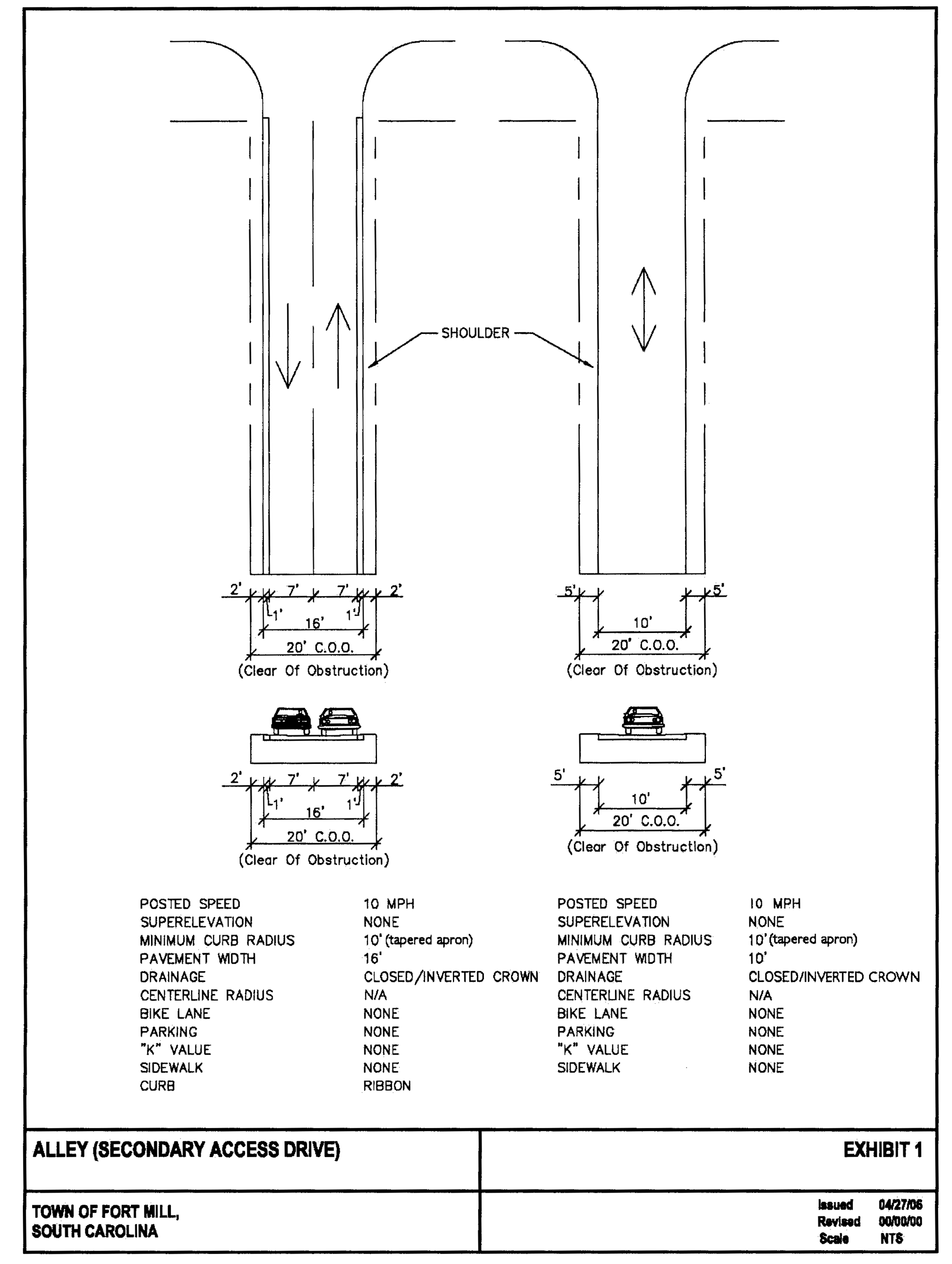
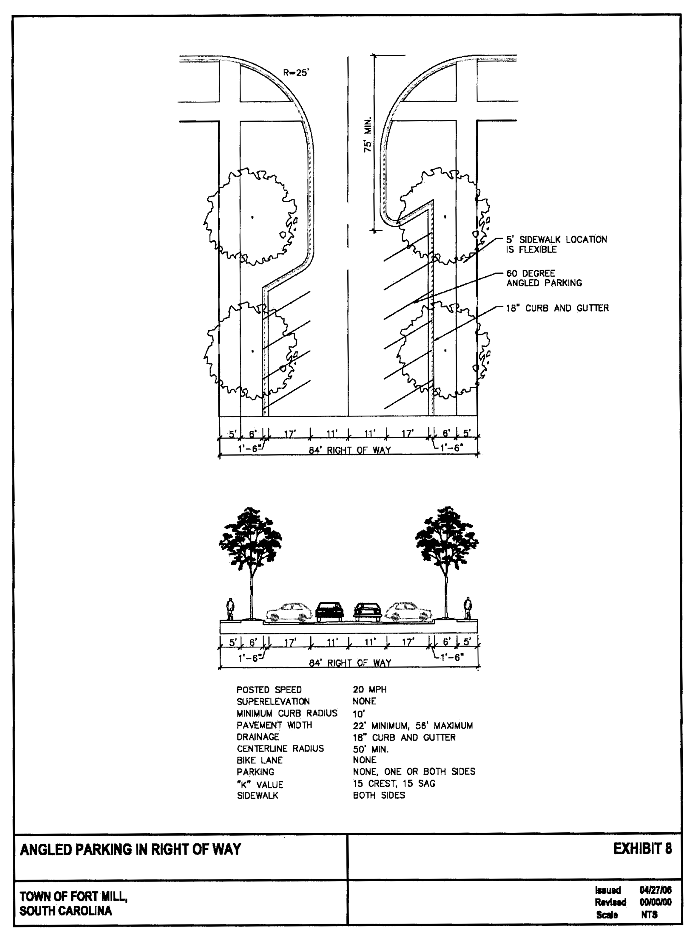
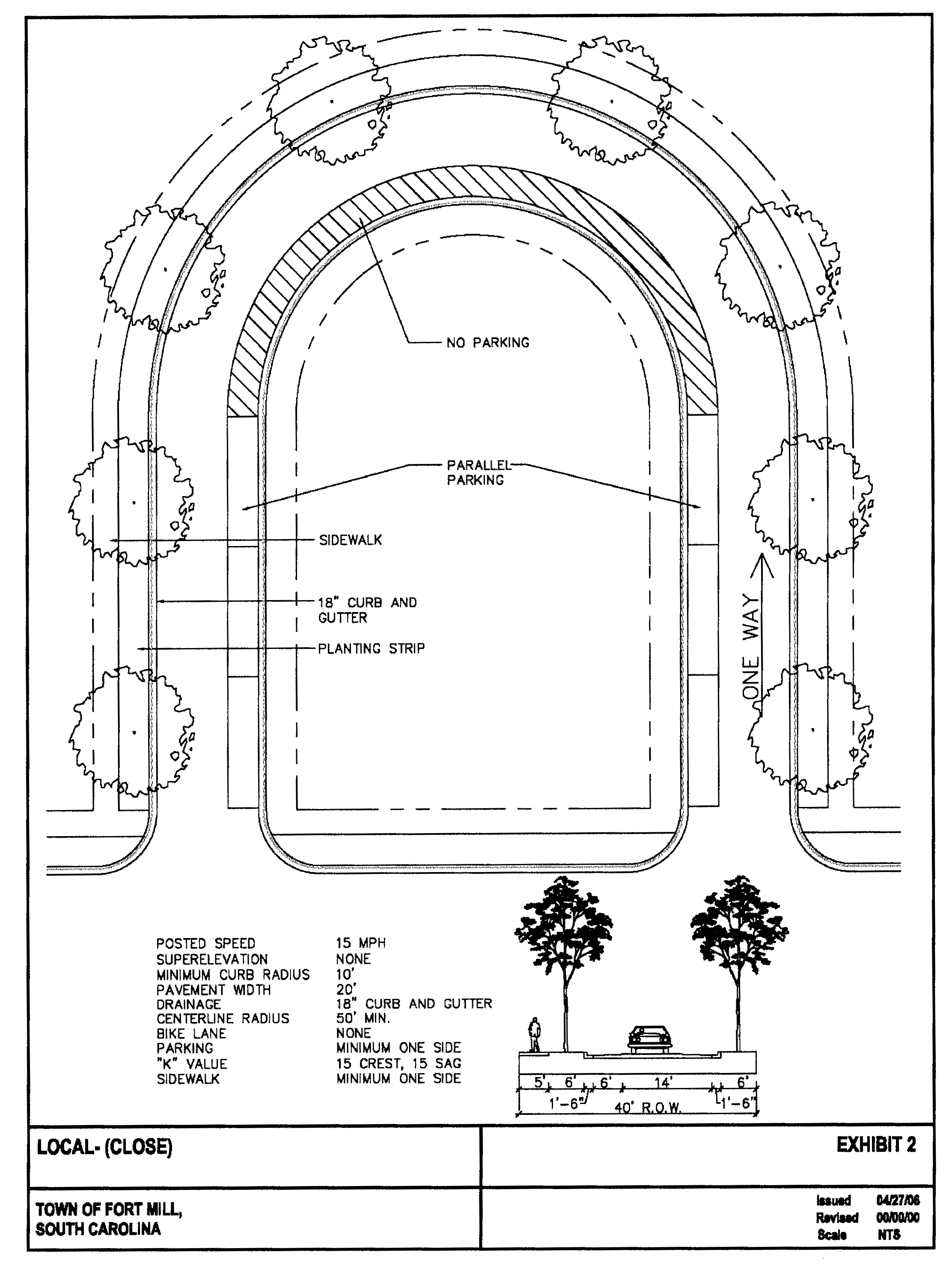
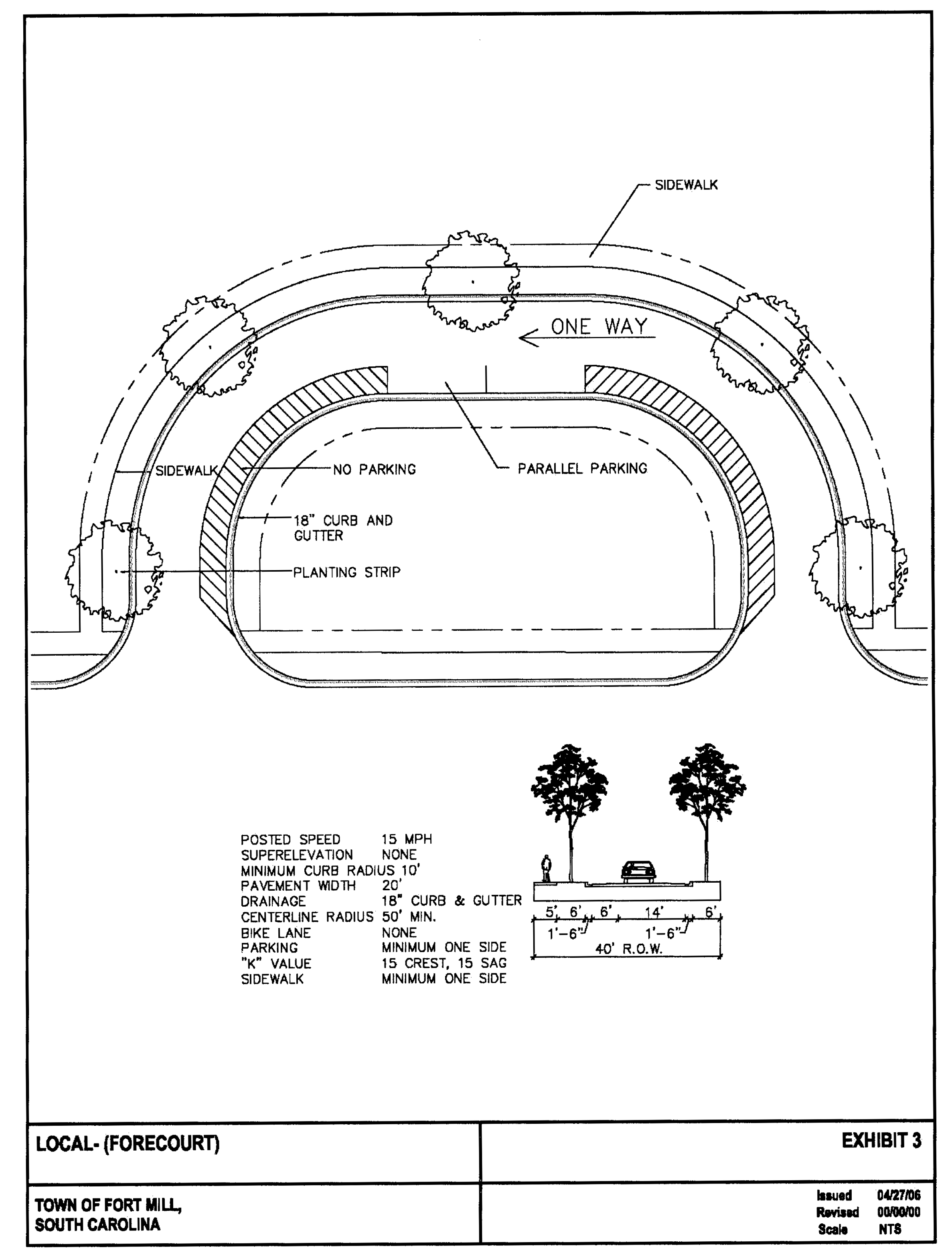
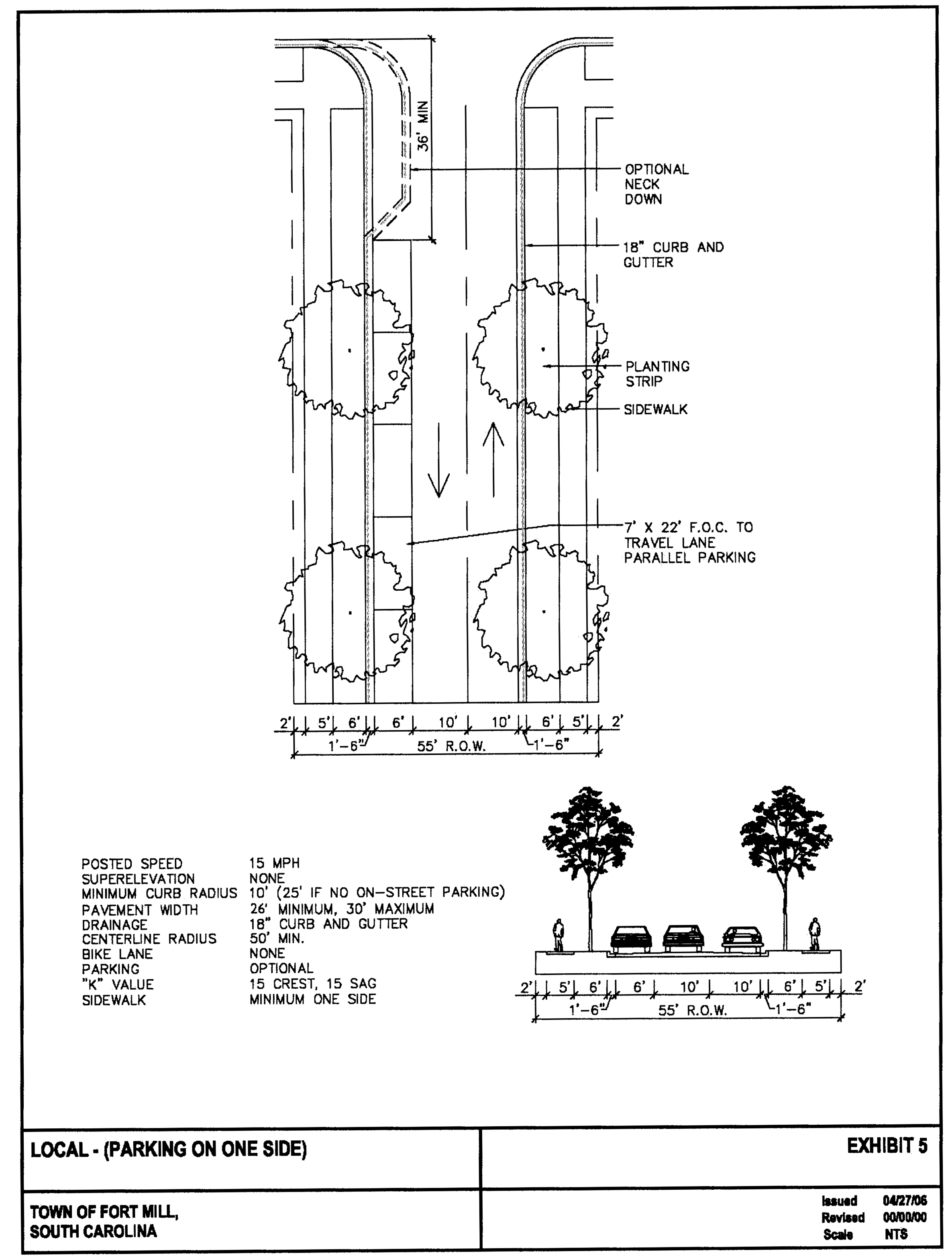
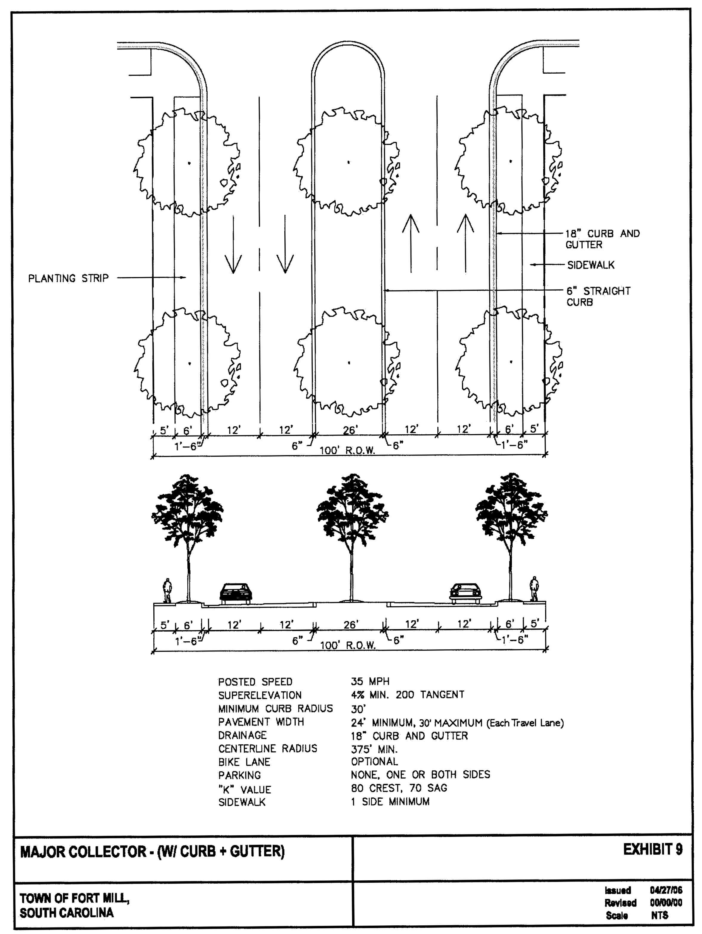
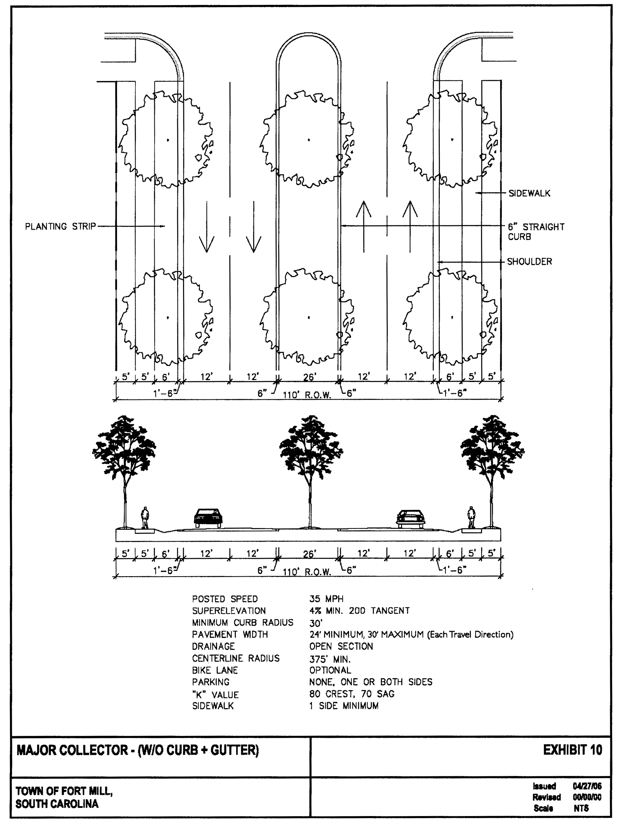
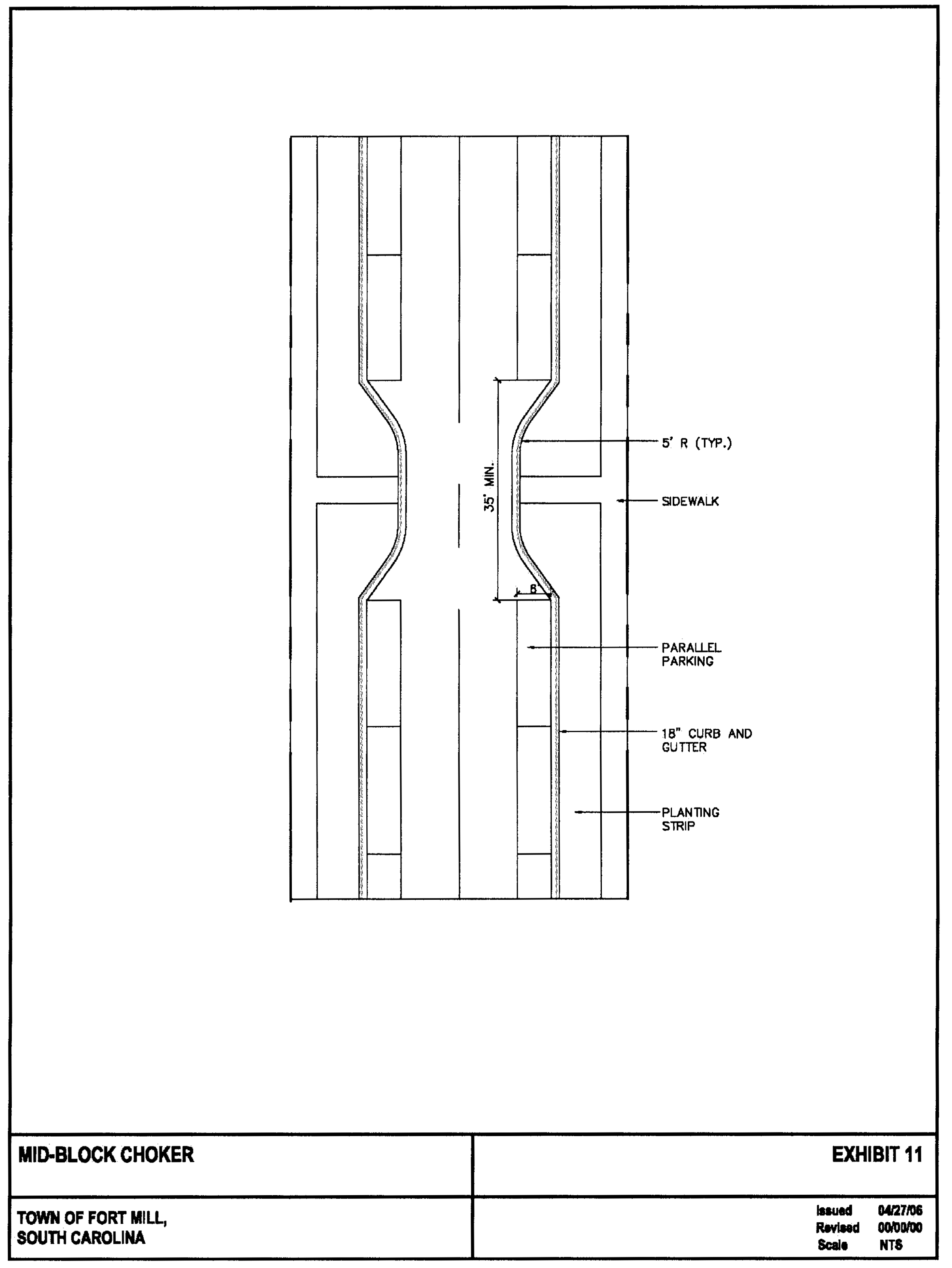
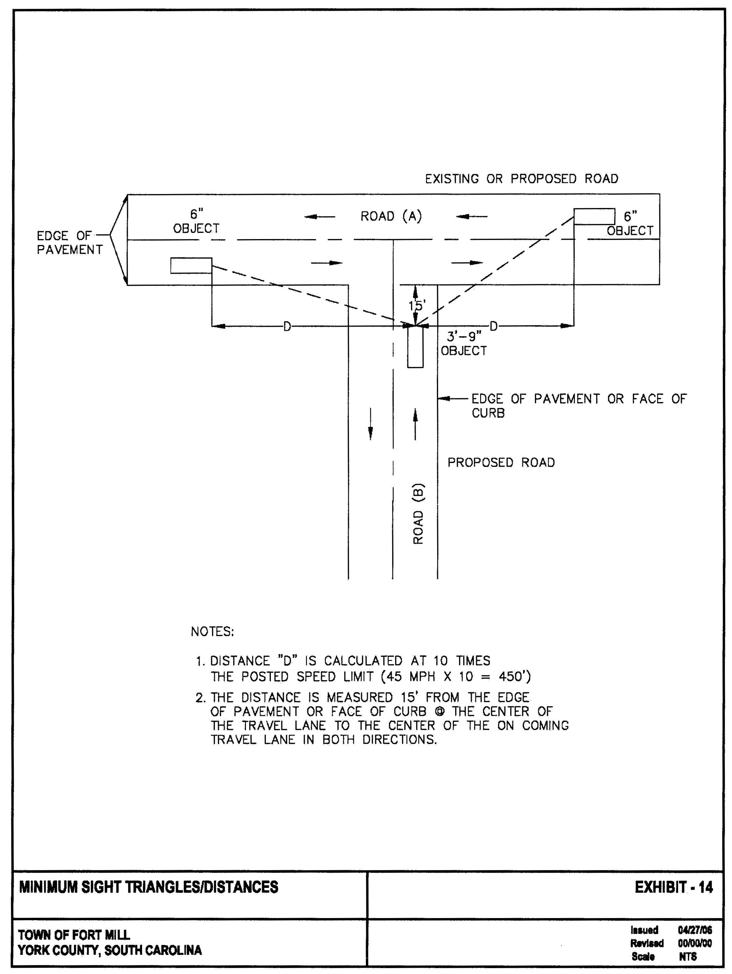
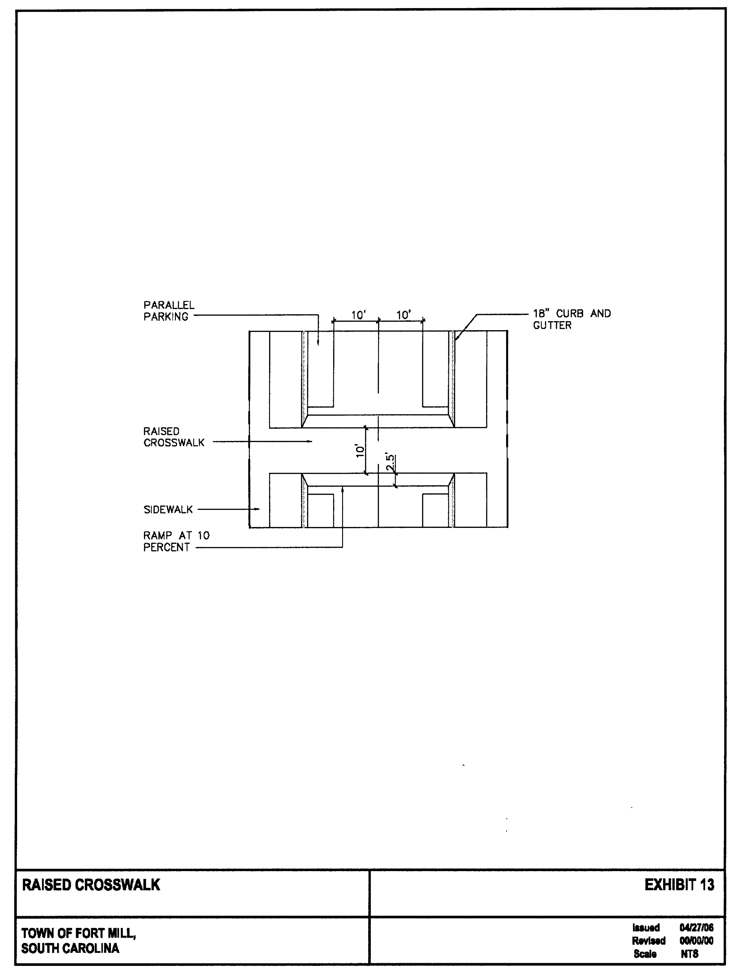
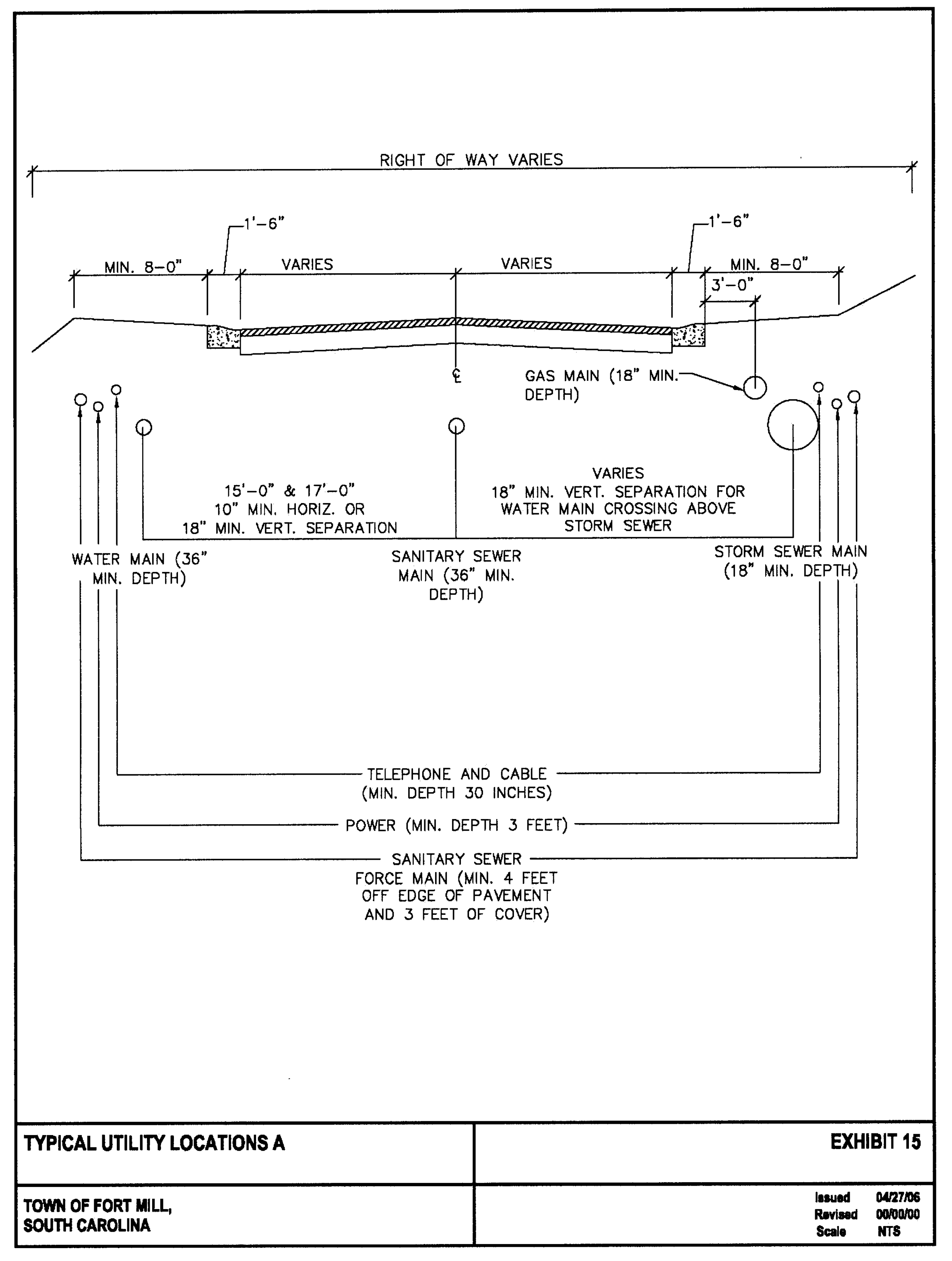
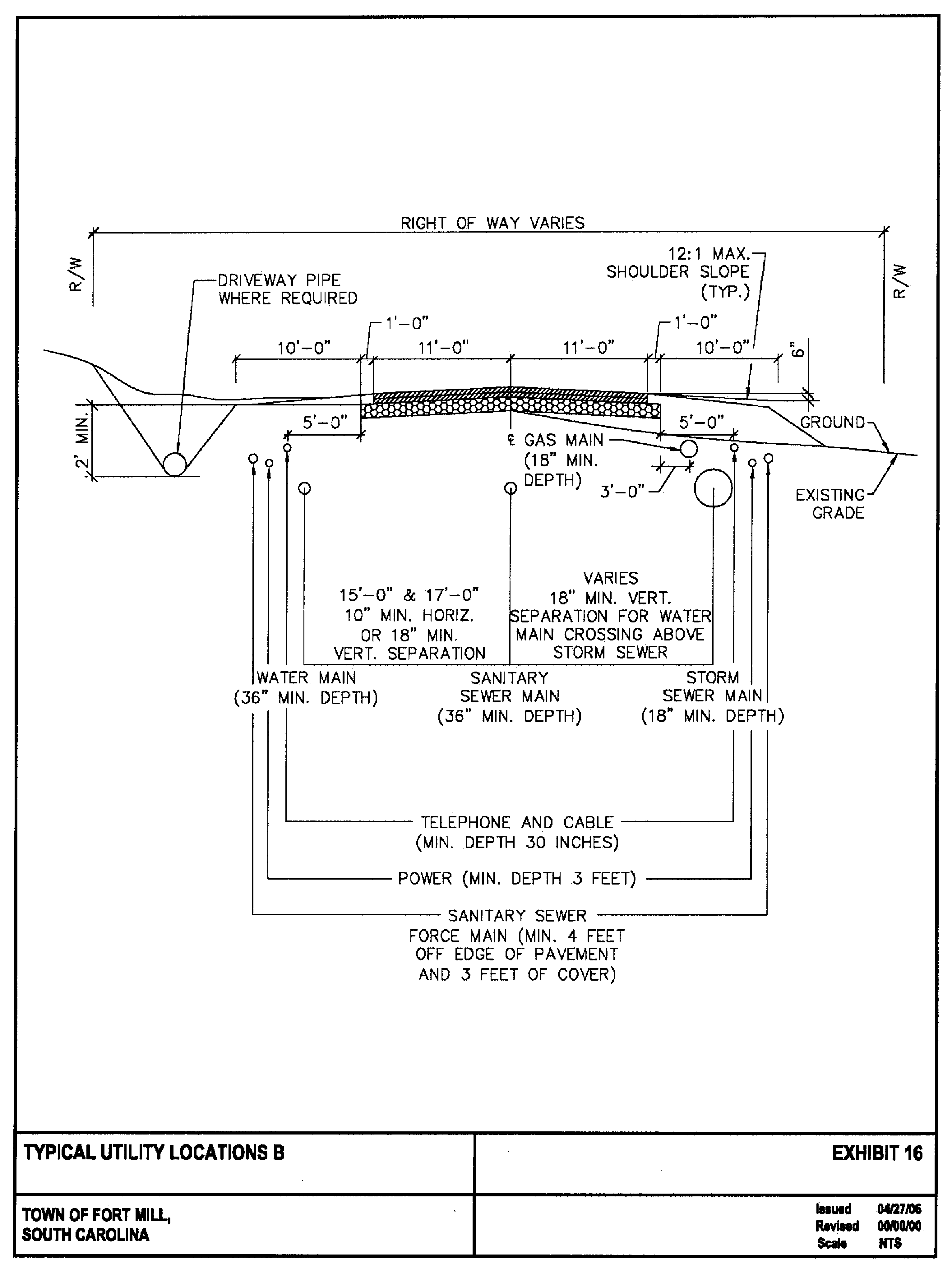
5.
Minimum vertical curves.
L = Minimum length of curve in feet;
A = Algebraic difference in grade in percent; and
K = Rate of vertical curvature shown in table.
[Need K Values for Design speeds of 10 and 15 mph.
Road centerline K values for vertical curves should be maximized in order to follow existing topography as closely as possible. This will enable the greatest amount of tree save possible within any development area.
G.
Parking and loading.
1.
Loading. Off-street loading shall be required for any uses that dispense or acquire goods. The minimum number of spaces to be provided shall be determined by the zoning administrator. No off-street loading space shall be required for any tenant space less than 25,000 square feet of gross floor area.
2.
Off-street parking. All off-street parking shall be provided in accordance with the off-street parking requirements set forth in article I, section 7, subsection I. of the ordinance, except as otherwise provided below.
a.
Off-street parking must be provided on every lot on which any of the following uses are hereafter established. The number of parking spaces provided will be at least as great as the number specified in article I, section 7, subsection I. of the zoning ordinance for the particular use(s). When application of the provision results in a fractional space requirement, the next larger requirements will prevail. The zoning administrator may vary this requirement resulting in a 10% decrease in the minimum number required. Up to 50% of the required parking spaces may be provided by on-street parking in conformance with section 4.G.7.
1)
The parking space requirements for a use not specifically listed will be the same as for a listed use of similar characteristics of parking demand.
2)
For uses having different parking requirements and occupying the same building or parcel, the minimum number of required spaces shall be the sum total of all the individual uses. For developments of portions of developments within the same mixed use development district designed as a single, coordinated project having at least 50,000 square feet of gross floor area, the minimum number of required spaces shall be one space for every 250 square feet of gross floor area designed for nonresidential use and occupancy.
3)
Shared parking is allowed and is encouraged in circumstances where the parking would be within 1,200 feet of each respective use.
4)
Those wishing to use shared parking as a means of satisfying off-street parking requirements must submit a shared parking analysis to the zoning administrator that clearly demonstrates the feasibility of shared parking. The study must be provided in a form established by the zoning administrator. It must address, at a minimum, the size and type of the proposed development, the composition of tenants, the anticipated rate of parking turnover and the anticipated peak parking and traffic loads for all uses that will be sharing off-street parking spaces.
5)
A shared parking plan shall be enforced through written agreement among all owners of record and included in the development agreements filed with the town. The owner of the shared parking area shall enter into a written agreement with the town with enforcement running to the town providing that the land comprising the parking area shall never be disposed of except in conjunction with the sale of the building which the parking area serves so long as the facilities are required; and that the owner agrees to bear the expense of recording the agreement and such agreement shall bind his or her heirs, successors, and assigns. An attested copy of the agreement between the owners of record shall be submitted to the zoning administrator for recordation in a form established by the town attorney. Recordation of the agreement must take place before issuance of a building permit or certificate of occupancy for any use to be served by the shared parking area. A shared parking agreement may be revoked only if all required off-street parking spaces will be provided on-site. The town shall void the written agreement if other off-street facilities are provided in accord with these zoning regulations.
3.
Handicap accessible parking. Handicap accessible parking spaces shall be provided in accordance with the table below:
4.
Minimum parking dimensions.
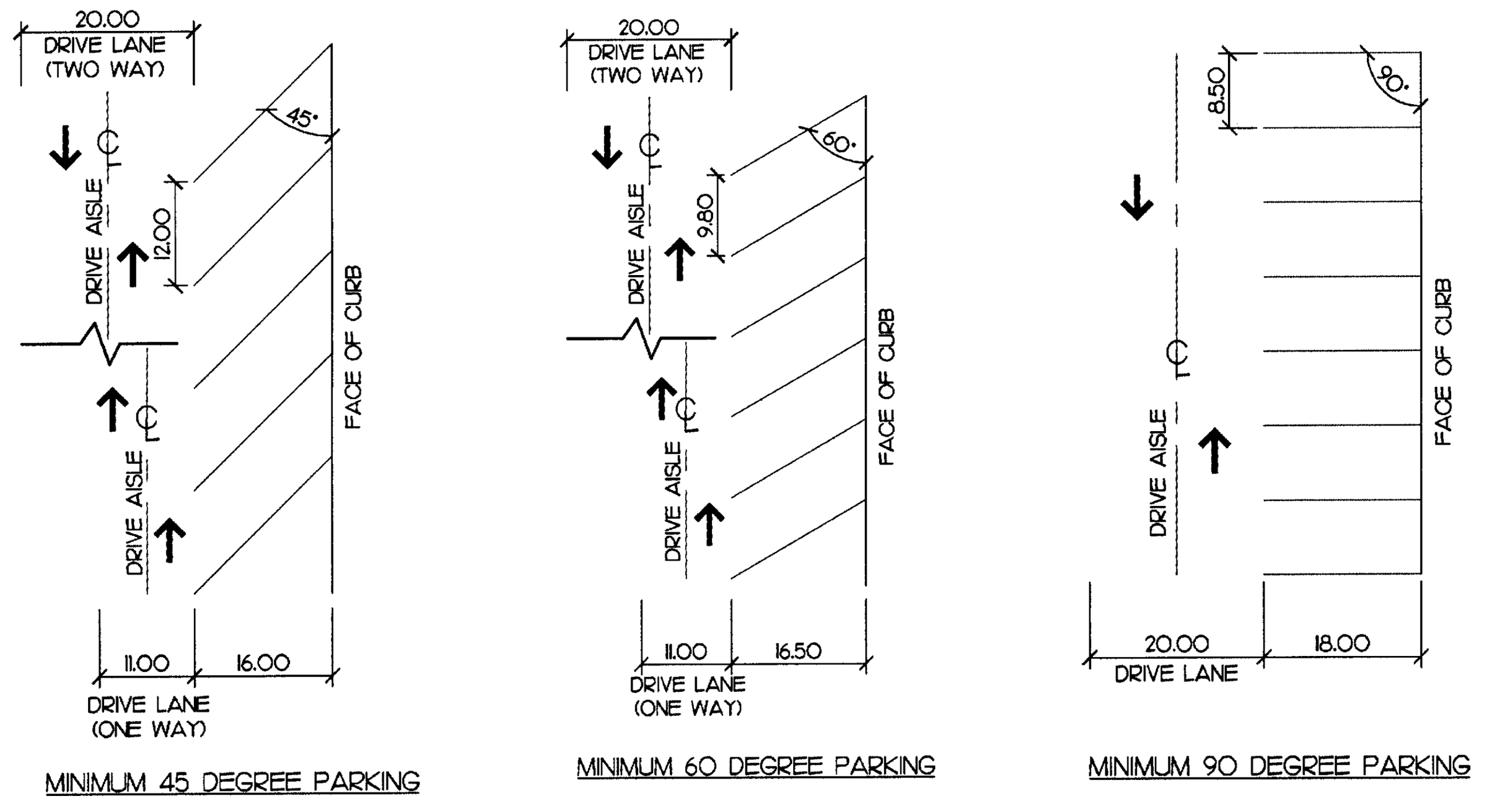
5.
Compact spaces. In parking lots having 20 or more spaces, up to 25 percent of the total required spaces may be provided as compact spaces. Such spaces shall have a minimum dimensions as follows:
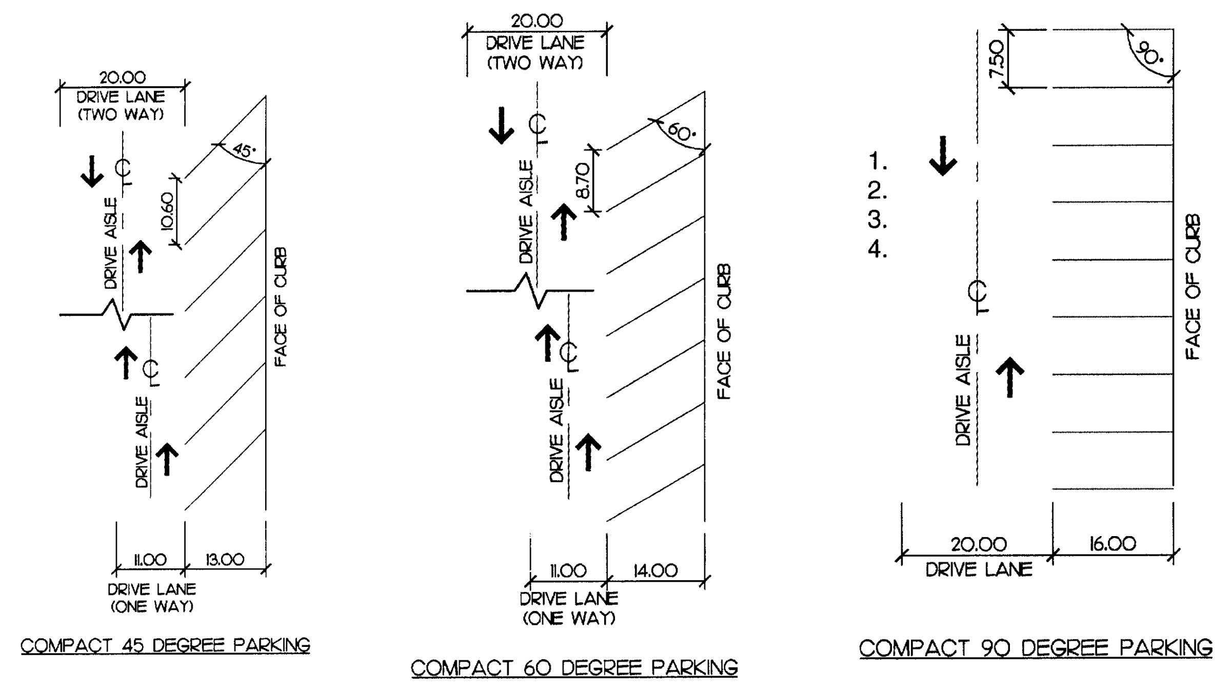
6.
Parking lot landscaping. Landscape islands within parking areas shall be no less than the minimum dimensions of a full-size parking space (measured from edge of pavement or back of curb, if such islands are defined by curb). Islands shall be installed every 25 spaces to include a 2.5" caliper tree (minimum). No parking space shall be further than 110 feet from a landscape island. All trees planted in landscape islands shall adhere to the standards set forth in chapter 38, division 3, tree control of the ordinance.
7.
On-street parking. A minimum of 50 percent of the required off-street parking must be provided on site. Where on-street parking is available or provided as part of the development, on-street parking spaces may account for up to 50% of the required spaces, provided:
a.
A key map is provided that delineates the location of allocated on-street spaces for a designated parcel or use.
b.
The on-street parking must be located within 1,200 feet of the primary entrance of a use.
c.
On-street parallel parking spaces shall be 7' x 20' measured from the face of curb (or edge of pavement, if curb does not exist).
d.
On-street diagonal parking with a 60-degree angle or less shall have a minimum travel lane width of 11 feet.
H.
Dedicated open space. Dedicated open space shall be provided in accordance with the following standards:
1.
A minimum of 20 percent of the gross land area of the project will be dedicated open space. A density bonus over and above the density otherwise allowed in the MXU district may be approved by the town council provided that the applicant increases the percentage of the total project area to be devoted to dedicated open space. This bonus may be granted only if specifically requested by the applicant. Any such bonus shall consist of a one percent increase in the allowable density for every one percent of land area devoted to dedicated open space unless town approves an alternative.
2.
Dedicated open space land shall be shown on the preliminary plat and shall be labeled to specify that the land has been dedicated to open space purposes. The plat shall specify that the open space land shall not be further subdivided or developed and is permanently reserved for open space purposes. The open space shall be conveyed by the applicant as a condition of plat approval and may be conveyed by any of the following means as determined by the town council:
a.
Deeded in perpetuity to the Town of Fort Mill;
b.
Reserved for common use or ownership of all property owners within the development by covenants in the deeds approved by the town attorney. A copy of the proposed deed covenants shall be submitted with the application;
c.
Deeded in perpetuity to a private, non-profit, tax-exempt organization legally constituted for conservation purposes under terms and conditions that ensure the perpetual protection and management of the property for conservation purposes. A copy of the proposed deeds and relevant corporate documents of the land trust shall be submitted with the application;
d.
Deeded to a property owner's association within the development upon terms and conditions approved by the town attorney that will ensure the continued use and management of the land for the intended purposes. If this option is selected, the formation and incorporation by the applicant of one or more appropriate property owners' associations shall be required prior to plat approval. A copy of the proposed property owner's deed and the by-laws and other relevant documents of the property owner's association shall be submitted with the application. The following shall be required if open space is to be dedicated to a property owners' association:
1)
Covenants providing for mandatory membership in the association and setting forth the owner's rights, interests, and privileges in the association and the common land, must be included in the deed for each lot or unit;
2)
The property owners' association shall have the responsibility of maintaining the open space and operating and maintaining recreational facilities;
3)
The association shall have the authority to levy charges against all property owners to defray the expenses connected with the maintenance of open space and recreational facilities;
4)
The applicant shall maintain control of dedicated open land and be responsible for its maintenance until development sufficient to support the association has taken place.
3.
The following may be counted towards required dedicated open space: conservation lands, natural areas, formal greens, plazas and courtyards, trails, buffers held in common ownership, and parks and recreation areas, including ball fields, golf courses (excluding vertical structures: clubhouse and maintenance facilities), tennis and basketball courts, playgrounds, and other areas used for active or passive recreation.
4.
Open space to be dedicated to the town shall have shape, dimension, character, location and topography to ensure appropriate public access, and to accomplish the following open space purposes:
a.
Natural resource conservation;
b.
Wetland and water course conservation;
c.
Selective forestry;
d.
Wildlife habitat;
e.
Recreation;
f.
Civic purposes; and
g.
Scenic preservation.
5.
Dedicated open space features that are not dedicated to the town may be open to the general public or restricted to the residents of the development.
6.
One hundred percent of all dedicated open space may be comprised of land characterized as conservation lands in article II, section 7, subsection 3.D) of the zoning ordinance, provided such lands are integrated into the development and serve as an amenity for the development;
7.
Streets and other impervious surfaces shall be excluded from the calculation of the minimum dedicated open space requirement; however, lands occupied by bike paths, landscaped grounds, or similar common recreational development may be counted as dedicated open space provided that impervious surfaces constitute no more than ten percent of the total required open space;
Commentary: For example, if the project is 100 acres, then at least 20 acres (or 20 percent) of the project must be set aside as dedicated open space. Of these 20 acres of dedicated open space, no more than two acres (ten percent) can be impervious surfaces.
8.
Up to 25 percent of this requirement may be satisfied with land covered by water or by stormwater detention or retention basins if the town determines that such a water body or basin is suitable for the purposes set forth in article I, section 1.
9.
Dedicated open space shall include the land necessary to provide access to the open space;
10.
The dedicated open space shall not be included in subdivision lots or in lot size calculations.
11.
The applicant shall convey or restrict the open space land by a deed instrument reviewed and approved by the Fort Mill Town Attorney to ensure that the land will be held and managed in perpetuity for open space purposes and shall not be further developed.
a.
As an alternative to providing all open space on site in accordance with the requirements above and with the town's consent, the developer may choose to provide up to 50 percent of the required open space utilizing one of the following options:
b.
Off-site parcels within town limits may be used to meet this requirement provided the land meets the open space purposes as determined by the town.
c.
Fees-in-lieu may be paid to the town for land acquisition for open space purposes.
I.
Signage. A proposed project signage package shall be provided for approval by the town. All signs shall meet the requirements of article III, signs of the ordinance, with the following exceptions:
1.
Project identification signs of up to 360 square feet of text area per sign shall be permitted at all project entrances that provide ingress/egress from a major collector road, arterial road, public streets, adjoining streets, minor streets, marginal access streets with major thoroughfares, intersections, and dead-ends, provided the following standards are met:
a.
Such copy area shall be incorporated into an architectural feature such as a wall and/or entryway monumentation that will not exceed 18 feet in height.
b.
Up to two such signs per individual project entrance shall be permitted. Each project is limited to one entrance of this type per 1,000 linear feet of frontage along a major arterial road.
c.
Sign structures may consist of brick, stone, metal or similar mixture of materials at the developer's discretion that match certain architectural characteristics of the development and will be integrated in accordance with the approved an overall sign package.
d.
Final design of these features will be submitted for approval by town in conjunction with a proposed signage package for the overall project.
2.
Off-site/off-premises signs shall be permitted to give visibility to businesses within the development, provided the following standards are met:
a.
Sign structures may consist of brick, stone, metal or similar mixture of materials at the developer's discretion that match certain architectural characteristics of the development and will be integrated in accordance with the approved overall sign package.
b.
Final design of these features will be submitted for approval by town in conjunction with a proposed signage package for the overall project.
J.
Landscaping. Tree planting requirements shall be as follows:
1.
Internal planting requirements for lots, excluding single-family development. Planting areas. Whenever the impervious cover exceeds 10,000 square feet, a planting area equal to ten percent of the total impervious surface must be provided for landscape purposes and tree planting. Internal tree planting is required at the rate of one large maturing shade tree per 10,000 square feet of impervious cover or fraction thereof. This planting area must be located on private property and shall be in addition to any other applicable planting requirements.
2.
Internal planting requirements for parking areas. Trees must be planted so that each parking space is no more than 110 feet from a tree trunk. Seventy-five percent of the trees planted must be large maturing shade trees. Where constraints, such as utility lines, would interfere with the healthy growth of the tree, small maturing shade trees are used.
3.
Existing trees. In meeting these internal planting requirements, credit may be given for existing trees if the following are met:
a.
Trees larger than 2.5 inches dbh may be counted towards the internal planting requirements on a 1:1 basis. Trees larger than ten inches dbh shall receive a credit of 1.5 toward tree planting requirement.
b.
The property owner must include a tree survey which identifies all trees of 2.5" caliper or greater that will be used to meet this requirement. Survey shall indicate species.
c.
Only healthy trees and those that have been protected during the entire development period, beginning prior to the commencement of site work and continuing through to issuance of the certificate of occupancy in accordance with approved tree protection techniques, may satisfy these tree planting requirements. If the minimum protection standards are not met, or if trees are observed by the town to be injured or threatened, they may be deemed ineligible for meeting these requirements.
K.
Buffers and project edge compatibility.
1.
Areas exempt from requirement to provide buffer.
a.
Buffers are not required between uses wholly contained within the project area or abutting nonresidential areas where buffers are not already required by the Ordinance.
b.
Project edge compatibility is required along project edges to provide a suitable transition between the proposed development and adjacent residential development. All edges shall be developed or otherwise treated in a manner that is compatible with adjacent land uses.
2.
Buffer required. A landscaped buffer shall only be required along all project edges abutting existing residential development excluding road frontage, and shall be measured perpendicular to the property lines that define the project area. This buffer shall be a natural, undisturbed wooded area where possible, and shall count towards the provision of open space for the development where the buffer is not platted and made part of an individual, privately-owned lot. Where an existing natural, undisturbed wooded area does not exist, a planted buffer shall be required in conformance with the buffer standards below.
3.
Buffer standards.
a.
Minimum buffer width.
1)
The minimum width of the project boundary buffer shall be 25 feet where the land use is comparable to the adjacent use and the width of the project's perimeter lots adjacent to the buffer is equal to or greater than the minimum lot width of the adjoining development (or the minimum lot width required by the zoning district applied to any adjoining undeveloped parcel).
2)
Where narrower lot widths are provided at the project's perimeter, the minimum buffer width shall be 35 feet (see the graphic below).
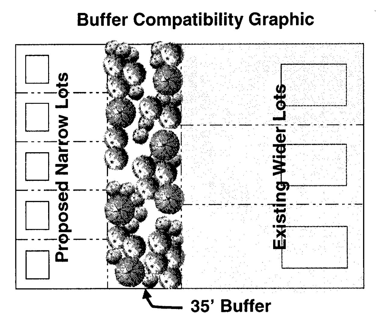
3)
The required width of any project boundary buffer may be reduced by 33 percent, provided a minimum six-foot opaque wall is constructed along the project boundary.
b.
Required buffer planting.
1)
Required project boundary buffers shall incorporate existing natural vegetation to the maximum extent feasible. Prior to disturbance of a required buffer, approval shall be obtained from the town. Where existing vegetation is inadequate to meet the planting standards, additional plant material shall be required.
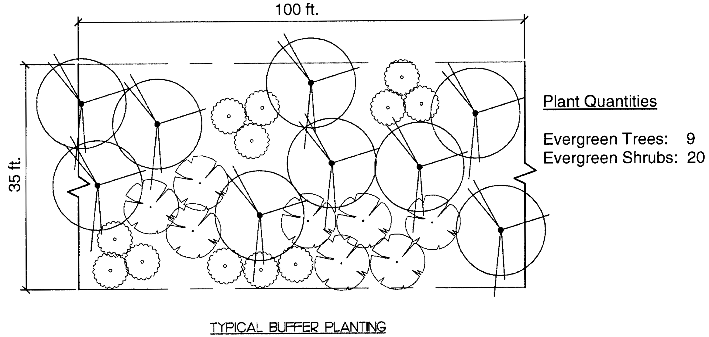
2)
Credit for existing vegetation. Credit shall be given for existing vegetation within the required buffer area that meets the planting requirements above, and if the following are met:
a)
Trees larger than 2.5 inches dbh may be counted towards the internal planting requirements on a 1:1 basis. Trees larger than ten inches dbh shall receive a credit of 1.5 toward tree planting requirement.
b)
The property owner must include a tree survey which identifies all trees of 2.5" caliper or greater that will be used to meet this requirement. Survey shall indicate species.
c)
Only healthy trees and those that have been protected during the entire development period, beginning prior to the commencement of site work and continuing through to issuance of the certificate of occupancy in accordance with approved tree protection techniques, may satisfy these tree planting requirements. If the minimum protection standards are not met, or if trees are observed by the town to be injured or threatened, they may be deemed ineligible for meeting these requirements.
c.
Trails within required buffers. Trails may be incorporated into required buffer areas provided adequate width (minimum 15 feet) is added to the required buffer width to accommodate both the trail and the required buffer plantings. Buffers with trails may also count toward the provision of open space for the development.
d.
Buffer crossings and penetrations. Buffer crossings and penetrations shall be limited to the minimum width required to accommodate the roadway, trail, or other facility that is crossing the buffer. The penetration or crossing must intersect the buffer at an angle between 90 degrees and 60 degrees.
e.
Alternative to required buffer. The applicant may submit for consideration and approval an alternative to the required buffer, provided the alternative demonstrates a positive, compatible relationship between proposed and adjacent uses.
L.
Lighting. All lighting shall adhere to the standards of article IV, section 6 of the ordinance.
M.
Screening.
1.
The provisions of this section must be met at the time that land is developed or redeveloped, or if an existing structure is substantially expanded. (Exemption: expansions of less than 2,000 sf or ten percent of the total floor area, whichever is greater). A buffer required in article IV, section 2, may be used to meet the requirements of this section. The requirements of this section do not apply to lots of portions of lots, which are vacant or undeveloped.
2.
The following must be screened from abutting property and from public view from a public street:
a.
Parking lots for more than ten automotive vehicles and parking decks, excluding new and used automotive sales lots and parking areas for detached, duplex, triplex or quadraplex dwellings on a single lot;
b.
Dumpsters, recycling containers (except for household recycling bins or recycling containers located at recycling collection centers), or solid waste handling areas;
c.
Service entrances or utility structures associated with a building, except in the area where such use abuts other service entrances or utility structures; and
d.
Loading docks or spaces, except in the area where such use abuts other loading docks and spaces.
e.
Outdoor storage of materials, stock and equipment; and
f.
Any other uses for which screening is required under these regulations.
3.
Any screening or buffer areas used to comply with the provisions of this section or other ordinance provisions for uses other than parking decks must consist of a planted area which is at least five feet wide. This area may contain any type of screening materials sufficient to separate visually the land uses, provided such materials meet the requirements of this section. If only a wall or fence is used, then the area devoted to the screen need only be wide enough to accommodate the wall or fence and allow for its maintenance. The composition of the screening material and its placement on the lot will be left up to the discretion of the property owner, so long as the purpose and requirements of this section are satisfied. The following list contains specific standards to be used in installing screening:
a.
Any fence or wall used for screening shall be constructed in a durable fashion of brick, stone, other masonry materials, wood posts and planks, poly vinyl chloride (PVC), or metal or other materials specifically designed as fencing materials or any combination thereof as may be approved by the zoning administrator. No more than 25 percent of the fence surface shall be left open and the finished side of the fence shall face the abutting property. A chain link fence with plastic, metal or wooden slats may not be used to satisfy the requirements of this section when abutting residential uses and districts and public streets;
b.
The maximum height of a wall or fence shall be eight feet, except when located between the primary facade of a structure and the street, in which case the maximum height shall be four feet.
c.
The minimum height for screening materials will be whatever is sufficient to visually separate the uses, but not less than four feet;
d.
The height of any screening materials on a corner lot must also comply with the provisions of section "b." above;
e.
Any earth berm used to meet the requirements of this section must be a minimum of four feet with a maximum slope of 3:1. Berms in excess of six feet in height shall have a maximum slope of 4:1 as measured from the exterior property line;
f.
Shrubs used in any screening or landscaping must be evergreen, at least three feet tall with a minimum spread of two feet when planted and no further apart than five feet. They must be of a variety and adequately maintained so that an average height of five to six feet could be expected as normal growth within four years of planting. The average expected height may be reduced to four feet for screening along public streets.
5.
Procedure for approval.
A.
Applicability. All proposed developments utilizing the MXU district or significant modifications to an approved MXU district shall be subject to the review and approval procedures found in this section.
B.
Approval authority.
1.
The planning director and planning commission shall have review and recommendation authority for the concept plan.
2.
The town council shall have final approval authority for the concept plan.
3.
The planning director shall have approval authority for a final plan/site specific plan where no significant modifications to the approved concept plan are required.
C.
Pre-application review/sketch plan.
1.
All applicants seeking MXU rezoning approval shall schedule a pre-application conference with the planning director to discuss the proposed development. At the pre-application conference, the planning director shall review the proposed sketch plan.
2.
At minimum, the sketch plan shall contain the following information:
a.
Location map of the proposed site;
b.
General description of proposed land uses, including approximate location and acreage; and
c.
Proposed gross density of the development, and net density of individual areas or parcels within the development.
3.
The planning director shall review the sketch plan and advise the applicant on any modifications that may be required to comply with the ordinance requirements. Once the pre-application conference is complete, the applicant shall prepare a concept plan of the entire MXU development.
D.
Concept plan.
1.
Application requirements.
a.
The application shall contain an application for zoning map change to an MXU district, a completed concept plan (section 5.D.4), and, if applicable, development conditions (section 5.D.3).
b.
Unless specifically modified using as a development condition, a development utilizing the MXU district shall comply with all town regulations in effect at the time of rezoning approval.
c.
The mix of uses shall be limited to the range of uses contained in the approved MXU development conditions.
2.
Review and approval procedure.
a.
Staff review.
1)
Upon receipt of a completed MXU development application, the planning director shall distribute the application to the appropriate departments for review of the application.
2)
The planning director shall prepare a staff report based on the comments provided by planning department and other staff. The report and recommendations shall be forwarded to the planning commission for review and recommendation.
3)
The planning director shall provide notice as required and schedule the MXU application on the next available planning commission agenda. The planning director will then inform the applicant/agent when they will appear on the planning commission agenda for action on the MXU application.
b.
Optional joint work session. The applicant may request a joint work session with the town council and planning commission to provide an opportunity for the applicant to present the MXU application and respond to any initial questions that council or board members may have regarding the proposed development.
1)
If the request is granted, the planning director shall schedule the joint work session and notify the applicant when the session will occur.
2)
No decision or final action may be taken at a joint work session.
3)
Planning commission hearing and recommendation.
4)
The planning director shall present the staff report to the planning commission.
5)
After allowing time for presentation from the applicant and public comments, the planning commission shall consider the application for conformance with the requirements of this ordinance and the review criteria in section 5.D.5.
6)
The planning commission shall make a recommendation to approve or deny the application.
c.
Town council hearing and final decision.
1)
The staff report and planning commission recommendations shall be forwarded to the town council for review and final decision.
2)
The planning director shall provide notice as required and schedule the MXU application on the next available town council agenda. The planning director will then inform the applicant/agent when they will appear on the planning commission agenda for action on the MXU application.
3)
The planning director shall present the staff report and recommendations by the planning commission to the town council.
4)
After allowing time for presentation from the applicant and public comments, the town council shall consider the application for conformance with the requirements of this ordinance and the review criteria in section 5.D.5, below.
5)
The town council shall make a decision to approve the application, deny the application, or refer the application back to the planning commission for further consideration.
3.
Development conditions. The applicant may submit conditions to be incorporated into the rezoning.
a.
A general narrative description of the development program.
b.
A list of any development conditions or modifications to the base standards that are being sought in conjunction with the MXU rezoning. These development conditions shall be binding upon the property unless amended by in conformance with the requirements of section 5.F.
c.
If phasing is proposed, the applicant may provide a general breakdown showing the various phases and the estimated schedule of construction.
4.
Concept plan requirements. At minimum, the concept plan shall contain the following information in schematic form:
a.
A title, giving the names of the developers and property owners, the date, scale, and the person or firm preparing the plan.
b.
A vicinity map and north arrow.
c.
The location and size of the area involved.
d.
The current zoning of the subject property and surrounding properties.
e.
The landowners and general land use of adjoining properties.
f.
Location of proposed uses assigned to sub-areas, and a tabulation of total dwelling units and the gross floor area to be devoted to various uses and activities and overall densities.
g.
Location of existing steep slopes, flood zones, wetlands, and other riparian areas, and other significant environmental features.
h.
General layout of transportation routes including streets and major pedestrian ways.
i.
The location of existing infrastructure (examples may include: roadways, sidewalks, and proximity of nearest water and/or sewer mains).
j.
Conceptual location for any proposed public uses including schools, parks, fire and medical emergency services, etc.
5.
Review criteria. In determining whether to approve, approve with conditions or deny a MXU zoning map amendment, the applicable review bodies shall consider the following criteria:
a.
The development is in conformity with the comprehensive plan and the purpose of the MXU district, and/or the development is in harmony with the character of the surrounding area.
b.
There is an orderly and creative arrangement of all land uses with respect to each other, the entire development, and the surrounding development.
c.
The development is staged in a manner which can be accommodated by the timely provision of public utilities, facilities and services.
E.
Final plan or site specific plan.
1.
Phasing. The MXU development may be completed at once or in phases. If the development is to be completed at once, the applicant shall prepare and submit a final plan. If the development is to be completed in phases, the applicant shall prepare and submit a site specific plan prior to construction of each phase of the project. In either case, the final plan/site specific plan shall contain the elements required in section 4, final plan/site specific plan requirements, and conform to the approved concept plan.
2.
Planning director review and approval.
a.
The planning director shall distribute the final plan/site specific plan application to the appropriate departments for review to ensure that all required elements are met.
b.
Once the final plan/site specific plans have been received and reviewed by the appropriate departments and the applicant has met all of the required elements of this ordinance, any other applicable regulations, and the adopted concept plan and development conditions, the planning director shall issue a final approval of the final plan/site specific plan so that the applicant or owner may begin the process of having the proposed site plan recorded.
c.
If any modifications are made to the final plan/site specific plan, the planning director will follow the specific procedure specified in section F, amendments to concept plan and/or site specific plan.
3.
Traffic impact analysis. A traffic impact analysis shall be required prior to the approval of any final plan or site specific plan. The analysis must be prepared by a professional engineer with expertise in the preparation of traffic impact analyses and must be submitted in a form acceptable to the town.
4.
Final plan/site specific plan requirements. The final plan/site specific plans must contain or provide evidence of the following information:
a.
A title, giving the names of the developers and property owners, the date, scale, and the person or firm preparing the plan.
b.
A vicinity map and north arrow.
c.
Scale, date, and legal description of the proposed site.
d.
Copy of the approved concept plan and development conditions, and proposed modifications (if any).
e.
Streets layout showing proposed rights-of-way, centerlines, cross section, and type and size of streets and sidewalks.
f.
Any land dedicated or to be dedicated to and accepted by the town for the construction of public facilities (i.e., schools, parks, public safety facilities, etc.).
g.
Location and layout of residential lots.
h.
Location and use of existing and proposed non-residential or mixed use structures.
i.
Site data breakdowns (for example: total square footage of proposed buildings, floor area ratio, total number and density of residential units, etc.).
j.
Location and dimensions of proposed boundaries, and easements,
k.
Location of open space and recreational areas, amenities, etc.
l.
Location and dimensions of any buffers to be included in the project.
m.
Evidence of all federal and state approvals including approved wetlands delineation.
n.
Conceptual utility and stormwater management plan(s).
F.
Amendments to concept plans and/or final plans/site specific plans. Any and all amendments to the concept plan and/or final/site specific plans for the MXU shall be subject to the following review procedures:
1.
The planning director shall have the authority to approve:
a.
Changes which result in a decrease in assigned density for a specific parcel, either residential or non-residential.
b.
Change in land use designation from multi-family to single-family or a change from any other use to open space/passive recreation.
c.
Change of land use in conformance with a use conversion schedule approved with the development agreement.
d.
Change in infrastructure features (i.e., roads/access, sewer, water, storm drainage) of the MXU area which are clearly beneficial to the occupants of the MXU area and will have no impact on adjoining or off-site properties.
e.
All other changes shall be considered as a new application in conformance with the requirements of this section.
2.
All other changes shall be processed as a new application.
6.
Definitions.
Abutting: Having common property boundary or lot line that are not separated by a street, alley, or other vehicular right-of-way such as a railroad.
Accessory structure or use: A use or above-ground structure that is customarily or typically subordinate to and serves a principal use or structure; is clearly subordinate in area, extent, or purpose to the principal use or structure served; and is located on the same lot as the principal use or structure. In no event shall "accessory use" or "accessory structure" be construed to authorize a use or structure not otherwise permitted in the district in which the principal use is located.
Adjoining: See "abutting."
Applicant: Any person or his/her duly authorized representative who submits an application as defined herein.
Average finished grade: The ground level adjoining a building or structure at all exterior walls.
Contiguous property: Property bordering, adjoining, or meeting the boundary, border, or surface.
Dedication: The deliberate appropriation of property by its owner for general public use.
Commentary: For the purposes of this ordinance, land can be dedicated through one of the following ways:
a)
Covenants providing for mandatory membership in the association and setting forth the owner's rights, interests, and privileges in the association and the common land, must be included in the deed for each lot or unit;
b)
The property owners' association shall have the responsibility of maintaining the open space and operating and maintaining recreational facilities;
c)
The association shall have the authority to levy charges against all property owners to defray the expenses connected with the maintenance of open space and recreational facilities;
d)
The applicant shall maintain control of dedicated open land and be responsible for its maintenance until development sufficient to support the association has taken place.
Developer: A person who undertakes land disturbance activities.
Encroachment: A building—or some portion of it—a wall or fence for instance that extends beyond the land of the owner and illegally intrudes on land of an adjoining owner or a street or alley.
Home occupation: A business, profession, occupation, or trade which is conducted within a residential building or accessory structure for the economic gain or support of a resident of the dwelling, and which is incidental and secondary to the residential use of the building.
Impervious surface: A surface composed of any material that impedes or prevents natural infiltration of water into the soil.
Lots: Land bounded by lines legally established for the purpose of property division. As used in this ordinance, unless the context indicates otherwise, the term refers to a zoning lot.
Principal structure: The structure in which the principal use of a property is conducted. This shall include any buildings which are attached to the principal structure by a covered structure.
Principal use: The primary or main use of land or structures, as distinguished from a secondary or accessory use.
Project edge: The edge of land and/or water, regardless of the number of individual parcels contained therein, on which development is proposed under these regulations.
(Ord. of 2-12-07; Ord. No. 2013-33, § II, 12-9-13)
Sec. 20. - MID Municipal improvement districts.
(a)
Findings of fact.
(1)
The town is a municipal corporation and a political subdivision of the State of South Carolina (the "state"). Pursuant to S.C. Code 1976, §§ 5-37-10 et seq., as amended (collectively, the "Act"), the town is authorized to cause the creation of municipal improvement districts (herein, each a "district" or "MID").
(2)
The creation of a MID allows for the financing of publicly-owned infrastructure serving persons and property located therein, with the cost thereof borne solely by the owners of property located within the boundaries of the MID. Thus, a MID will encourage an increase in the value of taxable property within the town without the cost of public improvements being charged against properties located within the town but outside of the boundaries of a MID.
(3)
Because the town is authorized by the Act to finance publicly-owned improvements within a MID through the issuance of bonds secured by assessments imposed on properties within a MID, and, further, because the interest on such bonds may, in many circumstances, be exempt from both state and federal income taxation, the use of a MID can also lower the cost of development to the developer of properties located within a MID.
(4)
The town is presently experiencing an upswing in growth, and, owing to its proximity to the Charlotte, North Carolina Metropolitan area, is expected to continue to experience such growth. Accordingly the council believes that in the near future it will be presented with one or more proposals to participate in MIDS.
(5)
In light of the foregoing, the council has commissioned Fishkind & Associates of Orlando, Florida to prepare for it recommended policies by which the town will be guided in reviewing proposals submitted to it for the creation of MIDS.
(6)
The council has reviewed the report of Fishkind & Associates, and has determined to incorporate the recommendations contained therein, along with others submitted by the town's administration, into a formal statement of policy regarding MIDS.
(b)
Policy statement. The council hereby approves the policy statement attached hereto as Exhibit A and incorporated herein by reference. [A copy can be found in the town office.]
(1)
No right to rely. The policy statement is intended to provide to the administration of the town guidelines for handling applications for MID developments and any transactions which might follow therefrom. While it is expected that the town administration is charged with enforcement of the policy statement, no developer or other third party has a right to rely on the matters contained therein, or bring any action for the enforcement thereof, such matters being in all circumstances at the discretion of the council.
(Amd. of 2-12-07, §§ 1.01, 2.01—2.03)
Editor's note— A resolution adopted February 12, 2007, did not specifically amend the zoning ordinance. Therefore, such resolution has been added as § 20 at the editor's discretion.
Sec. 21. - THCD Tom Hall Street corridor district.
1.
Tom Hall Street corridor district created: The Fort Mill Zoning Ordinance is amended to create the Tom Hall Street corridor district (THCD) in accordance with the standards and provisions of this ordinance. The THCD shall apply to the following road segments: all parcels zoned HC Highway Commercial between Main Street and Kimbrell Road, including those areas zoned highway commercial near the intersection of Tom Hall Street and Doby Bridge Road.
2.
Overlay zoning district: The THCD shall apply as an overlay district. Any use of land within the THCD shall comply with the standards and requirements of both the underlying district and the THCD. The provisions of the THCD shall apply in addition to other requirements of the zoning ordinance. In the case of conflict, the most restrictive provisions shall govern. No land shall be used or occupied and no structure shall be erected, altered, used or occupied within the THCD from the date of enactment of this ordinance as amended except as provided in this ordinance.
3.
Purpose: The purpose of the THCD therefore are:
a.
To create a more pedestrian friendly environment that provides more efficient points of access for the surrounding residential areas.
b.
To promote commercial and retail uses that are conducive to a vibrant and economically sound downtown central business district.
c.
To enhance the streetscape by setting higher standards of landscaping and building design.
d.
To decrease setbacks required in the underlying zoning district to enhance foot traffic between businesses and to promote use of shared parking between businesses.
4.
Prohibited uses: All uses permitted within the pre-existing (underlying) zoning district are permitted with the following exceptions:
a.
Research, development and testing laboratories.
b.
Any retail establishment having a building footprint in excess of 15,000 square feet; provided, however, that any existing retail building or collection of buildings lawfully in existence prior to the establishment of the THCD overlay may be rebuilt, altered or repaired, provided that the total footprint of any new building or buildings may not exceed the total combined square footage of the building or buildings being replaced. In instances where the planning commission determines that a proposed building or collection of buildings constructed, altered or repaired under the provisions of this paragraph contain enhanced and/or exemplary architectural design elements as part of the Commercial Development Appearance Review Process outlined in article V of this ordinance, the Commission shall be authorized to grant an additional square footage allowance of up to ten percent.
c.
Horticultural nursery.
d.
Convenience stores (with or without gas stations).
e.
Coin laundry services.
f.
Crematories.
g.
Car washes.
h.
Repair garages; provided, however, that if a repair garage was lawfully in existence prior to the establishment of the THCD overlay, and if such facility has continued to operate without interruption since that date, then the owner or operator of any such facility may be permitted to expand his existing facility under the following conditions: 1) where feasible, a suitable landscaped buffer or fence shall be used to screen the facility from neighboring residential uses; 2) any outdoor storage and/or holding areas shall be screened from public view by a suitable fence and appropriate landscaped buffer; and 3) the overnight storage of vehicles shall be prohibited, unless such vehicles are located inside the facility or within any enclosed and properly screened storage area.
i.
Warehouses (including mini warehouses or personal storage units).
j.
Hospitals.
k.
Dealerships (including new or used automobiles, recreational vehicles, boats, boat trailers and utility trailers).
l.
Wrecker services.
m.
Check cashing establishments, title loan lenders, deferred presentment lenders, pawnshops, loan brokers, and small loan companies.
n.
Tire retail and repair facilities; provided, however, that if a tire retail and repair facility was lawfully in existence prior to the establishment of the THCD overlay, and if such facility has continued to operate without interruption since that date, then the owner or operator of any such facility may be permitted to expand his existing facility under the following conditions: 1) where feasible, a suitable landscaped buffer or fence shall be used to screen the facility from neighboring residential uses; 2) any outdoor storage and/or holding areas shall be screened from public view by a suitable fence and appropriate landscaped buffer; and 3) the overnight storage of vehicles shall be prohibited, unless such vehicles are located inside the facility or within any enclosed and properly screened storage area.
o.
Day labor service agency.
p.
Tattoo facilities
5.
Building materials: Buildings shall be designed to use, to the greatest extent feasible, building materials such as rock, stone, brick and wood or any other material so deemed appropriate through the appearance review per article V of the zoning code so as to maintain the specialized commercial and historic character of the corridor.
6.
Other requirements:
a.
Minimum lot area—No minimum.
b.
Minimum side yard—No side yard required.
c.
Minimum rear yard—No rear yard required.
d.
Minimum front yard—Ten feet.
e.
No building shall exceed 60 feet in height.
(Amd. of 11-12-07; Ord. No. 2011-12, § III, 8-8-11; Ord. No. 2011-18, § I, 12-12-11; Ord. No. 2013-27, § I, 10-14-13)
Sec. 22. - UD Urban Development district.
1.
Purpose of district: It is the intent of this section that the UD zoning district be developed and reserved for high density residential and supporting light commercial or "main street" oriented business purposes. The regulations which apply within this district are designed to:
A)
Encourage the formation and continuance of a stable, healthy, prosperous, and compatible urban environment;
B)
Provide flexible options for high density residential, light commercial and mixed use development within the Town of Fort Mill's urban core;
C)
Enhance the vitality of existing commercial districts by promoting infill development which provides new and existing businesses with access to a larger, denser and more accessible customer base;
D)
Reduce traffic and parking congestion by promoting pedestrian friendly residential and commercial development;
E)
Ensure that the architectural quality and aesthetics of new residential and commercial development is harmonious with the look and feel of existing development within the town's urban core; and
F)
Discourage industrial and other encroachment capable of adversely affecting the residential and localized commercial character of the district.
2.
Permitted uses: The following uses shall be permitted in any UD zoning district:
A)
Multi-family residential dwellings, including:
(1)
Apartments.
(2)
Condominiums.
(3)
Cooperatives.
(4)
Lofts.
B)
Single-family attached residential dwellings, including:
(1)
Townhomes.
(2)
Row homes.
C)
Upper story residential dwelling units located above a ground floor commercial use.
D)
Private uses which are customarily associated with multi-family development, including:
(1)
Sales/rental office.
(2)
Gyms and fitness centers.
(3)
Pools and poolhouses.
(4)
Clubhouses and activity centers.
(5)
Off-street parking facilities.
(6)
Other amenities related to recreation and/or resident activities.
E)
Commercial uses, including:
(1)
Any retail business authorized in article II, section 8, subsection 2, paragraph A.
(2)
Any service business authorized in article II, section 8, subsection 2, paragraph B.
(3)
Day care center.
(4)
Private or semiprivate club, lodge, union hall or social center.
(5)
Publicly owned and operated building, facility or land.
F)
Accessory uses in compliance with the provisions of article I, section 7, subsection G.
G)
Customary home occupations established under the regulations in article I, section 7, subsection F.
3.
Conditional uses: The following uses shall be permitted in any UD zoning district on a conditional basis:
A)
Any conditional use authorized in article II, section 8, subsection 3, excluding those allowed under paragraphs G and I.
4.
Required improvements: Development within the UD zoning district shall include the following improvements:
A)
Off-street parking.
(1)
Uses permitted in UD zoning districts shall meet all standards set forth in article I, section 7, subsection I, pertaining to off-street parking, loading, and other requirements. Any mixture of parking lots, parking garages, parking decks, private garages and/or parking spaces located along private alleys and/or driveways may be used to satisfy this requirement. Where permitted, on-street parking located directly adjacent to the development may also be used to satisfy up to ten percent of the required number of parking spaces.
(a)
For the purpose of this subsection, the term "adjacent" shall mean directly adjoining the location of the proposed development (ie. on the same side of the street and equal in width, at the right-of-way and/or property line, to the parcel(s) proposed for development).
(2)
Parking lots, parking garages and parking decks shall be located behind, underneath or adjacent to—but not in front of—primary structures so as to minimize visibility from public rights-of-way. This requirement may be waived by the zoning administrator if site conditions exist that make rear and side locations impractical for off-street parking facilities. Where parking lots, parking garages and parking decks are situated in locations which are plainly visible from a public right-of-way, such facilities shall be screened by a landscaped buffer at least ten feet in width.
(3)
Parking lots, parking garages and parking decks shall be set back at least ten feet from any right-of-way or property line. The zoning administrator may waive the setback requirement along rear and/or side yards in instances when a shared parking agreement is entered into with a neighboring property owner.
B)
Landscaping, lighting and tree preservation.
(1)
Unless otherwise provided for in this section, the landscaping, lighting and tree preservation standards outlined in article IV shall apply.
C)
Sidewalks.
(1)
Sidewalks at least five feet in width shall be installed along each road frontage where a sidewalk does not currently exist. All sidewalks shall be constructed to comply with the standards of the town, South Carolina Department of Transportation (SCDOT), and the Americans with Disabilities Act (ADA).
(2)
Along frontages intended for ground floor commercial development, additional sidewalk width may be required to accommodate street furniture, outdoor seating areas, or other obstructions to pedestrian mobility.
(3)
New sidewalks shall be constructed in locations that will promote connectivity with existing sidewalk infrastructure. Where no adjacent sidewalk infrastructure exists, new sidewalks shall be stubbed out to locations identified by the zoning administrator in order to allow for connectivity with future development. These requirements may be waived administratively by the zoning administrator if circumstances exist that make such connections impractical.
D)
Stormwater and sediment control.
(1)
All new development shall comply with the Stormwater Management and Sediment Control regulations outlined in chapter 16, article III, of the Code of Ordinances for the Town of Fort Mill.
(2)
Where feasible, and consistent with the urban nature of the UD zoning district, the use of measures other than detention ponds to achieve water quality improvement is recommended.
(3)
In an effort to protect water quality, the use of low impact design methods such as cisterns, rain gardens, green roofs, pervious or permeable surfaces, bioswales, media filters, and other alternative methods for conserving and/or managing stormwater runoff are encouraged.
E)
Open space.
(1)
For developments that are located within one-quarter mile of a public recreation facility, there shall be no open space requirement.
(2)
For developments that are located more than one-quarter mile from a public recreation facility, a minimum of ten percent of the gross land area shall be set aside as open space.
(a)
If the property is intended to be subdivided as part of the proposed development plan, this open space shall be dedicated in the same manner as provided in article II, section 19, subsection H.
(b)
If the property will not be subdivided, the required open space may be incorporated into the overall site development plan.
(3)
For the purpose of this paragraph, the following shall apply:
(a)
A "public recreation facility" shall include any public park, playground, trail, greenway, athletic field, or similar publicly accessible facility.
(b)
Distance shall be measured using the ordinary walking distance from the subject property to the closest public access point of the nearest recreational facility.
(c)
The following may be counted towards the required dedicated open space: conservation lands, natural areas, formal greens, plazas and courtyards, trails, buffers held in common ownership, playgrounds, parks and recreation areas (excluding vertical structures such as clubhouses and maintenance facilities), and other areas used for active or passive recreation. Open space features may be open to the general public or restricted to residents of the development.
F)
Traffic improvements.
(1)
A traffic impact analysis (TIA) shall be required for any new development that includes more than 100 residential units, or for any new development that is expected to generate an average of more than 500 vehicle trips per weekday.
(2)
For all new projects, notwithstanding the previous paragraph, the developer shall meet with the zoning administrator and, if warranted, representatives from the SCDOT, prior to project approval for the purpose of reviewing proposed ingress/egress locations and traffic impact. Any traffic improvements recommended by the town and/or SCDOT shall be installed at the developer's cost.
5.
Appearance review required. Appearance review shall be required for all proposed development located within the UD district.
A)
Prior to the issuance of any permit for new exterior construction or addition which adds square footage—excluding minor repairs, restoration, and temporary structures—within the UD district, the proposed development shall first be reviewed and approved by the appearance review committee.
(1)
The procedure for appearance review shall be the same as outlined in article V, sections 1—4; provided, any proposed residential and commercial development shall be subject to the same appearance review process.
(2)
The standards for appearance review shall be the same as outlined in article V, section 5; provided, proposed development within the UD district shall be expected to incorporate a higher degree of architectural design and quality building materials. Masonry materials such as brick, natural stone, split faced stone, and rock, shall be the preferred materials for new development within the UD district. Synthetic products, such as hardiplank, hardiboard, and similar materials may be used when approved by the appearance review committee. Exterior insulation finishing system (EIFS), decorative architectural masonry unit (CMU) blocks, wrought iron and other quality metals may be used as accenting materials or for the incorporation of decorative elements. The appearance review committee may approve other materials on a case-by-case basis, provided such materials do not detract from the overall quality and aesthetic of new and existing development.
B)
Effect of historic preservation overlay district.
(1)
For UD zoned parcels which are located outside of the historic preservation overlay district, the appearance review committee's recommendation shall be final.
(2)
For UD zoned parcels which are also located within the historic preservation overlay district, the appearance review committee's recommendation shall be considered advisory in nature. As required by article II, section 11, subsection 10, a certificate of appropriateness shall also be required prior to the commencement of any work within the historic district.
C)
Certificate of appropriateness.
(1)
In addition to the appearance review process referenced in paragraph A) above, any new development proposed within the historic preservation overlay district shall also require a certificate of appropriateness from the historic review board prior to the issuance of a building permit.
(a)
The procedure and criteria for historic review shall be the same as outlined in article II, section 11, subsections 10 and 11.
(b)
In instances where the historic review board's decision is inconsistent with the appearance review committee's recommendation, the historic review board's decision shall govern.
6.
Other requirements: Unless otherwise specified elsewhere in this ordinance, uses permitted in UD Urban development zoning districts shall be required to conform to the following standards:
A)
Permitted density.
(1)
Residential uses: The maximum density for residential uses shall be 28 dwelling units per acre of total land area, less the total square footage of any building footprint(s) dedicated to commercial uses.
(2)
Commercial uses: The maximum area which may be dedicated to commercial uses shall be 10,000 square feet per acre.
(3)
Mixed use bonus: Where a proposed commercial building includes one or more upper-story residential unit(s), the square footage of that commercial building's footprint shall not be subtracted from the total land area when calculating the maximum density allowed for residential units in subparagraph (1) above. In instances when all proposed commercial structures include an upstairs residential component, the maximum area which may be dedicated to commercial uses shall be increased by 50 percent.
B)
Minimum lot size and width.
(1)
There shall be no required minimum lot size within the UD district; however, the planning commission shall have review authority for all lot designations and may require larger, smaller, or replatted lot sizes and/or shapes based upon the particular site plans submitted for a specific development.
C)
Minimum front yard.
(1)
No front yard required (ie. buildings may be drawn up to the sidewalk); however, where a front yard is provided, the minimum set back shall be at least five feet.
D)
Minimum side yard.
(1)
No side yard required; however, where a side yard is provided, the minimum set back shall be at least five feet. Parking facilities, roads and driveways shall be set back at least ten feet from any property line or right-of-way.
E)
Minimum rear yard.
(1)
No rear yard required; however, where a side yard is provided, the minimum set back shall be at least five feet. Parking facilities, roads and driveways shall be set back at least ten feet from any property line or right-of-way.
F)
Maximum height.
(1)
The maximum height permitted within the UD district shall be 45 feet.
G)
Signs.
(1)
Any sign permitted within the LC zoning district shall be similarly permitted under the same conditions within the UD district based on the sign guidelines set forth in article III.
(Ord. No. 2012-06, § III, 8-23-12)
Sec. 23. - R-5 Residential district.
1.
Purpose of district: It is the intent of this section that the R-5 residential zoning district be developed and reserved for medium density single-family residential purposes. The regulations which apply within this district are designed to encourage the formation and continuance of a stable and healthy residential environment, while allowing for flexibility in design standards, a variety in housing options, and enhanced protection for natural and environmental resources. This district shall be subject to the provisions of article I, section 5(B), legacy districts. Therefore, no new R-5 residential zoning district shall be established, nor shall the boundary of any existing R-5 residential zoning district be expanded.
2.
Permitted uses: The following uses shall be permitted in the R-5 zoning district:
a.
Single-family detached residential dwellings;
b.
Publicly owned building, facility, or land;
c.
Private uses which are customarily associated with residential development, including:
1.
Clubhouses and activity centers.
2.
Pools and poolhouses.
3.
Off-street parking facilities.
4.
Other amenities related to recreation and/or resident activities.
d.
Accessory use in compliance with the provisions of article I, section 7, subsection G;
e.
Customary home occupations established under the regulations in article I, section 7, subsection F;
f.
Religious institutions.
3.
Conditional uses: The following uses shall be permitted in any R-5 zoning district on a conditional basis:
a.
Public utility substation or subinstallation, including water towers; provided that:
1.
Such use is enclosed by a fence or wall at least six feet in height above finish grade, or by some other screening material deemed appropriate as part of the appearance review process,
2.
There is neither office nor commercial operation nor storage of vehicles or equipment on the premises, and
3.
A landscaped strip not less than ten feet in width is planted and suitably maintained around the facility;
b.
Temporary use in compliance with the provisions of article VI, section 4;
c.
Daycare facilities or pre-school nursery, provided that any such facility must be licensed or registered by the appropriate state agency.
4.
Other requirements: Unless otherwise specified elsewhere in this ordinance, uses permitted in R-5 districts shall be required to conform to the following standards:
a.
Maximum density for new residential subdivisions:
1.
The maximum gross residential density for new residential subdivisions within the R-5 district shall be three dwelling units per acre.
2.
Notwithstanding the preceding paragraph, the town council may authorize a maximum gross residential density of up to five dwelling units per acre by entering into a development agreement with an applicant, based upon terms that are mutually agreeable to both the town and the applicant, consistent with Section 6-31-10 et seq. of the South Carolina Code of Laws, 1976, as amended.
3.
For the purpose of this section, "gross residential density" shall be defined as the total number of residential units divided by the total acreage of land within the development.
b.
Minimum lot area: 5,000 square feet; provided, however, that the minimum lot area may be reduced up to 20 percent for any single-family detached residential lot with rear alley loaded access.
c.
Minimum lot width, measured at the building line: 50 feet; provided, however, that the minimum lot width may be reduced up to 20 percent for any single-family detached residential lot with rear alley loaded access.
d.
Minimum front yard depth, measured from the nearest street right-of-way line:
1.
For single-family residential dwellings, the minimum front yard setback shall be ten feet.
2.
For all other permitted uses within the R-5 district, the minimum front yard setback shall be 20 feet.
3.
Awnings, steps, porches, balconies and eaves may encroach up to 5' into the required front yard setback area, where provided.
4.
For exceptions to this requirement, See article I, section 7, subsection E.
5.
Line of sight guidelines shall apply for all corner lots and may result in a larger front yard setback.
e.
Minimum side yard:
1.
For single-family residential dwellings, the minimum side yard setback shall be five feet.
2.
For all other permitted uses within the R-5 district, the minimum side yard setback shall be ten feet.
3.
For side yard requirements pertaining to corner lots, see article I, section 7, subsection C.
4.
Awnings, steps, eaves, concrete or paver patios, and HVAC equipment may encroach up to 50 percent into the required side yard setback area.
5.
Line of sight guidelines shall apply for all corner lots and may result in a larger side yard setback.
6.
The minimum side yard setback for all accessory uses within the R-5 zoning district shall be five feet.
f.
Minimum rear yard:
1.
For single-family residential dwellings, the minimum rear yard setback shall be 15 feet.
2.
For all other permitted uses within the R-5 district, the minimum rear yard setback shall be 20 feet.
3.
For rear yard requirements pertaining to dual frontage lots, see article I, section 7, subsection D. For the purpose of this section, a private alley shall not be considered a road frontage.
4.
Awnings, steps, eaves, concrete or paver patios, porches, balconies and HVAC equipment may encroach up to five feet into the required rear yard setback area.
5.
The minimum rear yard setback for all accessory uses within the R-5 zoning district shall be five feet.
6.
Line of sight guidelines shall apply for all corner lots and may result in a larger rear yard setback.
g.
Maximum building height:
1.
The maximum building height for all structures within the R-5 zoning district shall be 35 feet.
2.
For exceptions to height regulations, see article I, section 7, subsection L.
h.
Dedicated open space requirements:
1.
For all new developments within the R-5 district, a minimum of 20 percent of the gross land area of the project shall be set aside as dedicated open space.
2.
For all new developments that include rear alley loaded access on at least 75 percent of all residential units, the open space requirement may be reduced by 25 percent.
3.
Dedicated open space shall be provided in accordance with section 19(4)(H), paragraphs 2-11, of the zoning ordinance.
i.
Buffer requirements:
1.
For all new developments within the R-5 district, a landscaped buffer at least 35 feet in width shall be required along all project edges abutting existing residential development, excluding road frontage, and shall be measured perpendicular to the property lines that define the project area. This buffer shall be a natural, undisturbed wooded area where possible, and shall count towards the open space requirement. Where an existing natural, undisturbed wooded area does not exist, a planted buffer shall be required. Planted buffers shall contain a minimum of nine evergreen trees and 20 evergreen shrubs for each 100 linear feet of buffer area.
2.
The required width of any project boundary buffer may be reduced by 25 percent, provided a minimum six-foot opaque wall is constructed along the project boundary.
j.
Sidewalk requirements:
1.
Notwithstanding other provisions of the zoning ordinance or the Code of Ordinances for the Town of Port Mill, all new developments within the R-5 district shall include sidewalks at least five feet in width along both sides of any new or existing road frontage (excluding alleys). All sidewalks shall be constructed to comply with the standards of the town, South Carolina Department of Transportation (SCDOT), and the Americans with Disabilities Act (ADA).
2.
New sidewalks shall be constructed in locations that will promote connectivity with existing sidewalk infrastructure. Where no adjacent sidewalk infrastructure exists, new sidewalks shall be stubbed out to locations identified by the zoning administrator in order to allow for connectivity with future development. These requirements may be waived administratively by the zoning administrator if circumstances exist that make such connections impractical.
k.
Traffic improvements:
1.
A traffic impact analysis (TIA) shall be required for any new development that includes more than 100 residential units, or for any new development that is expected to generate an average of more than 500 vehicle trips per weekday. Any traffic improvements recommended by the TIA shall be installed at the developer's cost.
2.
Notwithstanding the previous paragraph, the developer shall meet with the zoning administrator and, if warranted, representatives from the SCDOT, prior to project approval for the purpose of reviewing proposed ingress/egress locations and traffic impact. Any traffic improvements recommended by the town and/or SCDOT shall be installed at the developer's cost.
l.
Additional requirements: Uses permitted in R-5 zoning districts shall meet all standards set forth in article I, section 7, subsection 1, pertaining to off-street parking, loading, and other requirements.
m.
Signs: Signs permitted in the R-5 zoning district, including the conditions under which they may be located, are set forth in article III.
(Ord. No. 2013-17, § II, 6-24-13; Ord. No. 2014-20, § II, 9-8-14; Ord. No. 2018-09, § II, 3-26-18)
Sec. 24. - COD/COD-N Corridor overlay district.
1.
Purpose. The corridor overlay district is established for the purpose of maintaining a safe, efficient, functional and attractive roadway corridor for Fort Mill Parkway (the "bypass") and the surrounding areas. It is recognized that, in areas of high visibility, the protection of features that contribute to the character of the area and enhancements to development quality promote economic development and stability in the entire community.
2.
Applicability.
A)
All land within 500 feet of the outer edge of the right-of-way of the bypass corridor (the "corridor"), as defined herein, shall be subject to the standards and regulations of the COD/COD-N corridor overlay district, unless specifically excluded herein. Where part of a parcel is within 500 feet of the right-of-way of the corridor, only that portion of the parcel shall be subject to these regulations.
B)
COD-N refers to subareas of the land the lie within the corridor overlay district. This designation is intended for COD parcels or portions of parcels that lie within the areas identified as activity nodes in the adopted Fort Mill Comprehensive Plan and are envisioned to be more urban and/or commercial in nature. Consistent with the characteristics of these areas, they are more likely to accommodate a variety of uses in a walkable environment. Therefore, development will be designed to create distinct public spaces and to make connections to the streets, that are enhanced by landscaping and pathways, to create areas that are more appropriate for a pedestrian traffic. These subareas are subject to standards specified herein that are in addition to or serve as alternatives to the standards of the corridor overlay district.
C)
A corridor overlay district map, prepared by land design and dated November 21, 2013, is hereby adopted and incorporated into this section by reference. The boundaries of the COD and COD-N shall be as illustrated in the above referenced map, and a copy of which shall be maintained on file with the zoning administrator and town clerk.
D)
The COD and COD-N shall be incorporated into the Official Zoning Map for the Town of Fort Mill.
E)
The requirements of the COD and COD-N shall apply only to parcels located within the corporate limits of the Town of Fort Mill. Any unincorporated parcels within the boundaries of the COD and COD-N at the effective date of this ordinance shall become subject to the requirements of this section only upon the annexation of such parcels into the Town of Fort Mill.
F)
The standards established in this section shall be applied to any of the following types of new development to be located within the corridor overlay district which are submitted and approved after the effective date of this section:
1)
All nonresidential development, including civic and institutional uses, such as schools, churches and community facilities;
2)
Multifamily residential; and
3)
Single-family residential, with the following exceptions:
(a)
Single-family residential development shall be subject only to the following standards:
1.
The minimum setback requirements under dimensional requirements,
2.
The orientation requirements under building design,
3.
The applicable requirements under screening, and
4.
The applicable requirements under driveways on corridor.
(b)
In new single-family residential subdivisions, the standards pertaining to streetscape and pedestrian pathways shall also apply.
G)
These standards shall not apply to any development that is covered by a development agreement between the town and the developer, provided such development agreement was adopted prior to the effective date of this section, prepared consistent with the provisions of Chapter 31 of the South Carolina Code of Laws and is still in force.
H)
Existing development shall not be subject to these standards. However, expansions of existing nonresidential development resulting in a minimum ten percent increase in building area or lot area shall be subject to some of the standards, as indicated herein.
I)
Where more than 50 percent of the footprint of a proposed building lies with the corridor overlay district, all portions of such building shall be subject to the building design standards of subsection 5.
J)
Excluding building height regulations, if the requirements of the underlying zoning district are more restrictive, those requirements shall apply. Refer to subsection 4.A)2) building height under dimensional requirements.
3.
Permitted uses.
A)
All permitted, special and conditional uses of the underlying zoning district are allowed subject to the specific requirements and procedures for each use classification, except as follows.
B)
Notwithstanding the provisions of the underlying zoning district, the following uses shall be prohibited within COD/COD-N:
1)
Automobile rental and sales.
2)
Automotive wrecker service.
3)
Bingo halls.
4)
Casino or gambling establishment.
5)
Check cashing establishments, title loan lenders, deferred presentment lenders, pawnshops, loan brokers, and small loan companies.
6)
Communications towers. Where such towers must be permitted per the Telecommunications Act of 1996 and it has been demonstrated that no existing towers or structures (such as rooftops, watertowers, etc.) can accommodate such equipment, the towers shall not exceed 100 feet in height. To the extent practicable, they shall be roof-mounted, not freestanding, structures.
7)
Industrial or heavy manufacturing uses (prohibited in COD-N only).
8)
Junk or salvage yards.
9)
Mobile homes.
10)
Sexually-oriented businesses.
11)
Sweepstakes cafes.
12)
Tattoo facilities.
4.
Dimensional requirements.
A)
The dimensional requirements shall be the same as the underlying zoning district, except as follows:
1)
Building setbacks.
(a)
Subject to the notes below, the building setbacks of the underlying zoning districts shall apply, except along the corridor. Building setbacks, measured from the right-of-way of the corridor, shall be as follows:
(b)
Notes pertaining to building setbacks:
1.
The minimum setback in COD shall be reduced in cases where the setback area exceeds 40 percent of the acreage of a parcel already in existence on the effective date of this section. The width of the setback area shall be reduced to the extent necessary (up to a 15-foot reduction) in order that the buffer shall not exceed 40 percent of the parcel. No setback shall be less than 35 feet.
(c)
There shall be no development allowed in the setback from the corridor right-of-way, except as follows:
1.
Drainage features designed to mimic the natural environment;
2.
Driveways;
3.
Landscaping;
4.
Lighting;
5.
Parks and park-like amenities (not including athletic fields or facilities);
6.
Public utilities (limited to lines and other equipment);
7.
Retaining wall(s) up to ten feet in height (refer to subsection 16);
8.
Pathways, pedestrian ways, or bikeways;
9.
Signs, subject to subsection 13; and
10.
Streetscape elements.
2)
Building height:
(a)
Subject to the notes below, the minimum and maximum building heights shall be as follows:
(b)
Notes pertaining to building heights:
1.
Maximum and minimum building heights shall be measured as set forth in the definitions for "height of building, maximum," and "height of building, minimum."
2.
Buildings less than 2,500 square feet shall not be subject to the minimum height requirements; however, some portion of the structure's roofline shall be articulated in a manner that achieves the minimum height.
3.
Height may be above the maximum height indicated, provided all portions of the structure exceeding the height limit indicated shall be stepped back an additional one foot from the adjoining property line for each additional foot in excess.
4.
If the maximum building height of the underlying zoning of a parcel in COD-N is less than 45 feet, then 45 feet shall be the maximum height.
5.
Building design.
A)
Commercial appearance review.
1)
All buildings in the corridor overlay district shall comply with the requirements below. In addition, except as provided in subsection 2 below, all commercial development shall be subject to the requirements of article V, commercial development appearance review, as well as the commercial appearance review process.
2)
Any development that was granted a commercial appearance review approval by the planning commission prior to June 1, 2019, the same not having been issued a building permit as of June 1, 2019, shall be entitled to an administrative review and approval process for an amended commercial appearance review that conforms to the most recent design standards of the corridor overlay district. In the event that staff fails to approve an applicant's amended submittal pursuant to this section, the applicant may submit the amended plan to the planning commission for their review and approval.
B)
Orientation:
1)
Except as provided below for COD-N, the rear facades of buildings shall not be visible from the corridor. Such facades shall be oriented away from view from the corridor or shall be screened by landscaped buffers that meet or exceed the requirements for landscaped buffers in subsection 7.
2)
In COD-N, buildings may be oriented toward the public street(s).
(a)
Pedestrian access from the street is encouraged for all multi-family residential and nonresidential uses. Therefore, primary entrances shall be visible and accessible from the public street, where feasible. Where parking is provided at the rear of the building, the primary entrance may be located to provide access from such parking. Two primary entrances, one from the street and one from the rear parking area, are encouraged in these situations.
(b)
Loading areas of buildings shall not be visible from the corridor. Such loading areas shall be oriented away from view from the corridor or shall be screened per the requirements in subsection 8.
C)
Architectural features/facade treatments:
1)
Materials:
(a)
Buildings shall be designed to use building materials such as rock, stone, brick, stucco, concrete, wood or Hardiplank.
(b)
No mirrored glass shall be permitted on any facades in COD-N, and mirrored glass with a reflectance no greater than 20 percent shall be permitted in COD.
(c)
Corrugated metal shall not be used on any facade.
2)
In COD-N, variations in the rooflines and facades of adjacent buildings shall be encouraged to avoid monotony.
3)
In COD-N, any nonresidential facade facing the corridor or any other street shall be articulated with architectural features and treatments, such as windows, awnings, scoring, trim, and changes in materials (i.e., stone "water table" base with stucco above), to enhance the quality of pedestrian environment of the public street, particularly in the absence of a primary entrance, so that the facade is of the same quality and standard of design as if it were the front/primary facade.
6.
Streetscape.
A)
All trees planted in accordance with the requirements of this section shall be trees that are approved by the town, per the approved tree species list provided in section 38-71 of the Code of Ordinances.
1)
COD-N.
(a)
Street trees shall consist of canopy trees planted within the streetscape zone (the first 15 feet of the setback closest to the corridor) at rate of one tree per 50 linear feet along all corridor frontages. Tree spacing shall be not more than 60 feet and not less than 40 feet on center. At planting, street trees shall be a minimum of two inches in caliper (measured four feet above ground level) or eight feet in height. Such tree placement shall comply with SCDOT safety requirements. Significant trees protected in accordance with section 3 of the landscaping standards of article IV may be counted to satisfy this tree planting requirement.
(b)
All new development or expansions of existing development resulting in a minimum ten percent increase in building area or lot area shall provide landscaping within the setback in accordance with this subsection. For purposes of this subsection, the planting area shall be determined by multiplying the lot frontage, less driveways, times the minimum required setback width to determine required planting area.
1.
Trees.
a.
For every 2,500 square feet of planting area, a minimum of two trees shall be planted.
b.
At least 50 percent of the trees planted to meet this requirement shall be canopy trees. At planting, required trees shall be a minimum of two inches in caliper (measured four feet above ground level), and shall have a mature height of at least 35 feet.
c.
Street trees planted in this area shall be counted toward the minimum tree planting requirements.
d.
Significant trees protected in accordance with section 3 of the landscaping standards of article IV may be counted to satisfy this tree planting requirement.
2.
Shrubs.
a.
For every 2,500 square feet of planting area, a minimum of ten shrubs shall be planted.
b.
At least 50 percent of the shrubs planted shall be evergreen.
2)
COD.
(a)
Existing significant trees within 50 feet of the right-of-way of the corridor shall be protected in accordance with section 3 of the landscaping standards of article IV.
(b)
If the 50-setback minimum setback is utilized, a landscaped buffer shall be provided within the setback in accordance with the landscaped buffer requirements in subsection 7 for 50-foot buffers. Tree placement shall comply with SCDOT safety requirements. Significant trees protected in accordance with section 3 of the landscaping standards of article IV may be counted to satisfy the tree planting requirement.
(c)
If the 100-foot minimum setback is utilized, landscaping a landscaped buffer shall be provided within the setback in accordance with the landscaped buffer requirements in subsection 7 for 20-foot buffers. Tree placement shall comply with SCDOT safety requirements. Significant trees protected in accordance with section 3 of the landscaping standards of article IV may be counted to satisfy the tree planting requirement.
(d)
Street trees shall not be required along corridor frontages outside of COD-N. However, if such trees are provided, street trees shall be located only in areas where there is no existing vegetation to be preserved. Canopy trees may be combined with understory trees and may be uniformly spaced or clustered. However, canopy trees shall not be less than 40 feet on center. Such tree placement shall comply with SCDOT safety requirements.
7.
Buffers.
A)
Any required landscaped buffers shall meet the following requirements:
1)
A landscaped buffer shall be a natural, undisturbed wooded area where possible, provided it meets the intent of this buffer requirement. Where existing natural, undisturbed vegetation does not exist or is not sufficient to achieve intended separation and screening of uses, a planted buffer shall be provided.
2)
A planted landscaped buffer shall meet or exceed the following standards:
3)
Significant trees protected in accordance with section 3 of the landscaping standards of article IV may be counted to satisfy the tree planting requirement.
4)
Trees planted to satisfy a landscaped buffer requirement shall be a minimum of two inches in caliper (measured four feet above ground level) or eight feet in height.
8.
Screening.
A)
Screening shall be provided in accordance with the following:
1)
Multifamily and nonresidential development shall be screened as follows:
(a)
Notwithstanding the dimensional requirement of section 2 of article IV, which requires nonresidential vehicular areas shall be set back at least 25 feet from any property line abutting land used for residential purposes or located in a residential zone, landscaped buffers per subsection 7 shall be used to screen multifamily and nonresidential uses from existing one-family residential uses or approved one-family residential subdivision lots, except where one-family uses are integrated with other uses in accordance with an approved PND or MXU zoning district. This requirement applies to new development as well as expansions of existing development resulting in a minimum ten percent increase in building area or lot area. Such buffers shall only be required along property boundaries abutting single-family residential uses or lots.
(b)
All required trees and shrubs planted to meet this requirement shall be evergreen.
(c)
Required landscaped buffers shall be located entirely on the parcel of the developing multi-family or nonresidential use; the width of the required buffer shall be measured from the property boundary of the parcel that is being developed where it adjoins the parcels of existing single-family residential uses or approved single-family residential subdivision lots.
B)
All loading areas and service areas shall be screened from view from the corridor in accordance with section 5 of article IV.
C)
All rear facades of single family residential buildings visible from the corridor shall be screened from view from the corridor with a landscaped buffer.
D)
All off-street parking areas of multi-family and nonresidential development shall be screened from view from the corridor with a minimum of one row of evergreen shrubs. Such shrubs shall be planted not more than five feet on center and shall be at least three feet in height at time of planting. This requirement applies to new development as well as expansions of existing development resulting in a minimum ten percent increase in building area or lot area. Such shrubs may be counted toward any setback landscaping requirements for parcels in COD-N.
9.
Pedestrian pathways.
A)
Pedestrian pathways shall be provided in the COD district in accordance with the following requirements:
1)
Pedestrian pathways at least eight feet in width shall be provided along all sides of lots that abut public roads. Pedestrian pathways may be parallel to such roads or meandering to allow for street trees between the pathways and the road, to avoid existing vegetation to be preserved, and to address topographic issues.
2)
Continuous pedestrian pathways, not less than eight feet in width, shall be provided from the pedestrian pathways along public roads to the principal customer entrance of nonresidential establishments and the primary entrance of multi-family buildings. At a minimum, pedestrian pathways shall connect areas of pedestrian activity such as, but not limited to, road crossings, parking areas, and building entry points.
3)
No pedestrian pathway shall be closer than eight feet to the back of curb or edge of pavement of a public road, except at designated crosswalk locations. All pedestrian pathways constructed in accordance with the above provisions shall be constructed by the developer. Maintenance shall be the responsibility of the property owner unless the Town or SCDOT has accepted maintenance responsibilities in conjunction with the dedication by the developer or property owner of a right-of-way or an easement encompassing the pathway. All pedestrian pathways shall be constructed of concrete, concrete pavers, brick or a combination of such materials in accordance with the sidewalk standards of SCDOT's Standard Specifications for Highway Construction (and applicable town standards), and shall meet ADA requirements.
4)
With town approval, the developer may pay fees in lieu of constructing a required pedestrian pathway. This alternative means of providing a pathway shall be considered when the timing of development warrants a delay in pathway construction (i.e., planned off-site construction would result in the demolition of a newly constructed sidewalk, a pedestrian connection between two adjoining parcels requires a pedestrian bridge, or the construction of a pedestrian pathway requires coordination with a County or SCDOT construction project).
5)
Notwithstanding the requirements of this subsection, the reviewing authority (staff or planning commission) shall have the discretion to modify the pathway requirement to ensure a logical transition point where the required eight-foot pathways may transition to standard sidewalks in locations interior to a proposed development.
B)
Pedestrian pathways in the COD-N shall be subject to the following additional requirements:
1)
Pedestrian pathways at least eight feet in width shall be provided along the corridor within 15 feet of the right-of-way and all sides of lots that abut public roads. Pedestrian pathways may be parallel to such roads or meandering to allow for street trees between the pathways and the road, to allow existing vegetation to be preserved, or to address topographic issues.
2)
No pedestrian pathway shall be closer than eight feet to the back of curb or edge of pavement of a public road, except at designated crosswalk locations. However, pavement between the pedestrian pathway and the back of curb shall be permitted as an alternative to a planting strip, provided street trees in this area are installed using tree grates.
3)
All pedestrian pathways constructed along the corridor shall extend to the side property lines so that such pathways can be continued on the adjoining parcels in physically feasible locations as development occurs.
4)
If a pedestrian pathway has been constructed along the corridor on an adjoining property, and such pathway has been terminated at the common property line, the developing parcel shall construct a pedestrian pathway along the corridor in a manner that connects it to the existing pathway, thereby creating a continuous pedestrian pathway along the corridor.
5)
To facilitate internal pedestrian circulation in multi-family and nonresidential developments, pathways no less than eight feet in width shall be provided along any nonresidential facade featuring a customer entrance, and along any facade abutting public parking areas. Additional pathway width shall be provided as needed in nonresidential development to accommodate outdoor seating areas adjacent to restaurants to maintain an eight-foot wide clear pedestrian circulation area.
6)
Internal pedestrian pathways constructed in multi-family and nonresidential developments shall extend to the property lines in a manner that:
(a)
Connects to the existing pedestrian pathways on an adjoining developed parcel where such existing pathways have been stubbed out at the common property line; or
(b)
Facilitates the future continuation of such internal pathways into adjoining parcels in physically feasible locations as development on adjoining parcels occurs.
7)
Where the required pedestrian pathway crosses a new driveway or road which provides direct access between the property and the bypass right-of-way, pedestrian crosswalks shall be provided. Such crosswalks shall be distinguished from asphalt driving surfaces through the use of durable, low-maintenance, surface materials such as pavers, bricks, or scored, stamped or colored concrete to enhance pedestrian safety and comfort as well as the attractiveness of the pathways. Pedestrian crosswalks in internal parking areas and across new driveways providing access between the property and road rights-of-way other than the bypass shall also be provided, but need not meet the enhanced standards for crosswalks along the bypass right-of-way.
8)
Notwithstanding the requirements of this subsection, the reviewing authority (staff or planning commission) shall have the discretion to modify the pathway requirement to ensure a logical transition point where the required eight-foot pathways may transition to standard sidewalks in locations interior to a proposed development.
10.
Driveways on corridor.
A)
All driveways and public road intersections shall be subject to the standards and permitting processes of the town, York County, and/or SCDOT as may be applicable.
B)
Any parcel of land with frontage on a corridor shall have no more than one vehicular access point (driveway) connecting to the corridor, unless a traffic analysis demonstrates to the review authority (staff or planning commission) the need for an additional driveway due to potentially hazardous traffic conditions, and York County/SCDOT (as may be applicable) agree that an additional driveway is needed.
C)
No driveway shall be allowed within 400 feet of an intersection of any other public road on the corridor.
D)
Driveways shall be a minimum of 400 feet apart (measured from center line to center line) on the corridor, and shall align with opposing driveways, where possible.
E)
Shared driveways or parallel access roads shall be used when deemed necessary, and the appropriate legal documents may be required by the town prior to driveway permit issuance.
F)
A cross access easement may be required between adjacent lots fronting on the corridor in order to minimize the total number of access points along the corridor and to facilitate traffic flow between lots. The location and dimensions of such easement shall be determined by the property owners in coordination with town staff.
G)
If access to a lot or legally created parcel of land is physically unobtainable under these provisions, an access point may be approved which is located the greatest distance possible from an existing access point and in the safest possible location to be approved by the town, York County, and/or SCDOT as may be applicable.
H)
For the purpose of this section, adjacent parcels in common ownership fronting on the corridor shall be considered as one parcel when determining permitted driveways.
I)
Access to adjacent nonresidential development:
1)
Where feasible, driveway connections between adjacent nonresidential developments shall be provided and clearly identified. All driveway connections shall be constructed and stubbed, and future development of adjacent property shall complete a connection to any existing stub.
2)
Access easements shall be required to ensure outparcels or adjacent developments have adequate access if ownership patterns change.
3)
The decision making body with review authority (staff or planning commission) may waive the requirement for a driveway connection required above in those cases where unusual topography or site conditions would render such an easement of no benefit to adjoining properties.
4)
The decision making body with review authority (staff or planning commission) may approve the closure of driveway access in those cases where adjoining parcels are subsequently developed with a residential use.
11.
Parking.
A)
Off-street parking.
1)
All off-street parking shall be provided in accordance with the off-street parking requirements set forth in article I, section 7.
2)
All off-street parking areas shall be screened in accordance with the screening requirements of subsection 8.
3)
Landscaping in off-street parking lots shall meet the requirements of the landscaping standards of article IV.
4)
All such off-street parking shall be subject to the requirements of article V, commercial development appearance review, as well as the commercial appearance review process.
5)
Shared parking is allowed and is encouraged in circumstances where the parking would be within 1,200 feet of each respective use.
(a)
Those wishing to use shared parking as a means of satisfying off-street parking requirements must submit a shared parking analysis to the zoning administrator that clearly demonstrates the feasibility of shared parking. The study must be provided in a form established by or acceptable to the zoning administrator. It must address, at a minimum, the size and type of the proposed development, the composition of tenants, the anticipated rate of parking turnover and the anticipated peak parking and traffic loads for all uses that will be sharing off-street parking spaces.
(b)
A shared parking plan shall be enforced through written agreement among all owners of record and included in the development agreements filed with the town. The owner of the shared parking area shall enter into a written agreement with the town with enforcement running to the town providing that the land comprising the parking area shall never be disposed of except in conjunction with the sale of the building which the parking area serves so long as the facilities are required; and that the owner agrees to bear the expense of recording the agreement and such agreement shall bind his or her heirs, successors, and assigns. An attested copy of the agreement between the owners of record shall be submitted to the zoning administrator for recordation in a form established by the town attorney. Recordation of the agreement must take place before issuance of a building permit or certificate of occupancy for any use to be served by the shared parking area. A shared parking agreement may be revoked only if all required off-street parking spaces will be provided on-site. The town shall void the written agreement if other off-street facilities are provided in accord with these zoning regulations.
6)
In addition to off-street vehicular parking requirements, the following bicycle parking requirements shall be met for the retail, restaurant, office, service, civic, institutional and multi-family residential uses:
(a)
Bicycle parking shall be provided in an amount equal to five percent of the minimum required off-street parking for vehicles, or a minimum of two spaces, whichever is greater.
(b)
Such parking shall be located in close proximity to the primary entrance used by customers, visitors, or residents.
(c)
Bicycle parking areas shall be designed to utilize bike racks installed on paved surfaces.
(d)
Bicycle parking areas and pathways connecting them to the buildings they serve shall be lighted for the safety of the cyclists and to discourage theft.
(e)
Bicycle parking shall be encouraged, though not required, if the entire development has a gross floor area of 5,000 square feet or less.
(f)
Shared bicycle parking for two or more uses is permitted provided an attested copy of the agreement between the owners of record is submitted to the zoning administrator for recordation in a form established by the town attorney.
B)
On-street parking.
1)
No on-street parking shall be located on the corridor.
2)
In COD-N, a minimum of 50 percent of the required off-street parking shall be provided on site. Where on-street parking is available or provided as part of the development, on-street parking spaces may account for up to 50 percent of the required spaces, provided:
(a)
A key map is provided that delineates the location of allocated on-street spaces for a designated parcel or use.
(b)
The on-street parking must be located within 1,200 feet of the primary entrance of the use it is serving.
(c)
On-street parallel parking spaces shall be 7' x 20' measured from the face of curb (or edge of pavement, if curb does not exist).
(d)
On-street diagonal parking with a 60-degree angle or less shall have a minimum travel lane width of 11 feet.
12.
Signs.
A)
Freestanding signs.
1)
Freestanding identification signs for nonresidential and multi-family uses are permitted along the corridor in accordance with the following standards, which shall supersede the standards of the underlying zoning district for freestanding signs:
(a)
No parcel with less than 50 feet of frontage on the corridor shall be permitted to have a freestanding sign. Wall-mounted signs shall be permitted in such instances.
(b)
Parcels with 50 to 200 feet of frontage on the corridor may be permitted to have one freestanding sign.
1.
Maximum height: Four feet.
2.
Maximum sign face area: 0.5 square feet per two linear feet of frontage, up to a maximum sign area of 30 square feet (total).
3.
Minimum setback from right-of-way: Five feet.
(c)
Parcels with more than 200 feet of frontage on the corridor may be permitted to have up to two free standing signs.
1.
General provisions:
a.
Maximum height: Seven feet.
b.
Maximum sign face area (total): 50 square feet.
c.
Minimum setback from ROW: Five feet.
2.
Special provisions for unified, nonresidential, multi-tenant developments:
a.
Unified development signs that identify only the development shall be permitted. Within the same maximum sign face area, individual tenants or establishments may also be identified. Separate freestanding signs identifying individual tenants or establishments shall not be permitted in conjunction with the unified development signs.
b.
Each permitted sign shall conform to standards set forth for freestanding signs except that, if the street frontage of the unified development exceeds 300 feet, such standards may be modified as follows:
i.
Maximum height: 22 feet in height above the grade of the frontage street.
ii.
Maximum sign face area: 250 square feet per side.
iii.
Minimum setback from ROW: Ten feet.
iv.
Minimum separation between signs: 350 feet.
(d)
Internal lighting of signs, neon, LED, and flashing signs shall not be permitted along the corridor, except that up to 20 percent of the actual sign face may be utilized for LED display of public service messages such as time, temperature, or gas prices, in instances where LED signs are permitted within the underlying zoning district. Such signs shall be subject to all other requirements pertaining to LED signs within the appropriate underlying zoning district, as provided in article III. Any public use (including schools) which contains at least 2,000 linear feet of road frontage along the corridor shall be permitted to have one electronic changeable message sign (LED), provided the sign shall comply with all other requirements pertaining to LED signs within the appropriate underlying zoning district, as provided in article III.
(e)
Building floodlighting shall not be permitted, except in COD-N.
B)
Pole signs.
1)
Only parcels that lie wholly or in part within 150 feet of the Interstate-77 right-of-way shall be permitted to utilize pole signs, per article III, section 14. Pole signs shall be prohibited on all other parcels along the Corridor not meeting this requirement.
C)
Wall mounted signs.
1)
Wall mounted signs shall be permitted per article III, section 16.
D)
Temporary signs.
1)
The provisions of this subsection shall not apply to temporary signs permitted per article III, section 17.
E)
All other applicable sign standards pertaining to freestanding signs per article III shall apply along other street frontages.
13.
Traffic signals. In locations where town and SCDOT warrants for signals are met and to the extent practicable, new traffic signals shall be installed using steel poles with mast arm. Such poles shall be installed in accordance with the standards set forth in 690.1 of the SCDOT Traffic Signals Supplemental Specifications, and style and finish shall be consistent with the black, decorative mast arms approved by the town and installed elsewhere within the municipal limits.
14.
Utilities. To the extent practicable, all new utility lines shall be placed underground in accordance with the standards established by the utility. Where burying lines is deemed infeasible by good engineering practices, at a minimum, all tap lines from the main feeder shall be underground, and above-ground lines and supporting structures shall be located in a manner that screens them from public view. Such above-ground lines and supporting structures may be in easements outside of the road rights-of-way, for example, such that lines and structures are visually screened by street trees, vegetated buffers or buildings. Any visible, above-ground lines permitted by the town as a temporary measure shall be permitted in conjunction with an agreement that specifies a timeframe for permanently placing such lines underground or moving such lines to a location where they can be screened from public view.
15.
Walls and fences.
A)
Walls and fences enclosing a site or portion(s) thereof.
1)
Fences and walls shall be limited to a maximum height of six feet for rear and side yards and cannot extend beyond the principal structure into the front yard.
2)
Front yard fences and walls shall not exceed four feet in height and must be approved by the zoning administrator.
3)
Fences and walls cannot be located in any right-of-way.
4)
On corner lots, fences may not be permitted beyond the principal structure in side yards facing the adjoining street. The sides and rear fence shall conform to the above guidance; however, due to the potential visibility problem, the construction of fences within the front yard will be restricted. The code enforcement officer may use the authority provided in article I, section 7 M.A). to issue a special use permit for front yards on a case-by-case basis for corner lots.
B)
Retaining walls.
1)
No section of a retaining wall within a setback measured from the corridor right-of-way shall exceed ten feet in height as measured from the finished elevation at the base of the wall to the top of the wall cap.
C)
Construction, finishes and maintenance.
1)
Fences and walls shall be constructed with quality material and workmanship and be maintained in good repair.
2)
The material(s), color(s) and texture(s) of the sides of the walls and fences visible from public view shall complement the finishes of the structures of the associated development. Materials must be approved by the decision making body with review authority (staff or planning commission). Barbed wire, Constantine wire, razor wire, or poultry wire are strictly prohibited.
3)
The finished side offences and walls shall face adjoining property and shall blend with the landscape.
4)
For maintenance purposes and the property owners' protection, a six-inch setback from property lines shall be required.
16.
Alternative means of compliance.
A)
Strict interpretation and application of the standards of this section may create particular hardships in certain locations and situations. Such examples may include, but are not limited to, the presence of any one or more of the following:
1)
Unusual or extreme topographic conditions or separations in grade;
2)
Water bodies, such as rivers, lakes, streams, marshes and wetlands, as well as floodplains, floodways, riparian buffers and conservation areas;
3)
Irregular property configuration and/or dimensions, including lots that are extremely narrow or shallow in nature;
4)
Existing easements and rights-of-way (public or private) that limit or restrict ordinary development of the property;
5)
Public safety hazards, particularly, though not exclusively, related to ingress/egress locations;
6)
Wildlife habitats and/or endangered species;
7)
Sites and/or structures of archaeological and/or historical significance; and
8)
Existing development which is proposed for retrofitting or expansion.
B)
The decision making body with review authority (staff or planning commission) may approve a proposed development plan which does not meet a specific standard or standards of this section as an alternate means of compliance, subject to making the following findings:
1)
The proposed development attempts to meet the intent of the corridor overlay district;
2)
There are physical conditions, not only economic considerations, which prevent the proposed development from meeting the specific standards of this section;
3)
The proposed development will be designed to meet the standards of this section to the fullest extent possible; and
4)
The proposed development plan maintains or enhances public safety along the corridor.
In approving an alternate means of compliance, the reviewing authority may attach reasonable conditions regarding the location, character, or other features of the proposed building, structure, or use as the reviewing authority may consider advisable to protect established property values in the surrounding area, maintain the character of the corridor, or to promote the public health, safety, or general welfare.
C)
Should the reviewing authority (staff or planning commission) fail to approve an applicant's proposed alternate means of compliance, the applicant may submit a variance request to the board of zoning appeals. Requests for variances from the provisions of this section shall be subject to review and approval by the board of zoning appeals, pursuant to article VIII of this ordinance, and Section 6-29-800 of the SC Code of Laws.
D)
In no instance may staff, the planning commission or board of zoning appeals approve a variance or alternative means of compliance, the effect of which would be to allow the establishment of a use not otherwise permitted in either the underlying zoning district or the corridor overlay district, to extend physically a nonconforming use of land, or to change the zoning district boundaries shown on the official zoning map.
E)
Public uses. Notwithstanding the provisions of this subsection, due to the unique nature of certain public uses, the strict interpretation and application of the standards of this section may create particular hardships. The decision making body with review authority (staff or planning commission) may approve a proposed development plan for a public use which does not meet a specific standard or standards of this section as an alternate means of compliance, subject to making the following findings:
1)
The proposed development attempts to meet the intent of the corridor overlay district;
2)
Due to the unique nature of the public use, there are certain requirements and/or conditions which prevent the proposed development from meeting the specific standards of this section;
3)
The proposed development will be designed to meet the standards of this section to the fullest extent possible; and
4)
The proposed development plan maintains or enhances public health, safety, order, and general welfare along the corridor.
In approving an alternate means of compliance, the reviewing authority may attach reasonable conditions regarding the location, character, or other features of the proposed public use as the reviewing authority may consider advisable to protect established property values in the surrounding area, maintain the character of the corridor, or to promote the public health, safety, order, and general welfare.
17.
Waivers.
A)
The zoning administrator shall be authorized to grant a waiver from the requirements of the COD/COD-N overlay district for any parcel that meets the following criteria:
1)
At least 25 percent of the parcel must be located outside of the corridor overlay district, as established in subsection 2.A).
2)
The property shall have frontage along another public right-of-way other than or in addition to the corridor.
3)
All portions of the property within 250 feet of the corridor right-of-way must be undevelopable due to one or more of the following:
(a)
Presence of floodplain, floodway and/or wetland designation;
(b)
Applicability of the resource conservation district, as established in article II, section 13, of this ordinance; or
(c)
Documentation of a recorded conservation easement.
B)
Any applicant who meets the conditions established by this subsection may apply for a waiver from the requirements of the COD/COD-N overlay district. The waiver request shall be made on an application form provided by the zoning administrator. The zoning administrator shall be authorized to charge an administrative review fee of $100.00 for each application. The application shall not be considered complete until the applicant provides all information required on the application form and pays the required application fee. A separate waiver application form shall be required for each parcel.
C)
The zoning administrator shall have 30 days from the date upon which a completed application is received to render a decision on the waiver request. Any parcel which meets the eligibility requirements of this subsection shall be granted a waiver. If a decision is not made within 30 days, the waiver application shall be deemed approved.
D)
All waivers granted by the zoning administrator shall be subject to the following conditions:
1)
All proposed development and land disturbing activities shall be at least 250 feet from the corridor right-of-way.
2)
The parcel shall have no ingress or egress to or from the corridor right-of-way.
3)
All portions of the property within 250 feet of the corridor right-of-way shall be left in a natural, undisturbed state, except to accommodate a pedestrian facility connection, where feasible, between the two parcels on either side where such connection is not located within the corridor right-of-way.
4)
The parcel shall not be enlarged due to recombination or subdivided into two or more parcels during the waiver period.
E)
Waivers granted by the zoning administrator shall expire upon the earlier of the following:
1)
If the property owner or his designee fails to obtain a building permit within one year from the date the waiver is granted.
2)
If the parcel is enlarged due to recombination with all or part of one or more adjacent parcels.
3)
If the parcel is subdivided into two or more parcels.
Nothing in this paragraph is intended to limit a property owner's ability to apply for a new waiver upon expiration of an existing waiver, regardless of cause. A new or existing parcel may qualify for a new waiver if the parcel meets the requirements of paragraph A). Subsequent waiver requests for new or existing parcels shall follow the same procedures outlined in paragraphs B) and C) and, if granted, shall be subject to the same conditions contained within paragraph D).
F)
All waivers granted by the zoning administrator shall apply to the subject parcel and not the applicant. If an applicant shall sell or otherwise transfer the subject parcel to one or more subsequent owners after a waiver has been granted, the subsequent owner(s) need not apply for a new waiver, unless the waiver has expired per the provisions of paragraph E). Subsequent owners shall be subject to the same conditions as the original applicant, as outlined in paragraph D).
G)
Any aggrieved party may appeal the decision of the zoning administrator within 60 days following the date of approval or denial of a waiver request. The board of zoning appeals shall have the authority to hear and decide appeals where it is alleged there is error in an order, requirement, decision, or determination made by the zoning administrator in the enforcement of this subsection. All appeals shall be reviewed by the board of zoning appeals, pursuant to article VIII of this ordinance, and Section 6-29-800 of the SC Code of Laws.
(Ord. No. 2014-06, § III, 2-24-14; Ord. No. 2018-08, § I, 3-12-18; Ord. No. 2019-24, § I, 7-8-19)
Sec. 25. - RT-4 Residential district.
1.
Purpose of district: It is the intent of this section that the RT-4 residential zoning district be developed and reserved primarily for medium density single-family attached residential purposes. The regulations which apply within this district are designed to encourage the formation and continuance of a stable and healthy residential environment, while allowing for flexibility in design standards, a variety in housing options, and enhanced protection for natural and environmental resources.
2.
Permitted uses: The following uses shall be permitted in the RT-4 zoning district:
a.
Single-family attached residential dwellings (townhomes);
b.
Publicly owned building , facility, or land;
c.
Private uses which are customarily associated with residential development, including:
1.
Clubhouses and activity centers.
2.
Pools and poolhouses.
3.
Off-street parking facilities.
4.
Other amenities related to recreation and/or resident activities.
d.
Accessory use in compliance with the provisions of article I, section 7, subsection G;
e.
Customary home occupations established under the regulations in article I, section 7, subsection F;
f.
Religious institutions.
3.
Conditional uses: The following uses shall be permitted in any RT-4 zoning district on a conditional basis:
a.
Public utility substation or subinstallation, including water towers; provided that:
1.
Such use is enclosed by a fence or wall at least six feet in height above finish grade, or by some other screening material deemed appropriate as part of the appearance review process;
2.
There is neither office nor commercial operation nor storage of vehicles or equipment on the premises; and
3.
A landscaped strip not less than ten feet in width is planted and suitably maintained around the facility.
b.
Temporary use in compliance with the provisions of article VI, section 4.
c.
Daycare facilities or pre-school nursery, provided that any such facility must be licensed or registered by the appropriate state agency.
4.
Other requirements: Unless otherwise specified elsewhere in this ordinance, uses permitted in RT-4 districts shall be required to conform to the following standards:
a.
Maximum density for new residential subdivisions:
1.
The maximum gross residential density for new townhome subdivisions within the RT-4 district shall be four dwelling units per acre.
2.
For the purpose of this section, "gross residential density" shall be defined as the total number of residential units divided by the total acreage of land within the development.
b.
Minimum lot area:
1.
For single-family attached residential dwellings, the minimum lot area shall be 1,500 square feet. The minimum lot area may be reduced to 1,000 square feet for any single-family detached residential lot with rear alley loaded access.
2.
For all other permitted uses within the RT-4 district, the minimum lot area shall be 5,000 square feet.
c.
Minimum lot width, measured at the building line:
1.
For single-family attached residential dwellings, the minimum lot width shall be 15 feet. The minimum lot width may be reduced to ten feet for any single-family detached residential lot with rear alley loaded access.
2.
For all other permitted uses within the RT-4 district, the minimum lot width shall be 50 feet.
d.
Minimum front yard depth, measured from the nearest street right-of-way line:
1.
For single-family attached residential dwellings, no front yard setback shall be required. Where a front yard is provided, the minimum setback shall be five feet.
2.
For all other permitted uses within the RT-4 district, the minimum front yard setback shall be 20 feet.
3.
Awnings, steps, porches, balconies and eaves may encroach up to five feet into the required front yard setback area, where provided.
4.
For exceptions to the front yard setback requirement, see article I, section 7, subsection E.
5.
Line of sight guidelines shall apply for all corner lots and may result in a larger front yard setback.
e.
Minimum side yard:
1.
For single-family attached residential dwellings, no side yard setback shall be required. Where a side yard is provided, the minimum setback shall be five feet.
2.
For all other permitted uses within the RT-4 district, the minimum side yard setback shall be ten feet.
3.
For side yard requirements pertaining to corner lots, see article I, section 7, subsection C.
4.
The minimum side yard setback for all accessory uses within the RT-4 zoning district shall be five feet.
5.
Awnings, steps, eaves, concrete or paver patios, and HVAC equipment may encroach up to 50 percent into the required side yard setback area, where provided.
6.
Line of sight guidelines shall apply for all corner lots and may result in a larger side yard setback.
f.
Minimum rear yard:
1.
For single-family attached residential dwellings, the minimum rear yard setback shall be ten feet.
2.
For all other permitted uses within the RT-4 district, the minimum rear yard setback shall be 20 feet.
3.
For rear yard requirements pertaining to dual frontage lots, see article I, section 7, subsection D. For the purpose of this section, a private alley shall not be considered a road frontage.
4.
The minimum rear yard setback for all accessory uses within the RT-4 zoning district shall be five feet.
5.
Awnings, steps, eaves, concrete or paver patios, porches, balconies and HVAC equipment may encroach up to five feet into the required rear yard setback area.
6.
Line of sight guidelines shall apply for all comer lots and may result in a larger rear yard setback.
g.
Maximum building height:
1.
The maximum building height for all structures within the RT-4 zoning district shall be 45 feet.
2.
For exceptions to height regulations, see article I, section 7, subsection L.
h.
Dedicated open space requirements:
1.
For all new developments within the RT-4 district, a minimum of 20 percent of the gross land area of the project shall be set aside as dedicated open space.
2.
For all new developments that include rear alley loaded access on at least 75 percent of all residential units, the open space requirement may be reduced by 25 percent.
3.
Dedicated open space shall be provided in accordance with section 19 4.H., paragraphs 2—11, of the zoning ordinance.
i.
Buffer requirements:
1.
For all new developments within the RT-4 district, a landscaped buffer at least 35 feet in width shall be required along all project edges abutting existing residential development, excluding road frontage, and shall be measured perpendicular to the property lines that define the project area. This buffer shall be a natural, undisturbed wooded area where possible, and shall count towards the open space requirement. Where an existing natural, undisturbed wooded area does not exist, a planted buffer shall be required. Planted buffers shall contain a minimum of nine evergreen trees and 20 evergreen shrubs for each 100 linear feet of buffer area.
2.
The required width of any project boundary buffer may be reduced by 25 percent, provided a minimum six-foot opaque wall is constructed along the project boundary.
j.
Sidewalk requirements:
1.
Notwithstanding other provisions of the zoning ordinance or the Code of Ordinances for the Town of Fort Mill, all new developments within the RT-4 district shall include sidewalks at least five feet in width along both sides of any new or existing road frontage (excluding alleys). All sidewalks shall be constructed to comply with the standards of the town, South Carolina Department of Transportation (SCDOT), and the Americans with Disabilities Act (ADA).
2.
New sidewalks shall be constructed in locations that will promote connectivity with existing sidewalk infrastructure. Where no adjacent sidewalk infrastructure exists, new sidewalks shall be stubbed out to locations identified by the zoning administrator in order to allow for connectivity with future development. These requirements may be waived administratively by the zoning administrator if circumstances exist that make such connections impractical.
k.
Traffic improvements.
1.
A traffic impact analysis (TIA) shall be required for any new development that includes more than 100 residential units, or for any new development that is expected to generate an average of more than 500 vehicle trips per weekday. Any traffic improvements recommended by the TIA shall be installed at the developer's cost.
2.
Notwithstanding the previous paragraph, the developer shall meet with the zoning administrator and, if warranted, representatives from the SCDOT, prior to project approval for the purpose of reviewing proposed ingress/egress locations and traffic impact. Any traffic improvements recommended by the town and/or SCDOT shall be installed at the developer's cost.
l.
Additional requirements: Uses permitted in RT-4 zoning districts shall meet all standards set forth in article I, section 7, subsection I, pertaining to off-street parking, loading, and other requirements.
m.
Signs: Signs permitted in the RT-4 zoning district, including the conditions under which they may be located, are set forth in article III.
(Ord. No. 2014-20, § III, 9-8-14)
Sec. 26. - RT-8 Residential district.
1.
Purpose of district: It is the intent of this section that the RT-8 residential zoning district be developed and reserved primarily for high density single-family attached residential purposes. The regulations which apply within this district are designed to encourage the formation and continuance of a stable and healthy residential environment, while allowing for flexibility in design standards, a variety in housing options, and enhanced protection for natural and environmental resources.
2.
Permitted uses: The following uses shall be permitted in the RT-8 zoning district:
a.
Single-family attached residential dwellings (townhomes);
b.
Publicly owned building, facility, or land;
c.
Private uses which are customarily associated with residential development, including:
1.
Clubhouses and activity centers.
2.
Pools and poolhouses.
3.
Off-street parking facilities.
4.
Other amenities related to recreation and/or resident activities.
d.
Accessory use in compliance with the provisions of article I, section 7, subsection G;
e.
Customary home occupations established under the regulations in article I, section 7, subsection F;
f.
Religious institutions.
3.
Conditional uses: The following uses shall be permitted in any RT-8 zoning district on a conditional basis:
a.
Public utility substation or subinstallation, including water towers; provided that:
1.
Such use is enclosed by a fence or wall at least six feet in height above finish grade, or by some other screening material deemed appropriate as part of the appearance review process;
2.
There is neither office nor commercial operation nor storage of vehicles or equipment on the premises; and
3.
A landscaped strip not less than ten feet in width is planted and suitably maintained around the facility.
b.
Temporary use in compliance with the provisions of article VI, section 4.
c.
Daycare facilities or pre-school nursery, provided that any such facility must be licensed or registered by the appropriate state agency.
4.
Other requirements: Unless otherwise specified elsewhere in this ordinance, uses permitted in RT-8 districts shall be required to conform to the following standards:
a.
Maximum density for new residential subdivisions:
1.
The maximum gross residential density for new townhome subdivisions within the RT-8 district shall be eight dwelling units per acre.
2.
For the purpose of this section, "gross residential density" shall be defined as the total number of residential units divided by the total acreage of land within the development.
b.
Minimum lot area:
1.
For single-family attached residential dwellings, the minimum lot area shall be 1,500 square feet. The minimum lot area may be reduced to 1,000 square feet for any single-family detached residential lot with rear alley loaded access.
2.
For all other permitted uses within the RT-4 district, the minimum lot area shall be 5,000 square feet.
c.
Minimum lot width, measured at the building line:
1.
For single-family attached residential dwellings, the minimum lot width shall be 15 feet. The minimum lot width may be reduced to ten feet for any single-family detached residential lot with rear alley loaded access.
2.
For all other permitted uses within the RT-8 district, the minimum lot width shall be 50 feet.
d.
Minimum front yard depth, measured from the nearest street right-of-way line:
1.
For single-family attached residential dwellings, no front yard setback shall be required. Where a front yard is provided, the minimum setback shall be five feet.
2.
For all other permitted uses within the RT-8 district, the minimum front yard setback shall be 20 feet.
3.
Awnings, steps, porches, balconies and eaves may encroach up to five feet into the required front yard setback area, where provided.
4.
For exceptions to the front yard setback requirement, see article I, section 7, subsection E.
5.
Line of sight guidelines shall apply for all comer lots and may result in a larger front yard setback.
e.
Minimum side yard:
1.
For single-family attached residential dwellings, no side yard setback shall be required. Where a side yard is provided, the minimum setback shall be five feet.
2.
For all other permitted uses within the RT-8 district, the minimum side yard setback shall be ten feet.
3.
For side yard requirements pertaining to comer lots, see article I, section 7, subsection C.
4.
The minimum side yard setback for all accessory uses within the RT-8 zoning district shall be five feet.
5.
Awnings, steps, eaves, concrete or paver patios, and HVAC equipment may encroach up to 50% into the required side yard setback area, where provided.
6.
Line of sight guidelines shall apply for all comer lots and may result in a larger side yard setback.
f.
Minimum rear yard:
1.
For single-family attached residential dwellings, the minimum rear yard setback shall be ten feet.
2.
For all other permitted uses within the RT-8 district, the minimum rear yard setback shall be 20 feet.
3.
For rear yard requirements pertaining to dual frontage lots, see article I, section 7, subsection D. For the purpose of this section, a private alley shall not be considered a road frontage.
4.
The minimum rear yard setback for all accessory uses within the RT-8 zoning district shall be five feet.
5.
Awnings, steps, eaves, concrete or paver patios, porches, balconies and HVAC equipment may encroach up to five feet into the required rear yard setback area.
6.
Line of sight guidelines shall apply for all comer lots and may result in a larger rear yard setback.
g.
Maximum building height:
1.
The maximum building height for all structures within the RT-8 zoning district shall be 45 feet.
2.
For exceptions to height regulations, see article I, section 7, subsection L.
h.
Dedicated open space requirements:
1.
For all new developments within the RT-8 district, a minimum of 30 percent of the gross land area of the project shall be set aside as dedicated open space.
2.
For all new developments that include rear alley loaded access on at least 75 percent of all residential units, the open space requirement may be reduced by 25 percent
3.
Dedicated open space shall be provided in accordance with section 19 4.H., paragraphs 2—11, of the zoning ordinance.
i.
Buffer requirements:
1.
For all new developments within the RT-8 district, a landscaped buffer at least 50 feet in width shall be required along all project edges abutting existing residential development, excluding road frontage, and shall be measured perpendicular to the property lines that define the project area. This buffer shall be a natural, undisturbed wooded area where possible, and shall count towards the open space requirement. Where an existing natural, undisturbed wooded area does not exist, planted buffer shall be required. Planted buffers shall contain a minimum of 12 evergreen trees and 28 evergreen shrubs for each 100 linear feet of buffer area.
2.
The required width of any project boundary buffer may be reduced by 25 percent, provided a minimum six-foot opaque wall is constructed along the project boundary.
j.
Sidewalk requirements:
1.
Notwithstanding other provisions of the zoning ordinance or the Code of Ordinances for the Town of Fort Mill, all new developments within the RT-8 district shall include sidewalks at least five feet in width along both sides of any new or existing road frontage (excluding alleys). All sidewalks shall be constructed to comply with the standards of the town, South Carolina Department of Transportation (SCDOT), and the Americans with Disabilities Act (ADA).
2.
New sidewalks shall be constructed in locations that will promote connectivity with existing sidewalk infrastructure. Where no adjacent sidewalk infrastructure exists, new sidewalks shall be stubbed out to locations identified by the zoning administrator in order to allow for connectivity with future development. These requirements may be waived administratively by the zoning administrator if circumstances exist that make such connections impractical.
k.
Traffic improvements.
1.
A traffic impact analysis (TIA) shall be required for any new development that includes more than 100 residential units, or for any new development that is expected to generate an average of more than 500 vehicle trips per weekday. Any traffic improvements recommended by the TIA shall be installed at the developer's cost.
2.
Notwithstanding the previous paragraph, the developer shall meet with the zoning administrator and, if warranted, representatives from the SCDOT, prior to project approval for the purpose of reviewing proposed ingress/egress locations and traffic impact. Any traffic improvements recommended by the town and/or SCDOT shall be installed at the developer's cost.
l.
Additional requirements. Uses permitted in RT-8 zoning districts shall meet all standards set forth in article I, section 7, subsection I, pertaining to off-street parking, loading, and other requirements.
m.
Signs. Signs permitted in the RT-8 zoning district, including the conditions under which they may be located, are set forth in article III.
(Ord. No. 2014-20, § IV, 9-8-14)
Sec. 27. - RT-12 Residential district.
1.
Purpose of district: It is the intent of this section that the RT-12 residential zoning district be developed and reserved primarily for high density single-family attached residential purposes. The regulations which apply within this district are designed to encourage the formation and continuance of a stable and healthy residential environment, while allowing for flexibility in design standards, a variety in housing options, and enhanced protection for natural and environmental resources.
2.
Permitted uses: The following uses shall be permitted in the RT-12 zoning district:
a.
Single-family attached residential dwellings (townhomes);
b.
Publicly owned building, facility, or land;
c.
Private uses which are customarily associated with residential development, including:
1.
Clubhouses and activity centers;
2.
Pools and poolhouses;
3.
Off-street parking facilities;
4.
Other amenities related to recreation and/or resident activities;
d.
Accessory use in compliance with the provisions of article I, section 7, subsection G;
e.
Customary home occupations established under the regulations in article I, section 7, subsection F;
f.
Religious institutions.
3.
Conditional uses: The following uses shall be permitted in any RT-12 zoning district on a conditional basis:
a.
Public utility substation or subinstallation, including water towers; provided that:
1.
Such use is enclosed by a fence or wall at least six feet in height above finish grade, or by some other screening material deemed appropriate as part of the appearance review process;
2.
There is neither office nor commercial operation nor storage of vehicles or equipment on the premises; and
3.
A landscaped strip not less than ten feet in width is planted and suitably maintained around the facility.
b.
Temporary use in compliance with the provisions of article VI, section 4;
c.
Daycare facilities or pre-school nursery, provided that any such facility must be licensed or registered by the appropriate state agency.
4.
Other requirements: Unless otherwise specified elsewhere in this ordinance, uses permitted in RT-12 districts shall be required to conform to the following standards:
a.
Maximum density for new residential subdivisions:
1.
The maximum gross residential density for new townhome subdivisions within the RT-12 district shall be 12 dwelling units per acre.
2.
For the purpose of this section, "gross residential density" shall be defined as the total number of residential units divided by the total acreage of land within the development.
b.
Minimum lot area:
1.
For single-family attached residential dwellings, the minimum lot area shall be 1,500 square feet. The minimum lot area may be reduced to 1,000 square feet for any single-family detached residential lot with rear alley loaded access.
2.
For all other permitted uses within the RT-4 district, the minimum lot area shall be 5,000 square feet.
c.
Minimum lot width, measured at the building line:
1.
For single-family attached residential dwellings, the minimum lot width shall be 15 feet. The minimum lot width may be reduced to ten feet for any single-family detached residential lot with rear alley loaded access.
2.
For all other permitted uses within the RT-12 district, the minimum lot width shall be 50 feet.
d.
Minimum front yard depth, measured from the nearest street right-of-way line:
1.
For single-family attached residential dwellings, no front yard setback shall be required. Where a front yard is provided, the minimum setback shall be five feet.
2.
For all other permitted uses within the RT-12 district, the minimum front yard setback shall be 20 feet.
3.
Awnings, steps, porches, balconies and eaves may encroach up to five feet into the required front yard setback area, where provided.
4.
For exceptions to the front yard setback requirement, see article I, section 7, subsection E.
5.
Line of sight guidelines shall apply for all corner lots and may result in a larger front yard setback.
e.
Minimum side yard:
1.
For single-family attached residential dwellings, no side yard setback shall be required. Where a side yard is provided, the minimum setback shall be five feet.
2.
For all other permitted uses within the RT-12 district, the minimum side yard setback shall be ten feet.
3.
For side yard requirements pertaining to corner lots, see article I, section 7, subsection C.
4.
The minimum side yard setback for all accessory uses within the RT-12 zoning district shall be five feet.
5.
Awnings, steps, eaves, concrete or paver patios, and HVAC equipment may encroach up to 50 percent into the required side yard setback area, where provided.
6.
Line of sight guidelines shall apply for all comer lots and may result in a larger side yard setback.
f.
Minimum rear yard:
1.
For single-family attached residential dwellings, the minimum rear yard setback shall be ten feet.
2.
For all other permitted uses within the RT-12 district, the minimum rear yard setback shall be 20 feet.
3.
For rear yard requirements pertaining to dual frontage lots, see article I, section 7, subsection D. For the purpose of this section, a private alley shall not be considered a road frontage.
4.
The minimum rear yard setback for all accessory uses within the RT-12 zoning district shall be five feet.
5.
Awnings, steps, eaves, concrete or paver patios, porches, balconies and HVAC equipment may encroach up to five feet into the required rear yard setback area.
6.
Line of sight guidelines shall apply for all corner lots and may result in a larger rear yard setback.
g.
Maximum building height:
1.
The maximum building height for all structures within the RT-12 zoning district shall be 45 feet.
2.
For exceptions to height regulations, see article I, section 7, subsection L.
h.
Dedicated open space requirements:
1.
For all new developments within the RT-12 district, a minimum of 40 percent of the gross land area of the project shall be set aside as dedicated open space.
2.
For all new developments that include rear alley loaded access on at least 75 percent of all residential units, the open space requirement may be reduced by 25 percent
3.
Dedicated open space shall be provided in accordance with section 19 4.H., paragraphs 2—11, of the zoning ordinance.
i.
Buffer requirements:
1.
For all new developments within the RT-12 district, a landscaped buffer at least 75 feet in width shall be required along all project edges abutting existing residential development, excluding road frontage, and shall be measured perpendicular to the property lines that define the project area. This buffer shall be a natural, undisturbed wooded area where possible, and shall count towards the open space requirement. Where an existing natural, undisturbed wooded area does not exist, a planted buffer shall be required. Planted buffers shall contain a minimum of 20 evergreen trees and 42 evergreen shrubs for each 100 linear feet of buffer area.
2.
The required width of any project boundary buffer may be reduced by 25%, provided a minimum six-foot opaque wall is constructed along the project boundary.
(Ord. No. 2014-20, § V, 9-8-14)
Sec. 28. - TCP Transportation corridor protection overlay district.
1.
Purpose and intent:
a.
The town council finds the need for additional setbacks for road improvements identified in the capital projects sales and use tax programs, applicable Town of Fort Mill or York County Transportation Plans, and/or the Rock Hill-Fort Mill Area Transportation Study (RFATS) Long Range Transportation Plan to:
i.
Assist in the preservation of public health, safety, and welfare and to aid in the harmonious, orderly, and beneficial development of the county in accordance with the Comprehensive Plan;
ii.
Provide for the preservation and protection of corridors where transportation improvements are scheduled to occur; and
iii.
Minimize impacts associated with road widening and new road construction.
b.
This section shall apply to all land within the Town of Fort Mill which abuts or is located within the corridors identified within the capital projects sales and use tax programs, applicable Town of Fort Mill or York County Transportation Plans, and/or the Rock Hill-Fort Mill Area Transportation Study (RFATS) Long Range Transportation Plan.
2.
Relation to generally required setback: When determining the cumulative setback requirement for property within the identified corridors, the setback requirement provided in this section would be in addition to the setback requirement of the underlying zoning district, if applicable, in which the property is located.
3.
Administration: Any proposed structure or development which abuts or is located within a corridor as stated in subsection 28 6. from the capital projects sales and use tax programs, applicable Town of Fort Mill or York County Transportation Plans, and/or the Rock Hill-Fort Mill Area Transportation Study (RFATS) Long Range Transportation Plan will require the review by the planning director prior to receiving site plan approval and/or zoning compliance, in order to assess the impact of any proposed development on the road improvement and to ensure that the cumulative setback requirement is being met.
4.
Protection from encroachment: No building, structure, or facility shall be erected, constructed, reconstructed, moved, added to, or structurally altered within the limits of the minimum preservation corridor as defined in subsection 28 6. of the transportation corridor preservation overlay for any proposed street or highway improvement included within the capital projects sales and use tax programs, applicable Town of Fort Mill or York County Transportation Plans, and/or the Rock Hill-Fort Mill Area Transportation Study (RFATS) Long Range Transportation Plan.
5.
Establishment of setbacks: When a future alignment right-of-way for a road improvement has been established by the appropriate reviewing agency, the setback and associated buffer requirements shall be applied to the approved alignment right-of-way. Where an alignment for expanding an existing road or highway has not been determined, no construction or development shall occur on properties within the limits of the minimum preservation corridor until a final alignment has been determined by the appropriate agency or until the planning director, in coordination with appropriate agencies, has determined that the proposed construction or development will not have a negative impact on the future alignment or corridor.
6.
List of roads: The following roads have been identified for inclusion in the preservation corridor requirements:
(Ord. No. 2018-18, § II, 6-11-18)
Sec. 29. - Institutional district.
1.
Purpose and intent:
a.
The institutional district is intended to provide specifically defined areas for the development of cultural, educational, medical, governmental, religious, and other institutional facilities or campuses. The purpose is to promote the many varied uses associated with such institutions while providing specific use requirements designed to integrate the uses into the surrounding neighborhoods and community.
2.
Permitted uses: The following uses shall be permitted in any Institutional zoning district, provided that specific use requirements are met:
A)
Schools (K-12):
1.
Minimum lot area shall be two acres.
2.
Minimum lot width shall be 200 feet.
3.
Maximum building height may be up to 55 feet.
4.
At least one property line, meeting the minimum width requirement, shall abut and have direct access to an arterial or collector street
5.
All buildings, parking areas and outdoor activity areas (ball fields, tennis courts, playgrounds, bleachers, etc.) shall have a minimum 35-foot front yard setback and shall be setback 50 feet from any side or rear property line. Expansions or modifications to facilities constructed prior to the establishment of this district shall not be subject to the preceding setback requirements, provided that the expansion or modification is constructed so that it is no closer to any property line than the existing facility.
6.
Lighting shall be subject to the requirements of article 4, section 6 of the town's zoning ordinance, except that any lighting for athletic fields shall be exempt from the maximum height requirements.
7.
A 35-foot buffer shall be required along the perimeter of the property line. At a minimum, the typical 100-foot section of this buffer, as measured along the property line, shall contain two canopy trees, two ornamental trees, two evergreen trees, and four evergreen shrubs. Existing vegetation may be used to meet these planting requirements, but only upon submission of a tree survey by the applicant showing that the existing vegetation meets or exceeds the intent of the buffer.
8.
Sidewalks: In conjunction with new development or redevelopment, sidewalks shall be constructed across the width of the subject property. The sidewalk shall be located within the right-of-way or within the required setback area of all public and private streets to ensure current and future pedestrian connectivity. Where sidewalks are not located within the right-of-way, a public access easement shall be provided. Sidewalks shall be constructed in accordance with town specifications and standards.
B)
Religious institutions:
1.
Minimum lot area shall be two acres.
2.
Minimum lot width shall be 200 feet.
3.
At least one property line, meeting the minimum width requirement, shall abut and have direct access to an arterial or collector street.
4.
To the extent practical, shared parking arrangements should be employed with other uses in the vicinity, in accordance with the provisions of article I, in general, section 7, general provisions, subsection I.
3.
Conditional uses: Reserved.
4.
Other requirements: Reserved.
(Ord. No. 2019-27, § II, 9-23-19; Ord. No. 2020-07, § I, 3-9-20)