
Germantown City Zoning Code
ARTICLE VII
SMART GROWTH ZONING DISTRICTS SMARTCODE14
Editor's note— Ord. No. 2015-05, § 1, adopted April 27, 2015, repealed the former article VII, division 1, §§ 23-741—23-745, division 2, §§ 23-755—23-758, division 3, § 23-763, division 4, §§ 23-768—23-773, division 5, §§ 23-778—23-780, division 6, §§ 23-785—23-787, division 7, §§ 23-792—23-998, division 8, §§ 23-803—23-805, division 9, §§ 23-810—23-813, division 10, §§ 23-818, 23-819, division 11, §§ 23-824—23-826, division 12, §§ 23-831—23-833, and enacted a new article VII as set out herein. The former article VII pertained to similar subject matter. See Code Comparative Table for complete derivation.
Sec. 23-741. - Intent.
This article (i.e., this SmartCode) has been adopted to promote the health, safety and general welfare of the City of Germantown, Tennessee ("city") and its citizens, including without limitation: protection of the environment; conservation of land, energy and natural resources; reduction in vehicular traffic congestion; more efficient use of public funds; economic development; a more balanced and sustainable tax revenue stream; health benefits of a pedestrian environment; historic preservation; education and recreation; reduction in sprawl development; and improvement of the built environment and human habitat.
The purpose of this article is to implement the various small area plans and to fulfill the Guiding Principles of the Germantown Vision 2020 Strategic Plan.
(Ord. No. 2013-13, § 1, 11-11-13; Ord. No. 2015-05, § 1(Att.), 4-27-15)
Sec. 23-742. - Authority.
(a)
Provisions of this article are activated by "shall" when required; "should" when recommended; and "may" when optional.
(b)
The provisions of this article, when in conflict, shall take precedence over the existing City of Germantown Zoning Ordinances (chapter 23), the Germantown Subdivision Regulations (chapter 17), and the City of Germantown Sign Ordinances (chapter 14) (the "existing local codes").
(c)
Terms used throughout this article shall be accorded their commonly accepted meanings unless defined in the definitions (division 10). In the event of conflicts between these definitions and those of the existing local codes, those of this article shall take precedence. Capitalized terms in this article may refer to division 10 definitions.
(d)
Within the SmartCode zoning districts, the Design Review Commission shall exercise the powers and authority Vested in the Design Review Commission pursuant to the provisions of section 2.166 et seq. of the City Code of Ordinances relative to all developments, including the power to grant Justifiable Design Alternatives as applicable to their review authority, including division 8 (Signs) and section 23-796 (Lighting).
(Ord. No. 2013-13, § 1, 11-11-13; Ord. No. 2015-05, § 1(Att.), 4-27-15; Ord. No. 2023-20, (Att.), 11-13-23; Ord. No. 2024-16, (Att.), 10-18-24)
Sec. 23-743. - Applicability and pre-existing conditions.
(a)
Lots and buildings located within the SmartCode zoning districts and other areas of Germantown approved by the BMA shall be subject to the requirements of this article.
(b)
All pre-existing structures shall adhere to either the regulations of the zoning district in which they were located as of July 9, 2007, or this article. Please see Figure 1, Zoning District Map, July 9, 2007. Pre-existing structures shall also adhere to the following provisions:
(1)
All applicable provisions of Tennessee law and city ordinances relating to nonconforming uses, including, but not limited to, T.C.A., § 13-7-208 and section 23-666 of the City Zoning Ordinances, as may be amended and interpreted, shall continue to be applicable with respect to this article.
(2)
Property owners whose property is subject to the provisions of subsection 23-743(a) above shall be allowed (i) with respect to any application filed with the planning commission, to elect to comply with the provisions of this article or to comply with all provisions of the ordinances of the city applicable to the zoning designation in effect for the subject property immediately prior to the adoption of this article, (ii) to occupy or cause to be occupied any space in an existing building, a renovated building, or a building reconstructed on the property following a demolition with the same uses approved for the property immediately prior to the adoption of this article, and (iii) subject to the specific provisions of section 23-743(b)(2) below, in the event of a casualty requiring the demolition of, or repairs to, an existing structure, to rebuild the structure as it existed prior to the casualty in the same location on the subject property, using substantially similar materials, space configurations, site layout, and parking, regardless of the land use code in place at the time of the demolition caused by such casualty.
(3)
The benefits of development, redevelopment or usage of property pursuant to the SmartCode zoning districts are expressly conditioned upon full compliance with all provisions of the SmartCode.
(4)
Nothing contained herein shall modify the provisions of any Tennessee laws or city ordinances, as same may be amended and interpreted from time to time, requiring conformance with applicable building codes now or hereafter in place.
(Ord. No. 2013-13, § 1, 11-11-13; Ord. No. 2015-05, § 1(Att.), 4-27-15)
Sec. 23-744. - Process.
(a)
Approval process.
Sketch plan review. Prior to submitting a site plan or subdivision plat to the PC, an applicant shall submit a sketch plan application to the department of economic and community development (DECD) with the required documents and fees on the current checklist for sketch plan review, a minimum of 30 days prior to submitting an application to the PC.
Planning commission and design review commission: Site plan/subdivision plat approval.
Once plans and a complete application with all requirement documents and fees are submitted to the planning commission, the technical advisory committee (TAC) will review the plans. TAC is made up of representatives from all city departments Justifiable Design Alternatives shall be reviewed by TAC and issued by the planning commission. The applicant shall be given an opportunity to resubmit plans to respond to comments from TAC.
Thereafter the PC shall convene and vote on site plan or subdivision plat approval. Following approval by the planning commission, the applicant shall submit an application request with the required documents and fees per the current checklist to the design review commission.
The final site plan is subject to review and approval of the planning commission and the design review commission prior to forwarding it to the board of mayor and aldermen for action. If the final site plan is disapproved by either the planning commission [or the] design review commission, the applicant may appeal to the board of mayor and aldermen.
BMA resolution. Where there are no Justifiable Design Alternatives required according to the provisions of section 23-745, the mayor shall have the authority to grant an approval of behalf of the BMA. If Justifiable Design Alternatives are required, the application shall follow the procedures in section 23-745.
(b)
Site plan requirements. Building and site plans submitted under this section shall adhere to the requirements on the current checklist.
(Ord. No. 2013-13, § 1, 11-11-13; Ord. No. 2015-05, § 1(Att.), 4-27-15; Ord. No. 2023-20, (Att.), 11-13-23; Ord. No. 2024-16, (Att.), 10-18-24)
Sec. 23-745. - Justifiable Design Alternatives.
(a)
The provisions of this article are intended to govern and regulate all matters involving the use and development of land within the SmartCode zoning districts. However, in those instances where reasons are shown that would justify a deviation from the strict requirements of the provisions of this article as to property to which this article applies by operation of law or by election of the property owner, the PC or DRC shall have authority to permit such deviations. Any such deviation, for the purposes hereof, shall be referred to as a " Justifiable Design Alternative." A Justifiable Design Alternative is an official decision that permits a practice that is not consistent with a specific provision(s) of this article, but is justified by its intent (section 23-741) and is consistent with the adopted small area plan applicable to that location. In addition to the criteria noted above, the following specific instances may be considered for Justifiable Design Alternatives:
(1)
Decrease building height in T4/T4R, Section 23-769(1a) and T5/T5R (Section 23-770(1a).
(2)
Parking for civic functions (section 23-792).
(3)
Designation and/or design of civic buildings and civic spaces (sections 23-785 and 23-758(a)(1)).
(4)
Uses permitted by Justifiable Design Alternative (section 23-763(a)).
(5)
Increased building height in the T6 district (section 23-771(a)).
(6)
Number and orientation of buildings in the T3 district (section 23-778(a)(1)).
(7)
Building façade exterior materials that are not explicitly permitted per section 23-786(c) (for residential buildings) or section 23-787(d) (for mixed use and commercial buildings).
(8)
The utilization of publicly available parking to fulfill requirements for nonresidential use (section 23- 792(a)(2)).
(9)
The application of the parking sharing factor (section 23-792(a)(3)).
(10)
Surface parking spaces provided in excess of 120 percent of the minimum required (section 23- 792(d)(6)).
(11)
Use of an evergreen hedge or fence instead of a streetscreen (section 23-794(b)).
(12)
The construction of loading docks and service areas on primary frontages (section 23-795(b)).
(13)
Lighting levels beyond those permitted in (section 23-796(b)).
(14)
Any deviation from the sign standards (division 8).
(15)
Specific requirements for truck and transit bus routes and truck loading (section 23-812(a)).
(16)
Any deviation from BMA adopted Small Area Plan land use recommendations.
(b)
In determining justifiable reasons for granting a Justifiable Design Alternative, the PC (or the DRC (as determined by Section 2.166 et Seq. of the City Code) shall take into account, among other relevant factors that may be applicable, the relationship of the property to other properties, whether the deviation would be in accord with the intent of this article, principles of good land use planning as same may evolve over time, the topography of the property, and peculiar and exceptional practical difficulties or undue hardship upon the owner of the property. In determining whether to grant a Justifiable Design Alternative, financial hardship shall not alone be considered sufficient to justify a deviation. In all events, the PC (or the DRC shall take into consideration whether the proposed deviation may be granted without substantial detriment to the public good and without substantially impairing the intent and purpose of the provisions of this article.
(c)
If a Justifiable Design Alternatives is not granted by the PC (or the DRC the matter respecting the Justifiable Design Alternative may be appealed to the BMA, which shall have authority to approve or disapprove same. If the BMA refuses to grant a Justifiable Design Alternative, the applicant may appeal same to the courts of the State of Tennessee in accordance with applicable law.
(d)
This section (section 23-745) shall supersede all provisions of any other city ordinance that may be relevant to deviations (or matters of a similar nature) that might be classified as or termed "variances" if the subject property were not located in a SmartCode zoning district.
(e)
Justifiable Design Alternatives for division 6 (Building Design Standards), division 8 (Signs), section 23-794 (landscaping), and section 23-796 (lighting) shall solely be reviewed by the DRC.
(Ord. No. 2013-13, § 1, 11-11-13; Ord. No. 2015-05, § 1(Att.), 4-27-15; Ord. No. 2019-15, 1-27-20; Ord. No. 2024-16, (Att.), 10-18-24)
Sec. 23-755. - SmartCode zoning district descriptions.
This table provides description of the general character of each SmartCode zoning district, based on the transect concept. The transect is a system of ordering human habitats in a range from the most natural to the most urban. The SmartCode is based upon 6 transect zones which describe the physical character of place at any scale, according to the density and intensity of land use and urbanism.
| T1 | The Natural Zone consists of lands approximating or reverting to a wilderness condition, including lands unsuitable for settlement due to topography, hydrology or vegetation. | 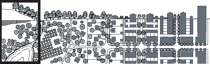 |
| T2 | The Rural Zone consists of lands in open or cultivated state or sparsely settled. These include woodland, agricultural lands, grasslands and irrigable deserts. | 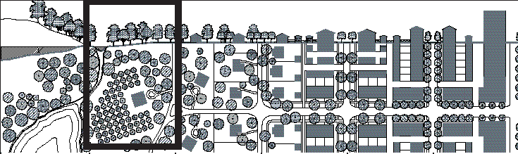 |
| T3 | The Sub-Urban Zone consists of low density suburban residential areas, differing by allowing home occupations. Planting is naturalistic with setbacks relatively deep. Blocks may be large and the roads irregular to accommodate natural conditions. | 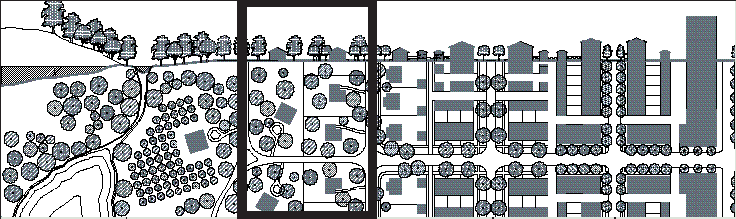 |
| T4 | The General Urban Zone consists of a mixed use but primarily residential urban fabric. It has a wide range of building types: single, sideyard, and rowhouses. Setbacks and landscaping are variable. Streets typically define medium-sized blocks. | 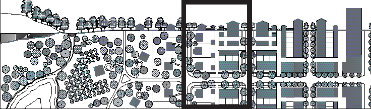 |
| T5 | The Urban Center Zone consists of higher density mixed use building types that accommodate retail, offices, rowhouses and apartments. It has a tight network of streets, with wide sidewalks, steady street tree planting and buildings set close to the frontages. |  |
| T6 | The Urban Core Zone consists of the highest density, with the greatest variety of uses, and civic buildings of regional importance. It may have larger blocks; streets have steady street tree planting and buildings set close to the frontages. |  |
| Source:DPZ | ||
(Ord. No. 2013-13, § 1, 11-11-13; Ord. No. 2015-05, § 1(Att.), 4-27-15)
Sec. 23-756. - Zoning and civic infrastructure map elements.
(a)
The regulating plan for the SmartCode zoning districts, which is adopted as an integral and related piece of this article, designates the following special requirements:
(1)
Public parking. Recommended locations for publicly-accessible and potentially publicly-funded/subsidized parking garages or lots.
(2)
New thoroughfares. Recommended locations for new thoroughfares based on the conceptual plan in the adopted small area plans. These alignments are conceptual only, but show the recommended spacing and location of new streets based on existing conditions and proposed build out.
(3)
Limited retail. On the indicated locations, the building area available for retail use is limited to: the first story of buildings at corner locations on major streets, not more than one per block; and other provisions of the "Limited Retail" designation in section 23-763(c).
(4)
Pedestrian/bicycle connections. Designated locations require a minimum 10-foot-wide pedestrian access and 20-foot right-of-way right be reserved between buildings.
(5)
Areas for civic space and/or parks. The regulating plan indicates where public open space currently exists and should be enhanced or expanded, or where new public open spaces are generally recommended per the adopted small area plans. With the exception of the existing municipal park, the locations of civic space/parks on the regulating plan are conceptual in nature and suggestive of the general scale and location of public open space, but do not preclude other locations for such space. However, where a civic space/park is designated on a particular block, such space shall be included in development plans in that block.
(6)
Landscape preservation. The regulating plan designates areas where a buffer of existing trees shall be preserved to maintain the green transition into the SmartCode zoning districts.
(7)
Required buffer. The regulating plan designates areas where new developments in T-4 and T-5 zones abut properties used for single family residential development in low density residential districts (RE-10, R-E, R-E-1, R, R-1, R-2, R-3) and where a 25-foot planting screen shall be provided to provide a transition between the smart growth zoning districts and the existing residential properties.
(8)
Three-story height maximum. Areas indicating the location where new buildings in smart growth zoning districts may not exceed three stories within 150 feet of the property line of abutting, low density, residentially zoned property (RE-10, R-E, R-E-1, R, R-1, R-2, R-3) that contain existing single family uses.
(Ord. No. 2013-13, § 1, 11-11-13; Ord. No. 2015-05, § 1(Att.), 4-27-15)
Sec. 23-757. - Restricted frontages.
(a)
Required shopfronts. The Regulating plan designates locations that require a shopfront frontage at sidewalk level along the entire length of the frontage.
(1)
The shopfront shall be no less than 60 percent glazed in clear glass along the linear frontage and provided with an awning, or gallery frontage overlapping the sidewalk as generally illustrated in section 23-773 (Table of Private Frontages).
(2)
The first floor shall be confined to Retail use through the depth of the first layer.
(Ord. No. 2013-13, § 1, 11-11-13; Ord. No. 2015-05, § 1(Att.), 4-27-15)
Sec. 23-758. - Civic space.
(a)
Civic space.
(1)
Civic space is an outdoor area dedicated for public use, such as a park, a green, a square, a plaza, or a playground. Civic space shall be approved in any SmartCode zoning district.
(2)
The minimum amount of Civic Space to be dedicated on each lot within the SmartCode zoning districts shall be as follows:
a.
For residential development, civic space as defined by Section 23-763(a)(1), shall be required as provided for in section 17-60 of the subdivision chapter of the Germantown Code based on the formula: number of units multiplied by the parkland ratio (0.0033) yields the number of acres of civic space.
b.
Payment-in-lieu of dedication for civic space is allowed as provided for in section 17-60(c) unless civic space is shown on the regulating plan.
c.
For all other developments, civic spaces shall be provided in the proposed development plan as usable public space.
d.
A request to be relieved of the requirement of civic space dedication or a payment-in-lieu fee for a development project shall be approved by a Justifiable Design Alternative in any SmartCode zoning district
(3)
Proposed locations and size of proposed civic spaces may be conceptual in nature and shall not preclude other locations for other such space. The type of civic space may be based on the table in Section 23-758(b). Final design details of the space shall be submitted to the Design Review Commission for approval with the final development plan.
(b)
Table of civic space types. Civic spaces shall be generally designed according to the following table:
| A. Park: A natural preserve available for unstructured recreation. A park may be independent of surrounding building frontages. Its landscape shall consist of paths and trails, meadows, woodland and open shelters, all naturalistically disposed. Parks may be lineal, following the trajectories of natural corridors. The minimum size shall be 10 acres. Larger parks may be approved by Justifiable Design Alternative in all zones. |  |
| B. Green: Green: An open space, available for unstructured recreation. A green may be spatially defined by landscaping rather than building frontages. Its landscape shall consist of lawn and trees, naturalistically disposed. The minimum size shall be 0.5 acres and the maximum shall be 15 acres. |  |
| C. Square: An open space available for unstructured recreation and civic purposes. A square is spatially defined by building frontages. Its landscape shall consist of paths, lawns and trees, formally disposed. Squares shall be located at the intersection of important thoroughfares. The minimum size shall be 0.25 acre and the maximum shall be 5 acres. |  |
| D. Plaza: An open space, available for civic purposes and commercial activities. A plaza shall be spatially defined by building frontages. Its landscape shall consist primarily of pavement. Trees are optional. Plazas shall be located at the intersection of important streets. The minimum size shall be 2000 square feet and the maximum shall be 0.5 acres. |  |
| E. Playground: An open space designed and equipped for the recreation of children. A playground shall be fenced and may include an open shelter. Playgrounds shall be interspersed within residential areas and may be placed within a block. Playgrounds may be included within parks and greens. There shall be no minimum or maximum size. |  |
| Source:DPZ | |
(Ord. No. 2013-13, § 1, 11-11-13; Ord. No. 2015-05, § 1(Att.), 4-27-15; Ord. No. 2024-16, (Att.), 10-18-24)
Sec. 23-763. - Permitted uses.
(a)
Uses shall be permitted by right, by Justifiable Design Alternative, or prohibited according to the following table:
(b)
Building function. Multi-family Development (Stand-Alone Single Use) shall not be permitted in the SmartCode Districts.
(c)
Additional use standards. The following additional use standards are applicable to T3, T4, T4R, T5, T5R, and T6.
(Ord. No. 2013-13, § 1, 11-11-13; Ord. No. 2015-05, § 1(Att.), 4-27-15; Ord. No. 2019-15, 1-27-20; Ord. No. 2024-16, (Att.), 10-18-24)
Sec. 23-768. - Sub-Urban Zone (T3).
This section establishes standards for the T3 SmartCode zoning district as shown in the adopted zoning map.
 |
BUILDING HEIGHT
A. Building height shall be measured as indicated in Sec. 23-780. | 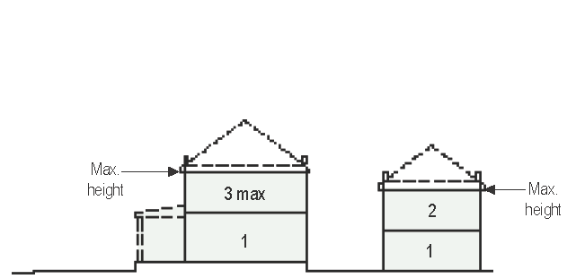 | |
| 1. BUILDING HEIGHT | |||
| A. Principal Building | 3 stories max. | ||
| B. Outbuilding | 2 stories max. |
BUILDING SITING
A. The façades and elevations of Principal Buildings shall be distanced from the lot lines as shown. | 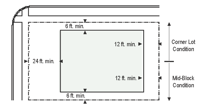 |
| 2. LOT OCCUPATION | |||
| A. Lot Width | 60 ft. min. | ||
| B. Lot Coverage | 60% max. | ||
| C. Frontage Buildout | n/a | ||
| 3. BUILDING DISPOSITION | |||
| A. Edgeyard | permitted | ||
| B. Sideyard | permitted | ||
| C. Rearyard | permitted | ||
| D. Courtyard | permitted | ||
| 4. BUILDING SITING |
OUTBUILDING SITING
A. The elevation of the Outbuildings shall be distanced from the lot lines as shown. | 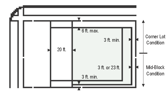 | |
| Principal Building | |||
| A. Front Setback | 24 ft. min. | ||
| B. Side Setback from right-of-way | 6 ft. min. | ||
| C. Side Setback from adjacent lot | 6 ft. min. | ||
| D. Rear Setback | 12 ft. min. | ||
| Outbuilding | |||
| E. Front Setback | 20 ft. min. + 4.A. | ||
| F. Side Setback from right-of-way | 6 ft. min. | ||
| G. Side Setback from adjacent lot | 3 ft. or 6 ft. | ||
| H. Rear Setback | 3 ft. or 23 ft. | ||
(Ord. No. 2013-13, § 1, 11-11-13; Ord. No. 2015-05, § 1(Att.), 4-27-15)
Sec. 23-769. - General Urban Zone (T4 and T4-Restricted).
This section establishes standards for the T4 and T4-Restricted (T4-R) SmartCode zoning districts as shown in the adopted zoning map. Additionally, development in the T4-R district shall be subject to the provisions in section 23-779.
 |
BUILDING HEIGHT
A. Building height shall be measured as indicated in Sec. 23-780. |  | |
| 1. BUILDING HEIGHT | |||
| A. Principal Building |
3 stories max.
2 stories min.1 story by Justifiable Design Alternative (min. 20 feet) |
BUILDING SITING
A. The façades and elevations of Principal Buildings shall be distanced from the lot lines as shown. B. Buildings shall have façades along principal frontage lines and elevations along lot lines. | 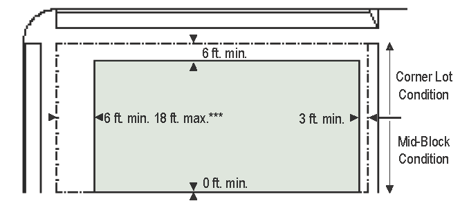 |
| B. Outbuilding | 2 stories max. | ||
| 2. LOT OCCUPATION | |||
| A. Lot Width |
18 ft min.
96 ft max. | ||
| B. Lot Coverage | 70% max. | ||
| C. Frontage Buildout | N/A | ||
| 3. BUILDING DISPOSITION | |||
| A. Edgeyard | permitted | ||
| B. Sideyard | permitted | ||
| C. Rearyard | permitted | ||
| D. Courtyard | prohibited |
OUTBUILDING SITING
A. The elevation of the Outbuildings shall be distanced from the lot lines as shown. | 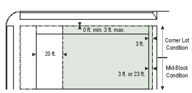 |
| 4. BUILDING SITING | |||
| Principal Building | |||
| A. Front Setback 1 |
6 ft min.
18 ft max. | ||
| B. Side Setback from right-of-way | 6 ft min. | ||
| C. Side Setback from adjacent lot | 0 ft or 6 ft | ||
| D. Rear Setback | 3 ft min. or 20 ft from alley centerline | ||
| Outbuilding | |||
| E. Front Setback | 20 ft min. + 4.A. | ||
| F. Side Setback from right-of-way | 6 ft min. | ||
| G. Side Setback from adjacent lot | 0 ft or 3 ft | ||
| H. Rear Setback | 3 ft min. or 20 ft from alley centerline | ||
| 110 ft. min. or 40 ft. max. from Poplar Ave. or Germantown Rd. frontages unless a frontage drive/road is constructed, in which case the setbacks are as delineated above shall apply in relation to the frontage drive/road. | |||
(Ord. No. 2013-13, § 1, 11-11-13; Ord. No. 2015-05, § 1(Att.), 4-27-15; Ord. No. 2024-16, (Att.), 10-18-24)
Sec. 23-770. - Urban Center Zone (T5 and T5-Restricted).
This section establishes standards for the T5 and T5-Restricted (T5-R) SmartCode zoning districts as shown in the adopted zoning map. Additionally, development in the T5-R district shall be subject to the provisions in section 23-779.
 |
BUILDING HEIGHT
A. Building height shall be measured as indicated in Sec. 23-780. | 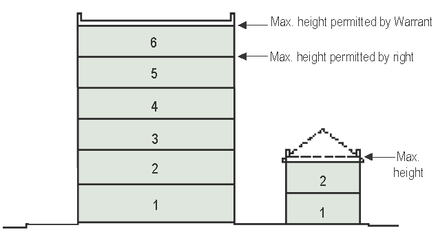 | |
| 1. BUILDING HEIGHT | |||
| A. Principal Building |
2 stories min.
5 stories max. by right 6 stories max. by Justifiable Design 1 story by Justifiable Design Alternative 20 ft min. |
BUILDING SITING
1. The façades and elevations of Principal Buildings shall be distanced from the lot lines as shown. 2. Buildings shall have façades along principal frontage lines and elevations along lot lines. | 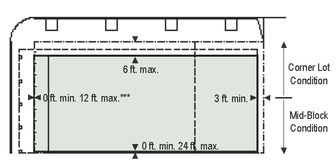 |
| B. Outbuilding | 2 stories max. | ||
| 2. LOT OCCUPATION | |||
| A. Lot Width |
18 ft min.
180 ft max. | ||
| B. Lot Coverage | 100% max. | ||
| C. Frontage Buildout | 70% min. | ||
| 3. BUILDING DISPOSITION | |||
| A. Edgeyard | prohibited | ||
| B. Sideyard | permitted | ||
| C. Rearyard | permitted | ||
| D. Courtyard | permitted |
OUTBUILDING SITING
1. The elevation of the Outbuildings shall be distanced from the lot lines as shown. | 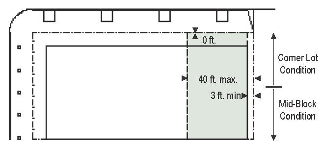 |
| 4. BUILDING SITING | |||
| Principal Building | |||
| A. Front Setback 1 |
0 ft min.
12 ft max. | ||
| B. Side Setback from right-of-way | 0 ft min. | ||
| C. Side Setback from adjacent lot | 0 ft min. | ||
| D. Rear Setback | 3 ft min. or 20 ft from alley centerline | ||
| Outbuilding | |||
| E. Front Setback | 40 ft max. from rear property line | ||
| F. Side Setback from right-of-way | 0 ft min. | ||
| G. Side Setback from adjacent lot | 0 ft min. | ||
| H. Rear Setback | 3 ft min. or 20 ft from alley centerline | ||
| 110 ft. min. or 40 ft. max. from Poplar Ave. or Germantown Rd. frontages unless a frontage drive/road is constructed, in which case the setbacks are as delineated above shall apply in relation to the frontage drive/road. | |||
(Ord. No. 2013-13, § 1, 11-11-13; Ord. No. 2015-05, § 1(Att.), 4-27-15; Ord. No. 2024-16, (Att.), 10-18-24)
Sec. 23-771. - Urban Core Zone (T6).
This subsection establishes standards for the T6 SmartCode zoning district as shown in the adopted zoning map.
 |
BUILDING HEIGHT
A. Building height shall be measured as indicated in Sec. 23-780. | 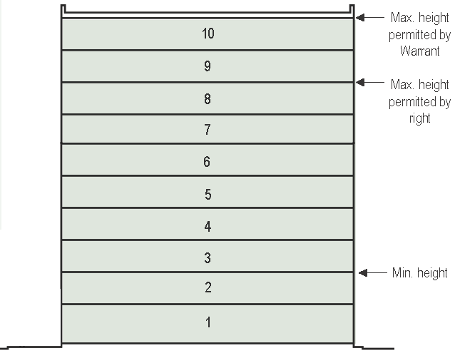 | |
| 1. BUILDING HEIGHT | |||
| A. Principal Building |
8 stories max. or 10 max. by Justifiable Design Alternative
2 stories min. | ||
| B. Outbuilding | 2 stories max. | ||
| 2. LOT OCCUPATION | |||
| A. Lot Width |
18 ft min.
700 ft max. | ||
| B. Lot Coverage | 100% max. |
BUILDING SITING
1. The façades and elevations of Principal Buildings shall be distanced from the lot lines as shown. 2. Buildings shall have façades along principal frontage lines and elevations along lot lines. | 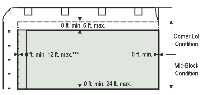 |
| C. Frontage Buildout | 80% min. | ||
| 3. BUILDING DISPOSITION | |||
| A. Edgeyard | prohibited | ||
| B. Sideyard | prohibited | ||
| C. Rearyard | permitted | ||
| D. Courtyard | permitted | ||
| 4. BUILDING SITING | |||
| Principal Building | |||
| A. Front Setback 1 |
0 ft min.
12 ft max. | ||
| B. Side Setback from right-of-way | 0 ft min. | ||
| C. Side Setback from adjacent lot | 0 ft min. | ||
| D. Rear Setback | 0 ft min. | ||
| Outbuilding | |||
| E. Front Setback | n/a | ||
| F. Side Setback from right-of-way | n/a | ||
| G. Side Setback from adjacent lot | n/a | ||
| H. Rear Setback | n/a | ||
| 110 ft. min. or 40 ft. max. from Poplar Ave. or Germantown Rd. frontages unless a frontage drive/road is constructed, in which case the setbacks are as delineated above shall apply in relation to the frontage drive/road. | |||
(Ord. No. 2013-13, § 1, 11-11-13; Ord. No. 2015-05, § 1(Att.), 4-27-15; Ord. No. 2024-16, (Att.), 10-18-24)
Sec. 23-772. - Table of building disposition.
Building type. This table approximates the location of the structure relative to the boundaries of each individual lot, establishing suitable basic building types for each SmartCode zoning district.
|
A. Edgeyard: A building that occupies the center of its lot with Setbacks on all sides.
This is the least urban of types as the front yard sets it back from the frontage.
The front yard is intended to be visually continuous with the yards of adjacent buildings.
The rear yard can be secured for privacy by fences and a well-placed Backbuilding
and/or Outbuilding.
Specific Types: Single-family House, Cottage, Villa, Urban Villa. | 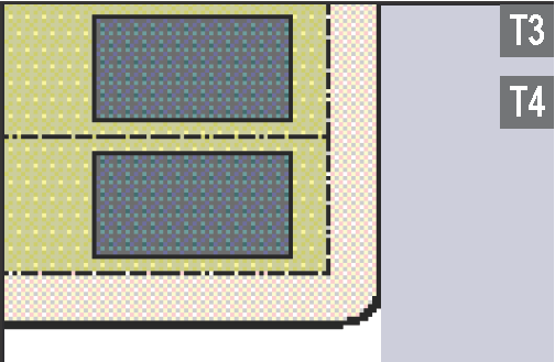 |
|
B. Sideyard: A building that occupies one side of the lot with the Setback to the
other side. The visual opening of the side yard on the street frontage causes this
building type to appear freestanding. A shallow frontage Setback defines a more urban
condition. If the adjacent building is similar with a blank party wall, the yard can
be quite private. This type permits systematic climatic orientation in response to
the sun or the breeze.
Specific Types: Charleston Single House, zero-lot-line house. |  |
|
C. Rearyard: A building that occupies the full frontage, leaving the rear of the lot
as the sole yard. This is a very urban type as the continuous Façade steadily defines
the public Thoroughfare. The rear Elevations may be articulated for functional purposes.
In its Residential form, this type is the Rowhouse. For its Commercial form, the rear
yard can accommodate substantial parking.
Specific Types: Townhouse, Rowhouse, Live-Work unit, perimeter block. | 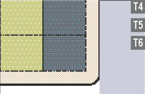 |
|
D. Courtyard: A building that occupies the boundaries of its lot while internally
defining one or more private patios. This is the most urban of types, as it is able
to shield the private realm from all sides while strongly defining the public Thoroughfare.
Because of its ability to accommodate incompatible activities, masking them from all
sides, it is recommended for workshops, Lodging and schools.
Specific Types: Patio House. | 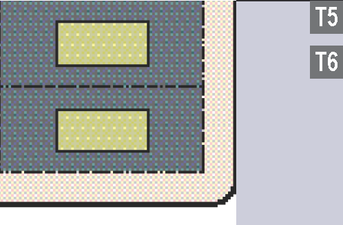 |
| Source: DPZ | |
(Ord. No. 2013-13, § 1, 11-11-13; Ord. No. 2015-05, § 1(Att.), 4-27-15)
Sec. 23-773. - Table of private frontages.
Private frontages. The private frontage is the area between the building and the lot lines.
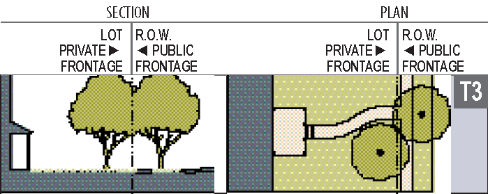 | |
| A. Common Yard: a frontage wherein the façade is set back substantially from the frontage line. The front yard created remains unfenced and is visually continuous with adjacent yards, supporting a common landscape. | |
| B. Porch & Fence: a frontage wherein the façade is set back from the frontage line with an attached porch permitted to encroaching. A fence at the frontage line maintains the demarcation of the yard. The porches shall be no less than 8 feet deep. |  |
| C. Terrace or Light Court: a frontage wherein the façade is set back from the frontage line by an elevated terrace or a sunken light court. This type buffers residential use from urban sidewalks and removes the private yard from public encroachment. The terrace is suitable for conversion to outdoor cafes. |  |
| D. Forecourt: a frontage wherein a portion of the façade is close to the frontage line and the central portion is set back. The forecourt created is suitable for vehicular drop-offs. This type should be allocated in conjunction with other frontage types. Large trees within the forecourts may overhang the sidewalks. |  |
| E. Stoop: a frontage wherein the façade is aligned close to the frontage line with the first story elevated from the sidewalk sufficiently to secure privacy for the windows. The entrance is usually an exterior stair and landing. This type is recommended for ground-floor residential use. |  |
| F. Shopfront and Awning: a frontage wherein the façade is aligned close to the frontage line with the building entrance at sidewalk grade. This type is conventional for retail use. It has a substantial glazing on the sidewalk level and an awning that may overlap the sidewalk to the maximum extent possible. |  |
| G. Gallery: a frontage wherein the façade is aligned close to the frontage line with an attached cantilevered shed or a lightweight colonnade overlapping the sidewalk. This type is conventional for retail use. The gallery shall be no less than 10 feet wide and may overlap the sidewalk to the right-of-way line. |  |
| Source: DPZ | |
(Ord. No. 2013-13, § 1, 11-11-13; Ord. No. 2015-05, § 1(Att.), 4-27-15)
Sec. 23-778. - General lot standards.
(a)
Building siting and orientation.
(1)
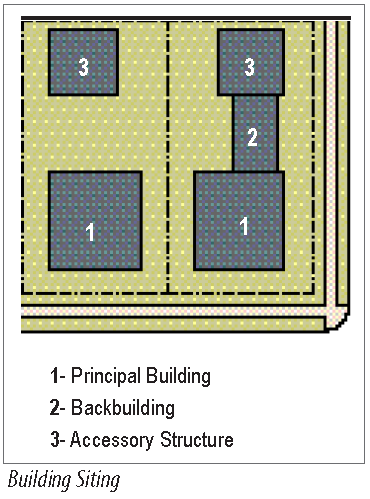
T3 district only: One principal building at the frontage, and one accessory structure to the rear of the principal building (unless otherwise permitted by Justifiable Design Alternative), may be built on each lot as shown at right.
(2)
All districts: Principal buildings shall have their principal pedestrian entrances on a frontage line.
(3)
Building setbacks along Poplar Avenue and Germantown Road shall be T3 at least ten feet and no more than 40 feet from the public right-of-way, T4 unless a frontage drive/road is constructed, in which case, the setbacks established in sections 23-768 to 23-771 shall apply in relation to the frontage drive/road.
(4)
Façades shall be built parallel to a rectilinear principal frontage line or T4 parallel to the tangent of a curved principal frontage line.
(5)
Liner buildings shall include retail, office uses, or some other active use along the primary frontage.
(b)
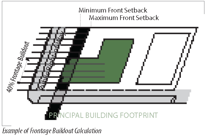
Frontage buildout. Façades shall extend along a minimum percentage of the frontage width at the setback, as the frontage buildout in sections 23-768 to 23-771 specifies. The width of a driveway provided at the frontage shall be exempt from this requirement. In the absence of a building façade along any part of a frontage line, a streetscreen shall be built contiguous with the façade in accordance with section 23-794(b).
(1)
T5: 70 percent minimum. In the absence of a building along the remainder of the frontage line, a streetscreen shall be built on the same plane with the façade.
(2)
T6: 80 percent minimum. In the absence of building along the remainder of the frontage line, a streetscreen shall be built on the same plane with the façade.
(c)
Encroachments. The following encroachments are allowed in the T4, T5, and T6 zones only:
(Ord. No. 2013-13, § 1, 11-11-13; Ord. No. 2015-05, § 1(Att.), 4-27-15; Ord. No. 2024-16, (Att.), 10-18-24)
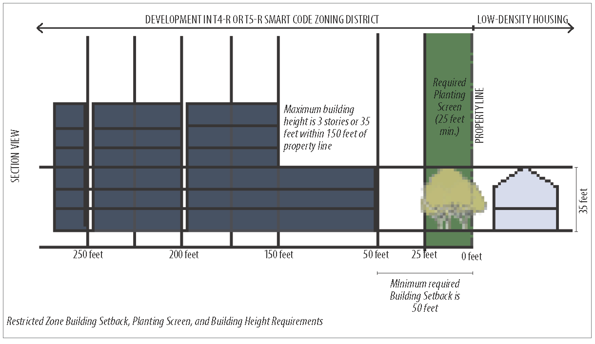
Sec. 23-779. - Restricted zone standards.
(a)
Applicability. The provisions of this section shall apply to any properties designated as T4-Restricted or T5- Restricted (T4-R or T5-R). These are transitional zones which abut low density single-family housing that is zoned as R-E-10, R-E, R-E-1, R, R-1, R-2, and R-3, hereafter "low density housing."
(b)
Setback and screening. A 50-foot building setback is required along all property lines that are adjacent to the low-density housing. This 50-foot setback shall include a planting screen of at least 25 feet in depth at the adjacent edge(s) of the property. The planting screen shall utilize existing landscaping where possible, and new plantings shall be predominately evergreen that are at least 8 feet in height when planted.
(c)
Permitted uses. Within 150 feet of the property line of such adjacent low-density housing, new buildings shall be limited to residential uses, limited retail, and/or parking facilities.
(1)
Where an above-ground parking facility is located at the perimeter of a building, it shall be screened or treated in such a way that cars and light fixtures are not visible from the street or from abutting residentially zoned properties.
(d)
Dumpsters. Garbage dumpsters shall not be placed within the first layer of a lot nor shall they be within 150 feet of low-density housing.
(e)
Height.
(1)
New buildings in the T4-R and T5-R districts may not exceed three stories within 150 feet of low-density housing. This height setback includes the required 50-foot building setback and 25-foot planting screen as described in subsection (b) of this section.
(Ord. No. 2013-13, § 1, 11-11-13; Ord. No. 2015-05, § 1(Att.), 4-27-15; Ord. No. 2024-16, (Att.), 10-18-24)
Sec. 23-780. - Height.
(a)
Building heights shall conform to the graphic below and as shown in sections 23-768 through 23-771 (district provisions).
(1)
The vertical extent of a building is measured by number of stories, not including a raised basement or an inhabited attic. Each story shall be no more than 15 feet clear, with the exception of the ground floor of a commercial or mixed use building, which may be up to 18 feet in height. While the height of each story may vary, the actual height of buildings may not exceed the maximum allowable individual story height multiplied by the maximum number of stories allowed by right (sections 23-768 through 23-771).
(2)
Height limits do not apply to masts, belfries, clock towers, chimney flues, water tanks, elevator bulkheads and similar structures.
(3)
Heights are measured from the average grade of the frontage line to the eave of a pitched roof or to the surface of a flat roof.
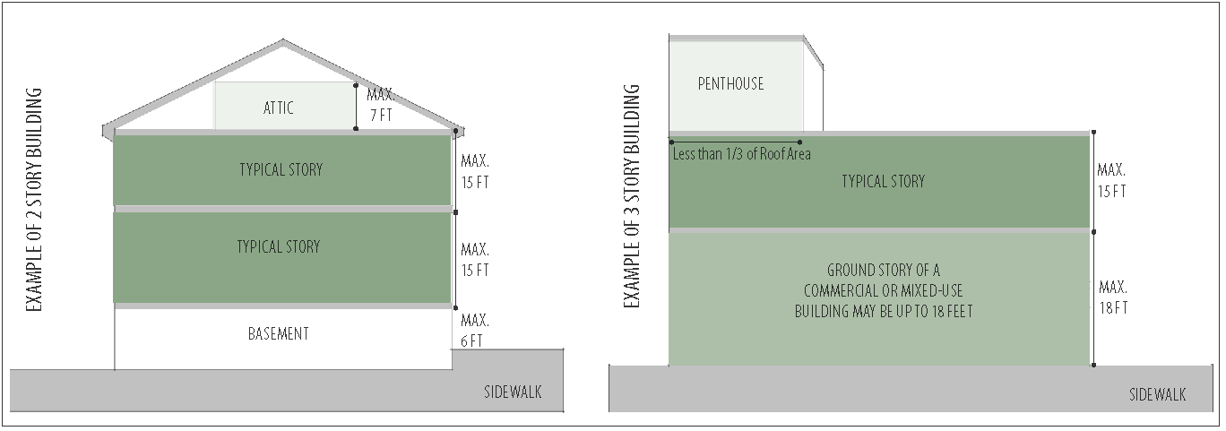
(Ord. No. 2013-13, § 1, 11-11-13; Ord. No. 2015-05, § 1(Att.), 4-27-15)
Sec. 23-785. - Civic/landmark buildings.
(a)
Applicability. The civic/landmark building type includes prominent public buildings such as libraries and city halls; semi-public buildings such as museums and colleges; and private buildings such as hospitals and churches.
(b)
Administration and review standards. Because of the unique characteristics of the civic/ landmark building type, it shall be subject to review and approval by the design review commission as part of the approval process. As part of this review process, the applicant may request modifications from the applicable district standards. All such modifications shall conform to the design guidelines that follow. Civic/landmark buildings:
(1)
Shall be incorporated based on the recommendations of the adopted small area plans.
(2)
Shall be sited to terminate a street vista whenever possible and must incorporate appropriate prominent features, designs, and entrances to celebrate a visual termination.
(3)
Shall incorporate detailing and materials that are authentic to the intended style.
(4)
May include a pedestrian plaza, courtyard, or similar landscaped area in lieu of a required building frontage and minimum setback.
(5)
Shall respect the character of the fronting streets through the provision of a pedestrian-friendly orientation, including clear entrances from the street and permeable street walls with adequate fenestration of a proportion, quantity and arrangement appropriate to and reflective of the building's architectural style.
(Ord. No. 2013-13, § 1, 11-11-13; Ord. No. 2015-05, § 1(Att.), 4-27-15; Ord. No. 2023-20, (Att.), 11-13-23)
Sec. 23-786. - Residential design standards.
(a)
Applicability. The standards of this section shall apply to those structures in the T3, T4, T5, and T6 districts which have primarily residential frontages (including live-work buildings).
(b)
Roof and eaves.
(1)
Pitched roofs, if provided, shall be symmetrically sloped no less than 8:12, except that porches and attached sheds may be no less than 2:12.
(2)
Flat roofs shall be enclosed by parapets a minimum of 42 inches high, or as required to conceal mechanical equipment to the satisfaction of the PC.
(3)
Materials: Residential roofs must be clad in wood shingles, standing seam metal, terne, slate, dimensional asphalt shingles or synthetic materials similar and/or superior in appearance and durability.
(c)
Frontage design.
(1)
Building entrances: All buildings with more than four sidewalk-level residential units along a single street shall have individual entrances to such units directly accessible from the required sidewalk or adjoining open space.
(2)
Raised entries: To provide privacy, all residential entrances within 15 feet of the sidewalk must be raised from the average sidewalk grade a minimum of 24 inches. Secondary subgrade or lightwell entrances are permitted. Exterior entry steps shall have enclosed risers.
(3)
Porches and stoops: Usable porches and stoops shall form a predominant motif of the building design and be located on the front and/or side of the building to respond to the climatic conditions and the vernacular of the region. Usable front porches are covered and are at least eight feet deep and 12 feet in width. Stoops and entry-level porches shall not be enclosed with screen wire or glass.
a.
T3: Balconies and porches shall be made of brick, stone, or painted wood.
b.
T4: Balconies and porches shall be made of brick, stone, painted wood, or metal.
c.
T5, T6: Balconies, galleries, and arcades shall be made of brick, stone, painted wood, metal, or concrete.
(4)
Fences: Fences shall be made of masonry, ornamental metal or durable wood, or some combination of the three. The use of chain link, plastic or wire fencing is prohibited in the SmartCode zoning districts.
(d)
Façade treatment and building walls.
(1)
Proportion: All openings, including porches, galleries, arcades and windows, with the exception of storefronts, shall be square or vertical in proportion.
(2)
Minimize blank walls: At least 30 percent of the total wall area of each façade shall be composed of transparent windows (excluding glass block) or doorways (egress only doorway excluded).
a.
"Transparent" shall mean clear glass such that there are direct views to the building's interior extending a minimum of six feet behind the window during daylight hours. Reflective, highly tinted glass, faux windows or casement display windows are prohibited in meeting this requirement.
(3)
Materials: Building façade materials, with the exception of corner treatments and columns, shall be combined only horizontally, with the heavier below the lighter.
a.
T3, T4: The exterior finish material on all façades shall be limited to brick, stone, wood siding, cementitious (fiber cement) siding and/or hard coat stucco. Other materials may be permitted by Justifiable Design Alternative.
b.
T5, T6: The exterior finish material on all façades shall be limited to brick, stone, and/or hard coat stucco. Other materials may be permitted by Justifiable Design Alternative.
(4)
Chimney: Chimneys shall extend to the ground.
(5)
Crawlspace: The crawlspace of buildings, if provided, must be enclosed.
(e)
Windows and doors.
(1)
Entry façade window trim shall not be flush with the exterior wall and shall have a minimum relief of 0.25 inch from the exterior wall.
(2)
Doors and windows that operate as sliders are prohibited along frontages.
(Ord. No. 2013-13, § 1, 11-11-13; Ord. No. 2015-05, § 1(Att.), 4-27-15; Ord. No. 2024-16, (Att.), 10-18-24)
Sec. 23-787. - Mixed use and commercial buildings design standards.
(a)
Applicability. The standards of this section shall apply to those structures in the T4, T5, and T6 districts which have primarily commercial frontages (excluding live-work buildings).
(b)
Roof and eaves.
(1)
Pitched roofs, if provided, shall be symmetrically sloped no less than 8:12, except that porches and attached sheds may be no less than 2:12.
(2)
Flat roofs shall be enclosed by parapets a minimum of 42 inches high, or as required to conceal mechanical equipment to the satisfaction of the PC.
(c)
Frontage design.
(1)
Pedestrian entrance from frontage required: All buildings and ground level tenants shall provide a functioning entrance, operable during normal business hours for ingress and egress, facing the frontage line. Buildings located on street corners may have a corner entrance.
(2)
Maximum entrance setback: Primary pedestrian entrances on the principal frontage shall be recessed a maximum of seven feet from the exterior façade, and shall remain unlocked during normal business hours.
(3)
Canopies and awnings: Awnings and canopies shall be of fabric, canvas, fixed metal, or similar material. They shall project a minimum of four feet from the façade, with a maximum projection over a sidewalk to within two feet of a public street curb. The awning or canopy shall have a minimum clearance height of eight feet above the sidewalk.
(4)
Balconies and porches:
a.
T4: Balconies and porches shall be made of brick, stone, painted wood, or metal.
b.
T5, T6: Balconies, galleries, and arcades shall be made of brick, stone, painted wood, metal, or concrete.
(5)
Fences: Fences shall be made of masonry, ornamental metal or durable wood, or some combination of the three. The use of chain link, plastic or wire fencing is prohibited in the SmartCode zoning districts.
(d)
Façade treatment and building walls.
(1)
Minimize blank walls: In order to minimize blank walls, architectural elements like windows and doors, bulkheads, masonry piers, transoms, cornice lines, window hoods, awnings, canopies, and other similar details must be used to articulate all façades. No façade length shall exceed 20 feet without such elements.
(2)
Required transparency zone: In T4, T5, and T6 districts, no less than 60 percent of the principal frontage of the sidewalk-level story shall be made up of clear glass, including windows and doors.
a.
"Transparent" shall mean clear glass such that there are direct views to the building's interior extending a minimum of six feet behind the window during daylight hours. Reflective, highly tinted glass, faux windows or casement display windows are prohibited in meeting this requirement.
(3)
Materials: Building façade materials, with the exception of corner treatments and columns, shall be combined only horizontally, with the heavier below the lighter.
a.
T4: The exterior finish material on all façades shall be limited to brick, stone, wood siding, cementitious (fiber cement) siding and/or hard coat stucco. Other materials may be permitted by Justifiable Design Alternatives.
b.
T5, T6: The exterior finish material on all façades shall be limited to brick, stone, and/or hard coat stucco. Other materials may be permitted by Justifiable Design Alternatives.
(e)
Windows and doors.
(1)
Doors and windows that operate as sliders are prohibited along frontages.
(2)
Entry façade window trim shall not be flush with the exterior wall and shall have a minimum relief of 0.25 inch from the exterior wall.
(3)
Ventilation grates or emergency exit doors located at the first floor level in the building façade, which are oriented to any public street, must be decorative.
(Ord. No. 2013-13, § 1, 11-11-13; Ord. No. 2015-05, § 1(Att.), 4-27-15; Ord. No. 2024-16, (Att.), 10-18-24)
Sec. 23-792. - Parking requirements.
(a)
Parking calculation: The required parking table below summarizes the parking requirements for each site or, conversely, the amount of building allowed on each site given the parking available. For mixed use areas, the sharing factor table below may be used to reduce the parking minimums, which will be the actual parking on-site. Parking requirements are inclusive of handicapped parking spaces.
(1)
On-street parking: On-street parking available along the frontage lines that correspond to each lot shall be counted toward the parking requirement of the building on the lot.
(2)
Public parking: The required parking for nonresidential uses may be provided by publicly available parking within 1,000 feet of the site that it serves, subject to approval by Justifiable Design Alternatives.
| A. REQUIRED PARKING TABLE | B. SHARING FACTOR TABLE | |||
|---|---|---|---|---|
| USE | T3 | T4 | T5 T6 | 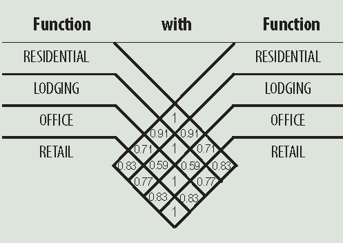 |
| Residential | 2.0/dwelling | 1.5/dwelling | 1.0/dwelling | |
| Lodging | 1.0/bedroom | 1.0/bedroom | 1.0/bedroom | |
| Office | 3.0/1000 sq. ft.* | 3.0/1000 sq. ft.* | 2.0/1000 sq. ft.* | |
| Retail | n/a | 4.0/1000 sq. ft.* | 3.0/1000 sq. ft.* | |
| Civic | To be determined by Justifiable Design Alternatives | |||
| Other | To be determined by Justifiable Design Alternatives | |||
| * The maximum number of permitted parking spaces for office and retail functions shall be 5 spaces per 1000 square feet. | ||||
(3)
Sharing factor: The sharing factor may be used to calculate the required parking for mixed use development(defined as two dissimilar functions occurring within any two adjacent blocks or a proximity determined by Justifiable Design Alternatives). The actual parking required is calculated by adding the total number of spaces required by each separate function and multiplying the total by the appropriate factor from the sharing factor table. When three uses share parking, the highest factor shall be used to calculate the required number of spaces.
(4)
Example: The residential function requires ten spaces while the office portion requires 12 spaces. Independently they would require 22 spaces, but when multiplied by the sharing factor of 0.71, they would require only 16 spaces. A second way to calculate: If there is a total of 22 spaces available for residential and office, dividing this by the factor 0.71 gives the equivalent of 30 spaces. Buildings may be designed to a functional density corresponding to 30 parking spaces.
(b)
General parking standards.
(1)
T5 and T6 only: A pedestrian entrance to all parking lots and parking structures shall be provided directly from a frontage line. For underground parking structures, the only pedestrian entrance may be directly from a principal building.
(2)
T5 and T6 only: The vehicular entrance of a parking lot or garage on a lot frontage shall be no wider than 30 feet. When applicable, the requirements of this section shall be subject to the conformance with the Tennessee Department of Transportation requirements for state highways.
(3)
Parking lots shall be masked from the frontage by a liner building or streetscreen (section 23-794(b)) as specified in section 23-778(a)(5).
(4)
Where an above-ground parking structure is located at the perimeter of a building, it shall be screened or treated in such a way that cars are not visible from the street or from abutting zoned properties (RE-10, R-E, RE-1, R, R-2, R-3) with residential uses.
(c)
Parking area location.
(1)
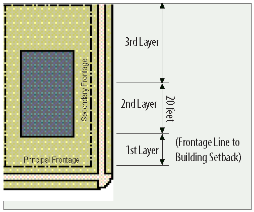
T3: Open parking areas shall be located at the second and third lot layers, except that driveway aprons and drop-offs may be located at the first layer. Garages shall be located at the third lot layer.
(2)
T4: All parking areas except for driveways shall be located at the third layer. Garages shall be at the third lot layer.
(3)
T5 and T6: All parking areas shall be located at the third lot layer.
(4)
T4, T5 and T6: For building on non-pedestrian-oriented streets, parking areas may be allowed on the frontage by Justifiable Design Alternative along Germantown Road, Poplar Avenue, and other non-pedestrian-oriented streets.
(5)
T4, T5 and T6: Uncovered (surface) parking is prohibited within the minimum building setbacks.
(d)
Surface parking.
(1)
Surface parking shall be organized into small groups or courts of no more than 25 spaces. Courts shall be divided by parking islands.
(2)
Parking islands shall be large enough for trees, low shrubs and ground cover. Parking islands shall be a minimum of 180 square feet in area. At least one shade tree and perimeter plantings shall be planted for each 200 square feet of parking area island. Planted islands should include trees of at least 2.5 inches caliper and perimeter plantings at least 18 inches high.
(3)
Shopping cart corrals shall be screened with landscaped parking islands.
(4)
Pedestrian circulation shall be provided for within parking areas:
a.
Pedestrian paths and crossings shall be provided from parking spaces to main entrances and to the street.
b.
Parking spaces shall be designed so they least interfere with pedestrian access and connections to adjoining developments.
c.
Landscaped medians shall be designed that contain pedestrian walkways. These medians shall be at least 15 feet wide to accommodate shade trees, evergreen plantings and pedestrian paths.
(5)
Maintenance and management of all landscaped areas shall be the responsibility of the property owners.
(6)
Surface parking spaces provided in excess of 120 percent of the minimum required shall be by Justifiable Design Alternative.
(7)
Parking located within the 50-foot building setback, as described in section 23-779 shall be parallel to the property line of abutting, low density, residentially-zoned property (RE-10, R-E, RE-1, R, R-1, R-2, and R-3) that contain single family uses.
(e)
Residential parking.
(1)
Garages shall be placed behind the building setback, facing the side or rear of detached homes.
(2)
For residential buildings on lots less than 50 feet wide and for all sideyard, rearyard, and courtyard residential buildings, garages or off-street parking shall be accessed from an alley or via a shared driveway only.
(f)
Bicycle parking. Bicycle parking for all nonresidential uses and for residential uses of more than four units per building is required. Bicycle parking shall be provided at a rate of one bicycle parking space for every 20 motor vehicle spaces provided up to a maximum of 20 bicycle spaces (1:20). No more than 20 spaces shall be required for any project.
(1)
Required racks. "Inverted U" type racks or other racks that support the bicycle at two points on the bicycle frame are required. A single inverted U rack shall count as two bicycle spaces.
(2)
Rack siting and dimensions.
a.
Racks shall be secured to the ground on a hard surface such as concrete, asphalt or unit pavers.
b.
Each bicycle parking space shall provide six feet by two feet in area per bicycle plus the area needed for access.
c.
Bicycle parking shall be located no closer than five feet from any wall or three feet from face of curb to provide adequate space for access and maneuvering.
d.
At least four feet between parallel racks shall be provided for access.
e.
Bicycle racks installed on sidewalks shall provide for a clear, unobstructed width of at least five feet for pedestrians and shall be installed parallel to the curb.
f.
Racks should be placed along a major building approach line and clearly visible from the approach and no more than 50 feet from building entrances or no further than the closest motor vehicle parking space, whichever is less. Rack placement should allow for visual monitoring by persons within the building and/or persons entering the building.
g.
If required bicycle parking is not visible from the street or main building entrance, a sign shall be posted at the main entrance indicating the location of the parking.
h.
Uses with several major, actively used entrances shall locate a portion of the required bicycle parking at each entrance.
(Ord. No. 2013-13, § 1, 11-11-13; Ord. No. 2015-05, § 1(Att.), 4-27-15; Ord. No. 2019-5, 2-25-19; Ord. No. 2024-16, (Att.), 10-18-24)
Sec. 23-793. - Driveways and cross-access connections.
(a)
Driveways.
(1)
Mid-block lot driveways: A mid-block lot without access to a side street or alley is permitted one driveway with a maximum width of 30 feet.
(2)
Corner lot driveways: Corner lots may take access from side street or secondary frontage only. Preference for access shall be given to the minor street as determined by the Administrator. Driveways shall be located as far from the adjacent public street intersection as practical to achieve maximum available corner clearance, with consideration of property limits, adjacent curb cuts, topography, and existing drainage facilities.
(3)
Driveway widths: Vehicular entrances to parking lots, garages, and parking structures shall be no wider than 30 feet at the frontage.
(4)
When applicable, the requirements of this section shall be subject to the conformance with the Tennessee Department of Transportation requirements for state highways.
(b)
Cross-access connections. Cross-access easements and connections to adjoining properties shall be required to connect driveways and parking lots. The following guidelines shall apply:
(1)
At least one connection is provided at all lot lines that are coincident for at least 60 feet with another lot that has primary frontage on the same street.
(2)
The connection is at least 20 feet in width.
(3)
If applicable, the connection aligns with a connection that has been previously constructed on an adjacent property.
(4)
The connection has a slope of no greater than 15 percent.
(5)
The connection is placed in an area which will not require the removal of significant natural features such as wetlands or trees with a caliper of four inches or more.
(6)
In the event these conditions cannot be met without undue hardship, or if such connections would create undesirable traffic flow, the administrator may waive the connection requirement.
(7)
Where a parking lot connection is required, an easement for ingress and egress to adjacent lots shall be recorded by the property owner in the form of an easement plat.
(Ord. No. 2013-13, § 1, 11-11-13; Ord. No. 2015-05, § 1(Att.), 4-27-15; Ord. No. 2019-5, 2-25-19)
Sec. 23-794. - Site landscaping.
(a)
Landscape species.
(1)
T3: The landscape installed shall consist primarily of native species requiring minimal irrigation, fertilization and maintenance.
(2)
T4, T5, T6: The species of landscape installed shall consist primarily of durable species tolerant of soil compaction.
(b)
Streetscreens. Streetscreens should be between 3.5 and eight feet in height and constructed of a material matching the adjacent building façade. The streetscreen may be replaced by an evergreen hedge or a fence by Justifiable Design Alternative. A landscaped streetscreen shall be at least five feet deep. Streetscreens shall have openings no larger than necessary to allow automobile and pedestrian access. In addition, all streetscreens over four feet in height shall be 30 percent permeable or articulated to avoid blank walls.
(Ord. No. 2013-13, § 1, 11-11-13; Ord. No. 2015-05, § 1(Att.), 4-27-15; Ord. No. 2024-16, (Att.), 10-18-24)
Sec. 23-795. - Utilities, trash containment and loading areas.
(a)
Garbage dumpsters. Garbage dumpsters shall be screened by a fencing that is composed of similar materials to the principal structure. Garbage dumpster fencing shall be opaque, at least 6 feet in height, and of sufficient height to completely screen the dumpster. Garbage dumpsters shall not be placed within the first layer of a lot nor shall they be within 150 feet of the property line of abutting, low density residentially zoned property (RE-10, R-E, RE-1, R, R-2, R-3) that contain existing single family uses.
(b)
Loading docks. Loading docks and service areas shall be permitted on primary frontages only by Justifiable Design Alternative. Screening of such is required.
(Ord. No. 2013-13, § 1, 11-11-13; Ord. No. 2015-05, § 1(Att.), 4-27-15; Ord. No. 2024-16, (Att.), 10-18-24)
Sec. 23-796. - Lighting.
(a)
General provisions.
(1)
All exterior illuminating devices, except those exempts from this standard or noted otherwise, shall cast light primarily downward (IESNA cutoff and semi-cutoff) and shall have lamp source shielded from direct view. Glare shields and cutoff devices shall be used to minimize throw onto adjacent properties.
(2)
Pole and building mounted light fixtures shall not exceed 25 feet, and shall not be higher than the majority of the building structure.
(3)
Pole-mounted parking lot light fixtures shall be placed so as to avoid conflicts with trees planted in landscape islands and medians.
(4)
Parking garage openings shall contain some form of screening to shield surrounding buildings and public spaces from parking garage light fixture.
(5)
All street lights within the SmartCode zoning districts shall be the standard MLGW decorative fluted cast iron top streetlight, unless an alternative is approved by the Design Review Commission.
(6)
Street lights shall be installed per Section 17-91.
(b)
Lighting levels.
(1)
Lighting levels should meet the minimum Illuminating Engineering Society of North America (IESNA) standards for security lighting of public spaces. Lighting levels shall not exceed 100 percent of recommended values. Greater lighting levels shall require a Justifiable Design Alternative from the DRC.
(2)
T3: Average lighting levels measured at the building frontage shall not exceed 0.4 footcandles.
(3)
T4: Average lighting levels measured at the building frontage shall not exceed 2.0 footcandles.
(4)
T5: Average lighting levels measured at the building frontage shall not exceed 2.0 footcandles.
(5)
T6: Average lighting levels measured at the building frontage shall not exceed 2.5 footcandles.
(6)
Average lighting levels along boundaries between zones may blend the required light levels.
(7)
Sidewalks and canopies may have higher lighting levels, where recommended by IESNA standards, but in no case shall they exceed 20 footcandles.
(c)
Site lighting plan requirements. A site lighting plan that is prepared by a licensed lighting design professional shall be submitted for all buildings 5,000 square feet or larger. The site lighting plan shall [be] included as part of the application submittal to the design review commission and shall include at least the following:
(1)
A site plan drawn to scale showing building(s), landscaping, parking areas, property lines, and proposed exterior light fixtures;
(2)
Mounting heights for all proposed light fixtures shall be indicated;
(3)
Specifications of the illuminating devices, lamps supports and other devices, including designation as IESNA "cut-off" fixtures. This description may include but is not limited to manufacturer's cutsheets;
(4)
Site lighting plan shall include point-by-point lighting calculations of the entire site extending a minimum of ten feet beyond the property line. Calculation point spacing shall not exceed a grid of more than 25 feet by 25 feet. Points falling within buildings shall be removed from calculations. Site shall be divided into multiple calculation zones. One zone shall be provided for the general parking area and driveways. A separate zone shall be provided for open space and perimeter area levels. Additional zones shall be provided for canopies, sidewalks, drive-up windows and other areas where higher than standard lighting levels are desired. Each lighting zone shall include minimum, maximum and average footcandle lighting levels; and
(5)
Any existing and proposed lighting of adjacent properties, as well as lighting of public rights-of-way (street lighting), in calculations.
(Ord. No. 2013-13, § 1, 11-11-13; Ord. No. 2015-05, § 1(Att.), 4-27-15; Ord. No. 2023-20, (Att.), 11-13-23; Ord. No. 2024-16, (Att.), 10-18-24)
Sec. 23-797. - Public art ("percent for art").
(a)
Applicability.
(1)
In the T5 and T6 zones, all private development is required to commit 0.5% of its threshold value to public art, not to exceed $200,000.00. Façade improvements and interior renovations are exempt from this requirement. An in-lieu of fee may be paid to the City of Germantown valued at 0.45% of the development's threshold value, not to exceed $200,000.00, in support of other public artwork throughout the city.
(2)
Threshold value is the sum of all construction costs shown on all building permits associated with the project, including site preparation. For alterations to existing development, the threshold value is the sum of all construction cost as defined above plus the value of existing improvements to the property, as listed in the county assessor's records.
(3)
Per section 2-295.4, the public arts commission shall make recommendations regarding the use of public art where public art is a required component of the private development process.
(4)
To ensure compliance with section 23-797(c), works of art proposed at the development site shall require the review and approval of the public arts commission.
(5)
Appeals of review decisions made by the public art commission pertaining to works of art at the development site shall be made to the board of mayor and aldermen.
(b)
Requirements. Public art must meet the following requirements:
(1)
Works of art must be placed on the outside of the building or at a location clearly visible and freely accessible to the public. Public art shall be installed either on the development site or on public property, including but not limited to parks, medians, and civic spaces.
(2)
The public art may not also be used to satisfy other requirements of city, state, or federal law.
(3)
The contract between the city and the developer shall ensure the installation, preservation, maintenance, and replacement, if necessary, of any qualifying public art installed as part of the development.
(c)
Definition.
Public art means, for the purposes of this section, a work of art that is visible and accessible to the public for a minimum of 40 hours per week and may include sculpture, painting, installations, photography, video, works of light or sound, or any other work or project determined by the public arts commission.
None of the following shall be considered public art for the purposes of this chapter and therefore, will not satisfy the intended purposes of the above requirements.
(1)
Objects that are mass produced or standard design, such as banners, signs, playground equipment, benches, statuary, street or sidewalk barriers, or fountains;
(2)
Reproduction, by mechanical or other means, of original works of art, except as incorporated into film, video, photography, printmaking or other derivative works as approved by the public arts commission;
(3)
Decorative, architectural, or functional elements that are designed by the building architect or landscape architect as opposed to an artist commissioned for this purpose; or
(4)
Landscape architecture or gardening, except where these elements are designed by an artist and are an integral part of a work of art.
(Ord. No. 2013-13, § 1, 11-11-13; Ord. No. 2015-05, § 1(Att.), 4-27-15; Ord. No. 2021-9, 7-12-21)
Sec. 23-798. - Stormwater management.
(a)
Stormwater shall be managed as established in section 21-342 of the Germantown Code of Ordinances.
(b)
Notwithstanding the requirements of section 21-342, the following types of development shall be exempt:
(1)
Site work on existing sites of one acre or less where impervious area is increased by less than two percent, and any earthwork that does not increase runoff and/or eliminate detention/retention facilities and/or stormwater storage or alter stormwater flow rates or discharge location(s).
(Ord. No. 2013-13, § 1, 11-11-13; Ord. No. 2015-05, § 1(Att.), 4-27-15)
Sec. 23-803. - Applicability and approval process.
(a)
All signs shall be subject to approval by director of economic and community development (DECD).
(b)
Justifiable Design Alternative: Any deviation from this shall be deemed a Justifiable Design Alternative and shall be reviewed by the DRC.
(Ord. No. 2013-13, § 1, 11-11-13; Ord. No. 2015-05, § 1(Att.), 4-27-15; Ord. No. 2023-20, (Att.), 11-13-23; Ord. No. 2024-16, (Att.), 10-18-24)
Sec. 23-804. - General provisions.
(a)
Address numbers. One address number no more than six inches measured vertically shall be attached to the building in proximity to the principal entrance or at a mailbox. Address numbers shall not be script.
(b)
Illumination. Illuminated signs shall adhere to the following provisions and restrictions in addition to those stated in the sign requirements by zone:
(1)
The light from any illuminated sign shall be shaded or shielded from surrounding areas;
(2)
No sign shall have blinking, flashing, or fluttering lights or other illuminating device, which has a changing light intensity, brightness or color. Beacon lights are not permitted;
(3)
No colored lights shall be used at any location in any manner so as to be confused with or construed as traffic control devices;
(4)
Neither the direct nor reflected light from primary light sources shall create a traffic hazard to operators of motor vehicles on public thoroughfares;
(5)
Exposed bulbs shall not be used on the exterior surface of any sign;
(6)
Exposed neon shall not be allowed;
(7)
Interior lighted translucent letters are allowed for wall signs for the purpose of building identification only, provided that any wall sign containing translucent letters is architecturally recessed into the building façade as approved by the DRC. Translucent background shall not be used;
(8)
Signs located on a lot abutting a residential zoning district or a sign within 100 feet of any residentially zoned area shall be so designed, located, shielded, and directed so as to prevent the casting of direct light upon adjacent residential properties.
(c)
Exemptions. The following types of signs are exempted from all the provisions of this chapter:
(1)
Signs erected by, or on the order of, a public officer in the performance of his public duty, such as safety signs, danger signs and traffic signs;
(2)
Historical markers as recognized by local, state or federal authorities;
(3)
Nonflashing interior signs ten feet or more from a show window;
(4)
Any signage required by federal law pertaining to wireless transmission facilities; and
(5)
Murals, when allowed as public art.
(Ord. No. 2013-13, § 1, 11-11-13; Ord. No. 2015-05, § 1(Att.), 4-27-15)
Sec. 23-805. - Permitted signs.
(a)
Permitted sign types. Signs are permitted in the T4, T5, and T6 districts according to the provisions in this section. Signs not explicitly listed below or in chapter 14 of the Code of Ordinances are prohibited.
(b)
Wall signs.
(1)
General. A wall sign mounted parallel to a building wall is permitted, provided that the wall contains the major entrance for public entry of the occupant and faces a public street. The following signs may also be allowed with the approval of the DECD, provided that such additional signs do not result in a total area of signage in excess of the size permitted in subsection (b) below:
a.
A wall sign on another wall of an occupant's premises in lieu of or in combination with a sign on a wall containing an entrance;
b.
More than one wall sign when there is more than one major entrance; provided, however, that such additional sign is on a wall facing a public street or customer parking lots and containing a major entrance, and provided that any such sign facing parking lots is not apparent from residential areas; and
c.
Signs or logos on doors, windows or awnings.
(2)
Size. Wall signs shall have a maximum total sign area per exterior façade with entrance of 50 square feet, or one-half square foot for each lineal foot of building wall or lease space on which the sign is erected, whichever results in the smaller sign area, never to exceed 100 square feet.
(3)
Location. Wall signs shall be face mounted on the building wall unless approved otherwise by the DRC. Wall-mounted signs may project no more than six inches from the face of the building and over a sidewalk in a city-maintained right-of-way. Signs shall not project above the roofline unless incorporated in the roof design and only if approved by the DRC.
(4)
Content. Wall signs shall contain the name of the business and may include primary products and services.
(c)
Ground-mounted signs.
(1)
General. Ground-mounted signs shall be for project, building or tenant identification only in lieu of or in combination with wall signs. Ground-mounted signs shall be permitted by right along Poplar Avenue and Germantown Road where building setbacks exceed ten feet. Ground-mounted signs elsewhere shall be permitted by Justifiable Design Alternative by the DRC. Ground-mounted signs shall not exceed six feet in height above the surrounding grade.
(2)
Size. Ground-mounted signs shall meet the following requirements:
a.
Single-faced, ground-mounted signs shall not exceed the lesser of 50 square feet or one-half square foot for each lineal foot of the premises or leased space of the occupant that faces the public street that the sign faces.
b.
Double-faced, ground-mounted signs shall not exceed a sign area total of both faces of the lesser of 100 square feet or one square foot for each lineal foot of the premises or leased space of the occupant that faces the public road from which the double-faced sign is visible.
c.
Where additional signs are permitted by the DRC, or where a ground-mounted sign is used in lieu of or in combination with one or more wall signs, the total area of all such signs shall not exceed the allowable sign area for one wall sign.
(3)
Location. Ground-mounted signs, the sign shall be placed a minimum of six feet and a maximum of 24 feet behind the right-of-way.
(4)
Content. Ground-mounted signs shall contain the name of business and may include the address, hours, instructions, and primary products and services.
(d)
Directory signs.
(1)
General. One wall-mounted directory sign shall be allowed for each upper floor business. Ground-mounted directories shall be allowed, provided that:
a.
In any project where one or more tenants does not have an exterior entrance or does qualify for an exterior sign, the building shall qualify for a directory. In addition, any retail project with two or more tenants shall qualify for a directory.
b.
The purpose of the directory shall be for customer convenience, direction and safety.
c.
The number of directories shall be limited to one for each main entrance to the building or project.
(2)
Size. Wall-mounted directly signs shall be no larger than six square feet. Ground-mounted directories shall not exceed the following sizes:
a.
Twelve and one-half square feet per face and total directory area shall not exceed 25 square feet when located within 75 feet of any public right-of-way.
b.
Twenty-five square feet per face and total directory area shall not exceed 50 square feet when located 75 feet or more from public right-of-way.
(3)
Location.
a.
Wall-mounted directory signs shall be located adjacent to the appropriate pedestrian entrance along the sidewalk. A wall-mounted directory sign may project no more than two inches from the building wall and over a sidewalk in a city-maintained right-of-way.
b.
Ground-mounted directories shall be located either behind the main building line or a minimum of 75 feet from any public right-of-way. Directories shall not be apparent from a public street. The height of a directory shall be a maximum of six feet, as measured from the surrounding grade.
(4)
Content.
a.
Wall-mounted directory signs shall contain the name of the business and may include primary products and services.
b.
Ground-mounted directories shall be limited to the following:
1.
Building identification and address. The building address shall be plainly visible and legible from the street or roadway as required by the Standard Fire Prevention Code as adopted by the city.
2.
Tenant name and location.
3.
Building location map as approved by the DRC.
4.
Building identification letters shall not exceed three inches, and tenant identification letters shall not exceed 2½ inches.
(e)
Hanging signs.
(1)
General. Hanging signs, provided that each tenant in the building have a hanging sign. Live-work units shall be allowed one hanging sign. All hanging signs shall be anchored.
(2)
Material. Hanging signs shall be fabricated from metal (no bare metal) or wood. Only lettering may be molded, vacuum-formed fiberglass or plastic.
(3)
Size. A hanging sign may project no more than four feet from the building wall. It may project up to three feet over a sidewalk in a city-maintained right-of-way. The overall area of hanging sign can be no more than six square feet. The sign face area does not include the area of the bracket. If the hanging sign is located in a breezeway and is perpendicular to the sidewalk, the sign will not count towards total sign space limit. If one store has a hanging sign, all stores (in the same development) shall have a hanging sign.
(4)
Location. Hanging signs shall be suspended from a bracket attached to a building wall and requires eight feet of clearance from the ground when projecting over a private or public walkway; otherwise, the sign can have a vertical clearance of six feet from the ground. It may project up to three feet over a sidewalk.
(5)
Content. The content of signs shall be composed of letters, numbers, and/or logos of the business.
(f)
Sandwich board signs.
(1)
Size. Sandwich board signs shall have a maximum total sign area of ten square feet and shall not count towards the total sign space limit.
(2)
Location. Sandwich board signs may be located on a public or private sidewalk provided that they not interfere with the flow of pedestrian or motor vehicle traffic.
(g)
Bicycle parking signs.
(1)
General. Bicycle parking signs are permitted to identify the location of bicycle parking if such parking is not visible from the main street.
(2)
Size. Bicycle parking signs shall have a maximum total sign area of 0.25 square feet per face.
(3)
Location. Bicycle parking signs are permitted within the right-of-way and shall adhere to the rules set for regulatory signs.
(h)
Traffic directional signs.
(1)
Size. Traffic directional signs shall not exceed a maximum total area of 128 square inches (0.89 square feet) per face—Eight inches by 16 inches—With a maximum of two faces per sign, not to exceed a total of 256 square inches (1.78 square feet). Such signs shall not exceed 20 inches above the existing grade.
(2)
Location. Traffic directional signs shall be located a minimum of one foot from the right-of-way (existing and/or proposed, whichever is greater) of any street.
(3)
Content. Traffic directional signs shall indicate "enter" or "exit" only. Letters should not exceed 3½ inches in height.
(i)
Parking lot signs.
(1)
Retail/Commercial and Shopping Center Parking signs shall be as approved by the Design Review Commission. Owners and Management are encouraged to update their current sign policies to reflect all approvals from Design Review Commission every five years, as needed.
(2)
Number of signs:
a.
Planned shopping centers shall be permitted two percent of the overall total allowable on-site parking space count, per City Code, for use as parking lot signage, exclusive of the required number of parking lot signs for "big box" or "junior box" tenants within the same center and/or on the same parcel, which shall be permitted the following;
1.
Twelve parking lot signs per "big box" and six parking lot signs per "junior box".
b.
Planned retail or commercial centers shall be permitted two percent of the overall total allowable on-site parking space count, per City Code, for use as parking lot signage.
(3)
Size of signs:
a.
Retail/Commercial and Shopping Center Parking Lot Signs shall not exceed a maximum total area of 128 square inches per face, eight inches by 16 inches, with a maximum of two faces per pole, not to exceed a total of 256 square inches. Such signs shall not exceed 48 inches above the existing surrounding grade.
(4)
Retail/Commercial and Shopping Center Parking signs shall be placed on an existing building column or on a permanently installed ground pole with exact locations to be approved by the ECD Director, or his designee, unless referred to the Design Review Commission by city staff or appealed by the applicant; a minimum of one foot from the existing and/or proposed (whichever is greater) parking space.
(5)
Project, tenant or product identification shall not be permitted on Retail/Commercial and Shopping Center Parking Lot signs within any project or development, unless such identification is approved by the Design Review Commission.
a.
Parking lot signage letters should be light in color on a dark background installed on a black pole with a decorative finial on top as approved by the Design Review Commission.
(j)
Changeable copy signs.
(1)
General. Changeable copy signs are permitted for secondary schools and churches. See section 14-33(b) of the Code of Ordinances.
(2)
Content. For changeable copy signs for secondary schools and churches, see section 14-33(e) of the Code of Ordinances.
(k)
Gas pump signs. Pump use directions, federal and state pumps, octane ratings and no smoking signs as required by federal, state and local authorities shall be allowed for businesses engaged in the sale of petroleum and petroleum products in combination with any substantial retail sales (i.e., convenience stores or drive-in groceries).
(Ord. No. 2013-13, § 1, 11-11-13; Ord. No. 2015-05, § 1(Att.), 4-27-15; Ord. No. 2024-16, (Att.), 10-18-24)
Sec. 23-810. - Applicability.
(a)
The following standards shall apply to and be implemented by all new residential and commercial subdivision development, multifamily development, and mixed use development.
(Ord. No. 2013-13, § 1, 11-11-13; Ord. No. 2015-05, § 1(Att.), 4-27-15)
Sec. 23-811. - Implementation.
(a)
Where the existing right-of-way is substandard, the fronting property owner shall be required to dedicate the appropriate amount of right-of-way (as measured from the centerline of the existing street). All noted sidewalk zone improvements including expanded sidewalks and street trees, lighting and street furniture are required with all development with the following exception:
(1)
Infill development that is less than four residential units or less than a block face in the T3 and T4 districts are not required to make sidewalk zone improvements.
(Ord. No. 2013-13, § 1, 11-11-13; Ord. No. 2015-05, § 1(Att.), 4-27-15)
Sec. 23-812. - Thoroughfare elements.
(a)
[Thoroughfare elements dimension table.] The thoroughfare element dimension table below assigns dimensions to various elements of the street sections for each of the thoroughfare assemblies designated in section 23-813. Specific requirements for truck and transit bus routes and truck loading shall be decided by Justifiable Design Alternative.
■ BY RIGHT
□ BY JUSTIFIABLE DESIGN ALTERNATIVE
(b)
Street trees. One street tree shall be planted for every 30 feet of frontage line.
(1)
T3 and T4: A minimum of one tree to match the species of street trees on the public frontage shall be planted within the first layer for each 30 feet of frontage line.
(2)
T5 and T6: Trees shall not be required in the first layer where building setbacks are 12 feet or less.
(Ord. No. 2013-13, § 1, 11-11-13; Ord. No. 2015-05, § 1(Att.), 4-27-15; Ord. No. 2024-16, (Att.), 10-18-24)
Sec. 23-813. - Thoroughfare assemblies.
(a)
Thoroughfare assemblies are designated for each adopted small area plan as established in the corresponding appendices to this [Smart]Code:
(1)
Central business district: See Appendix A.3.
(2)
Western Gateway: See Appendix B.3.
(Ord. No. 2013-13, § 1, 11-11-13; Ord. No. 2015-05, § 1(Att.), 4-27-15)
Sec. 23-818. - Definitions illustrated.
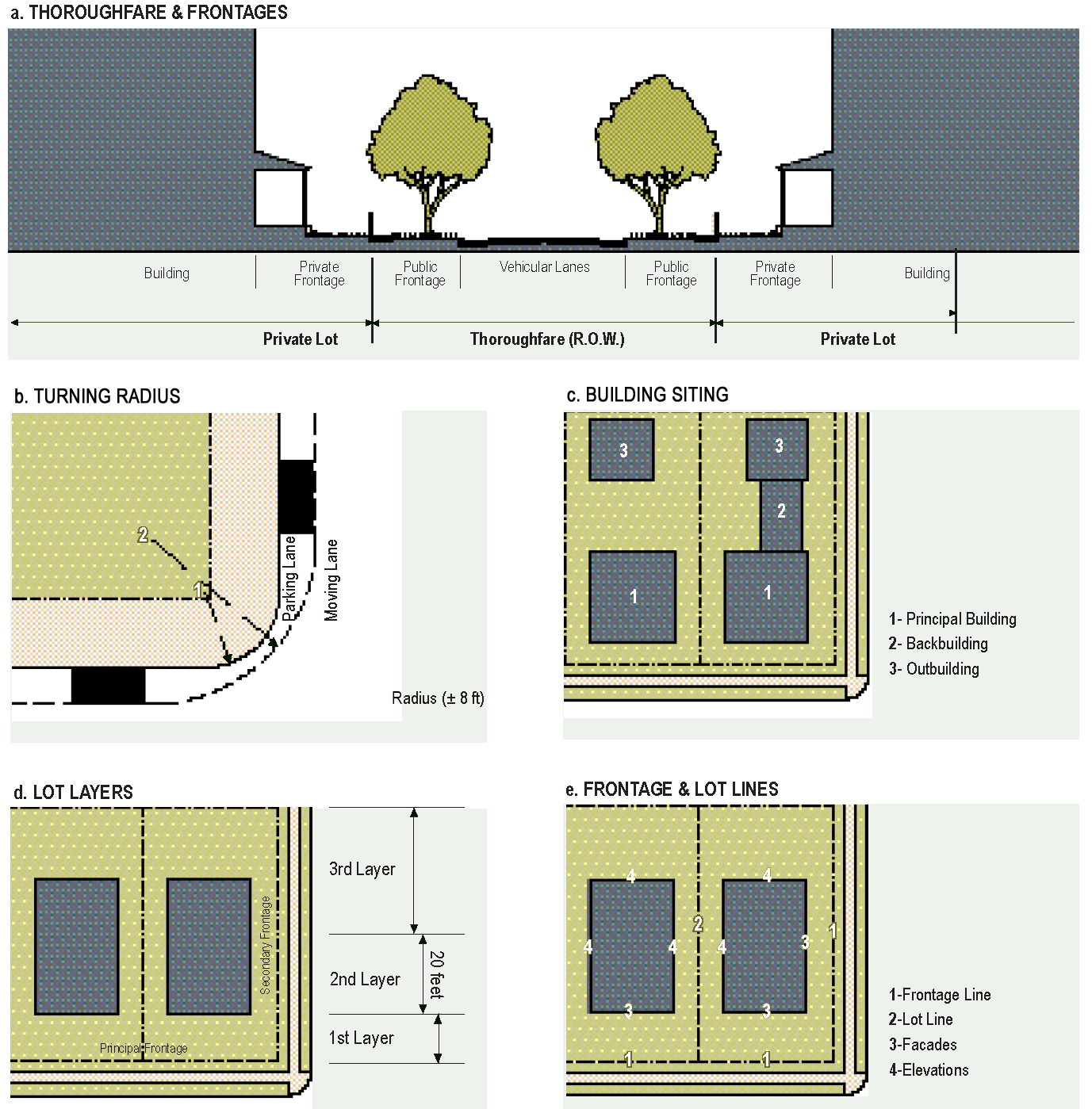
(Ord. No. 2013-13, § 1, 11-11-13; Ord. No. 2015-05, § 1(Att.), 4-27-15)
Sec. 23-819. - Definitions of terms and uses.
This section provides definitions for terms in this article that are technical in nature or that otherwise may not reflect a common usage of the term. If a term is not defined in this section, then the DECD shall determine the correct definition of the term.
Abut means having common property boundaries or lot lines which are not separated by a street.
Allee means a regularly spaced and aligned row of trees usually planted along a Thoroughfare or Pedestrian Path.
Accessory dwelling unit means a dwelling unit not greater than 600 square feet sharing ownership with a principal building. An accessory dwelling unit may or may not be within an outbuilding. Accessory dwelling units do not count toward maximum density calculations in the SmartCode zoning districts.
Adopted small area plan means a plan adopted by the board of mayor and aldermen in conformance with division 2 of this article.
Avenue (AV) means a thoroughfare of high vehicular capacity and low speed. Avenues are short distance connectors between urban centers. Avenues may be equipped with a landscaped median. Avenues become collectors upon exiting urban areas.
Back building means a single-story structure connecting a principal building to an outbuilding (see Table 14).
Bicycle lane (BL) means a dedicated bicycle lane running within a moderate-speed vehicular thoroughfare, demarcated by striping.
Bicycle route (BR) means a thoroughfare/street suitable for the shared use of bicycles and automobiles moving at low speeds.
"Big box" building means a singular retail or wholesale user who occupies no less than 60,000 square feet of gross floor area, typically requires high parking to building area ratios, and has a regional sales market. Regional retail/wholesale sales can include but are not limited to membership ware house clubs that emphasize bulk sales, discount stores, and department stores. This type of building can stand alone on its own parcel/lot or be integrated into a commercial/retail center.
"Junior box" building means a retail space containing no less than 20,000 to 59,999 square feet of gross floor area. This type of building can stand alone on its own parcel/lot or be integrated into a commercial/retail center.
Block means the aggregate of private lots, passages, rear lanes and alleys, circumscribed by thoroughfares.
Block face means the aggregate of all the building façades on one side of a block. The block face provides the context for establishing architectural harmony.
Boulevard (BV) means a thoroughfare designed for high vehicular capacity and moderate speed. Boulevards are long-distance thoroughfares traversing urbanized areas. Boulevards are usually equipped with slip roads buffering sidewalks and buildings. Boulevards become arterials upon exiting urban areas.
Building configuration means the form of a building, based on its massing, private frontage, and height.
Building function means the uses accommodated by a building and its lot. Functions are categorized as restricted, limited, or open, according to the intensity of the use.
Building height means the vertical extent of a building measured in stories, not including a raised basement or a habitable attic. Height limits do not apply to masts, belfries, clock towers, chimney flues, water tanks, elevator bulkheads and similar structures. Building height shall be measured from the average grade of the frontage line to the eave of a pitched roof or the surface of a flat roof.
Building siting means the placement of a building on its lot.
Building type means a structure category determined by function, disposition on the lot, and configuration, including frontage and height.
Civic means the term defining not-for-profit organizations dedicated to arts, culture, education, recreation, government, transit, and municipal parking.
Civic/landmark building means a building designed specifically for a civic function.
Civic space means an outdoor area dedicated for public use. Civic space types are defined by the combination of certain physical constants including the relationship between their intended use, their size, their landscaping and their enfronting buildings.
Commercial is the term collectively defining workplace, office and retail functions.
Cottage means an edgeyard building type. A single-family dwelling, on a regular lot, often shared with an outbuilding in the rearyard.
Courtyard building means a building that occupies the boundaries of its lot while internally defining one or more private patios.
Curb means the edge of the vehicular pavement detailed as a raised curb or flush to a swale. The curb usually incorporates the drainage system.
Density means the number of dwelling units within a standard measure of land area, usually given as units per acre.
Directory sign means a sign mounted or applied directly to the building wall adjacent to the pedestrian entrance along a sidewalk. A directory sign may project no more than two inches from the building wall and over a sidewalk in a city-maintained right-of-way.
Design speed means the velocity at which a thoroughfare tends to be driven without the constraints of signage or enforcement. There are three ranges of speed:
Very low: (below 20 miles per hour);
Low: (20—25 miles per hour);
Moderate: (25—35 miles per hour);
High: (above 35 miles per hour).
Lane width is determined by desired design speed.
Duplex house means a two-family building on a regular lot, share with ancillary buildings in the rearyard (an edgeyard building type). The main entrance to each dwelling is accessed directly from and faces the street.
Edgeyard building means a building that occupies the center of its lot with setbacks on all sides.
Elevation means an exterior wall of a building not along a frontage line. See "façade."
Enfront means to place an element along a frontage line, as in "porches enfront the street."
Entrance, principal means the main point of access of pedestrians into a building.
Existing local codes means previously adopted local codes and ordinances, including the following chapters of the city's Code of Ordinances: City of Germantown Zoning Ordinances (chapter 23), the Germantown Subdivision Regulations (chapter 17), and the City of Germantown Sign Ordinances (chapter 14).
Façade means the exterior wall of a building that is set along a frontage line (see "elevation"; "frontage line").
Frontage line means those lot lines that coincide with a public frontage. Façades along frontage lines define the public realm and are therefore more regulated than the elevations that coincide with other lot lines.
Hanging sign means a sign attached to and located below any permanent eave, roof, canopy, or bracket. It is most appropriately used along pedestrian-oriented streets or shopping centers to identify attached or closely spaced assemblage and/or repair of artifacts, using table-mounted electrical machinery and including their retail sale.
Home occupation means non-retail commercial enterprises permitted in zones T3—6. The work quarters should be invisible from the frontage, located either within the house or in an outbuilding. Permitted activities are defined by the Restricted Office category.
House (Syn.: single-family lot) means an edgeyard building type. A single-family dwelling on a large lot, often shared with an ancillary building in the rearyard.
Infill means a project within existing urban fabric.
Justifiable Design Alternative means an official decision that permits a practice that is not consistent with a specific provision(s) of this article, but is justified by its intent (section 23-741) and is consistent with the urban design guidelines and/or development concepts in the adopted small area plan.
Layer means a range of depth of a lot within which certain elements are permitted.
Liner building means a building specifically designed to mask a parking lot or a parking garage from a frontage.
Live-work means a fee-simple dwelling unit that contains a commercial component anywhere in the unit. (Syn.: Flexhouse.)
Lodging means premises available for daily and weekly renting of bedrooms.
Lot line means the boundary that legally and geometrically demarcates a lot (see "frontage line"). Codes reference lot lines as the baseline for measuring setbacks.
Lot width means the length of the principal frontage line of a lot.
Low density housing means low density single-family housing that is zoned as R-E-10, R-E, R-E-1, R, R-1, R-2, or R-3.
Manufacturing means premises available for the creation, assemblage and/or repair of artifacts, using table-mounted electrical machinery and including their retail sale.
Mixed use means multiple functions within the same building through superimposition or adjacency, or in multiple buildings within the same area by adjacency. Mixed use is one of the principles of traditional neighborhood development from which many of its benefits are derived, including compactness, pedestrian activity, and parking space reduction.
Multiuse trail (MT) means a path for cyclists and pedestrians running independently of a high-speed vehicular thoroughfare or parallel to a watercourse.
Multi-family building means a building with three or more dwelling units, for sale or rental that share one or more common walls.
(1)
Multi-family building (Mixed Use): A building with three or more dwelling units in a vertically integrated mixed use setting. The ideal model consists of a building with retail, office or restaurant uses on the ground floor and residential uses on the upper floors.
(2)
Multi-family building (Single Use): A building with three or more dwelling units built as a component of an integrated mixed use development appropriately designed and scaled to its surroundings.
Multi-family development (stand-alone single use) means a building or a group of buildings with three or more dwelling units that share one or more common walls and that is built solely for residential purposes and not as a component of an integrated mixed use development.
Neighborhood store means a building function (or use) allowing premises up to 3,500 square feet to be available for the commercial sale of convenience goods and merchandise and prepared foods, but excluding manufacturing. Convenience services such as laundry and laundry pickup station, as defined in the zoning ordinance, are also allowed.
Office means premises available for the transaction of general business but excluding retail, artisanal and manufacturing uses.
Outbuilding means a detached building or use subordinate to a principal building on the same lot and serving a purpose naturally and normally incidental to the principal building.
Parking lot sign means a sign located within the parking lots of commercial/retail centers to identify specific parking space(s) for designated use(s) or user(s).
Parking space, required means a paved and properly drained area enclosed or unenclosed required by this chapter to be permanently reserved for parking one motor vehicle. Each required parking space shall have a minimum area of 180 square feet and not less than nine feet wide, exclusive of driveways, and shall be connected with a public street, alley or by a paved driveway affording safe and convenient ingress and egress. The minimum area of a compact parking space shall be 128 square feet with a minimum width of eight feet. Except on lots occupied by single-family and two-family dwellings, parking spaces and driveways shall be so arranged as to provide for both ingress and egress by forward motion of the parked or parking vehicle.
Parking structure means a building containing two or more stories of parking. Parking structures shall have liner buildings at the first story or higher.
Passage (PS) means a pedestrian connector passing between buildings, providing shortcuts through long blocks and connecting rear parking areas to frontages. Passages may be roofed over.
Path (PT) means a pedestrian way traversing a park, with landscape matching the contiguous open space. Paths should connect directly with the urban sidewalk network.
Planter means the element of the public streetscape which accommodates street trees. Planters may be continuous or individual.
Principal building means the main building on a lot, usually located toward the frontage.
Private frontage means the privately held layer between the frontage line and the principal building façade. The structures and landscaping within the private frontage may be held to specific standards. The variables of private frontage are the depth of the setback and the combination of architectural elements such as fences, stoops, porches and galleries.
Public frontage means the area between the curb of the vehicular lanes and the frontage line. Elements of the public frontage include the type of curb, walk, planter, street tree and streetlight.
Rear alley (RA) means a vehicular driveway located to the rear of lots providing access to service areas and parking, and containing utility easements. Alleys should be paved from building face to building face, with drainage by inverted crown at the center or with raised curbs at the edges.
Rear lane (RL) means a vehicular driveway located to the rear of lots providing access to parking and outbuildings and containing utility easements. Rear lanes may be paved lightly to driveway standards. Its streetscape consists of gravel or landscaped edges, no raised curb and is drained by percolation.
Rearyard building means a building that occupies the full frontage line, leaving the rear of the lot as the sole yard. This is a more urban type, as the continuous façade spatially defines the public thoroughfare. For its residential function, this type yields a rowhouse. For its commercial function, the rear yard can accommodate substantial parking.
Road (RD) means a local, rural and suburban thoroughfare of low vehicular speed and capacity. Its public frontage consists of swales drained by percolation and a walking path or bicycle trail along one or both sides. The landscaping consists of multiple species composed in naturalistic clusters. This type is allocated to the more rural SmartCode zoning districts (T1—T3).
Rowhouse means a single-family dwelling that shares a party wall with another of the same type and occupies the full frontage line (Syn: townhouse; see "rearyard building").
Sandwich board sign means a portable sign which is ordinarily in the shape of an "A" or some variation thereof.
Setback means the area of a lot measured from the lot line to a building façade or elevation. This area must be maintained clear of permanent structures with the exception of: galleries, fences, garden walls, arcades, porches, stoops, balconies, bay windows, terraces and decks (that align with the first story level) which are permitted to encroach into the setback.
Shared parking means an accounting for parking spaces that are available to more than one function. The requirement is reduced by a factor, shown as a calculation. The shared parking ratio varies according to multiple functions in close proximity which are unlikely to require the spaces at the same time.
Sideyard building means a building that occupies one side of the lot with a setback to the other side.
Stand-alone surface parking lot means a parking area for motor vehicles where there is no building area below the parking area and no building area or roof above it.
Story means a habitable level within a building measured from finished floor to finished ceiling. Attics, parking garages, raised basements are not considered stories for the purposes of determining building height.
Street (ST) means a local urban thoroughfare of low speed and capacity. Its public frontage consists of raised curbs drained by inlets and sidewalks separated from the vehicular lanes by a planter and parking on both sides. The landscaping consists of regularly placed street trees. This type is permitted within the more urban SmartCode zoning districts (T4—T6).
Streetscape means the urban element that establishes the major part of the public realm. The streetscape is composed of thoroughfares (travel lanes for vehicles and bicycles, parking lanes for cars, and sidewalks or paths for pedestrians) as well as the visible private frontages (building façades and elevations, porches, yards, fences, awnings, etc.), and the amenities of the public frontages (street trees and plantings, benches, streetlights, etc.).
Streetscreen, sometimes called "streetwall," means a freestanding wall built along the frontage line, or coplanar with the façade, often for the purpose of masking a parking lot from the thoroughfare. Streetscreens [should] be between 3.5 and eight feet in height and constructed of a material matching the adjacent building façade. The streetscreen may be a hedge or fence by Justifiable Design Alternative. Streetscreens shall have openings no larger than is necessary to allow automobile and pedestrian access. In addition, all streetscreens over [four feet] high should be 30 percent permeable or articulated to avoid blank walls.
Technical advisory committee (TAC) is comprised of a representative from each of the various city departments that have jurisdiction over the permitting of a project, as well as a representative of the DRC.
Thoroughfare means a vehicular way incorporating moving lanes and parking lanes within a right-of-way.
Townhouse. Syn. rowhouse. (See "rearyard building.")
Transect. See section 23-755.
Type means a category determined by function, disposition, and configuration, including size or extent. There are community types, street types, civic space types, etc. (See also: "building type.")
Wall sign means any sign directly attached to an exterior wall of a building or dependent upon a building for its support. Signs directly painted on walls shall be considered wall signs. Various wall signs are defined as follows:
(1)
A wall sign is mounted or applied directly to the building wall, generally on the fascia. A wall sign may project no more than six inches from the building wall and over a sidewalk in a city-maintained right-of-way.
(2)
A canopy or awning sign is a wall sign applied directly to a canopy or awning. The permitted size of a canopy or awning sign will be calculated on the basis of the size of the building wall to which the canopy is attached. All canopy or awning area that is internally lit shall be counted as sign face area. External wall packs and floodlights shall not be used to light canopies or awnings.
Warrant means an official decision that permits a practice that is not consistent with a specific provision(s) of this article, but is justified by its intent (section 23-741) and is consistent with the urban design guidelines and/or development concepts in the adopted small area plan.
(Ord. No. 2013-13, § 1, 11-11-13; Ord. No. 2015-05, § 1(Att.), 4-27-15; Ord. No. 2019-15, 1-27-20; Ord. No. 2024-16, (Att.), 10-18-24)
Sec. 23-824. - Zoning map.
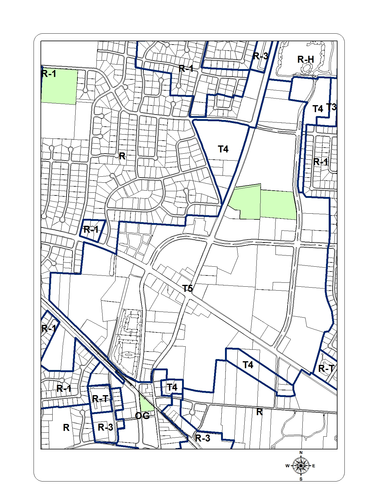
(Ord. No. 2013-13, § 1, 11-11-13; Ord. No. 2015-05, § 1(Att.), 4-27-15)
Sec. 23-825. - Civic infrastructure plan.
Reserved.
(Ord. No. 2013-13, § 1, 11-11-13; Ord. No. 2015-05, § 1(Att.), 4-27-15)
Sec. 23-826. - Thoroughfare assemblies for the central business district.
The following thoroughfare assemblies shall be implemented in accordance with section 23-810 of this article. The key gives the thoroughfare type followed by the right-of-way width, followed by the pavement width (face-of-curb to face-of-curb), and in some instances followed by specialized transportation capability. Where no specific street name is assigned, the assembly may be used in new development. Otherwise, assemblies are specific to existing or proposed streets.
 | 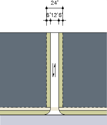 | 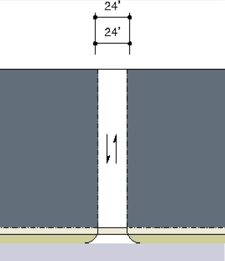 | |
| THOROUGHFARE TYPES | |||
| Boulevard: | BV | ||
| Avenue: | AV | ||
| Commercial Street: | CS | ||
| Street: | ST | ||
| Road: | RD | ||
| Rear Alley: | RA | ||
| Rear Lane: | RL | ||
| Multiuse Trail: | MT | ||
| Bicycle Lane: | BL | ||
| Bicycle Route: | BR | ||
| Path: | PT | ||
| Transit Route: | TR | ||
| RL-24-12 | RL-24-24 | ||
| Thoroughfare Type | Rear Lane (residential use) | Rear Alley (commercial use) | |
| Smart Growth Zoning District | T3, T4 | T6, T5, T4 | |
| Right-of-Way Width | 24 feet | 24 feet | |
| Pavement Width | 12 feet | 24 feet | |
| Movement | Yield Movement | Slow Movement | |
| Design Speed | 10 MPH | 10 MPH | |
| Pedestrian Crossing Time | 3.5 seconds | 6.5 seconds | |
| Traffic Lanes | 2 lanes | 2 lanes | |
| Parking Lanes | None | None | |
| Curb Radius | 25 feet | 25 feet | |
| Walkway Type | None | None | |
| Planter Type | None | None | |
| Curb Type | inverted crown/flat curb | inverted crown/raised curb | |
| Landscape Type | None | None | |
| Other Transportation Provision | None | None | |
| Rear Lane (RL): a vehicular driveway located to the rear of lots providing access to parking and outbuildings and containing utility easements. Rear lanes may be paved lightly to driveway standards. Its streetscape consists of gravel or landscaped edges, no raised curb and is drained by percolation. | Rear Alley (RA): a vehicular driveway located to the rear of lots providing access to service areas and parking, and containing utility easements. Alleys should be paved from building face to building face, with drainage by inverted crown at the center or with raised curbs at the edges. | ||
| 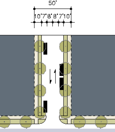 | 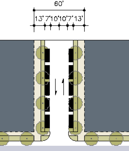 | |
| THOROUGHFARE TYPES | |||
| Boulevard: | BV | ||
| Avenue: | AV | ||
| Commercial Street: | CS | ||
| Street: | ST | ||
| Road: | RD | ||
| Rear Alley: | RA | ||
| Rear Lane: | RL | ||
| Multiuse Trail: | MT | ||
| Bicycle Lane: | BL | ||
| Bicycle Route: | BR | ||
| Path: | PT | ||
| Transit Route: | TR | ||
| ST-50-30 | ST-60-34 | ||
| Thoroughfare Type | Street | Street | |
| Smart Growth Zoning District | T4, T3 | T5, T4, T3 | |
| Right-of-Way Width | 50 feet | 60 feet | |
| Pavement Width | 30 feet | 34 feet | |
| Movement | Yield Movement | Slow Movement | |
| Design Speed | 20 MPH | 25 MPH | |
| Pedestrian Crossing Time | 4.5 seconds | 5.5 seconds | |
| Traffic Lanes | 2 lanes | 2 lanes | |
| Parking Lanes | Both Sides @ 7 feet unmarked | Both Sides @ 7 feet marked | |
| Curb Radius | 15 feet | 15 feet | |
| Walkway Type | 5 foot Sidewalk | 6 foot Sidewalk | |
| Planter Type | 5 foot Continuous planter | 7 foot Continuous planter | |
| Curb Type | Curb | Curb or Swale | |
| Landscape Type | Trees at 30' o.c. Avg. | Trees at 30' o.c. Avg. | |
| Other Transportation Provision | BR | BR | |
| 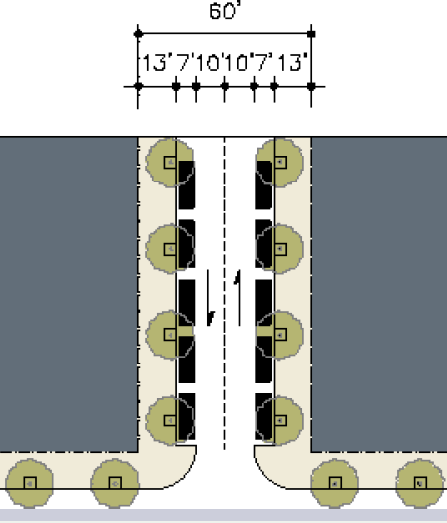 | 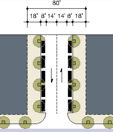 | |
| THOROUGHFARE TYPES | |||
| Boulevard: | BV | ||
| Avenue: | AV | ||
| Commercial Street: | CS | ||
| Street: | ST | ||
| Road: | RD | ||
| Rear Alley: | RA | ||
| Rear Lane: | RL | ||
| Multiuse Trail: | MT | ||
| Bicycle Lane: | BL | ||
| Bicycle Route: | BR | ||
| Path: | PT | ||
| Transit Route: | TR | ||
| CS-60-34 | CS-80-44 | ||
| Thoroughfare Type | Commercial Street | Commercial Street | |
| Smart Growth Zoning District | T6, T5 | T6, T5 | |
| Right-of-Way Width | 60 feet | 80 feet | |
| Pavement Width | 34 feet | 44 feet | |
| Movement | Slow Movement | Slow Movement | |
| Design Speed | 20 MPH | 25 MPH | |
| Pedestrian Crossing Time | 10 seconds | 12 seconds | |
| Traffic Lanes | 2 lanes | 2 lanes | |
| Parking Lanes | Both Sides @ 7—8 feet marked | Both Sides @ 8 feet marked | |
| Curb Radius | 15 feet | 15 feet | |
| Walkway Type | 13 foot Sidewalk | 18 foot Sidewalk | |
| Planter Type | 4×4" Tree well | 4×4" Tree well | |
| Curb Type | Curb | Curb | |
| Landscape Type | Trees at 30' o.c. Avg. | Trees at 30' o.c. Avg. | |
| Other Transportation Provision | BR | BR | |
| 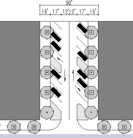 |  | |
| THOROUGHFARE TYPES | |||
| Boulevard: | BV | ||
| Avenue: | AV | ||
| Commercial Street: | CS | ||
| Street: | ST | ||
| Road: | RD | ||
| Rear Alley: | RA | ||
| Rear Lane: | RL | ||
| Multiuse Trail: | MT | ||
| Bicycle Lane: | BL | ||
| Bicycle Route: | BR | ||
| Path: | PT | ||
| Transit Route: | TR | ||
| CS-90-58 | AV-96-44 (Neshoba Rd) | ||
| Thoroughfare Type | Commercial Street | Commercial Street | |
| Smart Growth Zoning District | T5, T6 | T5, T4, T3 | |
| Right-of-Way Width | 86 feet | 96 feet | |
| Pavement Width | 54 feet | 44 feet | |
| Movement | Slow Movement | Slow Movement | |
| Design Speed | 25 MPH | 25 MPH | |
| Pedestrian Crossing Time | 7 seconds | 13 seconds | |
| Traffic Lanes | 2 lanes | 2 lanes | |
| Parking Lanes | Angle; Both Sides at 17 feet marked | Both Sides @ 8 feet marked | |
| Curb Radius | 15 feet | 10 feet | |
| Walkway Type | 16 foot Sidewalks | 6 foot Sidewalk | |
| Planter Type | 4×4 Tree well | 12 foot Continuous planter | |
| Curb Type | Curb | Curb | |
| Landscape Type | Trees at 30' o.c. Avg. | Trees at 30' o.c. Avg. | |
| Other Transportation Provision | BR | BR (Shared lane) | |
 | |
| CS-90-58 | |
| Thoroughfare Type | Commercial Street |
| Smart Growth Zoning District | T5, T6 |
| Right-of-Way Width | 86 feet |
| Pavement Width | 54 feet |
| Movement | Slow Movement |
| Design Speed | 25 MPH |
| Pedestrian Crossing Time | 7 seconds |
| Traffic Lanes | 2 lanes |
| Parking Lanes | Angle; Both Sides at 17 feet marked |
| Curb Radius | 15 feet |
| Walkway Type | 16 foot Sidewalks |
| Planter Type | 4×4 Tree well |
| Curb Type | Curb |
| Landscape Type | Trees at 30' o.c. Avg. |
| Other Transportation Provision | BR |
|  | 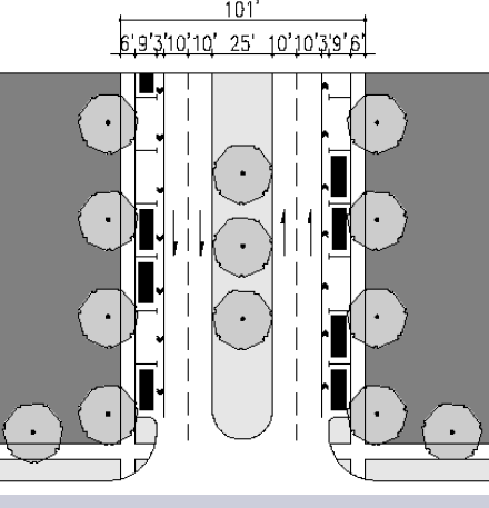 | |
| THOROUGHFARE TYPES | |||
| Boulevard: | BV | ||
| Avenue: | AV | ||
| Commercial Street: | CS | ||
| Street: | ST | ||
| Road: | RD | ||
| Rear Alley: | RA | ||
| Rear Lane: | RL | ||
| Multiuse Trail: | MT | ||
| Bicycle Lane: | BL | ||
| Bicycle Route: | BR | ||
| Path: | PT | ||
| Transit Route: | TR | ||
| AV-95-75-BL (West St) | AV-101-64 (Farmington Blvd) | ||
| Thoroughfare Type | Avenue | Avenue | |
| Smart Growth Zoning District | T6, T5, T4 | T6, T5, T4 | |
| Right-of-Way Width | 76 feet | 101 feet | |
| Pavement Width | 64 feet | 44 feet | |
| Movement | Slow Movement | Slow Movement | |
| Design Speed | 25 MPH | 25 MPH | |
| Pedestrian Crossing Time | 19 seconds | 18 seconds | |
| Traffic Lanes | 2 lanes | 4 lanes | |
| Parking Lanes | Both sides @ 8 feet unmarked | Both Sides @ 9 feet marked | |
| Curb Radius | 15 feet | 15 feet | |
| Walkway Type | 6 foot Sidewalk | 6 foot Sidewalk | |
| Planter Type | n/a (trees behind sidewalk) | n/a (trees behind sidewalk) | |
| Curb Type | Curb | Curb | |
| Landscape Type | Trees at 30' o.c. Avg. | Trees at 30' o.c. Avg. | |
| Other Transportation Provision | BL | BR, TR | |
(Ord. No. 2013-13, § 1, 11-11-13; Ord. No. 2015-05, § 1(Att.), 4-27-15)
Sec. 23-831. - Zoning map.
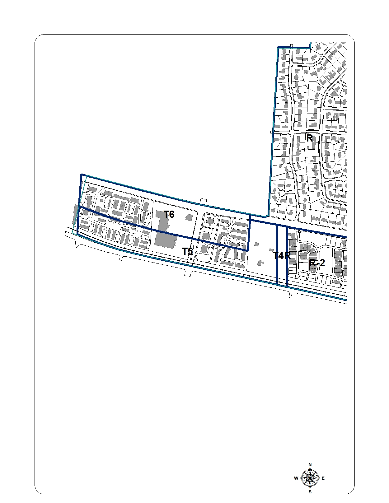
(Ord. No. 2013-13, § 1, 11-11-13; Ord. No. 2015-05, § 1(Att.), 4-27-15)
Sec. 23-832. - Civic infrastructure plan.
Reserved.
(Ord. No. 2013-13, § 1, 11-11-13; Ord. No. 2015-05, § 1(Att.), 4-27-15)
Sec. 23-833. - Thoroughfare assemblies.
Reserved.
(Ord. No. 2013-13, § 1, 11-11-13; Ord. No. 2015-05, § 1(Att.), 4-27-15)