
Gilchrist County Unincorporated
City Zoning Code
City Zoning Code
APPENDIX A
COMPREHENSIVE PLAN 2040
INTRODUCTION
Organizations must plan if effective progress is to be made towards reaching an objective. Those agencies charged with directing the growth of a community are no exception. The interaction of factors causing the growth and development of an area requires careful planning as a prerequisite to orderly growth. Three basic reasons are often given to justify the need for planning: (1) meet events which are expected to happen; (2) accomplish desired objectives; and (3) avoid unwanted conditions.
In 1985, the Florida Legislature enacted and the Governor signed into law the "Local Government Comprehensive Planning and Land Development Regulation Act." This legislation requires all local governments in Florida to revise and update the comprehensive plan for their respective jurisdictions in conformance with the provisions of the aforestated Act and the accompanying minimum criteria for plan review and determination of plan compliance contained in Chapter 9J-5, Florida Administrative Code.
This comprehensive planning process involves essentially four basic steps: (1) the collection and analysis of pertinent data concerning the physical and socio-economic characteristics of the study area, (2) the formulation of goals for future growth and development, (3) the development of objectives and policies guided by the goals, and (4) the implementation of the Comprehensive Plan.
Step (1) is accomplished through the preparation of this Data and Analysis document which, although not a part of the Comprehensive Plan in that it is not an adopted document with legal status, provides a basis for the formulation of the Comprehensive Plan. Steps (2) and (3) are the essence of the Comprehensive Plan and are contained within the document entitled Plan Elements. Step (4) is accomplished through the preparation and adoption and enforcement of land development regulations as mandated by the above referenced Act and by the construction of capital improvement projects identified within the Comprehensive Plan.
GENERAL SETTING OF GILCHRIST COUNTY
The unincorporated area of Gilchrist County is approximately 350 square miles or 215,631 acres in area. The County is located in the north central portion of the State of Florida and is bordered on the north by Columbia and Suwannee Counties (and separated by the Santa Fe River), on the east by Alachua County, on the south by Levy County, and on the west by Dixie and Lafayette Counties (and separated by the Suwannee River) as shown on the following location map.
ARTICLE IV - SANITARY SEWER, SOLID WASTE, DRAINAGE, POTABLE WATER AND NATURAL GROUNDWATER AQUIFER RECHARGE ELEMENT
The following plan element provides direction for the use, maintenance and location of general sanitary sewer, solid waste, drainage, potable water facilities and natural groundwater aquifer recharge areas in conformance with the Future Land Use Element of this Comprehensive Plan. The data collected for this plan element and its analysis, contained in the County's Data and Analysis document, are not part of this plan element but provide a basis for the formulation of it.
The future growth of the County depends upon the safe, adequate and economical provision of public facilities and services. This portion of the Comprehensive Plan provides a goal, objectives and policies which direct the implementation and use of such public facilities in a logical and economic fashion consistent with the State of Florida Comprehensive Plan, the North Central Florida Strategic Regional Policy Plan and other elements of this Comprehensive Plan.
GOAL IV-1 ENSURE THE PROVISION OF PUBLIC FACILITIES IN A TIMELY, ORDERLY, EFFICIENT, AND ENVIRONMENTALLY SOUND MANNER AT AN ACCEPTABLE LEVEL OF SERVICE FOR THE COUNTY'S POPULATION.
OBJECTIVE IV.1 The County shall continue to correct existing deficiencies by undertaking capital improvement projects in accordance with the schedule contained in the Capital Improvements Element of this Comprehensive Plan.
Policy IV.1.1 The County shall provide that within the schedule contained in the Capital Improvements Element, that capital improvement projects needed for replacement or correction of existing deficiencies in public facilities be given priority over providing for future facilities needs; (1) highest priority - projects imminently needed to protect the public health and safety; and (2) secondary priority - existing facilities not meeting maintenance or operation level of service standards adopted herein.
Policy IV.1.2 The County shall develop a recreational greenway to be used for hiking, horseback riding and bicycling trails, which link natural resources and expand recreational and natural resources education opportunities
PROCEDURE FOR MONITORING AND EVALUATION OF CAPITAL IMPROVEMENTS ELEMENT
Monitoring and evaluating the Capital Improvements Element is important to the effectiveness of the County's planning program due to fluctuations in the County's revenues and expenditures caused by shifting market and economic conditions.
The revenues and expenditures of the County will be used to predict fiscal trends in order to maintain the County's adopted level of service standards for public facilities and recreation. Therefore, the Capital Improvements Element requires a continuous program for monitoring and evaluation, and pursuant to Chapter 163, Part II, Florida Statutes, this element will be reviewed on an annual basis to ensure that fiscal resources are available to provide the public facilities needed to support the established level of service standards.
The annual review is the responsibility of the County's Local Planning Agency. County staff designated by the Board of County Commissioners will serve as advisory counsel to the Local Planning Agency dealing with all fiscal issues.
The Local Planning Agency shall consider the following criteria during its annual review and determination of findings and recommendations to the Board of County Commissioners.
1.
The review of the criteria used to evaluate capital improvement projects in order to ensure projects are ranked in their appropriate order of priority;
2.
The County's effectiveness in maintaining the adopted level of service standards;
3.
Impacts of service provisions of other local, regional or state agencies upon the County's ability to maintain its adopted level of service standards;
4.
Efforts by the County to secure grants or private funds, when available, to finance needed capital improvements;
5.
Consideration of corrections, updates and modifications concerning costs and revenue sources;
6.
Consistency of the Capital Improvements Element with the other elements of the Comprehensive Plan and particularly its support of the Future Land Use Element;
7.
The County's ability to provide public facilities within respective geographic service areas in order to determine need for any boundary modification or adjustment; and
8.
The appropriateness of including within the 5-Year Schedule of Improvements those identified improvements needed for the later part of the planning period.
The findings and recommendations of the Local Planning Agency will be transmitted to the Board of County Commissioners for review at a scheduled public hearing. Subsequent to review of the findings and recommendations of the Local Planning Agency, the Board of County Commissioners shall direct County staff to provide the Local Planning Agency with an updated 5-year schedule of Improvements and any drafts for amendments to the Capital Improvements Element as deemed necessary by the Board of County Commissioners.
The Local Planning Agency shall consider the annual amendment of the 5-Year Schedule of Improvements at the first scheduled date for consideration of amendments to the County's Comprehensive Plan. All amendments to the Schedule or elements except for corrections, updates, and modifications concerning costs; revenue sources; acceptance of facilities pursuant to dedications which are consistent with the plan; or the date of construction of any facility enumerated in the capital improvements element, shall be adopted in accordance with Section 163.3187, Florida Statutes, as amended.
ARTICLE IX - PROPERTY RIGHTS ELEMENT
Goal Gilchrist County shall ensure the that the private property rights are duly considered in its local decision-making.
Objective IX.1 In order to comply with the legislative intent expressed in Section 163.3161(10), F.S., that governmental entities respect private property rights, and the requirements of Section 163.3177(6), F.S., that each local government include a property rights element in its comprehensive plan, Gilchrist County shall consider private property rights in its local decision-making in accordance with the policies herein.
Policy IX.1.1 The following rights shall be considered in local decision making:
1.
The right of a property owner to physically possess and control his or her interests in the property, including easements, leases, or mineral rights.
2.
The right of a property owner to use, maintain, develop, and improve his or her property for personal use or for the use of any other person, subject to state law and local ordinances.
3.
The right of the property owner to privacy and to exclude others from the property to protect the owner's possessions and property.
4.
The right of a property owner to dispose of his or her property through sale or gift.
APPENDIX A - FUTURE LAND USE PLAN MAP FUTURE LAND USE PLAN MAP SERIES FUTURE TRAFFIC CIRCULATION MAP REGIONALLY SIGNIFCANT NATURAL AREAS MAPS
LEGEND
DESIGNATED URBAN DEVELOPMENT AREA BOUNDARIES
Note: The descriptions presented herein are for information purposes only. If any discrepancies are apparent between these descriptions and the boundaries shown on the presentation scale one inch equals one mile future Land Use Plan Map, those shown on the one inch equals one mile scale Future Land Use Plan Map shall prevail.
Illustration A-1A Public Land Uses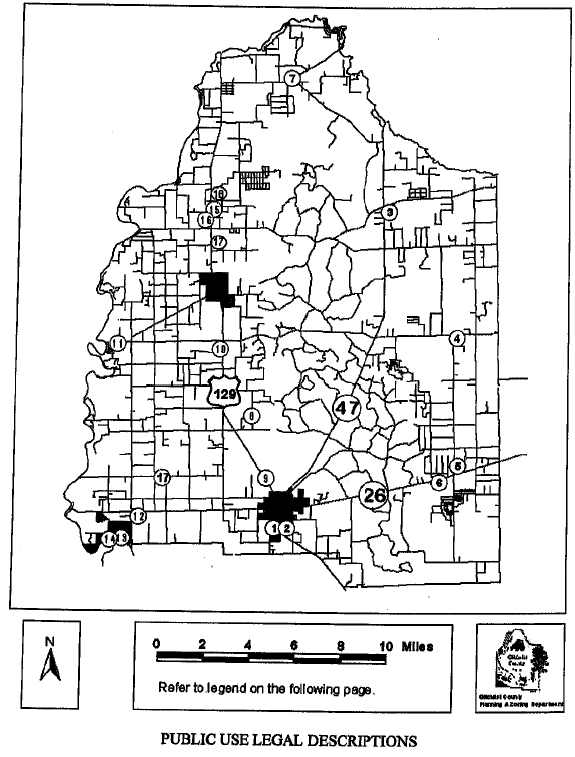
ATTACHMENT TO THE FUTURE LAND USE PLAN MAP
PUBLIC USE LEGAL DESCRIPTIONS
NOT SHOWN ON THE FUTURE LAND USE PLAN MAP
ATTACHMENT TO THE FUTURE LAND USE PLAN MAP
RECREATION USE LEGAL DESCRIPTIONS
NOT SHOWN ON THE FUTURE LAND USE PLAN MAP
Illustration A-1B Public Recreation Land Uses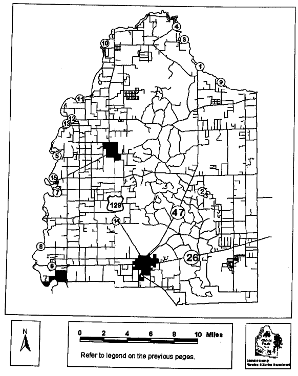
ILLUSTRATION A-II HISTORIC RESOURCES MAP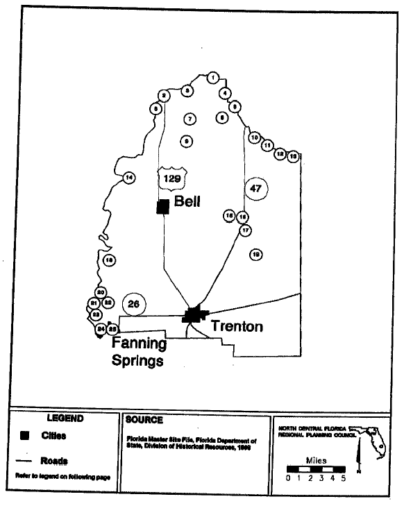
LEGEND FOR ILLUSTRATION A-II
HISTORIC RESOURCES
ILLUSTRATION A-III EXISTING AND PLANNED WATERWELLS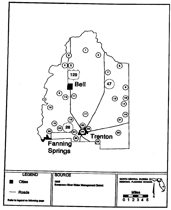
LEGEND FOR ILLUSTRATION A - III
EXISTING AND PLANNED WATERWELLS
ILLUSTRATION A-IV RIVERS AND LAKES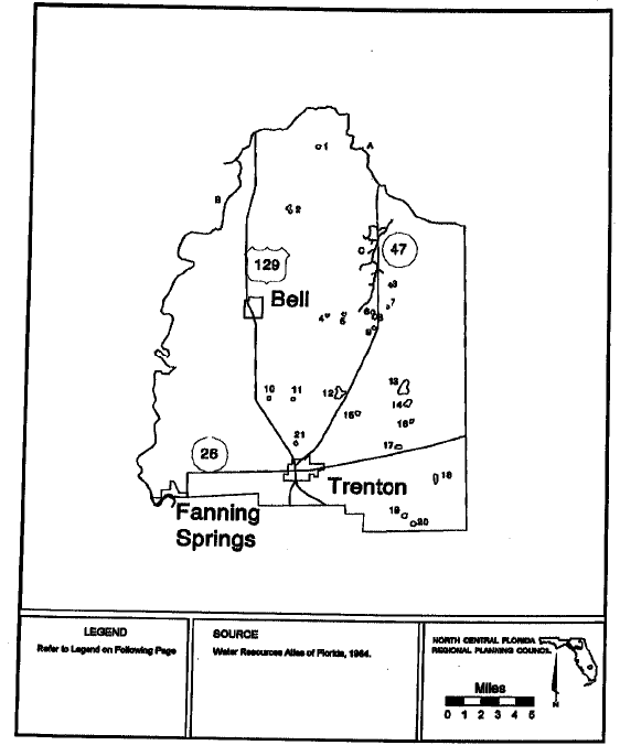
LEGEND FOR ILLUSTRATION A-IV
RIVERS AND LAKES
1984
ILLUSTRATION A-V FLOOD PRONE AREAS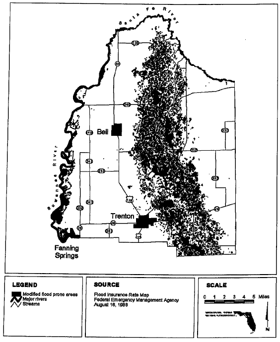
ILLUSTRATION A-VI WETLANDS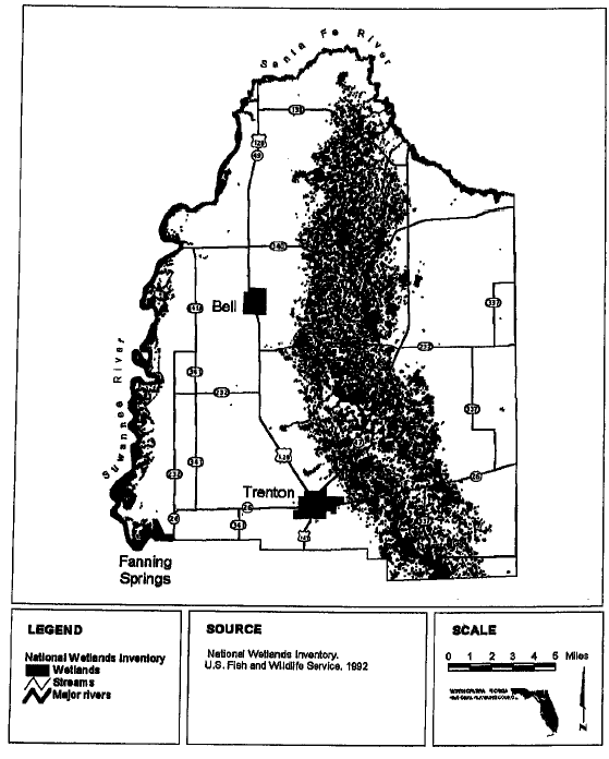
ILLUSTRATION A-VII MINERALS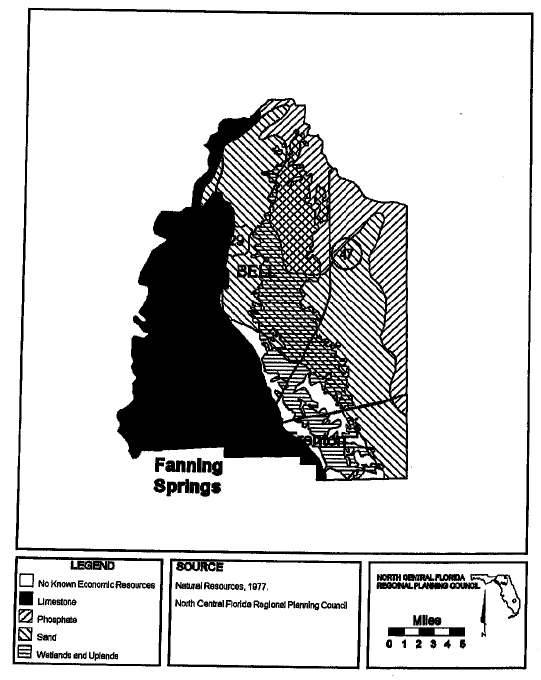
ILLUSTRATION A-VIII SOIL ASSOCIATIONS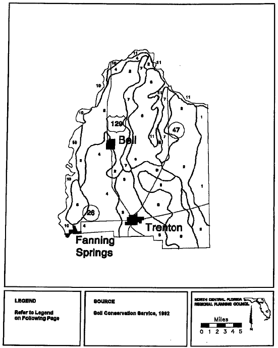
LEGEND FOR ILLUSTRATION A-VIII
SOIL ASSOCIATIONS
SOILS IN SANDY AREAS ON UPLANDS
1.
ALPIN-WADLEY: Nearly level and gently sloping, excessively drained and well drained soils that are sandy throughout or have a sandy surface layer and subsurface layer and a loamy subsoil.
2.
PENNY KERSHAW: Nearly level to moderately sloping, excessively drained soils that have thin lamellae of loamy find sand in the lower part of the underlying material or are sandy throughout.
SOILS ON SLIGHT KNOLLS AND UPLANDS
3.
BONNEAU-BLANTON-EUNOLA: Nearly level and gently sloping, moderately well drained soils that have a sandy surface land subsurface layer and a loamy subsoil.
4.
PENNEY-OTELA: Nearly level and gently sloping, excessively drained and moderately well drained soils that are sandy and have thin lamellae of loamy fine sand in the lower part of the underlying material or have a sandy surface layer and subsurface layer and a loamy subsoil.
5.
WADLEY-BLANTON: Nearly level and gently sloping, well drained and moderately well drained soils that have a sandy surface layer and subsurface layer and a loamy subsoil.
SOILS IN DEPRESSIONS, ON FLATWOODS, ON SLIGHT KNOLLS, AND IN TRANSITIONAL AREAS BETWEEN THE UPLANDS AND FLATWOODS
6.
LYNN-HAVEN-RIDGEWOOD: Nearly level, very poorly drained and somewhat poorly drained soils that have a sandy surface layer and a sandy subsoil coated with organic material or that are sandy throughout.
7.
ORTEGA-RIDGEWOOD: Nearly level and gently sloping, moderately well drained and somewhat poorly drained soils that are sandy throughout.
8.
WESCONNETT-LYNN-HAVEN-RIDGEWOOD: Nearly level and gently sloping, very poorly drained and somewhat poorly drained soils that have a sandy surface layer and a sandy subsoil coated with organic material or that are sandy throughout.
9.
LEON-WESCONNETT-SAPELO: Nearly level, poorly drained and very poorly drained soils that are sandy throughout and have a subsoil coated with organic material or that have a sandy surface layer and subsurface layer, a sandy subsoil, and a loamy substratum.
SOILS ON STREAM TERRACES AND FLOOD PLAINS
10.
GARCON-ELLOREE-OSIER-FLUVAQUENTS: Nearly level and gently sloping, somewhat poorly drained to very poorly drained soils that have a sandy surface layer and subsurface layer and a loamy subsoil, are sandy throughout, or have loamy and sandy strata.
11.
FLUVAQUENTS-ELLOREE: Nearly level, poorly drained and very poorly drained soils that have loamy and sandy strata or are sandy throughout.
SOURCE: U.S. Department of Agriculture, Soil Conservation Service, 1992.
LEGEND FOR ILLUSTRATION A-IX FUTURE TRAFFIC CIRCULATION-2012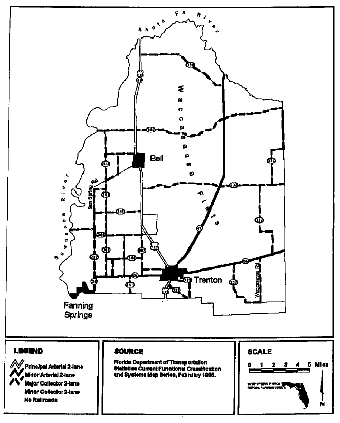
ILLUSTRATION A-IXa EMERGENCY EVACUATION ROUTES MAP-2012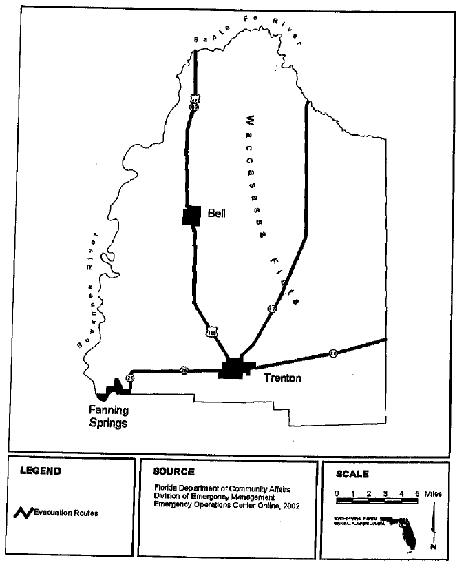
ILLUSTRATION A-IXB BICYCLE AND PEDESTRIAN FACILITIES MAP-2012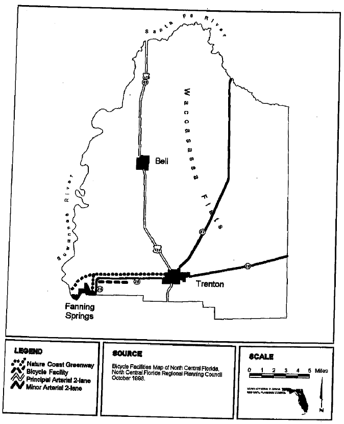
ILLUSTRATION A-X HIGH GROUNDWATER AQUIFER RECHARGE AREAS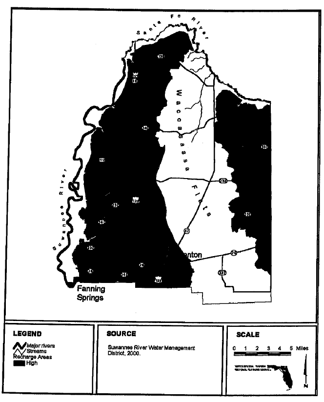
ILLUSTRATION A-Xia REGIONALLY SIGNIFICAANT NATURAL RESOURCES GROUNDWATER RESOURCES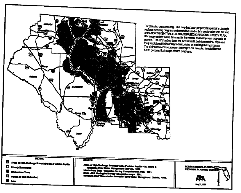
LEGEND FOR ILLUSTRATION A-Xia
REGIONALLY SIGNIFICANT NATURAL RESOURCES GROUNDWATER RESOURCES
GROUND WATER RESOURCES
1.
Alachua Sink
2.
Aucilla River Sink
3.
Brooks Sink
4.
Devil's Millhopper
5.
O'leno Sink
STREAM-TO-SINK WATERSHED
6.
Alapaha River
7.
Cannon Creek/Rose Creek/Price Creek
8.
Falling Creek
9.
Little River
10.
Norton Creek
11.
Rocky Creek
ILLUSTRATION A-XIb REGIONALLY SIGNIFICANT NATURAL RESOURCES NATURAL STREAMS
ILLUSTRATION A-XIc REGIONALLY SIGNIFICANT NATURAL RESOURCES PLANNING AND RESOURCE
MANGEMENT AREAS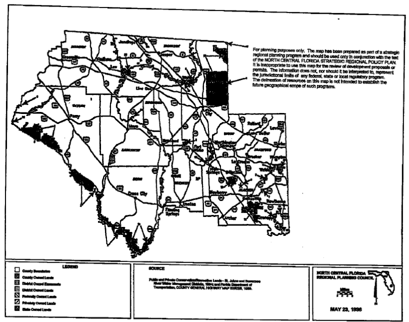
ILLUSTRATION A-Xic
REGIONALLY SIGNIFICANT NATURAL RESOURCES
PLANNING AND RESOURCE MANGEMENT AREAS
1.
Aucilla River Sinks
2.
Austin Cary Memorial Forest
3.
Big Bend Coastal Tracts
4.
Big Gum Swamp National Wilderness Area
5.
Big Shoals Tract
6.
Devil's Millhopper State Geological Site
7.
Gum Root Swamp
8.
Ichetucknee Springs State Park
9.
Lake Altho Swamp
10.
Lochloosa Forest
11.
Lower Suwannee River National Wildlife Refuge
12.
Okefenokee National Wildlife Refuge
13.
O'Leno State Park
14.
Oceola National Forest
15.
Paynes Praierie State Preserve
16.
Peacock Springs State Recreation Area
17.
River Rise State Preserve
18.
St. Mark's National Wildlife Refuge
19.
San Felasco Hammock State Preserve
20.
Santa Fe Swamp
21.
Stephen Foster State Folk Cultural Center
22.
Suwannee River State Park
Source: Public and Private Conservation/Recreation Lands - St. Johns and Suwannee River Water Management Districts, 1994; and Florida Department of Transportation, COUNTY GENERAL HIGHWAY MAP SERIES, 1989.
ILLUSTRATION A-XId REGIONALLY SIGNIFICANT NATURAL RESOURCES PLANNING AND RESOURCE
MANGEMENT AREAS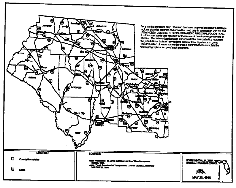
ILLUSTRATION A-Xid
REGIONALLY SIGNIFICANT NATURAL RESOURCES
PLANNING AND RESOURCE MANGEMENT AREAS
SURFACE WATER IMPROVEMENT MANAGEMENT WATERBODIES
1.
Alapaha River
2.
Alligator Lake
3.
Aucilla River
4.
Econfina River
5.
Fenholloway River
6.
Hampton Lake
7.
Lake Altho
8.
Lake Crosby
9.
Lake Rowell
10.
Lake Sampson
11.
Lake Santa Fe
12.
Little Lake Santa Fe
13.
New River
14.
Olustee Creek
15.
Santa Fe River
16.
Steinhatchee
17.
Suwannee River
18.
Withlocoochee River
SOURCE: SWIM Water Bodies - St Johns and Suwannee River Water Management Districts, 1995.
Lakes - Florida Department of Transportation, COUNTY GERNERAL HIGHWAY MAP SERIES, 1989.
ILLUSTRATION A-XIe REGIONALLY SIGNIFICANT NATURAL RESOURCES SURFACE WATER RESOURCES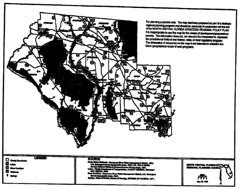
LEGEND FOR ILLUSTRATION A-Xie
REGIONALLY SIGNIFICANT NATURAL RESOURCES
SURFACE WATER RESOURCES
SURFACE WATER SYSTEMS
FRESH WATER WETLANDS
1.
Bee Haven Bay
2.
California Swamp
3.
Dixie County Coastal Fresh Water Wetlands
4.
Gum Root Swamp
5.
Hixtown Swamp
6.
Lake Altho Swamp
7.
Lochloosa Forest
8.
Mallory Swamp
9.
Osceola National Forest/Pinhook Swamp
10.
Paynes Prairie State Preserve
11.
San Pedro Bay
12.
Santa Fe Swamp
13.
Spring Warrior Swamp
14.
Taylor County Coastal / Fresh Water Wetlands
15.
Tide Swamp
16.
Waccasassa Flats
92.
Fowlers Prairie
LAKES
17.
Alligator Lake
20.
Lake Butler
23.
Lake Sampson
24.
Little Lochloosa Lake
25.
Little Santa Fe Lake
26.
Lochloosa Lake
27.
Newnans Lake
28.
Orange Lake
29.
Santa Fe Lake
91.
Lake Geneva
RMCR CORRIDORS
30.
Alapaha River
31.
Aucilla River
32.
Cross Creek
33.
Econfina River
34.
Ichetuknee River
35.
Prairie River
36.
River Styx
37.
Santa Fe River
38.
Steinhatchee River
39.
Withlacoochee River
SPRINGS
55.
Ginnie Spring
56.
Guaranto Spring
57.
Hart Spring
58.
Holton Spring
59.
Hornsby Spring
60.
Ichetuknee Spring
61.
Jamison Spring
62.
Jonathan Spring
63.
July Spring
64.
Lilly Spring
65.
Little Copper Spring
66.
Little River Spring
67.
Lumbercamp Spring
68.
Mearson Spring
69.
Morgan's Spring
70.
Northbank Spring
71.
Otter Spring
72.
Owens Springs
73.
Peacock Springs
74.
Pleasant Grove Spring
75.
Poe Spring
76.
Rock Bluff Spring
77.
Running Spring
78.
Ruth Spring
79.
Santa Fe Blue Spring
80.
Steinhatchee Spring
81.
Sun Spring
82.
Suwanacoochee Spring
83.
Suwannee Spring
84.
Suwannee Spring
85.
Suwaneee Blue Spring
86.
Troy Spring
87.
Turtle Spring
88.
Waldo Spring
89.
White Spring
90.
Withlacoochee Blue Spring
SOURCE: Fresh Water Wetlands - Suwannee River Water Management District; 1994; U.S. Geological Survey topographic maps, 1981; U.S. Fish and Wildlife Service National Wetlands Reconnaissance Survey Maps; 1981
Lakes - Florida Department of Transportation, COUNTY GENERAL HIGHWAY MAP SERIES; 1989
River Corridors - Suwannee River Water Management District
US Geological Topographic Maps, 1981
Springs - State of Florida, Bureau of Geology, Springs of Florida, 1977
INTRODUCTION
This Future Land Use Element and Future Land Use Plan map and map series designate the general distribution, location and extent of uses of land within the unincorporated areas of the County. The Future Land Use Element provides for appropriate distribution of population densities and building and structural densities and intensities. Data collected for this plan element and its analysis, contained in the County's Data and Analysis document, are not part of this plan element but provide a basis for its formulation.
PERMITTED USES, SPECIAL USES, AND COMPATIBILITY
The following policies list uses for each of the land use classifications described in the Future Land Use Element. In addition to the uses there are also uses listed as special use permits. A special use permit is a use that would not be appropriate generally or without restrictions throughout the land use classification, but if controlled as to number, area, or location would promote the public health, safety, welfare, morals, order comfort, convenience, appearance, prosperity or general welfare. Special use permits, as all other development orders, shall only be issued in conjunction with a Certificate of Concurrency Compliance as provided within the Concurrency Management System found within this Comprehensive Plan.
Before any special use permit shall be granted, the County shall make a specific finding that the granting of the special use permit will not adversely affect the public health, safety and welfare. Before any special use permit shall be granted, the County shall further make a determination that satisfactory provision and arrangement has been made concerning the following matters;
(a)
Ingress and egress to property and proposed structures thereon with particular reference to automotive and pedestrian safety and convenience, traffic flow and control, and access in case of fire or catastrophe;
(b)
Off-street parking and loading areas; (c) Refuse and service areas; (d) Utilities, with reference to locations, availability and compatibility; (e) Screening and buffering with reference to type, dimensions and character; (f) Signs, if any, and proposed exterior lighting; (g) Required yards and other open space; and (h) Considerations relating to general compatibility with adjacent properties and natural resources.
In addition, any non-agriculturally related special use permit granted in agriculturally classified areas within the County shall be required to maintain a buffer between any agricultural use and the special use permit use. The purpose of the buffer is to protect agriculture land uses from the special use.
The buffer should function to:
(a)
Screen the special use permit use from the adjacent farming activities; and
(b)
Provide protection to the agricultural land use from intrusive activities of the special use permit. by limiting access to the adjacent agricultural land use.
Further, the buffer must minimize the negative impacts of the uses upon each other, such that the longterm continuance of either use is not threatened by such impact. The buffer shall consist of a landscaped buffer and shall be designed, planted and maintained as to be 80 percent or more opaque between 2 and 6 feet above average ground level when viewed horizontally. A masonry or wood opaque structure may be substituted for the landscaped buffer.
VISION STATEMENT
Rural communities working in harmony to provide opportunities for all its citizens through balanced growth and enhanced education, while preserving our proud heritage, natural resources and agriculture.
FUTURE LAND USE GOAL, OBJECTIVES AND POLICIES
GOAL I - IN RECOGNITION OF THE IMPORTANCE OF CONSERVING THE NATURAL RESOURCES AND ENHANCING THE QUALITY OF LIFE IN THE COUNTY, DIRECT DEVELOPMENT TO THOSE AREAS WHICH HAVE IN PLACE, OR HAVE AGREEMENTS TO PROVIDE, THE LAND AND WATER RESOURCES, FISCAL ABILITIES AND SERVICE CAPACITY TO ACCOMMODATE GROWTH IN AN ENVIRONMENTALLY ACCEPTABLE MANNER.
OBJECTIVE I.1 The County shall continue to direct future population growth and associated development to appropriate areas within the County in order to promote orderly development.
Policy I.1.1 The location of higher density residential and high intensity commercial and industrial uses shall be directed to areas adjacent to arterial or collector roads identified on the County Future Transportation Map where public facilities are available to support such higher density or intensity.
Policy I.1.2 The County shall allocate amounts and mixes of land uses for agricultural, residential, commercial, industrial, public and recreation to meet the needs of the existing and projected future populations.
Policy I.1.3 The County's Future Land Use Plan Map shall base the designation of residential, commercial and industrial lands upon acreage which can be reasonably expected to develop by the year 2040 based on: (1) best available population data; and (2) best available housing need data.
Policy I.1.4 The County shall, prior to action on a site and development plan, determine the sufficiency of proposed screens and buffers to preserve internal and external harmony and compatibility with uses inside and outside the proposed development so that proposed urban development near agricultural or forested areas, wetlands and 100-year floodplain areas avoids adverse impact upon such areas.
Policy I.1.5 The County shall regulate future development in conformance with the land topography and soil conditions, and within an area which is or will be served by public facilities and services.
Policy I.1.6 The County's land development regulations shall be based on and be consistent with the following land use classifications and corresponding standards for densities and intensities.
Policy I.1.6.1 AGRICULTURAL LAND USE
a.
Agriculture-1
Agriculturally classified lands are lands which are predominantly used for crop cultivation, livestock, specialty farms, silviculture uses, dwelling units, and solar facilities and associated and related facilities. Silviculture activity shall be conducted in accordance with the silviculture policies contained within the Conservation Element of this Comprehensive Plan. The County shall prohibit intensive agriculture uses requiring an industrial wastewater permit from the Florida Department of Environmental Protection in the Agriculture-1 land use classification. In addition, other compatible agricultural or commercial uses and commercial establishments that are directly related to nature-based tourism and recreation may be approved as special use permits and shall be limited to an intensity of .25 floor area ratio, unless further limited herein.
Commercial establishments that are directly related to nature-based tourism and recreation are limited to commercial building space not greater than 2,500 square feet. Such establishments will be limited to: fishing and hunting equipment sales and rental (excluding boats, motors, and trailers); camping equipment sales and rental; horse stables; gift and souvenir shops; scuba gear sales and rental; and the sale and rental of canoes, kayaks, inner tubes, bicycles, roller blades and other similar nature based sales and rentals of non-motorized equipment.
Agricultural density shall be as provided below:
Agriculture-1 < 1 d.u. per 2 acres
b.
Agriculture-2 through Agriculture-5
Agriculturally classified lands are lands which are predominantly used for crop cultivation, livestock, specialty farms, silviculture activities conducted in accordance with the silviculture policies contained within the Conservation Element of this Comprehensive Plan, solar facilities and associated and related facilities, and dwelling units.
In Agriculture-2 through Agriculture-5 land use classifications, structures involving farm animals and livestock shall be located no closer than 45 feet of any lot line.
In addition, in Agriculture-2 through Agriculture-5 land use classifications, other compatible agricultural or commercial uses and commercial establishments that are directly related to nature-based tourism and recreation may be approved as special use permits and shall be limited to an intensity of .25 floor area ratio, unless further limited herein.
Intensive agriculture means any agricultural use requiring an industrial wastewater permit from the Florida Department of Environmental Protection. Intensive agriculture uses shall be allowed only in Agriculture-2 through Agriculture-5 land use classifications inclusive, and shall first obtain a special use permit from the County. However, existing intensive agriculture uses as of the date of adoption of this policy, will not be required to obtain a special use permit approval from the County for those existing intensive agriculture uses. However, expansion or change of existing intensive agriculture uses after the date of adoption of this policy, for which an industrial wastewater permit is required from the Florida Department of Environmental Protection for that expansion or change, will require a special use permit from the County, unless the expansion or change is required by the Florida Department of Environmental Protection to maintain the same livestock population of the activity as existed on the date of adoption of this policy.
Commercial establishments that are directly related to nature-based tourism and recreation are limited to commercial building space not greater than 2,500 square feet.
Dwelling unit densities in agriculture land use classifications are, as follows:
Agriculture-5 < 1 dwelling unit per 40 acres
Agriculture-4 < 1 dwelling unit per 20 acres
Agriculture-3 < 1 dwelling unit per 10 acres
Agriculture-2 < 1 dwelling unit per 5 acres
Within the Agriculture-2 and 3 land use classifications, any development which contains up to 25 lots may either be developed as a subdivision with a minimum lot size of 10 acres within the Agriculture-3 classification or 5 acres within the Agriculture-2 classification or as a Planned Rural Residential Development with clustered lots where no lot shall be less than 1 acre and an overall density of 1 dwelling unit per 10 acres within the Agriculture-3 classification or 5 acres within the Agriculture-2 classification shall be maintained on-site. Roads within all such subdivisions and Planned Rural Residential Developments shall comply with the provisions of the road paving policy contained within this plan element. Within the Agriculture-2 or 3 land use classifications, any development which contains more than 25 lots shall be developed as a Planned Rural Residential Development with clustered lots where no lot shall be less than 1 acre and an overall density of 1 dwelling unit per 10 acres within the Agriculture-3 classification and per 5 acres within the Agriculture-2 classification shall be maintained on-site. All lots, whether within a subdivision or Planned Rural Residential Development, shall have a length to width ratio no greater than 3 to 1. All Planned Rural Residential Developments shall be developed, as follows:
1.
the development shall maintain a minimum 80 percent of the development as undeveloped area. In addition, the number of lots shall not exceed 49 (unless this Comprehensive Plan is amended to permit more than 49 lots);
2.
the development shall be compact and contiguous and shall not be scattered throughout the development parcel. Building lots shall be located on the highest elevations on the site;
3.
the development shall provide a minimum of a 200-[foot] buffer from adjacent land uses, 75-foot undisturbed buffer from a perennial river, stream or creek and a minimum 50-foot setback from a lake, pond or wetland. This buffer may be a portion of the required undeveloped area;
4.
the developed area shall be configured in such a manner as to permit continued agriculture and/or silviculture uses of the undeveloped area;
5.
the developed area of the development, shall be located outside of (1) wetlands; (2) floodplains; (3) native upland vegetation; and (4) active agricultural areas, unless the entire development site consists of any or a combination of such areas. If the entire development site consists of any or a combination of such areas, the developed area shall be located in the least sensitive of such areas. Least sensitive areas shall be determined according to the order of priority of the above listing of such areas from most sensitive to least sensitive. In addition, if any developed area is located within any such sensitive areas, the development of such area shall be in accordance with the floodplain and wetlands policies contained within the Conservation Element of this Comprehensive Plan;
6.
the development shall have direct access to a paved road. For state maintained roads, such access shall require the approval of the Florida Department of Transportation;
7.
all internal roads shall be so located in order to minimize the number of access points to external roadways; and
8.
the developed area within the development shall provide a buffer to minimize the negative impacts of the uses within the developed area and uses within the undeveloped area upon each other, such that, the long-term continuance of uses in either area is not threatened by such impact. The buffer shall consist of a landscaped buffer and shall be designed, planted and maintained as to be 80 percent or more opaque between 2 and 6 feet above average ground level when viewed horizontally. A masonry or wood opaque structure may be substituted for the landscaped buffer.
Undeveloped areas means areas within a Planned Rural Residential Development, as required by this Comprehensive Plan, designed and intended for agricultural uses, (not to include intensive agricultural uses); silvicultural uses and conservation uses. It is not the intent that such undeveloped area be established perpetually. Therefore, at some future time, the Comprehensive Plan may be amended to allow other uses to occur within the undeveloped area.
(Ord. No. 2023-09, § 1, 9-18-2023)
Policy I.1.6.2 SILVICULTURE/AGRICULTURE
Lands classified as Silviculture/Agriculture shall be lands which are predominantly used for silviculture activities conducted in accordance with the silviculture policies contained within the Conservation Element of this Comprehensive Plan, limited agriculture uses as described below, dwelling units, development units, archery ranges, rifle, shotgun and pistol ranges, and hunting and fishing camps and uses customarily accessory and clearly incidental and subordinate to such uses, may be allowed by Special Use Permit, in accordance with the County's Land Development Code. In addition, telecommunications towers are allowed by Special Use Permit Development units, are structures commonly associated with row crops, pasture, hunting or silviculture activities such as barns, outbuildings and sheds, vehicle storage, small mill operations, and small office structures, provided that, any structures involving farm animals and livestock shall be no closer than 45 feet of any lot line.
Densities in the Silviculture/Agriculture land use classification are as follows:
Silviculture/Agriculture < 1 dwelling unit per 160 acres and < 1 development unit per 80 acres
Within the Silviculture/Agriculture land use classification, intensive agriculture uses shall be prohibited. Grazing of livestock on pasture lands shall be allowed and row crops planted on a rotational basis between the harvesting of timber and planting of trees as part of silviculture activities shall also be allowed. Solar facilities and associated and related facilities shall also be allowed. All agricultural uses and activities shall maintain a 50-foot natural buffer around all wetlands.
(Ord. No. 2023-09, § 2, 9-18-2023)
Policy I.1.6.3 PUBLIC LAND USE
Lands classified as public consist of public, charter and private schools, public buildings and grounds, other public facilities, (including sewer facilities, solid waste transfer stations, solid waste processing and recycling facilities, land clearing debris disposal facilities, drainage facilities, and potable water facilities), public health facilities and educations uses. Landfills, meaning the final disposal site for solid wastes, are not authorized as a permitted use within this land use category. Facilities which accept for disposal only land clearing debris and which are authorized to operate under a general permit issued by the Florida Department of Environmental Protection pursuant to Rule 62-701,803, Florida Administrative Code, or current applicable statute, are not considered "landfills" for purposes of this section, and are an authorized use within lands designated "public," subject to the requirements otherwise provided herein. "Land clearing debris" means rocks, soils, tree remains, trees and other vegetative matter which normally results from land clearing or land development operations for a construction project. Land clearing debris does not include vegetative matter from lawn maintenance, commercial or residential landscape maintenance, right-of-way or easement maintenance, fanning operations, nursery operations, or any other sources not related directly to a construction project; and
Public uses shall be limited to an intensity of .25 floor area ratio.
Policy I.1.6.4 CONSERVATION LAND USE
Lands classified as conservation use are lands devoted to the conservation of the unique natural functions within these lands;
Conservation uses include public access, silviculture activities conducted in accordance with the silviculture policies contained within the Conservation Element of this Comprehensive Plan and residential uses necessary to manage such conservation lands (i.e. ranger stations, research stations and park amenities).
Conservation uses shall be limited to an intensity of .25 floor area ratio.
Policy I.1.6.5 ENVIRONMENTALLY SENSITIVE LAND USE
Lands classified as Environmentally Sensitive are areas which are considered in need of special planning and treatment regarding land development regulation.
These are not preservation areas, but land uses permitted within these areas are to provide mitigating measures to protect the natural functions of the County's environmentally sensitive areas as designated within this Comprehensive Plan as regionally significant areas. Environmentally Sensitive Areas are lands within the areas of the 100-year flood, as designated by the Federal Emergency Management Agency, Flood Insurance Rate Map, dated August 16, 1988, located on the Suwannee and Santa Fe Rivers and identified within the Future Land Use Plan Map of this Comprehensive Plan as Environmentally Sensitive Areas. This designated corridor area shall conform with the following densities provided that within the Environmentally Sensitive Areas-2 category dwelling units may be clustered on smaller lots with no lot being less than 5 acres, if the site is developed as a Planned Residential Development and a density of 1 dwelling unit per 10 acres be maintained on site. All lots within Environmentally Sensitive Areas shall have a length to width ratio not greater than 3 to 1. Silviculture uses shall be conducted in accordance with the silviculture policies contained within the Conservation Element of this Comprehensive Plan. In addition, the County shall prohibit the location of intensive agriculture uses and non-residential uses such as industrial activities and non-surfacewater dependent commercial uses within these areas. Resource-based activities, such as spring water bottling plants consistent with Chapter 373, Part II, Florida Statutes and Chapter 40B-2, Rules of the Suwannee River Water Management District, or current applicable statute, surfacewater dependent commercial uses (such as marinas) and new campgrounds (including sites for travel trailers) of less than or equal to 100 campsites subject to maintaining a minimum distance from another campground within the Environmentally Sensitive Area of ½ mile, may be allowed as special use permits and limited to an intensity of .25 floor area ratio; and
Environmentally Sensitive Areas-1 < 1 d.u. per 40 acres
Environmentally Sensitive Areas-2 < 1 d.u. per 10 acres
Further, within the Environmentally Sensitive Area-2 category, dwelling units may be clustered on smaller lots with no lot being less than 5 acres, if the site is developed as a Planned Residential Development and a density of 1 dwelling unit per 10 acres is maintained on site as follows:
1.
the development shall maintain 50 percent of the total land area as an undeveloped area;
2.
the development shall be compact and contiguous and shall not be scattered throughout the development parcel. Building lots shall be located on the highest elevations on the site;
3.
the development shall provide a minimum of a 200 foot buffer from adjacent land uses, 75 foot undisturbed buffer from a perennial river, stream or creek and a minimum 50 foot setback from a lake, pond or wetland. This buffer may be a portion of the required undeveloped area;
4.
the developed area shall be configured in such a manner as to permit continued agriculture and/or silviculture uses of the undeveloped area;
5.
the developed area of the development, shall be located outside of (1) wetlands; (2) floodplain; (3) native upland vegetation; and (4) active agricultural areas, unless the entire development site consists of any or a combination of such areas, the developed area shall be located in the least sensitive of such areas. Least sensitive areas shall be determined according to the order of priority of the above listing of such areas from most sensitive to least sensitive. In addition, if any developed area is located within any such sensitive areas, the development of such area shall be in accordance with the policies within the floodplain and wetlands policies contained within the Conservation Element of this Comprehensive Plan;
6.
the development shall have direct access to a paved road. For state maintained roads, such access shall require the approval of the Florida Department of Transportation; and
7.
all internal roads shall be so located in order to minimize the number of access points to external roadways.
Policy I. 1.6.6 RECREATION LAND USE
Lands classified as recreation use consist of areas used for user-based and resource-based recreation uses; and recreation uses shall be limited to user-based and resource-based recreation uses; public access and residential and non-residential uses necessary to manage such recreation uses.
Recreation uses shall be limited to an intensity of less than or equal to .25 floor area ratio.
Policy I.1.6.7 COMMERCIAL LAND USE
Lands classified as commercial use consist of areas used for the sale, rental and distribution of products, or performance of services. In addition, other compatible uses in accordance with the County's Land Development Code may be approved as special use permits and be subject to an intensity of less than or equal to .25 floor area ratio; and
Commercial uses shall be limited to an intensity of less than or equal to 1.0 floor area ratio.
NOTE: The Future Land Use Plan Map shall not be amended to add new commercial land use designations in areas designated Agriculture-2 through Agriculture-5.
Policy I.1.6.8 INDUSTRIAL LAND USES
Lands classified as industrial consist of areas used for the manufacturing, assembly processing or storage of products. In addition, other compatible uses in accordance with the County's Land Development Code may be approved as special use permits and will be subject to an intensity of less than or equal to .25 floor area ratio;
Policy I.1.6.9 The use and future development of the 348 acres of the Ginnie Springs property shall be governed under the special exception and site plan approved by the Gilchrist County Zoning Board on January 14, 1991.
Policy I.1.6.10 Not withstanding the vesting rights policy contained within this plan element, the County shall allow the use of a parcel of property solely as a homestead by an individual who is the grandparent, parent, stepparent, adopted parent sibling, child, stepchild, adopted child, or grandchild of the person who conveyed the parcel to said individual, not withstanding the density or intensity of use assigned to the parcel in the plan. Such a provision shall apply only once to any individual.
Policy I.1.6.11 The County shall address potential incompatible land use situations which may result between residential and agricultural land uses by requiring that before approval may be granted for an intensive agricultural use as defined herein the following requirements shall be met.
1.
Divided animal holding lots, manure holding lagoons, and land areas to which effluent or scraped solids are applied are not located within five hundred (500) feet of a wetland, stream, river, or other surface water body;
2.
The proposed facility is not located within a 100-year floodplain as depicted on the current U.S. Federal Emergency Management Agency Flood Insurance Rate Map;
3.
The proposed facility is adequately screened and buffered to promote compatibility with adjacent agricultural and nonagricultural land uses, which include residential structures;
4.
The proposed facility does not exceed the maximum intensity, volume or capacity requirements for the type of proposed facility, as established by any Florida Department of Environmental Protection permit or Florida Department of Agriculture and Consumer Services permit;
5.
The proposed facility provides for an inspect/compliance monitoring program pursuant to any required Florida Department of Environmental Protection wastewater permit to ensure that the facility does not create a public health hazard;
6.
The proposed facility adequately controls point and nonpoint source runoff and ensures proper treatment of point and nonpoint source runoff to prevent adverse impacts to, or degradation of, the quality of surface or groundwater; the drainage system design shall provide for the attenuation/ retention of point and nonpoint source runoff from the proposed site, and water released from the site post-development shall not exceed pre-development in conformity;
7.
Soil conditions and characteristics are shown to be suitable for the proposed facility at the proposed site;
8.
The use of land by the proposed facility will not contaminate, degrade or adversely affect the quality of groundwater or potable water supply sources based upon scientific methodology;
9.
No cutting, clearing, grading or filling shall commence on any proposed site unless and until appropriate devices have been installed to minimize pollution, control erosion and removal of sediment from point and nonpoint source runoff; and
10.
The applicant has applied for all applicable federal, state and regional permits or equivalent.
Policy I.1.6.12 Solar facilities and associated and related facilities shall be an allowable use in all agricultural land use districts and in the industrial land use district. Solar facilities and associated and related facilities shall be subject to the supplemental criteria contained within the Land Development Code, including, but not limited to, design, security, landscaping, compatibility, and operations.
(Ord. No. 2023-09, § 3, 9-18-2023)
OBJECTIVE I.2 In order that adjacent land uses are not adversely impacted by any change in land use, a landscaped buffer of not less than 10 feet shall be required along the affected rear and/or side yards of the site which abuts lands within a residential land use category.
Policy I.2.1 The County shall regulate the location of public facilities so as to discourage the proliferation of urban sprawl.
Policy I.2.2 The neighborhood commercial district provides small scale retail service establishments which serve the convenience needs of adjacent areas within the designated urban development areas and the rural areas of the County. Neighborhood Commercial Activities are not shown on the Future Land Use Plan Map; rather these commercial activities should be accommodated throughout the County as market forces determine the need according to the following criteria:
1.
Neighborhood Commercial activities are intended to be oriented to and compatible with the area to be served. Such activities shall include retail commercial outlets for the sale of food, hardware or drugs; service establishments such as barber or beauty shops, shoe repair shops, and self-service laundries or dry cleaners; and commercial establishments that are directly related to nature-based tourism and recreation.
In addition, other compatible uses in accordance with the County's Land Development Code may be allowed as special use permits and will be subject to an intensity of .25 Floor Area Ratio.
Commercial establishments that are directly related to nature-based tourism and recreation, as listed above, are limited to: the uses in accordance with the County's Land Development Code.
2.
Neighborhood Commercial activities shall be located within one quarter mile of an intersection of an arterial with a collector road or an intersection of two collector roads;
3.
Sale, display, preparation and storage shall be conducted completely within an enclosed building and no more than 20 percent of the floor area shall to be devoted to storage; and
4.
Neighborhood Commercial uses shall be limited to an intensity of .25 floor area ratio.
(Ord. No. 2023-05, § 1, 4-17-2023)
Policy I.2.3. The County shall require a special use permit for dredging, filling, excavation and mining (this permit shall be in addition to any federal, state or regional agency required permit). The County shall require that mining operations be limited to lands within the County outside of subdivisions and those unapproved (unrecorded) subdivisions which have been recognized by the County as being statutorily vested; and outside of areas designated on the Future Land Use Plan Map as Environmentally Sensitive Areas, Conservation, Silviculture/Agriculture and Recreation; and, in accordance with the following criteria.
1.
The filing of a mining master plan with the Board of County Commissioners, which shall:
(a)
describe the boundaries of the areas of proposed mining;
(b)
describe the location of existing or proposed processing facilities, highways and railroads;
(c)
provide a topographic map of the area and its relationship to watersheds, drainage ways, floodways, streams, rivers and lakes;
(d)
describe the mining process to be conducted; and
(e)
describe the reclamation process to be conducted after mining, including the delineation of areas to be restored.
2.
Upon review of the mining master plan the Board of County Commissioners may approve, approve with conditions or deny an operating permit to commence the activities stated within the master plan, subject to all areas mined or disturbed by mining operations being reclaimed. Land and water areas shall be considered reclaimed if they include the following, when applicable:
(a)
Land areas not less than 3 feet above the ground water table, that have been graded to a level, gently rolling, sloping or terraced topography, with major continuous slopes no steeper than 4 horizontal to 1 vertical and in a way to minimize erosion due to rainfall, break up long uninterrupted slopes and make the surface suitable for vegetation. Vegetation shall be appropriately planted to prevent erosion and promote the future land use of the reclaimed area.
(b)
Water areas shall have a diversity of shallow and deep areas to enhance lake productivity for fish and wildlife habitat. Subaqueous slopes shall be no steeper than 4 horizontal to 1 vertical out to 6 foot depth at design elevation. Water quality shall be satisfactory for fish production and other wildlife. Such water quality shall not be degraded below the existing water quality classification established by the Florida Department of Environmental Protection.
(c)
Reclamation shall commence on mined areas, not used for waste settling areas, within 18 months after mining is completed in the area Progress shall be according to a time schedule established prior to commencing work and reported upon annually as the reclamation accomplished during the preceding calendar year.
(d)
The extraction of peat shall be prohibited in areas classified as Silviculture/Agriculture on the County's Future Land Use Plan Map.
(e)
Other standards set forth in Chapter 62C-16, Florida Administrative Code, or current applicable statute, Mine Reclamation, shall be applied in this policy. Nothing in this policy shall be in conflict with Chapter 62C-16, Florida Administrative Code, or current applicable statute.
(f)
Mining shall be prohibited which will result in an adverse effect on environmentally sensitive lands, such as surfacewater and groundwater resources, wetlands, floodplain, endangered, threatened, or species of special concern wildlife habitats, as designated by the Florida Fish and Wildlife Conservation Commission on the map entitled Strategic Habitat Conservation Areas, and rare or unique vegetative communities, which cannot be restored, based upon competent and substantial scientific evidence. Environmentally sensitive lands, such as wetlands, floodplain, endangered, threatened, or species of special concern wildlife habitats, as designated by the Florida Fish and Wildlife Conservation Commission on the map entitled Strategic Habitat Conservation Areas, and rare or unique vegetative communities, which can be restored, shall be restored to the same type, nature and function ecosystem.
(g)
Mining operations shall provide a minimum of a 200 foot buffer from adjacent properties.
For the purposes of this Comprehensive Plan "restoration" when used in conjunction with mining operations shall mean the recontouring and revegetation of lands, which will return the type, nature, and function of the ecosystem to the condition in existence immediately prior to mining operations. The County shall recognize technological limitations and economic considerations concerning the methods and practices to be used to restore environmentally sensitive lands, such as wetlands, floodplain, endangered, threatened, or species of special concern wildlife habitats, as designated by the Fish and Wildlife Conservation Commission on the map entitled Strategic Habitat Conservation Areas, and rare or unique vegetative communities. However, such considerations shall not result in environmentally sensitive lands, such as wetlands, floodplain, endangered, threatened, or species of special concern wildlife habitats, as designated by the Florida Fish and Wildlife Conservation Commission on the map entitled Strategic Habitat Conservation Areas, and rare or unique vegetative communities, not being restored to the same type, nature and function ecosystem. For example, restoration shall be considered accomplished when immature trees are used; mature trees are not required to be replanted in areas where mature trees were removed to allow for mining.
For the purposes of this Comprehensive Plan "revegetation" when used in conjunction with mining operations in reclaimed areas means a cover of vegetation consistent with land form created and the future land uses. In restored areas, it means a cover of vegetation that is designed to return the restored area to the condition in existence prior to mining operations.
Policy I.2.4 The County shall include provisions for drainage, which implement the level of service standard policies contained within the Sanitary Sewer, Solid Waste, Drainage, Potable Water and Natural Groundwater Aquifer Recharge Element of this Comprehensive Plan.
Policy I.2.5 The County shall maximize the conservation and protection of open space, by requiring that minimum percentages of Planned Residential Developments sites shall be set aside as undeveloped area as provided within the land use classification and standards for density and intensity policies of this plan element.
Policy I.2.6 National Flood Insurance Program requirements shall be required for all development within the areas of special flood hazard, floodways, and areas of shallow flooding.
Policy I.2.7 Convenient on-site traffic flow and needed vehicle parking shall be accomplished through the requirements of Chapter 14-96 and 14-97, Florida Administrative Code, Rules of the Florida Department of Transportation and the Florida Department of Transportation's Access Management Manual, or current applicable statute. In addition, the County shall require off-street parking to be provided for residential, commercial and industrial uses based upon intensity of use. Each off-street parking space, with the exception of handicapped parking spaces, shall be a minimum of 10 feet by 20 feet in size. Each handicapped parking space shall be a minimum of 12 feet by 20 feet in size, plus a 5 foot access aisle.
Policy I.2.8 The County shall limit the intensity of development by requiring that the length of lots less than 5 acres does not exceed 3 times the width of lots for the location of dwelling units within all land use categories which permit dwelling units. In addition, within all new subdivisions, including Planned Residential Developments and Planned Rural Residential Developments, containing lots less than 10 acres in size, the County shall require all roads in a new subdivision be paved to County standards.
Policy I.2.9 The County shall participate in the National Flood Insurance Program and regulate development and the installation of utilities in flood hazard areas in conformance with the program's requirements.
OBJECTIVE I.3 The County shall continue to identify and designate blighted areas which are feasible for redevelopment or renewal, through the updating of the housing condition survey using the Affordable Housing Needs Assessment prepared by Shimberg Center for Affordable Housing.
Policy I.3.1 The County shall request federal and state funds to redevelop and renew any identified blighted areas, where the County finds there is a competitive feasibility to receive such funding.
OBJECTIVE I.4 The County shall continue to work towards the elimination or reduction of uses inconsistent with the County's character and future land uses through establishing such inconsistent uses as non-conformities.
Policy I.4.1 The County hereby establishes the following provisions for nonconforming lots, structures and uses of land or structures.
1.
Nonconforming uses of land or structures may be continued where the lawful use of land existed prior to the adoption of this Comprehensive Plan where such use, is not permitted by this Comprehensive Plan. Such use may be continued, so long as it remains otherwise lawful, subject to its discontinuance after it ceases to exist for a period of more than 12 months.
2.
Nonconforming structures may be continued where a structure lawfully existed prior to the adoption of this Comprehensive Plan where such use would not be permitted to be built under this Comprehensive Plan by reason of restrictions on requirements other than use concerning the structure. Such structure may be continued so long as it remains otherwise lawful.
Policy I.4.2 The County hereby establishes the following administrative procedure and standards by which a property owner may demonstrate that private property rights have vested against the provisions of this Comprehensive Plan. These administrative procedures shall provide determination for the consistency of development with the densities and intensities set forth in this Comprehensive Plan.
Applications for vesting determinations shall be evaluated pursuant to the following criteria.
1.
Common law vesting - a right to develop or to continue the development of property notwithstanding this Comprehensive Plan may be found to exist whenever the applicant proves by a preponderance of evidence that the owner or developer, acting in good faith and reasonable reliance upon some act or omission of the County, has made such a substantial change in position or has incurred such extensive obligations and expenses that it would be highly inequitable and unjust to destroy the right to develop or to continue the development of the property.
2.
Statutory vesting - the right to develop or to continue the development of property shall be found to exist if a valid and unexpired final development order was issued by the County prior to adoption of this policy, substantial development has occurred on a significant portion of the development authorized in the final development order and is completed or development is continuing in good faith as of the adoption of this policy. A "final development order" shall be any development order which approved the development of land for a particular use or uses at a specified density of use and which allowed development activity to commence on the land for which the development order was issued. "Substantial development" shall mean that all required permits necessary to commence and continue the development have been obtained; permitted clearing and grading has commenced on a significant portion of the development; and the actual construction of roads and the stormwater management system, on that portion of the development is complete or is progressing in a manner that significantly moves the entire development toward completion.
3.
Presumptive vesting for consistency and concurrency - any structure on which construction has been completed pursuant to a valid building permit shall be presumptively vested for the purposes of consistency and concurrency and shall not be required to file an application to preserve their vested rights status.
4.
Presumptive vesting for density only, all lots of record as of the adoption of this policy, whether located within a subdivision or without, but only to the extent of one single family residence per lot; however, no more than 4 such lots shall be contiguous as of the adoption of this policy to any other lot(s) owned or under contract for deed to the person(s) applying for the single family residence building permit. Where there are more than 4 contiguous lots of record, as of the date of adoption of this policy, those lots or portions thereof exceeding the 4 lots and not meeting the required density requirement shall be required to combine such lots to meet the density requirement if such lots are located without a subdivision or if such lots are located within a recorded or unrecorded subdivision unless;
(a)
Such subdivisions have direct access to a County paved road and in which all lots front on a continually maintained paved or stabilized road that meets County standards; and
(b)
Such lots within such recorded or unrecorded subdivisions in which the sale of individual lots to persons by the original subdivider has occurred at the following rates;
(1)
At least 85 percent of the total number of lots are sold prior to the date of adoption of this policy, if the subdivision was created prior to July 3, 1972;
(2)
At least 60 percent of the total number of lots are sold by the date of adoption of this policy, if the subdivision was created from July 3, 1972 to December 31, 1987;
(3)
At least 50 percent of the total number of lots are sold by December 31, 1993 if the subdivision was created in 1988;
(4)
At least 50 percent of the total number of lots are sold by December 31, 1994 if the subdivision was created in 1989;
(5)
At least 50 percent of the total number of lots are sold by December 31, 1995 if the subdivision was created in 1990;
(6)
At least 50 percent of the total number of lots are sold by December 31, 1996 if the subdivision was created in 1991.
All lots presumptively vested by this policy shall not be required to file an application to preserve their vested rights in this regard.
OBJECTIVE I.5 The County shall use the Florida Department of State, Division of Historical Resources to assist the Board of County Commissioners with the designation of historic landmarks and landmark sites or historic districts within the unincorporated area of the County. The Florida Department of State, Division of Historical Resources shall review applications for historic designation
Policy I.5.1 The County shall refer to the Florida Department of State, Division of Historical Resources listing of all known prehistoric and historic sites within the unincorporated area of the County.
OBJECTIVE I.6 The County shall continue to enforce regulations to protect natural resources and environmentally sensitive lands (including but not limited to wetlands and floodplain). For the purposes of this Comprehensive Plan "wetlands" means those areas that are inundated or saturated by surface water or groundwater at a frequency and a duration sufficient to support, and under normal circumstances do support, a prevalence of vegetation typically adapted for life in saturated soils. Soils present in wetlands generally are classified as hydric or alluvial, or possess characteristics that are associated with reducing soil conditions. The prevalent vegetation in wetlands generally consists of facultative or obligate hydrophytic macrophytes that are typically adapted to areas having soil conditions described above. These species due to morphological, physiological or reproductive adaptations, have the ability to grow, reproduce or persists in aquatic environments or anaerobic soil conditions. Florida wetlands generally include swamps, marshes, bayheads, bogs, cypress domes and strands, sloughs, wet prairies, riverine swamps, marshes, hydric seepage slopes, tidal marshes, mangrove swamps and other similar areas. Florida wetlands generally do not include longleaf or slash pine flatwoods with an understory dominated by saw palmetto.
Policy I.6.1 The County shall continue to include provisions for the protection of community potable water supply wells by prohibiting new land uses which require or involve storage, use or manufacture of regulated materials as defined by Chapter 38F41, Florida Administrative Code, in effect upon adoption of this Comprehensive Plan and Code of Federal Regulations, Title 40, Part 302 and 355 and Title 49, Part 172, in effect upon adoption of this Comprehensive Plan, or current applicable statute, within the 300 foot area designated by this Comprehensive Plan as a well field protection area. All new well field protection areas shall be controlled by the owner of the community water system, either by conservation easement or in fee simple ownership. In addition, no transportation of such regulated materials shall be allowed in the well field protection area, except local traffic serving facilities within the well field protection area.
Policy I.6.2 The County shall prohibit the location of any structure, other than permitted docks, piers, or walkways within a wetland.
Policy I.6.3 The County shall protect high groundwater aquifer recharge areas by preventing drainage wells and sinkholes to be used for stormwater disposal; requiring well construction, modification and closure to be regulated by the Water Management District and Florida Department of Health (in particular, abandoned wells shall be closed in accordance with Chapter 64E-8, Florida Administrative Code in effect upon adoption of this Comprehensive Plan, or current applicable statute); and prohibiting the discharge and requiring protection against accidental releases of hazardous or toxic materials to the soils or groundwater.
These provisions will be applied to all High Groundwater Aquifer Recharge Areas as identified within the High Groundwater Aquifer Recharge Map contained within Appendix A of this Comprehensive Plan.
Policy I.6.4 The County shall, through stormwater management and land use design provisions, minimize the direct surface run-off into freshwater springs.
Policy I.6.5 The County's high groundwater aquifer recharge areas are shown on the High Groundwater Aquifer Recharge Map contained within Appendix A of this Comprehensive Plan, which is based upon the maps prepared by the Water Management District identifying high groundwater aquifer recharge areas.
OBJECTIVE I.7.1 The County shall continue to use a process for coordination with agencies responsible for the implementation of any regional resource planning and management plan prepared pursuant to Chapter 380, Florida Statutes, or current applicable statute.
Policy I.7.1 The County shall require that all proposed development which is subject to the provisions of any regional resource planning and management plan be consistent with such plan and that the proposed development be reviewed for such consistency during the development review process.
OBJECTIVE I.8 The County shall request assistance from the Water Management District with the review of subdivision plat construction plans, of all proposed subdivision plats and site and development plans within the drainage basin of any designated priority water body to provide the Water Management District an opportunity to review such subdivision plats and site and development plans to determine if the development is not inconsistent with any approved management plans within that basin.
Policy I.8.1 The County shall require the developer to submit development plans for all proposed subdivision plats and site and development plans within the drainage basin of any designated priority water body to the Water Management District for review and comment as to the consistency of the proposed development with any approved management plan within such basin prior to development review by the County.
OBJECTIVE I.9 The County shall maintain regulations, which regulate the location of development consistent with United States Department of the Interior, Geological Survey topographic information and soil conditions as identified within the United States Department of Agriculture Natural Resources Conservation Service, Soil Section, Soil Survey for the County.
Policy I.9.1 The County shall restrict development within unsuitable areas due to flooding, improper drainage, steep slopes, rock formations and adverse earth formations.
OBJECTIVE I.10 The County shall require that proposed development be approved only where the public facilities meet or exceed the adopted level of service standard.
Policy I.10.1 The County shall maintain procedures for the review of proposed development to determine its impact on level of service standards for public facilities so that such public facilities will meet the County's level of service standards and are available concurrent with the impacts of development.
OBJECTIVE I.11 The County shall maintain Planned Residential Development Regulations. The purpose of the Planned Residential Development Regulations is to permit Planned Residential Developments within both the designated urban development areas and rural areas of the County which are intended to: (1) Encourage the development of land as planned residential developments; (2) Encourage flexible and creative concepts of site planning; (3) Preserve the natural amenities of the land by encouraging scenic and function open areas; (4) Accomplish a more desirable environment than would be possible through the strict application of the minimum requirements of zoning and subdivision requirements; (5) Provide for an efficient use of land resulting in smaller networks of utilities and streets and thereby lowering development and housing costs; and (6) Provide a stable environmental character compatible with surrounding areas.
Policy I.11.1 The County's land development regulations shall contain specific and detailed provisions to manage future growth and development to implement the Comprehensive Plan which shall contain minimum provisions, as follows:
1.
Regulate the subdivision of land;
2.
Regulate the use of land and water consistent with this plan element and ensure the compatibility of adjacent land uses and provide for open space;
3.
Protect environmentally sensitive lands identified within the Conservation Element;
4.
Regulate areas subject to seasonal and periodic flooding and provide for drainage and stormwater management;
5.
Protect potable water wellfields and aquifer recharge areas;
6.
Regulate signage;
7.
Ensure safe and convenient onsite traffic flow and vehicle parking needs; and
8.
Provide that development orders and permits shall not be issued which result in a reduction of the level of service standards adopted in this Comprehensive Plan.
OBJECTIVE I.12 The County shall continue to enforce the airport related land use restrictions as provided in this plan element.
Policy I.12.1 Airport related land use restrictions shall be provided notwithstanding any other provisions of this Comprehensive Plan, so that no use may be made of land or water adjacent to any airport which will interfere with the operation of an airborne aircraft. The following special requirements shall apply to each permitted use.
1.
All lights or illumination used in conjunction with street, parking, signs, or use of land and structures shall be arranged and operated in such a manner that it is not misleading or dangerous to aircraft operating form the airport or in vicinity thereof;
2.
No operations from any land use type shall produce smoke, glare, or other visual hazards within 3 statute miles of any usable runway of the airport;
3.
No operations from any land use type shall produce electronic interference with navigation signals or radio communication between the airport and aircraft;
4.
Use of land for residential uses, schools, hospitals, storage of explosive material, assemblage of large groups of people, or any other use that could produce a major catastrophe as a result of and aircraft crash shall be prohibited within 5,000 feet of the approach or departure end of a runway; and
5.
No structure exceeding 150 feet in height above the established airport elevation shall be permitted within 5,000 feet of the approach or departure end of a runway.
OBJECTIVE I.13 Upon adoption of this Objective, the County shall approve telecommunication towers by special use permit. Telecommunication towers will be considered for special use permit review in all land use categories.
Policy I.13.1 The following standards shall apply to all new or expanded telecommunications towers, except telecommunications towers used for governmental purposes and located on property, rights-of-way, or easements owned by any governmental entity. Regardless of the land use category in which telecommunications tower or antenna is located, the tower or antenna shall meet the following standards:
(a)
Camouflaged towers shall be permitted within 1 times the height of the tower from recorded or unrecorded approved subdivisions;
(b)
towers that are not lit shall be at least 5 times the height of the tower or 450 feet, whichever is greater, from recorded or unrecorded approved subdivisions;
(c)
towers that are lit at night with red lights shall be at least 7 times the height of the tower from recorded or unrecorded approved subdivisions;
(d)
towers that are lit at night with white lights shall be at least 20 times the height of the tower from recorded or unrecorded approved subdivisions;
(e)
every reasonable effort shall be made to locate telecommunications towers in an Agriculture-4, Agriculture-5, Silviculture/Agriculture, Commercial, or Industrial land use categories; and
(f)
telecommunications towers shall be prohibited within a recorded or unrecorded approved subdivision.
OBJECTIVE I.14 Within areas designated as rural or agricultural on the Future Land Use Map, the County shall provide for Rural Florida Destination Village developments ("RFDs") as approved by a plan amendment to this comprehensive plan. RFDs are intended to provide Gilchrist County with resort-based economic development opportunities on rural and agricultural lands by attracting visitors to enjoy a "real Florida" experience based on rural landscapes, active agriculture, and the surrounding North Florida region's unique natural environment of forests, springs, rivers and tidelands. A Gilchrist County RFD shall be a second home and visitor destination community designed to provide visitors and part time residents with a Florida rural village experience characterized by the following:
1.
The form of the community shall be based on traditional Florida settlements, with a clustered energy-efficient land use pattern of village retail, office, residential and civic uses such as churches, community centers and pavilions organized around a main public square, with additional public squares as organizing elements for the design of neighborhoods within the community. An RFD must contain a mix of housing types, from small to large floor plans and from low to high density, consistent with historic village and small town development patterns in Florida.
2.
At least 50% of the residences in an RFD must be within 1300 feet of the main public square.
3.
At least 70% of the land in the RFD shall be dedicated through community association documents to open areas, made up of:
(a)
Civic uses,
(b)
Recreation uses,
(c)
Open space uses, or
(d)
Other public uses with no vertical structures.
At least half of the area designated as recreation and open space lands must be one or a combination of grass, native trees and shrubs, agriculture or silviculture.
4.
RFDs shall be located based on transportation node -advantaged settlement sites, such as sites where roads intersect, where roads or train tracks cross rivers, and airports. The transportation node must be within 1,300 feet of the RFD main public plaza;
5.
There must be a centrally managed pool of rental housing, which may consist of one or a combination of lodging types, including inns, lodges, hotel, bed & breakfast, apartment, townhouse, and detached residence.
6.
To prevent conflict with adjacent land uses, the RFD shall be surrounded on all sides by a dedicated vegetated buffer not less than 150 feet wide.
7.
All occupied buildings shall be connected to a central water supply and wastewater system. Wastewater shall be heated to an advanced level of nutrient removal meeting the highest state standards for springshed protection and 100% of the wastewater shall be used onsite for irrigation.
Policy I.14.1 An RFD must be approved by amendment to this Comprehensive Plan. Approval requires both a Future Land Use Map amendment and a Comprehensive Plan text amendment for a specific RFD development. RFD Comprehensive Plan amendments for specific RFD developments must include a concept plan and text with sufficient detail to demonstrate that the proposed RFD conforms with all of the characteristics of RFDs described in Objective I.14 and with Policy I.14.2. In order to gain experience with the impacts of this new economic development activity on Gilchrist County capital facilities, the County shall approve no more than five RFDs before the completion of the EAR report scheduled for 2016.
Policy I.14.2 In addition to the characteristics specified in Objective I.14, an RFD shall comply with the following development standards:
1.
Minimum Parcel Size. In order to have a sufficient parcel size to provide the mix of residential types, neighborhood commercial, civic, recreational amenities and open space requirements for an RFD while providing the external buffering required to be compatible with surrounding rural and agricultural uses, the minimum parcel size for an RFD shall be 320 acres.
2.
Densities/Intensities. Any combination of residential density and housing types is permitted as long as the overall gross density does not exceed one dwelling unit per gross acre. Commercial uses in an RFD shall have a gross floor area no greater than 100,000 square feet and no less than 20,000 square feet. Lodges, inns, hotels, bed and breakfast and similar lodging uses shall have a gross floor area no greater than 100,000 square feet and no less than 10,000 square feet. Civic uses, including community centers, churches, fire stations, theaters, pavilions, and similar public meeting and gathering places, shall not be limited.
3.
External Compatibility. All land uses proposed within a RFD shall be compatible with existing and planned uses of properties surrounding the RFD; that is, internal uses shall be able to coexist in relative proximity to existing or planned surrounding uses in a stable fashion over time such that neither internal nor surrounding uses are unduly negatively impacted, directly or indirectly by such uses.
4.
Open areas. At least 70% of the area within an RFD shall be three or more of the following uses: (1) civic, (2) recreation, (3) open space (including agriculture), or (4) other public uses with no vertical structures. These areas shall be dedicated in perpetuity to an incorporated entity with the explicit legal capacity to lien property for non-payment of assessments and fees, such as a homeowner association or community development district (CDD). Civic uses include community centers, churches, fire stations, theaters, pavilions, and similar public meeting and gathering places. Recreation areas include, but are not limited to external and internal buffer areas, conservation areas, native habitats, active and passive parks, stormwater management areas, golf courses, tennis courts, swimming pools, equestrian centers and trails, hiking/running trails, firearms shooting ranges, field archery, boating facilities, and other commonly owned recreation facilities open to the sky, with vertical structures appurtenant to the recreation use such as barns, pavilions, equipment storage, and recreation facility management offices. Open space areas include agriculture and undeveloped lands suitable for passive recreation or conservation uses.
5.
External Transportation Access. An RFD shall provide direct access to a major street (arterial or collector). Secondary access may be provided via local roadways.
6.
Internal Transportation Access. Every dwelling unit or other permitted use shall have access to a public street either directly or by way of a private road. All transportation systems shall be designed and constructed per Gilchrist County standards. Permitted uses are not required to front on a dedicated public road. Private roads shall be constructed according to County specifications as found in Article 10, Subdivision Regulations. If the RFD contains private roads, such private roads shall be dedicated to and maintained by CDD homeowners association or similar group. An internal system of access encouraging non-vehicular transportation access shall be provided so that residents are not reliant on vehicles for internal access within the RFD. Non-vehicular transportation access may be any combination of bike lanes, sidewalks, pedestrian trail system, or the like.
7.
Conservation and Environmentally Sensitive Areas. RFDs may include within their boundaries areas designated on the Comprehensive Plan as Conservation or Environmentally Sensitive, but no buildings or other development beyond facilities to manage recreation and open space use of the are4 such as visitor control and information offices and recreation access rentals (canoes, bicycles, etc.) shall be permitted.
8.
Buffering. The developed area within the RFD shall provide a buffer to minimize the negative impacts of the uses within the developed area and uses within the undeveloped area upon each other, such that, the long-term continuance of uses in either area is not threatened by such impact. A 75-foot vegetated buffer shall be maintained along all rivers, streams, and creeks, and a 50-foot vegetated buffer shall be maintained along all the shores of all lakes, ponds and wetlands. The RFD shall maintain a minimum 150-foot wide vegetated buffer, which may include recreation, agriculture or open space areas, along boundaries with external roads and adjacent properties.
9.
Landscaping. Development components shall be sited to minimize impacts on existing vegetation, significant tree stands and other natural habitats. The use of native and/or naturalized vegetation is encouraged and the implementation of xeriscape principles is required for all proposed/required plantings.
10.
Wastewater. A central wastewater treatment system shall be required and all inhabited structures must connect to the central system. Wastewater shall be treated to an advanced level of nutrient removal meeting the highest state standards for springshed protection.
11.
Water Source and Conservation. Potable water shall be provided by a central system. Water saving devices such as low flow and low volume fixtures shall be required. Landscape shall be irrigated with reclaimed wastewater. During the initial phase of the project, during periods of establishing new landscape materials, and during drought conditions, potable water and stormwater may be used to supplement reclaimed water to irrigate golf courses and common area open spaces consistent with County and Suwannee River Water Management District regulations.
12.
Stormwater. The development shall not adversely impact the quality, quantity, or rate of pre-development discharge of stormwater. Stormwater recharged onsite shall not adversely impact the quality of the groundwater.
Policy I.14.3 An application to amend this Comprehensive Plan to approve an RFD shall include the following information:
1.
Existing Conditions
(a)
The location of existing property or right-of-way lines both for private and public property, streets, railroads, utilities, buildings, transmission lines, sewers, bridges, culverts, drain pipes, water mains, fire hydrants, and any public or private easements.
(b)
Any land encumbered by deed restrictions or other legally enforceable limitations affecting the use of the property.
(c)
Topography of the site, with contour lines at two-foot intervals and showing all water courses, water bodies, floodplains, wetlands, important natural features and wildlife areas, soil types, vegetative cover and any known historic or archaeological resources.
(d)
The parcel's existing land use and zoning designations.
(e)
A depiction of the abutting property within 400 feet of the proposal, not including public right of way in the measurement showing land uses, locations of principal structures and major landscape features, densities of residential use, and traffic circulation systems.
2.
A description of the proposed development activities and a conceptual plan, showing, as appropriate:
(a)
he approximate location and intensity or density of the proposed development including types of uses, total commercial and lodging building floor area number of residential units and the approximate acreage for each use.
(b)
A general circulation plan, showing points of ingress to and egress from the site, pedestrian ways, and bicycle paths.
(c)
General description of proposed drainage systems.
(d)
General description of proposed potable water and wastewater facilities to serve the proposed development, including required improvements or extensions of existing off-site facilities.
(e)
The approximate location of proposed civic, recreation, open space, and other public use areas, with approximate size, percentage of total area and types of activities proposed to be permitted on them.
(f)
A description of lands to be dedicated or transferred to a public or private entity and the purposes for which the lands will be held and used.
(g)
A description of how the plan mitigates or avoids potential conflicts between land uses.
(h)
Conceptual plan illustrating internal and perimeter buffers, and any vegetation enhancement areas.
(i)
Phasing Plan (if applicable).
Policy I.14.4 The description required by Policy I.14.3 (2) above in an application to amend this Comprehensive Plan is not intended to provide a level of detail appropriate for issuing site plan approval. The required information is intended to confirm that the proposed RFD conforms to Policies I.14.1 and 2. Procedures shall be included in the Land Development Code for issuing final development orders that authorize development within a RFD to proceed. These procedures may include the use of master plan approval, plat approval, site plan approval and construction plan approval.
Policy I.14.5 The Oak Tree Landing RFD
1.
The Oak Tree Landing RFD shall encompass an area bounded on the north by County Road 232 and on the east by the Gilchrist County line, as shown on the accompanying amendment to the Future Land Use Map and the attached concept plan.
2.
Consistent with Objective I.14 and Policies I.14.1-4, Oak Tree Landing has the following characteristics:
(a)
Oak Tree Landing contains 654 acres in Gilchrist County. (An additional 161 acres of the project is located across the county line in Alachua County.)
(b)
Oak Tree Landing includes an existing public airport, a transportation node advantaged feature per Objective I.14.4
(c)
Oak Tree Landing will contain the following mix of uses:
(1)
Detached single family residential, from bungalows to manor homes.
(2)
Attached residential uses of various types and densities.
(3)
Paved runway and airport facilities, including hangars, tie-down areas, operations office, and fuel facility, but no maintenance facility.
(4)
Residences with attached and detached private airplane hangars.
(5)
One or more types of lodging in the form of hotels, lodges, inns, or bed & breakfasts.
(6)
A main public square within 1300 feet of the public airport.
(7)
Public squares and civic building sites, including a fire station and sites for buildings such as a theater, amphitheater, church and pavilion.
(8)
Fine arts school for post-secondary and community programs in the arts.
(9)
Golf course, driving range and putting area.
(10)
Clubhouses for golf and tennis with integrated conference center.
(11)
Tennis courts, swimming pools and spa.
(12)
Sporting clay courses or similar recreational amenities.
(13)
Agricultural fields.
(14)
Winery and/or other agricultural processing facilities.
(15)
Passive natural recreational areas.
(16)
Recreational trails for walking, running and bicycling.
(17)
Equestrian center and trail system.
(18)
Neighborhood commercial uses.
(19)
Neighborhood office uses.
(20)
Golf course accessory uses, i.e. food service, pro shop.
(21)
Maintenance facilities, offices and equipment storage for maintenance and operation of Oak Tree Landing.
(d)
Oak Tree Landing will contain a centrally managed pool of rental housing, including one or more types of lodging, such as hotel, inn, lodge, and bed and breakfasts, and apartments, townhouses, and detached residences.
(e)
At least 60% of the residences in Oak Tree Landing will be within 1300 feet of the main town square.
(f)
Oak Tree Landing residential lots and multifamily areas will have common amenities, central water and sewer utilities systems with reuse irrigation water serving all residences, and interconnecting streets and pathways in order to provide for a high quality village community that enhances opportunities for protecting the natural environment, promoting a healthy, active lifestyle and minimizing the need for vehicular traffic.
(g)
The Oak Tree Landing golf course will be designed to minimize ground disturbance and to protect the aquifer recharge area by:
(1)
Reuse irrigation water, reducing demand for groundwater use.
(2)
Use of drought-tolerant vegetation and native species for landscaping purposes and implementation of xeriscape principles.
(3)
Using environmentally sensitive fertilizing and pest control methods.
(4)
Designing fairway areas among natural areas and preserving and planting the maximum number of trees possible.
(h)
The Oak Tree Landing airstrip and airport facilities will be designed to FAA, FDOT and Gilchrist LDC standards.
(i)
The homes and buildings within the Oak Tree Landing RFD will be designed in the Florida vernacular architectural style within a natural setting. The proposed architecture, especially that within the Village Center shall include design elements such as houses with prominent front porches, wide roof overhangs, small front yards, rear alley-ways, metal roofs and other traditional neighborhood features emphasizing a rural ambiance, compatibility of components within distinctive neighborhoods, characteristically designed streets and public spaces, designed and coordinated entrance gateways and emphasized natural features.
(j)
Pedestrian linkages shall be provided between residential neighborhood and commercial components via a network of pathways and sidewalks.
(k)
Oak Tree Landing shall contain an overall gross density of no greater than 1.0 dwelling units per acre.
(l)
The maximum commercial gross floor area shall be no greater than 100,000 square feet and no less than 20,000 square feet, Lodge, inn, bed and breakfast and hotel uses shall be no greater than 100,000 square feet and no less than 10,000 square feet.
(m)
Perimeter buffers surrounding the Oak Tree Landing RFD shall be no less than 150 feet.
(n)
Internal buffers and landscaping shall be provided to function as buffering between intensity and diversity of uses, as streetscape enhancement, for vehicular use screening and other functional use screening and for enhancement of built and open/common space areas.
(o)
Maximum building height, excluding unoccupied architectural features such as steeples and bell or clock towers shall be 45 feet.
(p)
At least 70% of the area within Oak Tree Landing shall be open areas consisting of:
(1)
Civic Uses,
(2)
Recreation uses,
(3)
Open space uses, including agricultural or
(4)
Other public uses with no vertical structures, including a runway and taxiways.
(q)
Parking and lighting requirements shall be per Gilchrist County requirements.
(r)
All stormwater will be treated to predevelopment water quality standards and recharged on site.
(s)
All water and sewer for occupied non-residential uses shall be connected to the central water and wastewater systems.
OBJECTIVE I.15 Solar facilities and associated and related facilities shall be regulated consistent with state and federal permitting requirements.
Policy 1.15.1:
Pursuant to Section 163.3205 of Chapter 163, Florida Statutes, a solar facility shall be an allowable use in all agricultural land use districts and must comply with the setback and landscaped buffer area criteria for other similar uses in the agricultural land use district. Notwithstanding other provisions of this Comprehensive Plan, solar facilities and associated and related facilities are permitted subject to specific requirements as defined within the Land Development Code.
Policy 1.15.2:
Solar facilities and associated and related facilities shall be regulated consistent with state and federal permitting requirements and shall obtain an Environmental Resource Permit from the Florida Department of Environmental Protection or Suwannee River Water Management District County required setbacks to wetlands and floodplain impacts will be consistent with requirements for the above-mentioned Environmental Resource Permit.
(Ord. No. 2023-09, § 4, 9-18-2023)
100-YEAR FLOODPLAIN SPECIAL PLANNING AREA
OVERALL GOAL TO PROTECT AND MAINTAIN THE NATURAL FUNCTIONS OF THE SUWANNEE RIVER SYSTEM (DEFINED AS THE 100 YEAR FLOODPLAIN OF THE SUWANNEE RIVER IN THE COUNTY) INCLUDING FLOODWATER STORAGE AND CONVEYANCE, WATER QUALITY ASSURANCE, AND FISH AND WILDLIFE HABITAT, WHILE ALLOWING FOR THE APPROPRIATE USE AND DEVELOPMENT OF THE LAND.
OBJECTIVE S.1 To help ensure that development proposals and activities wholly or partially within the 100-year floodplain of the Suwannee River system are conducted in accordance with the physical limitations of this environmentally sensitive area, the County shall continue to coordinate provisions between the County and all agencies with jurisdiction within the 100-year floodplain of the Suwannee River system. Such coordination provisions shall provide a mechanism for all such agencies to review and make comment on such proposals or activities.
Policy S.1.1 The County shall request the Suwannee River Water Management District to provide a complete set of topographic maps delineating the 100-year and 10-year flood elevations within the County's jurisdiction along the Suwannee River system.
Policy S.1.2. The County shall notify the Suwannee River Water Management District of preliminary subdivision plats, site and development plans, rezoning or reclassification of lands, and special use permit hearings within the 100-year floodplain of the Suwannee River System. The purpose of such notification is to provide opportunity for the District to coordinate, among appropriate agencies, the review and comments on the potential impact of such plans or proposals on the natural resources of the Suwannee River System.
Policy S.1.3 The review of preliminary subdivision plats and site and development plans within the 100-year floodplain of the Suwannee River system shall be based on the best available information regarding the physical characteristics of the site, including floodplain and wetlands delineation, soil conditions, vegetative cover and critical wildlife habitat areas.
OBJECTIVE S.2 The County shall continue to take the actions identified within the following policies to protect unique natural areas within the Suwannee River system, including but not limited to springs and spring runs, critical habitat areas for fish and wildlife, unique vegetative communities, and public recreation areas.
Policy S.2.1 The County shall provide for the evaluation of unique natural areas within the 100-year floodplain of the Suwannee River system during the development review process, meaning the platting of subdivisions, Planned Residential Developments, and resource based activities (and incidental commercial uses located with such activities). The identification of such areas shall be based on the best available information provided by the Suwannee River Water Management District or other appropriate sources, including but not limited to land cover and vegetative mapping, resource investigations, and special site investigations. Strategies for protecting unique natural areas shall be coordinated with state and regional resource management agencies.
Policy S.2.2 The County shall require a 10 foot undisturbed vegetative buffer on public lands along the property lines of public lands within the 100-year floodplain of the Suwannee River system for the purposes of visual screening, stormwater runoff and erosion control, public safety, and buffering potentially incompatible land uses. Variations in the width of this buffer shall be made only for cases of undue hardship and on a site specific review.
Policy S.2.3 The County shall participate in the acquisition planning process (prior to actual purchase) of state and regional agencies for lands and unique natural areas located within the 100-year floodplain of the Suwannee River system.
Policy S.2.4 The County shall monitor the use of County-owned facilities on or within the 100-year floodplain of the Suwannee River system to ensure that the public use of these facilities does not threaten the facility or adjacent natural resources. Such facilities shall be maintained so as to prevent potential adverse impacts to the Suwannee River system such as erosion, release of inadequately treated stormwater or wastewater, or the accumulation of trash and debris.
Policy S.2.5 The County shall designate publicly owned springs, spring runs, unique vegetative communities and critical habitats within the Suwannee River system as conservation on the Future Land Use Plan Map.
OBEJCTIVE S.3 The County shall continue to regulate land use types, densities, and intensities for all lands within the 10-year, 25-year, 50-year and 100-year floodplain of the Suwannee River system as such delineations of the respective floodplain boundaries are made available by the Water Management District.
Policy S.3.1 The County hereby designates those lands within the County's jurisdiction lying within the 100-year floodplain of the Suwannee River system as an environmentally sensitive area.
Policy S.3.2 The areas within the 100-year floodplain, as designated by the Federal Emergency Management Agency, Flood Insurance Rate Map, effective at the time this comprehensive plan was initially adopted (dated August 16, 1988), of the Suwannee River system shall conform with the densities specified within the Environmentally Sensitive Areas-1 and Environmentally Sensitive Areas-2 categories, provided that within the Environmentally Sensitive Areas-1 category, dwelling units may be clustered on smaller lots with no lot being less than 5 acres, if the site is developed as a Planned Residential Development and a density of 1 dwelling unit per 10 acres be maintained on site in accordance with the criteria listed in the land use classification policies of this plan element. All lots within Environmentally Sensitive Areas shall have a length to width ratio no greater than 3 to 1. In addition, the County shall prohibit, within the 100-year floodplain of the Suwannee River System, intensive agriculture, non residential uses such as industrial activities and non water dependent commercial uses within these areas (Resource-based activities, such as spring water bottling plants consistent with Chapter 373, Part II, Florida Statutes and Chapter 408-2, Rules of the Suwannee River Water Management District, water dependent commercial uses (such as marinas) and campgrounds (including sites for travel trailers) of less than or equal to 100 campsites subject to maintaining a minimum distance from another campground within the 100-year floodplain of the Suwannee River System of ½ mile may be allowed as special use permits and be subject to an intensity of less than or equal to .25 floor area ratio. However, the existing campgrounds located at Ellie Rays, Blue Springs, Ginnie Springs, Hart Springs and Otter Springs, as of the date of adoption of this policy, may be expanded provided that the expansion is approved as a special use permit. In addition, such expansion shall be subject to an intensity of less than or equal to .25 floor area ratio and the combined number of existing campsites and additional campsites shall be less than or equal to 400 campsites.
Policy S.3.3 The County shall, within the 100-year floodplain of the Suwannee River System, limit dwelling unit density of residential uses to no greater than 1 dwelling units per 10 acres in areas not served by centralized potable water systems and sanitary sewer systems and 4 dwelling units per acre, provided a centralized potable water system and sanitary sewer system exists and each individual parcel conforms to all applicable state and County regulations. This higher density shall require approval of an amendment to the Future Land Use Plan Map to establish a district which allows 4 dwelling units per acre.
Policy S.3.4 Those lands within the 100-year floodplain as designated by the Suwannee River Water Management District along the Santa Fe and Suwannee River, for which a registered surveyor's benchmark shows is entirely above the 100-year floodplain, shall be permitted to be developed at a dwelling unit density as high as 1 dwelling unit per acre.
Policy S.3.5 The County shall prohibit development on the river berm by requiring a minimum undisturbed, vegetated buffer of 75 feet measured from the generally recognized river bank of the Santa Fe and Suwannee Rivers be maintained for all single-family residential and agricultural uses and silviculture activities. All other permitted land uses shall conform with the variable buffer requirements contained in Chapter 4084.3030(4), Florida Administrative Code, or current applicable statue, as administered by the Water Management District, in effect upon adoption of this policy. Exception shall be made for the provision of reasonable access to the river; and resource-based recreational activities within buffer areas.
OBJECTIVE S.4 The County shall continue to ensure that all development and redevelopment occurring in the 100-year floodplain of the Suwannee River system meet the building and design standards of the National Flood Insurance Program, the County, and the Suwannee River Water Management District.
Policy S.4.1 The County shall conform to the National Flood Insurance Program requirements for construction activities undertaken in the 100-year floodplain of the Suwannee River system.
Policy S.4.2 The County shall require all habitable structures be elevated no less than 1 foot above the 100-year flood elevation, without the use of fill materials within the regulatory floodway of the Suwannee River system.
Policy S.4.3 The County shall require all road construction and improvement projects within the 100-year floodplain of the Suwannee River System be designed in such a manner as to avoid any increase in floodway obstruction, any increase in the peak rate or volume of storm water runoff and any increase in pollutant loading to the receiving waters.
INTRODUCTION
A traffic circulation system provides for the safe and efficient movement of people and goods an supports existing and future development. This plan element identifies the types, locations, and extent of existing and proposed major thoroughfares and transportation routes in the County and establishes a framework for policy decisions in planning future transportation needs. Data collected for this plan element and its analysis, contained in the Data and Analysis document, are not part of this plan element but provide a basis for its formulation.
The Traffic Circulation Element interrelates with the Future Land Use Element due to the inherent two way relationship between land use and transportation. Land use patterns directly affect the demand for transportation facilities with more intensive land uses generating more traffic and requiring greater degrees of accessibility. Conversely, the transportation network affects and influences the use of land located adjacent to these facilities.
The Traffic Circulation Element also coordinates with other plan elements as required by the Local Government Comprehensive Planning and Land Development Regulation Act and accompanying Chapter 9J-5, Florida Administrative Code. Since the County's traffic circulation system does not stop at political boundaries, coordination with other local government is prerequisite to a functional traffic circulation system. The goal, objectives and policies of the Intergovernmental Coordination Element establish guidelines for coordination between various government entities.
The following goal, objective, and policies of this plan element serve as the plan for traffic circulation needs. The objectives and policies herein provide a basis for addressing transportation needs within the County.
TRAFFIC CIRCULATION GOAL, OBJECTIVES AND POLICIES
GOAL II - PROVIDE FOR A TRAFFIC CIRCULATION SYSTEM WHICH SERVES EXISTING AND FUTURE LAND USES.
OBJECTIVE II.1 The County shall maintain a safe, convenient and efficient level of service standard for all roadways.
Policy II.1.1 Establish the Service Standards as noted below at peak hour for the following roadway segments within the County as defined within the Florida Department of Transportation 2002 Quality/Level of Service Handbook.
LEVEL OF SERVICE ANALYSIS
Policy II.1.2 The County shall control the number and frequency of connections and access points of driveways and roads to arterial and collector roads by requiring access points for state roads to be in conformance with Chapter 14- 96 and 14-97, Florida Administrative Code, in effect upon adoption of this Comprehensive Plan and the following requirements for County roads.
1.
Permitting 1 access point for ingress and egress purposes to a single property or development
2.
Permitting 2 access points if the minimum distance between the two access points exceeds 20 feet;
3.
Permitting 3 access points if the minimum distance between each access point is at least 100 feet; or
4.
Permitting more than 3 access points where a minimum distance of 1000 feet is maintained between each access point
Subdivision plats, developments orders and development permits approved prior to the adoption of this Comprehensive Plan are exempt from ongoing requirements.
Policy II.1.3 The County shall require the provision of safe and convenient on-site traffic flow which includes the provision for vehicle and non-motorized vehicle parking to be located on the same lot or parcel of land the parking is intended to serve. Each off-street parking space, with the exception of handicapped. parking spaces, shall be a minimum of 10 feet by 20 feet in size. Each handicapped parking space shall be a minimum of 12 feet by 20 feet in size. plus a 5 foot wide access aisle. The County may allow the establishment of such off-street parking facilities within 300 feet of the premises they are intended to service when the practical difficulties prevent the placing of the facilities on the same lot as the premises they are designed to serve.
Policy II.1.4 The County shall include provisions which require all structures along new or realigned collector or arterial roadways to provide an additional setback of 75 feet as measured from the centerline of the right of way for the future need of additional right-of-way. Such additional right-of-way shall be provided by the developer of the land as part of the development review approval processor shall be purchased by the agency improving the roadway.
OBJECTIVE II.2 The County shall continue to require all traffic circulation system improvements be consistent with the land uses shown on the Future Land Use Plan Map by limiting higher density and higher intensity land use locations to be adjacent to collector and arterial roads.
Policy II.2.1 The County shall, as part of the capital improvement scheduling of roadway improvements, review all proposed roadway improvements to determine if such improvement will further the direction of the Future Land Use Plan Element. Where the roadway is operated and maintained by another jurisdictional authority, the County shall notify such jurisdiction, in writing, if any identified roadway improvement is not consistent with the provisions of the Future Land Use Plan Element.
Policy II.2.2 The County shall coordinate the traffic circulation system improvements with the provisions of the adopted Suwannee River Management Plan prepared pursuant to Florida Statutes Chapter 380, by the Suwannee River Resource Planning and Management Committee.
OBJECTIVE II.3 The County shall continue to coordinate its traffic circulation planning efforts with the Florida Department of Transportation for consistency with the Department's 5-Year Transportation Plan.
Policy II.3.1 The County shall, during the capital improvements planning process, review all proposed roadway improvements for consistency with the Florida Department of Transportation's 5-Year Transportation Plan.
OBJECTIVE II.4 The County shall continue to provide for the protection of future rights-of-way from building encroachment by establishing right-of-way setback requirements, as provided in the rights-of-way policy of this element, for all structures along new or realigned collector and arterial roadways.
policy II.4.1 The County shall include provisions which require all structures along new or realigned collector or arterial roadways to provide an additional setback of 75 feet as measured from the centerline of the right of way for the future need of additional right-of-way. Such additional right-of-way shall be provided by the developer of the land as part of the development review approval processor shall be purchased by the agency improving the roadway.
Policy II.4.2 The County shall require all new structures and any additions to existing structures on properties abutting the Section 4 road segment of State Road 26, as defined within this Traffic Circulation Element of the Comprehensive Plan, to provide a minimum 180 foot setback from the centerline of the existing right-of-way on the South side between the West city limits of Trenton and Wilcox curve; and a 115 foot setback from the centerline of the existing right-of-way on the North side between Wilcox curve and the North city limits of Fanning Springs. In addition, the County shall require all new structures and any additions to existing structures on properties abutting the Section 5 road segment of State Road 26, as defined within this Traffic Circulation Element of the Comprehensive Plan, to provide a minimum 115 foot setback from the centerline of the existing right-of-way. These setbacks shall not include the minimum yard requirements established with in the Land Development Regulations. Minimum yard requirements shall be provided in addition to the above referenced centerline setbacks.
INTRODUCTION
The following goal, objectives and policies constitute the Housing Element providing for decent, safe and sanitary housing at affordable costs and in sufficient quantities to meet the needs of both existing and future County residents. The data collected for this plan element and its analysis, contained in the County's Data and Analysis document, are not part of this plan element, but provide a basis for the its formulation.
This plan element establishes a goal for the County in addressing the housing needs of the County through the year 2013, as well as measurable objectives to meet the County's housing goal. In addition, each objective is supported by one or more corresponding policies to provide guidance and direction towards the accomplishment of that objective.
HOUSING GOAL, OBJECTIVES AND POLICIES
GOAL III - PROVIDE DECENT, SAFE AND SANITARY HOUSING IN SUITABLE ENVIRONMENS AT AFFORABLE COSTS TO MEET THE NEEDS OF THE COUNTY'S PRESENT AND FUTURE CITIZENS, INCLUDING THOSE RESIDENTS WITH SPECIAL NEEDS.
OBJECTIVE III.1 The County shall provide for affordable housing in accordance with the affordable housing needs assessment consistent with 9J-5.010(1)(a),(b),and (c), Florida Administrative Code. In addition, the new definition of affordable housing consistent with 9J-5.003(1),Florida Administrative Code shall be used to define affordable housing types to be for the existing and anticipated population.
Policy III.1.1 The County shall include as part of its adopted citizen participation plan a provision to insure that representatives of the local private and non-profit housing industry be provided opportunities to participate in housing related planning activities conducted by the County.
Policy III.1.2 The County' shall permit construction of government subsidized housing only within areas which are served by public facilities, as addressed within Chapter IV of this Comprehensive Plan, which meet or exceed the adopted level of service standards established in the other elements of this Comprehensive Plan. In addition, government subsidized housing shall be prohibited within areas subject to the 100-year flood, as designated by the Federal Emergency Management Agency, Flood Insurance Rate Map.
Policy III.1.3 The County will provide for allocation of at least 25 percent of the total land use allocation which permits swelling units, to permit affordable housing such as mobile homes.
Policy III.1.4 The County will provide assistance to individuals and families in obtaining funding through the State Housing Initiative Partnership (SHIP) for the purchase of housing and repair of existing housing.
OBJECTIVE III.2 The County shall continue to promote the maintenance of a safe and sanitary housing stock and the elimination of substandard housing conditions, as well as the establishment of provisions for the structural and aesthetic improvement of housing through adoption of minimum housing standards.
Policy III.2.1 The County to address the quality of housing and stabilization of neighborhoods shall include minimum housing standards for structural strength stability, sanitation, adequate light and ventilation and safety to life and property from fire and other hazards incident to the construction, alteration, repair, removal, demolition, use and occupancy of residential building based upon the following criteria.
1.
Every dwelling unit shall contain not less than a kitchen sink, lavatory, tub or shower and a water closet;
2.
Every dwelling unit shall have both a cold water and hot water supply
3.
Every dwelling unit shall have hearing facilities; and
4.
All exterior walls and roofs shall be structurally sound and free of defects.
Policy III.2.2 The County shall implement historic sites and structures preservation regulations consistent with the standards contained the document entitled Secretary of the interior's Standards for the Treatment of Historic Properties with Guidelines for Preserving, Rehabilitating, Restoring, and Reconstructing Historic Building.
OBJECTIVE III.3 The County shall continue to make available site opportunities for low - and moderate income families and mobile homes through the Future Land Use Element, in order to provide adequate sites for very low-and low-income households consistent with Chapter 9J-5.010(2)(f)(3), Florida Administrative Code, address the creation and/or preservation of affordable housing consistent with Chapter 9J-6.010.(3)(b)1, Florida Administrative Code, and address adequate sites and the distribution of housing types consistent with 9J-5.010(3)(b)3, Florida Administrative Code.
Policy III.3.1 The County's Local Planning Agency shall address the creation and /or preservation of affordable housing for low-and moderate-income persons in accordance with Chapter 9J-5.010(3)(b)l, Florida Administrative Code.
Policy III.3.2 The County shall address adequate sites and the distribution of housing types consistent with Chapter 9J-5.010(3)(b)3, Florida Administrative Code.
Policy III.3.3 The County shall make available site opportunities for low- and moderate-income families by permitting mobile homes in agriculturally-designated areas, as well as in certain single family and multi-family residential areas on individual lots through the Future Land Use Element and the Land Development Regulations.
OBJECTIVE III.4 The County shall continue to facilitate the provision of group homes such as long term residential care facilities or foster care facilities, as licensed or funded by the Florida Department of Children and Families, and adult congregate care living facilities as licensed by the Agency for Health Care Administration within residential areas or areas of residential character, upon adoption of this Comprehensive Plan.
Policy III.4.1 The County shall permit homes of six or fewer residents which in lower density residential areas as prescribed in Chapter 419, Florida Statutes, in effect upon adoption or amendment of this policy.
Policy III.4.2 The County shall permit homes of more than six residents which meet the definition of a community residential home as provided in Chapter 419, Florida Statutes within medium and high density residential land use categories based upon the following criteria:
1.
The County shall approve the siting of a community residential home, unless the County determines that the siting of the home at the site selected;
a.
Does not meet applicable licensing criteria established and determined by the Florida Department of Children and Families and Agency for Health Care Administration, including requirements that the home be located to assure the safe care and supervision of all clients in the home; and
b.
would result in such a concentration of community residential homes in the area in proximity to the site selected, or would result in a combination of such homes with other residences in the community, such that the nature and character of the area would be substantially altered. (A home that would be located within a radius of 1,200 feet of another existing community residential home shall be considered to bean over concentration of such homes that substantially alters the nature and character of the area. A home that would be located within a radius of 500 feet of a low or moderate density residential land use category shall be considered to substantially alter the nature and character of the area.)
The term community residential home shall include long-term residential care facilities licensed by the Florida Department of Children and Families and adult congregate living facilities licensed by the Agency for Health Care Administration.
OBJECTIVE III.5 The County shall continue to implement programs for the demolition of housing through the enforcement of hazardous building regulations.
Policy III.5.1 The County shall include a hazardous building code which shall require the rehabilitation or demolition and clearance of housing and other structures which pose a threat to public safety.
1.
The hazardous building code shall be remedial and shall be constructed to secure the beneficial interest and purposes which are public safety, health and general welfare through provisions dealing with structural strength, stability, sanitation, adequate light and ventilation, and safety to life and property from fire and other hazardous incident to the construction alteration, repair, removal, demolition, use and occupancy of building, structure or premises;
2.
The provisions shall apply to unoccupied buildings and shall apply equally to new and existing conditions; and
3.
Provisions to protect classified historical structures requiring architectural and engineering plans bearing the seal of a registered professional architect or engineer shall be included
Policy III.5.2 The County shall apply for federal and state housing assistance when the County can meet the eligibility requirements to receive a program award. In the case of assistance programs which use a scoring system based upon U.S. Bureau of Census data as a factor in determining award, such data shall be reviewed by County staff and a determination shall be made as to the probability of program award prior to application. Where such raw scores provide a low probability of funding, the County may decline to apply for such assistance program until such time as the raw scores improve the County's standing for award.
Policy III.5.3 The Local Planning Agency shall develop neighborhood plans to study and make recommendations to the local governing body regarding the conservation of such neighborhoods when existing residential neighborhoods are being considered for Future Land Use Map Amendments.
OBJECTIVE III.6 The County shall continue to provide for the restoration or rehabilitation for adaptive reuse of historically significant housing by requiring that no person may undertake alteration of the exterior part of County designated historic housing or demolish or relocate such housing without the Board of County Commissioners review and approval of such demolition alteration or relocation.
Policy III.6.1 The County hereby provides that after conducting a public hearing, the Board of County Commissioners shall review an application for a certificate of appropriateness for new construction, alterations, demolition or relocation of County designated historic housing and shall approve or deny such applications based upon the following guidelines.
1.
The effect of proposed work on the landmark or the property upon which such work is to be done;
2.
The relationship between such work and other structures on the historic housing site;
3.
The extent to which the historic architectural significance architectural style, design, arrangement, texture, materials, and color of the historic housing will be affected; and
4.
Whether the denial of a certificate would deprive the property owner of reasonable beneficial use or his or her property.
OBJECTIVE III.7 The County shall continue to require that relocation housing is available as a prerequisite to housing rehabilitation or neighborhood revitalization activities, which result in the displacement of residents.
Policy III.7.1 The availability of relocation housing shall be researched and verified by County staff prior to commencement of any governmental housing rehabilitation or neighborhood revitalization program to be enacted by the County, which result in the displacement of residents.
OBJECTIVE III.8 The County shall continue to coordinate information regarding County housing programs with the Housing Authority so that the Authority has the latest information available regarding local housing conditions and needs. In addition, the County shall cooperate with the Housing Authority in the planning of the housing assistance programs of the Housing Authority.
Policy III.8.1 The County shall coordinate County housing programs with the Housing Authority and provide public participation opportunities for the private sector to participate in planning for the provision of a supply of housing to accommodate the full range of life stages and economic capabilities of the County's residents.
SANITARY SEWER FACILITY SUB ELEMENT
GOAL IV-2-ENSURE THE PROVISION OF PUBLIC SANITARY SEWER FACILITIES IN A TIMELY, ORDERLY EFFICIENT AND ENVIRONMENTALLY SOUND MANNER AT AN ACCEPTABLE LEVEL OF SERVICE FOR THE COUNTY'S POPULATION.
OBJECTIVE IV.2 The County shall continue to coordinate the extension of, or increase in the capacity of sanitary sewer facilities by scheduling the completion of public facility improvements, and requiring that they are concurrent with projected demand.
Policy IV.2.1 The County hereby establishes the following level of service standards for sanitary sewer facilities.
Policy IV.2.2 The County shall prohibit the installation of septic tanks in locations with unsuitable soils which do not meet the installation requirements of Chapter 64E-6, Florida Administrative Code and as administered and regulated by the Florida Department of Health, in effect upon amendment of this Comprehensive Plan.
Policy IV.2.3 The County shall allow existing septic tanks and package wastewater treatment facilities to remain in service until such time as centralized sanitary sewer service is accessible, conditioned on the following requirements:
1.
The County shall not issue a building permit for construction of a building or facility where sanitary sewage is proposed to be disposed using an onsite sewage disposal system in an area classified industrial on the Future Land Use Plan Map, or uses for industrial or manufacturing purposes, or its equivalent, where a centralized sanitary sewer system is available within 1/4 mile of the area used or classified industrial, or where the likelihood exists that the on site sewage disposal system may receive toxic, hazardous or industrial waste; and
2.
The County shall not issue an occupational license to the owner or tenant of a building located in an area classified industrial on the County's Future Land Use Plan Map, or used for industrial or manufacturing purposes, or its equivalent, when such site is served by an onsite sewage disposal system without the owner or tenant first obtaining an annual operating permit from the County Health Department; and
3.
The County shall not issue a certificate or land development regulation compliance to a new owner or tenant of a building located in an area zoned industrial on the County's Official Zoning Atlas, or used for industrial or manufacturing purposes, or its equivalent, or which operates a business which has the potential to generate toxic, hazardous or industrial wastewater, when such site is served by an onsite sewage disposal system without the owner or tenant first obtaining an annual operating permit for an onsite sewage disposal system from the County Health Department.
Policy IV.2.4 The County shall allow the temporary use of package wastewater facilities within urban development areas where a centralized wastewater service has been planned and is part of the five year schedule of improvements within the Capital Improvements Element of this Comprehensive Plan to serve development until such time as the centralized sanitary sewer system is accessible.
Policy IV.2.5 The County shall limit development which proposes the construction of package waste water treatment facilities outside the urban development areas to public uses and special use facilities such as parks and resource-based recreation uses.
SOLID WASTE FACILITY SUB ELEMENT
GOAL IV.3-ENSURE THE PROVISION OF PUBLIC SOLID WASTE FACILITIES IN A TIMELY, ORDERLY EFFICIENT AND ENVIRONMENTALLY SOUND MANNER AT AN ACCEPTABLE LEVEL OF SERVICE FOR THE COUNTY'S POOPULATION.
Policy IV.3.1 The County herby establishes the following level of service standards for solid waste disposable facilities.
Policy IV.3.2 In coordination and cooperation with adjacent local governments, the County shall schedule, design, operate, and maintain solid waste disposal facilities in a manner which minimizes the effects of such facilities on water and air resources.
Policy IV.3.3 The County shall continue to enhance the use of solid waste facilities through separation of solid waste for recycling, as recycling programs are developed pursuant to Section 403.706, Florida Statutes, in effect upon amendment of the Comprehensive Plan.
DRAINAGE FACILITY SUB ELEMENT
GOAL IV.3 - ENSURE THE PROVISION OF PUBLIC DRAINAGE FACILITIES IN A TIMELY, ORDERLY EFFICIENT AND ENVIRONMENTALLY SOUND MANNER AT AN ACCEPTABLE LEVEL OF SERVICE FOR THE COUNTY'S POPULATION.
OBJECTIVE IV.4 The County shall continue to coordinate the extension of, or increase in the capacity of drainage facilities by scheduling the completion of public facility improvements and requiring that they are concurrent with projected demand.
Policy IV.4.1 The County hereby establishes the following level of services standards for drainage facilities.
LEVEL OF SERVICE STANDARD
For all projects not exempted from Chapter 40B-4 and 62-25, Florida Administrative Code and as administered and regulated by the appropriate State agency, in effect upon amendment of this Comprehensive Plan within the County, stormwater management systems will be installed such that the peak rate of post-development runoff will not exceed the peak-rate of pre-development runoff.
1.
Such storm water management systems shall design for storm events up through and including either one of the following design storms.
a.
A design storm with a 10-year, 24-hour rainfall depth with Natural Resource Conservation Service Type II distribution falling on average antecedent moisture conditions for projects serving exclusively agricultural, forest, conservation or recreational uses; or
b.
A design storm with 100-year critical duration rainfall depth for projects serving any land use other than agricultural, silvicultural, conservation or recreational issues.
2.
Facilities which directly discharge into an Outstanding Florida Water shall include an additional level of treatment equal to the runoff of the first 1.5 inches of rainfall from the design storm consistent with Chapter 62-25.025(9), Florida Administrative Code and as administered and regulated by the appropriate State agency, in effect upon adoption of this Comprehensive Plan, in order to meet the receiving water quality standards of Chapter 62-302, Florida Administrative Code and as administered and regulated by the appropriate State agency, in effect upon amendment of this Comprehensive Plan. Stormwater discharge facilities shall be designed so as not to lower the receiving water quality below its designated classification as established in Chapter 62-302, Florida Administrative Code and as administered and regulated by the appropriate State agency, in effect upon amendment of this Comprehensive Plan.
Any development exempt from Chapter 62-25 or 40B-4, Florida Administrative Code as cited above and which is adjacent to or drains into a surface water, canal, or stream, or which empties into a sinkhole, shall first allow the runoff to enter a grassed swale or other conveyance designed to percolate 80 percent of the runoff from a three year, one hour design storm within 72 hours after a storm event. In addition, any development exempt from Chapter 62-25 or 40B-4, Florida Administrative Code, as cited above, which is directly discharged into an Outstanding Florida Water shall include an additional level of treatment equal to the runoff of the first 1.5 inches of rainfall from the design storm consistent with Chapter 62-25.025(9), Florida Administrative Code and as administered and regulated by the appropriate State agency, in effect upon amendment of this Comprehensive Plan in order to meet the receiving water quality standards of Chapter 62-302, Florida Administrative Code. Such stormwater discharge facilities shall be designed so as not to lower the receiving water quality below its designated classification as established in Chapter 62-302, Florida Administrative Code anµ as administered and regulated by the appropriate State agency, in effect upon amendment of this Comprehensive Plan.
Policy IV.4.2 The County shall require the construction of structures or landscape alterations which maintain natural drainage flows including sheet flow and flow to isolated wetland systems.
Policy IV.4.3 The County, in response to written recommendations of the Florida Department of Environmental Protection shall request the Florida Department of Environmental Regulation to fund and conduct a detailed stormwater study and prepare a stormwater master plan to (1) determine the design, capabilities, and hydraulic demands on the County's stormwater management facilities, (2) assess the performance of existing facilities with regard to flood control, water quality treatment and impact on the surface and groundwater of the area, and (3) identify opportunities and funding options to correct existing quality and quantity problems. Upon completion of this master plan, and if stormwater management facilities are determined to be needed or modified, the County shall request the Florida Department of Environmental Regulation to fund and construct such needed facilities to be turned over to the County for subsequent operation and maintenance. The County shall amend this Comprehensive Plan to include the findings and recommendation (including projects in the five-year schedule of capital improvements), of the master plan.
POTABLE WATER FACILITY SUB ELEMENT
GOAL IV.5 - ENSURE THE PROVISION OF PUBLIC POTABLE WATER FACILITIES IN A TIMELY, ORDERLY EFFICIENT AND ENVIRONMENTALLY SOUND MANNER AT AN ACCEPTABLE LEVEL OF SERVICE FOR THE COUNTY'S POPULATION.
OBJECTIVE IV.5 The County shall continue to coordinate the extension of, or increase in the capacity of potable water facilities by scheduling the completion of public facility improvements and requiring that they are concurrent with projected demand.
Policy IV.5.1 The County hereby establishes the following level of service standards for potable water.
POLICY IV.5.2 The County shall permit:
(a)
Residential densities in excess of two dwelling units per acre but less than three dwelling units per acre, only within areas served by centralized potable water systems; and (b) residential densities in excel of three dwelling units per acre only within areas served by centralized potable water and sanitary sewer systems.
NATURAL GROUNDWATER AQUIFER RECHARGE SUB ELEMENT
GOAL IV.6-ENSURE THE PROTECTION OF SURFACE AND GROUNDWATER QUALITY AND QUANITY BY ESTABLISHMENT OF PLANS AND PROGRAMS TO PROMOTE ORDERLY USE AND DEVELOPMENT OF LAND IN A MANNER WHICH WILL PROMOTE SUCH PROTECTION AND AVAILABILITY. ;h1; OBJECTIVE IV.6 The County shall continue to prohibit the discharge of spray irrigation of primary treated effluent from any community sanitary sewer facility in high groundwater aquifer recharge areas, as identified in Appendix A of this Comprehensive Plan.
Policy IV.6.1 The County shall require that, during the development review process, all proposed development within the drainage basic of any designated priority water body shall be coordinated with the Water Management District. Further the County shall ensure that any proposed development is consistent with any approved management plans within that basin.
OBJECTIVE IV.7.1 The County shall continue to coordinate with the Water Management District to protect the functions of high groundwater aquifer recharge areas as designated by the Water Management District and identified in Appendix A of this Comprehensive Plan and natural drainage features by requiring all proposed subdivision plats be reviewed by the Water Management District prior to preliminary approval of the plat.
Policy IV.7.1.1 The County shall provide for the limitation of development adjacent to natural drainage features to protect the functions of the feature by enforcing a design standard that requires all development to conform to the natural contours of the land and natural drainage ways remain undisturbed. In addition, no development shall be constructed so that such development impedes the natural flow of water from higheradjacent properties across such development.
Policy IV.7.1.2 The County shall provide for the limitation of development and associated impervious surfaces in high groundwater aquifer recharge areas as identified within Appendix A of this Comprehensive Plan to protect the functions of the recharge area through requirement of the following standards.
1.
Stormwater management practices shall not include drainage wells and sinkholes for stormwater disposal where recharge is into potable water aquifers. Where development is proposed on private property with existing private drainage wells, these wells shall be abandoned, including adequate sealing and plugging according to Chapter 62-28, Florida Administrative Code and as administered and regulated by the Water Management District, in effect upon amendment of this Comprehensive Plan;
2.
Well construction, modification or closure shall be regulated in accordance with the criteria established by the Water Management District and the Florida Department of Health;
3.
Abandoned wells shall be closed in accordance with the criteria established in Chapter 62-28, Florida Administrative Code and as administered and regulated by the Water Management District, in effect upon amendment of this Comprehensive Plan;
4.
No person shall discharge or cause to or permit the discharge of a regulated material as listed in Chapter 442, Florida Statutes, in effect upon amendment of this Comprehensive Plan, to the soils, groundwater or surface water except, provided that the use of agricultural chemicals per labeled application rates shall be allowed on any lands designated agricultural on the Future Land Use Plan Map of this Comprehensive Plan;
5.
The County shall require that the following impervious surface coverages, including buildings and paved areas, such as driveways, be maintained, within high groundwater aquifer recharge areas, as follows:
a.
For parcels equal to or greater than 1 acre - impervious surface shall not exceed 20.0 percent; or
b.
For parcels less than 1 acre - impervious surface shall not exceed 40.0 percent
OBJECTIVE IV.8 The County shall continue to cooperate with the Water Management District with the implementation of its water conservation rule when water shortages are declared by the District. During such shortages, water conservation measures shall be implemented for the use and reuse of water of the lowest acceptable quality for the purposes intended. In addition, the County shall cooperate with the Water Management District with the dissemination of educational materials regarding the conservation of water prior to peak seasonal demand.
Policy IV.8.1 The County shall cooperate with the Water Management District in the Water Management District's enforcement of water use restrictions during a declared water shortage and, in addition, cooperate with the Water Management District with the dissemination of educational materials regarding the conservation of water prior to peak seasonal demand.
OBJECTIVE IV.9 The County shall require that construction activity undertaken shall protect the functions of natural drainage features.
Policy IV.9.1 The County shall require a certification by the preparer of the permit plans, that all construction activity undertaken shall incorporate erosion and sediment controls during construction to protect the functions of natural drainage features.
INTRODUCTION
The following goal, objectives and policies constitute the Conservation Element providing for the conservation, use and protection of the County's natural resources. The data collected for this plan element and its analysis, contained in the County's Data and Analysis document, are not part of this plan element, but provide a basis for its formulation.
Conservation land is defined as activities within land areas designated for the purpose of conserving or protecting natural resources or environmental quality. It includes areas used for such purposes as flood control, protection of quality or quantity of groundwater or surface water, floodplain management, or protection of vegetative communities or wildlife habitats.
The Future Land Use Plan Map addresses conservation future land use as defined above. The conservation future land use category shown on the Future Land Use Plan Map identifies lands which have been designated "conservation" for the purpose of protecting natural resources or environmental quality.
The Future Land Use Plan map series includes the identification of flood prone areas, wetlands, existing and planned waterwells, rivers, bays, lakes, minerals and soils which are land cover features, but are not land uses. Therefore, although these natural resources are identified within the Future Land Use Plan map series, they are not designated on the Future Land Use Plan Map as conservation areas. However, the constraints on future land uses of these natural resources are addressed in the following goal, objective and policy statements.
CONSERVATION GOAL, OBJECTIVES AND POLICIES
GOAL V - CONSERVE, THROUGH APPROPRIATE USE AND PROTECTION, THE RESOURCES OF THE COUNTY TO MAINTAIN THE INTEGRITY OF NATURAL FUNCTIONS.
OBJECTIVE V.1 The County shall continue to enforce provisions within the site plan review process to protect air quality by requiring the appropriate siting of development and associated public facilities.
Policy V.1.1 The County shall require that all appropriate air quality permits necessary for the activity to be identified prior to the issuance of the development order, so that minimum air quality levels established by the Florida Department of Environmental Protection are maintained by the County.
OBJECTIVE V.2 The County, in order to protect the quality and quantity of current and projected water sources, shall continue to require a 300 foot wellfield protection areas around community water system wells. In addition, the County, in order to protect high groundwater recharge areas, shall continue to limit development in these areas as specified in the high groundwater aquifer recharge protection policy of the Sanitary Sewer, Solid Waste, Drainage, Potable Water and Natural Groundwater Aquifer Recharge Element of this Comprehensive Plan.
POLICY V.2.1 The County, as part of the development review process, shall require the coordination of development plans with the Florida Department of Environmental Protection and the Water Management District to assist in the monitoring uses which may impact the current and projected water sources of the County.
Policy V.2.2 The County shall protect the present water quality classification established by the Florida Department of Environmental Protection by prohibiting industrial uses, commercial uses and intensive agricultural uses, such as milking hams and chicken houses, to be located adjacent to the County's surface water bodies as identified on Illustration A-IV Appendix A of this Comprehensive Plan.
Policy V.2.3 The County shall review and comment on proposals for the purchase of environmentally sensitive lands by the State of Florida as part of the Florida Forever Program as listed by the Acquisition and Restoration Council for the Board of Trustees of the Internal Improvement Trust Fund, Water Management District, or U.S. Government, under the programs administered by the U.S. Department of Interior, Florida Department of Community Affairs, Florida Department of Environmental Protection or the land acquisition programs of the Water Management District.
Policy V.2.4 The County shall require a 35-foot natural buffer around all wetlands and prohibit the location of agricultural, residential, commercial and industrial land uses within the buffer areas, but allow resource-based recreational activities within buffer areas and silviculture activities within buffer areas in accordance with the silviculture policies of this element.
Policy V.2.5 The County shall, through the development review process, require that post-development runoff rates and pollutant loads do not exceed pre-development conditions.
Policy V.2.6 The County shall require all new development to maintain the natural functions of wetlands and 100-year floodplains so that the long term environmental integrity and economic and recreational value of these areas is maintained.
Policy V.2.7 The County shall provide for the regulation of development within 100-year floodplains of the Santa Fe and Suwannee River by establishing these areas as Environmentally Sensitive in accordance with the land use classification policy contained in the Land Use Element of this Comprehensive Plan. In addition, in order to maintain the flood carrying and flood storage capacities of the floodplains and reduce the risk of property damage and loss of life, the County shall enforce flood damage prevention regulations.
Policy V.2.8 Where the alternative of clustering all structures on the nonwetland portion of the site exists, the County shall conserve wetlands through prohibiting any development which alters the natural function of wetlands and regulating mining operations within wetlands, as provided for in the mining policy contained in the Land Use Element of this Comprehensive Plan. Mitigation efforts shall be required for activities which alter the natural functions of wetlands in accordance with Chapter 62-312, Florida Administrative Code, in effect upon the amendment of this policy. Such mitigation shall result in no net loss of wetlands and all restored or created wetlands shall be of the same ecological type, nature and function.
Where the alternative of clustering all structures on the nonwetland portion of a site does not exist, the County shall allow only minimal residential development activity in those areas defined as wetlands within this Comprehensive Plan and such development activity shall conform to the density requirement for the land use classification applicable to the location of the wetland. However, in no case shall residential dwelling unit density be greater than 1 dwelling unit per 5 acres. In addition, such development activity shall comply with the following densities and performance standards.
1.
Residences and any support buildings shall be elevated no lower than 1 foot above the highest recorded flood level in the wetland. If flooding data is not available, residences and any support buildings shall be built at least 2 feet above the highest seasonal water level.
2.
Clearing or removal of native vegetation shall non exceed ½ acre per 5 acres. Exotic vegetation may be removed without regard to this limitation provided that, if the area cleared of exotic vegetation exceed the applicable ½ acre limitation, it is replanted with native wetland vegetation.
3.
Walking paths and driveways to the residence shall use permeable fill and shall be constructed with a sufficient number and size of culverts to allow the natural flow of water to continue.
For the purposes of this Comprehensive Plan, wetlands shall be generally located as identified in Appendix A, and more specifically described and defined as follows: Wetlands mean those areas that are inundated or saturated by surface water or ground water at a frequency and a duration sufficient to support, and under normal circumstances do support, a prevalence of vegetation typically adapted for life in saturated soils. Soils present in wetlands generally are classified a hydric or alluvial, or possess characteristics that are associated with reducing soil conditions. The prevalent vegetation in wetlands generals consist of facultative or obligate hydrophytic macrophytes that are typically adapted to areas having soil conditions described above. These species, due to morphological, physiological, or reproductive adaptations, have the ability to grow, reproduce or persist in aquatic environments or anaerobic soil conditions. Florida wetlands generally include swamps, marshes, bayheads, bogs, cypress domes and strands, sloughs, wet prairies, riverine swamps and marshes, hydric seepage slops, tidal marshes, mangrove swamps and other similar areas. Florida wetlands generally do not include longleaf or slash pine flatwoods with an understory dominated by saw palmetto. The delineation of actual wetland boundaries may be made by any professionally accepted methodology consistent with the type of wetlands being delineated, but shall be consistent with any unified statewide methodology for the delineation of the extent of wetlands ratified by the Legislature.
Policy V.2.9 The County shall support the Water Management District in their conducting of water conservation programs.
Policy V.2.10 The County shall comply with the plans of the Water Management District for the emergency conservation of water sources
Policy V.2.11 The County shall as part of the development review process, limit development to low density uses of less than or equal to one dwelling unit per acre in high groundwater aquifer recharge areas designated in the high ground water aquifer recharge policy of the Future Land Use Element of this Comprehensive Plan, in order to maintain the natural features of these areas.
Policy V.2.12 The County as part of the development review process shall require the maintenance of the quantity and quality of surface water runoff within natural drainage basins.
Policy V.2.13 The County shall not allow hazardous or bio-medical waste treatment facilities within the County because of geologic and soil conditions as they relate to and affect the ground and surface waters of the County and adjacent areas of the region.
Policy V.2.14 The County shall prohibit development on the reiver berm by requiring a minimum undisturbed, vegetated buffer of 75-feet measured from the generally recognized river bank of any Outstanding Florida Water, (Sante Fe and Suwannee Rivers), as classified by the Florida Department of Environmental Protection, on April 1, 2003, be maintained for all single-family residential and agricultural uses and silviculture activities.
All other permitted land uses shall conform with the variable buffer requirements contained in Chapter 40B-4.3030(4) Florida Administrative Code, as administered by the Water Management District, on January 1, 2003. Exception shall be made for the provision of reasonable access to the river; and resource-based recreational activities within buffer areas.
Policy V.2.15 The County shall required a minimum undisturbed, vegetated buffer of 50 feet measured from the generally recognized bank of all other perennial rivers, streams and creeks be maintained for all residential, commercial, industrial and agricultural uses. Exception shall be made for the provision of reasonable access to the river, stream, or creek; and resource-based recreational activities within buffer areas. In addition, silviculture activities within buffer areas shall be conducted in accordance with the silviculture policy of this element.
Policy V.2.16 Silviculture activities shall follow the best management practices outlined in the publication entitled Silviculture Best Management Practices, Florida Department and Agriculture and Consumer Services, 2000. In addition, silviculture activities shall also be conducted in accordance with Chapter 40B-4.3030(4)(c), Florida Administrative Code, April 1, 2003.
OBJECTIVE V.3 The County shall continue to (1) require special mining permits and that such permits be coordinated with then Florida Department Environment Protection (2) require that all subdivision plats be approved in a manner which will protect and conserve the natural functions of soils, and (3) coordinate with adjacent local governments, other governmental entities and research and interest groups concerning input into the identification and preservation of unique vegetative communities.
Policy V.3.1 The County shall require that any mining permit be coordinated with the Florida Department of Environmental Protection so that areas disturbed by mining activities are reclaimed to productive and beneficial use.
Policy V.3.2 The County shall submit proposed subdivision plats to the Soil and Water Conservation District and request the District's review and comment regarding topographic, hydrologic and vegetative cover factors in order to identify procedures for the protection and conservation of the natural functions of soils by the proposed development.
Policy V.3.3 The County shall consider flexible and creative concepts in development plans, where development retains forest resources located on the site, to be maintained as space to provide for recreation, wildlife habitat, watershed protection, erosion control and maintenance of water quality.
Policy V.3.4 The County shall cooperate with adjacent local governments, other governmental entities, research and interest groups to conserve and protect unique vegetative communities located within the County and adjacent local government jurisdictions.
OBJECTIVE V.4 The County shall continue to implement measures to identify and protect native wildlife and their habitats, including state and federally protected plant and animal species including (endangered, threatened and species of special concern) within proposed development sites and protect these natural resources from the impacts of development by the use of the Florida Fish and Wildlife Conservation Commission Strategic Habitat Conservation Areas, Florida Natural Areas Inventory, and Regionally Significant Natural Resources maps of the Strategic Regional Policy Plan to identify habitats which potentially contain endangered, threatened, or species of special concern and rare or unique vegetative communities prior to granting development approval.
Policy V.4.1 The County shall cooperate with the Florida Fish and Wildlife Conservation Commission in the monitoring and inventorying of wildlife and wildlife habitats within the County.
Policy V.4.2 The County shall cooperate in the application and compliance with all Federal and state regulations which pertain to endangered and rare species.
Policy V.4.3 The County shall consult with the Florida Fish and Wildlife Conservation Commission prior to the issuance of a development order where there is an indication that such issuance would result in an adverse impact to any endangered or rare species. All new development will maintain the natural functions of environmentally sensitive areas including, but not limited to, wetlands and 100-year floodplains so that the long term environmental integrity and economic impact and recreation value of these areas is maintained.
Policy V.4.4 The County shall address during the development review process the mitigation of development activities within environmentally sensitive areas which include, but are not limited to, those areas identified as regionally significant areas within Appendix A of this Comprehensive Plan to ensure that the potential impacts created by the proposed development activity will not alter the natural functions of the these natural resources. All new development will maintain the natural functions of environmentally sensitive areas, including but not limited to wetlands and 100-year floodplains so that the long term environmental integrity and economic impact and recreation value of these areas is maintained, as provided in the floodplain policies of this element.
Policy V.4.5 The County shall initiate, contingent upon State provided funding, development and implementation of a local wildlife habitat protection and management program and shall coordinate with state and federal wildlife programs.
Policy V.4.6 The County shall implement, contingent upon State-provided funding, a public education program on the need to protect and manage the habitat of threatened and endangered species and species of special concern.
Policy V.4.7 The County shall request the assistance of the Florida Fish and Wildlife Conservation Commission to conduct inventories of State and federally protected plant and animal species in the County.
Policy V.4.8 For land use areas designated Environmentally Sensitive Areas - 1, Conservation, Agriculture - 5 and Agriculture -6 on the Future Land Use Plan Map, the County shall require the evaluation of impacts to endangered, threatened or species of special concern wildlife and rare or unique vegetative communities by requiring, as a condition of permit approval of all proposed subdivisions of land into 25 or more lots, a survey of the site be conducted by the developer for the presence of state and federally protected plant and animal species. In addition, if protected species are found on the development site or would be affected by the development, a specific management plan shall be required from the developer, including necessary modifications to the proposed development, to ensure the preservation of the protected species and their habitat. The inventory and management plan shall be done in consultation with the Fish and Wildlife Conservation Commission, but the final approval of the management plan shall be the prerogative of the County.
OBJECTIVE V.5 The County, in order to protect significant natural resources in a manner which is in conformance with and furthers the North Central Florida Strategic Regional Policy Plan, as amended August 28, 1997, hereby adopts the following maps as they apply to the unincorporated areas of the County as part of the Future Land Use Map Series of this Comprehensive Plan; (1) Regionally Significant Natural Resources - Ground Water Resources, dated May 23, 1996;(2)Regionally Significant Natural Resources - Natural Systems, dated August 28, 1997; (3) Regionally Significant Natural Resources - Planning and Resource Management Areas, dated May 23, 1996; (4) Regionally Significant Natural Resources - Planning and Resource Management Areas (Surface Water Improvement Management Water Bodies), dated May 23, 1996; and (5) Regionally Significant Natural Areas - Surface Water Resources, dated May 23, 1996. The following policies provide direction for the use of these maps in applying the referenced policies of this Comprehensive Plan.
Policy V.5.1 The map entitled Regionally Significant Natural Resources - Ground Water Resources, dated May 23, 1996, included within the Future Land Use Map Series, identifies groundwater resources for the application of the provisions of the high groundwater aquifer protection policy of the Sanitary Sewer, Solid Waste, Drainage, Potable Water and Natural Groundwater Aquifer Recharge Element of this Comprehensive Plan.
Policy V.5.2 The map entitled Regionally Significant Natural Resources - Natural Systems, dated August 28, 1997, included within the Future Land Use Map Series, identifies listed species for the application of the provisions the critical wildlife habitat policy of this element.
Policy V.5.3 The maps entitled Regionally Significant Natural Resources - Planning and Resource Management Areas, dated May 23,1996, included within the Future Land Use Map Series, identifies state owned regionally significant lands for application of the provisions of the conservation land use policy of the Future Land Use Element of this Comprehensive Plan.
Policy V.5.4 The maps entitled Regionally Significant Natural Resources - Planning and Resource Management Areas (Surface Water Improvement Management Water Bodies), dated May 23, 1996, included within the Future Land Use Map Series, identifies surface water management improvement water bodies for the application of the provisions of the surface water runoff policy of this element.
Policy V.5.5 The map entitled Regionally Significant Natural Areas - Surface Water Resources, dated May 23, 1996, included within the Future Land Use Map Series, identifies surface water resources, including lakes, rivers, wetlands, and springs, for the application of the provisions of the surface water and riverbank protection policies of this element.
OBJECTIVE V.6 Protect, maintain, and where possible, enhance the resource quality of spring systems in order to preserve the recreational, economic, and environmental value of spring resources.
Policy V.6.1 Maintain low density (less than 1 unit per 5 acres) and intensity land uses, including single-family homes, non-intensive agriculture, water dependent commercial uses, and resource-based activities adjacent to first, second, or third magnitude springs and spring runs.
Policy V.6.2 Development adjacent to first, second, or third magnitude springs and spring runs will be designed, during the site planning process, in a way that minimizes potential impacts to spring resources.
Policy V.6.3 Development adjacent to first, second, or third magnitude springs and spring runs will provide an undisturbed buffer area of at least 35 feet around the spring and spring run. Development activities within this buffer area will be limited to resource-based recreational activities (such as spring access facilities) and silviculture activities.
Policy V.6.4 By 2005, develop innovative approaches to protect spring resources, such as transfer of development rights, performance zoning, on-site density transfer, and other techniques to maximize the establishment of undisturbed open space adjacent to springs and spring runs.
Policy V.6.5 Coordinate with the spring water sampling and testing programs of the USGS, Florida Department of Environmental Protection and the Suwannee River Water Management District.
Policy V.6.6 Support the efforts of local, regional, state, and federal agencies in the development of springshed identification and mapping. When such identification mapping becomes available, consider its incorporation into the Comprehensive Plan.
INTRODUCTION
Recreation is the pursuit of leisure time activities in an outdoor or indoor setting. Achieving the proper relationship of size, number, type and location of different park and recreation facilities is the primary objective of this plan element.
Data collected for this plan element and its analysis, contained in the County's Data and Analysis document, are not part of this plan element but provide a basis for its formulation.
The following goal, objectives and policies for resource based and activity based recreation facilities within the County establish guidelines for the proper relationship of size, number, type and location of the different park and recreation needs for the County. The level of service standards established within the policies provide guidelines for determining the acceptable quantities of recreational resources and facilities for the County's population.
Within these level of service standard policies, "persons to be served" is the population of the County or the actual population demand upon the facility, whichever is greater; "access points" are public or privately owned access which is available to the public at large; and the resource-and activity-based facilities which are not listed are considered to be exceeding an appropriate level of service for such activity based upon the limited demand for the activity within the County. Within these level of service standard policies, "persons to be served" is the population of the County or the actual population demand upon the facility, whichever is greater; "access points" are public or privately owned access which is available to the public at large; and the resource-and activity-based facilities which are not listed are considered to be exceeding an appropriate level of service for such activity based upon the limited demand for the activity within the County.
GOAL, OBJECTIVES, AND POLICIES
GOAL VI - ENSURE THE PROVISION AND MAINTENANCE OF ADEQUATE RECREATION FACILITIES AND OPEN SPACE FOR CITIZENS AND VISITORS AND ACCESS TO TIIBSE FACILITIES FOR ALL PERSONS, REGARDLESS OF SPECIAL NEED OR CONDITION.
OBJECTIVE VI.1 The County shall continue to provide vehicular and pedestrian access to County owned activity and resource based recreation facilities, as appropriate. The County shall continue to provide vehicular and pedestrian access to County owned activity and resource based recreation facilities, as appropriate.
Policy VI.1.1 The County shall maintain the number of access points to water oriented recreational resources for the County which will meet or exceed the level of service standards contained herein for resource based water related activities.
Policy VI.1.2 The County shall assist the Water Management District with the development of the primary linkage of the Dixie-Levy-Gilchrist portion of the Greenways 2000 rails to trails project, a recreational greenway to be used for hiking, horseback riding and bicycling and to link natural resources and expand recreational and natural resource education opportunities.
OBJECTIVE VI.2 The County, every year as input to the revisions to the Capital Improvements Element, shall continue to prepare an inventory of recreation facilities and determine current levels of service, based upon existing population in order to determine the need for additional capital improvements to maintain the adopted level of service standards.
Policy VI.2.1 The County shall establish cooperative policies with other units of government, the Florida Department of Environmental Protection, Water Management District, School Board and community organizations to meet recreation demands.
OBJECTIVE VI.3 The County hereby establishes the following level of service standards for resource based recreation facilities.
Policy VI.3.2 The County hereby establishes the following level of service standards for user based recreation facilities.
Policy VI.3.3 The County through the annual capital improvements budgeting process, shall identify funding sources to correct or improve existing deficiencies in County-owned parks and recreation facilities in accordance with the level of service standards contained herein.
OBJECTIVE VI.4 The County shall continue to require new subdivision or resubdivision to establish open space consistent with the policies outlined below.
Policy VI.4.1 The County shall maintain the acreage currently available in open space with the rural areas of the County.
Policy VI.4.2 The County, as part of the procedure for monitoring land evaluation of the Comprehensive Plan, shall recommend as appropriate, the purchase of lands for open spaces by public agencies and subsequent to such land purchase, to support and assist, when possible, in the management of such lands.
INTRODUCTION
The data collected for this plan element identifies the process of intergovernmental coordination. In addition, the corresponding analysis reviews the effectiveness of the intergovernmental coordination instruments which are in force to implement agreements for services between the County and its governmental counterparts. Although the data and corresponding analysis contained in the Data and Analysis Report are not part of this plan element, they provide a basis for its formulation.
The following goal, objectives and policies provide guidelines for coordination between the County and adjacent local governments and other governmental and service agencies.
GOAL VII - ESTABLISH PROCESSES AMONG THE VARIOUS GOVERNMENTAL ENTITIES TO ACHIEVE COORDINATION OF COMPREHENSIVE PLANNING, ENSURE COMPATIBLE DEVELOPMENT, PROVIDE ADEQUATE PUBLIC SERVICES AND PROMOTE THE EFFICIENT USEOF AVAILABLERESOURCESAMONG GOVERNMENTAL ENTITIES.
OBJECTIVE VII.1 The County shall continue to coordinate its comprehensive planning with the School Board, Water Management District, adjacent local government comprehensive plans and other units of local government providing services but not having regulatory authority over the use of land.
Policy VII.1.1 The County shall establish a procedure, as part of the Comprehensive Plan review and amendment process, that all plan amendments proposed within the Comprehensive Plan are coordinated with adjacent local governments, the School Board, Water Management District, Regional Planning Council, State and other units of government providing services but not having regulatory authority over the use of land.
Policy VII.1.2 The County shall use the Regional Planning Council's informal mediation process to resolve conflicts with other units of government.
Policy VII.1.3 The County shall establish interlocal agreements for the provision of services across jurisdictional boundaries.
Policy VII.1.4 The County shall use the Regional Planning Council's informal mediation process to resolve annexation issues.
OBJECTIVE VII.2 The County shall provide adjacent units of local government, School Board, Water Management District, Regional Planning Council, and the Florida Department of Community Affairs the opportunity to comment on Comprehensive Plan amendments.
Policy VII.2.1 The County, as part of the subdivision, multi-family, commercial and industrial site and development plan review process, shall review the relationship of proposed development to the existing comprehensive plans of adjacent local governments.
Policy VII.2.2 The County, as part of the monitoring and evaluation process of the Comprehensive Plan shall review the relationship of the Comprehensive Plan, to existing comprehensive plans of adjacent local governments.
Policy VII.2.3 The County administrative officer shall provide preliminary plats, and site and development plans for multi-family, commercial and industrial development to adjacent local governments, for review and comment, when the development is within 2 miles of adjacent local government's political boundary.
OBJECTIVE VII.3 The County shall continue to coordinate the establishment and amendment of level of service standards for public facilities with state and local entities having operational and maintenance responsibility for such facilities prior to the adoption or any amendment of such level of service standards. Further, the County shall only adopt level of service standards for facilities owned and/or operated by the County, except for the State Highway System.
Policy VII.3.1 The County, as part of the Comprehensive Plan monitoring and evaluation process, shall coordinate amendments of any level of service standards with appropriate state, regional, and local agencies, such as the Florida Department of Transportation, Florida Department of Environmental Protection, Water Management District, Regional Planning Council, adjacent local governments and the School Board prior to such amendment.
OBJECTIVE VII.4 The County shall continue to coordinate with the Water Management District regarding all development proposals with the potential for impacting the water resources of the County. Subdividers shall provide construction plans for conceptual review and comment by the Water Management District, prior to construction plan approval by the County.
Policy VII.4.1 The County, through the development review process, shall coordinate all development proposals with the Water Management District for all development proposals with the Water Management District for all development proposals within the watershed of any designated Surface Water Management and Improvement Act priority water body.
OBJECTIVE VII.5 The County shall continue to coordinate the Comprehensive Plan with the School Board Educational Facilities Plan.
Policy VII.5.1 Until such time as an interlocal agreement is adopted by the County and the School Board in accordance with the requirement of Chapter 163, Part II and Chapter 235, Florida Statutes, the following procedure shall be used to ensure intergovernmental coordination with the School Board for the location of educational facilities within the County.
1.
Upon receipt of a written notice from the School Board informing the County of the acquisition or leasing if of property to be used for new public educational facilities, the County shall notify the School Board within 45 days as to the consistency of the site with the Comprehensive Plan; and
2.
Subsequent to a request by the School Board for a comprehensive plan determination, the County shall determine the consistency, with the Comprehensive Plan, of any proposed educational capital improvement projects. At the
Policy VII.5.2 Until such time as an interlocal agreement is adopted by the County and the School Board in accordance with the requirements of Chapter 163, Part II and Chapter 235, Florida Statutes, the following procedure shall govern the collaborative planning program and decision making concerning population projections and public school siting between the County and the School Board.
1.
Upon receipt of the annual report specified in Chapter 235, Florida Statutes, whereby the School Board would notify the County of any additions to the School Board Educational Facilities Plan, the County shall respond to the receipt of said plan within 45 days; and
2.
The County shall coordinate population estimates and projections with the School at a minimum once each year as part of the review of the School Board Educational Facilities Plan.
Policy VII.5.3 In order to address the extension of public facilities to existing or new school, subject to concurrency, all expansions or new construction of public, charter, and private schools shall be subject to site and development plan review and approval.
Policy VII.5.4 In order to coordinate the effective and efficient provision and siting of education facilities with associated infrastructure and services within the County, representatives of the County and the School Board shall meet by the end of year 2002 to develop mechanisms for coordination of educational facilities planning.
Policy VII.5.5 The County shall focus on the following coordinating mechanisms when discussing the interlocal agreement, required by Chapter 163, Part II and Chapter 235, Florida Statutes, with the School Board
1.
Coordinate the review of the annual update of the Capital Improvements Element of the County and the annual educational facilities report and School Board Educational Facilities Plan;
2.
Coordinate the review and assessment of the associated costs and expenditures of siting and developing schools with needed public infrastructure;
3.
Coordinate the review of land uses that increase residential density;
4.
Use a unified data base, including population forecasts, student population, and land use and facilities; and
5.
Use recreational and physical plan facilities in a manner which fosters the coordination of use of the facilities consistent with their multi-function design.
OBJECTIVE VII.6 The County shall continue to provide all other units of local government located within the County, the opportunity to comment on the siting of facilities with countywide significance, including locally unwanted land uses.
Policy VII.6.1 The County, as part of the development review process, shall review the relationship of any facilities with countywide significance, including locally unwanted land uses, to the existing comprehensive plans of all other units of local governments located within the County.
OBJECTIVE VII.7 All development shall be located in a manner, which does not diminish the level of service of County public facilities less than the level of service standard established within the Comprehensive Plan.
Policy VII.7.1 In order to coordinate the effective and efficient provision and siting of high density and high density developments within the unincorporated area, the County shall endeavor to coordinate facilities planning with the municipalities and the School Board.
OBJECTIVE VII.8 The County shall establish a technical advisory committee to identify and implement joint planning areas, especially for the purpose of annexation, municipal incorporation and joint infrastructure service areas.
Policy VII.8.1 The technical advisory committee shall be comprised of appropriate County staff representatives. In addition, the County shall also invite staff representatives from the municipalities located within the County to participate as members of the technical advisory committee. The technical advisory committee shall be responsible for making recommendation to the appropriate local governing bodies concerning annexation, municipal incorporation, joint infrastructure service areas and other related joint planning issues.
Policy VII.8.2 The County shall use the informal mediation process of the Regional Planning Council to resolve annexation issues with the municipalities located within the County.
Policy VII.8.3 The County shall work with the municipalities located within the County to encourage annexation to meet the criteria for "urban in character" as specified within Chapter 171, Florida Statutes.
Policy VII.8.4 The County shall work with the municipalities located within the County where an urban services report is required by Chapter 171, Florida Statutes for annexation. Such report shall address the fiscal issues related to urban services for residents within the Designated Urban Development Areas as designated on the Future Land Use Plan Map of the Comprehensive Plan that are not yet annexed by the municipalities to minimize the time that one jurisdiction is providing services to an area for which it is not receiving revenue.
Policy VII.8.5 The County shall coordinate level of service standards with the municipalities located within the County for those services provided by the County within these municipalities.
Policy VII.8.6 The County shall continue to coordinate with the municipalities located within the County as well as the Florida Department of Transportation to maintain level of service standards for shared roadways.
Policy VII.8.7 The County shall coordinate with the municipalities located within the County as well as the Florida Department of Environmental Protection to maintain level of service standards for County recreational facilities within municipalities and State recreational facilities within the unincorporated area of the County.
Policy VII.8.8 The County shall coordinate with the municipalities located within the County to resolve planning issues within the Designated Urban Development Areas as designated on the Future Land Use Plan Mapof the Comprehensive Plan.
Policy VII.8.9 The County shall coordinate planning efforts with the municipalities located within the County for the provision of centralized potable water, sanitary sewer, drainage improvements and recreation facilities within the Designated Urban Development Areas as designated on the Future Land Use Plan Map of the Comprehensive Plan.
INTRODUCTION
The following goal, objectives and policies for capital improvements provide strategic planning for the financing and construction of improvements identified in the Data and Analysis document.
The data collected for this plan element and its analysis, contained in the County's Data and Analysis document, are not part of this plan element but provide a basis for its formulation.
This element is not a complete capital improvement program for the County because it considers only those public facilities which are planned for under the requirements of Chapter 163, Florida Statutes, Part II and Rule 9J-S, Florida Administrative Code, in effect upon amendment of this Comprehensive Plan.
CAPITAL IMPROVEMENTS GOAL, OBJECTIVES AND POLICIES
GOAL VIII - THE COUNTY SHALL ADOPT AND IMPLEMENT A CAPITAL IMPROVEMENTS PROGRAM WHICH COORDINATES THE TIMING AND PRIORITIZES THE DELIVERY OF THE NEEDS ADDRESSED WITHIN THE OTHER ELEMENTS OF THIS COMPREHENSIVE PLAN.
OBJECTIVE VIII.1 The County shall continue to provide capital improvements to correct the existing and projected deficiencies as identified within the schedule of improvements and funding of this plan element, by adopting an annual capital improvements budget which is consistent with such schedule.
Policy VIII.1.1 The County shall establish as part of the annual budgeting process, the following criteria for the evaluation of proposed capital improvement projects.
CRITERIA
1.
The County shall assess, on an annual basis and prior to or concurrent with the County's budget process, the level of service for the public facilities which have adopted level of service standards established by the Comprehensive Plan;
2.
The County shall schedule only those projects which are consistent with the goals, objectives and policies of this Comprehensive Plan and which do not exceed the County's fiscal capacity;
3.
The County shall identify those existing or projected public facility needs which occur, or are projected to occur, or are projected to occur, due to deficiencies in the maintenance of adopted levels of service standards;
4.
Capital improvement projects identified which are imminently needed to protect the public health and safety shall be given the highest priority;
5.
Capital improvements projects related to the maintenance and operation of existing facilities which, due to existing or projected needs, do not or are not expected to meet the adopted level of service standard for such facility shall be given the second order of priority;
6.
Capital improvement projects with the greatest deficiencies based upon the established level of service standards within the Comprehensive Plan shall be given the third order of priority;
7.
Capital improvement projects which, due to deficiencies based upon the established level of service standard within the Comprehensive Plan, are needed to provide public facilities to areas which have received development approval prior to the adoption of this Comprehensive Plan shall be given the fourth order of priority: and
8.
All other capital improvement projects shall be given the fifth order of priority.
Policy VIII.1.2 The County, upon identification of a need for drainage facility improvements due to deficiencies based upon the established level of service standards within the Comprehensive Plan, shall coordinate plans for improvements with the Water Management District prior to scheduling such drainage facility improvements.
Policy VIII.1.3 The County shall review the effectiveness of the capital improvements planning program through the Procedure for Monitoring and Evaluation of the Capital Improvements Elements contained with this plan element.
OBJECTIVE VIII.2 The County shall continue to require that all decisions regarding the issuance of development orders or permits shall be consistent with the established level of service standards adopted for public facilities within the Comprehensive Plan.
Policy VIII.2.1 The County shall use the level of service standards, contained within the respective plan elements of this Comprehensive Plan in reviewing impacts of new development and redevelopment upon the provision of public facilities:
TRAFFIC CIRCULATION
Establish the Service Standards as noted below at peak hour for the following roadway segments within the County as defined within the Florida Department of Transportation 2002 Quality/Level of Service Handbook.
LEVEL OF SERVICE STANDARDS
SANITARY SEWER FACILITIES
The County hereby establishes the following level of service standards for sanitary sewer facilities.
SOLID WASTE FACILITIES
The County hereby establishes the following level of service standards for solid waste disposal facilities:
DRAINAGE FACILITIES
The County hereby establishes the following level of service standards for drainage facilities:
LEVEL OF SERVICE STANDARD
For all projects not exempted from Chapter 40B-4 and 62-25, Florida Administrative Code and as administered and regulated by the appropriate State agency, in effect upon amendment of this Comprehensive Plan within the County, stormwater management systems will be installed such that the peak rate of post-development runoff will not exceed the peak-rate of pre- development runoff.
1.
Such storm water management systems shall design for storm events up through and including either:
a.
A design storm with a 10-year, 24-hour rainfall depth with Soil Conservation Service Type II distribution falling on average antecedent moisture conditions for projects serving exclusively agricultural, forest, conservation, or recreational uses; or
b.
A design storm with 100-year critical duration rainfall depth for projects serving any land use other than agricultural, silvicultural, conservation, or recreational issues.
2.
Facilities which directly discharge into an Outstanding Florida Water shall include an additional level of treatment equal to the runoff of the first 1.5 inches of rainfall from the design storm consistent with Chapter 62-25.025(9), Florida Administrative Code and as administered and regulated by the appropriate State agency, in effect upon amendment of this Comprehensive Plan, in order to meet the receiving water quality standards of Chapter 62-302, Florida Administrative Code and as administered and regulated by the appropriate State agency, in effect upon adoption of this Comprehensive Plan. Stormwater discharge facilities shall be designed so as not to lower the receiving water quality below its designated classification as established in Chapter 62-302, Florida Administrative Code and as administered and regulated by the appropriate State agency, in effect upon amendment of this Comprehensive Plan.
Any development exempt from Chapter 62-25 or 40B-4, Florida Administrative Code, as cited above and which is adjacent to or drains into a surface water, canal, or stream, or which empties into a sinkhole, shall first allow the runoff to enter a grassed swale or other conveyance designed to percolate 80 percent of the runoff from a three year, one hour design storm within 72 hours after a storm event. In addition, any development exempt from Chapter 62-25 or 40B-4, Florida Administrative Code, as cited above, which is directly discharged into an Outstanding Florida Water shall include an additional level of treatment equal to the runoff of the first 1.5 inches of rainfall from the design storm consistent with Chapter 62-25-025(9), Florida Administrative Code and as administered and regulated by the appropriate State agency, in effect upon amendment of this Comprehensive Plan in order to meet the receiving water quality standards of Chapter 62-302, Florida Administrative Code. Such stormwater discharge facilities shall be designed so as not to lower the receiving water quality below its designated classification as established in Chapter 62-302, Florida Administrative Code and as administered and regulated by the appropriate State agency, in effect upon amendment of this Comprehensive Plan.
POTABLE WATER FACILITIES
The County hereby establishes the following level of service standards for potable water.
RESOURCE-BASED RECREATION ACTIVITY/FACILITY
LEVEL OF SERVICE STANDARDS
ACTIVITY - BASED RECREATION ACTIVITY/FACILITY
LEVEL OF SERVICE STANDARDS
Policy VIII.2.2 The County's shall require that public facilities have a capacity which meets or exceeds the adopted level of service standard at the time the development order or permit is issued.
OBJECTIVE VIII.3 The County shall continue to enforce subdivision improvement standards wherein the subdivider, at his or her expense, shall grade and improve streets, street name signs, install storm water facilities, and where community sanitary sewer and potable water service is available, install sanitary sewer, water mains and fire hydrants.
Policy VIII.3.1 The County shall require proposed subdivisions, which include or are contiguous with an existing street, to improve the street to conform with the standards established within the land development regulations.
OBJECTIVE VIII.4 The County shall maintain a capital improvements budgeting process to mange the discal resources of the County so that needed capital improvements, identified within the Comprehensive Plan, are provided for existing and future development and redevelopment.
Policy VIII.4.1 The County shall incorporate within the County's annual budgeting process a capital improvements budget which addresses the needed projects found in the schedule of improvements and funding of this plan element.
Policy VIII.4.2 The County shall limit the issuance of development orders or permits to areas where the adopted level of service standards for the provision of public facilities found within the Comprehensive Plan are maintained. This provision also includes areas where development orders were issued prior to the adoption of the Comprehensive Plan.
Policy VIII.4.3 The County shall establish, as part of the annual capital improvements budgeting process, a policy to issue revenue bonds only when the maximum total of the annual payment for all revenue bonds does not exceed 20 percent of the County's annual non-ad valorem operating revenues.
Policy VIII.4.4 The County shall establish, as part of the annual capital improvements budgeting process, a policy to request issuance of general obligation bonds only when the maximum general obligation bonding capacity does not exceed 20 percent of the property tax base.
Policy VIII.4.5 The County shall apply for federal or state grant funding for projects which recognize the policies of other elements of this Comprehensive Plan, when available and where the County has competitive standing in any ranking process for determining a program award.
IMPLEMENTATION FIVE YEAR SCHEDULE OF IMPROVEMENTS
The five-year schedule of improvements shown below shows the timing, location, projected cost and revenue sources for any capital improvement needs identified within the other elements of the Comprehensive Plan.
Five-Year Schedule of Capital Improvements
INTRODUCTION
Chapter 9J-5, Florida Administrative Code requires the adoption of a concurrency management system to ensure facilities and services needed to support development are available concurrent with the impacts of such development. This concurrency management system ensures that, prior to the issuance of a development order or permit, the adopted level of service standards required within this Comprehensive Plan for roads, potable water, sanitary sewer, solid waste, drainage and recreation and open space will be maintained.
The County has adopted policies within this Comprehensive Plan which establish level of service standards for public facilities. The concurrency management system in tum provides a mechanism for the County to ensure the maintenance of these standards concurrent with the impacts of development.
PURPOSE AND OVERVIEW
The County shall require a concurrency review be made with applications for development approvals and a Certificates of Concurrency issued prior to development. If the application is deemed concurrent, a Certificate of Concurrency will be issued by the Land Development Regulation Administrator. If the development requires any other development permit, a copy of the Certificate of Concurrency shall be included with any future application for a development permit. A separate concurrency review shall not be required for each development permit for the same project.
For purposes of this Concurrency Management System, a development order means any order granting, denying, or granting with conditions an application for a development permit. A development permit includes any building permit, zoning permit, subdivision approval, rezoning, certification, special exception, variance, or any other official action of local government having the affect of permitting development of land.
Concurrency review addresses only the availability of public facilities and capacity of services, and a Certificate of Concurrency does not represent overall development approval. If the application for development is not concurrent, the applicant shall be notified that a certificate cannot be issued for the development. The burden of showing compliance with adopted levels of service and with meeting the concurrency test shall be upon the applicant.
The County shall review applications for development, and a development approval shall be issued only if the proposed development does not lower the existing level of service of public facilities and services below the adopted level of service in this Comprehensive Plan.
The minimum requirements for concurrency within this concurrency management system are, as follows:
1.
For Sanitary Sewer, Solid Waste, Drainage and Potable Water Facilities
a.
A development order or permit may be issued, subject to the condition that, at the time of issuance of a certificate of occupancy or its functional equivalent, if the necessary facilities and services are in place and available to serve the new development; or
b.
At the time the development order or permit is issued, the necessary public facilities and services are guaranteed in an enforceable development agreement, pursuant to Section 163.3220, Florida Statutes, or an agreement or development order issued pursuant to Chapter 380, Florida Statutes, to be in place and available to service new development at the time of the issuance of a certificate of occupancy or its functional equivalent.
2.
For Parks and Recreation Facilities
a.
At the time the development order or permit is issued, the necessary facilities and services are in place or under actual construction; or
b.
A development order or permit is issued subject to the condition that, at the time of the issuance of a certificate of occupancy or its functional equivalent, the acreage for the necessary facilities and services to serve the new development is dedicated or acquired by the County, or funds in the amount of the developer's fair share are committed; and
1.
A development order or permit is issued subject to the conditions that the necessary facilities and services needed to serve the new development are scheduled to be in place or under actual construction not more than one year after issuance of a certificate of occupancy or its functional equivalent as provided in the County's adopted 5-Year Schedule of the Capital Improvements Element; or
2.
At the time the development order or permit is issued, the necessary facilities and services are the subject of a binding executed agreement which requires the necessary facilities and services to serve the new development to be in place or under actual construction within not more than one year or under actual construction not more than one year after issuance of a certificate of occupancy or its functional equivalent; or
3.
At the time the development order or permit is issued, the necessary facilities and services are guaranteed in an enforceable development agreement, pursuant to Section 163.3220, Florida Statutes, or an agreement or development order issued pursuant to Chapter 380, Florida Statutes, to be in place or under actual construction not more than one year after issuance of a certificate of occupancy or its functional equivalent.
3.
For Transportation Facilities
a.
At the time a development order of permit is issued the necessary facilities and services are in place or under construction; or
b.
A development order or permit is issued, subject to the condition that the necessary facilities and services needed to service the new development are scheduled to be in place or under actual construction no more than three years after issuance of a certificate of occupancy or its functional equivalent as provide in the County's 5 Year Schedule of the Capital Improvements Element. The schedule of capital improvements may recognize and include transportation projects included in the fist three years of the applicable, adopted Florida Department of Transportation five year work program, for facilities on the Florida Intrastate Highway System. In addition, the schedule of capital improvements may recognize and include transportation projects included in the applicable, adopted Florida Department of Transportation five-year work program for facilities on the Florida Intrastate Highway System.
c.
At the time a development order or permit is issued the necessary facilities and services are guaranteed in an enforceable development agreement, pursuant to Section 163.3220, Florida Statutes, or an agreement or development order issues pursuant to Chapter 380, Florida Statutes, to be in place or under actual construction not more than three years after issuance of a certificate of occupancy or its functional equivalent.
d.
At the time a development order or permit is issues the necessary facilities and services are guaranteed in an enforceable development agreement, pursuant to Section 163.3220, Florida Statutes, to be in place or under actual construction not more than three years after issuance of a certificate of occupancy or its functional equivalent.
CONCURRENCY DETERMINATION PROCEDURES
A concurrency test shall be made of the following public facilities and services for which level of service standards have been established in this Comprehensive Plan: (1) traffic circulation, (2) sanitary sewer, (3) solid waste, (4) drainage, (5) potable water and (6) recreation and open space.
The concurrency test for facilities and services will be determined by comparing the available capacity of a facility or service to the demand created by the proposed project. Available capacity will be determined by adding to the total excess capacity of existing facilities the total capacity of any new facilities which meet the previously defined concurrency standards, followed by subtracting capacity committed through concurrency reservations or previously approved development orders or permits.
1.
For development orders and permits, the following determination procedures shall apply, as follows;
a.
Should an applicant desire to determine if sufficient capacity exists to accommodate the proposed project, the Land Development Regulation Administrator shall make an informal, nonbinding determination regarding the apparent sufficiency in the capacity of public facilities and services to satisfy the demands of the proposed project.
If there appears to be insufficient capacity, the Land Development Regulation Administrator shall make a determination of what public facilities or services would become deficient if the proposed project were approved.
b.
Certain development approvals are ineligible to receive a concurrency reservation because they are too conceptual and, consequently, do not allow an accurate assessment of public facility impacts. These development approvals are land use amendments to the Comprehensive Plan and rezoning requests and shall receive a nonbinding concurrency determination.
c.
Any concurrency determination, whether requested as part of an application for development approval or without an application for development approval, is a nonbinding determination of what public facilities and services are available on the date of inquiry. The issuance of a Certificate of Concurrency Compliance shall be the only binding action for reserving capacity in public facilities and services.
2.
For roadways, determination procedures shall apply, as follows:
a.
The County shall provide level of service information as set forth in the most recent Data and Analysis Report in support of the County's Comprehensive Plan. If this information indicates a level of service failure, the applicant may either (1) accept the level of service information as set forth in the most recent Data and Analysis Report supporting the County's Comprehensive Plan, or (2) prepare a more detailed Highway Capacity Analysis as outlined in the National Research Council, Transportation Research Board, Highway Capacity Manual, 2000, or (3) conduct a traffic impact analysis following the procedures outlined in the Florida Department of Transportation Site Impact Handbook, April 1997.
b.
If the applicant chooses to perform a more detailed analysis, the applicant shall submit the completed alternative analysis to the Land Development Administrator for review. The Land Development Administrator shall review the alternative analysis for accuracy and appropriate of the methodology.
c.
If the foregoing alternative methodology indicated an acceptable level of service and is accepted by the Land Development Regulation Administrator, the alternative methodology shall be used in place of the most recent Data and Analysis to support the County's Comprehensive Plan.
3.
For sanitary sewer, solid waste, drainage, potable water, and recreation and open space, determination procedures shall apply, as follows;
a.
The County shall provide level of service information as set forth in the most recent Data and Analysis Report in support of the County's Comprehensive Plan.
b.
If such level of service information indicates the proposed project will result in a level of service failure, the concurrency determination will be that adequate facility capacity exists at acceptable levels of service.
c.
If such level of service information indicates the proposed project will result in a level of service failure, the concurrency determination will be that adequate facility capacity at acceptable levels of service is not available on the date of application or inquiry.
CERTIFICATE OF CONCURRENCY COMPLIANCE
A Certificate of Concurrency Compliance shall only be issued upon final development approval. The Certificate of Concurrency Compliance shall remain in effect for the same period of time as the development order or permit granting final development approval. If the development approval does not have an expiration date, the Certificate of Concurrency Compliance shall be valid for 12 months from the date of issuance.
Unless development commences on or before the expiration date of the Certificate of Concurrency Compliance, the reserved capacity is forfeited by the applicant.
In such cases where there are competing application for public facility capacity, the order of priority shall apply, as follows:
1.
Issuance of a building permit based upon previously approved development order permitting redevelopment;
2.
Issuance of a building permit based upon previously approved development orders permitting redevelopment;
3.
Issuance of new development permits permitting redevelopment;
4.
Issuance of new development permits permitting new development.
In conclusion, the following conditions apply to the County's concurrency management system.
1.
Amendments to the Comprehensive Plan can be made twice each year and as otherwise permitted as small scale developments. In addition, changes can be made to the Capital Improvement Element by ordinance if the changes are limited to technical matters listed in Chapter 163, Part II, Florida Statutes.
2.
No development order or development permit shall be issued which would require the Board of County Commissioners to delay or suspend construction of any capital improvements in the 5-year schedule of Capital Improvements Element.
3.
If after issuance of a development order or development permit a substitution of a comparable project of the 5-Year schedule is proposed, the applicant may request the County to consider an amendment to the 5-Year schedule in one of the twice annual amendment reviews.
4.
The result of any development not meeting the adopted level of service standards for public facilities shall be cessation of the affected development or the reduction of the standard for level of service, which requires an amendment to the Comprehensive Plan.