
Gilchrist County Unincorporated
City Zoning Code
City Zoning Code
ARTICLE 6
DEVELOPMENT DESIGN AND IMPROVEMENT STANDARDS
6.01.01. - Purpose.
The purpose of this Article is to provide development design and improvement standards applicable to all development activity within the unincorporated area of the county.
6.01.02. - Responsibility for improvements.
All improvement required by this Article shall be designed, installed, and paid for by the Developer.
6.01.03. - Principles of development design.
The provisions of this Article are intended to ensure functional and attractive development. All development shall be designed to protect natural resources; avoid unnecessary impervious surface cover; provide adequate access to lots and sites; and avoid adverse effects of shadow, glare, noise, odor, traffic, drainage, and utilities on surrounding properties.
6.02.01. - Purpose.
This section establishes minimum requirements applicable to the development transportation system, including public and private streets, bikeways, pedestrian ways, parking and loading areas, and access control to and from public streets. The standards in this section are intended to minimize the traffic impacts of development, to assure that all developments adequately and safely provide for the storage and movement of vehicles consistent with good engineering and development design practices.
6.02.02. - Streets.
(a)
In general, streets shall be installed in accord with Section 10.05 of the Subdivision regulations in Article 10 of this Code.
(b)
In any case where the standards in Section 10.05 are inappropriate for, or inapplicable to, a particular type of development, standards may be established by the reviewing with the advice of the county engineer and county road superintendent.
6.02.03. - Access management.
(a)
Definitions.
Connection (or Access Connection) means any driveway, street, turnout or other means of providing for the movement of vehicles to or from the public roadway system.
Corner Clearance means the distance from an intersection of a public or private road to the nearest access connection, measured from the closest edge of the pavement of the intersecting road to the closest edge of the pavement of the connection along the traveled way.
Cross Access means an easement or service drive providing vehicular access between two or more contiguous sites.
Driveway Spacing means the distance between driveways as measured from the closest edge of pavement of the first driveway to the closest edge of pavement of the second driveway along the same side of a roadway.
Functional Area (intersection) means that area beyond the physical intersection that comprises decision and maneuver distance, plus any required vehicle storage length, and is protected through corner clearance standards and driveway spacing standards
Joint Access (or Shared Access) means a driveway connecting two or more contiguous sites to the public street system.
Throat Length means the distance parallel to the centerline of a driveway to the first on-site location at which a driver can make a right turn or a left turn. On roadways with curb and gutter, the throat length shall be measured from the face of the curb. On roadways without a curb and gutter, the throat length shall be measured from the edge of the paved shoulder.
(b)
Access to State Highways. Access spacing on all state highways shall be in accordance with the Access Classification System & Standards of the Florida Department of Transportation as set forth in Rules 14-96 and 14-97 of the Florida Administrative Code. A Notice of Intent to Permit such access must be obtained from the Florida Department of Transportation prior to County approval of a building permit or certificate of occupancy.
(c)
Access to County Roadways. Access spacing on roadways under the jurisdiction of Gilchrist County shall meet or exceed the minimum spacing requirements of Table A for that roadway classification.
Table A: Access Spacing
1 It is recognized that some areas, due to existing development characteristics, may not meet the connection spacing standards provided in this section. Access to such properties shall be allowed to continue, but every effort must be made to improve such access to the extent feasible as each site is redeveloped and as changes to the roadway allow.
2 Applies to full median openings on roadways with a median. Directional median opening spacing shall be 3 mile on all major arterials.
3 Applies to facilities with a posted speed of 45 mph or greater.
4 Applies to facilities with a speed of posted 40 mph or less.
(d)
Corner Clearance. Corner clearance for driveway access shall meet or exceed the minimum driveway spacing requirements for each impacted roadway. When these requirements cannot be met due to lack of frontage, the driveway shall be located at the rear property line farthest from the intersection and access may be limited to the street having the lower functional classification, unless this would create a safety or operational problem.
(e)
Deviations from Access Spacing on County Roadways. To provide reasonable flexibility to address variations in site development, topography and roadway characteristics, deviation from access spacing standards on County roadways may be permitted as indicated below.
(1)
Deviations up to 10% of the allowable spacing standard or 100 feet, whichever is less, may be authorized by the Planning Director where a property is otherwise unable to meet the minimum driveway spacing standards and where this deviation would not create a safety problem on the public road.
(2)
Other deviations shall require the approval of the Planning Commission. A traffic impact study shall be required at the expense of the applicant to assist the County in these determinations, unless a waiver is provided for joint and cross access under the provisions of this ordinance.
(f)
Waiver for Joint and Cross Access. Where the existing configuration of properties and driveways in the vicinity of the subject site precludes spacing of an access point in accordance with this ordinance, the Planning Director shall be authorized to waive the spacing requirement if all of the following conditions have been met:
(1)
A joint use driveway will be established to serve two abutting building sites with cross access easements;
(2)
The building site is designed to provide cross access and unified circulation with abutting sites; and
(3)
The property owner agrees to close any pre-existing connections that do not meet the spacing requirements of this ordinance after the construction of both sides of the joint use driveway.
(g)
Unified Access and Circulation. No commercial development shall be approved on any arterial roadway unless the property owners grant an easement allowing cross-access to and from adjacent properties. Applicants shall provide such easements, agreements and stipulations as may be necessary to ensure that adjoining properties may be easily tied in to create a unified system allowing general cross-access to and from the other properties in the affected area, and have joint maintenance responsibility for said easement. Such easements, agreements and stipulations shall be recorded in the public records of Gilchrist County prior to issuance of a building permit and shall constitute a covenant running with the land. The following shall also apply:
(1)
Where abutting properties are in the same ownership, no subdivision or site plan shall be approved without a master plan for unified access. All building sites within the affected area shall be made subject to the necessary easements, agreements and stipulations.
(2)
Where abutting properties are in different ownership, cooperation between owners on a unified access and circulation plan is strongly encouraged. As properties develop or redevelop, they shall be subject to the required unified access easements, agreements and stipulations as a condition of the building permit.
(3)
The Planning Director in coordination with the Planning Commission shall be authorized to allow exceptions from the unified access and circulation requirements of this ordinance where it is found that abutting properties have been so developed that it is clearly impractical to create a unified access and circulation system within part or all of the affected area.
(h)
Driveway Throat Length. A minimum driveway throat length, as shown in Figure A-1, shall be required to allow traffic entering a development site to be stored on site and to avoid queuing from the site onto the roadway, which causes delays to through traffic and creates safety hazards.
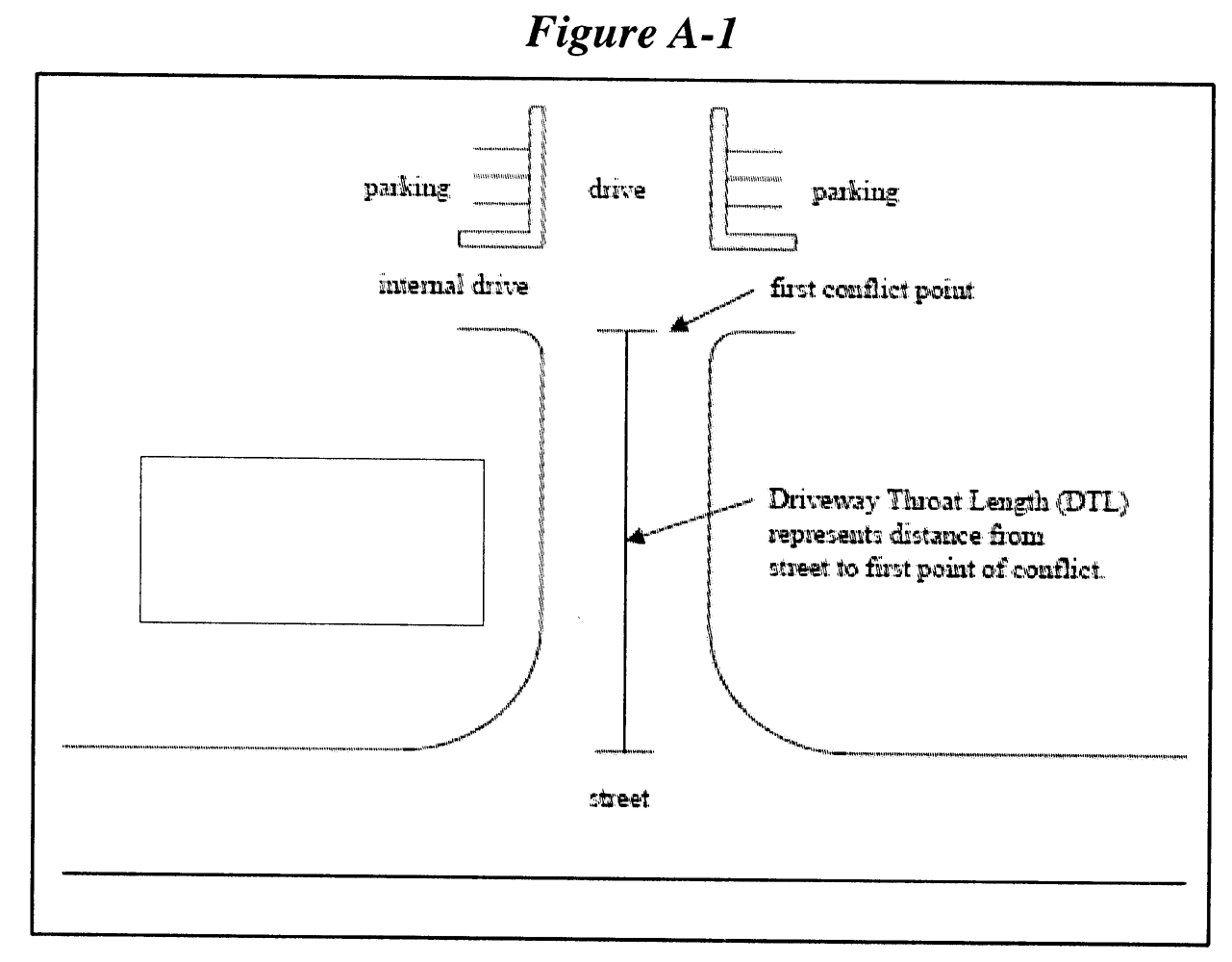
Figure A-1
The driveway throat length shall be defined as the distance from the street to the first point of conflict in the driveway and shall conform with the guidelines in Table B.
*Minimum guidelines. Actual required throat length shall be determined based on a traffic study and queuing analysis.
(i)
Nonconforming Connections. A development site that cannot be permitted access in accordance with the requirements of this ordinance and has no reasonable alternative means of access to the public road system, including joint and cross access with adjacent properties or side street access, shall be issued approval for a nonconforming connection. The nonconforming status of the connection shall be noted on the site plan or subdivision plan submitted for approval. A requirement may also be attached to the access that it be eliminated or altered at the cost of the applicant when the property is capable of being served by an alternate means of access and such alternate access shall be used by the property. Any requirement to provide for subsequent alternative access shall run with the property and be a condition of development approval.
6.02.04 - Standards for drive-up facilities.
All facilities providing drive-up or drive-through service shall provide on-site stacking lanes in accordance with the following standards:
(a)
The facilities and stacking lanes shall be located and designed to minimize turning movements in relation to the driveway access to streets and intersection.
(b)
The facilities and stacking lanes shall be located and designed to minimize or avoid conflicts between vehicular traffic and pedestrian areas such as sidewalks, crosswalks, or other pedestrian access ways.
(c)
A by-pass lane shall be provided.
(d)
Stacking lane distance shall be measured from the service window to the property line bordering the furthest street providing access to the facility.
(e)
Minimum stacking lane distance shall be as follows:
1.
Financial institutions shall have a minimum distance of 200 feet. Two or more stacking lanes may be provided which together total 200 feet.
2.
All other uses shall have a minimum distance of 120 feet.
(f)
Alleys or driveways in or abutting areas designed, approved, or developed for residential use shall not be used for circulation of traffic for drive-up facilities.
(g)
Where turns are required in the exit lane, the minimum distance from any drive-up station to the beginning point of the curve shall be 34 feet. The minimum inside turning radius shall be 25 feet.
6.02.05 - Visibility at intersections and curb breaks.
(a)
On a corner lot in all land use districts, no fence, wall, sign, hedge, landscaping, or structure shall be erected, placed, planted, or allowed to grow in such a manner as to obstruct vision between a height of 2 ½ and 6 feet above the centerline grades of the intersecting streets in the area bounded by the street lines of such corner lots and a line joining points along said street lines 25 feet from the point of such intersection.
(b)
In all land use districts, where a curb break intersects a public right-of-way, no fence, wall, sign, hedge, landscaping, or structure shall be erected, placed, planted, or allowed to grow in such a manner as to obstruct cross-visibility between a height of 2½ and six feet within the areas of property on both sides of the curb break formed by the intersection of each side of the curb break and public right-of-way lines with 2 sides of each triangle being 10 feet in length from the point of intersection and the third being a line connecting the end of the 2 other sides.
(c)
The requirements of this subsection shall not be deemed to prohibit any necessary retaining wall.
(d)
Trees shall be permitted in the clear space provided that foliage is cut away within the prescribed heights.
6.03.01 - Generally.
Off-street parking facilities shall be provided for all development within the county pursuant to the requirements of this Code. The facilities shall be maintained as long as the use exists that the facilities were designed to serve.
6.03.02 - Computation.
(a)
When determination of the number of off-street spaces required by this Code results in a fractional space, the fraction of ½ or less may be disregarded, and a fraction in excess of ½ shall be counted as 1 parking space.
(b)
In stadiums, sports arenas, churches and other places of assembly in which those in attendance occupy benches, pews or other similar seating facilities, and/or which contains an open assembly area, the occupancy shall be based on the maximum occupancy rating given the building by the fire marshal.
(c)
Gross floor area shall be the sum of the gross horizontal area of all floors of a building measured from the exterior faces of the exterior walls.
6.03.03 - Number of parking spaces required.
(a)
The table below specifies the required number of off-street automobile parking spaces.
(b)
A retail sales and service establishment shall provide parking in accord with the following table:
(c)
One motorcycle space shall be required per 40 vehicle spaces required by this Section. Motorcycle spaces are optional if less than 40 vehicle spaces are required. Motorcycle stalls shall be clearly labeled as such.
(d)
For uses not listed in the Table in (a) above, the number of required spaces shall be based on a study prepared by the property owner or operator that addresses:
1.
Type of use or uses and estimated total number of trips generated during peak conditions;
2.
Estimated parking duration per vehicle trip (turnover rates); and
3.
Estimated number of employees; one space to be provided for each two employees based on the shift of maximum employment.
6.03.04 - Special parking spaces.
(a)
Any parking area to be used by the general public shall provide suitable, marked parking spaces for handicapped persons. The number, design, and location of these spaces shall be consistent with the requirements of Sections 316.1955, .1956, Florida Statutes, or succeeding provisions. No parking space required for the handicapped shall be counted as a parking space in determining compliance with 6.03.03, but optional spaces for the handicapped shall be counted. All spaces for the handicapped shall be paved.
(b)
A portion of the parking spaces required by this Code may be designated as exclusively for motorcycle parking if the following conditions are met:
(1)
The Planning Director recommends that the spaces be so designated, based upon projected demand for them and lessened demand for automobile spaces.
(2)
The Planning Commission approves the recommendation and the designated spaces are shown on the final development plan.
(3)
The designated spaces are suitably marked and striped.
(4)
The designation does not reduce the overall area devoted to parking so that if the motorcycle spaces are converted to automobile spaces the minimum requirements for automobile spaces will be met.
The approval may later be withdrawn, and the spaces returned to car spaces, if the Planning Director finds that the purposes of this Code would be better served thereby, based upon actual demand for motorcycle and automobile parking.
6.03.05 - Parking reductions or increases.
(a)
Applicants for development plan review may vary from the off-street parking schedule in 6.03.03 by demonstrating reduced or increased parking demand. The provision of on-street parking may justify a reduction in off-street parking.
(b)
In all cases, the applicant shall provide sufficient documentation to the Planning Commission to clearly establish that minimum and maximum parking needs shall be accommodated.
(c)
Where inadequate on-site parking causes a recurring traffic hazard or a nuisance off-site, the owner shall be responsible for increasing the number of parking spaces or decreasing the need for parking spaces.
6.03.06 - Parking area dimensional requirements.
(a)
Parking lots may be in different configurations with regard to the angle of the space with the direction of travel of traffic in the aisles. Parallel parking has a zero angle while perpendicular parking has a 90 degree angle. Angled parking is generally laid out at 30, 45, 60 or 75 degree angles.
(b)
Parking spaces shall have a minimum width of 8.5 feet except where otherwise provided in this Article.
(c)
The other dimensions of parking spaces and the aisles providing access to such spaces shall be as set forth in the following table:
(d)
For parking spaces at a ninety degree angle to the aisle (perpendicular parking) and with a width of nine feet or more, the aisle width may be reduced to 22 feet.
(e)
Parallel spaces shall be a minimum of 22 feet long by a dimension between 7 and 9 feet wide. A line of parallel parking spaces will not require marking in 22-foot intervals unless the parking is to be metered.
(f)
Motorcycle spaces shall be a minimum of 8 feet long by 6 feet wide.
(g)
The design of all parking areas shall conform with current standards under the Americans with Disabilities Act (ADA), including the required number of reserved spaces for person with disabilities and van accessible spaces.
(h)
Parking wheel stops are required if the adjacent sidewalk width is less than six feet.
6.03.07 - Parking area design standards.
(a)
Any off-street parking lot serving any use other than dwellings of three units per building or less shall meet the following off-street parking lot requirements.
(b)
Off-street parking areas shall be provided with a hard-surface, all-weather pavement of asphalt or concrete, and shall be so graded and drained as to comply with stormwater management requirements. Alternative surfaces may be proposed for approval by the Planning Commission. All requests for non-standard parking facilities shall be accompanied by sufficient documentation for the Planning Commission to clearly establish the expected usage and suitability of the stabilized or alternative surface.
(c)
Parking areas shall be required to be lighted, unless the reviewing authority determines that due to factors such as time of usage and lack of safety benefit, lighting would not promote public safety. Where lighting is required, it shall be designed to provide safe, convenient and efficient ingress and egress for pedestrians and vehicles. Lighting shall be designed such that light levels and uniformity ratios are at least in compliance with the minimum standards proscribed by the Illuminating Engineering Society of North America (IESNA). Lighting design shall be consistent and coordinated for the entire site and shall be designed to meet the following standards.
(1)
Mounting heights for exterior luminaries shall not exceed 35 feet in height within a parking lot and 18 feet within adjacent non-vehicular pedestrian areas (with the height being measured from the finished grade to the bottom of the luminous opening of the luminary). All acceptable outdoor luminaries shall employ IESNA "semicutoff", "cutoff" or "full cutoff" light distribution designations and shall be either partially shielded fixtures or fully shielded fixtures to reduce glare or spillage. All lighting, regardless of location, shall be designed to prevent direct glare, light spillage and hazardous interference with automotive, bicycle and pedestrian traffic on adjacent streets and properties.
(2)
Mercury vapor fixtures shall not be permitted as a component of parking area lighting design.
(3)
Maximum maintained illumination levels measured at finished grade on adjoining property within 25 feet of the property line of the project in question shall be no more than 1.0 footcandles (fc) if the adjoining property is zoned commercial and no more than 0.5 fc when the adjoining property is zoned residential or is an existing residential use within 100 feet of the property line.
(4)
Photometric lighting plans showing maintained light levels at and out to at least 30 feet beyond property lines and with data points calculated on no greater than a ten foot by ten foot grid, and including fixture catalog numbers are required with development plan review and subject to approval. Manufacturer's cut sheets for the specified fixtures are also required for development plan review.
(5)
Any deviation(s) from these standards shall be noted at the time of preliminary development plan review along with a statement explaining the purpose of and reason for the deviation(s). The DRC shall make a determination whether to accept such deviation(s).
(d)
Parking facilities shall meet the landscaping requirements of Section 6.05 of this Article.
6.03.08 - Alteration of conforming development.
(a)
The number of off-street parking spaces may be reduced if the Planning Director or Planning Commission finds that a diminution in floor area, seating capacity, or other factor controlling the number of parking spaces would permit the site to remain in conformity with this section after the reduction.
(b)
The number of off-street parking spaces must be increased to meet the requirements of this section if the Planning Director or Planning Commission finds that an increase in floor area, seating capacity, or other factor controlling the number of parking or loading spaces required by this section causes the site not to conform with this section.
6.03.09 - Location of parking spaces.
(a)
Except as provided herein, all required off-street parking spaces and the use they are intended to serve shall be located on the same parcel.
(b)
The Planning Commission may approve off-site parking facilities as part of the parking required by this section if:
(1)
The location of the off-site parking spaces will adequately serve the use for which it is intended. The following factors shall be considered:
a.
Proximity of the off-site spaces to the use that they will serve.
b.
Ease of pedestrian access to the off-site parking spaces.
c.
Whether or not off-site parking spaces are compatible with the use intended to be served, e.g., off-site parking is not ordinarily compatible with high turnover uses such as retail.
(2)
The location of the off-site parking spaces will not create unreasonable:
a.
Hazards to pedestrians.
b.
Hazards to vehicular traffic.
c.
Traffic congestion.
d.
Interference with access to other parking spaces in the vicinity.
e.
Detriment to any nearby use.
(3)
The developer supplies a written agreement, approved in form by the County Attorney, assuring the continued availability of the off-site parking facilities for the use they are intended to serve.
6.04.01 - Requirements for all developments.
(a)
Generally. The following basic utilities are required for all developments subject to the criteria listed herein.
(b)
Electricity. Every principal use and every lot within a subdivision shall have available to it a source of electric power adequate to accommodate the reasonable needs of such use and every lot within such subdivision.
(c)
Telephone. Every principal use and every lot within a subdivision shall have available to it a telephone service cable adequate to accommodate the reasonable needs of such use and every lot within such subdivision.
(d)
Water and Sewer. Every principal use and every lot within a subdivision shall have central potable water and wastewater hookup whenever required by the County Comprehensive Plan and where the topography permits the connection to a city or county water or sewer line by running a connecting line no more than 200 feet from the lot to such line.
(e)
Illumination. All streets, driveways, sidewalks, bikeways, parking lots and other common areas and facilities in developments shall provide illumination meeting county design and construction standards.
(f)
Fire Hydrants. All developments served by a central water system shall include a system of fire hydrants consistent with county design and construction standards.
6.04.02 - Placement of utilities underground.
Subdividers and other developers are encourages to place all electric, telephone, cable television, gas distribution lines and other utility lines underground within easements or dedicated public rights-of-way.
6.04.03 - Utility easements.
When a developer installs or causes the installation of water, sewer, electrical power, telephone, or cable television facilities and intends that such facilities shall be owned, operated, or maintained by a public utility or any entity other than the developer, the developer shall transfer to such utility or entity the necessary ownership or easement rights to enable the utility or entity to operate and maintain such facilities.
6.05.01 - Generally.
(a)
Lots or parcels of land on which a one- or two-family home is used as a residence shall be exempt from all provisions of these landscaping regulations. This shall not be construed to exempt any new residential development that requires the approval of a plat or site plan by the County.
(b)
No accessory structures, garbage or trash collection points or receptacles, parking, or any other functional use contrary to the intent and purpose of this section shall be permitted in a required landscape area. This does not prohibit the combining of compatible functions such as landscaping and drainage facilities.
(c)
Unless otherwise specifically provided in a special use permit or other development approval, whenever trees or other landscaping are required to be planted such trees and landscaping shall be installed within six months of the date of the final development approval, and all such trees and landscaping shall remain in healthy condition thereafter.
(Ord. No. 2009-02, § 8, 2-16-2009)
6.05.02 - Vehicle use areas.
(a)
A vehicle use area is any portion of a development site used for circulation, parking, and/or display of motorized vehicles, except junk or automobile salvage yards.
(b)
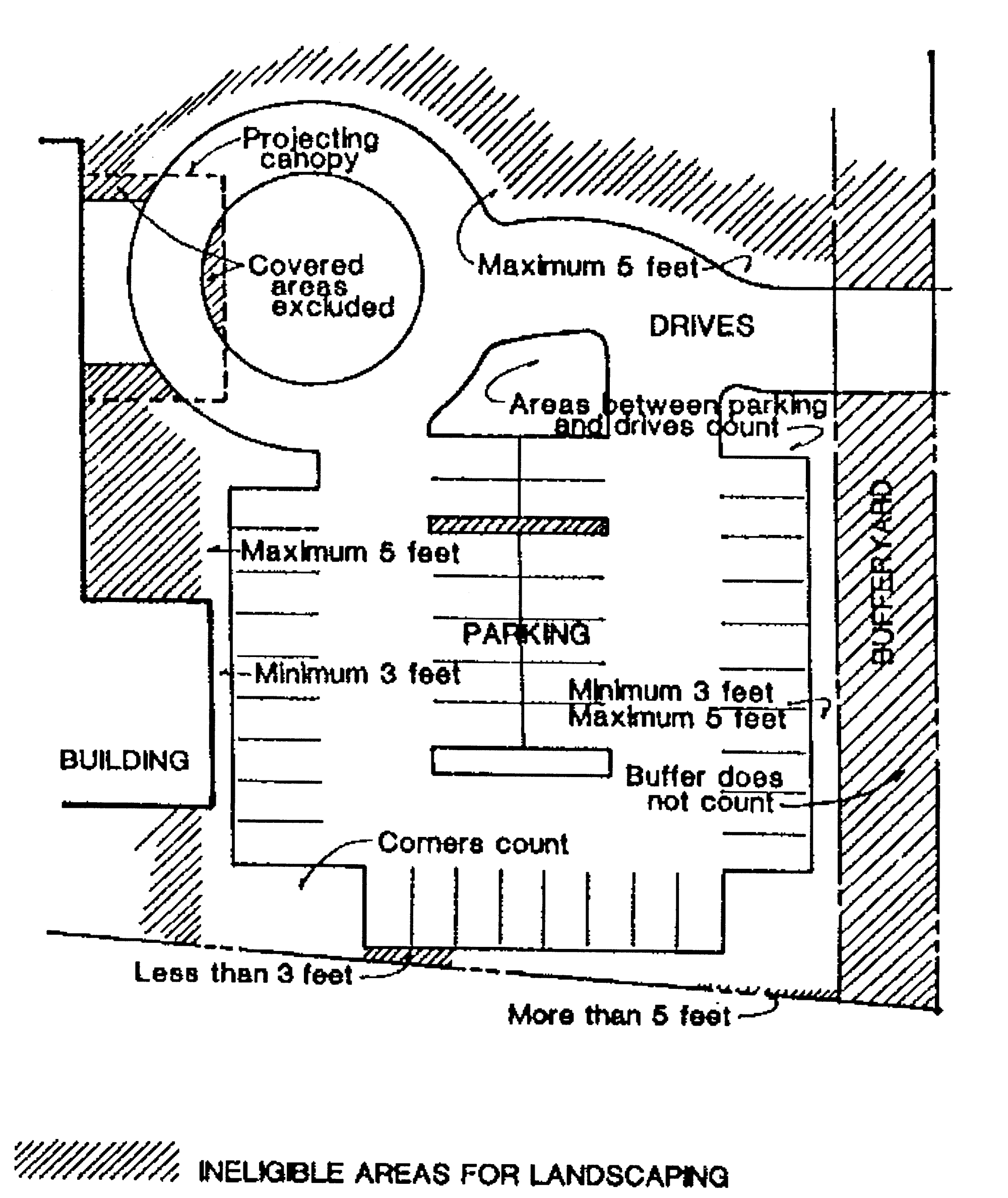
All vehicle use areas containing more than 1,000 square feet shall be landscaped in accord with Figure 6.05.02 A and Figure 6.05.02 B. Figure 6.05.02 C identifies the areas of landscaping that may be counted towards fulfilling the vehicle use area landscaping requirement.
(c)
Proportional amounts of landscaping shall be provided for fractional areas.
(d)
Vehicle use areas designed to accommodate vehicles that are larger or smaller than automobiles, or that do not have designated parking areas, shall meet the requirements of the above figures except that in place of twenty-four parking spaces, the square footage of 4,800 square feet shall be used.
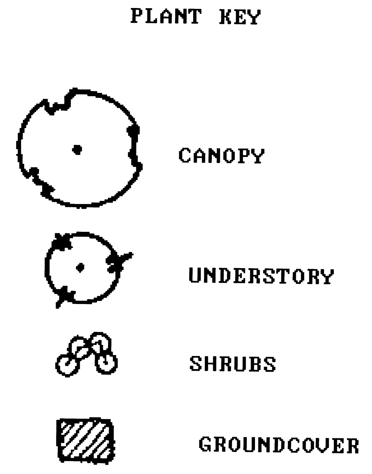
Plant key
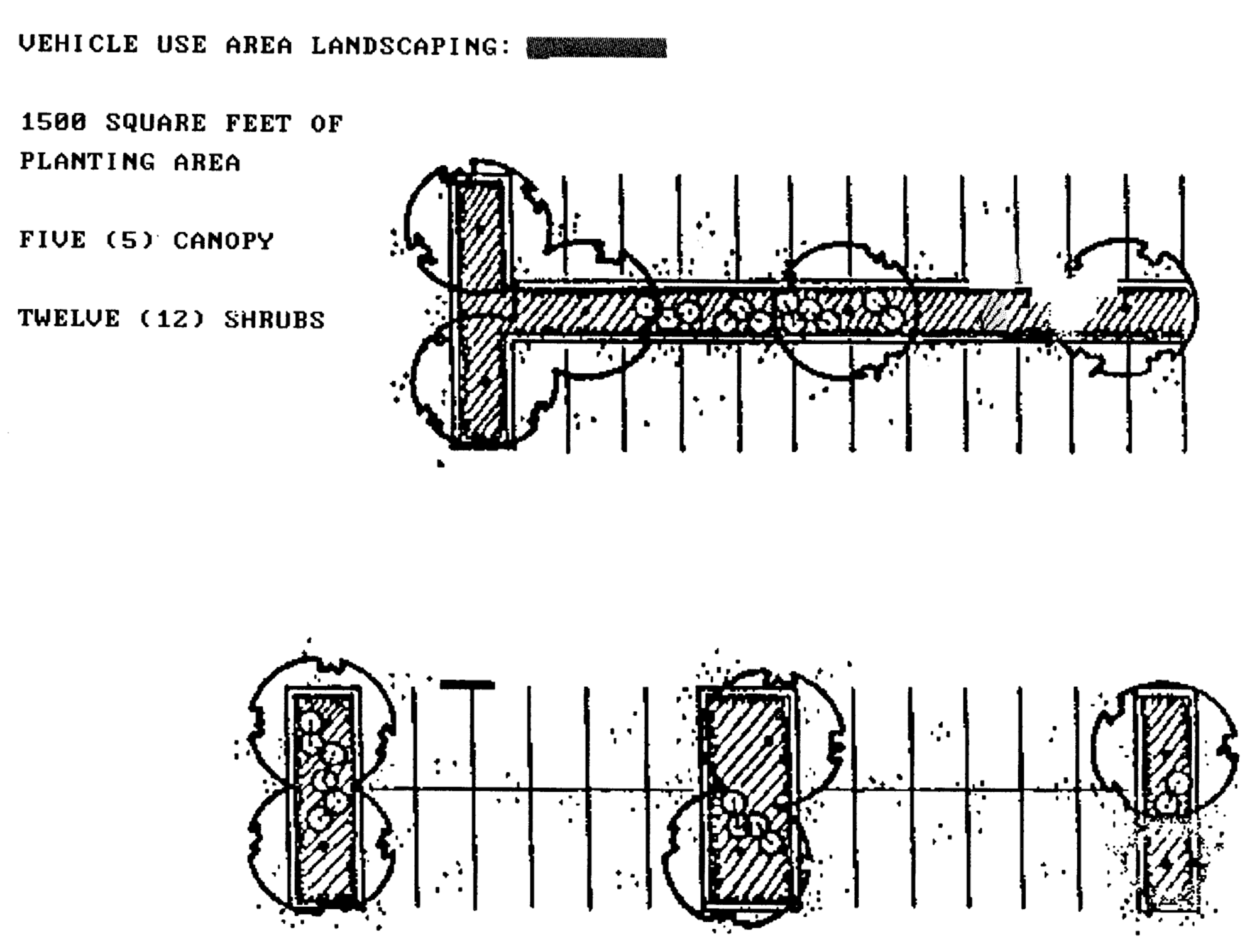
Vehicular use area landscaping
6.05.03 - Buffer zones.
(a)
A buffer zone is a landscaped strip along parcel boundaries that serves as a buffer between incompatible uses and zoning districts, as an attractive boundary of the parcel or use, or as both a buffer and attractive boundary. This shall not be interpreted to mean that parcels within a planned mixed use development must meet these requirements.
(b)
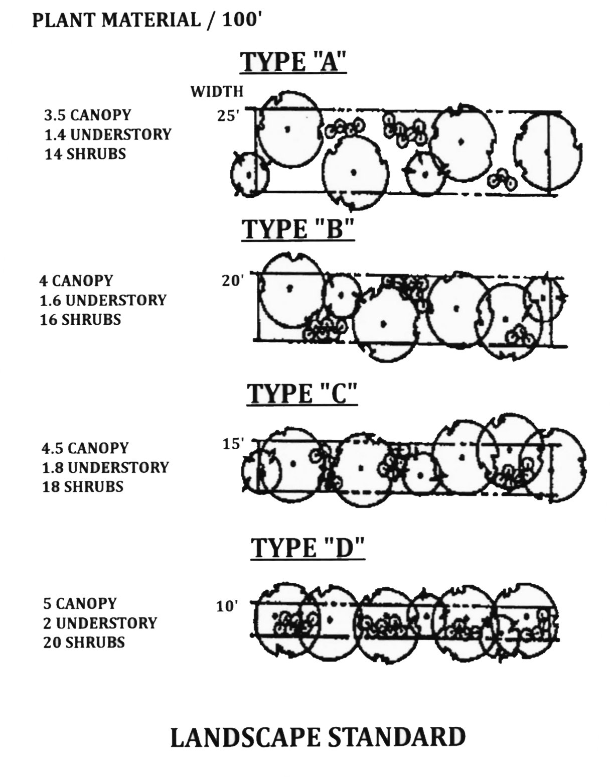
The standard for buffer zones is set out in the following illustration that specifies the number of plants required per 100 linear feet. To determine the total number of plants required, the length of each side of the property requiring a buffer shall be divided by 100 and multiplied by the number of plants shown in the illustration. The plants shall be spread reasonably evenly along the length of the buffer. The developer may choose among the width/planting options shown below.
(c)
The foregoing buffer shall be provided between abutting parcels as follows:
(d)
The use of existing native vegetation in buffer zones is preferred. If a developer proposes to landscape a buffer zone with existing native vegetation, the reviewing agency may allow a variance from the strict planting requirements of this section if:
(1)
The variance is necessary to prevent harm to the existing native vegetation; and
(2)
The buffering and/or aesthetic purposes of the buffer zone are substantially fulfilled despite the variance.
(e)
Where the use that is required to provide a buffer is subject to approval by a Special Use Permit, the buffer requirements of this section may be increased or decreased as a condition of a Special Use Permit upon good cause supported by written findings in the final order.
(f)
In any case where a buffer is required, the buffer may be crossed by driveways, trails, or other features of the development designed to provided connectivity or recreational opportunities.
(g)
All buffers shall be a minimum of six (6) feet in height, and shall be comprised entirely of existing natural vegetation including native shrubs and grasses if such vegetation is of sufficient height and density. If the existing natural vegetation is not sufficient to meet these criteria, then supplemental native shrubs shall be utilized to meet the criteria. Supplemental plantings shall be of size and type to ensure the height and density requirement is met within twenty-four (24) months of planting.
(Ord. No. 2024-07, § 1, 10-21-2024)
6.05.04 - Street trees.
Subdividers and other developers are encouraged to plant, within 5 feet of the right of way of each street within a residential development, one shade tree for every 100 linear feet of right of way. Trees planted pursuant to this section shall be selected from the approved list of canopy trees below.
6.05.05 - Landscape design and materials.
(a)
All landscaped areas required by this Code should conform to the following general design principles:
(1)
Landscaping should integrate the proposed development into existing site features through consideration of existing topography, hydrology, soils and vegetation.
(2)
The functional elements of the development plan, particularly the drainage systems and internal circulation systems for vehicles and pedestrians, should be integrated into the landscaping plan.
(3)
Landscaping should be used to minimize potential erosion through the use of ground covers or any other type of landscape material that aids in soil stabilization.
(4)
Existing native vegetation should be preserved and used to meet landscaping requirements.
(5)
Landscaping should enhance the visual environment through the use of materials that achieve variety with respect to seasonal changes, species of living material selected, textures, colors and size at maturity.
(6)
Landscaping design should consider the aesthetic and functional aspects of vegetation, both when initially installed and when the vegetation has reached maturity. Newly installed plants should be placed at intervals appropriate to the size of the plant at maturity, and the design should use short- and long-term elements to satisfy the general design principles of this section over time.
(7)
Landscaping should enhance public safety and minimize nuisances.
(8)
Landscaping should maximize the shading of streets and vehicle use areas.
(9)
No development plan shall be denied solely on the basis of the design principles in this section.
(b)
The following standards for the installation of plants shall be followed:
(1)
All plants shall be healthy and free of diseases and pests, and shall be selected from the list of approved species below. The Planning Director may authorize the use of an appropriate species not shown on the lists. The Planning Director should take steps to have the substituted species added to the list.
(2)
Plants shall be installed during the period of the year most appropriate for planting the particular species. If compliance with this requires that some or all of the landscaping be planted at a time after the issuance of a certificate of occupancy, the developer shall post a performance bond sufficient to pay the costs of the required, but not yet installed, landscaping before the certificate shall be issued.
(3)
Landscaping shall be protected from vehicular and pedestrian encroachment by means of raised planting surfaces, depressed walks, curbs, edges, and the like.
(4)
The landscaping shall not interfere, at or before maturity, with power, cable television, or telephone lines, sewer or water pipes, or any other existing or proposed overhead or underground utility service.
(5)
All plants shall be installed according to standards adopted by the Staff Forester.
(6)
The developer shall provide sufficient soil and water to sustain healthy growth of all plants.
(c)
The following table indicates the trees that may be used for street trees and within buffer areas.
CANOPY TREE LIST
(e)
The following plants shall not be installed as landscape material:
PROHIBITED TREE SPECIES
(g)
Mulches shall be a minimum depth of 2 inches and plastic surface covers shall not be used.
(h)
All required plants shall be maintained in a healthy, pest-free condition. Within 6 months of a determination by the Staff Forester that a plant is dead or severely damaged or diseased, the plant shall be replaced by the developer in accordance with the standards specified in this section.
6.06.01 - Generally.
All development proposals shall comply with the stormwater management requirements of the Suwannee River Water Management District and with all state, local, and federal stormwater regulations.
(Ord. No. 2024-06, § 1, 10-21-2024)
6.06.02 - Enforcement.
The stormwater management requirements imposed by the Suwannee River Water Management District shall become a condition of the County's development approval and may be enforced by the County as any other development condition.