
Golden Valley City Zoning Code
ARTICLE III
- ZONING DISTRICTS
Sec. 113-55. - Zoning Districts.
(a)
Districts. For the purpose of this chapter, the City is divided into the following zoning districts:
(1)
Single-Family Residential (R-1).
(2)
Moderate Density Residential (R-2).
(3)
Medium Density Residential (R-3).
(4)
High Density Residential (R-4).
(5)
Commercial.
(6)
Light Industrial.
(7)
Industrial.
(8)
Office.
(9)
Institutional.
(10)
Mixed Use.
(b)
Establishment. The districts and their boundaries are hereby established. No structure, building, premises, or land use shall be erected, established, or used for any purpose that does not comply with all applicable regulations of the district in which such structure, building, premises, or land use is located.
(Code 1988, § 11.10; Ord. No. 99, 2nd Series, 5-20-1993; Ord. No. 376, 2nd Series, 7-13-2007; Ord. No. 654, § 1, 1-2-2019)
Sec. 113-56. - Official Zoning Map.
(a)
Map Elements. The Official Zoning Map, together with all explanatory information or descriptions, is adopted by reference and declared to be a part of this chapter. The Official Zoning Map shall show the division of the City into zoning districts and include a legend, scale, any other information which may be relevant for the interpretation of the map, and shall bear the words: "This is the Official Zoning Map referred to in the Zoning Chapter of the City Code of the City of Golden Valley," together with the date of adoption of the ordinance from which this section is derived.
(b)
Amendments. If changes are made in district boundaries or other matters depicted on the Official Zoning Map, such changes shall be inscribed on the Official Zoning Map promptly after the amendment has been approved (or the permit has been issued) by the City Council together with an entry on the Official Zoning Map reflecting the number and date of enactment of the amending ordinance or resolution which effected the change.
(c)
Availability. The Official Zoning Map shall be posted for download on the City's website and shall be available upon request in the Physical Development Department office at the City Hall.
(d)
Unauthorized Changes. Any unauthorized change of the Official Zoning Map of whatever kind by a person is unlawful.
(e)
Vacations. Whenever any street, alley, or other public way is vacated by official action of the City Council, the zoning districts adjoining each side of such street, alley, or public way shall be automatically extended to the center of such vacation, and all area included in the vacation shall then be subject to all regulations applicable to the extended districts, provided that if, in the judgment of the City Attorney, the vacated street, alley, or public way does not become property of the adjoining landowners, then such automatic extension does not take place.
(Code 1988, § 11.11; Ord. No. 609, 11-11-1983; Ord. No. 244, 2nd Series, 4-26-2001; Ord. No. 755, §§ 1, 2, 12-20-2022)
Sec. 113-57. - General Requirements.
(a)
Applicability. The following requirements shall apply to each of the City's zoning districts, unless noted otherwise.
(b)
Lot and Yard Requirements.
(1)
Principal Structures on One Lot. Except for lots within the Mixed Use Zoning District or regulated under the planned unit development regulations of this chapter, every principal structure erected in the City after October 3, 1991, shall be located on a separate lot, and in no case shall there be more than one principal structure on a lot.
(2)
Divisions and Combinations. No division or combination of lots shall be permitted which fails to result in all lots conforming to this Code. Where City approval was obtained before October 3, 1991, of a combination of more than one lot or parcel, the combination shall be considered one lot, except that:
a.
If a principal structure is situated on two or more lots, but one or more of the lots is not necessary in order to allow the structure to maintain conformance with the requirements of the City Code in force at the time it was constructed, a division shall be permitted. Lots required for the structure may not be treated as separate lots unless the structure is removed or modified so as to come into conformance with all requirements of the City Code.
b.
If a principal structure is situated on two or more lots and additional land is acquired so that the structure may be expanded, all of the lots must be replatted to conform to the City Code.
c.
If a principal structure is situated on two or more lots and additional land is not necessary for a proposed expansion of the structure, replatting will not be required.
(3)
Rounding. In order to meet front yard, side yard, and rear yard setbacks of five feet or greater required by this chapter, landowners may compute the distance between their structure and the lot line by rounding up to the next whole foot (for example, a distance greater than 14.0 feet may be rounded to 15 feet).
(4)
Corner Visibility. All structures shall meet the corner visibility requirements of the City Code.
(5)
Easements. No structures shall be located in dedicated public easements.
(Code 1988, §§ 11.02(2), 11.03(63), 11.12; Ord. No. 609, 11-11-1983; Ord. No. 73, 2nd Series, 10-3-1991; Ord. No. 292, 2nd Series, 3-12-2004; Ord. No. 397, 2nd Series, 6-6-2008)
Sec. 113-87. - Summary use tables.
(a)
Residential Land Uses.
(1)
In general. Table 87-1, Residential Land Uses, lists all permitted, conditional, restricted, and prohibited uses in the Residential Zoning Districts.
(2)
Permitted uses. Uses specified with a "P" are permitted as of right in the district or districts where designated, provided that the use complies with all other applicable provisions of this Code.
(3)
Conditional uses. Uses specified with a "C" are allowed as a conditional use in the district or districts where designated, provided that the use complies with all other applicable provisions of this Code. Persons wishing to establish or amend a conditional use shall obtain a conditional use permit, as specified in Sec. 113-30, Conditional Uses.
(4)
Restricted uses. Uses specified with an "R" are permitted as of right in the district or districts where designated, provided they comply with additional standards detailed in the corresponding text of this Chapter.
(5)
Prohibited uses. Any use specified with an "X" or not listed in a particular district or any use not determined by the City Manager or their designee to be substantially similar to a use listed as permitted, conditional, or restricted shall be prohibited in that district.
(6)
District key. The notations in Table 87-1 represent the zoning districts listed below:
R-1: Single-Family Residential
R-2: Moderate Density Residential
R-3: Medium Density Residential
R-4: High Density Residential
Table 87-1 Residential Land Uses
(b)
Economic and Business Land Uses.
(1)
In general. Table 87-2, Economic and Business Land Uses, lists all permitted, conditional, restricted, and prohibited uses in the Commercial, Light Industrial, Industrial, and Office Zoning Districts.
(2)
Permitted uses. Uses specified with a "P" are permitted as of right in the district or districts where designated, provided that the use complies with all other applicable provisions of this Code.
(3)
Conditional uses. Uses specified with a "C" are allowed as a conditional use in the district or districts where designated, provided that the use complies with all other applicable provisions of this Code. Persons wishing to establish or amend a conditional use shall obtain a conditional use permit, as specified in Sec. 113-30, Conditional Uses.
(4)
Restricted uses. Uses specified with an "R" are permitted as of right in the district or districts where designated, provided they comply with additional standards detailed in the corresponding text of this Chapter.
(5)
Prohibited uses. Any use specified with an "X" or not listed in a particular district or any use not determined by the City Manager or their designee to be substantially similar to a use listed as permitted, conditional, or restricted shall be prohibited in that district.
(6)
District key. The notations in Table 87-2 represent the zoning districts listed below:
C: Commercial
LI: Light Industrial
I: Industrial
O: Office
Table 87-2 Economic and Business Land Uses
(c)
Institutional Land Uses.
(1)
In general. Table 87-3, Institutional Land Uses, lists all permitted, conditional, restricted, and prohibited uses in the Institutional Zoning District.
(2)
Permitted uses. Uses specified with a "P" are permitted as of right in the district or districts where designated, provided that the use complies with all other applicable provisions of this Code.
(3)
Conditional uses. Uses specified with a "C" are allowed as a conditional use in the district or districts where designated, provided that the use complies with all other applicable provisions of this Code. Persons wishing to establish or amend a conditional use shall obtain a conditional use permit, as specified in Sec. 113-30, Conditional Uses.
(4)
Restricted uses. Uses specified with an "R" are permitted as of right in the district or districts where designated, provided they comply with additional standards detailed in the corresponding text of this Chapter.
(5)
Prohibited uses. Any use specified with an "X" or not listed in a particular district or any use not determined by the City Manager or their designee to be substantially similar to a use listed as permitted, conditional, or restricted shall be prohibited in that district.
(6)
District key. The notations in Table 87-3 represent the zoning districts listed below:
I-A: Institutional Assembly
I-M: Institutional Medical
I-C: Institutional Civic
I-P: Institutional Parks and Natural Areas
Table 87-3 Institutional Land Uses
(d)
Mixed Use Land Uses.
(1)
In general. Table 87-4, Mixed Use Land Uses, lists all permitted, conditional, restricted, and prohibited uses in the Mixed Use Zoning District.
(2)
Permitted uses. Uses specified with a "P" are permitted as of right in the district or districts where designated, provided that the use complies with all other applicable provisions of this Code.
(3)
Conditional uses. Uses specified with a "C" are allowed as a conditional use in the district or districts where designated, provided that the use complies with all other applicable provisions of this Code. Persons wishing to establish or amend a conditional use shall obtain a conditional use permit, as specified in Sec. 113-30, Conditional Uses.
(4)
Restricted uses. Uses specified with an "R" are permitted as of right in the district or districts where designated, provided they comply with additional standards detailed in the corresponding text of this Chapter.
(5)
Prohibited uses. Any use specified with an "X" or not listed in a particular district or any use not determined by the City Manager or their designee to be substantially similar to a use listed as permitted, conditional, or restricted shall be prohibited in that district.
(6)
District key. The notations in Table 87-4 represent the zoning districts listed below:
MU-N: Neighborhood Mixed Use
MU-C: Community Mixed Use
MU-E: Employment Mixed Use
Table 87-4 Mixed Use Land Uses
(Ord. No.728, § 2, 12-21-2021; Ord. No. 732, §§ 4—6, 3-15-2022; Ord. No. 733, § 1, 3-15-2022; Ord. No. 734, §§ 4—6, 3-15-2022; Ord. No. 742, § 2, 8-16-2022; Ord. No. 746, § 1, 11-2-2022; Ord. No. 787, § 2, 12-3-2024; Ord. No. 809, § 3, 11-18-2025)
Sec. 113-88. - Single-Family Residential (R-1) Zoning District.
(a)
Purpose. The purpose of the Single-Family Residential (R-1) Zoning District is to provide for detached single-family dwelling units at a low density along with directly related and complementary uses.
(b)
District Established. Lots shall be established within the R-1 Zoning District in the manner provided for in Section 113-29. The district established and/or any subsequent changes to such district shall be reflected in the Official Zoning Map of the City as provided in Section 113-56.
(c)
Principal Uses. Permitted, conditional, restricted, and prohibited uses in the R-1 Zoning District shall be as specified in Section 113-87 (a) and Table 87-1, Residential Land Uses.
(d)
Accessory Uses. The following accessory uses shall be permitted in the R-1 Zoning District:
(1)
When the property owner resides in the dwelling, rental of single sleeping rooms to not more than two people for lodging purposes only; and
(2)
In-home child care licensed by the State.
(3)
Accessory Dwelling Units associated with a single-family home, as regulated by Section 113-159 and with either administrative approval or a conditional use permit.
(4)
Home occupations, as governed by the following requirements:
a.
The use of the dwelling for the occupation or profession shall be incidental and secondary to the use of the dwelling for residential purposes.
b.
The exterior appearance of the structure shall not be altered for the operation of the home occupation.
c.
There shall be no outside storage or display of signage or anything related to or indicative of the home occupation.
d.
An accessory structure, including a garage, shall not be used for a home occupation.
e.
A permitted home occupation shall not result in noise, fumes, traffic, lights, odor, excessive sewage or water use or garbage service, electrical, radio, or TV interference in a manner detrimental to the health, safety, enjoyment, and general welfare of the surrounding residential neighborhood.
f.
No physical products shall be displayed or sold on the premises those incidental to the permitted home occupation.
g.
No signs or symbols shall be displayed other than those permitted for residential purposes.
h.
Clients, deliveries, and other business activity where persons come to the home shall be limited to the hours of 9:00 a.m. to 9:00 p.m.
i.
No more than 20 percent of the gross floor area of the dwelling shall be used for the home occupation.
j.
Parking related to the home occupation shall be provided only on the driveway of the property where the home occupation operates.
k.
A home occupation shall not generate more than eight client trips per day and serve no more than two clients or customers at a time.
l.
There shall only be one outside employee allowed on the premises at which a home occupation is located.
m.
All other applicable City, State, and Federal licenses, codes and regulations shall be met.
n.
The following uses are prohibited home occupations:
1.
Repair, service, building, rebuilding or painting of autos, trucks, boats, and other vehicles
2.
Repair and service of items that cannot be carried by one person and repair and service of any item involving an internal combustion engine or motor
3.
Retail sales
4.
Medical/dental clinic or similar
5.
Restaurants or cafes
6.
Animal hospital
7.
Veterinary clinic
8.
Stable or kennel
9.
Funeral home, mortuary, or columbarium; and
10.
Sale or repair of firearms.
(e)
Principal Structures. Principal structures in the R-1 Zoning District shall be governed by the following requirements:
(1)
Setback Requirements. The following setbacks shall be required for principal structures in the R-1 Zoning District. Garages or other accessory structures which are attached to the dwelling or main structure shall also be governed by these setback requirements, except for stairs and stair landings of up to 25 square feet in size and for accessible ramps.
a.
Front Setback. The required minimum front setback shall be 35 feet from any front lot line along a street right-of-way line. Decks and open front porches, with no screens, may be built to within 30 feet of a front lot line along a street right-of-way line. This requirement shall not reduce the building envelope on any corner lot to less than 27 feet in width.
b.
Rear Setback. The required rear setback shall be 25 feet.
c.
Side Setbacks. Side yard setbacks are determined by the lot width at the minimum required front setback line. The distance between a structure and the side lot lines shall be governed by the following requirements:
1.
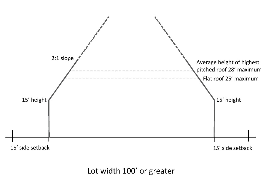
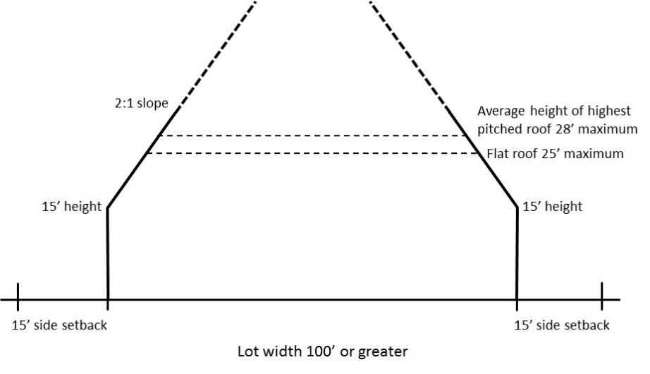
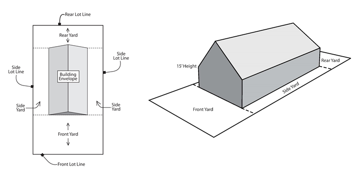
In the case of lots having a width of 100 feet or greater, the side setbacks for any portion of a structure 15 feet or less in height shall be 15 feet. The side setbacks for any portion of a structure greater than 15 feet in height shall be measured to an inwardly sloping plane at a ratio of 2:1 beginning at a point 15 feet directly above the side setback line (see figure below).
2.
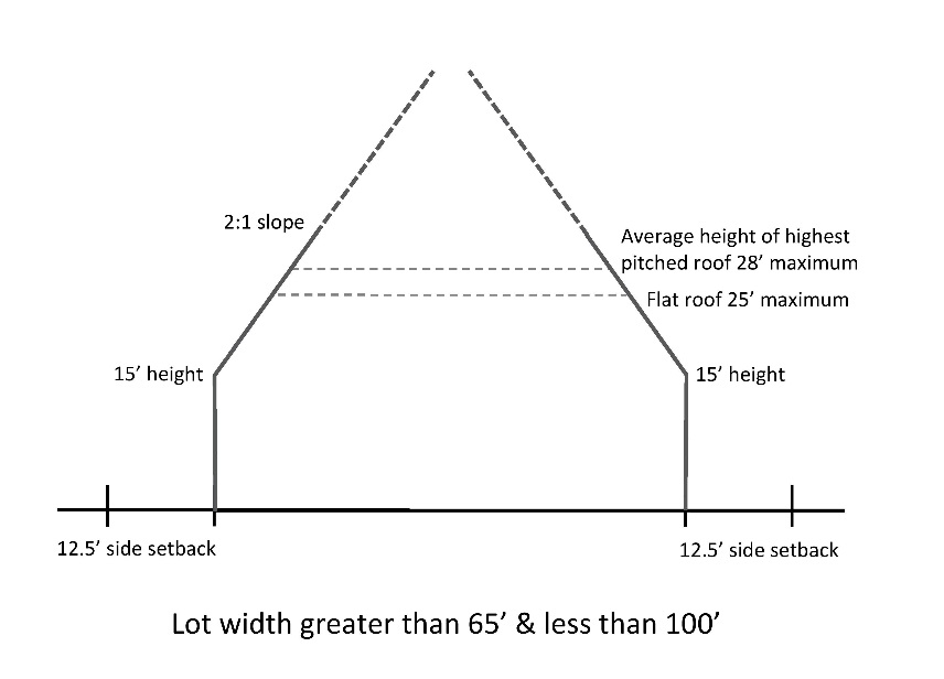
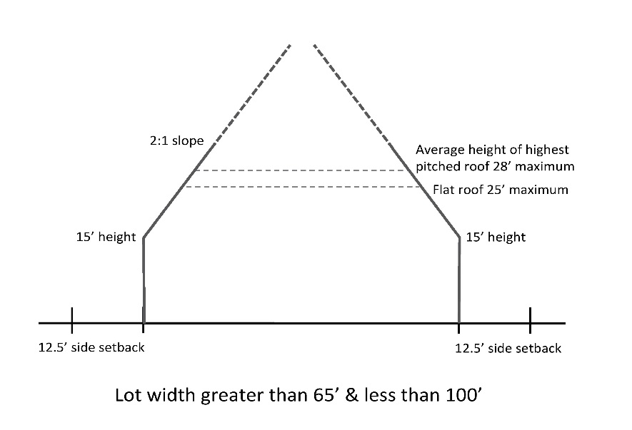
In the case of lots having a width greater than 65 feet and less than 100 feet, the side setbacks for any portion of a structure 15 feet or less in height shall be 12.5 feet. The side setbacks for any portion of a structure greater than 15 feet in height shall be measured to an inwardly sloping plane at a ratio of 2:1 beginning at a point 15 feet directly above the side setback line (see figure below).
3.
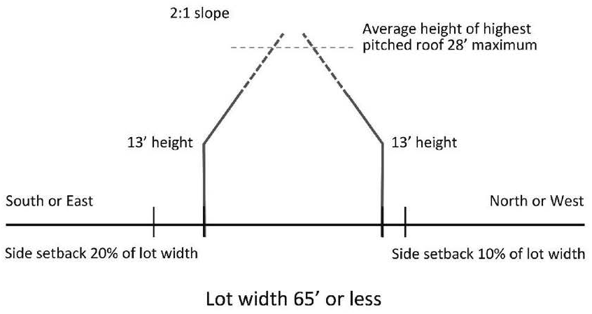
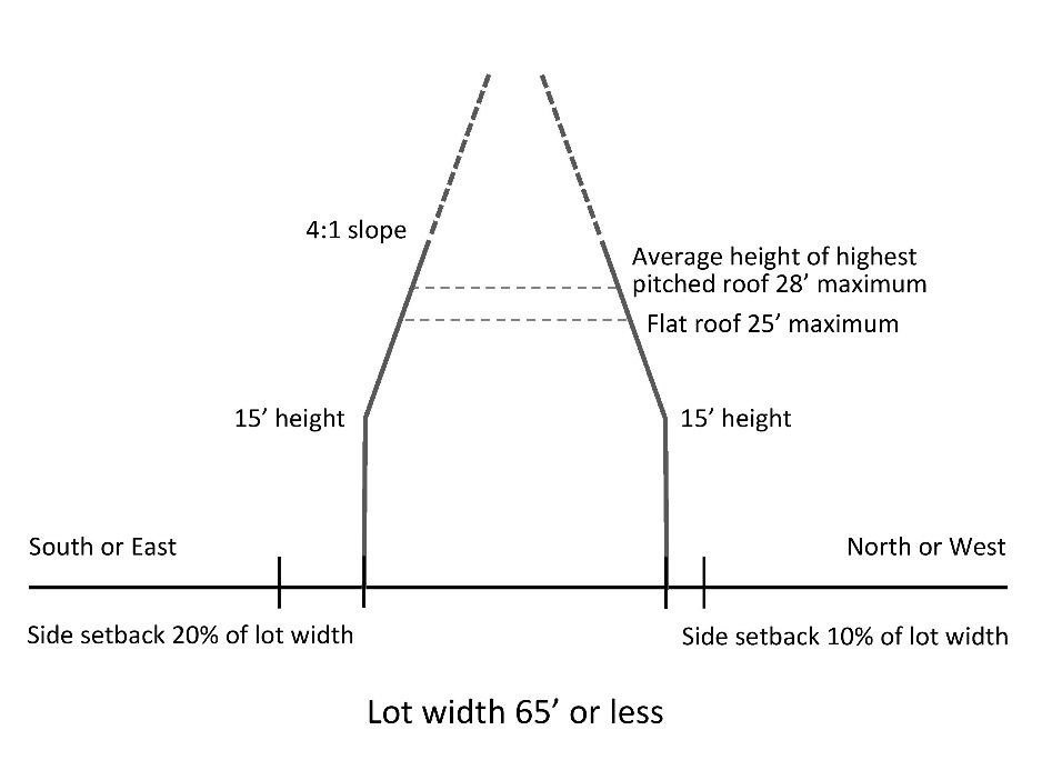
In the case of lots having a width of 65 feet or less, the side setbacks for any portion of a structure 13 feet or less in height along the north or west side shall be 10 percent of the lot width and along the south or east side shall be 20 percent of the lot width (up to 12.5 feet). In no case shall a side setback be less than 5 feet. The side setback for any portion of a structure greater than 13 feet in height measured to an inwardly sloping plane at a ratio of 2:1 beginning at a point 13 feet directly above the side setback line (see figure below).
d.
Corner Lot Setbacks. To determine the side yard setback, use the shorter front lot line.
e.
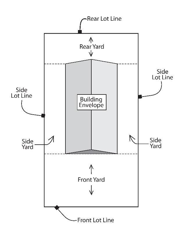
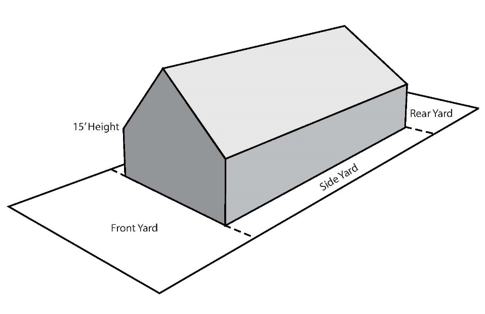
Building Envelope. Taken together, the front, rear, and side setbacks and the height limitation shall constitute the building envelope (see figures below). No portion of a structure may extend outside the building envelope, except for:
1.
Cornices and eaves, no more than 30 inches;
2.
For lots greater than 50 feet in width, bay windows or chimney chases, no more than 24 inches but no closer than 5 feet from the side property line;
3.
Chimneys, vents, or antennas;
4.
Stairs and stair landings up to 25 square feet in size;
5.
Accessible ramps; or
6.
For lots 65 feet in width or less, dormers, subject to the following requirements:
a.
In general.
i.
The total dormer length along one side of a structure may be broken into more than one section.
ii.
The total dormer length along one side of a structure is limited to 40 percent of the mail wall below.
iii.
No portion of any dormer shall extend above the ridge line of the roof.
b.
Shed dormer. A dormer with a flat eave line that runs parallel to the primary roof line.
i.
The front wall of a shed dormer shall be set back a minimum of two feet from the plane of the main wall below.
ii.
The side walls of a shed dormer shall be set back a minimum of four feet from the plane of the main wall below on each end of the structure.
iii.
The maximum height of a shed dormer shall be 20 feet as measured from the average grade to the front eave line of the dormer.
c.
Gable dormer. A dormer with a peaked roof.
i.
The front wall of a gable dormer shall be set back a minimum of two feet from the plane of the main wall below.
ii.
The side walls or furthest extent of a gable dormer shall be set back a minimum of four feet from the plane of the main wall below on each end of the structure.
iii.
The maximum height of a gable dormer shall be 25 feet as measured from the average grade to the dormer peak.
(2)
Height Restrictions. No principal structure shall be erected in the R-1 Zoning District with a building height exceeding 28 feet as measured from the average grade at the front building line. The average grade for a new structure shall be no more than one foot higher than the average grade that previously existed on the lot.
(3)
Structure Width Requirement. No principal structure shall be less than 22 feet in width as measured from the exterior of the exterior walls.
(4)
Side Wall Articulation. For any new construction, whether a new dwelling, addition, or replacement through a tear-down, any resulting side wall longer than 32 feet in length must be articulated, with a shift of at least two feet in depth, for at least eight feet in length, for every 32 feet of wall.
(5)
Decks. Decks over eight inches from ground level shall meet the same setbacks as the principal structure in the side and rear yards.
(6)
Kitchens. No more than one kitchen and one kitchenette shall be permitted in each dwelling unit.
(7)
Manufactured Homes. All manufactured or modular homes must meet the provisions of the zoning and building codes.
(f)
Accessory Structures. Accessory structures in the R-1 Zoning District shall be governed by the following requirements:
(1)
Location and Setback Requirements. The following location regulations and setbacks shall be required for accessory structures in the R-1 Zoning District:
a.
Location. A detached accessory structure shall be located completely to the rear of the principal structure, unless it is built with frost footings. In that case, an accessory structure may be built no closer to the front setback than the principal structure.
b.
Front Setback. Accessory structures shall be located no less than 35 feet from the front lot line.
c.
Side and Rear Setbacks. Accessory structures shall be located no less than five feet from a side or rear lot line.
d.
Cornices and Eaves. Cornices and eaves may not project more than 30 inches into a required setback.
e.
Separation Between Structures. Accessory structures shall be located no less than 10 feet from any principal structure and from any other accessory structure.
f.
Alleys. Accessory structures shall be located no less than five feet from an alley.
g.
Fences. For the purposes of setbacks, fences are not considered structures.
(2)
Height Restrictions. No accessory structure shall be erected in the R-1 Zoning District with a height in excess of one story, which is 10 feet from the floor to the top horizontal component of a frame building to which the rafters are fastened (known as the "top plate"). For the purposes of this regulation, the height of a shed roof shall be measured to the top plate.
(3)
Area Limitations. Each lot is limited to a total of 1,000 square feet of the following accessory structures: detached and attached garages, detached sheds, greenhouses, and gazebos. Swimming pools are not included in this requirement. No one detached accessory structure may be larger than 800 square feet in area and any accessory structure over 200 square feet in area requires a building permit. No accessory structure shall occupy a footprint larger than that of the principal structure.
(4)
Administrative Zoning Permits. The following shall require an administrative zoning permit:
a.
Fences
b.
Patios
c.
Any accessory structures less than 200 square feet in area; and
d.
Decks and platforms that do not require a building permit.
(5)
Garage Provisions. Garages in the R-1 Zoning District shall be governed by the following requirements:
a.
Minimum Garage Stalls. For lots greater than 50 feet wide, no building permit shall be issued for a single-family dwelling not having a one-stall garage. Lots 50 feet in width or less may be constructed without an enclosed garage stall.
b.
Maximum Garage Width. For lots 50 feet in width or less, the width of the front wall of an attached garage shall not exceed 75 percent of the width of the dwelling's front facade. For purposes of this subsection, a dwelling's front facade means that portion of the dwelling's building facing a front lot line that includes any front wall of a garage and provides vehicular access to the garage.
1.
Measurement of Front Facade. The width of the front facade shall be the direct, linear, horizontal distance between the dwelling's exterior side walls at the front facade's widest point.
2.
Measurement of Front Garage Wall. For purposes of this subsection, the front wall of a garage shall be the wall of the garage facing the front lot line, including any door providing vehicular access to the garage. The width of the front wall shall be the direct, linear, horizontal distance between the exterior or outermost location of the garage's two side walls at their intersection with the garage's front wall.
(6)
Roof Style. Gambrel and mansard roofs are not permitted on any accessory structure with a footprint of more than 200 square feet.
(7)
Decks. Freestanding decks or decks attached to accessory structures shall meet the same setback requirements for accessory structures.
(8)
Garden Structures. Garden structures shall be located no closer than five feet to any lot line. Garden structures shall not exceed 10 feet in height.
(9)
Play Structures. Play structures shall be located no closer than five feet to any lot line. Play structures shall not exceed 10 feet in height.
(10)
Swimming Pools. Swimming pools shall meet the same setback and location requirements for accessory structures. Setbacks shall be measured from the lot line to the pool's edge. Decks surrounding above-ground pools shall meet setback requirements.
(11)
Photovoltaic Modules. Freestanding photovoltaic modules, including solar panels and other photovoltaic energy receivers, which are in excess of three square feet shall meet the same setback, location, and height requirements for accessory structures.
(12)
Central Air Conditioning Units. Central air conditioning units shall be prohibited in a front yard.
(g)
Temporary Storage Units. Temporary storage units in the R-1 Zoning District shall be governed by the following requirements:
(1)
Duration. Temporary storage units shall not be stored on a lot for more than 14 days.
(2)
Location. Temporary storage units shall be stored on a hard surface and be located completely on private property.
(h)
Pre-1982 Structures. For all existing structures constructed in the R-1 Zoning District prior to January 1, 1982, the following structure setbacks shall be in effect:
(1)
Front Yard. The structure setback for principal structures shall be no closer than 25 feet to the front lot line.
(2)
Side Yard. The structure setback for principal structures shall be no closer than three feet to the side lot line.
(3)
Rear Yard. The structure setback for principal structures shall be no closer than 10 feet to the rear lot line.
(4)
Accessory structures. The structure setback for accessory structures shall be no closer than three feet to the side or rear Lot lines. At the discretion of the City Manager or his/her designee, a property owner may be required to move an accessory structure if it is located in a public easement area.
(i)
Pre-April 15, 2015, Structures, Building Permits and Applications. For all structures constructed and building permits issued or applied therefor in the R-1 Zoning District prior to April 15, 2015, if the height and side setbacks were deemed by the City to be compliant with the zoning code at the time a building permit was issued or applied therefor, the height and location shall be deemed conforming to current zoning code. However, in all cases, new construction and additions to such properties must comply with current requirements of the zoning code.
(j)
Buildable Lots. No dwelling or accessory structure shall be erected for use or occupancy as a residential dwelling on any tract of unplatted land which does not conform with the requirements of this section, except on those lots located within an approved plat. In the R-1 Zoning District a platted lot of a minimum area of 10,000 square feet and a minimum width of 80 feet at the front setback line shall be required for one single-family dwelling.
(k)
Lot Coverage. No lot or parcel in the R-1 Zoning District shall have lot coverage of more than 30 percent for a lot or parcel 10,000 square feet or greater in area, 35 percent for a lot or parcel greater than 6,000 square feet and less than 10,000 square feet in area and 30 percent for a lot or parcel 6,000 square feet or less in area. This requirement excludes swimming pools.
(l)
Impervious Surfaces. The total amount of impervious surfaces on any lot shall not exceed 50 percent of the area.
(m)
Paved Areas. Paved areas in the R-1 Zoning District, including those constructed of concrete, bituminous pavement, or pavers, are governed by the following provisions:
(1)
Driveways. Driveways built or reconstructed on or after January 1, 2005, shall be paved.
(2)
Setbacks. Paved areas shall be set back three feet from a lot line, except for shared driveways used by multiple property owners pursuant to a private easement.
(3)
Coverage. No more than 40 percent of the front yard may be covered with concrete, bituminous pavement, or pavers.
(4)
Street Access. Each lot may have only one street curb cut access, except the following lots may have up to two street curb cut accesses:
a.
A lot that contains two legally constructed garages.
b.
A lot of a resident who requires additional driveway access qualifying for a reduced class rate for homestead property as defined by Minn. Stats. § 273.13, subd. 22, Class 1b.
(Code 1988, § 11.21; Ord. No. 292, 2nd Series, 3-12-2004; Ord. No. 311, 2nd Series, 10-29-2004; Ord. No. 347, 2nd Series, 3-26-2015; Ord. No. 382, 2nd Series, 3-28-2008; Ord. No. 415, 2nd Series, 2-13-2009; Ord. No. 429, 2nd Series, 2-19-2010; Ord. No. 433, 2nd Series, 2-26-2010; Ord. No. 436, 2nd Series, 4-6-2010; Ord. No. 443, 2nd Series, 8-13-2010; Ord. No. 523, 2nd Series, 7-25-2014; Ord. No. 547, 2nd Series, 3-26-2015; Ord. No. 551, 2nd Series, 4-16-2015; Ord. No. 552, 2nd Series, 4-16-2015; Ord. No. 560, 2nd Series, 6-26-2015; Ord. No. 631, 2nd Series, § 1, 3-6-2018; Ord. No. 684, §§ 1—5, 7-21-2020; Ord. No.728, § 3, 4, 12-21-2021; Ord. No. 746, § 2, 11-2-2022; Ord. No. 805, § 2, 10-21-2025; Ord. No. 812, § 2, 12-16-2025)
Sec. 113-89. - Moderate Density Residential (R-2) Zoning District.
(a)
Purpose. The purpose of the Moderate Density Residential (R-2) Zoning District is to provide for single-family, two-family, and rowhouse dwellings at a moderate density (up to eight units per acre) along with directly related and complementary uses.
(b)
District Established. Lots shall be established within the R-2 Zoning District in the manner provided for in Section 113-29. The district established and/or any subsequent changes to such district shall be reflected in the Official Zoning Map of the City as provided in Section 113-56.
(c)
Principal Uses. Permitted, conditional, restricted, and prohibited uses in the R-2 Zoning District shall be as specified in Section 113-87 (a) and Table 87-1, Residential Land Uses.
(d)
Accessory Uses. The following accessory uses shall be permitted in the R-2 Zoning District:
(1)
When the owner resides in the dwelling, rental of single sleeping rooms to not more than two people per dwelling for lodging purposes only.
(2)
In-home child care licensed by the State.
(3)
Accessory Dwelling Units associated with a single-family home, as regulated by Section 113-159 and with either administrative approval or a conditional use permit.
(4)
Home occupations, as governed by the following requirements:
a.
The use of the dwelling for the occupation or profession shall be incidental and secondary to the use of the dwelling for residential purposes.
b.
The exterior appearance of the structure shall not be altered for the operation of the home occupation.
c.
There shall be no outside storage, signage, or display of anything related to or indicative of the home occupation.
d.
An accessory structure, including a garage, shall not be used for a home occupation.
e.
A permitted home occupation shall not result in noise, fumes, traffic, lights, odor, excessive sewage or water use or garbage service, electrical, radio, or TV interference in a manner detrimental to the health, safety, enjoyment, and general welfare of the surrounding residential neighborhood.
f.
No physical products shall be displayed or sold on the premises except such that are incidental to the permitted home occupation.
g.
No signs or symbols shall be displayed other than those permitted for residential purposes.
h.
Clients, deliveries, and other business activity where persons come to the home shall be limited to the hours of 9:00 a.m. to 9:00 p.m.
i.
No more than 20 percent of the gross floor area of the dwelling shall be used for the home occupation.
j.
Parking related to the home occupation shall be provided only on the driveway of the lot where the home occupation operates.
k.
A home occupation shall not generate more than eight client trips per day and serve no more than two clients or customers at a time.
l.
There shall only be one outside employee allowed on the premises at which a home occupation is located.
m.
All other applicable City, State, and Federal licenses, codes and regulations shall be met.
n.
The following uses are prohibited home occupations:
1.
Repair, service, building, rebuilding, or painting of motor vehicles, including trucks and boats
2.
Repair and service of items that cannot be carried by one person or of any item involving an internal combustion engine or motor
3.
Retail sales
4.
Medical/dental clinic or similar
5.
Restaurants or cafes
6.
Animal hospital
7.
Veterinary clinic
8.
Stable or kennel
9.
Funeral home, mortuary, or columbarium; and
10.
Sale or repair of firearms.
(e)
Principal Structures. Principal structures in the R-2 Zoning District shall be governed by the following requirements:
(1)
Setback Requirements. The following setbacks shall be required for principal structures in the R-2 Zoning District. Garages or other accessory structures which are attached to the dwelling or main structure shall also be governed by these setback requirements, except for stairs and stair landings up to 25 square feet in size and for accessible ramps.
a.
Front Setback. The required minimum front setback for single-family and two-family dwellings shall be 35 feet from any front lot line along the street right-of-way line. Decks and open front porches, with no screens, may be built to within 30 feet of a front lot line along a street right-of-way line. The required minimum front setback for rowhouses shall be 25 feet from any front lot line along the street right-of-way line.
b.
Rear Setback. The required rear setback for single-family and two-family dwellings shall be 25 feet and for rowhouses shall be 35 feet.
c.
Side Setbacks. Side yard setbacks are determined by the lot width at the minimum required front setback line. The distance between a structure and the side lot lines shall be governed by the following requirements:
1.
In the case of rowhouse lots, the side setbacks for any portion of a structure 20 feet or less in height shall be 20 feet. Any portion of a structure greater than 20 feet in height shall be stepped back an additional 15 feet from the side lot line.
2.
In the case of lots having a width of 100 feet or greater, the side setbacks for any portion of a structure 15 feet or less in height shall be 15 feet. The side setbacks for any portion of a structure greater than 15 feet in height shall be measured to an inwardly sloping plane at a ratio of 2:1 beginning at a point 15 feet directly above the side setback line (see figure below).
3.
In the case of lots having a width greater than 65 feet and less than 100 feet, the side setbacks for any portion of a structure 15 feet or less in height shall be 12.5 feet. The side setbacks for any portion of a structure greater than 15 feet in height shall be measured to an inwardly sloping plane at a ratio of 2:1 beginning at a point 15 feet directly above the side setback line (see figure below).
4.
In the case of lots having a width of 65 feet or less, the side setbacks for any portion of a structure 15 feet or less in height along the north or west side shall be 10 percent of the lot width and along the south or east side shall be 20 percent of the lot width (up to 12.5 feet). The side setback for any portion of a structure greater than 15 feet in height measured to an inwardly sloping plane at a ratio of 4:1 beginning at a point 15 feet directly above the side setback line (see figure below).
d.
Corner Lot Setbacks. To determine the side yard setback, use the shorter front lot line.
e.
Building Envelope. Taken together, the front, rear, and side setbacks and the height limitation shall constitute the building envelope (see figures below). No portion of a structure may extend outside the building envelope, except for:
1.
Cornices and eaves, no more than 30 inches
2.
Bay windows or chimney chases, no more than 24 inches
3.
Chimneys, vents, or antennas
4.
Stairs and stair landings up to 25 square feet in size; or
5.
Accessible ramps.
(2)
Height Restrictions. No principal structure for a single-family or two-family dwelling shall be erected in the R-2 Zoning District with a building height exceeding 28 feet as measured from the average grade at the front building line. No principal structure for a rowhouse shall be erected in the R-2 Zoning District with a building height exceeding 35 feet as measured from the average grade at the front building line to the highest point of the structure or exceeding three stories, whichever is less. The average grade for a new structure shall be no more than one foot higher than the average grade that previously existed on the lot.
(3)
Structure Width Requirement. No principal structure shall be less than 22 feet in width as measured from the exterior of the exterior walls.
(4)
Side Wall Articulation. For any new construction, whether a new dwelling, addition, or replacement after a tear-down, any resulting side wall longer than 32 feet in length must be articulated, with a shift of at least two feet in depth, for at least eight feet in length, for every 32 feet of wall.
(5)
Decks. Decks over eight inches from ground level shall meet the same setbacks as the principal structure in the side and rear yards.
(6)
Kitchens. No more than one kitchen and one kitchenette shall be permitted in each dwelling unit.
(7)
Manufactured Homes. All manufactured or modular homes must meet the provisions of the zoning and building codes.
(8)
Rowhouse Unit Requirements. No individual unit within a rowhouse shall have a width of less than 24 feet as measured from the interior faces of the shared dividing walls. Units shall be side by side and each unit shall have an individual front entrance.
(f)
Accessory Structures. Accessory structures in the R-2 Zoning District shall be governed by the following requirements:
(1)
Location and Setback Requirements. The following location regulations and setbacks shall be required for accessory structures in the R-2 Zoning District:
a.
Location. A detached accessory structure on a single-family or two-family lot shall be located completely to the rear of the principal structure, unless it is built with frost footings. In that case, an accessory structure may be built no closer to the front setback than the principal structure. A detached accessory structure on a rowhouse lot shall be located completely to the rear of the principal structure.
b.
Front Setback. Accessory structures shall be located no less than 35 feet from the front lot line.
c.
Side and Rear Setbacks. Accessory structures shall be located no less than five feet from a side or rear lot line.
d.
Cornices and Eaves. Cornices and eaves may not project more than 30 inches into a required setback.
e.
Separation Between Structures. Accessory structures shall be located no less than 10 feet from any principal structure and from any other accessory structure.
f.
Alleys. Accessory structures shall be located no less than five feet from an alley.
g.
Fences. For the purpose of setbacks, fences are not considered structures.
(2)
Height Restrictions. No accessory structure shall be erected in the R-2 Zoning District with a height in excess of one story, which is 10 feet from the floor to the top horizontal component of a frame building to which the rafters are fastened (known as the "top plate"). For purposes of this regulation, the height of a shed roof shall be measured to the top plate.
(3)
Area Limitations. Each single-family or two-family lot is limited to a total of 1,000 square feet and each rowhouse lot is limited to a total of 2,200 square feet of the following accessory structures: detached and attached garages, detached sheds, greenhouses, and gazebos. Swimming pools are not included in this requirement. No one detached accessory structure for a single-family or two-family lot may be larger than 800 square feet in area and for a rowhouse lot 1,100 square feet in area. No accessory structure shall occupy a footprint larger than that of the principal structure. All accessory structures are subject to the State Building Code and City ordinances.
(4)
Administrative Zoning Permits. The following shall require an administrative zoning permit:
a.
Fences
b.
Patios
c.
Any accessory structures less than 200 square feet in area; and
d.
Decks and platforms that do not require a building permit.
(5)
Garage Provisions. The following requirements shall apply to all garages constructed in the R-2 Zoning District:
a.
Minimum Garage Stalls. For lots greater than 50 feet wide, no building permit shall be issued for a single-family dwelling not having a one-stall garage. Lots 50 feet in width or less may be constructed with without an enclosed one garage stall.
b.
Maximum Garage Width. The width of the front wall of a garage, whether attached or detached, shall not exceed 65 percent of the width of the dwelling's front facade. For purposes of this subsection, a dwelling's front facade means that portion of the dwelling's building facing a front lot line that includes any front wall of a garage and provides vehicular access to the garage.
1.
Measurement of Front Façade. In the case of a single-family dwelling, the width of the front façade shall be the direct, linear, horizontal distance between the dwelling's exterior side walls at the front façade's widest point. In the case of a two-family or rowhouse dwelling, the width of the front façade shall be the direct, linear, horizontal distance between the dwelling unit's side boundary walls at the front façade's widest point.
2.
Measurement of Front Garage Wall. For purposes of this subsection, the front wall of a garage shall be the wall of the garage facing the front lot line, including any door providing vehicular access to the garage. The width of the front wall shall be the direct, linear, horizontal distance between the exterior or outermost location of the garage's two side walls at their intersection with the garage's front wall.
(6)
Roof Style. Gambrel and mansard roofs are not permitted on any accessory structure with a footprint of more than 200 square feet.
(7)
Decks. Freestanding decks or decks attached to accessory structures shall meet the same setback requirements for accessory structures.
(8)
Garden Structures. Garden structures shall be located no closer than five feet to any lot line. Garden structures shall not exceed 10 feet in height.
(9)
Play Structures. Play structures shall be located no closer than five feet to any lot line. Play structures shall not exceed 10 feet in height.
(10)
Swimming Pools. Swimming pools shall meet the same setback and location requirements for accessory structures. Setbacks shall be measured from the lot line to the pool's edge. Decks surrounding above-ground pools shall meet setback requirements.
(11)
Photovoltaic Modules. Freestanding photovoltaic modules, including solar panels and other photovoltaic energy receivers, which are in excess of three square feet shall meet the same setback, location, and height requirements for accessory structures.
(12)
Central Air Conditioning Units. Central air conditioning units shall be prohibited in a front yard.
(g)
Temporary Storage Units. Temporary storage units in the R-2 Zoning District shall be governed by the following requirements:
(1)
Duration. Temporary storage units shall not be stored on a lot for more than 14 days.
(2)
Location. Temporary storage units shall be stored on a hard surface and be located completely on private property.
(h)
Buildable Lots. No dwelling or accessory structure shall be erected for use or occupancy as a residential dwelling on any tract of unplatted land which does not conform with the requirements of this section, except on those lots located within an approved plat.
(1)
Single-Family Dwellings. A lot of a minimum area of 6,000 square feet and a minimum width of 50 feet at the front setback line shall be required for one single-family dwelling.
(2)
Two-Family Dwellings. A lot of a minimum area of 10,000 square feet and a minimum width of 100 feet at the front setback line shall be required for a two-family dwelling.
(i)
Lot Coverage. For single-family and two-family lots, structures, including accessory structures, shall not occupy more than 30 percent of the lot area. For rowhouse lots, structures, including accessory structures, shall not occupy more than 35 percent of the lot area.
(j)
Impervious Surfaces. The total amount of impervious surfaces on any lot shall not exceed 50 percent of the lot area.
(k)
Paved Areas. Paved areas in the R-2 Zoning District, including those constructed of concrete, bituminous pavement, or pavers, are governed by the following provisions:
(1)
Driveways. Driveways built or reconstructed on or after January 1, 2005, shall be paved.
(2)
Setbacks. Paved areas shall be set back three feet from a lot line, except for shared driveways used by multiple property owners pursuant to a private easement.
(3)
Coverage. No more than 40 percent of the front yard may be covered with concrete, bituminous pavement, or pavers.
(4)
Street Access. Each lot may have only one street curb cut access, except the following lots may have multiple street curb cut accesses:
a.
A single-family or two-family lot that contains two legally constructed garages may have up to two street curb cut accesses.
b.
A rowhouse lot that contains three or four legally constructed garages may have up to one street curb cut per garage.
c.
A lot of a resident who requires additional driveway access qualifying for a reduced class rate for homestead property as defined by Minn. Stats § 273.13, subd. 22, class 1b.
(Code 1988, § 11.22; Ord. No. 371, 2nd Series, 7-13-2007; Ord. No. 443, 2nd Series, 8-13-2010; Ord. No. 527, 2nd Series, 3-26-2015; Ord. No. 547, 2nd Series, 3-26-2015; Ord. No. 602, 2nd Series, 6-7-2016; Ord. No. 631, 2nd Series, § 2, 3-6-2018; Ord. No. 705, §§ 2—13, 3-16-2021; Ord. No.728, §§ 5, 6, 12-21-2021; Ord. No. 746, § 3, 11-2-2022; Ord. No. 805, § 3, 10-21-2025; Ord. No. 812, § 3, 12-16-2025)
Sec. 113-90. - Medium Density Residential (R-3) Zoning District.
(a)
Purpose. The purpose of the Medium Density Residential (R-3) Zoning District is to provide for medium density housing (up to 12 units per acre for multifamily dwellings and up to 17 units per acre with a conditional use permit) along with directly related and complementary uses. Senior and disability housing is permitted to a density of 20 units per acre and up to 25 units per acre with a conditional use permit.
(b)
District Established. Lots shall be established within the R-3 Zoning District in the manner provided for in Section 113-29. The district established and/or any subsequent changes to such district shall be reflected in the Official Zoning Map of the City as provided in Section 113-56.
(c)
Principal Uses. Permitted, conditional, restricted, and prohibited uses in the R-3 Zoning District shall be as specified in Section 113-87 (a) and Table 87-1, Residential Land Uses.
(d)
Accessory Uses. The following accessory uses shall be permitted in the R-3 Zoning District:
(1)
Storage in structures similar in construction and material to the principal structure, not to exceed 500 square feet
(2)
Parking in underground structures
(3)
Parking in enclosed structures similar in construction and materials to the principal structure; and
(4)
Private indoor and outdoor recreational facilities.
(e)
Density Bonus. Multifamily buildings shall be eligible for a density bonus of up to an additional three units per acre and senior and physical disability housing shall be eligible for a density bonus of up to an additional five units per acre, pursuant to the City's Residential Density Bonus Policy.
(f)
Principal Structures. Principal structures in the R-3 Zoning District shall be governed by the following requirements:
(1)
Setback Requirements. The following setbacks shall be required for principal structures in the R-3 Zoning District.
a.
Front Setback. The required minimum front setback shall be 25 feet from any front lot line along a street right-of-way line. An open front porch for each building, with no screens, may be built on the ground level to within 17 feet of a front lot line along a street right-of-way line.
b.
Side and Rear Yard Setback. When directly abutting any R-1 Zoning District, the required side and rear yard setback shall be 30 feet. In all other instances, the required side and rear yard setback shall be 20 feet.
(2)
Height Restrictions. Senior and disability housing with a conditional use permit shall not exceed five stories or 60 feet in building height, whichever is less, as measured from the average grade at the front building line. No other principal structure shall be erected in the R-3 Zoning District with a building height exceeding four stories or 48 feet, whichever is less. The average grade for a new structure shall be no more than one foot higher than the average grade that previously existed on the lot.
(3)
Decks. Decks over eight inches from ground level shall meet the same setbacks as the principal structure in the side and rear yards.
(4)
Kitchens. No more than one kitchen and one kitchenette shall be permitted in each dwelling unit.
(g)
Accessory Structures. Accessory structures in the R-3 Zoning District shall be governed by the following requirements:
(1)
Setback Requirements. The following structure setbacks shall be required for all accessory uses in the R-3 Zoning District:
a.
Front Setback. The required minimum front setback shall be 25 feet from any front lot line along a street right-of-way line.
b.
Side and Rear Yard Setback. The required minimum side and rear setback for enclosed parking structures and garbage enclosures shall be 30 feet when abutting any R-1 Zoning District and 20 feet in all other instances. The required minimum side and rear setback for other accessory structures shall be 15 feet.
c.
Separation Between Structures. Accessory structures shall be located completely to the rear of the principal structure and no less than 10 feet from the principal structure and from any other accessory structure.
(2)
Height Restrictions. No accessory structure shall be erected in the R-3 Zoning District with a height in excess of one story, which is 10 feet from the floor to the top horizontal component of a frame building to which the rafters are fastened (known as the "top plate"). For the purposes of this regulation, the height of a shed roof shall be measured to the top plate.
(3)
Administrative Zoning Permits. The following shall require an administrative zoning permit:
a.
Fences
b.
Patios
c.
Any accessory structures less than 200 square feet in area; and
d.
Decks and platforms that do not require a building permit.
(h)
Temporary Storage Units. Temporary storage units in the R-3 Zoning District shall be governed by the following requirements:
(1)
Duration. Temporary storage units shall not be stored on a lot for more than 14 days.
(2)
Location. Temporary storage units shall be stored on a hard surface and be located completely on private property.
(i)
Buildable Lots. No dwelling or accessory structure shall be erected for use or occupancy as a residential dwelling on any tract of unplatted land which does not conform with the requirements of this section, except on those lots located within an approved plat. In the R-3 Zoning District, a platted lot of a minimum area of 15,000 square feet shall be required for any principal structure. A minimum lot width of 100 feet at the front setback line shall be required.
(j)
Lot Coverage. Structures, including accessory structures, shall not occupy more than 40 percent of the lot area.
(k)
Impervious Surfaces. The total amount of impervious surfaces on any lot shall not exceed 60 percent of the lot area.
(Code 1988, § 11.23; Ord. No. 372, 2nd Series, 7-13-2007; Ord. No. 459, 2nd Series, 8-12-2011; Ord. No. 631, 2nd Series, §§ 3, 4, 3-6-2018; Ord. No. 694, §§ 1—8, 10-7-2020; Ord. No.728, §§ 7, 8, 12-21-2021; Ord. No. 805, § 4, 10-21-2025)
Sec. 113-91. - High Density Residential (R-4) Zoning District.
(a)
Purpose. The purpose of the High Density Residential (R-4) Zoning District is to provide for high density housing (up to 50 units per acre for multifamily dwellings and up to 70 units per acre for senior and disability housing) along with directly related and complementary uses. Multifamily dwellings and senior and disability housing is permitted to a density of 100 units per acre with a conditional use permit.
(b)
District Established. Lots shall be established within the R-4 Zoning District in the manner provided for in Section 113-29. The district established and/or any subsequent changes to such district shall be reflected in the Official Zoning Map of the City as provided in Section 113-56.
(c)
Principal Uses. Permitted, conditional, restricted, and prohibited uses in the R-4 Zoning District shall be as specified in Section 113-87 (a) and Table 87-1, Residential Land Uses.
(d)
Accessory Uses. The following accessory uses shall be permitted in R-4 Zoning Districts:
(1)
Storage in structures similar in construction and material to the principal structure, not to exceed 500 square feet
(2)
Parking in underground structures
(3)
Parking in enclosed structures similar in construction and materials to the principal structure; and
(4)
Private indoor and outdoor recreational facilities.
(e)
Principal Structures. Principal structures in the R-4 Zoning District shall be governed by the following requirements:
(1)
Setback Requirements. The following setbacks shall be required for principal structures in the R-4 Zoning District.
a.
Front Setback. The required minimum front setback shall be 25 feet from any front lot line along a street right-of-way line. An open front porch for each building, with no screens, may be built on the ground level to within 17 feet of a front lot line along a street right-of-way line.
b.
Side and Rear Yard Setback. When directly abutting any R-1 Zoning District, the required side and rear yard setback shall be 40 feet. In all other instances, the required side and rear yard setback shall be 20 feet.
(2)
Height Restrictions. No principal structure without a conditional use permit shall be erected in the R-4 Zoning District with a building height with a height in excess of five stories or 60 feet, whichever is less, as measured from the average grade at the front building line. The average grade for a new structure shall be no more than one foot higher than the average grade that previously existed on the lot.
(3)
Kitchens. No more than one kitchen and one kitchenette shall be permitted in each dwelling unit.
(f)
Accessory Structures. Accessory structures in the R-4 Zoning District shall be governed by the following requirements:
(1)
Setback Requirements. The following structure setbacks shall be required for all accessory uses in the R-4 Zoning District.
a.
Front Setback. The required minimum front setback shall be 25 feet from any front lot line along a street right-of-way line.
b.
Side and Rear Yard Setback. The required minimum side and rear setback for enclosed parking structures and garbage enclosures shall be 40 feet when abutting any R-1 Zoning District and 20 feet in all other instances. The required minimum side and rear setback for other accessory structures shall be 15 feet.
c.
Separation Between Structures. Accessory structures shall be located no closer to the front lot line than the principal structure and no less than 10 feet from the principal structure and from any other accessory structure.
(2)
Building Size. No accessory structure shall be erected in the R-4 Zoning District that exceeds 500 square feet.
(3)
Height Restrictions. No accessory structure shall be erected in the R-4 Zoning District with a height in excess of one story, which is 10 feet from the floor to the top horizontal component of a frame building to which the rafters are fastened (known as the "top plate"). For the purposes of this regulation, the height of a shed roof shall be measured to the top plate.
(4)
Administrative Zoning Permits. The following shall require an administrative zoning permit:
a.
Fences
b.
Patios
c.
Any accessory structures less than 200 square feet in area; and
d.
Decks and platforms that do not require a building permit.
(g)
Temporary Storage Units. Temporary storage units in the R-4 Zoning District shall be governed by the following requirements:
(1)
Duration. Temporary storage units shall not be stored on a lot for more than 14 days.
(2)
Location. Temporary storage units shall be stored on a hard surface and be located completely on private property.
(h)
Buildable Lots. No dwelling or accessory structure shall be erected for use or occupancy as a residential dwelling on any tract of unplatted land which does not conform with the requirements of this section, except on those lots located within an approved plat. In the R-4 Zoning District a platted lot of a minimum area of 20,000 square feet shall be required for any principal structure. A minimum lot width of 150 feet at the front setback line shall be required.
(i)
Lot Coverage. Structures, including accessory structures, shall not occupy more than 45 percent of the lot area.
(j)
Impervious Surfaces. The total amount of impervious surfaces on any lot shall not exceed 60 percent of the area.
(Code 1988, § 11.24; Ord. No. 373, 2nd Series, 7-13-2007; Ord. No. 444, 2nd Series, 8-13-2010; Ord. No. 631, 2nd Series, § 5, 3-6-2018; Ord. No.728, §§ 9, 10, 12-21-2021; Ord. No. 805, § 5, 10-21-2025; Ord. No. 812, § 4, 12-16-2025)
Sec. 113-92. - Commercial Zoning District.
(a)
Purpose. The purpose of the Commercial Zoning District is to provide for the establishment of commercial and service activities which draw from and serve customers in the community and are located in areas which are well served by collector and arterial streets. The district and its regulations should encourage business activity and vitality in support of the City's Economic Competitiveness goals and policies.
(b)
District Established. Lots shall be established within the Commercial Zoning District in the manner provided for in Section 113-29. The district established and/or any subsequent changes to such district shall be reflected in the Official Zoning Map of the City as provided in Section 113-56.
(c)
Principal Uses. Permitted, conditional, restricted, and prohibited uses in the Commercial Zoning District shall be as specified in Section 113-87 (b) and Table 87-2, Economic and Business Land Uses.
(d)
Accessory Uses. The following accessory uses shall be permitted in the Commercial Zoning District:
(1)
Essential services, Class I.
(e)
Restricted Uses. The following restricted uses shall be permitted within the Commercial Zoning District:
(1)
Retail establishments that sell lower-potency hemp edible products, , provided the following restrictions are observed:
a.
The retail establishment shall be located not less than 300 feet from all elementary or secondary school structure or 100 feet of any place of worship, as measured at the lot line.
b.
In the case of a multi-use building, distances from the retail establishment shall be measured from the portion of the structure occupied by the retailer.
(2)
Cannabis Cultivation and Cannabis Combination Business provided the following restrictions are observed:
a.
The business shall be located no less than 500 feet from all youth-oriented facilities, as measured at the edge of the structure.
b.
In the case of a multi-use building, distance from the cannabis cultivation shall be measured from the portion of the structure occupied by the business.
(f)
Restricted Uses. The following restricted uses shall be permitted within the Commercial Zoning District:
(1)
Retail establishments that sell tobacco or cannabinoids, , excluding lower-potency hemp edibles, provided the following restrictions are observed:
a.
The retail establishment shall be located not less than 500 feet from all youth- oriented facilities, as measured at the edge of the structure.
b.
In the case of a multi-use building, distances from the retail establishment shall be measured from the portion of the structure occupied by the retailer.
(2)
Animal hospitals, veterinary clinics, and/or pet grooming facilities:
a.
No animals or pens shall be kept outside the building or cause offensive odor or noise discernible at the property line of the lot on which the activity is conducted.
b.
The principal structure shall be located not less than 100 feet from any property zoned R-Medium Density Residential, High Density Residential, or Institutional.
(3)
Consumer Small Loan Lenders and Currency Exchanges, provided the following restrictions are observed:
a.
The use shall be located not less than 750 feet from a pawnshop, precious metal dealer, consumer small loan lender or currency exchange, as measured at the lot line. In the case of a multi-use building, distances from the use shall be measured from the portion of the structure occupied by the pawnshop or precious metal dealer.
b.
All entrances to the business, with the exception of emergency fire exits which are not usable by patrons, must be visible from the public right-of-way. When such businesses are located within an enclosed commercial complex, all patron entrances must open onto the common concourse.
(g)
Principal Structures. Principal structures in the Commercial Zoning District shall be governed by the following requirements:
(1)
Setback Requirements. The following setbacks shall be required for principal structures in the Commercial Zoning District:
a.
Front Setback. The required minimum front setback shall be 35 feet from any front lot line along a street right-of-way line. All front yards shall be maintained as landscaped green areas.
b.
Side and Rear Setbacks.
1.
For lots adjoining an R-1 or R-2 Zoning District, the required side yards shall be no less than 50 feet in width and the required rear yards shall be no less than 50 feet in depth.
2.
For lots adjoining an R-3, R-4, Office, or Institutional Zoning District, the required side yards shall be no less than 30 feet in width and the required rear yards shall be no less than 30 feet in depth.
3.
For lots adjoining a Commercial, Light Industrial, Industrial, or I-394 Mixed Use Zoning District or railroad right-of-way, the required side yards shall be no less than 20 feet in width and the required rear yards shall be no less than 20 feet in depth.
4.
One-half of the required side and rear yards, as measured from the lot line, shall be landscaped, planted, and maintained as a buffer zone.
(2)
Height Restrictions. No building or structure, other than water tanks, water towers, or essential service communication structures as provided for in this chapter, shall be erected to exceed a height of three stories or 36 feet, whichever is less, in the Commercial Zoning District. All necessary mechanical equipment and elevator penthouses will not be included in computation of building height. The City Council may grant a conditional use permit for a taller building.
(h)
Accessory Structures. Accessory structures in the Commercial Zoning District shall be governed by the following requirements:
(1)
Location and Setback Requirements. The following location regulations and setbacks shall be required for accessory structures in the Commercial Zoning District:
a.
Location. A detached accessory structure shall be located completely to the rear of the principal structure, unless it is built with frost footings. In that case, an accessory structure may be built no closer to the front setback than the principal structure.
b.
Front Setback. Accessory structures shall be located no less than 35 feet from the front lot line.
c.
Side and Rear Setbacks. Accessory structures shall be located no less than the required setback for principal structures in the Commercial Zoning District from a side or rear lot line.
d.
Cornices and Eaves. Cornices and eaves may not project more than 30 inches into a required setback.
e.
Separation Between Structures. Accessory structures shall be located no less than 10 feet from any principal structure and from any other accessory structure.
f.
Alleys. Accessory structures shall be located no less than 10 feet from an alley.
(2)
Height Restrictions. No accessory structure shall be erected in the Commercial Zoning District with a height in excess of one story, which is 10 feet from the floor to the top horizontal component of a frame building to which the rafters are fastened (known as the "top plate"). For the purposes of this regulation, the height of a shed roof shall be measured to the top plate. Attic space in accessory structures shall be used only for storage and/or utility space.
(3)
Number and Size. Only one accessory structure shall be allowed on each property and no accessory structure shall be larger in size than the principal structure. In no case shall an accessory structure be greater than 1,000 square feet or less than 120 square feet in area. Accessory structures include storage buildings, detached sheds, greenhouses, gazebos and other shelters. Accessory structures not used solely for storage and related activities shall have open sides from floor to ceiling, except that they may have railings and temporary screening (used only on two sides at a time), all constructed in accordance with the building code.
(4)
Design. All accessory structures constructed after the construction of the principal structure must be designed and constructed of similar materials as determined by the City Manager or his/her designee.
(5)
Parking Structures and Garages. Parking structures and garages shall not be considered accessory structures if they are used to meet the required number of parking spaces.
(i)
Lot Coverage. No building or structure, or group thereof, shall occupy more than 50 percent of the total land area of any lot or parcel in a Commercial Zoning District.
(j)
Administrative Zoning Permits. The following shall require an administrative zoning permit:
a.
Fences
b.
Restricted uses
c.
Any accessory structures less than 200 square feet in area.
(Code 1988, § 11.30; Ord. No. 569, 7-16-1982; Ord. No. 603, 8-26-1983; Ord. No. 609, 11-11-1983; Ord. No. 615, 5-25-1984; Ord. No. 643, 11-16-1984; Ord. No. 712, 6-23-1988; Ord. No. 4, 2nd Series, 8-25-1988; Ord. No. 80, 2nd Series, 11-28-1991; Ord. No. 127, 2nd Series, 4-27-1995; Ord. No. 264, 2nd Series, 12-13-2001; Ord. No. 271, 2nd Series, 11-15-2002; Ord. No. 344, 2nd Series, 5-25-2006; Ord. No. 346, 2nd Series, 7-1-2006; Ord. No. 365, 2nd Series, 3-23-2007; Ord. No. 346, 2nd Series, 7-1-2006; Ord. No. 540, 2nd Series, 1-30-2015; Ord. No. 569, 7-16-1982; Ord. No. 654, § 1, 1-2-2019; Ord. No. 655, § 1, 2-19-2019; Ord. No. 683, § 2, 6-16-2020; Ord. No. 720, § 2, 8-17-2021; Ord. No.728, §§ 11—15, 12-21-2021; Ord. No. 742, § 3, 8-16-2022; Ord. No. 787, §§ 3, 4, 12-3-2024; Ord. No. 805, § 6, 10-21-2025)
Sec. 113-93. - Light Industrial Zoning District.
(a)
Purpose. The purpose of the Light Industrial Zoning District is to provide for the establishment of warehousing, offices, and light industrial developments.
(b)
District Established. Lots shall be established within the Light Industrial Zoning District in the manner provided for in Section 113-29. The district established and/or any subsequent changes to such district shall be reflected in the Official Zoning Map of the City as provided in Section 113-56.
(c)
Principal Uses. Permitted, conditional, restricted, and prohibited uses in the Light Industrial Zoning District shall be as specified in Section 113-87 (b) and Table 87-2, Economic and Business Land Uses.
(d)
Accessory Uses. The following accessory uses shall be permitted in the Light Industrial Zoning District:
(1)
Essential services, Class II.
(2)
Sacred Communities, accessory to a religious institution's primary worship location and consistent with the requirements of Minn. Stat. § 327.30.
(e)
Restricted Uses. The following restricted uses shall be permitted within the Commercial Zoning District:
(1)
Sale or repair of firearms, provided the following restrictions are observed:
a.
The facility shall be located not less than 750 feet from any property zoned Institutional or any property zoned Mixed Use that allows Institutional uses, as measured at the lot line. The facility shall be located not less than 750 feet from any property zoned Institutional in any city adjoining Golden Valley, as measured at the lot line.
b.
The facility shall be located not less than 375 feet from any property zoned Residential or any property zoned Mixed Use that allows Residential uses, as measured at the lot line. The facility shall be located not less than 750 feet from any property zoned Residential in any city adjoining Golden Valley, as measured at the lot line.
c.
The facility shall be located not less than 750 feet from any of the following uses:
i.
Ball fields and other recreational facilities
ii.
Child care centers
iii.
Health, fitness, and/or exercise facilities, include dance studios, gymnastics training, weight lifting studios, aerobic exercise, and gymnasiums
iv.
Trade schools or training centers v. Adult day care centers; and
vi.
Places of worship.
d.
The facility shall be located not less than 1,000 feet from another firearm facility, as measured at the lot line.
e.
In the case of a multi-use building, distances from the firearm facility shall be measured from the portion of the structure occupied by the facility.
f.
All facilities shall meet applicable federal and state security standards including, but not limited to, Minn. Stats. § 624.7161 and Minnesota Rules Chapter 7504 as amended from time to time.
g.
No firearms or ammunition shall be displayed in windows. Windows must be of clear, transparent glass and be free of obstructions for at least three feet into the facility.
h.
In-vehicle sales or repair are prohibited and no firearm-related uses shall be allowed in a trailer or other nonpermanent building.
(f)
Principal Structures. Principal structures in the Light Industrial Zoning District shall be governed by the following requirements:
(1)
Setback Requirements. The following setbacks shall be required for principal structures in the Light Industrial Zoning District:
a.
Front Setback.
1.
The required minimum front setback shall be 35 feet from any front lot line along a street right-of-way line. All front yards shall be maintained as landscaped green areas.
2.
For lots facing an R-1 or R-2 Zoning District across a public street, the yard abutting that street shall not be less than 75 feet from the right-of-way line of the street to the structure.
b.
Side and Rear Setbacks.
1.
For lots adjoining an R-1 or R-2 Zoning District, the required side yards shall be no less than 100 feet in width and the required rear yards shall be no less than 100 feet in depth.
2.
For lots adjoining an R-3, R-4, Office, Institutional, or I-394 Mixed Use Zoning District, the required side yards shall be no less than 50 feet in width and the required rear yards shall be no less than 50 feet in depth.
3.
For lots adjoining a Commercial, Light Industrial, or Industrial Zoning District or railroad right-of-way, the required side yards shall be no less than 20 feet in width and the required rear yards shall be no less than 20 feet in depth.
4.
One-half of the required side and rear yards, as measured from the lot line, shall be landscaped, planted, and maintained as a buffer zone.
(2)
Height Restrictions. No building or structure, other than water tanks, water towers, or essential service communication structures as provided for in this chapter, shall be erected with a height in excess of four stories or 45 feet, whichever is less, in the Light Industrial Zoning District. All necessary mechanical equipment and elevator penthouses will not be included in computation of building height. The City Council may grant a conditional use permit for a taller building.
(g)
Accessory Structures. Accessory structures in the Light Industrial Zoning District shall be governed by the following requirements:
(1)
Location and Setback Requirements. The following location regulations and setbacks shall be required for accessory structures in the Light Industrial Zoning District:
a.
Location. A detached accessory structure shall be located completely to the rear of the principal structure, unless it is built with frost footings. In that case, an accessory structure may be built no closer to the front setback than the principal structure.
b.
Front Setback. Accessory structures shall be located no less than 35 feet from the front lot line.
c.
Side and Rear Setbacks. Accessory structures shall be located no less than the required setback for principal structures in the Light Industrial Zoning District from a side or rear lot line.
d.
Cornices and Eaves. Cornices and eaves may not project more than 30 inches into a required setback.
e.
Separation Between Structures. Accessory structures shall be located no less than 10 feet from any principal structure and from any other accessory structure.
f.
Alleys. Accessory structures shall be located no less than 10 feet from an alley.
(2)
Height Restrictions. No accessory structure shall be erected in the Light Industrial Zoning District with a height in excess of one story, which is 10 feet from the floor to the top horizontal component of a frame building to which the rafters are fastened (known as the "top plate"). For the purposes of this regulation, the height of a shed roof shall be measured to the top plate. Attic space in accessory structures shall be used only for storage and/or utility space.
(3)
Number and Size. Only one accessory structure shall be allowed on each lot and no accessory structure shall be larger in size than the principal structure. In no case shall an accessory structure be greater than 1,000 square feet or less than 120 square feet in area. Accessory structures include storage buildings, detached sheds, greenhouses, gazebos and other shelters. Accessory structures not used solely for storage and related activities shall have open sides from floor to ceiling, except that they may have railings and temporary screening (used only on two sides at a time), all constructed in accordance with the building code.
(4)
Design. All accessory structures constructed after the construction of the principal structure must be designed and constructed of similar materials as determined by the City Manager or his/her designee.
(5)
Parking Structures and Garages. Parking structures and garages shall not be considered accessory structures if they are used to meet the required number of parking spaces.
(h)
Lot Coverage. No building or structure, or group thereof, shall occupy more than 50 percent of the total land area of any lot or parcel in a Light Industrial Zoning District.
(i)
Administrative Zoning Permits. The following shall require an administrative zoning permit:
a.
Fences
b.
Restricted uses
c.
Any accessory structures less than 200 square feet in area.
(Code 1988, § 11.35; Ord. No. 546, 9-18-1981; Ord. No. 573, 8-27-1982; Ord. No. 609, 11-11-1983; Ord. No. 643, 11-16-1984; Ord. No. 664, 7-12-1985; Ord. No. 674, 12-27-1985; Ord. No. 712, 6-23-1988; Ord. No. 50, 2nd Series, 11-21-1990; Ord. No. 80, 2nd Series, 11-28-1991; Ord. No. 82, 2nd Series, 2-27-1992; Ord. No. 118, 2nd Series, 9-22-1994; Ord. No. 252, 2nd Series, 7-26-2001; Ord. No. 264, 2nd Series, 12-13-2001; Ord. No. 271, 2nd Series, 11-15-2002; Ord. No. 272, 2nd Series, 10-15-2002; Ord. No. 274, 2nd Series, 12-27-2002; Ord. No. 326, 2nd Series, 4-15-2005; Ord. No. 344, 2nd Series, 5-25-2006; Ord. No. 346, 2nd Series, 7-1-2006; Ord. No. 427, 2nd Series, 12-25-2009; Ord. No. 536, 2nd Series, 1-16-2015; Ord. No. 540, 2nd Series, 1-30-2015; Ord. No. 546, 9-18-1981; Ord. No. 567, 2nd Series, 7-30-2015; Ord. No. 591, 2nd Series, 3-10-2016; Ord. No. 654, § 1, 1-2-2019; Ord. No. 655, § 2, 2-19-2019; Ord. No.728, §§ 16—19, 12-21-2021; Ord. No. 780, § 2, 5-7-2024; Ord. No. 805, § 7, 10-21-2025)
Sec. 113-94. - Industrial Zoning District.
(a)
Purpose. The purpose of the Industrial Zoning District is to provide for the establishment of industrial and manufacturing development and uses along with directly related and complementary uses which, because of the nature of the product or character of activity, requires isolation from residential and commercial areas.
(b)
District Established. Lots shall be established within the Industrial Zoning District in the manner provided for in Section 113-29. The district established and/or any subsequent changes to such district shall be reflected in the Official Zoning Map of the City as provided in Section 113-56.
(c)
Principal Uses. Permitted, conditional, restricted, and prohibited uses in the Industrial Zoning District shall be as specified in Section 113-87 (b) and Table 87-2, Economic and Business Land Uses.
(d)
Accessory Uses. The following accessory uses shall be permitted in the Industrial Zoning District:
(1)
Essential services, Class II.
(e)
Accessory Uses. The following uses shall be permitted in the Assembly Subdistrict:
(1)
Living quarters associated with a place of worship, subject to the following:
a.
Living quarters shall be on the same property as the place of worship.
b.
The persons residing in the living quarters must be clergy, religious leaders, employees or otherwise similarly associated with the place of worship.
c.
The living quarters must comply with the development standards in the R- 1 zoning district (Section 113-88(e)).
d.
The living quarters shall not be taller or larger than the principal structure.
e.
The living quarters shall not count toward the one accessory structure allowed on each lot.
(2)
Sacred Communities, accessory to a religious institution's primary worship location and consistent with the requirements of Minn. Stat. § 327.30.
(f)
Restricted Uses. The following restricted uses shall be permitted within the Industrial Zoning District:
(1)
Sale or repair of firearms, provided the following restrictions are observed:
a.
The facility shall be located not less than 750 feet from any property zoned Institutional or any property zoned Mixed Use that allows Institutional uses, as measured at the lot line. The facility shall be located not less than 750 feet from any property zoned Institutional in any city adjoining Golden Valley, as measured at the lot line.
b.
The facility shall be located not less than 375 feet from any property zoned Residential or any property zoned Mixed Use that allows Residential uses, as measured at the lot line. The facility shall be located not less than 750 feet from any property zoned Residential in any city adjoining Golden Valley, as measured at the lot line.
c.
The facility shall be located not less than 750 feet from any of the following uses:
i.
Ball fields and other recreational facilities
ii.
Child care centers
iii.
Health, fitness, and/or exercise facilities, include dance studios, gymnastics training, weight lifting studios, aerobic exercise, and gymnasiums
iv.
Trade schools or training centers v. Adult day care centers; and
vi.
Places of worship.
d.
The facility shall be located not less than 1,000 feet from another firearm facility, as measured at the lot line.
e.
In the case of a multi-use building, distances from the firearm facility shall be measured from the portion of the structure occupied by the facility.
f.
All facilities shall meet applicable federal and state security standards including, but not limited to, Minn. Stats. § 624.7161 and Minnesota Rules Chapter 7504 as amended from time to time.
g.
No firearms or ammunition shall be displayed in windows. Windows must be of clear, transparent glass and be free of obstructions for at least three feet into the facility.
h.
In-vehicle sales or repair are prohibited and no firearm-related uses shall be allowed in a trailer or other nonpermanent building.
(2)
Cannabis Cultivation, Cannabis Manufacturing, and Cannabis Combination Business, provided the following restrictions are observed:
a.
The business shall be located no less than 500 feet from all youth-oriented facilities, as measured at the edge of the structure.
b.
In the case of a multi-use building, distance from the cannabis business shall be measured from the portion of the structure occupied by the business.
(g)
Principal Structures. Principal structures in the Industrial Zoning District shall be governed by the following requirements:
(1)
Setback Requirements. The following setbacks shall be required for principal structures in the Industrial Zoning District:
a.
Front Setback.
1.
The required minimum front setback shall be 35 feet from any front lot line along a street right-of-way line. All front yards shall be maintained as landscaped green areas.
2.
For lots facing an R-1 or R-2 Zoning District across a public street, the yard abutting that street shall not be less than 75 feet from the right-of-way line of the street to the structure.
b.
Side and Rear Setbacks.
1.
For lots adjoining an R-1 or R-2 Zoning District, the required side yards shall be no less than 100 feet in width and the required rear yards shall be no less than 100 feet in depth.
2.
For lots adjoining an R-3, R-4, Business and Professional Office, Institutional, or I-394 Mixed Use Zoning District, the required side yards shall be no less than 50 feet in width and the required rear yards shall be no less than 50 feet in depth.
3.
For lots adjoining a Commercial, Light Industrial, or Industrial Zoning District or railroad right-of-way, the required side yards shall be no less than 20 feet in width and required rear yards shall be no less than 20 feet in depth.
4.
One-half of the required side and rear yards, as measured from the lot line, shall be landscaped, planted, and maintained as a buffer zone.
(2)
Height Restrictions. No building or structure, other than water tanks, water towers, or essential service communication structures as provided for in this chapter, shall be erected with a height in excess of four stories or 45 feet, whichever is less, in the Industrial Zoning District. All necessary mechanical equipment and elevator penthouses will not be included in computation of building height. The City Council may grant a conditional use permit for a taller building.
(h)
Accessory Structures. Accessory structures in the Industrial Zoning District shall be governed by the following requirements:
(1)
Location and Setback Requirements. The following location regulations and setbacks shall be required for accessory structures in the Industrial Zoning District:
a.
Location. A detached accessory structure shall be located completely to the rear of the principal structure, unless it is built with frost footings. In that case, an accessory structure may be built no closer to the front setback than the principal structure.
b.
Front Setback. Accessory structures shall be located no less than 35 feet from the front lot line.
c.
Side and Rear Setbacks. Accessory structures shall be located no less than the required setback for principal structures in the Industrial Zoning District from a side or rear lot line.
d.
Cornices and Eaves. Cornices and eaves may not project more than 30 inches into a required setback.
e.
Separation Between Structures. Accessory structures shall be located no less than 10 feet from any principal structure and from any other accessory structure.
f.
Alleys. Accessory structures shall be located no less than 10 feet from an alley.
(2)
Height Restrictions. No accessory structure shall be erected in the Industrial Zoning District with a height in excess of one story, which is 10 feet from the floor to the top horizontal component of a frame building to which the rafters are fastened (known as the "top plate"). For the purposes of this regulation, the height of a shed roof shall be measured to the top plate. Attic space in accessory structures shall be used only for storage and/or utility space.
(3)
Number and Size. Only one accessory structure shall be allowed on each property and no accessory structure shall be larger in size than the principal structure. In no case shall an accessory structure be greater than 1,000 square feet or less than 120 square feet in area. Accessory structures include storage buildings, detached sheds, greenhouses, gazebos and other shelters. Accessory structures not used solely for storage and related activities shall have open sides from floor to ceiling, except that they may have railings and temporary screening (used only on two sides at a time), all constructed in accordance with the building code.
(4)
Design. All accessory structures constructed after the construction of the principal structure must be designed and constructed of similar materials as determined by the City Manager or his/her designee.
(5)
Parking Structures and Garages. Parking structures and garages shall not be considered accessory structures if they are used to meet the required number of parking spaces.
(i)
Lot Coverage. No building or structure, or group thereof, shall occupy more than 50 percent of the total land area of any lot or parcel in an Industrial Zoning District.
(j)
Administrative Zoning Permits. The following shall require an administrative zoning permit:
a.
Fences
b.
Restricted uses
c.
Any accessory structures less than 200 square feet in area.
(Code 1988, § 11.36; Ord. No. 551, 9-11-1981; Ord. No. 609, 11-11-1983; Ord. No. 641, 11-16-1984; Ord. No. 643, 11-16-1984; Ord. No. 712, 6-23-1988; Ord. No. 53, 2nd Series, 1-24-1991; Ord. No. 79, 2nd Series, 10-10-1991; Ord. No. 264, 2nd Series, 12-13-2002; Ord. No. 272, 2nd Series, 10-15-2002; Ord. No. 326, 2nd Series, 4-15-2005; Ord. No. 344, 2nd Series, 5-25-2006; Ord. No. 346, 2nd Series, 7-1-2006; Ord. No. 365, 2nd Series, 3-23-2007; Ord. No. 427, 2nd Series, 12-25-2009; Ord. No. 536, 2nd Series, 1-16-2015; Ord. No. 563, 2nd Series, 7-30-2015; Ord. No. 655, § 3, 2-19-2019; Ord. No.728, §§ 17—20, 12-21-2021; Ord. No. 780, § 3, 5-7-2024; Ord. No. 787, § 5, 12-3-2024; Ord. No. 805, § 8, 10-21-2025)
Sec. 113-95. - Office Zoning District.
(a)
Purpose. The purpose of the Office Zoning District is to provide areas for the offices, clinics, day care centers, financial institutions, and other compatible uses that serve local and regional needs. The District fosters employment opportunities and encourages transitions between land uses. The District is not intended to serve as an area for the sale of or handling of goods, wares, merchandise, or commodities.
(b)
District Established. Lots shall be established within the Office Zoning District in the manner provided for in Section 113-29. The district established and/or any subsequent changes to such district shall be reflected in the Official Zoning Map of the City as provided in Section 113-56.
(c)
Principal Uses. Permitted, conditional, restricted, and prohibited uses in the Office Zoning District shall be as specified in Section 113-87 (b) and Table 87-2, Economic and Business Land Uses.
(d)
Accessory Uses. The following accessory uses shall be permitted in the Office Zoning District:
(1)
Essential services, Class I.
(e)
Principal Structures. Principal structures in the Office Zoning District shall be governed by the following requirements:
(1)
Setback Requirements. The following setbacks shall be required for principal structures in the Office Zoning District:
a.
Front Setback.
1.
The required minimum front setback shall be 35 feet from any front lot line along a street right-of-way line. All front yards shall be maintained as landscaped green areas.
b.
Side and Rear Setbacks.
1.
For lots adjoining an R-1 or R-2 Zoning District, the required side yards shall be no less than 50 feet in width and the required rear yards shall be no less than 50 feet in depth.
2.
For lots adjoining an R-3, R-4, Office, or Institutional Zoning District, the required side yards shall be no less than 30 feet in width and the required rear yards shall be no less than 30 feet in depth.
3.
For lots adjoining a Commercial, Light Industrial, Industrial, or I-394 Mixed Use Zoning District or railroad right-of-way, the required side yards shall be no less than 20 feet in width and the required rear yards shall be no less than 20 feet in depth.
4.
Reserved.
5.
One-half of the required side and rear yards, as measured from the lot line, shall be landscaped, planted, and maintained as a buffer zone.
(2)
Height Restrictions. No building or structure shall be erected with a height in excess of three stories or 36 feet, whichever is less, in the Office Zoning District. All necessary mechanical equipment and elevator penthouses will not be included in computation of building height. The City Council may grant a conditional use permit for a taller building.
(f)
Accessory Structures. Accessory structures in the Office Zoning District shall be governed by the following requirements:
(1)
Location and Setback Requirements. The following location regulations and setbacks shall be required for accessory structures in the Office Zoning District:
a.
Location. A detached accessory structure shall be located completely to the rear of the principal structure, unless it is built with frost footings. In that case, an accessory structure may be built no closer to the front setback than the principal structure.
b.
Front Setback. Accessory structures shall be located no less than 35 feet from the front lot line.
c.
Side and Rear Setbacks. Accessory structures shall be located no less than the required setback for principal structures in the Office Zoning District from a side or rear lot line.
d.
Cornices and Eaves. Cornices and eaves may not project more than 30 inches into a required setback.
e.
Separation Between Structures. Accessory structures shall be located no less than 10 feet from any principal structure and from any other accessory structure.
f.
Alleys. Accessory structures shall be located no less than 10 feet from an alley.
(2)
Height Restrictions. No accessory structure shall be erected in the Office Zoning District with a height in excess of one story, which is 10 feet from the floor to the top horizontal component of a frame building to which the rafters are fastened (known as the "top plate"). For the purposes of this regulation, the height of a shed roof shall be measured to the top plate. Attic space in accessory structures shall be used only for storage and/or utility space.
(3)
Number and Size. Only one accessory structure shall be allowed on each lot and no accessory structure shall be larger in size than the principal structure. In no case shall an accessory structure be greater than 1,000 square feet or less than 120 square feet in area. Accessory structures include storage buildings, detached sheds, greenhouses, gazebos and other shelters. Accessory structures not used solely for storage and related activities shall have open sides from floor to ceiling, except that they may have railings and temporary screening (used only on two sides at a time), all constructed in accordance with the building code.
(4)
Design. All accessory structures constructed after the construction of the principal structure must be designed and constructed of similar materials as determined by the City Manager or his/her designee.
(5)
Building Permits. All accessory structures located in a Office Zoning District require a building permit.
(6)
Parking Structures and Garages. Parking structures and garages shall not be considered accessory structures if they are used to meet the required number of parking spaces.
(g)
Buildable Lots. No building or structure located in the Office Zoning District shall be located on a parcel of land that is less than one acre in area or less than 100 feet in width.
(h)
Lot Coverage. No building or structure or group thereof, shall occupy more than 40 percent of the total land area of any lot or parcel in an Office Zoning District. An additional 20 percent of the land area shall be allowed for the construction of a parking structure.
(i)
Administrative Zoning Permits. The following shall require an administrative zoning permit:
a.
Fences
b.
Restricted uses
c.
Any accessory structures less than 200 square feet in area.
(Code 1988, § 11.45; Ord. No. 541, 5-8-1981; Ord. No. 643, 11-16-1984; Ord. No. 80, 2nd Series, 11-28-1991; Ord. No. 264, 2nd Series, 12-13-2002; Ord. No. 271, 2nd Series, 11-15-2002; Ord. No. 344, 2nd Series, 5-25-2006; Ord. No. 346, 2nd Series, 7-1-2006; Ord. No. 396, 2nd Series, 3-28-2008; Ord. No. 654, §§ 1—24, 1-2-2019; Ord. No.728, §§ 20, 21, 12-21-2021; Ord. No. 805, § 9, 10-21-2025)
Editor's note— Ord. No. 654, adopted Jan. 2, 2019, changed the title of § 113-95 from "Business and Professional Offices Zoning District" to "Office Zoning District."
Sec. 113-96. - Institutional Zoning District.
(a)
Purpose. The purpose of the Institutional Zoning District is to establish areas where both public and private institutional uses such as schools, places of worship, hospitals, parks, golf courses, nursing homes, and public buildings may be located.
(b)
District Established. Lots shall be established within the Institutional Zoning District in the manner provided for in Section 113-29. The district established and/or any subsequent changes to such district shall be reflected in the Official Zoning Map of the City as provided in Section 113-56.
(c)
Subdistrict Descriptions. The subdistricts of the Institutional Zoning District shall be as follows:
Assembly Subdistrict (I-A)—This subdistrict includes educational facilities at all levels, cemeteries, places of worship for all denominations, and miscellaneous religious installations.
Civic Subdistrict (I-C)—This subdistrict includes administrative or service facilities (except those otherwise classified) at all levels of government.
Medical Subdistrict (I-M)—This subdistrict includes hospitals, surgical centers, nursing homes, and rehabilitation facilities.
Parks and Natural Areas Subdistrict (I-P)—This subdistrict includes open spaces used as golf courses, ball fields, playgrounds, parks, nature areas, stormwater ponding areas, and other undeveloped remnants.
(d)
Principal Uses. Permitted, conditional, restricted, and prohibited uses in the Institutional Zoning District shall be as specified in Section 113-87 (c) and Table 87-3, Institutional Land Uses.
(e)
Conditional Uses.
(1)
The following conditional uses may be allowed in the I-1 Institutional Zoning Sub-District after review by the Planning Commission and approval by the City Council in accordance with the standards and procedures set forth in this chapter:
a.
Adult day care centers
b.
Child care centers; and
c.
Heliports.
(2)
The following conditional uses may be allowed in the I-2 Institutional Zoning Sub-District after review by the Planning Commission and approval by the City Council in accordance with the standards and procedures set forth in this chapter:
a.
Adult day care centers; and
b.
Child care centers.
(3)
The following conditional uses may be allowed in the I-3 Institutional Zoning Sub-District after review by the Planning Commission and approval by the City Council in accordance with the standards and procedures set forth in this chapter:
a.
Adult day care centers
b.
Child care centers
c.
Congregate housing
d.
Heliports
e.
Hospitals and outpatient surgical facilities
f.
Lodge halls and private clubs
g.
Residential facilities; and
h.
Senior and disability housing.
(4)
The following conditional uses may be allowed in the I-4 Institutional Zoning Sub-District after review by the Planning Commission and approval by the City Council in accordance with the standards and procedures set forth in this chapter:
a.
Adult day care centers
b.
Child care centers; and
c.
Heliports.
(5)
Such other uses which, in the opinion of the City Council, are reasonably compatible with the uses specifically described above, may be permitted as a conditional use in Institutional Zoning Sub-Districts I-1 through I-4.
(f)
Principal Structures. Principal structures in the Institutional Zoning District shall be governed by the following requirements:
(1)
Setback Requirements. The following setbacks shall be required for principal structures in the Institutional Zoning District:
a.
Front Setback. The required minimum front setback shall be 35 feet from any front lot line along a street right-of-way line. All front yards shall be maintained as landscaped green areas and shall contain no off-street parking.
b.
Side and Rear Setbacks.
1.
Required side yards shall be no less than 50 feet in width and required rear yards shall be no less than 50 feet in depth.
2.
One-half of the required side and rear yards, as measured from the lot line, shall be landscaped, planted, and maintained as a buffer zone.
(2)
Height Restrictions. No building or structure, other than water tanks, water towers, or lighting fixtures shall be erected with a height in excess of three stories or 36 feet, whichever is less, in the Institutional Zoning District. Church spires, belfries, chimneys, and architectural finials may be permitted to exceed the maximum provisions of this section when erected in accordance with this chapter.
(g)
Accessory Uses. The following uses shall be permitted in the Assembly Subdistrict:
(1)
Reserved.
(2)
Reserved.
(3)
Living quarters associated with a place of worship, subject to the following:
a.
Living quarters shall be on the same property as the place of worship.
b.
The persons residing in the living quarters must be clergy, religious leaders, employees or otherwise similarly associated with the place of worship.
c.
The living quarters must comply with the development standards in the R-1 zoning district (Section 113-88(e)).
d.
The living quarters shall not be taller or larger than the principal structure.
e.
The living quarters shall not count toward the one accessory structure allowed on each lot.
(4)
Sacred Communities, accessory to a religious institution's primary worship location and consistent with the requirements of Minn. Stat. § 327.30.
(h)
Accessory Structures. Accessory structures in the Institutional Zoning District shall be governed by the following requirements:
(1)
Location and Setback Requirements. The following location regulations and setbacks shall be required for accessory structures in the Institutional Zoning District:
a.
Location. A detached accessory structure shall be located completely to the rear of the principal structure, unless it is built with frost footings. In that case, an accessory structure may be built no closer to the front setback than the principal structure.
b.
Front Setback. Accessory structures shall be located no less than 35 feet from the front lot line.
c.
Side and Rear Setbacks. Accessory structures shall be located no less than the required setback for principal structures in the Institutional Zoning District from a side or rear lot line.
d.
Cornices and Eaves. Cornices and eaves may not project more than 30 inches into a required setback.
e.
Separation Between Structures. Accessory structures shall be located no less than 10 feet from any principal structure and from any other accessory structure.
f.
Alleys. Accessory structures shall be located no less than 10 feet from an alley.
(2)
Height Restrictions. No accessory structure shall be erected in the Institutional Zoning District with a height in excess of one story, which is 10 feet from the floor to the top horizontal component of a frame building to which the rafters are fastened (known as the "top plate"). For the purposes of this regulation, the height of a shed roof shall be measured to the top plate. Attic space in accessory structures shall be used only for storage and/or utility space.
(3)
Number and Size. Only one accessory structure shall be allowed on each property and no accessory structure shall be larger in size than the principal structure. In no case shall an accessory structure be greater than 1,000 square feet or less than 120 square feet in area. Accessory structures include storage buildings, detached sheds, greenhouses, gazebos and other shelters. Accessory structures not used solely for storage and related activities shall have open sides from floor to ceiling, except that they may have railings and temporary screening (used only on two sides at a time), all constructed in accordance with the building code.
(4)
Design. All accessory structures constructed after the construction of the principal structure must be designed and constructed of similar materials as determined by the City Manager or his/her designee.
(5)
Parking Structures and Garages. Parking structures and garages shall not be considered accessory structures if they are used to meet the required number of parking spaces.
(i)
Lot Coverage. No building or structure, or group thereof, shall occupy more than 25 percent of the total land area of any lot or parcel in an Institutional Zoning District.
(j)
Administrative Zoning Permits. The following shall require an administrative zoning permit:
a.
Fences
b.
Restricted uses
c.
Any accessory structures less than 200 square feet in area.
(Code 1988, § 11.46; Ord. No. 567, 5-28-1982; Ord. No. 609, 11-11-1983; Ord. No. 643, 11-16-1984; Ord. No. 653, 4-12-1985; Ord. No. 80, 2nd Series, 11-28-1991; Ord. No. 127, 2nd Series, 4-27-1995; Ord. No. 264, 2nd Series, 12-13-2001; Ord. No. 344, 2nd Series, 5-25-2006; Ord. No. 346, 2nd Series, 7-1-2006; Ord. No.728, §§ 22, 24, 25, 12-21-2021; Ord. No. 780, § 4, 5-7-2024; Ord. No. 805, § 10, 10-21-2025)
Sec. 113-97. - Mixed Use Zoning District.
(a)
Purpose. The purpose of the Mixed Use Zoning District is to implement the following principles:
(1)
Implement the policies of the Comprehensive Plan.
(2)
Enable appropriate locations within the City to evolve towards a diverse mix of compatible uses.
(3)
Maximize integration rather than separation of uses.
(4)
Improve connectivity for all modes of transportation.
(5)
Provide a context suitable for high-frequency transit.
(6)
Foster neighborhood-serving retail and service uses.
The district includes specific standards for building form, height, bulk, and placement in order to encourage development that enhances walkability, frames the public realm, and seamlessly transitions to adjacent development.
(b)
District Established. Properties must be developed in the manner provided for in Section 113-29. The district and/or any subsequent changes to it shall be reflected in the Official Zoning Map of the City as provided in Section 113-56.
(c)
Subdistrict Descriptions. The subdistricts of the Mixed Use Zoning District reflect the character of the surrounding areas and support the goals of the Comprehensive Plan.
Neighborhood Subdistrict (MU-N)—This subdistrict allows a mix of uses including medium-density residential and medium-scale commercial, office, and institutional uses. Properties zoned for Neighborhood Mixed Use typically sit adjacent to County Roads or other roads classified as arterials or collectors and are accessible via a variety of transportation modes. The target market is the surrounding neighborhood. The built environment could incorporate freestanding businesses, religious or civic institutions, and attached housing options including small apartment buildings. These areas allow for both vertical and horizontal mixed use and do not require a mix of uses within every building.
Community Subdistrict (MU-C)—This subdistrict allows a mix of uses including high-density residential and commercial, office, and institutional uses. Properties zoned for Community Mixed Use typically sit adjacent to State Highways or Interstates and are accessible through frequent transit service. Target markets encompass the surrounding neighborhoods, the broader community, and even the wider region. The built environment could include freestanding businesses, shopping areas, employment centers, and apartment buildings. Envisioned as compact urban development areas that serve as gateways to the city and as activity centers for the community, they allow for both vertical and horizontal mixed use and do not require a mix of uses within every building
Employment Subdistrict (MU-E)—This subdistrict is similar to the Community Subdistrict, but the focus is on employment in a variety of settings, including light industrial uses. No residential uses are allowed in these areas.
(d)
Dimensional Standards.
(1)
Front Yards.
a.
Building façades must be located within the minimum and maximum front yard setbacks.
b.
If there is more than one front yard, staff will determine the assignment of the primary and secondary front yards.
(2)
Building Height.
a.
Building height in each of the Subdistricts reflects the policies of the Comprehensive Plan as follows:
b.
Building stepback requirements for upper stories shall be 15 feet from the façade of the story below.
c.
Stories are measured as follows:
i.
Stories are measured from finished floor to finished ceiling.
ii.
Ground floor height is subject to the following requirements:
1)
Ground floor height must be no less than 12 feet.
2)
Ground floor height is limited to 20 feet, above which it counts as an additional story.
iii.
Stories above the ground floor are limited to 14 feet in height.
iv.
The following projections are exempt from building height restrictions:
1)
Chimneys, vents, or antennas
2)
Spires, belfries, domes, or architectural finials
3)
Mechanical equipment or elevator penthouses
(3)
Façades.
a.
Building entries must be provided along street frontages as follows:
i.
The primary building entrance must be located along a street frontage.
ii.
One entry must be provided for every 80 feet of building façade. Where a building fronts onto two or more streets, the façade of a secondary front yard under 50 feet in length is exempt from the entry requirement.
iii.
Building entries may be recessed from the façade up to six feet in depth
b.
Encroachments are permitted as follows:
i.
Underground parking within the front yard setback provided the structure is not visible from the sidewalk.
ii.
Roof overhangs, cornices, window and door surrounds, and other façade decorations may encroach up to two feet into the front yard setback.
iii.
Canopies and awnings with a right-of-way permit may encroach into the public right-of-way to within two feet of the curb. A minimum clearance of 12 feet above the sidewalk is required.
iv.
Storefront display windows may project into the front yard setback no more than five feet and not beyond the property line
v.
Balconies, bay windows, and bow windows may encroach into the front yard setback up to three feet.
(e)
Uses.
(1)
Multiple uses within a single parcel or building are encouraged.
(2)
Home Occupations. The use of a dwelling for an occupation or profession shall be allowed for units that have direct access to the public right-of-way, subject to the following requirements:
a.
The business of the home occupation must be conducted by a person who resides in the dwelling unit. The business shall not employ more than two workers on-site at any one time who live outside of the unit.
b.
A home occupation shall not result in noise, fumes, traffic, lights, odor, excessive sewage or water use or garbage service, electrical, radio, or TV interference in a manner detrimental to the health, safety, enjoyment, and general welfare of the surrounding area.
c.
The business component may include offices, small service establishments, home crafts which are typically considered accessory to a dwelling unit, or limited retailing associated with fine arts, crafts, or personal services. It may not include a commercial food service requiring a license, a limousine business or auto service, repair for any vehicles other than those registered to residents of the property, or the sale or repair of firearms.
d.
Clients, deliveries, and other business activity shall be limited to the hours of 8 am to 9 pm.
e.
All buildings that permit home occupations shall adopt rules to regulate their operations in order to ensure that these units function harmoniously with other tenants within the building.
(3)
Uses in the Mixed Use Zoning District are subject to the requirements listed in Subsection (f) where the use notations have the following meanings:
P—Permitted
R—Permitted subject to restrictions
C—Allowed with the approval of a Conditional Use Permit
N—Not permitted
(f)
Subdistrict Standards.
(1)
Neighborhood Mixed Use (MU-N) Subdistrict.
a.
Principle Structure Setbacks.
i.
Primary front yard - three feet minimum to 12 feet maximum.
ii.
Secondary front yard - six feet minimum to 15 feet maximum.
iii.
Front yard across a public right-of-way from an R-1 or R-2 zoned property - 10 feet minimum to 15 feet maximum.
iv.
Side property line - 50 feet abutting R-1 or R-2 districts; 10 feet abutting all other districts.
v.
Rear property line - 75 feet abutting R-1 or R-2 districts; 15 feet abutting all other districts.
b.
Parking and Storage Setbacks.
i.
Primary front yard - 30 feet.
ii.
Secondary front yard - 15 feet.
iii.
Side property line - six feet.
iv.
Rear property line - six feet.
c.
Height.
i.
Minimum - 26 feet.
ii.
Maximum - four stories or 62 feet, whichever is less.
iii.
Parking structure maximum - building height less one story.
iv.
Building height limited to two stories or 34 feet, whichever is less, within 75 feet of R-1 or R-2 zoned properties.
d.
Stepbacks.
i.
15 foot minimum stepback is required above three stories for frontages on rights-of-way less than 70 feet in width
e.
Lot Coverage.
i.
Impervious maximum - 85%
ii.
Non-structure coverage maximum - 15%
iii.
Useable outdoor space minimum - 10%
f.
Principal Uses. Permitted, conditional, restricted, and prohibited uses in the Neighborhood Mixed Use Zoning District shall be as specified in Section 113-87 (d) and Table 87-4, Mixed Use Land Uses.
g.
Restricted Uses. The following restricted uses shall be permitted within the Neighborhood Mixed Use Zoning District:
i.
Home occupations, provided they comply with the requirements of Subsection (e)(2) above.
ii.
Retail Sales shall be limited to a maximum of 20,000 square feet of gross floor area.
iii.
Parking as an accessory to a principal use.
iv.
Institutional assembly, civic, and medical uses shall be limited to a maximum of 50 surface parking spaces.
v.
Cannabis Retail Sales and Cannabis Combination Business, provided the following restrictions are observed:
1.
The business shall be located no less than 500 feet from all youth- oriented facilities, as measured at the edge of the structure.
2.
In the case of a multi-use building, distance from the cannabis business shall be measured from the portion of the structure occupied by the business.
(2)
Community Mixed Use (MU-C) Subdistrict.
a.
Principle Structure Setbacks.
i.
Primary front yard - five feet minimum to 15 feet maximum.
ii.
Secondary front yard - 10 feet minimum to 15 feet maximum.
iii.
Front yard across a public right-of-way from an R-1 or R-2 zoned property - 10 feet minimum to 15 feet maximum.
iv.
Side property line - 50 feet abutting R-1 or R-2 districts; 10 feet abutting all other districts.
v.
Rear property line - 75 feet abutting R-1 or R-2 districts; 25 feet abutting all other districts.
b.
Parking and Storage Setbacks.
i.
Primary front yard - 30 feet.
ii.
Secondary front yard - 15 feet.
iii.
Side property line - six feet.
iv.
Rear property line - six feet.
c.
Height.
i.
Minimum - 26 feet.
ii.
Maximum - six stories or 90 feet, whichever is less.
iii.
Parking structure maximum - building height less one story.
iv.
Building height limited to two stories or 34 feet, whichever is less, within 75 feet of R-1 or R-2 zoned properties.
d.
Stepbacks.
i.
15 foot minimum stepback is required above three stories for frontages on rights-of-way less than 70 feet in width.
e.
Lot Coverage.
i.
Impervious maximum - 80%
ii.
Non-structure coverage maximum - 20%
iii.
Useable outdoor space minimum - 15%
f.
Principal Uses. Permitted, conditional, restricted, and prohibited uses in the Community Mixed Use Zoning District shall be as specified in Section 113-87 (d) and Table 87-4, Mixed Use Land Uses.
g.
Restricted Uses. The following restricted uses shall be permitted within the Community Mixed Use Zoning District:
i.
Home occupations, provided they comply with the requirements of Subsection (e)(2) above.
ii.
Retail Sales shall be limited to a maximum of 30,000 square feet of gross floor area.
iii.
Parking as an accessory to a principal use.
iv.
Drive-thru facilities, provide they comply with the requirements of Subsection (g)(3) below
v.
Institutional assembly, civic, and medical uses shall be limited to a maximum of 50 surface parking spaces.
vi.
Cannabis Retail Sales and Cannabis Combination Business, provided the following restrictions are observed:
1.
The business shall be located no less than 500 feet from all youth- oriented facilities, as measured at the edge of the structure.
2.
In the case of a multi-use building, distance from the cannabis business shall be measured from the portion of the structure occupied by the business.
(3)
Employment Mixed Use (MU-E) Subdistrict.
a.
Principle Structure Setbacks.
i.
Primary front yard - five feet minimum to 15 feet maximum.
ii.
Secondary front yard - 10 feet minimum to 15 feet maximum.
iii.
Front yard across a public right-of-way from an R-1 or R-2 zoned property - 10 feet minimum to 15 feet maximum.
iv.
Side property line - 50 feet abutting R-1 or R-2 districts; 10 feet abutting all other districts.
v.
Rear property line - 75 feet abutting R-1 or R-2 districts; 25 feet abutting all other districts.
b.
Parking and Storage Setbacks.
i.
Primary front yard - 30 feet.
ii.
Secondary front yard - 15 feet.
iii.
Side property line - six feet.
iv.
Rear property line - six feet.
c.
Height.
i.
Minimum - 26 feet.
ii.
Maximum - six stories or 90 feet, whichever is less.
iii.
Parking structure maximum - building height less one story.
iv.
Building height limited to two stories or 34 feet, whichever is less, within 75 feet of R-1 or R-2 zoned properties.
d.
Stepbacks.
i.
15 foot minimum stepback is required above three stories for frontages on rights-of-way less than 70 feet in width.
e.
Lot Coverage.
i.
Impervious maximum - 80%
ii.
Non-structure coverage maximum - 20%
iii.
Useable outdoor space minimum - 15%
f.
Principal Uses. Permitted, conditional, restricted, and prohibited uses in the Employment Mixed Use Zoning District shall be as specified in Section 113-87 (d) and Table 87-4, Mixed Use Land Uses.
g.
Restricted Uses. The following restricted uses shall be permitted within the Employment Mixed Use Zoning District:
i.
Retail Sales shall be limited to a maximum of 30,000 square feet of gross floor area.
ii.
Parking as an accessory to a principal use.
iii.
Drive-thru facilities, provide they comply with the requirements of Subsection (g)(3) below
iv.
Institutional assembly, civic, and medical uses shall be limited to a maximum of 50 surface parking spaces.
v.
Cannabis Retail Sales and Cannabis Combination Business, provided the following restrictions are observed:
1.
The business shall be located no less than 500 feet from all youth- oriented facilities, as measured at the edge of the structure.
2.
In the case of a multi-use building, distance from the cannabis business shall be measured from the portion of the structure occupied by the business.
(g)
Development Standards.
(1)
Parking.
a.
Required parking. Minimum required parking may be fulfilled in the following locations:
i.
Off-street parking shall be located to the side and rear of buildings.
ii.
Spaces may be provided on-site or between multiple connected sites with a recorded shared parking agreement.
iii.
Spaces may be leased from a private or public parking facility with a shared parking agreement with the parking facility owner.
b.
Access.
i.
Driveways are limited to 20 feet in width.
ii.
Sites with alley access must use the alley for ingress and egress.
iii.
Pedestrian access to off-street parking must be provided from front yards.
c.
Screening. Parking areas shall be screened from public streets, sidewalks, and paths with a masonry wall or evergreen hedge not less than 50 percent opaque on a year-round basis. The height of the screening shall be between 36 and 48 inches.
d.
Structured parking. The ground floor of any parking structure abutting a public street must have habitable space for a depth of 30 feet facing the street.
i.
Upper floors must be designed and detailed in a manner consistent with adjacent buildings.
ii.
Entrances shall be located to minimize conflicts with pedestrian movement.
iii.
Ramped floors are prohibited.
(2)
Pedestrian Circulation.
a.
Sidewalks shall be required along all street frontages, and sidewalk and trail design shall be consistent with the City's Bicycle and Pedestrian Plan.
b.
Walkways of at least six feet in width are required along all building facades that abut parking areas.
c.
A well-defined pedestrian path shall be provided from the sidewalk to each primary entrance of a building.
(3)
Drive-thru Facilities.
a.
Facilities and lanes shall be located behind the principal structure.
b.
Queuing lanes shall not interfere with pedestrian circulation.
c.
Drive-through canopies and other structures shall be constructed from the same materials as the principal structure and with a similar level of architectural quality and details.
(4)
Outdoor Dining Areas. Outdoor seating is permitted within rights-of-way, provided that sidewalks remain clear to a width of five feet.
(5)
Landscaping. In addition to the minimum landscaping requirements listed in Sec. 111-8, the six foot parking and storage setback areas along the side and rear property lines shall be landscaped, planted, and maintained as a green buffer.
(6)
Public Art. Public art is encouraged as a component of new development.
(h)
Administrative Zoning Permits. The following shall require an administrative zoning permit:
a.
Fences
b.
Restricted uses
c.
Any accessory structures less than 200 square feet in area.
(Ord. No. 669, § 1, 9-3-2019; Ord. No.728, §§ 23, 26—31, 12-21-2021; Ord. No. 787, § 6, 12-3-2024; Ord. No. 805, § 11, 10-21-2025)
Editor's note— Ord. No. 669, § 1, adopted Sept. 3, 2019, repealed the former § 113-97, and enacted a new § 113-97 as set out herein. The former § 113-97 pertained to I-394 mixed use zoning district and derived from Code 1988, § 11.47; Ord. No. 397, 2nd Series, adopted June 6, 2008; Ord. No. 540, 2nd Series, adopted Jan. 30, 2015; Ord. No. 567, 2nd Series, adopted July 30, 2015.
Sec. 113-123. - Planned Unit Development.
(a)
Intent and Purpose. It is the intent of this section to provide an optional method of regulating land use which permits flexibility from the other provisions of the City Code, including flexibility in uses allowed, setbacks, height, parking requirements, number of buildings on a lot, and similar regulations in exchange for public benefit in the form of amenities.
(1)
The purpose of this section is to:
a.
Encourage, preserve and improve the health, safety and general welfare of the people of the City by encouraging the use of contemporary land planning principles.
b.
Achieve a high quality of site planning, design, landscaping, and building materials which are compatible with the existing and planned land uses.
c.
Encourage preservation and protection of desirable site characteristics and open space and protection of sensitive environmental features including steep slopes, trees, scenic views, waterways, wetlands and lakes.
d.
Encourage construction of affordable housing and a variety of housing types.
e.
Encourage creativity and flexibility in land development.
f.
Encourage efficient and effective use of land, open space, streets, utilities and other public facilities.
g.
Allow mixed land uses and the assembly and development of land to form larger parcels.
h.
Encourage development in transitional areas which achieve compatibility with all adjacent and nearby land uses.
i.
Achieve development consistent with the Comprehensive Plan.
j.
Achieve development consistent with the City's redevelopment plans and goals.
k.
Encourage development that is sustainable and has a high degree of energy efficiency.
(2)
This section applies to all planned unit developments existing in the City on the date of enactment of the ordinance from which this section is derived and all subsequently enacted planned unit developments (or PUDs).
(b)
Applicability.
(1)
Optional Land Use Control. PUD provisions provide an optional method of regulating land use which permits flexibility in the uses allowed and other regulations, including setbacks, height, parking requirements, number of buildings on a lot, and similar regulations, provided the following requirements are met and the PUD plan complies with the other provisions of this section and other planned unit development sections. Approval of a PUD and granting of a PUD plan does not alter the existing zoning district classification of a parcel in any manner; however, once a PUD has been granted and is in effect for a parcel, no building permit shall be issued for that parcel which is not in conformance with the approved PUD plan, the building code, and with all other applicable City Code provisions.
(2)
Uses. Once a final PUD plan is approved, the uses are limited to those approved by the specific approved PUD ordinance for the site and by the conditions, if any, imposed by the City in the approval process.
(3)
Maintenance Preservation. All features and aspects of the final PUD plan and related documents, including, but not limited to, buildings, setbacks, open space, preserved areas, landscaping, wetlands, buffers, grading, drainage, streets and parking, hard cover, signs and similar features shall be used, preserved and maintained as required in said PUD plans and documents.
(c)
Standards and Guidelines.
(1)
Intent and Purposes. A PUD shall meet and be consistent with the intent and purpose provisions and all other provisions of this section.
(2)
Findings. Approval of a preliminary or final PUD plan, or a PUD amendment, requires the following findings be made by the City:
a.
Quality Site Planning. The PUD plan is tailored to the specific characteristics of the site and achieves a higher quality of site planning and design than generally expected under conventional provisions of this chapter.
b.
Preservation. The PUD plan preserves and protects substantial desirable portions of the site's characteristics, open space and sensitive environmental features including steep slopes, trees, scenic views, creeks, wetlands and open waters.
c.
Efficient; Effective. The PUD plan includes efficient and effective use (which includes preservation) of the land.
d.
Consistency. The PUD plan results in development that is compatible with adjacent uses and consistent with the Comprehensive Plan and redevelopment plans and goals.
e.
General Health. The PUD plan is consistent with preserving and improving the general health, safety and general welfare of the people of the City.
f.
Meets Requirements. The PUD plan meets the intent and purpose provisions of Subsection (a) of this section and all other provisions of this section.
(3)
Size. Each residential PUD must have a minimum area of two acres, excluding areas within a public right-of-way, designated wetland, or floodplain overlay district, unless the applicant can demonstrate to the satisfaction of the City Manager or his/her designee the existence of one or more of the following:
a.
Unusual physical features of the property itself or of the surrounding neighborhood such that development as a PUD will conserve a physical or topographic feature of importance to the neighborhood or community.
b.
The property is directly adjacent to or across a right-of-way from property which has been developed previously as a PUD and will be perceived as and will function as an extension of that previously approved development.
c.
The property is located in a transitional area between different land use categories.
(4)
Frontage. Frontage on a public street shall be at least 100 feet or adequate to serve the development.
(5)
Setbacks.
a.
The City may allow some flexibility in setbacks if it benefits all parties and the environment. Requiring greater or allowing lesser setbacks may be based on uses on and off the site, natural amenities and preservation, topography, density, building heights, building materials, landscaping, lighting and other plan features. The rationale and justification for these setbacks shall be described in the narrative.
b.
Principal building. No principal building shall be closer than its height to the rear or side lot line when such line abuts on a Single-Family Zoning District.
c.
All buildings. No building shall be located less than 15 feet from the back of the curbline along those roadways which are a part of the internal road system. Some minor deviations may be allowed provided adequate separation is provided through additional landscaping, berming or similar means.
(6)
Private Service Facilities or Common Areas. In the event certain land areas or structures are proposed within the PUD for shared recreational use or as service facilities, the owner of such land and buildings shall enter into an agreement with the City to assure the continued operation and maintenance to a pre-determined reasonable standard. These common areas may be placed under the ownership of one of the following as determined by the City Council:
a.
Dedicated to the public where community-wide use is anticipated
b.
Landlord; or
c.
Landowners or homeowners association, provided appropriate conditions and protections satisfactory to the City are met, such as formation of the association, mandatory membership, permanent use restrictions, liability insurance, local taxes, maintenance, and assessment provisions.
(7)
Private Streets.
a.
Private streets shall not be approved, nor shall public improvements be approved for any private right-of-way, unless a waiver is granted by the City based on the following and other relevant factors:
1.
Extension of a public street is not physically feasible as determined by the City
2.
Severe grades make it infeasible according to the City to construct a public street to minimum City standards
3.
The City determines that a public road extension would adversely impact natural amenities; or
4.
There is no feasible present or future means of extending right-of-way from other directions.
b.
If the City determines that there is need for a public street extension, this provision shall not apply, and the right-of-way for a public street shall be provided by dedication in the plat.
c.
If a waiver is granted for the installation of private streets, the following design standards shall apply:
1.
The street must have adequate width consistent with the transportation plan and must be located and approximately centered within an easement at least four feet wider than the street.
2.
The private street shall be designed to minimize impacts upon adjoining parcels.
3.
The design and construction standards must result in a functionally sound street in balance with its intended use and setting.
4.
The number of lots to share a common private access drive must be reasonable.
5.
Covenants which assign driveway installation and future maintenance responsibility in a manner acceptable to the City must be submitted and recorded with the titles or the parcels which are benefited.
6.
Common sections of the private street serving three or more dwellings must be built to a seven-ton design, paved to a width of 20 feet, utilize a minimum grade, and have a maximum grade which does not exceed 10 percent.
7.
The private street must be provided with suitable drainage.
8.
Covenants concerning maintenance and use shall be filed against all benefiting properties.
9.
Street addresses or City-approved street name signs, if required, must be posted at the point where the private street intersects the public right-of-way.
(8)
Hard Surfaces. Hard surface coverage is expected not to exceed the following standards.
(9)
Public Space. Properties within PUDs are subject to the dedication of parks, playgrounds, trails, open spaces, stormwater holding areas, and ponds as outlined in Chapter 109, pertaining to subdivisions, the Comprehensive Plan, redevelopment plans, or other City plans.
(10)
Mixed-Income Housing. All applications for new PUDs submitted after September 19, 2017, shall be consistent with the City's Mixed-Income Housing Policy.
(11)
Public Amenities (Affordable Housing Units). Provide affordable housing units beyond the minimum amount required in the City's Mixed-Income Housing Policy (and comply with all other provisions in the Policy). Three options of affordability include:
a.
An additional 10 percent of units within the development are rented or sold at 30 percent of area median income or less.
b.
An additional 20 percent of units within the development are rented or sold at 50 percent of area median income or less.
c.
An additional 30 percent of units within the development are rented or sold at 80 percent of area median income or less.
(12)
Public Amenities. All applications for new PUDs submitted after December 1, 2015, shall provide at least one amenity or combination of amenities that total at least five points from the public amenity option table below. An applicant may petition for credit for an amenity not included in the public amenity option table that is not otherwise required in the underlying zoning district; however, if the petition is granted, the amenity may only be allotted up to two points.
(d)
Procedures.
(1)
Qualifications. Application for a PUD or PUD amendment may be made only by the owner of the land involved in the PUD application, or by a duly authorized representative, or an option or contract holder, provided the application is accompanied by fully executed agreements or documents from the owner stating that such owner has no objections to the proposed application and is in fact joining in the same. The City may act as an applicant on its own behalf or on the behalf of an affiliated governmental body.
(2)
Preliminary PUD Conference. Prior to filing a PUD application and prior to conducting a neighborhood meeting, the applicant shall meet with City staff for a preapplication conference. The primary purpose of the conference is to allow the applicant and staff to discuss land use controls, appropriate use of the site, design standards, how the plan will achieve higher quality and meet the PUD purpose and design requirements, the application process, and the general merits of the applicant's proposal.
(3)
Neighborhood Meeting. At an appropriate point during development of a preliminary PUD plan or major PUD amendment application process, the applicant shall hold a neighborhood meeting. All property owners within 500 feet of the PUD, or a larger area as determined by the City, shall be given notice of the meeting. The purpose of the meeting is to inform the neighborhood of the proposal, discuss the concepts and basis for the plan being developed, and to obtain information and suggestions from the neighborhood.
(4)
Preliminary PUD Review.
a.
Planning Division. Upon submission of a completed preliminary PUD plan application, the Planning Division shall:
1.
Refer. Refer the application to other City departments for their written evaluations regarding those aspects of the proposal which affect public safety and the delivery of City services.
2.
Report. Prepare a report and refer it to the Planning Commission for review at the public hearing.
b.
Planning Commission.
1.
Public Hearing. The Planning Commission shall hold a public hearing and consider the application for consistency with the intent and purpose provisions in Subsection (a) of this section and other requirements of this section and principles and standards adhered to in the City. Notice of the official public hearing shall be published in the official newspaper of the City not less than 10 days prior to the date of the hearing. Such notice shall include the date, time, and place of the hearing and shall reasonably identify the subject site. Additionally, all property owners within 500 feet of the PUD, or a larger area as determined by the City, shall be given notice of the meeting.
2.
Recommendation. The findings and recommendation of the Planning Commission shall be forwarded to the City Council and may include recommended conditions and modifications to the preliminary PUD plan.
c.
City Council—Action. The findings and action of the City Council may include a request for plan amendments, approval, denial, or other action deemed appropriate by the City Council such as referral back to the Planning Commission.
(5)
Final PUD Conference. Following approval by the City Council of the preliminary PUD plan, with or without conditions, and prior to the submission of the final PUD plan for review, the applicant shall meet with City staff to demonstrate that all conditions or required modifications to the preliminary PUD plan have been addressed. Failure to hold this meeting prior to submission of the final PUD plan shall be grounds to deem the application incomplete.
(6)
Final PUD Review.
a.
Planning Division. Upon submission of a completed final PUD plan application, the Planning Division shall:
1.
Refer. Refer the application to other City departments for their written evaluations regarding those aspects of the proposal which affect public safety and the delivery of service.
2.
Report. Prepare a report and refer it to the Planning Commission for review at the informal public hearing.
b.
Planning Commission.
1.
Informal Public Hearing. The Planning Commission shall hold an informal public hearing. Notice of the official public hearing shall be published in the official newspaper of the City not less than 10 days prior to the date of the hearing. Such notice shall include the date, time, and place of the hearing and shall reasonably identify the subject site. Additionally, all property owners within 500 feet of the PUD or a larger area as determined by the City, shall be given notice of the meeting.
2.
Consistency. The Commission shall review the final PUD plan for consistency with the preliminary PUD plan as approved by the City Council, and the conditions, if any, imposed by the City Council, the intent and purpose provisions of Subsection (a) of this section, all other provisions of this section, and principles and standards adhered to in the City.
3.
Recommendation. The findings and recommendation of the Planning Commission shall be forwarded to the City Council and may include recommended conditions and modifications to the final PUD plan.
c.
City Council—Action. The findings and action of the City Council may include plan amendments, approval, denial, or other action based on findings and deemed appropriate by the City Council such as referral back to the Planning Commission.
d.
Approval. Approval of a PUD shall be by ordinance requiring an affirmative vote of a majority of the City Council.
(e)
Application - Preliminary PUD Plan.
(1)
Application and Preliminary PUD Plan Requirements. The applicant shall complete and sign the application and submit a preliminary PUD plan. All application requirements must be completed and submitted for the application to be processed. If it is proposed to develop a project during a period which will exceed two years, the applicant may request approval of a preliminary PUD plan for the entire project and permission to submit a final PUD plan only for the first stage of the project. Separate public hearings and a final PUD plan shall nevertheless be required respecting such successive stage of the project as the same is reached. Except to the extent the City Manager or his/her designee requires more or less information, the application shall include, but not be limited to, the following information:
a.
Narrative. A narrative statement explaining how the proposed PUD will meet the purpose and other provisions of this section.
b.
Preliminary site/development plan. A plan of the proposed development illustrating the nature and type of proposed development shall identify all land uses and proposed square footages, the locations of buildings, existing and proposed roadways and accesses, pedestrian ways and sidewalks, proposed parking areas, areas to be preserved, public and common areas, and the amenities to be provided. Setback measurements from buildings, roads, parking and high use outdoor activity areas to the nearest lot lines shall be shown on the site plan.
c.
Preliminary preservation plan. A preservation plan showing the areas to be preserved and spaces to be left open shall be provided. Preference shall be given to protecting sensitive environmental features including steep slopes, trees, scenic views, waterways, wetlands and lakes.
d.
Preliminary stormwater management plan. Preliminary plans for grading, drainage and erosion control which meet the City's standards shall be submitted. The plan shall show hard surface calculations by areas: buildings, private streets, driveways, parking lots, plazas, walks, trails, and all other impervious surfaces.
e.
Preliminary utilities plan. The applicant shall provide a plan showing how the site will be served by utilities.
f.
Preliminary building code analysis.
g.
Preliminary plat. All data required for a preliminary plat by the requirements of Chapter 109, pertaining to subdivisions.
h.
Preliminary building elevations, including height and materials.
i.
Future requirements. The applicant is advised to consider the additional requirements for a final PUD plan when preparing the preliminary PUD plan.
j.
Other. An applicant may submit any additional information which may explain the proposed PUD.
(f)
Application - Final PUD Plan.
(1)
Application and Final PUD Plan Requirements. Unless the applicant has obtained City Council permission to develop a project over more than two years, the applicant shall submit a complete final PUD plan within 180 days of preliminary PUD plan approval. Such 180-day period may be extended for additional 180-day periods by the City Council in the exercise of its sole discretion subject to such additional conditions as it deems appropriate. The final PUD plan shall be consistent with the preliminary PUD plan approved by the City Council, as well as the intent and purpose provisions of Subsection (a) of this section. Except to the extent the City Manager or his/her designee requires more or less information, the application shall include, but not be limited to, the following:
a.
Narrative. A narrative statement explaining how the proposed PUD will meet the purpose and other provisions of this section. The narrative must demonstrate that all conditions or required modifications to the preliminary PUD plan have been addressed.
b.
Final site/development plan. A plan of the proposed development illustrating the nature and type of proposed development shall identify all land uses and proposed square footages, the locations of buildings, existing and proposed roadways and accesses, pedestrian ways and sidewalks, proposed parking areas, areas to be preserved, public and common areas, and the amenities to be provided. Setback measurements from buildings, roads, parking and high use outdoor activity areas to the nearest lot lines shall be shown on the site plan.
c.
Final preservation plan. A preservation plan showing the areas to be preserved and spaces to be left open shall be provided. The plan shall include new plantings, fixtures, equipment and methods of preservation. Said plan and information may be included on the landscape plan.
1.
Wetlands and Ponds. Wetlands and ponds shall have a riparian buffer strip composed of natural vegetation but not an improved and/or fertilized lawn. The applicant shall comply with regulations set forth by the City, the Bassett Creek Watershed Management Commission, and the State.
2.
Buffers. Provisions for buffering the PUD site from adjacent uses shall be included. Natural amenities shall be used to the extent possible and supplemented by additional landscaping, berms or other features as may be appropriate. Buffers shall be based on the type of uses on and adjacent to the site, views, elevations and activities. Buffers may be included on the landscape plan.
3.
Tree Preservation Plan. A complete tree preservation plan consistent with the PUD requirements and the preliminary PUD plan as approved by the City.
4.
Landscape Plans. Complete landscaping plans showing vegetation to be removed, vegetation to be retained and proposed vegetation. Plans shall include species, quantities, planting methods and sizes. Within any specific PUD, the landscaping may be required to exceed the City's policy on minimum landscape standards.
d.
Final stormwater management plan. Complete plans for grading, drainage and erosion control which meet the City's standards shall be submitted. The plan shall show hard surface calculations by areas: buildings, private streets, driveways, parking lots, plazas, walks, trails, and all other impervious surfaces.
e.
Final utility plan.
f.
Final building code analysis.
g.
Final plat. Unless waived by the City, the applicant shall submit a final plat, as required by Chapter 109, pertaining to subdivisions. The title of the plat must include the following "P.U.D. No. _____" (the number to insert will be provided by the City).
h.
Other items, if determined to be applicable:
1.
Transportation and Parking Plan. A complete plan shall be submitted which includes:
(i)
Proposed sidewalks and trails to provide access to the building, parking, recreation and service areas within the proposed development and connection to the City's system of walks and trails
(ii)
Internal roads, if any
(iii)
Driveways
(iv)
Parking, including layout dimensions of spaces and aisles, total parking by use, and a notation about striping/painting the spaces
(v)
Off-street loading for business uses
(vi)
A plan for snow storage and removal
(vii)
A plan for maintenance of the facilities
(viii)
A calculation of traffic projections by use with assignments to the roads, drives and accesses serving the PUD, including existing traffic volumes for adjacent streets using the most recent counts and/or based on the uses and trip generation estimates; and
(ix)
A description of the alternatives and locations considered for access to the site and the rationale used in selecting the proposed location, width and design of streets, driveways and accesses.
2.
Architectural Plans. The applicant shall submit architectural plans showing the floor plan and elevations of all sides of the proposed buildings including exterior wall finishes proposed for all principal and accessory buildings. Cross sections may be required.
3.
Lighting Plan. Subject to the outdoor lighting requirements in this chapter.
4.
Solid Waste Management and Recycling Plan. The applicant shall provide a refuse disposal plan including provisions for storage and removal on a regular basis.
5.
Dwelling Information. The applicant shall submit complete data as to dwelling unit number, density net and gross, sizes, types, etc.
6.
Life-Cycle and Affordable Housing. If the PUD includes "life-cycle" or affordable housing, the applicant shall provide a narrative describing the housing, and the guarantees such as covenants to be used to secure such housing and maintain long-term affordability.
7.
Population. The applicant shall submit a population component which shall contain a descriptive statement of the estimated population and population characteristics.
8.
Employees. If office, commercial, business, service firms or institutional uses are included in the PUD, the estimated number of employees shall be included.
9.
Schedule. The applicant shall submit a schedule and proposed staging, if any, of the development.
(g)
PUD Permit and Development Agreement. Following City Council approval of a final PUD plan, City staff shall prepare both a PUD permit and a development agreement which reference all the approved plans and specify permitted uses, allowable densities, development phasing, required improvements, neighborhood communication plan if applicable, completion dates for improvements, letters of credit and other sureties, and additional requirements for each PUD, in accordance with the conditions established in the City Council approval of the final PUD plan and PUD ordinance. The PUD permit and development agreement shall be signed by the applicant or property owner within 30 days of the City Council's approval of the permit and agreement.
(h)
Building Permit. Following approval of a final PUD plan and execution of the PUD permit and development agreement, the City may grant building permits for proposed structures within the approved PUD area provided the requested permit conforms to the final PUD plan, all provisions of the PUD ordinance, the PUD permit, the development agreement and all other applicable City ordinances.
(i)
Multiple Parcels. A PUD may be regulated by a single agreement which may include attachments. One or more of the attachments may cover an individual lot. An applicant amending an approved PUD must show that the proposed change does not adversely affect any other property owner, if any, in the PUD, the terms of the final PUD plan, PUD permit, development agreement, and the intent and purpose provisions of Subsection (a) of this section and other provisions of this section. A proposed amendment which does not meet this requirement may be rejected by the City without review as would otherwise be required by this section.
(j)
Amendments. An application to amend an approved final PUD shall be reviewed by the City Manager or his/her designee to determine whether the amendment qualifies as a major amendment, minor amendment, or an administrative amendment.
(1)
Administrative Amendments. An administrative amendment is reviewed and approved by City staff in writing. To qualify for this review, the proposed amendment:
a.
Shall not qualify as a minor amendment or a major amendment
b.
Shall not have a significant impact to surrounding land uses
c.
Shall be consistent with the vision and guidance set forth in the Comprehensive Plan and the PUD as it was originally approved
d.
Shall be administrative in nature; and
e.
May only include changes to the PUD that:
1.
Change a utility plan
2.
Change a landscaping plan
3.
Change an interior building plan
4.
Change an outdoor lighting plan
5.
Change a grading/erosion control plan
6.
Change an architectural elevation; and/or
7.
Make other changes determined by the City Manager or his/her designee to be only administrative in nature.
(2)
Minor Amendments. A minor amendment shall be approved by a simple majority vote of the City Council with or without referral to the Planning Commission. To qualify for this review, the proposed amendment:
a.
Shall not qualify as an administrative amendment or a major amendment
b.
Shall be consistent with the vision and guidance set forth in the Comprehensive Plan and the PUD as it was originally approved; and
c.
May only include changes to a PUD that:
1.
Change land use to a use that is permitted in the underlying zoning district
2.
Increase the number of residential dwelling units by less than 10 percent
3.
Demolish or add an accessory structure
4.
Change a front yard, side yard, or rear yard setback that meets the minimum requirements set forth in the underlying zoning district
5.
Change the number of parking spaces that meets or exceeds the minimum off-street parking requirements set forth in this chapter
6.
Change parking lot configuration or design with no change in number of parking spaces
7.
Increase impervious surfaces up to the maximum amount allowable in the underlying zoning district
8.
Change building coverage up to the maximum amount allowable in the underlying zoning district
9.
Increase gross floor area in any individual building by less than 10 percent
10.
Significantly change architectural elevation plans in a way that alters the originally intended function of the plans
11.
Significantly change landscape plans in a way that alters the originally intended function of the plans; and/or
12.
Make other changes that do not cause the amendment to be considered a major amendment, as determined by the City Manager or his/her designee.
(3)
Major Amendments. A major amendment shall be reviewed by Planning Commission and approved by a simple majority vote of the City Council. To qualify for this review, the proposed amendment shall not qualify as an administrative amendment or a minor amendment, and may include changes to a PUD that:
a.
Eliminate, diminish or are disruptive to the preservation and protection of sensitive site features
b.
Eliminate, diminish or compromise the original intent and/or the high quality of site planning, architectural design, landscape design, landscape materials, or building materials
c.
Alter the location of buildings or roads
d.
Increase the number of residential dwelling units by 10 percent or more
e.
Introduce new uses
f.
Demolish or add a principal structure
g.
Change a front yard, side yard, or rear yard setback that does not meet minimum requirements set forth in the underlying zoning district
h.
Change the number of parking spaces causing the PUD to not meet the minimum off-street parking requirements set forth in this chapter
i.
Increase impervious surfaces above the maximum amount allowable in the underlying zoning district
j.
Change building coverage above the maximum amount allowable in the underlying zoning district
k.
Increase the gross floor area of any individual building by 10 percent or more
l.
Increase the number of stories of any building
m.
Decrease the amount of open space by more than three percent or alter it in such a way as to change its original design or intended function or use
n.
Create noncompliance with any special condition attached to the approval of the final PUD plan; and/or
o.
Make other changes that do not cause the amendment to be considered an administrative amendment or a minor amendment, as determined by the City Manager or his/her designee.
(k)
Cancellation. A PUD shall only be cancelled and revoked upon the City Council's adoption of an ordinance rescinding the ordinance approving the PUD.
(l)
Administration.
(1)
Deposit. The City may require the applicant to make funds available to cover fees for professional services generated by the establishment or modification of the PUD.
(2)
Records. The Physical Development Department shall maintain a record of all PUDs approved by the City Council including information on the use, location, conditions imposed, time limits, review dates, and such other information as may be appropriate. Each approved PUD shall be clearly noted on the zoning map.
(3)
Certification of Plans. The City may require that PUD plans be certified at the time of submittal and/or upon completion of construction.
(4)
Time Limits. No application which was denied shall be re-submitted for a period of six months from the date of denial.
(5)
Letter of Credit. To ensure conformance to the final PUD plan, PUD permit, and development agreement, the City may require the applicant to post a letter of credit in a form approved by the City, guaranteeing the faithful performance of certain work or matters covered in the agreement and in a sum equal to 150 percent of the total cost of all such items as determined by the Physical Development Department. The letter of credit or other surety may be reduced when specific parts or items are completed and upon recommendation of the Physical Development Department.
(6)
Effect on Conveyed Property. In the event any real property in the approved PUD agreement is conveyed in total, or in part, the buyers thereof shall be bound by the provisions of the approved final PUD plan; provided, however, that nothing herein shall be construed to create nonconforming lots, building sites, buildings or uses by virtue of any such conveyance of a lot, building site, building or part of the development created pursuant to and in conformance with the approved PUD.
(Code 1988, § 11.55; Ord. No. 584, 2nd Series, 11-26-2015; Ord. No. 631, 2nd Series, §§ 6, 7, 3-6-2018; Ord. No. 791, § 9, 12-17-2024)
Sec. 113-124. - I-394 Overlay Zoning District.
(a)
Purpose. The I-394 Overlay Zoning District is intended to impose on all dense developments, which will contain more than 0.6 square feet of gross floor area per square foot of land area within a lot or parcel in the I-394 Corridor, with the condition that once the traffic generated at the Xenia/Park Place Interchange, the Louisiana Avenue Interchange, and the General Mills Boulevard/Boone Avenue Interchange exceeds certain levels of service, or the established reserve capacity, whichever is first, the developments will be required to prepare and effectuate traffic management plans which will serve to reduce the traffic congestion, air and noise pollution, and other environmental problems. This Overlay Zoning District does not prohibit development, but, rather, permits development assuming appropriate traffic management plans are in place and effect.
(b)
Definitions. The following words, terms and phrases, when used in this section, shall have the meanings ascribed to them in this subsection, except where the context clearly indicates a different meaning:
Area Covered: The area covered by the I-394 Overlay Zoning District is that portion of Zones A, B, and C lying within the boundaries of Golden Valley. The overlay district is intended to supplement or overlay the existing zoning of lots or parcels in the area covered, not to contradict or replace the existing zoning and contemplates substantially completed and operational interchanges at I-394/Xenia-Vernon, I-394/Louisiana Avenue and I-394/General Mills Boulevard-Boone Avenue in the communities of St. Louis Park and Golden Valley. The City may restrict development below the projected reserve capacity or the traffic level of service, if, in the exercise of its judgment, it deems it appropriate to do so.
General Mills Boulevard/Boone Avenue Interchange: The area in which General Mills Boulevard/Boone Avenue crosses I-394 and the eastbound and westbound exit ramps intersect with them and the Boone Avenue intersection with the frontage roads on the south side of I-394.
Gross Floor Area: The sum of the gross horizontal areas of the floor of such building measured from the exterior faces and exterior ells or from the centerline of party walls separating two buildings. Basements devoted to storage and space devoted to off-street parking shall not be included.
Level of Service A: Traffic moves freely. All waiting vehicles clear on every green interval. Low percentage of stops on major movements (average delay per vehicle - five seconds).
Level of Service B: Traffic moves fairly freely. All waiting vehicles will still probably clear on each green interval. Vehicles on the major movements can expect a less than 50 percent probability of stopping (average delay per vehicle - 15 seconds).
Level of Service C: Traffic moves smoothly. Some minor movements may not completely clear on every green interval. Vehicles on the major movements can expect a greater than 50 percent probability of stopping (average delay per vehicle - 25 seconds).
Level of Service D: An acceptable intersection operation for peak period flow. Many intersection movements may not clear on every green interval. Some vehicles on the major movements may still go through the intersection without having to stop (average delay per vehicle - 40 seconds).
Level of Service E: Unstable traffic flows. All intersection movements experience failure to clear on their green intervals. No vehicles are able to go through the intersection without stopping (average delay per vehicle - 60 seconds).
Level of Service F: Saturation condition. All vehicles must stop and all vehicles will probably require more than one green interval to travel through the intersection (average delay per vehicle - 60 seconds).
Louisiana Avenue Interchange: The area in which Louisiana Avenue crosses I-394 and the westbound and eastbound exit and entrance ramps intersect with it and the Louisiana Avenue intersections with the frontage roads on the north and south sides of I-394.
PM Peak Hour: The period of time between 4:00 p.m. and 6:00 p.m. on business days of the week.
Reserve Capacity: The amount of additional gross floor office area that may be constructed before an intersection reaches a maximum acceptable traffic level of service. The total reserve capacity for the Xenia/Vernon interchange is 2,230,000 square feet of office development which has been allocated 60 percent or 1,338,000 square feet to St. Louis Park and 40 percent or 892,000 square feet to Golden Valley. The total reserve capacity for the Louisiana Avenue interchange is 1,575,000 square feet of office development which has been allocated 10 percent or 157,500 square feet to St. Louis Park and 90 percent or 1,417,000 square feet to Golden Valley. The total reserve capacity for the General Mills Boulevard/Boone Avenue interchange is 885,000 square feet of office development which has been allocated 100 percent to Golden Valley.
Xenia/Vernon Interchange: The area in which Xenia and Vernon Avenues cross I-394 and the eastbound and westbound exit and entrance ramps intersect with them and the Xenia/Vernon intersections with the frontage roads on both the north and south sides of I-394.
Zone A: Is that part of the land lying in Golden Valley/St. Louis Park within the following described area:
Following the south line of Circle Downs easterly from the intersection of Turners Crossroad and Circle Downs to State Highway 100; continue south along the westerly line of State Highway 100 to the northerly line of Parkdale Drive and continuing in a westerly direction across Vernon Avenue to the intersection of Cedar Lake Road; continue in a northwesterly direction on the north line of Cedar Lake Road to the intersection of Zarthan Avenue; continue along the east line of Zarthan Avenue North to the intersection of 16th Street West; continue west along the north line of 16th Street West to the east line of the Minneapolis, Northfield & Southern Railway right-of-way (except that portion which contains Interstate 394); continue northeasterly along the east line of the Minneapolis, Northfield & Southern Railway right-of-way to the east line of Laurel Avenue; continue east along the southerly line of Laurel Avenue to the intersection of Turners Crossroad and continue south on the westerly line of Turners Crossroad to the intersection of Circle Downs, the point of beginning.
Zone B: Is that part of the land lying in Golden Valley/St. Louis Park within the following described area:
Following the south line of Laurel Avenue east from the intersection of Winnetka Avenue and Laurel Avenue; continue on the southerly line of Laurel Avenue east to the westerly line of the Minneapolis, Northfield and Southern Railway right-of-way; continue in a southwesterly direction along the westerly line of the railway right-of-way (except that portion which crosses Interstate 394) to the intersection of 16th Street West; continue on the northerly line of 16th Street West westerly in a straight line to the east line of Hampshire Avenue; continue on the west line of Hampshire Avenue north to the intersection with 14th Street West; continue on the northerly line of 14th Street West to the intersection with Pennsylvania Avenue; continue on the easterly line of Pennsylvania Avenue north to the intersection with 13½ Street West; continue on the northerly line of 13½ Street West to the intersection of Rhode Island Avenue; continue on the easterly line of Rhode Island Avenue north to the intersection of 13th Avenue; continue on the north line of 13th Avenue west to the intersection with Texas Avenue; continue on the easterly line of Texas Avenue north to its intersection with Interstate 394; continue on the northerly line of Interstate 394 west to the intersection of Winnetka Avenue South; continue on the easterly line of Winnetka Avenue South north to the intersection of Laurel Avenue, the point of beginning.
Zone C: Is that part of the land lying in Golden Valley/St. Louis Park within the following described area:
Following the south line of Betty Crocker Drive east from the intersection of U.S. Highway 169 and Betty Crocker Drive to the intersection with General Mills Boulevard; continue on the west line of General Mills Boulevard south to the northerly line of Section 6, Township 117, Range 21; continue east on the northerly line of Section 6, Township 117, Range 21 to the intersection with Winnetka Avenue South; continue on the centerline of Winnetka Avenue South south (except that portion which crosses Interstate 394) extended to the boundary line of the Cities of Golden Valley and St. Louis Park; continue on said boundary line west to the east line of U.S. Highway 169 continue on the east line of U.S. Highway 169 north (except that portion which crosses Interstate 394) to the intersection with Betty Crocker Drive, the point of beginning.
(c)
Imposition of Conditions.
(1)
All developments in the area covered by this overlay district which will contain more than 0.6 square feet of gross floor area per each square foot of land area within a lot or parcel shall obtain a conditional use permit or planned unit development permit in conformance with the terms of this section.
(2)
In addition to the other land use requirements of the City Code, the conditional use permit or planned unit development permit shall include and be subject to the following conditions:
a.
For all parcels located within Zone A, each time the traffic generated for one hour during the p.m. peak hour three days out of five consecutive business days exceeds Level of Service E at more than half of the intersections within the Xenia/Vernon interchange (effective after the interchange is substantially completed and operational), or once the reserve capacity allocated to the City for this interchange has been used, whichever is first, the owner shall implement an original or revised traffic management plan. The traffic management plan initially shall be prepared when the traffic generated for one hour during the p.m. peak hour three days out of five consecutive business days reaches Level of Service E at more than half of the intersections of the Xenia/Vernon interchange (effective after the interchange is substantially completed and operational). It shall be designed to reduce the traffic generated by or from the parcel by a percentage which, in conjunction with the other parcels in the zone, will accommodate Level of Service E at the p.m. peak hour (or keep it within the City's allocable portion of the reserve capacity, if that applies), given the p.m. peak hour trips assumed to be generated by the parcel based on the table in Subsection (c)(4) of this section. The owner shall submit the traffic management plan to the Joint Task Force which shall review and approve all traffic management plans before they may be implemented.
b.
For all parcels located within Zone B. each time the traffic generated for one hour during the p.m. peak hour three days out of five consecutive business days exceeds Level of Service D at more than half of the intersections within the Louisiana Avenue interchange (effective after the interchange is substantially completed and operational), or once the reserve capacity allocated to the City for this interchange has been used, whichever is first, the owner shall implement an original or revised traffic management plan. The traffic management plan initially shall be prepared when the traffic generated for one hour during the p.m. peak hour three days out of five consecutive business days reaches Level of Service D at more than half of the intersections of the Louisiana Avenue interchange (effective after the interchange is substantially completed and operational). It shall be designed to reduce the traffic generated by or from the parcel by a percentage which, in conjunction with the other parcels in the zone, will accommodate Level of Service D at the p.m. peak hour (or keep it within the City's allocable portion of the reserve capacity, if that applies) given the p.m. peak hour trips assumed to be generated by the parcel based on the table in Subsection (c)(4) of this section. The owner shall submit the traffic management plan to the Joint Task Force which shall review and approve all traffic management plans before they may be implemented.
c.
For all parcels located within Zone C, each time the traffic generated for one hour during the p.m. peak hour three days out of five consecutive business days exceeds Level of Service E at more than half of the intersections within the General Mills Boulevard/Boone Avenue interchange (effective after the interchange is substantially completed and operational), or once the reserve capacity allocated to the City for this interchange has been used, whichever is first, the owner shall implement an original or revised traffic management plan. The traffic management plan initially shall be prepared when the traffic generated for one hour during the p.m. peak hour three days out of five consecutive business days reaches Level of Service E at more than half of the intersections of the General Mills/Boone Avenue interchange (effective after the interchange is substantially completed and operational). It shall be designed to reduce the traffic generated by or from the parcel by a percentage which, in conjunction with the other parcels in the zone, will accommodate Level of Service E at the p.m. peak hour (or keep it within the City's allocable portion of the reserve capacity, if that applies) given the p.m. peak hour trips assumed to be generated by the parcel based on the table in Subsection (c)(4) of this section. The owner shall submit the traffic management plan to the Joint Task Force which shall review and approve all traffic management plans before they may be implemented.
d.
Each development containing more than 0.6 square feet of gross floor area per each square foot of land area within a lot or parcel within one of the three zones shall monitor the traffic generated by it, the locations and times to be determined by the Joint Task Force, and it shall supply such traffic volume figures to the Joint Task Force. Each planning department will publish those figures yearly. The Joint Task Force shall determine the acceptable methods of measuring traffic volumes, the acceptability of persons or firms undertaking it and all other reasonable requirements in connection therewith.
(3)
Each developer or owner of a parcel who leases part of the parcel, or part of a building thereon, to one or more tenants shall include the following in each lease:
The Cities of Golden Valley and St. Louis Park have established an I-394 Traffic Zoning Ordinance. It will require traffic management plans for traffic generated by this and certain adjacent developments when certain conditions occur. Under such conditions it will restrict traffic generated by these developments. The plan is intended to promote improved traffic circulation and reduce pollution and congestion, particularly during peak times, for all users of City streets. The traffic management plans prepared by the owners may require the use of rideshare incentive programs, public transit incentives, bicycle and pedestrian incentive measures, variable work hours or flex-time programs under which employees are required to stagger their work hours, measures to reduce reliance on single-occupant vehicles, shared parking and the like. A copy of the complete ordinance may be obtained by calling the City offices of Golden Valley or St. Louis Park.
(4)
Trip generation rates table.
I-394 CORRIDOR TRAFFIC STUDY
TRIP GENERATION RATES SOURCE/COMPARISON
Mid rate in new (1987) I.T.E. range between 10—200 K.G.S.F. and 300—1,000 K.G.S.F.
(d)
Owner Requirement. Each development on a parcel which is required to have a traffic management plan by the terms of this section shall manage the traffic it generates in such a way as to substantially meet the terms of the traffic management plan for that parcel.
(e)
Traffic Management Plan. In addition to being approved by the Joint Task Force, the initial traffic management plan shall be reviewed by the other City planning agencies and approved by the City Council as part of the regular conditional or planned use approval process. It shall utilize the appropriate techniques available to reduce the p.m. peak hour traffic generated by the parcel, including, but not limited to:
(1)
Ride sharing incentive programs which may include activities to encourage and assist the formation of car, van, and bus pools, such as cash payments or subsidies and preferential parking charges and parking space location, and other analogous incentive programs.
(2)
Public transit incentive programs which may include the provision of para-transit services to and from convenient public transit sites and to accommodate mid-day and evening excursions, the constructing of transit shelters and amenities, the construction of bus/rail transit stations and related facilities, the dedication of land and the provision of other subsidies for the construction and operation of public transit facilities, the provision of transit fare media subsidies and marketing programs, and the provision of other analogous incentive programs.
(3)
Recommended improvements in public transit which services the site of the proposed use, such as changes in service routes, increases in the frequency of service, alternations in the location of facilities, the establishment of fare incentive programs and other measures designed to make public transit more accessible to occupants of the proposed use.
(4)
Bicycle and pedestrian incentive measures which may include the provision of bicycle parking and storage facilities, the construction and extension of bicycle paths and pedestrian walkways, the provision of shower and locker facilities and similar incentive features.
(5)
In the case of office and industrial uses, variable work hours, or flex time, programs under which employees working at the proposed use will stagger their work hours in order to effect a reduction in the amount of peak period traffic to and/or from the use which would otherwise occur.
(6)
Measures to reduce the reliance on single-occupancy vehicles by employees and others who will travel to and from the proposed use which may include parking fee structures tailored to discourage single-occupancy vehicles, proscription of tenant-employer subsidy of parking costs for single-occupancy vehicles, time and other access restrictions to parking spaces in on-site parking facilities, and programs to support and encourage the utilization of alternative transportation modes.
(7)
Use and accessory use design options which reduce reliance on single-occupancy vehicles by employees and others who will travel to and from the proposed use, such as the provision of less parking area than that required under the provisions this chapter, shared parking arrangements, the incorporation of residential units (in the case of proposed commercial uses) and other analogous design features.
(8)
Any other technique or combination of techniques capable of reducing the traffic and related impacts of the proposed use.
(f)
Nonconforming Traffic Generation Uses. Nonconforming traffic generation uses means all uses within the area covered by this section which existed or had approved land use and building permits in place before the effective date of the ordinance from which this section is derived. If a nonconforming traffic generation use exceeds more than 0.6 square feet of gross floor area per each square foot of land area within a lot or parcel, it may not be altered or modified unless it conforms to the terms of this section.
(g)
Joint Task Force. The Joint Task Force shall consist of eight members: two elected officials from each city, each city manager and a staff member appointed by the city manager from each city. The Joint Task Force's function shall be to periodically monitor the traffic generation and air pollution in Zones A, B, and C and to review traffic management plans so as to ensure their compliance with the intent and purpose of this section. It also shall adopt and promulgate rules of procedure. If the Joint Task Force deadlocks, the issue or matter shall be submitted first to mediation under the Rules of the American Arbitration Association. Thereafter, upon agreement of the parties, the issue or matter may be submitted under the Rules of the American Arbitration Association to binding arbitration by a single arbitrator chosen by the parties, or if they cannot agree, by the County District Court. The arbitration shall proceed under the Rules of the American Arbitration Association.
(h)
Traffic Management Fees and Assessments. Under the authority in Minn. Stats. § 462.353, subd. 4, each owner of a parcel or development subject to the terms of this section shall pay a traffic management administrative fee of $0.10 per square foot of gross floor area. Fifty percent of the fee shall be paid at the time such owner applies for a conditional use permit or planned unit development permit for such development and 50 percent of the fee shall be paid at the time such owner applies for a building permit therefor. The fees shall be collected by the City and deposited as a separate fund under the authority of the Joint Task Force. The fund will be used by the Joint Task Force only for its costs incurred in reviewing, investigating and administering traffic management plans under this section. Should the costs of administering and enforcing this section require it, the City reserves the right to periodically assess such costs to the parcels within the area covered. The City also reserves the right to periodically assess the parcels within the respective areas for the costs involved in implementing capital improvements designed to reduce traffic congestion, facilitate transit use, and implement traffic management plans in the vicinity of Xenia/Park Place Boulevard and I-394, Louisiana Avenue and I-394, and Boone Avenue and I-394.
(Code 1988, § 11.56; Ord. No. 13, 2nd Series, 3-22-1989; Ord. No. 174, 2nd Series, 11-27-1997)
Sec. 113-125. - Floodplain Management Overlay Zoning District.
(a)
Purpose.
(1)
It is found and determined by the City Council that the lands within the floodplains of Bassett Creek and its tributaries are an invaluable land resource; that lands within the floodplain are or may be subject to loss or imprudent alteration through uncoordinated and unplanned development; that the proper management of development of such lands is essential to avoid rapid runoff of surface waters, to preserve adequate groundwater infiltration, to protect surface waters, to prevent pollution of the City's water bodies, to minimize periodic flooding resulting in loss of life and property, to prevent interruption of governmental services and extraordinary public expenditures, and to control runoff and impairment of the tax base, all of which adversely affect the public health, safety and welfare; and that development within the floodplain must be regulated on the basis of and with proper consideration of the impact on Bassett Creek and other water bodies in the City.
(2)
It is the purpose of this section to guide and regulate the orderly development of land within the floodplain by establishing a system of management of the floodplain. It is further the intent of this section to promote a uniform Floodplain Management Program, consistent with the needs of individual cities having lands within the floodplain, to maximize the coordinated efforts of all members of the Bassett Creek Watershed Management Commission (BCWMC) in floodplain management, and to secure for the benefit of the citizens of the City the benefits of the National Flood Insurance Act of 1968 as amended.
(3)
This section is enacted pursuant to Minn. Stats. ch. 103F, and is in conformance with the Management Plan for the BCWMC.
(4)
In addition to the foregoing, the ordinance from which this section is derived is adopted to comply with the rules and regulations of the National Flood Insurance Program, codified as 44 CFR 59—78, as amended, so as to maintain the City's eligibility in the National Flood Insurance Program.
(5)
This section is also intended to preserve the natural characteristics and functions of watercourses and floodplains in order to moderate flood and stormwater impacts, improve water quality, reduce soil erosion, protect aquatic and riparian habitat, provide recreational opportunities, provide aesthetic benefits and enhance community and economic development.
(b)
District Established.
(1)
This section applies to all lands within the jurisdiction of the City shown on the Official Zoning Map and/or the attachments to the map as being located within the boundaries of the floodplain, and such area shall be referred to as the "floodplain management district." The floodplain management district is an overlay district that is superimposed on all existing zoning districts. The standards imposed in the overlay district are in addition to any other requirements in this chapter. In case of a conflict between this section and any other section of the City Code, the more restrictive standards will apply.
(2)
The floodplain management district includes those areas within Zone AE or Zone A as shown on the flood insurance rate map adopted in this section.
(3)
Base flood elevations for regional flood events are determined by referencing the flood insurance study, referred to below, and hydraulic models developed and maintained by the BCWMC. This method of identifying flood hazard areas is consistent with the standards established by the State Department of Natural Resources.
(4)
Where a conflict exists between the floodplain limits illustrated on the Official Zoning Map and actual field conditions, the flood elevations shall be the determining factor. The Administrator shall interpret the boundary location based on the ground elevations that existed on the site on the date of the first National Flood Insurance Program map showing the area within the regulatory floodplain, and other available technical data.
(5)
The official flood zone profile and map are hereby adopted by reference and made a part of this section. The profile and map are on file in the City's Physical Development Department, and are open to inspection by the public during normal business hours of the City.
(6)
The official boundaries of the floodplain zone shall be determined on the basis of the criteria set forth above. Copies of the flood insurance rate maps, adopted in this section, indicating the location of the floodplain zones, shall be on file in the City offices for informational purposes. The following maps together with all attached material are hereby adopted by reference and declared to be a part of the Official Zoning Map and this section. The attached material includes the Flood Insurance Study for Hennepin County, Minnesota, and Incorporated Areas, dated November 4, 2016, and the Flood Insurance Rate Map panels enumerated below, dated November 4, 2016, all prepared by the Federal Emergency Management Agency. These materials are on file in the City's Physical Development Department.
Effective Flood Insurance Rate Map panels:
27053C0194F
27053C0213F
27053C0214F
27053C0332F
27053C0351F
27053C0352F
27053C0354F
(c)
Definitions. The following words, terms and phrases, when used in this section, shall have the meanings ascribed to them in this subsection, except where the context clearly indicates a different meaning:
100-Year Floodplain: Lands inundated by a regional flood.
Administrator: The City Manager or his/her designee, who in consultation with the City Engineer, the technical advisors of the BCWMC, and other staff or outside technical experts as necessary, shall be responsible for discharging the administrative duties entailed by this section.
BCWMC: The Bassett Creek Watershed Management Commission.
Base Flood: The flood having a one percent chance of being equaled or exceeded in any given year. This is the regulatory standard also referred to as the "100-year flood." The base flood is the national standard used by the National Flood Insurance Program (NFIP) and all Federal agencies for the purposes of requiring the purchase of flood insurance and regulating new development. Base flood elevations (BFEs) are typically shown on flood insurance rate maps (FIRMs).
Base Flood Elevation: The elevation of the regional flood. The term "base flood elevation" is used in the flood insurance survey.
Basement: Any area of a structure, including crawl spaces having a floor or base subgrade (below ground level) on all four sides, regardless of the depth of excavation below ground level.
DNR Commissioner: The Commissioner of the State Department of Natural Resources.
Development: Any manmade change to improved or unimproved real estate, including buildings or other structures, mining, dredging, filling, grading, paving, excavation or drilling operations, or storage of equipment or materials.
Fill: Any material or combination of materials used in filling.
Filling: The artificial depositing upon any parcel of property of any soil, rock, rubble, mulch, vegetation or similar materials except for the depositing of any such materials in localized depressions for the sole purpose of landscaping, and except for the deposition of top soil on any particular parcel for the sole purpose of either gardening or landscaping. It shall be the duty of the Administrator to determine whether such deposition of materials falls within one of the exceptions as outlined.
Flood Fringe: That portion of the floodplain located outside of the floodway. The flood fringe shall include those Zone AE areas outside of the floodway as shown on the flood insurance rate map panels adopted in Subsection (b)(6) of this section. For lakes, wetlands and other basins that do not have a floodway delineated, the flood fringe also includes those areas below the one percent annual chance 100-year flood elevation but above the ordinary high water level as defined in Minn. Stats. § 103G.005, subd. 14. For those Zone A and Zone AE areas as shown on the flood insurance rate map panels adopted in Subsection (b)(6) of this section, where floodway/flood fringe boundaries are not shown in Zone A or Zone AE, an applicant for a special permit in the floodplain must meet the provisions of Subsection (d) of this section.
Flood Insurance Rate Map (FIRM): An official map on which the Federal Insurance Administrator has delineated both the special hazard areas and the risk premium zones applicable to the City. A FIRM that has been made available digitally is called a digital flood insurance rate map (DFIRM).
Floodprone Area: Any land susceptible to being inundated by water from any source.
Floodproofing: A combination of structural provisions, changes, or adjustments to properties and structures subject to flooding, primarily for the reduction or elimination of flood damages.
Floodplain: Those areas within the City which include the beds proper and the areas adjoining Bassett Creek or its tributaries which have been or hereafter may be covered by a regional flood. The floodplain shall be further divided into the floodway and the flood fringe.
Floodplain Management District: The district established by and defined in Subsection (b) of this section.
Floodway: The channels of Bassett Creek and its tributaries plus those portions of the floodplain which are required to convey the regional flood discharge and store the runoff from the regional flood. The floodway shall include those floodway areas as shown on the flood insurance rate map panels adopted in Subsection (b)(6) of this section. For those Zone A and Zone AE areas as shown on the flood insurance rate map panels adopted in Subsection (b)(6) of this section, where the floodway/flood fringe boundaries are not shown, an applicant for a special permit in the floodplain must meet the provisions of Subsection (d) of this section.
Lowest Floor: The lowest floor on the lowest enclosed area (including basement). An unfinished or flood-resistant enclosure, used solely for parking of vehicles, building access or storage in an area other than a basement area, is not considered a building's lowest floor, provided that such enclosure is not built so as to render the structure in violation of the applicable non-elevation design requirements of 44 CFR 60.3.
New Construction: Structures, including additions and improvements for which the start of construction commenced on or after the effective date of the ordinance from which this section is derived, or the effective date of applicable amendments to this section.
Obstruction: Any storage or placement of material or equipment, any dam, wall, wharf, embankment, levee, road, dike, pile, object, abutment, projection, excavation, channel rectification, culvert, conduit, pipe, building, wire, fence, stockpile, refuse, fill, deposit, clearing of trees or vegetation, structure or matter in, along, across, or projecting, in whole or in part, into any floodplain.
Official Flood Zone Profile and Map: The collection of flood profiles contained in the Flood Insurance Study, Volumes 1 of 2 and 2 of 2, Hennepin County, Minnesota, all jurisdictions, dated November 4, 2016, including the Flood Insurance Rate Maps for the City of Golden Valley, panels 27053C0194F, 27053C0213F, 27053C0214F, 27053C0332F, 27053C0351F, 27053C0352F and 27053C0354F, dated November 4, 2016.
Reach: A hydraulic engineering term used to describe a longitudinal segment of a stream or river influenced by a natural or manmade obstruction. For example, the segment of a stream or river between two consecutive bridges would constitute a reach.
Recreational Vehicle: A vehicle that is built on a single chassis, is 400 square feet or less when measured at the largest horizontal projection, is designed to be self-propelled or is permanently towable by a light-duty truck, and is designed primarily not for use as a permanent dwelling, but as a temporary living quarters for recreational, camping, travel or seasonal use. For the purposes of this section, the term "recreational vehicle" shall be synonymous with the term "travel trailer/travel vehicle."
Regional Flood: A flood which is representative of large floods known to have occurred generally in the State, and reasonably characteristic of what can be expected to occur on an average frequency in the magnitude of the one percent chance or 100-year recurrence interval. Regional flood is synonymous with the term "base flood" used in a flood insurance study.
Regulatory Flood Protection Elevation or RFPE: An elevation not less than two feet above the elevation of the regional flood. It is the elevation to which uses regulated by this section are required to be elevated or flood-proofed.
Repetitive Loss: Flood related damages sustained by a structure on two separate occasions during a 10-year period for which the cost of repairs at the time of each such flood event on the average equals or exceeds 25 percent of the market value of the structure immediately before the damage occurred.
Special Flood Hazard Area: A term used for flood insurance purposes synonymous with "100-year floodplain."
Special Permit: For the purposes of this section, a City stormwater management permit meeting the requirements for a special permit under this section and for a permit under Chapter 107, pertaining to stormwater management, and, as may be required by the Administrator, the approval of the BCWMC and DNR Commissioner.
Structure: Anything that is built or constructed, an edifice or building of any kind, or some piece of work artificially built up or composed of parts joined together in some definite manner, whether of a temporary or permanent character.
Substantial Damage: Damage of any origin sustained by a structure where the cost of restoring the structure to its condition prior to the damage would equal or exceed 50 percent of the market value of the structure immediately before the damage occurred.
Substantial Improvement: Within any consecutive 365-day period, any reconstruction, rehabilitation (including normal maintenance and repair), repair after damage, addition or other improvement of a structure, the cost of which exceeds 50 percent of the market value of the structure immediately before the start of construction of the improvement. The term "substantial improvement" includes structures that have incurred "substantial damage," regardless of the actual repair work performed. The term "substantial improvement" does not, however, include either:
(1)
Any project for improvement of a structure to correct existing violations of State or local health, sanitary or safety code specifications which have been identified by the local code enforcement official, and which are the minimum necessary to assure safe living conditions.
(2)
Any alteration of a historic structure, provided that the alteration will not preclude the structure's continued designation as a historic structure. For the purposes of this section, the term "historic structure" shall be as defined in Code of Federal Regulations, Part 59.1.
(d)
General Rules and Prohibitions Affecting Uses.
(1)
No existing land use, obstruction, or structure within the floodplain shall be altered in size or scope, except in accordance with the provisions of this section.
(2)
No temporary or permanent structure, dredge spoil site, sand and gravel operation, fill for driveways, roads, levees or other purposes; and no deposit, obstruction, or storage of material or equipment or other use shall be permitted, which acting alone or in combination with existing or anticipated uses, would adversely affect the efficiency or the capacity of the floodplain or the floodplain elevation or flood damages.
(3)
In connection with any proposed activity or development, or placement of an obstruction in the floodplain, there must be no net loss in floodplain storage and no increase in floodplain elevations consistent with the BCWMC watershed management plan and policies, as may be amended from time to time.
(4)
No use shall be permitted by right or by special permit unless the proposed use conforms to the land use plans and underlying zoning requirements of the City and the watershed management plan and goals and policies of the BCWMC.
(5)
Permit required. A permit issued by the Administrator in conformity with the provisions of this section shall be secured prior to the erection, addition, modification, rehabilitation (including normal maintenance and repair), or alteration of any building, structure, or portion thereof; prior to the use or change of use of a building, structure or land; prior to the construction of a dam or fence; prior to the change, replacement or extension of a nonconforming use or nonconforming structure; prior to the repair of a structure that has been damaged by flood, fire, tornado or any other source; and prior to the placement of fill, excavation of materials or the storage of materials or equipment within the floodplain.
(e)
Uses Permitted By Right. Provided that such uses shall not adversely affect the efficiency or restrict the capacity of the channels or floodways of any tributary to the main stream or other drainage facility or system, the following uses are permitted in the floodplain to the extent that they are not prohibited by any other City Code provision and provided they do not involve structures, fill, fences, dams, storage of materials or equipment.
(1)
Private and public open space or recreational uses, such as golf courses, tennis courts, driving ranges, archery ranges, picnic grounds, boat launching ramps, swimming areas, parks, wildlife habitat, trails, nature preserves and fishing areas.
(2)
Residential lawns, gardens, parking areas, and play areas.
(3)
Nonresidential parking areas, provided the following provisions are met:
a.
Any facility that will be used by employees or the general public must be designed with a flood warning system that provides adequate time for evacuation if the area is inundated to a depth and velocity such that the depth (in feet) multiplied by the velocity (in feet per second) would exceed a product of four upon occurrence of the regional one percent chance flood; and
b.
Vegetated buffers meeting City requirements must be established around wetlands, streams, and water bodies.
(4)
Signs and signals delineating or accessory to parks, trails and other permitted uses as described above in this subsection (e).
(5)
Recreational vehicles are allowed on individual lots of record if they meet the criteria listed in Subsections (e)(5)a through c of this section, and provided further that there will be no additions attached to the recreational vehicle, and no development placed on the parcel of land that would hinder the removal of the recreational vehicle from the site should flooding occur. The recreational vehicle must:
a.
Have current licenses required for highway use.
b.
Be highway ready, meaning on wheels or the internal jacking system; be attached to the site only by quick-disconnect type utilities commonly used in campgrounds and recreational vehicle parks; and must not have any permanent structural type additions attached to it.
c.
Be permissible in any preexisting, underlying zoning district.
(f)
Special Permits.
(1)
The following uses may be introduced into the floodplain upon the issuance of a special permit in accordance with the provisions of this section:
a.
Filling may be undertaken provided:
1.
That the filling is only in the flood fringe portion of the floodplain or in Zone A areas and Zone AE areas where a floodway has not been designated on the flood insurance rate map
2.
The requirements of Subsection (d) of this section are met; and
3.
That:
(i)
All fill materials deposited or stored in the floodplain shall be protected from erosion by vegetative cover, mulching, riprap or other acceptable method, consistent with and in compliance with Subsection (d) of this section and Chapter 107, pertaining to stormwater management. All materials or equipment must be stored outside the floodway, but within the flood fringe, and shall be elevated on fill to the RFPE.
(ii)
Dredge spoil sites and sand and gravel operations shall not be allowed in the floodway.
b.
Nonconformities that are in existence in the floodplain on the effective date of the ordinance from which this section is derived, or the effective date of applicable amendments to this section, may be redeveloped, altered, enlarged, or reconstructed upon issuance of a special permit, provided that the requirements of Subsection (k) of this section are met and the structure either is located in the flood fringe portion of the floodplain; or for Zone A areas and Zone AE areas where a floodway has not been designated, and is located in an area where any encroachment caused would be consistent with the criteria in Subsection (d) of this section. No permit shall be granted for the redevelopment of a parcel of land or for the alteration (except by removal), enlargement, replacement or reconstruction of any nonconforming structure or obstruction within the floodway or Zone A or Zone AE areas where a floodway has not been designated not meeting the criteria of Subsection (d) of this section.
c.
Structural works for flood control such as dams, levees, dikes and floodwalls may be erected consistent with the criteria in Subsection (d) of this section. The modification and additions to such works shall assure that the work will provide a means of decreasing flood damage potential in the area.
d.
Public utilities, railroad tracks, streets and bridges may be located provided they are designed to minimize impacts within the floodplain, and are compatible with the Watershed Management Plan of the BCWMC. These uses can cause no increase in stage to the 100-year flood within the floodplain. Protection to the RFPE shall be provided where failure or interruption of these public facilities would endanger the public health or safety or where such facilities are essential to the orderly functioning of the area. Where failure or interruption of service would not endanger life or health, a lesser degree of protection may be provided for minor or auxiliary roads, railroads or utilities.
e.
All public utilities and facilities such as gas, electrical, sewer and water supply systems to be located in the floodplain shall be floodproofed in accordance with the State Building Code or elevated to above the RFPE. New or replacement utilities and facilities must be designed and constructed to minimize or eliminate infiltration.
f.
Any on-site water supply or sewage treatment system to be replaced in the floodplain must be connected to the municipal water supply and sewage treatment system, respectively.
(2)
Applications for special permits shall be made to the Administrator by the owner of the land involved. Five copies of all submittal materials shall be provided. The application shall be accompanied by a fee in an amount determined by ordinance of the City Council, and shall include the following information:
a.
When determined necessary by the Administrator, a report, prepared or signed by a licensed professional engineer, detailing the results of computer modeling of the impact of the proposed structure or obstruction on the floodplain. Information that must be presented in this report shall include, but not necessarily be limited to: a statement of whether, and to what extent, the proposed structure or obstruction lies within the flood fringe or floodway; a quantification of any expected change in floodplain elevations due to the proposed structure or obstruction; a quantification of the expected impacts of any change in floodplain elevations on any upstream or adjacent property; and an explanation of any alternative construction options that have been investigated. The computer modeling shall assume that there will be an equal degree of encroachment on both sides of the stream extending for a significant reach. The computer modeling must be submitted in a format compatible with the hardware and software used by the City.
b.
Plans and specifications prepared by a State-licensed professional land surveyor or engineer, showing: the nature, location, dimensions, and elevation of the lot or plot and existing and proposed structures or obstructions; the relationship of the lot or plot and existing and proposed structures or obstructions to the location of the channel; surface water drainage plans; cross sections of the floodplain on both sides of the streambed; and longitudinal profiles of the streambed at sufficient intervals to determine the impact of the proposed structure or obstruction.
c.
Plans and specifications prepared by a licensed professional architect or engineer, showing: details of construction and materials, floodproofing, filling, dredging, grading, channel improvement, storage of materials, water supply (including withdrawal and discharge of groundwater and surface water), and sanitary facilities.
d.
Statement of the private and public benefits anticipated from the proposed structure or obstruction, and any hardship that may be imposed if the application is denied.
(3)
The review process shall consist of the following steps:
a.
Upon receipt of a fully completed application, it shall be forwarded first to the City Engineer. The City Engineer or a designated technical assistant shall be responsible for analyzing the information submitted to determine whether the subject property is located in the Floodway or Flood Fringe or is consistent with Subsection (d) of this section. The City Engineer may recommend a provisional approval to be finalized after review by the DNR Commissioner and the BCWMC, may request additional information from the applicant in order to complete the analysis, may request that the applicant modify the plans in order to achieve an acceptable outcome, or may deny the application on the grounds of unacceptable location or unacceptable increase in flood heights or flood damages.
b.
If the application is provisionally recommended for approval by the City Engineer, the Administrator shall within five business days submit two copies of the application and the City Engineer's report to the BCWMC, allowing an interval of up to 60 days for review and comment. Another copy shall be submitted to the DNR Commissioner for review and comment, with a minimum interval of 10 business days being allowed for such review and comment in addition to any time necessary for the actual transmittal of the application between offices.
c.
After receiving the comments of both the DNR Commissioner and the BCWMC, the Administrator shall route them, if necessary, back to the City Engineer, who shall repeat as much of Subsection (f)(3)a of this section as necessary in order to either deny the application or to recommend its approval. If the application is recommended for approval by the City Engineer, then the Administrator shall review the entire file for the application, including the comments submitted by all reviewing parties, and shall prepare and issue a permit containing all such conditions regulating the construction of the proposed structure or obstruction as may be deemed necessary to carry out the purposes of this section. The permit shall be fully executed within 15 business days of the receipt of the last set of comments or recommendations. A copy of the approved special permit shall be forwarded by mail to the DNR Commissioner within 10 days of issuance.
d.
If at any point in the application process the report of the City Engineer is that the application must be denied, then the Administrator shall, within five business days of receiving the report of the City Engineer, prepare and forward to the applicant a letter explaining that the application is denied and outlining all reasons for the denial. Once an application has been denied, it may not be resubmitted in substantially the same form for a period of at least six months following the date of the Administrator's letter of explanation.
(g)
Variances; Board of Zoning Appeals.
(1)
The Board of Zoning Appeals shall hear and decide all appeals where it is alleged that there is an error in any order, requirement, decision or determination made by an administrative officer in the enforcement of this section. The Board shall hear all such interpretive appeals and all appeals for variances from the strict application of the terms of this section in the same manner and under the same standard as it hears and decides appeals under Section 113-27, except as otherwise provided for herein.
(2)
Any variance shall include conditions that assure compliance with the requirements of this section insofar as practical.
(3)
Notwithstanding anything to the contrary in this chapter, a variance may not:
a.
Allow a use that is not allowed in the floodplain management district
b.
Permit a lower degree of flood protection than the regulatory flood protection elevation for the particular area
c.
Permit standards lower than those required by State law
d.
Permit an increase in the flood hazard or flood damage potential
e.
Permit a lower degree of flood protection than the flood protection elevation established by this section; or
f.
Be inconsistent with the purpose and intent of this section.
(4)
Notwithstanding anything to the contrary in this chapter, for any variance, the following additional criteria of the Federal Emergency Management Agency (FEMA) must be satisfied:
a.
Variances shall not be issued within any designated regulatory floodway if any increase in flood levels during the base flood discharge would result.
b.
Variances shall only be issued upon:
1.
A showing of good and sufficient cause
2.
A determination that failure to grant the variance would result in exceptional hardship to the applicant; and
3.
A determination that the granting of a variance will not result in increased flood heights, additional threats to public safety, extraordinary public expense, create nuisances, cause fraud on or victimization of the public, or conflict with existing local laws or ordinances.
c.
Variances shall only be issued upon a determination that the variance is the minimum necessary, considering the flood hazard, to afford relief.
(5)
Notwithstanding anything to the contrary in this chapter, an application for variance shall be made to the Administrator in the same manner as an application for a special permit under this section, and shall include the same required elements. The Administrator shall submit a copy of the application for review to the BCWMC and the DNR Commissioner within 45 days after receipt of the same from the applicant. The report of the Administrator shall accompany said application and shall include any other such data as the Administrator deems necessary for a complete review. There shall be a minimum interval of 10 days allowed for the review and comment by the DNR Commissioner, in addition to any time necessary for the actual transmittal of the application between offices, before the Board's hearing can take place.
(6)
The Board shall hear and decide upon the application in the same manner it decides appeals under this chapter. The Board shall take no action in the appeal unless 45 days have elapsed from the submission of the application to the BCWMC and the DNR Commissioner; provided, however, that if reports or comments have been received from both the BCWMC and the DNR Commissioner prior to the expiration of the aforesaid 45-day period, then the Board is empowered to thereupon act on said application prior to the end of said 45-day period. The recommendations of the BCWMC and the DNR Commissioner, if any, shall be appended to the application and the Administrator's report and considered by the Board in making its judgment. No variance shall be granted without full consideration of the standards, policies and purposes expressed in this section and chapter. The decision of the Board shall be subject to appeal to the City Council in the same manner as other zoning appeals. A copy of all decisions granting variances shall be forwarded by mail to the DNR Commissioner within 10 days of such action.
(7)
Flood insurance notice and recordkeeping. The Administrator shall notify the applicant for a variance that:
a.
The issuance of a variance to construct a structure below the base flood level will result in increased premium rates for flood insurance up to amounts as high as $25.00 for $100.00 of insurance coverage; and
b.
Such construction below the 100-year or regional flood level increases risks to life and property.
Such notification shall be maintained with a record of all variance actions. The City shall maintain a record of all variance actions, including justification for their issuance, and report such variances issued in its annual or biennial report submitted to the Administrator of the National Flood Insurance Program.
(h)
Lapse of Variance or Special Permit. If within one year after the issuance or grant of a special permit or variance under this section, the owner or occupant shall not have substantially completed the work authorized by such special permit or variance, then the special permit or variance shall become null and void unless a petition for extension of time in which to perform such work has been granted. Such petition to extend time shall be in writing and filed with the Administrator more than 20 days before the expiration of one year from the date the original special permit or variance was issued or granted, shall state facts showing a good-faith attempt to use the special permit or variance, and shall state the additional time requested to complete such work. No such extension shall exceed one year. Such petition, if it relates to a variance, shall be considered in the same manner as the original request for variance. If the petition relates to a special permit, it shall be heard and decided in the same manner as the original petition for a special permit. In determining under this subsection whether the petitioner has made a good-faith attempt to complete such work, such factors as the design, size, expense and type of the proposed work may be considered.
(i)
Certified Record Drawings. Upon completion of any work or project pursuant to a special permit or variance granted in accordance with this section, and prior to the use or occupancy of the land or completion thereon of any obstruction permitted by the special permit or variance, the applicant shall submit a certification, prepared by a licensed professional engineer or land surveyor (as appropriate) that the permitted work, including, but not limited to, finished fill and building floor elevations, floodproofing, or other flood protection measures, has been completed in compliance with the provisions of this section and in compliance with conditions contained in the special permit or variance. This certification shall include five copies of certified record drawings of the work completed. The certified record drawings shall also be submitted in digital format compatible with the City's computer hardware and software. The applicant shall be responsible for submitting an application for a letter of map amendment to FEMA, including all costs associated with the submittal.
(j)
Method for Determining Floodplain Boundary Location. All decisions regarding the location of the floodplain boundary will be based on elevations of the regional 100-year flood profile, the actual ground elevations on the site and other available technical data. In all cases where application is made pursuant to this section for interpretation of the existing floodplain zoning elevations and determination of the exact boundaries of the floodplain zone, as established by the official flood zone profile and map and flood insurance rate maps made a part hereof, the Administrator or a designated technical advisor shall:
(1)
Obtain from the applicant, at the applicant's expense, a current survey of the property in question, signed by a licensed land surveyor. The survey shall show exact elevations of the property and, if applicable, exact locations and elevations of any existing or proposed structures or obstructions.
(2)
Determine the floodplain zone elevations from the official flood zone profile and map or information provided by the applicant, consistent with Subsection (f)(2) of this section.
(3)
Land within the floodplain zone but outside of the floodway shall be considered flood fringe. The cost of such computation shall be reimbursed by the applicant.
(k)
Nonconforming Obstructions, Uses and Structures. Notwithstanding other sections of this chapter, the following shall apply to all obstructions, structures and uses within the floodplain:
(1)
Continuance. An obstruction or structure, or the use of a structure or premises, which was lawful before the effective date of the ordinance from which this section is derived, or the effective date of applicable amendments to this section, but which is not in conformity with the provisions of this section may be continued subject to the following conditions:
a.
No such obstruction, use or structure shall be replaced, expanded, changed, enlarged, or altered in any way, nor shall any parcel of land be redeveloped, without complying, in all respects, with this section, including, but not limited to, the obtaining of all required permits and variances. Any alteration or addition to a nonconforming obstruction, use, or structure shall be elevated on fill as specified in Subsection (k)(4)a of this section, or adequately floodproofed to the RFPE. Floodproofing shall be done in accordance with the FP-1 through FP-4 floodproofing classification of the State Building Code as adopted by the City, provided the cost of the alteration or addition does not exceed 50 percent of the market value of the existing structure prior to the alteration or addition, unless such alteration or addition includes the elevation on fill or adequate FP-1 or FP-2 floodproofing to the RFPE of the entire obstruction, use, or structure; and unless all other requirements of this subsection (k) are met.
b.
If such use of such obstruction or structure, or use of such premises, is discontinued for six consecutive months, any subsequent use of the obstruction, structure or premises shall comply, in all respects, with this section, including, but not limited to, the obtaining of all required permits and variances.
c.
If any nonconforming obstruction or structure is destroyed or damaged by any means, including floods, to the extent that the cost of repairing or restoring such destruction or damage would be 50 percent or more of the current market valuation then it shall not be reconstructed except in full compliance, in all respects, not limited to, the obtaining of all required permits and variances.
d.
If a substantial improvement occurs from any combination of a building addition to the outside dimensions of the existing building or a rehabilitation, reconstruction, alteration, or other improvement to the inside dimensions of an existing nonconforming building, then the building addition and the existing nonconforming building must meet the requirements of this subsection (k).
(2)
Certification of Nonconforming Uses. Upon application and submittal to the Administrator of an appropriate certification by a licensed professional land surveyor, the Administrator shall certify to the owners of properties whose uses were lawful prior to the effective date of the ordinance from which this section is derived, or the effective date of applicable amendments to this section, that said properties, the uses thereof and the structures thereon were and are a legal nonconforming use which may be continued as specified in said certification and as permitted by this chapter.
(3)
Nuisances. Uses or adjuncts thereof which are or become public nuisances shall not be entitled to continue as nonconforming uses.
(4)
Additional Standards for Floodplain Nonconformities.
a.
All redeveloped or reconstructed structures and additions to structures, that are not being floodproofed in accordance with this section, must be elevated on fill so that the lowest floor, including basement floor, is at or above the RFPE. The finished fill elevation for structures shall be no lower than one foot below the RFPE, and the fill shall extend at such elevation at least 15 feet beyond the outside limits of the structure erected thereon.
b.
The storage of any materials or equipment shall be located outside of the floodway, and shall be elevated on fill to the RFPE.
c.
Alternative elevation methods.
1.
Alternative elevation methods other than the use of fill may be used to elevate a structure's lowest floor above the RFPE. Use of these alternative methods must receive written authorization from the Floodplain Administrator and the City Engineer. These alternative methods may include the use of stilts, pilings, parallel walls, etc., or above-grade, enclosed areas such as crawl spaces or tuck under garages. The base or floor of an enclosed area shall be considered above grade and not a structure's lowest floor if:
(i)
The enclosed area is above grade on at least two sides of the structure
(ii)
It is designed to internally flood and is constructed with flood-resistant materials; and
(iii)
It is used solely for parking of vehicles, building access or storage.
2.
The above-noted alternative elevation methods are subject to the following additional standards:
(i)
Design and certification. The structure's design and as-built condition must be certified by a licensed professional engineer or architect as being in compliance with the general design standards of the State Building Code and, specifically, that all wiring, heating, ventilation, plumbing and air conditioning equipment and other service facilities must be at or above the RFPE, or be designed to prevent floodwater from entering or accumulating within the components during times of flooding.
(ii)
Specific standards for above-grade, enclosed areas. Above-grade, fully enclosed areas such as crawl spaces or tuck under garages must be designed to internally flood, and the design plans must stipulate:
A.
A minimum area of openings in the walls where internal flooding is to be used as a floodproofing technique. There shall be a minimum of two openings on at least two sides of the structure, and the bottom of all openings shall be no higher than one foot above grade. The automatic openings shall have a minimum net area of not less than one square inch for every square foot subject to flooding unless a licensed professional engineer or architect certifies that a smaller net area would suffice. The automatic openings may be equipped with screens, louvers, valves or other coverings or devices provided that they permit the automatic entry and exit of floodwaters without any form of human intervention; and
B.
The enclosed area will be designed of flood-resistant materials in accordance with the FP-3 or FP-4 classifications in the State Building Code, and shall be used solely for building access, parking of vehicles or storage.
d.
Basements, as defined by this section, in residential structures, shall not be allowed below the RFPE. Nonresidential basements may be allowed below the RFPE provided the basement is structurally dry floodproofed in accordance with Subsection (k)(4)f of this section.
e.
All new principal structures must have vehicular access at or above an elevation not more than two feet below the RFPE. If a variance to this requirement is granted, the City must specify limitations on the period of use or occupancy of the structure for times of flooding, and only after determining that adequate flood warning time and local flood emergency response procedures exist.
f.
As an alternative, all areas of substantially improved nonresidential structures, including basements, to be placed below the RFPE shall be floodproofed in accordance with structurally dry floodproofing classifications in the State Building Code. Structurally dry floodproofing must meet the FP-1 or FP-2 floodproofing classification in the State Building Code, and this shall require making the structure watertight with the walls substantially impermeable to the passage of water and with structural components having the capability of resisting hydrostatic and hydrodynamic loads and the effects of buoyancy. Nonresidential structures floodproofed to the FP-3 or FP-4 classifications shall not be permitted.
g.
Commercial use. Accessory land uses, such as yards, railroad tracks and parking lots, may be at elevations lower than the RFPE. However, a permit for such facilities to be used by the employees or the general public shall not be granted in the absence of a flood warning system that provides adequate time for evacuation.
h.
Manufacturing and industrial uses. Measures shall be undertaken to minimize interference with normal plant operations, especially along streams having protracted flood durations. Certain accessory land uses, such as yards and parking lots, may be at lower elevations subject to requirements set out in this section.
(l)
Obstructions.
(1)
The City shall have the right of reasonable entry upon lands in the floodplain for the purpose of ingress and egress to the floodplain, and the beds, banks and waters of the creeks, to remove any natural obstructions, such as, but not limited to, trees, debris, litter and silt.
(2)
It is unlawful for any person, without a special permit obtained pursuant to this section, to place any obstruction in Bassett Creek and its tributaries, to obstruct the passage of watercraft or to interfere with the use by the public of the beds, banks, waters or channels of said creek, except obstructions placed by the appropriate authority and used for floodplain management, in which case adequate provision shall be made for portaging and passage of watercraft.
(3)
Any artificial obstruction of the beds, banks, waters or channels of Bassett Creek or the floodplain made subsequent to February 3, 1981, and without first obtaining a special permit or variance therefor shall be removed by the owner of the adjoining land within 10 days after mailing to such owner of a demand to do so by the Administrator. If the owner shall fail or refuse to remove the obstruction, within said time, or if the owner cannot be found or determined, the City may remove such obstruction and the cost thereof shall be paid by the owner on demand, or may be assessed against the land, and collected in the same manner as prescribed by law for levying and collecting special assessments for municipal improvements.
(m)
Unlawful Act. It is unlawful for any person to violate any provision of this section or fail to comply with any of its terms or requirements. Each day such violation continues shall be considered a separate offense. Each obstruction or use placed or maintained in the floodplain in violation of this section is hereby declared to be a public nuisance and creation thereof may be enjoined and the maintenance thereof abated by appropriate judicial action. Nothing herein contained shall prevent the City from taking such other lawful action as is necessary to prevent, remedy or remove any violation.
(n)
Amendments.
(1)
Complete documentation on any proposed amendments to this section, including amendments to the official flood zone profile and map and flood insurance rate maps, must be submitted to the DNR Commissioner for review and approval, with a minimum of 10 days being allowed for such review in addition to any time necessary for the actual transmittal of the documents between offices; no public hearing shall be held by the City Council with regard to the proposed amendment until the approval of the DNR Commissioner is received. The BCWMC shall also be notified of any proposed amendment to this section at least 30 days in advance of the scheduled public hearing. Amendments that would affect the floodplain designation of any area must be approved by the FEMA before being adopted by the City. With all of these additional requirements incorporated, amendments to this section shall be made in the manner provided for all zoning amendments pursuant to this chapter and in compliance with State law.
(2)
There shall be no change made to the official flood zone profile and map or flood insurance rate maps that has the effect of removing or reducing the floodplain designation of any area unless it can be shown that the designation is in error or that the area has been filled to or above the elevation of the RFPE and is contiguous to lands outside of the floodplain above the RFPE. Special exceptions to this rule may be permitted by the DNR Commissioner if it is determined that the area in question is adequately protected by other measures. Changes affecting the floodplain designation of any area must also meet FEMA's Technical Conditions and Criteria.
(o)
Interpretation. In interpreting and applying the provisions of this section, they shall be held to be the minimum requirements for the promotion of the public health, safety, prosperity and general welfare.
(p)
Abrogation and Greater Restrictions. It is not the intention of this section to interfere with, abrogate or annul any covenant or other City Code provision; provided, however, where this section imposes a greater restriction upon the use or improvement of any premises than those imposed or required by other statutes, City Code provisions, rules, regulations, or permits of the City, State, or the BCWMC, or by covenants or agreements, the provisions of this section shall govern.
(q)
Warning and Disclaimer of Liability. This section does not imply that areas outside the floodplain or land uses or obstructions permitted within the floodplain will be free from flooding or flood damages. This section shall not create liability on the part of the City or any official or employee thereof for any flood damages that result from reliance on this section or any City action taken or administrative or City Council decision lawfully made hereunder.
(r)
Subdivision of Land.
(1)
In general. Recognizing that floodprone areas may exist outside of the designated floodplain management district, the requirements of this subsection (r) and Chapter 107, pertaining to stormwater management, shall apply to all land within the City.
(2)
Review criteria. No land shall be subdivided which is unsuitable for the reason of flooding, or inadequate drainage, water supply or sewage treatment facilities. All lots within the floodplain management district shall be able to contain a building site consistent with this section at or above the RFPE. All subdivisions shall have water and sewage treatment facilities that comply with the provisions of this section, and have road access both to the subdivision and to the individual building sites no lower than two feet below the RFPE. For all subdivisions in the floodplain, the floodway and flood fringe boundaries, areas of allowable encroachment for building sites in Zone A areas and Zone AE areas where a floodway has not been designated, the RFPE and the required elevation of all access roads shall be clearly labeled on all required subdivisions drawings and platting documents.
(3)
Encroachment studies in Zone A areas and Zone AE areas where a floodway has not been designated. In Zone A areas and Zone AE areas where a floodway has not been designated, applicants shall provide the information required in Subsection (f)(2) of this section to determine the 100-year flood elevation, the areas suitable for encroachment for building sites and the RFPE for the subdivision site.
(4)
Removal of special flood hazard area designation. FEMA has established criteria for removing the special flood hazard area designation for certain structures properly elevated on fill above the 100-year flood elevation. FEMA's requirements incorporate specific fill compaction and side slope protection standards for multi-structure or multi-lot developments. These standards should be investigated prior to the initiation of site preparation if a change of special flood hazard area designation will be requested.
(5)
If a subdivision proposal or other proposed new development is in a floodprone area, any such proposal must be reviewed to ensure that:
a.
All such proposals are consistent with the need to minimize flood damage within the floodprone area
b.
All public utilities and facilities, such as sewer, gas, electrical, and water systems are located and constructed to minimize or eliminate flood damage; and
c.
Adequate drainage is provided to reduce exposure of flood hazard.
(6)
Building sites. If a proposed building site is in a floodprone area, all new construction and substantial improvements must be:
a.
Designed (or modified) and adequately anchored to prevent floatation, collapse, or lateral movement of the structure resulting from hydrodynamic and hydrostatic loads, including the effects of buoyancy
b.
Constructed with materials and utility equipment resistant to flood damage
c.
Constructed by methods and practices that minimize flood damage; and
d.
Constructed with electrical, heating, ventilation, plumbing, and air conditioning equipment and other service facilities that are designed and/or located so as to prevent water from entering or accumulating within the components during conditions of flooding.
(s)
Additional Administrative Requirements.
(1)
State and Federal Permits. Prior to granting a permit or processing an application for a conditional use permit (CUP) or variance, the Administrator shall determine that the applicant has obtained all necessary State and Federal permits.
(2)
Certification. The applicant shall be required to submit certification by a licensed professional engineer, architect or land surveyor that the finished fill and building elevations were accomplished in compliance with the provisions of this section. Floodproofing measures shall be certified by a licensed professional engineer or architect.
(3)
Record of Lowest Floor Elevation. The Administrator shall maintain a record of the elevation of the lowest floor (including basement) of all new structures and alterations or additions to existing structures in the floodplain. The Administrator shall also maintain a record of the elevation to which structures or alterations and additions to structures are floodproofed.
(4)
Notifications for Watercourse Alterations. The Administrator shall notify, in riverine situations, adjacent communities and the Commissioner of the Department of Natural Resources, prior to the City authorizing any alteration or relocation of a watercourse. If the applicant has applied for a permit to work in the beds of public waters pursuant to Minn. Stats. ch. 103G, this shall suffice as adequate notice to the Commissioner of Natural Resources. A copy of said notification shall also be submitted to the Chicago Regional Office of FEMA. Applicant must maintain capacity for all watercourse alterations.
(5)
Notification to FEMA When Physical Changes Increase or Decrease the 100-Year Flood Elevation. As soon as is practicable, but not later than six months after the date such supporting information becomes available, the Administrator shall notify the Chicago Regional Office of FEMA of the changes by submitting a copy of said technical or scientific data.
(Code 1988, § 11.60; Ord. No. 614, 2nd Series, 10-13-2016)