Gridley City Zoning Code
ARTICLE 7
Combining District
17.52.010 Intent.
The purpose of the MUCZ district is to permit the development of residential dwellings as a primary use in combination with another district in order to:
A. Encourage retention of mixed residential dwelling types in existing neighborhoods.
B. Require a mix of residential dwelling types in new developments if several parcels are cleared for new construction.
C. Permit introduction of limited professional and neighborhood commercial uses into residential neighborhoods.
D. Provide for small-scale development of specified mixed uses without approval of a use permit.
E. Provide a density bonus pursuant to Chapter 17.28.
(Ord. 823-2016 § 17 (part), 2016)
17.52.020 Permitted uses.
A. One detached single-family dwelling unit and/or a combination of attached and/or detached dwelling unit(s):
1. The structure is a conventional framed, prefabricated, kit, modular or manufactured home; and,
2. It is placed on a foundation system pursuant to Section 18551 of the Health and Safety Code.
B. Permitted and accessory uses consistent with the underlying zoning designation.
C. Professional office use on the ground floor occupying no greater than seven hundred fifty (750) square feet.
D. Neighborhood commercial on the ground floor occupying no greater than one thousand two hundred (1,200) square feet.
(Ord. 823-2016 § 17 (part), 2016)
17.52.030 Conditional uses.
Conditional uses consistent with the underlying zoning designation excepting professional office and small neighborhood commercial as described in Section 17.52.040.
(Ord. 823-2016 § 17 (part), 2016)
17.52.040 Maximum permitted density.
Maximum permitted density within a MUCZ district shall be as described in Sections 17.52.090 and 17.52.100 and in accordance with this section.
A. Calculations of permitted density shall be based upon gross acreage within the boundaries of the combining district, including land utilized as public right-of-way for streets or alley purposes, or for open canals and ditches, private easements, public utility easements, and storm water detention ponds.
B. The total number of dwelling units permitted within the mixed use combining district shall be 150% of the number permitted by the underlying zoning district.
C. The density of dwelling units which are constructed on a single lot or on a group of lots within the mixed use combining district may vary pursuant to Chapter 17.28, "Residential Density Bonus".
(Ord. 823-2016 § 17 (part), 2016)
17.52.050 Mixed residential use is required for new construction.
Detached single-family dwellings shall not exceed:
A. 80% of the total number of dwellings within the boundaries described in this Chapter; and,
B. Shall be as described within Section 17.52.090 for MUCZ Area 1 and Section 17.52.100 for MUCZ Area 2.
(Ord. 823-2016 § 17 (part), 2016)
17.52.060 Development standards.
Standards for development shall be as described in the underlying zone.
(Ord. 823-2016 § 17 (part), 2016)
17.52.070 Minimum lot area lot width and yard requirements.
A. Standards for minimum lot area, width and yard requirements shall be as described in the underlying zone
B. Open space in the form of a park, or parklet may be considered an equivalent to yard area if located within three hundred (300) feet of a parcel:
1. Each parcel open space or yard area is related to allowable lot coverage; and,
2. If on-site yard area is not possible, adequate park, open space, or school yard area shall be available within walking distance of one thousand two hundred (1,200) feet of the dwelling unit.
(Ord. 823-2016 § 17 (part), 2016)
17.52.080 Maximum permitted lot coverage.
Standards for lot coverage shall be as described in the underlying zone.
(Ord. 823-2016 § 17 (part), 2016)
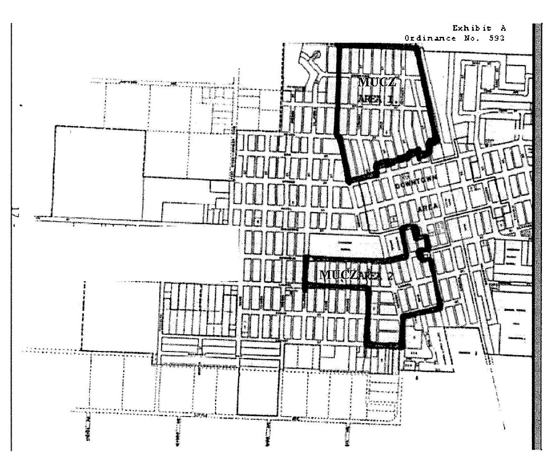
17.52.090 MUCZ Area 1.
Density Permitted: | 6 dwellings per acre average |
Boundaries of Area: (See attached Map) | North: North boundary of Orange Street |
South: North of Spruce Street, per map | |
East: East boundary of railroad right-of-way | |
West: West boundary of Indiana Street | |
Gross acreage of area: | 49 (34.55 developable; 14.5 in streets, alleys, etc.) |
# Dwellings permitted: | 294 (6 units per 49 acres) |
# Permitted/Net Acre: | 8.5 (294 divided by 34.5 acres) |
A. MUCZ Area 1 by Assessor's Parcel Number:
AP# | Address | Area | Zone |
AP# | Address | Area | Zone | |
009-012-002 | 1195 | Vermont Street | 0.20 | MUCZ1-R1 |
009-012-003 | 1185 | Vermont Street | 0.15 | MUCZ1-R1 |
009-012-008 | 1110 | Bridgeford Avenue | 0.157 | MUCZ1-R1 |
009-012-008 | 1140 | Bridgeford Avenue | MUCZ1-R1 | |
009-012-009 | 1137 | Vermont Street | 0.146 | MUCZ1-R1 |
009-012-010 | 1125 | Vermont Street | 0.168 | MUCZ1-R1 |
009-012-010 | 1125.5 | Vermont Street | MUCZ1-R1 | |
009-012-014 | 1166 | Indiana Street | 0.157 | MUCZ1-R1 |
009-012-015 | 1190 | Indiana Street | 0.157 | MUCZ1-R1 |
009-012-016 | 1182 | Indiana Street | 0.157 | MUCZ1-R1 |
009-012-018 | 1150 | Indiana Street | 0.157 | MUCZ1-R1 |
009-012-019 | 1120 | Indiana Street | 0.315 | MUCZ1-R1 |
009-012-019 | 1182 | Bridgeford Avenue | MUCZ1-R1 | |
009-012-019 | 1184 | Bridgeford Avenue | MUCZ1-R1 | |
009-012-020 | 1142 | Indiana Street | 0.157 | MUCZ1-R1 |
009-012-020 | 1142.5 | Indiana Street | MUCZ1-R1 | |
009-012-021 | 1155 | Vermont Street | 0.157 | MUCZ1-R1 |
009-012-022 | 1175 | Vermont Street | 0.146 | MUCZ1-R1 |
009-013-002 | 1195 | Ohio Street | 0.157 | MUCZ1-R1 |
009-013-003 | 1185 | Ohio Street | 0.157 | MUCZ1-R1 |
009-013-004 | 1175 | Ohio Street | 0.157 | MUCZ1-R1 |
009-013-009 | 1190 | Vermont Street | 0.315 | MUCZ1-R1 |
009-013-011 | 1150 | Vermont Street | 0.32 | MUCZ1-R1 |
009-013-012 | 1155 | Ohio Street | 0.157 | MUCZ1-R1 |
009-013-013 | 1135 | Ohio Street | 0.157 | MUCZ1-R1 |
009-013-014 | 1121 | Ohio Street | 0.157 | MUCZ1-R1 |
009-013-015 | 1010 | Bridgeford Avenue | 0.157 | MUCZ1-R1 |
009-013-016 | 1140 | Vermont Street | 0.157 | MUCZ1-R1 |
009-013-017 | 1060 | Bridgeford Avenue | 0.315 | MUCZ1-R1 |
009-021-002 | 1191 | Kentucky Street | 0.140 | MUCZ1-R1 |
009-021-003 | 1181 | Kentucky Street | 0.140 | MUCZ1-R1 |
009-021-004 | 1165 | Kentucky Street | 0.140 | MUCZ1-R1 |
009-021-005 | 1155 | Kentucky Street | 0.140 | MUCZ1-R1 |
009-021-005 | 1157 | Kentucky Street | MUCZ1-R1 | |
009-021-006 | 1141 | Kentucky Street | 0.140 | MUCZ1-R1 |
009-021-006 | 1139 | Kentucky Street | MUCZ1-R1 | |
009-021-007 | 1121 | Kentucky Street | 0.140 | MUCZ1-R1 |
009-021-008 | 900 | Bridgeford Avenue | 0.140 | MUCZ1-R1 |
009-021-012 | 1180 | Ohio Street | 0.135 | MUCZ1-R1 |
009-021-013 | 1190 | Ohio Street | 0.135 | MUCZ1-R1 |
009-021-014 | 1130 | Ohio Street | 0.12 | MUCZ1-R1 |
009-021-015 | 1120 | Ohio Street | 0.31 | MUCZ1-R1 |
009-021-015 | 1120.5 | Ohio Street | MUCZ1-R1 | |
009-021-015 | 960 | Bridgeford Avenue | MUCZ1-R1 | |
009-021-015 | 970 | Bridgeford Avenue | MUCZ1-R1 | |
009-021-015 | 980 | Bridgeford Avenue | MUCZ1-R1 | |
009-021-016 | 1176 | Ohio Street | 0.135 | MUCZ1-R1 |
009-021-017 | 1130 | Ohio Street | 0.11 | MUCZ1-R1 |
009-022-002 | 1150 | Kentucky Street | 0.26 | MUCZ1-R1 |
009-022-004 | 890 | Bridgeford Avenue | 0.074 | MUCZ1-R1 |
009-022-007 | 1194 | Kentucky Street | 0.20 | MUCZ1-R1 |
009-022-008 | 1160 | Kentucky Street | 0.24 | MUCZ1-R1 |
009-022-009 | 1180 | Kentucky Street | 0.22 | MUCZ1-R1 |
009-022-011 | 1140 | Kentucky Street | 0.28 | MUCZ1-R1 |
009-022-011 | 1140.5 | Kentucky Street | MUCZ1-R1 | |
009-022-012 | 1120 | Kentucky Street | 0.30 | MUCZ1-R1 |
009-022-012 | 798 | Bridgeford Avenue | MUCZ1-R1 | |
009-022-013 | 786 A-D | Bridgeford Avenue | 0.23 | MUCZ1-R1 |
009-032-002 | 1095 | Vermont Street | 0.157 | MUCZ1-R1 |
009-032-003 | 1083 | Vermont Street | 0.157 | MUCZ1-R1 |
009-032-003 | 1083.5 | Vermont Street | MUCZ1-R1 | |
009-032-009 | 1162 | Pecan Street | 0.130 | MUCZ1-R1 |
009-032-010 | 1194 | Pecan Street | 0.092 | MUCZ1-R1 |
009-032-011 | 1020 | Indiana Street | 0.092 | MUCZ1-R1 |
009-032-012 | 1040 | Indiana Street | 0.157 | MUCZ1-R1 |
009-032-013 | 1058 | Indiana Street | 0.157 | MUCZ1-R1 |
009-032-014 | 1066 | Indiana Street | 0.157 | MUCZ1-R1 |
009-032-017 | 1160 | Pecan Street | 0.096 | MUCZ1-R1 |
009-032-018 | 1015 | Vermont Street | 0.057 | MUCZ1-R1 |
009-032-019 | 1055 | Vermont Street | 0.315 | MUCZ1-R1 |
009-032-019 | 1059 | Vermont Street | MUCZ1-R1 | |
009-032-022 | 1185 | Bridgeford Avenue | 0.135 | MUCZ1-R1 |
009-032-023 | 1080 | Indiana Street | 0.18 | MUCZ1-R1 |
009-032-025 | 1035 | Vermont Street | 0.157 | MUCZ1-R1 |
009-032-026 | 1017 | Vermont Street | 0.157 | MUCZ1-R1 |
009-033-001 | 1090 | Vermont Street | 0.157 | MUCZ1-R1 |
009-033-001 | 1094 | Vermont Street | MUCZ1-R1 | |
009-033-001 | 1095 | Bridgeford Avenue | MUCZ1-R1 | |
009-033-002 | 1091 | Ohio Street | 0.157 | MUCZ1-R1 |
009-033-003 | 1083 | Ohio Street | 0.157 | MUCZ1-R1 |
009-033-004 | 1079 | Ohio Street | 0.157 | MUCZ1-R1 |
009-033-005 | 1055 | Ohio Street | 0.157 | MUCZ1-R1 |
009-033-006 | 1035 | Ohio Street | 0.157 | MUCZ1-R1 |
009-033-007 | 1025 | Ohio Street | 0.157 | MUCZ1-R1 |
009-033-008 | 1005 | Ohio Street | 0.157 | MUCZ1-R1 |
009-033-009 | 1010 | Vermont Street | 0.157 | MUCZ1-R1 |
009-033-010 | 1018 | Vermont Street | 0.157 | MUCZ1-R1 |
009-033-011 | 1042 | Vermont Street | 0.157 | MUCZ1-R1 |
009-033-012 | 1050 | Vermont Street | 0.157 | MUCZ1-R1 |
009-033-013 | 1070 | Vermont Street | 0.157 | MUCZ1-R1 |
009-033-014 | 1082 | Vermont Street | 0.157 | MUCZ1-R1 |
009-033-014 | 1082.5 | Vermont Street | MUCZ1-R1 | |
009-041-003 | 1075 | Kentucky Street | 0.140 | MUCZ1-R1 |
009-041-004 | 1025 | Kentucky Street | 0.140 | MUCZ1-R1 |
009-041-005 | 1021 | Kentucky Street | 0.140 | MUCZ1-R1 |
009-041-006 | 1015 | Kentucky Street | 0.140 | MUCZ1-R1 |
009-041-007 | 1005 | Kentucky Street | 0.140 | MUCZ1-R1 |
009-041-008 | 1010 | Ohio Street | 0.135 | MUCZ1-R1 |
009-041-009 | 1024 | Ohio Street | 0.135 | MUCZ1-R1 |
009-041-010 | 1030 | Ohio Street | 0.135 | MUCZ1-R1 |
009-041-010 | 1030.5 | Ohio Street | MUCZ1-R1 | |
009-041-011 | 1084 | Ohio Street | 0.135 | MUCZ1-R1 |
009-041-013 | 1050 | Ohio Street | 0.135 | MUCZ1-R1 |
009-041-014 | 1070 | Ohio Street | 0.126 | MUCZ1-R1 |
009-041-015 | 1080 | Ohio Street | 0.144 | MUCZ1-R1 |
009-041-016 | 1095 | Kentucky Street | 0.140 | MUCZ1-R1 |
009-041-017 | 1085 | Kentucky Street | 0.140 | MUCZ1-R1 |
009-042-001 | 1086 | Kentucky Street | 0.10 | MUCZ1-R1 |
009-042-003 | 1075 | Virginia Street | 0.16 | MUCZ1-R1 |
009-042-004 | 1034 | Kentucky Street | 0.08 | MUCZ1-R1 |
009-042-005 | 1020 | Kentucky Street | 0.09 | MUCZ1-R1 |
009-042-006 | 1025 | Virginia Street | 0.21 | MUCZ1-R1 |
009-042-008 | 1060 | Kentucky Street | 0.14 | MUCZ1-R1 |
009-042-009 | 1070 | Kentucky Street | 0.12 | MUCZ1-R1 |
009-042-010 | 890 | Pecan Street | 0.11 | MUCZ1-R1 |
009-042-011 | 880 | Pecan Street | 0.09 | MUCZ1-R1 |
009-043-002 | 1066 | Virginia Street | 0.18 | MUCZ1-R1 |
009-043-003 | 1046 | Virginia Street | 0.18 | MUCZ1-R1 |
009-043-004 | 1014 | Virginia Street | 0.18 | MUCZ1-R1 |
009-043-005 | 701 | Bridgeford Avenue | 0.18 | MUCZ1-R1 |
009-043-006 | 1090 | Virginia Street | 0.18 | MUCZ1-R1 |
009-043-007 | 1080 | Virginia Street | 0.18 | MUCZ1-R1 |
009-043-008 | 1070 | Virginia Street | 0.18 | MUCZ1-R1 |
009-062-001 | 980 | Indiana Street | 0.316 | MUCZ1-R1 |
009-062-002 | 991 | Vermont Street | 0.157 | MUCZ1-R1 |
009-062-003 | 985 | Vermont Street | 0.157 | MUCZ1-R1 |
009-062-004 | 977 | Vermont Street | 0.157 | MUCZ1-R1 |
009-062-005 | 967 | Vermont Street | 0.146 | MUCZ1-R1 |
009-062-006 | 941 | Vermont Street | 0.17 | MUCZ1-R1 |
009-062-007 | 935 | Vermont Street | 0.157 | MUCZ1-R1 |
009-062-008 | 1150 | Peach Street | 0.157 | MUCZ1-R1 |
006-062-009 | 1194 | Peach Street | 0.157 | MUCZ1-R1 |
009-062-010 | 908 | Indiana Street | 0.157 | MUCZ1-R1 |
009-062-011 | 910 | Indiana Street | 0.157 | MUCZ1-R1 |
009-062-012 | 944 | Indiana Street | 0.157 | MUCZ1-R1 |
009-062-012 | 946 | Indiana Street | MUCZ1-R1 | |
009-062-013 | 970 A-D | Indiana Street | 0.157 | MUCZ1-R1 |
009-071-001 | 1095 | Pecan Street | 0.157 | MUCZ1-R1 |
009-071-001 | 1097 | Pecan Street | MUCZ1-R1 | |
009-071-002 | 999 | Ohio Street | 0.157 | MUCZ1-R1 |
009-071-003 | 945 | Ohio Street | 0.157 | MUCZ1-R1 |
009-071-004 | 943 | Ohio Street | 0.157 | MUCZ1-R1 |
009-071-005 | 941 | Ohio Street | 0.157 | MUCZ1-R1 |
009-071-006 | 935 | Ohio Street | 0.157 | MUCZ1-R1 |
009-071-010 | 910 | Vermont Street | 0.157 | MUCZ1-R1 |
009-071-011 | 920 | Vermont Street | 0.157 | MUCZ1-R1 |
009-071-012 | 940 | Vermont Street | 0.157 | MUCZ1-R1 |
009-071-013 | 954 | Vermont Street | 0.157 | MUCZ1-R1 |
009-071-015 | 986 | Vermont Street | 0.157 | MUCZ1-R1 |
009-071-016 | 964 | Vermont Street | 0.157 | MUCZ1-R1 |
009-071-019 | 1040 | Peach Street | 0.157 | MUCZ1-R1 |
009-071-020 | 901 | Ohio Street | 0.157 | MUCZ1-R1 |
009-072-001 | 970 | Ohio Street | 0.086 | MUCZ1-R1 |
009-072-002 | 961 | Pecan Street | 0.049 | MUCZ1-R1 |
009-072-004 | 945 | Kentucky Street | 0.140 | MUCZ1-R1 |
009-072-005 | 931 | Kentucky Street | 0.140 | MUCZ1-R1 |
009-072-009 | 885 + | Kentucky Street | 0.06 | MUCZ1-R1 |
009-072-010 | 920 | Ohio Street | 0.30 | MUCZ1-R1 |
009-072-011 | 932 | Ohio Street | 0.135 | MUCZ1-R1 |
009-072-012 | 942 | Ohio Street | 0.135 | MUCZ1-R1 |
009-072-015 | 960 | Ohio Street | 0.135 | MUCZ1-R1 |
009-072-019 | 903 | Kentucky Street | 0.19 | MUCZ1-R1 |
009-072-020 | 991 | Kentucky Street | 0.140 | MUCZ1-R1 |
009-072-021 | 975 | Kentucky Street | 0.140 | MUCZ1-R1 |
009-072-022 | 948 | Ohio Street | 0.135 | MUCZ1-R1 |
009-072-023 | 895 | Kentucky Street | 0.145 | MUCZ1-R1 |
009-072-024 | 905 | Kentucky Street | 0.15 | MUCZ1-R1 |
009-072-024 | 905.5 | Kentucky Street | MUCZ1-R1 | |
009-081-001 | 990 | Kentucky Street | 0.14 | MUCZ1-R1 |
009-081-006 | 927.5 | Virginia Street | MUCZ1-R1 | |
009-081-006 | 927 | Virginia Street | 0.11 | MUCZ1-R1 |
009-081-007 | 925 | Virginia Street | 0.088 | MUCZ1-R1 |
009-081-008 | 917 | Virginia Street | 0.202 | MUCZ1-R1 |
009-081-009 | 851 | Virginia Street | 0.17 | MUCZ1-R1 |
009-081-010 | 870 A-C | Kentucky Street | 0.17 | MUCZ1-R1 |
009-081-011 | 890 | Kentucky Street | 0.17 | MUCZ1-R1 |
009-081-011 | 890.5 | Kentucky Street | MUCZ1-R1 | |
009-081-012 | 898 | Kentucky Street | 0.07 | MUCZ1-R1 |
009-081-013 | 902 | Kentucky Street | 0.14 | MUCZ1-R1 |
009-081-013 | 902.5 | Kentucky Street | MUCZ1-R1 | |
009-081-014 | 918 | Kentucky Street | 0.15 | MUCZ1-R1 |
009-081-015 | 924 | Kentucky Street | 0.140 | MUCZ1-R1 |
009-081-016 | 980 | Kentucky Street | 0.140 | MUCZ1-R1 |
009-081-016 | 980.5 | Kentucky Street | MUCZ1-R1 | |
009-081-017 | 943 | Virginia Street | 0.13 | MUCZ1-R1 |
009-081-019 | 961 | Virginia Street | 0.10 | MUCZ1-R1 |
009-071-020 | 955 | Virginia Street | 0.13 | MUCZ1-R1 |
009-081-021 | 957 | Virginia Street | 0.08 | MUCZ1-R1 |
009-082-001 | 960 | Virginia Street | 0.18 | MUCZ1-R1 |
009-082-002 | 950 | Virginia Street | 0.18 | MUCZ1-R1 |
009-082-003 | 944 | Virginia Street | 0.18 | MUCZ1-R1 |
009-082-004 | 928 | Virginia Street | 0.30 | MUCZ1-R1 |
009-082-005 | 918 | Virginia Street | 0.21 | MUCZ1-R1 |
009-082-006 | 850 | Virginia Street | 0.35 | MUCZ1-R1 |
009-111-001 | 896 | Indiana Street | 0.12 | MUCZ1-R1 |
009-111-003 | 831 | Vermont Street | 0.101 | MUCZ1-R1 |
009-111-004 | 821 | Vermont Street | 0.101 | MUCZ1-R1 |
009-111-005 | 777 | Vermont Street | 0.202 | MUCZ1-R1 |
009-111-006 | 775 | Vermont Street | 0.113 | MUCZ1-R1 |
009-111-007 | 755 | Vermont Street | 0.120 | MUCZ1-R1 |
009-111-008 | 715 | Vermont Street | 0.180 | MUCZ1-R1 |
009-111-008 | 735 | Vermont Street | MUCZ1-R1 | |
009-111-008 | 725 | Vermont Street | MUCZ1-R1 | |
009-111-008 | 745 | Vermont Street | MUCZ1-R1 | |
009-111-009 | 705 | Vermont Street | 0.170 | MUCZ1-R1 |
009-111-010 | 1160 | Spruce Street | 0.10 | MUCZ1-R1 |
009-111-011 | 1180 | Spruce Street | 0.10 | MUCZ1-R1 |
009-111-015 | 804 | Indiana Street | 0.21 | MUCZ1-R1 |
009-111-016 | 842 | Indiana Street | 0.14 | MUCZ1-R1 |
009-111-017 | 864 | Indiana Street | 0.14 | MUCZ1-R1 |
009-111-018 | 728.5 | Indiana Street | 0.390 | MUCZ1-R1 |
009-111-018 | 730 | Indiana Street | MUCZ1-R1 | |
009-111-018 | 760 A-C | Indiana Street | MUCZ1-R1 | |
009-111-019 | 895 | Vermont Street | 0.21 | MUCZ1-R1 |
009-111-020 | 851 | Vermont Street | 0.202 | MUCZ1-R1 |
009-111-021 | 780 | Indiana Street | 0.21 | MUCZ1-R1 |
009-111-022 | 778 | Indiana Street | 0.101 | MUCZ1-R1 |
009-112-002 | 1041 | Peach Street | 0.14 | MUCZ1-R1 |
009-112-003 | 795 | Ohio Street | 0.12 | MUCZ1-R1 |
009-112-004 | 785 | Ohio Street | 0.151 | MUCZ1-R1 |
009-112-005 | 777 | Ohio Street | 0.210 | MUCZ1-R1 |
009-112-006 | 749 | Ohio Street | 0.110 | MUCZ1-R1 |
009-112-007 | 745 | Ohio Street | 0.110 | MUCZ1-R1 |
009-112-008 | 715 | Ohio Street | 0.110 | MUCZ1-R1 |
009-112-013 | 826 | Vermont Street | 0.110 | MUCZ1-R1 |
009-112-014 | 870 + A | Vermont Street | 0.28 | MUCZ1-R1 |
009-112-015 | 830 | Vermont Street | 0.101 | MUCZ1-R1 |
009-112-018 | 740 | Vermont Street | 0.247 | MUCZ1-R1 |
009-112-019 | 750 A-C | Vermont Street | 0.150 | MUCZ1-R1 |
009-112-020 | 730 | Vermont Street | 0.138 | MUCZ1-R1 |
009-112-021 | 1078 | Spruce Street | 0.260 | MUCZ1-R1 |
009-121-001 | 790 | Ohio Street | 0.12 | MUCZ1-R1 |
009-121-002 | 965 | Peach Street | 0.11 | MUCZ1-R1 |
009-121-003 | 885 | Kentucky Street | 0.19 | MUCZ1-R1 |
009-121-004 | 865 | Kentucky Street | 0.176 | MUCZ1-R1 |
009-121-005 | 855 | Kentucky Street | 0.227 | MUCZ1-R1 |
009-121-006 | 705 | Kentucky Street | 0.130 | MUCZ1-R1 |
009-121-007 | 940 + | Spruce Street | 0.018 | MUCZ1-R1 |
009-121-012 | 754 | Ohio Street | 0.180 | MUCZ1-R1 |
009-121-013 | 758.1-4 | Ohio Street | 0.110 | MUCZ1-R1 |
009-121-013 | 758.5 | Ohio Street | MUCZ1-R1 | |
009-121-014 | 762 | Ohio Street | 0.110 | MUCZ1-R1 |
009-121-017 | 764 | Ohio Street | 0.270 | MUCZ1-R1 |
009-121-017 | 768 | Ohio Street | MUCZ1-R1 | |
009-121-017 | 772 | Ohio Street | MUCZ1-R1 | |
009-121-017 | 776 | Ohio Street | MUCZ1-R1 | |
009-121-017 | 774 | Ohio Street | MUCZ1-R1 | |
009-121-017 | 766 | Ohio Street | MUCZ1-R1 | |
009-121-017 | 770 | Ohio Street | MUCZ1-R1 | |
009-121-017 | 778 | Ohio Street | MUCZ1-R1 | |
009-122-001 | 860 | Kentucky Street | 0.108 | MUCZ1-R1 |
009-122-006 | 850 | Kentucky Street | 0.210 | MUCZ1-R1 |
009-122-007 | 856 | Kentucky Street | 0.106 | MUCZ1-R1 |
009-122-008 | 765 | Virginia Street | 0.25 | MUCZ1-R1 |
009-122-009 | 745 | Virginia Street | 0.12 | MUCZ1-R1 |
(Ord. 823-2016 § 17 (part), 2016)
17.52.100 MUCZ Area 2.
Density Permitted: | 4 dwellings per acre average. |
Boundaries of Area: | All of the properties south and east of Sycamore School which are included within the area identified as "Area 2" on the attached map. |
Gross Acreage of Area: | 39.55 acres (20.71 developable; 18.84 streets, alleys, railroad ROW) |
# Dwellings Permitted: | 158 (4 X 39.55 acres) |
# Permitted/Net Acre: | 7.63 (158 units divided by 20.71 acres) |
A. MUCZ Area 2 by Assessor's Parcel Number:
AP# | Address | Area | Zone |
AP# | Address | Area | Zone | |
010-034-001 | 1487 | Magnolia Street | 0.149 | MUCZ2-R1 |
010-034-002 | 1467 | Magnolia Street | 0.149 | MUCZ2-R1 |
010-034-003 | 1435 | Magnolia Street | 0.149 | MUCZ2-R1 |
010-034-003 | 1445 | Magnolia Street | MUCZ2-R1 | |
010-034-004 | 379 | Maine Street | 0.149 | MUCZ2-R1 |
010-034-006 | 325 | Maine Street | 0.149 | MUCZ2-R1 |
010-034-007 | 1436 | Laurel Street | 0.149 | MUCZ2-R1 |
010-034-007 | 1446 | Laurel Street | MUCZ2-R1 | |
010-034-009 | 340 | California Street | 0.149 | MUCZ2-R1 |
010-034-010 | 350 | California Street | 0.149 | MUCZ2-R1 |
010-034-011 | 335 A-D | Maine Street | 0.149 | MUCZ2-R1 |
010-034-012 | 355 A-D | Maine Street | 0.149 | MUCZ2-R1 |
010-034-013 | 1460 | Laurel Street | 0.09 | MUCZ2-R1 |
010-034-014 | 320 | California Street | 0.106 | MUCZ2-R1 |
010-034-015 | 310 | California Street | 0.107 | MUCZ2-R1 |
010-035-001 | 1387 | Magnolia Street | 0.149 | MUCZ2-R1 |
010-035-002 | 1369 | Magnolia Street | 0.149 | MUCZ2-R1 |
010-035-002 | 1365 | Magnolia Street | MUCZ2-R1 | |
010-035-004 | 375 | Indiana Street | 0.149 | MUCZ2-R1 |
010-035-005 | 357 | Indiana Street | 0.149 | MUCZ2-R1 |
010-035-006 | 347 | Indiana Street | 0.149 | MUCZ2-R1 |
010-035-007 | 325 | Indiana Street | 0.149 | MUCZ2-R1 |
010-035-008 | 1336 | Laurel Street | 0.149 | MUCZ2-R1 |
010-035-009 | 308 | Maine Street | 0.15 | MUCZ2-R1 |
010-035-010 | 320 | Maine Street | 0.149 | MUCZ2-R1 |
010-035-011 | 376 | Maine Street | 0.149 | MUCZ2-R1 |
010-035-012 | 378 | Maine Street | 0.149 | MUCZ2-R1 |
010-035-015 | 1345 | Magnolia Street | 0.149 | MUCZ2-R1 |
010-042-003 | 1245 | Magnolia Street | 0.08 | MUCZ2-R1 |
010-042-004 | 391 | Park Street | 0.08 | MUCZ2-R1 |
010-042-005 | 369 | Park Street | 0.16 | MUCZ2-R1 |
010-042-006 | 355 | Park Street | 0.149 | MUCZ2-R1 |
010-042-007 | 339 | Park Street | 0.149 | MUCZ2-R1 |
010-042-008 | 335 | Park Street | 0.149 | MUCZ2-R1 |
010-042-009 | 317 | Park Street | 0.149 | MUCZ2-R1 |
010-042-015 | 1250 | Laurel Street | 0.149 | MUCZ2-R1 |
010-042-016 | 300 | Indiana Street | 0.149 | MUCZ2-R1 |
010-042-017 | 360 | Indiana Street | MUCZ2-R1 | |
010-042-017 | 1253 | Magnolia Street | 0.61 | MUCZ2-R1 |
010-043-001 | 1173 | Magnolia Street | 0.149 | MUCZ2-R1 |
010-043-004 | 355 | Vermont Street | 0.14 | MUCZ2-R1 |
010-043-004 | 357 | Vermont Street | MUCZ2-R1 | |
010-043-006 | 310 | Park Street | 0.17 | MUCZ2-R1 |
010-043-007 | 334 | Park Street | 0.15 | MUCZ2-R1 |
010-043-008 | 336 | Park Street | 0.149 | MUCZ2-R1 |
010-043-008 | 344 | Park Street | MUCZ2-R1 | |
010-043-008 | 346 | Park Street | MUCZ2-R1 | |
010-043-009 | 358 | Park Street | 0.149 | MUCZ2-R1 |
010-043-009 | 362 | Park Street | MUCZ2-R1 | |
010-043-009 | 360 | Park Street | MUCZ2-R1 | |
010-043-010 | 392 | Park Street | 0.149 | MUCZ2-R1 |
010-043-011 | 1115 | Magnolia Street | 0.24 | MUCZ2-R1 |
010-043-013 | 365 | Vermont Street | 0.18 | MUCZ2-R1 |
010-043-014 | 345 | Vermont Street | 0.19 | MUCZ2-R1 |
010-043-014 | 345.5 | Vermont Street | MUCZ2-R1 | |
010-043-015 | 1140 | Laurel Street | 0.21 | MUCZ2-R1 |
010-052-001 | 482 + | Sycamore Street | 0.21 | MUCZ2-R1 |
010-052-004 | 443 | Kentucky Street | 0.31 | MUCZ2-R1 |
010-052-004 | 441 | Kentucky Street | MUCZ2-R1 | |
010-052-005 | 946 | Magnolia Street | 0.08 | MUCZ2-R1 |
010-052-008 | 472 | Ohio Street | 0.16 | MUCZ2-R1 |
010-052-008 | 480 | Ohio Street | MUCZ2-R1 | |
010-052-008 | 482 | Ohio Street | MUCZ2-R1 | |
010-052-010 | 464 | Ohio Street | 0.17 | MUCZ2-R1 |
010-052-010 | 466 | Ohio Street | MUCZ2-R1 | |
010-052-010 | 468 | Ohio Street | MUCZ2-R1 | |
010-052-010 | 464.5 | Ohio Street | MUCZ2-R1 | |
010-052-010 | 468.5 | Ohio Street | MUCZ2-R1 | |
010-052-011 | 406 | Ohio Street | 0.16 | MUCZ2-R1 |
010-052-011 | 430 | Ohio Street | 0.145 | MUCZ2-R1 |
010-061-001 | 380 | Vermont Street | 0.31 | MUCZ2-R1 |
010-061-001 | 1095 | Magnolia Street | MUCZ2-R1 | |
010-061-002 | 381 | Ohio Street | 0.21 | MUCZ2-R1 |
010-061-002 | 1017 | Magnolia Street | MUCZ2-R1 | |
010-061-002 | 383 | Ohio Street | MUCZ2-R1 | |
010-061-003 | 379 | Ohio Street | 0.21 | MUCZ2-R1 |
010-061-004 | 329 | Ohio Street | 0.21 | MUCZ2-R1 |
010-061-005 | 1040 | Laurel Street | 0.21 | MUCZ2-R1 |
010-061-006 | 320 | Vermont Street | 0.11 | MUCZ2-R1 |
010-061-007 | 330 | Vermont Street | 0.126 | MUCZ2-R1 |
010-061-008 | 340 | Vermont Street | 0.176 | MUCZ2-R1 |
010-061-009 | 360 | Vermont Street | 0.11 | MUCZ2-R1 |
010-062-001 | 989 | Magnolia Street | 0.21 | MUCZ2-R1 |
010-062-004 | 345 | Kentucky Street | 0.11 | MUCZ2-R1 |
010-062-005 | 335 | Kentucky Street | 0.11 | MUCZ2-R1 |
010-062-008 | 940 | Laurel Street | 0.11 | MUCZ2-R1 |
010-062-009 | 332 | Ohio Street | 0.16 | MUCZ2-R1 |
010-062-009 | 354 | Ohio Street | 0.16 | MUCZ2-R1 |
010-062-009 | 356 | Ohio Street | MUCZ2-R1 | |
010-062-009 | 358 | Ohio Street | MUCZ2-R1 | |
010-062-010 | 920 | Laurel Street | 0.11 | MUCZ2-R1 |
010-062-011 | 359 | Kentucky Street | 0.21 | MUCZ2-R1 |
010-062-013 | 322 | Ohio Street | 0.11 | MUCZ2-R1 |
010-062-015 | 300 | Ohio Street | 0.21 | MUCZ2-R1 |
010-062-015 | 300.5 | Ohio Street | MUCZ2-R1 | |
010-111-001 | 1181 | Laurel Street | 0.149 | MUCZ2-R1 |
010-111-002 | 1151 | Laurel Street | 0.149 | MUCZ2-R1 |
010-111-003 | 1149 | Laurel Street | 0.22 | MUCZ2-R1 |
010-111-004 | 1147 | Laurel Street | 0.22 | MUCZ2-R1 |
010-111-005 | 1109 | Laurel Street | 0.21 | MUCZ2-R1 |
010-111-005 | 1111 | Laurel Street | MUCZ2-R1 | |
010-111-006 | 251 | Vermont Street | 0.07 | MUCZ2-R1 |
010-111-006 | 255 | Vermont Street | MUCZ2-R1 | |
010-111-007 | 245 | Vermont Street | 0.23 | MUCZ2-R1 |
010-111-008 | 221 | Vermont Street | 0.16 | MUCZ2-R1 |
010-111-008 | 219 | Vermont Street | MUCZ2-R1 | |
010-111-009 | 1110 | Cedar Street | 0.066 | MUCZ2-R1 |
010-111-010 | 1120 | Cedar Street | 0.229 | MUCZ2-R1 |
010-111-011 | 1130 | Cedar Street | 0.229 | MUCZ2-R1 |
010-111-016 | 260 | Park Street | 0.17 | MUCZ2-R1 |
010-111-019 | 210 | Park Street | 0.44 | MUCZ2-R1 |
010-112-001 | 1175 | Cedar Street | 0.149 | MUCZ2-R1 |
010-112-002 | 1145 | Cedar Street | 0.229 | MUCZ2-R1 |
010-112-003 | 1141 | Cedar Street | 0.229 | MUCZ2-R1 |
010-112-004 | 1125 | Cedar Street | 0.229 | MUCZ2-R1 |
010-112-005 | 1115 | Cedar Street | 0.229 | MUCZ2-R1 |
010-112-006 | 195 | Vermont Street | 0.19 | MUCZ2-R1 |
010-112-007 | 129 | Vermont Street | 0.06 | MUCZ2-R1 |
010-112-008 | 1102 | Locust Street | 0.19 | MUCZ2-R1 |
010-112-009 | 1120 | Locust Street | 0.229 | MUCZ2-R1 |
010-112-010 | 1130 | Locust Street | 0.229 | MUCZ2-R1 |
010-112-011 | 1140 | Locust Street | 0.229 | MUCZ2-R1 |
010-112-012 | 1150 | Locust Street | 0.229 | MUCZ2-R1 |
010-112-012 | 1152 | Locust Street | MUCZ2-R1 | |
010-112-013 | 110 | Park Street | 0.13 | MUCZ2-R1 |
010-112-014 | 124 | Park Street | 0.176 | MUCZ2-R1 |
010-112-015 | 138 | Park Street | 0.149 | MUCZ2-R1 |
010-112-016 | 160 | Park Street | 0.149 | MUCZ2-R1 |
010-112-017 | 170 | Park Street | 0.149 | MUCZ2-R1 |
010-112-017 | 172 | Park Street | MUCZ2-R1 | |
010-121-002 | 283 | Ohio Street | 0.21 | MUCZ2-R1 |
010-121-004 | 221 | Ohio Street | 0.21 | MUCZ2-R1 |
010-121-004 | 227 | Ohio Street | MUCZ2-R1 | |
010-121-005 | 220 | Vermont Street | 0.21 | MUCZ2-R1 |
010-121-006 | 240 | Vermont Street | 0.21 | MUCZ2-R1 |
010-121-007 | 245 | Ohio Street | 0.21 | MUCZ2-R1 |
010-121-008 | 271 | Ohio Street | 0.21 | MUCZ2-R1 |
010-121-009 | 1053 | Laurel Street | 0.22 | MUCZ2-R1 |
010-121-009 | 1075 | Laurel Street | MUCZ2-R1 | |
010-121-010 | 250 | Vermont Street | 0.20 | MUCZ2-R1 |
010-122-006 | 210 | Ohio Street | 0.09 | MUCZ2-R1 |
010-122-012 | 225 | Kentucky Street | 0.35 | MUCZ2-R1 |
010-122-012 | 233 | Kentucky Street | MUCZ2-R1 | |
010-122-012 | 275 | Kentucky Street | MUCZ2-R1 | |
010-122-012 | 227 | Kentucky Street | MUCZ2-R1 | |
010-122-012 | 277 | Kentucky Street | MUCZ2-R1 | |
010-122-015 | 950 | Cedar Street | 0.05 | MUCZ2-R1 |
010-122-016 | 260 | Ohio Street | 0.378 | MUCZ2-R1 |
010-122-017 | 965 | Laurel Street | 0.159 | MUCZ2-R1 |
010-122-018 | 987 | Laurel Street | 0.15 | MUCZ2-R1 |
010-122-019 | 945 | Laurel Street | 0.128 | MUCZ2-R1 |
010-122-019 | 947 | Laurel Street | MUCZ2-R1 | |
010-122-020 | 943 | Laurel Street | 0.08 | MUCZ2-R1 |
010-122-021 | 205 | Kentucky Street | 0.23 | MUCZ2-R1 |
010-122-021 | 219 | Kentucky Street | MUCZ2-R1 | |
(Ord. 823-2016 § 17 (part), 2016)
17.53.010 Intent.
The purpose of the DMU Downtown Mixed Use District is to enhance the vitality of the Downtown are as shown in Exhibit "A" at the end of this chapter by allowing and encouraging a full range of high-intensity uses, including retail, multifamily housing, offices, entertainment and civic uses. The DMU District regulations specifically implement the following goals from the General Plan:
A. Enhance the Downtown as the predominant activity center and community gathering place for the surrounding areas.
B. Reinforce a compact development pattern in the Downtown core to support commercial uses for the surrounding residential areas.
C. Promote the Downtown's vitality and cultural character to provide uses that support day and night activity, support pedestrian design and linkages to the parks nearby.
D. Support residential and commercial uses together as single story or multi-story in existing or new construction.
E. Encourage mixed use development with a residential component inclusive of multi-family and high density residential.
F. Allowance of a dynamic mixture of uses from retail, arts and entertainment, restaurant, office, community service, and civic.
(Ord. 823-2016 § 18 (part), 2016)
17.53.020 Permitted uses.
Permitted uses consist of the permitted uses in the underlying zone, C-1, and the following without a conditional or administrative use permit:
A. A combination of attached and/or detached dwelling unit(s) in combination with a commercial use. (Minimum density is 10 du/ac).
B. Live/Work units.
C. Residential uses above first floor commercial uses.
D. Parks, playgrounds, play structures, outdoor recreation, skate park, plazas, and similar uses.
E. Child care and preschool.
F. Public/Quasi public administration.
(Ord. 823-2016 § 18 (part), 2016)
17.53.030 Conditional uses.
Conditional uses requiring Planning Commission review and approval:
A. Residential care facility with more than fourteen (14) clients.
B. Wireless communication tower.
C. Other uses or services not listed in the C-1 or Downtown Mixed Use districts.
(Ord. 823-2016 § 18 (part), 2016)
17.53.040 Development standards.
Standards for development shall be as follows:
A. Allowable Building Height: Fifty (50) feet - no restriction for first floor height.
B. Lot Coverage: 100%.
C. Density: Stand-alone residential development 10-30 du/ac. No maximum density if development is vertically mixed with commercial.
D. Parking required: None excepting 1 space per residential unit.
1. May use street parking or shared parking lots. No new parking shall be along the front property line. New parking shall be located to the side or rear of a structure and shall not be located at an intersection.
2. Parking lot lighting shall use the then current City of Gridley lighting.
E. Yard required: None.
F. Streetscape: Trees in planters or parkways - coordinate with City.
G. Street furnishings: Required.
H. Signage: May have the following building signage:
1. Blade signs affixed perpendicular to structure.
2. Building signage up to 25% of the building frontage for the business.
3. Lighting shall be halo, gooseneck or similar.
4. No monument signage allowed.
I. Design standards shall meet or exceed the design standards for lain Design Guidelines. The Planning Department may submit the design for review and approval by the Planning Commission. The architecture of existing structures built from the 1800's (or before) to the 1950's shall be renovated and protected when new development, façade upgrades, or change in use is proposed which would create substantial exterior modifications. Design shall be coordinated with the Planning Department.
J. Loading and unloading zones shall be coordinated with the Planning Department and Public Works to ensure street visibility, blocking, and safety are addressed.
K. All outdoor refuse areas shall provide an enclosure, landscaped and with a roof pursuant to Section 17.72.100.
(Ord. 823-2016 § 18 (part), 2016)
Exhibit A - Downtown Mixed Use Zoning District
17.54.010 Intent.
The purpose of the NMU Neighborhood Mixed Use District is to provide neighborhood service commercial and high density residential in "village" neighborhoods allowing a full range of retail, multi-family housing, offices, medical, entertainment and civic uses. The NMU District regulations specifically implement the following goals from the General Plan:
A. Enhance the NMU district as the predominant activity center and community gathering place for the Planned Growth Area neighborhoods and surrounding areas.
B. Reinforce a compact development pattern in the neighborhood center core to support commercial uses for the surrounding residential areas.
C. Promote the neighbor center vitality and cultural character to provide uses that support day and night activity, support pedestrian design and linkages to the parks nearby.
D. Support residential and commercial uses together as single story or multi-story in existing or new construction.
E. Encourage mixed use development with a residential component inclusive of multi-family and high density residential.
F. Allowance of a dynamic mixture of uses from retail, arts and entertainment, restaurant, office, community service, and civic.
(Ord. 823-2016 § 19 (part), 2016)
17.54.020 Permitted uses.
Permitted uses consist of the permitted uses in the underlying zone and in the C-1 district and the following without a conditional or administrative use permit:
A. A combination of attached and/or detached dwelling unit(s) in combination with a commercial use. (Minimum density is 10 du/ac)
B. Live/Work units.
C. Residential uses above first floor commercial uses.
D. Parks, playgrounds, play structures, outdoor recreation, skate park, plazas, and similar uses.
E. Child care and preschool.
F. Public/Quasi public administration.
(Ord. 823-2016 § 19 (part), 2016)
17.54.030 Conditional uses.
Conditional uses requiring Planning Commission review and approval:
A. Residential care facility with more than fourteen (14) clients.
B. Wireless communication tower.
C. Other uses or services not listed in the C-1 or Neighborhood Mixed Use districts.
(Ord. 823-2016 § 19 (part), 2016)
17.54.040 Development standards.
Standards for development shall be as follows:
A. Allowable Building Height: Forty (40) feet-no restriction for first floor height
B. Lot Coverage: 90%.
C. Density: Stand-alone residential development 10-30 du/ac. No maximum density if development is vertically mixed with commercial.
D. Parking required: None excepting 1 space per residential unit.
1. May use street parking or shared parking lots. Parking shall be located to the side, center, or rear of a structure or development and shall not be located at an intersection.
2. Parking lot lighting shall use the then current City of Gridley lighting.
E. Yard required: Yard pursuant to the requirements for R-3 and R-4.
F. Streetscape: Trees in planters or parkways - coordinate with City.
G. Street furnishings: Required.
H. Signage: May have the following building signage:
1. Blade signs affixed perpendicular to structure.
2. Building signage up to 25% of the building frontage for the business or no greater than 100 square feet.
3. Lighting shall be halo, gooseneck or similar.
4. Monument signage pursuant to Section 17.72.060.
I. Site Development Plan review required.
J. Loading and unloading zones shall be coordinated with the Planning Department and Public Works to ensure street visibility, blocking, and safety are addressed.
K. All outdoor refuse areas shall provide an enclosure, landscaped and with a roof pursuant to Section 17.72.100.
(Ord. 823-2016 § 19 (part), 2016)
17.55.010 Intent.
The purpose of the PD Planned Development District is to permit flexibility in the use and design of land and structures where modifications of specific provisions of this Title will not be contrary to the intent of the General Plan or harmful to areas adjacent to such development.
(Ord. 823-2016 § 20 (part), 2016)
17.55.020 Applicability.
The Planned Development District may be applied as a combining zone to any City zoning designation.
(Ord. 823-2016 § 20 (part), 2016)
17.55.030 Permitted uses.
Permitted uses in any PD zone shall be any use or combination of uses and densities which are so arranged and designed to provide a development which is in conformity with the General Plan. The underlying zoning district shall determine the dominant use of the PD district. Mixing uses under certain circumstances may be permitted.
(Ord. 823-2016 § 20 (part), 2016)
17.55.040 General regulation.
The following regulations shall apply to all PD districts:
A. The land use density and intensity of any PD district shall be consistent with the land use designation with which the PD district is combined. Densities may be increased for mixed residential uses which are consistent with the policies of the general plan. In no case shall densities exceed the maximum numbers of dwelling units allowed by the Gridley General Plan, except as otherwise permitted by State law.
B. Minimum off-street parking requirements shall be in accordance with Chapter 17.76.
C. Sufficient open space shall be required as determined by the Planning Commission/City Council. The amount of required open space shall be based on proposed intensity of land uses, population density, mixture of land uses, amenities provided and other pertinent factors. Open space shall not be construed to include streets, driveways, parking, or covered areas.
(Ord. 823-2016 § 20 (part), 2016)
17.55.050 Applicability - Modification powers.
In accordance with the public hearing procedure set forth in Chapters 17.06 Amendments or Rezoning and 17.08 Conditional Use Permits and regulations applicable only to the project area which differ from the otherwise applicable zoning provisions may be developed and applied. In acting on any such application, the City may alter setback requirements, height limits, sign requirements, building coverage limits, off-street parking regulations and density and intensity limits. The City may further authorize uses not permitted in the principal zoning district; provided, that such uses are desirable or convenient for the users of the project and compatible with other allowable and planned uses. Unless the Planning Commission grants a specific exception, such uses not otherwise permitted in the zoning district shall not occupy more than thirty percent of the planned development area, nor involve the construction of buildings occupying more than fifteen percent of the total floor area of planned structures. Approval of the planned development project may contain conditions or restrictions which the City deems necessary to carry out the purposes of this Title and to protect the public health, safety and welfare.
(Ord. 823-2016 § 20 (part), 2016)
17.55.060 Pre-application review.
Prior to application, the prospective applicant should consult with the planning director to obtain information and guidance before making commitments, or incurring substantial expense in the preparation of plans, surveys and other data.
(Ord. 823-2016 § 20 (part), 2016)
17.55.070 Application and initiation procedure.
A. An application for the establishment of a planned development zone shall include an application and fee as established by resolution by the City Council.
B. Where the planned development project includes the creation of new lots or condominium units, a tentative subdivision map application must be filed in accordance with Title 16.
(Ord. 823-2016 § 20 (part), 2016)
17.55.080 Application.
An application shall contain a site development plan and shall conform to the requirements of Chapter 17.07 and other information which provide the following information:
A. Legal boundaries, dimensions and area of the site, of existing parcels partially or wholly within the site, and of all existing streets, alleys and easements partially or wholly within or adjacent to the site.
B. Elevation, contour lines, slope, trees and other natural features of the site.
C. Existing structures, pavement, curbs, sidewalks, ditches, canals, pipes, poles, wiring, fences, landscaping and other manmade improvements on the site.
D. Boundaries, number, dimensions and area of all proposed lots, rights-of-way, easements, common areas and areas to be dedicated to the City or other public agency.
E. Location, lot coverage, number of stories and intended uses of all proposed buildings and structures.
F. Number, location and size of proposed dwelling units.
G. Location and dimensions of proposed streets, driveways, parking areas, loading areas and walkways.
H. Location and general description of proposed landscaping.
I. Arrangements for ownership, development and maintenance of community-owned areas and facilities, including covenants, conditions and restrictions.
J. Description of any proposed phasing of the project, indicating the sequence and timing of each unit and how each unit would independently constitute reasonable and orderly development of the site.
K. Architectural drawings and elevations of all building types and signs, including materials, colors and roofing.
L. Any additional information requested by the City staff or the Planning Commission.
(Ord. 823-2016 § 20 (part), 2016)
17.55.090 Additional materials - Prior to permit issuance.
Following the City Council approval of the planned development project and prior to the issuance of building permits, additional information may be required by City staff:
A. Proposed facilities and improvements for drainage, water, sewer, power, gas, telephone, cable, waste disposal, fire hydrants, lighting and other utilities.
B. Grading plan for construction.
C. Grades, widths and cross-sectional design of proposed streets, curbs, sidewalks, drainage canals and utility pipes, and plan and profile of road and utility improvements.
(Ord. 823- 2016 § 20 (part), 2016)
17.55.100 Action by Planning Commission.
A. The Planning Commission shall review and provide recommendations to the City Council upon the application as provided in Chapter 17.06 and the regulations set forth in Title 16.
B. The commission shall condition the tentative subdivision or tentative parcel map to become, effective concurrently with the effective date of the rezone approved by the City Council.
(Ord. 823-2016 § 20 (part), 2016)
17.55.110 Action by City Council.
A. The council shall consider the application and draft concept plan, together with the recommendation of the Planning Commission.
B. The council may approve a planned development district if it finds that:
1. The proposed district and the concept plan as recommended by the commission, or as modified by the council, is consistent with the general plan and with the purposes of this Title;
2. The proposed district and all uses therein shall be compatible and complementary to existing and potential development in the general vicinity.
C. An ordinance establishing a PD district, if enacted by the council, shall reference the development plan for the district as approved by the Council.
(Ord. 823-2016 § 20 (part), 2016)
17.55.120 Approval.
A. Approval of a planned development project shall be tied to the approved site development plan and the conditions deemed necessary by the City Council to ensure compliance with the standards and objectives of this Title and the general plan.
B. Where the approved site development plan includes the creation of new lots, approval of a tentative subdivision map pursuant to the provisions of Title 16 shall be accomplished at the same time as the PD rezone is approved.
(Ord. 823-2016 § 20 (part), 2016)
17.55.130 Development.
A. When a specific planned development project has been approved, the site development plan and conditions approved by the City Council shall constitute the regulations for the use, improvement and maintenance of the property within the boundaries of the PD district.
B. Except as provided in this Title, no use, structure or lot shall be created or altered in a PD district.
C. Minor revisions to the approved site development plan may be approved by the Planning Commission as long as such revisions do not increase the density or intensity or significantly modify the location, size or use of any main building.
(Ord. 823-2016 § 20 (part), 2016)
17.55.140 Expiration of planned development district.
A. If the planned development district change is not associated with a tentative subdivision map or tentative parcel map and construction of the project has not commenced within twenty-four months, then the planned development use permit will expire.
B. If any PD district expires, the zoning which existed prior to the adoption of the PD district, or its current equivalent, shall be in full force and effect.
C. A one-year extension may be granted by the City Council prior to the date of expiration.
(Ord. 823-2016 § 20 (part), 2016)
17.56.010 Intent.
The purpose of the AO Agricultural Overlay District is to provide a secondary zoning designation to allow commercial agricultural production to be conducted on properties that are designated on the General Plan and Zoning maps for eventual residential and/or non-residential urban uses, until those urban uses are actually developed. In a rural area characterized by intensive commercial agricultural production, some commercial agricultural uses may be conducted within an urbanizing farm community with minimal adverse impact on adjacent non-agricultural uses.
(Ord. 823-2016 § 21 (part), 2016)
17.56.020 Application of the AO district.
A. The AO district may be applied as a secondary zoning designation to properties on which no habitable structures have been constructed, or to those portions of a partially developed property that do not exceed an average density of two (2) residences per five (5) gross acres.
B. The minimum gross area in an AO district shall be five (5) acres.
(Ord. 823-2016 § 21 (part), 2016)
17.56.030 AO district regulations modify or supersede primary zoning district regulations.
For properties having the secondary AO zoning designation, permitted uses include only those allowed in the AO district. Uses allowed in the primary district may be established upon removal of the AO district pursuant to the zoning amendment procedure described in Chapter 17.06 of this Title.
(Ord. 823-2016 § 21 (part), 2016)
17.56.040 Permitted principal uses.
Permitted principal uses in the agricultural overlay district shall be as follows:
A. Commercial production agriculture, including growing of field crops, orchards, seed crops, and orchard stock.
B. One single-family dwelling unit per lot provided it meets all of the following:
1. A conventional framed, prefabricated, kit, modular or other manufactured structure may be installed; and,
2. It is placed on a foundation system pursuant to Section 18551 of the Health and Safety Code.
(Ord. 823-2016 § 21 (part), 2016)
17.56.050 Accessory uses.
Accessory uses may include any non-residential use that complies with the following criteria:
A. Wholesale and/or retail sales of commodities produced on the site, provided the use is operated as an integral part of the principal use and does not comprise a separate business or activity.
B. Use of structures or equipment for hulling, drying or otherwise processing the commodities produced on the site.
C. It does not occupy more than five percent (5%) of the gross area of the AO district.
(Ord. 823-2016 § 21 (part), 2016)
17.56.060 Conditional uses.
The following uses may be permitted in an agricultural overlay zone upon approval of a use permit:
A. Greenhouses.
B. Keeping of livestock for commercial raising of livestock.
(Ord. 823-2016 § 21 (part), 2016)
17.56.070 Fence requirements.
The general provisions of Chapter 17.72 shall apply. For purposes of fence regulations, the AO district is a non-residential district.
(Ord. 823-2016 § 21 (part), 2016)
17.56.080 Sign requirements.
The general provisions of Chapter 17.72 shall apply.
(Ord. 823-2016 § 21 (part), 2016)
17.56.090 Fee waiver.
There shall be no fee applied to an application for this Agricultural Overlay Zone.
(Ord. 823- 2016 § 21 (part), 2016)
17.58.010 Intent.
The purpose of the special parking combining zones is to permit greater flexibility as described below:
A. Within Special Parking Combining Zone Number 1, to permit a more dense development of small commercial properties, as is traditional in the Downtown Business District.
B. Within Special Parking Combining Zone Number 2, to minimize hardship on lots previously subdivided and developed in a manner that precludes compliance with parking requirements described in Chapter 17.76.
(Ord. 823-2016 § 22 (part), 2016)
17.58.020 Parking requirements for Special Parking Combining Zone Number 1, the central business area parking district.
A. This zone applies to the non-residential zoning districts located west of Haskell Street.
B. There are no on-site parking requirements for non-residential uses within Special Parking Combining Zone Number 1.
C. Parking shall comply with Section 17.53.040 for residential use.
(Ord. 823-2016 § 22 (part), 2016)
17.58.030 Parking requirements for Special Parking Combining Zone Number 2, the Downtown residential area.
A. This zone applies to the area bounded by the following lines:
1. Locust Street on the south.
2. Butte Water District Lateral No. 8 on the north.
3. West Biggs-Gridley Road on the west.
4. State Highway 99 on the east.
B. The requirements of Chapter 17.76 shall apply except:
1. No required parking space for residential uses within this district need be covered by a garage.
2. Tandem parking is permitted.
(Ord. 823-2016 § 22 (part), 2016)
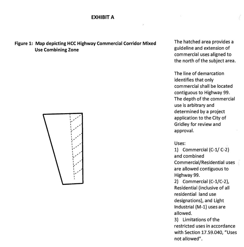
17.59.010 Intent.
A. The purpose of the HCC Highway Commercial Corridor Mixed Use Combining District is to provide service commercial, residential, and light industrial start-up uses allowing a full range of retail, single, duplex, and multi-family housing, offices, and light industrial start-up flex units. The combining zone regulations specifically implement the following General Plan Policies:
1. LAND USE POLICY 6.1 Commercial development through 2030 will be directed to areas along the stretch of Highway 99 in the existing Sphere of Influence, Downtown, and in Neighborhood Centers.
2. LAND USE POLICY 6.2 Larger-scale commercial development and redevelopment will be focused within the existing Sphere of Influence along Highway 99.
3. LAND USE POLICY 6.3 The City will encourage development of vacant parcels and creative reuse of undeveloped properties along Highway 99.
B. Goals to implement the policies include:
1. Reinforce a compact mixed use infill development pattern in the Highway Commercial Corridor.
2. Provide uses that support mixed use development to support linkages to other services nearby.
3. Support residential, commercial, and light industrial uses together as single story or multi-story.
4. Encourage mixed use development with a residential component inclusive of multifamily and high density residential.
5. Allowance of a dynamic mixture of uses from retail, restaurant, office, and light industrial flex start up.
6. Ensure the frontage of the HCC Highway Commercial Corridor Mixed Use Combining Zone is developed with Commercial and/or Commercial-Residential as shown on Figure 1 below.
(Ord. 828-2017 § 1 (part), 2017)
17.59.020 Permitted uses.
Permitted uses consist of the permitted uses in the C-1, C-2, M-1, R-1, R-2, R-3, and R-4 districts without a conditional or administrative use permit except as limited per Section 17.59.040:
A. Live/Work units.
B. Residential uses above first floor commercial uses.
C. Single family attached and/or detached units.
D. Commercial (C-1 and C-2) uses except as limited per Section 17.59.040 below.
E. Light Industrial (M-1) allowed uses per Chapter 17.42, except as limited per Section 17.59.040 below.
(Ord. 828-2017 § 1 (part), 2017)
17.59.030 Conditional uses.
Conditional uses requiring Planning Commission review and approval:
A. Other uses or services not listed in the C-1 or C-2 districts.
(Ord. 828-2017 § 1 (part), 2017)
17.59.040 Uses not allowed.
Uses not allowed within Highway Commercial Corridor Mixed Use Combining Zone:
A. Adult Entertainment.
B. Childcare and preschool.
C. Cocktail lounge, bar, tavern.
D. Dairy.
E. Flea Market (does not include special sales events, fundraisers).
F. Funeral homes.
G. Ice Skating Rink (allowed w/Temporary use Conditional Use Permit during the holiday season).
H. Stand-alone parking lots.
I. Solar Farms (Retail sale of solar equipment or assembly is permitted).
J. Transitional, emergency shelters, and support housing providing housing for individuals or families without time limit for year-round use.
(Ord. 828-2017 § 1 (part), 2017)
17.59.050 Development standards.
Standards for development shall be as follows:
A. Allowable Building Height: Forty (40) feet.
B. Lot Coverage: 80%.
C. Density: Stand-alone residential development 10-30 du/ac. No maximum density if development is vertically mixed with commercial.
D. Parking required: Parking shall be in conformance with Chapter 17.76 for uses.
1. May use shared parking lots with access/ingress/egress agreements. Parking shall be located to the rear of a structure or development as is practicable and shall not be located at an intersection.
2. Parking lot lighting shall use the current City of Gridley lighting standards and comply with the Highway 99 corridor lighting requirements.
E. Yard required: The provisions of Chapter 17.76 shall apply.
F. Streetscape: Trees in planters or parkways - coordinate with City.
G. Street furnishings: Required throughout.
H. Signage: May have the following building signage:
1. Blade signs affixed perpendicular to structure.
2. Building signage up to 25% of the building frontage for the business but no greater than 100 square feet.
3. Lighting shall be LED, gooseneck or similar. Refer to Chapter 17.72 for additional requirements.
4. Monument signage pursuant to Section 17.72.060.
I. Site Development Plan review required.
J. Loading and unloading zones shall be coordinated with the Planning Department and Public Works to ensure street visibility, blocking, and safety are addressed.
K. All outdoor refuse areas shall provide an enclosure, landscaped and with a roof pursuant to Section 17.72.100.
L. Commercial uses only, shall be developed contiguous to Highway 99.
M. Walls separating uses shall be required on a case by case basis. The intent of the mixed use development is to provide a cohesive commercial development. The City shall review each project and determine if walls should be constructed to separate uses based upon a site development plan. This requirement supersedes the requirements of Chapter 17.72.
(Ord. 828-2017 § 1 (part), 2017)