
Gun Barrel City City Zoning Code
CHAPTER 155
- SUBDIVISION REGULATIONS6
Cross reference— Replatting and variance requirements, see § 150.003
State Law reference— Subdivisions and property development, see Tex. Local Gov't Code §§ 212.001 et seq.
Sec. 155.01 - SHORT TITLE.
This chapter shall be known, cited and referred to as the "Subdivision Regulations for the City of Gun Barrel City, Texas."
(Ord. 100, passed 12-12-78; '88 Code, Ch. 9, § 1.00; Am. Ord. 99-028, passed 12-14-99)
Sec. 155.02 - STATUTORY AUTHORITY.
These rules and regulations as herein set forth governing the platting or replatting of land into subdivisions in the city and the land within the extraterritorial jurisdiction of the city are herein promulgated and adopted in accordance with Tex. Local Gov't Code §§ 212.001 et seq.
('88 Code, Ch. 9, § 2.00; Ord. 100, passed 12-12-78; Am. Ord. 99-028, passed 12-14-99)
Sec. 155.03 - PURPOSE.
(A)
Basic goal. In the interpretation and application of the provisions of this chapter, it is the intention of the City Council that the principals, standards, and requirements provided for herein shall be minimum requirements for the purpose of promoting the health, safety and general welfare of the citizens of the city and the area within the extraterritorial jurisdictions of the city. These regulations are further intended to lessen congestion in proposed streets; provide adequate light and air; prevent overcrowding of land; avoid undue concentration of population; facilitate the adequate provision of water, sewage, and other utilities, that a platting and development ordinance be promulgated for the city.
(B)
Objectives. To achieve this end, these regulations shall govern every person, firm, association or corporation owning any tract of land within the city limits or extraterritorial jurisdiction of the city who may hereafter divide the same into two or more parts for the purpose of laying out any subdivision or any tract of land or any addition to the city, or for laying out suburban lots or building lots, any lots, streets, alleys, parks or other portions intended for public use, or use of purchasers or owners of lots fronting thereof or adjacent thereto.
(Ord. 100, passed 12-12-78; '88 Code, Ch. 9, § 3.00; Am. Ord. 99-028, passed 12-14-99)
Sec. 155.04 - DEFINITIONS.
(A)
Rules for construction of language. For the purpose of the administration and enforcement of these regulations, and unless otherwise stated, the following rules of construction shall apply:
(1)
The word "shall" is always mandatory and not discretionary. The word "may" is permissive.
(2)
Words used in the present tense shall include the future; and words used in the singular number shall include the plural, and the plural, the singular, unless the context clearly indicates the contrary.
(3)
The phrase "used for" includes "arranged for," "designed for," "maintained for," "provided for," or "occupied for."
(4)
The word "person" includes an individual, a corporation, a partnership, or any other similar entity.
(5)
Unless the context clearly indicates the contrary, where a regulation involves two or more items, conditions, provisions or events, connected by the conjunction "and," "or," or "either...or," the conjunction shall be interpreted as follows:
(a)
"And" indicates that all the connected items, conditions, provisions, or events shall apply;
(b)
"Or" indicates that the connected items, conditions, provisions, or events may apply singly or in any combination;
(c)
"Either...or" indicates that the connected items, conditions, provisions, or events shall apply singly but not in combination.
(6)
The word "includes" shall not limit a term to the specified examples, but is intended to extend its meaning to all instances or circumstances of like kind or character.
(B)
Definitions. For the purpose of this chapter, the following definitions shall apply unless the context clearly indicates or requires a different meaning.
ACCESS. The primary means of ingress and egress to abutting property from a dedicated right-of-way.
ALLEY. A minor public right-of-way, not intended to provide the primary means of access to abutting lots, which is used primarily for vehicular service access to the back or sides of properties otherwise abutting on a street.
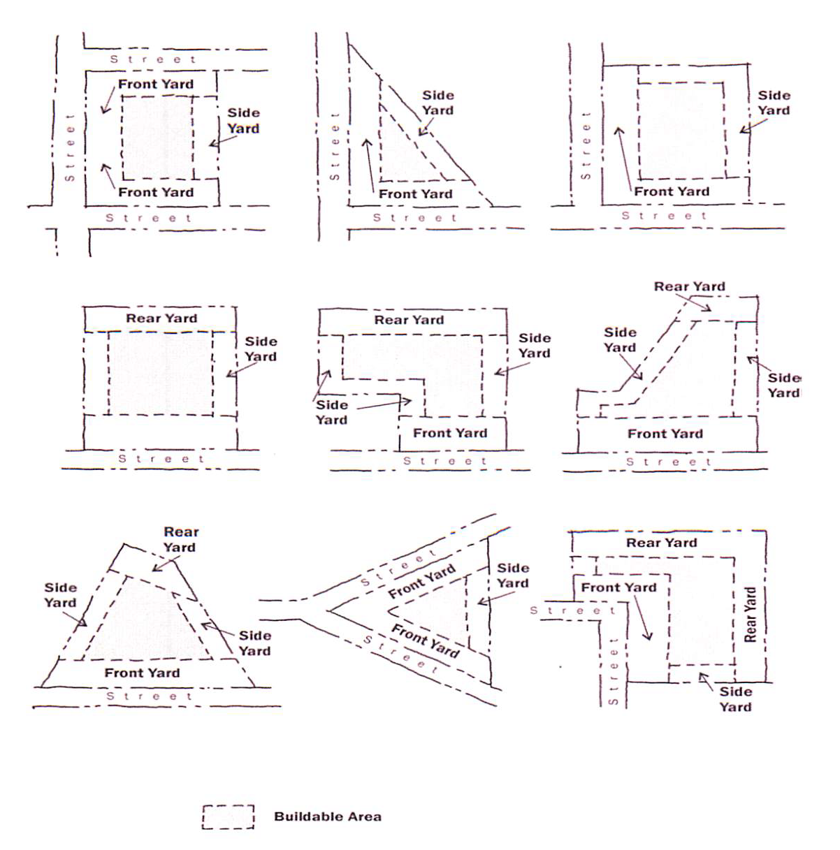
BUILDING SETBACK LINE or BUILDING LINE or SETBACK LINE . A line defining an area on the building lot between the street right-of-way line and all other property lines and the building line within which no building or structure shall be constructed (also referred to as a "yard"), encroach or project except as specifically authorized in an adopted ordinance of the city. The term BUILDING SETBACK LINE may be used interchangeably with the terms BUILDING LINE(S) and SETBACK LINE(S) throughout the subdivision regulations.
(1)
FRONT BUILDING SETBACK LINE (defining a front yard). A line parallel to the street right-of-way line which the building faces and takes its primary access from. Where lots have multiple frontages on one or more streets, the required front yard shall be provided on each street (see examples below).
(2)
SIDE BUILDING SETBACK LINE (defining a side yard). A line parallel to an adjacent lot which the building sides up to.
(3)
REAR BUILDING SETBACK LINE (defining a rear yard). A line parallel to an adjacent lot or alley, which the building backs up to and has its rear or secondary access from.
COMMISSION. The Planning and Zoning Commission of the city.
COMPREHENSIVE PLAN. The plan made and adopted by the City Council indicating the general locations recommended for the major thoroughfares, streets, parks, public buildings, zoning districts and other public improvements.
CUL-DE-SAC. A street having one end open to traffic and being permanently terminated by a vehicular turnaround.
DEAD-END STREET. A street, other than a cul-de-sac, with only one outlet.
EASEMENT. A grant by the property owner to the public, a corporation or persons, of the use of a strip of land for specific purposes.
ENGINEER. A person duly authorized under the provisions of the Texas Engineering Practice Act, being Tex. Rev. Civ. Stat. Art. 3271a, as heretofore or hereafter amended, to practice the profession of engineering.
EXTRATERRITORIAL JURISDICTION. The unincorporated area, not a part of any other city, which is contiguous to the corporate limits of the city, the outer boundaries of which are measured from the extremities of the corporate limits of the city, outward for such distances as may be stipulated in the Texas Municipal Annexation Act, being Tex. Local Gov't Code §§ 43.001 et seq., in accordance with the total population of the incorporated city. The EXTRATERRITORIAL JURISDICTION of the city is one mile from the city limits.
FINAL PLAT. The map, drawing, or chart in which the subdivider's plan of subdivision is presented and which he submits for approval and intends in final form to record.
FLOOD. A temporary rise in water level that results in inundation of areas not ordinarily covered by water.
FLOODPLAIN. Any land area susceptible to being inundated by water from any source.
GOVERNING BODY. The City Council or any duly appointed official, officer or agency designated by the City Council to execute the provisions of the Zoning Code.
IMPROVEMENTS. Street pavement, curbs, sidewalks, pedestrian ways, water mains, sanitary and storm sewers, permanent street monuments, trees and other appropriate items.
LOT. An undivided tract or parcel of land having frontage onto a public street or an approved private way and which is, or in the future may be offered for sale, conveyance, transfer or improvement, which is designated as a distinct and separate tract and which is identified by a lot number or symbol in a duly approved subdivision plat which has been properly filed on record.
LOT OF RECORD. Any lot which is part of a subdivision, the plat of which has been recorded in the office of the County Clerk.
PRELIMINARY PLAT. The map, drawing, or chart in which the subdivider's plan of subdivision and existing conditions is presented for tentative approval prior to submitting the final plat as herein stated.
STREET. A right-of-way which provides principal vehicular and pedestrian access to adjacent properties.
(1)
ARTERIAL STREET. A major traffic route crossing and connecting remote parts of the city and which is used primarily for fast or heavy volume traffic.
(2)
COLLECTOR STREET. A road which provides circulation within neighborhoods, carries traffic from minor streets to arterial streets, or carries traffic through or adjacent to commercial or industrial areas.
(3)
MARGINAL ACCESS STREET. A road which is parallel to and adjacent to an arterial street, and primarily provides access to abutting properties and protection from through traffic.
(4)
MINOR STREET. A road used primarily for access to abutting residential property.
(5)
PRIVATE STREET OR WAY. A private right-of-way serving more than one ownership, built to standard city specifications for a public street and approved as provided herein. A private street or way is owned in common by the owners of real property in the subdivision and must be maintained by the homeowners association of the subdivision.
(6)
PUBLIC STREET. A right-of-way dedicated to public use, built to standard city specification for a public street, whether designated as a street, avenue, highway, road, boulevard, lane, place or otherwise, and which has been accepted by the city for maintenance.
SUBDIVIDER. Any person or any agent thereof, dividing or proposing to divide land so as to constitute a subdivision as that term is defined herein. In any event, the term SUBDIVIDER shall be restricted to include only the owner, equitable owner or authorized agent of such owner or equitable owner of land sought to be subdivided.
SUBDIVISION. A division of any tract of land situated within the corporate limits, or within one mile of such limits, in two or more parts for the purpose of laying out any subdivision of any tract of land or any addition of any town or city, or for laying out suburban lots or building lots, or any lots, and streets, alleys or parts or other portions intended for public use or the use of purchasers or owners of lots fronting thereon or adjacent thereto. SUBDIVISION includes resubdivision, but it does not include the division of land for agricultural purposes in parcels or tracts of five acres or more and not involving any new street, alley or easement of access.
SURETY BOND. A surety bond or cash deposit made out to the city in an amount equal to the full cost of the improvements which are required by these regulations.
SURVEYOR. A licensed state land surveyor or a registered public surveyor authorized by state statute to practice the profession of surveying.
VARIANCE. A modification or variation from the provisions of these regulations as applied to a specific piece of property.
(Ord. 100, passed 12-12-78; '88 Code, Ch. 9, § 4.01; '88 Code, Ch. 9, § 4.02; Am. Ord. 99-024, passed 11-9-99; Am. Ord. 1999-028, passed 12-14-99; Am. Ord. O-2012-005, passed 4-24-12)
Sec. 155.05 - BUILDING LINES.
Building lines shall be shown on all lots intended for residential use and in some cases may be required on lots intended for business use, and shall provide at least the setback required by the zoning ordinance.
(Ord. 100, passed 12-12-78; '88 Code, Ch. 9, § 7.06; Am. Ord. 99-028, passed 12-14-99)
Cross reference— Penalty, see § 10.99
Sec. 155.06 - FLOOD HAZARD AREAS.
(A)
Flood hazard areas shall include all areas subject to inundation by flood waters of the 100-year frequency as delineated by the most recent Flood Hazard Boundary Map or Flood Insurance Rate Map, as the case may be, issued by or on behalf of the Federal Insurance Administration, and approved by the Commission and City Council.
(B)
All subdivisions after the enactment of these subdivision regulations with any areas subject to inundation according to division (A) of this section shall comply with the regulations and requirements of these subdivision regulations, the zoning ordinance and the flood hazard prevention ordinance of the city.
(Ord. 100, passed 12-12-78; '88 Code, Ch. 9, § 7.07; Am. Ord. 99-028, passed 12-14-99)
Cross reference— Flood damage prevention generally, see Chapter 153; Penalty, see § 10.99
Sec. 155.07 - OWNER'S CERTIFICATE OR DEED OF DEDICATION.
(A)
The dedication deed or certificate of dedication shall be executed by all persons, firms or corporations owning an interest in the property subdivided and platted, and shall be acknowledged in the manner prescribed by the laws of the state for conveyances of real property. Two true copies must be furnished with the original. The wife of all married men executing such dedication deed or certificate of dedication shall join with her husband therein unless satisfactory proof be provided showing that the property to be subdivided does not constitute any portion of such party's homestead, in which case the instrument of dedication shall state the fact that the property subdivided and platted does not constitute a part of such party's homestead and positively designates and identifies such party's homestead. In the case of lienholders, they may execute a subordination agreement, subordinating their liens to all public streets, alleys, parks, school sites and any other public areas shown on the plat of such subdivision as being set aside for public uses and purposes.
(B)
The dedication deed or certificate of dedication shall, in addition to the above requirements, contain the following:
(1)
An accurate description of the tract of land subdivided.
(2)
A statement and express representation that the parties joining in such dedication deed or certificate of dedication are the sole owners of such tract of land.
(3)
An express dedication to the public for public use forever of the streets, alleys, rights-of-way, parks, school sites and other public places shown on the attached plat.
(4)
A positive reference and identification of the plat of such subdivision by the name of such subdivision, date of plat, and engineer.
(Ord. 100, passed 12-12-78; '88 Code, Ch. 9, § 7.08; Am. Ord. 99-028, passed 12-14-99)
Sec. 155.08 - EXCEPTIONS TO PROVISIONS.
(A)
Plats or subdivisions which have received preliminary approval by the Commission within one year prior to the effective date of these regulations shall be excepted from these requirements; provided that the final plat of such subdivision is approved and filed for record within 180 days after the effective date of these regulations, or within one year after the approval date of the preliminary plat, whichever is greater.
(B)
Where any street forms any part of the boundary line of the subdivision, and some part of the width of such street has been dedicated or committed to dedication or committed to improvement, then the subdivider shall be required to dedicate and/or improve the balance of the width of such street, but otherwise, no improvements shall be required as a prerequisite to the approval for an existing dedicated street forming a boundary for a subdivision.
(C)
When any lot or a portion of a lot or portions of lots aggregating one tract larger in width and/or size than the average lot in the block in which the same is located are conveyed as a single unit for a single use purpose from a previously legally platted subdivision, no replat shall be required.
(Ord. 100, passed 12-12-78; '88 Code, Ch. 9, § 7.09; Am. Ord. 99-028, passed 12-14-99)
Sec. 155.09 - CONFLICT WITH OTHER PROVISIONS; STRICTEST TO CONTROL.
Ordinances, or parts of ordinances, with the exception of the building code and comprehensive zoning code of the city, which are inconsistent or in conflict with any of the provisions of these regulations are hereby repealed. Where the building code or zoning code of the city contain regulations which are more restrictive than the regulations contained herein, the ordinances which are most restrictive shall control.
(Ord. 100, passed 12-12-78; '88 Code, Ch. 9, § 8.00; Am. Ord. 99-028, passed 12-14-99)
Sec. 155.20 - PURPOSE.
The purpose of these provisions is to promote harmonious functional relationships among the various elements within any development, such as the location of activities, vehicular and pedestrian circulation systems and visual form, to ensure physical, social, and economic capability with neighboring developments and conditions, as well as the community at large and to prevent detrimental impact of the natural environment on and off the site by providing for review and approval of a plat or replat that is required to be prepared and that satisfies all applicable regulations and by requiring approval of plats and replats by the Planning and Zoning Commission and City Council.
(Ord. 100, passed 12-12-78; '88 Code, Ch. 9, § 5.01; Am. Ord. 99-028, passed 12-14-99; Am. Ord. 02-010, passed 3-26-02)
Sec. 155.21 - CRITERIA TO BE CONSIDERED DURING PLAT REVIEW.
The following criteria shall be considered when reviewing all subdivision plats or replats:
(A)
General character and compatibility of the proposed development should be compatible or in agreement (internally or with surrounding areas) in terms of housing types, yard depths, ground coverage, tree cover, surface drainage, density (in residential developments) and will result in the least possible detrimental impact to the site and surrounding areas and will be designed so as not to cause substantial depreciation of property values, or reduce the safety, light, or general convenience of neighboring developments.
(B)
Ingress to and egress from property and internal circulation, including access of service and emergency vehicles and design of off-street parking and loading areas.
(C)
The location and arrangement of all buildings and structures with regard to setback requirements and special consideration given to aspects such as visual form, sociability, and personal safety with regard to police and fire protection.
(D)
Environmental aspects with regard to sedimentation, drainage, and flood control and preservation of natural greenery on the site.
(E)
Utilities, with regard to availability and suitability for the use intended, and consideration of hook-in and service locations, including fire hydrants.
(F)
Screening, buffering and landscaping with regard to the type and dimensions, to preserve the character of surrounding areas and to provide privacy for the site in question.
(G)
Recreation and open space with attention to the location, size and development of the areas with regard to their usability, adequacy, and their relationship to community-wide open spaces and recreation facilities.
(H)
The plat or replat conforms to the general plan of the city and its current and future streets, alleys, parks, playgrounds and public utility facilities.
(I)
The plat or replat conforms to the general plan for the extension of the city and its roads, streets and public highways within the city and in its extraterritorial jurisdiction, taking into account access to and extension of sewer and water mains and the instrumentalities of the city.
(J)
A bond required under Tex. Local Gov't Code § 212.0106, if applicable, is filed with the city.
(Ord. 100, passed 12-12-78; '88 Code, Ch. 9, § 5.02; Am. Ord. 99-028, passed 12-14-99)
State Law reference— Standards for approval, see Tex. Local Gov't Code § 212.010
Sec. 155.22 - PLAT REVIEW PROCEDURES.
The following process shall be utilized to obtain approval of subdivision plats or replats:
(A)
Pre-submission conference. Prior to the official filing of a preliminary plat, the subdivider shall confer with and present a proposed plan of subdivision to the Planning Administrator for comments and advice on the procedures, specifications and standards required by the city for the subdivision of land and its conformity to the comprehensive plan.
(B)
Preliminary plat review.
(1)
Submission requirements. Following the pre-submission conference, all persons desiring to subdivide a tract of land within the city limits or extraterritorial jurisdiction of the city shall first prepare and submit to the Planning Administrator a preliminary plat, not less than ten days prior to any regular Commission meeting at which such plat will be considered. The subdivider shall submit eight copies of the material as indicated in § 155.23(A) of this subchapter. The material will be distributed to various departments or offices for review and comment relative to their specialty or concern. The comments and recommendations from the various departments and offices will be collected and compiled by the Planning Administrator and the plat with all comments and recommendations will be presented to the Commission for its consideration.
(2)
Commission review and approval.
(a)
Upon receipt of the preliminary plat and other information required by this Code, the Commission shall have 30 days to render a decision. Such decision may consist of approval, disapproval or conditional approval of the preliminary plat. A preliminary plat is considered approved by the Commission unless it is disapproved within 30 days after the date the plat was filed. When a preliminary plat shall have been approved by the Commission, the City Council shall act on the plat within 30 days after the date the plat is approved by the Commission or is considered approved by the inaction of the Commission. A plat is considered approved by the City Council unless it is disapproved within that period.
(b)
Conditional approval shall be considered to be the approval of a plat or replat, subject to conformity with prescribed conditions, but shall be deemed to be a disapproval of such plat or replat until such conditions are complied with. All objections made to the preliminary plat, or conditions imposed, shall be furnished to the subdivider. Approval of the preliminary plat shall not constitute acceptance of the final plat.
(c)
When a preliminary plat has been approved, the subdivider may thereafter file a final plat of the section or sections intended for immediate development. The remainder of the preliminary plat shall be considered approved or conditionally approved as provided above for a period of one year, and for such additional period as the Commission may elect. Where a preliminary plat has been approved and the subdivider fails to file a final plat of the subdivision or a section thereof within a period of one year, the approval of the primary plat shall be null and void.
(d)
The following notice shall be stamped on the face of each preliminary plat: "Preliminary Plat—for inspection purposes only, and in no way official or approved for record purposes."
(C)
Final plat review.
(1)
After the foregoing procedures have been complied with in the case of a preliminary plat and it has been approved by the Commission and the City Council, the subdivider shall prepare and submit to the Planning Administrator a final plat not less than ten days prior to any regular Commission meeting. The subdivider shall submit eight copies of the material as indicated in § 155.23(B) of this subchapter.
(2)
Upon the filing of the final plat, the Commission shall act on such plat within 30 days after the date the plat is filed. A plat is considered approved by the Commission unless it is disapproved within that period.
(3)
The City Council shall act on the final plat within 30 days after the date the final plat is approved by the Commission or is considered approved by the inaction of the Commission. A plat is considered approved by the City Council unless it is disapproved within that period. As provided in chapter 212 of the Local Government Code, "plat" includes a replat.
(4)
On approval of the plat by the City Council, it shall be signed by the Mayor and City Secretary in the space provided for and delivered to the Planning Administrator, who shall hold the approved plat and all copies until one of the following has been complied with:
(a)
The city's Planning Administrator has certified to the City Council that all of the improvements required of the subdivider under the terms of this chapter have been completed; or
(b)
When the subdivider has furnished the city a surety bond in lieu of any or all of the required improvements, which shall be delivered to the City Attorney for approval. The surety bond shall have attached thereto a copy of the contract for such improvements and such other information and data necessary to determine the validity and enforceability of such bond. When the bond has been examined and approved, the City Attorney shall furnish the City Council with certification that the surety bond is valid and enforceable regarding all improvements required by this chapter still incomplete and for which cash deposit has not been made.
(5)
Upon the delivery of the plat by the City Secretary, the same shall be filed with the County Clerk within 30 days.
(D)
Minor plat review and approval.
(1)
A minor plat shall meet the following criteria:
(a)
The proposed division of land which results in four or fewer lots;
(b)
All lots in the proposed subdivision front an existing public street and the construction or extension of a street or alley is not required to meet the standards of the city's Code;
(c)
Except for right-of-way widening and easements, the plat does not require the extension of any municipal facilities to serve any lot within the development; and
(d)
If minor revisions are required for a previously platted and recorded lot, a minor plat may be utilized in leu of a replat if allowed by State Law.
(2)
A minor plat shall be submitted to the City Planner with four paper copies and one PDF copy of the minor plat along with the plat application fee. The City Planner shall direct the minor plat to the appropriate city official and action shall be taken concerning the minor plat within 30 days of submission.
(3)
The items required on the minor plat shall be the same as for a final plat with the exception that the certificate of approval below shall be used in place of the planning and zoning and/or City Council's certificate of approval:
Administrative Official Certificate of Approval, to be placed on the plat:
APPROVED on this _______ day of _______, 20___, by the duly authorized Administrative Official for plat review and approval of the City of Gun Barrel City, Texas.
___________
Title and Date
(4)
All minor plats that meet the requirements of this division may be approved by the appropriate Administrative Official. Should the application not meet the requirements of this division, final approval may only be obtained by the City Council, with preliminary approval by the Planning and Zoning Commission.
(5)
Approval criteria for minor plat shall be in accordance with the general criteria in this division for plat approval with the following specific criteria for minor plats being as follows:
(a)
All lots to be created by the plat are already adequately served by public street and by all required utilities and services and by alleys, if applicable.
(b)
The ownership, maintenance and allowable uses of all designated easements have been stated on the minor plat.
(c)
Except for right-of-way widenings and easements, the plat does not require the extension of any municipal facilities to serve any lot within the development including any dedication statements and signatures for right-of-way dedications.
(6)
Recording.
(a)
All plats submitted for recordation shall be sealed by a registered professional land surveyor in the State of Texas.
(b)
All plats to be recorded shall be conformed to all conditions of approval and shall be submitted to the appropriate Administrative Official.
(c)
Plats shall be recorded in the plat records of Henderson County by the applicant and a copy delivered to the city. They shall include the following:
1.
All stipulations of approval;
2.
Payment of applicable fees, assessments and both current and delinquent taxes.
(Ord. 100, passed 12-12-78; '88 Code, Ch. 9, § 5.03; Am. Ord. 99-028, passed 12-14-99; Am. Ord. 01-011, passed 7-10-01; Am. Ord. 02-010, passed 3-26-02; Am. Ord. O-2023-015, § I.A, passed 9-26-23)
State Law reference— Failure of Commission or Council to act on final plat within 30 days constitute approval, see Tex. Local Gov't Code § 212.009
Sec. 155.23 - PLAT REQUIREMENTS.
(A)
Preliminary plat. The following information shall be certified by a state registered professional engineer or by a state licensed or registered land surveyor:
(1)
Eight copies of a preliminary plat showing the general features of the proposed development.
(2)
This preliminary plat shall be drawn on a scale of one inch to 100 feet and shall show the following:
(a)
The outline of the tract the plat is proposed to subdivide with the principal dimensions. Boundary lines shall be heavily drawn for easy identification.
(b)
The proposed plan of subdivision, showing streets, sidewalks, blocks, lots, alleys, easements, building lines, parks, schools, churches, and the like, with principal dimensions. The preliminary plat shall cover all of the tract intended to be developed, at any time, even though it is intended by the developer to file plats and install improvements for parts of the tract by sections or units. If it is the intent to develop the area by sections or units, the first unit to be developed shall be definitely identified.
(c)
The location, width, and name of existing streets and any blocks, lots, alleys, easements, building lines and water courses or other natural features in area affected, with principal dimensions, and any other significant information on all sides for a distance of not less than 200 feet.
(d)
The names of proposed streets. Such names shall be reviewed by the Building Inspector and conform to the names of existing streets of which they may be or become extensions or otherwise shall not duplicate or conflict with the recognized name of any other street located in the area subject to these regulations.
(e)
The location of existing sewer, water, fire hydrants and gas mains and other public utilities, if any.
(f)
Proposed general plan for storm water drainage sufficiently detailed to indicate the location of drainage ditches or structures and the direction of flow.
(g)
Any zoning district affecting the area being platted or any proposed changes in zoning for which application will be made.
(h)
The name of the proposed subdivision, north point, scale and date.
(i)
The name of the owner or owners and the engineer or engineer's.
(j)
Vicinity sketch or key map at a scale of not more than one inch to 800 feet which shall show all existing subdivisions, streets and tracts of acreage in the area and the general drainage plan, ultimate destination of water and possible storm sewer connections by arrows.
(k)
Typical cross-section of proposed street improvements and water and sewer installations where required.
(l)
The approximate acreage of the property to be subdivided.
(m)
Topographical information with contour lines at two-foot intervals.
(B)
Final plat. The following information shall be provided: Eight copies of the final plat of the subdivision or section to be developed. All final plats shall be drawn in india ink on tracing cloth or plastic tracing sheets 18 x 22 inches and to a scale of one inch to 100 feet. Where more than one sheet is required, an index sheet of a maximum size, 18 x 22 inches, shall be filed showing the entire subdivision. Where the area to be developed can be drawn on a sheet 1/2 size or less with the scale of the drawing remaining one inch equals 100 feet, a sheet 24 x 15 inches may be used.
(1)
The title or name by which the subdivision is to be identified, the acreage in the subdivision, north point, scale of the map, and the name of the state licensed or registered land surveyor responsible, and the name of the state registered professional engineer.
(2)
A definite legal description and identification, volume and page reference to County Deed Records of the tract being subdivided; this description shall be sufficient for the requirements of title examination. The plat shall be a descriptive diagram drawn to scale.
(3)
The boundaries of the subdivided property, the location or destination of all streets, alleys, parks and other areas intended to be dedicated or deeded to the public use, with proper dimensions. The boundaries of the subdivision shall be indicated by heavy line equivalent to a No. 5 reservoir pen and shall be tied by dimension to the established centerline of all existing boundary streets.
(4)
The location of all adjacent streets and alleys, with their names, and the name of adjoining subdivisions with exact location and designation by number of lots and blocks.
(5)
All lot, block, and street boundary lines, with blocks and lots numbered or lettered consecutively. Building lines and easements shall be shown and shall be defined by dimension. The actual width of all streets shall be shown, measured at right angles or radially, where curved.
(6)
Accurate dimensions, both linear and angular, on all items on the plat; the boundary survey on the site shall close within one in 10,000. Linear dimensions shall be expressed in feet and decimals of a foot; angular dimensions shall be shown by bearings. Curved boundaries shall be fully described and all essential information given; circular shall be defined by actual radius and not by degree of curve. Complete dimensional data shall be given on fractional lots.
(7)
The location and description of all lot and block corners and permanent survey reference monuments. Such corners and monuments shall be of 3/4 inch iron pipe or 5/8 inch rod and shall meet the following standards:
(a)
Lot corner shall be 24 to 30 inches long with the top set flush with the ground.
(b)
Block corners shall be 24 to 30 inches long set-in concrete with the top set flush with the ground and shall include the beginning and end of all curves within each block.
(c)
Reference points shall be 24 to 30 inches long placed one foot below the surface of the finished ground elevation at suitable locations throughout the subdivision. There shall be at least as many reference points as there are blocks in the subdivision but not less than two and the distance between successive monuments along any street or reference line shall not be greater than 1,000 feet. Reference points shall be other than and in addition to markers set for block or lot corners.
(8)
A certificate of ownership of all land embraced in the subdivision, and of the authenticity of the plat and dedication, signed and acknowledged by all owners of any interest in the land. The acknowledgment shall be in the form required in conveyance of real estate. Approval and acceptance of all lienholders shall be included.
(9)
A certificate by the responsible surveyor or engineer in charge, duly authenticated, that the plat is true and correct and in accordance with the determination of surveys actually made on the ground. If the surveyor or engineer who prepared the plat did not make the boundary survey, this fact should be noted in the certificate. Also, the certificate should show whether or not the tract is within the extraterritorial jurisdiction of the city, (one mile) measured in a straight line from the nearest points on the city limits, unless the information is shown in suitable manner elsewhere on the face of the plat.
(10)
The final plat submitted to the Commission and City Council and to be filed for record with the County Clerk shall not show construction features such as curblines or public utility lines or other structures not involved in the title covenant.
(11)
Protective covenants.
(11A)
Certificate of approval by Planning and Zoning Commission.
Approved this ______ day of _______________, 20_____, by the Planning and Zoning Commission of the City of Gun Barrel City, Texas.
_________________________
Chairman, Planning and Zoning Commission
Attest:
_______________________
Commission Secretary
(12)
Certificate of approval by City Council:
Approved this ______ day of _______________, 19_____, by the City Council of the City of Gun Barrel City, Texas.
_______________________
Mayor
Attest:
_______________________
City Secretary
(Ord. 100, passed 12-12-78; '88 Code, Ch. 9, § 5.04; Am. Ord. 99-028, passed 12-14-99; Am. Ord. 00-01, passed 1-11-00; Am. Ord. 02-010, passed 3-26-02)
State Law reference— Requirements to record, see Tex. Local Gov't Code § 212.004
Sec. 155.24 - REPLATS.
(A)
Any person who wishes to revise a subdivision plat which has been previously filed for record must make an application of the proposed revised plat to the Planning Administrator not less than 20 days prior to any regular Commission hearing date. The replat of a subdivision or portion of a subdivision shall meet all the requirements for a subdivision plat that may be pertinent. However, if the subdivision as replatted does not require any appreciable alteration or improvement of utility installations, streets, alleys, building setback lines, and the like, then no engineering plans will be required. No preliminary plats will be required for any replats. The procedure for approval of a replat shall be the same as for approval of any other final plat as provided in this chapter.
(B)
(1)
If, during the preceding five years, any of the area to be replatted was limited by a zoning classification to residential use for not more than two residential units per lot or any lot was limited by deed restrictions to residential use for not more than two residential lots, notice of the hearing shall be given before the fifteenth day before the date of the hearing by a publication in the official newspaper of the city and by written notice forwarded by the Commission to the owners of lots in the original subdivision that are within 200 feet of the lots to be replatted, as indicated on the most recently approved city tax roll or in the case of a subdivision within the extraterritorial jurisdiction, the most recently approved county tax roll of the property upon which the replat is requested. The written notice may be delivered by depositing the notice, properly addressed with postage prepaid, in a post office or postal depository within the boundaries of the city.
(2)
The following notice must be included in the written notice provided above, to wit: "If the proposed replat requires a variance and is protested in accordance with this subsection, the proposed replat must receive, in order to be approved, the affirmative vote of at least three-fourths of the members present of the Commission and the City Council. For a legal protest, written instruments signed by the owners of at least 20% of the area of the lots or land immediately adjoining the area covered by the proposed replat and extending 200 feet from that area, but within the original subdivision, must be filed with the Commission prior to the close of the public hearing."
('88 Code, Ch. 9, § 5.05; Ord. 260, passed 1-10-89; Am. Ord. 344, passed 6-23-92; Am. Ord. 398, passed 6-14-94; Am. Ord. 99-028, passed 12-14-99; Am. Ord. 02-010, passed 3-26-02)
Sec. 155.25 - PLAT FILING FEES.
Fees and charges shall be collected by the city's designated representative as provided for in § 16.00 of the Fee Schedule found in Appendix 1 of this Code when any annexation petition, plat or rezoning request is tendered to the city for consideration. Each of these fees and charges shall be paid in advance, and no action by either the Commission or the City Council shall be valid until the fees shall have been paid.
('88 Code, App. A, § 18.00; Ord. 389, passed 4-12-94; Am. Ord. 98-023, passed 8-11-98; Am. Ord. 99-028, passed 12-14-99)
Sec. 155.35 - PURPOSE.
The purpose of this subchapter is to establish standards and requirements to achieve the maximum compatibility and arrangement among the various elements within any development with their immediate and general surroundings.
(Ord. 100, passed 12-12-78; '88 Code, Ch. 9, § 6.01; Am. Ord. 99-028, passed 12-14-99)
Sec. 155.36 - STREETS.
The following street criteria shall be adhered to when developing any subdivision plat:
(A)
The arrangement, character, extent, width, grade and location of all streets shall conform to the general plan for the city and shall be considered in their relation to existing and planned streets, to topographical conditions, to public convenience and safety, and their appropriate relation to the proposed uses of the land to be served by such streets.
(B)
Where such is not shown in the general plan for the city, the arrangement of streets in the subdivision shall either:
(1)
Provide for the continuation or appropriate projection of existing principal streets in the surrounding area; or
(2)
Conform to a plan for the neighborhood approved or adopted by the Commission to meet a particular situation where topographical or other conditions made continuance or conformance to existing streets impracticable.
(C)
Minor streets shall be so laid out that their use by through traffic will be discouraged.
(D)
Where a subdivision abuts or contains an existing or proposed arterial street, the Commission may require marginal access streets, reverse frontage with screen planting contained in a non-access reservation along the rear property line, deep lots with rear service alleys, or such other treatment as may be necessary for adequate protection of residential properties and to afford separation of through and local traffic.
(E)
Where a subdivision borders on or contains a railroad right-of-way, the Commission may require a street approximately parallel to and on each side of such right-of-way, at a distance suitable for the appropriate use of the intervening land, as for park purposes in residential districts, or for commercial or industrial purposes in appropriate districts. Such distances shall also be determined with due regard for the requirements of approach grades and future grade separations.
(F)
Reserve strips controlling access to streets shall be prohibited except where their control is definitely placed in the city under conditions approved by the Commission.
(G)
Street intersections with centerline offsets of less than 125 feet shall be avoided.
(H)
A tangent at least 100 feet long shall be introduced between reverse curves on arterial and collector streets.
(I)
Streets shall be laid out so as to intersect as nearly as possible at right angles.
(J)
Fire hydrants shall be so located that no residence or commercial building is more than 500 feet from a fire hydrant.
(K)
Property lines at street intersections shall be rounded with a radius of 20 feet or of a greater radius where the Commission may deem it necessary.
(L)
Street right-of-way widths shall be as shown in the general plan for the city and where not shown therein shall be not less than as follows:
(1)
Major thoroughfares, street right-of-way width of 80 feet.
(2)
Collector, street right-of-way width of 60 feet.
(3)
All others, street right-of-way width of 50 feet.
(M)
Dead-end streets, designed to be so permanently, shall not be longer than 500 feet and shall be provided at the closed end with a turn-around having an outside roadway diameter of at least 80 feet and a street property line diameter of at least 100 feet. In cases where this will work a hardship on a property owner developer, it may be extended to a longer length street.
(N)
Street grades shall be established with due regard being had for topography, contemplated land uses, and the existing city drainage plan and facilities in the area surrounding the land to be subdivided, provided that the minimum street grade shall be 5/10 of 1%. No land shall be rejected for subdivision purposes for failure to provide for greater street grade than that contained in this section.
(O)
The flood design section for roadways shall be taken from back of curb to back of curb, provided that in no case shall the height of curbs for subdivision be more than eight inches. The run-off factor used in design of storm sewers shall be a minimum of Talbots and Rational Formula.
(P)
Half streets shall be prohibited, except where essential to the reasonable development of the subdivision and these regulations; and where the Commission finds it will be practicable to require the dedication of the other half when the adjoining property is subdivided. Wherever a half street is adjacent to a tract to be subdivided, the other half of the street shall be platted within such tract.
(Q)
No street names shall be used which will duplicate or be confused with the names of existing streets.
(Ord. 100, passed 12-12-78; '88 Code, Ch. 9, § 6.02; Am. Ord. 99-028, passed 12-14-99; Am. Ord. 01-017, passed 9-25-01)
Cross reference— Penalty, see § 10.99
Sec. 155.37 - ALLEYS.
The following alley criteria shall be adhered to when developing any subdivision plat:
(A)
Alleys shall be provided in commercial and industrial districts, except that the Commission may waive this requirement where other definite and assured provisions are made such as off-street loading and unloading, and parking.
(B)
The minimum width of an alley shall be 20 feet.
(C)
Alley intersections and sharp changes in alignment shall be avoided, but where necessary, corners shall be cut-off not less than 15 feet along each property line to permit safe vehicular movement.
(D)
Dead-end alleys shall be avoided where possible, but if unavoidable, shall be provided with adequate turn-around facilities at the dead-end.
(Ord. 100, passed 12-12-78; '88 Code, Ch. 9, § 6.03; Am. Ord. 99-028, passed 12-14-99)
Cross reference— Penalty, see § 10.99
Sec. 155.38 - BLOCKS.
The following block criteria shall be adhered to when developing any subdivision plat:
(A)
The lengths, widths, and shapes of blocks shall be determined with due regard to:
(1)
Provision of adequate building sites suitable to the special needs of the type of use contemplated.
(2)
Zoning requirements as to lot sizes and dimension.
(3)
Needs for convenient access, circulation, control and safety of street traffic.
(4)
Limitations and opportunities of topography.
(B)
Block lengths shall not exceed 1,000 feet.
(C)
Sidewalks four feet wide may be required by the city.
(Ord. 100, passed 12-12-78; '88 Code, Ch. 9, § 6.04; Am. Ord. 99-028, passed 12-14-99)
Cross reference— Penalty, see § 10.99
Sec. 155.39 - LOTS.
The following lot criteria shall be adhered to when developing any subdivision plat:
(A)
The lot size, width, depth, shape and orientation, and the minimum building setback lines shall be appropriate for the location of the subdivision and for the type of development and use required under the zoning code.
(B)
Within the extraterritorial jurisdiction the lot size, width, depth, shape and orientation, and the minimum building setback lines shall match the adjacent or nearest zoning district and shall be compatible with the Comprehensive Plan. Where no adjacent districts exist, the lot requirements shall match Zoning District R-3 for residential lots and B-l for business lots.
(C)
Corner lots for residential use shall have extra width to permit appropriate building setback from and orientation to both streets. When such lots side upon a major thoroughfare or collector street, a note to this effect shall be properly entered on the plat to be recorded.
(D)
The subdividing of the land shall be such as to provide, by means of a public street or an approved private way, each lot with satisfactory access to the existing public streets of the city; provided that any private way proposed for approval in connection with a subdivision plat by the Planning and Zoning Commission and the City Council shall be designed and constructed in accordance with the minimum standards for improvements set out in § 155.53 or in any other applicable ordinance, regulation, or policy of the city.
(E)
For new development not already platted, double frontage, and reverse frontage lots should be avoided, except where essential to provide separation of residential development from traffic arteries or to overcome specific disadvantages of topography and orientation. Double frontage and reverse frontage lots from an already platted subdivision shall require the minimum front yard set back on each street.
(F)
Side lot lines shall be substantially at right angles or radial to street lines.
(G)
Where a non-conforming lot of record in a residential zoning district has less width or depth or lot area than required by its current district requirements, it shall not prohibit the erection of structures, as long as the remaining current district requirements are met.
(Ord. 100, passed 12-12-78; '88 Code, Ch. 9, § 6.05; Am. Ord. 99-024, passed 11-9-99; Am. Ord. 99-028, passed 12-14-99; Am. Ord. O-2019-020, passed 8-27-19; Am. Ord. O-2021-024, passed 5-25-21)
Cross reference— Penalty, see § 10.99
Sec. 155.40 - DRAINAGE DESIGN STANDARDS.
(A)
Compliance. All commercial and residential subdivision development plans, site plans and subdivision plats submitted to the City of Gun Barrel City shall comply with the provisions of these regulations and any other applicable regulations. Those plats of developed property on which no new structures or additional impervious coverage are planned shall be exempt from the provisions of these sections until such time that new structures or additional impervious surfaces are proposed.
(B)
Storm water management system requirements. The Planning and Zoning Commission will not approve any plat, plan or subdivision which does not meet the minimum requirements of this section in making adequate provision for control of the quantity of storm water runoff to the benefit of both future owners of property within the subdivision and other lands upstream or downstream within the watershed. It shall be the responsibility of the subdivider to design and construct a system for the collection and transport of all storm water runoff flowing onto and generated within the subdivision in accordance with:
(1)
The requirements of these regulations.
(2)
Standard engineering practices, as recommended by the City Engineer.
(3)
Approved plans.
(4)
The principles and precedents of storm water law established by the Texas Water Code.
(5)
North Central Texas Standard Specifications for Public Works Construction adopted by the City of Gun Barrel City.
(C)
Basic design objectives. In general, the storm water management system shall be designed and constructed in a manner which promotes the development of a network of both natural and constructed drainage ways throughout the community and so as to:
(1)
Retain natural flood plains in a condition that minimizes interference with flood water conveyance, flood water storage, aquatic and terrestrial ecosystems, and ground and surface water.
(2)
Reduce exposure of people and property to the flood hazard and nuisance associated with inadequate control of runoff.
(3)
Systematically reduce the existing level of flood damages.
(4)
Ensure that corrective works are consistent with the overall goals of the city.
(5)
Minimize erosion and sedimentation problems and enhance water quality.
(6)
Plan for both the large flooding events and the smaller, more frequent flooding by providing both major and minor drainage systems.
(7)
Minimize future operational and maintenance expenses.
(8)
Reduce exposure of public investment in utilities, streets and other public facilities (infrastructure).
(D)
General design requirements.
(1)
The storm drainage system shall be separate and independent of any sanitary sewer system and its use shall not interfere with the operation and maintenance of road networks or utility systems.
(2)
Each lot, site and block within the subdivision shall be adequately drained as prescribed in the city's Construction Standards and Specifications for Roads, Streets, Structures, and Utilities. Any use of retaining walls swales, retention basins, or other planned improvements for storm water control shall be indicated on the preliminary plat.
(3)
No subdivision will be approved which calls for building within a regulatory floodway of any stream or watercourse. The City of Gun Barrel City may, when it deems necessary for the protection of the health, safety or welfare of the present and future population, prohibit subdivisions and/or development of any property which lies within a designated regulatory floodway of any stream or watercourse.
(4)
All lots or building sites within a subdivision shall be accessible to a public street during 100-year design storm conditions as prescribed in the city's Construction Standards and Specifications for Roads, Streets, Structures, and Utilities. Proof of access shall be included with the final construction plans.
(5)
All design calculations shall be prepared and submitted by a registered professional engineer, certified by the State of Texas, for review by the City Engineer.
(E)
Areas subject to inundation under design storm conditions, 100-year frequency storm event, shall be indicated with the minimum floor elevation of each lot so affected on a certified copy of the final plat submitted for filing. The Planning and Zoning Commission may, when it deems necessary for the protection of the health, safety or welfare of the present and future populations, place restrictions on the subdivision, regarding the design and use of areas within a drainage way or floodplain. The Planning and Zoning Commission will not approve any subdivision of land within the floodplain of any stream or water course unless the applicant demonstrates that the subdivision and all development anticipated therein will comply with the requirements of this section.
(F)
Design of all drainage facilities, including streets, inlets, storm sewers, outfall, culverts and ditches, shall conform with the city's Construction Standards and Specifications for Roads, Streets, Structures, and Utilities and Texas Department of Transportation Standards for storm sewer, culvert and bridge design.
(G)
All drainage facilities shall be designed to intercept, detain and transport the projected runoff from the 25-year frequency storm. Overflow and transport provisions shall be provided for the 100-year storm. Engineering calculations, modeling results, and hydraulic profile drawings shall be submitted by developer's engineer, certified by the State of Texas, for review by City Engineer.
(H)
Projected runoff rates for the design of drainage facilities shall be based on the expected ultimate developed state of the upstream contributing area. Said ultimate developed state shall be based on the maximum intensity allowable under existing zoning, and approved plans with the contributing area.
(I)
All development establishing impervious cover or otherwise modifying an existing site shall incorporate facilities to prevent any increase in the peak rate of runoff from a 25-year frequency storm. The city may waive this requirement under one or more of the following circumstances:
(1)
Approved off-site storage is provided for the required regulation of peak flows and adequate conveyance of storm water flows from the site to the off-site storage facility is demonstrated.
(2)
Development of a one-, two- or three-family residential structure on any legally platted lot creates no more impervious ground cover than 35% of the gross lot surface area exclusive of any area within the 100-year floodplain.
(3)
Certified engineering data and calculations are presented which demonstrate the absence of adverse impact on all downstream conveyances and property between the downstream property line and the receiving major waterway.
(4)
Certified engineering data and calculations are presented which fully describe, explain and justify recommended alternatives to detention.
(5)
The increase in runoff does not exceed 10% of the existing condition runoff up to a maximum increase of five cubic feet per second, and said runoff does not affect adjoining property.
(6)
The property is adjacent to a major waterway and in the judgment of the City Engineer, waiver of detention requirements will not result in an increase in the peak flood flow of the major waterway. Waiver of this requirement for any reason shall not relieve the owner of responsibility under civil law to adjacent and downstream property owners.
(J)
Design of major drainage ways through a subdivision and major structures such as multiple culverts, box culverts or bridges across a major drainage channel shall require a letter requesting a local fioodplain map amendment from the Federal Emergency Management Agency (FEMA). This request shall be submitted to FEMA prior to final construction plan approval.
(K)
Drainage channels.
(1)
The limits of the 25-year and 100-year storm event shall be determined for all water courses unless an exception is granted by the City Engineer. Calculations for storm events shall utilize the Rational Method and TxDOT Design Procedures for smaller watersheds and the SCS or HEC methods for larger watersheds.
(2)
No placement of fill material or channel modifications shall be undertaken within the area of the 100-year flood plain without written approval of the city. Channel modification may include residential construction, timber removal and site preparation. Such approval shall be based upon sealed engineering data and calculations furnished by the applicant and approved by the City Engineer. Channel modifications that alter the current Flood Hazard Boundary Map study parameters of the City of Gun Barrel City on file at FEMA will not be approved until a Letter of Map Revision (LOMR), or other appropriate letter, is prepared and submitted to FEMA by developer's engineer, certified by the State of Texas.
(3)
Concrete ditches/channels shall have a minimum bottom width of six feet and sloped walls (i.e., trapezoidal section) on 2:1 or 3:1 slopes. All open ditches shall be lined for erosion protection. The height of the lining, whether concrete or grassed, shall be adequate for the calculated depth at design flow plus one foot freeboard. Side slopes of earthen and grassed channels shall not be steeper than one foot vertical rise to four feet horizontal distance. In new subdivisions the developer shall provide all the necessary easements and rights-of-way required for drainage structures, including storm sewers and open flow channels. Earthen channels may be allowed where the velocity of the water does not exceed six feet per second or a slope greater than 0.50%. The earthen channels shall have established grass prior to issuance of any building permits. All bends in earthen channels shall be constructed with approved concrete rip-rap within the limits of the curve plus five feet minimum upstream and downstream. Easement width for storm sewer pipe shall be not less than 20 feet, and easement width for open channels shall be at least 20 feet wider than the design water surface elevation, 15 feet of which shall be on an open side to serve as access way for maintenance purposes. The channel easements shall not be fenced and shall be mowed by the property owners.
(4)
All constructed or modified earthen channels shall be designed utilizing a side slope of 4:1, or flatter, to allow for future maintenance and promote adequate slope stability. As a minimum, all slopes shall be hydro mulched, sodded or seeded, and stabilized with erosion control mat.
(5)
Modifications to curbs or open flow ditches/channels for access to municipal streets must be authorized and permitted. The fee shall be as provided for in the Fee Schedule found in Appendix 1 of the Code of Ordinances. The City Engineer or designated person from the city will conduct an inspection of the ditch/channel and give instructions with directions for the installation and size of the needed culvert. The contractor/installer of the culvert or driveway shall notify the authorized personnel to conduct a final inspection prior to covering the area. The city has authority to deny access to public streets if it is determined that the peak rate of runoff is restricted or that the access location is detrimental to the safety, health and welfare of citizens. Some examples of denied access are when the approach is on a curve or directly in-line with other driveways while backing. The Building Inspector, Street Department, Police Department, Fire Department and City Engineer or designated personnel can deny access upon their interpretation of the current impact to safety, health and welfare.
(L)
Streets and storm sewer.
(1)
(a)
All street sections shall be in accordance with city standards. The allowable design drainage capacity for storm water flow at the gutter at the 25-year storm flow shall be no deeper than the top of the curb.
(b)
Depth of flow in streets is to be controlled to allowable levels by modification of cross fall, gradient changes, or the use of curb inlets and/or curb drains, and storm sewers.
(c)
Streets and underground storm drains shall be designed to accommodate a 25-year frequency storm with adequate overland relief for the 100-year storm. Design of all bridges, culverts, underpasses and open channels are to be based on a 25-year frequency. All bridges and culverts to be built in the floodplain shall comply with the established floodplain regulations and analyzed for a 100-year event.
(d)
Water in excess of that permissible in streets with allowable depth or spread of water shall be carried in storm sewers or open ditches not in the street right-of-way.
(e)
Street grades shall be such that excessive sand deposition from low water velocities or pavement scouring from high velocities is to be avoided as far as practical.
(f)
Concrete valley gutters shall be provided when necessary to carry the water flow across all intersections. Concrete valley gutters shall be six inches thick and a minimum of ten feet wide. The valley gutters shall be poured monolithic with the curb returns. All intersection radii are to be 20 feet or greater at the curb line. Where water flows from a street directly into an open watercourse, an approved structure shall be used for the transition.
(2)
Where storm sewers are required, inlets shall be spaced so that the spread in the street for the design flow (25-year storm) shall not exceed one-third of the overall roadway width from face to face of curbs. Inlets will be sized using an allowable capacity determined using TxDOT design manual, taking into account street grade and cross-slope for a throat height of five inches and shall be designed so as to conform to city construction standards.
(3)
Design of storm sewers, outfalls, culverts, and drainage ditches shall conform to the following general requirements:
(a)
Manholes (inlets or junction boxes) shall be provided at all changes in grade or alignment, sewer intersections, and at a maximum of 1,000 feet on straight lines. Design of manholes shall conform to the current city construction standards.
(b)
Storm drains shall be reinforced concrete pipe (RCP), American Society of Testing Materials, Standard C76, Class 3 pipe for storm drains shall be constructed to the bank of the receiving drain way and shall have a minimum cover of not less than one foot over the top of the pipe. Erosion control measures shall be taken at the outlet of the pipe. When exit velocities exceed six fps at the 25-year storm, velocity attenuation structures shall be required.
(c)
Wherever possible, outfalls from storm sewers and ditches into natural drainage ways shall enter at the grade of the natural drainage channel. The subdivider's engineer, certified by the State of Texas, shall design drop-type outfall structures or shall otherwise provide adequate protection against erosion.
(M)
Bridges and culverts.
(1)
All bridge and culvert structures shall be designed to carry and/or contain the upstream runoff from a 25-year storm.
(2)
Runoff from the 100-year storm shall not top the road surface at a bridge or culvert crossing for an arterial or collector street crossing and shall not exceed a depth of six inches on a local street crossing.
(3)
All bridge and culvert structures shall be designed such that the structural integrity of the roadway shall not be diminished by the 25-year or 100-year storm event.
(4)
Bridges are to be constructed at all street crossings over the major streams in the city and shall have the proper dimensions to fit the proposed channel sections given in the drainage section of the city's comprehensive plan or as stipulated by the city. All bridges in the floodplain shall comply with established floodplain regulations.
(N)
Computations, plans and construction.
(1)
Plans and computations for proposed drainage facilities shall be certified with the seal of the developer's design engineer, certified by the State of Texas, and submitted to the City Engineer for acceptance prior to approval of construction plans. Approval shall be in writing from the City Engineer hired by the City of Gun Barrel City.
(2)
Computations for all drainage related designs shall be submitted with the plans for review. Data submitted shall include a drainage area map, a summary of methodology employed and resulting data, land use and run-off coefficient assumptions, and other pertinent hydrologic and hydraulic data. Failure to include surrounding or off-site drainage patterns is cause for refusal to review other data submitted.
(3)
The city shall make such inspections as are deemed necessary to assure proper installation. Neither the review nor approval of such plans nor the inspection of the completed work will create any liability on the part of the city.
(4)
Following construction, but prior to acceptance of improvements or issuance of a building permit, the design engineer, certified by the State of Texas, shall furnish one set of reproducible "as built" plans for each project, bearing certification by a registered professional engineer, certified by the State of Texas.
(5)
Plans for all subdivisions shall include lot grading plans showing flow direction arrows. Certificates of occupancy will not be issued for lots not graded in accordance with approved grading plans or approved amendments.
(O)
Building permits and utility connections.
(1)
Plans submitted for building permits and/or utility connections other than single family residential or duplex construction and for those projects already in compliance with this section shall include the necessary drainage related facilities designed and provided for in compliance with this section and the city's Construction Standards and Specifications for Roads, Streets, Structures, and Utilities.
(2)
Plans and design calculations for all drainage facilities shall be submitted to the city for acceptance prior to issuance of any permit within the development or subdivisions.
(3)
Detention of water on parking areas shall not result in a water depth of more than six inches at peak overflow elevations. Acknowledgment of detention depths within the site of a development shall be provided by the developer.
(4)
Erosion control techniques which conform to sound engineering practice shall be implemented during construction and at its completion to limit erosion and sedimentation to that level, or to a lesser level than that, existing prior to development.
(5)
Fences shown on the site plan shall be constructed and located so as not to interfere with the runoff of a lot. Fences shall not be permitted across platted drainage channels unless provided with openings for drainage.
(6)
Property located within the 100-year floodplain, to the extent that such property is deemed by the city to be necessary to provide adequate and proper drainage for the city, shall be dedicated to the public as a drainage easement which may be used as public open space.
(P)
Drainage easements.
(1)
General requirements.
(a)
Where a subdivision is traversed by a watercourse, drainage way, channel, or stream, or where a detention facility is required, there shall be provided a storm water easement or drainage right-of-way conforming substantially to the lines of such watercourse or facility and of such width and construction to contain the design storm and required one-foot freeboard. When parking lots or other approved use areas serve a dual function, including detention, those areas shall be designated on the plat as maintained by an open channel with landscaped banks having adequate width to contain the volume of flow generated by the design storm under ultimate development conditions.
(b)
Unlined open drainage channels or ditches shall not be permitted on residential lots. Lining shall be concrete, unless otherwise approved by the City Engineer.
(2)
Design requirements.
(a)
Where topography or other conditions are such as to make impractical the inclusion of drainage facilities within road rights-of-way, perpetual unobstructed easements at least 15 feet in width for such drainage facilities shall be provided across property outside the road lines and with satisfactory access to the road. Easements shall be indicated on the plat. Drainage easements shall be carried from the road to a natural watercourse or to other drainage facilities.
(b)
When a proposed drainage system will carry water across private land outside the subdivision, appropriate drainage rights must be secured, documented on the plat, and drawn on the construction plans.
(c)
Low-lying lands along watercourses subject to flooding or overflowing during storm periods shall be preserved and retained in their natural state as drainage ways except where modification can be shown to benefit the community and as approved by the City of Gun Barrel City. All development activity within the regulatory floodplain must comply with City of Gun Barrel City and Federal Emergency Management Agency (FEMA) floodplain management regulations.
(d)
All sedimentation, filtration, detention and/or retention basins and related appurtenances shall be situated within a drainage easement. The owners of the tracts upon which are located such easement, appurtenances, and detention facilities shall maintain same and be responsible for their upkeep. Notice of such duty to maintain shall be shown on the plats.
(Q)
Drainage facilities shall be designed to serve the entire subdivision. The City of Gun Barrel City may approve deferral of design of drainage facilities, if any are required, to the detailed development plan. For all other subdivisions, design of drainage facilities shall be completed with other required construction plans in order to ensure adequate drainage easements and other reservations on the plat.
(R)
The requirements set forth herein are not intended to be exhaustive and wherever it is necessary to make additional requirements in order to maximize the effectiveness of the drainage plan in question, such requirements shall be made by the City Engineer and the City of Gun Barrel City.
(Ord. O-2009-017, passed 7-14-09)
Sec. 155.50 - PURPOSE.
Provisions set forth in this subchapter establish the general improvements provisions required in any subdivision plat.
(Ord. 100, passed 12-12-78; '88 Code, Ch. 9, § 7.01; Am. Ord. 99-028, passed 12-14-99)
Sec. 155.51 - PLANS AND SPECIFICATIONS; COMPLIANCE WITH REGULATIONS.
(A)
When a preliminary plat of a subdivision has been approved by the Commission, the developer shall submit to the city's consulting engineer plans and specifications for all improvements pertinent to the subdivision. The city's consulting engineer, within 30 days of receipt of the plans and specifications, shall approve same if they conform to the requirements of these subdivision regulations, or disapprove same, giving his reasons therefor to the subdivider.
(B)
Before beginning any construction of the improvements outlined in this subchapter on proposed roadways or public utilities pertaining to any subdivision coming under the provisions of these subdivision regulations, eight complete sets of plans and specifications of such construction (in the form of plats, sketches, or other satisfactorily written descriptions) shall be filed with the Planning Administrator. These shall show such features as roadways, their grade and slope, cross-sections and longitudinal slope for drainage, full description of proposed pavement or street improvements, dimensions and specifications concerning public utilities to be installed showing proposed position on the ground.
(C)
All improvements shall be installed within all of the area of any subdivision or portion thereof given final approval, and at the cost of the developer.
(D)
All improvements shall be designed and constructed in conformity with the provisions of these subdivision regulations and no construction shall be commenced until these subdivision regulations are so complied with.
(Ord. 100, passed 12-12-78; '88 Code, Ch. 9, § 7.02; Am. Ord. 99-028, passed 12-14-99)
Cross reference— Penalty, see § 10.99
Sec. 155.52 - EASEMENTS.
(A)
Easements on rear or side lot lines shall be provided for utilities where necessary and shall be at least ten feet wide.
(B)
Where a subdivision is traversed by a watercourse, drainage way, channel, or stream, there shall be provided a storm water easement or drainage right-of-way conforming substantially with the lines of such watercourse, and such further width of construction, or both, as will be adequate for the purpose. Parallel streets or parkways may be required in collection therewith.
(Ord. 100, passed 12-12-78; '88 Code, Ch. 9, § 7.03; Am. Ord. 99-028, passed 12-14-99)
Sec. 155.53 - MINIMUM STANDARDS FOR IMPROVEMENTS.
The following minimum standards for improvements shall apply and shall be agreed to and complied within each subdivision or addition.
(A)
Paving.
(1)
All sidewalks in newly platted subdivisions shall be constructed of concrete according to the recommendations of the American Public Works Association, American General Contractors Association, American Road Builders Association, American Water Works Association, and the American Society of Testing Materials.
(2)
Width of paving for the various types of streets, including curbs shall not be less than the following:
(a)
Major thoroughfares, not less than 48 feet.
(b)
Collector, not less than 38 feet.
(c)
All other, not less than 30 feet.
(B)
Curb and gutters. Combined curb and gutters shall be constructed on each side of each street of each subdivision in accordance with plans and specifications which shall be furnished by the city.
(C)
Water and sewer lines. Each lot within the subdivided area shall be provided with access to such water and sewer at cost to the developer. The installation of all water and sewer lines within the subdivided area shall be constructed in accordance with plans and specifications furnished by the consulting engineer of the Water Supply District who shall in designing same, give due consideration to further development and adequate fire protection for the subdivided area.
(D)
Water connections. No Water Supply District shall make any water connections to any residence, business building or other structure upon any subdivided area subject to the jurisdiction and control of the city, the subdivision of which has not been accomplished in accordance with the terms and provisions of these regulations.
(Ord. 100, passed 12-12-78; '88 Code, Ch. 9, § 7.04; Am. Ord. 99-028, passed 12-14-99; Am. Ord. O-2019-016, passed 5-28-19)
Cross reference— Penalty, see § 10.99
Sec. 155.65 - WITHHOLDING BUILDING PERMITS.
No building permit shall be issued by the Building Inspector of the city on any piece of property other than an original or a resubdivided lot in a duly approved and recorded subdivision after the effective date of these regulations, unless all the provisions of these subdivision regulations have been complied with.
(Ord. 100, passed 12-12-78; '88 Code, Ch. 9, § 7.05; Am. Ord. 99-028, passed 12-14-99)
Sec. 155.66 - VARIANCES.
(A)
The City Council may authorize a variance from the regulations when, in its opinion, undue hardship will result from requiring strict compliance. In granting a variance, the Council shall prescribe only conditions that it deems necessary or desirable to the public interest in making the findings herein below required. The Council shall take into account the nature of the proposed usage of land involved, the existing usage of the land in the vicinity, the number of persons who will reside or work in the proposed subdivision, and the probable effect of such variances upon traffic conditions and upon the public health, safety, convenience, and welfare of individuals in the vicinity. No variances will be granted unless the Council finds the following:
(1)
Special circumstances or conditions. There are special circumstances or conditions affecting the land involved such that the strict application of the provisions of these subdivision regulations would deprive the applicant of the reasonable use of his land.
(2)
Preservation of property rights. The variances are necessary for the preservation and enjoyment of a substantial property right of the applicant, and that the granting of the variance, will not be detrimental to the public health, safety, or welfare of individuals, or injurious to other properties in the area.
(3)
Effect on other lands in the area. The granting of the variance will not have the effect of preventing the orderly subdivision of other lands in the area in accordance with the provisions of these subdivision regulations.
(4)
Observance of other ordinances. The Council may not authorize a variance that would constitute a violation of any other valid ordinance of the city.
(B)
Such findings of the Council, together with the specific facts upon which such findings are based, shall be incorporated in the official minutes of the Council meeting at which such variance is granted. Variances may be granted only when in harmony with the general purpose and intent of this section so that the general health, safety and welfare of citizens may be secured, and substantial justice be done. Pecuniary hardship to the subdivider, standing alone, shall not be deemed to constitute undue hardship.
(C)
Such variances and modifications as may be granted shall be by at least a two-thirds majority of the City Council.
(Ord. 100, passed 12-12-78; '88 Code, Ch. 9, § 7.10; Am. Ord. 99-028, passed 12-14-99)
Sec. 155.67 - VIOLATIONS.
(A)
Any person who violates any provision of these subdivision regulations shall be deemed guilty of a misdemeanor and shall be subject to a fine not to exceed $250. Each transaction in violation of any of the provisions hereof, and each day such violation exists, shall be deemed a separate offense.
(B)
Any person who shall violate any of the provisions of these subdivisions regulations, or who shall fail to comply with any of the provisions hereof, within the extraterritorial jurisdiction of the city shall be filed on in district court with the purpose of restraining and enjoining the violation of these subdivision regulations.
(Ord. 100, passed 12-12-78; '88 Code, Ch. 9, § 10.00; Am. Ord. 99-028, passed 12-14-99)
Cross reference— Penalty, see § 10.99