
Hardee County Unincorporated
City Zoning Code
City Zoning Code
ARTICLE 6
SIGN REGULATIONS
SECTION 6.01.00 - GENERAL PROVISIONS
These Sign Regulations are intended to complement the requirements of the adopted building and electrical codes. In case of an inconsistency between these regulations and the building or electrical code, the more stringent requirement shall apply.
SECTION 6.02.00 - PURPOSE, INTENT, AND SCOPE
The purpose of the Sign Regulations is to make known that signs provide an important medium through which businesses and individuals may convey a variety of commercial and noncommercial messages. When left unregulated, signs can become a threat to public safety as a traffic hazard, and a detriment to property values and the County's overall public welfare as an aesthetic nuisance. Therefore, the intent of these Sign Regulations is to:
(A)
Preserve the right of free speech and expression in the display of signs.
(B)
Further the objectives of Hardee County's Comprehensive Plan.
(C)
Protect the public health, safety, and welfare of the County's citizens.
(D)
Reduce traffic and pedestrian hazards.
(E)
Protect property values by minimizing signs' possible adverse effects.
(F)
Promote economic development.
(G)
Ensure the fair and consistent enforcement thereof.
SECTION 6.03.00 - SUBSTITUTION OF NONCOMMERCIAL SPEECH FOR COMMERCIAL SPEECH
Notwithstanding anything contained in this Article or Code to the contrary, any sign erected pursuant to the provisions of this Article or Code may, at the option of the owner, contain a noncommercial message in lieu of a commercial message and the noncommercial copy may be substituted at any time in place of the commercial copy. The noncommercial message (copy) may occupy the entire sign face or any portion thereof. The sign face may be changed from commercial to noncommercial messages, or from one noncommercial message to another noncommercial message, provided that the size, height, setback, and other dimensional criteria comply with the provisions of this Article and other applicable requirements have been satisfied.
SECTION 6.04.00 - CONTENT NEUTRALITY AS TO SIGN MESSAGE (VIEWPOINT)
Notwithstanding anything in this Article or Code to the contrary, no sign or sign structure shall be subject to any limitation based upon the content (viewpoint) of the message contained on such sign or displayed on such sign structure.
SECTION 6.05.00 - SIGN PERMITS
Unless specifically exempt, no temporary sign greater than 32 square feet in size, and no permanent sign, shall be placed, newly constructed, enlarged, or relocated in Hardee County until a sign permit has been issued by the County. No additional sign permits shall be required when changes are made to existing permitted signs if the location, sign area, and other dimensional elements of the existing sign remain the same. However, signs with electronic and/or lighting components may be subject to electrical permits, as required by these Sign Regulations and applicable State of Florida law. Applications for permits shall be submitted to the County, together with an application fee as established by resolution of the Board of County Commissioners.
A sign permit shall become null and void if the work for which the permit was issued has not been started within a period of six months after the date of the issuance of the permit. Additionally, any work started, but discontinued for a period greater than six months shall cause the permit to become null and void.
SECTION 6.06.00 - EXEMPTED SIGNS
The following signs are exempt from the operation of these Sign Regulations, and from the requirement that a permit be obtained for the erection of signs, provided they are not placed or constructed so as to create a hazard of any kind and that all remaining requirements of these regulations, including but not limited to construction and maintenance standards, shall be met.
(A)
Signs that are not designed or located so as to be visible from any street or adjoining property.
(B)
Permanent on-premises signs of two square feet or less.
(C)
Signs necessary to promote the public health, safety, and welfare, and regulatory, statutory, traffic control, or directional signs erected on public property.
(D)
Legal notices and official instruments.
(E)
Tablet signs no larger than two square feet when inscribed in a masonry surface or metal plaque and permanently affixed to the side of a building.
(F)
Signs carried by a person.
(G)
Flags in all zoning districts shall not count as chargeable square footage under these Sign Regulations provided no more than three flags may be displayed per premises and each flag must be flown from a flagpole.
(H)
On-premise temporary signs up to 32 square feet in sign area.
(I)
Signs incorporated into machinery or equipment by a manufacturer or distributor, ex. Caution signs for users.
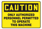
Figure 6-1: Example of Sign Incorporated into Machinery or Equipment
(J)
Signs located on or within public or semi-public athletic fields affixed to scoreboards, buildings, or structures facing the field.
SECTION 6.07.00 - PROHIBITED SIGNS
The following types of signs are prohibited in all districts:
(A)
Signs that are in violation of the adopted building or electrical code.
(B)
Any sign that, in the opinion of the County Manager/designee, constitutes a safety hazard.
(C)
Abandoned signs.
(D)
Signs imitating or resembling official traffic or government signs or signals.
(E)
Snipe signs and signs placed on any public property or public right-of-way.
(F)
Vehicular signs.
(G)
Any sign obstructing traffic visibility.
(H)
Signs with illuminated, moving, revolving, or rotating parts causing traffic hazards, not to exceed 12 feet in height and rotating at no more than two revolutions per minute. Illuminated signs of such intensity or brilliance as to cause glare or impair the vision of motorists, cyclists, or pedestrians using or entering a public right-of-way, or that are a hazard to occupants of any property because of glare or other characteristics.
(I)
Signs emitting sound, odor, smoke, or steam.
(J)
Parasite signs.
(K)
Signs that interfere with any fire escape, emergency exit, standpipe, or any window to the extent that light or ventilation is reduced to a point below that required by any provision of this Section or other applicable regulation.
(L)
Signs containing any statement, word, character, or illustration of an obscene, indecent or immoral nature that are not protected by the First Amendment of the United States and Chapter I § 4 of the Constitution of the State of Florida.
(M)
Any sign not specifically permitted by these Sign Regulations is prohibited.
SECTION 6.08.00 - PERMITTED SIGNS
The following signs are permitted within Hardee County, subject to the standards provided under this Section.
6.08.01 - Nonresidential Zoning Districts
(A)
Permanent On-Premises Freestanding Signs.
(1)
Signs are permitted accessory to structures on property zoned for such uses.
(2)
One sign shall be allowed for each road frontage, up to a maximum of two signs for each development site.
(a)
Where a single business, building, or facility is located at an intersection of two or more streets, up to two freestanding signs shall be allowed, provided each sign is clearly designed to be read from a different street.
(b)
Where multiple businesses share a single building or facility (multiple occupancy building), only one freestanding sign shall be allowed for the building or facility per road frontage, not to exceed a total of two freestanding signs, provided each sign is clearly designed to be read from a different street.
(3)
Freestanding signs shall not exceed one square foot of area for each linear front foot of the premises, measured upon the street, with no sign to exceed 150 square feet.
(4)
Pole signs and monument signs shall not exceed 15 feet in height. Ground signs shall not exceed six feet in height.
(5)
Minimum setbacks for a sign shall be 15 feet from any road right-of-way, measured from the leading edge of the sign, and 10 feet from all other property lines.
(6)
Any freestanding sign may display a single face, double face, or multi-face.
(B)
Wall and Fascia Signs.
(1)
Single Use Buildings.
(a)
One wall or fascia sign shall be allowed for each public street the building faces, up to a maximum of two signs per building.
(b)
Signs on buildings located at the intersection of two or more streets shall be clearly designed to be read from the streets.
(c)
Each wall/fascia sign shall not exceed one square foot of area for each linear front foot of the premises, measured upon the street, with the total of all wall/fascia signs not to exceed 150 square feet of area.
(d)
Wall/fascia signs shall not extend above the roof line or beyond the exterior wall to which it is attached.
(2)
Shopping Centers and Other Multiple Occupancy Buildings.
(a)
One wall or fascia sign per use or business shall be allowed for that portion of the building where such use or business faces the street.
(b)
One and one-half square feet of sign area is permitted for each linear front foot of the building frontage where the use or business faces the street that serves the shopping center or use. The total area of wall signs permitted shall apply with respect to each building, and separately to the exterior wall included in an occupant's individually owned or leased premises.
(c)
Wall signage for uses with more than 40,000 square feet in shopping centers or multiple occupancy buildings, and with frontage on an arterial or collector road, may be increased by 200% when the building is set back at least 200 feet from the public right-of-way.
(d)
Where an individually owned or leased premise does not include part of an exterior wall of a principal building, the occupant may display one sign up to six square feet of sign area on one side of the principal building in which the occupant is located.
(C)
Roof Signs.
(1)
Roof signs shall be permitted only in commercially zoned districts.
(2)
Roof signs shall be no more than 30% of the road front roof face upon which it is situated.
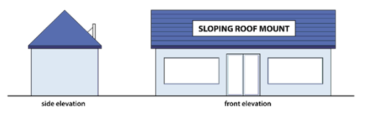
Figure 6-2: Example Roof Signs
6.08.02 - Residential Zoning Districts
(A)
Residential development entryway signs and signage for Residential Support Uses shall be permitted as follows:
(1)
Freestanding Signs.
(a)
One ground or monument sign shall be permitted for each main entrance on a public right-of-way.
(b)
The maximum sign face area shall be 32 square feet, and the total sign area, including mounting and support structures shall not exceed 50 square feet.
(c)
The maximum sign height shall be five feet.
(d)
A setback of 10 feet must be maintained from all property lines.
(e)
A single monument sign, located within a median, as part of a boulevard entrance, may be used in lieu of a sign established on either side of a subdivision entrance.
(2)
Wall Signs. A wall sign shall be proportionate to the wall on which it is located, but shall not exceed 32 square feet in sign area or extend more than 12 inches from the wall to which it is attached.
(3)
Illumination. The only form of artificial illumination allowed shall be indirect illumination.
(B)
Signage for other permitted uses shall be as follows:
(1)
Signs of two square feet or less are permitted in a window or on the building. Building signs shall be affixed flat against the exterior wall of the residence.
(2)
Permitted lodging uses, as identified in the permitted land uses Zoning District Table 3.03.00 (A), are allowed a metal or wood freestanding sign, up to two square feet in area. Such a sign shall not exceed four feet in height from the ground and shall maintain a minimum 10-foot setback from all property lines.
(3)
Signage shall be unlighted.
6.08.03 - Electronic Message Center Signs
(A)
Residential Properties. Electronic message center signs located within 50 feet of any residential property line, as measured from the property line to the sign, shall display static images only. When possible, the sign shall be oriented so that no portion of the sign face is visible from an existing or permitted principal structure on that lot.
(B)
State and County Highways. Electronic message center signs located on properties along State and County highways may be subject to State and County sign and permitting requirements.
(C)
Sign Standards.
(1)
All electronic message center signs shall come equipped with automatic shut-off technology so that the display will go dark during sign malfunction.
(2)
All electronic message center signs shall comply with the Building and the National Electrical Code.
(3)
All electronic message center signs shall come equipped with automatic dimming technology which automatically adjusts the sign's brightness based on ambient light conditions.
(4)
Electronic message center signs shall not be placed or illuminated so as to obscure or interfere with traffic control devices.
(5)
No electronic message center sign shall exceed a brightness level of 0.3-foot candles above ambient light as measured using a foot candle (Lux) meter at a preset distance depending on sign area, measured as shown on Table 6.08.03(A). For signs with an area in square feet other than those specifically listed in the table (e.g., 12 sq. ft., 400 sq. ft., etc.) the measurement distance may be calculated with the following formula: Measurement Distance = √ (Area of Sign Sq. Ft. x 100).
Table 6.08.03(A)
Electronic Message Center Sign Brightness Level Standard
6.08.04 - Temporary Signs
Temporary signs shall be allowed in all zoning districts and shall comply with the following requirements:
(A)
Generally.
(1)
Temporary signs may be ground or building signs but shall not be allowed as permanent signage.
(2)
Signs may be on-premises or off-premises. Off-premises signs shall require express consent of the property owner.
(3)
The square footage of a temporary sign shall not be included in the calculation of the total sign area allowance for a parcel.
(4)
On-premises temporary signs, up to 32 square feet in total sign area, require no sign permit.
(5)
One additional temporary sign is allowed for a parcel that has no permanent sign, provided that such sign is not displayed for a period of more than 60 days or until installation of the permanent sign, whichever occurs first. The additional sign shall comply with the dimensional requirements provided in letter G., below.
(6)
All temporary signs that may be readily moved from place to place shall be moved to a secure location upon a warning of high winds or hurricane by the National Weather Service.
(B)
Duration. Temporary signs shall be removed within 10 calendar days after the end of the scheduled occurrence or purpose to which they relate.
(C)
Portable Message Center Signs.
(1)
Portable message center signs shall only be allowed with one-time display (event) permitting.
(2)
Only one sign shall be allowed on an individual property at any one time.
(3)
Portable message center signs shall be allowed for a maximum of 14 consecutive calendar days per occurrence.
(D)
Banners and Blade Signs. Banners and blade signs shall only be allowed with one-time display (event) permitting.
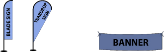
Figure 6-3: Example Blade Signs Example Banner
(E)
One-Time Display (Event) Signs. One-time display (event) signs shall be allowed no more than four times per year, up to a maximum of 14 days per occurrence. A sign permit is required. Signs may include banners, blade signs, temporary inflatable signs, portable message center signs and other allowable temporary signs. The aggregate sign area of one-time display (event) signs shall not exceed 200 square feet.
(F)
Temporary Inflatable Signs.
(1)
Temporary inflatable signs shall only be allowed with one-time (event) displays.
(2)
Temporary inflatable signs shall only be allowed for nonresidential uses in commercial and industrial zoning districts, on property which abuts an arterial roadway.
(3)
No more than one temporary inflatable sign shall be permitted on a single property at one time.
(4)
Inflatable displays shall be securely anchored or attached to prevent dislocation, entanglement or encroachment onto adjacent properties or public streets and to prevent undue hazards to motorists and pedestrians.
(5)
Inflatable displays shall not be attached to fences, landscaping, utility poles or private light poles.
(G)
Off-Premises Temporary Signs. Off-premises temporary signs shall require written consent of the property owner and an annual sign permit. The annual sign permit number shall be printed on, or affixed, to the sign.
(H)
Dimensional Requirements.
(1)
A parcel may display temporary signs with an aggregate sign area of up to 32 square feet.
(2)
Parcels exceeding one acre, and multiple-occupancy developments (e.g., strip shopping centers or strip malls) shall be permitted temporary signs not to exceed 64 square feet of aggregate sign area. The owner of the strip shopping center or mall shall be responsible for any penalties accrued for non-compliance by the tenants.
(3)
Temporary signs shall not exceed six feet in height in residential districts and eight feet in height in nonresidential districts.
(4)
Temporary signs shall have a minimum five-foot setback from the property line and shall not be located within the clear visibility triangle (Section 5.02.02(C)).
(I)
Maintenance. Temporary signs are subject to the standards provided in Section 6.11.00, Maintenance Standards.
6.08.05 - Billboards
(A)
General Provisions. Billboards, as defined in Article 14 of this Code, shall be permitted in C-1, C-2, A-1, A-2, I-1, and I-2 zoned districts adjacent to roads classified as arterial or collector in the Transportation Element of the Comprehensive Plan only, subject to the requirements provided in this Section and Chapter 479, F.S.
(B)
Design Standards.
(1)
Maximum height shall be 40 feet, with a minimum ground clearance of eight feet. Height shall be measured from the highest point of the sign, excluding embellishments, to the highest elevation of the adjoining road.
(2)
Setbacks shall be no less than 15 feet from the right-of-way line and no less than 100 feet from adjacent property owners.
(3)
Signs shall not exceed 950 square feet in size, including all embellishments.
(C)
Illumination. Illumination shall be directed only at the advertising surface(s) of the billboards, and no lighting tubes or bulbs shall be visible from adjoining roads or properties.
(D)
Multiple Panels.
(1)
A billboard having two sign panels back-to-back, separated by a distance of no more than four feet, shall be considered as one sign, and each face shall be permitted the full size permitted in letter (B) above.
(2)
For billboards having back-to-back panels separated by more than four feet, multiple panels facing in the same direction, or multiple panels arranged in a V-shape or other configuration, the combined surface area of all panels shall not exceed the full size permitted in letter (B) above.
(E)
Placement Intervals.
(1)
No billboard shall be placed within 1,500 feet of an existing or permitted billboard on the same side of the road.
(2)
Where the rear of a sign would be visible from any street or from adjoining district of residential classification, the exposed structural members of such sign shall be concealed by painted latticework or by plantings, and such back screening shall be properly maintained.
SECTION 6.09.00 - SIGN MEASUREMENT
(A)
Sign Area.
(1)
Calculating Geometric Figures. The area of the geometric figures, or the sum of the combination of geometric figures, which comprise the sign face shall comprise the sign area. Calculate the sign area by the actual panel surrounding copy. The area of a sphere shall be computed as the area of a circle.
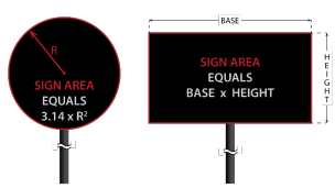
Figure 6-4: Signage Calculations
(2)
Architectural Features. Do not calculate embellishments. Architectural features that are either part of the building or part of a freestanding structure, and not an integral part of a freestanding sign, shall not be included in the sign area. A pole or other structural support of a freestanding sign shall not be included in the sign area unless such pole or structural support is internally illuminated or otherwise so designed to constitute a display device, or a part of a display device up to a maximum of 75% of the total size of the maximum allowed sign area. Any area of the structural support or cladding greater than 75% of the sign area shall count as part of the sign. Examples of measurable sign area:
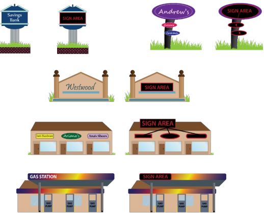
Figure 6-5: Examples of Measurable Sign Area
(3)
Canopy Signs. The area of a canopy sign shall be included in the calculation for wall/fascia signs.
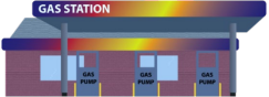
Figure 6-6: Example Canopy Sign
(4)
Multi-Faced Signs.
(a)
Double-faced Signs of Equal Size. When two identical sign faces are placed back-to- back so that both faces cannot be viewed from any point at the same time, and are part of the same sign structure, the sign area shall be computed as the measurement of one of the two faces.
(b)
Double-faced Signs Not of Equal Size. Where two sides of a sign are not of equal size, the larger of the two sides shall be used in determining sign area.
(c)
Multiple Faced Signs. The area of multiple faced signs in which the interior angle formed by the faces is greater than 91 degrees shall be expressed as the sum of the areas of all the faces, except for multiple faced signs containing faces that are configured back-to-back, in which case the area of the faces configured back- to-back shall be calculated according to the rule for double-faced signs.
(5)
Three-Dimensional Signs. Signs that consist of, or have attached to them, one or more three-dimensional or irregularly shaped objects shall have a sign area that is the sum of the area of two adjacent vertical sign faces of the smallest cube encompassing the sign or object.
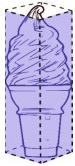
Figure 6-7: Example of a Three-Dimentional Sign
(B)
Sign Setbacks.
(1)
No permanent sign shall be placed or constructed within a clear visibility triangle, Section 5.02.02(C).
(2)
Setbacks shall be measured from the leading edge of the sign to the property or right-of-way line, as applicable.
(C)
Sign Height. Sign height shall be measured as the vertical distance between the top of a sign structure and the finished grade elevation, or the average elevation of the abutting roadway, nearest the base of the sign to the highest point on the sign.
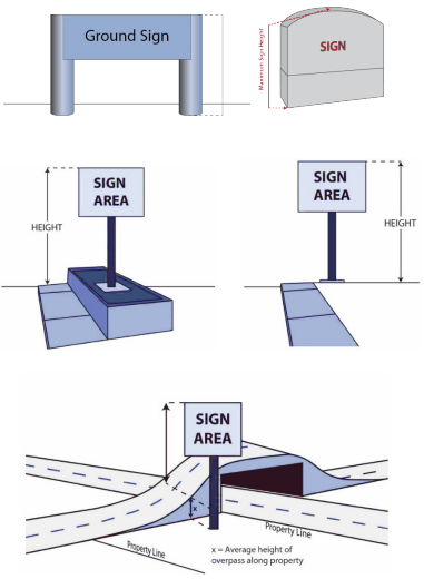
Figure 6-8: Examples of Sign Height
SECTION 6.10.00 - ILLUMINATION STANDARDS
(A)
All lighted signs shall conform to all applicable requirements of the Florida Building Code and the National Electrical Code.
(B)
Sign lighting shall not be designed or located to interfere with traffic lights.
(C)
Illumination by floodlights, spotlights, or unshielded bulbs is permissible so long as none of the light emitted shines onto an adjoining property or into the eyes of motorists or pedestrians using or entering public streets. This standard applies to sign illumination originating inside of business windows or sign illumination originating on signs which are outside.
(D)
Lights used for external sign illumination shall be so designed as to concentrate the illumination upon the sign, with steady, stationary, light, and such lights shall not glare upon the street or upon adjacent property.
(E)
Unshielded illuminated devices that produce glare or are a hazard or a nuisance to motorists or occupants of adjacent properties are prohibited.
(F)
Unless otherwise provided in this sign code, various types of sign illumination, including neon, incandescent, LED, and similar, compatible, or comparable lighting technologies, are permitted consistent with all applicable requirements of this sign code.
(G)
Internally illuminated signs in mixed use developments and in residential districts where residential support uses are located shall not be illuminated between the hours of 11:00 p.m. and 6:00 a.m.
SECTION 6.11.00 - MAINTENANCE STANDARDS
All signs, including their supports, braces, guys and anchors, electrical parts and lighting fixtures, and all painted and display areas, shall be maintained in accordance with the building and electrical codes adopted by Hardee County, and shall present a neat and clean appearance. The vegetation around, in front of, behind, and underneath the base of ground signs for a distance of 10 feet shall be neatly trimmed and free of unsightly weeds, and no rubbish or debris that would constitute a fire or health hazard shall be permitted under or near the sign. Damaged faces and/or structural members shall be repaired, replaced, or removed consistent with Section 6.12.00.
SECTION 6.12.00 - NONCONFORMING SIGNS
A nonconforming sign is one that was legally erected prior to the adoption of these current Sign Regulations, and which does not conform to the requirements herein.
(A)
Nonconforming Sign Alterations and Repairs.
(1)
A nonconforming sign shall not be enlarged or increased in any way from its existing size at the time of the adoption of these Sign Regulations.
(2)
Nonconforming signs shall not be repaired, or reestablished after damage or destruction, if the estimated cost of reconstruction or repair exceed 50% of the reproduction and installation cost of the sign.
(3)
Nonconforming signs or sign structures that are defined as abandoned signs under these Sign Regulations shall not be permitted for reuse.
(B)
Removal of Nonconforming Signs. All nonconforming and non-permitted signs, shall be removed within 30 days after the date upon which a violation notice is issued. If the sign is not removed or the violation, if correctable, is not corrected within the prescribed period, the County may remove the sign without further notice and may enter upon private property consistent with Section 12.03.02, Right of Entry. The cost of removing a nonconforming sign shall be assessed against the owner of the sign, by the County, and shall be enforceable consistent with Section 6.13.00 of this Article.
(C)
Casual, Temporary, or Illegal Use. The casual, temporary or illegal use of any sign shall not be sufficient to establish the existence of a nonconforming use or to create any rights in the continuance of such use.
SECTION 6.13.00 - SIGN REMOVAL
(A)
Prohibited Signs.
(1)
Prohibited signs on public property or rights-of-way shall be removed immediately and may, without notice, be removed by the County or its agent.
(2)
Illegal or prohibited signs shall be removed within 48 hours after receipt of written notification of the County Manager, or designee. If the sign is not removed within this time frame, the County may remove it at the owner's expense and/or the Code Enforcement Officer may process the violation consistent with the provisions set forth in Section 12.01.00 of this Code.
(B)
Unsafe and/or Deteriorated Signs. Should any sign become structurally insecure, in disrepair, deteriorated or otherwise unsafe, the County Manager, or designee, shall provide written notification to the owner, or person or firm maintaining it. Upon receipt of written notification, the owner shall:
(1)
In the case of imminent danger:
(a)
Immediately secure the sign or cause it to be placed in good repair (in a manner approved by the Building Official); or
(b)
Immediately remove the sign.
(2)
All other instances:
(a)
Secure the sign or cause it to be placed in good repair (in a manner approved by the Building Official) within 90 days after the date upon which a violation notice is issued; or
(b)
Remove the sign within 90 days after the date upon which a violation notice is issued.
(C)
Broken or Missing Sign Panel. In no case shall a sign box be left with a broken or missing sign panel. Such signs are subject to either (B)(1) or (B)(2), above, whichever is applicable.
(D)
When a Business Leaves a Location. When a business leaves a location, the signs pertinent to that business shall be removed by either the tenant or the landlord. If a new business will be moving in immediately, a box-type sign cabinet may be re-used by the new business operator by inserting a new "face" in the sign.
If a new business is not moving in within 90 days of the former leaving, then one of the following shall be required until a new business rents the space:
(1)
A blank panel may be inserted to replace the sign face of the prior business;
(2)
The existing sign face may be reversed so that the blank side of the panel is showing;
(3)
A sock or boot may be used to cover the sign.
In cases where totally new signs are being installed, the old signs they replace shall be completely removed upon installation of said new signs.
(E)
Illegally Erected Signs. If a sign has been illegally erected the owner of the property where such illegally erected sign is located and the lessee, if applicable, and within 10 days after notification by the County Manager or designee, shall either:
(1)
Have the sign immediately removed; or
(2)
Secure a permit for such sign, subject to all applicable County inspections.
SECTION 6.14.00 - VIOLATIONS OF THIS ARTICLE
It is a violation of this Article for property owners, tenants or occupants of property to maintain, install or allow a sign which is not permitted, exempt from the permit requirements of this Article, or otherwise not in compliance with this Article, to be on property which they own, lease or otherwise occupy, and any such violation of this Article is subject to the provisions set forth in Section 12.01.00 of this Code.
SECTION 6.15.00 - SEVERABILITY
(A)
If any part, section, subsection, paragraph, subparagraph, sentence, phrase, clause, term, or word of this Article is declared unconstitutional by the valid judgment or decree of any court of competent jurisdiction, the declaration of such unconstitutionality shall not affect any other part, section, subsection, paragraph, subparagraph, sentence, phrase, clause, term, or word of this Article.
(B)
Severability Where Less Speech Results. Without diminishing or limiting in any way the declaration of severability set forth in subsection (A) above, or elsewhere in this Article, this Code, or any adopting ordinance, if any part, section, subsection, paragraph, subparagraph, sentence, phrase, clause, term, or word of this Article is declared unconstitutional by the valid judgment or decree of any court of competent jurisdiction, the declaration of such unconstitutionality shall not affect any other part, section, subsection, paragraph, subparagraph, sentence, phrase, clause, term, or word of this Article, even if such severability would result in a situation where there would be less speech, whether by subjecting previously exempt signs to permitting or otherwise.
(C)
Severability of Provisions Pertaining to Prohibited Signs. Without diminishing or limiting in any way the declaration of severability set forth in subsections (A) or (B) above, or elsewhere in this Article, this Code, or any adopting ordinance, if any part, section, subsection, paragraph, subparagraph, sentence, phrase, clause, term, or word of this Article or any other law is declared unconstitutional by the valid judgment or decree of any court of competent jurisdiction, the declaration of such unconstitutionality shall not affect any other part, section, subsection, paragraph, subparagraph, sentence, phrase, clause, term, or word of this Article that pertains to prohibited signs, including specifically those signs and sign-types prohibited and not allowed under Section 6.07.00 of this Article. Furthermore, if any part, section, subsection, paragraph, subparagraph, sentence, phrase, clause, term, or word of Article 6 is declared unconstitutional by the valid judgment or decree of any court of competent jurisdiction, the declaration of such unconstitutionality shall not affect any other part, section, subsection, paragraph, subparagraph, sentence, phrase, clause, term, or word of Article 6.